Embed Size (px)
Citation preview
DOE/SC-ARM-17-009
Evaluation of Routine Atmospheric Sounding Measurements Using Unmanned Systems (ERASMUS) Field Campaign Report
March 2017
G de Boer D Lawrence S Palo B Argrow G LoDolce N Curry D Weibel W Finnamore P D’Amore S Borenstein T Nichols J Elston M Ivey A Bendure B Schmid C Long H Telg R-S Gao T Hock G Bland
DISCLAIMER
This report was prepared as an account of work sponsored by the U.S. Government. Neither the United States nor any agency thereof, nor any of their employees, makes any warranty, express or implied, or assumes any legal liability or responsibility for the accuracy, completeness, or usefulness of any information, apparatus, product, or process disclosed, or represents that its use would not infringe privately owned rights. Reference herein to any specific commercial product, process, or service by trade name, trademark, manufacturer, or otherwise, does not necessarily constitute or imply its endorsement, recommendation, or favoring by the U.S. Government or any agency thereof. The views and opinions of authors expressed herein do not necessarily state or reflect those of the U.S. Government or any agency thereof.
DOE/SC-ARM-17-009
Evaluation of Routine Atmospheric Sounding Measurements Using Unmanned Systems (ERASMUS) Field Campaign Report G de Boer, University of Colorado –Boulder (UCB) Principal Investigator D Lawrence, UCB S Palo, UCB B Argrow, UCB G LoDolce, UCB N Curry, UCB D Weibel, UCB W Finnamore, UCB P D’Amore, UCB S Borenstein, UCB T Nichols, UCB J Elston, Blackswift Technologies M Ivey, Sandia National Laboratories (SNL) A Bendure, SNL B Schmid, Pacific Northwest National Laboratory C Long, UCB H Telg, UCB R-S Gao, National Oceanic and Atmospheric Administration T Hock, National Center for Atmospheric Research G Bland, National Aeronautics and Space Administration Co-Investigators March 2017 Work supported by the U.S. Department of Energy, Office of Science, Office of Biological and Environmental Research
G de Boer et al., March 2017, DOE/SC-ARM-17-009
iii
Acronyms and Abbreviations
AAF ARM Aerial Facility AERI atmospheric emitted radiance interferometer AMF ARM Mobile Facility ARM Atmospheric Radiation Measurement Climate Research Facility ASR Atmospheric System Research BAO Boulder Atmospheric Observatory C centigrade 3D three-dimensional DEW Distant Early Warning DH2 DataHawk2 DOE U.S. Department of Energy ECOR ARM Eddy-Covariance system EMI electromagnetic interference ERASMUS Evaluation of Routine Atmospheric Sounding Measurements using Unmanned
Systems ESC electronic speed controller ICARUS Inaugural Campaigns for ARM Research using Unmanned Systems INS inertial navigation system km kilometer m meter mph miles per hour NASA National Aeronautics and Space Administration NCAR National Center for Atmospheric Research NetCDF Network Common Data Form NOAA National Oceanic and Atmospheric Administration PNNL Pacific Northwest National Laboratory POPS printed optical particle spectrometer RASM Regional Arctic System Model SD Secure Digital SNL Sandia National Laboratories UAS unmanned aerial systems UCB University of Colorado – Boulder USAF U.S. Air Force
G de Boer et al., March 2017, DOE/SC-ARM-17-009
iv
Contents
Acronyms and Abbreviations ...................................................................................................................... iii 1.0 Summary ............................................................................................................................................... 1 2.0 Results .................................................................................................................................................. 3 3.0 References ............................................................................................................................................ 9
3.1 Publications and References ......................................................................................................... 9 3.2 Presentations .............................................................................................................................. 10
4.0 Lessons Learned ................................................................................................................................. 12
Figures
1 Evaluation of the AERIoe data productusing DH2 measurements from the October 2016 campaign. ............................................................................................................................................... 4
2 Evaluation of lower atmospheric structure in the Regional Arctic System Model (RASM) currently employed by the NOAA Physical Sciences Division for sea ice forecasting. ........................ 4
3 Atmospheric profiling during August 2015 flights capture periods of cloud formation and dissipation. .............................................................................................................................................. 5
4 Near-cloud sampling. ............................................................................................................................. 5 5 Evaluation of the ability of the DH2 to measure turbulent fluxes of heat and moisture – here the
DH2 was flown alongside a 3D sonic anemometer at a common altitude at the Boulder Atmospheric Observatory, and fluxes are computed using eddy-covariance techniques for three separate flights. ....................................................................................................................................... 6
6 These two figures illustrate this technique applied to ERASMUS flight data collected during October 2016. ......................................................................................................................................... 8
7 Broadband radiometric measurements from Pilatus flights in April 2016. ............................................ 9 8 Aerosol size distribution as a function of height, as measured by POPS on-board the Pilatus
during April 2016 flights at Oliktok Point.............................................................................................. 9
G de Boer et al., March 2017, DOE/SC-ARM-17-009
1
1.0 Summary The Evaluation of Routine Atmospheric Sounding Measurements using Unmanned Systems (ERASMUS) campaign was proposed with two central goals:
1. Obtain scientifically relevant measurements of quantities related to clouds, aerosols, and radiation, including profiles of temperature, humidity, and aerosol particles, the structure of the arctic atmosphere during transitions between clear and cloudy states, measurements that would allow us to evaluate the performance of retrievals from U.S. Department of Energy (DOE) Atmospheric Radiation Measurement (ARM) Climate Research Facility remote sensors in the Arctic atmosphere, and information on the spatial variability of heat and moisture fluxes from the arctic surface.
2. Demonstration of unmanned aerial system (UAS) capabilities in obtaining measurements relevant to the ARM and ASR programs, particularly for improving our understanding of Arctic clouds and aerosols.
To do this, it was proposed that two types of UAS would be operated in the DOE-controlled airspace (R-2204, de Boer et al., 2016a) at Oliktok Point, Alaska, alongside the third ARM Mobile Facility (AMF3). The first of these aircraft is the University of Colorado Pilatus (de Boer et al., 2016b), which was originally proposed to carry instrumentation to measure aerosol size distribution, broadband radiation, and a cloud microphysical probe. After it became clear that in-cloud operation of the Pilatus would not be approved, the decision was made to eliminate the cloud microphysics component, and focus on the broadband radiation and aerosol measurements, with the broadband instruments being supplied by the ARM Aerial Facility (AAF), and the aerosol instrumentation (Printed Optical Particle Spectrometer, POPS, Gao et al., 2016) being supplied by the National Ocean and Atmospheric Administration (NOAA)’s Chemical Sciences Division. The second aircraft used in this campaign is the University of Colorado DataHawk2 (DH2) micro-UAS. The DH2 carries instrumentation to measure temperature, humidity, and pressure, and to estimate wind speed and direction.
Initially, all ERASMUS flights were scheduled to occur during April of 2015. Due to a variety of reasons, the decision was made to split the campaign into two segments, with the Pilatus scheduled to stick with the original April 2015 campaign period, and the DH2’s scheduled to instead conduct a separate two-week campaign between 2-16 August, 2015. Weather conditions at Oliktok during April 2015 resulted in a further delay of the Pilatus campaign to 2-16 April, 2016. After completion of these two campaigns, an extension was requested to allow for the completion of a third campaign (using DH2s) at Oliktok Point during October 2016.
For the August 2015 DH2 campaign, the original plan was to conduct routine (hourly) profiles of the lower atmosphere (surface to 2 km or cloud base, whichever is lower) for 12 hours per day. Unfortunately, it was determined that the US Air Force Long Range surveillance radar at Oliktok Point significantly interfered with the DH2’s control and flight systems. Therefore, after several days of troubleshooting, the operations plan was revised to conduct hourly profiles between the surface and the highest safe altitude, within a distance determined to be such that pilots felt comfortable taking control of the aircraft in case of radar-induced interference. Operating under this mode, we obtained routine profiles of the lowest portions of the atmosphere over the AMF3, including a total of 163 flights of various duration due to interference, and 23.2 total flight hours. Included in this profiling are several days where aircraft sampled in close proximity to cloud boundaries, and captured the evolution of the thermodynamic structure of the lower atmosphere during the formation and dissipation of cloud layers. Besides the radar
G de Boer et al., March 2017, DOE/SC-ARM-17-009
2
interference, the only other items that kept us grounded for relatively short periods were the presence of bears at Oliktok Point and fog. The data from these flights have been assembled in NetCDF format and are available from the ARM Data Archive (de Boer et al., 2016c). Unfortunately, two key AMF3 instruments (AERI and Raman lidar) for comparison to the DH2 measurements were down during this campaign.
For the April 2016 Pilatus campaign, the original plan was to conduct regular flights over an extended box pattern, including altitudes between the surface and 800 meters. This would keep the aircraft as level as possible in flight, maximizing our ability to capture useful radiation data with the Delta-T SPN-1s and Kipp and Zonen CGR-4s. The Pilatus system did not have any interference issues similar to those observed during DH2 operations. Unfortunately, the weather did not cooperate, and the original two-week campaign period saw continuously sustained winds at and above 25 miles per hour. During these high-wind times, we attempted to fly a couple of DH2 UAS that we had brought to evaluate the performance of the platform with modifications made to withstand the radar-induced interference. Unfortunately, the weather conditions proved to be too much for successful DH2 flights, and the flights that were conducted were short. In addition to operating the DH2 during the high-wind period, we additionally sampled the aerosol size distribution at the site, deploying our POPS aerosol sampler to the roof of the AMF3 one to three times per day. Finally, on 16 April, the winds began to die down and we decided to extend the campaign by two days in order to complete some Pilatus flights. On 16-17 April, we completed six flights with the Pilatus, including one flight with only POPS and PTH (pressure, temperature, humidity) sensors on board, four flights with the SPN-1 shortwave instrumentation (in addition to POPS and PTH), and one flight with the CGR-4 longwave instrumentation (in addition to POPS and PTH). Of these flights, we successfully collected data with each payload, but had a problem with the Secure Digital (SD) card being used to log our measurements during one and a half of the SPN-1 flights. Additionally, we had a propulsion system failure, related to a reset of the electronic speed controller (ESC) during the last flight, resulting in an unintended landing on the sea ice. The aircraft and instrumentation were unharmed during this event. The data from these flights have been assembled in NetCDF format and are available from the ARM Data Archive (de Boer et al., 2016c). Initial evaluation of the limited flight data has been completed. Because of the limited number of flights (four total flights with in-flight data logging), it is unlikely that significant scientific advances can be made. Having said this, the experiences gained from operating this aircraft under challenging weather conditions are invaluable for advising future cold-weather campaign periods at Oliktok Point. Additionally, exposure to the extended wind event clearly points to a need for UAS platforms capable of high-wind operation to ensure adequate data collection during any time of year.
Between 10 and 22 October, 2016, we operated the DH2 at Oliktok Point. Based on information from previous flights and testing at Oliktok Point, the DH2 was updated with improved autopilot software to better handle the interference resulting from the U.S Air Force (USAF) radar. These software updates worked very well, and while there were obvious signs of radar interference, there were no adverse effects on flight control. One thing that did come up with the extended flights was that the DH2’s ESC was reset several times in flight (again, likely as a result of EMI from the USAF radar), resulting in a loss of propulsion. We soon discovered that when such an event was encountered, a switch to manual control, reset of the throttle control on the handset, and transition back to autopilot would clear this issue. In total 41 flights were completed, resulting in 17.3 flight hours. With the exception of the first day, the first half of this two-week period featured high winds (20-30 mph) and marginal flying conditions. However, the second week was generally very good, weather wise, and we were able to sample a variety of conditions.
G de Boer et al., March 2017, DOE/SC-ARM-17-009
3
This includes well-mixed boundary layers resulting from northeasterly (onshore) winds. Additionally, we were able to sample a stable boundary-layer regime, as well as the lower atmosphere under a decoupled cloud system. In addition to profiling flights, we completed a series of low-altitude “flux” flights, just offshore, consisting of extended sampling at 15-20 m altitude over the ocean surface. This surface, over the time we were on site, transitioned from an open water surface with temperatures around 5 C, to one covered by 3-inch-thick sea ice. The data from these flights have been assembled in NetCDF format and are available from the ARM Data Archive (de Boer et al., 2016c). Analysis of this campaign period has begun, and data have been used to perform initial evaluations of modeling tools (e.g., NOAA’s RASM-ESRL sea ice forecast model) and remote-sensing retrievals (e.g. AERIoe).
In addition to the flight campaigns, work was completed in preparation for these flights. This includes working through the safety and approval process with SNL, PNNL, and DOE for operation in R-2204. These efforts have laid substantial groundwork for future UAS operations at Oliktok Point, including those conducted by the AAF. In addition, significant work has been completed to harden the DH2 aircraft against interference by the USAF radar systems and perform reliably in the polar environment. This work directly benefits ARM as ARM is now operating the DH2 under AAF command at Oliktok Point. Work completed in setting up the broadband radiometers for operation on small UAS has been adopted by the AAF for their future operations, including the characterization of the offset between the sensors and the inertial navigation system (INS) using a cartop system instead of requiring additional G-1 flights. Finally, work with the POPS has demonstrated the potential for that instrument, and the AAF has acquired several of these for use on their UAS and on the ARM tethered balloon system.
2.0 Results Analysis of the data sets collected is ongoing and currently not directly funded. Overall, numerous hours of measurements were collected using the two systems described above. Despite the volume of measurements, weather and other unforeseen circumstances (radar interference) limited our ability to carry out sampling as originally planned. In the end, measurements of atmospheric thermodynamics, radiation, aerosol size distribution and turbulent fluxes were obtained using these aircraft. Additionally, the potential for these or similar systems to be used as part of ARM and ASR’s ongoing research was demonstrated, albeit with some “road bumps” which were absorbed as part of this project. The data from these campaigns have all been submitted to the ARM Data Archive.
Since a thorough analysis of the measurements has not been completed, here we provide some examples of the types of data that were collected during the campaigns, and the information available from these measurements.
G de Boer et al., March 2017, DOE/SC-ARM-17-009
4
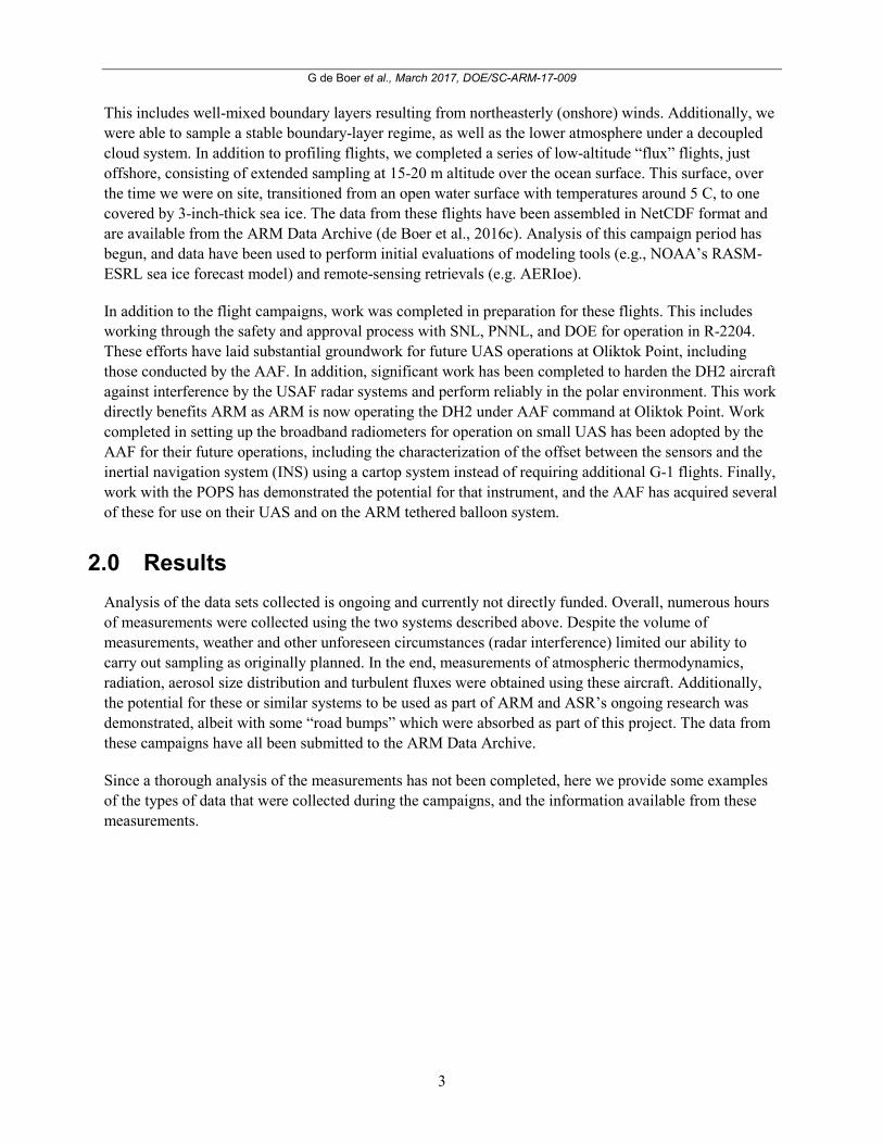
Figure 1. Evaluation of the AERIoe data product (developed by D. Turner) using DH2 measurements
from the October 2016 campaign. The background shading is the temperature retrieval from AERIoe, while the colored circles represent the temperatures measured using the DH2.
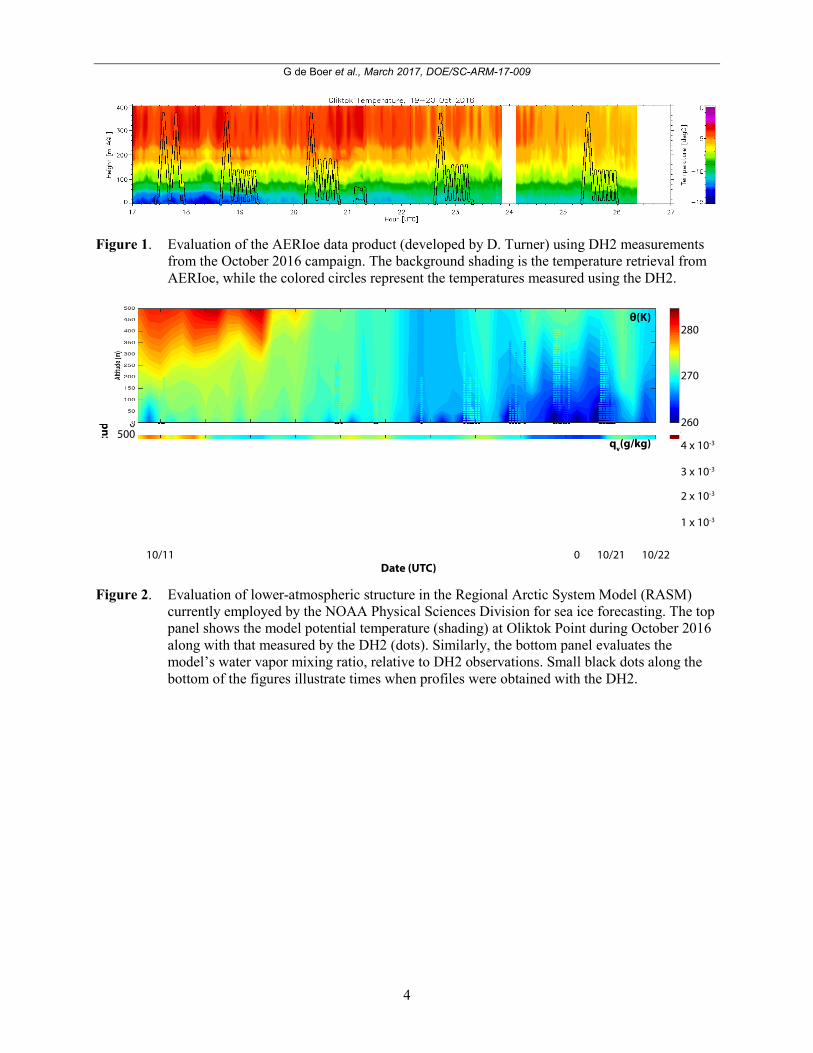
Figure 2. Evaluation of lower-atmospheric structure in the Regional Arctic System Model (RASM)
currently employed by the NOAA Physical Sciences Division for sea ice forecasting. The top panel shows the model potential temperature (shading) at Oliktok Point during October 2016 along with that measured by the DH2 (dots). Similarly, the bottom panel evaluates the model’s water vapor mixing ratio, relative to DH2 observations. Small black dots along the bottom of the figures illustrate times when profiles were obtained with the DH2.
G de Boer et al., March 2017, DOE/SC-ARM-17-009
5
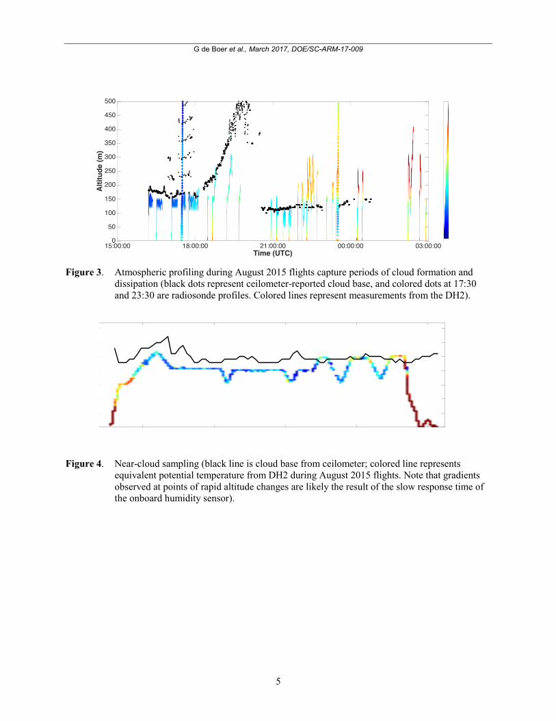
Figure 3. Atmospheric profiling during August 2015 flights capture periods of cloud formation and
dissipation (black dots represent ceilometer-reported cloud base, and colored dots at 17:30 and 23:30 are radiosonde profiles. Colored lines represent measurements from the DH2).
Figure 4. Near-cloud sampling (black line is cloud base from ceilometer; colored line represents
equivalent potential temperature from DH2 during August 2015 flights. Note that gradients observed at points of rapid altitude changes are likely the result of the slow response time of the onboard humidity sensor).
G de Boer et al., March 2017, DOE/SC-ARM-17-009
6
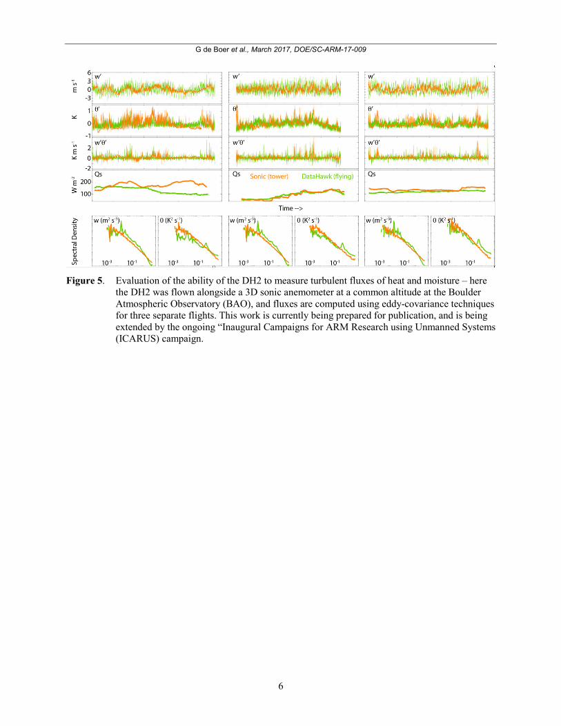
Figure 5. Evaluation of the ability of the DH2 to measure turbulent fluxes of heat and moisture – here
the DH2 was flown alongside a 3D sonic anemometer at a common altitude at the Boulder Atmospheric Observatory (BAO), and fluxes are computed using eddy-covariance techniques for three separate flights. This work is currently being prepared for publication, and is being extended by the ongoing “Inaugural Campaigns for ARM Research using Unmanned Systems (ICARUS) campaign.
G de Boer et al., March 2017, DOE/SC-ARM-17-009
7
G de Boer et al., March 2017, DOE/SC-ARM-17-009
8
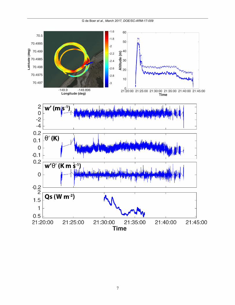
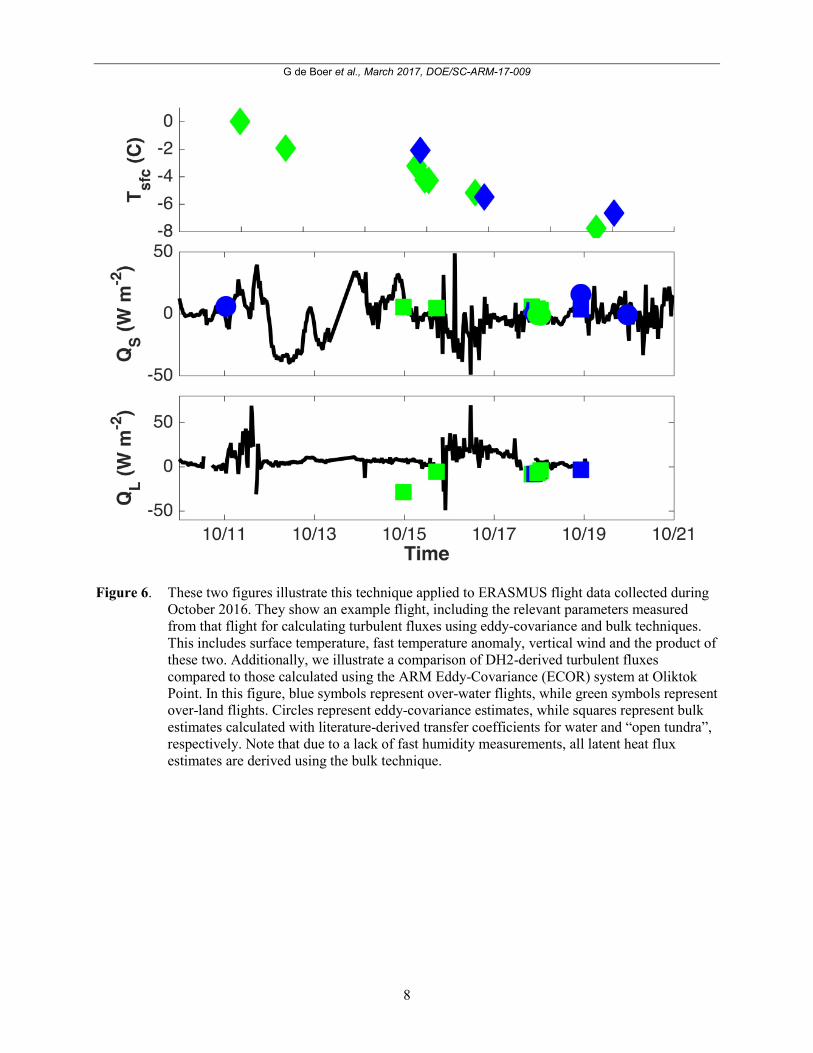
Figure 6. These two figures illustrate this technique applied to ERASMUS flight data collected during
October 2016. They show an example flight, including the relevant parameters measured from that flight for calculating turbulent fluxes using eddy-covariance and bulk techniques. This includes surface temperature, fast temperature anomaly, vertical wind and the product of these two. Additionally, we illustrate a comparison of DH2-derived turbulent fluxes compared to those calculated using the ARM Eddy-Covariance (ECOR) system at Oliktok Point. In this figure, blue symbols represent over-water flights, while green symbols represent over-land flights. Circles represent eddy-covariance estimates, while squares represent bulk estimates calculated with literature-derived transfer coefficients for water and “open tundra”, respectively. Note that due to a lack of fast humidity measurements, all latent heat flux estimates are derived using the bulk technique.
G de Boer et al., March 2017, DOE/SC-ARM-17-009
9
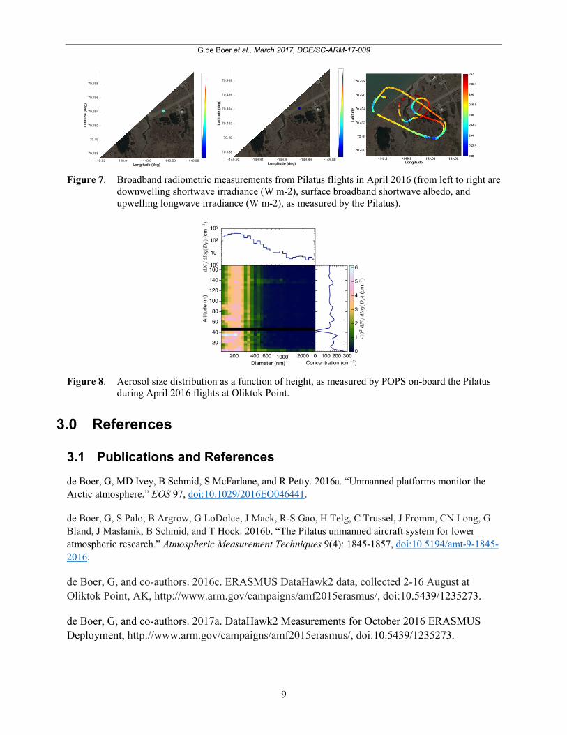
Figure 7. Broadband radiometric measurements from Pilatus flights in April 2016 (from left to right are
downwelling shortwave irradiance (W m-2), surface broadband shortwave albedo, and upwelling longwave irradiance (W m-2), as measured by the Pilatus).
Figure 8. Aerosol size distribution as a function of height, as measured by POPS on-board the Pilatus
during April 2016 flights at Oliktok Point.
3.0 References
3.1 Publications and References
de Boer, G, MD Ivey, B Schmid, S McFarlane, and R Petty. 2016a. “Unmanned platforms monitor the Arctic atmosphere.” EOS 97, doi:10.1029/2016EO046441.
de Boer, G, S Palo, B Argrow, G LoDolce, J Mack, R-S Gao, H Telg, C Trussel, J Fromm, CN Long, G Bland, J Maslanik, B Schmid, and T Hock. 2016b. “The Pilatus unmanned aircraft system for lower atmospheric research.” Atmospheric Measurement Techniques 9(4): 1845-1857, doi:10.5194/amt-9-1845-2016.
de Boer, G, and co-authors. 2016c. ERASMUS DataHawk2 data, collected 2-16 August at Oliktok Point, AK, http://www.arm.gov/campaigns/amf2015erasmus/, doi:10.5439/1235273.
de Boer, G, and co-authors. 2017a. DataHawk2 Measurements for October 2016 ERASMUS Deployment, http://www.arm.gov/campaigns/amf2015erasmus/, doi:10.5439/1235273.
G de Boer et al., March 2017, DOE/SC-ARM-17-009
10
de Boer, G, and co-authors. 2017b. ERASMUS Pilatus Measurements, http://www.arm.gov/campaigns/amf2015erasmus/, doi:10.5439/1235273.
Gao, R-S, H Telg, R McLaughlin, S Ciciora, L Watts, M Richardson, J Schwarz, A Perring, T Thornberry, A Rollins, M Markovic, T Bates, J Johnson, and D Fahey. 2016. “A light-weight, high-sensitivity particle spectrometer for PM2.5 aerosol measurements.” Aerosol Science and Technology 50(1): 88-99, doi:10.1080/02786826.2015.1131809.
3.2 Presentations
de Boer, G, D Lawrence, J Hubbe, D Weibel, F Mei, N Curry, W Finnamore, S Borenstein, G Maclean, S Semmer, A Bendure, and B Schmid. Use of Micro-UAS for Estimation of Turbulent Surface Fluxes of Heat and Moisture, AMS Annual Meeting, 23-27 January, 2017, Seattle, Washington.
de Boer, G, M. Maahn, M Shupe, M Norgren, A McComiskey, J Creamean, C Williams, S Matrosov, A Solomon, D Turner, D Lawrence, B Argrow, S Palo, D Weibel, N Curry, T Nichols, P D'Amore, W Finnamore, M Ivey, D Dexheimer, B Schmid, J Hubbe, F Mei, H. Telg, and S. Biraud. Recent Observational Efforts Using the DOE ARM Observatory at Oliktok Point, Alaska, AGU Fall Meeting (Invited), 12-16 December, 2016, San Francisco, California.
de Boer, G, B Argrow, A Bendure, G Bland, N Curry, P D'Amore, J Elston, W Finnamore, R-S Gao, T Hock, M Ivey, D Lawrence, G LoDolce, C Long, J Mack, J Maslanik, T Nichols, S Palo, B Schmid, H Telg, and D Weibel, An Update on Unmanned Aircraft Operations Along the North Slope of Alaska to Understand the Lower Arctic Troposphere, AGU Fall Meeting, 12-16 December, 2016, San Francisco, California.
de Boer, G, J Creamean, M Maahn, S Matrosov, A McComiskey, M Norgren, M Shupe, A Solomon, D Turner, and C Williams. Oliktok Point Site Science: An overview of ongoing research efforts, Pacific Northwest National Laboratory Seminar, 14 November, 2016, Berkeley, California.
de Boer, G, J Creamean, M Maahn, S Matrosov, A McComiskey, M Norgren, M Shupe, A Solomon, D Turner, and C Williams. Oliktok Point Site Science: An overview of ongoing research efforts, Lawrence Berkeley National Laboratory Seminar, 8 November, 2016, Berkeley, California.
de Boer, G, B Argrow, A Bendure, G Bland, N Curry, P D'Amore, J Elston, W Finnamore, R-S Gao, T Hock, M Ivey, D Lawrence, G LoDolce, C Long, J Mack, J Maslanik, T Nichols, S Palo, B Schmid, H Telg, and D Weibel. Use of Small Unmanned Aircraft to Study the Lower Arctic Troposphere, NOAA UAS Users Symposium, 25-27 October, 2016, La Jolla, California.
de Boer, G. Improved Understanding of the Lower Arctic Atmosphere through Observational Efforts, CIRES Review, 30 August, 2016, Boulder, Colorado.
de Boer, G. Use of Small Unmanned Aircraft to Enhance Understanding of the Arctic Atmosphere, International Arctic Research Center Summer School on Modeling of the Arctic Climate System, 10-23 July, 2016, Fairbanks, Alaska.
G de Boer et al., March 2017, DOE/SC-ARM-17-009
11
de Boer, G, B Argrow, A Bendure, G Bland, N Curry, P D'Amore, J Elston, W Finnamore, R-S Gao, T Hock, M Ivey, D Lawrence, G LoDolce, C Long, J Mack, J Maslanik, T Nichols, S Palo, B Schmid, H Telg, and D Weibel. The Use of Small Unmanned Aircraft to Study High-Latitude Boundary Layers, International Symposium on Atmospheric Boundary Layers in High Latitudes, 8 June, 2016, Columbus, Ohio.
de Boer, G, D Lawrence, S Palo, B Argrow, G LoDolce, N Curry, W Finamore, D Weibel, T Nichols, P D'Amore, R-S Gao, H.Telg, B Schmid, C Long, M Ivey, A Bendure, G Bland, J Maslanik, J Elston, and T Hock. An update on the ERASMUS (Evaluation of Routine Atmospheric Sounding Measurements using Unmanned Systems) campaign, International Society for Atmospheric Research using Remotely Piloted Aircraft (ISARRA) meeting, 23-25 May 2016, Toulouse, France.
de Boer, G, D Lawrence, S Palo, B Argrow, G LoDolce, N Curry, W Finamore, D Weibel, T Nichols, P D'Amore, R-S Gao, H Telg, B Schmid, C Long, M Ivey, A Bendure, G Bland, J Maslanik, J Elston, and T Hock. ERASMUS: Update on Recent UAS Deployments, DOE ASR/ARM PI Meeting, 2-5 May, 2016, Tysons, Virginia.
de Boer, G, B Argrow, A Bendure, G Bland, N Curry, P D'Amore, J Elston, W Finamore, R-S Gao, T Hock, M Ivey, D Lawrence, G LoDolce, C Long, J. Mack, T Nichols, S Palo, B Schmid, H Telg, and D Weibel. Recent efforts to use Small unmanned aircraft in studying the arctic atmosphere: An overview of COALA and ERASMUS, DOE ASR/ARM PI Meeting, 2-5 May, 2016, Tysons, Virginia.
de Boer, G, M Ivey, D Lawrence, N Curry, W Finamore, J Elston, S Palo, B Argrow, G LoDolce, J. Mack, B Schmid, C Cox, A Solomon, S Matrosov, M Shupe, A McComiskey, D Turner, J Creamean, M Norgren, and M Maahn. Surface and UAS-based observations at the Oliktok Point Observatory, Arctic Observing Summit, 16-18 March, 2016, Fairbanks, Alaska.
de Boer, G. Current efforts to obtain broadband radiative measurements using small UAS, Airborne Radiation Science Workshop (Invited), 8-11 March, 2016, Boulder, Colorado.
de Boer, G. Recent efforts to use small unmanned aircraft in studying the Arctic atmosphere, NCAR Earth Observing Laboratory Seminar (Invited), 8 March, 2016, Boulder, Colorado.
de Boer, G. UAS measurements for understanding turbulent fluxes, Workshop on ARM Unmanned Aircraft and Tethered Balloon Activities, 26-27 January, 2016, Boulder, Colorado.
de Boer, G, D Lawrence, J Elston, G LoDolce, J Mack, B Argrow, S Palo, G Bland, B Schmid, J Maslanik, R-S Gao, H Telg, N Curry, W Finamore, S Semmer, G Maclean, M Ivey, T Hock, B Bartram, A Bendure, and M Stachura. Development and Deployment of Unmanned Aircraft Platforms for Measuring Quantities Related to Earth Surface-Atmosphere Interactions, AGU Fall Meeting (Invited), 17 December, 2015, San Francisco, California.
de Boer, G, C Cox, J Creamean, D Lawrence, MD Shupe, and A Solomon. Arctic Observing Activities to Improve Process-Level Understanding Relevant to Simulation of the Surface Energy Budget, Arctic Observing Open Science Meeting (Invited), 19 November, 2015, Seattle, Washington.
de Boer, G, D Lawrence, B Argrow, S Palo, R-S Gao, J Maslanik, G LoDolce, J Mack, C Trussel, J Fromm, H Telg, D Weibel, A Bradley, J Elston, M Ivey, D Desilets, A Bendure, C Long, B Schmid, and
G de Boer et al., March 2017, DOE/SC-ARM-17-009
12
G Bland. UAS-Based Observational Efforts along the North Slope of Alaska, 3rd Conference of the International Society for Atmospheric Research using Remotely-piloted Aircraft (ISARRA), 21 May, 2015, Norman, Oklahoma.
de Boer, G, D Lawrence, B Argrow, S Palo, J Maslanik, J Elston, G Bland, M Ivey, D Desilets, B Schmid, J Mack, G LoDolce, C Trussel, J Fromm, R-S Gao, H Telg, D Weibel, A Bradley, and C Long. An Update on Unmanned Aircraft Campaigns at Oliktok Point, DOE Atmospheric Systems Research (ASR)/Atmospheric Radiation Measurement (ARM) Spring PI Meeting, 16-20 March, 2015, Tysons, Virginia.
de Boer, G, D Lawrence, J Elston, J Cassano, J Mack, N Wildmann, M Nigro, M Ivey, D Wolfe, A Muschinski, D Desillets, S Richardson, D Weibel, and T King. Estimating Turbulent Surface Fluxes from Small Unmanned Aircraft: Evaluation of Current Abilities, AGU Fall Meeting, 15-19 December, 2014, San Francisco, California.
de Boer, G, D Lawrence, B Argrow, S Palo, G Bland, J Maslanik, J Mack, J Elston, G LoDolce, R-S Gao, H Telg, and J Intrieri. Examples of Unmanned Aircraft Systems use in Arctic Atmospheric Observation, GEWEX 7th International Scientific Conference on the Global Water and Energy Cycle, 14-17 July, 2014, Den Haag, the Netherlands.
de Boer, G, B Argrow, D. Lawrence, S. Palo, J. Maslanik, J. Elston, J Mack, G LoDolce, R-S Gao, H Telg, and G Bland. Evaluation of Routine Atmospheric Sounding Measurements using Unmanned Systems (ERASMUS): Campaign Objectives and Planned Operations, 2nd Conference of the International Society for Atmospheric Research Using Remotely Piloted Aircraft (ISARRA), 26-28 May, 2014, Odense, Denmark.
de Boer, G, B Argrow, D Lawrence, S Palo, G Bland, J Elston, J Mack, J Maslanik, and R-S Gao. Evaluation of Routine Atmospheric Sounding Measurements using Unmanned Systems (ERASMUS): Campaign Objectives and Planned Operations, CIRES Rendezvous, 2 May, 2014, Boulder, Colorado.
de Boer, G, B Argrow, D Lawrence, S Palo, G Bland, J. Elston, and J Maslanik. Evaluation of routine atmospheric scientific measurements using unmanned systems (ERASMUS), Atmospheric Systems Research (ASR) Science Team Meeting, 10-13 March, 2014, Potomac, Maryland.
de Boer, G, J Maslanik, D Lawrence, S Palo, M Tschudi, B Argrow, G Bland, and J Elston. Evaluation of Routine Atmospheric Sounding Measurements using Unmanned Systems (ERASMUS): Overview and science goals, DOE ARM UAS Workshop, 25 July, 2013, Washington, DC.
4.0 Lessons Learned Many lessons were learned during this campaign, but most have been outlined in the text above. Certainly, much was learned about the process of obtaining flight permissions at Oliktok Point and operating in the Arctic environment. These lessons have been shared with ARM personnel from Sandia and PNNL through verbal and written communications. Additionally, significant information on the operating environment, including the influence of the USAF radar and the polar environment on systems, was obtained and shared with ARM personnel. In general, we believe that these flights provided
G de Boer et al., March 2017, DOE/SC-ARM-17-009
13
significant value from both a data-collection perspective, as well as from the perspective of learning to operate at this site. Ultimately, these lessons boil down to:
1. The process of obtaining approvals for operating within the restricted airspace at Oliktok Point takes a significant amount of time and should not be underestimated by PIs proposing to operate their aircraft here in the future. At this time, this procedure is as challenging as (or maybe more challenging than) working through the FAA COA process.
2. As expected, the weather conditions at Oliktok Point challenge operators conducting unmanned aircraft missions. The April 2016 deployment of the Pilatus was the most challenging due to winds and cold. Ultimately, operators requiring guaranteed flights should operate aircraft capable of flying in winds of 25 mph or higher. Operator comfort can be achieved even when temperatures are at -15 C or even lower, with a transmitter mitt with hand warmers particularly critical. Additionally, operators should be aware that icing conditions are likely in fog and clouds at almost any time of year.
3. The Kipp and Zonen CGR4s have an inadequate response time for aircraft operations that involve frequent attitude adjustments.
4. The US Air Force Dew Line Radar system causes substantial electromagnetic interference (EMI) on electronic systems. We noted impacts on instruments, autopilot systems, GPS, and electronic speed controllers (ESCs). The threat of this EMI must be evaluated on a system-by-system basis to ensure safe operation. Based on our experiences, the CloudCap Piccolo SL autopilot performed flawlessly without any notable issues. This system is shielded in a carbon enclosure. The DataHawk2 autopilot system designed at UCB initially performed poorly, but through significant work was upgraded to handle the EMI. Finally, the impact of the EMI on the ESCs of both the Pilatus and the DataHawk2 was that a full reset of the ESC triggered a safety that required confirmation of manual throttle being set to zero before re-arming the motor.