Embed Size (px)
DESCRIPTION
Telling about the Yasothon soil series in Khorat basin, NE Thailand with evidence of meteor impact in Roi Et province during Pleistocene generating a volume of sediments catapulted into the sky and deposited forming the Yasothon soils.
Citation preview
International Conference on Geology, Geotechnology and Mineral Resources of Indochina (GEOINDO 2011)1-3 December 2011, Khon Kaen, Thailand
66
Evidence of Sedimentary Deposits Generated by an Early Pleistocene Meteor Impact in Northeastern Thailand
Wickanet Songtham1, , Dallas C. Mildenhall2, Pratueng Jintasakul1, andJaroon Duangkrayom1
1Northeastern Research Institute of Petrified Wood and Mineral Resources, Nakhon Ratchasima Rajabhat University, Nakhon Ratchasima, Thailand
2GNS Science, Lower Hutt, New Zealand
ABSTRACTIn the northeast of Thailand, an Early Pleistocene meteorite impact generated a tektite strewnfield, breccias, and vast volumes of finer sediment which catapulted into the air and fell to the ground forming a tektite strewnfield and quartz and sandstone breccias in the basal part with a thick layer of structureless finer sediment. The impact site was previously suggested as a circular raised ridge with central depression occurring in Buntharik, Ubon Ratchathani but a geomorphologic landform in Phanom Phrai, Roi Et, is presented in this paper as an another possible impact site, but further detailed investigation is strongly recommended.
Keywords: Meteorite Impact, Tektite Strewnfield, Yasothon Soils, Basal Breccia, Northeastern Thailand
1. INTRODUCTIONA sedimentary layer in the northeast of Thailand with peculiar sedimentary features was first described as the Yasothon soil series (Moormann et al., 1964). The soils are widely distributed throughout the Khorat basin and are in sharp contact with the underlying quartz gravel deposits.The soils are generally characterized by a structureless massive layer about 3-15 meters thick, comprised mainly of well-sorted silt to fine sand with remarkable reddish or yellowish brown colors. They are generally found at high ground elevation from 200 meters above mean sea level aswell as in low lying areas where they have been disturbed by active erosion and deposition (Satarugsa, 1987). This soil unit is well exposed at high elevation, particularly in many man-made soil pits producing construction materials,especially for specialized brick manufacturing. This soil unit was described as the result of deposition in awidespread Late Pleistocene Khorat lake (Dheeradilok and Chaimanee, 1986) and as an aeolian deposit (Boonsener,1977). Löffler and Kubiniok (1991) argued that the lack of laminations or other features to indicate lacustrine or aeolian conditions meant that the Yasothon soils couldneither be fluvial nor aeolian.
The Yasothon soils are widely distributed, covering most of the Khorat basin area but field work in high elevation areas, particularly in the man-made soil pits, show the soil deposits overlying the abandoned river terrace deposits in parallel to the modern Mun and Chi rivers. Theseunderlying terrace deposits mainly consist of sub-angularto well rounded gravel, sand, and petrified wood generally exposed in the north of the Chi River and in the south of the Mun River as remnants of both rivers left behind after they shifted to their present positions as a result of Quaternary tectonism.
The provenance of these gravel deposits is clearly the result of river processes as indicated by frequent cross-
bedding, coarsening upward sequences, and the alternations of channel lag and channel bar sedimentary layers. The provenance of the sediment of the overlying Yasothon soils described as loess (Boonsener, 1977) is still in question. The loess is widely known as accumulationsof wind-blown sediment, loosely cemented, generally homogenous, and highly porous. Cross-bedding is also common and the size of the cross-bedding can be used to estimate wind velocity. However, the Yasothon soil deposits are structureless without any cross-bedding and any other features indicating aeolian deposits. Bunopas (1990) proposed that sedimentary deposits equivalent to the Yasothon soils were loesses, catastrophically generated by a Pleistocene meteor impact in Buntharik, Ubon Ratchathani, around 0.7-0.8 million years B.P., as dated by tektites. Field surveys in 2011 on the Yasothon soils and associated geological deposits found some evidence that seems to support the catastrophic loess hypothesis proposed by Bunopas (1990).
This paper is a part of ongoing research on petrified woodsfrom ancient river terrace deposits. Geological surveys associated with this research provided enough sedimentological information to allow us to propose ideas and suggestions as to the provenance and age of the Yasothon soil series.
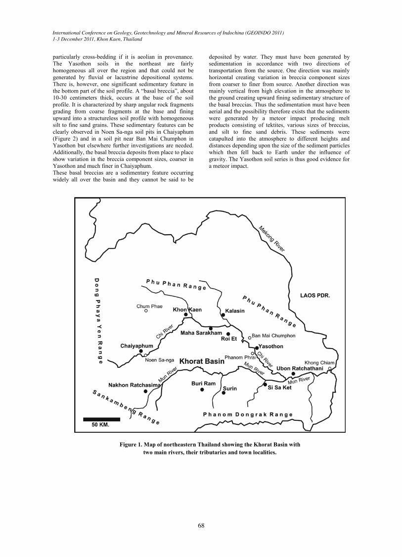
2. STUDY AREAThe study area is in the Khorat basin in the Northeast of Thailand between 101º-105º E longitude and 14º-17º Nlatitude. The area is bounded by Phu Phan ranges in the north, Dong Phaya Yen ranges in the west, Sankambeng ranges in the southwest, Phanom Dongrak ranges in the south, and high relief in the east forming a basin covering an area about 33,000 square kilometers. The elevation of the area is around 150-250 meters above mean sea leveland is named the Khorat Plateau. It covers 11 provinces including Chaiyaphum, Nakhon Ratchasima, Khon Kaen, Kalasin, Maha Sarakham, Roi Et, Buri Ram, Yasothon, Surin, Si Sa Ket, and Ubon Ratchathani (Figure 1). It is situated in the tropical zone with two distinctly different seasons, wet and dry. The wet season is between May and
Corresponding author: [email protected]
Copyright is held by the author/owner(s)GEOINDO 2011, December 1-3, 2011
International Conference on Geology, Geotechnology and Mineral Resources of Indochina (GEOINDO 2011)1-3 December 2011, Khon Kaen, Thailand
67
October and the rest of the year is dry consisting of winter and summer periods. Vegetation is mainly comprised ofdry dipterocarp forests with moist dipterocarp forests along the main rivers.
There are two main rivers in the basin, Chi River in the north and Mun River in the south flowing eastwards to join at Ban Khon Mai Yung in Ubon Ratchathani and flowingfurther eastwards joining the Mekong River at Khong Chiam. The Chi River has two main tributaries, Lam Nam Phong and Lam Pao from the northern side of the river whereas the Mun River has many tributaries flowing from the south such as Lam Ta Khong, Lam Phra Ploeng, Lam Sae, Lam Pai Mart, Huai Lam Phok, Huai Sam Ran, and Lam Dom Noi. The drainage pattern of the rivers and their tributaries in the basin is dendritic being recharged by about 1,234 to 1,476 millimeters precipitation for about 104-109 days a year.
The basin mainly contains fluvial sediments and the Yasothon soils supported by Mesozoic sandstone named in ascending succession from oldest to youngest as the Huai Hin Lat, Nam Phong, Phu Kradung, Phra Wihan, Sao Khua, Phu Phan, Khok Kruat, Maha Sarakham, and Phu Thok formations respectively. The basin has been generated by regional tectonic folding of the sandstone formations. The basin looks like a series of bowls piled up in succession from oldest to youngest with the oldest rockformation exposed at the outermost edge of the basin and the younger formations exposed in succession into the central basin. There is a series of Late Cenozoic basaltic flow in the south of the basin including Nakhon Ratchasima basalt, Buri Ram basalt, Surin basalt, Si SaKet basalt, and Ubon Ratchathani basalt (Barr and Macdonald, 1981).
The basin mainly contains unconsolidated sediments of probable Quaternary age. The lowermost sedimentary unit comprises residual mottled clay, the result of in situweathering of the Mesozoic sandstone bedrock. The next sedimentary unit is a gravel deposit with silicified wood,mainly occurring in the north of Chi River and in the south of Mun River parallel to the modern Chi and Mun rivers.An exception is in the west of the basin (west of Nakhon Ratchasima) where gravel deposits are also present between the two rivers. The uppermost part of the gravel deposits is always lateritic. Gravel sizes decreased remarkably from the west to the east and are regarded as indicating fluvial transport in an easterly direction (also reported by Löffler and Kubiniok, 1991). These gravel deposits are overlain by the Yasothon soils with a sharp contact boundary.
The Yasothon soils have obvious characteristics consisting of homogeneous fine sand to silt grain sizes, structureless
and reddish brown in color. The soils can be recognized from a long distance usually overlying the gravel deposits but other areas between the two main rivers also contain these soils. Many sandstone outcrops in Maha Sarakham, Khon Kaen, and Nakhon Ratchasima provinces, defined as
the Phu Thok Formation by some Thai geologists are possibly lateral equivalents of the Yasothon soils but have been slightly lithified. Field observations from some soil pits in Non Sa-nga, Chaiyaphum clearly show an interesting sedimentary feature consisting of small, fining upward breccias at the base of the Yasothon soil layer,about 10-30 centimeters thick. The breccias contain sharp,angular quartz sands and granules fining upwards. These characteristics are also observed in a soil pit in Ban Mai Chumphon, Mueang Yasothon, where the sandstone breccias contain much larger particles, 1-3 centimeters, buttheir general sedimentary features are still similar to the Noen Sa-nga sites
3. EVIDENCE OF METEOR IMPACTThere are three things in Khorat basin regarded as the result of a meteor impact, including tektites, Yasothon soils, and a possible impact site.3.1 TektitesTektites widely occur in the northeast from Chaiyaphum,Khon Kaen, Nakhon Ratchasima, Ubon Ratchathani, and other nearby provinces. They are black in color, glassy and composed of about 70 – 80% silica oxide (Barnes and Pitakpaivan, 1962; Barnes, 1967). There are two kinds, layered tektites and splashed tektites (Bunopas et al., 1999). The layered tektites have distinctive banding and relicts of incomplete melted parent materials which solidified on the ground shortly after impact and were distributed close to the source craters. The splashed tektites have various shapes that indicate melt solidification whilespinning and have deposited further away from the source craters with smaller sizes (Bunopas et al., 1999) and shapes varying from rounded, disc, pestle, dumbbell, eye drop, to irregular with normally a rough surface. A vast collection of over 3,000 pieces of tektites has been displayed in a private museum run by WichitPhromluangsri in Chum Phae, Khon Kaen Province. They were mainly found on gravel ground surfaces fromuncertain sources but Satarugsa (1987) and Löffler and Kubiniok (1991) reported the tektites as occurring on the top of pisolitic laterite underlying the reddish brown Yasothon soils. The tektites are reported to have both black and olive green colors in Europe, North America, and Africa with associated craters. The tektites in the northeast of Thailand are regarded as a part of the Australasian tektite strewnfield widely distributed from China, Indochina, and Australia and aged about 0.7-0.8 million years old (Lowman, 1964; Haines et al., 2004.).The precursor material of tektites is primarily of terrestrial origin generated by a meteorite impact that melts material from the Earth's surface and catapults it up to several hundred kilometers away from the impact site. Tektitesfrom Thailand are good evidence for a meteor impact of about 0.7–0.8 million years B.P. generating vast volume of sedimentwith breccias and tektites.
3.2 Yasothon soilEven though the Yasothon soils have been considered as an aeolian deposit by many workers (Boonsener, 1977; Udomchoke, 1989; Punratanasin, 2008) its structureless nature is unexplained. How can it be generated by wind currents? Wind-blown sedimentary deposits are generally homogeneous but internal structures should be present,
International Conference on Geology, Geotechnology and Mineral Resources of Indochina (GEOINDO 2011)1-3 December 2011, Khon Kaen, Thailand
68
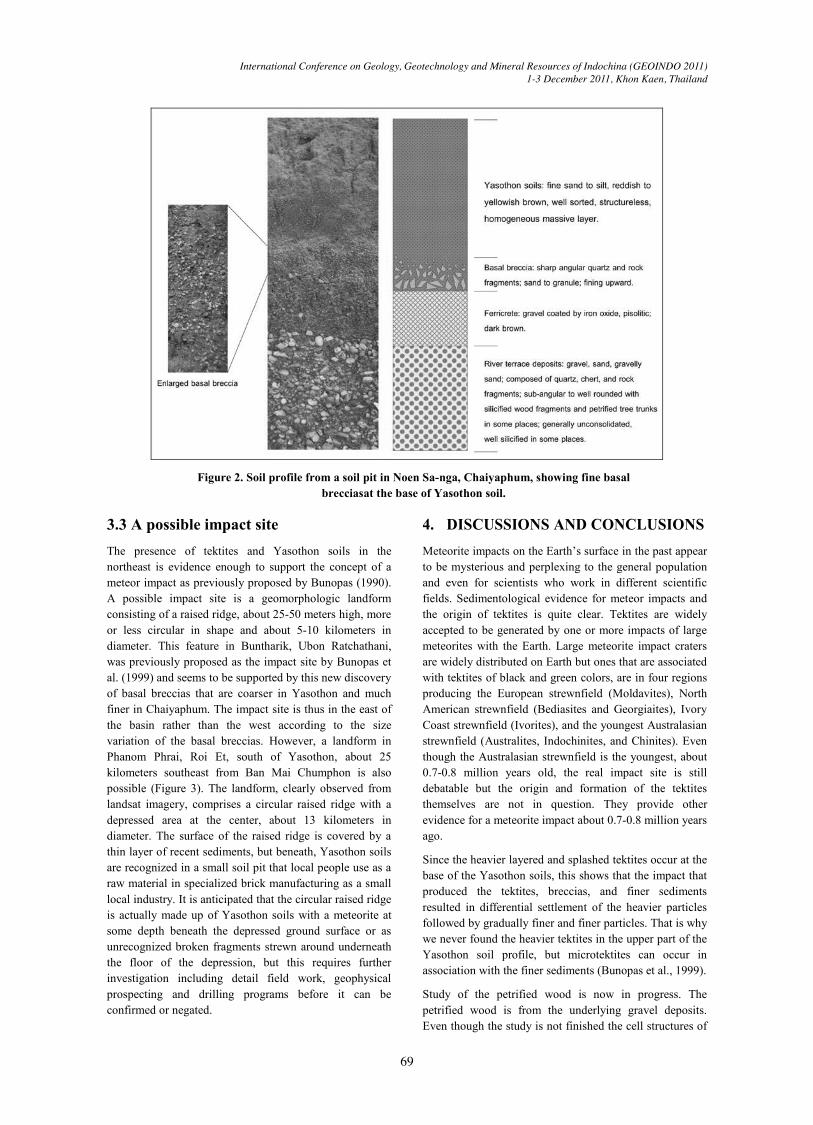
particularly cross-bedding if it is aeolian in provenance. The Yasothon soils in the northeast are fairly homogeneous all over the region and that could not be generated by fluvial or lacustrine depositional systems. There is, however, one significant sedimentary feature in the bottom part of the soil profile. A “basal breccia”, about 10-30 centimeters thick, occurs at the base of the soil profile. It is characterized by sharp angular rock fragments grading from coarse fragments at the base and fining upward into a structureless soil profile with homogeneous silt to fine sand grains. These sedimentary features can be clearly observed in Noen Sa-nga soil pits in Chaiyaphum (Figure 2) and in a soil pit near Ban Mai Chumphon in Yasothon but elsewhere further investigations are needed. Additionally, the basal breccia deposits from place to place show variation in the breccia component sizes, coarser in Yasothon and much finer in Chaiyaphum. These basal breccias are a sedimentary feature occurring widely all over the basin and they cannot be said to be
deposited by water. They must have been generated by sedimentation in accordance with two directions of transportation from the source. One direction was mainly horizontal creating variation in breccia component sizes from coarser to finer from source. Another direction was mainly vertical from high elevation in the atmosphere to the ground creating upward fining sedimentary structure of the basal breccias. Thus the sedimentation must have been aerial and the possibility therefore exists that the sediments were generated by a meteor impact producing melt products consisting of tektites, various sizes of breccias, and silt to fine sand debris. These sediments were catapulted into the atmosphere to different heights and distances depending upon the size of the sediment particles which then fell back to Earth under the influence of gravity. The Yasothon soil series is thus good evidence for a meteor impact.
Figure 1. Map of northeastern Thailand showing the Khorat Basin with two main rivers, their tributaries and town localities.
International Conference on Geology, Geotechnology and Mineral Resources of Indochina (GEOINDO 2011)1-3 December 2011, Khon Kaen, Thailand
69
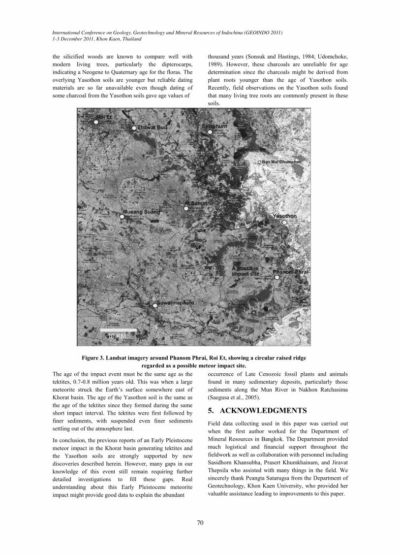
3.3 A possible impact siteThe presence of tektites and Yasothon soils in the northeast is evidence enough to support the concept of ameteor impact as previously proposed by Bunopas (1990).A possible impact site is a geomorphologic landform consisting of a raised ridge, about 25-50 meters high, more or less circular in shape and about 5-10 kilometers in diameter. This feature in Buntharik, Ubon Ratchathani, was previously proposed as the impact site by Bunopas et al. (1999) and seems to be supported by this new discoveryof basal breccias that are coarser in Yasothon and much finer in Chaiyaphum. The impact site is thus in the east of the basin rather than the west according to the size variation of the basal breccias. However, a landform in Phanom Phrai, Roi Et, south of Yasothon, about 25kilometers southeast from Ban Mai Chumphon is also possible (Figure 3). The landform, clearly observed from landsat imagery, comprises a circular raised ridge with a depressed area at the center, about 13 kilometers in diameter. The surface of the raised ridge is covered by a thin layer of recent sediments, but beneath, Yasothon soils are recognized in a small soil pit that local people use as a raw material in specialized brick manufacturing as a small local industry. It is anticipated that the circular raised ridge is actually made up of Yasothon soils with a meteorite at some depth beneath the depressed ground surface or as unrecognized broken fragments strewn around underneath the floor of the depression, but this requires further investigation including detail field work, geophysical prospecting and drilling programs before it can be confirmed or negated.
4. DISCUSSIONS AND CONCLUSIONSMeteorite impacts on the Earth’s surface in the past appear to be mysterious and perplexing to the general population and even for scientists who work in different scientific fields. Sedimentological evidence for meteor impacts and the origin of tektites is quite clear. Tektites are widely accepted to be generated by one or more impacts of large meteorites with the Earth. Large meteorite impact cratersare widely distributed on Earth but ones that are associatedwith tektites of black and green colors, are in four regionsproducing the European strewnfield (Moldavites), North American strewnfield (Bediasites and Georgiaites), Ivory Coast strewnfield (Ivorites), and the youngest Australasian strewnfield (Australites, Indochinites, and Chinites). Even though the Australasian strewnfield is the youngest, about 0.7-0.8 million years old, the real impact site is still debatable but the origin and formation of the tektites themselves are not in question. They provide other evidence for a meteorite impact about 0.7-0.8 million years ago.
Since the heavier layered and splashed tektites occur at the base of the Yasothon soils, this shows that the impact that produced the tektites, breccias, and finer sediments resulted in differential settlement of the heavier particles followed by gradually finer and finer particles. That is why we never found the heavier tektites in the upper part of the Yasothon soil profile, but microtektites can occur in association with the finer sediments (Bunopas et al., 1999).
Study of the petrified wood is now in progress. The petrified wood is from the underlying gravel deposits. Even though the study is not finished the cell structures of
Figure 2. Soil profile from a soil pit in Noen Sa-nga, Chaiyaphum, showing fine basal brecciasat the base of Yasothon soil.
International Conference on Geology, Geotechnology and Mineral Resources of Indochina (GEOINDO 2011)1-3 December 2011, Khon Kaen, Thailand
70
the silicified woods are known to compare well withmodern living trees, particularly the dipterocarps,indicating a Neogene to Quaternary age for the floras. The overlying Yasothon soils are younger but reliable dating materials are so far unavailable even though dating of some charcoal from the Yasothon soils gave age values of
thousand years (Sonsuk and Hastings, 1984; Udomchoke, 1989). However, these charcoals are unreliable for age determination since the charcoals might be derived from plant roots younger than the age of Yasothon soils. Recently, field observations on the Yasothon soils found that many living tree roots are commonly present in thesesoils.
Figure 3. Landsat imagery around Phanom Phrai, Roi Et, showing a circular raised ridge regarded as a possible meteor impact site.
The age of the impact event must be the same age as the tektites, 0.7-0.8 million years old. This was when a large meteorite struck the Earth’s surface somewhere east of Khorat basin. The age of the Yasothon soil is the same as the age of the tektites since they formed during the same short impact interval. The tektites were first followed by finer sediments, with suspended even finer sediments settling out of the atmosphere last.
In conclusion, the previous reports of an Early Pleistocene meteor impact in the Khorat basin generating tektites and the Yasothon soils are strongly supported by new discoveries described herein. However, many gaps in our knowledge of this event still remain requiring further detailed investigations to fill these gaps. Real understanding about this Early Pleistocene meteorite impact might provide good data to explain the abundant
occurrence of Late Cenozoic fossil plants and animals found in many sedimentary deposits, particularly thosesediments along the Mun River in Nakhon Ratchasima(Saegusa et al., 2005).
5. ACKNOWLEDGMENTSField data collecting used in this paper was carried out when the first author worked for the Department of Mineral Resources in Bangkok. The Department provided much logistical and financial support throughout the fieldwork as well as collaboration with personnel including Sasidhorn Khansubha, Prasert Khumkhainam, and Jiravat Thepsila who assisted with many things in the field. We sincerely thank Peangta Satarugsa from the Department of Geotechnology, Khon Kaen University, who provided her valuable assistance leading to improvements to this paper.
International Conference on Geology, Geotechnology and Mineral Resources of Indochina (GEOINDO 2011)1-3 December 2011, Khon Kaen, Thailand
71
6. REFERENCESBarnes, V.E., 1967. Tektites. International dictionary of
geophysics 2: 1507-1518.
Barnes, V.E., and Pitakpaivan, K., 1962. Origin of Indochinite tektites. Proceedings of the National Academy Sciences, USA 48: 947-955.
Barr, S.M., and Macdonald, A.S., 1981. Geochemistry and geochronology of Late Cenozoic basalt of Southeast Asia. Geological Society of America Bulletin, Part II, vol. 92: 1069-1142.
Boonsener, M., 1977. Engineering geology of the town of Khon Kaen, northeastern Thailand. Master Thesis No. 1023, Asian Institute of Technology, Thailand.
Bunopas, S., 1990. Tektites-Their origin and the continental catastrophic destruction in NE Thailand and Indochina. Proceedings of the 16th Conference on Sciences and Technology of Thailand, 25-27 October 1990, Bangkok: 512-513.
Bunopas, S., Wasson, J.T., Vella, P., Fontaine, H., Hada, S., Burret, C., Suphajunya, T., and Khositanont, S., 1999. Catastrophic loess, mass mortality and forest fires suggest that a Pleistocene cometary impact in Thailand caused the Australasian tektite field. Journal of the Geological Society of Thailand 1: 1-17.
Dheeradilok, P., and Chaimanee, N., 1986. A hypothesis for the origin of the sediments of the Neogene Khorat lake basin and recent deposits of the Songkhla Lake basin. Abstract for the International GeologicalCorrelation Program (IGCP), 3-7 February 1986,Haadyai, Thailand.
Haines, P.W., Howard, K.T., Ali, J.R., Burret, C.F., and Bunopas, S., 2004. Flood deposits penecontemporaneous with ~0.8 Ma tektite fall in NE Thailand: impact-induced environmental effects? Earth and Planetary Science Letters 225(1-2): 19-28.
Löffler, E., and Kubiniok, J., 1991. The age and origin of the Yasothon soils and associated gravel deposits. Journal of the Geological Society of Thailand 1(1): 69-74.
Lowman, P.D., 1964. The origin of tektites - a review. School Science and Mathematics, 64: 37-46.
Moormann, F.R., Montrakun, S., and Panichapong, S., 1964. Soils of North Eastern Thailand. Department of Land Development, Bangkok.
Punratanasin, P., 2008. The capacity of improved Khon Kaen loess as a road construction material. Advance in Transportation Geotechnics, Taylor & Francis Group, London: 535-540.
Saegusa, H., Thasod, Y., and Ratanasthien, B., 2005. Notes on Asian stegodontids. Quaternary International 126-128: 31-48.
Satarugsa, P., 1987. Engineering geology of Khorat City.Master Thesis, Asian Institute of Technology, Bangkok, Thailand.
Sonsuk, M., and Hastings, P.J., 1984. An age for the Yasothon soil series in the Sakhon Nakhon basin. Journal of the Geological Society of Thailand VII: 1-11.
Udomchoke, V., 1989. Quaternary stratigraphy of the Khorat Plateau area, northeastern Thailand. in N. Thiramongkol (ed.) Proceedings of the Workshop on Correlation of Quaternary Successions in South, East and Southeast Asia, pp. 69-94, Department of Geology, Chulalongkorn University, Bangkok.