Embed Size (px)
Citation preview

Evidences of early to late fluid migration from an upper Miocene turbiditic
channel revealed by 3D seismic coupled to geochemical sampling within
seafloor pockmarks, Lower Congo Basin
A. Gay a,*, M. Lopez b, P. Cochonat c, D. Levache d, G. Sermondadaz d, M. Seranne b
a Challenger Division for Seafloor Processes, National Oceanography Centre of Southampton, Southampton, UKb Laboratoire Dynamique de la Lithosphere, Universite Montpellier 2, Montpellier, France
c Laboratoire Environnements Sedimentaires, Departement Geosciences Marines, IFREMER, Brest, Franced TOTAL, Pau, France
Received 8 October 2004; received in revised form 16 February 2006; accepted 17 February 2006
Abstract
Using high quality 3D seismic data within the Lower Congo Basin (LCB), we have identified pockmarks that are aligned above the sinuous belt
of a buried turbiditic palaeo-channel, 1000 m beneath the seafloor. Geochemical analyses on cores (GC traces), taken in the centre of four of these
pockmarks along this channel, show no clear evidence for migrated oil. But, some features of the GC traces, including elevated baselines (UCMO
34 mg/g) and a broad molecular weight range of n-alkanes with little odd–even preference, may be interpreted as indicating the presence of
thermogenic hydrocarbons in the cores.
Seismic profiles show that these pockmarks developed above two main features representative of pore fluid escape during early compaction: (1)
closely spaced normal faults affecting the upper 0–800 ms TWT of the sedimentary column. This highly faulted interval (HFI) appears as a
hexagonal network in plane view, which is characteristic of a volumetrical contraction of sediments in response to pore fluid escape. (2) Buried
palaeo-pockmarks and their underlying chimneys seem to be rooted at the channel–levee interface. The chimneys developed during early stages of
burial and are now connected to the HFI.
This study shows that the buried turbiditic channel now concentrates thermogenic fluids that can migrate through early chimneys and polygonal
faults to reach the seafloor within some pockmarks. Using a multidisciplinary approach within the Lower Congo Basin, combining 3D seismic
data and geochemical analyses on cores, we trace the fluid history from early compaction expelling pore fluids to later migration of thermogenic
hydrocarbons.
q 2006 Elsevier Ltd. All rights reserved.
Keywords: Pockmarks; Turbiditic channels; Fluid migration; Polygonal faults; Seismic chimneys; Pipes
1. Introduction
Gases of thermal origin in near-surface sediments are
believed to have been generated at greater depth and migrated
to the surface (Leythaeuser et al., 1982, 2000). Detection of
near-surface thermal hydrocarbons could obviously be of
economic importance because it offers the possibility of direct
geochemical hydrocarbon prospecting and exploration
(Wenger and Isaksen, 2002; Abrams, 1992; Horvitz and Ma,
0264-8172/$ - see front matter q 2006 Elsevier Ltd. All rights reserved.
doi:10.1016/j.marpetgeo.2006.02.004
* Corresponding author. Address: National Oceanography Centre of South-
ampton, Room 786/12, Empress Dock, Southampton SO14 3ZH, UK. Tel.:
C44 23 8059 6614.
E-mail address: [email protected] (A. Gay).
1988; Faber and Stahl, 1984; Horvitz, 1972, 1978). The origin
of hydrocarbons in shallow sediments and the applicability of
geochemical surface data in petroleum prospecting is still
controversial due to difficulties in data interpretation and in the
principal understanding of the effects of biodegradation and
vertical migration of hydrocarbons from deep source rocks to
the surface (Faber et al., 1998; Hunt, 1990; Fuex, 1977).
Due to the low matrix permeability of argillaceous
mudstone, fluid flow through the sedimentary column is quite
slow and diffusive but it is compensated for by long Ma
timescale. However, active gas venting is clearly controlled
by subsurface structures such as faults and faulted anticlines
(Eichhubl et al., 2000). Evidence of focused fluid flow through
the sedimentary column is seen (1) on the surface by
pockmarks that are consistently located above faults of
a polygonal fault interval (Gay et al., 2004) and (2) in the
Marine and Petroleum Geology 23 (2006) 387–399
www.elsevier.com/locate/marpetgeo

A. Gay et al. / Marine and Petroleum Geology 23 (2006) 387–399388
sedimentary column by seismic chimneys that are indicative of
deeper reservoirs (Gay et al., 2003; Heggland, 1998). Seeps
associated with diapiric features in offshore West Africa are
often abundant and are often very large (visibly oil-stained
sediments, very high petroleum concentrations), actively
migrating, associated with high concentrations of gas with a
thermogenic component and sometimes supporting oil
slicks on the sea surface (Wenger and Isaksen, 2002). Even
when seeps are authenticated, their presence does not
prove economic hydrocarbon accumulations at depth, seal
failure or gas displacement from reservoirs (Wenger and
Isaksen, 2002). In the Lower Congo Basin (LCB), we have
identified pockmarks related to a deep buried turbiditic
channel (i.e. upper Miocene). Using a multidisciplinary
approach, combining 3D seismic data and geochemical
analyses on shallow sediments (Fig. 1), we trace the fluid
history from early compaction expelling pore fluids to
later migration of deep thermogenic hydrocarbons from
the upper Miocene turbiditic channel. Although our examples
are specific to the LCB, it is hoped that the dynamical
model proposed may find applicability in other basins
characterized by similar post-rift stratigraphy.
Fig. 1. Bathymetric map of the Congo–Angola Basin issued from the EM-12 multibe
area (grey-shaded rectangle) is located on the north flank of the present day Zaire cha
in this zone are reported.
2. Data base, sample selection and analyses
This study was primarily based on 3D seismic datasets from
the Lower Congo Basin (LCB) acquired by the TOTAL oil
company (Fig. 1). The selected 3D-dataset covers an area of
4150 km2 with a line spacing of 12.5 m, a CDP distance of
12.5 m and a vertical resolution of 4 ms. The data were loaded
on a workstation and interpreted using the SISMAGE software
developed by TOTAL. The bathymetric and reflectivity maps
were acquired with a Simrad EM12 dual multibeam.
Complementary data collected more recently with the Simrad
EM300 dual multibeam provide higher vertical and lateral
resolution for acquisition in water depth less than 3500 m. Data
from the ODP Leg 175 on the West African margin (see Fig. 1
for location) have constrained the stratigraphic record,
sedimentation rates and mechanical properties of Pliocene to
Recent sediments (Wefer et al., 1998a).
Core locations were chosen on the basis of strong evidence
of gas on seismic profiles (seismic chimney above a bottom
simulating reflector (BSR) and a free gas zone) and indications
of actual seepage processes (i.e. pockmark) on the seafloor
identified on 3D seismic data and on reflectivity maps (cores
am bathymetry acquired during the ZAIANGO project (1998–2000). The study
nnel between 1000 and 1800 m water depth. The three sites of the Leg ODP 175

Table 1
Synthesis of geochemical analyses conducted on the cores (Ca, Cb, Cc and Cd) taken within four different pockmarks along the upper Miocene channel
Depth (m) Imax TSF d13C (C1)
(‰)
C1 (ppm) C2 (ppm) C3 (ppm) iC4 (ppm) nC4 (ppm) Total C5–C7
(ppm)
Ca 1.2–1.4 902 – 77,330 316 146 39 745 166,900
1.8–2.0 5110 K70.32 73,264 282 83 21 424 21,439
2.6–2.8 563 – 62,128 187 80 28 682 197,434
Cb 1.2–1.4 638 – 512 6 10 3 27 17,262
1.8–2.0 4095 K86.81 1 23 64 15 238 24,767
2.4–2.6 2001 – 65,443 286 26 2 20 12,157
Cc 2.2–2.4 1344 – 36 8 39 24 120 232,826
3.2–3.4 698 – 29 8 46 21 87 86,342
4.4–4.6 21,155 – 34 7 9 1 20 14,057
Cd 1.8–2.0 2118 – 23 7 3 1 4 15,314
2.8–3.0 1306 – 125 9 4 2 4 31,151
4.0–4.2 6332 – 54 9 3 1 1 13,098
Three samples (depth in metres below seafloor) have been analysed for each core, showing strong concentrations of C1 (methane) within sediments of the cores Ca
and Cb. Extract yields and fluorescence intensities are relatively high (4000!Imax TSF!21,000) compared to other cores from the Congo–Angola Basins (!1000;
TOTAL, personal communication), which could be interpreted as indicating the presence of thermogenic hydrocarbons in the core. The isotopic analyses show a
value of d13CZK70‰ for Ca and K86‰ for Cb (relative to PDB).
A. Gay et al. / Marine and Petroleum Geology 23 (2006) 387–399 389
Ca, Cb, Cc and Cd on Fig. 3) between 1300 and 1700 m water
depth. Headspace gas concentrations (C1–C7) were measured
on all sections of cores with a GC–FID chromatography
system. The gases were resolved into separate peaks, which are
quantified in parts per million compared to a previously
calibrated standard. The samples were oven dried (40 8C) and
soxhlet extracted with n-hexane. The total extract was reduced
in volume. An aliquot of each sample was then scanned by
fluorometer to determine the maximum emission intensity with
a Perkin–Elmer LS50B Fluorometer. For the GC15C and GC–
MS analysis, hydrocarbon fractions were injected onto a
chromatography system. The mixture was resolved into
0 2000Metres
0
1000
ms
TW
T
Source
Res
A
Fig. 2. Line drawing of the seismic profile AB. The post-rift stratigraphy is character
containing the source rocks and (2) an Oligocene to Present sequence containing the r
faulting). Deep thermogenic fluids migrating from the source rocks are preferentially
1999).
separate peaks with an unresolved complex mixture (UCM):
three internal standards (heptamethylnonane, chloro-octade-
cane and squalane) were added to calibrate the peaks and UCM
response. Another aliquot was injected onto a capillary gas
chromatograph (HP 6890 Series GC System) fitted with a flame
ionisation detector through a split inlet with electronic pressure
control.
Several methods can be used to determine the sources of
gaseous and liquid hydrocarbon, such as the gas composition
(ratio of C1/C2), the maximum intensity of TSF, GC and GC–
MS (mass-spectrometry) analyses and the carbon isotopic ratio
of C1 (Prinzhofer et al., 2000; Abrams, 1996; Kastner et al.,
Interval affected bythe polygonal faulting
Interval with turbiditicchannels
Interval of source-rocks
Pre-rift
Plio-Pleistocene
Oligocene to Miocene
Albian to Eocene
Salt (Aptian)
rocks
Cover
ervoirs
B
ized by two superposed seismic architectures: (1) an Albian to Eocene sequence
eservoirs (turbiditic channels) and the sedimentary cover (affected by polygonal
trapped into the silty–sandy channels, playing the role of reservoirs (Burwood,

A. Gay et al. / Marine and Petroleum Geology 23 (2006) 387–399390
1995; Saunders et al., 1993; Brooks et al., 1983; Reitsema,
1978). Results are reported in Table 1.
3. Geological settings
The Lower Congo Basin is one of the numerous sub-basins
that developed during the opening of the West African passive
margin in the early Cretaceous (130 Ma) (Marton et al., 2000;
Jansen et al., 1984a,b). Following the deposition of thick
evaporites during mid-Aptian time (Karner et al., 1997), the
margin developed in three phases between the late Cretaceous
and the Present (Seranne et al., 1992) (Fig. 2):
(1) From late Cretaceous to early Oligocene. This period was
characterized by low-amplitude/low-frequency sea-level
Fig. 3. Up: dip map of seafloor within the Lower Congo Basin, calculated from the
associated with faults or salt diapirs. Four cores (Ca, Cb, Cc and Cd) have been take
oriented E–W. Down: reflectivity map acquired by IFREMER with a EM12 multib
changes and an even climate (greenhouse period)
(Seranne, 1999). These eustatic and climatic conditions
led to the deposition of an aggradational carbonate/
siliciclastic ramp. This interval is characterized by marine
source rocks producing thermogenic oils and gases
(Burwood, 1999) (Fig. 2).
(2) From early Oligocene to Pliocene. The major change in
oceanic circulation has led to the formation of an ice cap.
The environmental conditions were characterized by high-
amplitude/high-frequency eustatic variations and an
alternating drier and wetter climate (ice-house period)
(Seranne, 1999). The sedimentation was dominated by the
progradation of a terrigenous wedge that has led to the
formation of the large turbiditic fan off Congo and Angola
slope (Droz et al., 1996; Uchupi, 1992; Brice et al., 1982).
3D seismic datasets. This map shows fluid seeps evidences such as pockmarks
n within four different isolated pockmarks aligned along a band, 5–10 km wide,
eam. Small dark patches represent pockmarks on the seafloor.

Fig. 4. Seismic profile CD across an upper Miocene turbiditic channel. This profile illustrates the close relationship between an active pockmark on seafloor, an
underlying seismic chimney, the upward deflected BSR, an interval with high amplitude reflectors interpreted as a free gas zone, and a deep buried (O600 m)
turbiditic channel. Geochemical analyses conducted on core Ca have shown evidences of thermogenic fluids within shallow sediments.
A. Gay et al. / Marine and Petroleum Geology 23 (2006) 387–399 391
This fan is mainly composed of turbiditic palaeo-channels
(Oligo–Miocene interval). Thermogenic fluids migrating
upward are preferentially trapped into these silty–sandy
channels, playing the role of reservoirs (Burwood, 1999)
(Fig. 2). Further south, turbidite sands are commonly
associated with three major depositional sequences in the
Block 4 within the Angola basin (Anderson et al., 2000):
the 17.5–15.5 Ma sequence (Burdigalian, early Miocene),
the 8.2–6.3 Ma sequence (Tortonian, late Miocene),
and the 6.3–5.5 Ma sequence (Messinian, late Miocene).
(3) From early Pliocene to Present. The shelf and the slope are
deeply incised by a canyon that directly connects the
Congo River with the basin floor. Analyses conducted
during ODP Leg 175 have shown that turbidity currents
played a minimal role in transporting sediment within this
part of the Lower Congo Basin (Pufahl et al., 1998;
Giraudeau et al., 1998). Coarse sediments trapped into the
canyon were carried far onto the lower fan (Savoye et al.,
2000; Uenzelmann-Neben, 1998; Jansen et al., 1984a,b)
while only muddy sediments are deposited on the slope
(Cooper, 1999; Wefer et al., 1998b) and mixed with
hemipelagic sediments. The Pliocene–Present interval is
considered as a good seal above the Oligocene–Miocene
turbiditic interval (Fig. 2) (Burwood, 1999).
One of the main tectonic features of the West African
margin is the gravitational sliding of post-rift sediments above
a decollement layer made up of Aptian evaporites (Liro and
Cohen, 1995; Duval et al., 1992; Lundin, 1992). In the Lower
Congo Basin, gravitational processes created two structural
domains each about 100 km wide: an extensional domain on
the upper slope and a compressive domain located down slope
(Fig. 2). The extensional domain is locally associated with
large amounts of extension across listric faults creating
individual rafts and grabens (Rouby et al., 2002; Duval et al.,
1992; Burollet, 1975).
4. Organisation of seafloor pockmarks
In the southern part of the study area, the seafloor is
characterized by small circular pockmarks, ranging from 100 to
300 m in diameter, and from a few meters to a maximum of
20 m in depth (Fig. 3). These pockmarks appear as small
patches on the reflectivity map. These could be due to the
presence of carbonate concretions and chemosynthetic com-
munities within the depression (Gay et al., 2006). Although
pockmarks seem unorganised, they are aligned along a band,
5–10 km wide, oriented E–W (Fig. 3). The seismic profile CD
across a pockmark (core Ca location) displays two

Fig. 5. ‘Chaotism’ map of the upper Miocene turbiditic channel. The seismic block has been transformed into a ‘Chaotism’ block using the SISMAGE software. The
average value of ‘Chaotism’ within the upper Miocene interval is then calculated and projected on a map view. This map exhibits a variety of forms including high
sinuosity channels with well-developed levee systems or relatively straight channel segments. The overall trend of the channel is E–W, which is consistent with the
sediment supply from the Zaire River. Seafloor pockmarks are consistently located over the upper Miocene channel, suggesting that fluids are originating from this
level. Cores Ca to Cd are reported on this map.
A. Gay et al. / Marine and Petroleum Geology 23 (2006) 387–399392
superimposed acoustic anomalies, vertically elongated under
the pockmark (Fig. 4). The shallowest anomaly is ovoid in
shape with depressed high-amplitude reflectors interpreted as a
reduction in seismic velocities (pull-down effects) through a
gas-charged column. Such acoustic anomalies are also called
seismic chimneys, and could be indicative of fluid flow from
deeper levels (Tingdahl et al., 2001; Hempel et al., 1994) and
of deeper reservoirs (Heggland, 1998). The deepest anomaly
characterized by acoustic turbidity corresponds to an inverted
cone shape, marked by a fadeout of the reflectors. On both sides
of this region, the bright reflectors shift upward. Profile CD
(Fig. 4) shows a high-amplitude reflection parallel to the
seafloor located at 250 ms TWT. This is a bottom simulating
reflector (BSR), which is often considered as the lower
thermodynamic limit of the gas hydrate stability zone (Shipley
et al., 1979). BSR’s are characterized by reversed polarity
compared to the seafloor reflection, indicating a downward
reduction of seismic impedance and therefore of seismic
velocity. This contrast in impedance is probably due to the
presence of free gas trapped below the gas hydrate stability
zone, and the BSR can be considered as the interface between
E F
0
100
200
300
400
500
600
700
800
msTWTbelow seafloor
I
M
P
m 10000
PolygonalFault
Interval
Fig. 6. Left: random seismic section EF, parallel to the main slope and perpendicula
fault interval reaching the present day seafloor in the Lower Congo Basin. It is char
first 0–600 m of the sedimentary column. Right: detailed dip map of base Quaternary
faults in plane view. The formation of polygonal faulting may be due to the volume
high-velocity gas hydrates and the underlying gas-charged
sediments of low acoustic velocity. On this profile, the BSR is
deflected upward directly beneath the pockmark depressions,
suggesting a localized positive heat flow anomaly. This dome-
shaped anomaly could be due to an ascending movement of
fluids through the sedimentary column (De Batist et al., 2002).
The seismic chimney seems to take root on the top of an upper
Miocene turbiditic palaeo-channel. This channel appears on the
seismic as high-amplitude packages with strongly scoured/
erosional bases indicating deposition in a largely channelized
environment.
5. Cartography of the upper Miocene turbiditic channel
Due to the discontinuous character of turbiditic channels
and infills, automatic picking of sand bodies is difficult within
these intervals. Based on the amplitude of reflectors and their
continuity, the SISMAGE software developed by TOTAL
allows the calculation of the ‘Chaotism’ amplitude from a 3D
seismic block, using a running window semblance-based
algorithm. ‘Chaotism’ sliced in time or draped on a surface
E
F
Vry
Upperiocene
liocene
Km 50
Dip map of Base IVry
r to the polygonal faults. This profile exhibits the seismic facies of a polygonal
acterized by numerous closely spaced (100–500 m) normal faults affecting the
within the polygonal fault interval. This map highlights the polygonal pattern of
trical contraction of fine-grained sediments during early stages of compaction.

A. Gay et al. / Marine and Petroleum Geology 23 (2006) 387–399 393
helps define faults and stratigraphy by looking for disconti-
nuities or boundaries surrounding areas of interest. This
attribute highlights high chaotic sedimentary bodies (channel
deposits, abandoned channel infill) in black and low chaotic
deposits (channel levees, surrounding hemipelagic sediments)
in white. In the new 3D-Chaotism block, the upper Miocene
turbiditic channels exhibit a variety of forms including high
sinuosity channels with well-developed levee systems or
relatively straight features in map view (Fig. 5). Depositional
processes are believed to have been responsible for the
dominantly linear shape and channelized cross-sectional
geometry of reservoirs. The dominant orientation of turbiditic
channels corresponds to the direction of the sediment supply
issued from the Zaire River mouth and is related to the
progradation of the Zaire fan pro-delta across the study area.
Fig. 5 shows aligned pockmarks that are consistently
located above the upper Miocene turbiditic channel. This
observation suggests that fluids are originating from the
underlying channel to rise through seismic chimneys.
However, the Pliocene–Present interval is considered to act
as a seal, mainly because of its fine-grained content. This
interval is affected by a large number of polygonal faults,
which act as migration conduits for driving up fluids entrapped
Fig. 7. Seismic profile GH across the upper Miocene turbiditic channel. This
profile shows two buried seismic chimneys, which seem to take root on both
sides of the channel. These chimneys developed at shallower burial depth
during early compaction (Gay et al., 2003). Geochemical analyses realized on
core Cb have revealed strong evidences of deep thermogenic fluids.
within underlying sandy reservoirs (Gay et al., 2004; Lonergan
et al., 2000). We consider that the polygonal fault interval may
compromise the seal capacity of the Pliocene–Present
sedimentary cover.
6. Role of polygonal faults
The representative seismic section EF (Fig. 6) shows
the seismic expression of a polygonal fault interval in the
first 0–800 ms TWT below seafloor. It is characterized by
numerous closely spaced normal faults, which have small
offsets (5–30 m) and an average spacing of 100–500 m (Gay
et al., 2004). A dip map of a horizon located in the northern part
of the study area discloses a dense fault network with
polygonal pattern in plane view (Fig. 6). The polygons size
ranges from 1 to 3 km and they share their edges with the
adjacent polygons. Since the first recognition of a polygonal
fault system in the Leper Clay of Belgium (Henriet et al.,
1991), numerous examples of layer-bound polygonal fault
systems have been described worldwide from 3D seismic data
(Cartwright and Dewhurst, 1998; Lonergan et al., 1998;
Cartwright and Lonergan, 1997; Oldham and Gibbins, 1995;
Cartwright, 1994; Poag and Watts, 1987; Klitgord and Grow,
1980). It thus appears that lithology plays a key role in the
development and in the inhomogeneous frequency of faults
(Dewhurst et al., 1999a,b). Faulted intervals are now
interpreted as a layer-parallel volumetric contraction of fine-
grained sediments leading to pore fluids escape (Cartwright
and Lonergan, 1996). It thus appears that polygonal faulting
starts at the water-sediment interface, suggesting that expulsion
of fluids is initiated as the sediments are still unconsolidated
(Gay et al., 2004).
7. Early formation of conduits
The seismic profile GH (Fig. 7) across a pockmark (core Cb
location) shows two seismic chimneys branching on both sides
of an upper Miocene channel (see Fig. 3 for location). Their
bases are located at the channel–levee interface, where they
seem to take root because of the lack of any deeper seismic
anomaly. At about 250 m above the turbiditic channel, the
seismic chimneys end abruptly at the same time: they are
covered by circular depressions corresponding to palaeo-
pockmarks, now sealed by muddy Mid-Pliocene to Present
sediments. As previously described for the Pleistocene shallow
buried channel on the right flank of the Zaire Canyon, the
sediment overburden may stop the fluid escape and seal the
pockmarks if it exceeds 240 m (Gay et al., 2003). This could
indicate the syn-sedimentary escape of pore-fluids during the
deposition of sediments over the upper Miocene channel. The
development of a pockmark on the seafloor clearly indicates
that fluid escape continued after sealing of palaeo-pockmarks
and fluids have migrated mainly through the polygonal fault
interval.
40°Dip
0°
0 5Km
1500
ms
2000
ms
Ca
CbCc
Cd
Depth: 2.6-2.8 m Depth: 4.0-4.2 m Depth: 4.4-4.6 m Depth: 2.4-2.6 m
50
5
nC35
nC30
nC25
nC20
Pris
tane
Phy
tane
Tim
e(in
min
)
100
25
Depth: 1.8-2.0 m Depth: 2.8-3.0 m Depth: 3.2-3.4 m Depth: 1.8-2.0 m
Depth: 1.2-1.4 m Depth: 1.8-2.0 m Depth: 2.2-2.4 m Depth: 1.2-1.4 m
Core Ca Core CdCore CcCore Cb
n-AlkanesUCM
19.9922.12
14.2220.70
19.6428.73
13.7326.67
n-AlkanesUCM
19.7735.62
138.4650.72
17.2026.42
52.0434.09
n-AlkanesUCM
15.9719.96
34.8936.30
54.7464.25
28.3325.58
(in ug/g)
(in ug/g)
(in ug/g)
Upper Miocenechannel axis
50
100
50
100
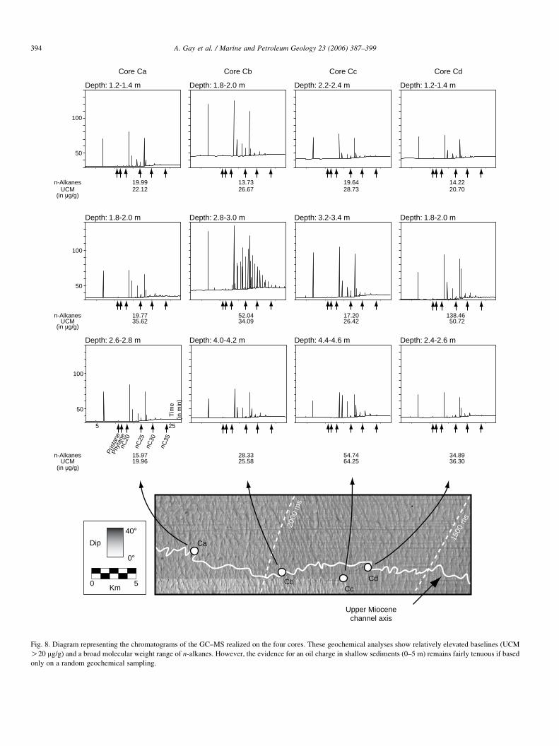
Fig. 8. Diagram representing the chromatograms of the GC–MS realized on the four cores. These geochemical analyses show relatively elevated baselines (UCM
O20 mg/g) and a broad molecular weight range of n-alkanes. However, the evidence for an oil charge in shallow sediments (0–5 m) remains fairly tenuous if based
only on a random geochemical sampling.
A. Gay et al. / Marine and Petroleum Geology 23 (2006) 387–399394

A. Gay et al. / Marine and Petroleum Geology 23 (2006) 387–399 395
8. Geochemical analyses on cores within isolated
pockmarks
In addition to possible biodegradation in the reservoir,
hydrocarbons are known to be oxidized by bacteria in the first
10 m below seafloor, in the aerobic zone and in the sulphate-
reducing interval (Wenger and Isaksen, 2002; Devol and
Ahmed, 1981; Bernard et al., 1978; Claypool and Kaplan,
1974). It is thus important to understand the processes
controlling the distribution of migrated and in situ hydro-
carbons in surficial sediments to detect anomalous migrated
hydrocarbons. A number of geochemical signatures can be
expected including that of a biogenic gas (including back-
ground gas), a migrated thermogenic gas or a mixed biogenic–
thermogenic.
More than 150 gravity cores were collected on the whole
Congo–Angola Basin by TOTAL. Four of these cores (Ca, Cb,
Cc, and Cd) were taken within pockmarks in the study area.
They are located above the upper Miocene channel at different
positions along the channel axis (Fig. 8). These cores were
chosen on the basis of actual/recent fluid seepage evidence
(underlying seismic chimney, hydrogen sulphide odor when
opening cores, carbonate concretions within the core).
Core Ca is characterized by a medium grey clay containing
carbonate concretions. The number of concretions increases
with depth. The core exhibited a strong sulphide odor when
opened. The sediments within core Cb are reddish brown very
soft clays overlying dark greenish grey clays with numerous
cemented sediment nodules up to 3 cm across. The sediments
exhibit a strong hydrogen sulphide odor. Core Cc is composed
of very soft dark greenish grey pure clays with occasional sand
sized particles in the upper sections of the core. Core Cd
corresponds to reddish brown very soft clays overlying very
soft clays with occasional sand sized particles.
Geochemical analyses conducted on these cores (Table 1)
show that extract yields and fluorescence intensities are
relatively high (4000!Imax TSF!21,000) compared to
other cores from the Congo–Angola Basins (!1000;
TOTAL, personal communication). The GC traces showed
no clear evidence for migrated oil but abundant evidence for
recent organic material, which tend to mask evidence of
thermogenic migrated hydrocarbons on chromatograms
(Fig. 8). But, some features of the GC traces, including
elevated baselines (UCMO20 mg/g) and a broad molecular
weight range of n-alkanes with little odd–even preference
(Fig. 8), could be interpreted as indicating the presence of
thermogenic hydrocarbons in the core.
Headspace analysis of C1–C7 (Table 1) show that the cores
Ca and Cb have high methane (C1) content and their isotopic
analyses show a value of d13CZK70‰ for Ca andK86‰ for
Cb (relative to PDB). Abundance ratios, heavier than K20 to
K50‰ are believed to be of thermal origin and ratios lower
than K70‰ are considered to be biogenic in origin (Brooks
et al., 1984; Tissot and Welte, 1984). The isotopic values of
cores Ca and Cb should therefore be interpreted as biogenic
gases. In order to complete geochemical interpretation of
the hydrocarbons (liquid fraction), extracts were selected for
GC–MS analysis. They contained clearly recognizable oil
fingerprints. These have been interpreted as most likely derived
from a marine Tertiary siliciclastic source rock with land plant
input (TOTAL, personal communication). The molecular
ratios of aromatic compounds analysed by GC–MS are
consistent with a mature source rock. The use of a complete
geochemical analysis thus shows that fluids reaching the
seabed can be interpreted as a mix of biogenic and thermogenic
gases.
9. Discussion
In the area of isolated pockmarks, there is a close
relationship between pockmarks, underlying chimneys,
upward deflection of the BSR (if present) and an
upper Miocene turbiditic channel. In the Lower Congo Basin,
turbidite sands are associated with three main stages of
deposition (Anderson et al., 2000): Burdigalian (17.5–
15.5 Ma), Tortonian (8.2–6.3 Ma) and Messinian (6.3–
5.5 Ma). The stacking patterns of the upper Miocene channels
comprise fine to medium grained massive sands overlain by a
fining upwards package interpreted as a channel abandonment
facies or as overbanks to an adjacent channel (Anderson et al.,
2000). The massive sands often form the basal units of
sequences that grade upwards into a succession of horizontally
laminated fine sands and silts, overlain by wavy, lenticular
bedded silts and interbedded muds. Due to the high porosity of
silts and sands within the channel infill, the upper Miocene
channel may concentrate thermogenic fluids migrating from
underlying source rocks. Syn-depositional major faults located
above turbiditic sand bodies may periodically act as main
vertical fluid escape pathways (Lonergan et al., 2000).
However, the main problem is the ability of fluids to migrate
through the impermeable Pliocene–Present cover. Detailed
observation of seismic profile GH (Fig. 7) has shown that fluids
may migrate through a polygonal fault interval that developed
during early stages of compaction (Gay et al., 2004). A study of
the organisation of faults shows that the pockmarks are
consistently located at the intersection of three neighbouring
hexagons (Gay et al., 2004). The triple-junction of three
neighbouring hexagonal cells represents a preferential pathway
for upward fluid migration from deeper levels. Consequently,
the polygonal fault interval represents an interval with a high
drainage potential for pore fluids. In this context, the fluids
migrating from deeper levels are preferentially driven through
this interval along the pre-existing faults, which affect all of the
polygonal fault interval. Faults are commonly considered
conduits through which hydrocarbons migrate vertically from
the source rock into shallower reservoirs. Faults may act either
as permeable conduits for the vertical channelized flow of
hydrocarbons (Hooper et al., 2002) or, over time, juxtapose
permeable beds allowing hydrocarbons to spill across sand-on-
sand contacts (Allan, 1989). Geochemical analyses conducted
on cores Ca and Cb within shallow sediments of pockmarks
over the upper Miocene channel show strong evidence of a mix
of biogenic methane and thermogenic fluids (methane and
heavier hydrocarbons). The presence of thermogenic fluids

A. Gay et al. / Marine and Petroleum Geology 23 (2006) 387–399396
within shallow sediments of cores Ca and Cb represents
evidence of thermogenic fluid migration from the reservoir (i.e.
the upper Miocene channel) up to the seafloor through the
polygonal fault interval.
A dynamic model is proposed for the LCB, which takes into
account both kinds of sedimentation, turbiditic sedimentation
building channel–levee systems on the slope and hemipelagic
sedimentation, which tends to seal the first one (Fig. 9):
Turbiditic channelbuildup
Oligocene to Miocene
Sealedpockmark
Activepockmark
FurrowFurrowFurrow
Pore fluids expulsion
Deep buried channel(>240 m)
Mid-Pliocene
PolygonalFault
Interval
Fig. 9. Dynamical model illustrating the four stages evolution of fluid migration du
fluids and biogenic fluids are expelled from (1) shallow buried channels (through ch
interval). At deeper burial thermogenic fluids are preferentially entrapped within the
polygonal faults, these fluids can migrate upward to cross the hydrate zone and rea
(1) During the late Miocene. Turbiditic channel–levee
systems developed on the slope. Possibly as a result of
landward avulsion, another channel–levee system is
building up on the slope and the turbiditic channel is
now abandoned.
(2) During the early Pliocene. There was slope incision by the
Zaire Canyon. Coarse sediments were carried far onto the
basin, starving the shelf. Only fine material, not confined
Sinuous beltof pockmarks
Shallow buried channel(<240 m)
Pore fluids expulsion
Early Pliocene
Thermogenicoils and gases
Mix of pore fluidsand thermogenicoils and gases
PolygonalFault
Interval
Activepockmark
Channel = Reservoir(> 800 m)
Present Day
ring burial in the Lower Congo Basin. During early stages of compaction, pore
imneys) and (2) fine-grained sediments of the slope (through a polygonal fault
turbiditic channel, which plays the role of a reservoir. Because of the presence of
ch the seafloor.

A. Gay et al. / Marine and Petroleum Geology 23 (2006) 387–399 397
into the canyon, was delivered to the Congo slope. This
suspended terrigenous material was mixed with hemi-
pelagic sediments to feed a thick progradational wedge
that overlies abandoned turbiditic sandy-channels. As the
sediment thickness over these buried palaeo-channels
ranges between 130 and 240 m, pore fluids continued to
escape and pockmarks develop on the seafloor.
(3) During the Mid-Pliocene. The sediment thickness over the
channel reached 240 m or more. The fine-grained
sedimentation on the slope provided an effective seal and
the fluid migration stops.
(4) From the Mid-Pliocene to the Present. During the early
compaction of overlying mud-dominated sediments, pore
fluids were expelled and numerous hexagonal small-scale
faults were initiated. The triple-junction of three neigh-
bouring hexagonal cells represents a preferential pathway
for fluid migration from deeper levels, in particular
thermogenic gases or oils, leading to the formation of
pockmarks on seafloor.
However, seismic profile CD (Fig. 4) shows that deep
thermogenic fluids cannot use early chimneys if hydrates are
present. In this case, fluids migrating from the upper Miocene
channel can accumulate under the hydrate stability zone to
form a thick layer of free gas. The main factor controlling fluid
entrapment is the presence of impermeable layers of hydrates,
150–200 m thick below the seafloor, leading to the generation
of excess pore fluid pressure in the underlying free gas
accumulation. The free gas can escape up to the seafloor along
faults of the polygonal fault interval. This system might follow
the fault-valve behaviour developed by Sibson (1992) and
fluids could escape periodically. Such cycling should be
recorded within this kind of pockmarks (mineralogy and/or
biology) and need further sampling and study.
10. Conclusion
This detailed study of pockmarks within the Lower
Congo Basin shows that the fluid migration history is
complex due to the inter-relation of tectonic features and
sedimentary bodies. We have shown that seafloor pock-
marks, which seem isolated are most often related to an
underlying upper Miocene turbiditic channel. Geochemical
analyses conducted on four cores taken within pockmarks
have led to the conclusion that fluids that are expelled on
the present day seafloor are a mix of biogenic and
thermogenic gases and oil. This observation suggests that
the upper Miocene channel may play the role of a reservoir
for thermogenic fluids originating from underlying Cretac-
eous source rocks.
However, two kinds of pore fluid escape during early stages
of compaction (0–600 m) have been identified: (1) chimneys
that formed on both edges of a buried turbiditic channel and (2)
a polygonal fault interval due to the volumetrical contraction of
mud-rich sediments starting at the water-sediment interface.
The identification of seafloor pockmarks related to an
underlying upper Miocene channel and associated with a mix
of biogenic and thermogenic fluids shows that these shallow
conduits can be re-used at deeper depth by thermogenic fluids
thereby questioning the seal capacity of the mud-dominated
sedimentary cover.
Evidence for a hydrocarbon generating system in a basin
needs a comprehensive approach. Geochemical sampling
locations should be selected at favourable sites for hydrocarbon
migration based on geophysical data and a good understanding
of local geology. The evidence for an oil charge in sediments of
the Lower Congo Basin would be fairly tenuous if based on
only geochemical analyses. If geophysical and geochemical
evidence are taken together, confidence in the interpretation
increases, and the evidence for widespread continuous
hydrocarbon migration becomes more compelling.
This study illustrates the fact that the sedimentary fluid
migration is a continuous process during the burial story of
sediments, starting at the sediment-water interface (escape of
pore fluids and/or biogenic fluids) and continuing during
compaction and lithification (thermogenic fluids).
Acknowledgements
The authors would like to express their gratitude to TOTAL
for their financial support, data and for supporting the
publication of this work. We gratefully acknowledge the
IFREMER team for the time and care it has taken in reviewing
this paper.
References
Abrams, M.A., 1992. Geophysical and geochemical evidence for subsurface
hydrocarbon leakage in the Bering Sea, Alaska. Marine and Petroleum
Geology Bulletin 9, 208–221.
Abrams, M.A., 1996. Distribution of subsurface hydrocarbon seepage in near-
surface marine sediments. In: Schumacher, D., Abrams, M.A. (Eds.),
Hydrocarbon Migration and its Near-Surface Expression, vol. 66. AAPG
Memoir, pp. 1–14.
Allan, U.S., 1989. Model for hydrocarbon migration and entrapment within
faulted structures. AAPG Bulletin 73, 803–811.
Anderson, J.E., Cartwright, J., Drysdall, S.J., Vivian, N., 2000. Controls on
turbidite sand deposition during gravity-driven extension of a passive
margin: examples from Miocene sediments in block 4, Angola. Marine and
Petroleum Geology 17, 1165–1203.
Bernard, B.B., Brooks, J.M., Sackett, W.M., 1978. Light hydrocarbons in
recent continental shelf and slope sediments. Journal of Geophysical
Research 83, 4053–4061.
Brice, S.E., Cochran, M.D., Pardo, G., Edwards, A.D., 1982. Tectonics
and sedimentation of the South Atlantic rift sequence: Cabinda,
Angola. In: Drake, W.A. (Ed.), Studies in Continental Margin
Geology, vol. 34. AAPG Memoir, pp. 5–18.
Brooks, J.M., Kennicutt II, M.C., Bernard, L.A., Genoux, G.J., Carey, B.D.,
(1983). Applications of total scanning fluorescence to exploration
geochemistry. Offshore Technology Paper, OTC-4624, pp. 393–400.
Brooks, J.M., Kennicutt, M.C., Fay, R.R., McDonald, T.J., 1984. Thermogenic
gas hydrates in the Gulf of Mexico. Science 225, 409–411.
Burollet, P.F., 1975. Tectonique en radeaux en Angola: Bulletin de la Societe
Geologique de France, v. XXII, p. 503–504.
Burwood, R., 1999. Angola: source rock control for Lower Congo Coastal and
Kwanza Basin petroleum systems. In: Cameron N.R., Bate R.H., Clure V.S.
(Eds.), The Oil and Gas Habitats of the South Atlantic. Geological Society
of London, London, vol. 153, p. 181–184.

A. Gay et al. / Marine and Petroleum Geology 23 (2006) 387–399398
Cartwright, J.A., 1994. Episodic basin-wide fluid expulsion from geopressured
shale sequences in the North Sea basin. Geology 22, 447–450.
Cartwright, J.A., Dewhurst, D.N., 1998. Layer-bound compaction faults in fine-
grained sediments. Geological Society of America Bulletin 110 (10),
1242–1257.
Cartwright, J., Lonergan, L., 1996. Volumetric contraction during the
compaction of mudrocks: a mechanism for the development of regional-
scale polygonal fault systems. Basin Research 8, 183–193.
Cartwright, J.A., Lonergan, L., 1997. Seismic expression of layer-bound fault
systems of the Eromanga and North Sea Basins. Exploration Geophysics
28, 323–331.
Claypool, G.E., Kaplan, I.R., 1974. The origin and distribution of methane in
marine sediments. In: Kaplan, I.R. (Ed.), Natural Gases in Marine
Sediments. Plenum Press, New York, pp. 99–139.
Cooper, C.K., 1999. Ocean currents offshore Northern Angola. OTC, paper
10749.
De Batist, M., Klekx, J., Van Rensbergen, P., Vanneste, M., Poort, J.,
Golmshtok, A., Kremlev, A., Khlystov, O., Krinitsky, P., 2002. Active gas-
hydrate destabilization and methane venting in Lake Baikal, Siberia? Terra
Nova 14, 436–442.
Devol, A.H., Ahmed, S.I., 1981. Are high rates of sulfate reduction associated
with anaerobic oxidation of methane? Nature 291, 407–408.
Dewhurst, D.N., Cartwright, J., Lonergan, L., 1999a. The development of
polygonal fault systems by syneresis of colloidal sediments. Marine and
Petroleum Geology 16, 793–810.
Dewhurst, D.N., Cartwright, J.A., Lonergan, L., 1999b. Three-dimensional
consolidation of clay-rich sediments. Canadian Geotechnical Journal 36
(2), 355–362.
Droz, L., Rigaut, F., Cochonat, P., Tofani, R., 1996. Morphology and recent
evolution of the Zaire turbidite system (Gulf of Guinea). GSA bulletin 108
(3), 253–269.
Duval, B., Cramez, C., Jackson, M.P.A., 1992. Raft tectonics in the Kwanza
basin, Angola. Marine and Petroleum Geology 9, 389–404.
Eichhubl, P., Greene, H.G., Naehr, T., Maher, N., 2000. Structural control of
fluid flow: offshore fluid seepage in the Santa Barbara Basin, California.
Journal of Geochemical Exploration 69/70, 545–549.
Faber, E., Stahl, W., 1984. Geochemical surface exploration for hydrocarbons
in North Sea. AAPG Bulletin 68 (3), 363–386.
Faber, E., Botz, R., Poggenburg, J., Schmidt, M., Stoffers, P., Hartmann, M.,
1998. Methane in Red Sea brines. Organic Geochemistry 29 (1–3),
363–379.
Fuex, A.N., 1977. The use of stable carbon isotopes in hydrocarbon
exploration. Geochemical Exploration 7, 155–188.
Gay, A., Lopez, M., Cochonat, P., Sultan, N., Cauquil, E., Brigaud, F., 2003.
Sinuous pockmark belt as indicator of a shallow buried turbiditic channel
on the lower slope of the Congo Basin, West African Margin. In: Van
Rensbergen P., Hillis R.R., Maltman A.J., Morley C.K. (Eds.), Subsurface
Sediment Mobilization. Geological Society of London, Special Publi-
cations, vol. 216, 173–189.
Gay, A., Lopez, M., Cochonat, P., Sermondadaz, G., 2004. Polygonal faults-
furrows system related to early stages of compaction—Upper Miocene to
Present sediments of the Lower Congo Basin. Basin Research 16, 101–116.
Gay, A., Lopez, M., Ondreas, H., Charlou, J.-L., Cochonat, P.,
Sermondadaz, G., 2006. Seafloor facies related to upward methane flux
within a giant pockmark of the Lower Congo Basin. Marine Geology 226,
81–95.
Giraudeau, J., Christensen, B.A., Hermelin, O., Lange, C.B., Motoyama, I.,
Shipboard Scientific Party, 1998. Biostratigraphic age models and
sedimentation rates along the southwest African Margin. In: Wefer G.,
Berger W.H., Richter C. (Eds.), Proceedings of the Ocean Drilling
Program, Initial Reports, vol. 175, p. 543–546.
Heggland, R., 1998. Gas seepage as an indicator of deeper prospective
reservoirs. A study based on exploration 3D seismic data. Marine and
Petroleum Geology 15, 1–9.
Hempel, P., Spiess, V., Schreiber, R., 1994. Expulsion of shallow gas in the
skagerrak-evidence from subbottom profiling, seismic, hydroacoustical and
geochemical data. Estuarine, Coastal and Shelf Science 38, 583–601.
Henriet, J.P., De Batist, M., Verschuren, M., 1991. Early fracturing of
Palaeogene clays, southernmost North Sea: relevance to mechanisms of
primary hydrocarbon migration. In: Spencer A.M., (Ed.), Generation,
Accumulation and Production of Europe’s Hydrocarbons. European
Association of Petroleum Geologists, Special Publication, vol. 1, p.
217–227.
Hooper, R.J., Fitzsimmons, R.J., Grant, N., Vendeville, B.C., 2002. The role of
deformation in controlling depositional patterns in the south-central Niger
Delta, West Africa. Journal of Structural Geology 24, 847–859.
Horvitz, L., 1972. Vegetation and geochemical prospecting for petroleum.
AAPG Bulletin 56, 925–940.
Horvitz, L., 1978. Near-surface evidence of hydrocarbon movement from
depth. In: Roberts, III, W.H., Cordell, R.J. (Eds.), Problems of petroleum
migration. AAPG, Studies in Geology, vol. 10, pp. 241–269.
Horvitz, E.P., Ma, S., 1988. Hydrocarbons in near-surface sand, a geochemical
survey of the dolphin field in North Dakota. Association of Petroleum
Geochemical Explorationnists Bulletin 4 (1), 30–46.
Hunt, I.M., 1990. Generation and migration of petroleum from abnormally
pressured fluid compartements. AAPG Bulletin 74, 1–12.
Jansen, J.H., Van Weering, T.C.E., Gieles, R., Van Ipresen, J., 1984a. Middle
and Late Quaternary oceanography and climatology of the ZAIRE-Congo
fan and the adjacent eastern Angola Basin. Netherlands Journal of Sea
Research 17, 201–249.
Jansen, J.H.F., Giresse, P., Moguedet, G., 1984b. Structural and sedimentary
geology of the Congo and southern Gabon continental shelf; a seismic and
acoustic reflection survey. Netherlands Journal of Sea Research 17 (2–4),
364–384.
Karner, G.D., Driscoll, N.W., McGinnis, J.P., Brumbaugh, W.D.,
Cameron, N.R., 1997. Tectonic significance of syn-rift sediment packages
across the gabon-cabinda continental margin. Marine and Petroleum
Geology 14 (7/8), 973–1000.
Kastner, M., Sample, J.C., Whiticar, M.J., Hovland, M., Cragg, B.A., Parkes,
J.R., 1995. Geochemical evidence for fluid flow and diagenesis at the
cascadia convergent margin. In: Carson B., Westbrook G.K., Musgrave
R.J., Suess E. (Eds.), Proceedings of the Ocean Drilling Program, Scientific
Results. ODP, vol. 146, p. 375–384.
Klitgord, K.D., Grow, J.A., 1980. Jurassic seismic stratigraphy and basement
structure of the western Atlantic magnetic quiet zone. AAPG Bulletin 64,
1658–1680.
Leythaeuser, D., Schaefer, R.G., Yukler, A., 1982. Role of diffusion in primary
migration of hydrocarbons. AAPG Bulletin 66, 408–429.
Leythaeuser, D., Schwark, L., Keuser, C., 2000. Geological conditions and
geochemical effects of secondary petroleum migration and accumulation.
Marine and Petroleum Geology 17, 857–859.
Liro, L.M., Cohen, R., 1995. Salt deformation history and postsalt structural
trends, offshore southern Gabon, west Africa. In: Jackson, M.P.A., Roberts,
D.G., Snelson, S. (Eds.), Salt Tectonics: A Global Perspective, AAPG,
Memoir, vol. 65, p. 323–331.
Lonergan, L., Cartwright, J., Jolly, R., 1998. The geometry of polygonal fault
systems in tertiary mudrocks of the North Sea. Journal of Structural
Geology 20 (5), 529–548.
Lonergan, L., Lee, N., Johnson, H.D., Cartwright, J., Jolly, R., 2000.
Remobilization and Injection in Deepwater Depositional Systems:
Implications for Reservoir Architecture and Prediction: Deep-Water
Reservoirs of the World, December 3–6, p. 515-532.
Lundin, E.R., 1992. Thin-skinned extensional tectonics on a salt detachment,
northern Kwanza basin, Angola. Marine and Petroleum Geology 9,
405–411.
Marton, L.G., Tari, G.C., Lehmann, C.T., 2000. Evolution of the angola passive
margin, West Africa, with emphasis on post-salt structural styles. In:
Moriak, W., Talwani, M. (Eds.), Atlantic Rifts and Continental Margins.
American Geophysical Union, Washington, DC, pp. 129–149.
Oldham, A.C., Gibbins, N.M., 1995. Lake Hope 3D: a case study. Exploration
Geophysics 26, 383–394.
Poag, C.W., Watts, A.B., Cousin, M., Goldberg, D., Hart, M.B., Miller, K.G.,
Mountain, G.S., Nakamura, Y., Palmer, A., Sciffelbein, P.A., Charlotte

A. Gay et al. / Marine and Petroleum Geology 23 (2006) 387–399 399
Schreiber, B., Tarafa, M., Thein, J.E., Valentine, P.C., Wilkens, R.H., et al.,
1987. Initial Reports of the Deep Sea Drilling Project, vol. 95. US
Government Printing Office, Washington, DC. 817 pp.
Prinzhofer, A., Rocha Mello, M., Takaki, T., 2000. Geochemical character-
ization of natural gas: a physical multivariable approach and its applications
in maturity and migration estimates. AAPG Bulletin 84 (8), 1152–1172.
Pufahl, P.K., Maslin, M.A., Anderson, L. et al., 1998. Lithostratigraphic
summary for LEG 175: Angola–Benguela upwelling system. In: Wefer, G.,
Berger W.H., Richter, C. (Eds.), Proceedings of the Ocean Drilling
Program. Initial Reports 175, p. 533–542.
Reitsema, R.H., 1978. Light hydrocarbon in Gulf of Mexico water: sources and
relation to structural highs. Journal of Geochemical Exploration 10,
139–151.
Rouby, D., Raillard, S., Guillocheau, F., Bouroullec, R., Nalpas, T., 2002.
Kinematics of a growth fault/raft system on the west African margin using
3-D restoration. Journal of Structural Geology 24, 783–796.
Saunders, D.F., Burson, K.R., Branch, J.F., 1993. Integrated surface methods
profiles, two east Texas fields. Association of Petroleum Geochemical
Explorationists Bulletin 9, 32–50.
Savoye, B., Cochonat, P., Apprioual, R., Bain, O., Baltzer, A., Bellec, V.,
Beuzard, P., Bourillet, J.-F., Cagna, R., Cremer, M., Crusson, A.,
Dennielou, B., Diebler, D., Droz, L., Ennes, J.-C., Floch, G.,
Guiomar, M., Harmegnies, F., Kerbrat, R., Klein, B., Kuhn, H.,
Landure, J.-Y., Lasnier, C., Le Drezen, E., Le Formal, J.-P., Lopez, M.,
Loubrieu, B., Marsset, T., Migeon, S., Normand, A., Nouze, H.,
Ondrias, H., Pelleau, P., Saget, P., Siranne, M., Sibuet, J.-C., Tofani, R.,
Voisset, M., et al., 2000. Structure et evolution recente de l’eventail
turbiditique du Zaire: premier resultats scientifiques des missions
d’exploration Zaiango 1 et 2 (Marge Congo–Angola). Comptes-Rendus
de l’Academie des Sciences de la Terre et des Planetes 331, 211–220.
Seranne, M., 1999. Early oligocene stratigraphic turnover on the west Africa
continental margin: a signature of the tertiary greenhouse-to-icehouse
transition? Terra Nova 11, 135–140.
Seranne, M., Seguret, M., Fauchier, M., 1992. Seismic super-units and post-rift
evolution of the continental passive margin of southern Gabon. Bulletin de
la Societe Geologique de France 163 (2), 135–146.
Shipley, T.H., Houston, M.H., Buffler, R.T., Shaub, F.J., McMillen, K.J.,
Ladd, J.W., Worzel, J.L., 1979. Seismic evidence for widespread possible
occurence of gas-hydrate horizons or continental slopes and rises. AAPG
Bulletin 63, 2204–2213.
Sibson, R.H., 1992. Implications of fault-valve behaviour for rupture nucleation
and recurrence. Tectonophysics 211, 283–293.
Tingdahl, K.M., Bril, A.H., de Groot, P.F., 2001. Improving seismic chimney
detection using directional attributes. Journal of Petroleum Science and
Engineering 29, 205–211.
Tissot, B.P., Welte, D.H., 1984. Petroleum formation and occurence. Springer,
Berlin.
Uchupi, E., 1992. Angola basin: geohistory and construction of the continental
rise. In: Poag, C.W., De Graciansky, P.A. (Eds.), Geologic Evolution of
Atlantic Continental Rifts. Nostrand Reinhold, New York, pp. 77–99.
Uenzelmann-Neben, G., 1998. Neogene sedimentation history of the Congo
Fan. Marine and Petroleum Geology 15, 635–650.
Wefer, G., Berger, W.H., Richter, C., 1998a. Proceedings of the Ocean Drilling
Program. Initial Reports, 175, 577 pp.
Wefer, G., Berger, W.H., Richter, C., 1998b. Facies patterns and authigenic
minerals of upwelling deposits off Southwest Africa. In: Proceedings of the
Ocean Drilling Program. Initial Reports, 175, pp. 487–504.
Wenger, L.M., Isaksen, G.H., 2002. Control of hydrocarbon seepage intensity
on level of biodegradation in sea bottom sediments. Organic Geochemistry
33 (12), 1277–1292.