Embed Size (px)
Citation preview

„BABEŞ‐BOLYAI” UNIVERSITY, CLUJ‐NAPOCA
THE FACULTY OF ENVIRONMENTAL SCIENCES
EVOLUTION OF GEOLOGICAL KNOWLEDGE AS SEEN IN SPECIFIC
PUBLICATIONS FROM EIGHTEENTH AND NINETEENTH CENTURY
REGARDING INNER‐CARPATHIAN AREA OF ROMANIA
PhD Thesis
(Summary)
PhD Student:
Gabriela R. Cadar (Morărescu)
Scientific coordinator:
Prof. PhD Vlad A. Codrea
Cluj – Napoca
2011

„BABEŞ-BOLYAI” UNIVERSITY CLUJ-NAPOCA
FACULTY OF ENVIRONMENTAL SCIENCES
EVOLUTION OF GEOLOGICAL KNOWLEDGE AS SEEN IN
SPECIFIC PUBLICATIONS FROM EIGHTEENTH AND
NINETEENTH CENTURY REGARDING INNER-CARPATHIAN
AREA OF ROMANIA
(PhD Thesis – Summary)
PhD Student:
Gabriela R. Cadar (Morărescu)
Scientific Coordinator:
Prof. PhD Vlad A. Codrea
Cluj-Napoca
2011
2
EVOLUTION OF GEOLOGICAL KNOWLEDGE AS SEEN IN SPECIFIC
PUBLICATIONS FROM EIGHTEENTH AND NINETEENTH CENTURY
REGARDING INNER-CARPATHIAN AREA OF ROMANIA
Keywords:
Old geological publications History of geology
Inner-Carpathian Romania Introduction pg.3
Chap. I: Historical background - socio-political issues pg.6
Chap. II: Geology and the geographical background of intracarpathian region pg.7
Chap. III: Geological research till 1939 pg.10
III.1. The concept of geology on a universal level pg.10
III.2. Geological research in Romania pg.11
III.3. Geological research in Inner-Carpathian Romania pg.13
III.4. Geological research in Inner-Carpathian area, reflected in 18th pg.17
and 19th centuries literature, from the collections B.C.U.
"Lucian Blaga" Cluj
Chap. IV: Old geological maps, significant for Romania’s inner-carpathian area pg.26
IV.1. Administrative maps of Transylvania pg.27
IV.2. Geological maps for Transylvania, 18th –19th centuries pg.29
Chap. V: Conclusions pg.34
Selective bibliography pg.40

3
INTRODUCTION
Essential in the historical evolution of a knowledge field is the answer to one question: when this
scientific discipline became an independent science, with strict research objectives with its own
specialized teaching and research institutions.
Although the concept of geology, in the modern sense is first used in the seventeenth century in a
1657 publication about earthquakes and minerals, "Geologia norvegica" by Mikkel Pederson
Escholt which emphasize some basic ideas regarding Earth constitution, stratigraphy, geologic
time scale, comparative anatomy of current living creatures and the ones of the past, we can say
that geology as a scientific discipline was individualised only at the end of the eighteenth
century.
In Romania, over time, knowledge and use of "stones" have evolved gradually challenging one
another, and the social implications in society’s development is demonstrated by archaeological
works revealing important data and discoveries. Since prehistoric times, there is evidence of
processed river gravel, flint, and other local rocks, in order to obtain tools. Limonite was used as
a dye in Banat, hematite for ornaments, amber as the cornerstone of healing, worship and beauty.
The first metal that led to metallurgy was copper and on Romanian territory was known from
Early and Middle Neolithic. In Transylvania this easy workable metal was extracted from copper
deposits in the Apuseni Mountains. Workshops for iron processing were discovered in Grădiştea
Muncelului and presumably the ore came from Ghelari or Teliuc.
Another useful mineral substance exploited from ancient times in our country was salt, many
deposits being found in the studied area. Late antiquity and medieval times are documented for
the use of local resources for building materials, extracting copper from local deposits for
making ornaments and iron for making agricultural tools, production of ceramic objects.
In Transylvania, the accumulation of geological knowledge was slow even if it has all that rich
deposits of precious metals that attracted particular attention to foreign scientists.
Geological research conducted over time within Romania’s Inner-Carpathian area of were
exposed in various scientific works, whether published monographic works, or articles in
professional periodicals. For locating these papers in terms of their date and place of publication
an important part have the bibliographical works, as those of Franz Toula1, Ion Simionescu2 and
1 Uebersicht über die geologischen Literatur der Balkanhalbinsel und des Orients, published in C.R. IX Congr. Géol. Internat. de Vienne, 1903

4
The Geological Bibliography of Romania, published by the Romanian Geological Institute , of
which the first volume was issued in 1926 and conducted by David Roman and Alexandru
Codarcea.
This thesis addresses historical, geological and physical-geographical issues, specific to the
studied region, the evolution of geology concept and geological research universally and locally,
in our country
The main objective is to bring again to the attention of the scientific community old geological
publications and documents published in Europe in the eighteenth and nineteenth century,
existing in the Central University Library "Lucian Blaga" Cluj collections. These works reflect
the main stages of geological knowledge development within the Inner-Carpathian area of
Romanian. The documents are either monographic works and maps with internationally
recognized scientific value, mentioned in the geological literature as important landmarks in the
history of this discipline or less mentioned documents and even omitted from the scientific
circuit.
The area referred to in this work include, from a physico-geographical point of view, the
Transylvanian Depression, adjacent areas of the Pannonian Basin and the Western Carpathians
(Apuseni Mountains).
The study of these documents have sought mainly to highlight and detail the information and
also reveal novel aspects of the research of local personalities.
Early information on mineral riches of Transylvania, especially on precious metals, appear in
historical works, made by foreign explorers, scholars and scholars concerned with natural
sciences or by various administrative officials. The first notes on the scientific nature aspects of
geology for Transylvania begin to appear only in the seventeenth century. In the eighteenth-
century specific publications for Inner-Carpathian area of Romania is much richer with the
issue of a series of works having technical-mining and geological-scientific background.
The nineteenth century geological papers described in this thesis present the achievements of
distinguished scientists and those of amateurs interested in the promotion and development of
geological research in East European area. A reference work is the monograph Geologie
Siebenbürgen (1863) with Franz Ritter von Hauer and Guido Stache authors, a very
comprehensive work, new geological data at the time, some still valid today.
A Romanian adapting of this publication is performed in 1883 by Basiliu Basiota, judge in Alba
Iulia, a geology amateur. His study was Western Mountains of Transylvania, a geological study
upon Metal Mountains of Transylvania. This study, undocumented in bibliographies of other
2 Geology of Romania: geological literature, consideraţiuni generale asupra tectonicei şi stratigrafiei României. În: Publicaţiunile Fondului Vasile Adamachi, tom IV (1906-1910), p. 37-66, Bucureşti.

5
geological works about the Apuseni Mountains, is another novel aspect of this paper, as well as
some personal correspondence documents of the famous Geology professor at the University of
Cluj, Antal (Anton) Koch who had great contribution in popularizing the study of Transylvania’s
geology topic in different scientific meetings at European level.
Geological exploration started in the eighteenth and nineteenth centuries on the Habsburg
Empire territory, experienced some decline uder the influence of the Napoleonian Wars. In
Transylvania geological studies were conducted more by foreign scientists (French, British,
Swiss). Between 1710 and 1850 the Vienna Imperial Court granted the mining industry more
attention than any other branch of industry and geological literature of the time took into account
in particular the topics of mineral location. Some geological studies authors were written by
travel enthusiasts (German, Italian, Norwegian, Dutch, French, British) or official messengers.
In the chapter dealing with eighteenth and nineteenth centuries geological maps of Transylvania
are highlighted those existing in B.C.U. "L. Blaga"’s collections. These maps were of utmost
importance in achieving further geological maps of Romania. They were scanned and stored in
digital format and printed by courtesy of B.C.U. "L. Blaga"’s management.
Geological publications of seventeenth to nineteenth centuries in the extent of Romania’s Inner-
Carpathian area has a special importance for the evolution of geological knowledge of the
Romanian territory. In this paper we have considered both their comparative study and making
available representative scanned works.

6
I. HISTORICAL BACKGROUND - SOCIO-POLITICAL ISSUES
Transylvania's past is quite difficult to study and interpret because, although since ancient times
it had a well established geographical individuality, as a historical entity the region had different
extents. As voievodship of Hungary (from the Middle Ages until 1541) Transylvania included in
its’ boundaries a well limited area between the Apuseni Mountains and the Eastern Carpathians.
Then the Transylvanian principality (after 1541) includes Banat, Crisana and Maramures, this
latter acception of Transylvania being close to the currently public meaning.
The work History of Transylvania published by the Romanian Cultural Institute, for example, in
an attempt to set a history timetable of the region took into account certain official changes,
important for the ruling elite.
Apuseni Mountains favorable geographical framework allowed the development of human
communities in this region since prehistoric times. The first inhabitants main occupation was
farming and grazing, but also mining in mineral-rich areas (in Eneolithic and Bronze Age). The
economic importance of this region, especially the south side, resulted in a well documented
steady living from the Iron Age and a continuous increase with the rise of the Dacian state,
whose political leaders, from Burebista to Decebal, were able to properly assess the economic
and strategic value of the area.
At the turn of the second millennium Carpathian territory was conquered by Hungarians and
organized in the so-called comitate, including the counties of Alba, Bihor and Turda. There are
local structures (kniezates, principalities, country) led by Romanian feudal lords, belonging to
noble families with small and medium status (eg Candea family of Lupşa and family Moga of
Zarand). Hungarian authorities send to Apuseni Mountains Saxon and Szeklers miners,
established in the Aries valley at Abrud, Rimetea, Baia de Aries, Rosia Montana. These colonists
along with the native population contributed to natural resources exploitation and defend the
territory against migratory peoples.
In the eighteenth century, after integration into the Habsburg Empire, there were many rebelions
in Transylvania in order to achieve feudal obligations cutoffs (uprising led by Horea in 1784-
1785) and then in nineteenth century to eradicate social and national oppression (the 1848-1849

7
revolution, when Avram Iancu led resistance movements in the Apuseni Mountains against
Hungarian army).
The Great Union of December 1-st, 1918 determined the application of legislative measures,
ensuring economic and political unification to completly integrate peacefully the new provinces.
During the period 1918-1920 have been established regional bodies for transition: Country's
Parliament and the Ruling Council of Transylvania, Union Committees for Bessarabia and
Bukovina. Involvement of the monarchy and especially of King Ferdinand in the union increased
and enhanced the prestige of Romania at the European level and worldwide, promoting the
affirmation of national culture and recruiting Romanian values based on criteria approved in all
Western European countries since the eighteenth and nineteenth centuries.
The beginning of the twentieth century brought great enthusiasm in Romanian spirituality circles
and in Transylvania began spectacular intellectual transformation, as the institutional framework
was created for the necessary academic development: the establishment of a Romanian
univerisity in Cluj, University of Dacia Superior, as a priority of Transylvania’s Leading
Council. Since higher education in Romanian was a special goal since the 1848, the aim of these
Transylvanian institutions was to become prestigeous in Europe as a center of culture and
modern science.
II. GEOLOGY AND THE GEOGRAPHICAL BACKGROUND OF
INTRACARPATHIAN REGION
Romania’s Inner-Carpathian territory as a geostructure falls in the Carpathian area (folded
structure in the Alpine orogenesis), domain corresponding to the Eurasian plate3 active edge.
This area along with the Precarpathian region (or Carpathian foreland) contains all major
geological units of our country’s territory. Geographicaly, Romania’s Inner-Carpathian area
corresponds to Transylvanian Depression and neighbouring areas of the Pannonian Basin, and
the Western Carpathians (Apuseni Mountains).
II.1 Internal depressions and their neighbouring areas
Transylvanian Depression
As a geostructure it is sorrounded by the three Romanian Carpathians branches: Eastern
Carpathians, Southern Carpathians and Western Carpathians. The terrain is a plateau in the
3 Eurasian and Afroeuropean Plates are the two main tectonic plates that resulted from Pangeea at the end of Hercinic Cycle.

northwest and in the center and southern part is hilly and plain. The main rivers are Mures and its
main tributaries, Tarnave, Ampoi, Aries, in the center and Somes with its tributaries in the north
The geological structure (Fig. 1), taking into account the interpretation that the Transylvanian
basin became a separate block after Transylvanian-Pannonian microplate division, during
Laramic Neocretacic paroxysm, consists of: a folded metamorphic basement with Mesozoic
sedimentary cover and tertiary post-tectonic cover of 4000 meters thick
Fig. 1: Geological map of the Transylvanian Depression (Mutihac et. Col., 2007)
Neighbouring areas of Pannonian Depression
Pannonian Depression has a similar evolution and structure as Transylvanian Depression, with a
prelaramic basement whose limits can not be fully established in our country. The eastern limit is
in Arad-Timisoara area, and the northern limit is Carei-Secueni area.
8

9
The Badenian sea that covered this depression extended to the eastern part of Carpathian
structures covering the edges, having inserts in the valleys of the three Cris. The neighbouring
depressions have their own geostructure, essentially differentiated by the fact that they have been
folded in the Alpine orogenesis, unlike the Pannonian basin whose basement has remained
stable. Specific facies is present here: Pannonian Facies of Sarmatian-Pliocenian age, which has
a rich endemic fauna.
Adjacent areas present a geomorphologic aspect of plain. These areas in order, from North to
South, are: Baia Mare Depression, Simleu Depression – most extended one, Borod Depression,
Beius Depression, Zarand Depression, Faget Depression, Lugoj Depression, Oraviţei Depression
(Mutihac, et. Col., 2007).
II.2 Apuseni Mountains
These mountains are situated to the west from the Eastern and Southern Carpathians arc, being
part of the studied territory and closing the triangle form in which lies the Transylvanian
Depression.
Their position is north of the river Mures, west limit is the Western Plain and east limit the
Transylvanian Depression, with some high areas in the west, bordering adjacent depressions.
There are two main structural units: the Northern Apuseni Mountains and the Southern Apuseni
Mountains which are the result of the evolution of a rift type area and the Pannonian block
continental margin.

10
III. GEOLOGICAL RESEARCH TILL 1939
III. 1 The concept of geology on a universal level 4
Prehistory and Antiquity
During a long and sometimes difficult evolution – for we know now that the destiny of humanity
reaches back in time to the Toumaï5 (Sahelanthropus tchadensis) and Orrorin tugenensis6 –, the
people of primitive communities realized very early – avant la lettre –the necessity to obtain
some basic geological knowledge in order to be able to distinguish and use the most suitable
materials for weapons and tools, and also to adorn later their sacral places, where they worshiped
their idols.
The Middle Ages and the Renaissance
During this period, most civilizations were announcing the development of modern science,
universally spread7
.
The scientific knowledge heritage of Antiquity survived the collapse of the Roman Empire, due
to Byzantium and arab schools of Damascus and Baghdad which translated the Greek works.
The Jews also translated the works (more or less complete) from Arabic to Hebrew, and in the
twelfth century they were translated from Hebrew into Latin, thus giving back to the West what
was left of the Greek heritage.
Birth and development of modern geology
The notion of geology was used only in the seventeenth century for the first time in its modern
sense with the publication in 1657, in Oslo. Mikkel Pederson Escholt’s Geologia Norvegica
(Geology of Norway) is a work that addresses to earthquakes and minerals.
In the eighteenth century, naturalists ideas and discoveries were still confronted by the Church,
and only after 1789, with the French Revolution, Earth Sciences became emancipated and
considerably diversified. Nevertheless, some exceedingly important events and discoveries from
4 Morărescu Gabriela, Codrea Vlad, “Geological Research in Inner-Carpathian Romania up to the 19th Century “. În: Philobiblon, 14 (2009): 229- 249. 5 Brunet Michel et al., “A new hominid from the upper Miocene of Chad, central Africa”. În: Nature 418 (2002): 145-151. 6 Brigitte Senut, Martin Pickford, „The geological and faunal context of Late Miocene hominid remains from Lukeino, Kenya”. În: Comptes Rendus de l'Academie des Sciences, Series IIA - Earth and Planetary Science 332/2 (2001): 145-152. 7 Istoria generală a ştiinţei. Vol. I: Ştiinţa antică şi medievală de la origini la 1450 (1970), Bucureşti: Editura Ştiinţifică, p. 430.

11
this period can be reviewed. Two very different theories regarding the origin of rocks and
minerals, neptunism and plutonism dominated geology of the eighteenth century.
In 1775 was established the neptunism school led by the German mineralogist Abraham Gottlob
Werner. Their theory was based on the idea that the origin of all rocks was in the water of seas
and oceans. Concentrated particularly on sedimentary rocks, Werner issued some erroneous
conclusions regarding the origin of volcanic and metamorphic rocks, but prepared a
"stratigraphic profile" of Earth's mantle rocks, without specifying their age, thus creating the
notion of geologic timeline. Werner described in his model primary series, granites and gneisses,
and three sedimentary series succeeding them.
During the nineteenth century, amid the fruitful dispute between plutonists and neptunists, some
basic principles of modern geology were established through fundamental scientific works.
Independent disciplines were successively separated: mineralogy, petrography and mineral
deposits. Research in these disciplines was facilitated by the development at the turn of two
centuries of other related sciences: chemistry, physics, zoology, botany, mechanics .
III.2 Geological research in Romania
Over time, knowledge and use of "stones" have gradually evolved in Romania, conditioned each
other, with social implications in the development of society.
In the early days of The Middle Ages metal processing craft began to separate from extracting
ores. Because there was a lack of iron throughout Europe, on Romanian territory iron smiths
began to seek it in limonitic ores and then in hematite and magnetite ores. In rudimentary
furnaces metal was extracted from iron ore to get the necessary material.
Another useful substance extracted in our country from ancient times was salt. Using the salted
water springs man obtain a solid mass that was exchanged for other products - process used in
Cacica - Suceava since the fourth millennium BC. During migration salt extraction still existed:
62 salt massives were discovered in Transylvania and Banat in seventh to nineth centuries at
Moresti, Cipau, Unirea, Noşlac, as Gepid settlements and close to Turda and Ocna Mures mines
as Avar settlements. Outside the Carpathians migratory peoples settled also around the salt mines
and salt springs. The main salt mines were in Turda, Ocna Mures Sinpaul, Ocnele Mari, but in
the following centuries exploitation was intensified in Ocna Dej, Cojocna, Uioara, Sic.
Late antiquity and medieval times findings indicate use of local resources for construction
materials like dacitic tuff in Dabaca fortress – nineth-tenth centuries, extracting copper from
local deposits to make adornments and iron for agricultural tools, production of ceramics, both

12
hand-made pottery and the wheel pottery, prevalent in tenth and eleventh centuries, making glass
beads in Tibiscum (Jupa) - Banat and Dierna (Orsova).
Written records of geological findings in Romania ca be found as notes in the works of Nicolaus
Olachus (1535) and Dimitrie Cantemir (1716). As for Transylvania, Georgius Vette observations
on vertebrate debris and emissions of methane were published by Henricus Vollgnad in the
Imperial Academy of Sciences publication Vienna (1676, 1677).
The first general geological map of Romania (except some regions of Dobrogea and Muntenia)
was drawn in 1806 by the Polish geologist Stanislaw Staszic, apprentice of A. G. Werner and
other European geologists.
The first mineralogy publication in Romanian (written, however, with Cyrillic letters) was
published in 1837, being an adaptation of I. Reinhard’s textbook (issued in Heidelberg in 1883)
by Iacob Cristian Stanislau Cihac.
In the second half of the 19th century, the evolution of geological sciences in Romania was
influenced by the appearance of new international scientific research methods, and, on a national
level, by the development of science, culture and education during the reigns of Alexandru Ioan
Cuza and King Carol I (in Walachia and Moldavia united and renamed Romania), as well as the
increase of geological research directed by the Imperial Institutes of Vienna and Budapest (for
Transylvania and Banat). In the Romanian principalities, the establishment of the universities of
Iaşi (1860) and Bucharest (1864) were also of a tremendous importance8.
In Transylvania, the progress of mineralogical studies was stimulated already in the last decades
of the 18th century by the establishment of the mineralogical section of the Museum of Sibiu
founded by Baron von Brukenthal, governor of Transylvania. As curator of this museum, Johann
Ludwig Neugeboren published considerable contributions on the gold bearing deposits of the
Metalliferous Mountains and the Neogene fossils of Transylvania (1836–1862). Furthermore, in
1855, the dean Johann Michael Ackner (councillor and correspondent of the Geological Institute
of Vienna) published the work Mineralogie Siebenbürgens9, synthesizing the data obtained in
the first half of the 19th century.
8 Dan Rădulescu, Radu Dimitrescu, Cercetarea geologică a pământului românesc în a doua jumătate a secolului XIX şi primele decenii ale secolului XX (The Geological Research of the Romanian Land in the Second Half of the 19th and the First Decades of the 20th Century), Academica: revistă de ştiinţă, cultură şi artă, New series, 24 (2004): 58 9 Michael J. Ackner (1855): Mineralogie Siebenbürgens: mit Geognostischen Andeutungen, Hermannstadt: Druck und Verlag von Theodore Steinhaussen, 392 p.

13
III.3 Geological research in Inner-Carpathian Romania
The results of geological research made in the Inner-Carpathian area of Romania in the course of
time have been presented in different scientific writings issued either as monographs, or as
articles in periodical publications. In order to find out these papers place and date of publication
of great help is to review specialized bibliographical works.
Such general works on the geological literature dealing with Romania are the old bibliographic
catalogues made by Franz Toula (Uebersicht über die geologischen Literatur der
Balkanhalbinsel und des Orients, published in C.R. IX Congrès Géologique International de
Vienne, 1903) and Ion Simionescu (Geologia României: literature geologic_; considera_iuni
generale asupra tectonicei _i stratigrafiei României – The Geology of Romania: Geological
Literature; General 1 Michael J. Ackner, Mineralogie Siebenbürgens: mit Geognostischen
Andeutungen (Hermannstadt: Druck und Verlag von Theodore Steinhaussen, 1855), 392.
Philobiblon Vol. XIV-2009 241 Considerations on Romania’s Tectonics and Stratigraphy,
19101), Bucharest, 1910.). In the regional bibliography of Hungary, compiled by Antal Bödör
and István Gazda in 1944 there are bibliographical data referring to all scientific domains,
organized according to the regional division of Hungary in the period 1527–1940 (Magyarország
honismereti irodalma 1527–1940 – The Historical, Geographical Literature of Hungary 1527–
1940).
Another very important reference work in Romanian geology is Bibliografia geologică a
României (The Geological Bibliography of Romania), a publication of the Geological Institute of
Romania, whose first volume was issued in 1926. This work was compiled by David Roman and
Alexandru Codarcea, and contains a part of the geological literature and of other related sciences
referring to Romania.
In Transylvania, geological knowledge has been slowly accumulated, although her rich precious
metal deposits in particular drew the attention of foreign researchers.
In addition to the historical “writings” which describe the rich mineral deposits of Transylvania,
scientific works began to be issued in order to support those interested in exploiting these useful
resources. For example, in the aid of pyrotechnists Breviculus pyrotechnicus memoriae
artificium in ea re commendatus (1697)10 written by Bálint Frank was published in Sibiu. In
1717, also in Sibiu, the first treatise on mineralogy, geology, ores and mining in Transylvania
was issued: Auraria Romano-Dacica, written by Gubernial Councillor Sámuel Köleséri de
Keres-Eer.
10 Industria minieră a judeţului Cluj: monografie (Mining Industry of Cluj County) (1972), Cluj: [s.n.], p. 40-45.

14
Valuable information on the exploitation of salt mines in Turda, Cojocna, Ocna Dejului, Ocna
Sibiului, Sic and Praid were comprised in mineralogist Johann Fridwaldszky’s Mineralogia
Magni Principatus Transylvaniae, issued in Cluj in 1767.
The mineralogist and metallurgist Ignatz Edler von Born had an important role in promoting the
knowledge on Transylvania’s mineral richness. He was a great Enlightened scholar born in Alba
Iulia, whose “letters” written after a journey in Banat discussing the mineralogy of Transylvania
and Banat were published in German in Frankfurt and Leipzig, and later on also translated to
French, English, and Italian (1774: Briefe über mineralogische Gegestände auf der Reise durch
das Temeser Banat, Siebenbürgen, Ober- und Nieder-Ungarn)11. He also published in 1783 an
article on stibine crystals in Transylvania entitled Nachricht vom gedigenen Spiessglanzkönig in
Siebenbürgen in the journal Abhandlungen einer Privatgesellschaft in Böhmen in Prague.
In 1774 the first monographic description referring to the cave of Fânaţe in Apuseni Mountains
(Elek Nedetzky: Funacza Pestere seu antri Funacza dicti historico physica relatio concinnata ab
Alexio Nedetzky de Eadem, qui ipsius antrum hocce lustravit anno 1772, die 19 Octobris, 1–36,
Viennae)12 was published.
The geographical regions of Transylvania and Banat were the subject of Franz Griselini’s later
(1780) published “attempt of political and natural history”: Versuch einer politischen und
natürlischen Geschichte des Temesvarér Banats, his work being translated to Romanian as well.
In the same year, Johann Ehrenreich von Fichtel published in Nuremberg a book in two sections,
the first containing reports on fossils found in Transylvania, the second additions to the
history of rock salt and salt mines in Transylvania (Beiträge zur Mineralgeschichte von
Siebenbürgen. I. Nachrichten von den Versteinerungen des Grossfürstentums Siebenbürgen. II.
Geschichte des Steinsalzes und der Salzgruben in Siebenbürgen). The same author described
later (1791) the Transylvanian Mountains in his Mineralogische Bemerkungen von den
Karpathen published in Vienna.
Hager Johann Daniel wrote a work on the occurrence of native gold in Transylvania: Über das
Vorkommen des Goldes in Siebenbürgen (1797), and Balthasar Hacquet one on the salt mines of
Transylvania and Galicia: Ueber die Salzberge in Siebenbürgen und Galizien (1794, in Moll’s
Jahrbücher der Berg- und Hüttenkunde, Prague).
11 Mineralogul şi metalurgistul I.E. von Born, născut la Alba Iulia, în urma unei călătorii prin Banatul Timişului realizează această lucrare pe teme mineralogice care, în următorii ani este tradusă şi în alte limbi: engleză, franceză şi italiană 12 Tiberiu Jurcsák, Rozalia Poliş, Doina Ignat, Mihai Şerban, Elisabeta Popa: „Date privind fauna fosilă a Peşterii Urşilor (Munţii Bihor)”. În: Nymphaea: Folia naturae Bihariae, VIII-IX (1980-1981): 161-162.

15
Jens Esmark published in Freiberg in 1798 his observations on mineralogical themes made
during journeys in Hungary, Transylvania and Banat (Kurze Beschreibung einer
mineralogischen Reise durch Ungarn, Siebenbürgen und das Banat)13.
At the turn of the 18th and 19th centuries Aiud was an important Transylvanian scientific centre;
its fame reached far and wide, a fact proved also by a 18th century manuscript preserved in the
Bethlen Documentary Library in this town14. In the first decades of the 19th century many foreigners travelling in Transylvania published
works focused on geology: François Sulpice Beudant (1822): Voyage minéralogique et
géologique en Hongrie pendant l’année 1818, Ami Boué (1831): Coup d’oeil d’ensemble sur les
Carpathes, le Marmorosch, la Transylvanie, etc., Lill von Lillienbach (1833): Journal d’un
voyage géologique fait à travers toute la chaine des Carpathes en Bukovine et en Transylvanie.
The western part of Apuseni Mountains (Bihor Mountains and Codru Moma Mountains) was
studied between 1858 and 1862 on the initiative of Hungary’s Habsburg Governor (Albrecht
Archduke), the results of this research being compiled in Adolf Schmidl’s work Das Bihar-
Gebirge published in 1863. This work reflects a synthetic conception in the survey of a region,
including multidisciplinary investigations (on geomorphology, geology, biogeography, economic
geography, and history), emphasizing a modern form of research, being a reference work in the
study of the karst in Bihor Mountains15.
In Transylvania in the 19th century, mineralogical research focused on the known gold and silver
deposits of the Apuseni Mountains (František Pošepny, Anton Koch), on the deposits of
Bucovina (Franz Herbich), the sulphur in Călimani Mountains (Fülöp Jakab Kremnitzky), and
the iron deposits in Banat. Zsigmond Szentpétery investigated the mafic rocks of Trascău,
Metaliferi, Drocea and Perşani Mountains, and Gyula Szádeczky the felsic rocks of Vlădeasa
Mountains16. Coal began to be used in metallurgy, which led to the intensification of scientific
research on these resources (Johann Kudernatsch – 1867, Roth von Telegd – 1890).
13 Lucrare în care se fac observaţii atente asupra multor localităţi de munte din Transilvania şi o descriere geologică generală a acestora. 14 Vlad A. Codrea, Gabriela R. Morărescu, Forray Erzsébet: „Un catalog manuscris din perioada de început a Muzeului de la Colegiul Bethlen Gábor, Aiud”. În: Elanul: revistă de cultură editată de Asociaţia culturală „Academia Rurală Elanul” şi Şcoala „Mihai Botez” din Giurcani, com. Găgeşti, jud. Vaslui, nr. 72 (2008):1, 12-13.
15 Liviu Vălenaş: „Consideraţii asupra informaţiilor documentare despre carstul Munţilor Apuseni în lucrarea „Das Bihar-Gebirge” (1863) de A. Schmidl”. În: Nymphaea: Folia naturae Bihariae, VIII-IX (1980-1981): 549-560. 16Dan Rădulescu, Radu Dimitrescu: „Cercetarea geologică a pământului românesc în a doua jumătate a secolului XIX şi primele decenii ale secolului XX”, În: Academica: revistă de ştiinţă, cultură şi artă, Serie nouă, nr. 24(2004): 59.

16
The middle of the 19th century marked a development in the investigation of Neogene volcanism
of the Carpathians. For the Inner-Carpathian region the genetic relationship between lode
mineralization and volcanic rocks was proved, laying thus the scientific basis for a new
prospecting activity of these deposits. When the University of Cluj was founded (1872), Anton
Koch was invited from Budapest to be a professor of geology, since the main aim of his
scientific research was to obtain geological information on the central unit of Transylvania, and
to make a geological synthesis17. In this extensive monograph published in two volumes (1894,
1900) former publications written by other geologists (e.g. Karl Hofmann, Ferenc Pávay-Vajna,
János Böckh) were referred to. In the volume describing the Palaeogene, Koch outlined a series
of correlations with formations from the Paris Basin, mainly based on lithology18.
Károly Herepei, a geologist who published in 1865 a work accompanied by a geological sketch,
made the first detailed description on the morphology and geology of the Transylvanian
Depression’s Southwestern region19. Later on (1896), he added new data to this work, writing a
new chapter referring to the geology of Alba County. This was the first part of the county’s
monograph published in Aiud20.
Palaeontology made the Romanian territory well known, Transylvania’s fossiliferous areas
becoming reference points for the international literature of the field (Johann Ludwig
Neugebauer, Franz Hauer).
Salt is a treasure of Inner-Carpathian Romania. It was exploited much before any thorough
scientific research was made. The first scientific information on this resource dates back to 1780
(Ignatz Edler von Born). František Pošepny around 1870 made research on salt, and beginning
with the 20th century, it has been investigated by many geologists both theoretically and
economically.
17Ioan. Al. Maxim: “Câteva consideraţiuni asupra valorii actuale a lucrării lui Anton Koch - Formaţiunile terţiare ale Bazinului Transilvaniei I. Paleogenul, 1894. II. Neogenul, 1900”. În: Studia Universitatis Babeş- Bolyai. Series II:Geologia-Geographia, 1959, 1: 7-22. 18 Cristina Fărcaş, Vlad Codrea: „Evolution of knowledge on Paleogene formations from the NW border of the Transylvanian Basin”. În: Studii şi cercetări, Geologie – Geografie Bistriţa, 9 (2004): 13-46. 19 Iustin Gherman: “Cercetări geologice în colţul de SW al depresiunii Transilvaniei (între Valea Stremţului şi Valea Ampoiului)”. În: Revista Muzeul Mineralogic-Geologic al Univesrităţii din Cluj la Timişoara, vol. VII (1940-1941): 3. 20 Herepei Károly, Gáspár János: „Alsófehér vármegye földrajzi és földtani leirása”. În: Alsófehér vármegye monografiája, I kötet, (Nagy-Enyed: Cirner és Lingner Könyvnyomdája, 1896): 103-183.
III.4 Geological research in Inner-Carpathian area, reflected in 18th and 19th centuries
literature, from the collections B.C.U. "Lucian Blaga" Cluj
Georgius Vette21 was one of the first scientists who had geologically relevant contributions and
published two studies in 1676: De draconibus Carpathicis et Transsylvanicis referring to
vertebrate fossils from Transylvania and illustrating the skull of a cave bear and De aquis
ardentibus, practically the first testimony of the methane presence in Sibiu outskirts, outlining
the existence of „burning waters”, most probably near Copşa Mică22.
In 1697 Frank Bálint23 translated and published in Sibiu, Conrad Haas’s manuscript which is a
"guide" with practical examples in pyrotechnics to help workers in mining, especially
firestatrters, important work to train future workers in Transylvanian salt mines, in specially
schools set up but much later, from 1780 to 1790.
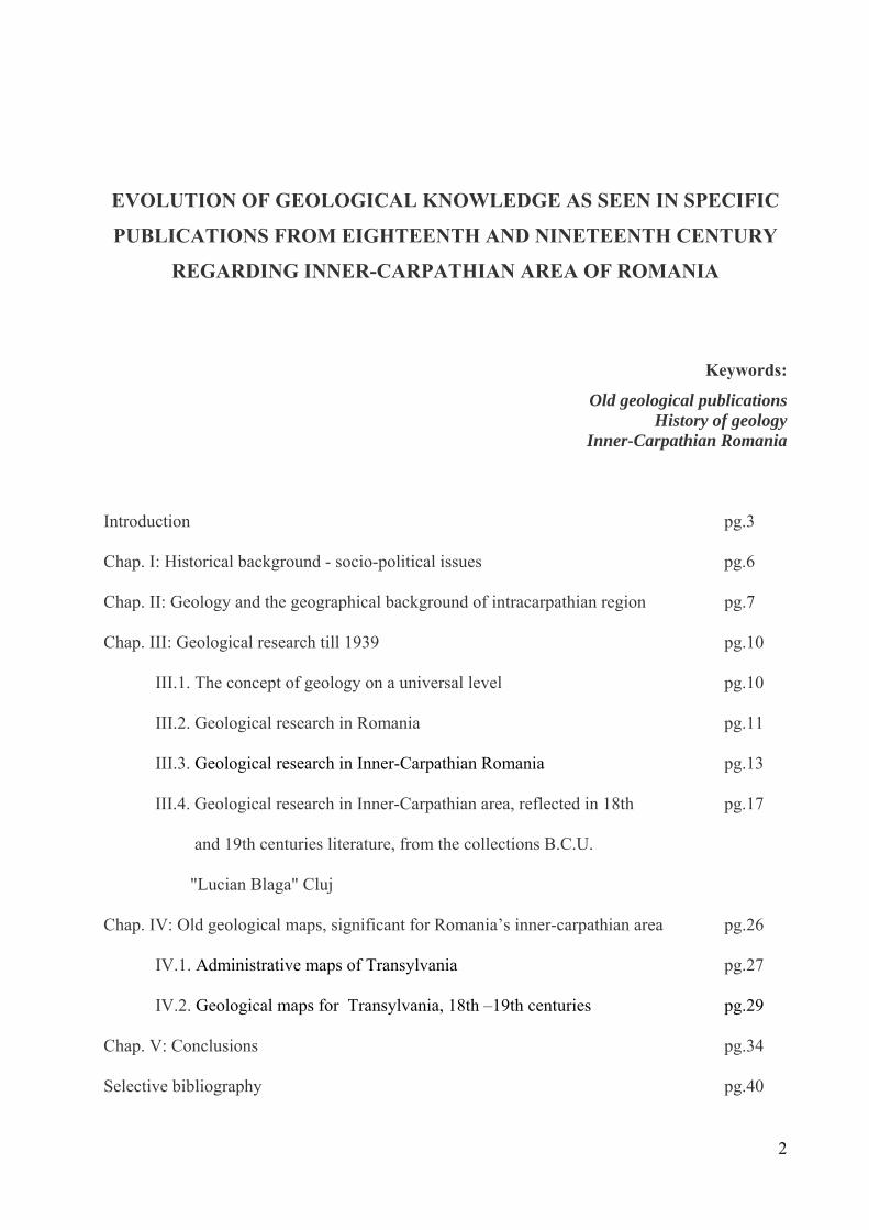
Sámuel Köleséri24 is the author of what is considered as the first published work on technical
topics about Romanian territory25 Auraria Romano-Dacica (Fig. 2). The work was published in
1717 at Sibiu and it describes mineralogy, geology, mining deposits of the principality of
Transylvania. In this valuable publication, the author
pays particular attention to the location of gold mines
in the territory and capture the historical aspects of
the exploitation and processing gold since the Roman
times.
Fig. 2 : Sámuel Köleséri: Auraria Romano-Dacica,
ediţia 1780 (BCU- 189905)
17
21 Georgius Vette (1645-1704): chimist şi naturalist sibian. 22 Emil Pop, „Vechi note naturaliste despre România”, Analele Academiei Române, Memoriile Secţiunii Ştiinţifice, Seria III, XVIII (1943), 5: 76-77. 23 Valentin Franck von Franckenstein (1643-1697), sibian, poet şi traducător din limba germană (Allgemeine Deutsche Biographie, Volumul 7, Leipzig 1877, p. 263–264). 24 Sámuel Köleséri (1663-1732), consilier gubernial; a studiat teologia, filosofia şi medicina în Olanda şi a fost numit medic şef şi supervizorul minelor în Transilvania. 25 Tataru S., Khiell O.: "Auraria romano-dacica de Samuel Koleserius”. În: 16th International Congress of the History of Science, Proc. B: Symposia, (1981).
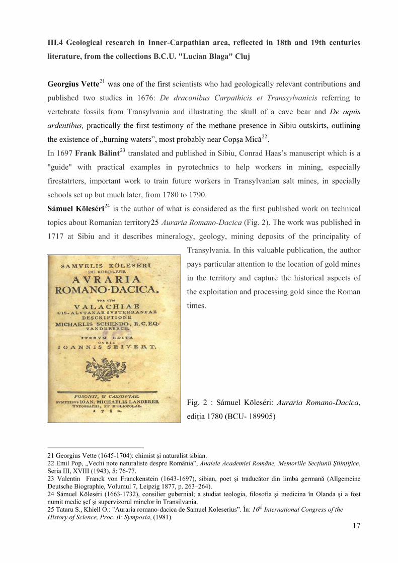
The same phenomenon described by Vette, appa ardens, is recorded also later in 1726 by Luigi
Ferdinando Marsigli (lat.Marsilius) in Medias area, at Bazna. Scientific observations he
gathered in twenty years in the Habsburg Empire were used to achieve his most important work
on the Danube, Danubius Pannonico – Mysicus (Fig. 3), a 6 volumes encyclopedia, richly
illustrated with 300 plates, which had a great importance in the development of European science
and culture.
18
Fig. 3: Luigi Ferdinando Marsigli: Danubius
Pannonico - Mysicus, 1726
(BCU – Opere de artă 34)
The manuscript of this work was prepared for
printing by Johann Christoph Müller, at
Nuremberg, working version appeared in 1700,
the work itself was proposed to be printed in
1704. Only after two decades in 1726, this work
is published in Amsterdam and The Hague and
components make up a map atlas to be published in 1744.
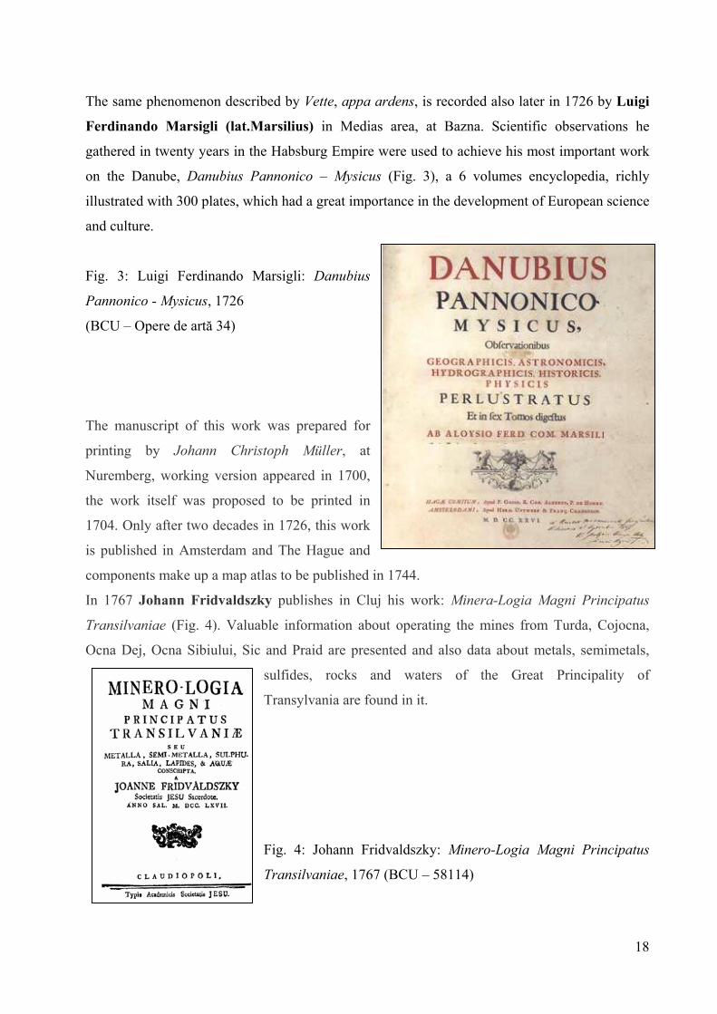
In 1767 Johann Fridvaldszky publishes in Cluj his work: Minera-Logia Magni Principatus
Transilvaniae (Fig. 4). Valuable information about operating the mines from Turda, Cojocna,
Ocna Dej, Ocna Sibiului, Sic and Praid are presented and also data about metals, semimetals,
sulfides, rocks and waters of the Great Principality of
Transylvania are found in it.
Fig. 4: Johann Fridvaldszky: Minero-Logia Magni Principatus
Transilvaniae, 1767 (BCU – 58114)

The famous mineralogist and metalurgist Ignaz Edlen von Born26
, undertook in 1770, a study
tour in Hungary, Transylvania and Banat. After the tour he sent to his friend, the German
geologist Johann Jakob Ferber, letters in which he recounts those observed in these areas:
geography features, natural resources, local customs and culture of the people. These letters were
first published in Germany, in Frankfurt in 1774, under the title: Briefe über Mineralogische
Gegenstünde, auf seiner Reise durch das Temeswarer Banna Siebenbürgen, Ober - und Nieder
Hungarn. They were translated then into English, Italian and French. The French version,
Voyage minéralogique fait en Hongrie et en Transylvania, 1780 (Fig. 5) - translated and
annotated by Antoine Grimaldi Monnet, the general inspector of mines in France and of the
Royal Academy of Sciences in Stockholm and Turin, was a valuable source of information for
professionals of that time.
Fig. 5: Ignaz Eldlen von Born:
Voyage minéralogique fait en Hongrie et en Transilvanie, 1780
(BCU: 52053)
Another passionate for natural sciences study of territories belonging to the Habsburg Empire, is
Francesco (Franz) Griselini27 who published in 1780 in Vienna, the work: Versuch einer
Polilischen und naturlichen Geschichte des Temeswarer Banats in Briefen en Standespersonen
und Gelehrte. Zweiter Theil: Naturliche Geschichte des Bannats.Beschaffenheit des Flaschen
Landes. Gebirge, mit ihren Mineralien und Fossilien: Mineralische Wasser und Brunnen, in
verschiedenen Gegenden; besonders die berühmten herkulischen Bäder zu Mehadia. work that
was designed into two distinct parts: the political history and the natural history of Banat, having
19
26 Ignaz Edlen von Born (1742-1791), urmează colegiul iezuit la Viena şi studii juridice la Praga, dar se dedică cercetărilor din domeniul ştiinţelor naturale (mineralogie, chimie, geologie) care vor rămâne ca preocupări primordiale, până la moartea sa.27 Francesco Griselini, savant italian născut la Veneţia, pasionat de studiul ştiinţelor umaniste şi ale naturii

a corespondance format, letters addressed to distinguished both military and political leaders and
scholars with whom he had personal or scientific relationships28.
Johann Ehrenreich von Fichtel29, Transylvanian Treasury adviser at Sibiu provided important
information for the geological research in Transylvania. Karl Alfred von Zittel30 considered him
in his work Geschichte der Geologie und Palaeontologie bis Ende des 19 Jahrhunderts (History
of Geology and Palaeontology to the end of nineteenth century) published in 1901, as one of the
most gifted stratigraphy researchers dedicated to geological study of the Austro-Hungarian
Empire territory.
At the turn of the 18th and 19th centuries, Aiud was an important Transylvanian scientific
centre; its fame reached far and wide, a fact proved also by a 18th century manuscript preserved
in the Bethlen Documentary Library in this town31. A detail still remained obscure to the public -
and paradoxically, to a part of museographs - is that from the existing natural sciences museum
collections in Romania, the Natural Sciences Museum of Aiud is undoubtedly the oldest. The
beginnings of this museum is linked to a core collection, mainly minerals, fossils and antiquities,
mentioned in the manuscript Catalogus Raritatum et Benefactorum (Fig. 6)32 kept by Ferenc
László Benkő Nagy, since 1796. This document was preserved in the Bethlen Documentary
Library of Aiud since the 18th century.
Fig.6: A part of the title page of the manuscript
Catalogus Raritatum et Benefactorum, in hard cover
20
28 Grisleini face deseori referire în scrisorile sale la scrierile lui Ignaz von Born şi ale lui Johann Jacob Ferber. 29 Johann Ehrenreich von Fichtel (1732-1795), născut la Pressburg (Bratislava de azi), consilier al tezoreriei transilvănene la Sibiu în 1769. 30 Karl Alfred von Zittel (1839-194), paleontolog german. 31 Vlad A. Codrea, Gabriela-Rodica Morărescu, Forray Erzsébet: „Catalogus Raritatum et Benefactorum, un manuscris reprezentativ din perioada de început a Muzeului de Ştiinţele Naturii din Aiud”. În: Hermeneutica Bibliothecaria – Antologie Philobiblon – vol. IV (2009), p.166-176. 32 Benkő Ferenc, Nagy László (1796): Catalogus Raritatum et Benefactorum, [manuscris], Aiud, 47 p.

21
In the last decade of the 18th century Jens Esmark33, a Danish geologist, undertook a travel in
Europe between 1791 and 1797 (almost 6 years), in order to collect different minerals from
different locations. He visited the territories belonging currently to the Czech Republic, Slovakia,
Austria, Hungary, Poland, Romania and draw some reports on these trips. In 1798, his work
Kurze Beschreibung einer mineralogischen Reise durch Ungarn, Siebenbürgen und das Bannat
is published in Freiberg, a description of his mineralogical trip through Transylvania and Banat.
Stanisław Staszic34 the great Polish scholar, wrote a series of four reports on the geology of
Poland and the neighboring regions in the years 1806-1809. He draw a general geological map of
Central and Eastern Europe, which includes a part of Romania and is considered one of the first
large-scale maps of Europe: Carta geologica totius Poloniae, Moldaviae, Transilvaniae, et partis
Hungariae, et Valachiae. Inventa per Staszic anno 1806. Hoffmann delin.t Frey Sculpt.t35
(Geological map of Poland, Moldova, Transylvania and part of Hungary and Wallachia). A
particularly important role in the bibliography used for Transylvanian territory by Staszic were
the work of Fichtel, Mineralogischen Bemerkungen von der Karpathen considered to be the first
mineralogical work of the country.
French mineralogist François Sulpice Beudant36 began his geological journey through the
Kingdom of Hungary in 1818 at the expense of the French Government. In 1822 he published a
work in three volumes accompanied by a map volume, which will get his recognition in the
European scientific world: Voyage minéralogique et géologique, en Hongrie, pendant l'année
1818 (BCU 83435). Beudant starts the journey as deputy director of the imperial cabinet of
mineralogy, to collect samples to develop mineralogical collections of the cabinet and to study
volcanic formations and their associated metal deposits in Hungary. Chapter XIV is devoted to
Transylvania and Banat (Fig.7). Before his departure from Paris, he reviewed information about
Transylvania while trying to gather as much data on this this region as he could, compared with
what was already known about Hungary.
33Jens Esmarck (1763-1839), expert danez în montanologie şi profesor de mineralogie, adept al neptunismului. 34 Stanisław Staszic (1755-1826), had a teological career, then studied Natural Sciences in Paris; he is one of the founders og Polish Enlightment. 35Algimantas Grigelis, Zbigniew Wojcik, Wojciech Narębski, Leonora Živilė Gelumbauskaitė, Jan Kozak, Stanisław Czarniecki: „The first large geological map of Central and Eastern Europe (1815)”. In: Geologija - Vilnius, Vol. 50(2008), No. 2(62), p.125–134. (After 1816 printed version, Warsaw) 36 François Sulpice Beudant (1787-1850), mineralog francez, profesor de matematică şi fizică, cu preocupări asupra studiului geologiei şi ştiinţelor conexe acesteia încă din 1814.

Fig. 7: F.S. Beudant: Coup-d’oeil sur la Transylvanie et sur le Banat, 1822
Another travel enthusiast, being interested in Roman archaeological sites in Transylvania and
collecting various mineral and fossil encountered was Johann Michael Ackner37 from
Sighisoara, which between 1832-1847 has made many journeys to the ancient Roman Empire,
often accepting to organize in his parish meetings for various scientific organizations.
Observations have resulted in articles and scientific papers published in various journals or
books (Antiqua Musei Parisiorum monumenta, 1809; Geologisch-palaeontologische Verhältnis
des siebenbürgischen Grenzgebirges längs der Kleinen Walachei, 1851; Beitrag zur Geognosie
und Petrefactenkunde des Südöstlichen Siebenbürgens: vorzüglich der Schichten aus dem
Bereich des Hermannstädter Bassin, 1854 ; Mineralogie Siebenbürgens (Fig.8), 1855).
Fig. 8: J. M. Ackner: Mineralogie Siebenbürgens, 1855 (BCU
190401)
22
37 Johann Michael Ackner (1782-1862), a urmat cursurile gimnaziale la Sighişoara şi Sibiu, iar studiile în filosofie le-a început la Colegiul reformat din Sibiu.

23
Observations and results of palaeontological and mineralogical research are published by
Ackner, between 1851-1853, in a series of articles in Transylvanian Society for Natural Sciences
of Sibiu magazine Verhandlungen und Mitteilungen des Siebenbürgischen Vereins für
Naturwissenschaften zu Hermannstadt [= Debates and communications in Transylvanian Society
for Natural Sciences of Sibiu] The fossils found in these study trips are specified and various
mineralogical observations (eg formation of "spheres of sandstone" (Sandsteinkugelbildung)
today called "concretiuni de Feleac").
Adolf A. Schmidl38 led an expedition between 1858-1862, initiated by the governor of Hungary
at that time, Archduke Albrecht, aiming to research the western Apuseni (Bihor Mountains and
Codru-Moma Mountains). Unlike other members of the expedition, which published their results
separately, Schmidl includes in his work, in addition to the synthesis of research results, the
topography of Professor Josef Wastler39. In his Das Bihar-Gebirge: an der Grenze von Ungarn
und Siebenbürgen: mit einer geodätischen Abhandlung, Karte, Panorama und Höhlen-Plänen
von Josef Wastler, Professor am Joanneum zu Gratz und Ansichten von R. Wirker, published in
Vienna in 1863, research is grouped by geomorphology, geology and biogeography and
economic geography, ethnography and history. A. Schmidl's work has the quality to be the first
speleological inventory of Bihor Mountains, proving its author’s synthetic thinking, addressing
multidisciplinary research methodology as it ranks among the "revolutionaries" of the
nineteenth-century scientific researchers. Although he was adept of lithological contact only
karst circulation theories, he has the merit of having understood the concept of karst system
(although not using it under that name) from a hydrogeological point of view, calling several
karst systems Bihor Mountains and Forest-Moma Mountains were research confirmed the
following years.
Franz Ritter von Hauer and Guido Stache’s work Geologie Siebenbürgens (Viena, 1863 –
BCU 65940 ; 99814), called by Ion Al. Maxim40 a milestone in geological research of
Transylvania is of great importance not only for presenting the geological structure of the region,
but especially for establishing the link between the structure and the logical, natural development
of the phenomena leading to geological units genesis of the perimeter investigated.
38 Adolf (Anton) Schmidl (1802-1863), profesor de geografie la Universitatea din Viena, cu o constantă preocupare în studiul fenomenelor carstice. 39 L. Vălenaş: „Consideraţii asupra informaţiilor documentare despre carstul Munţilor Apuseni în lucrarea "Das Bihar-Gebirge" (1863) de A. Schmidl”. În: Nymphaea: Folia naturae Bihariae, vol. VIII-IX (1980-1981), p. 549-560. 40 Ion Alexandru Maxim (1902-1968), doctor în geologie cu carieră didactică universitară la Cluj (1922-1968)

Edward Albert Bielz41 had the initiative to achieve this monograph as president of the
Transylvanian Society of Natural Sciences based in Sibiu, scientific association that financed the
monograph’s printing. Geologie Siebenbürgens contains a series of new geological data at the
time, some still availabletoday, which gives it a great level of originality42.
An adaptation of this publication in Romanian language was made in 1883 by Basiliu Basiota
(Başotă)43, a geology amateur, having legal training, but a great passion for travel, geography
and history. He undertook a trip in the Apuseni Mountains in 1859, then published a series of
papers and articles, highlighting the beauty and natural riches of these mountains. His research
study, Munţii apuseni ai Transilvaniei seau Studiu geologicu asupr’a structurei muntiloru
metalici ai Transilvaniei (Fig.9), published in Blaj in 1883, in a time when there have been great
advances in field geology in the world due to the emergence of new research methods of mineral
substances. This has influenced the development of science and education and thus, the evolution
of geological sciences and specialized higher education.
Fig.9: Basiliu Basiota: Studiu geologicu..., 1883 (BCU
178775)
24
41 Eduard Albert Bielz (1827-1989), om de ştiinţă sibian, care l-a însoţit pe F. Hauer în unele călătorii pe teritoriul transilvan, cu scopul cercetării din punct de vedere geologic al acestuia 42 Idem 43 Basiliu Basiota (1836-1906) face parte din rândul oamenilor de seamă ai ţinutului Năsăudului, fiind descendentul unei vechi familii boiereşti din Botoşani refugiată în Valea Someşului în timpul domniei lui Duca-Vodă (1665-1683).

25
Being passionate about travel, geography and history, Basiliu Basiota, published after 1875 a
series of papers and articles highlighting and commenting on general problems of environment
and natural phenomena, but also works that highlight the beauty and natural riches of these
lands, especially the Apuseni Mountains.
A great contribution in geological research Transylvanian territory and the development of
geological education university of Cluj had the famous geologist, petrography, mineralogy and
paleontology professor, Antal (Anton) Koch44, appointed in 1872 at the Department of
Mineralogy and Geology of the newly established University of Cluj and director of the
Geological Institute. He was appointed Doctor Honoris Causa in 1874 and served as Rector in
academic year 1891-1892. He contributed to the work of various specialized congresses, with
exposures on the geology of Hungary and Transylvania, showing geological maps published for
this area by other authors.
Antal Koch was the most active member of the Department of Natural Sciences of the
Transylvanian Museum Society, managing to clarify some issues related to the geological
evolution of Transylvania and to help complete The Collection of the Mineralogy and Geology
Museum at the University of Cluj45.
Contributions to the study of tetrapods fossils (especially dwarf dinosaurs) from Transylvania
start to be published in the late nineteenth century by the aristocratic adventurer, a passionate for
paleontology: Baron Franz Nopcsa46. His main research field was dinosaurs, and brought new
taxonomic concepts for determined Dinosauria species, different from those of his
contemporaries.
The beginning of the new century was characterized by a special movement in all groups of
Romanian spirituality in Transylvania. Here have worked great personalities of the natural
sciences and geology, recognized worldwide: Gheorghe Munteanu Murgoci, Ion Popescu-
Voiteşti, Emil Racovita. The professors of the University of Cluj proposed systematic and
diverse scientific activities were concerned in the highest degree of methodological attitude of
scientists and the enrichment of scientific research instruments.
44 Antal (Anton) Koch (1843-1927), profesor de geologie la Universitatea din Cluj; a publicat peste 200 de lucrări ştiinţifice: monografii, studii, articole în publicaţii periodice de specialitate din ţară şi străinătate, făcând parte din colectivul de redacţie a unora dintre acestea (Földtani Közlöny din Budapesta – 1871-1873, şi Orvos és Természettudományi Értesítő din Cluj – 1879-1895). 45 Vanek Ferenc: „Koch Antal”. În: Hivatás és tudomány: az erdélyi múzeum-egyesület kiemelkedő személyiségei, Kolozsvár: Erdélyi Múzeum-Egyesület, 2009, p. 283-339. 46 Franz Nopcsa (1877-1933), născut într-o familie de aristocraţi maghiari, în apropierea Haţegului, la Săcel, studiază la Universitatea din Viena începând cu anul 1898, preocuparea lui principală fiind paleontologia vertebratelor; a ocupat funcţia de director al Institutului Geologic al Ungariei, în intervalul 1925-1928.

26
IV. OLD GEOLOGICAL MAPS, SIGNIFICANT FOR ROMANIA’S INNER-
CARPATHIAN AREA
The geological map is a special document that currently is an essential source of information to
address issues involving the use of Earth resources, according to the risks and natural conditions
in the area of interest. It is absolutely necessary to know the geological structure, distribution and
typology of existing basement rocks and tectonic elements in a given region: land use planning,
location of industrial and civil objects, starting development projects and transport systems of
hydrological works and not the least the exploitation of mineral resources available.
The geological map is in fact a quadro-dimensional system of data, the fourth dimension being
the geological time, absolutely necessary to accurately assess the situation of natural elements
and environmental and socio-economic risk factors. The interpretation of a map is not only
locating geological formations or structures, but also understanding their characteristics at the
time of their formation. A geological map implemented in electronic format (digitized map)
completed with geographical information systems (GIS) is an interactive way to make
interpretations of extremely varied and complex issues.
The intense activity of mapping carried out mainly in the nineteenth century and very different
variants of using color to represent rocks, the second International Congress of Geology in
Bologna in 1881 established their need for standardization. This standard is used in general by
Europeans, as American geologists are using U.S. standard established in the same year (1881)
by the USGS director at the time, John Wesley Powell.
The European standard has become a necessity because as language barriers and geopolitical
situation in Europe in seventeenth and eighteenth centuries led to very diverse scientific
approaches, from a scientific community to another. Thus, the strongest scientific communities
have communicated and published the results of their work in English, French, German and
Italian.
For Romania, there were numerous geological maps made in Transylvania, Banat and Bukovina,
which were published several in a series of geological maps at different scales - 1:75.000,
1:200.000 and 1:350.000, but the first geological map of Romania, of greater importance, was
drawn to the scale of 1:175 000 and published in 1898, edited by Gregory Stefanescu. Until
1918, the Geological Institute (established in 1906) was occupied to draw the geological map of
Romania, 1:50.000 sheets, most detailed series of maps, which is the subject of a still ongoing
project. Many sheets were completed, but due to World War I, printing them all was a big
problem. In 1921, I.P. Voiteşti, printed a geological map of united Romania, scale 1:500.000,

and between 1936-1959, The Geological Institute of Romania coordinated completion of this
map, and several editions were printed at the same scale, as an integral part of the geological
map Earth. The evolution of geological maps making for Romania, in the last years were printed
geological maps at 1:100.000 and 1:200.000 scales, the latter covering the entire territory of
Romania.
IV.1. Administrative maps of Transylvania
Transylvania was reflected over time in various graphical representations, first in the form of the
administrative and geographical maps, by the foreign travelers and nature enthusiasts, passionate
for the history and nature of eastern parts of Central Europe, parts of the great empires.
Here are some examples:
Map drawn in 1579 by Wolfgang Lazius, Hungariae descriptio.
Map drawn by Johann Matthias Korabinszky (Fig.10), in 1786, included in his work:
Geographisch-historisches und Produkten-Lexikon von Ungarn, in welchem die vorzüglichsten
Oerter des Landes in alphabetischer Ordnung angegeben, ihre Lage bestimmt, und mit kurzen
Nachrichten, die im gesellschaftlichen Umgange angenehm und nützlich sind, vorgestellt
werden: mit einer Postkarte, durch deren Beyhilfe man sich einen vollständigen Ideal-Atlas
dieses Reichs selbst entwerfen kann. On this map are located the main post stations of the time,
very useful for travelers who arrived on these lands.
Fig. 10: Vorstellung des Königreichs
Ungarn nach den Poststationen für
Reisende. (J.M. Korabinszky)
27

An administrative division of the Habsburg Monarchy and lithographic representation
can be seen in E.K. Frühwirth’s map (Fig. 11), where Transylvania is part of Hungary, the
boundaries being set on line Carpathian Mountains (Southern and Eastern) (1830?).
Fig.11: Taschen
Postmeilen Karte der
Oesterr Monarchie
(1830?), versast und
lithographirt von E.K.
Frühwirth
In 1854, Eduard Albert Bielz47 Sibiu published a map (scale 1: 846,000) representing an
overview of the Principality of Transylvania in the new political-legal division, indicating also
the important locations of mineral resources in this territory: Uebersichts-Karte des
Grossfürstenthums Siebenbürgen, nach der neuen politisch-gerichtlichen Eintheilung, mit
Angabe aller bedeutenden und bemerkenswerthen Ortschaften dieses Landes (Fig.12).
28
47 Eduard Albert Bielz (1827-1898), om de ştiinţă născut la Sibiu, autorul principalei monografii a Principatului Transilvaniei, Handbuch der Landeskunde von Siebenbürgen, publicată în 1857

Fig.12: E.A. Bielz: Uebersichts-Karte des Grossfürstenthums Siebenbürgen, nach der neuen politisch-
gerichtlichen Eintheilung, mit Angabe aller bedeutenden und bemerkenswerthen Ortschaften dieses Landes, 1854
IV.2. Geological maps for Transylvania, 18th –19th centuries
Among the first geological maps is the mineralografic one: Mappa Mineralographica (Fig.13),
published in volume three of Count Luigi Ferdinando Marsigli’s work, Danubius Pannonico –
Mysicus (1726), in the vloume with the title: De Mineralibus circa Danubium Effossis: Necnon
Aquâ Abraſis, & eum deductis, second part, De Mediis Mineralibus, Lapidibus ac Metallis.
Fig.13: Mappa Mineralographica
(L.F. Marsigli: Danubius
Pannonico Mysicus, 1726, Vol. 3)
The first general geological map for Romania, (except some areas of Dobrogea and Muntenia)
can be considered Stanislaw Staszic’s map published in 1806, actually one of the first large-
scale maps of Europe. Staszic, a Polish geologist, along with other European geologists - have
received from German geologist Abraham Gottlob Werner the task to map geologically Europe.
The map of Staszic (Fig.14) - Carta Geologica totius Poloniae, Moldaviae, Transylvaniae et
partis Hungariae et Valachiae, sc. 1:325000 – is different from other maps published at the end
of eighteenth century and the beginning of nineteenth century by the fact that its author
introduces a new symbolism style (lines, dots and symbols for geomorphology perspective,
colors and numbers to emphasize the petrographic and mineralogical character of the basement).
29
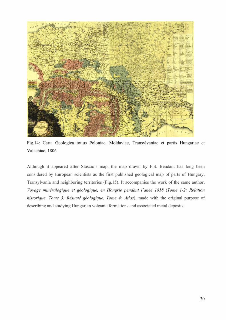
Fig.14: Carta Geologica totius Poloniae, Moldaviae, Transylvaniae et partis Hungariae et
Valachiae, 1806
Although it appeared after Staszic’s map, the map drawn by F.S. Beudant has long been
considered by European scientists as the first published geological map of parts of Hungary,
Transylvania and neighboring territories (Fig.15). It accompanies the work of the same author,
Voyage minéralogique et géologique, en Hongrie pendant l’aneé 1818 (Tome 1-2: Relation
historique. Tome 3: Résumé géologique. Tome 4: Atlas), made with the original purpose of
describing and studying Hungarian volcanic formations and associated metal deposits.
30

Fig.15: F.S. Beudant: Carte géologique de la Hongrie et de la Transylvanie avec une partie des
pays limitrophes, 1822
In the second part of the nineteenth century, geological investigations have focused primarily on
exploring areas where useful minerals were present, their delineation and exploitation conditions,
especially for rocks and minerals with great economic importance in mining and construction. In
this respect, Wilhelm Haidinger, as the first director of the Imperial Institute of Geology, has
initiated detailed geological surveys and conducted elaboration of well documented geological
maps for the Empire territory. In 1845, Haidinger gathers several research results and mapping
from scientists, thus making the first systematic geological map of the Austrian Empire,
1:864.000 scale: Geognostische Uebersichts Karte der oesterreichischen Monarchie. Among the
authors: François Sulpice Beudant, Ami Boué, Christian Leopold von Buch, Ernst Heinrich Karl
von Dechen, Bernhard von Cotta, Johann Grimm, Carl von lilienbach Lille, Paul Partsch, etc. In
this map is included the Inner Carpathian teritory of our country and in the legend are explained
symbols and colors used.
Karte der geognostischen Verhaltnisse des Grossfürstenthum Siebenbürgen. Eduard Albert
Bielz, 1854 is the geological map (inspired by the one by Partsch, but with reference only to
Transylvania) who accompanies the administrative one, carried on at the same scale, but with the
mineral areas reported andminerals explained in the legend.
In his Mineralogie Siebenbürgens: mit Geognostischen Andeutungen: eine vom Vereine zur
Beförderung der siebenbürgischen Landeskunde gekrönte Preisschrift, published in 1855 but
31
32
initiated in 1844, Ackner describes minerals discovered in Transylvania, enclosing at the end a
map that is a copy of Bielz map, describing the same way minerals as well as administrative
elements of the studied localities: Andeutungen der geognostisch-oryktognostischen Verhältnisse
Siebenbürgens.
Franz Ritter von Hauer, Wilhelm Haidinger's successor as head of the Imperial Geological
Institute, presented in 1865 at the Agriculture Expo in Cologne and then in 1866 in Vienna, The
General Geological map of Austro-Hungarian Empire (Geologische Karte der Übersichts-
Österreichische-Ungarischen Monarch) one of the most comprehensive geological maps of
Central Europe at that time, published afterwards between 1867 and 1874 in various editions
(scale 1:576.000). The background of this map were the work diaries of various members of the
Institute48, collected between 1850-1865 (as recorded on the studied map), first under the direct
coordination of W. Haidinger and then of his successor F.R. von Hauer.
Another product of F. Hauer geological mapping is also a map published around 1876,
scale 1:2 016 000 which used the same color scheme, and for the Inner-Carpathian territory one
can observe the carefully representation of existing units: Geologische Karte von Österriech-
Ungarn auf Grundlage der Aufnahmen der k.k. Geologischen Reichanstalt.
The renowned geologist and professor from Cluj, Antal Koch, exposed at the Millennial
Congress of Mining, Metallurgy and Geology in Budapest in 1896 a geological map of Hungary
edited by A. Semsey: Carte Géologique de la Hongrie49 that shows "deposits of precious
metals, ores, iron ore, salt and other minerals that can be sold, exploited or under exploration,
within the countries belonging to the Hungarian Crown." At the same event was shown and the
map A Magyar Korona országai területén mivélésben és feltárófélben levő nemesfém, ércz,
vaskö, köso és egyéb értékesithető ásványok efőfordulási helyei, based on official data obtained
from the captains of the mining area, drawn by J. Böckh and A. Gesell and that led later to the
realization of mining districts map at a different scale (1: 800 000).
Geological research started in the eighteenth and nineteenth centuries on the Habsburg Empire
territory, experienced some decline during the Napoleonian Wars, as well as the entire economy,
and geological studies were conducted more by foreign scientists (French, English, Swiss).
48 Sunt consemnaţi pe hartă, ca membri contributori la realizarea sa: Ferdinand Freih. Andrian, Johann Cžjžek, Franz Fötterle, Frans Ritter von Hauer, Ferdinand Ritter von Hochstetter, Johann Jokély, Johann Kundernatsch, Ferdinand Lidl, Markus Vincenz Lipold, Edmund von Mojsisovics, Melchior Neumayr, Karl Maria Paul, Karl Peters, Heinrich Prinzinger, Ferdinand Freih. von Richthofen, Urban Schloenbach, Guido Stache, Ferdinand Stoliczka, Dionys Stur, Heirich Wolf, Victor Ritter von Zepharovich. 49 Titlul în lb. germană: Geologische Karte von Ungarn, (BCU H48/38).

33
Between 1710 and 1850 the Vienna Imperial Court granted the mining industry more attention
than any other branches of industry, geological literature of the time taking into account the
particular topics on mineral location, authors of geological studies were travel enthusiasts
(German, Italian, Norwegian, Dutch, French, British) or official messengers. One of the reasons
for increased interest in geology and mining, ore mining can be considered to be the
establishment of one of the oldest institutions in the world stock market: Wiener Börse (1771 -
Wiener Börse)50, during Empress Maria Theresa, in order to issue and create a market for
government bonds.
În a doua parte a secolului al XIX-lea începe aplicarea proiectului iniţiat de Institutul Geologic
Imperial, de topografiere şi cartare geologică a cât mai multor porţiuni din teritoriul monarhiei,
acest lucru declanşând realizarea hărţilor geologice în primul rând pentru localizarea
formaţiunilor aparţinând Cuaternarului, hărţi cu o mare importanţă în evoluţia cercetării
geologice nu numai la nivelul Imperiului ci şi la nivelul întregului continent european.
In the second half of the nineteenth century begins implementation of the project initiated by the
Imperial Geological Institute, for surveying and geological mapping of many parts of the
monarchy. This innitiative triggered the implementation of geological maps to locate primarily
formations belonging to Quaternary, maps of great importance in the evolution of geological
research not only of the Empire but also of the entire European continent.
50 T.Gaudenyi, M. Jovanovic....

34
V. CONCLUSIONS
Geological knowledge evolved over time from observations of the practical interest in using the
underground mineral resources (river stone, metal ores, salt, coal) for the prosperity of
communities or for a scientific approach.
All issues concerning knowledge of geological structures, distribution and typology of existing
rocks in the basement, describing minerals and fossils found in the research areas were addressed
first in a theoretical and subjectively way by those interested in these issues. Many of them were
scholars, trained in other fields, but having agreat passion for travel and natural science.
Geological publications from the eighteenth and nineteenth centuries containig geological
aspects of the Romanian Inner-Carpathian area reflects the evolution in time of such an interest
in this part of Europe developed by scientists and scholars, foreign and domestic.
Revealing the historical aspects of the investigated territories resulted in accumulated knowledge
in various domains: geographical, sociological, demographic and ethnic, petrographic and
mineralogical composition of the formations encountered, the last of great importance in
detecting and locating targets that were designed to ensure the economic future of society.
Details obtained from experiments and field practice, professional representation on maps made
across Europe, have contributed to the enrichment of very valuable information sources for use
of mineral resources of the Earth.
Trying to achieve the objective of this thesis has proven to be a challenge, because most of the
documents to be investigated were written in less accessible languages: Latin, German,
Hungarian. I began by extracting the titles of these "landmarks" in the geology of Romanian
Inner-Carpathian area from the first volume of the publication of Romania Geological
Bibliography (publication of the Geological Institute of Romania), the rich bibliography of
geological monograph Geologie Siebenbürgens (Hauer and Stache, 1863) and traditional
catalogs of the Central University Library "L. Blaga" Cluj. Exploring these catalogs: systematic
catalog - geology, natural science, topographic catalog - Transylvania, Cluj, Banat, but mostly
special collections catalog, where I found the old and rare titles of publications and maps
(administrative, geographical and geological) allowed me to access and study in more detail the
documents mentioned and less circulated or even omitted from the circuit (Catalogus Raritatum

35
et Benefactorum - from the library of Aiud or Studiu geologicu asupr’a structurei muntiloru
metalici ai Transilvaniei of geology passionate Basiliu Başotă).
Library catalogs from Eötvös Loránd University (ELTE) in Budapest and visiting a part of the
special collections helped me verify the historical and bibliographical data on publications
studied.
The discovery and investigation of documents from personal archives of Professor Antal Koch
Cluj, at the Museum of Paleontology at the University "Babes-Bolyai" was a real opportunity to
bring to the attention of the scientific community novel aspect of life and work of this great
scientist .
From old periodic publications with articles and studies containing geological data, I analyzed in
detail a number of Romanian and German titles, such as Mineralogical Geological Museum
magazine of Cluj University and Verhandlungen und Mittheilungen des Vereins für
Naturwissenschaften zu siebenbürgischen Hermannstadt. There are many other periodicals with
titles with such works, written mainly in German and Hungarian, which are expected to be
investigated at a later stage. The language barrier, the large amount of information material and
necessary period of time study and analysis of these articles were factors that led to this decision.
Given the multidisciplinary content of many publications, followed by a documentary analysis,
we restricted the study only to those with significant geological aspects, while trying to point out
the geological data and information on the area of interest.
Passages from the studied publications that we found they are of geological interest, important
data for the location of geological structures or useful substances deposits have been scanned to
be accurately shown to the interested reader. Geological maps have been scanned also, this
process being difficult as some of them were on several sheets (and the topography was often not
the same for the same map sheets - eg. Staszic map, drawn up in 1806), in an attempt to provide
a collection of old geological maps in electronic form, easy to be addressed by interested
researchers.
As the study of documents that form the basis of this thesis research was going forward, I
prepared a synoptic table that allows an overview of the geological research characteristics in
historical periods considered, the evolution of the concept of geology and reference works
published at that time, inserting in the context specific publications in Romanian Inner
Carpathians area.

36
To point out the first scientific observations relevant to the geology of the area of Transylvania,
we included also the seventeenth century as period of time in the evolution of geological
knowledge and concepts. In that time the notion of "geology" was already used in a modern
sense, scattered observations appeared, sometimes poorly documented and lacking a scientific
method of research, explanations of natural phenomena described especially in religious
writings. Most scientists of those times had theological training, and their writings were
influenced by religious concepts.
At European level this century is marked by the emergence of key ideas in the field of geology,
on the constitution of the Earth (René Descartes, Mikkel Pederson Escholt, Athanasius Kircher,
Robert Boyle, GW Leibniz, William Whiston), mineralogy (Robert Boyle), water sources of
rivers (Pierre Perrault), notions of stratigraphy (Nicolas Steno), a better knowledge of fossils and
comparative anatomy terms of existing and fossil plants (Robert Hooke). In Inner-Carpathian
Romania only now appear the first geological writings. These are observations of Georgius Vette
from 1676, reporting about the presence of methane gas near Sibiu and the vertebrate fossils in
the area - fossil bones of so-called "dragons", Draco volans, which actually proved to be the
remains of cave bear, Ursus spelaeus.
In the eighteenth century, geology has been seen as independent scientific discipline, with the
first attempts to systematize known data. During this period happened the move from abstract
speculation to logical reasoning based on direct observation of natural phenomena. Although
naturalists studies were still influenced by the Church teachings, natural sciences were
developing rapidly, as geological research did. Prospecting ores criteria are highlighted by M.V.
Lomonosov in 1757, rocks are classified into four major orders -these orders referring to the age
of these rocks: primary, secondary, tertiary and quaternary (G. Arduino, 1759). The first
materialistic theory about Earth formation was made (G.-LL Buffon, 1749-1788), and the two
theories that dominate this century about the origin of rocks and minerals: neptunism (A.G.
Werner, 1775: origin of all rocks is in the water of the seas and oceans), and plutonism (J.
Hutton, 1795: conditions of formation of rocks are endogenous determined) were launched.
Stratigraphic column was developed by A.G. Werner in 1775 and the geological cycle was
defined by J. Hutton in 1795.
Against this background, many geological works about Inner-Carpathian area were published on
petrographic and mineralogical description of the studied area, paleontological descriptions, but
also on practical issues (mining history, administrative and economic issues affecting the mining
industry). They highlight the location of mines and minerals existing in those areas, and as

37
examples some graphical representation can be given: the geographical map of Griselini - Tabula
Bannatus Temesiensis, mineralographic map of Marsigli - Mappa Mineralographica with
location and special signs and distinct symbols for gold, salt, copper, and iron deposits.
Written in the early eighteenth century, the paper of gubernial advisor Sámuel Köleséri, Auraria
Romano-Dacica (1717), is entitled to be called the first technical publication for Romania, which
captures the historical aspects of the exploitation and gold processing in Transylvania,
emphasising location of gold mines in this territory. Sámuel Köleséri was one of the mineral
specimens donors from Transylvania for large collections of its kind in Europe (eg the collection
of John Woodward of the Sedgwick Museum in Cambridge there are specimens of cinnabar and
native antimony in Transylvania).
Johann Fridvaldszky - Minero-Logia Magni Principatus Transilvaniae (1767), paper containing
historical aspects of precious metals mines in Transylvania of a Jesuit priest with a passion for
mineralogy. These data were next to geographical, administrative and ethnical ones, and based
primarily on accounts of local mines employees - the main reason to be later criticized by Ignaz
Edlen von Born, who also wanted to meet him but to clarify some aspects.
A novel aspect in presenting the 18-th century’s publications is the general presentation of the
catalog manuscript of the first natural science collection in the country, Catalogus Raritatum et
Benefactorum (1796) by Ferenc Nagy and László Benkő and stored in the Bethlen Documentary
Library of Aiud.
Works presented in this thesis contain petrographic and mineralogical details and a accurate
location of mines in the areas studied, mineralizations and fossils found, geological terminology
used throughout Europe those days:
Luigi Ferdinando Marsigli: Danubius Pannonico Mysicus - Description du Danube
(1726), in whose volume three aspects of mineralogy are included for areas to the north
of Danube and examples of useful mineral deposits in Transylvania;
Ignaz Eldlen von Born: Voyage minéralogique fait en Hongrie et en Transilvanie (1774,
1780), which had a special role in promoting information about mineral riches of
Transylvania across Europe; also an article on stibine crystals in Transylvania published
in May 1783 „Nachricht vom gedigenen Spiessglanzkönig in Siebenbürgen” that
appeared in "Ab. einer Privatgesellschaft in Böhmen "in Prague;
Francesco Griselini: Versuch einer Polilischen und naturlichen Geschichte des
Temeswarer Banats in Briefen en Standespersonen und Gelehrte. Zweiter Theil:
Naturliche Geschichte des Bannats. Beschaffenheit des Flaschen Landes (1780), a work
containing a geographical map, descriptions of Banat’s geomorphology, petrographic

38
composition of this land, minerals in the area and location of their main operating mines;
here we find a reference to the use of peat from the lowland area of Banat as fuel instead
of wood to protect forests in the area;
Works published in 1780, 1791 respectively, on the fossils of Transylvania, the history of
salt extraction and description of Transylvania’s mountains, having as author the
Transylvanian treasury adviser, Johann E von Fichtel.: Beytrag zur Mineralgeschichte
von Siebenbürgen - volume 1: Nachricht von den Versteinerungen des
Grossfürstenthums Siebenbürgen and volume 2: Geschichte des Steinsalzes und der
Steinsalzgruben im Grossfürstenthum Siebenbürgen - and Mineralogische Bemerkungen
von den Karpathen;
Jens Esmarck: Kurze Beschreibung einer mineralogischen Reise durch Ungarn,
Siebenbürgen und das Bannat, (1798), with details and descriptions of rocks and
minerals in the mining districts of the Banat and gold-bearing mountains of Transylvania.
Publications of the nineteenth century are distinguished by this century’s scientists approach
with a method of detailing the knowledge accumulated by their predecessors and making
graphic, geological maps specific to certain parts of Central and Eastern Europe. We have thus
included some territory of Romania (except for some areas of Dobrogea and Muntenia) in
Stanisław Staszic’s map (1806), considered the first large geological map of Europe, and
François Sulpice Beudant’s geological map printed in 1822 which includes also Transylvania . In
the following years a series of rich geological and mineralogical maps were drawn by foreign
and local geologists and mineralogists, formed at high schools in Vienna and Budapest and
monographic works of particular importance in the Romanian geological research were written: Johann Michael Ackner: Antiqua Musei Parisiorum monumenta (1809) Geologisch-
palaeontologische Verhältnis des siebenbürgischen Grenzgebirges längs der Kleinen
Walachei (1851), Mineralogie Siebenbürgens (1855) and articles from Transylvanian
Society for Natural Sciences of Sibiu magazine, Verhandlungen und Mitteilungen des
Siebenbürgischen Vereins für Naturwissenschaften zu Hermannstadt;
Adolf A. Schmidl: Das Bihar-Gebirge: an der Grenze von Ungarn und Siebenbürgen,
which has the quality to be the first Speleological inventory of Bihor Mountains;
Franz Ritter von Hauer and Guido Stache: Geologie Siebenbürgens (1863), "milestone"
in geological research of Transylvania, a work containing a number of new geological
data at the time (some still available), which gives it a high degree of originality;
Nopcsa Franz, with his first scientific paper of paleontology, Dinosaurierreste aus
Siebenbürgen: Schädel von Limnosaurus transsylvanicus nov.gen. et spec. (1899),

39
describing this new species of herbivore dinosaur, which opens the series of papers of
this "pioneer" in the European paleobiological research, which managed to combine
systematic data with complete reconstruction of the dinosaurs and to correlate these with
geological surveys, stratigraphy and evolutionism.
The original contribution of this thesis about publications from the 19-th century is revealing to
the geological community certain documents, such as:
¬ Some documents from the personal archive of renowned geologist, and specialist in
petrography, mineralogy and paleontology, Antal (Anton) Koch, consisting of letters, official
addresses, drawings and sketches that show thoroughness and seriousness of the famous scientist
in his research themes and his promptitude in responding to work tasks, but also to requests from
other people interested in geological aspects of Transylvania.
¬ Munţii apuseni ai Transilvaniei seau Studiu geologicu asupr’a structurei muntiloru metalici ai
Transilvaniei published by a lawyer with a passion for geology, Basiliu Basiota, printed in Blaj
in 1883. This study, even if written by an amateur who took over and adapted largely from the
German text of Hauer & Stache’s work Geologie Siebenbürgens, has great significance primarily
due to the language in which it was written, Romanian, making it accessible to a wider category
of people interested in the process of extracting metals from the Apuseni Mountains. This author
published also some articles in popular periodicals of those times, having some socio-economic
aspects, and also bringing to the forefront of knowledge environmental problems, the efficient
exploitation of soil and subsoil riches of Transylvania.
The research performance of previous centuries scientists and the possibility of having access to
their specialized scientific publications created an effervescence in Romanian spirituality circles
of the late nineteenth and early twentieth century. It is in this century that in Transylvania took
place spectacular evolution of Romanian inteligentsia, through the creation of the institutional
framework necessary for academic development: the establishment of a Romanian University in
Cluj, existing as an institution of higher education since 1872, but teaching in Hungarian.
Development of higher education in Transylvania helped scientific research grow in general, and
geology also.

40
SELECTIVE BIBLIOGRAPHY
1. ANUARUL Universităţii din Cluj, An I (1919-1920).
2. REVISTA Muzeului Geologic-Mineralogic al Universităţii din Cluj, (1924-1935), Vol. I
– Vol. V.
3. ACKNER Michael J. (1851): Geologisch-palaeontologische Verhältnis des
siebenbürgischen Grenzgebirges längs der Kleinen Walachei. În: Archiv des Vereins fur
siebenbürgische Landeskunde, Bd. 4(3), p. 228-297.
4. ACKNER Michael J. (1855): Mineralogie Siebenbürgens: mit Geognostischen
Andeutungen, Hermannstadt: Druck und Verlag von Theodore Steinhaussen, 392 p.
5. AGRICOLA Julius (1924): Le mine et les gisements de charbon de Mehadia. În: Annales
des mines de Roumanie, VII: 102-113.
6. BASIOTA Basiliu M.D. (1883): Studiu geologicu asupr’a structurei muntiloru metalici ai
Transilvaniei, Blaj: Tipografia seminarului greco-catolic, 31 p.
7. BEUDANT François Sulpice (1822): Voyage minéralogique et géologique en Hongrie
pendant l’anée 1818. Paris: Veretière libraire. 4 vol.
8. BIELZ Eduard Albert (1883): Die Gesteine Siebenbürgens nach ihrem Vorkommen und
ihrer Verwendung, Hermannstadt, 56 p. [În: III Jahrbuche des siebenbürgishen Karpathen
Vereins].
9. BÖDÖR Antal, GAZDA István (1984): Magyarország honismereti irodalma 1527-1940,
Budapest: Könyvértékesítő vállalat, 482 p.
10. BORN Ignaz Edlen von (1774): Briefe über mineralogische Gegestände auf seiner Reise
durch das Temeswarer Bannat, Siebenbürgen, Ober- und Nieder-Ungarn, Frankfurt und
Leipzig: Johann Jakob Ferber, 228 p.

41
11. BORN Ignaz Edlen von (1780): Voyage minéralogique fait en Hongrie et en
Transilvanie, Paris: Serpente, 406 p.
12. CODREA Vlad A. (2000): Rinoceri şi tapiri terţiari din România, Cluj-Napoca: Presa
Universitară Clujeană, 174 p.
13. CODREA Vlad A., MORĂRESCU Gabriela (2008): Basiliu Basiota şi aurul
Apusenilor. În: Dacoromania, 35: 72-76.
14. CODREA Vlad A., MORĂRESCU Gabriela, FORRAY Erzsébet (2009): Catalogus
Raritatum et Benefactorum, un manuscris reprezentativ din perioada de început a Muzeului
de Ştiinţele Naturii din Aiud. În: Hermeneutica Bibliothecaria – Antologie Philobiblon – IV,
p.166-176.
15. ESMARK Jens (1798): Kurze Beschreibung einer mineralogischen Reise durch Ungarn,
Siebenbürgen und das Bannat, Freyber: Crazischen Buchhandlung, [64] p.
16. FICHTEL Johann Ehrenreich von (1780): Beytrag zur Mineralgeschichte von
Siebenbürgen, Nuremberg: Verlag der Raspischen Buchhandlung, 2 vol.: Vol. 1: Nachricht
von den Versteinerungen des Grossfürstenthums Siebenbürgen, mit einem Anhange und
beygefügrer Tabelle über die sämmtlichen Mineralien und Fossilien dieses Landes: [2], 158,
[1]p., 7 planşe; Vol 2: Geschichte des Steinsalzes und der Steinsalzgruben im
Grossfürstenthum Siebenbürgen, 134, [1] p., 4 planşe colorate manual.
17. FICHTEL Johann Ehrenreich von (1791-1792): Mineralogische Bemerkungen von
den Karpathen, Wien: Joseph Edlen von Kurzbeck, k.k. Hofbuchdrucker, Groß und
Buchhändler, 2 vol., 736 p.
18. FRIDVALDSZKY Johann (1767): Minero-logia Magni Principatus Transilvaniae seu
maetalla, semi-metalla, sulphura, salia, lapides & aquae, Claudiopoli: Typis Academicis
Societatis Jesu, 106+14 p.
19. GRISELINI Franz (1780): Versuch einer Polilischen und natürlichen Geschichte des
Temeswarer Banats in Briefen en Standespersonen und Gelehrte. Zweiter Theil: Natürliche
Geschichte des Bannats. Beschaffenheit des Flaschen Landes. Gebirge, mit ihren Mineralien
und Fossilien: Mineralische Wasser und Brunnen, in verschiedenen Gegenden; besonders die
berühmten herkulischen Bäder zu Mehadia, Wien: Johann Paul Krauss, 135 p.

42
20. HADNAGY Árpád, LORBERER Árpád (1980-1981): Geologul Stanislaw Staszic şi
importanţa activităţii sale pentru cunoaşterea geologică a României. În: Nymphaea: Folia
naturae Bihariae, vol. VIII-IX, p. 535-547.
21. HAUER Franz Ritter von, STACHE Guido (1863): Geologie Siebenbürgens: nach den
aufnahmen der k.k. geologischen Reichanstalt und literarischen Hülfsmitteln, Wien: Wilhelm
Braumüller, 636 p.
22. KOCH Anton (1894, 1900): Die Tertiärbildungen des Beckens der Siebenbürgischen
Landestheile. I-II Theil: Paläogene, Neogene.
23. KOCH Anton (1896): Carte géologique de la Hongrie: éditée avec la collaboration de la
Société Hongroise de l'Institut Géologique Roy. et de mr. André de Semsey, Budapest:
Kosmos, [15] p. (Expunere la Congresul Minelor, Metalurgiei si Geologiei, Budapesta 1896).
24. KÖLESERI Samuel de Keres-Eer (1717): Auraria Romano-Dacica, Cibinii, 243 p.
25. KÖLESERI Samuel de Keres-Eer (1780): Auraria Romano-Dacica, una cum Valachiae
Cis-Alutanae Subterraneae descriptione Michaelis Schendo Vanderbech, Iterum edita curis
Ioannis Seivert, Posonii et Cassoviae: Sumptibus I.M.Landerer, 295 p.
26. MARSIGLI Luigi Ferdinando (1726): Danubius Pannonico Mysicus: Osbervationibus,
Geographicus, Astronomicis, Hydrographicis, Historicis, Physicis. Haga, Amsterdam: Socio
Regiarum Parisiensis, Londinensis, Ponspeliensis, [6 volume].
27. MAXIM Ion Al. (1964): O sută de ani de la apariţia monografiei geologice a
Transilvaniei "Geologie Siebenbürgens"" de Fr. Hauer şi G. Stache. În: Studia Universitatis
Babeş-Bolyai. Series II: Geologia-Geographia, 1964(1), p: 57-67.
28. MAXIM Ion Al. (1968): Un ouvrage toujours actuel: Geologie Siebenbürgens par Fr.
Hauer et G. Stache. În: Revue roumaine de géologie, géophysique et géographie. Série de
Géologie, 12:1, p. 113-118.
29. MORĂRESCU Gabriela, CODREA Vlad A. (2007): Un entuziast uitat: Basiliu
Basiota. În: Elanul: revistă de cultură editată de Asociaţia culturală „Academia Rurală
Elanul” şi Şcoala „Mihai Botez” din Giurcani, com. Găgeşti, jud. Vaslui, 67:1, p. 6-8.
30. MORĂRESCU Gabriela, CODREA Vlad A. (2009): Basiliu Basiota – un entuziast al
geologiei secolului XIX. În: Noema, VIII, p. 483-493.

43
31. MORĂRESCU Gabriela, CODREA Vlad A. (2009): Geological Research in Inner-
Carpathian Romania up to the 19th Century. În: Philobiblon, 14: 229- 249.
32. MUTIHAC Vasile, IONESI Liviu (1974): Geologia României, Bucureşti: Editura
Tehnică, 646 p.
33. MUTIHAC Vasile, STRATULAT Maria Iuliana, FECHET Roxana Magdalena
(2007): Geologia României: ediţie revizuită, Bucureşti: Editura Didactică şi Pedagogică,
249p.
34. PETRESCU Iustinian, FABIAN Călin (2008): Distincţii academice şi de statacordate
naturaliştilor clujeni în perioada interbelică. În: Noema, VII, nr. 1, p. 22-41.
35. POP Emil (1943): Vechi note naturaliste despre România. În: Analele Academiei
Române, Memoriile Secţiunii Ştiinţifice, Seria III, XVIII/5: 75-96.
36. POŠEPNÝ František (1874): Geologisch-Montanistische Studie der Erzlagerstätten
von Rézbánya in S. O. – Ungarn, Budapest: Légrády Testvérek, 198 p. +3 h. [În: Földtani
közlöny, IV].
37. RACOVIŢĂ Emil G., VALENTINY Antal (1926): Catalogul revistelor ştiinţifice şi
medicale din Cluj, Cluj: Universitatea din Cluj, 454 p.
38. RĂDULESCU Dan, DIMITRESCU Radu (2004): Cercetarea geologiă a pământului
românesc în a doua jumătate a secolului XIX şi primele decenii ale secolului XX. În:
Academica: revistă de ştiinţă, cultură şi artă, Serie nouă, nr. 24, An XIV/161, p. 58-62.
39. RĂDULESCU Dan, DIMITRESCU Radu (2004): Începuturi ale cercetării geologice în
spaţiul românesc. În: Academica: revistă de ştiinţă, cultură şi artă, Serie nouă, nr. 23, An
XIV/160, p. 61-64.
40. ROMAN David, CODARCEA Alexandru (1926): Bibliografia geologică a României,
Bucureşti: Cultura Naţională, [vol.I], 155 p.
41. SCHMIDL Adolf A. (1863): Das Bihar-Gebirge an der Grenze von Ungarn und
Siebenbürgen: mit einer geodätischen Abhandlung, Karte, Panorama und Höhlen-Plänen von
Josef Wastler, Professor am Joanneum zu Gratz und Ansichten von R. Wirker, Wien: Verlag
von Förster & Bartelmus, 442 p.

44
42. SIMIONESCU Ion (1906-1910): Geologia României: literatura geologică,
consideraţiuni generale asupra tectonicei şi stratigrafiei României. În: Publicaţiunile
Fondului Vasile Adamachi, tom IV, p. 37-66, Bucureşti.
43. VĂLENAŞ Liviu (1980-1981): Consideraţii asupra informaţiilor documentare despre
carstul Munţilor Apuseni în lucrarea "Das Bihar-Gebirge" (1863) de A. Schmidl. În:
Nymphaea: Folia naturae Bihariae, VIII-IX , p. 549-560.
44. VLAD Şerban Nicolae (1974): Mineralogeneza skarnelor de la Dognecea. Bucureşti:
Editura Academiei Republicii Socialiste România, 120 p.
45. WOLLMANN Volker (1982): Johann Michael Ackner (1782-1862): Leben und Werk,
Cluj-Napoca: Editura Dacia, 284 p.
46. ZITTEL Karl Alfred von (1901): Geschichte der Geologie und Palaeontologie bis Ende
des 19 Jahrhunderts (History of Geology and Palaeontology to the end of nineteenth century),
London: Walter Scott, p. 87-89. http://www.geology.19thcenturyscience.org/books/1901-
Zittel-HistGeol/htm/doc.html
HĂRŢI:
1. *** Carte des districts miniers de la Hongrie (1898) (sc. 1 : 900 000)
2. ACKNER Johann Michael (1855): Andeutungen der geognostisch-oryktognostischen
Verhältnisse Siebenbürgens. (sc. 1 : 864 000)
3. BEUDANT François Sulpice (1822): Carte géologique de la Hongrie et de la Transylvanie
avec une partie des pays limitrophes. (sc. 1 : 1 000 000)
4. BIELZ Eduard Albert (1854): Karte der geognostischen Verhaltnisse des Grossfürstenthum
Siebenbürgen. (sc. 1 : 864 000)
5. BIELZ Eduard Albert (1854): Uebersichts-Karte des Grossfürstenthums Siebenbürgen,
nach der neuen politisch-gerichtlichen Eintheilung, mit Angabe aller bedeutenden und
bemerkenswerthen Ortschaften dieses Landes. (sc. 1 : 846 000)

45
6. BÖCKH János, GESELL Sándor (1896): A Magyar Korona országai területén mivélésben
és feltárófélben levő nemesfém, ércz, vaskö, köso és egyéb értékesithető ásványok
efőfordulási helyei. (sc. 1: 1 800 000)
7. FRÜHWIRTH E.K. von (1831?): Taschen Postmeilen Karte der Oesterr Monarchie, versast
und lithographirt.
8. HAIDINGER Wilhelm (1845): Geognostische Uebersichts Karte der oesterreichischen
Monarchie. (sc. 1 : 864 000)
9. HAUER Franz Ritter von (1867-1871): Geologische Übersichts-Karte der Österreichisch-
Ungarischen Monarchie nach den Aufnahmen der K.K. Geologischen Reichsanstalt. I – II
Blate. (sc. 1 : 576 000)
10. HAUER Franz Ritter von (1876): Geologische Karte von Österriech-Ungarn auf
Grundlage der Aufnahmen der k.k. Geologischen Reichanstalt. (sc. 1 : 2 016 000)
11. KORABINSZKY Johann Matthias (1786): Geographisch-historisches und Produkten-
Lexikon von Ungarn, in welchem die vorzüglichsten Oerter des Landes in alphabetischer
Ordnung angegeben, ihre Lage bestimmt, und mit kurzen Nachrichten, die im
gesellschaftlichen Umgange angenehm und nützlich sind, vorgestellt werden. Mit einer
Postkarte, durch deren Beyhilfe man sich einen vollständigen Ideal-Atlas dieses Reichs selbst
entwerfen kann, Pressburg.
12. LAZIUS Wolfgang (1579): Hungariae descriptio
13. SEMSEY André de (1896): Carte Géologique de la Hongrie (sc. 1: 1 000 000)
14. STASZIC Stanisław (1806): Carta geologica totius Poloniae, Moldaviae, Transilvaniae,
et partis Hungariae, et Valachiae. Hoffmann delin. Frey Sculpt. (sc. 1 : 325 000)