Embed Size (px)
Citation preview
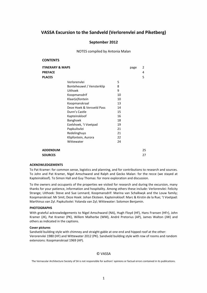
Vernacular Architecture Society of South Africa
Excursion to the Sandveld
(Verlorenvlei and Piketberg)
29-30 September 2012
1
VASSA Excursion to the Sandveld (Verlorenvlei and Piketberg)
September 2012
NOTES compiled by Antonia Malan
CONTENTS
ITINERARY & MAPS page 2
PREFACE 4
PLACES 5
Verlorenvlei 5 Bonteheuwel / Vensterklip 8 Uithoek 9 Koopmansdrif 10 Klaar(e)fontein 10 Koopmanskraal 13 Deze Hoek & Versveld Pass 14 Dunn’s Castle 15 Kapteinskloof 16 Banghoek 18 Ezelshoek, ‘t Voetpad 19 Papkuilsvlei 21
Redelinghuys 21 Klipfontein, Aurora 22 Wittewater 24
ADDENDUM 25
SOURCES 27
ACKNOWLEDGEMENTS
To Pat Kramer: for common sense, logistics and planning, and for contributions to research and sources. To John and Pat Kramer, Nigel Amschwand and Ralph and Gecko Malan: for the recce (we stayed at Kapteinskloof). To Simon Hall and Guy Thomas: for more exploration and discussion.
To the owners and occupants of the properties we visited for research and during the excursion, many thanks for your patience, information and hospitality. Among others these include: Verlorenvlei: Felicity Strange; Uithoek: Steve and Sue Lennard; Koopmansdrif: Marina van Schalkwyk and the Louw family; Koopmanskraal: Mr Smit; Deze Hoek: Johan Eksteen. Kapteinskloof: Marc & Kirstin de la Rue; ‘t Voetpad: Marthinus van Zyl. Papkuilsvlei: Yolanda van Zyl; Wittewater: Solomon Benjamin.
PHOTOGRAPHS
With grateful acknowledgements to Nigel Amschwand (NA), Hugh Floyd (HF), Hans Fransen (HFr), John Kramer (JK), Pat Kramer (PK), Willem Malherbe (WM), André Pretorius (AP), James Walton (JW) and others as indicated in the captions.
Cover pictures Sandveld building style with chimney and straight gable at one end and hipped roof at the other: Verorenvlei 1980 (HF) and Wittewater 2012 (PK). Sandveld building style with row of rooms and random extensions: Koopmanskraal 1969 (AP).
© VASSA
The Vernacular Architecture Society of SA is not responsible for authors’ opinions or factual errors contained in its publications.
2
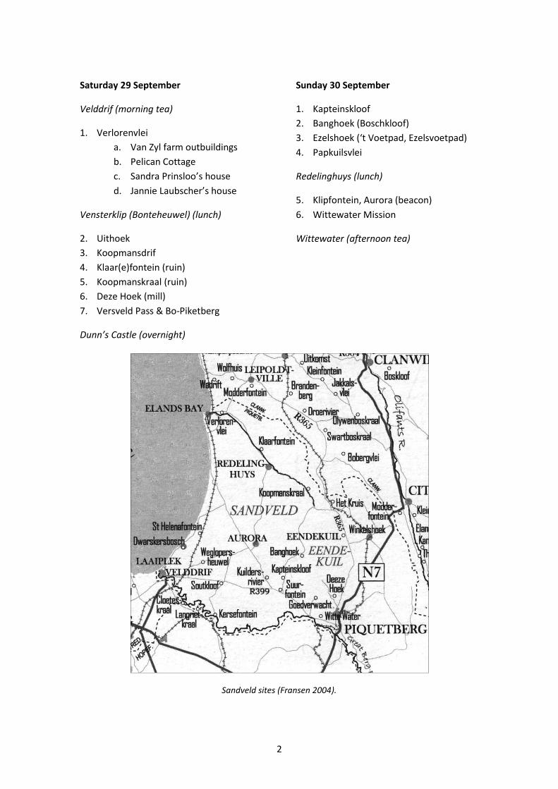
Saturday 29 September
Velddrif (morning tea)
1. Verlorenvlei
a. Van Zyl farm outbuildings
b. Pelican Cottage
c. Sandra Prinsloo’s house
d. Jannie Laubscher’s house
Vensterklip (Bonteheuwel) (lunch)
2. Uithoek
3. Koopmansdrif
4. Klaar(e)fontein (ruin)
5. Koopmanskraal (ruin)
6. Deze Hoek (mill)
7. Versveld Pass & Bo-Piketberg
Sunday 30 September
1. Kapteinskloof
2. Banghoek (Boschkloof)
3. Ezelshoek (‘t Voetpad, Ezelsvoetpad)
4. Papkuilsvlei
Redelinghuys (lunch)
5. Klipfontein, Aurora (beacon)
6. Wittewater Mission
Wittewater (afternoon tea)
Dunn’s Castle (overnight)
Sandveld sites (Fransen 2004).
3
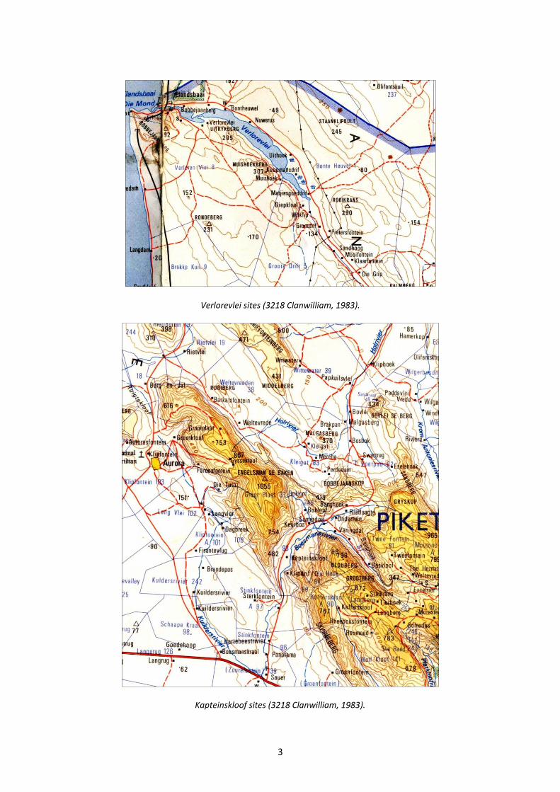
Verlorevlei sites (3218 Clanwilliam, 1983).
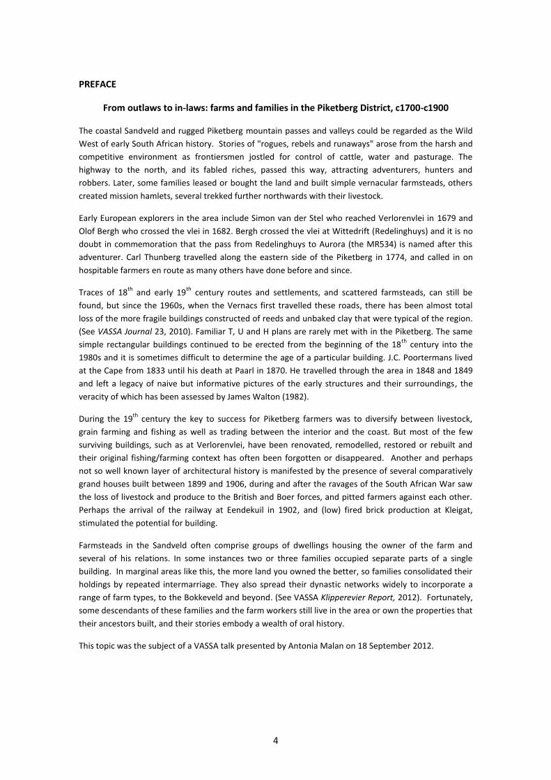
Kapteinskloof sites (3218 Clanwilliam, 1983).
4
PREFACE
From outlaws to in-laws: farms and families in the Piketberg District, c1700-c1900
The coastal Sandveld and rugged Piketberg mountain passes and valleys could be regarded as the Wild
West of early South African history. Stories of "rogues, rebels and runaways" arose from the harsh and
competitive environment as frontiersmen jostled for control of cattle, water and pasturage. The
highway to the north, and its fabled riches, passed this way, attracting adventurers, hunters and
robbers. Later, some families leased or bought the land and built simple vernacular farmsteads, others
created mission hamlets, several trekked further northwards with their livestock.
Early European explorers in the area include Simon van der Stel who reached Verlorenvlei in 1679 and
Olof Bergh who crossed the vlei in 1682. Bergh crossed the vlei at Wittedrift (Redelinghuys) and it is no
doubt in commemoration that the pass from Redelinghuys to Aurora (the MR534) is named after this
adventurer. Carl Thunberg travelled along the eastern side of the Piketberg in 1774, and called in on
hospitable farmers en route as many others have done before and since.
Traces of 18th
and early 19th
century routes and settlements, and scattered farmsteads, can still be
found, but since the 1960s, when the Vernacs first travelled these roads, there has been almost total
loss of the more fragile buildings constructed of reeds and unbaked clay that were typical of the region.
(See VASSA Journal 23, 2010). Familiar T, U and H plans are rarely met with in the Piketberg. The same
simple rectangular buildings continued to be erected from the beginning of the 18th
century into the
1980s and it is sometimes difficult to determine the age of a particular building. J.C. Poortermans lived
at the Cape from 1833 until his death at Paarl in 1870. He travelled through the area in 1848 and 1849
and left a legacy of naive but informative pictures of the early structures and their surroundings, the
veracity of which has been assessed by James Walton (1982).
During the 19th
century the key to success for Piketberg farmers was to diversify between livestock,
grain farming and fishing as well as trading between the interior and the coast. But most of the few
surviving buildings, such as at Verlorenvlei, have been renovated, remodelled, restored or rebuilt and
their original fishing/farming context has often been forgotten or disappeared. Another and perhaps
not so well known layer of architectural history is manifested by the presence of several comparatively
grand houses built between 1899 and 1906, during and after the ravages of the South African War saw
the loss of livestock and produce to the British and Boer forces, and pitted farmers against each other.
Perhaps the arrival of the railway at Eendekuil in 1902, and (low) fired brick production at Kleigat,
stimulated the potential for building.
Farmsteads in the Sandveld often comprise groups of dwellings housing the owner of the farm and
several of his relations. In some instances two or three families occupied separate parts of a single
building. In marginal areas like this, the more land you owned the better, so families consolidated their
holdings by repeated intermarriage. They also spread their dynastic networks widely to incorporate a
range of farm types, to the Bokkeveld and beyond. (See VASSA Klipperevier Report, 2012). Fortunately,
some descendants of these families and the farm workers still live in the area or own the properties that
their ancestors built, and their stories embody a wealth of oral history.
This topic was the subject of a VASSA talk presented by Antonia Malan on 18 September 2012.
5
SATURDAY 29 SEPTEMBER 2012
1. Verlorenvlei
A loan place since 1723 and in 1762 leased to Gerrit Cloete, and between 1769 and 1773 to
Andries Greef, then passed to the son of Jacobus Coetsee Jansz. Grazing rights between 1779
and 1787 were rented by Jan Jurgen Kotze. Granted to Michiel Johannes de Beer in 1837,
Theunis Erasmus Smit bought the farm in 1883. In the 20th century Smits, Coetsees, Kotzes,
Mosterts and others occupied various houses.
A distinctive architectural style developed at the mouth of the Verlorenvlei, similar to adjacent
inland areas, but different to what is considered the ‘classic’ Cape farmhouse (thatched,
gabled, symmetrical T or H in form). The earliest permanent, plastered unfired clay brick,
thatched farm buildings of the farm Verloenvlei were probably built in the late 1770s. (See also
VASSA Journal 23 2010 for a discussion of impermanent buildings.) Later a large hamlet
developed around them during the 19th century boom years of grain and fish production. One
40-metre longhouse (half of it outbuilding) was probably built or extended by Theunis Erasmus
Smit soon after 1800. Many related families gathered around the patriarch at Verlorenvlei,
occupying the simple houses which comprised the settlement.
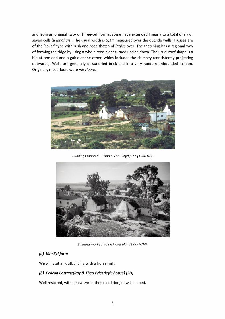
Detailed studies were undertaken of most of the individual buildings at Verlorenvlei, but few
of these houses have survived (Floyd 1980; Gribble 1987, 1990; Sinclair 1980, 1986). Including
stables, barns and houses, there were over 40 buildings or ruins still to be seen in 1992 when
Hugh Floyd led a VASSA tour to Verlorenvlei.
According to Floyd’s notes, a fairly consistent pattern of layout can be discerned from six
examples: a threshing floor with storage barn opening onto it, a stable and two or three
houses of the extended family. The standard plan for a house is a row of single-depth rooms,
6
and from an original two- or three-cell format some have extended linearly to a total of six or
seven cells (a langhuis). The usual width is 5,3m measured over the outside walls. Trusses are
of the ‘collar’ type with rush and reed thatch of latjies over. The thatching has a regional way
of forming the ridge by using a whole reed plant turned upside down. The usual roof shape is a
hip at one end and a gable at the other, which includes the chimney (consistently projecting
outwards). Walls are generally of sundried brick laid in a very random unbounded fashion.
Originally most floors were misvloere.
Buildings marked 6F and 6G on Floyd plan (1980 HF).
Building marked 6C on Floyd plan (1995 WM).
(a) Van Zyl farm
We will visit an outbuilding with a horse mill.
(b) Pelican Cottage(Ray & Thea Priestley’s house) (5D)
Well restored, with a new sympathetic addition, now L-shaped.
7
(1980 HF)
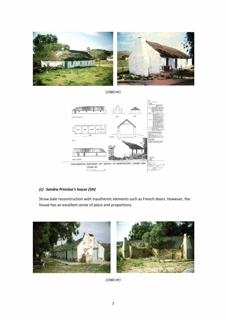
(c) Sandra Prinsloo’s house (5H)
Straw bale reconstruction with inauthentic elements such as French doors. However, the
house has an excellent sense of place and proportions.
(1980 HF)
8
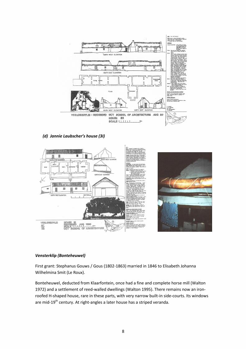
(d) Jannie Laubscher’s house (3I)
Vensterklip (Bonteheuwel)
First grant: Stephanus Gouws / Gous (1802-1863) married in 1846 to Elisabeth Johanna
Wilhelmina Smit (Le Roux).
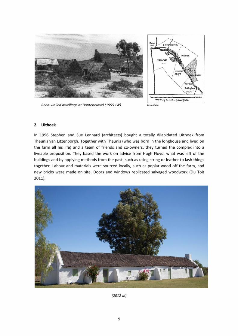
Bonteheuwel, deducted from Klaarfontein, once had a fine and complete horse mill (Walton
1972) and a settlement of reed-walled dwellings (Walton 1995). There remains now an iron-
roofed H-shaped house, rare in these parts, with very narrow built-in side-courts. Its windows
are mid-19th century. At right-angles a later house has a striped veranda.
9
Reed-walled dwellings at Bonteheuwel (1995 JW).
2. Uithoek
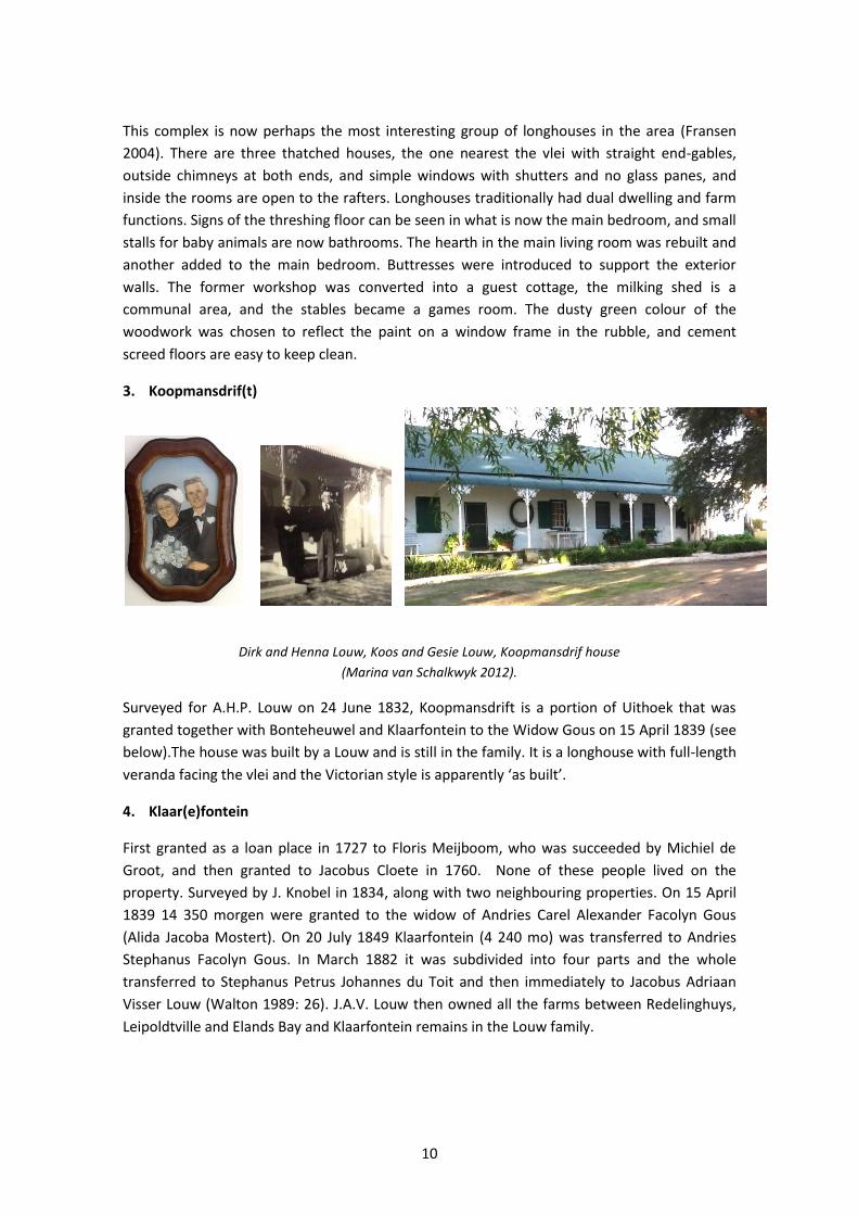
In 1996 Stephen and Sue Lennard (architects) bought a totally dilapidated Uithoek from
Theunis van Litzenborgh. Together with Theunis (who was born in the longhouse and lived on
the farm all his life) and a team of friends and co-owners, they turned the complex into a
liveable proposition. They based the work on advice from Hugh Floyd, what was left of the
buildings and by applying methods from the past, such as using string or leather to lash things
together. Labour and materials were sourced locally, such as poplar wood off the farm, and
new bricks were made on site. Doors and windows replicated salvaged woodwork (Du Toit
2011).
(2012 JK)
10
This complex is now perhaps the most interesting group of longhouses in the area (Fransen
2004). There are three thatched houses, the one nearest the vlei with straight end-gables,
outside chimneys at both ends, and simple windows with shutters and no glass panes, and
inside the rooms are open to the rafters. Longhouses traditionally had dual dwelling and farm
functions. Signs of the threshing floor can be seen in what is now the main bedroom, and small
stalls for baby animals are now bathrooms. The hearth in the main living room was rebuilt and
another added to the main bedroom. Buttresses were introduced to support the exterior
walls. The former workshop was converted into a guest cottage, the milking shed is a
communal area, and the stables became a games room. The dusty green colour of the
woodwork was chosen to reflect the paint on a window frame in the rubble, and cement
screed floors are easy to keep clean.
3. Koopmansdrif(t)
Dirk and Henna Louw, Koos and Gesie Louw, Koopmansdrif house
(Marina van Schalkwyk 2012).
Surveyed for A.H.P. Louw on 24 June 1832, Koopmansdrift is a portion of Uithoek that was
granted together with Bonteheuwel and Klaarfontein to the Widow Gous on 15 April 1839 (see
below).The house was built by a Louw and is still in the family. It is a longhouse with full-length
veranda facing the vlei and the Victorian style is apparently ‘as built’.
4. Klaar(e)fontein
First granted as a loan place in 1727 to Floris Meijboom, who was succeeded by Michiel de
Groot, and then granted to Jacobus Cloete in 1760. None of these people lived on the
property. Surveyed by J. Knobel in 1834, along with two neighbouring properties. On 15 April
1839 14 350 morgen were granted to the widow of Andries Carel Alexander Facolyn Gous
(Alida Jacoba Mostert). On 20 July 1849 Klaarfontein (4 240 mo) was transferred to Andries
Stephanus Facolyn Gous. In March 1882 it was subdivided into four parts and the whole
transferred to Stephanus Petrus Johannes du Toit and then immediately to Jacobus Adriaan
Visser Louw (Walton 1989: 26). J.A.V. Louw then owned all the farms between Redelinghuys,
Leipoldtville and Elands Bay and Klaarfontein remains in the Louw family.
11
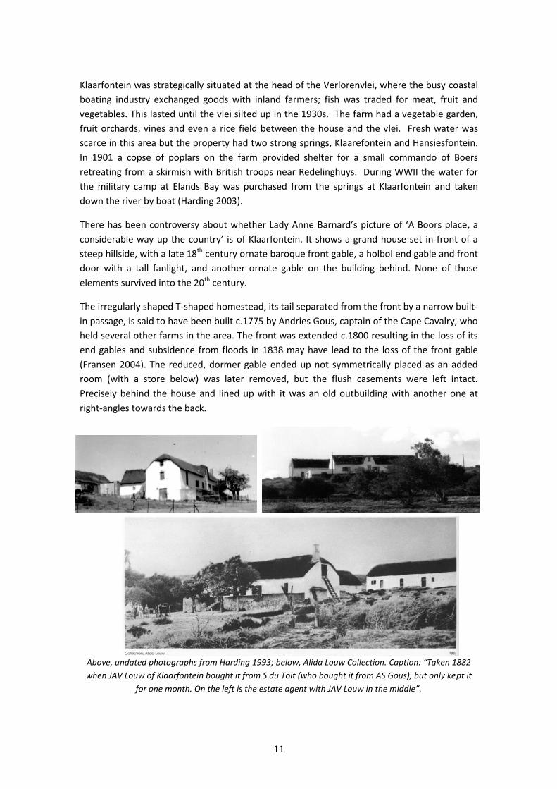
Klaarfontein was strategically situated at the head of the Verlorenvlei, where the busy coastal
boating industry exchanged goods with inland farmers; fish was traded for meat, fruit and
vegetables. This lasted until the vlei silted up in the 1930s. The farm had a vegetable garden,
fruit orchards, vines and even a rice field between the house and the vlei. Fresh water was
scarce in this area but the property had two strong springs, Klaarefontein and Hansiesfontein.
In 1901 a copse of poplars on the farm provided shelter for a small commando of Boers
retreating from a skirmish with British troops near Redelinghuys. During WWII the water for
the military camp at Elands Bay was purchased from the springs at Klaarfontein and taken
down the river by boat (Harding 2003).
There has been controversy about whether Lady Anne Barnard’s picture of ‘A Boors place, a
considerable way up the country’ is of Klaarfontein. It shows a grand house set in front of a
steep hillside, with a late 18th century ornate baroque front gable, a holbol end gable and front
door with a tall fanlight, and another ornate gable on the building behind. None of those
elements survived into the 20th century.
The irregularly shaped T-shaped homestead, its tail separated from the front by a narrow built-
in passage, is said to have been built c.1775 by Andries Gous, captain of the Cape Cavalry, who
held several other farms in the area. The front was extended c.1800 resulting in the loss of its
end gables and subsidence from floods in 1838 may have lead to the loss of the front gable
(Fransen 2004). The reduced, dormer gable ended up not symmetrically placed as an added
room (with a store below) was later removed, but the flush casements were left intact.
Precisely behind the house and lined up with it was an old outbuilding with another one at
right-angles towards the back.
Above, undated photographs from Harding 1993; below, Alida Louw Collection. Caption: “Taken 1882
when JAV Louw of Klaarfontein bought it from S du Toit (who bought it from AS Gous), but only kept it
for one month. On the left is the estate agent with JAV Louw in the middle”.
12
When James Walton measured the building
in 1982, he made the following deductions. It
was originally a longhouse of the type with a
central doorway, flanked by casement
windows on each side, and as the house is
built on a steep slope the front has a high
stoep. The central voorkamer was flanked by
two bedrooms, each of which had a
shuttered window. Behind, was a detached
second block at right-angles to the first, later
linked by a passage, which housed the
agterkamer and kitchen. Two buitekamers were later built to accommodate two brothers at
each end of the front wing, one of which (N-E) was built above a storeroom and the other (S-E)
was eventually converted into a kitchen.
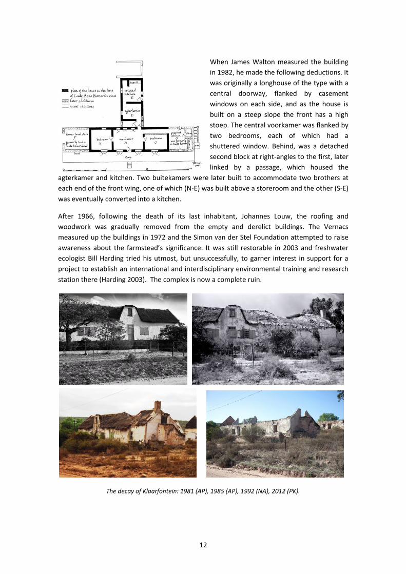
After 1966, following the death of its last inhabitant, Johannes Louw, the roofing and
woodwork was gradually removed from the empty and derelict buildings. The Vernacs
measured up the buildings in 1972 and the Simon van der Stel Foundation attempted to raise
awareness about the farmstead’s significance. It was still restorable in 2003 and freshwater
ecologist Bill Harding tried his utmost, but unsuccessfully, to garner interest in support for a
project to establish an international and interdisciplinary environmental training and research
station there (Harding 2003). The complex is now a complete ruin.
The decay of Klaarfontein: 1981 (AP), 1985 (AP), 1992 (NA), 2012 (PK).
13
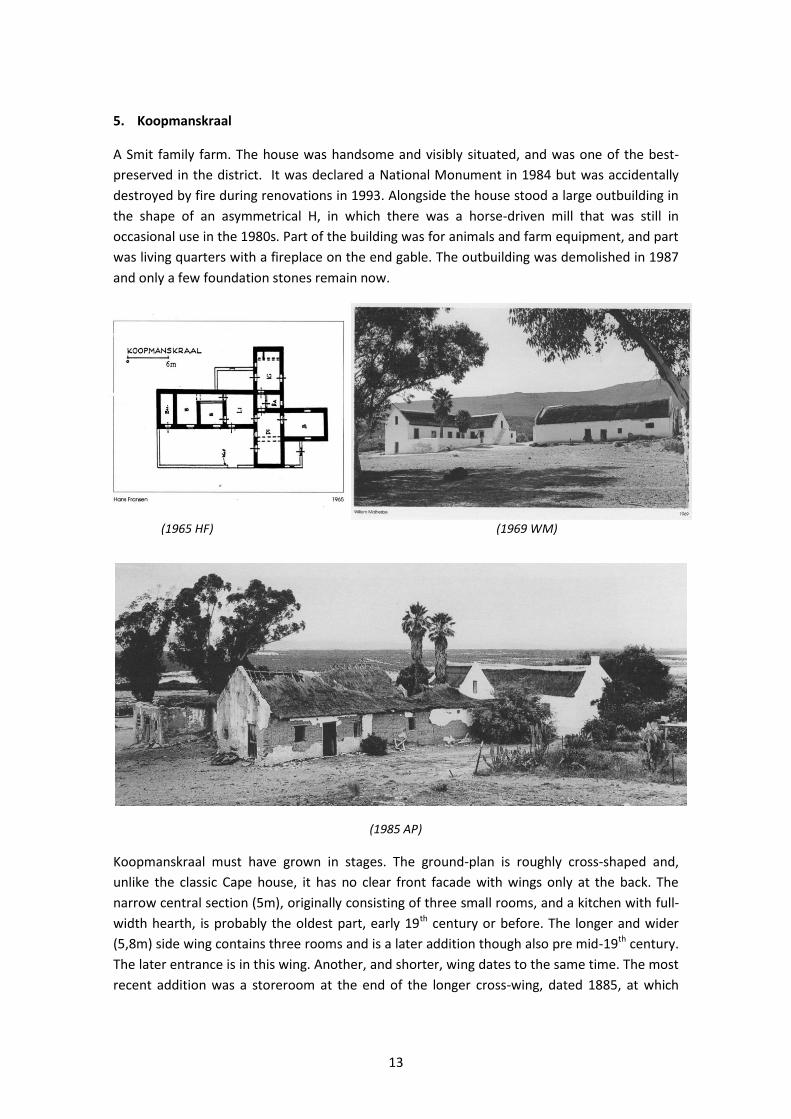
5. Koopmanskraal
A Smit family farm. The house was handsome and visibly situated, and was one of the best-
preserved in the district. It was declared a National Monument in 1984 but was accidentally
destroyed by fire during renovations in 1993. Alongside the house stood a large outbuilding in
the shape of an asymmetrical H, in which there was a horse-driven mill that was still in
occasional use in the 1980s. Part of the building was for animals and farm equipment, and part
was living quarters with a fireplace on the end gable. The outbuilding was demolished in 1987
and only a few foundation stones remain now.
(1965 HF) (1969 WM)
(1985 AP)
Koopmanskraal must have grown in stages. The ground-plan is roughly cross-shaped and,
unlike the classic Cape house, it has no clear front facade with wings only at the back. The
narrow central section (5m), originally consisting of three small rooms, and a kitchen with full-
width hearth, is probably the oldest part, early 19th century or before. The longer and wider
(5,8m) side wing contains three rooms and is a later addition though also pre mid-19th century.
The later entrance is in this wing. Another, and shorter, wing dates to the same time. The most
recent addition was a storeroom at the end of the longer cross-wing, dated 1885, at which
14
time the whole house was overhauled and new doors and windows put in. Steps lead to the
loft at one end and a garden wall fills in one of the angles of the cross. Due to the falling
ground, the end of the longer wing allows for a basement room (Fransen 1980).
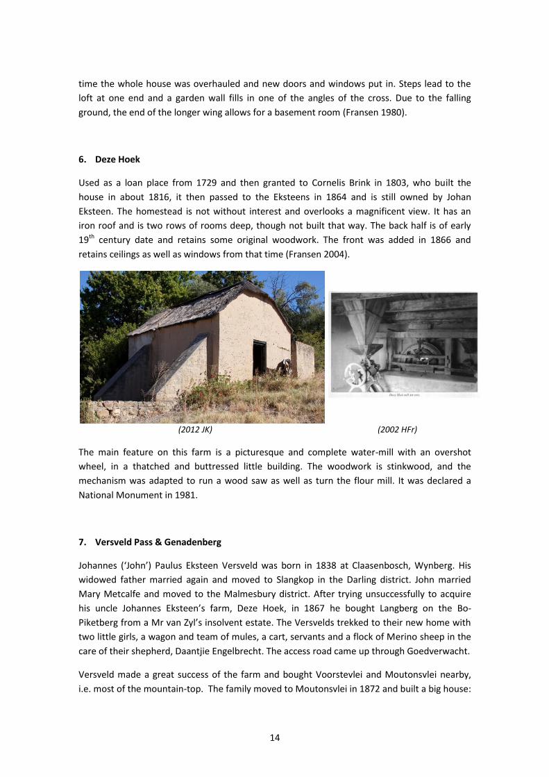
6. Deze Hoek
Used as a loan place from 1729 and then granted to Cornelis Brink in 1803, who built the
house in about 1816, it then passed to the Eksteens in 1864 and is still owned by Johan
Eksteen. The homestead is not without interest and overlooks a magnificent view. It has an
iron roof and is two rows of rooms deep, though not built that way. The back half is of early
19th century date and retains some original woodwork. The front was added in 1866 and
retains ceilings as well as windows from that time (Fransen 2004).
(2012 JK) (2002 HFr)
The main feature on this farm is a picturesque and complete water-mill with an overshot
wheel, in a thatched and buttressed little building. The woodwork is stinkwood, and the
mechanism was adapted to run a wood saw as well as turn the flour mill. It was declared a
National Monument in 1981.
7. Versveld Pass & Genadenberg
Johannes (‘John’) Paulus Eksteen Versveld was born in 1838 at Claasenbosch, Wynberg. His
widowed father married again and moved to Slangkop in the Darling district. John married
Mary Metcalfe and moved to the Malmesbury district. After trying unsuccessfully to acquire
his uncle Johannes Eksteen’s farm, Deze Hoek, in 1867 he bought Langberg on the Bo-
Piketberg from a Mr van Zyl’s insolvent estate. The Versvelds trekked to their new home with
two little girls, a wagon and team of mules, a cart, servants and a flock of Merino sheep in the
care of their shepherd, Daantjie Engelbrecht. The access road came up through Goedverwacht.
Versveld made a great success of the farm and bought Voorstevlei and Moutonsvlei nearby,
i.e. most of the mountain-top. The family moved to Moutonsvlei in 1872 and built a big house:
15
they had 15 children. However, they had a huge problem getting their produce and
themselves down the mountain to Piketberg. For instance, a trip to church entailed going by
cart to the edge of the mountain, changing to horses to descend to Deze Hoek, and then using
another cart to get to the village.
In 1889 Versveld started work on a pass with twenty labourers and daily oversaw their work.
The clever design of the zigzag road included loops at the bends (apparently inspired by the
way his watch chain lay on the bedside table) so that a wagon and team could take the corners
almost on the level. (A British army engineer saw it during the Anglo Boer War and built a
similar one in India.) The present Versveld pass was built in the 1940s by the Divisional Council,
slightly closer to Piketberg. You can still pick out the old pass leading to Moutonsvlei, and its
loops, if you look closely at the satellite picture on Google Earth.
Genadenberg mission station lies at the top of Versveld pass on old Voorstevlei farmland. The
land was purchased by the Moravian church in 1953 for their growing membership among
farm workers on Bo-op die Piketberg, however, some residents from Goedverwacht also
resettled at Genadenberg since it was closer to their places of work on the surrounding farms.
While a few residential houses were built during the early 1950s, such development was
constrained by the zoning of the property as agricultural land. The surrounding farmers also
encouraged its workers as well as the Church to rather ensure that people remained living on
the farms in the area. This has resulted in Genadenberg having a large, scattered congregation,
residing on the surrounding farms (SPP & LRC 2000).
The mountain is an important deciduous-fruit producing district of the Cape, as well as the
farming of buchu, a project started by one of John Versveld’s sons. In 2008 the CSIR undertook
a project to create a community-based buchu (Agathosma betulina) essential oil business.
Today, one also notices rows of lavender bushes.
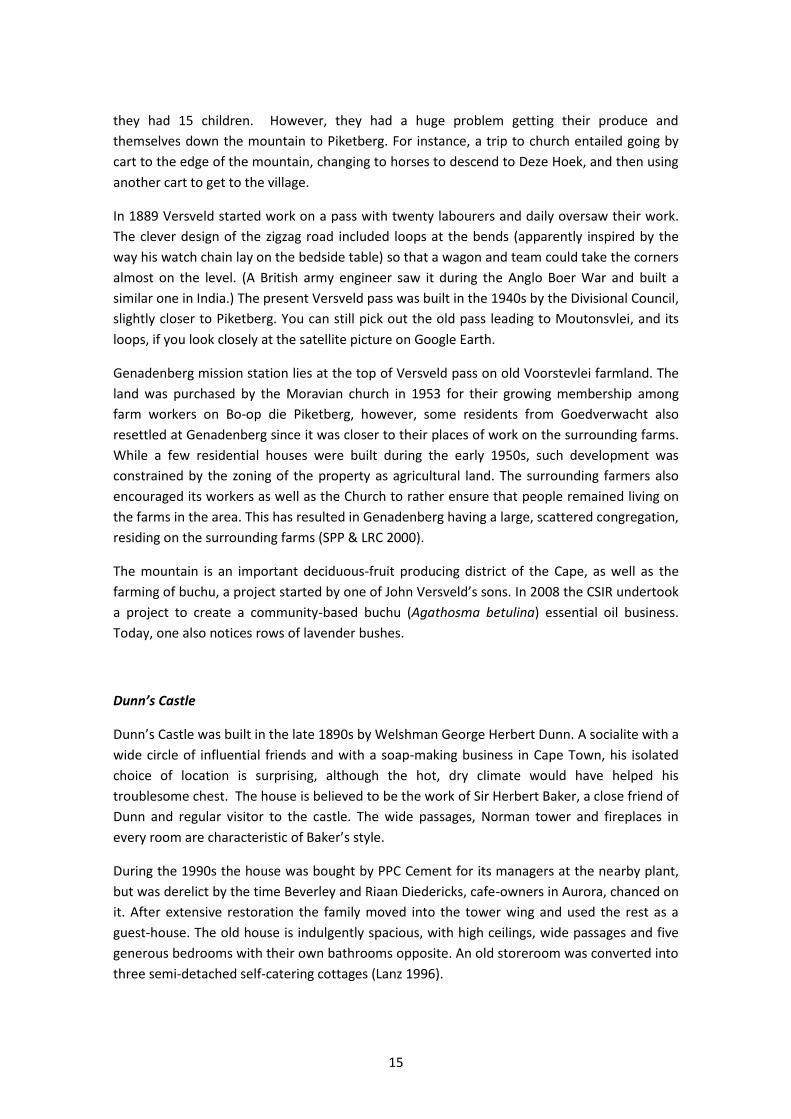
Dunn’s Castle
Dunn’s Castle was built in the late 1890s by Welshman George Herbert Dunn. A socialite with a
wide circle of influential friends and with a soap-making business in Cape Town, his isolated
choice of location is surprising, although the hot, dry climate would have helped his
troublesome chest. The house is believed to be the work of Sir Herbert Baker, a close friend of
Dunn and regular visitor to the castle. The wide passages, Norman tower and fireplaces in
every room are characteristic of Baker’s style.
During the 1990s the house was bought by PPC Cement for its managers at the nearby plant,
but was derelict by the time Beverley and Riaan Diedericks, cafe-owners in Aurora, chanced on
it. After extensive restoration the family moved into the tower wing and used the rest as a
guest-house. The old house is indulgently spacious, with high ceilings, wide passages and five
generous bedrooms with their own bathrooms opposite. An old storeroom was converted into
three semi-detached self-catering cottages (Lanz 1996).
16
Most recently, under new ownership, a contentious modern complex of 20 en-suite rooms and
self-catering facilities was built within sight of the road, which in heritage impact terms could
be considered inappropriate in scale, design and location.
(AP)
SUNDAY 30 SEPTEMBER 2012
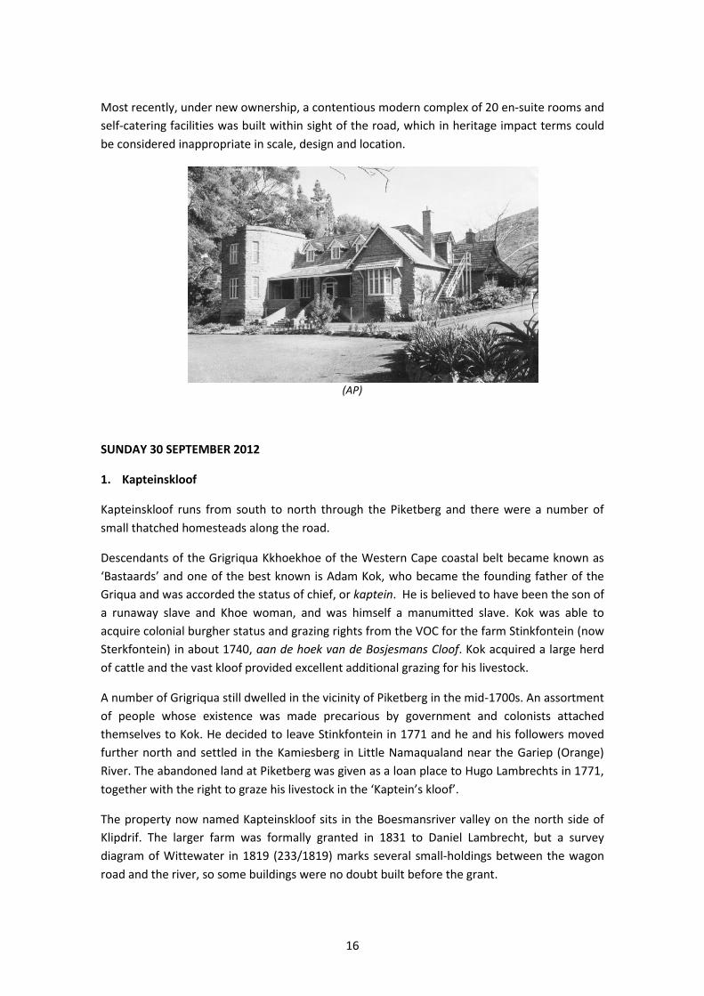
1. Kapteinskloof
Kapteinskloof runs from south to north through the Piketberg and there were a number of
small thatched homesteads along the road.
Descendants of the Grigriqua Kkhoekhoe of the Western Cape coastal belt became known as
‘Bastaards’ and one of the best known is Adam Kok, who became the founding father of the
Griqua and was accorded the status of chief, or kaptein. He is believed to have been the son of
a runaway slave and Khoe woman, and was himself a manumitted slave. Kok was able to
acquire colonial burgher status and grazing rights from the VOC for the farm Stinkfontein (now
Sterkfontein) in about 1740, aan de hoek van de Bosjesmans Cloof. Kok acquired a large herd
of cattle and the vast kloof provided excellent additional grazing for his livestock.
A number of Grigriqua still dwelled in the vicinity of Piketberg in the mid-1700s. An assortment
of people whose existence was made precarious by government and colonists attached
themselves to Kok. He decided to leave Stinkfontein in 1771 and he and his followers moved
further north and settled in the Kamiesberg in Little Namaqualand near the Gariep (Orange)
River. The abandoned land at Piketberg was given as a loan place to Hugo Lambrechts in 1771,
together with the right to graze his livestock in the ‘Kaptein’s kloof’.
The property now named Kapteinskloof sits in the Boesmansriver valley on the north side of
Klipdrif. The larger farm was formally granted in 1831 to Daniel Lambrecht, but a survey
diagram of Wittewater in 1819 (233/1819) marks several small-holdings between the wagon
road and the river, so some buildings were no doubt built before the grant.

17
In 1987 the run-down property was purchased by playwright Pieter and potter Marlize Fourie
who renovated the building into a home and guest-house. In 1992 the Fouries acquired the
adjacent free-standing dwelling (‘Tant Lettie’s house’), the oldest on the property, and turned
the ruin into an extension of their guest-house (Pretorius 1997). Since 2002 Kapteinskloof has
belonged to Marc and Kerstin de la Rue, who maintain the guest-house, farm on a small scale
and keep horses (note the modern stable block as one enters the property from the road).
(c. 1992 AP; c. 2012 www.safarinow.com)
The house is an elongated rectangle, though with a small kitchen wing which turns it into a L.
The walls of the guest-house (above) are of stone and clay and the rooms are open to the
rafters and thatch.
J.C. Poortermans, March 1849. ‘Captains Clove in the Piquet Mountains property of the widow F.
Lambregts’. It depicts a thriving settlement with a homestead, three other permanent structures and
several kapstylhuise. The dwelling has a hipped thatched roof and central doorway with two shuttered
windows on each side.
18
2. Banghoek (Boschkloof)
A loan farm of Johannes Lubbe in 1781, granted to Johannes Hendrik Fischer in 1821 (Walton
1968) and transferred to Jan Nicolaas Smit in 1832. It passed to his son-in-law, Dirk Jacobus
Kotze, who had married Madgelena Maria Smit, and then to their daughters who married into
the Burger family who still farm the valley (Country & Coastal Properties website). The name is
supposed to refer to an unexpected encounter with a rhino, several examples of which are said
to have taken place in the area and were dramatically reported by Francois Valentyn in his
book published in 1726.
In the 19th century it was a mixed farm with grain, vines, horses, oxen and small livestock, and
it served as an ox-wagon stopover with a blacksmith, water mill and schoolhouse with over 60
pupils (Country & Coastal Properties website). More recently, in 1991 the ‘Banghoek Private
Game Reserve’ was registered as a sectional title development comprising a combination of
nature reserve and holiday houses. A devastating fire destroyed most of the custom-designed
buildings in 2003.
The existing farmhouse was erected after 1821 and before 1849 and over the years has seen a
number of additions and alterations. The homestead (probably built by Fischer) is the only one
in the Kapteinskloof that is TT shaped. It had four half-hipped ends, one now replaced by a
gable, and no front gable. The two back wings are close together and the narrow passage is
now roofed over. The original windows have been replaced and the house is internally altered
though old ceilings remain, with squared beams in front and round beams in the back and side
rooms (Fransen 2004: 348).
(1990 AP)
19
J.C. Poortermans, 1849. ‘The estate Banghoek, situated in the Piquet mountains, Proprietor J. Smith
Esq.’. Shows the farmhouse and outbuildings, cultivated fields and a kraal on the hillside.
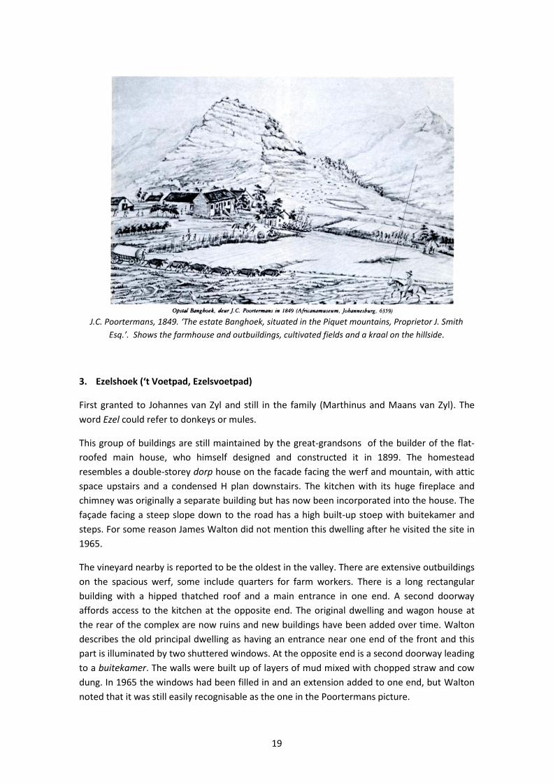
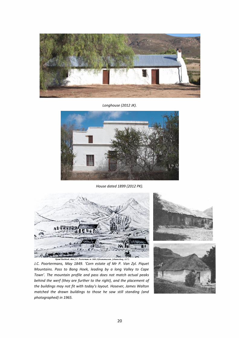
3. Ezelshoek (‘t Voetpad, Ezelsvoetpad)
First granted to Johannes van Zyl and still in the family (Marthinus and Maans van Zyl). The
word Ezel could refer to donkeys or mules.
This group of buildings are still maintained by the great-grandsons of the builder of the flat-
roofed main house, who himself designed and constructed it in 1899. The homestead
resembles a double-storey dorp house on the facade facing the werf and mountain, with attic
space upstairs and a condensed H plan downstairs. The kitchen with its huge fireplace and
chimney was originally a separate building but has now been incorporated into the house. The
façade facing a steep slope down to the road has a high built-up stoep with buitekamer and
steps. For some reason James Walton did not mention this dwelling after he visited the site in
1965.
The vineyard nearby is reported to be the oldest in the valley. There are extensive outbuildings
on the spacious werf, some include quarters for farm workers. There is a long rectangular
building with a hipped thatched roof and a main entrance in one end. A second doorway
affords access to the kitchen at the opposite end. The original dwelling and wagon house at
the rear of the complex are now ruins and new buildings have been added over time. Walton
describes the old principal dwelling as having an entrance near one end of the front and this
part is illuminated by two shuttered windows. At the opposite end is a second doorway leading
to a buitekamer. The walls were built up of layers of mud mixed with chopped straw and cow
dung. In 1965 the windows had been filled in and an extension added to one end, but Walton
noted that it was still easily recognisable as the one in the Poortermans picture.
20
Longhouse (2012 JK).
House dated 1899 (2012 PK).
J.C. Poortermans, May 1849. ‘Corn estate of Mr P. Van Zyl. Piquet
Mountains. Pass to Bang Hoek, leading by a long Valley to Cape
Town’. The mountain profile and pass does not match actual peaks
behind the werf (they are further to the right), and the placement of
the buildings may not fit with today’s layout. Hosever, James Walton
matched the drawn buildings to those he saw still standing (and
photographed) in 1965.
21
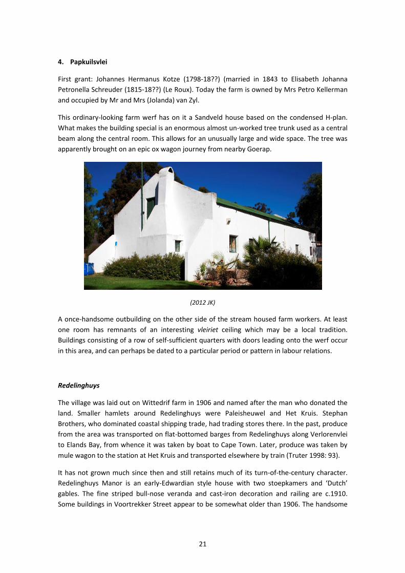
4. Papkuilsvlei
First grant: Johannes Hermanus Kotze (1798-18??) (married in 1843 to Elisabeth Johanna
Petronella Schreuder (1815-18??) (Le Roux). Today the farm is owned by Mrs Petro Kellerman
and occupied by Mr and Mrs (Jolanda) van Zyl.
This ordinary-looking farm werf has on it a Sandveld house based on the condensed H-plan.
What makes the building special is an enormous almost un-worked tree trunk used as a central
beam along the central room. This allows for an unusually large and wide space. The tree was
apparently brought on an epic ox wagon journey from nearby Goerap.
(2012 JK)
A once-handsome outbuilding on the other side of the stream housed farm workers. At least
one room has remnants of an interesting vleiriet ceiling which may be a local tradition.
Buildings consisting of a row of self-sufficient quarters with doors leading onto the werf occur
in this area, and can perhaps be dated to a particular period or pattern in labour relations.
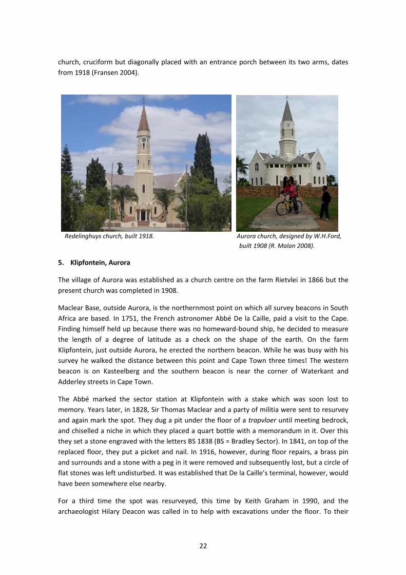
Redelinghuys
The village was laid out on Wittedrif farm in 1906 and named after the man who donated the
land. Smaller hamlets around Redelinghuys were Paleisheuwel and Het Kruis. Stephan
Brothers, who dominated coastal shipping trade, had trading stores there. In the past, produce
from the area was transported on flat-bottomed barges from Redelinghuys along Verlorenvlei
to Elands Bay, from whence it was taken by boat to Cape Town. Later, produce was taken by
mule wagon to the station at Het Kruis and transported elsewhere by train (Truter 1998: 93).
It has not grown much since then and still retains much of its turn-of-the-century character.
Redelinghuys Manor is an early-Edwardian style house with two stoepkamers and ‘Dutch’
gables. The fine striped bull-nose veranda and cast-iron decoration and railing are c.1910.
Some buildings in Voortrekker Street appear to be somewhat older than 1906. The handsome
22
church, cruciform but diagonally placed with an entrance porch between its two arms, dates
from 1918 (Fransen 2004).
Redelinghuys church, built 1918. Aurora church, designed by W.H.Ford,
built 1908 (R. Malan 2008).
5. Klipfontein, Aurora
The village of Aurora was established as a church centre on the farm Rietvlei in 1866 but the
present church was completed in 1908.
Maclear Base, outside Aurora, is the northernmost point on which all survey beacons in South
Africa are based. In 1751, the French astronomer Abbé De la Caille, paid a visit to the Cape.
Finding himself held up because there was no homeward-bound ship, he decided to measure
the length of a degree of latitude as a check on the shape of the earth. On the farm
Klipfontein, just outside Aurora, he erected the northern beacon. While he was busy with his
survey he walked the distance between this point and Cape Town three times! The western
beacon is on Kasteelberg and the southern beacon is near the corner of Waterkant and
Adderley streets in Cape Town.
The Abbé marked the sector station at Klipfontein with a stake which was soon lost to
memory. Years later, in 1828, Sir Thomas Maclear and a party of militia were sent to resurvey
and again mark the spot. They dug a pit under the floor of a trapvloer until meeting bedrock,
and chiselled a niche in which they placed a quart bottle with a memorandum in it. Over this
they set a stone engraved with the letters BS 1838 (BS = Bradley Sector). In 1841, on top of the
replaced floor, they put a picket and nail. In 1916, however, during floor repairs, a brass pin
and surrounds and a stone with a peg in it were removed and subsequently lost, but a circle of
flat stones was left undisturbed. It was established that De la Caille’s terminal, however, would
have been somewhere else nearby.
For a third time the spot was resurveyed, this time by Keith Graham in 1990, and the
archaeologist Hilary Deacon was called in to help with excavations under the floor. To their
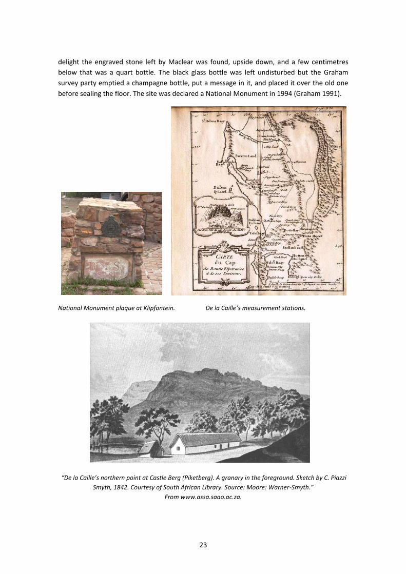
23
delight the engraved stone left by Maclear was found, upside down, and a few centimetres
below that was a quart bottle. The black glass bottle was left undisturbed but the Graham
survey party emptied a champagne bottle, put a message in it, and placed it over the old one
before sealing the floor. The site was declared a National Monument in 1994 (Graham 1991).
National Monument plaque at Klipfontein. De la Caille’s measurement stations.
“De la Caille’s northern point at Castle Berg (Piketberg). A granary in the foreground. Sketch by C. Piazzi
Smyth, 1842. Courtesy of South African Library. Source: Moore: Warner-Smyth.”
From www.assa.saao.ac.za.
24
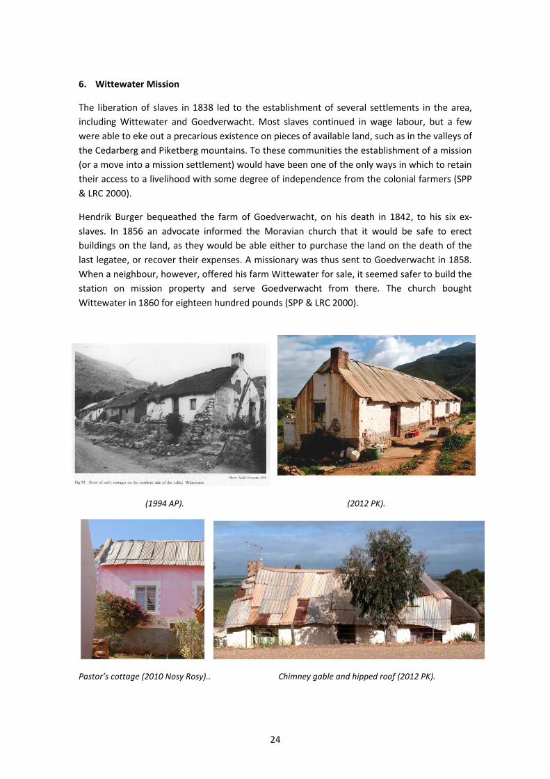
6. Wittewater Mission
The liberation of slaves in 1838 led to the establishment of several settlements in the area,
including Wittewater and Goedverwacht. Most slaves continued in wage labour, but a few
were able to eke out a precarious existence on pieces of available land, such as in the valleys of
the Cedarberg and Piketberg mountains. To these communities the establishment of a mission
(or a move into a mission settlement) would have been one of the only ways in which to retain
their access to a livelihood with some degree of independence from the colonial farmers (SPP
& LRC 2000).
Hendrik Burger bequeathed the farm of Goedverwacht, on his death in 1842, to his six ex-
slaves. In 1856 an advocate informed the Moravian church that it would be safe to erect
buildings on the land, as they would be able either to purchase the land on the death of the
last legatee, or recover their expenses. A missionary was thus sent to Goedverwacht in 1858.
When a neighbour, however, offered his farm Wittewater for sale, it seemed safer to build the
station on mission property and serve Goedverwacht from there. The church bought
Wittewater in 1860 for eighteen hundred pounds (SPP & LRC 2000).
(1994 AP). (2012 PK).
Pastor’s cottage (2010 Nosy Rosy).. Chimney gable and hipped roof (2012 PK).
25
Wittewater consisted of the usual two contour streets flanking a valley bottom with little
garden allotments. There are several rows of two- and three-roomed thatched cottages. Those
on the upper side of the street have high dressed stone stoeps in front, many with ‘buttresses’
supporting their front walls and also acting as side walls that screen each stoep from its
neighbours. Walton and Pretorius visited in 1994, and described the cottages thus. Most of the
thatched roofs terminate in a hipped gable but a few have triangular gables protected by the
thatch. Walls are of clay coated with lime, the entrance (with bo-en-onder door) is placed
centrally in the front wall, but some have a second doorway into the kitchen. Some window
openings were unglazed and closed by internal side-hung wooden shutters, but the majority
have side-hung casements.
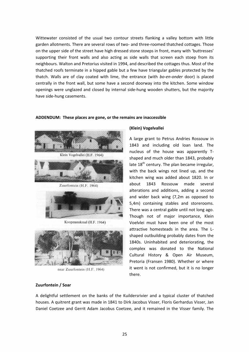
ADDENDUM: These places are gone, or the remains are inaccessible
(Klein) Vogelvallei
A large grant to Petrus Andries Rossouw in
1843 and including old loan land. The
nucleus of the house was apparently T-
shaped and much older than 1843, probably
late 18th century. The plan became irregular,
with the back wings not lined up, and the
kitchen wing was added about 1820. In or
about 1843 Rossouw made several
alterations and additions, adding a second
and wider back wing (7,2m as opposed to
5,4m) containing stables and storerooms.
There was a central gable until not long ago.
Though not of major importance, Klein
Voelvlei must have been one of the most
attractive homesteads in the area. The L-
shaped outbuilding probably dates from the
1840s. Uninhabited and deteriorating, the
complex was donated to the National
Cultural History & Open Air Museum,
Pretoria (Fransen 1980). Whether or where
it went is not confirmed, but it is no longer
there.
Zuurfontein / Soar
A delightful settlement on the banks of the Kuildersrivier and a typical cluster of thatched
houses. A quitrent grant was made in 1841 to Dirk Jacobus Visser, Floris Gerhardus Visser, Jan
Daniel Coetzee and Gerrit Adam Jacobus Coetzee, and it remained in the Visser family. The
26
actual homestead, prominently placed on a small rise overlooking the Piketberg-Aurora road,
was TT shaped with four gables and a simple small triangular front gable. Next to it stood a
smaller building, T-shaped and more modest. Both buildings dated from before the quitrent
grant, one perhaps from about 1825 and the other possibly earlier (Fransen 1980). They were
demolished in 1976 due to termite damage (Dirkie Neethling, pers.comm.).
Opposite the Zuurfontein buildings, across the road, there was another fairly large building, U-
shaped with fully hipped ends. Scattered around nearby were several other thatched old
houses (Soar) (Fransen 1980).
Kuildersrivier
A small L-shaped homestead of which the front part had end-gables and thatch of such an
uncommonly low pitch, about 30 degrees, that small loft-windows could be inserted below the
eaves (as became fashionable with iron roofs). It had a huge outside fireplace (with a small
window) and chimney stack. The outbuildings were un-whitewashed and had fully hipped
ends. The complex probably dated from mid-19th century (Fransen 2004).
Winkelshoek
In about 1960 this house was still a complete and fine H-house with a front gable and end-
gables of the pedimental holbol type and sash windows dating from c.1830. It was very much
as it had been when first built, without any later alterations, and apparently not in bad repair.
However, it was uninhabited. It was at first half demolished for some reason (c.2000), and then
completely removed to make way for a new wine cellar. Fransen (2004) states: “This is one of
the saddest and most inexcusable cases of vandalism – committed by the directors of a winery,
not by ignorant peasants – that has come to the notice of the authors”.
Eendekuil
Just outside the modern village stood an old T-shaped
homestead of great authenticity, uninhabited and deteriorating
in c.2000 and now demolished completely. It had a thatched roof
with three half-hipped ends, flush woodwork round the
casements and a door with fanlight (Fransen 1980). Two hipped
outbuildings stood in line with the homestead.
Schrik van Rondom
Grant made in 1839 to Johannes Albertus Laubscher, who probably built the large though
modest opgekleide T-shaped homestead. It was difficult to date in the absence of gables as,
like most Sandveld houses the traditional building methods were followed for a long time. A
large outbuilding behind the house looked as though it is the same age, and it was built
recently (Fransen 1980). Gold was prospected here as early as 1887 (Truter 1998: 48). On
Google Earth the buildings are now ruins, but the road across the river is no longer visible.
27
SOURCES
Du Toit, E. The remains of the day [Uithoek]. Architecture / Spaces, February 2011.
Floyd, H. 1980. Verlorenvlei: Recorded. School of Architecture, University of Cape Town.
Forbes, V.S. 1965. Pioneer Travellers of South Africa. Cape Town: A.A. Balkema.
Fransen, H. & Cook, M. 1980. The Old Buildings of the Cape. Cape Town: A.A. Balkema.
Fransen, H. 2004. The Old Buildings of the Cape. Johannesburg: Jonathan Ball.
Graham, K. 1991. Historic stone I – Maclear’s sector station at Klipfontein. South African Journal of Surveying and Mapping, 21(1): 13-14.
Gribble, J. 1987. Archives and ruins: aspects of the historical settlement of Verlorenvlei in the 18th century. Unpublished BA (Hons) project, University of Cape Town.
Gribble, J. 1990. Verlorenvlei vernacular: a structuralist analysis of Sandveld folk architecture. Unpublished MA dissertation, University of Cape Town.
Harding, W. 2003. Klaarfontein restoration proposal: Phase 1 Feasibility Study. International Environmental Management Systems Inc.
Lanz, C. 1996. Dunn’s Castle. Getaway, February 1996: 93-95.
Le Roux, J.G. nd. Bewaarders van ons Erfenis, Distrik Piketberg, vols 12 & 13: Wyk Sandveld, Wyk Verlorevlei & Wyk Piketberg. Paarl Heemkring.
Malan, A. & Webley, L. 2010. West Coast buildings: the architecture of a coastal frontier. VASSA Journal, 23: 2-22.
Mossop, E.E. 1931. Journals of the expeditions: of the honourable ensign Olof Bergh (1682 and 1683) and the ensign Isaq Schrijver (1689). Cape Town: Van Riebeek Society.
Penn, N. 1999. Rogues, Rebels and Runaways. Cape Town: David Philip.
Penn, N. 2005. The Forgotten Frontier. Cape Town: Double Storey Books.
Pretorius, A. 1997. Our Threatened Heritage. André Pretorius, Milnerton.
Sinclair, S. 1980. The rural settlement of Verlorenvlei in historical perspective. School of Environmental Studies (UCT), Research Report no. 20.
Smith, M.H.D. 1985. Boerepioneers van die Sandveld. Pretoria: Raad vir Geesteswetenskaplike Navorsing.
SPP & LRC. 2000. An inventory and description of the historical acquisition of Moravian Church land: a report compiled for the Moravian Church of South Africa by the Surplus People Project and the Legal Resource Centre.
Swanepoel, N.J. 1996. “Aan der Clawer Fonteijn”: a contribution towards the study of Klaarefontein and the Verlorenvlei. Unpublished BA (Hons) project, University of Cape Town.
Truter, C. 1998. West Coast: A Tourist Guide. Rondebosch: University of Cape Town.
Van Sittert, L. 1992. Labour, capital and the state in the St Helena Bay fisheries, c1856-c1956. PhD thesis, University of Cape Town.
Walton, J. 1982. Some early Piquetberg farms illustrated by Johannes Cornelius Poortermans. Restorica, 12: 8-15.
28
Walton, J. 1989. Old Cape Farmsteads. Cape Town: Human & Rousseau.
Walton, J. 1995. Cape Cottages. Cape Town: Intaka.
See Also
Floyd, H. & Marx, J. 1992. Verlorenvlei and the West Coast. VASSA Excursion, October 1992.
Van Zyl, B. nd. Klaarfontein aan die Verlorevlei: straks finaal tot niet? Verlore Erfenis, Die Burger.
Walton, J. 1968. Excursion to Piquetberg and Citrusdal. VASSA Excursion, November 1968.
Walton, J. 1972. Notes for excursion to Verlorenvlei. VASSA Excursion, 1972.
LOCAL CONTACTS
Solomon Benjamin, Wittewater Tourism: 079 298 2853.
Marc & Kirstin de la Rue, Kapteinskloof: 022 912 4605; [email protected].
Sue Lennard, Uithoek: 021 702 2288.
Heike Oelbuttel, Piketberg Tourism: 022 913 2063 / 084 372 3326; [email protected].
Sandveld Dorpshuys Coffee Shop & Museum, Redelinghuys: 022 962 1746.
The Tin Kitchen, Vensterklip: 022 972 1340.