Embed Size (px)
Citation preview
Executive S
umm
ary

GOLD LINE FINAL ENVIRONMENTAL IMPACT STATEMENT
ES-1 AUGUST 2009
ES Executive Summary
ES.1 Introduction This Final Environmental Impact Statement (FEIS) for the Gold Line project has been prepared in accordance with the Council on Environmental Quality regulations (40 Code of Federal Regulations [CFR] 1500) and the joint Federal Transit Administration (FTA)/Federal Highway Administration (FHWA) regulations (23 CFR 771). Because it is required as a supporting component of the Preferred Alternative, the Commuter Rail Maintenance Facility (CRMF) is also included in this FEIS. A Supplemental Environmental Assessment (SEA) to support the Gold Line and East Corridor Draft Environmental Impact Statement (DEIS) documents has been prepared for the CRMF and is incorporated by reference (FTA, 2009). Content and comments from that document are incorporated into this FEIS.
What is the proposed project? The proposed project is to provide commuter rail from Denver Union Station (DUS) in downtown Denver to Ward Road in Wheat Ridge, Colorado. From DUS to the CRMF (just north of 48th Avenue in Denver) the alignment is shared by all of the FasTracks commuter rail corridors for service at the CRMF and for passenger service for the Gold Line and Northwest Rail. North of the CRMF to Pecos Street, the alignment is shared by Gold Line and Northwest Rail for a continuation of passenger service on those corridors. The DUS to Pecos Street section is assumed to be locally funded. The Northwest Rail project is currently undergoing an environmental evaluation. The environmental evaluation will lead to an Environmental Assessment or Environmental Impact Statement (EIS) for that project. The federal lead agency for that project is the U.S. Army Corps of Engineers (USACE) as the federal action is the 404 permit. West of Pecos Street to Ward Road, the alignment would be primarily within the existing BNSF Railway Company and Union Pacific Railroad Company (BNSF/UP) freight railroad rights-of-way (ROW). The FTA, local governments, regulatory agencies, and the public concurred with the selection of the Preferred Alternative in the summer of 2007. The Regional Transportation District (RTD) Board of Directors adopted the selection of the Preferred Alternative on July 25, 2007. The DEIS was released for circulation on July 18, 2008 with a 45-day public comment period ending on September 1, 2008. Public hearings were held on August 6, 2008 and August 7, 2008. The FEIS documents the project activities that have occurred from the close of the public comment period (September 1, 2008) until the completion of the FEIS and Preliminary Engineering. Responses to the comments on the DEIS and the CRMF SEA are
GOLD LINE FINAL ENVIRONMENTAL IMPACT STATEMENT
ES-2 AUGUST 2009
included in Volume II, Response to Agency and Public Comments for the Gold Line Corridor and Commuter Rail Maintenance Facility.
What has happened since the release of the DEIS? The FEIS process immediately followed the completion of the DEIS. The principle activities and refinements to the project that occurred between the DEIS and the FEIS can be summarized as follows:
• Agency and public comments received on the DEIS were addressed and incorporated into the FEIS, where appropriate.
• Key project decisions were made on the basis of public and agency comment on the DEIS, continuing public and agency involvement, and a more detailed level of engineering on the project. These decisions included choosing one station site where there was previously more than one option and determining the most feasible alignment option between DUS and Pecos Street.
• The impact evaluation was modified and mitigation measures were recommended to account for refinements to the Preferred Alternative as the result of the completion of Preliminary Engineering.
• Additional agency and public involvement was conducted, particularly related to station design and corridor fencing options.
• Work on regulatory requirements required for project implementation, including fulfillment of the Section 404 (Wetlands and Waters of the US), Section 106 (Historic, Archaeological, and Cultural Resources), and Section 4(f) (Historic Resources and Parks and Recreational Resources) processes.
• Incorporation of the CRMF as part of the Preferred Alternative for the Gold Line, Northwest Rail, North Metro, and East Corridor projects.
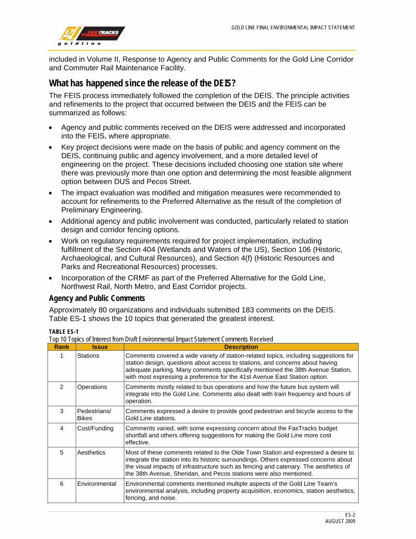
Agency and Public Comments Approximately 80 organizations and individuals submitted 183 comments on the DEIS. Table ES-1 shows the 10 topics that generated the greatest interest.
TABLE ES-1 Top 10 Topics of Interest from Draft Environmental Impact Statement Comments Received
Rank Issue Description1 Stations Comments covered a wide variety of station-related topics, including suggestions for
station design, questions about access to stations, and concerns about having adequate parking. Many comments specifically mentioned the 38th Avenue Station, with most expressing a preference for the 41st Avenue East Station option.
2 Operations Comments mostly related to bus operations and how the future bus system will integrate into the Gold Line. Comments also dealt with train frequency and hours of operation.
3 Pedestrians/ Bikes
Comments expressed a desire to provide good pedestrian and bicycle access to the Gold Line stations.
4 Cost/Funding Comments varied, with some expressing concern about the FasTracks budget shortfall and others offering suggestions for making the Gold Line more cost effective.
5 Aesthetics Most of these comments related to the Olde Town Station and expressed a desire to integrate the station into its historic surroundings. Others expressed concerns about the visual impacts of infrastructure such as fencing and catenary. The aesthetics of the 38th Avenue, Sheridan, and Pecos stations were also mentioned.
6 Environmental Environmental comments mentioned multiple aspects of the Gold Line Team’s environmental analysis, including property acquisition, economics, station aesthetics, fencing, and noise.

GOLD LINE FINAL ENVIRONMENTAL IMPACT STATEMENT
ES-3 AUGUST 2009
Rank Issue Description7 Right of Way/
Property Comments generally requested that RTD avoid property impacts and acquisitions as much as possible. Some applauded the decision to implement a single-track segment in Olde Town Arvada to avoid impacts; other commenters asked about the impacts to specific properties.
8 Public Involvement
Most comments praised the collaborative public involvement process, while others felt that they weren’t given enough information. Several comments requested that RTD continue to collaborate closely with the public as it makes decisions in future phases of the project.
9 Noise/Vibration Comments encouraged RTD to limit noise and vibration impacts as much as possible and were highly supportive of Quiet Zones as the preferred mitigation measure for noise impacts.
10 Transit Technology
Comments generally supported Electric Multiple Unit (EMU) technology for the Gold Line.
Source: Gold Line Team, 2008
Key Project Decisions Refinements to the Preferred Alternative Engineering design was approximately 10 percent complete at the release of the DEIS and 30 percent complete at release of the FEIS. The greatest number of changes results from subtle adjustments to the alignment to address the concerns of the freight railroad companies, improve travel speeds, reduce property acquisition, and minimize environmental impacts. In some cases, additional property acquisition is required to reduce impacts to railroad freight operations and the environment. The changes in impacts are documented in Section ES.4, Affected Environment and Environmental Consequences.
The major engineering changes to the Preferred Alternative since the release of the DEIS include:
• Selection of the East Direct Design Option (EDDO) in favor of the Railroad Alignment between DUS and Pecos Street.
• Selection of the 41st Avenue East Station location in favor of the 38th Avenue East Station and 39th Avenue East Station locations.
• Removal of the Pecos West Station option in favor of two options for the Pecos East Station location.
Selection of the Preferred Alignment Option During negotiations with the railroad companies, concern was expressed that the location of RTD commuter rail service in the North Yard, as required with the Railroad Alignment, would conflict with railroad operations. The placement of a commuter rail station to the east of the North Yard, as provided with the EDDO, was more convenient and better aesthetically for transit patrons. For these two reasons, RTD selected the EDDO for the DUS to Pecos Street section.
Station Selection Process During the FEIS, station alternatives were considered in the vicinity of 38th Avenue and at Pecos Street.
The three candidate stations in the vicinity of 38th Avenue (38th Avenue, 39th Avenue East, and the 41st Avenue East Stations) were evaluated for operational, environmental, financial, and public input. The 38th Avenue Station is not possible since negotiations with the railroad companies have favored the EDDO, as described earlier. Because this station option is only
GOLD LINE FINAL ENVIRONMENTAL IMPACT STATEMENT
ES-4 AUGUST 2009
possible with the Railroad Alignment, locating the station at 38th Avenue is not possible, because the station would be within the railroad ROW.
The 39th Avenue East Station option would require three more business acquisitions and the demolition of a historic property. Additionally, locating the pedestrian bridge in the vicinity of 39th Avenue is difficult due to railroad property constraints.
The 41st Avenue East Station option has been selected because it would effect fewer businesses, avoids most historic impacts, and is the most supported by the public, based on the public outreach program and comments on the DEIS. Additionally, the more northerly location of the 41st Avenue East Station is more responsive to the City and County of Denver’s transit-oriented development (TOD) planning. It would also have fewer traffic impacts on the 38th Avenue and Fox Street intersection.
Two station options were investigated at Pecos Street: the Pecos East and Pecos West Stations. The Pecos East Station option is the preferred option due to its potential to provide a transfer to Northwest Rail, a feature that is not available with the Pecos West Station option. Additionally, the Pecos West Station option would require the acquisition of several private businesses. The Pecos East Station option would not result in these impacts and is more compatible with TOD planning in Adams County. The Pecos East Station option has also received a much higher level of public support than the Pecos West Station option, which has received almost no support. One disadvantage of the Pecos East Station option is that it is dependent on the implementation of the Pecos Street grade separation project because the crossover for accessing Northwest Rail needs to be located in the center of the existing Pecos Street, something that is considered a safety issue. Consequently, a second Pecos East Option (Option A) that moves this crossover to the south, close to the station is retained in the FEIS. Option A would not allow for a cross-platform transfer to Northwest Rail, although this function could be added later when the Pecos Street grade separation project is built by relocating the crossover to the north.
The footprint and environmental impact of Option A is, for all practical purposes, identical to the original Pecos East Station option; however, some modification of the access road around the station would be required. If the Pecos Street grade separation project is built prior to the Gold Line, Option A would no longer be necessary.
Modifying the Impact Evaluation Based on Preliminary Engineering As the engineering design progressed from 10 percent complete during the DEIS to 30 percent complete during the FEIS, additional detail on some impact categories became available. The environmental resources with impact changes included:
• Land Acquisition, Displacements, and Relocation. Small changes resulting from partial acquisitions for at-grade crossing improvements for the Quiet Zone.
• Visual and Aesthetics Qualities. Additional detail on station architecture and fencing materials.
• Floodplains/Drainage/Hydrology. Additional modeling to more accurately assess the impacts of bridge placement on flood elevations.
While impact changes have occurred, they are minor and the overall impacts of the Preferred Alternative are comparable to those documented in the DEIS.

GOLD LINE FINAL ENVIRONMENTAL IMPACT STATEMENT
ES-5 AUGUST 2009
Additional Public and Agency Involvement Related to Station Design and Fencing Options The project team engaged local governments and community stakeholders throughout the preparation of the FEIS. A number of targeted efforts occurred during this timeframe. They included:
• Station Access and Design Issue Focused Teams (IFT). The project team convened IFT meetings in October and November 2008 to review and gather input to help complete the preliminary station design and access plans for the Gold Line stations.
• Local Governments Fencing Workshops. The project team held four meetings with local government representatives to review and gather input on future land use types and recommended fencing options. The first of the three meetings was held with the entire Gold Line Local Governments Team (LGT). Following that meeting, each government entity appointed one representative to participate in the three subsequent LGT Fencing Subcommittee meetings. These workshops helped inform the analysis and recommendations shown in Chapter 2, Alternatives Considered.
• Continuation of all Environmental Impact Statement Communication Activities. Throughout the preparation of the FEIS, the project team continued many of the same outreach and engagement efforts that were used throughout development of the DEIS. Those included publishing two project newsletters, making numerous updates to the project Web site, conducting multiple listening sessions, and distributing e-mail updates to the affected stakeholders.
Work on Regulatory Requirements Impacts to Wetlands and Waters of the United States. Due to refinements in the engineering of the alignment, the Gold Line project has reduced impacts to wetlands and waters of the United States and has obtained a Nationwide Permit, which is included in Appendix F.
Impacts to Historic Resources. The project has been found to have three Adverse Effects on Historic Resources. This was accomplished by ongoing and continuous coordination with the State Historic Preservation Officer (SHPO) and consulting parties. The Memorandum of Agreement (MOA) between FTA and the SHPO was completed in July of 2009 (see Appendix D).
Temporary Impacts to Trails and Minor Impacts to Park Resources. RTD has received concurrence from Adams County on Section 4(f) de minimis impact on the requirement to acquire 0.11 acre of parkland from Jim Baker Reservoir. This means that the impact was reduced through redesign such that the functioning of this park resource is not affected over the long term. Additionally, RTD has received 4(f) concurrence from the City and County of Denver, Adams County and the City of Arvada regarding temporary occupancy for construction impacts to trails on the South Platte River, Clear Creek and Ralston Creek, respectively indicating local government concurrence with how to manage these resources during construction.
Incorporation of the CRMF into the FEIS Process As mentioned above, the CRMF is shared by all four of the FasTracks commuter rail corridors. None of these corridors could function without a maintenance facility. For this reason, the CRMF is considered to be part of the Preferred Alternatives for all four of the commuter rail corridors. The impacts from the CRMF would not occur if none of the commuter rail projects were implemented. Thus, the results of the SEA have been incorporated into the Gold Line FEIS to provide a more complete picture of the impacts associated with the implementation of the Preferred Alternative for the Gold Line project.

GOLD LINE FINAL ENVIRONMENTAL IMPACT STATEMENT
ES-6 AUGUST 2009
Why was this report written? It is anticipated that federal funding will be available for the Gold Line project from FTA through a program called "New Starts." For RTD to be eligible for New Starts funding, the National Environmental Policy Act (NEPA) requires the evaluation of the impacts to the human and natural environment that would result from development of the project. This FEIS provides the results of that evaluation.
Where is this project? As shown in Figure ES-1, the Gold Line study area is in the Denver, Colorado, metropolitan area and encompasses the northwestern portion of the City and County of Denver, and parts of Adams County, Jefferson County, the City of Arvada, and the City of Wheat Ridge.
How do you read this final environmental impact statement? This FEIS is organized as follows:
Executive Summary – Provides a summary of the document, including a project description, Purpose and Need, expected impacts, and recommended mitigation measures.
Chapter 1: Purpose and Need – Presents a discussion of the Purpose of the project, the Need for mobility improvements, and the goals for the project.
Chapter 2: Alternatives Considered – Describes the alternatives screening processes used to define the Preferred Alternative for the Gold Line study area.
Chapter 3: Affected Environment and Environmental Consequences – Describes the existing social and natural environmental conditions in the study area and describes the anticipated impacts associated with the No Action and Preferred Alternatives, including the impacts of the CRMF. Potential mitigation measures are identified. These mitigation measures will be finalized in the decision document for this project.
Chapter 4: Transportation Systems – Discusses the existing transportation system and the anticipated benefits and impacts that would result from implementation of the No Action, Baseline, and Preferred Alternatives, including the impacts of the CRMF.
Chapter 5: Evaluation of Alternatives – Provides a comparative analysis of the No Action, Baseline, and Preferred Alternatives regarding how well they meet the Purpose and Need, the associated mobility benefits, and the environmental effects. A discussion of the financial feasibility of each alternative is also provided.
FIGURE ES-1 Gold Line Study Area

GOLD LINE FINAL ENVIRONMENTAL IMPACT STATEMENT
ES-7 AUGUST 2009
Chapter 6: Public Comment and Agency Coordination – Describes the public involvement process, including coordination with the LGT, the Agency Working Group (AWG), and the general public for selecting the Preferred Alternative and the final CRMF site.
Chapter 7: Final Section 4(f) and 6(f) Evaluation – Describes the results of the Section 4(f) and 6(f) analyses conducted to demonstrate the protection of publicly-owned parks; recreational resources; wildlife and waterfowl refuges; and historic sites of national, state, or local significance.
Chapter 8: References – Lists the sources for all references shown in this document.
Volume II: Response to Agency and Public Comments – Presents the agency and public comments on the DEIS and the SEA conducted for the CRMF and responses to both sets of comments.
Volume III: Appendices A through J – These appendices include the 404 Nationwide Permit, the MOA between SHPO and FTA, engineering, agency correspondence, and related technical documents.
ES.2 Purpose and Need Why do we need this project? Transit options to serve the Gold Line study area have been studied since 1992. Previous studies have evaluated the options to improve mobility in the corridor. Those studies have shown that mobility improvements have been needed for many years to provide a travel alternative to single-occupancy vehicle (SOV) travel in the corridor. The project Purpose and supporting Needs are described below.
Purpose The Purpose for the proposed Gold Line project is to implement fixed-guideway transit service within the Gold Line study area between DUS in downtown Denver and Ward Road in Wheat Ridge.
Need A fixed-guideway transit improvement in the Gold Line study area would meet a number of specific Needs, including:
• The need for mobility improvements, including:
- Improved travel times over SOV travel time in the Gold Line study area in 2030. - The provision of travel options. - Improvements to the regional transit system and rail system interconnectivity.
• The need to serve both traditional transit users and new transit users.
• The need to provide environmental benefits to the Gold Line study area and the Denver metropolitan region.
• The need to be cost effective and financed within the FasTracks Plan.
• The need to meet the voter mandate of the FasTracks Plan.
GOLD LINE FINAL ENVIRONMENTAL IMPACT STATEMENT
ES-8 AUGUST 2009
What are the goals of this project? The goals for the Gold Line project were used to define the evaluation criteria for the alternatives considered in this FEIS. These goals were endorsed through the agency and public processes provided for the project. They are listed in Table ES-2.
TABLE ES-2 Goals for Gold Line Study Area Fixed-Guideway Transit Project
Goal Objective DescriptionGoal 1 Best Value Providing a cost-effective transit option in the Gold Line study area. Goal 2 High Reliability and
Performance Providing a high-quality and reliable transit service that reduces travel times, reduces delays, and increases travel comfort in order to encourage travel by more efficient and environmentally sensitive means than motor vehicle travel.
Goal 3 Improved Efficiency Providing system linkage with other FasTracks corridors. Goal 4 Sustainable Land
Use Fulfilling existing land use and TOD plans in the Gold Line study area.
Goal 5 Improved Local Economy
Enhancing access to jobs, entertainment, recreation, and shopping for existing and future residents of the Gold Line study area.
Goal 6 Equal Opportunity Providing equitable transit opportunities regardless of financial means. Goal 7 Environmental
Protection Minimizing environmental impacts.
Goal 8 Sustainable Communities
Improving the environmental sustainability and development of sustainable communities.
Source: Gold Line Team, 2006
ES.3 Alternatives Considered The Gold Line EIS evaluated over 20 alternatives, and permutations of these alternatives, to meet the Purpose and Need for the corridor. Alternatives were developed and evaluated to address the travel markets in the Gold Line study area, to minimize environmental impacts, and in response to the input from the agency and public involvement process. Alternatives considered for the CRMF are discussed later in this Executive Summary.
What alternatives were evaluated for the Gold Line? The alternatives screening built off of previous studies conducted for the Gold Line Corridor, especially the I-70 Denver to Golden Major Investment Study (MIS) completed by RTD in 2000. The MIS evaluated highway widening, bus/high occupancy vehicle (HOV) lanes, Bus Rapid Transit, commuter rail, and light rail transit (LRT) technologies. Highway widening and bus/HOV lanes were not supported by the public due to the environmental impacts associated with the required interstate widening. The selected Locally Preferred Alternative (LPA) was LRT because it provided operational advantages over commuter rail at a comparable cost.
I-70 Denver to Golden Major Investment Study Alternatives such as personal rapid transit (PRT), highway widening, Bus/HOV, and push-pull locomotive commuter rail were eliminated in the MIS as described below.
Personal Rapid Transit. PRT was eliminated during Fatal Flaw Screening in the MIS due to lack of a proven prototype in revenue service and unknown development and implementation costs.
GOLD LINE FINAL ENVIRONMENTAL IMPACT STATEMENT
ES-9 AUGUST 2009
Highway Widening. Several highway widening alternatives were evaluated, with the most promising option including adding one eastbound and one westbound lane on Interstate 70 (I-70) between Wadsworth Boulevard and I-25, a distance of 4.8 miles. At $122 million (1997), this was the most affordable of the build alternatives evaluated during Detailed Evaluation. However, the alternative was dismissed due to a lack of Colorado Department of Transportation (CDOT) funding (therefore, there are no major I-70 projects funded in the study area in the 2030 Metro Vision Regional Transportation Plan and the Draft 2035 Metro Vision Regional Transportation Plan [Denver Regional Council of Governments (DRCOG), 2005a; DRCOG, 2005b; DRCOG, 2007]) and failure to meet local goals including the provision of a reliable travel option and land use objectives. This alternative would also require the widening of the existing I-70 corridor, resulting in impacts to parkland and residential land uses, including those owned by minority and low-income households. The MIS concluded that widening the I-70 corridor had more impact to the human environment and was much less supported than constructing a project on the railroad corridor (Gold Line alignment).
Bus/High Occupancy Vehicle. This alternative included the addition of one Bus/HOV lane in each direction from State Highway (SH) 58/Ward Road to I-25, including a direct flyover connection to I-25. The project length was 10 miles and had a cost of $261 million (1997). During Detailed Evaluation, it was found to be affordable, but not supportive of local goals for a reliable travel option and land use. It shared the same impact concerns noted above for the highway widening alternatives, only to a greater extent due to the construction impact of the wider Bus/HOV cross-section.
Commuter Rail. Two commuter rail alternatives were considered in the MIS during Detailed Evaluation. The first alternative included commuter rail using non-Federal Railroad Administration (FRA)-compliant Diesel Multiple Unit (DMU) technology, with one new separate track, traveling from DUS to Golden (a distance of 16 miles) at a cost of $292 million (1997). The proposed headways were 15 minutes during peak periods and 30 minutes during off-peak periods. The second commuter rail alternative deployed FRA-compliant locomotive hauled coach technology on track shared with the freight railroad companies and traveled from DUS to Golden. The service plan called for 20-minute headways during the peak period with no off-peak service. The estimated cost of this alternative was $83 million (1997).
Both alternatives were within the prescribed project budget, met local goals, and had manageable environmental impacts due to the freight corridor setting. However, neither alternative was cost-effective due to headways limited by shared track, which resulted in ridership that was much lower, respectively, than the competing LRT alternatives discussed below.
Light Rail Transit Alternatives. During Detailed Evaluation, two LRT alternatives were evaluated, one located on the I-70 alignment, and one located on the Railroad Alignment. The Railroad Alignment was selected in favor of the I-70 alignment due to lower costs (nearly $100 million) and more favorable cost per new rider ($7.73 versus $12.43). Both alternatives traveled from DUS to Ward Road with the option of a Phase 2 terminating in Golden. Because it met local goals, was within the prescribed budget, had manageable environmental impacts, and had the highest level of agency and public support, the Railroad Alignment alternative was adopted as the LPA. This recommendation was carried forward into the DEIS process, which is described below.
GOLD LINE FINAL ENVIRONMENTAL IMPACT STATEMENT
ES-10 AUGUST 2009
DEIS Alternatives During the initial phases of this DEIS, the freight railroads developed policies that did not allow sharing their ROWs with technology, such as LRT, that does not comply with FRA standards for crash worthiness. The freight ROW is depicted in Figure ES-2. As a result, the LRT alternative originally selected as the LPA in the MIS had to be dropped from further consideration in favor of heavier commuter rail technologies (both electric and diesel powered) that could operate within the freight railroad ROW. If LRT were to be considered, it had to be located on alternate alignments that either paralleled the freight rail ROWs or was on city streets. Streetcar technology was evaluated because it provided an alternative to LRT that was easier to construct, had fewer impacts in an urban environment, and was identified in public scoping as a potential alternative.

GOLD LINE FINAL ENVIRONMENTAL IMPACT STATEMENT
ES-11 AUGUST 2009
FIGURE ES-2 Freight Right-of-Way

GOLD LINE FINAL ENVIRONMENTAL IMPACT STATEMENT
ES-12 AUGUST 2009
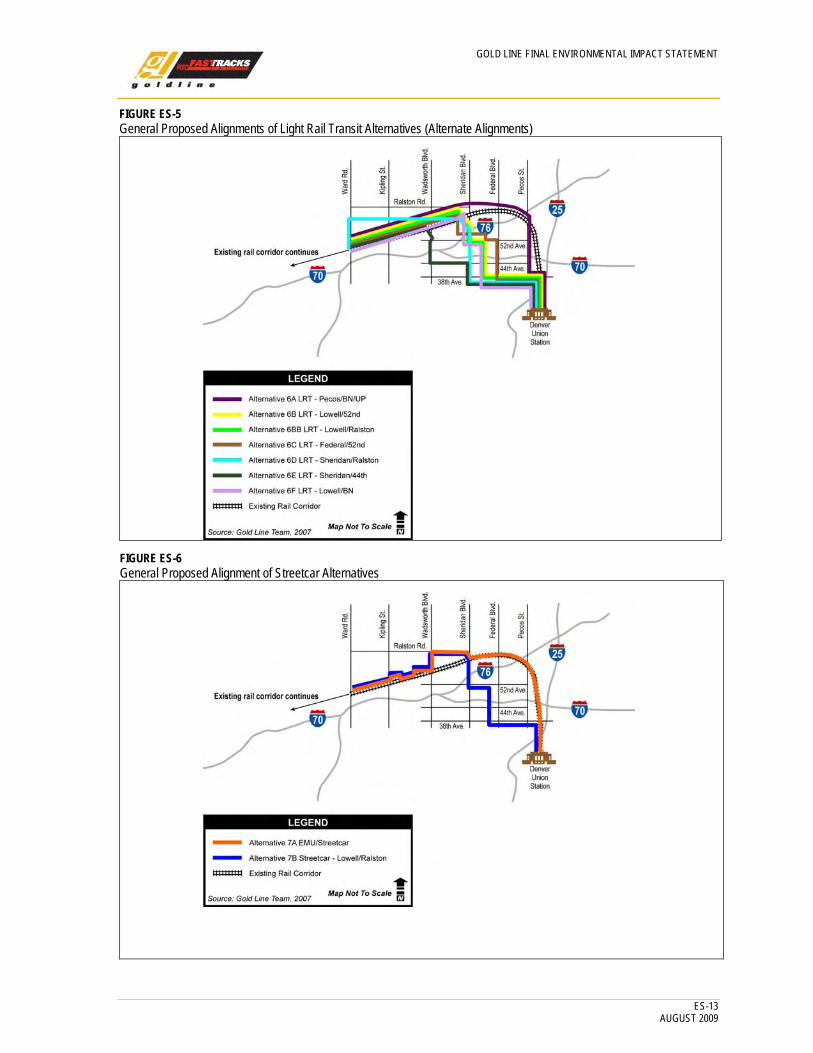
Figure ES-3 depicts the general proposed alignments of conceptual-level EMU and DMU Alternatives. Figures ES-4 and ES-5 show the general proposed alignments for LRT Alternatives, and Figure ES-6 shows the general proposed alignments for Streetcar Alternatives.
FIGURE ES-3 General Proposed Alignments of Electric Multiple Unit and Diesel Multiple Unit Alternatives
FIGURE ES-4 General Proposed Alignments of Light Rail Transit Alternatives (Railroad Alignment)
GOLD LINE FINAL ENVIRONMENTAL IMPACT STATEMENT
ES-13 AUGUST 2009
FIGURE ES-5 General Proposed Alignments of Light Rail Transit Alternatives (Alternate Alignments)
FIGURE ES-6 General Proposed Alignment of Streetcar Alternatives
GOLD LINE FINAL ENVIRONMENTAL IMPACT STATEMENT
ES-14 AUGUST 2009
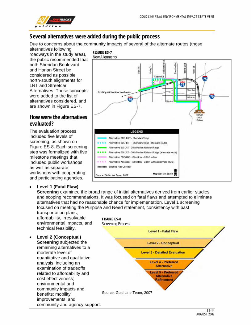
Several alternatives were added during the public process Due to concerns about the community impacts of several of the alternate routes (those alternatives following roadways in the study area), the public recommended that both Sheridan Boulevard and Harlan Street be considered as possible north-south alignments for LRT and Streetcar Alternatives. These concepts were added to the list of alternatives considered, and are shown in Figure ES-7.
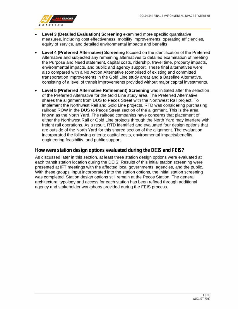
How were the alternatives evaluated? The evaluation process included five levels of screening, as shown on Figure ES-8. Each screening step was formalized with five milestone meetings that included public workshops as well as separate workshops with cooperating and participating agencies.
• Level 1 (Fatal Flaw) Screening examined the broad range of initial alternatives derived from earlier studies and scoping recommendations. It was focused on fatal flaws and attempted to eliminate alternatives that had no reasonable chance for implementation. Level 1 screening focused on meeting the Purpose and Need statement, consistency with past transportation plans, affordability, irresolvable environmental impacts, and technical feasibility.
• Level 2 (Conceptual) Screening subjected the remaining alternatives to a moderate level of quantitative and qualitative analysis, including an examination of tradeoffs related to affordability and cost effectiveness; environmental and community impacts and benefits; mobility improvements; and community and agency support.
FIGURE ES-8 Screening Process
Source: Gold Line Team, 2007
FIGURE ES-7 New Alignments
GOLD LINE FINAL ENVIRONMENTAL IMPACT STATEMENT
ES-15 AUGUST 2009
• Level 3 (Detailed Evaluation) Screening examined more specific quantitative measures, including cost effectiveness, mobility improvements, operating efficiencies, equity of service, and detailed environmental impacts and benefits.
• Level 4 (Preferred Alternative) Screening focused on the identification of the Preferred Alternative and subjected any remaining alternatives to detailed examination of meeting the Purpose and Need statement, capital costs, ridership, travel time, property impacts, environmental impacts, and public and agency support. These final alternatives were also compared with a No Action Alternative (comprised of existing and committed transportation improvements in the Gold Line study area) and a Baseline Alternative, consisting of a level of transit improvements provided without major capital investments.
• Level 5 (Preferred Alternative Refinement) Screening was initiated after the selection of the Preferred Alternative for the Gold Line study area. The Preferred Alternative shares the alignment from DUS to Pecos Street with the Northwest Rail project. To implement the Northwest Rail and Gold Line projects, RTD was considering purchasing railroad ROW in the DUS to Pecos Street section of the alignment. This is the area known as the North Yard. The railroad companies have concerns that placement of either the Northwest Rail or Gold Line projects through the North Yard may interfere with freight rail operations. As a result, RTD identified and evaluated four design options that are outside of the North Yard for this shared section of the alignment. The evaluation incorporated the following criteria: capital costs, environmental impacts/benefits, engineering feasibility, and public support.
How were station design options evaluated during the DEIS and FEIS? As discussed later in this section, at least three station design options were evaluated at each transit station location during the DEIS. Results of this initial station screening were presented at IFT meetings with the affected local governments, agencies, and the public. With these groups’ input incorporated into the station options, the initial station screening was completed. Station design options still remain at the Pecos Station. The general architectural typology and access for each station has been refined through additional agency and stakeholder workshops provided during the FEIS process.
GOLD LINE FINAL ENVIRONMENTAL IMPACT STATEMENT
ES-16 AUGUST 2009
What criteria were used to evaluate the alternatives? As shown on Table ES-3, criteria were developed for each level of screening and endorsed through the agency and public involvement process.
TABLE ES-3 Evaluation Criteria at Each Level of Screening
Screening Level Criteria Goal/Definition Level 1 (Fatal Flaw)
• Fulfillment of Purpose and Need • Consistency with past transportation plans
and studies (local, RTD, and regional) • Affordability • Irresolvable environmental impacts • Technical feasibility
Criteria must quali0tatively determine fulfillment of Purpose and Need, consistency with approved plans, general affordability, avoidance of fatal flaw environmental impact, and technical feasibility before an alternative can advance to Level 2.
Level 2 (Conceptual)
• Fulfillment of Purpose and Need • Affordability/cost effectiveness (FasTracks
Gold Line budget = $463.4 million, updated to $552.5 million after RTD Annual Program Evaluation, 2007)
• Environmental impacts • Community impacts/benefits • Consistency with local land use plans • Mobility improvements • Community support • Agency support
Building off of the above, the Criteria must provide both qualitative and quantitative measures of cost effectiveness, affordability, environmental and community impacts/benefits, consistency, mobility, and community and agency support before an alternative can advance to Level 3.
Level 3 (Detailed Evaluation)
• Cost effectiveness • Mobility improvements • Operating efficiencies • Equity • Environmental impacts/benefits
Increasingly more quantitative than Level 2, Criteria must determine cost effectiveness against potential ridership estimates, impacts on vehicle miles traveled (VMT), travel time improvements, service to traditional transit users, and establish the tradeoffs between environmental impacts and environmental benefits before an alternative can advance to Level 4.
Level 4 (Preferred Alternative)
• Capital costs • Ridership • Travel time • Environmental impacts/benefits • Property impacts (including historic
properties) • Public support
Criteria must determine best performing alternative considering refinements to the alternatives to reduce impacts, improve performance, and validated through additional agency and public involvement.
Level 5 (Preferred Alternative Refinement)
• Capital costs • Ridership • Travel time • Environmental impacts/benefits • Property impacts (including historic
properties) • Public support
Criteria must determine best performing refinements to reduce impacts and improve performance, validated through additional agency and public involvement.
Source: Gold Line Team, 2007
GOLD LINE FINAL ENVIRONMENTAL IMPACT STATEMENT
ES-17 AUGUST 2009
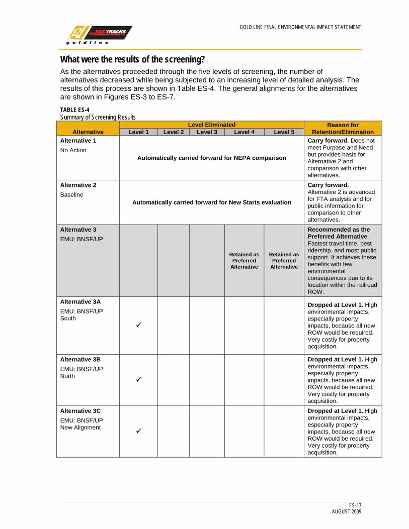
What were the results of the screening? As the alternatives proceeded through the five levels of screening, the number of alternatives decreased while being subjected to an increasing level of detailed analysis. The results of this process are shown in Table ES-4. The general alignments for the alternatives are shown in Figures ES-3 to ES-7. TABLE ES-4 Summary of Screening Results
Alternative Level Eliminated Reason for
Retention/Elimination Level 1 Level 2 Level 3 Level 4 Level 5 Alternative 1 No Action
Automatically carried forward for NEPA comparison
Carry forward. Does not meet Purpose and Need but provides basis for Alternative 2 and comparison with other alternatives.
Alternative 2 Baseline
Automatically carried forward for New Starts evaluation
Carry forward. Alternative 2 is advanced for FTA analysis and for public information for comparison to other alternatives.
Alternative 3 EMU: BNSF/UP
Retained as
Preferred Alternative
Retained as Preferred
Alternative
Recommended as the Preferred Alternative. Fastest travel time, best ridership, and most public support. It achieves these benefits with few environmental consequences due to its location within the railroad ROW.
Alternative 3A EMU: BNSF/UP South
Dropped at Level 1. High environmental impacts, especially property impacts, because all new ROW would be required. Very costly for property acquisition.
Alternative 3B EMU: BNSF/UP North
Dropped at Level 1. High environmental impacts, especially property impacts, because all new ROW would be required. Very costly for property acquisition.
Alternative 3C EMU: BNSF/UP New Alignment
Dropped at Level 1. High environmental impacts, especially property impacts, because all new ROW would be required. Very costly for property acquisition.
GOLD LINE FINAL ENVIRONMENTAL IMPACT STATEMENT
ES-18 AUGUST 2009
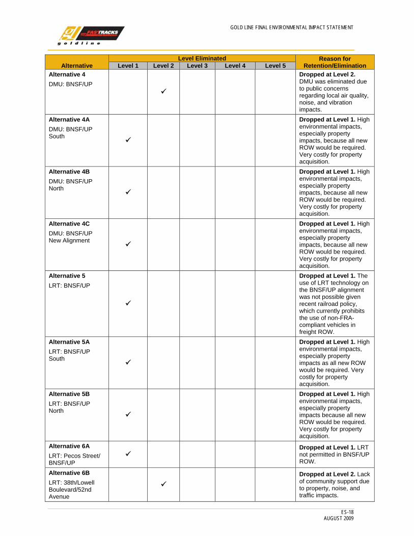
Alternative Level Eliminated Reason for
Retention/Elimination Level 1 Level 2 Level 3 Level 4 Level 5Alternative 4 DMU: BNSF/UP
Dropped at Level 2. DMU was eliminated due to public concerns regarding local air quality, noise, and vibration impacts.
Alternative 4A DMU: BNSF/UP South
Dropped at Level 1. High environmental impacts, especially property impacts, because all new ROW would be required. Very costly for property acquisition.
Alternative 4B DMU: BNSF/UP North
Dropped at Level 1. High environmental impacts, especially property impacts, because all new ROW would be required. Very costly for property acquisition.
Alternative 4C DMU: BNSF/UP New Alignment
Dropped at Level 1. High environmental impacts, especially property impacts, because all new ROW would be required. Very costly for property acquisition.
Alternative 5 LRT: BNSF/UP
Dropped at Level 1. The use of LRT technology on the BNSF/UP alignment was not possible given recent railroad policy, which currently prohibits the use of non-FRA-compliant vehicles in freight ROW.
Alternative 5A LRT: BNSF/UP South
Dropped at Level 1. High environmental impacts, especially property impacts as all new ROW would be required. Very costly for property acquisition.
Alternative 5B LRT: BNSF/UP North
Dropped at Level 1. High environmental impacts, especially property impacts because all new ROW would be required. Very costly for property acquisition.
Alternative 6A LRT: Pecos Street/ BNSF/ UP
Dropped at Level 1. LRT
not permitted in BNSF/UP ROW.
Alternative 6B LRT: 38th/Lowell Boulevard/52nd Avenue
Dropped at Level 2. Lack of community support due to property, noise, and traffic impacts.

GOLD LINE FINAL ENVIRONMENTAL IMPACT STATEMENT
ES-19 AUGUST 2009
Alternative Level Eliminated Reason for
Retention/Elimination Level 1 Level 2 Level 3 Level 4 Level 5 Alternative 6BB LRT: 38th/Lowell Boulevard/ Ralston Road
Dropped at Level 2. Lack of community support due to property, noise, and traffic impacts.
Alternative 6C LRT: 38th/ Federal Boulevard/ 52nd Avenue
Dropped at Level 1. Federal Boulevard is a congested state highway, resulting in high traffic impacts. Widening of Federal Boulevard would have been required, resulting in large numbers of property acquisitions.
Alternative 6D LRT: 38th/ Sheridan Boulevard/ Ralston Road
Dropped at Level 2. High costs, lower ridership, and high property acquisitions. High traffic impacts on Sheridan Boulevard as a result of taking one of its lanes.
Alternative 6DD (added at Level 2) LRT: 38th/ Sheridan Boulevard/ Ridge Road Not
Applicable (NA)
Dropped at Level 3. Higher costs and high numbers of residential acquisitions due to the need to acquire ROW east of Sheridan Boulevard to accommodate LRT. Minimal public support due to the impacts on property acquisition.
Alternative 6E LRT: 38th/ Sheridan Boulevard/ 44th Avenue
Dropped at Level 1. High costs, lower ridership, and high property acquisitions. High traffic impacts on Sheridan Boulevard as result of taking one of its lanes.
Alternative 6F LRT: 38th/Lowell Boulevard/ BNSF/UP
Dropped at Level 2. Lack of community support due to property, noise, and traffic impacts. Additionally, LRT would not be allowed within the freight rail ROW.
Alternative 6G (added at Level 2) LRT: 38th/ Harlan/ Ralston/ Ridge
NA Dropped at Level 2. Lack
of community support due to property, noise, and traffic impacts.
Alternative 7A EMU: BNSF/ UP/ Streetcar on Ridge Road
Dropped at Level 2.
Weak ridership due to mode transfer and comparatively high cost.
GOLD LINE FINAL ENVIRONMENTAL IMPACT STATEMENT
ES-20 AUGUST 2009
Alternative Level Eliminated Reason for
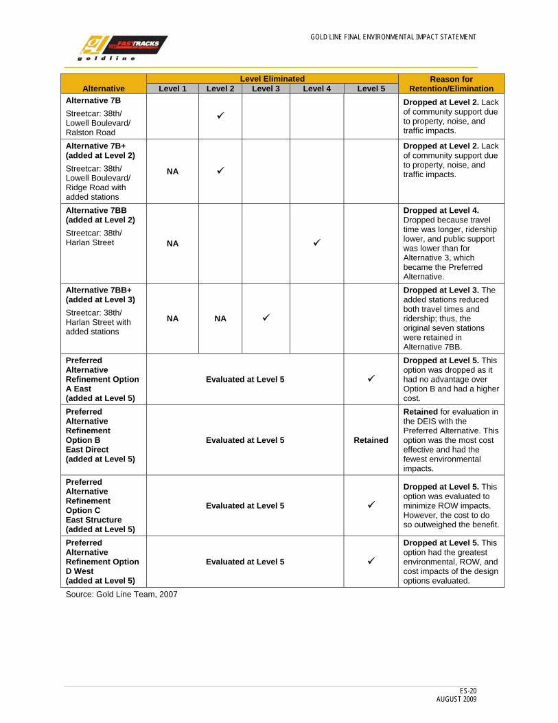
Retention/Elimination Level 1 Level 2 Level 3 Level 4 Level 5Alternative 7B Streetcar: 38th/ Lowell Boulevard/ Ralston Road
Dropped at Level 2. Lack of community support due to property, noise, and traffic impacts.
Alternative 7B+ (added at Level 2) Streetcar: 38th/ Lowell Boulevard/ Ridge Road with added stations
NA
Dropped at Level 2. Lack of community support due to property, noise, and traffic impacts.
Alternative 7BB (added at Level 2) Streetcar: 38th/ Harlan Street NA
Dropped at Level 4. Dropped because travel time was longer, ridership lower, and public support was lower than for Alternative 3, which became the Preferred Alternative.
Alternative 7BB+ (added at Level 3) Streetcar: 38th/ Harlan Street with added stations
NA NA
Dropped at Level 3. The added stations reduced both travel times and ridership; thus, the original seven stations were retained in Alternative 7BB.
Preferred Alternative Refinement Option A East (added at Level 5)
Evaluated at Level 5
Dropped at Level 5. This option was dropped as it had no advantage over Option B and had a higher cost.
Preferred Alternative Refinement Option B East Direct (added at Level 5)
Evaluated at Level 5 Retained
Retained for evaluation in the DEIS with the Preferred Alternative. This option was the most cost effective and had the fewest environmental impacts.
Preferred Alternative Refinement Option C East Structure (added at Level 5)
Evaluated at Level 5
Dropped at Level 5. This option was evaluated to minimize ROW impacts. However, the cost to do so outweighed the benefit.
Preferred Alternative Refinement Option D West (added at Level 5)
Evaluated at Level 5
Dropped at Level 5. This option had the greatest environmental, ROW, and cost impacts of the design options evaluated.
Source: Gold Line Team, 2007

GOLD LINE FINAL ENVIRONMENTAL IMPACT STATEMENT
ES-21 AUGUST 2009
Results from the Conceptual Screening Process Each level of screening was considered a project milestone. At each project milestone, input was solicited from local governments, agencies, and the public. Meetings and workshops were held to obtain this input. Input received from the local governments, agencies, and the public was used to refine the alternatives at each level.
Level 1 (Fatal Flaw) Screening – Key Results: • The alternatives that paralleled the BNSF/ UP alignment either to the north or south
resulted in too many private property acquisitions and too many community and environmental impacts. Implementation of these alternatives would also be more costly. This is true regardless of the technology (LRT, EMU, or DMU).
• Alternatives that required an entirely new alignment on city streets resulted in similar impacts as mentioned above.
• The use of LRT technology on the BNSF/UP alignment was not possible given recent railroad policy, which prohibits the use of non-FRA-compliant vehicles in freight ROW. For this reason, the LPA from the MIS had to be eliminated at Level 1 (Fatal Flaw) screening.
• The Streetcar Alternatives were carried forward to provide a less-costly option to LRT (while providing nearly the same capacity) and to avoid and minimize the impact of construction through the community.
Level 2 (Conceptual) Screening – Key Results: • Alternatives on the BNSF/UP alignment had the least impacts and better ridership than
the alternatives on alternative alignments, due to faster travel times.
• The LRT or Streetcar Alternatives both provided better access to transit for the residents of Northwest Denver, but resulted in more community impacts during construction, and LRT had greater property acquisition and traffic impacts. Additionally, the neighborhoods to the west in the study area were not as well served due to increased travel times.
• Streetcar Alternatives performed almost as well as the LRT Alternatives on the alternate alignments, and resulted in fewer property acquisition impacts.
Level 3 (Detailed Evaluation) Screening – Key Results: • Alternative 3 had the highest ridership, least environmental impact, and was the most
cost effective of the four alternatives investigated.
• The LRT Alternatives on alternative routes, 6DD and 6G, were more costly, had lower ridership, and resulted in much greater community impacts due to more property acquisition than either Alternative 3 or Alternative 7BB.
• Considering all factors, Alternative 3 would have the greatest chance to qualify for New Starts funding of the four alternatives evaluated.
• Two alternatives were carried into the selection of the Preferred Alternative process:
− Alternative 3: EMU – BNSF/UP − Alternative 7BB: Streetcar – 38th/Harlan Street
GOLD LINE FINAL ENVIRONMENTAL IMPACT STATEMENT
ES-22 AUGUST 2009
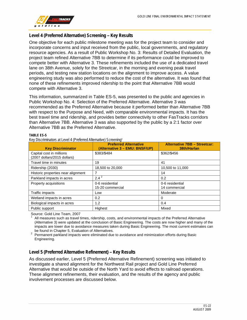
Level 4 (Preferred Alternative) Screening – Key Results One objective for each public milestone meeting was for the project team to consider and incorporate concerns and input received from the public, local governments, and regulatory resource agencies. As a result of Public Workshop No. 3: Results of Detailed Evaluation, the project team refined Alternative 7BB to determine if its performance could be improved to compete better with Alternative 3. These refinements included the use of a dedicated travel lane on 38th Avenue, solely for the Streetcar, in the morning and evening peak travel periods, and testing new station locations on the alignment to improve access. A value engineering study was also performed to reduce the cost of the alternative. It was found that none of these refinements improved ridership to the point that Alternative 7BB would compete with Alternative 3.
This information, summarized in Table ES-5, was presented to the public and agencies in Public Workshop No. 4: Selection of the Preferred Alternative. Alternative 3 was recommended as the Preferred Alternative because it performed better than Alternative 7BB with respect to the Purpose and Need, with comparable environmental impacts. It has the best travel time and ridership, and provides better connectivity to other FasTracks corridors than Alternative 7BB. Alternative 3 was also supported by the public by a 2:1 factor over Alternative 7BB as the Preferred Alternative.
TABLE ES-5 Key Discriminators at Level 4 (Preferred Alternative) Screening1
Key Discriminator Preferred Alternative
(Alternative 3 – EMU: BNSF/UP) Alternative 7BB – Streetcar:
38th/Harlan Capital cost in millions (2007 dollars/2015 dollars)
$383/$484 $362/$456
Travel time in minutes 19 41 Ridership (2030) 18,500 to 20,000 10,500 to 11,000 Historic properties near alignment 7 14 Parkland impacts in acres 2.4 2 0.2 Property acquisitions 0-6 residential
15-20 commercial 0-6 residential 14 commercial
Traffic impacts Low Moderate Wetland impacts in acres 0.2 0 Biological impacts in acres 1.2 0.4 Public support Highest Mixed Source: Gold Line Team, 2007 1 All measures such as travel times, ridership, costs, and environmental impacts of the Preferred Alternative
(Alternative 3) were updated at the conclusion of Basic Engineering. The costs are now higher and many of the impacts are lower due to avoidance measures taken during Basic Engineering. The most current estimates can be found in Chapter 5, Evaluation of Alternatives.
2 Permanent parkland impacts were eliminated due to avoidance and minimization efforts during Basic Engineering.
Level 5 (Preferred Alternative Refinement) – Key Results As discussed earlier, Level 5 (Preferred Alternative Refinement) screening was initiated to investigate a shared alignment for the Northwest Rail project and Gold Line Preferred Alternative that would be outside of the North Yard to avoid effects to railroad operations. These alignment refinements, their evaluation, and the results of the agency and public involvement processes are discussed below.
GOLD LINE FINAL ENVIRONMENTAL IMPACT STATEMENT
ES-23 AUGUST 2009
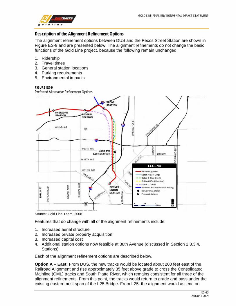
Description of the Alignment Refinement Options The alignment refinement options between DUS and the Pecos Street Station are shown in Figure ES-9 and are presented below. The alignment refinements do not change the basic functions of the Gold Line project, because the following remain unchanged:
1. Ridership 2. Travel times 3. General station locations 4. Parking requirements 5. Environmental impacts
FIGURE ES-9 Preferred Alternative Refinement Options
Source: Gold Line Team, 2008
Features that do change with all of the alignment refinements include:
1. Increased aerial structure 2. Increased private property acquisition 3. Increased capital cost 4. Additional station options now feasible at 38th Avenue (discussed in Section 2.3.3.4,
Stations)
Each of the alignment refinement options are described below.
Option A – East: From DUS, the new tracks would be located about 200 feet east of the Railroad Alignment and rise approximately 35 feet above grade to cross the Consolidated Mainline (CML) tracks and South Platte River, which remains consistent for all three of the alignment refinements. From this point, the tracks would return to grade and pass under the existing easternmost span of the I-25 Bridge. From I-25, the alignment would ascend on
GOLD LINE FINAL ENVIRONMENTAL IMPACT STATEMENT
ES-24 AUGUST 2009
retained fill and fly over 38th Avenue. The alignment would remain above existing grade (approximately 10 feet) from the 38th Avenue area to 41st Avenue. Near 42nd Avenue, the alignment would ascend on a third structure to clear the BNSF Railway Company Jersey Cutoff and then return to grade and pass under I-70, parallel Fox Street, and merge back into the approximate location of the Preferred Alternative alignment.
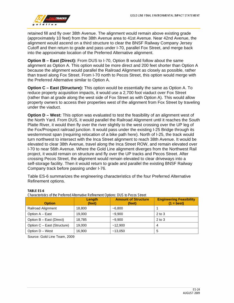
Option B – East (Direct): From DUS to I-70, Option B would follow about the same alignment as Option A. This option would be more direct and 200 feet shorter than Option A because the alignment would parallel the Railroad Alignment as closely as possible, rather than travel along Fox Street. From I-70 north to Pecos Street, this option would merge with the Preferred Alternative similar to Option A.
Option C – East (Structure): This option would be essentially the same as Option A. To reduce property acquisition impacts, it would use a 2,700 foot viaduct over Fox Street (rather than at grade along the west side of Fox Street as with Option A). This would allow property owners to access their properties west of the alignment from Fox Street by traveling under the viaduct.
Option D – West: This option was evaluated to test the feasibility of an alignment west of the North Yard. From DUS, it would parallel the Railroad Alignment until it reaches the South Platte River, it would then fly over the river slightly to the west crossing over the UP leg of the Fox/Prospect railroad junction. It would pass under the existing I-25 Bridge through its westernmost span (requiring relocation of a bike path here). North of I-25, the track would turn northwest to intersect with the Inca Street alignment to reach 38th Avenue. It would be elevated to clear 38th Avenue, travel along the Inca Street ROW, and remain elevated over I-70 to near 56th Avenue. Where the Gold Line alignment diverges from the Northwest Rail project, it would remain on structure and fly over the UP tracks and Pecos Street. After crossing Pecos Street, the alignment would remain elevated to clear driveways into a self-storage facility. Then it would return to grade and parallel the existing BNSF Railway Company track before passing under I-76.
Table ES-6 summarizes the engineering characteristics of the four Preferred Alternative Refinement options.
TABLE ES-6 Characteristics of the Preferred Alternative Refinement Options: DUS to Pecos Street
Option Length(feet)
Amount of Structure(feet)
Engineering Feasibility(1 = best)
Railroad Alignment 18,800 ~6,800 1 Option A – East 19,000 ~9,900 2 to 3 Option B – East (Direct) 18,785 ~9,900 2 to 3 Option C – East (Structure) 19,000 ~12,900 4 Option D – West 16,900 ~13,050 5 Source: Gold Line Team, 2009
GOLD LINE FINAL ENVIRONMENTAL IMPACT STATEMENT
ES-25 AUGUST 2009
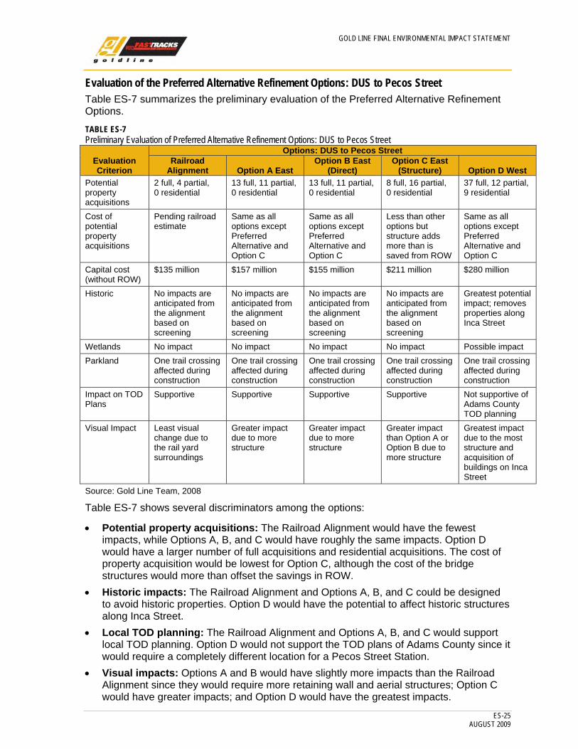
Evaluation of the Preferred Alternative Refinement Options: DUS to Pecos Street Table ES-7 summarizes the preliminary evaluation of the Preferred Alternative Refinement Options.
TABLE ES-7 Preliminary Evaluation of Preferred Alternative Refinement Options: DUS to Pecos Street
Evaluation Criterion
Options: DUS to Pecos StreetRailroad
Alignment Option A East Option B East
(Direct) Option C East
(Structure) Option D West Potential property acquisitions
2 full, 4 partial, 0 residential
13 full, 11 partial, 0 residential
13 full, 11 partial, 0 residential
8 full, 16 partial, 0 residential
37 full, 12 partial, 9 residential
Cost of potential property acquisitions
Pending railroad estimate
Same as all options except Preferred Alternative and Option C
Same as all options except Preferred Alternative and Option C
Less than other options but structure adds more than is saved from ROW
Same as all options except Preferred Alternative and Option C
Capital cost (without ROW)
$135 million $157 million $155 million $211 million $280 million
Historic No impacts are anticipated from the alignment based on screening
No impacts are anticipated from the alignment based on screening
No impacts are anticipated from the alignment based on screening
No impacts are anticipated from the alignment based on screening
Greatest potential impact; removes properties along Inca Street
Wetlands No impact No impact No impact No impact Possible impact Parkland One trail crossing
affected during construction
One trail crossing affected during construction
One trail crossing affected during construction
One trail crossing affected during construction
One trail crossing affected during construction
Impact on TOD Plans
Supportive Supportive Supportive Supportive Not supportive of Adams County TOD planning
Visual Impact Least visual change due to the rail yard surroundings
Greater impact due to more structure
Greater impact due to more structure
Greater impact than Option A or Option B due to more structure
Greatest impact due to the most structure and acquisition of buildings on Inca Street
Source: Gold Line Team, 2008
Table ES-7 shows several discriminators among the options:
• Potential property acquisitions: The Railroad Alignment would have the fewest impacts, while Options A, B, and C would have roughly the same impacts. Option D would have a larger number of full acquisitions and residential acquisitions. The cost of property acquisition would be lowest for Option C, although the cost of the bridge structures would more than offset the savings in ROW.
• Historic impacts: The Railroad Alignment and Options A, B, and C could be designed to avoid historic properties. Option D would have the potential to affect historic structures along Inca Street.
• Local TOD planning: The Railroad Alignment and Options A, B, and C would support local TOD planning. Option D would not support the TOD plans of Adams County since it would require a completely different location for a Pecos Street Station.
• Visual impacts: Options A and B would have slightly more impacts than the Railroad Alignment since they would require more retaining wall and aerial structures; Option C would have greater impacts; and Option D would have the greatest impacts.
GOLD LINE FINAL ENVIRONMENTAL IMPACT STATEMENT
ES-26 AUGUST 2009
• Overall capital and construction cost differential: When examining the overall capital and construction cost differential for all Options compared with the Railroad Alignment, Options A and B would be the lowest, with Option C higher, and Option D significantly higher.
When these results were presented to the LGT, at public workshops, and to the AWG, it was agreed that two design options for the shared alignment between DUS and Pecos Street should be considered in the DEIS:
1. Railroad Alignment 2. Option B East Direct (hereafter called the EDDO)
These options were evaluated and a recommendation was made during the FEIS, as discussed below.
What was the Preferred Alignment Option that was selected? During negotiations with the railroad companies, concern was expressed that the location of RTD commuter rail service in the North Yard, as required with the Railroad Alignment, would conflict with railroad operations. The placement of a commuter rail station to the east of the North Yard, as provided with the EDDO, would also be more convenient and provide better access for transit patrons. For these two reasons, RTD selected the EDDO for the DUS to Pecos Street section. From this point forward in the FEIS, the EDDO terminology is dropped and will be referenced as the “alignment.”
What alternatives were evaluated for the CRMF? The CRMF site selection process began in 2004 with the identification of 24 candidate sites. These sites were subjected to a three-level screening process incorporating environmental, community impact, and engineering criteria. Meetings with local agencies and the public were conducted at each level of screening over the past 4 years.
The CRMF site selection process evolved as events occurred and more knowledge was gained over the 4-year period. This process involved participation in two environmental processes:
• US 36 DEIS • East Corridor DEIS
During the US 36 DEIS study eight alternatives were carried past the Level 1 screening and in to Level 2 screening. Five alternatives were subjected to detailed environmental, community impact, and engineering evaluation and the UP 36th Street Yard/Properties West Site was recommended. This site was later renamed to the 40th/40th Site.
This initial recommendation was ultimately influenced by changed circumstances, including:
• Railroad negotiations • Peer review
Railroad Negotiations
Following negotiations between UP and RTD in 2007, it was determined that acquisition of the 40th/40th Site (previously the UP36th Street Yard/Properties West Site) would not be possible due to high acquisition costs. Therefore, RTD reconsidered other CRMF sites that had been evaluated earlier as part of the US 36 DEIS. In April 2007, RTD initiated a separate stand-alone CRMF Environmental Assessment process and, due to changed circumstances, considered alternatives that were previously eliminated. This resulted in a
GOLD LINE FINAL ENVIRONMENTAL IMPACT STATEMENT
ES-27 AUGUST 2009
recommendation for the RTD District Shops/Platte Division Site (hereafter referred to as the Platte Site). The environmental consequences were evaluated for this site in a technical memorandum.
Peer Review
With the objective of reducing the costs and impacts of the CRMF, RTD conducted a Peer Review consisting of independent industry experts. The Peer Review concluded that RTD should consider a smaller (less than 90 acres), less costly CRMF. Using the assumption of a smaller facility, it was possible to reevaluate four sites previously dismissed due to their smaller size and operational limitations. Sites included Smith Road (south side), Peoria Street/Interstate 225 (I-225), Smith Road (north side)/Chambers Road to Airport Road, BNSF 23rd Street Yard, the North Metro East, and the Platte Site.
During this same period, design modifications to the shared alignment for the Gold Line and Northwest Rail corridors allowed the consideration of one additional site—the Fox North Site, due to the fact that the majority of the property would be acquired for the alignment. The opportunity to utilize approximately 30 surplus acres avoided the need to acquire as much additional property for the CRMF.
After the evaluation of these six sites, the Fox North Site was selected as the best location, because it reduced the amount of property acquisition required (approximately 12 acres versus 40 acres), was supported by the surrounding neighborhoods, and environmental impacts were limited to private property acquisition and one section of historic track. It also received much higher public support when compared to the Platte Site. The two Smith Road sites were considered be too far from the DUS, the BNSF 23rd Street Yard was located offsite from an RTD transit corridor and would create multiple conflicts with at-grade freight crossings, and the North Metro East site had greater environmental and property acquisition impacts.
Commuter Rail Maintenance Facility Supplemental Environmental Assessment
The results of the CRMF SEA were presented to the public on April 23, 2009. The largest issue was the acquisition and relocation of the Owens Corning facility and the associated 61 jobs. In response to concerns about the potential loss of jobs, RTD redesigned the CRMF to minimize the impact on the Owens Corning facilities. As discussed in Chapter 2, Alternatives Considered, this involved some modifications to the original design and operational criteria and included the following measures:
1. Reduce the minimum storage to at least 78 vehicles for 2015 versus 96
2. Forego the paving of the vehicle storage tracks (to reduce storm water runoff)
3. Use underground storm water detention (to save site area)
4. Make adjustments to the mainline track which allows shifting of the site footprint to the south, away from Owens Corning.
In total, these changes avoid the acquisition of approximately 9 acres of the Owens Corning site, allowing the administration and plant operating facilities to remain intact. Owens Corning could potentially lose some outside storage area and some parking that would need to be relocated as a part of this project. As a result of this avoidance measure, the Owens Corning facility will not have to be relocated.
GOLD LINE FINAL ENVIRONMENTAL IMPACT STATEMENT
ES-28 AUGUST 2009
What are the alternatives carried into the FEIS? Three alternatives are evaluated in the Gold Line FEIS:
• No Action Alternative • Baseline Alternative • Preferred Alternative
What is the No Action Alternative? The No Action Alternative provides a base of comparison for determining the impacts of project alternatives. It does not mean that “nothing happens.” The No Action Alternative includes existing projects and financially committed projects within the study area to respond to the expected growth in the study area to the year 2030. These projects would be completed with or without implementation of the Preferred Alternative. By accounting for other projects to be built in a corridor or study area, the No Action Alternative provides the benchmark from which the Preferred Alternative is evaluated. Both highway and transit projects are part of the No Action Alternative.
Highway Projects The No Action roadway network in the region, including within the Gold Line study area, is assumed to be the roadway projects included in DRCOG fiscally constrained 2030 Metro Vision Regional Transportation Plan (RTP) (DRCOG, 2005a; DRCOG, 2005b). These include:
• Reconfiguration of the I-70/SH 58 Interchange • Reconstruction of the I-70/Kipling Interchange • The addition of new lanes on Wadsworth Boulevard between 46th Avenue and
36th Avenue
The RTP also references the reconstruction of the I-25 ramps at 17th Avenue and 23rd Avenue; however, this project is completed and has thus not been included in the FEIS. Additionally, the RTP includes a grade separation project at Wadsworth Boulevard that is also completed and therefore not included in the FEIS. Last, the addition of new through lanes on Pecos Street from 52nd Avenue to I-76 was to be locally funded and included in the RTP; however, this project has been cancelled and the funding dedicated to a grade separation project on Pecos Street.
Transit Projects Bus Operations The No Action Alternative includes bus service changes or enhancements that are planned to occur in the next 1 to 5 years, as well as committed bus service enhancements that will occur between 2006 and 2030. It also assumes that no additional transit facilities would be constructed in the Gold Line study area and that the Ward Road and Olde Town park-n-Rides (pnR) exist in the same locations as today and are not expanded.
Rail Improvements The No Action Alternative also includes a 1.9 mile section of the Northwest Rail project alignment from Pecos Street northwest to approximately West 72nd Avenue and Lowell Boulevard.
GOLD LINE FINAL ENVIRONMENTAL IMPACT STATEMENT
ES-29 AUGUST 2009
What is the Baseline Alternative? To fulfill the requirements of the FTA New Starts criteria, a Baseline Alternative was prepared to represent the “best that can be done” without implementing a major capital investment, such as rail transit. This alternative is often described as the “Best Bus Alternative.” The Baseline Alternative is included for financial and mobility comparisons in Chapter 4, Transportation Systems and Chapter 5, Evaluation of Alternatives in this document. Because the Baseline Alternative was not selected as the Preferred Alternative, it is not evaluated for environmental impacts in Chapter 3, Affected Environment and Environmental Consequences. The Baseline Alternative includes additional bus service and expanded pnR facilities. A full description of the technical elements of the Baseline Alternative is given in Chapter 4, Transportation Systems.
What is the Preferred Alternative? The elements of the Preferred Alternative are described below.
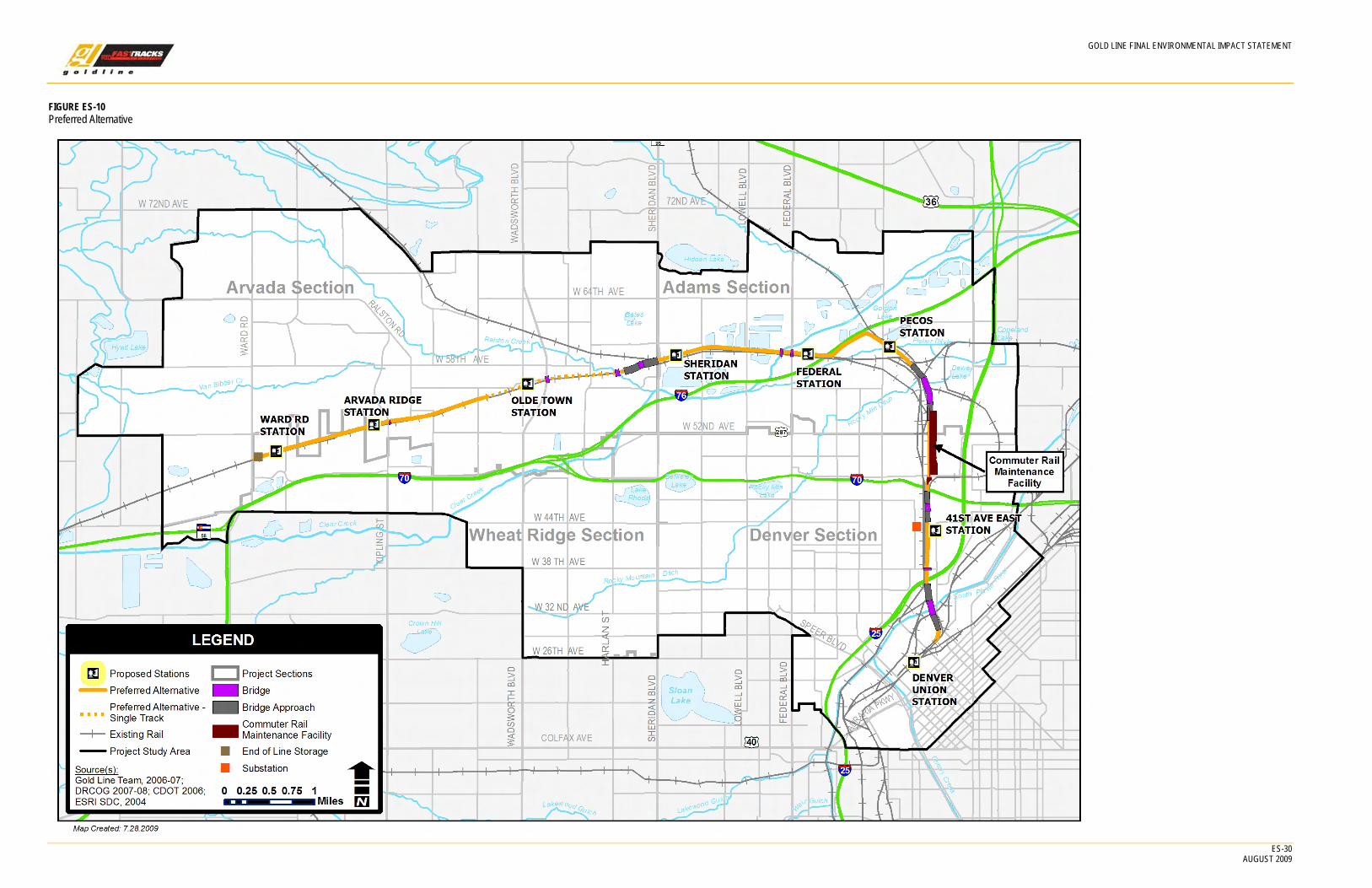
Proposed Alignment As shown on Figure ES-10, the Preferred Alternative would begin at DUS, share its alignment with the Northwest Rail project to Pecos Street, and terminate at Ward Road in Wheat Ridge. None of the new track would be shared with existing or planned freight operations.
DUS to Pecos Street As described previously, the Preferred Alternative would share the trackway with the other four commuter rail projects from DUS to the proposed CRMF; from the CRMF to Pecos Street the alignment is shared with the Northwest Rail project, as described below.
GOLD LINE FINAL ENVIRONMENTAL IMPACT STATEMENT
ES-30 AUGUST 2009
FIGURE ES-10 Preferred Alternative
GOLD LINE FINAL ENVIRONMENTAL IMPACT STATEMENT
ES-31 AUGUST 2009
Beginning at DUS, the alignment would operate on a double-track system dedicated to commuter rail. From DUS, the shared Northwest Rail/Gold Line tracks pass underneath Wewatta Street at grade. After passing under Wewatta, the tracks would be located between Fox Street and the Park Avenue viaduct and rise approximately 35 feet above grade to cross the Consolidated Main Line (CML) tracks and the South Platte River.
On the north side of the South Platte River, the tracks would descend to grade and pass through private property. Slightly to the south of I-25 the tracks would enter the BNSF Railway ROW and pass under the existing easternmost span of the I-25 Bridge. From I-25 the alignment would enter private property, ascend on retained fill and fly over 38th Avenue approximately 10 feet higher and 50 feet east of the existing freight railroad bridges at 38th Avenue. The alignment would remain 8 to 10 feet above existing grade north to the vicinity of the 41st Avenue East Station, then ascend on a third structure to clear a relocated BNSF Railway Company Jersey Cutoff and return to grade to pass under I-70. It would then parallel the rail yards on retained fill, then rise on structure to clear the existing freight tracks at Utah Junction. Since the DEIS, one private at-grade crossing for BNSF Railway Company maintenance vehicles has been added at the request of the railroad just to the south of I-25. However, there would be no at-grade track crossings or interconnections between the proposed commuter rail and the existing freight track network in this area.
Pecos Street to Ward Road A station would be provided at Pecos Street. West of the Pecos Station, the Preferred Alternative would separate from the Northwest Rail project and travel on its own alignment (separate from the freight railroad) for the remaining 7.7 miles to Ward Road, as described below.
The alignment would return to grade just east of Pecos Street and turn west, paralleling I-76 until it passes under this interstate highway and merges back into the railroad ROW, following it on the north. The proposed Federal Station would be located to the north of the tracks and immediately to the east of Federal Boulevard. The alignment would then continue on the north side of the track and cross Federal Boulevard and Clear Creek on structure. It would cross Lowell Boulevard and Tennyson Street at grade. The Sheridan Station would be located immediately east of Sheridan Boulevard. The alignment would then pass under Sheridan Boulevard. After passing under the Sheridan Bridge, the trackway would rise on retained fill and structure to cross over the UP Moffat Line, meeting grade west of Sheridan Boulevard between the BNSF Railway Company and UP rail lines.
After crossing over the Moffat Line tracks, the alignment would follow the BNSF Railway Company track that serves Golden along the north side of the existing ROW. To avoid impacts in areas of constrained ROW, a segment of single track would be constructed beginning immediately east of Ralston Road and Ralston Creek. The alignment would then pass under Ralston Road and cross over Ralston Creek on a single-track structure. It would remain at grade along the north side of the freight tracks to the Wadsworth Bypass, where a new single track bridge would be built to cross the Bypass. West of the Wadsworth Bypass, the single-track continues at grade to the Olde Town Station, and on to the vicinity of Balsam Street. From this point, the alignment would be double track to the Ward Road.
Two new bridges, one for the commuter rail and one for the freight rail, would be constructed over Kipling Street. There are no other bridges in this section.
Stations would be located at Arvada Ridge, just west of Kipling Street and 1,200 feet east of Ward Road.

GOLD LINE FINAL ENVIRONMENTAL IMPACT STATEMENT
ES-32 AUGUST 2009
Overhead Contact System The selected rail vehicle technology for the Gold Line study area would be EMU commuter rail vehicles. The EMU vehicles require electrification of the tracks by an Overhead Contact System (OCS) (commonly called a “catenary system”) along the corridor to provide power.
The alternating current (AC) electric power for the trains running in the Gold Line study area would be provided by one substation, powered from the existing electrical grid, and located immediately west of the existing Xcel Argo substation near West 43rd Avenue and Inca Street in Denver. There may be one transformer located in the Sheridan Station area. The purpose of the transformer is to use the power from the third phase of the 25-kilovolt (kV) electric substation to boost the power in the contact wire of the OCS.
End-of-Line Storage Facility Two additional tracks are proposed for vehicle storage at the western end of the Gold Line study area, between the Ward Road Station and Ward Road in Wheat Ridge. Up to six trains may be stored on these tracks overnight to begin the morning service.
Commuter Rail Maintenance Facility The EMU vehicles for all the FasTracks commuter rail projects would be serviced at a central CRMF, located immediately north of 48th Avenue on what is referred to as the Fox North Site, which straddles both Denver and Adams counties.
The CRMF would include a maintenance shop, EMU rail storage yard, DMU rail storage yard, employee facilities, administrative offices, employee parking facilities, a maintenance-of-way (MOW) building, and a laydown yard. The facility would service the following fleets:
• Gold Line—22 EMUs • Northwest Rail—22 DMUs • East Corridor—30 EMUs • North Metro Corridor—22 DMUs or EMUs
Train movements would occur throughout the day, with 229 movements scheduled for between 7 a.m. and 10 p.m. and 87 movements between 10 p.m. and 7 a.m. Train movements within the CRMF would occur at night. The operation of the CRMF would be ongoing 24 hours per day, 7 days per week. Maintenance activities need to occur during times when trains are not in revenue service. Night movements to and from the CRMF shop would be conducted in the same manner as daytime movements.
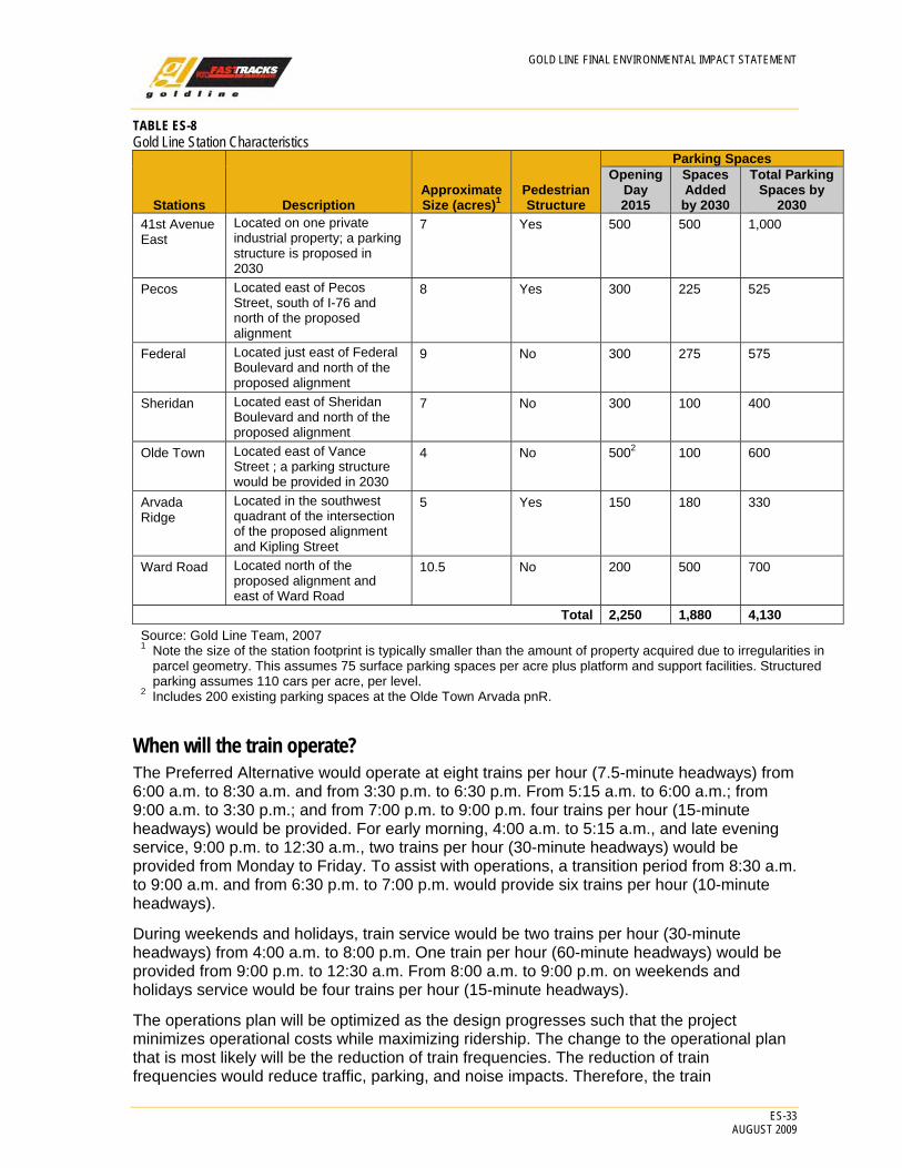
Stations The Preferred Alternative would include seven stations. The characteristics of the stations are shown in Table ES-8.
GOLD LINE FINAL ENVIRONMENTAL IMPACT STATEMENT
ES-33 AUGUST 2009
TABLE ES-8 Gold Line Station Characteristics
Stations Description Approximate Size (acres)1
Pedestrian Structure
Parking SpacesOpening
Day 2015
Spaces Added
by 2030
Total Parking Spaces by
2030 41st Avenue East
Located on one private industrial property; a parking structure is proposed in 2030
7 Yes 500 500 1,000
Pecos Located east of Pecos Street, south of I-76 and north of the proposed alignment
8 Yes 300 225 525
Federal Located just east of Federal Boulevard and north of the proposed alignment
9 No 300 275 575
Sheridan Located east of Sheridan Boulevard and north of the proposed alignment
7 No 300 100 400
Olde Town Located east of Vance Street ; a parking structure would be provided in 2030
4 No 5002 100 600
Arvada Ridge
Located in the southwest quadrant of the intersection of the proposed alignment and Kipling Street
5 Yes 150 180 330
Ward Road Located north of the proposed alignment and east of Ward Road
10.5 No 200 500 700
Total 2,250 1,880 4,130 Source: Gold Line Team, 2007 1 Note the size of the station footprint is typically smaller than the amount of property acquired due to irregularities in
parcel geometry. This assumes 75 surface parking spaces per acre plus platform and support facilities. Structured parking assumes 110 cars per acre, per level.
2 Includes 200 existing parking spaces at the Olde Town Arvada pnR.
When will the train operate? The Preferred Alternative would operate at eight trains per hour (7.5-minute headways) from 6:00 a.m. to 8:30 a.m. and from 3:30 p.m. to 6:30 p.m. From 5:15 a.m. to 6:00 a.m.; from 9:00 a.m. to 3:30 p.m.; and from 7:00 p.m. to 9:00 p.m. four trains per hour (15-minute headways) would be provided. For early morning, 4:00 a.m. to 5:15 a.m., and late evening service, 9:00 p.m. to 12:30 a.m., two trains per hour (30-minute headways) would be provided from Monday to Friday. To assist with operations, a transition period from 8:30 a.m. to 9:00 a.m. and from 6:30 p.m. to 7:00 p.m. would provide six trains per hour (10-minute headways).
During weekends and holidays, train service would be two trains per hour (30-minute headways) from 4:00 a.m. to 8:00 p.m. One train per hour (60-minute headways) would be provided from 9:00 p.m. to 12:30 a.m. From 8:00 a.m. to 9:00 p.m. on weekends and holidays service would be four trains per hour (15-minute headways).
The operations plan will be optimized as the design progresses such that the project minimizes operational costs while maximizing ridership. The change to the operational plan that is most likely will be the reduction of train frequencies. The reduction of train frequencies would reduce traffic, parking, and noise impacts. Therefore, the train

GOLD LINE FINAL ENVIRONMENTAL IMPACT STATEMENT
ES-34 AUGUST 2009
frequencies of 7.5 minutes during the peak, and 15 minutes in the off peak, assumed in this document, represent “worst case” from an environmental impact perspective.
ES.4 Affected Environment and Environmental Consequences What human or environmental resources were considered? Key resources and human environmental conditions that were evaluated in the DEIS and FEIS processes are listed in Table ES-9. The impacts of the Preferred Alternative that have been proven to be of greatest concern to the public have been highlighted. These seven resources are discussed in more detail below. The impacts and proposed mitigations of the Preferred Alternative are shown in Table ES-14 at the end of this Executive Summary.
Impacts have been reduced because the majority of the project would be located in a railroad ROW and most stations are proposed for current industrial areas. In addition, significant public input identified concerns and allowed the team to address, avoid, or minimize these concerns through the design process.
TABLE ES-9 Resources Evaluated in Gold Line FEIS
Resource Studied Most Significant Impacts Social Impacts Yes (during construction) Environmental Justice No Land Use Yes (benefits) Economic Conditions No Land Acquisition Yes Historic Resources Yes Visual Resources Yes Parkland, Open Space Yes Air Quality and Energy No Noise Yes Vibration No Biological Resources No Water Quality/Floodplains No Wetlands Yes Hazardous Materials No Public Safety and Security No Source: Gold Line Team, 2007
What kinds of environmental effects will the project have? The predicted impacts of the Preferred Alternative are highlighted below.
Social Impacts and Community Facility Impacts during Construction The Preferred Alternative would disrupt residents and businesses along the alignment primarily during construction. Construction would extend approximately 36 to 48 months. Including the section of track shared with the Northwest Rail project, approximately 95 acres would be exposed during construction, with about half in the railroad ROW and half in the station areas. Social and community impacts would be most apparent in Arvada, from Lamar

GOLD LINE FINAL ENVIRONMENTAL IMPACT STATEMENT
ES-35 AUGUST 2009
FIGURE ES-11 City of Arvada TOD Framework Plan
FIGURE ES-12 Typical Railroad ROW
Street to Kipling Street, due to the proximity of residences and businesses to the rail ROW. There would be few community impacts in Adams County. Residents and businesses in Denver and Wheat Ridge would experience only minor effects.
The CRMF would have no social or community facility impacts.
Land Use, Zoning, and Economic Considerations Transit-supportive land use has been a criterion for the evaluation of FTA-funded transit projects since 1997. Projects are evaluated to determine the degree to which existing development patterns and local land use policies are likely to encourage transit-supportive land use. Transit-oriented development is development adjacent to transit stations that is supportive of transit ridership, pedestrian-friendly, and has compact development oriented toward the transit station. The intent of the evaluation is to determine if local land use planning around station areas has been prepared to take advantage of the proposed transit investment through TOD. These advantages include more compact development, more cost-effective infrastructure investment, less auto dependency and congestion, and improved air quality. Such land use policies also improve the performance of the transit system through increased ridership and revenues.
All of the local governments in the Gold Line study area have prepared plans, or are in the process of preparing plans, to take advantage of the benefits of the Preferred Alternative. The impacts analysis concludes that the Preferred Alternative would be both compliant and supportive of existing and future land use and transportation planning within the Gold Line study area. An example of one of the plans analyzed is shown on Figure ES-11.
The Gold Line alignment would result in the acquisition and relocation of 16 businesses and the displacement of approximately 317 employees. The CRMF would not result in the relocation of any businesses but a small amount of private property would be acquired. Both of these elements of the Preferred Alternative would result in a small loss of annual property taxes. Construction activities would generate temporary construction employment. It is anticipated that 100 jobs would be created for maintenance and operation of the Gold Line and the operation of the CMRF would result in the creation of approximately 300 new jobs.
Land Acquisition, Displacements, and Relocations of Existing Uses Land acquisition has been one of the top concerns throughout the public process of the EIS. The Preferred Alternative would require the acquisition of 16 businesses for the construction of the alignment, stations, and electric transformer. Typical railroad ROW is shown on Figure ES-12. Approximately 128.8 acres of private property, 26.9 acres of railroad ROW, and 13.9 acres of municipal ROW would be acquired to implement the Preferred Alternative.

GOLD LINE FINAL ENVIRONMENTAL IMPACT STATEMENT
ES-36 AUGUST 2009
FIGURE ES-13 Historic Track
The majority of the private ROW acquisition is associated with planned station locations.
No full residential acquisitions or displacements would be required for the Preferred Alternative. However, some small, partial, sliver acquisitions of residential property would be needed for constructing at-grade crossings to implement the Quiet Zone.
The CRMF would result in acquisition of approximately 3.39 acres of property and would not result in the relocation of any businesses. The property acquisitions for the CRMF include a portion of the Owens Corning property and small strips of BNSF Railway Company ROW. The remaining property located within the Fox North Site would already be required by development of the shared alignment from DUS to Pecos Street.
Historical, Archaeological, and Cultural Resources Cultural resources are regulated through Section 106 of the National Historic Preservation Act and the Archeological and Historic Preservation Act. Figure ES-13 depicts historic track within the study area. The possibility of impacts to historic resources is important to study area stakeholders. The Preferred Alternative was found to have two adverse effects on National Register of Historic Places (NRHP)-eligible properties: 1) a segment of track on the Denver West Side Line (5DV3512.3) and 2) a portion of the Allen Rand Ditch (5JF4454.1). There are no adverse effects on archeological resources. Implementation of the CRMF would result in one adverse effect on a section of freight track, known as the Denver Utah Pacific Railroad, Chicago Burlington Quincy Siding and Spur (5AM1888.5 and 5DV6243.7).
Visual and Aesthetic Resources The visual impact of the rail project has been a concern identified in the public involvement process for the Gold Line study area, especially with respect to overhead catenary and the architecture of the transit stations.
Implementation of the Preferred Alternative would involve the installation of the following elements that would change visual quality:
• Structures required to grade separate roadways and freight lines • Pedestrian bridges required to cross freight tracks • Seven transit stations and pnR facilities • Numerous retaining walls • 11.2 miles of overhead catenary and trackway • Fencing • Storage of up to six EMU vehicles at the end-of-line near Ward Road for early morning
startup
All of these features would represent a visual change, with the degree of change dependent on the surrounding environment. The area most sensitive to these changes would be from Lamar Street to Kipling Street in Arvada where the project passes through developed Historic Districts. In most other instances, the visual change would be minor due to the fact that the project is being constructed within existing industrial and commercial land uses. Figure ES-14 presents a visual simulation at the Olde Town Station. Both station architectural topology and fencing materials have been presented to local agencies for endorsement.
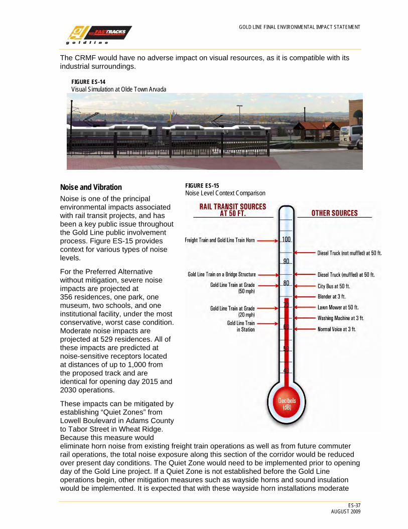
GOLD LINE FINAL ENVIRONMENTAL IMPACT STATEMENT
ES-37 AUGUST 2009
FIGURE ES-14 Visual Simulation at Olde Town Arvada
FIGURE ES-15 Noise Level Context Comparison
The CRMF would have no adverse impact on visual resources, as it is compatible with its industrial surroundings.
Noise and Vibration Noise is one of the principal environmental impacts associated with rail transit projects, and has been a key public issue throughout the Gold Line public involvement process. Figure ES-15 provides context for various types of noise levels.
For the Preferred Alternative without mitigation, severe noise impacts are projected at 356 residences, one park, one museum, two schools, and one institutional facility, under the most conservative, worst case condition. Moderate noise impacts are projected at 529 residences. All of these impacts are predicted at noise-sensitive receptors located at distances of up to 1,000 from the proposed track and are identical for opening day 2015 and 2030 operations.
These impacts can be mitigated by establishing “Quiet Zones” from Lowell Boulevard in Adams County to Tabor Street in Wheat Ridge. Because this measure would eliminate horn noise from existing freight train operations as well as from future commuter rail operations, the total noise exposure along this section of the corridor would be reduced over present day conditions. The Quiet Zone would need to be implemented prior to opening day of the Gold Line project. If a Quiet Zone is not established before the Gold Line operations begin, other mitigation measures such as wayside horns and sound insulation would be implemented. It is expected that with these wayside horn installations moderate

GOLD LINE FINAL ENVIRONMENTAL IMPACT STATEMENT
ES-38 AUGUST 2009
noise impacts would remain at 40 residences and at one institutional facility (the Wheat Ridge Regional Center) in Arvada. There would also be residual severe noise impacts at 18 residences (17 in Arvada and one in Wheat Ridge), at one school (the Lawrence Elementary School) and at one museum (the Arvada Flour Mill). At these residual impact locations, further mitigation (e.g., sound insulation) will be investigated and provided if practical to supplement the use of wayside horns.
Other mitigation measures such as noise walls have been found to be ineffective at mitigating noise from the Preferred Alternative for three reasons: 1) numerous openings in the walls at grade crossings; 2) visual impacts; and 3) property impacts, since the freight railroads would not allow sound walls within their ROWs.
No vibration impacts are anticipated from the operation of the Preferred Alternative for the Gold Line.
The CRMF would result in no noise or vibration impacts due to an absence of sensitive receptors surrounding this industrial site. Additionally noise and vibration analysis was completed for the operations between DUS to the CRMF resulting in no impacts.
Natural Resources – Wetlands Wetlands and other waters of the United States have been identified by the federal government as important resources. The protection of these areas is critical for maintaining the physical, chemical, and biological integrity of the waters of the United States. As a result, impacts to wetlands and the other waters are closely regulated. The loss of wetlands and the functional values they provide is a continuing problem in the United States. The development of new linear transportation infrastructure projects has the potential to add to that loss. As a result, wetlands in project areas are located, identified, and evaluated. Designs are then assessed for the ability to avoid the wetlands completely, minimize impacts to them, or, as a last resort, mitigate the impacts.
The Preferred Alternative would result in the direct, permanent impact of 0.74 acres of wetlands in the Gold Line study area. Of this total, 0.15 acre is considered jurisdictional by the USACE, much of this represented by impacts at the Ralston Creek crossing (see Figure ES-16). In addition, the project would result in direct permanent impact to 0.19 acre of jurisdictional other waters of the United States. Therefore, the Preferred Alternative would have a permanent impact on 0.34 acre of jurisdictional wetlands and other waters of the United States. Temporary impacts to wetlands would occur at Ralston Creek and would
FIGURE ES-16 Crossing at Ralston Creek
Quiet Zone A Quiet Zone is an area where crossings of the rail line include sufficient safety mechanisms, so that trains are no longer required to sound their horns when crossing. Quiet Zones need to be implemented by local government through approvals from the Public Utilities Commission (PUC), FRA, and the railroads. RTD can assist but cannot submit the application to implement a Quiet Zone.
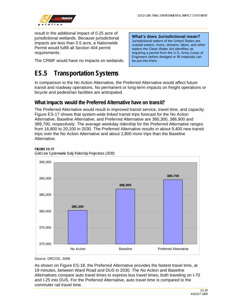
GOLD LINE FINAL ENVIRONMENTAL IMPACT STATEMENT
ES-39 AUGUST 2009
What’s does Jurisdictional mean? Jurisdictional waters of the United States are coastal waters, rivers, streams, lakes, and other waters the Clean Water Act identifies as requiring a permit from the U.S. Army Corps of Engineers before dredged or fill materials can be put into them.
result in the additional impact of 0.25 acre of jurisdictional wetlands. Because jurisdictional impacts are less than 0.5 acre, a Nationwide Permit would fulfill all Section 404 permit requirements.
The CRMF would have no impacts on wetlands.
ES.5 Transportation Systems In comparison to the No Action Alternative, the Preferred Alternative would affect future transit and roadway operations. No permanent or long-term impacts on freight operations or bicycle and pedestrian facilities are anticipated.
What impacts would the Preferred Alternative have on transit? The Preferred Alternative would result in improved transit service, travel time, and capacity. Figure ES-17 shows that system-wide linked transit trips forecast for the No Action Alternative, Baseline Alternative, and Preferred Alternative are 380,300, 386,900 and 389,700, respectively. The average weekday ridership for the Preferred Alternative ranges from 16,800 to 20,100 in 2030. The Preferred Alternative results in about 9,400 new transit trips over the No Action Alternative and about 2,800 more trips than the Baseline Alternative.
FIGURE ES-17 Gold Line Systemwide Daily Ridership Projections (2030)
380,300
386,900
389,700
370,000
375,000
380,000
385,000
390,000
395,000
No Action Baseline Preferred Alternative
Source: DRCOG, 2008
As shown on Figure ES-18, the Preferred Alternative provides the fastest travel time, at 19 minutes, between Ward Road and DUS in 2030. The No Action and Baseline Alternatives compare auto travel times to express bus travel times, both traveling on I-70 and I-25 into DUS. For the Preferred Alternative, auto travel time is compared to the commuter rail travel time.

GOLD LINE FINAL ENVIRONMENTAL IMPACT STATEMENT
ES-40 AUGUST 2009
FIGURE ES-18 Travel Time Comparison
Source: DRCOG, 2006a
Table ES-10 shows the impact to VMT and vehicle hours traveled (VHT) of each alternative in the Gold Line study area and the Denver metropolitan region. As shown in the table, differences in VMT and VHT between the three alternatives are expected to be minor. The impact would be less than a 1 percent difference in both the corridor and the region. None of the alignment or station design options would affect regional VMT.
TABLE ES-10 Vehicle Miles Traveled and Vehicle Hours Traveled Comparison (average weekday 2030)
Region Gold Line Study AreaNo Action Alternative
Baseline Alternative
Preferred Alternative
No Action Alternative
Baseline Alternative
Preferred Alternative
Daily VMT 103,302,956 103,297,703 103,275,346 6,320,851 6,314,068 6,302,630 Difference in VMT from No Action NA -5,253 -27,610 NA -6,783 -18,221
Daily VHT 3,352,644 3,352,862 3,350,753 204,575 204,166 203,430 Difference in VHT from No Action NA 218 -1,891 NA -409 -1,145
Source: Gold Line Team, 2008
What roadway impacts would the Preferred Alternative have? The majority of roadway impacts from the Preferred Alternative for the Gold Line are anticipated to be centered on the station access and adjacent intersections. It is anticipated that some intersections would be affected by the seven stations and require mitigation. Mitigation would include the addition of signals, turn lanes, or in some cases, both.

GOLD LINE FINAL ENVIRONMENTAL IMPACT STATEMENT
ES-41 AUGUST 2009
What railroad/roadway crossing improvements would be made? Rail crossing treatments have been proposed for the Preferred Alternative at-grade crossings, based on RTD’s Grade Crossing Evaluation Methodology, and to support the requirements for implementing Quiet Zones. As a result, the Preferred Alternative would incorporate 20 (including 2 grade crossings for the Northwest Rail project between DUS and Pecos Street) at-grade crossing improvement projects in the Gold Line study area. These mitigation measures would generally provide either dual gates with a curb barrier, or quad gates, depending on the geometry of the intersection.
What are the impacts to freight operations? Because the Gold Line commuter rail operations would occur on track that is separate from either the UP or the BNSF Railway Company freight tracks, there would be no impacts to freight operations. All crossings of the freight track would be grade-separated (via bridges) and safety would be improved at all at-grade roadway crossings, for both commuter rail and freight, through the provision of gates and improved signalization.
How would the CRMF impact transportation? As mentioned earlier, the CRMF is a key element for supporting the operations of the four FasTracks commuter rail projects. The facility would have very few impacts on other modes of transportation as shown below:
• The CRMF would result in a very small increase in traffic flow in to and out of the Fox North Site. The proposed CRMF is assumed to have 300 employees, which would generate about 900 trips per day. With implementation of the shared alignment and the proposed CRMF, approximately 516 daily trips related to existing private business operations would be displaced. Therefore, the Preferred Alternative would result in an additional 384 trips per day into and out of the Fox North Site.
• The 48th Avenue/Fox Street intersection servicing the CRMF is expected to operate beyond an acceptable a.m. peak-hour Level of Service (LOS) for the southbound left turn in both 2015 and 2030. Restriping 48th Avenue east of Fox Street would mitigate these impacts and bring the southbound left turn LOS back to acceptable levels and improve conditions compared to the No Action Alternative in both 2015 and 2030.
ES.6 Evaluation of Alternatives How does the NEPA process link with the New Starts process? The NEPA and the New Starts processes are both used for sound decision making. As mentioned earlier, NEPA focuses on alternatives and environmental impacts. The New Starts process focuses on mobility benefits, cost effectiveness, environmental benefits, and other factors such as how well the transit alternative supports local land use planning. To confirm that the Preferred Alternative is a good investment, FTA requires that it be evaluated against the Baseline Alternative, which is typically defined as transit improvements that can be implemented without a major capital investment.
The links between the two processes are presented in the two sections that follow.
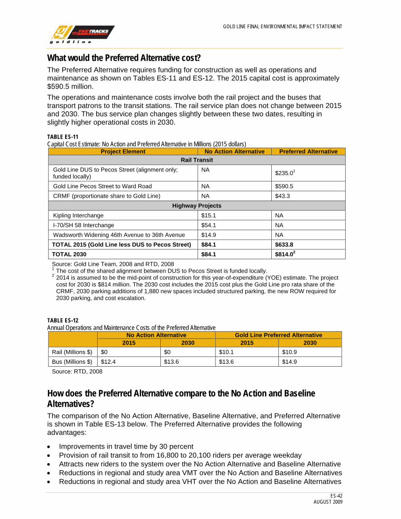
GOLD LINE FINAL ENVIRONMENTAL IMPACT STATEMENT
ES-42 AUGUST 2009
What would the Preferred Alternative cost? The Preferred Alternative requires funding for construction as well as operations and maintenance as shown on Tables ES-11 and ES-12. The 2015 capital cost is approximately $590.5 million. The operations and maintenance costs involve both the rail project and the buses that transport patrons to the transit stations. The rail service plan does not change between 2015 and 2030. The bus service plan changes slightly between these two dates, resulting in slightly higher operational costs in 2030.
TABLE ES-11 Capital Cost Estimate: No Action and Preferred Alternative in Millions (2015 dollars)
Project Element No Action Alternative Preferred Alternative Rail Transit
Gold Line DUS to Pecos Street (alignment only; funded locally)
NA $235.01
Gold Line Pecos Street to Ward Road NA $590.5 CRMF (proportionate share to Gold Line) NA $43.3
Highway Projects Kipling Interchange $15.1 NA I-70/SH 58 Interchange $54.1 NA Wadsworth Widening 46th Avenue to 36th Avenue $14.9 NA TOTAL 2015 (Gold Line less DUS to Pecos Street) $84.1 $633.8 TOTAL 2030 $84.1 $814.02 Source: Gold Line Team, 2008 and RTD, 2008 1 The cost of the shared alignment between DUS to Pecos Street is funded locally. 2 2014 is assumed to be the mid-point of construction for this year-of-expenditure (YOE) estimate. The project
cost for 2030 is $814 million. The 2030 cost includes the 2015 cost plus the Gold Line pro rata share of the CRMF, 2030 parking additions of 1,880 new spaces included structured parking, the new ROW required for 2030 parking, and cost escalation.
TABLE ES-12 Annual Operations and Maintenance Costs of the Preferred Alternative
No Action Alternative Gold Line Preferred Alternative 2015 2030 2015 2030
Rail (Millions $) $0 $0 $10.1 $10.9 Bus (Millions $) $12.4 $13.6 $13.6 $14.9 Source: RTD, 2008
How does the Preferred Alternative compare to the No Action and Baseline Alternatives? The comparison of the No Action Alternative, Baseline Alternative, and Preferred Alternative is shown in Table ES-13 below. The Preferred Alternative provides the following advantages:
• Improvements in travel time by 30 percent • Provision of rail transit to from 16,800 to 20,100 riders per average weekday • Attracts new riders to the system over the No Action Alternative and Baseline Alternative • Reductions in regional and study area VMT over the No Action and Baseline Alternatives • Reductions in regional and study area VHT over the No Action and Baseline Alternatives

GOLD LINE FINAL ENVIRONMENTAL IMPACT STATEMENT
ES-43 AUGUST 2009
TABLE ES-13 Key Performance Discriminators
Criterion No Action
Alternative2 Baseline
Alternative Preferred Alternative Capital Cost (millions) Highway –$84.1 $127.1 (2008)
$144.6 (2014) $590.51 (2014) ~$43.3 (Gold Line share of the CRMF)
Operating Cost—2030 (millions) $13.6 $17.8 $10.9 (rail) $14.9 (bus)
Travel time (2030) 27 minutes 27 minutes 19 minutes Rail Ridership NA NA 16,800 to 20,100
(average weekday, 2030) Regional daily VMT 103,302,956 103,297,703 103,275,346 Change in regional daily VMT over No Action Alternative
NA -5,253 -27,610
Study Area daily VMT 6,320,851 6,314,068 6,302,630 Change in study area daily VMT over No Action Alternative
NA -6,783 -18,221
Regional daily linked transit trips 380,300 386,900 389,700 Change in regional daily linked transit trips over No Action Alternative
NA +6,600 +9,400
Regional daily VHT 3,352,644 3,352,862 3,350,753 Change in regional daily VHT over No Action Alternative
NA 218 -1,891
Study Area VHT 204,575 204,166 203,430 Changes in study area VHT over No Action Alternative
NA 409 -1,145
Cost share with Northwest Rail No No Yes Employment 0.5 mile from stations (2030)
6,067 6,067 17,411
Population 0.5 mile from stations (2030)
7,017 7,017 18,638
Source: Gold Line Team, 2007 1 This is for FTA New Starts funding where 2014 is assumed to be the mid-point of construction for this year-of-
expenditure (YOE) estimate. The project cost for 2030 is $814 million. The 2030 cost includes the 2015 cost plus the Gold Line pro rata share of the CRMF, 2030 parking additions of 1,880 new spaces included structured parking, the new ROW required for 2030 parking, and cost escalation. The shared trackway from DUS to Pecos Street is funded locally and is not part of the FTA New Starts project. It is estimated to cost $235 million (YOE).
2 The No Action Alternative assumes current pnRs at Olde Town and Ward Road with no new parking added, plus the costs of funded roadway improvements.
How would this project be paid for? It is assumed that the Preferred Alternative would be funded by a combination of federal, local, and private funds. Federal funds may include the FTA New Starts monies, while local public funding includes sales and use taxes, revenue bond proceeds, and local contributions from cities and counties. Private funds would include funds available from the Public-Private Partnership assumed as the delivery method for this project.
ES.7 Public Comment and Agency Coordination A Public Involvement Plan and Corridor Coordination Plan (as required by Safe, Accountable, Flexible and Efficient Transportation Equity Act – A Legacy for Users [SAFETEA-LU]) were developed and implemented for the Gold Line project that blends

GOLD LINE FINAL ENVIRONMENTAL IMPACT STATEMENT
ES-44 AUGUST 2009
ongoing engagement strategies with intense outreach organized around key project milestones.
How has the public been involved with this project? Gold Line Process
The public has been involved in the Gold Line EIS since the beginning of the project (Figure ES-19). Public workshops were held seven times at two locations each in the corridor at SAFETEA-LU decision milestones, before the DEIS was released. In addition, the public involvement program conducted community listening sessions with a variety of community, civic, neighborhood, and municipal committees and organizations. These small-group meetings engaged stakeholders in smaller, more community-specific ways than is possible with the larger workshops. In order to give everyone ample opportunity to engage in the public process, outreach has also been implemented specifically for minority and low-income communities. Figure ES-20 shows the public involvement (and overall) schedule for the Gold Line Project.
CRMF Process Public involvement conducted in association with the CRMF between 2004 and 2008 included 15 milestone public meetings and the participation of hundreds of citizens from the surrounding area. During public meetings, attendees were afforded the opportunity to receive information and comment on the location of the CRMF. Public meetings occurred during the preparation of the US 36 and East Corridor DEISs and again for the SEA prepared for the CRMF, as described below.
In 2009, two public meetings were held relating to SEA process. The first meeting was held on January 22, 2009 to present and gather input on the two alternatives considered for the CRMF project – a CRMF at the Platte Site or a CRMF at the Fox North Site. The second meeting was held on April 23, 2009 to discuss the findings of the SEA. As a result of this second meeting, the CRMF was redesigned to avoid the relocation of the Owens Corning facility and the associated 61 jobs, as described earlier.
FIGURE ES-19 Public Workshop
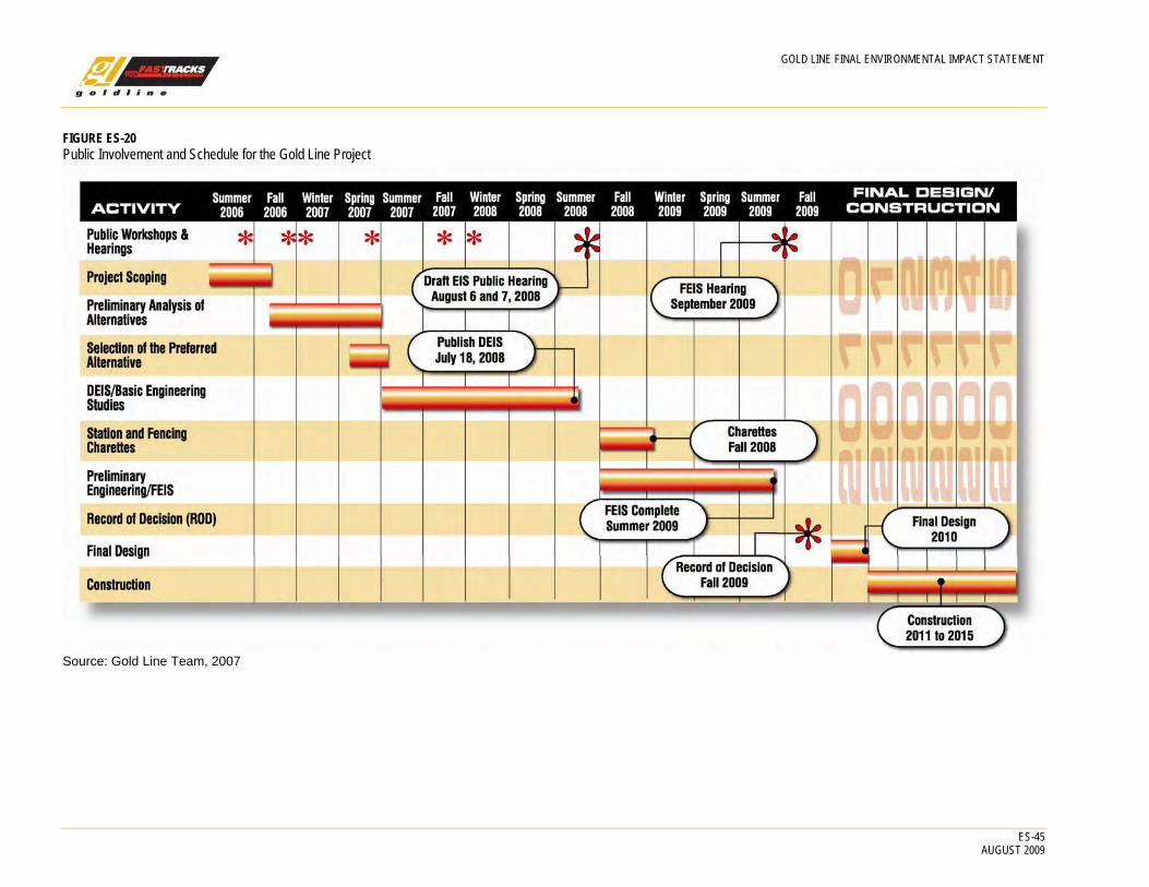
GOLD LINE FINAL ENVIRONMENTAL IMPACT STATEMENT
ES-45 AUGUST 2009
FIGURE ES-20 Public Involvement and Schedule for the Gold Line Project
Source: Gold Line Team, 2007

GOLD LINE FINAL ENVIRONMENTAL IMPACT STATEMENT
ES-46 AUGUST 2009
FIGURE ES-21Decision Process
Source: Gold Line Team, 2007
How have agencies been involved? The LGT and AWG have been involved in the project from its inception. All project information is presented first to the LGT for additional information, then to the public through public workshops, then to the combined LGT and AWG at Agency Milestone Meetings, as shown on Figure ES-21. As outlined in the Corridor Coordination Plan, and agreed to by all participating and cooperating agencies, public involvement was organized in the following manner:
Local Governments Team. This is comprised of elected officials and staff from each of the following local/ regional government entities:
• Adams County • City of Arvada • City and County of
Denver • Denver Regional
Council of Governments
• Jefferson County • Town of Lakeside • Town of Mountain
View • City of Wheat Ridge
Agency Working Group. The AWG is comprised of the LGT (as participating agencies) and representatives from the following state and federal cooperating and participating agencies, the joint lead agencies, and the railroads:
• BNSF Railway Company • CDOT • Colorado Department of Public Health and Environment (CDPHE) • Colorado Division of Wildlife (CDOW) • FHWA • FRA • FTA • RTD • SHPO • Union Pacific Railroad Company • Urban Drainage and Flood Control District (UDFCD) • United States Environmental Protection Agency (USEPA)
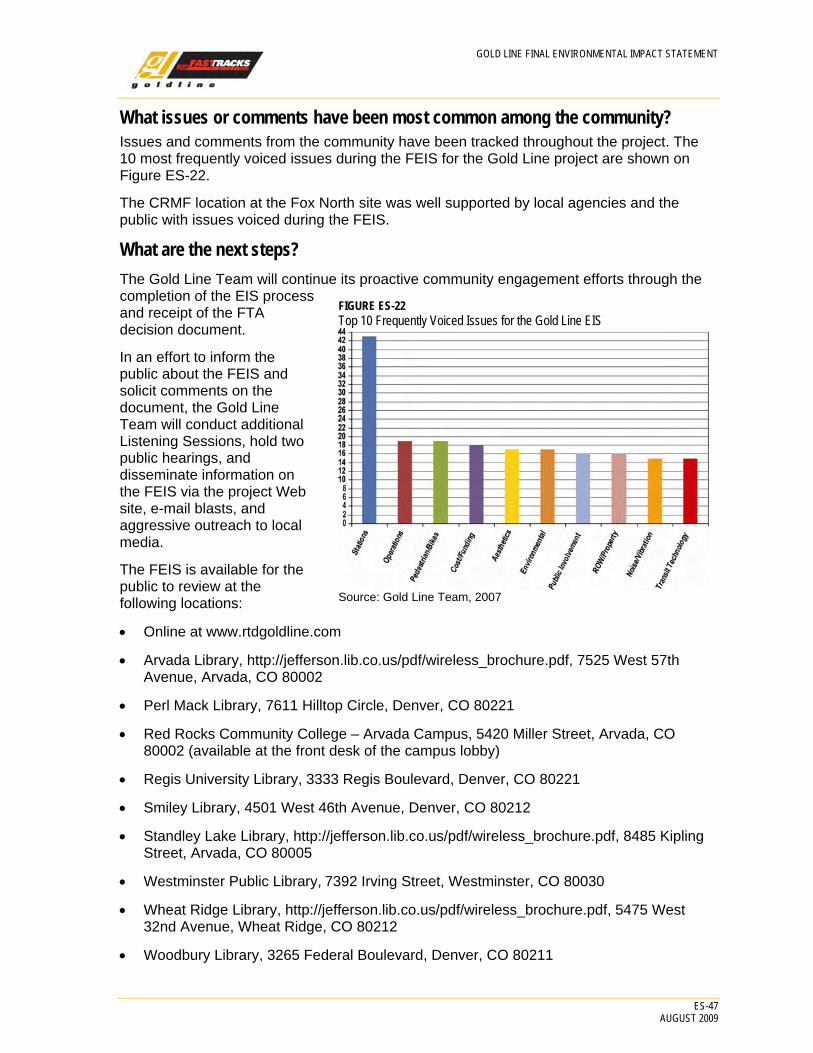
GOLD LINE FINAL ENVIRONMENTAL IMPACT STATEMENT
ES-47 AUGUST 2009
What issues or comments have been most common among the community? Issues and comments from the community have been tracked throughout the project. The 10 most frequently voiced issues during the FEIS for the Gold Line project are shown on Figure ES-22.
The CRMF location at the Fox North site was well supported by local agencies and the public with issues voiced during the FEIS.
What are the next steps? The Gold Line Team will continue its proactive community engagement efforts through the completion of the EIS process and receipt of the FTA decision document.
In an effort to inform the public about the FEIS and solicit comments on the document, the Gold Line Team will conduct additional Listening Sessions, hold two public hearings, and disseminate information on the FEIS via the project Web site, e-mail blasts, and aggressive outreach to local media.
The FEIS is available for the public to review at the following locations:
• Online at www.rtdgoldline.com
• Arvada Library, http://jefferson.lib.co.us/pdf/wireless_brochure.pdf, 7525 West 57th Avenue, Arvada, CO 80002
• Perl Mack Library, 7611 Hilltop Circle, Denver, CO 80221
• Red Rocks Community College – Arvada Campus, 5420 Miller Street, Arvada, CO 80002 (available at the front desk of the campus lobby)
• Regis University Library, 3333 Regis Boulevard, Denver, CO 80221
• Smiley Library, 4501 West 46th Avenue, Denver, CO 80212
• Standley Lake Library, http://jefferson.lib.co.us/pdf/wireless_brochure.pdf, 8485 Kipling Street, Arvada, CO 80005
• Westminster Public Library, 7392 Irving Street, Westminster, CO 80030
• Wheat Ridge Library, http://jefferson.lib.co.us/pdf/wireless_brochure.pdf, 5475 West 32nd Avenue, Wheat Ridge, CO 80212
• Woodbury Library, 3265 Federal Boulevard, Denver, CO 80211
FIGURE ES-22 Top 10 Frequently Voiced Issues for the Gold Line EIS
Source: Gold Line Team, 2007

GOLD LINE FINAL ENVIRONMENTAL IMPACT STATEMENT
ES-48 AUGUST 2009
Comments on the FEIS will be accepted for 30 days following the release of the document. Comments can be submitted verbally or in writing. Verbal comments will be accepted at the two public hearings. Written comments can be submitted via the following methods:
• Online at www.rtdgoldline.com
• E-mailing to [email protected]
• Mailing information requests and comments to FTA Region 8, David Beckhouse, Team Leader for Planning and Programs, C/O Gold Line Team, GBSM, 600 17th Street, Suite 2020 South, Denver, CO, 80202
• Dropping off comments at either of the two public hearings
• Completing and leaving a comment form at either of the two public hearings

GOLD LINE FINAL ENVIRONMENTAL IMPACT STATEMENT
ES-49 AUGUST 2009
TABLE ES-14 Summary of Impacts and Proposed Mitigation for the Preferred Alternative
Preferred Alternative Impacts Proposed Mitigation
Environmental Resources 3.1.1 Social Impacts and Community Facilities
Direct Impacts • No direct impacts to neighborhoods or community facilities. • Population changes would be consistent with local and regional
plans, which encourage TOD near the proposed transit stations.
• Benefit of an improved transit system and decreased congestion.
• No mitigation required.
Indirect Impacts • Probable shift of some population to the transit station areas
due to TOD.
• No mitigation required.
Temporary Construction Impacts • During the 36 to 48 month construction schedule,
approximately 95 acres would be exposed, about half in the railroad ROW and half for stations.
• Residences most affected by the inconveniences of construction (noise, dust, construction traffic) would be within 300 feet of the ROW. A total of 354 single-family and 12 multi-family properties are located in this area. The majority of the impacts would be in Arvada, between Lamar Street and Kipling Street.
• The construction of the 20 required at-grade crossings would result in temporary impacts to residents living in the vicinity of the at-grade crossing.
• Working with the communities, RTD will prepare a Construction Mitigation Plan (CMP) that specifies public communications, and construction means and methods to reduce or mitigate the inconveniences of construction such as noise, dust, visual blight, construction traffic, and preservation of access to homes, businesses, and community facilities.
• RTD will coordinate with the impacted neighborhoods prior to and during construction activities. • See Section 3.5, Visual and Aesthetic Qualities. • See Section 3.7.1, Air Quality. • See Section 3.8, Noise and Vibration. • See Chapter 4.0, Transportation Systems.
Cumulative Impacts • The Preferred Alternative would encourage compact urban
development because “in-fill” development would result adjacent to transit stations, reducing urban sprawl in the outskirts of the Gold Line study area. Neighborhoods would be revitalized as a result of the project action, increasing the use of community facilities and population densities around stations. The Preferred Alternative would help to shape the direction of future growth and strengthen neighborhoods.
• No mitigation required
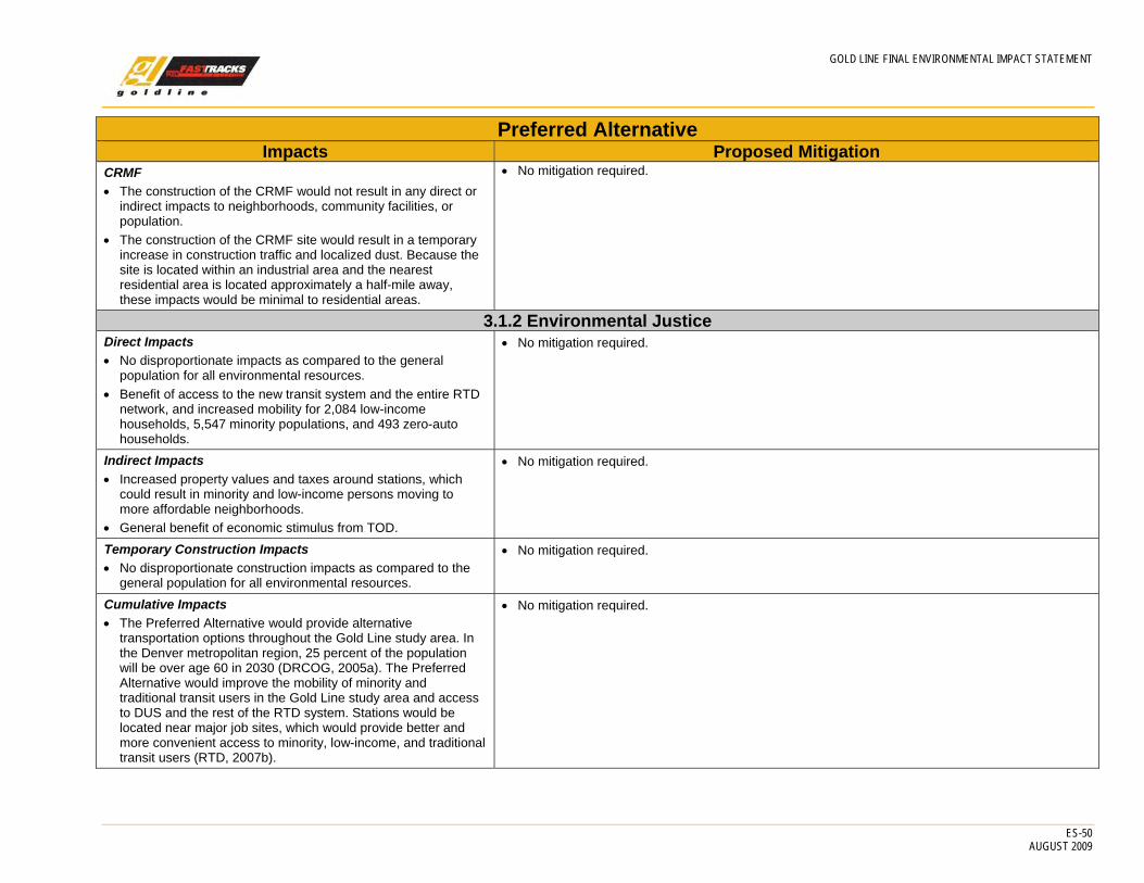
GOLD LINE FINAL ENVIRONMENTAL IMPACT STATEMENT
ES-50 AUGUST 2009
Preferred Alternative Impacts Proposed Mitigation
CRMF • The construction of the CRMF would not result in any direct or
indirect impacts to neighborhoods, community facilities, or population.
• The construction of the CRMF site would result in a temporary increase in construction traffic and localized dust. Because the site is located within an industrial area and the nearest residential area is located approximately a half-mile away, these impacts would be minimal to residential areas.
• No mitigation required.
3.1.2 Environmental Justice Direct Impacts • No disproportionate impacts as compared to the general
population for all environmental resources. • Benefit of access to the new transit system and the entire RTD
network, and increased mobility for 2,084 low-income households, 5,547 minority populations, and 493 zero-auto households.
• No mitigation required.
Indirect Impacts • Increased property values and taxes around stations, which
could result in minority and low-income persons moving to more affordable neighborhoods.
• General benefit of economic stimulus from TOD.
• No mitigation required.
Temporary Construction Impacts • No disproportionate construction impacts as compared to the
general population for all environmental resources.
• No mitigation required.
Cumulative Impacts • The Preferred Alternative would provide alternative
transportation options throughout the Gold Line study area. In the Denver metropolitan region, 25 percent of the population will be over age 60 in 2030 (DRCOG, 2005a). The Preferred Alternative would improve the mobility of minority and traditional transit users in the Gold Line study area and access to DUS and the rest of the RTD system. Stations would be located near major job sites, which would provide better and more convenient access to minority, low-income, and traditional transit users (RTD, 2007b).
• No mitigation required.
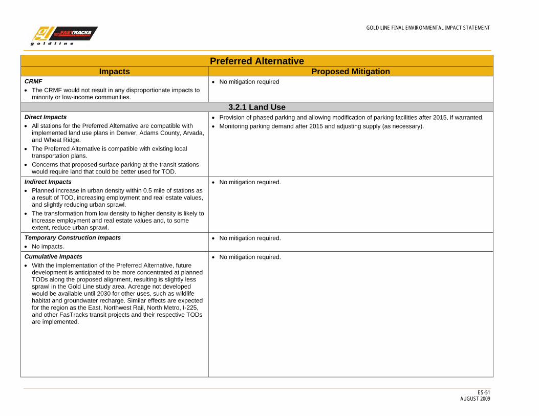
GOLD LINE FINAL ENVIRONMENTAL IMPACT STATEMENT
ES-51 AUGUST 2009
Preferred Alternative Impacts Proposed Mitigation
CRMF • The CRMF would not result in any disproportionate impacts to
minority or low-income communities.
• No mitigation required
3.2.1 Land Use Direct Impacts • All stations for the Preferred Alternative are compatible with
implemented land use plans in Denver, Adams County, Arvada, and Wheat Ridge.
• The Preferred Alternative is compatible with existing local transportation plans.
• Concerns that proposed surface parking at the transit stations would require land that could be better used for TOD.
• Provision of phased parking and allowing modification of parking facilities after 2015, if warranted. • Monitoring parking demand after 2015 and adjusting supply (as necessary).
Indirect Impacts • Planned increase in urban density within 0.5 mile of stations as
a result of TOD, increasing employment and real estate values, and slightly reducing urban sprawl.
• The transformation from low density to higher density is likely to increase employment and real estate values and, to some extent, reduce urban sprawl.
• No mitigation required.
Temporary Construction Impacts • No impacts.
• No mitigation required.
Cumulative Impacts • With the implementation of the Preferred Alternative, future
development is anticipated to be more concentrated at planned TODs along the proposed alignment, resulting is slightly less sprawl in the Gold Line study area. Acreage not developed would be available until 2030 for other uses, such as wildlife habitat and groundwater recharge. Similar effects are expected for the region as the East, Northwest Rail, North Metro, I-225, and other FasTracks transit projects and their respective TODs are implemented.
• No mitigation required.
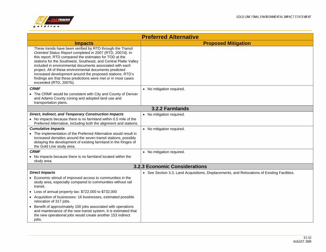
GOLD LINE FINAL ENVIRONMENTAL IMPACT STATEMENT
ES-52 AUGUST 2009
Preferred Alternative Impacts Proposed Mitigation
These trends have been verified by RTD through the Transit Oriented Status Report completed in 2007 (RTD, 2007d). In this report, RTD compared the estimates for TOD at the stations for the Southwest, Southeast, and Central Platte Valley included in environmental documents associated with each project. All of these environmental documents predicted increased development around the proposed stations. RTD’s findings are that these predictions were met or in most cases exceeded (RTD, 2007b).
CRMF • The CRMF would be consistent with City and County of Denver
and Adams County zoning and adopted land use and transportation plans.
• No mitigation required.
3.2.2 Farmlands Direct, Indirect, and Temporary Construction Impacts • No impacts because there is no farmland within 0.5 mile of the
Preferred Alternative, including both the alignment and stations.
• No mitigation required.
Cumulative Impacts • The implementation of the Preferred Alternative would result in
increased densities around the seven transit stations, possibly delaying the development of existing farmland in the fringes of the Gold Line study area.
• No mitigation required.
CRMF • No impacts because there is no farmland located within the
study area.
• No mitigation required.
3.2.3 Economic Considerations Direct Impacts • Economic stimuli of improved access to communities in the
study area, especially compared to communities without rail transit.
• Loss of annual property tax: $722,000 to $732,000 • Acquisition of businesses: 16 businesses, estimated possible
relocation of 317 jobs. • Benefit of approximately 100 jobs associated with operations
and maintenance of the new transit system. It is estimated that the new operational jobs would create another 153 indirect jobs.
• See Section 3.3, Land Acquisitions, Displacements, and Relocations of Existing Facilities.
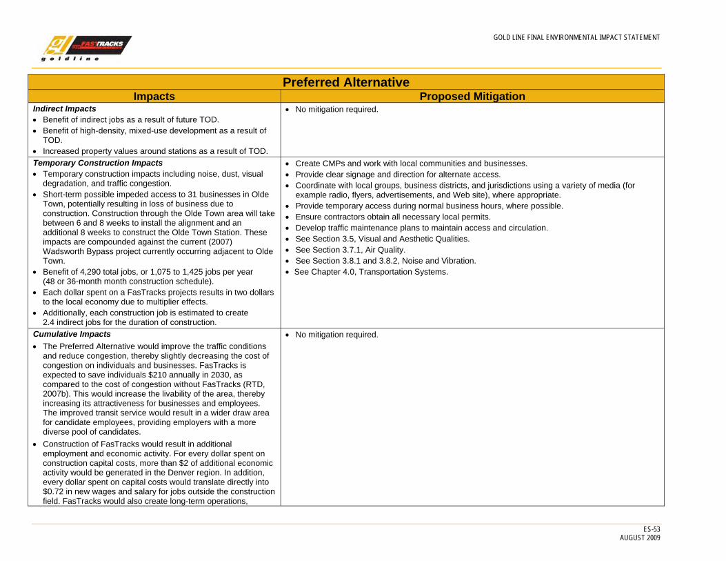
GOLD LINE FINAL ENVIRONMENTAL IMPACT STATEMENT
ES-53 AUGUST 2009
Preferred Alternative Impacts Proposed Mitigation
Indirect Impacts • Benefit of indirect jobs as a result of future TOD. • Benefit of high-density, mixed-use development as a result of
TOD. • Increased property values around stations as a result of TOD.
• No mitigation required.
Temporary Construction Impacts • Temporary construction impacts including noise, dust, visual
degradation, and traffic congestion. • Short-term possible impeded access to 31 businesses in Olde
Town, potentially resulting in loss of business due to construction. Construction through the Olde Town area will take between 6 and 8 weeks to install the alignment and an additional 8 weeks to construct the Olde Town Station. These impacts are compounded against the current (2007) Wadsworth Bypass project currently occurring adjacent to Olde Town.
• Benefit of 4,290 total jobs, or 1,075 to 1,425 jobs per year (48 or 36-month month construction schedule).
• Each dollar spent on a FasTracks projects results in two dollars to the local economy due to multiplier effects.
• Additionally, each construction job is estimated to create 2.4 indirect jobs for the duration of construction.
• Create CMPs and work with local communities and businesses. • Provide clear signage and direction for alternate access. • Coordinate with local groups, business districts, and jurisdictions using a variety of media (for
example radio, flyers, advertisements, and Web site), where appropriate. • Provide temporary access during normal business hours, where possible. • Ensure contractors obtain all necessary local permits. • Develop traffic maintenance plans to maintain access and circulation. • See Section 3.5, Visual and Aesthetic Qualities. • See Section 3.7.1, Air Quality. • See Section 3.8.1 and 3.8.2, Noise and Vibration. • See Chapter 4.0, Transportation Systems.
Cumulative Impacts • The Preferred Alternative would improve the traffic conditions
and reduce congestion, thereby slightly decreasing the cost of congestion on individuals and businesses. FasTracks is expected to save individuals $210 annually in 2030, as compared to the cost of congestion without FasTracks (RTD, 2007b). This would increase the livability of the area, thereby increasing its attractiveness for businesses and employees. The improved transit service would result in a wider draw area for candidate employees, providing employers with a more diverse pool of candidates.
• Construction of FasTracks would result in additional employment and economic activity. For every dollar spent on construction capital costs, more than $2 of additional economic activity would be generated in the Denver region. In addition, every dollar spent on capital costs would translate directly into $0.72 in new wages and salary for jobs outside the construction field. FasTracks would also create long-term operations,
• No mitigation required.

GOLD LINE FINAL ENVIRONMENTAL IMPACT STATEMENT
ES-54 AUGUST 2009
Preferred Alternative Impacts Proposed Mitigation
maintenance, and general administration jobs. Based upon the current employment figures for RTD light rail operations, it is estimated that FasTracks would create employment for approximately 1,100 workers. The long-term employment benefits will also have a multiplier effect on the regional economy, resulting in an additional 1,533 jobs for every 1,000 jobs created (employment multiplier of 1.53) by FasTracks operations. Thus, the number of new permanent jobs created during FasTracks operations is approximately 2,500. (RTD, 2007b).
• The estimated average number of jobs directly related to construction of the FasTracks system would be 2,171 jobs per year, representing about $217 million per year in wages and benefits per year, assuming a 7-year construction duration. The 2,171 direct employment jobs per year would generate approximately 5,000 additional indirect jobs (economic construction job multiplier of 2.42) per year in the Denver region for all industries not directly involved with construction of the FasTracks system. In total, the construction effort would employ over 7,000 people per year including direct and indirect jobs (RTD, 2007b).
CRMF • Approximately 300 jobs would be created by the CRMF. • An additional 459 jobs would be created as a result of these
long-term employment benefits with the operation of the CRMF (employment multiplier of 1.53). Conversely, additional jobs could be lost if second tier companies do not relocate within the Denver metro area.
• Loss of annual property tax: $7,000. • No business acquisitions. • Other businesses along Fox Street and 48th Avenue would be
temporarily impacted by construction-related vehicle traffic, and adjacent businesses could experience temporary disruptions as a result of construction related noise and dust. The construction of the CRMF at the Fox North Site would provide a benefit by generating a total of 990 construction jobs, or approximately 495 construction jobs per year for 2 years.
• Mitigation for the CRMF will be the same as those measures identified for the temporary construction impacts above.
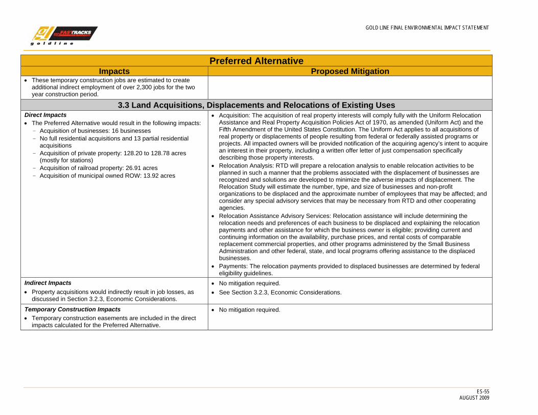
GOLD LINE FINAL ENVIRONMENTAL IMPACT STATEMENT
ES-55 AUGUST 2009
Preferred Alternative Impacts Proposed Mitigation
• These temporary construction jobs are estimated to create additional indirect employment of over 2,300 jobs for the two year construction period.
3.3 Land Acquisitions, Displacements and Relocations of Existing Uses Direct Impacts • The Preferred Alternative would result in the following impacts:
- Acquisition of businesses: 16 businesses - No full residential acquisitions and 13 partial residential
acquisitions - Acquisition of private property: 128.20 to 128.78 acres
(mostly for stations) - Acquisition of railroad property: 26.91 acres - Acquisition of municipal owned ROW: 13.92 acres
• Acquisition: The acquisition of real property interests will comply fully with the Uniform Relocation Assistance and Real Property Acquisition Policies Act of 1970, as amended (Uniform Act) and the Fifth Amendment of the United States Constitution. The Uniform Act applies to all acquisitions of real property or displacements of people resulting from federal or federally assisted programs or projects. All impacted owners will be provided notification of the acquiring agency’s intent to acquire an interest in their property, including a written offer letter of just compensation specifically describing those property interests.
• Relocation Analysis: RTD will prepare a relocation analysis to enable relocation activities to be planned in such a manner that the problems associated with the displacement of businesses are recognized and solutions are developed to minimize the adverse impacts of displacement. The Relocation Study will estimate the number, type, and size of businesses and non-profit organizations to be displaced and the approximate number of employees that may be affected; and consider any special advisory services that may be necessary from RTD and other cooperating agencies.
• Relocation Assistance Advisory Services: Relocation assistance will include determining the relocation needs and preferences of each business to be displaced and explaining the relocation payments and other assistance for which the business owner is eligible; providing current and continuing information on the availability, purchase prices, and rental costs of comparable replacement commercial properties, and other programs administered by the Small Business Administration and other federal, state, and local programs offering assistance to the displaced businesses.
• Payments: The relocation payments provided to displaced businesses are determined by federal eligibility guidelines.
Indirect Impacts • Property acquisitions would indirectly result in job losses, as
discussed in Section 3.2.3, Economic Considerations.
• No mitigation required. • See Section 3.2.3, Economic Considerations.
Temporary Construction Impacts • Temporary construction easements are included in the direct
impacts calculated for the Preferred Alternative.
• No mitigation required.

GOLD LINE FINAL ENVIRONMENTAL IMPACT STATEMENT
ES-56 AUGUST 2009
Preferred Alternative Impacts Proposed Mitigation
Cumulative Impacts • Private property acquisition required for the Preferred
Alternative (up to 128.78 acres) would be additive to the property required for three roadway projects and the Northwest Rail project committed under the No Action Alternative, plus the additional land needed for new public infrastructure to serve the 2030 population in the Gold Line study area, estimated at approximately 700 acres. This compares to the 20,000+/- acres that would be required for public infrastructure to accommodate the 2030 population estimated for the Denver metropolitan area.
• No mitigation required.
CRMF • The CRMF would result in the acquisition of approximately 3.39
acres of property and would not result in the relocation of any businesses.
• Acquisition: The acquisition of real property interests will comply fully with the Uniform Relocation Assistance and Real Property Acquisition Policies Act of 1970, as amended (Uniform Act) and the Fifth Amendment of the United States Constitution. The Uniform Act applies to all acquisitions of real property or displacements of people resulting from federal or federally assisted programs or projects. All impacted owners will be provided notification of the acquiring agency’s intent to acquire an interest in their property, including a written offer letter of just compensation specifically describing those property interests.
• Relocation Analysis: RTD will prepare a relocation analysis to enable relocation activities to be planned in such a manner that the problems associated with the displacement of businesses are recognized and solutions are developed to minimize the adverse impacts of displacement. The Relocation Study will estimate the number, type, and size of businesses and non-profit organizations to be displaced and the approximate number of employees that may be affected; and consider any special advisory services that may be necessary from RTD and other cooperating agencies.
• Relocation Assistance Advisory Services: Relocation assistance will include determining the relocation needs and preferences of each business to be displaced and explaining the relocation payments and other assistance for which the business owner is eligible; providing current and continuing information on the availability, purchase prices, and rental costs of comparable replacement commercial properties, and other programs administered by the Small Business Administration and other federal, state, and local programs offering assistance to the displaced businesses.
• Payments: The relocation payments provided to displaced businesses are determined by federal eligibility guidelines.
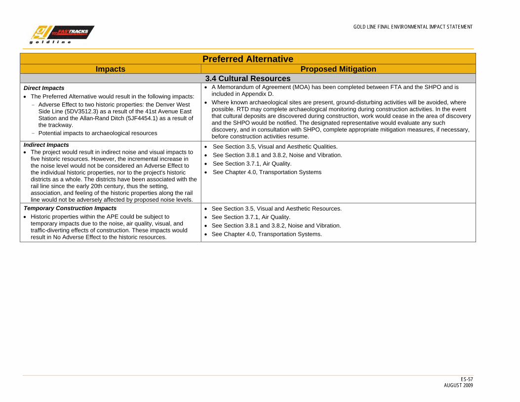
GOLD LINE FINAL ENVIRONMENTAL IMPACT STATEMENT
ES-57 AUGUST 2009
Preferred Alternative Impacts Proposed Mitigation
3.4 Cultural Resources Direct Impacts • The Preferred Alternative would result in the following impacts:
- Adverse Effect to two historic properties: the Denver West Side Line (5DV3512.3) as a result of the 41st Avenue East Station and the Allan-Rand Ditch (5JF4454.1) as a result of the trackway.
- Potential impacts to archaeological resources
• A Memorandum of Agreement (MOA) has been completed between FTA and the SHPO and is included in Appendix D.
• Where known archaeological sites are present, ground-disturbing activities will be avoided, where possible. RTD may complete archaeological monitoring during construction activities. In the event that cultural deposits are discovered during construction, work would cease in the area of discovery and the SHPO would be notified. The designated representative would evaluate any such discovery, and in consultation with SHPO, complete appropriate mitigation measures, if necessary, before construction activities resume.
Indirect Impacts • The project would result in indirect noise and visual impacts to
five historic resources. However, the incremental increase in the noise level would not be considered an Adverse Effect to the individual historic properties, nor to the project's historic districts as a whole. The districts have been associated with the rail line since the early 20th century, thus the setting, association, and feeling of the historic properties along the rail line would not be adversely affected by proposed noise levels.
• See Section 3.5, Visual and Aesthetic Qualities. • See Section 3.8.1 and 3.8.2, Noise and Vibration. • See Section 3.7.1, Air Quality. • See Chapter 4.0, Transportation Systems
Temporary Construction Impacts • Historic properties within the APE could be subject to
temporary impacts due to the noise, air quality, visual, and traffic-diverting effects of construction. These impacts would result in No Adverse Effect to the historic resources.
• See Section 3.5, Visual and Aesthetic Resources. • See Section 3.7.1, Air Quality. • See Section 3.8.1 and 3.8.2, Noise and Vibration. • See Chapter 4.0, Transportation Systems.
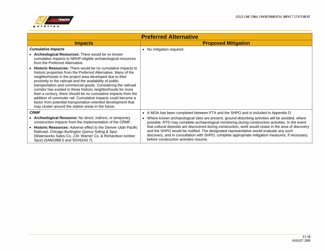
GOLD LINE FINAL ENVIRONMENTAL IMPACT STATEMENT
ES-58 AUGUST 2009
Preferred Alternative Impacts Proposed Mitigation
Cumulative Impacts • Archeological Resources: There would be no known
cumulative impacts to NRHP-eligible archaeological resources from the Preferred Alternative.
• Historic Resources: There would be no cumulative impacts to historic properties from the Preferred Alternative. Many of the neighborhoods in the project area developed due to their proximity to the railroad and the availability of public transportation and commercial goods. Considering the railroad corridor has existed in these historic neighborhoods for more than a century, there should be no cumulative impacts from the addition of commuter rail. Cumulative impacts could become a factor from potential transportation-oriented development that may cluster around the station areas in the future.
• No mitigation required.
CRMF • Archeological Resource: No direct, indirect, or temporary
construction impacts from the implementation of the CRMF. • Historic Resources: Adverse effect to the Denver Utah Pacific
Railroad, Chicago Burlington Quincy Siding & Spur (Waterworks Sales Co, J.M. Warner Co, & Richardson lumber Spur) (5AM1888.5 and 5DV6243.7).
• A MOA has been completed between FTA and the SHPO and is included in Appendix D. • Where known archaeological sites are present, ground-disturbing activities will be avoided, where
possible. RTD may complete archaeological monitoring during construction activities. In the event that cultural deposits are discovered during construction, work would cease in the area of discovery and the SHPO would be notified. The designated representative would evaluate any such discovery, and in consultation with SHPO, complete appropriate mitigation measures, if necessary, before construction activities resume.

GOLD LINE FINAL ENVIRONMENTAL IMPACT STATEMENT
ES-59 AUGUST 2009
Preferred Alternative Impacts Proposed Mitigation
3.5 Visual and Aesthetic Resources Direct Impacts • Project features that present the potential for visual change
include: - Structures - Numerous retaining walls located throughout the length of
the alignment - Up to four pedestrian bridges - Seven transit stations and pnR facilities - 11.2 miles of overhead catenary - 11.2 miles of trackway - Electric substation - Fencing along the alignment - Crash walls where the alignment is less than 50 feet from
the UP alignment between I-76 and the Federal Station and between the Sheridan Station and Sheridan boulevard
• No adverse impacts in the Denver, Adams, and Wheat Ridge Sections due to the industrial and rail-oriented character of the alignment.
• Anticipated sensitivities in the Arvada Section from Lamar Street to Kipling Street.
• Station aesthetics will be coordinated with local agencies and the public during final design. • Station designs must be approved by the appropriate design review committee by each local
jurisdiction. • Final designs for stations will follow and build from the Preliminary Engineering design. • The architecture of new transit structures will match existing designs where two structures are
parallel, where appropriate. • Architectural catenary poles in Olde Town, Arvada. • Station canopies will be based on the topologies selected at the station IFT meetings held during
the FEIS: – 41st Avenue East Station: Industrial Loft Modern – Pecos Station: Industrial Loft Modern – Federal Station: Town Center Contemporary – Sheridan Station: Neighborhood Craftsman – Olde Town Station: Main Street Historic – Arvada Ridge Station: Neighborhood Craftsman – Ward Road Station: Town Center Contemporary
• Fencing types, excluding station areas, will be provided, including: – Denver Section
Post and cable on emergency walkways on the South Platte River and 38th Avenue Bridges and adjacent to the 41st Avenue East Station
Chain link through other areas – Adams Section
Guardrail along I-76, where necessary Post and cable on emergency walkways on the Clear Creek Bridge, along the cantilever
walkway between Clear Creek and Tennyson Street and adjacent to the Pecos and Federal Stations
Chain link through other areas – Arvada
Post and cable on emergency walkways on the Ralston Creek Bridge, between Lamar Street and Carr Street and adjacent to the Sheridan Boulevard and Arvada Ridge Stations
Chain link through other areas – Wheat Ridge
Post and cable adjacent to the Ward Road Station Chain link through other areas
• Railings/fencing at station areas will be designed consistent with the station canopy typologies as identified above.
• The electric substation will be screened.
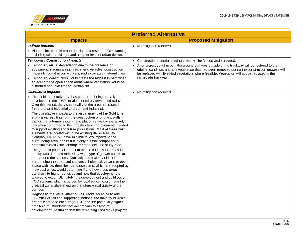
GOLD LINE FINAL ENVIRONMENTAL IMPACT STATEMENT
ES-60 AUGUST 2009
Preferred Alternative Impacts Proposed Mitigation
Indirect Impacts • Planned increase in urban density as a result of TOD planning
including taller buildings, and a higher level of urban design.
• No mitigation required.
Temporary Construction Impacts • Temporary visual degradation due to the presence of
equipment, staging areas, machinery, vehicles, construction materials, construction workers, and excavated material piles.
• Temporary construction would create the biggest impact when adjacent to the open space areas where vegetation would be disturbed and take time to reestablish.
• Construction material staging areas will be fenced and screened. • After project construction, the ground surfaces outside of the trackway will be restored to the
original condition, and any vegetation that had been removed during the construction process will be replaced with like-kind vegetation, where feasible. Vegetation will not be replaced in the immediate trackway.
Cumulative Impacts • The Gold Line study area has gone from being partially
developed in the 1950s to almost entirely developed today. Over this period, the visual quality of the area has changed from rural and industrial to urban and industrial. The cumulative impacts to the visual quality of the Gold Line study area resulting from the construction of bridges, walls, tracks, the catenary system, and platforms are comparatively low when compared to the infrastructure improvements needed to support existing and future populations. Most of these built elements are located within the existing BNSF Railway Company/UP ROW, have minimal to low impacts to the surrounding area, and result in only a small component of potential overall visual change for the Gold Line study area. The greatest potential impact to the Gold Line’s future visual quality would be determined by what type of growth occurs at and around the stations. Currently, the majority of land surrounding the proposed stations is industrial, vacant, or open space with low densities. Land use plans, which are adopted by individual cities, would determine if and how these areas transform to higher densities and how that development is allowed to occur. Ultimately, the development and build out of TOD stations, which is guided by local policy, would have the greatest cumulative effect on the future visual quality of the corridor. Regionally, the visual affect of FasTracks would be to add 119 miles of rail and supporting stations, the majority of which are anticipated to encourage TOD and the potentially higher architectural standards that accompany this type of development. Assuming that the remaining FasTracks projects
• No mitigation required.
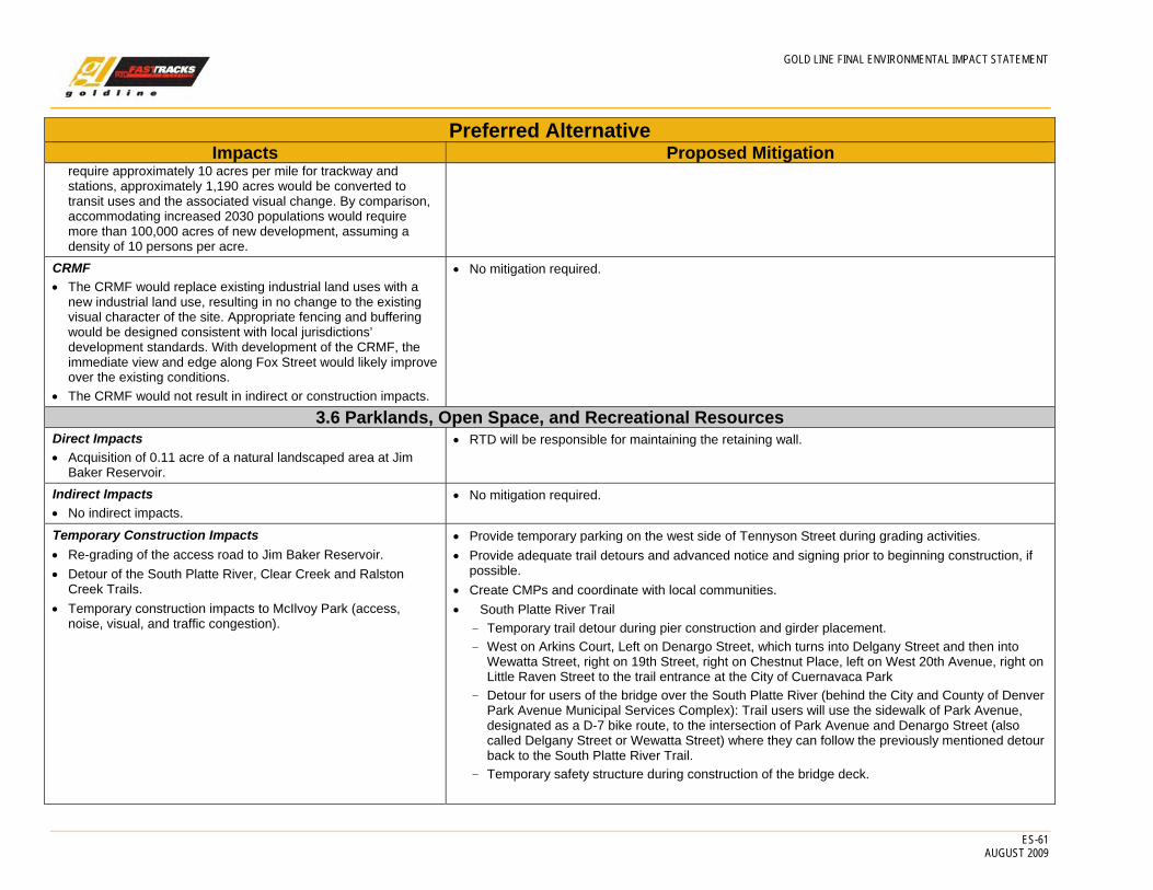
GOLD LINE FINAL ENVIRONMENTAL IMPACT STATEMENT
ES-61 AUGUST 2009
Preferred Alternative Impacts Proposed Mitigation
require approximately 10 acres per mile for trackway and stations, approximately 1,190 acres would be converted to transit uses and the associated visual change. By comparison, accommodating increased 2030 populations would require more than 100,000 acres of new development, assuming a density of 10 persons per acre.
CRMF • The CRMF would replace existing industrial land uses with a
new industrial land use, resulting in no change to the existing visual character of the site. Appropriate fencing and buffering would be designed consistent with local jurisdictions’ development standards. With development of the CRMF, the immediate view and edge along Fox Street would likely improve over the existing conditions.
• The CRMF would not result in indirect or construction impacts.
• No mitigation required.
3.6 Parklands, Open Space, and Recreational Resources Direct Impacts • Acquisition of 0.11 acre of a natural landscaped area at Jim
Baker Reservoir.
• RTD will be responsible for maintaining the retaining wall.
Indirect Impacts • No indirect impacts.
• No mitigation required.
Temporary Construction Impacts • Re-grading of the access road to Jim Baker Reservoir. • Detour of the South Platte River, Clear Creek and Ralston
Creek Trails. • Temporary construction impacts to McIlvoy Park (access,
noise, visual, and traffic congestion).
• Provide temporary parking on the west side of Tennyson Street during grading activities. • Provide adequate trail detours and advanced notice and signing prior to beginning construction, if
possible. • Create CMPs and coordinate with local communities. • South Platte River Trail
- Temporary trail detour during pier construction and girder placement. - West on Arkins Court, Left on Denargo Street, which turns into Delgany Street and then into
Wewatta Street, right on 19th Street, right on Chestnut Place, left on West 20th Avenue, right on Little Raven Street to the trail entrance at the City of Cuernavaca Park
- Detour for users of the bridge over the South Platte River (behind the City and County of Denver Park Avenue Municipal Services Complex): Trail users will use the sidewalk of Park Avenue, designated as a D-7 bike route, to the intersection of Park Avenue and Denargo Street (also called Delgany Street or Wewatta Street) where they can follow the previously mentioned detour back to the South Platte River Trail.
- Temporary safety structure during construction of the bridge deck.
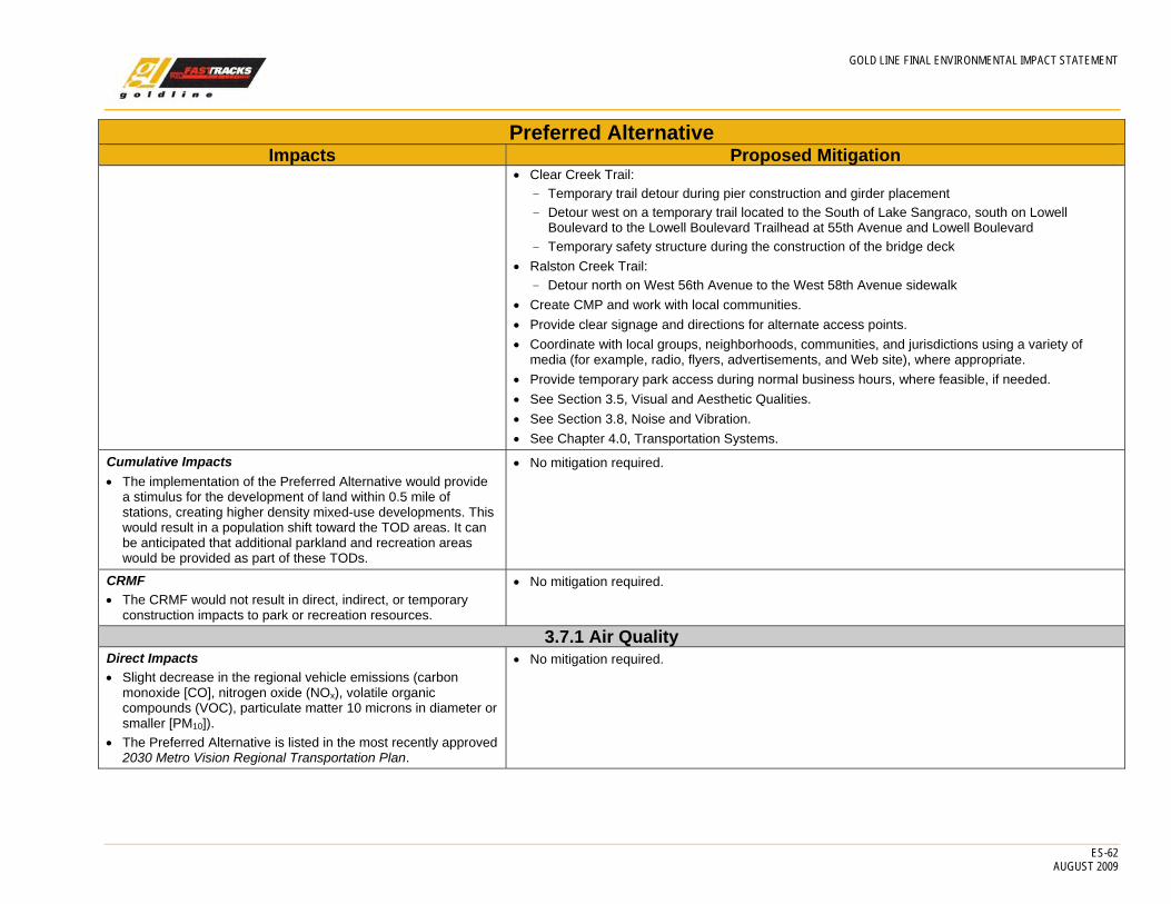
GOLD LINE FINAL ENVIRONMENTAL IMPACT STATEMENT
ES-62 AUGUST 2009
Preferred Alternative Impacts Proposed Mitigation
• Clear Creek Trail: - Temporary trail detour during pier construction and girder placement - Detour west on a temporary trail located to the South of Lake Sangraco, south on Lowell
Boulevard to the Lowell Boulevard Trailhead at 55th Avenue and Lowell Boulevard - Temporary safety structure during the construction of the bridge deck
• Ralston Creek Trail: - Detour north on West 56th Avenue to the West 58th Avenue sidewalk
• Create CMP and work with local communities. • Provide clear signage and directions for alternate access points. • Coordinate with local groups, neighborhoods, communities, and jurisdictions using a variety of
media (for example, radio, flyers, advertisements, and Web site), where appropriate. • Provide temporary park access during normal business hours, where feasible, if needed. • See Section 3.5, Visual and Aesthetic Qualities. • See Section 3.8, Noise and Vibration. • See Chapter 4.0, Transportation Systems.
Cumulative Impacts • The implementation of the Preferred Alternative would provide
a stimulus for the development of land within 0.5 mile of stations, creating higher density mixed-use developments. This would result in a population shift toward the TOD areas. It can be anticipated that additional parkland and recreation areas would be provided as part of these TODs.
• No mitigation required.
CRMF • The CRMF would not result in direct, indirect, or temporary
construction impacts to park or recreation resources.
• No mitigation required.
3.7.1 Air Quality Direct Impacts • Slight decrease in the regional vehicle emissions (carbon
monoxide [CO], nitrogen oxide (NOx), volatile organic compounds (VOC), particulate matter 10 microns in diameter or smaller [PM10]).
• The Preferred Alternative is listed in the most recently approved 2030 Metro Vision Regional Transportation Plan.
• No mitigation required.

GOLD LINE FINAL ENVIRONMENTAL IMPACT STATEMENT
ES-63 AUGUST 2009
Preferred Alternative Impacts Proposed Mitigation
Indirect Impacts • No CO hot-spot violations. • Parking facility CO levels below National Ambient Air Quality
Standards. • For the Gold Line project the Preferred Alternative would, by
itself, produce slightly more CO2 compared to the No Action Alternative. However, the increase associated with the Preferred Alternative is negligible and would be off-set by traffic reduction, and associated lower CO2 emissions, resulting from the FasTracks system ridership as a whole.
• No mitigation required.
Temporary Construction Impacts • Fugitive dust (PM10) emissions of 100 pounds per day based on
the assumption of a maximum disturbed area of 10 acres per day.
• For winter construction, the contractor shall install engine pre-heater devices to eliminate unnecessary idling.
• The contractor shall be prohibited from tampering with equipment to increase horsepower or to defeat emissions control device effectiveness.
• Construction vehicles and equipment used by the contractor shall be properly tuned and maintained.
• Construction vehicles and equipment, used by the contractor, shall be equipped with the minimum practical engine size for the intended job requirement.
• All construction equipment used by the contractor will be equipped to burn ultra low sulfur diesel fuel.
• The contractor shall use water or wetting agents to manage dust. • The contractor shall use wind barriers and wind screens to minimize the spreading of dust in areas
where large amounts of materials are stored. • The contractor shall use a wheel wash station and/or large-diameter cobble apron at
egress/ingress areas to minimize dirt being tracked onto public streets. • The contractor shall use vacuum powered street sweepers to control dirt tracked onto streets. • The contractor shall cover all dump trucks leaving the site. • The contractor shall cover or wet temporary excavated materials. • The contractor shall use a binding agent for long-term excavated materials.
Cumulative Impacts • The cumulative impact of FasTracks is projected to result in a
modest improvement in regional air quality due to reductions in vehicle miles traveled and more compact urbanization due to TOD.
• No mitigation is required.

GOLD LINE FINAL ENVIRONMENTAL IMPACT STATEMENT
ES-64 AUGUST 2009
Preferred Alternative Impacts Proposed Mitigation
CRMF • The rail operations associated with the CRMF are included in
the FasTracks Plan, which is included in the 2012 Transportation Improvement Plan and the Metro Vision Plan.
• Emissions of criteria pollutants (PM10, VOCs, NOx, and CO) would be below the National Ambient Air Quality Standards (NAAQS).
• The project meets the conformity hot spot requirements in 40 CFR §93.116 and §93.123 for PM10.
• The MSAT emission levels for the CRMF are similar to the No Action Alternative for the Tier 1 and Tier 2 study areas.
• Fugitive dust (PM10) emissions of 100 pounds per day based on the assumption of a maximum disturbed area of 10 acres per day.
• Mitigation for the CRMF will be the same as those measures identified for the temporary construction impacts above.
3.7.2 Energy Direct Impacts • Energy impacts are not a discriminator between the No Action
and Preferred Alternatives. • 166,733,285 million British thermal unit (Btus) in 2015, increase
of 110,560 million Btus or 0.0007 percent as compared to the No Action Alternative in the region.
• 207,858,217 million Btus in 2030, increase of 89,623 million Btus or 0.0004 percent as compared to the No Action Alternative in the region.
• No mitigation required.
Indirect Impacts • Energy use associated with TOD potentially less then the No
Action Alternative because of smaller residences, decreased dependence on automobiles, and increase in transit use.
• No mitigation required.
Temporary Construction Impacts • Energy usage of 1,132,998 million Btus with the Preferred
Alternative.
• Design efforts to reduce energy consumption and overall VMT including: - Creating multiple access points for parking lots, where possible. - Carefully designing “kiss-n-Ride” drop-offs to maximize efficiency and minimize number of
vehicles idling. - Positioning stations to be more easily accessible by pedestrians and bicyclists. - pnR improvements to decrease energy consumption consistent with RTD’s sustainability policy.
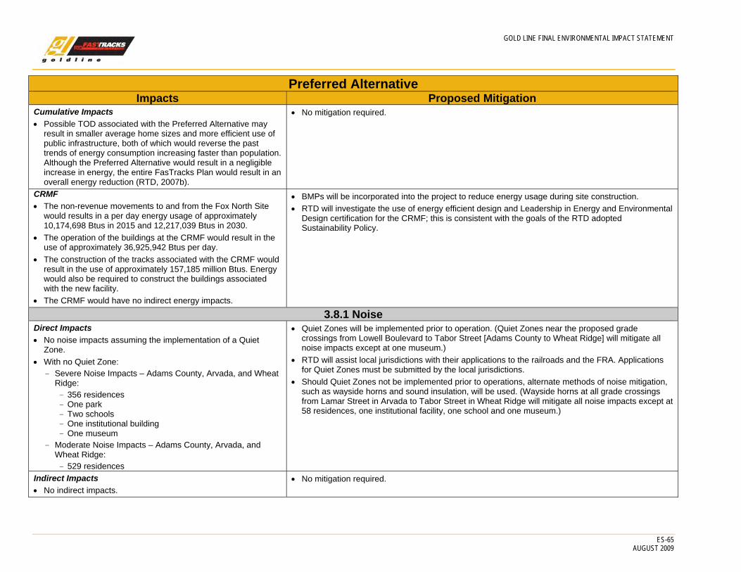
GOLD LINE FINAL ENVIRONMENTAL IMPACT STATEMENT
ES-65 AUGUST 2009
Preferred Alternative Impacts Proposed Mitigation
Cumulative Impacts • Possible TOD associated with the Preferred Alternative may
result in smaller average home sizes and more efficient use of public infrastructure, both of which would reverse the past trends of energy consumption increasing faster than population. Although the Preferred Alternative would result in a negligible increase in energy, the entire FasTracks Plan would result in an overall energy reduction (RTD, 2007b).
• No mitigation required.
CRMF • The non-revenue movements to and from the Fox North Site
would results in a per day energy usage of approximately 10,174,698 Btus in 2015 and 12,217,039 Btus in 2030.
• The operation of the buildings at the CRMF would result in the use of approximately 36,925,942 Btus per day.
• The construction of the tracks associated with the CRMF would result in the use of approximately 157,185 million Btus. Energy would also be required to construct the buildings associated with the new facility.
• The CRMF would have no indirect energy impacts.
• BMPs will be incorporated into the project to reduce energy usage during site construction. • RTD will investigate the use of energy efficient design and Leadership in Energy and Environmental
Design certification for the CRMF; this is consistent with the goals of the RTD adopted Sustainability Policy.
3.8.1 Noise Direct Impacts • No noise impacts assuming the implementation of a Quiet
Zone. • With no Quiet Zone:
- Severe Noise Impacts – Adams County, Arvada, and Wheat Ridge: - 356 residences - One park - Two schools - One institutional building - One museum
- Moderate Noise Impacts – Adams County, Arvada, and Wheat Ridge: - 529 residences
• Quiet Zones will be implemented prior to operation. (Quiet Zones near the proposed grade crossings from Lowell Boulevard to Tabor Street [Adams County to Wheat Ridge] will mitigate all noise impacts except at one museum.)
• RTD will assist local jurisdictions with their applications to the railroads and the FRA. Applications for Quiet Zones must be submitted by the local jurisdictions.
• Should Quiet Zones not be implemented prior to operations, alternate methods of noise mitigation, such as wayside horns and sound insulation, will be used. (Wayside horns at all grade crossings from Lamar Street in Arvada to Tabor Street in Wheat Ridge will mitigate all noise impacts except at 58 residences, one institutional facility, one school and one museum.)
Indirect Impacts • No indirect impacts.
• No mitigation required.
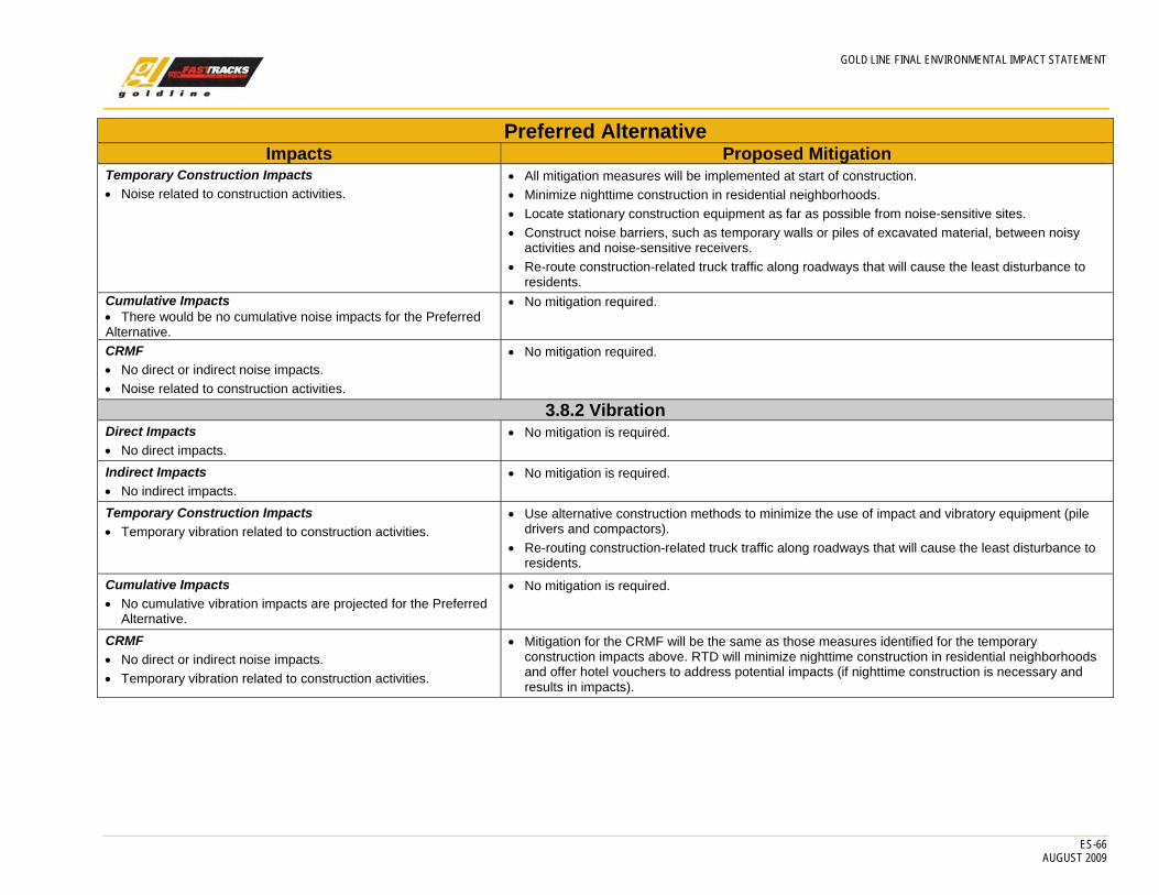
GOLD LINE FINAL ENVIRONMENTAL IMPACT STATEMENT
ES-66 AUGUST 2009
Preferred Alternative Impacts Proposed Mitigation
Temporary Construction Impacts • Noise related to construction activities.
• All mitigation measures will be implemented at start of construction. • Minimize nighttime construction in residential neighborhoods. • Locate stationary construction equipment as far as possible from noise-sensitive sites. • Construct noise barriers, such as temporary walls or piles of excavated material, between noisy
activities and noise-sensitive receivers. • Re-route construction-related truck traffic along roadways that will cause the least disturbance to
residents. Cumulative Impacts • There would be no cumulative noise impacts for the Preferred Alternative.
• No mitigation required.
CRMF • No direct or indirect noise impacts. • Noise related to construction activities.
• No mitigation required.
3.8.2 Vibration Direct Impacts • No direct impacts.
• No mitigation is required.
Indirect Impacts • No indirect impacts.
• No mitigation is required.
Temporary Construction Impacts • Temporary vibration related to construction activities.
• Use alternative construction methods to minimize the use of impact and vibratory equipment (pile drivers and compactors).
• Re-routing construction-related truck traffic along roadways that will cause the least disturbance to residents.
Cumulative Impacts • No cumulative vibration impacts are projected for the Preferred
Alternative.
• No mitigation is required.
CRMF • No direct or indirect noise impacts. • Temporary vibration related to construction activities.
• Mitigation for the CRMF will be the same as those measures identified for the temporary construction impacts above. RTD will minimize nighttime construction in residential neighborhoods and offer hotel vouchers to address potential impacts (if nighttime construction is necessary and results in impacts).

GOLD LINE FINAL ENVIRONMENTAL IMPACT STATEMENT
ES-67 AUGUST 2009
Preferred Alternative Impacts Proposed Mitigation
3.9 Biological Resources Direct Impacts • Minimal loss of vegetation and wildlife habitats at stream
crossings (approximately 1.5 acre). • No additional habitat fragmentation due to wider tracks,
retaining walls, security fencing, and bridge design. • Benefit of additional shading for fish and aquatic habitats due to
new bridges. • Potential impacts to animals and bird species from the catenary
system.
• The catenary system will incorporate appropriate requirements to protect animal and bird species.
Indirect Impacts • Planned increase in urban density as due to TOD would result
in fewer wildlife habitats around the undeveloped stations in the study area: Pecos and Federal.
• No mitigation required.
Temporary Construction Impacts • Loss of vegetation. • Spread of noxious weeds. • Impacts to aquatic habitats. • Potential damage or loss of migratory bird nests
• Grading plans will be prepared to minimize removal of riparian vegetation. • During construction, vehicle operation will be limited to the designated construction area and the
limits of the construction area will be fenced where they are adjacent to sensitive habitats including riparian areas, wetlands, and upland trees and shrubs.
• Areas of temporary disturbance will be seeded with an appropriate mixture of native grasses and forbs; shrubs will be planted where appropriate.
• Restoration of disturbed riparian habitat will include planting of native trees and shrubs, as well as seeding and regrading. Native grasses, forbs, and shrubs will also be seeded in riparian areas.
• Raptor nest surveys will be conducted annually during construction at an appropriate season (generally May 1 through June 1) to determine presence of active raptor nests. If an active nest is located, season buffers will be established and coordinated with CDOW to prevent disturbance to nesting birds during construction.
• Impacts to wildlife habitat will comply with Colorado Senate Bill 40 (33-5-101-107, Colorado Revised Statue 1973 as amended), where applicable.
• An integrated Noxious Weed Management Plan will be developed. This plan will be implemented during construction and will include identification of noxious weeds in the area, weed management goals and objectives, and prevention and control methods. Preventive measures include the following: - Contractor vehicles will be inspected before they are used for construction to ensure that they are
free of soil and debris capable of transporting noxious weed seeds or roots. - Noxious weeds observed in and near the construction area at the start of construction will be
treated with herbicides or physically removed to prevent seeds blowing into disturbed areas during construction. Any noxious weeds identified during construction will be identified and treated.
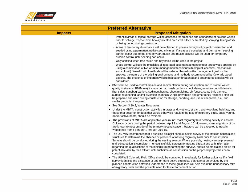
GOLD LINE FINAL ENVIRONMENTAL IMPACT STATEMENT
ES-68 AUGUST 2009
Preferred Alternative Impacts Proposed Mitigation
- Potential areas of topsoil salvage will be assessed for presence and abundance of noxious weeds prior to salvage. Topsoil from heavily infested areas will either be treated by spraying, taking offsite, or being buried during construction.
- Areas of temporary disturbance will be reclaimed in phases throughout project construction and seeded using a permanent native seed mixtures. If areas are complete and permanent seeding cannot occur due to the time of year, mulch and mulch tackifier will be used for temporary erosion control until seeding can occur.
- Only certified weed-free mulch and hay bales will be used in the project. - Weed control will use the principles of integrated pest management to treat target weed species by
using a combination of two or more management techniques (biological, chemical, mechanical, and cultural). Weed control methods will be selected based on the management goal for the species, the nature of the existing environment, and methods recommended by Colorado weed experts. The presence of important wildlife habitat or threatened and endangered species will be considered.
• BMPs will be used to control erosion and sedimentation during construction and to protect water quality in streams. BMPs may include berms, brush barriers, check dams, erosion control blankets, filter strips, sandbag barriers, sediment basins, sheet mulching, silt fences, straw-bale barriers, surface roughening, and/or diversion channels. A spill prevention and emergency response plan will be prepared and used during construction for storage, handling, and use of chemicals, fuel, and similar products, if required.
• See Section 3.10.2, Water Resources. • Under the MBTA, construction activities in grassland, wetland, stream, and woodland habitats, and
those that occur on bridges that would otherwise result in the take of migratory birds, eggs, young, and/or active nests, should be avoided.
• The provisions of MBTA are applicable year-round; most migratory bird nesting activity in eastern Colorado occurs during the period between April 1 and August 15. However, some migratory birds are known to nest outside of the primary nesting season. Raptors can be expected to nest in woodlands from February 1 through July 15.
• The USFWS recommends that a qualified biologist conduct a field survey of the affected habitats and structures to determine the absence or presence of nesting migratory birds prior to construction. Surveys should be conducted during the nesting season. Where possible, nesting can be prevented until construction is complete. The results of field surveys for nesting birds, along with information regarding the qualifications of the biologist(s) performing the surveys, should be maintained on file for potential review by the USFWS until such time as construction on the proposed project has been completed.
• The USFWS Colorado Field Office should be contacted immediately for further guidance if a field survey identifies the existence of one or more active bird nests that cannot be avoided by the planned construction activities. Adherence to these guidelines will help avoid the unnecessary take of migratory birds and the possible need for law enforcement action.

GOLD LINE FINAL ENVIRONMENTAL IMPACT STATEMENT
ES-69 AUGUST 2009
Preferred Alternative Impacts Proposed Mitigation
Cumulative Impacts • Vacant land that now serves as generally marginal wildlife
habitat would continue to be developed as the population increases by the year 2030. However, the TOD stimulated by the Preferred Alternative would slightly modify this trend because some percentage of the new development would occur at higher densities. This would have a modest positive effect on wildlife as some vacant land would not be developed during the planning period.
• No mitigation required.
CRMF • The CRMF would not result in any direct or indirect impacts to
biological resources. • Spread of noxious weeds.
• No mitigation is required.
3.10.1 Mineral Resources, Geology, and Soils Direct, Indirect and Temporary Construction Impacts • Geotechnical conditions, such as cut, fill and landslide slope
stability, erosion, structure foundation construction and integrity, potential for differential settlement, seismic risk, collapsible, shrinking/swelling soils, corrosive soils, in selected areas along the alignment will require engineering designs to avoid possible damage to foundations.
• None of these issues would prohibit implementation of these projects.
• Engineering of slope cuts for stability, shoring of slope cuts and shallow excavations, retaining walls, and dewatering systems where appropriate.
• Engineering techniques such as drainage systems to direct surface water and runoff, slope design, covering slope during construction, use of engineered fill, and prompt and appropriate revegetation.
• Mitigation of expansive bedrock, soil, and surficial materials with deep foundations into bedrock below perennial water table; specialized piers and footings; over-excavation with moisture treatment and compaction of backfill; engineered or imported fill; subsurface drainage systems; and surface water diversions.
• Mitigation of collapsible soils with shoring of excavations; retaining walls; drainage systems; excavation and/or engineered or imported fill; compaction, pre-construction flooding and/or loading; and use of geogrids or geotextiles.
• Mitigation of corrosive soils with coated and resistant steel and concrete; drainage systems. • Mitigation of shallow groundwater with engineered fills and dewatering systems. • Coordinating proposed alignment requirements with existing and altered topographies. • Engineering techniques and design to conform with anticipated probable maximum seismic events.
Cumulative Impacts • The Preferred Alternative is not anticipated to result in any
cumulative impacts beyond what has been described above under Direct Impacts.
• No mitigation required.
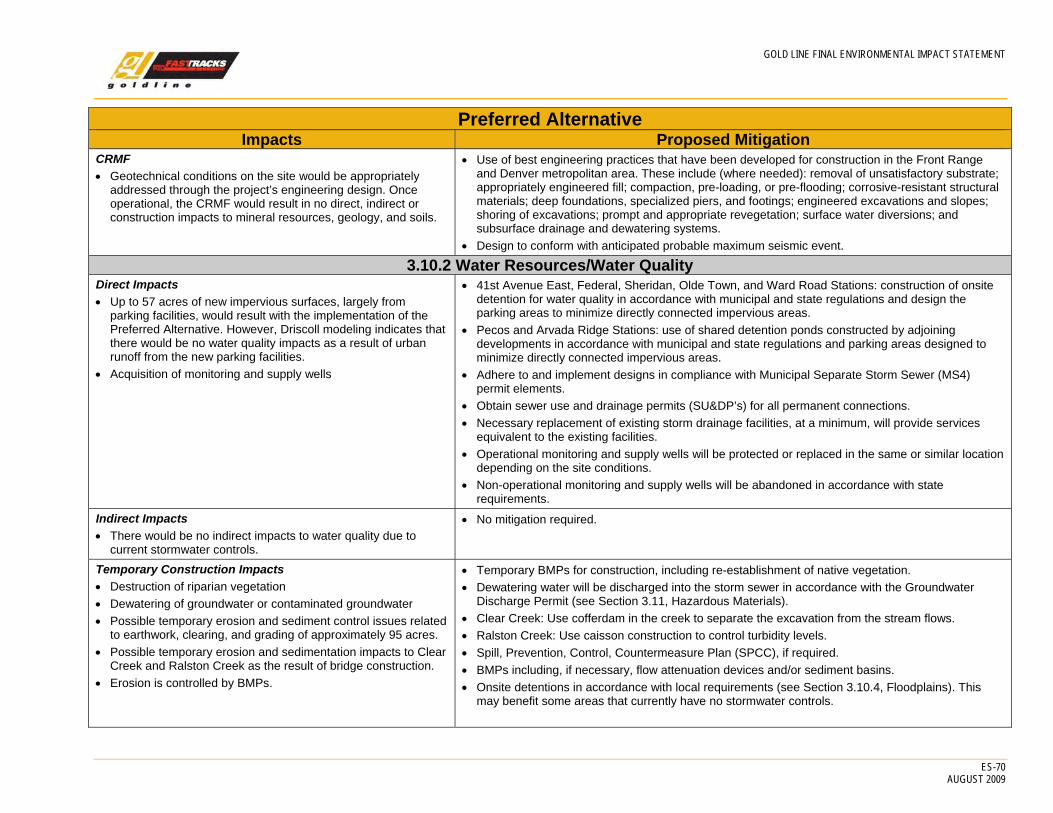
GOLD LINE FINAL ENVIRONMENTAL IMPACT STATEMENT
ES-70 AUGUST 2009
Preferred Alternative Impacts Proposed Mitigation
CRMF • Geotechnical conditions on the site would be appropriately
addressed through the project’s engineering design. Once operational, the CRMF would result in no direct, indirect or construction impacts to mineral resources, geology, and soils.
• Use of best engineering practices that have been developed for construction in the Front Range and Denver metropolitan area. These include (where needed): removal of unsatisfactory substrate; appropriately engineered fill; compaction, pre-loading, or pre-flooding; corrosive-resistant structural materials; deep foundations, specialized piers, and footings; engineered excavations and slopes; shoring of excavations; prompt and appropriate revegetation; surface water diversions; and subsurface drainage and dewatering systems.
• Design to conform with anticipated probable maximum seismic event.
3.10.2 Water Resources/Water Quality Direct Impacts • Up to 57 acres of new impervious surfaces, largely from
parking facilities, would result with the implementation of the Preferred Alternative. However, Driscoll modeling indicates that there would be no water quality impacts as a result of urban runoff from the new parking facilities.
• Acquisition of monitoring and supply wells
• 41st Avenue East, Federal, Sheridan, Olde Town, and Ward Road Stations: construction of onsite detention for water quality in accordance with municipal and state regulations and design the parking areas to minimize directly connected impervious areas.
• Pecos and Arvada Ridge Stations: use of shared detention ponds constructed by adjoining developments in accordance with municipal and state regulations and parking areas designed to minimize directly connected impervious areas.
• Adhere to and implement designs in compliance with Municipal Separate Storm Sewer (MS4) permit elements.
• Obtain sewer use and drainage permits (SU&DP’s) for all permanent connections. • Necessary replacement of existing storm drainage facilities, at a minimum, will provide services
equivalent to the existing facilities. • Operational monitoring and supply wells will be protected or replaced in the same or similar location
depending on the site conditions. • Non-operational monitoring and supply wells will be abandoned in accordance with state
requirements. Indirect Impacts • There would be no indirect impacts to water quality due to
current stormwater controls.
• No mitigation required.
Temporary Construction Impacts • Destruction of riparian vegetation • Dewatering of groundwater or contaminated groundwater • Possible temporary erosion and sediment control issues related
to earthwork, clearing, and grading of approximately 95 acres. • Possible temporary erosion and sedimentation impacts to Clear
Creek and Ralston Creek as the result of bridge construction. • Erosion is controlled by BMPs.
• Temporary BMPs for construction, including re-establishment of native vegetation. • Dewatering water will be discharged into the storm sewer in accordance with the Groundwater
Discharge Permit (see Section 3.11, Hazardous Materials). • Clear Creek: Use cofferdam in the creek to separate the excavation from the stream flows. • Ralston Creek: Use caisson construction to control turbidity levels. • Spill, Prevention, Control, Countermeasure Plan (SPCC), if required. • BMPs including, if necessary, flow attenuation devices and/or sediment basins. • Onsite detentions in accordance with local requirements (see Section 3.10.4, Floodplains). This
may benefit some areas that currently have no stormwater controls.
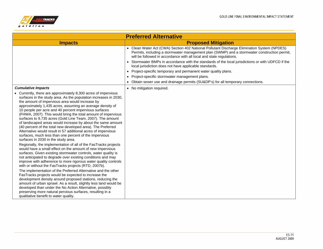
GOLD LINE FINAL ENVIRONMENTAL IMPACT STATEMENT
ES-71 AUGUST 2009
Preferred Alternative Impacts Proposed Mitigation
• Clean Water Act (CWA) Section 402 National Pollutant Discharge Elimination System (NPDES) Permits, including a stormwater management plan (SWMP) and a stormwater construction permit, will be followed in accordance with all local and state regulations.
• Stormwater BMPs in accordance with the standards of the local jurisdictions or with UDFCD if the local jurisdiction does not have applicable standards.
• Project-specific temporary and permanent water quality plans. • Project-specific stormwater management plans. • Obtain sewer use and drainage permits (SU&DP’s) for all temporary connections.
Cumulative Impacts • Currently, there are approximately 8,300 acres of impervious
surfaces in the study area. As the population increases in 2030, the amount of impervious area would increase by approximately 1,435 acres, assuming an average density of 10 people per acre and 40 percent impervious surfaces (FHWA, 2007). This would bring the total amount of impervious surfaces to 9,735 acres (Gold Line Team, 2007). The amount of landscaped areas would increase by about the same amount (40 percent of the total new developed area). The Preferred Alternative would result in 57 additional acres of impervious surfaces, much less than one percent of the impervious surfaces in 2030 in the study area. Regionally, the implementation of all of the FasTracks projects would have a small effect on the amount of new impervious surfaces. Given existing stormwater controls, water quality is not anticipated to degrade over existing conditions and may improve with adherence to more rigorous water quality controls with or without the FasTracks projects (RTD, 2007b). The implementation of the Preferred Alternative and the other FasTracks projects would be expected to increase the development density around proposed stations, reducing the amount of urban sprawl. As a result, slightly less land would be developed than under the No Action Alternative, possibly preserving more natural pervious surfaces, resulting in a qualitative benefit to water quality.
• No mitigation required.
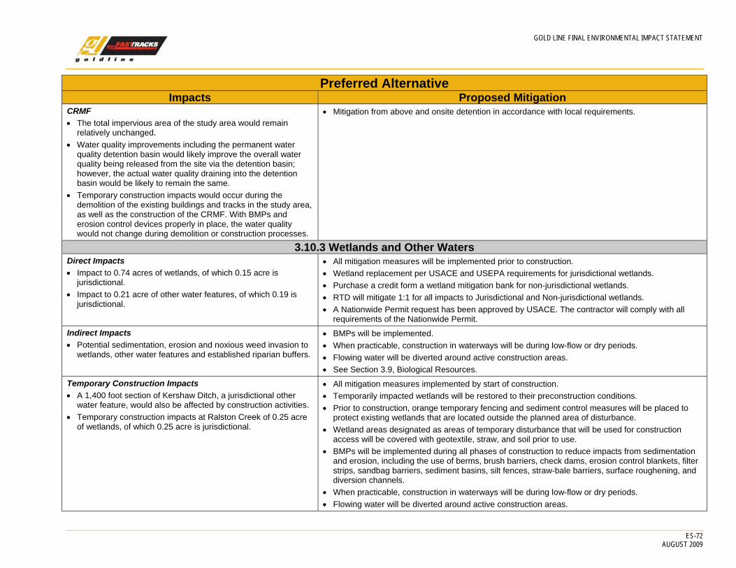
GOLD LINE FINAL ENVIRONMENTAL IMPACT STATEMENT
ES-72 AUGUST 2009
Preferred Alternative Impacts Proposed Mitigation
CRMF • The total impervious area of the study area would remain
relatively unchanged. • Water quality improvements including the permanent water
quality detention basin would likely improve the overall water quality being released from the site via the detention basin; however, the actual water quality draining into the detention basin would be likely to remain the same.
• Temporary construction impacts would occur during the demolition of the existing buildings and tracks in the study area, as well as the construction of the CRMF. With BMPs and erosion control devices properly in place, the water quality would not change during demolition or construction processes.
• Mitigation from above and onsite detention in accordance with local requirements.
3.10.3 Wetlands and Other Waters Direct Impacts • Impact to 0.74 acres of wetlands, of which 0.15 acre is
jurisdictional. • Impact to 0.21 acre of other water features, of which 0.19 is
jurisdictional.
• All mitigation measures will be implemented prior to construction. • Wetland replacement per USACE and USEPA requirements for jurisdictional wetlands. • Purchase a credit form a wetland mitigation bank for non-jurisdictional wetlands. • RTD will mitigate 1:1 for all impacts to Jurisdictional and Non-jurisdictional wetlands. • A Nationwide Permit request has been approved by USACE. The contractor will comply with all
requirements of the Nationwide Permit. Indirect Impacts • Potential sedimentation, erosion and noxious weed invasion to
wetlands, other water features and established riparian buffers.
• BMPs will be implemented. • When practicable, construction in waterways will be during low-flow or dry periods. • Flowing water will be diverted around active construction areas. • See Section 3.9, Biological Resources.
Temporary Construction Impacts • A 1,400 foot section of Kershaw Ditch, a jurisdictional other
water feature, would also be affected by construction activities. • Temporary construction impacts at Ralston Creek of 0.25 acre
of wetlands, of which 0.25 acre is jurisdictional.
• All mitigation measures implemented by start of construction. • Temporarily impacted wetlands will be restored to their preconstruction conditions. • Prior to construction, orange temporary fencing and sediment control measures will be placed to
protect existing wetlands that are located outside the planned area of disturbance. • Wetland areas designated as areas of temporary disturbance that will be used for construction
access will be covered with geotextile, straw, and soil prior to use. • BMPs will be implemented during all phases of construction to reduce impacts from sedimentation
and erosion, including the use of berms, brush barriers, check dams, erosion control blankets, filter strips, sandbag barriers, sediment basins, silt fences, straw-bale barriers, surface roughening, and diversion channels.
• When practicable, construction in waterways will be during low-flow or dry periods. • Flowing water will be diverted around active construction areas.

GOLD LINE FINAL ENVIRONMENTAL IMPACT STATEMENT
ES-73 AUGUST 2009
Preferred Alternative Impacts Proposed Mitigation
• No fill material will be stored in wetlands or other water features. • No unpermitted discharges will be allowed. • There will be no equipment staging, storage of materials, use of chemicals (such as soil stabilizers,
dust inhibitors, and fertilizers), or equipment refueling within 50 feet of wetlands or other water features.
• Any new or modified bridges will be designed to minimize direct discharge of stormwater runoff into wetlands.
• Construction equipment moving between watersheds will be washed prior to commencing work within a new area to prevent the spread of aquatic invasive species. This BMP complies with the Colorado Regional Conditions of the Nationwide Program.
Cumulative Impacts • The more compact land use possible through TOD would result
in fewer acres developed to accommodate the 2030 population in both the Gold Line study area and the larger Denver metropolitan area. However, if municipalities rigorously require developers to protect wetlands, the impacts to wetlands would be minimized under either the No Action Alternative or Preferred Alternative scenarios.
• No mitigation required.
CRMF • There would be no direct, indirect, or temporary construction
impacts to wetlands or other water features as a result of the CRMF.
• No mitigation required.
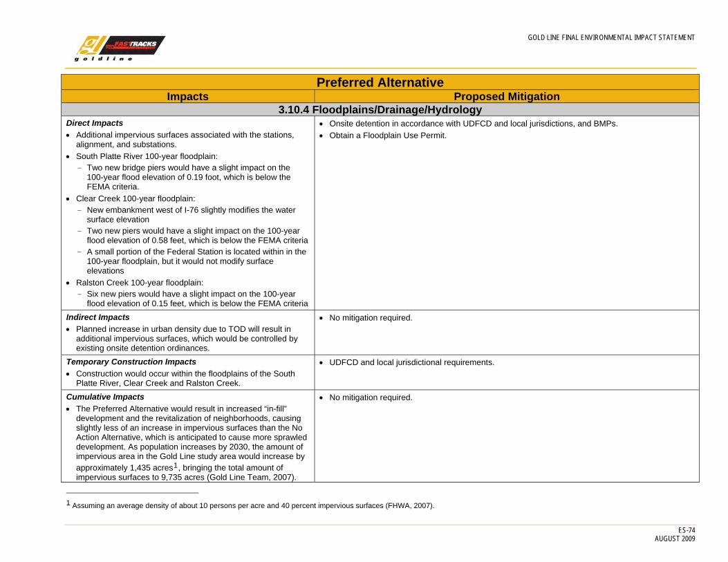
GOLD LINE FINAL ENVIRONMENTAL IMPACT STATEMENT
ES-74 AUGUST 2009
Preferred Alternative Impacts Proposed Mitigation
3.10.4 Floodplains/Drainage/Hydrology Direct Impacts • Additional impervious surfaces associated with the stations,
alignment, and substations. • South Platte River 100-year floodplain:
- Two new bridge piers would have a slight impact on the 100-year flood elevation of 0.19 foot, which is below the FEMA criteria.
• Clear Creek 100-year floodplain: - New embankment west of I-76 slightly modifies the water
surface elevation - Two new piers would have a slight impact on the 100-year
flood elevation of 0.58 feet, which is below the FEMA criteria - A small portion of the Federal Station is located within in the
100-year floodplain, but it would not modify surface elevations
• Ralston Creek 100-year floodplain: - Six new piers would have a slight impact on the 100-year
flood elevation of 0.15 feet, which is below the FEMA criteria
• Onsite detention in accordance with UDFCD and local jurisdictions, and BMPs. • Obtain a Floodplain Use Permit.
Indirect Impacts • Planned increase in urban density due to TOD will result in
additional impervious surfaces, which would be controlled by existing onsite detention ordinances.
• No mitigation required.
Temporary Construction Impacts • Construction would occur within the floodplains of the South
Platte River, Clear Creek and Ralston Creek.
• UDFCD and local jurisdictional requirements.
Cumulative Impacts • The Preferred Alternative would result in increased “in-fill”
development and the revitalization of neighborhoods, causing slightly less of an increase in impervious surfaces than the No Action Alternative, which is anticipated to cause more sprawled development. As population increases by 2030, the amount of impervious area in the Gold Line study area would increase by approximately 1,435 acres1, bringing the total amount of impervious surfaces to 9,735 acres (Gold Line Team, 2007).
• No mitigation required.
1 Assuming an average density of about 10 persons per acre and 40 percent impervious surfaces (FHWA, 2007).

GOLD LINE FINAL ENVIRONMENTAL IMPACT STATEMENT
ES-75 AUGUST 2009
Preferred Alternative Impacts Proposed Mitigation
The Preferred Alternative would result in an additional 57 acres of impervious surfaces or less than 1 percent of the impervious surfaces in 2030. By comparison, the total FasTracks Plan is estimated to increase impervious surfaces by about 280 acres (RTD, 2007b). This is cumulative to the amount of impervious surface required to accommodate the 2030 population, which may be as much as 40,000 acres (assuming that 40 percent of the 100,000 acres of new urbanized land is impervious). Impacts associated with additional impervious surfaces would be managed to predevelopment conditions using jurisdictional detention requirements, which have proven to be effective in minimizing the effects of urban runoff (RTD, 2007b).
CRMF • The CRMF would result in no direct, indirect, or temporary
construction impacts.
• Onsite detention in accordance with local jurisdictions and BMPs.
3.11 Hazardous Materials Direct Impacts • Possible impacts are all associated with construction, as
discussed below. • Acquisition of property would require additional site
characterization to determine the presence of hazardous wastes.
• No operational impacts on hazardous waste sites are anticipated.
• Evaluate ballast and railroad ties to be removed and disposed of with the proper waste classification. Disposal must be appropriate for the resulting classification.
• Complete site–specific Phase II Environmental Site Assessments (ESA) with subsurface investigation (soil and groundwater) for sites that may have been contaminated or affect final design, as documented by the Phase I ESA, where appropriate.
• Prepare a Hazardous and Contaminated Substances Health and Safety Plan (HASP) and a Hazardous Materials Management Plan (HMMP) to address contaminated soil and groundwater.
• Determine engineering controls to minimize quantity of contaminated materials. • Conduct an individual site-specific Phase I ESA of properties before acquisition. • Prepare an Asbestos Assessment Plan (AAP) and conduct asbestos surveys for any building
planned for acquisition or demolition. • Prepare a Lead-Based Paint Assessment Plan (LBPAP) and conduct lead-based paint
assessments for all structures that would be disturbed or demolished. Indirect Impacts • No impacts.
• No mitigation required.
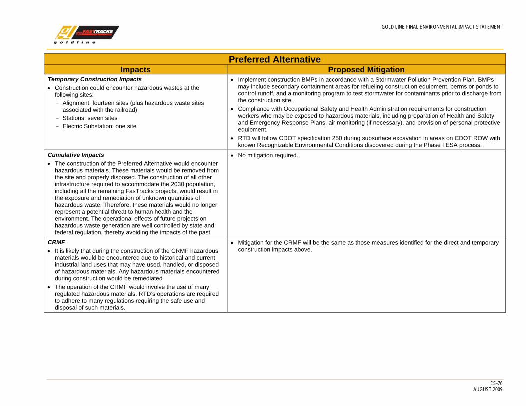
GOLD LINE FINAL ENVIRONMENTAL IMPACT STATEMENT
ES-76 AUGUST 2009
Preferred Alternative Impacts Proposed Mitigation
Temporary Construction Impacts • Construction could encounter hazardous wastes at the
following sites: - Alignment: fourteen sites (plus hazardous waste sites
associated with the railroad) - Stations: seven sites - Electric Substation: one site
• Implement construction BMPs in accordance with a Stormwater Pollution Prevention Plan. BMPs may include secondary containment areas for refueling construction equipment, berms or ponds to control runoff, and a monitoring program to test stormwater for contaminants prior to discharge from the construction site.
• Compliance with Occupational Safety and Health Administration requirements for construction workers who may be exposed to hazardous materials, including preparation of Health and Safety and Emergency Response Plans, air monitoring (if necessary), and provision of personal protective equipment.
• RTD will follow CDOT specification 250 during subsurface excavation in areas on CDOT ROW with known Recognizable Environmental Conditions discovered during the Phase I ESA process.
Cumulative Impacts • The construction of the Preferred Alternative would encounter
hazardous materials. These materials would be removed from the site and properly disposed. The construction of all other infrastructure required to accommodate the 2030 population, including all the remaining FasTracks projects, would result in the exposure and remediation of unknown quantities of hazardous waste. Therefore, these materials would no longer represent a potential threat to human health and the environment. The operational effects of future projects on hazardous waste generation are well controlled by state and federal regulation, thereby avoiding the impacts of the past
• No mitigation required.
CRMF • It is likely that during the construction of the CRMF hazardous
materials would be encountered due to historical and current industrial land uses that may have used, handled, or disposed of hazardous materials. Any hazardous materials encountered during construction would be remediated
• The operation of the CRMF would involve the use of many regulated hazardous materials. RTD’s operations are required to adhere to many regulations requiring the safe use and disposal of such materials.
• Mitigation for the CRMF will be the same as those measures identified for the direct and temporary construction impacts above.
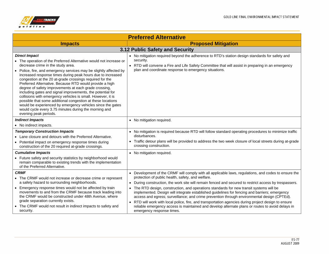
GOLD LINE FINAL ENVIRONMENTAL IMPACT STATEMENT
ES-77 AUGUST 2009
Preferred Alternative Impacts Proposed Mitigation
3.12 Public Safety and Security Direct Impact • The operation of the Preferred Alternative would not increase or
decrease crime in the study area. • Police, fire, and emergency services may be slightly affected by
increased response times during peak hours due to increased congestion at the 20 at-grade crossings required for the Preferred Alternative. Because RTD would provide a high degree of safety improvements at each grade crossing, including gates and signal improvements, the potential for collisions with emergency vehicles is small. However, it is possible that some additional congestion at these locations would be experienced by emergency vehicles since the gates would cycle every 3.75 minutes during the morning and evening peak periods.
• No mitigation required beyond the adherence to RTD’s station design standards for safety and security.
• RTD will convene a Fire and Life Safety Committee that will assist in preparing in an emergency plan and coordinate response to emergency situations.
Indirect Impacts • No indirect impacts.
• No mitigation required.
Temporary Construction Impacts • Lane closure and detours with the Preferred Alternative. • Potential impact on emergency response times during
construction of the 20 required at-grade crossings.
• No mitigation is required because RTD will follow standard operating procedures to minimize traffic disturbances.
• Traffic detour plans will be provided to address the two week closure of local streets during at-grade crossing construction.
Cumulative Impacts • Future safety and security statistics by neighborhood would
remain comparable to existing trends with the implementation of the Preferred Alternative.
• No mitigation required.
CRMF • The CRMF would not increase or decrease crime or represent
a safety hazard to surrounding neighborhoods. • Emergency response times would not be affected by train
movements to and from the CRMF because track leading into the CRMF would be constructed under 48th Avenue, where grade separation currently exists.
• The CRMF would not result in indirect impacts to safety and security.
• Development of the CRMF will comply with all applicable laws, regulations, and codes to ensure the protection of public health, safety, and welfare.
• During construction, the work site will remain fenced and secured to restrict access by trespassers. • The RTD design, construction, and operations standards for new transit systems will be
implemented. Design will integrate established guidelines for fencing and barriers; emergency access and egress; surveillance; and crime prevention through environmental design (CPTEd).
• RTD will work with local police, fire, and transportation agencies during project design to ensure reliable emergency access is maintained and develop alternate plans or routes to avoid delays in emergency response times.
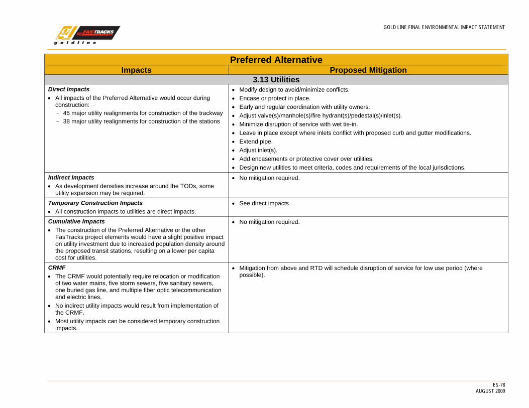
GOLD LINE FINAL ENVIRONMENTAL IMPACT STATEMENT
ES-78 AUGUST 2009
Preferred Alternative Impacts Proposed Mitigation
3.13 Utilities Direct Impacts • All impacts of the Preferred Alternative would occur during
construction: - 45 major utility realignments for construction of the trackway - 38 major utility realignments for construction of the stations
• Modify design to avoid/minimize conflicts. • Encase or protect in place. • Early and regular coordination with utility owners. • Adjust valve(s)/manhole(s)/fire hydrant(s)/pedestal(s)/inlet(s). • Minimize disruption of service with wet tie-in. • Leave in place except where inlets conflict with proposed curb and gutter modifications. • Extend pipe. • Adjust inlet(s). • Add encasements or protective cover over utilities. • Design new utilities to meet criteria, codes and requirements of the local jurisdictions.
Indirect Impacts • As development densities increase around the TODs, some
utility expansion may be required.
• No mitigation required.
Temporary Construction Impacts • All construction impacts to utilities are direct impacts.
• See direct impacts.
Cumulative Impacts • The construction of the Preferred Alternative or the other
FasTracks project elements would have a slight positive impact on utility investment due to increased population density around the proposed transit stations, resulting on a lower per capita cost for utilities.
• No mitigation required.
CRMF • The CRMF would potentially require relocation or modification
of two water mains, five storm sewers, five sanitary sewers, one buried gas line, and multiple fiber optic telecommunication and electric lines.
• No indirect utility impacts would result from implementation of the CRMF.
• Most utility impacts can be considered temporary construction impacts.
• Mitigation from above and RTD will schedule disruption of service for low use period (where possible).
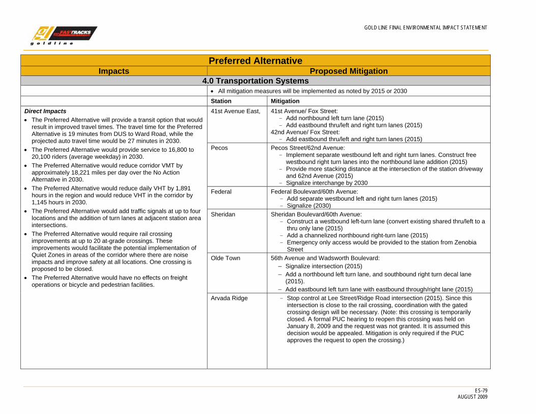
GOLD LINE FINAL ENVIRONMENTAL IMPACT STATEMENT
ES-79 AUGUST 2009
Preferred Alternative Impacts Proposed Mitigation
4.0 Transportation Systems • All mitigation measures will be implemented as noted by 2015 or 2030 Station Mitigation Direct Impacts • The Preferred Alternative will provide a transit option that would
result in improved travel times. The travel time for the Preferred Alternative is 19 minutes from DUS to Ward Road, while the projected auto travel time would be 27 minutes in 2030.
• The Preferred Alternative would provide service to 16,800 to 20,100 riders (average weekday) in 2030.
• The Preferred Alternative would reduce corridor VMT by approximately 18,221 miles per day over the No Action Alternative in 2030.
• The Preferred Alternative would reduce daily VHT by 1,891 hours in the region and would reduce VHT in the corridor by 1,145 hours in 2030.
• The Preferred Alternative would add traffic signals at up to four locations and the addition of turn lanes at adjacent station area intersections.
• The Preferred Alternative would require rail crossing improvements at up to 20 at-grade crossings. These improvements would facilitate the potential implementation of Quiet Zones in areas of the corridor where there are noise impacts and improve safety at all locations. One crossing is proposed to be closed.
• The Preferred Alternative would have no effects on freight operations or bicycle and pedestrian facilities.
41st Avenue East, 41st Avenue/ Fox Street: - Add northbound left turn lane (2015) - Add eastbound thru/left and right turn lanes (2015)
42nd Avenue/ Fox Street: - Add eastbound thru/left and right turn lanes (2015)
Pecos Pecos Street/62nd Avenue: - Implement separate westbound left and right turn lanes. Construct free
westbound right turn lanes into the northbound lane addition (2015) - Provide more stacking distance at the intersection of the station driveway
and 62nd Avenue (2015) - Signalize interchange by 2030
Federal Federal Boulevard/60th Avenue: - Add separate westbound left and right turn lanes (2015) - Signalize (2030)
Sheridan Sheridan Boulevard/60th Avenue: - Construct a westbound left-turn lane (convert existing shared thru/left to a
thru only lane (2015) - Add a channelized northbound right-turn lane (2015) - Emergency only access would be provided to the station from Zenobia
Street Olde Town 56th Avenue and Wadsworth Boulevard:
− Signalize intersection (2015) − Add a northbound left turn lane, and southbound right turn decal lane
(2015). − Add eastbound left turn lane with eastbound through/right lane (2015)
Arvada Ridge - Stop control at Lee Street/Ridge Road intersection (2015). Since this intersection is close to the rail crossing, coordination with the gated crossing design will be necessary. (Note: this crossing is temporarily closed. A formal PUC hearing to reopen this crossing was held on January 8, 2009 and the request was not granted. It is assumed this decision would be appealed. Mitigation is only required if the PUC approves the request to open the crossing.)
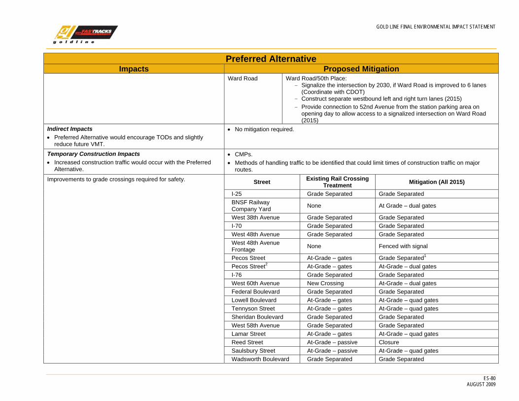
GOLD LINE FINAL ENVIRONMENTAL IMPACT STATEMENT
ES-80 AUGUST 2009
Preferred Alternative Impacts Proposed Mitigation
Ward Road Ward Road/50th Place: - Signalize the intersection by 2030, if Ward Road is improved to 6 lanes
(Coordinate with CDOT) - Construct separate westbound left and right turn lanes (2015) - Provide connection to 52nd Avenue from the station parking area on
opening day to allow access to a signalized intersection on Ward Road (2015)
Indirect Impacts • Preferred Alternative would encourage TODs and slightly
reduce future VMT.
• No mitigation required.
Temporary Construction Impacts • Increased construction traffic would occur with the Preferred
Alternative.
• CMPs. • Methods of handling traffic to be identified that could limit times of construction traffic on major
routes. Improvements to grade crossings required for safety. Street Existing Rail Crossing
Treatment Mitigation (All 2015)
I-25 Grade Separated Grade Separated BNSF Railway Company Yard None At Grade – dual gates
West 38th Avenue Grade Separated Grade Separated I-70 Grade Separated Grade Separated West 48th Avenue Grade Separated Grade Separated West 48th Avenue Frontage None Fenced with signal
Pecos Street At-Grade – gates Grade Separated1 Pecos Street2 At-Grade – gates At-Grade – dual gates I-76 Grade Separated Grade Separated West 60th Avenue New Crossing At-Grade – dual gates Federal Boulevard Grade Separated Grade Separated Lowell Boulevard At-Grade – gates At-Grade – quad gates Tennyson Street At-Grade – gates At-Grade – quad gates Sheridan Boulevard Grade Separated Grade Separated West 58th Avenue Grade Separated Grade Separated Lamar Street At-Grade – gates At-Grade – quad gates Reed Street At-Grade – passive Closure Saulsbury Street At-Grade – passive At-Grade – quad gates Wadsworth Boulevard Grade Separated Grade Separated

GOLD LINE FINAL ENVIRONMENTAL IMPACT STATEMENT
ES-81 AUGUST 2009
Preferred Alternative Impacts Proposed Mitigation
Vance Street At-Grade – gates At-Grade – quad gates Olde Wadsworth Boulevard At-Grade – gates At-Grade – quad gates
Zephyr Street and Allison Street At-Grade – gates At-Grade – quad gates
Balsam Street At-Grade – gates At-Grade – quad gates Carr Street At-Grade – gates At-Grade – quad gates Garrison Street At-Grade – gates At-Grade – quad gates Independence Street At-Grade – gates At-Grade – quad gates Kipling Street Grade Separated Grade Separated
Lee Street and State Home Road
At-Grade – lights (Note: this crossing is temporarily closed. A formal PUC hearing to reopen this crossing was held on January 8, 2009 and the request was not granted. It is assumed this decision would be appealed. Mitigation is only required if the PUC approves the request to open the crossing.)
If approved, At-Grade – quad gates
Miller Street At-Grade – passive At-Grade – quad gates Parfet Street At-Grade – passive At-Grade – quad gates Robb Street At-Grade – passive At-Grade – quad gates Tabor Street At-Grade – gates At-Grade – quad gates
CRMF • The Preferred Alternative would assist in providing the
commuter rail service component of the FasTracks program by providing the facilities necessary and required by the FRA to operate and maintain commuter rail service in the Denver Metro area.
• Mitigation is only required for the impacts to the 48th Avenue/Fox Street intersection. Re-striping 48th Avenue east of Fox Street would mitigate these impacts and bring the southbound left turn LOS back to acceptable levels and improve conditions compared to the No Action Alternative.

GOLD LINE FINAL ENVIRONMENTAL IMPACT STATEMENT
ES-82 AUGUST 2009
Preferred Alternative Impacts Proposed Mitigation
• The Preferred Alternative would result in a small increase in traffic flow into and out of the Fox North Site. The proposed CRMF is assumed to have 300 employees, which would generate about 900 trips per day. With implementation of the proposed CRMF, approximately 700 daily trips related to existing private business operations would be displaced. Therefore, the Preferred Alternative would result in an additional 203 trips per day into and out of the Fox North Site.
• Truck traffic to the North Fox Site would be reduced as a result of the Preferred Alternative. Existing businesses that generate truck traffic would be replaced by the CRMF traffic (primarily employee traffic) that does not typically include heavy truck traffic.
• One intersection evaluated for the Preferred Alternative is expected to operate beyond an acceptable a.m. peak-hour urban intersection at LOS F for the southbound left turn. The 48th Avenue/Fox Street (unsignalized) intersection is expected to be impacted by the Preferred Alternative for study years 2015 and 2030.
• The Preferred Alternative is not anticipated to provide enhancements for roadway capacity or add any traffic signals in the study area.
• The Preferred Alternative would have no effect on existing or future rail freight movements, transit, bicycle, or pedestrian facilities or services.
Section 4(f)
• Direct Use of the Denver West Side Line (5DV3512.3), the Denver Utah Pacific Railroad, Chicago Burlington Quincy Siding & Spur (Waterworks Sales Co, J.M. Warner Co, & Richardson lumber Spur) (5AM1888.5 and 5DV6243.7) and the Allan-Rand Ditch (5JF4454.1).
• A MOA has been completed between FTA and the SHPO and is included in Appendix D.
• De minimis use of the Jim Baker Reservoir. • Temporary parking will be provided on the west side of Tennyson Street. • RTD will be responsible for maintaining the retaining wall.
1 Grade separation improvements by Adams County, currently unfunded. 2 Assumes the grade separation at Pecos Street is not funded and constructed.