Embed Size (px)
Citation preview

AgreementNo.CE49/2012(TT)KowloonBayBusinessAreaPedestrianEnvironment
Improvement–FeasibilityStudyExecutiveSummary
AECOMASIALIMITED

Page | 1
1 STUDY BACKGROUND
1.1 The Kowloon Bay (KB) area used to be one of the traditional manufacturing bases inHong Kong. Over the years, the focus of economic activities in the area has shiftedfrom industrial/manufacturing-based to more services-based. With the various newlandmark buildings (e.g. MegaBox, ZCB - Zero Carbon Building) and high-gradeoffice buildings (e.g. 18 Kowloon East, Manhattan Place, and the development onNew Kowloon Inland Lot (NKIL) No. 6312 etc.) completed or under construction, itis evident that KB is undergoing a rapid transformation from its traditional industrialcharacter towards a new emerging business/commercial hub in Kowloon East (KE) –a new Core Business District (CBD2) to support Hong Kong’s economic developmentand will serve not only local workers and residents but also business travellers fromall over the world.
1.2 It is anticipated that the pedestrian flows in KE including the Kowloon Bay BusinessArea (KBBA) will increase rapidly in the transformation process. It is also thepublic’s aspiration for the area to become a more pedestrian-friendly area.
1.3 KBBA faces various physical problems inherited from its industrial past, and there arestill existing industrial and industrial-related activities in the area. There are frequentroadside loading/unloading activities, affecting pedestrian environment andoccasionally causing conflicts between vehicular traffic and pedestrians at busy roadsections. Narrow footpaths give rise to a congested and unpleasant walkingenvironment, while there is increasing demand to improve the existing road junctioncapacity. All these factors pose limitations to support the rapid growth of KBBA.
1.4 It is therefore the Government’s vision to create a pedestrian environment in KE thatis “walkable”, “stayable” and “sittable” for public. The walking environment shouldbe safe, comfortable, pleasant, convenient and healthy for people to enjoy thewalking experience, with public spaces created for people to stay, relax, meet peopleand enjoy various activities.
1.5 With the above objectives in mind, the Energizing Kowloon East Office (EKEO) ofthe Development Bureau (DEVB) commissioned the Kowloon Bay Business AreaPedestrian Environment Improvement – Feasibility Study (the Study) to reviewand assess the pedestrian and traffic environment of the KBBA, to develop feasibleproposals to enhance pedestrian connectivity in KB by firstly improving at-grade levelpedestrian environment and vehicular traffic facilities, which can be done in short tomedium term followed by the provision of pedestrian links to further improveconnectivity, which can be carried out in the long term. It was aimed at linkingpeople to and from the KB MTR Station to KBBA and towards the Kai TakDevelopment (KTD). The Study commenced in early 2013 and its overall vision was:
“To enhance the image of Kowloon Bay and create a WalkableCBD that weaves together work, live and play.”

Page | 2
2 OVERALL APPROACH & KEY STRATEGIES
2.1 The “WEAVE” Concept
2.1.1 The concept of a “WEAVE” was inspired by the industrial tradition of KE. Itsymbolises the heyday of Hong Kong's manufacturing industries when textilemanufacturing was one of the core components and embracing the developmenthistory of the area. With the “WEAVE” concept, the study aims to improve theconnectivity and accessibility between the KBBA, the KTD, the waterfront andsurrounding areas. Physically, the concept could be translated into design elements,such as streetscape and open space features that would collectively contribute todelivering a functional, vibrant, iconic, diverse and sustainable public realm.
2.2 Key Strategies2.2.1 To achieve the objectives of the study, the following strategies were derived to guide
the design approach and proposals:
(a) Enhance Walkability
· Upgrade pedestrian facilities· Enhance signage and way-finding facilities· Develop pedestrian links
(b) Face-lift the Pedestrian Environment
· Improve current design of passageways· Enhance greening and attractiveness· Upgrade public spaces
(c) Improve Road Traffic
· Demand management measures· Traffic management measures· Sustainable solutions

Page | 3
3 PEDESTRIAN AND TRAFFIC FORECAST AND ASSESSMENT
3.1 On the aspect of traffic environment, a pedestrian and traffic review was carried out toevaluate the existing pedestrian environment and traffic conditions within the KBBA.
3.2 In addition, capacity analyses were conducted for design years 2021 and 2030 toinvestigate the potential impact of the continuous transformation of KB on the roadnetwork and key pedestrian links within the KBBA, representing the medium andlong term future conditions respectively. Two assessment scenarios (with and withoutEnvironmental Friendly Linkage System (EFLS)) were tested for design year 2030,while for design year 2021, it was assumed that the EFLS would not yet be in place.
3.3 The latest territorial planning dataset available at the time of the Study was the 2011-based “Territorial Population and Employment Data Matrices (TPEDM)” compiled bythe Planning Department in 2013. The dataset was adopted for the Study as a basis todevelop the traffic forecast.
3.4 Based on the pedestrian assessment results, several existing pedestrian footbridges,including the footbridges at KB MTR Station Exit A and Exit B across Kwun TongRoad and the footbridge connecting between Telford Plaza Podium and Telford Houseacross Wai Yip Street, were already overloaded under the existing (Year 2013)condition.
3.5 Under the future conditions (both medium and long terms), as the pedestrian flowwould increase, some footbridges would become more congested, thus worsening thewalking environment. In addition to the aforesaid bottlenecks at KB MTR StationExit A and Exit B footbridges, the footbridge between Telford Plaza Podium andTelford House, the footbridge between Telford Plaza Podium and HKU School ofProfessional and Continuing Education (HKU SPACE) Footbridge would alsobecome overloaded.
3.6 Based on the traffic forecast and assessments, the capacity of the below junctionswould be reached in the future:
· Wang Kwong Road / Kai Cheung Road (T1)
· Wang Kwong Road/Lam Hing Street (T2)
· Wang Chiu Road/Kai Cheung Road (T3)
· Wang Chiu Road/Lam Hing Street (T4)
· Wang Chiu Road/Sheung Yuet Road (T5)
· Wang Chiu Road/Lam Fung Street (T6)· Wang Chiu Road/Sheung Yee Road (T7)

Page | 4
4 AT-GRADE PEDESTRIAN AND TRAFFIC IMPROVMENT MEASURES
4.1 While the problematic (with capacity issues) footbridges as identified in Chapter 3would require a holistic pedestrian network improvement which would be discussedin Chapter 5, the Study also identified some footpaths and pedestrian crossings (at-grade) which also require improvement measures to enhance the capacity,connectivity and/or safety. Most of these improvement measures for at-gradefacilities would be relatively simple and could be implemented in short to mediumterm.
4.2 To tackle the junction capacity problems as identified in Chapter 3, junctionimprovement measures were recommended under the Study.
4.3 The following at-grade pedestrian facility improvement proposals with locationsshown in Figure 1 were considered practicable for implementation in short tomedium-term. These proposals are being implemented by the Governmentprogressively. All proposals are expected to be completed by 2017 subject to theoutcome of local consultations and liaison with interfacing parties.
Pedestrian Facility Improvement Proposals
P1 - Proposed Crossing Widening at Ngau Tau Kok Road Crossing
4.4 The signal controlled junction at Ngau Tau Kok Road near Lee Kee Building wasobserved with heavy pedestrian crossing demand. Sometimes, large amount ofpedestrian amass at both sides of the crossing affecting the pedestrian circulation.
4.5 Since the junction was bounded by existing buildings and a viaduct at its east andwest respectively, , it would not be possible to widen the footpath and pedestrianwaiting area without affecting the carriageway width. Consideration was thereforegiven to increasing the effective width of the pedestrian crossing and removingobstructions along the pedestrian footpaths.
4.6 Having reviewed the geometry of this road section, two modifications were proposed:(1) remove the concrete wall and planters underneath the viaduct at the west of thejunction; and (2) construct a built-out at the western kerbside of Ngau Tau Kok Road.The improvement proposal would enhance the fluidity of the pedestrian movement byincreasing the effective width of the pedestrian crossing and allow extra waiting areato minimise conflicts between the waiting and through pedestrian traffic.
Before After

Page | 5
4.7 The proposed modification of removing of concrete wall was completed in end 2014(see photos). The result was noticeable and well received by the locals. Since thelocals were of view that the improvement proposal of narrowing the carriagewaywouldaffect the vehicular traffic, the proposal would be taken forward at a later stageif necessary, with the condition at the crossing being monitored.
P2, P4, P6 and P7 - Cautionary Pedestrian Crossing Enhancement
4.8 Within KBBA, it was found that many of the cautionary pedestrian crossings havelong crossing lengths, as the original design catered for industrial use. Improvementschemes were therefore proposed with a view to enhancing pedestrian safety andshortening the pedestrian crossing lengths at the following locations:
� P2 - Junction of Wang Hoi Road/Lam Lee Street� P4 - Junction of Wang Hoi Road/Wang Yuen Street
� P6 - Junction of Wang Tai Road/Lam Fook Street (Works completed in May2015)
� P7 – Junction of Wang Tai Road/Wang Yuen Street (Works completed inFebruary 2015 (see photos))
P3 and P8 - Pedestrian Crossing Widening along Sheung Yuet Road
4.9 It was observed that, during the morning and afternoon commuters’ peaks, thepedestrian flow along Sheung Yuet Road was high. Large crowds of pedestrianswishing to cross the roads were usually observed waiting at the sides of the signalisedjunctions, while sometimes the pedestrian refuges were overloaded with pedestriansforced to stand on the carriageway.
4.10 To deal with this high pedestrian demand along Sheung Yuet Road, it was proposed toincrease the pedestrian crossing capacities of the signalised junctions by increasingthe widths of the pedestrian crossings. Signalised crossings of high pedestriandemand were selected for widening, these included:
� P3 – Junction of Wang Hoi Road/Sheung Yuet Road� P8 – Junction of Wang Chiu Road/Sheung Yuet Road
Before After
Page | 6
P5 – Provision of Footpath at Wang Mau Street
4.11 Currently, footpath is not available at the eastern kerbside of Wang Mau Street whilethe pedestrian crossings at both the northern and southern ends of Wang Mau Streethave lengths of more than 10m. It was proposed to provide a continuous footpath(minimum 2.0m with 7.3m carriageway remaining) at the eastern kerbside of WangMau Street and modify the corner radii at the northern and southern ends of the roadsuch that the pedestrian crossing lengths could be shortened and hence to improve theaccessibility at the pedestrian crossing facilities.
P9 - Footpath Widening at Wang Kwun Road
4.12 It was observed that the frequent loading/unloading activities affected a number ofpedestrian crossings along Wang Kwun Road. Though a number of pedestriancrossing points were located along both sides of Wang Kwun Road, pedestrian drop-kerbs along the eastern kerbside near Lam Lok Street were often found “hidden”behind the loading/ unloading activities making it very difficult for pedestrians tolocate the proper path to cross the road. In order to improve the pedestrianenvironment and safety, local widening of the footpath at the crossing to shorten thecrossing distance was proposed at Wang Kwun Road and Lam Lok Street.
P10 - Additional Pedestrian Crossing at Junction of Lam Hing Street and Wang ChinStreet
4.13 At the junction of Lam Hing Street and Wang Chin Street, there was no convenientpedestrian crossing between Kowloon Bay International Trades and Exhibition Centre(KITEC) and Lam Hing Street. To use proper cautionary crossing facilities,pedestrian would be required to cross Wang Chin Street at Kai Cheung Road or at thesouthern end of Trademart Drive. Both routes would result in a 100m detour.Therefore, jaywalking was not uncommon in the area.
4.14 Since the completion and occupation of the Hong Kong Post Central Mail Centre(CMC) in recent year, the pedestrian crossing demand between the IMC and KITECwere increased.
4.15 It was proposed to provide an additional pedestrian crossing point between the twoexisting crossings at Wang Chin Street, near the western end of Lam Hing Street. Aspart of the works falls within an area managed by KITEC, further liaison would berequired to address the interfacing issues.
Vehicular Junction Improvement Proposals
4.16 Local junction improvement schemes1 were developed for the problematic junctionsas identified in Chapter 3 to mitigate the envisaged capacity problems. The tentativecompletion years for the various junctions are listed as follows:
1 Subject to further detailed assessments, some of the proposed local junction improvements may constitutedesignated projects (DPs) or material changes to exempted DPs under the Environmental Impact AssessmentOrdinance, which require environmental permits for their construction and operation.

Page | 7
Ref Junction Implementation Agent Tentative Completion(on or before)
T1 Wang Kwong Road /Kai Cheung Road
Contractor of CentralKowloon Route Project 2020
T2(Stage 1) Wang Kwong Road /
Lam Hing Street#
Contractor of CentralKowloon Route Project 2020
T2(Stage 2) To be determined Subject to further review on the
performance of Stage 1 worksT3 Wang Chiu Road /
Kai Cheung RoadContractor of Kai TakDevelopment Project 2019
T4 Wang Chiu Road /Lam Hing Street
Contractor of Kai TakDevelopment Project 2019
T5 Wang Chiu Road /Sheung Yuet Road To be determined Subject to further review before
2020T6 Wang Chiu Road /
Lam Fung Street# HyD’s Term Contractor 2018 (subject to the final designof the proposed EWS)
T7(Stage 1) Wang Chiu Road /
Sheung Yee Road
Contractor of Kai TakDevelopment Project 2018
T7(Stage 2)
To be determined Subject to further review on theperformance of Stage 1 works
# Junctions expected to be overloaded by 2030Note: The tentative completion years were estimated based on the current information available and will be
subject to the interface with other projects in the vicinity during implementation stage, the outcome oflocal consultations and funding being available.
5 COMPREHENSIVE PEDESTRIAN NETWORK
5.1 Overview
5.1.1 Through understanding the overall existing and planned development context ofKBBA and surrounding areas, as well as the existing problems (including theproblematic footbridges as identified in Chapter 3), constraints and opportunities, acomprehensive pedestrian network comprising a series of pedestrian links was alsoformulated, taking into consideration the existing and future pedestrian flows andactivities in KBBA.
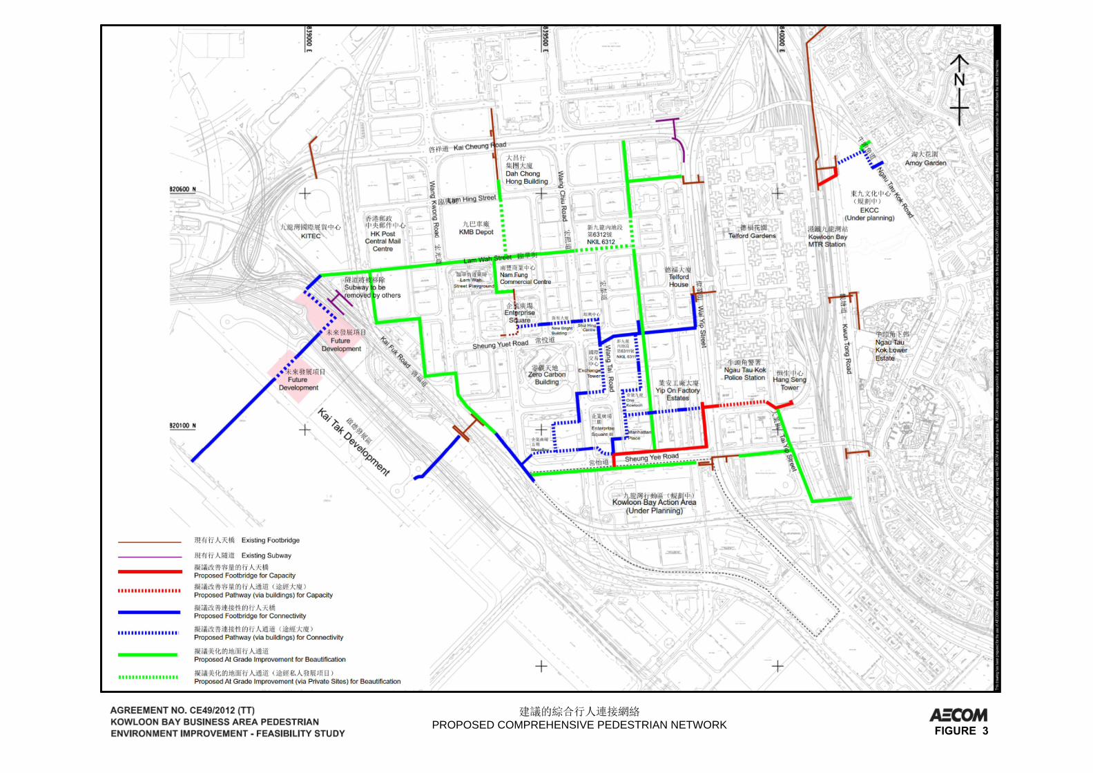
5.1.2 These pedestrian links were categorised into seven pedestrian links, with an aim toenhance capacity and connectivity within KBBA (between KB MTR Station andKBBA) as well as cross-district connectivity between KBBA and the KTD.
5.1.3 The proposed at-grade links include (1) Green Spine and (2) Green Link. Grade-separated pedestrian links were also developed with the Elevated Walkway System(EWS) proposed by private developers, including (3) Northern Kai Tak Link; (4)Southern Kai Tak Link; (5) Telford Amoy Link; (6) Siu Yip Street Link and (7) TaiYip Street Link. Figure 2 shows the alignments for the seven proposed pedestrianlinks graphically.
5.1.4 While these were only initial proposals aimed at identifying longer term solutions toenhance local connectivity, detailed alignments and design of these links will besubject to further study, as well as facilitation with the private sector and liaisons withrelevant government departments regarding future implementation and managementand maintenance responsibilities.

Page | 8
5.2 Green Spine
5.2.1 The “Green Spine” would mainly be a “car-free” north-south pedestrian passagewaywith seating/resting areas, which would integrate with the various existing sitting-outareas at Kai Cheung Road, Lam Hing Street, Wang Tai Road, Lam Fook Street andLam Wah Street to enhance the existing linear open spaces into a vibrant andattractive public area at the heart of KBBA. The existing sitting-out areas are beingface-lifted in phases and the first phase at Lam Fook Street Sitting-out Area wascompleted in March 2016 (see photos). The “Green Spine” will not only direct thenorth-south pedestrian flow, but also interact with adjacent commercial areas andstreets with possible future ground floor retailing to form a vibrant pedestriannetwork.
5.2.2 A portion of NKIL No. 6312 adjoining Lam Lee Street was included as a part of the“Green Spine”. Requirements relating to design, construction arrangement andmaintenance are incorporated into the land sale conditions, and this public open spaceis being developed by the private developer of NKIL No. 6312.
5.2.3 It was observed that at present, there is a substantial amount of pedestrians coming offfrom the footbridge from the podium of Telford Plaza across Wai Yip Street towardsLam Hing Street and Wang Hoi Road through the HKU SPACE courtyard area.There exists an opportunity to transform this area as a key connection node betweenthe KB MTR Station and KBBA by providing a landing plaza with rearrangement tothe existing motorcycle parking spaces and widening of the existing narrow footpathat Lam Hing Street by 1m. The improvement works are aimed at fostering a pleasantwalking experience for the pedestrians.
5.2.4 The alignment of the “Green Spine” will also extend to the west interacting with LamWah Street Playground, and further to the CMC and KITEC as well as the future“Green Link”; while branching off to the existing footbridge (KF63) across KaiCheung Road at the north via the Kowloon Motor Bus (KMB) Depot (upon itsredevelopment) and extending to the south to link with Sheung Yee Road and thefuture Kowloon Bay Action Area (KBAA) via Wang Mau Street.
5.2.1 In the long term, upon redevelopment of the adjacent buildings, possibility foropening up of the ground floor space for provision of food and beverages/retail shopsalong the “Green Spine” should be considered to encourage interactions with theseadjacent uses, as well as to complement the future development of the various vibrantstreets so as to further strengthen the “vibrancy” of the future CBD.
AfterBefore

Page | 9
5.3 Green Link
5.3.1 The “Green Link” would also form part of the network which would extend fromnorth to south linking-up all major open spaces, major new developments/ points ofinterests within the KBBA (i.e. KITEC, MegaBox, future KBAA), with possibility tofurther extend towards the Kwun Tong waterfront and along Hoi Bun Road to providea comfortable/green environment for pedestrian movement towards the waterfront.The “Green Link” aims to make use of the various Government, institution orCommunity (G/IC) sites at Wang Chin Street and Wang Kee Street by proposingappropriate set back along the sites to provide a wider and more spacious footpath forfuture greening and streetscape enhancement, which will guide pedestrian movementstowards the south through the various open spaces at Wang Kwong Road/Kai FukRoad and Sheung Yee Road/Kai Fuk Road. Planting and landscape treatment mayalso further extend southward to link up with all the key landmarks and points ofattractions within KBBA such as KITEC; the triangular open space at the junction ofSheung Yee Road/Kai Fuk Road where a proposed EFLS station might be located;MegaBox and the future KBAA through Sheung Yee Road, so as to form acomprehensive green network. In particular, the triangular open space at junction ofSheung Yee Road/Kai Fuk Road may be converted to a landscaped area, whichtogether with the proposed Kwun Tong Community Green Station would providemore green facilities in KBBA for public enjoyment. The portion of “Green Link”along Sheung Yee Road would require future setting back of the developments alongthe road to provide sufficient space for street-side greening and planting. This shouldbe taken into consideration in the future site planning of the KBAA.
5.4 Northern Kai Tak Link
5.4.1 The proposed Northern Kai Tak Link would comprise of the gazetted footbridgeunder the Central Kowloon Route (CKR) project; the planned northern footbridgeacross the Kai Tak South Apron and Approach Channel under Kai Tak OutlineZoning Plan (OZP) and other extensions to form a direct, extensive cross-districtpedestrian linkage between KB and Kai Tak South Apron. One option of theNorthern Kai Tak Link alignment would be to follow the current initial alignment ofthe planned northern footbridge as shown under the Outline Zoning Plan. Analternative alignment was also considered, which would be to shift the footbridgeslightly north to connect with the gazetted CKR footbridge across Kai Fuk Road(which would require provision of a future extension point). This would allow formore efficient and cohesive flow of pedestrian and better connection to thefootbridge. Utilising the future development of the two G/IC sites along Kai FukRoad due southwest of KITEC, the Northern Kai Tak Link would connect to thesebuildings via future connection points to be provided upon development of these sites,and would then further extend towards the waterfront to link with the shiftedfootbridge across to Kai Tak South Apron. This alternative alignment would allowfor better integration of the various planned footbridges, and more cohesive flow ofpedestrian. Future site planning and development of the two G/IC sites in Kai TakSouth Apron would need to take into consideration the required interface with theproposed Northern Kai Tak Link.
5.5 Southern Kai Tak Link
5.5.1 The proposed Southern Kai Tak Link would integrate with the proposed “Green Link”to provide an elevated connection which would start from the triangular open space at
Page | 10
Sheung Yee Road/Kai Fuk Road and connecting with the existing footbridge (KF-64)underneath Kwun Tong Bypass to serve the planned G/IC facilities along thewaterfront under the KTD as well as the potential EFLS station site at theaforementioned triangular open space.
5.5.2 In order to attract pedestrians for using the foresaid route with enhanced walkingenvironment, it was proposed to facelift the footbridge KF64. Landscapeenhancement in the triangular open space was also proposed to provide an enjoyablewalking environment for commuting between the EFLS station and KTD. Theaforesaid linkage may also be extended to KBAA and/or the adjacent MegaBox viaelevated linkage. Under the proposed pedestrian link, instead of linking thefootbridge (KF64) or the EFLS station with the KBAA directly via a continuouselevated walkway, pedestrians would be purposely diverted to the at-grade triangularopen space to enjoy the enhanced landscape before regaining access to KBAA via aseparate section of elevated link for crossing Sheung Yee Road.
5.6 Telford Amoy Link
5.6.1 In order to improve the pedestrian linkage between the KB MTR Station to the westof Kwun Tong Road and the residential area to the east of Kwun Tong Road (AmoyGarden and Tak Bo Garden, etc.), the Telford Amoy Link is proposed.
5.6.2 The proposed Telford Amoy Link would provide a 24-hour pedestrian route outsidethe future East Kowloon Cultural Centre (EKCC) connecting the residential area andKB MTR Station which aims at improving the pedestrian connection.
5.6.3 In order to relieve the crowded condition at the existing footbridge near KB MTRStation Exit B, an additional footbridge, linking the EKCC and KB MTR Stationacross Kwun Tong Road was proposed. Details on the proposal should be subject tofurther study as well as liaison with relevant government departments.
5.6.4 During the public engagement exercise of the Study, there were suggestions forproviding a direct footbridge between the Amoy Plaza and EKCC across Ngau TauKok Road, in order to enhance the connectivity among the Amoy Garden, EKCC andKB MTR Station. A connection point has been allowed in the design of EKCC tofacilitate future connection initiated by the private sector.
5.7 Siu Yip Street Link
5.7.1 The proposed Siu Yip Street Link would function as one of the major pedestrian linksin the south of KBBA, with the aim to complement the future EWS by providing analternate new route for pedestrians travelling between the KB MTR Station and theKBBA, through diverting some of the pedestrian flow to the future Siu Yip StreetLink so that the heavy volume of pedestrians at the southern footbridge from thepodium of Telford Plaza above Wai Yip Street could be relieved/shared.
5.7.2 The proposed link would provide an elevated pedestrian linkage from the existingHang Seng Tower/MTR Headquarters Building to the cluster of new office buildingsalong Sheung Yee Road through Siu Yip Street, as well as a possible connection fromthe existing Enterprise Square III to the future KBAA across Sheung Yee Road. Aconnection point would need to be provided at the Hang Seng Tower/MTRHeadquarters Building for the proposed Siu Yip Street Link.

Page | 11
5.7.3 There may be possibility that upon the possible relocation of the Ngau Tau KokPolice Station site, which is still uncertain at this stage, an internal connection shall beprovided within the future development at the police station site as part of the Siu YipStreet Link.
5.7.4 While there is currently no redevelopment programme for the Yip On Factory Estatessite, the desirable alignment of Siu Yip Street Link, after crossing Wai Yip Street,would be to go through the Yip On Factory Estates site, instead of along Wai YipStreet and Sheung Yee Road. With such desirable alignment, further connection canbe made to Manhattan Place directly, linking with the gazetted EWS and to KBAA.Such alignment would greatly reduce the demand for the valuable public road spaceand should hence be considered, if the opportunity to redevelop the Yip On FactoryEstates site arises in the future.
5.8 Tai Yip Street Link
5.8.1 Tai Yip Street Link would comprise facelifting the existing Sheung Yee RoadFootbridge across Wai Yip Street (KF39); widening the footpaths along Tai YipStreet from Hang Seng Tower to Sheung Yee Road Footbridge, facelifting part of theShort Term Tenancy site currently occupied by Hong Kong Society for Rehabilitation(see photos), and part of Wai Yip Street/Sheung Yee Road Sitting-out Area, in orderto increase the walking comfort and to divert the demand from those travelling alongthe congested Telford Plaza footbridge across Wai Yip Street. To improve theaesthetics of the existing footbridge, the requirement to facelift the existing SheungYee Road Footbridge across Wai Yip Street was included in land lease of NKIL No.6313.
5.8.2 Noting a proportion of pedestrian demand across Telford Plaza and Wai Yip Street toKBBA at the commuting peaks was caused by the bus passengers alighting at KwunTong Road, it was proposed to provide a new bus stop close to the junction of KwunTong Road/Hong Tak Road to divert the existing bus passengers pick-up/drop-off atsouthward of Kwun Tong Road so that public could access to the KBBA by HongTak Road, Tai Yip Street and the existing Sheung Yee Road Footbridge.
AfterBefore

Page | 12
5.9 Proposals by Others
5.9.1 The EWS was a private initiative gazetted in 2010 and authorised under the Roads(Works, Use and Compensation) Ordinance in February 2011. The implementationprogramme has yet to be confirmed by the private consortium. Under the currentstudy, assumption was made that the EWS would be developed. Upon completion,the EWS would provide a network of point-to-point elevated walkways linkingTelford Gardens through to various office buildings including MegaBox, OneKowloon, Manhattan Place, Exchange Tower and Enterprise Square III etc.
5.9.2 The gazetted alignment of the EWS was reviewed under the Study and the followingenhancements were proposed:
· omission of a section of EWS along the Green Spine between Sheung YuetRoad and Wang Yuen Road by integrating with an internal pedestrianwalkway in NKIL No. 6311 as provided for under the relevant lease. Thealignment of the footbridge connection between the development at NKIL No.6311 and One Kowloon would need to be adjusted accordingly;
· possible further extension of the EWS to connect with Nam Fung CommercialBuilding via Shui Hing Centre, New Bright Building and Enterprise Square;and
· shifting the section of EWS across Lam Fung Street to the west away fromWang Chiu Road and towards the building line of MegaBox to allowsufficient space for the planned vehicular junction improvement proposal T6at Wang Chiu Road and Lam Fung Street as mentioned in paragraph 4.14.
Section to beomitted andintegrated intoNKIL No. 6311
Nam FungCommercial Building

Page | 13
5.9.3 From an urban planning perspective, the justifications for developing a publicwalkway system would need to take account of, apart from forecast pedestrian flows,various walkability factors such as safety, comfort, convenience, time efficiency,etc. Furthermore, the benefits of improving the quality of pedestrian journeys interms of comfort and convenience, or seizing opportunities for connections withprivate developments and destinations which could create synergy and increase thevibrancy of an area, among other intangible benefits, must be considered. Thepossible extensions of the EWS would be hence conceptual only and subject to theinitiatives of the private developers in the vicinity and their redevelopment plans.Other alignments and connection points may also be possible. The alignment andpedestrian demand should hence be reviewed for the scheme to go further in a laterstage.
5.10 Comprehensive Pedestrian Network
5.10.1 With combining the aforementioned proposed at-grade and grade separated pedestrianlinks, a comprehensive pedestrian linkage network, as illustrated in Figure 3, isexpected to be formed within KBBA in the future.
6 PROPOSALS FOR BUILDING SETBACK FOR WIDER FOOTPATH
6.1 Apart from the above, specific areas were also identified for potential future setbackof building lines from their respective lot boundaries so as to form wider footpaths forstreetscape enhancement. The initial proposals are illustrated in Figure 4. Whilethese proposals illustrate a long term vision of the design framework of the study,realisation of these proposals would depend on individual private lot redevelopmentinitiatives and should be subject to onward liaison amongst government departments,bureaux and stakeholders:
i. Lam Hing Street (northern section between Po Lung Centre and KaderBuilding): Pedestrian flow assessment indicates that with the future increase inpedestrian flow and the various planned new redevelopments nearby (e.g. NKILNo. 6312), the Level of Service (LOS) for this section of the street is expected tochange from the current LOS C (under base year 2013 scenario) to LOS D (by2030). Making reference to the existing width of this section of footpath on LamHing Street, an additional setback for about 1m of the future building lines fromthe adjacent lot boundaries upon their future redevelopment is recommended toform a wider footpath with a minimum width of 4m, so that the LOS would bewithin the acceptable range of level C. The section of footpath on the northernsection Lam Hing Street between the Metro Centre and the Green Spine will bewidened by 1m under the footpath improvement works as mentioned in paragraph5.2.3.
ii. Wang Hoi Road (eastern section between Sheung Yuet Road and Wang TaiRoad): Wang Hoi Road is one of the busier streets within KBBA with variouscommercial/local shops already clustered along both sides of the road. Pedestrianflow assessment suggested that further increase in pedestrian flow is expected,particularly for the section of Wang Hoi Road between Wang Tai Road and

Page | 14
Sheung Yuet Road, resulting in predicted LOS to be changed from the currentLOS A (under base year 2013 scenario) to LOS E (by 2021 and also in 2030).The existing footpath width of this section of Wang Hoi Road ranges from about3m to 3.2m. There is a need for additional setback of the building line fromadjacent lot boundaries along the eastern edge of this section of Wang Hoi Roadfor 1.3m to 1.5m to achieve a minimum footpath width of 4.5m so as to achievethe acceptable range of LOS C.
iii. Lam Lok Street: Taking into consideration the various private redevelopmentproposals along Lam Lok Street (including YHC Tower, a newly constructedoffice building and an approved hotel development), as well as the proposedfuture upgrading of the Lam Wah Street Playground, Lam Lok Street has thepotential to become a vibrant street with restaurants and retail shops on theground floor to complement the new developments and future influx of visitors.With the existing footpath width of Lam Lok Street ranges from 2.5m to 3m,additional setback of the building line within the adjacent lots of about 2m to2.5m at certain sections of these streets (except for YHC Tower which wasrecently redeveloped) is proposed to achieve the recommended footpath width of5m to enable possible enhancement of streetscape design.
iv. Wang Tai Road (Section between Lam Wah Street and Sheung Yuet Road):Similar to Lam Lok Street, this section of Wang Tai Road has the potential tobecome a vibrant street taking into account the various planned/committedredevelopments and land sale sites (e.g. NKIL No. 6311 and 6312). The existingfootpath width of this section of Wang Tai Road is about 3m. Additional setbackof the building line from the adjacent lot boundaries for about 2m is proposed, toachieve a footpath width of 5m to enable possible enhancement of the streetscapedesign. This future vibrant street would complement well with the proposed“Green Spine”.
6.2 The implementation of the setback proposals would involve various measures underthe planning and land administration mechanisms. The setback proposals (i) and (ii)above are recommended to ensure the future pedestrian demand can be met. Thesetback requirements as depicted in the Kowloon Bay ODP on the buildings ofconcerned are noted to be sufficient in meeting the setback requirements of proposals(i) and (ii).
6.3 It was noted that a 4-metre setback requirement to allow for future pedestrian demandon Wang Tai Road and Lam Lok Street has already been imposed in the currentKowloon Bay ODP for Lam Lok Street and Wang Tai Road. The Study envisagedthat with the nearby new developments and open space enhancements, setbackproposals (iii) and (iv) would further enhance the vibrancy of these streets andrecommended that they should be incorporated into the Kowloon Bay ODP as anadministrative measure to take forward the proposals.

Page | 15
7 CONCLUSIONS
7.1 The Study has reviewed the existing pedestrian and traffic conditions in KBBA andanalysed the impact due to the development in KE up to 2030. To create a pedestrianenvironment in KBBA that is walkable, the Study introduced various pedestrianfacilities and traffic proposals for 17 individual locations. These proposals are beingtaken forward progressively in liaison with relevant government departments.
7.2 The Study also categorised the proposals into 7 pedestrian links, representing ourlong-term objective in connecting different parts of KBBA by improving at-gradepedestrian facilities, enhancing landscape and streetscape, promoting greening,diverting existing heavy pedestrian flow, connecting different important nodes ofattraction through at-grade connection or elevated walkways. Further to this Study,the preliminary proposals shall be further reviewed and studied in detail for relevantdepartments/parties’ consents, prior to implementation, if necessary.
7.3 In order to realise the vision of developing a "Walkable KE”, pilot scheme toencourage landowners to construct grade-separated pedestrian links at their own costin accordance with the aforementioned comprehensive pedestrian network will belaunched in KE. This will facilitate early provision of the proposed comprehensivepedestrian network in KBBA as well as the Kwun Tong Business Area.
FIGURES
Figure 1 – Improvement Proposals to Pedestrian Facilities and Traffic
Figure 2 – Proposed Pedestrian Links
Figure 3 – Proposed Comprehensive Pedestrian Network
Figure 4 – Building Setback Proposal


PROPOSED PEDESTRIAN LINKS FIGURE 2
PROPOSED COMPREHENSIVE PEDESTRIAN NETWORK

BUILDING SET BACK PROPOSAL FIGURE 4


![Food security and nutrition: building a global narrative ... · EXECUTIVE SUMMARY EXECUTIVE SUMMARY EXECUTIVE SUMMARY EXECUTIVE SUMMAR Y [ 2 ] This document contains the Summary and](https://img.pdfslide.net/doc/110x75/5ff5433612d22125fb06e6b5/food-security-and-nutrition-building-a-global-narrative-executive-summary-executive.jpg)