Embed Size (px)
Citation preview

EXHIBIT B.1: Specific Plan
Note: Changes to the Plan text from the October 11, 2012 draft are illustrated in track changes format. CPC-2009-598-SP For consideration by the City Planning Commission December 13, 2012

CPC-2009-598-SP

CORNFIELD ARROYO SECO SPECIFIC PLAN
DRAFT December 13, 2012

2

CPC-2009-598-SP December 13, 2012 DRAFT
3
Acknowledgements MAYOR
Antonio Villaraigosa
CITY COUNCIL DISTRICT ONE
Ed P. Reyes, Councilperson
Jose Gardea, Chief of Staff
Jill Sourial, Environmental Deputy
Susan Wong, Planning Deputy
Marisol Salguero, Field Deputy
Michael Fong, Former Field Deputy
DEPARTMENT OF CITY PLANNING (DCP)
Executive Office
Michael LoGrande, Director
S. Gail Goldberg, AICP, (Retired) Director
Alan Bell, AICP, Deputy Director
Jane Blumenfeld, (Retired) Acting Deputy Director
Eva Yuan-McDaniel, Deputy Director
Lisa Webber, Deputy Director
City Planning Commission
William Roschen, President
Regina M. Freer, Vice President
Sean Burton
Diego Cardoso
George Hovaguimian
Justin Kim
Robert Lessin
Dana M. Perlman
Barbara Romero
Project Staff
Ken Bernstein, Principal Planner
John Butcher, GIS Chief
Kevin Keller, Senior City Planner
Faisal Roble, Senior City Planner
Ly Lam, Senior Management Analyst I
Elvia Hernandez, Graphics Designer III
Michael Uhlenkott, (Retired) Graphic Designer III
Claire Bowin, AICP, City Planner
Patricia Diefenderfer, City Planner
Simon Pastucha, City Planner
David Somers, Planning Assistant
Maria Ortiz, Management Analyst II
Nekpen Aimiuwu, Management Analyst
Joyce Odell, (Retired) Cartographer
Shakeh Boghoskhanian, Graphic Designer II

4
Louisa Ranick, Graphic Designer II
Interns
Alex Campbell
Laura Kwak
Brian Lobel
Ryan Lue
Diana Fox Pangetsu
Kyung Mi Park
Tim Rosenstein
Avani Sheth
Ting Wang
Alycia Witzling
Jennifer Wong
CONSULTANT TEAM
Arup, Inc.
Jim Jordan, Project Director
Mark Shorett, Project Manager – Specific Plan
Mayra Madriz, Deputy Project Manager
Angus Deuchars, Senior Acoustical Consultant
Joseph Digerness, Acoustical Consultant
Jake Levitas, LEED® AP, Graduate Sustainability Consultant
Alex Mitchell, Project Manager -- EIR
Yolanda Owens, Project Administrator
Rowan Roderick-Jones, Senior Consultant
Michael Whiteman,Acoustical Consultant
Tom Berry, Senior Geotechnical Engineer
Gary Hsueh, Senior Transportation Planner
Kimberly Seigel, Master of Environmental Management, Duke University
Marlene Wong, Geotechical Engineer
Fehr and Peers
Kevin Johnson, Engineer/ Planner
Michael Kennedy, AICP, LEED AP, Senior Transportation Planner
John Muggridge, AICP, Associate
Balloffet International, LLC
Armando Balloffet, Ph.D. Colorado State University
Ninyo & Moore
James Barton, Senior Geologist
Carol Price, Principal Geologist
Jalal Vakili, Principal Engineer
Terence O’Hare Associates
Terence O’Hare, Principal Urban Planner
Ultra Systems
Paul Brenner, Senior Scientist
VFL Planning Consulting
Viviana Franco Lua, Planner

CPC-2009-598-SP December 13, 2012 DRAFT
5
COMMUNITY REDEVELOPMENT AGENCY (CRA)
Cecilia Estolano, Former Chief Executive Officer
Christine Essel, Chief Executive Officer
Don Spivack, Retired Deputy Chief of Operations and Policy (retired)
David Riccitiello, Regional Administrator
Lillian Burkenheim, Retired Project Manager (retired)
Karen Yamamoto, Senior Planner (retired)
Ed Huang, Retired Senior Planner (retired)
Bibiana Yung, Assistant Project Manager (retired)
Jason Neville, Associate Planner
DEPARTMENT OF TRANSPORTATION (DOT)
Jay Kim, Principal Transportation Engineer
Tomas Carranza, Senior Transportation Engineer
Michelle Mowery, Bikeways Coordinator
Will Halverson, Senior Management Analyst II
Dick Wong, Senior Management Analyst I
DEPARTMENT OF PUBLIC WORKS (DPW)
Bureau of Engineering
Deborah Weintraub, Deputy City Engineer II
Mahmood Karimzadeh, PR Architect
Reza Bagherzaceh, Senior Environmental Engineer
Carol Armstrong, Environmental Supervisor II
Lawrence Hsu, Senior Civil Engineer
Richard Fisher, Landscape Architectural Associate III
Bureau of Street Lighting
Kerney Marine,Senior Street Lighting Engineer
Bureau of Sanitation
Ali Poosti, P.E., Acting Division Manager
Abdulsamad DAnishwar, P.E., Acting Senior Environmental Engineer
Deborah Deets, Landscape Architect I
Wing Tam, Senior Environmental Engineer
Shahram Kharaghani, PR Environmental Engineer
Bureau of Urban Forestry
Ron Lorenzen, Street Tree Superintendent I
Green Streets Committee
Paula Daniels-Former Board of Public Works Commissioner
Jane Adrian- DPW/BOE
Melinda Bartlett- DPW/Bureau of Sanitation (BOS)
Michael Brown- DPW/BOE
Tomas Carranza- DOT
Johanna Chang- Los Angeles Department of Water and Power (LADWP)
Steven Chen-DPW/BOE

6
Robert Espinoza-CRA
Jose Gutierrez- DPW/BOS
Robert Gutierrez- DPW/Bureau of Street Services (BSS)
Eric Yoshida- LADWP
Edward Huang- CRA
Steven Naikaido-DPW/BOSS
Andy Niknafs- LADWP
Lance Oishi- DPW/BSS
Ron Olive-DPW/BSS
Jeong Park- DPW/BOE
Simon Pastucha-DCP
Majid Sadeghi-DPW/BOS
J. Shih-CRA
Susan Shu-DPW/BOE
Wing Tam-DPW/BOS
Aldo Ubau- Department of Building and Safety (DBS)
LOS ANGELES FIRE DEPARTMENT (LAFD)
Ernest Bobadilla, Fire Battalion Chief
Jose L. S-Cronenbold, Fire Battalion Chief
Curt Klafta, Fire Battalion Chief
Dean Ulrich, Fire Battalion Chief
Wade White, Fire Battalion Chief
LOS ANGELES HOUSING DEPARTMENT (LAHD)
Mercedes Márquez, Deputy Mayor of Housing and Interim General Manager
Helmi Hisserich, Assistant General Manager, Housing Development Bureau
Claudia Monterrosa, Director, Policy & Planning Unit
Helen Campbell, Management Analyst II, Policy & Planning Unit
DEPARTMENT OF WATER AND POWER
Tom Erb, (Retired) Director of Water Resources
Kelli Bernard, Director of Economic Development
David Pettijohn, Managing Water Utility Engineer
Natali Kassis, Civil Engineering Associate
Terrence McCarthy, Civil Engineering Associate
Imudiase Aimiuwu, Operations & Statistical Research Analyst
CALIFORNIA STATE PARKS
Ruth Coleman, (Former) Director
Jeff Brown, Sr. Landscape Architect
Ron Schafer, Superintendent – (Retired) Los Angeles District
Sean Woods, Superintendent – Los Angeles Sector
Randy Novack, Project Manager
Stephanie Campbell, Associate Park & Recreation Specialist

CPC-2009-598-SP December 13, 2012 DRAFT
7
NEIGHBORHOOD COUNCILS
Arroyo Seco Neighborhood Council
Chinatown-Alpine Hill Neighborhood Association
Eagle Rock Neighborhood Council
Elysian Valley Riverside Neighborhood Council
Glassell Park Neighborhood Council
Greater Cypress Park Neighborhood Council
Historic Cultural Neighborhood Council
Lincoln Heights Neighborhood Council
Silver Lake Neighborhood Council
Solano Canyon Neighborhood Council
BUSINESSES AND ORGANIZATIONS
Alpine Recreation Center
American Institute for Architects
Arroyo Seco Foundation
Audubon Society
California Endowment’s Center for Healthy Communities
Center for Sustainable Cities
Chinatown Advisory Committee
Chinatown BID
Chinatown Redevelopment Commission
Chinatown Service Center
Chinese American Citizens Alliance
Chinese Chamber of Commerce
Citylife
Creative Environments
Cypress Park Recreation
Cypress Park Youth & Family Center
Downey Recreation Center
El Pueblo de Los Angeles
Farmlab
Friends of Los Angeles River (FoLAR)
Goodwill Industries
Homeboys Industries
Lincoln Heights Industrial BID
Lincoln Park Recreation Center
Los Angeles & San Gabriel Watershed Council
Natural Resources Defense Council
North East Trees
Puerta del Sol
San Antonio Winery
Santa Monica Mountains Conservancy
Southeast Asian Community Alliance (SEACA)
The City Project
Tree People
Tujunga Watershed Stakeholders

8
William Mead Residents Association
Young Nak Church
SCHOOLS
Albion Street Elementary
Ann Street Elementary School
Cal State University, Northridge
Cathedral High School
Cal Poly Pomona
Franklin High School
Occidental College- Urban Environmental Policy Institute
University of California, Los Angeles
University of Southern California
Woodbury University
NATIONAL PARK SERVICE
Ann Cole
Ann Dove
Patrick Johnston Barbara Rice

CPC-2009-598-SP December 13, 2012 DRAFT
9
TABLE OF CONTENTS
1. PROCESS………………………….........11 2. ZONING AND STANDARDS………….......31
3. STREETS……..………………….…......75
4. MAPS……………………………...........83
APPENDICES
A1. MITIGATION MONITORING PLAN A. HISTORIC RESOURCES SURVEY B. POTENTIAL HAZARDOUS PROPERTY INVENTORY
A2. MODIFIED STREET CROSS-SECTIONS A3. STREET TREE LIST

10

CPC-2009-598-SP December 13, 2012 DRAFT
11
1 PROCESS 1.1 ADMINISTRATION……..…………………………………….…….….13 1.2 APPLICATION…………………………………………………………23

12

CPC-2009-598-SP December 13, 2012 DRAFT
13
1.1 ADMINISTRATION A. ESTABLISHMENT B. PURPOSES C. DEFINITIONS D. NON-CONFORMANCE E. INTERPRETATION F. SEVERABILITY
An ordinance establishing a Specific Plan, known as the Cornfield Arroyo Seco Specific Plan, for a portion of the Central City North, Northeast, and Silverlake-Echo Park Community Plan areas. THE PEOPLE OF THE CITY OF LOS ANGELES DO ORDAIN AS FOLLOWS:
A. ESTABLISHMENT The City Council establishes the Cornfield Arroyo Seco Specific Plan for the area within the lines on the Plan Boundary Map.
B. PURPOSES This Specific Plan is intended to: 1. Implement the Central City North, Northeast LA and Silverlake/Echo Park/Elysian Valley
Community Plans.
2. Transform an underserved and neglected vehicular-oriented industrial and public facility area into a cluster of mixed-use, pedestrian-oriented and aesthetically pleasing neighborhoods.
3. Increase access to open space.
4. Provide economic growth opportunities for emerging clean technologies.
5. Re-connect historical communities.
6. Maintain and enhance the concentration of jobs, in both the public and private sectors.
7. Provide a range of housing types and price levels that offer a full range of choices, including affordable housing opportunities, for people of diverse ages, ethnicity, household sizes and incomes.
8. Provide shops and services for everyday needs, including groceries, day care, cafes and restaurants, banks and drug stores, within an easy walk from home or work.
9. Facilitate pedestrian mobility, encourage bicycle use, provide shared and unbundled parking spaces, provide access to a variety of transit options including frequent light rail and bus connections, shared vehicles and bicycles, and taxis.
10. Lessen dependence on automobiles, and thereby vehicle emissions, while enhancing the personal health of residents, employees and visitors.

14
A. Provide “eyes on the street” to create a safe and stable community and to encourage interaction and identity.
B. Respect historically significant buildings, including massing and scale, while at the same
time, encouraging innovative architectural design that expresses the identity of contemporary urban Los Angeles.
C. Reduce the use of energy and potable water, improve the ecology surrounding the Los
Angeles River Watershed and Arroyo Seco, create connections from the community to the River and Arroyo Seco, and support the Los Angeles River Revitalization Master Plan (LARRMP).
D. Provide places for people to socialize, including parks, sidewalks, courtyards and plazas
that are combined with shops and services. E. Provide adequate public recreational open space within walking distance of residents and
employees, and to integrate public art and contribute to the civic and cultural life of the City.
C. DEFINITIONS.
Whenever the following terms are used in this Specific Plan, they shall be construed as defined in this section. Words and phrases not defined here shall be construed as defined in LAMC Sections 12.03, or 91.201-227. Project. The construction, erection, alteration, or addition to any building, sign or structure, on a lot located in whole or in part within the areas shown in Plan Boundary Map which requires the issuance of a demolition, grading, foundation, sign or building permit, use of land permit, or change of use permit. Active Street. A street where retail, cultural, office, and/or residential uses are encouraged at the ground floor level where adjacent to street frontage. Active Industrial Street. A street where retail, office, lobby, meeting rooms or sales areas are encouraged at the ground floor level where adjacent to street frontage. Affordable Housing. Rental Housing that includes units restricted to households earning Extremely Low, Very Low or Low, Incomes or For-Sale Housing that includes units restricted to households earning Moderate Income or less. Affordable Housing Floor Area Bonus. An increase in floor area greater than the otherwise maximum allowable floor area permitted as a bonus for projects that include a requisite number of affordable housing units per the Density Bonus Option. Allocation Plan. A plan that describes the amount of additional Floor Area that a project is seeking through either the bonus or transfer FAR Program. Ancillary. A permitted use that is limited to 10% of the Base FAR of the site.. Except Server Farms which are limited to 10% fo the FAR of the on-site principal use. Ancillary uses may be located in a standalone building or structure separate from the principal use. More than one ancillary use may be permitted on a single site. Animal Clinic / Kennels. Uses where animals or pets are given medical or surgical treatment by an authorized licensing agent to treat injuries, illnesses and diseases of animals, including uses where small, domesticated animals and pets are cared for and boarded overnight for a limited amount of time.

CPC-2009-598-SP December 13, 2012 DRAFT
15
Architectural Feature. Those purely aesthetic elements of the building, designed internal to the overall style of architecture, that are not habitable or otherwise to be counted toward floor area. \ Area Median Income (AMI). The median income in Los Angeles County as determined annually by the California Department of Housing and Community Development (HCD) or any successor agency, adjusted for household size. Automobile Fueling and Service Stations. Uses for fueling stations and car washes. Auto-Oriented Uses. Uses that include automobile wrecking, salvage, and tow yards. Average Building Height. The average building height is calculated by dividing the roof area of each building section by the total roof area and multiplying the height of each building or building section by its associated area percentage. The sum of each of these calculations represents the average building height. Base FAR. The base floor area ratio (FAR) established for each district within the Plan area. Block. A block is a tract of land bounded on all sides by streets or by a combination of streets, public parks, railroad rights-of-way, pier head lines or airport boundaries. Building Frontage Facade. Those portions of the exterior of a building or structure that are closest to the frontage of the property. Brownfield. Abandoned or under used industrial or commercial facilities (including older gas stations and auto repair yards located on smaller sites adjacent to residential neighborhoods) that may be contaminated by low concentrations of hazardous waste or pollution and have the potential to be redeveloped into other uses once environmental remediation has been performed. Central Parking. A parking structure or surface lot accessible and available for use by the public. Commercial Office. Uses that provide space for professional services. Community Serving Uses. Uses may include, but are not limited to, child care and other educational services, public library, fire station, medical services, or other non-profit whose services directly benefit the community. Conservation, Environmental, and Social Service Organizations, Religious Institutions and Public Facilities. Organizations and/or Institutions engaged in conservation, environmental, social service, religious and public service or support activities, except Religious Assembly. Cornfield Arroyo Seco Specific Plan Floor Area Payment Trust Fund means that certain interest-bearing Trust Account administered by the City Clerk’s Office designated as Cornfield Arroyo Seco Specific Plan Floor Area Payment Fund XXXX, from which funds may be distributed as set forth in Sub-Section 6.E.4 of this Plan. Corporate Headquarters. The main administrative center or centers for one or more enterprises. Designated Historical Resource. A building, structure, landscape element or natural feature listed in or formally determined to be eligible for the National Register of Historic Places, California Register of Historical Resources, or the City’s list of Historic-Cultural Monuments, or a Contributing Element in a City Historic Preservation Overlay Zone. Dual Pipe. A system of plumbing installations used to supply both potable and reclaimed water to a home or business through separate pipes. Under this system, two completely separate water piping systems are used to deliver water to the user.

16
Doner Site. A site from which Floor Area Rights are transferred pursuant to the provisions of this Plan. Drive-thru establishments. Uses, other than automobile fueling and service stations, that permit a customer to order and/or obtain a purchase without leaving the confines of their car. Eligible Historical Resource. A building, structure, landscape element, or natural feature identified through a completed historic survey or assessment to be eligible for recognition as historically or architecturally significant either individually or as part of a district at the local, State or national level. Entertainment, Exhibits and Multi-Purpose Cultural Facilities. Uses designed to host public or private gatherings for cultural activities , exhibits, or entertainment. Floor Area Payment means that dollar sum established by the application of the formula set forth in Section 2 of this Plan. Floor Area Rights means the right to construct additional floor area within a Project, pursuant to an approved Transfer Plan, in excess of the amount of floor area such Project would be allowed based on its lot area. Free-Standing Fast Food Establishment. A single or multiple tenant free-standing structure designed solely for restaurant use which dispenses prepared food over a counter or by way of drive through service for consumption on or off the premises. This definition does not include cafeterias. Greenway. A new zoning district established by this Plan that provides for open space. Heavy Manufacturing. Uses that fabricate, assemble, process, extract or treat predominantly raw materials; uses that require explosive or petroleum materials; or uses that produce noise, odor, dust, hazardous materials or other pollutants/nuisances that cannot be contained on site. Hospitals, Nursing and Residential Care Facilities. Uses involved in providing medical, surgical, or assisted living care to patients and offering short and long-term overnight care. Holiday Lighting. Seasonal displays of 60 days or less within one calendar year, using multiple low wattage bulbs (approximately 15 lumens or less) provided they do not constitute a fire hazard, create a nuisance, and are maintained in a safe condition. Hotels. Housing built to accommodate the general and traveling public for a typical fee, generally limited to stays of less than 31 days. Idenfication Sign. A wall sign that is limited to a company logo, generic type of business, or the name of a business or building. Illuminated Architectural Canopy Sign. An exposed illuminated structure that is attached to the wall of a building with the face of the sign approximately parallel to the wall and with the message integrated into its surface. Income, Extremely Low (3035% AMI), , Very Low (50% AMI),), Low (8060% AMI) Moderate (120% AMI), Annual income of a household that does not exceed amounts designated for each income category as determined by HUD, or any successor agencyExtremely Low Income (35% AMI) as defined by Health and Safety Code Section 50106; Very Low Income (50% AMI) as defined by Health and Safety Code Sectin 50105; Low Income (60% AMI) as defined by Health and Safety Code Section 50079.5, except that for purposed of this Plan Low Income will be calculated

CPC-2009-598-SP December 13, 2012 DRAFT
17
at 60% AMI; Moderate Income (120% AMI) as defined by Health and Safety Code Section 5093(b).. Inflatable Device. A sign that is a cold air inflated object, which may be of various shapes, made of flexible fabric, resting on the ground or structure and equipped with a portable blower motor that provides a constant flow of air into the device. Inflatable devices are restrained, attached, or held in place by a cord, rope, cable or similar method. The term inflatable device shall not include any object that contains helium, hot air or a lighter-than-air substance. Information Sign. A sign that is limited to a message giving directions, instructions, menus, or selections. Light Industrial Uses. Uses in the Classification Table defined as Manufacturing and Assembly, Repair and Maintenance Facilities, Research and Development, Publishing, Motion Picture, Broadcasting, Trucking and Transportation Terminals, Urban Agriculture, Utilities, or Warehousing, Distribution and Storage. Light Manufacturing and Assembly. Uses that process, fabricate, assemble, treat, or package finished parts or products and/or whose noise, odor, dust, hazardous materials or other pollutants/nuisances capable of harming or disrupting adjacent uses can be contained on site. Light Trespass. Light from any outdoor lighting onto neighboring property or property that is within a direct line from the light source that interferes with viewing of night sky, eliminates the ability to have darkness on the property or shines on any area on these properties or structures. Los Angeles River Revitalization Master Plan (LARRMP). Plan approved in 2007 by the Los Angeles City Council, which describes a vision for the revitalization of the 32 miles of the Los Angeles River that are within the City boundaries of the City of Los Angeles. Lot Coverage. Lot coverage is that portion of a zoning lot which, when viewed from above, is covered by a building. Maximum FAR. The maximum floor area ratio (FAR) established for each district within the Plan area. Monument Sign. A sign that is erected directly upon the existing or artificially created grade, or that is raised no more than 12 inches from the existing or artificially created grade to the bottom of the sign. Mural Sign. A sign that is painted on or applied to and integral with a wall, the written message of which does not exceed three percent of the total area of the wall. North Facade. North facades are defined as these facades between -22.5 and +22.50N. Off-Site Sign. A sign that displays any message directing attention to a business, product, service, profession, commodity, activity, event, person, institution or any other commercial message, which is generally conducted, sold, manufactured, produced, offered or occurs elsewhere other than on the premises where the sign is located. On-Site Sign. A sign that is other than an off-site sign. Parking “Cash-Out”. A program that allows employees to opt out of a parking space, instead receive compensation. The employer who leases (or owns) a space pays the employee not park. Partially Shielded Fixture. A fixture employing a top shield to reduce upward light, but otherwise does not shield the lamp from view.

18
Paseo or Pedestrian Walkway. Walkway that is open to the sky and that provides pedestrian passage between structures, or through landscaping, or parking lots, which is distinguished by ground surface treatments that provide for pedestrian safety and ease of movement. Pedestrian Amenities. Uses, services, or features typically available within, or adjacent to, a public right-of-way that assist and enhance the pedestrian experience. Amenities may include but are not limited to street furniture, wayfinding signage, kiosks, street lighting, street trees, coffee shops, and bookstores. Pedestrian Lighting. Freestanding lighting fixtures that illuminate the sidewalk or other pedestrian path of travel. Personal Services. Uses involved in personal service-oriented sales to the general public. Pole Sign. A freestanding sign that is erected or affixed to one or more poles or posts and that does not meet the requirements of a monument sign. Projecting Sign. A sign, other than a wall sign, that is attached to a building and projects outward from the building with one or more sign faces approximately perpendicular to the face of the building. Projection. The distance by which a sign extends beyond the building line. Publishing, Motion picture, and Broadcasting Industries. Uses engaged in film, video, audio, and other media production; but excluding movie houses and theatres. Public Benefit. Serves a public purpose benefitting the Plan area, such as: providing infrastructure or amenities to the public including, but not limited to, open space, pedestrian walkways, historic preservation, recreational, cultural, community and public facilities, new infrastructure, maintenance and improvement of existing infrastructure, job training and outreach programs, affordable housing, affordable child care, streetscape improvements, public arts programs, homeless services programs, or public transportation improvements. Publicly Accessible Open Space. Active or passive open space that is accessible to the public for a minimum of 10 hours per day or during all daylight hours, whichever is more. Publicly Accessible Parking Spaces. Parking spaces available to the public and/or adjacent properties for prescribed hours, and at a cost, as determined by the property owner and/or manager. Publicly Funded Affordable Housing. Residential development or substantial rehabilitation project-including mixed-use projects that receives a grant, loan, or other financial subsidy from any Federal, State or local agency requiring at least 20% of its units to be affordable to and occupied by low, very low, or extremely low-income households. Public Service Facilities. Uses that provide government services to the public (except health-related services; See Hospitals, Nursing and Residential Care Facilities). Receiver Site. A Receiver Site is a site that receives additional Floor Area Rights from a Donor Site pursuant to the provisions of this Plan. Repair and Maintenance Facilities. Uses engaged in the repair or servicing of industrial, business or consumer machinery, equipment, products or by-products. Repair and service of consumer goods falls into the Personal Services category.

CPC-2009-598-SP December 13, 2012 DRAFT
19
Research and Development. Uses engaged in scientific and technical research leading to the development of new products and processes, including development/testing activities and prototype fabrication. Restricted Affordable Units. A residential unit for which rental or mortgage amounts are restricted so as to be affordable to, and occupied by, Extremely Low, Very Low, Low, or Moderate Income households, as determined by the Los Angeles Housing Department. Retail Street. A street where retail and community serving uses are encouraged at the ground floor level where adjacent to street frontage. Recreation Facilities. Uses engaged with both indoor and outdoor recreational activity for the general public. Religious Assembly For the purpose of religious services or congregation. Residential-Multi-Family. Structures containing more than one dwelling unit located on a single lot as well as individual dwelling units on lots less than 3,000 square feet. A structure that provides multiple living units that may have separate sleeping areas and some combination of shared bath or toilet facilities. In addition, the structure may or may not have separate cooking facilities for each unit. Single Room Occupancy (SRO) residential structures, residential hotels, homeless shelters and rooming houses are also included in this category. Residential-Single Family. Dwelling units where no more than one dwelling unit is located on a lot greater than 3,000 square feet usually detached, and occupied by a single household unit. An accessory unit (“granny flat”) or servant quarters may also be provided. Restaurants and Bars. Uses involved in food, beverage and entertainment-oriented retail sales to the general public. Adult entertainment is not included in this category. Retail. Uses involved with the sale or lease of new or used products to the general public. River Buffer Area. A 300 feet buffer area adjacent to the Los Angeles River and Arroyo Seco. The 300 liner foot distance is calculated horizontally from the bottom of the channel perimeter. River Public Benefits means amenities provided to the public such as affordable housing; public open space; historic preservation; recreational, cultural, community and public facilities; storm water management; watershed protection and preservation; habitat restoration; flood control; streetscape improvements; public arts programs; or public transportation improvements with a demonstrable connection to improvements to the Los Angeles River and its environs. Roof Sign. A sign erected upon a roof of a building. Schools, Colleges, Tutoring, and Technical Training Programs. Uses that includes public and private schools as well as institutions offering courses of general or specialized study leading to a degree or certificate. Server Farms. Centers established for the exclusive purpose of storing computer and internet data. Setback/Street Line. A setback is the portion of a building that is set back above the base height (or street wall or perimeter wall) before the total height of the building is achieved. The position of a building setback in height factor districts is controlled by sky exposure planes and, in contextual districts, by specified distances from street walls.

20
Shared (Vehicle) Parking Space. A vehicle parking space for the exclusive use of a car-share organization that provides public access to a car rental on an hourly basis. Street Frontage. The length of a lot line separating a lot from one street. Streetwall (or street edge). The vertical face of one or more buildings adjacent within setback area and parallel to the public right-of-way. Supergraphic Sign. A sign, consisting of an image projected onto a wall or printed on vinyl, or mesh or other material with or without written text, supported and attached to a wall by an adhesive and/or by using stranded cable and eye-bolts and/or other materials or methods, and which does not comply with the following provisions of L.A.M.C. Sections: 14.4.10, 14.4.16, 14.4.17, 14.4.18; and/or 14.4.20. Transfer. Means the conveyance of unused allowable Floor Area of a lot from a Donor Site to a Receiver Site, which is approved in accordance with the requirements of this Plan. Transfer Plan means a plan which identifies and describes the Donor Site(s), Receiver Site(s), amount of Floor Area Rights to be transferred and the River Public Benefit Payment. Transportation Amenities. Bus shelters, bus benches, bicycle lockers, showers, public restrooms, café, restaurant, or community serving retail located adjacent to, or within 150’ of a bus and/or rail station, Trucking and Transportation Terminals. Uses engaged in the dispatching , maintenance and long-term or short-term storage of large vehicles such as tractor-trailers, catering trucks, shipping vessels, helicopters, locomotives, and airplanes, among others. Urban Center. A zoning district established by this Plan that permits the integration of residential and employment uses within a single site. The inclusion of residential activities is limited as a proportion of the overall employment areas. Unused FAR. FAR that a Donor Site does not need and has elected to transfer to a Receiver Site. Urban Agriculture. An activity that produces, processes, and markets beverages and/or food and other beverage or food products, applying intensive production methods, and (re)using natural resources and urban wastes, to yield a diversity of crops and livestock. Urban Village. A zoning district established by this Plan that permits the integration of commercial, residential and industrial uses within a single site. Urban Innovation. A zoning district established by this Plan that permits a variety of industrial employment uses. The inclusion of commercial and residential activities are limited as a proportion of the overall employment area. Use. Any activity, business or operation, listed in Table 8.2, which is conducted in a building or on a tract of land. Utilities. Uses that provide the transfer or delivery of power, water, natural gas, sewage, stormwater runoff, telephone and related communication services. Wall Sign. Any sign attached to, painted on or erected against the wall of a building or structure, with the exposed face of the sign in a plane approximately parallel to the plane of the wall.

CPC-2009-598-SP December 13, 2012 DRAFT
21
Warehousing, Distribution and Storage. Uses that package, provide, hold, and/or distribute goods in large quantities, especially to retail sales establishments. Long-term and short-term storage of commercial goods and personal items are included. Waste Management and Remediation Services. Uses that receive solid or liquid wastes (including hazardous wastes) for on-site disposal, recycling, or transfer to another location, including uses that manufacture or produce goods or energy from the biological decomposition of organic material. Wholesale. Uses engaged in the sale, lease, or rental of products primarily intended for industrial, institutional, or commercial businesses . The uses may include on-site sales or order taking and may include display areas. Window Sign. Any sign, except for a supergraphic sign, that is attached to, affixed to, leaning against, or otherwise placed within six feet of a window or door in a manner so that the sign is visible from the outside of the building.

22
D. USES AND BUILDINGS MADE NON-CONFORMING BY THIS PLAN Any legally existing uses, buildings or structures which are made nonconforming by establishment of this Specific Plan shall be deemed to be legal, non-conforming uses and may continue to exist without termination. Legal, nonconforming uses may not be expanded.
E. INTERPRETATION Whenever any ambiguity or uncertainty exists related to this Specific Plan or the application of this Specific Plan so that it is difficult to determine the precise application of these provisions, the Director shall, upon application by an owner, operator or lessee, issue written interpretations on the requirements of the Specific Plan consistent with the purpose and intent of this Specific Plan.
F. SEVERABILITY If any provision of this Specific Plan or its application to any person or circumstance is held to be unconstitutional or otherwise invalid by any court of competent jurisdiction, the invalidity shall not affect other Specific Plan provisions, clauses or applications which can be implemented without the invalid provision, clause or application, and to this end the provisions and clauses of this Specific Plan are declared to be severable.

CPC-2009-598-SP December 13, 2012 DRAFT
23
1.2 APPLICATION PROCESS A. RELATIONSHIP TO PROVISIONS OF THE LAMC B. PROHIBITIONS C. DEVELOPMENT REVIEW PROCEDURES D. ADMINISTRATIVE PROCEDURES FOR ALLOCATION OF FLOOR AREA RIGHTS
A. RELATIONSHIP TO THE LOS ANGELES MUNICIPAL CODE
1. The regulations of this Specific Plan are in addition to those set forth in the planning and zoning provisions of the Los Angeles Municipal Code (LAMC) Chapter 1, as amended, and any other relevant ordinance, and do not convey any rights not otherwise granted under the provisions and procedures contained in the LAMC or other ordinances, except as specifically provided for here.
2. Wherever this Specific Plan contains provisions which establish regulations (including, but
not limited to, standards such as densities, heights, uses, parking, signage, open space, and landscape requirements), which are different from, more restrictive or more permissive than would be allowed or required pursuant to the provisions contained in the LAMC, this Specific Plan shall prevail and supersede the applicable provisions of the LAMC and those relevant ordinances.
3. Site Plan Review Ordinance. Approvals pursuant to LAMC Sections 16.05 and 12.24 U
14 are not required for Projects within this Specific Plan area, because the Specific Plan supersedes those sections.
4. Commercial Corner and Mini-Shopping Centers Ordinance. Approvals pursuant to
LAMC Sections 12.22 A 23, and 12.24 W 27 are not required for Projects within this Specific Plan area because the Specific Plan supersedes those sections.
5. Development Combining Residential and Commercial Uses. Approvals pursuant to
LAMC Sections 12.22 A 18 and 12.24 V 2 are not required for Projects within this Specific Plan area because the Specific Plan supersedes those sections.
6. Hotels. Approvals pursuant to LAMC Section 12. 24 W 24 are not required for Projects
within this Specific Plan area, because the Specific Plan supersedes that section. 7. Landscape Ordinance. Compliance with the provisions of this Specific Plan shall be
considered compliance with the requirements of LAMC Sections 12.40, 12.41, 12.42 and 12.43.
8. Major Projects. Approvals pursuant to 12.24.U.14 are not required for Projects within this
Specific Plan area because the Specific Plan supersedes that section.
B. PROHIBITIONS
1. No demolition permit, grading permit, foundation permit, building permit, or use of land permit shall be issued for any Project on any lot located in whole or in part within this

24
Specific Plan area, unless the Project complies with all applicable provisions of this Specific Plan, as determined by the Director.
1.2. The provisions of this Specific Plan shall not apply to:
a. Any Project that has obtained a still-valid discretionary land use approval from the City prior to the operative date of this Specific Plan,
b. Underground tank removal/remediation, and/or seismic reinforcement/retrofitting,
c. Any Project where plans were accepted by the Department of Building and Safety for plan check prior to the effective date of this Specific Plan, and where the building permit application has not expired.
d. Any Project complying with an order issued by the Department of Building and Safety for the repair of an unsafe or substandard condition,
e. The interior remodeling of any existing building.
2.3. Land area subject to easements granted pursuant to this Specific Plan shall be counted as
buildable area for the purposes of determining maximum floor area ratio.
C. DEVELOPMENT REVIEW PROCEDURES
1. Application.
a. All or a portion of the provisions of this Specific Plan shall apply to all Projects located on any lot located in whole or in part within this Specific Plan area as illustrated in the Project Table.
b. All Projects proposed with the Plan area, except Projects eligible for an Administrative
Clearance, shall be submitted with an application to be filed with the Department of City Planning on a form provided by the Department, and include all information required by the instructions on the application and the guidelines adopted by the Director of Planning. Prior to deeming the application complete, the Director shall determine, and if necessary, advice the applicant of the processes to be followed, materials to be submitted, and fees to be paid.

CPC-2009-598-SP December 13, 2012 DRAFT
25
PROJECT TABLE Section No. 2.1 2.2 2.3 2.4 2.5 2.6 2.7 2.8 3 Appendix
Standards Zoning Building Mass
Urban Design
Open Space
Parking Conservation Performance Sign Streets MMP
Project Type Building Change of Use x x-4 x-1 x x Use of Land x x x x x x New Construction x x x x x x x x x x Addition >50% building value
x x x x x-5 x x x
Exterior Alteration>50% building value
x
• Street Facing Façade
x-2 x-5
• River-Arroyo Facing Façade
x-2 x-5
• Plaza or park facing Façade
x-2 x-5
Interior Alteration >50% building value
x-5
Eligible or Designated Historic Resource
x x-4 x x-3 x x x x-6
Demolition* x Pool/Spa Signs- New/Alterations
x
Site Grading x Fences and Block Walls
Underground Tank Removal/Remediation
Seismic Reinforcement/Retrofit
Division of Land Parcel Map x x x x x x x x x Tract Map x x x x x x x x x Public Works Permit A Permit x x x B Permit x x
PROJECT TABLE FOOTNOTES: 1. Existing parking located along a street frontage is not required to be relocated although the design of the
parking area shall be modified to conform to the applicable design and parking standards. 2. Existing ground floor space is not required to be redesigned to accommodate active uses; however,
entrance location and transparency standards apply 3. Projects identified as potential historic resources will need to comply with Section 2.6.C 4. Applied to extent feasible. 5. Applicable only to area being altered and to applicable construction activities. 6. Subject to only Historic Resource Mitigations. * Eligible or Designated Historic Resources seeking a demolition permit shall contact the Office of Historic
Resources. See Section 1.2.C.2.b.

26
2. Administrative Clearance. When the Director determines that a Project complies with the requirements of this Specific Plan, a permit may be issued with an Administrative Clearance from the Director. for the following types of Projects:
a. Demolition of an existing building or structure not identified as an historic resource or
potential historic resource in Appendix A1.B or any other historic resources survey
that has been accepted as complete by the Office of Historic Resources;
b. A project affecting a building identified as a historic resource, or potential historic
resource with less than 50 dwelling units and/or 50,000 gross square feet that has
met the Secretary of the Interior’s Standards as determined by the Office of Historic
Resources;
c. Exterior Remodeling or additions that do not result in an increase in floor area beyond the Base FAR prescribed in Section 2.1.G
d. Change of use to a use permitted by this Specific Plan; e. Signs;
f. Projects that provide Affordable Housing and are either; not identified as an historic
resource or potential historic resource or, are identified as an historic resource or
potential historic resource and have met the Secretary of the Interior’s Standards as
determined by the Office of Historic Resources;
g. Projects with less than 50 dwelling units or guest rooms, or combination thereof, that
conform to the provisions contained in Sections 2.1-2.8 of this Plan and that do not
require an Allocation of Floor Area Rights and are not located on a block identified in
the Maximum Block Length Map that requires the introduction of a paseo;
h. Projects with less than 50,000 gross square feet of nonresidential floor area, that
conform to the provisions contained in Sections 2.1-2.8 of this Plan and that do not require an Allocation of Floor Area Rights and are not located on a block identified in the Maximum Block Length Map that requires the introduction of a paseo.
3. Project Permit Compliance Review. No permit shall be issued for any Project other than
those identified above in Section 1.2 above. unless the Director has issued a Project Permit Compliance Review approval pursuant to the procedures set forth in L.A.M.C. Section 11.5.7, and for Projects requesting an Allocation of Floor Area Rights, the additional requirements specified in Section 1.2.C.5.of this Plan. Projects that fail to demonstrate compliance with the provisions of Section 2.2 of this Plan shall follow additional procedures set for in Section 1.2.C.4.
3 4. Director’s Determination of Alternative Design. If a proposed Project fails to meet the
urban design regulations contained in either Section 2.23 and/or Section 2.3 of this Plan, the applicant may apply to the Director of Planning for a Director’s Determination. Such application shall be processed in accordance with the procedures specified in LAMC 11.5.7 E.1. The limitations specified in LAMC 11.5.7 E.2 shall not apply. The Director shall approve a Project upon a written finding that the Project satisfied each of the requirements in 1.2.C.3.a-d. satisfies each of the following requirements, in addition to any other required specific plan findings that may pertain to the Project Permit Compliance: The Director’s Determination shall be bundled as a special consideration of the Administrative Clearance process and therefore the requested deviations from the building

CPC-2009-598-SP December 13, 2012 DRAFT
27
form and the urban design standards in Sections 2.2 and 2.3 shall be the subject of the written determination.
a. That the project conforms with the intent of the Urban Design Regulations required by Section 9 of this Specific Plan;
b. That there are special circumstances applicable to the project or project site which
make strict application of the urban design regulation(s) impractical;
c. That in granting the request, the Director has imposed project requirements and/or decided that the proposed project will substantially comply with all other applicable specific plan regulations; and
d. In granting the request, the Director has considered and found no detrimental effects
of the proposed project on surrounding properties and public rights-of-way.
4 5. Allocation of Floor Area Rights for Transfer FAR.
a. Application for Transfer of FAR. An Applicant seeking an Allocation of Floor Area Rights for a Transfer FAR shall file a Project Permit Compliance Application along with a request for approval of an Allocation with the Department on a form prescribed by the Director. The request shall be accompanied by a proposed Allocation Plan. The Allocation Plan shall be the only mechanism for approving the Allocation for any Project involving an Allocation of Floor Area Rights, pursuant to this subsection.
b. Action by Director. After reviewing the Application request, the Director may approve, approve with conditions or disapprove the request for Allocation, including the Floor Area Payment to be provided, based upon whether the proposed Project meets the findings required by Section 11.5.7 C.2 of the L.A.M.C. and, additionally, the following findings and conditions:
i. Findings.
a) The increase in Floor Area generated by the proposed Allocation is appropriate with respect to location and access to the circulation system, compatible with other existing and proposed developments and the City’s supporting infrastructure, or otherwise determined to be appropriate for the long-term development of the Central City; and
i.b) The Floor Area Payment is used for Public Benefits, as defined herein.
ii. Conditions of Approval.
a) ii. The Allocation shall provide a Floor Area Payment in conformance with the requirements of this Plan; and
b) iii. The Project receiving an Allocation must comply with the urban design standards contained in this Plan; and,
c) The Director may require additional conditions for the Allocation, as he or
she deems necessary to accomplish the purposes and objectives of this Plan.

28
c. Floor Area Payment. A Floor Area Payment shall be provided as part of an
approved Allocation Plan when a Project receives density from a site owned either
by the City of Los Angeles or the River Revitalization Corporation (Corporation).
Prior to approving an Allocation Plan, the Director shall determine make a finding
that the Floor Area Payment proposed by the Applicant in the Allocation Plan will
result in public benefits or improvements with an economic value consistent with
the sum of the Floor Area Payment set forth in Subsection (1.2.C.5.c.iii) below.
i. A Floor Area Payment may be provided by any combination of the payment of monies to the River Public Benefit Cornfield Arroyo Seco Floor Area Payment Trust Fund (a Public Benefit Trust Fund) or by the direct provision of Public Benefits by the Applicant; provided, at least 50% of the Floor Area Payment must consist of cash payment made by the Applicant to the Cornfield Arroyo Seco Floor Area Payment Trust Fund.
ii. The Payment under any Allocation Plan when a Project receives density from a site owned either by the City of Los Angeles or the River Revitalization Corporation shall equal (a) the sale price of the Receiver Site, if it has been purchased through an unrelated third-party transaction within 18 months of the date of submission of the request for approval of the Transfer, or the value of an Appraisal, if it has not, (b) divided by the Lot Area (prior to any dedications) of the Receiver Site, (c) further divided by the Base Floor Area Ratio Factor, (d) multiplied by 40%, and (e) further multiplied by the number of square feet of Floor Area Rights to be transferred to the Receiver Site.
iii. Example: If Receiver Site with a Lot Area of 50,000 square feet (before
any dedications) was purchased for $2,500,000 (through an unrelated third-party transaction within 18 months of the date of submission of the request for approval of the Transfer), the Floor Area Payment under an Allocation Plan transferring 25,000 square feet of Floor Area Rights would equal: (a) $2,500,000 (the purchase price), (b) divided by 50,000 (the Lot Area of the Receiver Site), (c) divided by the base FAR, for example, 3 (the Floor Area Ratio Factor), (d) multiplied by 40%, and (e) multiplied by 25,000 (the number of square feet of Floor Area Rights to be transferred) = $166,666.67 (or $6.66 for each square foot of transferred Floor Area Rights).
iv. For sites owned by the Corporation, the Corporation shall receive 100%
of the cash portion of the Payment, and for sites owned by the City of Los Angeles, the Corporation shall receive 50% of the cash portion of the Payment. The Payment may be used by the Corporation for any purpose which the Corporation is authorized to undertake. The cash payment may be used to fund the operating costs of the Corporation. the City shall receive 100% of the cash portion of the Payment.
v. The non-cash portion of the Payment, which shall not exceed 50% of the overall Payment, shall be provided as set forth in the Allocation Plan to the satisfaction of the Director.
d. Payments and Vesting. Any Floor Area Payment (when applicable) shall be
provided as set forth in the Allocation Plan and as set forth below in this subsection:

CPC-2009-598-SP December 13, 2012 DRAFT
29
i. If the Project Permit Compliance Application specifies a single-phase Project on the Receiver Site, then the owner of the Receiver Site shall pay the Administrative Fee together with the Floor Area Payment (when applicable) on or before the earlier of issuance of the building permit for the Project.
a) The issuance of the building permit for the Project; or, b) Twenty-four months after the final Project Permit Compliance
approval of the Allocation, the expiration of any appeals or appeals periods and recordation of the document running with the land described below in Paragraph A.2 of subsection 1.6.7 of this Plan, unless extended by the Director in accordance with LAMC 11.5.7 C.4(e).
ii. If the approved Project Permit Compliance Application specifies is a
multi-phased Project on the Receiver Site, then the owner of the Receiver Site may elect to pay the Administrative Fee together with the Floor Area Payment (when applicable) in any one of the three manners set forth below, unless extended by the Director in accordance with LAMC 11.5.7. C.4 (e).
a) In total for all phases of the Project, on or before the earlier of (i) the
issuance of the building permit for the first phase of the Project or (ii) 24 months after the final approval of the Allocation, the expiration of any appeals or appeals period for all phases of the Project and recordation of the document running with the land described below in Paragraph A.2 of subsection 1.6.7 of this Plan; or
b) Incrementally by each phase of the Project, proportionate to the
Floor Area Rights utilized in each such phase, on or before the issuance of the building permit for each such phase, with the amount of each payment being recalculated as of the date that the building permit for each phase is issued in accordance with an Appraisal establishing the fair market value of the Receiver Site within six months prior to the issuance of the building permit for that phase.
c) Upon the Applicant’s payment to the City of all of the Floor Area Payment (when applicable) together with all of the Administrative Fee Payment required under an approved Allocation, all Floor Area Rights allocated to the Receiver Site pursuant to the Allocation Plan shall vest in the Receiver Site and thereafter run with the land. Need to include info about what happens when transaction is between private parties.
e. Any Transfer approved pursuant to this Section shall be evidenced by a
recorded document, signed by the owner of the Donor Site and the owner of the Receiver Site and in a form designed to run with the land and satisfactory to the City Attorney. This document shall clearly set forth the amount of Floor Area Rights transferred, restrict the allowable Floor Area remaining on the Donor Site, and transfer Floor Area Rights to the Receiver Site.
D. ADMINISTRATIVE PROCEDURES FOR ALLOCATION OF FLOOR AREA RIGHTS.
1. General Requirements.

30
a. The Department shall establish an accounting of all Allocations and Floor Area Payments in the Cornfield Arroyo Seco Specific Plan Area.
i. The Department shall maintain a record of the available Floor Area
Rights in the Cornfield Arroyo Seco Specific Plan Area, and any Allocations and other records as may be necessary or desirable to provide an up-to-date account of the Floor Area Rights available for use in the Cornfield Arroyo Seco Specific Plan Area. The records shall be available for public inspection.
ii. The Department shall maintain an accounting of all Floor Area
Payments received from an Allocation, and an accounting of all expenditures made from Floor Area Payments. The records shall be available for public inspection.
b. Any Allocation of Floor Area Rights approved pursuant to this Specific Plan shall
be recorded by covenant, or similar instrument, to the satisfaction of the Director of Planning. This document shall clearly set forth the amount of Floor Area Rights allocated to the Receiver Site.
2. Cornfield Arroyo Seco Specific Plan Floor Area Payment Trust Fund. Funds held in the Cornfield Arroyo Seco Specific Plan Floor Area Payment Trust Fund (exclusive of funds paid to the Corporation) shall be disbursed in accordance with the provisions of Los Angeles Administrative Code Section 5.566; and
a. As determined by a committee comprised of one representative from each of the
following: the City Council Office for the City Council District in which the Receiver Site is located, the Chair of the Ad Hoc Committee on the Los Angeles River (unless they are the same), the City Engineer, the Mayor’s Office, the Chief Administrative Officer and the Chief Legislative Analyst, the Department of City Planning, the Los Angeles Housing Department and the Los Angeles River Revitalization Corporation Board in accordance with the procedure previously established for the Public Benefit Trust Fund,
b. Within five years after receipt, and c. For use on projects or programs providing a Public Benefit, as set forth in this
Section. The above notwithstanding, the Corporation shall, as noted above, receive 50% of cash contributions to the Cornfield Arroyo Seco Specific Plan Floor Area Payment Trust Fund as set forth in Sub-Section 6.E.4, which funds may be used for any purpose the Corporation may legally perform.

CPC-2009-598-SP December 13, 2012 DRAFT
31
2 ZONING AND STANDARDS 2.1 ZONING……………………………………………………….33 2.2 BUILDING FORM AND MASSING...........................................45 2.3 URBAN DESIGN …………………………..…………………..49 2.4 OPEN SPACE……………………………………………….…55 2.5 PARKING AND ACCESS………………………………….........61 2.6 CONSERVATION………………………………………….……67 2.7 PERFORMANCE………………………………………………..69 2.8 SIGNS………………………………………………………… 73

32

CPC-2009-598-SP December 13, 2012 DRAFT
33
2.1 ZONING A. PURPOSE B. LAND USE C. ZONING DISTRICTS D. PERMITTED USES E. USE LIMITATIONS F. LOT AREA G. FLOOR AREA H. BONUS FLOOR AREA
1. DENSITY BONUS 2. COMMUNITY BENEFIT
I. TRANSFER OF FLOOR AREA
A. PURPOSE
1. To protect existing light industrial areas from residential encroachment. 2. To provide areas where residential, commercial, and light industrial uses can co-locate
both horizontally and/or vertically. 3. To facilitate the development of mixed-use and affordable housing projects.
4. To ensure the continued provision of housing for the extremely low and very low income
populations.
4.5. To explore opportunities to incorporate affordable housing into future redevelopment efforts of city owned properties, especially those located within the Urban Village District.

34
B. LAND USE.
1. In order to regulate the use of property in the Plan the area is divided into four land use categories known as:
a. Public Facility
b. Open Space
c. Residential Multi-Family
d. Hybrid Industrial
2. The boundaries of each land use area are illustrated on the
Generalized Land Use Map.
C. ZONING DISTRICTS.
1. In order to regulate the use of property in the Plan, the Plan, as set forth in Section 12.04 of the LAMC, is divided into four zones to be known as:
a. Greenway (CASP)
b. Urban Village (CASP)
c. Urban Innovation (CASP)
d. Urban Center (CASP)
2. The boundaries of each zone are indicated on the Zoning District Map.

CPC-2009-598-SP December 13, 2012 DRAFT
35
D. PERMITTED USES. The permitted uses of the underlying zoning, as specified in the Use Classification Table on the next page, shall apply, as applicable, to all lots with the Plan. In addition, the following uses shall be permitted: a. Accessory Uses that are customarily incidental to that of the main
building/use of the land/ and on the same lot with a main building or main use are implicitly allowed although not directly identified as permitted in the Use Classification Table. There is no limitation on the percentage of area that can be dedicated for an accessory use.
b. Outdoor Eating Areas. Notwithstanding LAMC Section 12.24
A1(a)(10), outdoor eating areas on all floors of buildings, sidewalk easements and on public sidewalk areas, when in compliance with all other applicable local, state and federal code requirements, shall be permitted. Outdoor eating areas shall be designed in accordance with the applicable urban design standards.
36
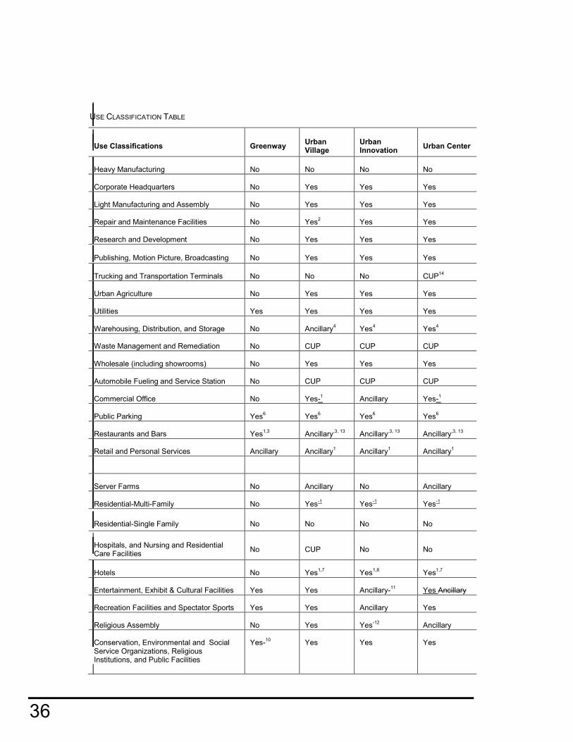
USE CLASSIFICATION TABLE
Use Classifications Greenway Urban Village
Urban Innovation
Urban Center
Heavy Manufacturing No No No No
Corporate Headquarters No Yes Yes Yes
Light Manufacturing and Assembly No Yes Yes Yes
Repair and Maintenance Facilities No Yes2
Yes Yes
Research and Development No Yes Yes Yes
Publishing, Motion Picture, Broadcasting No Yes Yes Yes
Trucking and Transportation Terminals No No No CUP14
Urban Agriculture No Yes Yes Yes
Utilities Yes Yes Yes Yes
Warehousing, Distribution, and Storage No Ancillary4
Yes4 Yes
4
Waste Management and Remediation Services
No CUP CUP CUP
Wholesale (including showrooms) No Yes Yes Yes
Automobile Fueling and Service Station No CUP CUP CUP
Commercial Office No
Yes-1
Ancillary Yes-1
Public Parking Yes6 Yes
6 Yes
6 Yes
6
Restaurants and Bars Yes1,3
Ancillary,3, 13
Ancillary,3, 13
Ancillary,3, 13
Retail and Personal Services Ancillary Ancillary1
Ancillary1 Ancillary
1
Server Farms No Ancillary No Ancillary
Residential-Multi-Family No Yes-1
Yes-1 Yes
-1
Residential-Single Family No No No No
Hospitals, and Nursing and Residential Care Facilities
No CUP No No
Hotels No Yes1,7
Yes1,8
Yes1,7
Entertainment, Exhibit & Cultural Facilities Yes Yes Ancillary-11 Yes Ancillary
Recreation Facilities and Spectator Sports Yes Yes Ancillary Yes
Religious Assembly No Yes Yes-12 Ancillary
Conservation, Environmental and Social Service Organizations, Religious Institutions, and Public Facilities
Yes-10 Yes Yes Yes

CPC-2009-598-SP December 13, 2012 DRAFT
37
FOOTNOTES FOR USE CLASSIFICATION TABLE
Yes. Allowable Use but often with footnotes to denote some constraint.
No. Use is not permitted
1. See Limits Table for limits on area FAR or square footage limits 2. Excludes truck repair 3. Free Standing Fast food establishments permitted with a Conditional Use Permit. 4. Selfstorage limited to 50% of Base FAR. 5. Limited to Technical Training Schools or Programs 6. Must be combined with the development of other uses. 7. Residential hotels or rooming houses permitted with a Project Permit Compliance 8. Residential hotels or rooming houses not permitted. 9. Permitted with a Conditional Use Permit 10. Limited to Block 70 11. Limited to Block 52 12. Limited to Blocks 50/51 13. Limited to Ancillary or 10% of Base FAR unless parcel is 30,000 square feet or less and
then Ancillary use can be permitted up to 1 FAR.
E. USE LIMITATIONS
1. The following uses shall be prohibited within the Plan area:
a. Auto-oriented uses, except as an accessory use.
b. Drive-through establishments.
2. Certain uses are further limited as to their overall percentage, square footage, or number of rooms as described in the Limits Table.
LIMITS TABLE
Use Classifications Greenway Urban
Village
Urban
Innovation
Urban
Center
Commercial Office N/A 65%1 Ancillary-(10%)
1 65%
1
Retail square footage limit 1,200 sf2
15,0002 sf 5,000
2 sf 100,000
2
Retail and/or Personal
Services
10% Retail
Only1
20%1
20%1 20%
1
Residential Multi-Family N/A
90%3, 4, 5
15%3,4,5
15%3,4,5
Hotels N/A 150 rooms 100 rooms 200 rooms
FOOTNOTE FOR LIMITS TABLE
Floor area of the specific use classification shall not exceed the allowable percentage of the total.permitted Base Floor Area of the site. Example. A 100,000 square foot site with a permitted 3
Schools, Colleges, Tutoring, and Training Programs
No Yes Yes5
Yes

38
FAR may not develop a project that exceeds 195,000 square feet (65% of 300,000 sf) of commercial use. The same project could include other permitted uses to maximize the permitted total floor area if desired. Projects that obtain an FAR in excess of their Base FAR as a result of a Bonus Option or TFAR shall constrain the overall square footage of the specific use to the permitted percentage.
1. Limited square footage permitted for each establishment
2. Floor area of Residential Multi-Family shall not exceed the allowable percentage of the total gross floor area of all principal and ancillary uses combined.
Construction shall only be permitted if built after or concurrent with on-site non-residential uses. Only the portion of live-work that is residential shall count towards the residential square footage.

CPC-2009-598-SP December 13, 2012 DRAFT
39
3. LOT AREA. The maximum number of dwelling units or guest rooms permitted shall not be limited by the lot area provisions of the L.A.M.C.
G. FLOOR AREA RATIO.
1. A Base Floor Area Ratio (Base FAR) and Maximum Floor Area Ratio (Max-FAR) is established for each parcel as set forth in the FAR Table Below and further illustrated in the FAR Map.
2. Where applicable, additional FAR, up to the Max FAR, can be added
to the Base FAR through the Bonus FAR and/or Transfer of Floor Area (TFAR) Programs described in Section 2.1.I of this Plan.
3. Residential projects with more than 15 units will need to utilize the
Bonus FAR Program in order to be eligible for the TFAR Program. Except, projects that elect to purchase Unused FAR from a Receiver Site that is unable to utilize the full extent of its FAR as a result of participation in the Density Bonus FAR Program (See 2.1.1.4) may do so without first participating in the Bonus FAR Program. .
4. Where applicable, non-residential projects may pursue either the
Bonus FAR and/or TFAR Programs up to the allowable Max FAR.
FAR TABLE
Density Greenway Urban
Village
Urban
Innovation
Urban Center
Base FAR 1.5 2.5 or 3.01 3.0 3.0
Base FAR within River Buffer
Areas
1.5 1.5 1.5 1.5
Max FAR** 1.5 3 to 52
3 to 42
3 to 62
Max FAR within River Buffer Areas 1.5 1.5 1.5 1.5
Max FAR within River Buffer Areas
with Density Bonus
NA 2 1.8 1.8
FAR TABLE FOOTNOTES 1 Projects with more than 15 units of residential are limited to a Base FAR of 2.5 unless the
residential portion of the project is equal to or less than 75% of the FAR or the project pursues the Density Bonus Option. All other projects have a 3.0 Base FAR. Due to the limitation described in the Limits Table on page 37 that limits the residential component of a project to 90% of the project’s FAR the residential portion of a project with a Base FAR of 2.5 would be 2.25 FAR.
2 Varies- see FAR Map

40
H. BONUS FAR. Projects may obtain additional FAR through complying with the Density Bonus Option and/or Community Benefit Bonus Options as described below.
1. Density Bonus Option. A Project in the Urban Village, Urban
Innovation, or Urban Center District that includes Residential uses may participate in the Density Bonus Option. Projects are either defined as Publicly Funded or Not Publicly Funded and shall utilize the appropriate Density Bonus strategy. may pursue, as appropriate, either of the two Density Bonus Strategies- Strategy A or Strategy B.
a. Publicly Funded.Strategy A. Projects that meet the
definition of a Publicly Funded Affordable Housing Project may add, record a covenant prior to pulling a building permit to set aside either 11% of the units for households earning less than 50% of AMI, 20% of the units for households earning less than 60% of AMI, or 100% of the units for earning 60% of AMI or less, may add depending upon the District it is located in, and its location in, or, outside of, the River Buffer Area, additional FAR, in exchange for providing the proscribed percentage of restricted affordable units, based upon the table below :
DENSITY BONUS FAR-PUBLICLY FUNDED PROJECTS TABLE- STRATEGY A
Affordability
Level/Location
Greenway Urban Village Urban
Innovation
Urban Center
11-20%
Affordable1
NA 3.375:1 3.15:1 ( max of
.6:1 FAR
Residential)
3.15:1 ( max of
.6:1 FAR
Residential)
100% Affordable NA 4:12 3.45:1 ( max of
.9:1 FAR
Residential)
3.45:1 ( max of
.9:1 FAR
Residential)
20% Affordable
River Buffer
NA 2:1 1.6:1 (max of .3:1
residential)
1.6:1 (max of .3:1
residential)
100% Affordable
River Buffer
NA 2:1 1.8:1 (max of
.525:1
residential)
1.8:1 (max of
.525:1
residential)
DENSITY BONUS FAR-PUBLICLY FUNDED PROJECTS- STRATEGY A FOOTNOTE 1Projects that provide 20% of the units for low-income households or 11% of the units for very-low income households. 2Projects in an area with a Max FAR of 3:1 shall be limited to a 3.375:1 Density Bonus FAR

CPC-2009-598-SP December 13, 2012 DRAFT
41
b. Not Publicly Funded Strategy B. Projects that do not use
Strategy A but still elect to include affordable units and record a covenant prior to pulling a building permit to set aside an identified number of affordable units are not Publicly Funded may add Density Bonus square footage, up to the permitted Bonus Square Footage, by including affordable units as described in the tables below.
i. Bonus Square Footage. Projects may add
Density Bonus square footage by including affordable units. The amount of bonus square footage is proportionally tied to the square footage of, and level of affordability of, each of the affordable units. The affordable unit square footage, plus the bonus market square footage shall be added together to determine the total amount of bonus square footage permitted as described in the table below:
BONUS SQUARE FOOTAGE TABLE
Affordability Affordable SF Market SF Total Bonus SF
Extremely-Low -35% AMI 1 6 7
Very Low -50% AMI 1 4 5
Low -60% AMI 1 2 3
Moderate (for-sale only) 1 3 2 4 3
BONUS SQUARE FOOTAGE TABLE FOOTNOTE: Add one additional market square foot for every square foot of an affordable unit with three bedrooms or more.
ii. Bonus FAR. Projects may add, depending upon the District it is located
in, and its location in, or, outside of, the River Buffer Area, additional FAR, up to the limits in the table below:
DENSITY BONUS FAR LIMIT-NOT PUBLICLY FUNDED PROJECTS STRATEGY B TABLE
Location Greenway Urban Village Urban
Innovation
Urban Center
Not River Buffer NA 4:1 3.45:1 ( max of
.9:1 FAR
Residential)
3.45:1 ( max of
.9:1 FAR
Residential)
River Buffer NA 2:1 1.8:1 (max of
.525:1 residential)
1.8:1 (max of
.525:1
residential)
DENSITY BONUS FAR-NOT PUBLICLY FUNDED PROJECTS STRATEGY B FOOTNOTE *Projects in an area with a Max FAR of 3:1 shall be limited to a 3.375:1 Density Bonus FAR

42
c. Incentives. Up to three, on or off-menu, incentives are offered to both Publicly
Funded Strategy A and Not Publicly Funded Strategy B Projects that participate in the Density Bonus Program.
i. Publicly FundedStrategy A. A publicly fundedStrategy A project:
a) With at least 11% very-low income or 20% low-income
affordable units is eligible for two incentives.
b) With 100% affordable units is eligible for three incentives.
ii. Not Publicly Funded Strategy B. A Strategy B project that is not
publicly funded that achieves:
a) A 3.0 FAR shall be eligible for one incentive
b) A 3.5 FAR shall be eligible for two incentives
c) A 4.0 FAR shall be eligible for three incentives.
iii. On-Menu Incentives.
a) Project in the Urban Village may increase the proportion of residential from 90% to 95% of the overall FAR.
b) Project in the Urban Village that has used the previous
incentive may request an increase of residential FAR from 95 to 100% FAR.
c) Project may increase their maximum height by 15’
d) Projects may exclude any public areas, accessible to all
residents, including public common areas that serve both residential and commercial uses, and any unenclosed architectural features and areas of a building from the total floor area calculation.
iv. Off-Menu Incentives. Project may request a waiver or modification
from any development standard. Project shall provide a pro forma or other documentation to show that the waiver or modification is necessary in order to make the Restricted Affordable Units economically feasible.
v. Covenant. Prior to issuance of a Building Department, the following
shall apply:
a) Rental Units. For any applicant that receives an Affordability
Bonus, in exchange for providing restricted rental units, a covenant acceptable to the Los Angeles Housing Department (LAHD) shall be recorded with the Los Angeles County Recorder, guaranteeing that the occupancy restriction will be observed for at least 30 years from the issuance of the Certificate of Occupancy or a longer period of time if required by the construction or mortgage financing assistance program, mortgage assistance program, or rental subsidy program.
b) For-Sale Units. For any applicant that receives an Affordability
Bonus, in exchange for providing restricted for-sale units, a covenant acceptable to the Los Angeles Housing Department and consistent with the for-sale requirements of California

CPC-2009-598-SP December 13, 2012 DRAFT
43
Government Code Section 65915(c)(2) shall be recorded with the Los Angeles County Recorder guaranteeing that the affordability criteria will be observed for at least ten years from the issuance of the Certificate of Occupancy.
c) If the duration of affordability covenants provided for in this
section conflicts with the duration of any other government requirement, the longest duration shall control.
d) Any covenant described in this section must provide for a
private right of enforcement by the City, any tenant, or owner of any building to which a covenant and agreement applies.
2. Community Benefit Option.
a. A Residential and/or Mixed-Use Project with a Base FAR of 2.5:1 that has
obtained a 3.375:1 by utilizing the Density Bonus Option may up to an additional .625 FAR in locations where the Max FAR Is 4 or more.
b. Projects that include more than 15 residential units will need
to comply with the Density Bonus Option in order to be eligible for the Community Benefit Option. Such projects will also need to utilize the Bonus FAR Program in order to be eligible for the TFAR Program.
c. A Non-Residential Project and/or a Mixed-Use Project with less than 15 units or
less than 75% residential with a Base FAR of 3:1 may add up to an additional 1 FAR (where permitted – see FAR Map) by providing one of the following Community Benefits and submitting, as part of the Project Permit Compliance Review Application, an Allocation Plan as described in Section 6.G of this plan.
d. Open Space. A Project may add 3 square feet of Floor Area for each square foot
of publicly accessible open space. e. Community Facility. A Project may add 6 square feet of Floor Area for each
square foot of area provided for a community facility (including access and loading/unloading), which may include but is not limited to child care and other educational services, public library, fire station, transportation amenities, medical services, or non-profit whose services directly benefit the community.
f. Public benefits may be provided on the same site as the Project or on a site within the Specific Plan Area.
g. The owner or owners of said property which is the recipient of the Community Benefit Bonus SF shall record an agreement in the Office of the County Recorder of Los Angeles County, California, as a covenant running with the land for the benefit of the City of Los Angeles, providing that such owner or owners shall continue to provide said public benefit (or a substitute benefit approved by the director) so long as the building or use the public benefit is intended to serve is maintained.

44
I. Transfer of FAR (TFAR) Program
1. Where applicable, non-residential projects may pursue either the Bonus FAR and/or TFAR Programs up to the allowable Max FAR.
2. Receiving Sites that participate in the Bonus FAR Program may also participate in the
TFAR Program.
3. An existing parcel which has a total FAR that is less than the Base FAR may transfer its Unused FAR to a Receiver Site that is located within the same District.
3.4. An existing parcel within the Urban Village District which is eligible, as a result of participation in the Density Bonus Strategy A Option, up to an FAR of 4:1 may transfer any of its Unused FAR to a Receiver Site that is located within the Specific Plan.
4.5. An existing parcel within the Greenway District which has a total FAR that is less than the
Base FAR may transfer its Unused FAR to a Receiver Site that is located within the Specific Plan.
5.6. Properties within the River Buffer Area may transfer any portion of their Unused FAR to
another property within the same district but may not be a Receiver Site.
6.7. The Unused FAR shall henceforth be referred to as the TFAR.
7.8. The value of the TFAR shall be determined between the participants of the Transfer unless the Donor Site is owned by either the City of Los Angeles or the Los Angeles River Revitalization (Corporation) in which case the Floor Area Payment described in Section 1.2.D. will be used to establish the value and payment method.

CPC-2009-598-SP December 13, 2012 DRAFT
45
2.2 BUILDING FORM A. PURPOSE B. YARD AND SETBACKS C. STREET WALL AND MASSING D. MAXIMUM LOT COVERAGE E. HEIGHT F. BUFFERS G. BLOCK LENGTH A. PURPOSE.
1. To provide spatial and proportional standards that reinforce the street as a large public outdoor room.
2. To emphasize the public realm (streets and public open spaces) more than individual
buildings.
3. To ensure that development is designed with a pedestrian orientation.
4. To reinforce the street wall with well-scaled elements or structures that are sensitive to the neighborhood context.
5. To respect the smaller scale of adjacent low-density buildings

46
B. YARD AND SETBACK REGULATIONS
1. Yard Requirements. No yard requirements shall apply except as required by the applicable
urban design standards. Where required by the Street Standards established in Section 3 of this Plan, a Project shall be required to provide a Sidewalk Easement.
2. Setbacks.
a. The building setback along any lot line that abuts a street, flood control channel, rail corridor or an adjacent side rear lot shall be as defined in the Building Setback Table below. The setback area for the building portion adjacent to the front lot line shall be further governed by the building’s ground floor use.
b. The ground floor street wall (including entries and display windows) may be set back
farther than the specified range, provided that structural columns and building walls above the ground floor are located within the specified range.
SETBACK TABLE
SETBACK TABLE FOOTNOTE: See Streetwall Table for further design guidance
Setback
Greenways
Urban Village
Urban Innovation
Urban Center
Front Yard/Ground Floor UseStreet
Façade/Ground Floor Use
- Retail N/A 0’-5’ max 0’-10’ max 0’-3’ max
- Professional Office/Live Work N/A 0’-10’ max 0’-15’ max 0’-5’ max
- Industrial N/A 0’-10’ max 0’-15’ max 0’-10’ max
- Residential N/A 0’-15’ max N/A 0’-10’ max
Alley, Side or Rear YardAbutting Property
Line 0’ min 0’ min 0’ min 0’ min
Public Parks 30’ min 30’ min 30’ min 30’ min
River or Arroyo Seco 50’ min 50’ min 50’ min 50’ min
Rail Tracks 30’ min 30’ min 30’ min 30’ min

CPC-2009-598-SP December 13, 2012 DRAFT
47
CB. Streetwall & Massing.
1. Streetwall. A minimum percentage of the Street Wall shall be built to the property line or
anywhere within the allowable setback area (pursuant to the Setback Table on the previous page. See Street Wall Table below.
2. Projects that include publicly accessible open space and/or stormwater retention/detention features between the building face and the property line shall be exempt from meeting the street wall percentage requirements.
2.3. Massing. Break the facade of large projects into a series of appropriately scaled buildings
so that no building shall be more than 300 feet in length at the base. Buildings more than 300’ in length shall include a design element that provides visual relief every 200’.The design feature shall either setback from or step forward from the primary face of the building by at least a depth of 12” and shall be of a width no less than 5% of the building face (ex: 5% of 200’ = 10’) and shall extend up the face of the building at least 6’.
DC. Maximum Lot Coverage. Projects shall limit the percentage of building footprint relative to
the overall site area as defined in the Maximum Lot.
MAXIMUM LOT COVERAGE TABLE
STREETWALL TABLE
Minimum Percent of Building
Street Wall at Setback
Greenways Urban
Village
Urban
Innovation
Urban
Center
Facing River or Arroyo Seco NA 0% 0% 0%
Secondary Modified NA 85% 80% 90%
Collector Modified NA 75% 70% 80%
Local Modified NA 65% 60% 70%
Max Lot Coverage Greenways Urban
Village
Urban
Innovation
Urban
Center
Maximum Buildable Lot Coverage* 25% 85% 85% 85%
Maximum Buildable Lot Coverage for
lots within 300 linear feet of the bottom
of adjacent edge of the River or Arroyo
(River Buffer Area)*
25% 50% 50% 50%
MAXIMUM LOT COVERAGE TABLE FOOTNOTES
*Existing buildings are exempt from this limitation

48
ED. HEIGHT.
1. 90% of a Street Wall shall comply with the minimum height as defined on the Building Heights Map.
2. The average height of the Project shall not exceed the average maximum height
established in the Building Heights Map as measured from the street grade of the primary street abutting the Project.
2.3. Parapet walls and other guard rails utilized to enclose roof terraces, gardens or green
roofs shall be permitted to exceed the maximum allowable height by no more than 42 inches.
3.4. Building shall be designed such that there is no more than 1.5 hours of shadow projection on any parks, open spaces, and/or rooftop areas of abutting properties between 10am and 2:00 pm on December 21.
FE. BUFFERS. Projects located adjacent to the RD 1.5 and RD 2 zones in Sub-Area 2 or other low-density residential uses outside, but immediately abutting the Specific Plan boundaries, shall:
1. Provide an open space a setback buffer of no less than 30’ between the edge of the building and the property line of the low density use; and,
2. At the buffer line and for a distance of 20’ back from the buffer line, no building shall
exceed a height of 125% of the buffer distance plus the side or rear yard setback (B) required by the zoning of the abutting property.
3. Additional height is permitted within a 50 degree envelope.
GF. Block Length. The block length in the three urban districts shall not exceed:
1. Urban Village 450 linear feet.
2. Urban Innovation 600 linear feet.
3. Urban Center 500 feet.
4. See the Maximum Block Length Map for identification of blocks that are known to exceed the block length.
5. A Project that is in a block that is longer than the allowable block distances, as defined in Sections 2.2F.1-3 above, that is located on either a thru lot, a lot abutting an alley or the Los Angeles State Historic Park, and has a street frontage in excess of 300 linear feet shall provide a through passageway that extends from the street to the nearest public right-of-way.
a. The owner or owners of said lot on which the paseo or pedestrian passage is to be provided shall record an agreement in the Office of the County Recorder of Los Angeles County, California, as a covenant running with the land for the benefit of the City of Los Angeles, providing that such owner or owners shall continue to provide said paseo as a publicly accessible pedestrian passageway so long as the building or use the paseo is intended to serve is maintained.
b. Such a passageway shall permit unlimited 24 hour public access to pedestrians,
bicyclists, and emergency vehicles where feasible.
c. Passageways shall be designed in conformance with Section 2.4.J.3. 5.6. Light Industrial Uses are exempt form the block length limitations.

CPC-2009-598-SP December 13, 2012 DRAFT
49
2.3 URBAN DESIGN A. PURPOSES B. ENTRANCE C. GROUND FLOOR D. WINDOWS AND GLAZING E. EXTERIOR LIGHTING F. MINIMIZE IMPACTS ON NEIGHBORS
A. PURPOSES
1. Maximize the advantage of the area’s moderate climate by emphasizing the public realm-streets and public spaces-more so than individual buildings.
2. Promote pedestrian-scaled architecture along the street. 3. Promote fine-grained and well articulated development while enabling desired development
intensities to be achieved. 4. Orient buildings to the street to promote sidewalk activity and reinforce the pedestrian
environment along the sidewalk. 5. Vary the horizontal plane of a building to provide visual interest and enrich the pedestrian
experience, while contributing to the quality and definition of the street wall.
6. Incorporate glazing that contributes to a warm, inviting environment while also reducing bird collisions by minimizing the reflection of surrounding habitat or sky.
7. Provide well-designed, energy efficient, architectural and landscape lighting that contributes
to a safe and inviting atmosphere without casting light into the night sky, adjacent properties, or sensitive habitat areas.
8. Integrate all exterior lighting (building, landscape, and security) with the building design to be of a character and scale that relates to the pedestrian and accentuates major architectural and special landscape features.
9. Respect neighboring properties, and design major mechanical systems, trash and
recycling, antennas, glare lighting, and reflective materials to limit adverse impacts.
10. Balance the need for security doors and windows with the need to create an attractive, inviting environment.

50
B. ENTRANCE.
1. Primary entrances shall be located on a public street or on a courtyard, plaza or paseo that is connected to and visible from a public street. such that a pedestrian entering the building need not walk through a vehicle parking area in order to arrive at the entrance.
2. At least one functional pedestrian building entrance, which may be either a building or
tenant/resident entrance, shall be provided every 75 feet, on average along all street frontages except on Local Industrial Modified Streets. (See the Active Streets Map )
3.2. The primary entrance to each street or sidewalk-level tenant space that has its frontage
along a public street shall be provided from that street.
4.3. The primary entrance to each street-level tenant that does not have its frontage along a public street shall be provided from a pedestrian paseo, courtyard or plaza, which is connected to a public street.
5. Primary entrances shall not be permitted from a parking area.
6.4. Ground floor residential units with individual entries shall include windows on the ground
floor that look out onto the street.
C. GROUND FLOOR
1. Frontage Uses
a) At least 75% of the ground floor frontage of a building, or 50% of the ground floor frontage of a building intended for Light Industrial uses, located on a Retail Street identified on the Active Streets Map shall be designed specifically for and occupied by retail and community serving uses. to accommodate the following uses: retail, community serving uses, cultural, professional office, live/work units, residential units with individual entries along the street, and/or other active space such as recreation and meeting rooms, lobby or sales areas, or common rooms.
b) At least 50% of the ground floor frontage of a building, or, 35% of the ground floor
frontage of a building intended for Light Industrial uses, located on an Active Street shall be designed to accommodate the following uses: retail, cultural, professional office, live/work units, residential units with individual entries along the street, and/or other active space such as recreation and meeting rooms, lobby or sales areas, or common rooms. (See the Active Streets Map)
c) At least 25% of the ground floor frontage of a building, or, 20% of the ground floor
frontage of a building intended for Light Industrial uses, located on an Active Industrial Street shall be designed to accommodate the following uses: lobby or sales areas, retail, professional office, and/or other active space such as meeting rooms. (See the Active Streets Map)
d) The owner or owners of said lot on which the ground-floor uses are to be provided shall record an agreement in the Office of the County Recorder of Los Angeles County, California, as a covenant running with the land for the benefit of the City of Los Angeles, providing that such owner or owners shall continue to provide said ground-floor uses as long as the building or use the ground-floor uses are intended to serve is maintained.
2. Transit Information. All Projects shall provide information about local transit service at a
primary entry point to the site or building. The information shall be prominently displayed, updated quarterly, and shall include phone numbers, web-information, and QR code for transit, paratransit, and taxis as well as brochures and maps for local bus and rail service.

CPC-2009-598-SP December 13, 2012 DRAFT
51
3. Ground Floor Transparency.
a) Along Retail Streets, transparent wall openings, such as storefront windows and doors, shall comprise at least 50% of a building’s street level façade(s) that is are between 2 feet to 8 feet from the finished floor level of the ground floor. An exception shall be made for buildings intended for Light Industrial Uses in which case the transparent wall openings need comprise only 35% of the building’s street level façade(s).
b) Along Active Streets and Paseos, transparent wall openings, such as storefront
windows and doors shall comprise at least 35% of a building’s the street level façade(s) that isare between 2 feet to 8 feet from the ground. An exception shall be made for buildings intended for Light Industrial Uses in which case the transparent wall openings need comprise only 25% of the building’s street level façade(s).
b)c) Along Active Industrial Streets, transparent wall openings, such as storefront windows and doors, shall comprise at least 25% of a building’s the street level façade(s) that is are between 2 feet to 8 feet from the ground. An exception shall be made for buildings intended for Light Industrial Uses in which case the transparent wall openings need comprise only 18% of the building’s street level façade(s).
c)d) An exception shall be made for older structures that are being renovated if the
transparency requirement would render the building structurally infeasible or would compromise the historical integrity or original character of the building.
4. Ground Floor Facade. To avoid blank walls that would detract from the experience and
appearance of an active streetscape there shall be no blank walls (without doors or windows) longer than 50 feet along sidewalks on Active or Retail Streets. Walls with public art installations such as murals shall be exempt.
5. Ground Floor Retail.
a) All ground floor retail space shall be located either along the street wall or along a
courtyard or plaza, provided the retail frontage is not more than 60 feet from the back of sidewalk and is visible from the sidewalk.
b) Ground floor retail space shall be provided to a depth of at least 25 feet from the front
façade and shall include an average 14 feet - 20 feet floor to ceiling height.
c)b) Where Retail streets intersect other streets, the ground floor retail space shall wrap the corner onto the other streets.
D. WINDOWS AND GLAZING.
1. Windows. To reduce interior heat gain and improve energy performance the window
to wall ratio (exclusive of the ground floor) shall not exceed 40% on the E, W, SW, NW, SE and NE facades unless an alternative façade design can demonstrate through building specific analysis that it provides the same or greater reduction in cooling loads of the building.
2. All windows on the aforementioned facades shall be shaded by 1’ fins or overhangs or other architectural feature that provides the equivalent shading value unless an alternative design solution can be demonstrated through building specific analysis that it provides the same or greater reduction in cooling loads of the building.
1. Glazing.
a) At least 50% of All ground-floor window and door glazing shall be transparent and
have a 0-10% reflectivity rating and/or include shading devices, screen or other

52
barriers to reduce birds’ access to glass, and/or angle the glass between 20-40 degrees from vertical.
b) Glazing on the upper floors shall include one or more of the following: 0-10%
reflectivity, etching, sandblasted patterns, fretting, or low-e patterning, shading devices, screen and other barriers to reduce birds’ access to glass, and/or angle the glass between 20-40 degrees from vertical.
E. EXTERIOR LIGHTING.
1. General Requirements
a) Light levels shall be measured with a photoelectric photometer, following the standard spectral luminous efficiency curve adopted by the International Commission on Illumination.
b) All projects in the Urban Center, Innovation, and Village Districts shall design all site
and building mounted lighting such that it produces a maximum initial illuminance value no greater than 0.20 horizontal and vertical foot candles at the site boundary and no greater than 0.01 horizontal foot candles 15 feet beyond the site. No more than 5.0% of the total initial designed lumens shall be emitted at an angle of 90 degrees or higher from nadir (straight down).
c) All projects in the Greenway District shall design all site and building mounted lighting
such that it produces a maximum initial illuminance value no greater than 0.01 horizontal and vertical foot candles at the site boundary and beyond. None of the total initial designed lumens shall be emitted at an angle of 90 degrees or higher from nadir (straight down).
d) Provide lighting along all vehicular access ways and pedestrian walkways.
e) All low pressure sodium, high pressure sodium, metal halide, fluorescent, quartz, incandescent greater than 60 watts, mercury vapor, and halogen fixtures shall be fully shielded in such a manner as to preclude light pollution or light trespass on any of the following; an abutting residential land use district; a lot zoned for residential use; public right of way, park, or open space.
f) Lighting (exterior building and landscape) shall be directed away from properties and
roadways, and shielded as necessary. In particular no lighting shall be directed at the window of a residential unit either within or adjacent to a project.
2. Exemptions: The following outdoor lighting fixtures and activities are exempt from the
requirements of this section:
a) Fixtures producing light directly by the combustion of fossil fuels, such as kerosene lanterns or gas lamps.
b) All neon, argon or krypton outdoor lighting fixtures.
c) Emergency lighting operated by a public utility or agency during the course of
repairing or replacing damaged facilities.
d) Emergency lighting and fixtures necessary to conduct rescue operations, provide emergency medical treatment or address any other emergency situation.
e) Lighting fixtures within five feet of an entrance or exit door and/or alcove of a dwelling
unit, not exceeding a height of eight feet and a wattage not exceeding 75 watts provided there is no light pollution, or light trespass, or when the lighting fixtures are regulated by a motion detector.
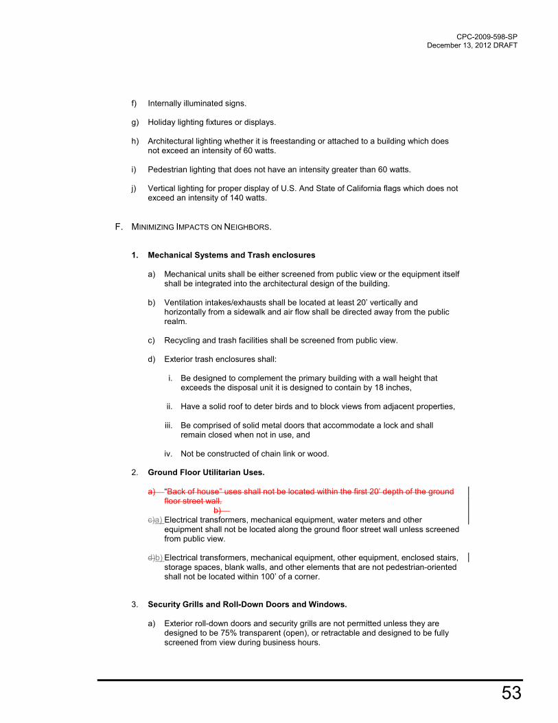
CPC-2009-598-SP December 13, 2012 DRAFT
53
f) Internally illuminated signs.
g) Holiday lighting fixtures or displays.
h) Architectural lighting whether it is freestanding or attached to a building which does not exceed an intensity of 60 watts.
i) Pedestrian lighting that does not have an intensity greater than 60 watts.
j) Vertical lighting for proper display of U.S. And State of California flags which does not
exceed an intensity of 140 watts.
F. MINIMIZING IMPACTS ON NEIGHBORS.
1. Mechanical Systems and Trash enclosures
a) Mechanical units shall be either screened from public view or the equipment itself
shall be integrated into the architectural design of the building.
b) Ventilation intakes/exhausts shall be located at least 20’ vertically and horizontally from a sidewalk and air flow shall be directed away from the public realm.
c) Recycling and trash facilities shall be screened from public view.
d) Exterior trash enclosures shall:
i. Be designed to complement the primary building with a wall height that exceeds the disposal unit it is designed to contain by 18 inches,
ii. Have a solid roof to deter birds and to block views from adjacent properties,
iii. Be comprised of solid metal doors that accommodate a lock and shall
remain closed when not in use, and
iv. Not be constructed of chain link or wood.
2. Ground Floor Utilitarian Uses.
a) “Back of house” uses shall not be located within the first 20’ depth of the ground
floor street wall. b)
c)a) Electrical transformers, mechanical equipment, water meters and other equipment shall not be located along the ground floor street wall unless screened from public view.
d)b) Electrical transformers, mechanical equipment, other equipment, enclosed stairs,
storage spaces, blank walls, and other elements that are not pedestrian-oriented shall not be located within 100’ of a corner.
3. Security Grills and Roll-Down Doors and Windows.
a) Exterior roll-down doors and security grills are not permitted unless they are
designed to be 75% transparent (open), or retractable and designed to be fully screened from view during business hours.

54
b) Any ground-level retail storefront windows must be kept open and visible (unshuttered) at night. A covenant shall be recorded binding future owners to comply with this provision.
c)b) Windows with security features shall not block out more than 30% of the natural
light to the interior, and shall be designed as an architectural feature compatible with the building’s style.

CPC-2009-598-SP December 13, 2012 DRAFT
55
2.4 OPEN SPACE A. PURPOSE B. TYPOLOGIES C. AREA REQUIREMENTS D. PERMITTED USES E. ACCESS F. DIMENSIONS AND BOUNDARIES G. LANDSCAPE H. OPERATIONS AND MAINTENANCE I. SPECIALTY DESIGN REQUIREMENTS
A. PURPOSES
1. Provide inviting, safe and accessible public open space.
2. Increase recreational opportunities for residents, employees, and visitors.
3. Provide pedestrian linkages throughout the Plan area.
4. Provide parks and open space that minimizes demand for potable water resources.
5. Encourage areas for community-based and local food production.
6. Provide open space areas that provide for native habitat and facilitate the migration of local species.
7. Provide adequate lighting to create a park environment where residents feel safe.
8. Generate visual interest by creating focal points and meeting places to enhance the area’s
image.
9. Support an easy transition between indoors and outdoors.
10. Include permanent and temporary seating that is placed with consideration to sun and shade, and other factors contributing to human comfort.

56
B. OPEN SPACE TYPOLOGIES Alleys. Alleys provide access to service activities and while not typically the most visible of public
spaces they can facilitate physical connections between traditional open spaces. Balconies. Balconies, are typically private open space areas generally available exclusively to a
unit’s occupants and their visitors. Community Gardens. Community Gardens provide community members with local opportunities
to tend individual plots and grow their own food. Courtyards. Courtyards are common open space areas of a scale and enclosure that is conducive
to social interaction at a smaller scale. A courtyard is typically contained on three sides by building and/or architectural features. Entry forecourts. Entry forecourts announce the function and importance of primary building
entrances. They should provide a clear comfortable transition between exterior and interior space. An entry forecourt is typically contained on two sides by building and/or architectural features. Parks. Parks provide a wide range of passive, active recreational, and picnic opportunities for
multiple users. Paseos. Paseos are extensions of the street grid located on private property. As outdoor passages
devoted exclusively to pedestrians, they establish clear connections between streets, plazas and courtyards, building entrances, parking and transit facilities. A paseo is typically contained on two sides by building and/or architectural features. Patios. Similar to Balconies, Patios are typically private open space areas generally available
exclusively to a unit’s occupants and their visitors Plazas. Plazas are common open space areas typically amenable to larger public gatherings. They
are readily accessible from the street, as well as active building uses. A courtyard is typically contained on only one side by building and/or architectural features. Promenade. A public area set aside as a pedestrian walkway. Residential Setbacks. Building setbacks adjacent to residential buildings provide a transition
between the public and private realm, allowing residents to have private spaces with visual access to the public realm. Roof Terrace. Roof terraces and gardens can augment open space and are especially encouraged
in conjunction with hotels or residential uses. Streets. Streets are the most public of all open spaces. Streets communicate the quality of the
public environment and the care a city has for its residents. Trails. Trails provide opportunities for walking and hiking without the interruption of vehicular traffic.

CPC-2009-598-SP December 13, 2012 DRAFT
57
C. AREA REQUIREMENTS
1. All Projects in the Greenway District shall provide 25% of the lot area as publicly accessible open space.
2. All Projects in the Urban Village, Urban Center and Urban Innovation Districts shall provide:
a. One square foot of common open space area for building users per every 16 square feet of residential space; and
b. One square foot of common open space area for building users for every 48 square
feet of non-residential space.
3. Projects subject to Quimby Fees as described in either 17.12 or 17.58 may utilize the 2.4.C.2 requirements above towards their Quimby contribution.
4. All common open space areas shall be designed to meet L.A.M.C. Section 12.21. G. 2 (a). 5. Projects may provide up to 25% less common open space if the open space is publicly
accessible and is maintained at no public expense. 6. Up to one-half of the required common open space area can be provided as private open
space, in lieu-of common open space, and shall be designed to meet the standards outlined in L.A.M.C. 12.21 G. 2 (b).
7. Any common area or publicly accessible open spaces shall be located within 900 feet of the
Project. 8. Individual Projects may combine the open space requirement of each Project into a single
open space equal to no less than the sum of the requirement of each parcel as long as the combined spaces remain accessible to all of the residents, employees or visitors of the respective Projects.
9. In the case of a Transfer of Floor Area Rights, a Project may comply with the provisions of
this Section by providing the required open space on either the recipient or the Donor Site. 10. All or a portion of a parking area, including access aisles, and driveways may qualify as
usable common or publicly accessible open space to the extent that the area complies with the following design standards:
a. Traffic design speed is 5 mph or less; and b. Parking Lot Design Standards in Section 2.5. D. 3. of this Plan.
11. Public alleyways, paseos, or new streets that are added to a Project site shall qualify as publicly accessible open space and may contribute to the open space requirement.
D. PERMITTED USES. Publicly Accessible Open Spaces shall be designed to serve at least one functional use listed below that includes but is not limited to:
Basketball Courts Bicycle Rental Center Community amenities Community garden space Farmers’ Market

58
Information or newstand kiosk (as long as it does not exceed 1.5% of the open space area). Off-leash Dog Park Open air cafe (as long as it occupies no more than 20% of the open space). Picnic Area or other seating Soccer Field Softball Field Tennis Courts Trails, Alleys, Streets, Paseos for walking and bicycling Transit Hub Amenities Exercise Areas, Yoga, Pilates, and Tai Chi
E. ACCESS 1. All paths of travel shall conform to the standards of the Americans with Disabilities Act
(ADA). 2. Publicly accessible open spaces shall:
a. Be at the same level as the public sidewalk for at least one half of its frontage and a depth of 10 feet, and may not be more than three feet above or below the street curb level.
b. Be visible from an adjoining street(s) or adjacent parks.
F. DIMENSIONS AND BOUNDARIES. All publicly accessible open space shall have a minimum area of 650 square feet with no horizontal dimension less than 15 feet when measured perpendicular from any point on each of the boundaries.
1. All publicly accessible open space shall have a minimum area of 650 square feet with no
horizontal dimension less than 15 feet when measured perpendicular from any point on each of the boundaries.
2. Blank walls longer than 100 feet are not permitted adjacent to common or publicly
accessible open space areas.
G. SEATING. Provide one linear foot of seating for every 500 square feet of common or publicly accessible open space area. The flat top of walls and ledges may count as seating as long as they are no less than 15 inches in depth, between 15 inches and 20 inches in height, and have smooth surfaces to ensure comfort.
H. LANDSCAPE
1. Trees.
a. Install deciduous trees at a minimum of one tree per 600 square feet of common or
publicly accessible open space area.

CPC-2009-598-SP December 13, 2012 DRAFT
59
b. Trees in common and/or publicly accessible open space areas must have a minimum caliper size of 4 inches at planting and have a canopy of at least 10 feet at maturity.
c. A 32 square foot permeable surface shall be maintained below each tree. for a distance of 2 feet from the trunk for every 1 inches of caliper. A tree with an expected 10 inches caliper at maturity would be required to have a 20 feet radial permeable surface below it.
2. Irrigation
a. Irrigation systems shall be equipped with a Weather Based Irrigation Controller such that the system does not turn on during a storm event or when the soil has moisture level sufficient to support the plant species.
b. Irrigation systems shall be designed to the water needs of different parts of the
landscape. This is referred to as Zoned Irrigation.
c. Any irrigation system shall be plumbed with a purple pipe to enable a connection to a recycled or gray water system once it is available.
d. All irrigation systems shall be either drip, microspray, or subsurface where
appropriate. 3. Hardscape and Materials
a. Hardscape materials shall have a Solar Reflectance Index (SRI) of at least 29. b. No spikes, pointed railings, or other sharp objects shall be permitted.
I. OPERATIONS AND MAINTENANCE.
1. The owner or owners of said lot on which the publicly accessible open space is to be provided and maintained shall record an agreement in the Office of the County Recorder of Los Angeles County, California, as a covenant running with the land for the benefit of the City of Los Angeles, providing that such owner or owners shall continue to provide and maintain said publicly accessible open space as described in Sections 5 of the Plan so long as the building or use the open space is intended to serve is maintained.
J. SPECIALTY DESIGN REQUIREMENTS
1. Community Gardens
a. Community gardens shall provide fencing, watering system and a secure storage space. b. Community gardens must have solar access of at least 4 hours of summer sun between the hours of 10am and 2pm. c. The Project shall identify the parties responsible for maintaining the garden’s operation.

60
2. Park Recreational Areas. Park-Recreational areas shall be designed to the specifications
of the Department of Recreation and Parks
3. Paseos. Paseos shall be designed to:
a. Be at least 20 feet wide; b. Have a clear line of sight from the street to the end of the passageway, gathering place, or focal element; c. Be at least 50% open to the sky or covered with a transparent material; and,
4. Off-Leash Dog Park Off-leash dog parks shall use softscaping to capture and “scrub”
animal fecal matter.

CPC-2009-598-SP December 13, 2012 DRAFT
61
2.5 PARKING AND ACCESS A. PURPOSE B. PARKING REGULATIONS C. PARKING CAP D. PARKING DESIGN E. VEHICULAR ACCESS F. DROP-OFF ZONES
A. PURPOSE
1. Manage and control the parking supply and demand. 2. Avoid an oversupply of parking. 3. Increase pedestrian, bicycle, and transit use, and reduce vehicular trips to, through, and
within the area. 4. Minimize the area’s parking footprint and preserve land for other productive uses. 5. Reduce the cost of parking typically associated with new construction. 6. Provide vehicular access from side streets or alleyways to minimize driveways along
Active Streets and to maintain building continuity and avoid vehicle and pedestrian conflicts.
7. Create active ground floors around the base of parking structures that are adjacent to
Active Streets. 8. Screen parking to provide a safe, aesthetically pleasing and secure environment for
pedestrians. 9. Provide adequate signage to public parking structures to aid visitors in finding them upon
arrival and getting oriented to their surroundings. 10. Encourage the use of alternate modes of transportation by reducing the availability of off-
street parking.
11. Limit the number and width of curb cuts and vehicular entries to promote street wall continuity and reduce conflicts with pedestrians.
11.12. Encourage the provision of shared parking agreements and/or public parking facilities.

62
B. PARKING REGULATIONS.
1. Supersedes LAMC requirements. Where this Specific Plan contains language or
standards that require more parking or permit less parking than LAMC Section 12.21, this Specific Plan shall supersede the LAMC.
2. Parking which is assigned to a particular Project or lot may be located anywhere within
1,500 feet of the Project site the Plan area.
3. All Projects that elect to provide any parking shall provide:
a. Vehicle charging stations for a minimum of 1%5% of vehicle parking spaces. b. In a publicly accessible area, one shared vehicle parking space for every 25 units
and/or 25,000 square feet, and c. Designated stalls for scooters, mopeds and motorcycles at a ratio of one space for
every 25 units and/or 25,000 square feet.
4. Residential Parking standards. Notwithstanding the provisions of Section 12.21 of the Code and regardless of the underlying zone, the following parking standards shall apply to Residential Projects or those residential portions of Mixed-Use Projects uses within the Specific Plan area: shall provide a minimum of one bicycle parking space or locker for ever two units.
a. Provide a minimum of one bicycle parking space or locker for every two units, and b. Provide a maximum of one vehicle parking space per unit, exclusive of the shared
vehicle and electric charging parking spaces. 5. Non-Residential Parking standards. Notwithstanding the provisions of Section 12.21 of
the Code and regardless of the underlying zone, the following parking standards shall apply to Non-Residential Projects or those non-residential portions of Mixed-Use Projects that are non-residential uses within the Specific Plan area: shall provide a minimum of one bicycle parking space or locker for every 2,000 square feet of non-residential area.
a. Provide a minimum of one bicycle space or locker for every 2,000 square feet. b. Provide a maximum of one vehicle parking space per 1,000 square feet, exclusive of
the shared vehicle parking spaces.
6. Open Space and Public Park Parking Standards. Notwithstanding the provisions of
Section 12.21 of the Code and regardless of the underlying zone, the following parking standards shall apply to Open Space areas and Public Parks within the Specific Plan area: shall provide a minimum of two bicycle parking spaces for every 15,000 square feet of open space or park area.
a. Provide a maximum of four parking spaces per acre. There is no minimum parking
requirement. b. Provide a minimum of two bicycle parking spaces for every 15,000 square feet of
open space or park area. 8. Additional Parking Capacity. Publicly accessible parking spaces (above and beyond
the Project’s maximum parking limit) may be developed, sold and/or rented for either short and/or long term periods of timeso long as they are not designated exclusively for a single property or use.

CPC-2009-598-SP December 13, 2012 DRAFT
63
79. Shared Parking Standards.
a. The owner or owners of said lot on which publicly accessible shared parking space(s) are to be provided shall record an agreement in the Office of the County Recorder of Los Angeles County, California, as a covenant running with the land for the benefit of the City of Los Angeles, providing that such owner or owners shall continue to provide said parking spaces for the use of a publicly accessible shared vehicle so long as the building or use the vehicle(s) are intended to serve is maintained.
b. Any parking space may be used for shared parking purposes. The purchaser or lessor
of a parking space may rent the space to a secondary shared user for hours and/or days when the primary user of the space is not occupying the space.
810. Unbundled Parking.
a. Projects shall unbundle the cost of parking from the cost of living and employment
areas, either by charging a rent or lease fee, or selling the parking space separately. The owner or owners of said lot on which the parking is to be provided shall record an agreement in the Office of the County Recorder of Los Angeles County, California, as a covenant running with the land for the benefit of the City of Los Angeles, providing that such owner or owners shall continue to provide said parking spaces separate from the cost of the sale or lease of the living and/or employment areas so long as the building or use they are intended to serve is maintained.
D. PARKING DESIGN REQUIREMENTS.
1. Bicycle Parking Design. Bicycle parking racks shall be provided in accordance with the
amounts required in Subsections 13.B of this plan. and shall be:
a. Located at a distance no greater than the vehicle parking spaces or 250’ whichever is less,
b. Located inside a parking structure or shall be located in other areas protected from
the weather when automobile parking spaces are provided in a structure, c. Clearly marked and separated from auto parking by some form of barrier to minimize
the possibility of a parked bicycle being hit by a car, d. Sufficient to accommodate a cycle at least six (6) feet in length and two feet wide and
shall have a minimum of six feet of overhead clearance, e. Provide either some form of stable frame permanently anchored to a foundation to
which at least two points of the bicycle may be conveniently secured using a chain and padlock, or a locker or other storage facilities which are convenient for storage and are reasonably secure from theft and vandalism,
f. Placed no closer than 24” from a wall, g. Spaced such that there is at least 30” between the racks from side to side (measured
from the center of the rack), and at least 48” between the racks from end to end (measured from the end points of each rack).
h. Provide aisles, at least five feet in width to access bicycle parking spaces, and i. Display signage, which is clearly legible upon approach to all pedestrian building
entrances that indicates the location of bicycle parking.

64
2. Parking Structure Design. Good parking structure design can elevate the building’s
stature and contribute to the overall quality of the built landscape. a. Parking structures shall have an external skin designed to improve the building’s
appearance and conceal ramps, walls and columns. This can include heavy-gage metal screen, pre-cast concrete panels, laminated glass or photovoltaic panels.
b. Parking structures that include parking at the ground level shall either line the
perimeter with active uses and/or provide a low screen to block views of parked vehicle bumpers and headlights from pedestrians.
c. Vertical circulation cores (elevators and stairs) shall be located on the primary
pedestrian corners and be highlighted architecturally so visitors can easily find and access these entry points.
d. Automobiles on parking levels above the ground floor shall be screened from public
view. e. Parking structures that abut or are adjacent to any residential use shall:
i. Contain solid decorative walls and/or baffles to block light and deflect noise along those sides closest to residential use,
ii. Contain solid spandrel panels at a minimum of 3 feet 6 inches in height, installed
at the ramps of the structure, to minimize headlight glare,
iii. Construct garage floors and ramps using textured surfaces to minimize tire squeal,
iv. Not contain exhaust vents along sides closest to residential uses, and
v. Not produce glaring light sources toward adjacent units.
3. Parking Lot Design
a. Parking lot area may contribute towards open space requirement as long as it meets
the standards described in Section 2.4.C.10.a. of this Plan.
b. The parking capacity of a surface parking lot shall be limited to no more than 10% of the total maximum parking provided allowed for the specific project unless the parking area also complies with the standards described in Section 2.4.C.10.a.
c. No at-grade parking space shall be located within the front yard. d. Off-street parking facilities containing five or more spaces and not in a structure shall
be effectively screened from abutting streets and lots. However, such screening shall not obstruct vehicle sight distances, entrances and exits and shall consist of one or a combination of the following:
i. A strip at least five feet in width of densely planted shrubs or trees which are at
least two feet high at the time of planting and are of a type that my be expected to form, within three years after time of planting, a continuous, unbroken, year round visual screen, or
ii. A wall, barrier, or fence of uniform appearance. Such wall, barrier, or fence may
be opaque or perforated provided that not more than fifty percent of the face is open. The wall, barrier or fence shall be at least four feet and not more than six feet in height.
CPC-2009-598-SP December 13, 2012 DRAFT
65
e. Provide any combination of the following strategies for 50% of the surface parking lot and driveways:
i. Shade within five years of occupancy,
ii. Paving materials with a Solar Reflectance Index (SRI) of at least 29, or
iii. Open grid pavement system.
f. On grade, open parking facilities which contain five or more parking spaces shall be landscaped in accordance with the design regulations required by Sections 2.4.H.2-2.4.I.3, the Landscape Requirements of the Los Angeles River Improvement Overlay and the following requirements:
i. At least five percent of the interior area of the parking facility shall be landscaped.
This does not include the perimeter planting provided for beautification or to satisfy screening requirements.
ii. Each planting shall be at least twenty five square feet in area and have no
dimension less than five feet.
iii. Each planting area shall contain at least one tree and the facility as a whole shall contain at least one tree for every ten parking spaces.
iv. Trees used to satisfy parking lot landscaping requirements shall be a minimum of
three inch caliper at planting and shall be suitable for location in parking lots.
v. Existing trees shall be preserved wherever possible.
vi. Existing and new trees shall be protected by bollards, high curbs or other barriers sufficient to minimize damage.
vii. Parking lots shall be designed to provide clear and designated paths of travel for
pedestrians.
viii. Paths shall conform to the standards of the Americans with Disabilities Act.
E. VEHICULAR ACCESS.
1. No curb cuts are permitted from Secondary Modified and Collector Modified Streets except when no other street type is adjacent to the Project.
2. Local Modified, Local Modified Industrial Streets and Alleyways shall provide the primary point of vehicular access for service and parking facilities.
3. Not more than two driveways shall be permitted per building, and at least 20 feet in distance should span between them.
4. Driveways shall not exceed the minimum width required by LADOT.
5. Parking and loading access shall be located a minimum of 25 feet from primary building entrances, pedestrian paseo, or public outdoor gathering area.
6.5. A vehicular exit from a parking structure within five feet of a sidewalk area, paseo, or trail shall feature a visual/audible alarm to warn pedestrians and cyclists of exiting vehicles.
F. DROP-OFF ZONES. Drop-off Zones, including residential, hotel and restaurant drop-off areas shall be provided either:
1. Within, or along the driveway access to the off-street parking facilities, or

66
2. Alongside the required curb line where there is a full-time curbside parking lane, with no sidewalk narrowing.

CPC-2009-598-SP December 13, 2012 DRAFT
67
2.6 CONSERVATION A. PURPOSE B. PLUMBING C. INTERIOR LIGHTING D. ENERGY PRODUCTION E. HEAT ISLAND REDUCTION F. WINDOWS/GLAZING G. POOLS AND JACUZZIS
A. PURPOSE
1. Reduce energy demand 2. Recycle water and decrease demand for potable water 3. Reduce waste and use of new materials 4. Reduce demand on natural resources.
B. PLUMBING AND PLUMBING FIXTURES : For all projects installing or replacing plumbing or plumbing fixtures.
1. All faucets not governed by City Ordinance 180822 shall not exceed 1.5 gallons per minute.
2. Residential shower stalls are not permitted to have more than one shower head per stall
Shower head flow shall be no greater than 2.0 gallons/minute. 3. All residential units shall be either individually metered or sub-metered such that each unit
is billed individually for its water use. 4. All Projects, which involve the installation of new internal rough plumbing system, shall
install a dual plumbing system such that toilets and approved industrial uses can be served by recycled water.
5. Tankless and on-demand Water Heaters shall be installed in lieu of standard water
heaters.
6. Conductivity Controllers or pH Conductivity Controllers shall be used when installing Cooling Towers.
7. Install a hot water on demand, re-circulation pump(s) to service any and all faucets
requiring hot water.
68
C. INTERIOR LIGHTING DESIGN AND OPERATIONS: For all projects installing or replacing interior lighting system.
1. All non-residential buildings or portions thereof shall install lighting controls to extinguish all unnecessary exterior and interior lights from 11pm to sunrise.
2. All buildings shall schedule nightly maintenance activities to conclude before 11pm. 3. All non-residential buildings or portions thereof use gradual, “staggered switching” to turn
on building lights at sunrise rather than instant light-up of the entire building.
4. All non-residential buildings or portions thereof shall install devices such as photo-sensors, infrared and/or motion detectors to turn off lights when no occupants are present.
5. All commercial and industrial buildings or portions thereof shall design lighting layouts in smaller zones and avoid wholesale area illumination.
6. All non-residential perimeter space with a continuous depth of 20ft shall have 20% dimming ballasts and day lighting control.
7. All buildings shall include dimmers in lobbies, atria and perimeter corridors for nighttime use.
D. ENERGY GENERATION: For all new construction projects.
1. All New Construction Projects shall install and maintain an onsite renewable energy generation system to provide a minimum of 20% of the Project’s non-residential electrical needs and 10% of the projects residential demand.
2. Participation in DWP’s Green Power for Green LA Program may be used to satisfy the
above requirement. Proof of annual participation will be required.
E. HEAT ISLAND REDUCTION. All Projects that are installing or replacing a roof shall use roofing materials that have a Solar Reflectance Index (SRI) equal to or greater than the values in the table below install an EPA approved Energy Star roof for a minimum of 75% of the roof surface of all buildings within the Project or install a green (vegetated) roof for at least 50% of the roof area of all buildings within the Project. Combinations of SRI Energy Star compliant and vegetated roof can be used provided that they collectively cover 75% of the roof area of all buildings.
F. WINDOWS/GLAZING. All projects that are installing or replacing windows shall refer to Section 9. Urban Design Regulations for requirements that will assist Projects in reducing internal heat gain.
G. POOLS AND JACUZZIS
1. All pools shall be installed with a water-saving pool filter. 2. A leak detection system shall be installed on all swimming pools and Jacuzzis.

CPC-2009-598-SP December 13, 2012 DRAFT
69
2.7 PERFORMANCE A. PURPOSE B. COMPLIANCE C. MAINTENANCE AND DELIVERY D. NOISE E. RECYCLED MATERIALS F. STORAGE G. VIBRATION H. UTILITIES
A. PURPOSES
1. To provide for a safe, clean, and healthy environment.
2. To minimize the effects of noise and vibrations on the surrounding environment.
3. To reduce the visual impact of utility facilities.
B. COMPLIANCE. Prior to the issuance of a building permit or land use permit, the owner of the lot or lots shall execute and record a covenant and agreement, acknowledging that the owner shall implement each of the applicable regulations set forth in this Section. The covenant and agreement shall run with the land and be binding upon the owners, and any assignees, lessees, heirs, successors of the owners. The City’s right to enforce the covenant and agreement is in addition to any other remedy provided by the law.

70
C. MAINTENANCE AND DELIVERY STANDARDS
1. All Projects shall be maintained in a clean, safe and sanitary condition. 2. All Projects shall keep the site clear of weeds, rubbish, and all types of litter and
combustible materials at all times.
3. All projects shall permit no loitering, camping, public begins, consumption of alcoholic beverages, use of illegal narcotics, or any other criminal activity on any premises.
4. All projects shall prevent standing water from accumulating anywhere on site.site,
notwithstanding any detention and/or retention requirements to the contrary. 5. Loading and unloading of vehicles shall occur either on site, within an alley, or a local
modified, or local industrial modified street. Loading and unloading of vehicles from a Secondary street shall be permitted only when no other public right of way is adjacent to the project site.
6. Site cleaning, sweeping, trash collection, deliveries, and loading and unloading to the site
are limited to the hours in table below.
MAINTENANCE AND DELIVERY SCHEDULE TABLE
D. NOISE
1. . Special events that include the use an audio system with amplifiers or fireworks displays shall require a special event permit. The permit shall require a noise management plan that includes the following:
a. Short-term (no less than 20 minute) ambient noise measurements taken within
one month of the event at the nearest sensitive receptors to the project site. b. A site plan showing placement of the stage (if used) and each amplifier, and/or
showing the placement of the fireworks launch area; c. Predicted combined noise levels from the amplifiers or fireworks displays at the
sensitive receptors; and, d. If necessary, measures to reduce amplified or fireworks noise levels to less than
10 dBA over the ambient noise levels at the receptors. 2. At the boundary line between two districts, the presumed ambient noise level of the
quieter zone shall be used. 3. Maximum Noise Levels within Industrial Workspaces shall be as defined in the Industrial
Noise Level Table below.
Hours Greenway Urban Village Urban Innovation Urban Center
Mon-Friday 6am-10pm 7am-7pm 24 Hours 6am-10pm
Sat., Sun., & Legal Holidays
8am-5pm 8am-5pm 24 Hours 8am-8pm

CPC-2009-598-SP December 13, 2012 DRAFT
71
INDUSTRIAL NOISE LEVEL TABLE
Noise levels
between Greenway Urban Village Urban Innovation Urban Center
7am-10pm 55 dBA Lbn 55 dBA Lbn 70 dBA Lbn 65 dBA Lbn
10pm-7am 45 dBA Lbn 45 dBA Lbn 65 dBA Lbn 55 dBA Lbn
4. Maximum Noise Levels within Commercial Workplaces shall be as defined in the Commercial Noise LevelTable below.
COMMERCIAL NOISE LEVEL TABLE
Noise
levels
between
Greenway Urban Village Urban Innovation Urban Center
7am-10pm 55 dBA Lbn 55 dBA Lbn 65 dBA Lbn 65 dBA Lbn
10pm-7am 45 dBA Lbn 45 dBA Lbn 60 dBA Lbn 55 dBA Lbn
5. Maximum Noise Levels within Residential Habitable Spaces shall be as defined in the Residential Noise Level Table below.
RESIDENTIAL NOISE LEVEL TABLE
Noise levels
between Greenway Urban Village Urban Innovation Urban Center
7am-10pm NA 50 dBA Lbn 50 dBA Lbn 50 dBA Lbn
10pm-7am NA 45 dBA Lbn 45 dBA Lbn 45 dBA Lbn
E. RECYCLED MATERIALS
1. All Projects shall provide a recycling area that is clearly labeled, and easily accessible. 2. All Projects are required to develop a recycling program and contract for recycling pick-up
if all recycled refuse is not re-used on site. 3. All recycled goods shall be placed or stored in Recycling Receptacles by the end of the
business day and not be left in plain view on the site. 4. All recycling receptacles shall be kept covered, and made of durable, waterproof,
rustproof, of incombustible construction, and of sufficient capacity to accommodate the materials collected.
5. The recycling area shall be kept free of litter, debris, spillage, bugs, rodents, odors, and
other similar undesirable hazards. 6. Paper products and other lightweight materials shall be immediately placed into covered
recycling receptacles.

72
7. All recycling receptacles and containers shall be kept in a secure location to prevent unauthorized entry and scavenging and theft of recyclable materials.
8. Recyclable materials, other than recyclable materials contained in reverse vending
machine commodity storage bins, shall be emptied from recycling receptacles when full or every week, whichever comes first.
F. STORAGE
1. No materials or equipment shall be stored out of doors to a height greater than the height of the enclosing wall or fence.
2. Open air storage of merchandise or materials must be confined to a storage area completely enclosed by a solid, non-combustible wall (with self-closing gates).
3. Trash storage bins shall be located within a gated, covered enclosure masonry block wall at least six feet in height.
G. VIBRATION. Consistent with ASHRAE 200 and the L.A.M.C Section 111.02 the Maximum Vibration Levels for Industrial, Commercial, and Residential uses shall be as defined in the Vibration Levels Table below.
VIBRATION LEVELS TABLE
Use Hours Urban Village Urban Innovation Urban Center
Industrial 7am-10pm 16,000 pin/s 32,000 pin/s 16,000 pin/s
10pm-7am 5,600 pin/s 32,000 pin/s 8,000 pin/s
Commercial 7am-10pm 16,000 pin/s 16,000 pin/s 16,000 pin/s
10pm-7am 5,600 pin/s 16,000 pin/s 8,000 pin/s
Residential 7am-10pm 8,000 pin/s 8,000 pin/s 8,000 pin/s
10pm-7am 5,600 pin/s 5,600 pin/s 5,600 pin/s
H. UTILITIES
1. All new utility lines, which directly service the lot or lots, shall be installed underground. If underground service is not available at the time the application is submitted and fees paid for plan check, then provisions should be made for future underground service to the satisfaction of the Bureau of Engineering, if determined necessary by the Department of Water and Power.
2. All utility boxes located within the public right-of-way shall be wrapped with a graphic
image.

CPC-2009-598-SP December 13, 2012 DRAFT
73
2.8 SIGNS A. PURPOSE B. PROHIBITIONS
A. PURPOSES.
1. To create strong building identity that is well integrated with the design of the architecture. 2. To provide clear and attractive business identity. 3. To attract visitors to publicly accessible open space areas.
B. PROHIBITIONS.
1. The exposed unfinished backs and sides of all signs shall not be visible from a public right-of-way or greenway.
2. The following signs are prohibited; animated, blinking or scrolling signs, inflatable devices,
off-site, supergraphics, pole signs, roof, and window signs. 3. Signs shall not obscure the architecture, windows or window trim and molding.
4. No signs other than flags and banners, shall be located above the second story. 5. Additional signs, beyond the Permitted signs described above, shall not be permitted.
i.


CPC-2009-598-SP December 13, 2012 DRAFT
75
3 STREETS A. PURPOSE B. STREET DEFINITIONS C. STREET MODIFICATION SUMMARY D. SIDEWALK E. STREET DESIGN F. STREET MODIFICATION DETAILS
A. PURPOSE.
1. To connect the area to its neighboring communities, the City of Los Angeles, and the greater Los Angeles region through a safe, efficient and accessible circulation network that embraces pedestrians, bicyclists, transit, truck traffic, and automobiles.
2. To recognize the shared use of streets not only for moving traffic, but also as the front door to
businesses that are the economic and fiscal foundation of the City and as public outdoor space for residents and workers.
3. To develop an efficient yet balanced circulation system that defines different types of streets based on
their transportation function and community role. 4. To provide residents, employees, and visitors with a variety of transportation alternatives that result in
a more efficient use of transportation resources.
5. Encourage a vibrant pedestrian-oriented environment, with activity centered along property edges at the interface between building and street.
6. Design streets and sidewalks so that pedestrians, bicyclists, transit riders, transit vehicles, trucks and
automobile traffic can coexist safely. 7. Build linkages to the neighboring Chinatown, Lincoln Heights, Cypress Park, Elysian and Heritage
Square neighborhoods as well as nearby regional park amenities such Elysian Park, Debs Park, El Rio de Los Angeles State Park, and Arroyo Seco and Los Angeles River Greenways.
8. Promote a multi-modal street network
9. Establish recommended standards for modified cross sections
10. Illustrate modified street standards
11. Establish street assumptions and criteria

76
B. STREET DEFINITIONS.
Collector Modified Streets. Collector Modified Streets emphasize multi-modal neighborhood travel and serve
as a “Main Street” for Urban Villages and Urban Centers. Collector Modified Streets have one vehicle lane in each direction. Typical features include wide sidewalks, exclusive bicycle lanes, on-street parking, and street trees. Local Modified Streets. Local Modified Streets emphasize access to individual properties and serve living or
work spaces. Local Modified Streets allow for one lane in each direction and are not designed to accommodate regular bus or truck traffic. Typical features include relatively narrow cross sections, on-street parking sidewalks, and street trees. Local Industrial Modified Streets. Local Industrial Modified Streets emphasize truck access to industrial
properties. Local Industrial Modified Streets allow for one lane in each and includes a bicycle lane. Typical features include limited on-street parking, sidewalks, and street trees. Modified Alleys. Modified Alley’s emphasize access to individual properties, and accommodate parking access
and service functions as an alternative to other streets and provide the opportunity to incorporate stormwater BMPs.
Pedestrian Street Lights: Provide ornamentation to supplement the required illumination level. Pedestrian
street lights contribute to the pedestrian scale of the area by adding a soft flow of light on the sidewalk and enhance pedestrian safety. Roadway Lights. Provide roadway illumination.
Secondary Modified Streets. Secondary Modified Streets emphasize intra-city, multi-modal travel and connect
urban activity centers. Secondary Modified Streets have two lanes in each direction and carry a mix of local and regional traffic. Typical features include on-street parking, exclusive bicycle lanes and wide sidewalks, and street trees.
Sidewalks. A sidewalk is that portion of the public-right-of-way that is typically raised above the street surface
and is physically defined as the area between the property line and the curb. A sidewalk can be divided into three separate zones; parkway, pedestrian, and furniture zone. Parkway Zone. The sidewalk area adjacent to the curb is typically referred to as the Parkway zone and
depending upon the level of activity may include landscaping, trees, transit infrastructure, signage, lighting, benches, fire hydrants, and vending machines. Pedestrian Zone. The Pedestrian Zone is the portion of the sidewalk that shall be maintained clear of
obstructions for the safe and accessible passage of pedestrians. Furniture Zone. The sidewalk area immediately abutting the property line is typically referred to as the
Furniture Zone. The width of the Furniture Zone will vary throughout the Plan area depending upon the overall width of the sidewalk area.
C. STREET MODIFICATION SUMMARY. For the purposes of this Subsection, the regulations and procedures contained in L.A.M.C. Section 12.37 shall be followed. Notwithstanding L.A.M.C. Section 12.37 H, the modified highway and street improvement standards illustrated in Section 3.G. of this Plan and summarized in the Street Modification table on the following page and on the Modified Street Standards Map shall be utilized, to the extent physically feasible, for any improvements of streets required in the Specific Plan area.

CPC-2009-598-SP December 13, 2012 DRAFT
77
STREET MODIFICATION TABLE Street Current Designation New Designation
Albion Local Street Local - Modified Ann (b/t Spring & to Main) Collector Street Local – Modified
Ann (Sough South of Main) Local Street Local – Modified Artesian Local Street Local – Modified Industrial Artesian Place Local Street Local-Modified Aurora Local Street Local – Modified Ave 16 Local Street Local – Modified Ave 17 Local Street Local – Modified Ave 18 Local Street Local/Collector – Modified Ave 19 Local Street Local/Collector- Modified Ave 20 (South of Broadway) Collector Street Collector- Modified Ave 20 (North of Broadway) Secondary Hwy Secondary- Modified Ave 21 Local Street Local- Modified Ave 22 Local Street Local- Modified
Ave 23 Local Street Local - Modified Ave 25 Local Street Local - Modified Ave 26 Secondary Hwy Collector- Modified Ave 33 Local Street Local - Modified Baker – to Aurora Local Street Local - Modified Barranca Local Street Local - Modified Bloom Local Street Local - Modified Bolero Local Street Local - Modified Broadway Major Hwy Class II Secondary - Modified Cardinal Local Street Local - Modified College Local Street Local – Modified Darwin Local Street Local – Modified
Elmyra (North of Main) Collector Street Local – Modified Elmyra (South of Main) Local Street Local – Modified Figueroa Major Hwy Class II Secondary- Modified Humboldt Local Street Local – Modified Industrial Lacy Local Street Local – Modified Leroy Local Street Local – Modified Llewellyn Local Street Local - Modified Magdelena Local Street Local – Modified Main Secondary Hwy Collector – Modified Messanger Collector Street Local – Modified Mozart Local Street Local – Modified Naud Collector Street Local – Modified
Pasadena Secondary Hwy Collector- Modified Rondout Local Street Local – Modified San Fernando Secondary Hwy Secondary – Modified Sotello Collector Street Local – Modified Spring Major Hwy Class II Secondary – Modified Weyse Collector Street Local – Modified Wilhardt Collector Street Local – Modified

78
D. SIDEWALK REGULATIONS.
1. Sidewalks.
a. Required minimum sidewalk widths for all streets in the plan area are shown in Section 3-G.
b. Street furniture, trees and similar amenities shall be located outside of the Pedestrian Zone.
c. A minimum 6’ wide barrier free continuous path of travel shall be provided in all Pedestrian Zones.
d. Projects selecting to install a paving pattern or non-standard material shall need to obtain approvals from DPW.
e. Sidewalks shall be maintained by the adjacent property owner.
2. Street Lighting.
a. Roadway lights shall be spaced 90 to 110 feet apart and designed to illuminate both the roadways and sidewalks to the levels required by the Bureau of Street Lighting for safety and security.
b. Space trees from other elements, as specified by the Urban Forestry Division, except that trees may be positioned within 10’ of pedestrian lights. The adjacent property owner shall agree to maintain any tree planted within 10’ of a pedestrian light so that the lights are accessible for maintenance purposes.
c. Energy-efficient Pedestrian Style Lighting Fixtures shall be installed midway between two street lights and no less than every 100’ or as determined by the Bureau of Street Lighting.
d. Once a Pedestrian Style Lighting Fixture is selected for a particular block the entirety of that block shall be designated with that lighting fixture type.
e. All light poles will be located adjacent to the curb as required by the Bureau of Street Lighting.
f. If the streets are widened or narrowed the existing street lights shall be moved along with the new curb line to maintain the existing street light and tree spacing pattern.
g. Obtain City Approval from Board of Public Works-Bureau of Street Lighting and Cultural Affairs
Department.
h. Maintenance is provided by the Bureau of Street Lighting funded through the assessment district process. Any additions or changes to the rates must be approved by all affected property owners through the Proposition 218 process.
3. Special Lighting. Special lighting that adds to the Area’s sense of place will be permitted within the
public right-of-way, provided that it does not interfere with pedestrian movement, vehicular safety, the approved street light/street tree spacing pattern, or other required streetscape elements.
a. Examples of special lighting include accent lighting of landscape and architectural features, and
seasonal light displays celebrating holidays or special events. b. Special lighting may be installed with a revocable permit. The infrastructure for this lighting will be
maintained by the permit holder and not BSL.

CPC-2009-598-SP December 13, 2012 DRAFT
79
4. Street Trees.
a. The Parkway area shall be planted with a tree selected from the street tree list (See Appendix ___. A3- Street Tree List) at the designated spacing for the selected tree. Street trees are typically spaced from 20 to 40’ feet on center. If there are no existing trees within the block the applicant may select the tree species from the list, with the approval of the Urban Forestry Division. Once a tree is selected and planted for a particular block that same tree species shall be planted by subsequent projects that develop within the same block.
b. Where existing street trees must be removed as a result of required street widening, or other
improvements, they shall be relocated or replaced, as approved by, the Urban Forestry Division.
c. Plant minimum 24” box trees. d. Trees shall be planted with 4’ x 8’ foot tree wells with a 3” decomposed granite on the tree well
surface, compacted to no more than 80%. e. Structural soil to a depth of three feet shall be installed under the entire width of sidewalk within 25
feet of all new or relocated street trees. f. Obtain city approval from the Department of Public Works-Urban Forestry Division. g. The adjacent property owner shall be responsible for regular pruning, staking, and supplemental
irrigation for the first three years as needed.
5. Sidewalk Dining Facilities. Just as sidewalk dining contributes to street life, the physical facilities
associated with it should contribute to the quality of the street environment and the project. While sidewalk dining is not required, projects that elect to include sidewalk dining shall follow the following regulations:
a. All dining facilities located on the sidewalk shall be freestanding, shall not be attached to the
sidewalk, and shall be removed when the dining facilities are not open for business. b. Enclosures are required only where alcohol is served, but may be provided elsewhere to create a
sense of security. Enclosures shall not exceed 42 inches in height and shall be fabricated of durable materials that are in the same family as, or compatible with, the project’s architectural materials.
c. A revocable permit, from the DPW is required for outdoor dining facilities.

80
E. STREET INTERSECTION DESIGN REGULATIONS
1. Crosswalks.
a. Painted ladder or white zebra striped crosswalks shall be installed at all intersections that include either a Major Class II, Modified Secondary and/or Collector street as indicated on the Subarea Street Maps in Section 4.
b. The Bureau of Engineering (BOE) shall flag intersections that require crosswalks on Navigate LA.
2. Signalized Intersections.
a. Traffic signals shall be added to the intersections indicated below and illustrated on the Street Maps in Section 4.
N. Main Street and W. College Ann Street and N. Spring Street Sotello Street and N. Spring Street Mesnager and N. Spring Street Wilhardt Street and N. Main Street S. Avenue 21 and N. Main Street Humboldt and Avenue 26
b. The Bureau of Engineering (BOE) shall flag intersections that require signals on Navigate LA.
3. Bicycle, Vehicle, and Parking Lanes
a. Traffic Lanes. Roadbeds shall be marked with the number of traffic lanes that coincide with the
standard plans on Navigate LA.
b. Bikeways.
i. All Bicycle Friendly Streets identified in the 2010 Bicycle Plan shall be improved to include Bicycle Friendly Street improvements as described in the 2010 Bicycle Plan and highlighted in the 2010 Bicycle Plan’s Technical Design Handbook.
ii. Any landscaped portions of a bicycle friendly feature shall be planted with drought tolerant
trees and/or low-maintenance, drought tolerant shrubs and groundcover.
iii. Bicycle lanes shall be included on N. Spring, N. Main, Pasadena Avenue, San Fernando Boulevard, Figueroa Street, and a portion of Avenue 26 as illustrated on the cross-section standard plans on Navigate LA and on the Street Maps in Section 4.
iv. Bicycle sharrow markings shall be included on Avenue 26 between the Arroyo Seco
(Pasadena) Freeway and the Gold Line Bridge as severe roadway width constraints, due to the freeway on and off-ramps prohibit the addition of bicycle lanes.

CPC-2009-598-SP December 13, 2012 DRAFT
81
v. Include a bicycle lane on Avenue 20 between Broadway and Main Street as illustrated in the cross-section standard plans on Navigate LA and on the Street Maps in Section 4.
iv.vi. Include temporary sharrow markings on Broadway between Avenue 18 and the Golden State
Freeway to indicate the presence of bicyclists until which time in the future a bicycle lane can be included as described in the 2010 Bicycle Plan.
c. Parking Lanes.
i. Car Share, Bicycle share or bicycle corrals shall be given priority access to on-street parking spaces.
ii. Approval for any enhancement or unique design treatments in the parking lane shall be
obtained from DOT.
iii. In the case that a parking space is reserved for a bicycle corral the adjacent property owner shall assume maintenance responsibilities beyond the normal re-striping and repair that will continue to be the purview of DOT.
d. Landscaped Median.
i. A landscaped median shall be installed along Spring Street between College and Baker Streets. The median improvements will be interrupted to accommodate left-turn pockets at Ann Street, Sotello and Mesnager Streets. ii. The landscaped median shall be approximately 10’ feet in width and shall be planted with mature, drought-tolerant, shade canopy trees and low-maintenance, drought-tolerant ground cover and shrubs.
iii. Approval for the design, plant selection, and irrigation plans for the landscaped median shall be obtained from DOT and the Department of Public Works.
iv. The Bureau of Street Services shall be responsible for regular pruning, weed control, tree and/or plant replacement, and irrigation repair and replacement.
F. STREET STANDARDS
1. The Plan’s Street Standards are modifications of the existing street designations and apply to the Plan’s
street segments illustrated in the cross-sections on the following pages. The primary distinction between
the various street designations that occur in the Plan is their number of traffic lanes. The designations are
then further distinguished by the width of sidewalk and the presence or absence of on-street parking and/or
bicycle lanes.
a. Major Class II. Four full-time traffic lanes (two in each direction) and two additional peak-period
traffic lanes that displace off-peak parking.
b. Secondary. Four full-time traffic lanes (two in each direction). Depending upon the road width
and its particular role this designation also may include full-time parking lanes and/or bicycle
lanes.
c. Collector. Two full-time traffic lanes (one in each direction) and full-time parking and bicycling
lanes.
d. Local. Two full-time traffic lanes (one in each direction) and full-time parking on at least one
side of the street.

82
2. The Plan’s Street Standards are illustrated by a series of cross-sections. The cross-sections show the
typical midblock conditions. Intersections are not shown. For each street, the existing street designation
and existing cross sections by segment are shown in the left column. The proposed cross-sections for
those same segments are shown in the right column. The legend on the following page identifies each
element in the cross section diagrams.
3. The proposed Plan Street Standard for each street segment includes:
a. Right-of-way width (ROW).
b. Roadway width (curb to curb).
c. Sidewalk width within the ROW. The sidewalk width cannot be reduced. In other words, the
roadway cannot be widened at the expense of the sidewalk.
4. Upon final approval of these standards the Bureau of Engineering will add a layer to its Navigate LA
website to inform all developers of the future block-by-block requirements for streets and sidewalk widths.

CPC-2209-598-SP December 13, 2012 DRAFT
83
4 MAPS PLAN BOUNDARY MAP
GENERALIZED LAND USE MAP
ZONING DISTRICTS MAP
FAR MAP
BLOCK NUMBERS MAP
MAXIMUM BLOCK LENGTH MAP
BUILDING HEIGHTS MAP
ACTIVE STREETS MAP
MODIFIED STREET STANDARDS MAP
STREET LABEL MAP (REFERENCE ONLY)
STREET TREE VARIETY MAP
SUBAREA 1 STREET MAP
SUBAREA 2 STREET MAP
SUBAREA 3 STREET MAP
SUBAREA 4 STREET MAP
SUBAREA 5 STREET MAP

Plan Boundary MapLos Angeles Riverand Arroyo Seco
Specific Plan Area
Metro Gold Line & Station
N Broadway
N Spring St
L os A
ng
el e
s Ri v e
r
San Fernando Rd
N Main St
Prepared by City of Los Angeles Planning Dept.037 a : June 2012
feet
0 200 400 600 800

N Broadway
N Spring St
L os A
ng
el e
s Ri v e
r
San Fernando Rd
N Main St
72
73
65
69
68
6766
62
63
64
55 55
55
55
60A
60B
60C
70
71
21C 52
47
45
4644
51
50
49
48
5657
53
54B 58
58
61
22
32
33
23
24
25
30A
26 27 28
29C29B29A
30B
30C
35
36
40
39
37
38
41
42
43
34
10
19A
19B
11
16
20
21B
18
17
12
13
14
15
3 4
5
7 6
7
7 8
7
7
7
9
9
31
68
55
64
65
75
76
74
Open Space
Hybrid Industrial
Residential Multi-Family
Public Facility
GeneralizedLand Use Map
feet
0 200 400 600 800
Prepared by City of Los Angeles Planning Dept.037 b : June 2012

N Broadway
N Spring St
L os A
ng
el e
s Ri v e
r
San Fernando Rd
N Main St
76
75
74
73
72
71
70
69
68 68
6766
65
6564
63
62
61
60C
60B
60A
58
58
5756
55 55
55
55 55
54B
53
52
51
50
49
48
47
46
45
44
43
42
41
40
39
38
3736
35
34
33
32
31
30C
30B
30A
29C29B29A
2827 26
25
24
23
22
21C
21B
20
19B
19A
18
17 16
15
14
13
1211
10
9
9
8
7
7
7
7
7
7
6
5
4 3
Los Angeles River and Arroyo Secoa
Urban Center Zone
Urban Innovation Zone
Urban Village Zone
Greenway Zone
Public Facilities
RD2-1 (no change)
RD1.5-1 (no change)
Metro Gold Line & Station
Zoning Districts Map
feet
0 200 400 600 800
Prepared by City of Los Angeles Planning Dept.037 c : June 2012

N Broadway
N Spring St
L os A
ng
el e
s Ri v e
r
San Fernando Rd
N Main St
72
73
65
69
68
6766
62
63
64
55 55
55
55
60A
60B
60C
70
71
21C 52
47
45
4644
51
50
49
48
5657
53
54B 58
58
61
22
32
33
23
24
25
30A
26 27 28
29C29B29A
30B
30C
35
36
40
39
37
38
41
42
43
34
10
19A
19B
11
16
20
21B
18
17
12
13
14
15
3 4
5
7 6
7
7 8
7
7
7
9
9
31
68
55
64
65
75
76
74
Los Angeles River and Arroyo Seco
Maximum 6:1 FAR
Maximum 5:1 FAR
Maximum 4:1 FAR
Maximum 3:1 FAR
3:1 Base FAR*
1.5:1 Base and Maximum FAR
River Buffer Area
Metro Gold Line & Station
* Additional density available through Bonus or Transfer FAR Programs up to allowed maximum.
Projects with more than 15 units of residential are limited to a Base FAR of 2:5:1 unless the residential portion of the project is equal to, or less than, 75% ofthe Base FAR.
Exceptions for Density Bonus projects.
FAR Map
feet
0 200 400 600 800
Prepared by City of Los Angeles Planning Dept.037 d : June 2012

Block Numbers MapLos Angeles Riverand Arroyo Seco
Specific Plan Area
Metro Gold Line & Station
N Broadway
N Spring St
L os A
ng
el e
s Ri v e
r
San Fernando Rd
N Main St
72
73
65
69
68
6766
62
63
64
55 55
55
55
60A
60B
60C
70
71
21C 52
47
45
4644
51
50
49
48
5657
53
54B 58
58
61
22
32
33
23
24
25
30A
26 27 28
29C29B29A
30B
30C
35
36
40
39
37
38
41
42
43
34
10
19A
19B
11
16
20
21B
18
17
12
13
14
15
3 4
5
7 6
7
7 8
7
7
7
9
9
31
68
55
64
65
75
76
74
Prepared by City of Los Angeles Planning Dept.037 e : June 2012
feet
0 200 400 600 800

N Broadway
N Spring St
L os A
ng
el e
s Ri v e
r
San Fernando Rd
N Main St
Los Angeles River and Arroyo Secoa
Urban Center
Urban Innovation
Urban Village
Greenway
RD2-1 (no change)
RD1.5-1 (no change)
Exceeds Allowable Block Length
Recommended New Accessways
Metro Gold Line & Station
Maximum Block Length Map
Prepared by City of Los Angeles Planning Dept.037 f : June 2012
feet
0 200 400 600 800

Building Heights MapLos Angeles Riverand Arroyo Seco
Specific Plan Area
Min. 25', Max. Avg. 45'
Min. 25', Max. Avg. 60'
Min. 35', Max. Avg. 75'
Min. 35', Max. Avg. 90'
Min. 45', Max. Avg. 110'
Min. 60', Max. Avg. 120'
Metro Gold Line & Station
N Broadway
N Spring St
L os A
ng
el e
s Ri v e
r
San Fernando Rd
N Main St

Active Streets MapLos Angeles Riverand Arroyo Seco
Specific Plan Area
Active Streets
Retail Streets
Active Industrial Streets
Metro Gold Line & Station
N Broadway
N Spring St
L os A
ng
el e
s Ri v e
r
San Fernando Rd
N Main St
Prepared by City of Los Angeles Planning Dept.037 h : June 2012
feet
0 200 400 600 800

N Broadway
N Spring St
L os A
ng
el e
s Ri v e
r
San Fernando Rd
N Main St
Los Angeles Riverand Arroyo Seco
Local – Modified
Collector – Modified
Secondary – Modified
Major Class II – Modified
Local Industrial – Modified
Specific Plan Area
Metro Gold Line & Station
Modified Street Standards Map
Prepared by City of Los Angeles Planning Dept.037 j: November 2012
feet
0 200 400 600 800

Rond
out
St
Street Label MapLos Angeles Riverand Arroyo Seco
Specific Plan Area
0 1200 1600
feet
400 800
Prepared by the City of Los Angeles Planning Department • Graphics Services Section • November 2012 • 037r
DRAFT
Bishops Rd
Baker S
t
College St
Bruno St
Hill
St
North Broadway
Alhambra St.
Cardinal St
Bolero St.
Sotello St
Naud S
tWeys
e St
Naud St
N. Sprin
g St.
Wilhardt St
Mesnager St
Ann St
Bloom St
Leroy St
Elmyra St
Llewellyn St
North Main St
North M
ain St
Chavez St
Magdalena St
Albion St
Albio
n St
Mozart St
Gib
bons
St
Lam
ar S
t
Clo
ver
St
Cardinal St
Plaza San Antonio
Ave
nue
19
Ave
nue
20
Mou
lton
Av
Savo
y St
Casanova St
Solano Av
Cottage H
ome St Darwin AV
Figue
roa S
tArro
yo Se
co A
v
River St
Av 22
Avenue 26
Avenue 28
Loreto St.
Cypress AvIdell
St Jeffri
es S
t
San
Fern
ando
Rd Hur
on S
t
Golden State Frwy
Humboldt St
Avenue 25
Pasa
dena
Frw
y
Barranca St
Barranca St
Lacy St
Pasadena Frwy
Lacy
St
Artesia
n St
Art
esia
n S
t
Hum
bold
t S
t
Avenue 33
Avenue 34
Avenue 27
Avenue 28
Avenue 29
Avenue 30
Avenue 31
Barr
anca
St
Pas
aden
a A
v
Pas
aden
a A
v
Avenue 23
Avenue 18
Avenue 17Avenue 16
Avenue 19
Aurora St
Avenue 21
Avenue 26
Avenue 20
N Broadway
L os A
ng
el e
s Ri v e
r
San Fernando Rd

lllllllllllllll
llllllllllllllll
llllllll
llllllll
llllllllll ll ll llll ll ll ll ll ll ll ll ll ll ll ll llll ll ll ll ll ll ll llll ll ll ll ll ll lllll lll lll l ll l ll l l
l l ll l lllll l ll l ll l ll l ll l ll l ll l ll l ll lll l ll l ll l l l
lllll l ll
l l l ll l l l l
l l l l ll l l l l
l l l l ll l l l l
l l ll ll lll
ll l lll l l
l l l ll l l
l l ll l ll ll ll llll llll ll ll ll ll ll ll llll ll llll ll ll ll llll ll ll ll ll ll ll llll llll ll ll ll ll ll ll l ll l ll l lllll l ll llll ll l ll l l
ll ll l ll l ll l ll l lll ll l ll l ll l ll l ll l ll l ll l ll l ll l ll l ll l ll l lll ll l ll l ll l ll lll l ll l ll l ll l ll l ll lll l ll l ll l ll l ll l ll l ll l lll l
l lll l ll lll l lll ll l ll l ll l ll l ll lll l lllll l
Street Tree Variety #1
Street Tree Variety #2
Street Tree Variety #3
Median Treatment
Los Angeles Riverand Arroyo Seco
Metro Gold Line & Station
Street Tree Variety Map
l l l l l l ll l l l l l l l l
Prepared by City of Los Angeles Planning Dept.037 k : June 2012
feet
0 200 400 600 800

Los Angeles River and Arroyo Seco
Specific Plan Area
Zebra Striping for Existing Crosswalks
Zebra Striping for Proposed Crosswalks
Proposed Traffic Signal Existing Traffic Signal
Existing Stop Sign
Proposed Street Extension
Metro Gold Line and Station
Subarea 1 Street Map
Vignes St
feet
0 200 400 600 800
Prepared by City of Los Angeles Planning Dept.037 l : June 2012
Bishops Rd
Baker St
College St
College St
College St
Alpine StAlam
eda
St
Bruno St
Hill
St
North
Bro
adway
North Broadway
North Spring St
North Spring St
North S
pring
St
North
Spr
ing
StNe
w H
igh
St
Bernard St
Doyle Pl
Alhambra Av
Rond
out
St
Rondout St
Cottage Home St
Aurora St
Cardinal St
Magdalena St
Bolero Ln
Llewellyn StElmyra St
Ann St
Bloom St
Leroy St
Sotello St
Naud StWeyse
St
Naud St
Mesnager St
Wilhardt St
North M
ain St
North Main St
Chavez St
Los A
ngel
es R
iver Uni
on
Pac
ific
Railr
oad
Co. R
/W
Savoy St
North Broadway
Solano Av
Bake
r St
North Broadway
Uni
on
Pac
ific
Railr
oad
Co. R
/W

North Spring St
North Main St
Alhambra Rd
Golden State Frwy
Los
Ange
les
Rive
r
Daly
St
Avenue 21
N. Broadway
Manitou Av
Vallejo St
Avenue 21
Aven
ue 2
4
Daly
St
Albion StGolden State Frwy
Avenue 16Albion
St
Uni
on
Pac
ific
Railr
oad
Co. R/W
Mozart St
Gibb
ons
St
Lam
ar S
t
Clov
er S
t
Avenue 19
Avenue 20
Aven
ue 1
9
Aven
ue 2
0
Aven
ue 2
1
Mozart St
Mou
lton
Av
Daly
St
Wor
kman
St
Darwin Av
Alhambra Av
North Broadway
North Main St
Los Angeles River and Arroyo Seco
Specific Plan Area
Zebra Striping for Existing Crosswalks
Zebra Striping for Proposed Crosswalks
Proposed Traffic Signal
Existing Traffic Signal
Existing Stop Sign
Proposed Street Extension feet
0 200 400 600 800
Prepared by City of Los Angeles Planning Dept.037 m : June 2012
Subarea 2 Street Map

North Spring St
Pasa
dena
Ave
Pasadena Ave
Avenue 20
Ave 22
North Broadway
San Fernando Rd
Golden State Frwy
Ave 23
Avenue 21
Pasad
ena
Frwy
Los Angeles River L A C F C D
Uni
on
Pac
ific
Railr
oad
Co. R/W
San Fernando Rd
Barranca St
Lacy St
Avenue 19
Avenue 18
Humboldt St
Barranca St
North
Broadway
feet
0 200 400 600 800
Los Angeles River and Arroyo Seco
Specific Plan Area
Zebra Striping for Existing Crosswalks
Zebra Striping for Proposed Crosswalks
Existing Traffic Signal
Metro Gold Line
Prepared by City of Los Angeles Planning Dept.037 n : June 2012
Subarea 3 Street Map
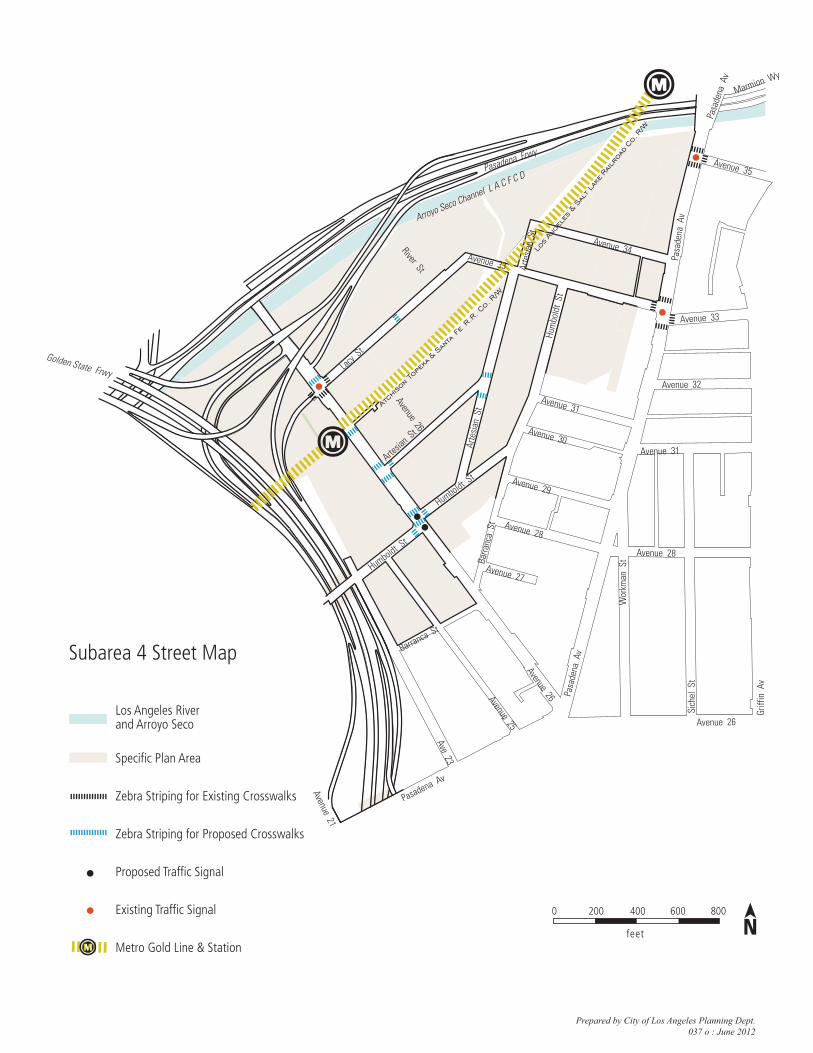
Los Angeles River and Arroyo Seco
Specific Plan Area
Zebra Striping for Existing Crosswalks
Zebra Striping for Proposed Crosswalks
Proposed Traffic Signal
Existing Traffic Signal
Metro Gold Line & Station
Prepared by City of Los Angeles Planning Dept.037 o : June 2012
Subarea 4 Street Map
Pasadena Av
Griff
in A
v
Golden State Frwy
Humboldt St
Avenue 26Avenue 25
Ave 23
Avenue 21
Barranca St
Pasadena Frwy
Arroyo Seco Channel L A C F C D
Lacy S
t
Artesia
n St
Arte
sian
St
Hum
bold
t St
Avenue 33
Avenue 34
Humboldt St
Avenue 27
Avenue 28
Avenue 29
Avenue 30
Avenue 31
Avenue 33
Avenue 32
Avenue 31
Avenue 28
Barra
nca
St
Pasa
dena
Av
Sich
el S
t
Pasa
dena
Av
Pasa
dena
Av
Marmion Wy
Los An
gele
s & Sa
lt Lak
e Ra
ilroa
d Co
. R/W
Atch
ison To
peka
& San
ta Fe R.
R. Co. R/W
River St
Avenue 35
Avenue 26
Wor
kman
St
Avenue 26
Arte
sian
St
feet
0 200 400 600 800

Riverside Dr
Golden State Frwy
Blake Av
Arnold
St
Barclay
St
Oros S
tHuro
n St
Figuer
oa St
Arroyo
Seco A
v
Cypress Av
River St
Loreto St
Avenue 27
Avenue 28
Avenue 26 Idell S
t
Jeffrie
s St
San
Fern
ando
Rd
Figuer
oa St
San Fernando Rd
Huron St
Aven
ue 1
9
Huron S
t
Ave 22South
ern
Pac
ific
Railr
oad
Co. R/W
Stat
e Ra
ilroa
d R
/W
Pasad
ena
Frwy
Pasadena Frwy
Arroyo Seco Channel L A C F C D
Marmion W
y Marmion Wy
Pasa
dena
Av
Figuer
oa St
L os A
ng
el e
s Ri v e
r
Los Angeles River and Arroyo Seco
Specific Plan Area
Zebra Striping for Existing Crosswalks
Zebra Striping for Proposed Crosswalks
Existing Traffic Signal
Existing Stop Sign
Metro Gold Line & Station
feet
0 200 400 600 800
Prepared by City of Los Angeles Planning Dept.037 p: June 2012
Subarea 5 Street Map