Embed Size (px)
Citation preview
Exhibit K
Compliance with Statewide Planning Goals
Nolin Hills Wind Power Project February 2020
Prepared for
d/b/a Nolin Hills Wind, LLC
Prepared by
Tetra Tech, Inc.

This page intentionally left blank
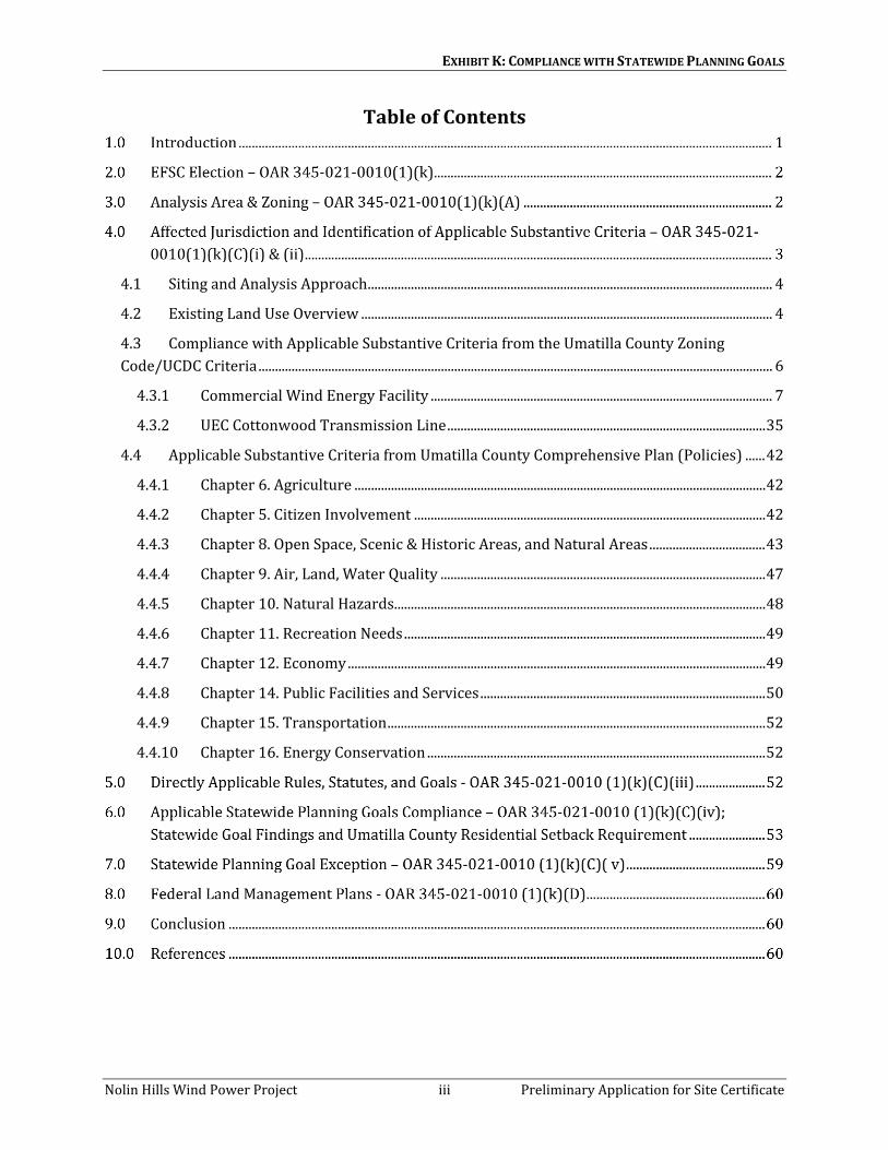
EXHIBIT K: COMPLIANCE WITH STATEWIDE PLANNING GOALS
Nolin Hills Wind Power Project iii Preliminary Application for Site Certificate
Table of Contents
4.1 Siting and Analysis Approach .......................................................................................................................... 4
4.2 Existing Land Use Overview ............................................................................................................................ 4
4.3 Compliance with Applicable Substantive Criteria from the Umatilla County Zoning Code/UCDC Criteria ........................................................................................................................................................... 6
4.3.1 Commercial Wind Energy Facility ....................................................................................................... 7
4.3.2 UEC Cottonwood Transmission Line ................................................................................................ 35
4.4 Applicable Substantive Criteria from Umatilla County Comprehensive Plan (Policies) ...... 42
4.4.1 Chapter 6. Agriculture ............................................................................................................................ 42
4.4.2 Chapter 5. Citizen Involvement .......................................................................................................... 42
4.4.3 Chapter 8. Open Space, Scenic & Historic Areas, and Natural Areas ................................... 43
4.4.4 Chapter 9. Air, Land, Water Quality .................................................................................................. 47
4.4.5 Chapter 10. Natural Hazards ................................................................................................................ 48
4.4.6 Chapter 11. Recreation Needs ............................................................................................................. 49
4.4.7 Chapter 12. Economy .............................................................................................................................. 49
4.4.8 Chapter 14. Public Facilities and Services ...................................................................................... 50
4.4.9 Chapter 15. Transportation .................................................................................................................. 52
4.4.10 Chapter 16. Energy Conservation ...................................................................................................... 52

EXHIBIT K: COMPLIANCE WITH STATEWIDE PLANNING GOALS
Nolin Hills Wind Power Project iv Preliminary Application for Site Certificate
List of Tables Table K-1. High-Value, Arable, and Nonarable Lands In and Around the Site Boundary and
Micrositing Corridors ....................................................................................................................................... 5
List of Figures Figure K-1. Analysis Area
Figure K-2. Zoning
Figure K-3. Land Use
Figure K-4. NRCS Soil Classifications
Figure K-5. High-Value Farmland
Figure K-6. Arable and Non-Arable Land
Figure K-7. Setbacks

EXHIBIT K: COMPLIANCE WITH STATEWIDE PLANNING GOALS
Nolin Hills Wind Power Project v Preliminary Application for Site Certificate
Acronyms and Abbreviations Applicant Nolin Hills Wind, LLC
ASC Applicant for Site Certificate
AVA American Viticultural Area
BMP best management practice
CRP Conservation Reserve Program
CTUIR Confederated Tribes of the Umatilla Indian Reservation
EFSC or Council Energy Facility Siting Council
EFU Exclusive Farm Use
I-84 Interstate 84
kV kilovolt
NOI Notice of Intent
NRCS Natural Resources Conservation Service
O&M operations and maintenance
OAR Oregon Administrative Rule
ODEQ Oregon Department of Environmental Quality
ODFW Oregon Department of Fish and Wildlife
ONHT Oregon National Historic Trail
ORS Oregon Revised Statutes
Project Nolin Hills Wind Power Project
ROW right-of-way
RPS Renewable Portfolio Standard
SCADA supervisory control and data acquisition
SHPO State Historic Preservation Office
UCCP Umatilla County Comprehensive Plan
UCDC Umatilla County Development Ordinance or Code
UEC Umatilla Electric Cooperative
UGB urban growth boundary

EXHIBIT K: COMPLIANCE WITH STATEWIDE PLANNING GOALS
Nolin Hills Wind Power Project vi Preliminary Application for Site Certificate
This page intentionally left blank.

EXHIBIT K: COMPLIANCE WITH STATEWIDE PLANNING GOALS
Nolin Hills Wind Power Project 1 Preliminary Application for Site Certificate
Introduction
Exhibit K demonstrates that the Nolin Hills Wind Power Project (Project) complies with the Energy Facility Siting Council’s (EFSC or Council) land use standard in Oregon Administrative Rule (OAR) 345-022-0030, which provides:
OAR 345-022-0030, Land Use
(1) To issue a site certificate, the Council must find that the proposed facility complies with the statewide planning goals adopted by the Land Conservation and Development Commission.
(2) The Council shall find that a proposed facility complies with section (1) if:
(a) The applicant elects to obtain local land use approvals under ORS 469.504(1)(a) and the Council finds that the facility has received local land use approval under the acknowledged comprehensive plan and land use regulations of the affected local government; or
(b) The applicant elects to obtain a Council determination under ORS 469.504(1)(b) and the Council determines that:
(A) The proposed facility complies with applicable substantive criteria as described in section (3) and the facility complies with any Land Conservation and Development Commission administrative rules and goals and any land use statutes directly applicable to the facility under ORS 197.646(3);
(B) For a proposed facility that does not comply with one or more of the applicable substantive criteria as described in section (3), the facility otherwise complies with the statewide planning goals or an exception to any applicable statewide planning goal is justified under section (4); or
(C) For a proposed facility that the Council decides, under sections (3) or (6), to evaluate against the statewide planning goals, the proposed facility complies with the applicable statewide planning goals or that an exception to any applicable statewide planning goal is justified under section (4).
(3) As used in this rule, the "applicable substantive criteria" are criteria from the affected local government's acknowledged comprehensive plan and land use ordinances that are required by the statewide planning goals and that are in effect on the date the applicant submits the application. If the special advisory group recommends applicable substantive criteria, as described under OAR 345-021-0050, the Council shall apply them. If the special advisory group does not recommend applicable substantive criteria, the Council shall decide either to make its own determination of the applicable substantive criteria and apply them or to evaluate the proposed facility against the statewide planning goals.

EXHIBIT K: COMPLIANCE WITH STATEWIDE PLANNING GOALS
Nolin Hills Wind Power Project 2 Preliminary Application for Site Certificate
EFSC Election – OAR 345-021-0010(1)(k)
OAR 345-021-0010 (1)(k) Information about the proposed facility’s compliance with the statewide planning goals adopted by the Land Conservation and Development Commission, providing evidence to support a finding by the Council as required by OAR 345-022-0030. The applicant must state whether the applicant elects to address the Council's land use standard by obtaining local land use approvals under ORS 469.504(1)(a) or by obtaining a Council determination under ORS 469.504(1)(b). An applicant may elect different processes for an energy facility and a related or supporting facility but may not otherwise combine the two processes. Once the applicant has made an election, the applicant may not amend the application to make a different election. In this subsection, “affected local government” means a local government that has land use jurisdiction over any part of the proposed site of the facility. In the application, the applicant must….
Nolin Hills Wind, LLC (the Applicant) has elected to address EFSC's land use standard by obtaining a land use determination from EFSC pursuant to Oregon Revised Statutes (ORS) 469.504(1)(b) for the Project and all related and supporting facilities except the Umatilla Electric Cooperative (UEC) Cottonwood transmission line. This Preliminary Application for Site Certificate (ASC) has conservatively included the UEC Cottonwood transmission line as part of the Project and addressed its potential impacts in the applicable exhibits per EFSC standards and the applicable substantive criteria herein (see Section 4.3.2). Pending further discussions with UEC and the County, the Final ASC will be updated with the election (Council determination or local land use approval) for the UEC Cottonwood transmission line.
Upon issuance of an EFSC Site Certificate for the Project, the Applicant will submit conditional use and zoning permit applications to Umatilla County. After review of the permits, Umatilla County shall issue the permits without further conditions pursuant to ORS 469.401(3).
Analysis Area & Zoning – OAR 345-021-0010(1)(k)(A)
OAR 345-021-0010(1)(k)(A) Include a map showing the comprehensive plan designations and land use zones in the analysis area;
Pursuant to the Project Order, the Analysis Area for purposes of this exhibit is “the area within the Site Boundary and 0.5 miles from the Site Boundary.” Figure K-1 shows both the Site Boundary and the Analysis Area for this Exhibit. Figure K-2 provides the land use zones in the Analysis Area. All the land within the Analysis Area except the very northern section of the UEC Cottonwood transmission line corridor is zoned Exclusive Farm Use (EFU; see Figure K-2). The portion of the UEC Cottonwood transmission line corridor near Interstate 84 (I-84) includes areas of Rural Tourist Commercial, Agri Business, and Light Industrial zoning (see Figure K-2 inset).

EXHIBIT K: COMPLIANCE WITH STATEWIDE PLANNING GOALS
Nolin Hills Wind Power Project 3 Preliminary Application for Site Certificate
Affected Jurisdiction and Identification of Applicable Substantive Criteria – OAR 345-021-0010(1)(k)(C)(i) & (ii)
OAR 345-021-0010 (1)(k) (C) If the applicant elects to obtain a Council determination on land use:
(i) Identify the affected local governments;
(ii) Identify the applicable substantive criteria from the affected local government’s acknowledged comprehensive plan and land use regulations that are required by the statewide planning goals and that are in effect on the date the application is submitted and describe how the proposed facility complies with those criteria;
The Project is entirely within Umatilla County. A commercial wind power generation facility is a Conditional Use in Umatilla County. In its November 6, 2017 response to the Project Notice of Intent, Umatilla County identified the following applicable substantive criteria, which are addressed in Sections 4.3and 4.4:
• For the wind energy generation facility including related and supporting facilities such as access roads and collector lines - Umatilla County Development Ordinance or Code (UCDC) Sections 152.060, 152.061, 152.615, and 152.616(HHH)
• For the transmission lines and substations - UCDC Sections UCDC 152.059 and UCDC 152.617 (II)(7).
• The following Umatilla County Comprehensive Plan (UCCP) policies:
o Agriculture, Policies 1, 8 and 17;
o Citizen Involvement, Policies 1 and 5;
o Open Space, Scenic & Historic Areas, and Natural Areas, Policies 1(a), 5(a & b), 6(a), 8(a), 9(a), 10(c, d & e), 20 (a), 20(b)(1-8), 22, 23(a), 24(a), 26, 37 & 38(a-c), 39(a) and 42(a);
o Air, Land, Water Quality, Policies 1, 7 and 8;
o Natural Hazards, Policies 1 and 4;
o Recreational Needs, Policy 1;
o Economy of the County, Policies 1, 4 and 8(a-f);
o Public Facilities and Services, Policies 1(a-d), 2, 9 and 19;
o Transportation, Policies 18 and 20; and
o Energy Conservation, Policy 1.

EXHIBIT K: COMPLIANCE WITH STATEWIDE PLANNING GOALS
Nolin Hills Wind Power Project 4 Preliminary Application for Site Certificate
4.1 Siting and Analysis Approach
The Applicant is requesting micrositing flexibility for the Project’s facilities with regard to turbine selection, as well as the final layout for turbines, and related and supporting facilities. To allow flexibility in the choice of wind turbines available at the time of construction, this ASC analyzes impacts for two turbine models that represent a range of alternative turbine technologies (i.e., encompassing the scale and impacts of the turbines), while limiting the total maximum generating capacity to 350 megawatts. The turbine vendor, size, number, and actual turbine nameplate generating capacity that will ultimately be installed have not yet been determined.
This approach will allow the Applicant to select the most appropriate turbine model available at the time the turbines are acquired, so long as the turbines are of no greater impact than allowed for in the Site Certificate, and which satisfy all the conditions of Site Certificate. This flexibility is required because turbine manufacturers offer new turbine models with improved technology approximately every 1 to 2 years and retire older models. Before construction, the Applicant will determine the number of turbines in each corridor, the spacing between turbines, and their precise locations within the corridor, based on the wind turbine models selected and other various siting criteria.
The Project’s micrositing process is informed by substantial environmental due diligence. Surveys and studies have been completed as part of the siting process (as referenced in applicable Exhibits) to minimize environmental and land use impacts from the Project. The environmental due diligence is consolidated into detailed constraints mapping that is used and continually updated as necessary to guide Project micrositing and compliance with applicable standards and regulations and the Site Certificate. At the same time, siting of wind turbines is driven by many factors including land availability, habitat, landowner agreement, existing land uses, access, wind regime, turbine spacing requirements and wind farm energy generation optimization. Therefore, while some micrositing of the Project is anticipated prior to construction, substantial relocations are not anticipated due to these many interacting siting factors.
4.2 Existing Land Use Overview
To support the responses to the applicable substantive criteria, this section provides an existing land use conditions overview. As stated earlier, most of the Analysis Area is located in land primarily zoned EFU. However, as shown on Figure K-3, the majority of the Analysis Area (approximately 52,082 acres or 68 percent of the Analysis Area) includes uncultivated farm land primarily composed of grasslands including some areas of Conservation Reserve Program (CRP) lands. Exhibit P and Figure P-3 provide more detail on the surveyed habitats and ground cover within the Site Boundary.
The Analysis Area also includes areas with high-value farmland designations per ORS 195.300(10)(a), (c), and (f). These provisions are summarized below:

EXHIBIT K: COMPLIANCE WITH STATEWIDE PLANNING GOALS
Nolin Hills Wind Power Project 5 Preliminary Application for Site Certificate
• ORS 195.300(10)(a) relies on criteria related to soil types as classified by Natural Resources Conservation Service (NRCS). It includes land in a tract1 composed predominantly of soils that are irrigated or not irrigated, and classified as prime, unique, Class I, or Class II.
• ORS 195.300(10)(c) relies on the land in the EFU zone being located within a place of use water right, an irrigation district, or a diking district.
• ORS 195.300(10)(f) relies on the land in the EFU zone being located within the boundaries of the Columbia Valley viticultural area (see 27 Code of Federal Regulations Part 9, Subpart C - Approved American Viticultural Areas, Section § 9.74 Columbia Valley)—and meeting certain elevation (below 3,000 feet), slope (between zero and 15 percent), and aspect (between 67.5 and 292.5 degrees) criteria.
Approximately 7,726 acres or 10 percent of the Analysis Area is classified as high-value farmland by soil classification alone, per ORS 195.300(10)(a). However, Class I and II soils are not predominant on any given tract within the Site Boundary where the commercial wind facility will be sited, and the micrositing corridors largely avoid these Class I and Class II soil areas (see Figures K-4 and K-5).2 There are additional areas of high-value farmland per ORS 195.300(10)(a) along the UEC Cottonwood transmission line (see Figures K-4 and K-5). Approximately 12,067 acres within the Analysis Area (15 percent) meet the definition of high-value farmland under ORS 195.300(10)(c) place of use water rights (Figure K-5); however, these areas are primarily within the UEC Cottonwood transmission line corridor where it intersects with the Westland Irrigation District. While the entirety of the Analysis Area is within the Columbia Valley American Viticultural Area (AVA), high-value farmland per ORS 195.300(10)(f) occurs on a patchy basis throughout the Site Boundary and Analysis Area (see Figure K-5). In total, of the 78,618 acres within the Analysis Area, approximately 28,039 acres (36 percent) is classified as high-value farmland under ORS 195.300(10) (Table K-1, Figure K-5).
Table K-1. High-Value, Arable, and Nonarable Lands In and Around the Site Boundary and Micrositing Corridors
Land Type Acres (percent) in Analysis
Area Acres (percent) in Site
Boundary
Acres (percent) in Micrositing Corridors
High-value farmland 36% 24% 31% Arable 2 81% 78% 88% Nonarable 19% 22% 12% 1. High-value farmland designations per ORS 195.300(10)(a), (c), and (f) 2. Arable includes Class I-IV soils, cultivated land regardless of soil class, and high-value lands and soils.
1 "Tract" means one or more contiguous lots or parcels under the same ownership. Figures K-4 and K-5 show high value farmland and tracts within Analysis Area for the commercial wind power generation site. 2 In the EFU zone, transmission lines are reviewed as a utility necessary for public service (ORS 215.275) or associated transmission lines (ORS 215.274), which do not include criteria specific to high-value farmland.
EXHIBIT K: COMPLIANCE WITH STATEWIDE PLANNING GOALS
Nolin Hills Wind Power Project 6 Preliminary Application for Site Certificate
As shown on Figure K-6 and in Table K-1, most of the land in the Site Boundary and Analysis Area for the Project is arable. A large amount of the cultivated arable land within the Analysis Area is devoted to dryland winter wheat farming, predominantly producing soft white winter wheat. Dryland farming has evolved as a set of techniques and management practices used by farmers to continually adapt to the presence or lack of moisture in a given crop cycle. Winter wheat is generally planted in the fall, October or November, and harvested in summer months, July and August. Winter wheat is commonly grown on a 2-year wheat-fallow cycle, in which the field is allowed to lie fallow for one crop season between plantings. Wheat planted the following year can then take advantage of 2 years of accumulated soil moisture, greatly enhancing the likelihood of a successful harvest. These practices for dryland wheat farming include the use of a fallow period in a crop rotation, noted above, terracing or contour plowing, eliminating weeds and leaving crop residue to shade the soil, cover cropping, and strip cropping. Some farmers use a no-till method in which the field is sprayed with an herbicide following harvest and crop stubble is left on the field during periods when the field is fallow. Establishment of field crops includes weed control, field preparation, seed bed preparation, fertilization, and seeding or planting of the crop. Herbicides may be applied prior to field cultivation where perennial weeds or a heavy sod are present. In addition to dryland wheat farming, livestock grazing, mostly sheep, is a prevalent agriculture use in and around the Analysis Area.
As noted above, the vast majority of cultivated land within the Analysis Area is devoted to dryland winter wheat farming. The amount of land removed from cultivation to operate the wind farm is estimated to be a maximum of 76 acres, and the Project has been sited to minimize impacts to farmlands as noted throughout this exhibit. The Analysis Area includes one area of irrigated lands within the commercial wind energy facility siting area. The Project’s turbines will have no impact on these irrigation systems because the Project will skirt the edge of the irrigated fields and, in advance of construction, irrigation systems will be identified on-site with the landowner to avoid impact. Areas of irrigation along the UEC Cottonwood transmission line corridor will be spanned by the transmission line. As noted above, livestock grazing occurs in limited areas in and around the Analysis Area. Based upon experience in the Pacific Northwest farming community, sheep and other livestock are commonly observed in close proximity to wind turbines, utilizing the shade of the towers on hot days. Sheep and other livestock grazing is compatible with wind farms. In general, wind energy can help to make livestock grazing and other agricultural practices more sustainable by providing a reliable income stream for the rancher or farmer.
4.3 Compliance with Applicable Substantive Criteria from the Umatilla County Zoning Code/UCDC Criteria
The Applicant is addressing the applicable substantive criteria for the commercial wind energy facility and related and supporting facilities (to be constructed and owned and operated by the Applicant) separately from the UEC Cottonwood transmission line. Section 4.3.1 addresses the criteria for the commercial wind facility including Project substations, the 230-kilovolt (kV) Project substation connector line, and the BPA Stanfield transmission line option. Section 4.3.2 addresses the standards for the potential UEC Cottonwood transmission line that would be located within the
EXHIBIT K: COMPLIANCE WITH STATEWIDE PLANNING GOALS
Nolin Hills Wind Power Project 7 Preliminary Application for Site Certificate
Site Boundary but owned and operated by the UEC (see also Exhibit B for a detailed description of the facilities).
4.3.1 Commercial Wind Energy Facility
4.3.1.1 UCDC §152.059 LAND USE DECISIONS
In an EFU zone the following uses may be permitted through a land use decision via administrative review (§ 152.769) and subject to the applicable criteria found in §152.617. Once approval is obtained a zoning permit (§152.025) is necessary to finalize the decision.
(C) Utility facilities necessary for public service, including wetland waste treatment systems but not including commercial facilities for the purpose of generating electrical power for public use by sale or transmission or communication towers over 200 feet in height. A utility facility necessary for public service may be established as provided in ORS 215.275 and in § 152.617 (II) (7).
Response: Umatilla County’s response to the Notice of Intent (NOI) provided that the transmission lines and Project collector substations will be processed by the County as a Land Use Decision for Utility Facility Necessary for Public Service. Hence, from the County’s perspective, these facilities are authorized pursuant to ORS 215.283(1)(c), with criteria for approval addressed in ORS 215.275 and 215.274. The Applicant asserts that the Project’s collector substations should be reviewed as related to and supporting the “commercial utility facility for the purpose of generating power for public use by sale” (ORS 215.283(2)(g)) because they will solely provide internal facility functions. Collector substations have consistently been reviewed by the Council as an inherent part of a wind energy facility.
According to past site certificate orders, similar to Umatilla County, the Council reviews the Project substation connector line as “utility facilities necessary for public service” because the internal transmission structures and lines are indistinguishable from interconnection or other types of transmission towers or lines. Utility facilities necessary for public service are permitted in the EFU zone, subject to the criteria established in OAR 660-033-0130(16), which mirror the requirements of ORS 215.275. A utility facility necessary for public service may alternatively be established in an EFU zone if it meets the requirements for an associated transmission line as defined in ORS 215.274 and 469.300. Those statutes define an "associated transmission line" as a "new transmission line constructed to connect an energy facility to the first point of junction of such transmission line … with either a power distribution system or an interconnected primary transmission system or both or to the Northwest Power Grid." The Project substation connector line cannot be characterized as a utility facility necessary for public service as defined by ORS 215.274 because it does not connect to the Northwest Power Grid. The towers for the Project substation connector line will all be less than 200 feet in height. Thus, the line, if reviewed as a utility facility for public service, would be permitted administratively subject to ORS 215.275, which is addressed in Section 4.3.1.6. The BPA Stanfield transmission line option is addressed as an associated transmission line under ORS 215.274 (see Section 4.3.1.6) because it connects to the Northwest Power Grid. The UEC
EXHIBIT K: COMPLIANCE WITH STATEWIDE PLANNING GOALS
Nolin Hills Wind Power Project 8 Preliminary Application for Site Certificate
transmission line is addressed as a transmission line under ORS 215.275 and is addressed independent of the commercial wind facility in Section 4.3.2.
4.3.1.2 UCDC §152.060 CONDITIONAL USES PERMITTED
In an EFU zone the following uses may be permitted conditionally via administrative review (§ 152.769), subject to the requirements of this section, the applicable criteria in § 152.061, §§ 152.610 through 152.615, 152.617 and §§ 152.545 through 152.562. A zoning permit is required following the approval of a conditional use pursuant to § 152.025. Existing uses classified as conditional uses and listed in this section may be expanded subject to administrative review and subject to the requirements listed in OAR 660, Division 033.
(F) Commercial utility facilities for the purpose of generating power for public use by sale as provided in § 152.617 (I)(C). (For specific criteria for Wind Power Generation see § 152.617 (I)(W)3)
Response: The Project, except the Project substation connector line and external transmission lines (UEC Cottonwood transmission line and BPA Stanfield transmission line options), meets the definition of a commercial utility facility as defined in UCDC §152.617(I)(C) and ORS 215.283(2)(g). See the sections below for a discussion of the Project’s compliance or noncompliance with the applicable criteria listed in UCDC §152.061, §152.615, §152.616, and §152.617.
Under ORS 469.401(3), following issuance of the Site Certificate, the County, upon the Applicant’s submission of the proper application and fee, shall issue the conditional use and zoning permits addressed in the Site Certificate, subject only to the conditions set forth in the Site Certificate and without hearings or other proceedings.
4.3.1.3 UCDC §152.061 STANDARDS FOR ALL CONDITIONAL USES [IN EFU ZONE]
The following limitations shall apply to all conditional uses in an EFU zone. Uses may be approved only where such uses:
(A) Will not force a significant change in accepted farm or forest practices on surrounding lands devoted to farm or forest use; and
(B) Will not significantly increase the cost of accepted farm or forest practices on lands devoted to farm or forest use.
Response: There is no forest use within the Analysis Area or Site Boundary as shown on Figure K-2. The lands devoted to farm use in Umatilla County are used primarily for cultivation of wheat and grazing of livestock, and related accessory uses. Also included in the Analysis Area are grasslands and other areas that are not economical to cultivate, but which are interspersed with cultivated lands devoted to farm use. These grasslands include “wasteland” consistent with the definition under ORS 215.203. Based on the definition of farm use, essentially the entire 48,077-acre area
3 UCDC §152.617(I)(W) has been deleted in its entirety and the reader is cross-referenced to UCDC §152.616(HHH), which is discussed in Section 3.4.1.5.

EXHIBIT K: COMPLIANCE WITH STATEWIDE PLANNING GOALS
Nolin Hills Wind Power Project 9 Preliminary Application for Site Certificate
within the Site Boundary except developed roadways is considered devoted to farm use per ORS 215.203; of this, approximately 13,263 acres are currently used for dryland wheat farming or irrigated agriculture, and the remainder is nonnative and native grasslands. The Project will only remove a maximum of approximately 95 acres from farm use and 76 acres from cultivation. The Project also may remove some areas (approximately 12 acres) that are typically used for sheep grazing; however, the land is expected to support the same number of sheep because of the intermittent nature of the Project footprint.
The impact of the Project will not force a significant change in accepted farm practices or significantly increase the cost of farm practices in the Analysis Area, for the following reasons:
• Facility components and temporary construction laydown and staging areas are being sited to minimize disturbance to farming operations including unnecessarily dividing fields.
• Land permanently lost to farm use due to siting of permanent Project improvements is a de minimis percentage of the total farm use land in Umatilla County—less than 0.01 percent of the 1,308,312 acres of land in farms (USDA 2012). Therefore, the inability to use the land for farm purposes is not significant.
• Project access roads and other facilities will be constructed and maintained by the Applicant such that the cost burden for maintenance does not fall upon the farm or ranch owners.
• Project access roads improved or developed for the Project could benefit agricultural users of land in the Analysis Area through improved access to farm fields and resulting lower fuel costs.
• While some increase in traffic is anticipated during construction, Exhibit U demonstrates that the temporary increase in the level of traffic will not significantly impact level of service on local roads. Therefore, construction traffic will not interfere with harvest time activities such as tractor movement between fields or trucks delivering agricultural products to market.
• The Applicant will record in the real property records of Umatilla County a Covenant Not to Sue against its Project leasehold interests with regard to generally accepted farming practices on adjacent farmland.
• The Project will not limit or impact current or future farm activities on the surrounding land and will not diminish the opportunity for neighboring parcels to expand, purchase, or lease any vacant land available for agricultural uses.
• The Applicant will implement a weed control plan during construction and operation that will reduce the risk of weed infestation in cultivated land and the associated cost to the farmer for weed control (see Attachment P-4 to Exhibit P for weed prevention and control measures).
EXHIBIT K: COMPLIANCE WITH STATEWIDE PLANNING GOALS
Nolin Hills Wind Power Project 10 Preliminary Application for Site Certificate
• The Project will not affect the application of pesticides or fertilizers using ground-based methods. Aerial spraying may be utilized for application of pesticides or fertilizers to crops within the Analysis Area. Although the presence of wind turbines can increase both the difficulty and the risk of aerial spraying in the vicinity of a wind farm, the presence of wind turbines does not remove the possibility of aerial spraying in an area, as spray pilots commonly fly at very low altitudes, navigating around terrain, trees, utility poles, transmission lines, farm structures, and other obstacles. In addition, compared to other applications approved by EFSC (e.g., Wheatridge, Shepherds Flat South, Golden Hills, Montague), there are substantially fewer areas of the Site Boundary and adjacent to the Site Boundary that are actively farmed and would potentially use aerial spraying.
• Construction and operation of the Project could cause changes in routes of access to fields and changes in the pattern of cultivation, seeding, fertilizing and harvesting near the turbines and access roads. To minimize this, the Applicant, in consultation with the landowners, will minimize obstacles to farming in cultivated fields (facility components around which the farmer would have to plow, plant, and harvest).
• Construction of the Project could adversely affect soil quality by erosion or compaction. Some farmland would be temporarily disturbed and unavailable for farming during construction. To avoid or reduce adverse impacts to soil quality, the Applicant will implement dust control and erosion-control measures during construction and operation of the facility (see Exhibit I). To the extent practicable, the Applicant proposes to reduce impact to soils by using areas that are already disturbed and limiting the area of new disturbance.
• Construction vehicles will use previously disturbed areas including existing roadways and tracks. When practical, temporary construction yards and laydown areas will be located within existing disturbed areas or the future footprint of permanent structures. The width of new permanent roadways will be the minimum consistent with safe use. Underground communication and electrical lines will be buried within the area disturbed by temporary road widening to the extent practicable, and turbine foundations will abut roadways as closely as possible. Upon completion of construction, the Applicant will restore temporarily disturbed areas to their pre-construction condition (see Attachment P-4 to Exhibit P for revegetation measures).
The measures above are intended to avoid or minimize the impacts of the Project on farming operations in the Analysis Area, and to mitigate for necessary impacts. The Applicant will consult with area landowners during construction and operation of the Project to determine further measures to reduce or avoid any adverse impacts to farm practices on surrounding lands and to avoid any increase in farming costs.
As it relates to farm practices on the participating landowners’ properties, the Project is designed and legally structured through lease agreements such that the cost burden of constructing and maintaining access roads and other facilities would not fall on the landowner and would not
EXHIBIT K: COMPLIANCE WITH STATEWIDE PLANNING GOALS
Nolin Hills Wind Power Project 11 Preliminary Application for Site Certificate
increase the costs of farming for affected landowners. Additionally, each participating landowner will be compensated for the loss of agricultural lands, and the new income stream from lease payments will help to stabilize fluctuating agricultural income, making farming more sustainable. Therefore, the Project would not force a significant change in accepted farm practices or significantly increase the cost of farm practices,
4.3.1.4 UCDC §152.615 ADDITIONAL CONDITIONAL USE PERMIT RESTRICTIONS
In addition to the requirements and criteria listed in this subchapter, the Hearings Officer, Planning Director or the appropriate planning authority may impose the following conditions upon a finding that circumstances warrant such additional restrictions: [list of conditions omitted for brevity]
Response: To the extent any restrictions or conditions of the type listed in Section 152.615 are deemed necessary to mitigate the impacts of the Project, they will be implemented through the EFSC Site Certificate process consistent with ORS 469.401(2).
4.3.1.5 UCDC §152.616 (HHH) CONDITIONAL USE CRITERIA FOR COMMERCIAL WIND POWER GENERATION FACILITIES
Response: UCDC §152.616(HHH)(1) provides that the procedural requirements of 152.616(HHH)(1) through (5) do not apply to a wind energy facility for which EFSC is making the land use decision. In general, UCDC §§152.616(HHH)(1) through (4) contain only procedural requirements, while UCDC §152.616(HHH)(5) provides both procedural and substantive requirements in the form of a list of conditional use application submittal requirements. As a result, this application only discusses the substantive criteria of 152.616§§ (HHH)(5) through (11).
UCDC §152.616(HHH)(5) Application Requirements
The following information shall be provided as part of the application, or subject to the County’s discretionary authority, be required prior to the construction or operation of the Wind Power Generation Facility through a condition of approval: [subsections (a) through (l) omitted for brevity]
Response: Except for subsection (d), UCDC §156.616(HHH)(5) lists materials that are required to be submitted to the County as part of an application for a County Conditional Use Permit. Consequently, those requirements are procedural in nature and do not apply to this Project, for which the Applicant is electing an EFSC decision on land use. Therefore, the information submitted as part of this ASC, or that will be provided as conditions of the Site Certificate, will satisfy all of the information requirements identified by Umatilla County. Subsection (d) requires a demonstration of compliance with UCDC §152.061, which is discussed above. Thus, to the extent it applies, this criterion is satisfied.
UCDC §152.616(HHH)(6) Standards/Criteria of Approval; Statewide Goal Findings to Address Residential Setback Criteria

EXHIBIT K: COMPLIANCE WITH STATEWIDE PLANNING GOALS
Nolin Hills Wind Power Project 12 Preliminary Application for Site Certificate
The following requirements and restrictions apply to the siting of a Wind Power Generation Facility:
(a) Setbacks. The minimum setback shall be a distance of not less than the following:
(1) From a turbine tower to a city urban growth boundary (UGB) shall be two miles. The measurement of the setback is from the centerline of a turbine tower to the edge of the UGB that was adopted by the city as of the date the application was deemed complete.
Response: The Project is consistent with this standard. The micrositing corridors are located no closer than approximately 2 miles from the nearest UGB in Umatilla County, for the city of Echo.
(2) From turbine tower to land zoned Unincorporated Community (UC) shall be 1 mile.
Response: The Project is consistent with this standard. There are no lands zoned UC within one mile of the micrositing corridors.
(3) From a turbine tower to a rural residence shall be 2 miles. For purposes of this section, "rural residence" is defined as a legal, existing single family dwelling meeting the standards of §152.058 (F)(1)-(4), or a rural residence not yet in existence but for which a zoning permit has been issued, on a unit of land not a part of the Wind Power Generation Facility, on the date a Wind Power Generation Facility application is submitted. For purposes of this section, the setback does not apply to residences located on properties within the Wind Power Generation Facility project application. The measurement of the setback is from the centerline of the turbine tower to the center point of the rural residence.
Response: Although the turbine locations have not been finalized, some of the final locations may not ultimately meet the above setback standard for rural residences outside of the Project lease area (see Figure K-7). This may be the case for up to approximately eight rural residences based on evaluation of Turbine Option 2 (see Exhibit C). Of those eight rural residences, almost all will be more than a mile away from a turbine tower including three residences that are over 1.9 miles and two over 1.7 miles from a turbine. Additionally, the second closest rural residence has executed a “Good Neighbor Agreement Waiver” with the Applicant. Because the setback criterion is not a land use regulation required by the statewide planning goals, it does not qualify as one of the “applicable substantive criteria” defined in OAR 345-022-0030(3).4 Therefore, the Project is not subject to the
4 ORS 469.504(b)(A) provides that a proposed energy facility “shall be found in compliance with the statewide planning goals under ORS 469.503(4)” if the Facility “complies with applicable substantive criteria from the affected local government’s acknowledged comprehensive plan and land use regulations that are required by the statewide planning goals and in effect on the date the application is submitted, and with any Land Conservation and Development Commission administrative rules and goals and any land use statutes that apply directly to the facility under ORS 197.646 (Implementation of new requirement in goal, rule or statute).” Further, in its evaluation of the energy facility against the local applicable substantive criteria, EFSC may approve an energy facility if “the proposed facility does not comply with one or more of the applicable substantive criteria but does otherwise comply with the applicable statewide planning goals.” ORS

EXHIBIT K: COMPLIANCE WITH STATEWIDE PLANNING GOALS
Nolin Hills Wind Power Project 13 Preliminary Application for Site Certificate
setback criterion. In addition, as noted in the Proposed Order, if the proposed Project does not comply with one or more of the applicable substantive criteria, the Applicant can demonstrate that the Project nevertheless complies with the applicable statewide planning goals. Section 5.0 demonstrates the Project complies with all statewide planning goals, specifically applicable statewide planning goals, Goal 3 and Goal 14, which are also discussed below.
The purpose of Goal 3 is to preserve agricultural land. The 2-mile residential setback does not in any way relate to or impact the preservation or protection agricultural lands or agricultural practices. The setback does not in any other way address any requirements of any statewide planning goal. As stated in previous sections, the Project will not force a significant change in accepted farm practices or significantly increase the cost of farm practices, either within the Site Boundary or within the Analysis Area. Facility components and temporary construction laydown and staging areas are being sited to minimize disturbance to farming operations including unnecessarily dividing fields. In addition, land permanently lost to farm use due to siting of permanent Project improvements is a de minimis percentage of the total farm use land in Umatilla County, less than 1 percent. The purpose of the EFU Zone is to protect and maintain agricultural lands for farm use, consistent with existing and future needs for agricultural products. The EFU zone is also intended to allow other uses that are compatible with agricultural activities. Commercial wind energy facilities are an allowed use on EFU land subject to county/state review per OAR 660-033-0120. This exhibit provides the county/state review for the allowed use consistent with OAR 660-033-0120.
The Project is designed to minimize a variety of constraints while meeting the Project’s purpose to provide significant renewable energy generation concentrated on a single site. These environmental and land use constraints have been integrated with siting requirements for wind turbines such as land availability, landowner agreement, access, wind regime, turbine spacing requirements, and wind farm optimization. The Project has been sited considering on-site factors and constraints as well as relevant off-site impacts. The Project has been sited to minimize and avoid the following on-site and off-site constraints and impacts, which are further addressed in other exhibits within this ASC:
• The Project will avoid impacts to Washington ground squirrel habitat (Exhibits P and Q).
• The Project will avoid impacts to cultural resources (Exhibit S).
• The carrying capacity of public resources and facilities will not be impacted. The Applicant will enter into a Road Use Agreement with Umatilla County for potential public road impacts. Adverse impacts to public services and facilities are not anticipated (see Exhibit U).
• The Project will not emit any odor or impact air quality.
• As noted in Exhibit X, the Project will meet all applicable Oregon Department of Environmental Quality (ODEQ) regulations (OAR 340-035-0035) for noise impacts.
469.504(b)(B). See, Save Our Rural Or. v. EFSC, 121 P.3d 1141 (Or. 2005). See Section 5 below for Statewide Goal Findings and Analysis.
EXHIBIT K: COMPLIANCE WITH STATEWIDE PLANNING GOALS
Nolin Hills Wind Power Project 14 Preliminary Application for Site Certificate
• The presence of the Project facilities, primarily the wind turbines, will be non-natural vertical elements in locations where they are visible. As demonstrated in Exhibits L, R, and T, the Project will not result in significant adverse impacts to protected areas, scenic resources, or recreational resources (see Exhibit R). Development of the Project facilities will result in minimal changes to the existing topography, landforms and land cover. The Applicant will implement best management practices (BMPs; outlined in Exhibit R) to blend the appearance of the Project facilities and limit their visual contrast in the landscape to the extent practicable. Most importantly, most residences are at lower elevations where turbines are not visible because of impeding terrain or fewer turbines are visible (see Exhibit R, Figures R-2 and R-3).
• As discussed in Exhibit DD, the Project has been designed to avoid dangers to human safety. Public access to Project facilities will be minimal because the Project will be located on private lands; therefore, public access is already limited. Access roads developed or improved for the purposes of Project construction and operation will be gated and locked when not actively in use. During operation, a rigorous inspection program of the turbine foundations is maintained. In addition, the supervisory control and data acquisition (SCADA) system (described in Exhibit B) acts as the “nerve center” of the Project by connecting individual turbines, substation(s), and meteorological towers to a central computer housed in the Operations and Maintenance (O&M) Building. The SCADA system allows each component of the Project to be monitored for activity in present time. If an issue arises with a turbine, it alerts the O&M staff so that turbine(s) can be shut down to minimize consequences of failure and potential safety risks. In addition, the Project is designed to maintain substantial setbacks such that, in the highly unlikely event of a catastrophic failure, the collapsed turbine or thrown blades could not impact public roads or nonparticipating property owners.
Where Goal 3 protects agricultural land, Goal 14 provides for an orderly and efficient transition from rural to urban land use. Commercial wind energy facilities are generally not permitted within UGBs or unincorporated community areas that may include more concentrated rural residences but also other community supporting land uses such as commercial development and public uses (including but not limited to schools, churches, grange halls, post offices). As stated above, there will be no turbine towers within 2 miles of a UGB and 1 mile of an unincorporated community, consistent with those setback standards. Interestingly, the setback for rural residences in this standard, which defers to the definition of a rural residence in the EFU zone (UCDC §152.058 (F)(1)-(4)), requires a larger setback (2 miles) than for an unincorporated community (1 mile) which also contains residences, and often a greater density of residences.
In consideration of the diligent Project siting considerations for on- and off-site impacts reviewed above, state land use regulations that allow for commercial wind facilities on EFU land, sufficient buffers from residences in UGBs and unincorporated communities, and balancing the rights and interests of property owners inside and outside the lease area, the Applicant requests that the 2-mile rural residence setback from a turbine tower be replaced with a 0.5-mile setback for turbines

EXHIBIT K: COMPLIANCE WITH STATEWIDE PLANNING GOALS
Nolin Hills Wind Power Project 15 Preliminary Application for Site Certificate
from rural residences outside the Site Boundary. A 0.5-mile setback is sufficient to address any potential safety concerns related to the wind turbine operation, such as ice “throw” which could occur in unusual weather conditions. The 0.5-mile setback provides a logical setback distance on EFU zoned land where commercial wind energy is an allowed use and follows the setback methodology used for the UGB and unincorporated community, which reduces the setback by half for zoning that provides for less dense residential development. Moreover, for the Helix Wind Power Facility that was sited in Umatilla County, the Council declined to apply the 2-mile setback land use regulation during the contested case, which included an assertion of threat to public health and safety because it would be a departure from the public health setback of 0.25 mile that has been applied most commonly by EFSC.5
The setback of 0.5 mile (2,640 feet) would be measured from the centerline of the turbine tower to the center of the house outside the Site Boundary and would apply to residences existing at the time of Project construction.
In addition to the 0.5-mile setback for turbines from rural residences outside the Site Boundary, the Applicant is proposing a setback from non-leased parcels of 110 percent of maximum blade tip height, measured from the centerline of the turbine tower to the nearest boundary of the Applicant’s lease area or Site Boundary. This setback is a common safety setback in most existing EFSC site certificates (e.g., Shepherds Flat, Stateline, Wheatridge, Montague, Leaning Juniper). By providing these two setbacks, the Applicant is adequately protecting the rights and safety of property owners outside the Site Boundary while providing a mechanism for property within the Site Boundary to avoid being unnecessarily restricted by local land use regulations for development of a use that is allowed by state law.
Because the Project complies with all “applicable substantive criteria,” and to the extent that those criteria are not met, the Project complies with applicable statewide planning goals (see Section 5), a goal exception is not required. Therefore, the Council may find compliance with statewide planning goals under ORS 459.504(1)(b)(B) especially considering the proposed setbacks of 0.5 mile from a turbine tower to rural residences outside the Site Boundary and 110 percent of maximum blade tip height, measured from the centerline of the turbine tower to the nearest boundary of the Applicant’s lease area or Site Boundary.
(4) From a turbine tower to the boundary right-of-way of County Roads, state and interstate highways, 110% of the overall tower-to-blade tip height. Note: The overall tower-to-blade tip height is the vertical distance measured from grade to the highest vertical point of the blade tip.
Response: Because the tallest turbine type under consideration is 656 feet in overall height, the minimum setback could be as much as 722 feet. Depending on the turbine model selected, the Project will be microsited to meet the 110 percent overall tower to blade height from public right-of-way (ROW). The Project will, therefore, be in compliance with this requirement.
5 Final Order on Final Order Denying a Contested Case Proceeding and Approving Amendment #2 for the Helix (August 24, 2012).
EXHIBIT K: COMPLIANCE WITH STATEWIDE PLANNING GOALS
Nolin Hills Wind Power Project 16 Preliminary Application for Site Certificate
(5) From tower and project components, including transmission lines, underground conduits and access roads, to known archeological, historical or cultural sites shall be on a case by case basis, and for any known archeological, historical or cultural site of the Confederated Tribes of the Umatilla Indian Reservations the setback shall be no less than 164 feet (50 meters).
Response: Exhibit S provides information on the historic, cultural, and archaeological resources that may potentially be impacted by the Project. The information in Exhibit S demonstrates that the Project will comply with the EFSC’s Historic, Cultural, and Archaeological Resources Standard, OAR 345-022-0090.
The Confederated Tribes of the Umatilla Indian Reservation (CTUIR) has taken an active role in the Project, conducting site visits, preparing a project-specific Traditional Use Study, and participating in the cultural resource pedestrian surveys. In both turbine option scenarios, the Project is designed to maintain a minimum 50-meter (164-foot) setback to most identified significant (NRHP-listed or likely eligible for listing on the NRHP) archaeological, historic, and cultural resources, including archaeological resources of the CTUIR in Umatilla County. There are three exceptions to this: the historical route of the Oregon National Historic Trail (ONHT), one archaeological site (NH-MC-12), and one historic site (NH-DM-02).
The Applicant will design the selected transmission line route to avoid direct impacts to all identified trail ruts as well as the National Park Service–designated ONHT route. Any indirect visual or auditory impacts will be determined and mitigated through consultation with SHPO and the Oregon-California Trails Association. This additional work will occur on a continuing basis. Any indirect impacts on the ONHT and associated archaeological sites are anticipated to be mitigated to less than significant.
The disturbance footprint associated with the BPA Stanfield transmission line6 is within 50 meters (164 feet) of pre-contact site NH-MC-12. If this transmission line is constructed, the site will be monitored when construction occurs within less than 200 feet to ensure significant impacts are avoided. The site will also be specifically addressed through consultations with the CTUIR.
Although a disturbance area associated with a new access road is proposed within the site boundary of NH-DM-02 under each turbine option scenario, the site consists of a standing historic building and structure, which are set back farther from the disturbance footprint. The road avoids the aboveground features of the site, and the proximity of the road to the historic site boundary is therefore not anticipated to have a significant impact. As such, significant impacts on the site are not anticipated as a result of the Project.
Avoidance of these resources will be ensured through monitoring during construction (see Exhibit S, Section 4). Exhibit S, Table S-3 lists the resources and the nearest distance to the Project’s disturbance footprint. As noted in Exhibit S, indirect (visual and auditory) impacts on 29
6 The BPA Stanfield transmission line is an associated transmission line per ORS 215.274.
EXHIBIT K: COMPLIANCE WITH STATEWIDE PLANNING GOALS
Nolin Hills Wind Power Project 17 Preliminary Application for Site Certificate
archaeological sites are anticipated. However, these impacts will be mitigated to less than significant.
(6) New electrical transmission lines associated with the project shall not be constructed closer than 500 feet to an existing residence without prior written approval of the homeowner, said written approval to be recorded with county deed records. Exceptions to the 500 feet setback include transmission lines placed in a public right of way. Note: Transmission and distribution lines constructed and owned by the applicant that are not within the project boundary are subject to a separate land use permit.
Response: No dwellings are located within 500 feet of the Project substation connector line or BPA Stanfield transmission line option. For the UEC Cottonwood transmission line, which is within the Site or Project Boundary but which will be constructed and operated by UEC, the entire transmission line will be within a public ROW corridor owned and operated by UEC. Hence, the setback requirement does not apply due to the transmission line being placed in public right of way. Note, according to the UCDC §150.03, the definition for ROW is: “Land reserved, used, or to be used for a highway, street, alley, walkway, drainage facility, or other public purpose.” The UEC Cottonwood transmission line will be used for public purpose, to transmit energy to the public for use; therefore, the UEC ROW is land that is used for public purpose.
(7) The turbine/towers shall be of a size and design to help reduce noise or other detrimental effects. At a minimum, the Wind Power Generation Facility shall be designed and operated within the limits of noise standard(s) established by the State of Oregon. A credible noise study may be required to verify that noise impacts in all wind directions are in compliance with the State noise standard.
Response: The analysis presented in Exhibit X demonstrates that the Project can be operated within the limits of the State of Oregon’s noise standards.
(b) Reasonable efforts shall be made to blend the wind turbine/towers with the natural surrounding area in order to minimize impacts upon open space and the natural landscape.
Response: No part of the Analysis Area is designated open space. Nonetheless, the Project is designed to minimize impacts upon undeveloped lands and the natural landscape by siting turbines and roads at the edges of farm fields and along existing natural and developed site contours and utilizing existing farm access roads as much as possible. This approach minimizes the need for grading and cut-and-fill slopes, allowing the Project to maintain natural contours and blend into the existing environment to the greatest extent practicable. The turbines will be painted standard white per Federal Aviation Administration guidelines.
(c) The development and operation of the Wind Power Generation Facility will include reasonable efforts to protect and preserve existing trees, vegetation, water resources, wildlife, wildlife habitat, fish, avian, resources, historical, cultural and archaeological site.
EXHIBIT K: COMPLIANCE WITH STATEWIDE PLANNING GOALS
Nolin Hills Wind Power Project 18 Preliminary Application for Site Certificate
Response: As described in Exhibits P, Q, and S, the Project is being designed to protect and preserve existing vegetation, wildlife and wildlife habitat (including avian resources), and historic, cultural and archeological resources. The Project will have no impact upon fish or water resources, as described in Exhibits J and O.
(d) The turbine towers shall be designed and constructed to discourage bird nesting and wildlife attraction.
Response: The turbines are designed to discourage bird nesting and wildlife attraction. The turbine towers are hollow cylinders that do not provide suitable areas for perching or nesting. Likewise, the turbine nacelles are constructed with a smooth outer shell that does not facilitate perching or nesting.
(e) Private access roads established and controlled by the Wind Power Facility shall be gated and signed to protect the Wind Power Generation Facility and property owners from illegal or unwarranted trespass, illegal dumping and hunting and for emergency response.
Response: The Project is consistent with this standard. The Applicant will install gates and no-trespassing signs at all Project access roads established or improved for the purpose of Project construction and operation.
(f) Where practicable the electrical cable collector system shall be installed underground, at a minimum depth of 3 feet; elsewhere the cable collector system shall be installed to prevent adverse impacts on agriculture operations.
Response: As stated in Exhibit B, the electrical collector system lines will be installed at a minimum depth of 3 feet underground to the extent practicable. In agricultural fields, the minimum depth will be 3 feet such that they would not interfere with or be susceptible to damage from agricultural operations. Where land use and soil conditions make a buried depth of 3 feet infeasible, collector lines may be buried at a depth of less than 3 feet, while still adhering to National Electrical Safety Code standards.
(g) Required permanent maintenance/operations buildings shall be located off site in one of Umatilla County’s appropriately zoned areas, except that such a building may be constructed on site if:
(1) The building is designed and constructed generally consistent with the character of similar buildings used by commercial farmers or ranchers, and
(2) The building will be removed or converted to farm use upon decommissioning of the Wind Power Generation Facility consistent with the provisions of §152.616 (HHH) (7).
Response: Any O&M building constructed in Umatilla County will be a one-story building of about 6,000 square feet with adjacent parking, similar in appearance and construction to agricultural buildings commonly found in Umatilla County, and will be constructed adjacent to the northern substation within the Site Boundary. Upon decommissioning of the Project, the Applicant will
EXHIBIT K: COMPLIANCE WITH STATEWIDE PLANNING GOALS
Nolin Hills Wind Power Project 19 Preliminary Application for Site Certificate
remove it in accordance with its approved decommissioning plan. The County will be protected against decommissioning costs pursuant to the decommissioning bond discussed in Exhibit M.
(h) A Wind Power Generation Facility shall comply with the Specific Safety Standards for Wind Energy Facilities delineated in OAR 345 024 0010 (as adopted at time of application).
Response: The Project is consistent with the Specific Safety Standards for Wind Energy Facilities, as discussed in Exhibit DD.
(i) A Covenant Not to Sue with regard to generally accepted farming practices shall be recorded with the County. Generally accepted farming practices shall be consistent with the definition of Farming Practices under ORS 30.930. The Wind Power Generation Facility owner/operator shall covenant not to sue owners, operators, contractors, employees, or invitees of property zoned for farm use for generally accepted farming practices.
Response: As noted previously in this Exhibit, the Applicant will record a Covenant Not to Sue against its leasehold interests prior to construction of the Project.
(j) Roads.
(1) County Roads. A Road Use Agreement with Umatilla County regarding the impacts and mitigation on county roads shall be required as a condition of approval.
Response: The Applicant acknowledges and will accept a condition of approval requiring that it enter into a Road Use Agreement with Umatilla County prior to beginning construction on the Project. Under the terms of the agreement, the Applicant will leave all public roads utilized during construction of the Project in as good or better condition as exists at the time construction commences. In addition, the Applicant will coordinate with the County Public Works Director, regarding specific road improvements necessary to accommodate construction and oversize loads on county roads and meet county road building requirements. Access permits to state and county roads will be obtained by the contractor as noted in Exhibit E.
(2) Project Roads. Layout and design of the project roads shall use best management practices in consultation with the Soil Water Conservation District. The project road design shall be reviewed and certified by a civil engineer. Prior to road construction the applicant shall contact the State Department of Environmental Quality and if necessary, obtain a storm water permit (National Pollution Discharge Elimination System).
Response: The Applicant will implement BMPs for stormwater management as described in Exhibit I, and as will be required under the terms of the NPDES 1200-C permit and associated Erosion and Sediment Control Plan. All Project roads are being designed and reviewed by a certified civil engineer.
(k) Demonstrate compliance with the standards found in OAR 660-033-0130 (37).
Response: OAR 660-033-0130(37) provides, in the pertinent part, as follows:
EXHIBIT K: COMPLIANCE WITH STATEWIDE PLANNING GOALS
Nolin Hills Wind Power Project 20 Preliminary Application for Site Certificate
(37) … A proposal for a wind power generation facility shall be subject to the following provisions:
(a) For high-value farmland soils described at ORS 195.300(10), the governing body or its designate must find that all of the following are satisfied:
Response: OAR 660-33-0130(37)(a) provides criteria for locating a wind power generation facility on high-value farmland soils. The rule references ORS 195.300(10) for the definition of “high-value farmland soils”. As noted in Section 4.2, the Project Site Boundary includes areas with high-value farmland designations per ORS 195.300(10)(a), (c), and (f). As shown in Table K-1, the Site Boundary includes 11,550 acres of high-value farmland, and the Project micrositing corridor includes 4,259 acres of high-value farmland, which constitutes about 37 percent of the total high-value farmland within the Site Boundary.
As shown on Figure K-5, high-value farmland occurs on a patchy basis throughout the Analysis Area, Site Boundary, and micrositing corridors. Because the definition in ORS 195.300(10)(f)(a) is not tied to soils, water availability, or actual use of the land, high-value farmland defined by these criteria can occur indiscriminately on land, even on developed areas. Ultimately, given that water for irrigation is generally not available for almost all of the Site Boundary and grapes require substantially more water than is naturally available as precipitation in the Analysis Area, it is unlikely these areas of high-value farmland could be used for viticulture use. Additionally, the area of high-value farmland impacted by this Project represents an insignificant portion of the 11.52-million-acre Columbia Valley AVA.
(A) Reasonable alternatives have been considered to show that siting the wind power generation facility or component thereof on high-value farmland soils is necessary for the facility or component to function properly or if a road system or turbine string must be placed on such soils to achieve a reasonably direct route considering the following factors:
Response: As noted in previous Final Orders for wind energy facilities, an applicant must first determine whether “reasonable alternatives” to locating the facility, or components of the facility, on non-high-value farmland exist. Then, the applicant must “show that siting the wind power generation facility or component thereof on high-value farmland soils is necessary for the facility or component to function properly.” In prior Council Orders7, the Council has found that an alternative location or logical configuration of a proposed wind power generation facility on land that does not contain high-value farmland is a “reasonable” alternative under OAR 660-033-0130(37)(a)(A) only if the alternative location has a substantially similar wind resource compared to the configuration that would affect high-value farmland. However, to utilize a high wind resource, there must be topographic features suitable for wind turbines and areas that are technically feasible for construction, including the installation of linear facilities. These are represented by the Project micrositing corridors.
7 Final Order on the Application for the Wheatridge Wind Energy Facility (April 2017), p. 147; Final Order on the Request for Amendment 4 Montague Wind Power Facility Site Certificate (August 2019), p. 84.

EXHIBIT K: COMPLIANCE WITH STATEWIDE PLANNING GOALS
Nolin Hills Wind Power Project 21 Preliminary Application for Site Certificate
The Nolin Hills Project area enables the concentration of significant renewable energy generation on a single site, at a scale that can respond to the region’s clean energy needs, goals, and policies. Due to the patchy nature of the areas of high-value farmland associated with the AVA as defined by ORS 195.300(10)(f)(a) criteria, it is difficult to avoid high-value farmland within the Analysis Area in any comprehensive way that addresses site attributes—attributes that also limit the range of potential agricultural operations and enable the integration of renewable energy with agricultural practices. These areas of AVA high-value farmland are highly irregular in shape and size, are not reflective of actual land uses, and are overall well-distributed with no substantial open areas or areas of particular concentration. There is no substantive difference in the proportion or distribution of high-value farmland in the Site Boundary versus in the Analysis Area. Thus, any alternative siting configuration would not materially reduce the impact on high-value farmland while still meeting the Project purpose and objectives. Alternate locations could slightly increase the impact to high-value farmland given the somewhat higher percentage of high-value farmland in other parts of the County, specifically to the North.
(i) Technical and engineering feasibility;
Response: In consideration of technical and engineering feasibility, wind energy projects have specific siting needs that require turbines to be located near the tops of hills and ridges, away from objects or landforms that could shield the wind or cause turbulence. The relationship between turbine sites is also strictly controlled to avoid turbulence impacts or wakes from one turbine on another. For these reasons, changing the micrositing corridors would likely have significant detrimental economic and energy-generation impacts on the Project. Based on the proportion and location of high-value farmland in and around the Analysis Area, it is not possible to completely avoid or substantially further reduce impacts to high-value farmland without compromising the technical feasibility of the Project without introducing additional impacts.
Some adjustments to Project facility locations are expected to occur during final engineering design, and these are expected to result in further reductions of Project impacts. However, neither minor adjustments nor significant relocations of Project facilities will be likely to materially reduce the impact on high-value farmland, due to the high proportion and relatively even distribution of high-value farmland within the Site Boundary. Moreover, even if the Project were to be developed on similar agricultural lands in the general area, it is unlikely that a similar project will have significantly lower impacts to high-value farmland or lands dedicated to agricultural use due to the similar land uses and proportion and distribution of high-value farmland in the surrounding area. In general, development of the Project in another location will require a similar amount of land disturbance and will likely have similar social and environmental consequences as the Project.
The location of turbines and associated facilities must be approved by each participating landowner pursuant to the Applicant’s lease agreements. The proposed locations are vetted with the landowners to minimize disruption to current agricultural lands and practices. The Project also utilizes existing agricultural access routes and places turbines at the edges of farm fields (see Exhibit B). Because landowners have an interest in minimizing impacts to the most valuable

EXHIBIT K: COMPLIANCE WITH STATEWIDE PLANNING GOALS
Nolin Hills Wind Power Project 22 Preliminary Application for Site Certificate
portions of their farms, wind turbine corridor locations that deviate from the layout vetted by the landowners would only increase, rather than decrease, impacts to profitable farmland.
(ii) Availability of existing rights of way; and
Response: The Project already maximizes the use of existing ROWs to the extent feasible to minimize impacts. Specifically, the Project also maximizes the use of existing agricultural access roads to minimize the need to construct new roads through productive agricultural land. Because of the large size of lots, topography, and rural nature of the surrounding, there are fewer straight stretches of ROW that could be used for Project purposes. In general, there are few if any available ROWs in the Site Boundary that could serve the proposed Project in a reasonably direct manner and, at the same time, significantly reduce impacts to high-value farmland.
In summary, the evidence shows that feasible alternative layouts or micrositing corridors within or near the Analysis Area would not materially lessen the impacts on high-value farmland while still meeting Project objectives. A major relocation of the Project to other parts of the county or state is not practical or feasible – this is a locationally dependent wind energy project that seeks to take advantage of favorable wind conditions on areas of high elevation within the Site Boundary, the remoteness of the site away from urban areas, the cooperation of the site’s landowners, and the location relative to transmission distribution networks. Other areas of the county will have either similar impacts or more impacts due to greater predominance of high-value farmland soils and access to irrigation. Further, many sites simply are not topographically suitable for wind energy generation. Therefore, reasonable alternatives have been considered and the finding is that siting the wind power generation facility on high-value farmland soils is necessary for the Project to function properly.
(iii) The long term environmental, economic, social and energy consequences of siting the facility or component on alternative sites, as determined under paragraph (B);
(B) The long-term environmental, economic, social and energy consequences resulting from the wind power generation facility or any components thereof at the proposed site with measures designed to reduce adverse impacts are not significantly more adverse than would typically result from the same proposal being located on other agricultural lands that do not include high-value farmland soils;
Response: The Division 22 Standards and applicable Council rules provide a comprehensive approach to best ensure actionable consideration of impacts on resources. The Project will have limited long-term environmental consequences in that a small footprint of agricultural land will be made unavailable for the life of the Project. However, this impact is insignificant because most of the permanent impacts are to already-disturbed agricultural ground, where existing agricultural practices can continue around the wind turbines. Overall, the Project provides a positive long-term environmental impact by reducing reliance on carbon-based sources of energy and thereby reducing greenhouse gas emissions and helping Oregon meet its renewable energy goals.

EXHIBIT K: COMPLIANCE WITH STATEWIDE PLANNING GOALS
Nolin Hills Wind Power Project 23 Preliminary Application for Site Certificate
Similarly, the long-term net economic, social, and energy consequences of the Project are all positive. The Project will generate both temporary and permanent jobs bringing economic benefits and development to Umatilla County. Additionally, the Project will have positive economic and social benefits by bringing additional revenue to local farmers and to the community in the form of property taxes, employment and improved roads. The small permanent impact on high-value farmland within the Site Boundary (approximately 0.01 percent of the total high-value farmland in the Site Boundary) will have negligible economic impact in the long term.
The long-term environmental, economic, social and energy consequences of the Project are minimal, and they cannot be materially further reduced by relocating the Project elsewhere in the general vicinity. The remote location of the Project renders insignificant any other adverse social consequences (i.e., noise and visual impacts). As discussed above, high-value farmland and lands dedicated to agricultural use are found throughout the Analysis Area and are distributed such that any chosen location in the general area would be likely to encompass similar proportions of both high-value farmland and agricultural lands.
The impact avoidance and minimization measures described throughout this application (e.g., Revegetation Plan) will be implemented during Project design, construction, and operation, keeping adverse consequences at a minimum, regardless of specific location. Therefore, even if the entire Project were to be moved elsewhere in the Analysis Area, it would have a similar (low) level of overall impacts, and similar levels of impacts to high-value farmland and lands dedicated to agricultural use. Consequently, there is no evidence that a different site exists that meets Project objectives and has significantly less adverse environmental, economic, social, and energy consequences as the proposed layouts and micrositing corridors.
(C) Costs associated with any of the factors listed in paragraph (A) may be considered, but costs alone may not be the only consideration in determining that siting any component of a wind power generation facility on high-value farmland soils is necessary;
Response: See response to subsection (A) above. Regardless of cost, feasible alternatives affecting materially less high-value farmland are not available in the general area. Costs are not a determinative factor in siting the Project in the proposed location as opposed to any other location. Fundamentally, it is the wind resource value, access to transmission, and relatively low natural resource constraints that are the determinative factors.
(D) The owner of a wind power generation facility approved under subsection (a) shall be responsible for restoring, as nearly as possible, to its former condition any agricultural land and associated improvements that are damaged or otherwise disturbed by the siting, maintenance, repair or reconstruction of the facility. Nothing in this subsection shall prevent the owner of the facility from requiring a bond or other security from a contractor or otherwise imposing on a contractor the responsibility for restoration; and
EXHIBIT K: COMPLIANCE WITH STATEWIDE PLANNING GOALS
Nolin Hills Wind Power Project 24 Preliminary Application for Site Certificate
Response: Umatilla County's requirement is set forth in UCDC §152.616(HHH)(l) and (m). As described in Exhibit M, the Applicant will provide a bond or letter of credit to cover the cost of site rehabilitation in the event of decommissioning or dismantling of uncompleted construction, which will also satisfy Umatilla County's standard.
(E) The criteria of subsection (b) are satisfied.
Response: The requirements of OAR 660-033-0130(37) subsection (b) are addressed below.
(b) For arable lands, meaning lands that are cultivated or suitable for cultivation, including high-value farmland soils described at ORS 195.300(10), the governing body or its designate must find that:
(A) The proposed wind power facility will not create unnecessary negative impacts on agricultural operations conducted on the subject property. Negative impacts could include, but are not limited to, the unnecessary construction of roads, dividing a field or multiple fields in such a way that creates small or isolated pieces of property that are more difficult to farm, and placing wind farm components such as meteorological towers on lands in a manner that could disrupt common and accepted farming practices;
Response: Measures to be taken by the Applicant to minimize the negative impacts on agricultural operations on the underlying property are outlined in response to UCDC §152.061. As discussed in the response to UCDC §152.616(HHH)(6)(a)(3), the impact of the Project will not force a significant change in accepted farm practices on the subject property, for the reasons discussed below:
• Project components and temporary construction laydown and staging areas will be sited to minimize disturbance to farming operations, as determined through consultation with the affected landowners.
• Land lost to farm use due to siting of Project improvements is a de minimis percentage of the total farm use land in Umatilla County. On the subject property, the loss of farmed acreage is offset through compensation to the participating landowners; therefore, the inability to use the land for farm purposes is not significant.
• Project site access roads and other facilities will be constructed and maintained by the Applicant, such that the cost burden for maintenance does not fall upon the farm or ranch owners. Roads are sited along existing agricultural roads or at the edges of fields where practicable, as approved by the affected landowners. The Project will not impair the delivery and circulation of farm equipment and vehicles. In fact, field access is anticipated to be enhanced through on-site road improvements.
• Private access roads improved or developed for the Project will benefit agricultural users of the land through improved access to farm fields and resulting lower fuel costs.
EXHIBIT K: COMPLIANCE WITH STATEWIDE PLANNING GOALS
Nolin Hills Wind Power Project 25 Preliminary Application for Site Certificate
• As part of the lease agreements, each landowner must approve the site plan for facilities located on his lands; this mechanism ensures that Project facilities will not be considered disruptive to the practices of each landowner.
• The Project will not affect the application of pesticides or fertilizers using ground-based methods. Aerial spraying may be utilized for application of pesticides or fertilizers to crops within the Analysis Area; however, as described above, the Project will not significantly impact the ability to conduct aerial spraying.
• The Applicant will implement a Weed Control Plan (contained within the Revegetation Plan; see Exhibit P, Attachment P-4) that will reduce the risk of weed infestation in cultivated land and the associated cost to the farmer for weed control.
• The Applicant will record a covenant not to sue against its Project leasehold interests regarding generally accepted farming practices on adjacent farmland.
• Where existing roads are not used, construction and operation of the Project could cause changes in routes of access to fields and changes in the pattern of cultivation, seeding, fertilizing and harvesting near the turbines and access roads. To minimize this, the Applicant, in consultation with the landowners, will minimize obstacles to farming in cultivated fields (facility components around which the farmer would have to plow, plant and harvest).
• The Applicant will consult with area landowners during construction and operation of the facility to determine further measures to reduce or avoid any adverse impacts to farm practices on surrounding lands and to avoid any increase in farming costs.
• Construction of the Project could adversely affect soil quality by erosion or compaction. Some farmland would be temporarily disturbed and unavailable for farming during construction. To avoid or reduce adverse impacts to soil quality, the Applicant will implement dust control and erosion-control measures during construction and operation of the facility (see Exhibit I). To the extent practicable, the Applicant proposes to reduce impact to soils by using areas that are already disturbed and limiting the area of new disturbance.
• Construction vehicles will use previously disturbed areas including existing roadways and tracks. When practical, temporary construction yards and laydown areas will be located in developed areas or within the future footprint of permanent structures. The width of new permanent roadways will be the minimum consistent with safe use. Underground communication and electrical lines will be buried within the area disturbed by temporary road widening to the extent practicable, and turbine foundations will abut roadways as closely as possible while still meeting setback standards. Upon completion of construction, Nolin Hills will restore temporarily disturbed areas to their pre-construction condition.
The measures above are intended to avoid or minimize the impacts of the Project on farming operations on the subject property, and to mitigate for necessary impacts. The Project is designed

EXHIBIT K: COMPLIANCE WITH STATEWIDE PLANNING GOALS
Nolin Hills Wind Power Project 26 Preliminary Application for Site Certificate
and legally structured such that the cost burden of constructing and maintaining access roads and other facilities would not fall on the landowner and would not increase the costs of farming for affected landowners. Additionally, each participating landowner will be compensated for the loss of agricultural lands, and the new income stream from lease payments will help to stabilize often-fluctuating agricultural income, making farming more sustainable.
(B) The presence of a proposed wind power facility will not result in unnecessary soil erosion or loss that could limit agricultural productivity on the subject property. This provision may be satisfied by the submittal and county approval of a soil and erosion control plan prepared by an adequately qualified individual, showing how unnecessary soil erosion will be avoided or remedied and how topsoil will be stripped, stockpiled and clearly marked. The approved plan shall be attached to the decision as a condition of approval;
Response: Mitigation of geologic impacts including soil erosion are discussed in Exhibits H and I, and in response to UCDC §152.061. Further, the Applicant will comply with the terms of its NPDES permit and the associated Erosion and Sediment Control Plan.
(C) Construction or maintenance activities will not result in unnecessary soil compaction that reduces the productivity of soil for crop production. This provision may be satisfied by the submittal and county approval of a plan prepared by an adequately qualified individual, showing how unnecessary soil compaction will be avoided or remedied in a timely manner through deep soil decompaction or other appropriate practices. The approved plan shall be attached to the decision as a condition of approval; and
Response: Minimization of impacts to soil are discussed in Exhibit I and in response to UCDC §152.061.
(D) Construction or maintenance activities will not result in the unabated introduction or spread of noxious weeds and other undesirable weeds species. This provision may be satisfied by the submittal and county approval of a weed control plan prepared by an adequately qualified individual that includes a long-term maintenance agreement. The approved plan shall be attached to the decision as a condition of approval.
Response: As discussed in response to UCDC §152.061, the Applicant will implement a Weed Control Plan in coordination with Umatilla County that will reduce the risk of weed infestation in cultivated land and the associated cost to the farmer for weed control.
(c) For nonarable lands, meaning lands that are not suitable for cultivation, the governing body or its designate must find that the requirements of OAR 660-033-0130(37)(b)(D) are satisfied.
Response: The Project is located primarily on arable lands but would impact some non-arable lands as well. OAR 660-033-0130(37)(b)(D) addresses the spread of noxious weeds; as noted above, the

EXHIBIT K: COMPLIANCE WITH STATEWIDE PLANNING GOALS
Nolin Hills Wind Power Project 27 Preliminary Application for Site Certificate
Applicant will implement a Weed Control Plan that will reduce the risk of weed infestation in cultivated land and the associated cost to the farmer for weed control.
(d) In the event that a wind power generation facility is proposed on a combination of arable and nonarable lands as described in OAR 660-033-0130(37)(b) and (c) the approval criteria of 660-033-0130(37)(b) shall apply to the entire project.
Response: The Project would impact some nonarable land around the edges of existing farm fields, thus would include both arable and nonarable lands. Compliance with the approval criteria of OAR 660-033-0130(37)(b) is discussed above.
(l) Submit a plan for dismantling of uncompleted construction and/or decommissioning and/or re-powering of the Wind Power Generation Facility as described in §152.616 (HHH) (7).
Response: The Project is designed to have a useful life of approximately 30 years, at which time it may be repowered or decommissioned. Exhibit W provides an initial dismantling and site restoration plan. When the Project is to be decommissioned, the Applicant will provide a final decommissioning plan to Umatilla County prior to beginning decommissioning activities. Providing a decommissioning/repowering plan prior to initial construction of the Project is not an optimal approach because technologies and practices for wind project decommissioning and repowering are certain to change significantly between Project approval and the time at which decommissioning or repowering becomes necessary. Nonetheless, the County will be protected against decommissioning costs pursuant to the decommissioning bond discussed in Exhibit M.
(m) A surety bond shall be established to cover the cost of dismantling uncompleted construction and/or decommissioning of the Wind Power Generation Facility, and site rehabilitation pursuant to §152.616 (HHH) (7) and (8). The intent of this requirement is to guarantee performance (not just provide financial insurance) to protect the public interest and the county budget from unanticipated, unwarranted burden to decommission wind projects. For projects being sited by the State of Oregon’s Energy Facility Siting Council (EFSC), the bond or letter of credit required by EFSC will be deemed to meet this requirement.
Response: As described in Exhibit W, the Applicant will provide a bond or letter of credit to cover the cost of site rehabilitation in the event of decommissioning or dismantling of uncompleted construction, which will also satisfy the County's standard.
(n) The actual latitude and longitude location or Stateplane NAD 83(91) (suitable for GPS mapping) coordinates of each turbine tower, connecting lines, O & M building, substation, project roads and transmission lines, shall be provided to Umatilla County on or before starting electrical production.

EXHIBIT K: COMPLIANCE WITH STATEWIDE PLANNING GOALS
Nolin Hills Wind Power Project 28 Preliminary Application for Site Certificate
Response: Prior to beginning commercial operations, the Applicant will provide actual locational data to Umatilla County and area emergency service providers, in a form to be agreed upon at that time.
(o) An Operating and Facility Maintenance Plan shall be submitted and subject to County review and approval.
Response: Prior to beginning commercial operations, the Applicant will provide an Operating and Facility Maintenance Plan for Umatilla County’s review and approval.
(p) A summary of as built changes to the original plan, if any, shall be provided by the Wind Power Generation Facility owner/operator 90 days of starting electrical production.
Response: Consistent with this standard, within 90 days after beginning commercial operations, the Applicant will provide a summary of any as built changes to the original plan to Umatilla County.
(q) Submit a Socioeconomic Assessment of the Wind Power Generation Facility.
Response: A socioeconomic assessment of the impacts of the Project is provided as part of Exhibit U and will be reviewed and approved by EFSC.
UCDC §152.616(HHH) (7) Dismantling/Decommissioning.
A plan for dismantling and/or decommissioning that provides for completion of dismantling or decommissioning of the Wind Power Generation Facility without significant delay and protects public health, safety and the environment in compliance with the restoration requirements of this section. [Detailed list of plan contents omitted for brevity.]
Response: The Project is designed to have a useful life of up to approximately 30 years, at which time it may be repowered or decommissioned. Exhibit W provides an initial dismantling and site restoration plan. When the Project is to be decommissioned, the Applicant will provide a final decommissioning plan to Umatilla County prior to beginning decommissioning activities. Providing a decommissioning/repowering plan prior to initial construction of the Project is not an optimal approach because technologies and practices for wind project decommissioning and repowering are certain to change significantly between Project approval and the time at which decommissioning, or repowering becomes necessary.
UCDC §152.616(HHH)(8) Decommissioning Fund
The Wind Power Generation Facility owner/operator shall submit to Umatilla County a bond acceptable to the County, in the amount of the decommissioning fund naming Umatilla County beneficiary or payee. [Detailed list of bond conditions omitted for brevity.]
Response: As described in Exhibit M, the Applicant will provide a bond or letter of credit to cover the cost of site rehabilitation in the event of decommissioning or dismantling of uncompleted construction, which will also satisfy the County's standard.
UCDC §152.616(HHH)(9) Annual Reporting
EXHIBIT K: COMPLIANCE WITH STATEWIDE PLANNING GOALS
Nolin Hills Wind Power Project 29 Preliminary Application for Site Certificate
Within 120 days after the end of each calendar year the Wind Power Generation Facility owner/operator shall provide Umatilla County a written and oral annual report including the following information: [Detailed list of report contents omitted for brevity.]
Response: The Applicant will provide Umatilla County with annual reports of Project operations, within 120 days of the end of each calendar year, consistent with Council standards.
UCDC §152.616(HHH)(10)Permit Amendments
The Wind Power Generation Facility requirements shall be facility specific, but can be amended as long as the Wind Power Generation Facility does not exceed the boundaries of the Umatilla County conditional use permit where the original Wind Power Generation Facility was constructed. … An amendment to a Site Certificate issued by EFSC will be governed by the rules for amendments established by [EFSC].
Response: As noted in the criterion, any amendment to the EFSC Site Certificate shall be processed with EFSC according to the applicable statutes and administrative rules governing amendment of Site Certificates.
UCDC §152.616(HHH)(11) Walla Walla Watershed
Lands located within the Walla Walla Sub-basin east of Highway 11 shall be subject to additional standards. The purpose of these criteria is to prevent impacts to the following: highly erodible soils (as defined by the Oregon Department of Agriculture) and federally listed threatened and endangered species. The standards are also designed to protect sensitive streams and to be consistent with the Clean Water Act.
Response: This criterion applies only to land within the Walla Walla sub-basin east of Highway 11 and, as such, does not apply to this Project.
4.3.1.6 UCDC §152.617 STANDARDS FOR REVIEW: CONDITIONAL USES AND LAND USE DECISIONS ON EFU AND GF ZONED LANDS
(II) EFU AND GF ZONE LAND USE DECISIONS
(7) Utility Facility Necessary for Public Service.
Response: The Project substation connector transmission line, if reviewed as a commercial utility facility for public service, would be permitted administratively subject to ORS 215.275 which is addressed in Subsection (A) below. The BPA Stanfield transmission line connects to the Northwest Power Grid and therefore would be permitted as an associated transmission line under ORS 215.274 which is addressed under Subsection (B) below. The UEC Cottonwood transmission line is addressed as a transmission line under ORS 215.275 and is addressed independent of the commercial wind facility in Section 4.3.2.

EXHIBIT K: COMPLIANCE WITH STATEWIDE PLANNING GOALS
Nolin Hills Wind Power Project 30 Preliminary Application for Site Certificate
(A) A utility facility established under ORS 215.283(1)(c) is necessary for public service if the facility must be sited in an exclusive farm use zone in order to provide the service. To demonstrate that a utility facility is necessary, an applicant must:
Response: ORS 215.283(1)(c) refers to ORS 215.275 2 (Utility facilities necessary for public service); or ORS 215.274 for associated transmission line for criteria for establishing transmission lines in the EFU zone. These standards require the Applicant to show that reasonable alternatives have been considered and that the utility facility must be sited in an EFU zone due to one or more of six factors. As provided below, at least the first three factors support the conclusion that the internal transmission line is a necessary utility facility.
(1) Demonstrate that reasonable alternatives have been considered and that the facility must be sited in an exclusive farm use zone due to one or more of the following factors:
(a) Information provided in the technical and engineering feasibility;
Response: Technical and engineering feasibility requires a Project substation connector transmission line joining the two parts of the Project site. This allows for distribution of the power generated by both areas of the Project through the two project substations and ultimately to the grid via only one substation connector line (i.e., the BPA Stanfield line or UEC Cottonwood line) and a third-party substation. The only alternative to this design would be to eliminate the internal transmission line and a substation entirely, but this is not feasible because it would require numerous parallel long stretches of collector lines to transfer the energy from the turbines to one substation. Therefore, this factor is met.
(b) The proposed facility is locationally dependent. (It must cross land in one or more areas zoned for exclusive farm use in order to achieve a reasonably direct route or to meet unique geographical needs that cannot be satisfied on other lands.)
Response: The Project substation connector transmission line connects the substations in the north and south parts of the Project, limiting the need for multiple collector lines and reducing the risk of potentially greater land disturbance. Therefore, the Project substation connector transmission line is locationally dependent. As noted above, all the land between the Project substations is zoned EFU. There is no route between the two parts of the Project that would not impact EFU land (see Figure K-2), and any route that only partially impacted EFU land would be so circuitous and substantially longer as to be impractical and cost-prohibitive, and would violate the requirement in ORS 215.275(2)(b) to "achieve a reasonably direct route." Therefore, this factor is met.
(c) Show a lack of available urban and non-resource lands;
Response: There are no available urban and non-resource lands for the Project substation connector transmission line for the reasons stated previously and as shown on Figure K-2. Therefore, this factor is met.
(d) Due to availability of existing rights of way.
EXHIBIT K: COMPLIANCE WITH STATEWIDE PLANNING GOALS
Nolin Hills Wind Power Project 31 Preliminary Application for Site Certificate
Response: There is no public ROW that will connect the Project substations in a reasonably direct manner due to the limited public ROW in the area, large tax lots, and topography (see Figure C-4 and C-5 in Exhibit C). Even short segments of public road ROW are not suitable between the two collector substations for the transmission, as such ROWs are limited in width and generally not linear due to the topography.
(e) Due to public health and safety concerns; and
Response: The Project substation connector transmission line will not be near any other residence or occupied structure. It will also be on private land without public access. Therefore, this factor is met.
(f) Show it must meet other requirements of state and federal agencies.
Response: The Oregon Department of Fish and Wildlife (ODFW) and its Habitat Mitigation Policy, along with EFSC’s standards, require the Applicant to avoid and minimize adverse impacts to higher value habitat consistent with the requirements of ODFW’s Habitat Mitigation Policy (see Exhibit P). Additionally, the Project substation connector transmission line consolidates transmission so that multiple collector lines are not needed and is the most direct and shortest route, having the least impacts on ongoing agricultural operations. For these reasons, the Project substation connector line meets this factor.
(2) Costs associated with any of the factors listed in subsection (A) above may be considered, but cost alone, including the cost of land, may not be the only consideration in determining that a utility facility is necessary for public service. Land costs shall not be included when considering alternative locations for substantially similar utility facilities and the siting of utility facilities that are not substantially similar.
Response: Cost alone is not a factor used in siting the Project substation connector transmission line. As stated in subsection (A), the line is locationally dependent and cannot avoid EFU land. The proposed line satisfies the criteria under UCDC §152.617(II)(7)(A) and ORS 215.275(2) and therefore is allowed under both statutes.
(3) The owner of a utility facility approved under this section shall be responsible for restoring, as nearly as possible, to its former condition any agricultural land and associated improvements that are damaged or otherwise disturbed by the siting, maintenance, repair or reconstruction of the facility. Nothing in this paragraph shall prevent the owner of the utility facility from requiring a bond or other security from a contractor or otherwise imposing on a contractor the responsibility for restoration.
Response: Exhibit W provides site restoration and retirement estimates including for the internal transmission line. Exhibit M provides financial documentation of the Applicant’s ability to obtain bonding for site restoration.
EXHIBIT K: COMPLIANCE WITH STATEWIDE PLANNING GOALS
Nolin Hills Wind Power Project 32 Preliminary Application for Site Certificate
(4) The governing body of the county or its designee shall impose clear and objective conditions on an application for utility facility siting to mitigate and minimize the impacts of the proposed facility, if any, on surrounding lands devoted to farm use in order to prevent a significant change in accepted farm practices or a significant increase in the cost of farm practices on surrounding farmlands.
Response: Project minimization and avoidance measures for impacts to farm practices are addressed in Section 4.3.1.3.
(5) Utility facilities necessary for public service may include on-site and off-site facilities for temporary workforce housing for workers constructing a utility facility….
Response: The Project will not include on-site or off-site facilities for temporary workforce housing.
(B) An associated transmission line is necessary for public service and shall be approved by the governing body of a county or its designee if an applicant for approval under ORS 215.283(1)(c) demonstrates to the governing body of the county or its designee that the associated transmission line meets either the requirements of paragraph (1) of this subsection or the requirements of paragraph (2) of this subsection.
Response: A utility facility necessary for public service may be established in an EFU zone if it meets the requirements for an associated transmission line as defined in ORS 215.274 and 469.300. Those statutes define an "associated transmission line" as a "new transmission line constructed to connect an energy facility to the first point of junction of such transmission line … with either a power distribution system or an interconnected primary transmission system or both or to the Northwest Power Grid." The BPA Stanfield transmission line meets the definition of an associated transmission line in ORS 469.300 (3) because it will connect the energy generated from the Project to the Northwest Power Grid at BPA’s planned Stanfield Substation. The BPA Stanfield route leads north following County Road 1350 from the northern Project substation, then turns northwest parallel to an existing BPA high-voltage transmission line. Approximately 1.5 miles downriver from the community of Nolin, the transmission line will span the Umatilla River within an existing overhead line utility corridor and continue in parallel with the existing transmission line to the Stanfield Substation. This route is 4.1 miles total in length, of which 2.8 miles parallel the existing BPA line.
(1) An applicant demonstrates that the entire route of the associated transmission line meets at least one of the following requirements:
(a) The associated transmission line is not located on high-value farmland, as defined in ORS 195.300, or on arable land;
(b) The associated transmission line is co-located with an existing transmission line;
EXHIBIT K: COMPLIANCE WITH STATEWIDE PLANNING GOALS
Nolin Hills Wind Power Project 33 Preliminary Application for Site Certificate
(c) The associated transmission line parallels an existing transmission line corridor with the minimum separation necessary for safety; or
(d) The associated transmission line is located within an existing right of way for a linear facility, such as a transmission line, road or railroad that is located above the surface of the ground.
Response: As noted above, the BPA Stanfield transmission line will follow County Road 1350 and then parallel an existing transmission line. However, because the BPA Stanfield transmission line will be adjacent to an existing ROW rather than within an existing ROW, it does not meet any of the identified factors for the entire route. However, the entire route meets more than one of the following factors.
(2) After an evaluation of reasonable alternatives, an applicant demonstrates that the entire route of the associated transmission line meets, subject to paragraphs (3) and (4) of this subsection, two or more of the following criteria:
(a) Technical and engineering feasibility;
Response: The Certificate Holder evaluated the technical and engineering feasibility of alternative transmission routes to minimize potential impacts to arable land and high-value farmland. The existing BPA transmission line is a fixed corridor end point for all alternative transmission line routes. Although the location of the proposed Project collector substation could be moved within the Site Boundary, no feasible alternative route exists that can connect the Project’s facilities to the BPA transmission line without crossing high value and arable land due to the extent of these lands located in the area between the Project and the BPA transmission line, and the opportunity to parallel an existing ROW (Exhibit C, Figures C-4 and C-5).
The BPA Stanfield transmission line is feasible to develop within the transmission line corridor (as defined in OAR 345-001-0010(13)) because it represents the straightest route and the shortest length, and the least impacts as it avoids sensitive habitat and minimizes impacts to high-value farmland and arable land. Therefore, it meets the technical and engineering feasibility criterion.
(b) The associated transmission line is locationally-dependent because the associated transmission line must cross high-value farmland, as defined in ORS 195.300, or arable land to achieve a reasonably direct route or to meet unique geographical needs that cannot be satisfied on other lands;
Response: There are no urban or non-resource lands available to locate the transmission line where it could serve its purpose of conveying energy from the wind farm (on EFU land) to the electrical grid system. Figures K-2 through K-6 show the current Umatilla County zoning within and surrounding the Site Boundary, including the BPA Stanfield transmission line route, land use, high-value farmland, and arable land. As shown on Figure K-2, all land within and adjacent to the site boundary is zoned EFU by Umatilla County. In addition, the transmission line route was sited so that it could have a reasonably direct route to the BPA grid system interconnection point, thereby minimizing impacts. Only small portions of the transmission line route cross through high-value

EXHIBIT K: COMPLIANCE WITH STATEWIDE PLANNING GOALS
Nolin Hills Wind Power Project 34 Preliminary Application for Site Certificate
farmland (Figure K-5) and, where practicable, support structures will also be placed to avoid high-value farmland to further minimize impacts.
(c) Lack of an available existing right of way for a linear facility, such as a transmission line, road or railroad, that is located above the surface of the ground;
Response: As noted above, the BPA Stanfield transmission line will follow County Road 1350 and then parallel an existing transmission line thereby utilizing existing linear ROWs. However, it may be adjacent to the existing ROW for County Road 1350 due to the limited ROW of the rural roadway and potential for future widening. Therefore, the Project is utilizing linear ROWs but is being sited adjacent to a County Road ROW to also minimize the impact to linear ROWs.
(d) Public health and safety; or
Response: The Applicant is minimizing health and safety risks from exposure to magnetic fields or shock by limiting the length of the transmission line for the Project and locating the transmission line away from populated areas. However, the rationale for route selection was not based on health and safety risks.
(e) Other requirements of state or federal agencies.
Response: As documented through the site certificate process, the Project complies with other requirements of state and federal agencies.
(3) As pertains to paragraph (2), the applicant shall present findings to the governing body of the county or its designee on how the applicant will mitigate and minimize the impacts, if any, of the associated transmission line on surrounding lands devoted to farm use in order to prevent a significant change in accepted farm practices or a significant increase in the cost Umatilla County Development Code of farm practices on the surrounding farmland.
Response: The Applicant has designed the BPA Stanfield transmission line to minimize, to the greatest degree practicable, impacts to EFU land. The BPA Stanfield transmission line pole structures will permanently impact less than 0.1 acre, thereby removing very little land from agricultural production. In addition, the transmission line is sited to minimize disturbing agricultural practices by being sited adjacent to existing linear ROWs. The amount of new transmission line corridor has been minimized to the greatest extent practicable by following the shortest practicable route between the wind farm substation and the planned BPA substation. Landowners and farm operators will be compensated for the loss of land for agricultural production, as necessary. In addition, when construction is completed, lands temporarily affected by construction will be restored to their original condition. Therefore, because permanent impacts of the BPA Stanfield transmission line are minimal, and the transmission line has been sited in consideration of farming practices, it will not force a significant change in accepted farm practices or a significant increase in the cost of farm practices on the surrounding farmland.

EXHIBIT K: COMPLIANCE WITH STATEWIDE PLANNING GOALS
Nolin Hills Wind Power Project 35 Preliminary Application for Site Certificate
(4) The governing body of a county or its designee may consider costs associated with any of the factors listed in paragraph (B) of this subsection, but consideration of cost may not be the only consideration in determining whether the associated transmission line is necessary for public service.
Response: Land costs were not a significant consideration in determining the location of the transmission line segment. No alternative location exists, regardless of cost, to locate the 230-kV transmission line exclusively on non-EFU land; however, the vast majority of the transmission line route is currently located on non-EFU land. The location was dependent on providing a connection for the energy generated by the wind energy facility to the electrical energy grid interconnection point.
4.3.2 UEC Cottonwood Transmission Line
This section addresses the UEC Cottonwood transmission line from the Project substation to the existing UEC Cottonwood Substation. The UEC transmission line is in three zones: EFU (24 miles), Light Industrial (0.4 mile), and Rural Tourist Commercial (0.3 mile). In addition, a portion of the Site Boundary associated with the UEC Cottonwood transmission line (0.35 acre) is located within the Agri-Business Zone. In the EFU zone, the UEC Cottonwood line is an allowed use, subject to criteria pursuant to ORS 215.275 as an administrative review. In all the other zones the UEC Cottonwood line passes through, it is a conditional use.
4.3.2.1 EFU, EXCLUSIVE FARM USE ZONE
UCDC §152.059 LAND USE DECISIONS
In an EFU zone the following uses may be permitted through a land use decision via administrative review (§ 152.769) and subject to the applicable criteria found in §152.617. Once approval is obtained a zoning permit (§152.025) is necessary to finalize the decision.
(C) Utility facilities necessary for public service, including wetland waste treatment systems but not including commercial facilities for the purpose of generating electrical power for public use by sale or transmission or communication towers over 200 feet in height. A utility facility necessary for public service may be established as provided in ORS 215.275 and in § 152.617 (II) (7).
Response: Umatilla County’s response to the NOI provided that the transmission lines and Project substations would be processed by the County as a Land Use Decision for Utility Facility Necessary for Public Service. Hence, from the County’s perspective, these facilities are authorized pursuant to ORS 215.283(1)(c), with criteria for approval addressed in ORS 215.275.
4.3.2.2 RTC, RURAL TOURIST COMMERCIAL ZONE
UCDC §152.283 CONDITIONAL USES PERMITTED.

EXHIBIT K: COMPLIANCE WITH STATEWIDE PLANNING GOALS
Nolin Hills Wind Power Project 36 Preliminary Application for Site Certificate
In an RTC Zone, the following uses and their accessory uses are permitted subject to the requirements of §§152.610 through 152.616, 152.284 and 152.286 of this chapter, and upon the issuance of a zoning permit:
(D) Utility facility as provided in § 152.616 (CCC);
Response: The standards of §152.610-152.616 (CCC) are addressed in subsequent sections of this section. The UCDC Sections 152.284 LIMITATIONS ON USES and §152.286 DIMENSIONAL STANDARDS generally apply to buildings and other uses except for UCDC §152.286(2), which requires no permanent features within 100 feet of the high-water line of streams, lakes, or wetlands. The UEC Cottonwood transmission line pole placement will be sited in consideration of this setback requirement, which will be documented through the zoning permit.
4.3.2.3 AB, AGRI-BUSINESS ZONE
UCDC § 152.292 CONDITIONAL USES PERMITTED.
(N) Utility facility as provided in § 152.616 (CCC),
Response: The standards of UCDC § 152.616 (CCC) are addressed in subsequent sections of this section. The applicable Section 152.303 for utility facilities refers back to 152.616(CCC).
4.3.2.4 LI, LIGHT INDUSTRIAL ZONE
UCDC § 152.303 CONDITIONAL USES PERMITTED; GENERAL CRITERIA.
(A) In a LI Zone, the following uses and their accessory uses are permitted, conditionally, subject to the requirements of §§ 152.610 through 152.616, 152.303 and upon the issuance of a zoning permit:
(16) Utility facility as provided in § 152.616 (CCC);
Response: The standards of UCDC § 152.610-152.616 (CCC) are addressed in subsequent sections of this section. The applicable Section 152.303 for utility facilities refers back to 152.616(CCC).
4.3.2.5 CONDITIONAL USES AND LAND USE DECISIONS
Response: UCDC § 152.610 through § 152.615 contains procedural requirements. As a result, only the substantive criteria under § 152.615, .616, and .617 are addressed.
UCDC §152.615 ADDITIONAL CONDITIONAL USE PERMIT RESTRICTIONS
In addition to the requirements and criteria listed in this subchapter, the Hearings Officer, Planning Director or the appropriate planning authority may impose the following conditions upon a finding that circumstances warrant such additional restrictions: [list of conditions omitted for brevity]
EXHIBIT K: COMPLIANCE WITH STATEWIDE PLANNING GOALS
Nolin Hills Wind Power Project 37 Preliminary Application for Site Certificate
Response: To the extent any restrictions or conditions of the type listed in Section 152.615 are deemed necessary to mitigate the impacts of the UEC Cottonwood transmission line, they will be implemented through the EFSC Site Certificate process consistent with ORS 469.401(2).
UCDC § 152.616 (CCC) Conditional Use Criteria for utility facility
(1) The facility is designed to minimize conflicts with scenic values and adjacent recreational residential, forest, grazing and farm uses as outlined in policies of the Comprehensive Plan;
Response: Exhibit R demonstrates how the UEC Cottonwood transmission line has been designed to minimize conflicts with scenic values and adjacent land uses. Existing views include roadways, bridge and transmission line crossings, residential/commercial buildings, and agricultural fields. Scenic quality is focused locally and will not be significantly impacted by the Project. Overall, Project facilities will be similar to current modifications to the natural landscape.
(2) The facility be of a size and design to help reduce noise or other detrimental effects when located adjacent to recreational residential dwellings;
Response: Exhibit X documents how the Project, including the UEC Cottonwood transmission line, will meet the ODEQ Noise standards.
(3) The facility may be required to be fenced, landscaped or screened;
Response: Transmission lines, because they are aerial in nature, are not typically fenced, landscaped, or screened.
(4) The facility does not materially alter the stability of the overall land use pattern of the area;
Response: The UEC Cottonwood transmission line will be approximately 24.9 miles in length, of which approximately 17.2 miles will be a new 230-kV transmission line and approximately 7.7 miles an upgrade of an existing 115-kV UEC transmission line. Of the 17.2-mile new transmission line corridor, all but approximately 6 miles parallel road ROW. The upgraded section and the section that parallels road ROW generally integrate into the land use pattern as existing linear facilities. The section of new transmission line corridor will not alter the stability of the overall land use pattern of the area because the permanent ground impact of the poles will be minor, and the poles will generally span the underlying land uses (primarily range land).
(5) The facility does not constitute an unnecessary fire hazard, and consideration be made for minimum fire safety measures which can include, but are not limited to:
(a) The site be maintained free of litter and debris;
(b) Using non combustible or fire retardant treated materials for structures and fencing;
(c) Clearing site of all combustible materials within 30 feet of structures;
EXHIBIT K: COMPLIANCE WITH STATEWIDE PLANNING GOALS
Nolin Hills Wind Power Project 38 Preliminary Application for Site Certificate
Response: The UEC Cottonwood transmission line will follow relevant national fire safety standards to minimize risk of fire. With proper maintenance and safety checks, the electrical collection system and 230-kV transmission line are unlikely to cause a fire.
(6) Major transmission tower, poles and similar gear shall consider locations within or adjacent to existing rights of way in order to take the least amount of timberland out of production and maintain the overall stability and land use patterns of the area, and construction methods consider minimum soil disturbance to maintain water quality;
Response: The UEC Cottonwood transmission line will be approximately 24.9 miles in length, of which approximately 17.2 miles will be a new 230-kV transmission line and approximately 7.7 miles an upgrade of an existing 115-kV UEC transmission line. Of the 17.2-mile new transmission line corridor, all but approximately 6 miles parallel road ROW. The upgraded section and section that parallel road ROW generally integrate into the land use pattern as existing linear facilities. The section of new transmission line corridor will not alter the stability of the overall land use pattern of the area because the permanent ground impact of the poles will be minor, and the poles will generally span the underlying land uses (primarily range land). There will be no timberland removed for the transmission line. Exhibit I provides BMPs to minimize soil disturbance to maintain water quality.
(7) The facility shall adequately protect fish and wildlife resources by meeting minimum Oregon State Department of Forestry regulations;
Response: Protection of fish and wildlife is addressed in Exhibits P and Q. However, the Project is not sited in forestland.
(8) Access roads or easements be improved to a standard and follow grades recommended by the Public Works Director;
Response: Easement and any access roads will be coordinated with the Public Works Director and will be incorporated into the Road Use Agreement as applicable.
(9) Road construction be consistent with the intent and purposes set forth in the Oregon Forest Practices Act or the 208 Water Quality Program to minimize soil disturbance and help maintain water quality;
Response: Exhibit I provides BMPs to minimize soil disturbance to maintain water quality.
(10) Land or construction clearing shall be kept to a minimum to minimize soil disturbances and help maintain water quality;
Response: In general, vegetation in the area is grasslands. Tree removal will be minimal if any at all. Exhibit I provides BMPs to minimize soil disturbance to maintain water quality.
(11) Complies with other conditions as deemed necessary provided in § 152.615.
Response: The Applicant understands additional conditions may be applied to the Project.
EXHIBIT K: COMPLIANCE WITH STATEWIDE PLANNING GOALS
Nolin Hills Wind Power Project 39 Preliminary Application for Site Certificate
UCDC §152.617 STANDARDS FOR REVIEW: CONDITIONAL USES AND LAND USE DECISIONS ON EFU AND GF ZONED LANDS
(II) EFU AND GF ZONE LAND USE DECISIONS
(7) Utility Facility Necessary for Public Service.
(A) A utility facility established under ORS 215.283(1)(c) is necessary for public service if the facility must be sited in an exclusive farm use zone in order to provide the service. To demonstrate that a utility facility is necessary, an applicant must:
(1) Demonstrate that reasonable alternatives have been considered and that the facility must be sited in an exclusive farm use zone due to one or more of the following factors:
(a) Information provided in the technical and engineering feasibility;
Response: The Applicant evaluated the technical and engineering feasibility of alternative transmission routes to minimize potential impacts to arable land and high-value farmland. Although the location of the proposed Project substation could be moved within the Site Boundary, no feasible alternative route exists that can connect the Project’s facilities to the existing UEC transmission line without crossing arable land, due to the extent of high-value and arable lands located in the area between the Project and the UEC Cottonwood transmission line, and due to the geographic limitations of gullies, ravines, and steep slopes in the areas where there are non-arable soils (Figures K-5 and K-6).
The proposed UEC Cottonwood transmission line route is feasible to develop within the transmission line corridor (as defined in OAR 345-001-0010(13)) because it represents the straightest route, and the shortest length with the least impacts as it avoids sensitive habitat and minimizes impacts to high-value farmland and arable land. Therefore, it meets the technical and engineering feasibility criterion.
(b) The proposed facility is locationally dependent. (It must cross land in one or more areas zoned for exclusive farm use in order to achieve a reasonably direct route or to meet unique geographical needs that cannot be satisfied on other lands.)
Response: As shown on Figures K-5 and K-6, the UEC Cottonwood transmission line route is locationally dependent because it must cross high-value farmland and/or arable land to achieve a reasonably direct route between the Project and the UEC Cottonwood Substation while maximizing the use of the existing UEC transmission line and roads. Protecting the value of EFU land is an important motivating factor for co-locating the UEC Cottonwood transmission line in an existing utility corridor in the area. While the implementation of such a corridor will necessarily affect land zoned EFU, UEC will collaboratively work with area landowners to minimize impact to current and anticipated future farm use.
(c) Show a lack of available urban and non-resource lands;

EXHIBIT K: COMPLIANCE WITH STATEWIDE PLANNING GOALS
Nolin Hills Wind Power Project 40 Preliminary Application for Site Certificate
Response: There are no urban or non-resource lands in the area; all available land in this portion of Umatilla County is zoned EFU except for a small area near the UEC Cottonwood Substation.
(d) Due to availability of existing rights of way.
Response: The UEC Cottonwood transmission line will be approximately 24.9 miles in length, of which approximately 17.2 miles will be a new 230-kV transmission line and approximately 7.7-miles an upgrade of an existing 115-kV UEC transmission line. Of the 17.2 miles of new transmission line corridor, all but approximately 6 miles parallel a road ROW. The upgraded section and section that parallel road ROW generally integrate into the land use pattern as existing linear facilities. The section of new transmission line corridor will not alter the stability of the overall land use pattern of the area because the permanent ground impact of the poles will be minor and the poles will generally span the underlying land uses (primarily range land).
(e) Due to public health and safety concerns; and
Response: Public health and safety is not a direct factor in this Project’s determination of necessity.
(f) Show it must meet other requirements of state and federal agencies.
Response: The UEC Cottonwood transmission line will be constructed according to National Electrical Safety Code standards and meet the requirements of state and federal agencies as pertinent.
(2) Costs associated with any of the factors listed in subsection (A) above may be considered, but cost alone, including the cost of land, may not be the only consideration in determining that a utility facility is necessary for public service. Land costs shall not be included when considering alternative locations for substantially similar utility facilities and the siting of utility facilities that are not substantially similar.
Response: Cost was not a factor used in siting the UEC Cottonwood transmission line. The most important factor in siting the UEC Cottonwood transmission line was the option to use existing transmission ROW and use or parallel a road ROW.
(3) The owner of a utility facility approved under this section shall be responsible for restoring, as nearly as possible, to its former condition any agricultural land and associated improvements that are damaged or otherwise disturbed by the siting, maintenance, repair or reconstruction of the facility. Nothing in this paragraph shall prevent the owner of the utility facility from requiring a bond or other security from a contractor or otherwise imposing on a contractor the responsibility for restoration.
Response: Exhibit W provides a site restoration and retirement estimate including for the transmission line. Exhibit M provides documentation of the Applicant’s ability to obtain bonding for site restoration.
EXHIBIT K: COMPLIANCE WITH STATEWIDE PLANNING GOALS
Nolin Hills Wind Power Project 41 Preliminary Application for Site Certificate
(4) The governing body of the county or its designee shall impose clear and objective conditions on an application for utility facility siting to mitigate and minimize the impacts of the proposed facility, if any, on surrounding lands devoted to farm use in order to prevent a significant change in accepted farm practices or a significant increase in the cost of farm practices on surrounding farmlands.
Response: Project minimization and avoidance measures for impacts to farm practices are addressed in Section 4.3.1.3.
(5) Utility facilities necessary for public service may include on-site and off-site facilities for temporary workforce housing for workers constructing a utility facility….
Response: The Project will not include on-site or off-site facilities for temporary workforce housing.
(B) An associated transmission line is necessary for public service and shall be approved by the governing body of a county or its designee if an applicant for approval under ORS 215.283(1)(c) demonstrates to the governing body of the county or its designee that the associated transmission line meets either the requirements of paragraph (1) of this subsection or the requirements of paragraph (2) of this subsection.
(1) As used in this section, associated transmission line has the meaning given that term in ORS 469.300 (Definitions).
ORS 469.300 (3). Associated transmission lines means new transmission lines constructed to connect an energy facility to the first point of junction of such transmission line or lines with either a power distribution system or an interconnected primary transmission system or both or to the Northwest Power Grid.
Response: From the northern Project substation, the Project will directly connect to the regional grid via the UEC Cottonwood transmission line that will be constructed, owned, and operated by UEC. The UEC transmission line does not meet the definition of an associated transmission line in ORS 469.300 (3) because it is part of an interconnected primary transmission system. In addition, there are several factors that will distinguish this UEC transmission line from an “associated transmission line” defined in ORS 469.300.
• Capacity Building. The UEC Cottonwood transmission line fits within the context of that larger endeavor by augmenting the capacity of electric transmission service along this corridor; a strategic long-term response to accommodate a broad range of interests in the area.
• System Integration. The proposed facilities will be integrated into UEC’s existing electric system, rebuilding existing infrastructure for greater reliability as well as providing additional capacity in the area to accommodate future development. The proposed facility will integrate with the existing UEC Cottonwood Substation.
EXHIBIT K: COMPLIANCE WITH STATEWIDE PLANNING GOALS
Nolin Hills Wind Power Project 42 Preliminary Application for Site Certificate
• Open and Non-Discriminatory Service. It is UEC’s policy to provide interconnection and point-to-point transmission service on an open and nondiscriminatory basis for wholesale transmission requests. All UEC facilities, including the UEC transmission line in this application, are governed by this policy.
4.4 Applicable Substantive Criteria from Umatilla County Comprehensive Plan (Policies)
4.4.1 Chapter 6. Agriculture
1. Umatilla County will protect, with Exclusive Farm Use zoning pursuant to ORS 215, lands meeting the definition of farmland in this plan and designated as Agricultural on the Comprehensive Plan Map.
Response: Umatilla County has adopted zoning and allocated lands identified as Agricultural on the Comprehensive Plan Map to the EFU zoning district pursuant to ORS 215. As discussed above, the proposed Project meets the applicable substantive criteria of the Umatilla County EFU zone.
8. The county shall require appropriate procedures/ standards/policies be met in the Comprehensive Plan and Development Ordinance when reviewing non-farm uses for compatibility with agriculture.
Response: The Project is located in the EFU zone, except for portions of the UEC Cottonwood transmission line, and this exhibit demonstrates consistency with applicable substantive criteria for the EFU zoning district in Umatilla County.
17. Continue to encourage timber management to occur on lower elevation seasonal grazing as permitted in the Exclusive Farm Use Zone.
Response: As noted in Umatilla County's letter dated November 6, 2017, most but not all comprehensive plan policies are implemented by the UCDC. In the case of these agricultural policies, they are implemented by the regulations of the EFU zone including the substantive criteria of the UCDC discussed above in Section 4.3. Specifically, with respect to Policy 17, there is no active timber management within the Site Boundary.
4.4.2 Chapter 5. Citizen Involvement
1. Provide information to the public on planning issues and programs, and encourage continuing citizen input to planning efforts.
Response: The ASC approval process incorporates opportunities for citizen input on the planning and permitting process, through the NOI, scoping meetings, official notices to surrounding property owners and solicitation of comments, and the public hearings process. Therefore, this UCCP policy regarding citizen involvement is satisfied.

EXHIBIT K: COMPLIANCE WITH STATEWIDE PLANNING GOALS
Nolin Hills Wind Power Project 43 Preliminary Application for Site Certificate
5. Through appropriate media, encourage those County residents' participation during both city and County deliberation proceedings.
Response: As noted above, the Site Certificate process with EFSC provides ample opportunity for public review of application materials and input and participation in the planning process, including at least one hearing in the local area. The EFSC process is consistent with Statewide Land Use Planning Goal 1 regarding citizen involvement. Accordingly, the UCCP policies regarding citizen involvement are met.
4.4.3 Chapter 8. Open Space, Scenic & Historic Areas, and Natural Areas
1. (a) The County shall maintain this resource [Open Space] by limiting development mainly to existing built up areas.
Response: The Project will be built on existing, cultivated farmlands and CRP land. It will consist of wind turbines spaced at large intervals and supporting connecting infrastructure, much of which will be buried underground. The Project is located entirely on private land, none of which is designated as open space. The footprint of the Project is relatively small compared to the Site Boundary (see Exhibit C). The Project will not significantly alter the rural, sparsely developed character of the land within the Site Boundary. The impacts of the Project on scenic, protected and recreational areas are discussed in further detail in Exhibits R, L, and T.
5. (a) The County shall maintain rural agricultural lands, Development shall be of low density to assure retention of upland game habitat,
Response: Although the Site Boundary encompasses a fairly large geographic area (48,077 acres), the density of developed areas from the Project and existing agricultural land uses will remain very low, and the vast majority of land within the Site Boundary will remain undeveloped. The Project impacts will occur primarily on agricultural lands such that upland game habitat, and particularly the streams, wetlands and riparian areas on which game relies, will be minimally affected.
(b) Land uses should maintain the vegetation along stream banks, fence rows, woodlots, etc. Research ways to reduce harassment and loss of upland game by free roaming dogs and cats.
Response: The Project is a widely spaced series of turbines with a relatively small footprint and with minimal supporting infrastructure, much of which is located underground (collector lines); as such, it will not interfere with game movement or habitat. Sensitive habitat and vegetated areas along stream banks, fence rows, and woodlots will not be permanently disturbed by the Project. There are no characteristics of the Project that would attract or exacerbate the problem of free roaming dogs and cats.
6. (a) Developments or land uses that require drainage, channelization, filling or excessive removal of riparian vegetation in sensitive waterfowl areas should be identified.
Response: The Project does not require drainage, channelization, filling, or excessive removal of riparian vegetation in sensitive waterfowl areas.

EXHIBIT K: COMPLIANCE WITH STATEWIDE PLANNING GOALS
Nolin Hills Wind Power Project 44 Preliminary Application for Site Certificate
8. (a) Setbacks shall be established to protect significant and other wetlands.
Response: The Project has been designed to avoid impacts to wetlands and maintain sufficient setbacks from wetland edges to prevent indirect impacts to nearby wetlands.
9. (a) The County shall encourage land use practices which protect and enhance significant wetlands.
Response: The Project will not disturb wetlands in Umatilla County, as further discussed in Exhibit J.
10. (c) Compatible land use shall maintain the riparian vegetation along streams in the floodplain. Stream bank vegetation shall be maintained along streams outside of the floodplain by utilizing appropriate setbacks.
Response: The Project has been designed to avoid impacts to riparian or other stream bank vegetation (see Exhibit J).
10. (d) Development or land use that requires channelization, excessive removal of streamside vegetation, alteration of stream banks and filling into stream channels shall be restricted in order to maintain streams integrity.
Response: The Project has been designed to avoid nearly all impacts to streams, and would potentially impact only ephemeral streams where access roads must cross (see Exhibit J). If there are impacts to ephemeral streams, all appropriate measures will be implemented to maintain stream integrity. Streamside vegetation removal will be avoided to the extent practicable, and areas disturbed temporarily will be restored to approximately original contours and reseeded with native species.
10. (e) New roads, bridges and access rights-of-way shall be designed to avoid channel capacity, and minimize removal of shoreline vegetation.
Response: Any new or improved roads shall be sited in consultation with the affected landowner and the County to minimize removal of shoreline vegetation, if any exists on the Project site. No new roads, bridges or access rights-of-way will adversely affect channel capacity (see Exhibit J).
20. (a) Developments of potentially high visual impacts shall address and mitigate adverse visual effects in their permit application, as outlined in the Development Ordinance standards.
Response: Exhibits L, R, and T provide evidence that the Project will not result in significant adverse visual impacts to protected areas, scenic resources, and recreational resources. Visual impacts are minimized as discussed in Exhibit R and Section 4.3, which addresses the Development Ordinance standards applicable to the Project. The presence of the Project facilities, primarily the wind turbines, will be non-natural vertical elements in locations where they are visible. Development of the Project facilities will result in minimal changes to the existing topography, landforms, and land cover. The Applicant will implement BMPs (outlined in Exhibit R to blend the appearance of the Project facilities and limit their visual contrast in the landscape to the extent practicable.
EXHIBIT K: COMPLIANCE WITH STATEWIDE PLANNING GOALS
Nolin Hills Wind Power Project 45 Preliminary Application for Site Certificate
20. (b) It is the position of the County that the Comprehensive Plan designations and zoning already limit scenic and aesthetic conflicts by limiting land uses or by mitigating conflicts through ordinance criteria. However, to address any specific, potential conflicts, the County shall insure special consideration of the following when reviewing a proposed change of land use:
(1) Maintaining natural vegetation whenever possible.
(2) Landscaping areas where vegetation is removed and erosion might result.
(3) Screening unsightly land uses, preferably with natural vegetation or landscaping.
(4) Limiting rights-of-way widths and numbers of roads intersecting scenic roadways to the minimum needed to safely and adequately serve the uses to which they connect.
(5) Limiting signs in size and design so as not to distract from the attractiveness of the area.
(6) Siting Developments to be compatible with surrounding area developments and recognizing the natural chrematistics or the location.
(7) Limiting excavation and filling only to those areas where alteration of the natural terrain is necessary and re-vegetating such areas as soon as possible.
(8) Protection vistas and other views which are important to be recognized because of their limited number and importance to the visual attractiveness of the area.
Response: Exhibit R reviews Project impacts to important scenic resources in Umatilla County. Wind energy projects are a conditional use in the Umatilla County EFU zone and aesthetic and scenic conflicts are addressed for a project as part of the substantive criteria applicable to the project. Nonetheless, the Project incorporates many of the design guidance elements enumerated in this policy to minimize aesthetic impacts. For example, vegetation removal will be largely limited to agricultural crops and within the minimum area needed to construct the Project. Disturbed areas will be revegetated as soon as practicable following construction to restore the visual quality of the land and to prevent erosion. Project access roads have been reduced to the minimum length needed to develop the Project, and they will be narrowed following construction to a minimum width needed for typical maintenance vehicles. Turbines will be painted with a grey, white, or off-white, low-reflectivity coating to minimize reflection and contrast with the sky; this reduces the visual impact of skylining while still making the turbines visible to pilots during daytime. Support towers for the transmission lines will be either wood, which will largely blend with the surroundings, or steel, which will have a low-reflectivity coating. Electrical collector lines will be located underground to the extent practicable. The access road routes and turbine locations have been chosen to limit the need for cut and fill, and to follow existing terrain as much as possible. While the turbines represent a nontraditional structure on the landscape that cannot reasonably be screened, the O&M Building will appear similar to existing agricultural structures in the area. Outdoor lighting at the Project substations and the O&M Building will be kept to the minimum required for safety,
EXHIBIT K: COMPLIANCE WITH STATEWIDE PLANNING GOALS
Nolin Hills Wind Power Project 46 Preliminary Application for Site Certificate
motion sensors will connect with switches to reduce lighting when an area is not in use, and lighting will be directed downward and inward to prevent off-site glare.
22. The County shall cooperate with state agencies and other historical organizations to preserve historic buildings and sites, cultural areas, and archeological sites and artifacts.
Response: The Project will not impact historic buildings (see Exhibit S). All other known historic, cultural, and archaeological resources have been avoided through modifications to the Project layout or will have insignificant impacts. In the event that previously undiscovered sites or artifacts are found during construction, the Applicant will coordinate with the SHPO regarding an appropriate course of action to conserve the resource. Avoidance of impacts to cultural or archaeological resources is discussed in Exhibit S.
23. (a) Umatilla County shall encourage and cooperate in developing a detailed county-wide historic site inventory.
Response: Any historic site information developed in the course of Project development shall be provided for inclusion in the Umatilla County historic site inventory.
24. (a) Umatilla County shall protect significant historical and cultural sites from land use activities which diminish their value as historical resources.
Response: Avoidance of impacts to cultural or historical resources is discussed in Exhibit S. The Project, taking into account mitigation, has been designed to avoid significant impacts on historic, cultural, and archaeological resources. Direct impacts on known resources have been avoided through Project design (see Exhibit S, Tables S-3 and S-4). Avoidance has been achieved either through spanning overhead lines over the resource or through moving Project components. Avoidance of these resources will be ensured through monitoring during construction (see Exhibit S, Section 5). Despite this effort, some indirect impacts (visual and auditory) may occur as a result of the Project. All will be mitigated to less than significant (see Exhibit S).
26. The County shall cooperate with the Tribe, Oregon State Historic Preservation Office, and others involved in concern identifying and protecting Indian cultural areas and archeological sites.
Response: The Applicant has cooperated and consulted with the CTUIR and will consult with Oregon SHPO through the ASC process regarding cultural and archaeological resources (see Exhibit S). All identified native American cultural and archaeological sites eligible or potentially eligible for regulatory protection are avoided, as required by applicable standards.
37. The County shall ensure compatible interim uses provided through Development Ordinance standards, and where applicable consider agriculturally designated land as open space for appropriate and eventual resource or energy facilities use.
Response: The Project is an energy facility on agricultural designated land, as encouraged by this policy.
EXHIBIT K: COMPLIANCE WITH STATEWIDE PLANNING GOALS
Nolin Hills Wind Power Project 47 Preliminary Application for Site Certificate
38. (a) The County shall encourage mapping of future agencies [sic] sites, ensure their protection from conflicting adjacent land uses, and required reclamation plans.
Response: The Project does not involve aggregate or mineral exploration, extraction, or reclamation, and will not impact any existing aggregate or mineral extraction site except to the extent that the Project may purchase aggregate from a permitted mine (see Exhibit B). The Project will not prevent the future development of aggregate or mineral extraction site and will not represent a conflicting land use that would adversely affect or be adversely affected by mining activities in the vicinity.
(b) Aggregate and mineral exploration, extraction, and reclamation shall be conducted in conformance with the regulations of the Department of Geology and Mineral Industries.
Response: The Project does not involve aggregate or mineral exploration, extraction, or reclamation, and will not impact any existing aggregate or mineral extraction site except to the extent that the Project may purchase aggregate from a permitted mine.
(c) The County Development Ordinance shall include conditional use standards and other provisions to limit or mitigate conflicting uses between aggregate sites and surrounding land uses.
Response: The Project will not impact any known aggregate sites. The Project does not include the development of any aggregate or other mining sites. Rock/gravel will be obtained from one of the four existing quarries near the Project, if possible. Some of these existing quarries may not have current permits. If a new or renewed permit is required, it will be obtained by a selected contractor. These third-party permits are described in more detail in Exhibit E. The Project complies with all applicable substantive criteria related to protection of aggregate resources.
39. (a) The County shall strictly enforce state and county development standards pertaining to gravel extraction/processing uses through appropriate agencies; whether new operations or expansions of existing sites.
Response: Rock/gravel will be obtained from one of the four existing quarries near the Project if possible. Some of these existing quarries may not have current permits. If a new or renewed permit is required, it will be obtained by a selected contractor. These third-party permits are described in more detail in Exhibit E.
42. (a) Encourage development of alternative sources of energy.
Response: This is an alternative energy project that is consistent with and implements this policy.
4.4.4 Chapter 9. Air, Land, Water Quality
1. Discharges from existing and future developments shall not exceed applicable environmental standards.
Response: The Project will not discharge any pollutants or other regulated materials in exceedance of environmental standards. The Applicant will obtain and comply with an NPDES permit for
EXHIBIT K: COMPLIANCE WITH STATEWIDE PLANNING GOALS
Nolin Hills Wind Power Project 48 Preliminary Application for Site Certificate
stormwater discharge and shall follow BMPs to minimize discharges and emissions during construction. Once operational, the Project will not discharge pollutants or other materials regulated by environmental law. Waste materials will be managed in compliance with applicable laws and regulations (see Exhibits B and CC).
7. Consider cumulative noise impacts and compatibility of future developments, including the adoption of appropriate mitigating requirements of plan updates.
Response: Noise impacts and mitigation are discussed in Exhibit X, which demonstrates that the Project can be operated to comply with state noise regulations. The Applicant has considered the potential for and is not aware of potential future developments that could give rise to cumulative noise impact issues.
8. Recognize that protection of existing wells has priority over development proposals requiring additional subsurface sewage disposal.
Response: The only subsurface sewage disposal will be at the O&M Building, which will be located sufficiently far from any existing wells to avoid any potential conflict. The septic systems will be designed and operated according to State and County standards that are designed to protect groundwater quality as confirmed through building permits (see Exhibit E).
4.4.5 Chapter 10. Natural Hazards
1. The County will endeavor, through appropriate regulations and cooperation with applicable governmental agencies, to protect life and property from natural hazards and disasters found to exist in Umatilla County.
Response: The Project is in an area largely free of natural hazards and will incorporate many features protective of life and property (see Exhibit H). The Project incorporates substantial setbacks to public roads, such that it would not represent a hazard to public health or safety even in the event of a catastrophic failure. Project facilities, in particular the turbines, will be located away from known hazard areas. The turbine foundations and other structures will be designed and built to rigorous engineering standards as required by current building codes so that they can withstand earthquakes. Exhibit H demonstrates that the Project can be designed, engineered, and constructed to avoid dangers to human safety and the environment in case of a design seismic event. Exhibit E provides the additional permits that will be obtained to demonstrate compliance.
4. Potentially hazardous major developments (e.g. power plants) must address earthquake hazard possibilities.
Response: There are no known or active faults mapped within the Project Site Boundary (see Exhibit H). The risk of seismic hazards to human safety at the proposed Project is considered low (See Exhibit H). There are no known liquefaction, subsidence, or landslide risk areas within the Site Boundary. All foundations will be built to applicable engineering standards for earthquake safety, and all County setbacks from roads will be observed, reducing the risk that Project improvements could collapse onto roads. In Exhibit H, the Applicant has demonstrated that the Project can be

EXHIBIT K: COMPLIANCE WITH STATEWIDE PLANNING GOALS
Nolin Hills Wind Power Project 49 Preliminary Application for Site Certificate
designed, engineered, and constructed to avoid dangers to human safety and the environment in case of a design seismic event.
4.4.6 Chapter 11. Recreation Needs
1. Encourage and work with local, state, federal agencies and private enterprise to provide recreational areas and opportunities to citizens and visitors to the County.
Response: The Project will not interfere with or have any influence on the ability of the County to implement this policy. The Project is located in a rural area dedicated to agricultural use and, as noted above, Project structures will take up a limited area of land. Additionally, there are no areas zoned Open Space or for parks in the Site Boundary. In general, the setting of the Project, primarily agricultural with no major waterways, does not provide any ideal spaces for recreational areas or opportunities especially in consideration of other areas of the County.
4.4.7 Chapter 12. Economy
1. Encourage diversification within existing and potential resource-based industries.
Response: The Project is consistent with this policy because it represents a diversification of existing resource-based industries, primarily agriculture. The existing economic use of Project land will not be significantly impacted by the Project, so the Project will be an addition to and diversification of the County economy rather than a replacement of one economic use with another.
4. Participate in selected economic development programs and projects applicable to the County desired growth.
Response: The Project is outside of all UGBs. The Project will make economic use of the wind resource of Umatilla County without detriment to other wind projects or natural resource uses. The Project will generate economic growth and jobs within Umatilla County and will integrate two compatible land uses – agricultural and wind energy generation.
8. Evaluate economic development proposals upon the following:
Will the proposal:
a. increase or decrease available supplies?
b. improve or degrade qualities?
c. balance withdrawal with recharge rates?
d. be a beneficial use?
e. have sufficient quantities available to meet needs of the proposed project and other existing and reassembly anticipated needs?
f. reduce other use opportunities and if so, will the loss be compensated by other equal opportunities?
EXHIBIT K: COMPLIANCE WITH STATEWIDE PLANNING GOALS
Nolin Hills Wind Power Project 50 Preliminary Application for Site Certificate
Response: The Project will utilize the wind resource of Umatilla County, without detriment to other wind projects or land and natural resource uses. The Project will provide economic growth and jobs within Umatilla County; will have no effect on natural resource supplies or quality; and will be a net beneficial use by reducing the need for carbon-intensive energy sources. Water service will be provided to the O&M Building from local providers using overhead or underground lines. Water will be provided by an on-site well. Water use is estimated at 50-100 gallons per day per worker, for a total of less than 5,000 gallons per day. The Applicant will work with the County during the building permitting process to make sure that the water withdrawal will be within a balanced recharge rate. The existing economic use of Project land – agriculture – will not be significantly impacted by the Project. The Project will be an addition to the County economy rather than a replacement of one economic use with another. Additionally, the landowners’ loss of available agricultural land will be compensated by lease payments to each landowner, which can provide a stable source of income over a period of many years for farmers and ranchers.
4.4.8 Chapter 14. Public Facilities and Services
1. The county will control land development in a timely, orderly, and efficient manner by requiring that public facilities and services be consistent with established levels of rural needs consistent with the level of service requirements listed on pages J-27 and J-28 of the Technical Report. Those needs are identified as follows:
a. Fire protection shall be provided consistent with Policies 8,9,10.
Response: Policies 8, 9, and 10 respectively call for the formation or expansion of rural fire districts in areas designated for non-resource use; the provision of adequate fire-fighting water supplies for significant new rural developments in coordination with the appropriate fire district; and assistance by the County in locating satellite fire stations. As described in Exhibit U, fire protection service in the Analysis Area is provided by a number of agencies, including the Echo Rural Fire Protection District and Pilot Rock Rural Fire Protection District. The Applicant will provide construction plans, phasing information, and locational information for all Project facilities, including Project access, to all involved fire departments. During construction, and particularly during activities that present a potential fire hazard, the Applicant will maintain water trucks on site for rapid response in the event of a fire. None of the fire departments have suggested that water supplies should be maintained for the Project; any specific requirements will be determined prior to beginning construction. The development of the Project would not preclude the use of other portions of the participating properties for use as the location of a future fire station.
b. Police protection shall be provided consistent with Policy 7.
Response: Policy 7 calls for the allocation of county funding to maintain at least the state average of 0.34 officers per 1,000 people. During operations, the Project will create full-time employment for up to 10 to 15 workers, some of whom may be new residents in Umatilla County. However, the addition of a small number of employees and their families would not significantly affect the provision of police services. Additionally, the Project will contribute toward funding of police
EXHIBIT K: COMPLIANCE WITH STATEWIDE PLANNING GOALS
Nolin Hills Wind Power Project 51 Preliminary Application for Site Certificate
services through increased property tax revenues, allowing the County to maintain this minimum level of service.
c. Surface. Water Drainage-Roadside drainage shall be maintained and plans for drainage shall be required in multiple use areas.
Response: Roadside drainage will be maintained on all roads developed or improved for the County, including at locations where Project access roads intersect County roads or state highways. The specific requirements for roadside drainage will be determined through the NPDES permit and the associated Erosion and Sedimentation Control Plan that must meet applicable local government erosion and sediment control or stormwater management requirements. The Applicant will coordinate with Umatilla County Public Works to ensure the roadside drainage plans for the Project will meet County specifications.
d. Roads shall be maintained or improved to standards adopted by the County Road Department which are consistent with nationally accepted standards that correlate traffic to desired road conditions.
Response: The Applicant will enter into a road use agreement with Umatilla County to ensure that roads will be maintained or improved to County standards.
2. Require that domestic water and sewage disposal systems for rural areas be provided and maintained at levels appropriate for rural use only. Rural services are not to be developed to support urban uses.
Response: Water supply and sewage disposal plans for the Project are consistent with the rural nature of the site. Once in operation, the Project will not have significant water needs; water for the O&M Building will be provided by an exempt well in coordination with the local building permits. Construction water will be obtained from municipal water suppliers or from some other permitted source (see Exhibit O) in quantities within the service capacity of those providers and hauled to the Project site.
Sewage disposal will be handled by portable toilets during construction, and thereafter by an on-site septic system (see Exhibit U).
9. Require adequate water supplies for firefighting as part of significant new developments in rural areas in coordination with the appropriate rural fire district.
Response: The Applicant believes this policy is directed more at occupied development such as residential and commercial buildings. Nonetheless, the Applicant has confirmed the adequacy of fire protection services in Umatilla County as discussed in Exhibit U. Attachment U-3 is a record of correspondence with the Echo Rural Fire Protection District and Umatilla County Fire District 1 confirming that the construction and operation of the Project will not impede their abilities to provide emergency services. In general, wind projects do not pose a significant fire risk.
19. Where feasible, all utility lines and facilities shall be located on or adjacent to existing public or private rights-of-way so as to avoid dividing existing farm or forest units; and transmission lines should be located within existing corridors as much as possible.

EXHIBIT K: COMPLIANCE WITH STATEWIDE PLANNING GOALS
Nolin Hills Wind Power Project 52 Preliminary Application for Site Certificate
Response: Electrical collector lines will generally follow Project access roads, which are routed to avoid dividing existing farm fields to the maximum extent practicable. Due to the location of the turbines and public ROW setback requirements, it is generally not practical to place collector lines in public ROWs. Because the Project is in an EFU-zoned area with large lots and topographical constraints, the areas near the Project substations lack well-defined linear infrastructure such as roads that would provide a reasonably direct route for the Project 230-kV substation connector line to connect the substations without substantially lengthening the route. Ultimately, there are no existing transmission or ROW corridors in the vicinity of the Project that could be used to electrically connect the Project from the north to the south; therefore, the route has been chosen to be the most direct and avoid undue habitat impacts.
4.4.9 Chapter 15. Transportation
18. The County will review right-of-way acquisitions and proposals for transmission lines and pipelines so as to minimize adverse impacts on the community.
Response: Electric transmission lines that are part of the Project will be reviewed by EFSC as part of this Site Certificate application. The Applicant understands that the County will comment on the ASC content regarding ROW for Project transmission lines.
20. Request larger industrial and commercial development proposals, consider sponsoring carpooling programs.
Response: During operations, the Project will create full-time employment for 10-15 people in a rural location. Given that all employees will not be working at the same time, the temporary nature and short-term duration of various jobs during construction, significant carpooling is not a viable option.
4.4.10 Chapter 16. Energy Conservation
1. Encourage rehabilitation /weatherization of older structures and the utilization of locally feasibly renewable energy resources through use of tax and permit incentives.
Response: The Project is a wind energy facility that utilizes locally feasible renewable energy resources, in furtherance of this policy. The Project does not involve the reuse of existing structures that could be considered for rehabilitation or weatherization.
Directly Applicable Rules, Statutes, and Goals - OAR 345-021-0010 (1)(k)(C)(iii)
(iii) Identify all Land Conservation and Development Commission administrative rules, statewide planning goals and land use statutes directly applicable to the facility under ORS

EXHIBIT K: COMPLIANCE WITH STATEWIDE PLANNING GOALS
Nolin Hills Wind Power Project 53 Preliminary Application for Site Certificate
197.646(3) and describe how the proposed facility complies with those rules, goals and statutes;
The Project Order requires the Applicant to identify any Land Conservation and Development Commission administrative rules and goals and any land use statutes that apply directly to the Project. Pursuant to OAR 660-033-0120, wind power generation facilities must comply with the standards set forth in OAR 660-033-0130(5) and (37). The standards of OAR 660-033-0130(5) are discussed above in response to UCDC §152.061. The standards of OAR 660-033-0130(37) are discussed above in response to UCDC §152.616(HHH)(6)(k). The administrative rules applicable to the transmission lines are either ORS 215.275 for the Project substation connector transmission line and UEC Cottonwood transmission line and ORS 215.274 for the BPA Stanfield transmission line. All of these standards are met. The applicable statewide planning goals are Goal, 3, Goal, 13, and Goal 14. The Project complies with these and all Statewide Planning Goals as demonstrated in the following section.
Applicable Statewide Planning Goals Compliance – OAR 345-021-0010 (1)(k)(C)(iv); Statewide Goal Findings and Umatilla County Residential Setback Requirement
OAR 345-021-0010(k)(C)(v)(iv) If the proposed facility might not comply with all applicable substantive criteria, identify the applicable statewide planning goals and describe how the proposed facility complies with those goals;
ORS 469.504(1)(b)(B) provides that a utility facility “shall be found in compliance with the statewide planning goals under ORS 469.503 (4)” if the facility does not comply with “one or more of the applicable substantive criteria but does otherwise comply with the applicable statewide planning goals.” As discussed in Section 4.1, the turbine locations within the micrositing corridors have not been finalized. Some of the current proposed turbine locations may not meet the 2-mile setbacks to rural residences outside the Project lease area, imposed by UCDC §152.616(HHH)(6)(a)(3). The rural residence setback is not required by the statewide planning goals, and most specifically does not implement any requirements of Statewide Goal 3 (Agriculture). However, it is a criterion in one of the sections (Section UCDC 152.616(6)) of the UCDC that Umatilla County has identified as an applicable substantive criteria. Therefore, in order to demonstrate that the residential setback criteria should not be applied to the Project, pursuant to ORS 469.504(1)(b)(B), the Applicant demonstrates below that the Project complies with each Statewide Planning Goal, and accordingly requests that the Council exercise its authority to determine compliance with the Council’s Division 22 Land Use Standard.
Goal 1, Citizen Involvement:
"To develop a citizen involvement program that insures the opportunity for citizens to be involved in all phases of the planning process."
EXHIBIT K: COMPLIANCE WITH STATEWIDE PLANNING GOALS
Nolin Hills Wind Power Project 54 Preliminary Application for Site Certificate
Goal Compliance: This Goal governs public participation in the land-use process. The Applicant does not propose any changes to the public-participation requirements of local or state law. The Council's application for site certificate rules provide sufficient notice and comment periods to satisfy Goal 1 as it applies to the Project. The Applicant has and will comply with the Council's public-notice standards.
Goal 2, Land Use Planning:
"To establish a land use planning process and policy framework as a basis for all decision and actions related to use of land and to assure an adequate factual base for such decisions and actions."
Goal Compliance: This Goal governs the land-use planning process. Goal 2 is not applicable to the Project because the Applicant is proceeding under a specific, statutorily created land-use option, ORS 469.504(1)(b)(B).
Goal 3, Agricultural Lands:
"To preserve and maintain agricultural lands."
Goal Compliance: This Goal is designed for the protection of agricultural lands. Goal 3 provides that “[a]gricultural lands shall be preserved and maintained for farm use, consistent with existing and future needs for agricultural products, forest and open space and with the state's agricultural land use policy expressed in ORS 215.243 and 215.700.” ORS 215.243 provides the land use policy which includes a finding essentially that EFU zoning provides for a mechanism of agricultural lands conservation. Effective since January 2009, OAR 660-033-0130(37) allows wind power generation facilities on agricultural lands subject to minimum standards without a goal exception. Those minimum standards are addressed in in response to UCDC §152.616(HHH). As demonstrated in the response to UCDC §152.616(HHH) above, the Project satisfies these criteria and, therefore, is consistent with Goal 3.
The rural residence setback requirement does not implement Goal 3—the rural residence setback criterion is not a land use regulation required by the statewide planning goals; it does not qualify as one of the “applicable substantive criteria” defined in OAR 345-022-0030(4). Consequently, pursuant to EFSC’s statutory authority, the Facility is not subject to the setback criterion in consideration of Goal 3. In addition, the rural residential setback does not affect the impact of the Facility on agricultural lands. That is, locating a few of the turbines closer to the rural residences will not increase any impacts to agricultural lands. The wind turbines displace minor amounts of land on parcels that vary in size but are generally large enough to accommodate both farm and wind energy uses. The resulting farm use displacement impacts are minor and are offset by the lease payments, which create stability in the economy of each farmer and compensate for the volatility of crop production and prices. The Project will be compatible with adjacent agricultural uses in the surrounding area, as it will not limit or impact current or future farm activities on the surrounding land and will not diminish the opportunity for neighboring parcels to expand,
EXHIBIT K: COMPLIANCE WITH STATEWIDE PLANNING GOALS
Nolin Hills Wind Power Project 55 Preliminary Application for Site Certificate
purchase, or lease any vacant land available for agricultural uses. The Applicant will consult with landowners to minimize disruptions to ranching and farming operations due to construction activities such as turbine delivery. The Project will also be compatible with adjacent rural residential uses, as it will either meet the ODEQ noise setback standard regulations or obtain a noise easement from land owners prior to construction. Therefore, the Project is consistent with Goal 3 even if the rural residence setback criterion is not met for all of the turbines.
Goal 4, Forest Lands:
"To conserve forest lands by maintaining the forest land base and to protect the state's forest economy by making possible economically efficient forest practices that assure the continuous growing and harvesting of forest tree species as the leading use on forest land consistent with sound management of soil, air, water,
Goal Compliance: This Goal is designed for the protection of forest lands. The Project will not disturb any forest lands as there are none in this vicinity of the Project. Therefore, the Project is consistent with this Goal.
Goal 5, Open Spaces, Scenic, Historic and Natural Resources:
"To conserve open space and protect natural and scenic resources."
Goal Compliance: The Project will be built on existing, cultivated farmlands and grasslands some of which are CRP land. It will consist of wind turbines spaced at large intervals and supporting connecting infrastructure, much of which will be buried underground. The Project is located entirely on private land, none of which is designated as open space. The footprint of the Project is relatively small compared to the Site Boundary (see Exhibit C). The Project will not significantly alter the rural, agrarian sparsely developed character of the Site Boundary. The impacts of the Project on natural resources such as habitat, scenic resources, protected and historical areas are discussed in further detail in Exhibits Q, R, L and S. As noted in these Exhibits and Section 4.4.3, the Project will not adversely affect a significant Goal 5 resource. Therefore, the Project complies with Goal 5.
Goal 6, Air, Water and Land Resources:
"To maintain and improve the quality of the air, water and land resources of the state."
Goal Compliance: This Goal is primarily concerned with waste and process discharges to the land, water, and air of the state. At a federal level, the elements within Goal 6 correspond broadly to the Clean Air Act and Clean Water Act. At a state level, Goal 6 covers many areas regulated by the ODEQ through its permitting actions. ODEQ ensures its permitting decisions comply with the plan and zoning regulations of the affected local government and coordinates with DLCD and other agencies to be sure that city and county plans comply with state and federal laws. Exhibits E and CC identify the additional permits that will be obtained in compliance with federal and state regulations. Overall, using wind, a renewable energy source, to produce energy has fewer effects on the environment than many other energy sources. Wind turbines may also reduce the amount of
EXHIBIT K: COMPLIANCE WITH STATEWIDE PLANNING GOALS
Nolin Hills Wind Power Project 56 Preliminary Application for Site Certificate
electricity generation from fossil fuels, which results in lower total air pollution and carbon dioxide emissions. Oregon’s Renewable Portfolio Standard (RPS) establishes a requirement for how much of Oregon’s electricity must come from renewable resources like wind. The current RPS is set at 50 percent by 2040. In addition to Oregon’s RPS, private companies have their own renewable energy procurement policies, which increase the demand for renewable energy in Oregon. These public and private policies are intended to reduce greenhouse gas emissions, mitigate climate impact, and reduce reliance on carbon-based fuels. Therefore, the Project complies with Goal 6.
Goal 7, Areas Subject to Natural Disasters and Hazards:
"To protect life and property from natural disasters and hazards.”
Goal Compliance: This Goal is intended to ensure that developments which could be damaged by natural disasters with the potential for resultant injury to persons or property are approved only where appropriate safeguards are in place. Exhibits H and DD address natural disasters and hazards and provide safeguards, as necessary, for the Project. Therefore, the Project complies with Goal 7.
Goal 8, Recreational Needs:
"To satisfy the recreational needs of the citizens of the state and visitors and, where appropriate, to provide for the siting of necessary recreational facilities including destination resorts."
Goal Compliance: The Project does not involve the siting of a recreational facility. The discussion in Exhibit T of this Application demonstrates that the Project will not have an adverse impact on any recreational opportunities or facilities in the county. Therefore, Goal 8 does not apply.
Goal 9, Economic Development:
"To provide adequate opportunities throughout the state for a variety of economic activities vital to the health, welfare, and prosperity of Oregon's citizens.
Goal Compliance: This Goal provides certain guidelines for local governments to follow to stimulate orderly economic growth. In particular, the planning guidelines in the Goal emphasize the use of "geographically appropriate" sites for major facilities and also the expansion and increased productivity of existing facilities. The Project will utilize the wind resource of Umatilla County, without detriment to other wind projects or land and natural resource uses to provide economic growth and jobs within Umatilla County. The existing economic use of Project land – agriculture – will not be significantly impacted by the Project. The Project will be an addition to the County economy rather than a replacement of one economic use with another. Additionally, the landowners’ loss of available agricultural land will be compensated by lease payments to each landowner, which can provide a stable source of income over a period of many years for farmers and ranchers.
The Project will benefit the local economy in the short term by providing temporary construction-related employment. During construction, construction workers and their employers will purchase goods and supplies, stay in area hotels, and eat at local restaurants, all of these providing an
EXHIBIT K: COMPLIANCE WITH STATEWIDE PLANNING GOALS
Nolin Hills Wind Power Project 57 Preliminary Application for Site Certificate
economic benefit to the local and regional economy by supporting area businesses. Development of the Facility will increase economic diversity within Umatilla County and offer nonagricultural employment opportunities for local residents. Finally, operation of the Project will also produce additional revenue for Umatilla County through a community service fee or taxes. This additional revenue will contribute to improved local services such as roads, schools, police, and fire that benefit Umatilla County and the region. Therefore, the Project complies with Goal 9.
Goal 10, Housing:
"To provide for the housing needs of citizens of the state."
Goal Compliance: This Goal is intended to assist local governments in developing plans to provide adequate housing. In particular, Goal 10 requires local governments to inventory their buildable lands and to decide which lands must be used for residential development to meet projected housing needs. Except for the UEC Cottonwood transmission line which is in commercial and industrial zones, the Project is within EFU zoning which limits the development of non-farm housing by statute. The Project will be at least 2 miles from a UGB and 1 mile from UC–designated areas of the Country that include zoning that permits residential development. The Project will not prevent residential development on these lands and will not result in any land being removed from the county's inventory of buildable land. The Project will not interfere with the county’s ability to provide needed housing for its citizens. Therefore, the Project complies with Goal 10.
Goal 11, Public Facilities and Services:
"To plan and develop a timely, orderly and efficient arrangement of public facilities and services to serve as a framework for urban and rural development."
Goal Compliance: This Goal requires local governments to coordinate their land-use planning with an analysis of the availability of public facilities and services such as water, sewer, and roads. Exhibit U provides an analysis of impacts of the Project on public facilities and services. The Project will not require any new public facilities or services from the county. The Project will not require public water or sewer facilities from the county. Impacts on public roads will be addressed in a Road Use Agreement, in compliance with all permit requirements. Finally, the Project will not interfere with the County's ability to provide public services to its citizens. Therefore, the Project complies with Goal 11.
Goal 12, Transportation:
"To provide and encourage a safe, convenient and economic transportation system."
Goal Compliance: This Goal governs local government decisions regarding transportation facilities. The Project will not require the construction of any new public roads nor will it create any long-term conflicts with such facilities in the county. Construction of the Project will involve certain short-term impacts on several roads in the county (see Exhibit U). Impacts on public roads will be addressed in a Road Use Agreement with the County, in compliance with all permit requirements.

EXHIBIT K: COMPLIANCE WITH STATEWIDE PLANNING GOALS
Nolin Hills Wind Power Project 58 Preliminary Application for Site Certificate
However, such short-term impacts are not addressed by Goal 12 or its implementation rules. Therefore, the Project complies with Goal 12.
Goal 13, Energy Conservation:
"To conserve energy."
Goal Compliance: This Goal requires local governments to maximize energy conservation. In particular, the Goal emphasizes the efficient siting of land uses and the multiple use of land when possible. This Project will help meet Oregon's renewable energy needs in a cost-effective manner. Statewide Land Use Planning Goal 13 calls for land and uses developed on land to be managed and controlled so as to maximize the conservation of all forms of energy, based on sound economic principles. Furthermore, Goal 13’s Planning Guideline No. 5 encourages local land use plans to consider “as a major determinant the existing and potential capacity of the renewable energy sources to yield useful energy output” and calls for land conservation and development actions to “whenever possible…. utilize renewable energy sources.” (See Goal 13, planning guideline No.5).
In accordance with Goal 13, there are a number of State policies and statutory programs that together reflect a consistent state policy of supporting renewable energy development. In 2005, the State of Oregon published a Renewable Energy Action Plan (ODOE 2005). The Plan calls for significant, additional development of renewable resources, including solar energy. In 2007, the Oregon legislature passed Senate Bill 838 establishing Oregon’s Renewable Portfolio Standard (RPS) for electricity, requiring that 25 percent of Oregon’s electric load come from new renewable energy by 2025. On March 11, 2016, Governor Kate Brown signed Senate Bill 1547, which doubles the RPS from 25 percent to a requirement that 50 percent of Oregon’s electric load must come from new renewable energy by 2040. Also, the Oregon Legislature has enacted numerous tax credits and economic development incentives favoring renewable energy development. The Project will assist the state with its mandate to meet the renewable portfolio standard. Therefore, the Project complies with Goal 13.
Goal 14, Urbanization:
"To provide for an orderly and efficient transition from rural to urban land use."
Goal Compliance: This Goal governs the transition from rural to urban land use in areas outside of established Urban Growth Boundaries. Goal 14 provides for establishment of UGBs to ensure the efficient and compatible use of land to provide for livable communities. The Project is sited outside of UGBs and entirely on EFU zoned land as an allowed use without exception. The Project will meet setback criteria related to compatible distances to urban areas (See 152.616(HHH)(6)(a)(1) and (2)). Goal 14 limits urban development outside UGBs, and the rule implementing Goal 14 for rural residential areas specifies the level of development a county may allow without the area becoming urbanized. A wind power generation facility, because of its design – focused on a string of turbines – and because it does not require urban services, is not an urban or urbanizing use and is allowed in the EFU zones subject to certain criteria, with which the Applicant has documented consistency in addressing UCDC §152.616(k). The proposed use will also be compatible with adjacent rural

EXHIBIT K: COMPLIANCE WITH STATEWIDE PLANNING GOALS
Nolin Hills Wind Power Project 59 Preliminary Application for Site Certificate
residential uses, as it will either meet the ODEQ noise setback standard regulations or obtain a noise easement from land owners prior to construction. Similar to Goal 3, the rural residence setback requirement does not implement Goal 14; therefore, it does not qualify as one of the “applicable substantive criteria” defined in OAR 345-022-0030(4). Consequently, the Project is not subject to the setback criterion in consideration of Goal 14.
For the reasons noted above, even though some of the turbines may not meet the residential setback requirement, the Project complies with the applicable statewide planning goals and therefore meets the standard in ORS 469.504(1)(b)(B). Therefore, the Project complies with Goal 14.
Goal 15 Willamette River Greenway:
Goal Compliance: This Goal is not applicable to the Project because it is not located in any of the geographical areas covered by this Goal.
Goal 16 Estuarine Resources:
Goal Compliance: This Goal is not applicable to the Project because it is not located in the geographical areas covered by this Goal.
Goal 17 Coastal Shorelands:
Goal Compliance: This Goal is not applicable to the Project because it is not located in the geographical areas covered by this Goal.
Goal 18 Beaches and Dunes:
Goal Compliance: This Goal is not applicable to the Project because it is not located in the geographical areas covered by this Goal.
Goal 19 Ocean Resources:
Goal Compliance: This Goal is not applicable to the Project because it is not located in the geographical areas covered by this Goal.
Statewide Planning Goal Exception – OAR 345-021-0010 (1)(k)(C)(v)
OAR 345-021-0010 (1)(k)(C )(v) If the proposed facility might not comply with all applicable substantive criteria or applicable statewide planning goals, describe why an exception to any applicable statewide planning goal is justified, providing evidence to support all findings by the Council required under ORS 469.504(2); and
The Project does not require a statewide planning goal exception.
EXHIBIT K: COMPLIANCE WITH STATEWIDE PLANNING GOALS
Nolin Hills Wind Power Project 60 Preliminary Application for Site Certificate
Federal Land Management Plans - OAR 345-021-0010 (1)(k)(D)
OAR 345-021-0010 (1)(k)(D) If the proposed facility will be located on federal land:
These provisions do not apply. No portion of the area within the Project Site Boundary is located on federal lands.
Conclusion
For the reasons set forth above, there is substantial evidence upon which EFSC can find that the Project meets the applicable land use standard for approval of a Site Certificate.
References
ODOE (Oregon Department of Energy). 2005. Oregon’s Renewable Energy Action Plan. Prepared by the Oregon Department of Energy for Governor Ted Kulongoski. Salem, OR. April 12. https://digital.osl.state.or.us/islandora/object/osl:12844
USDA (U.S. Department of Agriculture). 2012. Census of Agriculture. Umatilla County.
Umatilla County. 2016. Umatilla County Development Code. First adopted 1983. Last amended April 2016.
Umatilla County. 2017. Umatilla County Comprehensive Plan. First adopted 1983. Last amended June 2017.

EXHIBIT K: COMPLIANCE WITH STATEWIDE PLANNING GOALS
Nolin Hills Wind Power Project Preliminary Application for Site Certificate
Figures

EXHIBIT K: COMPLIANCE WITH STATEWIDE PLANNING GOALS
Nolin Hills Wind Power Project Preliminary Application for Site Certificate
This page intentionally left blank.
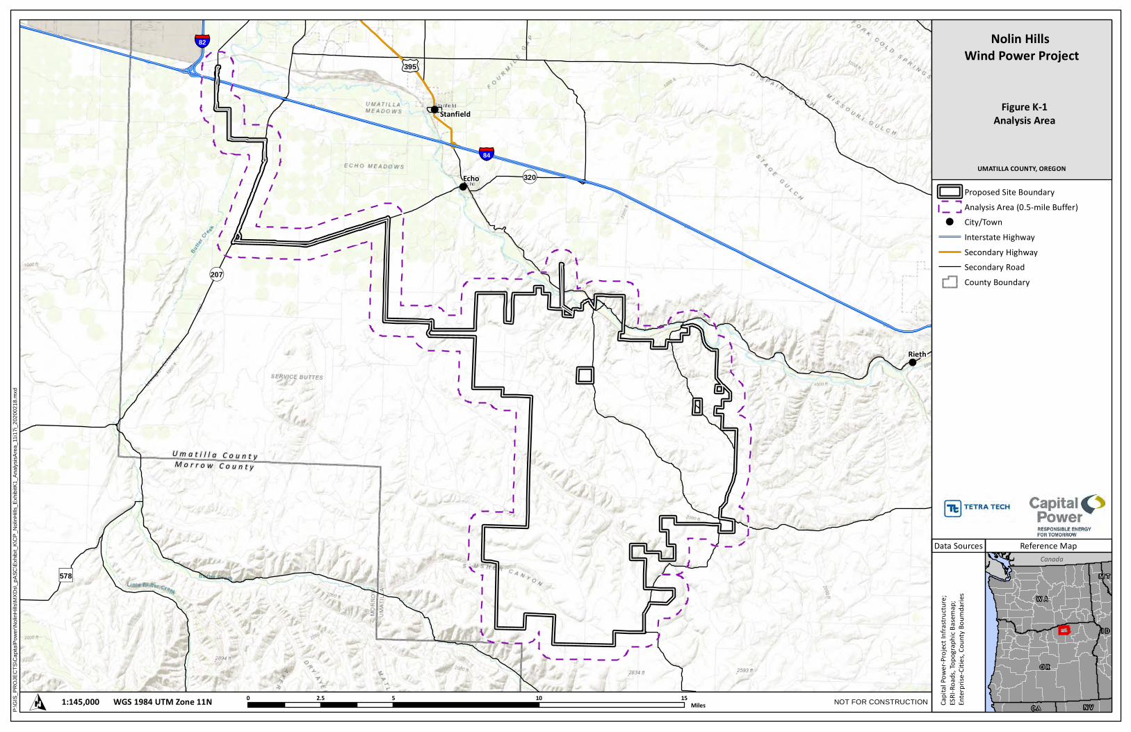
!
!
!
!!
!
!
!
!
!
!
!
!
!
!
!
!
!
!
!
!
!
!
!
!
!
!
!
!
!
!
!
!
!
!
!
!
!
!
!
!
!
!
!
!
!
!
! !
!
!
!
!
!
!
!
!
!
!
!
!
!
!
!
!
!
!
!
!
!
!
£¤395
")578
¬«320
¬«207
§̈¦82
§̈¦84
M o r r o w C o u n t yU m a t i l l a C o u n t y
Stanfield
Echo
Rieth
Canada
O R
W A
I D
N VC A
M T
Reference Map
UMATILLA COUNTY, OREGON
Nolin Hills Wind Power Project
Figure K-1Analysis Area
WGS 1984 UTM Zone 11N1:145,000O 0 5 10 152.5MilesP:\
GIS_
PROJ
ECTS
\Cap
italPo
wer\N
olinH
ills\M
XDs\_
pASC
\Exhib
it_K\C
P_No
linHil
ls_Ex
hibitK
1_An
alysis
Area
_11i1
7i_20
2002
18.m
xd
Proposed Site Boundary
Analysis Area (0.5-mile Buffer)
! City/Town
Interstate Highway
Secondary Highway
Secondary Road
County Boundary
Data Sources
Capi
tal P
ower
-Pro
ject
Infr
astr
uctu
re;
ESRI
-Roa
ds, T
opog
raph
ic B
asem
ap;
Ente
rpris
e-Ci
ties,
Cou
nty
Boum
darie
s
NOT FOR CONSTRUCTION

£¤395
")578
¬«320
¬«207
§̈¦82
§̈¦84
M o r r o w C o u n t yU m a t i l l a C o u n t y
Stanfield
Echo
Rieth
Canada
O R
W A
I D
N VC A
M T
Reference Map
UMATILLA COUNTY, OREGON
Nolin Hills Wind Power Project
Figure K-2Zoning
WGS 1984 UTM Zone 11N1:145,000O 0 5 10 152.5Miles
P:\G
IS_P
RO
JEC
TS\C
apita
lPow
er\N
olin
Hills
\MXD
s\_p
ASC
\Exh
ibit_
K\C
P_N
olin
Hills
_Exh
ibitK
2_Zo
ning
_11i
17i_
2020
0218
.mxd
Proposed Site Boundary
Analysis Area (0.5-mile Buffer)
! City/Town
Interstate Highway
Secondary Highway
Secondary Road
County Boundary
Urban Growth Boundary
City Limit
Data Sources
Capi
tal P
ower
-Pro
ject
Infr
astr
uctu
re;
ESRI
-Roa
ds, T
opog
raph
ic B
asem
ap;
ESRI
-Citi
es, C
ount
y Bo
umda
ries;
DLCD
- Urb
an G
row
th B
ound
ary;
ArcG
IS F
eatu
re S
ervi
ce-C
ity L
imit
NOT FOR CONSTRUCTION
Zoning Boundaries
Agri-business
Exclusive Farm Use
Exclusive Farm Use- 20 Acre
Exclusive Farm Use- 40 Acre
Exclusive Farm Use/ LimitedUse Overlay
Exclusive FarmUse/Aggregate ResourceOverlay
Exclusive Farm Use/FutureIndustrial Overlay
Heavy Industrial
Heavy Industrial/AggregateResource Overlay
Light Industrial
Light Industrial/Limited UseOverlay
Limited Rural Light Industrial
Rural Heavy Industrial
Rural HeavyIndustrial/AggregateResource Overlay
Rural Light Industrial
Rural Residential-4 Acre
Rural Tourist Commercial
Unincorporated Community
§̈¦82
§̈¦84
See Detailed Map Extent Below
Detailed Map Extent
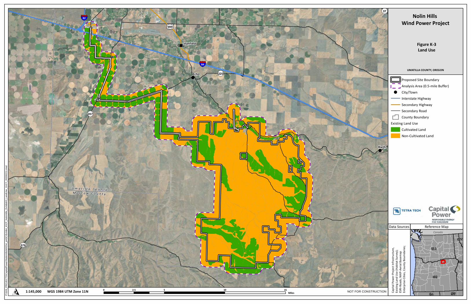
!
!
!
!!
!
!
!
!
!
!
!
!
!
!
!
!
!
!
!
!
!
!
!
!
!
!
!
!
!
!
!
!
!
!
!
!
!
!
!
!
!
!
!
!
!
!
! !
!
!
!
!
!
!
!
!
!
!
!
!
!
!
!
!
!
!
!
!
!
!
£¤395
UV578
¬«37
¬«320
¬«207
§̈¦82
§̈¦84
M o r r o w C o u n t yU m a t i l l a C o u n t y
Stanfield
Echo
Rieth
Canada
O R
W A
I D
N VC A
M T
Reference Map
UMATILLA COUNTY, OREGON
Nolin Hills Wind Power Project
Figure K-3Land Use
WGS 1984 UTM Zone 11N1:145,000O 0 5 10 152.5MilesP:\
GIS_
PROJ
ECTS
\Cap
italPo
wer\N
olinH
ills\M
XDs\_
pASC
\Exhib
it_K\C
P_No
linHil
ls_Ex
hibitK
3_La
ndUs
e_11
i17i_2
0200
211.m
xd
Proposed Site BoundaryAnalysis Area (0.5-mile Buffer)
! City/TownInterstate HighwaySecondary HighwaySecondary RoadCounty Boundary
Existing Land UseCultivated LandNon-Cultivated Land
Data Sources
Capita
l Powe
r-Proj
ect Inf
rastru
cture,
Existin
g Lan
d Use
(Habit
at Sur
vey);
ESRI-R
oads;
NAIP-
Aeria
l Basem
apEnt
erprise
-Citie
s, Cou
nty Bo
umdar
ies;
NOT FOR CONSTRUCTION

£¤395
UV578
¬«320
¬«207
§̈¦82
§̈¦84
M o r r o w C o u n t yU m a t i l l a C o u n t y
Stanfield
Echo
Rieth
1
2
3
4
5
6
78
9
10
1112
1314
1516
17
18
19
2022232425
2627
Canada
O R
W A
I D
N VC A
M T
Reference Map
UMATILLA COUNTY, OREGON
Nolin Hills Wind Power Project
Figure K-4NRCS Soil Classifications
WGS 1984 UTM Zone 11N1:145,000O 0 5 10 152.5MilesP:\
GIS_
PROJ
ECTS
\Cap
italPo
wer\N
olinH
ills\M
XDs\_
pASC
\Exhib
it_K\C
P_No
linHil
ls_Ex
hibitK
4_NR
CS_S
oilCla
ssific
ation
s_11
i17i_2
0200
218.m
xd
Proposed Site Boundary
Analysis Area (0.5-mile Buffer)
Tract Boundary*
! City/Town
Interstate Highway
Secondary Highway
Secondary Road
County Boundary
NRCS Soil Classifications
No Value
1
2
3
4
6
7
8
Data Sources
Capi
tal P
ower
-Pro
ject
Infr
astr
uctu
re;
ESRI
-Roa
ds, T
opog
raph
ic B
asem
ap;
Ente
rpris
e-Ci
ties,
Cou
nty
Boum
darie
s;
NOT FOR CONSTRUCTION
*Each Tract Numbered is Labeled 1 through 25

£¤395
UV578
¬«320
¬«207
§̈¦82
§̈¦84
M o r r o w C o u n t yU m a t i l l a C o u n t y
Stanfield
Echo
Rieth
1
2
3
4
5
6
78
9
10
11
12
1314
1516
17
18
19
2022232425
26
27
Canada
O R
W A
I D
N VC A
M T
Reference Map
UMATILLA COUNTY, OREGON
Nolin Hills Wind Power Project
Figure K-5High-Value Farmland
WGS 1984 UTM Zone 11N1:145,000O 0 5 10 152.5MilesP:\
GIS_
PROJ
ECTS
\Cap
italPo
wer\N
olinH
ills\M
XDs\_
pASC
\Exhib
it_K\C
P_No
linHil
ls_Ex
hibitK
5_Hig
hValu
e_Fa
rmlan
d_11
i17i_2
0200
218.m
xd
Proposed Site Boundary
Analysis Area (0.5-mile Buffer)
Micrositing Corridor
Tract Boundary*
! City/Town
Interstate Highway
Secondary Highway
Secondary Road
County Boundary
High Value Farmland (HVF)
HVF per Classes I and II Soils
HVF per Columbia Valley ViticultureArea
Data Sources
Capi
tal P
ower
-Pro
ject
Infr
astr
uctu
re;
ESRI
-Roa
ds, T
opog
raph
ic B
asem
ap;
Ente
rpris
e-Ci
ties,
Cou
nty
Boum
darie
s;
NOT FOR CONSTRUCTION
*Each Tract Numbered is Labeled 1 through 25
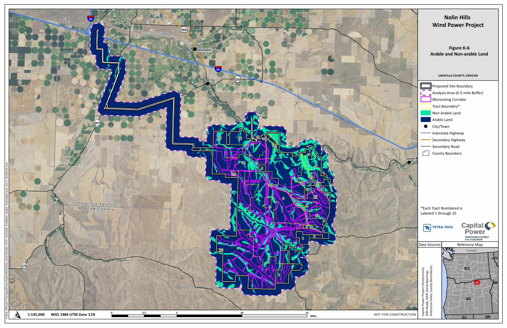
£¤395
UV578
¬«320
¬«207
§̈¦82
§̈¦84
M o r r o w C o u n t yU m a t i l l a C o u n t y
Stanfield
Echo
Rieth
1
2
3
4
5
6
78
9
10
11
12
1314
1516
17
18
19
2022232425
26
27
Canada
O R
W A
I D
N VC A
M T
Reference Map
UMATILLA COUNTY, OREGON
Nolin Hills Wind Power Project
Figure K-6Arable and Non-arable Land
WGS 1984 UTM Zone 11N1:145,000O 0 5 10 152.5MilesP:\
GIS_
PROJ
ECTS
\Cap
italPo
wer\N
olinH
ills\M
XDs\_
pASC
\Exhib
it_K\C
P_No
linHil
ls_Ex
hibitK
6_Ar
able_
NonA
rableL
and_
11i17
i_202
0021
8.mxd
Proposed Site Boundary
Analysis Area (0.5-mile Buffer)
Micrositing Corridor
Tract Boundary*
Non-Arable Land
Arable Land
! City/Town
Interstate Highway
Secondary Highway
Secondary Road
County Boundary
Data Sources
Capi
tal P
ower
-Pro
ject
Infr
astr
uctu
re;
ESRI
-Roa
ds; N
AIP-
Aeria
l Bas
emap
;En
terp
rise-
Citie
s, C
ount
y Bo
umda
ries;
NOT FOR CONSTRUCTION
*Each Tract Numbered is Labeled 1 through 25
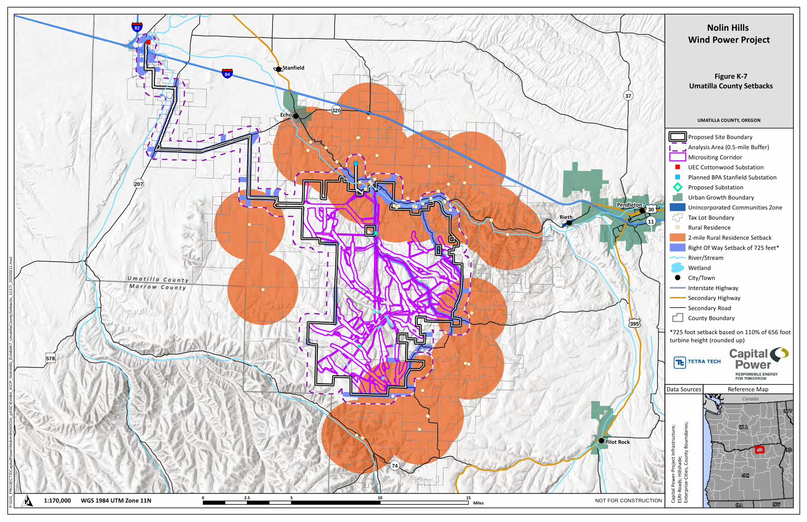
!( !(
!(
!(
!(
!(
!( !(!(
!(
!(
!(
!(!(
!(
!(
!(
!(
!(!(
!(
!(
!(!(
!(
!(
!(
!(
!(!(
!(!(
!(
!(!(
!(
!(
!(
!(!(
!(
!(
!(
!(
!(
!(
!(
!(
!(
!(
")
")
!
!
!
!!
!
!
!
!
!
!
!
!
!
!
!
!
!
!
!
!
!
!
!
!
!
!
!
!
!
!
!
!
!
!
!
!
!
!
!
!
!
!
!
!
!
!
! !
!
!
!
!
!
!
!
!
!
!
!
!
!
!
!
!
!
!
!
!
!
!
!
!
!
!
!
!
!
!
!
!
!
!
!
!
!
!
!
!
!
!
!
!
!
!
!
!
!
!
£¤30
£¤395
")578
¬«11
¬«320
¬«74
¬«37
¬«207
§̈¦82
§̈¦84
M o r r o w C o u n t yU m a t i l l a C o u n t y
Stanfield
Echo
RiethPendleton
Pilot Rock
Canada
O R
W A
I D
N VC A
M T
Reference Map
UMATILLA COUNTY, OREGON
Nolin Hills Wind Power Project
Figure K-7Umatilla County Setbacks
WGS 1984 UTM Zone 11N1:170,000O 0 5 10 152.5MilesP:\
GIS_
PROJ
ECTS
\Cap
italPo
wer\N
olinH
ills\M
XDs\_
pASC
\Exhib
it_K\C
P_No
linHil
ls_Ex
hibitK
7_Um
atilla
Coun
tySetb
acks
_11i1
7i_20
2002
11.m
xd
Proposed Site BoundaryAnalysis Area (0.5-mile Buffer)Micrositing Corridor
") UEC Cottonwood Substation") Planned BPA Stanfield Substation
Proposed SubstationUrban Growth BoundaryUnincorporated Communities ZoneTax Lot Boundary
!( Rural Residence2-mile Rural Residence SetbackRight Of Way Setback of 725 feet*River/StreamWetland
! City/TownInterstate HighwaySecondary HighwaySecondary RoadCounty Boundary
Data Sources
Capita
l Powe
r-Proj
ect Inf
rastru
cture;
ESR
I-Roa
ds; Hi
llshad
e;Ent
erprise
-Citie
s, Cou
nty Bo
umdar
ies;
NOT FOR CONSTRUCTION
*725 foot setback based on 110% of 656 footturbine height (rounded up)


![[Exhibit A] [Exhibit B]. [Exhibit D] [Exhibit F]](https://img.pdfslide.net/doc/110x75/6294402616e6d749834caeff/exhibit-a-exhibit-b-exhibit-d-exhibit-f.jpg)