Embed Size (px)
Citation preview

Existing Ecological Conditions at Proposed
New Brighton Park Habitat Enhancement Project
PMV Habitat Enhancement Program
Prepared for: Port Metro Vancouver 100 The Pointe, 999 Canada Place Vancouver, BC V6C 3T4 Prepared by: Hemmera Envirochem Inc. 18
th Floor, 4730 Kingsway
Burnaby, BC V5H 0C6 File: 302-035.04 June 2015

PMV HEP Hemmera New Brighton Park - i - June 2015
TABLE OF CONTENTS
1.0 INTRODUCTION .............................................................................................................................. 1
1.1 RATIONALE ........................................................................................................................... 1
2.0 PROJECT LOCATION .................................................................................................................... 3
3.0 PROPOSED HABITAT ENHANCEMENT PROJECT ..................................................................... 5
3.1 SITE HISTORY ....................................................................................................................... 5
3.2 PROPOSED WORKS ............................................................................................................... 7
4.0 EXISTING BIOPHYSICAL CONDITIONS ....................................................................................... 8
4.1 GENERAL SITE DESCRIPTION ................................................................................................. 9
4.2 FIELD ASSESSMENT METHODS ............................................................................................... 9
4.2.1 Backshore and Intertidal Survey ............................................................................ 9
4.2.2 Subtidal Survey .................................................................................................... 10
4.3 PHYSICAL CHARACTERISTICS ............................................................................................... 13
4.4 HABITAT VALUES ................................................................................................................. 19
4.4.1 Fish and Wildlife Habitat ...................................................................................... 19
4.4.2 Vegetation ............................................................................................................ 19
4.5 FISH AND INVERTEBRATES ................................................................................................... 23
4.5.1 Fish Species ......................................................................................................... 23
4.5.2 Invertebrate Species ............................................................................................ 26
4.6 WILDLIFE ............................................................................................................................ 28
5.0 CONCLUSION ............................................................................................................................... 31
6.0 REFERENCES ............................................................................................................................... 33
7.0 STATEMENT OF LIMITATIONS ................................................................................................... 35
List of Tables
Table A Biophysical Assessment Substrate Classification ............................................................ 10
Table B Listed Fish Species with the Potential to Occur Near the Project Site (B.C. Ministry of
Environment 2013) ............................................................................................................ 26
Table C Bird Species Observed Utilizing the Proposed Project Area and Nearshore Waters ....... 29
Table D Listed Wildlife Species of the Metro Vancouver CWH Zone with Potential to Occur at the
Project Site ........................................................................................................................ 30

PMV HEP Hemmera New Brighton Park - ii - June 2015
List of Figures
Figure 1 New Brighton Park Project Site – Regional Setting ............................................................ 3
Figure 2 New Brighton Park Project Site – Site Location .................................................................. 4
Figure 3 Proposed Ecological Corridor Connecting Hastings Park Sanctuary to New Brighton Park
............................................................................................................................................ 7
Figure 4 Biogeoclimatic Subzones of Metro Vancouver with Project Site ........................................ 9
Figure 5 Backshore and Intertidal Biophysical Assessment Area................................................... 10
Figure 6 Subtidal Dive Survey Transect Locations ......................................................................... 12
Figure 7 New Brighton Park Biophysical Map ................................................................................. 14
Figure 8 Physical Substrate of the Intertidal Habitat Surrounding the Project Site ......................... 15
Figure 9 High and Low Tides Lines at the Project Site ................................................................... 15
Figure 10 New Brighton Park Biophysical Subtidal Map ................................................................... 16
Figure 11 Marine Vegetation at the Project Site is Characterized by Bull Kelp ................................ 21
List of Photos
Photo 1 View of New Brighton in the Early 1900’s, Looking East .................................................... 6
Photo 2 Completed Shoreline Stabilization with Dune Grass Bench in Foreground Bioengineered
and Boulder Banks in Background (facing west) ................................................................ 6
Photo 3 Upland Habitat at New Brighton Park Looking East ......................................................... 17
Photo 4 Rock Groynes Separating Scalloped Intertidal Beaches with Varying Substrates and
Boulder Banks Looking East ............................................................................................. 17
Photo 5 Dune grass Bench Created with Boulders and Sand Fill below Riparian Shrub Backshore
Habitat ............................................................................................................................... 18
Photo 6 Gravel, Cobble, Shell Debris Sediment Nearshore of Intertidal Beach from Transect 3 .. 18
Photo 7 Riparian Shrub and Tree Habitat along the Shoreline Bank at New Brighton Park ......... 20
Photo 8 Marine Vegetation and Invertebrates in Low Intertidal Zone ............................................ 21
Photo 9 Marine Vegetation and Fish in Shallow Subtidal Zone at the Western Edge of the Park
from Western Random Swim ............................................................................................ 22
Photo 10 Marine Vegetation in Shallow Subtidal Zone Transect 2 (West side of Park) .................. 22
Photo 11 Marine Vegetation in Shallow Subtidal Zone at Transect 3 (East side of Park) ............... 23
Photo 12 Tubesnout in Shallow Subtidal Zone at the Western Random Swim ............................... 25
Photo 13 Lingcod in Shallow Subtidal Zone at the Western Random Swim .................................... 25
Photo 14 Dungeness Crab Buried in Fine Sediment East Random Swim Survey ......................... 27

PMV HEP Hemmera New Brighton Park - iii - June 2015
Photo 15 Red Rock Crab in Shallow Subtidal Rocky Habitat Transects 1 ..................................... 27
Photo 16 Ochre and Leather Sea Stars Feeding on Barnacles on Rocky Habitat Transect 2 (West
side of Park) ...................................................................................................................... 28
List of Appendices
Appendix A Aerial Photography Review
Appendix B GL Williams and Associates Memorandum
Appendix C Hemmera Biophysical Assessment: Dive Survey Results

PMV HEP Hemmera New Brighton Park - 1 - June 2015
1.0 INTRODUCTION
The proposed New Brighton Park Habitat Enhancement Project (the Project) in the City of Vancouver,
B.C., is being considered as a potential project under Port Metro Vancouver’s (PMV’s) Habitat
Enhancement Program (HEP) in collaboration with the Vancouver Board of Parks and Recreation
(VBPR). Project planning is being undertaken in accordance with the “Working Agreement Concerning
Procedures for Development and Operation of the Port Metro Vancouver Habitat Bank” (2012) between
Fisheries and Oceans Canada (DFO) and PMV.
The objective of this assessment was to document the existing ecological habitats and potential species
use of the proposed New Brighton Park Habitat Enhancement Site (the Site) adjacent to the south shore
of Burrard Inlet. General ecosystem conditions and occurrences of species of management concern will
inform Project design and construction mitigation at the site.
1.1 RATIONALE
As part of the Habitat Enhancement Program, PMV is applying a landscape approach to identifying
potential sites where the productivity of fish and wildlife habitat can be increased, existing habitat can be
enhanced to increase its productivity, or degraded habitat can be restored to benefit fish and wildlife
species that utilize the lower Fraser River estuary and Burrard Inlet.
The Project is located within the “Fraser Estuary, Boundary Bay, Burrard Inlet, Fraser and North Arms”
Geographic Service Area (GSA). In Burrard Inlet, between the Ironworkers Memorial Bridge and the
Lions’ Gate Bridge, less than 10% of the shoreline has not been subject to industrialization and
urbanization (Stantec Consulting Ltd. 2009). The shoreline of New Brighton Park and the upland areas
include shoreline protection features and foreshore fill so although it is not industrialized, it is not a true
“natural” area. This makes it an excellent candidate for habitat restoration and enhancement. PMV is
placing a priority on fish habitat enhancement and marsh restoration when seeking restoration and
enhancement opportunities in this GSA. Site selection for this Project was based on factors including
need, habitat productivity, site location, feasibility and cost, sustainable habitat creation, ownership and
tenure, and consideration towards First Nations and communities.
The site has been selected based on its potential to benefit a broad range of fish and wildlife species and
increase the overall ecological function. The proposed Project would restore and enhance a historically
filled foreshore and upland area to provide high-value habitat for fish, birds and other wildlife.
The creation of a tidal wetland feature would also improve habitat in the Burrard Inlet for juvenile salmon
rearing. The potential inclusion of rocky reefs for the establishment of bull kelp could also help to support
several species of seaweed and rockfish and increase marine productivity in the area.

PMV HEP Hemmera New Brighton Park - 2 - June 2015
Information considered during preparation of this report included:
A review of current and historical aerial photographs.
Field reconnaissance information (2015).
Desktop study and background research.

PMV HEP Hemmera New Brighton Park - 3 - June 2015
2.0 PROJECT LOCATION
The New Brighton Park Habitat Enhancement Project is located in the City of Vancouver, B.C. The
proposed enhancement site is located along the south shore of Burrard Inlet, in the Inner Harbour, west
of the Ironworkers Memorial Bridge and Second Narrows (Figure 1 and Figure 2) and adjacent to the
Viterra Cascadia Terminal (to the east) and Hastings Park (to the south).
Figure 1 New Brighton Park Project Site – Regional Setting
Google Earth Maps

PMV HEP Hemmera New Brighton Park - 4 - June 2015
Figure 2 New Brighton Park Project Site – Site Location
Google Earth Maps

PMV HEP Hemmera New Brighton Park - 5 - June 2015
3.0 PROPOSED HABITAT ENHANCEMENT PROJECT
3.1 SITE HISTORY
Previously known as Hastings Townsite, British Royal Engineers surveyed the location of New Brighton
Park into lots in 1863. This was the location of the first post office, customs office, and Canadian Pacific
Railway office established in the City of Vancouver (Photo 1). An aerial photograph review indicates that
the middle and northern ends of the proposed Project site were likely filled at various stages during the
mid-1900s, which contributed to the loss of valuable fish habitat (Appendix A: Historic Aerial
Photographs). Historical uses of the site prior to its development into a municipal park were primarily for
lumber-related industries, particularly shingle manufacturing (Keystone Environmental Ltd 1997a, b).
Infilling of the shoreline ceased around the early 1970’s (Appendix A). However, wave-related erosion
along the eastern portion of the park prompted shoreline stabilization works by Kerr Wood Leidal and
Raincoast Applied Ecology in 2006-2007. The project included stabilizing the backshore with large
boulders for armouring and bioengineered banks (using Hooker’s willow (Salix hookeriana), wattle and
geotextile soil wrap; Photo 2), and the re-working of rip rap groynes. To improve the marine riparian
habitat value of the site, native dune grass (Lymus mollis) benches were created at the seaward toe of
the stabilized banks (Photo 2) and on the tops of the groynes. Dune grass and large-leaved lupine
(Lupinus polyphyllous) meadows were created at the tops of some banks, and riparian shrub
(thimbleberry (Rubus parviflorus), Nootka rose (Rosa nutkana), snowberry (Symphoricarpus albus), red
flowering currant (Ribes sanguineum), and mock-orange (Philadelphus lewisii)) and tree (black
cottonwood (Populus trichocarpa) habitats were created along the tops of the stabilized banks.
As part of the Hastings Park / PNE Master Plan released in 2011, the City of Vancouver proposed an
ecological corridor connecting the “Sanctuary Pond,” constructed in the park in 1999, to the waterfront
through New Brighton Park (Figure 3). These plans include daylighting of Renfrew Creek and connecting
it to a newly established salt marsh at Burrard Inlet, with pedestrian and bicycle pathways facilitating
public access (Phillips Farevaag Smallenberg 2011). In 2013, the first leg of daylighting a portion of
Renfrew Creek and connecting it with Hastings Park was completed, establishing Creekway Park
(Figure 3).

PMV HEP Hemmera New Brighton Park - 6 - June 2015
Photo 1 View of New Brighton in the Early 1900’s, Looking East
Photo 2 Completed Shoreline Stabilization with Dune Grass Bench in Foreground Bioengineered and Boulder Banks in Background (facing west)
Source: Raincoast Applied Ecology 2007
Vancouver Archives

PMV HEP Hemmera New Brighton Park - 7 - June 2015
Figure 3 Proposed Ecological Corridor Connecting Hastings Park Sanctuary to New Brighton Park
3.2 PROPOSED WORKS
PMV is working with the VBPR to explore the restoration of habitat in New Brighton Park. The proposed
project is consistent with the City’s Hasting Park / PNE Master Plan and the objectives of PMV’s HEP,
and could support the restoration of Renfrew Creek as part of the revitalization of Hastings Park.
The proposed project is in the conceptual design stage and may include the restoration and enhancement
of approximately 25,000 m2 (2.5 ha) of intertidal, subtidal, instream and riparian habitats. Project
components could include the creation of a tidal wetland with a marsh component, the construction of
subtidal rocky reefs, enhancement of marine riparian habitat, and the creation of streamside habitat at the
southern end of the park. The design is expected to maintain access to the shoreline and provide
environmental education opportunities.
Phillips Farevaag mallenberg 2011

PMV HEP Hemmera New Brighton Park - 8 - June 2015
4.0 EXISTING BIOPHYSICAL CONDITIONS
Information related to the existing biophysical conditions of the Project Site was obtained from the
following sources:
Online Sensitive Habitat Inventory and Mapping (SHIM 2013);
Online Fraser River Estuary Management Program (FREMP) and Burrard Inlet Environmental
Action Program (BIEAP) Habitat Atlas (FREMP 2015);
Online Fisheries Information Summary System (FISS 2015);
Online E-Fauna B.C. database (Klinkenberg 2015);
Online B.C. Species and Ecosystems Explorer (B.C. Ministry of Environment 2015);
Online iMap database (iMap 2015);
Aerial photographs (Port Metro Vancouver 2015); and
Site visits and field studies including subtidal survey, terrestrial/vegetation survey, and bird
observations (Hemmera and GL Williams and Associates 2015).

PMV HEP Hemmera New Brighton Park - 9 - June 2015
4.1 GENERAL SITE DESCRIPTION
The Project Site falls within the Dry Maritime Coastal Western Hemlock (CWHdm) biogeoclimatic
subzone (Figure 4; SHIM 2013, Government of B.C. 2012). The CWHdm subzone occurs at lower
elevations (0-650 m), and is typified by warm, relatively dry summers and moist, mild winters with little
snowfall (Green and Klinka 1994). The mean annual temperatures in the CWH zone range from 5.2 to
10.5°C, with mean annual precipitation ranging from 1000 to 4400mm (Pojar et al 1991).
Figure 4 Biogeoclimatic Subzones of Metro Vancouver with Project Site
4.2 FIELD ASSESSMENT METHODS
4.2.1 Backshore and Intertidal Survey
A backshore and intertidal biophysical assessment was conducted in the eastern portion of New Brighton
Park during the low tide cycle on May 6, 2015 (Figure 5). Substrate type and relative composition were
described visually using a generalized Wentworth-based scale (Wentworth 1922; Table A) (Appendix B:
GL Williams and Associates Memorandum).
Wildlife observations were generated during two one-hour point count surveys during the early morning
hours of May 4 and May 7, 2015. The same assessment area as the biophysical survey was used
(Figure 5).
Government of B.C. 2012

PMV HEP Hemmera New Brighton Park - 10 - June 2015
Table A Biophysical Assessment Substrate Classification
Substrate Type Size Range (Diameter)
Bedrock/ Boulder >256 mm
Cobble 64 – 256 mm
Gravel 2 – 64 mm
Sand 0.06 – 2 mm
Silt/Clay/Mud <0.06 mm
Other* -
Note: * Substrates can also include anthropogenic structures, debris and shell hash etc., all of which were characterized under “substrate – other” during field sampling.
Figure 5 Backshore and Intertidal Biophysical Assessment Area
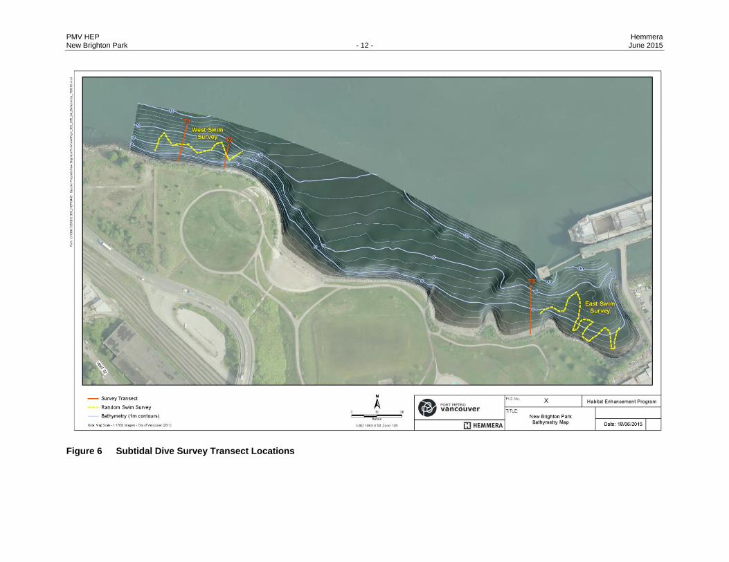
4.2.2 Subtidal Survey
Atek Hydrographic Surveys Ltd. collected nearshore bathymetric data at New Brighton Park on April 22nd
2015 and provided a 1 meter resolution digital elevation surface of the seafloor (Figure 6). These data
were then used to produce derived products, including depth contours and seafloor rugosity maps.
Rugosity is a measure of three dimensional roughness of the seafloor and can be used to characterize
seafloor habitats. Rugosity can be used to distinguish between more complex areas, high-relief rocky
habitat, and less complex areas such as low-relief gravel and sand habitats.
A Worksafe BC certified dive team conducted a detailed biophysical survey in the nearshore subtidal
zone, on April 30th 2015, following the DFO Marine Foreshore Environmental Assessment Procedure
(DFO unpublished). Three transects were established perpendicular to the waterline within the Site
(Figure 7). The start and end of each transect were recorded with a Garmin GPS and underwater video
was recorded using a high definition GoPro camera. All fish observed were recorded by the lead diver

PMV HEP Hemmera New Brighton Park - 11 - June 2015
while travelling to the deepest portion of the dive, while laying a measuring tape to the estimated Site
boundary, or between 30 m and 40 m from the high-high water level (HHWL). The HHWL in Vancouver
Harbour is approximately five metres above chart datum (m CD). For each transect survey a 1 x 1 m area
was sampled at 5 m intervals along the transect line. Within each 1 m2 area sampled the diver recorded:
transect position, depth, substrate type, vegetation cover, sessile invertebrate cover, mobile invertebrate
density and fish density. Transects were established in two areas at the park. Transects one and two
were located along the west edge (western area) of the park boundaries with a separation of
approximately 50 m between them. Transect three was located at the eastern edge (eastern area) of the
park at the off leash dog park. In order to characterize the larger site as a whole, two random swim
surveys were conducted at the west and east ends of the park boundary, in addition to the transect
surveys (Figure 7). The path of the random swim surveys was recorded from a small vessel, which
followed the divers at a safe distance while recording the path using a Garmin GPS. Random swim
surveys are considered a semi-quantitative assessment and in this case, provided approximate
information on the habitats and species of interest within the proposed site.
Dive survey data were used to guide biophysical mapping of the nearshore area. Substrate types,
changes or breaks in species community, dominant vegetation, and other notable features (e.g. outfalls,
cables, etc.) were recorded. As with the intertidal assessment, substrate type and relative composition
were described visually using a generalized Wentworth-based scale (Wentworth 1922; Table A).
PMV HEP Hemmera New Brighton Park - 12 - June 2015
Figure 6 Subtidal Dive Survey Transect Locations

PMV HEP Hemmera New Brighton Park - 13 - June 2015
4.3 PHYSICAL CHARACTERISTICS
The upland park area is relatively flat, sloping up to an overpass at New Brighton Road near the southern
bounds of the park. Organic soil, covered with grass and the occasional landscaped tree, is interspersed
with gravel pathways and an access road to New Brighton Pool (Figure 7, Photo 3; Appendix B).
A section of the newly enhanced Renfrew Creek (Section 3.1) at Creekway Park is located along the
southern edge of New Brighton Road. The Creekway Park water feature receives water flow from
stormwater in the Hastings Park catchment. This section of the water feature consists of a series of weirs
to retain storm water. Flows in the cobble lined stream channel were low during the biophysical
assessment. The stream channel follows a steep gradient to a corrugated steel half arch culvert that
discharges into a storm drain on the north side of the New Brighton Road overpass. From this location,
the stormwater is culverted under the park and discharges through a wooden outlet into the intertidal
beach in Burrard Inlet (Figure 7; Appendix B).
Burrard Inlet is an industrial port that is heavily developed with armoured slopes, bulkheads and ship
loading facilities, which reduces fish and wildlife habitat values. Due to prior shoreline stabilization and
creation of marine riparian habitat (Section 3.1), the shoreline of the proposed enhancement area
consists primarily of large boulders and elevated dune grass benches (Figure 7, Photo 4 and Photo 5).
Three moderately sloping intertidal beaches, separated by two rock groynes, run along the waterfront in
the eastern portion of New Brighton Park. The Burrard Inlet Environmental Action Program (BIEAP) Atlas
characterizes intertidal substrate types along Burrard Inlet. According to the atlas, the intertidal
beaches at the eastern end of the park are comprised of cobble, fine gravel, and sand with some boulder
(Figure 8; FREMP 2015). This characterization was confirmed during the biophysical assessment
(Figure 7, Photo 4; Appendix B). Tides along New Brighton Park are semi diurnal and the tidal range
exceeds 5 m (Appendix B, Table 1; Figure 9).
SCUBA survey results (west and east) characterized the sediment types present in the nearshore area
(Figure 10). To the west, the deeper subtidal zone (9 m – 5 m) is characterized by coarser sediments
(cobble to gravel). The shallower portions were predominantly rip rap, which is described as boulders
(from 5 m depths and shallower). There was a greater proportion of boulder habitat along the west side of
the park. The eastern transect followed a shallower grade, typical of a coarse sediment beach (sand,
gravel, cobble, and shell debris). The shallow grade resulted in a longer transect than was required to
survey the western transects. At depth (4 m), substrate was primarily comprised of a gravel, sand, and
shell debris mix, which transitioned into coarser materials (cobble and larger shell debris) at
approximately 0 m CD (Photo 6, Appendix C: Hemmera Biophysical Assessment: Dive Survey
Results). The random swim survey at the west end indicated that the nearshore was made up of large
sediment (boulder), while a mix of cobble, gravel, and sand sediment was observed in areas deeper than
approximately 4 m CD. The random swim survey at the east end of the site determined the presence of
softer sediments, gravel, and sand, mixed with cobbles.

PMV HEP Hemmera New Brighton Park - 14 - June 2015
Figure 7 New Brighton Park Biophysical Map

PMV HEP Hemmera New Brighton Park - 15 - June 2015
Figure 8 Physical Substrate of the Intertidal Habitat Surrounding the Project Site
Figure 9 High and Low Tides Lines at the Project Site
FREMP 2013
FREMP 2015

PMV HEP Hemmera New Brighton Park - 16 - June 2015
Figure 10 New Brighton Park Biophysical Subtidal Map

PMV HEP Hemmera New Brighton Park - 17 - June 2015
Photo 3 Upland Habitat at New Brighton Park Looking East
Photo 4 Rock Groynes Separating Scalloped Intertidal Beaches with Varying Substrates and Boulder Banks Looking East
GL Williams 2015
GL Williams 2015

PMV HEP Hemmera New Brighton Park - 18 - June 2015
Photo 5 Dune grass Bench Created with Boulders and Sand Fill below Riparian Shrub Backshore Habitat
Photo 6 Gravel, Cobble, Shell Debris Sediment Nearshore of Intertidal Beach from Transect 3

PMV HEP Hemmera New Brighton Park - 19 - June 2015
4.4 HABITAT VALUES
4.4.1 Fish and Wildlife Habitat
The upland portions of the proposed Project Site consists of an urban park with a maintained lawn which
provides few habitat opportunities (Appendix B). A band (3-5 m) of native riparian habitat was present
along the shoreline and included a number of shrubs and trees and a few narrow dune grass benches
(Appendix B). The low intertidal and shallow subtidal habitats sustained a diverse array of algal species,
including kelp.
4.4.2 Vegetation
Vegetation in the upland area consists mostly of a maintained lawn (Appendix B Table 2) interspersed
with some native western red cedar (Thuja plicata) and Douglas-fir (Pseudotsuga menziesii). A row of
Lombardy poplar (Populus nigra) are present along the eastern border of the park with an understory of
snowberry (Symphoricarpos albus) and invasive Himalayan blackberry (Rubus armeniacus) and Scotch
broom (Cytisus scoparius). The overpass of New Brighton Road, bordering the south side of the park,
was covered with invasive English ivy (Hedera helix; Appendix B).
The riparian shrub and tree habitat bordering the shoreline bank (above HWM) consisted of native
species, many of which were planted during shoreline stabilization works in 2006-2007 (Section 3.1;
Photo 7). A full list of native shrub species is presented in Appendix B Table 2. Black cottonwood
(Populus balsamifera) and red alder (Alnus rubra) were interspersed in this band of habitat. Several
narrow dune grass benches were observed during the biophysical assessment (Photo 5).
The BIEAP Atlas (2010) characterized marine vegetation in the intertidal habitat along Burrard Inlet.
According to the atlas, the low intertidal area is characterized by a band of bull kelp (Nereocystis
luetkeana) (Figure 11; FREMP 2013). A detailed vegetation inventory has not been undertaken;
however, the biophysical assessment confirmed the presence of bull kelp and also documented sugar
kelp (Saccharina latissima), splendid iridescent seaweed (Mazzaella splendens), sea lettuce (Ulva
lactuca) and the invasive wireweed (Sarguassum muticum; Photo 8). Vegetation in mid to high intertidal
zones included rockweed (Fucus garneri) with some Turkish washcloth (Mastocarpus papillatus) and sea
lettuce. A detailed list of intertidal vegetation is presented in Appendix B.
The subtidal marine assemblages observed within the Site are typical of those commonly occurring on
hard substrates in Vancouver Harbour (Morris 2001, FREMP 2013, Appendix C: Table C1). The shallow
subtidal zone with coarse sediments was characterized by a mix of brown kelp species including: bull
kelp, seersucker kelp (Costa costaria), and sugar kelp (Photo 9).Other common algal species including:
splendid iridescent seaweed, rockweed, sea lettuce, red bladed and red filamentous species were also
present within the subtidal zone. The western area transects were dominated by kelp forest species and
smaller red and green algal communities (Photo 10). In all transects, deeper subtidal areas were

PMV HEP Hemmera New Brighton Park - 20 - June 2015
dominated by coarse gravel and cobble substrates with minimal opportunistic kelp and algae. Common
species in the deeper sand and gravel zone included red filamentous and red blade algae. The eastern
area had less algal coverage as the benthic habitat lacked large coarse sediments and there was less
rocky surface. Bull kelps and smaller opportunistic algae are valued ecosystem components and were
observed within the shallow subtidal zone. The shallow subtidal zone was dominated by grass kelp (Ulva
intestinalis) (Photo 11).
Photo 7 Riparian Shrub and Tree Habitat along the Shoreline Bank at New Brighton Park
GL Williams 2015

PMV HEP Hemmera New Brighton Park - 21 - June 2015
Figure 11 Marine Vegetation at the Project Site is Characterized by Bull Kelp
Photo 8 Marine Vegetation and Invertebrates in Low Intertidal Zone
FREMP, 2013

PMV HEP Hemmera New Brighton Park - 22 - June 2015
Photo 9 Marine Vegetation and Fish in Shallow Subtidal Zone at the Western Edge of the Park from Western Random Swim
Photo 10 Marine Vegetation in Shallow Subtidal Zone Transect 2 (West side of Park)

PMV HEP Hemmera New Brighton Park - 23 - June 2015
Photo 11 Marine Vegetation in Shallow Subtidal Zone at Transect 3 (East side of Park)
A search of the online B.C. Species and Ecosystems Explorer database indicated that upwards of 100 at-
risk vegetation species potentially occur in the CWH zone; however, there are no known rare vegetation
occurrences at or near the park (B.C. Ministry of Environment 2013).
4.5 FISH AND INVERTEBRATES
4.5.1 Fish Species
Burrard Inlet encompasses approximately 11,300 ha which consists of six sub-areas: Outer Harbour and
English Bay, False Creek, the Inner Harbour, the Central Harbour, Indian Arm and Port Moody Arm
(Georgia Strait Alliance 2003). While the amount of high quality fish habitat is limited by urban and
industrialization, Burrard Inlet is known to host a diversity of fish species.
Juvenile salmon are abundant in nearshore habitats from early spring to fall, particularly chum
(Oncorhynchus keta), chinook (O. tshawytscha) and, every second year, pink (O. gorbuscha) (Haggarty,
2001). Juvenile coho (O. kisutch), sockeye (O. nerka), steelhead (O. mykiss) and cutthroat trout
(Oncorhynchus clarki) are also present, in lower abundances (Haggarty 2001). Adult salmon have been
observed within 17 streams that flow into Burrard Inlet and are known to spawn in rivers on the north
shore of the inlet, particularly in the Capilano and Seymour rivers that support salmon hatcheries
(Haggarty 2001). Historically, Renfrew Creek ran from south of hasting’s park down to the shoreline of
Burrard Inlet through the proposed project area; however, this is now classified as a lost stream as it was
culverted and is no longer fish bearing (FREMP 2015).

PMV HEP Hemmera New Brighton Park - 24 - June 2015
Approximately 63 other fish species occur in the nearshore areas of Burrard Inlet, including: Pacific
herring (Clupea pallasii), northern anchovy (Engraulis mordax), lingcod (Ophiodon elongates), flatfish
(English sole (Parophrys vetulus), starry flounder (Platichthys stellatus) and rock sole (Lepidopsetta
bilineata)), Pacific staghorn sculpin (Leptocottus armatus), shiner surfperch (Cymatogaster aggregata)
and quillback rockfish (Sebastes maliger) (Haggarty, 2001). There are three Rockfish Conservation Areas
(RCA’s) in eastern portions of Burrard Inlet, one of which (subarea 28-11) occurs a few kilometres east of
the site, adjacent to Maplewood Mudflats (DFO 2008).
The Project Site, which sustains a variety of substrate and marine vegetation could include habitat for
some of these species. Fish species observed during the subtidal surveys included tube snouts
(Aulorhynchus flavidus) (Photo 12), lingcod (Photo 13), kelp perch (Brachyistius frenatus) (Photo 9),
striped perch (Embiotoca lateralis), Blackeyed goby (Rhinogobiops nicholsii), and copper rockfish
(Sebastes caurinus) (see Appendix C for a full list of species). The sandy gravel habitats characteristic of
the deeper subtidal and habitats off the beaches provide habitat for flatfish species such as English sole,
speckled sanddab (Citharichthys stigmaeus), and starry flounder.
Fourteen listed marine and freshwater fish species occur in the CWH zone (B.C. Ministry of
Environment 2013). Several of these have the potential to occur at or near the Project Site and are
presented in Table B.
Although it was included in Table B, green sturgeon (Acipenser medirostris) has a low likelihood of
occurring near the Project Site. Very little is known about green sturgeon habitat use in Canada. Rearing
and spawning by this anadromous species has not been recorded in Canada, although the species may
forage along the marine coast of British Columbia.
Cutthroat trout and anadromous bull trout would be likely to utilize the present vegetated habitat offered at
the Project Site, including kelp areas and eelgrass habitat.

PMV HEP Hemmera New Brighton Park - 25 - June 2015
Photo 12 Tubesnout in Shallow Subtidal Zone at the Western Random Swim
Photo 13 Lingcod in Shallow Subtidal Zone at the Western Random Swim

PMV HEP Hemmera New Brighton Park - 26 - June 2015
Table B Listed Fish Species with the Potential to Occur Near the Project Site (B.C. Ministry of Environment 2013)
Scientific Name
English Name Provincial
Listing1 SARA
2 COSEWIC
3 Comments
Acipenser medirostris
green sturgeon Red 1-SC
(2006) SC (1987)
Habitat preferences are poorly understood, but it is unlikely these fish could use the Project Site as they are primarily observed in marine waters off the B.C. coast. Green sturgeon are not known to breed in Canadian waters
Oncorhynchus clarkii clarkii
cutthroat trout, clarkii subspecies
Blue Not
listed Not listed
May forage in shallow shoreline areas in Burrard Inlet near the project site.
Salvelinus confluentus
bull trout Blue Not
listed SC (2012)
An anadromous fish that is present in Burrard inlet at certain times of the year.
Notes: 1 Red = Endangered or Threatened, Blue = Special Concern
2 Schedule 1 = federal species at risk
3 E = Endangered, T = Threatened, SC = Special Concern
4.5.2 Invertebrate Species
A detailed inventory of invertebrates in the intertidal zone was not undertaken during the biophysical
survey; however, a wide variety of invertebrates were observed in the low intertidal zone. These included:
ochre sea stars (Pisaster ochraceus), leather stars (Dermasterias imbricata), and a red rock crab (Cancer
productus; Photo 8). The mid to high intertidal zone was dominated by barnacles on large substrates
(Appendix B).
Invertebrate species observed during the subtidal transects included Dungeness crab (Metacarcinus
magister), red rock crab, leather star, sea cucumbers (Parastichopus californicus, Cucumaria miniata),
and ochre sea star (see Appendix C for a full list of species). Invertebrates were abundant in the kelp
zone and included Dungeness crab, red rock crab, and ochre star (Photo14, Photo 15, Photo 16). In the
deeper subtidal sand and gravel zone bivalve shells were abundant suggesting a large presence of horse
clams (Tresus sp.) (Photos 6). Dungeness crab and red rock crabs were abundant. Horse clam beds and
Dungeness crab are valued ecosystem components and were observed within the shallow subtidal zone
of the Site.
No listed invertebrate species at risk were observed in the intertidal zone during the biophysical
assessment or subtidal zone during SCUBA surveys.

PMV HEP Hemmera New Brighton Park - 27 - June 2015
Photo 14 Dungeness Crab Buried in Fine Sediment East Random Swim Survey
Photo 15 Red Rock Crab in Shallow Subtidal Rocky Habitat Transects 1

PMV HEP Hemmera New Brighton Park - 28 - June 2015
Photo 16 Ochre and Leather Sea Stars Feeding on Barnacles on Rocky Habitat Transect 2 (West side of Park)
4.6 WILDLIFE
Designated as an internationally recognized Important Bird Area (IBA), the Burrard Inlet is an important
migratory bird corridor, providing essential habitat for significant concentrations of waterfowl species, such
as Western grebe, Barrow’s Goldeneye, and Surf Scoters (IBA Canada 2015). The Burrard Inlet and the
surrounding shoreline also provides essential habitat for a variety of other bird species. Most of these
species are waterbirds, such as loons, grebes, cormorants, geese, ducks, gulls, coots and alcids
(Haggarty, 2001). However, birds of prey, such as osprey (Pandion haliaetus) and bald eagle (Haliaeetus
leucocephalus), as well as marsh and shorebirds, including great blue heron (Ardea herodias), plovers
and western sandpiper (Erolia mauri) (Haggarty, 2001) also utilize this habitat area.
Bird species noted during two 1-hour point count surveys are documented in Table C. Surveys were
conducted during early morning periods that coincided with high tide. As a result, bird species utilizing the
intertidal zone were also noted during the biophysical assessment and included a great blue heron
(Ardea herodias) and northwestern crow (Corvus caurinus). No other wildlife species were noted during
field assessments. A gyrfalcon (Falco rusticolus) has been repeatedly sighted on the Viterra Terminal
adjacent to the east border of New Brighton Park, as recently as March 2015 (eBird 2015)
The most common marine mammal in Burrard Inlet is the harbour seal (Phoca vitulina), although grey
whales (Eschrichtius robustus), Steller sea lions (etopias jubatus) and false killer whales (Pseudorca
crassidens) are occasionally observed (Haggarty, 2001).

PMV HEP Hemmera New Brighton Park - 29 - June 2015
In the Metro Vancouver Regional District, 23 listed bird and 17 mammal wildlife species occur within the
Coastal Western Hemlock zone (B.C. Ministry of Environment 2013). Table D indicates listed species that
have the potential to occur at or near the proposed project site.
Table C Bird Species Observed Utilizing the Proposed Project Area and Nearshore Waters
Scientific Name English Name May-05-2015 May-07-2015
Water
Larus glaucescens Glaucous-winged gull 2 0
Phalacrocorax pelagicus Pelagic Cormorant 1 3
Cepphus columba Pigeon Guillemot 0 1
Viterra Caisson
Phalacrocorax pelagicus Pelagic Cormorant 1 0
Larus glaucescens Glaucous-winged Gull 2 2
Branta canadensis Canada Goose 0 2
Columba livia Rock Dove 18 10
Riparian Tree/Shrub
Melospiza melodia Song Sparrow 2 1
Zonotrichia leucophrys White Crowned Sparrow 1 1
Cardellina pusilla Wilson's Warbler 1 1
Turdus migratorius American Robin 2 0
Passerculus sandwichensis Savanah Sparrow 1 0
Colaptes auratus Northern Flicker 1 0
Streptopelia decaocto Eurasian collared dove 2 25
Poecile atricapillus Black-capped Chickadee 2 0
Psaltriparus minimus American Bushtit 10 12
Vermivora celata Orange Crowned Warbler 0 1
Passer domesticus House Sparrow 0 1
Open Park
Corvus caurinus Northwestern crow 3 6
Overhead
Columba livia Rock Dove 10 14
Branta canadensis Canada Goose 2 0
Spinus tristis American Goldfinch 3 0
Tachycineta thalassina Violet-green swallow 0 2
- Swallow unknown sp 2 0
Larus glaucescens Glaucous-winged gull 1 1
Hydroprogne caspia Caspian Tern 0 2
Corvus caurinus Northwestern crow 0 3
Phalacrocorax pelagicus Pelagic Cormorant 0 1
Falco peregrinus Peregrine Falcon 0 1

PMV HEP Hemmera New Brighton Park - 30 - June 2015
Table D Listed Wildlife Species of the Metro Vancouver CWH Zone with Potential to Occur at the Project Site
Scientific Name English Name Provincial
Listing1 SARA
2 COSEWIC
3 Comments
Birds
Falco rusticolus Gyrfalcon Blue Not listed NAR Seen perching near Project Site
Asio flammeus Short eared owl Blue 1-SC (Jul 2012) SC (Apr 2008)
Ardea herodias fannini
Great blue heron, fannini subspecies
Blue 1-SC
(Feb 2010) SC (Mar 2008)
Seen foraging at the Project Site; no nesting colonies located at or near the Project Site.
Phalacrocorax auritus
Double-crested cormorant
Blue Not listed NAR (May 1978) May over-winter near the Project Site; between foraging for fish on open water it often spends time perched on pilings and rocks.
Buteo lagopus Rough-legged hawk
Blue Not listed NAR (May 1995) May forage in marsh adjacent to the Project Site; this species forage over treeless areas including marshlands.
Hydroprogne caspia Caspian tern Blue Not listed NAR (May 1999) May forage for fish at the Project Site.
Chordeiles minor Common nighthawk
Yellow 1-T (Feb 2010) T (Apr 2007) May forage for insects over the Project Site.
Cypseloides niger Black swift Yellow Not listed E (May 2015) May forage for insects at or near to the Project Site.
Falco peregrinus anatum
Peregrine falcon, anatum subspecies
Red 1-SC
(Jun 2012) SC (Apr 2007)
May forage for birds, bats and rodents within marsh habitat near the Project Site.
Hirundo rustica Barn swallow Blue Not listed T (May 2011)
Seen in marsh habitat near Project site; this species may nest under bridges near river banks and wetlands from which mud is collected to construct nests; forage over open areas such as water bodies.
Progne subis Purple martin Blue Not listed Not listed Breeds in nest boxes adjacent to the Project Site; species feeds on flying insects, over marsh and mudflat habitat.
Mammals
Myotis keenii Keen's myotis Blue 3 (Mar 2005) DD (Nov 2003) Likely found foraging insects over the Project Site.
Myotis lucifugus Little brown myotis Yellow Not listed E (Nov 2012) Likely found foraging insects over the Project Site.
Eumetopias jubatus
Steller sea lion Blue 1-SC (2005) SC (2013) May be found in subtidal marine habitat adjacent to Project Site
Source: B.C. Ministry of Environment 2013 Notes:
1 Red = Endangered or Threatened, Blue = Special Concern
2 Schedule 1 = federal species at risk
3 E = Endangered, T = Threatened, SC = Special Concern, NAR = Not at Risk, DD = Data Deficient

PMV HEP Hemmera New Brighton Park - 31 - June 2015
5.0 CONCLUSION
The proposed Project would focus on restoration and enhancement of a historically filled foreshore and
upland area to provide high-value habitat for fish, birds and other wildlife. New Brighton Park is one of a
few areas between First and Second Narrows in Burrard Inlet that have not been subject to development.
The upland fill on former intertidal habitats and the shoreline erosion protection make it a prime candidate
for fish and wildlife habitat restoration in Burrard Inlet. Creating and restoring habitat features important to
fish and wildlife will add great value to the depleted habitats sustained by Burrard Inlet.
The potential creation of a tidal wetland feature and inclusion of a rock reef could contribute to the
following ecological functions:
Increasing marine primary productivity in Burrard Inlet;
Supplementing the detritus based food web;
Creating intertidal habitat for benthic and drift invertebrates that are important prey items for
juvenile salmonids and other fishes;
Providing intertidal and subtidal vegetation cover and refuge for juvenile salmonids prior to out-
migration and rearing rockfish species;,
Creating habitat for waterfowl feeding, nesting, loafing, and refuge; and
Creating habitat for shorebird foraging.
Increasing the overall habitat diversity of the New Brighton Park shoreline and the shoreline of
Burrard Inlet by converting a primarily landscaped park to a tidal wetland feature;
With relatively few natural areas remaining in Burrard Inlet, and New Brighton Park having sustained a
long history of foreshore fill and shoreline erosion protection, the proposed project represents an
opportunity to add to the fish and wildlife habitat base between First and Second Narrows and increase
habitat diversity and productivity for a variety of species. The proposed project will also serve as an
attractive feature that will lend itself to public education focused on natural areas that benefit fish and
wildlife.

PMV HEP Hemmera New Brighton Park - 32 - June 2015
Report prepared by: Hemmera Envirochem Inc.
Mikaela Davis, M.Sc. Scott Toews M.Sc. Project Biologist Biologist Report peer reviewed by: Hemmera Envirochem Inc.
Scott Northrup, R.P.Bio., P.Biol. Project Director, Senior Biologist

PMV HEP Hemmera New Brighton Park - 33 - June 2015
6.0 REFERENCES
B.C. Ministry of Environment. 2015. B.C. Species and Ecosystems Explorer. Accessed (20 May 215)
from: http://a100.gov.bc.ca/pub/eswp/
Community Mapping Network Sensitive Habitat Inventory and Mapping (SHIM). 2015. Sensitive Habitat
Inventory and Mapping. Accessed (20 May 2015) from: http://www.cmnmaps.ca/SHIM/
eBird. 2015. Online Checklist Program. Accessed (20 May 2015) from: http://ebird.org/ebird/map/
gyrfal?neg=true&env.minX=&env.minY=&env.maxX=&env.maxY=&zh=false&gp=false&ev=Z&mr
=1-12&bmo=1&emo=12&yr=all&byr=1900&eyr=2015
Fisheries and Oceans Canada (DFO). 2008. Rockfish Conservation Areas - Pacific Region
Area 28. Accessed (20 May 2015) from: http://www.pac.dfo-mpo.gc.ca/fm-gp/maps-cartes/rca-
acs/areas-secteurs/28-eng.html
Fisheries Information Summaries System (FISS). 2013. ‘Fish Distributions Query’. Accessed from:
www.env.gov.bc.ca/fish/fiss/
Fraser River Estuary Management Program (FREMP). 2015. Burrard Inlet Environmental Action Program
& Fraser River Estuary Management Program Habitat Atlas. Accessed (20 May 2015) from:
www.cmnmaps.ca/FREMP/
Georgia Strait Alliance. 2003. A Review of Burrard Inlet Effluent Discharges. Accessed (12 December,
2014) from: https://www.georgiastrait.org/files/share/PDF/BurrardEffluent031.pdf
Government of British Columbia. 2012. Biogeoclimatic ecosystem classification subzone map. Accessed
(16 October, 2013) from: ftp://ftp.for.gov.bc.ca/HRE/external/!publish/becmaps/PaperMaps/field/
DCK_ChilliwackResourceDistrict_SouthCoastRegion__field.pdf
Government of British Columbia iMap (iMap). 2015. iMap. Accessed (20 May 2015) from:
http://webmaps.gov.bc.ca/imfx/imf.jsp?site=imapbc
Green, R.N. and Klinka. 1994. A Field Guide for Site Identification and Interpretation for the Vancouver
Forest Region. Ministry of Forests. 185 pp. http://www.for.gov.bc.ca/hfd/pubs/docs/lmh/lmh28.htm
Haggarty, Dana. R. 2001. An Evaluation of Fish Habitat in Burrard Inlet, British Columbia. Master Thesis.
Department of Zoology, University of British Columbia. Accessed (29 September 2014) from:
https://circle.ubc.ca/bitstream/handle/2429/12080/ubc_2002-0094.pdf?sequence=1

PMV HEP Hemmera New Brighton Park - 34 - June 2015
Important Bird Area (IBA) Canada. 2015. English Bay and Burrard Inlet IBA Site Summary. Accessed (20
May 2015) from: http://www.ibacanada.ca/site.jsp?siteID=BC020&lang=EN
Keystone Environmental Ltd. 1997a. Report of Findings Preliminary Site Investigation, Stage 1, New
Brighton Park. Prepared for City of Vancouver Board of Parks and Recreation, Vancouver , B.C.
Keystone Environmental Ltd. 1997b. Report of Findings Preliminary Site Investigation, Stage 2, New
Brighton Park. Prepared for City of Vancouver Board of Parks and Recreation, Vancouver , B.C.
Klinkenberg, B. (Editor) 2015. E-Flora BC: Electronic Atlas of the Plants of British Columbia. Lab for
Advanced Spatial Analysis, Department of Geography, University of British Columbia, Vancouver.
Accessed from: eflora.bc.ca.
Phillips Farevaag Smallenberg. 2011. Hastings Park / Pacific National Exhibition Master Plan. Prepared
for the City of Vancouver. Accessed (20 May 2015) from: http://vancouver.ca/files/cov/
HastingsParkPNE-doco-MasterPlan.pdf
Pojar, J. Klinka, K., & Demarchi, D.A. 1991. Chapter 6: Coastal Western Hemlock Zone. Ecosystems of
British Columbia. Special Report Series 06. B.C. Ministry of Forests. Pp 96-111. Retrieved on
September 29, 2014 from http://www.for.gov.bc.ca/hfd/pubs/Docs/Srs/Srs06.htm
Stantec Consulting Ltd. 2009. Burrard Inlet Shoreline Change – Baseline Assessment. Prepared for
Burrard Inlet Environmental Action Program

PMV HEP Hemmera New Brighton Park - 35 - June 2015
7.0 STATEMENT OF LIMITATIONS
This report was prepared by Hemmera Envirochem Inc. (“Hemmera”), based on fieldwork and/or research
conducted by Hemmera, for the sole benefit and exclusive use of Port Metro Vancouver. The material in it
reflects Hemmera’s best judgment in light of the information available to it at the time of preparing this
Report. Any use that a third party makes of this Report, or any reliance on or decision made based on it,
is the responsibility of such third parties. Hemmera accepts no responsibility for damages, if any, suffered
by any third party as a result of decisions made or actions taken based on this Report.
Hemmera has performed the work as described above and made the findings and conclusions set out in
this Report in a manner consistent with the level of care and skill normally exercised by members of the
environmental science profession practicing under similar conditions at the time the work was performed.
This Report represents a reasonable review of the information available to Hemmera within the
established Scope, work schedule and budgetary constraints. The conclusions and recommendations
contained in this Report are based upon applicable legislation existing at the time the Report was drafted.
Any changes in the legislation may alter the conclusions and/or recommendations contained in the
Report. Regulatory implications discussed in this Report were based on the applicable legislation existing
at the time this Report was written.
In preparing this Report, Hemmera has relied in good faith on information provided by others as noted in
this Report and has assumed that the information provided by those individuals is both factual and
accurate. Hemmera accepts no responsibility for any deficiency, misstatement or inaccuracy in this
Report resulting from the information provided by those individuals.
The liability of Hemmera to Port Metro Vancouver shall be limited to injury or loss caused by the negligent
acts of Hemmera. The total aggregate liability of Hemmera related to this agreement shall not exceed the
lesser of the actual damages incurred, or the total fee of Hemmera for services rendered on this project.

APPENDIX A
Aerial Photography Review

New Brighton Park - Historical Aerial Overview
N
N
1949
1954

N
N
1963
1969

N Around
1969

N
N
1978
1979

N 1986
N 1993

1999
N
N 1994

N 2011
N 2002

APPENDIX B
GL Williams and Associates Memorandum

File No. : GW1501-03C
Date: May 25, 2015
To: Mikaela Davis, Hemmera
cc.: Charlotte Olson, Port Metro Vancouver Scott Northrup, Hemmera
From: Gary Williams, Professional Wetland Scientist
Subject: New Brighton Habitat Enhancement Project Site Biophysical Survey
On May 6, 2015, Mikaela Davis, Hemmera, and I conducted a biophysical habitat assessment of the site that encompasses the eastern section of New Brighton Park east of the swimming pool (Figure 1). The site is currently used as an off-leash dog area with a circular pathway between New Brighton Road and the southern shore of Burrard Inlet. During the biophysical survey of the intertidal and backshore zones of the site, observations were recorded and documented with a Nikon D7000 SLR camera equipped with a 300 mm lens and spatial locations of habitat identified with a Garmin model 610 handheld GPS. This memo provides the results of the biophysical assessment conducted to provide pertinent data and information to guide design of value added fish and wildlife habitat. It was prepared to supplement a more comprehensive Ecological Conditions Report prepared by Hemmera. Site Background: Since European colonization in the mid-1880’s, there has been considerable infilling along the shore of Burrard Inlet. The original shoreline was surveyed by the Royal Engineers in 1890 (Figure 2A). Shoreline change between 1930 and 2005 was documented using aerial photos (Figure 2B). Less than 10% of the natural shoreline between First and Second Narrows remains ʻnaturalʼ and has not been developed for industrial or urbanized uses (BIEAP 2009). Within the study area, existing intertidal beach and vegetated backshore habitats occur within the historically filled area that comprises the eastern portion of New Brighton Park.
MEMO

2
T
Figure 1. New Brighton Park location (A, Google Earth) and extent of intertidal and backshore habitat biophysical survey (B, Bing Maps) conducted on May 6, 2015.

3
Figure 2. Royal Engineers chart prepared in 1890 (A) showing original shoreline of Burrard Inlet in vicinity of Second Narrows and shoreline change (B) between 1930 () and 2005 () modified from BIEAP (2009).
In the winter of 2006-2007, shoreline protection works were constructed within the New Brighton study site. The protection works consisted of extending the rock riprap groins and constructing upper bank protection using rock rip rap and live willow staking, and lower bank protection using sand filled berms planted with beach grass and lupine. The beach was re-contoured using sandy gravel, supplemented with cobble and boulder placements.

4
Description of Existing Habitats:
Tides at the New Brighton site are semi diurnal and the tidal range exceeds five metres (Table 1). The bathymetry in the vicinity of the study site is shown in Figure 3.
Table 1. Tidal water levels at the New Brighton Park site (CHS 2011).
Tidal Elevation Geodetic Datum (m) Chart Datum (m)
HHWLT (higher high water, large tide) 1.9 5.0 HHWMT (higher high water, mean tide) 1.3 4.4 MWL (mean water level) 0.0 3.1 LLMT (lower low tide, mean tide) -2.0 1.1 LLWLT (lower low water, large tide) -3.2 -0.1 Note: Chart datum (m) =geodetic datum (m) -3.1
Figure 3. Marine chart showing bathymetry and navigation features in the vicinity of Second Narrows and New Brighton study site (CHS 2011).
The entire Burrard Inlet shoreline within the study area has been reconstructed for shoreline protection purposes, with large diameter rounded rock groins constructed to create three scalloped beach areas (Photo 1). The existing intertidal habitat consists of a wide, moderately sloping beach covered in unconsolidated cobble, gravel, and sand beach sloping up to an upper intertidal rock berm (Photo 2). A beach grass bench is situated just above the higher high water level and a band of native shrubs planted along the top of bank (Photo 3). At the western limit of the study area, a timber pile supported observation deck exists (Photo 4).

5
The stable, large diameter rock and cobble in the upper to mid-intertidal are colonized by a thick growth of rockweed, Fucus gardneri, associated with Turkish washcloth, Mastocarpus papillatus, sea lettuce, Ulva lactuca. (Photo 5). Barnacles dominate the upper to mid-intertidal invertebrate community (Photo 7).
Seaweed diversity increases in the lower intertidal with the presence of several kelp species (i.e. bull kelp, Nereocystis luetkeana; sugar kelp, Laminaria saccharina; Turkish towel, Chondracanthus exasperatus; wireweed, Sargassum muticum (Photo 6). A red rock crab, Cancer productus, and several species of sea stars were observed. A great blue heron was foraging in the kelp at low water (Photo 8).
The backshore vegetation above higher high water consists of a band of beach grass, Leymus mollis, planted within narrow rock bermed benches, and a 3-5 m band of native tree and shrubs, most of which appear to have been planted (Photo 9). The backshore and upland south of the shore consists of mowed lawn landscaped with native and exotic planted trees (Photo 10). A listing of the trees and shrubs recorded is shown in Table 2.
Table 2. Backshore vegetation (landscape trees and habitat plantings) observed in the New Brighton Park study area on May 4, 2015.
Backshore Vegetation Common Name Scientific Name
Trees: Exotic
1 pin oak Querus palustris
California incense cedar Calocedrus decurrens Halka honeylocust Gleditsia triacanthos Lombardy poplar Populus nigra maple Acer spp. Crimean linden Tilia euchlora Native western red cedar Thuja plicata Douglas fir Pseudotsuga menziesii black cottonwood Populus balsamifera red alder Alnus rubra Shrubs snowberry Symphoricarpos albus Native Nookta rose Rosa nutkana thimbleberry Rubus parviflorus red-flowering currant Ribes sanguineum mock orange Philadelphus lewisii red-osier dogwood Cornus stolonifera willow Salix spp. Invasive Scotch broom Cytisus scoparius Himalayan blackberry Rubus armeniacus Japanese knotweed
English Ivy Polygonum cuspidata Hedera helix
Herbaceous (habitat bench) beach grass Leymus mollis large-leaved lupine Lupiunus polyphyllus
Notes: 1 Exotic trees were identified using the City of Vancouver Street Trees for New Brighton Road (http://data.vancouver.ca/datacatalogue/streetTrees.htm).

6
Along the eastern boundary of the property, shared with Viterra’s Cascadia Terminal, a line of tall Lombardy poplar trees exist (Photo 11), with an understory of Himalayan blackberry and snowberry. Several cedar trees and a Douglas fir occur west of the line of poplar.
The upland lawn is relatively flat, but an area east of the swimming pool bounded by the paved access road and New Brighton Road has been landscaped with exotic trees, e.g. pin oak, Taija Japanese maple, Halka honeylocust, etc. (Photo 12). The wall along the New Brighton overpass is covered with English ivy.
A section of the daylighted Renfrew Creek flowing from Hastings Park is located along the southern edge or New Brighton Road. The reconstructed creek consists of a series of weirs to retain storm water (Photo 13), but at the time of the survey flows in the cobble lined stream channel below the weirs were low (Photo 14). The stream channel follows a steep gradient to a half steel culvert that empties into a storm drain on the north side of the New Brighton Road overpass (Photo 15). From this location the stream is culverted under the park until it discharges through a wooden culvert onto the intertidal beach on the shore of Burrard Inlet (Photo 16).
Comments on Restoration Potential:
The New Brighton Park site has been infilled and modified the natural tidal habitats and reduced fish and wildlife habitat. Excavating upland to create intertidal salt marsh and other marine habitats would improve the diversity and productivity for fish and wildlife in the Inner Harbour where over 90% of the shoreline has been developed.
Over 75 species of marine and anadromous fish have been recorded in Burrard Inlet (Renyard 1988). The New Brighton HEP project offers opportunities to restore several fish functions (e.g. feeding, refuge, rearing, and spawning) to the site. As well, approximately 320 bird species utilize Burrard inlet (IBA Canada Important Bird Areas, http://ibacanada.ca). Opportunities to increase the diversity and productivity of fish and wildlife habitat include subtidal placement of boulders to create subtidal kelp beds, constructing intertidal salt marsh, beaches and tidal channels, and planting backshore herbaceous and woody native vegetation.
The project could also include the completion of the daylighting of Renfrew Creek, which has been an objective of the Hastings Park/PNE Master Plan. Currently the creek restoration ends at the New Brighton Road overpass where intermittent stream flows are conveyed into Burrard Inlet through a flume and underground culvert. As part of the project, the stream channel could be daylighted to flow into the constructed habitat, but channel flows would likely be very low in summer and steep gradients south of New Brighton Road would be a constraint to salmonid migration to upstream habitat.
References Cited:
BIEAP. 2009. Burrard Inlet shoreline change – baseline assessment. Final Report. Stantec report to Burrard Inlet Environmental Action Plan, Burnaby: 29 p.
CHS, 2011. Burrard Inlet Vancouver Harbour Central Portion, Chart3494, scale 1:10,000. Canadian Hydrographic Service, Fisheries and Oceans Canada.

7
IBA Canada Important Bird Areas, Seasonal bar chart for IBA English Bay & Burrard Inlet, http://www.ibacanada.ca/explore.jsp?lang=EN
Renyard, T.S. 1988. The fishes of Burrard Inlet. Discovery 17(4): 126-129 p.

8
Appendix – Shoreline Habitat Photos

9
Photo 1. Extended rounded rock groins separating scalloped intertidal beaches.
Photo 3. Beac grass bench located below backshore shrubs.
Photo 2. Boulder, cobble, gravel, and sand beach substrates.
Photo 4. Timber pile supported observation deck at the western limit of study area.

10
Photo 5. Luxuriant growth of macroalgae on large rounded rock installed for bank armouring.
Photo 7. Barnacles colonizing stable rock in the intertidal zone.
Photo 6. Bull and sugar kelps colonizing rock substrate in the lower beach intertidal zone.
Photo 8. Great blue heron foraging along the lower intertidal zone.

11
Photo 9. Planted native shrubs along top of bank.
Photo 11. Lombardy poplar and cedar trees along eastern border of study site.
Photo 10. Dog off-leash area with gravel pathway system through grass lawn and landscape trees.
Photo 12. Landscape trees planted in island between New Brighton Road and vehicle access to swimming pool.

12
Photo 13. Daylighted Renfrew Creek showing weir and cobble-gravel lined channel in Creekway Park.
Photo15. Aboveground flume transports flows from daylighted stream to underground culvert that discharges into Burrard Inlet.
Photo 14. Steep section of daylighted stream channel with minimal waterflow in May 2015.
Photo 16. Wooden culvert beach outlet of Renfrew Creek that discharges into Burrard Inlet.

APPENDIX C
Hemmera Biophysical Assessment:
Dive Survey Results

Appendix CHemmera Biophysical Assessment:Dive Survey Results
Appendix C. New Brighton Biophysical Assessment Survey Data.Transect: 1 1 1 1 1 1 1 2 2 2 3 3 3 3 3 3 3 3 3 VideoQuadrat: 1 2 3 4 5 6 7 1 2 3 1 2 3 4 5 6 7 8 9
Distance: 30 25 20 15 10 5 0 15 10 5 55 50 45 40 35 30 25 20 15Depth m gauge: 11.6 10.4 8.8 7.0 4.9 1.2 -0.9 6.4 4.3 1.2 7.0 6.1 4.9 3.7 2.7 1.5 1.2 0.6 0.3
Depth m CD: 8.9 7.7 6.1 4.3 2.2 (+)1.5 (+)3.6 3.6 1.5 (+)1.6 4.1 3.2 2.0 0.8 -0.2 -1.4 -1.7 -2.3 -3.6Alaria marginata PresentChondracanthus exasperatus PresentCladophora 1 5Constantinea subulifera 1Costaria Costata 10 PresentCryptopleura ruprechtiana PresentDesmerastia mundaDiatoms PresentFucus distichus 40 PresentHidebrandia 40Mastocarpus papillatusMazaella splendons 20 10 PresentNereocystis leutkeana 5 5 PresentPorphyra 5Red blade 1 15 10 20 50 5 5 5 10 10 15 PresentRed filamentous 5 70 40 40 30 15 5 15 PresentSaccharina latissima 5 35 10 5 PresentUlva intestinalis 5 10 PresentUlva lactuca 5 10 5 1 10 10 15 5 5 PresentBalanus glandula 40 60 40 30 10 20 70 40 5 5 5 5 1 5 5 5 PresentCancer productus 1 1 PresentChiton unknown 4 PresentCnemidocarpa finmarkiensis 1 1Cucumaria miniata PresentDermasterias imbricata 1 1 1 1 PresentEvasterias troscheli 1 2Hydroid sp. 40 40 5 5 20 5 PresentLirularia spp. 3 2 3Hermisenda 1 1 1Metacarcinus magister 1 1 1 PresentOregonia gracilus 1 1 PresentParastichopus cal. 1 1 PresentPisaster ochracious 1 1 1 1 PresentLepidogobius lepidusRhinogobiops nicholsii 1 1Citharichthys stigmaeus PresentSculpin unkown 1Ophiodon elongatus PresentSebastes caurinus PresentAulorhynchus flavidus 1 PresentBare 100 100 100Boulder/ bedrock 70 100 100 100 100 100Cobble 90 90 40 80 40 80 40 90 100Gravel 60 30 20 50 40 10Sand 90 90 60 15 60SiltShell 50 60 10 10 5