Embed Size (px)
Citation preview
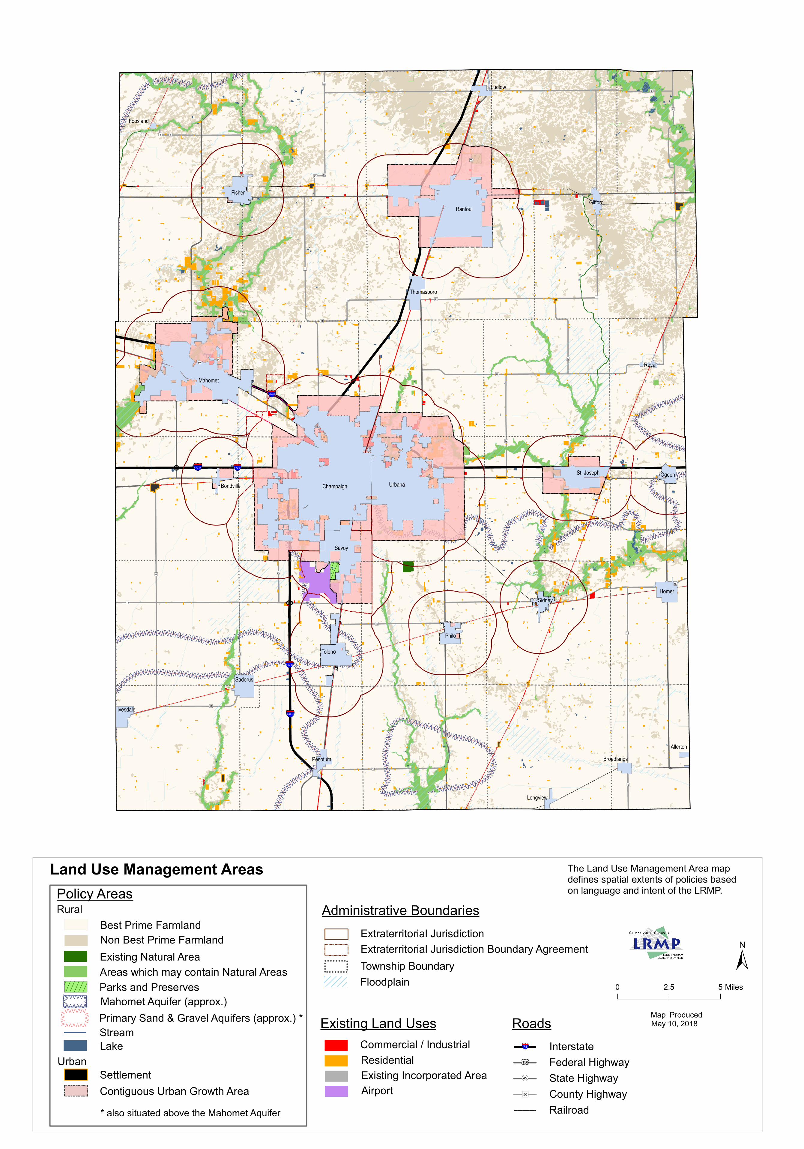
InterstateFederal HighwayState HighwayCounty HighwayRailroad
Stream
Champaign Urbana
Rantoul
Mahomet
Tolono
Fisher
St. Joseph
Philo
Homer
Sadorus
Savoy
Sidney
Ogden
Ivesdale
Thomasboro
Gifford
Pesotum
Ludlow
Royal
Broadlands
Bondville
Longview
Allerton
Foosland
§̈¦I-57 S
§̈¦I-57 N
§̈¦I-74 E
§̈¦I-72 E§̈¦I-72 W
")9
")22
")18
")17
")1
")11
")24
")15
")55
")20
")14
")32
")6 ")25
")16
")23
")8
")19
")13
")12
")30
")50")54
")20
")8
")18
")30
")15
")23
")11
")11
")23
")11
")8
")13
0 52.5 Miles
±
Policy AreasLand Use Management Areas
Map Produced May 10, 2018
Administrative Boundaries
Existing Land UsesCommercial / IndustrialResidential
§̈¦74
£¤150
¬«45
")50
Existing Natural Area
Urban
Contiguous Urban Growth AreaSettlement
Extraterritorial JurisdictionExtraterritorial Jurisdiction Boundary Agreement
RuralBest Prime FarmlandNon Best Prime Farmland
Roads
FloodplainAreas which may contain Natural Areas
VVVVVVVVVVVVV VVVVVV
Township Boundary
Lake
Parks and Preserves
Existing Incorporated Area
VVVV
VVVVVVVVV VVVVVV
Airport
The Land Use Management Area map defines spatial extents of policies basedon language and intent of the LRMP.
Mahomet Aquifer (approx.) Primary Sand & Gravel Aquifers (approx.) *
* also situated above the Mahomet Aquifer


![San Pat materials [rtb] - Allison, Bass€¦ · Web viewSulphur Springs Country Club, 422 ... If the plat merely uses the word "street ... Private roads or subdivision roads which](https://img.pdfslide.net/doc/110x75/5ae2323f7f8b9a7b218bac07/san-pat-materials-rtb-allison-web-viewsulphur-springs-country-club-422-.jpg)