Embed Size (px)
Citation preview
1
PRE- FEASIBILITY REPORT
(In terms of provision of EIA Notification 2006)
(Amendment in EC (under clause 7 (ii)) a of EIA notification 2006& its amendment)
For
Expansion of Kayad Lead-Zinc Ore Underground Mine from 1.0 million
TPA to 1.2 million TPA (ROM)
At
Kayad Mine, Village, Kayad, Ajmer District, Rajasthan
By
Hindustan Zinc Limited
Rajasthan
Submitted to
Ministry of Environment, Forests and Climate Change (MoEF&CC)
New Delhi
October-2017
2
TABLE OF CONTENTS
S. No. Chapter Page No
1 Executive Summary 3
2 Introduction of Project 4
3 Project Description 7
4 Site Analysis 19
5 Planning 22
6 Proposed Infrastructure 23
7 Rehabilitation and Resettlement(R&R) Plan 23
8 Project Schedule and Cost Estimates 23
9 Analysis of Proposal 24
3
1. EXECUTIVE SUMMARY
• Hindustan Zinc Limited (HZL) is Asia’s largest non-ferrous metal producer of Zinc and Lead
and has Head officeat Udaipur, Rajasthan. HZL is world's second largest integrated
producerof Zinc with a global share of approximately 6.0%
• HZL has its operations in exploration, mining, ore processing, smelting and refining of
Zinc, Lead, Cadmium, Copper and Silver. It is also a major producer of sulphuricacid, as a
by-product of lead-zinc metal processing. HZL also has interest in wind and thermal
power generation.
• The Kayad Lead Zinc Mine is located in District & Tehsil of Ajmer Tehsil of District Ajmer.
• Environment Clearance was granted by MoEF&CC, New Delhi for Enhancement in
Production Capacity of Kayad Lead -Zinc Ore underground mine from 0.35 million TPA
(ROM) to 1.0 million TPA (ROM) vide letter no. J-11015/47/2012-IA II(M) dated
23.09.2014. Presently Valid Consent to Operate is available from Rajasthan State
Pollution Control Board (RSPCB), Jaipur for carrying Miningactivities vide letter
no.F(Mines)/Ajmer(Ajmer)/1(1)/2009-2010/7897-7901dated 04.03.2015.
• The present proposal is for expansion of Lead – Zinc ore production from underground
mine from 1.0million TPA (ROM) to 1.2million TPA (ROM). The Ore Produced at the Kayad
Mine is sent to RampuraAguchaMine for ore beneficiation in the existing mills
havingcapacity of 6.5 MTPA capacity located in Hurda Tehsil, BhilwaraDist of Rajasthan.
The ore concentrate produced at RampuraAgucha Mine shall be processed at existing
HZL Smelters.
• The Kayad village is 9 Km NNE of Ajmer city and is well connected by tar road. Jaipur, the
state capital is 127 km NE of Mine. Nearest Airport is Kishangarh at 20 KM,NE of Mine.
Although the nearest railway station is Madar (B.G.) at 6 km to the south of Kayad, the
main railway station is at Ajmer on Ajmer-Kishangarh section of North Western Railway, 9
km SSE of Kayad. NH 79,Jaipur-Ajmer is at about half a km. from the lease area
• Kayad deposit is hosted by mid proterozoic Delhi Fold Belt of Metasediments (2000 my-
750 my).Kayad Lies near the center of this 30 km wise belt in Ajmer Area . Mining Lease
is demarcated on part plan of Survey of India Toposheet no. 45J/10. The deposit lies
between latitude N 260 31’ 30” to N26
0 32’ 30”, longitude E 74
0 41’ 00” to E 74
0 42’ 00”,
4
2.0 INTRODUCTION OF PROJECT
2.1 Identification of Project and Project Proponent:
2.1.1 Identification of Project
Zinc is a very versatile non-ferrous metal. Zinc’s different applications rank it as the 4th most
common metal in use after iron, aluminum and copper. In India, zinc demand growth
continues to remain strong at about 8%, and is expected to leverage support from the
automotive and the white goods sectors like galvanizing steel which protects from
corrosionOther major uses for Zinc include its utility in brass and bronze among many alloys;
die casting, batteries, chemical compounds such as paints, ceramics, pharmaceuticals and
fertilizers.
Over the medium term, growth in consumption is projected to average 5 per cent a year
which is also likely to remain stable till Year 2025. Global zinc demand continues to be driven
mainly by galvanizing sector in the emerging economies of Asia and Africa. The reported
increase in Chinese manufacturing activities and US automotive sales along with emerging
signs of stability in Europe’s manufacturing and services sector are expected to support zinc
demand.
The reason for expansion is that the ore produced at the Kayad Mine is sent to Rampura
Agucha Mines for beneficiation inthe existing mills of 6.5 MTPA capacities. Production from
opencast mine at Rampura Agucha is now on a decreasing trend due to increasing pit depth.
In order to increase the indigenousproduction of concentrates for captive smelters it is
necessary to utilize the milling capacity ofRampuraAgucha mine mill to full extent.
Ore production from Rampura Agucha underground mines is ramped up and the combined
treatment of Rampura Aguchaore and Kayad ore will ensure the better utilization of the
milling capacity.
The existing modified mining plan was approved by IBM which is valid upto year 2020-21.
Nearly 10248 m of underground delineation drilling and 4970 m surface drilling was
completed in the FY 16-17, the resultant change in configuration and redesign of mine
methods leads to overall addition of 1.7 Mt reserves. The revised current exploration plan of
FY 17-18 is in progress and 13831 m drilling has been completed upto 30-Sep-2017 which has
enhanced the resource by 2.1Mt.The exploratory drilling supported in further updation of the
shape & geometry of the Ore body in the lower block where the most of the production will
come during the planned period. The estimated reserve and resource is 9.74 Mt as on 1st
Oct
2017.
In addition to the above, several positive intersections during the progressive exploration
have indicated additional ore potential of Kayad Mines. Various satellite lenses have been
identified both along strike and depth in addition to the easterly extension of the main lens.
The eastern fringes of the main lens are further found to be extending for greater length.
However the width of the ore is ~ 2-6 m with 4-7 % (Total metal content).
2.1.2 Project Proponent
Hindustan Zinc Limited (HZL) is the only integrated Lead & Zinc manufacturer in India and
owns captive lead and zinc mines at Rampura Agucha, Rajpura Dariba, Kayad, Sindesar Khurd
and Zawar Mines that cater to the requirement of lead and zinc concentrate for its smelters
located at Chanderiya, Dariba & Debari. All the mining & smelting operations are based at
Rajasthan.
5
2.2 Brief Description of Nature of Project
2.2.1 Nature of the Project
The projects is a mechanised underground Lead-Zinc mine project and is classified as
“Category-A” by Ministry of Environment & Forests, New Delhi as per EIA notification dated
on 14th September 2006.The present proposal is for expansion of Lead – Zinc ore production
from underground mine from 1.0 to 1.2million TPA (ROM) (20% increase). Amendment in EC
under clause 7 (ii)aof EIA notification 2006, & subsequent amendments is applied.
2.2.2 Size of the Project
Kayad Minedeposit extends over a lease area of 480.45ha with an estimated insituore
reserves& resources as on 01.10.2017is 9.74Mt (1.17% Pb and 7.23% Zn). The proposed
expansion of mine is from 1.0to 1.2million TPAof Lead-Zinc Ore Production (20%
increase).Total cost of the proposed expansion is estimated to be Rs.171crores.
2.2.3 Location of the Project
The Kayadmine is 9 Km NNE of Ajmer city and is well connected by tar road. Jaipur, the state
capital is at 127 Km of NE and nearest airport is Kishangarh at 20 km NE of the deposit.
Although the nearest railway station is Madar (B.G.) at 6 km to the south of Kayad, the main
railway station is at Ajmer on Ajmer-Kishangarh section of North Western Railway, 9 km SSE
of Kayad. NH 8 79 Jaipur-Ajmer is at about half a km. from the lease area. Mining Lease is
demarcated on part plan of Survey of India Toposheet no. 45J/10. Kayad Deposit lies
between Latitudes 26°31’41.47”N-26°31’37.04”Nand Longitudes 74°41”30.73”E-
74°41’30.45”E.
.
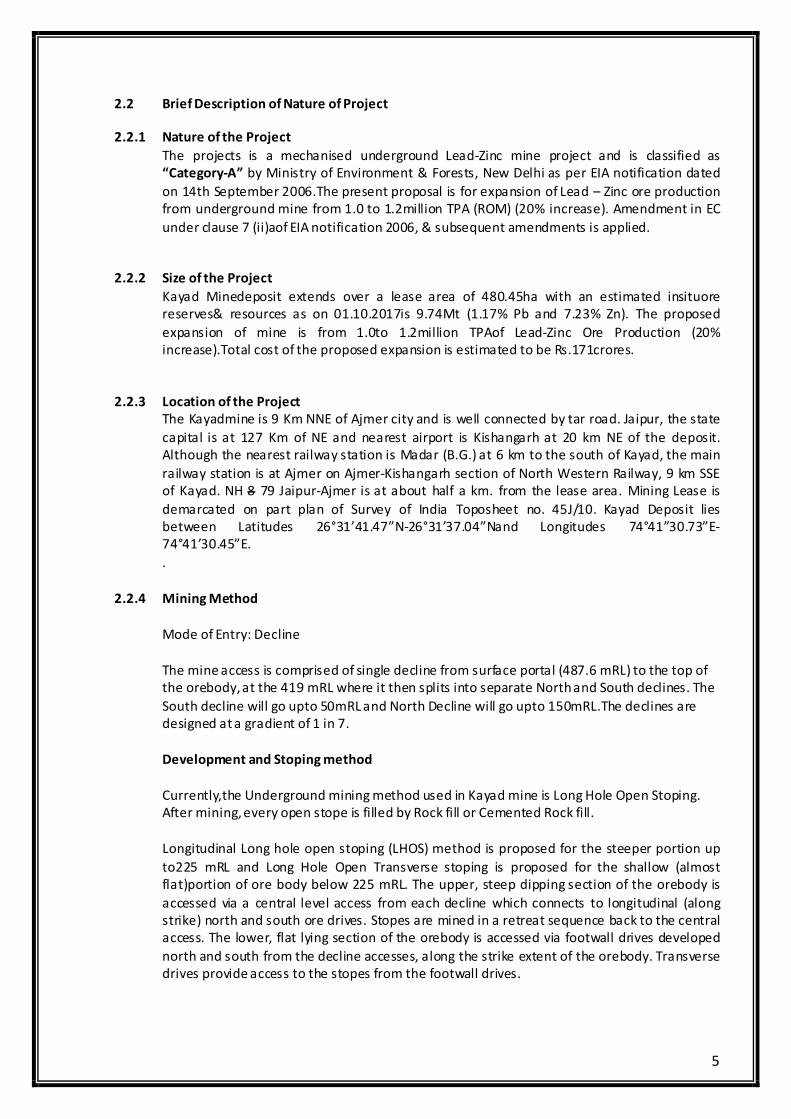
2.2.4 Mining Method
Mode of Entry: Decline
The mine access is comprised of single decline from surface portal (487.6 mRL) to the top of
the orebody, at the 419 mRL where it then splits into separate North and South declines. The
South decline will go upto 50mRL and North Decline will go upto 150mRL.The declines are
designed at a gradient of 1 in 7.
Development and Stoping method
Currently,the Underground mining method used in Kayad mine is Long Hole Open Stoping.
After mining, every open stope is filled by Rock fill or Cemented Rock fill.
Longitudinal Long hole open stoping (LHOS) method is proposed for the steeper portion up
to225 mRL and Long Hole Open Transverse stoping is proposed for the shallow (almost
flat)portion of ore body below 225 mRL. The upper, steep dipping section of the orebody is
accessed via a central level access from each decline which connects to longitudinal (along
strike) north and south ore drives. Stopes are mined in a retreat sequence back to the central
access. The lower, flat lying section of the orebody is accessed via footwall drives developed
north and south from the decline accesses, along the strike extent of the orebody. Transverse
drives provide access to the stopes from the footwall drives.
6
Mine Development in Block I and II is completed for main lens and Block III is currently being
developed.In Block III wherever ore body is steeper LongitudinalOpen Stoping Method is
proposed. All the mining is planned with back filling with Rock fill(RF) and Cemented rock fill
(CRF). Other Mining Methods such as Drift and fill method may be considered wherever
orebody configuration requires.
Ore body is being accessed by developing ore drives of 5 m x 4.5 m (WxH) in dimension from
all these main levels. The decline of 5.5m x 5m (WxH) in dimension is serving the purpose of
hauling of waste and ore up to surface. In addition, the decline also serves as man, material &
ventilation intake to the mine. Decline is also used for the to-and–fro transport of all heavy
earth moving and drilling equipment. The second egress to the mine is provided in ventilation
raise of 3.5m dia. at North of the mine.
Production drilling is planned from both the drill level. Rings shall be drilled from slot to FW
contact of orebody using Simba/Solo/ITH drill machinecovering the geometry of the stope.
Three main mechanical ventilators of 150 Cum/sec (450 KW) capacity are installed at bottom
of South ventilation raise (3.5m diameter circular) at 400 mRL, North ventilation raise (3.5m
diameter circular) at 375 mRL and Central ventilation raise (3.5m diameter circular) at 250
mRL. The fans serve as the main exhaust for both sections. Fresh air enters through main
decline (130 Cum/sec) and through North surface ventilation intake raise (50 Cum/sec) and
South surface ventilation intake raise (50 Cum/sec).
The blasted muck from stope is then withdrawn at extraction level through LHDs and then
directly loaded in to mine trucks for hauling through ramps from underground to surface
stock yard. From stock yard, ore is dispatched to RampuraAgucha Mine for further
processing.
While blasting in stopes, each ring in the stope will be blasted with multiple delays, so that
the blast vibrations are kept within the safe limits. Care shall be taken to maintain through
proper hole measurement, charge length, stemming and adequate delay in holes. Adequate
numbers of detonators shall be used to keep the charge per delay in permissible limit and
each blast vibration and sound will be monitored by CIMFR, Dhanbad.
Fig 4: LVS showing Mine workings
7
2.2.5 Importance to the Country & Region
Enhancing the production capacity ofthis Lead-Zinc deposit is important for the country's
long-term economic growth and increased revenue earnings. This will transform the region's
economy from predominantly agricultural to significantly industrial, and accelerate the pace
of industrial development in the region.
2.2.6 Supply and Demand Details
In the aftermath of the Great Financial Crisis of 2008-2009, the Indian economy lost
momentum. Growth in industrial production slowed from an average of 7.9% during 2000-
2008 to 3.9% over the period 2010-2015.
The rising trend of Indian economy has increased growth and also the continuing boom in
manufacturing and in steel production coupled with the growth in automobile industries and
infrastructure in particular has raised demand for lead and zinc metals considerably.
2.3 Need for the Project and its Importance to the Country & Region
Zinc is a very versatile non-ferrous metal. Zinc’s different applications rank it as the 4th most
common metal in use after iron, aluminum and copper. Global zinc consumption is forecast
to grow at a compound average annual rate of 2.4% p.a. over the period 2016-2021. Global
zinc consumption is projected to grow to 20Mt in 2035 representing an average annual
increase of 0.28Mt.
Consumption growth sets a requirement for extra raw material supply to smelters
(concentrate and secondary materials) of 0.28Mt/a Zn. Whilst some of the extra mine
capacity will come from expansions and mine life extensions of existing producers, the
majority will be from new mines. HZL’s largest producer RampuraAguchaopenpit mine is in
closure stage, so by mining this deposit, HZL will provide the country with increased revenue
earnings. This will also transform the region's economy..
2.4 Import Vs Indigenous Production
The present production capacities of Zinc in India are sufficient to meet the domestic
requirements. However, the demand for zinc in India is expected to grow at a rate of
8%which makes it viable for the expansion of the zinc production capacities. Further the
deficit in international market during the upcoming years provides opportunity for export.
2.5 Export Possibility
Indian exports majorly catered to South East Asian and African nations. In India, since,
Hindustan Zinc is the largest producer of primary zinc, export of zinc is highly feasible and
shall bring value addition.
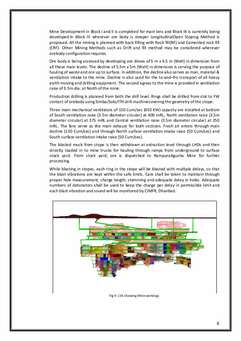
2.6 Domestic/Export Market
Zinc having found primary application in galvanization, a range of galvanized products are
produced to meet various industrial and consumer demands. Galvanized sheets (corrugated
and plain), galvanized pipes, galvanized structures, galvanized sheet, galvanized wires are
used for various applications. Galvanizing Segment accounts for 68% share of the overall zinc
demand in India while Non-Galvanizing accounts for 32% share. Among the major customer
segments, Galvanized Sheets accounts for major share of the zinc consumption followed by
structures and Alloys. The following chart explains the demand for zinc in India and its
segment wise break-up
8
(Source: Wood Mackenzie Long Term Outlook)
India has the potential for exporting zinc profitably as global zinc demand continues to be
high & driven mainly by galvanizing sector in the emerging economies of Asia and Africa. The
reported increase in Chinese manufacturing activities and US automotive sales along with
emerging signs of stability in Europe’s manufacturing and services sector are expected to
support zinc demand
2.7 Employment Generation (Direct & Indirect)
The existing operation has direct employment of about 629 persons and the proposed
project will be managed by the existing resources but there is an ample opportunity for
increase in indirect employment due to mining related activities like transport, small
workshops, garages, and due to development of local area.
3.0 PROJECT DESCRIPTION
3.1 Type of Project
The proposed project is a mechanized underground lead-zinc mining brownfield project
involving 20% increase in ore productioni.e from 1.0 to 1.2 million TPA (ROM).
3.2 Location
The Kayad village is 9 Km NNE of Ajmer city and is well connected by tar road. Jaipur, the
state capital and nearest airport is 127 km NE of the deposit. Although the nearest railway
station is Madar (B.G.) at 6 km to the south of Kayad, the main railway station is at Ajmer on
Ajmer-Kishangarh section of North Western Railway, 9 km SSE of Kayad. NH 8 Jaipur-Ajmer is
at about half a km.
Kayad deposit is hosted by mid proterozoic Delhi Fold Belt of Metasediments (2000 my-750
my).Kayad Lies near the center of this 30 km wise belt in Ajmer Area. Mining Lease is
demarcated on part plan of Survey of India Toposheet no. 45J/10. It lies between Latitudes
26°31’41.47”N-26°31’37.04”N and Longitudes 74°41”30.73”E-74°41’30.45”E.
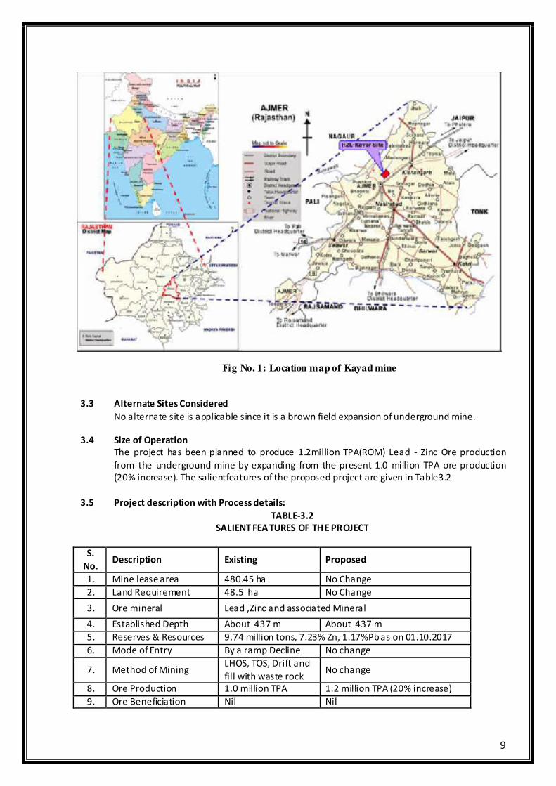
9
Fig No. 1: Location map of Kayad mine
3.3 Alternate Sites Considered
No alternate site is applicable since it is a brown field expansion of underground mine.
3.4 Size of Operation
The project has been planned to produce 1.2million TPA(ROM) Lead - Zinc Ore production
from the underground mine by expanding from the present 1.0 million TPA ore production
(20% increase). The salientfeatures of the proposed project are given in Table3.2
3.5 Project description with Process details:
TABLE-3.2
SALIENT FEA TURES OF THE PROJECT
S.
No. Description Existing Proposed
1. Mine lease area 480.45 ha No Change
2. Land Requirement 48.5 ha No Change
3. Ore mineral Lead ,Zinc and associated Mineral
4. Established Depth About 437 m About 437 m
5. Reserves & Resources 9.74 million tons, 7.23% Zn, 1.17%Pb as on 01.10.2017
6. Mode of Entry By a ramp Decline No change
7. Method of Mining LHOS, TOS, Drift and
fill with waste rock No change
8. Ore Production 1.0 million TPA 1.2 million TPA (20% increase)
9. Ore Beneficiation Nil Nil
10
10. Waste Rock Generation
(2017-18 to 2020-21)
5,95,000 MT
8,55,000 MT*
11. Waste dump area 1.0 Ha No change
12. Power requirement &
Source
5.0 MW, AVVNL &
Emergency 1.0 MW
DG set
No change
13. Water requirement &
Source
560 m3/day, (PHED+
STP+ Mine
Dewatering
No change
14. Manpower requirement
(Nos.) 629 No Change
15 Project Cost Rs. 350 crores Rs. 171 Crores (Additional)
16 Environment Protection
Cost Rs. 4.3 crores Rs. 17 Crores
* In the proposed expansion of Kayad Mine, no additional waste will be dumped on the surface
beyond the already approved waste quantity and hence no additional waste dump is envisaged. The
increased waste generated will be disposed off into the underground voids. Additional waste
required for backfilling will be utilised from Rampura Agucha Mine.
3.5.1 Mine Description&Introduction:
Kayad deposit is hosted by mid proterozoic Delhi Fold Belt of Metasediments (2000 my-750
my).Kayad Lies near the center of this 30 km wise belt in Ajmer Area. Mining Lease is
demarcated on part plan of Survey of India Toposheet no. 45J/10. Kayad Deposit lies
between Latitudes 26°31’41.47”N-26°31’37.04”N and Longitudes 74°41”30.73”E-
74°41’30.45”E.The area is undulating with altitude varying from 486-568 506 MSL. The
highest point is at 568506 MSL. The area is mostly soil covered with weathered rock. No
prominent landmark is present within project site.
3.5.2 Geology
3.5.2.1 Topography
The area is undulating with altitude varying from 480 to 506 mRL. The highest point is a small
hillock just east of the village Kayad, attaining an altitude of 506 mRL. The area is mostly soil
covered with a few outcrops here and there. The seasonal “Kala Nala” (outside the ML)
flowing from south to north joins Phool Sagar reservoir near Kayad village. The drainage is a
seasonal and is mostly of dendritic pattern and there is no watercourse other than seasonal
“Kala Nala” in the area. A number of dug well with water table varying between 20 to 30 m
are present.
The Kayad village falls on the western end of lease boundary. The topsoil is fertile and
suitablefor agriculture. Seasonal crops are jawar, maize, bazra and other cereals etc.
3.5.2.2 Regional Geology
Kayad deposit is hosted by mid proterozoic Delhi Fold Belt of metasediments (2000 my-750
my). Kayad lies near the centre of this 30 km wide belt in Ajmer area. While a major
Kaliguman lineament forms the boundary of Delhi supergroup with Sandmata / Mangalwar
complex in the east, MarwarSupergroup lithology bounds this in the west.
11
The rocks are assumed to have been deposited in a shelf margin to a shelf interior
environment. Later orogenesis with magmatism concomitant contributed a significant change
in the overall setup and morphotectonic features.
Table: Summarized Geological Succession
Group Sub Group Formation Litho units
Ajabgarh Group
Arauli
Ajmer Formation
Carbonaceous Phyllite, Ga rnetiferous,
Chlorite schist
Barkhol Carbonaceous Phyllite and Quartzite
Thanagazi Phyllite , Felsic volcanic rocks
Sariska Quartzite, Phyllite and Marble
Kushalgarh Siliceous Schist, Marble bands and
dolomite rich bands.
Structure
The general strike of litho units exposed in the Kayad and its surrounding area is NNE-SSW
toNE-SW parallel to regional trend of central axis of main "Delhi Synclinorium". An open
foldstructure with shallow north easterly plunging hinge has been revealed after the detailed
studies of the recent oriented core drilling over the deposit. The contact of quartz mica schist
and calc silicate is a folded one. Hinge of the fold strikes in N25E-S25W direction. While one
limb is dipping about 600-70
0 due SE, the other one is flatter with dips ranging from 10
0 to 40
0
due SE.
The primary bedding is well preserved in the form of color and compositional banding
represented by bands of ferruginous, siliceous and carbonates material in the calc-silicate
exposed on the mound east of Kayad village. Foliation in the schist is parallel to axial plane of
F2 fold and is dominant secondary structure recorded in the area. The foliations are often
seencrenulated in the schist due to later deformation and shearing.
Joints are seen in the quartzite, quartz mica schist, Calc-silicate and rarely in the migmatites
and gneisses. The common trends are E-W with vertical dips and NNE-SSW having steep dips
of 70 to 80 degrees due east or west.
Mineralization
In the mineralised zone grains of sphalarite, galena and pyrrhotite show effect of shearing in
the form of brecciation and mylonitisation. Number of small sympathetic to tangential shears
and fracture planes of varying width is encountered in the boreholes. The main host rock is
Quartz mica schist with some mineralization also occurring in calc silicate.
12
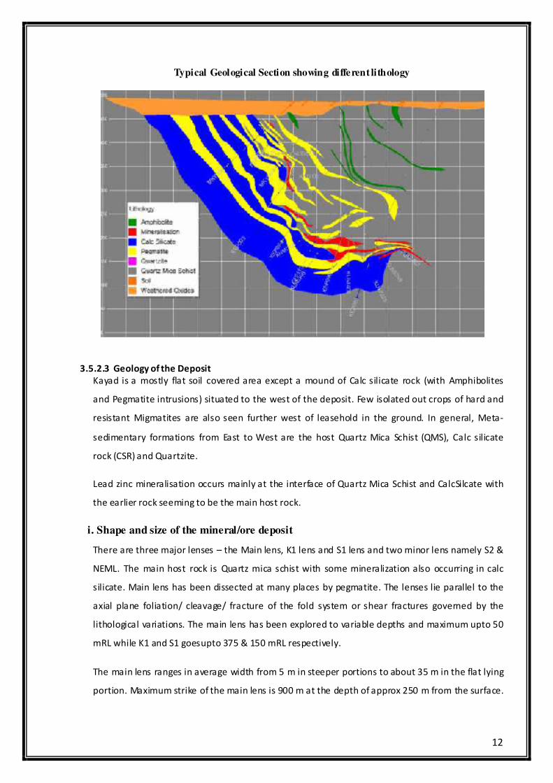
Typical Geological Section showing different lithology
3.5.2.3 Geology of the Deposit
Kayad is a mostly flat soil covered area except a mound of Calc silicate rock (with Amphibolites
and Pegmatite intrusions) situated to the west of the deposit. Few isolated out crops of hard and
resistant Migmatites are also seen further west of leasehold in the ground. In general, Meta-
sedimentary formations from East to West are the host Quartz Mica Schist (QMS), Calc silicate
rock (CSR) and Quartzite.
Lead zinc mineralisation occurs mainly at the interface of Quartz Mica Schist and CalcSilcate with
the earlier rock seeming to be the main host rock.
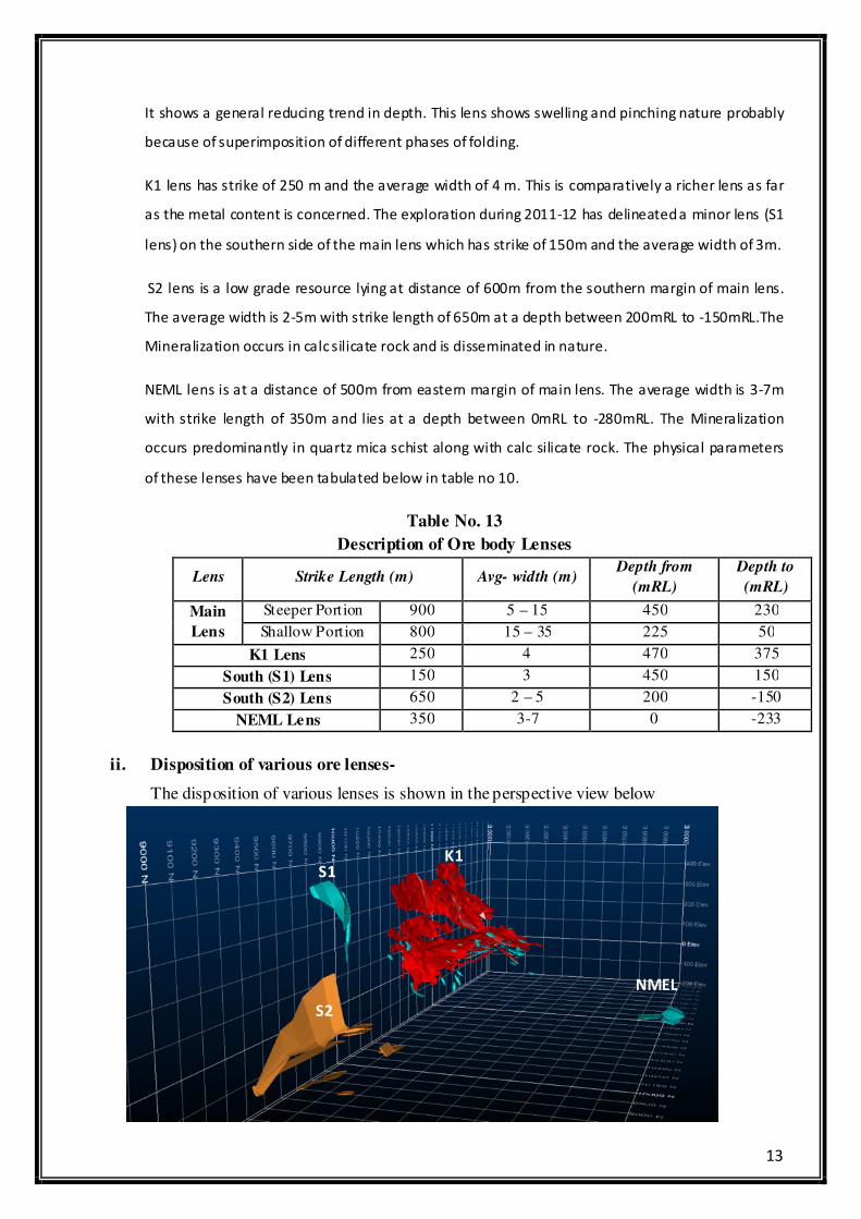
i. Shape and size of the mineral/ore deposit
There are three major lenses – the Main lens, K1 lens and S1 lens and two minor lens namely S2 &
NEML. The main host rock is Quartz mica schist with some mineralization also occurring in calc
silicate. Main lens has been dissected at many places by pegmatite. The lenses lie parallel to the
axial plane foliation/ cleavage/ fracture of the fold system or shear fractures governed by the
lithological variations. The main lens has been explored to variable depths and maximum upto 50
mRL while K1 and S1 goesupto 375 & 150 mRL respectively.
The main lens ranges in average width from 5 m in steeper portions to about 35 m in the flat lying
portion. Maximum strike of the main lens is 900 m at the depth of approx 250 m from the surface.
13
It shows a general reducing trend in depth. This lens shows swelling and pinching nature probably
because of superimposition of different phases of folding.
K1 lens has strike of 250 m and the average width of 4 m. This is comparatively a richer lens as far
as the metal content is concerned. The exploration during 2011-12 has delineated a minor lens (S1
lens) on the southern side of the main lens which has strike of 150m and the average width of 3m.
S2 lens is a low grade resource lying at distance of 600m from the southern margin of main lens.
The average width is 2-5m with strike length of 650m at a depth between 200mRL to -150mRL.The
Mineralization occurs in calc silicate rock and is disseminated in nature.
NEML lens is at a distance of 500m from eastern margin of main lens. The average width is 3-7m
with strike length of 350m and lies at a depth between 0mRL to -280mRL. The Mineralization
occurs predominantly in quartz mica schist along with calc silicate rock. The physical parameters
of these lenses have been tabulated below in table no 10.
Table No. 13
Description of Ore body Lenses
Lens Strike Length (m) Avg- width (m) Depth from
(mRL)
Depth to
(mRL)
Main
Lens
Steeper Portion 900 5 – 15 450 230
Shallow Portion 800 15 – 35 225 50
K1 Lens 250 4 470 375
South (S1) Lens 150 3 450 150
South (S2) Lens 650 2 – 5 200 -150
NEML Lens 350 3-7 0 -233
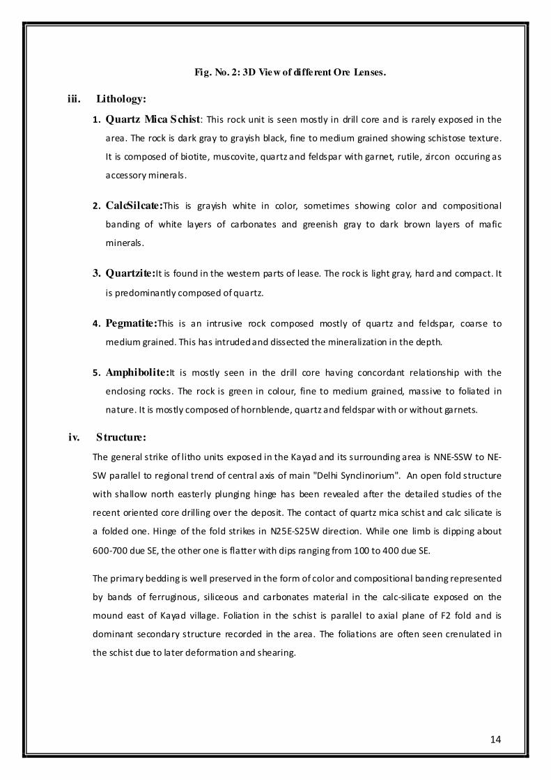
ii. Disposition of various ore lenses-
The disposition of various lenses is shown in the perspective view below
S2
S1 K1
NMEL
14
Fig. No. 2: 3D View of different Ore Lenses.
iii. Lithology:
1. Quartz Mica Schist: This rock unit is seen mostly in drill core and is rarely exposed in the
area. The rock is dark gray to grayish black, fine to medium grained showing schistose texture.
It is composed of biotite, muscovite, quartz and feldspar with garnet, rutile, zircon occuring as
accessory minerals.
2. CalcSilcate:This is grayish white in color, sometimes showing color and compositional
banding of white layers of carbonates and greenish gray to dark brown layers of mafic
minerals.
3. Quartzite:It is found in the western parts of lease. The rock is light gray, hard and compact. It
is predominantly composed of quartz.
4. Pegmatite:This is an intrusive rock composed mostly of quartz and feldspar, coarse to
medium grained. This has intruded and dissected the mineralization in the depth.
5. Amphibolite:It is mostly seen in the drill core having concordant relationship with the
enclosing rocks. The rock is green in colour, fine to medium grained, massive to foliated in
nature. It is mostly composed of hornblende, quartz and feldspar with or without garnets.
iv. Structure:
The general strike of litho units exposed in the Kayad and its surrounding area is NNE-SSW to NE-
SW parallel to regional trend of central axis of main "Delhi Synclinorium". An open fold structure
with shallow north easterly plunging hinge has been revealed after the detailed studies of the
recent oriented core drilling over the deposit. The contact of quartz mica schist and calc silicate is
a folded one. Hinge of the fold strikes in N25E-S25W direction. While one limb is dipping about
600-700 due SE, the other one is flatter with dips ranging from 100 to 400 due SE.
The primary bedding is well preserved in the form of color and compositional banding represented
by bands of ferruginous, siliceous and carbonates material in the calc-silicate exposed on the
mound east of Kayad village. Foliation in the schist is parallel to axial plane of F2 fold and is
dominant secondary structure recorded in the area. The foliations are often seen crenulated in
the schist due to later deformation and shearing.
15
Joints are seen in the quartzite, quartz mica schist, Calc-silicate and rarely in the migmatites and
gneisses. The common trends are E-W with vertical dips and NNE-SSW having steep dips of 70 to
80 degrees due east or west.
Based on the drilling data and mapping of limited surface outcrops of lithounits it is observed that
a major shear zone trending N-S to NNE-SSW is passing through the area near the contact of calc-
silicate and quartz mica schist along which major pegmatite bodies have probably been emplaced.
This zone is 40 to 100m wide and quartz mica schist show mylonitisation, brecciation and
retrograde alteration of muscovite to sericite.
In the mineralised zone grains of sphalarite, galena and pyrrhotite show effect of shearing in the
form of brecciation and mylonitisation. Number of small sympathetic to tangential shears and
fracture planes of varying width is encountered in the boreholes. In general these shear planes
depending upon their spatial orientation are either at high angle to the core axis or are parallel to
sub parallel in nature.
v. Mineralogy
The main ore minerals are sphalerite and galena. Chalcopyrite occurs in minor proportions mostly
on footwall of the orebody. Other sulphides like pyrrhotite and some pyrite also constitutes the
assemblage. The sulphides occur as discontinuous veins, massive bands, fracture fillings, and
occasionally as disseminations. Sphalerite is coarse to medium grained.
Galena occurs as medium grained inclusions, patches and small stringers within sphalerite and
pyrrhotite. Chalcopyrite is observed as fracture fillings within pyrrhotite and occasionally in
sphalerite. Quartz, biotite, muscovite, feldspar with occasional Amphiboles (hornblende) and
garnet are main gangue minerals.
3.5.2.4 Exploration:
Exploration at Kayad commenced in 1967 when Geological Survey Of India (GSI) carried out
multisensory airborne geophysical Survey in some parts of Rajasthan and other states under
(OHR) Operation Hard Rock.
Two anomalies were picked in Kayad and Ghugra area near Ajmer. After geological mapping and
geochemical survey to ascertain the causative source of aero geophysical anomaly, drilling in the
anomalous geochemical anomaly zone led to the discovery of this deposit in 1988. GSI drilled 3179
m in 14 holes at 200 m spacing from 1988-91. A total 7.5 million tons of lead-zinc ore resource
with 1.20% lead and 12.0% zinc was estimated by GSI.
16
In view of potentiality of the prospect, Mineral Exploration Corporation Ltd., (MECL) formulated
an integrated scheme of exploration involving 7650 meters of drilling in 42 boreholes, bench scale
beneficiation test and base line environment survey. MECL drilled 9584.90m in 42 holes (1994-97)
on promotional basis and estimated 10 million tons of reserves grading 2.67%Pb and 14.89% Zn
over a strike of 1 Km and vertical depth of 250m.
Evaluation of MECL data revealed significant exploration gaps and presence of pegmatite
intrusions in host rock and had considerable impact on the continuity of orebody in strike and dip.
Hindustan Zinc Limited (HZL) planned the exploration with an objective of delineation of the
deposit by filling the gaps, establish firm geological, metallurgical and geotechnical parameters for
conceptual mine planning and preparation of feasibility report.
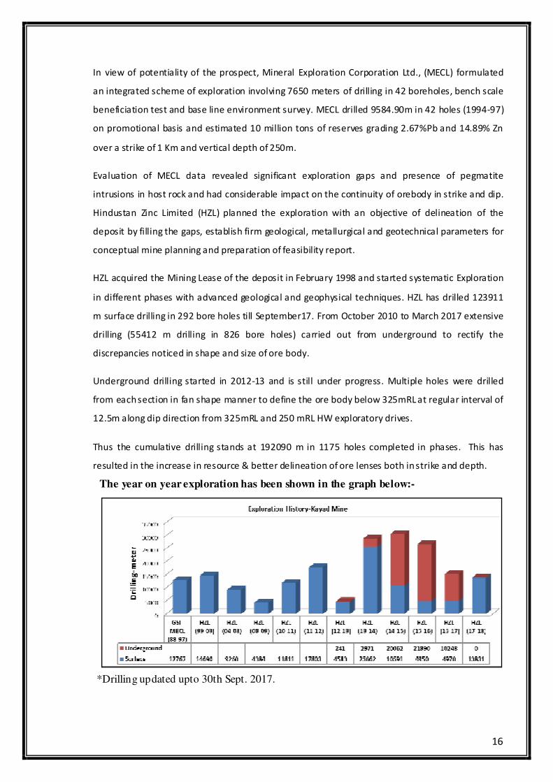
HZL acquired the Mining Lease of the deposit in February 1998 and started systematic Exploration
in different phases with advanced geological and geophysical techniques. HZL has drilled 123911
m surface drilling in 292 bore holes till September17. From October 2010 to March 2017 extensive
drilling (55412 m drilling in 826 bore holes) carried out from underground to rectify the
discrepancies noticed in shape and size of ore body.
Underground drilling started in 2012-13 and is still under progress. Multiple holes were drilled
from each section in fan shape manner to define the ore body below 325mRL at regular interval of
12.5m along dip direction from 325mRL and 250 mRL HW exploratory drives.
Thus the cumulative drilling stands at 192090 m in 1175 holes completed in phases. This has
resulted in the increase in resource & better delineation of ore lenses both in strike and depth.
The year on year exploration has been shown in the graph below:-
*Drilling updated upto 30th Sept. 2017.
17
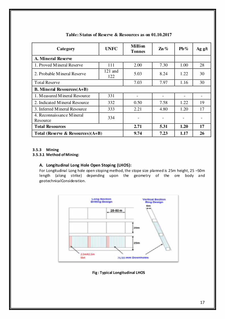
Table: Status of Reserve & Resources as on 01.10.2017
Category UNFC Million
Tonnes Zn% Pb% Ag g/t
A. Mineral Reserve
1. Proved Mineral Reserve 111 2.00 7.30 1.00 28
2. Probable Mineral Reserve 121 and
122 5.03 8.24 1.22 30
Total Reserve 7.03 7.97 1.16 30
B. Mineral Resources(A+B)
1. Measured Mineral Resource 331 - - - -
2. Indicated Mineral Resource 332 0.50 7.58 1.22 19
3. Inferred Mineral Resource 333 2.21 4.80 1.20 17
4. Reconnaissance Mineral
Resource 334 - - - -
Total Resources 2.71 5.31 1.20 17
Total (Reserve & Resources)(A+B) 9.74 7.23 1.17 26
3.5.3 Mining
3.5.3.1 Method of Mining:
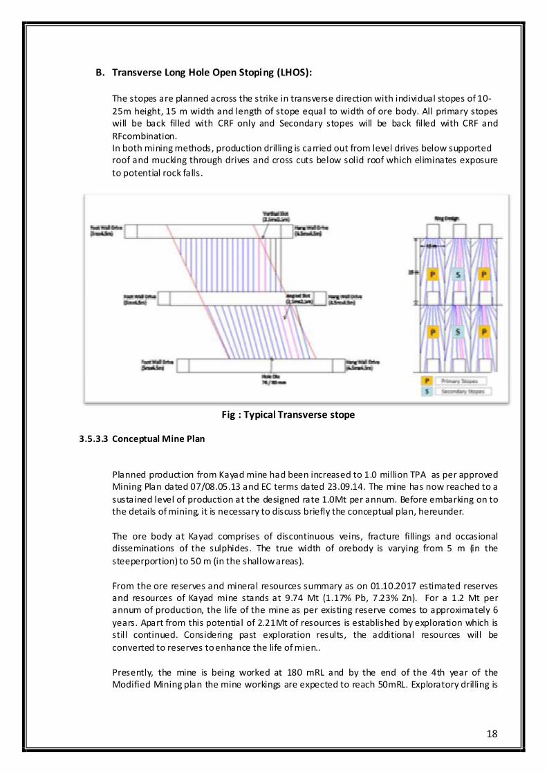
A. Longitudinal Long Hole Open Stoping (LHOS):
For Longitudinal Long hole open stoping method, the stope size planned is 25m height, 25 –50m
length (along strike) depending upon the geometry of the ore body and
geotechnicalConsideration.
Fig : Typical Longitudinal LHOS
18
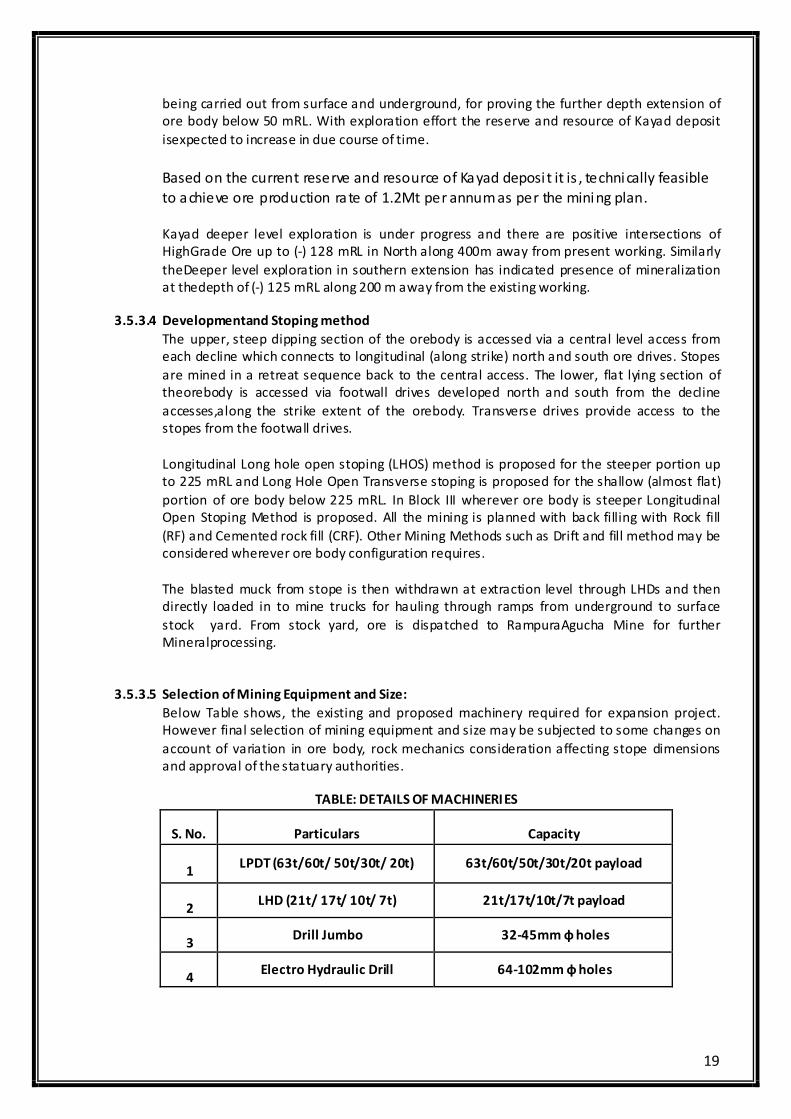
B. Transverse Long Hole Open Stoping (LHOS):
The stopes are planned across the strike in transverse direction with individual stopes of 10-
25m height, 15 m width and length of stope equal to width of ore body. All primary stopes
will be back filled with CRF only and Secondary stopes will be back filled with CRF and
RFcombination.
In both mining methods, production drilling is carried out from level drives below supported
roof and mucking through drives and cross cuts below solid roof which eliminates exposure
to potential rock falls.
Fig : Typical Transverse stope
3.5.3.3 Conceptual Mine Plan
Planned production from Kayad mine had been increased to 1.0 million TPA as per approved
Mining Plan dated 07/08.05.13 and EC terms dated 23.09.14. The mine has now reached to a
sustained level of production at the designed rate 1.0Mt per annum. Before embarking on to
the details of mining, it is necessary to discuss briefly the conceptual plan, hereunder.
The ore body at Kayad comprises of discontinuous veins, fracture fillings and occasional
disseminations of the sulphides. The true width of orebody is varying from 5 m (in the
steeperportion) to 50 m (in the shallow areas).
From the ore reserves and mineral resources summary as on 01.10.2017 estimated reserves
and resources of Kayad mine stands at 9.74 Mt (1.17% Pb, 7.23% Zn). For a 1.2 Mt per
annum of production, the life of the mine as per existing reserve comes to approximately 6
years. Apart from this potential of 2.21Mt of resources is established by exploration which is
still continued. Considering past exploration results, the additional resources will be
converted to reserves to enhance the life of mien..
Presently, the mine is being worked at 180 mRL and by the end of the 4th year of the
Modified Mining plan the mine workings are expected to reach 50mRL. Exploratory drilling is
19
being carried out from surface and underground, for proving the further depth extension of
ore body below 50 mRL. With exploration effort the reserve and resource of Kayad deposit
isexpected to increase in due course of time.
Based on the current reserve and resource of Kayad deposi t it is , technically feasible
to achieve ore production rate of 1.2Mt per annum as per the mining plan.
Kayad deeper level exploration is under progress and there are positive intersections of
HighGrade Ore up to (-) 128 mRL in North along 400m away from present working. Similarly
theDeeper level exploration in southern extension has indicated presence of mineralization
at thedepth of (-) 125 mRL along 200 m away from the existing working.
3.5.3.4 Developmentand Stoping method
The upper, steep dipping section of the orebody is accessed via a central level access from
each decline which connects to longitudinal (along strike) north and south ore drives. Stopes
are mined in a retreat sequence back to the central access. The lower, flat lying section of
theorebody is accessed via footwall drives developed north and south from the decline
accesses,along the strike extent of the orebody. Transverse drives provide access to the
stopes from the footwall drives.
Longitudinal Long hole open stoping (LHOS) method is proposed for the steeper portion up
to 225 mRL and Long Hole Open Transverse stoping is proposed for the shallow (almost flat)
portion of ore body below 225 mRL. In Block III wherever ore body is steeper Longitudinal
Open Stoping Method is proposed. All the mining is planned with back filling with Rock fill
(RF) and Cemented rock fill (CRF). Other Mining Methods such as Drift and fill method may be
considered wherever ore body configuration requires.
The blasted muck from stope is then withdrawn at extraction level through LHDs and then
directly loaded in to mine trucks for hauling through ramps from underground to surface
stock yard. From stock yard, ore is dispatched to RampuraAgucha Mine for further
Mineralprocessing.
3.5.3.5 Selection of Mining Equipment and Size:
Below Table shows, the existing and proposed machinery required for expansion project.
However final selection of mining equipment and size may be subjected to some changes on
account of variation in ore body, rock mechanics consideration affecting stope dimensions
and approval of the statuary authorities.
TABLE: DETAILS OF MACHINERIES
S. No. Particulars Capacity
1 LPDT (63t/60t/ 50t/30t/ 20t) 63t/60t/50t/30t/20t payload
2 LHD (21t/ 17t/ 10t/ 7t) 21t/17t/10t/7t payload
3 Drill Jumbo 32-45mm ф holes
4 Electro Hydraulic Drill 64-102mm ф holes
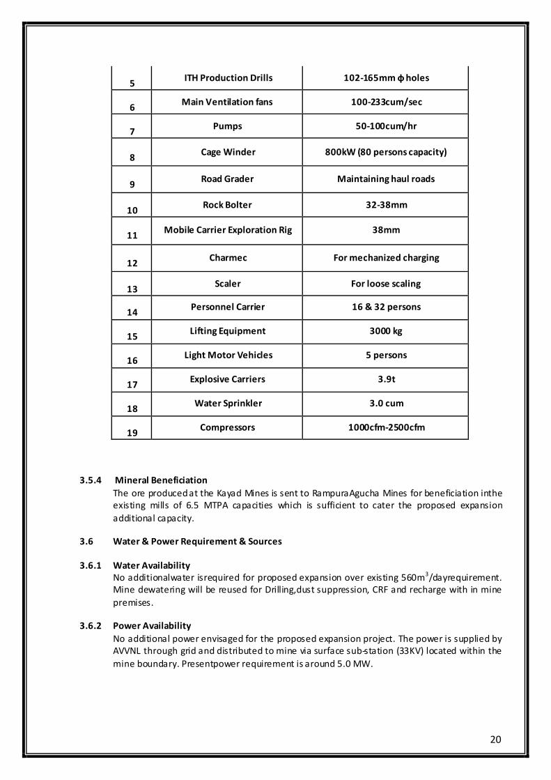
20
5 ITH Production Drills 102-165mm ф holes
6 Main Ventilation fans 100-233cum/sec
7 Pumps 50-100cum/hr
8 Cage Winder 800kW (80 persons capacity)
9 Road Grader Maintaining haul roads
10 Rock Bolter 32-38mm
11 Mobile Carrier Exploration Rig 38mm
12 Charmec For mechanized charging
13 Scaler For loose scaling
14 Personnel Carrier 16 & 32 persons
15 Lifting Equipment 3000 kg
16 Light Motor Vehicles 5 persons
17 Explosive Carriers 3.9t
18 Water Sprinkler 3.0 cum
19 Compressors 1000cfm-2500cfm
3.5.4 Mineral Beneficiation
The ore produced at the Kayad Mines is sent to RampuraAgucha Mines for beneficiation inthe
existing mills of 6.5 MTPA capacities which is sufficient to cater the proposed expansion
additional capacity.
3.6 Water & Power Requirement & Sources
3.6.1 Water Availability
No additionalwater isrequired for proposed expansion over existing 560m3/dayrequirement.
Mine dewatering will be reused for Drilling,dust suppression, CRF and recharge with in mine
premises.
3.6.2 Power Availability
No additional power envisaged for the proposed expansion project. The power is supplied by
AVVNL through grid and distributed to mine via surface sub-station (33KV) located within the
mine boundary. Presentpower requirement is around 5.0 MW.
21
3.6.3 Emergency Power
Incase of any power shortage or failure the captive stand by DG (1MVA) setis available
provide power. No additional emergency power required for the proposed expansion project.
3.7 Qty of Waste to be generated (Solid & Liquid) Wastewater Generation and its Management
3.7.1 Solid Mine Waste
The waste rock generated during mining operations was earlier being stacked at waste dump
at surface. The waste dump area is of 1.0 Ha and on the surface acquired area. With the
subsequent increase in quantum of stoping, the waste rock was being directly taken into use
as cemented rock fill in belowground. Additional waste generation due to development
activities is envisaged to 8,55,000tonne. Thus as per proposed plan Waste generation during
next 4 years will be 14,50,000tonneas compared to existing 5,95,000tonne.
In the proposed expansion of Kayad Mine, no additional waste will be dumped on the surface
beyond the already approved waste quantity and hence no additional waste dump is
envisaged. The increased waste generated will be disposed off into the underground
voids.Additional waste required for backfilling will be utilized from RampuraAgucha Mine.
3.7.2 Tailing Disposal
As the ROM ore is being transported to RampuraAgucha Lead Zinc Mines for beneficiation, no
tailing will be generated at site. The mine water will be re-used and there will not be any
discharge from the mine, hence no adverse impact is anticipated on ground water quality.
3.7.3 Used oil and other waste
Used oil generated shall be stored at earmarked area in drums and shall be sold to
registered/ authorized recyclers;No additionalused oil and Oil contaminated waste
generation is envisaged .No change in other waste for the proposed expansion.
4.0 SITE ANALYSIS
4.1 Connectivity
The Kayad village is 9 Km NNE of Ajmer city and is well connected by tar road. Jaipur, the
state capital is 127 km NE of the deposit and nearest airport is kishangarh at 20 Kms from
site. Although the nearest railway station is Madar (B.G.) at 6 km to the south of Kayad, the
main railway station is at Ajmer on Ajmer-Kishangarh section of North Western Railway, 9 km
SSE of Kayad. NH 79Jaipur-Ajmer is at about 3 Km from site
4.2 Land Form, Land use and Land Ownership
4.2.1 Land Form
The area is undulating with altitude varying from 480 to 506 mRL. The highest point is a small
hillock just east of the village Kayad, attaining an altitude of 506 mRL. The area is mostly soil
covered with a few outcrops here and there. The seasonal “Kala Nala” (outside the ML)
flowing from south to north joins Phool Sagar reservoir near Kayad village. The drainage is a
seasonal and is mostly of dendritic pattern and there is no watercourse other than seasonal
“Kala Nala” in the area.
22
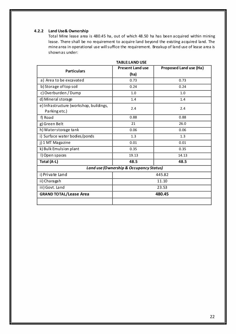
4.2.2 Land Use& Ownership
Total Mine lease area is 480.45 ha, out of which 48.50 ha has been acquired within mining
lease. There shall be no requirement to acquire land beyond the existing acquired land. The
mine area in operational use will suffice the requirement. Breakup of land use of lease area is
shown as under:
TABLE:LAND USE
Particulars Present Land use
(ha)
Proposed Land use (Ha)
a) Area to be excavated 0.73 0.73
b) Storage of top soil 0.24 0.24
c) Overburden / Dump 1.0 1.0
d) Mineral storage 1.4 1.4
e) Infrastructure (workshop, buildings,
Parking etc.) 2.4 2.4
f) Road 0.88 0.88
g) Green Belt 21 26.0
h) Water storage tank 0.06 0.06
i) Surface water bodies/ponds 1.3 1.3
j) 1 MT Magazine 0.01 0.01
k) Bulk Emulsion plant 0.35 0.35
l) Open spaces 19.13 14.13
Total (A-L) 48.5 48.5
Land use (Ownership & Occupancy Status)
i) Private Land 445.82
ii) Charagah 11.10
iii) Govt. Land 23.53
GRAND TOTAL/Lease Area 480.45

23
4.3 Topography
Topography of the area is shown in attached map
TOPOGRAPHICAL FEATURES OF THE AREA WITHIN 15.0 KM RADIUS
4.4 Existing Infrastructure and Amenities
Kayad Mine is well equipped with infrastructures like Administrative office, Work
Shop,Vocational training Center, Rescue room, Canteen, Rest Room, Washrooms,
Ambulance, First-aid facilities, Refuge Chamber etc.
4.6 Soil Classification
It has been observed that the pH of the soil in the study area ranged from 7.9-8.2. The
electrical conductivity was observed to be in the range of 0.32-0.42 mmhos/cm. The nitrogen
values range between 338.2 -386. Kg/ha. The phosphores value range between 44-56 kg/ha.
The potassium values range between 122-146 kg/ha. NPK values were found to be medium
to less in most of the locations.
4.7 Climatic Conditions
The climate is tropical to semi arid. The day temperature attains to 40° to 46°C in May-June
but falls to 4 to 10°C in December-January. Rainfall is restricted to monsoon period between
July and September and average annual rainfall between 2001 and 2016 was 312 mm.
The average data on climatic conditions are represented below:
24
Temperature: Max. 45.7°C, Min. 4.6°C
District average rainfall: 50.73 cm (10 years)
Wind direction (winter): South West and West
Wind direction (post monsoon): South West followed by North East & North West
Avg. wind speed: 1 to 20 kmph
Avg. relative humidity: 46%
4.8 Social Infrastructure available
The existing social infrastructure available with in 15 kmsincludes the following:
• Hospitals
• Bank
• Post Office
• School
• Police Station
• Shopping Market
• Sports Infrastructure
• Gym
• Club House
5.0 PLANNING
5.1 Planning Concept
The present proposal is for expansion of Lead – Zinc ore production from underground mine
from 1.0 million TPA (ROM) to 1.2 million TPA (ROM) [20% increase].
From the ore reserves and mineral resources summary as on 01.10.2017 estimated reserves
and resources of Kayad mine stands at 9.74 Mt (1.17% Pb, 7.23% Zn). For a 1.2 Mt per
annum of production, the life of the mine as per existing reserve comes to approximately 6
years. Apart from this potential of 2.21Mt of resources is established by exploration which is
still continued. The additional resources are expected to further enhance the mine life.
Longitudinal Long hole open stoping (LHOS) method is proposed for the steeper portion up to
225 mRL and Long Hole Open Transverse stoping is proposed for the shallow (almost flat)
portion of ore body below 225 mRL. In Block III wherever ore body is steeper Longitudinal
Open Stoping Method is proposed. All the mining is planned with back filling with Rock fill
(RF) and Cemented rock fill (CRF). Other Mining Methods such as Drift and fill method may
be considered wherever orebody configuration requires.
5.2 Population Projection
As per 2011 census, 47,792persons inhabited in 16 villages of the study area (within10 km
radius). The distribution of population in the study area is shown below:
TABLE: DISTRIBUTION OF POPULATION IN STUDY AREA
Particulars Study Area
Male Population 24578
Female Population 23214
Total Population 47792
Population density 212.82
Female / Male ratio 0.9064
% literacy 62.68
Source: As per the 2011 census record.
The males and females constitute to about 51.4% and 48.6% of the study area. In this area,
no major industries are expected. Therefore, normal growth of population is expected.
25
5.3 Assessment of Infrastructure Demand
The infrastructures have already been completed for the present operations. The same
facility is adequate for the proposed project thus not making any perceptible impact on the
landscape
5.4 Amenities and Facilities
i) Drinking water supply
ii) Medical Facilities
iii) Animal Husbandry Camps
iv) Support in agriculture
v) Support to Anganbadi Centers
vi) Enhancing computer literacy and providing computers.
6.0PROPOSED INFRASTRUCTURE
6.1 Industrial Area
For the proposed project, no additional infrastructuredevelopmentis required other than
mining equipment.
6.2 Green Belt Development:
Thick vegetation is developed along the mine lease boundary to attenuate the noise levels
generated in the mine lease area. The plantation will be carried out along the roads within
the mine boundary to arrest dust.At present, 21 haisdeveloped with plantation and it will be
raised upto26 ha for next 5 years as per proposed plantation plan which is more than 33% of
the acquired area.
6.4 Connectivity
The Kayad village is 9 Km NNE of Ajmer city and is well connected by tar road. Jaipur, the
state capital and nearest airport is 127 km NE of the deposit. Although the nearest railway
station is Madar (B.G.) at 6 km to the south of Kayad, the main railway station is at Ajmer on
Ajmer-Kishangarh section of North Western Railway, 9 km SSE of Kayad. NH 8 Jaipur-Ajmer is
at about half a km.
6.5 Drinking water management
Freshwater is being sourced from PHED for domestic Consumption. The drinking water
facilities are being developed. Potable water is being/will be made available for all the
employees.
6.6 Waste Water management
Mine water generated in the mining activity is suitably treated and reused in wet drilling
operations, dust suppression, Cemented rock fill, in underground operation and in sprinkling
on surface roads for dust suppression and Planation. Zero discharge is being/will be
maintained from mining premises.
6.7 Solid Waste Management
Solid waste occurs in two forms from mine described as under:
• Mine Rock Waste
The waste rock generated during mining operations was earlier being stacked at waste
dump at surface. The waste dump area is of 1.0 Ha and on the surface acquired area.
26
With the subsequent increase in quantum of stoping, the waste rock was being directly
taken into use for cemented rock fill in belowground. Additional waste generation due to
development activities is envisaged to 8,95,000 tonne. Thus as per proposed planWaste
generation during next 4 years will be 14,50,000 tonne.
In the proposed expansion of Kayad Mine, no additional waste will be dumped on the
surface beyond the already approved waste quantity and hence no additional waste
dump is envisaged. The increased waste generated will be disposed off into the
underground voids.Additional waste required for backfilling will be utilized from
RampuraAgucha Mine.
• Mill Tailings
As the ROM ore is being transported to RA Mine for beneficiation, no tailing will be
generated at site.
6.8 Power requirement& supply/ source
No additional power is required for the proposed expansion.
7.0 REHABILITATION AND RESETTLEMENT (R&R) PLAN
No additional land needs to be acquiredtherefore, no R&R is applicable.
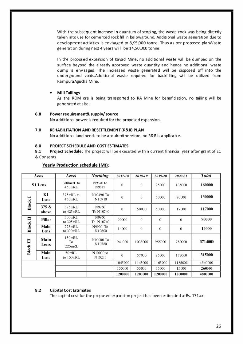
8.0 PROJECT SCHEDULE AND COST ESTIMATES
8.1 Project Schedule: The project will be executed within current financial year after grant of EC
& Consents.
Yearly Production schedule (Mt):
Lens Level Northing 2017-18 2018-19 2019-20 2020-21 Total
S1 Lens 300mRL to 450mRL
N9640 to N9815
0 0 25000 135000 160000
Blo
ck
I K1
Lens
375mRL to
450mRL
N10490 To
N10710 0 0 50000 80000 130000
375 &
above
375mRL
to 425mRL
N9960
To N10740 0 50000 50000 17000 117000
Blo
ck
II
Pillar 300mRL
to 325mRL
N9960
To N10740 90000 0 0 0 90000
Main Lens
225mRL to 300mRL
N9930 To N10800
14000 0 0 0 14000
Blo
ck I
II
Main Lens
150mRL To
225mRL
N10000 To N10780
941000 1038000 955000 780000 3714000
Main
Lens
50mRL
to 150mRL
N10000 to
N10255 0 57000 85000 173000 315000
1045000 1145000 1165000 1185000 4540000
155000 55000 35000 15000 260000
1200000 1200000 1200000 1200000 4800000
8.2 Capital Cost Estimates
The capital cost for the proposed expansion project has been estimated atRs. 171.cr.
27
9.0 ANALYSIS OF PROPOSAL
9.1 Financial Benefit
The proposed project shall generate foreign exchange to the country by exporting
Zinc;additionally, it will also reduce import of phosphoric acid thus saving of foreign
exchange. This will also generate revenue to the state Government as well as central
government. The people around the region will get direct and indirect employment thus
improves the financial status.
9.2 Employment generation due to project
The existing operation has direct employment of about 629 persons and the proposed
project will be managed by the existing resources but there is an ample opportunity for
increase in indirect employment due to mining related activities like transport, small
workshops, garages, and due to development of local area.
.
9.3 Social Economic Development
The proposed expansion project will bring in people from different cultures for secondary
employment like transporters, vendors, local canteen and tea stall operators etc. such as:
• Generate indirect employment opportunities;
• Real estate development;
• Increase in purchasing power;
• Development of ancillary small scale supporting electro mechanical services for
automobile’s, civil, electrical and mechanicals etc. as part of CSR.
• Agriculture marketing and increased demand for locally produced farm products for large
number of employees existing in the project;
• Access to high quality health care facilities;
• Women empowerment;
9.4 National Economic Development
The present production capacities of Zinc in India are sufficient to meet the domestic
requirements. However, the demand for zinc in India is expected to grow at a rate of
7.1%which makes it viable for the expansion of the zinc production capacities. Further the
deficit in international market during the upcoming years provides opportunity for export.
9.5 Export Possibility
Indian exports majorly catered to South East Asian and African nations. In India, since,
Hindustan Zinc is the largest producer of primary zinc, export of zinc is highly feasible and
shall bring value addition.
9.6 Land value appreciation
The infrastructure development related to the proposed project is likely to cause
appreciation of real estate prices in the nearby areas. Locals with land holdings in
neighbouring areas are likely to benefit economically.
28
9.7 Social Benefits
The proposed project shall proactively participate in the upliftment of socio economic index
of the communities around the project site by way of financial and administrative support.
The project will open up employment opportunities, directly and also indirectly. There shall
be opportunities for entrepreneurs to engage in many service sectors directly or indirectly
associated with the project.
The CSR approach of the company shall be towards sustainable livelihood management of
the community around. There shall be focus on education, health, sanitation, drinking water,
agriculture, water shed management, culture identity preservation, welfare of socially
weaker sections and marginalized people.
***********