Embed Size (px)
Citation preview
The business of sustainability
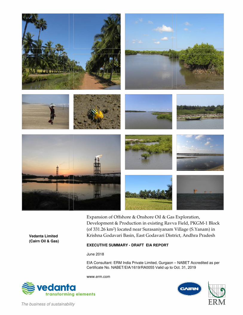
Expansion of Offshore & Onshore Oil & Gas Exploration,
Development & Production in existing Ravva Field, PKGM-1 Block
(of 331.26 km2) located near Surasaniyanam Village (S.Yanam) in
Krishna Godavari Basin, East Godavari District, Andhra Pradesh
EXECUTIVE SUMMARY - DRAFT EIA REPORT
June 2018
EIA Consultant: ERM India Private Limited, Gurgaon – NABET Accredited as per
Certificate No. NABET/EIA/1619/RA0055 Valid up to Oct. 31, 2019
www.erm.com
Vedanta Limited
(Cairn Oil & Gas)
ERM EXECUTIVE SUMMARY DRAFT EIA OF OIL & GAS EXPANSION (EXPLORATION, DEVELOPMENT & PRODUCTION), PKGM-1 BLOCK, AP
VEDANTA LIMITED (CAIRN OIL & GAS) 1 JUNE 2018
EXECUTIVE SUMMARY OF DRAFT EIA OF PROPOSED OIL & GAS EXPLORATION, DEVELOPMENT AND PRODUCTION
IN PKGM-1 BLOCK
1.0 INTRODUCTION
1. Vedanta Limited (Cairn Oil & Gas) (hereinafter also referred to as Cairn or Vedanta) is one of the largest independent
oil and gas exploration and production companies in India. On behalf of Ravva Joint Venture, Vedanta Limited (Cairn
Oil & Gas) (erstwhile Cairn India Limited or Cairn Energy India Pty Limited) has been carrying out oil and gas
operations in PKGM-1 Block (also referred to as Ravva Field or Ravva Block) since 1997. The PKGM-1 Block is located
in the Bay of Bengal in the Krishna-Godavari Basin near Surasaniyanam Village, Uppalaguptam Mandal in East
Godavari District, Andhra Pradesh.
2. Cairn is the Operator of Ravva Joint Venture comprising of Oil & Natural Gas Corporation Limited, Vedanta Ltd (Cairn
Oil and Gas), Videocon Industries Ltd. and Ravva Oil Singapore Pty. Ltd. under the Production Sharing Contract (PSC)
signed for PKGM-1 Block with the Ministry of Petroleum and Natural Gas (MoPNG) through Directorate General of
Hydrocarbons (DGH), Government of India. The PKGM-1 Block has an area of 331.26 sq.km (km2).
3. Initially, ONGC discovered the oil & gas in the field in 1988. On October 28, 1994 when a PSC was signed byRavva
Joint Venture, the offshore facilities included four wells, two platforms and two pipelines for production of 3,000
barrels of oil per day (BOPD) with an onshore processing capacity of 8,600 BOPD. The Ravva JV commenced
operations in 1995 and over the years increased production capacity and upgraded facilities. The operatorship of the
field was transferred in 1995 to Command Petroleum (India) Pty Ltd which subsequently in 1997 was transferred to
the erstwhile company of Vedanta Ltd i.e. Cairn Energy India Pty Limited (CEIL).
2.0 EXISTING OPERATIONS IN THE BLOCK
4. Currently, within PKGM-1 Block, there exists eight (8) oil and gas platforms (six for crude oil and two for natural gas
production), connecting pipelines, and Ravva Terminal near Surasaniyanam Village ~1 km from shore (with oil, gas
and water separation and water injection facilities). Well fluid from offshore wells is routed through existing subsea
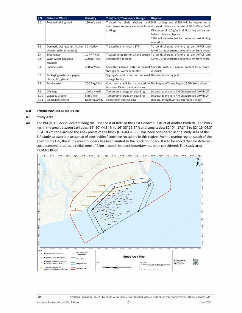
pipelines to onshore Ravva terminal for separation of oil, gas and water. The separated crude is transferred through
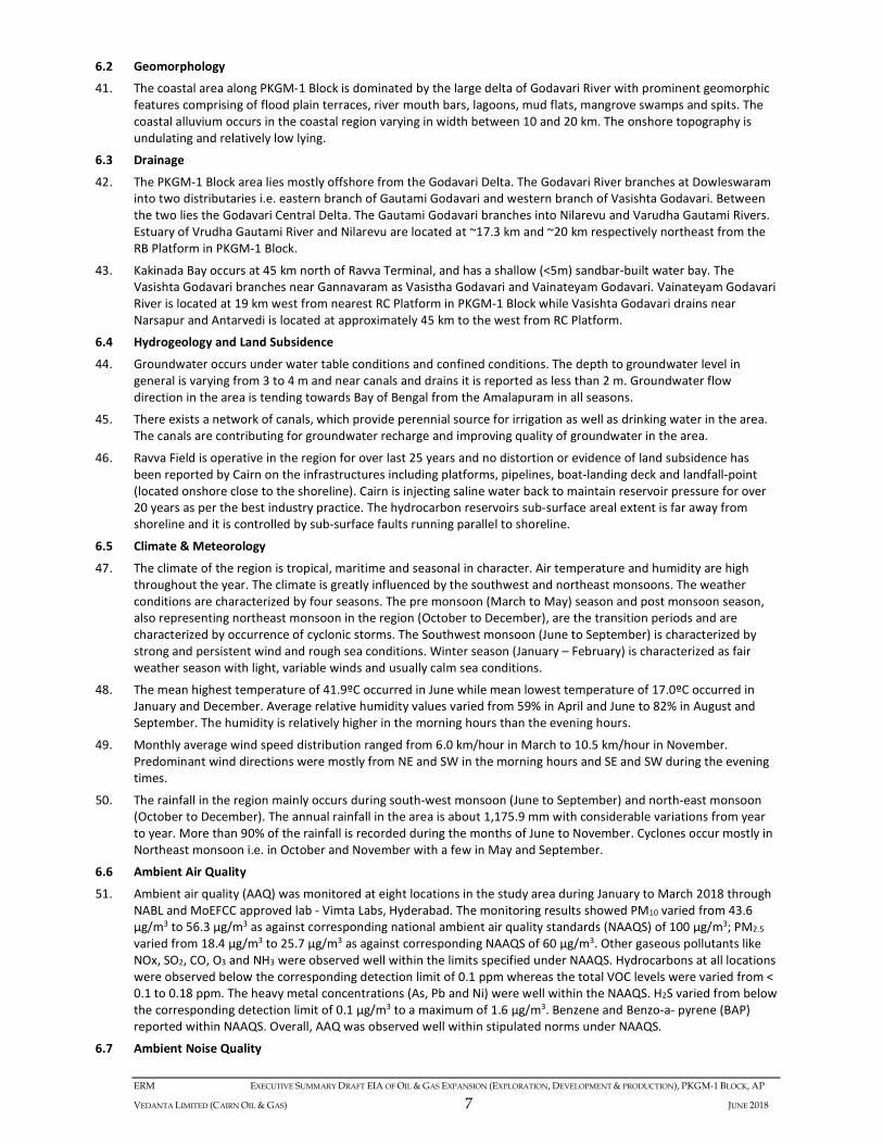
offshore pipelines to Single Point Mooring (SPM) point from where it is transported through Shuttle Tankers. The
separated natural gas is compressed and treated before it flows to Gas Authority of India Limited (GAIL). The
produced water generated is treated and recycled for re-injection into hydrocarbon reservoirs after comingling with
the saline ground water.
5. The existing operations of Ravva Field in PKGM-1 Block are governed by following Environmental and CRZ Clearances
obtained from Ministry of Environment, Forest and Climate Change (MoEFCC):
a. EC no. J-11011/11/90-IA dated 30 July 1990 (Phase -I)
b. EC no. J-11011/6/91-IA (Phase -I) dated 19 December 1991
c. EC no. J-11012/59/95-1A-II (I), dated 03 July 1996 (Phase II)
d. EC no. J-11011/84/2000-IA – II dated 30 January 2001 (for Ravva Satellite Gas Development)
e. EC no. J-11011/50/2001-IA II dated 11 Sep 2001 (for exploratory drilling of 8 wells)
f. EC no. J - 11011/207/2004-IA(II)I dated 4 August 2005 (for drilling of 15 infill wells)
g. EC No. J-11011/81/2013-IA-II dated 23 Feb 2015 and CRZ Clearance No. 11-20/2015-IA III dated 25 May 2017
(for new offshore RI Platform, drilling of 20 development & 6 exploratory offshore wells and laying of
interconnecting pipelines)
3.0 PROJECT PROPOSAL
6. Over the years due to aging of the reservoir, production of oil and gas has declined. In order to maintain
hydrocarbon production at already approved production capacities, Cairn now proposes the following:
i. Drilling of a total of 123 exploratory and development wells covering 83 nos. exploratory wells and 40 nos.
development (production) wells. Of the 83 exploratory wells, 59 are proposed to be drilled from standalone
offshore locations, 14 nos. from existing offshore platforms and 10 nos. from proposed onshore well pads to
assess presence of hydrocarbons in prospects identified. Of the 40 development (production) wells, 17 will
be drilled from the existing offshore platforms and 23 nos. from proposed onshore well pads]
ii. Establishing of 8 nos. of onshore well pads (five adjoining and three within the PKGM-1 Block)#; and
iii. Laying of ~15 km of pipeline corridor (for three pipelines) connecting onshore well pads with the existing
onshore oil & gas processing Ravva Terminal.
# Note: For drilling of wells from five onshore well pads proposed to be established adjoining (outside) the PKGM-1 Block to tap
hydrocarbons resource from within the block through inclined drilling. For establishing well pads outside PKGM-1 Block, Cairn has
ERM EXECUTIVE SUMMARY DRAFT EIA OF OIL & GAS EXPANSION (EXPLORATION, DEVELOPMENT & PRODUCTION), PKGM-1 BLOCK, AP
VEDANTA LIMITED (CAIRN OIL & GAS) 2 JUNE 2018
already obtained concurrence from ONGC and the mining lease of the required land area will be transferred to Cairn from ONGC.
The above-mentioned drilling program will be accomplished in 10 years.
7. There will be no modifications/ alterations at the onshore Ravva Terminal as the processing facilities and utilities
have adequate capacity to handle the already approved production capacity of 50,000 BOPD of crude and 2.32
MMSCMD (million standard cubic meter per day) of natural gas. The present production is approximately 15,000
BOPD of crude and 1.40 MMSCMD of natural gas.
4.0 REQUIREMENT OF ENVIRONMENTAL IMPACT ASSESSMENT (EIA) STUDY
8. The activities proposed (as per paragraph 6 above) would require prior Environmental Clearance from Ministry of
Environment, Forests and Climate Change (MoEFCC), Government of India under the EIA Notification 2006 and CRZ
Clearance under the CRZ Notification, 2011 as the above proposed activities fall in coastal regulation zone. The
above approvals are to be appraised based on EIA study conducted as per the terms of reference issued by MoEFCC
on 24 March 2018. The Project has also considered for CRZ mapping in the block by engaging National Centre for
Sustainable Coastal Management (NCSCM), Chennai (a MoEFCC authorized agency).
9. The draft EIA study will form the basis for public consultation to be duly conducted by Andhra Pradesh Pollution
Control Board (APPCB). The environmental concerns expressed during the consultation will be duly incorporated to
finalize EIA Report. This EIA Report, the CRZ Map and other submittals by Cairn will become the basis for the Project
appraisal by Andhra Pradesh Coastal Zone Management Authority (APCZMA) and MoEFCC.
5.0 PROJECT DESCRIPTION
5.1 Existing Activities in the Ravva Block
10. Within PKGM-1 Block, 55 exploratory/appraisal/infill and production wells have been drilled to date. Currently,
there exists six (6) self-flow producing wells, sixteen (16) gas lift wells and nine (9) injectors spread over on eight (8)
unmanned fixed well-head offshore platforms. Six platforms (RA, RB, RC, RD, RE & RF) are meant for crude oil
production while remaining two (RG & RH) for gas production. RA and RC Platforms have an interconnecting bridge.
No oil and gas separation processing facility exists at the offshore platforms except water separation units at
platform RC. Well fluid from the platforms is transferred through subsea pipelines to onshore Ravva Terminal at
Surasaniyanam for oil, gas and water separation process and water injection facilities. A Single Point Mooring (SPM)
facility exists offshore which is connected to the onshore Terminal through sub-sea pipeline from where crude oil is
transported to Shuttle Tankers.
11. The treated produced water and lift gas from onshore Ravva Terminal is transferred to platforms through subsea
pipelines. In addition, there are subsea pipelines between the platforms for distributing water for injection and lift
gas. The associated systems available at the platforms include: a) wellheads; b) production/test manifold with
knockout provision; c) flow pipelines (with pig launchers/receivers); d) test separator / flow meters; e) water
injection system; f) gas lift system; g) instrumentation control panel & telemetry PLC system; and h) utility system
comprising of electrical system, instrumentation gas system, chemical injection system, drain system, vent system
and fresh water storage and distribution system.
5.2 The Onshore Ravva Processing Terminal
12. Wells’ fluid (containing mixture of oil, water and gas) from offshore platforms is conveyed to onshore Ravva
Terminal located at Sursaniyanam through four pipelines which join a common header leading to three crude
stabilization trains containing Free Water Knock Out Drum (FWKOD), Flow Splitter and Crude Oil Stabilization Units
(CSU). The separated oil and gas are further treated for phase separation while separated water called produced
water is treated in Produced Water Re-injection System (PWRI).
13. The separated produced water is treated to separate oil from water by degassing in the degasser vessel and oil-
water separation in surge tank. Separated produced water is treated in Induced Gas Floatation (IGF) unit of PWRI
System. Produced water up to 90,000 barrels per day (14,310 m3/day) is comingled with ~9,170 m3/day of saline
groundwater withdrawn from deep aquifers of existing deep bore wells at the Ravva Terminal. Comingled produced
water is filtered to remove oil and suspended solids and chemically treated to prevent from scaling, corrosion and to
avoid sulphur reducing bacterial (SRB) growth before it is sent to all platforms for re-injection into confined
hydrocarbon reservoirs.
14. Oil skimmed from the IGF’s discharge is pumped into an oil recovery sump from where it is pumped to the Crude Oil
Wash Tank. The produced water from the process units that is not routed through PWRI system is routed to the API
separator, where oil in water and inert sediments are separated. Treated produced water from the API separator is
pumped to the Effluent Treatment Plant (ETP) for further treatment.
15. The crude oil is sent for storage in one of the floating roof storage tanks T-401, T-402, T-403 each of 45,243 m3
capacity and T-405 of 45,932 m3 capacity. One storage tank T-404 of 2,940 m3 capacity has been provided to receive
ERM EXECUTIVE SUMMARY DRAFT EIA OF OIL & GAS EXPANSION (EXPLORATION, DEVELOPMENT & PRODUCTION), PKGM-1 BLOCK, AP
VEDANTA LIMITED (CAIRN OIL & GAS) 3 JUNE 2018
crude from nearby ONGC facility for storage and final evacuation. The crude from storage tanks is pumped through
two parallel 20 inches subsea pipelines to the SPM, for transportation through shuttle tankers to GOI nominated
refineries within the country.
16. Separated natural gas is compressed in associated gas compressors and Third Stage Gas Recovery (TSGR)
compressors. The compressed gas is further treated with glycol and cooled to 0 ºC. Treated gas from the gas/gas
exchanger flows to GAIL. Glycol is recycled.
5.3 Existing Utilities at the Onshore Ravva Terminal
17. The existing utilities available at the Ravva Onshore Terminal include the following:
� An ETP of 3000 m3/day capacity consisting of primary, secondary and tertiary treatment system. The treated
wastewater is discharged into the sea through a submerged sub-sea pipeline leading to a pipe diffuser system at
marine outfall located at 540 m from the shore at approximately 5 m water depth;
� High Pressure (HP) and Low Pressure (LP) Flares have been operating to relieve any pressure of vessel and piping
works during abnormal conditions. Ravva Terminal is equipped for minimum flaring under normal conditions. A
closed loop hot oil heater has been provided to heat various exchangers;
� Captive power of 10 MW capacity is available through four gas turbine driven generators (2.5 MW each). An
emergency power diesel generator of 1,000 KVA is also available to cater to emergency power needs.
� There are nine firewater pumps along with firewater storage capacity of 15,765 m3. Firewater is sourced from
rain water harvesting ponds and RO plant;
� Saline groundwater of ~ 9,570 m3/day is withdrawn from deep tube wells. Of this, 9170 m3/day is comingled
with produced water for reinjection in hydrocarbon reservoir and 400 m3/day is treated in reverse osmosis units
for domestic and fire water make up needs;
� Living quarters (LQ) exist to accommodate 90 bachelors near onshore Ravva Terminal.
� Sewage from Living quarters and Ravva Terminal is treated in the Sewage Treatment plant (STP) of 175 m3/day
capacity and treated sewage is used in watering the plantation and green belt within the Ravva Terminal;
� A helipad has been provided at the Living Quarters with approval of Directorate General of Civil Aviation for
taking up sorties to unmanned platforms within the Ravva Field;
� Cairn has deployed one vessel exclusively for surveillance of existing offshore installations. This vessel is also
equipped with firefighting capabilities and oil spill response equipment. The offshore operation activities are
supported by one vessel and a line boat is available for SPM surveillance, maintenance and support in tanker
loading. Additionally, one Tug is deployed for assisting tanked loading operation. All the vessels are operated as
per the approval of Directorate General of Shipping and Naval authorities;
�
5.4 Proposed Activities in the Ravva Field
18. As discussed in paragraph 6 above, the proposed project is to maximize production of hydrocarbons resources
available in the PKGM-1 Block by optimally utilizing existing infrastructure and facilities. Following subsections briefly
cover the additional onshore and offshore activities proposed in response to the declining production from existing
wells.
5.4.1 Proposed Onshore Activities
19. It is proposed to have eight (8) well pads for drilling of 10 exploration wells and 23 developmental wells at the
onshore as a part of the development project. Out of eight (8) well pads, five (5) onshore well pads will be located
outside PKGM-1 Block1 and three (3) onshore well pads will be located inside PKGM-1 Block. Overall, the onshore
activities will include:
a) Onshore Well Pads Site Development:
20. The tentative plot plan for each well pad will cover area of approximately 3.83 ha (225m x 170m). The sites selected
for onshore well pads nos. 1, 2, 4, and 5 are located in coastal area, well pad no. 3 is located within aquaculture field,
well pad 6 located in backwater, while the well pads nos. 7 and 8 (RX-9) are located in existing old drill sites. Site
preparation will involve leveling, filling and consolidation of the site for staging equipment and machinery. The well
pad sites will be raised above HFL. Individual sites will be duly fenced to a height of about 2 m using wired fencing.
HDPE lined pits will be constructed for temporary storage of drill cuttings, drilling wash waters and waste mud.
21. Site development will also involve upgradation/construction of site approach roads and laying of onshore pipelines.
The well pad nos. 3, 7 and 8 has all weathered access road from Ravva onshore processing facility. The existing road
will be upgraded and strengthened for the rig movement. The well pad nos. 1, 2, 4 and 5 has no direct access, hence
access roads will be developed for these well pads. Cairn has decided not develop well pad 6 for environmental
reasons. Wells that were to be drilled from well pad 6 will be drilled from well pad 7.
1 Cairn Oil & Gas has already received concurrence from ONGC on drilling of wells from onshore well pads located outside the block; and the mining lease of the
required land area will be transferred to Cairn from ONGC.
ERM EXECUTIVE SUMMARY DRAFT EIA OF OIL & GAS EXPANSION (EXPLORATION, DEVELOPMENT & PRODUCTION), PKGM-1 BLOCK, AP
VEDANTA LIMITED (CAIRN OIL & GAS) 4 JUNE 2018
22. There will be ~15 km of pipeline corridor comprising of three subsurface pipelines connecting onshore well pads
with the existing Ravva Terminal. These subsurface pipelines include i) 8 inches diameter pipeline connecting well
fluids from each well pads to Ravva Terminal; ii) 6 inches diameter gas lift sub-surface pipeline to Ravva Terminal; iii)
14 inches diameter for carrying injection water from Ravva Terminal to the onshore well pads to maintain reservoir
pressure. The development of pipeline will be taken up only after commercially viable discovery of hydrocarbon
resources. In case of commercially viable discovery is made, initially for up to two years, Cairn is proposing to daily
transfer well fluids through about two road tankers from a well pad.
b) Onshore Wells Drilling and Testing:
23. After completion of construction of a well pad and provision of basic facilities, a drill rig will be transported to the
well pad site. The drill equipment are designed as modular/skid mounted type, which facilitates quick mobilization
and demobilization. The rig will have various allied equipment like mud tanks, mud pumps, compressors, fuel tank
and DG sets etc. Water based mud will be used for shallower sections and synthetic based mud will be used for
deeper sections of a well. Drill cuttings generated will be collected and separated using a solid control system and
temporarily stored on-site in impervious HDPE lined pits. Drilling and wash wastewater generated will also be
temporarily stored onsite in impervious HDPE lined pits. The wash wastewater will be adequately treated in a mobile
ETP to ensure conformance to applicable regulatory norms of APPCB. Well control equipment in form of Blowout
preventers (BOP) will be installed over the wellhead to forestall the possibility of any potential blowout, and regain
control of the wellbore.
24. Towards the end of the drilling cycle, well testing will be initiated to establish the characteristics of the reservoir and
the viability of commercially exploiting the reserve. The controlled flow of hydrocarbons from a drilled well will be
temporary testing and ground flared.
c) Onshore Site Closure and Decommissioning:
25. After completion of an exploratory drilling, if no commercial reserves are established, the well pad site will be
properly reclaimed and rehabilitated. This process will involve capping of the well(s), decommissioning of the rig and
all machineries above ground, ensuring removal of drilling waste from captive waste pit as per CPCB guidelines,
disposal or reuse of fill materials, restoration of top soil within well pad site and transfer of leased land back to the
landowner.
5.4.2 Proposed Offshore Activities
26. In the offshore part of the block, there will be 14 exploratory and appraisal wells drilling from existing offshore
platforms 2 nos. RB, 1 no.RC, 2 nos.RD, 4 nos. RE, 2 nos. RF, 1 no. RG and 2 nos. RH and 59 exploratory / appraisal
wells drilling from standalone offshore locations.
27. There will be 17 developmental wells drilling from the existing well-head platforms 4 nos. RB, 3 nos. RC, 4 nos. RD, 1
no. RE, 2 nos. RF and 3 nos. RH. Existing platforms will be extended to facilitate installation of new wells slots and
ancillary items. Each new well will be connected to the manifold through the flow-arms and will have all the relevant
instrumentation and control philosophy applicable for the particular platform.
28. In offshore part of the block, drilling process for developmental (infill production) and exploration andappraisal wells
is similar. Jack up rig will be used in both cases - mat supported jack up or independent leg jack-up may be deployed.
Water based mud (WBM) will be used for initial, shallower sections. The deeper more difficult to drill formations will
be drilled using synthetic based mud (SBM) which will be re-used to maximum extent. Blowout preventers (BOP) will
be installed to forestall possibility of any potential blowout.
29. At the end of well drilling almost the entire volume of SBM will be collected for re-use in next drilling operation.
WBM typically consists of water, bentonite, polymers and barite. Spent WBM will be disposed offshore. Other
chemical additives viz. glycols and salts may be used in conjunction to mitigate potential problems related to hydrate
formation. Drill cuttings will be generated due to crushing action of the drill bit. Cuttings will be then separated from
drilling mud using shale shakers, hydro-cyclones (including de-sanders and de-silters), and centrifuges. The major
liquid, solid waste anticipated due to drilling operations include spent drilling mud and drill cuttings. These wastes
are stored, handled and disposed as per the requirements of the applicable Indian regulation, APPCB and MARPOL
convention. The sewage generated will be treated and disinfected onboard in a Sewage Treatment Plant (STP)
before it is disposed offshore beyond 3 nautical miles (nm) from shore complying with the MARPOL requirements.
5.5 Project Utilities and Resource Requirements
30. Camp Site: A camp site will be established with porta cabins at any of the previously constructed well pads nos. 7 or
8 (RX9) for deployment of labour for well pads construction and for subsequent drilling activities at any of the well
pad site. Some of the skilled manpower will be provided accommodation in the existing Ravva Living Quarters.
Unskilled manpower for well pads construction activities will be hired from local villages.
31. Power Requirement: Power requirement for each onshore drill site and campsite will be met through diesel
generators. Two diesel generators, each of 1,000 kVA capacities, will be simultaneously operated at the drill site
while one diesel generator of similar capacity will be kept as standby during drilling operation. There will also be one
ERM EXECUTIVE SUMMARY DRAFT EIA OF OIL & GAS EXPANSION (EXPLORATION, DEVELOPMENT & PRODUCTION), PKGM-1 BLOCK, AP
VEDANTA LIMITED (CAIRN OIL & GAS) 5 JUNE 2018
diesel generator of 350 kVA capacity catering to the power requirements of the campsite (with another 350 kVA DG
set as standby).
32. For offshore drilling activity, diesel generators are incorporated in the design / infrastructure for self-sustained
operations at sea. The power that will be available onboard the rig for offshore drilling and lighting the quarters at
the rig. Power supply shall be made available through 3 of the 4 main diesel generators (each of 2,000 kVA) typically
installed on board the jack up rig. There will also be one diesel generator of 500 kVA capacity catering to the
emergency auxiliary power supply.
33. Water Supply: Water requirement of ~5 m3/day for domestic use at onshore campsite. For well drilling there will be
water requirement of ~50 m3/day for onshore drilling activities for ~ 50 days per well and domestic water
requirement for the same period will be ~5 m3/day. Thus average water requirement for onshore well drilling is
expected to ~60 m3/day. All water requirement for onshore activities will be met through existing reverse osmosis
plant available at existing Ravva Terminal using saline ground water as input to RO Plant.
34. For offshore drilling activity, typically a jack up rig has storage of drill water of ~4000 bbls (~635 m³) and domestic
and other water storage of ~800 bbls (130 m³). The drill water is mainly consumed for preparation of mud. Minor
quantities are used for washing and cleaning the rig. Average daily water requirement for offshore drilling
operations will be 85 m3/day. Of this 45 m3/day will be saline water sourced from sea and 40 m3/day will be fresh
water to be sourced from nearby port through supply vessels.
35. Manpower: There will be ~100 workers engaged for construction of well pad site for a period of ~50 days. For
drilling activities there will be ~80 manpower (skilled and semi-skilled) which will be camped at the campsite. At any
point of time at the onshore drilling location, there will be ~50 manpower available onboard rig at each drill site
which will comprise of engineers, skilled workers and support staff.
36. Well Abandonment: In case of exploration/appraisal wells found as dry and is to be abandoned, several cement
plugs will be set in the open-hole section at various positions in the casing and the casing will be cut and retrieved as
deep as possible both for onshore and offshore locations. For offshore, all strings of casing are cut ~3 m (10 feet) or
more below the seabed, and all structures above this point will be recovered.
5.6 Pollution Sources & Embedded Controls
37. Air emissions: From both onshore and offshore drilling, point source air emissions will be generated from diesel
generators. The emissions from diesel generators will be controlled through optimized operations and discharged
through stack of adequate height as per CPCB criteria. For storage and handling of bentonite and other materials
covered sheds will be provided to minimize fugitive dust emissions. Vehicles movement to onshore well pads will be
allowed through designated route only at low speed (~30 kmph) to minimize disturbance and fugitive dust emission.
38. Noise & Vibrations: At the well pads, noise and vibration will be controlled by establishing proper foundation for the
rig and effective maintenance of rotating equipment. Noise barriers will be installed surrounding the noise
generating equipment. Diesel generators at the well pads will be provided with integral acoustic enclosure.
39. Liquid, Solid and Hazardous Wastes from onshore and offshore activities will be as per the following Table
S.N. Nature of Waste Quantity Treatment/ Temporary Storage Disposal
A. Onshore Drilling Activity
A.1 Drill cuttings containing oil 250 m3 / well Temporary storage in HDPE lined
impervious pits within well pad sites
APPCB approved common hazardous waste
treatment, storage and disposal facility
(CHWTSDF)
A.2 Residual drilling mud 200 m3 /well
A.3 Used lubricating/waste oil 10 m3/ well Dedicated paved area for storage
A.4 Food waste 25 kg /day Temporary storage before daily
transfer to the Ravva Terminal
Will be composted in-house or sent to piggeries
A.5 Non-combustible waste
(i.e. metallic residues, glass)
20 kg/ day Temporary storage in dedicated
bins
Recycling vendors
A.6 Packaging wastes 1000 kg/ well
A.7 Left over chemicals and
materials
250 kg/ well Temporary storage in bins in
secured stores
Disposal through supplier vendor
A.8 Cement, grit, & painting waste 500 kg/ well Temporary storage in bins APPCB approved CHWTSDF
A.9 Wash wastewater 5m3/ day/ well Primary treatment in modular ETP
at well pad before transfer through
tankers to Ravva Terminal ETP
ETP at Ravva Terminal for final treatment and
disposal through existing marine outfall.
A.10 Sewage 4.5m3/day/ well Primary treatment in modular STP at
campsite and well pads before
transfer through tankers to Ravva
Terminal STP
STP at Ravva Terminal for use of treated sewage
in land application
A.11. Biomedical wastes Minor quantity Collected in specific bins APPCB approved vendors
B. Offshore Drilling Activity
B.1 Drill cuttings 220 m3 / well
ERM EXECUTIVE SUMMARY DRAFT EIA OF OIL & GAS EXPANSION (EXPLORATION, DEVELOPMENT & PRODUCTION), PKGM-1 BLOCK, AP
VEDANTA LIMITED (CAIRN OIL & GAS) 6 JUNE 2018
S.N. Nature of Waste Quantity Treatment/ Temporary Storage Disposal
B.2 Residual drilling mud 150 m3 / well Treated in shale shakers and
centrifuges to separate mud from
cuttings.
Drill cuttings and WBM will be intermittently
disposed offshore at a rate of 50 bbl/hour/well.
Oil content if <10 g/kg in drill cutting will be met
before offshore disposal.
SBM will be collected for re-use in next drilling
operation
B.3 Domestic wastewater (kitchen
shower, toilet & laundry)
30 m3/day Treated in an on-board STP To be discharged offshore as per APPCB and
MARPOL requirements beyond 3 nm from shore.
B.4 Bilge water 10 m3 / well Treated on board for oil and grease
content of < 15 ppm.
To be discharged offshore as per APPCB and
MARPOL requirements beyond 3 nm from shore. B.5 Wash water and deck
drainage
200 m3 / well
B.6 Cooling water 200 m3/hour Seawater cooling water is passed
through oil- water separator.
Seawater with < 15 ppm oil content for offshore
disposal.
B.7 Packaging materials, paper,
plastic, tin, glass etc
Segregate and store in on-board
storage facility
Disposal at nearby port.
B.8 Food waste 20-25 kg/ day Food waste will be macerated to
less than 25 mm particle size and
Discharged offshore beyond 3 NM from shore
B.9 Oily rags 100 kg / well Temporary storage on board rig Disposal to onshore APPCB approved CHWTSDF
B.10 Waste & used oil 5 m3 / well Temporary storage on board rig Disposal to onshore APPCB approved CHWTSDF
B.11 Biomedical wastes Minor quantity Collected in specific bins Disposal through APPCB approved vendor.
6.0 ENVIRONMENTAL BASELINE
6.1 Study Area
40. The PKGM-1 Block is located along the East Coast of India in the East Godavari District of Andhra Pradesh. The block
lies in the area between Latitudes: 16° 20’ 44.8” N to 16° 33’ 26.6” N and Longitudes: 82° 04’ 17.3” E to 82° 19’ 04.3”
E. A 10 km zone around the apex points of the block (G-A-B-C-D-E-F) has been considered as the study area of the
EIA study to ascertain presence of sensitivities/ sensitive receptors in this region. For the marine region south of the
apex points F-G, the study area boundary has been limited to the block boundary. It is to be noted that for detailed
socioeconomic studies, a radial zone of 2 km around the block boundary has been considered. The study area
PKGM-1 Block
ERM EXECUTIVE SUMMARY DRAFT EIA OF OIL & GAS EXPANSION (EXPLORATION, DEVELOPMENT & PRODUCTION), PKGM-1 BLOCK, AP
VEDANTA LIMITED (CAIRN OIL & GAS) 7 JUNE 2018
6.2 Geomorphology
41. The coastal area along PKGM-1 Block is dominated by the large delta of Godavari River with prominent geomorphic
features comprising of flood plain terraces, river mouth bars, lagoons, mud flats, mangrove swamps and spits. The
coastal alluvium occurs in the coastal region varying in width between 10 and 20 km. The onshore topography is
undulating and relatively low lying.
6.3 Drainage
42. The PKGM-1 Block area lies mostly offshore from the Godavari Delta. The Godavari River branches at Dowleswaram
into two distributaries i.e. eastern branch of Gautami Godavari and western branch of Vasishta Godavari. Between
the two lies the Godavari Central Delta. The Gautami Godavari branches into Nilarevu and Varudha Gautami Rivers.
Estuary of Vrudha Gautami River and Nilarevu are located at ~17.3 km and ~20 km respectively northeast from the
RB Platform in PKGM-1 Block.
43. Kakinada Bay occurs at 45 km north of Ravva Terminal, and has a shallow (<5m) sandbar-built water bay. The
Vasishta Godavari branches near Gannavaram as Vasistha Godavari and Vainateyam Godavari. Vainateyam Godavari
River is located at 19 km west from nearest RC Platform in PKGM-1 Block while Vasishta Godavari drains near
Narsapur and Antarvedi is located at approximately 45 km to the west from RC Platform.
6.4 Hydrogeology and Land Subsidence
44. Groundwater occurs under water table conditions and confined conditions. The depth to groundwater level in
general is varying from 3 to 4 m and near canals and drains it is reported as less than 2 m. Groundwater flow
direction in the area is tending towards Bay of Bengal from the Amalapuram in all seasons.
45. There exists a network of canals, which provide perennial source for irrigation as well as drinking water in the area.
The canals are contributing for groundwater recharge and improving quality of groundwater in the area.
46. Ravva Field is operative in the region for over last 25 years and no distortion or evidence of land subsidence has
been reported by Cairn on the infrastructures including platforms, pipelines, boat-landing deck and landfall-point
(located onshore close to the shoreline). Cairn is injecting saline water back to maintain reservoir pressure for over
20 years as per the best industry practice. The hydrocarbon reservoirs sub-surface areal extent is far away from
shoreline and it is controlled by sub-surface faults running parallel to shoreline.
6.5 Climate & Meteorology
47. The climate of the region is tropical, maritime and seasonal in character. Air temperature and humidity are high
throughout the year. The climate is greatly influenced by the southwest and northeast monsoons. The weather
conditions are characterized by four seasons. The pre monsoon (March to May) season and post monsoon season,
also representing northeast monsoon in the region (October to December), are the transition periods and are
characterized by occurrence of cyclonic storms. The Southwest monsoon (June to September) is characterized by
strong and persistent wind and rough sea conditions. Winter season (January – February) is characterized as fair
weather season with light, variable winds and usually calm sea conditions.
48. The mean highest temperature of 41.9ºC occurred in June while mean lowest temperature of 17.0ºC occurred in
January and December. Average relative humidity values varied from 59% in April and June to 82% in August and
September. The humidity is relatively higher in the morning hours than the evening hours.
49. Monthly average wind speed distribution ranged from 6.0 km/hour in March to 10.5 km/hour in November.
Predominant wind directions were mostly from NE and SW in the morning hours and SE and SW during the evening
times.
50. The rainfall in the region mainly occurs during south-west monsoon (June to September) and north-east monsoon
(October to December). The annual rainfall in the area is about 1,175.9 mm with considerable variations from year
to year. More than 90% of the rainfall is recorded during the months of June to November. Cyclones occur mostly in
Northeast monsoon i.e. in October and November with a few in May and September.
6.6 Ambient Air Quality
51. Ambient air quality (AAQ) was monitored at eight locations in the study area during January to March 2018 through
NABL and MoEFCC approved lab - Vimta Labs, Hyderabad. The monitoring results showed PM10 varied from 43.6
μg/m3 to 56.3 μg/m3 as against corresponding national ambient air quality standards (NAAQS) of 100 μg/m3; PM2.5
varied from 18.4 μg/m3 to 25.7 μg/m3 as against corresponding NAAQS of 60 μg/m3. Other gaseous pollutants like
NOx, SO2, CO, O3 and NH3 were observed well within the limits specified under NAAQS. Hydrocarbons at all locations
were observed below the corresponding detection limit of 0.1 ppm whereas the total VOC levels were varied from <
0.1 to 0.18 ppm. The heavy metal concentrations (As, Pb and Ni) were well within the NAAQS. H2S varied from below
the corresponding detection limit of 0.1 μg/m3 to a maximum of 1.6 μg/m3. Benzene and Benzo-a- pyrene (BAP)
reported within NAAQS. Overall, AAQ was observed well within stipulated norms under NAAQS.
6.7 Ambient Noise Quality
ERM EXECUTIVE SUMMARY DRAFT EIA OF OIL & GAS EXPANSION (EXPLORATION, DEVELOPMENT & PRODUCTION), PKGM-1 BLOCK, AP
VEDANTA LIMITED (CAIRN OIL & GAS) 8 JUNE 2018
52. The baseline noise monitoring in the study area was carried out at eight locations during March 2018. The
equivalent ambient noise level for residential areas during daytime (Leq day) varied from 50 to 53.5 dB(A) as against
the corresponding standard of 55 dB(A) while Leq night in residential areas varied from 40.1 to 43.5 dB(A) as against the
corresponding standard 45 dB(A). The daytime noise levels recorded at the commercial location was 59.4 dB(A) and
was within the prescribed limit of 65 dB(A). The night time noise levels recorded at the commercial location was 53.8
dB(A) which was within the prescribed limit of 55 dB(A). Overall, noise levels in residential and commercial areas in
the study area were observed to be well within the prescribed norms.
6.8 Landuse
53. The land use pattern of the study area shows sea area of 60.24% followed by agriculture land area of 12.73%,
aquaculture land area of 13.14% and reserve forestland of 4.68% (3.96% under mangrove vegetation and 0.72%
under Casuarina Plantation). The other major landuse types observed in the study include backwater (2.83%),
Casuarina plantation (1.42%), settlements (0.99%) and sand dunes (0.86%).
6.9 Soil Quality
54. Soil samples were collected from six locations from surrounding villages in the study area. The quality of soil
indicated that texture of the soil varied from clayey (S1, S2 and S3), sandy loam (S4 and S6) and sandy (S5). pH
ranged from 6.1 to 7.5. The SAR varied from 3.8 to 13.2. The analysis results also indicated that there is no
enrichment of heavy metals in soil.
6.10 Ground and Surface Water Quality
55. The groundwater quality of the study area was assessed by collecting and analyzing samples from four locations. The
pH of the groundwater varied from 7.1 to 7.4 which remained within corresponding drinking water norm (IS:10500)
of 6.5 to 8.5 while turbidity ranged from 1 to 3 NTU which is within acceptable limit of 5 NTU. The groundwater
samples collected from Challapalli and Samanthakur Villages showed higher levels of chlorides, TDS, alkalinity and
hardness probably due ingress of saline marine water in ground water. The groundwater collected from Cairn Living
Quarters and Uppalaguptam Village showed levels of chloride, TDS, alkalinity and hardness within the permissible
limits of IS:10500. The groundwater samples did not reveal presence of any metallic or biological contaminants.
56. Surface water was collected from four locations i.e. Surasaniyanam Backwater, Cherriyanam Backwater, Challapalli
Canal water and creek near Surasaniyanam. The surface water from the canals, creeks and backwater areas is used
for washing and catching fish. The surface water quality revealed that the water conforms to CPCB Water Quality
Criteria of Class “B “(Outdoor Bathing Organized) and Class “D” (propagation of wildlife and fisheries).
6.11 Marine Water Quality
57. Marine water samples were collected from eight locations from three water depths for each location during April
2018 in the PKGM-1 Block. In general, the marine water samples collected from the three different depths (i.e.
surface, mid depth and bottom) did not reveal much variation in terms of concentrations of physicochemical
parameters. The marine water samples collected from different locations revealed metal and oil and grease contents
below detectable limits to very low levels of Cadmium, Copper, Lead and Total Chromium.
6.12 Marine Sediment Quality
58. Sediment was mainly comprised of sand, silt and clay and their ratio varied considerably at all the monitoring
stations. Along the Ravva Block, the silt was the dominant fraction (average 52.38%), followed by clay (average
33.62%) and sand (average 14.56%). In all samples, sand composition ranged from 0.4% to 76.54%, while silt varied
from 1.96% to 84.5% and clay varied from 5% to 85%. The sediment samples collected from different locations did
not reveal presence of high concentration of metals. Concentration of TPH was also found to be low at the
monitored stations. Thus, the sediment samples did not reveal presence of any metallic or oil pollution in the area.
6.13 Marine Ecology
59. Phytoplanktons: 15 genera of phytoplanktons were identified in the study area, with average composition of
Chlorophyceae (64%), Cyanophyceae (20%) and Bacillariophyceae (16%).
60. Zooplankton: 6 genera of zooplankton were identified in the study area including 2 species of Copepods, 2 species
of Cladocerans, 1 species of Rotifer and 1 species of Protozoa.
61. Benthos: Benthos were composed of a wide variety of species living in burrows in the sediment or on the sediment
surface. Meiobenthic community is represented by Copepods, Nematodes, Turbellarians, Nemertins, Foraminifera,
Kinorynchs, Halacarids etc. Macrobenthic community is represented by Polychaetes, Molluscs, Cumceans
Amphipods, Isopods, Cnidarians, Oligochaetes and Tanaidacea etc.
62. Marine fishes: 11 species of cartilaginous skeleton fishes without swim bladder and 37 species of fishes with boney
skeleton and swim bladder were enumerated from the secondary data.
63. Marine Reptiles: Olive Ridley’s Turtles (Lepidochelys olivacea), listed as Vulnerable by IUCN Red list of Threatened
Species and listed as Schedule I of Wildlife Protection Act 1972, is known to occur mainly in Sacramento Shoal and
ERM EXECUTIVE SUMMARY DRAFT EIA OF OIL & GAS EXPANSION (EXPLORATION, DEVELOPMENT & PRODUCTION), PKGM-1 BLOCK, AP
VEDANTA LIMITED (CAIRN OIL & GAS) 9 JUNE 2018
beyond 10 km from nearest well proposed to be drilled in PKGM-1 Block. Some solitarily nesting sites have also
been reported along the coast in the study area.
64. Cetaceans: Cetaceans generally occurs in water depth of 50 m or more. Water depth in PKGM-1 Block gradually
increases to 10 m up to ~10 km from shore followed by further increase beyond southern boundary of the block. As
the block has shallow water depth, Cetacean species have not been reported in the study area. However, sporadic
with rare sighting of dolphin species - short-beaked Common Dolphin (Delphinus delphis) and Bottlenose Dolphin
(Tursiops truncates) cannot be ruled out in lower water depths. Cetaceans Minke Whale (Balaenoptera
acutorostrata) and Unidentified Baleen whales have been reported in deeper water off Kakinada region of the East
Godavari District much away from PKGM-1 Block.
6.14 Terrestrial Ecology
6.14.1 Terrestrial Flora
65. Beach Vegetation: The beach habitat is represented by two shrub species, three climber species and two herb
species. The highest density calculated for shrubs is for Thespesia populneoides (4.71 individuals/sq.m.), while for
herbs is for Tephrosia purpurea (15.29 individuals/sqm). Highest density for climbers is calculated for Ipomoea biloba
(5.14 individuals/sq.m) as the species grows well in the shade of the adjoining shelter belt while Spinifex littoreus is
limited to the dry areas.
66. Casurina - shelter belt plantation was found along the coast with varied density. The Casurina equistifolia is
prominent tree species planted along the coast in the Study area. Where habitation is close to coast, species of
Cocos nucifera and Borassus flabellifer, the palm species were also encountered.
67. Vegetation in back waters/lagoons areas included mangrove species Avacinia officianalis and mangrove associate
species such as Sueda maritima, Salicornia brachiata and Sesuvium portulacastrum.
68. Dense plantation of coconut (Cocos nucifera) are maintained along aquaculture ponds in the study area. Apart from
coconut plantations, other preferred species are Albizia saman, Azadirachta indica, Mangifera indica, Millettia
pinnata. In some area above inundation level Prosopis juliflora has been established.
69. In the study area reserve forest patches of Balusutippa RF, Kandikuppa RF, Kothapalem I, Kothapalem II, mainly in
the mangrove habitat comprised of mature vegetation up to 8-10m height in well-protected areas. A total of 16
species of trees and one climber, one shrub and four herbaceous mangrove associates were enumerated from the
mangrove habitats. The highest IVI calculated for trees is Avicennia officianalis (11.77) while the lowest IVI
calculated for tree is Scyphiphora hydrophyllacea (1.63).
70. The agricultural lands predominantly rice fields are away from the coast where fresh water are supplied from
Dowleswaram Barrage through a network of canal system. A few tolerant wild species (Sarcolobus, Ficus hispida,
Urena lobata, Sida spp., Chloris sp.) grow along canals and bunds. Shrub flora is dominated by Lantana camara,
Eupatorium odoratum, Calotropis, etc.
71. Cairn has developed mangrove plantations in 55 acre adjacent to the terminal in Surasaniyanam Village. The
mangrove plantation provide excellent roosting site to many avifaunal species and refuge to the smooth coated
otter. Probably security provided by Cairn at such locations provide safe refuge to the otter family.
72. Coringa Wildlife Sanctuary: Coringa wildlife sanctuary is located beyond 18 km north of the block, a part of Godavari
mangroves is located in East Godavari River Estuarine Ecosystem (EGREE) area of Coastal region of the Bay of Bengal
in the East Godavari District of Andhra Pradesh.
6.14.2 Terrestrial Fauna
73. Butterflies: A total of 26 species of 17 genera belonging to 4 families of butterflies were observed from the study
area. None of these species bear any conservational status from IUCN or Wildlife Protection Act, 1972 (WPA).
74. Amphibians: A total of three (03) species of amphibians Common Asian Toad, Indian Skipper Frog and Indian Bull
Frog pertaining to freshwater habitats such as village ponds and fresh water canals were observed. None of the
species are listed in IUCN Red List v2017.3 and WPA.
75. Reptiles: A total of 14 species of 11 genera belonging to 7 families of reptiles were enumerated from the study area.
These belong to variety of habitats from fresh water to marine, terrestrial and human habitation. Most have been
assessed as “Least Concern”. Three species Olive Ridley Turtles (Lepidochelys olivacea), Indian flapshell turtle
(Lissemys punctata) and Monitor lizard (Varanus benghalensis) are listed as Schedule-I species and two species Rat
snake (Ptyas mucosus) and Checkered kelback (Xenochrophis piscator) are listed as Schedule–II species of Wildlife
Protection Act, 1972.
76. Avifauna: A total of 96 species of 70 genera belonging to 40 families of avifauna were observed in the study area.
Out of the total 96 avifauna species observed 68 were resident bird species, 26 were winter visitor species and one
vagrant species. Two species western black tailed godwit (Limosa limosa) and Black headed Ibis (Threskiornis
melanocephalus) were listed as Near Threatened as per IUCN red list category and one species Osprey (Pandion
ERM EXECUTIVE SUMMARY DRAFT EIA OF OIL & GAS EXPANSION (EXPLORATION, DEVELOPMENT & PRODUCTION), PKGM-1 BLOCK, AP
VEDANTA LIMITED (CAIRN OIL & GAS) 10 JUNE 2018
haliaetus) was listed under Schedule-I of Wildlife Protection Act, 1972. Indian Pond Heron (Ardeola grayii) and Little
Egret (Egretta garzetta) were the most abundant bird species.
77. Mammals: 25 species observed/reported from the study area. Two (2) species Fishing cat and Smooth coated Otter
are listed as Vulnerable category and one (1) species as Near Threatened as per IUCN red list. Three (03) species
Fishing cat, Smooth coated otter and Indian Pangolin are listed as Sch.-I. Six (06) species Jackal, Indian Fox, Jungle
Cat, Small Indian Civet, Common Palm Civet and Grey Mongoose are listed as Sch.-II species.
78. Coringa Wildlife Sanctuary: Located at 18 km from the block, the sanctuary has a rich variety of avian fauna
together with a fair population of golden jackal, fishing cat and a healthy breeding population of smooth coated
otter. The sanctuary has long sand pit where olive ridley sea turtles nest from January to March every year.
6.15 Socioeconomics
79. Socio-economics show that the study area primarily comprises of rural settlements. The Ravva Terminal and
immediate offshore area falls under Uppalaguptam Mandal of East Godavari District. The immediate vicinity of the
terminal area is scarcely populated. Within 2 km radius there exist, Surasaniyanam and Chirrayanam villages having
total population of 3,878 and 1,736 respectively as per 2011 census. Within 2 to 10 km, there exist 32 villages having
a total population 181,764 as per 2011 census with average literacy rate of 63.42% and a female literacy rate of
58.98%, which is lower than the district literacy rates..
80. There is no archaeological protected site within the study area. One locally famous Lord Hanuman temple (about 6
yrs. old) is located in Surasaniyanam Village close to Ravva Terminal. Kundawaleshwaram Temple is also located in
study area, which is locally very popular. Besides these, small temples were observed in most of the villages in the
study area.
81. Consultation with health officials suggested that common form of ailment here are Viral Fever, Diarrhoea,
Conjunctivitis, Mumps, Cold and Cough, Dengue, Malaria, Jaundice and Water borne diseases. Ambulance facility in
case of medical emergency is also available there.
82. Surasaniyanam is the closest village from the Ravva Terminal. Most houses of this village have access to their own
toilet and household level water supply connections. Cairn has taken up number of CSR programs in this village.
83. Agriculture (mostly paddy cultivation) and fishing (both culture and capture) are the mainstay of the economy of the
study area. The farm sector employs ~70% of the active and productive work force whereas the non-farm sector (i.e.
agriculture labour; labour in oil & gas operations or other small scale business/trading) employs ~30% of the
workforce in study area. The overall work participation rate (WPR) is ~50%. The WPR was found to be higher among
males as compared to the females.
84. Land beyond the coastal area are largely irrigated land are used for multiple cropping. Higher proportion of irrigated
land is also linked to the fact that this area has good coverage of canals developed for irrigation. Rice, coconut and
Banana are most produced crops in study area. Crops are cultivated during Rabi as well as Kharif seasons.
85. There are number of fish culture tanks rearing fishes and prawns in coastal area up to 2 km area from the shoreline
in study area. The main fish species include Katla, Rohu, Mrigala, Barbus, Cat Fishes, Murrel, Mullets, Hilsa, etc.
Fishing communities are dependent on fishing and associated aquaculture industries for their livelihood. Owners of
these tanks have access to big land holding and usually belong to general category, whereas the labours working on
these tanks are typically either from scheduled caste or from other backward caste of the society.
86. Other sources of livelihood in study area include direct or indirect employment opportunities in oil & gas operations
in the study area and other small scale factories available the area. Cairn operation provides direct, indirect or
contractual employment opportunities to 400 people; however most of the employment benefit is restricted to the
Surasaniyanam Village only.
7.0 IMPACT ASSESSMENT & MITIGATIONS
7.1 Potential Impacts due to Onshore Activities
7.1.1 Impact on Landuse
Potential Impacts
87. The land requirement for each well pad is 3.83 ha. Off the eight well pads proposed, two well pads 7 & 8 were
previously developed by Cairn in 2006-07. For all the eight well pads development, there will be involvement of
30.64 ha of land. The private and government land falling in the proposed well pads area will be taken on lease
initially for three years. In case of commercially viable discovery of hydrocarbon resources, lease will be extended
for a long term period till decommissioning of the wells. With the setting up of well pads, the land use will change
from aquaculture or coastal area will be diverted to industrial land.
ERM EXECUTIVE SUMMARY DRAFT EIA OF OIL & GAS EXPANSION (EXPLORATION, DEVELOPMENT & PRODUCTION), PKGM-1 BLOCK, AP
VEDANTA LIMITED (CAIRN OIL & GAS) 11 JUNE 2018
88. The land requirement for the laying of onshore subsurface pipeline (15 km long for 15 m wide corridor) is 22.5 ha.
The land use assessment along the proposed pipeline corridor reveals that 72.2% of the area is under coastal land
(landward side of the high bund along the beach and Casuarina plantation), 13.1% is under backwater and 14% is
under aquaculture fields. With the laying of pipeline, the existing land use along the pipeline corridor (ROW) will be
meant for industrial use. The pipeline will be subsurface, and no structural development is envisaged which may
lead to loss of value of land.
Mitigations
� Land acquired for pipeline will be brought to its best achievable original state after completion of the pipeline
laying activity, to merge it with surrounding land use.
� All wastes from area surrounding onshore well pad sites and pipeline corridor will be removed after completion
of the drilling / pipeline laying activities.
7.1.2 Impact on Physiography and Drainage
Potential Impacts
89. The proposed drill sites 1, 2, 4 & 5 are located near the narrower section of the Surasaniyanam coastal area. The well
pad # 3 is located within area meant for aquaculture. The well pad 6 is located near the mouth of Chirrayanam
Creek. The preparation of well pad no. 6 if located in this area it will hinder backwater flow, hence Cairn has decided
not to develop well pad 6, the wells that were to be drilled from well pad 6 will now be drilled from well pad 7. The
unplanned raising of well pad sites together with construction of approach road, without provision of adequate
cross drainage may disturb the drainage pattern of the area and potentially affect drainage in the coastal area. It can
also potentially lead to instances of localised flooding / water logging.
90. The ~15 km onshore buried pipeline laying will be laid through a combination of HDD technique (at water crossings)
and open trenching with limited excavations at some locations resulting in low and temporary impact on micro-
drainage. In the beach area, the depth of pipeline will be maintained 1 m below surface level. Trenching, earthworks
and stockpiling associated with pipeline and road works if not managed, can potentially disturb the micro-drainage
of the area.
Mitigations
� Adequate drainage system for the well pads to be provided to maintain the micro-drainage of area;
� Site approach roads will be designed with due consideration of micro drainage
� Land after completion of the pipeline laying to be appropriately reclaimed and reinstated;
� Maintain the cross drainage structure along the pipelines route.
7.1.3 Impact on Soil and Sediment Quality
Potential Impacts
91. Disturbance of the top soil: The proposed onshore well pads are located along coastal area, aquaculture fields.
Except for previously developed well pad sites (7 & 8), there will be disturbance of topsoil on coastal area of ~19 ha
(3.83 ha x 5 well pads nos. 1, 2, 3, 4 & 5) requiring filling up to ~1 m.
92. Handling of oil, chemical and waste: The drilling chemicals, cement for mud preparation, fuel and lubricants will be
stored in dedicated paved storage sheds within well pad sites. The hazardous waste (spent oil & used oil), batteries,
and municipal waste will be stored within designated storage areas of the well pad sites before final disposal. Thus,
contamination of soil can happen only due to accidental spillage of fuel, lubricants and paints from storage areas
and during the transfer of fuels and chemicals. Any contamination of soil with fuel, lubricants and paints may affect
the soil microbes and bacterial growth and can affect soil quality.
93. Storage and disposal of drill cuttings and spent mud: Cairn is proposing use of water based mud (WBM) for the
upper sections and use of synthetic base mud (SBM) for deeper and more difficult formations. It is estimated that
nearly about 250m3 drill cuttings and 200 m3 spent drilling mud is likely to be generated from each well drilling. For
onshore well pads, the project design takes into account construction of HDPE lined impervious pits for storage of
drill cuttings, drilling mud and drilling fluid respectively. At the end of drilling of a well almost the entire amount of
the SBM will be collected for maximum reuse in next drillings, while spent WBM and SBM (after maximum reuse)
will be disposed at CHWTSDF. Accidental spillage of drill cuttings and spent mud on nearby open soil may lead to
change of soil characteristics due to chemical contamination.
94. Surface Runoff: Surface runoff during monsoon season from disturbed construction site, construction material and
waste storage area and over any spillages have the potential to degrade soil quality due to deposition of foreign
materials, hydrocarbon and other hazardous waste in the nearby land or back water area.
95. Laying of Pipeline: The soil dug during trenching will be reused for covering after laying the pipelines. Care will be
taken to restore the location of the concealed pipelines to its earlier state. The pipeline laying will be taken up one
ERM EXECUTIVE SUMMARY DRAFT EIA OF OIL & GAS EXPANSION (EXPLORATION, DEVELOPMENT & PRODUCTION), PKGM-1 BLOCK, AP
VEDANTA LIMITED (CAIRN OIL & GAS) 12 JUNE 2018
year after commercially viable discovery of hydrocarbons. The pipeline laying is expected to be completed within a
short period of ~ 3 months.
96. Wastes: Any wastes if not managed well, it will cause nuisance and cause pollution of the soil and marine water.
Mitigations
� Fill material for raising of land area for well pads is to be sourced from approved quarries only;
� Project and related activities, to the extent possible will be restricted during monsoon season;
� Drainage system at site is to be provided with sedimentation tank and oily-water separator to prevent
contaminants, especially oil and grease, from being carried off by surface runoff;
� Construction waste generated from the onshore well pad sites will be utilized for backfilling within the site
itself;
� All wastes will be disposed of as per inbuilt embedded controls. Food waste generated from the labour camp
and construction sites will be transferred to the Ravva Terminal and composted in house or sent to piggeries;
� Dedicated paved area will be identified for storage of drilling chemicals, fuel, lubricants and oils within the drill
sites;
� Paved storage areas will be provided for storage of oils, lubricants at the production facilities
� HDPE lined pits will be provided for storage of drill cuttings, spent mud, drilling waste water, formation water,
etc.
� Testing of drill cutting will be undertaken to determine if they are hazardous in nature and accordingly their
disposal will be planned.
� Spills of contaminants on soil will be managed using spill kits;
� Best practices e.g. use of pumps and dispensing nozzle for transfer of fuel, use of drip trays, etc. will be adopted.
7.1.4 Impact on Air Quality
Potential Impacts
97. Fugitive emission: Fugitive dust emissions are expected primarily from earthwork for well pad development,
handling and transportation of fill material and re-entrainment of dust during movement of the vehicles on village
roads, handling of dry powdery ingredient of drilling mud during well drilling and excavation and soil handling during
pipeline laying. The dust generated generally will settle down on the adjacent areas (expected to be within 500 m
from the source) within a short period due to its larger particle size.
98. Emissions from Vehicles/Equipment: The pre-drilling, drilling and decommissioning operations will involve
movement of diesel operated vehicles and operation of machineries and equipment. Use of heavy vehicles will be
particularly intense during site preparation and decommissioning phases. Gaseous pollutants such as NOx, SO2, CO
and hydrocarbons are likely to be emitted from operation of vehicles and machineries.
99. Operation of Diesel Generators: The emission from each of the diesel generators at drill sites will be due to
combustion of diesel. There will be two operating diesel generators each of 1,000 KVA capacities attached to the
drilling rig for power requirement of the rig. Additionally, one 350 KVA DG set will be operational for supply of
power for camp and other operations.
100. Sour Gas: Crude produced from Ravva is sweet and light (API 35 degree) and gas produced is having CO2 with ~2% of
mole fraction but no H2S is encountered. However, in the event of any H2S encountered during drilling, adequate
controls will be in place.
101. Flaring: Test flaring will be done only for exploratory and appraisal well. The emission from the test flaring will be
due to estimated combustion of 6,000 barrels equivalent of oil per day, which will be only for a short period of 1 to 2
days per drilling location.
102. The emissions from the power generation due to diesel combustion and test flaring along with emissions from Ravva
Terminal (with operations running at full capacity) were considered as the principal input sources for the air quality
dispersion modelling conducted for the study. The resultant ground level concentrations have been observed within
limits prescribed standards i.e. NAAQS for pollutants PM10, NOx, SO2 and CO hence, will have minor impact on health
related issues for human and biological/ecological receptors in the surrounding area.
Mitigations
� Regular water sprinkling will be carried out at the site during dry season;
� Stockpile will be maintained against the wall or obstruction, which will works as a windbreak;
� Vehicle, equipment and machinery used for drilling would conform to applicable emission norms; regular
preventive maintenance to be undertaken.
� Drilling chemicals and materials would be stored in covered areas to prevent fugitive emissions;
ERM EXECUTIVE SUMMARY DRAFT EIA OF OIL & GAS EXPANSION (EXPLORATION, DEVELOPMENT & PRODUCTION), PKGM-1 BLOCK, AP
VEDANTA LIMITED (CAIRN OIL & GAS) 13 JUNE 2018
� DG set stacks / flare stacks would have adequate height, as per statutory requirements, to be able to effectively
disperse exhaust gases;
� Trucks used for transport of material during site preparation and decommissioning will be provided with
impervious sheeting;
� During construction, the approach road will be kept clean, free from mud and slurry to prevent any entrainment
of dust;
� Use of low sulphur diesel oil (0.2% or less);
� No cold venting to be resorted during well testing;
� In event of H2S being encountered during drilling, adequate controls including installation of H2S detectors will
be in place.
7.1.5 Impact on Noise
Potential Impacts
103. Construction machinery/equipment noise: The construction stage activities such as transportation of raw materials
for civil works, operation of heavy equipment and construction machinery, etc. are likely to cause increase in the
ambient noise levels in and around the well pad sites. The noise generated is likely to be attenuated within 500m
and may cause discomfort for the workers / villagers who are within 500m of the well pad sites.
104. Noise from Vehicular Traffic: Vehicles supplying material and manpower to the sites will result in increase in noise
levels and may cause incremental noise disturbances to residents near site approach roads.
105. Operation of drilling rig and ancillary equipment: Noise during operational phase are anticipated from operation of
drilling rig and ancillary equipment viz. shale shakers, mud pumps and diesel generators. The average equivalent
noise levels of drilling rig and ancillary equipment is estimated to be 95 dB(A).
106. Noise modelling has been done using SoundPlan 7.2 model to predict noise levels from drilling rig. The resultant
noise levels at nearby villages will remain well within the prescribed equivalent noise standards i.e. 55dB(A) Leq day
and 45 dB(A) Leq night both from drilling activities at the well pad site as well existing operations of Ravva Terminal.
The predicted noise level at the fence line of well pad site is expected to be less than 75 dB(A) during day time and
70 dB(A) during night time.
107. Occupational health and safety impacts viz. Noise Induced Hearing Loss (NIHL) is anticipated for personnel working
close to such noise generating equipment unless they are wearing appropriate personnel protective equipment.
Mitigations
� Provide noise barriers surrounding the high noise generating equipment at the well pad site.
� All equipment involved for well pad development and drilling activity are to be provided with noise control
measures. All diesel generators would be provided with acoustic enclosures;
� Regular maintenance of vehicles and machineries;
� Ensure low speed (less than 30 kmph) of vehicles plying through roads near villages;
� Restrict unnecessary use of horns by trucks and vehicles near settlement areas;
� Appropriate PPEs (e.g. ear plugs) will be used by workers while working near high noise generating equipment.
7.1.6 Impact on Road and Traffic
Potential Impacts
108. Daily ~10 trucks/trailers load materials during ~50 days of well pad construction will be transported during
predrilling phase. During drilling activity 5 to 7 trucks/trailers load materials will be transported during mobilization
and demobilization (each of 4 to 5 days) of a well drilling at a well pad site. Additionally, 10 to 15 light motor
vehicles will be used for transport of site workers during drilling of a well.
109. Based on the traffic survey conducted, it is noted that Amlapuram – Kakinada – Chirayanam, Amlapuram-
Surasaniyanam Road and village roads from Ravva Onshore terminal to Surasaniyanam and Challapalli are the
principal roads that will be used for transportation of construction material and drilling rig and machineries.
110. The increase of traffic during construction phase will cause perceptible changes in the existing road traffic volume.
This may cause deterioration of existing road infrastructure. The increased traffic may also cause disturbance to
community of the nearby villagers and at sensitive man-made habitat like schools.
Mitigations
� Avoid traffic movement during school hours and market times;
� Ensure regular maintenance of access roads;
� Deploy traffic marshals at important road junctions and near sensitive receptors (e.g. schools) for management
of Project related traffic.
ERM EXECUTIVE SUMMARY DRAFT EIA OF OIL & GAS EXPANSION (EXPLORATION, DEVELOPMENT & PRODUCTION), PKGM-1 BLOCK, AP
VEDANTA LIMITED (CAIRN OIL & GAS) 14 JUNE 2018
7.1.7 Impact on Surface Water Quality
Potential Impacts
111. Surface run-off from well pad site: The site development activity viz. site raising with soil/ sands during site
construction may result in increase in soil erosion that might lead to an increased silt load in the surface run-off. The
surface run off from drilling waste (cuttings and drilling mud) storage areas, hazardous waste (waste oil, used oil,
etc.) storage areas and chemical storage areas is likely to be contaminated. Onshore well pads proposed within
coastal area. Any accidental runoff from drill sites and production facilities (including during monsoon) will create an
adverse impact upon the water quality and aquatic ecology of the receiving streams (inland/estuarine water bodies).
112. Hydro Testing of New Pipelines: Discharge of untreated hydro testing of pipelines before their commissioning will
have adverse impact on nearby coastal water, thus requires prior treatment.
113. Discharge of Drilling and Domestic Wastewater: There will be drilling wash wastewater and domestic wastewater
generation from a well pad. As defined in paragraph 39 above, with the embedded controls on wash and domestic
wastewaters, the resultant impact of disposal of wash and domestic wastewater will have insignificant impact on
coastal water quality. However, any accidental release of untreated process effluent will adversely affect the coastal
water quality.
114. Discharge of Treated Wastewater from Ravva Terminal: All wastewater generated at Ravva Terminal will continue
to be treated through primary, secondary and tertiary three stages treatment at ETP to comply with the applicable
standards as prescribed by APPCB before treated wastewater discharge offshore through existing marine outfall.
Produced water comingled with saline groundwater will continue to be treated in PWRI system before its injection
into hydrocarbon reservoirs to maintain reservoir pressure.
Mitigations
� Each well pad site will have modular ETP and STP for primary treatment followed by final treatment at Ravva
Terminal/Living Quarters. The treated water will be disposed as per APPCB discharge standards;
� Hydro test wastewater for pipeline commissioning will be transferred to ETP at Ravva Terminal for treatment
and final disposal.
� Construction activities viz. stripping, excavation etc., during monsoon season will be restricted to the extent
possible;
� All surface runoff from the construction site will be channelized through storm water drainage system;
adequate size double chambered sedimentation tank will be provided;
� Proper treatment of all wastewater and produced water discharges will be made to ensure that they comply
with criteria set by the regulatory bodies (MoEFCC and SPCB);
� All chemical and fuel storage areas, process areas will have proper bunds so that contaminated run-off cannot
escape into the storm-water drainage system;
� An oil-water separator will be provided at the storm water drainage outlet, to prevent discharge of
contaminated run-off;
� Spill kits will kept available for removal of any oil or chemical spillage on site.
7.1.8 Impact on Ground Water Resources
Potential Impacts
115. Abstraction of ground water: Water requirement at the Ravva Terminal is met through groundwater resources.
Cairn is withdrawing groundwater of 9,570 m3/day through old deep wells. Of the 9,570 m3/day water requirement,
9,170 m3/day is used for injection into reservoir to maintain reservoir pressure by filling the void created due to fluid
extraction and remaining 400 m3/day is fed to RO Plant for domestic use.
116. During onshore drilling activities the average daily requirement per well will be 60 m3/day. The required water for
drilling activities will be sourced from the existing ground water wells within Ravva Terminal.
117. Cairn sponsored a study on groundwater abstraction at Ravva Terminal by National Geophysical Research Institute
(CSIR-NGRI), Hyderabad. The study was conducted in two different phases i.e. 2006-2008 (Phase I) and 2014-2016
(Phase II). The study highlights the following points:
� The depth to groundwater level in general is varying from 3 to 4 m and near canals and drains it was reported
less than 2 m. Groundwater flow direction in the area is tending towards the Bay of Bengal from the
Amalapuram in the all seasons.
� The groundwater pumping wells inside the onshore terminal are tapping the aquifer zones at depths 70 m up to
140 m below mean sea level for withdrawal of highly saline groundwater with salt concentration of more than
25,000 mg/l. The groundwater pumping rate has been sustained @ 600 m3/hour since beginning of
ERM EXECUTIVE SUMMARY DRAFT EIA OF OIL & GAS EXPANSION (EXPLORATION, DEVELOPMENT & PRODUCTION), PKGM-1 BLOCK, AP
VEDANTA LIMITED (CAIRN OIL & GAS) 15 JUNE 2018
groundwater withdrawal and has been continuously injecting the salt water into the oil producing wells in
offshore.
� Overall, the comparison of water levels and water quality data from 2006 -2008 to 2014-2016 indicated in the
area there is no decrease in groundwater levels in the shallow aquifer. Cairn has permission to withdraw
groundwater from Andhra Pradesh State Water, Land and Tree Authority for extraction of 10,413 m3/day of
saline ground water from the existing six bore well.
118. With the continual withdrawal of groundwater, no significant change in drawdown in the pumping wells has been
observed indicating no over exploitation of groundwater from onshore terminal wells. The water is drawn from
saline aquifer, which is not used for irrigation, animal husbandry or domestic usage. This abstraction is not affecting
any fresh water aquifer.
119. Drilling of wells if not well controlled, it may intersect existing ground resource thus may affect groundwater quality
and quantity.
Mitigations
� Proper engineering controls including providing multiple steel casings and cementing which act as barrier
between drilled sections and surrounding area.
� Ravva Terminal, being an old facility, Cairn is to ensure periodic monitoring of groundwater quality surrounding
all process and storage tank and hazardous waste storage areas, where required necessary mitigation of
restoring integrity of that area.
� In case of any accidental spills, Cairn is to recover any spilled crude oil/chemical or fuel oil and adequately treat
the area, thus to prevent any subsurface contamination; regular trainings in this regard is to be imparted to its
staff.
� Periodically monitor the groundwater levels in the surrounding area to ascertain any impact of groundwater
withdrawal.
7.1.9 Impact on Ground Water Quality
Potential Impacts
120. Contamination accidentally spill of fuel, lubricant & chemical storage areas, drill cutting & waste mud storage and
disposal area: Fuels, chemical lubricant etc., would be stored at a designated paved and impervious area within drill
site. Thus, contamination of groundwater can happen only due to accidental spillage of fuel, lubricants and
chemicals from storage areas and during the transfer of fuels and chemicals.
121. The drill cutting and the spent mud would be stored in HDPE lined pits at site. Improper lining system or any
puncture in the liner system can lead to the potential contamination of soil and subsequently ground water.
122. The other impact on the groundwater quality will be due to the drilling activity. Water based mud will be used.
However, synthetic based mud may also be used for deeper sections. Possibility of contamination of subsurface and
unconfined aquifers may also exist if the casing and cementing of the well is not carried out properly leading to
infiltration or seeping of drilling chemicals or mud into porous aquifer regions.
123. Treated produced water comingled with brackish groundwater will be injected through water injection wells to
maintain hydrocarbon pressure of reservoir. This process is not expected to have any adverse impact on
groundwater regime, subject to compliance of MoEFCC standards (injection of produced water into confined
hydrocarbon reservoir structure at more than 1,000 m with oil in water content of less than 10 ppm).
Mitigations
� The drill cutting along with spent mud will be stored in HDPE lined pits.
� After completion of the drilling activity, all drilling waste will be disposed off to nearby CHWTSDF.
� Impervious storage area will be provided especially for fuel and lubricant, chemical, hazardous waste, etc.
� Spill of paint/fuel (if any) will be adequately managed by trained personnel;
� All fuel transfer operations will be conducted in paved areas;
� Regularly monitoring of ground water quality in the vicinity of well sites will be conducted.
7.1.10 Impact on Ecology
Potential Impacts
124. Habitat Loss during onshore Well Pad Construction: The well pad locations are to be developed in potential sites of
migratory birds represented by 26 species mostly small waders. These bird species are listed as Least Concern as per
IUCN Red list for threatened Category and Sch-IV of Wildlife Protection Act, 1972. There are sufficient wintering
shallow water wading sites available in the study area.
125. Habitat Disturbance during Construction of Approach Road and Pipeline: Approach roads planned for the well pads
1, 2, 4 and 5 are adjacent to the shelter belt on the land side of the coastal area. The proposed road is not part of

ERM EXECUTIVE SUMMARY DRAFT EIA OF OIL & GAS EXPANSION (EXPLORATION, DEVELOPMENT & PRODUCTION), PKGM-1 BLOCK, AP
VEDANTA LIMITED (CAIRN OIL & GAS) 16 JUNE 2018
any critical habitat such as forestland and is unlikely to result in any major removal of trees from the shelter belt.
The onshore pipeline will be laid along the approach road and will be subsurface. The road and pipeline construction
activity may cause temporary habitat disturbances for small burrowing animals.
126. Noise generation during construction activities (drilling, movement of vehicles, etc.): Noise generated from the
construction activities, drilling and movement of machinery will lead to habitat disturbances to the surrounding
avifaunal species (resident as well as migratory).
Mitigations
� The project activity at the onshore well pads will be limited within the periphery of the drill site. Spill-over of
activities on adjoining or other lands will be avoided.
� Any tree cutting shall be avoided and existing roads will be used to the extent possible.
� The construction phase should avoid migratory season of birds (Oct-February)
� In case the migratory season cannot be avoided due to project schedules, early morning and evening activities
should be avoided which usually experience peak bird activity
� Night activities to be avoided to the extent possible, if the same is unavoidable, then low lights and illumination
used should be used.
7.1.11 Impact due to Loss of Land
Potential Impacts
127. The land requirement for each onshore well pad is 3.83 ha (~225m x ~170m). The sites selected for onshore drilling
are not having any settlements / structures. Therefore, resettlement and rehabilitation will not be applicable for this
Project.
128. The land for six well pads (i.e. 1 to 6 including relocated well pad 6) works out to be ~23 ha. In addition, land of
~22.5 ha will be required for pipeline corridor of 15 km and land of ~5 ha will be required for site approach road. The
land for pipeline will be available for restricted land use. The exact magnitude of impact due to loss of land will be
estimated subsequent to the completion of the land surveys.
129. If the identified lands are of private landowners then land lease mode will be applied and in case of govt. land, land
allotment from Govt. to be applied. Initially lease will be taken for 3 years for exploration purpose and in case of
commercially viable discovery of hydrocarbon resources, the land lease would be converted into long term lease up
till life of the project
Mitigations
� Cairn will compensate all affected landowners for any loss of land resulting out of the proposed onshore drilling
program In accordance with their Standard Operating Procedure (SOP) on direct land procurement / lease /
renewal / surrender (SOP VL-Land-SOP-DP/LDL-00A3 dated 20 April 2018)
� Cairn should ensure that livelihood of local community, if any affected by the proposed land take are identified
and compensated through adequate compensation and other livelihood restoration activities directly or
indirectly through CSR activities.
7.1.12 Impacts due to Labour Influx
Potential Impacts
130. There will be average 100 workers engaged for construction of well pads and 80 manpower for drilling activities at
each well pad site which will comprise of technical personnel, skilled workers and support staff. While the technical
personnel and skilled workers are expected to be migrant, the unskilled workers (especially required during site and
approach road development activities) will most likely be local community members. While the engineers and skilled
workers directly hired by Cairn will be accommodated at the existing living quarters, the contractors will provide
accommodation to their workers by hiring rooms and residences on rent in the surrounding villages and some of
necessary workers will be accommodated in campsite to be developed at already available well pads nos. 7 or 8.
131. This influx of labour into the project area is thus likely to create both positive and negative impacts on the local
community. This migrant workforce is to be hired through contractors and is likely to be comprised of male workers
from neighbouring states. In keeping with this, the major potential risks and impacts may include:
� Conflicts with local community due to difference in socio-cultural behaviours between the local community and
migrant workforce;
� Increase in pressure on local resources (water, food supplies etc.) and infrastructure (road, local public
transportation system etc.);
� Resentment amongst the local community due to competition for employment opportunities in the project;
� Increase in economic opportunities for the local community while servicing the migrant workforce (room
rentals, supply provisions, etc.)
ERM EXECUTIVE SUMMARY DRAFT EIA OF OIL & GAS EXPANSION (EXPLORATION, DEVELOPMENT & PRODUCTION), PKGM-1 BLOCK, AP
VEDANTA LIMITED (CAIRN OIL & GAS) 17 JUNE 2018
Mitigations
� A code of conduct should be developed for all laborers involved in the project to prevent them from being
involved in illegal and immoral activities. This code of conduct should make the workers aware about the local
cultural sensitivities and should be made aware about the Sexually Transmitted Diseases and HIV/AIDS;
� Ensure that the Grievance Mechanism allows for the local community to report any concern or grievance
regarding the conduct of the migrant workers.
7.1.13 Impact on Livelihoods and Economic Opportunities
Potential Impacts
132. While no direct additional permanent employment is to be generated, temporary employment opportunities will be
created during the well development and drilling phase of the Project. It will include opportunities for semi-skilled
and unskilled labour for construction of well pads, site approach roads and laying of pipelines, economic
opportunities due to influx of migrant workers during the construction phase and income generation due to
expenditure on supplies and equipment, which together with rentals etc. will provide minor inputs to the local
economy.
133. Other than this, the only socio-economic interactions will be with fishermen of the area. The proposed
development may result in impacts on fishing and aquaculture activities in the backwaters close to onshore well
pads in terms of access restrictions.
Mitigations
� Cairn’s policy on local content will be implemented for this Project. As per the policy, wherever possible,
engagement of local contractors and workers during the construction/ development phase will be preferred.
� Cairn should ensure that livelihood of fishermen, if affected by the proposed development are identified and
compensated through other livelihood restoration activities directly or indirectly through CSR activities.
7.1.14 Impacts on Community Health and Safety
Potential Impacts
134. The community within 5 km from well pads include villages Surasaniyanam, Chirrayanam, T. Challapalle, Challapalli,
and Gachakoyla Pora. All villages are located beyond 1 km from any of the well pads. The major community health
and safety risks includes:
� Exposure to air and noise pollution
� Hazards due to operational pipelines and abandoned infrastructure
� Potential road hazards associated with movement of construction vehicle and equipment
� Potential exposure to spills, fires and explosions
� Nuisance due to improper waste handling
� Cultural interference due to migrant labour
Mitigations
� Fences and warning signs will be put up at appropriate places. Public access control through deployment of
adequate security will be implemented for the facility;
� A community emergency preparedness and response plan that considers the role of communities and
community infrastructure will be developed. As part of this, community consultations to be done to educate on
do’s and don’ts to be followed. Clear guidance on access and land use limitations in safety zones or pipeline
ROW will be provided.
� A grievance redressal mechanism will be in place. Cairn will regularly monitor the grievances and their solutions
during the proposed Project activities.
7.1.15 Impact on Visual Quality
Potential Impacts
135. Physical presence of rig and associated equipment by setting up of rig, DG set and other machineries on well lpads
will create an impression of an industrial setup. The well pad sites are all located in rural settings. The industrial
setup is likely to cause visual impacts for the surrounding settlements.
136. There will be potential impact due to light and visual intrusion during drilling of wells round the clock drilling over
average ~50 days and requires use of strong lighting to illuminate drilling rig at night. Well testing will be conducted
at the end of exploratory drilling through ground flaring, thus will have minimum impact of light and visual intrusion.
137. Laying of interconnected pipelines and construction of site approach roads along the sea beach. The trenching
activity in 15 km of running length, the storage of soil and materials on the Right of Way (ROW) of the pipeline/road
and the temporary storage of pipelines will create visual disturbance and will be aesthetically displeasing.
ERM EXECUTIVE SUMMARY DRAFT EIA OF OIL & GAS EXPANSION (EXPLORATION, DEVELOPMENT & PRODUCTION), PKGM-1 BLOCK, AP
VEDANTA LIMITED (CAIRN OIL & GAS) 18 JUNE 2018
Mitigation
138. Following mitigation measures will be in place
� Storage facility for construction materials will be provided in enclosed sheds within proposed well pad sites;
� Labour camp with sanitation facility, solid waste collection facilities will be set up in within well pad sites.
� All construction activities will be restricted within designated sites;
� Appropriate shading of lights to be arranged to prevent scattering;
� Along the coast, trenching for pipelines once laid will be covered immediately with burrowed soil and levelled as
per the surrounding land.
� On completion of work all temporary structures, surplus materials and decommissioning wastes will be
completely removed from site and disposed at a designated area.
7.2 Potential Impacts due to Offshore Activities
7.2.1 Impact on Air Quality
Potential Impacts
139. The air emissions during drilling of a development or exploratory / appraisal well will result from:
� Power generation on board rig for drilling of a well through diesel generators;
� Flaring of hydrocarbon during testing of an exploratory/appraisal well; and
� Dust generation during loading of bulk solids from supply vessels.
140. The emissions due to power generation on board rig and during test flaring have been modelled and the incremental
concentrations of PM10, NOx, SO2 and CO have been found to remain well within the corresponding NAAQS.
Mitigations
141. Mitigation measures will be in place to minimize potential adverse impacts of air emissions on health of receptors.
Receptors of air quality include coastal birds and human receptors, which will not be resident in the offshore region.
Following mitigations will be in place:
� Diesel power generators to be maintained to achieve efficient combustion, fuel efficiency and therefore reduce
emissions;
� Low sulphur diesel oil (approx. 0.2% or less) will be used;
� No cold venting to be resorted during well testing;
� The vent boom shall be so located HC gas concentration on the platform remains within acceptable limits for
personnel safety, under worst operating & environmental conditions.
� Although the crude found in the block is sweet. H2S gas detectors will be provided onboard the rig to ensure
that the exposure to personnel is managed by used of appropriate personnel protective equipment (PPEs).
� Other fugitive emissions will be reduced by appropriate storage and handling;
� Loss of ozone depleting materials from the rig’s systems will be kept to a minimum by preventive maintenance
of all relevant equipment.
7.2.2 Underwater Noise
Potential Impacts
142. Noise from Support Vessel: Support vessels that will be used to support drilling activities will maintain their position
by using thrusters when manoeuvring close to jack up rig for supporting drilling activities. Support vessels generate
underwater noise while maintaining their dynamic positioning. Noise produced is typically broadband noise, with
some low tonal peaks.
143. Noise from Drilling Activity: Drilling of developmental and exploratory wells generates underwater noise as the drill
bit penetrates into the seabed strata.
144. It is to be noted that noise from routine helicopter flights during landing and take-off from rig and machinery noise
generated from power generating units on-board will have insignificant underwater noise propagation.
145. The increase of underwater noise level may have impact on marine mammals, marine fish population and sea
turtles.
146. The underwater noise level in range of 174 to 190 dB re 1 µPa is expected from the proposed drilling in Ravva Field
and 180 to 185 dB re 1µPa is expected from support vessel. None of the noise sources from the Project are capable
of causing instantaneous injury because the source levels are not high enough, even at very short ranges.
Considering, a noise source of 190 dB re 1µPa from drilling, the background noise level of 120 dB re 1µPa will be
achieved within 3.2 km while threshold for behavioural effects on fish at 160 dB re 1 µPa will be achieved at 31.6 m
from source.
ERM EXECUTIVE SUMMARY DRAFT EIA OF OIL & GAS EXPANSION (EXPLORATION, DEVELOPMENT & PRODUCTION), PKGM-1 BLOCK, AP
VEDANTA LIMITED (CAIRN OIL & GAS) 19 JUNE 2018
147. For operation of support vessel, considering a noise source of 185 dB re 1 µPa, the background noise of 120 dB re 1
µPa will be achieved at 1.77 km while distance for threshold for behaviour effects on fish at 160 dB re 1 µPa will be
achieved at 17.8 m from source. The behaviour effect is also related with the fact that animal is to remain for 30
minutes or more at this threshold noise level for deafness or behavioural effects.
Mitigations
� Sudden loud noises, such as from the moving and putting down of heavy equipment, to be avoided, when
cetaceans are observed in the region;
� Vessel and all noise generating equipment to be maintained in good working order.
7.2.3 Ambient Noise
Potential Impacts
148. Typical noise generation sources in air include helideck during landing and take-off, rotary bit during drilling, power
generation through diesel generators, moving pumps and miscellaneous operations at the control room, living
quarters on board the rig. The incremental noise propagation from rig operations within 500 m will be 47.5dB(A),
which together with the baseline noise level will be well within acceptable level.
Mitigations
149. Following mitigations will be in place to minimize ambient noise levels:
� Diesel generators located at the rig are housed in an enclosure at the deck and the exhausts are provided with
silencers.
� Helicopters must maintain a minimum in-transit flying altitude of 500 m;
� Direct flight paths between Ravva LQ (onshore) and rig must be adhered; hovering or circling over any marine
fauna or coastal areas with birds will be avoided;
� All pilots and crew to be aware that deviations to flight paths are not permitted unless for technical or safety
reasons.
7.2.4 Impact on Seabed and Sediment Quality
Potential Impacts
150. Positioning of Rig for Wells Drilling: Positioning of the rig due to anchoring at a drilling location may result in
temporary physical seabed disturbances and can result in increased turbidity in the water column causing
disturbance to benthic and marine faunal health in localised and limited area surrounding the footprint of jack up rig
and support vessels near the selected drilling location. A small area of approximately 0.1 km x 0.1 km (0.010 km2) is
expected to be disturbed due to positioning of the rig at a drilling location. As the area is shallow in water depth
varying from 10 m to 20 m, it is likely that the majority of organisms being mobile would re-establish themselves in
close proximity.
151. Suspended sediment due to seabed disturbance could however lead to the smothering of benthic fauna. The
disturbance at seabed is expected to be short-term during positioning of rig and the exposed populations (of low
sensitivity) are expected to recover relatively quickly.
152. Discharge of Drill cuttings and Spent Mud: Cairn is proposing use of water based mud (WBM) for the upper sections
and use of synthetic base mud (SBM) for deeper more difficult formations. WBM typically consists of water,
bentonite, polymers and barite. At the end of drilling of a well almost the entire amount of the SBM, if used will be
collected for re-use in next drilling operation, while WBM will be discharged offshore. It is proposed that
approximately 150 m3 (240 tonnes) per well of WBM of low toxicity will be disposed offshore.
153. Drill cutting consists of inert geological material. The amount of drill cuttings created is estimated at 220 m3 (484
tonnes) per well. It is estimated that about 4% by weight of drilling mud will remain on the cuttings after treatment.
In total it is therefore anticipated that a mass of 504 tonnes of drilling cuttings will be discharged offshore per well.
For drilling of 90 wells (73 exploratory + 17 developmental) in offshore region, Cairn will dispose offshore ~45,000
tonnes of drill cuttings over a period of 10 years.
Mitigations
154. Following mitigations will be in place to minimize impact on seabed and sediment quality:
� Cairn will comply with MoEFCC Guidelines for Disposal of Drill Cuttings and Drilling Fluid for Offshore Installation
notified as per GSR 546 (E) dated 30 August 2005;
� Before offshore disposal of drill cuttings and unusable drilling mud (WBM only), Cairn will ensure prior
laboratory composition testing as well as their low toxicity testing, thereby ensuring use of low toxicity chemical
additives for preparation of drilling fluids;
� Only WBM/SBM with low toxicity drilling mud additives shall be used in the programme. Cairn will ensure that
chemical additives used in the drilling fluid (WBM or SBM) should be biodegradable;

ERM EXECUTIVE SUMMARY DRAFT EIA OF OIL & GAS EXPANSION (EXPLORATION, DEVELOPMENT & PRODUCTION), PKGM-1 BLOCK, AP
VEDANTA LIMITED (CAIRN OIL & GAS) 20 JUNE 2018
� Offshore discharges to be done at 3 to 5 m below the sea surface; for offshore disposal within 4.8 km from
shore line, prior approval from APPCB will be obtained;
� Spent SBM will be brought onshore for disposal to CHWTSDF;
� Cairn to ensure that well wise record of data on quantity and quality of drilling fluid and drill cuttings generation
and disposal options used offshore, along with effluent quality is maintained and submitted to MoEFCC every six
months as part of the compliance report;
� Cairn is required to monitor the petroleum hydrocarbon and heavy metal concentration in the marine fish
species regularly and report the same to MoEFCC regularly.
7.2.5 Impact on Marine Water Quality
Potential Impacts
155. Discharge of Drilling Waste: Drilling process generates spent drilling mud and drill cuttings. The drill cuttings from
the drilling fluid (mud) are separated in shale shakers, desanders and desilters. Waste and mud residues if
discharged offshore, these will have potential to cause an increase in suspended solids in the water column and also
have toxic effects due to mud additives.
156. Discharge of Waste water from support facility: Sanitary wastewater from Rig: Jack up rig operations will typically
result in the generation of 30 m³ per day of sewage and wastes from the kitchen, shower and laundry area (black
and grey water). Approximately 12 m3/day of black water (sewage) and 18 m3/day of grey water will be generated.
Black water will be released to the marine environment after treatment in an on-board STP. The treated wastewater
discharge in accordance with MARPOL requirement will not consume dissolved oxygen from marine water and will
have high dilution, thus will not impact on marine water quality and marine fauna.
157. Sanitary wastewater from Barge, Tugs, Support Vessels: Tugs and support vessels used for the drilling program will
generate sewage and wastes from the kitchen, shower and laundry area (black and grey water). Black water will be
released to the marine environment at the locations of the support vessels, tugs and barges after treatment in
accordance with MARPOL requirement.
158. Wash water and deck drainage runoff including WBM/SBM spills will be recycled to mud system or recirculated in
mud preparation. Excess wash water of approximately 200 m3/ well will be treated to ensure oil and grease content
of less than 15 ppm as per MARPOL requirement before offshore discharge at 0.6 m from sea surface.
159. Bilge water discharge: Water that accumulates in the drains and bilges of the Rig and other support vessels would
likely to become contaminated with low levels of hydrocarbons and other chemicals. Unmanaged discharge of this
water to the sea represents a potential impact on local water quality and marine organisms. It is expected that the
bilge water will be treated on board and discharged offshore at 0.6 m from sea surface complying with MARPOL
requirement of 15 ppm of oil and grease content. Oily water or bilge water containing more than 15 ppm of oil &
grease content will not be discharged offshore. It will be treated and oil will be collected in oil tank and waste oil will
be brought to shore for treatment and disposal.
160. Cooling water: Seawater is pumped on board the Rig, where it is deoxygenated and sterilised by electrolysis (by
release of chlorine from the salt solution) and then circulated as coolant for various plant, including air conditioning
condensers and air compressors. Seawater lifting may result in entrainment of fish, if not prevented with screen at
the suction pipe. The discharge cooling water will be heated up to 4 to 5ºC above ambient temperature. The
anticipated temperature at the sea surface will be in the vicinity of 3ºC above ambient temperature within 15m from
point of discharge and less than 0.5ºC above ambient temperature within 100 m from point of discharge. No
adverse impact is expected from the discharge of cooling waters during the drilling of the wells given the fact of
rapid dilution of cooling water and relatively smaller volume of cooling seawater involved.
161. The above offshore discharges will be treated as MARPOL requirement and will not have toxic constituents, hence
will have minimum impact on water quality and marine fauna.
162. Solid Waste: The solid wastes like packaging materials, paper, plastic, tins, glass, etc. will be generated from the
offshore drilling facility. It is proposed to segregate these waste and store it on-board storage facility and dispose
them in the land based disposal facility. However, if these waste are disposed in the sea, they can act as potential
hazard to seabirds and other marine life through accidental ingestion and if it contains chemical toxins then it can
cause poisoning. It also constitutes a visual pollutant as flotsam, either at sea or when it ends up on the shore or the
seabed.
163. Kitchen waste: Kitchen waste comprises biodegradable food waste. Kitchen waste will be disposed as per MARPOL
requirement. Kitchen discharges include food scraps which will be macerated to less than 25 mm particle size and
discharged offshore (beyond 3 NM i.e. 5.4 km from shore). If these wastes disposed without maceration, they can
pose an issue of food floating on surface and possibly result in choking in marine fishes on consuming the food
waste.
ERM EXECUTIVE SUMMARY DRAFT EIA OF OIL & GAS EXPANSION (EXPLORATION, DEVELOPMENT & PRODUCTION), PKGM-1 BLOCK, AP
VEDANTA LIMITED (CAIRN OIL & GAS) 21 JUNE 2018
164. Hazardous Wastes: The hazardous wastes like oily rags, used oil, and oily waste (bilge oil from surface water
drainage and waste engine oil) will be generated from offshore drilling activity. As per MARPOL disposal into sea is
prohibited. Cairn will arrange for its disposal in an onshore disposal facility (APPCB approved recycling agency or
CHWTSDF). Accidental discharge of these hazardous waste will affect the marine water quality.
165. Biomedical Waste: Biomedical wastes like stained bandages, used syringes, blades, etc will be generated from
offshore activities. These waste will be collected in specific bins provided with biomedical waste containing sealable
bags for disposal onshore to APPCB approved vendors.
Mitigations
166. Drill Cutting & Drilling Mud: Cairn will comply with MoEFCC Guidelines for Disposal of Drill Cuttings and Drilling Fluid
for Offshore Installation notified as per GSR 546 (E) dated 30 August 2005.
167. Liquid Wastes: Treatment and discharge to be undertaken in accordance with APPCB standards and MARPOL
requirements:
� Cairn is also to ensure that marine water discharges are in accordance with the standards prescribed under the
Environment (Protection) Rules, 1986;
� Rig deck and drainage system will include coamings around the main decks to contain leaks, spills and
contaminated wash-down water to minimise the potential for uncontrolled overboard release. A closed drain
system will collect hazardous fluids from process equipment in hydrocarbon service; if the deck becomes
contaminated, oily deck drainage will be contained by absorbents or collected by a pollution pan for disposal to
onshore;
� Oil discharge monitors are used to ensure oil in water content targets are not exceeded. Records will be
maintained of all discharges with oil content to verify controls in place are working effectively. Regular
monitoring of drainage discharge for oil content to be analysed to ensure compliance with standards;
� For any offshore discharges within 4.8 km from shore line, prior approval from APPCB will be obtained;
� Staff to be suitably trained to deal with spills and discharges;
� Recording of spills and irregular discharges as incidents, in accordance with required incident report procedures
as described in Cairns’s Oil Spill Contingency Plan;
� Provision of screen at the intake pipe of cooling water lift to prevent any entrainment of fish; and
� The movement of Jack up Rig is required to be monitored to ensure that its movement avoids any MARPOL
demarcated sensitive areas en-route to the drilling location in Ravva Field.
Solid Waste:
� No garbage would be disposed of to the sea;
� Wastes are required to be segregated and stored on-board in appropriate containers and transported back to
shore where they will be either recycled or disposed of at an approved landfill or other disposal site; these
wastes will not be discharged to the marine environment;
� Organic food wastes generated will be macerated to pass through a 25 mm mesh and discharged beyond 3 NM
from land with no floating solids or foam. For offshore discharge of food waste within 4.8 km from shore line,
prior approval from APPCB will be obtained;
� Complying with MARPOL standards before disposal. No plastic to be disposed to sea;
� Plastic, scrap metal and other non-combustibles should be segregated and disposed onshore;
� Residual solid waste and rubbish generated on the drilling and support vessels (including incinerator ash) should
be segregated, weighed and documented in waste manifests prior to disposal at appropriate facilities onshore;
� Biomedical waste is to be collected in specific collection bins provided with collection bags for onshore disposal;
and
� All hazardous waste (e.g. fluorescent tubes, batteries, oily rags and spent fuel etc.) will be collected and retained
on-board for disposal at suitable onshore reception facilities.
7.2.6 Marine Ecology
Potential Impacts
168. Impacts due to sea bed disturbances: A small area of approximately 0.1 km x 0.1 km (0.010 km2) is expected to be
disturbed due to positioning of the rig at a drilling location. As the area is shallow in water depth varying from 10 m
to 20 m, it is likely that the majority of organisms would be mobile to re-establish themselves in close proximity.
Suspended sediment due to seabed disturbance can lead to short term smothering of benthic fauna.
169. Impacts due to underwater noise: Potential underwater noise generation have been identified due to:
� Propellers and thrusters of support vessels engaged for drilling of development and exploratory wells and laying
of subsea pipelines;
ERM EXECUTIVE SUMMARY DRAFT EIA OF OIL & GAS EXPANSION (EXPLORATION, DEVELOPMENT & PRODUCTION), PKGM-1 BLOCK, AP
VEDANTA LIMITED (CAIRN OIL & GAS) 22 JUNE 2018
� Rotation of drilling bits while drilling of wells;
170. Pathological damage or mortality and behavioural disturbance occur to marine fauna due to underwater noise
source if located in immediate vicinity when noise level is 160 dB re 1μPa at 1 m or more and marine animal remain
within this threshold for 30 minutes or more as against the background noise level of 120 dB re 1μPa. Underwater
noise is unlikely to cause damage or disturbance to marine mammals in shallow water area, as marine mammals
generally occur in water depth of 50 m or more which is present beyond 5 km from existing facilities in Ravva Field.
Behavioural impacts if any are likely to be limited to individuals in the vicinity of noise source as marine fauna will
tend to avoid being closer to the noise source.
Mitigations
� Contractor to visually inspect the area before start of activities;
� Sudden loud noises, such as from the moving and putting down of heavy equipment, will be avoided when
cetaceans are observed in the region;
� The vessel and all noise generating equipment will be maintained in good working order;
� Prior to the beginning of the work, Acoustic Mitigation Devices (AMD) should be used to drive away groups or
individuals of marine mammals;
� Noise emissions should begin at low power, increasing gradually until full power is reached. The soft start
procedure should be of 20 min duration at least;
� Dedicated and independent Marine Mammal Observers (MMO) should watch the Exclusion Zone (EZ) for 30 min
before the beginning the soft start procedure (120 min for highly sensitive species);
� The soft start procedure should be delayed if cetaceans enter the EZ Continuous watch should be kept for the
entire duration of noise emission;
� The activity should be stopped (or powered down) if cetaceans enter the EZ; in case of a halt in noise, a new 30
min watch should be kept without animals in the EZ before re-starting noise emissions (120 min for highly
sensitive species).
7.2.7 Impacts on Community Health and Safety
Potential Impacts
171. The receptors for impacts on community health and safety include the settlements in near shore areas and
fishermen likely to interact with the offshore facilities. The major community health and safety risks include:
� Potential exposure to spills, fires and blowouts
� Accidents involving fishermen and fishing vessels
� Hazards due to operational pipelines and abandoned infrastructure
� Exposure to noise pollution
� Improper waste management
172. In the event of a serious oil spill, significant and long lasting impacts can be anticipated on socio-economic resources
in the areas impacted. In the event of a serious oil spill there is the potential for significant and long term
(potentially in excess of 5 years) impacts to occur on socio-economically important resources, particularly
fisheries/aquaculture resources sites.
Mitigations
173. Notification of the location of offshore facilities (including subsea hazards) and the timing of offshore activities
should be provided to local and regional maritime authorities, including fishery groups. The position of fixed facilities
and safety exclusion zones should be marked on nautical charts. Clear instructions regarding access limitations to
exclusion zones should be communicated to other sea users.
174. Subsea pipeline routes should be regularly monitored for the presence of pipeline spans and identified spans should
be repaired in a timely manner.
175. A spill response plan should be formulated. This plan should include arrangements for the Public training to warn of
existing hazards, along with clear guidance on access and land use limitations in safety zones or pipeline rights of
way. The spill response plan should be effectively communicated to the fishing community.
176. The grievance redressal process should be regularly tracked and monitored as part of the management function.
8.0 ONSITE RISKS & MITIGATIONS
177. Risk Assessments for both onshore and offshore activities have been undertaken as part of the EIA Study. From
onshore activities, following risk scenarios have been identified:
a. Blowouts / loss of well control (resulting in blowout pool fire);
b. Hydrocarbons leaks due to loss of containment while drilling & testing (resulting in flash fire and jet fire); and
ERM EXECUTIVE SUMMARY DRAFT EIA OF OIL & GAS EXPANSION (EXPLORATION, DEVELOPMENT & PRODUCTION), PKGM-1 BLOCK, AP
VEDANTA LIMITED (CAIRN OIL & GAS) 23 JUNE 2018
c. Interconnecting hydrocarbon pipeline network failure (resulting in jet fires associated with pipework failures,
vapour cloud explosions and flash fires).
178. As per the consequence modelling results, the effect zones are expected to remain within 200 m from the release
site for the heat effect threshold of 5 kW/m2. The overall PLL for a platform operations was estimated to be 4.59 x
10-4 per year. The transportation accident risk was found to be the highest risk contributor to the overall risk, which
accounts for approximately 89% of the total PLL due to the high frequency. The Individual Risk for workers working
on a platform was calculated to be 4.98 x 10⁻⁵ per.
179. A Ravva Field Emergency Response Plan (RFERP) has been specifically developed by Cairn for operations associated
to the Ravva field. This plan applies to the emergency situations that are likely to arise in the following operations at
Ravva - onshore terminal, off-shore platforms, marine operations, helicopter operations, living quarters and vehicle
transport operations.
180. An oil spill modelling study of 2017 by Environ Software, sponsored by Cairn, covered all the months in a year for
stochastic and fates for three spill sizes 100, 1,000, and 5,000 tons of Crude oil spill. The outcome of the study
indicated that spills during:
� January and March moves to Southwestern coastal zone of Ravva block,
� February, April and June moves towards Northeastern coast of Ravva block,
� May moves to Northern coast of Ravva Block,
� July, August and September moves towards North eastern direction open sea; and
� October, November and December moves towards south-western direction open sea.
181. The most vulnerable zone of shoreline landing is on either side of the Ravva Basin; in north/south and west
direction. The spilled oil will be moving towards the coast and hence there will be impact on the marine sensitive
areas on the shore. The spills during July to December, moves towards open sea either in eastern or western open
boundary. The spilled oil will be moving towards the open sea and hence there will not be impact on the marine
sensitive areas on the shore. The spilled crude oil undergoes a number of physical and chemical changes. The major
weathering processes, as already described are spreading, evaporation, dispersion, emulsification, dissolution,
oxidation, sedimentation and biodegradation. It is estimated that 40% of oil is evaporated within 4 days and very
small quantity of oil dissolved into the water. The weathering processes of oil spill are more or less similar in various
scenarios irrespective of quantities oil spill, but it differs depending on the spill landing time, wind speed and
temperature. Indepth analysis of the oil spill model results help in formulating a response strategy to prevent,
control and manage spills.
182. Accordingly an Oil Spill Contingency Plan (OSCP) for Ravva operations has been developed by Cairn is intended to
respond to any unforeseen oil spills from the operations in the Ravva field with the involvement of all line personnel
in a timely and duty bound manner in order to reduce the effects of such spills on loss of property, damage to
marine environment and effect on Company’s reputation. The plan is to primarily deal with oil spill emergencies
resulting from exploration, production and transportation of crude oil from the Ravva offshore facilities and include
the surface facilities viz., platforms, drilling rigs, vessels and subsurface pipelines and all other associated
infrastructure required for the production operations.
9.0 ANALYSIS OF ALTERNATIVES
183. The PKGM-1 Block has been assigned to Ravva JV by MoPNG in accordance with the PSC. Cairn on behalf of Ravva JV
proposes exploit contingent hydrocarbon resources. Therefore, there are no options for alternative locations for the
PKGM-1 Block and proposed activities within onshore and offshore region of the Block. The basis for selection of a
drilling site is dependent on the geophysical and geological interpretations of the prevailing underground strata.
Identification of locations for drilling of wells is determined based on data suggesting presence of oil and gas in the
area and hence it is therefore implied that the location for drilling cannot be altered.
184. The well pad 6 is located near the mouth of Chirrayanam Creek. The preparation of well pad no. 6 at the selected
location will hinder backwater flow, hence Cairn has decided not to develop well pad 6. Wells that were to be drilled
from well pad 6 &7, will now be drilled from well pad 7.
185. The project has considered route alternatives for the onshore pipeline proposed between the onshore well pads and
the Ravva onshore terminal. The recommended alignment avoids water logged area as much as possible and is
routed on the landward side of high bund along the beach thereby causing minimum disturbance in the beach side
area.
186. Whilst not undertaking the contingent resource exploitation to enhance oil and gas production from within the
Ravva Field, as per already approved capacity, it would avoid any potential for environmental impacts, but at the
ERM EXECUTIVE SUMMARY DRAFT EIA OF OIL & GAS EXPANSION (EXPLORATION, DEVELOPMENT & PRODUCTION), PKGM-1 BLOCK, AP
VEDANTA LIMITED (CAIRN OIL & GAS) 24 JUNE 2018
same time it would preclude the Government of India and the society at large from enjoying the socio-economic
benefits from increased production of oil and gas from national reserves.
10.0 ENVIRONMENTAL MANAGEMENT PLAN
187. An Environmental Management Plan (EMP) has been developed based on established requirements of an
environmental management system covering Planning, Implementation, Checking and Review phase to overall
ensure continual improvement. The EMP defines Cairn’s EHS Policy, EHS Management System (EHSMS), and relevant
applicable Indian environmental regulatory and MARPOL requirements. The EMP summarises potential impacts
associated with the proposed oil and gas development in the onshore and offshore region of Ravva Field and clearly
set out the corresponding control/mitigating measures that need to be implemented. The EMP also set out the
organization structure and the environmental monitoring programme for key environmental parameters to be
monitored in respect of environmental performance and management review process.
188. The EMP will be a “live” document. It will be reviewed by the Project team prior to start of any activity related to
proposed oil and gas development in consultation with Cairn’s HSE department. Periodic review and audits will be
done for effective management of environment system and accordingly, where required during the
189. Project life cycle, the EMP will be updated as needed to provide effective management of environmental issues.
Implementation of the EMP will involve Cairn, its contractors and its logistics providers. The overall responsibility of
compliance of the requirement lies with Cairn.
11.0 CONCLUSION
190. The impact assessment study indicates that the overall impact from the proposed expansion project will be short to
medium term, reversible, localised and are not expected to contribute significantly to the surrounding environment.
191. To minimize adverse impact of backwater flow in to Chirrayanam Creek, Cairn has decided not to develop well pad
6..
192. Mitigation measures have been suggested to minimize adverse significant environmental impacts. Risk assessment
including oil spill analysis has been included as part of the study. Cairn has developed an Oil Spill Contingency
Response Plan, which will be implemented in the event of any oil spill. An EMP has been developed to cover
implementation mechanism for recommended mitigation measures to counter likely adverse environmental impacts
arising due to drilling of offshore and onshore wells, development / upgradation of site access roads and laying of 15
km of onshore pipelines along with the on-going operations in the Ravva Field. So with the implementation of the
pollution control mechanisms and strengthen the existing environment and risk management measures, the
anticipated impacts from the proposed drilling project will be mitigated.
193. Cairn will also ensure that the environmental performances of all the activities are monitored throughout execution
of various Project components. Hazard and consequence monitoring will also be included to cover health and safety
related aspects, incidents of accidental spills and effective health and safety management before, during post drilling
of wells. Cairn will continue to report environmental performance and submit monitoring reports regularly to
statutory authorities.
194. The effective management system coupled with monitoring of environmental components and efforts for continual
improvements will result in satisfactory environmental performance for the proposed expansion of oil and gas
exploration, development and production has been planned in the exiting Ravva field (PKGM-1 Block).
ERM consulting services worldwide www.erm.com
ERM has over 160 offices Across the following countries worldwide
Argentina Netherlands Australia Peru Belgium Poland Brazil Portugal China Puerto Rico France Singapore Germany Spain Hong Kong Sweden Hungary Taiwan India Thailand Indonesia UK Ireland USA Italy Venezuela Japan Vietnam Korea Malaysia Mexico
ERM India Private Limited
Building 10, 4th Floor Tower A, DLF Cyber City Gurgaon – 122 002, NCR , India Tel: 91 124 417 0300 Fax: 91 124 417 0301
Regional Office – West 801, 8th Floor, Windfall, Sahar Plaza, J B Nagar, Andheri (East), Mumbai – 400 059 Tel: +91 22 42107373 Fax: 91- 022- 4210 7474
Regional Office – West 201, “637” Building, Opp. Sears Towers, Gulbai Tekra, Ambawadi; Ahmedabad 380 006, Gujarat, India Tel: +91 79 66214300 Fax: +91 79 66214301
Regional Office -South Ground Floor, Delta Block Sigma Soft Tech Park Whitefield, Main Road Bangalore- 560 066, India Tel: +91 80 49366 300 (Board)
www.erm.com
Regional Office –East 4th Floor, Asyst Park, GN-37/1, Sector-V, Salt Lake City, Kolkata 700 091 Tel : 033-40450300