Embed Size (px)
Citation preview
Geomatics LaboratoryComo Campus
Experiences in collecting and managing VGI for the identification of protocols and best practices
Politecnico di Milano, DICA – Geomatics Laboratory at Como Campus
Maria Antonia Brovelli, Marco Minghini, Giorgio Zamboni
COST Action TD1202 – Wien, September 22-23 2014
2
✔ Set of practices in which citizens participate in data collection, analysis and dissemination of a scientific project (Cohn 2008)
✔ Active or passive
✔ Explicit or implicit
✔ Classification (Haklay 2013)
Citizen science
Geomatics Laboratory, Politecnico di Milano – Como Campus
✗ volunteered computing: citizens download data, run analyses on their own
computers and send back data to the server
✗ volunteered thinking: citizens perform classification works
✗ participatory sensing: applications centered on mobile phones capabilities
➔ 'classic' citizen science: amateurs engaged in traditional scientific activities
➔ community science: measurements and analysis carried out by amateurs in order to set action plans to deal with environmental problems
➔ citizen cyberscience: use of computers, GPS receivers and mobile phones
3
✔ Set of practices in which citizens participate in data collection, analysis and dissemination of a scientific project (Cohn 2008)
✔ Active or passive
✔ Explicit or implicit
✔ Classification (Haklay 2013)
Citizen science – Our experience
Geomatics Laboratory, Politecnico di Milano – Como Campus
➔ 'classic' citizen science: amateurs engaged in traditional scientific activities
➔ community science: measurements and analysis carried out by amateurs in order to set action plans to deal with environmental problems
➔ citizen cyberscience: use of computers, GPS receivers and mobile phones
✗ volunteered computing: citizens download data, run analyses on their own
computers and send back data to the server
✗ volunteered thinking: citizens perform classification works
✗ participatory sensing: applications centered on mobile phones capabilities
4
➔ field-data collection from mobile devices➔ data access and interaction based on user privileges➔ data Web publication and sharing➔ data access through multi-dimensional (2D and 3D) Web interfaces➔ data participative enrichment
✔ To build an architecture for participatory sensing applications enabling:
Our purpose
Geomatics Laboratory, Politecnico di Milano – Como Campus
✔ To use FOSS (Free and Open Source Software), i.e. programs recognizing users four essential freedoms (GNU Project 1996):
➔ to run the software for any purpose➔ to modify the software according to the needs➔ to re-distribute copies of the software➔ to distribute copies of modified versions of the software

5
Participatory sensing FOSS architecture
Geomatics Laboratory, Politecnico di Milano – Como Campus
6
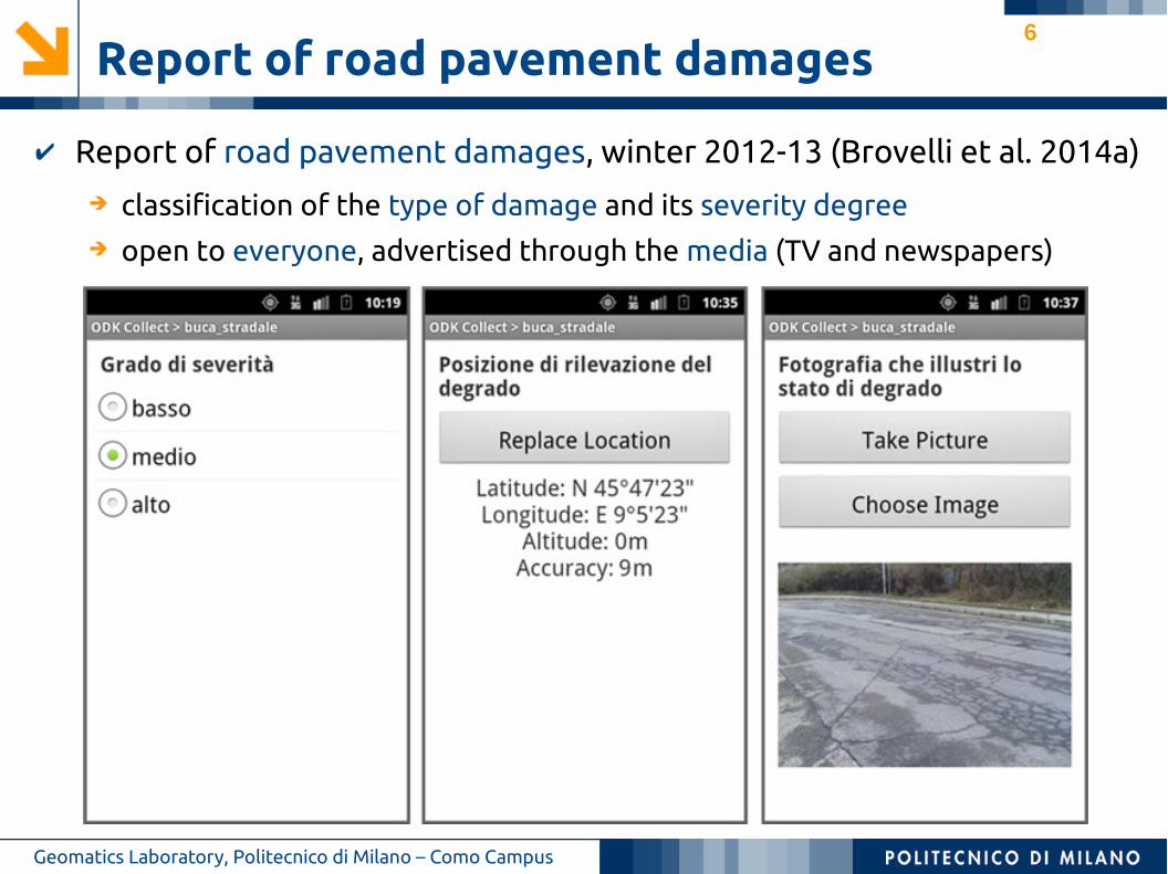
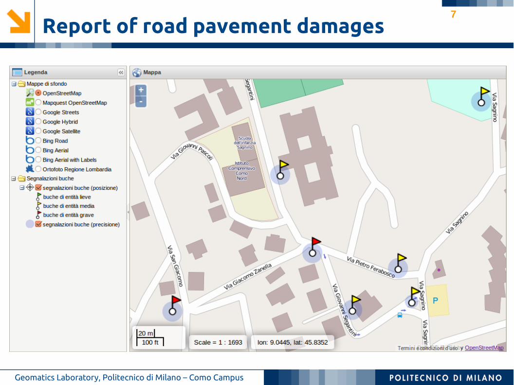
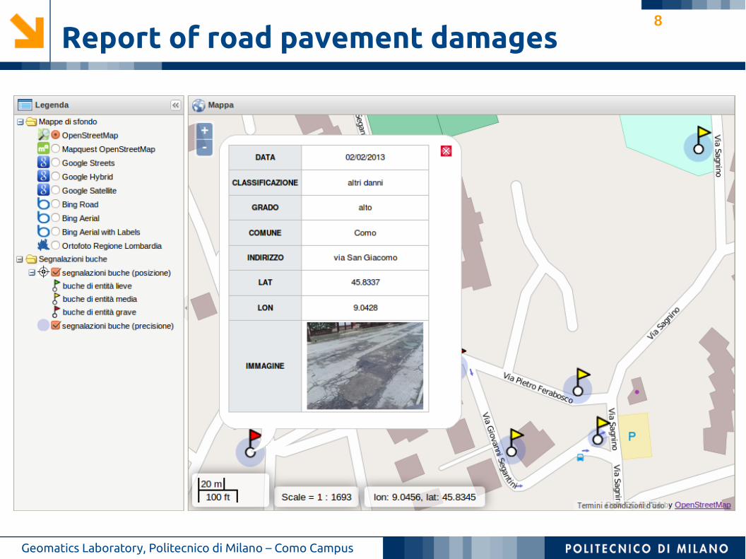
Report of road pavement damages
Geomatics Laboratory, Politecnico di Milano – Como Campus
➔ classification of the type of damage and its severity degree➔ open to everyone, advertised through the media (TV and newspapers)
✔ Report of road pavement damages, winter 2012-13 (Brovelli et al. 2014a)
7
Report of road pavement damages
Geomatics Laboratory, Politecnico di Milano – Como Campus
8
Report of road pavement damages
Geomatics Laboratory, Politecnico di Milano – Como Campus
9
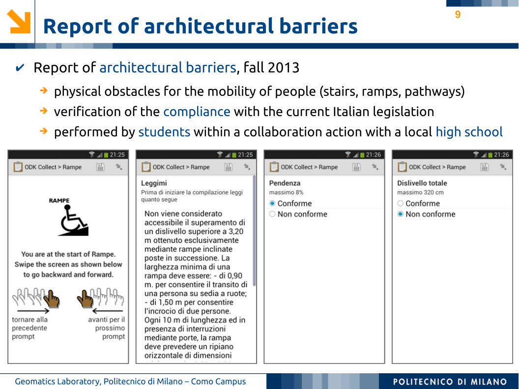
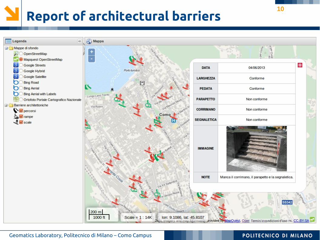
Report of architectural barriers
Geomatics Laboratory, Politecnico di Milano – Como Campus
➔ physical obstacles for the mobility of people (stairs, ramps, pathways)➔ verification of the compliance with the current Italian legislation➔ performed by students within a collaboration action with a local high school
✔ Report of architectural barriers, fall 2013
10
Report of architectural barriers
Geomatics Laboratory, Politecnico di Milano – Como Campus
11
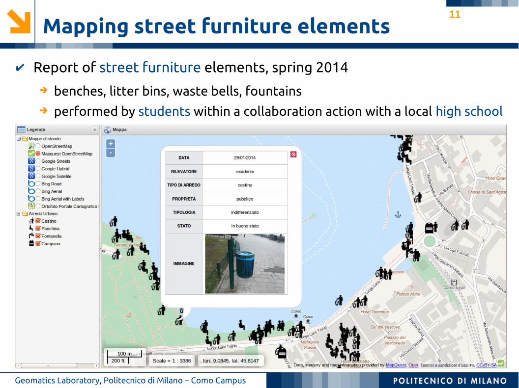
Mapping street furniture elements
Geomatics Laboratory, Politecnico di Milano – Como Campus
➔ benches, litter bins, waste bells, fountains➔ performed by students within a collaboration action with a local high school
✔ Report of street furniture elements, spring 2014
12
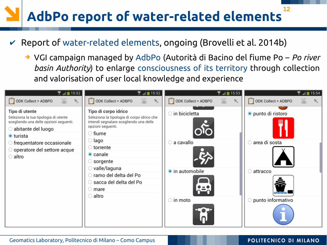
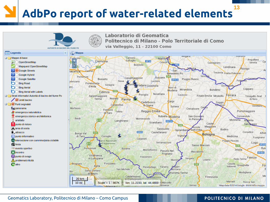
AdbPo report of water-related elements
Geomatics Laboratory, Politecnico di Milano – Como Campus
➔ VGI campaign managed by AdbPo (Autorità di Bacino del fiume Po – Po river basin Authority) to enlarge consciousness of its territory through collection and valorisation of user local knowledge and experience
✔ Report of water-related elements, ongoing (Brovelli et al. 2014b)
13
AdbPo report of water-related elements
Geomatics Laboratory, Politecnico di Milano – Como Campus
14
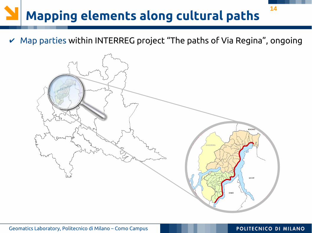
Mapping elements along cultural paths
Geomatics Laboratory, Politecnico di Milano – Como Campus
✔ Map parties within INTERREG project “The paths of Via Regina”, ongoing
SVIZZERA
15
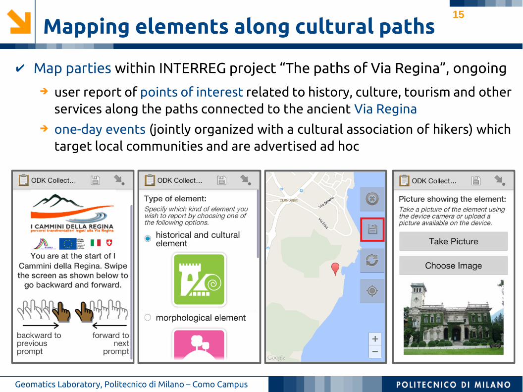
Mapping elements along cultural paths
Geomatics Laboratory, Politecnico di Milano – Como Campus
➔ user report of points of interest related to history, culture, tourism and other services along the paths connected to the ancient Via Regina
➔ one-day events (jointly organized with a cultural association of hikers) which target local communities and are advertised ad hoc
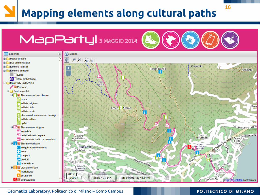
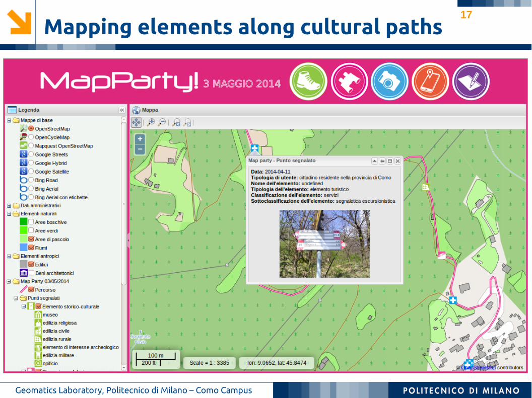
✔ Map parties within INTERREG project “The paths of Via Regina”, ongoing
16
Mapping elements along cultural paths
Geomatics Laboratory, Politecnico di Milano – Como Campus
17
Mapping elements along cultural paths
Geomatics Laboratory, Politecnico di Milano – Como Campus
18
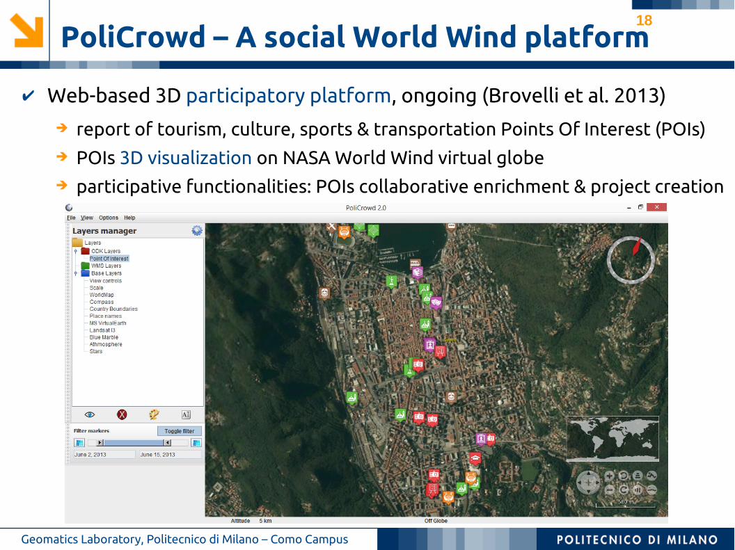
PoliCrowd – A social World Wind platform
Geomatics Laboratory, Politecnico di Milano – Como Campus
➔ report of tourism, culture, sports & transportation Points Of Interest (POIs)➔ POIs 3D visualization on NASA World Wind virtual globe➔ participative functionalities: POIs collaborative enrichment & project creation
✔ Web-based 3D participatory platform, ongoing (Brovelli et al. 2013)
19
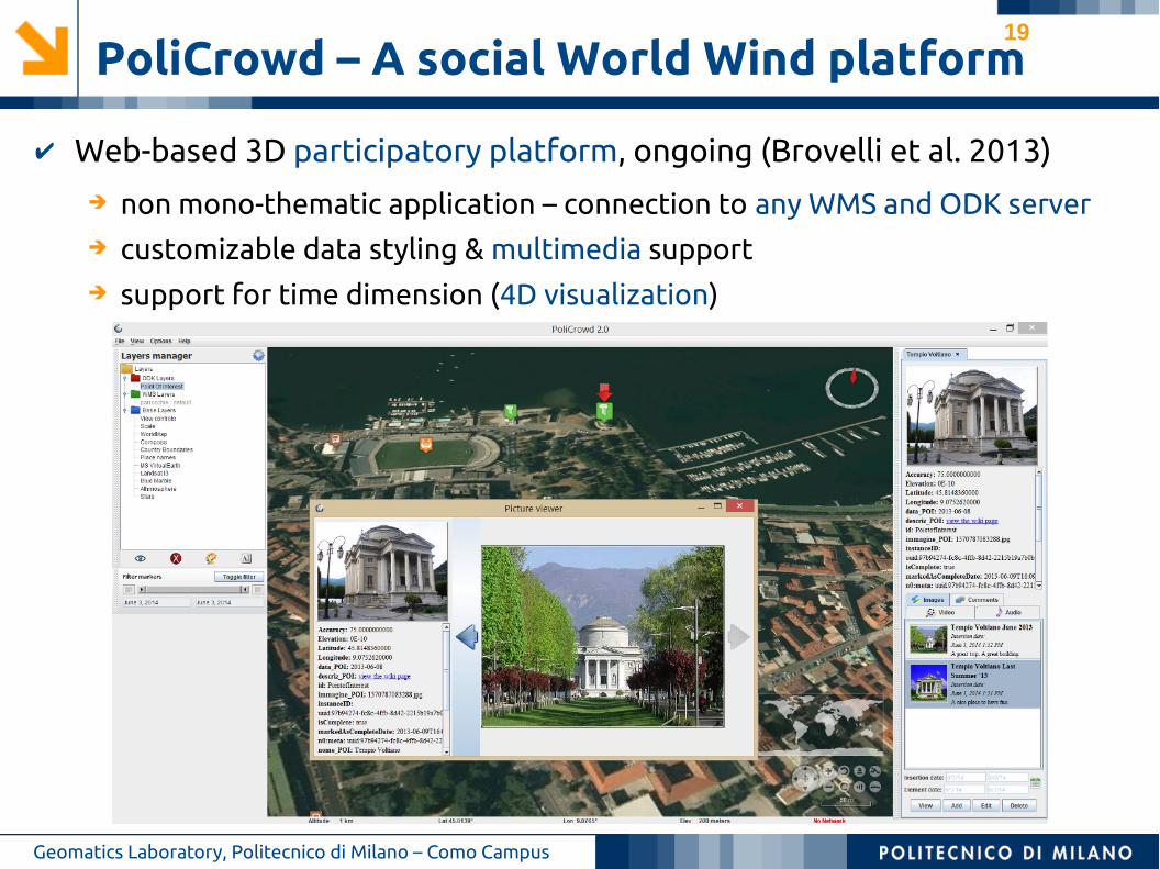
PoliCrowd – A social World Wind platform
Geomatics Laboratory, Politecnico di Milano – Como Campus
➔ non mono-thematic application – connection to any WMS and ODK server➔ customizable data styling & multimedia support➔ support for time dimension (4D visualization)
✔ Web-based 3D participatory platform, ongoing (Brovelli et al. 2013)
20
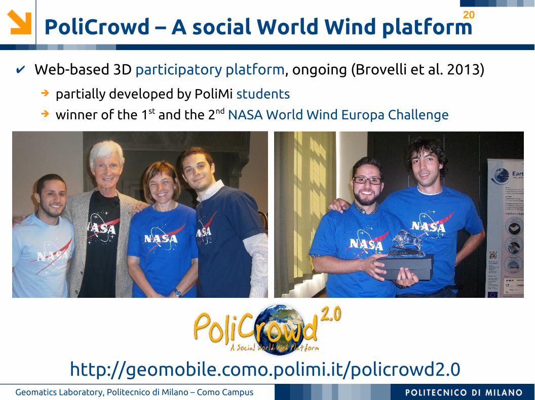
PoliCrowd – A social World Wind platform
Geomatics Laboratory, Politecnico di Milano – Como Campus
➔ partially developed by PoliMi students➔ winner of the 1st and the 2nd NASA World Wind Europa Challenge
✔ Web-based 3D participatory platform, ongoing (Brovelli et al. 2013)
http://geomobile.como.polimi.it/policrowd2.0
21
Results & considerations
Geomatics Laboratory, Politecnico di Milano – Como Campus
➔ depends on the number of expected users
✔ VGI data quantity
✗ campaigns open to the general public usually do not foster a widespread participation many data collected by relatively→ few users
✗ campaigns targeted to specific user groups turn out to be more effective many data collected by almost→ all the users involved
➔ depends on the kind of expected users✗ the younger and more technology-oriented they are, the more they will
participate
➔ depends on the foreseen duration of the campaign
✗ (without incentives or prizes) people are little stimulated to participate in the long time students, but also adults!→
✗ short VGI campaigns (like map parties) are the most effective solution
➔ generally very high (much more than expected!)
✔ VGI data quality (semantic & logical accuracy, consistency, completeness)

22
Results & considerations
Geomatics Laboratory, Politecnico di Milano – Como Campus
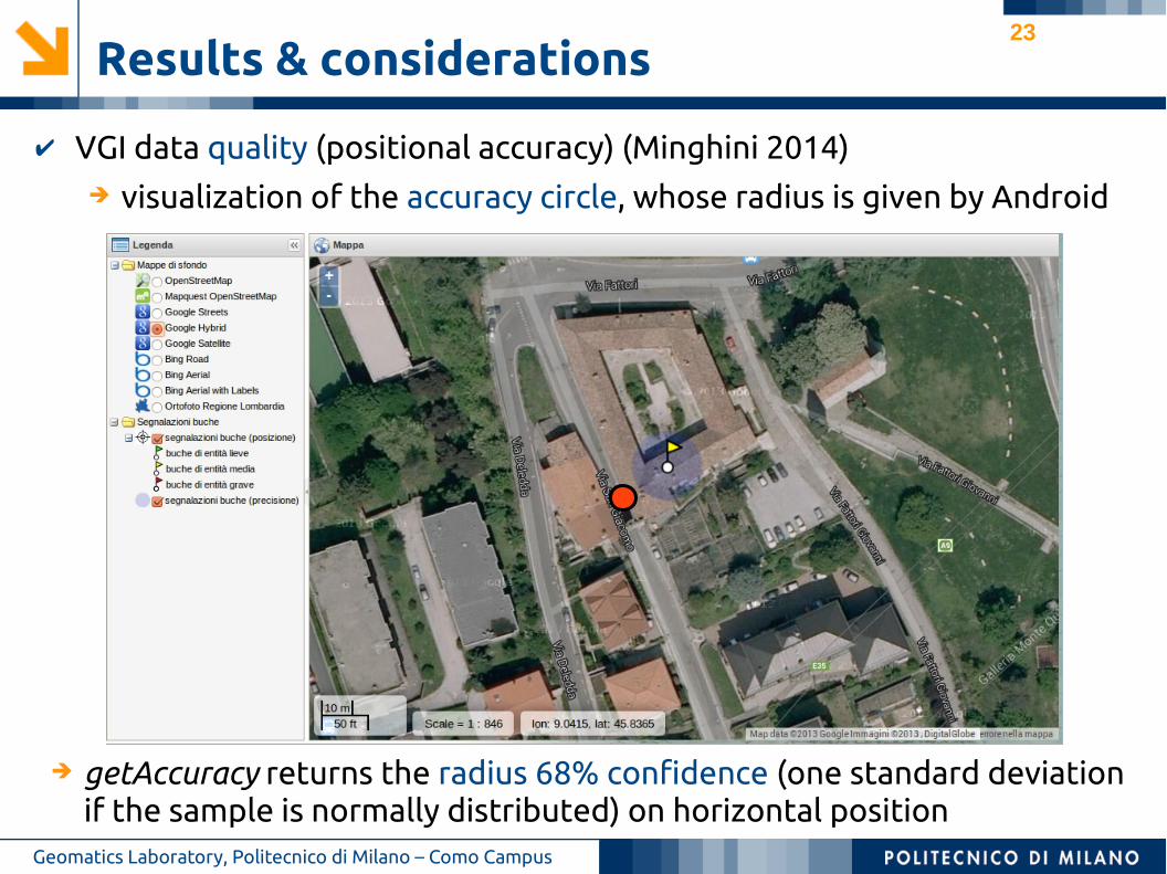
✔ VGI data quality (positional accuracy) (Minghini 2014) ➔ visualization of the accuracy circle, whose radius is given by Android
23
Results & considerations
Geomatics Laboratory, Politecnico di Milano – Como Campus
✔ VGI data quality (positional accuracy) (Minghini 2014)
➔ getAccuracy returns the radius 68% confidence (one standard deviation if the sample is normally distributed) on horizontal position
➔ visualization of the accuracy circle, whose radius is given by Android
24
Results & considerations
Geomatics Laboratory, Politecnico di Milano – Como Campus
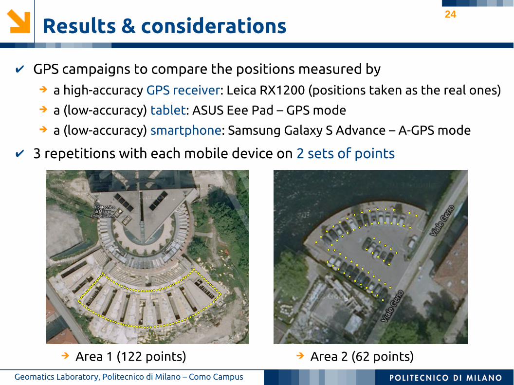
✔ GPS campaigns to compare the positions measured by➔ a high-accuracy GPS receiver: Leica RX1200 (positions taken as the real ones)➔ a (low-accuracy) tablet: ASUS Eee Pad – GPS mode➔ a (low-accuracy) smartphone: Samsung Galaxy S Advance – A-GPS mode
✔ 3 repetitions with each mobile device on 2 sets of points
➔ Area 1 (122 points) ➔ Area 2 (62 points)
25
Results & considerations
Geomatics Laboratory, Politecnico di Milano – Como Campus
✔ Main operations performed
➔ outlier detection and removal through robust regression➔ ordinary linear regression between the high- and low-accuracy coordinates➔ test on the parameters of the ordinary linear regression➔ tests of independence/correlation between the X and Y errors of the mobile
device estimated locations
✔ Main results➔ shorter TTFF (Time To First Fix) for A-GPS geolocation➔ variable number of outliers (tablet: even > 10%, smartphone: < 7%)➔ positional accuracy: median values of 4-10 m, max values of tens of meters➔ ordinary linear regression: significant disturbs due to both the position (a
parameter) and a non-unique bias b lower than the positional accuracy➔ some correlation between the X and Y errors only for Area 2➔ variable reliability of the Android-returned accuracy value (tablet: even 30%,
smartphone: > 75%)
26
Results & considerations
Geomatics Laboratory, Politecnico di Milano – Como Campus
✔ Main operations performed
➔ outlier detection and removal through robust regression➔ ordinary linear regression between the high- and low-accuracy coordinates➔ test on the parameters of the ordinary linear regression➔ tests of independence/correlation between the X and Y errors of the mobile
device estimated locations
✔ Main results➔ shorter TTFF (Time To First Fix) for A-GPS geolocation➔ variable number of outliers (tablet: even > 10%, smartphone: < 7%)➔ positional accuracy: median values of 4-10 m, max values of tens of meters➔ ordinary linear regression: significant disturbs due to both the position (a
parameter) and a non-unique bias b lower than the positional accuracy➔ some correlation between the X and Y errors only for Area 2➔ variable reliability of the Android-returned accuracy value (tablet: even 30%,
smartphone: > 75%)
27
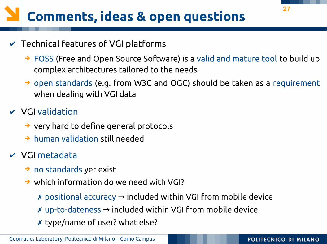
Comments, ideas & open questions
Geomatics Laboratory, Politecnico di Milano – Como Campus
✔ Technical features of VGI platforms
✔ VGI metadata➔ no standards yet exist➔ which information do we need with VGI?
➔ FOSS (Free and Open Source Software) is a valid and mature tool to build up complex architectures tailored to the needs
➔ open standards (e.g. from W3C and OGC) should be taken as a requirement when dealing with VGI data
✗ positional accuracy included within VGI from mobile device→
✗ up-to-dateness included within VGI from mobile device→
✗ type/name of user? what else?
✔ VGI validation➔ very hard to define general protocols➔ human validation still needed
28
References✔ Cohn, J. P. (2008). Citizen science: Can volunteers do real research?. BioScience 58(3),
192–197.
✔ Haklay, M. (2013). Citizen Science and Volunteered Geographic Information: Overview
and Typology of Participation. In D. Sui, S. Elwood and M. Goodchild (eds) Crowdsourcing
Geographic Knowledge. Dordrecht: Springer. 105–122.
✔ GNU Project (1996). What is free software? the free software definition [available
online] http://www.gnu.org/philosophy/free-sw.en.html (accessed: 2014-09-18).
✔ Brovelli, M. A., Minghini, M. and Zamboni, G. (2013). Participatory GIS: Experimentations
for a 3D social virtual globe. International Archives of the Photogrammetry, Remote
Sensing and Spatial Information Sciences XL-2/W2, 13–18.
✔ Brovelli, M. A., Minghini, M. and Zamboni, G. (2014a). Public Participation GIS: a FOSS
architecture enabling field-data collection. International Journal of Digital Earth (ahead
of print) 1–19. doi: 10.1080/17538947.2014.887150.
✔ Brovelli, M. A., Dotti, L., Minghini, M., Pancaldi, M. and Zamboni, G. (2014b). Volunteered
Geographic Information for water management: a prototype architecture. Proceedings
of th 11th International Conference on Hydroinformatics, New York, August 17-21, 2014.
✔ Minghini, M. (2014). Multi-dimensional GeoWeb platforms for citizen science and civic
engagement applications. PhD thesis, Politecnico di Milano.Geomatics Laboratory, Politecnico di Milano – Como Campus
29
Contacts
Thanks for your attention!
Politecnico di Milano
Laboratorio di Geomatica – Polo Territoriale di ComoVia Valleggio 11, 22100 Como (Italy)
@MarcoMinghini
Marco Minghini
Geomatics Laboratory, Politecnico di Milano – Como Campus