Embed Size (px)
Citation preview
EXPLANATORY MEMOIR
SHEETS 39, 40, 51, 52, AND NORTHERN PORTION OF 62
OF THE MAPS
OF THE
GEOLOGICAL KURVEY OF IRELAND, .
INCLUDING- THE
COUNTRY AR0 UND BELMULLET, BANGOR, CORICK,
BELDERG, AND PORTACLOY,
AND THE
ISLANDS OF INISHKEA, INISHGLORA, AND D UVILLAUN,
BP
RICHARD G. SYMES, M.A., F.G.S. ; W. A. TRAILL, M.A.I. ;
AND
A. M‘HENRY.
, .&&shed by Order of the Lords Commissioners of Her Majesty’s Treaswy.
DUBLIN: PRINTED FOR HER MAJESTY'S STATIONERY OFFICE:
PUBLISHED BY
ALEX. THOM & CO., 87, 88, dz 89, ABBEY-STREET, THE QUEEN'S PRINTING OFFICE.
HODGES, FIGGIS cur, Co., 104, ‘GRAFTON-STREET.
LONDON:
I,oNGMAN&CO., PATERNOSTERROW; TR~?BNER&CO.,LUDGATE HILL,,
1881.

9. \‘r. ,
4. , ‘7
THE
GEOLOGICAL SURVEY OF THE UNITED KINGDOBJ ISCO&DUCTEDUNDERTHEPOWERSOFTEE
STH & 9mz VICT., CHAP. 63.-31~~ JULY, 1845.
' DIRECTOR-GENERALOF THE GEOLOGICALSURVEYOFTHEUNITEDISINGDOM :
PROFESSOR A. C. RAMSAY, LL.D., P.R.S. ,
Crsological Survey O$iceand Museum of Practical Geology, Jermyn-etreet,London.
IRISH BRANCH.
O&e, 14, Hume-street, Dublin.
DIRECTOR:
EDWARD HULL,LL.D., F.R.S.,F.G.S.
DISTRICT SURVEYOR:
G. H. KINAHAN, M.R.I.A.,&cr
SENIORGEOLOGISTS:
W. H. sAILY, F.Q.s., L.S. (Acting Palsontologist) ; J. O’KELLY, x.A., M.R.I.A. R. G. SYMES, M.A., F.G.S.; S. B. N. WILKINSON.
ASSISTANTGEOLOGISTS:
J. NOLAN, M.R.I.A.; R. J. CRUISE, M.R.I.A.;
F. W. EGAN, B.A. ; E. T. HARDMAN, F.C.S. ; J. R. KILROE ; W. F. MITCHELL ; and ALEX. M‘HENRY F.E.G.S.I.
FOSSIL COLLECTORS:
LEESON; AND R. CLARK.
The observations made in the course of the Geological Survey are entered, in the Brat instance, on the Maps of the Ordnance Townland Survey, which are on the scale of six inches to the mile. By means of marks, writing, and colours, the nature, extent, direction, and geological formation of all portions of rock visible at the surface are laid down on these maps, which are preserved as data maps and geological records in the
’ office in Dublin. The results of the Survey are published by means of coloured copies of the one-inch
map of the Ordnance Survey, accompanied by printed Explanations. Longitudinal sections, on the scale of six inches to the mile, and vertical sections
of coal-pits, &c., on the scale of forty feet to the inch, arealso published, and in pre.. paration.
Condensed memoirs on particular districts will also eventually appear. The heights mentioned in these Explanations are all taken from the Ordnance Mane.
AGENTSFORTHESALE OFTHEMAPSAND PUBLICATIONS:
. Messrs. LONGMANS, GREEN, & Co., London ;
Messra. HODGES, FIGGIS, & Co., Grafton-street, Dublin ; ALEX, Te OM & Co., Printers and Publishers, Abbey*street, Dublin.
PKEFACE.
THE district included in this Memoir is one of the wildest and most inaccessible in Treland; remarkable, as regards its outward configuration, for the vast extent of moorland, once clothed by forests of oak and pine, of which evidence is afforded by the occurrence of stems and roots of trees imbedded in the peat. It was the last haunt of the red deer in, the north-west of the
island, which disappeared with the forests which afforded it shelter. The Geological Survey of the district was carried out during the years 1876-78, by Messrs. Symes, W. B. Leonard, and A. M’Henry in the west, and Messrs. H. Leonard and W. A. Trail1 in the east. Its structure is of much interest : first, from the possible presence at Belmullet of gneiss belonging to the Lauren-
tian formation, and secondly, from the occurrence of sheets of trap, of older age than the Carboniferous, interbedded with the metamorphic rocks, amongst which they were intruded prior to their metamorphism, and consequently having themselves under- gone a change from their original condition along with the schists amongst which they are enclosed. The details of these phenomena are clearly described in the Memoir by the authors,
and are laid down on the Survey maps as fully as the small scale has allowed. Mr. Trail1 has now retired from the Survey, but ere leaving had drawn up the structural details of the district surveyed by himself and his colleague.
EDWARD HULL, D&rector.
29th March, 1881.
EXPLANA'l'ORP MEMOIR TO ACCOMPANY
k
SHEETS 39, 40, 51, 52, AND NORTHERN PORTION OF
62 OF THE MAPS
OF THE
GEOLOGICAL SURVEY ’ OF IRELAND, ,
PART I.
PHYSICAL GEOGRAPHY.
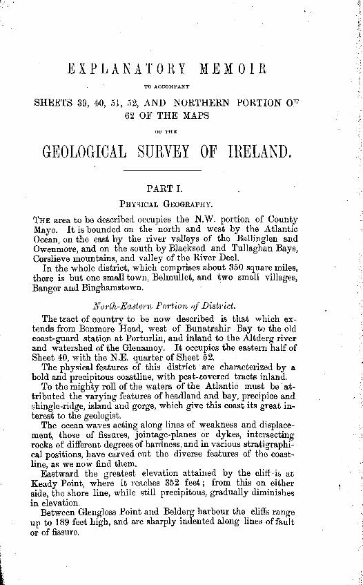
THE area to be described occupies the N.W. portion of County Mayo. It is bounded on the north and west by the Atlantic Ocean, on the east by the river valleys of the Ballinglen and Owenmore, and on the south by Blacksod and Tullaghan Bays, Corslieve mountains, and valley of the River Deel.
In the whole district, which comprises about 350 square miles, there is but one small town, Belmullet, and two small villages, Bangor and Binghamstown.
North-Eccstema Portioa of D&&t.
The tract of country to be now described is that which ex- tends from Benmore Head, west of Bunatrahir Bay to the old coast-guard station at Porturlin, and inland to the Altderg river and watershed of the Glenamoy. It occupies the eastern half of Sheet 40, with the N.E. quarter of Sheet 52.
The physical features of this district / are characterized by a bold and precipitous coastline, with peat-covered tracts inland.
To the mighty roll of the waters of the Atlantic must be ’ at- tributed the varying features of headland and bay, precipice and shingle-ridge, island and gorge, which give this coast its great in- terest to the geologist.
The ocean waves acting along lines of weakness and displace- ment, those of fissures, jointage-planes or dykes, intersecting rocks of different degrees of hardness, and in various stratigraphi- cal positions, have carved out the diverse features of the coast- line, as we now find them.
.
P
,
Eastward the greatest elevation attained by the cliff ‘is at Keady Point, where it reaches 352 feet ; from this on either aide, the shore line, while still precipitous, gradually diminishes in elevation.
Between Glengloss Point and Belderg harbour the cliffs range up to 189 feet high, and are sharply indented along lines of fault or of fissure.
,
To the westward they again increase considerably in altitude, attaining to 640 feet at Benwee Geevraun point, and in con- tinuation of Glinsk Mountain to about 850 feet, although there they are not so steep.
Opposite the island of Illanmaster the cliffs are 790 feet high and very precipitous. From thence to Porturlin they range in varying heights of 400 to 600 feet, with islands detached from the several headlands and fissure gorges cut into the mainland.
Further westward the cliffs attain to still higher elevations. The inland portions of the district are characterized by ex-
tensive tracts of upland and mountain bog, for the greater pal%
obscuring the underlying rocks. A ridge_.of high ground, which forms the watershed between
the Glenamoy and Owenmore river basins, is continued from Maumakeogh, 1,243 feet high, by the summit 1,165 feet to Ben- more, and further south-.westward by the summits marked 871, 522, and 663 feet towards Slieve Fyagh, 1,090 feet high.
Among these eleva.tions Benmore forms the most conspicuous I fea’ture, rising from the low marshy ground at Boorfuagh in steep
rocky acclivities to a height of 1,155 feet, and round its northern and western flanks several well-marked escarpments, or slightly inclined terraces, with outcropping ridges, may be observed, the structures of which are described at page 26, et seq.
-At the base of the northern slopes of this mountain there occurs a small lake called Lough Nambrackkeagh, pent in by drift, or moraine accumulations, at an elevation of 502 feet.
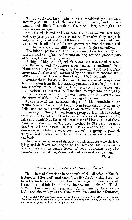
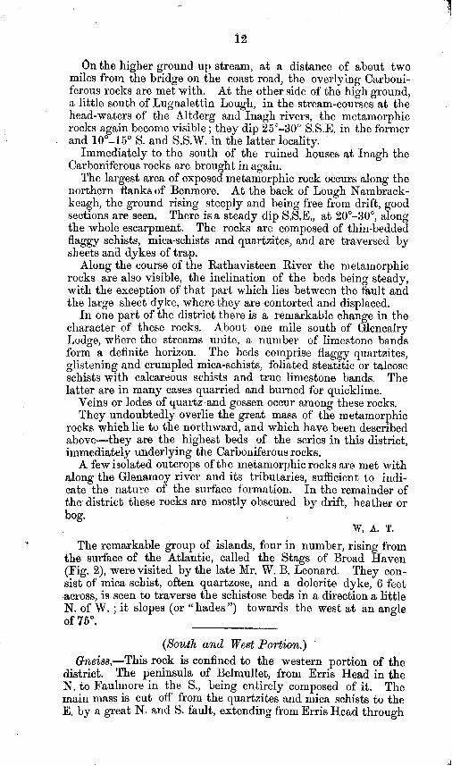
The Stags of Broad Haven form a group of four islarads rising . from the surface of the Atlantic, at a distance of upwards of a
mile and a half from the north-west coast of Mayo. One of these rises to an elevation of 316 feet, another to 312 feet, the next 256 feet, and the lowest 243 feet. That nearest the coast is dome-shaped, while the most northern of the group is pointed. They consist of schistose rocks, and form a favourite retreat for sea-birds.
The Glenamoy river and its tributary streams traverse the low- lying and drift-covered region to the west of this, adjacent to which there are extensive tracts of deep unbroken bog, with Loughauns or small bog-lakes, without any exit for bainage.
W. A. T,
Southern and Western Portion, of District
The principal elevations in the south of the district is Knock- lettercuss (1,208 feet,), and Carrafull (890 feet), which together, form the northern spur of the Corslieve range of mountains, al- though divided into two hills by the Owenmore river.” To the N.W. of the above, and separated from them by Carrowmore Lake, and the valleys of the Owenmore river and its tributaries,
* See Hull’s ‘( Physical Geography and Geology of Ireland,” p. 179, in which an ex- plmation is given of the cause why this river cuts through the ridge, on its way to the oea, instead of going out in a norlherly direction.
. .
Glencastle (780 feet) Broad Haven is Knock-
9
we have Knocknascollop (788 feet) and hills, and between Carrowmore Lake and nalower (612 feet).
The long N. and S. peninsula, locally called “ The Mullet,” which is separated from the mainland by Blacksod Bay and an arm of Broad Haven, contains no very considerable elevations- the highest (434 feet) being towards Erris Head on the north, whilst the remainder of the peninsula is low-lying and gently undulating ground.
The coastline from Rossport, along Broad Haven to Erris Head and thence to Armagh Head, presents a continuous line of bold precipitous cliff’s, generally inaccessible, the remaining part being low, gravelly, sandy, and rocky beaches.
In the SE. of the district there is an extensive tract of undu- lating country, which is occupied by the lower Carboniferous sandstone, generally covered by thick bog and drift.
Dro&,ccge.-The principal catchment basin is that of the Owenmore river and its tributary streams, which drains more than half the district, and flows into Tullaghan Bay. There are several small streams also flowing into Broad Haven and Black- sod Bay, but none of them are of much importance.
La&s.-Carrowmore Lake, which is about four square miles in extent, lies in the centre of the district, and drains into the Owenmore river. There are also numerous small bog-lakes scattered over the country, some of them at elevations of over 600 feet.
A. M‘H.
Name.
PART II. CHAPTERS I.
ROCK FORMATIONS AND DIVISIONS.
Aqueous Rocks. Colour on Map.
Recent and Post- Blown sand when forming
Glacial. dunes.
[Alluvial and Bog, Raw Umber.
Post-Pliocene, Sand and gravel, boulder 1 (Drift Deposits), . c,ay, . . . . ( i%graved dots.
Lower Carboni- d” Lower Limestone, Prussian blue.
ferous. . dl
. Lower Sandstone, ‘with 1 Prussian blue
bands of Limestone. J
with Indian ink, withgellowdotb.
Metamorphic Rodcs. I p Mica Schist, . . . Pale
i Crimson
Lake. p Quartz, . . . . Do*~ wd~d *
i pq Micaceous Quartzite,.
yamboge. with . Pale
i Crimson
X Crystalline Limestone Lak_e.
in 1
+I Schist, . . . Cobalt.
E Dolomite, . . . 1
Emerald green over
y Gneijs, . . . Chmn Lske
. Pale
i Crimson
Lake. A Hornblende Rock, . l . Burnt caymine.
10
Ipeous Rocks. -
B Basalt, Dolerite, 1 . Bwnt Carmine.
BP Porphyritic, . , ,, ,, 1) D&rite, . . . . F Felstone, . . . . T/kk’?dion ”
G Granite, . . . Pale Carmine.
1. M ETAMOHPHIC ROCKS.
North-east Portiom- The rocks of this series are much ob- scured by superficial coverings of drift and bog. The chief exposures are found along the coast and up the Glenglassera River ; on Benmore also, and the high ground adjacent, and at the head waters of the Inagh and Altderg rivers, and of the Glenamoy, above Glencalry Lodge, the rocks are again laid bare. With few other exceptions, and those of small extent, these rocks are hid, but, nevertheless, sufficient outcrops are visible to denote the relative positions of the beds.
The metamorphic rocks underlie the whole district, but appear first upon the surface at the Glenglasscra river, and from thence westward and southward to Inagh and Lough Morenateoran ; being overlaid on the east and south by the Lower Carboniferous . Sandstone formation.
In the eastward of the district they consist of evenly-bedded, flaggy quartzites, micaceous schists, and flags with partings ofmica- schist, and decomposing iron-stained red and yellow sandstones.
They have a prevailing easterly dip, ranging between E.N.E. and E.S.E., at variable angles of inclination, averaging about 15” to 25”. Veins, strings and nests of quartz, with rhomboidal scales of silvery mica are of frequent occurrence, and these often coat the jointage planes. The jointage has here an average direction of N. 15” E., inclined westward at high angles, usually about $0”~85”.
Faults are also common;-but in general they have only small displacements, many of them range N.N.E., with conjugate faults E.S.E. ; others bear E.N.E., and some nearly E. and W.
The metamorphic rocks, which at Port and Glengloss Point are dipping steadily to the eastward, towards Belderg Harbour become considerably disturbed, being often thrown into a series of alternating folds. To the westward of this, the average dip changes more to the south, and the contortions are more numer- ous, the beds in many cases being inverted, or folded back upon themselves several times.
,
The rocks along here have a more definite metamorphic charac- $ter, consisting of flaggy quartzites, crumpled schists and mica- schists, in which foliation begins to be apparent.
Many remarkable faults and dykes occur in this portion of the coa& which will be noted further on.
Returning to the inland parts of the district, the metamorphic rocks are exposed along the bed of the Glenglassera river, with a very constant dip E. and E. 15” S., at angles of 10” to 15’, rising occasionally as high aa 25’.
. - ‘7
._- - -
Fig. 2. The Stags of Broadhaven and Benwee Head, Co. Mayo, as seen fro? Erris H&.
On the higher ground up stream, at a distance of about two miles from the bridge on the coast roa,d, the overlying Carboni- ferous rocks are met with. At the other side of the high ground, a little south of Lugnalettin Lough, in the stream-courses at the head-waters of the Altderg and Inagh rivers, the metamorphic rocks again become visible; they dip 25”-30” S.S.E. in the former and 10°-Eio S. and S.S.W. in the latter locality.
Immediately to the south of the ruined houses at Inagh the Carboniferous rocks are brought in again.
The largest area of exposed metamorphic rock occurs along the northern flanks of Benmore. At the back of Lough Nambrack- keagh, the ground rising steeply and being free from drift, good sections are seen, There is a steady dip S,S,E,, at 20”-30”, along the whole escarpment. The rocks are composed of thin-bedded flaggy schists, mica-schists and quartzites, and are traversed by sheets and dykes of trap.
Along the course of the Rathavisteen River the metamorphic rocks are also visible, the inclination ’ of the beds being steady, with the exception of that part which lies between the fault and the large sheet dyke, where they are *contorted and displaced.
In one part of the district there is a remarkable change in the character of these rocks. About one mile south of Glencalry Lodge, wliere the streams unite, a number of limestone bands form a definite horizon. The beds comprise flaggy quartaites, glistening and crumpled mica-schists, foliated steatitic or talcose schists with calcareous schists and true limestone bands. The latter are in many cases quarried and burned for quicklime.
Veins or lodes of quartz and gossen occur among these rocks. They undoubtedly overlie the great mass of the metamorphic
rocks which lie to the northward, and which have been described above-they are the highest beds of the series in this district, immediately underlying the Carboniferous rocks,
A few isolated outcrops of the metamorphic rocks are met with along the Glenarnoy river and its tributaries, sufficient to indi- cate the nature of the surface formation. In the remainder of the_ district these rocks are rnostly obscured by drift, heather or bog.
ty, A. T.
‘), The remarkable group of islands, four in number, rising from the surface of the Atlantic, called the Stags of Broad Haven (Fig, 2), were visited by the late Mr. W. B, Leonard. They con- sist of mica schist, often quartzose, and a dolerite dyke, 6 feet across, is seen to traverse the schistose beds in a direction a little N, of W, ; it slopes (or “hades”) towards the west at an angle of 75”.
(South and West Portion,) ’
&eiss,-This rock is confined to the western portion of the district. The peninsula of Belmullet, from Erris Head in the N. to Faulmore in the S., being entirely composed of it. The main mass is cut off’ from the quartzites and mica schists to the E. by a great N. and S. fault, extending from Erris Head through
13
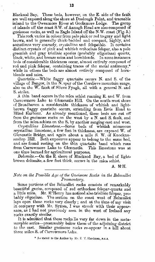
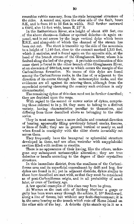
Blacksod Bay, These beds, however, on the E. side of the fault are well exposed along the shore at Doolough Point, and traceable inland to the Owenmore River at Goolamore Lodge. The group of isla,nds off the coast S.W. of Annagh Head are also composed of gneissose rocks, as well as Eagle Island off the N.W. coast (Fig. 3.)
This rock varies in colour from pale pink or red to gray and light brown, and is generally thick-bedded and compact, highly, and sometimes very coarsely, crystalline and felspathic. It contains distinct crystals of pink and whitish orthoclase felspar, also a pale
) greenish and gray triclinic species (probably oligoclase) quartz, black, white, and bronze mica and hornblende. In some instances beds of considerable thickness occur, almost entirely composed of
I red and pink felspar, containing traces of the metal antimony,* while in others the beds are almost entirely composed of horn- blende and mica.
Quart&e.-White flaggy qunrtzite occurs N. and S. of the village of Bangor, in the N. spur of the Corslieve mountain range, also on the W. flank of Slieve Fyagh, all with a general N. and S. strike.
A thin band occurs in the mica schist running E. and W. from Carrowmore Lake to Glencastle Hill. On the south-west shore of Broadhaven a considerable thickness of whitish and light- brown flaggy quartzite occurs, extending from Erris Head to Blind Harbour. As already mentioned, these beds are cut off from the gneissose rocks on the west by a N. and S. fault, and from the mica schists on the S. by another ranging east and west.
Crystalline Limestone.- Some beds of whitish micaceous crystalline limestone, a few feet in thickness, are exposed W. of Glencastle Bridge, and again about a mile S. W. of Knockna- scallop Hill. Both exposures appear to belong to the same bed, and are found resting on the thin quartzite band which runs from Carrowmore Lake to Glencastle. This limestone was at one time burned for agricultural purposes.
Dolomite .-On the E. shore of Blacksod Bay, a bed of light- brown dolomite, a few feet thick, occurs in the mica schist.
A. M‘H.
,
Note on the Possible Age! 01 the Gn,eissose RocX:s in the Belmullet PromorLtory.
Some portions of the Belmullet rocks consists of remarkably beautiful gneiss, composed of red orthoclase felspar-quartz and a little mica. Mr. M‘Henry has noticed also triclinic felspar, pro- bably nligoclase. The section on the coast west of Belmullet lays open these rocks very clearly ; and at the time of my visit in company with Mr. Symes, I was struck with their appear- ance, as I had not previously seen in the west of Ireland any rocks exactly similar.
It is admitted that these rocks lie very far down in the meta- morphic series-presumably below these of the adjoining district to the east. Similar gneissose rocks reappear in a hill about three miles S. of Carrowmore Lake.
* As stated to the Author by Mr. IX I’. Hardman, F.C.S.
14
Fig. 3. Eagle Maul, off Erris Head, from Doonane Point, formed of felspathic and hornblendic Gneiss.
On seeing during last spring sections of the Lower Laurentian rocks in the N.W. Highlands of Scotland-for instance, around the village of Rhiconich, and along the shores of Loch Laxford, I was strongly reminded of the sections west of Belmullet. The rocks are precisely similar in appearance and apparently in composition, consisting of granitoid gneiss, of red orthoclase, OligocIase, quartz, and a little mica, with numerous pegmatite dykes and veins. These Lower Laurentian gneissose rocks are succeeded by hornblendic schists, and in some districts are separated from the overlying Lower Silurian quartzites and limestone, by horizontal beds of red sandstone and conglomerate, of Cambrian age, unconformable to the formation both above and below.* In parts of Sutherland and Ross, however, the interven- ing Cambrian sandstones had been removed by denudation before the Silurian beds were deposited, and there the Laurentian beds are immediately succeeded by the Silurian, and both series being more or less metamorphosed. The dissimilarity is not so striking as when they are separated by the Cambrian sandstone and con- glomerate.
It is possible that in West Mayo the conditions may be similar to those just described. Certainly there is no Cambrian sandstone or conglomerate visible anywhere at the surface in the west of Ireland. If it should happen that the red gneiss of Belmullet is really of Laurentian age, then it is succeeded by the schists and quartzites of Lower Silurian age, without the intervention of the Cambrian formation, There would be, in that case, a great hiatus at the junction. NO actual superposition has been observed, as the red gneiss is faulted against the schists and quartzites by the large fault, shown on the Map, ranging by the town of Belmullet. Similar beds of red gneiss are known to occur in Donegal, and it is hoped that when that district comes to be mapped by the Officers of the Survey, additional light will be thrown upon their relations to the Lower Silurian quartzites and schists, and gneiss of north-west Mayo,
E. H.
* See Ramsay’s Physical Geology of Great Britain. 5th edit. P. 286.
a-“,- . I
Fig. 4. Unconformability of Carboniferous and Metamorphic Rocks at Fohernadeevaun, Glenglassera River,
\
_- i _ -
. 16
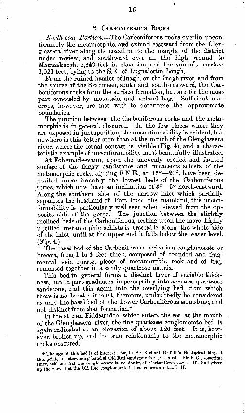
2. CARBONIFEROUS ROCKS.
North-east Portion.- The Carboniferous rocks overlie uncon- formably the metamorphic, and extend eastward from the Glen- . glassera river along the coastline to the margin of the district under review, and southward over all the high ground to Maumakeogh, 1,243 feet in elevation, and the summit marked 1,021 feet, lying to the SE. of Lugnalettin Lough.
From the ruined hamlet of Inagh, on the Inagh river, and from the source of the Srahmeen, south and south-eastward, the Car- boniferous rocks form the surface formation, but are for the most part concealed by mountain and upland bog. Sufficient out- crops, however, are met with to determine the approximate boundaries.
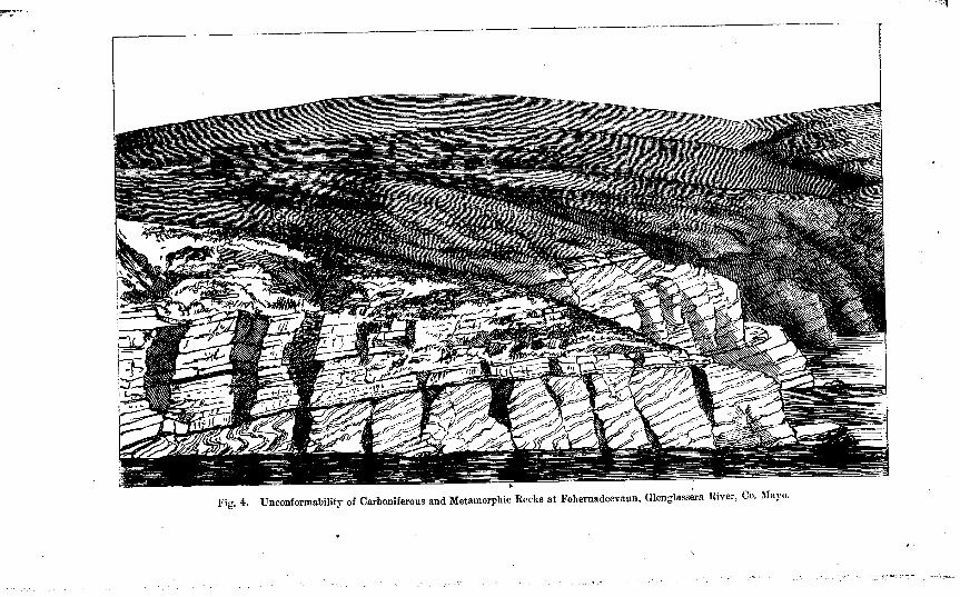
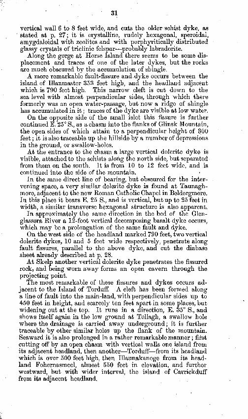
The junction between the Carboniferous rocks and the meta- morphic is, in general, obscured. In the few places where they are exposed in juxtaposition, the unconformability is evident, but nowhere is this better seen than at the mouth of the Glenglassera river;where the actual contact is visible (Fig. 4), and a charac- teristic example of unconformability most beautifully illustrated,
At Fohernadeevaun, upon the unevenly eroded and faulted surfape of the flaggy sandstones and micaceous schists of the , metamorphic rocks, dipping E.N.E., at 16Q-200, have been de- posited unconformably the lowest beds of the Carboniferous series, which now have an inclination of 3°--50 north-eastward.
l Along the southern side of the narrow inlet which partially separates the headland of Port from the mainland, this uncon- formability is particularly well seen when viewed from the op- posite side of the gorge. The junction between the slightly inclined beds of the Carboniferous, resting upon the more highly uptilted, metamorphic schists is traceable along the whole side of the inlet, until at the upper end it falls below the water level. (Fig. 4.)
The basal bed of the Carboniferous series is a conglomerate or breccia, from 1 to 4 feet thick, composed of rounded and frag- mental vein quartz, pieces of metamorphic rock and of trap cemented together in a sandy quartzose matrix,
This bed in general forms a distinct layer of variable thick- ness, but in part graduates imperceptibly into a coarse quartzose sandstone, and this again into the overlying bed, from which there is no break ; it must, therefore, undoubtedly be considered as only the basal bed of the Lower Carboniferous sandstone, and not distinct from that formation.*
111 the stream Fiddaundoo, which enters the sea at the mouth of the Glenglassera river, the fine quartzose conglomerate bed is again indicated at an elevation of about 120 feet. It is, how- ever, broken up, and its true relationship to the metamorphic rocks obscured.
* The age of this bed is of interest ; for, in Sir Richard Griffith’s Geological Map at this point, an intervening band of Old Red sandstone is represepted. Sir R. G.. sometime since, told me that the conglomerate is, no doubt, of Carboniferous age. He had given up the view that the Old Red conglomerate is here represented.-E. H,
I.7
Along the shore, a little to the eastward, between Nyranagh and Claddaghnahowna, at the base of the cliffs 160 feet high, the metamorphic rocks are visible at about the sea level, dipping apparently 20”-30” E.N.E. beneath the Carboniferous sandstones which overlie them unconformably, and dip from 5” to IO” only, By the breaking away of the sandstones, owing to the sea action, the schists are revealed at low tides, and in the face of the cliff adjacent their broken uneven surface is again visible underneath the sandstones and shales.
The margin of the Carboniferous rocks along the eastern side of the Glenglassera river, where on the higher ground they over- lie the metamorphic beds, is only traceable approximately by the slightly more abrupt slope of the ground, being obscured by drift and bog.
On the west side of Lugnalettin Lough-which is supposed to be dwithin the metamorphic area -there are, on the rising ground which forms a kind of escarpment, traces of the Carboniferous beds, the hase of which would seem to be at an elevation of about 1,06 feet.
The southern junction of the Carboniferous rocks is still more obscure, the nearest exposures of the different formations being in the river bed at Inagh ; to the northward of which, about I,ZOOfeet, the metamorphic schists a,re disclosed, dipping 300 E. 15 S.; while at th e Corn Mill (in ruins) broken up Carboni- ferous sandstones occur, and 2,200 feet down stream coarse iron- stained sandstones dipping 20° S.W. These latter are at an elevation of 450 feet, while the metamorphic rocks occupy the higher ground to the north and north-west.
In the bed of the Altderg river white, yellow, and purple sandstones and shales occur, dipping loo N., 5“ E., but some as high as 15’. Other sandstones in the tributary streams also dip P-70 N., 5” E.
The inclination of these beds dipping northward in the low- - lying country, and the metamorphic rocks dipping southwards on
all the high ground lying to the north of .it, would seem to in- dicate that this junction might be a line of fault with a down- throw to the southward, but this is uncertain.
The remainder of this boundary is obscured by almost un- broken tracts of upland bog.
In the low ground at the head waters of the chief southern tributttry of the Glenamoy river, mica schists are found, but on the higher slopes from Lough Naguroge to Glenamoy Bridge occasional blocks of the characteristic basal conglomerate are met with, evidencing the not far distant occurrence of that bed upon the higher ground to the southward.
A similar conglomerate basal bed of the Carboniferous rocks with unconformability to the metamorphic beds is found near
8 Bangor on the Owenmore river. Tge best sections of the Carboniferous rocks are, however, met
with along the coast from the Glenglassera river eastward to ; Benmore Head. The lower beds of the series, overlying the
L B
18
basal conglomerate, consist chiefly of massive yellowish gray sandstones, with greenish shale partings.
At Claddaghnahowna the cliffs are 160 feet high, and the pre- vailing dip is about E. at 5*. About midway up the face of the adjacent prqjecting headland there are thick beds of shale, which, however, die out towards the land side.
Many smali faults occur among these beds, bearing N. 40 E., N. 40 W., and due E. and W. On the top of the clif% there is a considerable head of drift, which attains a depth of over 40 feet in some places.
Near Minnaum headland there are also a number of faults which mostly bear E.S.E., the downthrow in most cases being on the land side or to the south. The inner face of the cliff which forms the extreme headland is the side of- a fault in- clined 50“ southward. It meets another fault, which is vertical, and the intervening wedge of rock is displaced from its normal inclination.
The beds at this point are higher up in the series, and consist of red, purple, yellow, and green shales, <ernating with grayish white san.dstones. ,
At Bunnahowna, where the Owenbehy stream is precipitated in a cascade over the edge of the perpendicular cliff, the lowest traces of limestone in this series are met with. A few narrow bands of this rock from 2 to 5 inches thick occur here, and are made more evident by the characteristic weathering.
Adjacent to this in the narrow gorge cut out by this stream, there are evenly-bedded micaceous purple sandstones and purple mottled shales, also yellow sandstones and some fine conglo- merate beds, or very coarse sandstones with arenaceous nodules weathering into a red sand.
The cliffs along this part of the coast are perpendicular, and in- crease gradually in height until, at Benmore, they exceed 300 feet, while at Keady Point 352 feet is attained ; eastward of this they fall away by degrees in elevation.
Near the top of Keady Point a few thicker beds of limestone occur, which, on account of the scarcity of lime for agriculture and building purposes, have been quarried for burning,
The bedding of the sandstones along here is only slightly in- clined from the horizontal towards the E.N.E.
At the head of the small bay, between this point and Benader- reen, into which the waves roll majestically, the inclined face of rock is laid bare by the removal of the outer portion up to a line of fault which bears E.&E. with an inclination northward of 25” from the vertical, the southern side remaining ititact.
W. A. T.
Soudhew Portion.
About 60 square miles of the S.E. portion of t’he district is oc- cupied by the Lr. Carboniferous Sandstone, which rests_unconform- ably on the metamorphic series generally at low angles. But few good sections are seen in these rocks on account of the thick
covering of bog and drift which is spread over the whole country, In the Glencullin river there are some openings into variegated micaceous sandstones, and shales, with a few beds of limestone towards the head of the stream. / At Glenco, along the valley of the Owenmore, the best section can be seen, consisting of brownish red micaceous sandstones, under a red conglomerate, and that under greenish and red sand- stones, which, taken as a whole, constitute the lowest beds in this district of this formation, but which are not the actual basal beds, as the sandstones are thrown down to the east by a great north and south fault called the Corslieve fault*. The higher we ascend in the series and in an easterly direction, the sandstones become interstratified with shales, and vary in colour from red and brown to white, and in texture from hard to soft and friable. Interstra- tified with these sandstones and shales are three remarkable bands
.
* of pure limestone, the thickest of these is only 3 feet, and is extensively worked in the neighbourhood-limestone being very scarce. It is probable that the limestones found in the Glencullen river, which runs to the north of the Owenmore, is the representa- tive of these three bands. Near Sheskin Lodge there are exposures of white and gray flaggy sandstones penetrated by a thin dyke of dolerite. A. M’H.
3. POST-PLIOCENE DEPOSITS.
North-East Portion. ’ Of these deposits the following are found in this district :-
Lower Boulder clay with stiff blue unstratified YW; sand and gravel, and erratic boulders.
The Lower Boulder clay widely and deeply overspreads the country, more especially filling up the valleys and flanking the sides of the hills, Numerous sections occur in the stream courses and a,long the coast up to 40 or 50 feet in depth.
This clay is of the ordinary unstratified character and brownish colour, partaking largely of the nature of the disintegrated local rocks. In some sections it is seen to be underlaid by, or to graduate into, a hard blue compact clay (ZUZ), with few large, but many small boulders or pebles, some of which are ice-scratched.
This blue clay works up with water into a plastic mass which becomes very hard on drying. In some places, as near Belderg, it is constantly saturated with water, and consequently is a stiff, soft, tenacious plastic clay, which might readily be used for brick- making or other like purposes.
Shells and shell fragments were found in these clays in four different localities.+
Overlying this lower boulder clay there occur sands and gravels; these are sparingly distributed, and are met with only in the river valleys, near where they debouch into the sea.
They occur, however, at considerable elevations, the chief loca- lities being along the eastern flanks of the Glenulra river (Fig. 5)
zlc Explanation to accompany sheet 63. t JWe. Paper on the occurrence of Lower Boulder Clay (Till) with shells, in the
Counties of Down and Mayo. Trans. Brit. Association, 1875, p. 83. c. B2
i I 20 .
.
up to heights of 260 feet ;* up to 200 and 240 feet.
on both sides of the Glenglassera river Adjacent to the BeldergR. C. Chapel they
are again met with, at the lower level of 60 feet, while, in some mounds, a little to the eastward, they attain to about 200 feet.
Glenuln River.
Irregulrrly-bedded gravel.
Sands and gravels horizontally stratified with shull fragments
Fine sand.
Brown boulder clay with gravelly b lnde and a few shell fragments.
Blue plastic boulder olay (Till), with shells
Carboniferous sand- stones, shales, and limestones.
Fig. 5. Post-Pliocene Deposits, Glenulra River, Co. Mayo.
The lower components of these beds are in general fine sands evenly stratified, overlying which are beds of coarser gravel merging into irregularly bedded gravels near to the surface.
Shell fragments were also found in these sands and gravels, but they were usually in a very broken state.
The following is a description of the section which occurs in the Glenulra river between the bridge and thesea (Fig 5). r
The lowest part visible, closely overlying the rock, is 10 feet of hard stiff blue clay, Till, with small sub-angular, rounded and ice-scratched blocks, chiefly limestone and sandstone, and contain- ing shells mostly fragmental-(list given below)-these are at an elevation of about 160 feet.
Above this there is about 40 feet of a brownish boulder clay,
also containing shell fragments, and with large, sub-angular and rounded blocks ; there are in it bands of red and brown brick clay,
pure, plastic, and free from grit, also beds and lenticular layers of gravel. Towards its upper portion it becomes of a more sa,ndy
% See Explanation, kfetn. Sheet 41.
nature, and blends gradually into the overlying horizontally bedded sands, which form a well-marked band about 15 feet in thickness.
Over these there are evenly-bedded gravels, coarse and fine, for about 25 feet, and on the top of them 25 feet more of coarse irregularly bedded gravels, as if disturbed and re-arranged-some- what resembling esker gravel.
These together form an exposed vertical ‘section of over 100 feet, and show well the relation existing between these several deposits.
In the brownish clay also, in one of the streams adjacent to the Owenbehy Coastguard Station, shells were again found ; these were at an elevation of about 300 feet.
In the stream called Fiddawntawnanauneen, about one mile westward of Glenglassera, the greatest number of shells were found in the lower boulder clay ; they were embedded in the soft blue clay. Specimens of the frail shell, Tellina calcaria, were most numerous, many of them were unbroken, and some had most valves perfect. These were at an elevation of about 120 feet.
In the similar clays at Belderg Harbour, shells were again found pretty abundantly, at an elevation of about 25 feet.
The following is a complete list of the shells found in the lower boulder clay, in the above four localities, as named by the Rev. Dr. Grainger, M.R.I.A., * from specimens actually collected.
Tellina calcaria, Cyprina Islandica, Saxicava rzcgosa, Leda pemula,
abysaecoka 1, .23&ci~~rn undoturn, Mya trwncata, Mytilus modiolua, Fusus antiquw, Balanus, Natica (borings),
W. A. T.
South and West Portion.
Lower boulder clay is found over the entire country to the S. and W., containing ice-scratched boulders and fragments of the rocks which occur irt situ, miles to the south, showing that the ice movement was in a N.W. direction, Over this deposit in several places is seen the stratified sands and gravels.?
A, M‘H,
4. BZZtiwizcm.-Thick deposits occur in the valleys of the various river streams in the southern portion of the district, especially along the River Owenmore.
* j&Ie Paper on Post-Tertiary deposits by Dr. Grainger. t Sir R. Griffith, in the 13th Report of the British Association, gives an account of the
occurrence of the following species of shells from the sands and gravels of the 6’ Mullet.“ purpura, la@M, Littohzn I rudis, Patr?la VUlgnlG, Ca9diunt edule, i$f$&o ed&, Gtto,*ina littoyca, O&*ea edulis, Pecten vamami
5. Peat %ogs .-Peat bogs are numerous and extensive over the whole country, particularly in the southern portion, where they are of vast extent and great thickness, and along the shores of Blacksod Bay and Broad Haven extend even below low-water mark. These extensive low-lying bogs contain numerous trunks and roots of large forest trees, such as the oak, fir, JLC., as well as the stems, leaves, and fruit of the hazel and other stunted varieties, which prove the existence at one time of large tracts of forest in the country, although it is now quite destitute of timber.
6. Blown, Sands.-There are extensive tracts of country covered by these sands, especially along the extreme western side of “The Mullet,” where the accumulations extend, almost unbroken, from Termoncariagh, in the north, to Fallmore, in the south, a distance of ten miles. On the east shores of Blacksod Bay several detached accumulations also occur. as well as on the W. Island of Iniskea.*
,
A. M‘H,
7. Glaciation. -The direct evidences of glaciation in this district are few, the nature of the rocks being such that they have not retained the markings which are so abundantly found in other places.
The few undoubted indications which do, however, occur, clearly prove the direction of the ice-flow in these parts, thus corroborating the north-westerly movement of the drift and erratic boulders with respect to their originating locality.
Along the shore to the east of the Glenulra River typicd ice- striations may be seen upon the Carboniferous sandstones and limestones, especially at Altnatona and Bunamddaun, these striae unquestionably show a movement of the ice-flow in the direction W. 40' N., obliquely off the land. and W Sfi” N.t
The strise range between N.W.
The metamorphic rocks in general have not preserved the glacial markings, but at Belderg Harbour some ice-planing and strie are visible upon the quartzites and contorted schists, the direction .being N.W., and nearer Horse Island apparently N. 30" W., possibly owing to a slight deflection by Benwee Geevraun Point.
The other chief locality for glacial indications is adjacent to the Belmullet road, near to the Erris Barony Bridge, and on the . large bosses of rock near to the place where the road branches off to Glencalry, the glaciation though rather obscure seems also to indicate a N. or N.N.Westerly movement of the ice.
8. ERRATIC: BOULDERS. Resting upon the surface of the Drift, but apparently distinct
from the included boulders there are some true erratics of rocks different from the surface formations. They are mostly of porphyritic granite, and seem to be identical with the granite of the Pontoon district or the Ox Mountains, from which most probably they have been derived.
* A very interesting general geological account of Erris is u.E., in the First Vol. of the Geological Society of Dublin, 1833.
given by Mr, P. Knight,
t The bearings give the direction ia or toward which the ice-flow moved,
23 !
‘A few are found on the headlands near the Glenglassera River, but they are much more abundant along the western side of Belderg Harbour and on Horse Island. Others are met with further westward upon the headlands near Illanmaster, and at intervals along the shore. They seem to be of the same rock as that composing the large boulder called “ The White Horse ” in the Glen Valley, near Ballycastle. The evidence from the carry of these boulders is that the movement of the ice was in a N. Westerly direction.
VV. A. T.
QZaciatiom.-In the western part of the district but one case of well-marked glaciation was noticed. It is exposed on the shore under the Boulder Drift at Kinrovar Point, and indicates ice-movement in a N.W. direction. Erratic blocks are common over the entire district, some of them being boulders of the Old Red Sandstone which occurs in situ, to the south-west, about Newport and Mulranny. Large granite erratics are met with in the undulating low country at the extreme S.E. of the district, and from their lithological character are identical with the granite at Pontoon. (Sheet 64.)
A, M’H, 9. FAULTS.
The leading faults of the north-east portion of the district have been noted in the details of the several localities. One, however, requi es
f a fuller description. The headland at Port, near the
outfaJ of the Glenglassera river, is almost formed into an island by deep inlets on either side of the narrow neck which connects it with.the mainland. These have been worn away along the line of a fault, which exhibits itself at the head of each gorge in broken-up masses of fault-rock. The Carboniferous sandstones occupy the south side, and the metamorphic rocks the north side of the fault. The downthrow is consequently to the southward or on the land side ; its displacement cannot be less than 130 feet, but may be much more, and in all probability is very much greater.
The curving up of the sandstone beds to the south side of the fault is also indicative of the southern downthrow.
In this locality, therefore, there may be seen an excellent example of unconformability, and of fault displacement, in juxta position.
W. A. T. The faults of the south and western portion of the district are
very numerous, and can be well traced, especially along the coast line ; the principal one being that which extends N. and S. from Erris Eead, past Belmullet, and down Blacksod Bay, separating the quartzites from the pink gneissose rocks. There is also another important fault which joins the above about a mile N.. of Bel- mullet, and runs in an E.N.E. direction, cutting off the same mass of quartzite from the mica-schist, the dislocation being well seen on ihe sea coast a little W. of Ballyglass Light House. uJust west of the village of Bangor there is a well-marked (nearly U. and W.)
fault, which probably extends westward till it meets that of Blacksod Bay. This fault brings in a wedge-shaped mass of the gneiss rocks (Laurentian ?) on the north against the mica- schist. There are also several faults, well marked, which occur in the N. spur of the Corslieve range, all parallel to the Bangor fault, or nearly so. On the east flank of Knocklettercuss mountain terminates thegreat Corslieve fault with a N.W. and S.E. direc- tion, bringing the Lower Carboniferous beds directly against the quartzites.
A. M’H.
CHAPTER II.
(a.) IGNEOUS ROCKS.
North-east Po’~‘tiolz. -Next in order to the Metamorphic and Carboniferous formationsare the Igneous rocks. They consist of intrusive masses of trap, which penetrate both of the above for- mations. They occur in the form of sheets and dykes.
The trap dykes are more abundant within the metamorphic area. A certain number of them, forming one group or variety of trap, seem to be confined to the metamorphic rocks alone, while the remainder, belonging to another group, penetrate both formations.
There is a general resemblance between the rocks of each of these groups, for they both belong primarily to the pyroxenic division, yet still it is possible in most cases to determine to which class any particular example belongs.
They may be considered as belonging to two distinct periods of formation.
The older series, to a large extent, occurs chiefly in sheets among the mica-schists and quartzites, contorted and crumpled with them, and often apparently resembling only altered beds of the metamorphic series. Their intrusive nature, in most cases, may however be determined on careful examination by the cut- ting across of some beds in part of their course. Many instances occur which clearly exhibit their true irruptive nature, where they more definitely cut across the bedding of the schists.
These sheets and dykes, for the greater part, seem to have been intruded among the sedimentary strata, from which the meta- morphic rocks have been formed, previous to the occurrence of the metamorphic action, and to have been displaced, contorted, and themselves metamorphosed with these beds.
When first it became apparent that certain of the trap dykes possessed distinctive characteristics, different from those of the others, and that they were nowhere found among the Carboni- ferous rocks, while the other variety did occur, it was conjectured that they belonged to a dii1erent period of intrusion-in fact, that they were of antecedent age to the formation of the Lower Carboniferous sandstones,
When such dykes were found among the metamorphic rocks, adjacent to the margin of the Carbonifcrous, invariably the exact
point of junction was obscured by Drift or other superficial covering, so that it was impossible to determine absolutely whether those dykes entered that formation, or were cut off by it.
The preponderating weight of evidence was all along in favour of these dykes being of older formation than the Carboniferous
(
epoch ; it was, however, inconclusive until some undoubted f’rag- ments of this distinctive variety. were found in the basal con- glomerate bed of the Carboniferous series above referred to, p. 1.6. The occurrence of su.ch, possessing the characters requisite for identification, at once determined the pre-Carboniferous age of this class of trap rock, showing the sheets to be distinct from those other and later trap dykes which penetrate not only the metamorphic, but the Carboniferous, formation as well,
They may thus be considered as constituting, in North Mayo, a group of pre-Carboniferous metamorphosed sheets of trap.*
The older dykes which primarily were of a basaltic type have been somewhat altered by the metamorphic action to which they have beep subjected, together with the beds which contain them. In their present condition they +ay be classed as melaphyres, basalts, diorites, and diabases.
It is of frequent occurrence to find in thick sheets of this I trap that the central portion is apparently a micro-crystalline
basalt (melaphyre), passing by imperceptible gradation into a fibrous hornblendic rock, and this again, towards the margin of the sheet, into a black micaceous schistose mass in platy layers, conforming to the bedding of the adjacent mica-schists.
These rocks are usually very hard and heavy, and break with a hackly, splintery fracture, the more schistose portion, however, being soft and crumbling. a dull.green in colour.
They vary from a dark iron-blue to They are composed of plagioclase, the
triclinlc characteristics of which are clearly visible, and a pyroxenic mineral, which-probably owing to the metamorphic action-is variable, augite, hornblende, and diallage graduating into each other. Green chlorite seems also to be largely pre- sent, in fact to form almost an essential.
Other minerals are frequently developed, either disseminated or in nests and aggregations, viz.-mica, bronzite, talc or chlorite, green earth , garnet, epidote, orthoclase, calcite, quartz, iron pyrites, magnetite, and a steel ‘blue* iridescent mineral.
Among these older sheets or dykes the hexagonal and spheroidal structure is not developed, nor are they vesicular or amygdaloidal, except to a very small extent. >
There is a characteristic weathering of these dykes which at once distinguishes them. Through the finely.crystalline or fibrous greenish base there are distributed white or yellowish white crystalline grains owing to the decomposition of the felspar.
Among a large number of dykes belonging to this class, a few characteristic and remarkable examples may be here described. -
\
* Vide Report, British Association, 1876. Trms. of sections, p. 97,
.At Beiderg B b ar our a peculiar instance is met with, Along the eastern side of this inlet a number of large bosses, of very hard and black-looking trap, protrude through the light-coloured mica-schists and flaggy quartzites. These beds are sometimes thrown into qua-quaversal hollows, or rise up around the humps or bosses in concentric layers like the coats of an onion. In some places only the tops of the igneous bosses appear through, show- ing the cause of the swelling undulations of the metamorphic beds.
It appears that these protrusions form the top surface of an approximately horizontal but undulating sheet of trap, of un- determined thickness, dipping under the rocks at the west side of the bay, and concealed by the higher ground on the eastward, where it is overlaid by schists and quartzites.
‘Following the course of the sheet to Altar-d it becomes inter- woven with the schists, and contains large masses of them caught up in it. The metamophic beds are there much contorted, being folded back sharply upon themselves in many places.
The sheet is traceable round the narrow gorge at Weeran, and is there cut across by the vertical dolerite dyke of the second class, which bears W. 35” N., and is of undoubted later origin.
The sheet of trap is again visible on the outer coast opposite Carrickneill Islands, where its intrusive character is clearly demonstrated ; at this point it is forty to fifty yards in width.
This same sheet is also traceable in the opposite direction, from Balderg Harbour southward. It shows at Ballinapark, and, along the lower flanks of the hill, where it appears as a flat sheet, outcropping in a broken escarpment through the bog, the top surface being exposed for a width of about 600 feet before it is overlaid by the schists.
At the small hamlet on the flanks of the mountain, marked 1,117, it occurs in three large bosses, at an elevation of about $50 feet, being still of sheet-like form, slightly inclined to the west- ward, and approximately of about 100 feet in perpendicular thickness.
On the other side of the Erris barony boundary, the hill lying to the east of Lougherglass, and adjacent to the smaller lake, seems to be composed entirely of this trap rock, which extends
. to near the main road, but is obscured by bog to the south and west. It covers a large area as if with a sheet. It is pro- bable, however, that in this immediate locality, there may occur the pipe or vent through which the molten matter was erupted, extending, but gradually diminishing in thickness towards Belderg Harbour.
It also partakes of the same variable composition as described t above, being in part a true dolerite, in part distinctly a diorite, and in part a chloritic diabase.
Around the northern flanks of the farther summit of the mountain, marked 1,117, an approximately parallel sheet of similar trap is found, at a higher level, viz., at an elevation of 5%) to 600 feet, outcropping below the mica schists. It is of 40 to 50 feet in perpendicular thickness.
To the east of Balderg Harbour several other dykes are visible along the coast, as at Carrickanilra, Pollinagee and Foherlin. At Tawnaghnoneen Point there is a large sheet of melaphyre 50 feet thick ; and a smaller one at Cabaundoo, partially interbedded, but otherwise cutting across the several contortions.
On the flanks of the hill opposite the Belderg Coastguard Station, there is a large sheet of trap outcropping at an elevation of about 250 feet adjacent to the hamlet of Raheen. It is a dolerite in part, but elsewhere, especially in weathered specimens, it shows the black schistose structure, with the characteristic white specks of the decomposing felspar through a fibrous dark greenish hornblendic base.
Following the shore line from Belderg Harbour westward, Horse Island is met with. It is almost completely separated from the mainland by a deep and narrow gorge, due probably to a line of fault or fissure. Along the north side of it there is a dyke of finely crystalline blue melaphyre, from 10 to 12, feet in width. It waves vertically in its course W.N.Westward, and then bends round to the northward, traversing across the island , where it becomes contorted with the metamorphic schists, and is there recognisable as one of the older or pre-Carboniferous dykes, from its characteristic flaky, micaceous and chloritic schistose nature.
It seems to be the oldest dyke on the island. It is first/cut by the Geevraun lode, then by a trap dyke 3 to 4 feet wide, bearing N.E. and inclined eastward at 80”-a decomposing dolerite crumbling into a micaceous iron-stained sand ; then by a 15-foot dolerite dyke, also bearing N.Eastward along a line of fault-a decomposing ferruginous micaceous trap with a quartzose pyritous vein-stuff down the centre, 1 to 2 feet in width. These two dykes belong probably to the second or later series.
In the face of the cliffs on either side of Benwee Geevrnun headland large sheets of trap are discernible apparently up to 30 or PO feet in width.
About one mile and a half further westward a most interesting locality occurs, where Glinsk Mountain abuts upon the seaboard, near the townland boundary of Glinsk and Laghtmurragha. The cliffs attain a height of about 900 feet, and are broken into steep slopes and precipices, they are partially accessible from the top by a winding path,or from the bottom by land ing from a boat,
There are here several large dykes, belonging to the older series, both interbedded and more directly intrusive ; they some- times form large S curves folded back upon themselves, and often
I contain masses of the schists caught up in them. They all have the appearance of having been contorted and
metamorphosed with the rocks which contain them, and partake of the several characteristics of this group of dykes, as given above, Adventitious minerals are largely developed in some of them,
Several fault s and a lode occur here also, displacing the schists and the sheets of trap.
Fromnear the summit of the headland,marked790 feet, opposit*e
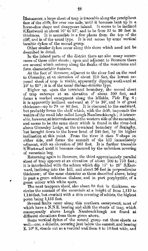
Uanmaster, a large sheet of trap is traceable along the precipitous face of the cliffs, for over one mile, until it becomes bent up in a horse-shoe shape and disappears inland. It seems to be inclined S.Eastward at about 10” to 15", and to be from 25 to 30 feet in thickness. It is accessible in a few places from the top of the cliff, and is of the usual type. It is ‘cut across by some vertical basaltic dykes of the second group.
Other similar dykes occur along this shore which need not be described in detail.
In the inland parts of the district there are also many occurr-
ences of those older sheets ; upon and adjacent to Benmore there are several which outcrop along the flanks of the mountains and form characteristic features.
At the foot’ of Benmore, adjacent to the river ford on the road to Glencalry, at an elevation of about 210 feet, the lowest ex- posed sheet of trap is visible, apparently dipping southward at 10” to 25O ; it is of the usual diabase-dolerite type.
Higher up, upon the townland boundary, the second sheet of trap outcrops at an elevation of about 500 feet, and forms a marked escarpment along the hillside, V$cZe Fig. 6 ; it is apparently inclined eastward at 5” to lo”, and is of great thickness-up to 70 or 80 feet. It is obscured to the eastward, but probably forms the shelf which, with the drift, impounds the waters of the small lake called Lough Nambrackkeagh ; it is trace- able, however,at intervals aroundthe western side of the mountain, and seems to be the same sheet which is found in the river-bed above Glencalry Lodge, at the townland boundary of Sralaghy, but brought down to the lower level of 240 feet, by its higher inclination at this point. From the river it rises V-shape on either side, and forms the summit of the hill immediately aCijacent, with an elevation of 565 feet. It is further traceable &Westward until it becomes obscured by the unbroken covering of mountain bog.
Returning again to Benmore, the third approximately parallel sheet of trap appears at an elevation of about 700 to 750 feet ; it, is interbedded with the schists which dip 15” to 20” S.East- ward, inclining into the hill, a’nd about 30 feet in perpendicular thickness ; of the same character as those described above, being in part a green schistose diabase, and in part porphyritic, of a green colour with white spots.
The next trappean sheet, also about 30 feet in thickness, en- circles the summit of the mountain at a height of from 1,110 to 1,140 feet, but overlaid with a thin covering of schists, the highest point being 1,155 feet.
Several faults occur along this northern escarpment, most of which have a N.N.E. bearing and shift the sheets of trap, which consequently above Lough Nambrackkeagh are found at different elevations from those given above.
Some vertical dykes of the second group cut these sheets as well-one, a dolerite, occuring just below the summit, and bearing E. 10’ S., stands out as a vertical wall from 6 to 10 feet wide, and
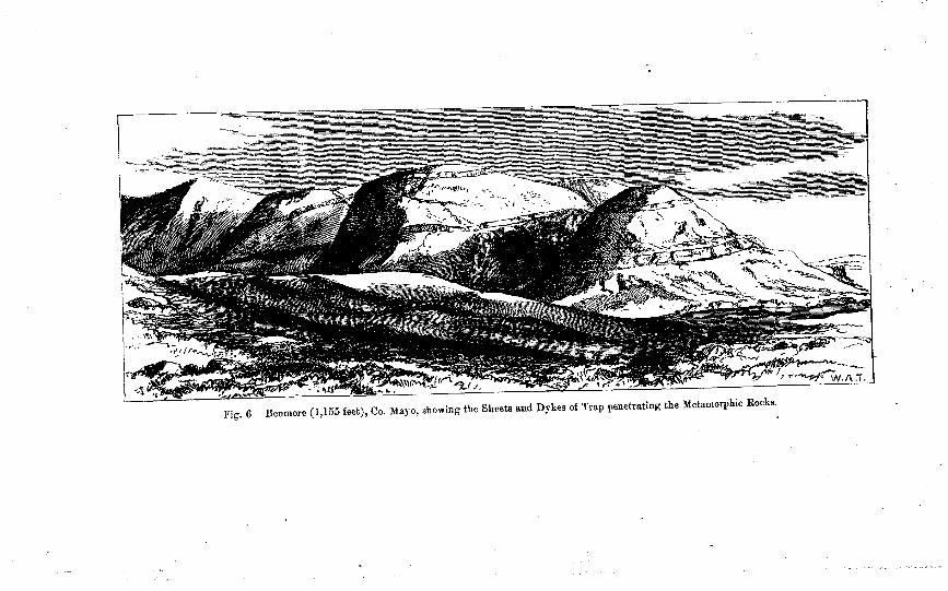
Fig. CJ Benmore (1,155 feet), Co. Mayo, showing the Sheets and Dykes of Trap penetrating the Metamorphic Rocks. .
30 . .
resembles rubble masonry, from the rude hexagonal structure of the sides. A second one, upon the other side of the fault, bears S.E., and is from 10 to 15 feet in width. Still further eastward a third, also 15 feet wide, bears E. 25’ S.
In the Rathavisteen River, at a height of about 450 feet, one , of the above sheets-a diabase or spotted dolerite-is again ex- posed,-and is cut across by the large vertical dyke which bears E.S.B., and along-side of which the channel of ‘the stream has been cut out. The sheet is traceable up the side of the mountsiu to a heiwht of 1,140 feet, close to the summit marked 1,155 feet, which it” encircles, and is found again on the opposite side, at the head of the branch stream of the Glenglassera River, where it is faulted along the bed of the gorge. A probable continuation of this same sheet is found in the other branch of the Glenglassera River, at an elevation of 680 feet, near to which occurs the margin of the Carboniferous form ation. No traces of this dyke are found among the Carboniferous rocks, in the line of, or adjacent to the direction of its course through the metamorphic rocks, and the evidences are all against its entering them, although from the superficial covering obscuring the country such evidence is only circumstantial.
The remaining dykes of this class need not be further described; they are depicted upon the maps.
With regard to the second or newer series of dykes, compris- ing those referred to in p. 24, they seem to belong to a distinct variety, having characteristics peculiar to themselves, and differing from those described above as belonging to the older series.
-
They in most cases have a more definite and constant direction of bearing, apparently filling previously formed cracks, fissures, . or lines of fault; they are in general vertical or nearly so, and when found in contiguity with the older sheets invariably cut across them.
They frequently have the hexagonal or spheroidal structure developed in them, and are often vesicular with amygdaloidal cavities filled. with zeolites or steatite.
There is no appearance of their having, like the others, under- gone any subsequent metamorphic alteration ; they are true dolerites or basalts according to the degree of their crystalline structure.
In this immediate district, from the smallness of the Carboni- ferous area a’nd its superficial concealment by drift and bog, few dykes are found in it ; yet in adjacent districts, dykes similar to those here described are met with, so that they must be considered as of post-Carboniferous origin, and in all probability of much later, or even of Tertiary, age.
A few special examples of this class may here be given. At Weeran on the east side of Belderg Harbour a gorge or
gully has been worn away through the schists, E. 35” Southward, along a line of fissure, but without any fault-displacement ; it is in the same bearing as the trench which cuts off Horse Island on the other side of the bay. A dolerite dyke stands up in it as a
31 ’
vertical wall 6 to 8 feet wide, and cuts the older schist dyke, as * stated at p, 27 ; it is crystalline, rudely hexagonal, speroidal,
amygdaloidal with zeolites and with porphyritically distributed glassy crystals of triclinic felspar-probably labradorite.
Along the gorge at Horse Island there seems to be some dis- placement and traces of one of the later dykes, but the rocks are much obscured by the accumulation of shingle.
A more remarkable fault-fissure and dyke occurs between the island of Illanmaster 353 feet high, and the headland adjacent which is 790 feet high. This narrow cleft is cut down to the sea level with almost perpendicular sides, through which there formerly was an open water-passage, but now a ridge of shingle has accumulated in it ; traces of the dyke are visible at low water.
On the opposite side of the small islet this fissure is further continued E. 25” S., as a chasm into the flanks of Glinsk Mountain, the open sides of which attain to a perpendicular height of 300 feet ; it is a.lso traceable up the hillside by a number of depressions in the ground, or swallow-holes.
At the entrance to the chasm a large vertical dolerite dyke is visible, attached to the schists along the north side, but separated. from them on the south. It is from 10 to 12 feet wide, and is continued into the side of the mountain.
In the same direct line of bearing, but obscured for the inter- vening space, a very similar dolerite dyke is found at Taunagh- more, adjacent to the new Roman Catholic Chapel in Beldergmore. In this place it bears E. 25 S., and is vertical, but up to 25 feet in width, a similar transverse hexagonal structure is also apparent.
In approximately the same direction in the bed of the Glen- glassera River a 12-foot vertical decomposing basalt dyke occurs,’ which may be a prolongation of the same fault and dyke.
On the west side of the headland marked 790 feet, two vertical dolerite dykes, 10 and 5 feet wide respectively, penetrate along fault fissures, parallel to the above dyke, and cut the diabase sheet already described at p. 28.
At Skelp another vertical dolerite dyke penetrates the fissured rock, and being worn away forms an open cavern through the projecting point.
The most remarkable of these fissures and dykes occurs ad- jacent to the Island of TordufK A cleft has been formed along a line of fault into the main-land, with perpendicular sides up to 450 feet in height, and scarcely ten feet apart in some places, but widening out at the top. It runs in a direction, E. 35” S., and shows itself again in the low ground at Tollagh, a swallow hole where the drainage is carried away underground; it is further traceable by other similar holes up the flank of the mountain, Seaward it is also prolonged in a rather remarkable manner ; first cutting off by an open chasm with vertical walls one island from its adjacent headland, then another-Torduff-from its headland which is over 500 feet high, then Illaunakanoge from its head- land Fohernasmeel, almost 550 feet in elevation, and further westward, but with wider interval, the island of Carrickduff from its adjacent headland.
.
52
The view looking down this cleft with its four pairs of opposing ~ perpendicular headlands on either side is almost unique.
A small trap dyke seems to fill the fisure in some places, but it was quite inaccessible, and much obscured by the mass of faulf- rock.
Another interesting example of the later dykes is one which occurs along the Rathavisteen River, near Benmore, where the stream has cut out a channel at one side of it which attains a depth of 50 feet in some places, the side wall of the dyke being thus exposed. It is a vertical dolerite wall 25 feet in width, and distinctly cutting the sheet dykes ; it partakes of the several structures, spheroidal, concretionary, platy, amygdaloidal and zeolitic in different portions of its course.
W. A. T.
. South and. Western, Portion.
Dole&e. -There are two 1 distinct sets of dolerite dykes in the western as well as in the eastern part of the district-the one undoubtedly pre- and the other probably of post-Carboniferous age. The former are more massive in character, sometimes attain- ing, a thickness of 25 feet, and in some cases interbedded for many hundred feet before cutting across the strata. This rock is of a dark greenish gray colour, slightly porphyritic, containing small crystals of triclinic felspar, and was evidently metamor- phosed simultaneously with the schists which it penetrates.
The newer or post-Carboniferous trap-rocks occur generally as narrow irertical dykes, varying in thickness from one to te ufeet, and are of a dark gray colour, very dense, and sometimes amygdaloidal, the dykes being in many instances columnar from wall to wall, and cut across the metamorphosed traps as well as the schists in conjunction, and are devoid of foliation.
Both sets of dykes are very numerous and well exposed throughout the entire district, but more especially along the coast line from Blind Harbour to Erris Head, and thence S. W to Cross Point, on the west coast.
(6.) Felstone. -In the western portion of the district but one felstone dyke was observed. It is exposed on the W. shore of the head of Blacksod Bay, one mile N. of Binghnmstown, penetrating the pink gneissose beds. In colour it varies from a dull purple to greenish gray, and is very compact-closely resembling the Killery Bay felstones.
A. M’H.
(c.) G,ra?zite.-The only true granite found in the district, lies about nine miles south of Belmullet, and at the extreme of (‘ The Mullet ” point. The area occupied is about four square miles, and rises from the sea-level to 342 feet at Termon Hill.
The physical features over this tract occupied by the granite are very different from those found elsewhere with a similar rock : in the low ground the aspect is similar to that where a horizontal sedimentary rock would be deposited, while in the high ground the granite assumes a terraced form, and nowhere
33
was the hummocky or mammilated appearance observed. This, however, may be accounted for by the rapid decomposition of the rock along planes of cooling.
The composition of this rock is very uniform, being an aggre- -gate of small crystals of two micas, one felspar and quartz, with a slight per-centage of minute crystals of iron pyrites : the felspar is either gray, or flesh-coloured.
Good sections of the granite can be seen along the whole of the s>hore line on the Termon coast and numerous quarries have been worked.
The system of joints or planes of cooling are very remark- able ; the upright ones being very regular, generally vertical, and constant in direction; -which was noted in every case to be N. 30” W. : the horizontal planes are not so regular, as they occur in the form of nearly parallel wavy curves through the mass, and along which the rock can be successfully quarried. Near Gubaphumba there is a large quarry in which flags from 35 to 100 square feet, and 9 to 11 inches thick, are frequently raised, but the rapid decomposition and change of colour from pink to rusty brown prevents it being of any great economic value.
The age of this rock is clearly pointed out to be newer than ’
that of the gneissose rocks which are found in conjunction on the west of (‘ The Mullet” promontory: in the latter the foliation is remarkable, and the presence of eurite and small granite veins in the metamorphic rocks points to the granite as the source , from which the veins were irrupted. It is considered that the granite is of intrusive origin,
R. G. S.
c
INDEX.
Alluvium, 21. Altard, 26. Altderg river, 7, 10, 12, 17. Altnatona, 22. Armagh head, 13. Antimony, 13. Aqueous rocks, 9. Atlantic, 7, 8, 12. Augite, 25.
Ballinapark, 26. Ballinglen river, 7. Bangor, 7, 13, 17, 23, 24. Ballycastle, 23. Ballyglass, 23. Belderg harbour, 7, 10, 19, 20, 22,23, 26,
27,30. Beldergmore, 31. Belmullet, 7, 12, 13, 14, 22, 23, 32. Benadereen, 18. Benmore mountain, 8, 12.
head, 7, 10, 17, 18, 28,29, 32. Blelwee Geevraun point, 8, 27.
head, 11. Binghamstown, 7,32. Blacksod bay, 7, 9, 13, 22, 23, 24, 32. Blind harbour, 32. Blown sand. 22. Bog, 8, 9, IO, 12, 16, 17, 19, 22, 28.
,, lakes, 9. Boorfuagh, 8. Boulder clay, 21, 23. Broad haven, 9, 13, 22. Bronzite, 25. Bunatrahir bay, 7. Bunnahowna, 18, 22.
Cabaundoo, 27. Calcareous schists, 12. Calcite, 26. Cambrian, 14. Carboniferous rocks, 16, 17, 22, 30.
$1 sandstone, 9, 10, 12, 16, 23, 24.
Carrafull mountain, 8. Carrickanilra, 27. Carrickduff, 31. Carrowmore lake, 8, 9, 13. Chloritic diabase, 26. Chlo&e, 25. schist, 27.
Claddaghnahowna, 17, 18. Conglomerate, 14, 16, 17, 18. 19. Corslieve fault, 19, 24. Crystalline mountain, limestone, 8, 13. 13.
Deal river, 7. Denudation, 14. Diabase, 30. Diallage, 25.
Dolerite dykes, 7, 10, 12, 14, 19, 24, 25,. 26, 27, 28, 29, 30,31, 32.
Dolomite, 13. Donegal, 14. Doolough point, 13. Drainage, 8, 9. Drift, 8, 9, 10, 12, 17, 18, 19, 20, 21, 22,
26.
Eagle island, 13, 14. Epidote, 25. Erratic boulders, 22, 23. Erris, 26.
,, head, 9, 12, 13, 23,32.
Faulmore. 12.22. Faults, 7,‘lO; 12,13, 14, 16, 17,18, 2324,.
27,30, 31.32. Felq&, I3, 31, 32, 33. Felstone, 32. Fiddaundoo river, 16. Fiddawntawnanauneen, 21. Foherlin, 27. Fohernadeevaun, 16. Fohernasmeel, 31.
Garnet, 25. Geevraun point, 22.
lode, 27. Gla&tion, 22? 23. Glenamoy, 7, 10.
7, bridge, 17. river, 8, 12, 17.
Glengalry lodge, 10, 12, 22, 28. Glencastle mountain, 9, 13.
bridge, 13., Glenzo, 19. Glencullin, 19. Glenglassera river, 10, 16, 17, 20, 21, 23,
30, 31. Glengloss point, 7, 10. Glen&a, 19, 22. Glinsk mountain, 8, 27, 31. Gneiss, 12, 13, 24, 32, 33. Goolamore lodge, 13. Granite, 32, 33. Gubaphumba, 33.
Highlands of Scotland, 14. Hornblende, 13, 26.
9) rock, 25. schist, 14.
Ho&i island, 22, 23, 27, 30.
Ice scratched blocks, 19, 21. striae, 22.
I&eous rocks, 10, 24. Illaunakanoge, 31. Illanmaster island, 8,23, 28, 31. Inagh river, 10, 12, 16, 17. Iniskea islands, 22.
35
Iron pyrites, 26, 32. Islands, 8, 12, 13.
Joint planes, 7, 10.
Ready point, 7, 18. Killery bay, 32. Kinrovar point, 23. Knocklettercuss mountain, 8, 24. Knocknalower, 9. Knocknascollop mountain, 9.13.
Laghtmurragh, 27. Lakes, 8, 9. Laurentian rocks, 14, 24. Laxford lough, 14. Limestone, 12. 13, 14, 18, 19. List of shells from boulder clay, 21 Loughauns, 8. Lougherglass, 26. Lower boulder clay, 19.
silurian, 14. L&ralettin lough, 12, 16, 17.
Magnetite, 26. Maumakeogh mountain, 8, 16. Melaphyre, 24, 27. Metamorphic rocks, 9, 10, 12, 13, 16, 17,
18, 22, 24, 30. Mica, 10, 13, 14, 25, 33.
schist 10 12, 13, 16, 22, 24, 26, 27. &rnaum headland, 18. Morenateoran lough, 10. Mountain bog, 8, 17. Mulranny, 23.
Naguroge lough, 17. Nambrackeagh lough, 8, 12, 28. Newport, 23. Nyranagh, 17.
01i3red sandstone and conglomerate, 16, .
Olinoclase. 13. 14. Or&oclase, 19, 14, 25. Owenbehy, 18,21. Oweamare river, 7,8,9, 13, 17, 19, 21. Ox mountains, 22.
Pegmatite, 14. Physical geography, 7.
Pollinagee, 27. Pontoon, 22. Port point, 10, 16,23. Porturlin, 7, 8. Post Pliocene, 19, 20, 21.
Quartz, 12, 13, 14, 16, 25, 33. Quartzite, 10, 12, 13, 14, 22, 24, 26.
Rathavisteen river, 12, 30, 32. Red sandstone, 14. Rhiconicb, 14. Rock formations and divisions, 9. Ross, 14. Rossport, 9,
Sand and gravel, 20. Sandstone, 16, 17,18, 19. Scotland. 14. Shales, 17, 18, 19. Shistose rocks, 8,37. 28. Shells in boulder’clay, 19, 20. Sheskin lodge, 19. Skelp, 31. Slieve Fyagh mountain, 8, 13. Srahmeen, 16. Sralaghy, 28. Stags of Broad Haven, 8, 11, 12. Steatitic schist, 12. Sutherland, 14.
Talc, 26. Talcose schist, 12. Taunaghmore, 31. Tawnaghnoneen point, 27. Termon hill; 32. 33. Tertiary age, 30: The Mullet, 9. 22, 32, 33. The White ‘Horse; 23.’ Till, 19, 20. Torduff island, 31. Tollagh, 31. Tullaghan bay, 7, 9.
Unconformability, 14, 16, 16, 18, 23.
Watershed, 8. Weathering, 18. Weeran, 26,39.
Zeolites, 31.
I~JBLIN : Printed by ALEX. THOM & Co., 87, 88, & 89, Abbey-street, The Queen’s Printing Office.
For Her Majesty’s Stationery Office.
P. 9.-x-4/81.
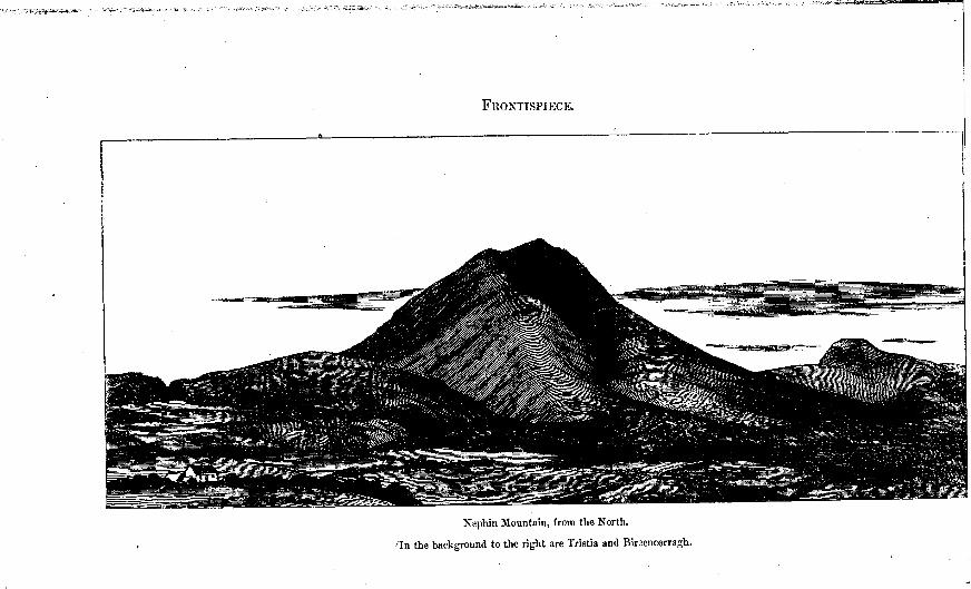
Xephin BLountain, from the North.
I /‘In the background to the right are Tristia and Birzencorragh.