Embed Size (px)
Citation preview
Department of Parks and Wildlife June 2016
1
Explanatory note - Conservation status and resource management of wild sandalwood (Santalum spicatum) Background This document provides a brief overview of the conservation status and projected resource of wild sandalwood (Santalum spicatum) on Crown lands. The information is derived from the comprehensive work undertaken by the Working Group which reviewed the sandalwood Order in Council in 2015. The focus of the document is on living (green) sandalwood, as the salvage of dead sandalwood is considered to have much lesser impacts on the species and environment. Summary
The natural distribution of wild sandalwood (Santalum spicatum) in Western Australia exceeds 146M hectares, extending across the wheatbelt, goldfields and through the arid and semi-arid rangelands. This hemiparasitic species generally occurs only on suitable landform and soil conditions in association with a range of host Acacia, Eucalyptus and Eremophila species.
Existing and proposed reserves and other areas not available for the commercial harvest of wild sandalwood on lands managed by Parks and Wildlife comprise approximately 21M hectares within the natural distribution, with further areas in the southern rangelands excluded from harvest on private conservation lands.
The existing and proposed reserves are geographically dispersed across the rangelands, contributing to a Comprehensive, Adequate and Representative (CAR) reserve system which seeks to include the representation of genetic diversity for sandalwood within reserves. The current stand condition and age class distribution of sandalwood trees within reserves reflects the cumulative historical impacts of previous harvesting, grazing, fire events, and regeneration persistence. This can range from no impact (National Parks and long-standing conservation reserves) to substantial impact (former pastoral leases acquired since the year 2000).
Sandalwood occurs at variable frequency across the lands available for harvesting, with tree size class distributions reflecting the history of previous harvesting, a lack of seedling regeneration, persistent grazing by native and introduced herbivores, and high natural mortality rates among young trees. These factors have given rise in many areas to an overall depletion in the frequency of trees below merchantable size. Seeding and grazing exclusion programs in areas harvested in the past two decades have refined approaches to redress this trend, including aligning seedling establishment with favourable weather conditions.
The areas outside of reserves within which commercial harvest operations have been conducted by the Forest Products Commission (FPC), and are proposed to continue during the period 2016 to 2026, are located in the goldfields and southern rangelands. These lands comprise a subset (16 per cent) of the natural distribution of sandalwood.
Department of Parks and Wildlife June 2016
2
The Sandalwood (Limitation on Removal of Sandalwood) Order (No.2) 2015 (OIC) makes available up to 1,250 tonnes per annum of green (live) sandalwood for harvest, of which 90 per cent (1,125 tonnes) will be sourced from harvesting on Crown lands through the FPC. Over the 10 year period of the OIC this equates to 11,250 tonnes, which is approximately 8 per cent of the estimated standing resource within the supply zones identified by the FPC as being scheduled for harvest during this period.
Within areas available for harvest the long-term persistence of sandalwood in the landscape will be achieved through a combination of measures, including: maintenance of a minimum size restriction on trees permitted to be harvested; a reduction in the quota permissible from harvest areas; patch-level silvicultural practices applied during harvesting to retain mature, seed-bearing trees; and targeted seeding programs to establish regeneration.
The low proportion of the total species distribution subject to harvesting during the period of the OIC, the dispersed occurrence of the sandalwood resource, and the silvicultural retention and regeneration practices in harvested areas suggest the overall environmental impacts of harvesting will be relatively subtle and widely dispersed across the landscape.
Landscape-scale modelling of future tree size class distributions within the areas proposed for harvesting indicates that at the reduced level of removals under the OIC and with supplemental regeneration actions, a cohort of mature seed-bearing trees including ingrowth from small size classes will persist over the long term.
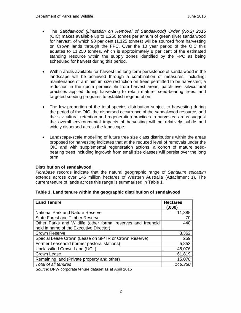
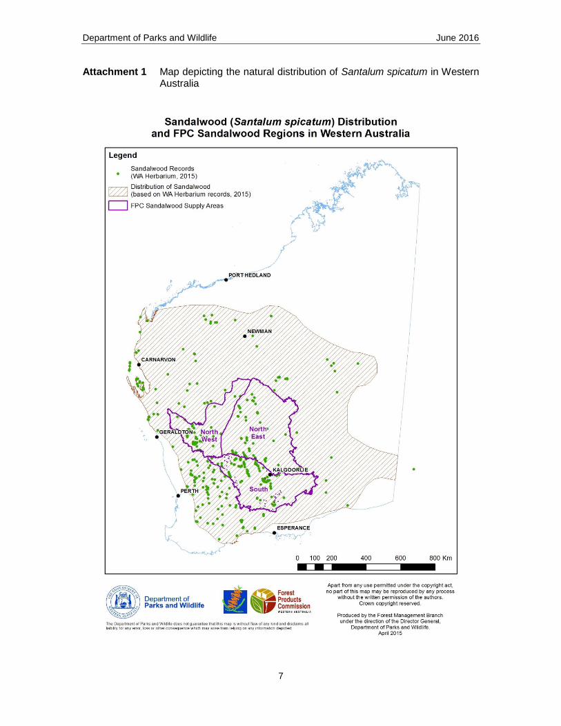
Distribution of sandalwood Florabase records indicate that the natural geographic range of Santalum spicatum extends across over 146 million hectares of Western Australia (Attachment 1). The current tenure of lands across this range is summarised in Table 1. Table 1. Land tenure within the geographic distribution of sandalwood
Land Tenure Hectares (,000)
National Park and Nature Reserve 11,385
State Forest and Timber Reserve 70
Other Parks and Wildlife (other formal reserves and freehold held in name of the Executive Director)
448
Crown Reserve 3,362
Special Lease Crown (Lease on SF/TR or Crown Reserve) 259
Former Leasehold (former pastoral stations) 5,853
Unclassified Crown Land (UCL) 48,076
Crown Lease 61,819
Remaining land (Private property and other) 15,078
Total of all tenures 146,350 Source: DPW corporate tenure dataset as at April 2015
Department of Parks and Wildlife June 2016
3
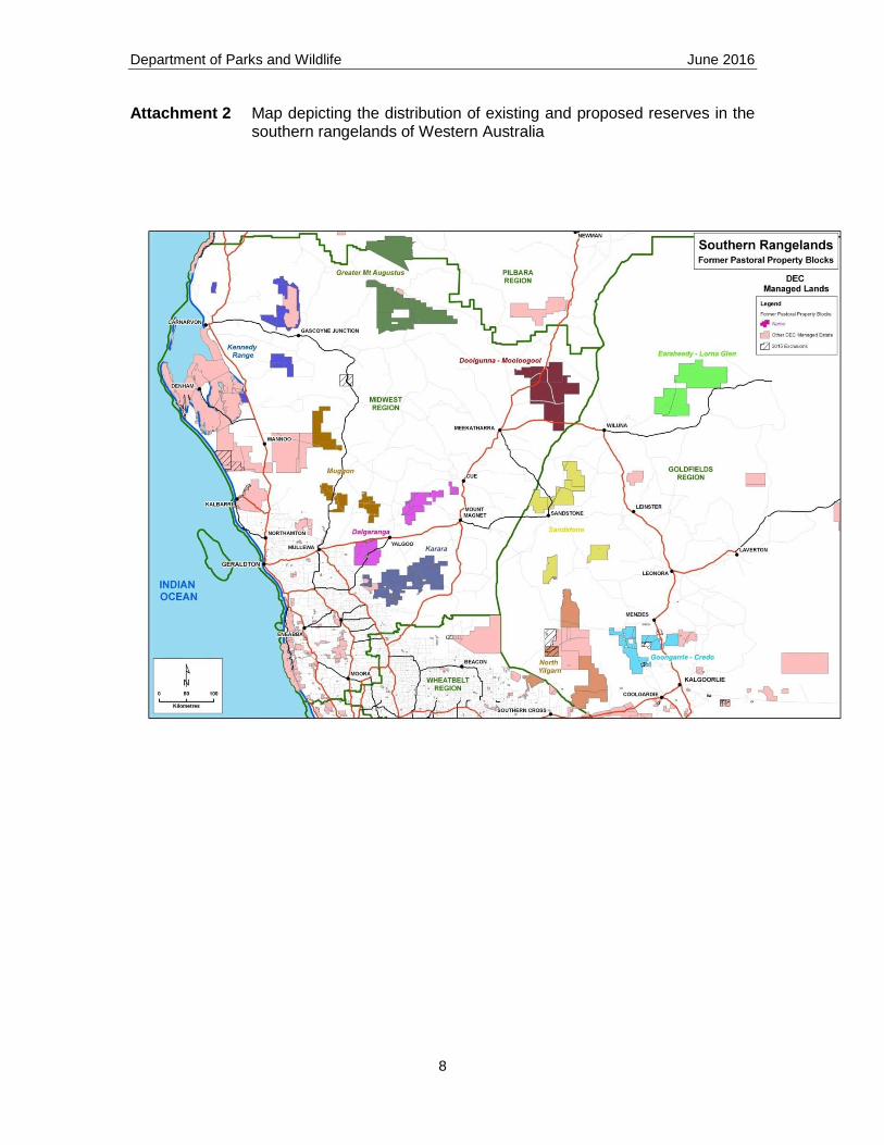
Clearing for agriculture and harvesting has reduced the occurrence of sandalwood in the Wheatbelt to remnant stands within conservation reserves and private property. The rangelands of the Goldfields, Gascoyne and southern Pilbara retain significant stands of sandalwood of varying condition due to the cumulative historical impacts of previous harvesting, grazing by introduced and native herbivores, bushfire regimes, and the reduction in seed dispersal following the depletion of native animals. Genetic variation has been recorded between populations of sandalwood growing in the northern areas (between 150 to 250mm mean annual rainfall) and southern areas (within the 250 to 650mm annual rainfall zone) (Byrne 2001). Protection in reserves Sandalwood is protected under the Wildlife Conservation Act 1950 and is not listed as a threatened species. It is not listed on the department’s Priority Flora List. The species is further protected from harvest within the network of conservation reserves comprising over 21M hectares within the geographic range of the species. The main area of commercial harvesting of sandalwood is across the southern rangelands. A comprehensive review of the condition and representation of vegetation systems within the southern rangelands provided the basis for defining a CAR reserve system (Brandis 2008). A number of pastoral properties were subsequently purchased for future reservation and have been progressively destocked of introduced herbivores to improve the condition of the vegetation. Attachment 2 depicts the geographic dispersal of former pastoral stations which contribute to the reserve system. The condition of sandalwood stands within reserves varies considerably. In many areas the depletion of natural regeneration over many years by grazing and other pressures, has led to a highly skewed distribution of tree size (age) classes. A long-term decline in the relative frequency of the older, larger trees will arise from a lack of recruitment into larger tree sizes to replace the natural mortality rates of older trees.
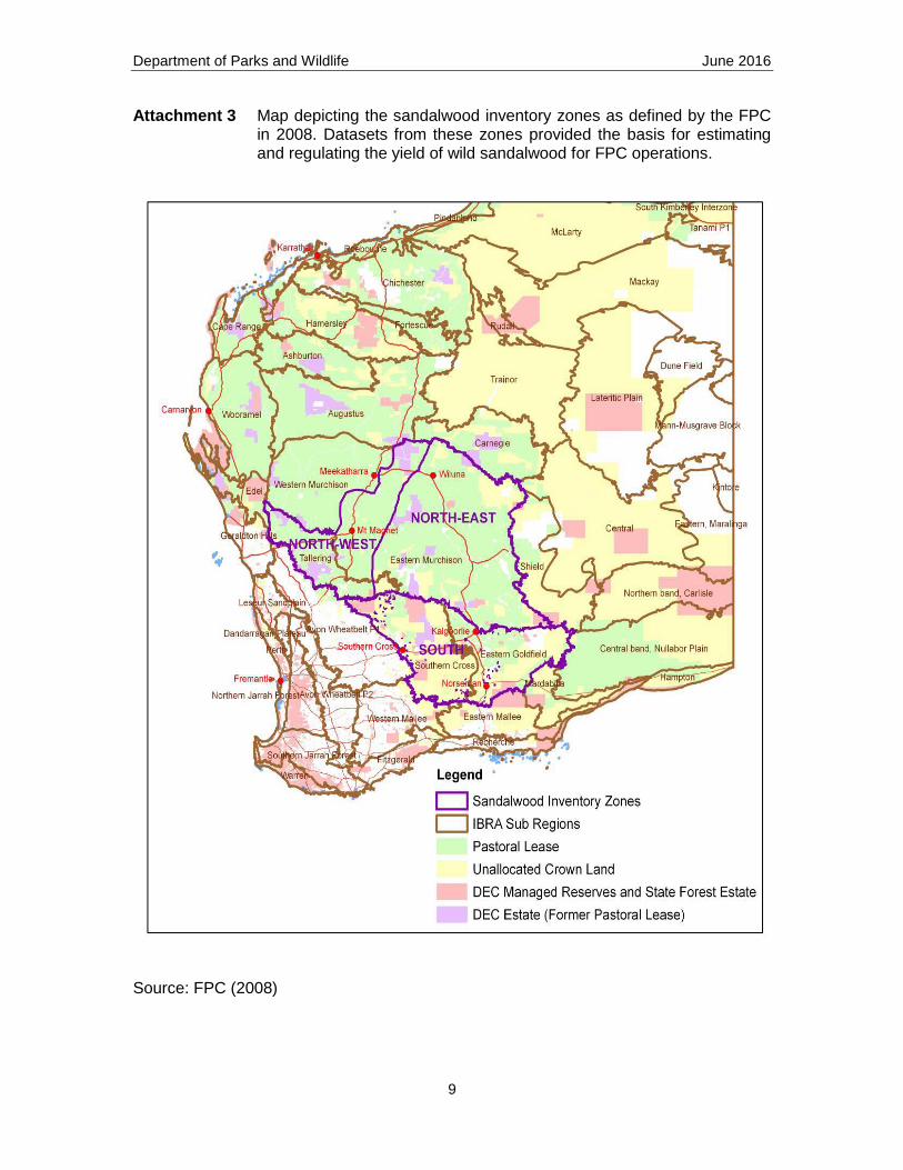
Location of proposed harvesting during the 2015 OIC Within the distribution of sandalwood, the FPC and predecessor agencies have undertaken strategic inventory and harvesting of the resource within a subset of the rangelands (Attachment 3). Geographic zones1 – North-east, North-west and South – were defined to reflect the variation in previous harvest history (and hence the relative availability of green and dead sandalwood), historical grazing impacts and controls (and hence the status of regeneration and future growth), and to manage the dispersion of harvest contractors. The FPC advised that the proposed location of harvesting operations for green sandalwood during the period to 2026 would predominantly be in the North-east and South inventory zones. The total area of land on tenures potentially available for harvest within these zones is approximately 23M hectares (or 16 per cent of the area within the total 146M hectares natural distribution of sandalwood).
1In 2016 the FPC renamed and varied the geographic supply zones. The original names and
extent are retained here to be consistent with usage in the OIC Working Group report in 2015.
Department of Parks and Wildlife June 2016
4
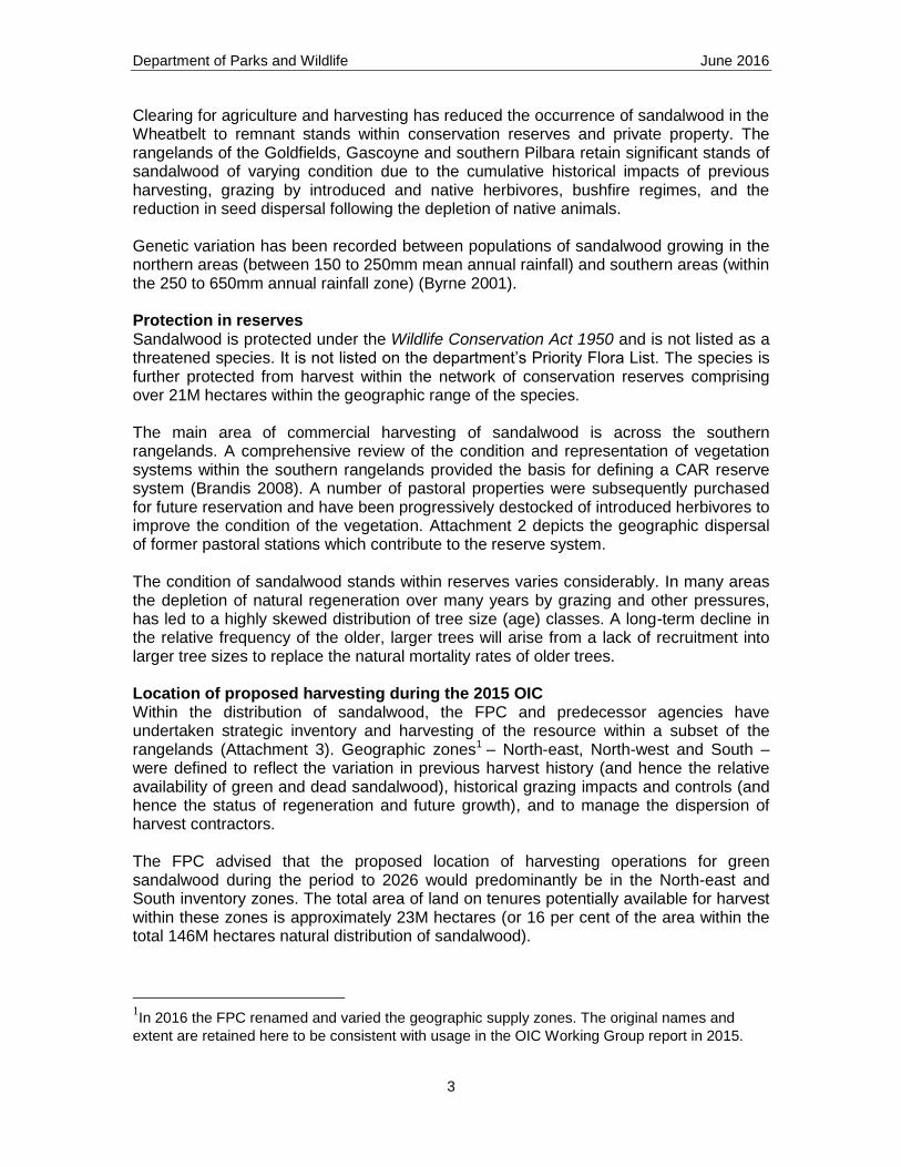
Standing resource (growing stock) Within areas available for harvest, the Sandalwood Regulations 1993 prohibit the removal of trees smaller than a minimum merchantable size. The merchantable green (live) sandalwood resource therefore comprises stems larger than the minimum legal limit of 400 mm circumference (126 mm diameter), measured at approximately 150 mm above the ground. Estimates of the standing sandalwood resource within the inventory zones were derived by the FPC in 2008 from strategic inventories comprising 1,346 inventory plots (Table 2). Table 2. Total area (hectares) and standing resource (tonnes) at 2008 on areas available to harvest within each FPC inventory zone.
Areas harvested during 1995-2007
Areas harvested prior to 1995
FPC Inventory zone
Area
(hectares)
Green standing resource (tonnes)
Dead standing resource
(tonnes)
Area
(hectares)
Green standing resource (tonnes)
Dead standing resource
(tonnes)
North-west 634 000 1 602 000 15 000 8 000
North-east 1 694 000 4 655 000 43 000 24 000
South 1 733 000 3 994 000 106 000 58 000
Total 4 061 000 56 000 32 000 10 161 000 164 000 90 000
Source: FPC Note: Grey cells depict areas and volumes not included in the resource estimates and modelling conducted when reviewing the OIC. The resource remaining in areas harvested since 1995 was excluded when analyzing the basis for an economically viable, acceptable quota for the period to 2026. This was due to the dispersed location of the retained trees, the likely low rate of ingrowth into merchantable size classes during the next 10 years, and the preference to avoid further disturbance in areas where seeding had occurred to promote regeneration. The standing resource of green wood in areas harvested prior to 1995 in the North-west zone was also excluded for similar reasons. The 2008 estimate of the (available) standing resource was adjusted to account for natural mortality, improvements to utilization, harvesting and illegal removals since the 2008 inventory. These reductions to the strategic inventory estimates suggest the available standing resource of green sandalwood in the North-east and South zones would be up to 139,000 tonnes. Projected impacts of harvest levels on sandalwood size class distributions A computer simulation model developed by the FPC for sandalwood yield projection (and previously verified by Parks and Wildlife) was used to examine the outcome of varying harvest levels on future landscape-scale tree size class distributions, growing stock and potential yields. Using the current standing inventory to derive tree size class
Department of Parks and Wildlife June 2016
5
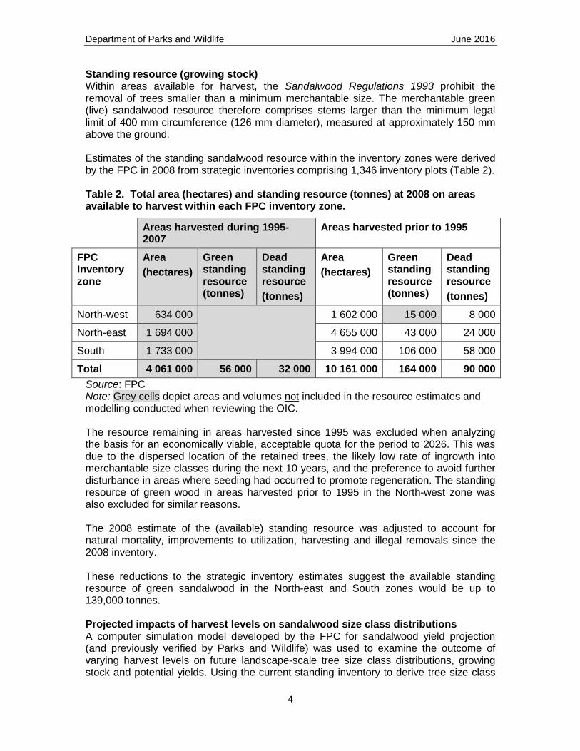
distribution for a region, projections varied according to future rates of natural mortality, tree growth, regeneration seeding, ingrowth to merchantable sizes, and quantities removed. These rates have been derived from inventory and research plots, operational trials and observed historical trends. For example, Figure 1 depicts the simulated size class distributions arising over time for an inventory zone with an annual harvest level of 640 tonnes of green sandalwood and rates of tree growth, natural mortality and regeneration derived for the area.
Figure 1. Projected distribution of sandalwood tree size at year 0, 10 and 40 within a supply zone following harvesting through years 1 to 10. Growing conditions in the arid and semi-arid environments can give rise to highly variable rates of regeneration, tree growth and natural mortality. The sensitivity of model outputs to variations in these processes was examined by assigning an appropriate probability distribution for each variable and performing multiple iterations from the initial size class distribution. Projections indicated that given the range of uncertainties associated with tree growth rates, recruitment and other variables over successive decades, a level of harvest of no greater than 1,125 tonnes per annum for the period to 2026 would maintain an acceptable size class distribution by 2026, from which future adjustments could be made based on monitored growth and survival of mature trees and regeneration. Projected impact of the 2015 OIC harvest level on growing stock Under the 2015 OIC the total projected legal harvest of green sandalwood by the FPC during the 10 years to 2026 would be up to 11,250 tonnes (1,125 tonnes per year x 10 years). This equates to approximately 8 per cent of the estimated standing resource within the subset of areas cutover prior to 1995 in the North-east and South inventory zones.
0.00
0.10
0.20
0.30
0.40
0.50
0.60
0.70
0.80
0.90
1.00
Ste
ms
pe
r h
ecta
re
Diameter class (mm)
Projected stem size distribution - year 0, 10 and 40
Year 0
Year 10
Year 40
Department of Parks and Wildlife June 2016
6
Protection of sandalwood at the local scale within the landscapes available for harvest Given the historical lack of regeneration, all model simulations forecast a marked reduction in the frequency of larger trees in merchantable size classes over the longer term. While the reduction in merchantable size classes and potential episodic level of supply has implications for the wild sandalwood industry, the persistence of the sandalwood species within areas available for harvesting will be managed through a requirement to retain a complement of mature seed bearing trees in all harvested areas on sites suitable for seed dispersal and seedling survival, and a large-scale, targeted program of seeding on favourable sites. This will continue to be augmented in some areas (particularly on conservation lands where harvesting will not occur) with fencing and grazing control measures. The FPC has continued to refine techniques for the successful establishment of sandalwood regeneration, with ongoing monitoring of survival under a range of conditions at trial locations in the rangelands. During the last decade the seeding program conducted in association with harvesting has expanded to now involve the sowing of around 3.5 million seeds in most years. Seedling survival will vary with site, seasonal weather conditions and grazing pressures, with simulation modelling suggesting that establishment rates higher than one percent will have provide a significant improvement on future ingrowth and the long-term persistence of seed bearing trees in the rangelands. References Brandis, A.J. (2008) Rescuing the rangelands: management strategies for restoration and conservation of the natural heritage of the Western Australian rangelands after 150 years of pastoralism. WA Department of Environment and Conservation, Perth, 246 pp. Byrne, M. (2001) Genetic diversity in Western Australian sandalwood (Santalum spicatum): report to the Forest Products Commission. Department of Conservation and Land Management, Perth.
Department of Parks and Wildlife June 2016
7
Attachment 1 Map depicting the natural distribution of Santalum spicatum in Western Australia
Department of Parks and Wildlife June 2016
8
Attachment 2 Map depicting the distribution of existing and proposed reserves in the southern rangelands of Western Australia
Department of Parks and Wildlife June 2016
9
Attachment 3 Map depicting the sandalwood inventory zones as defined by the FPC in 2008. Datasets from these zones provided the basis for estimating and regulating the yield of wild sandalwood for FPC operations.
Source: FPC (2008)


![Biodiversity Conservation Regulation 2017 · Biodiversity Conservation Regulation 2017 [NSW] Explanatory note Page 2 Published LW 25 August 2017 (2017 No 432) (l) criminal and civil](https://img.pdfslide.net/doc/110x75/5f0baf827e708231d431b7b4/biodiversity-conservation-regulation-2017-biodiversity-conservation-regulation-2017.jpg)


![Environment Conservation Act · 2018-12-09 · 2 No.11927 . GOVERNMENT GAZETIE, 9 JUNE 1989 . Act No. 73, 1989 . ENVIRONMENT CONSERVATION ACf, 1989 . GENERAL EXPLANATORY NOTE: [ ]](https://img.pdfslide.net/doc/110x75/5eaf53a65056921a0117189b/environment-conservation-act-2018-12-09-2-no11927-government-gazetie-9-june.jpg)