Embed Size (px)
Citation preview
SYSTEM
Soil Mapping and Advisory Services
Botswana
EXPLANATORY NOTE ON THE
LAND SYSTEMS MAP OF BOTSWANA
by
P.V. DE WIT.
and
R.P. BEKKER
FOOD AND AGRICULTURE ORGANIZATION OF THE UNITED NATIONSUNITED NATIONS DEVELOPMENT PROGRAMME
GOVERNMENT OF BOTSWANA
Gaborone, 1990
AG:BOT/85/011FIELD DOCUMENT 31

The noncluI,n,, J,k7efi this report are those considered appropriate at theimo ofThov m:ty t) modified in the light of further knowledge gained at subsequentqi ot
s employed and the presentation of the material in this documentd, itiTLy che expresion of any opinion whatsoever on the part of the Foodand Agt-iculture Organization of the United Nations concerning the legal or(t,:lstiAutinal status of any country, territory or sea area or concerning thedelimitation of trontiers.

De Wit P.V., Bekker, R.P., 1990. Explanatory note on the land systems map ofBotswana. FAO/UNDP/Government of Botswana. Soil Mapping and Advisory ServicesProject AG: BOT/85/011. Field Document 31. 43 pp, 1 map.
TABLE OF CONTENTS
1
:BE LAND CLASSIFICATION SYSTEM 2
SOURCES OF INFORMATION 4
4 CLINATF 5
THE LAND UNITS OF BOTSWANA 10
5.1. Land Divisions 10
5.1.1. The Hardveld 10
5.1.2. The Sandveld 10
5.1.3. The Lacustrine System 12
5,1,4, The Alluvial System 12
135.2.1. Solid ro,.ks on the Hardveld 135,2.2. Parent material in the Sandveld 15
5.2.3. Materias of the Lacustrine System 16
5.2.4. Materials of the Alluvial System 17
5.3. Land Systems 18
5.3.1, Geomorphological forms and features 18
related to the Hardveld5.3.2. Geomorphological forms and features 20
related to the Sandveld5.3.3, Geomorphological forms and features , , 23
related to the Lacustrine System5.3.4. Geomorphological forms and features 24
related to the Alluvial SystemVEGETATION ... . 26
6.1. Methodology .....,............... .. . ................ 26
6,2. Regional vegetation distribution 28
29
29
THE LAUD SYSTEMS MAP 30
9.1, Topographic base 30
9.2. Mapping units and symbols .............. . .. ............. 30
9.3. Leiend 30
REFERENCES
LIST OF TABLES
1 The land systems approach ..............,................. .. .... 2
2. Vegetation, structure retained for the land systems .... ....... 27
classification
LIST OF FIGURES
Subdivisive land 3
Agro-climatic zones of 6
Climatic diagrams of synoptic stations in Botswana............... 8
Land divisions of Botswana,. 11
APPENDIX 1 The legend of the land systems map of BotswanaAPPENDIX 2 Codes used in the land systems legend of Botswana

1 INTRODUCTION
Within the overall Government development hjctit that Inc 50i1 Mappin ac).'t
Advisory Services Project (BOT/851011) shouLd imp7ove rho tasLr modum altolong term planning of agriculture and rural deve'opmerP., a n t. i oui ri L map
of Botswana was produced as a first step.Institutions involved in national planning Lequire inlocmaliopdensed form to identify regional difference in resourr'e eadovilent,
However at an early stage of development ot ti e NaT,Iona; Soil Map, it p(o-,'-,o
necessary to produce a separate map based on phys tosi ajni un.t `,1,
additional information or iandforms, topovaphy and vecr.4tion.The production of such a map also fits the SADCC proramme t masli-s ib'landforms of the SADCC region to transtoi ot to, Flucymember states.
':,The combination of the soil map and the mav, provir ii
basis for the inventory of physical resones in Solse:au, ,4ndtual inclusion in a Geographical Information Svs'iym.Last but not Least, the land ,ysem.,, and soi.T.. maps iv an od;,;atonapose, allowing a quick ovetview or rhe lanO cesouLoe;:-
It should be emphasized that although The itiitial idea w:)..; Lisystems map at the same scale as the soil map ;1i1 Or7, opp, thr Form,, t11,
been printed at scale 1/2 000 000 for technic_al and rin,iaci3i 1.easou-.
2 THE LAND CLASSIFICATION SYSTEM
The system adopted for the classification of land in Botswana is developed bythe Division of Land Resources and Regional Survey of the Commomwealth Scien-tific and Industrial Research Organisation in Australia (Christian and Stewart1953; Perry, 1962). A similar approach was used earlier by Bawden and Stobbs(1963) for the study of then Eastern Bechuanaland. Later the same methodologywas proposed for reconnaissance surveys in Jordan by Mitchell and Howard(il8),
land systems approach is a hierarchical, sub-divisive classification sys-, where physiography, geology, geomorphology and topography are retained as
diaplostic criteria.The term land system is defined as a tract of land that is homogeneous accord-
tn certain pre-conceived criteria. A land systems classification is a
Illeiarchical subdivision of land according to these criteria. The term landunit is regarded as a general term to be used when referring to a homogeneousunit of land.
F,r Botswana following hierarchical classification for reconnaissance studieslr '; proposed. :
Table 1
THE LAND SYSTEM APPROACH
land system geomorphology,topography
2
Landform pattern of geograph-ically and geomorphologicallyrelated smaller land units,which are recurrent in thisland unit.
land unit paramount discipline descriptionto identify unit
land division physical geography Gross landform expressiveof a continental structure;i.e. a major physiographicunit.
land region geology Surface form expressive ofa lithological unit or aclose lithological associationhaving everywhere undergonegeomorphic evolution.
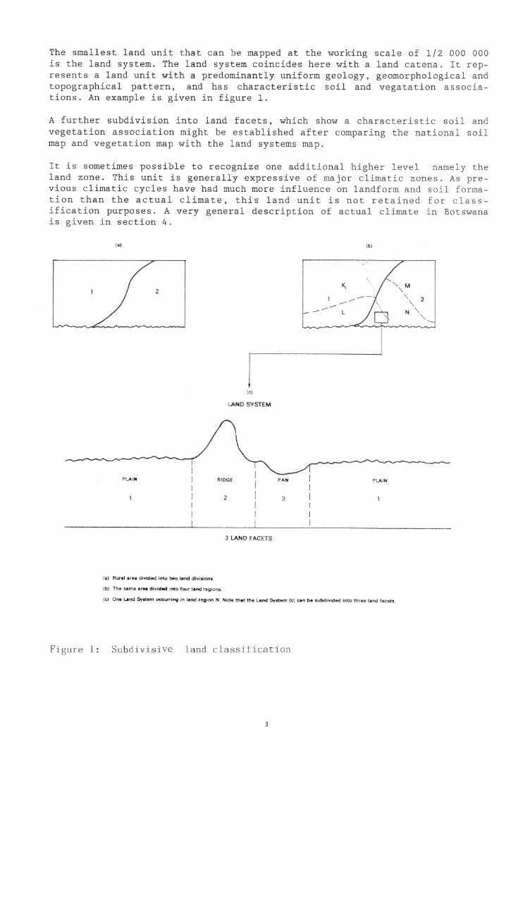
The smallest land unit that can be mapped at tne working scale of 1/2 upe Oof)
is the land system. The Land system coincides here wit4 A land L'atena 1(
resents a land unit with a predominantly uniform geology, geomcuphologLItopographical pattern, and has characteristic soil and vegatation at,ea-tions. An example is given in figure 1.
A further subdivision into land facets, which show a characteristic soL.vegetation association might be establisbed af1et comparing the It!ri.r,1map ano vegetation map with the land systems map.
It .s sometimes possible to recognize one additional 1:44tler
land zone. This unit is generally expressive ot nil ici ctimriric A. r?C-vious climatic cycles have had much more influence on LonOiemciLi cl
tion than the actual climate, ihis land un i. 1s nor teLHih,.,dification purposes, A very general description or dct,m1is given in scction 4.
(a)
2
2
ic)
LAND SYSTEM
3 LAND FACETS
(al Rural area divided jeto two lend diviwions
lb) The same area divided into four land regions
(c) One Land Sywtem occurring in lend region N. Note thet the Lend System (c) can be 5,', ,tc 'ee lend tarots.
Figure 1: Subdivisive land classification
3 SOURCES OF INFORMATION.
The subdivision of the area into major physiographic units, determining thedifferent land divisions, is done by satellite imagery interpretation. Thefull coverage of the country at a scale of 1/250 000 was available on LandsatMSS bands 4,5 and 7. Most of the satellite images were also acquired at thescale of 1:1 million. The boundaries of the land divisions were mostlyclearly visible on the images.
The information for the identification of the land regions, based on
lizi,ological units, is collected from previous field documents on reconnais-san,, soil maps of Botswana, and from the photo-geological map of Mallick et
:.981). In the Botswana Soil Legend (Remmelzwaal 1988), the first or mainunit distinction is based on parent material and rock type. These main unitsare well reflected in the soil maps, and they can be used for identifying landregions. The photo-geological map ( scale 1/1 000 000) is based on 1:250 000Landsat imagery interpretation. This map is very useful for land classifica-tion, especially in the sandveld, because the authors adopted a morphogeneticsubdivision of the surface deposits.
delineation of the land systems is based on several sources of informa-, The soil reconnaissance reports of Botswana (see above) generally in-
1a chapter on landscapes. Much effort has been given to the landscape
- jopment of the hardveld, which consequently is very comprehensively repre-im these documents. In order to put these landscapes in a broader, na-context, several modifications have been made without sacrificing theof detail.
Large areas of Botswana, especially the Southwest and Central Kalahari are notcovered by reconnaissance soil surveys. For this part, representing 35% oft1-14 total surface, intensive satellite imagery and aerial photo interpretation(lu-iles varying from 1:50 000 to 1:70 000) and additional numerous fieldchecks were necessary.The Bawden and Stobbs (1963) land systems classification of the eastern partof Botswana (representing less than 20% of the extent of Botswana), gives
-ble information. However the major disadvantage of latter system isthe land units are identified more in terms of geographical position and
:s in terms of geomorphological features.
LJH information is derived from the National Soil map of Botswana (De Wit,Natergaele, 1990).Veqet.ation data characterizing the different land systems are extracted fromthe vegetation survey of Botswana (Bekker and De Wit, 1990).
4
4 CLIMATE
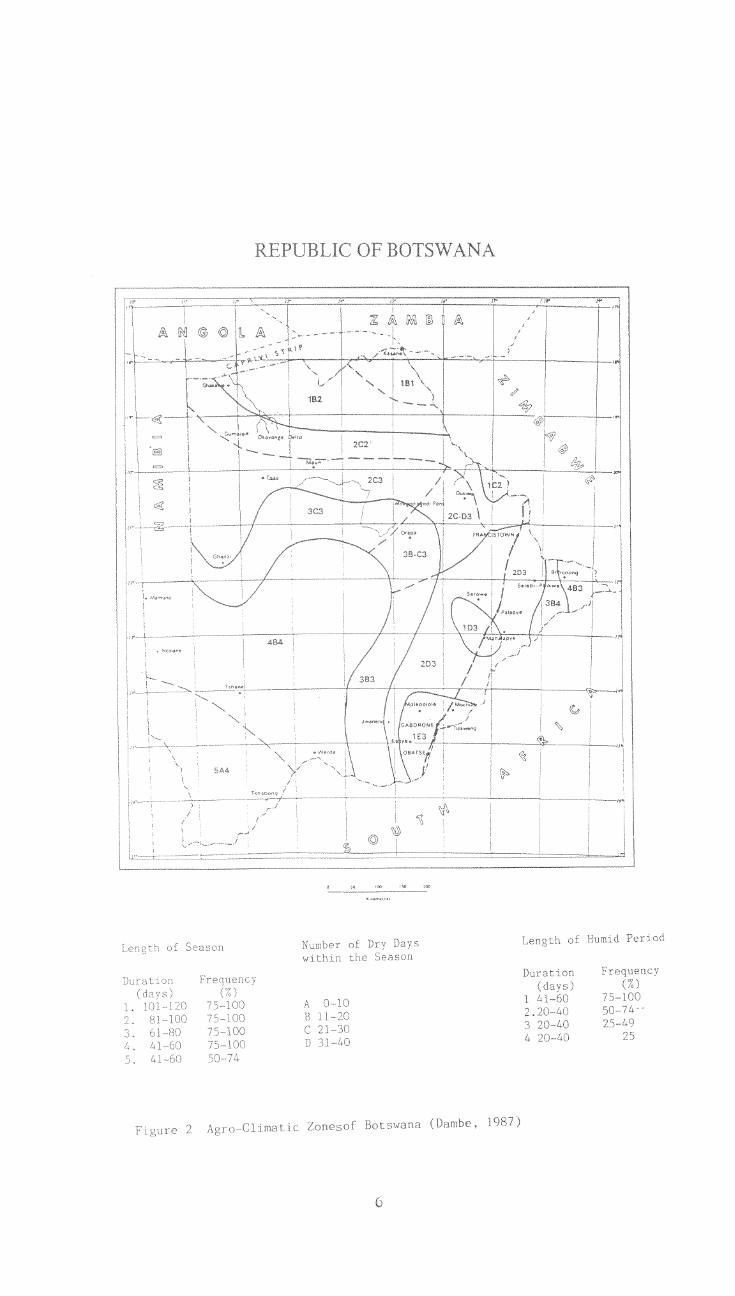
Although the actual climate in Botswana is not directly related to landformdevelopment and soil formation, it is very important for crop growth andnatural vegetation distribution.Climate has been widely discussed in previous work (Blair Rains and McKay,1963 ; Pike, 1971 ; Sims, 1981 ; Vossen, 1989).However no comprehensive climatic map has been established for the country.Recently Dambe (1987) worked out an agro-climatic zones approach, based on thelength of the growing season, its frequency of occurrence, the number of, drydays within the growing season, and the length of the humid period (see fig.2)
It should be noted that following definitions apply
growing season : the length of the growing season is equal to the length ofthe growing period if one growing period occurs, or equals the total lengthof the growing periods when two or more growing periods occur plus the num-ber of dry days
growing period : the start of the growing period is assumed when precipita-tion exceeds half the potential evapotranspiration. The end of the periodis assumed when precipitation falls below half potential evapotranspirationplus a number of days required to evaporate an assumed 100mm of soil mois-ture reserve when available
humid period : the period during a growing period when precipitation ex-ceeds full potential evapotranspiration
dry days : days during the growing season when no soil moisture is availa-ble and rainfall is less than half the potential evapotranspiration
The following six broad agro-climatological regions can be retained
Shakaw - Kasane (1B1, 1B2)
This region is characterized by a relative long reliable growing season of101-120 days, with less than 20 dry days. Drought resistant crops such as sor-ghum can be grown without irrigation.
Gomnre - Ghanzi - Maun (2C2, 203)
This region borders south of the Shakawe-Kasane region. It is characterizedby a shorter growing season of 81-100 days, with 21-30 dry days. The length ofthe humid period is 20-40 days, with an occurrence of less than 50Z. Sorghumcan be grown without irrigation, but the risk of crop failure is higher thanin the previous region.
5
5A4
999
OF BC
7
,
'
' -J. Humid Period
Fip,ure- 1987)
Francistown Palapye (2D3)
This principle agro-limatic cegion of the hardveld shows a 1,-nWhLug season of 81-100 days, hut with 3L-4C, dry day, ixplying h t thoseaf,on can ftegnently be split op in several sholter growin pciLength ot the humid period is 20-40 days, with au occurrence of 10
The 2r:owth ot rainfed sorghum i very ueliahle and ow vieid,; and hih r
of crop faiLure might be expected,
Jwaneng Orapa - 7A)ane (3C3, 3B3, 3B4)
This zegion be nonsidered as a 172ansiri,,nal zone hetw+enregions 2 and 3 and the arid region 5, rhe length ot the g7owipig sosonbetween 61 and 80 days, with 11-:%0 diy days, The huvild period no! ox 0014C days in more than fi ve our of ten vPtr ,.:ondition for rainted ,--otglIum acevery marginal to unsuitable.
Tshane - Bobonong (483, 4134, 5A4)
This region Lan be .onsideued the t ariJ of Botswana, With a Lenr,t!.) of
growing season oE thar r0 Jays, it unsultat-qe ter lainfed sorghum.
Gaborone -Mahalapye - Maitengwe (102, 1D3, 1E3)
Thil region is ;coffered over tne hadveLd and is uharactet Hod byorjginating from lo(aL abrupt disnrinuit(,,s in i-,Toglapny
Shosilon.g hLlis near Mahalapyo). Alt!,.ou0 tire 1Pngt t of th,.? gowlng
10-1;'.0 ,-.an he intA,riuptcd by ::1-50 diy days, This can load !,) to ormore shortr growing periods, whLch might result irr unrel-!able crop gup,»1),Low ytelck and A high risk ot crop failute.
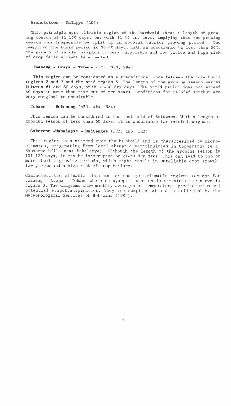
c.limatic diagrams ter fib,' regio-c'xceptJwaueug - - Tobane where no synoptic station is siruated a shownfiguie 3. The diagrams show monthly avelages c)f tempel'ature, p!-"cipit,Itior ATOApolential evapotLansTdration. They are u-ompLleci with data ,ollekted hy rhoMeteoioLogit,ai Services ot rotswana (1,94),
7
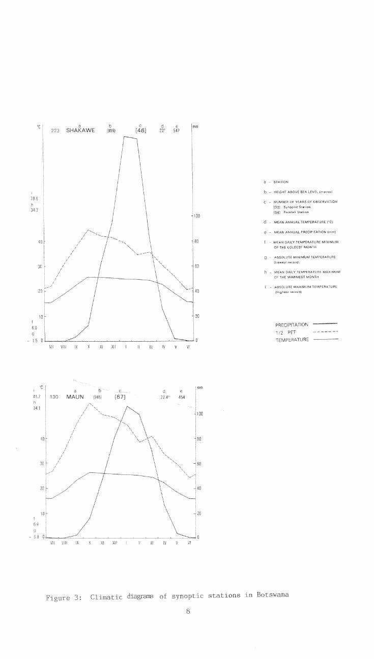
39 6
3.4.3
40
30F
IAKAWEo d e
[461 72 547
X XI XII I H HI IV V
e
8
mm
a a STATION
3: CI of synoptic stations in Botswana
b - HEIGHT ABOVE SEA LEVEL (metres)
C NUMBER OF YEARS OF OBSERVATION
132) SynoptIc Stetion(§A) flemfali SteCon
MEAN ANNUAL TEMPERATURE CC).
e - MEAN ANNUAL PRECIPITATION (rem)
f - MEAN DAILY TEMPERATURE MINIMUMOE THE COLDEST MONTH
g ABSOLUTE MINIMUM TEMPERATURE
Newest record)
h MEAN DAILY TEMPERATURE MAXIMUM
OF THE WARMEST MONTLE
ABSOLUTE MAXIMUM TEMPERATURE
III)gheet record)
PRECIPITATION
1/2 PET _
TEMPERATURE -
UN [67] 22 4" 454
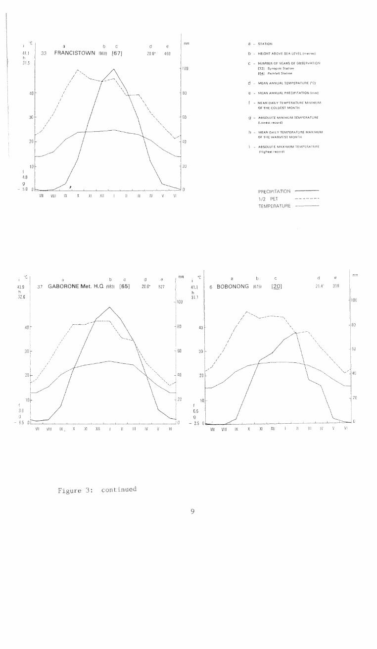
40
33 FRANCISTOWN 19591 [67] 20.5' 450
VII c IX X xi XV I H HI IV V VI
Ie
43.9 1 3 7 GABORONE Met. H,Q 198:31 [65] 2913 527
h I
$2.5 r
W VIII IX
_; 0
61 XII I H III IV V VI
Figure 3: continued
20
9
1
5
cl
2.5
a ,
b - _
C 4frOl
d - ,JfiE I"Cd
531' t'14,111',
"ddd4 d "
a 0
6 BOBONO[-- 21.4 JIA
VII VII XI XII I II IIIId
180
60
6 a b cmm
10
5 THE LAND UNITS OF BOTSWANA
5.1. Land Divisions
'us r.aoss -nototm, ot continental stvuklutet, itUi 101_ pi;v't op,cal)31ic LI!, 1 t s whic:71 Lati fie ieognfzed
[ !13rdvo;d, rt,e i r I t he t.,7t astral-1.p -,,vstem and the ,;1-
5.1.1. The Hardveld (H)
"L' i J n 0ei J n 0e Jc,..f.rihed as a truLtutal suria.2e developed en mtlyoc;.ut'og .0". the est.e:..n pa t: or botswana. lt :..oincides more
I uNh *.r.c Ltte Teri iaiv nd Qwterna,,,,+ orosion surfare, as defineJ by! Tt,e Te!cid/v sortace is an almost tiat to
H.0Hi with ayleei til I!idge, Due to an uprisïng of the .Lid1..a1,111ati-ole..;i... axis (Ki-.igI ari iollowed hy a
`; , I OIL o .10 h IlpFr 5;,I tt. S h 1,ttlf-t ,11110 k 4zwe
; ;W. ,U1LA' L1 sei. te' The c-a&:+-eln t,(J.411ar? of the TPrti..ity erosion r-f,. mdlk(t L J lteJk ot ,IJon, to inore dJosL red valleys i..ad
0 (IT, ho h r t t lie ; litI 1.7 en(' Vud.0 hMeT,t,S Oe V LI (1r ¡Oct ; Ltt tiff v,A1 cfvtz fne fistdveld j t_tIA3.:1
, ; y L-1.1 t tt orLi On a I tr 01111 OiTtP depo tiJ Ottal at oasrc
ht l'f; Tifo h011Thitit" twoon the hal.dveld and rhe( LAI_Ht't hv mor osiov, imes th.is sc.arp As
- ' owe 'carps,somet imes it aP nd is t.int anj t hP eastward ext on-
r y tho hoidveld ko near P.:hete
5.1.2. The Sandveld (S)
Iht <1,E-a ihi h s mainly ,-'overe6 by Kalahari sands.Y"fl e lt\ a.,,,sumed that Ka'iihari :ands '.¡Te flT Himiitanl Iv ot lote teLiary
L te ' R('W' t Mt k.)Cris:.' 1 I LSoOocK and Van S tot,mkAli.J,.(1 lour ditfelerCr types L ttat i deposits; tfie 1(alahari san&.>, ; ,1675) rart of the k.afahaii sands," f 5LILICi I y 1TV `, I o'les
LL,t tOintS t 31110. -t "1' 0(1', ; on SILI.Ur'Lle 111 tht-.;
'Wirt :.,1tO Lis K,:troy locf.s wI;il 110W ,..Li,14-- :Hie the Ka Llibar i Jere,: t
Due t o .1 n. el evat t , a ba s ifi wo eta 1).' i shedt;',kt Sir( r :And pL ing tite I .::artspco. t of
1:1 1),;!tlig the ,7),Jd Lotfit-'1 e,o.;ion suitace was formed. All 3:-I pr,u.1 t L Hi Ciattond Lbi estiro snrfice, Aitern.atiw?ly in ,Iry periods,
04!. ".:n1 e t he a ea a ad e e 1 oned . 'The i Pwork nc, E t he" 00( fluli t dry t 1oitate ".L.i SU] rid iii C 011lp 01,,
)ci ,1 irierliotnis. t,r1,1 LiIL11tLIIi LOdI dun», Prn,-; are a 1 1 I ri a ing 4,:.111;
:1; f 1,-11 si-oAptains OLI molo i CL Ott 4;1110 101 ma t ions 1 r f pan' ori,e the :.,Indv(.1..d, the are;-,.,-1, As
I J i Lt h I It t jk, F,Cb LIlIC i sand , I hE y 4-t
i LI 1 o 1)MTs t't iff7f '0.10\.f i (.1 czini f HIA,ILUtL Lt,e
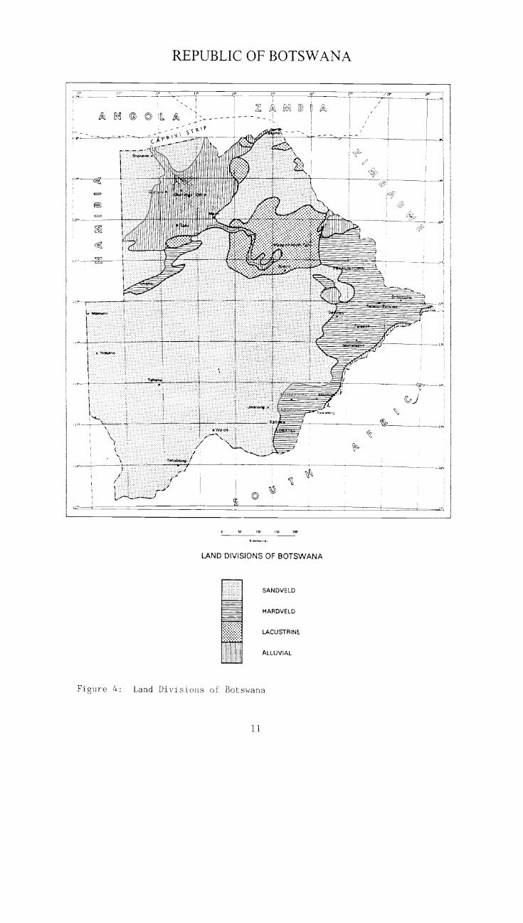
REPUBLIC OF BOTSWANA
LAND DIVISIONS OF BOTSWANA
SANDVELD
MARDVELD
LACUSTRINE
ALLUVIAL
Figure 4: Land Divisions of Botswana
11
1 ir, , 1 % 1,- Sr
' 1
A, H © 0 :or, ,,,
-" \ik-°i ÌÌ
17 ,/,_, L'IY\\ 15
. et\? -
,
[I '/A,
',,
i.
C X r ......,_ ...,,, A
4 Lii
i
I
1
5,04,14,wy,,,,,
1Ft
2...L 1
ilIII13i !iiii
11411II 'Willyk-..
ÌKÌ'ÌÌ.-
Cn
iiiihilfilir.:Ì
:. _,-
ÌÌ
70-- jag,
- X..
1111"""Mi-;:".7....:.-;:::.. . 101111.11"..I '
' ' 10111111 .-.-
I.i ..-.* . 14,444,.0..
.._."::=. il AI 4 "-
..140,.
.:.RF --_
.................
__:-..-7:----
. 6 ......___1
i
.I
i#
i.
.1\211.1.-71.
.:,.....
i. Nme*,,t,
IIM1111 ....remem..... r 1
.11
1i..'(1 ..,=./. .
1 %
.... .
Tla.wen,
A - SI'Xl 6\\ ' 111W4,04 4
I\ 1
Ì ,... ."-' , 1
/
6,---+
I
\ f.':-'
Tt1-0.1*.w.L .-'
III
Ì
I
/I
1i
[
' r.
5.1.3. The Lacustrine System (L)
In the lacustrine system, three major developments can be recognized inBotswana : Lake Ngami, the Mababe depression and the Makgadikgadi depressions.
'P can be easily detected on the Landsat imageries. Lake Ngami is ponded:nst the Qhanzi ridge, probably by downthrown movements on the Okavango1 _ marginal fault (Mallick et al 1981). The lake was probably fed by
vtTss c:raining from the southwest, and possibly the Okavango.Mababe depression appears also to be fault-bounded. It lies on a slightly
tilted block between two north-west downthrowing faults. The depressionreceived floodwaters from distributaries of the Okavango and the Linyanti-Chobe.
The history of the Makgadikgadi lacustrine system is very complex and it isnot our aim here to develop all the theories of its development, which areTtv'll described by ,Breyer (1986) and Bailleul (1979). During the late Ter-tisiry and Quaternary time, a tectonic activity along a northeast axis altered
llow of the major rivers. Block faulting probably caused the formation ofMakgadikgadi basin. The depression was filled by the inflow of several
rivers during the more humid periods to form the lake. During the late Quater-nary age, different morphological processes modified the outlook of thedepression deposits. The alternation of humid and dry periods led to the for-
H_on of different lacustrine terraces. During the dry periods the depositsreworked by wind activity and resulted in dune formation. Also several
essional strandlines can be observed. It must be mentioned that theLighest terrace of the Makgadikgadi complex, as described by Breyer (1986) isnot considered here as a lacustrine system because the aeolian sandcovers aretoo thick. This terrace must thus be considered as part of the sandveld.
additional lacustrine development occurs near Pandamatenga, in the depres-sions bordered by longitudinal and transverse dunes.
5.1.4. The Alluvial System (A)
In the alluvial system two major forms can be recognized, namely the wide val-
ley floors and the alluvial spreads. The distribution of wide valley floors
is relatively unimportant in Botswana; the Limpopo, the Boteti and theLinyanti-Chobe can be mentioned as examples.
The wide valley floors in the Kalahari, like the Okwa river and its
tributaries are mostly infilled with aeolian sand; actually they are part of
the sandveld. The major alluvial spread is the Okavango delta. The OkavangoRift is an alluvium filled graben structure. The sedimentation has been from
three sources (Mallick et al 1981). The southwestern part was filled by rivers
draining from the south and west, which have long been dry. Another part of
the delta receives alluvium from the active Okavango and Linyanti rivers,which are perennial. Active deposition in swamps on the alluvial fan of the
Okavango river is encroaching across the older alluvium to the south-west. The
Okavango and Chobe alluvium coalesces in the north-east of the rift. The val-
ley in which the Okavango river flows before reaching the head of the fan is
probably controlled by faults.
12
tIC',1111.o. 1. e L5) :" (1 ` 7) 1 r z t
;"¡.' Q LI
),trit,t- I 1"-- 1.v I rt, I/
;.i 31_ tC311., h;;;;,L rF v wt->.1 t 1,,
1
1 ivial spreads of. t ! - occur in front of the boundar y.)etween the :' 11-r(tr
5.2. Land Regions
A 7.-11'10 "-;;;',;t ;Itr ; ;.,;;;;LL. og,_HSIL ,-"oT JA,71.t,r Cl, f r, ;
[J tAtO ogic 1 untt. 1.i, :!;1- r'[L.:2n r r,1 t I k t h Lrtil I -
hasa:t, 6rar:t,' t L
'inrIt 17 riot tLJ LtjrLrO 1.00 IL t, C;01 S,.01,1 ;,1
ver Ltl ,cite th o tRakk.,
o Lotimen;-
5.2.1. Solid rocks on the Hardveld
The fo id roc: led on
Afwhibole-rich meta-basic rocks
1y met A--ti--,i1;:. (amphibuiltes ) r L L A l r
u I r r - d LII'' f Lr ç I L +
r!rant.L-cs:I nt ',1 Ir
Jt;'1.,111,ally hi ily JO t -z at "cal
Basalt (Hb)
hlos t. of L.-le as,
I g L ve C.; . f t rI t
L ,lain by deolkalt'And L, ;'j-(J t- t co -i! v.1.
t ho i ,(:
kasa t. J-
13
1 I Thin
, t 5'5 5, , 11' 5' 5'.,11;151'5,n`r 5.52,!n) , IliL4 L.'' nit,',1! 5'18
,`' 'ii sSS ,ist I a 111s' 1451; ,; "-Ld , ÏLLeL nie 1ti Ck'n1'n-',1_1'¡' 5'55,[1n(515.)1, 5'n t 1.11.t t en Lin5.,' e,o
lo ;,,t154t-1
,S 54 Ç4's> 1001 ",,115 , 110
sII t j 111,J o rnZA U.'', of t-.14t,
k..)1_ 5 "5145 (..,1,455L -5 415't - j A 1,j '55 ti Titi ti, Vt1t ft_S j J
5 -j t S Vyty'r i,..)r).'Ll
I) 5,, Lq t ock type , and occurs on thei. SI 051515 , Ln I t '11 N, ,nsn snnnns nt 1 t istiPi ji H
(Hg)
5'55.. 551 5n'S se S'n it i HiC i kv 12 LI 1.11.1 H sto,[j `SSS Hi '?,¡51,1 I 11, i 5ilis Hi L )[11/,' 4- t 1-u- L r 311 1
' L tuihit I 7,554 4.4-A4,:, I .nn,,,knq 3.nnid ld [(I LI t ''
5 5
S nnn'sk nI I 't ensinsnd i L4,, --,He -n1 n /id i/rn' 5 , I 51555,-'"J t s" t',11) Lit' k-/ 2:`1 C1t H t cl t t e;. t n I h
.005,[51 .,515H In, 5 n551 5.5 h55-5 \k i i i5 5 risg t npit e n n t J. 5-04 >5t
d nn 10"S s_ j 4S ji i i 11MHI r'"Ti t L hnnnn 1'-'111Ì SC-1(111
tj. t C'.111 t
6.5)11(SSSH 'ji 5jist.H iSitt ,j 14p4: I'i",tt5ro I iì
d I i ns_nnniN ç n-1. Si5snn1-14 14o-'11,5'i I55 424 teitH ,1 this rock type .
14
' , ' , ' 1`,=1: ;`, 1101 ..n. t its nnnn t çI
1ln Y" H" ' 's t Ç j I Ut, 1. I L01.,.; 1 -
rocks )
Si 5 nlilsI55 0 5551 5 5i t Ç ssLt Y.Y.Y S LS t , 0'14'
, ,I ii_ 5-5` j11_11 t r41c 4'51y'2,, 5'7'5Vçççs j ç ir111
5S5nn, '55 0 5J 1 ! \ PI 5 -I; 1,11-1)i)5t itt 1 t
t, J, 544 4SiS t.jçtj'tf'd t
I"' Y 5
,S. Hiui ' nns
SI
HII 'nil ISsnn sdn ji
Granite (Hi)
The Gaborone granite differs from the granites and acid gneisses of Base-ment complex in that it has a very coarse grained porphyritic struL.tdre. It
gives rise to a higher proportion of medium textured soils developea ci uq-dulating plains.
Acid volcanic lavas (Hy)
The acid volcanic lavas of the Kanye group are mainly composed of felsiticmaterial and porphyry. The outcrops of these rocks form hill ranges in thesouth east of the country
Dolomite (Hn)
Dolomi:Jes of the Damara group occur in the north east. They are veryrestricted in extent and comprise hills with pediments.
5.2.2. Parent material in the Sandveld
In the sandveld, three types of parent material can be recognised
Aeolian sand deposits (Sa)
The deep aeolian sand deposists cover the largest part of the sandveld. Theycan be correlated with the Kalahari beds as defined by Boocock and Van Straten(1962).
In the Central Kalahari basin the Kalahari beds seldom exceed 90m in thitK-ness. Greater thicknesses over 150m have been recorded, particularly 'nvicinity of fossil drainage grooves in the headwaters of the Molopo river inthe south east of the country.These beds have been formed under a terrestrial environment and show markedvariation in detail both laterall), and vertically. When they are treated asunits distributed over a wide area, both lithology and the general successionare however remarkebly constant. The different landforms, which will be di-cussed later, are mainly developed under recent aeolian and fluviatile in-fluence.
alperficial aeolian deposits over solid rock (Sc, Ss, Sb, Sd)
The superficial aeolian deposits over solid rock are mostly occuring on thewestern fringe of the hardveld. They must be considered as a transitionalzone between the hardveld and the aeolian sand deposits.
15

Majo
r "-
t.^ I
NH' h
,
s)
C' a
I 'ï .,7)", " ''tko
-I ,
lacustrin
(Lv)
H -YEkkkV
I o kkk,"I'L .111,1
A d tic
c
sano --oped on the Karoo
Partly ae
k,11
5.2.4
T-
_Aluvial _s (Ar)
T
17
5.3. Land Systems
A 1:n.1,. system is a landform pattern of geographically and geomorpholoLlyelated smaller land units (land facets),which are recurrent in this landunit.
The land s-ystems of Botswana are identified by combining the different geomor-features and theirpholoRical respective topography.
The iollowt g geomorphological forms and features are recognized and retainedfoi tho the land systems classification. They are grouped together in functionof the major phy3iographic units they are occuring in.
5. -.Gurphological forms and features related to the Hardveld
The landfonms of the hardveld can be divided into two broad categories : the
erosional surface resulting from the continual removal of the products ofweathering, and the depositional surfaces resulting from the accumulation ofmaterial.The erosional surfaces can be further divided into the upland plains, and thevalleys. As these latter make integral part of the landfacet "plain", and asthey- are to small to ma.) individually, they are not retained at this level ofmapping. Under the dc.itional surfaces we can consider broadly the alluvialtettace n!1::,. the floodplains. The vast depositional surfaces are describedunde7 "Al Ivium". The iiiinor terraces and floodplains have also to be con-
part of the landfacet "plains".
Following geomorphological forms/features can be recognized
Plains
The plains of the hardveld have to be considered as structural plains; theyare the tesult of different erosion cycles, as mentioned by Bawden and Stobbs
(1963).
18
Following topographical classes are retained (Remmelzwaal and Van Waveren1988)
class slope (Z)
flat 0 - 0.5
almost flat 0.5 - 2
gently undulating 2 - 5
undulating 5 - 8
rolling 8 - 16
hilly > 16
, which is an char4n4 ny'?, kn 1,"1 ny:., fl L ,
110 sn'n il iCD olio! 1 t L I nLrnt L.,Itsa )1.:»L I
, Tat"' t' uh ' ",
kif9h.,",;;" tr k, -ict,i ' r1 ,
Hills
,"h;t ,M ..7) hills can)i Leo.t. ' k"", [1,-="
Escarpments
Coo t tC n; - ma 'ireak
..13 I I co.
Kopjes
1,0 nl"1,01 a
C
Pediments
I s'11- [`,,4
u" Li ho_
n.
Plateau
, iti L. L n v,
1,11v
Led with
Ridge
rE1-0,LvPL,,, ch-y nOttitictlt - flathn-'4.1ootFor ,hnnCh' "voo"'"ohL di,
19
Hilly areas
Iiillv iv:,t,1 tO t
viviwo --
0,d
Jdinal dune
1,1
I` I
i Ji . jtt',I
bine
ving
20
Up_
1
tsTt
1 luvl alt-',1
t nt itt ti pari iith thed ,r ywlt of Ition of
, I L Lo111- tlp 01
(.1.1_51-7
ed r t h t
11) crITIle
Al_ _am in the har ust be rc,- - as a flat
5.3. holog ted to the Sandveld
of ae,.y unk.i
urnula-
Linguoid dune
V ;71 ,,' 1 - 71.71 7. L t 7 '7 7; L.It L71 7. l'7,; 7: 7"7"' , 7 I, r
I Elf i I t L L I t, Ll17-1 717-" - d 7 ',7st- 77" 7L t. .7t71,m; lhahi, tirh.?L NMLLI.J.t1 hh..hht, . 7,hr" 777 ....71777"'; .7.171 h ,77d
17-1 777., ,d 7-,7777,71- ti ,t7 if.7771;th r, f" ("1-1,77- ; p..do 77.1., I 01:.'"1Lidapso".1..6 i t r h,- t- r, I
WPIt.-"; h I L t-f 11',, 11,, !
1 h s
7;7
ulate dune
Rf-To),,R.1.1L.',: k,t, fc).-: :.trans\ ri,l,..; - 0,' 4. ;:l.j ' 1,--, hi, .., 1 't v,
t ,, 5 A , f,-,t- J. ,. , t HI P,[,(, ...-1.- 1 .,- !- - -1 1.,1--y,,,,,,t)1 +,,12 .,.. L-L-r_ ct ° ..--, ' - 1,11.1 , ,,, , L° : L, 1 1 , li° 1, ' °
, °
WI ,-, L° .f..1( - '',L-ii - )),-, , .°1: L°Th 7 t 77 '7' ,-7 hd;1.. ' 7 '7' "h . '.., , .'
74, ...t ...., 7 t't it, i 'i f i t ' .1. f . i Mt.!. itt r t t i 'Tit -r ' tr 1 it , I-0-; r ". t`'` 0 tt ; t t itr " "t t . t ." ' 1 t If t . 0r ft'r 1 'f, L° t _1 t ' f tr't 1f it.' i 1. Cit't ° it i t.t . i it' . t t 1 t t 0ti "f I I . l' t " " 0 t of 0 i 0,1,
Transverse dune
L
1 I 1r-1 1
i):»' II_ L ti '727 fhtt 7-,t771 'L -7" 7.77-h -.1 ,7;;;" h 7 dh, i LIfILLII ; 77,7 777 77,7" r7V,,17 ; 777. 7 17117 (71, t 7,7 , th1,7
''' 1'1V '!"L i,77 I 7" 7; .71 "d
171,7).ttLi. ,4 777,7,7 7; ,;
L-IL, L'' t
Sand mound
riLe ," r1- 1 I -77
7-7,777 717,"1 s'777-.77t77.. , ' 7-77; L °,',lt L
Pan
t 7 '7 7 77;7 -1 ;17 ;7117 7. 77 ''L L;"II7770,-.7 ni ho tt ."( ti t, fit' ft t " t
t.1f t ittf. , ti71:1 t.t 'L Pt' ts J t t t. 1 L
C t eruz "d7shdt 77 7 '2.77. itt1X7,7777'71. :01; :,,7,,o ,; J t 1 L L.1
77.111277,77/7 77[0 4 IJ/7,7 7- 7 itt ; - t, , t
de pi oss 1°1, LL ' LL I t I
t-stw,a s-olg ;`LS Si It L, LNL ,1 ' L- °ILL
ryt,P,:1,-1,t , L L ,LI L '
lac k L 77.4 rtaj 5L:fle ,° o ,L-5 1Y L 0'7,1 ILL h; 717 "i ' tilt t't T
21
1,11 ly chdaue s-; . T in !-1.1z,iit t - tH <;e.
hol ;ire k-nt Lie1 i t y t.o
-Lora! ;.t 1. to t Tic cnc
calcrete-rimm tn,4 belt cl-,1 tLom tio Namibian,,Ldo; tu Lsol' trtIc1, ttI JOOt,,, t t t tfle,
ozin,t I LiI I Jc cutti/,;,11 . ¡Li tl t.`"1, 07,` .-tto11 PSI
' tk s O1 it (It 1101 I tat"i_. I/1 . 1;1,-,11,).11 rat tit tc9H c.'111:2:;` MOZZ I' ttIL t-j ' Ottai)1 ih,11ttt:
' 'owe r 1., ,p ).ZIII t 1, i-,,4,3ot iLitt
,z11 1,-5iJHS t,. -It( 01 !Ott 1- t diudc, .,1 ttlt rIt';P JZ5JMìI1,0
Itd I 1 _TILlitt t'iits JLittt' T..11, 1 LILO 111)1: 1t) ttttt'O: 1.1,1 f:itt tt1.1.1tt?
( .1t1P,t1Z' ktt M i 11i1t " 11,Si t, AL ..,11.11/ "tilt n,- Ve'L
1 ag ,SZì,1 t Ji, Hii 1.t`11". 1`,_'11111;itt.t1,, ...1) -1 ) r '
4,1 !,11 c It I Jy`: ii!, I. I i rCL,I Jill 111,'In
1110r, L ",,` I S A I ! 'it tettt -
, "-tt 11 .1 "Itr
i h
, '."tern Botswana _tie and of deflationdr",21
Quo,-t _ o, \-4 `0, e,)111,1
Li 1.111,°b " ;r LIRLJ j L 1_,911 I
10rutti'd ' [1'1 WH.1,;:li La, s, Jj,oj Auo, L,1,
v `.1 ( e ,)1_1; nje; -1 In to, 1 VII 111 OtIttLY r1- 1 Ottl
CLIt, o H;)", )1,3 t ", 1,0
Fossil river valleys
'Ffn' , at- R i , CM CiaJt L,
nee I t F, \-d
/ t ' I tt, Jni I ¡HIt L jr t t IN" ; ti',' t ii liii 1 1t-ti',Irt cl I ,
',',.101( I ,iti M, 1 iod s i he k e ;, al :" y
vzit t ' 1,` C 1)( 1 t bc't.-1:1 i evyot_I-,-;,,..1 r1(,, t`
The :.,(tdt he, to I JOW I. t.L11
it ' s the aeolia ' 3 are extensively
22
5.3.3. Geomorphological forms and features related to the Lacustrine System
Plain
Especially recognized in the ttakadrkga,ti depresaet,, the laeustrinecorrespond with the 9.2,)-9e8 mas1 terrac, mentienea bv Breyer (le-48t1). Tseplains are flat to occasionally gently andc.latlhg, The f.erlaco i rmeoduring the Holocene b7 la,:ustriae depoi-eitien, AtLeL recession ot the laLeduuing a dry period, isolated lakes wA_th their own -liktee formed.Aeclian processes and eal,tete formation bee.ame w_:aesproad.Together with the plains are also considered the lake bottoms and fossiltiaaaplains.
Salt pans liable to flooding
These flat depressions aro the la: mnants of the 13ke. Some part,perennial water, other pacts are cove-Led hyhave not been reworked by aeolian or ftrenal otoslee.
Pans
Reference is made here to the pans oec,J!ttng tu tnerepresent the lower parts ot tbP pLains 3nd must he konsidered as foqtibottoms. Some of tnem cin be :-easonally ponded Tice iake bo!roms strixo ,;ensnare ftat. In the biger par Q, like Ryqana pan, the lake Por cio own;edby acolan activity, and duheq can be ohservedRemnants of to,,sil r.randllae features are clearly ',;isihle.
Shoreline
Gently undulatin6 sand ridges formed under humid p j the wave action ofvast water MdSSOS,Thesr srrandlines are common t,Lbabe Ana Laxe Ngami, of
them are situated on the west :-Lje of bo exp(aAn,a re;waves formed by eastern winds. That cainrides wA;11 tLe aire,-ttou of the
gitudinal dunes.
Ridges of reworked lacustrine deposits
These elevations are vestiges aC nor
marking older shoreline po,;ltions.They are possibly predating the later stages of devgitudinal dune system.
23
::)f the Ion-
Fossil lagoon
kr-.1
I)",'11F itt
24
.1.055-11h1 1,',111h, IL1,si t' I
t h t
Rivt
I ,k
fans
25
11, 11
1 . , . , 1. , ,u, , ' 1. o,) 1, li LA, / ' A ' .../A 11/ A : 1 .
i /oAAA A A , A N',L, ' A , 'Ni/ /...NAN,NAI . IN., ','NP NA1 A / A / " "AA N O' 1
IN ,N, ' Hl N o' / ,.A. t."' to o s 'A'AA HN, 1-A , Ah lo' L
r EcELE LE ','' ,Er tr,o' , , ,-, , ,., 1 -
I E u,s- EII 'E' , 1-1 1h, .',Fkk kk;k4k ..' .:,,, I '..'"- ','s '''s ' 16s, , 'Thl'
',Iti ,s111 sskt 1". s , k k k'',' 's ' '',., .°11',',..' c's '' Vi(, t t titk kk' 1,,
(Hl, S ,°.s°,..s 5,
only ,,,of 1" n'o ,2 h, y oS t
2 21h;),. icu,;;, ,E1 hyr ,Ir ;
SrEE EI tk. ssk k
-sss Irth,tt *.
sk'k '
il ¡I,s1 r , , r,
11,?t
" '" Ao IN'
Sto
Ts , os °,-, ,s,
hrs ° 1,, A o /
Ts.s. -.°:-. - r) ' srs, s,,, , , _ s.°,s 1.ssse1°-2" Irs "s°=° , ANo I / O, loo" ho'It ft S
t 1, -A 1,,' -.- ,,I 11 , ,,,. ANTs, . ,r, ,, , H,t ' L hoolll IN AA
Oh,' NAO
o thtt,t, 'St
Alluvial flats
The occurrence of alluvial flats is confined to the upper catchments on thehir,i1 parts of the bavdvoih, The textures of the deposits are directly related
tho of the material, Mnst alluvium is found in association withothe. -?nts and rocks.
6. VEGETATION
6.1. Methodology
In (,i,lor to 1-pity eh land system iu terms of vegetation, an intensive studyof the vegetation of Botswana has been cairted ont-, (Bekker and De Wit, 1990).AttPt (ouultin exitin publications and vegetatLon maps, each land systemwa, t)rcJimiuduv JetineJ L..,*_tncfurai veF,etatioh 1:ype, dominant or prominentwody , gr_zAs- dad torb TheL_Jes, and cover.F,1111,JutAl veo,otation tvri,, '31C distinguished according to vegetation struc-
which i% con:Adet-26 aq a complex of pidnt life forms, verticalot plant H_omass and its hoti.7,orital coverage within these
strata (Mtlellr Lomhoi aud Ellenberg, Lq74).Powinant cp.0 ìe eontrt A v,,geration community ty their presence and canopycovel . Prominent .Te 'les are cha :ate for a certain community, but theyave not necesar j iv dominan t.Ih ;a next step approximately V300 field observations stored in the, Botswana
,flatabase were proeesse'l. The locations ot the releves were plotted on theland sv,iems map dud lists ot structutal vegetation types and species occur-H.:1r,, in eich Lind s.ystem wete drawn up,
further 3tage preliminary vegetation characteristics were updated and ad-insted by comparing titel;itdie data with field obseivattons.For ea,11 land -tystem the most widespread structural vegetation type was deter-
two or ometimes piste types occur in one Land system, a range isNote that the most eommon strmturo is Oven first
The listed dominant ano promtuanr species were pfincipally obtained from theLharactotjstie structural vegetation i7pe(s),Veiiotation associations arc the fundamental unit, for describing the land sys-
They tom a 1.vptial, combluation of species wdth a range of structuralveve'ation types and a speci_fi: ecological occurrence (land region, parentmaterial, soil group, me,io elimate). Associatic,ns are marked by their mostdom:Hant aO prominent specie,:It ,dioud be noted that associations can be regrouped in alliances. Althoughthis pro(edur,, hat:, been followed for the vegetation classification of Botswana
;eidset and De Wit, 19(.)0,, it has no: been retained for the land systems map.
For de,h'ribing the vegetJtion structure of the land systems, structural
vegetat ron desctibed by Phemmeizwaal and Van Waveren (1988) was regrouped into
,ldsses (qee table 2).
26
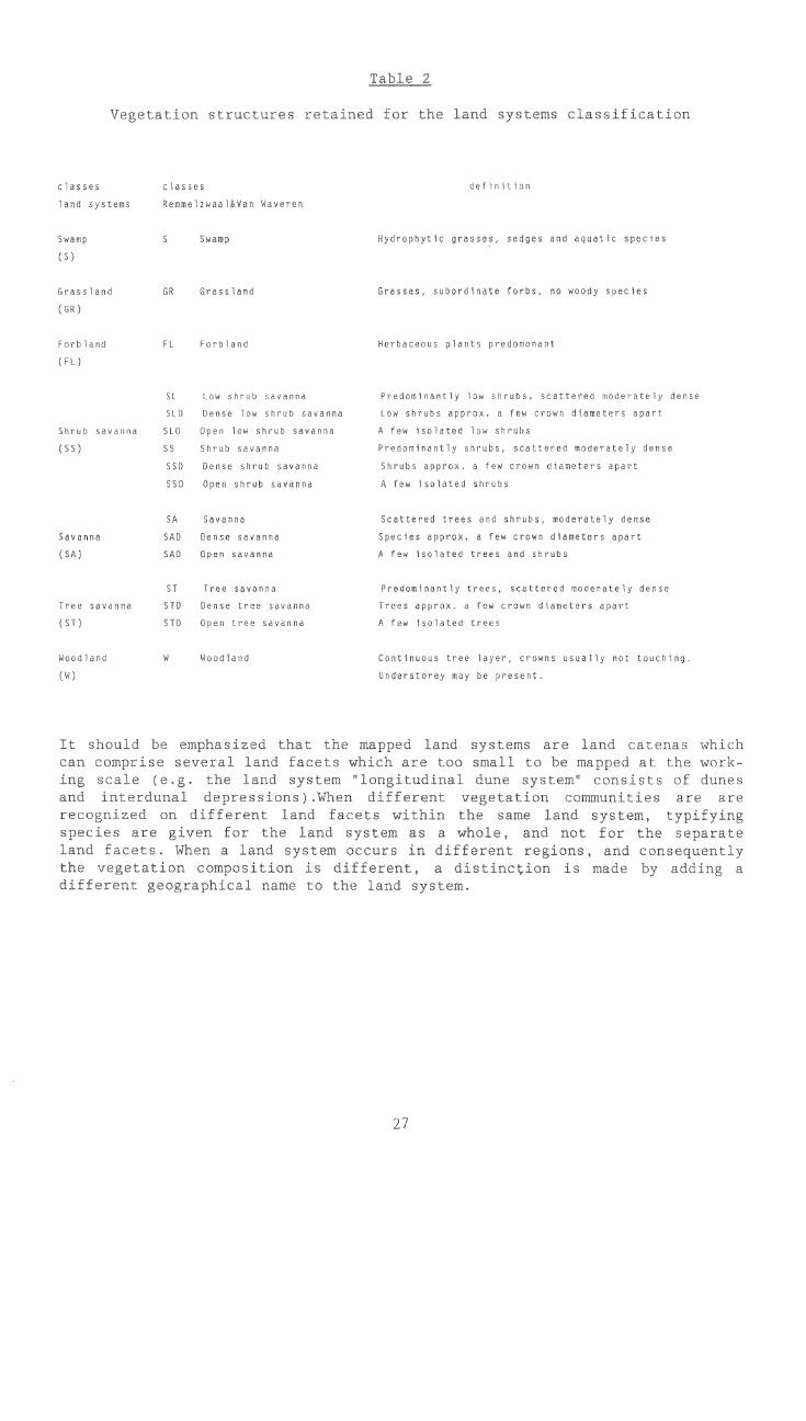
SA
Sdvanna SAL
(SA) SAL
Table 2
`on structure: ad f 0)
cl Ion
Swamp S S grasses, d aquatic species
(S)
,3. GR Grasses, subordinat- rr woody specles
Forbland FL F 1ants predc
(FL)
SL. shrub t 41 , s l-w shrubsn scattsrpa mh dense
STD , a few crown
Shrub savanna savanna A fpw is- hs
(SS) (sense
b, Ok ' innn,'ulna 1 hlalhd sat
trees an,
27
ense
apart
ST Tree savann ,IJominantly trees, su moderately dense
Tree savanna STO Dense Sr e /a s ,t a crown c leters apart
(ST) STO Open tr( A Ihv ,,,,,'so
Cant Inuous tree layer, cro. not touch I ng
Understorey may be present.
I i i;,10i is 1iT b t ha E He nu fip,?kl ..111(1. 1. o Land - -
whic1). .ace too !,,mallno. ivst Ora 1 p Ot
ata,' diffecerroc i u e,1 ent land fa,' itO w;) thy:, 3,:anie 1 and i3y 3 v p
ace pJ,vru toL Lim-, Land w uotsum a, and -to..7.n,i5 tht:c.cut.--;. in J-Iffc.:enr Xl1w1 c,q;e:to,Lv
Lc,o. s ,htol,yllt , dLpHr, io(1 LO ni l-y acid ps.z, a
1-1,11ne io 1,11,0 ?y,-em,
,
11
The tr)101),h
t
i'0111tt.,7/11)i 111}2,
r-20
j ohn ' t
- I ,
"cilo,
tOo
,
.P",:
1 it ,t0 ,,,li,,' \ a-, 2.i.t,_ - LI , k 'i
'... 1 ', I r. tiLtiL, i', :i, i ;:.1 i ti 1 :.i 1.),,,r, TIi,,I('-'- 3 -
A L [,,,c,. h- i-..N.0 -el) tIII= 110_ t flt'T I.;K, tHA./ rt tt
,711
tttt',0
t r
1 tu L h,t_o` -k)u! tir 1, ,\
\ 1- I 'T .H. ' ,`J
_
28
t0,1 ,z =-1
t to7 ae h,"&rciv,-Aci
Po. ;1°.,',!..
I ji'.
and11.0 ,7'r'1 ti'-
LttiV
't \ I
1.111, in L11.0 ttW krrip.F.!/ t t I t 3
1"t`l t,ttirr,
,'E(bt t 't'
,,txt 117 C.11);2,Ltitj
andc'; r)3
h,- - e t
y rtW t
,",c3 -;_l 3
LI, L L,
p 1"' u t ,ta i El Z) t
'1 te_ L.-, I 1-rh-- .,t
6.2. vegeLation distribution
!3
aho4 t e; t` [2.,t1 It)4.1 "z!' ``cili 3 7 1.
species. A line drawn between Martin's Drift and the Mokgware Hills forms thesouthern boundary. The mopane-line can be followed from the Mokgwane Hills innorth-eastern direction until a point west of Serule. From there the line Irls
to the north-west to an area south of Sowa Pan and Ntwetwe Pan up to Lake Kauin the west. The mopane-line surrounds the Pans and the associated shocolink-features in the west, which are free of the species. At 18.5' south it runseastwards to the Zimbabwean border. Just north of Stoffels Pan mopane reoccurGand the line runs south of the Mababe Depression, via the eastern bank of theThamalakane River towards Lake Ngami. From there it runs south of the Okavangs)Delta, surrounding the perennial swamp. Colophospermum mopane occurs along thedelta fringes and on the fossil alluvium. The mopane-line excludes the dunesystem located along the Caprivi Strip (although the species is recorded insome interdunal depressions, Smith 1990, personal communication) and hits theKwando River at the Namibian border.
LOCATION
In order to locate a specific land system on a topographic map, a locationname is added to each land system. If a specific land system occurs scatteredin different geographic positions, every major occurrence is defined by a cor-responding name. Mostly names of villages, settlements, national parks andgame reserves, rivers, important well- known pans are used.If there occurs more than one distinct vegetation structure/composition withinthe same land system, this is also indicated by a different location name.
SOILS
Each land system is characterized by a range of different soils. The informa-tion was obtained by overlying the national soils map on the land systems map.The occurring soils mentionned in the legend are indicating the dominant sub-groups.They are classified according to the FAO/UNESCO/ISRIC Revised Legend ofthe Soil Map of the World (1988).
29
9. THE LAND SYSTEMS MAP
9.1. Topographic base
1,1116 ")','",,,,11,5 111-11. l'(11 "<A",' Ilk,' )1,17-t 1..); c74., ne. 1, ":"9 000t'v ILh ini( \ hL ìLLV7 1111 iLLLIf
1'1, pi ,' -,5)7.75 , I.; )),;7i17t ,,tt ',7er 75; ion ,)I uhe aiìts7,7:5; tem.,L h ;,1 , ; , r h °":1 000 1 `..1"
,,IL,
9.2. Mapping units and symbols
ctL 11;;, il L t 01;1'`,.1";, 1 ; ern II,77 -tr
r,,,' '',"` "2, I '," h h th.' 1,11 <
17''' ;t7; tt ,t L Lo J ,?T ,` <,o 11; , 7''; ;';;;-
), 1 I LC:" T ;
01111, 5`,7;<,-;"01", C.L ; ; ,` 'O ;
lilt ) Ito`, il,tt ,,t;;;,17- () )70) 1 O to: Iicr,oVyi `, It)LJ un JAW. 1, ; Lt-it ;1 7) Lot_I r ,,t10\;`,-st a HP
11 t, LI' 0,1 I u i h I ",, 7 1 5'i ';;;;;,,, 1
:`11 ,'LL,' tr, L5, I* t,;) 131 L' I 5,1.1-, L;h11 31 0 7,t-');,'L<)1 J h"(.111;11hk'î I ILI ; 111;`,L ,,111H5l ,
9.3. Legend
, ' -0;;0,;.<2 JThLol v, hIi1 ,710LIloj j)o, too 1 r°
o°° YoI ILL Lo 'I t01 I tLJ \n" 0' l,hl LiiLiojo j_C 't
Iron 71 7) o'°11 Il lo °°;"to.°) o°,°,1oro' oaI 77771,
'LO I ,,oll _int.' ol "' 77",)
<1!,,I)t t,11,s1 I ) cr.) srzuc W',' -10(1 Os, e LLVCfl ,LI
a 11 t <; I '01. 5.' 0 I. t10 (<1! 1,_11 C01-' k;'; 11,1
le (1990) .
30
REFERENCES
BAI'I- T.A., 1975 A recontlii--sanco z-flovev o che' ,,vor 1,ands ln
ot Vol '+9,1
BAILLEUL T.A., 1979 Makkf,atirkgadi paws coalpLex of Genirat Botswana.cf AmeLica Bulle- (Jan I. 84-312.
BAWDEN M.G., The land rescure toF fl(-Thuanal,:nd.
STOBBS A.R., 1963 Dire.'ror3te Overseah 5:lr,devs, ;:oresfYy ,',Irtt landuse sec" London
R.P, DE WIT P.V. A contrLLation to the y(--6..t,,tY,-,n 3t:,0)-11'91 ot: Botswana, FAOMN[TfO,overnlit(nv H Itttau Plifloct
BOT/8.1i. Field ooumell N. Cob0Hro
BLAIR- INS A., Th state lands. Stud. LandMcKAY D, 1963 Re - Dir. Oversea
BREYER J., 1986
GREY D.R.C., 1976
KING L.C., 1963
The l:ylantl or tower Botet( iogionBotswana and i's FUltal))Wy trditional dc:h.Lo
i\fk enit J ont I ao -achUnive!-,)1,v Hamhnt:,-;. Harohnrgor Boch-rikum,"1),-1-,
3ar.A
C.S., GeHoral 1-,Tolt on sncvey or Katherine - Darwir -'WART G.A., 1953 Land Sol No L
DAMBE D., 1987 Agro-r-Liu-Iti( ir l,yrs,lua, Der,autrw,iA of
Metec.rological Servi.ye, Botswan,1 (draft),
DE WIT, P.V., EK,p13nfory 11:LE Or, the Nat:0n.,--;1 Soil 10qt, Bc,t.lwAna
NACHTW.R6AELF. F.O., FAO/UNPPN:ovnment Ploiect1.99 Le] Lt Pocamont No
FAO/UNESCO/ISRIC, t. the F :0 Soil Map Hi th,11988 World, Wot:,d Resou t P i F A Rome,
Tne pfo:TeLtl.ng ot Le Mot11,1 hr.th110 ,:ind sno( I ut e,,i t ,
pect Jtipcihl. Lh .1)
Sou;:h dFn.i,nap Scenv. A of geomo:-Ylivet and 1-lvd - lor,don.
MALLICK D.I.J., 1981 A geologL:al )retation of Lands,it imaolvac rhotoraphy ot Borswdra. C4t-oi Tv and
Mint:.raL Resource, No 56, London.
31
McCARTHY T.S.,STANISTREET I.G.,CAIRNCROSS B.,1988
McCONNEL R.B., 1955
METEOROLOGICALSERVICES OF BOTSWANA,1984
MITCHELL C.W., andHOWARD J.A., 1978
MUELLERDOMBOIS, D.,r H. , 1974
PERRY R.A., 1962
PIKE J.G., 1971
REMMELZWAAL A., 1988
REMMELZWAAL A.VAN WAMEREN E.J., 1988
ROERS A.W., 1936
SIMS D., 1981
The sedimentary dynamics of active fluvial channelson the Okavango (delta) alluvial fan. Botswana.Department of Geology, University of Witwatersrand.Draft.
Succession for a Provisional Geological Map of theBechuanaland Protectorate.Ann. Rpt. Geol. Surv. Dept
1959 Notes on the Geology and Geomorphology of theBechuanaland Protectorate.20th Int. Geol. Cong, 1956 Assoc. de Serv. Geol.
Climatological Summaries for Botswana. Department ofMeteorogical Services - Ministry of Works andCommunications Gaborone, Botswana.
Land system classification - a case history : Jordan.AGLT Bulletin 2/78. FAO, Rome.
Aims and Methods of Vegetation Ecology. John Wiley &Sons, New York, London, Sydney, Toronto.
General report on land of the Alice Springs area,Northern Territory.CSIRO Aust. Land Res. Ser. No 6.
Rainfall and evaporation in Botswana. Surveys andtraining for the development of water resources andagricultural production, technical document. No 1.
FAO, Rome.
Soil Legend of Botswana. FAO/UNDP/Gove-r,ment
Fotswana Project BOT/85/011. Field Document Ni 11.Gaborone.
.swana Soil Database. Guidelines for Soil Profile.77iption. FAO/UNDP/Government of Botswana Project
JT/85/011. Field document No 9. Gaborone.
The surface geology of the Kalahari Trans. Geol. Soc.S. Afr. XXIV.
Agro-climatological information, crop requirementsand agricultural zones for Botswana. Land UtilisationDivision, Ministry of Agriculture, Gaborone, Botswana.
VAN STRATEN 0.J., 1968 Notes on the geology and hydrogeology of the CentralKalahari region, Bechuanaland Protectorate. Trans.Geol. Soc. S. Afr., Vol 65.
32

33
VEREEK K., 1988 The soils of south east Ngamiland. FAO/UNDP/Governmentof Botswana Project BOT/85/011. Field Document No 14Gaborone.
VOSSEN P., 1989 An agrometeorological contribution to quantitative Irld
qualitative rainy season quality monitoring in ot-wl-na. PhD thesis, State University of Gent.

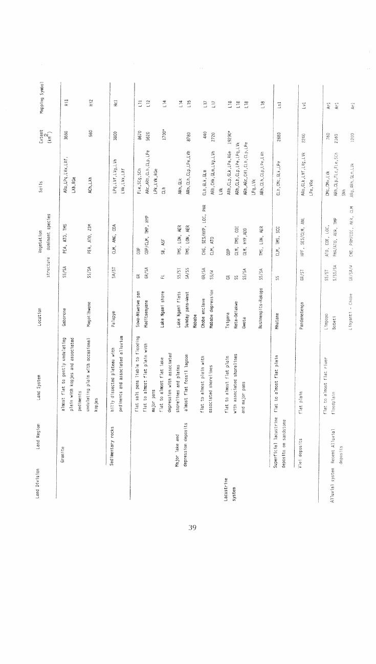
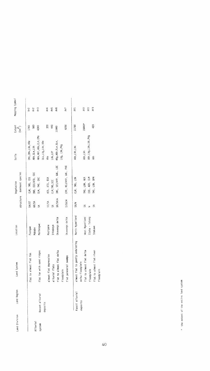
APPENDIX I
Legend of t e Land Systems Map of Botswana
34
Aeolian !
almost flat
lulating
pis
iculate
lat to ge
dune syst..h few pans
hube game res,
Sa2
Sa3
Sa4
5a4
5a4
Sa5
5a5
Sa7
Sa8
SA
SA
Sa9
Sala
Sall
ARo,
LVIS
,
3 3
on
Soils
SS
AH
SA
TM
SA
AMr,
AL
)m
MO
SA
AME, ALU,BSA
ARc
30
Rn
AME, ALU, BSA
9450
LON
2700
Jh
1740
TMS, LON, AER
ARc
7650
SS
CIA, RHO
ARc
uo
SS
AME, ALU, BSA
5
Kahgw.
SA
AME, ALU, BSA
AR1
9J50
TMS, LON, AER
ARh, AR1
ARo
31180
Lel
Mat
ec
uns
ARo
2763
0
LZna Region
Lano System
Land
f"7Y, PEA
TMS, LON, PER
4
Sa15
almost flat fossil valley
Ve!
ion
Soils
Lone Tree
South Ngamiland
TMS, LON, PLR
TMS, LON, AEB
Sal)
Sal7
Stoffels pan
SA/SS
TMS, LON, PTA
)0
Sal7
Shorobe
SS/SA
TMS, LON, CO
ARh, Clp, LVh
2380
Sal8
Deception
SS/SA
TMS, LON, CTA
ARh, AR1, CL1
5760
Sal9
Nxai pan north
ST
CLM, CO
ARI, Ato
240
Sa20
Chobe
W/SA
PTA, BKP
ARo
3460
Sa21
SE Ngamiland
SS/SA
TMS, LON, CO
ARh, AR1, ARo
3440
Sa22
Roo ibok
SS/SA
TMS, LON, AER
ARh,AR1,ARo,CIA,CL1
7840
Sa23
RGe
Tshane
SS/SA
TMS, LON, AER
ARo, LPe, RGe
1515
Scl
Dibete
SA
TMS, ATO, AME
AR1, ARD, LVk
3250
Sbl
Lephephe
SA
TMS, ATO, AME
ARl,ARo,LPq,LVf,LVk
4740
Sb2
Morupule, Makobela
SA
CLM, ANG, COA
AR1,ARo,CLh,CLp,LPe
5960
Sb3
LPq,LVf,LVx
Gatlhaba
SS/SA
TMS,ATO,ZIM
AR1,ARo,CL,h,CLp,LPe
2720
Sb4
LVk,LVx,RGe
Mokhomma
SS/SA
TMS, ATO, ZIM
ARo, CLp
460
Sb5
Superficial aeolian
almost flat plain
Khakhea
SS
TMS, LON, AER
Ato
150
Ssl
sand!deposits on
gently undulating to undulating
Mararaleng
SS/GR
AME, ALU, BSA/STU
Ato, RGe
930
Ss2
sandstone and other
plain
sedimentary rocks
Land System
7-77
!-,flat plain with
!led longitudinal dunes
almost flat to gently
.
eroded parabolic dune system
undulating parabolic dune system
with fossil rivers
Aeolian sand deposits
gently undulating to undulating
parabolic dune system
almost flat to gently undulating
plain
gently undulating transverse
dune system
almost flat plain with fossil
rivers
Sandveld
Superficial aeolian
flat to almost flat plain
sand deposits on
cal crete
flat plain with minor valleys
Superficial aeolian
flat to gently undulating valleys
sand depotits on
with associated plains
basalt and sedimentary
flat to gently undulating plain
rocks
with mixed alluvium
almost flat to gently undulating
plain with occasional valleys
almost flat plain with hills and
ridges
flat to almost flat plain
Makoba
SA
TMS, LON, AER
CLp
6080*
S66
Letlhakane
SA
CLM, TMP
CLp,LPe,LVk
Sb6
Superficial aeolian
almost flat to gently undulating
Aha
SA
TMS, LON, AER
ARo
440
Sdl
Sandveld
sand deposits on
plain
dolomite and sedimentary
rocks
Ngwezumba
SA/W
CLM, TMS, COI
ARh,ARo,LVf,LVh
1200
Sml
Betsha
SA
CLM, TMS, LON
ARh,AR1,ARo
4240
5m2
Francistown
SA
CLM, ANG, COI
LVx,Rgc,VRe
800
Hal
Chizwina
SA
CLM, ANG, COI
LVx,VRe
440
Ha2
Bobonong
SS/SA
CLM, ANG, COA
LVh,LVk,RGc,RGe
3020
Hbl
Serowe
SA
CLM, ANG, COA
RGe
280
Hb2
Pandamatenga
SA
CLM, ANG, COI
RGe
200
Hb4
Saasane
SA
CLM, ANG, COI
AR1,CLh,LPe,LVf,LVx
1200
Hb5
Serowe
SA
CLM, ANG, COA
LVk,LVx,VRe
420
Hb5
Point Drift
SA/ST
CLM, ANG, COA
CLp,LVk,RGe
730
Hs1
Mokoro
SA
CLM, ANG, COA
ACh,AR1,LPg,LVx,LXf
1120
Hs2
Bonwapitse
SA
COA, ANG, ATO
AR1,0d,LVf,LVx
800
Hs2
Kudumatse
SA
COA, ANG, ATO
AR1,LVf,LVk
1040
Hs3
Malotwana
SS/SA
PEA, ATO, TMS
ACh,A81,ARo,LVf,LVk
5320
Hs4
LVxiLkf
. molepolole SA
PEA, AJO, EMS
LE
ci460
Hs5
Sese
SA
,ETA
CMc,LVhiLVkiLkni
1700
Hs6
Land Division
Land Region
Land System
Location
Vegetation
Soils
Extent
Mapping Symbol
structure
dominant species
(km2)
Partly submerged
almost flat plain with major pans
aeolian sand deposits
almost flat to gently undulating
longitudinal dune system
Amphibole - rich
undulating plain with occasional
meta-basic rocks
hill ranges
gently undulating plain
dissected undulating plateau
escarpments with associated
Basalt
undulating plains
gently undulating plain
almost flat plain with associated
alluvium
Hardveld
dissected undulating plateau with
escarpments
undulating plain with isolated
hills and flat alluvium
gently undulating to undulating
plain with flat alluvium
Sandstone
almost flat to gently undulating
plain with occasional kopjes and
fossil valleys
hills with transitional undulating
to
hilly
escarpi7
flat
IQger
iin
Dolerite
Granitic greiss
Hardveld
flat to a
it plain
flat
1ridge with
net.
2
gently undulating to undulating
plain with eroded valleys
dissected undulating plain with
associated pedimento
flat to gently undulati.yg p,
-
almost flat to gently undul,
plain with eroded valleys
undulating to rolling plain with
frequent kopjes and almost flat
pedimento
rugged hilly areas
gently undulating plain with
occasional kopjes
flat to almost flat plain
almost flat to gently undulating
plain
gently undulating valleys with
almost flat pedimento
gently undulating plain with fossil Mmathethe
valleys
Acid volcanic lavas
hills with undulating pedimento
Kanye
Vegc!
Soils
SA
SS/SA
1260
9920
Hs7
Hs8
,LPd
SA
COA
LPg,1,91,LVx,LXf,
,8Ge
13270
Hgl
SA
ANG, ATO
RGe
1280
Fig2
SA/ST
COA, ANG, ATO
LVf,LVh
640
Hg3
SA
COA, ANG, ATO
AR0,LVx,LXf,LO,48e
4360
Hg4
SA
CLM, AN
,COA
LVh,LXn
1350
Hg6
ST
CLM, ANG, BUA
CMo,LVx,LXh,RGd,RGe
1480
Hg7
ST
CLM, ANG, BUA
LVg,LVx,RGd,RGe
10400
Hg8
ST
CLM, ANG, COI
CMc,CMo,LVf,Llik,LVx
5240
Hg9
RGd,RGe
SA
AEB, ATO, USA
LVk,LVx,LXf,LXh
800
Hg10
SS
/SA
PE
A, A
TO
, AK
ARGe
660
Hgll
SS
/SA
RE
A,ATO, AKA
AR0,CL1,Pq,LVh,LIN
3920
Hg12
LXh,RGc,RGe,VRe
SS
CO
A,
ANG,
AT
OLPg,LVk,LVx
1560
881
SS
/SA
PE
A, A
TO
,TMS
LVf,LVk,VRe
680
Hd2
SA
EMS, LON, PER
CEp,I,Pq
200
Hn1
SA/SS
HEA, AT0, 71m
E.Pq,LVo, Xf,RGe
1620
Hvl
Land Division
Land Region
Land System
Dolomite and
hills with associated almost flat
Aha
sedimentary rocks
to gently undulating pedimento
hills with flat alluvium and
Shoshong
almost flat pedimento
almost flat to gently undulating
Mahetwe
pedimento
Tewane
Mahalapye
Shakwe
Maope
Ramokgwebana
Shashe
Matsitama
Olifants Drift
Ramotswa
Sedimentary rocks
hilly dissected plateau with
pediments and associated alluvium
Superficial lacustrine
flat to almost flat plain
deposits on sandstone
Vlei deposits
flat olain
flat to almost plain with
associated shorelines
Location
Vegetation
Soils
Extent
Mapping Symbol
structure
dominánt species
(km2)
Gaborone
SS/SA
PEA, ATO, TMS
ARo,LPq,LVx,LXf,
3660
Vil
LXh,RGe
Magotlhwane
SS/SA
PEA, ATO, ZIM
ACh,LXh
560
812
Palapye
SA/ST
CLM, ANG, COA
LPci,LVf,LVg,LVh
3800
Hcl
LVk,LVx,LXf
Sowa-Ntwetwe pan
GR
ODP
FLe,SCg,5Ch
8670
L11
Maditsenyane
GR/SA
ODP/CLM, IMP, HYP
ARc,ARh,Cth,Ctp,LPe
5620
L12
LPk,LVk,RGe
Lake Ngami shore
FL
SB, ASF
CLh
1700*
L14
Lake Ngami flats
SS/ST
TMS, LON, AER
ARh,GLk
L14
Sunday pans-West
SA/SS
EMS, LON, AER
ARh,CLh,CO,LPe,LVh
8780
L15
Mababe
Chobe enclave
GR/SA
CHG, SES/OP, LOC, PHR
CLh,GLk,GLm
440
1_17
Mababe depression
SS/4
CLM, ATO
ARh,CHk,GLm,LVg,LVh
2720
L17
LVk
Tsigara
GR
ODP
ARh,C14,GLk,LPe,RGe
19290*
L18
Nata-Odiakwe
SS
CLM, PIS, COI
ARh,CLh,CLp,LPe,LF-g,LVk
L18
Gweta
SS/SA
CLM, HYP,ADD
ARh,ARc,CH1,CLn,Ctp,LPe
L18
LPg,LVk
Bushmenpits-Rakops
SS/5A
VIS, LON, AER
ARh,CLh,Ctp,LPe,LVh
L18
Mhatane
SS
CLM, TMS, SCC
CLh,CMc,GLk,LPe
2680
Ls1
Pandamatenga
GRIST
HPE, SES/CLM, ANL
ARo,GLk,LVf,LVg,LVk
Lvi
LPe,VRe
Limpopo
Boteti
,LOE,
TMP
2Mv,TVk
,101:-,ltr,Fte,SC
Arl
Arl
Linyanti - Chobe
,CO,
Yym,LVE
Arl
Land Region
Land System
Land Division
Granite
almost flat to gently undulating
plain with kopjes and associated
pediments
undulating plain with occasional
kopjes
Major lake and
depression deposits
flat salt pans liable to flooding
flat to almost flat plain with
major pans
flat to almost flat lake
depression with associated
shorelines and plains
almost flat fossil lagoon
Lacustrine
system
flat to almost flat plain
with associated shorelines
and major pans t flat river
flat'
flompla-
,ystem
Re(e.
./1
depDsit
Allu
vial
syst
emR
ecen
t allu
vial
depo
sits
Fos
sil a
lluvi
alal
mos
t fla
t to
gent
ly u
ndul
atin
g
depo
sits
delta
floo
dpla
in
flat t
o al
mos
t fla
t del
ta
flood
plai
n
flat t
o al
mos
t fla
t riv
erflo
odpl
ain
*th
e ex
tent
of t
he e
ntire
land
sys
temfla
t to
alm
ost f
lat f
an
flat f
an w
ith s
and
ridge
s
alm
ost f
lat d
epre
ssio
n
allu
vial
flat
sfla
t to
alm
ost f
lat d
elta
flood
plai
n
flat p
eren
nial
sw
amps
Loca
tion
stru
ctur
e
Soi
lsM
appi
ng S
ymbo
l
Puo
ngw
eS
A/S
TC
LM, T
MS
, CO
IC
Mc,
CM
v,LV
k,V
Re
1760
Ar2
Mab
abe
GR
/SA
CN
D, C
EC
/AT
O, C
OI
AR
h,G
Le,L
Vh
560
4r2
Mai
teng
we
SA
CLM
, TM
S, D
RC
AR
h,A
R1,
AR
0,C
Lh,C
Mo
4240
Ar3
GLk
,LV
g,LV
x,V
Re
Mod
ipan
eS
S/S
AA
EB
, AT
O, O
SA
VR
e32
0A
r4
Dik
abey
aS
AC
LM,T
MS
,SC
CLV
k,LX
f44
0A
r5
Oka
vang
o de
ltaG
R/S
A/W
¡MC
, SE
S/H
YP
, GA
L, L
OC
AR
g,A
Rh,
FLe
,GLe
,
LVg,
LV
k,P
Hg
1164
0A
r6
Oka
vang
o de
ltaS
/SA
/WC
PP
, MIJ
/HY
P, G
AL,
PX
R62
50A
r7
Nor
th N
gam
iland
SA
/WC
LM, T
MS
, LO
NA
Rh,
LVh,
LVk
1176
0A
fl
Wes
t Nga
mila
ndS
AT
MS
, LO
N, A
ER
AR
h,LV
h16
440*
Af2
Ets
ha -
Tot
eng
WC
OI,
AE
R, C
LMA
Rh,
LVg,
LVh,
LVk,
PH
gA
f2
Sha
kaw
eS
AT
MS
, LO
N, B
PM
AR
h42
0A
f3
Land
Div
isio
nLa
nd R
egio
nLa
nd S
yste
m

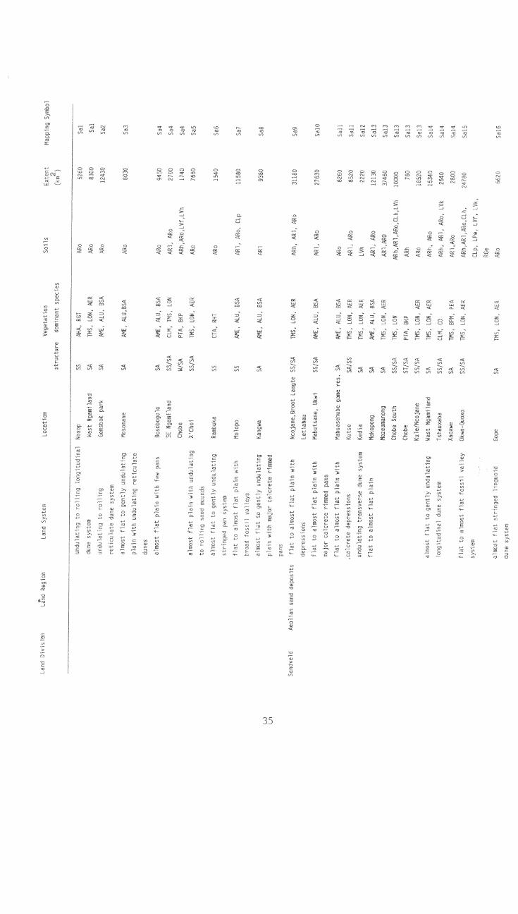
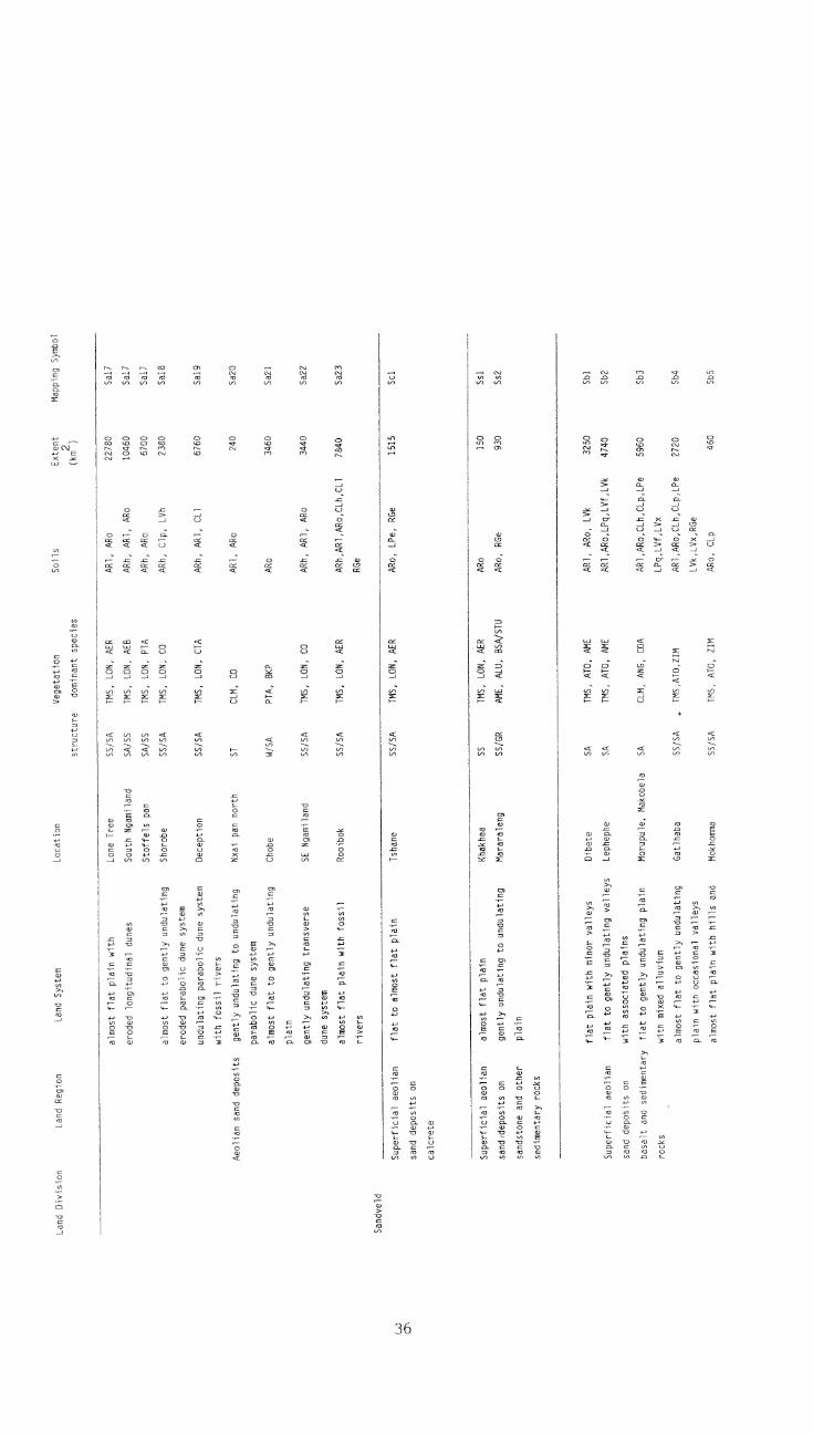
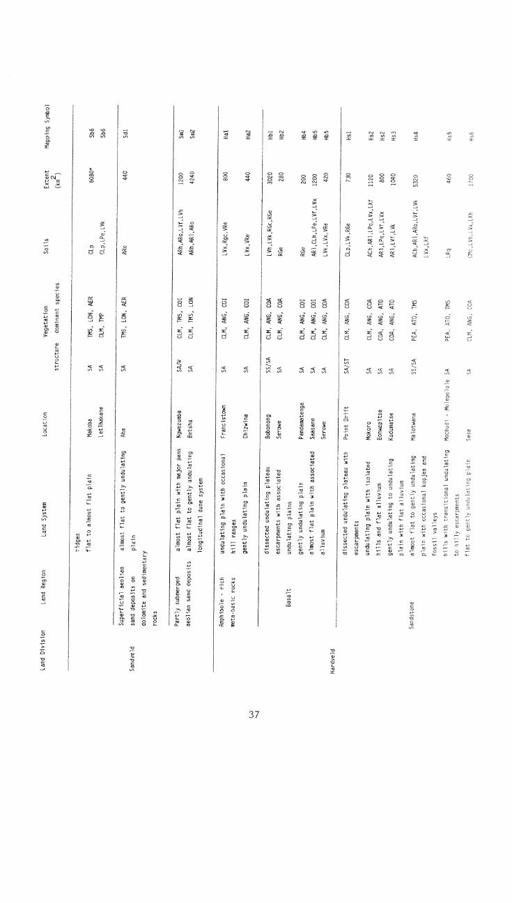
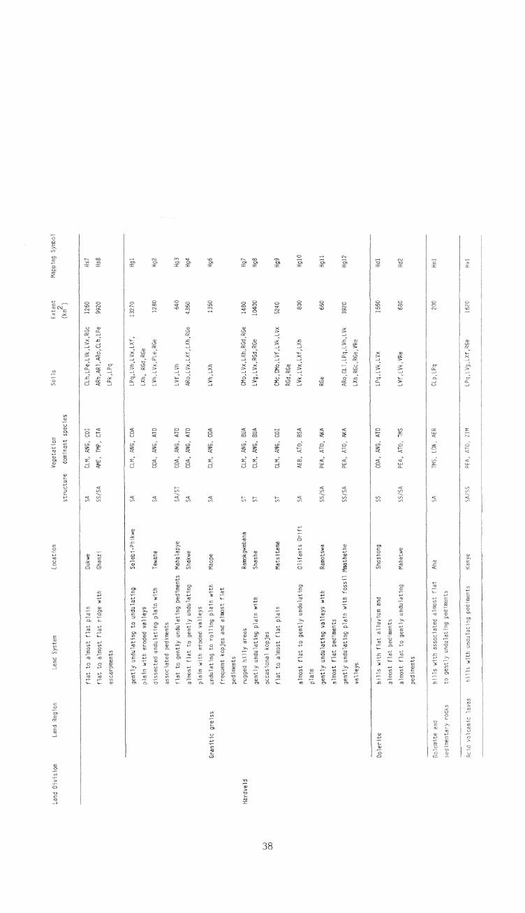
APPENDIX 2
Codes used in the Land Systems Map of Botswana
41
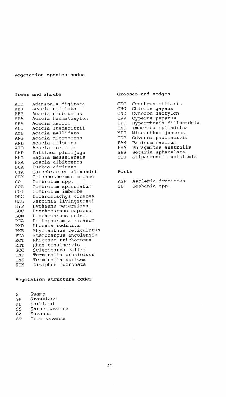
Vegetation species codes
Trees and shrubs
ADD Adansonia digitataAER Acacia eriolobaAEB Acacia erubescensAHA Acacia haematoxylonAKA Acacia karrooALU Acacia luederitziiAME Acacia melliferaANG Acacia nigrescensANL Acacia niloticaATO Acacia tortilisBKP Baikiaea plurijugaBPM Baphia massaiensisBSA Boscia albitruncaBUA Burkea africanaCTA Catophractes alexandriCLM Colophospermum mopaneCO Combretum spp.COA Combretum apiculatumCOI Combretum imberbeDRC Dichrostachys cinereaGAL Garcinia livingstoneiHYP Hyphaene petersianaLOC Lonchocarpus capassaLON Lonchocarpus nelsiiPEA Peltophorum africanumPXR Phoenix redinataPHR Phyllanthus reticulatusPTA Pterocarpus angolensisRGT Rhigozum trichotomumRHT Rhus tenuinervisSCC Sclerocarya caffraTMP Terminalia prunioidesTMS Terminalia sericeaZIM Ziziphus mucronata
Vegetation structure codes
S SwampGR GrasslandFL ForblandSS Shrub savannaSA SavannaST Tree savanna
42
Grasses and sedges
CEC Cenchrus ciliarisCHG Chloris gayanaCND Cynodon dactylonCPP Cyperus papyrusHPF Hyparrhenia filipendulaIMC Imperata cylindricaMIJ Miscanthus junceusODP Odyssea paucinervisPAM Panicum maximumPHA Phragmites australisSES Setaria sphacelataSTU Stipagrostis uniplumis
Forbs
ASF Asclepia fruticosaSB Sesbania spp.

Soil unit codes
ACh Haplic AcrisolARc Calcaric ArenosolARg Gleyic ArenosolARh Haplic ArenosolAR1 Luvic ArenosolARo Ferralic ArenosolCHk Calcic ChernozemCH1 Luvic ChernozemCLh Haplic CalcisolCL1 Luvic CalcisolCLp Petric CalcisolCMc Calcaric CambisolCMo Ferralic CambisolCMv Vertic CambisolCMx Chromic CambisolFLc Calcaric FluvisolFLe Eutric FluvisolGLe Eutric GleysolGLk Calcio GleysolGLm Mollic GleysolLPe Eutric LeptosolLPk Rendzic LeptosolLPq Lithic LeptosolLVf Ferric LuvisolLVg Gleyic LuvisolLVh Haplic LuvisolLVk Calcio LuvisolLVx Chromic LuvisolLXf Ferric LixisolLXh Haplic LixisolPHg Gleyic PhaeozemPH1 Luvic PhaeozemPLe Eutric PlanosolRGc Calcaric RegosolRGd Dystric Regoso1RGe Eutric RegosolSC Gleyic SolonchakSCh Haplic SolonchakSNh Haplic SolonetzVRe Eutric Vertisol
43