Embed Size (px)
Citation preview
Proceedings World Geothermal Congress 2010 Bali, Indonesia, 25-29 April 2010
1
Exploration of Four Geothermal Properties in Nevada
Joel A. Ronne, Jeffrey B. Witter, and Gary R. Thompson
Sierra Geothermal Power, Suite 500-666 Burrard Street, Vancouver, B.C., V6C 3P6, Canada
[email protected], [email protected], and [email protected]
Keywords: geothermal, exploration, Nevada, geophysics, gravity, magnetotellurics, drilling, temperature gradient, geothermometry
ABSTRACT
Sierra Geothermal Power (SGP) is actively exploring four geothermal properties in Nevada; Reese River, Silver Peak, Alum and Barren Hills. Each prospect is at a different stage of exploration. The exploration techniques used have included analysis of historic temperature gradient hole (TGH) data, the drilling of slim wells, gravity, surface geology and structure mapping, remote sensing, temperature surveys at conducted at a depth of 2 m, magnetotellurics (MT), reflection seismic and airborne electromagnetic methods. Independent resource assessments were commissioned from GeothermEx and their total resource assessment of the four properties is a 90% confidence of 136 MW or greater and a 50% confidence of 307 MW or greater. Although SGP has been exploring all four prospects since 2006, the majority of the exploration activities have been conducted at the Reese River geothermal prospect in north-central Nevada.
The Reese River prospect is a “blind” resource that lies within a region of NE-trending faults called the Humboldt structural zone. SGP has drilled a total of five wells that range in depth from 487 m to 1580 m and conducted geochemical and geophysical surveys. These have detected areas of intense subsurface hydrothermal alteration including advanced argillic and silicified zones.
Shallow TGH drilling from the 1970’s and 1980’s has mapped a broad geothermal anomaly with a surface expression greater than 10 km long by 3 km wide at the Reese River prospect. Deeper drilling has confirmed commercial grade temperatures with well 13-4 reaching a bottom-hole temperature of ~150 °C. The chemistry of the Reese River geothermal fluids are similar to that being produced at the Beowawe reservoir in Nevada. Compatible geothermometry of up to 155 °C were obtained for water samples from three wells and cation geothermometry from a 85 °C shallow water well suggested that reservoir temperatures at depth may exceed 200 °C.
Depth-to-basement has been estimated from modeled gravity profiles, with offsets fitting fault zones inferred from lost circulation zones in wells. MT data indicate a widespread zone of low resistivity smectite alteration at <200 m depth with an underlying relatively resistive ~70 °C clastic aquifer. This is sourced from deeper resistive aquifers, probably fractured carbonates, igneous intrusives and metamorphic rocks at 125 to 150 °C that are less well resolved below a 3D distribution of low resistivity smectite clay 300 to 1800 m thick. A revised 3D MT correlation of the MT data, modeled gravity, and drillhole data allow for new interpretations of the subsurface structure and permeability, thereby aiding in identifying new drill targets.
1. INTRODUCTION
Although SGP is actively exploring four geothermal properties in Nevada, the majority of the SGP surveys through mid-2009 have been conducted at the Reese River prospect (Witter et al., 2009). SGP holds 25 km2 of US federal geothermal leases at Reese River in Lander County, 320 km northeast of Reno. Geologically, it lies within a region of NE-trending faults, called the Humboldt structural zone, as well as an area of elevated heat flow called the Battle Mountain High (Faulds et al., 2003). This region contains several well-known developed geothermal fields, including Dixie Valley and Beowawe.
The other three prospects are located in the Walker Lane structural belt. The Silver Peak prospect is located in Esmeralda County, Nevada, 240 km northwest from Las Vegas and consists of 32 km2 of federal geothermal leases. There are two 55 kV transmission lines and a substation within SGP's lease boundaries. The Alum prospect covers 29 km2 of federal geothermal leases 10 km to the north of the Silver Peak prospect. There is a 55 kV line that runs within a few hundred meters of the lease boundary. The Barren Hills prospect consists of 21 km2 of federal geothermal leases in Lyon County, Nevada, and is located about 16 km south of Yerington and 100 km southeast of Reno.
This paper describes briefly outlines the exploration progress at all four prospects and then details the results of a multi-faceted geothermal exploration program conducted by SGP at the Reese River prospect.
2. PROSPECT HISTORY & PREVIOUS WORK
2.1 Reese River
The Reese River geothermal prospect is an almost “blind” resource in that it lacks typical geothermal surface manifestations such as hot springs or obvious hydrothermal alteration. Nestled in an inter-montane basin on the west side of the Shoshone Range, the prospect was first discovered by uranium prospectors when they encountered hot water in some of their drill holes (Sadlier-Brown 2006). Outcrops of sinter and rocks with intense argillic alteration were not discovered until 2006. Following up the lead provided by the warm wells, Phillips Petroleum and Amax Exploration explored the prospect in the 1970-1980’s drilling 52 TGH from 27 to 152 m deep, with most of the holes about 100 m deep. This shallow drilling program mapped elevated temperature over an area 10 km long by 3 km wide. In 2003, Western Geothermal Partners LLC (Western) acquired the Reese River geothermal lease on a non-competitive basis. Western conducted geological mapping and radiometric surveys, as well as soil and bio-geochemical surveys supported by a 2005 award from the U.S. Department of Energy’s Geothermal Resource Exploration and Development (GRED III) grant program. The geologic mapping program conducted by Western established the relationship between different formations
Ronne et al.
2
exposed at the surface and identified the location and extent of a major range-front fault as well as other minor faults.
In early 2006, SGP acquired an option to purchase from Western a 100% interest in the project and has since fully exercised the option. In 2008, SGP contracted independent consultant GeothermEx to conduct a resource assessment of the Reese River prospect. The results of the assessment provided a resource estimate that Reese River could support a 26 MW plant at the 90% confidence level (P90) for 20 years and 58 MW at the 50% confidence level (P50) (GeothermEx, 2008a).
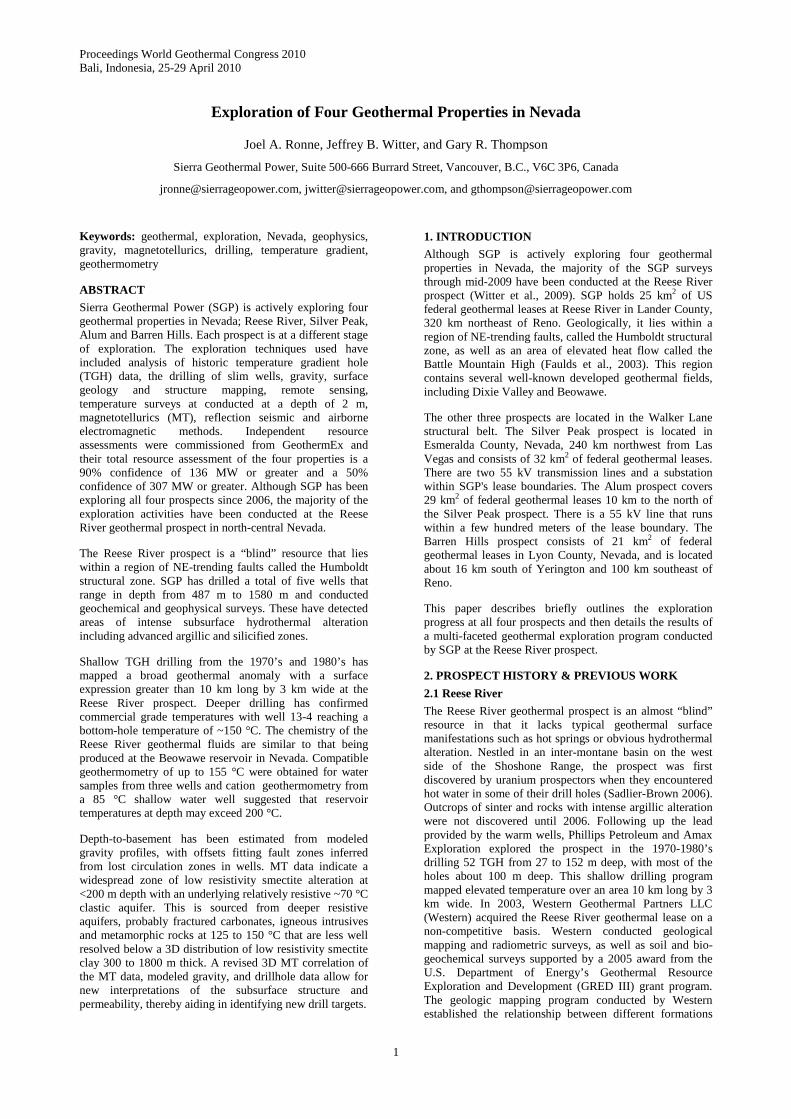
Figure 1: Location map for Reese River, Silver Peak, Alum and Barren Hills Prospects in Nevada.
2.2 Silver Peak
Silver Peak was first explored for geothermal potential in the 1980s by Phillips Petroleum Company with six TGH. Exploration resumed in 2005 with two more TGH drilled by Western. Many geothermal features are visible on the property including dry thermal vents, travertine-manganese sinter deposits, fossilized algae mats and complex faulting. A shallow well encountered temperatures of up to 75 °C at depths less than 21 m. Chemical geothermometers applied to the thermal waters suggest that temperatures may reach 200 °C to 230 °C at depth. SGP has completed a gravity survey and detailed geologic mapping. In 2006, GeothermEx conducted an independent assessment and estimated a 90% probability (confidence level) that the Silver Peak geothermal resource could support 15 MW of electrical generation and a 50% probability of the resource exceeding 40 MW (GeothermEx, 2006).
In April 2008, SGP obtained a positive environmental assessment decision, a Finding of No Significant Impact, from the Bureau of Land Management (BLM) on its proposed exploration and drilling plan for Silver Peak. Ongoing exploration activities include TGH drilling, a 2D seismic survey, a magnetic survey, and a MT survey with 3D inversion. Slim well and production assessment wells are planned for the next stages of exploration which will be
partially supported by a US Department of Energy grant of US$5 million.
2.3 Alum
Geothermal exploration of the Alum prospect started with drilling shallow TGH the greater region in the 1970s, and continued in the early 1980s with more local shallow drilling. In total, 46 TGH have been drilled to date by Amax Exploration, Phillips Petroleum, and O'Brien Resources. Chemical geothermometry indicated reservoir temperatures between 155 °C and 225 °C. SGP completed a gravity survey and detailed surface and structural mapping of the prospect. The work to date has indicated the presence of a large geothermal reservoir in the area. According to an assessment conducted by GeothermEx in 2004, the potential geothermal reserves at Alum are estimated to have a 90% probability (confidence level) that it can support a plant of at least 41 MW, and a 50% probability of exceeding 90 MW.
In July 2009, SGP received a positive environmental assessment decision with a Finding of No Significant Impact from the BLM on its proposed exploration plans. Ongoing exploration activities include a magnetic survey, combined gravity and magnetic modeling, and a MT survey with 3D inversion. A slim hole well and production assessment wells are planned for the next stages of exploration which will be partially supported by a US Department of Energy grant of US$5 million.
2.4 Barren Hills
Previous exploration of the Barren Hills area was conducted by Chevron Oil Company during the late 1970s and early 1980s. Chevron drilled 44 TGH between 150 and 600 m and conducted various geological and geophysical studies. SGP has conducted exploration in the area, including a gravity survey, geological mapping and geochemical studies. In 2007, GeothermEx was commissioned by SGP to conduct a geothermal resource assessment and provide an independent technical report on the Barren Hills project. The assessment concluded that the project has a 90% probability (confidence level) of generating at least 55 MW, and a 50% probability that the reserve can support a plant of 117 MW (GeothermEx, 2008b).
SGP is currently conducting environmental assessment activities which are expected to be concluded in the first half of 2010 which will allow drilling of production assessment wells and other exploration activities to proceed.
3. EXPLORATION AT REESE RIVER
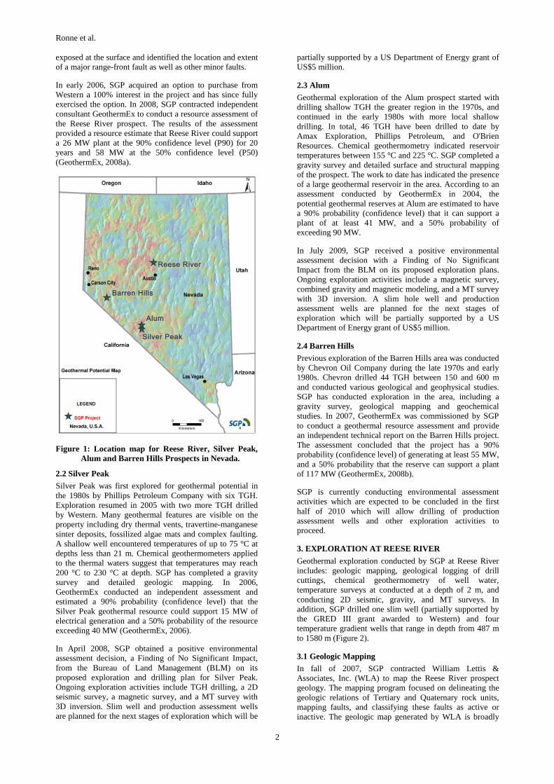
Geothermal exploration conducted by SGP at Reese River includes: geologic mapping, geological logging of drill cuttings, chemical geothermometry of well water, temperature surveys at conducted at a depth of 2 m, and conducting 2D seismic, gravity, and MT surveys. In addition, SGP drilled one slim well (partially supported by the GRED III grant awarded to Western) and four temperature gradient wells that range in depth from 487 m to 1580 m (Figure 2).
3.1 Geologic Mapping
In fall of 2007, SGP contracted William Lettis & Associates, Inc. (WLA) to map the Reese River prospect geology. The mapping program focused on delineating the geologic relations of Tertiary and Quaternary rock units, mapping faults, and classifying these faults as active or inactive. The geologic map generated by WLA is broadly
Ronne et al.
3
similar to the previous geologic maps; however, the WLA mapping program was much more stringent in their identification of faults. Although alignments associated with the horst and graben structure and likely structural alignments in the basin are prominent in the shaded relief topography (Figure 2), no reliable evidence for active faulting was found in the field.
3.2 Active Seismic Survey
In the fall of 2007, SGP contracted Optim, Inc. to perform an active source, 2D reflection and refraction seismic survey at the Reese River prospect. Seven lines of seismic data were acquired totaling 28 line km. Four of the seismic lines were oriented perpendicular to known geologic structures; the other three were oriented at other angles. The seismic energy source was 1 kg seismic explosive charges in 5 m shot holes spaced 67 m apart along the seismic lines. The geophone station spacing was 33 m. Seismic velocities were constrained using Optim’s SeisOpt® Simulated Annealing Optimization refraction analysis of first arrival picks. Velocities for the Kirchhoff pre-stack depth migration were assumed at greater depths. Estimated seismic velocities increased with depth and ranged from about 1200 m/s near the surface to 4,300 m/s at the maximum resolvable depth of about 900 m. Coherent seismic alignments were initially interpreted as reflections to depths of 1500 to 2500 m.
The seismic survey was less effective than initially hoped in identifying subsurface geologic structure. In 2008, Cumming Geoscience assisted SGP in assessing the uncertainty in the seismic data and concluded that little reflection seismic signal was apparent in the field shot gathers. The reflection images appeared to be dominated by noise effects. Many of the coherent alignments initially interpreted as ~10 Hz reflections are likely to be ground roll arrivals that were insufficiently attenuated during acquisition and processing. Higher frequency dipping alignments appear to be first break reverberations that were not appropriately suppressed in preprocessing. A seismic source and noise test survey might have helped assess the seismic characteristics of the area and tune the seismic survey parameters, but the logistics of changing shot holes source parameters often make optimization tests impractical for such a small survey. Due to uncertainties in the quality of the reflection seismic results, these data have not been used to identify subsurface geologic structures. However, the refraction inversion images of P-wave velocity are more reliable than the reflection data and show the overall basin geometry, albeit at much lower resolution than was expected from the reflection seismic data.
3.3 Gravity Survey
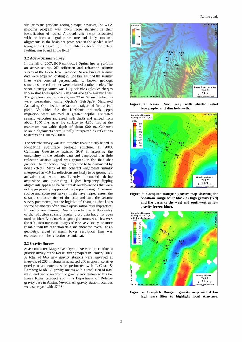
SGP contracted Magee Geophysical Services to conduct a gravity survey of the Reese River prospect in January 2008. A total of 666 new gravity stations were surveyed at intervals of 200 m along lines spaced 250 m apart. Relative gravity measurements were performed with LaCoste & Romberg Model-G gravity meters with a resolution of 0.01 mGal and tied to an absolute gravity base station within the Reese River prospect and to a Department of Defense gravity base in Austin, Nevada. All gravity station locations were surveyed with dGPS.
Figure 2: Reese River map with shaded relief topography and slim hole wells.
Figure 3: Complete Bouguer gravity map showing the Shoshone range horst block as high gravity (red) and the basin to the west and southwest as low gravity (green-blue).
Figure 4: Complete Bouguer gravity map with 4 km high pass filter to highlight local structure.
Ronne et al.
4
The gravity survey has provided important constraints on the overall subsurface structure and depth-to-bedrock at the Reese River prospect. In general, a relative gravity low (blue in Figure 3) lying west of the Shoshone Range high (in red) can be interpreted as a sediment-filled basin that deepens to the southwest. The 4 km high-pass filtered gravity data, together with the topography, in Figures 4 and 2 respectively, suggest that the basin morphology is likely to be more complex, with NE-trending structures causing a series of high and low trends that reflect, in part, offsets caused by faults west of the main basin bounding fault.
To better constrain structures and estimate depth-to-bedrock across the Reese River prospect, SGP computed gravity models along 33 profiles roughly perpendicular to strike (Witter et al., 2009). Depth-to-bedrock was estimated using a simple two-layer geologic model assuming a 300 – 375 kg/m3 density contrast relative to the 2400 kg/m3 density assumed for the complete Bouguer density. The profiles were fixed to zero depth in areas where bedrock outcrops. The morphology of the calculated bedrock surface was then interpreted to identify geologic structures as well as associated faults. The structures identified in the modeled profiles match the gravity highs and lows observed on the 4 km high-pass filtered gravity image and tie the depth-to-bedrock observed in the five deep wells within ~200 m.
3.4 Magnetotelluric Survey
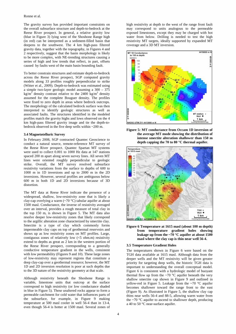
In February 2008, SGP contracted Quantec Geoscience to conduct a natural source, remote-reference MT survey of the Reese River prospect. Quantec Spartan MT systems were used to collect 0.001 to 1000 Hz data at 147 stations spaced 200 m apart along seven survey lines. All seven MT lines were oriented roughly perpendicular to geologic strike. Overall, the MT survey resolved subsurface resistivity variations from the surface to depths of 600 to 1000 m in 1D inversions and up to 2000 m in the 2D inversions. However, several profiles are ambiguous below 600 m in both 1D and 2D inversions because of 3D distortion.
The MT data at Reese River indicate the presence of a widespread, shallow, low-resistivity zone that is likely a clay-cap overlying a warm (~70 °C) tabular aquifer at about 1500 masl. Conductance, the inverse of resistivity averaged over an interval, provides a rough measure of total clay in the top 150 m, is shown in Figure 5. The MT data also resolve deeper low-resistivity zones that likely correspond to the argillic alteration zone characterized by smectite clay. Smectite is a type of clay which commonly forms impermeable clay caps on top of geothermal reservoirs and shows up as low resistivity zones on MT profiles. Large, contiguous zones of relatively low (<5 ohm.m) resistivity extend to depths as great as 2 km in the western portion of the Reese River prospect, corresponding to a generally conductive temperature gradient in the wells, consistent with low permeability (Figures 9 and 10). These large zones of low-resistivity may represent regions that constitute a deep clay-cap over a geothermal resource; however, the MT 1D and 2D inversion resolution is poor at such depths due to the 3D nature of the resistivity geometry at that scale.
Although resistivity beneath the Shoshone Range is variable, limestone units that outcrop at the surface correspond to high resistivity (or low conductance shaded in blue in Figure 5). These unaltered rocks appear to form a permeable catchment for cold water that influences parts of the subsurface, for example, in Figure 9 making temperature at 500 masl cooler in well 56-4 than in 13-4, even though 56-4 is hotter at 1500 masl. Several zones of
high resistivity at depth to the west of the range front fault may correspond to units analogous to the permeable exposed limestones, except they may be charged with hot water from below. Drilling is needed to test the high resistivity MT targets, ideally supported by expanded MT coverage and a 3D MT inversion.
Figure 5: MT conductance from Occam 1D inversion of the average MT mode showing the distribution of intense smectite alteration shallower than 150 m depth capping the 70 to 80 °C thermal aquifer.
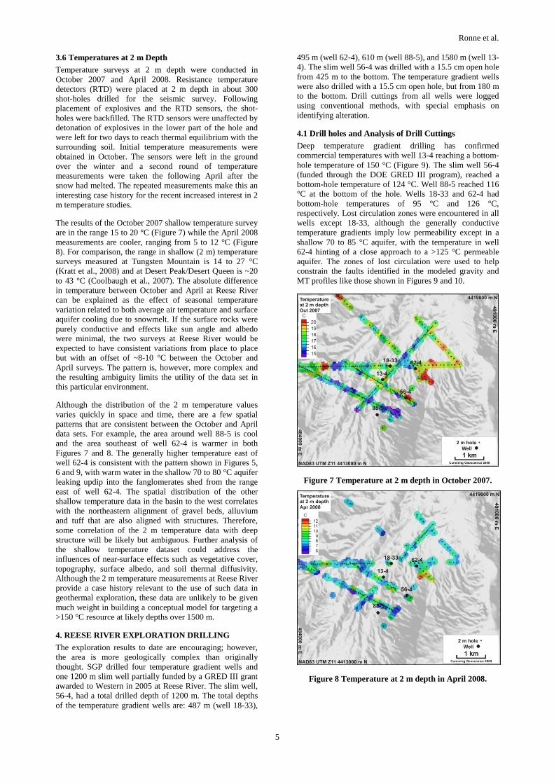
Figure 6 Temperature at 1615 masl (about 100 m depth) from temperature gradient holes showing leakage up from the ~70 °C aquifer at about 1500 masl where the clay cap is thin near well 56-4.
3.5 Temperature Gradient Holes
The temperatures shown in Figure 6 were based on the TGH data available at 1615 masl. Although data from the deeper wells and the MT resistivity will be given greater priority for targeting deep wells, the historic TGH data is important to understanding the overall conceptual model. Figure 6 is consistent with a hydrologic model of buoyant thermal flow up from the ~70 °C aquifer beneath the very shallow smectite cap shown in Figure 9 and outlined in yellow-red in Figure 5. Leakage from the ~70 °C aquifer becomes shallower toward the range front to the east (Figure 9). As illustrated in Figure 5, the shallow clay cap thins near wells 56-4 and 88-5, allowing warm water from the ~70 °C aquifer to ascend to shallower depth, producing a 40 to 50 °C near-surface aquifer.
Ronne et al.
5
3.6 Temperatures at 2 m Depth
Temperature surveys at 2 m depth were conducted in October 2007 and April 2008. Resistance temperature detectors (RTD) were placed at 2 m depth in about 300 shot-holes drilled for the seismic survey. Following placement of explosives and the RTD sensors, the shot-holes were backfilled. The RTD sensors were unaffected by detonation of explosives in the lower part of the hole and were left for two days to reach thermal equilibrium with the surrounding soil. Initial temperature measurements were obtained in October. The sensors were left in the ground over the winter and a second round of temperature measurements were taken the following April after the snow had melted. The repeated measurements make this an interesting case history for the recent increased interest in 2 m temperature studies.
The results of the October 2007 shallow temperature survey are in the range 15 to 20 °C (Figure 7) while the April 2008 measurements are cooler, ranging from 5 to 12 °C (Figure 8). For comparison, the range in shallow (2 m) temperature surveys measured at Tungsten Mountain is 14 to 27 °C (Kratt et al., 2008) and at Desert Peak/Desert Queen is ~20 to 43 °C (Coolbaugh et al., 2007). The absolute difference in temperature between October and April at Reese River can be explained as the effect of seasonal temperature variation related to both average air temperature and surface aquifer cooling due to snowmelt. If the surface rocks were purely conductive and effects like sun angle and albedo were minimal, the two surveys at Reese River would be expected to have consistent variations from place to place but with an offset of ~8-10 °C between the October and April surveys. The pattern is, however, more complex and the resulting ambiguity limits the utility of the data set in this particular environment.
Although the distribution of the 2 m temperature values varies quickly in space and time, there are a few spatial patterns that are consistent between the October and April data sets. For example, the area around well 88-5 is cool and the area southeast of well 62-4 is warmer in both Figures 7 and 8. The generally higher temperature east of well 62-4 is consistent with the pattern shown in Figures 5, 6 and 9, with warm water in the shallow 70 to 80 °C aquifer leaking updip into the fanglomerates shed from the range east of well 62-4. The spatial distribution of the other shallow temperature data in the basin to the west correlates with the northeastern alignment of gravel beds, alluvium and tuff that are also aligned with structures. Therefore, some correlation of the 2 m temperature data with deep structure will be likely but ambiguous. Further analysis of the shallow temperature dataset could address the influences of near-surface effects such as vegetative cover, topography, surface albedo, and soil thermal diffusivity. Although the 2 m temperature measurements at Reese River provide a case history relevant to the use of such data in geothermal exploration, these data are unlikely to be given much weight in building a conceptual model for targeting a >150 °C resource at likely depths over 1500 m.
4. REESE RIVER EXPLORATION DRILLING
The exploration results to date are encouraging; however, the area is more geologically complex than originally thought. SGP drilled four temperature gradient wells and one 1200 m slim well partially funded by a GRED III grant awarded to Western in 2005 at Reese River. The slim well, 56-4, had a total drilled depth of 1200 m. The total depths of the temperature gradient wells are: 487 m (well 18-33),
495 m (well 62-4), 610 m (well 88-5), and 1580 m (well 13-4). The slim well 56-4 was drilled with a 15.5 cm open hole from 425 m to the bottom. The temperature gradient wells were also drilled with a 15.5 cm open hole, but from 180 m to the bottom. Drill cuttings from all wells were logged using conventional methods, with special emphasis on identifying alteration.
4.1 Drill holes and Analysis of Drill Cuttings
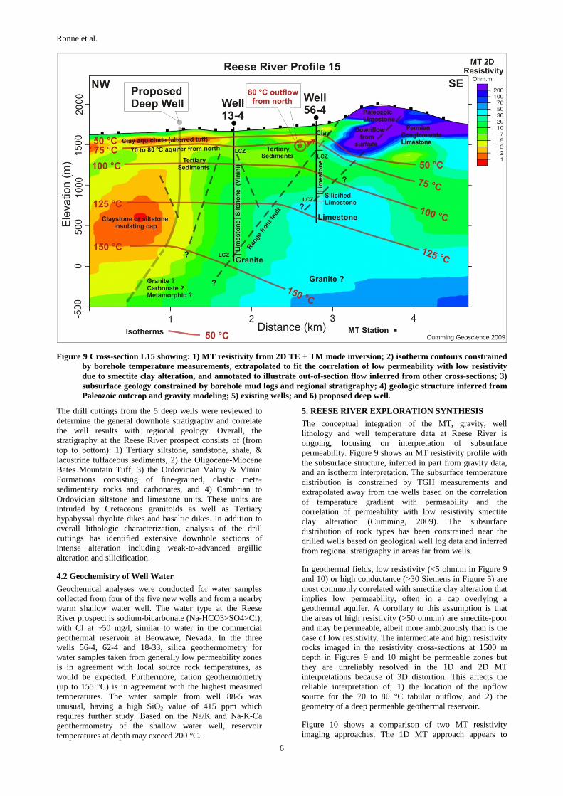
Deep temperature gradient drilling has confirmed commercial temperatures with well 13-4 reaching a bottom-hole temperature of 150 °C (Figure 9). The slim well 56-4 (funded through the DOE GRED III program), reached a bottom-hole temperature of 124 °C. Well 88-5 reached 116 °C at the bottom of the hole. Wells 18-33 and 62-4 had bottom-hole temperatures of 95 °C and 126 °C, respectively. Lost circulation zones were encountered in all wells except 18-33, although the generally conductive temperature gradients imply low permeability except in a shallow 70 to 85 °C aquifer, with the temperature in well 62-4 hinting of a close approach to a >125 °C permeable aquifer. The zones of lost circulation were used to help constrain the faults identified in the modeled gravity and MT profiles like those shown in Figures 9 and 10.
Figure 7 Temperature at 2 m depth in October 2007.
Figure 8 Temperature at 2 m depth in April 2008.
Ronne et al.
6
Figure 9 Cross-section L15 showing: 1) MT resistivity from 2D TE + TM mode inversion; 2) isotherm contours constrained by borehole temperature measurements, extrapolated to fit the correlation of low permeability with low resistivity due to smectite clay alteration, and annotated to illustrate out-of-section flow inferred from other cross-sections; 3) subsurface geology constrained by borehole mud logs and regional stratigraphy; 4) geologic structure inferred from Paleozoic outcrop and gravity modeling; 5) existing wells; and 6) proposed deep well.
The drill cuttings from the 5 deep wells were reviewed to determine the general downhole stratigraphy and correlate the well results with regional geology. Overall, the stratigraphy at the Reese River prospect consists of (from top to bottom): 1) Tertiary siltstone, sandstone, shale, & lacustrine tuffaceous sediments, 2) the Oligocene-Miocene Bates Mountain Tuff, 3) the Ordovician Valmy & Vinini Formations consisting of fine-grained, clastic meta-sedimentary rocks and carbonates, and 4) Cambrian to Ordovician siltstone and limestone units. These units are intruded by Cretaceous granitoids as well as Tertiary hypabyssal rhyolite dikes and basaltic dikes. In addition to overall lithologic characterization, analysis of the drill cuttings has identified extensive downhole sections of intense alteration including weak-to-advanced argillic alteration and silicification.
4.2 Geochemistry of Well Water
Geochemical analyses were conducted for water samples collected from four of the five new wells and from a nearby warm shallow water well. The water type at the Reese River prospect is sodium-bicarbonate (Na-HCO3>SO4>Cl), with Cl at ~50 mg/l, similar to water in the commercial geothermal reservoir at Beowawe, Nevada. In the three wells 56-4, 62-4 and 18-33, silica geothermometry for water samples taken from generally low permeability zones is in agreement with local source rock temperatures, as would be expected. Furthermore, cation geothermometry (up to 155 °C) is in agreement with the highest measured temperatures. The water sample from well 88-5 was unusual, having a high SiO2 value of 415 ppm which requires further study. Based on the Na/K and Na-K-Ca geothermometry of the shallow water well, reservoir temperatures at depth may exceed 200 °C.
5. REESE RIVER EXPLORATION SYNTHESIS
The conceptual integration of the MT, gravity, well lithology and well temperature data at Reese River is ongoing, focusing on interpretation of subsurface permeability. Figure 9 shows an MT resistivity profile with the subsurface structure, inferred in part from gravity data, and an isotherm interpretation. The subsurface temperature distribution is constrained by TGH measurements and extrapolated away from the wells based on the correlation of temperature gradient with permeability and the correlation of permeability with low resistivity smectite clay alteration (Cumming, 2009). The subsurface distribution of rock types has been constrained near the drilled wells based on geological well log data and inferred from regional stratigraphy in areas far from wells.
In geothermal fields, low resistivity (<5 ohm.m in Figure 9 and 10) or high conductance (>30 Siemens in Figure 5) are most commonly correlated with smectite clay alteration that implies low permeability, often in a cap overlying a geothermal aquifer. A corollary to this assumption is that the areas of high resistivity (>50 ohm.m) are smectite-poor and may be permeable, albeit more ambiguously than is the case of low resistivity. The intermediate and high resistivity rocks imaged in the resistivity cross-sections at 1500 m depth in Figures 9 and 10 might be permeable zones but they are unreliably resolved in the 1D and 2D MT interpretations because of 3D distortion. This affects the reliable interpretation of; 1) the location of the upflow source for the 70 to 80 °C tabular outflow, and 2) the geometry of a deep permeable geothermal reservoir.
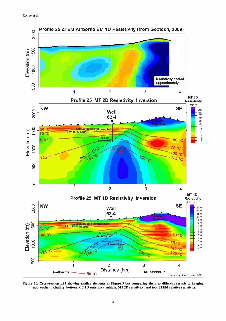
Figure 10 shows a comparison of two MT resistivity imaging approaches. The 1D MT approach appears to

Ronne et al.
7
resolve shallow resistivity and the 2D MT might more reliably resolve resistivity at depths over a few hundred meters. However, the location of the interpreted reservoir near well 62-4 is ambiguous and the MT resolution of the deep resistive feature (blue in Figure 10) could be improved by a 3D inversion.
Figure 10 also includes a comparison to an airborne ZTEM test survey conducted by GeoTech (Berardelli et al., 2009). The ZTEM data processing is still undergoing adjustment and, in any case, it must be “scaled” to an average resistivity in the survey area in order to match the MT. However, as an airborne method, a relatively low cost survey can be collected to constrain shallow resistivity over a larger area with relatively few access limitations. As illustrated in Figure 10, this system appears to resolve resistivity to at least several hundred meters. The reliability of the method and options for joint inversion of the airborne ZTEM data and conventional MT are being investigated.
Besides well deepening, the current interpretation cross-sections identify at least three drilling targets. As shown in Figure 9, a proposed deep well located to the west of 13-4 is interpreted to reach 150 °C at shallower depth than deepening 56-4 beneath a thick low-resistivity clay zone. More brittle Paleozoic carbonate or igneous rocks might be encountered as shallow as ~1500 m depth. Drilled directionally, this deep well would likely extend across intra-basin faults and, perhaps an inferred basin-bounding fault. A conceptually similar target might reach 150 °C at shallower depth by drilling near 88-5, although this is less constrained by data. Figure 10 resolves a resistive zone beneath a low resistivity clay cap, albeit with considerable ambiguity because it is a 3D feature. Improved clay analyses in the wells, additional MT data, and a 3D MT inversion will reduce the ambiguity and related risk in the interpretations.
3. CONCLUSIONS AND FUTURE WORK
Construction of resource conceptual model cross-sections that synthesize the exploration data, akin to those shown in Figures 9 and 10, have aided SGP in characterizing the risks of many potential targets, leading to several re-drill options and three new drill targets at Reese River, including; 1) fractured carbonates or granites at >150 °C flooring the deep basin beneath a thick clay cap west of well 13-4, 2) fractured carbonates at 125 to 200 °C near well 62-4, and 3) fractured carbonates or granites at >150 °C at shallower depth near well 88-5 than near 13-4 due to the higher conductive temperature gradient in well 88-5. The risk issues for these targets are similar but are weighted differently; for instance, a greater likelihood of high deliverability may be offset by a lower likelihood of encountering that deliverability in a zone >150 °C.
Four additional projects are planned to further characterize the relative risk of the geothermal targets at Reese River before a deep well is drilled. 1) Detailed alteration and geologic mapping at the surface focused on structural relations and tying the surface faults and geology to the subsurface geothermal system. 2) Clay analyses of drill cuttings to identify zones that contain smectite, illite, alunite, chlorite, and other clays, possibly using a combination of methods including x-ray diffraction, infrared spectroscopy, methylene-blue, and/or dielectric constant analysis. The positive identification of smectite in Reese River drill cuttings would clarify the association between the observed resistivity variations, rock type, and permeability. 3) A second MT survey would cover a larger
area of the Reese River prospect and would be followed by a 3D inversion to less ambiguously resolve the 3-dimensional resistivity variations in the subsurface. 4) A regional, shallow temperature gradient drilling program will provide additional information about the geographic extent of the Reese River thermal anomaly. Following the integration of the information from these projects into its assessment models, SGP plans to move forward with a deep drilling program to penetrate the geothermal reservoir.
At Silver Peak and Alum, ongoing geophysics and geology surveys will be used to target deep wells. These targets will be drilled in 2010 with supporting funds from the US DOE.
At Barren Hills once permitting is completed in the first half of 2010, further geophysical and temperature gradient work will be preformed to locate deep drill targets.
REFERENCES
Berardelli, P., Legauult, J.M., Milicevic, B., and Orta, M.: Preliminary geophysical report on helicopter-borne ZTEM tipper AFMAG survey results over Reese River Test Survey, August 2009, Lander County, Nevada, Sierra Geothermal Power Corp. Geotech Ltd. promotional report released at the Geothermal Resources Council Annual Meeting, (2009).
Coolbaugh, M.F., Sladek, C., Faulds, J.E., Zehner, R.E., and Oppliger, G.L.: Use of Rapid Temperature Measurements at a 2-Meter Depth to Augment Deeper Temperature Gradient Drilling, Proceedings, Thirty-Second Workshop on Geothermal Reservoir Engineering, Stanford University, Stanford, CA (2007)
Cumming, W.B.: Geothermal resource conceptual models using surface exploration data. Proceedings, Thirty-Fourth Workshop on Geothermal Reservoir Engineering, Stanford University, Stanford, CA (2009)
Faulds, J.E., Garside, L.J., and Oppliger, G.L.: Structural analysis of the Desert Peak-Brady geothermal fields, northwestern Nevada: Implications for understanding linkages between northeast-trending structures and geothermal reservoirs in the Humboldt structural zone, Geothermal Resources Council Transactions, 27 (2003), 859-864.
GeothermEx: Independent Technical Report Resource Evaluation of the Silver Peak Geothermal Project Esmeralda County Nevada, Unpublished report, (2006).
GeothermEx: Technical Update Report on the Reese River Geothermal Project Lander County Nevada, Unpublished report, (2008a).
GeothermEx: Independent Technical Report Resource Evaluation of the Barren Hills Geothermal Project Lyon County Nevada, Unpublished report, (2008b).
Kratt, C., Coolbaugh M.F., Sladek C., Zehner R.E., Penfield R. and Delwiche B.: A New Gold Pan for the West: Discovering Blind Geothermal Systems with Shallow Temperature Surveys, Geothermal Resources Council Transactions, 32, (2008), 153-157.
Sadlier-Brown, T.L.: Technical Report on the Reese River Geothermal Resource, Unpublished report, (2006).
Witter, J.B., Ronne, J.A. and Thompson G.R.: Exploration at The Reese River Geothermal Prospect in Nevada, Geothermal Resources Council Transactions, 33, (2009), 549-556.
Ronne et al.
8
Figure 10. Cross-section L25 showing similar elements as Figure 9 but comparing them to different resistivity imaging approaches including: bottom, MT 1D resistivity; middle, MT 2D resistivity; and top, ZTEM relative resistivity.