Embed Size (px)
Citation preview

1
PineCrestElementarySchoolGeographyBowlWinter2019
OurWorld,OurCountry
YourFirstandLastName: ___ANSWERKEY__________YourTeacher’sName: ____________________________________YourGrade: _____________
ThisprogramwasdevelopedatWoodlinElementarySchoolinSilverSpring,MDandadaptedforuseatPineyBranchElementarySchool&PineCrestElementarySchool.ThankyoutoEnchantedLearning.com,discoveryschool.comandNationalgeographic.com/xpeditionsfortheirdownloadablemapsandothermaterial.Visitthesesitesformoregeographyinformation.
ExploreNorthAmerica

2
TableofContents
DirectionsforCompletingThisPacket 3
TheUnitedStatesofAmerica 4
StateCapitalsandPostalAbbreviations 5
NewEnglandStates: 8 Connecticut,Maine,Massachusetts,NewHampshire,RhodeIsland,Vermont
Mid-AtlanticStates: 11 NewYork,Pennsylvania,NewJersey,Maryland,Delaware,theDistrictofColumbia
SouthAtlanticStates: 14 WestVirginia,Virginia,NorthCarolina,SouthCarolina,Georgia,Florida
EastSouthCentralStates: 17 Kentucky,Tennessee,Alabama,Mississippi
WestSouthCentralStates: 20 Texas,Oklahoma,Arkansas,Louisiana
MidwesternandGreatPlainsStates: 23 NorthDakota,SouthDakota,Minnesota,Wisconsin, Michigan,Nebraska,Iowa,Kansas,Missouri,Illinois,Indiana,Ohio
MountainStates: 29 Montana,Idaho,Wyoming,Nevada,Utah,Colorado,Arizona,NewMexico
PacificStates: 33 Alaska,Hawaii,Washington,Oregon,California
MajorBodiesofWater: 36 TheGreatLakes,TheMississippiRiver
MountainRanges 39
Canada 40
Mexico 42
CentralAmerica 44
Caribbean 46
WordstoKnow 48

3
ComealongonajourneytoexploretheNorthAmerica!
YourjourneywilltakeyouacrosstheUnitedStatesofAmerica.Alongtheway,youwillclimbhighatopmountains,descenddeepintocanyons,crossflatplains,andnavigatebodiesofwater,bothlargeandsmall.Youwillalsolearnaboutournorthernneighbor,Canada.ThenyouwillheadsouththroughMexico,CentralAmericaandtheCaribbean.Happytrails!Directions:
1. Throughoutthispacket,youwillfindmapsandquestions.Alltheinformationyouneedtoanswerthequestionsisfoundonthemapsinthispacket.Youdonotneedtolookatmapsorbooksoutsideofthispackettofindtheanswers.Youwillneedapencilandcoloredpencilsorcrayonstocompletethispacket.Youmayworkwithafriend,sibling,parent,orguardian.
2. Rememberthatonthemaps,capitalcitiesaremarkedwithstars.Vocabularywordsin
italicscanbefoundattheendofthepacket,intheWordstoKnowsection.
3. Allimportantdatesareincludedinthepacketletter.PutyourcompletedpacketintheGeoBowlBoxintheFrontLobby.Thepacketwillbereturnedtoyouwithanycorrectionsmarkedasneeded.Youwillalsoreceiveacertificaterecognizingyourinterestandeffort.
4. AllstudentswhocompletethepacketandshowanefforttostudyfortheGeoBowlquiz
areeligibletoparticipateonaGeoBowlteam(seepacketletterformoredetails.)Teamsmaybemadeupofstudentsfromdifferentclasses.
5. Thegrade-levelGeoBowlteamswillcompeteagainsteachotherinbowlsatassemblies
April26th.

4
TheUnitedStatesofAmerica
TheUnitedStatesofAmerica(USA)islocatedonthecontinentofNorthAmerica,borderedbyCanadatothenorthandMexicotothesouth.TheUSAismadeupoffifty(50)states.Two(2)ofthestatesarenotconnectedbylandtotheother48states.AlaskaliesonthenorthwesternborderofCanada,andHawaiiisagroupofsmallislandsinthePacificOcean.ThetotalpopulationoftheUnitedStatesisapproximately308,747,538people(takenfromthe2010U.S.CensusBureauCount).Every10years,acountofeveryonelivingintheUnitedStatestakesplace.Thiscountiscalledacensus,andthenextonewillhappenin2020.TheoriginalcolonieswereintheeastoftheUSA.Asthecountrygrew,settlersmovedfromeasttowestacrossthecontinent.Thispacketalsostartsintheeastandmoveswest.

5
StateCapitalsandPostalAbbreviations
Giveeachnumberedstateitsnameandstatecapital.Thepostalabbreviationisalreadyprovidedtogiveyouaclue.Postalabbreviationsareatwolettercodeforastatethatthepostofficeusestodelivermail.ThepostalabbreviationforMarylandisMD.Seethemapsofthestatesgroupedbyregionlaterinthepacketforhelp. StateName StateCapital Postal
Abbreviation
1. Delaware Dover DE
2.Pennsylvania Harrisburg
PA
3.NewJersey Trenton
NJ
4. Georgia Atlanta GA

6
StateName StateCapital PostalAbbreviation
5. Connecticut Hartford CT
6. Massachusetts Boston MA
7. Maryland Annapolis MD
8. SouthCarolina Columbia SC
9. NewHampshire Concord NH
10. Virginia Richmond VA
11. NewYork Albany NY
12. NorthCarolina Raleigh NC
13. RhodeIsland Providence RI
14. Vermont Montpelier VT
15. Kentucky Frankfort KY
16. Tennessee Nashville TN
17. Ohio Columbus OH
18. Louisiana BatonRouge LA
19. Indiana Indianapolis IN
20. Mississippi Jackson MS
21. Illinois Springfield IL
22. Alabama Montgomery AL
23. Maine Augusta ME
24. Missouri JeffersonCity MO
25. Arkansas LittleRock AR
26. Michigan Lansing MI
27. Florida Tallahassee FL
28. Texas Austin TX

7
StateName StateCapital Postal
Abbreviation
29. Iowa DesMoines IA
30. Wisconsin Madison WI
31. California Sacramento CA
32. Minnesota St.Paul MN
33. Oregon Salem OR
34. Kansas Topeka KS
35. WestVirgina Charleston WV
36. Nevada CarsonCity NV
37. Nebraska Lincoln NE
38. Colorado Denver CO
39. NorthDakota Bismarck ND
40. SouthDakota Pierre SD
41. Montana Helena MT
42. Washington Olympia WA
43. Idaho Boise ID
44. Wyoming Cheyenne WY
45. Utah SaltLakeCity UT
46. Oklahoma OklahomaCity OK
47. NewMexico SantaFe NM
48. Arizona Phoenix AZ
49. Alaska Juneau AK
50. Hawaii Honolulu HI

8
NewEnglandStates:Connecticut,Maine,Massachusetts,NewHampshire,RhodeIsland,&Vermont
1.ConnecticutisthethirdsmalleststateinsizeintheUSA.Abouthowwideisthisstate?(Hint:usethekeyonthebottomofthemap.) 50miles,100miles,200miles,or300miles? ________________100miles___________________________2.RhodeIslandisthesmalleststateinsizeintheUnitedStates.Usingthekeyatthebottomofthemap,estimatehowmanymileslongRhodeIslandisfromnorthtosouth. __________________~50miles________________________________3.WhichoceanbordersMassachusetts? ____________________AtlanticOcean_______________________________

9
4.Colorinredthecape(apointoflandjuttingintothesea)insoutheasternMassachusetts.ThiscapeiscalledCapeCod.Amuchsmallerpointofland,CapeAnn,isinthenortheast.PartsofCapeAnnwereactuallysettledbeforeBoston.5.Vermontisknownfordairyfarming,maplesugar,andicecream.WhichcountrybordersVermontonthenorth? _____________Canada_____________________________________6.NewHampshirehastheshortestcoastlineofalltheNewEnglandstates,exceptforlandlockedVermont.IsNewHampshirenorth,east,southorwestofVermont? _______________East___________________________________7.WhichoceanformsMaine’ssouthernborder? _______________AtlanticOcean____________________________________8.MaineisthelargeststateinNewEnglandandwasoncepartofMassachusetts.WhatisthecapitalcityofMaine? ________________Augusta____________________________________FunFacts:✏Connecticut,Massachusetts,NewHampshireandRhodeIslandwerepartoftheoriginalthirteencoloniesthatbecametheUnitedStateswhenindependencefromEnglandwasdeclaredin1776.✏Vermontwasthe14thstatetojointheUnitedStates.Itwasthefirststatetooutlawslavery. ColonialFlag
10

11
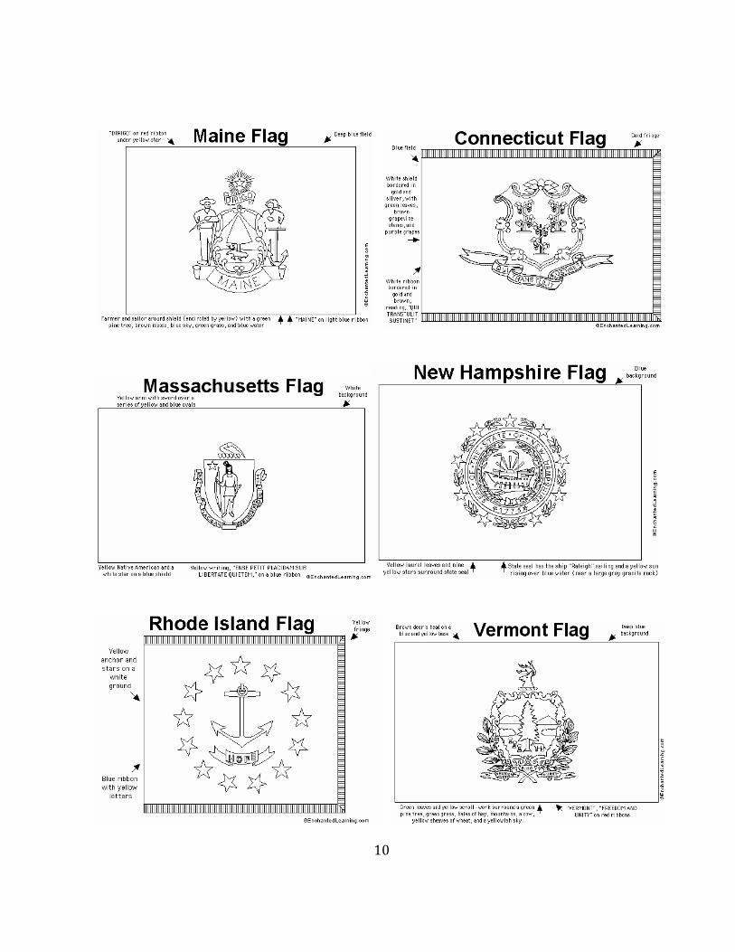
Mid-AtlanticStates:NewYork,Pennsylvania,NewJersey,Maryland,Delaware,andtheDistrictofColumbia
EverystateintheMid-AtlanticRegionwasoneofthe13originalcoloniesoftheUnitedStates.ThatincludesNewYork,Pennsylvania,NewJersey,Maryland,andDelaware.1.WhatmountainrangerunsfromNewYorksouththroughMaryland?Coloritgreen. _____________AppalachianMountains_____________________________________2.Beforebecomingthenation’scapital,thelandthatisnowtheDistrictofColumbiawaspartofMaryland.Washington,D.C.becamethenation’scapitalonJune11,1800.(Previously,thecountryhadbeengovernedfromPhiladelphia,PA.)WhatstatebordersWashington,D.C.onthenorth,east,andsoutheast? ______________Maryland_____________________________3.WhatstatebordersDelawareonthewestandsouth? ______________Maryland___________________________________

12
4.Marylandisdividedintotwopartsbyalargebodyofwater.Thisbodyofwaterproducesmoreseafood–oysters,crabs,clams,finfish–thananycomparablebodyofwaterintheworld.Whatisthisbodyofwatercalled? ________________ChesapeakeBay________________________________5.ThebeachesofRehoboth,Bethany,andDeweyareonthecoastofDelaware,alongthe __________Atlantic___________________Ocean.6.WhichoftheGreatLakesbordersPennsylvaniaonthenorthwest? ____________LakeErie_______________________________________7.WhichbayliesbetweenNewJerseyandthestatetothesouth? __________DelawareBay______________________8.WhatisthenameofthestatetothesouthofNewJersey? ___________Delaware____________9.WhichtwoGreatLakesborderNewYork?Colorthemblue.__________LakeErie________________________ _________LakeOntario_________________FunFacts:✏NewYork,NewYorkisthelargestcityintheUnitedStates,withover8millionpeople!✏TheStatueofLibertywasagiftfromthegovernmentofFrance.ItstandsonLibertyIslandinNewYorkHarborandhaswelcomedimmigrantsandrefugeesfromaroundtheworld.✏DelawareisknownastheFirstState,becauseitwasthefirsttoratify(approve)theConstitution.✏Washington,D.C.isnotastate.✏BoththeDeclarationofIndependenceandtheUnitedStatesConstitutionwerewrittenandsignedinPennsylvania.
13
14
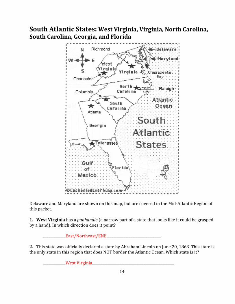
SouthAtlanticStates:WestVirginia,Virginia,NorthCarolina,SouthCarolina,Georgia,andFlorida
DelawareandMarylandareshownonthismap,butarecoveredintheMid-AtlanticRegionofthispacket.1.WestVirginiahasapanhandle(anarrowpartofastatethatlookslikeitcouldbegraspedbyahand).Inwhichdirectiondoesitpoint? _____________East/Northeast/ENE________________________________2.ThisstatewasofficiallydeclaredastatebyAbrahamLincolnonJune20,1863.ThisstateistheonlystateinthisregionthatdoesNOTbordertheAtlanticOcean.Whichstateisit? _____________WestVirginia________________________________________________

15
3.WhatisthenameofthebaythatjoinstheAtlanticOceanonVirginia’seasternborder? _________________ChesapeakeBay____________________________________4.CivilrightsactivistMartinLutherKing,Jr.wasborninthecapitalofGeorgia.Whatisthenameofthiscity? _________________Atlanta___________________________________5.Florida,theonlystatethatwasoriginallyacolonyofSpain,isapeninsula(landalmostentirelysurroundedbywater).WhichoceanbordersFloridaontheeast? _______________AtlanticOcean_________________________________________6.WhichlargebodyofwaterbordersFloridaonthewest? ________________GulfofMexico___________________________________7.VirginiawasthehomeofGeorgeWashingtonandThomasJefferson.ThecapitaloftheConfederacyduringtheCivilWarisalsoVirginia’scurrentstatecapital.Whatisit? ________________Richmond_____________________________________8.ThefirstbattleoftheCivilWartookplaceatFortSumter,SouthCarolinain1860.WhatisthenameofthestatethatbordersSouthCarolinatothenorth? ________________NorthCarolina____________________________________FunFacts:✏In1903,OrvilleandWilburWrightconductedthefirstsuccessfulairplaneflightonanislandoffthenortheastcoastofNorthCarolina,inatowncalledKittyHawk.✏Virginia,NorthCarolina,SouthCarolina,andGeorgiawerepartoftheoriginal13coloniesthatbecametheUnitedStateswhenindependencefromEnglandwasdeclared.

16

17
EastSouthCentralStates:Kentucky,Tennessee,Alabama,Mississippi
1.Kentuckypridesitselfinproducingsomeofthenation’sbesthorses.Thestatetakesitsnicknamefromthebluegrassthehorsessometimeseat.FrankfortisthecapitalofKentucky.TotheeastofFrankfortisacityknownasthecenterofthestate’sBluegrassarea.Whatisthenameofthiscity? ______________Lexington_________________________________2.WhatistheriverthatformsKentucky’snorthernborder.Traceitinblue. ___________________OhioRiver___________________________________3.WhatbodyofwaterbordersAlabamatothesouth? __________________GulfofMexico________________________________

18
4.TherearethreelargecitiesinTennessee,locatedinthewestern,middle,andeasternpartsofthestate.Namethem.___________Memphis__________________________ ____________Knoxville_______________________________Nashville__________________________5.TheMississippiRiveristheoneofthelongestriversintheU.S.WhichthreestatesinthisregionhavetheMississippiRiverastheirwesternborder?_____________Kentucky______________________ _____________Mississippi_____________________________________Tennessee____________________6.WhichstateinthisregiondoesNOTbordertheMississippiRiver? ______________Alabama________________________________7.WhichstatebordersMississippitothenorth? __________________Tennessee______________________________ FunFacts:✏RootbeerwasinventedinBiloxi,Mississippiin1898byEdwardAdolfBarq,Sr.✏Kentucky’sMammothCaveisthelongestrecordedcavesystemintheworld.Itis348milesofexploredandmappedcaves.Ifyouputthesecondandthirdlongestcavesintheworldtogether,MammothCaveisstill100mileslonger.✏Tennesseeisfamousformusic:MemphisforBlues,Soul,andRock&Roll,andNashvilleforCountrymusic.

19
-

20
WestSouthCentralStates:Texas,Oklahoma,Arkansas,Louisiana
1.Texasisthe2ndlargeststateinsizeandtheonlystatethatwasalsoanindependentrepublic.From1836until1845,itwasanindependentcountry,theRepublicofTexas.WhatisthelargebodyofwaterthatbordersTexastotheeast? __________________GulfMexico_________________________________2.WhichcountrybordersTexasonthesouthwest?
___________________Mexico___________________________________3.Whatisthenameoftheriverformingtheborderbetweenthesecountries? ___________________RioGrande______________________________________4.ThesquigglyborderbetweenTexasandOklahomaisformedbytheRedRiver.Tracethatborderinthecolorfromwhichtherivertakesitsname.5.Oklahomaismadeupofalargerectangleandalongpanhandle(anarrowpartofastatethatlookslikeitcouldbegraspedbyahand)onthenorthwest.WhatstateistothesouthofOklahoma’spanhandle? ___________________Texas_______________________________6.WhatriverformstheeasternborderofArkansas?Traceitinblue.
__________________MississippiRiver____________________________________

21
7.BillClintonwasgovernorofArkansasandlivedinitscapitalandlargestcitywhenhewaselectedpresidentin1992.WhatisthecapitalandlargestcityinArkansas? _______________________LittleRock__________________________8.Louisiana’slargestcitywasalmostdestroyedbyHurricaneKatrinain2005.Thiscityissoutheastofthecapital,BatonRouge.Whatisthenameofthiscity?Circleitgreen. _____________________NewOrleans_________________________________9.Thenation’slargestriverrunsthroughLouisianatotheGulfofMexico.Nametheriver. _______________________MississippiRiver_______________________________FunFacts:✏Texashasagreaternumberoftornadoesthananyotherstate,butOklahoma’stornadoesaremoredangerous.✏Louisianaisoneofthemostmulticulturalstates;itslongtimeinhabitantsareofAmericanIndian,French,Spanish,English,andAfricanancestry.✏LouisianaistheonlystatewithalargepopulationofCajuns–descendantsoftheAcadianswhoweredrivenoutofCanadainthe1700s,becausetheywouldn’tpledgeallegiancetotheKingofEngland.

22

23
MidwesternandGreatPlainsStates:NorthDakota,SouthDakota,Minnesota,Wisconsin,Michigan,Nebraska,Iowa,Kansas,Missouri,Illinois,Indiana,&Ohio
1.TheGreatPlainsaretreelessgrasslandsthatgetlittlerain.ThestatesoftheGreatPlainslieinacolumnbetweenNorthDakotaandKansas.NamethefourGreatPlainsstatesyouwoulddrivethrough,ifyoudrovefromBismarcksouthallthewaytoTopeka.__________NorthDakota_____________________ _________Nebraska____________________________SouthDakota_______________________ ___________Kansas________________________2.TwoofthelongestriversintheUnitedStateslieinthisregion.Theyarethe__________Missouri______and_________Mississippi____________Rivers.Tracetheminblue.3.TheGreatLakesarefivelargebodiesofwaterontheborderoftheU.S.andCanada.WhichoftheGreatLakesformspartofthenortheasternborderofMinnesota? __________________LakeSuperior___________________________4.WhichriverformsmostofIowa’swesternborder?___________MissouriRiver_____________

24
5.Minnesotahasmorethan12,000lakes.OneoftheselakesisthesourceofoneofthelongestriversintheUnitedStates.YoucanseeonthemapthatthisriverbeginsinMinnesota.Whatisthisriver’sname?Tracetheriverinblue. __________________MississippiRiver______________________________6.Iowaisboundontwosidesbyrivers.Whatarethenamesoftheserivers?_________MissouriRiver_________________ _____________MississippiRiver____________7.TheMissouriRiverbeginsinMontanaandthenflowsthroughorbetweensixotherstatesbythetimeitjoinstheMississippiRivernorthofSt.Louis,Missouri.Namethesestates.Tracetheriverinred.__________NorthDakota___________________ _________Iowa_________________________________SouthDakota______________________ _________Missouri______________________________________Nebraska________________________ _________Kansas___________________________8.Michiganisastatewithtwoseparatepeninsulas(landalmostentirelysurroundedbywater).ItissurroundedbytheGreatLakes.WhichoftheGreatLakesseparatestheUpperandLowerPeninsulasofMichigan?Colorthislakeinblue. ______________LakeMichigan____________________________________________9.ThisstateishometohugecarvingsoftheheadsofPresidentsWashington,Jefferson,Lincoln,andTeddyRoosevelt.ThecarvingsarecommonlyreferredtoasMountRushmore.ThecapitalofthisstateisPierre.Namethisstate. ________________SouthDakota_____________________________________10.WhichoftheGreatLakesbordersWisconsinonthenorth? _____________LakeSuperior______________________________________11.ThecityofGreenBay,Wisconsin,whichliesonthenorthernedgeofthestate,isthesmallestcitytohaveanNFLfootballteam.WhichGreatLakeborderstheeasternsideofWisconsin? _______________LakeMichigan____________________________________

25
12.ThecapitalofIllinoiswasAbrahamLincoln’shomeatthetimeofhiselectionasthe16thpresidentoftheUnitedStates.Hewasburiedinthiscitywhenhedied.Whatisthiscapitalcity? _________________Springfield__________________________________13.Indiana’scapitalandlargestcityhasbecomefamousfora500milecarracethatisheldthereeveryyearoverMemorialDayweekend.Whatisthenameofthiscity? __________________Indianapolis_________________________________14.Ohioissometimesreferredtoasthe“HeartofitAll,”becauseitisshapedlikeaheartandisinthemiddleofthecountry.WhichGreatLakeistothenorthofOhio?Colorthislakeblue. ___________________LakeErie___________________________________FunFacts:✏Kool-Aid,abrandofflavoreddrinkmix,wasinventedinNebraskain1927.✏OneoftheoldestmountainsintheUnitedStates,calledtheOzarks,arelocatedinsouthwesternMissouri.Thesemountainshavebeenworndownbyerosiontoformaplateau(ahigh,flatarea).
MountRushmore

26

27

28
29
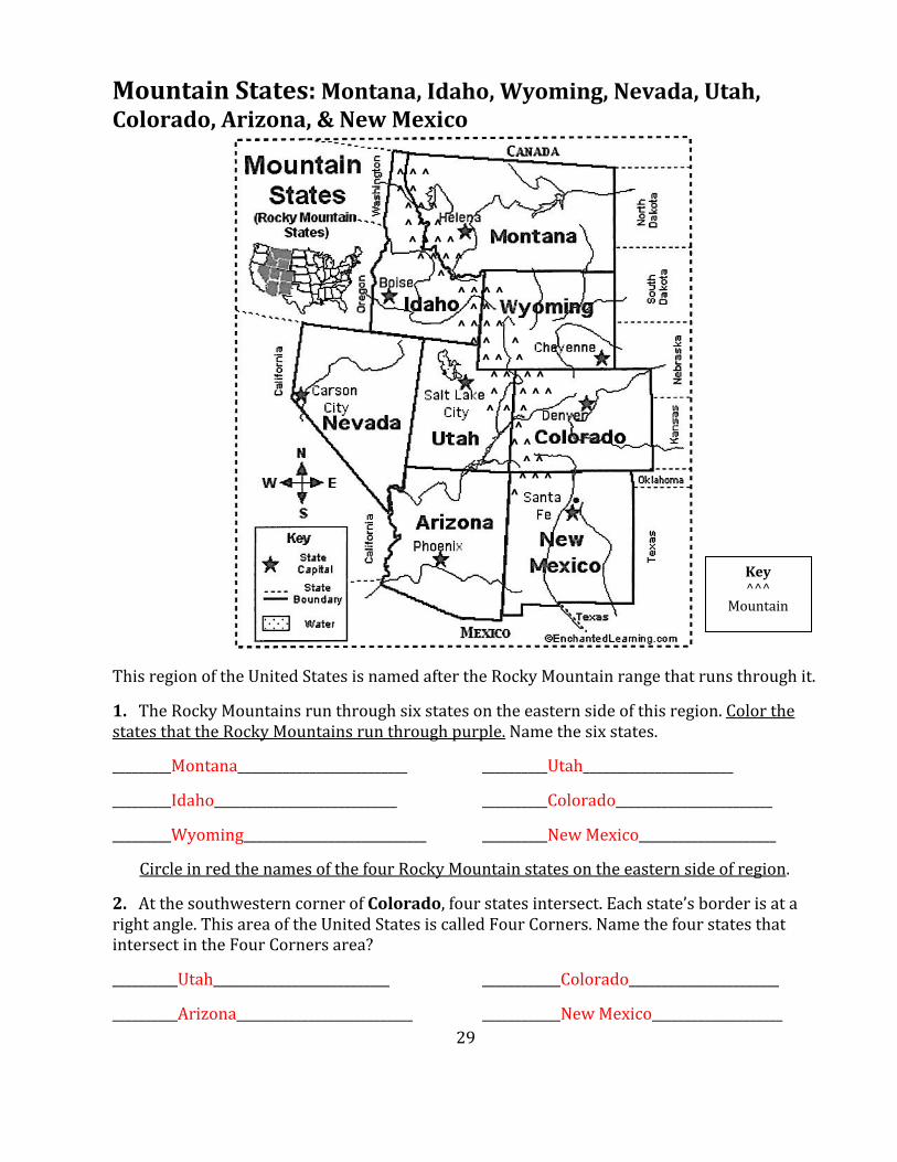
MountainStates:Montana,Idaho,Wyoming,Nevada,Utah,Colorado,Arizona,&NewMexico
ThisregionoftheUnitedStatesisnamedaftertheRockyMountainrangethatrunsthroughit.1.TheRockyMountainsrunthroughsixstatesontheeasternsideofthisregion.ColorthestatesthattheRockyMountainsrunthroughpurple.Namethesixstates._________Montana__________________________ __________Utah________________________________Idaho____________________________ __________Colorado_________________________________Wyoming____________________________ __________NewMexico_____________________CircleinredthenamesofthefourRockyMountainstatesontheeasternsideofregion.2.AtthesouthwesterncornerofColorado,fourstatesintersect.Eachstate’sborderisatarightangle.ThisareaoftheUnitedStatesiscalledFourCorners.NamethefourstatesthatintersectintheFourCornersarea?__________Utah___________________________ ____________Colorado_________________________________Arizona___________________________ ____________NewMexico____________________
Key^^^
Mountain
^ ^ ^ ^ ^ ^ ^ ^ ^ ^ ^ ^ ^ ^ ^ ^ ^ ^ ^ ^ ^ ^ ^ ^ ^ ^ ^ ^ ^ ^ ^ ^ ^ ^ ^ ^ ^ ^ ^ ^ ^ ^ ^ ^ ^ ^ ^ ^ ^ ^ ^ ^ ^ ^ ^ ^

30
3.WhichcountrybordersMontanaandIdahotothenorth? __________________Canada______________________________4.Utah’scapitalwasthesiteofthe2002WinterOlympics.Namethecity. __________________SaltLakeCity________________________________________5.ThecapitalcityofNevadaislocatedonthewesternsideofthestate,closetotheCaliforniaborder.WhatisNevada’scapital? __________________CarsonCity__________________________________6.ThelargestcityinColorado–thestatecapital–isknownastheMileHighCity,becauseoneofitspointsisexactly1mileabovesealevel(thelevelofthesurfaceoftheocean).Namethiscity. ___________________Denver____________________________________7.WhatcountrybordersArizonaandNewMexicotothesouth? ___________________Mexico__________________________________8.Thisstateishometotheworld’slargestcanyonorgorge(adeepvalleywithsteepwalls).Thiscanyon,calledtheGrandCanyon,is29mileslong,upto18mileswide,and1miledeep.ToreachthesouthernrimoftheGrandCanyon,youwouldtravelabout230milesnorthofPhoenix,thisstate’scapital.Namethisstate. _________________Arizona___________________________________9.ThecapitalofNewMexicoisthehighestU.S.statecapital.Itsitsatnearly7,000feetabovesealevel(thelevelofthesurfaceoftheocean).Whatisthiscity’sname?Circleitinredorgreen. __________________SantaFe_______________________________________FunFacts:✏“RedorGreen?”istheofficialstatequestionofNewMexico.Ifsomeoneasksyouthis,theywanttoknowifyouliketoeatredorgreenpeppers.✏WyomingTerritorygrantedwomentherighttovotein1869,thefirststateorterritorytodoso.

31

32

33
PacificStates:Alaska,Hawaii,Washington,Oregon,California
1.ThelargeststatebysizeintheUnitedStatesisconnectedtotheNorthAmericancontinent,butdoesnotborderanyotherstate.Whatisthenameofthisstate? _______________Alaska____________________________________2.In1867,SecretaryofStateWilliamSewardboughtAlaskafromRussiafor$7,200,000.Atthattime,thedealwasknownas“Seward’sFolly”,butitturnedouttobeoneofthebestrealestatedealsinhistory.WhatcountrybordersAlaskatotheeast? ________________Canada_________________________________________3.TheIditarod,anannual1,000milesleddograce,startsinthisAlaskancitylocatedtothenorthwestofJuneau.Whatisthenameofthiscity? ________________Anchorage_______________________________________

34
4.Hawaiiwasitsowncountry,withitsownkingsandqueens,formanyyears.In1893,itsqueensurrenderedHawaiitotheUnitedStates.In1959,itofficiallybecamethe50thstate.InwhichoceanisHawaiilocated?_____________PacificOcean_______________________________________5.ThestateofHawaiiismadeupofeight(8)mainislands.TheOlympicswimmerDukeKahanamokupopularizedthesportofsurfingnationwideandlivedinthelargestcityinHawaii,whichisalsoHawaii’scapital.Namethiscity._______________Honolulu______________________________________6.ThelargestcityinthestateofWashingtonisnamedforafamouschiefoftheSuquamishpeople.ItislocatedonalargebayandisNOTthestatecapital.Whatisthecity?Circleitinorange. ____________Seattle__________________________________________7.TheColumbiaRiverdividesWashingtonfromthestatetoitssouth.Whatisthenameofthisstate? _____________Oregon_____________________________________________8.WhichoceanbordersOregononthewest? _____________PacificOcean________________________________________9.WhichcountrybordersCaliforniatothesouth? ______________Mexico______________________________________10.Hollywood,famousasthecenteroftheworld’smovieproduction,isinCalifornia’slargestcity.LocatedinsouthernCalifornia,thenameofthiscitymeansCityofAngelsinSpanish.Whatisthenameofthiscity? _______________LosAngeles_________________________________________FunFacts:✏MorepeopleliveinCaliforniathaninanyotherstateintheU.S.A.✏Oregon’sstateflagfeaturesabeaverononeside.Itistheonlystateflagtohaveatwo-sideddesign.✏WashingtonistheonlystatenamedafteraU.S.president.

35

36
MajorBodiesofWaterTheGreatLakes
1.TohelprememberthenamesoftheGreatLakes,rememberthatthefirstlettersoftheirnamesspellHOMES.ListtheGreatLakesbelow.Colorthemblue.
H_________LakeHuron_______________________ O_________LakeOntario___________________ M_________LakeMichigan__________________ E__________LakeErie___________________ S__________LakeSuperior___________________2.Whichisthenorthernmost(farthestnorth)GreatLake? _________________LakeSuperior_______________________________3.OnestatetouchesfourGreatLakes.Namethatstate._______Michigan______________4.NamethefourGreatLakesthatthisstateborders._________LakeSuperior___________________ ________LakeHuron_______________________________LakeMichigan____________________ _________LakeErie________________________
37
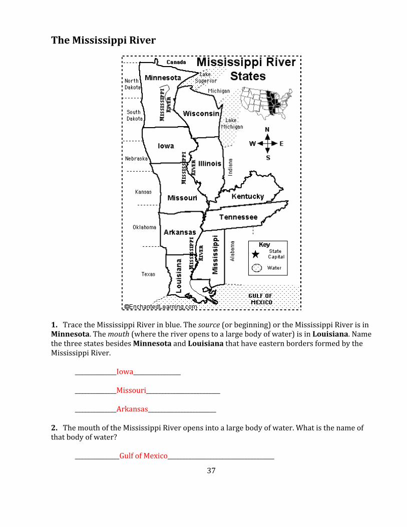
TheMississippiRiver
1.TracetheMississippiRiverinblue.Thesource(orbeginning)ortheMississippiRiverisinMinnesota.Themouth(wheretheriveropenstoalargebodyofwater)isinLouisiana.NamethethreestatesbesidesMinnesotaandLouisianathathaveeasternbordersformedbytheMississippiRiver. ______________Iowa________________ ______________Missouri_________________________ ______________Arkansas_______________________2.ThemouthoftheMississippiRiveropensintoalargebodyofwater.Whatisthenameofthatbodyofwater? _______________GulfofMexico____________________________________

38
3.IfyoutookaboatuptheMississippiRiverstartingatthemouthoftheriver,whichsixstateswouldyouseeofftotherightsideofyourboatbeforeyougottoMinnesota? __________Louisiana________________________ __________Mississippi____________________________ __________Tennessee__________________________ __________Kentucky____________________________ __________Illinois_____________________________ __________Wisconsin_____________________________

39
MountainRanges
1.TheAppalachianMountainsrunfromGeorgiainthesouthtothisstateinthenorth.Whatisthenorthernmost(furthestnorth)stateoftheAppalachianMountainrange?LookattheNewEnglandstatesregionalmapearlierinthispacketforhelp. ______Maine___________________________________________2.InwhichstatearetheSierraNevadaMountainslocated?ThisstatealsohasthelongestPacificOceancoastline. _______California___________________________________________________3.TheRockyMountainsformonecontinentaldivide(alineofhigherlandthatdividestwowatersheds,sothewaterfallingononesideflowsintooneocean,andwaterfallingontheothersideflowstoanotherocean)intheUnitedStates.So,waterfallingontheeastsideoftheRockyMountainswouldeventuallyflowintothe_____________Atlantic__________________Ocean.WaterfallingonthewestsideoftheRockieswouldflowintothe______________Pacific________________Ocean.

40

41
Canada
TheanswerstothequestionsonthispagecanbefoundontheCanadaReferenceMap.
1. Canada’snorthernmostpointisonly400milesfromtheNorthPole.WhatoceanliesnorthofCanada?__________ArcticOcean_______________________
2. WhatisthenameoftheenormousCanadianbaythatalmostdividesCanadaintwo?____________HudsonBay________________________________
3. NamethecountrythatbordersCanadatothesouth.______UnitedStatesofAmerica______
4. WhatisthenameofthelargeriverthatflowsnorthintotheBeaufortSea?_____________MackenzieRiver_______________Highlightitonthemap.
5. Canadaispartofwhichcontinent?________NorthAmerica____________
6. Canadahasprovinces,insteadofstates.WhichprovinceborderstheGreatLakes?______Ontario_______________
7. FouroftheGreatLakesborderCanada.Whichistheonelakethatdoesnot?
_____________LakeMichigan________________________________
8. ThecapitalofCanadaislocatedintheprovinceofOntario,neartheborderofQuebec.WhatisthecapitalofCanada?______Ottawa___________Highlightitonthemap.
9. WhatmajorwaterfallisonCanada’sborderwiththeUnitedStates,betweenLakeOntario
andLakeErie?____________NiagaraFalls____________________
10. NorthAmerica’smajormountainrangeextendsmorethan3000milesfromthesouthwesternU.S.throughCanada’sprovincesofAlbertaandBritishColumbiaandintotheYukonTerritory.Namethismountainrange.___________RockyMountains_______________
11. Canada’swesternmostprovince,BritishColumbia,borderswhatocean?
______PacificOcean_____________
12. NovaScotia,NewBrunswick,andPrinceEdwardIsland,onCanada’seastcoastareknownastheMaritimeProvinces.Whatoceanborderstheseprovinces?________AtlanticOcean____________________________________

42

43
Mexico
TheanswerstothequestionsonthispagecanbefoundontheMexicoReferenceMap.
1. Mexico’scapitalcitywasbuiltbyanancientsocietycalledtheAztecs,morethan600yearsago.Itisoneofthelargestcitiesintheworld.WhatisthecapitalofMexico?____________MexicoCity_________________Highlightitonthemap.
2. ThenameoftheriverthatseparateMexicofromtheUnitedStatesmeans“BigRiver”inSpanish.Nametheriver________RioGrande_____________.Highlightthisriveronthemap.
3. WhattwocountriesborderMexicoonthesoutheast?_____Guatemala________________and________Belize__________
4. AcapulcoishometoMexico’sfamouscliffdivers,whodivefromheightsofupto150feet.AcapulcoisonMexico’sWestCoast,sowhichoceandotheydiveinto?______________PacificOcean_____________________________
5. EveryyearmanyhurricanescomethroughthelargebodyofwaterthatbordersMexicoontheeast.Thisbodyofwateriscalledthe____GulfofMexico______andispartofthe_____Atlantic________Ocean.
6. WhatisthenameofthedesertinnorthwesternMexico?____________SonoranDesert____________________________________
7. ThelongpeninsulaonthenorthwestcoastofMexicohasahot,dryclimate.Cactuscangrowto60ft.tallormore!Whatisthenameofthispeninsula?_________________________BajaCalifornia___________________________________
8. ThepeninsulainsoutheasternMexicousedtobeahide-outforpirates.Nowitisapopularvacationspotforpeoplefromallovertheworld.Whatisthenameofthepeninsula?___________YucatanPeninsula___________________

44
45
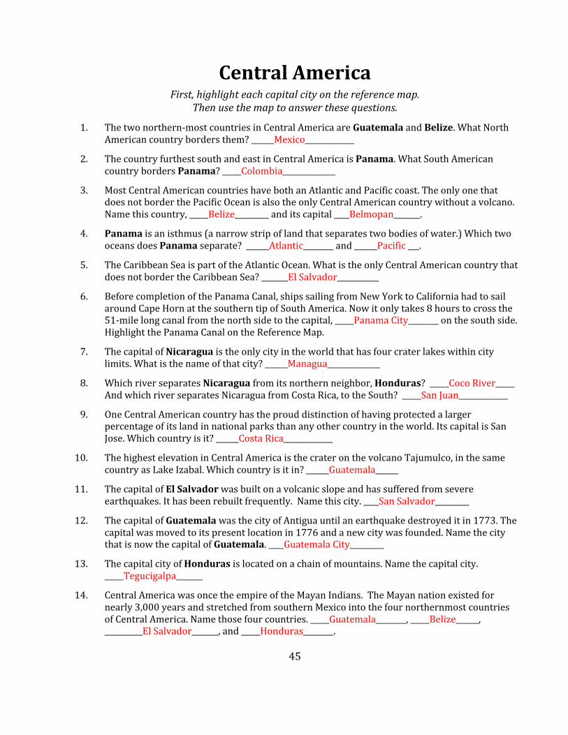
CentralAmericaFirst,highlighteachcapitalcityonthereferencemap.
Thenusethemaptoanswerthesequestions.
1. Thetwonorthern-mostcountriesinCentralAmericaareGuatemalaandBelize.WhatNorthAmericancountrybordersthem?______Mexico_____________
2. ThecountryfurthestsouthandeastinCentralAmericaisPanama.WhatSouthAmericancountrybordersPanama?_____Colombia______________
3. MostCentralAmericancountrieshavebothanAtlanticandPacificcoast.TheonlyonethatdoesnotborderthePacificOceanisalsotheonlyCentralAmericancountrywithoutavolcano.Namethiscountry,_____Belize_________anditscapital____Belmopan_______.
4. Panamaisanisthmus(anarrowstripoflandthatseparatestwobodiesofwater.)WhichtwooceansdoesPanamaseparate?______Atlantic________and______Pacific___.
5. TheCaribbeanSeaispartoftheAtlanticOcean.WhatistheonlyCentralAmericancountrythatdoesnotbordertheCaribbeanSea?_______ElSalvador___________
6. BeforecompletionofthePanamaCanal,shipssailingfromNewYorktoCaliforniahadtosailaroundCapeHornatthesoutherntipofSouthAmerica.Nowitonlytakes8hourstocrossthe51-milelongcanalfromthenorthsidetothecapital,_____PanamaCity________onthesouthside.HighlightthePanamaCanalontheReferenceMap.
7. ThecapitalofNicaraguaistheonlycityintheworldthathasfourcraterlakeswithincitylimits.Whatisthenameofthatcity?______Managua______________
8. WhichriverseparatesNicaraguafromitsnorthernneighbor,Honduras?_____CocoRiver_____AndwhichriverseparatesNicaraguafromCostaRica,totheSouth?_____SanJuan_____________
9. OneCentralAmericancountryhastheprouddistinctionofhavingprotectedalargerpercentageofitslandinnationalparksthananyothercountryintheworld.ItscapitalisSanJose.Whichcountryisit?______CostaRica_____________
10. ThehighestelevationinCentralAmericaisthecrateronthevolcanoTajumulco,inthesamecountryasLakeIzabal.Whichcountryisitin?______Guatemala______
11. ThecapitalofElSalvadorwasbuiltonavolcanicslopeandhassufferedfromsevereearthquakes.Ithasbeenrebuiltfrequently.Namethiscity.____SanSalvador_________
12. ThecapitalofGuatemalawasthecityofAntiguauntilanearthquakedestroyeditin1773.Thecapitalwasmovedtoitspresentlocationin1776andanewcitywasfounded.NamethecitythatisnowthecapitalofGuatemala.____GuatemalaCity_________
13. ThecapitalcityofHondurasislocatedonachainofmountains.Namethecapitalcity._____Tegucigalpa_______
14. CentralAmericawasoncetheempireoftheMayanIndians.TheMayannationexistedfornearly3,000yearsandstretchedfromsouthernMexicointothefournorthernmostcountriesofCentralAmerica.Namethosefourcountries._____Guatemala________,_____Belize______,__________ElSalvador_______,and_____Honduras________.

46

47
TheCaribbean
TheanswerstothequestionsonthispagecanbefoundontheCaribbeanAmericanReferenceMap.
Highlighteachcapitalcityonthemap.
1. TherearemanyislandsintheCaribbeanSea,andseveraldifferentcountries.TheCaribbeanSeaispartofwhatocean?__________AtlanticOcean_______________
2. ThefourlargestislandsoftheCaribbeanarecalledtheGreaterAntilles(ANtilleez).Namethem:________Cuba_________,_________Jamaica____________,__________PuertoRico___________and_____Hispaniola_______________.ThesmallerislandsarecalledtheLesserAntilles.
3. JamaicaisaCaribbeanislandcountryfamousforreggaemusic.NamethecapitalcityofJamaica.____________Kingston____________________________
4. ThelargestcountryintheCaribbeanisonly90milesawayfromKeyWest,Florida.ItishometoanAmericanmilitarybaseatGuantanamoanditscapitalisHavana.Namethecountry.___________Cuba_______________
5. PuertoRicoisaCaribbeanislandthatisaterritoryoftheUnitedStates,notanindependentcountry.Withapopulationofabout4million,PuertoRicohasmorepeoplethan24statesandtheDistrictofColumbia,butitisnotastate.Namethecapital._________SanJuan______________________
6. TheislandofHispaniolahastwocountriesonit.Thecountrythatisfartherwesthastwoofficiallanguages(FrenchandCreole).Namethecountry______Haiti______andthecapital_______Port-au-Prince________________________HalfofHaiti’sentirepopulationlivesinHaiti’scapital,wherethedevastatingearthquakehitinJanuary2010.
7. TheDominicanRepublic(thelargerofthetwocountriesontheislandofHispaniola),ishometotheoldestuniversityintheWesternHemisphereandthetombofChristopherColumbus.Itscapitalcityis:_______SantoDomingo______________
8. OftheGreaterAntilles,whichislandisfarthestEast?__________PuertoRico______________

48
WordstoKnow
canyon adeepvalleywithsteepwalls(alsoseegorge)cape apointoflandjuttingintotheseacensus acountofeveryonelivinginacountrycontinent averylargeareaoflandusuallysurroundedbywaterandusually containingmanycountriescontinentaldivide alineofhigherlandthatdividestwowatersheds,sothewaterfalling ononesideflowsintooneocean,andwaterfallingontheotherside flowstoanotheroceanequator animaginarylinearoundthemiddleoftheearth,dividingthetwo halvesgorge adeepvalleywithsteepwalls(alsoseecanyon)mouth whereariveropenstoalargebodyofwaterocean averylargebodyofwaterpanhandle anarrowpartofastatethatlookslikeitcouldbegraspedbyahandpeninsula landalmostentirelysurroundedbywatersealevel thelevelofthesurfaceoftheoceansource thebeginning(ofabodyofwater)