Embed Size (px)
Citation preview
EXPLORING 10,000 YEARS OF HUMAN HISTORY ON EBEY’S PRAIRIE, WHIDBEY ISLAND,
WASHINGTON
by
Andrea L. Weiser B.A., Fort Lewis College, 1992
THESIS SUBMITTED IN PARTIAL FULFILLMENT OF THE REQUIREMENTS FOR THE DEGREE OF
MASTER OF
ARTS
In the Department
of Archaeology
© Andrea L. Weiser 2006
SIMON FRASER UNIVERSITY
Fall 2006
All rights reserved. This work may not be reproduced in whole or in part, by photocopy
or other means, without permission of the author.
SIMON FRASER UNIVERSITY
PARTIAL COPYRIGHT LICENCE
I hereby grant to Simon Fraser University the right to lend my thesis, project or extended essay (the title of which is shown below) to users of the Simon Fraser University Library, and to make partial or single copies only for such users or in response to a request from the library of any other university, or other educational institution, on its own behalf or for one of its users.
I further grant permission to Simon Fraser University to keep or make a digital copy for use in its circulating collection.
I further agree that permission for multiple copying of this work for scholarly purposes may be granted by me or the Dean of Graduate Studies. It is understood that copying, publication or public performance of this work for financial gain shall not be allowed without my written permission.
Public performance permitted: Multimedia materials that form part of this work are hereby licenced to Simon Fraser University for educational, non-theatrical public performance use only. This licence permits single copies to be made for libraries as for print material with this same limitation of use.
Public performance not permitted: Multimedia materials that form part of this work are hereby licenced to Simon Fraser University for private scholarly purposes only, and may not be used for any form of public performance. This licence permits single copies to be made for libraries as for print material with this same limitation of use.
Multimedia licence not applicable to this work. No separate DVD or DC-ROM material is included in this work.
Title of Project:
Exploring 10,000 Years of Human History on Ebey’s Prairie, Whidbey Island, Washington
Author: Andrea L. Weiser (Date Signed)
SIMON FRASER UNIVERSITY
PARTIAL COPYRIGHT LICENCE
The author, whose copyright is declared on the title page of this work, has granted to Simon Fraser University the right to lend this thesis, project or extended essay to users of the Simon Fraser University Library, and to make partial or single copies only for such users or in response to a request from the library of any other university, or other educational institution, on its own behalf or for one of its users.
The author has further granted permission to Simon Fraser University to keep or make a digital copy for use in its circulating collection.
The author has further agreed that permission for multiple copying of this work for scholarly purposes may be granted by either the author or the Dean of Graduate Studies.
It is understood that copying or publication of this work for financial gain shall not be allowed without the author’s written permission.\
Permission for public performance, or limited permission for private scholarly use, of any multimedia materials forming part of this work, may have been granted by the author. This information may be found on the separately catalogued multimedia material and in the signed Partial Copyright Licence.
The original Partial Copyright Licence attesting to these terms, and signed by this author, may be found in the original bound copy of this work, retained in the Simon Fraser University Archive.
W. A. C. Bennett Library Simon Fraser University
Burnaby, BC, Canada
ii
APPROVAL
NAME: Andrea L. Weiser DEGREE: M.A. TITLE OF THESIS: Exploring 10,000 Years of Human History on
Ebey’s Prairie, Whidbey Island, Washington EXAMINING COMMITTEE: Chair: Dr. Eldon Yellowhorn Assistant Professor _________________________________________ Dr. Dana Lepofsky, Associate Professor Senior Supervisor _________________________________________ Dr. Catherine D’Andrea, Associate Professor _________________________________________
Dr. Douglas Deur, Research Coordinator Pacific N.W. Cooperative Studies Unit University of Washington Examiner
Date Approved: _________________________________________
iii
ABSTRACT
Northwest Coast prairies contain a suite of resources not available in other ecosystems, making them a unique and sought after environment for animals and people. Archaeological research in Northwest Coast prairies is in its infancy but it is clear that an integrated approach, drawing on a number of disciplines, is needed to decipher human use of prairies in the past. I investigate the archaeological, archaeobotanical, and ethnographic record of Ebey’s Prairie, located on central Whidbey Island in Washington State. My findings indicate that people used Ebey’s Prairie throughout prehistory for a variety of activities over a broad time scale (~10,000 to 150 BP). Direct evidence of Camassia—one of the most important native plant foods in the Northwest, is one indication that indigenous people tended and maintained edible and useful plant resources on Ebey’s Prairie for hundreds and perhaps thousands of years. Keywords: Whidbey Island; anthropogenic prairie; camas, archaeobotany; Ferry House; Northwest Coast
iv
DEDICATION
To my husband, Andris, for his patience and loving support. To my parents, C.J.
and Adrienne Weiser, my sister, Rachel R. Robertson, and brother, Russell R. Weiser, for
helping me believe I can do anything I put my mind to.
v
ACKNOWLEDGEMENTS
I gratefully acknowledge the support of those who contributed to this project.
Most especially, I thank my thesis committee advisor, Dr. Dana Lepofsky, and committee
members, Dr. Catherine D’Andrea and Dr. Douglas Deur for their enthusiasm, thorough
editing, and guidance. Much of the data presented here was acquired through a National
Park Service project to investigate archaeological deposits at the Ferry House Site. I am
grateful for the team of archaeologists, historians, specialists, and volunteers I had the
pleasure of working with. Thank you to Gretchen Luxenberg, Rob Harbour, Jim
Thompson, Bob Mierendorf, Brooke Larrabee, Kirstie Haertel, Doug Wilson, Bob
Cromwell, Julie Stein, Jacob Fischer, and Larry Conyers. Naoko Endo, Derrick Horne,
Garnet Martens, Mathias Schuetz, Marah Fernando, Phil Dering and Greg Morrissey
offered expertise and advice in the laboratory, Monika Nill, Keith Garnett, Rob Klengler,
and Doug Littauer provided expertise for graphics, Rachel Robertson, Sarah Welch, and
Jen Herkes assisted with tables and editing, and Andris Vezis helped with field
experiments.
I am also grateful for funding provided by the National Park Service, Simon
Fraser University Graduate Fellowships, the International Graduate Student Bursary, the
Dr. J.V. Christensen Award, an Association of Washington Archaeology Research Grant
and an Albright-Wirth Grant. NPS funding supported my fieldwork and paid for the
radiocarbon dates reported in this thesis. Other funds supported me during research,
writing, and dissemination of results at national and regional conferences.
vi
TABLE OF CONTENTS
APPROVAL .................................................................................................. ii Abstract......................................................................................................... iii Dedication......................................................................................................iv Acknowledgements ........................................................................................v Table of Contents..........................................................................................vi List of Figures ............................................................................................ viii List of Tables .............................................................................................. xiii Chapter 1: Introduction................................................................................1
Anthropogenic Prairies of the Northwest Coast..........................................................1 What is a Prairie?..................................................................................................................... 1 What is an “Anthropogenic Prairie”? ...................................................................................... 2 The Distribution and Significance of Anthropogenic Prairies on the Northwest Coast .......... 3
Outline of this Thesis....................................................................................................10
Chapter 2: Cultural Context of Anthropogenic Prairies.........................12 Plant Resources in Anthropogenic Prairies ...............................................................12 Animal Resources in Anthropogenic Prairies ...........................................................16 Maintaining the Harvest ..............................................................................................16 Ebey’s and other Prairies of Whidbey Island............................................................18
Historic Evidence of Indigenous Use of Ebey’s Prairie ........................................................ 22 Archaeological Context of Ebey’s Prairie ............................................................................. 30 The Ferry House Site (45IS221) on Ebey’s Prairie ............................................................... 33
Chapter 3: Methods.....................................................................................35 Field Methods ...............................................................................................................36
Exploratory Excavation Units................................................................................................ 38 Remote Sensing ..................................................................................................................... 38 Feature Sampling ................................................................................................................... 41 Excavations under the Ferry House ....................................................................................... 41
Laboratory Methods ....................................................................................................43 Flotation ............................................................................................................................. 43 Sorting and Quantifying Feature Contents ............................................................................ 46 Archaeobotanical Identification............................................................................................. 47 Analysis of Artifacts from Excavation .................................................................................. 51 Analysis of Artifacts from Private Collections ...................................................................... 52
vii
Deciphering Human Activities across Time and Space ............................................53 Exploring Prairie Longevity .................................................................................................. 54
Chapter 4: Results and Interpretations.....................................................55 Results of Remote Sensing...........................................................................................55 Feature Sampling .........................................................................................................56
Summary of Archaeobotanical Remains Recovered from Features ...................................... 95 Summary of Other Remains Recovered from Features ....................................................... 102
Activities Indicated by Features and Archaeobotanical Remains .........................104 Cooking Methods................................................................................................................. 104 Camping and Longer-term Settlement................................................................................. 109 Seasonal Use of the Ferry House Site.................................................................................. 110
Results of Artifact Analysis .......................................................................................110 Artifacts from Excavation.................................................................................................... 110 Artifacts from Private Collections ....................................................................................... 117
Activities Indicated by Artifacts ...............................................................................123 Hunting ........................................................................................................................... 123 Plant Processing................................................................................................................... 124 Expedient Tool-making and Settlement............................................................................... 128 Trade ........................................................................................................................... 128
Activities Across Time and Space .............................................................................129 Exploring Prairie Longevity ................................................................................................ 132 Potential for Further Evidence ............................................................................................. 140
Chapter 5: Discussion and Recommendations .......................................141 The Distribution of Anthropogenic Prairies ........................................................................ 142 Maintaining the Harvest through Management ................................................................... 148 The Future of Archaeological Study of Prairies .................................................................. 149
References Cited ........................................................................................151 Appendices..................................................................................................168
Appendix A: Northwest Coast Prairie Plants Targeted by People........................169 Appendix B: Animals Targeted by People in Northwest Coast Prairies ..............182 Appendix C: Northwest Coast Plants with Edible Underground Parts................184 Appendix D: Bulbs and Tubers of the Northwest Coast Used for
Comparative Analysis ...............................................................................187 Appendix E: Photomicrographs of Epidermal Tissue from Bulb
Midsections.................................................................................................189 Appendix F: Archaeobotanical Content of Bulk Samples from Features 1-3 ......192 Appendix F: Archaeobotanical Content of Bulk Samples from Features 5-
11 .................................................................................................................197 Appendix G: Lithic Artifacts Excavated from the Ferry House Site on
Ebey's Prairie in 2001 to 2004 Field Seasons .........................................202

viii
LIST OF FIGURES
Figure 1. General distribution of Northwest Coast Prairies. Discontinuous prairies
occurred within the broad areas denoted by hatching. Distribution is based on ranges of Camassia and Q.garyanna recorded in the California flora database http://www.calflora.org accessed April 24, 2006, Gould (1942), Oregon Flora Project (2005), Lea et al. (2003) and the US Forest Service http://www.na.fs.fed.us/pubs/silvics_manual/volume_2/quercus/garryana.jpg accessed on April 24, 2006. .......................................................................................... 4
Figure 2. Map of the Pacific Northwest showing showing the location of Whidbey Island, the Puget Trough, and Willamette Valley and Interior basins where numerous prairies are located. ....................................................................................................... 6
Figure 3. Types of plants identified in western Washington prairies (based on species identified in prairies by Cooper (1860a) and Lotspeich et al. (1961). Number above each column indicate number of plant species per category............................ 13
Figure 4. Ethnographic uses documented for many of the plant taxa in Northwest Coast prairies. Uses based on ethnographic references (e.g., Collins 1974; Ebey 1855; Farrar 1916, 1917, Gibbs 1877; Gunther 1973; Norton 1979b; Suttles 1974, 1990; Turner 1975, 1998) for Northwest Coast Peoples. Number above each column indicates number of plant taxa per category. Some taxa will fit into multiple categories, such as Rosa which was used for food, medicine, materials, and toiletry. The strong representation of medicines, shown here, may be significant for prairies. Further study would be needed to demonstrate whether this pattern is truly representative............................................. 15
Figure 5. Ebey’s, Crockett’s and Smith’s Prairies located on central Whidbey Island in Puget Sound, Washington. Base map created by Doug Littauer. .............................. 18
Figure 6. Ebey's Prairie today, view to the west. Unpublished photograph by R. Harbour, used with permission. .................................................................................................. 21
Figure 7. Native prairie plants, Camassia quamash, Fritilaria lanceolata, and Lomatium sp. on Ebey's Ridge above Ebey’s Prairie. Unpublished photograph by R. Harbour, used with permission. ................................................................................... 21
Figure 8. 1792 Engraving by John Sykes. Duck-netting poles, across Admiralty Inlet from Ebey's Prairie (Vancouver 1798:234). University of Washington Libraries, Special Collections Division http://content.lib.washington.edu/ accessed 2/24/2006..................................................................................................... 30
Figure 9. Archaeological sites of central Whidbey Island. Data points are generated from Washington State Department of Archaeology and Historic Preservation Records, Olympia. Base map prepared for Ebey’s Landing National Historical Reserve by Doug Littauer. ........................................................................................... 32
ix
Figure 10. Location of the Ferry House Site (45IS221). Base map acquired from http://terraserver-usa.com, accessed October 23, 2005.......................................... 34
Figure 11. Excavation units at the Ferry House Site (45IS221). Base map by Keith Garnett. ........................................................................................................................ 37
Figure 12. Map of ground-penetrating radar survey grid at the Ferry House Site 45IS221. Anomalies are denoted by white outlines. Base map by Keith Garnett, overlay by Larry Conyers............................................................................................. 40
Figure 13. Trenches excavated under and adjacent to the Ferry House. Refer to Figure 11 for location of Ferry House. Base map by Monika Nill........................................... 42
Figure 14. Stage 1 bucket flotation; capturing light fraction in a sheer mesh cloth. Unpublished photograph by Rob Klengler, used with permission. .............................. 45
Figure 15. Stage 2 bucket flotation; agitating heavy fraction in water in a mesh-bottomed bucket. Unpublished photo by Rob Klengler, used with permission............................ 45
Figure 16. Locations of the 11 features analyzed in this thesis. Note that features 5-7, 10 and 11 are outside of the Ferry House Site boundary as it is currently defined. Base map created by Keith Garnett............................................................................. 57
Figure 17. Photograph of Feature 1 during excavation of Test Unit 6. This uncatalogued photograph is part of the collection of North Cascades National Park Service Complex. Photograph courtesy of the National Park Service. Small bars on north arrow indicate cm. .............................................................................................. 63
Figure 18. Stratigraphic profile showing Features 1, 2a, 2b, and 3 of the Ferry House Site. Original drawing by Robert Mierendorf and Andrea Weiser, digital graphic by Monika Nill.................................................................................................. 65
Figure 19. Feature 2 at the Ferry House Site in Test Unit 6. This photograph is part of the collection of North Cascades National Park Service Complex. Photograph courtesy of the National Park Service. Small bars on north arrow indicate cm........... 70
Figure 20. Features 2a and 2b at the Ferry House Site in Test Unit 18. This photograph is part of the collection of North Cascades National Park Service Complex. Photograph courtesy of the National Park Service. Small bars on north arrow indicate cm................................................................................................................... 70
Figure 21. Ferry House Site Features 1-3 in Test Unit 6. This uncatalogued photograph is part of the collection of North Cascades National Park Service Complex. Photograph courtesy of the National Park Service. Small bars on north arrow indicate cm................................................................................................................... 73
Figure 22. Camassia from Feature 4, Ferry House Site. Bulb on left is ~470-290 cal. BP (Field Bag 82). These items are in the collection of North Cascades National Park Service Complex. Photograph by Andrea Weiser, used by courtesy of the National Park Service. ........................................................................................... 75
x
Figure 23. Camassia bulb from Feature 4, Ferry House Site. This item is in the collection of North Cascades National Park Service Complex. Photograph by Andrea Weiser, used by courtesy of the National Park Service............................................... 75
Figure 24. Distribution of Camassia in Feature 4, recovered from trenches and test units under and adjacent to the Ferry House. Base map created by Keith Garnett. .......... 77
Figure 25. Stratigraphic profile of Feature 4 in Test Unit 7 of the Ferry House Site. Original drawing by Andrea Weiser, digital graphic by Monika Nill. ............................ 78
Figure 26. Two common types of dissasembled ancient camas ovens based on research by Thoms (1989:399)................................................................................................... 82
Figure 27. Disassembled experimental earth oven. Unpublished photograph by Rob Klengler, used with permission. ................................................................................... 84
Figures 28 and 29. Camas bulbs after roasting. Photograph on left shows salal and lettuce leaf wrapping. On right, note variation between uncooked and completely charred bulbs. Unpublished photographs by Rob Klengler, used with permission. ........................................................................................................... 84
Figure 30. Features 5 and 6 bulk sample locations in Strat Pit Expanded 5. This uncatalogued photograph is part of the collection of North Cascades National Park Service Complex. Photograph courtesy of the National Park Service. Small bars on north arrow indicate cm. ....................................................................... 86
Figure 31. Stratigraphic profile showing Features 5-7. Original drawing by Andrea Weiser and Julie Stein, digital graphic by Monika Nill. ............................................................ 87
Figure 32. Features 8a and 8b in Strat Pit Expanded 8 and Trench 3. This photograph is part of the collection of North Cascades National Park Service Complex. Photograph courtesy of the National Park Service. Scale bars on meter stick are 10 cm increments. ................................................................................................. 89
Figure 33. Stratigraphic profile showing Features 8a and 8b. Original drawing by Bob Mierendorf, digital graphic by Monika Nill. ................................................................... 90
Figure 34. Feature 10 in roadcut before bulk sampling. This photograph is part of the collection of North Cascades National Park Service Complex. Photograph courtesy of the National Park Service. Scale bars on meter stick are in 10 cm increments. .................................................................................................................. 92
Figure 35. Stratigraphic profile of Features 10 and 11. Original drawing by Andrea Weiser, digital graphic by Monika Nill. ......................................................................... 93
Figure 36. Feature 11 in roadcut before bulk sampling. This photograph is part of the collection of North Cascades National Park Service Complex. Photograph courtesy of the National Park Service. Scale bars on meter stick are in 10 cm increments. .................................................................................................................. 95
Figure 37. Relative ubiquity of charred archaeobotanical elements in features from the vicinity of the Ferry House Site on Ebey’s Prairie. Numbers above each bar indicate number of features which contain each botanical element. ........................... 96

xi
Figure 38. Relative ubiquity of plant types based on taxonomic identifications from the archaeobotanical assemblage of the Ferry House Site and vicinity. Numbers above each column indicate number of plant taxa per category. .............................. 100
Figure 39. Potential uses of the plant taxa identified from features in the vicinity of the Ferry House Site. Number above each column indicates number of taxa identified which correspond to each use category. Uses of plants are based on ethnographic references (Collins 1974; Ebey 1855; Farrar 1916, 1917; Gibbs 1877; Gunther 1973; Norton 1979b; Suttles 1974, 1990; Turner 1975, 1998) for Northwest Coast Peoples. Some taxa will fit into multiple categories, like Rosa which was used for food, medicine, materials, and toiletry. Ethnographic records are often biased toward food plants and the strong representation of medicines, shown here, may be significant for prairies. Further study would be needed to demonstrate whether this pattern is truly representative................................................................................................. 101
Figure 40. Relative ubiquity of non-botanical contents in features from the vicinity of the Ferry House Site on Ebey’s Prairie. Numbers above each bar indicate number of features which contain each element. ................................................................... 103
Figure 41. Distribution of artifacts excavated from the Ferry House Site. Base map created by Keith Garnett............................................................................................ 111
Figure 42. Temporally-diagnostic artifacts from the Ferry House Site. On the left is a stemmed triangular projectile point (EBLA 1989) about 4,000 to 1,500 years old (Type 10A; Mierendorf et al. 1998:508). In the center is a stemmed and shouldered triangular projectile (EBLA 116) about 5,000 to 3,000 years old (Type 7; Mierendorf et al. 1998:505). On the right is the base of an early stemmed lanceolate (EBLA 1802) about 10,800-7,000 years old (Type 2C; Mierendorf et al. 1998:498). Age ranges are uncalibrated, approximate, and based on data from Northwest Coast and Plateau archaeological sites. These items are in the collection of North Cascades National Park Service Complex. Photograph by Andrea Weiser, used by courtesy of the National Park Service. Scale in cm.......................................................................................... 112
Figure 43. Lithic artifacts excavated from the Ferry House Site and vicinity in 2001-2004. Columns illustrate percentages of artifact types. Number above each column indicates the number of specimens per category. Debitage is a combination of lithic flakes and shatter. Multi-wear indicates multiple types of wear on a single specimen such as pecking, grinding and flaking. Reused as FMR refers to tools or cores which were subsequently cracked, crazed or reddened from exposure to heat and usually in association with cooking features. Quantities include artifacts identified in flotation samples. ......................................................... 114
Figure 44. Lithic material types identified from artifacts excavated in the Ferry House Site and vicinity in 2001-2004. Columns illustrate percentage of each material type. Number above each column indicates the number of specimens per category. Quantities include artifacts recovered from flotation samples and fire-modified rock. Lithic material types were identified using a comparative collection housed at the National Park Service Marblemount Curation Facility. M-g crystalline refers to medium-grained crystalline. ................................................ 115
xii
Figure 45. Distribution of artifacts collected from Ebey's Prairie. Base map acquired from http://terraserver-usa.com, accessed October 23, 2005. Data points based on surface collections reported by Trebon (1998) and archaeological excavation at the Ferry House Site.............................................................................................. 118
Figure 47. Artifacts from Ebey’s Prairie and edges in private collections recorded by Trebon (1998). Artifact categories are listed in quotations because they were designated by collectors but not clearly defined. This figure excludes projectiles which dominate the assemblage (i.e., n=856), but see Table 31 and Figure 50 for analysis of 400 of them. ................................................................ 120
Figure 48. Age Ranges of 400 projectile points found on Ebey's Prairie, recorded by Trebon (1998). Bars illustrate the age ranges of projectiles based on style categories. Numbers to the right of each bar indicate number of specimens in each age range. Age ranges are based on uncalibrated and approximate dates identified for each style category (see Table 19) in a typology presented by Mierendorf et al. (1998:496-514). Note that a high number of projectiles is consistent through the Holocene suggesting that the habitat for game remained open despite the regional shift to closed canopy forests during the Middle and Late Holocene. ........................................................................................ 122
Figure 49. Chronology of inferred human activities on Ebey's Prairie in the Holocene based on artifacts, features, and archaeobotanical remains. Note an increase in features since about 2,300 BP............................................................................... 131
Figure 50. Features and artifacts on Ebey’s Prairie and archaeological sites in the vicinity. Most of Ebey’s Prairie has not been systematically surveyed by archaeologists. Note the concentration of archaeological sites along the shore of Penn Cove and near Ebey’s Landing. Also note concentrations of artifacts in Ebey’s Prairie. Features and artifacts on Ebey’s Prairie and archaeological sites in the vicinity. Base map created by Doug Littauer. Data points for scattered artifacts generated from records collected by Trebon (1998), data points for features derive from this thesis, and data points for recorded archaeological sites from Washington State Department of Archaeology and Historic Preservation Records, Olympia........................................ 133
xiii
LIST OF TABLES
Table 1. General climatic fluctuations influencing Northwest Coast prairies during the Holocene (after Whitlock and Knox 2002). .................................................................... 5
Table 2. Indicators of prairie use and their discoverability as archaeological deposits in prairies. .......................................................................................................................... 8
Table 3. Prairie enhancement strategies used by Northwest Coast Peoples to promote resource abundance. Summarized from Turner and Peacock (2005). ....................... 17
Table 4. Indigenous uses of Ebey’s Prairie in the historic period. Summarized from Ebey (1855), Farrar (1916, 1917) and Kellogg (2001).......................................................... 23
Table 5. Indigenous uses of bracken fern (Pteridium aquilinium) on the Northwest Coast. Summarized from Gunther (1973), Norton (1979), Suttles (1974) and Turner (1995, 1998)................................................................................................................. 25
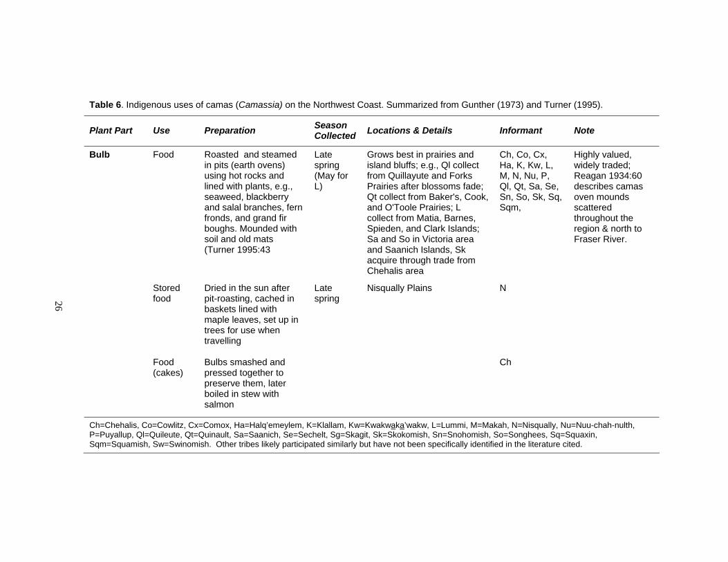
Table 6. Indigenous uses of camas (Camassia) on the Northwest Coast. Summarized from Gunther (1973) and Turner (1995). ..................................................................... 26
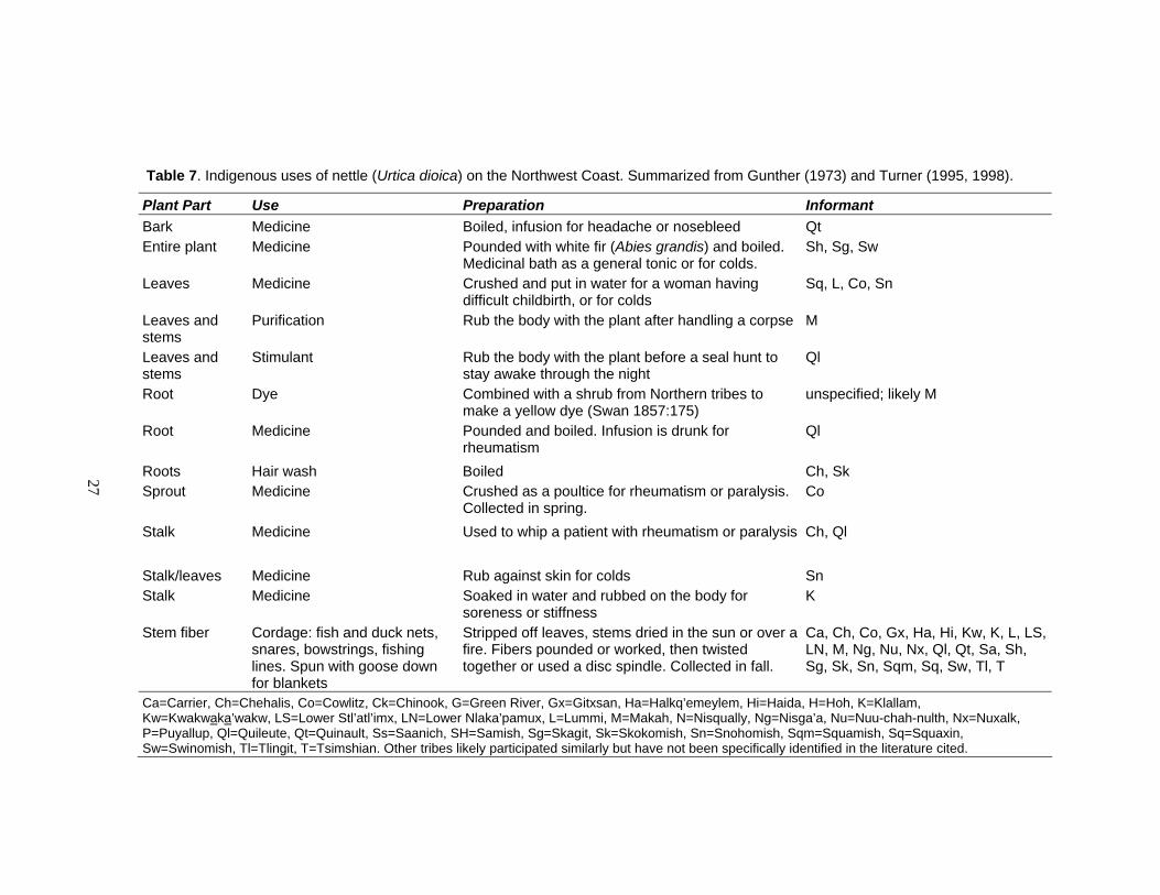
Table 7. Indigenous uses of nettle (Urtica dioica) on the Northwest Coast. Summarized from Gunther (1973) and Turner (1995, 1998). ........................................................... 27
Table 8. Summary of cultural content recovered in bulk soil samples and general interpretations of features. ........................................................................................... 58
Table 9. Overall summary of non-botanical feature contents recovered from bulk soil samples........................................................................................................................ 59
Table 10. Charred underground storage organs recovered from 6.4 mm (1/4-inch) and 3.2 mm (1/8-inch) screen during excavation under and around the Ferry House Site. .................................................................................................................. 61
Table 11. Radiocarbon ages of cultural deposits at the Ferry House Site and vicinity on Ebey’s Prairie............................................................................................................... 64
Table 12. Summary of Feature 4 cultural material collected from 6.4 mm (1/4-inch) screen during excavation............................................................................................. 76
Table 13. Features 1 and 4 at the Ferry House Site compared to common characteristics and contents described for earth ovens in the Northwest. .......................................... 83
Table 14. Plants identified in the archaeobotanical assemblage of the Ferry House Site and vicinity. .................................................................................................................. 98
Table 15. Faunal remains present in features in the vicinity of the Ferry House Site. ................ 104
Table 16. Density of archaeobotanical remains per liter of soil analyzed. .................................. 105
xiv
Table 17. Inferences about human activities on Ebey’s Prairie based on features. ................... 107
Table 18. Ages of artifacts recovered from the Ferry House Site and vicinity during excavation.................................................................................................................. 113
Table 19. Projectile points examined from Ebey's Prairie private collections and their age ranges based on hafting morphology. ....................................................................... 121
Table 20. Inferences about human activity on Ebey’s Prairie based on artifacts........................ 126
Table 21. Inferred ecological history and concurrent human activity on Ebey’s Prairie during the Late Glacial and Holocene........................................................................ 135
Table 22. Efficacy of the methods employed to determine ancient use of Ebey’s Prairie. ......... 143
Table 23. Multiple methods used to study Ebey’s Prairie and the results and interpretations gained from each. .............................................................................. 145
Table 24. Potential research questions and strategies for answering them on Northwest Coast prairies............................................................................................................. 147
1
CHAPTER 1: INTRODUCTION
Anthropogenic Prairies of the Northwest Coast
It is well recognized among anthropologists that the ecological abundance of the
Northwest Coast played a central role in the development of complex social and
economic systems of Northwest Coast people (e.g., Ames and Maschner 1999; Matson
and Coupland 1995; Suttles 1987a, 1990). For archaeologists, models of social
development have largely focused on specific resources, especially salmon, but more
recently on other fisheries (Coupland 1988; Matson 1983, 1992; Matson and Coupland
1995; Moss 1993). Terrestrial resources, and indeed terrestrial ecosystems, have received
considerably less attention. In this thesis I focus on one human-influenced terrestrial
ecosystem — the anthropogenic prairie of the Pacific Northwest Coast. As defined in
this thesis, anthropogenic prairies are grassy lowland openings in the forest-dominated
landscape, which were maintained and enhanced by people.
What is a Prairie?
Ecologists have been grappling with how to classify prairie ecosystems on the
Northwest Coast for a long time. For instance, James G. Cooper, a naturalist hired by the
United States government, spent the better part of two years between 1854 and 1857
classifying prairies in western Washington based on the soils, vegetation, elevation, and
the causes which produced them (Cooper 1860a; WNPS 1994:11). What Cooper began
to recognize is that small prairies at that time were not only widespread across the

2
landscape from seashore to mountain top on various soil substrates, but that maintenance
of these ecosystems by indigenous people, through intentional burning, was also
widespread. Cooper’s observations, though valuable, were not quantifiable.
Today, ecological studies indicate that openings naturally occur in early
successional forests throughout the Pacific Northwest Coast (Franklin and Dyrness 1988;
Krukeberg 1991) but close naturally as trees encroach upon them (Boyd 1999a; Lertzman
et al. 1996; Lertzman et al. 2002). Natural fire frequency is low on the Northwest Coast
however, and cannot account for the existence of extensive prairie openings which were
documented in the early historic period (e.g., Boyd 1999b). It follows then, that the
prolonged existence of prairies prior to European contact was largely the result of
extensive management by indigenous peoples.
What is an “Anthropogenic Prairie”?
Their (prairies) most striking feature is the abruptness of the forests which surround them, giving them the appearance of lands which have been cleared and cultivated for hundreds of years. From various facts observed, I conclude that they are the remains of much more extensive prairies, which within a comparatively recent period, occupied all the lower and drier parts of the valleys, and which the forests have been gradually spreading over in their downward progress from the mountains. The Indians, in order to preserve their open grounds for game, and for the production of their important root, the camas, soon found the advantage of burning… (Cooper 1860a:23; WNPS 1994:16).
I use the term anthropogenic prairie (after Norton 1979b) to identify the human-
maintained herbaceous lowland openings west of the Cascade Mountains. I use this term
because it incorporates the word “prairie,” commonly used in much of the literature by
American ethnologists and ecologists to describe the open lowland ecosystems of the

3
Northwest Coast (Franklin and Dyrness 1988; Kruckeberg 1991; White 1980). Further, it
highlights the essential component of these ecosystems — the role of humans. Canadian
ecologists use the term “meadow” for such ecosystems (e.g., Lepofsky et al. 2005a), and
they generally reserve the term “prairies” to refer to the vast openings of the Central
Plains which occur east of the Cascade Range.
The Distribution and Significance of Anthropogenic Prairies on the Northwest Coast
Anthropogenic prairies were once common on the Northwest Coast (Figure 1) and
were deeply linked to subsistence strategies for indigenous peoples (Norton 1979b).
Determining the distribution of prairies across the Northwest Coast in any given time
period is difficult, given the dynamic combination of natural and cultural disturbances
which produce and maintain them (Table 1). Documenting the distribution of prairies in
the last 250 years in particular is problematic because of the unprecedented rate of change
in the distribution of prairie ecosystems during this time. These changes are due to the
combined effect of the cessation of intentional burning by many indigenous peoples and
the conversion of pre-contact prairie ecosystems into farmland by European settlers.
Despite these confounding factors, historic documents combined with paleoecological
data indicate that prairies were once a relatively common part of the ecological mosaic of
the Pacific Northwest (Cooper 1860a; Crawford and Hall 1997; Franklin and Dyrness
1988; Kruckeberg 1991; Leopold and Boyd; Boyd 1999a, 1999b; Lea et al. 2003; North
et al. 1979; Pojar and MacKinnon 1994), especially on southern Vancouver Island in
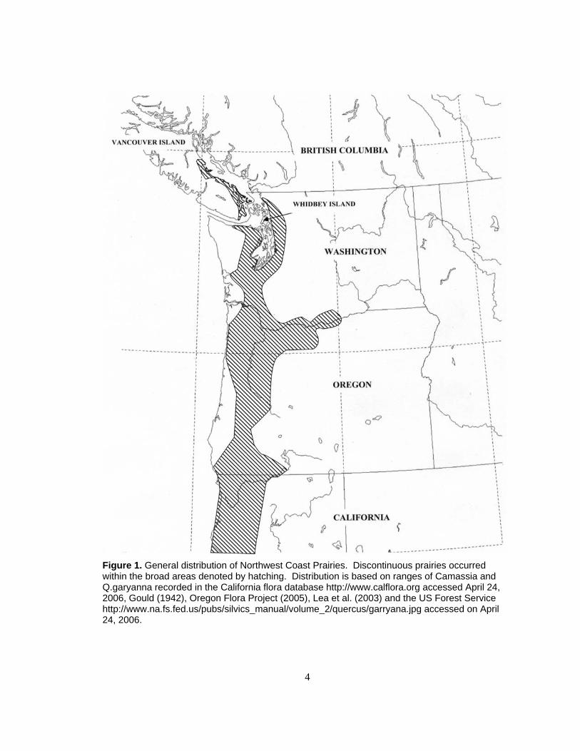
4
Figure 1. General distribution of Northwest Coast Prairies. Discontinuous prairies occurred within the broad areas denoted by hatching. Distribution is based on ranges of Camassia and Q.garyanna recorded in the California flora database http://www.calflora.org accessed April 24, 2006, Gould (1942), Oregon Flora Project (2005), Lea et al. (2003) and the US Forest Service http://www.na.fs.fed.us/pubs/silvics_manual/volume_2/quercus/garryana.jpg accessed on April 24, 2006.
5
Table 1. General climatic fluctuations influencing Northwest Coast prairies during the Holocene (after Whitlock and Knox 2002).
Time Period Climate Vegetation
Early Holocene 11,000-7,800 BP
Drought: summer temperatures 1-3°C higher than today, annual precipitation 40-50% lower than today.
Prairies open naturally: bracken fern, red alder and Douglas-fir in pollen record.
Mid-Holocene 7,800-4,400 BP
Drought subsides: summers cooler and wetter than Early Holocene but drier and warmer than today.
Prairies shrink, forests begin to close. Oak and Douglas-fir less abundant, western redcedar, western hemlock, Oregon ash, big leaf maple increase in pollen record.
Late Holocene 4,400-present
Cooling trend, reaching modern temperatures and precipitation.
Prairies continue to shrink and forests close naturally, treeline shifts downslope. Probably warm and dry within the Fraser Valley Fire Period (2,400-1,200 BP) (Hallett et al. 2003; Lepofsky et al. 2005b). Historically, indigenous people counteract this by burning prairies (Boyd 1999a; Minnis and Elisens 2000; Vale 2002).
British Columbia, in the Puget Basin of Washington, and the Willamette Valley of
Oregon (Figure 2). The rainshadow effect, which creates warm dry pockets within the
cool wet maritime climate, is one factor which has influenced the long-term maintenance
of these ecosystems (Franklin and Dyrness 1988; Kruckeberg 1991).
To document the approximate extent of anthropogenic prairies on the Northwest
Coast, I plotted the distribution of the historic and modern extent of camas (Camassia
spp.) and Garry oak (Quercus garryana) — two common taxa of anthropogenic prairies
(Figure 1). While such a map does not represent the full extent or diversity of
anthropogenic prairies, it clearly demonstrates that such ecosystems were once
widespread in the complex ecological mosaic of the region.
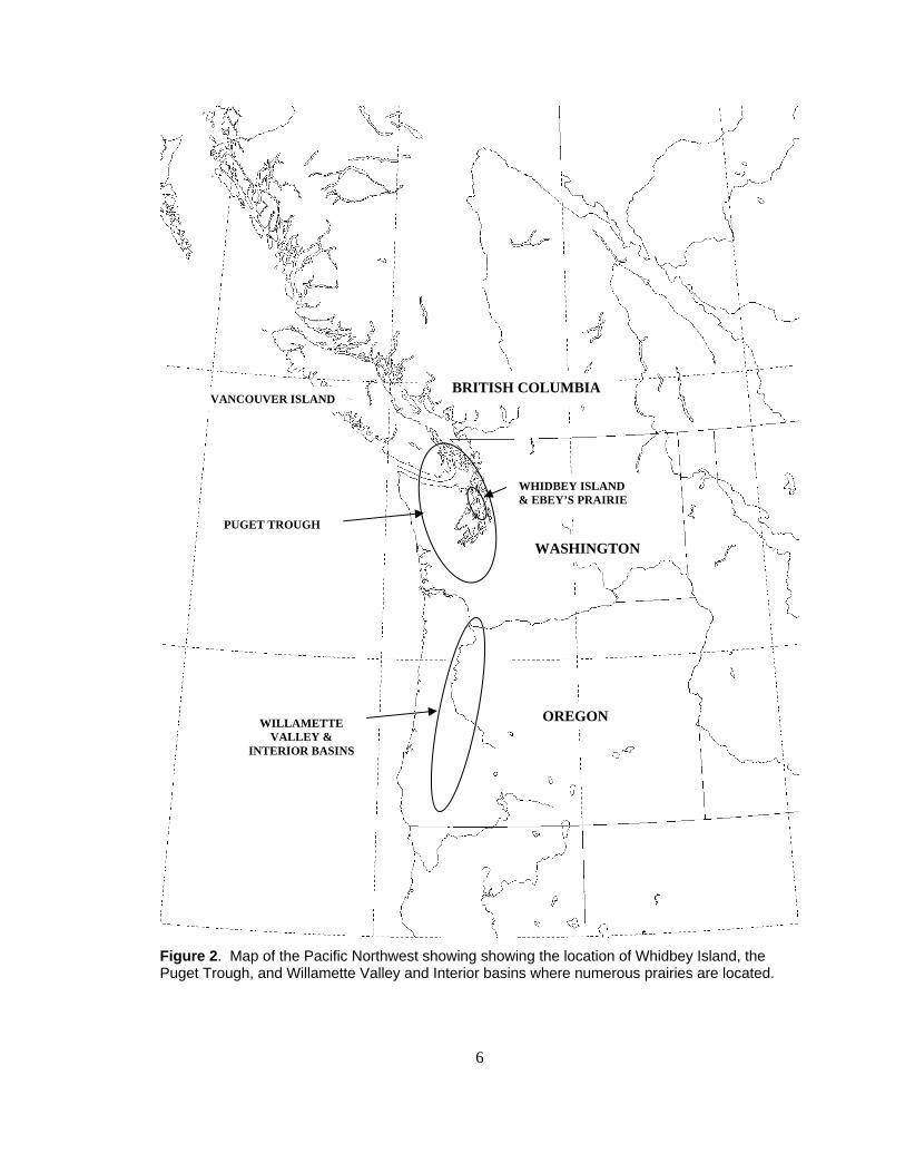
6
Figure 2. Map of the Pacific Northwest showing showing the location of Whidbey Island, the Puget Trough, and Willamette Valley and Interior basins where numerous prairies are located.
PUGET TROUGH
WILLAMETTE VALLEY &
INTERIOR BASINS
BRITISH COLUMBIA VANCOUVER ISLAND
WASHINGTON
OREGON
WHIDBEY ISLAND & EBEY’S PRAIRIE
7
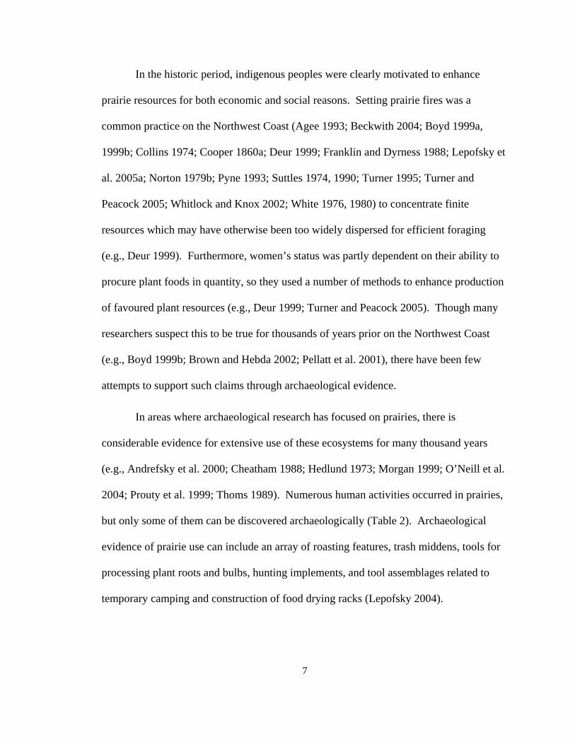
In the historic period, indigenous peoples were clearly motivated to enhance
prairie resources for both economic and social reasons. Setting prairie fires was a
common practice on the Northwest Coast (Agee 1993; Beckwith 2004; Boyd 1999a,
1999b; Collins 1974; Cooper 1860a; Deur 1999; Franklin and Dyrness 1988; Lepofsky et
al. 2005a; Norton 1979b; Pyne 1993; Suttles 1974, 1990; Turner 1995; Turner and
Peacock 2005; Whitlock and Knox 2002; White 1976, 1980) to concentrate finite
resources which may have otherwise been too widely dispersed for efficient foraging
(e.g., Deur 1999). Furthermore, women’s status was partly dependent on their ability to
procure plant foods in quantity, so they used a number of methods to enhance production
of favoured plant resources (e.g., Deur 1999; Turner and Peacock 2005). Though many
researchers suspect this to be true for thousands of years prior on the Northwest Coast
(e.g., Boyd 1999b; Brown and Hebda 2002; Pellatt et al. 2001), there have been few
attempts to support such claims through archaeological evidence.
In areas where archaeological research has focused on prairies, there is
considerable evidence for extensive use of these ecosystems for many thousand years
(e.g., Andrefsky et al. 2000; Cheatham 1988; Hedlund 1973; Morgan 1999; O’Neill et al.
2004; Prouty et al. 1999; Thoms 1989). Numerous human activities occurred in prairies,
but only some of them can be discovered archaeologically (Table 2). Archaeological
evidence of prairie use can include an array of roasting features, trash middens, tools for
processing plant roots and bulbs, hunting implements, and tool assemblages related to
temporary camping and construction of food drying racks (Lepofsky 2004).
8
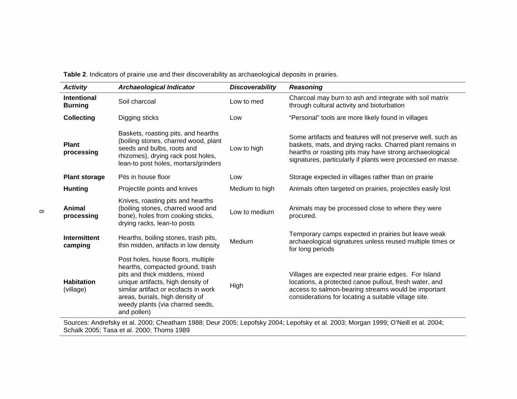
Table 2. Indicators of prairie use and their discoverability as archaeological deposits in prairies.
Activity Archaeological Indicator Discoverability Reasoning Intentional Burning Soil charcoal Low to med Charcoal may burn to ash and integrate with soil matrix
through cultural activity and bioturbation
Collecting Digging sticks Low “Personal” tools are more likely found in villages
Plant processing
Baskets, roasting pits, and hearths (boiling stones, charred wood, plant seeds and bulbs, roots and rhizomes), drying rack post holes, lean-to post holes, mortars/grinders
Low to high
Some artifacts and features will not preserve well, such as baskets, mats, and drying racks. Charred plant remains in hearths or roasting pits may have strong archaeological signatures, particularly if plants were processed en masse.
Plant storage Pits in house floor Low Storage expected in villages rather than on prairie
Hunting Projectile points and knives Medium to high Animals often targeted on prairies, projectiles easily lost
Animal processing
Knives, roasting pits and hearths (boiling stones, charred wood and bone), holes from cooking sticks, drying racks, lean-to posts
Low to medium Animals may be processed close to where they were procured.
Intermittent camping
Hearths, boiling stones, trash pits, thin midden, artifacts in low density Medium
Temporary camps expected in prairies but leave weak archaeological signatures unless reused multiple times or for long periods
Habitation (village)
Post holes, house floors, multiple hearths, compacted ground, trash pits and thick middens, mixed unique artifacts, high density of similar artifact or ecofacts in work areas, burials, high density of weedy plants (via charred seeds, and pollen)
High
Villages are expected near prairie edges. For Island locations, a protected canoe pullout, fresh water, and access to salmon-bearing streams would be important considerations for locating a suitable village site.
Sources: Andrefsky et al. 2000; Cheatham 1988; Deur 2005; Lepofsky 2004; Lepofsky et al. 2003; Morgan 1999; O’Neill et al. 2004; Schalk 2005; Tasa et al. 2000; Thoms 1989
9
In this thesis I explore the ancient history of one anthropogenic prairie, on
Whidbey Island, historically named Ebey’s Prairie (Figure 2). The larger goal of this
thesis is to highlight the potential for archaeological research in prairies of the Northwest
Coast and contribute to our understanding of how people used them in the past. A
number of ethnographic studies illustrate that prairies were important to Northwest Coast
indigenous people at least since the proto-historic period (Beckwith 2004; Collins 1974;
Gunther 1973; Norton 1979a, 1979b; Suttles 1987a, 1990; Thomas 2006; Turner 1995,
Turner and Efrat 1982; Turner and Kuhnlein 1983; Turner and Peacock 2005; White
1980; 1999). Archaeological evidence can extend our understanding of prairie use
further into the past.
My reconstruction of the history of use of Ebey’s Prairie by ancient peoples
involves multiple lines of evidence. First, I compiled Northwest Coast ethnographic and
ethnohistoric literature to understand how indigenous people used and sustained
anthropogenic prairies. Second, I reviewed the results from archaeological research in
coastal and non-coastal prairies of the Northwest. These became the foundation for my
understanding of the kinds of artifacts and features most likely to be recognized in
anthropogenic prairies. This background research helped me to formulate an
archaeological sampling strategy for Ebey’s Prairie specifically. Third, I excavated a
small portion of Ebey’s Prairie to look for artifacts, features, and stratigraphic deposits
which could help me develop a chronology of cultural events. I sampled several features
and examined their contents in the laboratory to determine what kinds of activities were
represented over time by the archaeological deposits. Further, I examined diagnostic
10
stone tools found scattered across Ebey’s Prairie to contribute to my understanding of the
chronology of activities over time.
My results show that people have been using Ebey’s Prairie for a variety of
activities over a broad time scale (~10,000 to 150 BP). Many of these activities are
represented in the ethnographic and ethnohistoric records. Over 800 projectile points
found scattered across the prairie suggest that game were plentiful and consistently
hunted since about 10,000 years ago. From ethnographic records it is clear that game
were attracted to prairies due to their rich forage. An increase in the number of features
since ~2,300 cal. BP illustrates that people may have used part of Ebey’s Prairie more
intensively in the Late Holocene, shifting from primarily hunting to multiple uses,
including plant processing. Further, the increased presence of plants which thrive in
open, non-forested ecosystems in the last 2,300 years suggests that people were burning
the Ebey's landscape to discourage forests and encourage economically important plants,
such as camas prior to European contact. Increased plant food production, especially
since ~2,300 cal. BP on Ebey’s Prairie, is consistent with the timeline of other significant
social developments on the Northwest Coast during this period (Ames 2005; Ames and
Mashner 1999; Matson and Coupland 1995).
Outline of this Thesis
In the following chapters, I will discuss ethnographic and paleoenvironmental
literature as well as direct evidence I gathered from Ferry House Site (45IS221) on
Ebey’s Prairie. In Chapter 2, I present specific ethnographic evidence about the
11
indigenous use of Ebey’s and other prairies on Whidbey Island. I also briefly discuss the
archaeological context of Ebey’s Prairie and introduce the Ferry House Site, where I
collected field data. Through my evaluation of the ecological and cultural context of
Ebey’s Prairie in Puget Sound, I establish that this ecosystem is well suited for further
exploration. Subsurface deposits on Ebey’s Prairie are relatively well preserved and it
has an already richly documented ethnographic record.
Through an examination of the Ferry House Site (45IS221) and a review of other
archaeological sites on Ebey’s Prairie, I investigate the human use of this anthropogenic
prairie throughout the prehistoric period. In Chapter 3, I discuss my field and laboratory
methods, my analysis of artifact collections documented by Trebon (1998), and review
broader paleoecological data from the region. In Chapter 4, I present results and offer
interpretations, leading to a chronology of human activities on Ebey’s Prairie in
prehistory. These results inform my discussion of the broader context of Northwest
Coast anthropogenic prairies in Chapter 5, and I suggest future directions for
archaeological research in them.
12
CHAPTER 2: CULTURAL CONTEXT OF ANTHROPOGENIC PRAIRIES
Rather than being major Indian food sources because they dominated the prairies, bracken and camas more likely dominated the prairies because they were major Indian food sources (White 1976:333).
Plant Resources in Anthropogenic Prairies
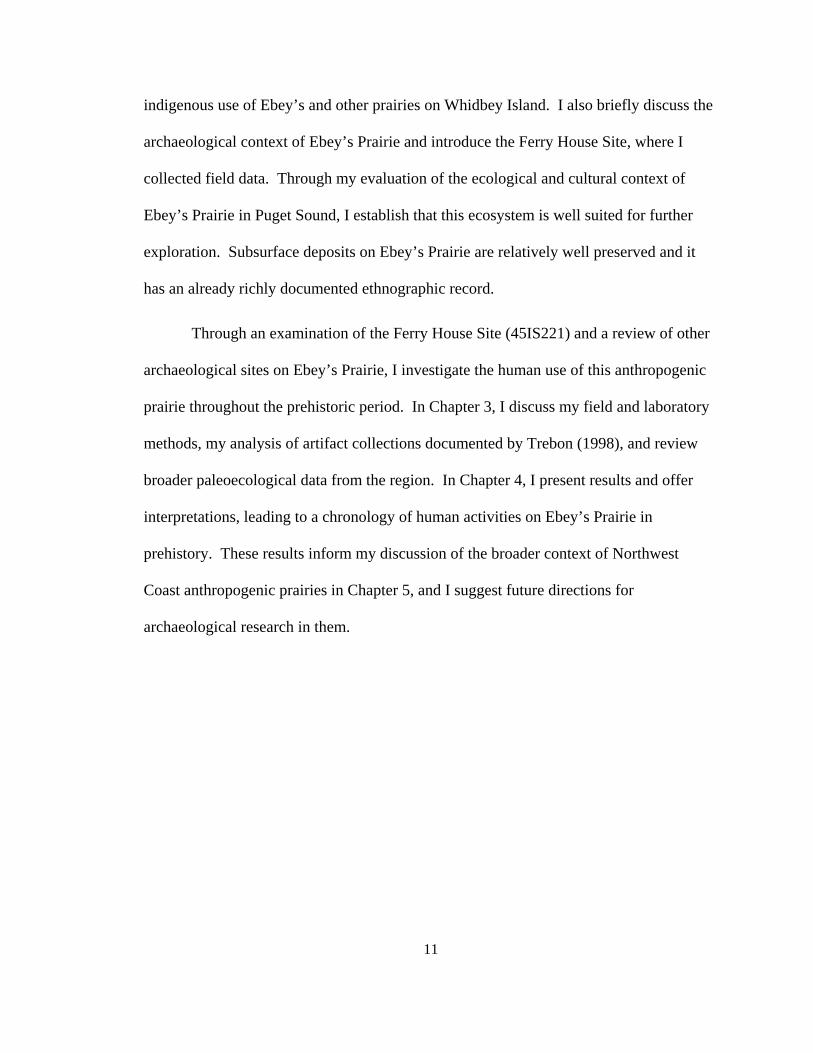
Prairies support a range of plants not available in forested ecosystems. Cooper
(1860a), and Lotspeich et al. (1961), identified 162 prairie and prairie-ecotone plants as
native species in western Washington prairies (Appendix A). Though this list of plants
cannot be considered complete for Northwest Coast prairies, it serves as a starting point
and a means of demonstrating the diversity of these ecosystems. Nearly all these plant
species listed require unforested or sparcely forested ecosystems to survive. Based on
these data, Northwest Coast prairies hosted plants from 38 plant families and included
primarily forbs with lesser amounts of grasses and grasslike plants (i.e., sedges and
rushes), shrubs, and a few trees such as pines (Pinus) and Garry oak (Q. garryanna)
(Figure 3).
A wide variety of plants found in prairies were used by indigenous peoples of the
Northwest Coast. Nutritionally speaking, plants were a critical source of carbohydrates,
as well as vitamins, minerals, and fiber not available in a meat and fish diet (Norton
1979a; Turner and Kuhnlein 1983). Nearly 60% of the plant species identified in
13
0
10
20
30
40
50
60
70
80
90
Forbs Shrubs Grasses Trees
Types of Plants Identified
% o
f Tot
al Q
uant
ity
133
2
1215
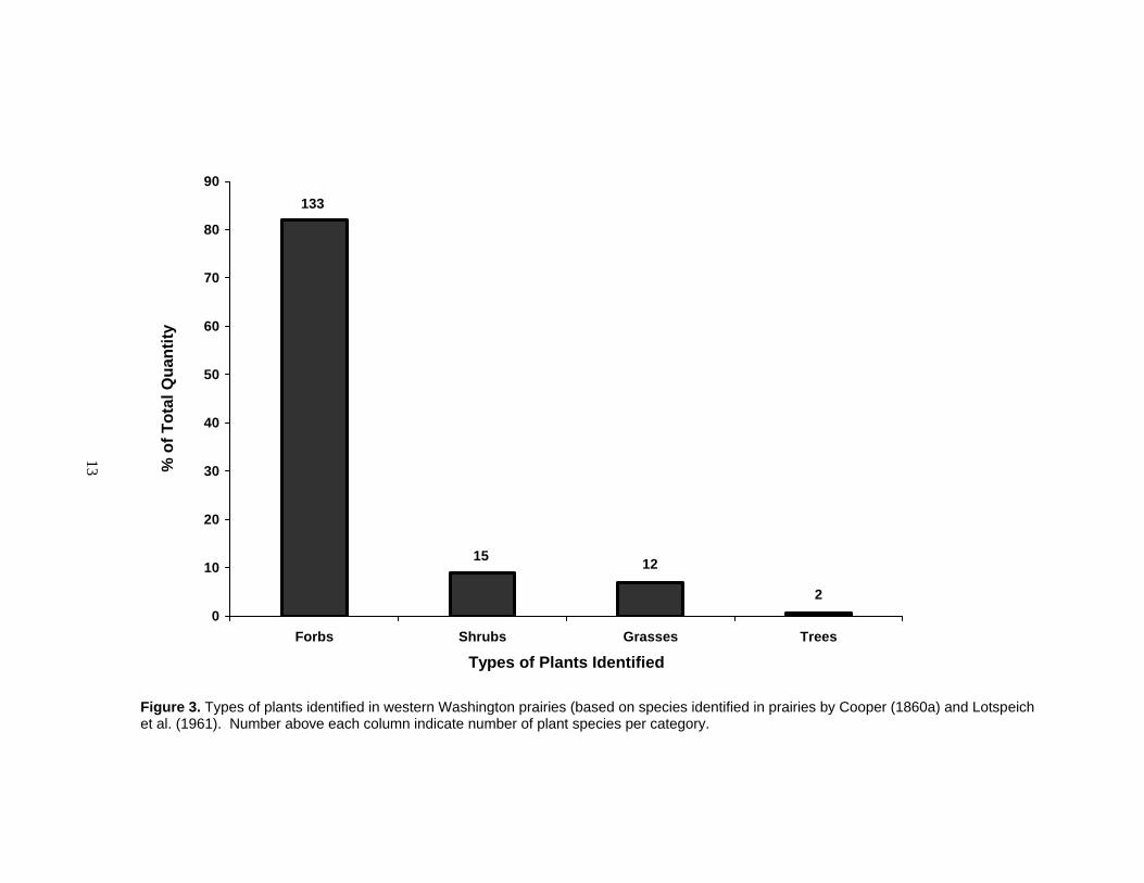
Figure 3. Types of plants identified in western Washington prairies (based on species identified in prairies by Cooper (1860a) and Lotspeich et al. (1961). Number above each column indicate number of plant species per category.
14
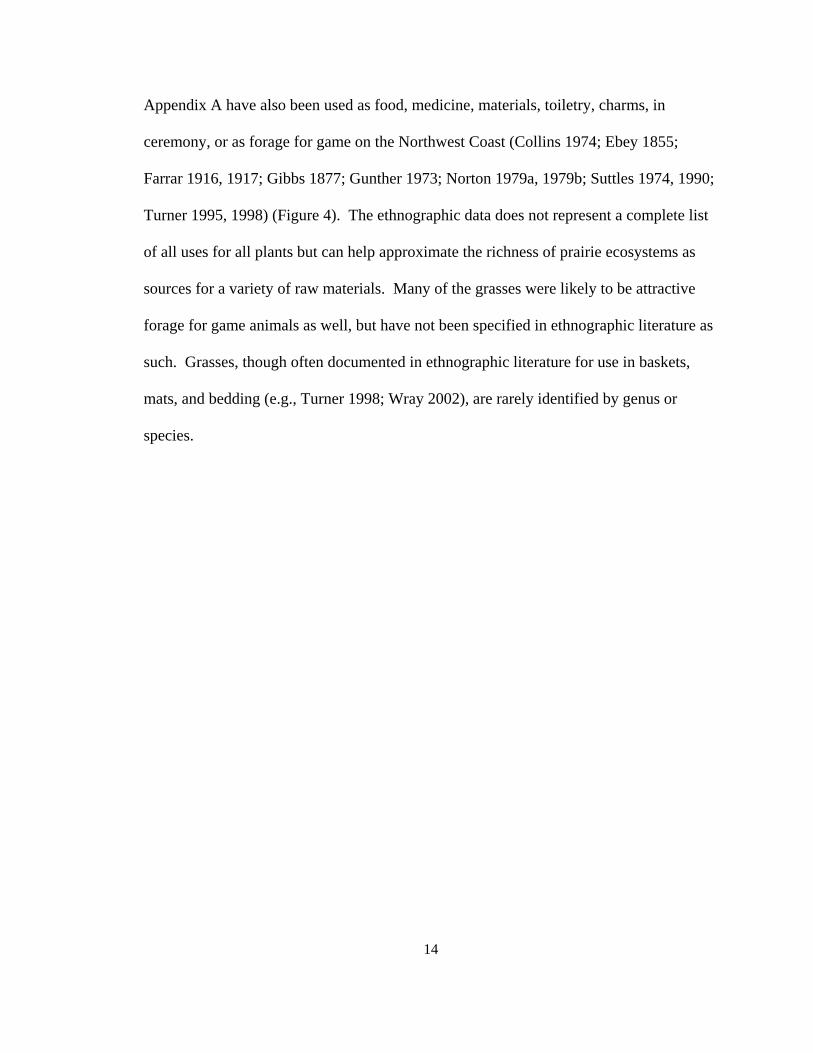
Appendix A have also been used as food, medicine, materials, toiletry, charms, in
ceremony, or as forage for game on the Northwest Coast (Collins 1974; Ebey 1855;
Farrar 1916, 1917; Gibbs 1877; Gunther 1973; Norton 1979a, 1979b; Suttles 1974, 1990;
Turner 1995, 1998) (Figure 4). The ethnographic data does not represent a complete list
of all uses for all plants but can help approximate the richness of prairie ecosystems as
sources for a variety of raw materials. Many of the grasses were likely to be attractive
forage for game animals as well, but have not been specified in ethnographic literature as
such. Grasses, though often documented in ethnographic literature for use in baskets,
mats, and bedding (e.g., Turner 1998; Wray 2002), are rarely identified by genus or
species.

15
0
5
10
15
20
25
30
35
40
Medici
ne
Food
Materia
ls
Charm
Ceremony
Superstiti
on
Toiletry Fuel
Bedding
Ethnographic Uses
% T
axa
iden
tifie
d pe
r Eth
nogr
aphi
c U
se34
28
16
5
2 211
2
Figure 4. Ethnographic uses documented for many of the plant taxa in Northwest Coast prairies. Uses based on ethnographic references (e.g., Collins 1974; Ebey 1855; Farrar 1916, 1917, Gibbs 1877; Gunther 1973; Norton 1979b; Suttles 1974, 1990; Turner 1975, 1998) for Northwest Coast Peoples. Number above each column indicates number of plant taxa per category. Some taxa will fit into multiple categories, such as Rosa which was used for food, medicine, materials, and toiletry. The strong representation of medicines, shown here, may be significant for prairies. Further study would be needed to demonstrate whether this pattern is truly representative.
16
Animal Resources in Anthropogenic Prairies
Three categories of birds and mammals can be found in prairies: inhabitants,
foragers, and predators (Appendix B). Inhabitants are small mammals who forage and
make their homes in grassy openings. Foragers, such as deer and elk, spend much of
their time under the forest canopy, but browse regularly on plants in and along the edges
of prairies. Birds like ducks and geese feed primarily in prairies and wetlands. Finally,
predatory mammals and birds often target other animals in prairies, and feed on prairie or
edge vegetation to supplement their diet (Banfield 1974; Cowan et al. 1978).
Ethnographic and ethnohistoric sources indicate that many of the animals that
frequent prairies were hunted by people and used as food as well as for utilitarian and
ceremonial items (Barnett 1955; Cooper 1860b; Drucker 1955; Gunther 1972; Jenness
1977; Matthews 1955; Maud 1978; Suttles 1974) (Appendix B). A variety of hunting
techniques were employed to target animals in prairies.
Maintaining the Harvest
Historically, indigenous people exercised a range of techniques to sustain prairie
productivity (Table 3) because prairies contained a wealth of useful and edible plants and
animals, and were not ubiquitous across the Northwest Coast region. Indigenous people
set intentional, low-intensity fires to discourage the encroachment of trees and brushy
vegetation, enhance forage for game animals (e.g., White 1980), increase edible berry
yields, and promote other edible, medicinal, and useful plants (Peacock and Turner 2000;

17
Table 3. Prairie enhancement strategies used by Northwest Coast Peoples to promote resource abundance. Summarized from Turner and Peacock (2005).
Desired Outcome Enhancement Strategy Season Effect
Hunt deer, elk, bear
Intentional burning Fall Enhance browse, lure animals to prairie, replenish soil
Collect root vegetables
Intentional burning Selective harvest by season Replant propagules
Fall Spring or fall During harvest
Reduce species competition, replenish soil, grow large healthy roots
Collect young greens
Intentional burning Selectively harvest by season
Fall Spring
Reduce species competition, replenish soil, grow edible greens
Collect herbaceous leaves for matting and packing material
Intentional burning Fall Reduce species competition, replenish soil, grow large healthy leaves
Turner and Peacock 2005). In short, the simple act of setting fire to the prairie helped to
enhance a culturally-preferred environment.
Socially-prescribed rules were observed historically which prevented
overharvesting of valued prairie resources and helped manage them sustainably
(Beckwith 2004; Collins 1974; Deur and Turner 2005; Gunther 1973; Peacock and
Turner 2000; Suttles 1990). Such social practices, though widespread historically, can be
difficult to demonstrate archaeologically.
18
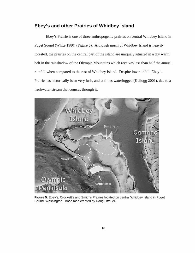
Ebey’s and other Prairies of Whidbey Island
Ebey’s Prairie is one of three anthropogenic prairies on central Whidbey Island in
Puget Sound (White 1980) (Figure 5). Although much of Whidbey Island is heavily
forested, the prairies on the central part of the island are uniquely situated in a dry warm
belt in the rainshadow of the Olympic Mountains which receives less than half the annual
rainfall when compared to the rest of Whidbey Island. Despite low rainfall, Ebey’s
Prairie has historically been very lush, and at times waterlogged (Kellogg 2001), due to a
freshwater stream that courses through it.
Figure 5. Ebey’s, Crockett’s and Smith’s Prairies located on central Whidbey Island in Puget Sound, Washington. Base map created by Doug Littauer.
Ebey’s
Crockett’s
Smith’s
45IS22

19
Early explorers did not mention Ebey’s Prairie by name (named in 1850 for settler
Isaac Ebey) but it likely figured prominently in their descriptions of Whidbey Island
prairies because it was exceptionally lush and productive, and it was easily visible from
Admiralty Inlet — the main water route from open ocean into Puget Sound. The earliest
accounts of Whidbey Island prairies come from the Vancouver Expedition. In 1792,
Second Lieutenant Peter Puget described the “beautiful lawns” with grass “Man Height,”
and “healthfull and delightfull plains which distinguish this favored Land from the Rest
of the Coast of America…An Island distinguished in the General Chart by the name
Whidbey’s Island is absolutely as fine a tract of Land as I have ever saw, at least
apparently so” (Morgan 1979:17). Ebey’s Prairie was first mapped in 1841 on a nautical
chart of Admiralty Inlet (NOAA 2005) which illustrates a grassy/marshy opening
between two ridges with one large conifer tree near the center of the prairie. Isaac
Stevens, early Washington governor, noted the unique quality of Whidbey Island’s
prairies in the 1850s, writing, “there are on the sound (Puget’s) many islands worthy of
mention, the most important of which is Whidby’s (sic) island, which may be called the
garden of the Territory….On this island is a considerable quantity of prairie land, which
at an early day was taken up by the settlers” (Stevens 1860:260). Naturalist J. G. Cooper,
one of Steven’s agents, described rich prairies, such as Ebey’s, with black soil 30-91 cm
deep, very high in organic content and hosting vegetation which grew about 180-200 cm
tall and included “everything adapted to the climate in luxuriant profusion” (Cooper
1860a:14).
20
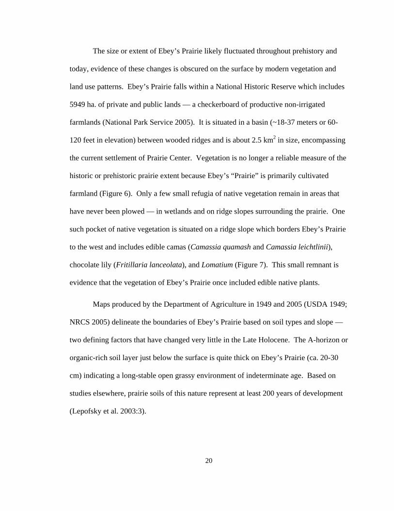
The size or extent of Ebey’s Prairie likely fluctuated throughout prehistory and
today, evidence of these changes is obscured on the surface by modern vegetation and
land use patterns. Ebey’s Prairie falls within a National Historic Reserve which includes
5949 ha. of private and public lands — a checkerboard of productive non-irrigated
farmlands (National Park Service 2005). It is situated in a basin (~18-37 meters or 60-
120 feet in elevation) between wooded ridges and is about 2.5 km2 in size, encompassing
the current settlement of Prairie Center. Vegetation is no longer a reliable measure of the
historic or prehistoric prairie extent because Ebey’s “Prairie” is primarily cultivated
farmland (Figure 6). Only a few small refugia of native vegetation remain in areas that
have never been plowed — in wetlands and on ridge slopes surrounding the prairie. One
such pocket of native vegetation is situated on a ridge slope which borders Ebey’s Prairie
to the west and includes edible camas (Camassia quamash and Camassia leichtlinii),
chocolate lily (Fritillaria lanceolata), and Lomatium (Figure 7). This small remnant is
evidence that the vegetation of Ebey’s Prairie once included edible native plants.
Maps produced by the Department of Agriculture in 1949 and 2005 (USDA 1949;
NRCS 2005) delineate the boundaries of Ebey’s Prairie based on soil types and slope —
two defining factors that have changed very little in the Late Holocene. The A-horizon or
organic-rich soil layer just below the surface is quite thick on Ebey’s Prairie (ca. 20-30
cm) indicating a long-stable open grassy environment of indeterminate age. Based on
studies elsewhere, prairie soils of this nature represent at least 200 years of development
(Lepofsky et al. 2003:3).

21
Figure 6. Ebey's Prairie today, view to the west. Unpublished photograph by R. Harbour, used with permission.
Figure 7. Native prairie plants, Camassia quamash, Fritilaria lanceolata, and Lomatium sp. on Ebey's Ridge above Ebey’s Prairie. Unpublished photograph by R. Harbour, used with permission.

22
Historic Evidence of Indigenous Use of Ebey’s Prairie
Historically, several Coast Salish groups used Ebey’s Prairie for a number of
activities (Table 4). Ethnohistoric documents place the Skagit, Snohomish, S’Cllalum,
(White 1980:15-17), Skekowmish or Sowkamish (sic), Snoqualmie, Tulalip (Kellogg
2001:15-17), as well as unidentified tribes from the Seattle and Port Madison area (Ebey
1855) and upper Puget Sound (Kellogg 2001:17) on Ebey’s Prairie. Many of these
groups had familial ties with one another and also followed protocols regarding resources
within their territories, for hunting, fishing, and plant collection (Haeberlin and Gunther
1930:136-137). Such protocols would govern how and when prairie resources were used
and by whom.
Ebey’s Prairie had several resources worth fighting for — some of the richest soil
and abundant animal resources in the vicinity (Ebey 1855; Farrar 1916, 1917; Kellogg
2001; White 1980). Ethnohistoric documents provide evidence of conflict between the
S’Clallum, who paddled across Admiralty Inlet from the Olympic Peninsula, and the
Skagit and Skekowmish or Sowkamish (sic) (Kellogg 2001:8), who had villages
bordering Ebey’s Prairie (Farrar 1916, 1917; Kellogg 2001:1, 2, 8; Vancouver 1792:568;
White 1980:16-17). In fact, Father Blanchet documented that two S’Clallum men died in
a scuffle with Chief Tslalakum’s men in 1841 (Kellogg 2001:8). By most accounts, the
S’Cllalum were latecomers who began laying claim to the fertile soil of Ebey’s Prairie

23
Table 4. Indigenous uses of Ebey’s Prairie in the historic period. Summarized from Ebey (1855), Farrar (1916, 1917) and Kellogg (2001).
Group Use Date Source Possible Archaeological Signature
Skekwamish or Sowkamish1 Chief Tslalakum's village on bluff 50' above beach
May 28 – June 1, 1840
Blanchet (cited in Kellogg 2001:7-9)
Shell midden, post holes, house floors, hearths, implements
Skekwamish or Sowkamish1 & Skagit
Indigenous Catholic worship; i.e., room built of mats, plank altar, post with flag and Catholic “ladder”
May 29, 1840 Blanchet (cited in Kellogg 2001:7-9)
Possibly post holes
S’Clallum & Skekwamish1 Indigenous battle; two Clallam killed
May 28, 1840 Blanchet (cited in Kellogg 2001:7-9)
None; individuals were likely taken to S’Clallum village
Unspecified indigenous group Indigenous cultivation of potatoes; potato plants and use of digging sticks
May 30, 1840 Blanchet (cited in Kellogg 2001:7-9)
None
S’Clallum Defense of potato grounds; wooden fort
1840 OPD 18532 (cited in White 1980:15)
Possibly post holes
Chief Patkanim of Snog-qualamies (Snoqualmie?) and sub-chiefs of Whidbey Island and upper Puget Sound
Feasting on 60 deer and holding council
1848 Thomas Glasgow (cited in Kellogg 2001:17)
Cooking features
Indigenous people from Seattle area
Collect and cook camas 1855 Ebey 1855 Cooking features
Indigenous people from Port Townsend area (Cllalam?)
Camping on beach below Ebey's house
1855 Ebey 1855; Farrar 1916, 1917
Ephemeral cooking features, trash pile
1 These group names identified by Blanchet in 1840 do not match any currently recognized tribal names, yet they are phonetically similar to several Coast Salish groups (e.g., Skokomish, Skykomish, Squamish) 2 Olympia Pioneer and Democrat (April 9, 1853) (cited in White 1980:15)
24
after the introduction of potatoes and the Skagit had long-term villages near the prairie
edge (White 1980:15-16).
Three plants documented as being culturally important and which grew on Ebey’s
Prairie in the early historic period are bracken fern (Pteridium aquilinium) (Table 5),
camas (Camassia) (Table 6), and nettle (Urtica dioica ) (Table 7) (Blanchet 1878; Ebey
1855; Farrar 1916, 1917; White 1980). Several varieties of berries and wild onion were
also widespread on the prairie (Bell 1914, 1915:222). These plants were used similarly
by most Northwest Coast People.
Camas (Camassia) was abundant on Ebey’s Prairie historically (Blanchet 1878;
Ebey 1855; Farrar 1916, 1917) and was highly valued food resource of the Northwest
Coast people (Gibbs 1877; Gunther 1973; Collins 1974; Turner 1995). Camas was
closely linked to anthropogenic prairies (Norton 1979; White 1980), and has been
identified in archaeological deposits elsewhere on the Northwest Coast (e.g., Lepofsky
2004; O’Neill 2004; Tasa et al. 2000). The bulb of this plant was valued because it was
one of few starchy foods in the diet (Turner and Kuhnlein 1983) and has a sweet flavour
(Turner and Peacock 2005). In order to make the bulb palatable and digestible, a long
slow cooking period was necessary (24-48 hours); it was typically cooked in quantity in
earth ovens (Gunther 1973; Turner 1995) which leave a recognizable archaeological
signature (Thoms 1989). This cooking process also increases the chances that some of
the bulbs become charred and preserved in archaeological deposits.
Ethnographic and ethnohistoric accounts record that Coast Salish people settled
along the borders of Ebey’s Prairie and camped on the prairie while they collected camas.

25
Table 5. Indigenous uses of bracken fern (Pteridium aquilinium) on the Northwest Coast. Summarized from Gunther (1973), Norton (1979), Suttles (1974) and Turner (1995, 1998).
Plant Part Use Preparation Season Collected
Locations & Details Informant
Rhizome Food Roasted in ashes peeled, starchy center eaten. Sometimes stored in baskets (Sw) or steamed in pits, chewed and fibers spit out. Eaten with fish eggs or oil.
Fall; L, Sk Numerous burnt prairies: e.g., SG collected juicy ones at Birdsview in Skagit River basin
Ch, Co, Ck, G, Ha, K, Kw, L, M, Nu, Ql, Qt, Se, Sg, Sh, Sk, Sn, Sq, Sw
Food (bread) Pound with dogwood sticks (Sn) and dry pulp of rhizome, grind to flour, make paste, cook as bread
H, No, Ql, Sh, Sn, Ss
Rhizome fiber Cordage Fibers twisted into cordage Likely fall Ql Tinder or “slow
matches”1 Fibers for tinder or bound in cedar bark or clam shells for slow burning, also bundled for torches (SS, Ha)
Early spring (for torches)
When bundled, they could hold a fire for hours or days
Ha, Kw, Nu, Ow, SS
Fiddleheads/ shoots
Food Eaten raw or boiled (fiddlehead) Spring Co, Nu, Se
Hunting lure Burn prairies to lure deer and elk with new growth
Likely fall On the Olympic Peninsula; Forks and Quillayute Prairies
Ql
Leaves Food preparation
Lining for steaming pits unspecified (widespread)
Design pattern Used as a template in basket weaving designs
Hi
Wiping fish Leaves used to lay fish on during cleaning and to wipe them off
M, Ql, Sq, Sw
Camp bedding Cut and pile for bedding Sq, SS
1=reported in Turner 1998:65, Ch=Chehalis, Co=Cowlitz, Ck=Chinook, G=Green River, Ha=Halkomelem, Hi=Haida, H=Hoh, K=Klallam, Kw=Kwakwaka’wakw, L=Lummi, M=Makah, N=Nisqually, No=Nooksack, Nu=Nuu-chah=nulth, Nx=Nuxalk, Ow=Oweekeno, P=Puyallup, Ql=Quileute, Qt=Quinault, Sa=Saanich, Sh=Samish, Se=Sechelt, Sg=Skagit, Sk=Skokomish, Sn=Snohomish, Sq=Squaxin, SS=Straits Salish, Sw=Swinomish. Other tribes likely participated similarly but have not been specifically identified in the literature cited.
26
Table 6. Indigenous uses of camas (Camassia) on the Northwest Coast. Summarized from Gunther (1973) and Turner (1995).
Plant Part Use Preparation Season Collected Locations & Details Informant Note
Bulb Food Roasted and steamed in pits (earth ovens) using hot rocks and lined with plants, e.g., seaweed, blackberry and salal branches, fern fronds, and grand fir boughs. Mounded with soil and old mats (Turner 1995:43
Late spring (May for L)
Grows best in prairies and island bluffs; e.g., Ql collect from Quillayute and Forks Prairies after blossoms fade; Qt collect from Baker's, Cook, and O'Toole Prairies; L collect from Matia, Barnes, Spieden, and Clark Islands; Sa and So in Victoria area and Saanich Islands, Sk acquire through trade from Chehalis area
Ch, Co, Cx, Ha, K, Kw, L, M, N, Nu, P, Ql, Qt, Sa, Se, Sn, So, Sk, Sq, Sqm,
Highly valued, widely traded; Reagan 1934:60 describes camas oven mounds scattered throughout the region & north to Fraser River.
Stored food
Dried in the sun after pit-roasting, cached in baskets lined with maple leaves, set up in trees for use when travelling
Late spring
Nisqually Plains N
Food (cakes)
Bulbs smashed and pressed together to preserve them, later boiled in stew with salmon
Ch
Ch=Chehalis, Co=Cowlitz, Cx=Comox, Ha=Halq’emeylem, K=Klallam, Kw=Kwakwaka’wakw, L=Lummi, M=Makah, N=Nisqually, Nu=Nuu-chah-nulth, P=Puyallup, Ql=Quileute, Qt=Quinault, Sa=Saanich, Se=Sechelt, Sg=Skagit, Sk=Skokomish, Sn=Snohomish, So=Songhees, Sq=Squaxin, Sqm=Squamish, Sw=Swinomish. Other tribes likely participated similarly but have not been specifically identified in the literature cited.
27
Table 7. Indigenous uses of nettle (Urtica dioica) on the Northwest Coast. Summarized from Gunther (1973) and Turner (1995, 1998).
Plant Part Use Preparation Informant Bark Medicine Boiled, infusion for headache or nosebleed Qt Entire plant Medicine Pounded with white fir (Abies grandis) and boiled.
Medicinal bath as a general tonic or for colds. Sh, Sg, Sw
Leaves Medicine Crushed and put in water for a woman having difficult childbirth, or for colds
Sq, L, Co, Sn
Leaves and stems
Purification Rub the body with the plant after handling a corpse M
Leaves and stems
Stimulant Rub the body with the plant before a seal hunt to stay awake through the night
Ql
Root Dye Combined with a shrub from Northern tribes to make a yellow dye (Swan 1857:175)
unspecified; likely M
Root Medicine Pounded and boiled. Infusion is drunk for rheumatism
Ql
Roots Hair wash Boiled Ch, Sk Sprout Medicine Crushed as a poultice for rheumatism or paralysis.
Collected in spring. Co
Stalk Medicine Used to whip a patient with rheumatism or paralysis Ch, Ql
Stalk/leaves Medicine Rub against skin for colds Sn Stalk Medicine Soaked in water and rubbed on the body for
soreness or stiffness K
Stem fiber Cordage: fish and duck nets, snares, bowstrings, fishing lines. Spun with goose down for blankets
Stripped off leaves, stems dried in the sun or over a fire. Fibers pounded or worked, then twisted together or used a disc spindle. Collected in fall.
Ca, Ch, Co, Gx, Ha, Hi, Kw, K, L, LS, LN, M, Ng, Nu, Nx, Ql, Qt, Sa, Sh, Sg, Sk, Sn, Sqm, Sq, Sw, Tl, T
Ca=Carrier, Ch=Chehalis, Co=Cowlitz, Ck=Chinook, G=Green River, Gx=Gitxsan, Ha=Halkq’emeylem, Hi=Haida, H=Hoh, K=Klallam, Kw=Kwakwaka’wakw, LS=Lower Stl’atl’imx, LN=Lower Nlaka’pamux, L=Lummi, M=Makah, N=Nisqually, Ng=Nisga’a, Nu=Nuu-chah-nulth, Nx=Nuxalk, P=Puyallup, Ql=Quileute, Qt=Quinault, Ss=Saanich, SH=Samish, Sg=Skagit, Sk=Skokomish, Sn=Snohomish, Sqm=Squamish, Sq=Squaxin, Sw=Swinomish, Tl=Tlingit, T=Tsimshian. Other tribes likely participated similarly but have not been specifically identified in the literature cited.
28
Early ethnographer George Gibbs noted that camp sites related to camas harvest
and roasting could generally be found, “near the skirts of timber which border the open
lands for the convenience of gathering and preserving” (Gibbs 1877:193). Early
explorers, missionaries and people who settled on Ebey’s Prairie documented that
villages and temporary camps were located on the east and west edges of the prairie
(Farrar 1916, 1917; Kellogg 2001:1, 2, 8; Vancouver 1792:568; White 1980:16-17). One
village, led by Chief Tslalakum and recorded by Father Blanchet as Skekowmish or
Sowkamish (sic), was described by Blanchet in 1840 to be situated on the west side of the
prairie and on a bluff 50 feet above Ebey’s Landing (Kellogg 2001:8). This is in close
proximity to the Ferry House archaeological site described in detail later in this thesis and
may, in fact, account for some of the archaeological deposits found during my excavation
there. Temporary camps described by the Ebey family in diaries and letters (Farrar 1916,
1917) are also in close proximity to or perhaps on the Ferry House archaeological site.
According to ethnohistoric sources, indigenous people actively tended the Ebey’s
Prairie ecosystem to maintain and encourage certain resources. In addition to setting fires
regularly to keep the prairie open (Cooper 1860b:22-23; Fararr 1916, 1917; White
1980:20-22, 1999:40, 42) indigenous people tilled the land with digging sticks (Kellogg
2001:9) to harvest and encourage camas (Ebey 1855; Gibbs 1978:39).
Early exploring parties, like the Vancouver and Wilkes Expeditions, among
others, noted the abundance of deer, elk, and ducks (Kellogg 2001:3; Vancouver
1792:68; White 1999:19, 46) on all prairies of Whidbey Island. Several historical
references mention the abundance of deer, in particular, on Ebey’s Prairie (Farrar 1916,

29
1917; Kellogg 2001; White 1980). Even after European settlement on the prairie, deer
and other game were plentiful. When interviewed by June Collins (1974), John Fornsby,
an Upper Skagit man, reported that there had always been plenty of deer and ducks on
Whidbey Island and that the Lower Skagit people ate meat most every day (Collins
1974:302). One method of duck hunting used tall poles to secure nettle-fiber nets (Figure
8). People scared the ducks into the nets at night using flaming torches. The abundant
nettle supply on Ebey’s Prairie, deriving from plants 180-215 cm (6-7 feet) tall, could
have provided prime material for net construction.
Ebey’s Prairie was also used as a place for large groups to gather for worship,
council, and feasts (Kellogg 2001). In 1840, Father Blanchet performed religious
services on Ebey’s Prairie and noted that “chiefs and subchiefs” joined them from other
parts of Whidbey Island (Kellogg 2001:8,19). Blanchet also noted that the people who
came together to worship had a great deal of practice with the Catholic songs before he
had arrived, indicating that such gatherings had been regular events. In 1848, a large
multi-tribal council was held on Ebey’s Prairie to discuss encroachment into their
territories by European settlers. Sixty deer were killed for the feast (Kellogg 2001:17)
and one would-be settler was chased off of Ebey’s Prairie by several of the men.
By the late 1850s indigenous use of Ebey’s Prairie had changed in several ways.
In particular, setting the prairie on fire was discouraged, many traditional camas grounds
were claimed by homesteaders, and guns were increasingly used for hunting. The
increased hunting pressure by Europeans led to a sharp decline in the abundance of deer
(White 1980). The village site at Ebey’s Landing, adjacent to the Ebey family
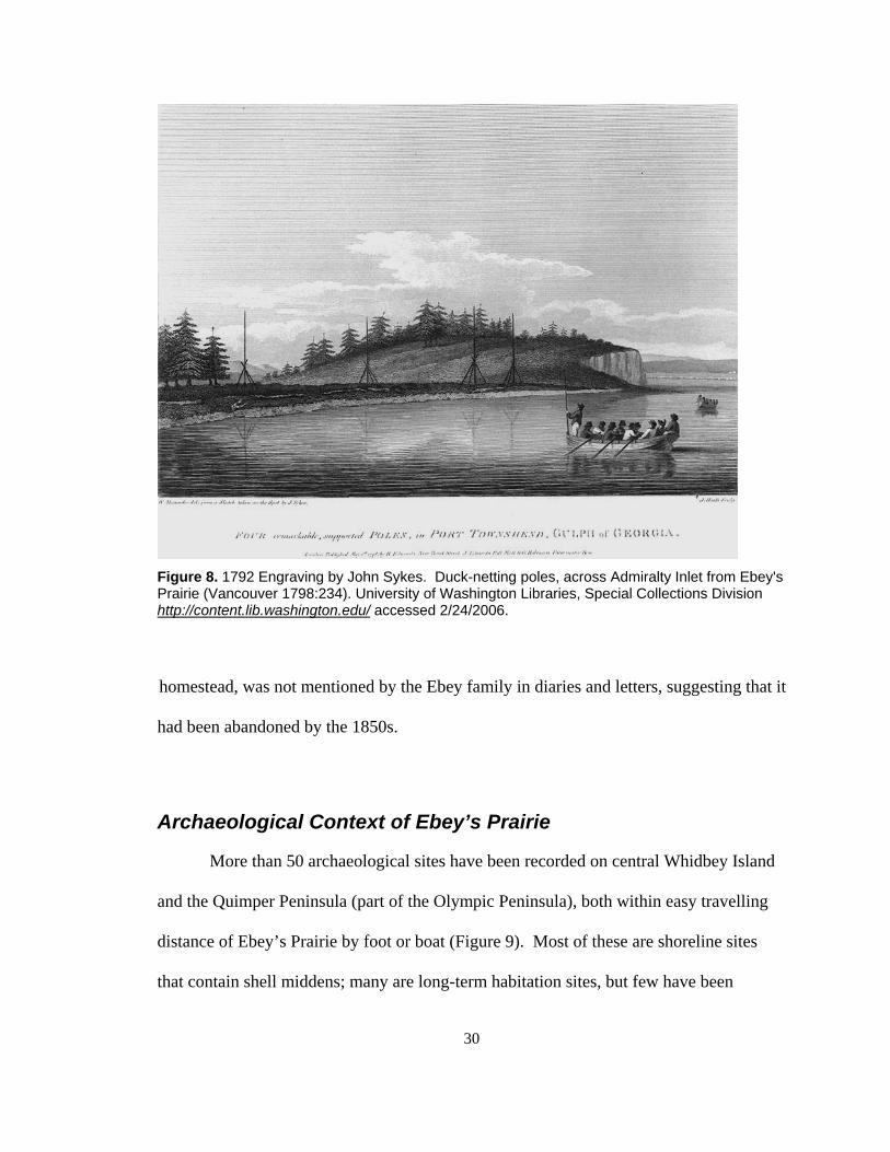
30
Figure 8. 1792 Engraving by John Sykes. Duck-netting poles, across Admiralty Inlet from Ebey's Prairie (Vancouver 1798:234). University of Washington Libraries, Special Collections Division http://content.lib.washington.edu/ accessed 2/24/2006.
homestead, was not mentioned by the Ebey family in diaries and letters, suggesting that it
had been abandoned by the 1850s.
Archaeological Context of Ebey’s Prairie
More than 50 archaeological sites have been recorded on central Whidbey Island
and the Quimper Peninsula (part of the Olympic Peninsula), both within easy travelling
distance of Ebey’s Prairie by foot or boat (Figure 9). Most of these are shoreline sites
that contain shell middens; many are long-term habitation sites, but few have been

31
radiocarbon dated or examined in detail (Smith 1907; Smith and Fowke 1901; Bryan
1954, 1955, 1963; Holmes and Kidd 1961; Kidd 1961; Jermann 1977a, 1977b; Robinson
1980, 1981; Wesson 1988; Luttrell et al. 2003). Though artifacts have been noted
scattered across Ebey’s Prairie (Trebon 1998), it has never been systematically examined
by archaeologists.
A long history of artifact collecting on Ebey’s Prairie is both a detriment to the
archaeological record and a testament to its richness. Unfortunately, local citizens have
collected over 800 artifacts from Ebey’s Prairie over the past several decades (e.g.,
Trebon 1998) and specific context of these artifacts has been lost due to a lack of
documentation when they were collected.
Ebey’s Prairie is in close proximity to several winter village sites identified
ethnographically (Suttles and Lane 1990:486; White 1980:16) and many more identified
archaeologically (Wesson 1988). The Ferry House Site (45IS221), reported on in this
thesis, is the only archaeological site within Ebey’s Prairie to receive in-depth study.
Based on the cursory evidence of surface finds (Trebon 1998), many more archaeological
sites are expected within the prairie.
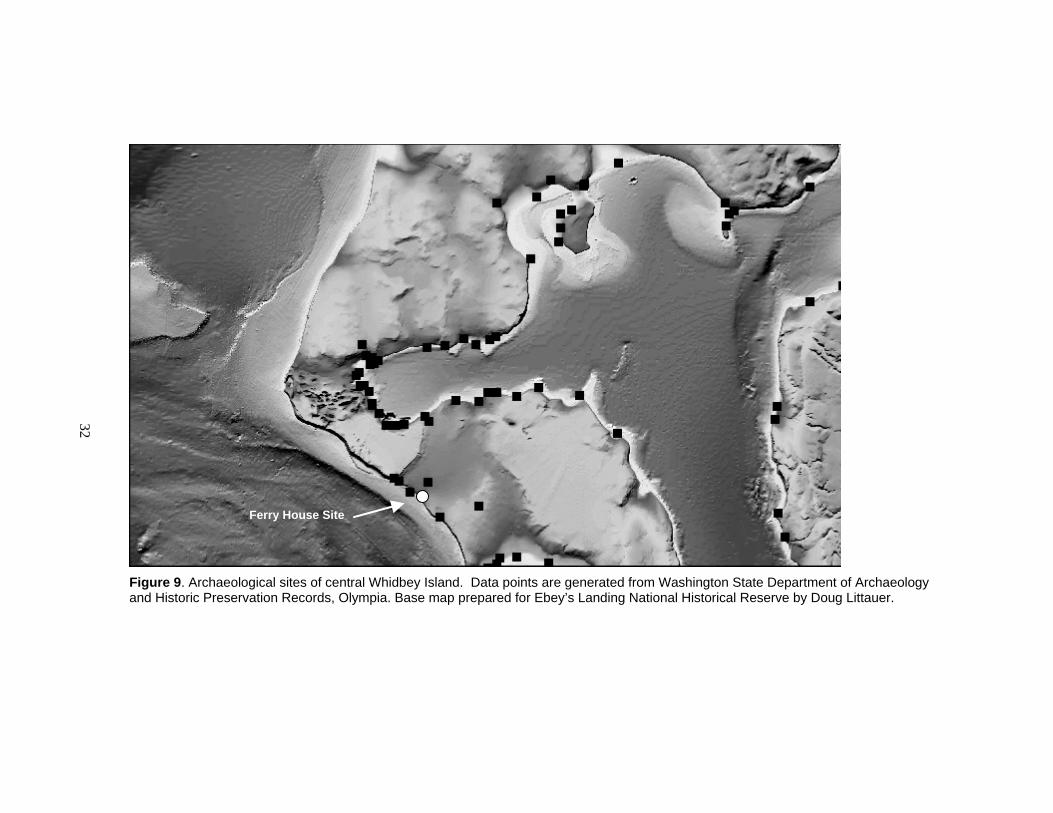
32
Figure 9. Archaeological sites of central Whidbey Island. Data points are generated from Washington State Department of Archaeology and Historic Preservation Records, Olympia. Base map prepared for Ebey’s Landing National Historical Reserve by Doug Littauer.
Ferry House Site
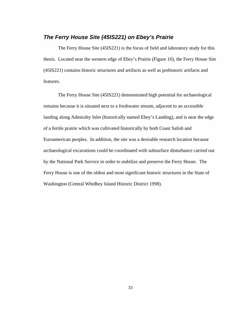
33
The Ferry House Site (45IS221) on Ebey’s Prairie
The Ferry House Site (45IS221) is the focus of field and laboratory study for this
thesis. Located near the western edge of Ebey’s Prairie (Figure 10), the Ferry House Site
(45IS221) contains historic structures and artifacts as well as prehistoric artifacts and
features.
The Ferry House Site (45IS221) demonstrated high potential for archaeological
remains because it is situated next to a freshwater stream, adjacent to an accessible
landing along Admiralty Inlet (historically named Ebey’s Landing), and is near the edge
of a fertile prairie which was cultivated historically by both Coast Salish and
Euroamerican peoples. In addition, the site was a desirable research location because
archaeological excavations could be coordinated with subsurface disturbance carried out
by the National Park Service in order to stabilize and preserve the Ferry House. The
Ferry House is one of the oldest and most significant historic structures in the State of
Washington (Central Whidbey Island Historic District 1998).
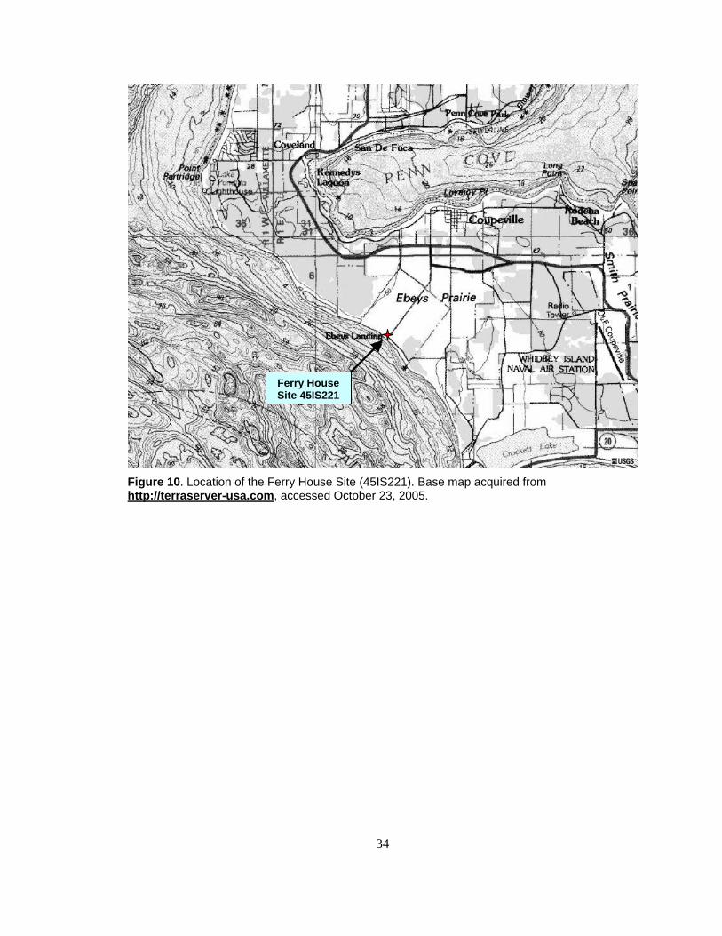
34
Figure 10. Location of the Ferry House Site (45IS221). Base map acquired from http://terraserver-usa.com, accessed October 23, 2005.
Ferry HouseSite 45IS221
35
CHAPTER 3: METHODS
I used a variety of field and laboratory methods to explore the anthropogenic
history of Ebey’s Prairie. In this chapter, I outline the field methods used to find and
document prehistoric artifacts and features at the Ferry House Site (45IS221) as well as
the laboratory methods used to examine the artifacts and archaeobotanical remains
recovered from the excavations. I also discuss how I analyzed a large group of diagnostic
artifacts which were collected throughout Ebey’s Prairie by private landowners and
documented in unpublished records and a summary report by Trebon (1998).
My excavation data from the Ferry House site derives from an archaeological
investigation which was guided by the requirements of Section 106 of the National
Historic Preservation Act and conducted by the National Park Service. Technical results
focusing solely on the Ferry House Site archaeological investigation are published
elsewhere (see Mierendorf and Weiser 2002, 2006).
National Park Service objectives were dictated by a need to retrieve
archaeological data from underneath and around the Ferry House within areas where
ground disturbance was necessary during stabilization of the building. I operated within
the confines of the National Park Service project objectives and property boundaries. My
own objectives were to locate and sample prehistoric artifacts and features within this
project area, and to further analyze them in the laboratory. It was also important for me
to establish stratigraphic context and age of features whenever possible to construct a
chronology of human activities on Ebey’s Prairie. I incorporate data generated from the

36
Ferry House Site investigation as well as data from other sources to inform my broader,
prairie-wide discussion in this thesis.
Field Methods
I used a judgemental sampling strategy and standard archaeological excavation
methods to find, examine, and document prehistoric archaeological features and artifacts
at the Ferry House Site. I first conducted a systematic surface survey of the Ferry House
Site, but vegetation limited visibility and the only artifacts identified were metal scraps
and brick associated with the historic Ferry House. I then randomly placed and
excavated exploratory test holes (50 x 50 cm) around the perimeter of the Ferry House
within the area of planned disturbance. A team of National Park Service archaeologists,
including me, subsequently discovered artifacts, features, and archaeobotanical remains
through the excavation of a number of additional subsurface tests (Figure 11). The tests
included seventeen 50 x 50 cm exploratory holes, one 1 x 2 m excavation unit, one 2 x 2
m excavation unit, and eight shovel test pits (approximately 40 cm wide), two of which
were expanded to approximately 0.50 x 1.5 m units, and 44 trenches of varying depth and
size. Excavated soil was sifted through 6.4 mm (1/4-inch) mesh except for features
which were sampled in bulk for later analysis, or sifted through 3.2 mm (1/8-inch) mesh
in the field. From these exploratory pits, excavation units, trenches and an exposed road
cutbank, we collected information from features, artifacts, and archaeobotanical remains.
Details of our field research are available in technical reports produced by the National
Park Service (Mierendorf and Weiser 2002, 2006).
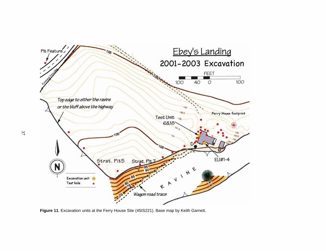
37
Figure 11. Excavation units at the Ferry House Site (45IS221). Base map by Keith Garnett.
38
Exploratory Excavation Units
In each of ten exploratory 50 x 50 cm test pits, special attention was given to any
soil anomalies (such as dark staining) or clusters of artifacts which might indicate
prehistoric features. Each test pit was excavated until no cultural remains were recovered
for at least 10 cm and then a stratigraphic profile was drawn of the test unit before it was
backfilled. Using these methods, we were able to locate intact prehistoric features below
the litter of fragmented historic artifacts.
A feature composed of a cluster of fire-modified rock was exposed in the initial
exploratory tests (see Test Units 6 & 18 on Figure 11). The area surrounding this feature
was expanded into to a 1 x 2 m excavation unit and was further examined over the next
two brief field seasons. This excavation eventually revealed four features (Features 1, 2a,
2b, and 3), and became the inspiration for further exploration in other areas with the
intent of finding and analyzing additional features. Further descriptions of features and
specific feature locations are provided in the context of results in Chapter 3.
Remote Sensing
The National Park Service chose to use ground-penetrating radar (GPR) in an
effort to find more prehistoric features. Specialist Larry Conyers was hired for this
purpose. Conyers (2002) laid out test grids on the west (15 x 40 m), north (12 x 30 m),
and south (12 x 20 m) sides of the Ferry House and passed GPR equipment over the
ground surface along grid lines spaced 0.5 m apart, looking for anomalies. See Conyers
technical report (2002) for further details of the methods and equipment used.
39
In order to recognize what type of reflection profile a prehistoric feature would
produce, Conyers first passed his GPR equipment over a known prehistoric pit feature
that was visible in the road cut. He found that the feature produced an anomaly which
was subtle but visible as a spike in wave data. He then continued with his test grids and
indicated areas where anomalies or subtle spikes in his GPR wave data occurred. He
indicated several anomalies on the west and south sides of the Ferry House, which were
potential prehistoric archaeological features (Figure 12). The archaeological crew placed
exploratory shovel pits in each of the locations where significant anomalies had been
indicated. In addition, we placed shovel pits where anomalies did not occur to ground-
truth the effectiveness of GPR as a prediction tool. We selected these locales based on
our own predictions of where cultural deposits were likely to be found (e.g., along the
terrace and creek edges). Nine shovel tests, each averaging 40 cm wide, were excavated
to varying depths until no cultural remains were found. Shovel tests yielding prehistoric
artifacts or features were expanded into larger excavation units in a separate but related
sedimentological project by Stein et al. (2006). I also sampled these areas for artifact and
feature content.
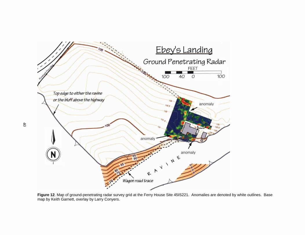
40
Figure 12. Map of ground-penetrating radar survey grid at the Ferry House Site 45IS221. Anomalies are denoted by white outlines. Base map by Keith Garnett, overlay by Larry Conyers.
anomaly
anomaly
anomaly
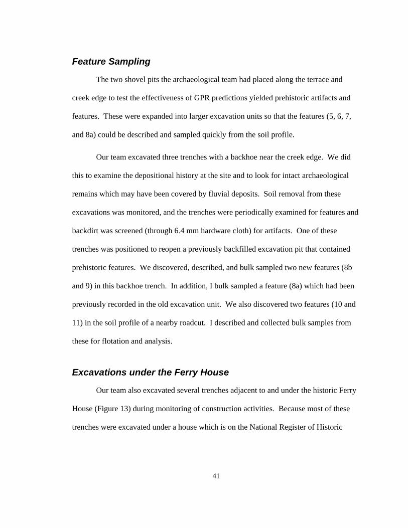
41
Feature Sampling
The two shovel pits the archaeological team had placed along the terrace and
creek edge to test the effectiveness of GPR predictions yielded prehistoric artifacts and
features. These were expanded into larger excavation units so that the features (5, 6, 7,
and 8a) could be described and sampled quickly from the soil profile.
Our team excavated three trenches with a backhoe near the creek edge. We did
this to examine the depositional history at the site and to look for intact archaeological
remains which may have been covered by fluvial deposits. Soil removal from these
excavations was monitored, and the trenches were periodically examined for features and
backdirt was screened (through 6.4 mm hardware cloth) for artifacts. One of these
trenches was positioned to reopen a previously backfilled excavation pit that contained
prehistoric features. We discovered, described, and bulk sampled two new features (8b
and 9) in this backhoe trench. In addition, I bulk sampled a feature (8a) which had been
previously recorded in the old excavation unit. We also discovered two features (10 and
11) in the soil profile of a nearby roadcut. I described and collected bulk samples from
these for flotation and analysis.
Excavations under the Ferry House
Our team also excavated several trenches adjacent to and under the historic Ferry
House (Figure 13) during monitoring of construction activities. Because most of these
trenches were excavated under a house which is on the National Register of Historic
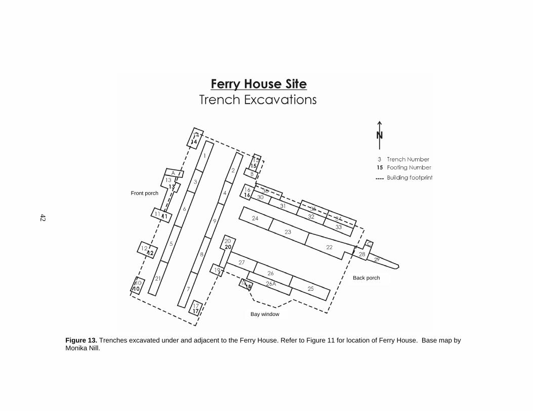
42
Figure 13. Trenches excavated under and adjacent to the Ferry House. Refer to Figure 11 for location of Ferry House. Base map by Monika Nill.
Bay window
Back porch
Front porch
43
Places, we were unable to cut out the floor or destabilize the structure by digging
archaeological excavation units beneath it. Instead, soil was removed by tunnelling
beneath the house with hand shovels and headlamps and transporting soil by sled to
locations where it could be screened and examined by archaeologists. Using this method,
soil within the first 30 cm of depth below surface was mixed as it was removed, and we
were therefore unable to ascribe more precise vertical provenience to our archaeological
finds. However the horizontal provenience of finds could be roughly determined. Soil
removed from each trench was transferred to buckets labelled with the trench number.
Each trench was mapped so that the distribution of artifacts could be estimated (Figure
13). All artifacts and archaeobotanical remains larger than 6.4 mm (¼-inch), were
collected, except for fire-modified rock which was noted and discarded. Through
excavations under the Ferry House, we were able to discover additional prehistoric
artifacts, including a modified bone tool, and a nondescript lens of blackened soil that
contained charred plant bulbs (Feature 4). Since most of this feature was under the Ferry
House where archaeological excavation was not possible, it was not described in detail or
bulk sampled. The charred bulbs collected from this feature are described in Chapter 3.
Laboratory Methods
Flotation
I processed the bulk soil samples from the Ferry House Site (45IS221) using two-
stage bucket flotation which combines techniques described by Watson (1976) and more
recently by Pearsall (2000). Each soil sample was immersed in a bucket of water and
44
gently stirred by hand and left to rest for approximately five minutes, while the light and
heavy fraction separated due to gravity. The light fraction was then decanted to a
geological sieve lined with fine-weave sheer cloth with an approximate aperture of 0.25
mm. Some of the light fraction was also removed from the water surface with a cloth-
lined scoop of the same aperture (Figure 14). This process was repeated until light
fraction particles were no longer visible on the surface. The heavy fraction was then
transferred to a bucket with a mesh bottom (stainless steel hardware screen) with an
aperture of 0.5 mm or, for some samples, a geological sieve with an aperture of 1 mm and
submerged in a larger bucket of water with continuous freshwater flow and gently
agitated by hand (Figure 15). Remaining light fraction particles which floated to the
surface were collected using a cloth-lined scoop. Heavy fraction materials were gently
agitated until the water looked clear. The heavy fraction was removed by hand to a
geological sieve lined with sheer cloth. Both heavy and light fraction catch cloths were
placed directly on a drying rack for later examination.
Many of the bulk soil samples from the Ferry House Site (45IS221), particularly
from features, contained solid blocky clods due to very fine silt and clay particles (and
possibly fire ash) which made it difficult to obtain clean light fraction specimens. These
clods were persistent, even when wet. Consequently several samples had to be floated
twice in order to separate light and heavy fractions. Even then, light fraction materials
were often trapped in the bottom of the bucket. I tried additional techniques to expedite
separation of light and heavy fractions including use of a deflocculant (baking soda) in
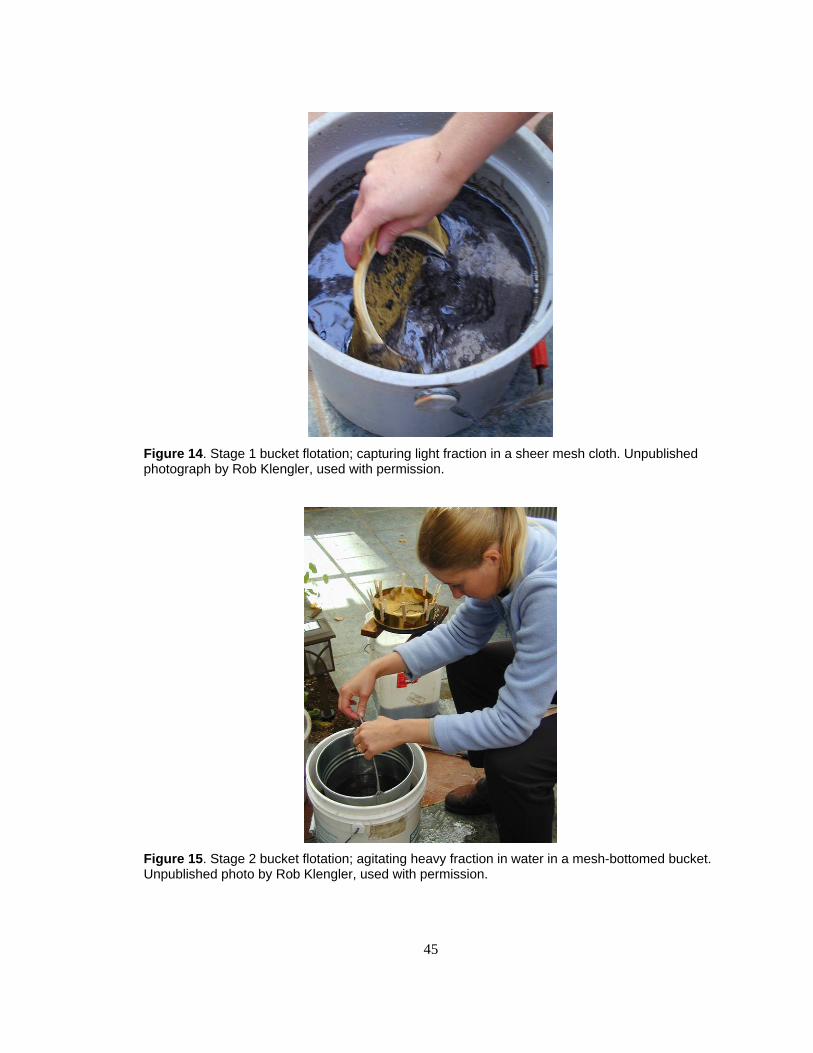
45
Figure 14. Stage 1 bucket flotation; capturing light fraction in a sheer mesh cloth. Unpublished photograph by Rob Klengler, used with permission.
Figure 15. Stage 2 bucket flotation; agitating heavy fraction in water in a mesh-bottomed bucket. Unpublished photo by Rob Klengler, used with permission.

46
the flotation water to change the water density, and gently sieving samples through a
0.212 mm mesh geological sieve before flotation while the material was still dry. By
gently dry sieving, I was able to eliminate some of the fine silt particles and prevent
heavy caking in the bottom of the flotation bucket. However, even using these additional
techniques, the light fraction samples were covered with adherent fine silt particles which
made specimens difficult to identify microscopically.
Sorting and Quantifying Feature Contents
Once dry, I weighed and separated each sub-sample (light and heavy fractions for
each bulk sample) using a series of geological sieves (4.0 mm, 2.0 mm, 1.0 mm, 0.425
mm, 0.25 mm aperture and catch basin (<0.25 mm). I sorted sub-samples by hand and
identified archaeobotanical remains using the aid of a light binocular microscope (10-
40x).
I examined light fractions down to the smallest particle size in the catch basin
(<0.25 mm) for microscopically identifiable archaeobotanical material. I also examined
all heavy fractions for paleoethnobotanical remains. Charred plant elements such as
fruits, seeds and achenes, buds, and needles were separated from each light and heavy
fraction and weighed or counted. In the light fractions, charred wood fragments >2.0 mm
in size were separated from the non-charred materials and weighed. In the heavy
fractions, charred wood fragments >1.0 mm in size were separated from other materials
and weighed. In addition, I sorted heavy fractions into remaining constituent parts (e.g.,
gravel or sand, artifacts, bone, and shell) down to the 1.0 mm particle size and weighed or
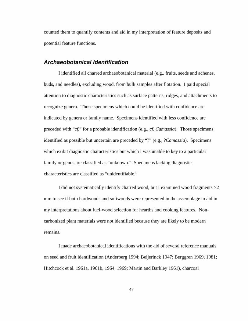
47
counted them to quantify contents and aid in my interpretation of feature deposits and
potential feature functions.
Archaeobotanical Identification
I identified all charred archaeobotanical material (e.g., fruits, seeds and achenes,
buds, and needles), excluding wood, from bulk samples after flotation. I paid special
attention to diagnostic characteristics such as surface patterns, ridges, and attachments to
recognize genera. Those specimens which could be identified with confidence are
indicated by genera or family name. Specimens identified with less confidence are
preceded with “cf.” for a probable identification (e.g., cf. Camassia). Those specimens
identified as possible but uncertain are preceded by “?” (e.g., ?Camassia). Specimens
which exibit diagnostic characteristics but which I was unable to key to a particular
family or genus are classified as “unknown.” Specimens lacking diagnostic
characteristics are classified as “unidentifiable.”
I did not systematically identify charred wood, but I examined wood fragments >2
mm to see if both hardwoods and softwoods were represented in the assemblage to aid in
my interpretations about fuel-wood selection for hearths and cooking features. Non-
carbonized plant materials were not identified because they are likely to be modern
remains.
I made archaeobotanical identifications with the aid of several reference manuals
on seed and fruit identification (Anderberg 1994; Beijerinck 1947; Berggren 1969, 1981;
Hitchcock et al. 1961a, 1961b, 1964, 1969; Martin and Barkley 1961), charcoal

48
identification (Hoadley 1990), and thorough examination of macrobotanical reference
specimens housed in Dana Lepofsky’s paleoethnobotanical laboratory at Simon Fraser
University.
Plant Bulbs Recovered In Situ or from Screens
A number of charred plant bulbs were recovered in screens or in situ during
excavation of Feature 4. To devise methods for identifying charred geophytes, I used
reference manuals (Hather 1993, 2000) and consulted with archaeobotanist Phil Dering
(Shumla School, Texas) and plant physiologist Dr. Marah Fernando (Simon Fraser
University Biological Sciences). For identifications, I used my own collection of fresh
and charred plant bulbs and rhizomes as well as those in Dana Lepofsky’s
paleoethnobotanical collection. To examine and identify geophytes, I used varying
degrees of magnification (10-200x) and a variety of light microscopes in the Biological
Sciences department of Simon Fraser University and a Scanning Electron Microscope
(SEM) in the BioImaging Facility in the Botany department at University of British
Columbia with the help of Derrick Horne.
To identify these specimens, I divided them into categories by shape, then by
cross-section, and further by cellular patterning. Initially, I sorted remains using
specimen shape, attachments and basic structure (e.g., overlapping modified leaf scales of
a bulb vs. porous parenchymous tissue of a rhizome) as guides to identify the type of
remain (e.g., bulb, root, rhizome). I used a dissecting microscope (10-40x) to examine
details. Based upon ethnographic literature (e.g., Turner 1995) and plant identification
manuals (Hitchcock et al. 1961a, 1961b, and 1969), I determined that 24 plants native to
49
the Pacific Northwest produce edible bulbs, roots, and rhizomes that were commonly
used by indigenous people (Appendix C). I considered these the most likely geophytes to
be recovered in prehistoric archaeological deposits because edible geophytes from other
parts of the world were not introduced until the historic period (Suttles 1990). I
compared my archaeological specimens to reference specimens for each of these edible
geophytes (Appendix D) except one, an onion (Allium amplectins), which was not
available for examination in the reference collection. For this species, I relied upon
botanical illustrations and descriptions provided by Hitchcock et al. (1969).
After finding that the majority of remains from the Ferry House Site were in the
Liliaceae family, based on overall shape and morphology at low magnifications (<40x), I
attempted to determine genus by looking at the epidermal cell patterning at higher (40-
200 x) magnification. To do this, it was necessary to first create a comparative collection
of epidermal cell tissues from edible bulbs in the Liliaceae family (Appendix E). I used
both charred and non-charred reference specimens from my own collections and from
Dana Lepofsky’s paleoethnobotanical collection at Simon Fraser University. I examined
each reference bulb with a dissecting microscope (10-40x) and peeled a thin layer of
epidermal tissue from the midsection of fresh (uncharred) bulbs using tweezers or a
fingernail. For charred samples, I flaked off a thin layer of epidermal tissue using
tweezers, taking care that the specimen be as thin as possible to let enough light pass
through to photograph the cell walls. I created temporary mounts of epidermal tissue to
slides, using distilled water and cover slips. For some of the fresh (uncharred) samples, I
also experimented with tinting agents diluted with distilled water (i.e., 10% chloral

50
hydrate and 0.05% toluidine blue) and polarizing optics to increase visual clarity of
epidermal cell walls. I examined each specimen using a light microscope (40-200x) and
took digital photomicrographs of epidermal tissue at various magnifications to use as a
comparative collection for identifying the archaeological specimens (Appendix E). I
used a Scanning Electron Microscope (SEM) to examine a few of the specimens. To do
this, I mounted the whole specimen to a platform with adhesive. I used the same
techniques, described above, to acquire, examine, and photograph archaeological tissue
specimens. Whether flaking off tissue to mount on slides or mounting the specimen
whole to examine with SEM, archaeological samples became damaged during the
examination process. I was not able to determine a strategy which was non-destructive to
the archaeological samples because they are easily crushed and extremely brittle.
As I was developing my methods to evaluate these specimens, I noted that
epidermal tissue on a single specimen may have cells which are various shapes and sizes,
depending on what part of the organ it was taken from. For example, cell openings on
the midsection of the bulb coat may be compacted, while cell openings near the apex of
the bulb, particularly during new growth, may be elongated. For this reason, I
consistently examined the midsections of bulbs in the comparative collection and
archaeological specimens. To ensure that I was examining mid-sections on
archaeological specimens, I chose whole or nearly whole bulbs. Bulb fragments were not
examined in detail.
The process of finding and examining epidermal tissue on archaeological samples
requires switching back and forth to various magnifications (e.g., 10-200x). Ideally, a

51
dissecting microscope with 10-40x magnification and a microscope designed for taking
photomicrographs with higher magnification (40-200x), are in close proximity to one
another to make identifications possible. I was able to make identifications on most of
my archaeological samples, even those less photogenic, by comparing with the set of
reference photomicrographs I had created.
Analysis of Artifacts from Excavation
I evaluated each lithic artifact collected during the Ferry House Site (45IS221)
excavations of 2001-2004 (including those from under the house) and categorized them
using common characteristics and usewear patterns (as identified by Andrefsky 1988;
Crabtree 1971; Mierendorf et al. 1998; Plew et al. 1985) and using specific artifact
categories as defined by Mierendorf et al. (1998:444-457). I based my identifications on
flake morphology (e.g., bulb of percussion, concoidal and radial scarring), usewear (e.g.,
evidence of grinding, pecking, and crushing), and evidence of heat (e.g., fire-spalling,
blocky fracturing, and discoloration from oxidized minerals) to determine types and
functions of artifacts. To identify material types, I used a lithic comparative collection
housed in the National Park Service Marblemount Curation Facility at North Cascades
National Park Service Complex. All artifacts evaluated from the Ferry House Site
(45IS221) have been accessioned and are housed at the National Park Service Curation
Facility in Marblemount, Washington.

52
Analysis of Artifacts from Private Collections
I also analyzed projectile points which had been collected across Ebey’s Prairie
by citizens over several decades (Trebon 1998). The National Park Service sponsored a
project to have researcher Teresa Trebon interview several citizens about the artifacts
they had collected while farming private lands on Ebey’s Prairie. This was a way for the
National Park Service to retrieve archaeological data from a larger expanse of the prairie
which may not be available otherwise. During interviews, Teresa had photographed the
collections and plotted roughly where the artifacts had been found. I chose to evaluate
artifacts from five out of the 15 collections she documented (Interviews 20 and 24-27)
because the great majority of artifacts in these collections were clearly from the
bottomlands of Ebey’s Prairie (i.e., <150 ft in elevation) and were temporally diagnostic.
I chose not to analyze artifacts from the 10 additional interviews because I was unable to
discriminate between artifacts found on the prairie and those which were not.
From the five interviews, I evaluated the diagnostic attributes of 400
photographed projectile points. I enlarged artifact photographs to aid in identification
and classified projectiles into temporal categories based on hafting morphology using the
guideline presented by Mierendorf et al. (1998: 495-514). In Mierendorf’s key,
projectiles are illustrated with planview outlines and grouped in style categories based on
hafting elements. These style categories are assigned age ranges based upon projectiles
from radiocarbon-dated contexts in archaeological sites throughout the Northwest. In my
analysis, I used size as an identifying factor only when necessary to distinguish between
projectile point styles with similar hafting morphology. Attributes like artifact thickness
53
and basal grinding could not be discerned from planview photographs, but many
specimens could easily be categorized into the chronological time periods suggested by
Mierendorf et al. (1998) based on more obvious features of the hafting element. I did not
evaluate specimens which appeared to be unfinished bifaces, were broken, or otherwise
lacked clearly identifiable characteristics.
Deciphering Human Activities across Time and Space
I compiled several sets of information to decipher how people used Ebey’s Prairie
during prehistory through time and across space. To determine spatial distribution of
cultural remains, I mapped the locations of artifacts and features found on the Ferry
House Site (45IS221) during excavation and the locations of surface artifacts collected by
citizens from across the prairie. To determine age of cultural deposits, I used radiocarbon
age estimates acquired from excavated cultural contexts (primarily features) and seriation
of the projectile point styles I analyzed from private collections.
The apparent functions of features and artifacts helped me to determine the types
of human activities represented on the prairie (Chapter 3). I interpreted feature functions
based on their appearance, associations within natural and cultural soil stratigraphy, and
content. I determined artifact functions by examining their forms and usewear patterns.
By comparing features and artifacts in relation to one another spatially, temporally, and
functionally, I was able to reconstruct the human activities represented on Ebey’s Prairie
throughout the Holocene, which are presented in the following chapters.

54
Exploring Prairie Longevity
How Long was Ebey’s Prairie Anthropogenic?
The archaeological and archaeobotanical study also has relevance to the question
of how long Ebey’s Prairie has been a prairie. Further, these data have the potential to
answer the question of how long Ebey’s Prairie has been anthropogenic, or manipulated
and influenced by people. In order to answer these questions I first evaluated the regional
changes in climate that would naturally result in the closing or opening (via tree
encroachment or lack thereof) of the Ebey’s ecosystem. To do this, I compared evidence
of glacial history regionally and more specifically on Ebey’s Prairie. I also compared
ecological data from other, similar low elevation, flat landforms with xeric microclimates
influenced by the rainshadow effect (i.e., today’s “prairies” of southeast Vancouver
Island and the Olympic Peninsula). By learning the climatic and ecological fluctuations
of the region, I was able to assess whether the archaeological and archaeobotanical data
from the Ferry House Site could offer more specific detail about how long Ebey’s Prairie
has been anthropogenic.
55
CHAPTER 4: RESULTS AND INTERPRETATIONS
In this chapter I outline results from various lines of evidence to document the
prehistory of human activity on Ebey’s Prairie. The ethnographic evidence reviewed in
Chapter 1 documents that Coast Salish people were hunting, cultivating and processing
camas, worshipping, feasting, and holding council on Ebey’s Prairie after Euroamericans
arrived in the region (Ebey 1855; Farrar 1916, 1917; Kellogg 2001; White 1980). These
records also indicate that Coast Salish people periodically burned Ebey’s Prairie and had
temporary campsites and longer-term settlements near the prairie edges which they
occupied year after year. In this chapter, I extend the reconstruction of human use of
Ebey’s Prairie into the more distant past. I do this by examining features, artifacts, and
archaeobotanical remains from a small portion of Ebey’s Prairie in the vicinity of the
Ferry House Site (45IS221), as well as through examination of artifacts collected across
Ebey’s Prairie by landowners and farm workers. These data are the foundation of my
interpretations of the human activities across Ebey’s Prairie throughout the Holocene.
Results of Remote Sensing
We were able to determine that GPR was not an effective tool for quickly finding
prehistoric features on this site. In fact, none of the GPR anomalies we ground-truthed
through excavation corresponded to prehistoric features. What they did correspond to
were concentrations of historic artifacts, particularly metal scraps or brick — items which
reflect radar and produce recognizable spikes in wave data. Large concentrations of

56
rocks — such as those associated with camas roasting features (cf. Thoms 1989), should
also produce similar spikes in wave data. Thus, it seems unlikely that features with
highly reflective contents are located within the GPR survey area. Conyers did note that
an abundance of subtle reflections in the three GPR test grids may indicate prehistoric
features (Conyers 2002:10) with few reflective materials (e.g., roasting or storage pits
with only a few rocks), but these small spikes in wave data could also represent a number
of naturally occurring soil anomalies and would take a great deal of time to analyze.
Magnetometry has been effectively used to find roasting features in the Willamette
Valley (O’Neill et al. 2004) and may be a more effective tool for finding prehistoric
features in Ebey’s Prairie in the future.
Feature Sampling
In total, our archaeological team discovered 13 prehistoric features near the
western edge of Ebey’s Prairie on the Ferry House Site and the adjacent vicinity (Figure
16). I documented and sampled eleven of these features. I collected bulk samples from
10 of the 11 features which are described in detail later in this chapter. These samples
were then floated and analyzed (Table 8, Table 9, and Appendix F). In addition, I
analyzed archaeobotanical remains from Feature 4 which had been recovered in screens
during excavation (Table 10 and Appendix E). Feature types include one rock cluster,
several hearths, midden deposits, and carbon-rich soil layers associated with
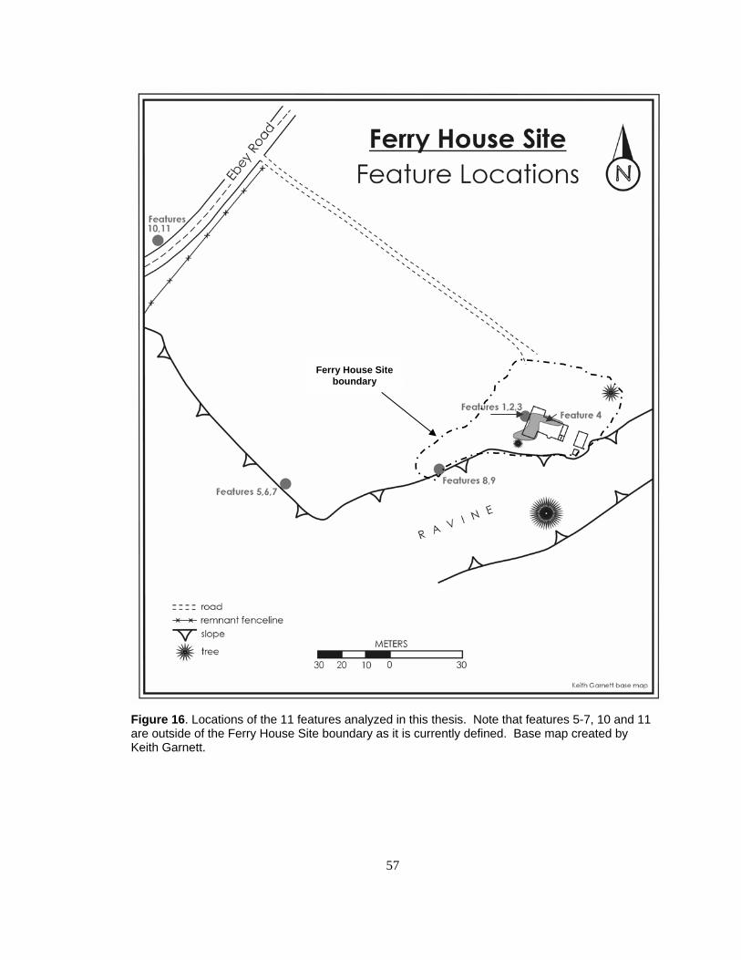
57
Figure 16. Locations of the 11 features analyzed in this thesis. Note that features 5-7, 10 and 11 are outside of the Ferry House Site boundary as it is currently defined. Base map created by Keith Garnett.
Ferry House Site boundary
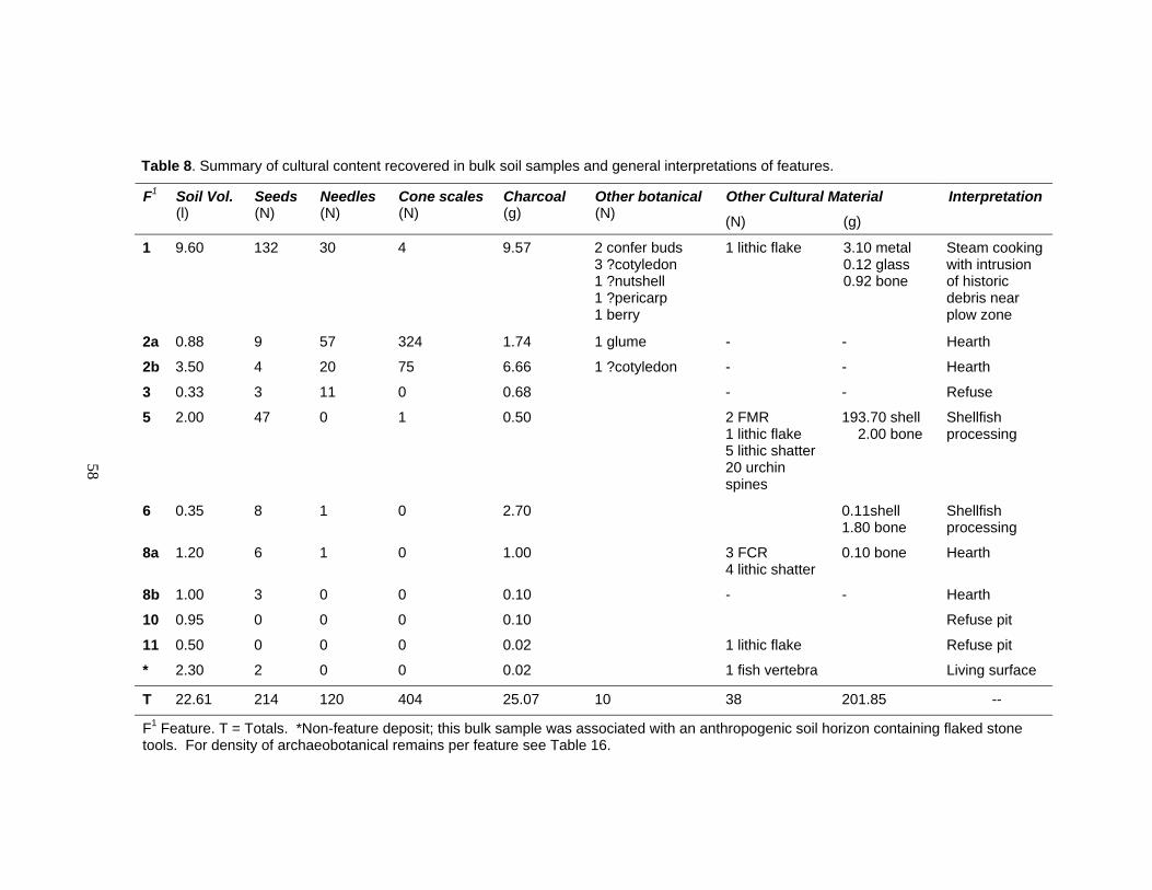
58
Table 8. Summary of cultural content recovered in bulk soil samples and general interpretations of features.
Other Cultural Material F1 Soil Vol. (l)
Seeds (N)
Needles (N)
Cone scales (N)
Charcoal (g)
Other botanical (N) (N) (g)
Interpretation
1 9.60 132 30 4 9.57 2 confer buds 3 ?cotyledon 1 ?nutshell 1 ?pericarp 1 berry
1 lithic flake
3.10 metal 0.12 glass 0.92 bone
Steam cooking with intrusion of historic debris near plow zone
2a 0.88 9 57 324 1.74 1 glume - - Hearth
2b 3.50 4 20 75 6.66 1 ?cotyledon - - Hearth
3 0.33 3 11 0 0.68 - - Refuse
5 2.00 47 0 1 0.50 2 FMR 1 lithic flake 5 lithic shatter 20 urchin spines
193.70 shell 2.00 bone
Shellfish processing
6 0.35 8 1 0 2.70 0.11shell 1.80 bone
Shellfish processing
8a 1.20 6 1 0 1.00 3 FCR 4 lithic shatter
0.10 bone
Hearth
8b 1.00 3 0 0 0.10 - - Hearth
10 0.95 0 0 0 0.10 Refuse pit
11 0.50 0 0 0 0.02 1 lithic flake Refuse pit
* 2.30 2 0 0 0.02 1 fish vertebra Living surface
T 22.61 214 120 404 25.07 10 38 201.85 --
F1 Feature. T = Totals. *Non-feature deposit; this bulk sample was associated with an anthropogenic soil horizon containing flaked stone tools. For density of archaeobotanical remains per feature see Table 16.
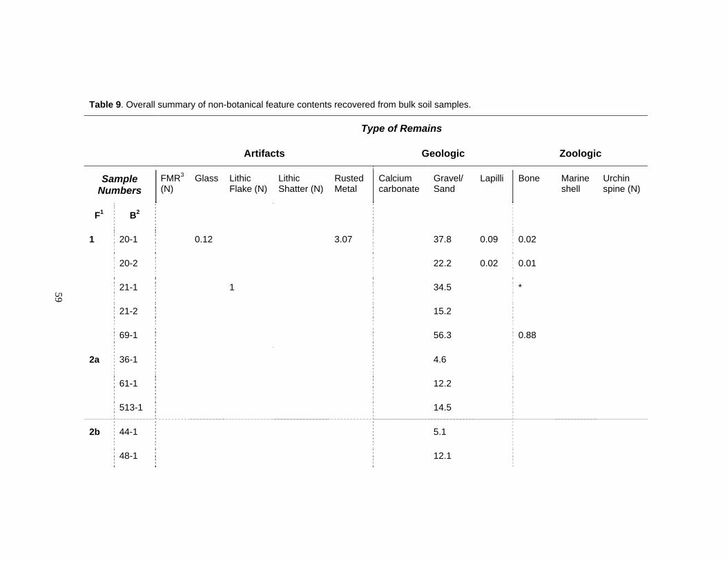
59
Table 9. Overall summary of non-botanical feature contents recovered from bulk soil samples.
Type of Remains
Artifacts Geologic Zoologic
Sample Numbers
FMR3
(N) Glass Lithic
Flake (N) Lithic Shatter (N)
Rusted Metal
Calcium carbonate
Gravel/ Sand
Lapilli Bone Marine shell
Urchin spine (N)
F1 B2
1 20-1 0.12 3.07 37.8 0.09 0.02
20-2 22.2 0.02 0.01
21-1 1 34.5 *
21-2 15.2
69-1 56.3 0.88
2a 36-1 4.6
61-1 12.2
513-1 14.5
2b 44-1 5.1
48-1 12.1
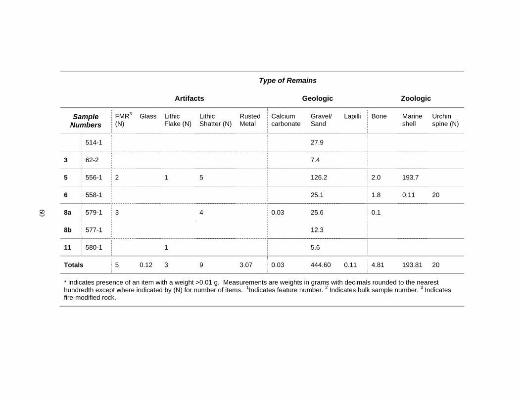
60
Type of Remains
Artifacts Geologic Zoologic
Sample Numbers
FMR3
(N) Glass Lithic
Flake (N) Lithic Shatter (N)
Rusted Metal
Calcium carbonate
Gravel/ Sand
Lapilli Bone Marine shell
Urchin spine (N)
514-1 27.9
3 62-2 7.4
5 556-1 2 1 5 126.2 2.0 193.7
6 558-1 25.1 1.8 0.11 20
8a 579-1 3 4 0.03 25.6 0.1
8b 577-1 12.3
11 580-1 1 5.6
Totals 5 0.12 3 9 3.07 0.03 444.60 0.11 4.81 193.81 20
* indicates presence of an item with a weight >0.01 g. Measurements are weights in grams with decimals rounded to the nearest hundredth except where indicated by (N) for number of items. 1Indicates feature number. 2 Indicates bulk sample number. 3 Indicates fire-modified rock.
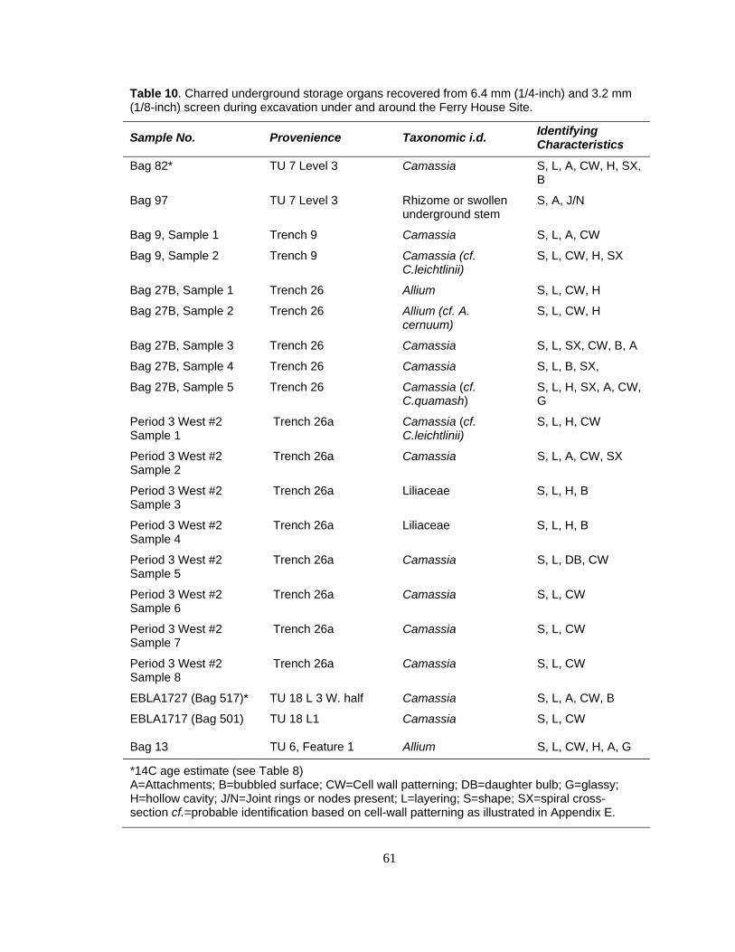
61
Table 10. Charred underground storage organs recovered from 6.4 mm (1/4-inch) and 3.2 mm (1/8-inch) screen during excavation under and around the Ferry House Site.
Sample No. Provenience Taxonomic i.d. Identifying Characteristics
Bag 82* TU 7 Level 3 Camassia S, L, A, CW, H, SX, B
Bag 97 TU 7 Level 3 Rhizome or swollen underground stem
S, A, J/N
Bag 9, Sample 1 Trench 9 Camassia S, L, A, CW
Bag 9, Sample 2 Trench 9 Camassia (cf. C.leichtlinii)
S, L, CW, H, SX
Bag 27B, Sample 1 Trench 26 Allium S, L, CW, H
Bag 27B, Sample 2 Trench 26 Allium (cf. A. cernuum)
S, L, CW, H
Bag 27B, Sample 3 Trench 26 Camassia S, L, SX, CW, B, A
Bag 27B, Sample 4 Trench 26 Camassia S, L, B, SX,
Bag 27B, Sample 5 Trench 26 Camassia (cf. C.quamash)
S, L, H, SX, A, CW, G
Period 3 West #2 Sample 1
Trench 26a Camassia (cf. C.leichtlinii)
S, L, H, CW
Period 3 West #2 Sample 2
Trench 26a Camassia S, L, A, CW, SX
Period 3 West #2 Sample 3
Trench 26a Liliaceae S, L, H, B
Period 3 West #2 Sample 4
Trench 26a Liliaceae S, L, H, B
Period 3 West #2 Sample 5
Trench 26a Camassia S, L, DB, CW
Period 3 West #2 Sample 6
Trench 26a Camassia S, L, CW
Period 3 West #2 Sample 7
Trench 26a Camassia S, L, CW
Period 3 West #2 Sample 8
Trench 26a Camassia S, L, CW
EBLA1727 (Bag 517)* TU 18 L 3 W. half Camassia S, L, A, CW, B
EBLA1717 (Bag 501) TU 18 L1 Camassia S, L, CW
Bag 13 TU 6, Feature 1 Allium S, L, CW, H, A, G
*14C age estimate (see Table 8) A=Attachments; B=bubbled surface; CW=Cell wall patterning; DB=daughter bulb; G=glassy; H=hollow cavity; J/N=Joint rings or nodes present; L=layering; S=shape; SX=spiral cross-section cf.=probable identification based on cell-wall patterning as illustrated in Appendix E.
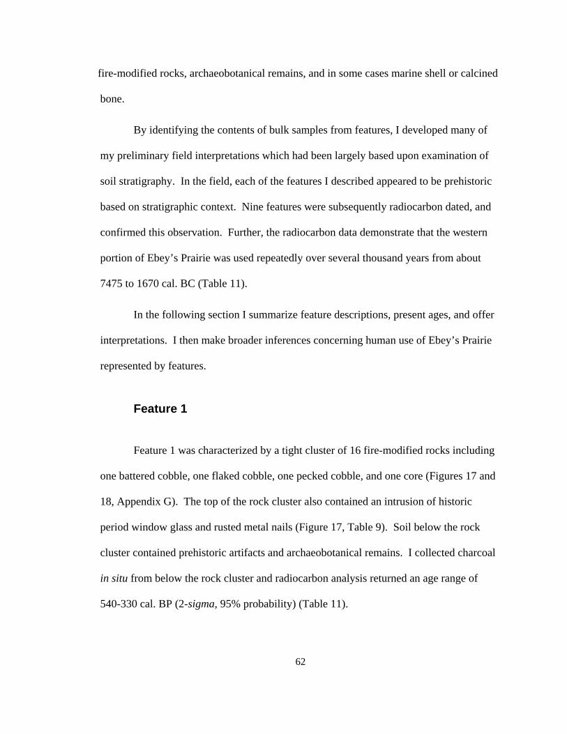
62
fire-modified rocks, archaeobotanical remains, and in some cases marine shell or calcined
bone.
By identifying the contents of bulk samples from features, I developed many of
my preliminary field interpretations which had been largely based upon examination of
soil stratigraphy. In the field, each of the features I described appeared to be prehistoric
based on stratigraphic context. Nine features were subsequently radiocarbon dated, and
confirmed this observation. Further, the radiocarbon data demonstrate that the western
portion of Ebey’s Prairie was used repeatedly over several thousand years from about
7475 to 1670 cal. BC (Table 11).
In the following section I summarize feature descriptions, present ages, and offer
interpretations. I then make broader inferences concerning human use of Ebey’s Prairie
represented by features.
Feature 1
Feature 1 was characterized by a tight cluster of 16 fire-modified rocks including
one battered cobble, one flaked cobble, one pecked cobble, and one core (Figures 17 and
18, Appendix G). The top of the rock cluster also contained an intrusion of historic
period window glass and rusted metal nails (Figure 17, Table 9). Soil below the rock
cluster contained prehistoric artifacts and archaeobotanical remains. I collected charcoal
in situ from below the rock cluster and radiocarbon analysis returned an age range of
540-330 cal. BP (2-sigma, 95% probability) (Table 11).
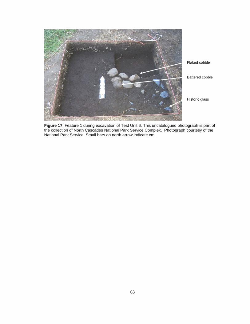
63
Figure 17. Feature 1 during excavation of Test Unit 6. This uncatalogued photograph is part of the collection of North Cascades National Park Service Complex. Photograph courtesy of the National Park Service. Small bars on north arrow indicate cm.
Historic glass
Flaked cobble
Battered cobble
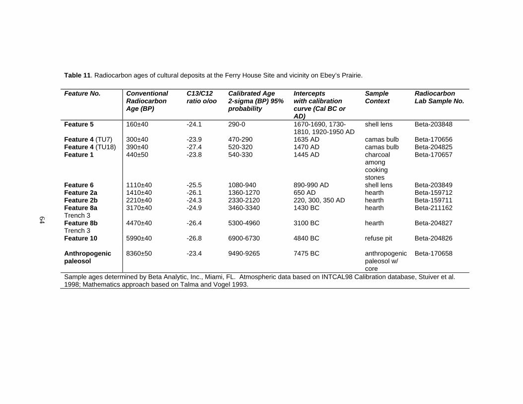
64
Table 11. Radiocarbon ages of cultural deposits at the Ferry House Site and vicinity on Ebey’s Prairie.
Feature No. Conventional Radiocarbon Age (BP)
C13/C12 ratio o/oo
Calibrated Age 2-sigma (BP) 95% probability
Intercepts with calibration curve (Cal BC or AD)
Sample Context
Radiocarbon Lab Sample No.
Feature 5
160±40 -24.1 290-0 1670-1690, 1730-1810, 1920-1950 AD
shell lens Beta-203848
Feature 4 (TU7) 300±40 -23.9 470-290 1635 AD camas bulb Beta-170656 Feature 4 (TU18) 390±40 -27.4 520-320 1470 AD camas bulb Beta-204825 Feature 1 440±50 -23.8 540-330 1445 AD charcoal
among cooking stones
Beta-170657
Feature 6 1110±40 -25.5 1080-940 890-990 AD shell lens Beta-203849 Feature 2a 1410±40 -26.1 1360-1270 650 AD hearth Beta-159712 Feature 2b 2210±40 -24.3 2330-2120 220, 300, 350 AD hearth Beta-159711 Feature 8a Trench 3
3170±40 -24.9 3460-3340 1430 BC hearth Beta-211162
Feature 8b Trench 3
4470±40 -26.4 5300-4960 3100 BC hearth Beta-204827
Feature 10
5990±40 -26.8 6900-6730 4840 BC refuse pit Beta-204826
Anthropogenic paleosol
8360±50 -23.4 9490-9265 7475 BC anthropogenic paleosol w/ core
Beta-170658
Sample ages determined by Beta Analytic, Inc., Miami, FL. Atmospheric data based on INTCAL98 Calibration database, Stuiver et al. 1998; Mathematics approach based on Talma and Vogel 1993.
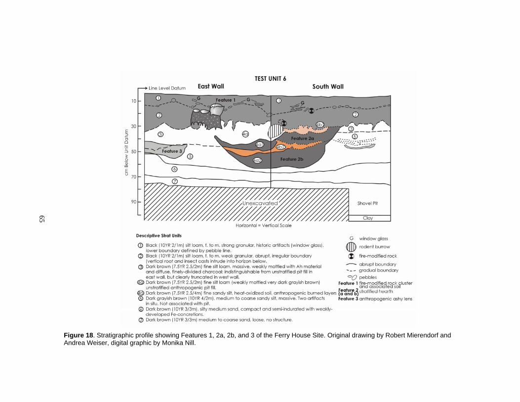
65
Figure 18. Stratigraphic profile showing Features 1, 2a, 2b, and 3 of the Ferry House Site. Original drawing by Robert Mierendorf and Andrea Weiser, digital graphic by Monika Nill.

66
I collected and analyzed five bulk soil samples from this feature. Many of the
seeds in the assemblage from Feature 1 were eroded but some still retained diagnostic
characteristics and I was able to make probable or secure identifications after close
examination of seed coats, ridges, and other characteristics (Appendix F). There were
also many seeds in Feature 1 that were highly fragmented, unidentifiable, and are not
reported in the content summary in Appendix F. Faunal remains in this feature were
highly fragmented and could not be identified to genera.
Interpretation of Feature 1
Feature 1 appears to represent a prehistoric steam-cooking feature, used in
summer through early fall, for processing plants and animals, with intrusion of historic
debris near the plow zone. The cluster of fire-modified rock which included discarded
cobble tools, a diverse charred archaeobotanical assemblage, and a small sample of
highly fragmented calcined faunal remains provide the basis for this interpretation.
Many of the plants identified from the archaeobotanical assemblage of Feature 1
are edible and include bulbs (Liliaceae), berries (cf. Amelanchier, Ericaceae, cf. Fragaria,
Rubus, Sambucus, and possibly nuts (?nutshell, ?pericarp1, ?cotyledon). The occurrence
of this array of edible plants together suggests that they were introduced to Feature 1 as a
result of human agency. Lily bulbs, berries, and nuts were often cooked by Northwest
Coast people (Suttles 1974, 1987a, 1987b; Turner 1995, 1998) in hearths or earth ovens.
Alternatively, plant remains may have been introduced unintentionally by people,
animals, or other natural processes. This explanation seems unlikely given the presence
1 A pericarp refers to the fruit wall. In true nuts a nutshell and pericarp are the same.
67
of artifacts in the same matrix and the nature of charred remains which are mostly food
plants.
The small size of the archaeobotanical assemblage could reflect a number of
possibilities which would produce very few charred remains, including particular cooking
techniques such as steaming, or very few cooking episodes. Wrapping them in vegetal
material before cooking them or using baskets or cedar boxes to contain edible plants
during cooking were common practices used by Northwest Coast people (Turner 1995,
1998). Low recovery rates of charred archaeobotanical remains are consistent with other
archaeobotanical assemblages on the Northwest Coast (Lepofsky 2000a, 2004; Lepofsky
et al. 2004; Lepofsky and Lyons 2003; Lyons 2000) and can also reflect a number of
taphonomic processes which have diminished the discoverability of remains (Lepofsky
2000a, 2002; Pearsall 2000).
Low temperatures and sustained cooking are indicated by the presence of fire-
modified rocks (which produce sustained, reflective heat), and numerous plant fragments
which are volatile and likely to be destroyed at higher temperatures. The plant fragments
include needles, cone scales, conifer buds, needle tip fragments, and numerous minute
twigs from both hardwoods and softwoods. Northwest Coast people commonly practiced
steam cooking and would smother a fire with soil and vegetal debris and add hot rocks to
provide indirect heat for the foods they were cooking (People of ‘Ksan 1980; Turner
1995, 1998).
The preservation of charred needles in Feature 1 likely reflects a smothered fire.
Needles from four different conifers (Abies, Picea, Pinus and Tsuga) were identified in

68
the archaeobotanical assemblage. These may indicate use of green conifer branches in
steam cooking, or may be the remains of fuel wood with needles still attached used to
keep the fire going over long periods. Both these uses have been documented
ethnographically (Turner 1995). Fresh conifer needles would have been desirable for fire
starting as well, due to the high resin content, though when used for this purpose needles
commonly burn to ash. Conifer boughs would have been available in the surrounding
tree islands. Though high winds are common on Ebey’s Prairie, and could potentially
blow light materials like loose needles into a cooking fire, the association with edible
plant seeds and small-diameter branchlets suggests that the conifer needles were
intentional constituents of the feature.
Many of the seeds recovered from this feature originate from plants which are
edible and may also have been used as packing materials in steam cooking (Asteraceae,
Brassica, Chenopodium, Claytonia, cf. Cyperaceae, Ericaceae, Euphorbia, Galium, cf.
Lamiaceae, Plantago, cf. Portulaca, cf. Potamogeton, Ranunculus, cf. Ruppia, Scirpus,
Silene, and cf. Sparganium). The plant species identified from seeds indicate that this
feature was likely used in summer to early fall, when seeds of these plants reach maturity.
The cobble tools included in the cluster of fire-modified rock show signs of
flaking, pecking and battering. These are tools which would be well suited for a number
of functions, including chopping and splitting small branches for firewood collecting,
scooping the earth for pit construction, and scraping and hammering poles for temporary
structures or drying racks. While cobble tools in the cluster appear to have served a
secondary function as part of the heating element for a cooking feature, none of them

69
have been severely broken or otherwise rendered unusable. They would still be
functional tools today and may have been left in this cluster intentionally for future use.
Feature 1 did not appear contiguous with any of the other features at the Ferry
House Site based on stratigraphy examined during excavation. However, several
attributes of Feature 1 appear similar to Feature 4, such as the presence of Liliaceae bulb
fragments and fire-modified rock, the potential association with steam cooking, the age
range of each feature, and the similar stratigraphic unit in which they were discovered.
Features 2a and 2b
Feature 2 was basin-shaped and characterized by two layers of black (10 YR 2/1)
(Munsell 1973), carbon-rich sediment (i.e., very fine particulate charcoal in the soil
matrix) with a layer of reddish, heat-oxidized soil between them. This feature had an
amorphous shape in planview and did not appear to be directly associated with the fire-
modified rock cluster in Feature 1 overlying it (Figure 18). I concluded that there were
two separate, overlapping events represented by the black lenses, and the oxidized layer
of soil between them was associated with the lower of the two lenses (see Figures 19 and
20). I collected bulk samples from each lens for microscopic analysis. The age of
Features 2a and 2b was obtained from charcoal collected in situ during excavation.
Radiometric analysis revealed an age range of 1360-1270 cal. BP (2-sigma, 95%
probability) for Feature 2a (the upper lens) and 2330-2120 cal. BP (2-sigma, 95%
probability) for Feature 2b (the lower lens). Two lithic flakes found during excavation
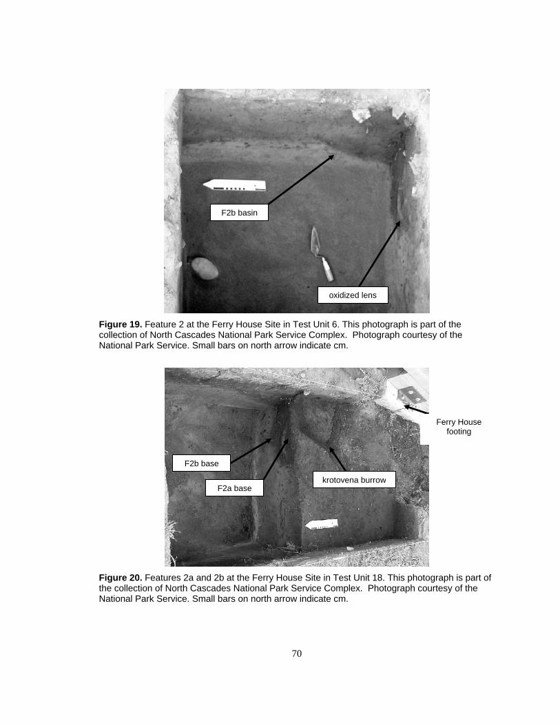
70
Figure 19. Feature 2 at the Ferry House Site in Test Unit 6. This photograph is part of the collection of North Cascades National Park Service Complex. Photograph courtesy of the National Park Service. Small bars on north arrow indicate cm.
Figure 20. Features 2a and 2b at the Ferry House Site in Test Unit 18. This photograph is part of the collection of North Cascades National Park Service Complex. Photograph courtesy of the National Park Service. Small bars on north arrow indicate cm.
F2b basin
oxidized lens
F2b base
F2a basekrotovena burrow
Ferry House footing
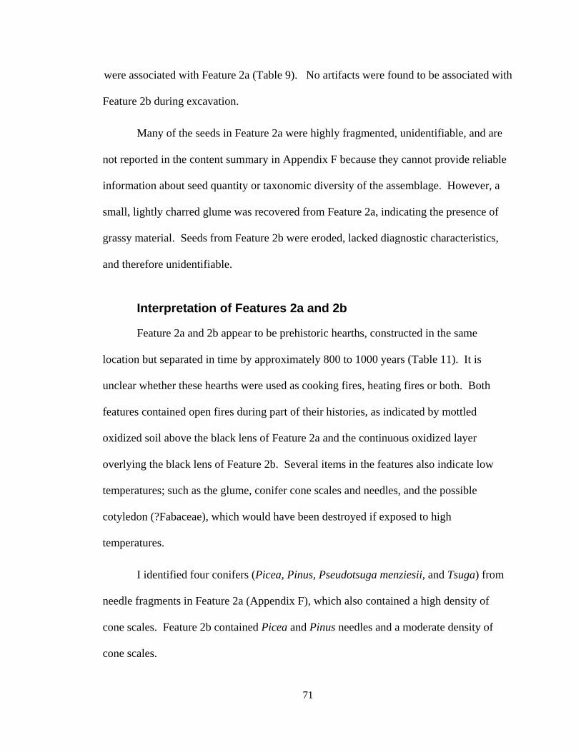
71
were associated with Feature 2a (Table 9). No artifacts were found to be associated with
Feature 2b during excavation.
Many of the seeds in Feature 2a were highly fragmented, unidentifiable, and are
not reported in the content summary in Appendix F because they cannot provide reliable
information about seed quantity or taxonomic diversity of the assemblage. However, a
small, lightly charred glume was recovered from Feature 2a, indicating the presence of
grassy material. Seeds from Feature 2b were eroded, lacked diagnostic characteristics,
and therefore unidentifiable.
Interpretation of Features 2a and 2b
Feature 2a and 2b appear to be prehistoric hearths, constructed in the same
location but separated in time by approximately 800 to 1000 years (Table 11). It is
unclear whether these hearths were used as cooking fires, heating fires or both. Both
features contained open fires during part of their histories, as indicated by mottled
oxidized soil above the black lens of Feature 2a and the continuous oxidized layer
overlying the black lens of Feature 2b. Several items in the features also indicate low
temperatures; such as the glume, conifer cone scales and needles, and the possible
cotyledon (?Fabaceae), which would have been destroyed if exposed to high
temperatures.
I identified four conifers (Picea, Pinus, Pseudotsuga menziesii, and Tsuga) from
needle fragments in Feature 2a (Appendix F), which also contained a high density of
cone scales. Feature 2b contained Picea and Pinus needles and a moderate density of
cone scales.
72
Seasonality of the features is unclear. One seed, which is likely Rosa, and a
glume, found in Feature 2a could indicate that the feature was deposited in the late
summer or early fall when seeds of these plants reach maturity. However, rose seeds and
grass glumes may also have remained on dried plants through the winter before being
deposited in the hearth.
It is clear that Features 2a and 2b are not directly associated with one another
because of their temporal separation. The fact that they overlap spatially may signify an
indirect association, however. This locale appears to have been favored for particular
activities which centered around a hearth, even over thousands of years. The two features
appear to have served similar functions for heating and perhaps cooking, based on their
appearance and contents. Feature 2a may be more directly associated with Feature 3,
based on depth, proximity, and content, though their temporal relationship is yet
unknown. This possible relationship is discussed further in the context of observations
related to Feature 3.
Feature 3
Feature 3 was characterized by a small area of darkly stained soil which was
roughly rectangular in shape, flat on the top and concave at the bottom (Figures 18 and
21). During excavation I noted that this unusual soil lens contained charcoal flecks and
fire ash.
73
Figure 21. Ferry House Site Features 1-3 in Test Unit 6. This uncatalogued photograph is part of the collection of North Cascades National Park Service Complex. Photograph courtesy of the National Park Service. Small bars on north arrow indicate cm.
I sampled this feature in its entirety and analyzed the contents. The sample
contained very few charred remains but included small diameter (~1 mm) pieces of
branch wood and otherwise contained very few charred remains (Appendix F). There has
been no attempt to determine the age of this feature. Charcoal was collected in situ
during excavation but it has not been submitted for radiocarbon analysis.
Interpretation of Feature 3
Feature 3 provides no evidence that it is a hearth. Rather, the presence of few
charred needles, seeds, or wood charcoal, combined with the mixed and mottled
sediments with ash, point toward a refuse dump or potentially a windblown deposit from
a hearth located nearby (such as Feature 2a). The shallow, linear nature of Feature 3 may
indicate that feature fill was deposited where a log or other item used to be.
74
Feature 3 may be related to Feature 2a (a hearth) which is in close proximity (ca.
20 cm distant), situated at a comparable depth, and is to the windward side of Feature 2a
for at least part of the day. The presence of Picea and Pseudotsuga menziesii needles in
Feature 3 is consistent with the contents of Feature 2a. The mottled appearance of the
oxidized soil overlying the top of Feature 2a is also consistent with a wind-deflated
surface where oxidized soil has been displaced. Radiocarbon analysis of the charcoal
collected in situ from Feature 3 would help determine whether Feature 2a and Feature 3
are contemporaneous.
Feature 4
Feature 4 is largely defined by its content, rather than its appearance. The most
distinguishing characteristic of Feature 4 is that it contains charred Liliaceae bulbs, many
of them Camassia (Figures 22 and 23, Table 10). It also contains carbon-rich sediment,
fire-modified rock, and large fragments of charcoal >6.4 mm (1/4-inch) in size (Table
12). Most of this feature was not visible in profile because it was excavated from under
the Ferry House (Figure 24). However, a small window into the stratigraphic context of
this feature can be demonstrated in Test Unit 7 (Figure 25). The content recovered from
this feature (Tables 10 and 12) only represents remains >6.4 mm (1/4-inch) in size due to
the dry screening method used.
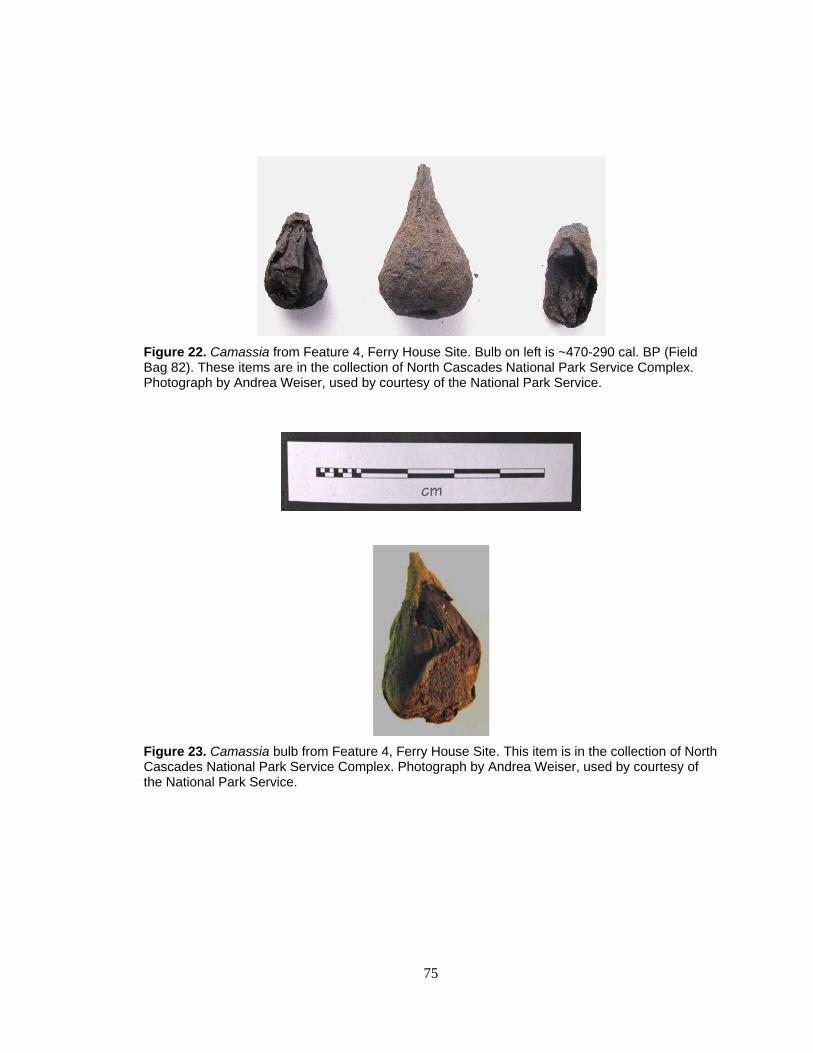
75
Figure 22. Camassia from Feature 4, Ferry House Site. Bulb on left is ~470-290 cal. BP (Field Bag 82). These items are in the collection of North Cascades National Park Service Complex. Photograph by Andrea Weiser, used by courtesy of the National Park Service.
Figure 23. Camassia bulb from Feature 4, Ferry House Site. This item is in the collection of North Cascades National Park Service Complex. Photograph by Andrea Weiser, used by courtesy of the National Park Service.
76
Table 12. Summary of Feature 4 cultural material collected from 6.4 mm (1/4-inch) screen during excavation.
Cultural Material Quantity (N) Archaeobotanical Remains Lilliaceae bulbs 20+ Charcoal >6.4 mm 51-200 Root or rhizome 1 Artifacts Fire-modified rocks ~50
A number of the plant bulbs recovered from Feature 4 were too fragmented to
classify but I was able to identify 20 nearly-whole specimens (Table 10). I examined
these 20 specimens in detail and compared them to reference samples, finding that the
majority of them were camas (Camassia) and onion (Allium). Both camas and onion
bulbs have paper-thin overlapping modified leaf scales which appear as concentric rings
or a spiral in cross-section. I was able to differentiate between these two genera in some
samples by examining the epidermal tissue where the delicate net or brick-like cell-wall
patterning was visible. Although epidermal cells can appear similar in shape and
arrangement in onion and camas, a difference in the size of cellular openings is a
distinguishing characteristic (see Appendix E). One sample from Feature 4 was clearly
not in the Liliaceae family and appeared to be a swollen underground stem or rhizome. I
compared this sample with several rhizomes and swollen underground stems but the
specimen lacked diagnostic characteristics and I was unable to make a positive
identification.

77
Figure 24. Distribution of Camassia in Feature 4, recovered from trenches and test units under and adjacent to the Ferry House. Base map created by Keith Garnett.
The Ferry House Footprint
Scale in feet
Trench 26
Trench 9
Trench 26a
Test Unit 7
Test Unit 18
Key
Camassia bulbs Feature 4 boundary
N
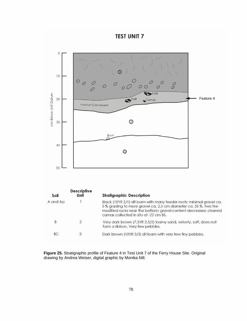
78
Figure 25. Stratigraphic profile of Feature 4 in Test Unit 7 of the Ferry House Site. Original drawing by Andrea Weiser, digital graphic by Monika Nill.
Feature 4
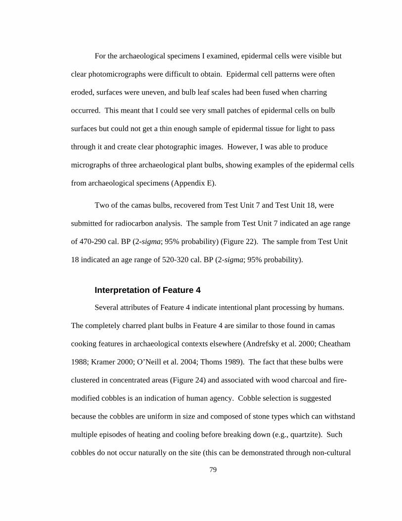
79
For the archaeological specimens I examined, epidermal cells were visible but
clear photomicrographs were difficult to obtain. Epidermal cell patterns were often
eroded, surfaces were uneven, and bulb leaf scales had been fused when charring
occurred. This meant that I could see very small patches of epidermal cells on bulb
surfaces but could not get a thin enough sample of epidermal tissue for light to pass
through it and create clear photographic images. However, I was able to produce
micrographs of three archaeological plant bulbs, showing examples of the epidermal cells
from archaeological specimens (Appendix E).
Two of the camas bulbs, recovered from Test Unit 7 and Test Unit 18, were
submitted for radiocarbon analysis. The sample from Test Unit 7 indicated an age range
of 470-290 cal. BP (2-sigma; 95% probability) (Figure 22). The sample from Test Unit
18 indicated an age range of 520-320 cal. BP (2-sigma; 95% probability).
Interpretation of Feature 4
Several attributes of Feature 4 indicate intentional plant processing by humans.
The completely charred plant bulbs in Feature 4 are similar to those found in camas
cooking features in archaeological contexts elsewhere (Andrefsky et al. 2000; Cheatham
1988; Kramer 2000; O’Neill et al. 2004; Thoms 1989). The fact that these bulbs were
clustered in concentrated areas (Figure 24) and associated with wood charcoal and fire-
modified cobbles is an indication of human agency. Cobble selection is suggested
because the cobbles are uniform in size and composed of stone types which can withstand
multiple episodes of heating and cooling before breaking down (e.g., quartzite). Such
cobbles do not occur naturally on the site (this can be demonstrated through non-cultural
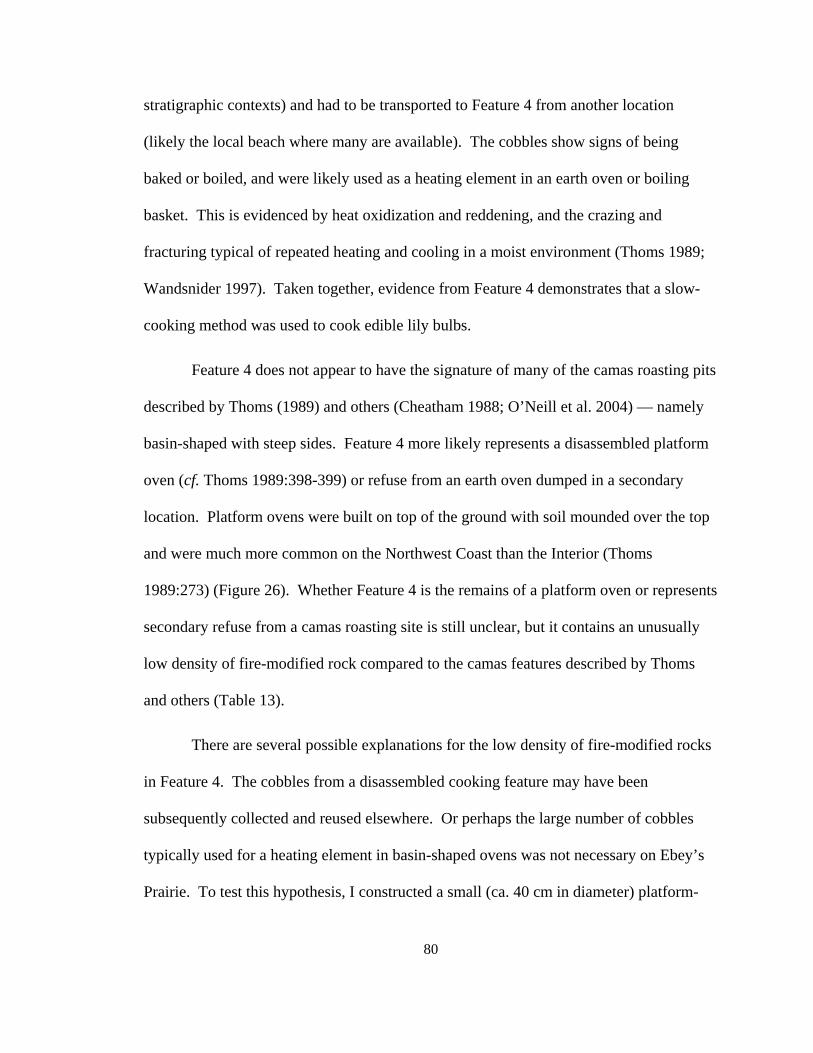
80
stratigraphic contexts) and had to be transported to Feature 4 from another location
(likely the local beach where many are available). The cobbles show signs of being
baked or boiled, and were likely used as a heating element in an earth oven or boiling
basket. This is evidenced by heat oxidization and reddening, and the crazing and
fracturing typical of repeated heating and cooling in a moist environment (Thoms 1989;
Wandsnider 1997). Taken together, evidence from Feature 4 demonstrates that a slow-
cooking method was used to cook edible lily bulbs.
Feature 4 does not appear to have the signature of many of the camas roasting pits
described by Thoms (1989) and others (Cheatham 1988; O’Neill et al. 2004) — namely
basin-shaped with steep sides. Feature 4 more likely represents a disassembled platform
oven (cf. Thoms 1989:398-399) or refuse from an earth oven dumped in a secondary
location. Platform ovens were built on top of the ground with soil mounded over the top
and were much more common on the Northwest Coast than the Interior (Thoms
1989:273) (Figure 26). Whether Feature 4 is the remains of a platform oven or represents
secondary refuse from a camas roasting site is still unclear, but it contains an unusually
low density of fire-modified rock compared to the camas features described by Thoms
and others (Table 13).
There are several possible explanations for the low density of fire-modified rocks
in Feature 4. The cobbles from a disassembled cooking feature may have been
subsequently collected and reused elsewhere. Or perhaps the large number of cobbles
typically used for a heating element in basin-shaped ovens was not necessary on Ebey’s
Prairie. To test this hypothesis, I constructed a small (ca. 40 cm in diameter) platform-
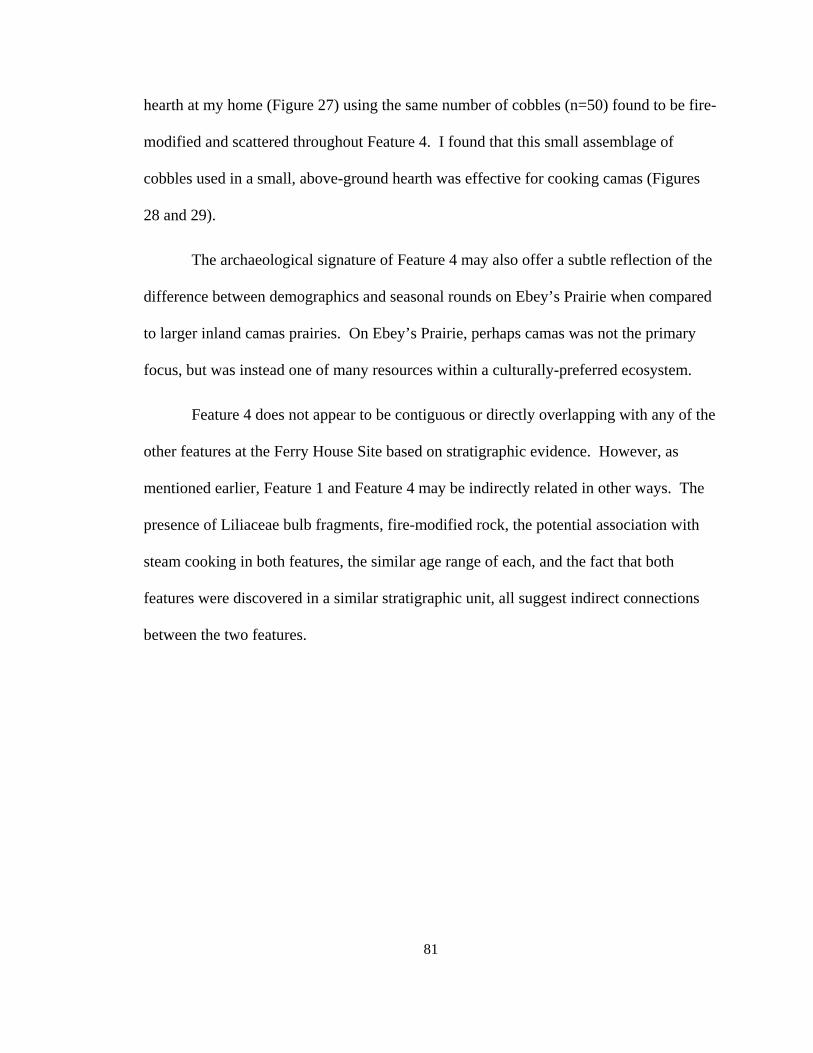
81
hearth at my home (Figure 27) using the same number of cobbles (n=50) found to be fire-
modified and scattered throughout Feature 4. I found that this small assemblage of
cobbles used in a small, above-ground hearth was effective for cooking camas (Figures
28 and 29).
The archaeological signature of Feature 4 may also offer a subtle reflection of the
difference between demographics and seasonal rounds on Ebey’s Prairie when compared
to larger inland camas prairies. On Ebey’s Prairie, perhaps camas was not the primary
focus, but was instead one of many resources within a culturally-preferred ecosystem.
Feature 4 does not appear to be contiguous or directly overlapping with any of the
other features at the Ferry House Site based on stratigraphic evidence. However, as
mentioned earlier, Feature 1 and Feature 4 may be indirectly related in other ways. The
presence of Liliaceae bulb fragments, fire-modified rock, the potential association with
steam cooking in both features, the similar age range of each, and the fact that both
features were discovered in a similar stratigraphic unit, all suggest indirect connections
between the two features.
82
Figure 26. Two common types of dissasembled ancient camas ovens based on research by Thoms (1989:399).
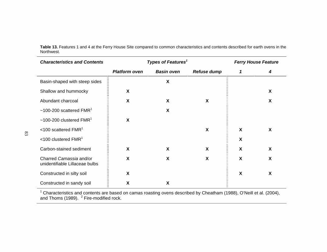
83
Table 13. Features 1 and 4 at the Ferry House Site compared to common characteristics and contents described for earth ovens in the Northwest.
Characteristics and Contents Types of Features1 Ferry House Feature
Platform oven Basin oven Refuse dump 1 4
Basin-shaped with steep sides X
Shallow and hummocky X X
Abundant charcoal X X X X
~100-200 scattered FMR1 X
~100-200 clustered FMR1 X
<100 scattered FMR1 X X X
<100 clustered FMR1 X
Carbon-stained sediment X X X X X
Charred Camassia and/or unidentifiable Lillaceae bulbs
X X X X X
Constructed in silty soil X X X
Constructed in sandy soil X X 1 Characteristics and contents are based on camas roasting ovens described by Cheatham (1988), O’Neill et al. (2004), and Thoms (1989). 2 Fire-modified rock.
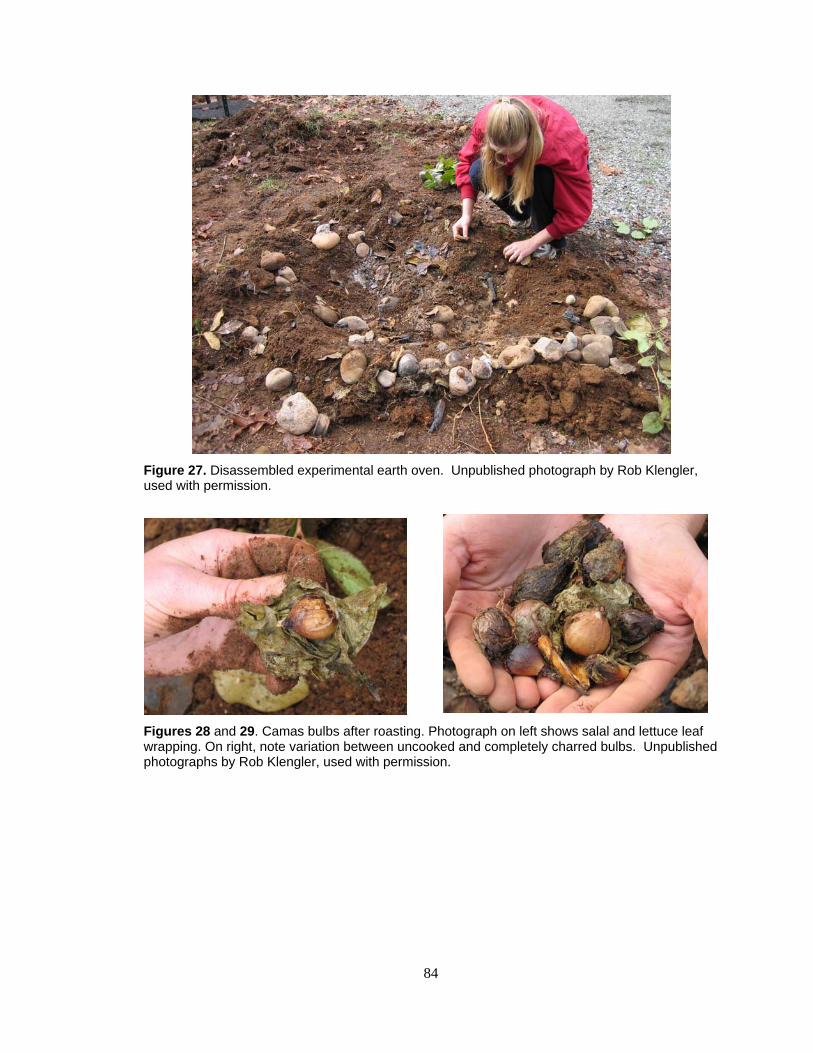
84
Figure 27. Disassembled experimental earth oven. Unpublished photograph by Rob Klengler, used with permission.
Figures 28 and 29. Camas bulbs after roasting. Photograph on left shows salal and lettuce leaf wrapping. On right, note variation between uncooked and completely charred bulbs. Unpublished photographs by Rob Klengler, used with permission.
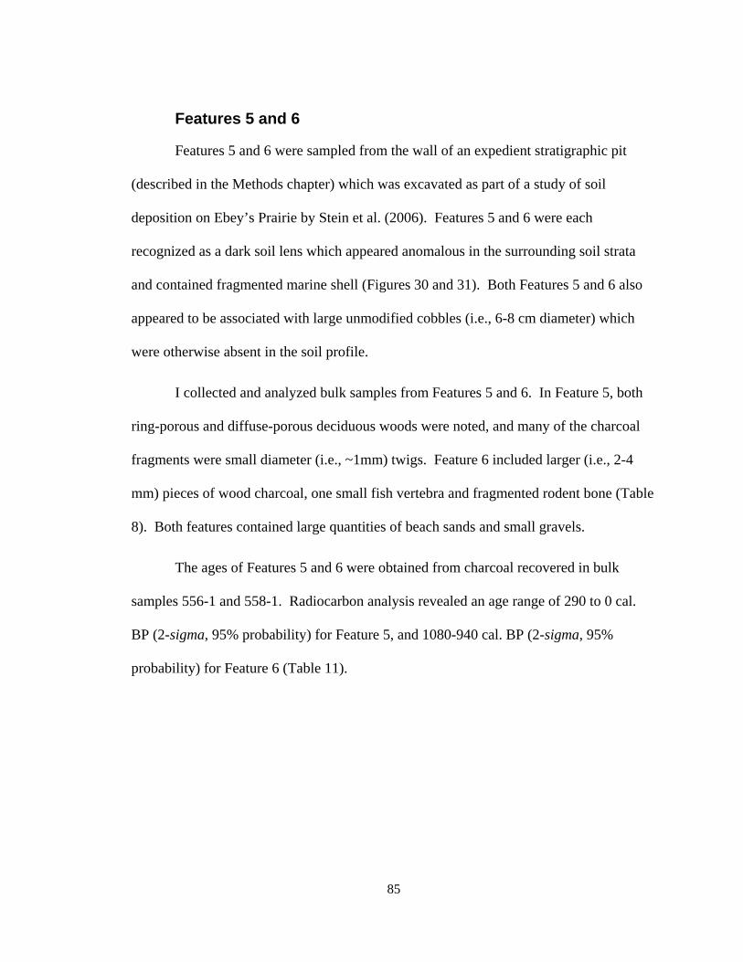
85
Features 5 and 6
Features 5 and 6 were sampled from the wall of an expedient stratigraphic pit
(described in the Methods chapter) which was excavated as part of a study of soil
deposition on Ebey’s Prairie by Stein et al. (2006). Features 5 and 6 were each
recognized as a dark soil lens which appeared anomalous in the surrounding soil strata
and contained fragmented marine shell (Figures 30 and 31). Both Features 5 and 6 also
appeared to be associated with large unmodified cobbles (i.e., 6-8 cm diameter) which
were otherwise absent in the soil profile.
I collected and analyzed bulk samples from Features 5 and 6. In Feature 5, both
ring-porous and diffuse-porous deciduous woods were noted, and many of the charcoal
fragments were small diameter (i.e., ~1mm) twigs. Feature 6 included larger (i.e., 2-4
mm) pieces of wood charcoal, one small fish vertebra and fragmented rodent bone (Table
8). Both features contained large quantities of beach sands and small gravels.
The ages of Features 5 and 6 were obtained from charcoal recovered in bulk
samples 556-1 and 558-1. Radiocarbon analysis revealed an age range of 290 to 0 cal.
BP (2-sigma, 95% probability) for Feature 5, and 1080-940 cal. BP (2-sigma, 95%
probability) for Feature 6 (Table 11).
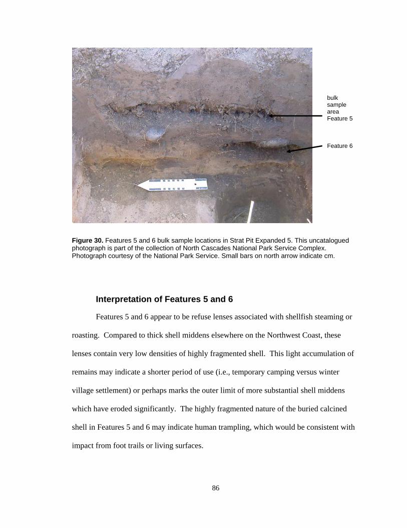
86
Figure 30. Features 5 and 6 bulk sample locations in Strat Pit Expanded 5. This uncatalogued photograph is part of the collection of North Cascades National Park Service Complex. Photograph courtesy of the National Park Service. Small bars on north arrow indicate cm.
Interpretation of Features 5 and 6
Features 5 and 6 appear to be refuse lenses associated with shellfish steaming or
roasting. Compared to thick shell middens elsewhere on the Northwest Coast, these
lenses contain very low densities of highly fragmented shell. This light accumulation of
remains may indicate a shorter period of use (i.e., temporary camping versus winter
village settlement) or perhaps marks the outer limit of more substantial shell middens
which have eroded significantly. The highly fragmented nature of the buried calcined
shell in Features 5 and 6 may indicate human trampling, which would be consistent with
impact from foot trails or living surfaces.
bulk sample area Feature 5
Feature 6
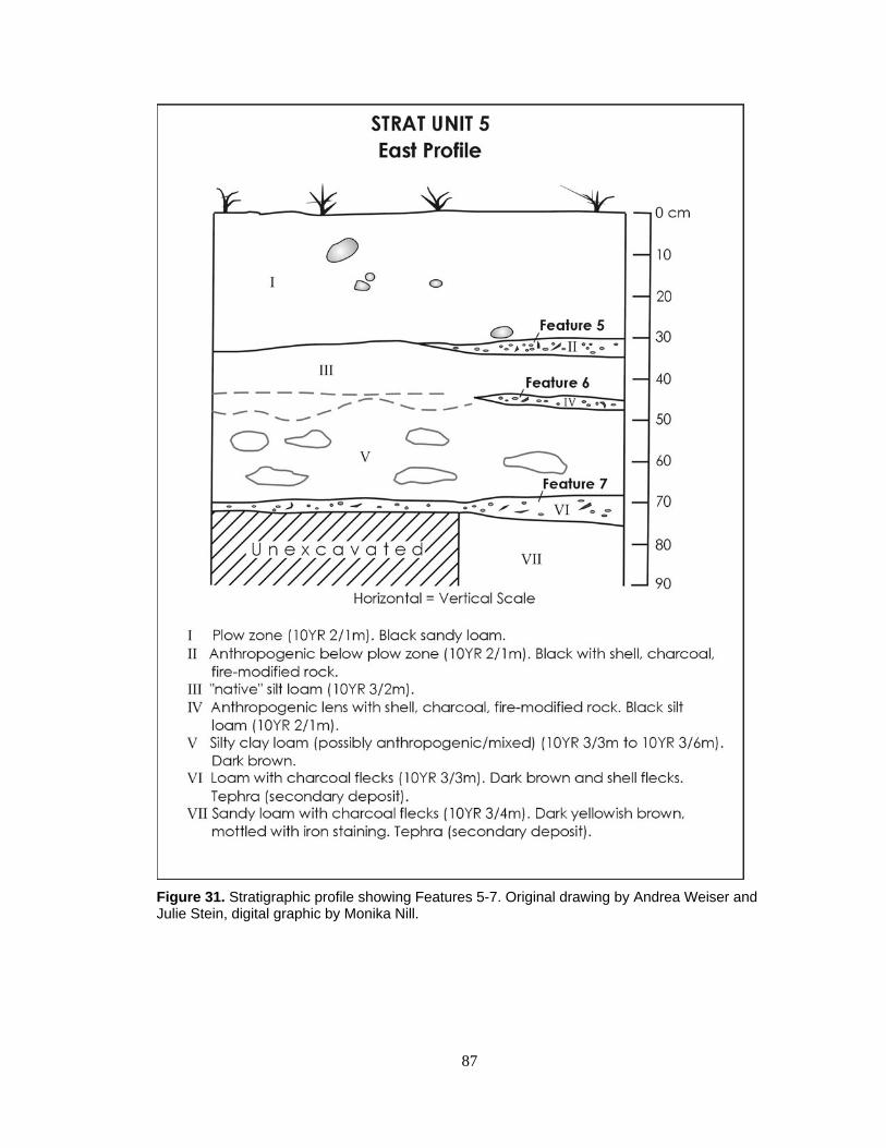
87
Figure 31. Stratigraphic profile showing Features 5-7. Original drawing by Andrea Weiser and Julie Stein, digital graphic by Monika Nill.
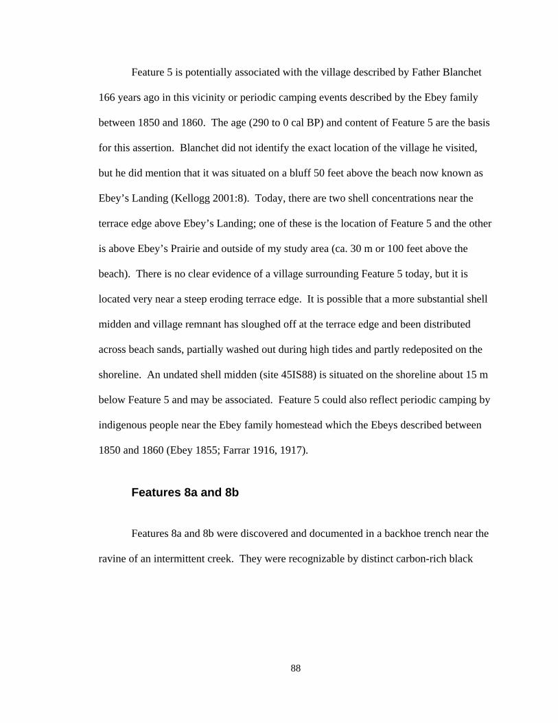
88
Feature 5 is potentially associated with the village described by Father Blanchet
166 years ago in this vicinity or periodic camping events described by the Ebey family
between 1850 and 1860. The age (290 to 0 cal BP) and content of Feature 5 are the basis
for this assertion. Blanchet did not identify the exact location of the village he visited,
but he did mention that it was situated on a bluff 50 feet above the beach now known as
Ebey’s Landing (Kellogg 2001:8). Today, there are two shell concentrations near the
terrace edge above Ebey’s Landing; one of these is the location of Feature 5 and the other
is above Ebey’s Prairie and outside of my study area (ca. 30 m or 100 feet above the
beach). There is no clear evidence of a village surrounding Feature 5 today, but it is
located very near a steep eroding terrace edge. It is possible that a more substantial shell
midden and village remnant has sloughed off at the terrace edge and been distributed
across beach sands, partially washed out during high tides and partly redeposited on the
shoreline. An undated shell midden (site 45IS88) is situated on the shoreline about 15 m
below Feature 5 and may be associated. Feature 5 could also reflect periodic camping by
indigenous people near the Ebey family homestead which the Ebeys described between
1850 and 1860 (Ebey 1855; Farrar 1916, 1917).
Features 8a and 8b
Features 8a and 8b were discovered and documented in a backhoe trench near the
ravine of an intermittent creek. They were recognizable by distinct carbon-rich black
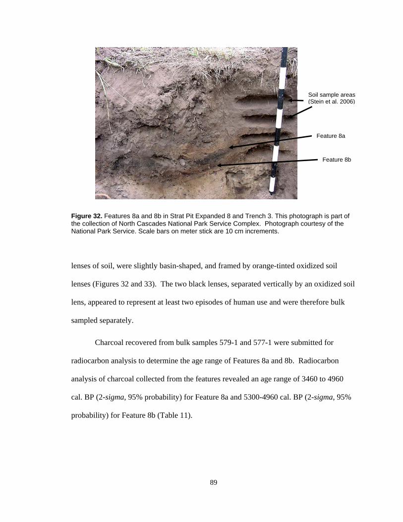
89
Figure 32. Features 8a and 8b in Strat Pit Expanded 8 and Trench 3. This photograph is part of the collection of North Cascades National Park Service Complex. Photograph courtesy of the National Park Service. Scale bars on meter stick are 10 cm increments.
lenses of soil, were slightly basin-shaped, and framed by orange-tinted oxidized soil
lenses (Figures 32 and 33). The two black lenses, separated vertically by an oxidized soil
lens, appeared to represent at least two episodes of human use and were therefore bulk
sampled separately.
Charcoal recovered from bulk samples 579-1 and 577-1 were submitted for
radiocarbon analysis to determine the age range of Features 8a and 8b. Radiocarbon
analysis of charcoal collected from the features revealed an age range of 3460 to 4960
cal. BP (2-sigma, 95% probability) for Feature 8a and 5300-4960 cal. BP (2-sigma, 95%
probability) for Feature 8b (Table 11).
Feature 8a
Feature 8b
Soil sample areas (Stein et al. 2006)
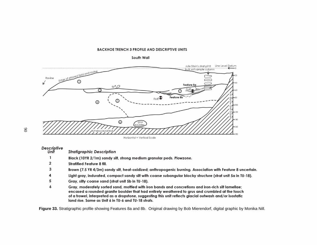
90
Figure 33. Stratigraphic profile showing Features 8a and 8b. Original drawing by Bob Mierendorf, digital graphic by Monika Nill.
91
Interpretation of Features 8a and 8b
Features 8a and 8b appear to be hearths, constructed in the same location but
separated in time. It is unclear whether these hearths were used as cooking fires, heating
fires, or both. Both features contain evidence of open flame as opposed to smothered
fires at least during part of their histories, as indicated by mottled oxidized soil above the
black lens of Feature 8a and the continuous oxidized layer overlying the black lens of
Feature 8b. Charcoal was highly fragmented in both samples and perhaps much of the
charcoal content, observable as carbon-rich soil lenses in the field, was from particles
smaller than 0.250 mm in size which could have washed away during the flotation
process.
Feature 8a contained seeds from forbs (Brassica, Trifolium, and Polygonum) and
at least one piece of diffuse porous hardwood which was the basis for the age
determination of this feature. The three seeds from Feature 8b were highly eroded and
lacked diagnostic characteristics. No clear associations can be made between Features 8a
and 8b and any other features in the vicinity of the Ferry House Site.
Features 10 and 11
Features 10 and 11 were observed in the cutbank of a road near the western edge
of the Ferry House Site. Feature 10 is a large basin-shaped pit containing carbon-rich
soil, fire-cracked rock, and at least one lithic flake which fell from the profile during wall
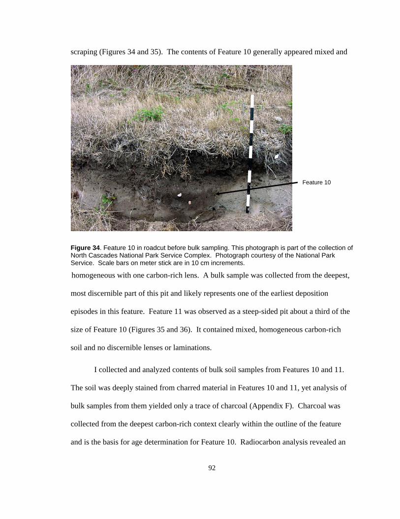
92
scraping (Figures 34 and 35). The contents of Feature 10 generally appeared mixed and
Figure 34. Feature 10 in roadcut before bulk sampling. This photograph is part of the collection of North Cascades National Park Service Complex. Photograph courtesy of the National Park Service. Scale bars on meter stick are in 10 cm increments.
homogeneous with one carbon-rich lens. A bulk sample was collected from the deepest,
most discernible part of this pit and likely represents one of the earliest deposition
episodes in this feature. Feature 11 was observed as a steep-sided pit about a third of the
size of Feature 10 (Figures 35 and 36). It contained mixed, homogeneous carbon-rich
soil and no discernible lenses or laminations.
I collected and analyzed contents of bulk soil samples from Features 10 and 11.
The soil was deeply stained from charred material in Features 10 and 11, yet analysis of
bulk samples from them yielded only a trace of charcoal (Appendix F). Charcoal was
collected from the deepest carbon-rich context clearly within the outline of the feature
and is the basis for age determination for Feature 10. Radiocarbon analysis revealed an
Feature 10
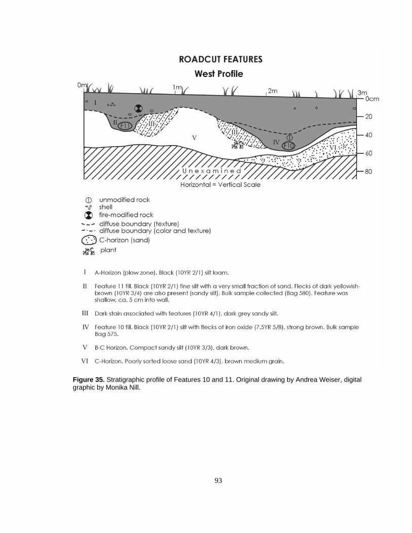
93
Figure 35. Stratigraphic profile of Features 10 and 11. Original drawing by Andrea Weiser, digital graphic by Monika Nill.

94
age range of 6900-6730 cal. BP (2-sigma, 95% probability) (Table 11). There is
currently no basis for age determination of Feature 11. However, the stratigraphic
context of Feature 11 and its apparent lack of bioturbation when compared to Feature 10
(as demonstrated through easily distinguished outlines) suggest that it is younger than
Feature 10.
Interpretation of Features 10 and 11
Features 10 and 11 appear to be refuse pits, based on the mixed homogeneous
appearance of feature fill. Though one carbon-rich lens appears in Feature 10, it is
mixed, mottled and does not appear comparable to a primary hearth deposit. Instead, this
lens likely reflects one early episode of secondary deposition (perhaps hearth cleanings)
within the feature. Since the matrix of both features appeared mixed and homogeneous
and lacked individual laminations which could demonstrate multiple deposition episodes,
I concluded that each feature was likely deposited in a single episode. The age range
derived from this lens can only be representative of a single depositional event. No clear
associations can be made between Feature 10 and Feature 11 and any other features in
vicinity of the Ferry House Site.

95
Figure 36. Feature 11 in roadcut before bulk sampling. This photograph is part of the collection of North Cascades National Park Service Complex. Photograph courtesy of the National Park Service. Scale bars on meter stick are in 10 cm increments.
Summary of Archaeobotanical Remains Recovered from Features
The archaeobotanical remains from all but one feature (Feature 4) were recovered by
flotation. I was able to make taxonomic identifications based upon a variety of remains
such as seeds, needles, bulbs, a glume, and a single fruit (Figure 37 and Appendix F).
Wood charcoal was apparent in all samples during flotation as highly fragmented
particulate blended into the soil matrix. Most charred wood pieces were smaller than 1
mm and were weighed but problematic to identify. However, by examining some of the
largest charred wood pieces (i.e., 2 mm in size or greater) I was able to establish that both
hardwoods and softwoods were represented in the assemblage and that the majority of the
pieces were small diameter twigs.
Feature 11

96
0
5
10
15
20
25
30
35
Wood
Seed
Needle
Cone s
cale
Bulb
Nut pa
rt
Bud
Berry
Root/rh
izome
Glume
Botanical Element
% U
biqu
ity in
Fea
ture
s
11
8
6
4
2 21 1 1 1
Figure 37. Relative ubiquity of charred archaeobotanical elements in features from the vicinity of the Ferry House Site on Ebey’s Prairie. Numbers above each bar indicate number of features which contain each botanical element.
97
Overall, the density of archaeobotanical remains in all samples was low but I was
able to gain useful information about the types of plants (i.e., grasses and grasslike plants
such as sedges, forbs, shrubs and trees) represented by features in the Ferry House Site
and vicinity (Table 14). The majority of ancient plants identified from the features were
also native to the anthropogenic prairies of western Washington in the early historic
period (listed in Appendix A). Like anthropogenic prairies, the archaeobotanical
assemblage is dominated by forbs (Figure 38), and includes a variety of edible and useful
plants (Figure 39). Both prairie and forest vegetation is represented, by the presence of
annuals, perennials, hardwoods, and softwoods in feature deposits. Four of the plants
identified from ancient seeds in Features 1 and 5 derive from freshwater aquatic plants.
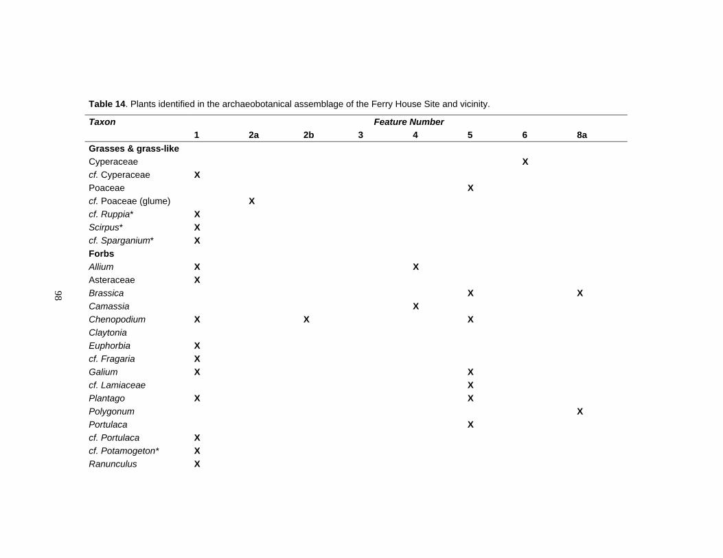
98
Table 14. Plants identified in the archaeobotanical assemblage of the Ferry House Site and vicinity.
Taxon Feature Number 1 2a 2b 3 4 5 6 8a Grasses & grass-like Cyperaceae X cf. Cyperaceae X Poaceae X cf. Poaceae (glume) X cf. Ruppia* X Scirpus* X cf. Sparganium* X Forbs Allium X X Asteraceae X Brassica X X Camassia X Chenopodium X X X Claytonia Euphorbia X cf. Fragaria X Galium X X cf. Lamiaceae X Plantago X X Polygonum X Portulaca X cf. Portulaca X cf. Potamogeton* X Ranunculus X
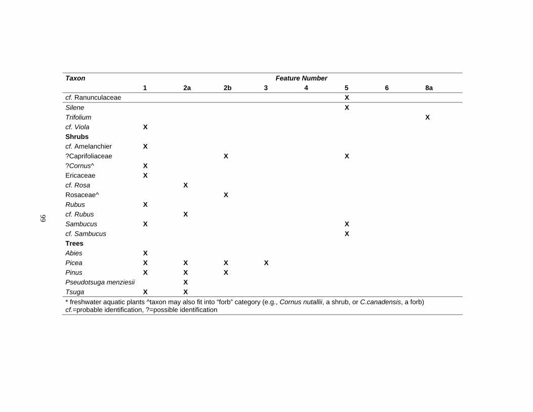
99
Taxon Feature Number 1 2a 2b 3 4 5 6 8a cf. Ranunculaceae X Silene X Trifolium X cf. Viola X Shrubs cf. Amelanchier X ?Caprifoliaceae X X ?Cornus^ X Ericaceae X cf. Rosa X Rosaceae^ X Rubus X cf. Rubus X Sambucus X X cf. Sambucus X Trees Abies X Picea X X X X Pinus X X X Pseudotsuga menziesii X Tsuga X X * freshwater aquatic plants ^taxon may also fit into “forb” category (e.g., Cornus nutallii, a shrub, or C.canadensis, a forb) cf.=probable identification, ?=possible identification
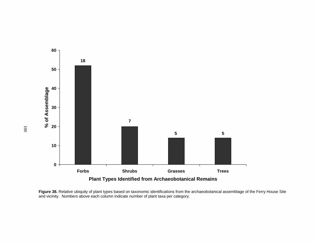
100
0
10
20
30
40
50
60
Forbs Shrubs Grasses Trees
Plant Types Identified from Archaeobotanical Remains
% o
f Ass
embl
age
18
7
5 5
Figure 38. Relative ubiquity of plant types based on taxonomic identifications from the archaeobotanical assemblage of the Ferry House Site and vicinity. Numbers above each column indicate number of plant taxa per category.
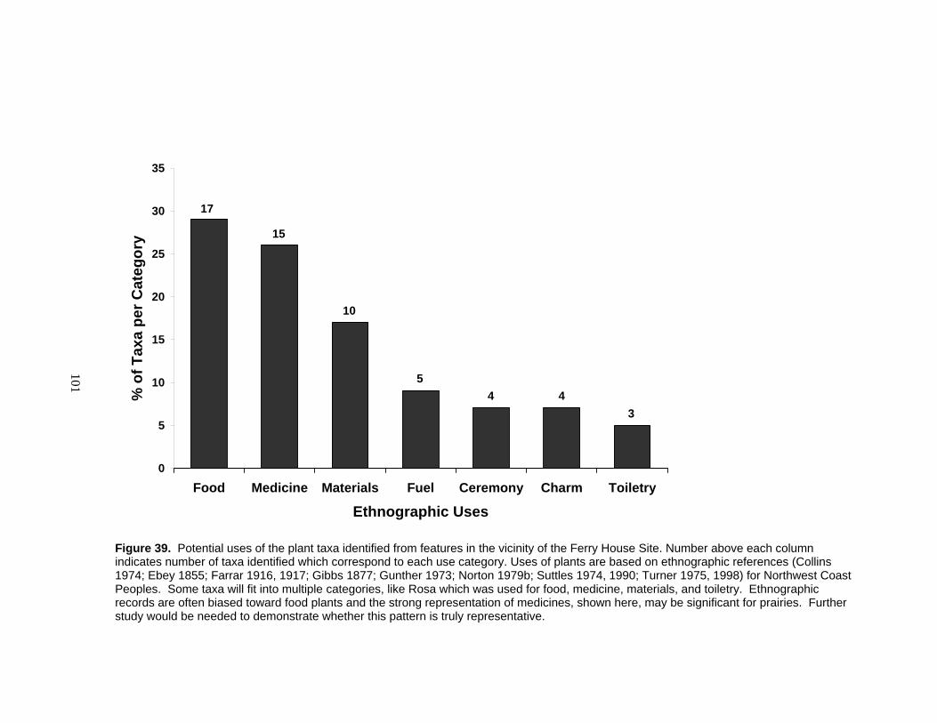
101
0
5
10
15
20
25
30
35
Food Medicine Materials Fuel Ceremony Charm Toiletry
Ethnographic Uses
% o
f Tax
a pe
r Cat
egor
y
17
15
10
54 4
3
Figure 39. Potential uses of the plant taxa identified from features in the vicinity of the Ferry House Site. Number above each column indicates number of taxa identified which correspond to each use category. Uses of plants are based on ethnographic references (Collins 1974; Ebey 1855; Farrar 1916, 1917; Gibbs 1877; Gunther 1973; Norton 1979b; Suttles 1974, 1990; Turner 1975, 1998) for Northwest Coast Peoples. Some taxa will fit into multiple categories, like Rosa which was used for food, medicine, materials, and toiletry. Ethnographic records are often biased toward food plants and the strong representation of medicines, shown here, may be significant for prairies. Further study would be needed to demonstrate whether this pattern is truly representative.
102
Summary of Other Remains Recovered from Features
In addition to archaeobotanical remains, feature deposits contained a number of
other materials including beach sand, faunal remains, and lithic debitage (Table 9 and
Figure 40). Those features which had been described in the field as mixed secondary
deposits (i.e., refuse pits or lenses) rather than hearths were found to contain medium to
high densities of sand and gravel in the laboratory. This discovery helped to verify
secondary deposition. Lithic debitage from features was primarily composed of materials
available on the nearby shoreline (a distance of ~15 meters from the features that
contained them). Only one flake recovered from a feature (Feature 11) was composed of
an exotic raw material — obsidian.
Faunal remains include bone, shell and urchin spines found in four of the features
(Table 15). These were retained for future analysis and are stored in the National Park
Service Marblemount Curation Facility. Bone and shell pieces were calcined or charred,
most were highly fragmented and many were non-diagnostic. Given the time required,
these remains were not systematically identified. However, during sorting and
quantification, I noted that the samples contained the remains of mussels, clams, urchins,
and fish. The bones of a small rodent and a more robust animal were also present.
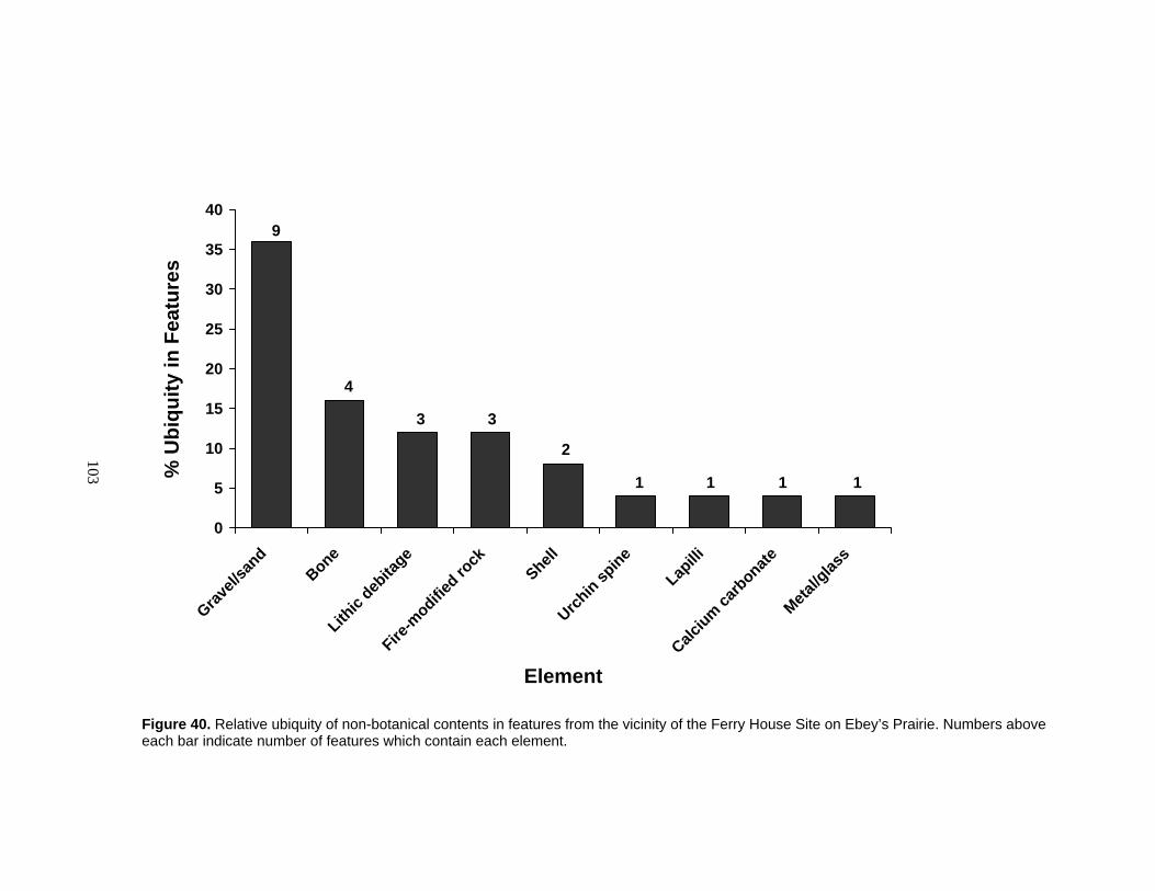
103
0
5
10
15
20
25
30
35
40
Gravel/
sand
BoneLith
ic deb
itage
Fire-m
odified ro
ck
ShellUrch
in spine
Lapilli
Calcium ca
rbonate
Metal/g
lass
Element
% U
biqu
ity in
Fea
ture
s
9
4
3 3
2
1 1 1 1
Figure 40. Relative ubiquity of non-botanical contents in features from the vicinity of the Ferry House Site on Ebey’s Prairie. Numbers above each bar indicate number of features which contain each element.

104
Table 15. Faunal remains present in features in the vicinity of the Ferry House Site.
Feature No. Faunal Remains Clam Mussel Urchin Fish Rodent Unknown mammal 1 x 5 x x x x 6 x x x x 8a x x
Activities Indicated by Features and Archaeobotanical Remains
I developed my interpretations of features by reviewing the appearance, contents
(Table 8), relative density of remains (Table 16) and age (Table 11) of each. I then used
these data to make inferences about the use of Ebey’s Prairie more generally (Table 17).
Many of the archaeobotanical remains recovered from bulk samples and from screens at
the Ferry House Site demonstrate that people were processing plants on Ebey’s Prairie
throughout history since about 2,300 BP. Some of the plants found in the Ferry House
Site features were locally available in Ebey’s Prairie and others were carried in from just
beyond the prairie ecosystem. Archaeobotanical remains in these features indicate that a
broad array of edible and useful plants from both prairie and forest ecosystems were used
by people on Ebey’s Prairie. An apparent increase in features since about 2,300 BP (see
Table 11) may indicate that the Ferry House Site was more intensively used during the
late Holocene.
Cooking Methods
Based on my field observations and the contents of feature deposits, it appears
that various cooking methods were employed at the Ferry House Site. A variety of
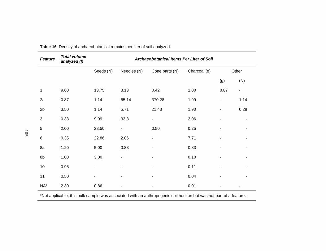
105
Table 16. Density of archaeobotanical remains per liter of soil analyzed.
Feature Total volume analyzed (l) Archaeobotanical Items Per Liter of Soil
Other Seeds (N) Needles (N) Cone parts (N) Charcoal (g)
(g) (N)
1 9.60 13.75 3.13 0.42 1.00 0.87 -
2a 0.87 1.14 65.14 370.28 1.99 - 1.14
2b 3.50 1.14 5.71 21.43 1.90 - 0.28
3 0.33 9.09 33.3 - 2.06 - -
5 2.00 23.50 - 0.50 0.25 - -
6 0.35 22.86 2.86 - 7.71 - -
8a 1.20 5.00 0.83 - 0.83 - -
8b 1.00 3.00 - - 0.10 - -
10 0.95 - - - 0.11 - -
11 0.50 - - - 0.04 - -
NA* 2.30 0.86 - - 0.01 - -
*Not applicable; this bulk sample was associated with an anthropogenic soil horizon but was not part of a feature.

106
woods were used and the presence of oxidized soil layers in hearth deposits (Features 2a,
2b, 8a, and 8b) provide evidence of high heat and open flame, for some episodes of use,
while the remains of highly combustible materials like small diameter twigs, conifer
needles, and liliaceous bulbs are evidence that low to moderate temperatures were also
maintained in features (i.e., smothered fires). The fire-modified rock in several features
provides evidence of a heating element which could help accomplish a low temperature
slow cooking environment for steaming or roasting.
The recovery of camas and onion bulbs from the Ferry House Site is a significant
result. According to Northwest Coast ethnographic sources camas, in particular, was a
critical food resource yet the cooked bulbs have been rarely found in archaeological sites
of the region (see Chapter 1). Accounts state that onion provided flavouring for foods
(Gunther 1973; Turner 1995) and was sometimes cooked with camas (Pojar and
MacKinnon 1994:106). Finding both genera in Feature 4 suggests that the occupants of
Ebey’s Prairie may have also cooked the two foods together. The seeds of various non-
edible forbs found in Ferry House features are from genera which would be conducive to
steam cooking in earth ovens — typical methods of preparing camas and onion bulbs on
the Northwest Coast (Collins 1974; Gunther 1973; Reagan 1917; Turner and Kuhnlein
1983, Turner 1995). Only a few of the many plants used to promote steam in steaming
and roasting pits are specifically mentioned in ethnographic literature. It is known,
however, that plants which retain water (e.g., Lysichiton americanum or skunk cabbage)
were desired for such a purpose (Gunther 1973; Turner 1995, 1998). The seeds of
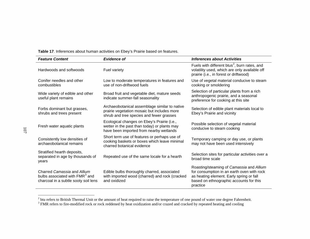
107
Table 17. Inferences about human activities on Ebey’s Prairie based on features.
Feature Content Evidence of Inferences about Activities
Hardwoods and softwoods Fuel variety Fuels with different btus2, burn rates, and volatility used, which are only available off prairie (i.e., in forest or driftwood)
Conifer needles and other combustibles
Low to moderate temperatures in features and use of non-driftwood fuels
Use of vegetal material conducive to steam cooking or smoldering
Wide variety of edible and other useful plant remains
Broad fruit and vegetable diet, mature seeds indicate summer-fall seasonality
Selection of particular plants from a rich anthropogenic prairie, and a seasonal preference for cooking at this site
Forbs dominant but grasses, shrubs and trees present
Archaeobotanical assemblage similar to native prairie vegetation mosaic but includes more shrub and tree species and fewer grasses
Selection of edible plant materials local to Ebey’s Prairie and vicinity
Fresh water aquatic plants Ecological changes on Ebey’s Prairie (i.e., wetter in the past than today) or plants may have been imported from nearby wetlands
Possible selection of vegetal material conducive to steam cooking
Consistently low densities of archaeobotanical remains
Short term use of features or perhaps use of cooking baskets or boxes which leave minimal charred botanical evidence
Temporary camping or day use, or plants may not have been used intensively
Stratified hearth deposits, separated in age by thousands of years
Repeated use of the same locale for a hearth Selection sites for particular activities over a broad time scale
Charred Camassia and Allium bulbs associated with FMR3 and charcoal in a subtle sooty soil lens
Edible bulbs thoroughly charred, associated with imported wood (charred) and rock (cracked and oxidized
Roasting/steaming of Camassia and Allium for consumption in an earth oven with rock as heating element. Early spring or fall based on ethnographic accounts for this practice
2 btu refers to British Thermal Unit or the amount of heat required to raise the temperature of one pound of water one degree Fahrenheit. 3 FMR refers to fire-modified rock or rock reddened by heat oxidization and/or crazed and cracked by repeated heating and cooling
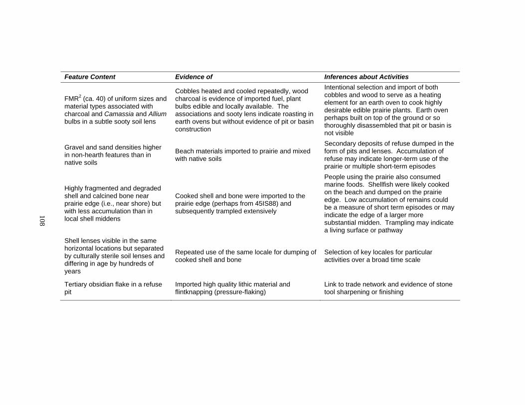
108
Feature Content Evidence of Inferences about Activities
FMR2 (ca. 40) of uniform sizes and material types associated with charcoal and Camassia and Allium bulbs in a subtle sooty soil lens
Cobbles heated and cooled repeatedly, wood charcoal is evidence of imported fuel, plant bulbs edible and locally available. The associations and sooty lens indicate roasting in earth ovens but without evidence of pit or basin construction
Intentional selection and import of both cobbles and wood to serve as a heating element for an earth oven to cook highly desirable edible prairie plants. Earth oven perhaps built on top of the ground or so thoroughly disassembled that pit or basin is not visible
Gravel and sand densities higher in non-hearth features than in native soils
Beach materials imported to prairie and mixed with native soils
Secondary deposits of refuse dumped in the form of pits and lenses. Accumulation of refuse may indicate longer-term use of the prairie or multiple short-term episodes
Highly fragmented and degraded shell and calcined bone near prairie edge (i.e., near shore) but with less accumulation than in local shell middens
Cooked shell and bone were imported to the prairie edge (perhaps from 45IS88) and subsequently trampled extensively
People using the prairie also consumed marine foods. Shellfish were likely cooked on the beach and dumped on the prairie edge. Low accumulation of remains could be a measure of short term episodes or may indicate the edge of a larger more substantial midden. Trampling may indicate a living surface or pathway
Shell lenses visible in the same horizontal locations but separated by culturally sterile soil lenses and differing in age by hundreds of years
Repeated use of the same locale for dumping of cooked shell and bone
Selection of key locales for particular activities over a broad time scale
Tertiary obsidian flake in a refuse pit
Imported high quality lithic material and flintknapping (pressure-flaking)
Link to trade network and evidence of stone tool sharpening or finishing

109
freshwater aquatic plants recovered from Features 1 and 5 may have derived from plants
which were selected to promote steam cooking of foods.
Evidence of berries recovered in the assemblage could indicate that they were
steamed, roasted, or eaten fresh around the fire — all common customs among Northwest
Coast people (Collins 1974; Gunther 1973; Turner and Kuhnlein 1983; Turner 1995,
1998). Berries were sometimes cooked in association with shellfish (Turner 1998), and
the berry seeds and calcined shell remains in Features 5 and 6 may be indicative of this
practice on Ebey’s Prairie. Alternatively, berry seeds may have been tracked in by
people and charred unintentionally or deposited by animals and other natural processes
and subsequently charred, though these explanations seem unlikely given the association
with wood charcoal, shellfish, and artifacts.
Camping and Longer-term Settlement
The consistent low densities of archaeobotanical remains in features suggest that
the Ferry House Site was used only for short-term camping events in prehistory. Of
course, a variety of taphonomic processes could account for the low recovery rates
(Lepofsky 2000a, 2002; Pearsall 2000). Further, there is a lack of evidence for
permanent structures. While some of the features (e.g., the stratified hearths and shell
lenses), indicated repeated activities in the same locations, none of the deposits were
abundant enough to suggest substantial settlements. The repeated camping episodes,
however, probably reflect that Ebey’s was a preferred resource gathering area. At the
Ferry House Site these resources include prairie plants such as Camassia sp. and Allium

110
sp. bulbs, and berry-producing forbs and shrubs which can grow in prairies or on prairie
edges (cf. Amelanchier, ?Caprifoliaceae, Ericaceae, cf. Fragaria, Rubus, and Sambucus).
Seasonal Use of the Ferry House Site
The paleoethnobotanical assemblage suggests that the Ferry House Site may have
been used by people throughout the year. The seeds and fruits of perennials and annuals
indicate that the site was used by people in summer through early fall seasons when the
seeds of these plants reach maturity. The presence of charred Camassia sp. and Allium
sp. bulbs in Feature 4 suggests early spring or fall seasonality of the site, based on
ethnographic information on bulb harvesting and processing (e.g., Collins 1974; Cooper
1860a; Gibbs 1877; Gunther 1973; Ebey 1855; Olson 1936; Suttles 1974, 1990).
Remains like rose seeds and grass glumes (found in Feature 2) can remain intact on dried
plants throughout the winter in this locale.
Results of Artifact Analysis
Artifacts from Excavation
Prehistoric artifacts were found sparsely scattered across the Ferry House Site
(Figure 41) from a variety of soil depths. The majority of artifacts recovered from
excavation (n=355) were not temporally diagnostic nor could they be ascribed relative
dates based on their context. Exceptions to this are the three dacite projectile points and a
greenstone core (Figure 42 and Table 18).
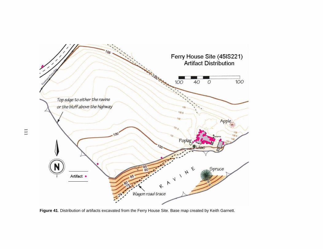
111
Figure 41. Distribution of artifacts excavated from the Ferry House Site. Base map created by Keith Garnett.

112
Nearly all prehistoric artifacts recovered from the Ferry House Site, except one
bone tool, were made of stone (Figure 43). The lithic artifacts were composed of a
number of material types, most of them locally available in the shoreline gravels below
the site such as dacite, quartzite, and metasediment (Figure 44). Some non-local exotic
materials like chalcedony, jasper, chert, and an obsidian flake (from Feature 11) were
also present in the assemblage. The majority of artifacts are flakes and shatter resulting
from lithic reduction and are composed of dacite.
Figure 42. Temporally-diagnostic artifacts from the Ferry House Site. On the left is a stemmed triangular projectile point (EBLA 1989) about 4,000 to 1,500 years old (Type 10A; Mierendorf et al. 1998:508). In the center is a stemmed and shouldered triangular projectile (EBLA 116) about 5,000 to 3,000 years old (Type 7; Mierendorf et al. 1998:505). On the right is the base of an early stemmed lanceolate (EBLA 1802) about 10,800-7,000 years old (Type 2C; Mierendorf et al. 1998:498). Age ranges are uncalibrated, approximate, and based on data from Northwest Coast and Plateau archaeological sites. These items are in the collection of North Cascades National Park Service Complex. Photograph by Andrea Weiser, used by courtesy of the National Park Service. Scale in cm.
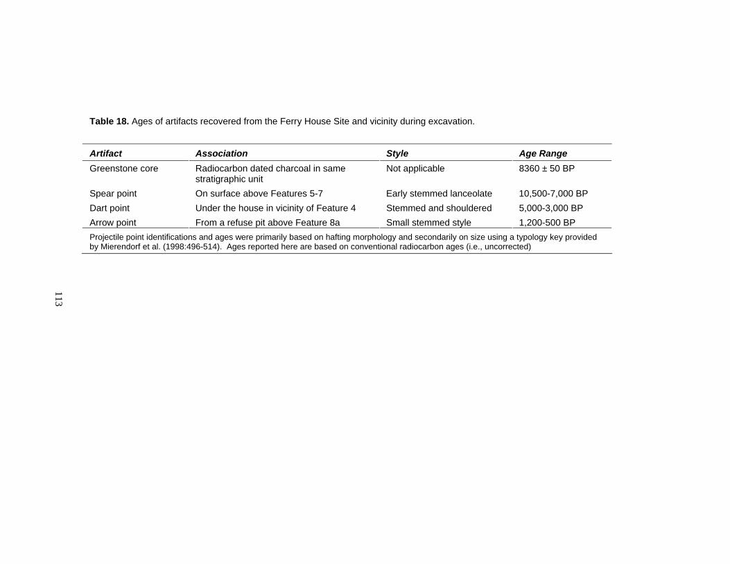
113
Table 18. Ages of artifacts recovered from the Ferry House Site and vicinity during excavation.
Artifact Association Style Age Range Greenstone core Radiocarbon dated charcoal in same
stratigraphic unit Not applicable 8360 ± 50 BP
Spear point On surface above Features 5-7 Early stemmed lanceolate 10,500-7,000 BP Dart point Under the house in vicinity of Feature 4 Stemmed and shouldered 5,000-3,000 BP Arrow point From a refuse pit above Feature 8a Small stemmed style 1,200-500 BP Projectile point identifications and ages were primarily based on hafting morphology and secondarily on size using a typology key provided by Mierendorf et al. (1998:496-514). Ages reported here are based on conventional radiocarbon ages (i.e., uncorrected)
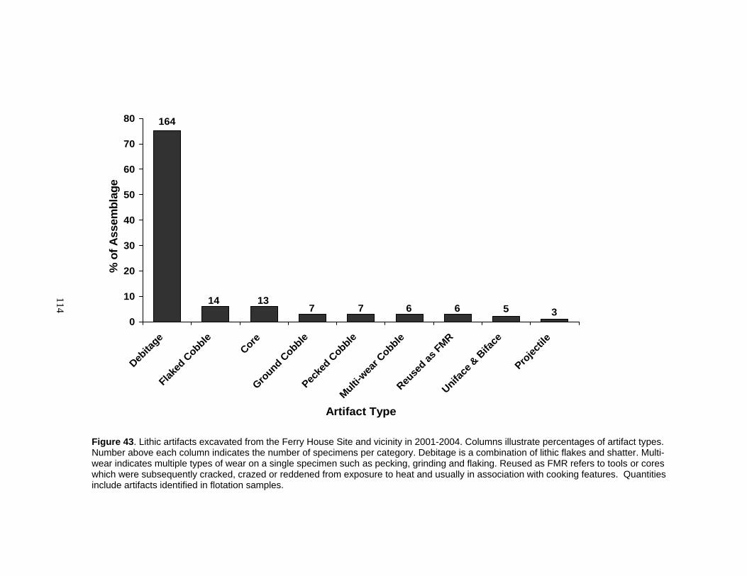
114
0
10
20
30
40
50
60
70
80
Debita
geFlak
ed C
obble
CoreGro
und Cobble
Pecke
d Cobble
Multi-wea
r Cobble
Reuse
d as FMR
Uniface
& B
iface
Projec
tile
Artifact Type
% o
f Ass
embl
age
164
14 137 7 6 6 5 3
Figure 43. Lithic artifacts excavated from the Ferry House Site and vicinity in 2001-2004. Columns illustrate percentages of artifact types. Number above each column indicates the number of specimens per category. Debitage is a combination of lithic flakes and shatter. Multi-wear indicates multiple types of wear on a single specimen such as pecking, grinding and flaking. Reused as FMR refers to tools or cores which were subsequently cracked, crazed or reddened from exposure to heat and usually in association with cooking features. Quantities include artifacts identified in flotation samples.
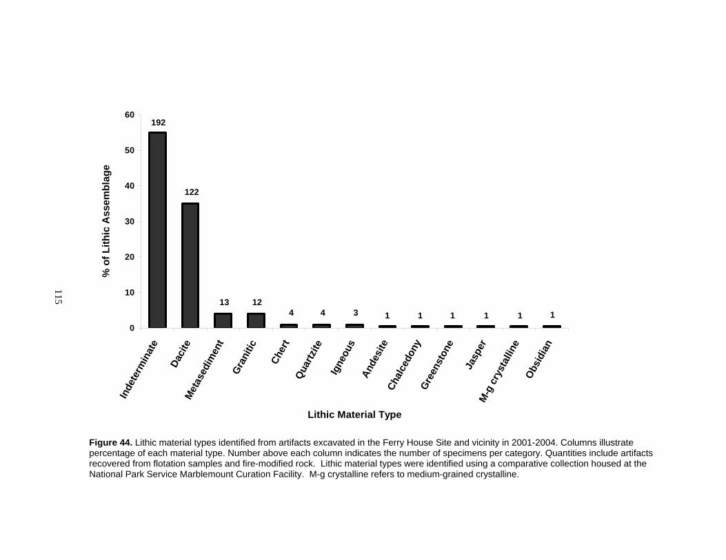
115
0
10
20
30
40
50
60In
dete
rmin
ate
Daci
teM
etas
edim
ent
Gran
itic
Cher
tQu
artz
iteIg
neou
sAn
desi
teCh
alce
dony
Gree
nsto
ne
Jasp
erM
-g c
ryst
allin
eOb
sidi
an
Lithic Material Type
% o
f Lith
ic A
ssem
blag
e192
122
13 12 4 4 3 1 1 1 1 1 1
Figure 44. Lithic material types identified from artifacts excavated in the Ferry House Site and vicinity in 2001-2004. Columns illustrate percentage of each material type. Number above each column indicates the number of specimens per category. Quantities include artifacts recovered from flotation samples and fire-modified rock. Lithic material types were identified using a comparative collection housed at the National Park Service Marblemount Curation Facility. M-g crystalline refers to medium-grained crystalline.

116
This assemblage of flaked lithics demonstrates early to late-stage lithic reduction
using both free-hand percussion and bipolar percussion techniques. Cobble cortex is
evident on 59% of the flakes and shatter (indicating early-stage reduction), while 41%
exhibit no cortex (indicating late-stage reduction). Five small pressure flakes, composed
of exotic materials, indicate late-stage reduction or resharpening of fully formed imported
tools. Three artifacts show evidence of bipolar percussion indicated by impact scars on
both ends and impact cones of force originating from opposite ends and expanding
toward one another. These artifacts include two bipolar cores and a biface. One of these
bipolar cores was subsequently fire modified. The majority of cores (n=11) exhibit
evidence of freehand percussion; two of these served additional functions, one as a
cutting or scraping tool and one as a heat source in a cooking feature.
Many of the tools in the artifact assemblage are cobbles which also appear to have
served multiple functions. That is, they exhibit a combination of flaking, grinding, and
pecking or battering and also show signs of subsequent exposure to fire. Many of these
had become part of the heating element in Feature 1, and were found clustered with other
fire-modified cobbles. The flaked cobbles in the assemblage were likely produced
expediently — they typically exhibit only two or three adjacent flake scars on the same
margin. This type of artifact has been found associated with camas processing locales
elsewhere (Thoms 1989:311).
The artifact assemblage derived from excavated contexts illustrates that multiple
techniques were used to create, use, and reuse tools derived from cobbles locally
available on the nearby beach. Many of the tools were expediently produced and likely
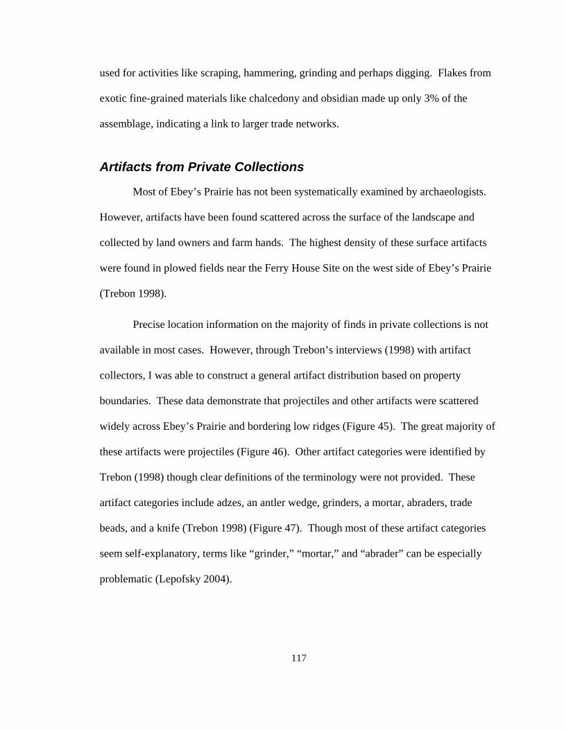
117
used for activities like scraping, hammering, grinding and perhaps digging. Flakes from
exotic fine-grained materials like chalcedony and obsidian made up only 3% of the
assemblage, indicating a link to larger trade networks.
Artifacts from Private Collections
Most of Ebey’s Prairie has not been systematically examined by archaeologists.
However, artifacts have been found scattered across the surface of the landscape and
collected by land owners and farm hands. The highest density of these surface artifacts
were found in plowed fields near the Ferry House Site on the west side of Ebey’s Prairie
(Trebon 1998).
Precise location information on the majority of finds in private collections is not
available in most cases. However, through Trebon’s interviews (1998) with artifact
collectors, I was able to construct a general artifact distribution based on property
boundaries. These data demonstrate that projectiles and other artifacts were scattered
widely across Ebey’s Prairie and bordering low ridges (Figure 45). The great majority of
these artifacts were projectiles (Figure 46). Other artifact categories were identified by
Trebon (1998) though clear definitions of the terminology were not provided. These
artifact categories include adzes, an antler wedge, grinders, a mortar, abraders, trade
beads, and a knife (Trebon 1998) (Figure 47). Though most of these artifact categories
seem self-explanatory, terms like “grinder,” “mortar,” and “abrader” can be especially
problematic (Lepofsky 2004).

118
Figure 45. Distribution of artifacts collected from Ebey's Prairie. Base map acquired from http://terraserver-usa.com, accessed October 23, 2005. Data points based on surface collections reported by Trebon (1998) and archaeological excavation at the Ferry House Site.
I evaluated 400 of the projectile points which were photographed during five
interviews conducted by Trebon (1998) and compared them to a key compiled by
Mierendorf et al. (1998:495-514). In Mierendorf’s key, hafting styles of projectiles are
classified into age categories based on stratigraphic and radiocarbon evidence from
Northwest Coast and Interior sites. Based on the 400 projectiles I evaluated from Ebey’s
Prairie, I found that the oldest spear points were deposited between 10,800 and 7,000
years ago (Table 19). This was shortly after glacial ice receded and Ebey’s Prairie
KEY
Artifact concentration
Ferry House Site
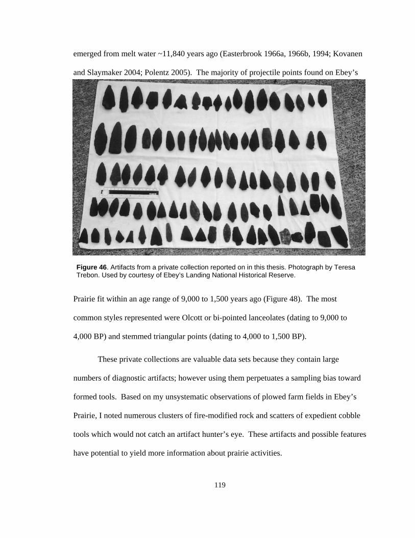
119
emerged from melt water ~11,840 years ago (Easterbrook 1966a, 1966b, 1994; Kovanen
and Slaymaker 2004; Polentz 2005). The majority of projectile points found on Ebey’s
Prairie fit within an age range of 9,000 to 1,500 years ago (Figure 48). The most
common styles represented were Olcott or bi-pointed lanceolates (dating to 9,000 to
4,000 BP) and stemmed triangular points (dating to 4,000 to 1,500 BP).
These private collections are valuable data sets because they contain large
numbers of diagnostic artifacts; however using them perpetuates a sampling bias toward
formed tools. Based on my unsystematic observations of plowed farm fields in Ebey’s
Prairie, I noted numerous clusters of fire-modified rock and scatters of expedient cobble
tools which would not catch an artifact hunter’s eye. These artifacts and possible features
have potential to yield more information about prairie activities.
Figure 46. Artifacts from a private collection reported on in this thesis. Photograph by Teresa Trebon. Used by courtesy of Ebey’s Landing National Historical Reserve.
120
0
10
20
30
40
50
60
70
"Adze" "Bead" "Abrader" "Grinder" "Knife" "Mortar" "Wedge"
Artifact Type
% o
f Ass
embl
age
21
4
2 21 1 1
Figure 47. Artifacts from Ebey’s Prairie and edges in private collections recorded by Trebon (1998). Artifact categories are listed in quotations because they were designated by collectors but not clearly defined. This figure excludes projectiles which dominate the assemblage (i.e., n=856), but see Table 31 and Figure 50 for analysis of 400 of them.
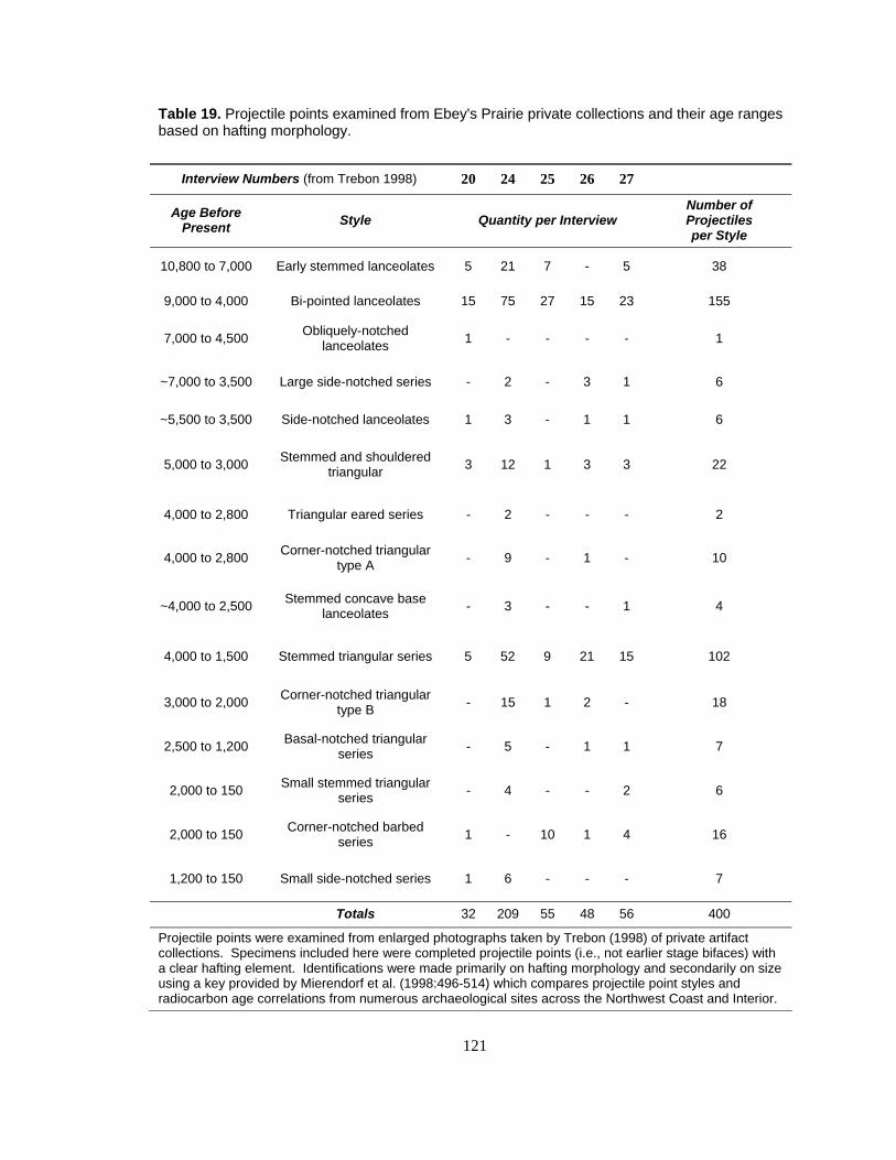
121
Table 19. Projectile points examined from Ebey's Prairie private collections and their age ranges based on hafting morphology.
Interview Numbers (from Trebon 1998) 20 24 25 26 27
Age Before Present Style Quantity per Interview
Number of Projectiles per Style
10,800 to 7,000 Early stemmed lanceolates 5 21 7 - 5 38
9,000 to 4,000 Bi-pointed lanceolates 15 75 27 15 23 155
7,000 to 4,500 Obliquely-notched lanceolates 1 - - - - 1
~7,000 to 3,500 Large side-notched series - 2 - 3 1 6
~5,500 to 3,500 Side-notched lanceolates 1 3 - 1 1 6
5,000 to 3,000 Stemmed and shouldered triangular 3 12 1 3 3 22
4,000 to 2,800 Triangular eared series - 2 - - - 2
4,000 to 2,800 Corner-notched triangular type A - 9 - 1 - 10
~4,000 to 2,500 Stemmed concave base lanceolates - 3 - - 1 4
4,000 to 1,500 Stemmed triangular series 5 52 9 21 15 102
3,000 to 2,000 Corner-notched triangular type B - 15 1 2 - 18
2,500 to 1,200 Basal-notched triangular series - 5 - 1 1 7
2,000 to 150 Small stemmed triangular series - 4 - - 2 6
2,000 to 150 Corner-notched barbed series 1 - 10 1 4 16
1,200 to 150 Small side-notched series 1 6 - - - 7
Totals 32 209 55 48 56 400
Projectile points were examined from enlarged photographs taken by Trebon (1998) of private artifact collections. Specimens included here were completed projectile points (i.e., not earlier stage bifaces) with a clear hafting element. Identifications were made primarily on hafting morphology and secondarily on size using a key provided by Mierendorf et al. (1998:496-514) which compares projectile point styles and radiocarbon age correlations from numerous archaeological sites across the Northwest Coast and Interior.
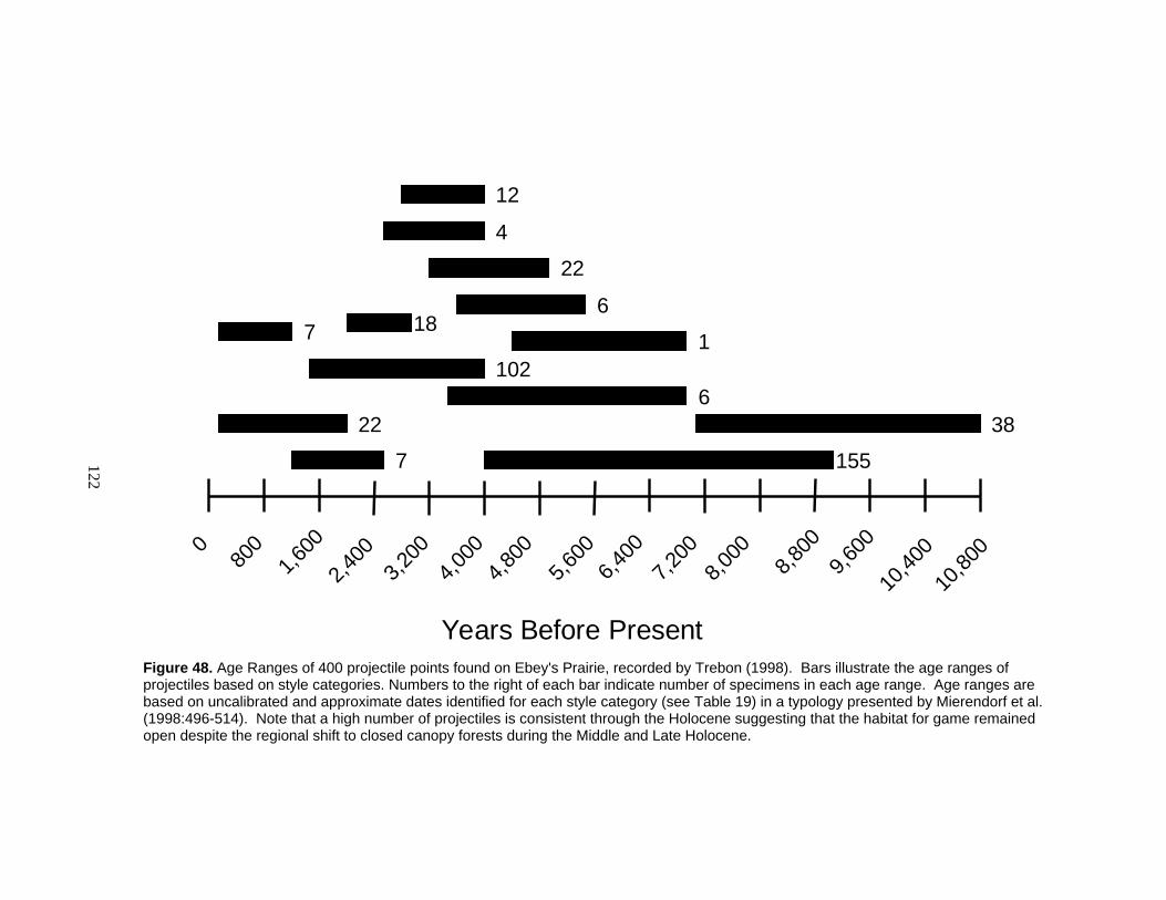
122
Years Before Present
9,600
8,800
4,000
3,200
2,4001,6
000
10,40
0
800
4,800
5,600
6,400
7,200
8,000
10,80
0
38
155
6
7
1021
22
6
22
4
7
12
18
Figure 48. Age Ranges of 400 projectile points found on Ebey's Prairie, recorded by Trebon (1998). Bars illustrate the age ranges of projectiles based on style categories. Numbers to the right of each bar indicate number of specimens in each age range. Age ranges are based on uncalibrated and approximate dates identified for each style category (see Table 19) in a typology presented by Mierendorf et al. (1998:496-514). Note that a high number of projectiles is consistent through the Holocene suggesting that the habitat for game remained open despite the regional shift to closed canopy forests during the Middle and Late Holocene.

123
Activities Indicated by Artifacts
The artifact assemblage of the Ferry House Site and the greater Ebey’s Prairie
represent the variety of human activities that were conducted on the prairie (Table 20).
Many of the lithic raw materials found on the Ferry House Site and vicinity are available
on the nearby shoreline where they could have been collected and then transported to the
prairie where they were used.
Hunting
Hunting is strongly demonstrated by the large number of projectile points varying
in style, size, and age found scattered across Ebey’s Prairie and the surrounding ridges
(Mierendorf and Weiser 2006; Trebon 1998). To date, one projectile has been found
about every 3 square meters based on the total assemblage of projectiles (n=859) spread
across Ebey’s Prairie (~2,500 square meters). Based on the hafting element of 400 of
these, hunting big game animals with spears began shortly after ice receded, developed
into a long period of hunting with atlatls and darts, and shifted in the Late Period to bow
and arrow technology. The high density of projectile points, shown consistently across
time, suggests that a high density of game was likely also consistent. Further, an open
habitat with rich forage is likely to have attracted animals to this location.
To determine a rough proxy for hunting intensity through time, I compared
number of projectiles in different time periods. I observed a slight increase in hunting
implements since about 4,000 years ago (for pre-4,000 BP, 194 projectile points over a
span of 6,800 years represent 0.03 projectile points per year, for post-4,000 BP, 172
124
projectiles over a span of 3,850 years represent 0.04 projectile points per year) which
may indicate an increased intensity. Of course this measure relies on the premise that all
other factors are held constant. For example, my analysis does not account for the
likelihood of a collector to find a certain size or style of projectile versus another, nor
does it address whether hunters were more likely to lose spear points, dart points, or
arrows most frequently. However, based on the present data set this analysis is the only
way of roughly assessing hunting intensity through time. The fact that hunting is
consistent through time suggests it was consistently preferred by game animals and
hunters alike. This data helps to substantiate the idea that the landform had not hosted a
closed canopy forest at any time during the Holocene.
Plant Processing
Plant processing on Ebey’s Prairie is indicated by a variety of artifact types
comparable to those found associated with plant roasting features throughout the
Northwest (e.g., Thoms 1989). One “mortar” and two “grinders” (Trebon 1998) now in
private collections (Trebon 1998), and several cobbles with ground surfaces from the
Ferry House Site indicate mashing and grinding. Such artifacts have been linked to plant
food processing in the Northwest and Interior (Thoms 1989; Lepofsky 2004). Pecked
cobbles from the Ferry House Site could suggest a number of activities relating to plant
use including fire wood procurement (e.g., to hammer a wedge) and placement of racks
used for drying plants. Cobbles with only a few flakes removed (expedient tools) could
have been used to scrape away ground vegetation or excavate pits. This is the type of
tool kit associated with camas processing in the Interior (Thoms 1989) and by association

125
may represent the same activities on Ebey’s Prairie. In addition, many flaked, ground,
pecked, and unmodified cobbles found on the Ferry House Site were associated with
charred plant remains and they showed signs of heat oxidation. They were therefore
likely to be heating elements for cooking plants and perhaps other foods.
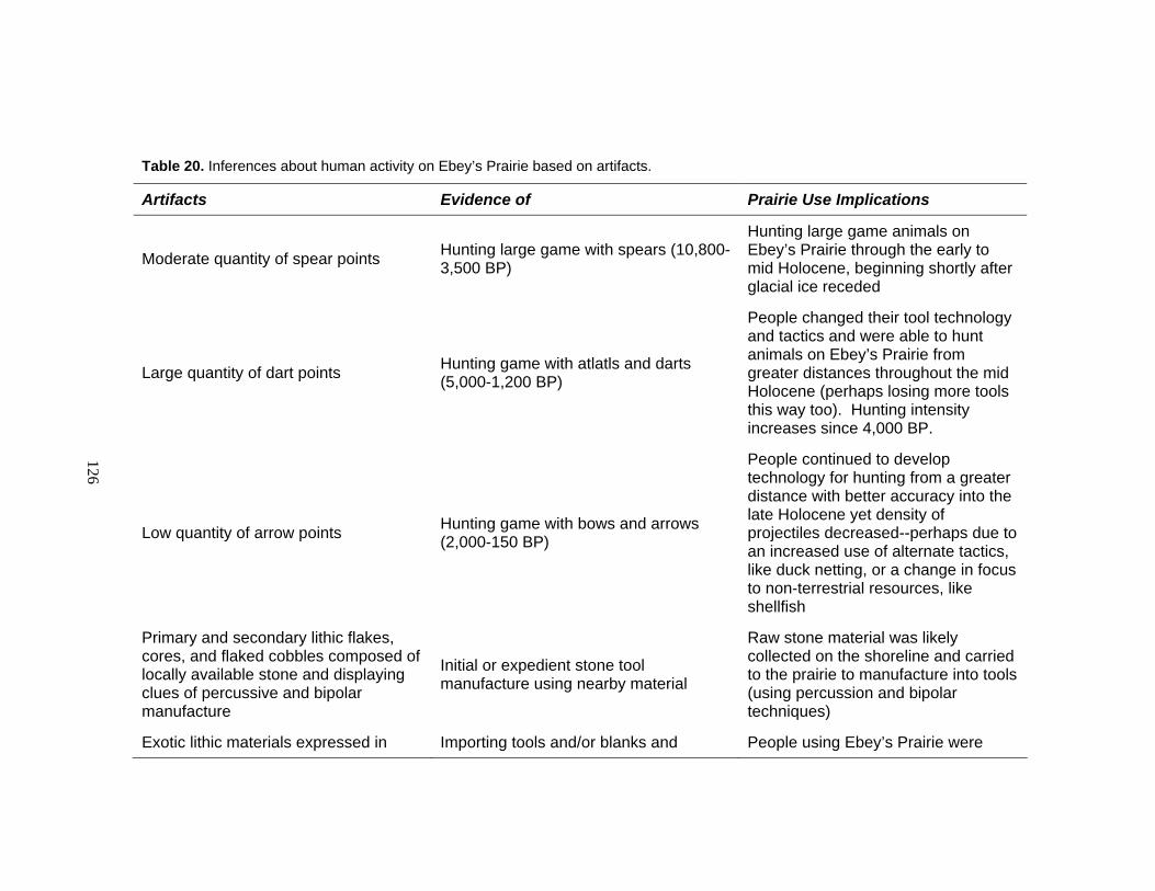
126
Table 20. Inferences about human activity on Ebey’s Prairie based on artifacts.
Artifacts Evidence of Prairie Use Implications
Moderate quantity of spear points Hunting large game with spears (10,800-3,500 BP)
Hunting large game animals on Ebey’s Prairie through the early to mid Holocene, beginning shortly after glacial ice receded
Large quantity of dart points Hunting game with atlatls and darts (5,000-1,200 BP)
People changed their tool technology and tactics and were able to hunt animals on Ebey’s Prairie from greater distances throughout the mid Holocene (perhaps losing more tools this way too). Hunting intensity increases since 4,000 BP.
Low quantity of arrow points Hunting game with bows and arrows (2,000-150 BP)
People continued to develop technology for hunting from a greater distance with better accuracy into the late Holocene yet density of projectiles decreased--perhaps due to an increased use of alternate tactics, like duck netting, or a change in focus to non-terrestrial resources, like shellfish
Primary and secondary lithic flakes, cores, and flaked cobbles composed of locally available stone and displaying clues of percussive and bipolar manufacture
Initial or expedient stone tool manufacture using nearby material
Raw stone material was likely collected on the shoreline and carried to the prairie to manufacture into tools (using percussion and bipolar techniques)
Exotic lithic materials expressed in Importing tools and/or blanks and People using Ebey’s Prairie were

127
Artifacts Evidence of Prairie Use Implications
tertiary flakes, and exotic beads sharpening them and acquiring finished beads from outside sources
connected to broader trade networks
Ground cobbles and mortars Grinding of semi-resistant materials Importing cobbles to Ebey’s Prairie (likely from the shoreline) to grind plants and perhaps other materials
Pecked cobbles Use of cobbles as hammers or anvils
Importing cobbles to Ebey’s Prairie to use as hammers or anvil stones perhaps for flintknapping and for constructing temporary structures like drying racks
Adze blades, antler wedge, and flaked cobbles Woodworking and firewood procurement
Collecting firewood along the edges of Ebey’s Prairie and carrying some woodcutting tools to the Ferry House Site
Knives, unifaces, and bifaces Cutting and perhaps butchering and scraping hides
Perhaps butchering animals on Ebey’s Prairie
Cobbles, cores and cobble tools with heat oxidation, cracking, and crazing Heat modification
Using imported cobbles, including those previously used as tools, to provide a heat source for cooking

128
Expedient Tool-making and Settlement
Collectively, scatters of lithic detritus and expedient tools, fire hearths, and refuse
pits, provide evidence for camping activity on Ebey’s Prairie. The majority of the artifact
assemblage demonstrates that people at the Ferry House Site and vicinity manufactured
expedient tools, from locally-available lithic material, but did not manufacture fine
finished tools. The presence of expedient tools likely indicates short-term use episodes
such as camping or day use. A few artifacts are composed of exotic cherts, chalcedony,
jasper, and obsidian. These were all small interior flakes which likely represent detritus
from sharpening finished tools which were imported from elsewhere.
While most artifacts found on Ebey’s Prairie suggest short term camping, a few
artifacts indicate longer term settlements in the near vicinity. Adze blades and wedges
found on Ebey’s Prairie (Trebon 1998), indicate wood procurement and woodworking.
Unlike cobble choppers, which could be expediently made from local materials, adze
blades were more time-consuming to create and composed of stone material that was
unique for its hardness (e.g., serpentinite). Further, adze blades were useful for more
precise carving and shaping (such as for canoes) (Stewart 1984, 1986; Suttles 1990).
Trade
Two types of items found on Ebey’s Prairie indicate trade: beads and exotic lithic
materials. Trade items were widespread throughout the Northwest Coast (Suttles 1990)
and finding these items on Ebey’s Prairie simply suggests that people using this
ecosystem were somehow linked to the broader trade networks of the region. The small

129
assemblage of exotic lithic materials (e.g., chert, jasper, chalcedony, and obsidian) is
indicative of trade, exchange, or diffusion because these materials are not available from
any local or nearby sources.
Activities Across Time and Space
Taken together, my analyses of features, artifacts, archaeobotanical remains,
ethnographic, and ethnohistoric records indicate that indigenous people participated in a
range of activities on Ebey’s Prairie between about 150 and 10,000 years ago. The range
of activities is partly evidenced by diversity of feature types and contents. Despite a
small sample size, the thirteen prehistoric features discovered at the Ferry House Site
reflect cooking using a number of methods and ingredients including edible berries, plant
bulbs, and shellfish (Table 8). People chose to use fuel wood in hearths and roasting
features that included both conifer boughs and hardwoods and they utilized open flame,
smothered coals, and hot cobbles to achieve desired cooking and heating temperatures
and durations (Table 17). The stratified hearths and accumulation of refuse near the
Ferry House also indicates that the site was used repeatedly — most likely for repeated
camping episodes. Finely crushed shell in some features may indicate human trampling
on pathways near the terrace edge, overlooking the shoreline and Admiralty Inlet.
The artifact assemblage also indicates a number of activities. Hunting was clearly
practiced long term on Ebey’s Prairie as evidenced by a wide variety and high density of
spear, dart, and arrow points. Though flintknapping is also represented by hammerstones
and lithic detritus on the Ferry House Site, the focus seems to have been on creating,

130
using, and reusing expedient tools which served multiple functions, rather than a focus on
production of bifaces or projectiles (Table 20). Lithic tools found on the Ferry House
Site include a number of implements useful for woodcutting, plant processing, cutting
and scraping. Artifact data helps substantiate the pattern of camp episodes seen through
features, and further illustrates a potential focus on plant processing.
The broad time scale of these activities on Ebey’s Prairie is reflected in the
artifact styles as well as through carbon dating of feature deposits (Figure 49). Artifact
seriation using the only temporally-diagnostic artifacts from Ebey’s Prairie — projectiles
— provides broad age categories associated with different tool styles and hunting
techniques. Based on these alone, the history of hunting on Ebey’s Prairie potentially
began about 1,000 years after glacial retreat (10,800 years ago). Though no features of
this age have yet been discovered on the prairie, the oldest radiocarbon-dated context
(~9,490-9,265 BP) still indicates that people deposited flaked stone and wood at the Ferry
House Site in the Early Holocene at a time when the ground surface was marine sand
with minimal organic content (Mierendorf and Weiser 2006). Ten additional radiocarbon
dates from features (Table 11) provide more precise age ranges corresponding to human
activity on the prairie.
Intensity of prairie use appears to have increased over time based on an increase
of features and artifacts over time. The frequency and density of features increases in the
Late Holocene (Figure 49), as does the number of projectiles scattered across the prairie.
Evidence from the vicinity of the Ferry House Site suggests artifacts
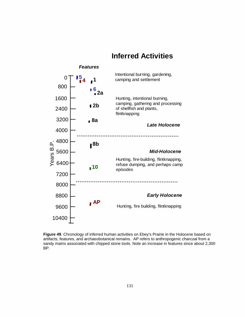
131
Features
Year
s B
.P.
9600
8800
4000
3200
2400
1600
0
10400
800
4800
5600
6400
7200
8000
5
10
8b
6 2aHunting, intentional burning, camping, gathering and processing of shellfish and plants, flintknapping
Inferred Activities
Hunting, fire-building, flintknapping, refuse dumping, and perhaps camp episodes
Hunting, fire building, flintknapping
Early Holocene
Mid-Holocene
Late Holocene
Intentional burning, gardening, camping and settlement
8a
AP
4 1
2b
Figure 49. Chronology of inferred human activities on Ebey's Prairie in the Holocene based on artifacts, features, and archaeobotanical remains. AP refers to anthropogenic charcoal from a sandy matrix associated with chipped stone tools. Note an increase in features since about 2,300 BP.

132
and features may be concentrated in particular areas (Figure 50). The vicinity of the
Ferry House Site which is in close proximity to water, the forest edges, canoe pullouts,
and dry ground for camping, had a higher density of projectiles on the surface than other
parts of the prairie (Trebon 1998). As well, the features at the Ferry House site were
clustered and some were directly overlying other features indicating repeated use. The
highest density was four features per cubic meter, and 2 features per square meter were
common.
Ethnohistoric data provided a record of events in the historic era and offered a
glimpse of activities which would not preserve in the archaeological record. Traditional
indigenous practices were recorded during a short period between the time Captain
Vancouver and his crew first witnessed Whidbey Island in 1792 and the Ebey family
began to exercise their rights as landowners on Ebey’s Prairie, in the mid to late 1850s.
Evidence of indigenous burning and use of specialized tools like digging sticks early in
this period indicate that these techniques were already in place by the time
Euroamericans arrived in the region. Prairie burning and other management techniques
appear to have become necessary thousands of years earlier, to increase productivity of
especially valued resources like camas, which would otherwise suffer habitat loss as the
forest closed in. This assertion is based on ecological changes throughout the Holocene
which are discussed in the following section.
Exploring Prairie Longevity
My analyses provide evidence that while the Ebey’s landform was used
throughout the Holocene, the intensity and nature of use shifted through time.
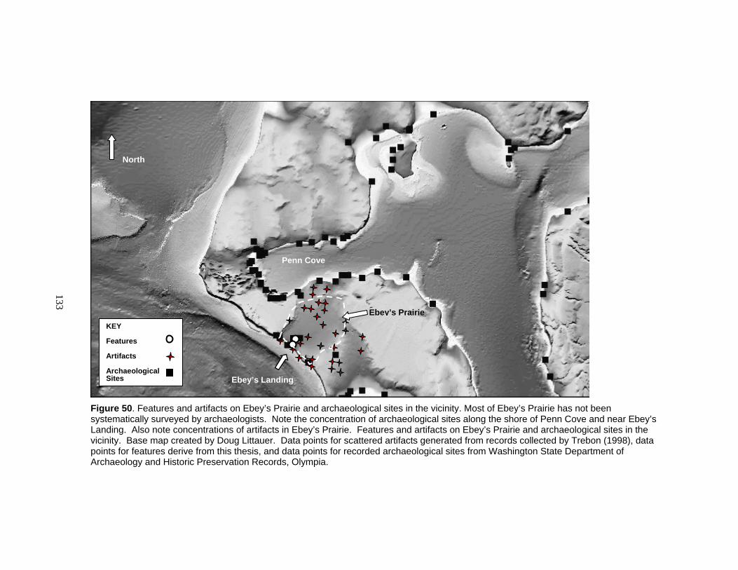
133
Figure 50. Features and artifacts on Ebey’s Prairie and archaeological sites in the vicinity. Most of Ebey’s Prairie has not been systematically surveyed by archaeologists. Note the concentration of archaeological sites along the shore of Penn Cove and near Ebey’s Landing. Also note concentrations of artifacts in Ebey’s Prairie. Features and artifacts on Ebey’s Prairie and archaeological sites in the vicinity. Base map created by Doug Littauer. Data points for scattered artifacts generated from records collected by Trebon (1998), data points for features derive from this thesis, and data points for recorded archaeological sites from Washington State Department of Archaeology and Historic Preservation Records, Olympia.
KEY Features Artifacts Archaeological Sites
Ebey’s Prairie
North
Penn Cove
Ebey’s Landing
134
Intensification or increased human energy investment per unit area to produce a greater
output is most aptly reflected by intentional burning of Ebey’s Prairie to encourage edible
and useful resources. The compiled evidence suggests that sometime in the last 2-3
millennia, the inhabitants of Ebey’s Prairie began setting fires. I determine this by
establishing the natural succession of vegetation on Northwest Coast Prairies and then
comparing it to local archaeobotanical evidence which counters these natural patterns
(Table 21).
Using evidence of glacial history and regional vegetation patterns throughout the
Late Glacial and Holocene, I found that Ebey’s Prairie emerged from glacial
meltwater/marine water as a landform about 12,000 years ago (Easterbrook 1966a,
1966b, 1994, Kovanen and Slaymaker 2004; Polentz 2005) and remained relatively open
until about 8,000 years ago (Table 21). In the Mid-Holocene, Ebey’s Prairie was likely
encroached upon by a mixed deciduous and conifer forest as summers became cooler and
wetter. This pattern is true for similar physiographic units on the Northwest Coast. By
about 4,400 years ago, mixed conifer forests were clearly established regionally (Brown
and Hebda 2002; McLachlan and Brubaker 1995; Pellatt et al. 2001; Whitlock and Knox
2002) yet the range of species from Ebey’s Prairie is consistent with an open ecosystem.
Within the general moist, cooling trend of the Late Holocene, a warm dry interval about
2,400-1,200 years ago (the Fraser Valley Fire Period) reflects an increase in fires (Hallett
et al. 2003; Lepofsky et al. 2005b), but trees continued to encroach upon openings since
about 1,200 BP (Brown and Hebda 2002; McLachlan and Brubaker 1995; Pellatt et al.
2001; Whitlock and Knox 2002).
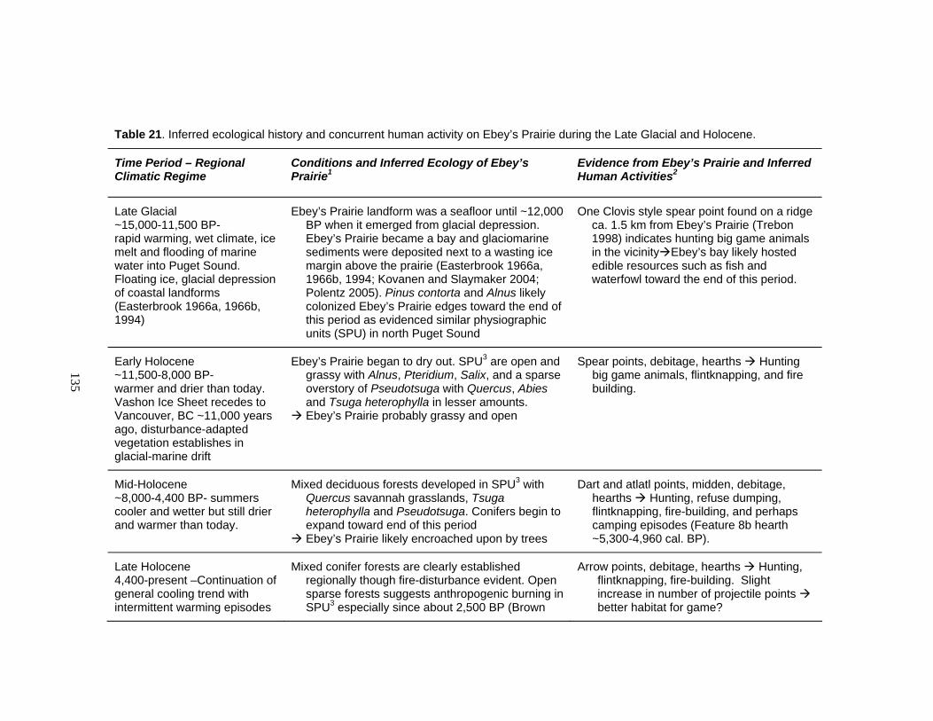
135
Table 21. Inferred ecological history and concurrent human activity on Ebey’s Prairie during the Late Glacial and Holocene.
Time Period – Regional Climatic Regime
Conditions and Inferred Ecology of Ebey’s Prairie1
Evidence from Ebey’s Prairie and Inferred Human Activities2
Late Glacial ~15,000-11,500 BP- rapid warming, wet climate, ice melt and flooding of marine water into Puget Sound. Floating ice, glacial depression of coastal landforms (Easterbrook 1966a, 1966b, 1994)
Ebey’s Prairie landform was a seafloor until ~12,000 BP when it emerged from glacial depression. Ebey’s Prairie became a bay and glaciomarine sediments were deposited next to a wasting ice margin above the prairie (Easterbrook 1966a, 1966b, 1994; Kovanen and Slaymaker 2004; Polentz 2005). Pinus contorta and Alnus likely colonized Ebey’s Prairie edges toward the end of this period as evidenced similar physiographic units (SPU) in north Puget Sound
One Clovis style spear point found on a ridge ca. 1.5 km from Ebey’s Prairie (Trebon 1998) indicates hunting big game animals in the vicinity Ebey’s bay likely hosted edible resources such as fish and waterfowl toward the end of this period.
Early Holocene ~11,500-8,000 BP- warmer and drier than today. Vashon Ice Sheet recedes to Vancouver, BC ~11,000 years ago, disturbance-adapted vegetation establishes in glacial-marine drift
Ebey’s Prairie began to dry out. SPU3 are open and grassy with Alnus, Pteridium, Salix, and a sparse overstory of Pseudotsuga with Quercus, Abies and Tsuga heterophylla in lesser amounts. Ebey’s Prairie probably grassy and open
Spear points, debitage, hearths Hunting big game animals, flintknapping, and fire building.
Mid-Holocene ~8,000-4,400 BP- summers cooler and wetter but still drier and warmer than today.
Mixed deciduous forests developed in SPU3 with Quercus savannah grasslands, Tsuga heterophylla and Pseudotsuga. Conifers begin to expand toward end of this period Ebey’s Prairie likely encroached upon by trees
Dart and atlatl points, midden, debitage, hearths Hunting, refuse dumping, flintknapping, fire-building, and perhaps camping episodes (Feature 8b hearth ~5,300-4,960 cal. BP).
Late Holocene 4,400-present –Continuation of general cooling trend with intermittent warming episodes
Mixed conifer forests are clearly established regionally though fire-disturbance evident. Open sparse forests suggests anthropogenic burning in SPU3 especially since about 2,500 BP (Brown
Arrow points, debitage, hearths Hunting, flintknapping, fire-building. Slight increase in number of projectile points better habitat for game?
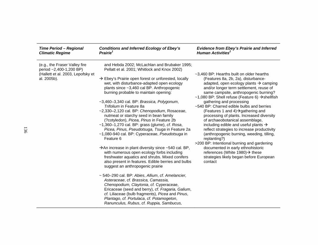
136
Time Period – Regional Climatic Regime
Conditions and Inferred Ecology of Ebey’s Prairie1
Evidence from Ebey’s Prairie and Inferred Human Activities2
(e.g., the Fraser Valley fire period ~2,400-1,200 BP) (Hallett et al. 2003, Lepofsky et al. 2005b).
and Hebda 2002; McLachlan and Brubaker 1995; Pellatt et al. 2001; Whitlock and Knox 2002)
Ebey’s Prairie open forest or unforested, locally wet, with disturbance-adapted open ecology plants since ~3,460 cal BP. Anthropogenic burning probable to maintain opening:
~3,460–3,340 cal. BP: Brassica, Polygonum,
Trifolium in Feature 8a ~2,330–2,120 cal. BP: Chenopodium, Rosaceae,
nutmeat or starchy seed in bean family (?cotyledon), Picea, Pinus in Feature 2b
~1,360–1,270 cal. BP: grass (glume), cf. Rosa, Picea, Pinus, Pseudotsuga, Tsuga in Feature 2a
~1,080-940 cal. BP: Cyperaceae, Pseudotsuga in Feature 6
An increase in plant diversity since ~540 cal. BP, with numerous open ecology forbs including freshwater aquatics and shrubs. Mixed conifers also present in features. Edible berries and bulbs suggest an anthropogenic prairie
~ 540–290 cal. BP: Abies, Allium, cf. Amelancier,
Asteraceae, cf. Brassica, Camassia, Chenopodium, Claytonia, cf. Cyperaceae, Ericaceae (seed and berry), cf. Fragaria, Galium, cf. Liliaceae (bulb fragments), Picea and Pinus, Plantago, cf. Portulaca, cf. Potamogeton, Ranunculus, Rubus, cf. Ruppia, Sambucus,
~3,460 BP: Hearths built on older hearths (Features 8a, 2b, 2a), disturbance-adapted, open ecology plants camping and/or longer term settlement, reuse of same campsite, anthropogenic burning?
~1,080 BP: Shell refuse (Feature 6) shellfish gathering and processing
~540 BP: Charred edible bulbs and berries (Features 1 and 4) gathering and processing of plants. Increased diversity of archaeobotanical assemblage, including edible and useful plants reflect strategies to increase productivity (anthropogenic burning, weeding, tilling, replanting?)
>200 BP: Intentional burning and gardening documented in early ethnohistoric references (White 1980) these strategies likely began before European contact

137
Time Period – Regional Climatic Regime
Conditions and Inferred Ecology of Ebey’s Prairie1
Evidence from Ebey’s Prairie and Inferred Human Activities2
Scirpus, cf. Sparganium, Tsuga, cf. Viola, and a nutshell and pericarp of unknown genus in Features 1 and 4
Plants adapted to openings continue in the pre-contact and historic period, providing physical evidence of anthropogenic burning
~290–0 BP: Brassica, ?Caprifoliaceae,
Chenopodium, Galium, cf. Lamiatae, Plantago, Poaceae, Portulaca, cf. Ranunculus, cf. Rubus, Sambucus, Silene in Feature 5
1 Regional ecological information is also based on Grigg and Whitlock 1998; Kutzbach and Guetter 1986; McLachlan and Brubaker 1995; Pearl 1999; Sea and Whitlock 1995; Whitlock 1992; Worona and Whitlock 1995. Ecological information for Ebey’s Prairie specifically is based paleoethnobotanical analysis in this thesis. 2Human activity is based on the artifacts, features, archaeobotanical remains, and historic documents analyzed in this thesis. cf.=probable identification, ?=possible identification 3SPU are similar physiographic units to Ebey’s Prairie, i.e., low elevation, flat, xeric microclimate as influenced by rainshadow effect like S. Vancouver Island, and parts of the Olympic Peninsula
138
How Long was Ebey’s Prairie Anthropogenic?
Indigenous burning in Ebey’s Prairie was documented historically (e.g., White
1980) and my study on Ebey’s Prairie provides at least some archaeological evidence to
support the idea that indigenous people were also setting fires in prehistory. Based on the
climatic regime, anthropogenic burning was necessary to keep prairies open in the
Middle and Late-Holocene. Through my examination of artifacts and features it is clear
that people were actively using the Ebey’s Prairie during this time. The consistently high
densities of projectile points throughout the Holocene hint at a stable, likely open habitat
for game animals. The slight increase in hunting about 4,000 years ago may be tied to a
concurrent change in the ecological mosaic of the landform. The intensity of human use
with regard to plant resources seems to have increased over time based on the higher
number of features, artifacts, and edible plant remains evident in the Late Holocene.
Further, my archaeobotanical evidence shows that prairie plants were present on Ebey’s
Prairie since about 3,460 years ago and up to the historic period — during a generally
wet, cool trend when trees should have been closing in rapidly.
The “prairie” condition at Ebey’s is sparsely demonstrated by archaeobotanical
remains in the early part of the Late Holocene. One 3,340 to 3,460 year old hearth
(Feature 8a), with four identifiable seeds from three plant taxa which are well adapted to
openings (Brassica, Polygonum, and Trifolium), provides the evidence that Ebey’s Prairie
was open. More recent features (ca. 2,300 cal. BP to present) provide stronger evidence
of the prairie condition, with about 80% of the total archaeobotanical assemblage
deriving from 31 plant taxa well adapted to or requiring open ecosystems (Table 14 and
139
Figure 38). Concurrently, an increase in features with edible plant remains during this
time suggests that people had perhaps shifted their focus to plant production from a
previous hunting/foraging economy. The clearest evidence for anthropogenic burning
derived from the archaeobotanical assemblage is edible camas and onion bulbs in features
since about 540 years ago to 290 years ago. These plants grow only in openings in
coastal maritime environments and are known to have been carefully managed in agro-
ecosystems by indigenous people (Deur 1999). Further, tree encroachment during this
time would have been at a peak without human-set fires to maintain the opening.
The warm, dry interval known as the Fraser Valley fire period, ca. 2,400-1,200
years ago likely also contributed to the open condition of Ebey’s Prairie. Though a
marked increase in fires during this period has been well-researched in the Fraser Valley
and coastal mountains (Hallett et al. 2003; Lepofsky et al. 2005b), higher resolution
evidence is needed to establish whether this was also an active fire period on Northwest
Coast prairies. The increase of features on Ebey’s Prairie falls within the Fraser Valley
fire period and leads me to question whether there is a causal relationship. If Ebey’s
Prairie was more prone to fires during this period, did naturally-ignited fire create a
larger, more productive opening and spur people to focus on plant production and more
intensive maintenance of that opening in subsequent years? This possibility has been
suggested in regard to berry production elsewhere (Lepofsky et al. 2005b) and may very
well be represented on a regional scale. It follows that as the socioeconomy of
indigenous people became more complex, the demand for useful and edible plants likely
increased, and so did the need to boost plant production.
140
Potential for Further Evidence
It appears that there is high potential for additional features and artifacts on
Ebey’s Prairie, based on the distribution of archaeological remains from private
collections and archaeological excavations at the Ferry House Site, and distribution of
other archaeological sites recorded in the vicinity (Figure 50). The artifact distribution
based on those picked up by collectors show that projectiles, at least, were widespread.
Since projectiles were the primary target for artifact collectors, other items they found
less frequently, like grinding stones, are evidence that a broader artifact assemblage likely
exists across a greater expanse of the prairie than is presently recognized. In my own
unsystematic examination of plowed fields on various parts of the prairie, I noted scatters
of flaked cobbles and clusters of fire-modified rock which may indicate undocumented
features. Further, excavation at the Ferry House Site illustrates that prehistoric features
can be found intact below the plow zone.
A systematic survey of the unexamined portions of Ebey’s Prairie is needed to
more accurately estimate the distribution of features and artifacts based on surface
evidence. Archaeological sites along the shoreline on the east side of the prairie also
indicate that additional archaeological remains may be found on the eastern portion of the
prairie. At present, these sites have been minimally investigated.
141
CHAPTER 5: DISCUSSION AND RECOMMENDATIONS
In this thesis I focused on deciphering the history of human activity in an
endangered ecosystem — the anthropogenic prairie of the Northwest Coast. Today,
anthropogenic prairies of this region continue to shrink and disappear yet many of them,
like Ebey’s Prairie, contain intact archaeological evidence with potential to enrich our
understanding of ancient ecological and human history. In this thesis, I established that
prairies were essential for Coast Salish people as resource-rich ecosystems which they
maintained and enhanced, particularly after the encroaching forests began to threaten
prairie existence.
My limited archaeological and archaeobotanical sample from Ebey’s Prairie
contributes to an understanding of human use of this ecosystem throughout the
prehistoric period. By using ethnographic modeling, and establishing a set of
archaeological expectations from work in similar environments, I determined a strategy
for finding and identifying features through archaeological excavation. My design for
archaeological and archaeobotanical sampling also utilized flotation and microscopic
analyses to recover and identify archaeobotanical remains which would otherwise go
undocumented. The combination of methods I used has proven worthwhile and, in fact,
requisite for the study of human use of Ebey’s Prairie and similar ecosystems elsewhere.
The broader goal of this thesis was to emphasize the importance of research in
Northwest Coast Prairies and evaluate which methods would be useful to study them.
My study demonstrates that understanding how people used prairies in the past requires
142
using landscape-level approaches and methods from multiple disciplines. Despite
limitations, this approach can be successfully applied to other Northwest Coast prairies
(Table 22).
Studies like this one, which illustrate the importance prairie ecosystems and
human activities in them on a landscape level, must rely on multiple lines of evidence
(Table 23). A study focusing solely on the archaeological excavation of the Ferry House
Site would have missed the strong evidence of hunting provided through the projectile
points unsystematically collected by individuals from plowed fields throughout Ebey’s
Prairie. Similarly, a focus only on the artifacts in private collections would have missed a
variety of other artifact types as well as the features we examined. The nature and age of
archaeobotanical remains from features we excavated in the vicinity of the Ferry House
site has illustrated a broader scope of human activity on the prairie than surface artifacts
could provide and enabled more precise estimates of time scale through radiocarbon
dates.
The Distribution of Anthropogenic Prairies
One of the biggest challenges of studying ancient prairies on the Northwest Coast
is determining their previous distribution throughout the region. Northwest Coast prairies
have been patchy ecosystems during optimal conditions and are rapidly disappearing due
to a number of land use changes, including modern construction, agriculture, and tree
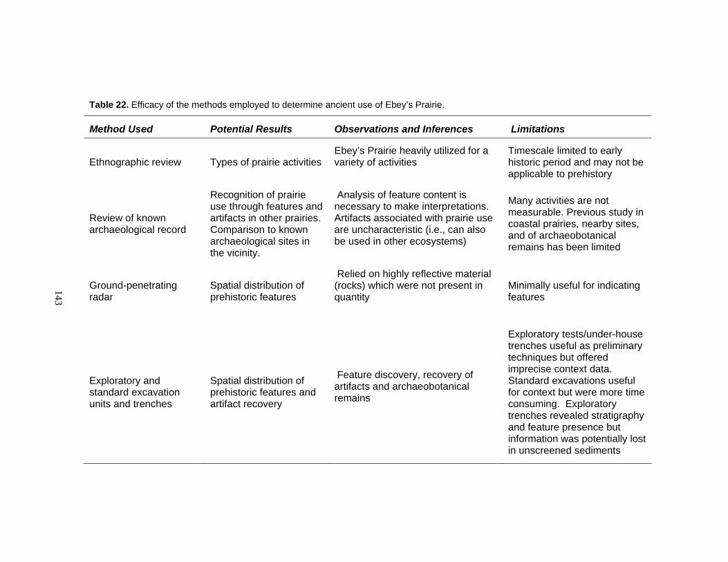
143
Table 22. Efficacy of the methods employed to determine ancient use of Ebey’s Prairie.
Method Used Potential Results Observations and Inferences Limitations
Ethnographic review Types of prairie activities Ebey’s Prairie heavily utilized for a variety of activities
Timescale limited to early historic period and may not be applicable to prehistory
Review of known archaeological record
Recognition of prairie use through features and artifacts in other prairies. Comparison to known archaeological sites in the vicinity.
Analysis of feature content is necessary to make interpretations. Artifacts associated with prairie use are uncharacteristic (i.e., can also be used in other ecosystems)
Many activities are not measurable. Previous study in coastal prairies, nearby sites, and of archaeobotanical remains has been limited
Ground-penetrating radar
Spatial distribution of prehistoric features
Relied on highly reflective material (rocks) which were not present in quantity
Minimally useful for indicating features
Exploratory and standard excavation units and trenches
Spatial distribution of prehistoric features and artifact recovery
Feature discovery, recovery of artifacts and archaeobotanical remains
Exploratory tests/under-house trenches useful as preliminary techniques but offered imprecise context data. Standard excavations useful for context but were more time consuming. Exploratory trenches revealed stratigraphy and feature presence but information was potentially lost in unscreened sediments

144
Method Used Potential Results Observations and Inferences Limitations
Feature Sampling
Determining stratigraphic contexts, recovering datable material and feature content for analysis
A variety of features. Datable material recovered from profiles. Context of features recorded and content collected for further analysis
Level of documentation was inconsistent between expedient versus slower, more precise techniques
Analysis of artifacts from excavation
Spatial distribution of artifacts, types and ages of activities, tool technology
Plant processing and expedient tool manufacture are represented. Diagnostic projectiles help establish longevity of hunting at the Ferry House Site
Limited sampling produced a limited artifact assemblage
Analysis of private artifact collections
Types and ages of activities, tool technology and spatial distribution
Hunting widespread throughout the Holocene. Plant processing, wood working and trade represented
No stratigraphic context. Collection locations imprecise. Sample bias toward projectiles
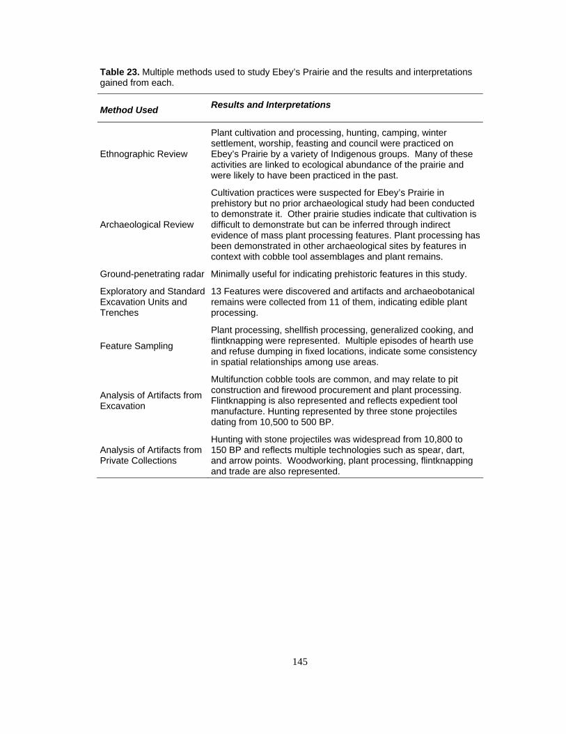
145
Table 23. Multiple methods used to study Ebey’s Prairie and the results and interpretations gained from each.
Method Used Results and Interpretations
Ethnographic Review
Plant cultivation and processing, hunting, camping, winter settlement, worship, feasting and council were practiced on Ebey’s Prairie by a variety of Indigenous groups. Many of these activities are linked to ecological abundance of the prairie and were likely to have been practiced in the past.
Archaeological Review
Cultivation practices were suspected for Ebey’s Prairie in prehistory but no prior archaeological study had been conducted to demonstrate it. Other prairie studies indicate that cultivation is difficult to demonstrate but can be inferred through indirect evidence of mass plant processing features. Plant processing has been demonstrated in other archaeological sites by features in context with cobble tool assemblages and plant remains.
Ground-penetrating radar Minimally useful for indicating prehistoric features in this study.
Exploratory and Standard Excavation Units and Trenches
13 Features were discovered and artifacts and archaeobotanical remains were collected from 11 of them, indicating edible plant processing.
Feature Sampling
Plant processing, shellfish processing, generalized cooking, and flintknapping were represented. Multiple episodes of hearth use and refuse dumping in fixed locations, indicate some consistency in spatial relationships among use areas.
Analysis of Artifacts from Excavation
Multifunction cobble tools are common, and may relate to pit construction and firewood procurement and plant processing. Flintknapping is also represented and reflects expedient tool manufacture. Hunting represented by three stone projectiles dating from 10,500 to 500 BP.
Analysis of Artifacts from Private Collections
Hunting with stone projectiles was widespread from 10,800 to 150 BP and reflects multiple technologies such as spear, dart, and arrow points. Woodworking, plant processing, flintknapping and trade are also represented.
146
encroachment. I created a map approximating Northwest Coast prairie distribution
(Figure 1) in my introduction by focusing on two plant species which I knew to be
common on anthropogenic prairies — camas and Garry oak — but I recognize the
limitations of this approach. These genera respond well to periodic, low intensity
burning, they do not survive in closed-canopy forested ecosystems, and are therefore
good indicators of anthropogenic prairies (Beckwith 2004; Lea et al. 2003; Norton
1979b). However, their presence on the landscape is not solely linked to past human
activity. Nor can isolated communities of these plants fully define the previous and
likely greater extent of now extinct prairies. Further, these native plants continue to
become more popular as horticultural and restoration specimens. They may be placed in
previously forested areas to create new “prairies” and be falsely recognized as part of
ancient prairie communities. This is particularly true of Camassia which is desirable for
its showy flower, hardiness, and ability to spread easily in optimal conditions. Though
this phenomenon is not currently widespread enough to complicate landscape-level
studies, it could be in the foreseeable future.
In order to address ancient prairie distribution on a regional scope and throughout
time, a combination of methods and disciplines is needed (Table 24). It is necessary to
combine evidence from modern plant communities and prairie soils to create a regional
prairie map which approximates past prairie distribution. Historic maps and documents,
and archaeological and paleoethnobotanical records are additional lines of evidence
which are needed to verify that these prairies were anthropogenic. Currently, most of the
palynological studies in the region have been acquired from forested locales and therefore

147
Table 24. Potential research questions and strategies for answering them on Northwest Coast prairies.
Research Question Research Strategies Suggested Methods Potential Outcomes
How “endangered” are Northwest Coast prairies today?
Determine current distribution of prairies
Map prairie communities regionally, through botanical survey information
Create baseline data and generate interest in preserving remaining prairies
What was the distribution of Northwest Coast prairies throughout the Holocene?
Combine evidence from paleobotany, soils, and historical records
Compile historical accounts of prairie distribution, prairie soils data, and sample open or previously open sites for pollen, phytoliths and macroremains. Radiocarbon date pollen, phytoliths and associated charcoal.
Discovery of spatial and temporal patterns in local and regional ecology specific to prairies.
How was prairie distribution influenced by people in the past?
Look for dramatic shifts in ecology and burn intervals
Paleobotanical study to recognize rapid increases in prairie plants with no apparent natural cause. Fire ecology study to determine where burn intervals appear much more frequent than natural fire sequence (e.g., on prairie edges where old growth trees and wood charcoal exist). Compilation of historic references to indigenous burning in the historic period.
Discovery of areas where prairies were recovered by or extended by frequent burning in the historic and prehistoric past.
How were prairies used by people in the past?
Find features and artifacts in prairies
Landscape-level surveys with surface and subsurface examination and unobtrusive techniques like magnetometry to identify areas for further study.
Discovery of features and artifacts across current or previous prairie ecosystems
Analyze features and artifacts recovered from prairies
Macro and microanalysis of feature deposits and artifacts. Determine age estimates from radiocarbon dated deposits and seriation of diagnostic artifact types
Create a chronology of activities in prairies and compare to regional trends in human prehistory.
148
offer scant evidence regarding prairie history. More pollen studies are needed which
specifically target the ecological history of prairies. A region-wide map showing prairie
distribution in each major phase of the Holocene would be a tremendous asset to future
study of human use of these ecosystems.
Maintaining the Harvest through Management
Researchers from many disciplines would like to determine the antiquity of
cultivation practices on Northwest Coast prairies. Historic and ethnographic records
provide indirect evidence for indigenous methods of cultivation, and can inform a
discussion of these practices in prehistory (Deur and Turner 2005). Historic records also
demonstrate that anthropogenic prairies were abundant during the early historic period
even though climatic conditions favored tree encroachment through most of the Middle to
Late Holocene (Boyd 1999; Whitlock and Knox 2002). The premise that, without
burning, forests would close in on Northwest Coast prairies is reasonably solid for the
region based on modern ecological studies (Lertzman et al. 1996; Lertzman et al. 2002).
Therefore, it is reasonable to conclude that indigenous people may have been
intentionally burning certain resource areas for thousands of years in this region.
However, it has proven difficult to find direct prehistoric evidence of intentional
burning in prairies (Lepofsky et al. 2003). Evidence of fire through wood charcoal
abundance alone is not an adequate measure of anthropogenic burning. Not only do
prairies produce scant wood charcoal evidence due to the lack of trees (Lepofsky et al.
2003; Lepofsky et al. 2005b) but surrounding forests may produce a false signature for
human-set fires during the Fraser Valley fire period ~2,400 to 1,200 BP (Hallett et al.
149
2003; Lepofsky et al. 2005b) which appears to have been fire-prone even without human
agency due to a hot, dry climatic interval within the overall cooling trend of the Late
Holocene.
Paleobotanical, sedimentological and archaeological studies can illustrate
fluctuations in prairie distribution and indicate human activity in prairies throughout the
past and thereby inform a discussion about cultivation in the past. Of these, landscape-
level archaeological investigation with an emphasis on paleoethnobotany offers perhaps
the most promising line of evidence for inferring ancient cultivation (Lepofsky 2004). If
cultivation was necessary to maintain prairie openings on the Northwest Coast and
archaeological evidence reflects mass processing of prairie plants (e.g., hundreds of
camas roasting features) then it is reasonable to conclude that cultivation was practiced in
the ancient past. On the Northwest Coast, mass processing of prairie plants has only been
clearly demonstrated archaeologically in the Willamette Valley of Oregon (Cheatham
1989; O’Neill et al. 2004), though limited studies on Vancouver Island (Eldridge 2000;
Baptiste and Wollstonecroft 1997; Capes 1964) and elsewhere (Morgan 1999; Schalk et
al. 2005) have identified earth ovens and a few isolated camas bulb fragments. These
data suggest that research focused on high potential areas for plant processing, using
larger excavation blocks, could demonstrate mass plant processing in other areas.
The Future of Archaeological Study of Prairies
The inherent challenges of studying human history in prairies are greatly
outweighed by the potential benefits of gaining a broader understanding of Northwest
Coast prehistory. As demonstrated in Ebey’s Prairie, the archaeological evidence of

150
prairie use may appear subtle when compared to shoreline sites, yet it represents
important activities in a hunter-gatherer economy. Research in prairies can help to
balance the often repeated sampling bias toward shoreline sites and marine resources in
Northwest Coast archaeology. Further, study in prairie ecosystems can help to fill a gap
in our knowledge about prehistoric plant use that shoreline sites may not be able to fully
address. Ethnographic and ethnohistoric accounts clearly show overlapping use of
shoreline, prairie, and forest resource areas by Northwest Coast people. Prairies should
be investigated as unique ecological units but the evidence from them, in the long term, is
only one strand in the overlapping social and economic web of ancient human history.
Regional chronologies of human activity should combine evidence from all ecosystems
and site types. The results generated from this study of one prairie landscape illustrate
the great potential for further archaeological and paleoethnobotanical investigations in
Northwest Coast prairies to contribute to broader discussions of regional prehistory.

151
REFERENCES CITED
Agee, J.K. 1993 Fire Ecology of the Pacific Northwest Forests. Island Press, Covelo, California. Ames, Kenneth M. 2005 Intensification of Food Production on the Northwest Coast and Elsewhere. In Keeping it Living: Traditions of Plant Use and Cultivation on the Northwest Coast of North America, edited by Douglas Deur and Nancy Turner, pp. 67-100. University of Washington Press, Seattle. Ames, Kenneth M. and Herbert D.G. Maschner 1999 Peoples of the Northwest Coast: Their Archaeology and Prehistory. Thames and Hudson, London, United Kingdom.
Anderberg, A.L. 1994 Atlas of seeds and small fruits of Northwest-European plant species (Sweden,
Norway, Denmark, East Fennoscandia, and Iceland) with morphological descriptions. Part 4 Resedaceae—Umbelliferae. Swedish Museum of Natural History, Stockholm. Andrefsky, William Jr. 1988 Lithics:Macroscopic Approaches to Analysis. Cambridge University Press,
Cambridge. Andrefsky, William Jr., Greg Burtchard, Kira Presler, Stephen R. Samuels, Paul H. Sanders and Alston Thoms (contributing editors) 2000 The Calispell Valley Archaeological Project Final Report. Center for Northwest Anthropology, Project Report No. 16, Washington State University, Pullman. Banfield, Alexander W.F. 1974 The Mammals of Canada. University of Toronto Press, Toronto, Ontario. Baptiste, Gladys and Michele Wollstonecroft 1997 Plant Remains. In Vancouver Island Highway Project, Victoria Approaches Archaeological Data Recovery DcRu-92, Volume I. Report prepared for the Ministry of Transportation and Highways. B.C. Archaeology Branch 1996-212, 1996-226. Millenia Research, British Columbia.
152
Barnett, Homer G. 1955 The Coast Salish of British Columbia. The University Press, Eugene, Oregon. Beckwith, Brenda
2004 “The Queen Root of This Clime”: Ethnoecological Investigations of Blue Camas (Camassia leichtlinii (Baker) Wats., C quamash (Pursh) Greene; Liliaceae) and its Landscapes on Southern Vancouver Island, British Columbia. Unpublished Ph.D. dissertation, Department of Biology, University of Victoria, British Columbia.
Beijerinck, W. 1947 Zadenatlas der Nederlandsche Flora: Ten Behoeve Van de Botanie, Palaotologie, Bodemcultuur en Warenkennis. H. Veenman & Zonen, Wageningen, Netherlands. Bell, Edward 1914 & 1915 A New Vancouver Journal. Washington Historical Quarterly 5 and 6. Berggren, G. 1969 Atlas of seeds and small fruits of Northwest-European plant species (Sweden, Norway, Denmark, East Fennoscandia, and Iceland) with morphological descriptions. Part 2 Cyperaceae. Swedish Museum of Natural History, Stockholm. 1981 Atlas of seeds and small fruits of Northwest-European plant species (Sweden, Norway, Denmark, East Fennoscandia, and Iceland) with morphological descriptions. Part 3 Saliaceae-Cruciferae. Swedish Museu of Natural History, Stockholm. Blanchet, Francis N. 1878 Historical Sketches of the Catholic Church in Oregon During the Past Forty Years, Ferndale edition, Portland. Boyd, Robert (editor) 1999a Indians, Fire, and the Land in the Pacific Northwest. Oregon State University Press, Corvallis. 1999b Strategies of Indian Burning in the Willamette Valley. In Indians, Fire, and the Land in the Pacific Northwest, edited by Robert Boyd, pp. 94-138. Oregon State University Press, Corvallis. Brown, K. J. and R. J. Hebda 2002 Origin, development, and dynamics of coastal temperate conifer rainforests of southern Vancouver Island, Canada. Canadian J. For. Res. 32: 353-372.

153
Bryan, A.L. 1954 Excavations in Deception Pass State Park. June-August 1954. Report on file, Washington Department of Archaeology and Historic Preservation, Olympia. 1955 An Intensive Archaeological Reconnaissance in the Northern Puget Sound Region. Unpublished Masters thesis, Department of Anthropology, University of Washington, Seattle. 1963 An Archaeological Survey of Northern Puget Sound. Occassional Papers of the Idaho State University Museum, No. 11, Pocatello. Capes, Katherine H. 1964 Contributions to the Prehistory of Vancouver Island. Occassional Papers of the Idaho State University Museum, No. 15, Pocatello. Central Whidbey Island Historic District 1998 Amendment of district nomination form, on file, Washington State Department of Archaeology and Historic Preservation, Olympia. Cheatham, Richard 1988 Late Archaic Settlement Pattern in the Long Tom Sub-Basin, Upper Willamette Valley, Oregon. University of Oregon Anthropological Papers No. 39. Department of Anthropology, University of Oregon, Eugene. Collins, June 1974 Valley of the Spirits: The Upper Skagit Indians of Western Washington. University of Washington Press, Seattle. Conyers, Larry 2002 Report on Ground Penetrating Radar Mapping, Ebey’s Landing, Whidbey Island, Washington. Unpublished ms. produced for the National Park Service, Seattle, Washington. Geophysical Investigations and Consulting, Denver, Colorado. Cooper, James G. 1860a Report Upon the Botany of the Route, Volume XII, Book 2. In Explorations and Surveys for a Railroad Route from the Mississippi River to the Pacific Ocean 1853-55. United States Congress, Senate, Washington DC. 1860b. Report Upon the Mammals Collected on the Survey, Volume XII, Book 2, Zoological Report, No. 2, Chapter 1. In Explorations and Surveys for a Railroad Route from the Mississippi River to the Pacific Ocean 1853-55. United States Congress, Senate, Washington DC.

154
Coupland, Gary 1988 Prehistoric Economic and Social Change in the Tsimshian Area. Research in Economic Anthropology 10 (Supplement 3):211-43. Cowan, Ian McTaggert and Charles J. Guiguet 1978 The Mammals of British Columbia. British Columbia Provincial Museum, Victoria, British Columbia. Crabtree, Don E. 1971 Experiments in Flintworking. Reprinted from Tebiwa, The Journal of the Idaho State University Museum, Pocatello. Crawford Rex C. and Heidi Hall 1997 Changes in the South Puget Prairie Landscape. In South Puget Sound Prairie Landscape, edited by Patrick Dunn and Kern Ewing, pp. 11-15. The Nature Conservancy of Washington, Seattle. Dahlquest, Walter W. 1948 Mammals of Washington. University of Kansas, Lawrence, Kansas. Deur, Douglas 1999 Salmon, sedentism, and cultivation:towards an environmental prehistory of the
Northwest Coast. In Northwest Lands and Peoples: An Environmental Hisory Anthology, pp. 135-155, edited by P. Hirt and D. Noble. University of Washington Press, Seattle.
Deur, Douglas
2005 Tending the Garden, Making the Soil: Northwest Coast Estuarine Gardens as Engineered Environments. In Keeping it Living: Traditions of Plant Use and Cultivation on the Northwest Coast of North America, edited by Douglas Deur and Nancy Turner, pp. 296-327. University of Washington Press, Seattle.
Deur, Douglas and Nancy Turner (editors) 2005 Keeping it Living: Traditions of Plant Use and Cultivation on the Northwest Coast of North America. University of Washington Press, Seattle. Drucker, Phillip 1955 Indians of the Northwest Coast. The Natural History Press, Garden City, New York. Easterbrook, D.J. 1963 Late Pleistocene Glaciation of Whidbey Island, Washington. Geological Society of America, Special Papers 76.

155
Easterbrook, D.J. (continued) 1966a Glaciomarine environments and the Fraser glaciation in northwest Washington—Guidebook for first Annual Field Conference, Pacific Coast Section, Friends of the Pleistocene, September 24-25, 1966. Privately published by author. 1966b Radiocarbon chronology of late Pleistocene deposits in northwest Washington. Science 152 (3723):764-767.
1994 Stratigraphy and chronology of early to late Pleistocene glacial and interglacial sediments in the Puget Lowland, Washington. In Geologic field trips in the Pacific Northwest: Volume 1. Edited by Donald A. Swanson and Ralph A. Haugerud. U.S. Geological Survey, Department of Geological Sciences, University of Washington, Seattle.
Ebey, Winfield 1855 Diary entry, dated 21 May, 1855. Unpublished manuscript, on file at the University of Washington Archives, Seattle. Eldridge, M. 2000 Eagles Nest Estate Archaeological Data Recovery DcRt-71. Report prepared by Millenia Research Ltd. for K. Ujimoto, International Technology Integration Inc., and Songees First Nation. Farrar, Victor (ed.) 1916 The Diary of Colonel and Mrs. I. N. Ebey. Washington Historical Quarterly 7:236-46, 307-21 (July and October, 1916). 1917 The Diary of Colonel and Mrs. I. N. Ebey. Washington Historical Quarterly 8:40-62, 124-53 (January and April, 1917). Franklin, Jerry F. and C.T. Dyrness 1988 Natural Vegetation of Oregon and Washington. Oregon State University Press, Corvallis. Gibbs, George 1877 Tribes of Western Washington and Northwestern Oregon. Contributions to North American Ethnology 1(2):157-361. Gould, Frank 1942 A Systematic Treatment of the Genus Camassia Lindl. American Midland Naturalist 28(3)712-742. Grigg, L. D. and C. Whitlock 1998 Late-glacial climate and vegetation changes in western Oregon. Quaternary Research 49:287-298.
156
Gunther, Erna 1972 Indian Life on the Northwest Coast of North America—As Seen by the Early Explorers and Fur Traders during the Last Decades of the Eighteenth Century. The University of Chicago Press, Chicago, Illinois. 1973 Ethnobotany of Western Washington: The Knowledge and Use of Indigenous Plants by Native Americans. University of Washington, Seattle. Haeberlin, Hermann and Erna Gunther 1930 The Indians of Puget Sound. University of Washington Press, Seattle. Hallett, Douglas, Dana Lepofsky, Rolf Mathewes, and Ken Lertzman 2003 11,000 years of Fire History and Climate in Mountain Hemlock Rainforests of
Southwestern British Columbia based on Sedimentary Charcoal. Canadian Journal of Forest Research 33:292-312.
Hather, Jon G. 1993 An Archaeobotanical Guide to Root and Tuber Identification. Oxbow Monograph Series 28, Oxford. 2000 Identifying Charred Parenchyma. Archetype, London.
Hedlund, Gerald Curry 1973 Background and Archeology of Inland Cultural Sites at Connel’s Prairie, Washington (45PI44 and 45PI45). Green River Community College, Auburn, Washington. Hitchcock, C.L., A. Cronquist, M. Ownbey and J.W. Thompson 1961a Vascular Plants of the Pacific Northwest, Part 4: Erucacease through Campanulaceae. University of Washington Press, Seattle. 1961b Vascular Plants of the Pacific Northwest, Part 3 Saxifragaceae to Ericaceae. University of Washington Press, Seattle. 1964 Vascular Plants of the Pacific Northwest, Part 2 Salicaceae to Saxifragaceae University of Washington Press, Seattle. 1969 Vascular Plants of the Pacific Northwest, Part 1: Vascular Cryptograms, Gymnosperms, and Monocotyledons. University of Washington Press, Seattle. Hoadley, R.B. 1990 Identifying Wood: Accurate Results with Simple Tools. The Taunton Press, Newtown, Connecticut.
157
Holmes, Brian and R.S. Kidd 1961 Site Survey, Whidbey Island, January 30, 1961. Unpublished manuscript on file, University of Washington, Office of Public Archaeology, Seattle. Jenness, Diamond 1977 [1932] Indians of Canada, 7th Edition. University of Toronto Press, Toronto, Ontario. Originally published as Bulletin 65, Anthropological series no. 15, of the National Museum of Canada. Jermann, Jerry 1977a Preliminary Archaeological Assessment of Penn Cove Marina Facilities. Unpublished letter report dated March 29 on file with the Washington Department of Archaeology and Historic Preservation, Olympia. 1977b Preliminary Archaeological Assessment of Penn Cove Marina Facilities. Unpublished letter dated June 9, on file with the Washington Department of Archaeology and Historic Preservation, Olympia. Kellogg, George 2001 A History of Whidbey’s Island. Island County Historical Society, Coupeville. Kidd, R.S. 1961 Site Survey, Whidbey Island, March 5, 1961. Manuscript on file, University of Washington, Office of Public Archaeology, Seattle. Kramer, Stephanie 2000 Camas Bulbs, the Kalapuya, and Gender: Exploring Evidence of Plant Food Intensification in the Willamette Valley of Oregon. Unpublished Master’s thesis, Department of Anthropology, University of Oregon, Eugene. Kruckeberg, Arthur R. 1991 The Natural History of Puget Sound Country. University of Washington Press, Seattle. Kutzbach, J..E. and P. J. Guetter 1986 The influence of changing orbital patterns and surface boundary conditions on climate simulations for the past 18,000 years. Journal of Atmospheric Sciences 43:1726-1759. Lea, Ted, Dan Horth, Duncan Richards and Tim Brierley 2003 Historical Garry Oak Ecosystems of Greater Victoria and Saanich Peninsula. Funded by B.C. Ministry of Sustainable Resource Management, and Forest Renewal British Columbia, Terrestrial Ecosystem Restoration Program (TERP). [email protected], British Columbia.
158
Leopold, Estella B. and Robert Boyd 1999 An Ecological History of old Prairie Areas in Southwestern Washington. In Indians, Fire, and the Land in the Pacific Northwest, edited by Robert Boyd, 139- 163. Oregon State University Press, Corvallis. Lepofsky, Dana 2000a Site Formation Processes at Keatley Creek: The Paleoethnobotanical Evidence. In The Ancient Past of Keatley Creek Site, vol 1., Taphonomy, edited by B. Hayden, pp. 105-134. Archaeology Press, Simon Fraser University, Burnaby. 2002 Plants and Pithouses; archaeobotany and site formation processes at the Keatley Creek village site. In Hunter-gatherer Archaeobotany: Perspectives from the Northern Temperate Zone, edited by Sara L.R. Mason and Jon G. Hather, pp. 62-73. Institute of Archaeology, University College of London, London. 2004 Paleoethnobotany in the Northwest. In People and Plants in Ancient Western North America, edited by Paul Minnis, pp.367-464. Smithsonian Books, Washington. Lepofsky, Dana, Douglas Hallett, Ken Lertzman, Rolf Mathews, Albert Mchalsie and Kevin Washbrook 2005a Documenting Precontact Plant Management on the Northwest Coast: An Example of Prescribed Burning in the Central and Upper Fraser Valley, British Columbia. In Keeping it Living, edited by Douglas Deur and Nancy Turner, pp.
218-239. University of Washington Press, Seattle. Lepofsky, Dana, Ken Lertzman, Douglas Hallett, and Rolf Mathewes 2005b Climate Change and Culture Change on the Southern Coast of British
Columbia 2,400-1,200 cal. BP: An Hypothesis. American Antiquity 70(2):267-293.
Lepfosky, Dana, E. Heyerdahl, K. Lertzman, D. Schaepe, and B. Mierendorf 2003 Climate, Humans, and Fire in the History of Chittenden Meadow. Conservation Ecology 7:5. [online] URL:http://www.consecol.org/vol7/iss3/art5 Lepofsky, Dana, Madonna Moss and Natasha Lyons 2004 The Paleoethnobotanical Remains from the Cape Addington Site. In The Cape Addington Site, edited by Madonna Moss. University of Oregon, Eugene. Lepfosky, Dana and Natasha Lyons 2003 Modeling ancient plant use of the Northwest Coast: towards an understanding of mobility and sedentism. Journal of Archaeological Science 30:1357-1371.
159
Lertzman, K.P., G. Sutherland, A. Inselberg, and S. Saunders 1996 Canopy Gaps and the Landscape Mosaic in a Temperate Rainforest. Ecology 77:1254-70. Lertzman, K. P, D. Gavin, D. Hallett, L. Brubaker, D. Lepofsky and R. Mathewes 2002 Long-term Fire Regime Estimated from Soil Charcoal in Coastal Temperate Rainforests. Conservation Ecology 6(2):5; [online] URL:http://www.consecol.org/vol6/iss2/art5 Lotspeich, F.B., J. B. Secor, R. Okazaki, and H.W. Smith 1961 Vegetation as a Soil-Forming Factor on the Quillayute Physiographic Unit in Western Cllalam County, Washington. Ecology 42(1) 53-68. Luttrell, Charles T., Fred Crisson, Pamela McKenney, and Ryan Ives 2003 Cultural Resources Investigations for Washington State Department of Transportation’s SR 20: Libbey Road Vicinity to Sidney Street Vicinity Project, Island County, Washington. Short Report DOT03-04, Archaeological and Historical Services, Eastern Washington University, Cheney. Lyons, Natasha 2000 Investigating Ancient Socioeconomy in Coast Salish Territory: A Paleoethnobotanical Analysis from the Scowlitz Site, southwestern B. C. Unpublished Master’s thesis, Simon Fraser University, Burnaby. Martin, A.C. and W.D. Barkley 1961 Seed Identification Manual. University of California Press, Berkeley. Matson, R. G. 1983 Intensification and the Development of Cultural Complexity: the Northwest versus the Northeast. In The Evolution of Maritime Cultures on the Northeast and the Northwest of America, edited by Ronald J. Nash, pp. 125-148. Publication 11, Department of Archaeology, Simon Fraser University, Burnaby, British Columbia. 1992 The Evolution of Northwest Coast Subsistence. In Long-term Subsistence Change in Prehistoric North America, edited by Dale Croes, Rebecca A. Hawkins, Barry L. Isaac, pp. 367-428. Research in Economic Anthropology Supplement 6. JAI Press Greenwich, Connecticut. Matson, R. G. and Gary Coupland 1995 The Prehistory of the Northwest Coast. Academic Press, San Diego, California.
160
Matthews, James S. 1955 Conversations with Khahtsahlano, 1932-1954. Manuscript on file, Bennett Library, Simon Fraser University, Burnaby, British Columbia. Maud, Ralph (editor) 1978 The Salish People: The Local Contribution of Hill-Tout, Vol. III: The Mainland Halkomelem. Talonbooks, Vancouver, British Columbia. McLachlan, J.S and L. B. Brubaker 1995 Local and Regional Vegetation Change on the Northeastern Olympic Peninsula Mierendorf, R.R., D.J. Harry, and G.M. Sullivan 1998 An Archaeological Site Survey and Evaluation in the Upper Skagit River Valley, Whatcom County, Washington. North Cascades National Park Service Complex, Sedro-Woolley, Washington. Mierendorf, Robert and Andrea Weiser 2002 Archeological Oversight of Emergency Stabilization at the Ferry House, Ebey’s Landing National Historical Reserve, Island County, Washington. North Cascades National Park Service Complex, Marblemount, Washington. Mierendorf, Robert and Andrea Weiser (editors) 2006 Archeological Investigations at the Ferry House, Ebey’s Landing National Historical Reserve, Island County, Washington. North Cascades National Park Service Complex, Marblemount, Washington. Ministry of Forests, British Columbia 2003 Provincial Digital Biogeoclimatic Subzone/Variant Version 5.0. Electronic document. ftp://ftp.for.gov.bc.ca/hre/external/!publish/becmaps/WithBase/, accessed September 8, 2004. Minnis, Paul and Wayne Elisens (editors) 2000 Biodiversity and Native America. University of Oklahoma Press, Norman. Morgan, Murray 1979 Puget’s Sound: A Narrative of Early Tacoma and the Southern Sound. University of Washington Press, Seattle. Morgan, Vera (editor) 1999 The SR-101 Sequim Bypass Archaeological Project: Mid- to Late-Holocene Occupations on the Northern Olympic Peninsula, Clallam County, Washington, Volume 2. Report submitted to the Washington State Department of Transportation. Eastern Washington University Reports in Archaeology and History 100-108. Archaeological and Historical Services, Cheney, Washington.
161
Moss, Madonna 1993 Shellfish, Gender and Status on the Northwest Coast of North America: Reconciling Archaeological, Ethnographic and Ethnohistorical Records of the Tlingit. American Anthropologist 95(3):631-652. Munsell 1973 Munsell Soil Color Charts. Macbeth Division of Kollmorgen Corporation, Baltimore, Maryland. National Oceanic and Atmospheric Association. 2005 Navigation Chart of Admiralty Inlet, Puget Sound and Hoods Canal, Oregon Territory, Puget Sound, 1841. Office of Coast Survey Historical Map and Chart Collection, Chart No. 146. http://nauticalcharts.noaa.gov/csdl/ctp/abstract.htm accessed on November 9, 2005. National Park Service 2005 Ebey’s Landing National Historical Reserve Draft General Management Plan and Environmental Impact Statement Volume II: Technical Supplement. Ebey’s Landing National Historical Reserve, Coupeville, Washington. Natural Resources Conservation Service 2005 Soil Survey for Island County, Washington, WA029. Arcview shapefile, http://www.nrcs.usda.gov accessed 2/24/2006 North, M.E.A., M.W. Dunn and J.M Teversham 1979 Vegetation of the Southwestern Fraser Lowland 1858-1880 (map). Minister of Supply and Services Canada. Lands Directorate, Environment Canada, Vancouver, British Columbia. Norton, Helen 1979a Evidence for Bracken Fern as a food for aboriginal peoples of western Washington. Economic Botany 33:384-396. 1979b The Association between Anthropogenic Prairies and Important Food Plants in Western Washington. Northwest Anthropological Research Notes 13(2). Olson, Ronald L. 1936 The Quinault Indians. University of Washington Publications in Anthropology Vol. 6(1) pp.1-194, Seattle.
162
O'Neill, B.L. 1987 Archaeological Reconnaissance and Testing in the Noti-Veneta Section of the Florence-Eugene Highway, Lake City, Oregon. Oregon State Museum Report 87-6, Eugene O’Neill, Brian, Thomas Connolly and Dorothy Friedel 2004 A Holocene Geoarchaeological Record for the Upper Willamette Valley, Oregon: The Long Tom and Chalker Sites. University of Oregon Anthropological Papers 61. Museum of Natural History and Department of Anthropology, Eugene. Oregon Flora Project 2005 Oregon Plant Atlas. All records for genus Camassia and Quercus garyanna, vouchered observations 1860 to 2005 A.D. Electronic database. http://www.oregonflora.org, accessed February 10, 2005. Peacock, Sandra and Nancy Turner 2000 “Just Like a Garden”: Traditional Resource Management and Biodiversity Conservation on the Interior Plateau of British Columbia. In Biodiversity and Native America. University of Oklahoma Press, Norman. Pearl, C. A. 1999 Holocene Environmental History of the Willamette Valley, Oregon: Insights from an 11,000-year Record from Beaver Lake. Master’s thesis, Interdisciplinary Studies Program, University of Oregon, Eugene. Pearsall, Deborah 2000 Paleoethnobotany: a Handbook of Procedures, second edition. Academic Press, San Diego, California. Pellatt, M. G., R. J. Hebda and R. W. Matthewes 2001 High-resolution Holocene vegetation history and climate from Hole 1034B, ODP leg 169s, Saanich Inlet, Canada. Marine Geology 174 (1-4): 211-226. People of ‘Ksan 1980 Gathering What the Great Nature Provided: Food Traditions of the Gitksan. Douglas & McIntyre, Vancouver. Plew, Mark G., James C. Woods, and Max G. Pavesic (editors) 1985 Stone Tool Analysis: Essays in Honor of Don E. Crabtree. University of New Mexico Press, Albuquerque. Pojar, Jim and Andy MacKinnon (editors) 1994 Plants of the Pacific Northwest Coast.: Washington, Oregon British Columbia and Alaska. Ministry of Forests, Lone Pine Publishing, Victoria.
163
Polentz, M., S. L. Slaughter, and G. W. Thorsen 2005 Geologic Map of the Coupevillen and Part of the Port Townsend North 7.5- minute Quadrangles, Island County, Washington. Washington Division of Geology and Earth Resources, Geologic Map GM-58. Washington State Department of Natural Resources. Prouty, G.L., B.L. O’Neill, and T.J. Connolly 1999 Aboriginal Plant Use at the Chalker and Long Tom Sites. In The Long Tom and Chalker Sites: A Holocene Geoarchaeological Record for the Upper Willamette Valley, by B.L. O’Neill, T.J. Connolly, and C.E. Friedel, pp. 249-260, Oregon State Museum of Anthropology Report No. 99-6. University of Oregon, Eugene. Pyne, S.J. 1993 Keeper of the flame: a survey of anthropogenic fire. In Fire in the Environment. PJ Crutzen and JG. Goldammer (editors), pp. 245-266. Environ. Sci Res. Rep. ES 13. John Wiley & Sons, New York. Reagan, Albert B. 1917 Archaeological Notes on Western Washington and Adjacent British Columbia. Proceedings of the California Academy of Sciences. Fourth Series 7(1):1-31. Robinson, Joan 1980 A Preliminary Archaeological Reconnaissance of SR20:Libbey Road to Penn Cove Road. Unpublished letter report dated November 10 on file with the Washington Department of Archaeology and Historic Preservation, Olympia. 1981 Final Report of Test Excavations at Penn Cove SR20: Libbey Road to Penn Cove Road. Unpublished letter report dated February 4 on file with the Washington Department of Archaeology and Historic Preservation, Olympia. Schalk, Randall, M. Breidenthal, N. Stenholm, and M. Wolverton 2005 Archaeological Monitoring and Evaluation for the Centralia Wastewater System Improvements Project. Cascadia Archaeology, Seattle. Sea, D. S. and C. Whitlock 1995 Post-glacial Vegetation and Climate of the Cascade Range, Central Oregon. Quaternary Research 43:370-381. Smith, H.I. 1907 Archaeology of the Gulf of Georgia and Puget Sound. American Museum of Natural History Memoir 4, Part 6:301-441.
164
Smith, H.I. and G. Fowke 1901 Cairns of British Columbia and Washington. American Museum of Natural History Memoir 4, Part 2:55-755. Stein, Julie, Shelby Anderson and Jacob Fischer 2006 Report on the Ebey’s Prairie Depositional History. Submitted in partial fulfillment of CESU contract “Native Americans and the Pacific Northwest Environment: An Interdisciplinary Study.” Submitted to the Pacific West Region, National Park Service, Seattle, Washington Stevens, Isaac 1860 Explorations and Surveys for a Railroad Route from the Mississippi River to the Pacific Ocean 1853-55. General Report, Vol. XII, Part 1. United States Congress, Senate, Washington DC. Stewart, Hillary 1984 Cedar: Tree of Life to the Northwest Coast Indians. Douglas & McIntire, Vancouver, British Columbia. 1986 Stone, Bone, Antler and Shell: Artifacts of the Northwest Coast. Douglas & McIntyre, Vancouver, British Columbia. Stuiver, M., et al. 1998 INTCAL98 Radiocarbon Age Calibration. Radiocarbon 40(3):1041-1083. Suttles, Wayne P. 1974 Economic Life of the Coast Salish of Haro and Rosario Straits. Garland Publishing, New York, New York. 1987a Affinal Ties, Subsistence, and Prestige among the Coast Salish. In Coast Salish Essays, edited by W.P. Suttles, pp. 15-25. University of Washington Press, Seattle, Washington. 1987b Coping with Abundance: Subsistence on the Northwest Coast. In Coast Salish Essays, edited by W.P. Suttles, pp. 45-63. University of Washington Press, Seattle, Washington. 1990 Central Coast Salish. In Handbook of North American Indians, Vol. 7- Northwest Coast, edited by Wayne Suttles, pp. 453-475. Smithsonian Institution, Washington, D.C. Suttles, Wayne and Barbara Lane 1990 Southern Coast Salish. In Handbook of North American Indians, Vol. 7- Northwest Coast, edited by Wayne Suttles, pp. 485-502. Smithsonian Institution, Washington, D.C.
165
Swan, James G. 1972 The Northwest Coast; or Three Years’ Residence in Washington Territory, (originally published in New York,1857). University of Washington Press, Seattle. Talma, A.S., and J.C. Vogel 1993 A Simplified Approach to Calibrating C14 Dates. Radiocarbon 35(2):317-322. Tasa, Guy, Thomas Connolly and Charles Hodges 2000 Archaeological Investigations at the Mill Creek Site Complex: I-5/North Santiam Highway Interchange, Marion Coundy, Oregon. University of Oregon Anthropological Papers No. , Eugene. Thomas, Genavie 2006 Evaluating and Managing Ethnographic Cultural Landscapes: Iceberg Point, Lopez Island, Washington. Unpublished Master’s thesis. Department of Anthropology, Central Washington University, Ellensburg. Thoms, Alston 1989 The Northern Roots of Hunter-Gatherer Intensification: Camas and the Pacific Northwest. Unpublished PhD dissertation, Department of Anthropology, Washington State University. Trebon, Theresa 1998 Cultural Artifacts of Ebey’s Landing National Historical Reserve: A Report on the Artifact Documentation Project. Report prepared for the National Park Service and the Trust Board of Ebey’s Landing National Historical Reserve. Continuum History and Research, Sedro-Woolley, WA. Trost, Teresa 2005 Forgotten Waters: A Zooarchaeological Analysis of the Cove Cliff Site (DhRr 18), Indian Arm, British Columbia. Unpublished Master’s thesis. Department of Archaeology, Simon Fraser University, Burnaby. Turner, Nancy 1995 [1975] Food Plants of British Columbia Indians Part I: Coastal Peoples. Handbook No. 34. Royal British Columbia Museum, Victoria, British Columbia. 1998 Plant Technology of First Peoples in British Columbia. Royal British Columbia Museum Handbook, UBC Press, Vancouver, British Columbia. Turner, N. J. and B. S. Efrat 1982 Ethnobotany of the Hesquiat Indians of Vancouver Island. Cultural Recovery Paper no. 2. British Columbia Provincial Museum, Victoria.
166
Turner N. J. and H. V. Kuhnlein 1983 Camas (Camassia spp.) and Rice Root (Fritillaria spp.): two liliaceous “root” foods of the northwest coast Indians. Ecology of Food and Nutrition 13:199-219. Turner, Nancy and Sandra Peacock 2005 Solving the Perennial Paradox: Ethnobotanical Evidence for Plant Resource Management on the Northwest Coast. In Keeping It Living, edited by Douglas Deur and Nancy Turner, pp. 101-150. University of Washington, Seattle. Ugolini, F. C. and A. K. Schlichte 1973 The Effect of Holocene Environmental Changes on Selected Western Washington Soils. Soil Science 116(3):218-227. United States Department of Agriculture 1949 Soil Survey Series No. 6. United States Department of Agriculture. Vancouver, George 1792 A Voyage of Discovery to the North Pacific Ocean and Round the World, 1791-1795, Volume II. Kaye Lamb (editor). London. 1798 A Voyage of Discovery to the North Pacific Ocean, Vol. 1, Plate 2, f.p. 234, R. Edwards, J. Edwards, and G. Robinson, London. Vale, Thomas (editor) 2002 Fire, Native Peoples, and the Natural Landscape. Island Press. Washington. Watson, Patricia 1976 In pursuit of prehistoric subsistence: a comparative account of some contemporary flotation techniques. Mid-Continental Journal of Archaeology 1:77- 93. Wandsnider, L. 1997 The Roasted and the Boiled: Food Composition and Heat Treatment with Special Emphasis on Pit-Hearth Cooking. Journal of Anthropological Archaeology 16:1-48. Washington Native Plant Society 1994 Plant Life of Washington Territory: Northern Pacific Railroad Survey, Botanical Report 1853-1861. Douglasia Occassional Papers, Washington Native Plant Society, Vol. 5, Woodinville, Washington. Washington State Department of Archaeology and Historic Preservation 2003 Unpublished collection of archaeological site records for Washington State, 1063 S. Capitol Way Suite 106, Olympia.

167
Wesson, Gary 1988 Prehistoric Cultural Resources of Island County. Report for the Washington State Department of Community Development, Office of Archaeology and Historic Preservation, Olympia. White, Richard 1976 Indian land use and environmental change: Island County, Washington, A case study. Arizona and the West 18:327-337. 1980 Land Use, Environment and Social Change: The Shaping of Island County, Washington. University of Washington Press, Seattle. 1999 Indian Land Use and Environmental Change, Island County, Washington. In Indians, Fire, and the Land, edited by Robert Boyd, pp. 36-49. Oregon State University Press, Corvallis. Whitlock, C. 1992 Vegetational and climatic history of the Pacific Northwest during the last 20,000 years: Implications for understanding present-day biodiversity. The Northwest Environmental Journal 8:5-28. Whitlock, C. and M. A. Knox 2002 Prehistoric Burning in the Pacific Northwest. In Fire, Native Peoples, and the Natural Landscape, edited by Thomas Vale, pp. 195-231. Island Press, Washington DC. Worona, M. A. and C. Whitlock 1995 Late Quaternary Vegetation and Climate History near Little Lake, Central Coast Range, Oregon. Geologic Society of America Bulletin 107:867-876. Wray, Jacilee (editor) 2002 Native Peoples of the Olympic Peninsula: Who We Are. Produced by the Olympic Peninsula Intertribal Cultural Advisory Committee. University of Oklahoma Press, Norman.
168
APPENDICES
Appendix A: Northwest Coast Prairie Plants Targeted by People
Appendix B: Animals Targeted by People in Northwest Coast Prairies
Appendix C: Northwest Coast Plants with Edible Underground Parts
Appendix D: Bulbs and Tubers of the Northwest Coast Used for Comparative Analysis
Appendix E: Photomicrographs of Epidermal Tissue from Bulb Midsections
Appendix F: Archaeobotanical Content of Bulk Samples from Features
Appendix G: Lithic Artifacts Excavated from the Ferry House Site on Ebey’s Prairie
in 2001 to 2004 Field Seasons
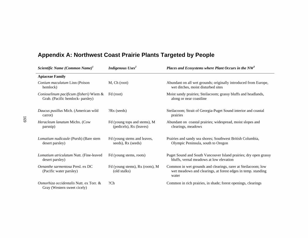
169
Appendix A: Northwest Coast Prairie Plants Targeted by People
Scientific Name (Common Name)1 Indigenous Uses2 Places and Ecosystems where Plant Occurs in the NW3
Apiaceae Family Conium maculatum Linn (Poison
hemlock) M, Ch (root) Abundant on all wet grounds; originally introduced from Europe,
wet ditches, moist disturbed sites
Conioselinum pacificum (fisheri) Wiem & Grab. (Pacific hemlock- parsley)
Fd (root) Moist sandy prairies; Steilacoom; grassy bluffs and headlands, along or near coastline
Daucus pusillus Mich. (American wild carrot)
?Rx (seeds) Steilacoom; Strait of Georgia-Puget Sound interior and coastal prairies
Heracleum lanatum Michx. (Cow parsnip)
Fd (young tops and stems), M (pedicels), Rx (leaves)
Abundant on coastal prairies; widespread, moist slopes and clearings, meadows
Lomatium nudicaule (Pursh) (Bare stem desert parsley)
Fd (young stems and leaves, seeds), Rx (seeds)
Prairies and sandy sea shores; Southwest British Columbia, Olympic Peninsula, south to Oregon
Lomatium utriculatum Nutt. (Fine-leaved desert parsley)
Fd (young stems, roots) Puget Sound and South Vancouver Island prairies; dry open grassy bluffs, vernal meadows at low elevation
Oenanthe sarmentosa Presl. ex DC (Pacific water parsley)
Fd (young stems), Rx (roots), M (old stalks)
Common in wet grounds and clearings, rarer at Steilacoom; low wet meadows and clearings, at forest edges in temp. standing water
Osmorhiza occidentalis Nutt. ex Torr. & Gray (Western sweet cicely)
?Ch Common in rich prairies, in shade; forest openings, clearings
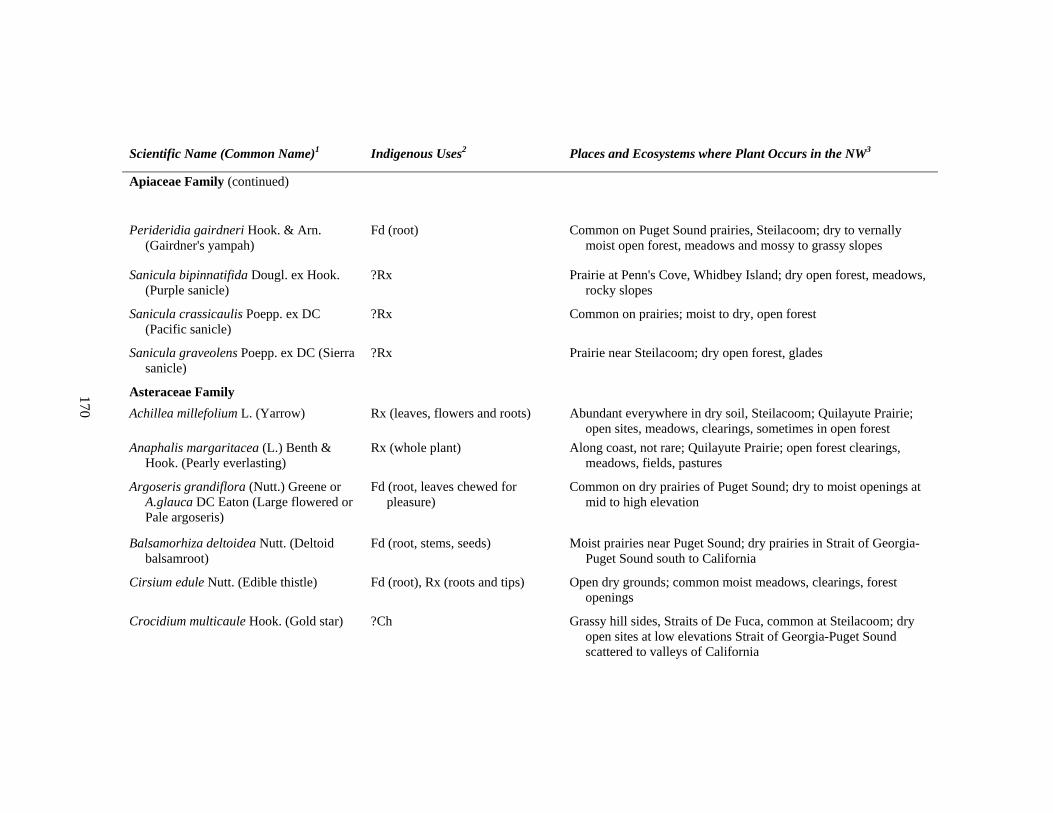
170
Scientific Name (Common Name)1 Indigenous Uses2 Places and Ecosystems where Plant Occurs in the NW3
Apiaceae Family (continued)
Perideridia gairdneri Hook. & Arn. (Gairdner's yampah)
Fd (root) Common on Puget Sound prairies, Steilacoom; dry to vernally moist open forest, meadows and mossy to grassy slopes
Sanicula bipinnatifida Dougl. ex Hook. (Purple sanicle)
?Rx Prairie at Penn's Cove, Whidbey Island; dry open forest, meadows, rocky slopes
Sanicula crassicaulis Poepp. ex DC (Pacific sanicle)
?Rx Common on prairies; moist to dry, open forest
Sanicula graveolens Poepp. ex DC (Sierra sanicle)
?Rx Prairie near Steilacoom; dry open forest, glades
Asteraceae Family Achillea millefolium L. (Yarrow) Rx (leaves, flowers and roots) Abundant everywhere in dry soil, Steilacoom; Quilayute Prairie;
open sites, meadows, clearings, sometimes in open forest Anaphalis margaritacea (L.) Benth &
Hook. (Pearly everlasting) Rx (whole plant) Along coast, not rare; Quilayute Prairie; open forest clearings,
meadows, fields, pastures
Argoseris grandiflora (Nutt.) Greene or A.glauca DC Eaton (Large flowered or Pale argoseris)
Fd (root, leaves chewed for pleasure)
Common on dry prairies of Puget Sound; dry to moist openings at mid to high elevation
Balsamorhiza deltoidea Nutt. (Deltoid balsamroot)
Fd (root, stems, seeds) Moist prairies near Puget Sound; dry prairies in Strait of Georgia-Puget Sound south to California
Cirsium edule Nutt. (Edible thistle) Fd (root), Rx (roots and tips) Open dry grounds; common moist meadows, clearings, forest openings
Crocidium multicaule Hook. (Gold star) ?Ch Grassy hill sides, Straits of De Fuca, common at Steilacoom; dry open sites at low elevations Strait of Georgia-Puget Sound scattered to valleys of California
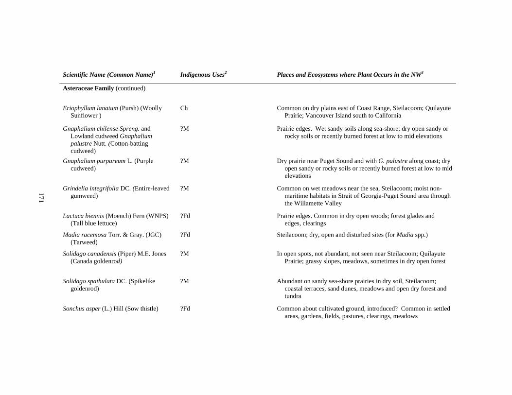
171
Scientific Name (Common Name)1 Indigenous Uses2 Places and Ecosystems where Plant Occurs in the NW3
Asteraceae Family (continued)
Eriophyllum lanatum (Pursh) (Woolly Sunflower )
Ch Common on dry plains east of Coast Range, Steilacoom; Quilayute Prairie; Vancouver Island south to California
Gnaphalium chilense Spreng. and Lowland cudweed Gnaphalium palustre Nutt. (Cotton-batting cudweed)
?M Prairie edges. Wet sandy soils along sea-shore; dry open sandy or rocky soils or recently burned forest at low to mid elevations
Gnaphalium purpureum L. (Purple cudweed)
?M Dry prairie near Puget Sound and with G. palustre along coast; dry open sandy or rocky soils or recently burned forest at low to mid elevations
Grindelia integrifolia DC. (Entire-leaved gumweed)
?M Common on wet meadows near the sea, Steilacoom; moist non-maritime habitats in Strait of Georgia-Puget Sound area through the Willamette Valley
Lactuca biennis (Moench) Fern (WNPS) (Tall blue lettuce)
?Fd Prairie edges. Common in dry open woods; forest glades and edges, clearings
Madia racemosa Torr. & Gray. (JGC) (Tarweed)
?Fd Steilacoom; dry, open and disturbed sites (for Madia spp.)
Solidago canadensis (Piper) M.E. Jones (Canada goldenrod)
?M In open spots, not abundant, not seen near Steilacoom; Quilayute Prairie; grassy slopes, meadows, sometimes in dry open forest
Solidago spathulata DC. (Spikelike goldenrod)
?M Abundant on sandy sea-shore prairies in dry soil, Steilacoom; coastal terraces, sand dunes, meadows and open dry forest and tundra
Sonchus asper (L.) Hill (Sow thistle) ?Fd Common about cultivated ground, introduced? Common in settled areas, gardens, fields, pastures, clearings, meadows
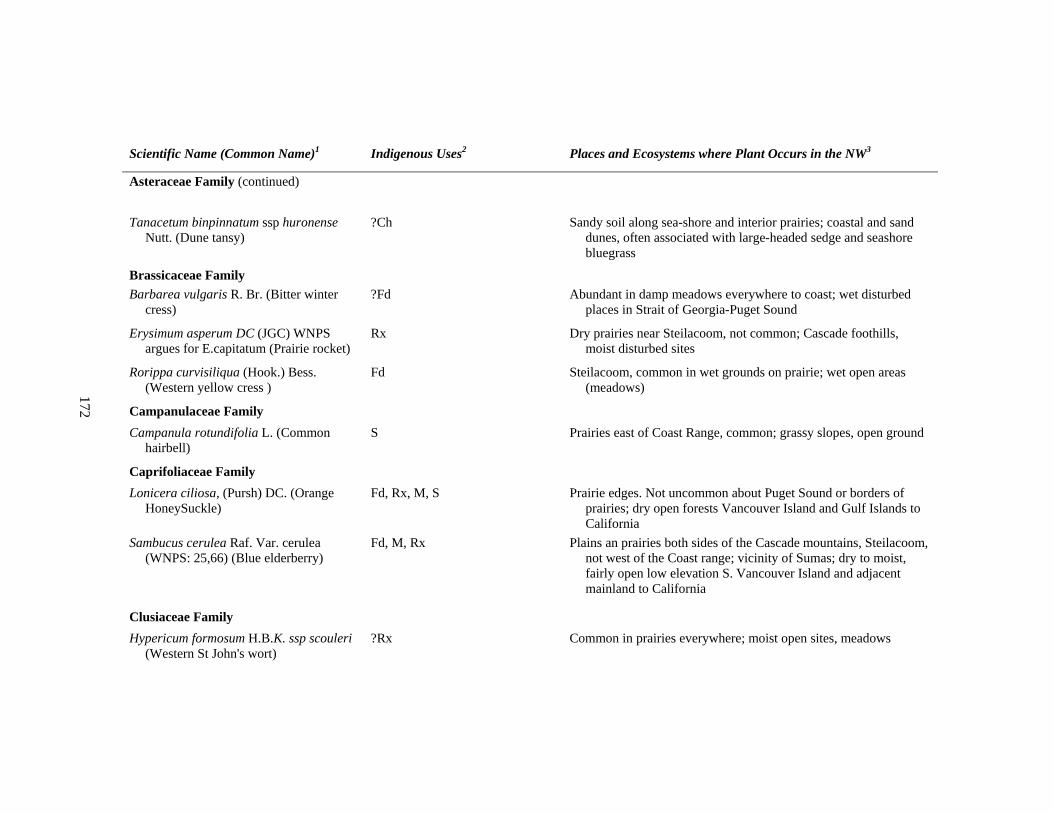
172
Scientific Name (Common Name)1 Indigenous Uses2 Places and Ecosystems where Plant Occurs in the NW3
Asteraceae Family (continued)
Tanacetum binpinnatum ssp huronense Nutt. (Dune tansy)
?Ch Sandy soil along sea-shore and interior prairies; coastal and sand dunes, often associated with large-headed sedge and seashore bluegrass
Brassicaceae Family Barbarea vulgaris R. Br. (Bitter winter
cress) ?Fd Abundant in damp meadows everywhere to coast; wet disturbed
places in Strait of Georgia-Puget Sound
Erysimum asperum DC (JGC) WNPS argues for E.capitatum (Prairie rocket)
Rx Dry prairies near Steilacoom, not common; Cascade foothills, moist disturbed sites
Rorippa curvisiliqua (Hook.) Bess. (Western yellow cress )
Fd Steilacoom, common in wet grounds on prairie; wet open areas (meadows)
Campanulaceae Family Campanula rotundifolia L. (Common
hairbell) S Prairies east of Coast Range, common; grassy slopes, open ground
Caprifoliaceae Family Lonicera ciliosa, (Pursh) DC. (Orange
HoneySuckle) Fd, Rx, M, S Prairie edges. Not uncommon about Puget Sound or borders of
prairies; dry open forests Vancouver Island and Gulf Islands to California
Sambucus cerulea Raf. Var. cerulea (WNPS: 25,66) (Blue elderberry)
Fd, M, Rx Plains an prairies both sides of the Cascade mountains, Steilacoom, not west of the Coast range; vicinity of Sumas; dry to moist, fairly open low elevation S. Vancouver Island and adjacent mainland to California
Clusiaceae Family Hypericum formosum H.B.K. ssp scouleri
(Western St John's wort) ?Rx Common in prairies everywhere; moist open sites, meadows
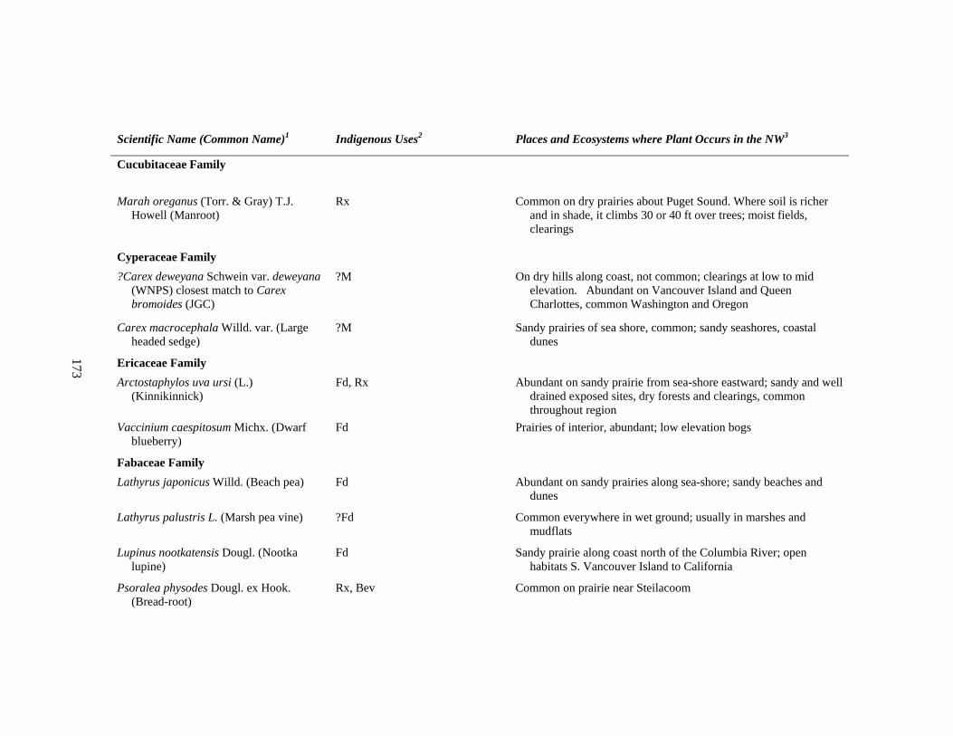
173
Scientific Name (Common Name)1 Indigenous Uses2 Places and Ecosystems where Plant Occurs in the NW3
Cucubitaceae Family
Marah oreganus (Torr. & Gray) T.J. Howell (Manroot)
Rx Common on dry prairies about Puget Sound. Where soil is richer and in shade, it climbs 30 or 40 ft over trees; moist fields, clearings
Cyperaceae Family ?Carex deweyana Schwein var. deweyana
(WNPS) closest match to Carex bromoides (JGC)
?M On dry hills along coast, not common; clearings at low to mid elevation. Abundant on Vancouver Island and Queen Charlottes, common Washington and Oregon
Carex macrocephala Willd. var. (Large headed sedge)
?M Sandy prairies of sea shore, common; sandy seashores, coastal dunes
Ericaceae Family Arctostaphylos uva ursi (L.)
(Kinnikinnick) Fd, Rx Abundant on sandy prairie from sea-shore eastward; sandy and well
drained exposed sites, dry forests and clearings, common throughout region
Vaccinium caespitosum Michx. (Dwarf blueberry)
Fd Prairies of interior, abundant; low elevation bogs
Fabaceae Family Lathyrus japonicus Willd. (Beach pea) Fd Abundant on sandy prairies along sea-shore; sandy beaches and
dunes
Lathyrus palustris L. (Marsh pea vine) ?Fd Common everywhere in wet ground; usually in marshes and mudflats
Lupinus nootkatensis Dougl. (Nootka lupine)
Fd Sandy prairie along coast north of the Columbia River; open habitats S. Vancouver Island to California
Psoralea physodes Dougl. ex Hook. (Bread-root)
Rx, Bev Common on prairie near Steilacoom
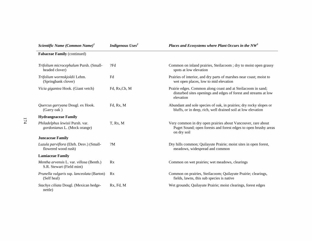
174
Scientific Name (Common Name)1 Indigenous Uses2 Places and Ecosystems where Plant Occurs in the NW3
Fabaceae Family (continued)
Trifolium microcephalum Pursh. (Small-headed clover)
?Fd Common on inland prairies, Steilacoom ; dry to moist open grassy spots at low elevation
Trifolium wormskjoldii Lehm. (Springbank clover)
Fd Prairies of interior, and dry parts of marshes near coast; moist to wet open places, low to mid elevation
Vicia gigantea Hook. (Giant vetch) Fd, Rx,Ch, M Prairie edges. Common along coast and at Steilacoom in sand; disturbed sites openings and edges of forest and streams at low elevation
Quercus garryana Dougl. ex Hook. (Garry oak )
Fd, Rx, M Abundant and sole species of oak, in prairies; dry rocky slopes or bluffs, or in deep, rich, well drained soil at low elevation
Hydrangeaceae Family Philadelphus lewisii Pursh. var.
gordonianus L. (Mock orange) T, Rx, M Very common in dry open prairies about Vancouver, rare about
Puget Sound; open forests and forest edges to open brushy areas on dry soil
Juncaceae Family Luzula parviflora (Ehrh. Desv.) (Small-
flowered wood rush) ?M Dry hills common; Quilayute Prairie; moist sites in open forest,
meadows, widespread and common
Lamiaceae Family Mentha arvensis L. var. villosa (Benth.)
S.R. Stewart (Field mint) Rx Common on wet prairies; wet meadows, clearings
Prunella vulgaris ssp. lanceolata (Barton) (Self heal)
Rx Common on prairies, Steilacoom; Quilayute Prairie; clearings, fields, lawns, this sub species is native
Stachys ciliata Dougl. (Mexican hedge-nettle)
Rx, Fd, M Wet grounds; Quilayute Prairie; moist clearings, forest edges
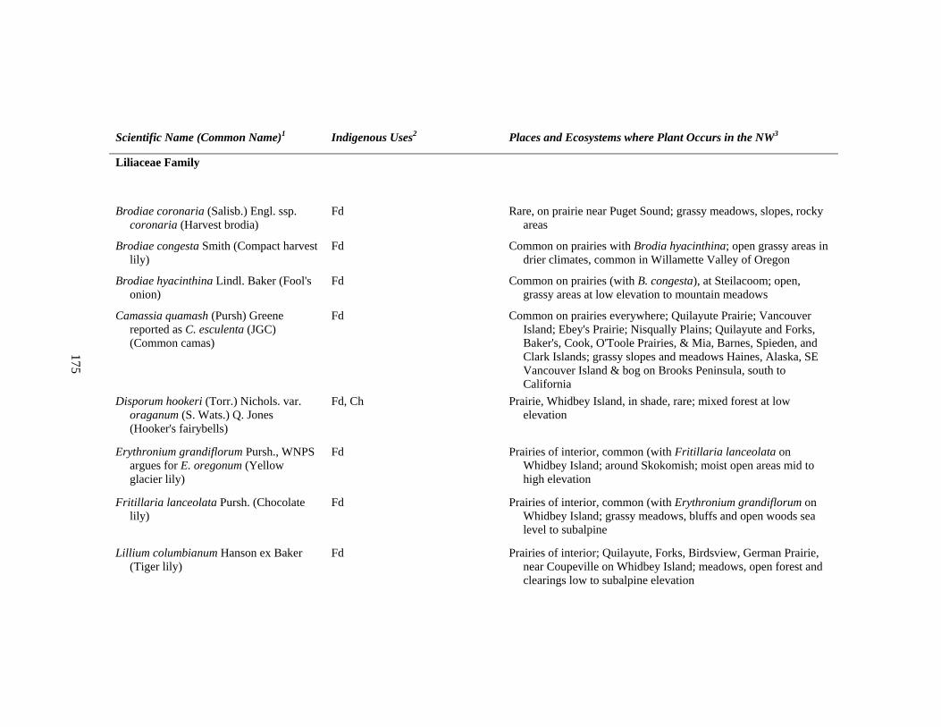
175
Scientific Name (Common Name)1 Indigenous Uses2 Places and Ecosystems where Plant Occurs in the NW3
Liliaceae Family
Brodiae coronaria (Salisb.) Engl. ssp. coronaria (Harvest brodia)
Fd Rare, on prairie near Puget Sound; grassy meadows, slopes, rocky areas
Brodiae congesta Smith (Compact harvest lily)
Fd Common on prairies with Brodia hyacinthina; open grassy areas in drier climates, common in Willamette Valley of Oregon
Brodiae hyacinthina Lindl. Baker (Fool's onion)
Fd Common on prairies (with B. congesta), at Steilacoom; open, grassy areas at low elevation to mountain meadows
Camassia quamash (Pursh) Greene reported as C. esculenta (JGC) (Common camas)
Fd Common on prairies everywhere; Quilayute Prairie; Vancouver Island; Ebey's Prairie; Nisqually Plains; Quilayute and Forks, Baker's, Cook, O'Toole Prairies, & Mia, Barnes, Spieden, and Clark Islands; grassy slopes and meadows Haines, Alaska, SE Vancouver Island & bog on Brooks Peninsula, south to California
Disporum hookeri (Torr.) Nichols. var. oraganum (S. Wats.) Q. Jones (Hooker's fairybells)
Fd, Ch Prairie, Whidbey Island, in shade, rare; mixed forest at low elevation
Erythronium grandiflorum Pursh., WNPS argues for E. oregonum (Yellow glacier lily)
Fd Prairies of interior, common (with Fritillaria lanceolata on Whidbey Island; around Skokomish; moist open areas mid to high elevation
Fritillaria lanceolata Pursh. (Chocolate lily)
Fd Prairies of interior, common (with Erythronium grandiflorum on Whidbey Island; grassy meadows, bluffs and open woods sea level to subalpine
Lillium columbianum Hanson ex Baker (Tiger lily)
Fd Prairies of interior; Quilayute, Forks, Birdsview, German Prairie, near Coupeville on Whidbey Island; meadows, open forest and clearings low to subalpine elevation
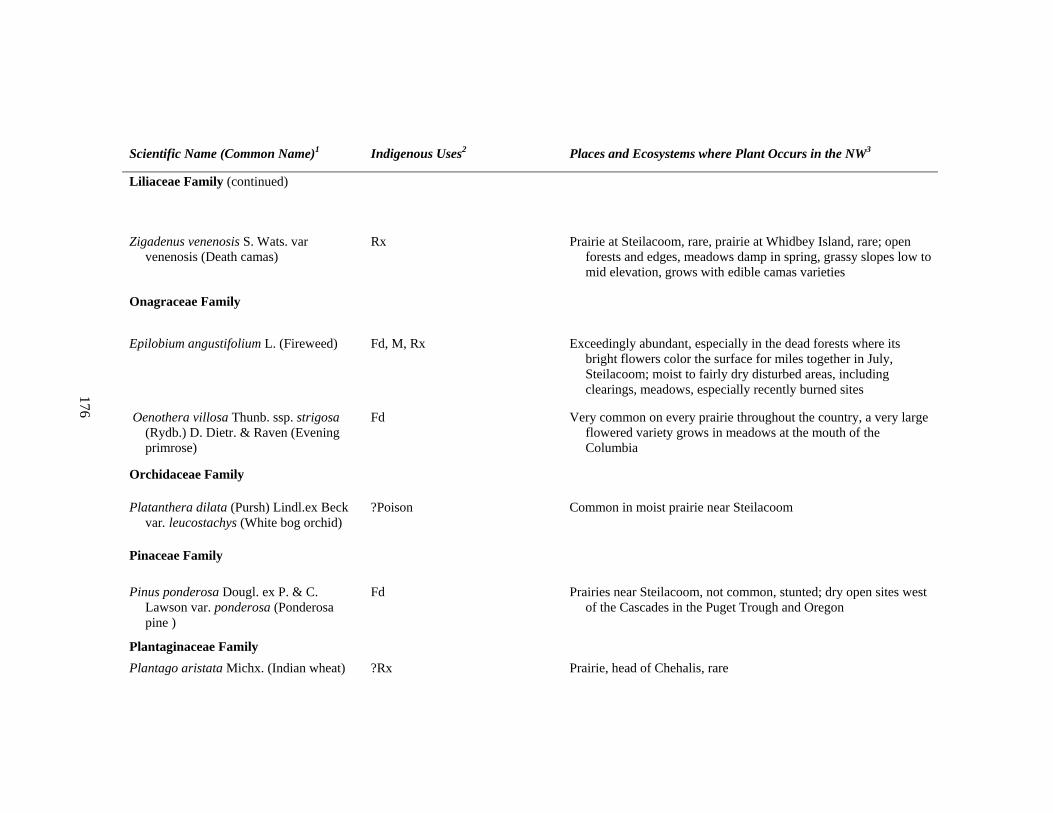
176
Scientific Name (Common Name)1 Indigenous Uses2 Places and Ecosystems where Plant Occurs in the NW3
Liliaceae Family (continued)
Zigadenus venenosis S. Wats. var venenosis (Death camas)
Rx Prairie at Steilacoom, rare, prairie at Whidbey Island, rare; open forests and edges, meadows damp in spring, grassy slopes low to mid elevation, grows with edible camas varieties
Onagraceae Family
Epilobium angustifolium L. (Fireweed) Fd, M, Rx Exceedingly abundant, especially in the dead forests where its bright flowers color the surface for miles together in July, Steilacoom; moist to fairly dry disturbed areas, including clearings, meadows, especially recently burned sites
Oenothera villosa Thunb. ssp. strigosa (Rydb.) D. Dietr. & Raven (Evening primrose)
Fd Very common on every prairie throughout the country, a very large flowered variety grows in meadows at the mouth of the Columbia
Orchidaceae Family
Platanthera dilata (Pursh) Lindl.ex Beck var. leucostachys (White bog orchid)
?Poison Common in moist prairie near Steilacoom
Pinaceae Family
Pinus ponderosa Dougl. ex P. & C. Lawson var. ponderosa (Ponderosa pine )
Fd Prairies near Steilacoom, not common, stunted; dry open sites west of the Cascades in the Puget Trough and Oregon
Plantaginaceae Family Plantago aristata Michx. (Indian wheat) ?Rx Prairie, head of Chehalis, rare

177
Scientific Name (Common Name)1 Indigenous Uses2 Places and Ecosystems where Plant Occurs in the NW3
Plantaginaceae Family (continued)
Plantago major L. var. pachyphylla Pilger. (Common plantain)
?Rx A very large variety in an opening of the forest, Chehalis river, apparently indigenous
Poaceae Family
Agrostis oregonensis (Oregon bentgrass ) Fg Quilayute Prairie; wet meadows Vancouver Island south
Bromus carinatus Hook. & Arn. (California brome grass)
?Fg Dry prairie at Steilacoom, and salt meadows common; open habitats in the southern half of our region
Calamagrostis neglecta (Ehrh.)Gaertn., Mey., & Scherb. var neglecta (Slimstem reedgrass)
?Fg Sandy sea-shore prairies Steilacoom with Elymus mollis; wetlands, wet meadows, dune slacks, shores
Deschampsia cespitosa (L.) Beauv. (WNPS) JGC reported as Aira latifolia Hook. (a high elev. grass) (?Tufted hairgrass)
?Fg Damp prairies and salt meadows with D. elongata; Tidal marshes, beaches, meadows from sea level to alpine
Deschampsia elongata (Hook.) Munro ex Benth. (Slender hairgrass)
?Fg The common grass on damp prairies and salt meadows with ?D. cesitosa; Clearings, meadows often disturbed sites near habitation
Elymus mollis Trin. ssp. Mollis (Dunegrass)
M, ?Fg Sandy sea-shore prairies Steilacoom with Calamagrostis neglecta; wetlands, wet meadows, dune slacks, shores
?Hordeum pratense Kunth., introduced? ?Fg Prairies with Poa annua
Koeleria cristata (L.) Pers. ?Fg Dry prairies
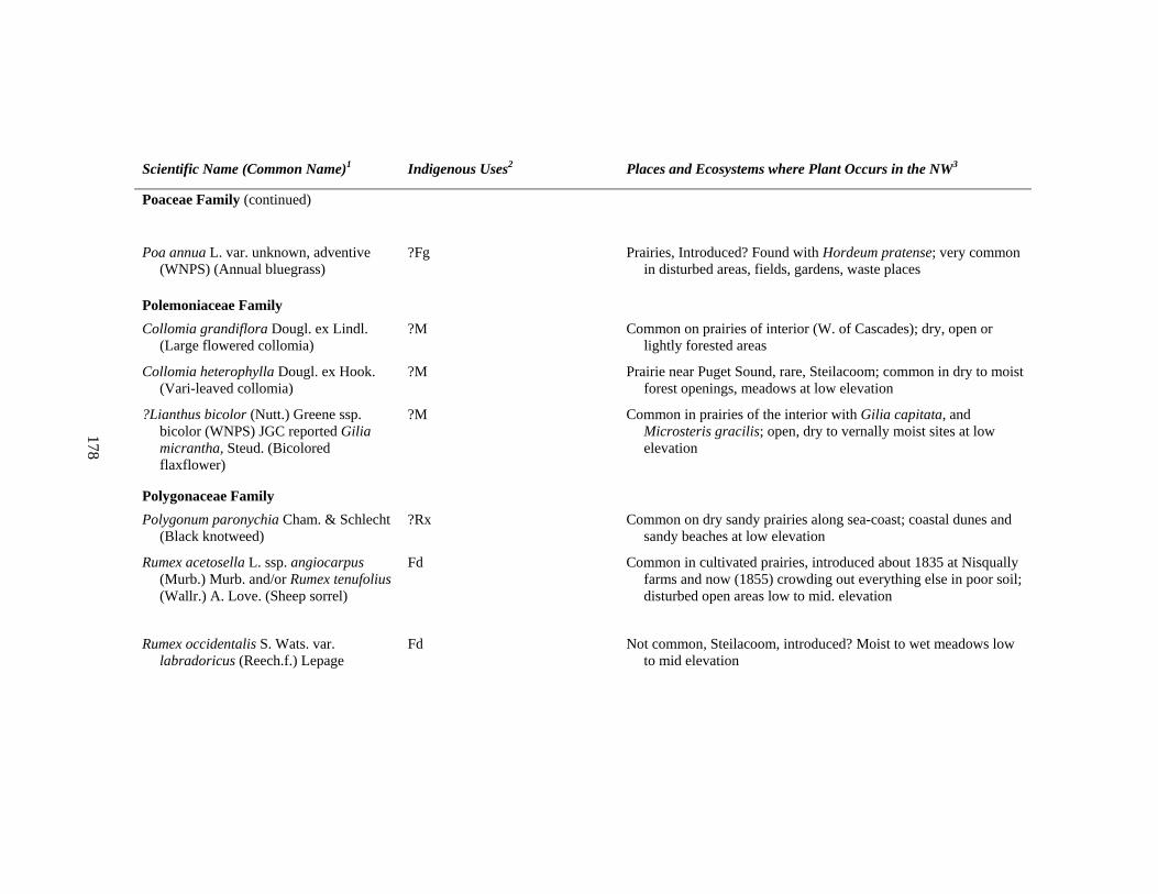
178
Scientific Name (Common Name)1 Indigenous Uses2 Places and Ecosystems where Plant Occurs in the NW3
Poaceae Family (continued)
Poa annua L. var. unknown, adventive (WNPS) (Annual bluegrass)
?Fg Prairies, Introduced? Found with Hordeum pratense; very common in disturbed areas, fields, gardens, waste places
Polemoniaceae Family Collomia grandiflora Dougl. ex Lindl.
(Large flowered collomia) ?M Common on prairies of interior (W. of Cascades); dry, open or
lightly forested areas
Collomia heterophylla Dougl. ex Hook. (Vari-leaved collomia)
?M Prairie near Puget Sound, rare, Steilacoom; common in dry to moist forest openings, meadows at low elevation
?Lianthus bicolor (Nutt.) Greene ssp. bicolor (WNPS) JGC reported Gilia micrantha, Steud. (Bicolored flaxflower)
?M Common in prairies of the interior with Gilia capitata, and Microsteris gracilis; open, dry to vernally moist sites at low elevation
Polygonaceae Family Polygonum paronychia Cham. & Schlecht
(Black knotweed) ?Rx Common on dry sandy prairies along sea-coast; coastal dunes and
sandy beaches at low elevation
Rumex acetosella L. ssp. angiocarpus (Murb.) Murb. and/or Rumex tenufolius (Wallr.) A. Love. (Sheep sorrel)
Fd Common in cultivated prairies, introduced about 1835 at Nisqually farms and now (1855) crowding out everything else in poor soil; disturbed open areas low to mid. elevation
Rumex occidentalis S. Wats. var. labradoricus (Reech.f.) Lepage
Fd Not common, Steilacoom, introduced? Moist to wet meadows low to mid elevation
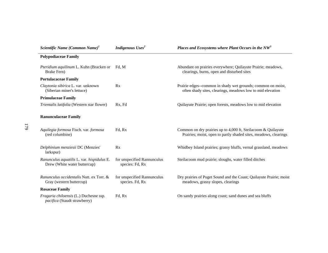
179
Scientific Name (Common Name)1 Indigenous Uses2 Places and Ecosystems where Plant Occurs in the NW3
Polypodiaceae Family
Pteridium aquilinum L. Kuhn (Bracken or Brake Fern)
Fd, M Abundant on prairies everywhere; Quilayute Prairie; meadows, clearings, burns, open and disturbed sites
Portulacaceae Family Claytonia sibirica L. var. unknown
(Siberian miner's lettuce) Rx Prairie edges--common in shady wet grounds; common on moist,
often shady sites, clearings, meadows low to mid elevation
Primulaceae Family Trientalis latifolia (Western star flower) Rx, Fd Quilayute Prairie; open forests, meadows low to mid elevation
Ranunculaceae Family
Aquilegia formosa Fisch. var. formosa (red columbine)
Fd, Rx Common on dry prairies up to 4,000 ft, Steilacoom & Quilayute Prairies; moist, open to partly shaded sites, meadows, clearings
Delphinium menziesii DC (Menzies' larkspur)
Rx Whidbey Island prairies; grassy bluffs, vernal grassland, meadows
Ranunculus aquatilis L. var. hispidulus E. Drew (White water buttercup)
for unspecified Rannunculus species: Fd, Rx
Steilacoom mud prairie; sloughs, water filled ditches
Ranunculus occidentalis Nutt. ex Torr. & Gray (western buttercup)
for unspecified Rannunculus species. Fd, Rx
Dry prairies of Puget Sound and the Coast; Quilayute Prairie; moist meadows, grassy slopes, clearings
Rosaceae Family Fragaria chiloensis (L.) Duchesne ssp.
pacifica (Staudt strawberry) Fd, Rx On sandy prairies along coast; sand dunes and sea bluffs
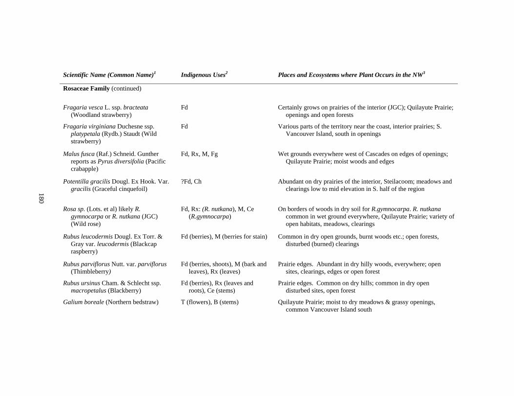
180
Scientific Name (Common Name)1 Indigenous Uses2 Places and Ecosystems where Plant Occurs in the NW3
Rosaceae Family (continued)
Fragaria vesca L. ssp. bracteata (Woodland strawberry)
Fd Certainly grows on prairies of the interior (JGC); Quilayute Prairie; openings and open forests
Fragaria virginiana Duchesne ssp. platypetala (Rydb.) Staudt (Wild strawberry)
Fd Various parts of the territory near the coast, interior prairies; S. Vancouver Island, south in openings
Malus fusca (Raf.) Schneid. Gunther reports as Pyrus diversifolia (Pacific crabapple)
Fd, Rx, M, Fg Wet grounds everywhere west of Cascades on edges of openings; Quilayute Prairie; moist woods and edges
Potentilla gracilis Dougl. Ex Hook. Var. gracilis (Graceful cinquefoil)
?Fd, Ch Abundant on dry prairies of the interior, Steilacoom; meadows and clearings low to mid elevation in S. half of the region
Rosa sp. (Lots. et al) likely R. gymnocarpa or R. nutkana (JGC) (Wild rose)
Fd, Rx: (R. nutkana), M, Ce (R.gymnocarpa)
On borders of woods in dry soil for R.gymnocarpa. R. nutkana common in wet ground everywhere, Quilayute Prairie; variety of open habitats, meadows, clearings
Rubus leucodermis Dougl. Ex Torr. & Gray var. leucodermis (Blackcap raspberry)
Fd (berries), M (berries for stain) Common in dry open grounds, burnt woods etc.; open forests, disturbed (burned) clearings
Rubus parviflorus Nutt. var. parviflorus (Thimbleberry)
Fd (berries, shoots), M (bark and leaves), Rx (leaves)
Prairie edges. Abundant in dry hilly woods, everywhere; open sites, clearings, edges or open forest
Rubus ursinus Cham. & Schlecht ssp. macropetalus (Blackberry)
Fd (berries), Rx (leaves and roots), Ce (stems)
Prairie edges. Common on dry hills; common in dry open disturbed sites, open forest
Galium boreale (Northern bedstraw) T (flowers), B (stems) Quilayute Prairie; moist to dry meadows & grassy openings, common Vancouver Island south
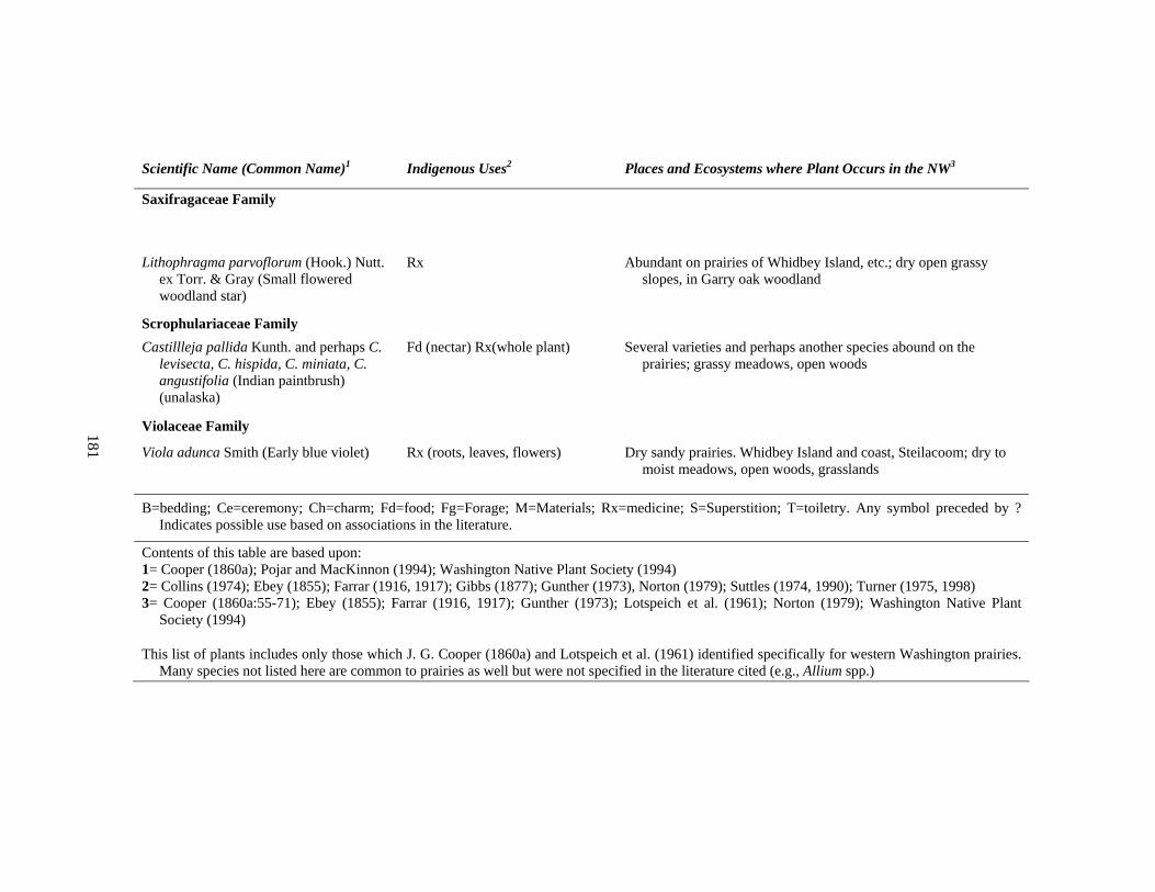
181
Scientific Name (Common Name)1 Indigenous Uses2 Places and Ecosystems where Plant Occurs in the NW3
Saxifragaceae Family
Lithophragma parvoflorum (Hook.) Nutt. ex Torr. & Gray (Small flowered woodland star)
Rx Abundant on prairies of Whidbey Island, etc.; dry open grassy slopes, in Garry oak woodland
Scrophulariaceae Family Castillleja pallida Kunth. and perhaps C.
levisecta, C. hispida, C. miniata, C. angustifolia (Indian paintbrush) (unalaska)
Fd (nectar) Rx(whole plant) Several varieties and perhaps another species abound on the prairies; grassy meadows, open woods
Violaceae Family
Viola adunca Smith (Early blue violet) Rx (roots, leaves, flowers) Dry sandy prairies. Whidbey Island and coast, Steilacoom; dry to moist meadows, open woods, grasslands
B=bedding; Ce=ceremony; Ch=charm; Fd=food; Fg=Forage; M=Materials; Rx=medicine; S=Superstition; T=toiletry. Any symbol preceded by ? Indicates possible use based on associations in the literature.
Contents of this table are based upon: 1= Cooper (1860a); Pojar and MacKinnon (1994); Washington Native Plant Society (1994) 2= Collins (1974); Ebey (1855); Farrar (1916, 1917); Gibbs (1877); Gunther (1973), Norton (1979); Suttles (1974, 1990); Turner (1975, 1998) 3= Cooper (1860a:55-71); Ebey (1855); Farrar (1916, 1917); Gunther (1973); Lotspeich et al. (1961); Norton (1979); Washington Native Plant
Society (1994)
This list of plants includes only those which J. G. Cooper (1860a) and Lotspeich et al. (1961) identified specifically for western Washington prairies. Many species not listed here are common to prairies as well but were not specified in the literature cited (e.g., Allium spp.)
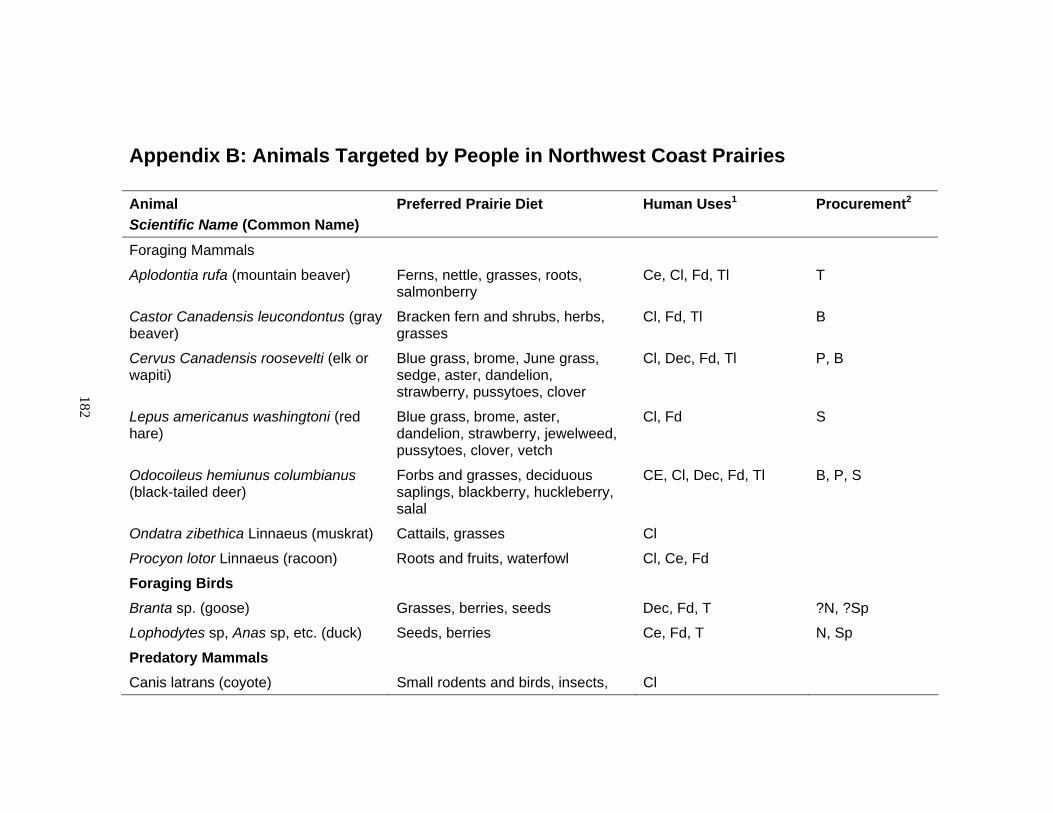
182
Appendix B: Animals Targeted by People in Northwest Coast Prairies
Animal Scientific Name (Common Name)
Preferred Prairie Diet Human Uses1 Procurement2
Foraging Mammals
Aplodontia rufa (mountain beaver) Ferns, nettle, grasses, roots, salmonberry
Ce, Cl, Fd, Tl T
Castor Canadensis leucondontus (gray beaver)
Bracken fern and shrubs, herbs, grasses
Cl, Fd, Tl B
Cervus Canadensis roosevelti (elk or wapiti)
Blue grass, brome, June grass, sedge, aster, dandelion, strawberry, pussytoes, clover
Cl, Dec, Fd, Tl P, B
Lepus americanus washingtoni (red hare)
Blue grass, brome, aster, dandelion, strawberry, jewelweed, pussytoes, clover, vetch
Cl, Fd S
Odocoileus hemiunus columbianus (black-tailed deer)
Forbs and grasses, deciduous saplings, blackberry, huckleberry, salal
CE, Cl, Dec, Fd, Tl B, P, S
Ondatra zibethica Linnaeus (muskrat) Cattails, grasses Cl
Procyon lotor Linnaeus (racoon) Roots and fruits, waterfowl Cl, Ce, Fd
Foraging Birds
Branta sp. (goose) Grasses, berries, seeds Dec, Fd, T ?N, ?Sp
Lophodytes sp, Anas sp, etc. (duck) Seeds, berries Ce, Fd, T N, Sp
Predatory Mammals
Canis latrans (coyote) Small rodents and birds, insects, Cl
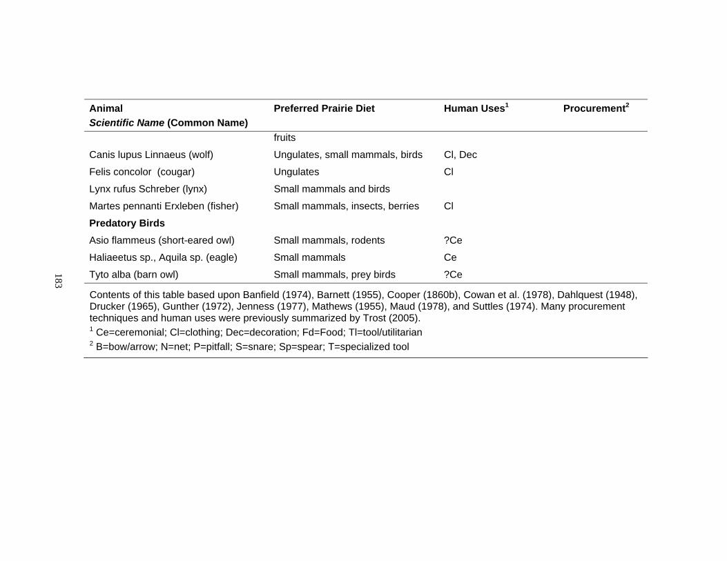
183
Animal Scientific Name (Common Name)
Preferred Prairie Diet Human Uses1 Procurement2
fruits
Canis lupus Linnaeus (wolf) Ungulates, small mammals, birds Cl, Dec
Felis concolor (cougar) Ungulates Cl
Lynx rufus Schreber (lynx) Small mammals and birds
Martes pennanti Erxleben (fisher) Small mammals, insects, berries Cl
Predatory Birds
Asio flammeus (short-eared owl) Small mammals, rodents ?Ce
Haliaeetus sp., Aquila sp. (eagle) Small mammals Ce
Tyto alba (barn owl) Small mammals, prey birds ?Ce
Contents of this table based upon Banfield (1974), Barnett (1955), Cooper (1860b), Cowan et al. (1978), Dahlquest (1948), Drucker (1965), Gunther (1972), Jenness (1977), Mathews (1955), Maud (1978), and Suttles (1974). Many procurement techniques and human uses were previously summarized by Trost (2005). 1 Ce=ceremonial; Cl=clothing; Dec=decoration; Fd=Food; Tl=tool/utilitarian 2 B=bow/arrow; N=net; P=pitfall; S=snare; Sp=spear; T=specialized tool
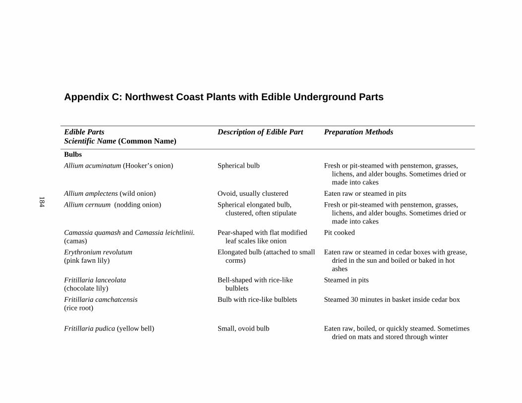
184
Appendix C: Northwest Coast Plants with Edible Underground Parts
Edible Parts Scientific Name (Common Name)
Description of Edible Part Preparation Methods
Bulbs Allium acuminatum (Hooker’s onion) Spherical bulb Fresh or pit-steamed with penstemon, grasses,
lichens, and alder boughs. Sometimes dried or made into cakes
Allium amplectens (wild onion) Ovoid, usually clustered Eaten raw or steamed in pits Allium cernuum (nodding onion) Spherical elongated bulb,
clustered, often stipulate Fresh or pit-steamed with penstemon, grasses,
lichens, and alder boughs. Sometimes dried or made into cakes
Camassia quamash and Camassia leichtlinii. (camas)
Pear-shaped with flat modified leaf scales like onion
Pit cooked
Erythronium revolutum (pink fawn lily)
Elongated bulb (attached to small corms)
Eaten raw or steamed in cedar boxes with grease, dried in the sun and boiled or baked in hot ashes
Fritillaria lanceolata (chocolate lily)
Bell-shaped with rice-like bulblets
Steamed in pits
Fritillaria camchatcensis (rice root)
Bulb with rice-like bulblets Steamed 30 minutes in basket inside cedar box
Fritillaria pudica (yellow bell) Small, ovoid bulb Eaten raw, boiled, or quickly steamed. Sometimes dried on mats and stored through winter
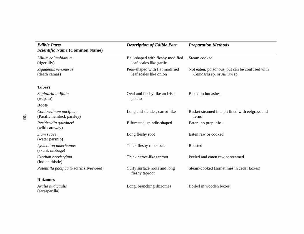
185
Edible Parts Scientific Name (Common Name)
Description of Edible Part Preparation Methods
Lilium columbianum (tiger lily)
Bell-shaped with fleshy modified leaf scales like garlic
Steam cooked
Zigadenus venonesus (death camas)
Pear-shaped with flat modified leaf scales like onion
Not eaten; poisonous, but can be confused with Camassia sp. or Allium sp.
Tubers Sagittaria latifolia (wapato)
Oval and fleshy like an Irish potato
Baked in hot ashes
Roots Conioselinum pacificum (Pacific hemlock parsley)
Long and slender, carrot-like Basket steamed in a pit lined with eelgrass and ferns
Perideridia gairdneri (wild caraway)
Bifurcated, spindle-shaped Eaten; no prep info.
Sium suave (water parsnip)
Long fleshy root Eaten raw or cooked
Lysichiton americanus (skunk cabbage)
Thick fleshy rootstocks Roasted
Circium brevistylum (Indian thistle)
Thick carrot-like taproot Peeled and eaten raw or steamed
Potentilla pacifica (Pacific silverweed) Curly surface roots and long fleshy taproot
Steam-cooked (sometimes in cedar boxes)
Rhizomes Aralia nudicaulis (sarsaparilla)
Long, branching rhizomes Boiled in wooden boxes
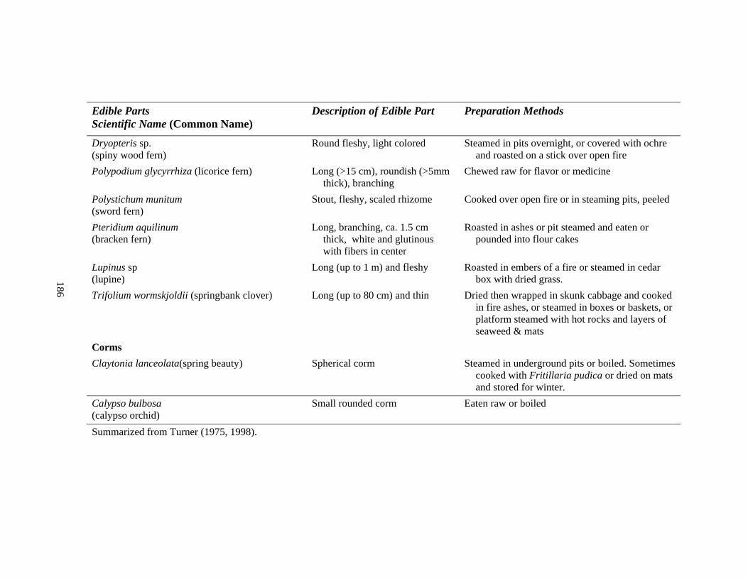
186
Edible Parts Scientific Name (Common Name)
Description of Edible Part Preparation Methods
Dryopteris sp. (spiny wood fern)
Round fleshy, light colored Steamed in pits overnight, or covered with ochre and roasted on a stick over open fire
Polypodium glycyrrhiza (licorice fern) Long (>15 cm), roundish (>5mm thick), branching
Chewed raw for flavor or medicine
Polystichum munitum (sword fern)
Stout, fleshy, scaled rhizome Cooked over open fire or in steaming pits, peeled
Pteridium aquilinum (bracken fern)
Long, branching, ca. 1.5 cm thick, white and glutinous with fibers in center
Roasted in ashes or pit steamed and eaten or pounded into flour cakes
Lupinus sp (lupine)
Long (up to 1 m) and fleshy Roasted in embers of a fire or steamed in cedar box with dried grass.
Trifolium wormskjoldii (springbank clover) Long (up to 80 cm) and thin Dried then wrapped in skunk cabbage and cooked in fire ashes, or steamed in boxes or baskets, or platform steamed with hot rocks and layers of seaweed & mats
Corms Claytonia lanceolata(spring beauty) Spherical corm Steamed in underground pits or boiled. Sometimes
cooked with Fritillaria pudica or dried on mats and stored for winter.
Calypso bulbosa (calypso orchid)
Small rounded corm Eaten raw or boiled
Summarized from Turner (1975, 1998).
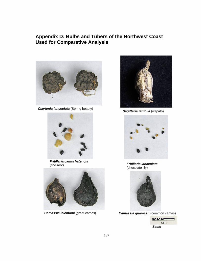
187
Appendix D: Bulbs and Tubers of the Northwest Coast Used for Comparative Analysis
Claytonia lanceolata (Spring beauty) Sagittaria latifolia (wapato)
Fritillaria lanceolata (chocolate lily)
Fritillaria camschatencis (rice root)
Camassia leichtlinii (great camas) Camassia quamash (common camas)
Scale

188
Allium acuminatum (Hooker’s onion)
Allim geyeri (Geyer’s onion)
Allium cernuum (nodding onion)
Zygadenus venenosis (death camas)
Scale
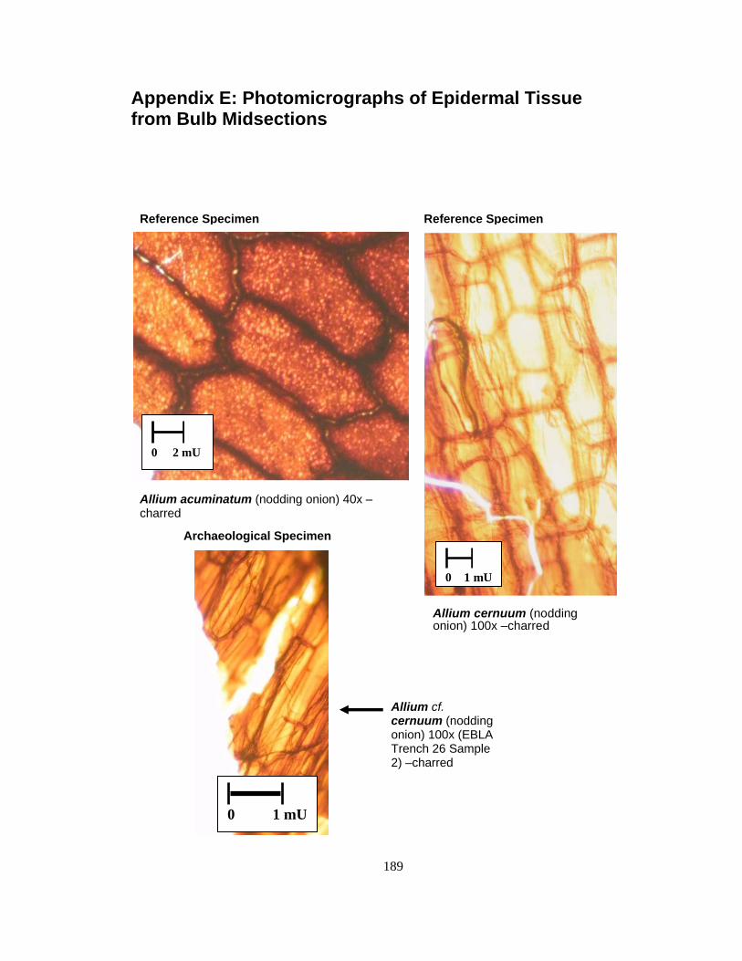
189
Appendix E: Photomicrographs of Epidermal Tissue from Bulb Midsections
Allium acuminatum (nodding onion) 40x –charred
0 2 mU
Reference Specimen
Allium cernuum (nodding onion) 100x –charred
0 1 mU
Reference Specimen
0 1 mU
Allium cf. cernuum (nodding onion) 100x (EBLA Trench 26 Sample 2) –charred
Archaeological Specimen
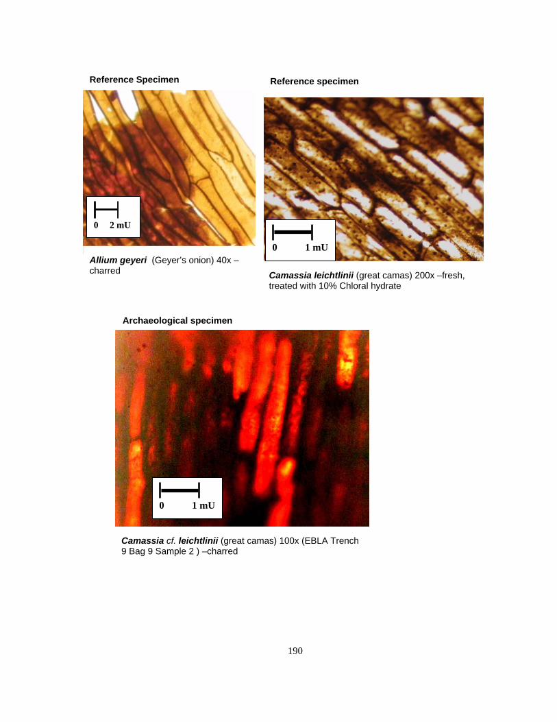
190
Camassia leichtlinii (great camas) 200x –fresh, treated with 10% Chloral hydrate
0 1 mU
Reference specimen
Allium geyeri (Geyer’s onion) 40x –charred
0 2 mU
Reference Specimen
Camassia cf. leichtlinii (great camas) 100x (EBLA Trench 9 Bag 9 Sample 2 ) –charred
0 1 mU
Archaeological specimen

191
Camassia quamash (common camas) 400x –fresh, viewed with polarizing optics
0 1 mU
Reference Specimen
Zygadenus venenosus (death camas) 100x –fresh, treated with 0.05% w/v toluidine blue
0 1 mU
Reference Specimen
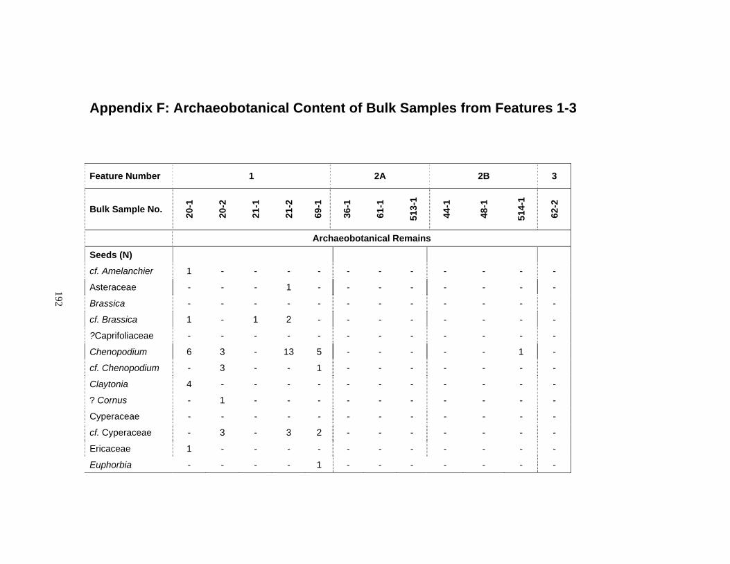
192
Appendix F: Archaeobotanical Content of Bulk Samples from Features 1-3
Feature Number 1 2A 2B 3
Bulk Sample No. 20-1
20-2
21-1
21-2
69-1
36-1
61-1
513-
1
44-1
48-1
514-
1
62-2
Archaeobotanical Remains
Seeds (N)
cf. Amelanchier 1 - - - - - - - - - - -
Asteraceae - - - 1 - - - - - - - -
Brassica - - - - - - - - - - - -
cf. Brassica 1 - 1 2 - - - - - - - -
?Caprifoliaceae - - - - - - - - - - - -
Chenopodium 6 3 - 13 5 - - - - - 1 -
cf. Chenopodium - 3 - - 1 - - - - - - -
Claytonia 4 - - - - - - - - - - -
? Cornus - 1 - - - - - - - - - -
Cyperaceae - - - - - - - - - - - -
cf. Cyperaceae - 3 - 3 2 - - - - - - -
Ericaceae 1 - - - - - - - - - - -
Euphorbia - - - - 1 - - - - - - -

193
Feature Number 1 2A 2B 3
Bulk Sample No. 20-1
20-2
21-1
21-2
69-1
36-1
61-1
513-
1
44-1
48-1
514-
1
62-2
Archaeobotanical Remains
cf. Fragaria 1 - - - - - - - - - - -
Galium - - 1 1 - - - - - - - -
cf. Labiateae - - - - - - - - - - - -
Plantago 7 1 - - 6 - - - - - - -
Seeds (N)
Poaceae - - - - - - - - - - - -
Polygonum - - - - - - - - - - - -
Portulaca - - - - - - - - - - - -
cf. Portulaca 1 - - - - - - - - - - -
cf. Potamogeton 3 - - - 2 - - - - - - -
Ranunculus 2 - - - - - - - - - - -
cf. Ranunculaceae - - - - - - - - - - - -
Roseaceae - - - - - - - - - - 1 -
cf. Rosa - - - - - 1 - - - - - -
Rubus 1 - - - 1 - - - - - - -
cf. Rubus - 1 - - - - - - - - - -
cf. Ruppia 1 - - - - - - - - - - -
Sambucus - 1 - - - - - - - - - -
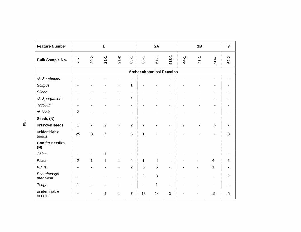
194
Feature Number 1 2A 2B 3
Bulk Sample No. 20-1
20-2
21-1
21-2
69-1
36-1
61-1
513-
1
44-1
48-1
514-
1
62-2
Archaeobotanical Remains
cf. Sambucus - - - - - - - - - - - -
Scirpus - - - - 1 - - - - - - -
Silene - - - - - - - - - - - -
cf. Sparganium - - - - 2 - - - - - - -
Trifolium - - - - - - - - - - - -
cf. Viola 2 - - - - - - - - - - -
Seeds (N)
unknown seeds 1 - 2 - 2 7 - - 2 - 6 -
unidentifiable seeds 25 3 7 - 5 1 - - - - - 3
Conifer needles (N)
Abies - - 1 - - - - - - - - -
Picea 2 1 1 1 4 1 4 - - - 4 2
Pinus - - - - 2 6 5 - - - 1 -
Pseudotsuga menziesii - - - - - 2 3 - - - - 2
Tsuga 1 - - - - - 1 - - - - -
unidentifiable needles - - 9 1 7 18 14 3 - - 15 5
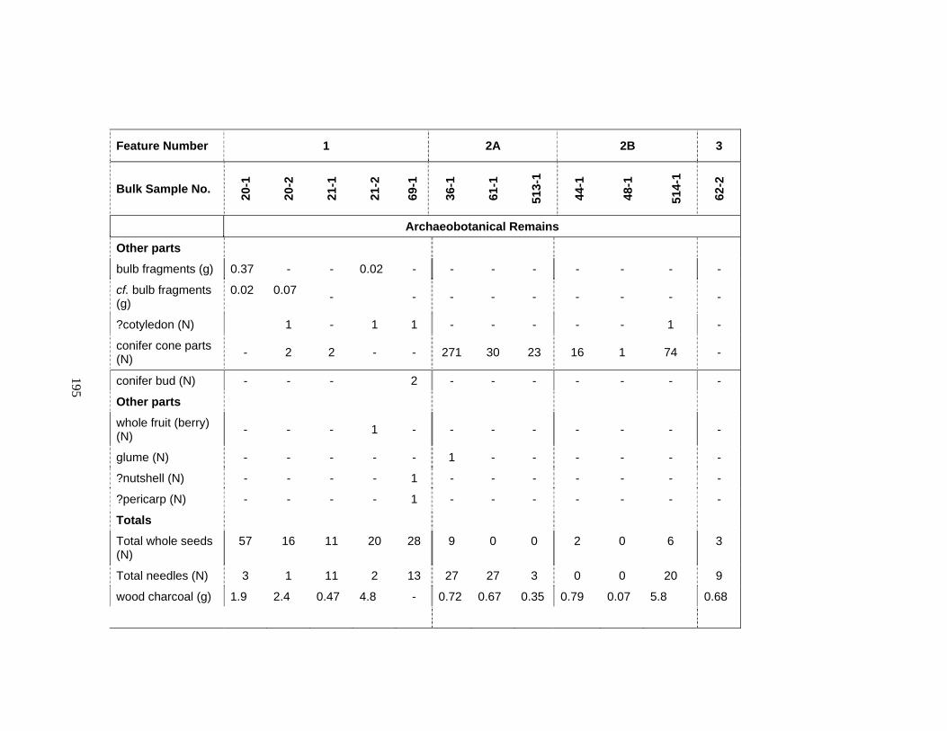
195
Feature Number 1 2A 2B 3
Bulk Sample No. 20-1
20-2
21-1
21-2
69-1
36-1
61-1
513-
1
44-1
48-1
514-
1
62-2
Archaeobotanical Remains
Other parts
bulb fragments (g) 0.37 - - 0.02 - - - - - - - -
cf. bulb fragments (g)
0.02 0.07 - - - - - - - - -
?cotyledon (N) 1 - 1 1 - - - - - 1 -
conifer cone parts (N) - 2 2 - - 271 30 23 16 1 74 -
conifer bud (N) - - - 2 - - - - - - -
Other parts
whole fruit (berry) (N) - - - 1 - - - - - - - -
glume (N) - - - - - 1 - - - - - -
?nutshell (N) - - - - 1 - - - - - - -
?pericarp (N) - - - - 1 - - - - - - -
Totals
Total whole seeds (N)
57 16 11 20 28 9 0 0 2 0 6 3
Total needles (N) 3 1 11 2 13 27 27 3 0 0 20 9
wood charcoal (g) 1.9 2.4 0.47 4.8 - 0.72 0.67 0.35 0.79 0.07 5.8 0.68
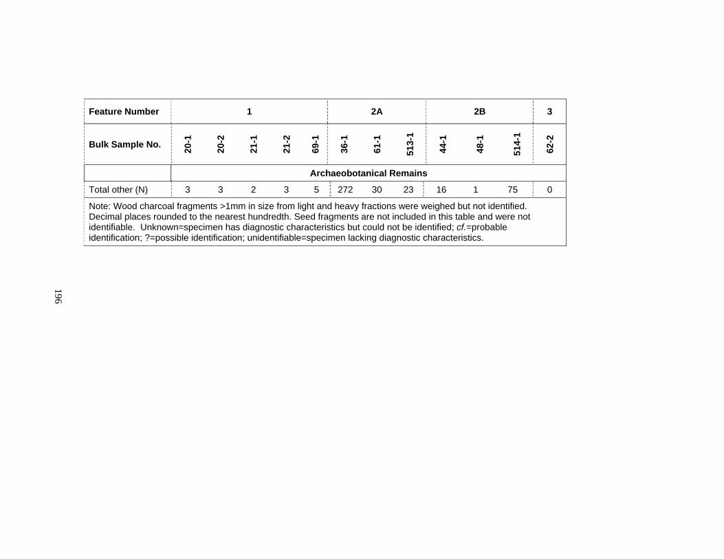
196
Feature Number 1 2A 2B 3
Bulk Sample No. 20-1
20-2
21-1
21-2
69-1
36-1
61-1
513-
1
44-1
48-1
514-
1
62-2
Archaeobotanical Remains
Total other (N) 3 3 2 3 5 272 30 23 16 1 75 0
Note: Wood charcoal fragments >1mm in size from light and heavy fractions were weighed but not identified. Decimal places rounded to the nearest hundredth. Seed fragments are not included in this table and were not identifiable. Unknown=specimen has diagnostic characteristics but could not be identified; cf.=probable identification; ?=possible identification; unidentifiable=specimen lacking diagnostic characteristics.
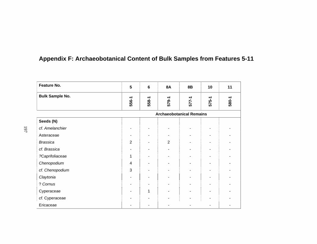
197
Appendix F: Archaeobotanical Content of Bulk Samples from Features 5-11
Feature No. 5 6 8A 8B 10 11
Bulk Sample No.
556-
1
558-
1
579-
1
577-
1
575-
1
580-
1
Archaeobotanical Remains
Seeds (N)
cf. Amelanchier - - - - - -
Asteraceae - - - - - -
Brassica 2 - 2 - - -
cf. Brassica - - - - - -
?Caprifoliaceae 1 - - - - -
Chenopodium 4 - - - - -
cf. Chenopodium 3 - - - - -
Claytonia - - - - - -
? Cornus - - - - - -
Cyperaceae - 1 - - - -
cf. Cyperaceae - - - - - -
Ericaceae - - - - - -
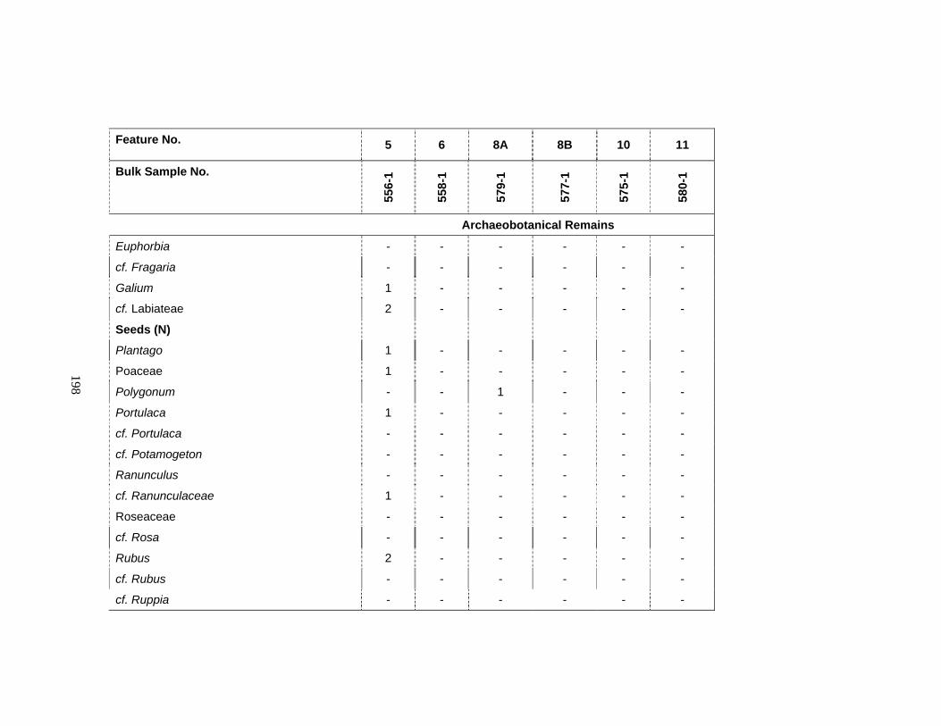
198
Feature No. 5 6 8A 8B 10 11
Bulk Sample No.
556-
1
558-
1
579-
1
577-
1
575-
1
580-
1
Archaeobotanical Remains
Euphorbia - - - - - -
cf. Fragaria - - - - - -
Galium 1 - - - - -
cf. Labiateae 2 - - - - -
Seeds (N)
Plantago 1 - - - - -
Poaceae 1 - - - - -
Polygonum - - 1 - - -
Portulaca 1 - - - - -
cf. Portulaca - - - - - -
cf. Potamogeton - - - - - -
Ranunculus - - - - - -
cf. Ranunculaceae 1 - - - - -
Roseaceae - - - - - -
cf. Rosa - - - - - -
Rubus 2 - - - - -
cf. Rubus - - - - - -
cf. Ruppia - - - - - -
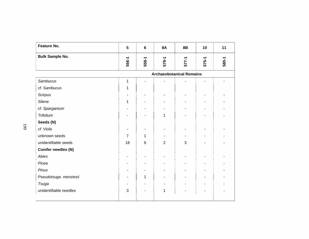
199
Feature No. 5 6 8A 8B 10 11
Bulk Sample No.
556-
1
558-
1
579-
1
577-
1
575-
1
580-
1
Archaeobotanical Remains
Sambucus 1 - - - - -
cf. Sambucus 1
Scirpus - - - - - -
Silene 1 - - - - -
cf. Sparganium - - - - - -
Trifolium - - 1 - - -
Seeds (N)
cf. Viola - - - - - -
unknown seeds 7 1 - - - -
unidentifiable seeds 18 6 2 3 - -
Conifer needles (N)
Abies - - - - - -
Picea - - - - - -
Pinus - - - - - -
Pseudotsuga menziesii - 1 - - - -
Tsuga - - - - - -
unidentifiable needles 3 - 1 - - -

200
Feature No. 5 6 8A 8B 10 11
Bulk Sample No.
556-
1
558-
1
579-
1
577-
1
575-
1
580-
1
Archaeobotanical Remains
Other parts
bulb fragments (g) - - - - - -
cf. bulb fragments (g) - - - - - -
?cotyledon (N) - - - - - -
conifer cone parts (N) 1 - - - - -
conifer bud (N) - - - - - -
Other parts
whole fruit (berry) (N) - - - - - -
glume (N) - - - - - -
?nutshell (N) - - - - - -
?pericarp (N) - - - - - -
Totals
Total whole seeds (N) 47 8 6 3 0 0
Total needles (N) 3 1 1 0 - 0
wood charcoal (g) 0.5 2.7 1.1 0.1 0.1 0.02
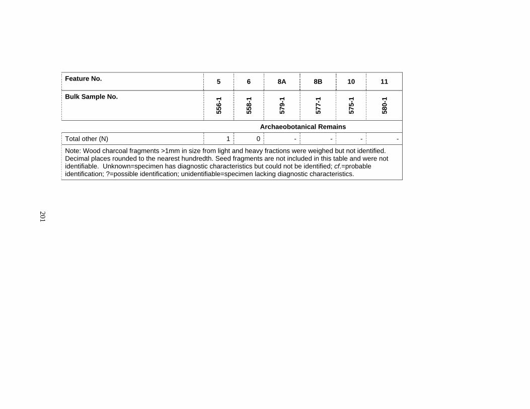
201
Feature No. 5 6 8A 8B 10 11
Bulk Sample No.
556-
1
558-
1
579-
1
577-
1
575-
1
580-
1
Archaeobotanical Remains
Total other (N) 1 0 - - - -
Note: Wood charcoal fragments >1mm in size from light and heavy fractions were weighed but not identified. Decimal places rounded to the nearest hundredth. Seed fragments are not included in this table and were not identifiable. Unknown=specimen has diagnostic characteristics but could not be identified; cf.=probable identification; ?=possible identification; unidentifiable=specimen lacking diagnostic characteristics.

202
Appendix G: Lithic Artifacts Excavated from the Ferry House Site on Ebey's Prairie in 2001 to 2004 Field Seasons
NOCA Catalog No. or Field Bag No.
Unit Level Lithic Material Artifact category
Total Notes
525 n/a Surface Indeterminate Flaked cobble 1
525 n/a Surface Dacite Flake 1 Interior1
665 TU 1 2 Dacite Flake 1 Interior
725 TU 4 2 Chert Flake 1 Secondary2
n/a TU 6 2 Granitic Flaked cobble 1 Feature 1
n/a TU 6 2 Granitic Pecked, ground, and fire-modified cobble
1 Feature 1
n/a TU 6 2 Granitic Core 1 Feature 1 contents
n/a TU 6 2 Granitic FMR3 1 Feature 1 contents
n/a TU 6 2 Indeterminate FMR 3 Feature 1 contents
1254 TU 6 3 Metasediment Shatter and FMR 1 With cortex
791 TU 6 4 Granitic Flake 1 Primary4
792 TU 6 4 Metasediment Flake 1 Interior
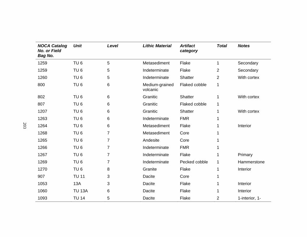
203
NOCA Catalog No. or Field Bag No.
Unit Level Lithic Material Artifact category
Total Notes
1259 TU 6 5 Metasediment Flake 1 Secondary
1259 TU 6 5 Indeterminate Flake 2 Secondary
1260 TU 6 5 Indeterminate Shatter 2 With cortex
800 TU 6 6 Medium-grained volcanic
Flaked cobble 1
802 TU 6 6 Granitic Shatter 1 With cortex
807 TU 6 6 Granitic Flaked cobble 1
1207 TU 6 6 Granitic Shatter 1 With cortex
1263 TU 6 6 Indeterminate FMR 1
1264 TU 6 6 Metasediment Flake 1 Interior
1268 TU 6 7 Metasediment Core 1
1265 TU 6 7 Andesite Core 1
1266 TU 6 7 Indeterminate FMR 1
1267 TU 6 7 Indeterminate Flake 1 Primary
1269 TU 6 7 Indeterminate Pecked cobble 1 Hammerstone
1270 TU 6 8 Granite Flake 1 Interior
907 TU 11 3 Dacite Core 1
1053 13A 3 Dacite Flake 1 Interior
1060 TU 13A 6 Dacite Flake 1 Interior
1093 TU 14 5 Dacite Flake 2 1-interior, 1-

204
NOCA Catalog No. or Field Bag No.
Unit Level Lithic Material Artifact category
Total Notes
secondary
1093 TU 14 5 Dacite Shatter 1 With cortex
1126 TU 15 3 Indeterminate FMR 1
1130 TU 15 5 Dacite Flake 1 Secondary
1130 TU 15 5 Indeterminate FMR 1
1168 TU 16 4 Dacite Flake 1 Interior
1164 TU 16 5 Dacite Flake 1 Interior
1164 TU 16 5 Indeterminate Shatter 2 Without cortex
1166 TU 16 7 Volcanic Shatter 1 Without cortex
1201 TU 17 5 Granitic Ground cobble 1
1207 TU 17 7 Probably dacite Biface 1
1223 TU 18A 2 Dacite Flake 1 Secondary
1705 TU 18 1 Indeterminate Flake 1 Secondary
1715 TU 18 1 Metasediment Core & FMR 1 Bipolar
1735 TU 18 5A Greenstone Core 1
1740 TU 18 6 Medium-grained crystalline
Flake 1 Interior
1219 TU 19 1 Dacite Flake 1 Secondary
1245 TU 19 3 Dacite Uniface 1
1245 TU 19 3 Chert Flake 1 Secondary
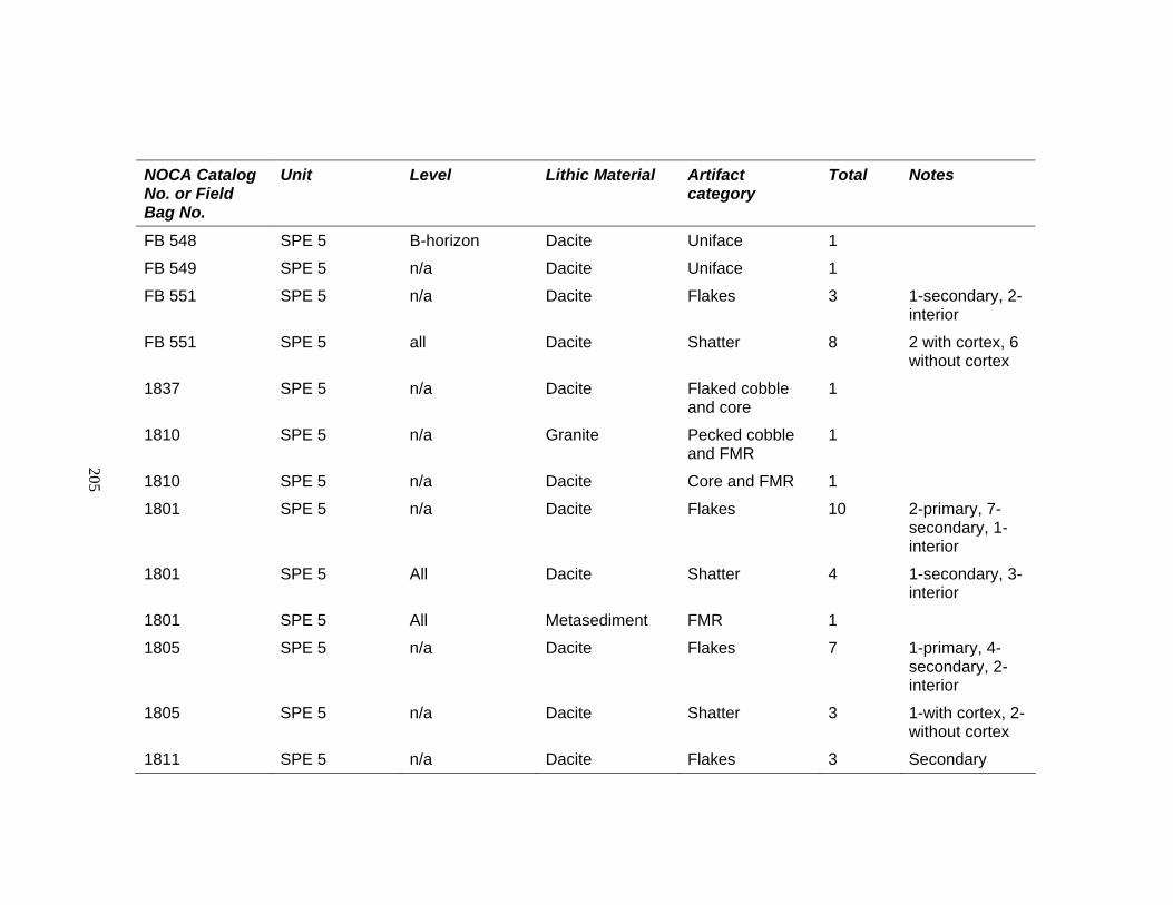
205
NOCA Catalog No. or Field Bag No.
Unit Level Lithic Material Artifact category
Total Notes
FB 548 SPE 5 B-horizon Dacite Uniface 1
FB 549 SPE 5 n/a Dacite Uniface 1
FB 551 SPE 5 n/a Dacite Flakes 3 1-secondary, 2-interior
FB 551 SPE 5 all Dacite Shatter 8 2 with cortex, 6 without cortex
1837 SPE 5 n/a Dacite Flaked cobble and core
1
1810 SPE 5 n/a Granite Pecked cobble and FMR
1
1810 SPE 5 n/a Dacite Core and FMR 1
1801 SPE 5 n/a Dacite Flakes 10 2-primary, 7-secondary, 1-interior
1801 SPE 5 All Dacite Shatter 4 1-secondary, 3-interior
1801 SPE 5 All Metasediment FMR 1
1805 SPE 5 n/a Dacite Flakes 7 1-primary, 4-secondary, 2-interior
1805 SPE 5 n/a Dacite Shatter 3 1-with cortex, 2-without cortex
1811 SPE 5 n/a Dacite Flakes 3 Secondary
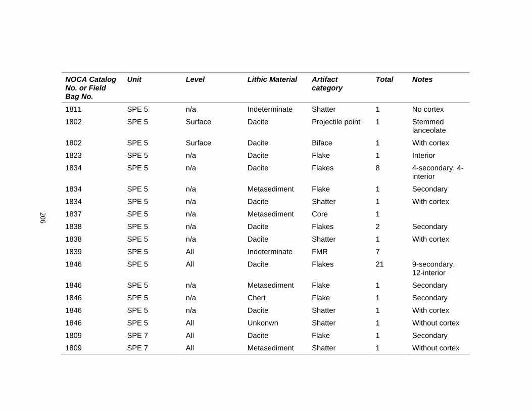
206
NOCA Catalog No. or Field Bag No.
Unit Level Lithic Material Artifact category
Total Notes
1811 SPE 5 n/a Indeterminate Shatter 1 No cortex
1802 SPE 5 Surface Dacite Projectile point 1 Stemmed lanceolate
1802 SPE 5 Surface Dacite Biface 1 With cortex
1823 SPE 5 n/a Dacite Flake 1 Interior
1834 SPE 5 n/a Dacite Flakes 8 4-secondary, 4-interior
1834 SPE 5 n/a Metasediment Flake 1 Secondary
1834 SPE 5 n/a Dacite Shatter 1 With cortex
1837 SPE 5 n/a Metasediment Core 1
1838 SPE 5 n/a Dacite Flakes 2 Secondary
1838 SPE 5 n/a Dacite Shatter 1 With cortex
1839 SPE 5 All Indeterminate FMR 7
1846 SPE 5 All Dacite Flakes 21 9-secondary, 12-interior
1846 SPE 5 n/a Metasediment Flake 1 Secondary
1846 SPE 5 n/a Chert Flake 1 Secondary
1846 SPE 5 n/a Dacite Shatter 1 With cortex
1846 SPE 5 All Unkonwn Shatter 1 Without cortex
1809 SPE 7 All Dacite Flake 1 Secondary
1809 SPE 7 All Metasediment Shatter 1 Without cortex

207
NOCA Catalog No. or Field Bag No.
Unit Level Lithic Material Artifact category
Total Notes
1989 SPE 8 1 Dacite Projectile point 1 Stemmed, triangular
17 TR A n/a Quartzite Flaked cobble 1
51 TR 1 n/a Indeterminate Flaked cobble and core
1
51 TR 1 n/a Indeterminate Flake 1 Primary
92 TR 4 n/a Granitic Ground cobble 1
114 TR 4 n/a Indeterminate Flake 1 Primary
114 TR 4 n/a Dacite Flake 1 Interior
115 TR 4 n/a Chalcedony Flake 1 Interior
116 TR 4 n/a Dacite Projectile point 1
134 TR 5 n/a Dacite Flake 2 1-primary, 1-interior
174 TR 8 n/a Indeterminate Ground cobble 1
542 TR 22 n/a Indeterminate Flaked and pecked cobble
1
543 TR 22 n/a Dacite Flake 1 Secondary
437 TR 25 n/a Metasediment Flake 1 Secondary
437 TR 25 n/a Indeterminate Flaked and pecked cobble
1
437 TR 25 n/a Indeterminate FMR 2

208
NOCA Catalog No. or Field Bag No.
Unit Level Lithic Material Artifact category
Total Notes
470 TR 26 n/a Dacite Flake 3 1-primary, 1-secondary, 1-interior
470 TR 26 n/a Indeterminate Flake 2 Secondary
471 TR 26 n/a Quartzite Core 1
473 TR 26 n/a Medium-grained volcanic
Flaked cobble 1
947 TR 26 n/a Dacite Flake 2 Secondary
948 TR 26 n/a Indeterminate Flaked cobble 2
491 TR 27 n/a Dacite Flake 1 Interior
956 TR 28 n/a Indeterminate Flaked cobble 1
600 TR 29 n/a Dacite Flake 1 Interior
618 TR 31 n/a Indeterminate Pecked cobble 1
634 TR 32 n/a Dacite Flake 1 Interior
635 TR 32 n/a Indeterminate Pecked cobble 1
646 TR 33 n/a Quartzite Core 1
986 TR 35 n/a Quartzite Shatter 1 With cortex
995 TR 36 n/a Dacite Core 1
278 FT 14 n/a Indeterminate Ground cobble 1
1274 EU 1 1 Indeterminate FMR 2
1470 EU 1 1 Probably dacite FMR 1
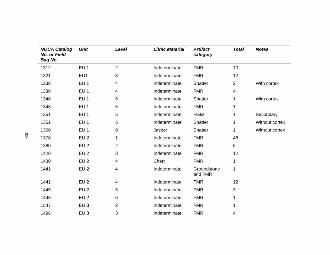
209
NOCA Catalog No. or Field Bag No.
Unit Level Lithic Material Artifact category
Total Notes
1312 EU 1 2 Indeterminate FMR 10
1321 EU1 3 Indeterminate FMR 12
1338 EU 1 4 Indeterminate Shatter 2 With cortex
1338 EU 1 4 Indeterminate FMR 4
1348 EU 1 5 Indeterminate Shatter 1 With cortex
1348 EU 1 5 Indeterminate FMR 1
1351 EU 1 5 Indeterminate Flake 1 Secondary
1351 EU 1 5 Indeterminate Shatter 1 Without cortex
1360 EU 1 8 Jasper Shatter 1 Without cortex
1378 EU 2 1 Indeterminate FMR 46
1380 EU 2 2 Indeterminate FMR 6
1420 EU 2 3 Indeterminate FMR 12
1430 EU 2 4 Chert FMR 1
1441 EU 2 4 Indeterminate Groundstone and FMR
1
1441 EU 2 4 Indeterminate FMR 12
1445 EU 2 5 Indeterminate FMR 3
1448 EU 2 6 Indeterminate FMR 1
1547 EU 3 2 Indeterminate FMR 1
1496 EU 3 3 Indeterminate FMR 4
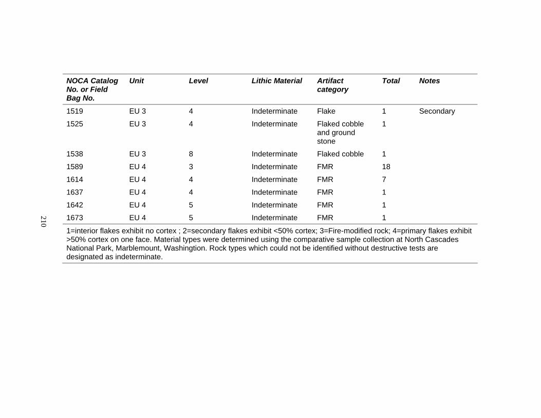
210
NOCA Catalog No. or Field Bag No.
Unit Level Lithic Material Artifact category
Total Notes
1519 EU 3 4 Indeterminate Flake 1 Secondary
1525 EU 3 4 Indeterminate Flaked cobble and ground stone
1
1538 EU 3 8 Indeterminate Flaked cobble 1
1589 EU 4 3 Indeterminate FMR 18
1614 EU 4 4 Indeterminate FMR 7
1637 EU 4 4 Indeterminate FMR 1
1642 EU 4 5 Indeterminate FMR 1
1673 EU 4 5 Indeterminate FMR 1
1=interior flakes exhibit no cortex ; 2=secondary flakes exhibit <50% cortex; 3=Fire-modified rock; 4=primary flakes exhibit >50% cortex on one face. Material types were determined using the comparative sample collection at North Cascades National Park, Marblemount, Washingtion. Rock types which could not be identified without destructive tests are designated as indeterminate.