Embed Size (px)
Citation preview
Explori Texa E rng s co egi no s
Vickie Dunlevy SmithFulmore Middle School, Austin
Texas Parks and Wildlife Department4200 Smith School Road
Austin, Texas 78744
Linda S. CampbellTexas Parks and Wildlife Department
Endangered Resources BranchAustin, Texas
PWD BK R3000-030 (1/96)
Dispersal of this publication conforms withTexas State Documents Depository Law,and it is available at Texas State PublicationsClearinghouse and/or Texas Depository Libraries.
INTRODUCTION
The purpose of this curriculum guide is to explore the natural and cultural resources that existin each of the eleven natural regions or ecoregions of Texas. The purpose is to familiarizestudents with the resources of their state so that they will be better prepared to make informedchoices regarding natural and cultural resource management and stewardship. The curriculumis written for students in grades 4 through 7. Both fourth and seventh grade curricula includethe study of Texas history. Units on endangered species are often taught during the fifth orsixth grade year.
The goals of the curriculum guide are for students to:1. Become familiar with regional ecosystems2. Discern the ecological reasons for the unique attributes of each ecoregion3. Understand the importance of diversity in living communities4. Detect symbiotic relationships among particular Texas organisms5. Understand the interdependency of humans and natural systems6. Understand factors relating to the decline of some native plants and animals7. Learn about the people that have shaped the character of Texas
This guide can be used to supplement state adopted text books and materials. It can also serveas an integrated unit with social studies, language arts, and math. The activities can be used inconjunction with the study of Texas history. Finally, the guide can be used as the basis forteaching separate units on ecology, natural regions, or endangered and threatened plants andanimals of Texas.
Format of the guide:1. Descriptions of the Natural Regions of Texas2. Ecoregion Map3. Table - Features of the Natural Regions of Texas4. Lesson Plan5. Suggested Questions from Ecoregion Video6. Evaluation Activity7. Appendix I - References and Resources8. Appendix II - Other Suggested Activities for Daily Lesson Planning
This curriculum guide is written as a seven to ten day unit to enable teachers and students toexplore the vast natural resources, ecoregions, and heritage of Texas. The materials integratescience, social studies, language arts, and math. The eleven natural regions of Texas arefeatured in table format describing each region's size, topography, annual rainfall, vegetation,and rare plants and animals. A map of Texas divided into the ecoregions is provided forreference. The Texas Eco Trivia Game provides a tool for authentic assessment. A video,entitled "Ecoregions of Texas," describes the regions in seven, 10 minute segments. Eachsegment focuses on the unique cultural and natural heritage of the region. The
, available from Texas Parks and Wildlife, can be used toaccompany this curriculum guide.
TexasEndangered Species Activity Book
BACKGROUND INFORMATION
The organization of Texas into ecoregions or natural regions enables us to inform studentsabout the diverse areas of Texas in an distinct way. By studying the similarities and differencesof the various natural regions, students gain a practical and relevant perspective concerninghow nature (rainfall, geology, plants and animals) and humans throughout history have shapedthe Texas we know today.
Due to its size and geographic location, Texas is unique among states. Covering 266,807 sq.miles, 15 of the 50 states could fit within its borders. A large area of land will usually have agreat deal of variation in climate and landscapes, factors influencing habitat diversity. The statehas impressive topographic diversity, including 91 mountain peaks that are a mile or morehigh. Our geographic location is also important in that eastern habitats meet western ones andsouthern subtropical habitats meet northern temperate ones.
The natural regions of Texas look different from one another, both in terms of the living aspects(plant and animal communities) and the non-living attributes (topography, geology, soils).Texas is divided into the following eleven natural regions:
1. Pineywoods2. Oak Woods and Prairies3. Blackland Prairies4. Gulf Coast Prairies and Marshes5. Coastal Sand Plains6. South Texas Brush Country7. Edwards Plateau8. Llano Uplift9. Rolling Plains10. High Plains11. Trans Pecos
The accompanying table entitled highlights the uniquefeatures of each ecoregion, such as size, topography, rainfall, soil types, predominantvegetation, native plant communities, and rare plants and animals.
It may be convenient to group some ecoregions in order to satisfy a 7 or 10 day schedule. Thebrackets on the list above suggest one way to group the natural regions for study. Aninterdisciplinary approach may be used by teaching the science portion of the unit in parallelwith social studies, integrating the cultural aspects and geography of the regions into the socialstudies curriculum.
The following is a brief description of each of the ecoregions of Texas.
Features of the Natural Regions of Texas
[[
[[
Region 1: Pineywoods
Region 2: Oak Woods and Prairies
Region 3: Blackland Prairies
Rolling terrain covered with pines and oaks, and rich bottomlands with tall hardwoods,characterize the forests of the east Texas Pineywoods. This region is part of a much larger areaof pine-hardwood forest that extends into Louisiana, Arkansas, and Oklahoma.
The average annual rainfall of 36 to 50 inches is fairly uniformly distributed throughout theyear, and humidity and temperatures are typically high. The soils of the region are generallyacidic and mostly pale to dark gray sands or sandy loams. Elevations range from 200 to 500 feetabove sea level.
The Pineywoods region can be described as pine and pine-hardwood forests with scatteredareas of cropland, planted pastures, and native pastures. Timber and cattle production areimportant industries in the region. Farms and ranches are relatively small in size compared tothe state average.
Longleaf pine forests once dominated the southeastern part of the Pineywoods. A few pocketsof longleaf pine may still be seen today. Mixed pine-oak forests occur to the west and north ofthe longleaf pine area. Dominant trees include loblolly pine, blackjack oak, and post oak.Hardwood forests of sweetgum, magnolia, tupelo, elm, and ash occur in the lowlands. Swampsare common and are most outstanding in the southern part of the pine-oak forest.
The Oak Woods and Prairies region is a transitional area for many plants and animals whoseranges extend northward into the Great Plains or eastward into the forests. This region,sometimes called the Cross-Timbers, was named by early settlers, who found belts of oak forestcrossing strips of prairie grassland.
Average annual rainfall averages 28 to 40 inches per year. May or June usually brings a peak inmonthly rainfall. Upland soils are light colored, acidic sandy loam or sands. Bottomland soilsmay be light brown to dark gray and acidic with textures ranging from sandy loams to clays.The landscape of the region is gently rolling to hilly and elevations range from 300 to 800 feetabove sea level.
The region can be described as oak savannah, where patches of oak woodland are interspersedwith grassland. Cattle ranching is the major agricultural industry in the Oak Woods andPrairies. Introduced grasses such as bermudagrass are grazed along with forage crops andnative grasslands.
The Blackland Prairies region is named for the deep, fertile black soils that characterize the area.Blackland Prairie soils once supported a tallgrass prairie dominated by tall-growing grassessuch as big bluestem, little bluestem, indiangrass, and switchgrass. Because of the fertile soils,much of the original prairie has been plowed to produce food and forage crops.
The average annual rainfall ranges from 28 to 40 inches. May is the peak rainfall month for thenorthern end of the region; however, the south-central part has a fairly uniform rainfalldistribution throughout the year. Typically, soils are uniformly dark-colored alkaline clays,often referred to as "black gumbo," interspersed with some gray acidic sandy loams. Thelandscape is gently rolling to nearly level, and elevations range from 300 to 800 feet above sealevel.
Crop production and cattle ranching are the primary agricultural industries.
The Gulf Coast Prairies and Marshes region is a nearly level, slowly drained plain less than 150feet in elevation, dissected by streams and rivers flowing into the Gulf of Mexico. The regionincludes barrier islands along the coast, salt grass marshes surrounding bays and estuaries,remnant tallgrass prairies, oak parklands and oak mottes scattered along the coast, and tallwoodlands in the river bottomlands.
Average annual rainfall varies from 30 to 50 inches per year distributed fairly uniformlythroughout the year. The growing season is usually more than 300 days, with high humidityand warm temperatures. Soils are acidic sands and sandy loams, with clays occurring primarilyin the river bottoms.
Native vegetation consists of tallgrass prairies and live oak woodlands. Brush species such asmesquite and acacias are more common now than in the past. Although much of the nativehabitat has been lost to agriculture and urbanization, the region still provides important habitatfor migratory birds and spawning areas for fish and shrimp.
The Coastal Sand Plains is fairly level with elevations less than 150 feet above sea level. Averageannual rainfall is 24 to 28 inches per year and the soils are primarily windblown sands. Thevegetation can be described as tallgrass prairie with live oak woodlands, mesquite savannah, andsalt marshes. Woody vegetation is more extensive now than in pre-settlement times.
Most of this region is grazed by cattle. In the past, the Coastal Sand Plains were called the "WildHorse Prairie" because of the large herds of feral horses roaming here in the 19th century.
The South Texas Brush Country is characterized by plains of thorny shrubs and trees andscattered patches of palms and subtropical woodlands in the Rio Grande Valley. The plains wereonce covered with open grasslands and a scattering of trees, and the valley woodlands were oncemore extensive. Today, the primary vegetation consists of thorny brush such as mesquite, acacia,and prickly pear mixed with areas of grassland.
The average annual rainfall of 20 to 32 inches increases from west to east. Average monthlyrainfall is lowest during winter, and highest during spring (May or June) and fall (September).
Region 4: Gulf Coast Prairies and Marshes
Region 5: Coastal Sand Plains
Region 6: South Texas Brush Country
Summer temperatures are high, with very high evaporation rates. Soils of the region are alkalineto slightly acidic clays and clay loams. The deeper soils support taller brush, such as mesquiteand spiny hackberry, whereas short, dense brush characterizes the shallow caliche soils.
Although many land changes have occurred in this region, the Brush Country remains rich inwildlife and a haven for many rare species of plants and animals. It is home for semi-tropicalspecies that occur in Mexico, grassland species that range northward, and desert speciescommonly found in the Trans-Pecos.
Livestock grazing and crop production are the principal agricultural land uses.
The Edwards Plateau region comprises an area of central Texas commonly known as the TexasHill Country. It is a land of many springs, stony hills, and steep canyons. The region is home to awhole host of rare plants and animals found nowhere else on earth.
Average annual rainfall ranges from 15 to 34 inches. Rainfall is highest in May or June andSeptember. Soils of the Edwards Plateau are usually shallow with a variety of surface textures.They are underlain by limestone. Elevations range from slightly less than 100 feet to over 3,000feet above sea level. Several river systems dissect the surface, creating a rough and well-drainedlandscape.
The limestone of the Edward's Plateau is honeycombed with thousands of caves. Beneath theeastern edge of the Plateau lies a hidden world of underground lakes known as the EdwardsAquifer. This precious water resource also is home to a number of curious creatures, such as theblind salamander.
Today, the Edwards Plateau is characterized by grasslands, juniper/oak woodlands, and plateaulive oak or mesquite savannah. Open grasslands and savannahs were more common in pre-settlement times than they are today. Ranching is the primary agricultural industry in the region.
The Llano Uplift is also known as the central mineral region. Although surrounded by theEdwards Plateau region, the Llano Uplift is distinguished by its unique geology. Home to someof the oldest rocks in Texas, the central mineral region contains unique minerals and rockformations. The region is characterized by large granite domes, such as Enchanted Rock nearFredericksburg.
Rainfall averages about 24 to 32 inches per year, peaking in May or June and September. Thelandscape is rolling to hilly and elevation range from 825 to 2,250 feet above sea level. Soils arepredominantly coarse textured sands, produced from weathered granite over thousands of years.
Native vegetation consists of oak-hickory or oak-juniper woodlands, mesquite-mixed brushsavannah, and grasslands. Open grassland and savannah were once more common than they aretoday. Ranching is the predominant agricultural industry.
Region 7: Edwards Plateau
Region 8: Llano Uplift
Region 9: Rolling Plains
Region 10: High Plains
Several Texas rivers begin in the gently rolling hills and broad flats of the Rolling Plains. Theserivers and their numerous tributaries are responsible for the rolling character of the land. Therivers have cut canyons that shelter some plants and animals typical of the Rocky Mountains.
Average annual rainfall is 20 to 28 inches, with peaks in May and September. A summer dryperiod with high temperatures and high evaporation rates is typical. Soils vary from coarsesands along outwash terraces adjacent to streams, to tight clays and shales. Soil reaction isneutral to slightly alkaline. Elevations vary from 800 to 3,000 feet above sea level.
The original prairie grasslands included tall and mid-grasses such as bluestems and gramas.Buffalo grass and other shortgrasses have increased under heavy, uncontrolled grazing. Mesquiteis a common invader on all soils. Much of the Rolling Plains today can be described as amesquite-shortgrass savannah. Stream floodplains are dominated by various hardwood species,and juniper is common on steep slopes along rivers.
Steep slopes, cliffs, and canyons occurring just below the edge of the High Plains Caprockcomprise the Escarpment Breaks area of the Rolling Plains. The Breaks are an ecotone ortransition zone between the High Plains grasslands and the mesquite savannah of the RollingPlains. Crop and livestock production are the major agricultural industries in this region.
The High Plains region, together with the Rolling Plains, comprise the southern end of the GreatPlains of the central United States. The High Plains is a relatively level high plateau, separatedfrom the Rolling Plains by the Caprock Escarpment. Elevations range from 3,000 to 4,500 feetabove sea level.
Average annual rainfall is 15 to 22 inches. Rainfall is lowest in winter and mid-summer andhighest in April or May and September or October. Extended droughts have occurred hereseveral times this century. Surface texture of soils ranges from clays on hardland sites in thenorth to sands in the southern portion of the region. Caliche generally underlies these surfacesoils at depths of two to five feet.
Native vegetation of the High Plains is shortgrass prairie dominated by buffalo grass. Althoughhistorically a grassland, mesquite and yucca have invaded parts of the region. Shinnery oak andsand sage are common invaders on sandy lands, and juniper has spread from the breaks onto theplains in some areas.
Immense herds of buffalo and pronghorn antelope once thundered across vast prairies of bluegrama and buffalo grass. Today, the plains are mostly irrigated cropland and the nativevegetation includes more mesquite and juniper. Although much of the shortgrass prairie and thevast prairie dog towns are gone, large flocks of wintering waterfowl still come to the playa lakes(shallow, round depressions which spot the surface, sometimes covering more than 40 acres).
Region 11: Trans Pecos
The Trans Pecos is perhaps the most complex of all the regions. It occupies the extreme westernpart of the state eastward generally to the Pecos River. This is a region of diverse habitats andvegetation, varying from the desert valleys and plateaus to wooded mountain slopes.Elevations range from 2,500 feet to more than 8,749 feet at Guadalupe Peak. Even the mountainranges vary greatly in the environments they offer for plant and animal life. Some arecharacterized by volcanic rocks, others by limestone.
Over most of the area average annual rainfall is less than 12 inches, but varies greatly from yearto year and from lower to higher elevations. July and August are usually the higher rainfallmonths. Mountain outwash materials have formed the soils of the Trans Pecos. Surface texturesand profile characteristics are varied. Soil reaction is generally alkaline.
Due to the diversity of soils and elevations, many vegetation types exist in the region. Theprincipal plant communities are creosote-tarbush desert scrub, desert grassland, yucca andjuniper savannahs, and montane forests of pinon pine and oak.
The various subregions reflect the diversity of the Trans Pecos. The Sand Hills area consists ofshin oak and mesquite on wind-blown dunes. Flat-topped mesas and plateaus are intersectedby steep-walled canyons and dry washes that comprise the Stockton Plateau. Soils with highsalt content and gypsum dunes are typical of the Salt Basin area. The Desert Scrub subregion isan area of low rainfall and rapid drainage. Creosotebush flats with yucca, lechuguilla, andvarious small-leafed plants are common. The Desert Grassland area occurs in the central part ofthe region and is characterized by deeper soils with high clay content. Finally, the MountainRanges have higher rainfall and woody vegetation such as junipers, oaks, pinon pine,ponderosa pine, and Douglas fir.
Ranching is the primary industry in the Trans Pecos region.
DAILY LESSON PLAN
Students will be able to:1. Distinguish the ecoregions of Texas by the natural features they contain2. Identify on the Texas map approximately where each ecoregion is located3. Recognize the diverse cultural and natural history of Texas4. Explain why plants and animals need a certain kind of habitat to survive5. Name some rare plants or animals found in each ecoregion6. Define the term "endangered" with regard to plant and animal species
One or two natural regions will be discussed each day. Grouping the eleven natural regions asfollows will enable teachers to complete seven units in seven class sessions.
Day 1 Piney WoodsDay 2 Oak Woods and Prairies & Blackland PrairiesDay 3 Gulf Coast Prairies and Marshes & Coastal Sand PlainsDay 4 South Texas Brush CountryDay 5 Edwards Plateau & Llano UpliftDay 6 Rolling Plains & High PlainsDay 7 Trans Pecos
The teacher will supply the tables and maps for students to complete as required. Teachers maywish to leave portions of the table blank for students to complete by taking notes. The amountleft blank, if any, would vary by grade level and ability. Students should color the appropriateregion on the map as each ecoregion is discussed. Activities from the
can be used to supplement lessons on specific regions. The video,, has a ten minute feature for each of the seven ecoregion groupings.
Students should keep the tables, map, and notes in a notebook or a section of their notebook tobe used as references for the final evaluation.
Critter/Plant of the Day and Features of the Natural Regions of Texas tablesEcoregions of Texas mapEcoregions of Texas video
1. Daily WARM-UP with Critter/Plant of the DayTo begin the unit each day, use an animal or plant example from the specific ecoregion to be
discussed. The example can be as simple as a laminated photograph of a particular species ofplant or animal or a living specimen such as a grasshopper in a plastic jar. Pass this samplearound the class in an assigned rotation to permit each student a close look. Describe the historyof the object in a way to peak curiosity and show the special nature of each region. Students canjot down interesting facts about the organism on the Critter of the Day table. Examples of itemsto bring might include pine needles and pine cones from the Pineywoods, interesting rocks
OBJECTIVES
METHOD
MATERIALS
PROCEDURE
Texas EndangeredSpecies Activity Book EcoRegions of Texas
Texas Endangered Species Activity Book
from the Trans Pecos, shells from the Gulf Coast, photos of the Texas Blind Salamander orBlack-capped Vireo for the Edwards Plateau, or mesquite leaves or pricklypear pads from theSouth Texas Brush Country. Teachers may also want to have students bring examples of plantsand animals that can be found locally for the class to name and learn about.
2. After a short introduction of the unit (see description of each region, use critter/plant of theday, or show video segment of the region), each student will receive the ecoregion map and theblank table entitled . Students can take notes bycompleting the blank table as the teacher provides information and leads discussions on eachecoregion.
3. The map can be colored to coordinate with the video as follows:Piney Woods - greenOak Woods and Prairies & Blackland Prairies - blackGulf Coast Prairies and Marshes & Coastal Sand Plains - blueSouth Texas Brush Country - yellowEdwards Plateau & Llano Uplift - purpleRolling Plains & High Plains - redTrans Pecos - brown
4. Choose the activity from the which corresponds tothe region being discussed:
Piney Woods - p. 13, the Red-cockaded WoodpeckerOak Woods and Prairies - p. 44, the Houston ToadGulf Coast Prairies and Marshes - p. 37, the Whooping CraneSouth Texas Brush Country - p. 34, the OcelotHigh Plains - p. 4, the Black-footed FerretTrans Pecos - p. 22, the Greater Long-nosed Bat
5. To integrate math concepts and skills, have students graph the size and/or annual rainfalldata for each ecoregion. Teachers may want to have students work together in small groupsand check their work with others.
6. After viewing the video and upon completion of the tables, map, and activities have studentsdiscuss why some plants and animals are rare or have become endangered.What are some things people can do to help endangered species?
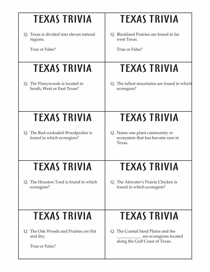
is a trivia game used as a final evaluation of the unit.
Features of the Natural Regions of Texas
Texas Endangered Species Activity Book
Texas Eco TriviaEVALUATION
DAY 3: GULF COAST PRAIRIES AND MARSHES AND COASTAL SAND PLAINS
DAY 4: SOUTH TEXAS BRUSH COUNTRY
DAY 5: EDWARDS PLATEAU AND LLANO UPLIFT
DAY 6: ROLLING PLAINS AND HIGH PLAINS
WHEEL OF TROUBLE
ARE YOU ME?
IDENTIFYING SOME COMMON SHRUBS AND TREES
TOOTHPICK CAMOUFLAGE
AQUIFERS AND SPRINGS AND PROTOZOA AND GREEN ALGAE IN A TEXAS POND
DESCRIBING A TEXAS PLANT COMMUNITY
WHAT ORGANISM AM I?
From , this activity addresses why sea turtles are endangered.
From , this activity challenges students to match the various larval and juvenilestages of aquatic animals to their corresponding adult form.
From . Students learn to use a dichotomous key to identify plants.Besides learning a basic science skill, students can be challenged to create and use keys toidentify plants in their local area.
From . This activity shows howadaptations such as camouflage help animals like the Ocelot and Jaguarundi survive in theirdense brushy habitat, and how lack of cover decreases their chances of survival.
From . These activities will help students recognize the significanceof aquifers and springs, determine the environmental consequences of the loss of ground watercontained in aquifers, and observe the diversity of microscopic organisms found in local ponds.
From . This activity teaches the concept of a "plant community"and helps students learn about the composition of a plant community in their area. The activitycan be the basis for a discussion of plant communities in these ecoregions.
From . This activity integrates art into the basic science lesson.Species such as the Black-footed Ferret, Texas Horned Lizard, Prairie Dog, Plains Spotted Skunkor Swift Fox can be used in this activity to enhance awareness concerning the loss grasslandhabitat for these animals.
Nature Scope Endangered Species
Aquatic WILD
Texas Environmental Guide
Environmental Education Activities for Children and Youth
Texas Environmental Guide
Texas Environmental Guide
Texas Environmental Guide
DAY 7: TRANS PECOS
ADDITIONAL RELATED ACTIVITIES:
TEXAS CACTI, POLLINATION IN TEXAS FLOWERS, AND MAKING DYES FROM TEXAS
PLANTS
WILDLIFE 3
WATER
ENDANGERED SPECIES
FOOD CHAIN GAME
ECO-ACTING PROBLEM SOLVING
WILDLIFE 4
A TO Z WALK
MICROTREK TREASURE HUNT AND LITTER WE KNOW
From . These activities will introduce the Trans Pecos flora, helpcreate an awareness of Texas' cultural history, and help students recognize that materials usedin our everyday life have natural resource origins.
From NRCS , this activity integrates math byusing percentages to calculate the survival and reproduction rates of wildlife species.
From NRCS , this activity integrates math bydiscussing how varying rainfall amounts affect the environment.
From . This activity helps students develop an awareness ofendangered and threatened plant species of Texas.
From . This activity identifies theroles of individuals in a food chain and the proper proportions of individuals needed in a foodchain.
From . This activity has studentsuse given information, observation, inference, and nonverbal communication to recite an exactphrase.
From NRCS . This activity introduces termsfor use in describing aggregations of animals.
From . This activity requiresstudents to walk and record observations using all five senses. Observations are recorded usingwords starting with each letter of the alphabet.
Adapted from , this activity emphasizes observation and categorizing skills.
Texas Environmental Guide
Suggested Environmental Education Lesson Plans
Suggested Environmental Education Lesson Plans
Texas Environmental Guide
Environmental Education Activities for Children and Youth
Environmental Education Activities for Children and Youth
Suggested Environmental Education Lesson Plans
Environmental Education Activities for Children and Youth
Project WILD
MAKE A COAT!
DRAWING ON NATURE
WHERE'S MY BABY
From . In this activity, students learn that plants and animals are importantsources of clothing materials, both today and in the past. Students also collect and analyze datato infer the sources of most materials used in clothing today, and distinguish between someexamples of renewable and nonrenewable natural resources.
From , this activity integrates art so that students will be able to generalize thatwildlife and other animals are important inspiration for art as well as subjects of science.
From , this activity shows how mother free-tailed bats findtheir babies.
Project WILD
Project WILD
Educator's Activity Book About Bats
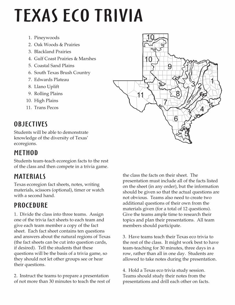
TEXAS ECO TRIVIA
OBJECTIVES
METHOD
MATERIALS
PROCEDURE
Students will be able to demonstrateknowledge of the diversity of Texas'ecoregions.
Students team-teach ecoregion facts to the restof the class and then compete in a trivia game.
Texas ecoregion fact sheets, notes, writingmaterials, scissors (optional), timer or watchwith a second hand.
1. Divide the class into three teams. Assignone of the trivia fact sheets to each team andgive each team member a copy of the factsheet. Each fact sheet contains ten questionsand answers about the natural regions of Texas(the fact sheets can be cut into question cards,if desired). Tell the students that thesequestions will be the basis of a trivia game, sothey should not let other groups see or heartheir questions.
2. Instruct the teams to prepare a presentationof not more than 30 minutes to teach the rest of
the class the facts on their sheet. Thepresentation must include all of the facts listedon the sheet (in any order), but the informationshould be given so that the actual questions arenot obvious. Teams also need to create twoadditional questions of their own from thematerials given (for a total of 12 questions).Give the teams ample time to research theirtopics and plan their presentations. All teammembers should participate.
3. Have teams teach their Texas eco trivia tothe rest of the class. It might work best to haveteam-teaching for 30 minutes, three days in arow, rather than all in one day. Students areallowed to take notes during the presentation.
4. Hold a Texas eco trivia study session.Teams should study their notes from thepresentations and drill each other on facts.
1. Pineywoods
2. Oak Woods & Prairies
3. Blackland Prairies
4. Gulf Coast Prairies & Marshes
5. Coastal Sand Plains
6. South Texas Brush Country
7. Edwards Plateau
8. Llano Uplift
9. Rolling Plains
10. High Plains
11. Trans Pecos
123
4
11
10
10
9
8
6
7
5
ASSESSMENT
ENRICHMENT
Ask students to name two important factsabout the ecoregions of Texas.
As a class, develop a board game based on theecoregions of Texas. Put the game in the libraryso other students may play and learn from it.
Create a list of terms that are significant in thestudy of the eco regions of Texas. Break theclass into two teams and play a version of"Pictionary" by having students illustrate theconcept/term while teammates guess. If theteam does not guess the correct term within acertain time frame, the other team can earnpoints if they guess the word.
The questions and answers from this gamemake great work station or independent deskactivity work when the questions and answersare copied separately, laminated and used asmatching flash cards.
5. Hold the Texas eco trivia competitionaccording to the following rules:
Each group asks all of their questions asa set. The order of the groups should bedecided randomly.Questions are directed to the remainingtwo teams on an alternating basis.A team has 30 seconds to discuss thequestion before they are required togive an answer (there should be somesort of official timer, whether it is astudent watching the clock, a mini-hourglass, etc.).One point is awarded for each correctanswer.The team with the most points wins.Tie-breaker questions should be used inthe case of a tie.
6. After the game is over, ask students toname the trivia facts they felt were mostimportant. List these on the board anddiscuss them in more detail.
�
�
�
�
�
TEXAS TRIVIA TEXAS TRIVIA
TEXAS TRIVIA TEXAS TRIVIA
TEXAS TRIVIA TEXAS TRIVIA
TEXAS TRIVIA TEXAS TRIVIA
TEXAS TRIVIA TEXAS TRIVIA
Q. Texas is divided into eleven naturalregions.
True or False?
Q. Blackland Prairies are found in farwest Texas.
True or False?
Q. The Pineywoods is located inSouth, West or East Texas?
Q. The tallest mountains are found in whichecoregion?
Q. The Red-cockaded Woodpecker isfound in which ecoregion?
Q. Name one plant community orecosystem that has become rare inTexas.
Q. The Houston Toad is found in whichecoregion?
Q. The Attwater's Prairie Chicken isfound in which ecoregion?
Q. The Oak Woods and Prairies are flatand dry.
True or False?
Q. The Coastal Sand Plains and the____________ are ecoregions locatedalong the Gulf Coast of Texas.
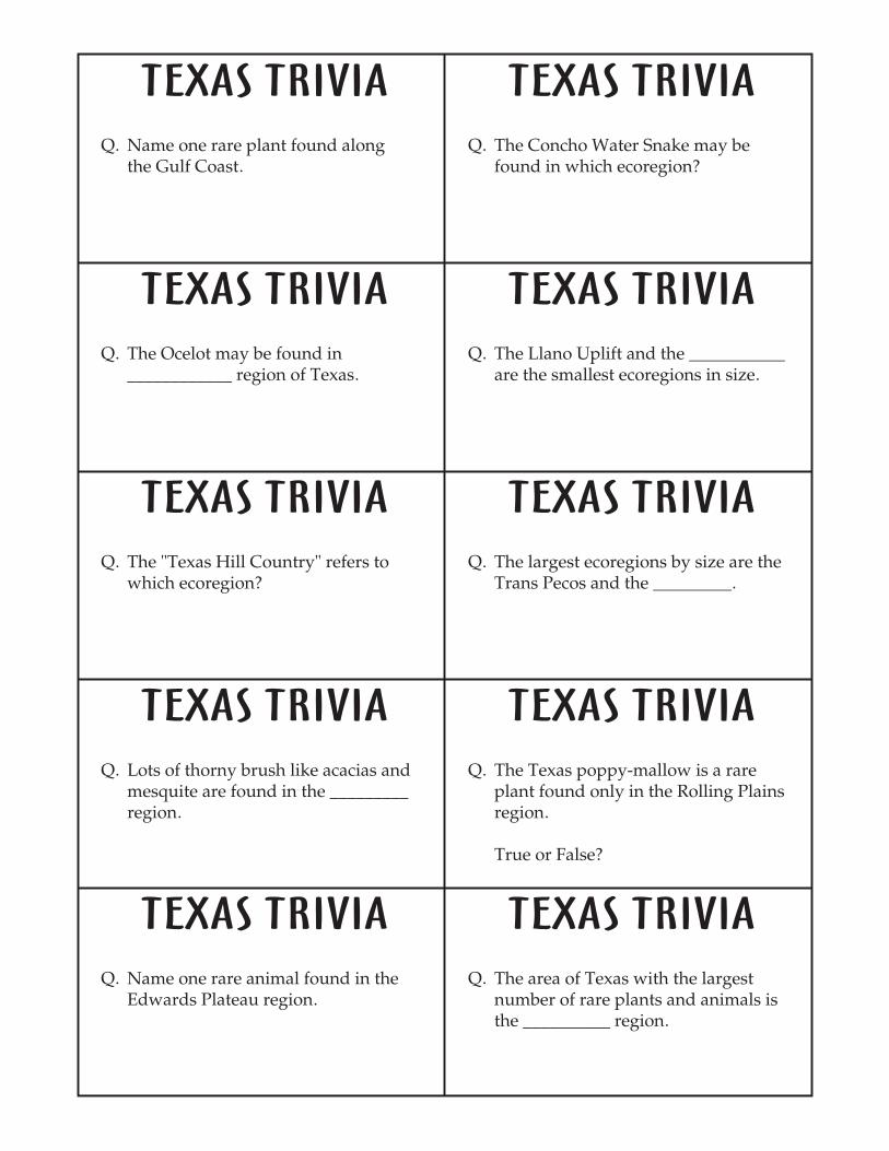
TEXAS TRIVIA TEXAS TRIVIA
TEXAS TRIVIA TEXAS TRIVIA
TEXAS TRIVIA TEXAS TRIVIA
TEXAS TRIVIA TEXAS TRIVIA
TEXAS TRIVIA TEXAS TRIVIA
Q. Name one rare plant found alongthe Gulf Coast.
Q. The Concho Water Snake may befound in which ecoregion?
Q. The Ocelot may be found in____________ region of Texas.
Q. The Llano Uplift and the ___________are the smallest ecoregions in size.
Q. The "Texas Hill Country" refers towhich ecoregion?
Q. The largest ecoregions by size are theTrans Pecos and the _________.
Q. Lots of thorny brush like acacias andmesquite are found in the _________region.
Q. The Texas poppy-mallow is a rareplant found only in the Rolling Plainsregion.
True or False?
Q. Name one rare animal found in theEdwards Plateau region.
Q. The area of Texas with the largestnumber of rare plants and animals isthe __________ region.
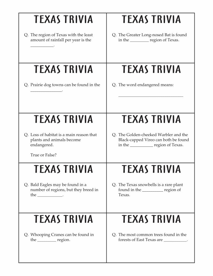
TEXAS TRIVIA TEXAS TRIVIA
TEXAS TRIVIA TEXAS TRIVIA
TEXAS TRIVIA TEXAS TRIVIA
TEXAS TRIVIA TEXAS TRIVIA
TEXAS TRIVIA TEXAS TRIVIA
Q. The region of Texas with the leastamount of rainfall per year is the___________.
Q. The Greater Long-nosed Bat is foundin the _________ region of Texas.
Q. Prairie dog towns can be found in the_______________.
Q. The word endangered means:
_______________________________
Q. Loss of habitat is a main reason thatplants and animals becomeendangered.
True or False?
Q. The Golden-cheeked Warbler and theBlack-capped Vireo can both be foundin the ___________ region of Texas.
Q. Bald Eagles may be found in anumber of regions, but they breed inthe ____________.
Q. The Texas snowbells is a rare plantfound in the __________ region ofTexas.
Q. Whooping Cranes can be found inthe _________ region.
Q. The most common trees found in theforests of East Texas are ___________.
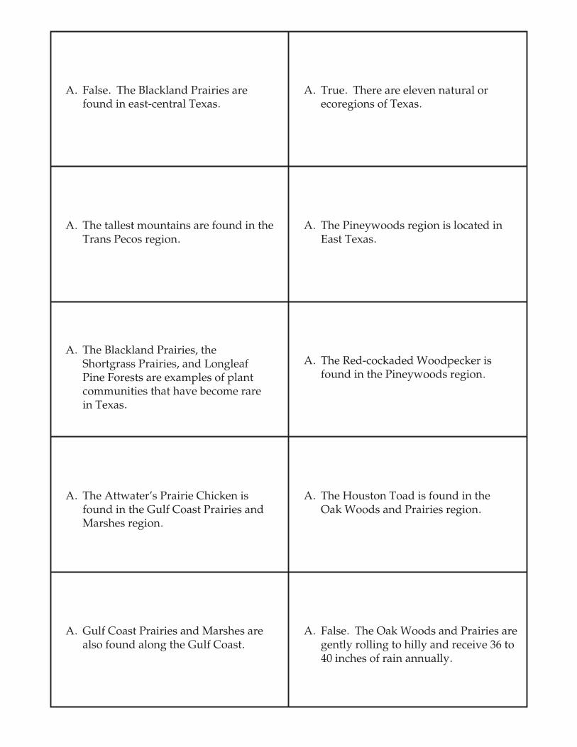
A. False. The Blackland Prairies arefound in east-central Texas.
A. True. There are eleven natural orecoregions of Texas.
A. The tallest mountains are found in theTrans Pecos region.
A. The Pineywoods region is located inEast Texas.
A. The Blackland Prairies, theShortgrass Prairies, and LongleafPine Forests are examples of plantcommunities that have become rarein Texas.
A. The Red-cockaded Woodpecker isfound in the Pineywoods region.
A. The Attwater's Prairie Chicken isfound in the Gulf Coast Prairies andMarshes region.
A. The Houston Toad is found in theOak Woods and Prairies region.
A. Gulf Coast Prairies and Marshes arealso found along the Gulf Coast.
A. False. The Oak Woods and Prairies aregently rolling to hilly and receive 36 to40 inches of rain annually.
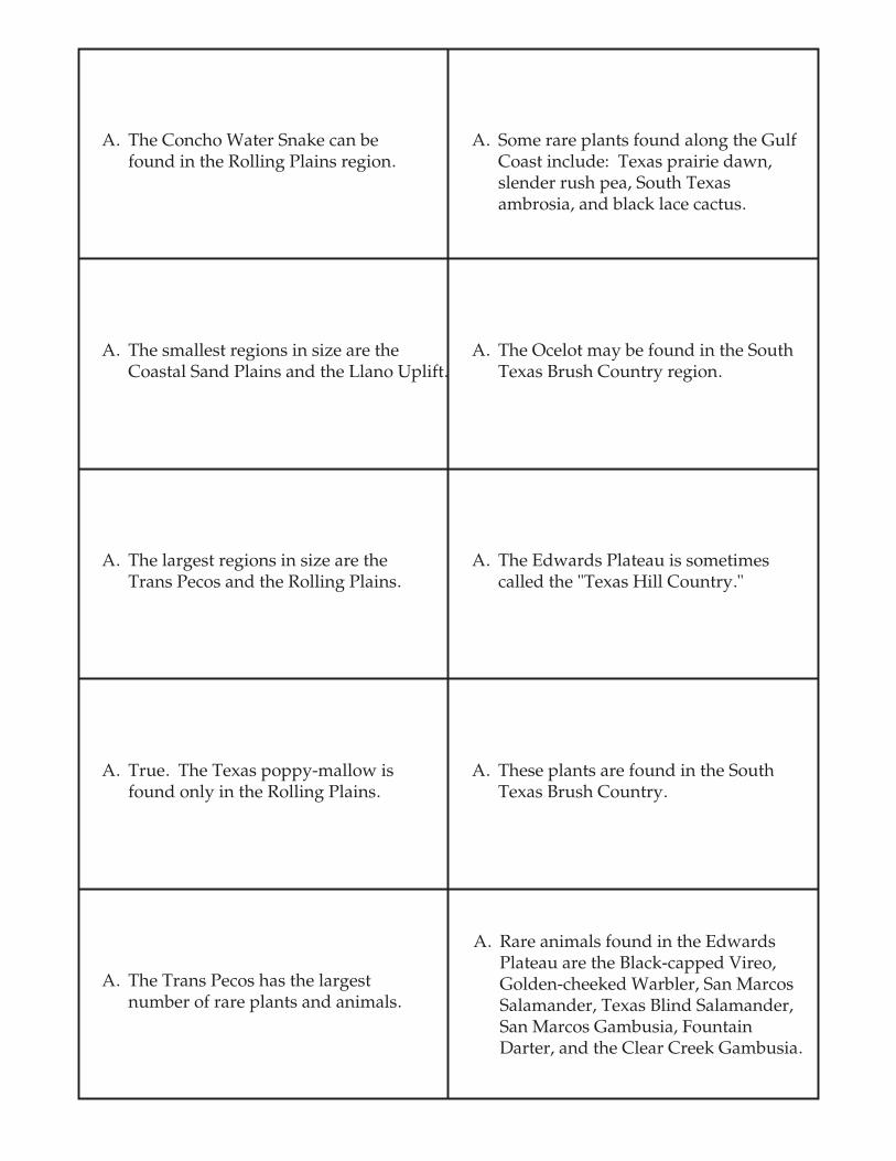
A. The Concho Water Snake can befound in the Rolling Plains region.
A. Some rare plants found along the GulfCoast include: Texas prairie dawn,slender rush pea, South Texasambrosia, and black lace cactus.
A. The smallest regions in size are theCoastal Sand Plains and the Llano Uplift.
A. The Ocelot may be found in the SouthTexas Brush Country region.
A. The largest regions in size are theTrans Pecos and the Rolling Plains.
A. The Edwards Plateau is sometimescalled the "Texas Hill Country."
A. True. The Texas poppy-mallow isfound only in the Rolling Plains.
A. These plants are found in the SouthTexas Brush Country.
A. The Trans Pecos has the largestnumber of rare plants and animals.
A. Rare animals found in the EdwardsPlateau are the Black-capped Vireo,Golden-cheeked Warbler, San MarcosSalamander, Texas Blind Salamander,San Marcos Gambusia, FountainDarter, and the Clear Creek Gambusia.
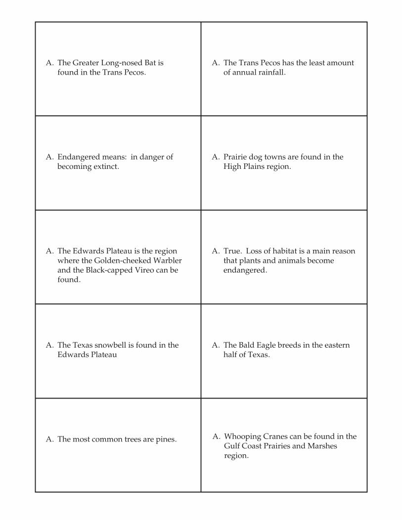
A. The Greater Long-nosed Bat isfound in the Trans Pecos.
A. The Trans Pecos has the least amountof annual rainfall.
A. Endangered means: in danger ofbecoming extinct.
A. Prairie dog towns are found in theHigh Plains region.
A. The Edwards Plateau is the regionwhere the Golden-cheeked Warblerand the Black-capped Vireo can befound.
A. True. Loss of habitat is a main reasonthat plants and animals becomeendangered.
A. The Texas snowbell is found in theEdwards Plateau
A. The Bald Eagle breeds in the easternhalf of Texas.
A. The most common trees are pines. A. Whooping Cranes can be found in theGulf Coast Prairies and Marshesregion.
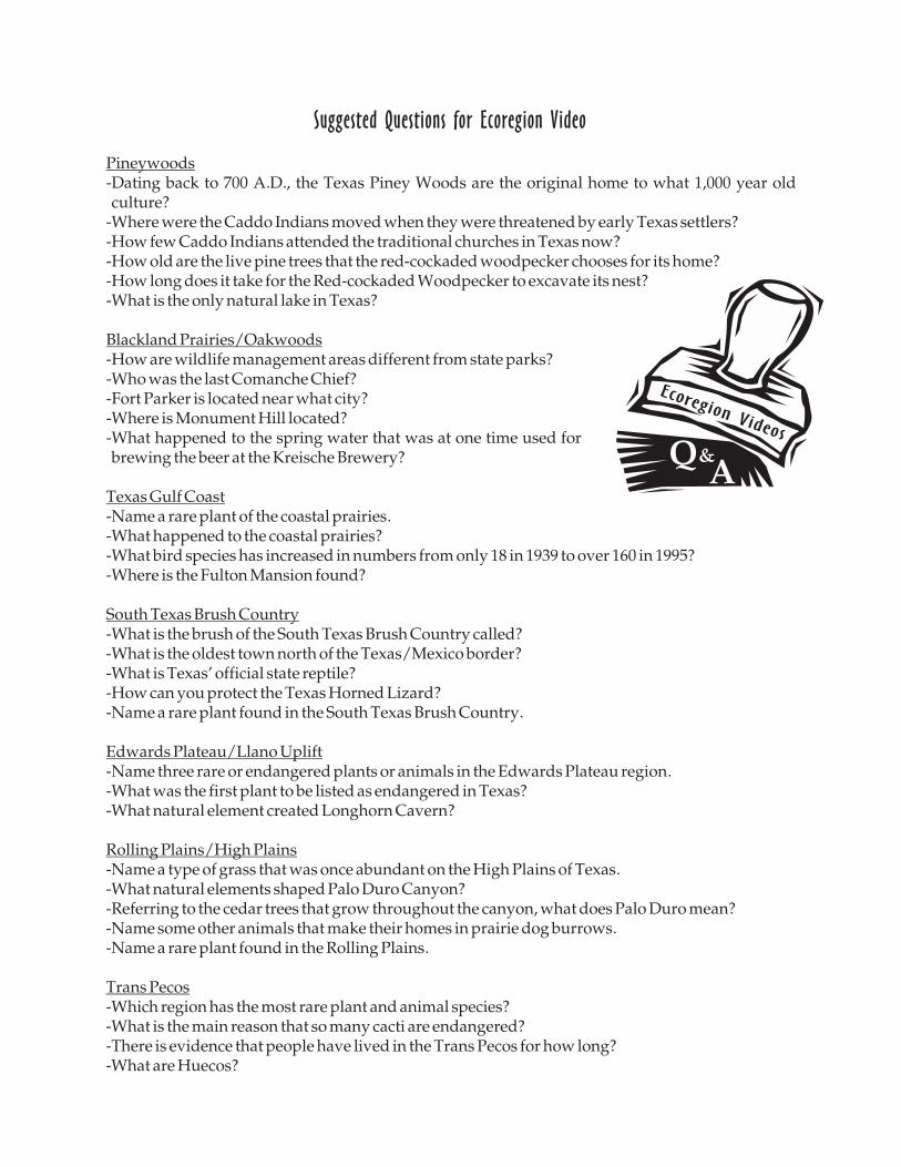
Suggested Questions for Ecoregion Video
-Dating back to 700 A.D., the Texas Piney Woods are the original home to what 1,000 year oldculture?
-Where were the Caddo Indians moved when they were threatened by early Texas settlers?-How few Caddo Indians attended the traditional churches in Texas now?-How old are the live pine trees that the red-cockaded woodpecker chooses for its home?-How long does it take for the Red-cockaded Woodpecker to excavate its nest?-What is the only natural lake in Texas?
-How are wildlife management areas different from state parks?-Who was the last Comanche Chief?-Fort Parker is located near what city?-Where is Monument Hill located?-What happened to the spring water that was at one time used forbrewing the beer at the Kreische Brewery?
-Name a rare plant of the coastal prairies.-What happened to the coastal prairies?-What bird species has increased in numbers from only 18 in 1939 to over 160 in 1995?-Where is the Fulton Mansion found?
-What is the brush of the South Texas Brush Country called?-What is the oldest town north of the Texas/Mexico border?-What is Texas' official state reptile?-How can you protect the Texas Horned Lizard?-Name a rare plant found in the South Texas Brush Country.
-Name three rare or endangered plants or animals in the Edwards Plateau region.-What was the first plant to be listed as endangered in Texas?-What natural element created Longhorn Cavern?
-Name a type of grass that was once abundant on the High Plains of Texas.-What natural elements shaped Palo Duro Canyon?-Referring to the cedar trees that grow throughout the canyon, what does Palo Duro mean?-Name some other animals that make their homes in prairie dog burrows.-Name a rare plant found in the Rolling Plains.
-Which region has the most rare plant and animal species?-What is the main reason that so many cacti are endangered?-There is evidence that people have lived in the Trans Pecos for how long?-What are Huecos?
Pineywoods
Blackland Prairies/Oakwoods
Texas Gulf Coast
South Texas Brush Country
Edwards Plateau/Llano Uplift
Rolling Plains/High Plains
Trans Pecos
Ecoregion Videos
QA
&
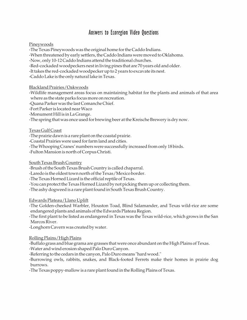
-The Texas Pineywoods was the original home for the Caddo Indians.-When threatened by early settlers, the Caddo Indians were moved to Oklahoma.-Now, only 10-12 Caddo Indians attend the traditional churches.-Red-cockaded woodpeckers nest in living pines that are 70 years old and older.-It takes the red-cockaded woodpecker up to 2 years to excavate its nest.-Caddo Lake is the only natural lake in Texas.
-Wildlife management areas focus on maintaining habitat for the plants and animals of that areawhere as the state parks focus more on recreation.
-Quana Parker was the last Comanche Chief.-Fort Parker is located near Waco-Monument Hill is in La Grange.-The spring that was once used for brewing beer at the Kreische Brewery is dry now.
-The prairie dawn is a rare plant on the coastal prairie.-Coastal Prairies were used for farm land and cities.-The Whooping Cranes' numbers were successfully increased from only 18 birds.-Fulton Mansion is north of Corpus Christi.
-Brush of the South Texas Brush Country is called chaparral.-Laredo is the oldest town north of the Texas/Mexico border.-The Texas Horned Lizard is the official reptile of Texas.-You can protect the Texas Horned Lizard by not picking them up or collecting them.-The ashy dogweed is a rare plant found in South Texas Brush Country.
-The Golden-cheeked Warbler, Houston Toad, Blind Salamander, and Texas wild-rice are someendangered plants and animals of the Edwards Plateau Region.
-The first plant to be listed as endangered in Texas was the Texas wild-rice, which grows in the SanMarcos River.
-Longhorn Cavern was created by water.
-Buffalo grass and blue grama are grasses that were once abundant on the High Plains of Texas.-Water and wind erosion shaped Palo Duro Canyon.-Referring to the cedars in the canyon, Palo Duro means "hard wood."-Burrowing owls, rabbits, snakes, and Black-footed Ferrets make their homes in prairie dogburrows.
-The Texas poppy-mallow is a rare plant found in the Rolling Plains of Texas.
Answers to Ecoregion Video Questions
Pineywoods
Blackland Prairies/Oakwoods
Texas Gulf Coast
South Texas Brush Country
Edwards Plateau/Llano Uplift
Rolling Plains/High Plains
Trans Pecos-The Trans Pecos region has the most rare plant and animal species in Texas.-Many cacti are endangered because they are gathered by collectors.-There is evidence that people have lived in the Trans Pecos for ten to twelve thousand years.-Huecos are basins or oases that fill with water.
Following the video, teachers may want to initiate a class discussion concerning what factorscontribute to the endangered status of most of the plants and animals seen on the video.
Note: Most endangered plants and animals of Texas are affected by loss of habitat. Examplesinclude loss of old pines due to commercial forestry practices (Red-cockaded Woodpecker) andloss of tall grass coastal prairie due to crop production and urban expansion (Attwater's PrairieChicken).
APPENDIX I
REFERENCES AND RESOURCES
Aquatic WILD Activity Guide. 1993. Western Regional Environmental Education Council, Inc.Available to participants in Project WILD Workshops held throughout Texas. Forinformation and workshop schedule, contact Project WILD Coordinator, Texas Parksand Wildlife Department.
Educator's Activity Book About Bats. 1991. Bat Conservation International, Austin, Texas (512-327-9721)
Endangered and Threatened Animals of Texas - Their Life History and Management. 1995.Written by Linda S. Campbell and produced by Texas Parks and Wildlife Press, Austin,Texas. Available through University of Texas Press or Texas Parks and WildlifeDepartment.
Environmental Education Activities for Children and Youth. 1994. Presentation toEnvironmental Education Skills Workshop, Castroville, Texas by Dr. Milton Payne,Science and Outdoor Education, Stephen F. Austin State University, Nacogdoches,Texas.
"Eye On Earth" video programs on endangered species and Texas ecoregions. 1994 and 1995.Production Texas Education Agency and the T-Star Network in cooperation with TexasParks and Wildlife Department. Tapes available through the Regional Service Centers.
From Alligators to Whooping Cranes: A Texas Resource Guide to Endangered Species. 1994.Developed by Glenda Bell, Michael Bishop, Pat Merkord, Lonna Sanderson, and Dr.Kenn Heydrick, Austin Independent School District. Available from U.S. Fish andWildlife Service and Texas Parks and Wildlife Department.
Nature Scope Series. National Wildlife Federation
Playa Lakes Teaching Unit. Developed by the Playa Lakes Joint Venture and available bycontacting the Project WILD Coordinator of Texas Parks and Wildlife Department.
Project WILD Activity Guide. 1992. Western Regional Environmental Education Council, Inc.Available to participants in the Project WILD Workshops held at locations throughoutTexas. For workshop information and schedules, contact Project WILD Coordinator,Texas Parks and Wildlife Department.
Rare and WILD Texas - Project WILD Supplemental Activities for Texas. 1995. Availablefrom Project WILD Coordinator or Endangered Resources Branch of Texas Parks andWildlife Department.
Suggested Environmental Education Lesson Plans. Available from the U.S. Natural ResourcesConservation Service (formerly Soil Conservation Service), Temple, Texas (817-774-1228).
Texas Almanac. 1994-95. Dallas Morning News, Dallas, Texas.
Texas Endangered Species Activity Book. 1996. Available from the Endangered ResourcesBranch of Texas Parks and Wildlife Department.
Texas Environmental Guide. 1991. Holt, Rinehart, and Winston.
Texas Parks and Wildlife Magazine Articles on Rare Resources, October, 1995. Available fromthe Endangered Resources Branch of Texas Parks and Wildlife Department.
Texas Parks and Wildlife Department Toll Free 800-792-1112Endangered Resources Branch 512-912-7011Project WILD Coordinator 512-328-6035
APPENDIX II
. (Publishers andavailability of these teaching tools are listed under "References and Resources")
These two activities can be done outdoors or in a gym.
Use this activity for a fast moving and attention getting unit initiation. Objectives:to discuss predator/prey relationships, recognize limiting factors which affect wildlifepopulations, and the importance of adaptations in predator/prey relationships.
Also from . Objectives: to identify components of habitat and how humans andother animals depend upon habitat.
From . The features of each region are listed, adding informationconcerning what the Pineywoods and other regions were like prior to the first Spanishsettlements of the 1680's.
From the U.S. Natural Resources Conservation Service (NRCS),, introduces wildlife habitat management, and looks closely at
wildlife habitat on a school site. introduces students to outdoor recreational fishing.
From . Objectives include: identify and describe food, water, and shelter as threeessential components of habitat; describe the importance of good habitat for animals; define"limiting factors" and give examples; and recognize that some fluctuations in wildlifepopulations are natural as ecological systems undergo constant change.
From , these activitieswere developed specifically for Texas by Texas Parks and Wildlife. Variations of
's popular activity entitled these activities challenge students to: define whatit means for a plant or animal to be endangered or threatened; identify and name a number ofTexas endangered and threatened species; describe factors which may cause species to declineand become endangered, and discuss why we should care about endangered and threatenedspecies.
OTHER SUGGESTED ACTIVITIES FOR DAILY LESSON PLANNING
INTRODUCTION TO THE ECOREGION CURRICULUM
DAY 1: PINEYWOODS
DAY 2: OAK WOODS AND PRAIRIES AND BLACKLAND PRAIRIES
QUICK FROZEN CRITTERS!
HABITAT LAP SIT!
THE CHANGING FACE OF TEXAS
WILDLIFE 1 AND WILDLIFE II
Wildlife 1
Wildlife 2
OH DEER!
OH DEER!
Project WILD
Project WILD
Texas Environmental Guide
Suggested EnvironmentalEducation Lesson Plans
Project WILD
Rare and WILD Texas--Project WILD Supplemental Activities for TexasProject
WILD