Embed Size (px)
Citation preview

Exploring the relevance and feasibility of PES approaches for producing environmental services through changes in agricultural practices:
A case study in the Mekong region (IRRI Ref. No.: DPPC2006‐146)
Final Report
submitted to the
International Center for Tropical Agriculture (CIAT)
March 2009
Contact:
Dr. Michael T. Jackson Director for Program Planning and Communications (DPPC)
Telephone: +63 (2) 580‐5600 ext. 2747 or 2513; Direct: +63 (2) 580‐5621; Fax: +63 (2) 812‐7689 or 580‐5699 E‐mail address: dppc‐[email protected] Mailing address: DAPO Box 7777, Metro Manila, Philippines Courier address: 10th Floor, Suite 1009, Security Bank Center, 6776 Ayala Avenue, Makati City 1226
Telephone: +63 (2) 891‐1236, 891‐1303

Exploring the relevance and feasibility of PES approaches for producing environmental services through changes in agricultural practices: A case
study in the Mekong region
(IRRI Ref. No.: DPPC2006-146)
Final Report
submitted to the International Center for Tropical Agriculture (CIAT)
This report was prepared by Damien Jourdain, Sushil Pandey and Hari Gurung
March 2009
ii
List of acronyms used in this report
CIRAD Centre de Coopération Internationale en Recherche Agronomique pour le Développement
GSO General Statistics Office of Vietnam
IRD Institut de Recherche pour le Développement
IRRI: International Rice Research Institute
IWMI International Water Management Institute
MARD Ministry of Agriculture and Rural Development
MONRE Ministry of Natural Resource and Environment
MSEC Management of Soil Erosion Consortium
RUPES Rewarding Upland Poor for Environmental Services
TUEBA Thainguyen University of Economics and Business Administration
1. Introduction
Vietnam is characterized by a fast‐changing economic and institutional environment. Policies initiated in the 1990s have induced rapid changes in the agricultural sector. In a few years, Vietnam evolved from a chronic food shortage state to a net exporter in rice and a few other agricultural commodities. In the northern provinces, the changes are most visible in the Red River Delta, where agricultural production in general and rice production in particular increased sharply.
Major changes also occurred outside of the delta in the mountainous regions. In this case, however, the reforms had mixed results because of the biophysical and social diversity. Today, concerns exist that some regions/communities have been left out of the process of economic growth.
There are also concerns about induced unsustainable practices and environmental problems stemming from the changes. Some of these problems are mainly found in the Red River Delta, and are specific to intensive agriculture, for example, water pollution from fertilizer and pesticide use. However, the environmental problems in the mountainous areas, unlike the delta, are mainly linked to the unsustainable use of sloping land for agriculture and forestry because of the slower adoption of intensive agriculture by farmers.
Deforestation and slash‐and‐burn agriculture are identified by some governmental organizations as the main causes of the problem. A mix of reforestation programs, economic incentives (subsidies), technical assistance (improved and sustainable agricultural practices), and regulations have been used by the Vietnamese government to reduce these problems through large development projects. Land‐use practices such as forestation, agro‐forestry, tree‐based land‐use alternatives, and agroecologically sound practices such as conservation agriculture that bring about environmental benefits are promoted (Gouyon 2002). However, the environmental services these land uses provide, that is, ecosystem and watershed services, biodiversity conservation, and carbon storage, are usually unrewarded and are only indirectly connected to economic activities (The et al 2004).
Although some progress can be observed in reforestation, many agricultural households still employ unsustainable agricultural practices to meet their short‐term and medium‐term livelihood needs.
Payment for environmental services (PES) schemes offer a new approach that focuses directly on creating a conditional benefit transfer between providers and beneficiaries of an environmental service. The past few years have witnessed a surge of interest in the development of PES schemes in Asia, and in Vietnam.

2
2. Objectives and milestones
The year‐long project activities and milestones were organized into two separate phases. The first six months were designed as a problem identification phase and the second six months were dedicated to more specific research activities, such as focus group discussions with selected communities and hydrological research in selected catchments. Specific activities for the two phases are detailed below.
2.1. First six months of activities
1. Review of the literature on environmental issues related to upland development in northern Vietnam.
2. Analysis of major changes in land use in uplands over the past decade using time‐series data. The data include land use, area under major crops, and changes in cropped area and forested area at regional (northern mountains) and provincial levels.
3. Interviews and discussions with government officials, provincial authorities, and local leaders on the emerging environmental issues and policies related to agricultural land use.
2.2. Second six months of activities
1. Elicitation and analysis of perceptions of upland farmers of environmental impacts generated by their livelihood practices, the mechanisms in place to mitigate environmental problems, and existing relations between communities (traditional institutions and mechanisms to control activities, and existing reward systems if any, among others).
2. In collaboration with MSEC, a study of the hydrological balance and effects of different land‐use scenarios in the small watershed of Sai Luong in Nam Bung Commune. Then the use of the results and findings of the hydrological balance study as a basis for discussions on environmental services with farmers.
3. Development of a modeling framework and model for farm households typical to the upper catchment of northern Vietnam to study PES.
3. Exploratory and conceptualizing activities
3.1. Environmental issues related to upland development in northern Vietnam: a literature review
The literature review was based on three main sources of information:
• Published and unpublished (mainly working papers and conference presentations) materials related to the recent changes in major environmental indicators in Vietnam. Reports produced by international organizations (e.g., FAO, UNEP, UNDP, World Bank), CGIAR centers (e.g., ICRAF, CIFOR), and national institutions (e.g., MARD, MONRE) were accessed.

3
• The Vietnamese government official Web site (www.chinhphu.vn) was used to extract the decisions and decrees related to agriculture, forestry, and environmental protection handed down over the last 15 years in Vietnam.
• Literature produced by or related to PES projects in Asia. Particular mention is made of the RUPES project in Asia.
• Discussions with decision‐makers at national, provincial, and district levels.
3.1.1. Environmental issues and recent policy changes
The literature review focused on two main environmental issues: (a) the reduction in forested area and (b) the land degradation and decrease in watershed services provided by upper catchment areas (water flow regulations, flood control, dam silting avoidance, etc.).
In terms of forestry, most publications mention a fast decline in forest area in an earlier period before 1990, followed by a recovery in recent years. Between 1950 and 1990, the proportion of the national territory covered by forests decreased from at least 40% to around 20%. During the same period, the quality of the forest also declined. Wood and energy requirements of a rapidly increasing rural population and the agricultural practices of ethnic minorities, for example, shifting cultivation, are often cited as the main causes of this deforestation. At the end of the 1980s, the Vietnamese government reacted to this and initiated several important policy reforms. Land was specifically allocated to different forestry use and could not be accessed by shifting cultivators. National reforestation programs gave economic incentives to farmers or organizations for protecting existing forest or planting trees in new areas. The proportion of the national territory covered by forest is now increasing. It is estimated that about 12 million ha of land was forested in 2005.
This turnaround in forested area is due to at least two complementary phenomena: (a) a rise in lowland agricultural productivity that reduced the pressure on highland agriculture and (b) active reforestation and protection policies. The policy shift was efficient in reversing the rapid deforestation that took place before 1990. However, doubts remain about the effectiveness of the programs in restoring the watershed services normally associated with forest: biodiversity, watershed protection, and water regulation. In effect, a lot of reforestation observed in recent years is carried out through planting fast‐growing species instead of a slower process of assisted natural regeneration.
Vietnam has about 33 million hectares of land, of which 25 million hectares are sloping land. It is estimated that as much as 50% of the total land is degraded, through both chemical degradation and topsoil erosion.
Policy changes also occurred in the 1990s: a progressive opening up of markets, land allocation, and land titles to individual households; the forestry policies mentioned above; and overall economic reforms that induced a rise in demand for agricultural products.
4
3.1.2. A rapid diversification of rural households
Depending on the type of households considered, reforms resulted in
(a) Lower soil degradation and erosion occurred when the intensification of lowland areas allowed farmers to grow permanent crops (tea, fruit trees) or forestry crops on their sloping land.
(b) Greater soil degradation and erosion also occurred
• with the intensification of lowland areas by continuous and intensive cropping of lowlands, for example, maize intensification in Vietnam, and
• when the lack of access to irrigated land and a reduction in available upland cropping area forced farmers to reduce the fallow periods of their traditional systems.
The main message of this overview is that, with differentiated and diversified production systems in upland areas, any PES initiative should therefore take into account that not all land users would be equally interested in participating in such schemes.
3.1.3. The special cases of dams and PES
The fast economic development of Vietnam created sharp growth in demand for electricity, estimated to be increasing at about 15% per year. Given its geographical configuration, Vietnam intends to use its large hydroelectric power potential. Its potential hydropower is estimated at 17,000 MW, whereas its developed hydropower is 4,000 MW (Dzung 2006).
In northern Vietnam, the two main power plants in operation are situated in Hoa Binh Province on the Black River and in Yen Bai Province (Thac Ba) on the Chai River. Two important dams are under construction in Son La Province on the Black River and in Tuyen Quang Province on the Gam River. As an example, we will concentrate on the impacts created by the dams along the Black River.
Damming the Black River at Hoa Binh affected many ecosystem dynamics (Vo Tri Chung et al 1998). The dam construction ended in 1994. In 1998, the dam supplied nearly 50% of Vietnam’s electricity need. The regulation of river flows by the dam contributed to reduced flooding and increased dry‐season irrigation downstream.
However, it also resulted in the inundation of 200 km2 of surface area and inundation 230 km upstream. This represents 11,000 ha of farmland lost, of which 4,000 ha were paddy land. Some 58,000 persons (mainly ethnic minorities) were displaced from lowland areas to upper slopes of the watershed. They are now farming on sloping land. Erosion has increased sharply. Heavy sediments are now loading in the dam. The life expectancy of the dam, estimated at 300 years at project inception, is now estimated to be only 50 years (Vo Tri Chung et al 1998).
Work has started on the construction of the Son La dam (Tac Bu). It is expected to generate a large amount of electricity (2,400 MW). However, as with the first dam, 10,000 ha of

5
farmland, 4,000 ha of forest and 30,000 ha of other land will be lost to flooding. Water will displace 95,000 persons, mainly rural (86%), in the upper part of the watershed. The same environmental degradation phenomena are likely to happen if no incentives are given to relocated households to adopt sustainable agricultural practices.
There is potential to establish mechanisms of incentives/rewards between the newly relocated households and the beneficiary of the watershed services (i.e., Electricity Company of Vietnam). As mentioned earlier, many PES projects in Asia fall under this type of arrangement (Huang and Upadhyaya 2007).
As of January 2008, large hydroelectric companies had contributed to a “Forestry Rehabilitation Fund” (Government of Vietnam 2008). However, these companies are transferring the additional costs to electricity users. This could be seen as a first PES scheme to be implemented in northern Vietnam. However, several points can be raised about the scheme:
• To what extent could this scheme be considered as voluntary, when this is implemented by decree? Were the electric companies really volunteering for such a scheme? The final payers, that is, electricity end users, are not volunteering since in most cases they are unaware of the existence of this payment built into their electricity charges.
• To what extent will this be conditional? What will happen if siltation problems are still present after several years of payments?
Why are only forestry projects considered for PES? One could argue that several antierosive agricultural practices are on the shelf that are often not adopted by farmers because they are not economically viable. The application of PES schemes may create an incentive for farmers to use such antierosion practices.
3.1.4. Conclusions of the review
A rapid assessment allowed us to identify different scenarios of evolution of the production systems in the northern mountainous provinces of Vietnam.
Among them, two are of particular concern since they would result in continued, if not increasing, degradation of the soils. The first target group corresponds to farm households that are well integrated to markets and hence are responding to increasing demand for animal feed. The second target group corresponds to less market‐integrated households that are responding to the reduction in cropping area by shortening rotation/fallow cycles.
These groups could be identified as “providers of environmental services” if they could reduce the impact they have on sloping lands. Potential environmental service users who can pay for the services are difficult to identify since lowlanders are often agricultural households that are only a little better off than upland households that are the recipient of the payment. Hydroelectric companies are an easier target since they are generating huge revenues. Recent policy changes seem to indicate they will be targeted as payers.

6
3.2. Data collection: major land‐use changes in the mountainous provinces of northern Vietnam
3.2.1. Data collection—provincial level
Vietnam has at least three sources of information on land use. First, the General Statistics Office (GSO) publishes a statistical yearbook that gives information aggregated at national or provincial levels. The GSO also conducted a rural census in 2001. Second, the MONRE is also gathering some information on forestry and agriculture. Paradoxically, the MONRE publishes some interesting information on rice in upland areas that is more detailed than the MARD data. Finally, researchers published research reports that contain important information on the evolution of agriculture and rural development in Vietnam in the last few decades (e.g., Vu Tu Lap and Taillard 1994, Nguyen Sinh Cuc 2003).
A Microsoft Access database on provincial land use over time has been created. The following official sources were used to create it:
• General Statistics Office (1999). Statistical yearbook 1999. Hanoi, Statistical Publishing House.
• General Statistics Office (2002). Statistical yearbook 2002. Hanoi, Statistical Publishing House.
• General Statistics Office (2003). Results of the 2001 rural, agricultural, and fishery census. Hanoi, Statistical Publishing House. 719 p.
• General Statistics Office (2006b). Statistical yearbook 2006. Hanoi, Statistical Publishing House.
• General Statistics Office (2006a). Socio‐economic statistical data of 671 districts, towns, and cities under the authority of provinces in Vietnam. Hanoi, Statistical Publishing House. 2,733 p.
• Nguyen Sinh Cuc (2003). Vietnam agriculture and rural area in the renovation period (1986‐2002). Hanoi, Statistical Publishing House. 1,056 p.
Some statistical information was also obtained in electronic format from the GSO Web site (www.gso.gov.vn) (General Statistics Office 2008) and existing atlases.
Since the data came from different sources, they were in different units of measurement; therefore, they had to be converted to identical units.
The database contains data on many variables at the provincial level for the northern provinces (Table 1). The database developed by the project will be jointly kept and maintained under the care of TUEBA (International Cooperation Department) and NOMAFSI (Agrarian System Department). The data will be made available by the two institutions on request.

7
Table 1. Date on variables at the provincial level for the northern provinces of Vietnam.
Information item Available years Source
Population and households Population (000 persons) 1995‐2006 Rural population (000 persons) 1995‐2006
General Statistics Office (2002, 2006b)
Agricultural laborers (000 persons) 2002 Nguyen Sinh Cuc (2003) No. of households 2002 Nguyen Sinh Cuc (2003) No. of agricultural households 2002 Nguyen Sinh Cuc (2003) Land use Total area (km2) 2005 GSO Agricultural production land (000
ha) 1995‐2006 GSO
Cropping area Area of seasonal rice (000 ha) 1995‐2006 GSO Area of winter‐spring rice (000 ha) 1995‐2006 GSO Area of other annual food crops:
maize, cassava GSO
Agricultural production Production of seasonal rice (tons) 1995‐2006 GSO Production of winter‐spring rice
(tons) 1995‐2006 GSO
Production of other annual food crops: maize, cassava
1995‐2006 GSO
Production of tea 1995‐2002 Nguyen Sinh Cuc (2003) Forestry Total forestry land (000 ha) 2005‐2006 GSO Natural forestry land (000 ha) 2005‐2006 GSO Planted forestry land (000 ha) 2005‐2006 GSO Animals No. of buffalo 1995‐2006 GSO No. of cattle 1995‐2006 GSO No. of pigs 1995‐2006 GSO Poultry 1995‐2006 GSO Goats 1995‐2006 GSO
3.2.2. Data collection—district level
Mountainous provinces are quite large and they have great diversity of situations between the different districts of the same province. Therefore, we decided to collect statistical data/information at the district level for the 15 northern Vietnamese mountainous provinces. A contract was made with the GSO to collect the required information.
The data were collected on the following variables (see Table 2). The database developed by the project will be jointly kept and maintained under the care of TUEBA (International

8
Cooperation Department) and NOMAFSI (Agrarian System Department). The data will be made available by the two institutions on request.
Table 2. Information available at the district level.
Total population Rural population Population of working age Total employed population Employed population in agriculture and forestry (persons) Total area Agricultural production land Total forestry land Productive forest land Protected forest land Special forest land Area of upland rice Area of seasonal rice Area of winter‐spring rice Area with 1 rice crop per year Area with 2 rice crops per year Area of maize Area of cassava Area of tea Area of coffee Production of upland rice Production of seasonal rice Production of winter‐spring rice Production of maize Production of cassava Production of tea (dry) Production of coffee (seed) No. of buffalo No. of cattle No. of pigs
9
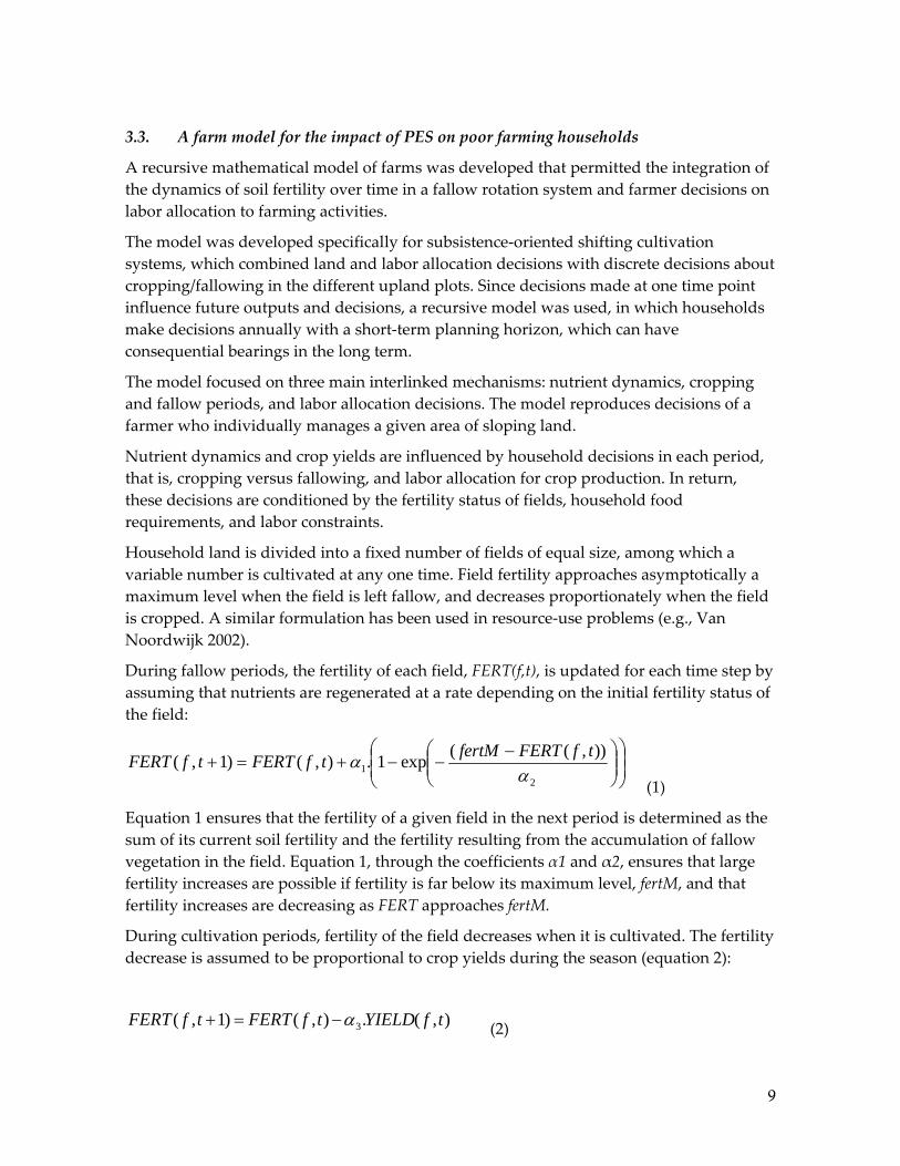
3.3. A farm model for the impact of PES on poor farming households
A recursive mathematical model of farms was developed that permitted the integration of the dynamics of soil fertility over time in a fallow rotation system and farmer decisions on labor allocation to farming activities.
The model was developed specifically for subsistence‐oriented shifting cultivation systems, which combined land and labor allocation decisions with discrete decisions about cropping/fallowing in the different upland plots. Since decisions made at one time point influence future outputs and decisions, a recursive model was used, in which households make decisions annually with a short‐term planning horizon, which can have consequential bearings in the long term.
The model focused on three main interlinked mechanisms: nutrient dynamics, cropping and fallow periods, and labor allocation decisions. The model reproduces decisions of a farmer who individually manages a given area of sloping land.
Nutrient dynamics and crop yields are influenced by household decisions in each period, that is, cropping versus fallowing, and labor allocation for crop production. In return, these decisions are conditioned by the fertility status of fields, household food requirements, and labor constraints.
Household land is divided into a fixed number of fields of equal size, among which a variable number is cultivated at any one time. Field fertility approaches asymptotically a maximum level when the field is left fallow, and decreases proportionately when the field is cropped. A similar formulation has been used in resource‐use problems (e.g., Van Noordwijk 2002).
During fallow periods, the fertility of each field, FERT(f,t), is updated for each time step by assuming that nutrients are regenerated at a rate depending on the initial fertility status of the field:
⎟⎟⎠
⎞⎜⎜⎝
⎛⎟⎟⎠
⎞⎜⎜⎝
⎛ −−−+=+
21
)),((exp1.),()1,(α
α tfFERTfertMtfFERTtfFERT (1)
Equation 1 ensures that the fertility of a given field in the next period is determined as the sum of its current soil fertility and the fertility resulting from the accumulation of fallow vegetation in the field. Equation 1, through the coefficients α1 and α2, ensures that large fertility increases are possible if fertility is far below its maximum level, fertM, and that fertility increases are decreasing as FERT approaches fertM.
During cultivation periods, fertility of the field decreases when it is cultivated. The fertility decrease is assumed to be proportional to crop yields during the season (equation 2):
),(.),()1,( 3 tfYIELDtfFERTtfFERT α−=+ (2)

10
Yield obtained in each field depends on its initial fertility and labor use. Yield will increase asymptotically toward a yield ceiling, Y0(t), as field fertility or labor input per unit area increases.
For each year, decisions about the number of plots cropped and the labor allocated in each cropped plot are simulated using mathematical programming.
The project used this model to anticipate the changes in farm household strategies (area cultivated, labor allocation, etc.) if the household participated in various types of PES schemes. In turn, we can also evaluate the impact these new strategies would have on the area of cultivated land (vs. fallowed land), and ultimately on soil fertility. It is anticipated that, if farmers would lose by participating in such schemes, they would not voluntarily participate in them.
Two papers have been presented at international conferences and workshops:
Jourdain D, Tai DA, Quang DD, Pandey S. 2008. PES in upper‐catchments of Vietnam: expected differential impact for contrasted farmers. In: 2nd International Forum on Water and Food, Addis Ababa, Ethiopia, 10‐14 Nov. 2008 (see Appendix 1).
Tai DA, Jourdain D, Quang DD, Pandey S. 2008. Payment for environmental services in the upper‐catchments of Vietnam: will it help the poorest? In: Interdependencies between upland and lowland agriculture and resource management, Stuttgart, 1‐4 April 2008, Hohenheim University (see Appendix 2).
A paper based on the paper presented at Hohenheim University will soon be published in a special issue titled “PES in Southeast Asia” of the peer‐reviewed journal International Journal of the Commons (see Appendix 3).
4. Field‐related activities
4.1. Perceptions of upland farmers on environmental impact of their agricultural practices
In October 2008, three focus group discussions were organized in three communities of Van Chan District. The purpose was to better understand the perceptions of a panel of upland and lowland farmers of the environmental impacts generated by their practices, and the existing relations between the upland and lowland communities.
Three communes, Son Thinh (lowlanders) and Nam Lanh and Nam Bung (uplanders), were chosen for this activity. Village leaders (usually People’s Committee members) and selected villagers were invited to participate in the focus group meetings. Fourteen participants (10 were nonleaders) in Son Tinh, 18 (12 were nonleaders) in Nam Lanh, and 13 (of which 8 were nonleaders) in Nam Bung participated.
The meetings were organized into four separate activities:
• First, farmers were asked to identify and locate the main environmental resources in their communities. In Vietnam, the smallest political administrative unit is the

11
commune. The villages within the communes are well identified by farmers, but often have fuzzy boundaries in administrative terms. The boundaries were the ones designated by the groups themselves. Participatory mapping was done to map the village and its physical resources.
• Second, a group discussion was conducted to study farmers’ perceptions of the potential impact of their activities on the resources, and the consequential implications for (a) themselves, (b) other members of their own communities, and (c) other communities.
• Third, in a reverse way, participants were asked in what way they were affected by the actions of members of their own communities and actions of other communities.
• Finally, PES–based systems were described to the participants and then they were asked to present their reactions and views on the potential benefits and problems associated with this kind of scheme.
4.1.1. Resource maps
Resource maps were drawn with farmer participation in Son Tinh and Nam Lanh communes (Fig. 1). Participatory mapping was not done for Nam Bung Commune to avoid repetition for the resource‐mapping exercise had been done earlier in another project. In each case, the different physical features of the communities were mapped in terms of soils and other resources (water, main crops, forest and forest products extracted from these zones).
Fig. 1. An example of a resource map for one village of Nam Lanh Commune.

12
Lowland areas are used mainly for irrigated rice production. Son Tinh and Nam Lanh commune farmers produce two rice crops, spring and summer, per year.
Farmers of Nam Bung produce only one rice crop per year in the irrigated lowlands. Although the lowland paddy fields remain idle during the winter, farmers collect various kinds of useful herbs that grow in them. Buffaloes and other farm animals also graze in the idle paddy fields during the winter season.
Gardens and fruit trees are grown in small patches or on pieces of land immediately next to the village dwellings. These areas are usually surrounded by fences to prevent wandering animals from destroying the crops.
Upland areas are usually divided into several plots for different uses.1 Upland rice, maize, and cassava are the main crops grown there. The farmers of Nam Lanh and Nam Bung communes fallow part of their uplands for short periods. Fallow is practiced for regenerating soil and fertility for future cropping. The fallows are primarily bushy. Only a few herbs are extracted from these fallows.
Newly planted tree‐sapling areas for afforestation can be found scattered on the hill slopes as a result of recent governmental forestry project endeavors. These plantations are well protected. However, in Sai Luong Village of Nam Bung Commune, no forest is left in the vicinity due to heavy deforestation. Sai Luong farmers now have to depend on distant and remote forests for their forestry product needs (see below). Local people usually collect firewood (it is sometimes sold, but this seems to be a “sensitive subject”), bamboo shoots (for home consumption and selling during the winter season), and lumber for housing. The custom of making wooden houses is popular among the local people. Approval to cut trees for house construction can be obtained from the forest management group. In some villages, there is a forest management rule called Huong uoc. Besides regulating the use and protection of forest, the management group identifies the beneficiaries and defines benefit‐sharing rules.
Some villagers also reported that they were given some plots of forest land for protection and were remunerated (given fees) for protecting the forest. Villagers consider the forestry‐related subsidy very low, which is enough to compensate only some of their labor input or costs.
Water is mainly used for agricultural production and household use such as cleaning, washing, cooking, and bathing. In the rainy season, water is sufficient for crop production. However, participants reported water shortages during the dry/spring season (November‐March) except in Nam Kip Village (Nam Lanh Commune), where two streams supply water for irrigation.
1 The commune of Son Thinh does not have a significant area of sloping land.

13
4.1.2. Self‐impact and impact on others
Participants were asked whether they perceived their activities as sustainable or not. They were then asked to enumerate potential problems that they would create for themselves or for others, now or in the future. Overall, participants reported three problems: the trend of declining soil fertility, increasing difficulties in obtaining forest products, and health related problems because of the use of agro‐chemicals.
The main concern of upland participants was the trend of decreasing land fertility (expressed mainly in Sai Luong). The farmers associated the decreasing crop yields to a longer cultivation period for land with shorter fallow periods. Soil erosion, and with it the soil fertility gradient, was mentioned by the participants. The Sai Luong participants mentioned that crop fields in the lower parts of the sloping landscape were more fertile than those on higher parts of the landscape or at higher elevation on the hill. The participants attributed the soil fertility differential to a downward flow of soil and nutrients. However, the participants did not mention the potential impact of these flows on paddy fields situated on the valley floor. Similarly, they did not mention the potential problems of dams and irrigation infrastructure built on lower parts of the basin. In summary, most upland farm households do not believe that they are negatively affecting the population living or farming in the lower parts of the catchment or watershed. Although they are well aware of soil erosion and declining soil fertility, they see their individual activities and contribution to the problem of erosion and effect on their own and other downstream communities in the catchment or watershed as marginal.
Participants of Nam Bung also mentioned going long distances to collect forest products (firewood, bamboo, lumber, etc.). They mentioned that the forest that had once existed in the immediate vicinity of the village had long ago disappeared. They blamed the preceding generations for the forest depletion. There is a relative abundance of forested land in Nam Lanh and they did not mention pressing problems in terms of forest product availability. Participants of Nam Bung and Son Thinh admitted they had to cut trees from forests outside their areas.
Loss of forest is not perceived as an irreversible problem. People are more concerned with the “traveling time” to get the products needed than with the overall disappearance of forest.
The use of chemical fertilizer and pesticides was perceived by some participants as not so good for their own health.
4.1.3. Impact from others
The impacts of other communities were somewhat easier to elicit from the participants, especially the negative ones. Depending on the locality of the participants, they listed the increasing scarcity of water availability for cropping, increasing irregularity in water flows (and related crop damages for lowlanders), and some water contamination as the problems or impacts.
14
The water contamination problem was very specific to the Nam Bung participants. The villagers suspect that the two recently opened iron ore mines are releasing some metals into the streams, and subsequently affecting the downstream paddy fields. So far, villagers have negotiated some financial compensation from the private owner of the mine (one payment of US$360/ha).
According to lowland participants (Son Thinh), water scarcity problems are mainly caused by forest cutting and burning in the upper highland in the watershed. The decrease in forested area is seen as the cause of irregular rains and water flows. The increasing irregularity in water flows is also seen as a consequence of agricultural activities of villages situated in the upland areas. The reduction in forested area was also blamed for the higher incidences of floods that destroyed paddy fields downstream and in the valleys.
Within the Sai Luong small catchment, water availability in the lowland paddy area of the catchment was also said to be affected by terrace constructions in the surrounding sloping areas. However, in this case, the interactions are taking place between members of the same community.
Some local conflict exists between communities over the use of forests and forest products. For example, the Nam Lanh residents accuse the villages from the neighboring commune (Nam Bung) of stealing wood and forest products and destroying forests.
4.1.4. Reactions to the concept of PES
The PES concept is not new to Vietnamese government officials of the different ministries, especially from the Ministry of Agriculture and the Ministry of Environment. Vietnam has been actively participating in Rewarding Upland Poor for Environmental Services (RUPES) project activities. However, no PES activities have taken place in Yen Bai Province. Provincial, district, and commune officials were not familiar with the PES concept. Even more so, the farmers that participated in the focus group meeting were completely unaware of this type of transactions.
Lowland participants blame some of their problems on agricultural practices of upland farmers. However, they also recognize that upland farmers are usually poorer and less educated than they are. Therefore, they favor the transfer of money, or education programs targeted to uplanders, if this limits deforestation.
When asked whether they would be ready to contribute to such money transfer or not, they responded that they, too, were poor: “The scheme would be between poor and less poor people!” The farmers responded that they cannot participate in such schemes, that is, pay for environmental services, because of their financial situation. Hence, they called for more government interventions such as direct subsidies for some agricultural practices.
On the other side, upland participants, especially in Nam Bung, were somehow distrustful about forestry projects. They see the projects as reducing land available for farming, thus bringing additional constraints rather than helping them out.

15
4.2. Hydrological balance and effects of different land‐use scenarios
Given the potential effects of upland agricultural practices on lower parts of the basins, a catchment in Nam Bung Commune was selected to evaluate/study the interactions at a small scale. The rationale of selecting a small catchment was the ease in developing a hydrological model and studying the impact of agricultural practices on water outflows. Although this type of activity usually requires several years of data collection and validation, the project used the research experience of the Management of Soil Erosion Consortium (MSEC) project team in Vietnam for the last six years. We adapted the MSEC hydrological model—developed for mountainous areas of Vietnam—for the catchment hydrological model in Nam Bung.
Mr. Adrian Levrel, from “Polytech Montpellier” (Montpellier Sciences University) (www.polytech.univ‐montp2.fr), conducted the necessary field work to do the hydrological modeling research from June to December 2008. He was co‐supervised locally by Didier Orange of the MSEC team (IWMI/IRD), Damien Jourdain (IRRI/CIRAD), and Do Anh Tai (Thainguyen University of Economics and Business Administration (TUEBA), Vietnam.
Because of the complexity of the water balance exercise and subsequent modeling requirements, it was decided to concentrate the research in Sai Luong watershed (21.758°N, 104.338°E) in Nam Bung Commune. This catchment includes a narrow valley bottom (around 30 ha, or 2% of Sai Luong Village area) called “Trung Tam” in Sai Luong, where irrigated rice fields are found (see Figs. 1 and 3).
These rice fields are irrigated by water coming from surrounding subcatchments that belong to Sai Luong Village. The catchment configuration had many desired features for easier hydrological modeling, and the IRRI/CIRAD/TUEBA team also had prior information on farm household land resource endowment, demography, agricultural practices, and livelihood strategies, among others.
To assess the water dynamics in this watershed and the water volume available in the valley bottom for agriculture, the following four subactivities were conducted. For more details, please see Adrian Levrel’s full report (Appendix 4).

16
Fig 2. Sai Luong bottom valley and surrounding catchment areas
4.2.1. Measurement of the different parameters needed for the water balance
1. Identification of water entry points for the valley‐bottom area. For the Sai Luong valley bottom, seven entry points were identified.
2. Daily measurement of water flows at those entry points:
a. One thalimedes was installed at the major entry point to automatically record daily flows.
b. Daily flows of other minor entry points were recorded using nonautomated techniques.
3. A geographic positioning system (GPS) unit was used to demarcate the catchment and locate each water entry point in the catchment. Based on the GPS reading, a map was created (Fig. 3).
4. For each catchment area, land use and vegetative covers were identified and mapped (Fig. 4).
5. Meteorological data were recorded. An automatic weather station, Cimel (21.75891°N, 104.33823°E), recorded rainfall amount and intensity every 6 minutes. This automatic station also recorded temperature, humidity, wind speed, and solar radiation intensity. The Cimel rainfall data were complemented with data collected on a daily basis from two manual rain gauges (21.76234°N, 104.33858°E, and 21.75069°N, 104.34001°E).

17
Fig. 3. GPS map of main subwatersheds at Sai Luong.
4.2.2. Survey on water uses and needs
The survey aimed to obtain farm users’ assessment of the hydrological variability (if possible, for the last 10 years) of the watershed. Another objective was to learn about the different uses of water by farmers (water systems, recycling, storage basin, etc.).

18
Fig. 4. Example of a subwatershed identified (S4).
In Sai Luong, after the cessation of cooperatives in 1991, land was not redistributed according to household composition as was often done elsewhere in Vietnam. Instead, the families reclaimed the land based on ancestral ownership of the land prior to the setup of a cooperative in the commune. Descendants of families that first established the village have more land now. The names of the families (lineage) that have the ancestral ownership over land and resources are Ban Them, Trieu Tien Huong, and Trieu Trung. As a result, the families that have less access to paddy land have had to construct new terraces on the outskirts of the irrigated lands. These newly constructed terraces could potentially affect the flows of water that reach the central paddy area.
4.2.3. Modeling and subsequent scenario analysis
A model of the selected catchment had been developed, calibrated, and validated (see Adrian Levrel’s report, Appendix 4). The next step was to run simulations under three different scenarios: (a) full pasture, (b) after the progressive construction of terraces along the slopes, and (c) with progressive reforestation of the upper area, and compare the results with the current scenario.

19
Fig. 5. 3D map of the watershed with PLER model running.
However, because of a lack of time, the scenarios could not be developed and simulated. The research team is currently cooperating with the MSEC project to complete the scenario simulations and compare the results with farmers’ perceptions of the potential impact of the expected changes in interactive discussion sessions with the farmers.
5. Summary and conclusions
The purpose of this project was to explore the possibilities of research activities with the theme of PES in the upland areas of northern Vietnam. Several exploratory activities were conducted.
First, a literature review and some interviews with selected decision‐makers were undertaken to identify the potential areas where PES could be used. Two different scales, namely, small and large, were identified as the potential application of PES. At the small watershed/catchment level, interactions are easy to identify, and the proximity of users and service providers facilitates the implementation of this kind of approach. But, PES schemes in general presuppose differences in revenues between users and providers of services (see below) at a much larger level. The Vietnamese government, however, seems to be keen on mitigating the effects of farming practices at the catchment levels of dams (present or future). This option seems more viable since a large number of service buyers (for example, hydroelectric plants) are likely to transfer their additional cost to electricity

20
users, who would be the final payers. This idea has led to the creation of forestry funds (financed by hydroelectric plants). These funds could be used to pay for reforestation, which could ultimately, with modifications, qualify as a PES scheme. Although there is great potential for this type of scheme, it is unclear why only the forestry component was considered worthwhile for the PES project.
Second, some focus group discussions with the selected communities permitted a better understanding of some of the interactions between uplanders and lowlanders, and whether some reward mechanisms could be realistically proposed. Although farmers mainly recognize the impact of others, they hardly picture themselves as creating problems for others. In addition, many lowlanders found the idea of rewarding uplanders for changing their practices interesting, but found it unfair that they would be asked to pay for these rewards. Considering themselves as “medium‐poor” (the poorest being the uplanders), they find it hard to have to finance this scheme. The government’s intervention is usually called upon. In addition, analyses of perceptions of farm economic modeling and hydrological modeling at a small catchment level were pursued as an activity complementary and additional to the project activities. The models were developed to understand the rationale of potential participants and to get a better understanding of the interactions between lowlanders and uplanders. The hydrological modeling is done in collaboration with the IWMI/IRD MSEC team. Both modeling activities have progressed rapidly, but, given the short span of this project, they could not be developed and validated to their full potential. These activities, and especially discussions of the issues identified via the use of the models, would be worth continuing.
6. References
Dzung NT. 2006. Dam development in Vietnam and its social and environmental impacts In: 2nd GWSP Asia Network Workshop, “Global water system hotspots in Asia region: mega cities and dams,ʺ Guangzhou, China, 8‐11 June 2006.
General Statistics Office. 2002. Statistical yearbook 2002. Hanoi, Statistical Publishing House. 725 p.
General Statistics Office. 2003. Results of the 2001 rural, agricultural and fishery census. Hanoi, Statistical Publishing House. 719 p.
General Statistics Office. 2006a. Socio‐economic statistical data of 671 districts, towns and cities under the authority of provinces in Vietnam. Hanoi, Statistical Publishing House. 2,733 p.
General Statistics Office. 2006b. Statistical yearbook 2006. Hanoi, Statistical Publishing House.
General Statistics Office. 2008. Monthly statistical information. www.gso.gov.vn, last consulted 12/2008.

21
Gouyon A. 2002. Rewarding the upland poor for environmental services: a review of initiatives from developed countries. In: RUPES Regional Inception/Planning Workshop, Puncak, Indonesia, 6‐8 February 2002.
Government of Vietnam. 2008. Decree 05/2008/ND‐CP dated 14 January 2008 by Prime Minister on Funds for the Protection and Development of Forestry.
Huang M, Upadhyaya SK. 2007. Watershed‐based Payment for Environmental Services in Asia. Working Paper 06‐07. Office of International Research, Education, and Development (OIRED), Virginia Tech University.
Nguyen Sinh Cuc. 2003. Vietnam agriculture and rural area in the renovation period (1986‐2002). Hanoi, Statistical Publishing House. 1,056 p.
The BD, Ha DT, Chinh NQ. 2004. Rewarding upland farmers for environmental services: experience, constraints and potential in Vietnam. Bogor (Indonesia): World Agroforestry Centre (ICRAF).
Van Noordwijk M. 2002. Scaling trade‐offs between crop productivity, carbon stocks and biodiversity in shifting cultivation landscape mosaics: the FALLOW model. Ecol. Modelling 149(1‐2):113‐126.
Vo Tri Chung et al. 1998. Community case studies from upland Vietnam. In: Poffenberger M, editor. Stewards of Vietnamʹs upland forests. Quezon City (Philippines): Asia Forest Network and the Forest Inventory and Planning Institute.
Vu Tu Lap, Taillard C. 1994. An atlas of Vietnam. Paris: La Documentation Française. 421 p.

Appendix 1 - Paper by Damien Jourdain et al.
PES in Upper-catchments of Vietnam: Expected Differential Impact for Contrasted Farmers
D. Jourdain1,2,3, Do Anh Tai4, Dang Dinh Quang5, S. Pandey3
1 CIRAD, UMR G-EAU, Hanoi, Vietnam, [email protected] 2 CIRAD, UMR G-EAU, F-34398 Montpellier, France 3 IRRI, Social Science Division, Los Baños, Philippines 4 Thainguyen University of Economics and Business Administration, Thainguyen, Vietnam 5 Northern Mountainous Agriculture and Forestry Science Institute, Phu To, Vietnam Paper read in the 2nd International Forum on Water and Food, November 10-14, 2008, Addis Ababa, Ethiopia. Paper published in the Proceedings of 2nd International Forum on Water and Food, Volume III, Nov 10-14, 2008, Addis Ababa, Ethiopia, pp. 64-68.

PES in Upper-catchments of Vietnam: Expected Differential Impact for Contrasted Farmers
D. Jourdain1,2,3, Do Anh Tai4, Dang Dinh Quang5, S. Pandey3 1 CIRAD, UMR G-EAU, Hanoi, Vietnam, [email protected] 2 CIRAD, UMR G-EAU, F-34398 Montpellier, France 3 IRRI, Social Science Division, Los Baños, Philippines 4 Thainguyen University of Economics and Business Administration, Thainguyen, Vietnam 5 Northern Mountainous Agriculture and Forestry Science Institute, Phu To, Vietnam Abstract In most upper-catchments of the Northern provinces of Vietnam current land uses are producing negative externalities that affect downstream areas. Slash-and-burn is often blamed as the main cause for the problem. Land uses that would bring about environmental benefits include tree-based land use alternatives and agro-ecological practices (e.g. direct-seeded mulching cropping systems). However, the environmental services these alternative land uses would provide are un-rewarded. Payments for Environmental Services (PES) schemes present a new approach that focuses on creating a conditional benefit transfer between the upland providers of environmental services and the downstream beneficiaries. Agricultural households in upper-catchments have unequal access to natural resources, inducing contrasted farming practices and livelihood strategies. Our main objective was to evaluate the response of contrasted households to PES schemes that would reward them when they set aside some land for forestry projects. We looked at the specificity of PES schemes targeted at agricultural households of the upper-catchments in Northern Vietnam. Based on farm typologies developed earlier and using a simplified farm model, we analyzed how households with different endowments would respond to such PES schemes. MEDIA GRAB Access to irrigated land instrumental for reducing poverty and erosion for poor farmers of Northern provinces of Vietnam

Introduction In most upper-catchments of the Northern provinces of Vietnam current land uses are producing negative externalities that affect downstream areas. Slash-and-burn is often blamed as the main cause for the problem. New land uses that would bring about environmental benefits include tree-based land use alternatives and agro-ecological practices (e.g. direct-seeded mulching cropping systems). However, the environmental services these alternative land uses would provide are un-rewarded. Payments for Environmental Services (PES) schemes present a new approach that focuses on creating a conditional benefit transfer between the upland providers of environmental services and the downstream beneficiaries (Pagiola and Platais 2002; Wunder 2005). The past few years have witnessed a surge of interest in the development of PES schemes in Asia. In Vietnam, while some projects using the conceptual framework of PES are being initiated in the central and southern part of the country (e.g. WWF 2007), no PES schemes are currently being implemented in the upper catchment areas of Northern Vietnam (Wunder, Bui Dung The, and Ibarra 2005). However, the Vietnamese Government expressed recently its interest in starting such a scheme to protect fragile upper-catchments whose degradations are causing problems, among others, on hydro-electric infrastructures. Agricultural households in upper-catchments have unequal access to natural resources, inducing contrasted farming practices and livelihood strategies (Do Anh Tai et al. 2007). Our main objective was to evaluate the response of contrasted households to PES schemes that would reward them when they set aside some land for forestry projects. While some analytical work has already given general results (Zilberman, Lipper, and McCarthy 2006), we looked at the specificity of PES schemes targeted at agricultural households of the upper-catchments in Northern Vietnam. A large diversity of situations in the upper-catchments of Vietnam Mountainous provinces of Vietnam contain huge ecological and economic heterogeneity. In upper-catchments areas, household livelihoods are influenced by major driving forces such as the type of land they have access to, the amount of water they can capture for irrigation, and the markets they have access to. Household surveys conducted in Yen Bai province in 2006 and 2007 were used to build a generic typology of upland farmers to relate the differences in resource endowments and their livelihood strategies. The first and main differentiating factor was the combined access to land and water. Results showed that land well-suited for growing paddies was unevenly distributed between households. For the typology construction, two types of access to land and water were defined: (1) households with sloping rainfed land only, (2) households with sloping rainfed land and access to water flows allowing the production of one or two paddy crops per year. The second differentiating factor is the household access to markets (inputs, outputs, and off-farm). Large differences were found between the communities access to markets. Distance to main markets gives one explanation. Many households were also excluded from markets because of previous bad experiences such as defaults on previous credits. On the latter, participation to input/output markets were also found to be highly variable between households of the same community. Based on these factors, we classified the households in four categories (Table 1). Of the four groups identified, types 1 and 3 households are the poorest in terms of income generation and also the most vulnerable over time. Both have a limited access to markets, but they are contrasted by their access to irrigated land. For the remaining of this paper, we will therefore concentrate on the impact of the PES scheme on these two groups. Type 1 farmers do not have land suitable for growing paddy rice. Hence they cultivate only more fragile sloping lands for their food needs. Shifting-cultivation rice based systems are used. With low availability of land per capita, shifting cultivation is practiced with short fallow periods, and the overall land fertility is progressively decreasing. Without access to input, output markets, food demand can only be met through traditional cultivation techniques (no fertilizers) and through food produced from their own land (no purchase of rice). Type 3 farmers have access to water for irrigation, but have limited access to markets. Most of the activities are concentrated on the production of paddy rice. Sloping areas are only cropped when the rice paddy production is not sufficient for household needs. In particular, when farmers can grow two rice crops per year, the remaining upland is usually left idle for soil fertility recovery. The fourth group does have access to water for irrigation and to markets. Table 1 : Simplified typology of households in upper-catchments
Access to land and water Upland mainly (no water)
Paddy land mainly (water for 2 rice crops)
No Subsistence rainfed rice farming (18%)
Subsistence paddy farming (21%) Access to markets Yes Diversified upland growers (15%) Diversified production (46%)
A simple model of type 1 and 3 production systems was developed and simulations were conducted to analyze their potential reactions to different types of PES schemes. However, modeling shifting cultivators is not straightforward since the model has to reproduce systems with discontinuous

behavior over time, and cannot rely on the traditional hypotheses of income maximizing behavior and market integration. The specificities of our modeling approach Shifting cultivation systems are characterized by the use of long fallow periods alternating with short cultivation periods and the absence of use of external inputs. The rationale of discontinuing cultivation is double. First, fragile sloping soils are degrading fast and crop yields tend to fall rapidly. Second, invasion of weeds after few years of cultivation are causing a sharp reduction of labor productivity. For these subsistence oriented shifting cultivation systems, we hypothesized that a field cultivated in the preceding season, is given up if two conditions are fulfilled: (1) the discounted projected benefit stream of continued cultivation is less than the one associated with the alternative options of concentrating efforts on the other opened fields, or by opening a new field, and (2) the expected food production stream will not fall below the household minimum requirements. Since the two types of farmers modeled do not have access to markets, it was assumed that modeled farmers are only interested basic consumption needs. When these are met they prefer more leisure to higher consumption. Hence, the households’ objective is to reach a food sufficiency target with the minimum of labor effort, implying that consumption beyond that level has no real value (e.g. Dvorak 1992; Angelsen 1999; Rasmussen and Møller-Jensen 1999). Most conservation decisions involve inter-temporal trade-offs. Nevertheless, most farmers with pressing subsistence needs have high discount rates resulting in very short planning horizons. Still, decisions taken at one point of time will influence future outputs and decisions. Hence, we used a recursive model, where households take decision annually with short-term planning horizon, but have to bear the consequences of their previous choices. Model structure and dynamics The model simulates private decisions of a farmer that has been allocated a given area of sloping land for individual management. It focused on three interlinked mechanisms: nutrient dynamics, cropping and fallow periods, and labor allocation decisions. The model is recursive dynamic and deterministic. It is recursive dynamic because farmers make annual decisions based on expectations over their planning horizons and on the actual state of the system. However, the state of the system depends only on the previous decisions. The following assumptions were also made: only one crop is grown, land available to the household is fixed, household population is constant over time, and fertility status of each field can be described by only one parameter. Nutrient dynamics is influenced by household decisions at each period, i.e. cropping versus fallowing, and labor input in each cropped plot. In return, those decisions will be conditioned by the status of each available fields, and household food requirements and labor constraints. Household land is divided into a fixed number of fields of equal size, among which a variable number is cultivated at any time. Fertility equations ensured that plot fertility increase at a decreasing rate during fallow periods, and decrease proportionally to yields during cultivation periods. Yield obtained in each plot will depend on its actual fertility and the labor investment. The production function ensured that yields increase at a decreasing rate with plot fertility and labor input. The modeled households have no access to markets, so it was assumed that households chose the number of fields cultivated or fallowed and allocated labor among cultivated lands in order to produce enough food and minimize labor input. The household planning horizon is one year. For each time step, we implemented the following decision process. Four strategies with respect to opening and abandonment of fields were defined: (1) no changes made compare to previous season, (2) one new field is opened and no fields abandoned, (3) one field is abandoned, (4) one new field is opened, and one field is abandoned. If a field is to be opened, the field with the highest fertility is chosen. Besides, field clearing time is added to the labor needs of this plot. If a field is to be abandoned, the cultivated field with the lowest fertility value is chosen. For each strategy, a decision model, using non-linear programming, is applied that minimize household’s labor input, while producing the required food and respecting the family labor constraints. If a strategy is impossible at a particular time, it is discarded during that loop. Farmers with access to water can also allocate labor to their paddy fields. Paddy fields are producing food according a specific production function. The strategy giving the lowest forecasted value of household labor required is retained. State variables are re-calculated for the next time step using the chosen strategy. This model was implemented using GAMS with the non-linear programming solver CONOPT2 (Drud 2006). Simulations and discussion Many of the mechanisms required by the model were difficult to extract from available empirical data. Hence, they are based on generalized empirical findings in terms of yields decrease over cultivation years in shifting cultivation systems and are as far as possible based on a household survey done in the Van Chan district, Yen Bai province in 2007. We first ran the model for base scenarios (Scenarios 1 and 3 of table 2) to reproduce the main phenomena observed over time in the shifting cultivation systems. In all cases, households were composed of 3 working adults that provided food for a total of 5 household members. The models were able to reproduce a cropping/fallow system quite realistically. Figure 1 shows the fertility index

of one farm plots over the years under the different scenarios. The upward sloping part of the curves correspond to fallow periods, the downward sloping part of the curves correspond to cultivation periods. Farms without access to irrigated land (scenario 1) have a shorter cropping/fallow period of around 16 years, with a cultivation period of 6 to 7 years. Farms with access to irrigated land (scenario 3) have a longer cropping/fallow cycle of 20 years, with around 5 years of cultivation and the remaining time for fallow. Given the high productivity of paddy fields, fertility can be maintained over time in the sloping land. Different coefficients taken for the yield and fertility equations provided slightly different cycle length, but the same fundamental cycle was obtained, which suggests that the most fundamental mechanisms are represented in the model, even though real empirical coefficients could not be obtained.
For the simulated farms with access to water, the average land fertility is decreasing only slightly over time suggesting that shifting-cultivation systems could be sustainable over time since enough time is given for soil fertility recovery. Fertility is decreasing faster for the farm without access to irrigated land since they have shorter fallow periods.
Simulation years (t)
5 10 15 20 25 30 35 40 45 50
Ferti
lity
inde
x
20
40
60
80
100
120
Scen 1Scen 2Scen 3Scen 4
Figure 1: Fertility index over time of one selected plot. Sc 1 and 3 are base scenarios. Sc 2 and 4 correspond to a 25% reduction of cropping area in the sloping compartment of the farm. Then, we simulated the effects of an hypothetical PES scheme, where participants would receive monetary compensation to set-aside part of their cultivated land for reforestation (Scenario 2 and 4). However, given the high transaction costs these households are facing, monetary payments are unlikely to be easily translatable into real goods. Hence households have no other opportunities than to live with their new constraints, and can only reduce slightly the amount of food they expect from their agricultural land. To illustrate this, we simulated farmers that should reduce their cropping area by 25%, and that would receive monetary compensations that would reduce their food needs from agriculture by 10%. Other alternative PES schemes could be considered, such as monetary compensations for adopters of a set sustainable farming practices and are likely to produce different results, but actual projects of Vietnamese government in the northern part of Vietnam focused so far on forestry projects. For households without irrigated land, a sharp soil fertility decrease was observed over time in the area left for agriculture (Scenario S2 of figure 1). While protected areas are recovering progressively, increased degradation took place on the remaining cultivated land. With less available land to agriculture, households were forced to reduce the fallow periods, and to cultivate their land for longer periods of time. Simulation results even show that the land under cultivation does not diminish the proposed PES scheme (Table 2). Therefore, the overall effects on erosion transmitted to downstream users and dams would depend on the relative sensitivity of protected and cultivated soils to erosion.
Table 2 : Land and water access under the different scenarios. Scenarios Paddy
area (ha) Upland area (ha)
Upldand area under cultivation after 15 years (ha)*
1 (Base, Group 1) 0 3.5 1.31 2 (Protected zone, Group 1) 0 2.62 1.31 (0%) 3 (Base, Group 3) 0.2 3.5 0.87 4 (Protected zone, Group 3) 0.2 2.62 0.82 (-6%) * Results of the simulations

For households with irrigated land, the farmers are decreasing their fallowing period, but are also increasing the labor allocated to irrigated crop (Scenario 4) to be able to produce sufficient food for their needs. Cultivation area in the upland compartment is slightly reduced, and the fertility index in the remaining land is slightly increasing. Therefore, the reduction of available land to agriculture is likely to decrease the erosion created by those upstream farmers. Conclusions PES scheme designed to set aside land for forestry programs is likely to have very contrasted effects on farm households without access to markets depending on their access to irrigated land. Farmers with access to irrigation are more likely to participate in such PES schemes because they can compensate the reduction in land availability by increasing the productivity of the lowland compartment. In contrast, farmers without irrigated land are likely to suffer most from land set aside program if only monetary compensations are given. For them, participation in the scheme can only be compensated by cropping more intensively the non-protected zones, hence increasing the likeliness of erosion on these zones. For farmers without irrigation, having access to new irrigated areas to compensate for their loss in sloping land would be the most favorable reward. For communities that have difficult access to markets, funds transferred to communities in the form of irrigation infrastructure are likely to be more efficient both in terms of soil conservation and livelihood improvement than monetary transfers to individual farms for forestry projects. For example, building-up concrete canals so that more households have access to irrigated land is likely to produce important environmental effects by reducing the pressure on sloping lands. However, this kind of reward would not be conditional. The results of this simplified model are confirming the information obtained during group discussions with farmers in the communities where this work was conducted. Farmers have often expressed the need for improvement of irrigation infrastructure as a mean to improve their livelihoods, and also tend to see set-aside programs for forestry projects as an additional constraint to their daily life more than an opportunity. In contrast they showed interest in projects that would increase land productivity whether by getting improved access to water or by new sustainable technologies on the sloping lands. In the latter case, new cropping systems such as direct seeded rice or maize with cover mulch are often reducing incomes in the first years of adoption (Affholder et al. 2008). Alternative PES scheme that would provide some compensations conditioned to the adoption of such technologies are also likely to meet interest from farmers. Acknowledgements This paper presents findings from PN11 “Rice Landscape Management for Raising Water Productivity, Conserving Resources, and Improving Livelihoods in Upper Catchments of the Mekong and Red River Basins”, a project of the CGIAR Challenge Program on Water and Food. Additional funds from the Theme 2 PES initiative were also used to obtain the specific results on PES impact. References Affholder, François, Damien Jourdain, Marion Morize, Dang Dinh Quang, and Aymeric Ricome. 2008.
Eco-intensification sur les versants montagneux au Vietnam. Contraintes et opportunités d’adoption des SCV par les agriculteurs. Cahiers d'Agriculture 17 (3):290-296.
Angelsen, Arild. 1999. Agricultural expansion and deforestation: modelling the impact of population, market forces and property rights. Journal of Development Economics 58 (1):185-218.
Do Anh Tai, Nguyen Van Cong, Ma. Lourdes Velasco, Damien Jourdain, Tran Pham Van Cuong, Hoang Ha, Nguyen Dac Dung, Pham Nhu Cuong, Ta Viet Anh, Sushil Pandey, Hari Gurung, and Ben Samson. 2007. Assessment on the socio-economic situation and challenges to agricultural development in upper-catchment of Vietnam: the case of Van Chan district, Yen Bai province. Thainguyen, Vietnam: TUEBA.
Drud, Arne. 2006. CONOPT Solver. Bagsvaerd, Denmark: ARKI Consulting and Development. Dvorak, K.A. 1992. Resource management by West African farmers and the economics of shifting
cultivation. American Journal of Agricultural Economics 74:809-815. Pagiola, S, and G Platais. 2002. Payments for environmental services. Environment Strategy Notes 3. Rasmussen, Kjeld, and Lasse Møller-Jensen. 1999. A generic model of shifting cultivation. Geografisk
Tidsskrift, Danish Journal of Geography 1:157-164. Wunder, Sven. 2005. Payments for environmental services: Some nuts and bolts. Bogor, Indonesia:
Center for International Forestry Research. Wunder, Sven, Bui Dung The, and Enrique Ibarra. 2005. Payment is good, control is better: Why
payments for forest environmental services in Vietnam have so far remained incipient. Bogor, Indonesia: CIFOR.
WWF. 2007. Paying for ecological services: the use of economic tools to deliver conservation goals in Vietnam - A portfolio of projects. Hanoi: WWF.
Zilberman, David, Leslie Lipper, and Nancy McCarthy. 2006. When are payments for environmental services beneficial to the poor? Rome: FAO.

Appendix 2 – Extended abstract and powerpoint slides by Do Anh Tai et al.
Payment for environmental services in the upper-catchments of Vietnam: will it help the poorest?
Do Anh Tai1, Damien Jourdain2, Dang Dinh Quang3, Sushil Pandey4
1 Thainguyen University of Economics and Business Administration (TUEBA), Thainguyen City, Vietnam 2 UMR G-EAU, CIRAD / IRRI, SAM Project, Hanoi, Vietnam 3 Northern Mountainous Agriculture and Forestry Science Institute (NOMAFSI), Phu Ho Commune, Phu Tho Province, Vietnam 4 Social Science Division, IRRI, The Philippines Extended abstract and powerpoint slides of presentation made to the “International Symposium on Interdependencies between upland and lowland agriculture and resource management,” 1-4 April 2008, University of Hohenheim, Stuttgart, Germany.
Payments for environmental services in upper-catchments of Vietnam: will it help the poorest?
Do Anh Tai1, Damien Jourdain2, Dang Dinh Quang3, Sushil Pandey4 1Thainguyen University of Economics and Business Administration (TUEBA), Thainguyen City,
Vietnam 2UMR G-EAU, CIRAD / IRRI, SAM Project, Hanoi, Vietnam
3Northern Mountainous Agriculture and Forestry Science Institute (NOMAFSI), Phu Ho Commune, Phu Tho Province, Vietnam
4Social Science Division, IRRI, The Philippines
Northern provinces of Vietnam suffer from environmental problems such as deforestation, soil degradation, and loss of biodiversity. As a result, the livelihoods of most agricultural households are unsustainable. Moreover, the current land use practices are also producing negative externalities that adversely affect the downstream areas.
Deforestation and slash-and-burn cultivation techniques are blamed by some governmental organizations as the main causes for the problem. A mix of incentives (generally subsidies), technical assistance (usually improved and sustainable agricultural practices), and regulation have been used to address the problem. While some progress can be observed in terms of reforestation, many agricultural households are still employing unsustainable agricultural practices that will in the medium term affect their own livelihoods. Land use practices, which would bring about environmental benefits, include forest plantation, agro-forestry, tree-based land use alternatives and agro-ecologically sound practices such as conservation agriculture (Gouyon, 2002). However, the environmental services these land use provide, i.e. watershed services, biodiversity conservation and carbon storage are usually un-rewarded and only indirectly connected to economic activities (Bui Dung The et al., 2004).
Payments for Environmental Services (PES) schemes present a new approach that focuses directly on creating a conditional benefit transfer between the upland providers of environmental services and the downstream beneficiaries. Such schemes can take the advantage of upland-lowland interactions in generating environmental benefits while improving the livelihoods of upland farmers. The past few years have witnessed a surge of
interest in the development of PES schemes in Asia. In Vietnam, while some projects using the conceptual framework of PES are being initiated in the central and southern part of the country (e.g. WWF, 2007), no PES schemes are currently being implemented in the upper catchment areas of Northern Vietnam (Wunder et al., 2005). However, the Vietnamese Government expressed recently its intention to start such a scheme to protect fragile upper-catchments whose degradation is causing problems on hydro-electric infrastructures.
Households in upper-catchments have unequal access to natural resources. The upper-catchments are generally composed of narrow valley bottoms, where irrigated rice fields are found and surrounding sloping land where upland rice, maize and cassava are the principal crops. The differential access to these two types of land has some important consequences on household farming practices and livelihood strategies.
The main objective of this paper is to review the potential responses of the different types of households to a PES scheme that would reward farmers to set aside some land for forestry projects. Subsequently, we will investigate if poorly endowed farmers would gain from participating in such a scheme. While, some analytical work has already given general results (Zilberman et al., 2006), we would look at the specificity of PES schemes targeted at agricultural households of the upper-catchments in Northern Vietnam.
The proposed paper is organized in two parts. The first part proposes a typology of farmers of two typical upper-catchments of the northern province of Yen Bai, Vietnam. The second, using a simplified farm model analyses how
71 Contributed Paper Session II
International Symposium 2008, Stuttgart, GermanyInterdependencies between Upland and Lowland Agriculture and Resource Management

households with different endowments would respond to such a PES scheme.
The Sai Luong and the Pan Cang catchments were selected for their contrasted water availability and access to markets. The villagers of the Sai Luong catchment, in Nam Bung commune, share a relatively large area of flat valley bottom where rice paddies are grown. Most farmers do not have access to the input or output markets. On the other hand, the villagers of the Pang Cang catchment, in Suoi Giang commune, have only access to sloping land. They are now increasingly making use of water runoffs by constructing irrigated terraces along the slopes. Farmers have access to input and output markets and are actively marketing their agricultural products such as tea, maize and cassava. Participatory exercises were conducted to elicit the rules that govern access of households to land and water resources. Household surveys results were used to build a typology of farmers to relate the differences in resource endowments to livelihood strategies and actual agricultural practices.
Results showed that land well-suited for growing paddies, i.e. bottom-valley paddies or terraces established on the sloping areas, is unevenly distributed between households. First, not all bottom-valley plots have access to water during the spring season even if water is abundant in the catchment. As a result, a large proportion of villagers cannot grow rice during that season, while others can grow two rice crops per year. Second, households also have unequal opportunities to build irrigated terraces on the sloping areas. These terraces collect water from very small streams or runoffs. When constructing a new terrace, households have to find a source of water that is not already used to irrigate terraces built by other households (“first come / first served” rule). As a result, households that were allocated land bordering streams, and already built terraces tend to block construction of terraces by other households, or force them to search water further away, therefore increasing these new terraces constructing costs. This inequity in access to water contributes to unsustainable use of sloping land. Households with limited access to water have to grow rice and other food crops on steep sloping land to meet their food needs.
We used farm models to analyse the potential impact of the PES scheme on the different farm types. For this paper, we specifically studied the
impact on the poorest agricultural households of the catchment, i.e. with poor access to markets and water. Based on fundamental mechanisms of upland cultivation, a simple model was formulated, focusing on the flow of nutrients, and in particular the use of fallow period for recovering nutrients, the allocation of labour with the purpose of satisfying subsistence needs and maximizing labour productivity, and the management of agricultural land, in particular the re-opening of fields after a fallow period. Heuristic rules have been used to express how farmers select between a numbers of options in order to obtain their goals. Finally, a test of the response of the model to a hypothetical PES scheme is carried out.
The first results showed that farmers with little paddy land are not likely to gain from a PES scheme where some land should be set aside. If the PES scheme is imposed upon them, then the reduction of the cropping area would force them to reduce their fallow period. Land degradation would then increase in the remaining cropping areas. Protection of one part of the catchment will provoke higher degradation rates in other parts of the catchment.
REFERENCES Bui Dung The, Dang Thanh Ha and Nguyen Quoc Chinh (2004). Rewarding upland farmers for environmental services: experience, constraints and potential in Vietnam. Bogor, Indonesia, ICRAF. Gouyon, A. (2002). Rewarding the upland poor for environmental services: a review of initiatives from developed countries. In: RUPES Regional Inception/Planning Workshop, Puncak, Indonesia, 6-8 February 2002. Wunder, S., B. D. The and E. Ibarra (2005). Payment is good, control is better: Why payments for forest environmental services in Vietnam have so far remained incipient. Bogor, Indonesia, CIFOR: 75 p. WWF (2007). Paying for ecological services: the use of economic tools to deliver conservation goals in Vietnam - A portfolio of projects. Hanoi, WWF. Zilberman, D., L. Lipper and N. McCarthy (2006). When are payments for environmental services beneficial to the poor? ESA Working Paper 06-04. Rome, FAO.
Rewards for the Upland Poor for Downstream-Friendly Practices and Ecological Services 72
International Symposium 2008, Stuttgart, GermanyInterdependencies between Upland and Lowland Agriculture and Resource Management
11
PES in PES in upperupper--catchmentscatchments of of Vietnam: Vietnam: willwill itit help the help the poorestpoorest??
Do Anh TaiDo Anh Tai, Thainguyen University of , Thainguyen University of EconomicsEconomics and Business Administration (TUEBA), Thainguyen and Business Administration (TUEBA), Thainguyen
City, VietnamCity, Vietnam
Damien JourdainDamien Jourdain, UMR G, UMR G--EAU, CIRAD / IRRI, EAU, CIRAD / IRRI, Hanoi, VietnamHanoi, Vietnam
Dang Dinh QuangDang Dinh Quang, , NorthernNorthern MountainousMountainous Agriculture and Agriculture and ForestryForestry Science Institute Science Institute
(NOMAFSI), Phu Ho Commune, Phu (NOMAFSI), Phu Ho Commune, Phu ThoTho Province, Province, VietnamVietnam
Sushil PandeySushil Pandey, IRRI, The Philippines, IRRI, The Philippines

22
Rice Landscape Rice Landscape Management for Management for Raising Water Raising Water Productivity, Productivity, Conserving Conserving Resources, and Resources, and Improving Improving Livelihoods in Upper Livelihoods in Upper Catchments of the Catchments of the Mekong and Red Mekong and Red River Basins (PN 11)River Basins (PN 11)
Special grant from Special grant from Theme 2 PES Theme 2 PES InitiativeInitiative

33
The The problemproblem
UnsustainableUnsustainable land useland use
DownstreamDownstream effectseffects damsdamssiltationsiltation (ex. (ex. HoaHoa BinhBinh, Son , Son La)La)
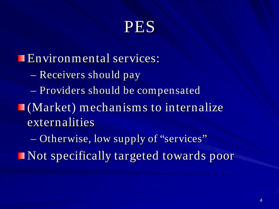
44
PESPES
Environmental services: Environmental services: –– Receivers should payReceivers should pay
–– Providers should be compensatedProviders should be compensated
(Market) mechanisms to internalize (Market) mechanisms to internalize externalities externalities –– Otherwise, low supply of Otherwise, low supply of ““servicesservices””
Not specifically targeted towards poorNot specifically targeted towards poor

55
PES in VietnamPES in Vietnam
Ministry of Planning and Investment (MPI) : Tax on Ministry of Planning and Investment (MPI) : Tax on electricity for forestry schemes?electricity for forestry schemes?
MARD: guidelines for quantifying payments for MARD: guidelines for quantifying payments for watershed protectionwatershed protection
Pilot payment schemePilot payment scheme for forest environmental for forest environmental services in services in Lam DongLam Dong (south) and (south) and Son La Son La (north)(north) under study. under study.
International organizations and NGOsInternational organizations and NGOs

66
ObjectiveObjective
Potential Potential response response of differentiated of differentiated householdshouseholds
PES : Reward farmers that set aside some land PES : Reward farmers that set aside some land in environmentally sensitive areas for forestryin environmentally sensitive areas for forestry
Diversity of households Diversity of households diversity of responsesdiversity of responsesmodelingmodeling
Impact on the poorest?Impact on the poorest?

77
DiversityDiversity of of householdshouseholds
Access to land and water
Upland mainly (no water)
Paddy land mainly (water for 2 rice crops)
Access to markets
No Subsistence upland rainfed rice farming
Subsistence paddy farming
Yes Diversified upland growers
Diversified production

88
One One problemproblem, , differentdifferent causes?causes?
Type 1: Type 1: farmersfarmers «« forcedforced »» to use more to use more agricultural land agricultural land –– UplandUpland ricerice on on slopesslopes
Type 3: Type 3: SustainableSustainable whenwhen enoughenough water water
Type 2 & 4: Type 2 & 4: marketmarket conditions conditions createcreate incentivesincentives to use more agricultural land: to use more agricultural land: –– MaizeMaize in Son Lain Son La–– MarketMarket maymay alsoalso drive to drive to sustainablesustainable solutions: solutions:
bamboobamboo, , teatea

99
ModelingModeling approachapproach
IndividualIndividual householdshouseholds–– Objective Objective functionfunction ( full ( full bellybelly …… incomeincome optimizersoptimizers))–– BoundedBounded resourcesresources (no real open (no real open accessaccess))–– DynamicDynamic ((limitedlimited horizon), horizon), recursiverecursive
UplandUpland compartmentcompartment: : «« ShiftingShifting cultivationcultivation »»–– DiscreteDiscrete decisionsdecisions --> open/close > open/close fieldsfields ((heuristicheuristic rulerule))–– FertilityFertility dynamicsdynamics equationsequations–– Labour allocation (Labour allocation (optimizationoptimization) ) betweenbetween plotsplots
LowlandLowland compartmentcompartment–– Labour allocationLabour allocation

1010
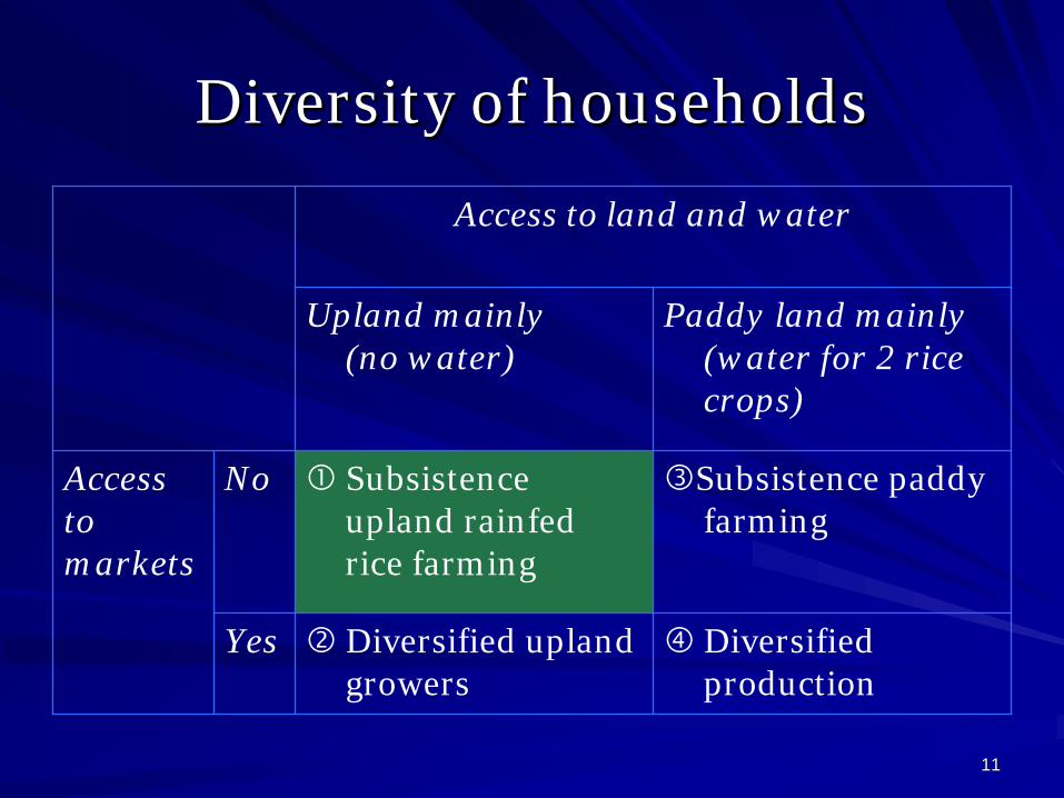
1111
DiversityDiversity of of householdshouseholds
Access to land and water
Upland mainly (no water)
Paddy land mainly (water for 2 rice crops)
Access to markets
No Subsistence upland rainfed rice farming
Subsistence paddy farming
Yes Diversified upland growers
Diversified production

1212
0
20
40
60
80
100
120
1 5 9 13 17 21 25 29 33 37 41 45 49 53 57 61 65 69 73 77 81 85 89
Simulation years (t)
Fert
ility
inde
x of
the
plot
s
F01F15

1313
EffectsEffects of setof set--asideaside schemescheme
20
30
40
50
60
70
80
90
100
110
120
1 6 11 16 21 26 31 36 41 46 51 56 61 66 71 76 81 86 91
Simulated years (t)
Plot
s fe
rtili
ty in
dex
01 - S101 - S215 - S115 - S2

1414
ResultsResults and conclusionsand conclusions
Direct Direct paymentpayment maymay not not bebe usefuluseful for for poorestpoorest–– High transaction High transaction costscosts: : MonetaryMonetary rewardsrewards are are unlikelyunlikely to to bebe
attractive to attractive to householdhousehold badlybadly connectedconnected to to marketsmarkets. .
Participation Participation mightmight::–– ProtectProtect somesome part of the catchmentpart of the catchment–– IncreaseIncrease problemsproblems in in otherother parts parts throughthrough cropcrop intensification intensification
of of remainingremaining zones (zones (reductionreduction of of fallowfallow periodsperiods) )
Alternative Alternative rewardsrewards workedworked out out betterbetter–– Food Food sufficiencysufficiency isis the main the main problemproblem
Direct Direct foodfood supplysupplyInsuranceInsurance againstagainst foodfood shortageshortage
–– BetterBetter water water accessaccess help for help for terracingterracing / infrastructure / / infrastructure / institutions institutions
–– InIn--kindkind fertilizersfertilizers

1515
ExtensionsExtensions
DifferentDifferent farmersfarmers typestypes–– ObjectivesObjectives
–– Land and water Land and water endowmentendowment
DifferentDifferent technicaltechnical alternativesalternatives–– Conservation agriculture Conservation agriculture insteadinstead of setof set--asideaside
BetterBetter integrateintegrate agronomicagronomic data data throughthrough interinter--disciplinarydisciplinary workwork

Appendix 3 - Copy of the manuscript submitted to the peer-reviewed journal “International Journal of the Commons” for publication in the special issue titled “PES in South-East Asia”

Payments for environmental services in upper-catchments of Vietnam: will it help the poorest?
Damien Jourdain, CIRAD, UMR G-EAU, Hanoi, Vietnam IRRI, SAM Project, Hanoi, Vietnam
CIRAD, UMR G-EAU, F-34298 Montpellier, France
Sushil Pandey, Social Science Division, IRRI, The Philippines
Do Anh Tai, Thainguyen University of Economics and Business Administration (TUEBA), Thainguyen City, Vietnam
Dang Dinh Quang, Northern Mountainous Agriculture and Forestry Science Institute
(NOMAFSI), Phu Ho Commune, Phu Tho Province, Vietnam ABSTRACT In Asia, there is a surge of interest in the development of Payments for Environmental Services (PES) programs. They represent a new approach that focuses directly on creating a conditional benefit transfer between providers and beneficiaries of environmental services. More specifically, in Vietnam, a Fund for the Protection and Development of Forestry has been recently established that puts in place the mechanisms for the payment of fees by downstream users of watershed services to finance forestry projects in the upper-catchments. This paper reviews the potential response of upland farming households to a PES scheme that rewards them to set aside part of land for the production of environmental services. We examine the viability of PES schemes targeted at agricultural households of the upper-catchments in Northern Vietnam. We focus our attention on households identified as the poorest in the upper-catchment areas, i.e. those with a small endowment of productive land, limited access to water for irrigation, and low access to markets. We find that farmers are unlikely to participate in a voluntary land retirement programs unless they are ‘compensated’ for the loss in food production and a ‘forced’ set aside program is likely to generate an overall negative impact on both poverty and environmental protection. Development and dissemination of improved technologies that increase food yields is a complementary strategy to promote environmental protection.
ACKNOWLEDGMENT This paper presents findings from PN11 “Rice Landscape Management for Raising Water Productivity, Conserving Resources, and Improving Livelihoods in Upper Catchments of the Mekong and Red River Basins”, a project of the CGIAR Challenge Program on Water and Food. Additional funds from the Theme 2 PES initiative were also used to obtain the specific results on PES impact.

2
KEY WORDS Shifting cultivation; Vietnam; Environmental services; Poverty; Modelling; Land Set-Aside
INTRODUCTION Payments for Environmental Services (PES) schemes present a new approach that focuses directly on creating a conditional benefit transfer between providers of environmental services, in this case the uplanders, and the downstream beneficiaries of these services. PES schemes are based on the principles that those who benefit from environmental services should pay for them, and that those who contribute to generating these services should be compensated for providing them. Hence, the approach seeks to create mechanisms that internalize what would otherwise be an externality(Pagiola et al. 2008). Such schemes can take the advantage of upland-lowland interactions in generating environmental benefits while improving the livelihoods of upper-catchment agricultural households. The past few years have witnessed a surge of interest in the development of PES schemes in Asia (e.g. Boquiren 2004; Pattanayak 2004; Suyanto et al. 2005). In Vietnam, while some projects using the conceptual framework of PES are being initiated in the central and southern part of the country (e.g. WWF 2007), no PES schemes are currently being implemented in the upper catchment areas of Northern Vietnam (Wunder et al. 2005). However, the Vietnamese government expressed recently its interest in starting such a scheme to protect fragile upper-catchments whose degradations are causing problems, among others, on hydro-electric infrastructures. In particular, the Vietnamese government recently created a « Fund for the Protection and Development of Forestry » that puts in place the mechanisms for the payment of fees by downstream users of watershed services to this fund. The money collected will then be used to finance forestry projects in the upper-catchments. For the moment, the main potential payees are the hydro-power plants, and the tourism industry (Government of Vietnam 2008), and the main potential beneficiaries would be farming households. Deforestation and slash-and-burn cultivation techniques are often blamed as the main causes of land degradation and deforestation in upper-catchments. A mix of incentives (subsidies), technical assistance on improved and sustainable agricultural practices, and regulation have been used to address the problem. However, such practices have not been widely adopted by farmers. In an attempt to meet their short-term livelihood needs, many agricultural households are still employing agricultural practices that are unsustainable in the long term. Land use practices, which would bring about environmental benefits, include forest plantation, agro-forestry systems, tree-based land use alternatives, and agro-ecologically sound practices such as conservation agriculture (Gouyon 2002). However, the environmental services these land use practices provide, i.e. watershed services, biodiversity conservation and carbon storage are usually un-rewarded and only indirectly connected to economic activities (The et al. 2004). Agricultural households in upper-catchments have unequal access to natural resources. The upper-catchments are generally composed of narrow valley bottoms where irrigated rice fields are found and of surrounding sloping land where upland rice, maize and

3
cassava are the principal crops. Forested areas are scattered on the sloping land and are now usually found at large distances from villages. The differential access to these land resources is an important determinant of household farming practices and livelihood strategies. The main objective of this paper is to review the potential response of upland households to a PES scheme that rewards them to set aside part of land for the production of environmental services. In the first section of this paper, we review briefly the economic literature on PES and their potential impact on poverty. This review focuses on papers that unveil the possibility of negative impact on poor farming households that can not participate as service providers in potential PES program. Given the possibility of negative impacts, we propose a framework to evaluate ex-ante the response of poor farming households in the Northern provinces of Vietnam. The second section describes the study area and the current farming systems. Then we propose a stylised typology of farming households in that region. In the third section of the paper, we develop a farm household model, and show how it can be used to anticipate farmers’ participation in potential PES programs and impact on their production strategy. Finally, in the fourth section, we examine the likely viability of PES schemes targeted at agricultural households of the upper-catchments in Northern Vietnam. We focus our attention on households identified as the poorest in the upper-catchment areas, i.e. those with a small endowment of productive land, limited access to water for irrigation, and low access to markets. We find that farmers are unlikely to participate in a voluntary land retirement program unless they are ‘compensated’ for the loss in food production through in-kind grain transfers or through the promotion of technologies that increase food yields. PES AND POVERTY PES approach was initially conceptualized and undertaken as a mechanism to improve the efficiency of natural resource management, and not really as a mechanism for poverty reduction (Pagiola et al. 2005). However, the recent attractiveness of PES to policy-makers is that both environmental degradation and rural poverty in upper-catchments may be mitigated by this approach (Landell-Mills and Porras 2002). However, some authors have also warned that the impact of PES programs on poverty may not always be positive (Wunder 2005). Land and labour market conditions can affect both participants and non-participants of PES programs. First, with insecure tenure, poor households in target areas may be evicted by powerful groups willing to capture the increased value of previously marginal land (Landell-Mills and Porras 2002). Second, PES schemes may have a positive impact on those who participate but a negative impact on poor households that are unable to participate, or on poor consumers. For example, a PES program that limits access to forested land may also exacerbate problems of landless households and herders, whose livelihoods depend crucially on gathering forest products (Kerr 2002). Third, PES can have a negative impact on farmers with small land area who derive most of their incomes as agricultural wage labour (Zilberman et al. 2008). Fourth, PES does not always result in poverty reduction as targeted poor households may be unwilling to participate if PES payments

4
do not cover the opportunity costs of requested land-use adjustments (Wunder 2008). Finally, the targeted producers of environmental services may be unable to participate in the PES program because of insecure land tenure, lack of land title, small farm holdings, or lack of access to credit to undertake investments such as reforestation (Pagiola et al. 2005; Grieg-Gran et al. 2005). This paper concentrates on the viability of participation of upland farming households in PES programs. An ex-ante analysis of the potential behaviour of farmers is proposed that takes into account their resource endowments, income levels and livelihood strategies. The focus of the paper is on households identified as the poorest in the upper-catchment areas, i.e. those with a small endowment of productive land, limited access to water for irrigation, and low access to markets. The specific policy intervention considered is a set-aside program that rewards farmers for retiring all or part of their land from food production. A LARGE DIVERSITY OF SITUATIONS IN THE UPPER-CATCHMENTS OF VIETNAM Study area Most of the empirical work was conducted in the district of Van Chan of the Yen Bai province (Figure 1). This district, containing part of the Hoang Lien mountain range, is surrounded by the Red and the Black Rivers. Two communes, Nam Bung and Suoi Giang, have been selected for their contrasted characteristics in terms of water regimes, i.e. the ratio of lowland to upland areas, and access to markets. Both communes are situated at an average height of 900 m.a.s.l. and are populated by ethnic minorities, mainly Thai, Hmong and Dao. Both communes contain a large diversity of small catchments typical of the Northern provinces of Vietnam. Upper-catchments are composed of narrow flat valley bottoms, usually used for paddy production, surrounded by sloping land. Terraces are also found in higher areas of the catchments. These terraces are either irrigated when sufficient water flows can be captured, or are conducted as rainfed lowland terraces. In either ways those terraces allow the use of draft power, and are affecting water flows within the catchment. Finally, distant forested areas provide the ground for complementary food needs e.g. hunting, fruit collection, and other non-timber forest products (Figure 2). Agricultural households are conducting contrasted agricultural activities in those different compartments. In the valley bottoms, irrigated rice is cultivated continuously. Several rice crops are sometimes cultivated within one calendar year, depending on local conditions and farms constraints. Depending on their connection to markets and their financial constraints, farmers will use highly variable levels of external inputs such as hybrid rice, fertilizers and insecticides. However, for cash constrained households, only traditional rice varieties with no chemical inputs cropping systems are possible. On upper terraces, lack of water during the dry season reduces the possibilities to one rainfed lowland rice crop per year. However, other crops, such as maize and soybean are also found.

5
Figure 1: Map of Vietnam, with indication of the study area in Yen Bai Province In contrast, agricultural activities are not continuous on the sloping land. Farmers alternate cultivation periods with fallow periods. In the study area, a typical cropping rotation will alternate eight to nine successive years of cropping with fallow. This sequence includes one to two years of dry-land rice cultivation, followed by two to three maize cropping years and several years of cassava cropping. Then, land is returned to fallow for several years before this cropping cycle is started again. A typology of household situations In upper-catchment areas, the major determinants of household livelihoods are land endowments, access to markets, and access to irrigation. Land endowments include not only the farm size but also the relative proportion of sloping uplands where rice is grown under dry-land conditions and paddy fields (such as terraced areas in lower slopes and valley bottoms) where rice is grown under wetland conditions. Rice grown in paddy fields generally produces higher yields than grown in sloping fields. For a given farm size, households who have a higher proportion of paddies are hence more food secure than those with a higher proportion of sloping uplands. In addition, those who meet most of their rice requirements from paddy fields are likely to grow non-food crops in the sloping uplands. This effect is reinforced if the lowland fields are irrigated.

6
Figure 2: A cross-section of a typical upper-catchment in the Northern mountainous provinces of Vietnam. Access to markets (inputs, outputs, and off-farm employment) is another important determinant of livelihood strategies. Production systems tend to be subsistence-oriented in areas with poor access to markets. Commercial production systems evolve when access to markets is good. Of the three main differentiating factors, the impact of access to water is mediated mainly through paddies where more intensive production of rice is possible when irrigation is available. The access to water is considered as a sub-category within the households with lowland plots. Hence, households can be classified into four categories based on the share of lowland in total farm area and access to markets (Table 1). Farmers of the first group cultivate fragile sloping lands for their food needs. Fallow-rotation upland rice based systems are used: secondary vegetation is cut and burned, upland rice is cultivated for one or two seasons, followed by maize and cassava. After a few years of cultivation, land is left to fallow. The families usually complement food needs with products collected in surrounding forested areas. Food productivity tends to decline over time as land use is intensified (or fallow cycle is reduced) in response to rising population pressure. Good access to markets offers the second group of farmers, who basically face the same constraints as the first group, more choices in their livelihood strategies. Off-farm work allows them to obtain monetary incomes. Purchased inputs can be used to prevent the decline in food productivity. Also, farmers can purchase food from the market when needed. The resulting environmental effects in sloping uplands tend to be positive or negative depending on whether farmers switch to perennial crops or intensify the land use in favour of annual crops. For example, the replacement of existing rice-fallow cultivation systems to maize-cassava continuous cropping systems for animal feed is likely to increase soil erosion and the associated negative externalities on downstream users. Of the four groups identified, farmers of group 1 tend to be the poorest and also the most vulnerable. Intensification of land use can take the form of reduced fallow periods
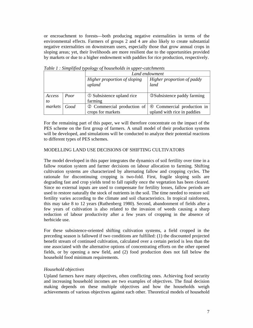
7
or encroachment to forests—both producing negative externalities in terms of the environmental effects. Farmers of groups 2 and 4 are also likely to create substantial negative externalities on downstream users, especially those that grow annual crops in sloping areas; yet, their livelihoods are more resilient due to the opportunities provided by markets or due to a higher endowment with paddies for rice production, respectively. Table 1 : Simplified typology of households in upper-catchments
Land endowment Higher proportion of sloping upland
Higher proportion of paddy land
Poor Subsistence upland rice farming
Subsistence paddy farming Access to markets Good Commercial production of
crops for markets Commercial production in
upland with rice in paddies For the remaining part of this paper, we will therefore concentrate on the impact of the PES scheme on the first group of farmers. A small model of their production systems will be developed, and simulations will be conducted to analyze their potential reactions to different types of PES schemes. MODELLING LAND USE DECISIONS OF SHIFTING CULTIVATORS The model developed in this paper integrates the dynamics of soil fertility over time in a fallow rotation system and farmer decisions on labour allocation to farming. Shifting cultivation systems are characterized by alternating fallow and cropping cycles. The rationale for discontinuing cropping is two-fold. First, fragile sloping soils are degrading fast and crop yields tend to fall rapidly once the vegetation has been cleared. Since no external inputs are used to compensate for fertility losses, fallow periods are used to restore naturally the stock of nutrients in the soil. The time needed to restore soil fertility varies according to the climate and soil characteristics. In tropical rainforests, this may take 8 to 12 years (Ruthenberg 1980). Second, abandonment of fields after a few years of cultivation is also related to the invasion of weeds causing a sharp reduction of labour productivity after a few years of cropping in the absence of herbicide use. For these subsistence-oriented shifting cultivation systems, a field cropped in the preceding season is fallowed if two conditions are fulfilled: (1) the discounted projected benefit stream of continued cultivation, calculated over a certain period is less than the one associated with the alternative options of concentrating efforts on the other opened fields, or by opening a new field, and (2) food production does not fall below the household food minimum requirements. Household objectives Upland farmers have many objectives, often conflicting ones. Achieving food security and increasing household incomes are two examples of objectives. The final decision making depends on these multiple objectives and how the households weigh achievements of various objectives against each other. Theoretical models of household

8
decision making are based on the maximization of ‘subjective’ utility (Nakajima 1970). The objective function is often simplified for empirical modelling in terms of the income level achieved and food needs satisfied. Poorly-developed marketing infrastructure and institutions in remote uplands also force such simplifications by constraining the application of household economy models that consider both the consumption and production side together with the markets linkages (Singh et al. 1986). In the simplification used here, a household is assumed to minimize the total labour use in food production subject to satisfying the family food requirements. This assumption implies that the household is basically subsistence-oriented with very limited interaction with markets (Group 1 household in Table 1). In the real world, upland farmers do have some interactions with the market and make land/labour use decisions in the light of market opportunities. In fact, most farmers fall somewhere in a continuum between fully subsistence-oriented and fully market-oriented. Analysis based on these extreme scenarios, although unlikely to be observed in the real world, can help generate insights into the farmer behaviour as conditions approach either fully market- or fully subsistence-oriented production. The quantitative modelling included in this paper is based on the assumption of fully subsistence-oriented production. Temporal considerations Most conservation decisions involve inter-temporal trade-offs: immediate gains of an action must be balanced against associated long term losses. Nevertheless, most farmers with pressing subsistence needs have high discount rates, resulting in very short planning horizons. Still, decisions taken at one point of time will influence future outputs and decisions. Hence, we used a recursive model, where households take decisions annually with short-term planning horizon, but have to bear the consequences of their previous choices. Model structure and dynamics Farmers make a number of decisions that are potentially relevant for the management of natural resources: cropping and fallow periods, crop choice, labour and other inputs, soil conservation investments, etc. We focused on three main interlinked mechanisms: nutrient dynamics, cropping and fallow periods, and labour allocation decision. The model reproduces decisions of a farmer who has been allocated a given area of sloping land for individual management. The following additional assumptions were also made: • Land available to the household is fixed. Therefore, expansion of agricultural
activities into open-access forest is not an option as is the case in Vietnam. • Food requirements and labour supply are time invariant. • It is assumed that the fertility status of each field f at period t can be described by
only one parameter FERT(f, t). This implies that one single nutrient is assumed to be globally limiting the production.
Nutrient dynamics and crop yields are influenced by household decisions at each period, i.e. cropping versus fallowing, and the quantity of labour input into crop production. In
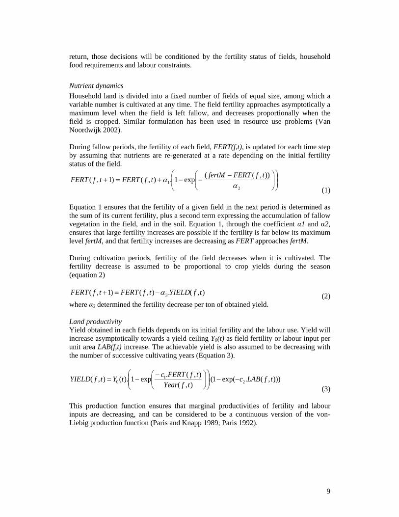
9
return, those decisions will be conditioned by the fertility status of fields, household food requirements and labour constraints. Nutrient dynamics Household land is divided into a fixed number of fields of equal size, among which a variable number is cultivated at any time. The field fertility approaches asymptotically a maximum level when the field is left fallow, and decreases proportionally when the field is cropped. Similar formulation has been used in resource use problems (Van Noordwijk 2002). During fallow periods, the fertility of each field, FERT(f,t), is updated for each time step by assuming that nutrients are re-generated at a rate depending on the initial fertility status of the field.
⎟⎟⎠
⎞⎜⎜⎝
⎛⎟⎟⎠
⎞⎜⎜⎝
⎛ −−−+=+
21
)),((exp1.),()1,(α
α tfFERTfertMtfFERTtfFERT (1)
Equation 1 ensures that the fertility of a given field in the next period is determined as the sum of its current fertility, plus a second term expressing the accumulation of fallow vegetation in the field, and in the soil. Equation 1, through the coefficient α1 and α2, ensures that large fertility increases are possible if the fertility is far below its maximum level fertM, and that fertility increases are decreasing as FERT approaches fertM. During cultivation periods, fertility of the field decreases when it is cultivated. The fertility decrease is assumed to be proportional to crop yields during the season (equation 2) ),(.),()1,( 3 tfYIELDtfFERTtfFERT α−=+ (2) where α3 determined the fertility decrease per ton of obtained yield. Land productivity Yield obtained in each fields depends on its initial fertility and the labour use. Yield will increase asymptotically towards a yield ceiling Y0(t) as field fertility or labour input per unit area LAB(f,t) increase. The achievable yield is also assumed to be decreasing with the number of successive cultivating years (Equation 3).
))),(.exp(1.(),(
),(.exp1).(),( 21
0 tfLABctfYear
tfFERTctYtfYIELD −−⎟⎟⎠
⎞⎜⎜⎝
⎛⎟⎟⎠
⎞⎜⎜⎝
⎛ −−=
(3) This production function ensures that marginal productivities of fertility and labour inputs are decreasing, and can be considered to be a continuous version of the von-Liebig production function (Paris and Knapp 1989; Paris 1992).
10
Land use and labour allocation As discussed earlier, labour is allocated, fallowed land is brought into cultivation and cultivated land is left fallow according to household decision rules involving factors such as household labour productivity and food sufficiency. The modelled households have no access to markets, so it was assumed that households choose the number of fields cultivated or left fallow and allocate labour among cultivated lands in order to produce enough food. For each year, decisions about the number of plots cropped and the labour allocated in each of the cropped plot are simulated according the following process. Construction of scenarios on which plots should be cropped / left fallow: Four scenarios are built: (1) the household cultivates the same plots that was cultivated in the previous year, (2) the household cultivates one new plot and do not leave any of the cropped ones fallow, (3) one of the cropped plots is left fallow (4) one plot under fallow is cropped, and one cropped plot is left fallow. The plot with the highest value of FERT(f,t) is chosen as the newly cropped plot and clearing time (opening(t)) is added to the labour needs. The cropped field with the lowest value of FERT(f,t) is chosen as the plot newly left fallow. Identification of the most favourable scenario For each scenario, a non-linear programming model is used to minimize the household’s labour input, while producing the required food (equation 4) and respecting the family labour constraints (equation 5). For each scenario, the model obtains the allocation of labour to each of the cropped field under that scenario. This model is implemented using GAMS (Rosenthal 2007) with the non-linear programming solver CONOPT2 (Drud 2006). )(),().(( tfoodtfYIELDfsize
f≥∑
(4) Where food(t) represents the household food requirements; )()()),().(( tflabtopeningtfLABfsize
f≤+∑
(5) where
o LAB(f,t) is labour allocated to field f (endogenous); o flab(t) is the household available labour time.
The best scenario is retained and represents the decision taken during the year t. Implementation of the decisions and step forward to the next year Finally, the soil fertility index of each plot is re-calculated for the next time step under that scenario.
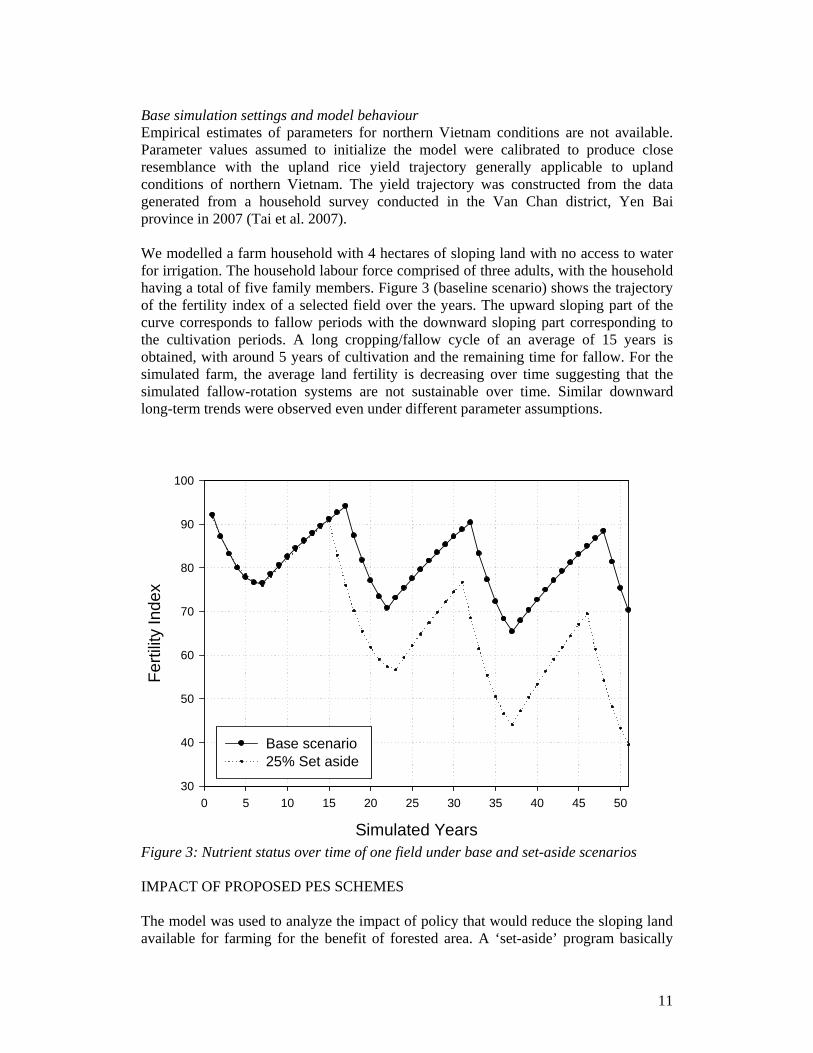
11
Base simulation settings and model behaviour Empirical estimates of parameters for northern Vietnam conditions are not available. Parameter values assumed to initialize the model were calibrated to produce close resemblance with the upland rice yield trajectory generally applicable to upland conditions of northern Vietnam. The yield trajectory was constructed from the data generated from a household survey conducted in the Van Chan district, Yen Bai province in 2007 (Tai et al. 2007). We modelled a farm household with 4 hectares of sloping land with no access to water for irrigation. The household labour force comprised of three adults, with the household having a total of five family members. Figure 3 (baseline scenario) shows the trajectory of the fertility index of a selected field over the years. The upward sloping part of the curve corresponds to fallow periods with the downward sloping part corresponding to the cultivation periods. A long cropping/fallow cycle of an average of 15 years is obtained, with around 5 years of cultivation and the remaining time for fallow. For the simulated farm, the average land fertility is decreasing over time suggesting that the simulated fallow-rotation systems are not sustainable over time. Similar downward long-term trends were observed even under different parameter assumptions.
Simulated Years
0 5 10 15 20 25 30 35 40 45 50
Ferti
lity
Inde
x
30
40
50
60
70
80
90
100
Base scenario25% Set aside
Figure 3: Nutrient status over time of one field under base and set-aside scenarios IMPACT OF PROPOSED PES SCHEMES The model was used to analyze the impact of policy that would reduce the sloping land available for farming for the benefit of forested area. A ‘set-aside’ program basically
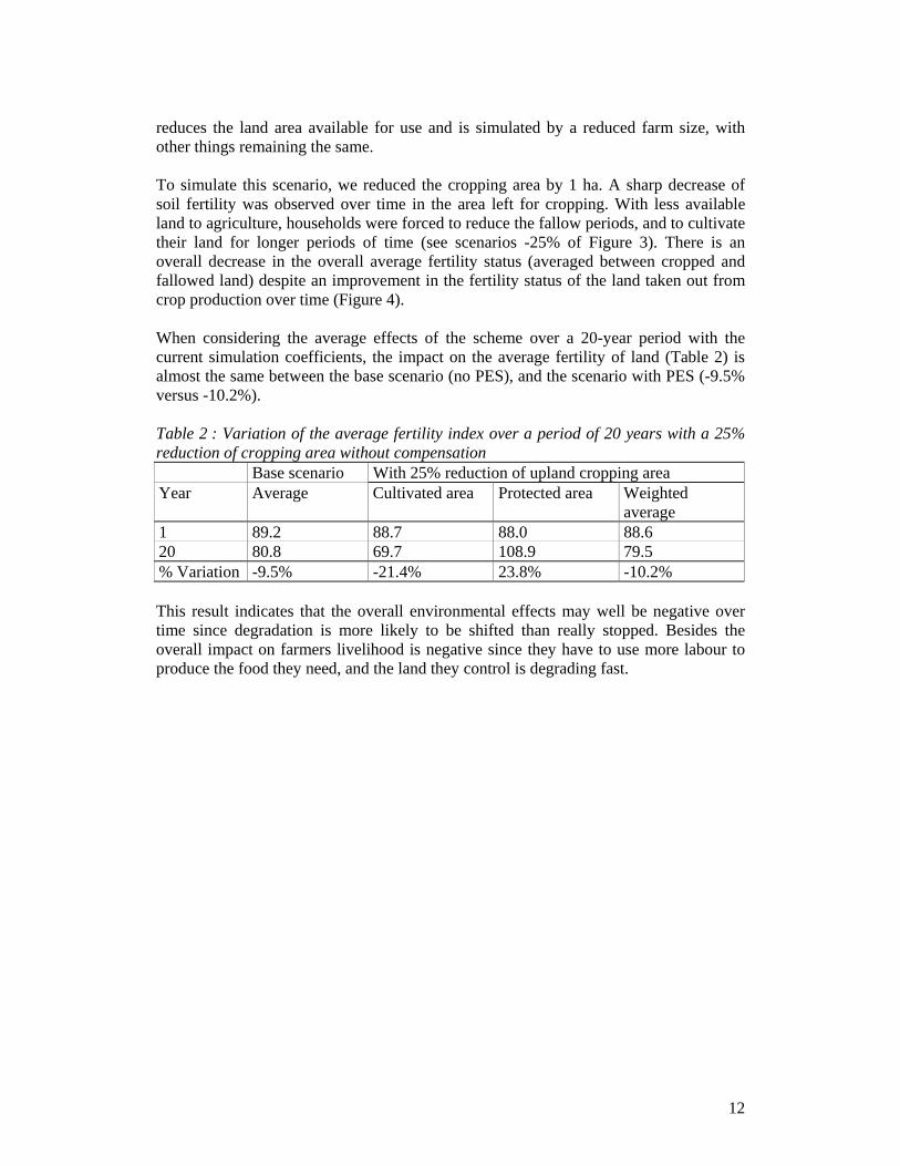
12
reduces the land area available for use and is simulated by a reduced farm size, with other things remaining the same. To simulate this scenario, we reduced the cropping area by 1 ha. A sharp decrease of soil fertility was observed over time in the area left for cropping. With less available land to agriculture, households were forced to reduce the fallow periods, and to cultivate their land for longer periods of time (see scenarios -25% of Figure 3). There is an overall decrease in the overall average fertility status (averaged between cropped and fallowed land) despite an improvement in the fertility status of the land taken out from crop production over time (Figure 4). When considering the average effects of the scheme over a 20-year period with the current simulation coefficients, the impact on the average fertility of land (Table 2) is almost the same between the base scenario (no PES), and the scenario with PES (-9.5% versus -10.2%). Table 2 : Variation of the average fertility index over a period of 20 years with a 25% reduction of cropping area without compensation Base scenario With 25% reduction of upland cropping area Year Average Cultivated area Protected area Weighted
average 1 89.2 88.7 88.0 88.6 20 80.8 69.7 108.9 79.5 % Variation -9.5% -21.4% 23.8% -10.2% This result indicates that the overall environmental effects may well be negative over time since degradation is more likely to be shifted than really stopped. Besides the overall impact on farmers livelihood is negative since they have to use more labour to produce the food they need, and the land they control is degrading fast.

13
Simulated Years
0 5 10 15 20 25 30 35 40 45 50
Ave
rage
Fer
tility
Inde
x
20
30
40
50
60
70
80
90
100
110
120
Base Scenario 25% reduction of upland cropping area - Cultivated area25% reduction of upland cropping area - Protected zone25% reduction of upland cropping area - Total area
Figure 4: Impact on average plot fertility of a 25% reduction of cropping area without compensation. A mechanism for ensuring that households are able to meet their food needs is to compensate them for the lost food production resulting from the withdrawal of land. A sustainable land fertility status can be achieved by compensating farmers in the form of direct provision part of their food requirements. Such a provision may take the form of annual in-kind subsidy of grain. This mechanism was used by China’s Sloping Land Conversion Program that compensated farmers who converted degraded land to forests (Bennett and Xu 2005). It has to be noted, however, that the cost of making such transfers may be too high in remote areas to make it a viable strategy except for some limited areas. Another solution would be to act upon farmers’ risk induced behaviours. As a matter of fact, households’ food requirements include a “buffer surplus” to be prepared for a bad climatic event or pest outbreaks. An in-kind insurance mechanism that would ensure a minimum grain supply during the low yield years is likely to increase the households’ well-being (by decreasing their vulnerability). Also, food transfers involved are likely to be less costly as they are limited to adverse years only. Nevertheless, the total cost will be substantial unless the program is limited to only a small area. An effective and viable strategy to promote set-aside of land is to increase the yield per unit of agricultural land through the public provision of improved agricultural
14
technologies. Pressure to intensify land use can be reduced if crop yields are higher as farmers will be able to meet their food needs from a smaller area. The success of ‘return land to forest’ program in the uplands of Yunnan, China is partly due to the availability of high yielding upland rice technologies (Pandey et al. 2005). In addition, such technologies help promote income generation by releasing resources (land and labour) that can be used to produce market-oriented crops without sacrificing the household food security. Investments in agricultural R&D and technology promotion may be considered by rural communities as a part of broader development interventions, not a part of PES. Nevertheless, at the sectoral level, such investments can be seen as a strategy to promote environmentally beneficial changes in land use. DISCUSSION AND CONCLUSION This article developed a recursive dynamic model of shifting cultivators that integrated the dynamics of soil fertility over time and farmers decisions in order to analyse the potential effect of their participations in PES programs. The model predicted that farmers are unlikely to participate in a voluntary land retirement program unless they are ‘compensated’ for the loss in food production through in-kind grain transfers or through the promotion of technologies that increase crop yields. The article also showed that if households are somehow forced into the program, through top-down selection of protected areas, this induces a reduction of environmental degradation in targeted zones, but an increase of environmental degradation on the remaining part of their land-holding. The overall net environmental effect could actually be negative. In addition, the overall effect on poverty would be negative since labour productivity diminishes progressively and farmers’ food supply becomes more insecure. This study used a simplified model of household behaviour in situations with limited access to markets. This forces farmers to intensify land use to meet the food requirement from the remaining farm area as land is set aside from agricultural production. An improvement in the access to markets and non-farm employment opportunities can relax this constraint by enhancing farmers’ overall food entitlements even when production accounts for only a part of the total requirements. Environmentally beneficial land use patterns can evolve in a commercially-oriented system if property rights to land are well-defined (Pandey and Lapar 1998). Voluntary participation in PES schemes is also more likely when food entitlements can be enhanced through market participation. Second, we have not studied the possibility of technological change that could be induced by a PES scheme. Technical solutions such as direct-seeding over mulch cropping systems (DMC) are potential alternatives to slash and burn practices for land-constrained farm households of the upper-catchments (Husson et al. 2000). When adopted, these technologies can generate positive externalities to downstream users through erosion control. However, a recent study carried out in Northern provinces of Vietnam shows that the adoption of these DMC systems is not immediately profitable for farming households (Affholder et al. 2008). Compensating farmers for the transition costs linked to the adoption of this new technology could potentially be very effective.
15
More generally, support to development and dissemination of improved technologies that raise land productivity is an important strategy to reduce the intensification pressure in fragile and to prevent environmental degradation. Such technologies could be considered as part of the larger schemes for encouraging farmers to adopt environmentally superior production and land use practices. LITERATURE CITED Affholder, F., D. Jourdain, M. Morize, D. D. Quang, and A. Ricome. 2008. Eco-
intensification sur les versants montagneux au Vietnam. Contraintes et opportunités d’adoption des SCV par les agriculteurs. Cahiers d'Agriculture 17 (3):290-296.
Bennett, M. T., and J. Xu. 2005. China’s Sloping Land Conversion Program: Institutional Innovation or Business as Usual? Paper read at ZEF-CIFOR workshop: Payments for environmental services in developed and developing countries, at Titisee, Germany.
Boquiren, R. R. 2004. Rewards for environmental services in the Philippines uplands: Constraints and opportunities for institutional reform. Bogor, Indonesia: World Agroforestry Centre (ICRAF).
Drud, A. 2006. CONOPT Solver. Bagsvaerd, Denmark: ARKI Consulting and Development.
Gouyon, A. 2002. Rewarding the upland poor for environmental services: a review of initiatives from developed countries. Paper read at RUPES Regional Inception/Planning Workshop, 6-8 February 2002, at Puncak, Indonesia.
Government of Vietnam. 2008. Decree 05/2008/ND-CP dated 14 January 2008 by Prime Minister on the Funds for the Protection and Development of Forestry
Grieg-Gran, M., I. Porras, and S. Wunder. 2005. How can market mechanisms for forest environmental services help the poor? Preliminary lessons from Latin America. World Development 33 (9):1511–1527.
Husson, O., H. D. Tuan, P. Lienhard, and D. H. Tham. 2000. Development of direct sowing techniques as alternatives to slash-and-burn systems in the mountainous areas of Northern Vietnam. Paper read at EC Workshop on Sustainable Rural Development in the Southeast Asian Mountainous Region, 28-30 November 2000. Delegation of the European Commission to Vietnam, at Hanoi, Vietnam.
Kerr, J. 2002. Watershed development, environmental services, and poverty alleviation in India. World Development 30 (8):1387–1400.
Landell-Mills, N., and I. T. Porras. 2002. Silver bullet or fools’ gold? A global review of markets for forest environmental services and their impact on the poor. In Instruments for sustainable private sector forestry series. London: International Institute for Environment and Development (IIED).
Nakajima, C. 1970. Subsistence and commercial family farms: some theoretical models of subjective equilibrium. In Subsistence Agriculture and Economic Development, edited by C. R. Wharton. London: Frank Cass & Co.
Pagiola, S., A. Arcenas, and G. Platais. 2005. Can payments for environmental services help reduce poverty? An exploration of the issues and the evidence to date from Latin America. World Development 33 (2):237-253.

16
Pagiola, S., A. R. Rios, and A. Arcenas. 2008. Can the poor participate in payments for environmental services? Lessons from the Silvopastoral Project in Nicaragua. Environment and Development Economics 13 (3):299-325.
Pandey, S., and M. L. A. Lapar. 1998. A micro-economic analysis of adoption of contour hedgerows in the Philippines uplands. In Soil erosion at multiple scales, edited by F. W. T. Penning de Vries, F. Agus and J. Kerr: CAB International.
Pandey, S., D. Tao, F. Hu, L. E. Velasco, J. Zhou, L. Wen, Z. Wang, G. Wu, and H. Si. 2005. Upland rice systems and farmer livelihoods in Yunnan: recent changes and impact. In Social Sciences Research Paper Serie. Los Banos, The Philippines: International Rice Research Institute.
Paris, Q. 1992. The von Liebig hypothesis. American Journal of Agricultural Economics 74 (4):1019-1028.
Paris, Q., and K. K. Knapp. 1989. Estimation of the von-Liebig response functions. American Journal of Agricultural Economics 71 (1):178-186.
Pattanayak, S. K. 2004. Valuing watershed services: concepts and empirics from southeast Asia. Agriculture, Ecosystems and Environment 104 (1):171-184.
Rosenthal, R. E. 2007. GAMS: a user's guide. Washington, D.C.: GAMS Development Corporation.
Ruthenberg, H. 1980. Farming systems in the Tropics. Oxford: Oxford University Press. Singh, I., L. Squire, and J. Strauss, eds. 1986. Agricultural households models:
extensions, applications and policy. Baltimore and London: John Hopkins University Press.
Suyanto, S., B. Leimona, R. P. Permana, and F. J. C. Chandler. 2005. Review of the development environmental services market in indonesia. Bogor: World Agroforestry Center (ICRAF).
Tai, D. A., N. V. Cong, M. L. Velasco, D. Jourdain, T. P. V. Cuong, H. Ha, N. D. Dung, P. N. Cuong, T. V. Anh, S. Pandey, H. Gurung, and B. Samson. 2007. Assessment on the socio-economic situation and challenges to agricultural development in upper-catchment of Vietnam: the case of Van Chan district, Yen Bai province. Thainguyen, Vietnam: TUEBA.
The, B. D., D. T. Ha, and N. Q. Chinh. 2004. Rewarding upland farmers for environmental services: experience, constraints and potential in Vietnam. Bogor, Indonesia: World Agroforestry Centre (ICRAF).
Van Noordwijk, M. 2002. Scaling trade-offs between crop productivity, carbon stocks and biodiversity in shifting cultivation landscape mosaics: the FALLOW model. Ecological Modelling 149 (1-2):113-126.
Wunder, S. 2005. Payments for environmental services: Some nuts and bolts. Bogor, Indonesia: Center for International Forestry Research.
———. 2008. Payments for environmental services and the poor: concepts and preliminary evidence. Environment and Development Economics 13 (3):279-297.
Wunder, S., B. D. The, and E. Ibarra. 2005. Payment is good, control is better: Why payments for forest environmental services in Vietnam have so far remained incipient. Bogor, Indonesia: CIFOR.
WWF. 2007. Paying for ecological services: the use of economic tools to deliver conservation goals in Vietnam - A portfolio of projects. Hanoi: WWF.

17
Zilberman, D., L. Lipper, and N. McCarthy. 2008. When could payments for environmental services benefit the poor? Environment and Development Economics 13 (3):255-278.