Embed Size (px)
Citation preview
Exploring the Shortest Route Options: Applying
Environmental Indicators to Calculating Shortest Route
Matthew Pulis
Email: [email protected]
Maria Attard
GIS Laboratory, Geography Division
University of Malta
Email: [email protected]
Abstract
Studies suggest that a large percentage of traffic
congestion occurs during peak hours [1]. Many loca-
tion based services and systems today exist that
assist traffic routing to maximise on travel time and
reduce trip lengths (e.g. Garmin, TomTom). The ob-
jective of this study looks at enhancing these sys-
tems by adding functionalities and variables that
favour fuel savings as well as shortest route. A sys-
tem is developed using Open Source GIS (using the
PostGIS and pgRouting extensions for the DBMS:
PostgreSQL), whereby a number of variables, includ-
ing weather conditions, road network, traffic status,
vehicle specification data and road gradient are
manipulate by the user to achieve shortest and most
fuel efficient route.
Index Terms
Geographic Information Systems, Shortest Path
Routing, Fuel efficiency.
1. Introduction
Geographic Information Systems (GIS) can be
used for different uses, particularly Location Based
Services (LBS). This study aims to enhance currently
available routing systems with options that take
into consideration weather, traffic direction in the
road network and road (slope) gradient. These fac-
tors impact vehicle fuel efficiency. This system will
be operable both of desktop or mobile devices with
the latter having a randomised point representing
the current location. This concept model uses some
randomised data providing route planning depen-
dent on the type of route chosen by the driver, and
also taking into consideration weather and roads,
with live data in order to avoid blocked roads due to
for example an accident or flooding.
1.1 Location Based Services
LBS are considered by many as the driving force
of Mobile Commerce. Such services are normally
based on clients’ geographical location [2]. LBS are
not limited to business applications but to emer-
gency and social services such as in the US, Canada
and Japan [3], [4], [5] and the EU [6].
1.2 Transport Geographic Information
Systems (T-GIS)
GIS are being applied in many industries mainly
but not limiting, public safety, resource manage-
ment, government roads, road networking and so
on. A GIS can be seen as a stack of different map
layers, be it raster or vector, where each layer is
geographically aligned to each other [7].
The challenges in T-GIs’s are related to Data
Management, Data Manipulation and Data Analysis.
Dueker & Butler [8] argue that sharing T-GIS data is
“both an important issue and a difficult one”. The
different applications also affect how streets are
broken into logical statements which can be pre-
pared for information extracts. For example routing
software would accept a straight highway as three
line segments, ensuring that the driver starts the
highway and does not exit before the end of the
line (broken down in a few segments). In accident
recognition software, the same highway has to be
segmented in smaller and more manageable slices
for the accident to be located more effectively. In
contrast with what Thill [9] claims with regard to
the lack of data manipulation required by society,
Downey [10] claims that these techniques have im-
proved. Similarly by Wootton & Spainhour [11], that
state the recent improvements with regard to data
manipulation tools in GIS. One other development
has been Open Source GIS.
PostgreSQL is a widely known open source
RDBMS which can be extended with PostGIS. The
main core functions of PostGIS were developed by
Refractions Research and follow the OpenGIS "Sim-
ple Features Specification for SQL”. PostGIS sup-
ports all the standards that are supported by Open
GIS Consortium (OGC, OGC SQL functions, OGC
Simple Features) [12].
1.3 Finding the Best Route
Studies conclude that optimization techniques in
solving pickup and delivery problems are not prom-
ising [13]. The main application of these techniques
is when a route is needed between a source vertex
and a target one. Thus routing algorithms can be
deemed more successful when the starting and
ending vertices are known prior to the exercise,
rather than trying to minimise paths when visiting
vertices [13]. Different studies propose different
algorithms to identify a route starting from a single
vertex can reach all the rest of the vertices in the
network. These are called single-source SPAs or
single-source queries [14]. A benefit of these que-
ries is that they can be enhanced to allow for sec-
ondary constraints, such as Boolean weights or dif-
ferential costs. Such queries are also used in this
study, where the starting and ending vertices are
known, and the constraints will be passed as Boo-
lean weights.
1.4 Fuel Consumption
Lin [15] looked at fuel use by applying the exper-
tise of (taxi) drivers, in preparing their routes within
the city. Many of the routes chosen were very simi-
lar, given the time of the day. This contrasted with
Leshed et al. [16] where many of the responses
showed that a consideration of time of day, speed,
fuel consumption and congestion. These results
have led Chang, Wu & Ho [17] to develop a net-
work system which took into consideration fuel
consumption, speed, and real-time traffic informa-
tion.
2. Methodology
This study proposes a routing system able to
operate for both desktop and mobile users (Figure
1).
Figure 1. System Overview
The study tests different routing algorithms
based on changes in:
• Weather conditions;
• Road conditions including:
o planned road blocks;
o temporary road blocks such as traffic con-
gestion or accidents.
• Vehicle used(engine and type of vehicle);
• Road gradient
The Dynamic Systems Development Methodol-
ogy (DSDM) was applied to this study and MoSCoW
(Must Could Should Would) requirements were
drawn up in order to prioritise the core require-
ments (
Table 1).
From the start of the project, the main aim of
this research was to deal with dynamic routing. This
makes the choice of variables a key factor in the
planning of the system. Based on the literature re-
view, a number of variables affecting dynamic
choice of the route, but which are not particularly
used in the industry and research have been identi-
fied. Despite the obvious choice of some variables
others were not so obvious. This section does not
only base the discussion on what types of variables
were chosen but also on how the data associated
with such variables were collected and processed.
2.1 Traffic Conditions
Identifying a good quality dataset was a key
concern in this study. The dataset needed to fea-
ture different gradient type of streets and traffic
directions (One-Way and Bi-Directional segments).
Traffic conditions are affected by weather and
network information. The weather website used for
this study (www.wunderground.com) provided an
updated RSS feed. The reports from wunder-
ground.com are not very specific, so it is left to a
randomizing engine to decide the effect on weather
over the streets. Such technique was computed
following Gera [18].
Network information was more difficult to find.
A randomizing engine was created to simulate traf-
fic block on the roads. For the scope of the project,
it was decided that a random generating function
for disabling roads would be needed, producing an
XML file. A Sample RSS reader was scripted to ex-
tract the random generated data. The generated
data will have random type of events with a corre-
sponding randomised time factor (Table 2). This
randomising technique was inspired from Karl et al.
[19].
2.2 Choice of Data
After extensive research for the desired data, in-
cluding gradient and turn restrictions, GRASS data
book was used [20]. After reviewing the data, clari-
fications from the data collection team, [21], was
sought to clarify details in the metadata. The gradi-
ent in the available raster files was not useful to
street segments. GRASS software was used to com-
bine the raster files with the vector files. This new
Shape file was checked for altitude changes, and
after successfully exporting the data into a 3-D
plane, the Shape File was exported to PostGIS using
OGR tool. The dataset chosen is made up of sixteen
types of road classes, three State road segments,
about two thousand highway segments, another
circa twenty five thousand primary road segments
and almost ten thousand secondary road segments.
2.3 Modifying the Data
The technique used to enable or disable roads
included the creation of two columns in the table,
one showing attribute access for normal vehicles,
and one for emergency access. So as to keep such
dynamic data apart from the main spatial data,
views were used. What is stored actually on the
database is the Expiry data of the ban, which when
compared with the current timestamp of the query,
if it is earlier, it means the road can be used (having
a TRUE status) else, status will be set to FALSE mak-
ing it impossible to be called for routing. Thus in the
database only the expiry date is stored making it
possible to be heavily indexed by using B-Tree In-
dexing method. A similar technique was used to
display the reason, if the segment was banned:
Table 1. MoSCoW Requirements
Priority Description
Must To build up a Location Based Service for
mobile customers which act as an intel-
ligent route planner.
Must To plan a route should allow the user to
specify which planning has to be used
Must To design and build a Geography Infor-
mation System that will act as the back-
end for the system offering these ser-
vices.
Must To design and build a Web-Interface
front end for the users to communicate
with the backend.
Must To allow queries to be planned against
live data and thus minimizing risks of
finding traffic jams.
Must The Web-Interface needs to be com-
pliant to W3C Standards. It must be cor-
rectly viewed on Gecko Engine.
Must All software used in this project need to
be Open Source and confirm to Open
Standards.
Should Such a Web-Interface should be access-
ible from mobile devices for the route
planning section.
Could To prepare different types of Users,
each with a separate login and a login
class.
Could Syndicate data from a Traffic and
Weather update site.
Would Use Maltese data instead of American
one
Would Instead of synthetic use real data, espe-
cially Traffic conditions
Would Use GPS locators instead of a random
point on the map
2.4 Computing the Route
This function, extends the Shortest_Path_SP()
PL/PGsql function in the pgRouting package. This
function was modified to accept another parame-
ter. The wrapping function makes also possible cap-
turing the source and target edges, something
which required two extra SQL calls in the pgRouting
function. Another enhancement provided on this
function is the ability to allow the specification of
the rule column to use when doing the routing.
What one must point out from the algorithm is that
where possible, the extents start on a small scale,
and var_max_dist denotes the extent by which the
point is searched, keeping it as small as possible.
This is done so as to limit the function processing
time. Wherever possible, the function is using both
spatial and non spatial indexing. For example the
“&&” notion make use of the GIS index present on
the geospatial table.
Table 2. Types of Random Road Blocking
Blockage Type Minimum
Blocking
Maximum
Blocking
Accident / Road
Lights Malfunction
2 Hours 1 Day
Road Works 1 Week 3 Months
Road Maintenance /
Road Construction
6 Months 2 Years
The Shortest Path function returns the closest
edges, however, the custom function written for
this project, extends this by forming an additional
path between the vertex and the edge, so as to be
able to guide the driver for the first and last sec-
tions of the journey. This extension is made by loop-
ing through the first and last result set, and making
use of PostGIS function line_locate_point() to find
out the nearest point from the edge to the source
or target. A set of points is created in order to join
lines was created so as to join the starting and end-
ing point to the route.
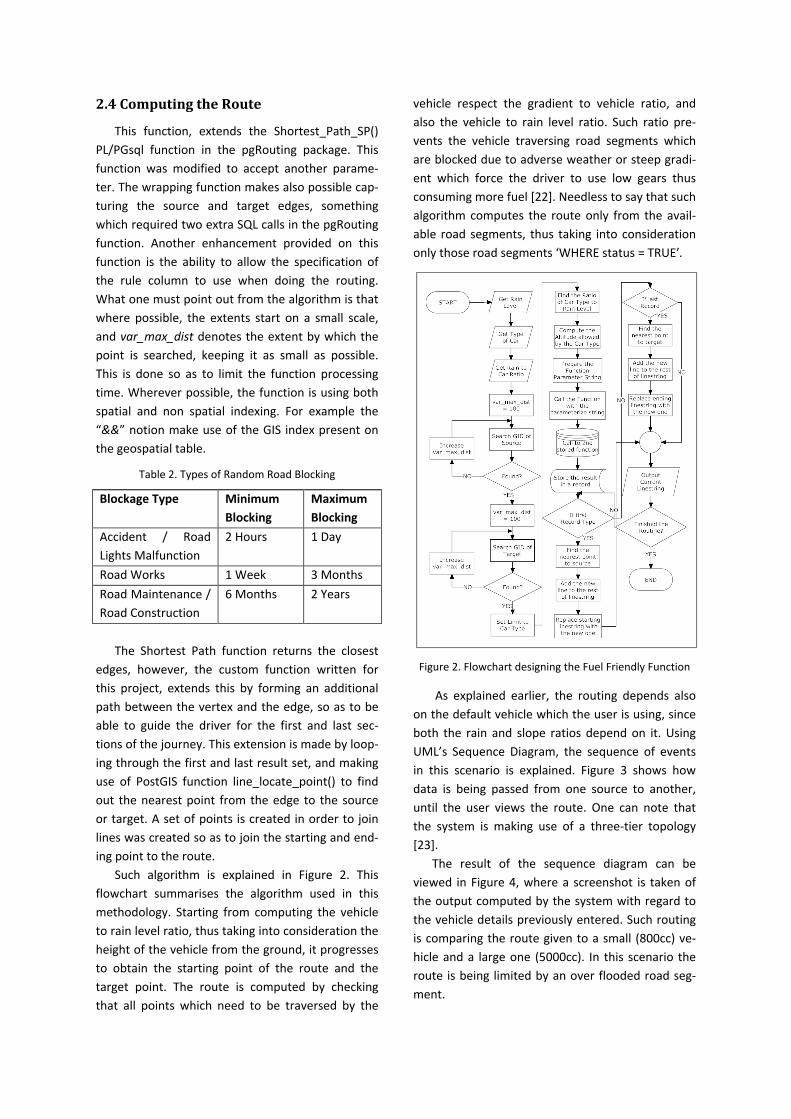
Such algorithm is explained in Figure 2. This
flowchart summarises the algorithm used in this
methodology. Starting from computing the vehicle
to rain level ratio, thus taking into consideration the
height of the vehicle from the ground, it progresses
to obtain the starting point of the route and the
target point. The route is computed by checking
that all points which need to be traversed by the
vehicle respect the gradient to vehicle ratio, and
also the vehicle to rain level ratio. Such ratio pre-
vents the vehicle traversing road segments which
are blocked due to adverse weather or steep gradi-
ent which force the driver to use low gears thus
consuming more fuel [22]. Needless to say that such
algorithm computes the route only from the avail-
able road segments, thus taking into consideration
only those road segments ‘WHERE status = TRUE’.
Figure 2. Flowchart designing the Fuel Friendly Function
As explained earlier, the routing depends also
on the default vehicle which the user is using, since
both the rain and slope ratios depend on it. Using
UML’s Sequence Diagram, the sequence of events
in this scenario is explained. Figure 3 shows how
data is being passed from one source to another,
until the user views the route. One can note that
the system is making use of a three-tier topology
[23].
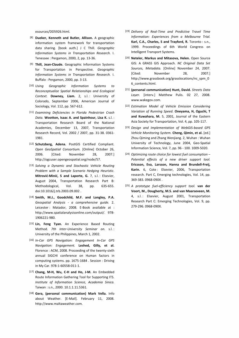
The result of the sequence diagram can be
viewed in Figure 4, where a screenshot is taken of
the output computed by the system with regard to
the vehicle details previously entered. Such routing
is comparing the route given to a small (800cc) ve-
hicle and a large one (5000cc). In this scenario the
route is being limited by an over flooded road seg-
ment.
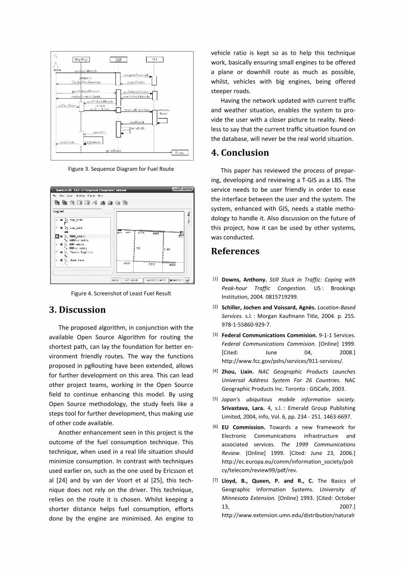
Figure 3. Sequence Diagram for Fuel Route
Figure 4. Screenshot of Least Fuel Result
3. Discussion
The proposed algorithm, in conjunction with the
available Open Source Algorithm for routing the
shortest path, can lay the foundation for better en-
vironment friendly routes. The way the functions
proposed in pgRouting have been extended, allows
for further development on this area. This can lead
other project teams, working in the Open Source
field to continue enhancing this model. By using
Open Source methodology, the study feels like a
steps tool for further development, thus making use
of other code available.
Another enhancement seen in this project is the
outcome of the fuel consumption technique. This
technique, when used in a real life situation should
minimize consumption. In contrast with techniques
used earlier on, such as the one used by Ericsson et
al [24] and by van der Voort et al [25], this tech-
nique does not rely on the driver. This technique,
relies on the route it is chosen. Whilst keeping a
shorter distance helps fuel consumption, efforts
done by the engine are minimised. An engine to
vehicle ratio is kept so as to help this technique
work, basically ensuring small engines to be offered
a plane or downhill route as much as possible,
whilst, vehicles with big engines, being offered
steeper roads.
Having the network updated with current traffic
and weather situation, enables the system to pro-
vide the user with a closer picture to reality. Need-
less to say that the current traffic situation found on
the database, will never be the real world situation.
4. Conclusion
This paper has reviewed the process of prepar-
ing, developing and reviewing a T-GIS as a LBS. The
service needs to be user friendly in order to ease
the interface between the user and the system. The
system, enhanced with GIS, needs a stable metho-
dology to handle it. Also discussion on the future of
this project, how it can be used by other systems,
was conducted.
References
[1] Downs, Anthony. Still Stuck in Traffic: Coping with
Peak-hour Traffic Congestion. US : Brookings
Institution, 2004. 0815719299.
[2] Schiller, Jochen and Voissard, Agnès. Location-Based
Services. s.l. : Morgan Kaufmann Title, 2004. p. 255.
978-1-55860-929-7.
[3] Federal Communications Commision. 9-1-1 Services.
Federal Communications Commision. [Online] 1999.
[Cited: June 04, 2008.]
http://www.fcc.gov/pshs/services/911-services/.
[4] Zhou, Lixin. NAC Geographic Products Launches
Universal Address System For 26 Countries. NAC
Geographic Products Inc. Toronto : GISCafe, 2003.
[5] Japan's ubiquitous mobile information society.
Srivastava, Lara. 4, s.l. : Emerald Group Publishing
Limited, 2004, info, Vol. 6, pp. 234 - 251. 1463-6697.
[6] EU Commission. Towards a new framework for
Electronic Communications infrastructure and
associated services. The 1999 Communications
Review. [Online] 1999. [Cited: June 23, 2006.]
http://ec.europa.eu/comm/information_society/poli
cy/telecom/review99/pdf/rev.
[7] Lloyd, B., Queen, P. and R., C. The Basics of
Geographic Information Systems. University of
Minnesota Extension. [Online] 1993. [Cited: October
13, 2007.]
http://www.extension.umn.edu/distribution/naturalr
esources/DD5926.html.
[8] Dueker, Kenneth and Butler, Allison. A geographic
information system framework for transportation
data sharing. [book auth.] J C Thill. Geographic
Information Systems in Transportation Research. I.
Tenessee : Pergamon, 2000, 2, pp. 13-36.
[9] Thill, Jean-Claude. Geographic Information Systems
for Transportation in Perspective. Geographic
Information Systems in Transportation Research. I.
Buffalo : Pergamon, 2000, pp. 3-13.
[10] Using Geographic Information Systems to
Reconceptualize Spatial Relationships and Ecological
Context. Downey, Liam. 2, s.l. : University of
Colorado, September 2006, American Journal of
Sociology, Vol. 112, pp. 567-612.
[11] Examining Deficiencies in Florida Pedestrian Crash
Data. Wootton, Isaac A. and Spainhour, Lisa K. s.l. :
Transportation Research Board of the National
Academies, December 13, 2007, Transportation
Research Record, Vol. 2002 / 2007, pp. 31-38. 0361-
1981.
[12] Schutzberg, Adena. PostGIS Certified Compliant.
Open GeoSpatial Consortium. [Online] October 26,
2006. [Cited: November 28, 2007.]
http://ogcuser.opengeospatial.org/node/57.
[13] Solving a Dynamic and Stochastic Vehicle Routing
Problem with a Sample Scenario Hedging Heuristic.
Mitrović-Minić, S and Laporte, G. 7, s.l. : Elsevier,
August 2004, Transportation Research Part B:
Methodological, Vol. 38, pp. 635-655.
doi:10.1016/j.trb.2003.09.002 .
[14] Smith, M.J., Goodchild, M.F. and Longley, P.A.
Geospatial Analysis - a comprehensive guide. 2.
Leicester : Matador, 2008. E-Book available at :
http://www.spatialanalysisonline.com/output/. 978-
1906221-980.
[15] Lin, Feng Tyan. An Experience Based Routing
Method. 7th Inter-University Seminar on. s.l. :
University of the Philippines, March 1, 2002.
[16] In-Car GPS Navigation: Engagement In-Car GPS
Navigation: Engagement. Leshed, Gilly, et al.
Florence : ACM, 2008. Proceeding of the twenty-sixth
annual SIGCHI conference on Human factors in
computing systems. pp. 1675-1684 . Session : Driving
in My Car. 978-1-60558-011-1.
[17] Chang, M-H, Wu, C-H and Ho, J-M. An Embedded
Route Information Gathering Tool for Supporting ITS.
Institute of Information Science, Academia Sinica.
Taiwan : s.n., 2000. 10.1.1.11.5361.
[18] Gera, (personal communication) Mark Vella. Info
about Weather. [E-Mail]. February 11, 2008.
http://www.maltaweather.com.
[19] Delivery of Real-Time and Predictive Travel Time
Information: Experiences from a Melbourne Trial.
Karl, C.A., Charles, S and Trayford, R. Toronto : s.n.,
1999. Proceedings of 6th World Congress on
Intelligent Transport Systems.
[20] Neteler, Markus and Mitasova, Helen. Open Source
GIS: A GRASS GIS Approach. NC Original Data Set
Sources, Metadata. [Online] November 24, 2007.
[Cited: November 28, 2007.]
http://www.grassbook.org/grasslocations/nc_spm_0
6_contents.html.
[21] (personal communication) Hunt, David. Streets Data
Layer. [interv.] Matthew Pulis. 02 27, 2008.
www.wakegov.com.
[22] Estimation Model of Vehicle Emission Considering
Variation of Running Speed. Oneyama, H, Oguchi, T
and Kuwahara, M. 5, 2001, Journal of the Eastern
Asia Society for Transportation, Vol. 4, pp. 105-117.
[23] Design and Implementation of WebGIS-based GPS
Vehicle Monitoring System. Cheng, Qimin, et al. [ed.]
Zhou Qiming and Zhang Wenjiang. 2, Wuhan : Wuhan
University of Technology, June 2004, Geo-Spatial
Information Science, Vol. 7, pp. 96 - 100. 1009-5020.
[24] Optimizing route choice for lowest fuel consumption –
Potential effects of a new driver support tool.
Ericsson, Eva, Larsson, Hanna and Brundell-Freij,
Karin. 6, Cote : Elsevier, 2006, Transportation
research. Part C, Emerging technologies, Vol. 14, pp.
369-383. 0968-090X .
[25] A prototype fuel-efficiency support tool. van der
Voort, M., Dougherty, M.S. and van Maarseveen, M.
4, s.l. : Elsevier, August 2001, Transportation
Research Part C: Emerging Technologies, Vol. 9, pp.
279-296. 0968-090X.


![Comparative Study of Sublingual and Vaginal Misoprostol in ...route [10]. A pharmacokinetic study has revealed that sublingual route could achieve the peak concentration in the shortest](https://img.pdfslide.net/doc/110x75/5e3b0030c6d28e472e2e75da/comparative-study-of-sublingual-and-vaginal-misoprostol-in-route-10-a-pharmacokinetic.jpg)