Embed Size (px)
Citation preview
EXTRACTION OF 3D ROAD GEOMETRY FROM AIRBORNE IFSAR DATA
Q. Zhang a*, L. Giovannini b, M. Simantov a, J. de Vries a, M. Vuong a, S. Griffiths a, B. Mercer a, X. Li c
a Intermap Technologies Corp., 500, 635 – 6th Ave SW, Calgary, Alberta, T2P 0T5 Canada - (qzhang, msimantov,
jdevries, mvuong, sgriffiths, bmercer)@intermap.com b Intermap Technologies GmbH, Heimeranstrasse 35, 80339, Munich, Germany - [email protected]
c Intermap Technologies Corp., 200 - 2 Gurdwara Road, Ottawa, Ontario, K2E 1A2, Canada - [email protected]
Commission III, WG III/4
KEY WORDS: Road extraction, 3D, DEM, InSAR, IFSAR
ABSTRACT:
Building an accurate 3D road database is important for many future advanced automotive applications. Intermap is in the process of
collecting 2D road networks based on its orthorectified radar imagery and extracting elevations from its IFSAR-derived DEMs. The
current 2D collection process is mainly manual, while the elevation assignment to the 2D road vectors is highly automated. This
paper presents a semi-automated approach for 2D road extraction from radar imagery and discusses the challenges that we are facing
in terms of assigning elevations and the approaches that we have been taking to building 3D road geometry based on IFSAR-derived
DEMs. Validation results from various areas in Europe have shown that the 3D road vector products have overall vertical accuracy
in the range of 0.5 to 2.0m RMSE, depending on the complexity of the area and the amount of road obstruction due to forest and
buildings.
* Corresponding author.
1. INTRODUCTION
Research has shown that 3D road geometry can play a
significant role in a number of automotive applications such as
Advanced Driver Assistance Systems (ADAS) (e.g., predictive
adaptive front lighting, adaptive cruise control, and lane
keeping assist) (Dobson, 2009), fuel economy (e.g., predictive
throttle control, predictive transmission control, and hybrid
power cycle optimization) (Li and Tennant, 2009; Zhang et al.,
2009), etc.
There have been a few different approaches to building a 3D
road network. Using a land-based mobile mapping system is
one of the most popular methods adopted by some major
navigation data providers (Dobson, 2009; IDG Service, 2007).
However, as the mobile mapping system has to be physically
driven on the roads, this approach has been considered time
consuming and viable for only highways or major roads, which
accounts for less than 10% of all the driveable roads
(NAVTEQ, 2006).
An alternative approach is to extract the road vector data from
imagery – either optical or radar. Cost of source data, wide-area
availability, resolution and accuracy are all factors in this type
of approach. In this work, we take advantages of the relatively
high-resolution orthorectified radar images (ORIs) and digital
elevation models (DEMs) that have recently been created
through the NEXTMap® Europe and NEXTMap® USA
programs. These products have been created seamlessly using
airborne interferometric SAR (IFSAR or InSAR) for most of
Western Europe (~2.2 M km2) and the USA (lower 48 states
plus Hawaii ~8.0M km2) (Mercer and Zhang, 2008) and have
the spatial accuracy and spatial detail required for 3D road
extraction in most areas. What is referred to generically as
DEMs, is in fact represented by two elevation products: DSMs
(Digital Surface Models) and DTMs (Digital Terrain Models).
DSMs are created directly from the IFSAR and as the name
implies, represent the apparent surfaces of terrain and objects
upon it including natural surfaces such as that of vegetation or
man-made objects such as buildings. DTMs represent the bare
terrain and are derived from the DSMs. The ORI data have
resolution of 1.25m over most of the NEXTMap Europe and
USA data sets (0.625m for some) with absolute horizontal
accuracy at the 2m RMSE level. DSM and DTM data are
posted at 5m with 1m RMSE vertical specification
(unobstructed, moderate sloped terrain).
For purposes described above, Intermap is in the process of
collecting 2D road networks based on its ORIs with the third
dimension coming from the DEMs. The current process for 2D
collection is manual (using special-purpose workstations with
Intermap proprietary software) and hence labour intensive.
There is a need to integrate some automated algorithms to speed
the collection process and also to ensure the quality of the
extracted road vectors. This has led to some research and
development on a new approach to semi-automated 2D road
network extraction from Intermap's ORIs (Giovannini et al.,
2010). In this paper we will review the current performance of
this approach.
The elevation assignment to the 2D road vectors based on
DEMs is highly automated. In this paper, we will discuss the
challenges and the approaches that we have been taking along
with the results of validation studies.
An overview of our 3D road program is given in Section 2
followed by detailed methodologies and evaluation results in
Section 3 and 4 for the semi-automated 2D road collection and
the elevation assignment respectively. Section 5 is our
conclusions and future work.
In: Paparoditis N., Pierrot-Deseilligny M., Mallet C., Tournaire O. (Eds), IAPRS, Vol. XXXVIII, Part 3B – Saint-Mandé, France, September 1-3, 2010
24
2. OVERVIEW OF 3D ROAD PROGRAM
The main objective of our 3D road program is to provide an
accurate and continent-wide homogeneous road network
database with full road coverage. Such a database is strongly
demanded by automotive ADAS and energy management
applications.
In our program, road vectors are classified as: highways
(Category 1), major Roads (Category 2), minor Roads
(Category 3), and local Roads (Category 4). A feature code is
used to determine whether a vector is a road, a bridge, or a
tunnel. Currently we are focusing on the centrelines only.
Further data can be derived such as, curve radius, beginning and
end of curves, centerline slope, beginning and end of hills, and
inflection points.
Figure 1 shows our 3D workstation and interface used in 3D
road collection.
Figure 1. 3D Workstation (Top) and 3D Vector Collection
Software (Bottom)
3. SEMI-AUTOMATED 2D ROAD EXTRACTION
Road extraction from orthorectified radar images has gained a
lot of interest in the past decades with the increasing availability
of high resolution spaceborne and airborne radar systems
(Tupin et al., 1998; Wessel et al., 2002; Bentabet et al., 2003).
However, radar imagery is quite different from optical. It is
considered less suitable for object extraction and its processing
is more complicated (Baltsavias, 2004).
In the area of road extraction from remotely sensed imagery, the
semi-automated methods are preferred by many researchers
because of the on-the-fly editing capabilities they offer to the
user (Doucette et al., 2001). These types of algorithm ordinarily
rely on user-provided clues e.g. seed points to identify
approximate feature location and/or road direction (Baltsavias,
2004). In such a system, the focus is mainly to enhance user’s
productivity as the user supervision is ensuring the correctness,
completeness, and accuracy of the extracted road network.
However, many semi-automated methods, developed at
academic and research institutions, were not really conceived
and designed from the beginning as such, and thus are not real,
consistent semi-automated approaches and do not lead to
systems that are relevant for practical use (Baltsavias, 2004). In
this work, we adopted the idea of integrating automatic road-
ahead prediction capability with standard manual collection at
the system design stage. The basic manual collection tools are
the baseline of this work and road-ahead prediction is offered to
the operator without interfering with the current manual
operation (Figure 2).
A novel road path finding approach has been designed to
predict a road vector starting from the current road end-point.
The road path finding is based on an optimization process that
combines both radiometric information along the road path and
road geometric modelling. Detailed descriptions of the road-
ahead prediction and geometric modelling can be found in
Giovannini et al. (2010).
Figure 2. Road-ahead prediction: red line – previously accepted
road vector; blue line – connecting line between
current road end-point and cursor location; green line
– road-ahead prediction.
The new semi-automated approach successfully addresses the
need to increase road extraction speed, while guaranteeing
compliance to high standards of accuracy. Figure 3 shows one
of the extracted road networks overlaid on the input ORI. The
area is a developed area in the southeast of Munich, Germany.
The road network (or the street grid) is very dense and the input
radar image is quite speckly, which makes the area not
favourable for an automated road extraction approach.
However, our semi-automated program worked successfully on
about one third of the roads (red lines) for which the road-ahead
prediction has been accepted.
It can be seen from Figure 3 that the overall road vectors are
visually well-aligned with the input ORI and following road
geometric rules. Tests are underway to determine precisely how
much this approach speeds up the extraction and what
improvement it brings to absolute and relative road accuracies.
In: Paparoditis N., Pierrot-Deseilligny M., Mallet C., Tournaire O. (Eds), IAPRS, Vol. XXXVIII, Part 3B – Saint-Mandé, France, September 1-3, 2010
25
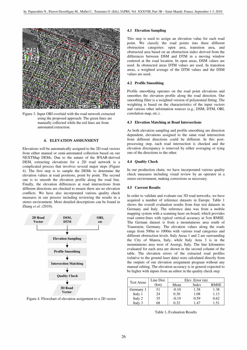
Figure 3. Input ORI overlaid with the road network extracted
using the proposed approach: The green lines are
manually collected while the red lines are from
automated extraction.
4. ELEVATION ASSIGNMENT
Elevations will be automatically assigned to the 2D road vectors
from either manual or semi-automated collection based on our
NEXTMap DEMs. Due to the nature of the IFSAR-derived
DEM, extracting elevations for a 2D road network is a
complicated process that involves several major steps (Figure
4). The first step is to sample the DEMs to determine the
elevation values at road positions, point by point. The second
one is to smooth the elevation profile along the road line.
Finally, the elevation differences at road intersections from
different directions are checked to ensure there are no elevation
conflicts. We have also incorporated various quality check
measures in our process including reviewing the results in a
stereo environment. More detailed descriptions can be found in
Zhang et al. (2010).
Figure 4. Flowchart of elevation assignment to a 2D vector
4.1 Elevation Sampling
This step is used to assign an elevation value for each road
point. We classify the road points into three different
obstruction categories: open area, transition area, and
obstructed area based on an obstruction index derived from the
differences between DSM and DTM in a moving window
centered at the road location. In open areas, DSM values are
used. In obstructed areas DTM values are used. In transition
areas, a weighted average of the DTM values and the DSM
values are used.
4.2 Profile Smoothing
Profile smoothing operates on the road point elevations and
smoothes the elevation profile along the road direction. Our
smoothing filter is a weighted version of polynomial fitting. The
weighting is based on the characteristics of the input vectors
and various other information sources (e.g., DSM, DTM, ORI,
correlation map, etc.).
4.3 Elevation Matching at Road Intersections
As both elevation sampling and profile smoothing are direction
dependent, elevations assigned to the same road intersection
from different directions could be different. In this post-
processing step, each road intersection is checked and the
elevation discrepancy is removed by either averaging or tying
one of the directions to the other.
4.4 Quality Check
In our production chain, we have incorporated various quality
check measures including visual review by an operator in a
stereo environment, making corrections as necessary.
4.5 Current Results
In order to validate and evaluate our 3D road networks, we have
acquired a number of reference datasets in Europe. Table 1
shows the overall evaluation results from four test datasets in
Germany and Italy. The reference data was from a mobile
mapping system with a scanning laser on-board, which provides
road centre-lines with typical vertical accuracy at 5cm RMSE.
The German dataset is from a mountainous area south of
Traunstein, Germany. The elevation values along the roads
range from 500m to 1000m with various road categories and
different obstruction levels. Italy Areas 1 and 2 are surrounding
the City of Matera, Italy, while Italy Area 3 is in the
mountainous area west of Assergi, Italy. The line kilometres
evaluated for each area are shown in the second column of the
table. The elevation errors of the extracted road profiles
(relative to the ground laser data) were calculated directly from
the outputs of our elevation assignment program without any
manual editing. The elevation accuracy is in general expected to
be higher with inputs from an editor in the quality check step.
Elev. Error (m) Test Areas
Line Dist.
(km) Mean Stdev RMSE
Germany 1 51 -0.10 1.38 1.38
Italy 1 24 0.30 1.08 1.13
Italy 2 35 -0.19 0.59 0.62
Italy 3 68 0.32 1.47 1.51
Table 1. Evaluation Results
2D Road
Vector
DSM,
DTM
ORI,
etc
Elevation Sampling
Profile Smoothing
Intersection Matching
Quality Check
3D Road
Vector
In: Paparoditis N., Pierrot-Deseilligny M., Mallet C., Tournaire O. (Eds), IAPRS, Vol. XXXVIII, Part 3B – Saint-Mandé, France, September 1-3, 2010
26
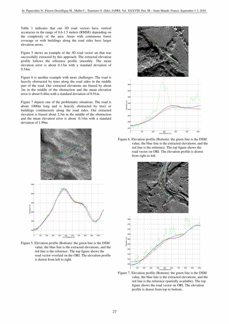
Table 1 indicates that our 3D road vectors have vertical
accuracies in the range of 0.6-1.5 meters (RMSE) depending on
the complexity of the area. Areas with continuous forest
coverage or with buildings along the road sides have larger
elevation errors.
Figure 5 shows an example of the 3D road vector set that was
successfully extracted by this approach. The extracted elevation
profile follows the reference profile smoothly. The mean
elevation error is about 0.13m with a standard deviation of
0.54m.
Figure 6 is another example with more challenges. The road is
heavily obstructed by trees along the road sides in the middle
part of the road. Our extracted elevations are biased by about
2m in the middle of the obstruction and the mean elevation
error is about 0.48m with a standard deviation of 0.91m.
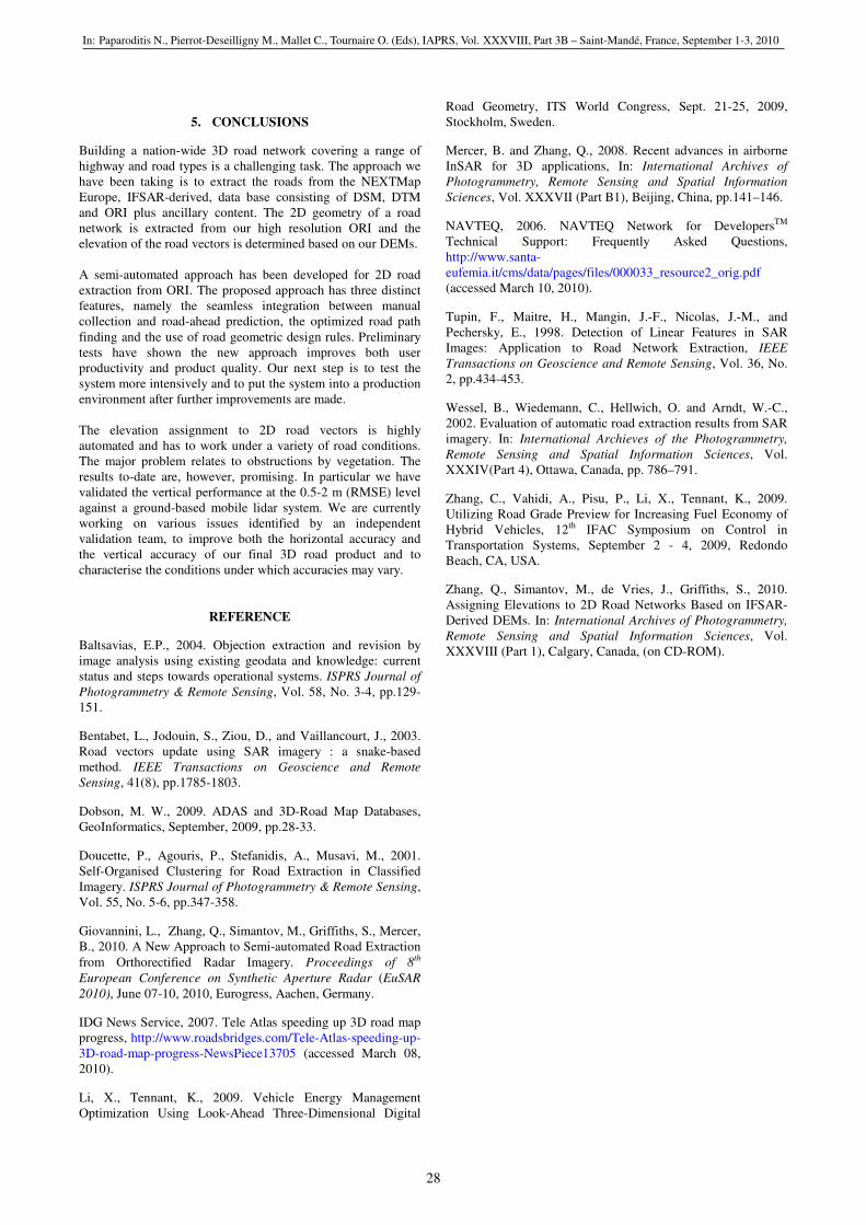
Figure 7 depicts one of the problematic situations. The road is
about 1000m long and is heavily obstructed by trees or
buildings continuously along the road sides. Our extracted
elevation is biased about 2.5m in the middle of the obstruction
and the mean elevation error is about -0.14m with a standard
deviation of 1.99m.
100 200 300 400 500 600 700 800 900 1000
0 100 200 300 400 500 600 700 800 900 1000
340
345
350
355
360
365
Line Distance (m)
Ele
vation (
m)
Figure 5. Elevation profile (Bottom): the green line is the DSM
value, the blue line is the extracted elevations, and the
red line is the reference. The top figure shows the
road vector overlaid on the ORI. The elevation profile
is drawn from left to right.
0 100 200 300 400 500 600
625
630
635
640
645
650
655
660
Line Distance (m)
Ele
vation (
m)
Figure 6. Elevation profile (Bottom): the green line is the DSM
value, the blue line is the extracted elevations, and the
red line is the reference. The top figure shows the
road vector on ORI. The elevation profile is drawn
from right to left.
0 100 200 300 400 500 600 700 800 900 1000
635
640
645
650
655
660
665
670
675
680
Line Distance (m)
Ele
vation (
m)
Figure 7. Elevation profile (Bottom): the green line is the DSM
value, the blue line is the extracted elevations, and the
red line is the reference (partially available). The top
figure shows the road vector on ORI. The elevation
profile is drawn from top to bottom.
In: Paparoditis N., Pierrot-Deseilligny M., Mallet C., Tournaire O. (Eds), IAPRS, Vol. XXXVIII, Part 3B – Saint-Mandé, France, September 1-3, 2010
27
5. CONCLUSIONS
Building a nation-wide 3D road network covering a range of
highway and road types is a challenging task. The approach we
have been taking is to extract the roads from the NEXTMap
Europe, IFSAR-derived, data base consisting of DSM, DTM
and ORI plus ancillary content. The 2D geometry of a road
network is extracted from our high resolution ORI and the
elevation of the road vectors is determined based on our DEMs.
A semi-automated approach has been developed for 2D road
extraction from ORI. The proposed approach has three distinct
features, namely the seamless integration between manual
collection and road-ahead prediction, the optimized road path
finding and the use of road geometric design rules. Preliminary
tests have shown the new approach improves both user
productivity and product quality. Our next step is to test the
system more intensively and to put the system into a production
environment after further improvements are made.
The elevation assignment to 2D road vectors is highly
automated and has to work under a variety of road conditions.
The major problem relates to obstructions by vegetation. The
results to-date are, however, promising. In particular we have
validated the vertical performance at the 0.5-2 m (RMSE) level
against a ground-based mobile lidar system. We are currently
working on various issues identified by an independent
validation team, to improve both the horizontal accuracy and
the vertical accuracy of our final 3D road product and to
characterise the conditions under which accuracies may vary.
REFERENCE
Baltsavias, E.P., 2004. Objection extraction and revision by
image analysis using existing geodata and knowledge: current
status and steps towards operational systems. ISPRS Journal of
Photogrammetry & Remote Sensing, Vol. 58, No. 3-4, pp.129-
151.
Bentabet, L., Jodouin, S., Ziou, D., and Vaillancourt, J., 2003.
Road vectors update using SAR imagery : a snake-based
method. IEEE Transactions on Geoscience and Remote
Sensing, 41(8), pp.1785-1803.
Dobson, M. W., 2009. ADAS and 3D-Road Map Databases,
GeoInformatics, September, 2009, pp.28-33.
Doucette, P., Agouris, P., Stefanidis, A., Musavi, M., 2001.
Self-Organised Clustering for Road Extraction in Classified
Imagery. ISPRS Journal of Photogrammetry & Remote Sensing,
Vol. 55, No. 5-6, pp.347-358.
Giovannini, L., Zhang, Q., Simantov, M., Griffiths, S., Mercer,
B., 2010. A New Approach to Semi-automated Road Extraction
from Orthorectified Radar Imagery. Proceedings of 8th
European Conference on Synthetic Aperture Radar (EuSAR
2010), June 07-10, 2010, Eurogress, Aachen, Germany.
IDG News Service, 2007. Tele Atlas speeding up 3D road map
progress, http://www.roadsbridges.com/Tele-Atlas-speeding-up-
3D-road-map-progress-NewsPiece13705 (accessed March 08,
2010).
Li, X., Tennant, K., 2009. Vehicle Energy Management
Optimization Using Look-Ahead Three-Dimensional Digital
Road Geometry, ITS World Congress, Sept. 21-25, 2009,
Stockholm, Sweden.
Mercer, B. and Zhang, Q., 2008. Recent advances in airborne
InSAR for 3D applications, In: International Archives of
Photogrammetry, Remote Sensing and Spatial Information
Sciences, Vol. XXXVII (Part B1), Beijing, China, pp.141–146.
NAVTEQ, 2006. NAVTEQ Network for DevelopersTM
Technical Support: Frequently Asked Questions,
http://www.santa-
eufemia.it/cms/data/pages/files/000033_resource2_orig.pdf
(accessed March 10, 2010).
Tupin, F., Maitre, H., Mangin, J.-F., Nicolas, J.-M., and
Pechersky, E., 1998. Detection of Linear Features in SAR
Images: Application to Road Network Extraction, IEEE
Transactions on Geoscience and Remote Sensing, Vol. 36, No.
2, pp.434-453.
Wessel, B., Wiedemann, C., Hellwich, O. and Arndt, W.-C.,
2002. Evaluation of automatic road extraction results from SAR
imagery. In: International Archieves of the Photogrammetry,
Remote Sensing and Spatial Information Sciences, Vol.
XXXIV(Part 4), Ottawa, Canada, pp. 786–791.
Zhang, C., Vahidi, A., Pisu, P., Li, X., Tennant, K., 2009.
Utilizing Road Grade Preview for Increasing Fuel Economy of
Hybrid Vehicles, 12th IFAC Symposium on Control in
Transportation Systems, September 2 - 4, 2009, Redondo
Beach, CA, USA.
Zhang, Q., Simantov, M., de Vries, J., Griffiths, S., 2010.
Assigning Elevations to 2D Road Networks Based on IFSAR-
Derived DEMs. In: International Archives of Photogrammetry,
Remote Sensing and Spatial Information Sciences, Vol.
XXXVIII (Part 1), Calgary, Canada, (on CD-ROM).
In: Paparoditis N., Pierrot-Deseilligny M., Mallet C., Tournaire O. (Eds), IAPRS, Vol. XXXVIII, Part 3B – Saint-Mandé, France, September 1-3, 2010
28