Embed Size (px)
Citation preview
f . ^ f e i ; f t ; l ^ - ' £? • : • ' • h • HH
• ' - - j - . - " . ; ^ V : ; . ' . : - » ; . ' • • - . . • . '.C, ' * --^ : ' « • • ' • • ' B^^H
$~t'g$'?M"~:-"y. .? .? ' • ^ ' • • . " ' -"• ' • HH
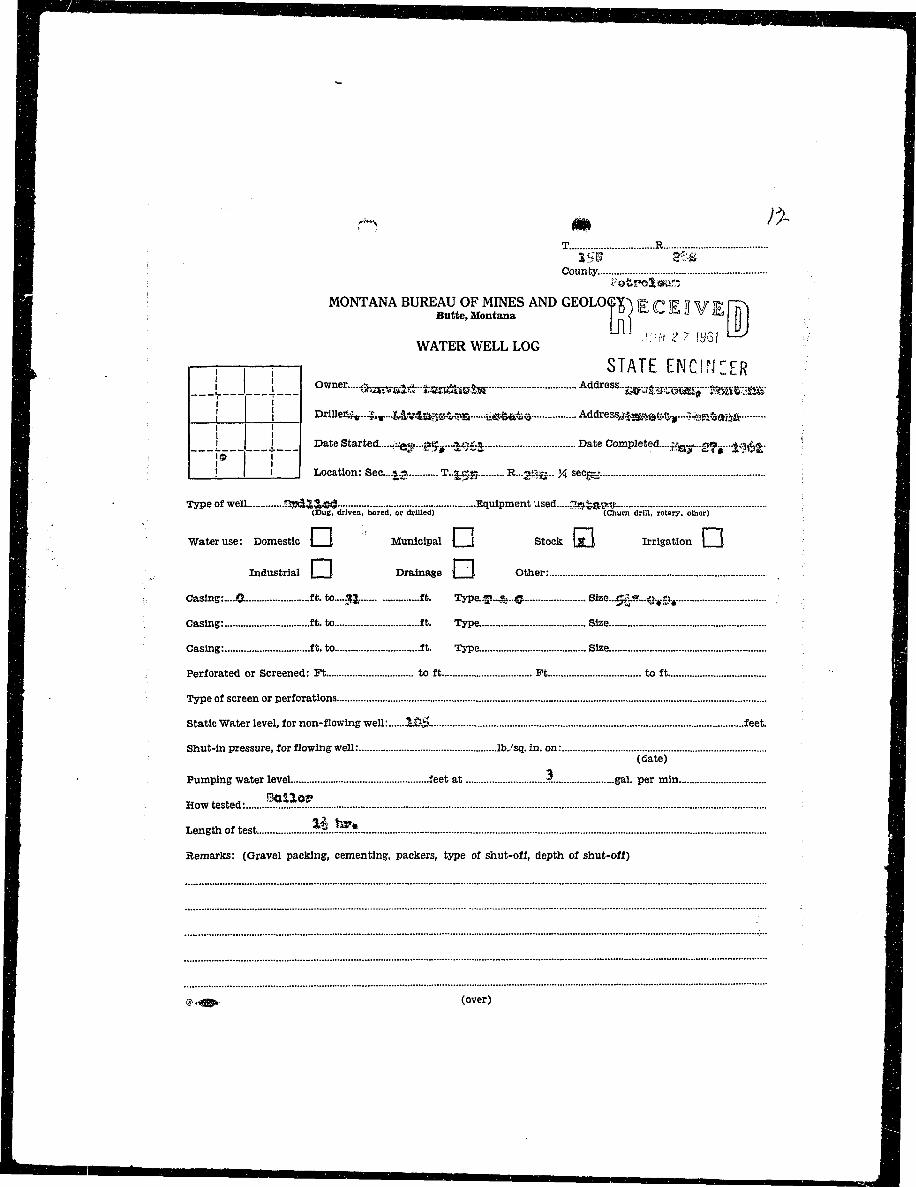
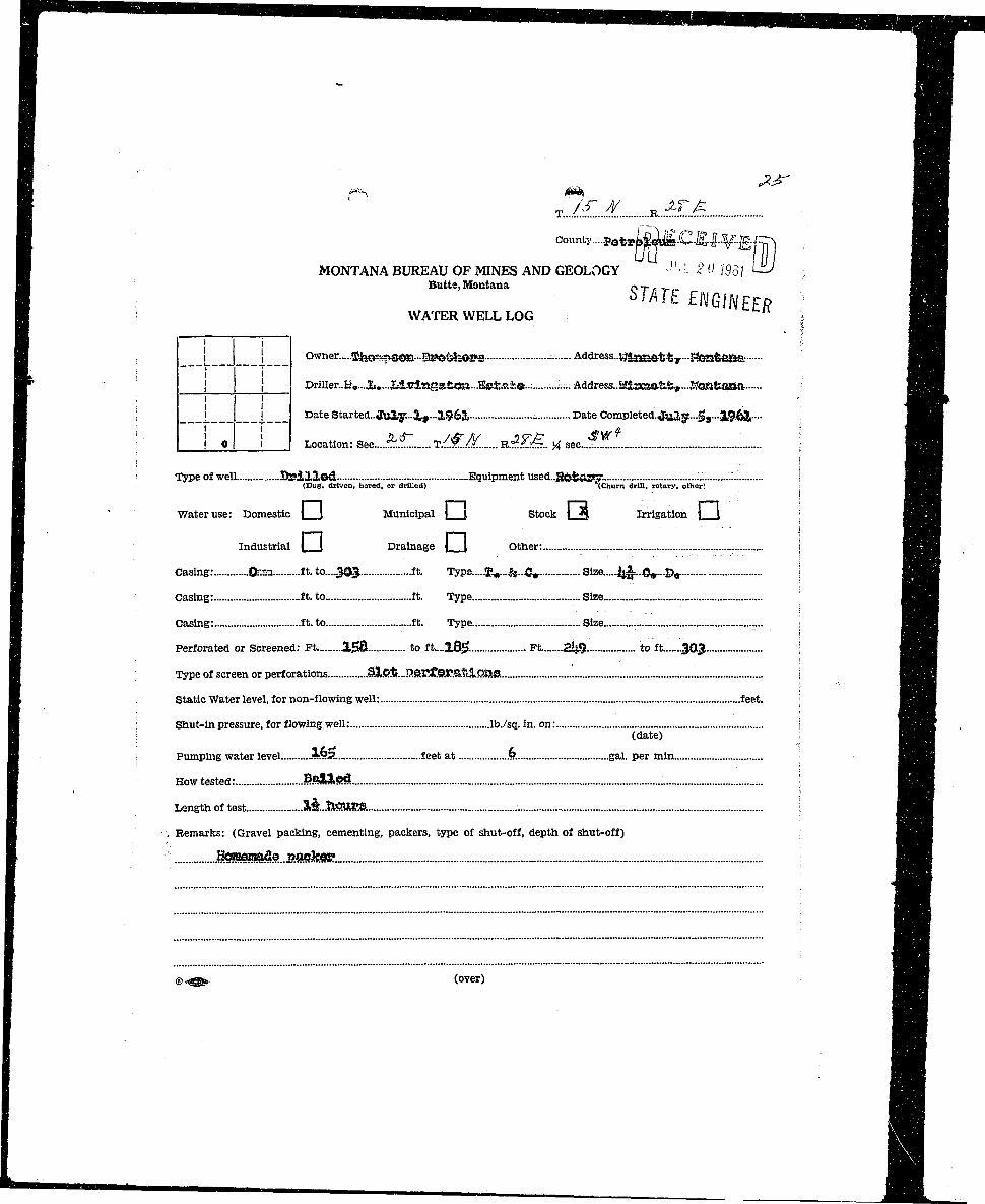
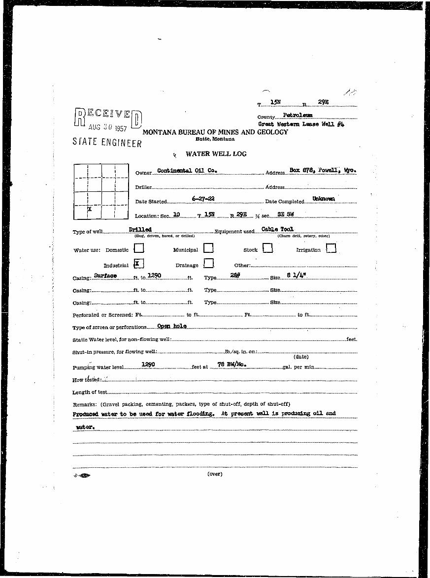
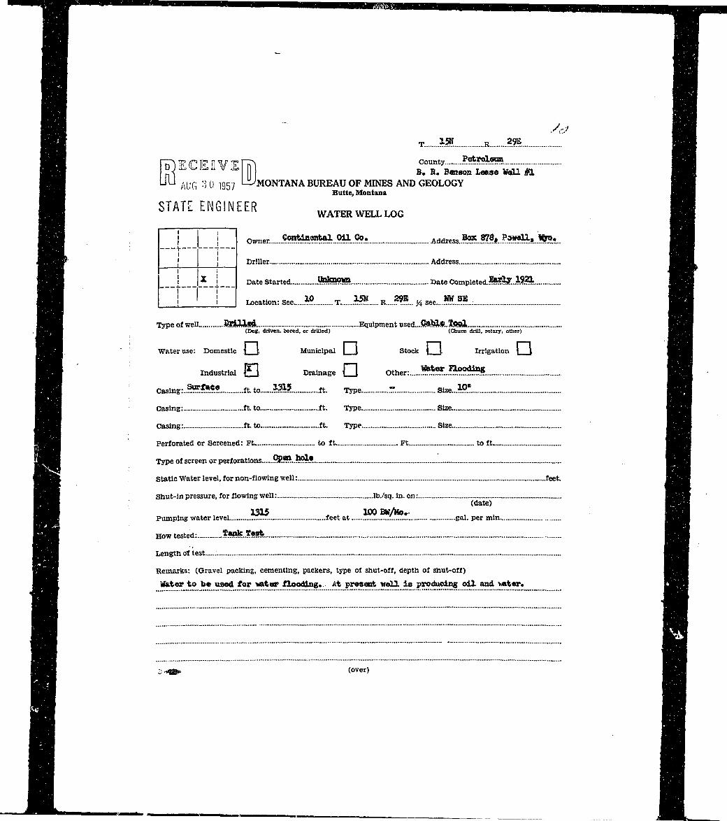
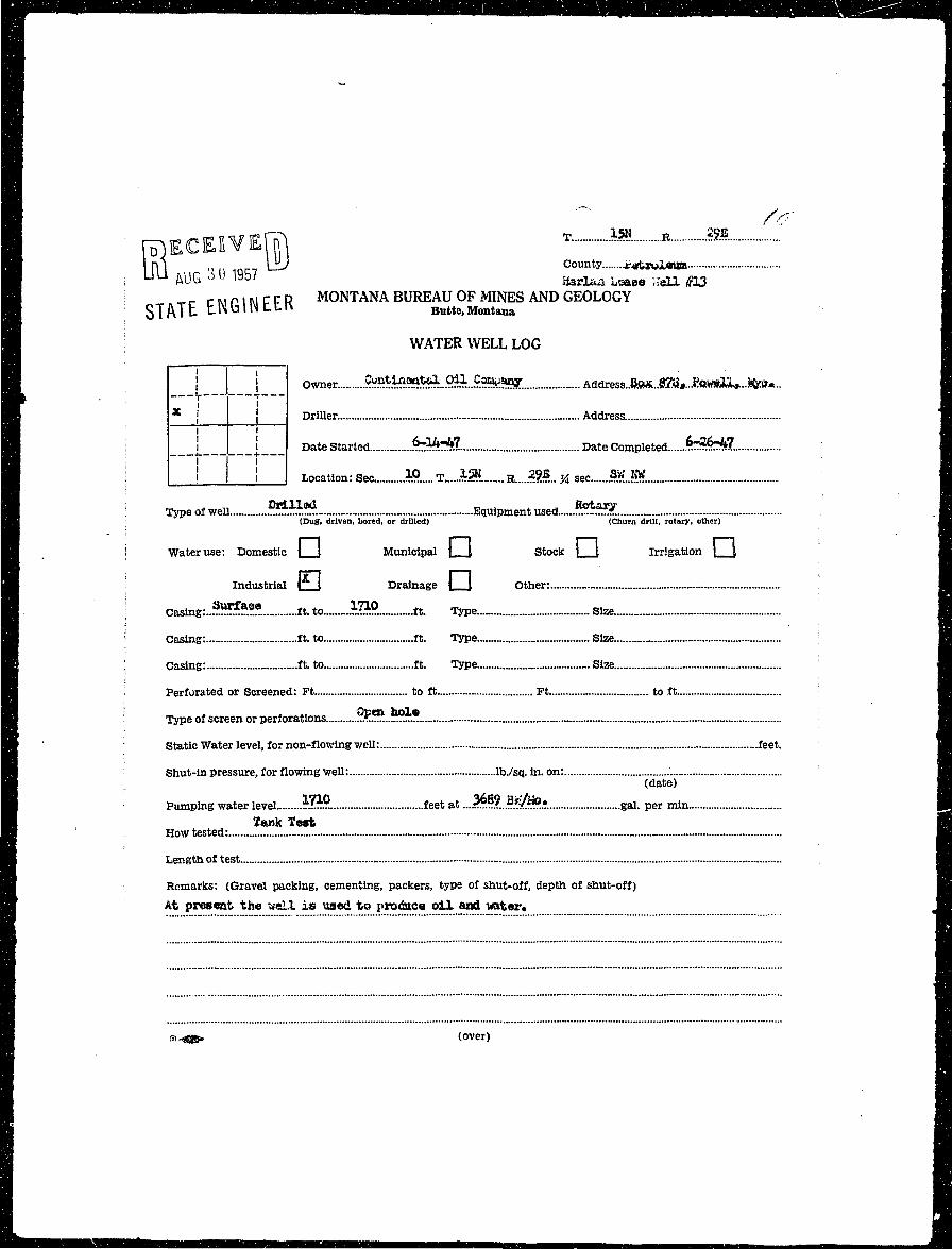
" IB T R •B . as» &:& IB : County •B ; ;;otrol^;ir-; BB ! MONTANA BUREAU OF MINES AND GEOLOGY^ 1R f 1i? 11V H? HT\ 1B ; Bntte,Montana T" I '^ ^ t i V & Ml : 9I i WATER WELL LOG ^ •'•:* 27 W\ U I IB . —j i — STATE ENGINEER 1B : I ! Drilleii{tr...|;,m....?Ta.vl5ivs.s%v>SS iifi^i&S Address^^s^s^.-.^feja^aaa. MHa i ^BB — I i — D a t e S t a r t e d •i^ey-^r-i^i Date Complete<L....^..g?s...^£. ; •Hj : JO j flB 1 ! ' I Location: Sec....^ T - ^ g B...2a^.. K sec^j. ; •H - Type of well 3S*SS&*£ Equipment used ^fejKKjf. •H B (Dug, driven, bored, or drilled) (Churn drill, rotary, other) MB
^B Water use: Domestic j [ Municipal \ [ Stock }g Irrigation 1 | fl
HI Industrial j i Drainage i t Other: BH
H Casing:....£ ft. to....§3,. ft. Type.*..^..^. Size...ej|.S... .:::1.i(. . fl
H 9Hi Casing: ft. to ft. Type Size HIH Casing: ft. to ft. Type Size HI H• J : Perforated or Screened: Ft to ft Ft to ft fflj
Hf • Type of screen or perforations A |
H Static Water level, for non-flowing well: ifijs. feet. H
I f Shut-in pressure, for flowing well: lb./sq. in. on: ^ 1
BJ (date) •• H BIHI
H Pumping water level feet at .? gal. per min B j
I Howtested: ?«$??.. 1I Lengthoftest M..^« •I 1• Remarks: (Gravel packing, cementing, packers, type of shut-off, depth of shut-off) H^H ,. ; OHI
I IZIIIZIIIZIIIZIZZZZZZZZ: II <?.i®* (over) •
I"*IM'M'IM"^IM'""**''I**I"MI"M'" m

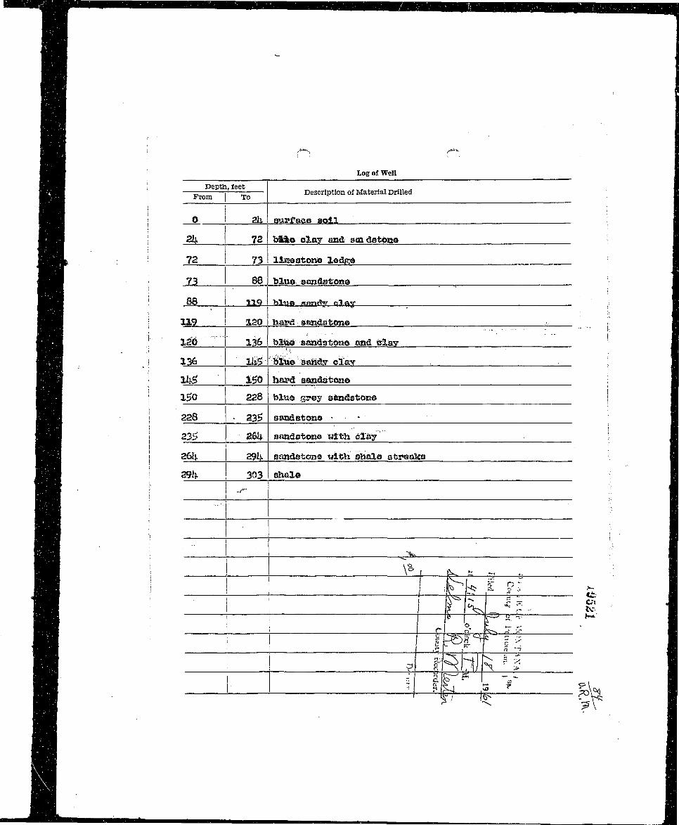
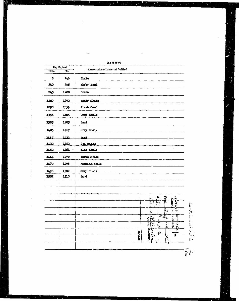
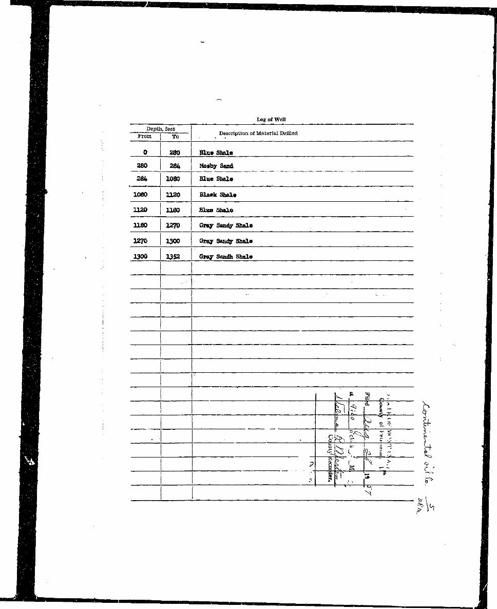
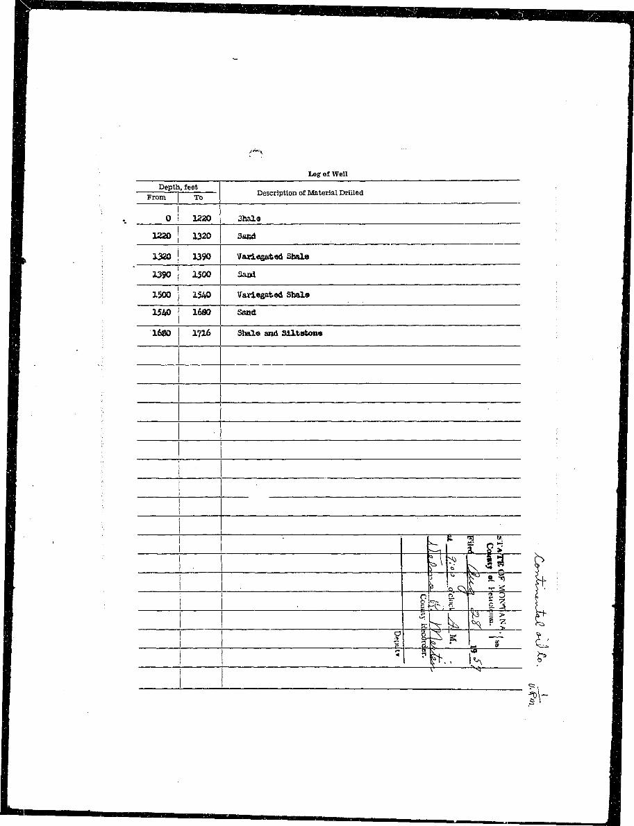
HH Log of Well ^ ^ H^ B • _____ _—_ — ^ ^ H•H Depth, feet _____•JBk : — 1 Description of Material Drilled ^ ^ ^ R
H ; o- 2.3 an*? o.oy • •• ! HH^ K I 13 £2 'i-vay ats2r.datcm© fl^^HHj ' '-jil &} Bind nawiwtoao «lt)> h%s»> st^oeko ' ^ H H L
I • ®* ^ aaga 08adg 3>&K|° : flH_ H I ' * ; •____•H • :y • 70 j t&) Slue aaKtlstonsi (tswrt l<a*s<»») ^ ^ B^H X&f 1^6 ®?e$ HtaKt5stcn« ' B__H
I 3—i " A> i HI i p i j K •
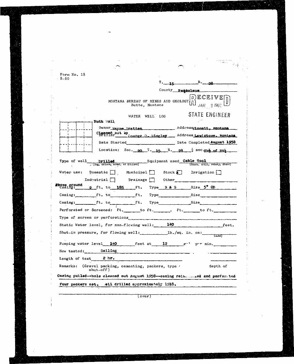
1§ H B Form No. 18 | D |
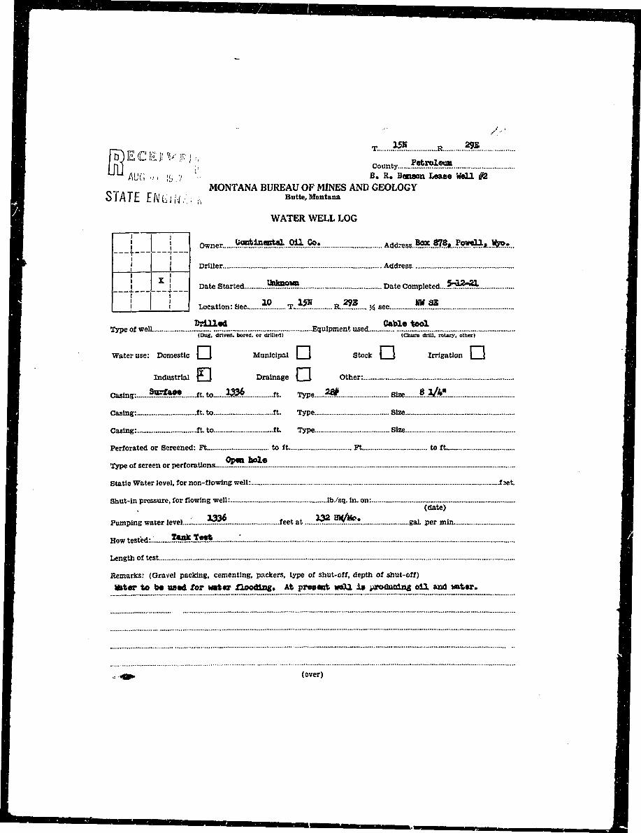
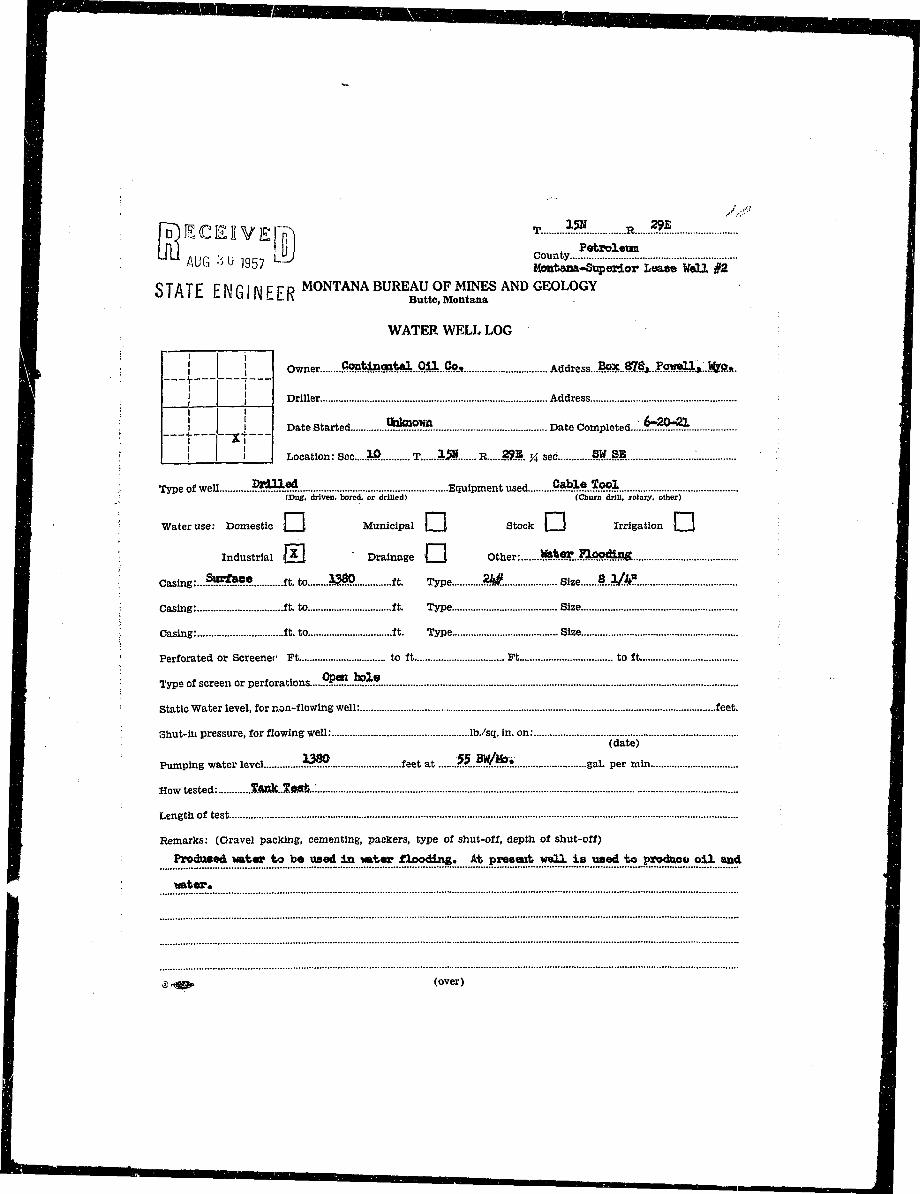
BH s-°° HiH T._is ^R.__as . — nH ^ f l County P«8fc Q fliim . '. HB
M i- RECEIVED I •fl|B MONTANA BUREAU OF MINES AND GEOLOGY n] Ml •• ^ H• ^ B Bu t t e , Montana UU j ^ j <> |g<;<; LlV ; BH
| H WATER WELL LOG STATE ENGINEER I JEH B k . . I ; 1 ; 1 Ruth well - " : "Hif ^ ^ H . _ _ ' I Owner wmyw. izrvt+.an Address^iyinafct., Montana ; ^^H
H H ! ' Cloaoed o u t t>y . . . ; l ^ H^^B _ _ ! i Dr i l l e r f or»er» n . iilntxlBV Address i^wj atotm. Montana \ BH^Hfl|H : j i T v— — ^ ' r— . ^^^_
• ^ H ! ! Date Started m Date Completed August 195S ; |flH H ; ! i " " , < mm• ^ H \ I i I i [ Location: Sec. PQ T• \$ R» OS i sec^ro| nt mr\ ; fl^H^ B 9 ' ; Type of well Drilled Equipment used Cable I'ool _—__ ' B H^^HHB : s (Dugj driven,, bored, or drilled] lCiuirn> drill, rotary, ottiar^ [ I ^ ^ H H
^ ^ H i Water- use: Domestic \^J . Municipal [Z] Stock jj [ Irrigation | [ j IBS
B^H[ Ind'.istrial Q Drainage Q Other j fl^B
HH : ^asin^g?""0 ffi f t . to 185 f t . Type S & S Size 5* OP . j B H
^BSR ; Casing: ft, to f t . Type Size BBI
^ ^ B I Casing: ft. to f t . Type Size ; ' flHBH '• • I ' SBHH| : Perforated or Screened: Ft. to ft. . Ft. to ft. j HBIBH1 : \ HBHHjK • i Type of screen or perforations \ H^Hfl^HH i ; H^EBHl I Static Water level, for non-flcwing well: 140 feet. | ^Hi^HH ' Shut-in pressure, for flowing well: lb./sq. in. on: \ ^^H
BBB i (date) i fl^BHH ; Pumping water level 140 feet at 12 g--1 p<~- min. ; j^Bn
• H B l How tested: Sailing . ^ H
H H I : Length of test 2 hr, > M R I|H^H8 Remarks: (Gravel packing, cementing, packers, type ' depth of fi^HBSJ shut-off) HBI^^H Casing pulled--hole cleaned out August 1958-"Caaing rein,, i.ed and porf'or; ted J B I| H H Four pttolcera set, .ell drilled approximately 1918. H H
HB Cover") HBII I
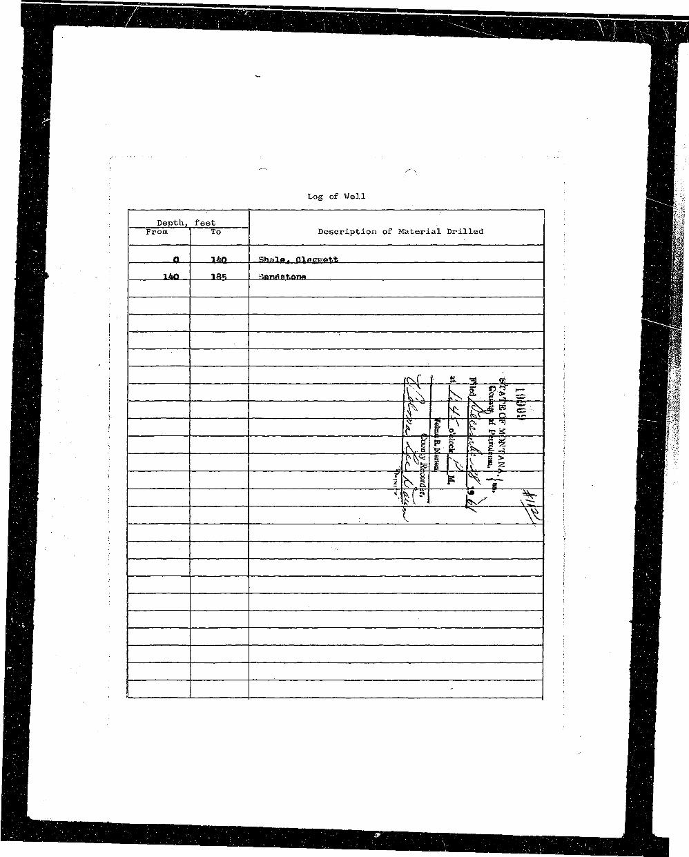
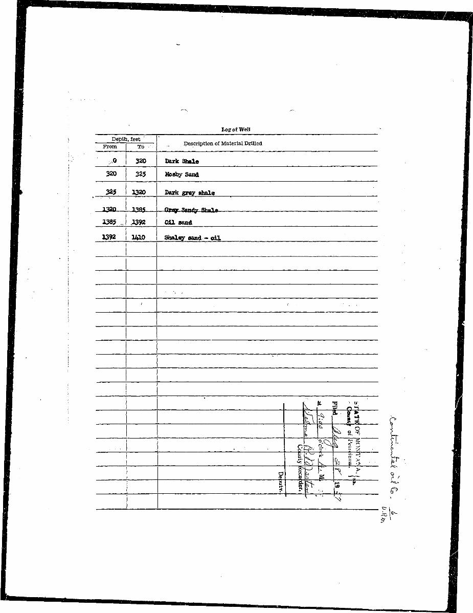
^^^B ; Log of Well ' BMW
^BH ; Depth, feet H^K' )^^^B From 1 To Description of Material Drilled i ^^HB?4
^•H ; ' '• HIHI#•EB ' i ^Hii•Hj ; 0 140 iShplfl, OlPgCTtt ; ^ H | l^Hnp - | l&Q 1B5 strong t<»m • V^BUm
• H H I ~"~ : ~ i I ^ B E I I
jHHB • | : : '• i ^^HE!'^
B B S i h^4 ^ hv • E ^ ^ — ' M B i : -
BBH ^ TTPT"^ Ti . ? HH "
^ • B ? c a f5 ^ * " i H H| ^ B ; % *kf% ?•—^ ^ r • i BHB^B ' l . ^ '* F>NX \ - ^ i ^ ^ H
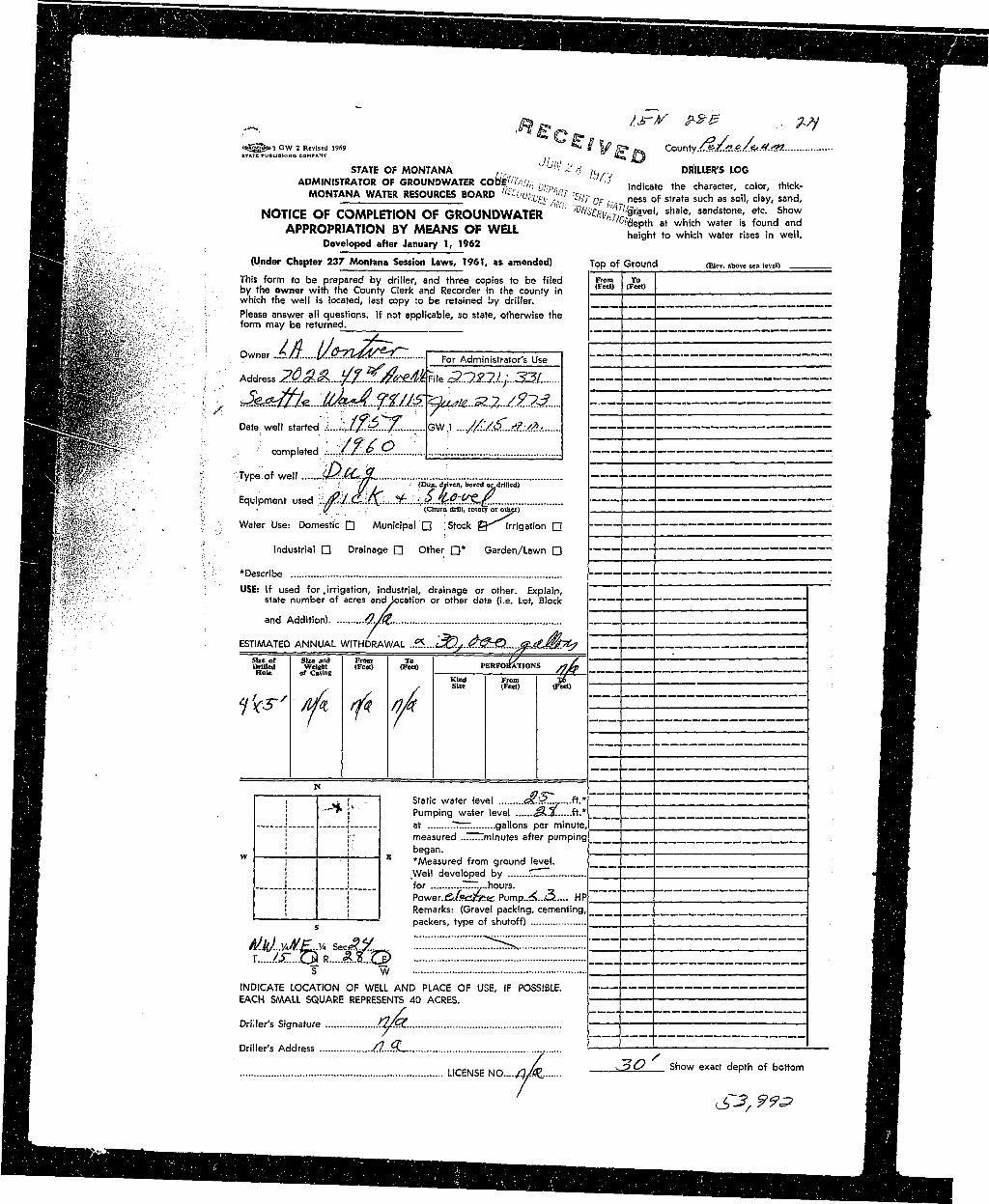
^ ^ D | o^^»3 GW 2 Revised 1969 * V ' S* OteK County._^^#A./&.#.'5W flflH^^^^HB STATE PUBLISHING COMPANY ( i £ ^ fi'3 ^ ^ _ _ ^ _ H
• ^H STATE OF MONTANA , ' L'!'-1 i'. r<: ,L, . DRILLER'S LOG ^BHHH ADMINISTRATOR OF GROUNDWATER CoB^^i/y,- ^ , n d i c a t e 1 h e c h a r a c t c o | t h i c k . ^ H• n MONTANA WATER RESOURCES BOARD '<^0ulic^^ - ^ ^ n e s s Q f s t f a t a s u c h g s c|ay_ s a n d < Hj
^ B NOTICE OF COMPLETION OF GROUNDWATER '" ' ^ ^ ^ C ^ f 1 ' sha'_: usandston!' fc- j * ™ HH
H APPROPRIATION BY MEANS OF WELL ° * & « ^ ^ ^ vS •^ ^ H | , Developed after January 1, 1962 I^^^B
| ^ S § / i (Under Chapter 237 Montana Session Laws, 1961, as amended) Top of Ground (Eicv. above sea level) _ ^ H
H^K A <," ?\ ^ i s *o r m t 0 be pi"ePared by driller, and three copies to be filed From j o _HHW^Mfc'-pg j by the owner with the County Clerk and Recorder in the county in ( ' ' ' ^ ^ H^ ^ ^ K ^ & C i - which the well is located, last copy to be retained by driller. ^ ^ H^^^BI - lMIS i i - ' Please answer all questions. If not applicable, so state, otherwise the ____B^ ^ ^ ^ ^ f c ^ - form may be returned ^ H
^ • K ^ O^AA u**^ , ForAdminislfato,use • ^ L ^ Z Z I I E E , mI K B ' ^ ; :" Address 2^.^..y/-.^^#R,ea^.?J.,..33/. H
H ^ K - • \ .^f^e..:_^..^/^^.^.7,..^.?^.... i-U—L—zzz. H3»__^^EP:;":: Date well started 1 J;jf^3^........ GW ,1 ....//UK..*:/*.: fl_T» P .;^mio ::.;] , | ^±±HZ\ ^^ •• H F i :type:of well J>MJL H^ • • K ^ ! ' * * 1 ,.' ! 'fj. I (Dug, diiven, bored or drilled) ^ ^ H
^ S ' - ?: Equipment used l./ltijM^,.±.uS.&?#&£.. • •^^^Ht ~4 t,' " V * ty • (Chum drill, rotary or othei) _______________________________________ H_^^B^ | B } tw '"?v '-' Water Use: Domestic • Municipal D Stock ©^Irrigation • — ^ ^ ^ B
• f c ^ i . • I '•'• •• : ' HH ^ B r 'X*^' Industrial • Drainage • Other • * Garden/Lawn • ^HB
HsV1 u; ' H •• K ^ ' ^ 'Describe ^ BH ^ H v 'v '; USE: If used for,irrigation, industrial, drainage or other. Explain, ^ ^ ^ B| ^ ^ H ' i state number of acres and location or other data (i.e. Lot, Block _^^B^ H and Addition) #./%. ^ _ H[ B B ESTIMATED ANNUAL WITHDRAWAL .?S....s3Q.yL.<^^S>....^aLM7^ flB| H H Size or SUe and From To 1/ ~Y~ _ ^ _ B9HB Drilled Welebl (Feet) (Feet) PERFORATIONS /ftp ^ ^ ^ B^ H B Hole or Casing _. '/K ^^H^ • H Kind From X6 M_HH• , / , / tFttt) ^ HH ^ m nfe m mt
H H I j [ ^ ! - I Static water level <aP..£l,....ft.*" |" ~ I I HH H . ! —> j * Pumping water level J£.X.....ft.* I 1 ^ 9I^H J ! at .TT r. gallons per minute, B H R^ ^ B i !',' measured minutes after pumping __HI
H I w i I ! E beaan. ; 1; H H
^ H H I ! *Measured from ground level. _^HL^ ^ H | | Well developed by T....... *_^HFHV i J for . ~ ..hours. HHH B B ', | Power. f i i fe i_^« Pump..<<..A_>..... HP HHH ^ H | '; Remarks: (Gravel packing, cementing, ^H9^ H B ' packers, type of shutoff) ; _BH
H ^JJ^VME^ sec y rrrrz:"!!!!S^rrzrz ^ Bj H T w MH^ H INDICATE LOCATION OF WELL AND PLACE OF USE, IF POSSIBLE. HS• • EACH SAAALL SQUARE REPRESENTS 40 ACRES. HH
^^H y .._____ ___. B^RBo
^ H Driller's Signature /3/GL iHr
B H Driller's Address /}...<%_ ' ' W^M
H LICENSE UO..../iA 13°/> Sh°W eX3Ct d6pth ° f b0tt0m H
M H M I MIBBHHHH_ail__BHHBBH l^HJ^
I • • : . . , ! V ; { r ^ -:::!••:•^ H . ".' '•;••' :. {L : •:• •"• '••.•••• .""i i : A S T A f E O F MONTANA,) : ' '• L5 .';:;;.: . ' £ ' " " i i s i i - J
•H , . , : • • ' • " ' t - ' i •• , ••• ' - ' - . ' • b o u n t y of .Pe t^ leuf t i , p ' ' ; '• "•\: " ;' ''"' :: ; v I
Hi : " •:: ' : ! v- : ' •£ : .': i . " ' i - < f r n i a d > : ' •lllN i f ? i f o • > , ! • ' :•: '., .. i : ;::•:• ^ ;i ; " I
^ ^ B ^; !:' '•• "• "'" '• '-• •i$rsA*?tJL*- /***?^y^f-- ' "•;;: • ••-" ^ ' ' I •fl^^B • . ' • • • • -1^ ' D i r e c t o r o £ R e c o r i i s . ~" j , "' z--'^- , I
I
II ' rJ£JL ...*.^A •• County.....potj?i>S^-C.E|--¥:-Ffr^ Hi• OH fl I B• MONTANA BUREAU OF MINES AND GEOLOGY ••'"!- 2 0 1961 L-J BHH Butte, Montana O T f i r r ^ B HI , SJA^~ ENGINEER H- flB WATER WELL LOG HB
I —' T— ••* IB i i Owner.....ffifeo»S>B l-Ba?©&feO-J!«S • •--• Address-.^aafttty S?&S&a»8: fl^B
B : "" t "I . —• P j j Drmer..a»..Jt#...l8tv4r«S8t«>»..S»*Aisd-.: :»»Address..Hias^fet»---SteateMtttt 9 H B .
• i J__ _ _J Date Started..Juijr-X#-3.§6l -•-- DateCompleted.^i|i3,y...ga....l$^t.... I^^B
I j I I V " I 1 Location: Sec...A£: *{£JL *&£. % mJPOl :.- \ HI ! - - i H i• Type of well Drilled Equipment used..R©fca2?7- : :... .:..... j |HHH I (Dug. driven, bored, or drilled) (Churn drill, rotary, other) : ^ ^ ^ H
• i—i Pa i—i H BMunicipal 1 |, Stock i *|. Irrigation \ J I ^Hfl
B Industrial \ I Drainage | \ Other: j • H B
• Casing: .Qr.sa ft.to..._303 ft. Type.....S....|5..C» Size i^..Q^...^ i MSI
B Casing: ft. to ft. Type Size BVJBI
H Casing: ft. to ft. Type _ Size I Hflfim • BHB• Perforated or Screened: Ft 1.S8 to ft....l8g. Ft 2 l$ to ft .^0$. | flHH ~ • I^BHHBH
H Type of screen or perforations .S3,©fc...P.0.rJ£am1fl<?XtS j IBB
K ; Static Water level, for non-flowing well: feet. ; HflB
• • Shut-in pressure, for flowing well: lb./sq. in. on: I BBS
• | (date) : HnI Pumping water level i52. feet at 6 gal. per min : B H BB How tested: BaJ2,©a \ BHB Length of test l&it&!i5U8!:8» ;. flHB BHB• •: Remarks: (Gravel packing, cementing, packers, type of shut-off, depth of shut-off) H H B1 Bomraiads..£fiyBJ«5 . _ | HI BmI zziizizzziiiizz: : •I :z"::::::: i II ^ HI ©. s«- (over) Bfli
* • . U K
—^^y " —Ml"! IIMII—W—•——MB—•
S U M : ^u"s <**•fl^H Logo; Well^HHl : _ _ _ ^ —HHHI : Depth, feet• 9 B I —j; r z, Description of Material Drilled
H H _JL 2k aupfaea aoil ;
flH : _2U 1Z bi&o c l a y and scndatona :
^HL 12 73 liraaatone ledaa
^ H | i _Z3 88 blue sandstone .
MHH i _§8 119 bluft Rfirtdy olay . ,
^ ^ H ; 119 150 faayfi aandafcone .-., ^ i'
j B H I" ISO 136 blicfea aaadstone and day :• I
BBS . /• 1J6 Il&; rVSlti'<> "-safedy eiay : \ •
JBHa } Hj-5 150 hayd aanetatcaie | I
B^B ! ISO I 228 bluo gr>ey simfistono | I
BBB I 228 • 23g sagidstone • I I
flH I 235 gfilj. aoadatooe mttx slay' ; I
HHH i 26^ 29^ eandetons with ahale sfcreake fl
B H ! 29k ! 303 shale fl
H i 1 j ;Pk i 9; ^ I
I j <|fefrrt?~., I• ! 'W >h ?\s I
• • — • — — — — • — — •••||HIIIII ^llftHHIIIH 11 ^
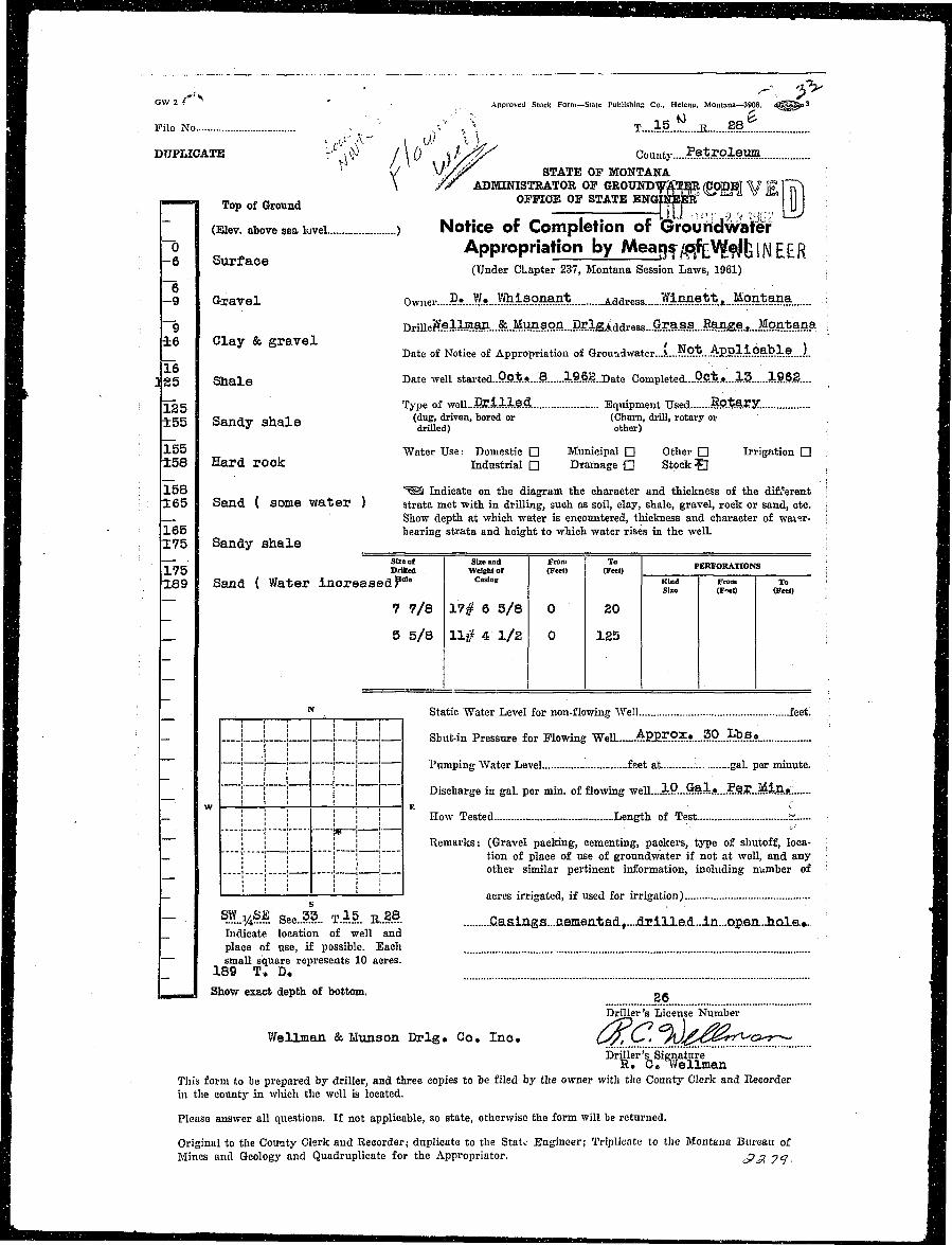
B ^ ~" ."' "~~ ^-. jv IHJ OW 2 f . Approved Slock Form—Stale PubllshinR Co., Helena, Montana—3908. i ^ ^ ^ > 3 fl
9 Pile No - '• .-," , \ T....15 R 2.8
• DUPLICATE - ,\>) l\() st-sy/ Countv Petroleum• • Vi / \ B if / < / ' "B V' -./iT STATE OP MONTANA• \ /jr ADMINISTRATOR OF GROUNDWA~TER (CODE] V F !~rT">
0 . T o p o f G r o u n d OFFICE OF STX?E E N Q | ^ ^ K A V & j j j ;
• ~ (Eiev. above sea luvei ) Notice of Completion of Grouridwater
I IS surface Appropriation by MaagyfffeVftlfciNEER 1• : (Under CLapter 237, Montana Session Laws, 1961) ; 1
• - 9 Gravel O\vnei-....R»:.E».J^-M°^M%. ^ddres8._..MM.?**.*JM.95*9ffla. ; I
R ; ~g DrillerV.ellffian..&..¥.^spn...D^ . IB 16 Clay & gravel , „ .• v ' I• _ Date of Notice of Appropriation of Groundwater....\...£'.Ot.. ApolipaDle...JL •
• 225 Sha le D a t e w e l 1 started..P.&t*..'8 196g..Date Completed....P.Qt*...£& 1.9.62... I
^ : 125 Type of weU...BEillM Equipment Used Rotary. IH ±55 SandV Shale ^du.g> dr iven> b o r e d o r (Churn, drill, rotary or •jH " drilled) other) BH 155 Water Use: Domestic • Municipal • Other • Irrigation • ; fl• i 5 8 Hard rook Industrial Q Drainage Q Stock S , •
flj '• 158 ^©8 Indicate on the diagram the character and thickness of the different IH 1 6 5 Sand ( some w a t e r ) strata met with in drilling, such as soil, clay, shale, gravel, rock or sand, etc. j •HE . Show depth at which water is encountered, thickness and character of wai>;r- i HJH • 165 bearing strata and height to which water rises in the well. ; fljH 175 Sandy shale i •Hi Sl2Bof Size and From To mimmiTrnm ; H• 175 Drilled WelBhtot (F«t) (Feet) PKBEORATTONS , B
• 189 Sand ( Water increasedPOIe CnslIlg «|;d ^ ^ ; •
1 ~~ 7 7/8 17# 6 5/8 0 20 3
• _ 5 5/8 11# 4 1/2 0 125 S
B : . N Static Water Level for non-flowing Well feet. B
ft ' - . . .J j. ! L...1 Sbut-in Pressure for Flowing WelL......A.EP.r.O?.?.....?.P....L5.?.« fl
I j j j j 1 ! Pumping Water Level feet at gal. per minute. HJ
• ! | | i" j Discharge in gal. per min. of flowing well....l.P...Gai.»...?e.?..Minfr., H
I _ _ | | i i j ! How Tested Length of Test... b: fl
• ; ; | ] | j Remarks: (Gravel packing, cementing, packers, type of shutoff, loca- • HJ• _ i | I ! | ] tion of place of use of groundwater if not at well, and any SI ; ! ! | j I other similar pertinent information, including number of : HJ
• _ I '• ' ' ' '• ! ' acres irrigated, if used for irrigation) HJI ** * *fllI — s.E.y4§?. Sec..?.?.. T..15. E..28 .Caainga...aemen.tad,....drilLe.d..in...ap.en...hQla.. |m _ Indicate location of well and HI place of use, if possible. Bach HI — small square represents 10 acres. HJI _ 189 T. D. HI __mmmm. Show exact depth of bottom. o - I BI Driller's License Number HJ
I Wellman & Munson Drlg. Co. Inc. ^ZrQ' fV'£^~?TrX'c^?^J H• Driller's Signature HI R. C. IVellman HJI Tliis form to be prepared by driller, and three copies to be filed by the owner with the County Clerk and Eecorder H
| in the county in which the well is located. BJ
I Please answer all questions. If not applicable, so state, otherwise the form will be returned. j H
I Original to the Coutity Clerk and Recorder; duplicate to the Stato Engineer; Triplicate to the Montana Bureau of IHB Mines and Geology and Quadruplicate for the Appropriator. *p £. 7<J B f
I r " " """• ' " ' ' - i n v • -.., I.- H
I • STATBOV- MONTANA., _ .n •. .. -ir .; _,_.., H |H ' i; . •• Coussf o£ Pctrolcoui. \ - | ^ H
H ; • *<• ft' + S ..-o'ctocl^ M. h •••..IH :^ ; jHR
I H '"- - - %H [ i n^^BH O > ' 2 Approved Slock Form—Stale Publishing Co., Helena, Montana—42329 t45g|g*>3 fl^Hfl
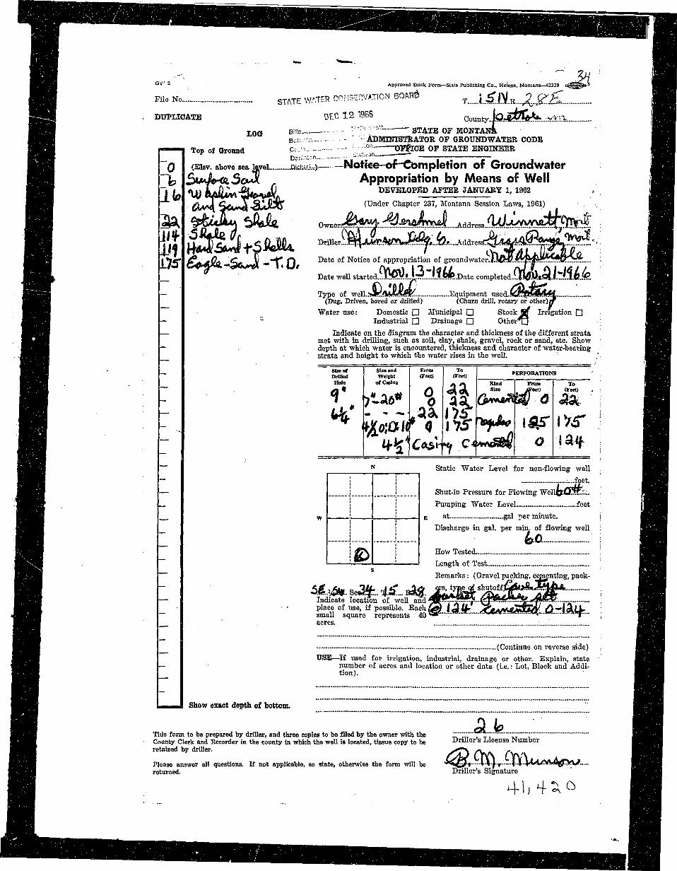
M l File No.... STATE WlTER CONSERVATION BOAR& T LSfJljjJ^S H3 S S ; DUPLICATE DEC 1 2 1965 County..|Q.*A??l(^....^.>:::?iI iMIH i LOd Bi!!o ; - n . . --STATE OF MONTANA ' 8 HflHj Bu;;.v.i-. ADKraTSTEATOE OP GROUNDWATER CODE 1 ^ 99 ^ 9 i Top of Ground P= '- - " '•-"— DTflCE OF STATE ENGINEER I|^B
• H I ~ Q (Eiev. above sea level jaicii" ) No*ice-of-Cbmpletion of Ground water flHflfl Hb ^MhrdiSo^i Appropriation by Means of Well flflj^ H l I I \ U CkA&W\'£lto-'tj4& DEVELOPED AFTER JANUARY. 1, 1962 V H^SfllH / L V 3 ^6tv«X-SJJ^C (Under Chapter 237, Montana Session Laws, 1961) • . . B ^ H
• 3A fT^Jk O » ^ A y A d d r e s s . M ^ ^ ^ M
•HH I*I*T £?M.*Qn Cym V HT rt ^ a t e °* Notice of appropriation of groundwator.J.HM/..ftT««Kr?l**K^r*: . ; | ^ ^ l•H !-/*» CA**«,-30»AIS« * \*U* CV\jrv\ 1^-ltfiA f\l'" f\l 16// I^HH^K, _ Date weU started...]!.'*?*!?*. IpLJjl?!?..Date completed..LlwM«.Q!li**.J.e.«P. ^Ki
^^S - Type of weU.jyA«A*«K Equipment used..0ft35lkl'*f I H^ ^ ^ ^ H (Dug, Driven, bored or drilled) (Churn drill, rotary or other) IT ^ ^ ^ H^ ^ ^ B Water use: Domestic • Municipal Q Stock i f Irrigation D 1HB^^^H ~ ~ Industrial D Drainage • Other^J . ^B^H^ B ^ B — Indicate on the diagram the character and thickness of the different strata ^ ^ ^ H^ ^ ^ H met with in drilling, such as soil, clay, shale, gravel, rock or sand, etc. Show ' H ^ H^H|H ~ depth at which water is encountered, thickness and character of water-bearing H ^ l^ ^ H H ' strata and height to which the water rises in the well. ' ,' l^^f l] ^ H H - - - • • ••' • ' • •B^^H| - Size of Size and From To prnvnRATlniNJs I ^ ^ ^ H|^HH ~ DllDod Weltht (FMt) (Fert) PERFORATIONS ^ H |H^HI • - HoI<! ofCaslnc . . Kin,, Vnm To BHB
^Hj H N Static "Water Level for non-flowing well ^ ^ | R[ H H - I i I i I .....feet. IHiJj^HB — j _ _ j Shut-in Pressure for Flowing "WellO&J.'sr::... ra^Hj^^Hv _ ! ; Pumping Water Level feet ' i f l a B• H H H w j ! E at gal per minute. i fll^B^^^^B ! I Discharge in gal. per min. of flowing well : ^^9B
BjHl i #?\ ! How Tested. '. H ^ H. B B S B ~~ I ' **^ I 1 Length of Test ^ ^ ^ H^B^^B Bcmarks: (Gravel packing, cementing, pack- • ^ ^ l^ H H - A^,Ai» o "\U- „! «C ^£t ers, typte oi shutoffMSoSa l kJk. ^ | H |•^•H — Indicate location of well andTK"/--x'--"-y"-'(;T*^*!!^;-^f-'^7?*:^:"--"it- ; flB^H^^^H - " place of use, if possible. Each&A) i<QU« VVAM^AS£&K A-*leLLL- BlHi<^^V - smaU square represents 40 ST™-m-^- <o-*9ras**ssiBB*..J*..~i.i«*p_ ; •HHI ^ ^ H ' acres. l HI•H^H (Continue on reverse side) , j^n^H^ ^ ^ H USE—If used for irrigation, industrial, drainage or other. Explain, state I^Hfln^H — number of acres and location or other data (i.e.: Lot, Block and Addi- IH^H• ^^K tion). ' ^ H H I
• j ^ H L—i^J Show exact depth of bottom. ^ 1 ^ 1
^ ^ ^ H This form to be prepared by driller, and three copies to be filed by the owner with the ^ ^ fl^^^l^ ^ H County Clerk and Recorder in the county in which the well is located, tissue copy to be Driller s License Number ^HH• j ^ H l retained by driller. y^jT\ /VAV f\ i H^H^ ^H Please answer all questions. If not applicable, so state, otherwise the form will be < ^ £ ? t '•••f-r 4-l"4»4/W«*l^!VV/..... RI^B• ^ ^ H returned. Driller's Signature ' I^^HI
i l
•
" ^ **••— ^ i ^ v*"" •
• * * ~ r • " • > - * •
I __ ™ IH County / 2 A / / ^ / / / ^ Twp. y ^ ^ Rge. JXF£~ t j^H
^Bk i — — County ! f^HB^ B . Sec. Name of Appropriates Type of Form File No. Remarks ^ | H
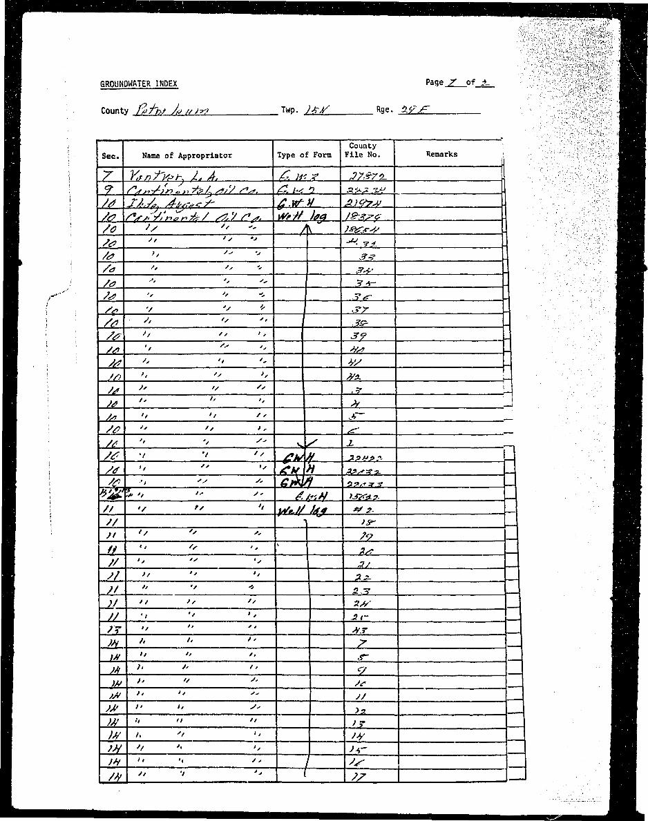
• ] 7 Y^nt'Vsh I. A. & IV. X I 37&71L. |] HH
H ! /^ J-/..A /Li,***/* ^T.R^V ^ ; < ^ > ^ I HB• ! //? /y^v/»jr^4/ ff.'/fs* #'# )?* t**r? J ^M• ; /0 '/ ^ A )s&fV J H I• ^L__H " " -***• J • H• : /^ " '' £5L 4 | Hm 1 /«y I: I S^L J H• /<? ^ 2JH J MMH >'-•" / ^ .z^ -I ^ HH ; / > v ^ » ^£2 -I BH• i & '* ' \ 3s^ \ IH• ; /& f> " 3£ J • •• : /g ^ &2. J ^ H• _M-—1± '' &L J | ^ H• : _^kL_± " L2 M ' H |• ^___^ " it 'j HI /si '/ li ^ £Z. — • •• _^1_J^ 2 LL J£L — ^ H• _^L_J 1 11. s ^ A - , | H• 2£--2. '1 '' £*>f **»>?- U H |• I ^£.-11 '1 \L-j£hL>L ^ ^ ^ ^ J ^ H• ; /# ••> " * G>wi ~ 4**** J flB• j %jg5»'/ " " £/r,H ij&.9. J M B• i _IL i iz. U ^B• ; \7r " * /y n W• I /y ^ " 2^ _J ^ H• // ^ 'i 2A J n• // ^ 2 _J • §1 // i g^ _J I^KI _j/_ __a 2 'i s±: —1 ^ B• // *> SJZ _J HII /? >* Z H i Z • •• )* *> '' '_: 2 —j MMH ;>V " ^ ^ £2 —4 ^ HI M }> t '1 2 -J ^ HI w >' " t *£. —4 MtI ;A> >' 1 H _ J ^MI >M " '' ± is _J ^MI W '' " *± i£ 1 ^HI )M __A 2 '1 i£ -J IHI W '< 2 Jjr I j | Hi )H '' / ss _n ^M• b — — " — ™-
l
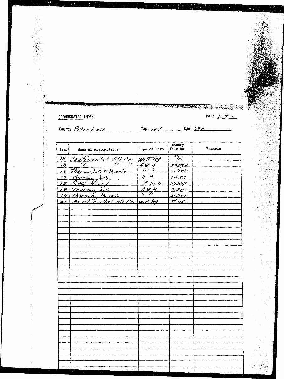
I I GROUNDWATER INDEX Page jZ of j ~ I
I ; County /•£/>• x* J*if/x> Twp. / - r a ^ Rge. J?F^~ I
I ! . . . . . ]• ; County ' 1I Sec. Name of Appropriator Type of Form File No. Remarks J
I ; )JS- ~fAjj-<?^n2,r, ^ /^ ,« /x> f' '-* ,3 / &*•<>/ I
I ; J&- *r>?**<•<>*> }.,/«. -£ HTH a>&.A-*- , II i / f J-Jtsr*-*^} ?&***;- " M Af&4-*r I
ywm\
• 3 raw, _ , «H^» O.JMU MIMIX /
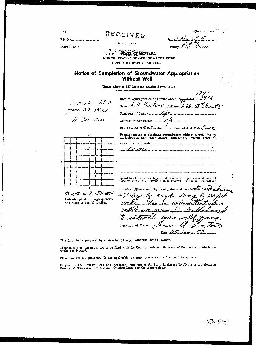
•RECEIVED , - . , *>„ rPile No *-J£M3LJ£jLj£-
Jim z<i ig/j ^ y—77DUPLICATE County..Zj^K>2tr£fe6<k2^?.:
PURGES / ^ ^ M S i ? ™ *ADMINISTRATOR OF OKOUNDWATEE CODE
OFFICE OF STATE ENGINEER
Notice of Completion of Groundwafer Appropriation ]Without Well
(Under Chapter 237 Montana Session Laws, 1961)
--?-_, Date of Appropriation of Groundwater—i^Ae/M£i.)S. J.,f.,/..&....
/ Contractor (if any) /M&.
//•' 3<£> /?-S?i. Address of Contractor '...MM- :
Date Started...«fe$?..«C^&nftC.... Date Completed..^S?...<Iil^**<^ett.
N Describe means of obtaining groundwater without a well "as by1 1 \ 1 1 j ; ' 1 sub-irrigation and other natural processes". Include depth to
i.—! 1 1 1 water when applicable
—!—!~l—• ~ f ~ l — 6&&&2.1 ;_. I
W I \ \ •} I ' E
I i i i 1 ! Quantity of water developed and used with explanation of method; f" "! 1 j ! used to measure or estimate such amount. If use is intermittent
S estimate approximate lengths of periods of yi&i..k/Xbaat..Qail^lei(e^t^ <tu«3
S/.LVM. sec...z. ,m jm w J ^ ^ £ j , a ^ ^^^^...jm.j4^/Indicate point of appropriation __ /j U fl / __ //-JuJ_ / ^^and place of use, if possible. ..UCr£JU-.^ U<Le,.~^<3- <£^S^a^C^^^i4^^o^
Signature of Owner ^Q*<&&O& ^ C . . . . - - ^ ^ * - ; ; ^ ^ ^ ^ ^ ^
T>a.te..J2.5Z..J.U*r.lg....#i3
This form to be prepared by contractor (if any), otherwise by the owner.
Three copies of this notice are to be filed with the County Clerk and Recorder of the county in -which the I
works are located. -J
Please answer all questions. If not applicable, so state, otherwise the form will be returned. 9
Original to the County Clerk and Recorder; duplicate to the State Engineer; Triplicate to the Montana IBureau of Mines and Geology and Quadruplicate for the Appropriates Jj
S3j 993 I
— ^ •
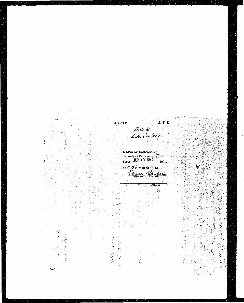
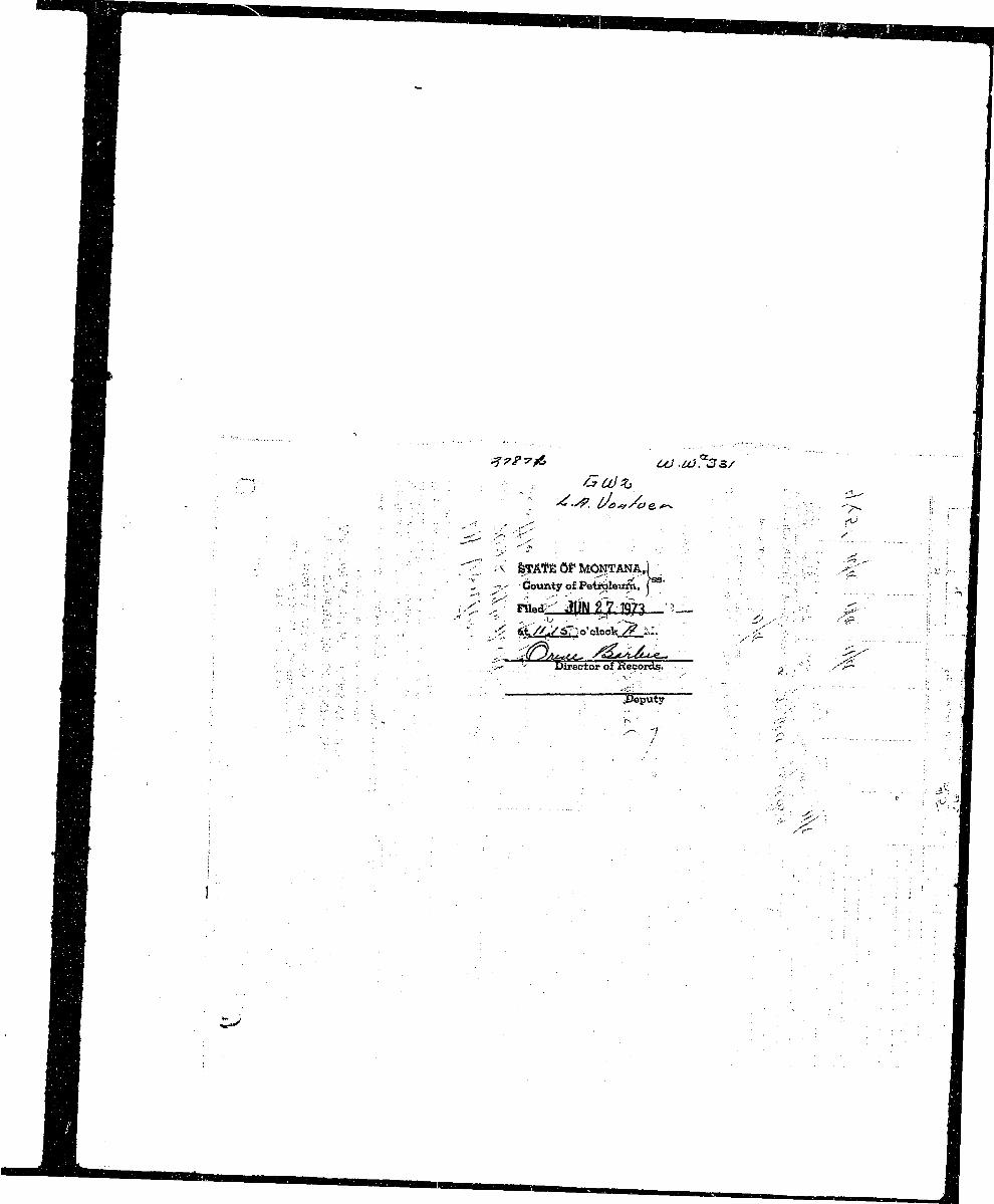
rnI ^. , HI : • . ;_, : IH | County of Petroleum, ( • • • < , , • • ^^IB• I ^ JUNE71973' ,. . • ' ^ ;. •H at //1&6 o'cloch; /^ M. ^ ' , ^ H f
^ H ' Director of Records. ' f ,"' <^H^B| I
9 B ^ ^ <•? I^ H l G w 2 - Approved Slock Form—Stale Publishing Co., Helena, Montana—3908b - ^ 5 J ^ > $ 1
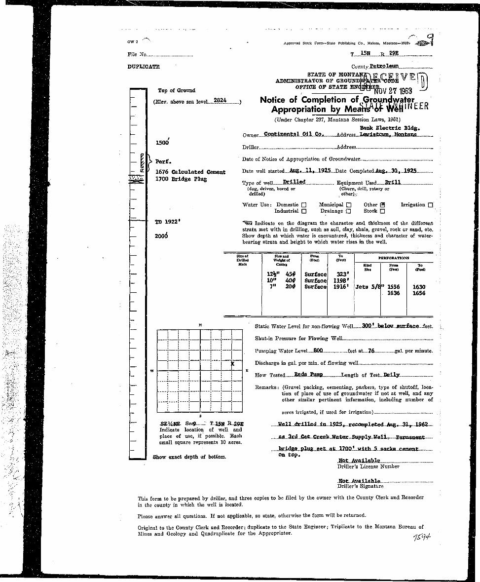
ftflf File No T 15.N R,...??..?.
^Hj DTTPLICATE Coimty.P.e.£r.Qleum.HH STATE OP M0NTAN2p| |C" (p ]C= ft \p |B> |"T\H H H ADMINISTRATOR OF GROUNDWrATER^OBE W ' 11 I !• • H . m e r, J OFFICE OP STATE ENQpilER-.,i nr/ snrn "J
nflfl| I Top of Ground _ T ^ NOV 2 7 1963 —IB ~ (Eiev. above sea level 28?4 , Notice of Completion of GroujidwaterH H ~ Appropriation by MeattsAof W^ft'li EER
H|H (Under Chapter 237, Montana Session Laws, 1961)
^Hfl ~ Bank Electric Bldg.^ H | - Owner....Continent3iO.il..Co.. _Address...Lawi8tCwn,..M0iitana IHH — 1500 1
JflHM Driller .Address I
•HJfl K > Perf Date of Notice of Appropriation of Groundwater I
fiwX - <Z ) 1576 Calculated Cement D a t c w e l 1 started....Aug*...ll»...1925....Date Corapleted.Au&....3Q,..1925 IM L . : = « £ " 0 0 Bridge Plug Type of well Drilled Equipment Used B r i l l Ij H H H " — (dug, driven, bored or (Churn, drill, rotary or Iftnfl drilled) other);.: : flH 1 8 Water Use: Domestic • Municipal • Other 0 Irrigation Q \ •^ • ^ 1 ~ Industrial D Drainage G Stock • ' ; fl^ ^ ^ H — — • JJJ 1922 =^j in(j}cate on the diagram the character and thickness of the. different ! I^^|H ~ strata met with in drilling, such as soil, clay, shale, gravel, rock cr sand, etc. ; S^ ^ H B — 200(5 Show depth at which water is encountered, thickness and character of water- : I
. H H H bearing strata and height to which water rises in the well. \ •• ^ ^ B • S b e o ( Size and From To PERFORATIONS - I^ H l Drilled WelBhtof (FMI) (Feet) PERFOKATIOWS B•^^B — Hole OUIHB Kind From To i IH H H SUe (Fed) (Feet) : •
HH — 12%" 45# Surface 323' 19BH _ 1°" ° * Surface 1198' 1^ H 7" 20# Surface 1916' Jets 5/8" 1556 1630 1•^H — 1636 1656 fl
| ^ H | ^ N Static Water Level for non-flowing Well .300..l....belOH..BUrfafie...feet. ; I
V^^^ft — | i ] | i Shut-in Pressure for Flowing WelL •
' \ - ' > | H H H ' '< ' '' 1 Pumping AVater Level.....80Q feet at....76 gal. per minute. I
^ ^ ^ H j ! i | j ; C Discharge in gal. per min. of flowing well •
, ' ^ H B - " : I | j i I E H o w Tested .Bfi.da..Rjffl?. Length of Test...Dlaily. " I
{ , l ^ ^ ^ H i l l ! ' i Remarks: (Gravel packing, cementing, packers, type of shutoff, loca- fli "*> j ^ ^ | H — ; ! ! i" "l ! *'on °^ place of use of groundwater if not at well, and any flli*A j^^HE • ! ! ' ! ! other similar pertinent information, including number of H
<flBVJ — ' '• '• ' ' ! ! ' acres irrigated, if used for irrigation) ..; H
A' J^B ~ SE^UE. Sees T..15N R..29E Hell..idri.lled...ia..l925,...rficonq>leted..Aus...3Lr..19.62... M_ flH^ _ Indicate location of well and H
• H H place of use, if possible. Each ia8...3rd..Cat..Crjeek..Watar..Supply...Welifr....3ewaaaeBt fl•' fl^H — small square represents 10 acres. B
flflH - .bj:.i.dBe...p.lug..s.et...at...l7Q0.l...w.ith..5...8acka..C£meat H,' . H B H I Show exa«t depth of bottom. oa top . •L flflflj ——i .HQ.t...AsailabJ.e flj
B H H ' Driller's License Number H
" B H .Hot.Availahle IHJflB Driller's Signature •
. ^ ^ ^ B This form to be prepared by driller, and three copies to be filed by the owner with the County Clerk and Recorder fl1 < ^ | H R in the county in which the well is located. H
\ f l ^ f l Please answer all questions. If not applicable, so state, otherwise the form will be returned. fl
^ H H Original to the County Clerk and Recorder; duplicate to the State Engineer; Triplicate to the. Montana Bureau of HHAVJ Mines and Geology and Quadruplicate for the Appropriator. siCCld. fl
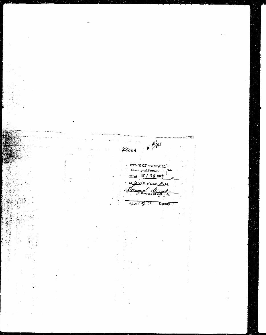
^B||V'.: ' " "• ••-- •- -222U * / ^ . W
:;i^r;: : ' STATE O? MGB7AKS,) : v BH| |Sfii;.;;. . ; : | Countycf Petroleum, p 3 ' -: ? I ^ H
iS'-:..••• -: . :. : Rkd_Nov2 6?9fig in : | B
I S'-o;.'; 5 : ' " ~. ^Jirectop oi ii^orda". "•• ;-- J ^ H H
^'K -.':r'": ' : • HHn-$^M%%:-.-.-^?--~. ••• ' • H H
| - . . f : « - . •;•• •_. ' ' HH
^ ^ ^ ^ ^ H ' *—Helena Independent Record Q 5^1 |{> '
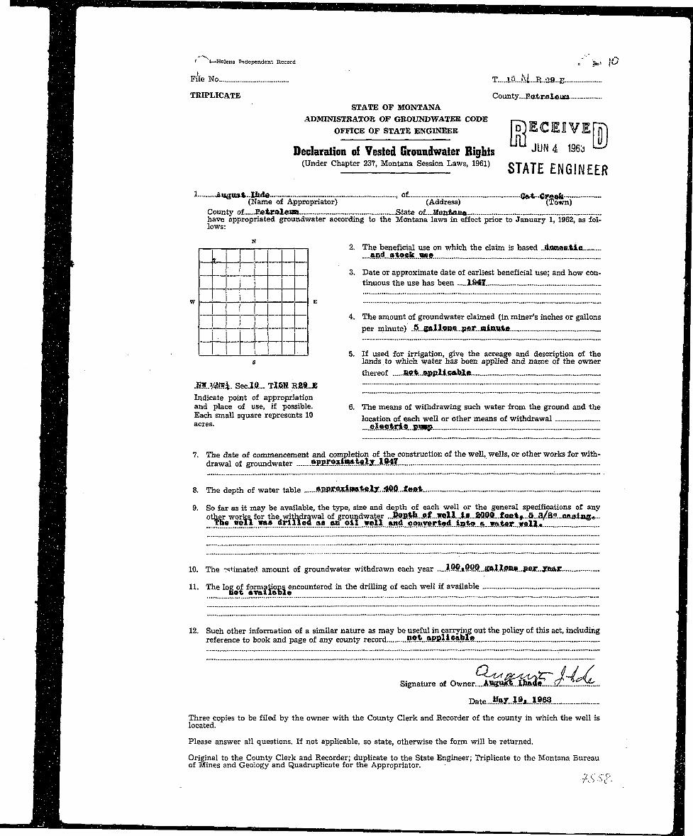
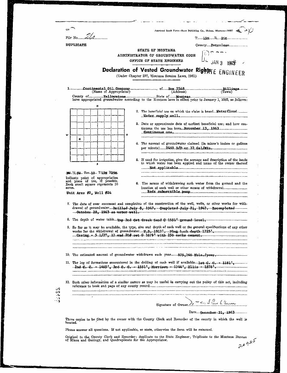
SH File No T....J.§....M.-Jl..3fl..E
B^H TRIPLICATE County...Eatr.ale«a.^ ^ H STATE OF MONTANA^ H l ADMINISTRATOR OF GROUNDWATER CODE . - ^^ ^ B OFFICE OF STATE ENGINEER D^ E C E 2 V E fTPl
flB| Declaration of Vested Groundwaier Bights JUN 4 196b I^ H H (Under Chapter 237, Montana Session Laws, 1961) QTflTFFMflMCCD I
^ ^ H 1 -fiu3u»t..Iiid« , oi G»*. Greek IBH^H (Name of Appropriator) (Address) (Town) IH H | County of jpatroleuin State of...ilcmtiiisa Ifl^H have appropriated groundwater according to the Montana laws in effect prior to January 1, 1962, as fol- I^ ^ ^ H lows: •
^ ^ H | I 1 1 1 1 2. The beneficial use on which the claim is based ..(Losme&tle. 1
^ B B I ....»»*..».*«»&.. «se. I£ ^ B R 3. Date or approximate date of earliest beneficial use; and how con- II^HH tinuous the use has been 1847 fl
HflJHH. yy • E . -~ .. fl
^^Hj j 4. The amount of groundwater claimed (in miner's inches or gallons Ij ^ ^ H ! per minute) .5..g9.l.]lsn.9-.par. JBiawte I
| H H | - - • :— 5. If used for irrigation, give the acreage and description of the flflAnV s lands to which water has been applied and name of the owner I^ ^ B thereof 1W!*...ftppUcftblei •
| H | | M..VM&. Secl-Q... TlOH Ra8..JE IHH^H Indicate point of appropriation BIPJHI and place of use, if possible. 6. The means of withdrawing such water from the ground and the IB | Each small square represents 10 l o c a t i o n rf e a c h w e l l Q r o t h e r m e a n s o £ w i t h d r a w a l fl
BH| acres- _ftlMdUClflLSLM» I
^ ^ ^ | 7. The date of commencement and completion of the construction of the well, wells, or other works for with- IH H drawal of groundwater »fiE.roxi«w-t«ly..I547 •
l ^ R 8. The depth of water table *SBroxiBftt8ly...4ft.0...«:oftt •
Hj^B 9. So far as it may be available, the type, size and depth of each well or the general specifications of any HBIB other works, for the withdrawal of groundwater ...P.ap.tb...9.f...1Hlll..iA..SQftS>...fjD&t«...a..a/a!?...c&ai.ng«.. •^^H ....:™ '•**..***..* ^ I
•HH| 10. The -<!+imated amount of groundwater withdrawn each year ?.ft?.iQ.P.P...g«l.iffl»*..|JBjr..yB3»r •
fl^H H. The log of formations encountered in the drilling of each well if available •^ • j H «ot avftiiaW© * •
^ ^ ^ B 12. Such other information of a similar nature as may be useful in carrying out the policy of this act, including Sfl^H| reference to book and page of any county record 5ft$.«fiE8l!..?.ftMft I
^ ^ 9 Signature of Owner. ...A\HP« t Xfe«ae .....(Z!.I/:£. r... I
•H Date...WftT..l»A..lJ.6a. 9
H|H Three copies to be filed by the owner with the County Clerk and Recorder of the county in which the well is H
9HB located. •
^ H | H Please answer all questions. If not applicable, so state, otherwise the form will be returned. H
H H H Original to the County Clerk and Recorder; duplicate to the State Engineer; Triplicate to the Montana Bureau MBM of Mines and Geology and Quadruplicate for the Appropriator. Mm
1I 2 i m **BppJ!£—*& •••• •
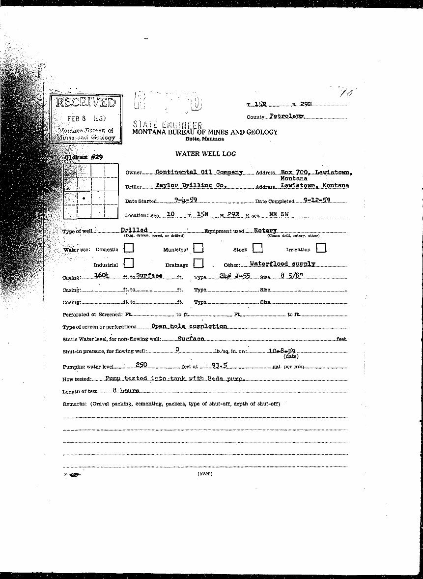
1 M | | ; RECEIVED LJij 'Jj T...1SN. &..&»^^Ky FEB8 iiioi) . . . v , ; V , , , ' r > ^ County...Petpo.Xe.m
H B B a " T"atana-.Pwri»flu of MONTANA BUREAUOF MINES AND GEOLOGYH W H ^ ^ ^ M > M ^ f f < t>uci Gaologpr | Butte, Montana
BMppgg^^ WATER WELt LOGHBSH^ SHfefj • ! Owner. .C.Qn.tln©Jlfcal....OIl...aDmp.aJiy. Address....Box...7QQ«...Ite.wl3.to«nf
BHffiBI^V j — Montana
Hi^^^^^P^ iJ -I I ! Drmer- ^^9^...M^M^B...9.9.x Address.....^«^s*own»...Kont»na
HHBH^^W^'l^t;' ' i Date Started 9.zkr.$9. Date Completed 9 - 1 2 ^ ^
| H | ^ P ? , ,:| ' • i I Location: Sec 10 T...1SE.......R..29E.. y4 seo NE..SWB W a B P B w ?j;:: -TypeofwelL.' .Eri.1.1.9.4 ; Equipmentused...'....RQ.fcaEXB B E ^ ^ » ^ S % '• .-:';' ' (Dug, driven, bored, or drilled) (Churn drill, rotary, other)
S ^ ^ ^ ^ K S f;H;:y7iXeiMse: Domestic |__1 Municipal | _ J Stock | I Irrigation I t
^ ^ ^ ^ ^ ' Industrial |Z1 Drainage d l • Other: WaterJC:lopd..STiPEly
^ ^ ? " Casing:.- .M9k ft. to.Swf ace ft. ^ e ?ktJ-&...... Size L&S1
fp|fi-i Casing: ft. to ft. Type. Size
• ; Casing: ft. to ft. Type Size
; Perforated or Screened: Ft to ft Ft to ft
Type of screen or perforations .QpP.n..iK?Jle....C.QJT3p2vff.t.i.Qn.
Static Water level, for non-flowing well: Suc f aae . feet.
Shut-in pressure, for flowing well: .P.. lb./sq. in. on: 10.w.8.«.^9(date)
Pumping water level ?.«?.?. feet at '....3.2>*3.. gal. per min I
How tested: .^WflP....t.B.B.t.e.d..IriiQ.:.tank...wI.tli..E.edfl...puiiip.
Length of test S...hOUrB.
Remarks: (Gravel packing, cementing, packers, type of shut-off, depth of shut-off)
».*gsp- (over)
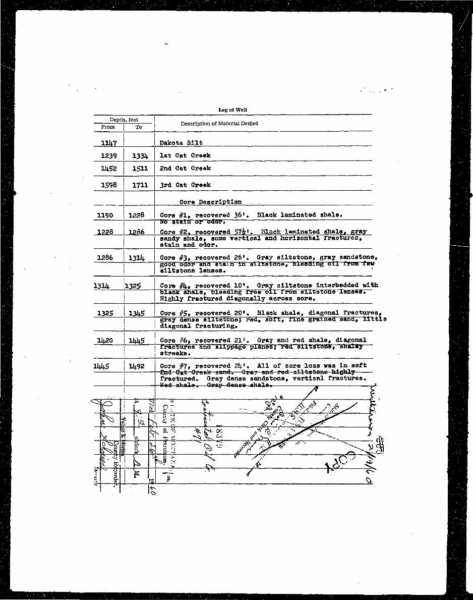
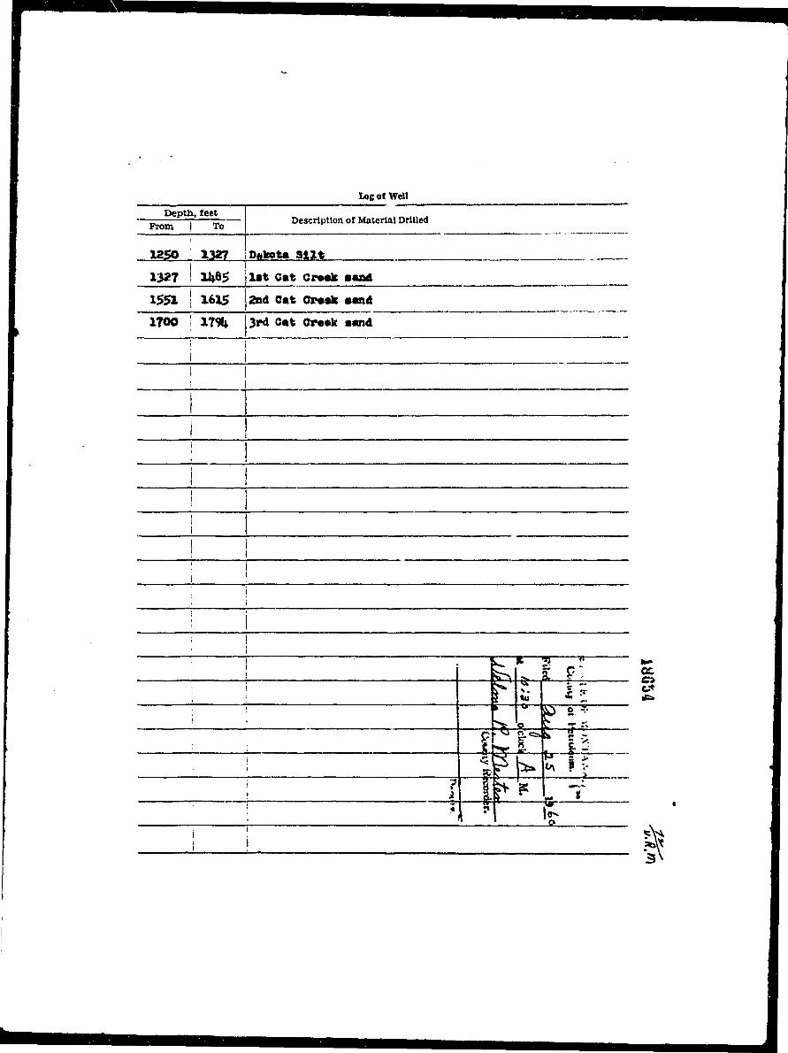
IHi Depth, feet flUgj| — —j Description of Material Drilled HH
BM I nilH llli.7 ! Dakota Si l t W^MH 1239 I 13314. 1st Cat Creek HBH 11+52 l £ l l 2nd Cat Creek HHH 1598 1711 3rd Cat Creek H H
|H __J Core Description •Vsl
H 1190 j 1228 Core #1, recovered 36*. Blaok laminated shale. ^ ^ BBfl No stain or odor* '• •^•flH 1228 1286 Core #2, recovered $7h*. Black laminated shale, gray BAHHi ! sandy shale, some vertical and horizontal fractures, • • • •HH j stain and odor* fi^^SH 1286 1334 Core #3» recovered 26 ' . Gray all-fcaiione^ gray s'jr>d°to.ne» HH^B gooa odor ana staxn in siltstone, bleeding oi l Ix-urn fe*r ^^^HBB siltstone lenses. ' ^^^B
H I ^ ^ BH 13114. !l325> I Core ffii-, recovered 10*. Gray siltstone lnterbedded with • • •B | black sftale, bleeding free oix rrom sixtstone lenses. ••^H• Highly fractured diagonally across core. •^•jH BHIH 1325 13J4.g Core #$t recovered 20*. Black shale, diagonal fractures, •Vfl•9 I gray dense siltstone; red, sort, rine grained sana, little i^^HH I diagonal fracturing. • • •H li<.20 I lliit- Core #6, recovered 21*. Gray and red shale, diagonal ft^H•• i rraofares and slippage planes; red. siltstone, shaley H^^B
B . .. j streaks. . :__ : ^ ^ BH lU t-5 11 .92 Core #7, recovered 21;'. All of core loss was in soft H^B•J • 2nd Oat Creek sand.—Graj and red alltatono highly- HHI•J I fractured. Gray dense sandstone, vertical fractures. • " « •H ! Rod ohaJre-,—Gray denae chale-. -* ~s HftVi
I TP kg ?• t %^^ I' I
I ~Wcmwii)' .:1SH , ^ . . : ri Y ^ H O r /• -,- County PetrO.lftH©. I
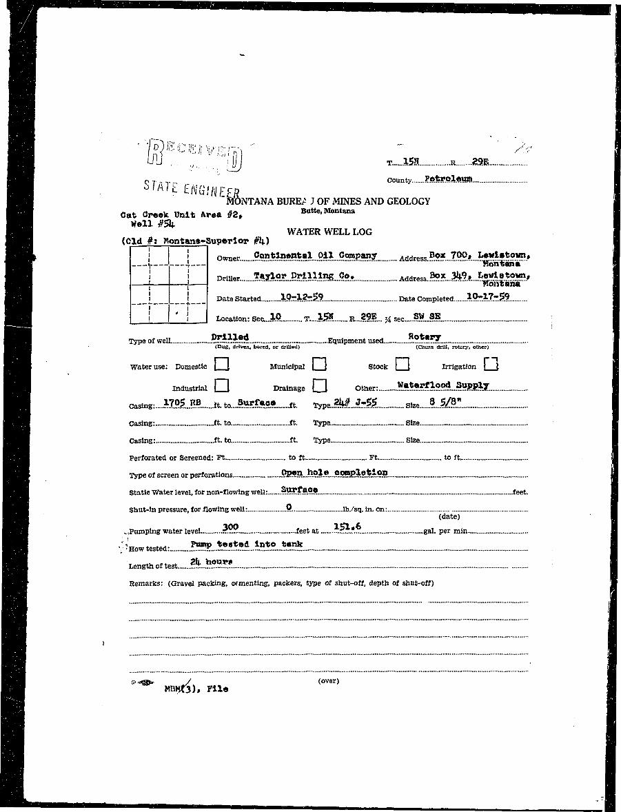
•I «>'A1t EHGIHEER i• H MONTANA BURE/ J OF MINES AND GEOLOGY 1WB Oat Creak Unit Area #2, Butte, Montana I^ H Well #${. 1• • WATER WELL LOG 1^ ^ H (Old #> Wontana-Superlor #k)^HL. ] ! owner ?9"t?.*5$5**l ?*.* 9.?*$*$$. Address ?.?* .7.99 » ?H>**»*'?!IE»| ^ ^ F v 4 — "Kontani" 'S B j I Druier... .?«jlo?...P?^inR....9«- Address ^X....M»...^^.2*.°«?V^ ^ H 1 L • Ttontana• H ! i Date Started .JO-3L.fe59 Date Completed %.Q?M.T$9.^ ^ ^ ^ ^ ^ H — — — J-. _ — — — — — + — — —
^ H 1 ! ' ' I Location: Sec...l.P. T-lSl R.-SBL. 'A sec $*_&$S S ]
^ ^ B Type of well. 55*ii** Equipment used. .?.?*•??'.^ ^ ^ H ' <DuS> driven, bored, or drilled) (Churn drill, rotary, other)
^•H Water use: Domestic \ I Municipal | \ Stock j \ Irrigation J \
Wm industrial • Drainage Q Other: ^3^1^?.°^...^HSM.
^M Castag:...!!?.!.?.? it. to... *2**S39.—ft. 7ype..?M.J-& Size ?..1$1
^ | H Casing: ft. to ft. Type Size
^ ^ H Casing: ft. to ft. Type Size I
j ^ ^ H Perforated or Screened: Ft to ft Ft to ft M
^^m Type of screen or perforations .Ql a .hole .OOBplotlon il
^^H Static Water level, for non-flowing well: ?5?.?.#.?.®. feet. I
HiH Shut-in pressure, for flowing well: $ lb./sq. in. on: •^HB (date) ' •
B J H ^,Pumping water level ?*.?. feet at i"?™".™ gal. per min I
| S ' 'HOW tested: ?«P...^!»*«i..^^..*?!* I
H Lengthoftest. ?L>?5»«! 1
H ^ W Remarks: (Gravel packing, cementing, packers, type of shut-off, depth of shut-off) V
HB V"«3!f* ./ (over) •
toe of Well
Depth, feet—zz i ™ Description of Material Drilled
From I To
1250 1327 Dakota S l i t
1327 U»8g l i t Cut Cr—k a«nd I
1551 I 1615 2nd Oat Oraric sand I
1700 ' 17% 3rd Cat Creak sand
i 1
j Ii
1 I1 jI
__ i |
I 1; i
1 [] j
I ij : ; r~ It 5 •" 1— I
i !" h ?. f |; I I, i j to < • •fe I
' k o ^ T a Ii £ f ^ 1 5. I
i ! S±5c-jc.—,. S- -; II « N T P s > •; xPfc^ * V I
1 1 ^ I— 3\ I
I r
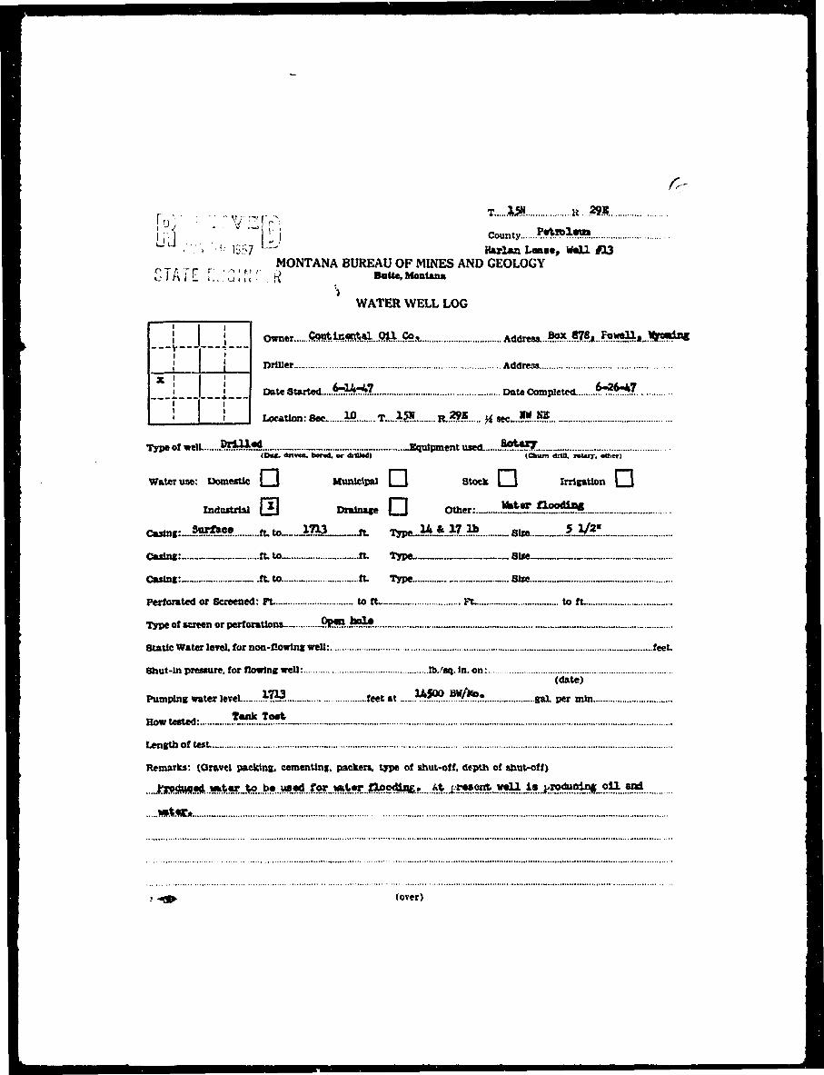
I uyy ---v-v, *-*" ***H j p | jj j County ?«**?1*»»• L L J ,••;.•, :.<; 13f;7 — llulaa Law*, m i l #13• MONTANA BUREAU OF MINES AND GEOLOGY• S i ATE r.i.'CIN •""."« . Butte. Montana• ' WATER WELL LOG I
I J j owner fi«^^«?^....Qil,.Co. _ Address....^..^?«..?9]!^*_.*fto?!^ I
H { [ Driller _ Address M
I [ ] DateStarted....*^:*?. Date Completed. $*?*"*7. •
I I ! I ! I Location: Sec Wl T»...15». R..??* ^wJSJB. I
B Type of welL..~J&£yL*$ —Equipment used.......*?**?7.. _ _ •• | (DM. drtvnt, bend, or dHU*d) (Chum drill, roury. olhcr) ^ 1
H Water use: DomesUc ] | Municipal | | Stock | J Irrigation | J fl
• Indttitrlal GO Drainage O Other: **!?J5S2^*I _ I
I c«lng:-. •«*«!•._.-ft. to___JLW3 Jt. Tn*J**M* _„ Six* 5J&L I
H Casing: ft. to ft. Type-.—. Size „ _ ^ |
^B CnTlPf . .ft. to .ft. T pe - Size — ^ |
H Perforated or Screened: Ft— - to ft- n~ ~ to ft. _ •
jH Type of screen or perforations..... PR*?l.i?^? ^M
^m Static Water level, tor non-flowing well: „ _ _ feet. ^ |
H Shut-In pressure, for flowing well: Is.'aq. In. on: H• (date) •
• Pumping water te«L.._....*??5...._ feet at .._..**???...?$*!•; ^ai per mln I
I HowU»ted: *^^!*:._. _ I
• Length of test. _ - ™ H
• Remarks: (Oravcl packing, cementing, packers, type of shut-off, depth of shut-off) • •
• .._^|SMJ«SM..»l!«CJte...^...VW!a*^ V
• wMi«C» _ - •
• • -4» (over) H
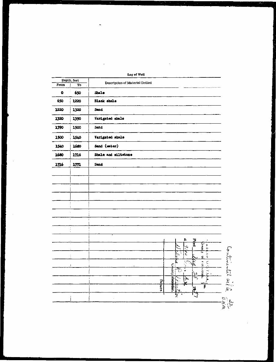
H Log of WeU I
H Depth, feet ( •^ B —From—i T Description of Material Drilled •
• 0 650 j Shale I
I 650 j 1220 I Black shale I
I 1220 J 1320 Sand •
• I32O I 1390 Varlgated shale M
• 1390 1500 I Sand I
I 1500 j 1540 Varlgatad shale M
I 1M0 j 1680 Sand (water) I
• 1680 I 1716 Shale and aUtstone fl
I ; ' 1 bl?M- r IM , — — — v - ! •• jX -• -•• <*• \ ^ H
• •% i T ^ I >: • S •
I t. ? cy . | . •
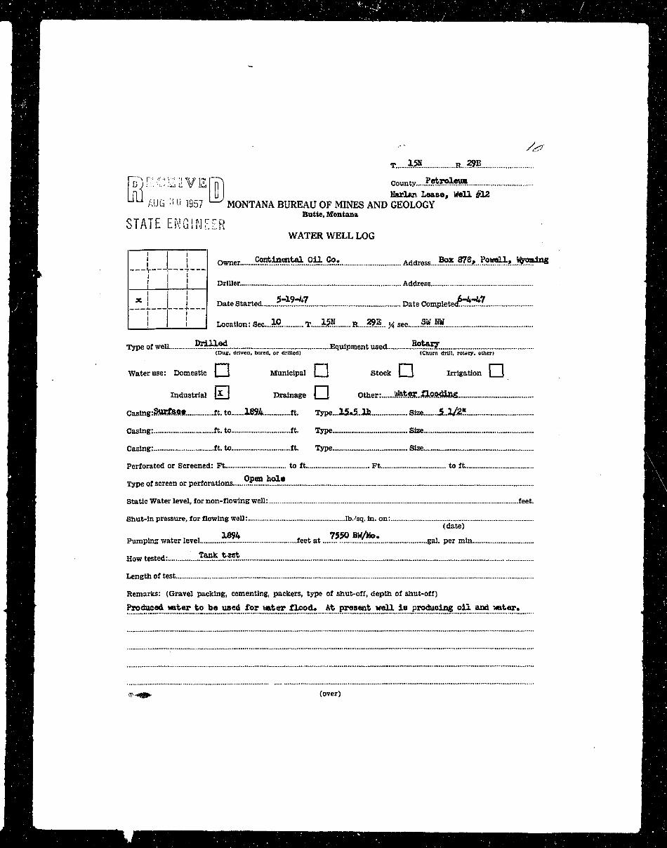
^ H FD) f: C]21VE[K] County .?•*"*«• H•n [1 ] U I Harlan Lease, Well #12 WM^ B | AUG •'• U 1957 MONTANA BUREAU OF MINES AND GEOLOGY | D^ ^ ^ H Butte, Montana i^H
B STATE ENGINF.ER - H• • WATER WELL LOG BBH —i r- •M | I owner .??*^S^...9*L!?<>.? Address....^..^?*...??*^*...?*?!?!"?1^ flH
^^Kf j j Driller Address ' ^ H
fl^H X i I Date Started .?™?!*7 Date Completed?^?*:? a^H
' ^ H [__! l__l Location: seeJW T.....15» R...JS.?.. J4 sec W.W ^ B^H HI^ ^ H Type of well. .??M?:?4 Equipment used. .??*??!£ HI^ ^ ^ ^ H (Dug, driven, bored, or drilled) (Churn drill, rotary, other) ^ ^ ^ H^ H H Water use: Domestic ] \ Municipal | | Stock ] J Irrigation | \ H H
^ B rn r-i H^^M Industrial l £ J Drainage \ I Other: .^tejc.^Pftdiflg ^ H
^^M Casing:§HKteff.t. It. to 1894. ft. Type...25«5..1b Size 5-3/%?. flH
^ ^ ^ H Casing: ft. to ft. Type Size ^ ^ H
^ ^ H Casing: ft. to ft. Type Size I ^ H
^ ^ ^ H Perforated or Screened: Ft to ft Ft to ft M B ^ I^^^^H Oioen hoi* ^HBH
^^^^B Type of screen or perforations .:.£™../-™ I^HBI
| ^ ^ H Static Water level, for non-flowing well: feet. ^ H l
^H^B Shut-in pressure, for flowing well: lb./sq. in. on: fl^^l^ ^ H (date) ^ H^ ^ H 1394 7550 BW/Ho. BH^ • ^ H Pumping water level feet at gal. per min ^ ^ H j
^ H Howtested: _..*«!Li:«!* Hj^ ^ ^ H Length of test ^ ^ ^ H^m H^ ^ ^ H Remarks: (Gravel packing, cementing, packers, type of shut-off, depth of shut-off) ^ ^ H l^ H ^ V Pxoduoed water to be used Tor water flood. At present well i s producing oil and *ater. .fl H
• •"••'••"" • : fl
• zzzzmiiiiiiii^m — — •^^M r-*m- (over) HH
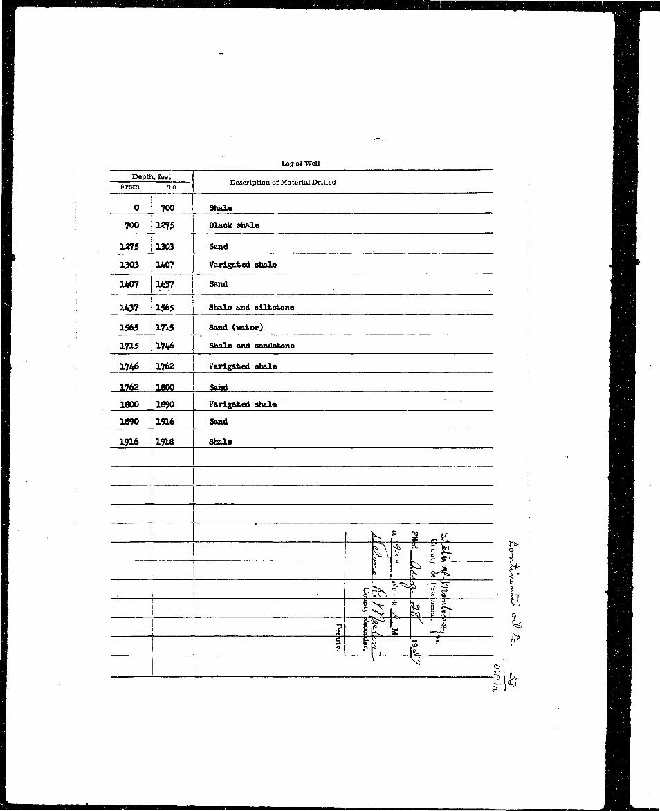
I Log of Well ^ B BI Depth, feet ^ H H• — i Description of Material Drilled , ^BH• From | To . I^^^H
1 0 1 700 Shala ^ B
I 700 1275 Black ohale ^ H
I 1275 3303 Sand . H
J 1303 140? Varlgated shale ^Bm
I 1407 1437 Sand flHI ; '- — •• 1437 | 156$ I Shale and oiltstone SH
I 1565 1715 Sand (water) HH
I 1715 1746 Shale and sandstone ^HB1 1746 1762 Varigated ahale ^BB
I 1762 1800 Sand ^ ^ B
I 1800 1690 ?arlgated ahale ' flH
1 ' ^HI 1890 1916 Sand H
" : , t ; t
i I" A b I i t f •1 I ML p t^. e. H
. 1 ; B I IF e m! f.K- k pa g | t 9 H H
H T « • R 29E
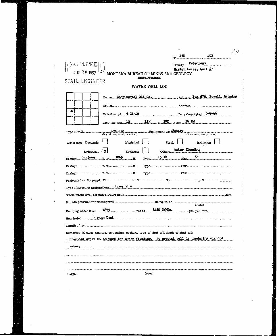
Hj . |T) E C E2 V E IT) county *•**!»*•| H . In] „ liJj Harlan Lease, Well #UB | | AUG •> 0 1957 MONTANA BUREAU OF MINES AND GEOLOGYH I H Butte, MontanaH STATE ENGINEERmm WATER WELL LOGflfl | j Owner. Gonfei»enfts3,..OiJ,..??9.f. Ad6iess..*mM8xJ°y^.*..l&9**toeH "r^ ^ ^ K t . [ { Driller. Address
I B ^ H *' I '9H _l j Date Started S.TiZfcM Date Completed &&*$gH 1 ' i 1 Location: Sec » T....15N R....??E... J4 sec ?WJW ;
^ ^ ^ D Type of well PSAiiGSl Equipment used.??^.^!?!.
^ ^ ^ H | (Dug, driven, bored, or drilled) (Churn drill, rotary, other) : H
^HH • Water use: Domestic | \ Municipal j \ Stock | J Irrigation | J •
•H industrial Q Drainage Q Other: ^..B™.*?*. I
H Casing: ***™* ft.to *#* ft. Type £lb Size *". I
^ m Casing: ft.to ft. Type Size I
I^^^H Casing: ft. to ft. Type Size D
j ^ ^ H Perforated or Screened: Ft to ft Pt to ft •
I H Type of screen or perforations fiR"?...^.? I
J ^B Static Water level, for non-flowing well: feet. I
l^^^l Shut-in pressure, for flowing well: lb./sq. In. on: •
^ ^ B ( te) •^ ^ H Pumping water level M75. feet at 3W?..BW/lto. gai p e r m i n •
^ ^ 1 How tested: ^iftafc.Zfie* I
•^H Length of test H
^ ^ ^ B Remarks: (Gravel packing, cementing, packers, type of shut-off, depth of shut-off) D
HH ....?.»^*i..^*«O.9...M.M*^...?9.?...^^ I^ ^ H wa*«f!. *fl
Wm\ ('•-«s^ (over) H
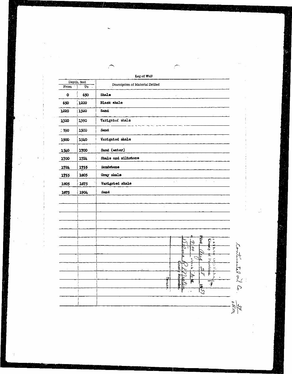
I I^ H Log of Well Hfl^H Depth, feet ' B B• W —= —r = Description of Material Drilled • •• M B , r rom To - • •• fl^H• H 0 650 Shale ^ 9H 650 1220 Black shale MiH i ; M|• • 1220 1320 Sand HI^T ' 1320 1390 Varlgatud shale ; H B
Hj :?9o 1500 sand n |
H | 1500 1540 Varlgated shale ^ H
H 1540 1700 Sand (water) ^ H
^H - 1700 1724 Shale and siltstone ; •
B 1724 1755 Sandstone \ WM
H HHH 1755 1805 Gray shale . ^ HH | 1805 1675 Varlgated shale BH
I i " r*M; [L •i g^r T \l I •
I —' IV 1
™—mm———— M
•••••|^nHH|HBHHHHHHMflnBnHnHHM|HMnBnHBn|HMUHHtt|BH
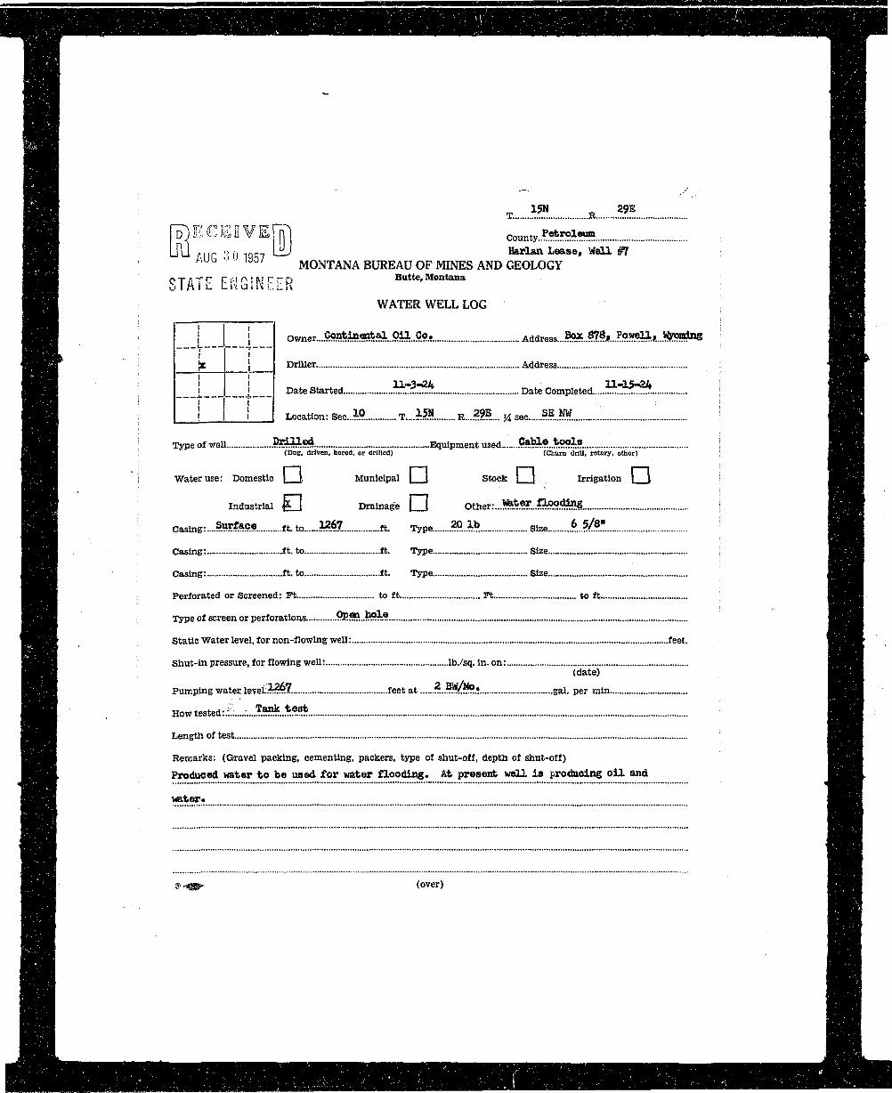
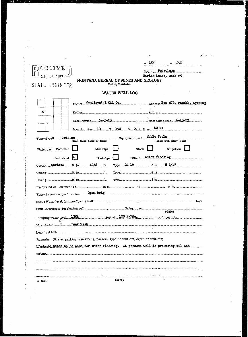
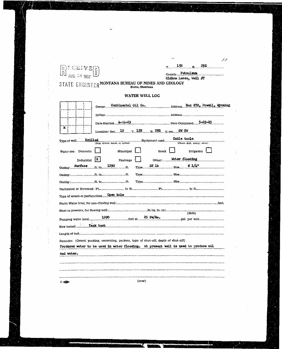
1 j- - : 1Hfl : roECEE¥E|T| county Petroleum... : H^ H LIU AUG 3 0 i g 5 7 W Harlan Lease, Well #7 ; H |HHl / U b l 3 0 / MONTANA BUREAU OF MINES AND GEOLOGY H |HH S T A T E E N G I N E E R Butte,Montana ; fflgBi WATER WELL LOG H H
JBR I I Owner....???*iJ?««ti?il..9fy:...9.?«..... Address *°X 87St Powell, Wooing flH•L .. — r—T— : H&T^gfflT }K I { Driller. Address . H^HHH I i n-3-2ii ii-15-^it flflH^ ^ H i i Date Started "...TZ!?. Date Completed zCZZ. < ^HHm i —f 1— : HBHB I ! I I Location: Sec..!?. T....l?» R..j?2L. * sec 1?.NW : W| ^ ^ H : Type of well .l^:?^:!?* Equipment used J5*] S..*? !:?. i i^^BB ^ ^ ^ D ( D u e> d r l v c n> bored, or drilled) (Churn clrlU, rotary, other) : ^HHI
B H ^ B ! Water use: Domestic ] |, Municipal | \ Stock | { Irrigation | J [ ^ ^ ^ B
•H Industrial PLJ Drainage L J Other:. ^*e .F *?-oodinS ! HHI
DH Casing:... Swface. f t.t0 12.67 ft. T^pe 20.1b s l z e .6.5/8" I^H
H^H Casing: ft. to ft. Type Size : HH
flHH Casing: ft. to ft. Type Size j ^BH
^ ^ ^ H Perforated or Screened: Ft to ft Ft to ft ' ^ ^ ^ B• • • ; : ,. BH|HH Type of screen or perforations .ftR!?...^.6. ^ ^ H
•HB Static Water level, for non-flowing well: feet. ^ ^ ^ K
j H ^ H Shut-in pressure, for flowing well: lb./sq. in. on: HHHH H (date) H B^BH Pumping water levetS^T;. feet at ?...#]x™o« gal. per min HH
H B . Howtested:£.™?55>?_te«t HH•^•B Length of test |BH
M ^ H | Remarks: (Gravel packing, cementing, packers, type of shut-off, depth of shut-off) H H H
H ^ B Produced water to be used for water flooding. At present well is producing oil and H ^ f t
^ B B H water* ^^fl l• :: ::: :::::::: ::::::: : ::: : •• ::: ::: :: ; : : : : : mH H ®-*m* <over) H H
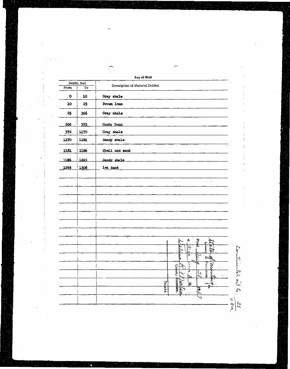
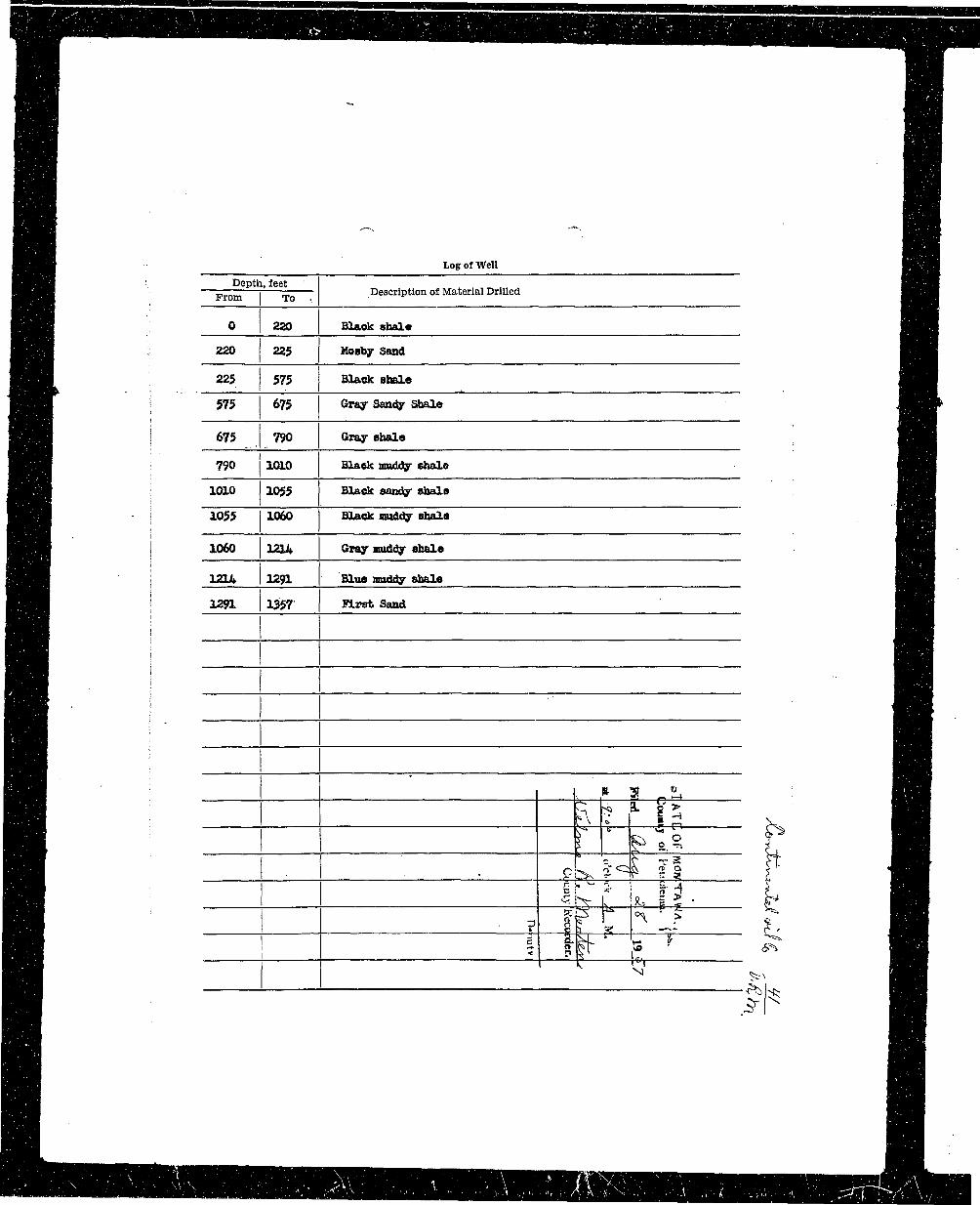
^BB Depth, feet T Hi• ^ H | •: —— i — Description of Material Drilled ^ ^ H
^^KB ; • ^^HHH 0 10 Gray abalo H |fl^B 10 25 Brovn loam B H
^ H | 25 366 Gray shale B H
•H| 366 372 Mosto Saad flH
f^Hj 372.. LL70 Gray ghale IH
•H| 1170 I 1181 Sandy shale : MM
•IH 1181 1186 Shell and sand ^ H H
fl^H " —1186 J^65 Sandy stole H |
BH ] 1265 1308 lot Sand | H
H • • • i ' i hr ? rk I
I -1 ' M=?. I• __j f "ir E1 # t- •I I
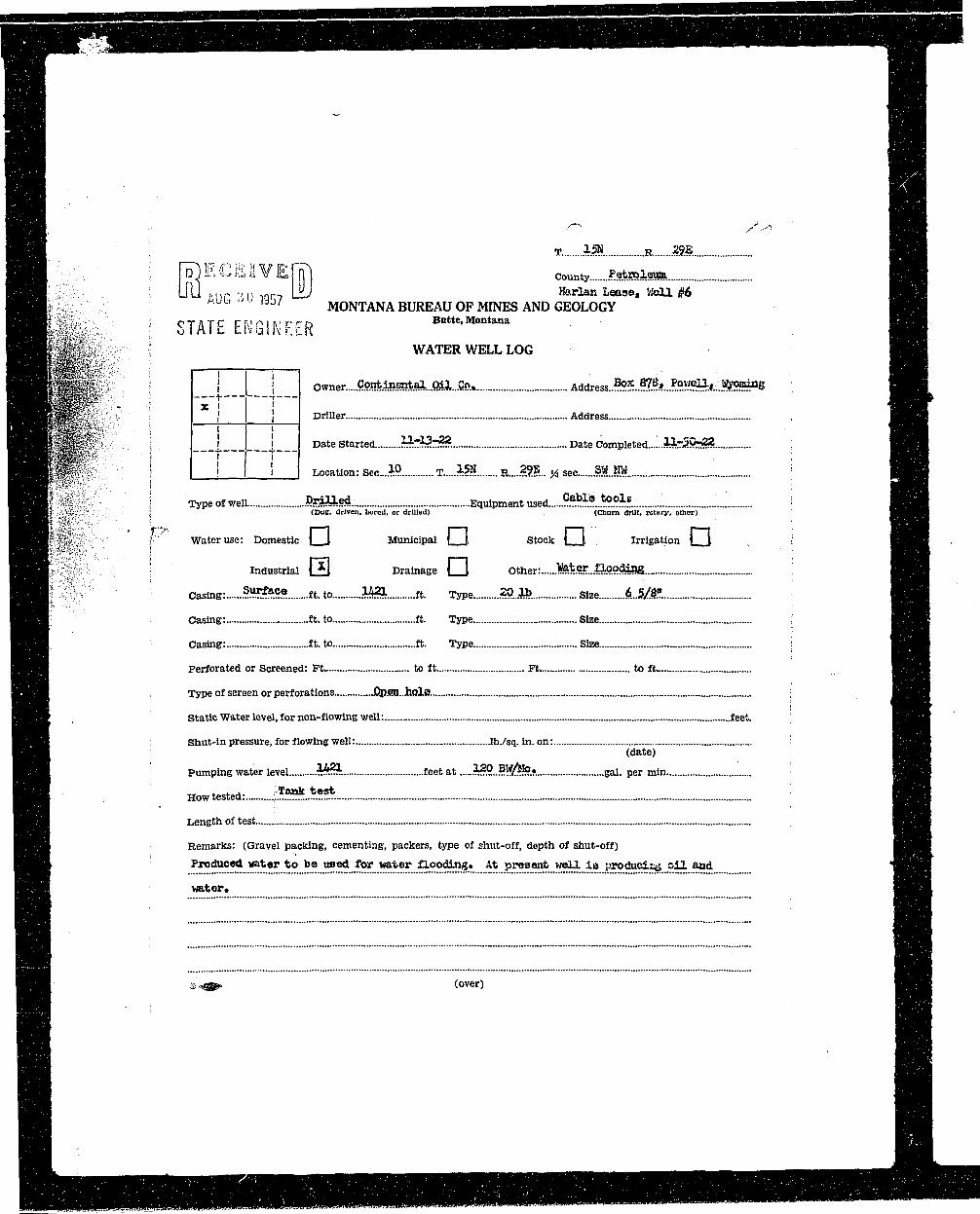
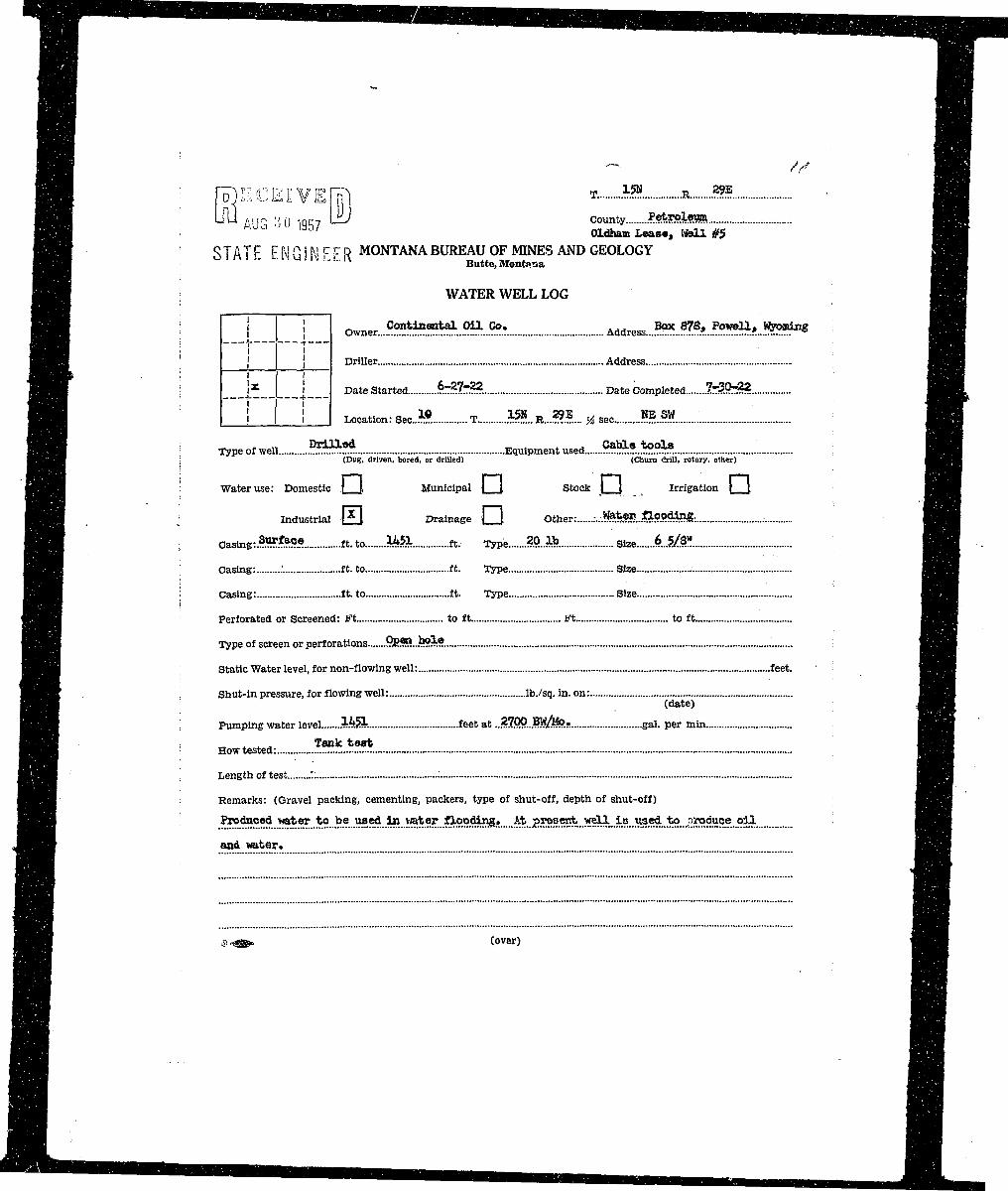
»• ; r^ECEHVEH?! County PjfcRiffli HIH ! LrQ AUQ :j y ig57 L±U *«*» Lease, «bll #6 : H |( H P ' J / MONTANA BUREAU OF MINES AND GEOLOGY HHB B STATE ENGINEER Butte.Montana . . . • MBHHTiT^ ' WATER WELL LOG ' - : H B• H R f r-i r—I • • H^ • K i ' owner.... Cont.i??.entai..m.l...a5>.. Address-.^.M^.^^A-.J^^ne BHH H P - vr—i— :' fflr• S f i -I 1 - Drmer "^ : •H l K , I ] Date Started £«>*? . Date Completed...:..^**?? ! H HBP | ! I I Location: Sec...!? T 1 » R.....?.??... y, sec .§»..»?. ' H H
H H ' i : HnHB ! Type of well Drilled Equipment used '****J*$* : HH^ H ^ ^ H ; ' i (Dug, driven, bored, or drilled) (Churn drill, rotary, other) ^ H ^ R B
| ^^B" '* ' l . ' ••"' Water use: Domestic | I Municipal | | Stock | \ Irrigation \ \ \ HBI
• n : . i ^UUIfliB • Industrial \jH Drainage | I Other: .Tfe*er..ia.godxBg..-. ' IHB^ H Casing: Sur&ce stAo UZL ft. Type 20.1b size kJt/SSL HH
^ ^ ^ K Casing: ft. to ft. Type Size ;' ^ ^ ^ B
^ ^ ^ H ! Casing: ft. to ft. Type Size i H I ^ H
^ ^ ^ B Perforated or Screened: Ft to ft Ft to ft ^BH
j ^ ^ H Type of screen or perforations .Qpen..iiolo. ; M^Bi
^ ^ ^ K Static Water level, for non-flowing well: feet. ^ ^ H BIB HB^ B ^ B Shut-in pressure, for flowing well: lb./sq. in. on: H ^ HH B (date> H B^ ^ B Pumping water level .M?k feet at ?^9..3^/^°.f. gal. per min BIB
MM , Howtested: ;?!?**?$. ggH | B Length of test HH^•j^B B^RBB• ^ • H Remarks: (Gravel packing, cementing, packers, type of shut-off, depth of shut-off) • • • •H H Produced water to be used for water flooding. At present well i s produd^ oil and "HHB
|^B HH• B H water. IH^B
B H S' ss (over) HH|
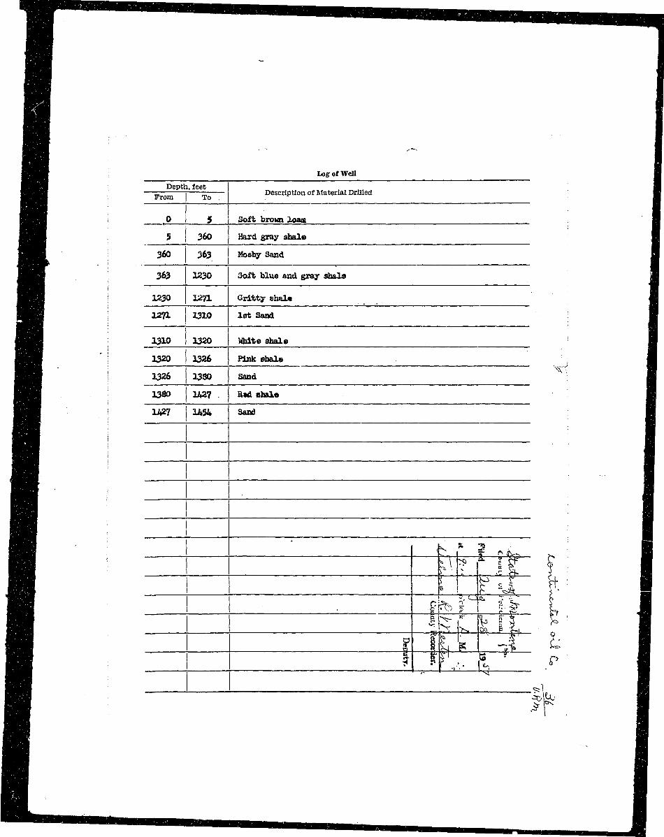
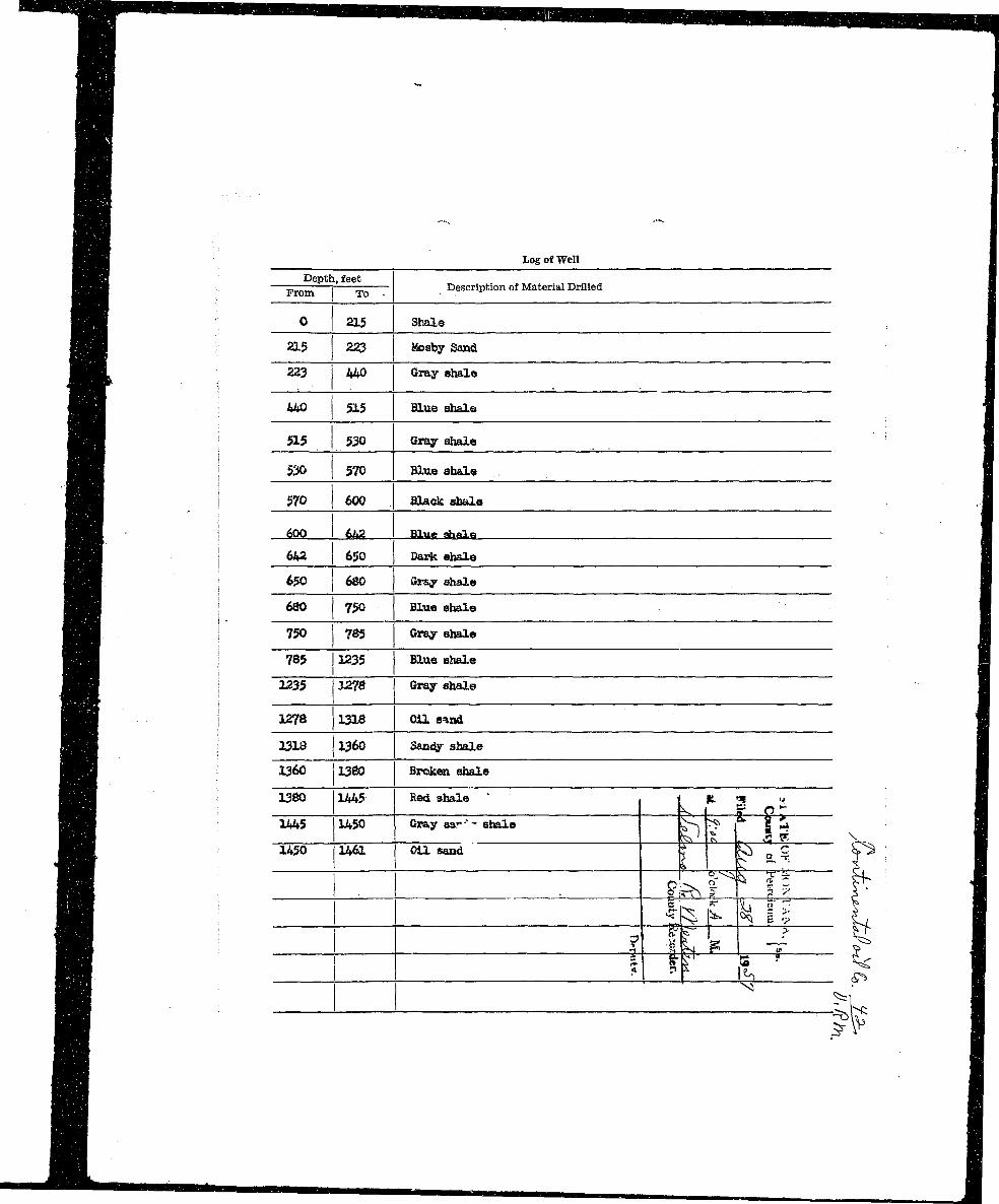
^ ^ B ; Log Of Well •
l ^ H Depth, feet •fl^HH — 5 j 5 Description of Material Drilled •
HH[ n0 5 Soft brown loam •
j^Hj 5 360 Hard gray shale •
flH^ 360 263 Mosby Sand 9
| ^ H 363 1230 Soft blue and gray shale M
BH ! 1230 12?1 Gritty shale fl
M B \ ^T1 ^io i0t ssnd ; •^ ^ H 1310 1320 White shale I
H : 1320 1326 Pink shale fl
Hi • ; X'' fl| ^ H i 1326 13S0 Sand 9j ^ H 1380 1427 . Had shale B| H | ; 1A2? 1454 Sand I
I ': . ^ i..m R ?*?. . I• Ml 1 """^ y County.....?«*r&l«SB
I '• U U AUG ;>*•) 1957 '—^ Harlan Lease, WeU. #5• i MONTANA BUREAU OF MINES AND GEOLOGY• I STATE ENGINEER Butte,Montana
I WATER WELL LOG
• i t Owner.....??^.^L9.^...9.?.?. Address.^.. W*.iS!59ij»_.*teH^>am- ! — | 1 — . . •H \ x I j DriUer Address
• '• i i Date Started ST^SXHSL Date Completed 6rr*3.r33m i —L, j —
B ; I i I Location: Sec Ifi T 15& R....28S.. % sec....?*f..*!!*
I j Type of well Bxitted Equipment used 9*9*. !*2!**
B8 j (Dug, driven, bored, or drilled) (Churn drill, rotary, other)
B \ Water use: Domestic ] \ Municipal | \ Stock | j, Irrigation j |
I ! Industrial 0 , Drainage j _ J Other: *fe*??.^??^6
I | Oasing:....SHRte.fi« ft. to 1358. ft. Type .84..1fe .Size B..2/M
B I Casing: ft. to ft. Type Size
B 1 Casing: ft. to ft. Type Size
B i Perforated or Screened: Ft to ft Ft to ft
I ! Type of screen or perforations .9SS5..*S?5 9
B | Static Water level, for non-flowing well: feet. H
• s Shut-in pressure, for flowing well: lb./sq. in. on: H
• : (date) . •
• I Pumping water level .?£5$ feet at ....10Q...?!ft«?.s gal. per min H
I ' • How tested: L $SJ3fe.Ss9fe.: •
I Length of test fl
I Remarks: (Gravel packing, cementing, packers, type of shut-off, depth of shut-off) I
I P»dusM..i&*.9i..fefl..fea..ms*..Jf9^...>»t9r..£lB.edin&» Afe..px»jaaj*..Kall..ia..piMi4ttsins..9i3l...aixl flj
I ; ©*@» (over) B
• Log of Well ^ ^ B
I Depth, feet ^ ^ H• —^—— j = Description of Material Drilled H^H
• 0 370 Bluo and dark obal* ^ H |
B 370 380 Sand ^Hj
1 380 1165 Blus and gray ehalo HI
I 1165 1270 Gritty shale ^ B ^
I 1270 1330 1st Saad ^ H
I j 1330 1345 Bed shale ^ H
I * IH• i 1345 1360 Saad ' ^ H
i ' > I^HI i 1435 1460 Saad HB
; — 1 — rtft"1 ^ I
•; }* 1
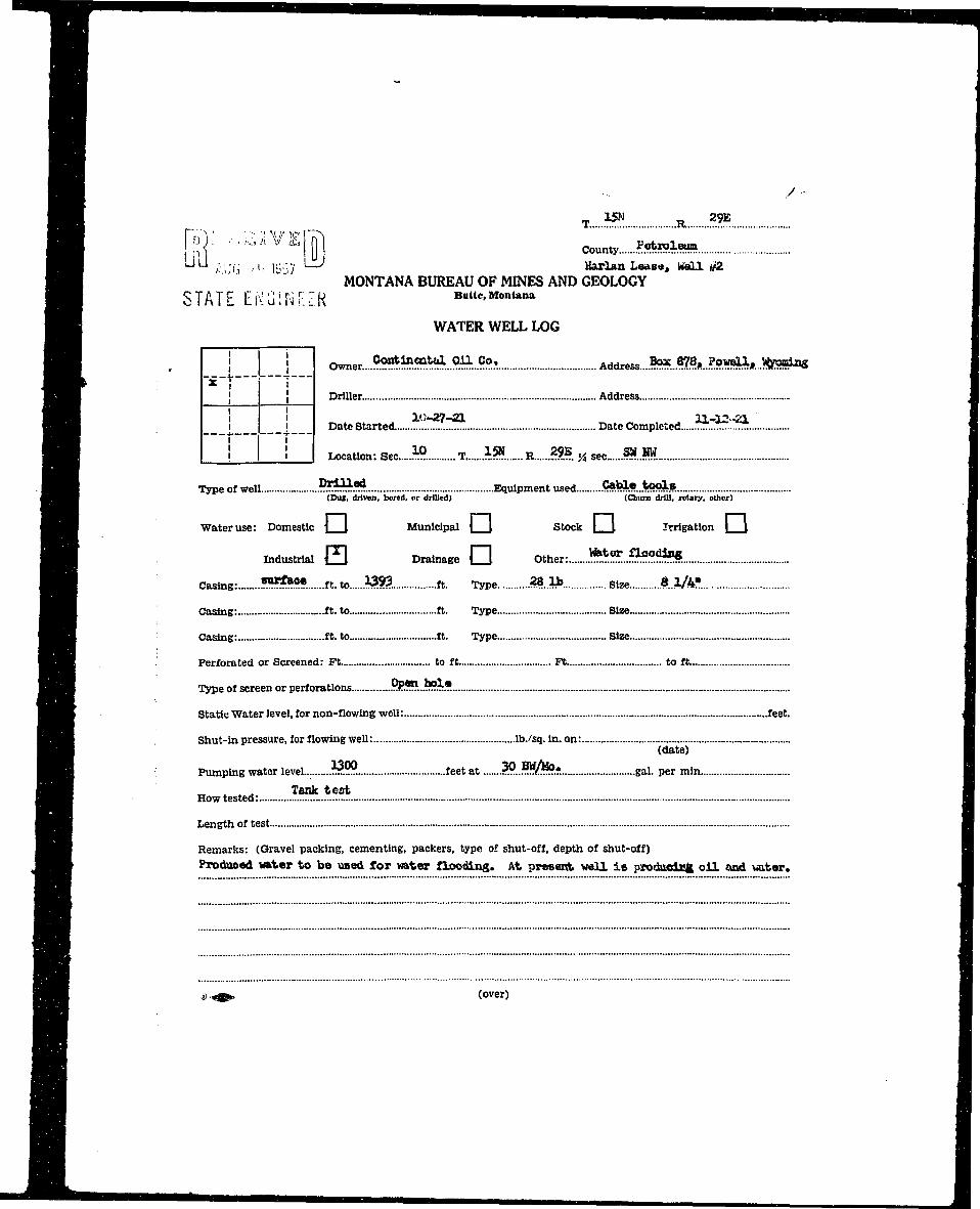
I 1^ B T 15N R 29E
• n?"i:" *i; v EITI ^ I M ^ Z I Z I I I^ H ULJ / 'IJb :>>< l';:;7 ^ Marian Leasa , WaU (/2 I• • " MONTANA BUREAU OF MINES AND GEOLOGY IH STATE ElVGJNF.ZR BuUe,Montana I^ H WATER WELL LOG I
^M , j i Owner....^.^«^...?B..??..T Address...*".??**. *^#...!ftSHk« 1
J ^ ^ H j j Driller. Address I
^ ^ H | _ ! Date Started. '. Date Completed .~! !T.'.'!! ~ fl
^M I I I | Location: Sec M T «?. R ??B « sec * W I
^ ^ B Type of well .??:*^.?*. Equipment used. C*M*..;toals 1^ ^ ^ ^ B (Dug, driven, bored, or drilled) (Chum drill, rotary, other) •
^ ^ H Water use: Domestic \ I Municipal | \ Stock | \ Irrigation | J •
• • Industrial Q Drainage • Other: **5:.«5?*!51 1
H | Casing: «***•• ft. to W$. ft. Type 28.1b s ize $_UV. I
^ ^ H Casing: ft. to ft. Type Size I
^ ^ H Casing: ft. to ft. Type Size •
^ ^ ^ H . Perforated or Screened: Ft to ft Ft to ft •
• ^ ^ B Type of screen or perforations z!?*?..*??i.*. •
• ^ ^ K Static Water level, for non-flowing well: feet. M
^ ^ ^ B Shut-in pressure, for flowing well: lb./sq. in. on: I
• H (date) •^ ^ H Pumping water level ."**??. feet at ??...??/-{?•. gal. per min H
H B B ,T . . Tank test I|BBBJ How tested: •
^ ^ H Length of test I
• ^ ^ B Remarks: (Gravel packing, cementing, packers, type of shut-off, depth of shut-off) H< ^ ^ B Produced vater to be used for water flooding. At present veil i s prodaictcfc oi l and uater. I
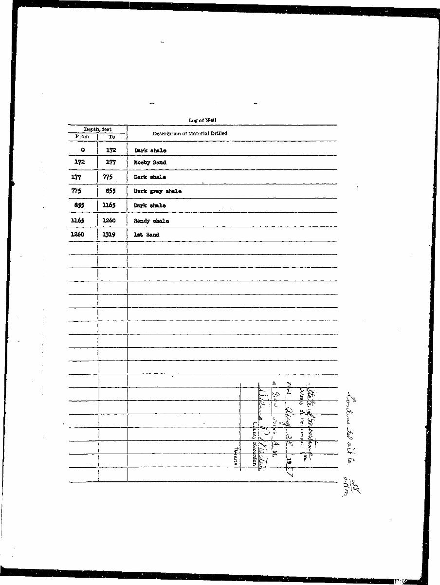
• Los of Well jI Depth, feet I• —~ i — Description of Material Drilled I• rrom | To II i I• O I 172 Dark ahal« I
I 172 177 Moaby Sand I
I 177 77$ Dark sbalc I
I 775 j 855 Dark gray stela 1
I 655 U65 Dark ehale II 1165 1260 Sandy shale I
1 1 ^> r y if ^ 11 pit 3T^ P 1
[ : g» Mk ^ I
1 l&k -A ^ Ii 1 l IFf is -r r I
|K I
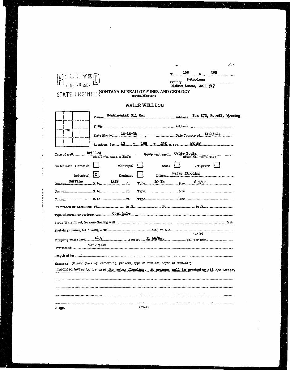
I I• RECEIVER T' ^~t - Ii ^ ^ B I ,. \VJ County I DWM U U AUG -Jl) 1957 ]-J Oldham Lease, Well #17 HHal O T P T C r M i M r - MONTANA BUREAU OF MINES AND GEOLOGY H|HH b I A I L. t iVu 1H f. £. K Butte, Montana •^ H WATER WELL LOG •
— ,—i 1—i B• B f c I owner Continental Oil Co. A d d r e s s Box 878, PowOl, ^oming •JBm '• "~t r~ mflflH ! I Driller Address H^BlH i "• i MBI B V ! i Date Started ?£$£$!*. Date Completed ?*r?s?.7**S HHH L_J I j Location: Sec 10 T 1§B R .2?B. ^ s e c MM •
i H Type of well MM Equipment used CaU.«..?ool« Hf ^ B ^ H . (Bus, driven, bored, or drilled) (Churn drill, rotary, other) fl^H
BHH _ fllH ^ ^ K ' Water use: Domestic \ I Municipal | \ Stock | j, Irrigation \ J ^ B
H | industrial H Drainage • Other: !^J°Z*!?*. B
Mi Casing:...?1?^* ft. to ™*. ft. Type <*>..?*. Size 6..#*! M
^ ^ ^ H Casing: ft. to ft. Type Size Hfl
^ ^ H i Casing: ft. to ft. Type Size WM
• H ^ H ; Perforated or Screened: Ft to ft Ft to ft ^Hj
^^Ht Type of screen or perforations §PS*..feS3*. H |
j^^H Static Water level, for non-flowing well: feet. Bj
^HHi Shut-in pressure, for flowing well: lb./sq. in. on: WM^ ^ B (date) M|^^HV Pumping water level ,?Zzz. feet at *?..r.!K~!?.?. gal. per min • •
• H _, Tank Teat BMM How tested: ^ B
| ^ ^ l Length of test :, |HJ
H H R Remarks: (Gravel packing, cementing, packers, type of shut-off, depth of shut-off) B
•v B• J H Produced water to be used for water flooding. At present well i s producing, oil and water. - f l |I = ~:==== :::::::= ::;=:::= I• irTTTzzuzziiiin 1
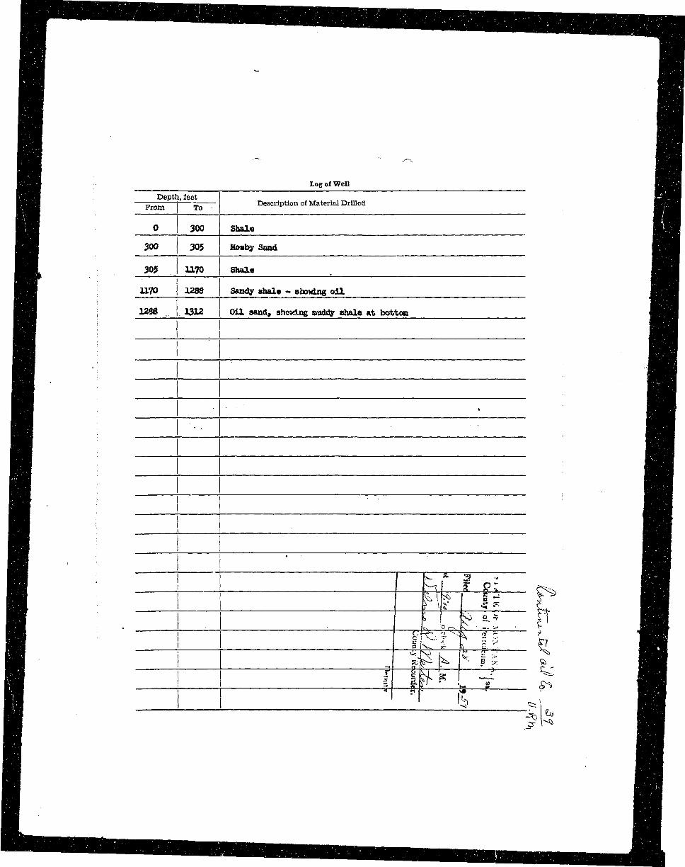
HH Log of Well H H H• H H Depth, feet ^ H lHHH —Ftmii.—i T ~ Description of Material Drilled HflH
H 0 300 Shale flB
HH 300 30$ Mosby Sand flfl
H L 305 UL?0 Shale ^ ^ f l
^ H 1170 1288 Sandy ahale - showing oil. flH
H H : 1288 1312 Oil sand, showing atidfly ahala at bottom flfli
H B J 1 pi K § z H^BH ' 1 M [ a g; ?^ H HH : M ^ g? L a^H
H | ! g rv. i- T l.v 5 H HHB 1 ^ k "v. = > ^ Hi
H 1 f f k ^ I -i— ^ 9BH ^ \ H H
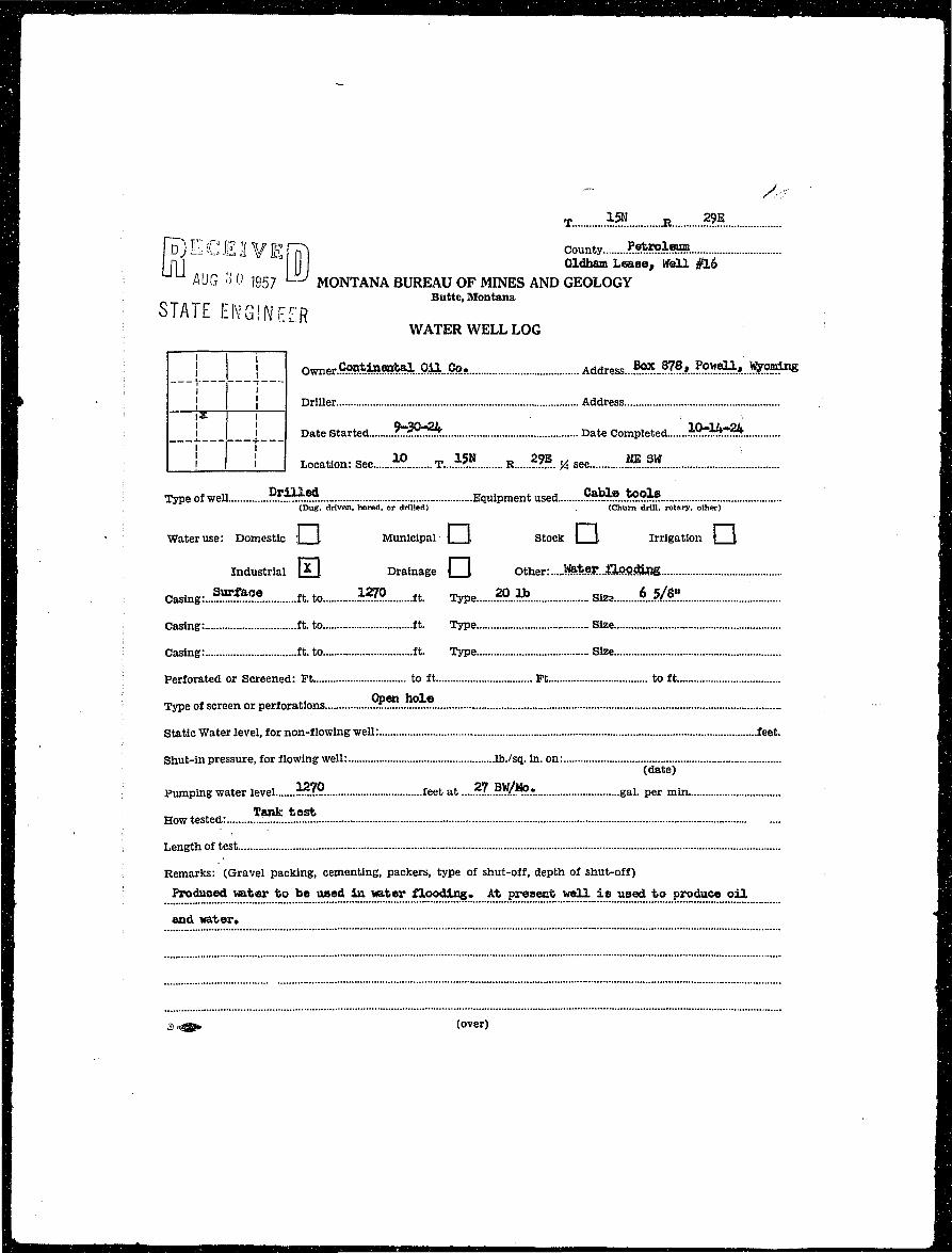
1 r^EClIVErrTl County M»isffl»• i n ) I] Oldham Lea se , Well #16I : AUG •> 0 1957 ^ MONTANA BUREAU OF MINES AND GEOLOGY• Butte, Montana
I STATE ENGINFjFR• WATER WELL LOG
I ! | j owner.f?«ntineatal.gil...Co. Ad^ess...^...^?.*!?^^^.^^1^
B> • | J Driller Address M
B ; | j _ Date Started ^ ^ ^ * Date Completed }®??&$!k 9
I I 1 I 1 I Location: Sec «?. T... *??. R M * sec M M '. I
I Type of well ?**£•* Equipment used 5^®.*^!:? IH ; (Dug, driven, bored, or drilled) . (Churn drill, rotary, other) SQ
• • Water use: Domestic 1 \ Municipal j |, Stock \ \ Irrigation | J fl
I r—i r~~i flm Industrial J^ 1 Drainage | |. Other: $f&SK..%kB9.&R& I
I Casing:...?^^^. ft. to *?7° ft. Type » ._» Sto 6 5/8" I
I . Casing: ft. to ft. Type Size fl
I ; Casing: ft. to ft. Type Size H
I : Perforated or Screened: Pt to ft Ft to ft fl
I Open hole ^1
• Type of screen or perforations TT. •
• Static Water level, for non-flowing well: feet. fl
I Shut-in pressure, for flowing well: lb./sq. in. on: H
I (date) •• ; Pumping water level }?7.9.. feet at .....?7..M/*.r gal. per min flI * * A "Sank test fl• How tested: • •I i Length of test flj
• i Remarks: (Gravel packing, cementing, packers, type of shut-off, depth of shut-off) H
I Produced water to be used in water flooding. At present well i s used to produce o i l 9
9 and water* 'fl
I
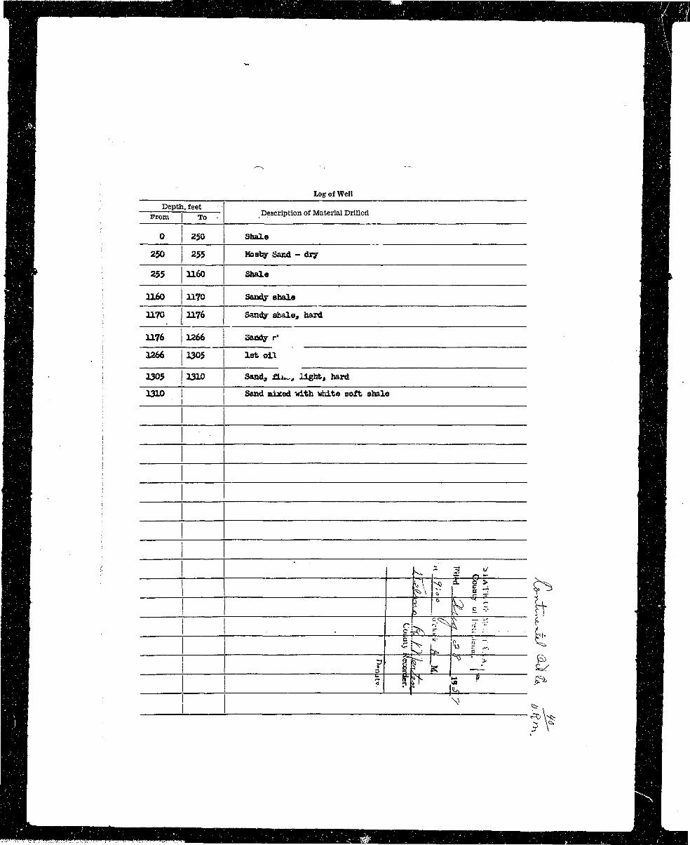
^ ^ H Log of Well HBHlB Depth, feet ' flBH^•H —From i T Description of Material Drilled flBB
^ H 0 250 Shale flHH | v i 1 ^^HBBS 250 255 Mosby Sand - dry flH
flH 1 SH•Hi 255 1160 Shale ^ ^ &HH ; : . HH^H ^ H U£0 1170 Sandy shale flHB M W i i^HflHHj i 1170 1176 Samfy sbaleg hard S HHH > 1176 1266 Saody r> HH• H : 1266 1305 1st oil J^H
^^H i 1305 1310 Sand, £Lu~, l ight, hard HH
1 ~~lHH . L J U » | | n .-,, lnr I U J County M*??:<*>*. H| » ; AUG o 0 1957 Oldham L e a s e , W a l l ^ S |H R STATF F i\i^ I iwrrn MONTANA BUREAU OF MINES AND GEOLOGY Hi• T O b l A l l . L i V u I J r . r R Butte, Montana BBH B WATER WELL LOG HH• I ["I I—I •| H B ! I owner ?.™*^M^...9.^...?°*. Address ^..^A.i?]*??^*..)*™?111^ BH
wAVf | | Driller Address HiH
flBn ! | !_ Date Started bdQ&>. Date Completed fc?fc?3 A B B
| H [ [__! j _ _ J Location: Sec 10 T...15N R..2.9E.... % sec. MM BH
HHH ^ ^H^ H Type of well....- MOM Equipment used .?^.e...^°?t?. BH
' j^^^^B (Dug, driven, bored, or drilled) (Churn drill, rotary, other) JHHHH
fl^^B ; Water use: Domestic :| I Municipal | |, Stock j \ Irrigation \ J, H^H
WBM i Industrial 0 Drainage Q , Other: M.??...?^?*^ ^ B
9B I °™**-- —-- ft-to -^ «• e -••- size --^ mmB^^B i SHU
HH i Casing: It. to ft. Type Size •Vfl
flBU : Casing: ft. to ft. Type Size 8 H H
^ ^ ^ H ' Perforated or Screened: Ft to ft Ft to ft •Vfl
^ ^ H | Type of screen or perforations 9)f???...!*9 .? BVfl
W ^ H Static Water level, for non-flowing well: feet. JHHIHB HHB B H Shut-in pressure, for flowing well: lb./sq. in. on: •HBK B (date) B H I^ 9 B Pumping water level.... "??? feet at .? <~?.* gal. per min BBl
• H . How tested': ;...„......?**..:&!** HB!
• H H Length of test CBB
B H ^^HB B B Remarks: (Gravel packing, cementing, packers, type of shut-off, depth of shut-off) BBHBBH BBH
J ^ H S Produced water to be used in water flooding. At present well i s used to produce o i l H H H IHH AffJHHHj an(i water. ^BBlI = :=:::::: : ::: := : " :::= : :: := IH =::==::. -- - :_: : - - :::::: •^ • H S . . ^ (over) HH
I^BBHHHHHHBHMHHHHHHHHHHHHHHHHHBBHMH^H^
B _ H B _ B B I rf—-. ..•«*., H__HHBvi
^B|H log of Well _ • _ •BBBB ' Depth, feet flBBjBBBj —From i T Description of Material Drilled _ B B M
•HE 0 220 Black shale B_BflH| 220 225 Mooby Sand H H
HB 225 575 Blaok shale S H IH H B T I 575 675 Gray Sanely Shale - f^HrflHHH t -—___--____________ . -—. A ^ B B B B
W A H H i 675 790 Gray shale H H
^ H B 79° 101° Black mxdd7 shale t B HftHS 1010 1055 Black sandy shale H HH H 9 - I 1055 1060 Black muddy shale HHBi
H H I i io6° izLi* Gray "" ^sbaie H B^ ^ H ! 1214 1291 Blue middy shale IBB^nH ; 1291 135? First Sand ^ ^ H
^ • V ' (ft 3 «• • I B VHHBBBBM \ ^ w» l 1 . HHB9HB
H ; A > I § v SHH H ; I ^ ° s ° T H HH ~~ : * « F ~s Vf H HB H i . c ^_ a ^^ 2 2 s 'BvBTBBBJ J; i>r L n* 1 S • f4 B B HBBBJ ^ ~ tcS, Y* " i ^ B B BH B D ?,r , • ' - BBB1H ^ B H . 5 £_ 1 fr^ —~ C ' H^BHBB_HHBr I £ S. ^ L -* ^ " KS. B ^ B H B H
H 1 \_ B|L___£__ ^ H IBBB i 1 T r**' BBB
BBB ^ ': _ H•BB . •—• —— ^ s B H H
HB_ " x BBB
B^B_HHHB_HBHHBHHBBVHHH^
jaB : roiscEiivEnrj T *a » &• • H( H I UIJ llJG v O i g s 7 liU County Petroled H HM i ; Oldham Lease, Well #5 B H |
H H STATE E N GIN F F R MONTANA BUREAU OF MINES AND GEOLOGY SB
• B H -'-IV Bntte, Montana IBB
H R WATER WELL LOG H H
H H I I I I Owner Continental Oil Co. A(Jdress Box 878, Powell, Wyoming BBan ; —r T— n^ ^ H ' I 1 DriUer Address BH
^^H \ ]_*_ _ ! Date Started 6.r?7r??. Date Completed .7^30^2 HflL
H H I j l | Location: Sec...3;?. T *!».R....??.?.... % sec "L«W HgM l Type of well ™£*. Equipment used !«*?.*?*?. ; B |^ ^ ^ B H ; (Dug, driven, bored, or drilled) (Churn drill, rotary, other) ^HHS
•HH I Water use: Domestic :| (, Municipal | I Stock | J, Irrigation \ 1 ^ ^ Hfl^Hj • Industrial [£J Drainage |_J, Other: :..*M..^?.?ilSU. : fiHjH H Casing:.?H. C6 f t . t o U51 ft. Type 20 1b s i z e 6...5/31! J J .
[^Hi i Casing: : ft.to ft. Type Size ^ ^ B
^ ^ ^ B : Casing: ft.to ft. Type Size flj^H
^ ^ B i Perforated or Screened: Ft to ft Ft to ft i ^ ^ H
^ ^ H l "^pe ot s c r e e n or perforations 9R*L£9?:? . j ^^B
^ ^ H H Static Water level, for non-flowing well: feet. ' j ^ ^ H
IH^H . ; Shut-in pressure, for flowing well: lb./sq. in. on: ^ ^ ^ B^^Hf (date) -HHI^ ^ H l • Pumping water level M51 feet at ...?700.BW$i?.s g a l p e r m i n i^BI
H H * * Tank tost H B^ ^ | B ; How tested: I H H
flHB , Length of test .V: : ^ ^ B
^ ^ ^ H - Remarks: (Gravel packing, cementing, packers, type of shut-off, depth of shut-off) • ^ ^ B• ^ H | Produced water to be used in water flooding. At present '<fell io used to produce oil ^HfiH v BH
^^^B and water. H HI ===== 1• ::::::::i::::: :::::::::::====z:i: •j H H $«^> (over) f^Hi
^ ^ H Depth, feet 1• J H —Prom 1 T Description of Material Drilled 1
fj^K ° ^ Shale 1H H 215 223 Mosby Sand I
H H L 223 440 Gray shale I
• H 440 515 Blue shale fl
^ H ' 515 530 Gray ahale 1
JH | 530 570 Blue ahale 1
Mi | 570 600 Black shale I
H H H • i 600 6/i? Blup »*iftifi 1
HH j 642 650 Park ahale 1
^^m ; 650 680 Gjray shale I
HH ! 680 750 Blue shale fl
flH I 750 ?85 Gray shale I
•H ! 785 11235 Blue shale •
8B I 1235 1578 Gray shale 9
BH i 1278 1318 Oil sand 9
j H H - 1313 1360 Sandy shale I
flH 1360 1360 Broken ahale I
H H 1380 1445 Red shale • ^ ^ ~u H
B H 1445 1450 I Gray sa"---shale J r ^ ^ g S IH n i ^ ' ^ r , •§ B v^ B
H M 145° ^^ on-sand i si o c y ^ ••I ; ota-'T ?c Br • JflH : : g j r^ 5 ;a y, i •I ; — J I N ^ ^ I I1 : 1- rirkT jf I
B B I < —» 4 ••• H
I i. T m B m a• R E C E K V E m ' county M M i i . : , 11 ; L AUG ao 1957 LiLJ <*«* **«*•«*»««1 #4 IHj I y o / MONTANA BUREAU OF MINES AND GEOLOGY •• i STATE ENGINEER Butte,Montana •I | y WATER WELL LOG I
I I ! I I Owner....^^^**?!..^...??.?- AadreSs....?^..M*..^«^»..!*?.r. IB ^ \ J j Driller Address H
• i [ ] Date Started $**!.'*£. Date Completed......!**?^* I
• ; | i Location: Sec.iP. T..A59. R..??? % sec .?E.M 9
• i Type of well ??^-.?* Equipment used .9?^.?..?.?^;. I^M , (Dug, driven, bored, or drilled) (Churn drill, rotary, other) : H |
H "f Water use: Domestic \ [ Municipal | |, Stock | J, Irrigation \ { H
• j Industrial P 1 Drainage \ I Other: •
I I casing:..?™^?* ft. toJ£82 ft. Type M Size .lift?.: I
H . ; Casing: ft. to ft. Type Size H
• i Casing: ft. to ft. Type Size I
S ;: Perforated or Screened: Ft to ft Ft to ft H
\ Type of screen or perforations .Qp.SJ...bsl9 H
• Static Water level, for non-flowing well: feet. ifl
! Shut-in pressure, for flowing well: lb./sq. in. on: B; (date) M
j Pumping water level ~?T. feet at !.?...„../.???.• gal. per min H
! How t^sted:.^! • '. B
; Length of test fl
: Remarks: (Gravel packing, cementing, packers, type of shut-off, depth of shut-off) Bj
Produced water to be used *»r T»ter Aoo^S*.....^ ^.^^...^^...^..J!^.^^...?^:..33^ •
water. 9
^,^5>. (over) - H
H Log of Well ^ ^ HM . ^ ^ HH Depth, feat ^HB^M —— i — Description of Material Drilled ^ ^ ^ H^ H From | To . fl^^HH HH• 0 240 Shale H9H 240 245 Mosby Saad HI• • H• 245 1280 Shale ^ H
H 1280 1290 Sawjy Shale j^Bv• ; onH 1290 135$ First Sand BH
H j 1355 1385 Gray Shalt j^B
I j 1365 1405 1 3and ^HjH 1405 1417 Pray St»al« ^ HH U17 U» *»** ^ HH 1422 1452 EedShale ^ H
H 1452 1464 KLne Shale ^ HH ; 1464 1470 White Shale j ^ HHj U70 1 1496 Mottled Shale ^ B
B : 1496 1502 Gray Shal* ^ HH 1502 1510 Sand ^ H
I I , —tW^-» II zr^=^l I
F IH In] :! County ?•**??:*» IH AUG "i 19 7 ' B* R* Benson Lease Well #2 IH MONTANA BUREAU OF MINES AND GEOLOGY 1
• S f A T E E N G i i i , . . h Butte- M«>ntana IM WATER WELL LOG I
I | j owner <>«*^!^...9^..C?.! Address..???. W*...??*^*..!*?-... I
HP j J Driller Address fl
B [ * _ j _ _ _ Date Started Jf^SSHS: Date Completed....**&$L j |
• 1 ! """ 1 1 Location: Sec » T..M R..?*.... H sec JES. Ifl ••TJ Dril led Cable too l H• Type of well ..^ZTz. Equipment used. ^ZZTZ.Z^fz. fl^ H (Dug. driven, bored, or drilled) (Churn drill, rotary, other) ^m
^M ' Water use: Domestic j I Municipal | \ Stock ( \ Irrigation 1 } fl
H j Industrial IT I Drainage { I Other: fl
• CasinB: .?«*«••. tt.to......V&>. It. Type M. Size iM? I
H Hfll Casing: ft. to ft. Type Size •• fl• j Casing: ft. to ft. Type Size •fl Perforated or Screened: Ft- to ft _ Ft to ft— flI Open hole 9
H Type of screen or perforations mM
H Static Water level, for non-flowing well: f aet. H
H Shut-in pressure, for flowing well: lb./sq. in. on: _ •• . (date) •
B Pumping water level....:". .*???. feet at .?!??...?!l ?_r gal. per min fl
• Howtested:.. *»*k.im '. E
• Length of test H• Ifl Remarks: (Gravel packing, cementing, packers, type of shut-off, depth of shut-off) H• Mater to be used for water flooding. At present w«Xl Is producing o i l and voter. B
I •• " " ; 1I I:::::::::::,: : _ ; :..: ::. II . « • (over) fl
H H Vn) ¥ C F JI ¥ F HTi County •———• SfflHMB LJ U AUG ;•; () 1957 UvMONTANA BUREAU OF MINES AND GEOLOGY HH^H^B Butte, Montana flHH
• STATE ENGINEER WATERWELLLOG •M B j I Owner. Ccn^«^OilCo. Address..?«?..M>. .?«9?k J fc t . Hi"^H v ^ BB|H V I [ Driller Address IR
• H ___!___ _* _ 1 — D a t e s t a r t e d **«**» Date Completed..?": .. W21 MB
H [__! i _ _ | Location: Sec *? T *£?. R.....???... y4 sec.M.??.... H |
^^M Type of well ft*U.«4 Equipment used....C«fel«.l«»3. ^ H. flH^H (Dug, driven, bored, or drilled) (Chum drill, rotary, other) ^HHi
•B^R - ^^^Bf^^af " Water use: Domestic \ I Municipal | \ Stock | \ Irrigation 1 \ flBH• H • r - , r—, HiH [ Industrial H Drainage Q Other: **5L??*?«»| B H •H Casing:..?^**" ft. to ?:M ft. Type - Btae_35!?. Hi•Hi Hi^ H B Casing: ft. to ft. Type Size i^H
JB^H Casing: ft. to ft. Type Size B ^ B
9Ji^H Perforated or Screened: Ft to ft Pt to ft • •^H
» H B Type of screen or perforations §£*!*.£??••. BIB
f^^^ Static Water level, for non-flowing well: feet. flflBHBH ' •HHK• B Shut-in pressure, for flowing well: lb./sq. in. on: HHBH (date) HBl•SB 1315 100 BW/ltor HH• ^ B Pumping water level feet at gal. per min ^ • • 1
•BEB IHBB 9 B How tested: ?«*.**»* | MH H Length oT test HHHI HHBAB Remarks: (Gravel packing, cementing, packers, type of shut-off, depth of shut-off) HYflH ^ K Water to be used for *&tor fljoodj^ig. . At present well Is produoir« o i l and vater. fiHi
I =EE=EEEEEEE= I^ H .J. S* (over) HH
— — " • * » " ^ i • „ ,«•»,_-__
^HBf Depth, feet IH^H —From i — Description of Material Drilled •
^ 9 0 200 Blue Shale I
^ H 280 284 Mosby Sand I
| H 264 1080 | Blue Shale I
^ H * 1080 1120 Blade Sfaalc I
•H 1120 1180 Blue Shalo 1
HH 1180 | 1270 Gray Sandy Staal* I
•H 12?0 1300 Gray Qatidy Shalo I
^ H • 1300 I 1352 Gray SaadhShal8 2
m i -- H | > 1 IF ?. I
r i• RECEIVER T •-- R —• IH UU A , , r •, |, 1 Q r , Llj County 1• ; L u ' J ! « 7 Montana-Superior Lease Well #2 IH STATF FIMPIMFTD MONTANA BUREAU OF MINES AND GEOLOGY 1H 0 1 AIL t I M b l N t t K Butte,Montana 1• WATER WELL LOG I« L i l l O w n e r tontt»«n^.Oil.Co., Aadress...Box.«J'8,..Pow«li*..Vfeft*. 1
H j | Driller .. Address I
H i l l Date Started ^SSUSh Date Completed... . ^ P ^ L '. I
• ;• | j 1 1 Location: Sec.....iP T .iSH R .2?B j4 sec SW..SB IH Type of well ?**^*4. Equipment used .??*&« .?$*! IH H (Dug, driven, bored, or drilled) (Churn drill, rotary, other) B
H • : Water use: Domestic \ I Municipal \ j, Stock | J, Irrigation \ J, fl
" Drainage \ I Other: J**M..?35odiagl H
I Casing:...?????.??. ft. to 33$O ft. Type M. Size *j/k* I
H Casing: ft. to ft. Type Size •
H Casing: ft. to ft. Type Size •
H ' Perforated or Screenec Ft to ft Pt to ft •
H j Type of screen or perforations.....? .??..."™:?. fl
H i Static Water level, for non-flowing well: feet. JH
H ! Shut-in pressure, for flowing well: lb./sq. in. on: H
• (date) •
B Pumping water level ~r??. feet at f^.~VJ~!.* gal. per min Bj
• HOW tested: 5R«nfc..K*a*..: I
• Length of test •
H Remarks: (Gravel packing, cementing, packers, type of shut-off, depth of shut-off) S• Prodosed vat«t> to b« used in « t « r flooding. At praoeut wall i s used to prodaoo o i l and M^ : water. *M
===EEEEEE=
H tog of Well - IH HH . Depth, feet fltm • — — — j ——- Description of Material Drilled •^^H - a rom 1 o • *~ * • i s
H ; ,0 320 Dark Shale 1
• i 320 325 MosbySand 1
» ! 325 1320 Dark gwy shale 1
• ; _132Q 1385 fimy Snnrty .Shall) «• i 1385 .. .3392 Oil aaad fl
• I 1392 HIP Shalay aand - o i l 1
• p I r- ~" -J £T H
I i gf rr 'i b 4 "' I
I RECEIVE^ T- m * m
• HI i\ inc-7 LrJ County i atjrwlWlB
• i LJU AL)G oU 1957 ^ ^ L e a 8 e . ; a i ^• _ rMPlMCCR MONTANA BUREAU OF MINES AND GEOLOGY• STATE EMGlNttK Butte.Montana
• WATER WELL LOG
I } j owner. ^^SSS^JS^J^SSL Address..U.«K..83:aj»...i?ftWftU>..3!ted.... 1
H x I j Driller. Address H
• : j_ j Date Started £ ^ £ & 7 Date Completed. &*&$?.. fl
• I _ _ J l _ _ Location: See *9.....T 1.2K. R....2?]L J4 sec .§*'_Stf. fl
• : Type of well ??i~™. Equipment used.—™rH? . fl• (Dug, driven, bored, or drilled) (Churn drill, rotary, other) ^ B
H j Water use: Domestic | 1 Municipal J I Stock j I Irrigation | J fl
• • Industrial | I Drainage | [ Other: fl
I | cas ing: . .?^® ft. to ™ ft. Type Size I
I i Casing: ft. to ft. Type Size fl
B ! Casing: ft. to ft. Type _ Size fl
• • Perforated or Screened: Ft to ft Ft to ft H
B ; Type of screen or perforations Jr???... !"1®. H
m • Static Water level, for non-flowing well: feet. B
• Shut-in pressure, for flowing well: lb./sq. in. on: H• (date) •I Pumping water level W$ feet at ...^l.^fl&°*. gal. per min •
I Tank Teat jfl
• ' How tested: _ HE
I Length of test. S
• Remarks: (Gravel packing, cementing, packers, type of shut-off, depth of shut-off) H
• At present the well i s used to produce oil and water. J |
IB Log of Well 1H Depth, feet I• — £—r Description of Material Drilled •^^M r rom TO H
M : . 0 [ 1220 3hale . Iflj 1220 1320 Sand ; IBL j 1320 1390 Variegated Stale 8
I 1390 1500 Sawi I
H 1500 1540 Variegated Sbais fl
B ! ^i ^ g > v flI i i pbUr ^ IB i : t ocs$ Zi ft : fl
I - [ a_ II J
H J | G V Approved Stock Form—Slate Publishing Co., Helena, Montana—38687 o ^ _ ** Yj fl
H **?/ ' I• J File No #££•.£ T 15JJ R.....25E- IHJ DUPLICATE County E e t r o l e u m IH STATE OF MONTANA . - - ir> „ ^ n 1H ADMINISTRATOR OF GROUND WATER CODE I ' ' IH OFFICE OF STATE ENGINEER U i_ JAM 0 . . ^ 0 / I
H Declaration of Vested Groundwater Rig^^£ £^^|'urrn IH (Under Chapter 237, Montana Session Laws, 1961) " ' C. t f\ •
I 1B 1 Coatineutal..ail.jCompaBuy. , of .Bo3t.254S Billings- flH (Name of Appropnator) (Address) (Town) SH County of Xellowstonft State of .Montana IHi have appropriated groundwater nccording to the Montana laws in effect prior to January 1, 1962, as follows: •B N •H i l l i l l 2- The beneficial use on which the claim is based....Watexflood •B L --—| 1 i !—i j — ...Watar...supply..Hell. •fl | j " " | | j S 3. Date or approximate date of earliest beneficial use; and how con- 9• J ! i 1 1 j j tinuous the use has been...N0Kember...l3,...19j63. Ifl ! | j | j j ...Cantinuoua..use^ m
fl w • 1 1 •—-I j E •B | ! ! i l l 4. The amount of groundwater claimed (in miner's inches or gallons flH j I j j j i per minute) 2.460...B/D..£ir...2Z..GaL/llin. _ I
• J | | | | j j 0H 1 i • I ' l l 5. If used for irrigation, give the acreage and description of the lands flflj g to which water has been applied and name of the owner thereof jHB Not-applitaile •B .lW-^-SW- Seel©.. T.15H R29E- HH Indicate point of appropriation B•j and place of use, if possible. „ . , , - , . , A . , , HHJ Each small square represents 10 6. The means of withdrawing such water from the ground and the 8BJ acres. location oi" each well or other means of withdrawal HB Unit Area #2 , Well #24 —*ada...auhmersAblfi..nuiap B
HJ 7. The date of com- encement and completion of the construction of the well, wells, or other works for with- HI drawal of groundwater.....ftr.ii.ie4..j«iy..8.j- -l-947»---<Joa^l«t«d--Jttly-21i---1947v---Reeemp-leted- HB --Octo-bet-aS,,-1943 a s wa te r -ve l lv H
m I• 8. The depth of water table....5Op...3r^.^^t-.<hreefc-Sa«d-<3 ••lS51'---grouBd-level-v •
H HIHJ 9. So far as it may be available, the type, size and depth of each well or the general specifications of any other HJH works ior the withdrawal of groundwater T..D.....lS17-!-r- "P-lug-tcMsk-dsptfe -1-725-*., HHj Ca8iag...«..5..1/2V.,...X7..flnd..20#[email protected].. with 25a sacks-oeiaont •
I 1HJ 10. The estimated amount of groundwater withdrawn each year &75-4-?60--Bb-lB-.-/year-. flj
I fl• 11. The log of formations encountered in the drilling of each well if available.....l-sfe...C-.-C-.~--l-18-l"-» fl• ...2ad-Cr-C»-—-44QSV-3r-d--<2-. -G-. l^Sl-'-.-Mojrrisen—-l?44-!»-BlliB-—48-7S-'--. fl
Hj 12. Such other information of a similar nature as may be useful in carrying out the policy of this act, including HJB ^ reference to book and page of any county record HJ
I ** ; ::zzzzzzzz::z:zzz::zzzzzzzzzzzzzzzzzzz:: II Signature of Omier2.tZ..^lLZ^.A3^^r. fl
I Date....De€effiber--31ir-1963- fl
H Three copies to be filed by the owner with the County Clerk and Recorder of the county in which the well is fl
I located. ' fl
I Please answer all questions. If not applicable, so state, otherwise the form will be returned. BJ
I Original to the County Clerk and Recorder; duplicate to the State Engineer; Triplicate to the Montana Bureau . fljI of Mines and Geology, and Quadruplicate for the Appropriator. C Hfl
9*1* I
| f l | ^ ' Approved Stock Form—State Publishing Co., Helena, Moi -ana—38637 ° ^ ^ , ^ ° 3 Hj
Bj Pile No T...I5N. E....Z9E H
B DUPLICATE County Petroleum B
H STATE OF MONTANA B
H ADMINISTRATOR OF GROUNDWATER CODE fu) E C E l VJEfn^ IH OFFICE OF STATE ENGINEER [fli I [] I 9• Jl'L 18 t.fi>3}-^ •H Declaration of Vested Groundwater Right&^..T 1H (Under Chapter 237, Montana Session Laws, 1961) « ' A l t E N G I N E E R fl
H 1 C!cat;i«eat»i..0.il..Coinpany. , of.....Bank..&l£Ctr.ic...3ldg... Lea ia l am. , HH | . (Name of Appropriator) (Address) (Town) ; UBj County of. IsxSDS. State of Montana j IBJ have appropriated groundwater according to the Montana laws in effect prior to January 1, 1962, as follows: .; B
MJ_ i l l i l l -• '-The beneficial use on which the claim is based..an..M»e..in- : IH j t — ! ! j 1 i j C ^ t C r e e k W a t e r f l p o d _ .•; I
H j j ! ~!"~ l i i 3. Date or approximate date of earliest beneficial use; and how con- HH 1 1 — ; 1 j tinuous the use has been....Mpy.effiber.»..1959..-..B.Qntit>UOUa • - HB i l l i ! 1 ..SJJBRSL j ;• fl
H j I j i I ! ! 4. The amount of groundwater claimed (in miner's inches or gallons ! jflH j j ! j 1 1— per minute) 9.6...gal.../rain. V M
^m j i I I i ! I 5. If used for irrigation, give the acreage and description of the lands H^ 5 ' g to which water has been applied and name of the owner thereof fl
• WE...3A..SB. Sec.10.... ai5tt. 129E.- 9H Indicate point of appropriation HH | and place of use, if possible. * • * , _ . * • i. ^ r l t j •, ., IB Each small square represents 10 6- The means of withdrawing such water from the ground and the •H acres. location of each well or other means of withdrawal HH t tol t Area #2 Well #32 ...B£da_.subniergible..pimp ; - B
H ; 7. The date of commencement and completion of the construction of the well, wells, or other works for with- IH drawal of groundwater .Ccaailenced..9.r-.<i-?59.r..C£aii»leted. 9-i2*5& I
H 8. The depth of water table Xbird-CatCraak-Sand. 1SS&-- t o --17111- fl
H 9. So far as it may be available, the type, size and depth of each well or the general specifications of any other BB works for the withdrawal of groundwater H" <&sli&.£.jy&V.*..:2Ms^ •M .mAt...%o...xj>.....»£..m&\*. 9
H 10. i'he estimated amount of groundwater withdrawn each ye^r l,204,500-l>&l/year B
B 11. The log of formations encountered in the drilling of each well if available fl• ls.t..Cat...Cceek..-1239.!.«1334.1. fl• 2nd..Cai:..CreeIc....JLA52.^15UJ. flB 3rd..Cat..fceek-.-1538.!.-17Ui fl
H 12. Such other information of a similar nature as may be useful in carrying out the policy of this act, including HjH reference to book and page of any county record flj
fl CONTINENTAL OIL C0KPANY * H
I Signature of O vner .J5^\.^l:.^/^J...^i)^K^-Z.. flI Acting Dis t r ic t Superintendent fljI Date July...l5r..1963 HI Three copies to be filed by the owner with the County Clerk and Recorder of the county in which the well is HJ• located. HJI Please answer all questions. If not applicable, so stata, otherwise the form will be returned. B j
I Original to the County Clerk and Recorder; duplicate to the State Engineer; Triplicate to the Montana Bureau HJ• of Mines and Geology, and Quadruplicate for the Appropriator. __ ,. . HJ


![^ -y>- •'•• n:-::Uk] Imediaserver.dnrc.mt.gov/archive/ground_water/... · h gw3 • '" • 3 hi ^b file no..™ ..... ' t...2k*..r....o. ^ll ^h duplicate* county.....qhqata](https://img.pdfslide.net/doc/110x75/5b7aab2a7f8b9a460c8c509d/-y-n-uk-h-gw3-3-hi-b-file-no-t2kro.jpg)