Embed Size (px)
Citation preview

Federal AviationAdministrationFAA NextGen
Weather Systems
To: FPAW Fall Forum
By: Alfred Moosakhanian (FAA)
Bob Carson (Harris)
Tom Doyle (Raytheon)
Alan Fraser (Raytheon)
November 19 , 2015
Common Support Services – Weather (CSS-Wx) and
NextGen Weather Processor (NWP)

2Federal AviationAdministration
FPAW Fall ForumNovember 19, 2015
OVERVIEW
• NextGen Wx Systems FAA/Alfred– Status– Overview– Examples
• NWP Overview Raytheon/Tom-Alan• CSS-Wx Overview Harris/Bob• User Participation FAA/Alfred• Summary / Q&A Panel
3Federal AviationAdministration
FPAW Fall ForumNovember 19, 2015
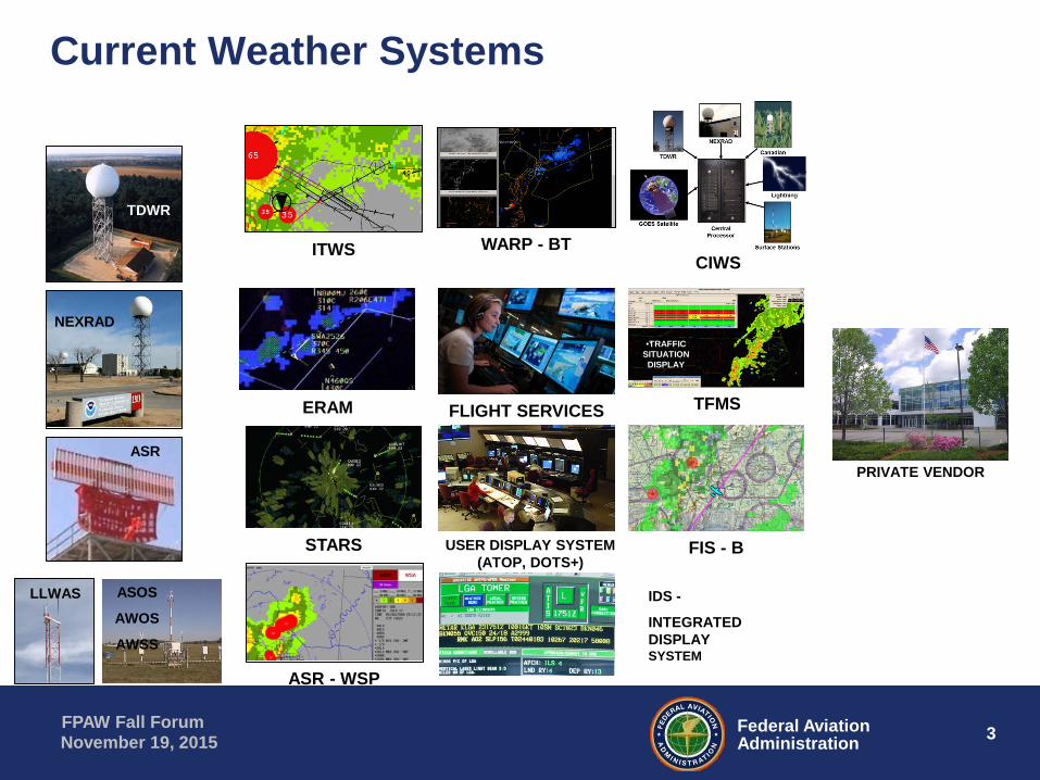
Current Weather Systems
ITWS
STARS USER DISPLAY SYSTEM(ATOP, DOTS+)
TFMS
•TRAFFIC SITUATION DISPLAY
ERAM FLIGHT SERVICES
FIS - B
ASR - WSP
IDS -
INTEGRATEDDISPLAYSYSTEM
WARP - BTCIWS
TDWR
NEXRAD
ASR
LLWAS ASOS
AWOS
AWSS
PRIVATE VENDOR

4Federal AviationAdministration
FPAW Fall ForumNovember 19, 2015
NextGen Weather Systems: Consolidation of NAS Operational Weather/Display
STARS USER DISPLAY SYSTEM(ATOP, DOTS+)
TFMS
•TRAFFIC SITUATION DISPLAY
ERAM FLIGHT SERVICES
FIS - B
ASR - WSP
IDS -
INTEGRATEDDISPLAYSYSTEM
TDWR
NEXRAD
ASR
LLWAS ASOS
AWOS
AWSS
PRIVATE VENDOR
•Common Support
Services-Weather
(CSS-Wx)
•NextGen Weather
Processor (NWP)
•Aviation Weather Display (AWD)

5Federal AviationAdministration
FPAW Fall ForumNovember 19, 2015
NextGen Weather Program Status
• January 2014: SIR Packages released to industry– NextGen Weather Processor (NWP)– Common Support Services – Weather (CSS-Wx)
• March 2015: JRC Final Investment Decision • April 2015: Contracts awarded• 2019/2020: Initial Operational Capabilities for Key Sites
CSS-Wx: NWP:
Investment Analysis
Readiness Decision
JRC Initial Investment Decision
Released SIR Packages to
Industry
JRC Final Investment Decision
Awarded Contracts
NextGen Weather Implementation
December
2010
September
2013
January
2014
March
2015
April
2015
2015-2020

6Federal AviationAdministration
FPAW Fall ForumNovember 19, 2015
Good Source of Background Informationhttp://www.faa.gov/nextgen/programs/weather/

7Federal AviationAdministration
FPAW Fall ForumNovember 19, 2015
NextGen Weather Architecture

8Federal AviationAdministration
FPAW Fall ForumNovember 19, 2015
CSS-Wx Data Access Services • Ingests weather sensor, NWP data and NOAA
data (e.g. Satellite, models) • Makes weather data available through Web
Services• Adheres to international standards for handling
and representing geospatial data
• Filters and transforms large gridded datasets
• NetCDF format
• Filters and transforms non-gridded datasets
• WXXM 2.0 XML format
Web MapService
• Renders weather data as single large image or sets of tiled images for display
• JPEG, PNG, GIF, KML format
Web FeatureService
• Filters and transforms non-gridded data sets
• WXXM 2.0 XML format
Web CoverageService
• Filters and transforms large gridded dataset
• NetCDF format
9Federal AviationAdministration
FPAW Fall ForumNovember 19, 2015
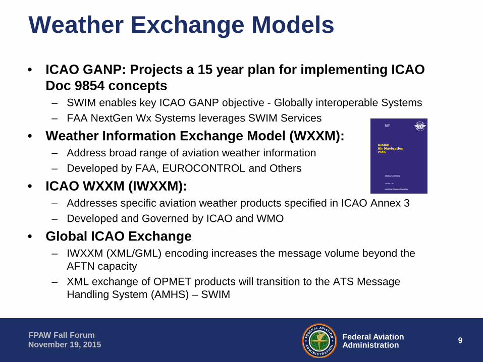
Weather Exchange Models• ICAO GANP: Projects a 15 year plan for implementing ICAO
Doc 9854 concepts– SWIM enables key ICAO GANP objective - Globally interoperable Systems– FAA NextGen Wx Systems leverages SWIM Services
• Weather Information Exchange Model (WXXM):– Address broad range of aviation weather information– Developed by FAA, EUROCONTROL and Others
• ICAO WXXM (IWXXM):– Addresses specific aviation weather products specified in ICAO Annex 3– Developed and Governed by ICAO and WMO
• Global ICAO Exchange– IWXXM (XML/GML) encoding increases the message volume beyond the
AFTN capacity– XML exchange of OPMET products will transition to the ATS Message
Handling System (AMHS) – SWIM
10Federal AviationAdministration
FPAW Fall ForumNovember 19, 2015
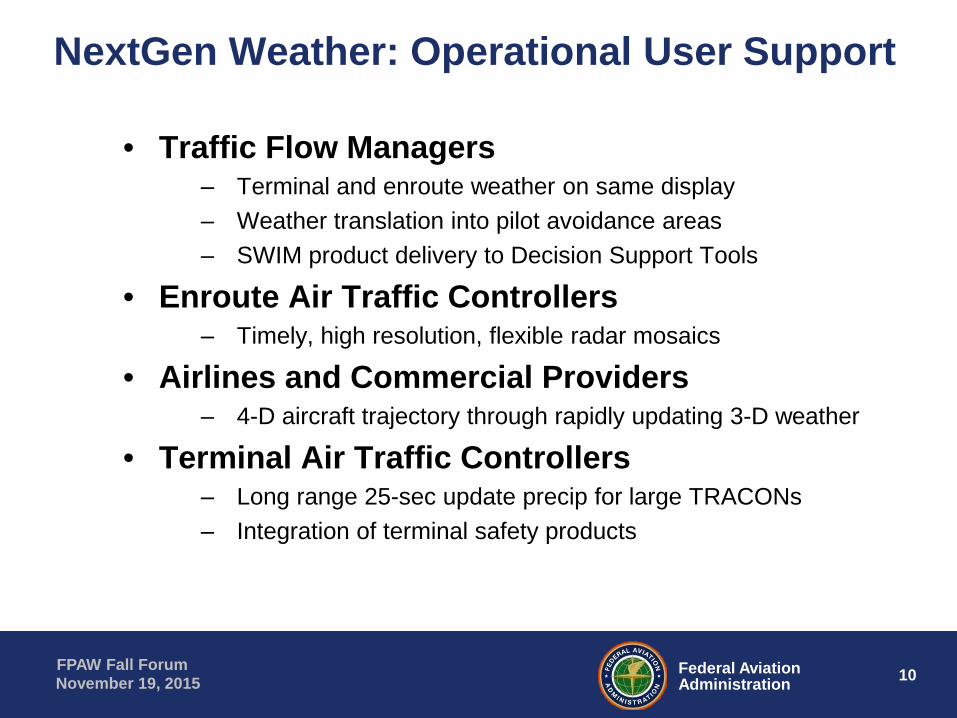
NextGen Weather: Operational User Support
• Traffic Flow Managers‒ Terminal and enroute weather on same display‒ Weather translation into pilot avoidance areas‒ SWIM product delivery to Decision Support Tools
• Enroute Air Traffic Controllers‒ Timely, high resolution, flexible radar mosaics
• Airlines and Commercial Providers‒ 4-D aircraft trajectory through rapidly updating 3-D weather
• Terminal Air Traffic Controllers‒ Long range 25-sec update precip for large TRACONs‒ Integration of terminal safety products
11Federal AviationAdministration
FPAW Fall ForumNovember 19, 2015
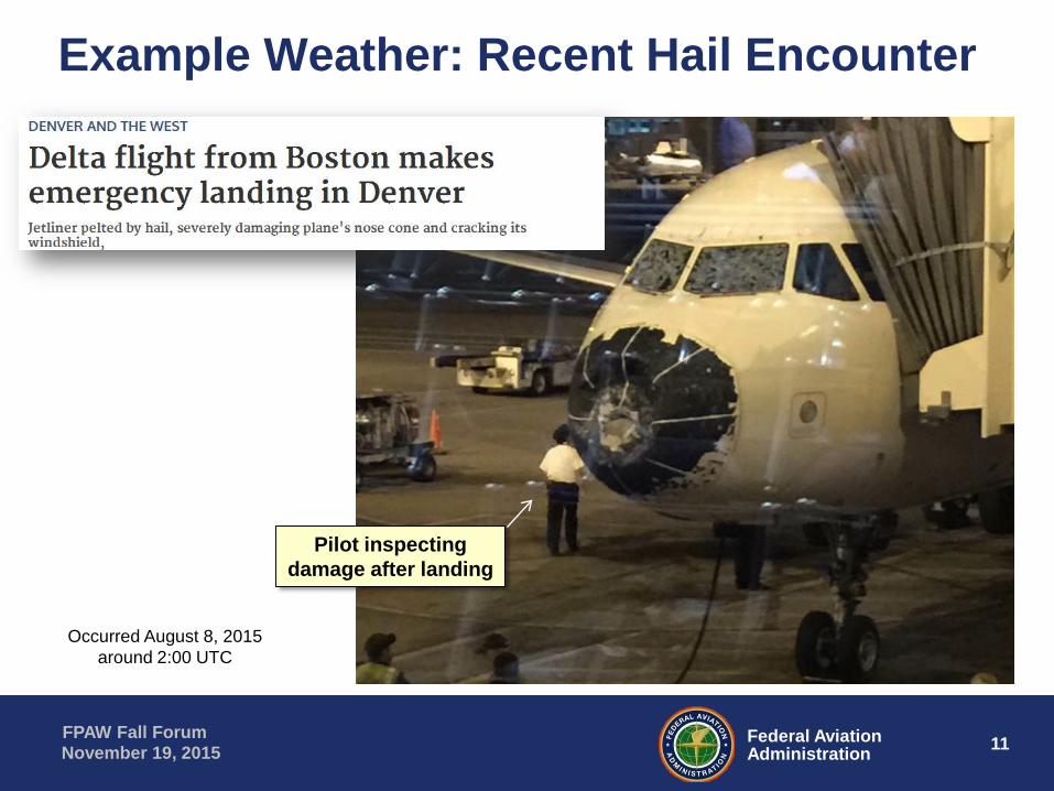
Pilot inspectingdamage after landing
Example Weather: Recent Hail Encounter
Occurred August 8, 2015around 2:00 UTC

12Federal AviationAdministration
FPAW Fall ForumNovember 19, 2015
Today’s Traffic Flow Management System Wx

13Federal AviationAdministration
FPAW Fall ForumNovember 19, 2015
New Storm Information: NextGen Weather
Storm Info Tags &Tornado Icon
Terminal• Safety
Growth Trends(rapid update)
Enroute ATC• 25 sec update
Benefits ofTerminal &Enroute Wx
Consolidation
14Federal AviationAdministration
FPAW Fall ForumNovember 19, 2015
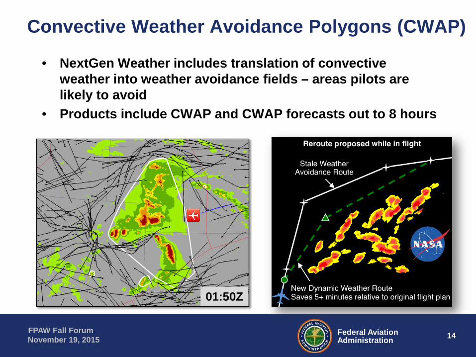
Convective Weather Avoidance Polygons (CWAP)
• NextGen Weather includes translation of convective weather into weather avoidance fields – areas pilots are likely to avoid
• Products include CWAP and CWAP forecasts out to 8 hours
01:50Z
15Federal AviationAdministration
FPAW Fall ForumNovember 19, 2015
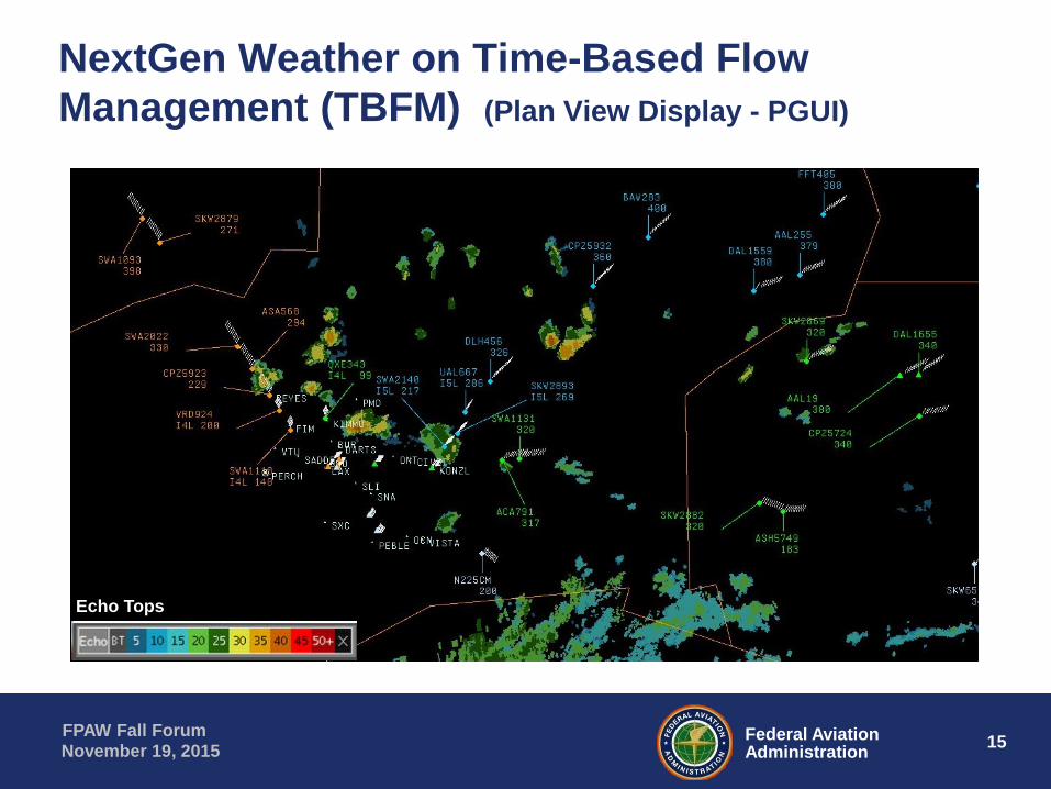
NextGen Weather on Time-Based Flow Management (TBFM) (Plan View Display - PGUI)
Echo Tops
16Federal AviationAdministration
FPAW Fall ForumNovember 19, 2015
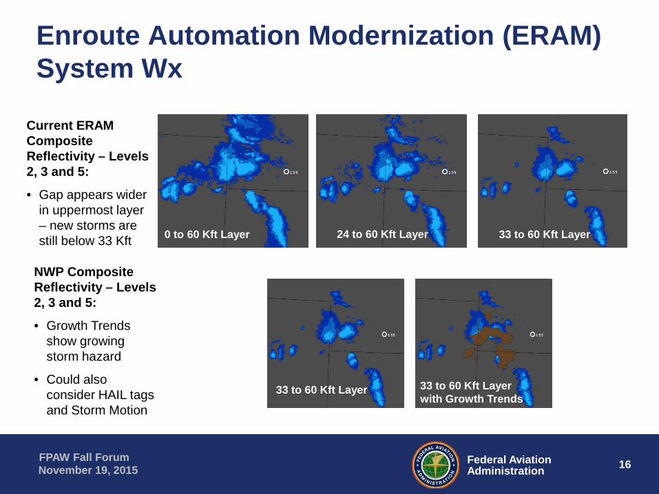
Enroute Automation Modernization (ERAM) System Wx
0 to 60 Kft Layer
Current ERAM Composite Reflectivity – Levels 2, 3 and 5:
• Gap appears wider in uppermost layer – new storms are still below 33 Kft 33 to 60 Kft Layer24 to 60 Kft Layer
NWP Composite Reflectivity – Levels 2, 3 and 5:
• Growth Trends show growing storm hazard
• Could also consider HAIL tags and Storm Motion
33 to 60 Kft Layer 33 to 60 Kft Layer with Growth Trends

17Federal AviationAdministration
FPAW Fall ForumNovember 19, 2015
NextGen Flexible Enroute Layer Mosaics• Example shows
Composite Reflectivity from “floor” to 60 Kft
• Layer bottom (“floor”) selectable in 1 Kft increments
• NextGen Weather radar mosaics contain fine-scale vertical storm structure
• Level 2 precip extends to 55 Kft!

18Federal AviationAdministration
FPAW Fall ForumNovember 19, 2015
4-D Trajectory Through Convective Weather
1 3
•Left •Right
Flight altitude34 Kft as
approaching
In cross
section
box
In storm

19Federal AviationAdministration
FPAW Fall ForumNovember 19, 2015
NextGen Precip for Use in Terminal ATC• NextGen Weather
precipitation product made from NEXRAD and TDWR radars
• Calibrated to match Terminal STARS ASR 6-level precipitation
• Range & update rate selectable Up to full CONUS, 25 sec
• Web Map Service can convert digital product to graphic for display User-selected “styles”
dictate colors and features

20Federal AviationAdministration
FPAW Fall ForumNovember 19, 2015
NextGen Weather on STARS• Terminal safety
products can easily be integrated on NAS user displays Microbursts Gust Fronts Storm Motion Storm Leading Edges
• Provides additional ATC safety margin
• Also provides common situational awareness All users viewing
same weather info
Copyright © 2015 Raytheon Company. All rights reserved. Customer Success Is Our Mission is a registered trademark of Raytheon Company.
FPAW NWP Inputs
Tom Doyle

22Federal AviationAdministration
FPAW Fall ForumNovember 19, 2015
NextGen Weather Processor Overview
• Aviation weather algorithms– Ingest of real-time enhanced 4D weather and model data– Specialized to meet the needs of the aviation community– Integrated into a virtualized, scalable and flexible framework
• Aviation Weather Display– Common HTML 5 Web Application for all users
• All operational and maintenance features via web browser user interface– AWD Website for NAS and External users
• Hosted by redundant central compute clusters– Small Form Factor workstation (Dedicated AWD)
• Each AWD hosts proxy website and local services (e.g. TDWR bypass)• Compute Cluster Infrastructure and Platform Services
– NWP software applications are hosted on a common platform– Virtualized, scalable, hardware independent– Directly connected to CSS-Wx via private LAN

23Federal AviationAdministration
FPAW Fall ForumNovember 19, 2015
NextGen Weather Processor in the NAS
ITWS DisplayReplacement,
STARSCommand
Center UsersAviation
Stakeholders
TRACON AWDs ARTCSCC AWDs
NEXRAD
LightningNetworksSurface Obs
Networks
TDWR
NOAA Model Data
SatelliteCanadianWX Radars
MDCRS
ASR
NAS Users
AWD Website
Common Support System – Weather (CSS-Wx)
NextGen Weather Processor (NWP) Compute ClustersGeneration ofAviation Weather Products
CONUS+Domain
Terminal Areas
CSS-Wx – NWP Private LAN
AWD Website
NESG
AviationStakeholder
OGC Systems
NAS OGC Consumer Systems
OGC Services OGC Services
NESG
WARP DisplayReplacement,
CIWSARTCC AWDs
ITWS DisplayReplacement,
STARSCERAP AWDs
ITWS DisplayReplacement,
STARSATCT AWDs
Other Domains
Virtualized Hosting
ofAviation Weather
Algorithms
NWP Provides Access for NAS and External Users via Aviation Weather Displays (AWDs) and AWD Website OGC Service Consumers
24Federal AviationAdministration
FPAW Fall ForumNovember 19, 2015
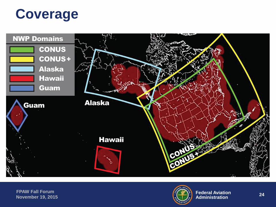
Coverage

25Federal AviationAdministration
FPAW Fall ForumNovember 19, 2015
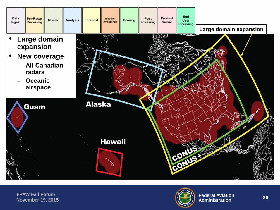
Coverage• Large domain
expansion• New coverage
– All Canadian radars
– Oceanic airspace
Large domain expansion
26Federal AviationAdministration
FPAW Fall ForumNovember 19, 2015
• Large domain expansion
• New coverage– All Canadian
radars– Oceanic
airspace
Large domain expansion
27Federal AviationAdministration
FPAW Fall ForumNovember 19, 2015
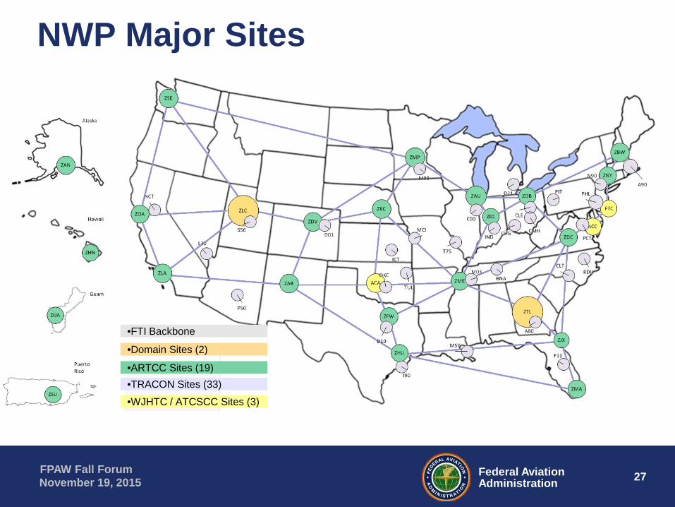
NWP Major Sites
•FTI Backbone
•Domain Sites (2)
•ARTCC Sites (19)
•WJHTC / ATCSCC Sites (3)•TRACON Sites (33)

28Federal AviationAdministration
FPAW Fall ForumNovember 19, 2015
NWP Domain Algorithms
Post ProcessingScoringAnalysisAnalysisMosaicPer-Radar
ProcessingWeather
Avoidance
Ingest
ProductPackaging

29Federal AviationAdministration
FPAW Fall ForumNovember 19, 2015
WARNING: EAR Controlled Information
Common Support Services – Weather (CSS-Wx)
Robert Carson, Harris

30Federal AviationAdministration
FPAW Fall ForumNovember 19, 2015
WARNING: EAR Controlled Information
• Acquire weather information from FAA and other sources• Provide data to systems that consume weather data • Publish weather information in standardized formats for use by
the FAA’s ATO, commercial aviation, general aviation, and other Federal agencies
• Publish aviation weather products provided by the NWP, NOAA NextGen Web Services, other FAA weather data sources, and non-FAA weather data sources for aviation users
• High-level capabilities:– Standardize weather information in common formats identified by the Open Geospatial
Consortium (OGC);– Filter weather information geospatially and temporally based on a user’s requirements;– Disseminate weather information via the SWIM system;– Perform weather data management; and– Store, archive, and retrieve weather information.
CSS-Wx CONOPS/Mission

31Federal AviationAdministration
FPAW Fall ForumNovember 19, 2015
WARNING: EAR Controlled Information
ARTCCs, ATCSCC
ARTCCs, ATCSCC
ARTCCs, ATCSCC & CERAPs
CSS-Wx Architecture within the NAS
CSS-Wx(Distribution)
GDMS
MSFTI
NEMS
AWD
ARTCCs, ATCSCCARTCCs, ATCSCCTRACONs
Consumers
CSS-Wx(Terminal)
GDMS
MS
NWP(Terminal)
AWD
TDWR RMLS
AIMM
Harris Operations Center
WSR-88D
Sensors
OGC WS Consumers
Decision Support Tools
(TFMS, TBFM, TFDM)
IDS-R
Central ZTL, ZLCFAA Atlanta & Salt Lake City
CSS-Wx(Central)
GDMS
Catalog
NWP(Domain)
AWD
NEMC
NESG
WMSCR
NEMS
External tothe NAS
NWS
Weather Data
NOAA
CanadianRadar
NG
ITW
S
NOAA PORT
MS
CSS-Wx Subsystems:
• Catalog Subsystem
• Geospatial Data Mediation Subsystem (GDMS)
• Management Subsystem (MS)
CSS-Wx Services:
• Provider Acquisition Services
• Geospatial Data Access Services
• N-Tier Services
• Consumer Distribution Services
• Sensor System Mediation Services
• Management Services
• Security Services
• Discovery Services
32Federal AviationAdministration
FPAW Fall ForumNovember 19, 2015
WARNING: EAR Controlled Information
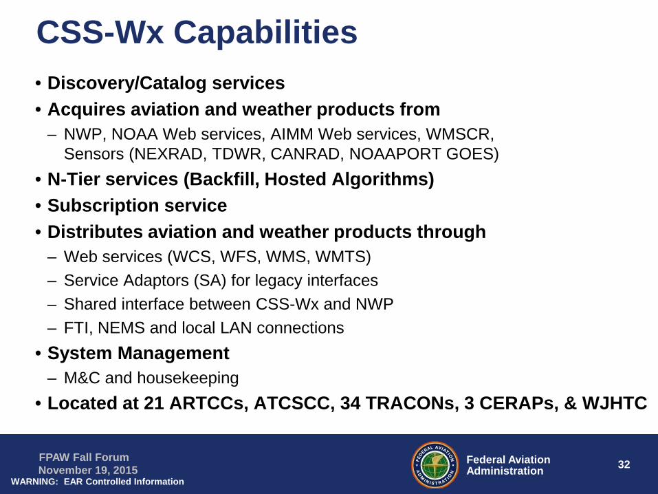
• Discovery/Catalog services• Acquires aviation and weather products from
– NWP, NOAA Web services, AIMM Web services, WMSCR, Sensors (NEXRAD, TDWR, CANRAD, NOAAPORT GOES)
• N-Tier services (Backfill, Hosted Algorithms)• Subscription service• Distributes aviation and weather products through
– Web services (WCS, WFS, WMS, WMTS)– Service Adaptors (SA) for legacy interfaces– Shared interface between CSS-Wx and NWP– FTI, NEMS and local LAN connections
• System Management– M&C and housekeeping
• Located at 21 ARTCCs, ATCSCC, 34 TRACONs, 3 CERAPs, & WJHTC
CSS-Wx Capabilities

33Federal AviationAdministration
FPAW Fall ForumNovember 19, 2015
WARNING: EAR Controlled Information
• Web Coverage Service (WCS)– A coverage is digital geospatial information representing space-varying phenomena– Distributes coverage/gridded data using the Open Geospatial Consortium (OGC) Web
Coverage Service Implementation Standard (Example: NOAA gridded models, radar mosaics, etc.)
– Outputs gridded data in netCDF-4• Web Feature Service (WFS)
– A feature is an abstraction of a real world phenomenon where a geographic feature is a feature associated with a location relative to the Earth
– Distributes feature/non-gridded data in WXXM format using the OGC OpenGIS Web Feature Service Interface Standard
• Web Mapping Service (WMS)– WMS provides rendered maps as map image files using the OGC defined Web Map Service– Obtains gridded and non-gridded products from the WCS-I and WFS-I through the cascade
method to produce maps/images from those data and distribute the images to consumers– Supports the output of PNG, JPG and GIF formats
• Web Mapping Tile Service (WMTS)– Provides maps in the form of map tiles– Uses predetermined maps to provide the capability to cache map tiles– Supports the output of PNG, JPG, and GIF formats
CSS-Wx Web Services

34Federal AviationAdministration
FPAW Fall ForumNovember 19, 2015
WARNING: EAR Controlled Information
• Conversions (WCS, WFS, WMS)– Conversion to/from spherical, NAD83 and WGS84 and unit conversions
• Filtering – Filter weather data based on user‐selected field/layer names
• (WCS, WMS) Spatial extends using basic geometries (bounding box), temporal trajectory, and specified parameter value “above”, “below”, “equal to”
• (WFS) Geospatial Points, Line Segments, 2‐D Polygon, Circle, basic geometries (BB), user‐specified trajectory‐related geometries, by two specified times (For example, a forecast time and a dataset generation time)
• (WMTS) TileMatrix, valid time, elevation• Decimation (WCS, WMS)
– Decreased data resolutions with data interpolation methods • Quantization (WCS, WMS)
– Quantize data values of a user‐specified weather product• Re-projections (WCS, WMS, WMTS)
– Re-projection for Lambert Conformal, Latitude/Longitude, Mercator, Stereographic, Cartesian, En Route, and Oceanic NAS Projection map projection coordinates and Tile Matrices
• Store Configuration Parameters– Fields for coverages/features/layers, titles and unique IDs per coverage/feature/layer,
quantization profiles, endpoints, coordinate reference system, etc.– (WMS) Styled Layer Descriptor (SLD) and Scalable Vector Graphic (SVG) files
CSS-Wx Web Service Capabilities

35Federal AviationAdministration
FPAW Fall ForumNovember 19, 2015
WARNING: EAR Controlled Information
• Ad-hoc Request/Response MEP (WCS, WFS, WMS, WMTS)– Consumer identifies the raster dataset along with filtering parameters using the
GetCapabilities operation– Available datasets are defined by service metadata which may be retrieved by the
GetCoverage/Feature/Map/Tile operation
• Static and On-Demand Persistent Query subscriptions (WCS, WFS, WMS)– Static: Design time stored subscriptions with products published to a JMS endpoint– On-Demand: Run time OGC client processed subscriptions with products published to
a JMS endpoint
• Static and On-demand Notification subscriptions (WCS)– Static: Design time store subscriptions– On-Demand: Run time OGC client processed subscriptions– Consumer receives notification that published information is available through the
subscription– Consumer may then retrieve the data through a Request/Response exchange
CSS-Wx Web Service Message Exchange Patterns

36Federal AviationAdministration
FPAW Fall ForumNovember 19, 2015
WARNING: EAR Controlled Information
CSS-Wx N-Tier Services• Hosted Algorithm Services
– Hosted Algorithms integrate weather data with user-specified and/or site-adaptable information to generate products for immediate use
– Hosted Algorithms by a Web service acting on behalf of a consumer application
– Hosted processing reduces bandwidth and latency costs associated with transporting large data sets over telecommunication circuits
• Model Data Backfill – In the event of missing model data,
the CSS-Wx System will provide the capability to replace the missing data with valid forecast information from previous model runs
Hosted Algorithms• End-User Algorithms
– Composite Reflectivity with Flexible Floor– Icing And Composite Icing Layer– Composite Turbulence and Turbulence
Layer– Precipitation Altitude Mask– CWAM Weather Avoidance Field
• Display Algorithms– Precipitation Grid Display– Composite Reflectivity Grid Display– Icing Grid Display– Icing Contour Display– Turbulence Grid Display– Turbulence Contour Display– Altitude‐Masked Precipitation Grid Display

37Federal AviationAdministration
FPAW Fall ForumNovember 19, 2015
CSS-Wx Products• NOAA
– Model Products– Alphanumeric– Gridded & Graphic
• Aeronautical – AIMM– Geopolitical Boundaries– Geopolitical Features– NAS Boundaries– NAS Routes– NAS Features– System & Sensor Locations
• Sensor Product Sets– NEXRAD Level III– TDWR Base Data– NavCanada Weather Radar– GOES (E/W) Satellite Data
• NWP Domain Products– Gridded Analyses– Gridded Forecasts (0-2 hours)– Gridded Forecasts (2-8 hours)– Non-Gridded Analyses– Non-Gridded Forecasts– System Information Messages
• NWP Terminal Products– Gridded Products– Non-Gridded Products– System Information Messages
• WMSCR (Source) Products– Lightning Detection Data– Surface Wx Obs (OMO)– Pilot Reports (PIREPs)
38Federal AviationAdministration
FPAW Fall ForumNovember 19, 2015
WARNING: EAR Controlled Information
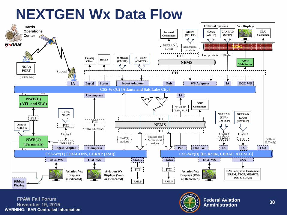
NEXTGEN Wx Data FlowExternal Systems
AIMM(WS EP)
NOAA (WS EP)
CANRAD (SFTP)
NEXRAD (CMTCP)
TDWR•(UDP)
WMSCR(CMHP)
NESGNESG
Ingest Adaptor
ASR-9sASR-11s
NWP(D) (ATL and SLC)
NWP(T) (Terminals) Wx Tap
FTI
•Compress
Uncompress
TDWR/LLWAS
(GOES data)
NOAAPORT
Ingest AdaptorsIA
FTI
CSS-Wx(D) [En Route, CERAP, ATCSCC]
NEXRAD (ZUA)
(CMTCP)
IA
WS Adaptors IA
Pub
IA
NEXRAD (ZAN, ZUA
BWMNWP(T) products
Weather and Aeronautical
products
CSA
Wx Displays
Internal Consumers
Pub
NAS Subsystem Consumers(ERAM, ATOP, MEARTS,
DOTS, FDP2k)
OGC WS
CSA
DLU Consumer
OGC Consumers
OGC WS
AWD Web Server
OGC WS
OGC WS
Aviation Wx Displays (Web or Dedicated)
OGC WS
Aviation Wx Displays
(Dedicated)
Aviation Wx Displays (Web or Dedicated)
NEMS
•FTI
NEMS•FTI
FTI
NEXRAD TDWR
Ribbon Display
ATL SLC
CSS-Wx(T) [TRACONS, CERAP (ZSU)]
FTI
Status
RMLS
Status
FTI
RMLS
Status
FTI
RMLS
Aeronautical products
Wx products Radar
Radar
Radar
Wx productsGOES
Radar
NEXRAD (ZAN)
(CMTCP)
IA
FTIRadar
(ZTL or ZLC only)
Harris Operations Center
Portal
CatalogClient
CSS-Wx(C) [Atlanta and Salt Lake City]
FTI

39Federal AviationAdministration
FPAW Fall ForumNovember 19, 2015
NAS User Participation
• CSS-Wx provides access to common source –FAA and External Users– FAA ATC/ATM Controllers– Airline AOCs– LM Flight Service– Weather Vendors– Others …
• Enhances access to timely updates and new products
• Provides opportunity for new support concepts and procedures

40Federal AviationAdministration
FPAW Fall ForumNovember 19, 2015
Demonstration – User ParticipationNextGen Integration and Evaluation Capability (NIEC)
NWP Test Reference System
• Generate NWP Test Data
• Could be provided to users for early development and demonstration
Global SWIM Demonstrations – FTB
• Mini Global II (MG II)
• Global AIXM, IWXXM, & FIXM exchange
• Complex ATM Scenarios
• Mar-Apr 2016
Capability Evaluations (CE) – NIEC/FTB
• Evaluate SWIM data exchange
• Ground: Between Systems / Users
• Air-Ground: Via AAtS System
• Evaluate/Develop Wx Integration and New Applications
41Federal AviationAdministration
FPAW Fall ForumNovember 19, 2015
NextGen Weather Summary
• CSS-Wx and NWP programs are on contract for implementation– NWP will generate advanced aviation weather products for
NAS operations
– CSS-Wx will provide NWP and NOAA products along with other weather data to FAA and External users via SWIM
• Concept Evaluations and Global Demonstrations will advance implementation of:– NextGen Wx Systems– ICAO ATM and FAA NextGen concepts

42Federal AviationAdministration
FPAW Fall ForumNovember 19, 2015
Resources
• NextGen Weather:– https://www.faa.gov/nextgen/programs/
• CSS-Wx Wiki at NCAR:– https://wiki.ucar.edu/display/CSSWX/CSS-Wx+Home
• Program contact information:Alfred Moosakhanian, FAANextGen Weather Systems Manager, AJM-333(202) [email protected]

43Federal AviationAdministration
FPAW Fall ForumNovember 19, 2015
Key Acronyms• ADAS: Automated Weather Observing System (AWOS)
Data Acquisition System • ARTCC: Air Route Traffic Control Center• ASOS: Automated Surface Observing System• ASR: Airport Surveillance Radar• ATOP: Advanced Technologies and Oceanic Procedures• AWD: Aviation Weather Display• AWOS: Automated Weather Observing System• AWSS: Automated Weather Sensor System• CDDS: CIWS Data Distribution Service• CIWS: Corridor Integrated Weather System• CREWS: CTAS Remote Weather System• CSS-Wx: Common Support Services for Weather• DHS: Department of Homeland Security• DoD: Department of Defense• DOTS+: Dynamic Oceanic Tracking System Plus• DST: Decision Support Tools• ERAM: En Route Automation Modernization• EWD: Enhanced WINS Dissemination (WARP)• FBWTG: FAA Bulk Weather Telecommunications
Gateway• FDP2K: Flight Data Processing 2000 System• FTI: FAA Telecommunications Infrastructure• IDS-R: Information Display System Replacement• ITWS: Integrated Terminal Weather System
• LLWAS: Low-Level Windshear Alert System• MEARTS: Microprocessor En Route Automated Radar
Tracking System• NAS: National Airspace System • NESG: NAS Enterprise Security Gateway• NEXRAD: Next Generation Weather Radar (WSR-88D)• NFU: NWS Filtering Unit• NOAA: National Oceanic and Atmospheric Administration• NEMC: National Enterprise Management Center• NWP: NextGen Weather Processor• OGC: Open Geospatial Consortium • RAMP: Radar Acquisition and Mosaic Processor• SWIM: System Wide Information Management• TBFM: Time Based Flow Metering• TDWR: Terminal Doppler Weather Radar• TFDM: Terminal Flight Data Manager• TFMS: Traffic Flow Management System• TMU: Traffic Management Unit• TRACON: Terminal Radar Approach Control• VOLPE: National Transportation Systems Center (ITWS
Web Services Provider)• WARP: Weather and Radar Processor• WINS: Weather Information Network Server• WMSCR: Weather Message Switching Center
Replacement