Embed Size (px)
Citation preview

VOL. 11, NO. 5, MARCH 2016 ISSN 1819-6608
ARPN Journal of Engineering and Applied Sciences ©2006-2016 Asian Research Publishing Network (ARPN). All rights reserved.
www.arpnjournals.com
2849
FACIES ANALYSIS AND STRATIGRAPHIC SEQUENCE OF THE NORTHEAST MALAY BASIN, OFFSHORE
TERENGGANU, MALAYSIA
Noorzamzarina Sulaiman, Umar Hamzah and Abdul Rahim Samsudin Department of Geology, School of Environmental Sciences and Natural Resources, Faculty of Science and Technology,
National University of Malaysia, Bangi, Selangor, Malaysia E-Mail: [email protected]
ABSTRACT
Stratigraphic sequences and facies variability in the Lower Miocene to Pleistocene strata of the study area, northeast Malay Basin, Terengganu offshore, were investigated using the interpretation of 3-D high-resolution seismic data and profiles. Eight sequence boundaries (SB) were recognized in the studied formations due to the presence of variability of in the facies stacking pattern. The unconformity bounded early Lower Miocene to Recent succession in the northeast Malay Basin is subdivided into eight sequence boundaries or formations; the SB1, SB2, SB3, SB4, SB5, SB6, SB7 and SB8. These rock units were deposited in the variety of depositional environments including coastal fluvio-marine, inner neritic and holomarine environment. The stratigrahic sequences in the study area were determined by the difference of seismic reflection attribute including the amplitude strength, frequency and internal configuration. The sequences also characterized by the different of types of depositional environments. Keywords: seismic facies analyses, stratigraphic sequence, seismic reflection attribute, lower miocene- Pleistocene.
INTRODUCTION
The Malay Basin is one of the deepest continental extensional basins in the region and is believed to have formed during early Tertiary times. The regional studies from northeast Malay Basin required the various data to gain a better understanding of its regional geology and facies sucessions. When applied to the interpretation of passive continental margin environments, stratigraphic sequencing has been shown to be a useful tool for constructing isochronous stratigraphic frameworks, predicting the location of hydrocarbon reservoirs, and the exploration of lithostratigraphic traps (Vail et al. 1977; Posamentier et al. 1988, 1992; Van Wagoner et al., 1990; Catuneanu et al., 2009). Research and exploration during the past three decades have demonstrated that sequence-stratigraphic concepts developed for passive continental margin strata may also be applied to the study of lacustrine basins (Shanley and McCabe, 1994; Strecker et al., 1999; Lin et al., 2001; Folkestad and Satur, 2008). However, the application of stratigraphic sequencing to the description of ancient rift basins has been limited by previously unconsidered factors in the development and tectonic evolution of continental rift basins (Shanley and McCabe, 1994). Emphasis has been given in recent years to the influence of tectonic and climatic factors on the development of sequences and depositional systems in continental basins (Shanley and McCabe, 1994; Strecker et al., 1999; Zcchin et al., 2006; Magbegbeola and Willis, 2007). The Malay Basin is an elongate NW-SE trending basin, underlain by a pre-Tertiary basement of metamorphic, igneous and sedimentary rocks. These are thought to be the offshore continuation of the geology of eastern Peninsular Malaysia. A well exploration known as
Well-A was used to interpret the seismic sequences (Lower Miocene- Recent) against regional tectono-stratigaphic, incorporated with a published stratigraphy scheme obtained from the wells in the study area. Our approach is to identify sequence boundaries were mostly based on the seismic characteristics including amplitude continuity, reflection frequency and internal configuration. The purposes of this study are to improve present understandings of regional seismic stratigraphy and to review the facies development of the study area. Literature review
Located in the northern part of Sunda Shelf (Figure-1), the Malay Basin is a complex rift composed of numerous extensional grabens. Most of these grabens have not been penetrated because of their great depths, but were interpreted from magnetic, gravity and seismic data. Some smaller grabens have been identified from seismic mapping on the west-central margin, including the Dungun Graben, described above, and the TokBidan Graben (Liew, 1994). The pre-Tertiary basement shallows to the southeast as a result of late Middle Miocene tectonic deformation and uplift. The Malay Basin is separated from Pattani Basin which Narathiwat High in the north and from the Penyu Basin in the south by Tenggol Arch also extending southeast until West Natuna Basin in Indonesia. Dimensions of Malay Basin are about 200 km wide, 500 km long and total area approximately 83 000 km2. Generally, the Malay Basin was developed starting in Middle Miocene resulted from the Asia and India plate collision formed by extrusion of crustal slabs SE Asia. Malay Basin is mainly NW-SE trending wrench faults and as result the opening of the South China Sea. The

VOL. 11, NO. 5, MARCH 2016 ISSN 1819-6608
ARPN Journal of Engineering and Applied Sciences ©2006-2016 Asian Research Publishing Network (ARPN). All rights reserved.
www.arpnjournals.com
2850
basement is mainly Cretaceous granites elongated to the Con Son Swell bounded by fault direction is South to
North.
Figure-1. The map shows the major Tertiary sedimentary basins and structural-stratigraphic provinces in Peninsular Malaysia. Upper right inset of the index shows locations of 3-D seismic profiles and a
exploration well in the study area.
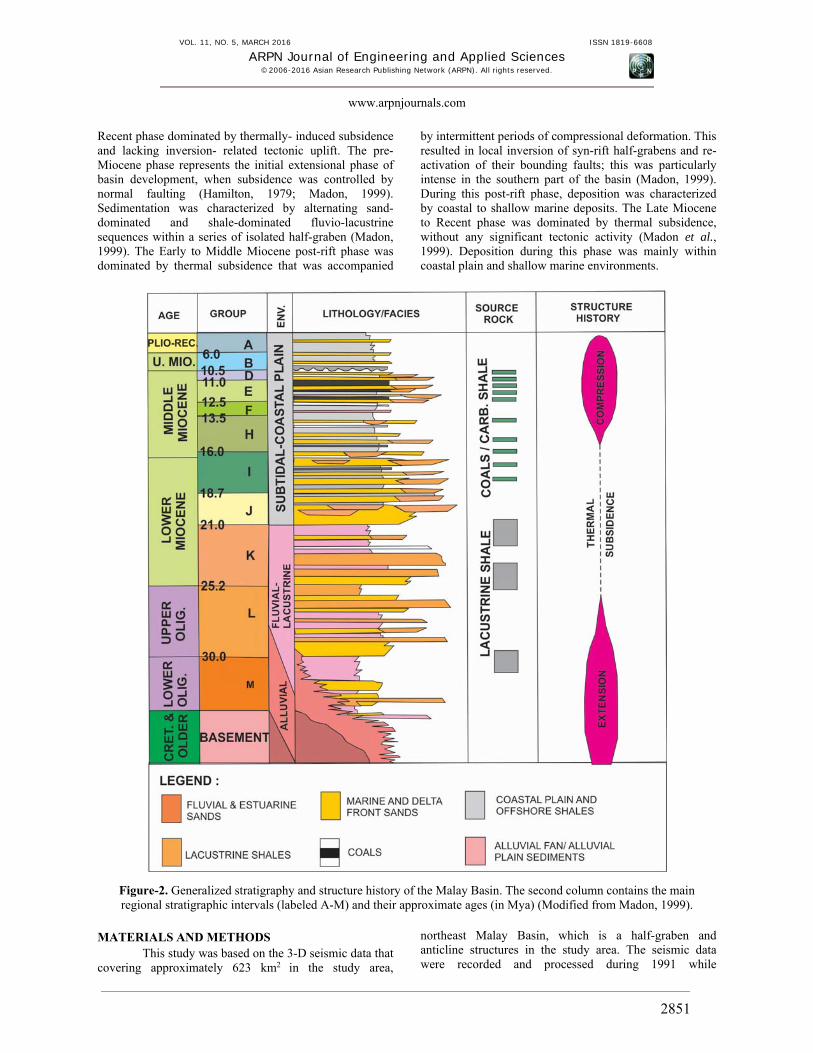
The structural is less steep with more structured in northeast flank marked by a number of half-grabens (Ngah et al., 1996). The basin compromises a thick succession (>8 km) of Oligocene-Miocene to Recent deposits, which overlie a pre-Tertiary basement consisting of metamorphic, igneous and sedimentary rocks (Figure-2). The basin in northeast part was filled with alluvial, lacustrine and fluvial sediments during Oligocene to early Lower Miocene. Coastal fluvio-marine increase to inner neritic from late Lower Miocene to the present but narrow
seaway from northeast to southwest flank (NikRamli, 1986). This type of non-marine sediments filled which major supply by Gulf of Thailand from Mekong River during Oligocene to Pliocene (Hutchison, 1989). The structural evolution of the Malay Basin can be divided into three tectono-stratigraphic phases (Tjia, 1994; Madon et al., 1998; Khalid Ngah et al., 1996; Tjia and Liew, 1996): 1) a pre-Miocene syn-rift phase; 2) an Early to Middle Miocene post-rift phase dominated by thermally-induced subsidence and basin inversion; and 3) a Late Miocene to
VOL. 11, NO. 5, MARCH 2016 ISSN 1819-6608
ARPN Journal of Engineering and Applied Sciences ©2006-2016 Asian Research Publishing Network (ARPN). All rights reserved.
www.arpnjournals.com
2851
Recent phase dominated by thermally- induced subsidence and lacking inversion- related tectonic uplift. The pre-Miocene phase represents the initial extensional phase of basin development, when subsidence was controlled by normal faulting (Hamilton, 1979; Madon, 1999). Sedimentation was characterized by alternating sand-dominated and shale-dominated fluvio-lacustrine sequences within a series of isolated half-graben (Madon, 1999). The Early to Middle Miocene post-rift phase was dominated by thermal subsidence that was accompanied
by intermittent periods of compressional deformation. This resulted in local inversion of syn-rift half-grabens and re-activation of their bounding faults; this was particularly intense in the southern part of the basin (Madon, 1999). During this post-rift phase, deposition was characterized by coastal to shallow marine deposits. The Late Miocene to Recent phase was dominated by thermal subsidence, without any significant tectonic activity (Madon et al., 1999). Deposition during this phase was mainly within coastal plain and shallow marine environments.
Figure-2. Generalized stratigraphy and structure history of the Malay Basin. The second column contains the main regional stratigraphic intervals (labeled A-M) and their approximate ages (in Mya) (Modified from Madon, 1999).
MATERIALS AND METHODS
This study was based on the 3-D seismic data that covering approximately 623 km2 in the study area,
northeast Malay Basin, which is a half-graben and anticline structures in the study area. The seismic data were recorded and processed during 1991 while

VOL. 11, NO. 5, MARCH 2016 ISSN 1819-6608
ARPN Journal of Engineering and Applied Sciences ©2006-2016 Asian Research Publishing Network (ARPN). All rights reserved.
www.arpnjournals.com
2852
exploration borehole data were tied to the seismic survey to complement and calibrate seismic interpretations in cases where the relatively low-resolution data were ambiguous. The chronostratigraphic column was used to estimate the ages of strata and sequence boundaries. In order to choose the most prominent seismic reflectors as sequence boundaries, all possible sequence boundaries were initially identified in a high-quality migrated seismic refletion section. The lateral extent of each probable sequence boundary was evaluated through correlation across of the seismic sections. The fundamental concept of seismic sequence analysis is that every seismic section is divided into relatively conformable or concordant seismic reflectors. They were then tied to well and dated. Then, seismic facies analysis was conducted to correlate reflection attribute and identify stratigraphic sequence characteristics between seismic and well data. Three characteristics of reflection attributes were used to distinguish between different seismic facies which are frequency, internal reflector configuration and amplitude strength. This methods used in the present study is set out below.
The sequence boundaries identified on seismic reflection data were calibrated together with a exploration well. Every identified seismic facies type was correlated with well data to establish a relationship between the seismic facies and lithofacies. Time to depth conversion has been done by the average velocity model based on time-depth relationship for the well. Depositional systems and facies associations in strata of Lower Miocene-Recent were delineated by interpreting 2-D and 3-D high-resolution seismic profiles and analyzing well log. Sequence boundaries (unconformity interfaces) of the Lower Miocene-Recent strata succession were identified on seismic profiles as onlap surfaces or truncation surfaces, and in well-log data as abrupt change surfaces. These interpretations served as a foundation for understanding the structural style and the composite stratigraphic sequence framework. After a regionally consistent seismic sequence, stratigraphic framework was constructed and chronostartigraphic data were used to
calibrate the seismic interpretations by age intervals. The depositional systems and cycles were identified from synthetic seismogram of well-log data. At this stage, systems tracts were defined in relation to the sequence boundaries and maximum flooding surfaces appearing on seismic profiles as downlap surfaces, and as condensed sections in well logs. RESULTS AND DISCUSSIONS Sequence stratigraphic and facies analysis
In this study, the sequence boundaries (seismic units) are determined from the well logs data and the observation of the seismic facies from 2-D seismic section. Eight sequence boundaries featured particular reflection patterns and geological ages as shown in Figure-3. The oldest sequence boundary interpreted was the basement layer; hence indicating the basement of the study area. The depth and two-way time information for five top formations are observed from the time-depth curve. In addition, the three sequence boundaries are found from the 2-D seismic sections by the amplitudes and the appearance of facies differentiation. After establishing the sequence boundaries, the seismic facies in the units were identified. Each unit, known as a Group, is bounded by basin-wide seismic reflectors. Some of these reflectors represent major sequence boundaries and are erosional unconformities on the basin flanks. Based on seismic data and well log, the facies of every sequence boundaries from SB1 (the oldest) until SB8 (the youngest) are observed. Lithology influence on amplitudes can often be recognized by the pattern of amplitudes as observed on horizon slices and by understanding how different lithologies occur within a deposition system. By relating lithologies to depositional systems we often refer to these as lithofacies or facies. The link between amplitude characteristics and depositional patterns makes it easier to distinguish lithofacies variations and fluid changes in the seismic section and well logs.

VOL. 11, NO. 5, MARCH 2016 ISSN 1819-6608
ARPN Journal of Engineering and Applied Sciences ©2006-2016 Asian Research Publishing Network (ARPN). All rights reserved.
www.arpnjournals.com
2853
Figure-3. The sequence boundaries for seismic inline-803. The interpretation were used the lithostratigraphic log from the well- A.
Upper oligocene to lower miocene sequence (SB 1)
Reflection characteristics of this sequence are represented by chaotic pattern, low amplitude and low-frequency. The Upper Oligocene to Lower Miocene sequence was indicated as syn-rift unit, and is determined as extensional phase of basin development. The unit is characterized by chaotic, low amplitude and low frequency. This sequence is classified as Group K and the sediments were initially deposited in islolated grabens and half-grabens, with thick deposits of alternating sand-dominated and shale-dominated, fluvio-lacustrine sequences. These sediments consist of fan delta and high-energy fluvial deposits, alluvial plain and lacustrine sediments, which were deposited in relatively shallow lacustrine environments. These deposits show increasing lacustrine influence towards the basin centre. Group K has an estimated average thickness of 400m, and consists of sandstone and shale deposited in braided rivers in alluvial fans and delta complexes (Mazlan et al. 1999a; HIS 2004). According to Khalid (2010), he concluded that the Group K is best developed in the west and central parts of the southern Malay Basin, with over 600 m of sediments in the west. This group consists of thick alluvial-plain deposits, comprising braided channel sandstone and siltstone, and lower coastal/ delta- plain deposits. Lower miocene to upper miocene sequence (SB 2- SB 6)
The Late Lower Miocene to Upper Miocene sequence were including the Group J, I, H, F, E and D.
The transition from lacustrine shale (Group K) to marine sandstone (Group J) marks a significant change in the depositional history of the basin. The first marine incursion is dated at between 18.7 to 21 Ma (mid Early Miocene) at the top of Group K (Azmi et al. 1996). Subsequent Groups J to D sediments were deposited during the post-rift phase which lasted till Late Miocene. The middle Lower to Middle Miocene sediments were deposited in marine, tidal-estuarine, coastal plain and fluvial environments. Groups J and I consist of progradational to aggradational fluvial to tidal- estuarine sandstone. The Group J sequence that has chaotic facies is developed after the deposition where the deformation occurred and the anticline produced (Figure-4). This is because after these chaotic facies, there is sub-parallel facies were occurred. The amplitude in the upper part of sequence is moderate and the lower part shows the low amplitude strength. The frequency in this sequence is low. The Group J sequence with average thickness of 250 m and consisting of shale and sandstones sequences, deposited in a tidally influence coastal fluvio-marine environment. Sandstones are mainly of tidal flats, channels and shoreface facies. The lower Group J was deposited in sub-tidal sand bars, trending WNW-ESE parallel to the palaeo-shoreline.
The Group I sequence is characterized by sub-parallel to parallel configuration, low amplitude and low frequency (Figure-5) with average thickness 300 m, comprises shale, coaly shale, sandstone and coal. The basin was probably at or near sea level by Early Miocene

VOL. 11, NO. 5, MARCH 2016 ISSN 1819-6608
ARPN Journal of Engineering and Applied Sciences ©2006-2016 Asian Research Publishing Network (ARPN). All rights reserved.
www.arpnjournals.com
2854
time, as indicated by the abundance of coal-bearing strata in the succession. Basin inversion commenced in late Early Miocene, corresponding to the top of group I. The Groups H and F sequence sediments were deposited during an overall sea-level rise and are dominated by marine to deltaic sediments with fluvial/ estuarine channels. Reflection characteristics of Group H sequence are represented by local chaotic pattern, sub-parallel to parallel configuration, moderate amplitude and moderate frequency (Figure-6). This group section is mainly composed of shales interbedded with siltstones, thin sandstones and abundant coaly beds. The sandstones made up of point bars and channels are interpreted to have been deposited in a lower coastal plain environment with tidal and marine influences. This sequence is about 63 m thick.
Reflection characteristics of the Group F sequence are represented by sub-parallel to parallel facies and also chaotic pattern that are exist because of the deformation from the existence of faults. There is parallel facies in the upper part of Group F sequence (Figure-7). Hilly facies or a little chaotic pattern in the lower part of this sequence is proposed that the sediment deposition in the area is relatively high energy. This sequence has moderate to high amplitude and frequency. The Group F section is comprised of alternating shales and siltstones with minor sandstones beds and is about 181 m thick. This sequence deposited in coastal fluvial plain environment with varying tidal influence.
The Group E sequence consists of sandstones interbedded with shales and siltstones. Coaly beds can be seen scattered through out the section. The sandstones
thickness ranges from 3 m to 20 m are made up of channel and point bar sandstones deposited in lower coastal plain environment. This sequence is about 370 m thick. This sequence is characterized by sub-parallel to parallel facies and moderate to high amplitude and frequency (Figure-8). The deposition of Groups D, E and F sediments continued in the central and northern parts of the basin, while the southern part was uplifted and underwent erosion. The top of the Group D sequence is marked by the Pliocene/ Miocene Unconformity. It is about 136 m thick. It is comprised of intercalated clay stones, siltstones and sandstones deposited in a delta front environment with varying lagoonal and tidal flat influences. Figure-9 show the facies in the Group D sequence that characterized by the existence of sub- parallel to parallel facies and low amplitude and frequency. Pliocene to recent sequence (SB 8)
This sequence was indicated as a phase of gentle subsidence and fully open-marine environments were established. Groups A/ B sediments consist. These groups are undifferentiated and form the youngest and thickest sequence and are about 1008 m thick. They mainly made up of unconsolidated clay stones and siltstones rich in fossils and pyrite. The sediments are interpreted to have been deposited in an inner neritic to holomarine environment. The Group B sequence is characterized by parallel configuration and high amplitude and frequency (Figure-10). These parallel facies shows the uniformity during the stable sediment deposition.
Figure-4. Facies in the Group J sequence.

VOL. 11, NO. 5, MARCH 2016 ISSN 1819-6608
ARPN Journal of Engineering and Applied Sciences ©2006-2016 Asian Research Publishing Network (ARPN). All rights reserved.
www.arpnjournals.com
2855
Figure-5. Facies in the Group I sequence.
Figure-6. Facies in the Group H sequence.

VOL. 11, NO. 5, MARCH 2016 ISSN 1819-6608
ARPN Journal of Engineering and Applied Sciences ©2006-2016 Asian Research Publishing Network (ARPN). All rights reserved.
www.arpnjournals.com
2856
Figure-7. Facies in the Group F sequence.
Figure-8. Facies in the Group E sequence.

VOL. 11, NO. 5, MARCH 2016 ISSN 1819-6608
ARPN Journal of Engineering and Applied Sciences ©2006-2016 Asian Research Publishing Network (ARPN). All rights reserved.
www.arpnjournals.com
2857
Figure-9. Facies in the Group D sequence.
Figure-10. Facies in the Group B sequence. CONCLUSIONS
A seismic interpretation of the Malay Basin has been made based on seismic data in the form of 3-D and using cross-sectional data that is supported by the analysis of seismic data recording to the well sediments of Lower Miocene to Pliocene age. A total of eight sequences boundaries have been identified in the study area (northeast Malay Basin), which are labelled as SB1 (younger) to the border of SB 8 (older) sequence. Sequence boundary that obtained is determined by the presence of the indicated amount of termination deposition showed end of a deposition such as onlaps, downlap and toplap. Sequence boundary SB1, lower Miocene aged,
around 18.7 million years ago meanwhile, SB2 also lower Miocene age of 16 million years ago. There is a sequence boundary SB3, Miocene aged around 13.5 million years ago. Sequence boundary SB4, as well as Miocene age with the age of about 12.5 million years ago. SB5 and SB6 sequence boundary, upper Miocene aged respectively 11 and 10.5 million years ago .Sequence boundary SB7, Pliocene aged about 6 million years ago and the youngest sequence boundary SB8, Pliocene to Recent age of 1.5 million years ago. The three types of seismic reflection attributes were recognized in the seismic section including the amplitude strength, frequency and internal configuration.

VOL. 11, NO. 5, MARCH 2016 ISSN 1819-6608
ARPN Journal of Engineering and Applied Sciences ©2006-2016 Asian Research Publishing Network (ARPN). All rights reserved.
www.arpnjournals.com
2858
ACKNOWLEDGEMENTS We acknowledged Petroleum Management Unit
(PMU) team under PETRONAS for allowing us to access seismic profiles and well of northeast Malay Basin. We would like to thank Mr Joseph Gnapragasan from SMT Kingdom for teaching the seismic interpretation using the 8.8 Kingdom software. REFERENCES Catuneanu O., Abreu V., Bhattacharya J.P., and Blum M.D. 2009.Toward the standardization of sequence stratigraphy. Earth-Science Reviews. 92:1-33. Folkestad A. and Satur N. 2008. Regressive and transgressive cycles in a rift- basin: depositional model and sedimentary partitioning of the Middle Jurassic Hugin Formation, southern Viking Graben, North Sea. Sedimentary Geology 207: 1-21. Hamilton W. 1979. Tectonics of Indonesian region. United States Geological Survey Professional Paper: 1078. Hutchison C.S. 1989. Geological Evolution of South East Asia. Oxford monographs on Geology and Geophysics no.13 Clarendon Press, Oxford. Khalid Ngah, Mazlan Madon and Tjia H.D. 1996. Role of pre-Tertiary fractures in formation and development of the Malay and Penyu basins. In: Hall R. and Blundell D (eds). Tectonic Evolution of Southeast Asia. Geological Society of London Special Publication, 106: 281-289. Lin C.S., Eriksson K. and Li S.T. 2001. Sequence architecture, depositional systems, and controls on development of lacustrine basin fills in part of Erlian Basin, Northeast China. AAPG Bulletin. 85: 2017-2043. Madon M. 1999. Basin types, tectono- stratigraphic provinces, structural styles. In: Petronas (ed.) The Petroleum Geology and Resources of Malaysia. Petronas, Kuala Lumpur. pp. 77-111. Madon M. and Watts A.B. 1998.Gravity anomalies, subsidence history and the tectonic evolution of the Malay and Penyu Basins (offshore Peninsular Malaysia). Basin Research. 10: 375-392. Madon M, Abolins P, Jamaal Hoesni M, Ahmad M. 1999.Malay Basin. In: Petronas (ed.) The Petroleum Geology and Resources of Malaysia. Petronas, Kuala Lumpur. pp. 173-217. Magbegbeola O.A. and Willis B. 2007. Sequence stratigraphy and syndepositional deformation of the
Agbada Formation, Robertkiri field, Niger Delta, Nigeria. AAPG Bulletin. 91: 945-958. NikRamli. 1986. Depositional model of a Miocene barred wave and storm-dominated shoreface and shelf, southeastern Malay Basin, offshore West Malaysia. American Association of Petroleum Geologists Bulletin. 70: 34- 47. Shanley K.W., McCabe P.J. 1994. Perspectives on the sequence stratigraphy of continental strata: AAPG Bulletin 78: 544- 568. Strecker U., Stridtmann J.R. and Smithson A. 1999. Conceptual tectonostratigraphic model for seismic facies migration in a fluvio-lacustrine extensional basin. AAPG Bulletin. 83: 43-61. Tjia H.D. 1994. Inversion tectonics in the Malay Basin: evidence and timing of events. Geological Society of Malaysia Bulletin. 36: 119-126. Tjia H.D. and Liew K.K. 1996. Changes in tectonic stress field in northern Sunda Shelf basins. In: Hall, R and Blundell, D.J. (eds.), Tectonic Evolution of Southeast Asia. Geological Society of London Special Publication. 106: 291-306. Vail P.R. and Mitchum R.M. 1977. Seismic stratigraphy and global change of sea-level, part 1: seismic stratigraphy applications to hydrocarbon exploration. Dlm. Payton, C.E. (pnyt). AAPG Memoir. 26: 51-52. Van Wagoner J.C., Mitchum R.M., Campion K.M. and Rahmanian V.D. 1990.Siliclastic sequence stratigraphy in well logs, cores and outcrops: concepts for high-resolution correlation of time and facies: AAPG Methods in Exploration Series. p. 55. Zcchin M., Mellere d., and Roda C. 2006. Sequence stratigraphy and architectural variability in growth fault-bounded basin fills: a review of Plio-Pleistocene stratal units of Croton basin, southern Italy. Journal of the Geological Society. 163, 471-486.