Embed Size (px)
Citation preview
FACILITY CONDITION
ASSESSMENT: COASTAL BEND PUBLIC BOAT RAMPS
By
Jacob R. Brown
November 2, 2015
A Professional Paper Submitted In Partial Fulfillment of the Requirements for the Degree of
MASTER OF SCIENCE
Texas A&M University-Corpus Christi
Environmental Science Program
Corpus Christi, Texas
Approved: ____________________________________Date:_____________
Dr. R. Mclaughlin, Chairperson
Approved: ____________________________________Date:_____________
Dr. J. Gibeaut, Member
Approved: ____________________________________Date:_____________
Tony Wood, Member
1
Table of Contents
Introduction…………………………………………………………………………………………………………………………….…3
Methodology………………………………………………………………………………………………………………………….….4
Assessment of Facilities………………………………………….…………………………………………………………….….16
Captain Cady’s Bait Shop…………………………………………………………………………………………………….…...17
Captain Cady’s Bait Shop 2……………………………………………………………………………………………………….19
Copano Bay State Fishing Pier-South………………………………………………………………………………….……21
Cove Harbor…………………………………………………………………………………………………………………………….23
Navigation Boat Ramp……………………………………………………………………………………………………………..25
Goose Island State Park…………………………………………………………………..……………………………………….27
Rockport Beach Boat Ramp……………………………………………………………………………………………………..29
St. Charles Bay Boat Ramp……………………………………………………………………………………………………….31
Kaufer-Hubert Memorial Park………………………………………………………………………………………………….33
Bird Island Basin, Padre Island National Seashore…………………………………………………………………….35
Billings Bait & Tackle………………………………………………………………………………………………………………..37
Clem’s Marina………………………………………………………………………………………………………………………….39
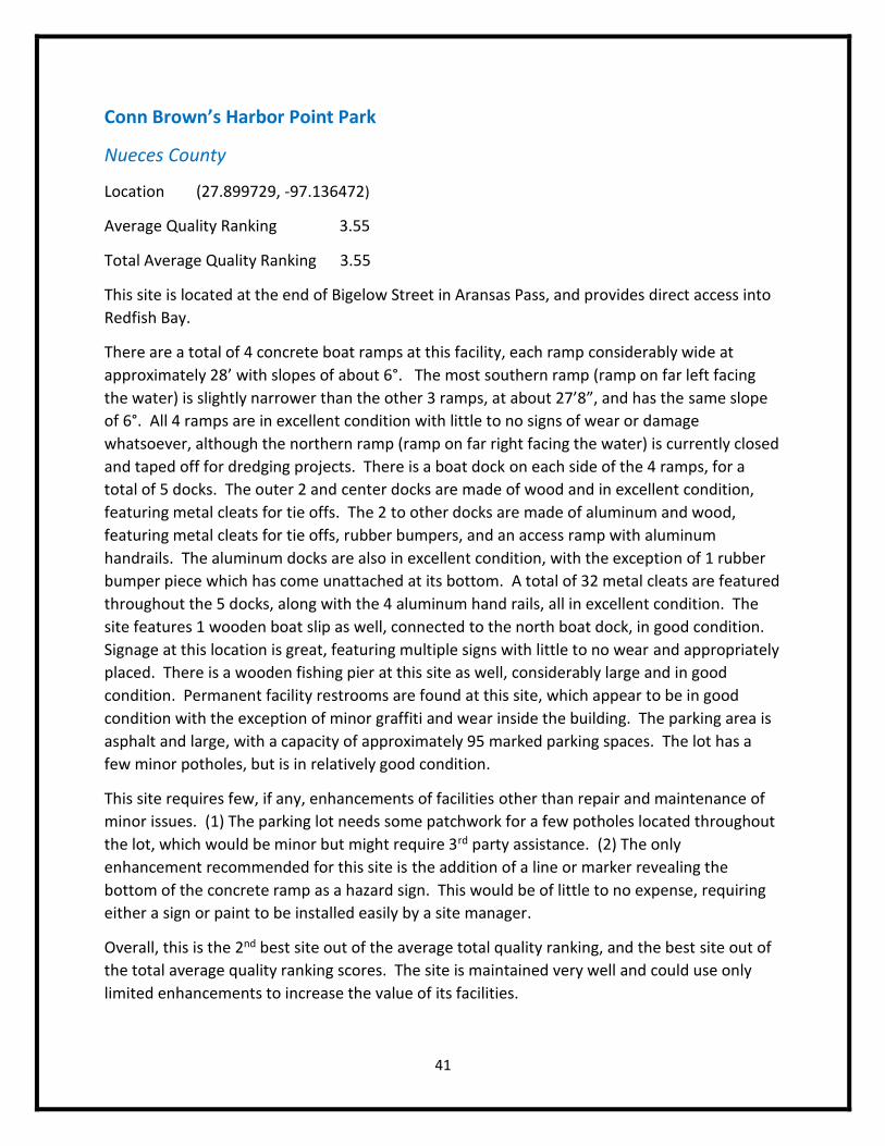
Conn Brown’s Harbor Point Park………………………………………………………………………………………………41
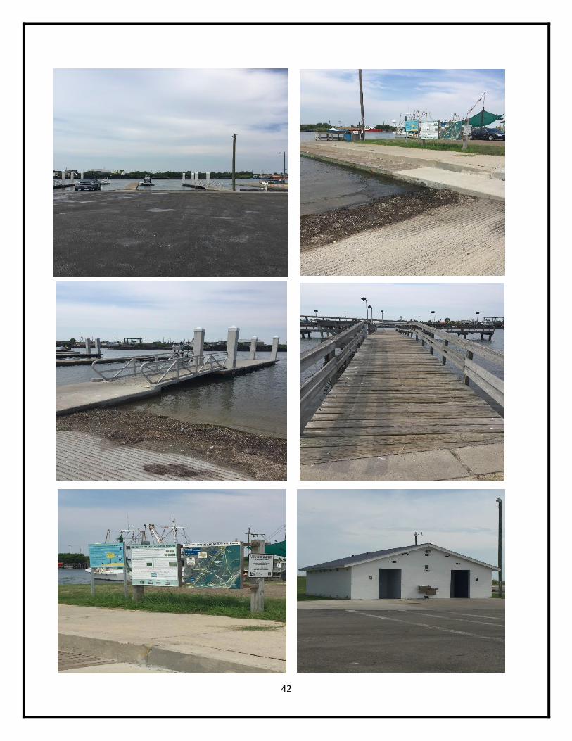
Coopers Alley L-Head……………………………………………………………………………………………………………….43
Marinaville……………………………………………………………………………………………………………………………….45
Dennis Dryer Municipal Harbor………………………………………………………………………………………….…….47
Fin & Feather Marina……………………………………………………………………………………………………………….49
Hazel Bazemore County Park……………………………………………………………………………………………………51
Labonte Park……………………………………………………………………………………………………………………………53
Packery Channel………………………………………………………………………………………………………………………55
Aransas River Boat Ramp…………………………………………………………………………………………………………57
2
Austwell Community Park………………………………………………………………………………………………………..59
Texas Parks & Wildlife Boat Ramp……………………………………………………………………………………………61
Cove Park…………………………………………………………………………………………………………………………………63
Ransom Park……………………………………………………………………………………………………………………………65
San Patricio County Navigation District #1……………………………………………………………………………….67
Analysis……………………………………………………………………………………………………………………………………69
Conclusion……………………………………………………………………………………………………………………………….70
Appendix I……………………………………………………………………………………………………………………………….71
Appendix II………………………………………………………………………………………………………………………………72
Appendix III……………………………………………………………………………………………………………………………..73
Appendix IV………………………………………….………………………………………………………………………………….74
Literature Cited………………………………………………………………………………………………………………………..75
3
Introduction
The Texas Coastal Bend has an extensive coastline along beaches, bays, and riparian systems in
5 separate counties: Aransas, Kleberg, Nueces, Refugio, and San Patricio. Together, these
counties account for a vast portion of the state’s coast, stretching hundreds of miles. Each of
the counties are dependent upon access to their waterways for tourism, emergency response,
and the general welfare of the community. This essential need for access to waterways has led
to the increased attention on public access throughout the coast.
As such, public access sites have increased over the past decade throughout the region,
creating more opportunities for the general public to engage in these activities (Texas General
Land Office). Public boat ramps, arguably the most essential public access site in the region
next to public beaches, are found throughout the Coastal Bend with great variability in size,
condition, and amenities provided. Incredibly, there is no known inventory and assessment of
the public ramps along this region. While some counties, such as Nueces and Aransas, have
conducted their own inventories of public access sites, assessments for these sites have yet to
occur. In order to provide the general public, site managers, and community planners with
knowledge of their facilities and general condition, this report will conduct a facility condition
assessment for all public boat ramps along the Coastal Bend. The assessment will involve not
only the boat ramp itself, but include other essential features located at public boat ramps that
add significant value through benefit of some sort.
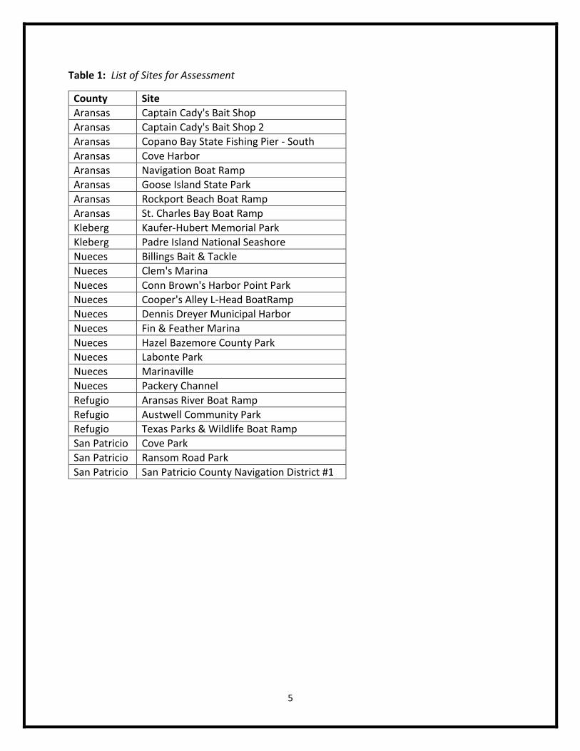
In total, there are 26 public boat ramps throughout the 5 Coastal Bend counties, geographically
identified on Appendix IV. A list of the sites is featured on Table 1. Each site will require
physical examination and assessment of all conditions, including composition, size, identified
hazards, and a quality ranking score. Quality ranking scores (1-4) were developed for this
project to rank the facilities based on a set of parameters. A list of the parameters used to
assess each feature’s quality is found on Table 2. The quality ranking score was used so that
further analysis of sites and features could be accomplished. Each site, county, and amenity
has an average quality ranking score, reflecting the average quality of identified features. The
average quality ranking score is only an assessment of the current features present, without
penalizing the score for absence of a feature (restroom, pier, etc.). A separate average was
used, called total average quality ranking, which supplemented zeros for sites without a given
feature. The features considered were: boat ramp, boat dock, pier, access road, access
ramp/stairwell, parking lot, hand rails, tie downs, boat slips, signage, and restrooms.
This report will not only assess each of these sites and features, but will also determine the best
and most practical enhancements for each given site. Enhancements will be chosen based on
priority of the feature, depending on expense, benefit, and risk. Each variable, expense, benefit
and risk, have several subsets used for consideration, further discussed in the next section. The
importance of these enhancements cannot be stressed enough, because failure to repair or
replace some of the features currently in poor condition could potentially lead to user

4
incidents, resulting in litigation against site managers and associated costs for any damage to
property or users themselves. Finally, this report will compare all sites assessed to determine
the best and worst sites, as well as comparative analysis between counties and features.
Methodology
Methods involved for this project include a series of steps, first to identify sites and parameters,
then collect the data, assess the data, create a working table for analysis, and finally develop
enhancement recommendations based on priority and condition.
Identify Sites & Define Parameters
o To identity all of the public boat ramps throughout each of the 5 counties, the
Texas General Land Office Application, found online at txcoasts.com#, was used.
This application was recently released and has current 2015 data for the entire
Texas coastline. The application allows a user to choose a given feature, like
boat ramps, and identify the location geographically. Therefore, the application
further provided during the data collection process, and was used to navigate to
rural areas with little to no other directional guidance. Below is a list of the 26
public boat ramps within the Coastal Bend region (Table 1), identified through
the txcoasts.com web application.
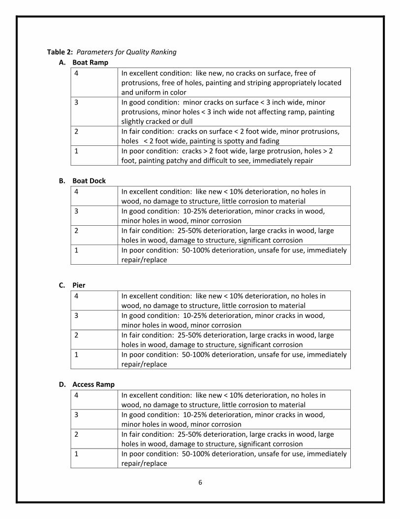
o Parameters for assessing each of the features at the sites was developed after
researching similar projects done for parks in the past. In general, the
parameters are set as follows: (1) Poor: Immediate need of repair/replacement;
(2) Fair: Major damage to feature but maintains essential function; (3) Good:
Minor damage and wear to feature, overall decent condition; (4) Excellent: Little
to no noticeable wear or damage of feature, almost new conditions. A detailed
set of parameters used when evaluating each feature is found below on Table 2.
5
Table 1: List of Sites for Assessment
County Site
Aransas Captain Cady's Bait Shop
Aransas Captain Cady's Bait Shop 2
Aransas Copano Bay State Fishing Pier - South
Aransas Cove Harbor
Aransas Navigation Boat Ramp
Aransas Goose Island State Park
Aransas Rockport Beach Boat Ramp
Aransas St. Charles Bay Boat Ramp
Kleberg Kaufer-Hubert Memorial Park
Kleberg Padre Island National Seashore
Nueces Billings Bait & Tackle
Nueces Clem's Marina
Nueces Conn Brown's Harbor Point Park
Nueces Cooper's Alley L-Head BoatRamp
Nueces Dennis Dreyer Municipal Harbor
Nueces Fin & Feather Marina
Nueces Hazel Bazemore County Park
Nueces Labonte Park
Nueces Marinaville
Nueces Packery Channel
Refugio Aransas River Boat Ramp
Refugio Austwell Community Park
Refugio Texas Parks & Wildlife Boat Ramp
San Patricio Cove Park
San Patricio Ransom Road Park
San Patricio San Patricio County Navigation District #1
6
Table 2: Parameters for Quality Ranking
A. Boat Ramp
4 In excellent condition: like new, no cracks on surface, free of protrusions, free of holes, painting and striping appropriately located and uniform in color
3 In good condition: minor cracks on surface < 3 inch wide, minor protrusions, minor holes < 3 inch wide not affecting ramp, painting slightly cracked or dull
2 In fair condition: cracks on surface < 2 foot wide, minor protrusions, holes < 2 foot wide, painting is spotty and fading
1 In poor condition: cracks > 2 foot wide, large protrusion, holes > 2 foot, painting patchy and difficult to see, immediately repair
B. Boat Dock
4 In excellent condition: like new < 10% deterioration, no holes in wood, no damage to structure, little corrosion to material
3 In good condition: 10-25% deterioration, minor cracks in wood, minor holes in wood, minor corrosion
2 In fair condition: 25-50% deterioration, large cracks in wood, large holes in wood, damage to structure, significant corrosion
1 In poor condition: 50-100% deterioration, unsafe for use, immediately repair/replace
C. Pier
4 In excellent condition: like new < 10% deterioration, no holes in wood, no damage to structure, little corrosion to material
3 In good condition: 10-25% deterioration, minor cracks in wood, minor holes in wood, minor corrosion
2 In fair condition: 25-50% deterioration, large cracks in wood, large holes in wood, damage to structure, significant corrosion
1 In poor condition: 50-100% deterioration, unsafe for use, immediately repair/replace
D. Access Ramp
4 In excellent condition: like new < 10% deterioration, no holes in wood, no damage to structure, little corrosion to material
3 In good condition: 10-25% deterioration, minor cracks in wood, minor holes in wood, minor corrosion
2 In fair condition: 25-50% deterioration, large cracks in wood, large holes in wood, damage to structure, significant corrosion
1 In poor condition: 50-100% deterioration, unsafe for use, immediately repair/replace
7
E. Hand Rails
4 In excellent condition: like new < 10% deterioration, no holes in wood, no damage to structure, little corrosion to material
3 In good condition: 10-25% deterioration, minor cracks in wood, minor holes in wood, minor corrosion
2 In fair condition: 25-50% deterioration, large cracks in wood, large holes in wood, damage to structure, significant corrosion
1 In poor condition: 50-100% deterioration, unsafe for use, immediately repair/replace
F. Tie Offs
4 In excellent condition: like new < 10% deterioration, no holes in wood, no damage to structure, little corrosion to material
3 In good condition: 10-25% deterioration, minor cracks in wood, minor holes in wood, minor corrosion
2 In fair condition: 25-50% deterioration, large cracks in wood, large holes in wood, damage to structure, significant corrosion
1 In poor condition: 50-100% deterioration, unsafe for use, immediately repair/replace
G. Boat Slips
4 In excellent condition: like new < 10% deterioration, no holes in wood, no damage to structure, little corrosion to material
3 In good condition: 10-25% deterioration, minor cracks in wood, minor holes in wood, minor corrosion
2 In fair condition: 25-50% deterioration, large cracks in wood, large holes in wood, damage to structure, significant corrosion
1 In poor condition: 50-100% deterioration, unsafe for use, immediately repair/replace
H. Signage
4 In excellent condition: like new, appropriate signs in place, no damage to signs, signage system in place
3 In good condition: few damaged signs (0-10%), multiple signage system
2 In fair condition: damaged signs (10-25%), multiple signage system, signs difficult to read
1 In poor condition: damaged signs < 25%, need replacing
8
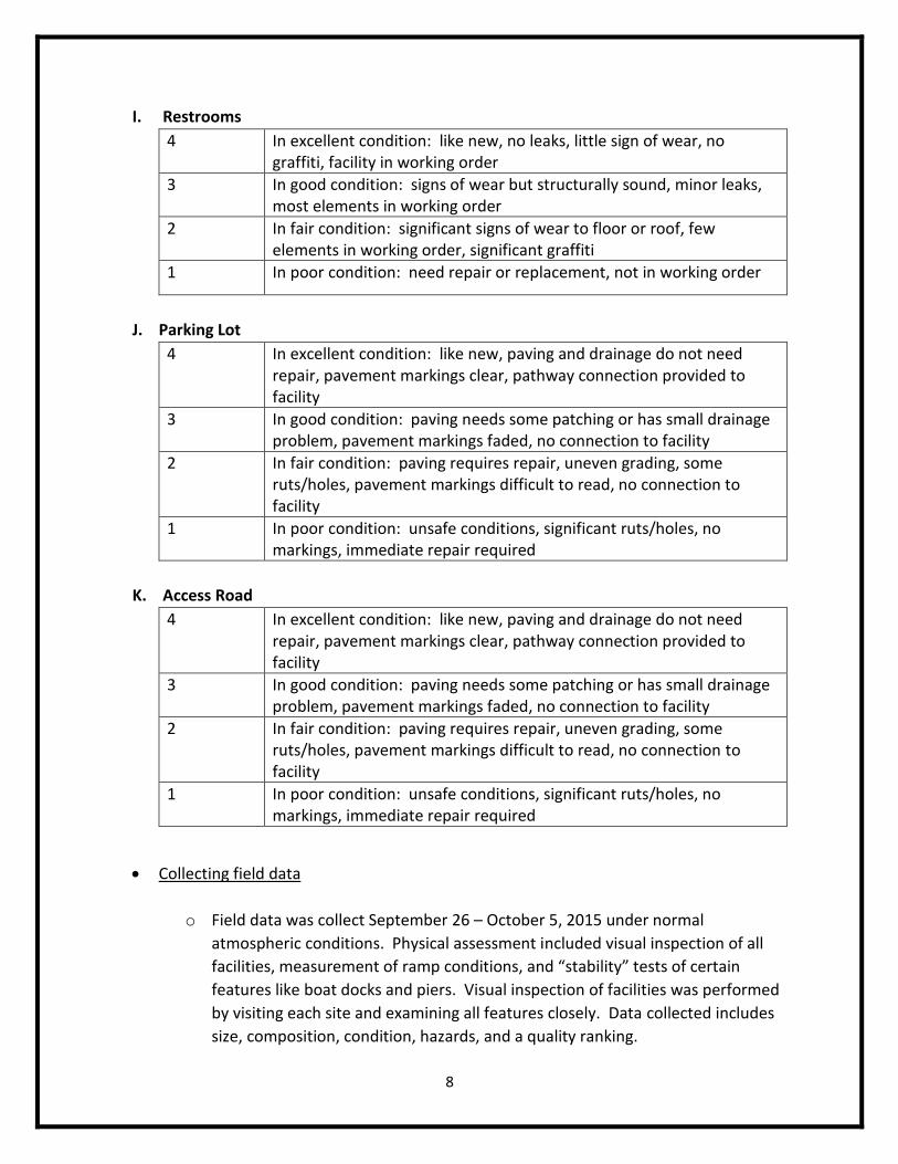
I. Restrooms
4 In excellent condition: like new, no leaks, little sign of wear, no graffiti, facility in working order
3 In good condition: signs of wear but structurally sound, minor leaks, most elements in working order
2 In fair condition: significant signs of wear to floor or roof, few elements in working order, significant graffiti
1 In poor condition: need repair or replacement, not in working order
J. Parking Lot
4 In excellent condition: like new, paving and drainage do not need repair, pavement markings clear, pathway connection provided to facility
3 In good condition: paving needs some patching or has small drainage problem, pavement markings faded, no connection to facility
2 In fair condition: paving requires repair, uneven grading, some ruts/holes, pavement markings difficult to read, no connection to facility
1 In poor condition: unsafe conditions, significant ruts/holes, no markings, immediate repair required
K. Access Road
4 In excellent condition: like new, paving and drainage do not need repair, pavement markings clear, pathway connection provided to facility
3 In good condition: paving needs some patching or has small drainage problem, pavement markings faded, no connection to facility
2 In fair condition: paving requires repair, uneven grading, some ruts/holes, pavement markings difficult to read, no connection to facility
1 In poor condition: unsafe conditions, significant ruts/holes, no markings, immediate repair required
Collecting field data
o Field data was collect September 26 – October 5, 2015 under normal
atmospheric conditions. Physical assessment included visual inspection of all
facilities, measurement of ramp conditions, and “stability” tests of certain
features like boat docks and piers. Visual inspection of facilities was performed
by visiting each site and examining all features closely. Data collected includes
size, composition, condition, hazards, and a quality ranking.
9
o Measurements were collected only for the actual boat ramps themselves. Data
was collected for the boat ramp width and slope, using a standard open reel
measuring tape and a magnetic angle reader. Units were recorded in the English
system using measurements of feet and inches for width, and measured in
degrees for slope.
o Stability tests were performed for most wooden structures (boat docks, piers,
access ramp/stairwells). These tests simply involved walking on the structure
and feeling for weaknesses in the wood, loose boards, or shifting of weight in the
structure.
Analyzing Quality Ranking
o Upon completion of field work, the data was then transferred to an Excel
spreadsheet for further analysis. The quality ranking data was extracted for each
site and feature, and congregated onto one spreadsheet containing only quality
ranking data. This data was then organized by county with overall county
averages for specific features.
o Average quality rankings were assessed for sites, features, and counties. The
average quality ranking was determined by averaging only the assessed quality
rankings for a given site or feature. For example, if a site had quality rankings of
3 for every feature except for restrooms, because restrooms were not located at
the site, then the average quality ranking would not consider restrooms into the
rank, resulting in an average of 3.
o A separate average was calculated, called total average quality ranking, which
accounts for missing features that are not located at a site. For instance,
consider the same example used on the previous paragraph where a site has a
quality ranking of 3 across the board, with the exception of restrooms because
they are simply not available at the location. The total average quality ranking
adds restrooms into the calculation, with a given value of 0, thus reducing the
quality ranking of the feature or site.
o Finally, an assessment of the percentage of sites with a given feature was
calculated per county and totaled with all counties. This information was used
to identify the frequency of features present at the most locations assessed.
Enhancement Prioritization
o Enhancements are prioritized according to the cost, benefits, and risk analyses
found on Tables 3-11. Recommendations for future enhancements.
(repair/replacement) are based off this list of priorities, so that one feature will
take precedence over the other in determining focus of enhancement.
10
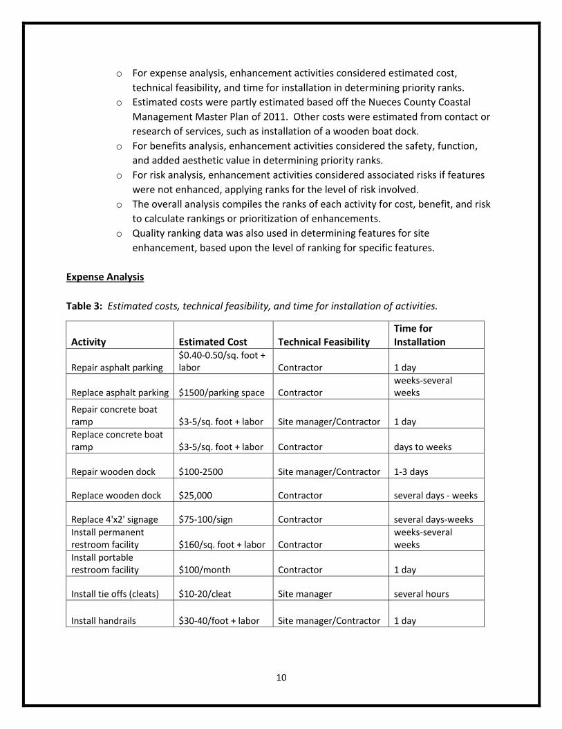
o For expense analysis, enhancement activities considered estimated cost,
technical feasibility, and time for installation in determining priority ranks.
o Estimated costs were partly estimated based off the Nueces County Coastal
Management Master Plan of 2011. Other costs were estimated from contact or
research of services, such as installation of a wooden boat dock.
o For benefits analysis, enhancement activities considered the safety, function,
and added aesthetic value in determining priority ranks.
o For risk analysis, enhancement activities considered associated risks if features
were not enhanced, applying ranks for the level of risk involved.
o The overall analysis compiles the ranks of each activity for cost, benefit, and risk
to calculate rankings or prioritization of enhancements.
o Quality ranking data was also used in determining features for site
enhancement, based upon the level of ranking for specific features.
Expense Analysis
Table 3: Estimated costs, technical feasibility, and time for installation of activities.
Activity Estimated Cost Technical Feasibility Time for Installation
Repair asphalt parking $0.40-0.50/sq. foot + labor Contractor 1 day
Replace asphalt parking $1500/parking space Contractor weeks-several weeks
Repair concrete boat ramp $3-5/sq. foot + labor Site manager/Contractor 1 day
Replace concrete boat ramp $3-5/sq. foot + labor Contractor days to weeks
Repair wooden dock $100-2500 Site manager/Contractor 1-3 days
Replace wooden dock $25,000 Contractor several days - weeks
Replace 4'x2' signage $75-100/sign Contractor several days-weeks
Install permanent restroom facility $160/sq. foot + labor Contractor
weeks-several weeks
Install portable restroom facility $100/month Contractor 1 day
Install tie offs (cleats) $10-20/cleat Site manager several hours
Install handrails $30-40/foot + labor Site manager/Contractor 1 day
11
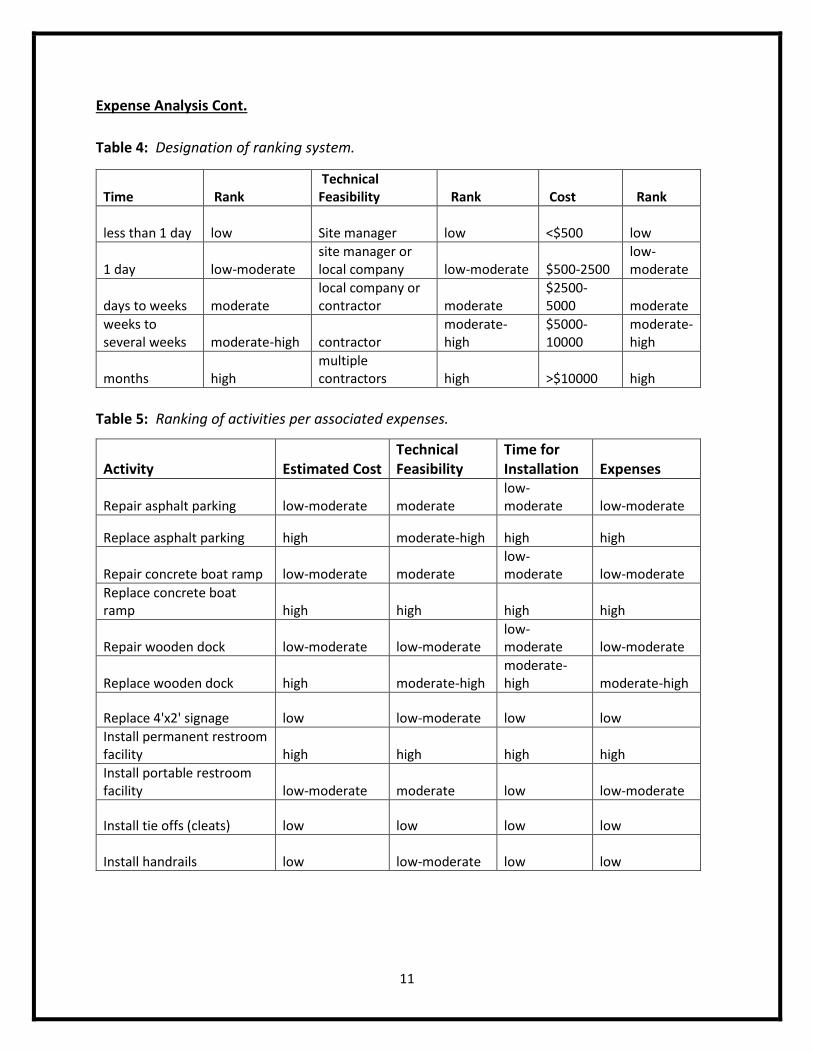
Expense Analysis Cont.
Table 4: Designation of ranking system.
Table 5: Ranking of activities per associated expenses.
Time Rank Technical Feasibility Rank Cost Rank
less than 1 day low Site manager low <$500 low
1 day low-moderate site manager or local company low-moderate $500-2500
low-moderate
days to weeks moderate local company or contractor moderate
$2500-5000 moderate
weeks to several weeks moderate-high contractor
moderate-high
$5000-10000
moderate-high
months high multiple contractors high >$10000 high
Activity Estimated Cost Technical Feasibility
Time for Installation Expenses
Repair asphalt parking low-moderate moderate low-moderate low-moderate
Replace asphalt parking high moderate-high high high
Repair concrete boat ramp low-moderate moderate low-moderate low-moderate
Replace concrete boat ramp high high high high
Repair wooden dock low-moderate low-moderate low-moderate low-moderate
Replace wooden dock high moderate-high moderate-high moderate-high
Replace 4'x2' signage low low-moderate low low
Install permanent restroom facility high high high high
Install portable restroom facility low-moderate moderate low low-moderate
Install tie offs (cleats) low low low low
Install handrails low low-moderate low low
12
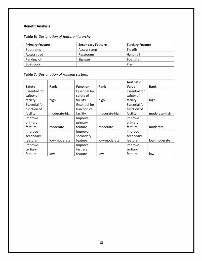
Benefit Analysis
Table 6: Designation of feature hierarchy.
Primary Feature Secondary Feature Tertiary Feature
Boat ramp Access ramp Tie offs
Access road Restrooms Hand rail
Parking lot Signage Boat slip
Boat dock Pier
Table 7: Designation of ranking system.
Safety Rank Function Rank Aesthetic Value Rank
Essential for safety of facility high
Essential for safety of facility high
Essential for safety of facility high
Essential for function of facility moderate-high
Essential for function of facility moderate-high
Essential for function of facility moderate-high
Improve primary feature moderate
Improve primary feature moderate
Improve primary feature moderate
Improve secondary feature low-moderate
Improve secondary feature low-moderate
Improve secondary feature low-moderate
Improve tertiary feature low
Improve tertiary feature low
Improve tertiary feature low
13
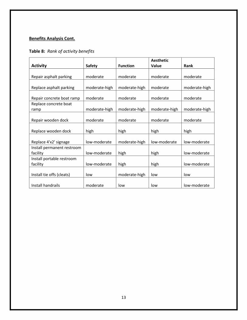
Benefits Analysis Cont.
Table 8: Rank of activity benefits
Activity Safety Function Aesthetic Value Rank
Repair asphalt parking moderate moderate moderate moderate
Replace asphalt parking moderate-high moderate-high moderate moderate-high
Repair concrete boat ramp moderate moderate moderate moderate
Replace concrete boat ramp moderate-high moderate-high moderate-high moderate-high
Repair wooden dock moderate moderate moderate moderate
Replace wooden dock high high high high
Replace 4'x2' signage low-moderate moderate-high low-moderate low-moderate
Install permanent restroom facility low-moderate high high low-moderate
Install portable restroom facility low-moderate high high low-moderate
Install tie offs (cleats) low moderate-high low low
Install handrails moderate low low low-moderate
14
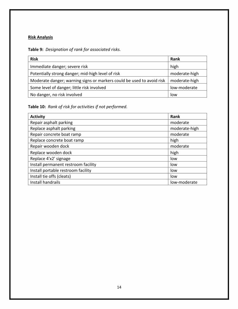
Risk Analysis
Table 9: Designation of rank for associated risks.
Risk Rank
Immediate danger; severe risk high
Potentially strong danger; mid-high level of risk moderate-high
Moderate danger; warning signs or markers could be used to avoid risk moderate-high
Some level of danger; little risk involved low-moderate
No danger, no risk involved low
Table 10: Rank of risk for activities if not performed.
Activity Rank
Repair asphalt parking moderate
Replace asphalt parking moderate-high
Repair concrete boat ramp moderate
Replace concrete boat ramp high
Repair wooden dock moderate
Replace wooden dock high
Replace 4'x2' signage low
Install permanent restroom facility low
Install portable restroom facility low
Install tie offs (cleats) low
Install handrails low-moderate

15
Overall Analysis
Table 11: Rank of activities based on cost, benefit, and risk analyses.
Activity Cost Benefit Risk Overall
Repair asphalt parking low-moderate moderate moderate moderate
Replace asphalt parking high moderate-high moderate-high moderate-high
Repair concrete boat ramp low-moderate moderate moderate moderate
Replace concrete boat ramp high moderate-high high high
Repair wooden dock low-moderate moderate moderate moderate
Replace wooden dock moderate-high high high high
Replace 4'x2' signage low low-moderate low low
Install permanent restroom facility high low-moderate low moderate
Install portable restroom facility low-moderate low-moderate low low-moderate
Install tie offs (cleats) low low low low
Install handrails low low-moderate low-moderate low-moderate
Prioritization of Features for Enhancement
1) Boat Ramp
2) Access Road
3) Parking Lot
4) Boat Dock
5) Access Ramp
6) Restrooms
7) Hand Rails
8) Signage
9) Tie Offs
10) Pier
11) Boat Slips

16
Assessment of Facilities

17
Captain Cady’s Bait Shop
Aransas County
Location (27.913178, -97.133030)
Average Quality Ranking 2.00
Total Average Quality Ranking 0.91
Captain Cady’s Bait Shop is a privately owned bait shop adjacent to a public boat ramp. The
boat ramp is referred to as Captain Cady’s Bait Shop due to its proximity and lack of predefined
name. This boat ramp offers access to Red Fish Bay through the Conn Brown Harbor, and is
regularly used year round.
The site features 2 adjacent boat ramps, separated by a wide wooden boat dock. The ramps
themselves are in poor condition, made up of a patchwork of asphalt, concrete, and sand. The
approximate width of the ramps are 19’ and 17’, both having slopes of 6°. Hazards from the
ramp include large potholes, submerged concrete rubble, a large wooden board in obstruction
of the ramp, and submerged wooden posts. The wooden boat dock is very wide and in fair
condition, missing a large piece from one of the mid-section boards needing immediate repair.
The wood appears to be old and worn, but overall functions properly and is very stable. Repairs
to the dock are minor and would take little time. The parking lot and access ramp are also in
fair condition. The parking lot is composed of sand/gravel mix, featuring approximately 4
spaces. The “access ramp” is a diagonal extension of the boat dock, which could use minor
enhancements to allow better ease of access.
Initial enhancements for this site include (1) repairing the damaged boat ramp and removing all
associated hazards from the immediate area. Expenses for repairing the damaged boat ramp
along with removing hazards are low-moderate, with a total cost of less than $2500. (2) The
parking lot needs to be levelled along with clear markings for designated areas. With minimal
spaces considered, this project would not be costly and could add great value to the site. (3)
The dock could be repaired easily with replacement of one board at little cost. (4) The access
ramp could use a small gravel path between the dock and parking area due to the surrounding
wet sand. Laying gravel in this area would require minimal costs. (5) Finally, the site needs to
add signage, as there is none present on or around the location. To fully equip this site with
proper signage, an estimated $500 is needed.
Overall, this site has the 2nd lowest average quality ranking and the 2nd lowest total average
quality ranking out of all 26 sites. The ramp itself has several hazards and issues needing
immediate repair. Other features such as parking, access ramp, boat dock, and signage could
be enhanced at minimal costs and provide extended value to this site.

18
19
Captain Cady’s Bait Shop 2
Aransas County
Location (27.989755, -97.079026)
Average Quality Ranking 3.11
Total Average Quality Ranking 2.55
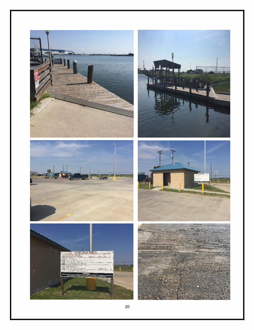
Captain Cady’s Bait Shop 2 is another privately owned bait shop adjacent to a public boat ramp,
hence the name of the site. The boat ramp allows access to Aransas Bay through Cove Harbor
and appears to be a relatively new site.
There is a single concrete boat ramp at this site, approximately 23’ wide with a slope of 8°. The
ramp has a few minor cracks but no significant damage to any area. The site has 2 wooden
boat docks on either side of the ramp, each in good condition with minor damage and wear.
The east dock has an extended pier with a fish cleaning station in good condition, while the
west dock features wooden hand rails with no significant damage or wear. Signage at this site
is fair and could use improvements. Several of the signs are worn to the point they are illegible
and need replacement. The site has permanent restroom facilities which are in good condition,
although there was graffiti on both mirrors in the men’s facilities.
The site is in overall great condition, and could use only a few minor enhancements. (1)
Signage needs to be updated and improved upon. One or 2 signs need replacement while the
other signs simply need to be cleaned or repainted. Associated costs for signage improvements
are low, estimated to be less than $500. (2) Metal or wooden tie offs would be a beneficiary
feature to have at this site, and could easily be installed for minimal costs of roughly $200.
Along with tie offs, adding rubber bumpers to the dock itself would be a great option, which
would require little expense and man power. (3) While the parking lot was given an excellent
rating for its quality ranking, some of the lines are faded and could use a fresh coat of paint.
This would again, be at minimal cost to site managers and enhance aesthetic value of the
facility.
Overall, this site is ranked 9th for average quality ranking and 8th for total average quality
ranking. Most of the features are in good condition and could use minor repair at minimal
costs. One other consideration for this site would be to add a line or buoy representing the
bottom of the concrete boat ramp. One site out of all 26 sites assessed during this project had
this feature, and added superb value to the site.
20
21
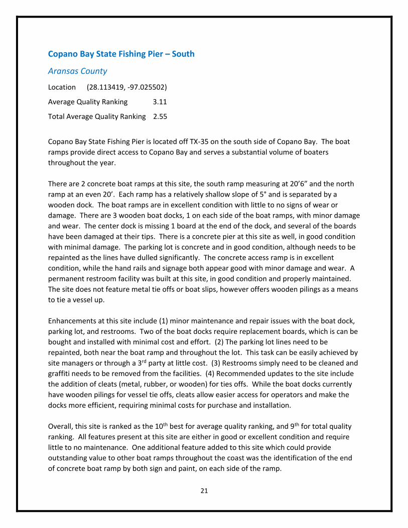
Copano Bay State Fishing Pier – South
Aransas County
Location (28.113419, -97.025502)
Average Quality Ranking 3.11
Total Average Quality Ranking 2.55
Copano Bay State Fishing Pier is located off TX-35 on the south side of Copano Bay. The boat
ramps provide direct access to Copano Bay and serves a substantial volume of boaters
throughout the year.
There are 2 concrete boat ramps at this site, the south ramp measuring at 20’6” and the north
ramp at an even 20’. Each ramp has a relatively shallow slope of 5° and is separated by a
wooden dock. The boat ramps are in excellent condition with little to no signs of wear or
damage. There are 3 wooden boat docks, 1 on each side of the boat ramps, with minor damage
and wear. The center dock is missing 1 board at the end of the dock, and several of the boards
have been damaged at their tips. There is a concrete pier at this site as well, in good condition
with minimal damage. The parking lot is concrete and in good condition, although needs to be
repainted as the lines have dulled significantly. The concrete access ramp is in excellent
condition, while the hand rails and signage both appear good with minor damage and wear. A
permanent restroom facility was built at this site, in good condition and properly maintained.
The site does not feature metal tie offs or boat slips, however offers wooden pilings as a means
to tie a vessel up.
Enhancements at this site include (1) minor maintenance and repair issues with the boat dock,
parking lot, and restrooms. Two of the boat docks require replacement boards, which is can be
bought and installed with minimal cost and effort. (2) The parking lot lines need to be
repainted, both near the boat ramp and throughout the lot. This task can be easily achieved by
site managers or through a 3rd party at little cost. (3) Restrooms simply need to be cleaned and
graffiti needs to be removed from the facilities. (4) Recommended updates to the site include
the addition of cleats (metal, rubber, or wooden) for ties offs. While the boat docks currently
have wooden pilings for vessel tie offs, cleats allow easier access for operators and make the
docks more efficient, requiring minimal costs for purchase and installation.
Overall, this site is ranked as the 10th best for average quality ranking, and 9th for total quality
ranking. All features present at this site are either in good or excellent condition and require
little to no maintenance. One additional feature added to this site which could provide
outstanding value to other boat ramps throughout the coast was the identification of the end
of concrete boat ramp by both sign and paint, on each side of the ramp.
22
23
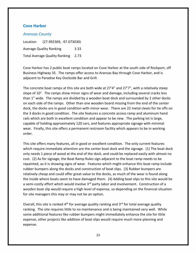
Cove Harbor
Aransas County
Location (27.992369, -97.073030)
Average Quality Ranking 3.33
Total Average Quality Ranking 2.73
Cove Harbor has 2 public boat ramps located on Cove Harbor at the south side of Rockport, off
Business Highway 35. The ramps offer access to Aransas Bay through Cove Harbor, and is
adjacent to Paradise Key Dockside Bar and Grill.
The concrete boat ramps at this site are both wide at 27’4” and 27’7”, with a relatively steep
slope of 10°. The ramps show minor signs of wear and damage, including several cracks less
than 1” wide. The ramps are divided by a wooden boat dock and surrounded by 2 other docks
on each side of the ramps. Other than one wooden board missing from the end of the center
dock, the docks are in good condition with minor wear. There are 22 metal cleats for tie offs on
the 3 docks in good condition. The site features a concrete access ramp and aluminum hand
rails which are both in excellent condition and appear to be new. The parking lot is large,
capable of holding approximately 120 cars, and features appropriate signage with minimal
wear. Finally, this site offers a permanent restroom facility which appears to be in working
order.
This site offers many features, all in good or excellent condition. The only current features
which require immediate attention are the center boat dock and the signage. (1) The boat dock
only needs 1 piece of wood at the end of the dock, and could be replaced easily with almost no
cost. (2) As for signage, the Boat Ramp Rules sign adjacent to the boat ramp needs to be
repainted, as it is showing signs of wear. Features which might enhance this boat ramp include
rubber bumpers along the docks and construction of boat slips. (3) Rubber bumpers are
relatively cheap and could offer great value to the docks, as much of the wear is found along
the inside where boats seem to have damaged them. (4) Adding boat slips to this site would be
a semi-costly effort which would involve 3rd party labor and involvement. Construction of a
wooden boat slip would require a high level of expense, so depending on the financial situation
for site managers this may or may not be an option.
Overall, this site is ranked 4th for average quality ranking and 3rd for total average quality
ranking. The site requires little to no maintenance and is being maintained very well. While
some additional features like rubber bumpers might immediately enhance the site for little
expense, other projects like addition of boat slips would require much more planning and
expense.
24
25
Navigation Boat Ramp
Aransas County
Location (28.060260, -97.033520)
Average Quality Ranking 2.86
Total Average Quality Ranking 1.82
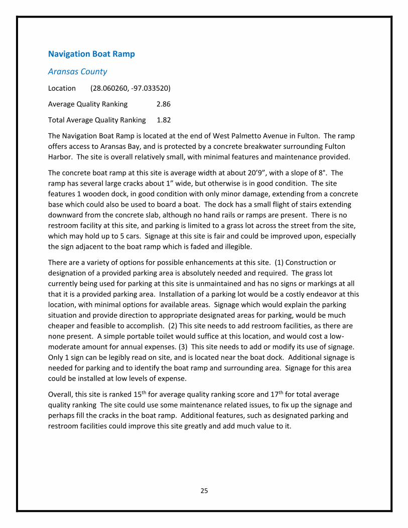
The Navigation Boat Ramp is located at the end of West Palmetto Avenue in Fulton. The ramp
offers access to Aransas Bay, and is protected by a concrete breakwater surrounding Fulton
Harbor. The site is overall relatively small, with minimal features and maintenance provided.
The concrete boat ramp at this site is average width at about 20’9”, with a slope of 8°. The
ramp has several large cracks about 1” wide, but otherwise is in good condition. The site
features 1 wooden dock, in good condition with only minor damage, extending from a concrete
base which could also be used to board a boat. The dock has a small flight of stairs extending
downward from the concrete slab, although no hand rails or ramps are present. There is no
restroom facility at this site, and parking is limited to a grass lot across the street from the site,
which may hold up to 5 cars. Signage at this site is fair and could be improved upon, especially
the sign adjacent to the boat ramp which is faded and illegible.
There are a variety of options for possible enhancements at this site. (1) Construction or
designation of a provided parking area is absolutely needed and required. The grass lot
currently being used for parking at this site is unmaintained and has no signs or markings at all
that it is a provided parking area. Installation of a parking lot would be a costly endeavor at this
location, with minimal options for available areas. Signage which would explain the parking
situation and provide direction to appropriate designated areas for parking, would be much
cheaper and feasible to accomplish. (2) This site needs to add restroom facilities, as there are
none present. A simple portable toilet would suffice at this location, and would cost a low-
moderate amount for annual expenses. (3) This site needs to add or modify its use of signage.
Only 1 sign can be legibly read on site, and is located near the boat dock. Additional signage is
needed for parking and to identify the boat ramp and surrounding area. Signage for this area
could be installed at low levels of expense.
Overall, this site is ranked 15th for average quality ranking score and 17th for total average
quality ranking The site could use some maintenance related issues, to fix up the signage and
perhaps fill the cracks in the boat ramp. Additional features, such as designated parking and
restroom facilities could improve this site greatly and add much value to it.
26
27
Goose Island State Park
Aransas County
Location (28.128569, -96.985629)
Average Quality Ranking 3.00
Total Average Quality Ranking 1.64
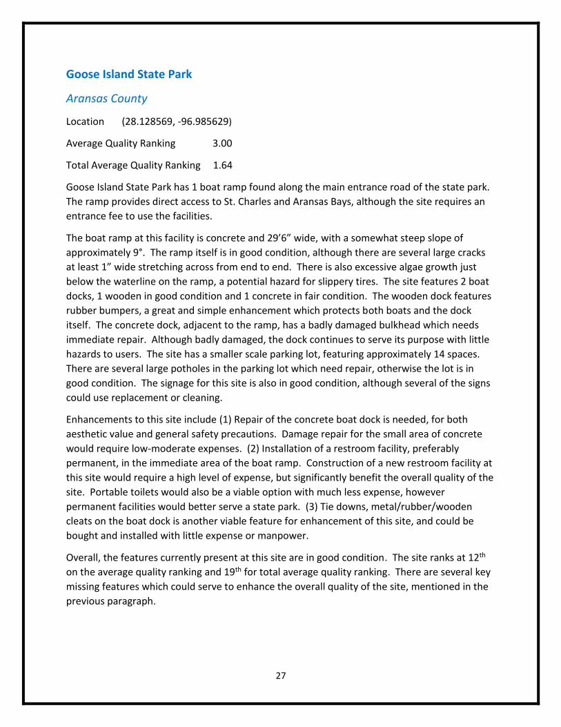
Goose Island State Park has 1 boat ramp found along the main entrance road of the state park.
The ramp provides direct access to St. Charles and Aransas Bays, although the site requires an
entrance fee to use the facilities.
The boat ramp at this facility is concrete and 29’6” wide, with a somewhat steep slope of
approximately 9°. The ramp itself is in good condition, although there are several large cracks
at least 1” wide stretching across from end to end. There is also excessive algae growth just
below the waterline on the ramp, a potential hazard for slippery tires. The site features 2 boat
docks, 1 wooden in good condition and 1 concrete in fair condition. The wooden dock features
rubber bumpers, a great and simple enhancement which protects both boats and the dock
itself. The concrete dock, adjacent to the ramp, has a badly damaged bulkhead which needs
immediate repair. Although badly damaged, the dock continues to serve its purpose with little
hazards to users. The site has a smaller scale parking lot, featuring approximately 14 spaces.
There are several large potholes in the parking lot which need repair, otherwise the lot is in
good condition. The signage for this site is also in good condition, although several of the signs
could use replacement or cleaning.
Enhancements to this site include (1) Repair of the concrete boat dock is needed, for both
aesthetic value and general safety precautions. Damage repair for the small area of concrete
would require low-moderate expenses. (2) Installation of a restroom facility, preferably
permanent, in the immediate area of the boat ramp. Construction of a new restroom facility at
this site would require a high level of expense, but significantly benefit the overall quality of the
site. Portable toilets would also be a viable option with much less expense, however
permanent facilities would better serve a state park. (3) Tie downs, metal/rubber/wooden
cleats on the boat dock is another viable feature for enhancement of this site, and could be
bought and installed with little expense or manpower.
Overall, the features currently present at this site are in good condition. The site ranks at 12th
on the average quality ranking and 19th for total average quality ranking. There are several key
missing features which could serve to enhance the overall quality of the site, mentioned in the
previous paragraph.
28
29
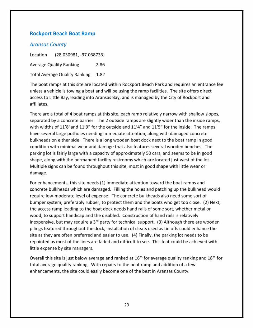
Rockport Beach Boat Ramp
Aransas County
Location (28.030981, -97.038733)
Average Quality Ranking 2.86
Total Average Quality Ranking 1.82
The boat ramps at this site are located within Rockport Beach Park and requires an entrance fee
unless a vehicle is towing a boat and will be using the ramp facilities. The site offers direct
access to Little Bay, leading into Aransas Bay, and is managed by the City of Rockport and
affiliates.
There are a total of 4 boat ramps at this site, each ramp relatively narrow with shallow slopes,
separated by a concrete barrier. The 2 outside ramps are slightly wider than the inside ramps,
with widths of 11’8”and 11’9” for the outside and 11’4” and 11’5” for the inside. The ramps
have several large potholes needing immediate attention, along with damaged concrete
bulkheads on either side. There is a long wooden boat dock next to the boat ramp in good
condition with minimal wear and damage that also features several wooden benches. The
parking lot is fairly large with a capacity of approximately 50 cars, and seems to be in good
shape, along with the permanent facility restrooms which are located just west of the lot.
Multiple signs can be found throughout this site, most in good shape with little wear or
damage.
For enhancements, this site needs (1) immediate attention toward the boat ramps and
concrete bulkheads which are damaged. Filling the holes and patching up the bulkhead would
require low-moderate level of expense. The concrete bulkheads also need some sort of
bumper system, preferably rubber, to protect them and the boats who get too close. (2) Next,
the access ramp leading to the boat dock needs hand rails of some sort, whether metal or
wood, to support handicap and the disabled. Construction of hand rails is relatively
inexpensive, but may require a 3rd party for technical support. (3) Although there are wooden
pilings featured throughout the dock, installation of cleats used as tie offs could enhance the
site as they are often preferred and easier to use. (4) Finally, the parking lot needs to be
repainted as most of the lines are faded and difficult to see. This feat could be achieved with
little expense by site managers.
Overall this site is just below average and ranked at 16th for average quality ranking and 18th for
total average quality ranking. With repairs to the boat ramp and addition of a few
enhancements, the site could easily become one of the best in Aransas County.
30
31
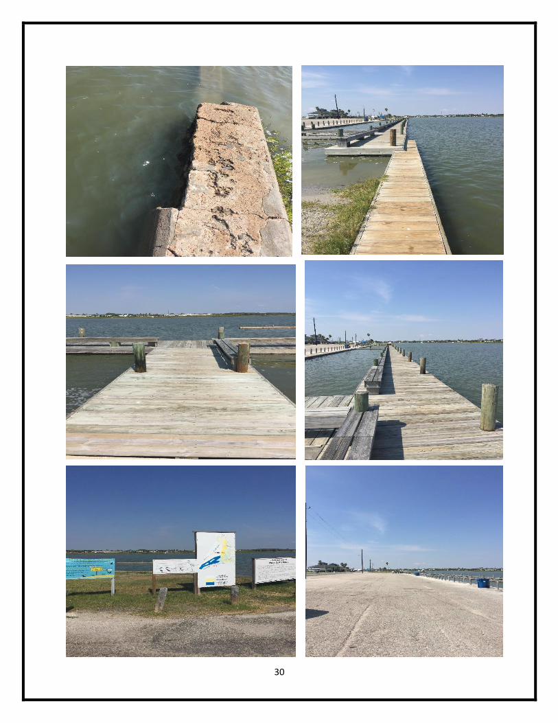
St. Charles Bay Boat Ramp
Aransas County
Location (28.142046, -96.976335)
Average Quality Ranking 3.33
Total Average Quality Ranking 2.73
St. Charles Bay boat ramp is located in Lamar, TX near the Lamar Beach Street/4th Street
intersection. The ramp provides access to the south side of St. Charles Bay, near the opening to
Aransas Bay.
There is 1 concrete boat ramp at this site which is considerably wide at 28’10”, with a slope of
9°. The ramp is in good condition with only a few minor cracks to the concrete and minor
damage to a wooden bumper along the bulkhead. There is also large buildup of algae below
the waterline which could be considered a hazard. The site features 1 wooden boat dock and 1
concrete dock. The concrete dock features rubber bumpers and is in good condition, while the
wooden dock looks to have had recent repairs and is in excellent condition. The wooden dock
has a total of 12 cleats, 9 wooden and 3 metal which are all in good condition. There are
wooden steps leading the wooden boat dock which serve as the access ramp and provide
wooden and aluminum hand rails for ease of access. Also, there are 2 boat slips featured at this
site with rubber tires lining the inside, acting as bumpers against the boat dock. The boat slips
are in excellent condition and look to have been recently repaired with the rest of the boat
dock.
This site features 9 out of the 11 features which were inventoried during data collection, and
has one of the highest total average quality ranking scores. Improvements to current
conditions of this site include (1) repairing the bulkhead adjacent to the boat ramp, which
would be inexpensive and not require a great deal of labor. (2) The algae needs removal from
the ramp as well, allowing better grip and friction for boaters as they pull out of the ramp. (3)
There are also several potholes along the parking lot which need repair, easily fixed at minimal
costs. Enhancements for this site include (4) addition of a restroom facility, preferably
permanent, although a portable toilet would serve just as well and require less expense. (5)
The site could also use a proper access ramp that extends down to the wooden boat dock,
despite the quality of the hand rails and access stairs currently featured. (6) Finally, the site
could use more signage, as there is presently 1 sign which is in great condition but extremely
small.
Overall, this site is ranked 5th for average quality ranking and 8th for total average quality
ranking. Other than a few minor repairs, the site looks to be in great condition overall.
Addition of a restroom facility would greatly enhance this site and add more convenience for
users.
32
33
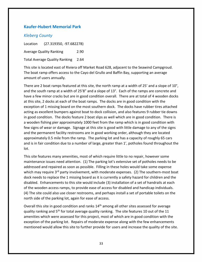
Kaufer-Hubert Memorial Park
Kleberg County
Location (27.319350, -97.682278)
Average Quality Ranking 2.90
Total Average Quality Ranking 2.64
This site is located east of Riviera off Market Road 628, adjacent to the Seawind Campgroud.
The boat ramp offers access to the Cayo del Grullo and Baffin Bay, supporting an average
amount of users annually.
There are 2 boat ramps featured at this site, the north ramp at a width of 25’ and a slope of 10°,
and the south ramp at a width of 25’8” and a slope of 13°. Each of the ramps are concrete and
have a few minor cracks but are in good condition overall. There are at total of 4 wooden docks
at this site, 2 docks at each of the boat ramps. The docks are in good condition with the
exception of 1 missing board on the most southern dock. The docks have rubber tires attached
acting as excellent bumpers against boat to dock collision, and also features 9 rubber tie downs
in good condition. The docks feature 2 boat slips as well which are in good condition. There is
a wooden fishing pier approximately 1000 feet from the ramp which is in good condition with
few signs of wear or damage. Signage at this site is good with little damage to any of the signs
and the permanent facility restrooms are in good working order, although they are located
approximately 0.5 mile from the ramp. The parking lot and has a capacity of roughly 65 cars
and is in fair condition due to a number of large, greater than 1’, potholes found throughout the
lot.
This site features many amenities, most of which require little to no repair, however some
maintenance issues need attention. (1) The parking lot’s extensive set of potholes needs to be
addressed and repaired as soon as possible. Filling in these holes would take some expense
which may require 3rd party involvement, with moderate expenses. (2) The southern-most boat
dock needs to replace the 1 missing board as it is currently a safety hazard for children and the
disabled. Enhancements to this site would include (3) installation of a set of handrails at each
of the wooden access ramps, to provide ease of access for disabled and handicap individuals.
(4) The site could also use closer restrooms, and perhaps install a set of portable toilets on the
north side of the parking lot, again for ease of access.
Overall this site in good condition and ranks 14th among all other sites assessed for average
quality ranking and 5th for total average quality ranking. The site features 10 out of the 11
amenities which were assessed for this project, most of which are in good condition with the
exception of the parking lot. Repairs of moderate expense along with the few enhancements
mentioned would allow this site to further provide for users and increase the quality of the site.
34
35
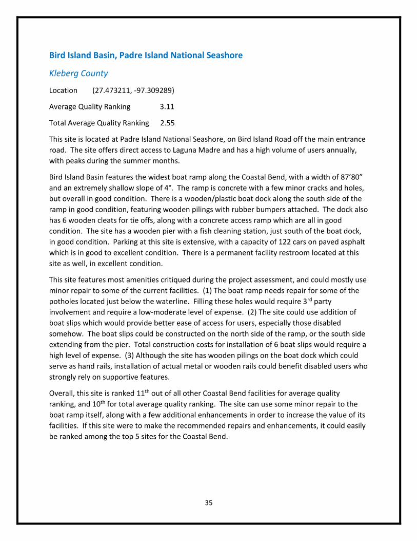
Bird Island Basin, Padre Island National Seashore
Kleberg County
Location (27.473211, -97.309289)
Average Quality Ranking 3.11
Total Average Quality Ranking 2.55
This site is located at Padre Island National Seashore, on Bird Island Road off the main entrance
road. The site offers direct access to Laguna Madre and has a high volume of users annually,
with peaks during the summer months.
Bird Island Basin features the widest boat ramp along the Coastal Bend, with a width of 87’80”
and an extremely shallow slope of 4°. The ramp is concrete with a few minor cracks and holes,
but overall in good condition. There is a wooden/plastic boat dock along the south side of the
ramp in good condition, featuring wooden pilings with rubber bumpers attached. The dock also
has 6 wooden cleats for tie offs, along with a concrete access ramp which are all in good
condition. The site has a wooden pier with a fish cleaning station, just south of the boat dock,
in good condition. Parking at this site is extensive, with a capacity of 122 cars on paved asphalt
which is in good to excellent condition. There is a permanent facility restroom located at this
site as well, in excellent condition.
This site features most amenities critiqued during the project assessment, and could mostly use
minor repair to some of the current facilities. (1) The boat ramp needs repair for some of the
potholes located just below the waterline. Filling these holes would require 3rd party
involvement and require a low-moderate level of expense. (2) The site could use addition of
boat slips which would provide better ease of access for users, especially those disabled
somehow. The boat slips could be constructed on the north side of the ramp, or the south side
extending from the pier. Total construction costs for installation of 6 boat slips would require a
high level of expense. (3) Although the site has wooden pilings on the boat dock which could
serve as hand rails, installation of actual metal or wooden rails could benefit disabled users who
strongly rely on supportive features.
Overall, this site is ranked 11th out of all other Coastal Bend facilities for average quality
ranking, and 10th for total average quality ranking. The site can use some minor repair to the
boat ramp itself, along with a few additional enhancements in order to increase the value of its
facilities. If this site were to make the recommended repairs and enhancements, it could easily
be ranked among the top 5 sites for the Coastal Bend.
36
37
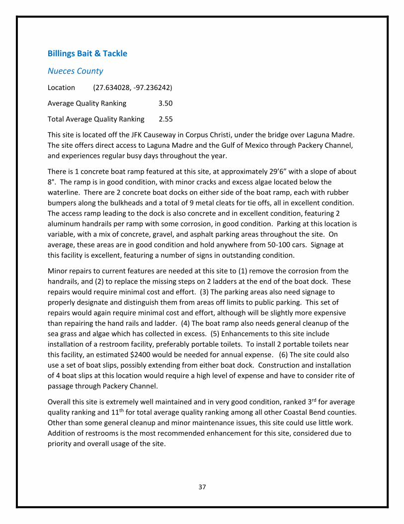
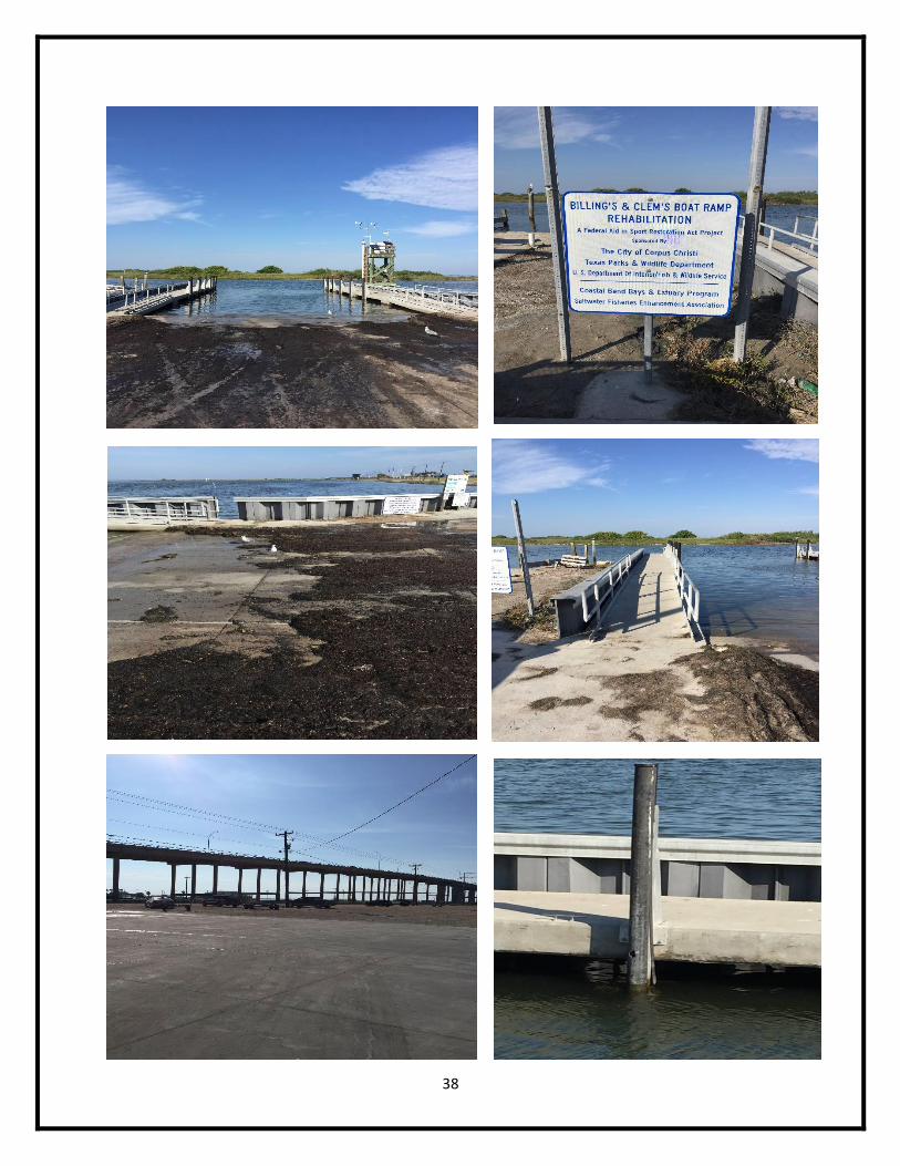
Billings Bait & Tackle
Nueces County
Location (27.634028, -97.236242)
Average Quality Ranking 3.50
Total Average Quality Ranking 2.55
This site is located off the JFK Causeway in Corpus Christi, under the bridge over Laguna Madre.
The site offers direct access to Laguna Madre and the Gulf of Mexico through Packery Channel,
and experiences regular busy days throughout the year.
There is 1 concrete boat ramp featured at this site, at approximately 29’6” with a slope of about
8°. The ramp is in good condition, with minor cracks and excess algae located below the
waterline. There are 2 concrete boat docks on either side of the boat ramp, each with rubber
bumpers along the bulkheads and a total of 9 metal cleats for tie offs, all in excellent condition.
The access ramp leading to the dock is also concrete and in excellent condition, featuring 2
aluminum handrails per ramp with some corrosion, in good condition. Parking at this location is
variable, with a mix of concrete, gravel, and asphalt parking areas throughout the site. On
average, these areas are in good condition and hold anywhere from 50-100 cars. Signage at
this facility is excellent, featuring a number of signs in outstanding condition.
Minor repairs to current features are needed at this site to (1) remove the corrosion from the
handrails, and (2) to replace the missing steps on 2 ladders at the end of the boat dock. These
repairs would require minimal cost and effort. (3) The parking areas also need signage to
properly designate and distinguish them from areas off limits to public parking. This set of
repairs would again require minimal cost and effort, although will be slightly more expensive
than repairing the hand rails and ladder. (4) The boat ramp also needs general cleanup of the
sea grass and algae which has collected in excess. (5) Enhancements to this site include
installation of a restroom facility, preferably portable toilets. To install 2 portable toilets near
this facility, an estimated $2400 would be needed for annual expense. (6) The site could also
use a set of boat slips, possibly extending from either boat dock. Construction and installation
of 4 boat slips at this location would require a high level of expense and have to consider rite of
passage through Packery Channel.
Overall this site is extremely well maintained and in very good condition, ranked 3rd for average
quality ranking and 11th for total average quality ranking among all other Coastal Bend counties.
Other than some general cleanup and minor maintenance issues, this site could use little work.
Addition of restrooms is the most recommended enhancement for this site, considered due to
priority and overall usage of the site.
38
39
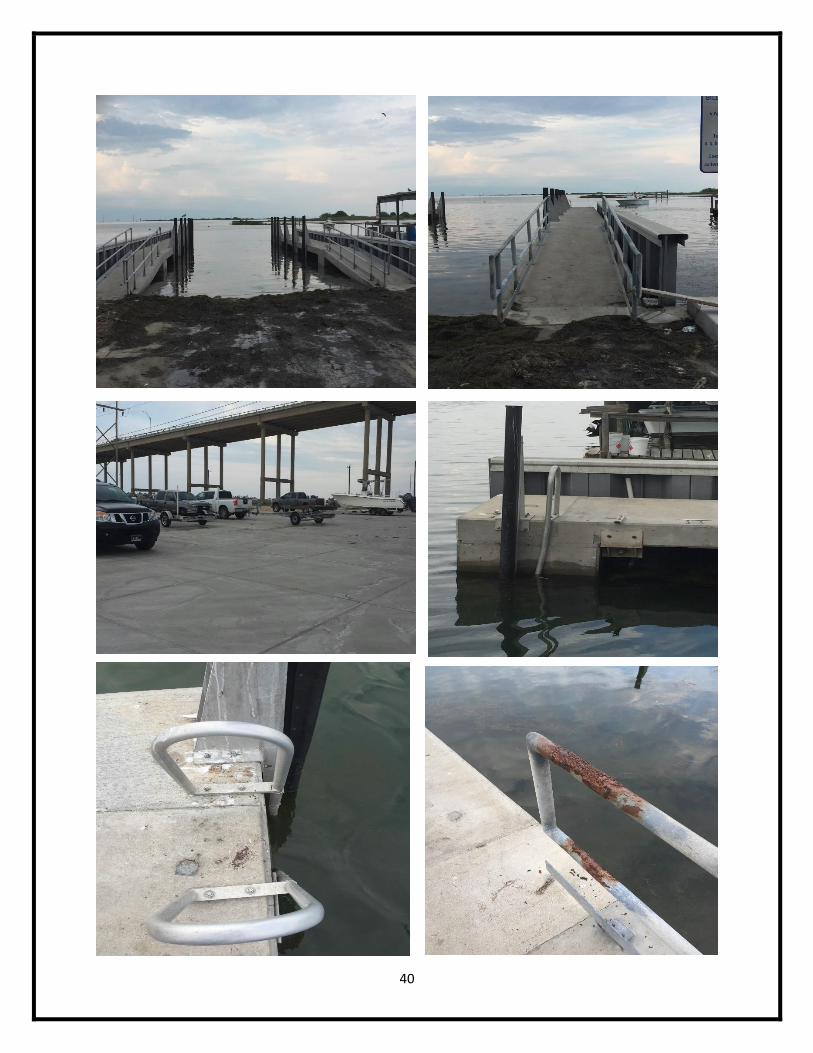
Clem’s Marina
Nueces County
Location (27.634903, -97.238146)
Average Quality Ranking 3.25
Total Average Quality Ranking 2.36
This site is located off the JFK Causeway, under the bridge over Laguna Madre, adjacent to
Billings Bait & Tackle. The site receives regular high volumes of users throughout the year, with
peak volumes occurring during the summer months.
The ramp at this facility is slightly smaller than the Billings Bait & Tackle at a width of 22’ and a
slope of 5°. Other than a few minor cracks and some excess algae growth below the water line,
the ramp is in good condition. The ramp, similar to Billings’s ramp, has 2 concrete boat docks
on either side of the ramp in excellent condition. Each of the ramps feature rubber bumpers
and a total of 14 metal cleats with no signs of wear or damage. Access to the dock is provided
via concrete ramp with aluminum hand rails that have a moderate level of corrosion. Signage is
excellent at this facility, featuring a number of signs all in great condition with little sign of
wear. The parking situation is similar to Billings Bait & Tackle, consisting of a mix of concrete,
gravel, and asphalt with a capacity of about 30-50 cars. There are no public restrooms featured
at this location.
Facilities at this boat ramp need (1) general cleanup for excess seagrass and algae, along with
(2) removal of corrosion from the handrails. This can be accomplished through site managers
with minimal effort. (3) Replacement ladder steps are needed for each of the ladders at the
end of the docks, requiring minimal cost for purchase or installation. (4) Enhancements to this
site would include installation of a set of portable restroom facilities, as there are none present.
Installation of 2 portable toilets (1 male 1 female) is estimated at $2400 for annual expenses.
(5) Finally, construction of boat slips or a pier would enhance the value of this facility. Boat
slips would be ideal at this location, considering the high volume of boaters that use this facility,
although there is limited area to work with greatly limiting the potential of this feature. A small
pier on the other hand, could be constructed and added to this location for public fishing
efforts and additional access to boats after launch. Construction of a pier or boat slip would
require a high level of expense.
Overall this site is well managed and in good condition, ranking 7th for average quality ranking
and 13th for total average quality ranking among all other counties. Other than minor
maintenance issues, this site could most benefit from the addition of portable restroom
facilities, installed and maintained at moderate levels of expense. Addition of a pier would also
increase the value of this site, although would require a moderate-high level of expense for
construction.
40
41
Conn Brown’s Harbor Point Park
Nueces County
Location (27.899729, -97.136472)
Average Quality Ranking 3.55
Total Average Quality Ranking 3.55
This site is located at the end of Bigelow Street in Aransas Pass, and provides direct access into
Redfish Bay.
There are a total of 4 concrete boat ramps at this facility, each ramp considerably wide at
approximately 28’ with slopes of about 6°. The most southern ramp (ramp on far left facing
the water) is slightly narrower than the other 3 ramps, at about 27’8”, and has the same slope
of 6°. All 4 ramps are in excellent condition with little to no signs of wear or damage
whatsoever, although the northern ramp (ramp on far right facing the water) is currently closed
and taped off for dredging projects. There is a boat dock on each side of the 4 ramps, for a
total of 5 docks. The outer 2 and center docks are made of wood and in excellent condition,
featuring metal cleats for tie offs. The 2 to other docks are made of aluminum and wood,
featuring metal cleats for tie offs, rubber bumpers, and an access ramp with aluminum
handrails. The aluminum docks are also in excellent condition, with the exception of 1 rubber
bumper piece which has come unattached at its bottom. A total of 32 metal cleats are featured
throughout the 5 docks, along with the 4 aluminum hand rails, all in excellent condition. The
site features 1 wooden boat slip as well, connected to the north boat dock, in good condition.
Signage at this location is great, featuring multiple signs with little to no wear and appropriately
placed. There is a wooden fishing pier at this site as well, considerably large and in good
condition. Permanent facility restrooms are found at this site, which appear to be in good
condition with the exception of minor graffiti and wear inside the building. The parking area is
asphalt and large, with a capacity of approximately 95 marked parking spaces. The lot has a
few minor potholes, but is in relatively good condition.
This site requires few, if any, enhancements of facilities other than repair and maintenance of
minor issues. (1) The parking lot needs some patchwork for a few potholes located throughout
the lot, which would be minor but might require 3rd party assistance. (2) The only
enhancement recommended for this site is the addition of a line or marker revealing the
bottom of the concrete ramp as a hazard sign. This would be of little to no expense, requiring
either a sign or paint to be installed easily by a site manager.
Overall, this is the 2nd best site out of the average total quality ranking, and the best site out of
the total average quality ranking scores. The site is maintained very well and could use only
limited enhancements to increase the value of its facilities.
42
43
Coopers Alley L-Head
Nueces County
Location (27.791574, -97.389489)
Average Quality Ranking 3.63
Total Average Quality Ranking 2.64
This site is located in downtown Corpus Christi, at the west end of Coopers Alley. The site
offers access into the Corpus Christi Marina area, behind the rock breakwater, and Corpus
Christi Bay.
The site features 3 concrete boat ramps, 1 wide ramp in the middle at 30’8” with 2 narrower
ramps alongside at 15’4”. All 3 ramps have slopes of about 7°, and are in excellent condition
with almost no signs of wear or damage at all; however, the western ramp (ramp on the left)
currently has caution tape blocking the ramp due to submerged debris, which is due for
removal sometime in the near future. The ramps feature 2 boat docks between the large and
small ramps made of aluminum, wood, and plastic, featuring 24 metal cleats for tie offs and
rubber bumpers on all sides of the docks. The docks are all in excellent condition with no signs
of damage whatsoever. Access to the docks are provided via aluminum ramp extending from
the concrete ramp area, which is also in excellent condition. Signage at this location is great,
with multiple signs featuring a plethora of information about hazards and general standards for
the area. The asphalt parking area is in good condition and can hold approximately 60 vehicles.
Restrooms at this site are a permanent facility which is in fair to good condition. All facilities
seem to be in working order, however the restrooms general appearance could use some
upkeep and repair.
This site could only use a few enhancements, along with some general repair/maintenance
issues. (1) The aluminum access ramps featured could use a set of handrails, preferably
aluminum, to provide additional safety and support for those disabled. Installation of handrails
would be a minimal expense, possibly requiring involvement from a 3rd party. (2) The site could
also use boat slips for additional ease of access, along the eastern dock. There are many boat
slips featured along the marina, however all of them require a monthly rental fee for the space.
The recommended boat slip additions would be for public use only, and require no fees. (3)
Minor maintenance issues that need addressed are the restroom facilities, requiring general
clean up and possibly a fresh coat of paint to increase aesthetic value.
Overall, this site ranks 1st for the average quality ranking score and 6th for total average quality
ranking. Most features at this site are in excellent condition, requiring only minimal
maintenance efforts for upkeep. Additional enhancements recommended could increase the
value of these facilities at moderate-high level of expense.
44
45
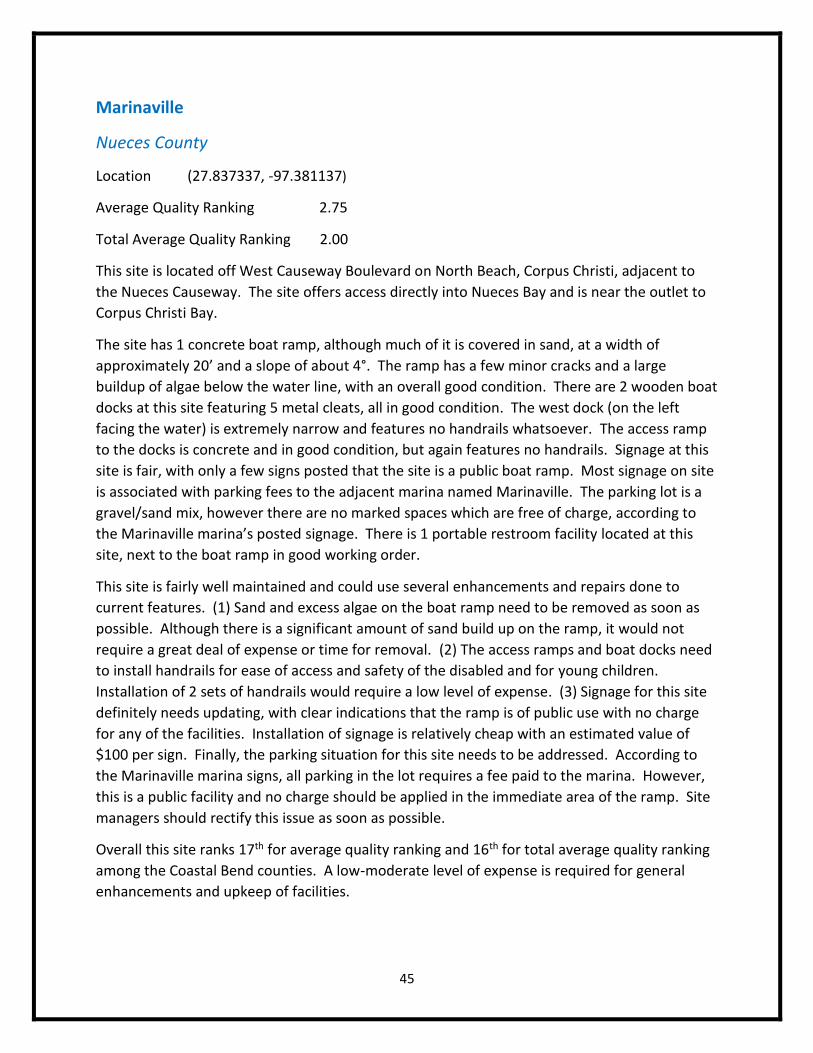
Marinaville
Nueces County
Location (27.837337, -97.381137)
Average Quality Ranking 2.75
Total Average Quality Ranking 2.00
This site is located off West Causeway Boulevard on North Beach, Corpus Christi, adjacent to
the Nueces Causeway. The site offers access directly into Nueces Bay and is near the outlet to
Corpus Christi Bay.
The site has 1 concrete boat ramp, although much of it is covered in sand, at a width of
approximately 20’ and a slope of about 4°. The ramp has a few minor cracks and a large
buildup of algae below the water line, with an overall good condition. There are 2 wooden boat
docks at this site featuring 5 metal cleats, all in good condition. The west dock (on the left
facing the water) is extremely narrow and features no handrails whatsoever. The access ramp
to the docks is concrete and in good condition, but again features no handrails. Signage at this
site is fair, with only a few signs posted that the site is a public boat ramp. Most signage on site
is associated with parking fees to the adjacent marina named Marinaville. The parking lot is a
gravel/sand mix, however there are no marked spaces which are free of charge, according to
the Marinaville marina’s posted signage. There is 1 portable restroom facility located at this
site, next to the boat ramp in good working order.
This site is fairly well maintained and could use several enhancements and repairs done to
current features. (1) Sand and excess algae on the boat ramp need to be removed as soon as
possible. Although there is a significant amount of sand build up on the ramp, it would not
require a great deal of expense or time for removal. (2) The access ramps and boat docks need
to install handrails for ease of access and safety of the disabled and for young children.
Installation of 2 sets of handrails would require a low level of expense. (3) Signage for this site
definitely needs updating, with clear indications that the ramp is of public use with no charge
for any of the facilities. Installation of signage is relatively cheap with an estimated value of
$100 per sign. Finally, the parking situation for this site needs to be addressed. According to
the Marinaville marina signs, all parking in the lot requires a fee paid to the marina. However,
this is a public facility and no charge should be applied in the immediate area of the ramp. Site
managers should rectify this issue as soon as possible.
Overall this site ranks 17th for average quality ranking and 16th for total average quality ranking
among the Coastal Bend counties. A low-moderate level of expense is required for general
enhancements and upkeep of facilities.
46
47
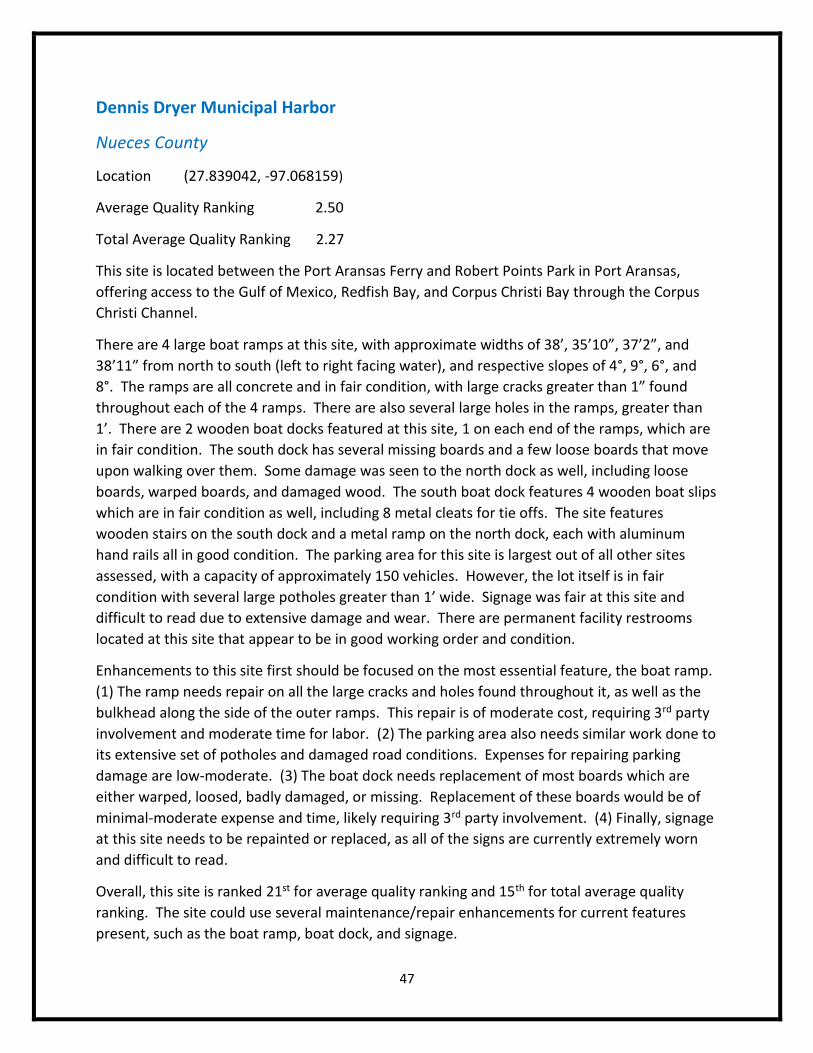
Dennis Dryer Municipal Harbor
Nueces County
Location (27.839042, -97.068159)
Average Quality Ranking 2.50
Total Average Quality Ranking 2.27
This site is located between the Port Aransas Ferry and Robert Points Park in Port Aransas,
offering access to the Gulf of Mexico, Redfish Bay, and Corpus Christi Bay through the Corpus
Christi Channel.
There are 4 large boat ramps at this site, with approximate widths of 38’, 35’10”, 37’2”, and
38’11” from north to south (left to right facing water), and respective slopes of 4°, 9°, 6°, and
8°. The ramps are all concrete and in fair condition, with large cracks greater than 1” found
throughout each of the 4 ramps. There are also several large holes in the ramps, greater than
1’. There are 2 wooden boat docks featured at this site, 1 on each end of the ramps, which are
in fair condition. The south dock has several missing boards and a few loose boards that move
upon walking over them. Some damage was seen to the north dock as well, including loose
boards, warped boards, and damaged wood. The south boat dock features 4 wooden boat slips
which are in fair condition as well, including 8 metal cleats for tie offs. The site features
wooden stairs on the south dock and a metal ramp on the north dock, each with aluminum
hand rails all in good condition. The parking area for this site is largest out of all other sites
assessed, with a capacity of approximately 150 vehicles. However, the lot itself is in fair
condition with several large potholes greater than 1’ wide. Signage was fair at this site and
difficult to read due to extensive damage and wear. There are permanent facility restrooms
located at this site that appear to be in good working order and condition.
Enhancements to this site first should be focused on the most essential feature, the boat ramp.
(1) The ramp needs repair on all the large cracks and holes found throughout it, as well as the
bulkhead along the side of the outer ramps. This repair is of moderate cost, requiring 3rd party
involvement and moderate time for labor. (2) The parking area also needs similar work done to
its extensive set of potholes and damaged road conditions. Expenses for repairing parking
damage are low-moderate. (3) The boat dock needs replacement of most boards which are
either warped, loosed, badly damaged, or missing. Replacement of these boards would be of
minimal-moderate expense and time, likely requiring 3rd party involvement. (4) Finally, signage
at this site needs to be repainted or replaced, as all of the signs are currently extremely worn
and difficult to read.
Overall, this site is ranked 21st for average quality ranking and 15th for total average quality
ranking. The site could use several maintenance/repair enhancements for current features
present, such as the boat ramp, boat dock, and signage.
48
49
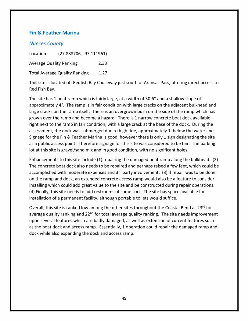
Fin & Feather Marina
Nueces County
Location (27.888706, -97.111961)
Average Quality Ranking 2.33
Total Average Quality Ranking 1.27
This site is located off Redfish Bay Causeway just south of Aransas Pass, offering direct access to
Red Fish Bay.
The site has 1 boat ramp which is fairly large, at a width of 30’6” and a shallow slope of
approximately 4°. The ramp is in fair condition with large cracks on the adjacent bulkhead and
large cracks on the ramp itself. There is an overgrown bush on the side of the ramp which has
grown over the ramp and become a hazard. There is 1 narrow concrete boat dock available
right next to the ramp in fair condition, with a large crack at the base of the dock. During the
assessment, the dock was submerged due to high tide, approximately 1’ below the water line.
Signage for the Fin & Feather Marina is good, however there is only 1 sign designating the site
as a public access point. Therefore signage for this site was considered to be fair. The parking
lot at this site is gravel/sand mix and in good condition, with no significant holes.
Enhancements to this site include (1) repairing the damaged boat ramp along the bulkhead. (2)
The concrete boat dock also needs to be repaired and perhaps raised a few feet, which could be
accomplished with moderate expenses and 3rd party involvement. (3) If repair was to be done
on the ramp and dock, an extended concrete access ramp would also be a feature to consider
installing which could add great value to the site and be constructed during repair operations.
(4) Finally, this site needs to add restrooms of some sort. The site has space available for
installation of a permanent facility, although portable toilets would suffice.
Overall, this site is ranked low among the other sites throughout the Coastal Bend at 23rd for
average quality ranking and 22nd for total average quality ranking. The site needs improvement
upon several features which are badly damaged, as well as extension of current features such
as the boat dock and access ramp. Essentially, 1 operation could repair the damaged ramp and
dock while also expanding the dock and access ramp.
50
51
Hazel Bazemore County Park
Nueces County
Location (27.867411, -97.639776)
Average Quality Ranking 2.60
Total Average Quality Ranking 1.18
This site is located on the northwest side of Calallen off County Road 69. The site provides
access to the Nueces River and is managed by Nueces County.
There is 1 small-average sized boat ramp at this site, at approximately 20’6” with a slope of
about 4°. The ramp has a large crack at its base, a few inches wide, along with a few minor
holes and in overall fair condition. There is no boat dock or access ramp featured at this site.
Limited parking is available, with a small 6 vehicle lot next to the ramp. The portable restroom
facilities are located approximately 0.5 mile from the ramp and in good condition. Signage for
this site is appropriately placed and in good condition.
This site needs (1) to repair the large crack along the boat ramp. (2) Then a boat dock of some
sort is needed, in order to allow access to the boat for all users. Not providing a boat dock
could potentially be very dangerous for both the boat and boater, as users will be forced to
climb into the boat from the back near the propeller, and the boat will have to be in very
shallow water to do this. Access for children, elderly, and the disabled is extremely limited
without a proper boat dock to easily load and unload. Installation of a boat dock would require
significant expense and 3rd party involvement, but would increase not only the value of this site,
but the safety of its features as well. (3) If adding a boat dock, other enhancements for the
dock itself would include cleats for tie offs, rubber bumpers, an access ramp of some sort, and
hand rails for the access ramp. Together, these features are reasonably inexpensive and would
require moderate labor for installation. (4) Finally, this site needs closer restroom facilities for
users. Portable toilets would work at this site, considering its location.
Overall this site is ranked 20th for average quality ranking and 23rd for total average quality
ranking, requiring a good deal of work for repairs and enhancements. The ramp repairs and
boat dock construction are undoubtedly at the top of the list for priority. Other features like
the tie offs, access ramp, and hand rails would increase the value of the facilities, but are
secondary and tertiary features. Again, the importance of constructing a boat dock cannot be
stressed enough at this site, for both safety and quality values.

52
53
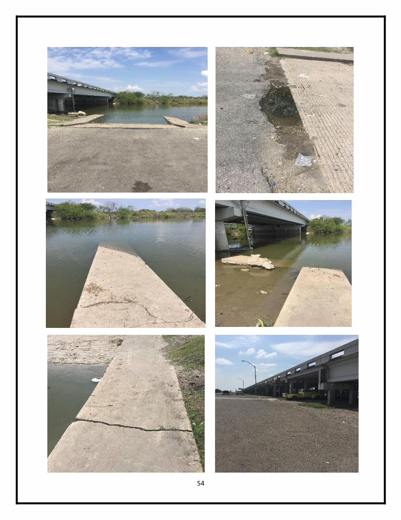
Labonte Park
Nueces County
Location (27.895358, -97.628705)
Average Quality Ranking 2.43
Total Average Quality Ranking 1.55
This site is located off IH-37 at exit 16, just north of Corpus Christi, and provides access to the
Nueces River.
The site features 1 boat ramp of moderate size, at a width of 20’1” and a slope of about 9°. The
ramp is in fair condition, due to several large cracks throughout the ramp and a submerged
concrete block considered a hazard. There are 2 concrete boat docks at this site which are in
fair condition. Each of the docks slopes downward toward the water’s edge, a potential hazard
for users. There is also a large crack running through the west dock (right side facing the
water). A concrete access ramp is featured for each of the docks, also in fair condition due to
large cracks. There are approximately 15 spaces for parking at this site, on a gravel/asphalt mix
ground which has several large potholes and in fair condition. The access road for this site
however, was given an excellent rating and in great condition. A permanent facility restroom is
also available at this site, approximately 0.5 mile from the boat ramp.
(1) Enhancements to this site first need to focus on repairing the damaged boat ramp. This
would require low-moderate expenses and 3rd party involvement. (2) Repair or replacement of
the boat dock is also necessary, especially since the docks create some sort of a hazard with
their current profile. Replacement of the docks is estimated at a moderate-high level of
expense. (3) Secondary and tertiary features for the dock such as tie offs, bumpers, and hand
rails should also be considered. (4) The site needs to improve its parking area and patch the
extensive set of potholes throughout the designated area. These repairs would be at minimal-
moderate costs. (5) Additionally, the site could use closer restroom facilities, preferably
portable toilets, to enhance the quality of the facilities. Installation of 2 portable restrooms
would require an estimated $2400 annually.
Overall, this site ranks considerably low at 22th among all average quality ranking scores and
20th for total average quality ranking. The site needs repair on current ramp features as well as
major improvements on the condition of the boat docks and parking area. With moderate-high
expenses, these improvements may be accomplished thus increasing the value of this site.
54
55
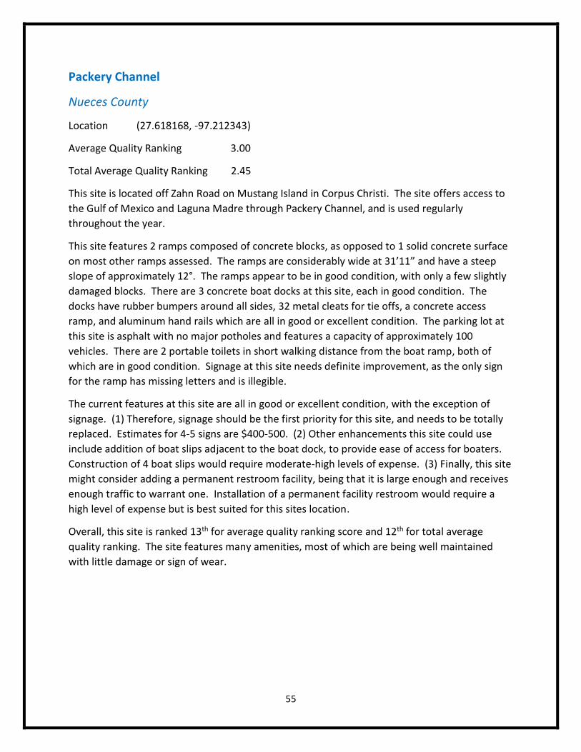
Packery Channel
Nueces County
Location (27.618168, -97.212343)
Average Quality Ranking 3.00
Total Average Quality Ranking 2.45
This site is located off Zahn Road on Mustang Island in Corpus Christi. The site offers access to
the Gulf of Mexico and Laguna Madre through Packery Channel, and is used regularly
throughout the year.
This site features 2 ramps composed of concrete blocks, as opposed to 1 solid concrete surface
on most other ramps assessed. The ramps are considerably wide at 31’11” and have a steep
slope of approximately 12°. The ramps appear to be in good condition, with only a few slightly
damaged blocks. There are 3 concrete boat docks at this site, each in good condition. The
docks have rubber bumpers around all sides, 32 metal cleats for tie offs, a concrete access
ramp, and aluminum hand rails which are all in good or excellent condition. The parking lot at
this site is asphalt with no major potholes and features a capacity of approximately 100
vehicles. There are 2 portable toilets in short walking distance from the boat ramp, both of
which are in good condition. Signage at this site needs definite improvement, as the only sign
for the ramp has missing letters and is illegible.
The current features at this site are all in good or excellent condition, with the exception of
signage. (1) Therefore, signage should be the first priority for this site, and needs to be totally
replaced. Estimates for 4-5 signs are $400-500. (2) Other enhancements this site could use
include addition of boat slips adjacent to the boat dock, to provide ease of access for boaters.
Construction of 4 boat slips would require moderate-high levels of expense. (3) Finally, this site
might consider adding a permanent restroom facility, being that it is large enough and receives
enough traffic to warrant one. Installation of a permanent facility restroom would require a
high level of expense but is best suited for this sites location.
Overall, this site is ranked 13th for average quality ranking score and 12th for total average
quality ranking. The site features many amenities, most of which are being well maintained
with little damage or sign of wear.
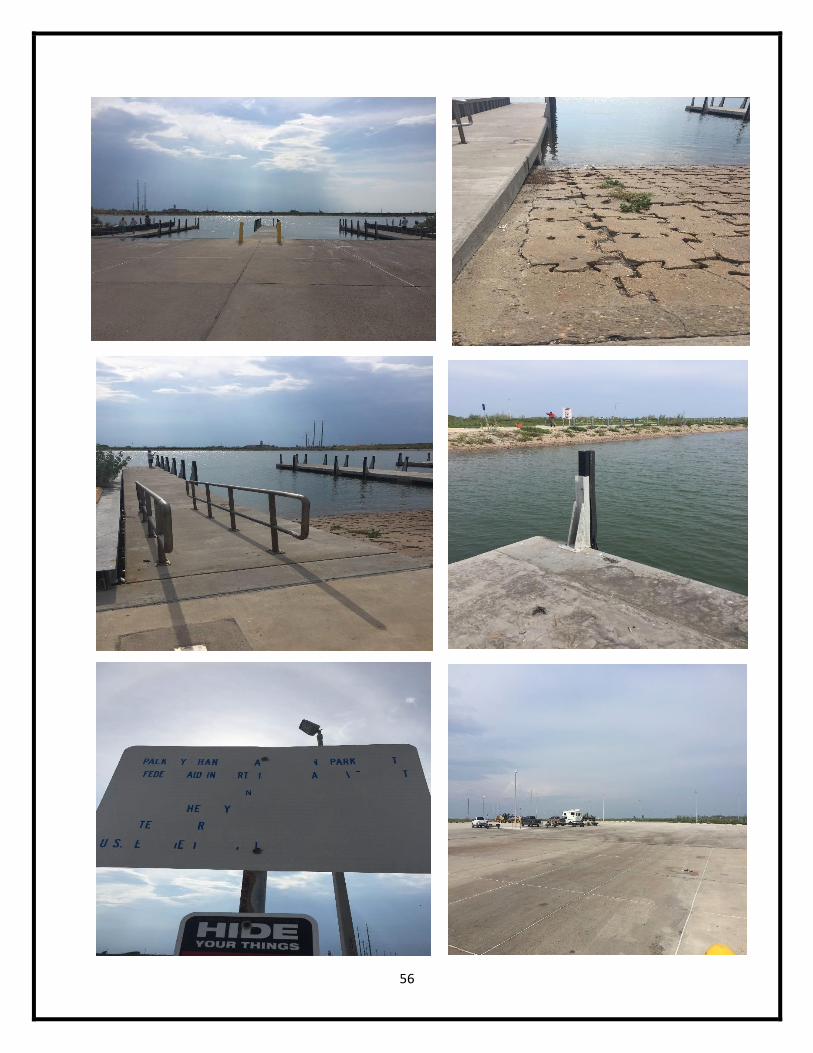
56
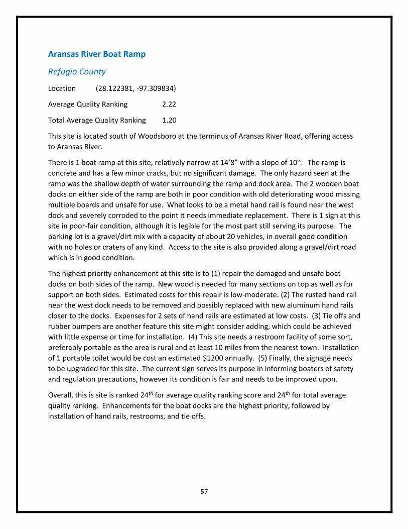
57
Aransas River Boat Ramp
Refugio County
Location (28.122381, -97.309834)
Average Quality Ranking 2.22
Total Average Quality Ranking 1.20
This site is located south of Woodsboro at the terminus of Aransas River Road, offering access
to Aransas River.
There is 1 boat ramp at this site, relatively narrow at 14’8” with a slope of 10°. The ramp is
concrete and has a few minor cracks, but no significant damage. The only hazard seen at the
ramp was the shallow depth of water surrounding the ramp and dock area. The 2 wooden boat
docks on either side of the ramp are both in poor condition with old deteriorating wood missing
multiple boards and unsafe for use. What looks to be a metal hand rail is found near the west
dock and severely corroded to the point it needs immediate replacement. There is 1 sign at this
site in poor-fair condition, although it is legible for the most part still serving its purpose. The
parking lot is a gravel/dirt mix with a capacity of about 20 vehicles, in overall good condition
with no holes or craters of any kind. Access to the site is also provided along a gravel/dirt road
which is in good condition.
The highest priority enhancement at this site is to (1) repair the damaged and unsafe boat
docks on both sides of the ramp. New wood is needed for many sections on top as well as for
support on both sides. Estimated costs for this repair is low-moderate. (2) The rusted hand rail
near the west dock needs to be removed and possibly replaced with new aluminum hand rails
closer to the docks. Expenses for 2 sets of hand rails are estimated at low costs. (3) Tie offs and
rubber bumpers are another feature this site might consider adding, which could be achieved
with little expense or time for installation. (4) This site needs a restroom facility of some sort,
preferably portable as the area is rural and at least 10 miles from the nearest town. Installation
of 1 portable toilet would be cost an estimated $1200 annually. (5) Finally, the signage needs
to be upgraded for this site. The current sign serves its purpose in informing boaters of safety
and regulation precautions, however its condition is fair and needs to be improved upon.
Overall, this is site is ranked 24th for average quality ranking score and 24th for total average
quality ranking. Enhancements for the boat docks are the highest priority, followed by
installation of hand rails, restrooms, and tie offs.
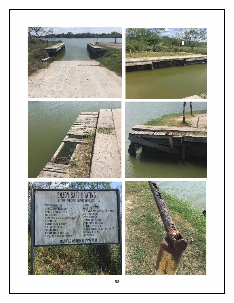
58
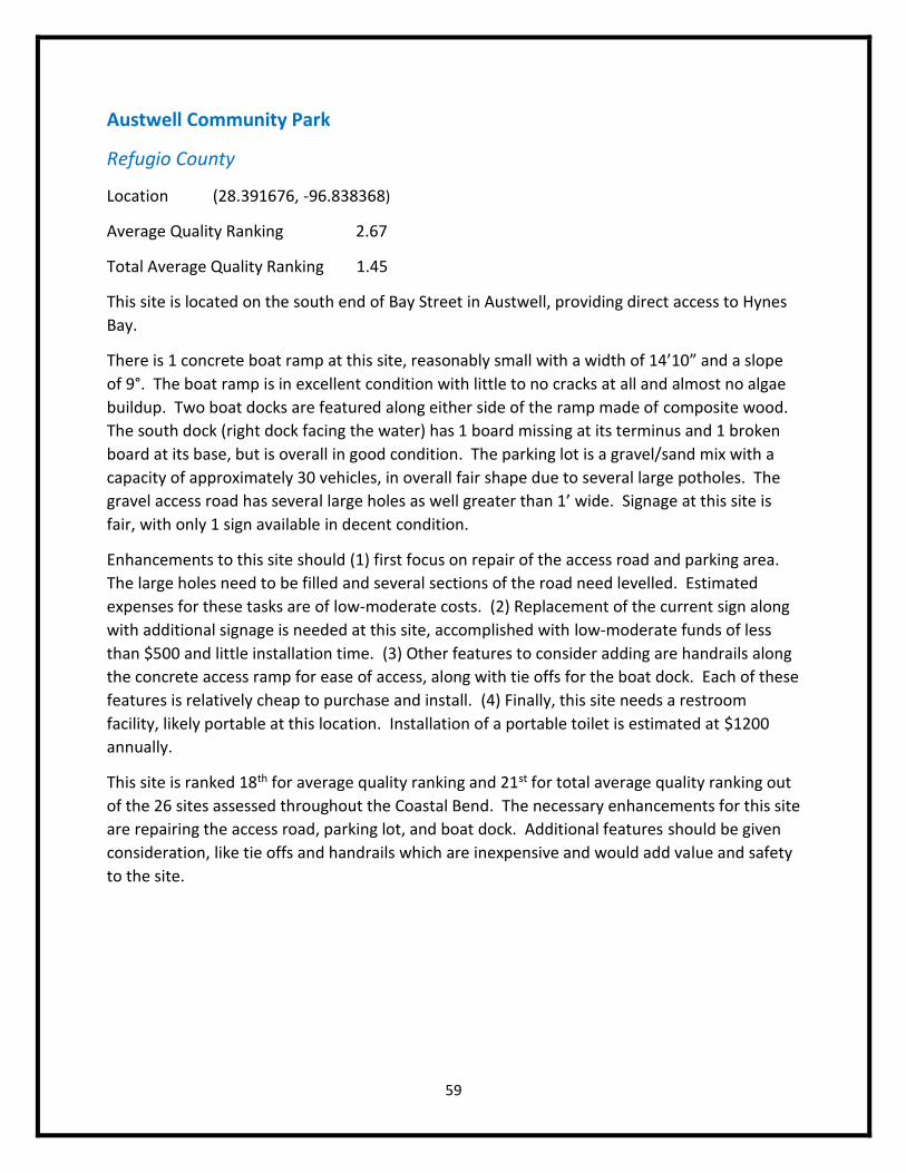
59
Austwell Community Park
Refugio County
Location (28.391676, -96.838368)
Average Quality Ranking 2.67
Total Average Quality Ranking 1.45
This site is located on the south end of Bay Street in Austwell, providing direct access to Hynes
Bay.
There is 1 concrete boat ramp at this site, reasonably small with a width of 14’10” and a slope
of 9°. The boat ramp is in excellent condition with little to no cracks at all and almost no algae
buildup. Two boat docks are featured along either side of the ramp made of composite wood.
The south dock (right dock facing the water) has 1 board missing at its terminus and 1 broken
board at its base, but is overall in good condition. The parking lot is a gravel/sand mix with a
capacity of approximately 30 vehicles, in overall fair shape due to several large potholes. The
gravel access road has several large holes as well greater than 1’ wide. Signage at this site is
fair, with only 1 sign available in decent condition.
Enhancements to this site should (1) first focus on repair of the access road and parking area.
The large holes need to be filled and several sections of the road need levelled. Estimated
expenses for these tasks are of low-moderate costs. (2) Replacement of the current sign along
with additional signage is needed at this site, accomplished with low-moderate funds of less
than $500 and little installation time. (3) Other features to consider adding are handrails along
the concrete access ramp for ease of access, along with tie offs for the boat dock. Each of these
features is relatively cheap to purchase and install. (4) Finally, this site needs a restroom
facility, likely portable at this location. Installation of a portable toilet is estimated at $1200
annually.
This site is ranked 18th for average quality ranking and 21st for total average quality ranking out
of the 26 sites assessed throughout the Coastal Bend. The necessary enhancements for this site
are repairing the access road, parking lot, and boat dock. Additional features should be given
consideration, like tie offs and handrails which are inexpensive and would add value and safety
to the site.
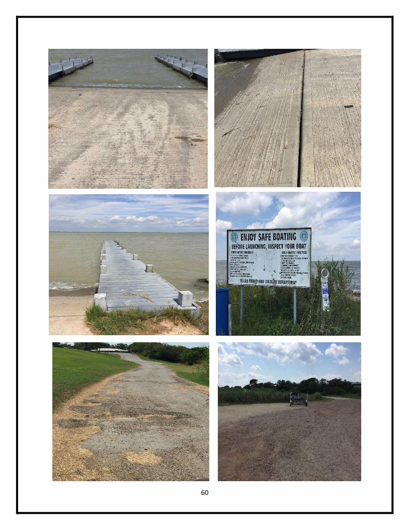
60

61
Texas Parks & Wildlife Boat Ramp
Refugio County
Location (28.077941, -97.221549)
Average Quality Ranking 2.00
Total Average Quality Ranking 0.91
This site is located south of Bayside off FM 136, providing direct access to Copano Bay. There is
a long concrete breakwater featured in front of the facilities at this site.
There are 2 boat ramps at this site with widths of 14’5” and 15’5”, both having slopes of
approximately 10°. The ramps are made of concrete, however there is a great amount of gravel
built up on top of them needing removal. Other than the gravel, the ramps are in good
condition. This site has 3 boat docks, all of which are in poor condition and unsafe for use. The
boat docks are wooden and have most of their boards missing, with large gaps between the
remaining boards. The parking lot is in fair condition, with several large potholes found
throughout the area greater than 1’. Other than the access road, which is in good condition,
there are no other features at this site.
(1) Enhancements to this site should first address replacing all 3 wooden boat docks.
Replacements costs for each of the boat docks require a high level of expense, however is
essential for the safety of this boat ramp. (2) The parking lot needs to be repaired, filling in all
the large holes and craters. A 3rd party would be required for this project at low-moderate level
of expense. (3) Signage is needed at this site, being as there is not 1 sign identifying the site
anywhere. Installation of 4-5 signs for this site would cost an estimated $400-500.
(4) Restroom facilities are also needed at this site, preferably portable as this site is obviously
not well maintained and requires easy to manage facilities. Installation of 1 portable toilet is
estimated at a value of $1200 annually. Other feature enhancements not available at this site
like an access ramp, tie offs, and hand rails could be added with little expense.
This site is the worst assessed site out of all 26 sites assess throughout the Coastal Bend. The
site ranks last for both average quality ranking and total average quality ranking. The highest
priority enhancement is undoubtedly replacing the wooden docks, followed by repairing the
parking lot. Other enhancements like installation of proper signage and portable restroom
facilities would greatly increase the value and use of this site. Additional features for the boat
dock like an access ramp, tie offs, and hand rails would also greatly benefit the facilities at
minimal expense.
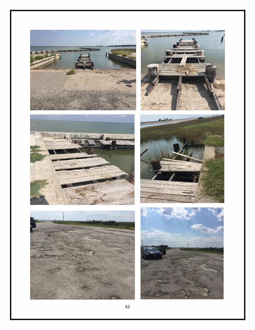
62

63
Cove Park
San Patricio County
Location (27.837703, -97.220411)
Average Quality Ranking 2.89
Total Average Quality Ranking 2.36
This site is located on the south side of Ingleside off County Road 1069 (Main Street), providing
access to Ingleside Cove and Corpus Christi Bay.
There are 2 smaller than average boat ramps at this site, with widths of approximately 16’ and
steep slopes of 12°. The ramps are in fair condition due to several large potholes at the top of
the ramp. Other than these few large holes, the ramp is in overall good condition. The site has
3 wooden boat docks all in good condition with few signs of minor wear or damage to the
wood. The docks have a total of 7 metal cleats, many of which are loose or completely
unattached from the dock, in overall fair condition. One of the docks extends to a pier
featuring a fish cleaning station. The north dock (far right dock) has a wooden access ramp
connected from the parking lot with wooden hand rails, all in good condition. Parking at this
site is fair, with a capacity of approximately 50 vehicles. The parking area has several large
potholes greater than 1’, needing repair. This site has permanent facility restrooms which are
in fair condition due to the damaged water fountains in front. One of the water fountains at
the restrooms has loose wiring and parts exposed, a potential hazard for children or pets. The
other fountain has minor damage, but looks to be in deteriorating conditions. Finally, signs at
this site are in good condition and appropriately placed throughout the area.
Repairs at this site should (1) first focus on repairing the large holes at the top of the boat ramp,
along with the concrete bulkhead adjacent to the ramp. These repairs would require 3rd party
involvement and low-moderate expenses. The parking area needs repair as well to fill in the
large holes throughout the lot, also requiring 3rd party involvement at low-moderate expenses.
The restroom water fountains need replacement at least for the exposed fountain, which could
be accomplished with low-moderate costs. While many of the metal cleats are loose or
unattached, they are not damaged to the point they need replacement. Simply re-installing
these tie offs would resolve this issue with no cost and minimal effort by site managers. Other
enhancements which could enhance this site are rubber bumpers for the wooden docks, and a
sign or marking showing the extent of the boat ramp in the water, similar to Copano Bay State
Park’s markers. Purchase and installation of both features is relatively cheap with minimal
effort for installation.
Overall, this site is ranked 19th for average quality ranking score and 14th for the total average
quality ranking score. The site is in fairly good condition, with only a few maintenance issues
that need resolved such as the boat ramp, parking lot, restrooms, and tie offs.
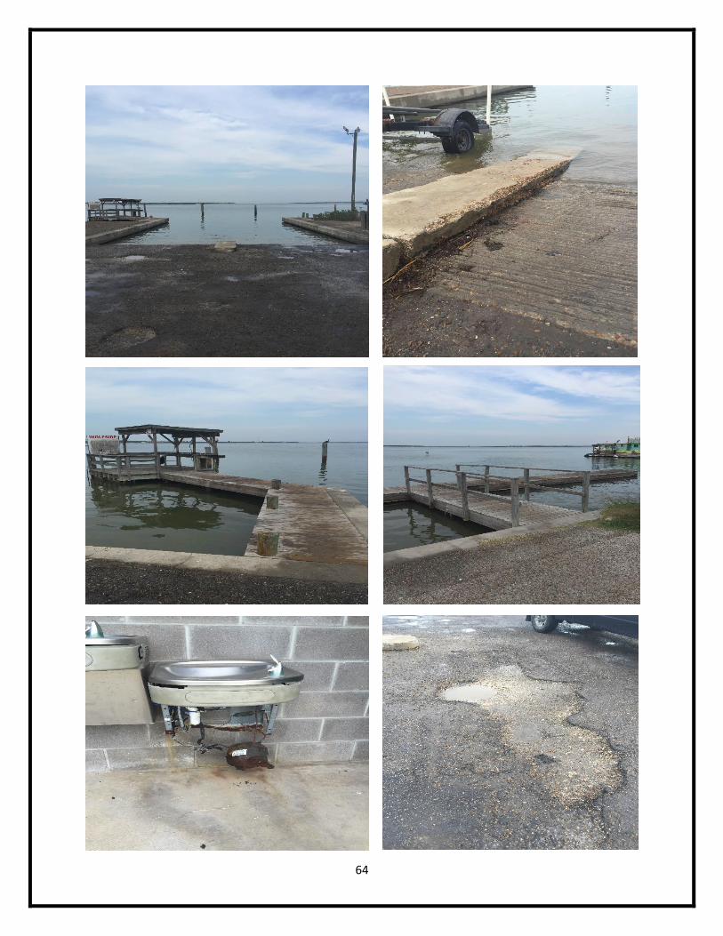
64
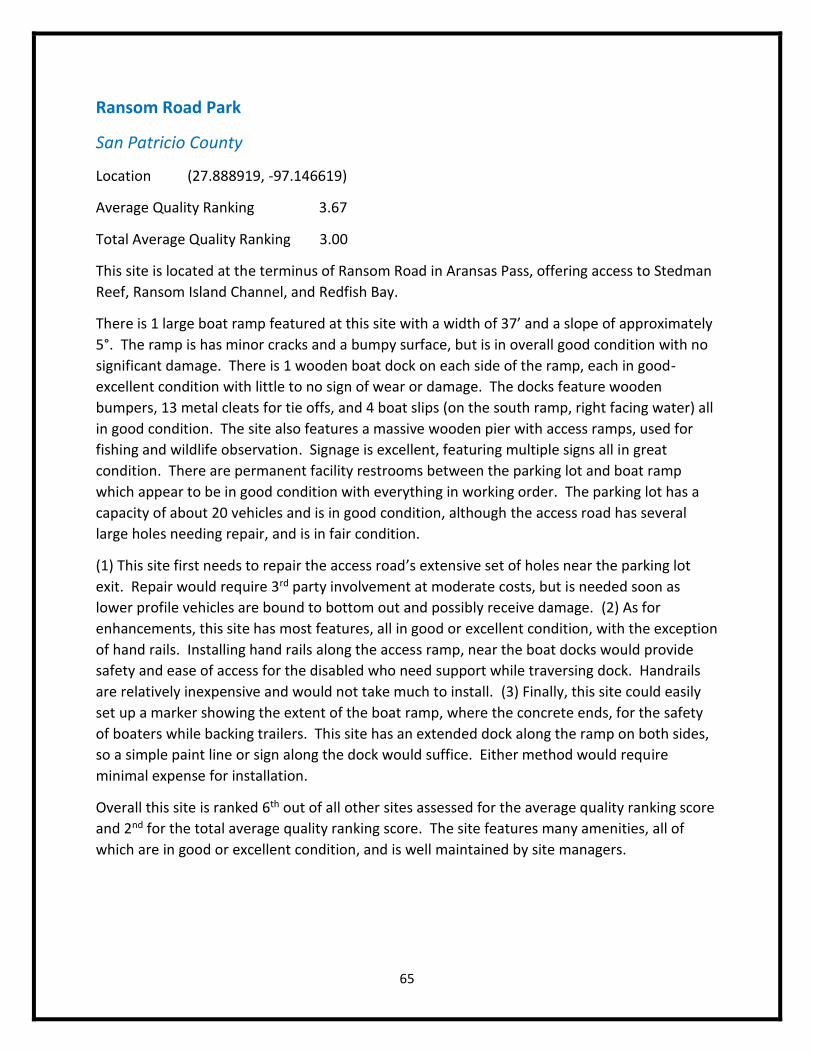
65
Ransom Road Park
San Patricio County
Location (27.888919, -97.146619)
Average Quality Ranking 3.67
Total Average Quality Ranking 3.00
This site is located at the terminus of Ransom Road in Aransas Pass, offering access to Stedman
Reef, Ransom Island Channel, and Redfish Bay.
There is 1 large boat ramp featured at this site with a width of 37’ and a slope of approximately
5°. The ramp is has minor cracks and a bumpy surface, but is in overall good condition with no
significant damage. There is 1 wooden boat dock on each side of the ramp, each in good-
excellent condition with little to no sign of wear or damage. The docks feature wooden
bumpers, 13 metal cleats for tie offs, and 4 boat slips (on the south ramp, right facing water) all
in good condition. The site also features a massive wooden pier with access ramps, used for
fishing and wildlife observation. Signage is excellent, featuring multiple signs all in great
condition. There are permanent facility restrooms between the parking lot and boat ramp
which appear to be in good condition with everything in working order. The parking lot has a
capacity of about 20 vehicles and is in good condition, although the access road has several
large holes needing repair, and is in fair condition.
(1) This site first needs to repair the access road’s extensive set of holes near the parking lot
exit. Repair would require 3rd party involvement at moderate costs, but is needed soon as
lower profile vehicles are bound to bottom out and possibly receive damage. (2) As for
enhancements, this site has most features, all in good or excellent condition, with the exception
of hand rails. Installing hand rails along the access ramp, near the boat docks would provide
safety and ease of access for the disabled who need support while traversing dock. Handrails
are relatively inexpensive and would not take much to install. (3) Finally, this site could easily
set up a marker showing the extent of the boat ramp, where the concrete ends, for the safety
of boaters while backing trailers. This site has an extended dock along the ramp on both sides,
so a simple paint line or sign along the dock would suffice. Either method would require
minimal expense for installation.
Overall this site is ranked 6th out of all other sites assessed for the average quality ranking score
and 2nd for the total average quality ranking score. The site features many amenities, all of
which are in good or excellent condition, and is well maintained by site managers.
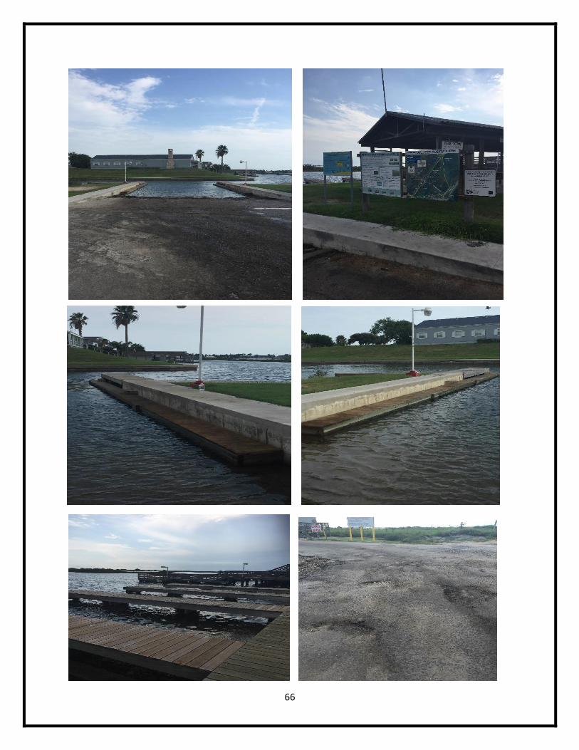
66
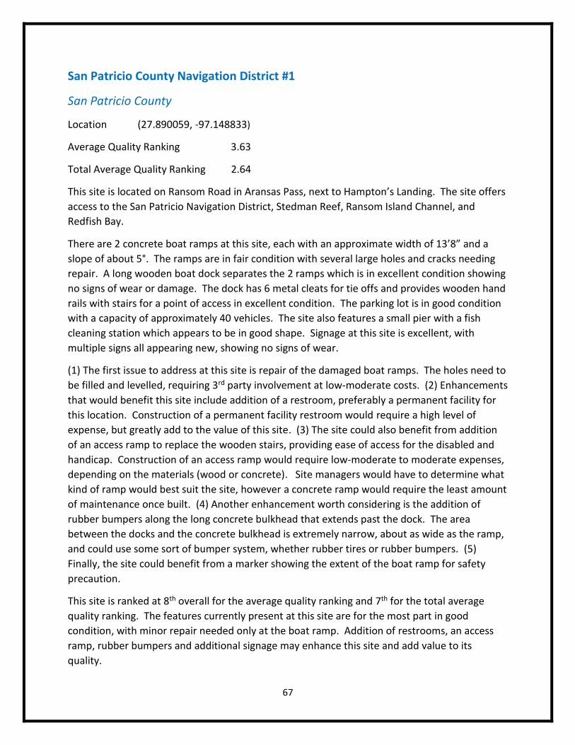
67
San Patricio County Navigation District #1
San Patricio County
Location (27.890059, -97.148833)
Average Quality Ranking 3.63
Total Average Quality Ranking 2.64
This site is located on Ransom Road in Aransas Pass, next to Hampton’s Landing. The site offers
access to the San Patricio Navigation District, Stedman Reef, Ransom Island Channel, and
Redfish Bay.
There are 2 concrete boat ramps at this site, each with an approximate width of 13’8” and a
slope of about 5°. The ramps are in fair condition with several large holes and cracks needing
repair. A long wooden boat dock separates the 2 ramps which is in excellent condition showing
no signs of wear or damage. The dock has 6 metal cleats for tie offs and provides wooden hand
rails with stairs for a point of access in excellent condition. The parking lot is in good condition
with a capacity of approximately 40 vehicles. The site also features a small pier with a fish
cleaning station which appears to be in good shape. Signage at this site is excellent, with
multiple signs all appearing new, showing no signs of wear.
(1) The first issue to address at this site is repair of the damaged boat ramps. The holes need to
be filled and levelled, requiring 3rd party involvement at low-moderate costs. (2) Enhancements
that would benefit this site include addition of a restroom, preferably a permanent facility for
this location. Construction of a permanent facility restroom would require a high level of
expense, but greatly add to the value of this site. (3) The site could also benefit from addition
of an access ramp to replace the wooden stairs, providing ease of access for the disabled and
handicap. Construction of an access ramp would require low-moderate to moderate expenses,
depending on the materials (wood or concrete). Site managers would have to determine what
kind of ramp would best suit the site, however a concrete ramp would require the least amount
of maintenance once built. (4) Another enhancement worth considering is the addition of
rubber bumpers along the long concrete bulkhead that extends past the dock. The area
between the docks and the concrete bulkhead is extremely narrow, about as wide as the ramp,
and could use some sort of bumper system, whether rubber tires or rubber bumpers. (5)
Finally, the site could benefit from a marker showing the extent of the boat ramp for safety
precaution.
This site is ranked at 8th overall for the average quality ranking and 7th for the total average
quality ranking. The features currently present at this site are for the most part in good
condition, with minor repair needed only at the boat ramp. Addition of restrooms, an access
ramp, rubber bumpers and additional signage may enhance this site and add value to its
quality.
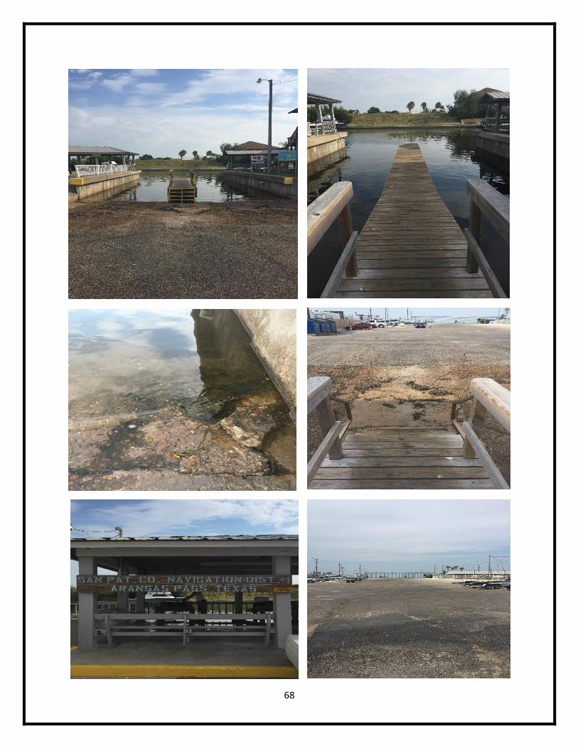
68
69
Analysis
The 26 public boat ramps assessed along the Coastal Bend have a great degree of variability
among available amenities and quality of such features. While all the sites required boat ramps
to be considered as part of this assessment, many lack other key features which have the
potential to add great value to their sites and facilities. Restrooms, for instance, were only
found at 58% of the facilities inspected, with about half of those facilities being permanent and
the other half being portable. Proper hand rails were only found at 42% of all the sites
assessed, a feature which may increase safety and ease of access for disabled users. The
availability of amenities like restrooms and hand rails may strongly persuade boaters from
visiting a site, depending on the boater. A further breakdown of the percentage of sites with
given features is found on Appendix I.
The 26 sites assessed also have a wide range of quality for both average quality ranking and
total average quality ranking. Again, average quality ranking is the average quality of provided
amenities at a given site, not penalizing for absence of features. For average quality ranking,
the range of all sites assessed is 2.00 – 3.63, the highest rank belonging to Cooper’s Alley L-
Head in Nueces County and the lowest ranks given to the Texas Parks & Wildlife Boat Ramp in
Refugio County and Captain Cady’s Bait Shop in Aransas County. The highest ranking average
quality ranking score among all counties was at San Patricio County with an average rank of
3.04 for its 3 sites. The lowest ranking county for average quality ranking was Refugio County
with an average of 2.28 for its 3 available sites. Overall, the average ranking for all counties
assessed for average quality ranking was 2.85.
Considering the range for average quality ranking, a superimposed system of assigning values to
sites by splitting them into quarters (intervals of 0.41) was applied to provide general rankings.
Based on the superimposed ranking system, 7 sites are in excellent condition including 4 sites
from Nueces, 2 sites from Aransas, and 1 site from San Patricio Counties. These 3 counties
appear to have the best maintained facilities throughout the Coastal Bend region. A total of 4
sites were found to have poor conditions, including 1 from Nueces, 2 from Refugio, and 1 from
Aransas Counties.
Total average quality ranking scores, which considered 9 amenities at sites, penalizing a site for
absence of a given feature, was considerably different than average quality ranking scores. The
range for total average quality ranking was 0.91 – 3.55, with the highest rank going to Conn
Browns Harbor Point Park in Nueces County, and the lowest ranks belonging to the Texas Parks
& Wildlife Boat Ramp in Refugio County and Captain Cady’s Bait Shop in Aransas County. The
highest ranking county for total average quality ranking was San Patricio County, with an
average of 2.67 for its 3 available sites. The lowest ranking county was Refugio County with an
average of 1.18 for its 3 sites. Overall, the average for all counties assessed for total quality
ranking was 2.17.
70
To further rank these sites and counties, a system of assigning quality rank was imposed by
splitting the ranks into quarters with intervals of 0.66. Based on this superimposed system of
general ranking, only 2 sites are considered to be in excellent condition, 1 from Nueces County
and the other from San Patricio County. A total of 7 sites have poor conditions based on this
ranking, 3 from Nueces, 3 from Refugio, and 1 from Aransas County.
Conclusion
The Texas Coastal Bend region offers a large number of public access sites for boaters, featuring
a variety of amenities at each location. Some sites have great quality facilities across the board,
while others need vast improvements for safety and essential function of certain features. This
report examined the 26 public boat ramps in this region in order to provide site managers and
users with general knowledge about their facilities, or lack thereof. Site managers and users
may now compare boat ramps within their area and determine the ideal location for boat
launch, or for future improvement projects. Enhancements to sites were provided in this
report to allow site managers to visualize what features need improvement and to what
degree. Estimated expenses and associated costs were taken into account for enhancements
as well, providing site managers with values for replacing or repairing site amenities. In the
event of a strong storm along the Gulf coast, several or most amenities at a given site may
require replacement or major repair. This report may provide guidance for assessing what
features to focus on first, aiding in prioritization of maintenance or replacement tasks. Some of
the enhancements noted in this report should be addressed in a timely fashion because they
may result in damage to the health or property of users. To avoid potential liability concerns,
repairing or replacing these potentially dangerous features should immediately be considered.
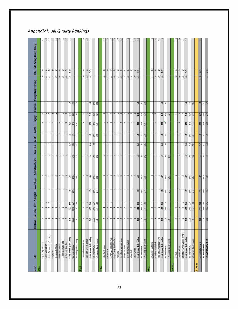
71
Appendix I: All Quality Rankings
Coun
tySit
eBo
at Ra
mp
Boat
Doc
kPie
rPa
rking
Lot
Acce
ss Ro
adAc
cess
Ram
p/St
airs
Hand
Rails
Tie O
ffsBo
at Sl
ipsSig
nage
Restr
oom
sAv
erag
e Qua
lity R
ankin
gTo
tal
Tota
l Ave
rage
Qua
lity R
ankin
gAr
ansa
sCa
ptain
Cady
's Ba
it Sho
p1
2
23
2
2.00
100.9
1
Capt
ain Ca
dy's
Bait S
hop 2
33
34
34
3
2
33.1
128
2.55
Copa
no Ba
y Sta
te Fi
shing
Pier
- Sou
th4
33
32
43
33
3.11
282.5
5
Cove
Har
bor
33
4
34
43
3
33.3
330
2.73
Navig
ation
Boat
Ramp
33
3
33
3
2
2.8
620
1.82
Goos
e Isla
nd St
ate P
ark
33
3
33
3
3.0
018
1.64
Rock
port
Beac
h Boa
t Ram
p2
3
33
3
33
2.86
201.8
2
St. Ch
arles
Bay B
oat R
amp
34
3
34
43
42
3.3
330
2.73
Coun
ty A
vera
ge Q
uality
Rank
ing
2.75
3.00
3.00
3.13
2.88
3.38
3.50
3.00
4.00
2.57
3.00
2.95
34.20
2.21
% of
Site
s with
Feat
ure
100%
100%
25%
100%
100%
100%
50%
38%
13%
88%
50%
Tota
l Ave
rage
Qua
lity Ra
nking
2.75
3.00
0.7
5
3.13
2.88
3.3
8
1.7
5
1.1
3
0.5
0
2.25
1.50
Klebe
rgKa
ufer
-Hub
ert M
emor
ial Pa
rk3
33
23
3
33
33
2.90
292.6
4
Padr
e Isla
nd N
ation
al Se
asho
re3
33
33
3
3
34
3.11
282.5
5
Coun
ty A
vera
ge Q
uality
Rank
ing
3.00
3.00
3.00
2.50
3.00
3.00
0.00
3.00
3.00
3.00
3.50
3.01
30.00
2.59
% of
Site
s with
Feat
ure
100%
100%
100%
100%
100%
100%
0%10
0%50
%10
0%10
0%
Tota
l Ave
rage
Qua
lity Ra
nking
3.00
3.00
3.0
0
2.50
3.00
3.0
0
-
3.00
1.50
3.0
0
3.5
0
Nuec
esBil
lings
Bait &
Tack
le3
4
33
43
4
4
3.50
282.5
5
Clem'
s Mar
ina3
3
33
43
3
4
3.25
262.3
6
Conn
Brow
ns H
arbo
r Poin
t Par
k4
43
33
44
43
43
3.55
393.5
5
Coop
er's
Alley
L-He
ad Bo
atRa
mp4
4
33
4
4
43
3.63
292.6
4
Mar
inavil
le3
3
33
3
2
23
2.75
222.0
0
Denn
is Dr
eyer
Mun
icipa
l Har
bor
22
2
33
33
22
32.5
025
2.27
Fin &
Feat
her M
arina
22
3
32
2
2.3
314
1.27
Haze
l Baz
emor
e Cou
nty P
ark
2
3
3
2
32.6
013
1.18
Labo
nte P
ark
22
2
42
2
32.4
317
1.55
Pack
ery C
hann
el3
4
33
43
3
13
3.00
272.4
5
Coun
ty A
vera
ge Q
uality
Rank
ing
2.80
3.11
3.00
2.80
3.10
3.33
3.20
3.29
2.50
2.70
3.00
2.95
32.83
2.18
% of
Site
s with
Feat
ure
100%
90%
10%
100%
100%
90%
50%
70%
20%
100%
70%
Tota
l Ave
rage
Qua
lity Ra
nking
2.80
2.80
0.3
0
2.80
3.10
3.0
0
1.6
0
2.3
0
0.5
0
2.70
2.10
Refu
gioAr
ansa
s Rive
r Boa
t Ram
p3
1
33
1
2
2.17
131.1
8
Austw
ell Co
mmun
ity Pa
rk4
3
22
3
2
2.67
161.4
5
Texa
s Par
ks &
Wild
life Bo
at Ra
mp3
1
23
1
2.00
100.9
1
Coun
ty A
vera
ge Q
uality
Rank
ing
3.33
1.67
0.00
2.33
2.67
1.67
0.00
0.00
0.00
2.00
0.00
2.28
13.67
1.18
% of
Site
s with
Feat
ure
100%
100%
0%10
0%10
0%10
0%0%
0%0%
67%
0%
Tota
l Ave
rage
Qua
lity Ra
nking
3.33
1.67
-
2.3
3
2.6
7
1.67
-
-
-
1.33
-
San P
atric
ioCo
ve Pa
rk2
33
23
33
2
32
2.60
262.3
6
Rans
om Ro
ad Pa
rk3
43
32
4
34
43
3.30
333.0
0
San P
atric
io Co
unty
Navig
ation
Dist
rict #
12
43
33
43
3
4
3.22
292.6
4
Coun
ty A
vera
ge Q
uality
Rank
ing
2.33
3.67
3.00
2.67
2.67
3.67
3.00
2.67
4.00
3.67
2.50
3.04
33.83
2.67
% of
Site
s with
Feat
ure
100%
100%
100%
100%
100%
100%
67%
100%
33%
100%
67%
Tota
l Ave
rage
Qua
lity Ra
nking
2.33
3.67
3.0
0
2.67
2.67
3.6
7
2.0
0
2.6
7
1.3
3
3.67
1.67
All C
ount
iesAv
erag
e Qua
lity Ra
nking
2.81
2.96
3.00
2.81
2.92
3.16
3.27
3.07
3.20
2.75
3.00
2.85
23.38
2.17
% of
Site
s with
Feat
ure
100%
96%
31%
100%
100%
96%
42%
54%
19%
92%
58%
Tota
l Ave
rage
Qua
lity Ra
nking
2.81
2.85
0.92
2.81
2.92
3.04
1.38
1.77
0.62
2.54
1.73
2.13
23.38
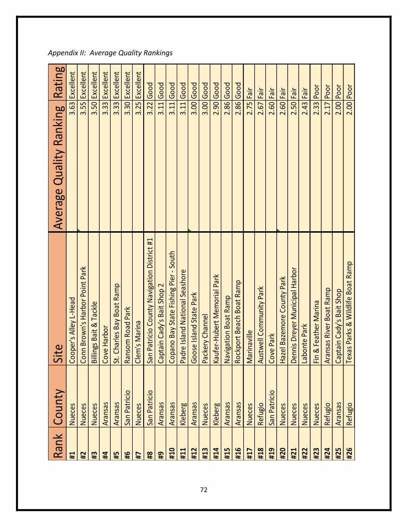
72
Appendix II: Average Quality Rankings
Rank
Coun
tySi
teA
vera
ge Q
ualit
y Ra
nkin
gRa
ting
#1N
uece
sC
oo
per'
s A
lley
L-H
ead
3.63
Exce
llent
#2N
uece
sC
onn
Bro
wn'
s H
arbo
r Po
int
Park
3.55
Exce
llent
#3N
uece
sB
illin
gs B
ait
& T
ackl
e3.
50Ex
celle
nt
#4A
rans
asC
ove
Har
bor
3.33
Exce
llent
#5A
rans
asSt
. Cha
rles
Bay
Bo
at R
amp
3.33
Exce
llent
#6Sa
n Pa
tric
ioR
anso
m R
oad
Par
k3.
30Ex
celle
nt
#7N
uece
sC
lem
's M
arin
a3.
25Ex
celle
nt
#8Sa
n Pa
tric
ioSa
n Pa
tric
io C
oun
ty N
avig
atio
n D
istr
ict
#13.
22G
oo
d
#9A
rans
asC
apta
in C
ady'
s B
ait
Sho
p 2
3.11
Go
od
#10
Ara
nsas
Co
pano
Bay
Sta
te F
ishi
ng P
ier
- So
uth
3.11
Go
od
#11
Kleb
erg
Padr
e Is
land
Nat
iona
l Sea
sho
re3.
11G
oo
d
#12
Ara
nsas
Go
ose
Isla
nd S
tate
Par
k3.
00G
oo
d
#13
Nue
ces
Pack
ery
Cha
nnel
3.00
Go
od
#14
Kleb
erg
Kauf
er-H
uber
t M
emo
rial
Par
k2.
90G
oo
d
#15
Ara
nsas
Nav
igat
ion
Bo
at R
amp
2.86
Go
od
#16
Ara
nsas
Ro
ckpo
rt B
each
Bo
at R
amp
2.86
Go
od
#17
Nue
ces
Mar
inav
ille
2.75
Fair
#18
Ref
ugio
Aus
twel
l Co
mm
unit
y Pa
rk2.
67Fa
ir
#19
San
Patr
icio
Co
ve P
ark
2.60
Fair
#20
Nue
ces
Haz
el B
azem
ore
Co
unty
Par
k2.
60Fa
ir
#21
Nue
ces
Den
nis
Dre
yer
Mun
icip
al H
arbo
r2.
50Fa
ir
#22
Nue
ces
Labo
nte
Park
2.43
Fair
#23
Nue
ces
Fin
& F
eath
er M
arin
a2.
33Po
or
#24
Ref
ugio
Ara
nsas
Riv
er B
oat
Ram
p2.
17Po
or
#25
Ara
nsas
Cap
tain
Cad
y's
Bai
t Sh
op
2.00
Poo
r
#26
Ref
ugio
Texa
s Pa
rks
& W
ildlif
e B
oat
Ram
p2.
00Po
or
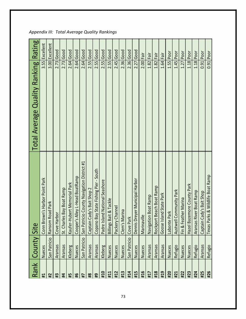
73
Appendix III: Total Average Quality Rankings
Rank
Coun
tySi
teTo
tal A
vera
ge Q
ualit
y Ra
nkin
gRa
ting
#1N
uece
sCo
nn B
row
n's
Har
bor P
oint
Par
k3.
55Ex
celle
nt
#2Sa
n Pa
tric
ioRa
nsom
Roa
d Pa
rk3.
00Ex
celle
nt
#3Ar
ansa
sCo
ve H
arbo
r2.
73G
ood
#4Ar
ansa
sSt
. Cha
rles
Bay
Boat
Ram
p2.
73G
ood
#5Kl
eber
gKa
ufer
-Hub
ert M
emor
ial P
ark
2.64
Goo
d
#6N
uece
sCo
oper
's A
lley
L-H
ead
Boat
Ram
p2.
64G
ood
#7Sa
n Pa
tric
ioSa
n Pa
tric
io C
ount
y N
avig
atio
n D
istr
ict #
12.
64G
ood
#8Ar
ansa
sCa
ptai
n Ca
dy's
Bai
t Sho
p 2
2.55
Goo
d
#9Ar
ansa
sCo
pano
Bay
Sta
te F
ishi
ng P
ier -
Sou
th2.
55G
ood
#10
Kleb
erg
Padr
e Is
land
Nat
iona
l Sea
shor
e2.
55G
ood
#11
Nue
ces
Billi
ngs
Bait
& T
ackl
e2.
55G
ood
#12
Nue
ces
Pack
ery
Chan
nel
2.45
Goo
d
#13
Nue
ces
Clem
's M
arin
a2.
36G
ood
#14
San
Patr
icio
Cove
Par
k2.
36G
ood
#15
Nue
ces
Den
nis
Dre
yer M
unic
ipal
Har
bor
2.27
Goo
d
#16
Nue
ces
Mar
inav
ille
2.00
Fair
#17
Aran
sas
Nav
igat
ion
Boat
Ram
p1.
82Fa
ir
#18
Aran
sas
Rock
port
Bea
ch B
oat R
amp
1.82
Fair
#19
Aran
sas
Goo
se Is
land
Sta
te P
ark
1.64
Fair
#20
Nue
ces
Labo
nte
Park
1.55
Poor
#21
Refu
gio
Aust
wel
l Com
mun
ity P
ark
1.45
Poor
#22
Nue
ces
Fin
& F
eath
er M
arin
a1.
27Po
or
#23
Nue
ces
Haz
el B
azem
ore
Coun
ty P
ark
1.18
Poor
#24
Refu
gio
Aran
sas
Rive
r Boa
t Ram
p1.
18Po
or
#25
Aran
sas
Capt
ain
Cady
's B
ait S
hop
0.91
Poor
#26
Refu
gio
Texa
s Pa
rks
& W
ildlif
e Bo
at R
amp
0.91
Poor
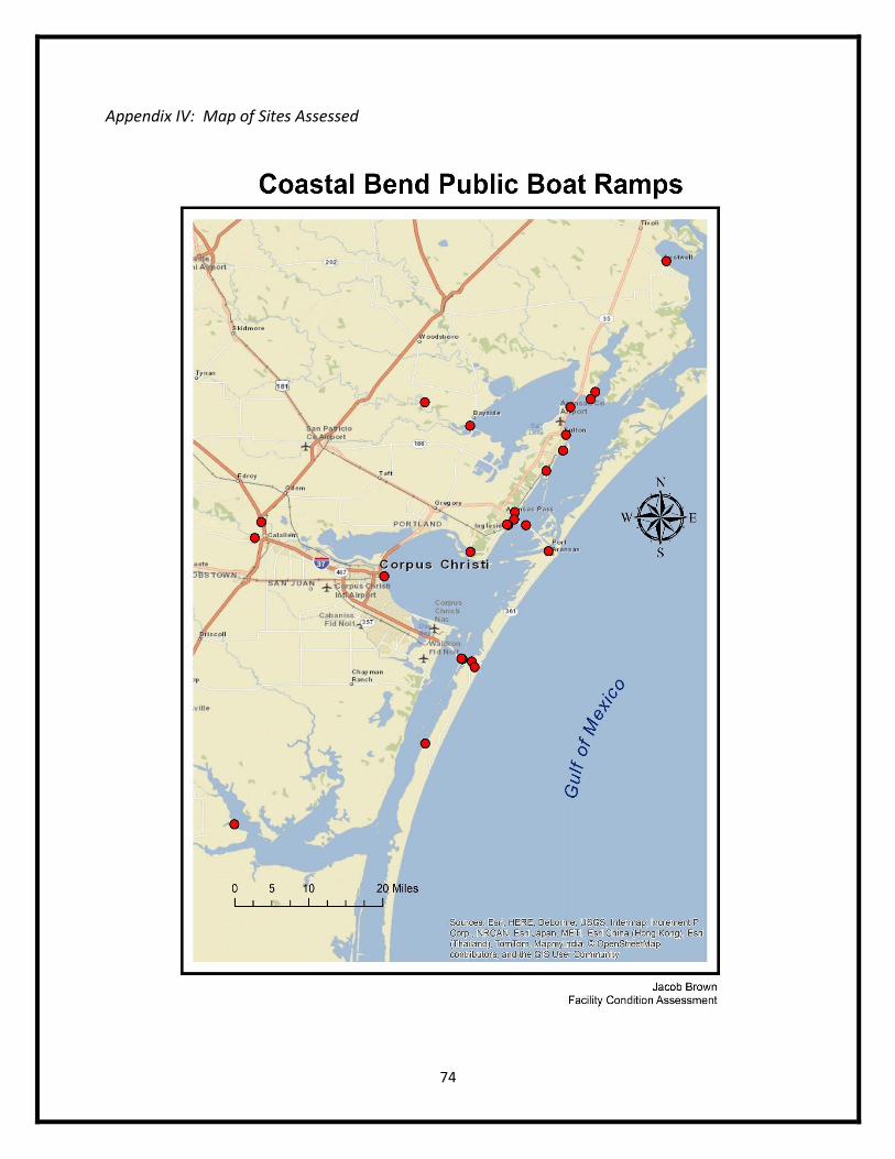
74
Appendix IV: Map of Sites Assessed
75
Literature Cited
(2015) Brahney Paving. Asphalt Paving. <http://www.fixasphalt.com/asphalt-paving>
(2015) Cost Helper Home & Garden. Repairing a Deck Cost. <home.costhelper.com/deck-
repair.html.
(2015) Google Maps. Decimal Degrees.
(2015) Google Shopping. Aluminum Hand Rails.
(2015) Google Shopping. Tie Offs-Metal Cleats.
(2011) Naismith Engineering Inc. Nueces County Coastal Parks Master Plan.
(2007) Pierce County Government. Park and Facility Condition Assessment.
<http://www.piercecountywa.org/DocumentCenter/View/4973>
(2015) Signs. Custom Aluminum Signs. <www.signs.com/aluminum/>.
(2015) Skid-O-Kan. Phone Number (361) 949-5571.
(2015) Texas General Land Office. Texas Coasts Application. Austin, TX. <txcoasts.com#>.