Embed Size (px)
Citation preview
Faculty of Electrical Engineering
DESIGN AND DEVELOPMENT OF MOBILE ROBOT
THEMATIC MAPPING USING FLEXIBLE ELLIPSE SHAPE
REGION
Mohd Hafiz Bin Taib
Master of Science in Electrical Engineering
2014
DESIGN AND DEVELOPMENT OF MOBILE ROBOT THEMATIC MAPPING
USING FLEXIBLE ELLIPSE SHAPE REGION
MOHD HAFIZ BIN TAIB
A thesis submitted in fulfilment of the requirements for the award of
the degree of Master of Science in Electrical Engineering
Faculty of Electrical Engineering
UNIVERSITI TEKNIKAL MALAYSIA MELAKA
2014
DECLARATION
I hereby declare that this thesis entitled “Design and Development of Mobile Robot
Thematic Mapping using Flexible Ellipse Shape Region” is the result of my own research
except as cited in the references. The thesis has not been accepted for any degree and is not
concurrently submitted in candidature of any other degree.
Signature : ………………………
Name : MOHD HAFIZ BIN TAIB
Date :
APPROVAL
I hereby declare that I have read this thesis and in my opinion this thesis is sufficient in
terms of scope and quality for the award of Master of Science in Electrical Engineering.
Signature : ………………………
Supervisor Name : MUHAMMAD FAHMI BIN MISKON
Date :

DEDICATION
To my beloved family, family in law and wife
ABSTRACT
Map is used to associate the entity of normal data distribution of an environment and also be used as a reference to detect changes in monitoring application. However, there is limitation in the use of a map if the designer of a robot needs to consider its resources, such as usage of memory space. The available map has a problem in terms of rigid structure or rigid perception of robot heading and indirectly uses a lot of memory space. Therefore, a new mapping technique called flexible ellipse shape region is proposed in this study. The ellipse boundary can be changed to accommodate normal data distribution of environment and it allows perception of robot heading to be mapped to normal data distribution from 0° until 360°. The objective of this study is to design and validate a new mapping technique, called flexible ellipse shape region. The performance of the map will be compared with grid map, perception based map and flexible region map in terms of memory space, access time and accuracy of map. Number of region is used to measure memory space of different maps. Meanwhile, the access time is calculated using time complexity, while accuracy of map is measured using new technique of confidence region. The experiments were conducted using Amigobot mobile robot in an L-shaped environment equipped with sonar sensor. The robot also has to carry a light sensor and a temperature sensor. The results of the experiments have shown that flexible ellipse shape region used 0.13%, 5%, 13.04% of memory space when being compared to grid map, perception-based map and flexible region map when being mapped with non-directional sensor data. In terms of access time, flexible ellipse shape region has used less time when being compared to perception based map and flexible region map. However, flexible ellipse shape region uses more access time when being compared to grid map. Lastly, map accuracy of flexible ellipse shape region is found to be higher, which is about 55.5% when being compared to flexible region map when being mapped with non-directional sensor data.
i
ABSTRAK
Peta digunakan untuk memaparkan entiti taburan data normal persekitaran dan digunakan sebagai rujukan untuk mengesan perubahan seperti dalam aplikasi pemantauan. Akan tetapi terdapat had untuk menggunakan peta jika pereka bentuk robot memerlukan pertimbangan bagaimana sumber yang terdapat pada robot seperti penggunaan ruang memori dapat dioptimumkan. Peta sedia ada mempunyai masalah dari segi struktur yang rigid dan persepsi robot yang rigid dan secara tidak langsung menggunakan memori yang banyak. Oleh itu teknik peta yang baru yang dipanggil rantau fleksible berbentuk elips telah dicadangkan. Sempadan elips boleh bertukar untuk menampung taburan data normal persekitaran dan ia membenarkan persepsi robot untuk memetakan taburan data normal persekitaran daripada 0° until 360°. Objektif tesis ini adalah untuk mereka bentuk dan mengesahkan satu teknik pemetaan yang baru yang dipanggil rantau fleksible berbentuk elips. Prestasi peta ini akan dibandingkan dengan peta grid, peta berasaskan persepsi dan peta rantau fleksible dari segi ruang memori, masa mengakses dan ketepatan peta. Jumlah bilangan rantau digunakan untuk mengira ruang memori bagi peta yang berbeza. Sementara itu masa mengakses peta dikira dengan menggunakan kompleksiti masa. Kemudian ketepatan peta diukur dengan menggunakan teknik baru bagi rantau keyakinan. Eksperimen dijalankan dengan menggunakan robot mudah alih Amigobot di dalam persekitaran berbentuk L. Amigobot telah disediakan dengan sonar sensor. Robot mudah alih juga membawa sensor cahaya dan sensor suhu. Keputusan kajian daripada beberapa eksperimen menunjukkan rantau fleksible berbentuk elips menggunakan 0.13%, 5%, 13.04% ruang memori berbanding grid map, peta berasaskan persepsi dan peta rantau fleksible apabila memetakan data yang tidak sensitif pada arah. Dari segi masa mengakses rantau fleksible berbentuk elips menggunakan masa yang lebih sedikit apabila dibandingkan dengan peta rantau fleksible dan peta berasaskan persepsi. Walaubagaimanapun rantau fleksible berbentuk elips menggunakan masa yang lebih banyak apabila dibandingkan dengan peta grid. Akhir sekali, ketepatan peta bagi rantau fleksible berbentuk elips adalah lebih tinggi kira-kira sebanyak 55.5% apabila dibandingkan dengan peta rantau fleksible apabila memetakan data yang tidak sensitif pada arah.
ii
ACKNOWLEDGEMENT
Firstly, praise Allah, the Almighty, whom we ultimately depends on for sustenance and guidance. Secondly, I would like to express my sincere appreciation and deeply indebted to my main supervisor Dr. Muhammad Fahmi Bin Miskon and my co-supervisor Dr. Hamzah Bin Sakidin, for their assistance, constructive suggestions and encouragement which have helped me all the times of research and writing of this thesis.
I also would like to express my gratitude to members of CERIA laboratory, especially to Mohd Nurul Al-Hafiz Bin Sha’abani, Mohd Hanif Bin Harun, Bazli Bin Bahar,Awangku Khairul Ridzwan, Mohd Ihsan Bin Sabri, Mohd Razmi Bin Razali, Kamarul Syaffiq and Hafizah Binti Rahim for their valuable advices and suggestions throughout the project.
I also wish to thank UTeM, the Faculty of Electrical Engineering and financial grant from KPT throughout this project under Exploratory Research Grant Scheme (ERGS).
Also my special thanks to my parents, Taib and Meriam, sister Hafizah, her husband Zaidi, nephew Amar Ariff, niece Nadia Natasya and brother Hanif for their support and care in these years. Not to forget my parent-in-laws, Yazid and Umi, brother and sister in-laws, Yasir, Mutawakillah, his wife and daughter Maryam, and Bintu Yazid.
Finally, I thank my beloved wife who has always been supportive, helpful and considerate in my work.
.
iii
TABLE OF CONTENT
PAGE
DECLARATION ii APPROVAL ii DEDICATION ii ABSTRACT i ABSTRAK ii ACKNOWLEDGEMENT iii TABLE OF CONTENT iv LIST OF TABLES vii LIST OF FIGURES viii LIST OF ALGORITHM xii LIST OF APPENDICES xiii LIST OF PUBLICATION xiv CHAPTER 1. INTRODUCTION 1
1.1 Background 1 1.2 Motivation of Research 2 1.3 Problem Statement 2 1.4 Objective of Research 4 1.5 Scope of Study 5 1.6 Significance of Study 5 1.7 Contribution of Research 6 1.8 Thesis Outline 8
2. LITERATURE REVIEW 10 2.1 Introduction 10 2.2 Thematic Mapping 11
2.2.1 Spatial Indexing 13 2.2.2 Map Used by Mobile Robot 14
2.3 Map Performance Analysis 22 2.3.1 Memory Space : Number of Region 23 2.3.2 Access time : Time Complexity 24
2.4 Summary 26
3. RESEARCH METHODOLOGY 29 3.1 Introduction 29 3.2 Perception Based Map 31
3.2.1 Definition and Design Consideration 31 3.2.2 Creation of a region 32
3.3 Flexible Region Map 34 3.3.1 Definition and Design Consideration 34 3.3.2 Initiation of a Region 35 3.3.3 Expansion of the Region 36 3.3.4 Merging Two Region 39
iv
3.4 Flexible Ellipse Shape Region 41 3.4.1 Definition and Design Consideration 41 3.4.2 Initiation of a Region 44 3.4.3 Expansion of the Region 44 3.4.4 Merging Two Region 48
3.5 Summary of Mapping Process 55 3.6 New Technique for Measuring Accuracy of the Map 56
3.6.1 Confidence Region 57 3.7 Summary 59
4. GENERAL DESIGN OF EXPERIMENT 60 4.1 Environment Setup 60 4.2 Amigobot 63 4.3 Monitoring Software 65
5. RESULTS AND DISCUSSION 67 5.1 Introduction 67 5.2 Experiment of Memory Space 67
5.2.1 Experiment 1 : Memory space when mapping different type of sensor measurement with different type of mapping technique. 68
5.2.1 Experiment 2 : Memory space when mapping light sensor measurement with different type of mapping technique. 76
5.2.2 Experiment 3 : Memory space when mapping different type of sensor measurement with different type of mapping technique using different type of route. 80
5.2.3 Experiment 4 : To see the effect of changing the value of the region tolerance, RT on the usage of memory space 92
5.3 General Discussion of Memory Space 97 5.4 Experiment 5 : Access time when mapping with different type of
mapping technique 98 5.5 Experiment of Accuracy of Map 100
5.5.1 Experiment 6 : Accuracy of map when mapping different type of sensor measurement with different type of mapping technique. 100
5.5.2 Experiment 7 : Accuracy of map when mapping different type of sensor measurement with different types of mapping technique using different types of route. 106
5.5.3 Experiment 8 : To see the effect of changing the value of the region tolerance, RT to accuracy of map 117
5.6 General Discussion of Accuracy of Map 122
6. CONCLUSION 124 6.1 Introduction 124 6.2 Conclusion 124 6.3 Future Work 126
REFERENCES 127 APPENDIX – A : Specification of Amigobot 132 APPENDIX – B : Algorithm of Ellipse Boundary 133
v

APPENDIX – C : Experimental Result 135
vi
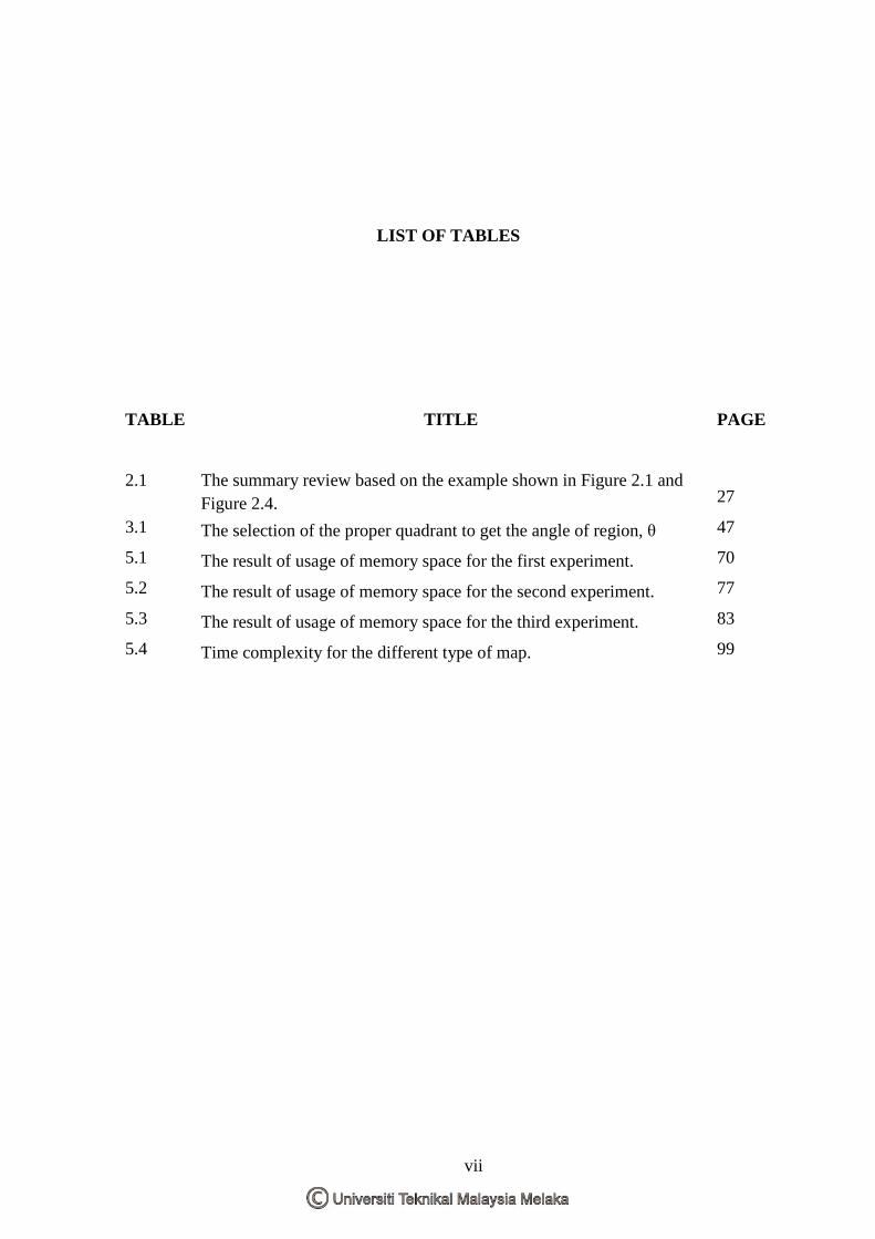
LIST OF TABLES
TABLE TITLE PAGE
2.1 The summary review based on the example shown in Figure 2.1 and Figure 2.4. 27
3.1 The selection of the proper quadrant to get the angle of region, θ 47
5.1 The result of usage of memory space for the first experiment. 70
5.2 The result of usage of memory space for the second experiment. 77
5.3 The result of usage of memory space for the third experiment. 83
5.4 Time complexity for the different type of map. 99
vii
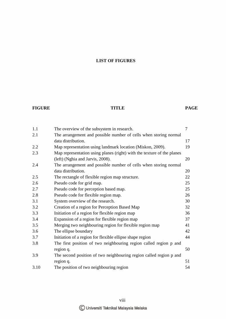
LIST OF FIGURES
FIGURE TITLE PAGE
1.1 The overview of the subsystem in research. 7 2.1 The arrangement and possible number of cells when storing normal
data distribution. 17 2.2 Map representation using landmark location (Miskon, 2009). 19 2.3 Map representation using planes (right) with the texture of the planes
(left) (Nghia and Jarvis, 2008). 20 2.4 The arrangement and possible number of cells when storing normal
data distribution. 20 2.5 The rectangle of flexible region map structure. 22 2.6 Pseudo code for grid map. 25 2.7 Pseudo code for perception based map. 25 2.8 Pseudo code for flexible region map. 26 3.1 System overview of the research. 30 3.2 Creation of a region for Perception Based Map 32 3.3 Initiation of a region for flexible region map 36 3.4 Expansion of a region for flexible region map 37 3.5 Merging two neighbouring region for flexible region map 41 3.6 The ellipse boundary 42 3.7 Initiation of a region for flexible ellipse shape region 44 3.8 The first position of two neighbouring region called region p and
region q. 50 3.9 The second position of two neighbouring region called region p and
region q. 51 3.10 The position of two neighbouring region 54
viii
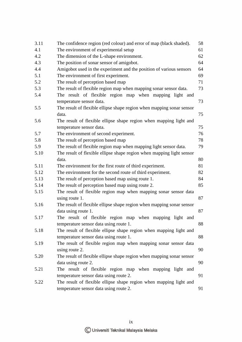
3.11 The confidence region (red colour) and error of map (black shaded). 58 4.1 The environment of experimental setup 61 4.2 The dimension of the L-shape environment. 62 4.3 The position of sonar sensor of amigobot. 64 4.4 Amigobot used in the experiment and the position of various sensors 64 5.1 The environment of first experiment. 69 5.2 The result of perception based map 71 5.3 The result of flexible region map when mapping sonar sensor data. 73 5.4 The result of flexible region map when mapping light and
temperature sensor data. 73 5.5 The result of flexible ellipse shape region when mapping sonar sensor
data. 75 5.6 The result of flexible ellipse shape region when mapping light and
temperature sensor data. 75 5.7 The environment of second experiment. 76 5.8 The result of perception based map 78 5.9 The result of flexible region map when mapping light sensor data. 79 5.10 The result of flexible ellipse shape region when mapping light sensor
data. 80 5.11 The environment for the first route of third experiment. 81 5.12 The environment for the second route of third experiment. 82 5.13 The result of perception based map using route 1. 84 5.14 The result of perception based map using route 2. 85 5.15 The result of flexible region map when mapping sonar sensor data
using route 1. 87 5.16 The result of flexible ellipse shape region when mapping sonar sensor
data using route 1. 87 5.17 The result of flexible region map when mapping light and
temperature sensor data using route 1. 88 5.18 The result of flexible ellipse shape region when mapping light and
temperature sensor data using route 1. 88 5.19 The result of flexible region map when mapping sonar sensor data
using route 2. 90 5.20 The result of flexible ellipse shape region when mapping sonar sensor
data using route 2. 90 5.21 The result of flexible region map when mapping light and
temperature sensor data using route 2. 91 5.22 The result of flexible ellipse shape region when mapping light and
temperature sensor data using route 2. 91
ix
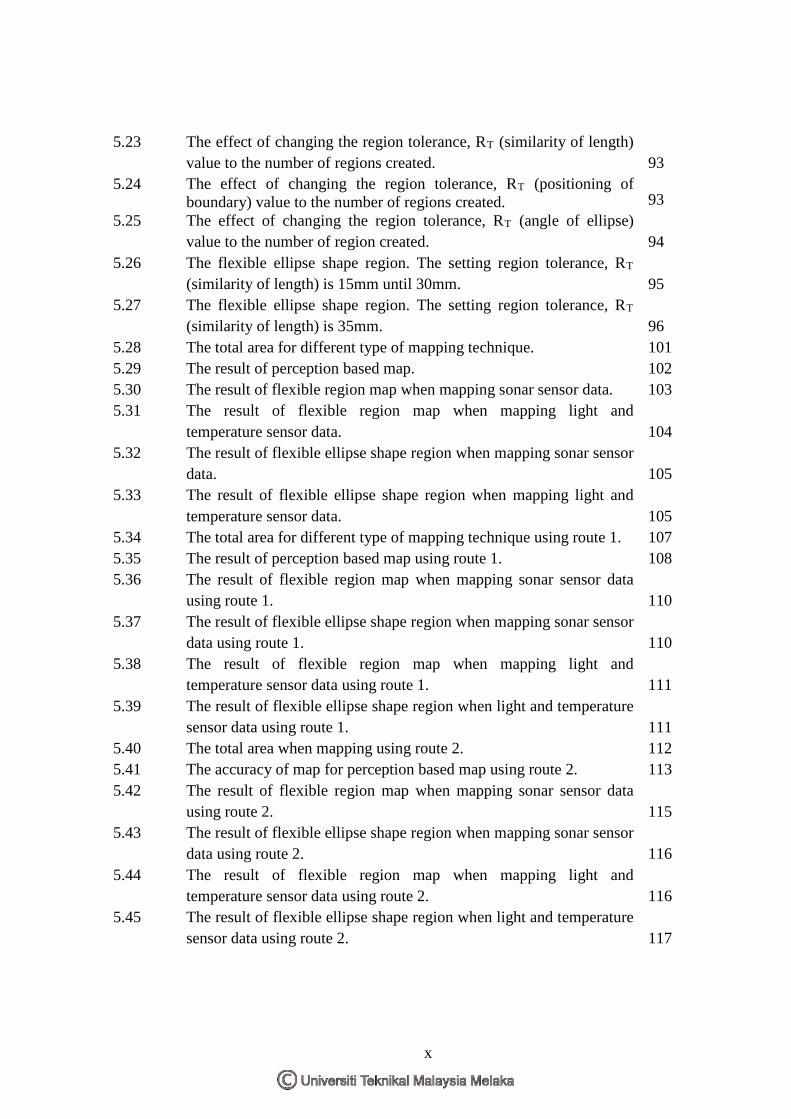
5.23 The effect of changing the region tolerance, RT (similarity of length) value to the number of regions created. 93
5.24 The effect of changing the region tolerance, RT (positioning of boundary) value to the number of regions created. 93
5.25 The effect of changing the region tolerance, RT (angle of ellipse) value to the number of region created. 94
5.26 The flexible ellipse shape region. The setting region tolerance, RT (similarity of length) is 15mm until 30mm. 95
5.27 The flexible ellipse shape region. The setting region tolerance, RT (similarity of length) is 35mm. 96
5.28 The total area for different type of mapping technique. 101 5.29 The result of perception based map. 102 5.30 The result of flexible region map when mapping sonar sensor data. 103 5.31 The result of flexible region map when mapping light and
temperature sensor data. 104 5.32 The result of flexible ellipse shape region when mapping sonar sensor
data. 105 5.33 The result of flexible ellipse shape region when mapping light and
temperature sensor data. 105 5.34 The total area for different type of mapping technique using route 1. 107 5.35 The result of perception based map using route 1. 108 5.36 The result of flexible region map when mapping sonar sensor data
using route 1. 110 5.37 The result of flexible ellipse shape region when mapping sonar sensor
data using route 1. 110 5.38 The result of flexible region map when mapping light and
temperature sensor data using route 1. 111 5.39 The result of flexible ellipse shape region when light and temperature
sensor data using route 1. 111 5.40 The total area when mapping using route 2. 112 5.41 The accuracy of map for perception based map using route 2. 113 5.42 The result of flexible region map when mapping sonar sensor data
using route 2. 115 5.43 The result of flexible ellipse shape region when mapping sonar sensor
data using route 2. 116 5.44 The result of flexible region map when mapping light and
temperature sensor data using route 2. 116 5.45 The result of flexible ellipse shape region when light and temperature
sensor data using route 2. 117
x
5.46 The effect of changing the region tolerance, RT (similarity of length) value to the total area of the map. 118
5.47 The effect of changing the region tolerance, RT (positioning of boundary) value to the total area of the map. 119
5.48 The effect of changing the region tolerance, RT (angle of ellipse) value to the total area of the map. 120
5.49 The flexible ellipse shape region. The setting region tolerance, RT (similarity of length) is 15mm until 30mm. 121
5.50 The flexible ellipse shape region. The setting region tolerance, RT (similarity of length) is 35mm. 121
xi
LIST OF ALGORITHM
ALGORITHM TITLE PAGE
3.1 The creation and expansion process 55 3.2 The merging process 56
xii
LIST OF APPENDICES
APPENDIX TITLE PAGE
A Specification of AmigoBot 132 B Algorithm of Ellipse Boundary 133 C Experimental Result 135
xiii
LIST OF PUBLICATION
1. TAIB, M. H., MISKON, M. F. & SHA'ABANI, M. N. A. H. 2011. "Mapping Ambient Temperature Using Flexible Ellipse Shape Region Map". Malaysian Technical Universities International Conference on Engineering & Technology (MUiCET 2011).
2. TAIB, M. H., MISKON, M. F., SAKIDIN, H. & SHA'ABANI, M. N. A. H. 2014. Defining the Boundary of Regions in Thematic Map Using Flexible Ellipse Shape Region. Australian Journal of Basic and Applied Sciences (AJBAS 2014), 171-186.
xiv
CHAPTER 1
INTRODUCTION
This chapter describes the background, motivation and problem statements to give
an idea of the contribution of this research study. The objective, scope and significance of
the study are also described here. Lastly this chapter ends with an outline of the thesis.
1.1 Background
Mapping is a technique to display and assign the entity for normal data distribution
of an environment. Typical use of a map in robotics field is to determine a robot pose. A
lot of researches have been done in this area. Sebastian Thrun in (Thrun, 2002) has
described in details the characteristics of different mapping approaches (mainly for indoors
environment). Other than determining robot pose, map is also used to have awareness of a
robot surrounding (Toda et al., 2012, Mansley et al., 2011). The latter use of a map is
described as thematic map (Radhadevi, 2013, Fauvel et al., 2013) or a map that represents
the spatial pattern of attribute or theme. The objective of the map is to allocate the status of
a normal data distribution with respect to where the measurement is taken in the
environment. This research concentrates on the study of thematic map for mapping normal
data distribution of an environment particularly for novelty detection. Example application
1
of such map is monitoring application (Boehm et al., 2013) or for adaptation or learning
(Miskon and Russell, 2009a).
1.2 Motivation of Research
Computer memory is getting cheaper these days and cloud allows online storage
(Almorsy et al., 2011). However, there are applications that still require considering
memory space for storage. The problem of swarm robotic (Boubou and Tagawa, 2011) and
micro robotic (Jaramillo et al., 2013) in terms of power supply, physical size and physical
weight of the robot is taken seriously. As an example, flying micro robot (Heng et al.,
2011) is restricted to carry the power supply. Thus, even though the price of memory is
reasonable nowadays, designers are still thinking ways of how the robot’s resources, such
as memory space could be optimized. When memory space can be reduced that means
more area can be mapped.
1.3 Problem Statement
Mapping normal data distribution is defined as mapping the commonly observed
measurement with sensors. It is a task that cannot be taken lightly. This is because it varies
from place to place or time to time. That is one of the difficulties in its modelling or
mapping.
Furthermore conventional map such as grid map (Einhorn et al., 2011) and quadtree
map (Cocaud and Jnifene, 2010) needs to be predefined and have a rigid structure (non-
flexible). It causes these maps to use a lot of memory space. If the robot having small
2
physical size use conventional map such as grid map to map the normal data distribution of
environment, this will reduce the size of the environment to be mapped, demands more
energy and memory space. This is the reason why flexible region map has been introduced.
Flexible region map (Miskon and Russell, 2009b) has a flexible structure. The
structure can grow and merge. The advantage of the map being, if the normal data
distribution of environment has similar readings, the usage of memory space of flexible
region map is less than conventional map. If the usage of memory space can be optimized
that means more area can be mapped. However the flexible region map has a limitation if
the normal data distribution of an environment is not aligned to 4 discrete values of robot
heading such as 0°, 90°, 180° and 270°. If flexible region map faces the problem then the
usage of memory space of the map is increased. Therefore, to solve the problem a new map
called flexible ellipse shape region is proposed in this study.
Flexible ellipse shape region is a type of flexible maps. It is also able to grow and
merge. When using the ellipse to define the boundary instead of rectangle, the angle of
robot perception is not limited anymore because the boundary of the map can map the
normal data distribution from 0° until 360°. For this reason, under certain condition the
usage of memory space for the flexible ellipse shape region is less than flexible region
map. This allows memory space to be optimized.
Another issue in the field of mapping is the access time (Miskon, 2009). When the
normal data distribution is mapped using the flexible mapping technique, the access time to
get the information from the map is not as direct as conventional grid map. Study on this
performance parameter has not been conducted yet, therefore the performance of flexible
maps in terms of access time is unknown. In this study, it is hypothesized that the flexible
types of maps demand more access time as compared to the grid map.
3
The accuracy of the map is one of the topics in the study of mapping. The accuracy
in this study is defined as how accurate the map can represent the normal data distribution
of an environment (Jachalsky, 2010). When using flexible mapping technique, the
boundary of the maps could change. Hence the measurement of the accuracy of map or
how accurate the boundary created to bound the area of similar data distribution. If similar
normal data distribution is mapped using flexible region map and flexible ellipse shape
region, the accuracy of map of flexible region map is found to be higher because the total
area of flexible region map is more flexible than ellipse shape region. This statement is
based on general equations of rectangle and ellipse as shown in equation (1.1) and equation
(1.2) where AR is the area of rectangle boundary for flexible region map and AE is the area
of ellipse boundary of flexible ellipse shape region.
𝐴𝐴𝑅𝑅 = 𝑙𝑙𝑙𝑙𝑙𝑙𝑙𝑙ℎ𝑡𝑡 × 𝑤𝑤𝑤𝑤𝑤𝑤𝑡𝑡ℎ (1.1)
𝐴𝐴𝐸𝐸 = 𝑚𝑚𝑚𝑚𝑚𝑚𝑚𝑚𝑚𝑚 × 𝑚𝑚𝑤𝑤𝑙𝑙𝑚𝑚𝑚𝑚 × 𝜋𝜋 (1.2)
1.4 Objective of Research
The objective of this research is to propose and validate a new idea to overcome the
problem of mapping normal data distribution of environment. It is based on the following
points :
1. To design and develop a new map with flexible structure using ellipse shape
boundary.
4
2. To design and develop a new map with flexible perception of robot heading using
ellipse shape boundary.
3. To investigate the performances of different types of maps perceived by different
types of sensors using different routes in terms of memory space, access time and
accuracy of map.
1.5 Scope of Study
The scope of the research is as follows :
1. The experiments use Amigobot to collect normal data distribution of environment.
2. There are three types of normal data distribution of environment that will be
collected, namely sonar data, ambient temperature and ambient light.
3. The experiments use sonar sensor, ambient temperature sensor and ambient light
sensor.
4. There is one of the experiments that collect data of a lamp in a dark lab.
5. The test is conducted in a laboratory environment (L-shape).
6. The software used for developing offline maps is Matlab R2009a.
1.6 Significance of Study
There are many benefits when mapping normal data distribution using mobile
robot. One of the advantages due to the mobility of mobile robot is it provide the
opportunities and allows a static sensor to overcome its limitation such as limited work
range (Russell, 2007). Hence, installation of static sensor was not practical because it
5