Embed Size (px)
Citation preview

NORTH TECHNICAL UNIVERSITY
FACULTY OF ENGINEERING IN APPLIED SCIENCES
CAREER OF ENGINEERING IN COMPUTER SYSTEMS
TOPIC
“STUDY AND IMPLEMENTATION OF A SYSTEM GIS WEB FOR THE SYSTEM OF
AVALUOS AND CADASTERS OF THE ILLUSTRIOUS MUNICIPALITY OF IBARRA”
APPLICATION
“SYSTEM GIS FOR THE REGULATED AREA OF THE CANTON OF IBARRA”
Author: Byron Mesias Cueva Cabrera.
Director: Ing. Mauricio Rea.
Ibarra – Ecuador

EXECUTIVE SUMMARY
The present document details all the
processes that were continued for the
development of the System GIS for the
regulated area of Ibarra (GIS IMI); for the
System of Cadasters and Avaluos of the
Illustrious Municipality of Ibarra.
In the elaboration and development of the
System GIS IMI, the document presents five
chapters. In each one it is detailed the
processes, methodologies and concepts that
will serve as help in the course of the
elaboration of the System.
In the chapter one, a description is made
subsequently from the institution to which
leaves to apply the system, in the chapter
two main concepts they are detailed that
they are involved and they are necessary to
know in the development of the application.
In the chapter three, are carried out an
analysis of the tools for the development of
the system and it is selected the most
advisable according to the architecture to
outline.
The chapter four are developed through the
phases of the software methodology XP
(Extreme Programming), being this one of
those more used by the bosses of projects.
Lastly in the chapter five the conclusions are
detailed those that you has ended up when
carrying out the System.
CHAPTER I
1. INTRODUCTION
1.1. Antecedents
The Illustrious Municipality of Ibarra is a
public Institution that has as mission to Plan,
to regulate, to execute and to promote the
sustainable integral development of the
canton of Ibarra, through efficient and
transparent services of quality with the
active participation of the citizenship
socially in order to achieve a good one to
live.
The cadastral information, especially the
one referred to the value of the surface of
the inhabited areas, is a fact more associated
to the territorial entities and therefore, it is
in susceptible principle of being negotiated
by Systems of Geographical Information.
The Systems GIS facilitates the connection of
geographical information with descriptive
information. Contrary to a traditional map, a
GIS can present on the map of a certain
region, in way interactive, several layers that
you/they overcome and that they contain
thematic information; for example, have

3 Byron Mesias Cueva Cabrera
more than enough natural resources, human
establishments, education, transport, health,
agriculture, geology, etc.
1.2. Base Legal of the Institution.
1.2.1. Mission of IMI.
The municipality of Ibarra plans, it
regulates, it executes and it promotes the
sustainable integral development of the
canton, through efficient and transparent
services of quality with the active
participation of the socially responsible
citizenship in order to achieve the good one
to live.
1.2.2. Vision of IMI.
We will be a municipality leader in
administration with social responsibility
that guarantees justness, honesty, work and
efficiency why Ibarra is constituted in a
prosperous canton, attractiveness and
incluyente, capital of the services and the
knowledge, relating of the good one to live
in the north region of the Ecuador.
1.3. Problem.
At the present time the Municipality of
Ibarra has a system GIS, in which the space
information is managed through plane files,
making these that the consultations of
properties and analysis of the geographical
information are slow and difficult, the access
of the users is not also concurrent and it is
limited alone to the local net of the
Municipality.
The System GIS at the moment works in a
desk environment through a control called X
it Activates MapObject and Visual Basic, that
which limits its yield a lot since all the
geographical information is managed
through shapefiles.
1.4. Objectives.
1.4.1. General Objective.
To implement a System of Geographical
Information Web that allows the interaction
with the System of Cadasters and
Evaluations of the Municipality of Ibarra, of
quick access and attendee for the users.
CHAPTER II
2. THEORETICAL MARCO.
2.1. System of Geographical
Information.
A GIS can be defined as a software group,
hardware, methodologies, data and people
(users), perfectly integrated, so that ago
possible the gathering, storage, prosecution
and analysis of data georeferenciados, as

4 Byron Mesias Cueva Cabrera
well as the production of information of its
application, with the purpose of solving
administration problems and of planning.
[Lib.01]
2.2. Exchange of Space data in the
Web.
2.2.1. The Open Geospacial Consortium
OGC.
The OGC (Open Geoespatial Consortium) she
is born in 1994, it is an international
organization without ends of lucre,
integrated by companies, public organisms
and Universities, in a consent process for the
definition of open standards and
interoperables inside the Systems of
Geographical Information and of the World
Wide Web, looking for agreements that
facilitate the interoperación of
geoprocesamiento systems and to facilitate
the exchange of the geographical
information.
2.2.2. Languages of Marked.
A language of marked is a form of coding a
document that together with the text, it
incorporates labels or marks that contain
additional information about the structure
of the text or its presentation. As: XML,
HTML, GML, KML, SVG and GeoRSS.
2.2.3. Formatos Vectoriales.
They are formats for code of a variety of
structures of expressed geographical data in
a vectorial way. As: GeoJSON and WKT.
2.2.4. OGC Web Services (OWS).
The OWS is specifications of standard
international for the OGC for the use of the
geographical information through the Web.
It is the generic name with which all the
standard OGC groups Web Services (WMS,
WFS, WCS, CSW, WPS, etc.). [Lib.02]
2.2.4.1. WMS (Web Map Services).
The service Web Map Services interactúa
with the clients through petitions HTTP,
produces maps indexed spacely in a
dynamic way, starting from geographical
information. These maps are
correspondents to the clients in form of
digital image.
Figure 1 OCG WMS
Source: [www.01]
2.2.4.2. WFS (Web Features Services).
WFS provides an interface that allows the
client to obtain and to upgrade data
georeferenciados by means of the format
GML of multiple servants WFS using the
protocol HTTP. It allows to consent to

5 Byron Mesias Cueva Cabrera
vectorial data and to consult all the
attributes of a phenomenon (feature)
geographical.
Through these interfaces it can combine, to
use and to manipulate the information that
is behind the maps by means of the
invocation of operations WFS on the
geographical elements.
Figure 2 OCG WFS
Source: [www.01]
2.2.4.3. WCS (Web Coverage Service).
It defines the interface and operations that
allow the access interoperable to
"coverages" geoespaciales, the term refers to
content as: images satelitales, air pictures,
digital models of elevation (DEM), and any
space phenomenon represented by values in
each measure point. [Lib.03]
2.3. Database.
2.3.1. Relational Database.
2.3.1.1. PostgreSQL.
It is a system of database administration
object-relational, since it includes
characteristic of orientation to objects, as
inheritance, types of data, functions,
restrictions, triggers, rules and transactional
integrity. PostgreSQL is characterized to be a
stable system, of high yield, great flexibility
since works in most of the operating
systems.
PostgreSQL uses a model client servant and
it uses multiprocesos to guarantee the
stability of the system, a failure in one of the
processes won't affect the rest and the
system continued working.
2.3.2. Spatial Database.
2.3.2.1. PostGIS.
It is a module that he adds support of
geographical objects to the database object-
relacional PostgreSQL, transforming it into a
space database for their use in GIS.
Their implementation is based on
geometries and optimized slight indexes, to
reduce the disk use and memory.
2.4. Servers of Applications.
2.4.1. HTTP Apache.
It is a servant web HTTP of open code, for
platforms Unix (BSD, GNU/Linux, etc.),
Microsoft Windows, Macintosh and other
that implements the protocol HTTP/1.1 and
the notion of virtual place. [www.02]
2.4.2. Tomcat.
It works as a servlets container developed
under the project Jakarta in the Apache

6 Byron Mesias Cueva Cabrera
Software Foundation. Tomcat implements
the specifications of the servlets and of
JavaServer Pages (JSP) of Sun Microsystems.
It works in any operating system that has
the virtual machine Java. [www.03]
2.5. Languages of Programming.
2.5.1. CSS.
It is a language used to control the aspect or
presentation of the defined electronic
documents with HTML and XHTML. CSS is
the best form of separating the contents and
its presentation and it is indispensable to
create pages complex web. [www.04]
2.5.2. PHP.
It is an interpreted programming language
(Language of high yield), designed originally
for the creation of pages dynamic web. It is
used mainly for the interpretation on the
side of the servant (server-side scripting).
[www.05]
2.5.3. JAVASCRIPT.
It is an interpreted programming language,
dialect of the standard ECMAScript. He is
defined as guided to prototypes, imperative,
weakly tipado and dynamic, developed to
increase the functionalities of the language
HTML. [www.06]
2.5.4. PHP MAPSCRIPT.
It is a module to enlarge functionalities to
PHP so that he works with MapServer. This
module will allow him to use the language of
scripting of great reach of PHP to create and
to modify in a dynamic way the images of
map of MapServer. [www.07]
2.5.5. MAPFILE.
It is the main file of configuration of
MapServer. It is a text file, with extension ".
map", in that a series of parameters is
included which define the available layers in
the service, the style with which they will be
represented, its simbología in that format
will be generated the image, the reference
system, etc. [www.08]
2.6. FRAMEWORKS
It is a conceptual and technological structure
of defined support, usually with devices or
concrete software modules, with base to
which another software project can be more
easily organized and developed. [www.09]
2.6.1. Symfony 1.16.
It is a framework PHP that facilitates and it
optimizes the development of the
applications web. Symfony takes charge of
all the common and boring aspects of the
applications web, letting the programmer to
be devoted to contribute value developing
the unique characteristics of each project.
Symfony separates the business logic, the
servant logic and the presentation of the
application web. [www.10]
2.6.2. Dcotrine.
Doctrine is a mapeador of object-relacional
(ORM) written in PHP that provides a layer
of persistence for objects PHP. It is a layer of
abstraction that is located exactly above a
SGBD. [www.11]
2.6.3. Ext JS.
It is a library of JavaScript for the
development of applications interactive web

7 Byron Mesias Cueva Cabrera
using technologies like AJAX, DHTML and
DOM. It was developed by Sencha. [www.12]
2.7. Methodology of Extreme
Programming XP.
2.7.1. Definition.
It is an agile methodology based on four
principles: simplicity, communication,
feedback and value. Also guided by tests and
refactorización; the tests are designed
before programs the functionality, the
programmer believes their own unit test. Xp
looks for the client's satisfaction trying to
maintain during the whole time its trust in
the product.
2.7.2. Activities.
2.7.2.1. To Code.
It is necessary to code and to capture our
ideas through the code.
2.7.2.2. To Make Tests.
The tests give the opportunity to know if
that implemented is it that in fact one had in
mind. The tests indicate us that our work
works, when we cannot think of any test
that can originate a failure in our system,
then we will have ended up completely.
2.7.2.3. To Listen.
We have to listen our clients which the
problems of their business are, we should
have one he listens active explaining what is
easy and difficult of obtaining, and the
feedback between both helps us to all to
understand the problems.
2.7.2.4. To Design.
The design believes a structure that
organizes the logic of the system, a good
design it allows that the system grows with
changes in a single place. The designs should
be simple, if in some part of the system it is
of complex development, that adapted is to
divide it in several. If there are shortcomings
in the design or bad designs, these they
should be corrected as soon as possible.
2.7.3. Cycle of Life.
The cycle of life of XP is emphasized in the
character iterativo and incremental of the
development, a development iteration is a
period of time in which is carried out a
group of certain functionalities that
you/they correspond to a group of user's
histories in the case of XP.
The iterations are relatively short since it is
thought that among quicker he is given
developments to the client, more feedback
he will obtain and this will represent a
better quality of the long term product. A
phase of initial analysis guided to program
the development iterations exists and each
iteration includes design, code and tests.
[www.13]
2.7.4. Phases.
2.7.4.1. Phase of Exploration.
In this phase she is defined the reach of the
project. The client details what needs by

8 Byron Mesias Cueva Cabrera
means of the writing of simple Histories of
User. The programmers estimate the times
of development based on this information.
It should be clear that the estimates carried
out in this phase are primary, and they could
vary when it is analyzed more in detail in
each iteracción.
This hard phase typically a couple of weeks,
and the result is a general vision of the
system. [www.13]
2.7.4.2. Phase of Planning.
The phase of planning is a short phase, in
which the client, the managers and the
group of developers agree the order in that
user's histories should be implemented, and,
associated to these, the deliveries. The result
of this phase is the plan of Deliveries.
[www.14]
2.7.4.3. Phase of Iteration.
This is the main phase in the cycle of
development of XP. The functionalities are
developed in this phase, generating at the
end of each an a deliverable one functional
that implements user's histories assigned to
the iteration. The iterations are also used to
measure the progress of the project. An
iteration finishes without errors it is a clear
measure of advance. [www.13]
2.7.4.4. Phase of Production.
It requires tests and extra confirmation of
the operation of the system before this you
can liberate the client. In this phase, the new
changes can still be opposing and he should
take the decision of if it is included or not in
the one rereads you current. [www.13]
2.7.5. Devices.
2.7.5.1. Histories of User.
It represents a brief description of the
behavior of the system, it uses the client's
terminology without technical language, one
is carried out for each main characteristic of
the system, they are used to make estimates
of time and for the plan of deliveries, they
replace a great document of requirements
and they preside over the creation of the
tests of acceptance. [www.14]
2.7.5.2. Tasks of Engineering.
The engineering tasks are used to describe
the tasks that are carried out on the project.
The tasks can be: I develop, correction,
improves, etc.
These tasks have relationship with user's
history; it is specified the beginning date and
end of the task, it is named the responsible
programmer of completing it and we
describe that it is to make in the task.
[www.15]
2.7.5.3. Cases of Test of Acceptance.
It allows to confirm that the history has been
implemented correctly. [www.15]
2.7.5.4. Card CRC.
These cards are divided in three sections
that the information of the name of the class,
their responsibilities and their collaborators
contain. In them the design of the system is
expressed. [www.15]

9 Byron Mesias Cueva Cabrera
2.8. Some Definitions.
2.8.1. Server of Maps.
A servant of maps, good known for their
initials IMS (Internet Map Server) it
provides maps or cartography through the
Internet, facilitating the process of
publication of up-to-date Geographical
Information, in real time and cheaper form
to any part of the world. [www.16].
2.8.2. Clients Light GIS.
A slight client for GIS is an application in
Internet with which we can visualize and to
treat the Geographical Information through
some basic tools of manipulation, sailing and
analysis. [www.17]
2.8.3. Client Heavy GIS.
It is denominated heavy client to the
program "client" of an architecture client-
servant when the biggest computation load
is displaced toward the computer that
executes this program. The program client is
qualified as heavy when it assumes most of
the functionalities. [www.18]
2.8.4. Norma ISO 19110: Methodology
for the creation of catalog of
phenomena.
The ISO 19110 provide a normative mark to
organize and to disclose the classification of
phenomena of the real world, associated to a
relative location to the earth.
It specifies as the classification of
phenomena he is organized in a catalog that
is presented to the users, in the form of a
group of geographical data, and it defines
the methodology to classify diverse types of
phenomena.
CHAPTER III
3. STUDY OF TOOLS GIS - OPEN
SOURCE.
3.1. Open Source.
It is the term with which one knows to the
distributed software and developed freely.
The open code has a point of view more
guided to the practical benefits of sharing
the code that to the ethical and moral
questions which highlight in the call Free
software. [www.19].
3.2. Free software.
The free software, it is the denomination of
the software that respects the freedom of
the users on their acquired product and,
therefore, once obtained it can be used,
copied, studied, modified, and redistributed
freely.
3.3. Servers of Maps.
3.3.1. Square of Compatibility.
Server Server OWS Deegree WMS, WFS, WCS, WFS –T
GeoServer WMS, WFS, WFS-T, WCS

10 Byron Mesias Cueva Cabrera
MapGuide WMS, WFS
MapServer WMS, WFS, WCS
QGIS Server WMS Square 2 Comparative of Server of Maps, Square of
Compatibility
Source: Thesis (Summary)
3.3.2. Square of Technical
Catacterísticas.
Server Platform Deegree Windows, Linux.
GeoServer Windows, Linux, Mac
MapGuide Windows, Linux
MapServer Windows, Linux, Mac, Solaris
QGIS Server Windows, Linux, MacOSX
Square 2 Comparative of Server of Maps, Square of
Technical Characteristics.
Source: Thesis (Summary)
3.3.3. Square of Functionalities and
Characteristic Main.
Server Thematic
maps Symbol
Deegree SI SI
GeoServer SI SI
MapGuide SI SI
MapServer SI SI
QGIS Server
SI SI
Square 3 Comparative of Server of Maps, Square of
Functionalities and Characteristic Main.
Source: Thesis (Resumen)
3.3.4. Selection of Tool.
It has been selected MapServer like servant
of services WMS, WCS and WFS, for the
following reasons:
It is developed in C, reason why it is
quicker to the renderizar moment a
map.
He has a module in PHP (MapScript), for
the biggest control and generation of
dynamic configurations (MapFiles).
It has simbología through regular
expressions and SLD.
It is compatible with most of databases
geoespaciales and formats of vectorial
information and raster.
Also, it was used GeoServer like servant of
services WFS-T, to be slighter than Deegree,
since it is both the only servants that offer
this service. It is also compatible with
GeoExt and OpenLayers.
3.4. Clients Light GIS.
3.4.1. Square of Compatibility.
Client Client OWS Geomajas WMS, WFS, WFS – T
Mapbender WMS, WFS-T
GeoExt WMS, WFS, WFS-T, WCS
MapFish WMS, WFS
OpenLayers WMS, WFS, WCS, WFS-T
GeoMoose WMS, WFS
Square 4 Comparative of Clients Light GIS, Square of
Compatibility.
Source: Thesis (Summary)
3.4.2. Square of Technical
Characteristics.
Client Language Programming
11 Byron Mesias Cueva Cabrera
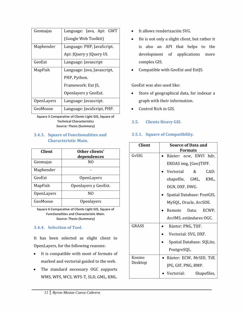
Geomajas Language: Java, Api: GWT
(Google Web Toolkit)
Mapbender Language: PHP, JavaScript.
Api: JQuery y JQuery UI.
GeoExt Language: Javascript
MapFish Language: Java, Javascript,
PHP, Python.
Framework: Ext JS,
Openlayers y GeoExt.
OpenLayers Language: Javascript.
GeoMoose Language: JavaScript, PHP.
Square 5 Comparative of Clients Light GIS, Square of
Technical Characteristics
Source: Thesis (Summary)
3.4.3. Square of Functionalities and
Characteristic Main.
Client Other clients' dependences
Geomajas NO
Mapbender -
GeoExt OpenLayers
MapFish Openlayers y GeoExt.
OpenLayers NO
GeoMoose Openlayers
Square 6 Comparative of Clients Light GIS, Square of
Functionalities and Characteristic Main.
Source: Thesis (Summary)
3.4.4. Selection of Tool.
It has been selected as slight client to
OpenLayers, for the following reasons:
It is compatible with most of formats of
marked and vectorial guided to the web.
The standard necessary OGC supports
WMS, WFS, WCS, WFS-T, SLD, GML, KML.
It allows renderización SVG.
He is not only a slight client, but rather it
is also an API that helps to the
development of applications more
complex GIS.
Compatible with GeoExt and ExtJS.
GeoExt was also used like:
Store of geographical data, for indexar a
graph with their information.
Control Rich in GIS.
3.5. Clients Heavy GIS.
3.5.1. Square of Compatibility.
Client Source of Data and Formats
GvSIG Ráster: ecw, ENVI hdr,
ERDAS img, (Geo)TIFF.
Vectorial & CAD:
shapefile, GML, KML,
DGN, DXF, DWG.
Spatial Database: PostGIS,
MySQL, Oracle, ArcSDE.
Remote Data: ECWP,
ArcIMS, estándares OGC.
GRASS Ráster: PNG, TIIF.
Vectorial: SVG, DXF.
Spatial Database: SQLite,
PostgreSQL.
Kosmo Desktop
Ráster: ECW, MrSID, Tiff,
JPG, GIF, PNG, BMP.
Vectorial: Shapefiles,

12 Byron Mesias Cueva Cabrera
GML, DXF, DWG, DGN,
CSV (por extensión).
Spatial Database: PostGIS,
Oracle, MySQL.
OpenJump Ráster: ECW, MrSID, JPG,
TIFF, MIF.
Vectorial: Shapefiles,
GML, DXF.
Spatial Database:
Postgis, ArcSDE, Oracle
y MySQL.
Quamtum GIS Ráster: Tif, png
Vectorial: shapefiles,
MapInfo, SDTS y GML.
Spatial Database:
Postgis.
Udig Ráster: ECW, MrSID,
JPEG, PNG,TIFF.
Vectorial: Shapefiles.
Spatial Database:
ArcSDE, Oracle, DB2,
Postgis.
Square 7 Comparative of Clients Heavy GIS, Square of
Compatibility.
Source: Thesis (Summary)
3.5.2. Square of Technical
Characteristics.
Client Platforms GvSIG Windows, Linux, MacOS X
GRASS Windows, Linux, MacOS X
Kosmo Desktop
Windows, Linux
OpenJump Windows, Linux, Mac, Unix
Quamtum GIS Windows, Linux, Mac, Unix
Udig Windows, Linux, Mac
Square 8 Comparative of Clients Heavy GIS, Square of
Technical Characteristics.
Source: Thesis (Summary)
3.5.3. Square of Functionalities and
Characteristic Main.
Client Export of vectorial information to Postgis.
GvSIG SI
GRASS SI
Kosmo Desktop
SI
OpenJump NO
Quamtum GIS SI (Plugin Spit)
Udig NO
Square 9 Comparative of Clients Heavy GIS, Square of
Functionalities and Characteristic Main.
Source: Thesis (Resumen)
3.5.4. Selection of Tools.
According to the benefits of these tools it has
been chosen to the tools to be used in the
following way:
GvSIG: For migration of data from the Shape
to the database PostGIS, since this tool
immigration authorities the data just as it is
in the file shape without altering the
attributes, it also follows the standard: the
primary keys or id's name them with gid and
the geometric column with the name
the_geom.
Quamtum GIS: For test of services WMS,
WFS and WFS-T, since are a quick client in
consultation of services OWS.

13 Byron Mesias Cueva Cabrera
uDig: For test of services WMS-C, this it is
the only tool that allows to consume a
service WMS in Cache.
Kosmo: For edition of geographical
information in PostGIS, since bill with more
edition tools.
CHAPTER IV
4. DESIGN AND DEVELOPMENT OF
THE APPLICATION.
The present chapter is developed through
the phases of the methodology of
development Extreme Programming XP.
Firstly in the Phase of Exploration she is
carried out the gathering of user's histories
detailing in them the user's necessities, he
intends the architecture of the System and of
their operation; ending up this way
describing the necessary tereas for the
realization of the system and their priorities.
In the Phase of planning he is carried out the
Plan of Deliveries, which has estimates of
time, to carry out the deliverable ones in
each iteration; subsequently he is carried
out the Phase of Iteration where the work is
detailed carried out in each task of the
necessary iterations for the development of
the System, the same ones that he has as exit
a prototype from the system to which is
applied the defined tests of acceptance by
the user; for I finish when the System fulfills
all the requirements and after having
approved with all the tests of acceptance
you proceeds to the Phase of Production,
where it is detailed the procedures to
continue and requirements so that system
can work in an environment of Production.
4.1. PHASE OF EXPLORATION.
Metaphor
The proposed system is an application GIS
that allows the unfolding of the cadastral
information through thematic maps,
generating a vision and wider analysis when
uniting the geographical object with the
cadastral information of Ibarra. The system
also allows to carry out searches and
location for geographical aspects and
alphanumeric information. Finally the
system allows the obtaining of the
information that affects or it describes the
reality of a property, one could say that a
property is the unit of more essential
information when studying the I castrate of
a city.

14 Byron Mesias Cueva Cabrera
Architecture of the System
Figure 3 Architecture of the System
Source: Owner
Functional Architecture of the System
Figure 4 Functional Architecture of the System
Source: Owner
Modules of the System
Starting from the description of the
functions and processes obtained in user's
histories, the System GIS IMI has been
designed having as main modules the
following ones:
Figure 5 Modules of the System
Source: Owner
Module of Security and Access to the
System: In this module it is where the user
is identified and to the moment to have
access to the system, the different permits
like menus, submenús and articles are
assigned.
Module View of Maps: This module is the
main of the application the same one that
allows the unfolding and sailing of the
cadastral information, through the
consumption of the services OWS.
Module of Consultations and Searches:
This module allows to obtain the
information that the geographical object
generates, that is to say descriptive
information, through searches for different
concepts is already geographical or
alphanumeric information.
Detail of Histories of User
Module of Security and Access to the
System.

15 Byron Mesias Cueva Cabrera
o History of User 1: Security and Control
of Access.
Task 1: To design the structure of
data for the control of Access to
the System.
Task 2: To create the interface for
the into to the System.
Module View of Maps.
o History of User 2: Repository of
geographical data.
Task 1: Installation and
configuration of the module
Postgis.
Task 2: Creation of the database
and user's lists.
Task 3: Summary of the cadastral
information.
Task 4: Migration of the
geographical information.
o History of User 3: Publication of maps
in the web.
Task 1: Installation of Apache.
Task 2: Installation and
configuration of MapServer.
Task 3: Publication of the Service
WMS.
Task 4: Installation of Tomcat.
Task 5: Instalación y configuración
de Geoserver.
Task 6: Installation and
configuration of Geoserver.
Task 7: Installation and
configuration of Tile Cache.
Task 8: Publication of the service
WMSC.
o History of User 4: Unfolding of
geographical information and
collection of layers.
Task 1: Design of the structure of
data for the control of layers.
Task 2: Design of the main interface
of the application.
Task 3: Programming of he sent of
data of configuration of layers.
Task 4: Programming of the
atmosphere of consumption of
services WMS and WMSC.
Task 5: Programming of the tree of
collection of layers.
o History of User 5: Sailing functions and
describer of legends.
Task 1: Programming of sailing
functions.
Task 2: Programming of the panel
describer of legends.
o History of User 6: Addition and
elimination of layers.
Task 1: Design of the window to
add layers and groups of layers.
Task 2: Programming of the
addition and elimination of layers
and groups of layers.
16 Byron Mesias Cueva Cabrera
o History of User 7: Estimate of
longitude and area.
Task 1: Programming of the
function of mensuration of
longitude.
Task 2: Programming of the area
mensuration.
Module of Consultations and Searches.
o History of User 8: Quick location of
cadastral information.
Task 1: Design and programming of
location of areas.
Task 2: Design and programming of
location of streets.
Task 3: Design and programming of
location of main places.
o History of User 9: Consultation of
predial Information.
Task 1: Configuration of the predial
layer that allows applications
GetFeaturesInfo.
Task 2: Design of the window of
consultation of the predial
information.
Task 3: Programming of the
consultation function and load of
data.
o History of User 10: Search of a
property.
Task 1: Design of the window for
the search of a property.
Task 2: Programming of the
function of drawing of a property.
o History of User 11: It consults of the
zonificación of a property.
Task 1: Design of the window for
consultation of the zonificación of a
property.
o History of User 12: It consults of the
uses of floor of a property.
Task 1: Design of the window for
consultation of the use of floor of a
property.
o History of User 13: It consults of the
description of a land.
Task 1: Design of the window for
consultation of the description of
the land.
o History of User 14: It consults of the
infrastructure and services.
Task 1: Design of the window for
consultation of the infrastructure
and services of a property.
o History of User 15: Report of the
properties of a citizen.
Task 1: Report of the properties of
a citizen.
o History of User 16: It consults of the
predial tax.
Task 1: Design and programming of
the window of consultation of the
predial tax.
17 Byron Mesias Cueva Cabrera
o History of User 17: Consultation of
adjacent properties.
Task 1: Design and Development of
the window of consultation of the
adjacent ones.
o History of User 18: Impression of the
Outline of a property.
Task 1: Interface for the generation
of the outline of a property.
Task 2: Programming of the report
of impression of the outline.
o History of User 19: It consults of the
payment of the predial tax for
parishes.
Task 1: Generation of a dynamic
layer for the consultation of the
predial tax for parish.
Task 2: Design of the interface for
the consultation of predial taxes for
parish.
4.2. PHASE OF PLANNING.
Planning for Histories.
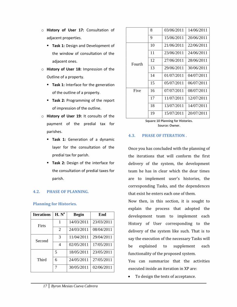
Iterations H. No Begin End
Firts 1 14/03/2011 23/03/2011
2 24/03/2011 08/04/2011
Second 3 11/04/2011 29/04/2011
4 02/05/2011 17/05/2011
Third
5 18/05/2011 23/05/2011
6 24/05/2011 27/05/2011
7 30/05/2011 02/06/2011
8 03/06/2011 14/06/2011
9 15/06/2011 20/06/2011
Fourth
10 21/06/2011 22/06/2011
11 23/06/2011 24/06/2011
12 27/06/2011 28/06/2011
13 29/06/2011 30/06/2011
14 01/07/2011 04/07/2011
15 05/07/2011 06/07/2011
Five 16 07/07/2011 08/07/2011
17 11/07/2011 12/07/2011
18 13/07/2011 14/07/2011
19 15/07/2011 20/07/2011
Square 10 Planning for Histories.
Source: Owner.
4.3. PHASE OF ITERATION .
Once you has concluded with the planning of
the iterations that will conform the first
delivery of the system, the development
team he has in clear which the dear times
are to implement user's histories, the
corresponding Tasks, and the dependences
that exist he enters each one of them.
Now then, in this section, it is sought to
explain the process that adopted the
development team to implement each
History of User corresponding to the
delivery of the system like such. That is to
say the execution of the necessary Tasks will
be explained to supplement each
functionality of the proposed system.
You can summarize that the activities
executed inside an iteration in XP are:
To design the tests of acceptance.

18 Byron Mesias Cueva Cabrera
To program user's histories.
Code Refactorización and the design
(when it is necessary).
To execute the tests of acceptance.
4.4. PHASE OF PRODUCTION.
Next he is carried out a verification of the
elements of the system, so that this he has a
good operation in a production atmosphere.
Figure 6 Production environment.
Source: Owner
5. CONCLUSION AND
RECOMMENDATIONS.
5.1. Impacts.
The Access and knowledge of the
cadastral information on the part of the
employees of the Municipality have
increased notably as it indicates it the
following graph.
System Access and knowledge of
the Information
Previous
GIS
13%
GIS IMI 35%
Square 11 Access and knowledge of the Information.
Source: Owner.
Figure 7 Access and knowledge of the Information.
Source: Owner
The 13% conforms alone the personnel
of the addresses of Cadasters and
Evaluations, and Planning, since these
addresses were those that generated and
they registered this information. Thanks
to the new systems GIS IMI has been
reached to 35% of employees, since he
has left integrating information of other
addresses like it is Civic Participation,
public Works, and I Traffic and Trasporte,
with the purpose of being able to publish
from the web information that is of its
interest.
0%
10%
20%
30%
40%
GISAnterior
GIS IMI
Acceso yconocimientode laInformación
19 Byron Mesias Cueva Cabrera
Also the fact of being a system web, this
makes possible that is accessible from the
internet, and not alone he concentrates
on the local net of the Municipality.
Another contribution has been carried
out to the Plan of Territorial
Classification in 2011, which generated a
lot of information with respect to use and
floor occupations, state of roads and
sidewalks, etc. The same information that
thanks to the System GIS IMI was
accessible for other people and external
institutions to the Municipality.
It has also been contributed to the
integration of information with EMAPA,
through an access to the System. This
way EMAPA has been able to upgrade its
predial information he stops then to have
a communication through the cadastral
code.
The Firemen also use the system to
consult locations of places of interest.
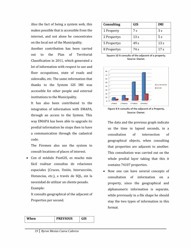
Con el módulo PostGIS, es mucho más
fácil realizar consultas de relaciones
espaciales (Cruces, Unión, Intersección,
Distancias, etc.), a través de SQL, sin la
necesidad de utilizar un cliente pesado.
Example:
It consults geographical of the adjacent of
Properties per second.
When PREVIOUS GIS
Consulting GIS IMI
1 Property 7 s 3 s
2 Propertys 13 s 5 s
5 Propertys 49 s 13 s
8 Propertys 74 s 17 s
Square 10 It consults of the adjacent of a property. Source: Owner.
Figure 8 It consults of the adjacent of a Property.
Source: Owner.
The data and the previous graph indicate
us the time in lapsed seconds, in a
consultation of intersection of
geographical objects, when consulting
that properties are adjacent to another.
This consultation was carried out on the
whole predial layer taking that this it
contains 74107 properties.
Now one can have several concepts of
consultation of information on a
property, since the geographical and
alphanumeric information is separate,
while previously in a file shape he should
stay the two types of information in this
format.

20 Byron Mesias Cueva Cabrera
5.2. Conclusions.
The standards of the OGC allow to share
geographical information in the internet
without caring the platforms or
development technologies, it is the base
for the interoperability among Systems
of Geographical Information.
The use of the module Postgis, makes
that the geographical information is
more governable and of easy analysis,
through the language SQL.
The use of free software is beneficial for
the institution, since it is a saving in the
cost of licenses.
A software developed with XP, allows to
obtain documented the most
outstanding information and of interest
for a programmer without being left to
other topics that they already lengthen
the understanding and the quick
analysis of a system developed.
5.3. Recommendations.
To the moment to develop a System GIS,
it is a good point to think since of the
hardware infrastructure on which goes
to work, they are systems that require of
many prosecution resources and
memory.
It is necessary to guide the development
together with the clients or users of the
system, since they have the experience
in the handling of the information and
other processes.
To make use of good programming
practices and design patterns, they allow
to implement applications of easy
maintenance and mainly scalable.
To use standard of consumption and
publication of geographical information
will allow that to future that information
can be shared with other institutions
that have interest on the same one.
6. BIBLIOGRAPHY AND
REFERENCES
6.1. WEB SITES
[www.01] Standard OpenGEO OGC. www.opengeo.org [www.02] Servant Apache HTTP. http://es.wikipedia.org/wiki/Servidor_HTTP_Apache [www.03] Tomcat http://es.wikipedia.org/wiki/Tomcat. [www.04] CSS http://www.librosweb.es/css/capitulo1.html. [www.05] PHP http://es.wikipedia.org/wiki/PHP. [www.06] JavaScript http://es.wikipedia.org/wiki/JavaScript

21 Byron Mesias Cueva Cabrera
[www.07] MapScript http://mapserver.org/mapscript/index.html#mapscript [www.08] MapFile http://www.google.com.ec/url?sa=t&rct=j&q=
referencia%20mapfile&source=web&cd=1&ve
d=0CFIQFjAA&url=http%3A%2F%2Fwww.free
webs.com%2Felk007007%2Fdownloads%2Fref
erencia_mapfile.pdf&ei=F7fTT5esEpHk6QHIzrS
TAw&usg=AFQjCNEINF_srI5baPeShMD_7CyaM
H19rw&cad=rja
[www.09] Framework http://es.wikipedia.org/wiki/Framework [www.10] That it is Symfony. http://www.symfony.es/que-es-symfony/. [www.11] Doctrine (PHP) http://es.wikipedia.org/wiki/Doctrine_%28PHP%29 [www.12] Ext JS http://es.wikipedia.org/wiki/Ext_JS. [www.13] Cycle of Life and Phases http://programacion-extrema.wikispaces.com/5.+Ciclo+de+vida+y+fases [www.14] Cycle of Life and Phases http://programacion-extrema.wikispaces.com/5.+Ciclo+de+vida+y+fases [www.15]
Devices http://programacion-extrema.wikispaces.com/7.+Artefactos [www.16] Chapter 4 Servants of Maps http://es.wikipedia.org/wiki/Cliente_pesado [www.17] Slight clients' comparison in the Web http://wiki.osgeo.org/wiki/Comparaci%C3%B3n_de_clientes_ligeros_web_para_SIG. [www.18] Heavy client. http://es.wikipedia.org/wiki/Cliente_pesado. [www.19] Open Source http://es.wikipedia.org/wiki/C%C3%B3digo_abierto 6.2. BOOKS
[Lib.01] Moreno Jiménez Antonio. (2da. Edición).
Systems and Analysis of the Geographical
information.
[Lib.02]
The MapServer Team. (2011) MapServer
Documentation Release 5.6.6.
[Lib.03] Whiteside Arliss, Evans John D. (2008). Web Coverage Service (WCS) Implementation Standard. Open Geospatial Consortium Inc.