Embed Size (px)
Citation preview

1
Fagali’i Catchment Biorap Survey Report:Rapid Assessment of Priority Coastal Areas for Fagali’i, Samoa
Fagali’i Catchment Biorap Survey Report: Rapid Assessment of Priority Coastal Areas
for Fagali’i, Samoa

Fagali’i Catchment Biorap Survey Report:Rapid Assessment of Priority Coastal Areas
for Fagali’i, Samoa
Prepared byJames Atherton
Produced and reviewed by the GEF Pacific International Waters Ridge to Reef Regional Project, Pacific Community (SPC), Suva, Fiji
Suva, Fiji, 2021

© Pacific Community (SPC) 2021All rights for commercial/for profit reproduction or translation, in any form, reserved.
SPC authorises the partial reproduction or translation of this material for scientific, educational or research purposes, provided that SPC and the source document are
properly acknowledged. Permission to reproduce the document and/or translate in whole, in any form, whether for commercial/for profit or non-profit purposes, must be requested
in writing. Original SPC artwork may not be altered or separately published without permission.
Original text: English
Citation: Atherton J. 2021. Fagali’i Catchment Biorap Survey Report: Rapid Assessment of Priority Coastal Areas for Fagali’i, Samoa The Pacific Community (SPC), Suva, Fiji. 24 pp.
Edited by: Seema Deo (Footprints in the Sand Consulting)
Layout and Design by Navneet Lal/Pacific Community (SPC)
Cover Photo: A small waterfall and pool on the Fagali’i stream at around 230 m elevation - James Atherton Produced and reviewed by GEF Pacific International Waters Ridge to Reef Regional Project, Pacific Community (SPC), Suva, Fiji.
Prepared for publication at SPC’s Suva Regional Office, Private Mail Bag, Suva, Fiji, 2021www.spc.int | [email protected]
Printed by Quality Print, Suva, Fiji, 2021
Fagali’i Catchment Biorap Survey Report:Rapid Assessment of Priority Coastal Areas for Fagali’i, Samoa
iii
CONTENTSAbbreviations .............................................................................................................................. iiiList of Tables .................................................................................................................................. vList of Figures................................................................................................................................. vAcknowledgements ...................................................................................................................... vi1. Introduction ............................................................................................................................... 12. Methodology ............................................................................................................................. 3
2.1 Ecological Indicator, E1 Diversity .......................................................................................................................3
2.2 Ecological Indicator, E3 Habitat Quality ............................................................................................................3
2.3 Methods for GIS Watershed Analysis ................................................................................................................4
2.4 Survey Schedule and Sites Visited .....................................................................................................................4
2.5 Survey Team ......................................................................................................................................................4
3. Results ....................................................................................................................................... 73.1 Fauna, Flora and Avifauna on the Fagali’i Catchment .......................................................................................7
3.2 Summary of key GIS statistics for the Vaivase and Fagali’i Catchments ..........................................................13
3.3 MNRE staff, local villagers and Fagali’i Village Committee trained in surveying skills and techniques ...........14
3.4 Community involvement and participation strengthened ..............................................................................14
3.5 Protection and conservation management policies and sustainability options developed for climate resilience .....................................................................................................................14
4. Conclusion and Recommendations ......................................................................................... 15References ................................................................................................................................... 17Annex 1. Scope of Works ............................................................................................................. 18Annex 2. Observations Record Sheet for each survey site .......................................................... 19Annex 3. Survey Data .................................................................................................................. 20

iv
ABBREVIATIONSDEC Department of Environment and Conservation
GEF Global Environment Facility
GIS Geographic Information System
GPS Global Positioning System
ICM Integrated Coastal Management
IUCN International Union for Conservation of Nature
IWRM Integrated Water Resource Management
IW R2R International Waters Ridge to Reef
MNRE Ministry of Natural Resources and Environment
MPA Marine Protected Area
PUMA Planning and Urban Management Agency
R2R Ridge to Reef
RapCA Rapid Coastal Assessment
REP Relative Erosion Potential
WRD Water Resources Division

Fagali’i Catchment Biorap Survey Report:Rapid Assessment of Priority Coastal Areas for Fagali’i, Samoa
v
LIST OF TABLESTable 1: Survey Schedule (see also Figure 1) ................................................................................. 4
Table 2: Survey Team and Positions (see Figure 1) ........................................................................ 4
Table 3: Checklist of birds seen and heard .................................................................................... 8
Table 4: Finfish species density, size and biomass at Fagali’i Fish Reserve .................................. 11
Table 5: Key GIS statistics for the Vaivase and Fagali’i catchments.............................................. 12
LIST OF FIGURESFigure 1: The survey team at the Moata’a mangroves (site number 1) ......................................... 5
Figure 2: Taro farming on steep slopes of the Fagali’i catchment (site number 10) ..................... 5
Figure 3: Survey sites visited ......................................................................................................... 6
Figure 4: Percentage cover of the main substrate groups in the Fagali’i fish reserve. ................ 11
Figure 5: Invertebrate species diversity in the Fagali’i Fish Reserve ............................................ 13
Figure 6: 2013 Land Cover of the Fagali’i, Vaivase and adjacent catchments ............................. 16
vi
ACKNOWLEDGEMENTSI would like to acknowledge the assistance of the entire survey team that made this project successful and enjoyable. I specifically thank Niuava Fata Eti Malolo, Vitolina Taupau and Paulo Amerika from WRD and Piula Hakai from DEC as well as the community representatives Friday, Rambo, Pasese, Toa and Isaako. Faafetai tele lava me le tou fesoasoani i lenei polokolame.

1
Fagali’i Catchment Biorap Survey Report:Rapid Assessment of Priority Coastal Areas for Fagali’i, Samoa
1. INTRODUCTIONThe purpose of the Regional International Waters Ridge to Reef Project is to test the mainstreaming of ‘ridge-to-reef’ (R2R), climate resilient approaches to integrated land, water, forest, and coastal management in Pacific Island countries through strategic planning, capacity building and piloted local actions to sustain livelihoods and preserve ecosystem services.
The regional project provides the primary coordination vehicle for the national R2R STAR projects that are part of the Pacific R2R programme, by:
• building on nascent national processes from the previous GEF IWRM1 project to foster sustainability and resilience for each island through reforms in policy, institutions, and coordination;
• building capacity of local institutions to integrate land, water, and coastal management through on-site demonstrations;
• establishing evidence-based approaches to integrated coastal management (ICM) planning; and
• improved consolidation of results monitoring, and information and data required to inform cross-sector R2R planning approaches.
All projects and studies done for the Pacific R2R Programme consider gender and social inclusion requirements. This is to ensure that planning, implementation of interventions and reporting include the status and priorities of men, women, youth, and all key sectors of communities.
Samoa IW R2R Project – Demonstration SiteThe Samoa IW R2R demonstration site is the Fagali’i Watershed Catchment, and its assessment and survey provide the opportunity to collect the baseline information and data relevant to establish the indicators. This project will also focus attention on harnessing support from all sectors if communities, including men, women, youths, elders and traditional community leadership and governance structures to improve the relevance on investment in ICM planning, including marine protected areas (MPA), and the roll out of demonstrating the ‘community to cabinet’ approach in natural resource management.
The Fagali’i catchment is roughly 500 km2 in area and has a population density of 1439 (PUMA and MNRE 2014). The Fagali’i River is critical as it is one of the main water sources in Samoa. Located in the capital of Apia, the increasing population and land developments are a major cause of degradation in the area. Clearing of land for farming and housing along the upper catchment coupled with poor waste management, often leads to the reduction of water in the lower catchment during prolonged dry season resulting in soil erosion and sediment loading along the waterways. The rationale for conducting the survey in the Fagali’i catchment was because a key component of the national R2R project was to provide information needed for the conservation and management of the site and its surroundings (www.pacific-r2r.org).
1 Global Environment Facility Integrated Water Resources Management

2
Relevant Policies and Legislation The following policies and legislative frameworks have a direct bearing on the conservation and management of the Fagali’i catchment:
The Land Surveys and Environment Act (1989), which was amended in 2016, has provisions for the conservation and protection of the environment and the establishment of National Parks and other forms of protected areas (www.palemene.ws).
The Waste Management Act (2010) provides for, amongst other things, the designation of waste management service areas by the Minister and for the designation of approved waste management operators by the Ministry. The Act also requires a permit to be obtained for dumping and incineration of wastes at sea and provides for community involvement in waste management (www.paclii.org).
i. The Water Resources Management Act (2008) makes provision for the management, conservation and use of water resources in Samoa, including coastal waters where freshwater discharges or accumulates (www.paclii.org). The result of this Biorap/RapCA survey would support an application for the conservation and management of the Fagali’i catchment if communities deemed it appropriate.
ii. The Forestry Management Act (2011) provides for the effective and sustainable management of Samoa’s forestry resources, and for related purposes. It also allows the Ministry of Natural Resources and Environment to have the principal responsibility for management of the forestry resources and gives them sole power to issue rights to exploit the resources (www.paclii.org).
Purpose and ScopeThe objective of the rapid assessment of the Fagali’i catchment is to:
• conduct fieldwork/survey on forest and mangroves biodiversity in one of the key biodiversity areas;
• provide information needed for the conservation and management plans of the site, and their surrounding areas; and
• establish the baseline information and indicators for the R2R project.
This report presents a review and the rapid coastal assessment results of the Fagali’i catchment survey that was conducted from 3rd to 10th of December 2018. The full scope of works for the survey is shown in Annex 1. The key outcomes for the project are as follows: -
• Survey of the fauna, flora, and avifauna on the Fagali’i catchment;
• MNRE staff, local villagers and Fagali’i Village Committee trained on surveying skills and techniques;
• Community involvement and participation strengthened. This engagement is gender inclusive and participatory in nature to allow for consultations and engagement within cultural norms and restrictions; and
• Protection and conservation management policies and sustainability options developed for climate resilience.

3
Fagali’i Catchment Biorap Survey Report:Rapid Assessment of Priority Coastal Areas for Fagali’i, Samoa
2. METHODOLOGY
2.1 Ecological Indicator, E1 DiversityThe survey sites were selected to sample a range of habitats from the coastal zone to the upper watershed area of the Fagali’i catchment (Figure 3). The research team used a map depicting the sites and habitat types sourced from available reports. The sites were haphazardly selected based on accessibility and representation of flora and fauna. A total of 18 sites were surveyed over 5 days (see details on GPS locations in later sections).
Unfortunately, the team discovered on the first day of the survey that the map of the Fagali’i watershed in the Fagali’i watershed management plan (Water Resources Division (WRD) 2016) included the Vaivase catchment (1004 ha) but was missing the adjacent Fagali’i catchment (644 ha). Therefore, adjustments had to be made to the survey plan so that both the Fagali’i and the Vaivase stream catchments could be surveyed.
Different tasks were delegated and shared between the groups who conducted the survey (Figure 1).
i. Record and GPS reader
ii. Bird surveys
iii. For the terrestrial fauna, a visual survey method was conducted to record skinks, snakes, butterflies, and birds for each site
iv. Filming and photographs
v. Team leader was responsible for general observation and assessment of the status of different plant species and compilation of list.
For each site, observation was made for the general habitat (vegetation), the level of human disturbance, topographic features, and presence of invasive species, birds, butterflies, reptiles, and freshwater fauna. The sites were marked and recorded using a Garmin GPS. Dominant tree species were recorded, and a list was compiled, which included all dominant species observed within the allocated sites. Endemic and invasive plants within the area were also noted.
2.2 Ecological Indicator, E3 Habitat QualityThe field survey was conducted over five days between the Fagali’i and Vaivase stream (see Figure 3). The team spent time conducting freshwater and terrestrial faunal survey targeting freshwater invertebrates, insects, and other terrestrial invertebrates, herpetofauna and avifauna.
For the terrestrial fauna, a visual survey method was conducted to record skinks, snakes, butterflies, and birds for each site. Birds were documented based on actual sightings and on recognised bird calls.
For the macro-invertebrates, a single sample was collected from each site using a hand-net. The nets were placed downstream of the water flow and the habitats was disturbed to drive the targeted species out. The survey schedule and sites visited are shown in Table 1 and Figure 1.
4
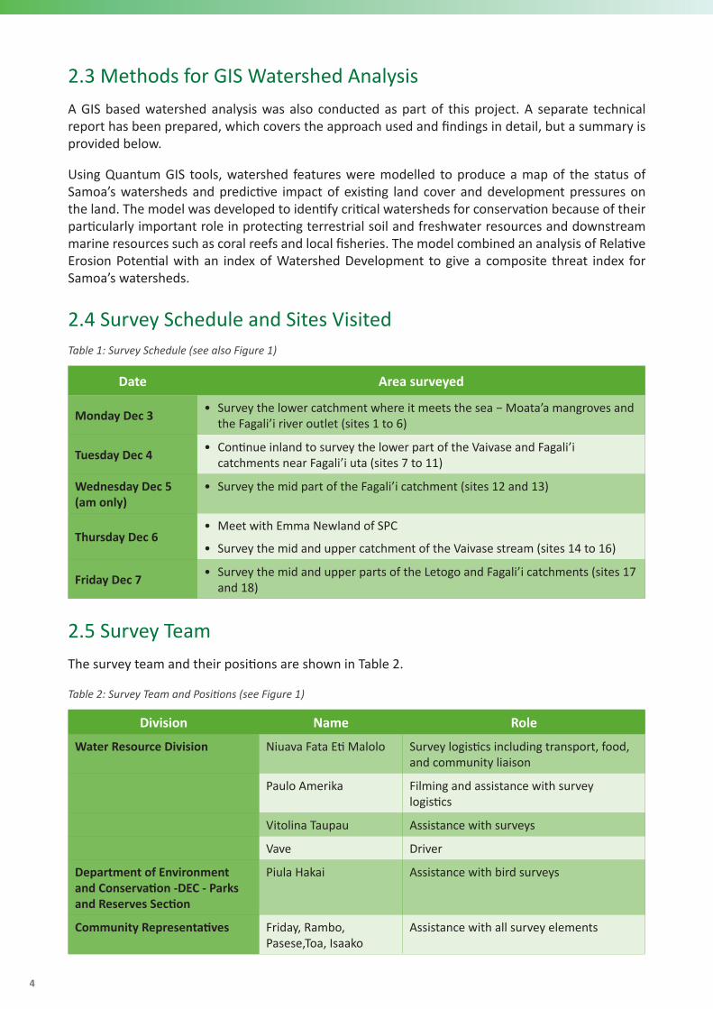
2.3 Methods for GIS Watershed AnalysisA GIS based watershed analysis was also conducted as part of this project. A separate technical report has been prepared, which covers the approach used and findings in detail, but a summary is provided below.
Using Quantum GIS tools, watershed features were modelled to produce a map of the status of Samoa’s watersheds and predictive impact of existing land cover and development pressures on the land. The model was developed to identify critical watersheds for conservation because of their particularly important role in protecting terrestrial soil and freshwater resources and downstream marine resources such as coral reefs and local fisheries. The model combined an analysis of Relative Erosion Potential with an index of Watershed Development to give a composite threat index for Samoa’s watersheds.
2.4 Survey Schedule and Sites VisitedTable 1: Survey Schedule (see also Figure 1)
Date Area surveyed
Monday Dec 3 • Survey the lower catchment where it meets the sea − Moata’a mangroves and the Fagali’i river outlet (sites 1 to 6)
Tuesday Dec 4 • Continue inland to survey the lower part of the Vaivase and Fagali’i catchments near Fagali’i uta (sites 7 to 11)
Wednesday Dec 5 (am only)
• Survey the mid part of the Fagali’i catchment (sites 12 and 13)
Thursday Dec 6• Meet with Emma Newland of SPC
• Survey the mid and upper catchment of the Vaivase stream (sites 14 to 16)
Friday Dec 7 • Survey the mid and upper parts of the Letogo and Fagali’i catchments (sites 17 and 18)
2.5 Survey TeamThe survey team and their positions are shown in Table 2.
Table 2: Survey Team and Positions (see Figure 1)
Division Name Role
Water Resource Division Niuava Fata Eti Malolo Survey logistics including transport, food, and community liaison
Paulo Amerika Filming and assistance with survey logistics
Vitolina Taupau Assistance with surveys
Vave Driver
Department of Environment and Conservation -DEC - Parks and Reserves Section
Piula Hakai Assistance with bird surveys
Community Representatives Friday, Rambo, Pasese,Toa, Isaako
Assistance with all survey elements

5
Fagali’i Catchment Biorap Survey Report:Rapid Assessment of Priority Coastal Areas for Fagali’i, Samoa
Figure 1: The survey team at the Moata’a mangroves (site number 1)
Figure 2: Taro farming on steep slopes of the Fagali’i catchment (site number 10)

Figure 3: Survey sites visited

7
Fagali’i Catchment Biorap Survey Report:Rapid Assessment of Priority Coastal Areas for Fagali’i, Samoa
3. RESULTSThe full survey results, including GPS positions for each survey site are shown in Annex 3. A summary of the results is described below, including some key findings of the GIS analysis conducted for the Fagali’i and Vaivase catchments. A separate report describes in full the GIS analysis of catchment health and relative erosion potential (REP) that was conducted.
3.1 Fauna, Flora and Avifauna on the Fagali’i CatchmentThe survey was successfully completed, and 18 sites were visited, stretching from the coastal zone to inland and as high as 480 m above sea-level. Due to the steep topography, some sites such as 14 and 15 could not be visited so were observed from the nearest overlook from the road using binoculars. As noted earlier, the Fagali’i river catchment was added to the survey area to give an overall survey area of 1648 ha (i.e., 16.5 km2).
The survey findings by taxonomic group are presented below.
Plants and vegetation
• Total diversity of species recorded
• Dominant tree species
• Rare, endemic, and endangered species
• Species of conservation valueOverall, both the Vaivase stream and the Fagali’i catchment were found to be in relatively good condition, especially away from the coastal villages. The Fagali’i catchment forest cover exceeds 50% and about 39% for Vaivase Stream (see Table 3, Annex 3). Plants and vegetation indicators also demonstrate relatively good conditions. The Moata’a mangrove area (site 1) was found to be in good health with relatively high cover (Rhizophora mangle). However, the team observed a small marshland of Sa’ato (Acrosticum aureum) and Gatae (Erythrina fusca) and indiscriminate piles and dumping of rubbish at site 3 (called Gataivai spring by the locals).
Riparian strips along Vaivase and Fagali’i rivers are generally healthy relative to ecological indicators measured or estimated in this study, although in many cases, are dominated by introduced invasive plants such as Tamaligi (Albizzia chinensis and Albizzia falcataria), Pulu mamoe (Castilla elastica) and Pulu vao (Funtumia elastica). Patches of native forest are found along both rivers, especially above around 200 m elevation and on steep slopes. Tava (Pometia pinnata) and Maota (Dysoxylum species) are the dominant native tree species in both the Fagali’i and Vaivase catchments.
Birds
The specific measures of bird counts include the following:
• Total diversity of species recorded
• Dominant species
• Species of conservation value

The findings of the bird surveys are shown in Table 3. Most of the bird observations were from the 5-minute bird counts method conducted.
Table 3: Checklist of birds seen and heard
Common name
Site
1
Site
2
Site
3
Site
4
Site
5
Site
6
Site
7
Site
8
Site
9
Site
10
Site
11
Site
12
Site
13
Site
14
Site
15
Site
16
Site
17
Site
18
Introduced birds
Common Myna N N Y Y Y Y Y Y Y N Y N Y Y Y Y N Y
Jungle Myna Y Y N N N N N N N N N N N N N N N N
Red-vented Bulbul Y Y N Y Y N Y Y N N N N N N N N N N
Feral Pigeon N N N N N N N N N N N N N N N N N N
Native birds
White-throated Pigeon N N N N N N N N N N N N N N N N N N
White-rumped Swiftlet N N N N N N N Y N Y N N Y Y Y Y Y Y
Wattled honeyeater N N Y N Y N N N Y Y Y N N N N Y Y Y
Pacific Pigeon N N N N N N N N N Y N Y Y N Y Y Y Y
Tooth-billed Pigeon N N N N N N N N N N N N N N N N N N
Scarlet Robin N N N N N N N N N Y N N N N N Y N Y
Samoan Whistler N N N N N N N N N N N N Y Y N Y Y Y
Samoan Triller N N N N N N N Y N N Y N N Y N N N N
Samoan Starling N N N N N N N N N N N N N Y N Y N Y
Samoan Flycatcher (Broadbill) N N N N N N N Y N Y Y N N N N N Y N
Samoan Fantail Y N N N N N N N Y Y Y Y N N N N N N
Red-headed parrotfinch N N N N N N N N N N N N N N N N N N
Purple-capped Fruit-dove N N N N N N Y N N Y Y N N N Y Y N Y
Purple Swamphen N N N N N N N N N N N N N N N N N N

Common name
Site
1
Site
2
Site
3
Site
4
Site
5
Site
6
Site
7
Site
8
Site
9
Site
10
Site
11
Site
12
Site
13
Site
14
Site
15
Site
16
Site
17
Site
18
Polynesian Triller Y Y N N N Y N N N N N N N N N N Y N
Polynesian Starling N N N N N N N N N N N N N Y N N N N
Mao N N N N N N N N N N N N N N N Y N Y
Many-coloured Fruit-dove N N N N N N N N N N N N N N N N N N
Long-tailed Cuckoo N N N N N N N N N N N N N N N N N N
Flat-billed Kingfisher N N N N N N N N N N N N N Y N Y Y Y
Cardinal myzomela N N N Y N N N N Y N N N Y Y Y N Y N
Buff-banded Rail N Y N Y N N N N N N N N N N N N N N
Blue-crowned Lory N N N N N N N N Y N N N N Y N N N N
Barn Owl N N N N N N N N N N N N N N N N N N
White-browed Crake N N N N N N N N N N N N N N N N N N
Spotless Crake N N N N N N N N N N N N N N N N N N
Shy Ground-dove N N N N N N N N N N N N N N N N N N
Australian Grey Duck N N Y N N N N N N N N N N N N N N N
Shorebirds/seabirds
White Tern N N N N N N Y Y N N N N Y N Y Y Y Y
White-tailed Tropic-bird N N N N N N N Y N N N N N N N N Y N
Black Noddy N N N N N N N N N N N N N N N N N N
Brown Noddy N Y Y N N N N N N N N N N N N Y Y Y
Tahiti Petrel N N N N N N N N N N N N N N N N N N
Golden Plover N Y N N N N N N N N N N N N N N N N
Totals 4 6 4 4 3 3 4 7 5 7 6 2 6 9 6 12 11 12KEY N: Not present Y: Present

10
Species of special conservation interest due to endemicity and rarity
The sites with the highest bird diversity were in inland areas where native forest cover was the highest- sites 16 (206 m), 17 (262 m) and 18 (229 m) where more than 10 bird species were recorded, including either the rare and threatened Maomao (Gymnomyza samoensis) or the Samoan Broadbill, Tolai fatu (Myiagra albiventris) (see Figure 3, Annex 3).
Other Taxa observed
A basic survey of reptiles, butterflies and freshwater fauna was conducted. Common butterflies seen at most sites were the Grass Yellow (Eurema hecabe xexicanacea) and occasionally the Blue Tiger (Tirumula hamala melittula). The most common reptile seen was the Black Skink (Emoia nigra) observed at most sites, and occasionally the Blue- tailed skink (Emoia impar). Interestingly, no flying foxes were recorded during the survey.
The freshwater diversity was highest in the cleaner waters of the upper catchments and included Ula vai (Macrobrachium spp) and a freshwater eel (tuna, Anguilla marmorata) at site 13 at 256 m on the Fagali’i stream (see Figure 3). Where water was more turbid, introduced fish such as Poeciliaexicanaa and Gambusia affinus (mosquito fish) and Tilapia (Oreochromis mossambicus) were found. The native Inato (Kuhlia rupestris) was common in most of the inland sites while mudskippers (Apofu) were common in the Moata’a mangrove area (Periophthalmus spp) (Figure 3 & 6; Annex 3).
Invasive species
The main invasive species recorded were invasive plants − in particular, various Tamaligi species (Samanea saman, Albizzia chinensis and Albizzia falcataria), Pulu mamoe (Castilla elastica) and Pulu vao (Funtumia elastica) as well as invasive birds, the Common Myna (Acridotheres tristis), Jungle Myna (Acridotheres fuscus) and Red-vented Bulbul (Pcynonatus cafer). Additionally, most sites had Giant African snails (Lissachatina fulica). Invasive species were found in all sites visited (see Figure 3 & 6; Annex 3).
Threatened species and environmental threats
Threatened biodiversity, as listed by IUCN Red List, included the Maomao (Gymnomyza samoensis) and the Tolai fatu or Samoan broadbill (Myiagra albiventris) observed at a few inland sites as well as the native bush palm, Niu vao (Clinostigma samoense). It is likely that other threatened species are found in patches of native forest especially in the remote inland parts of both catchments. Generally, the areas of highest biodiversity are the areas where there are patches of native forest, and these are mostly found in the middle to upper reaches of the catchments (Figure 3 & 6; Annex 3).
The health of the Vaivase and Fagali’i catchments continues to suffer from the spread of invasive plants into the interior of the catchments, crop farming (mostly taro) on steep slopes and near rivers, cattle encroachment into some river valleys from adjacent cattle ranches (Figure 3). The team also observed indiscriminate dumping of municipal waste and other types in some areas (e.g., at the entrance to the Moata’a mangroves as well as at the Fagali’i and Vaivase river mouths) and this needs to be addressed and discussed with all members of the community to ensure there is wider accountability for waste management.

11
Fagali’i Catchment Biorap Survey Report:Rapid Assessment of Priority Coastal Areas for Fagali’i, Samoa
Assessment of Habitat Quality
The University of Samoa has carried out water quality assessments in the Fagali’i catchment, and the results of that study can be referred to as appropriate. Similarly, lessons and comparison can be carried out with other previous studies for better understanding on tempo-spatial impacts, if any.
Assessment of Coastal/ Marine Areas of Fagali’i
The assessment of the Fagali’i fish reserve, covering the area adjacent to the mouth of Fagali’i river, shows an area dominated in seagrass and macroalgae. The diversity and abundance of fish and invertebrates is low. A total of 145 individual fish within 1000 m2 was observed across 7 species from 6 common finfish families (Table 4). The rabbitfish species (Siganus vermiculatus) was the most dominant species, with an average length of 8 cm.
Table 4: Finfish species density, size, and biomass at Fagali’i Fish Reserve
Seagrass (Other), mainly (Halophila ovalis and Syringodium isoetifolium) dominated the substrate groups in the reserve, accounting for about 55% of the total substrate observed (Figure 4). Abiotics (sand and rubble) and macroalgae (Padina, Sargassum sp.) followed with lower percentage cover. Live coral cover only accounts for about 3%, suggesting the reserve is relatively unproductive and unsuitable habitat for fish.
Figure 4: Percentage cover of the main substrate groups in the Fagali’i fish reserve.

12
Regarding invertebrates, the rock boring urchin (tuitui) (Echinometra mathaei) was the dominant species, with lollyfish (Holothuria atra) and the blue starfish (Linkia laevigata) in very low numbers (Figure 5).
Figure 5: Invertebrate species diversity in the Fagali’i Fish Reserve
The areas surveyed are exposed during low tide, thus, the dominance of rock boring urchins in those habitats. This also means that low abundances of live corals in the reserve have been likely replaced by dominating macroalgae species. Possibly, pollution in the area triggers high macroalgae growth, likely due to the very close proximity of the reserve to the discharges and offloads from the adjacent coastal communities. The research team did not observe this trend of invertebrate composition in areas further offshore beyond the reserve boundary; rather there was an increase in the presence of live corals there compared to the reef flat. The area closer to and on the reef drop off had much stronger wave action, providing favourable clean water conditions for healthy corals.
This area near to and on the drop off was also suggested in the past assessment (2013) to be included in the boundary of the fish reserve, however the community decided to demarcate the boundary only on the reef flat. As such, this assessment once again reiterates the importance of extending the boundary further offshore to include better live coral habitats and thus better protection of more diverse and richer fish and invertebrate populations.
With the community’s request to restock giant clams in the reserve, the current location of the reserve is not feasible given its high exposure during low tide and the lack of favourable habitats and conditions for the clams to survive. Unless the reserve is extended further offshore to deeper and favourable clam habitats, this request cannot be considered.

13
Fagali’i Catchment Biorap Survey Report:Rapid Assessment of Priority Coastal Areas for Fagali’i, Samoa
3.2 Summary of key GIS statistics for the Vaivase and Fagali’i Catchments A summary of the key GIS statistics for the Vaivase and Fagali’i catchments is given in Table 4 while Figure 4 is a map of the 2013 land cover of the two catchments from the Forestry Division. A full explanation of the GIS analysis findings is presented in a separate report describing in full the GIS analysis of catchment health and relative erosion potential (REP) that was conducted.
Table 5: Key GIS statistics for the Vaivase and Fagali’i catchments
Catchment Name
Area (Ha)
Mean
Relative
Erosion
Potential
Rd Length (m)
Rd Length
(m/Ha)
Creek
Cross-ings
Creek
Cross-ings/
Km2
Catchment
Forest
Cover 2013 (Percent)
Percent
Deforested
1999 to 2013
Fagali’i 644.1 8.5 19971 31 2 0.3105 54.13 5.54
Vaivase 1004.6 9.5 23448 23 4 0.3981 37.87 8.08
Figure 6: 2013 Land Cover of the Fagali’i, Vaivase and adjacent catchments

14
3.3 MNRE staff, local villagers and Fagali’i Village Committee trained in surveying skills and techniquesAll members of the survey team, including the five village representatives, were trained in the survey approach and in species identification. The MNRE team of Fata, Lina and Piula took turns to record data while other staff called out their observations during the fieldwork. The survey team was divided into teams focused mostly on vegetation and another focused-on birds. The community representatives focussed mostly on invasive species, reptiles, and freshwater fauna under the supervision of the Team Leader and other Specialists.
3.4 Community involvement and participation strengthened Community involvement which included the participation of all members of the community (men, women, youth, and other sectors of the communities), was key to the success of the project. As noted above, five community representatives were involved in the survey and were trained in biodiversity survey techniques. Feedback from the community representatives was positive and all learned a lot during the week.
A community consultation was also held on the 14th of March at the Fagali’i Pulenu’u fale where the results of the fieldwork were presented. There was wider community engagement and representation, and the consultation was attended by the Ridge to Reef committee, including Matai and Women’s Committee.
3.5 Protection and conservation management policies and sus-tainability options developed for climate resilienceThe recommendations section of this report discusses recommended management options for the conservation of the catchments.

15
Fagali’i Catchment Biorap Survey Report:Rapid Assessment of Priority Coastal Areas for Fagali’i, Samoa
4. CONCLUSION AND RECOMMENDATIONSThe rapid biodiversity assessment successfully assessed the core terrestrial biodiversity values of the Fagali’i and Vaivase catchments. The Fagali’i catchment forest cover exceeds 50% and about 39% for Vaivase Stream, thereby demonstrating relatively good health, particularly good forest cover on the steep erodible slopes.
While both catchments were found to be in relatively good condition, with good riparian strips along both rivers, the main threats to catchment health relate to the continued spread of invasive plants inland, some crop farming (mostly taro) on steep slopes and near rivers, cattle encroachment into some river valleys from adjacent cattle ranches and some trash in some areas (e.g., at the entrance to the Moata’a mangroves as well as at the Fagali’i and Vaivase river mouths).
The Fish Reserve established adjacent to the mouth of the Fagali’i serves to address overfishing in the area. The habitats remain relatively poor with live coral cover < 8% and the area dominated with dead corals, algae, and presence of high counts of sea urchins. The reef flat in the reserve is dry during low tide, and discharge from land and at the river mouth add further pressure to the dynamics of a healthy ecosystem in the area. Identifying men and women fishing activities, methods of fishing can help identify interventions that can address overfishing.
Several recommendations are provided below for improving ecosystem health of the Fagali’i catchment.
(1) The baseline for healthy ecosystems in various types of Fagali’i forests and vegetation
While both catchments do have large agricultural areas, these areas tend to be on gentle slopes on the coastal plain, or on ridges inland. The river valleys remain largely forested although much of the forest is dominated with invasive plants, especially Samanea saman, Albizzia chinensis, Albizzia falcataria, Castilla elastica and Funtumia elastica.
Of the two catchments, the Vaivase stream catchment has a lower forest cover and has had a higher rate of forest loss in recent years (8% of the catchment was deforested between 1999 and 2013) and thus needs more attention regarding conservation measures.
A complete biodiversity assessment of the area focusing on taxa that were not thoroughly assessed in this study (i.e., entomology, mammals, herpetofauna and freshwater vertebrates and invertebrates)
Water quality biophysical assessments of the area need close and regular monitoring to better understand the impacts of policy interventions including R2R investments and planning. Consider using several more indicators or the full suite of 22 indicators for measuring environmental stress reduction in Fagali’i catchment and others in the country.
(2) Management and rehabilitation of the catchments
Site specific recommendations are given in Annex 3. The key recommendations for catchment health are the maintenance of riparian strips along rivers as well as the maintenance of forest cover on steep slopes. Replanting and restoration efforts should continue along riverbanks, especially in areas where riverbank vegetation is sparse. It is recommended that the tree planting programme along riverbanks is continued, especially in areas with poor riparian strips. Engagement of all sectors of the communities (men, women, youth, and vulnerable groups) in management and rehabilitation efforts could result in wider support for the work to be done and commitment to interventions planned which can result in sustainable outcomes.

16
Public awareness programmes should be on-going- targeting men, women and youths and their different areas of interest and this should continue to promote the role of riparian strips to reduce erosion, stabilise riverbanks and promote native biodiversity as well as to discourage the dumping of waste in rivers, streams, and swamps. Public awareness programs and capacity building exercises should be gender and social inclusive and community members should also be discouraged from growing crops on steep slopes and near rivers and encouraged to fence cattle away from rivers so that they don’t cause riverbank erosion or pollute water supplies.
(3) Key biota indicators that could be used for monitoring changes in forest and mangrove ecosystem of the Fagali’i catchment and in the freshwater systems as well
The two main indicators recommended for monitoring ecosystem health in the Fagali’i and Vaivase catchments are: a) land cover mapping and b) bird distribution and abundance. Land cover mapping is a standard tool for assessing catchment health as it provides the status of forest and other land cover (e.g., cropland, settlements etc.) in the catchment as well as changes over time.
Ideally, land cover mapping would try to separate forests dominated by introduced trees (often termed secondary forest) from forest dominated with native trees. Birds are a good indicator of catchment health as bird diversity and abundance is closely related to the quality of the forest habitat. Native Samoan birds evolved in rainforests so tend to be most abundant where there are native trees to feed on or nest in. Conversely, areas dominated by introduced bird species tend to also be dominated by introduced plants.
The summary table below shows the recommended environmental monitoring approach and periodicity for the two catchments.
Figure 6: 2013 Land Cover of the Fagali’i, Vaivase and adjacent catchments
Monitoringparameter
Repeat frequency
Method Source of data Comments
Land cover At least once every 10 years
National land cover mapping using high resolution aerial photography or satellite imagery
Forestry Division or can also be done at lower resolution by Water Resources Division using Google Earth imagery or drones.
Important to use similar land cover classes as past land cover mapping so that meaningful comparisons can be made
Bird distribution and abundance
Annual or every two years
5-minute bird counts
DEC monitoring Can be done at a sample of sites representing lower, middle, and upper catchment at same sites as past 5-minute bird counts

17
Fagali’i Catchment Biorap Survey Report:Rapid Assessment of Priority Coastal Areas for Fagali’i, Samoa
REFERENCESForestry Management Act. 2011. Retrieved from: http://www.paclii.org/
Lands, Surveys and Environment Act.2016. Retrieved from: https://www.palemene.ws/
Planning and Urban Management Agency & Ministry of Natural Resources and Environment. 2014. Cities and Climate Change Initiative: Apia, Samoa-Climate Change Vulnerability Assessment Abridged Report.
Samoa trials nature-based solution to protect Fagali’i River Catchment. Retrieved from: https://www.pacific-r2r.org/news/samoa-trials-nature-based-solution-protect-Fagali’i-river-catchment
Samoa Bureau of Statistics 2016. Census 2016 Preliminary Count-Village Directory
Tauati M. 2016. Report of the Fagali’i Fish Reserve. Unpub. Report of the Ministry of Agriculture and Fisheries, Apia, Samoa.
Waste Management Act 2010. Retrieved from: http://www.paclii.org/
Water Resources Management Act (2008). Retrieved from:
https://www.ecolex.org/details/legislation/water-resources-management-act-2008-lex-faoc089580/
WRD 2016. Fagali’i Watershed Management Plan. MNRE 2016.

18
ANNEX 1.Scope of WorksThe main tasks to be undertaken for the successful delivery of the Baseline Ecological Surveys are as follows:
• Developing and selection of survey methods and a time schedule of works and deliverables for the overall study, in liaison with the R2R Project Manager and survey teams. This shall include an implementation plan, including site area cover, survey methodology for each site, logistics and engagement/consultations with local communities;
• Conduct the field surveys and baseline data collection at the sites, and their surrounding areas for assessing the biodiversity of the coastal mangroves and forest. Among key tasks related to the surveys, these should include, but not be limited to:
• Collect possible new plants/weeds for identification and analysis
• Site and record status of other forestry resource species such as birds, reptiles, flying fox etc, where necessary and provide result analysis;
• Assess and report separately on rare and endangered endemic species on the coastal mangrove areas;
• Report on the presence of and impacts of human activities in the sites surveyed;
• Identify invasive plants/weeds and report on its impacts as well as identify possible options for prevention, control and eradication;
• Identify areas of conservation/rehabilitation priority within the study area; and,
• Types of conservation/rehabilitation methods to be used in different areas of the watershed.
• Perform an analysis on the Relative Erosion Potential (REP) of the Fagali’i Watershed Area, utilizing the Universal Soil Loss Equation (USLE) and other spatial techniques.
• Provide a detailed technical and scientific report with results and findings, including conclusions and recommendations on (1) the baseline for healthy ecosystems in the various types of vegetation in the forests of Fagali’i; (2) management and rehabilitation of the coastal mangrove areas of Fagali’i (3) key biota indicators that could be used for monitoring changes in forest and mangrove ecosystem of the Fagali’i Catchment.
• Assist the R2R project team in the restitution of the survey results to the local stakeholders and village communities by providing visual material and simplified text of results and findings for presentations. Local stakeholders should include men, women, youths, and other vulnerable members of communities.
• Where relevant, provide specialized trainings and capacity building sessions for MNRE and project staff on methods to be used for the different specialist biota surveys and identification of species within the coastal area of Fagali’i and mangroves, as well as on the REP analysis and the use of spatial/USLE tools. These specifically targeted training should be gender inclusive.

19
Fagali’i Catchment Biorap Survey Report:Rapid Assessment of Priority Coastal Areas for Fagali’i, Samoa
ANNEX 2.
Observations Record Sheet for each survey site
Surveyor’s names
Site/Location name
Date: Time: Weather:
WP Number: Lat: Long:
Elevation (m): Photo numbers:
Habitat (main vegetation type):
Human use and level of disturbance:
Topographic Features (e.g., crater, slope, ridge, valley etc)
Invasive species presence:
Birds seen/heard:
Other indigenous biota # seen Comment/spp./etc
Insects (e.g., butterflies)
Reptiles
Flying foxes
Freshwater fauna
Comments on other biota:
Site management recommendations:

ANNEX 3.
Survey DataSi
te N
umbe
r
Surv
eyor
s
Site
Nam
e
Date
Tim
e
Wea
ther
GPS
- W
GPS
- S
Elev
ation
(m)
Gen
eral
Hab
itat
(Veg
etati
on)
Hum
an U
se
and
Leve
l of
Dist
urba
nce
Topo
grap
hic
feat
ures
Inva
sive
Spe
cies
Bird
s (Se
en/
Hear
d)
Fres
hwat
er F
auna
Oth
er C
omm
ents
Site
Man
agem
ent
Reco
mm
enda
tions
1 Paulo, Fata,Vave,Lina,
Piula,Friday, Rambo,
Pasese,Toa, Isaako, James
Moata’a Mangroves
03-12-18
10am Partly Cloudy/ showers
-171.74522 -13.83963 14 Rhizophora Mangrove
Forest (togo fafine)
Low (but trash near
entrance to site)
mangrove swamp
Tamaligi- Samanea
saman (rain tree)
jungle myna bird (h), bulbul
(h), seu (h), miti tai
avaava, aua, ise,
lupo, tilapia, apofu
Many paa limanu (fiddler
crab)
well managed- but can clear
trash from entrance road
2 Paulo, Fata,Vave,Lina,
Piula,Friday, Rambo,
Pasese,Toa, Isaako, James
Vaivase Stream (River mouth
close to the bridge)
03-12-18
10:40am Partly cloudy
-171.74137 -13.84215 5 Mixture of mangroves
(togo fafine), tamaligi
raintree, and hibiscus, while the eastern
side is more open and
grassy
medium (eastern side is a reclaim area)
flat riverbank/
riparian strip
Samanea saman (rain tree), black
tamaligi- Albizzia
chinensis, Coccinia grandis
(ivy gourd); Wedelia trilobata
jungle myna; brown noddy; ve'a; miti tai;
bulbul; golden plover (tuli)
pelupelu, aua, tilapia
Turbid river During past cyclones tree logs blocked
the river mouth into the lagoon at the bridge. The western side needs to
be planted with trees and well
maintained (riparian strip). Some trash in
the river
3 Paulo, Fata,Vave,Lina,
Piula,Friday, Rambo,
Pasese,Toa, Isaako, James
Gataivai Spring
03-12-18
11:20am Partly Cloudy
-171.73877 -13.84388 4 Herbaceous marsh
(sa'ato); dying gatae (Erythrina
fusca); bamboo;
nonu; fau; tulutulu;
niuafa
high (rubbish/
tree cutting)
swamp Tamaligi- Samanea
saman (rain tree)
common myna bird; honey
eater; brown noddy; toloa (only when it
rains)
na Large Pterocarpus indica (from PNG) planted on site- food
for pigs
Rubbish found in the area,
recommended for waste
management
4 Paulo, Fata,Vave,Lina,
Piula,Friday, Rambo,
Pasese,Toa, Isaako, James
Fagali’i Stream Mouth
03-12-18
12:30pm Partly Cloudy
-171.73344 -13.84247 12 Secondary forest.
Tamaligi rain tree, fue malo, fau, nonu, laugapapa,
lau mafiafia, salato (main vegetation: fau, tamaligi
raintree
Medium (minor trash)
flat riverbank
Tamaligi- Samanea
saman (rain tree)
common myna bird,
segasega mauu, bulbul,vea
avaava, ise,tilapia, aua, apofu
Well vegetated
riparian strip
Maintain the riparian strip

21
Site
Num
ber
Surv
eyor
s
Site
Nam
e
Date
Tim
e
Wea
ther
GPS
- W
GPS
- S
Elev
ation
(m)
Gen
eral
Hab
itat
(Veg
etati
on)
Hum
an U
se
and
Leve
l of
Dist
urba
nce
Topo
grap
hic
feat
ures
Inva
sive
Spe
cies
Bird
s (Se
en/
Hear
d)
Fres
hwat
er F
auna
Oth
er C
omm
ents
Site
Man
agem
ent
Reco
mm
enda
tions
5 Fata,Vave,Lina, Piula,Friday,
Rambo, Pasese,Toa,
Isaako, James
Fagali’i Ford 03-12-18
1pm Partly Cloudy
-171.73523 -13.85064 32 Western side is mostly
dominated by pulu mamoe (Castilla elastica); eastern
side- canopy level:
Samanea saman, Albizzia
chinensis; sub canopy:
Trema cannabina (magele) ; shrubs:
Macaranga stipulosa
(laupapata), Hibiscus
tiliacesous (fau), crepe
ginger ground
cover: grass, ta'amu and ferns. Also,
revegetation zone nearby
of Malili, Tava and
Leva
varies from low to
medium
Incised Riverbank
Mostly dominated by Castilla
elastica (pulumamoe) and Funtiumia
elastica (puluvao), plus some Samanea
saman
common myna & bulbul (seen);
iao (heard)
ulavai, inato to maintain the riparian zone and continue
the good management
by MNRE and Fagali’i Community
6 Fata,Vave,Lina, Piula, James
Vaivase stream bridge
03-12-18
1:40pm Partly Cloudy
-171.74499 -13.84689 32 Secondary forest - lau
fu'afu'a, papata,
and black tamaligi
medium (a bit
disturbed with minor
trash surrounding
the area
Incised Riverbank
Black tamaligi (A.chinensis), (Diffenbachia)
dumb cane, Tamaligi rain
tree- Samanea seman
ve'a (s); common myna
(h); mitivao (h/s)
0% freshwater biodiversity
as river is dry
river is dry Maintain the riparian strip

22
Site
Num
ber
Surv
eyor
s
Site
Nam
e
Date
Tim
e
Wea
ther
GPS
- W
GPS
- S
Elev
ation
(m)
Gen
eral
Hab
itat
(Veg
etati
on)
Hum
an U
se
and
Leve
l of
Dist
urba
nce
Topo
grap
hic
feat
ures
Inva
sive
Spe
cies
Bird
s (Se
en/
Hear
d)
Fres
hwat
er F
auna
Oth
er C
omm
ents
Site
Man
agem
ent
Reco
mm
enda
tions
7 Fata,Vave,Lina, Piula,Friday,
Rambo, Pasese,Toa,
Isaako, James, Simaika
U131 Nr Fagali’i airstrip
04-12-18
9:30am Partly Cloudy; Breezy
-171.74082 -13.85092 52 Secondary forest- lau
papata, black
tamaligi, pulu
mamoe, mosooi,
fau (mostly dominated by fau tree)
medium (invasives
dominated)
top edge of the river;
gently slope near the
ridge
black tamaligi; tamaligi rain
tree; pulu mamoe
common myna (h); manutagi (h); gogo sina (s); bulbul (s)
Had planned to conduct a quantitative transect plot here, but too
steep and dominated
with invasive plants
strengthen riparian zones,
protection especially in the
flat areas
8 Fata,Vave,Lina, Piula,Friday,
Rambo, Pasese,Toa,
Isaako, James, Simaika
Vaivase Stream (Siona)
04-12-18
10:25am Partly Cloudy
-171.74075 -13.86071 52 Secondary forest- pulu
mamoe, toi, tamaligi
rain tree, faapasi,
tava, fu'afu'a, puluvao, sika soga (mostly
dominated by tamaligi
raintree- secondary
forest)
medium (taro
plantation)
bottom of the river valley;
medium incised; low
river flow
African snail manusina, tolai, mitivao,
pe'ape'a, common myna, bulbul, tava'e
igato, ulavai, and
tilapia
water flows here but not 2km
downsstrem at the bridge
(site 6)
manage plantation on the riparian
zones, replant riparian strips
9 Fata,Vave,Lina, Piula,Friday,
Rambo, Pasese,Toa,
Isaako, James, Simaika
Fagali’i Stream (Siona)
04-12-18
11.35am Partly Cloudy
-171.7354 -13.86305 63 Secondary forest
with pulu mamoe, pulu vao,
black tamaligi,
lopa
Medium with sone
small maumaga
Incised river valley with waterfall
Common myna birds, Seu,
Cardinal honey eater, Segavao
and Iao
Ula vai Fast flowing and clean
steam, popular
swimming area with
waterfall and pool
Maintain the riparian strip
10 Fata,Vave,Lina, Piula,Friday,
Rambo, Pasese,Toa,
Isaako, James, Simaika
Vaivase Stream (Siona)
04-12-18
1:15pm Partly Cloudy
-171.74181 -13.86718 79 Secondary Forest:
puluvao; pulumamoe;
atone; ifi; big aoa
(F.obliqua); tava; maota; nonu; ferns
(mostly dominated by tamaligi and pulu
vao)
medium incised river puluvao, pulumamoe, and tamaligi
tolaifatu (s/h); iao (h); pe'ape'a
(s); tolaiula (s); lupe (h);
manutagi (h); se'u (h)
Ulavai Large Aoa sign of native forest, river flow much
lower than the Fagali’i stream
Maintain the native forest
in the riparian zones

23
Site
Num
ber
Surv
eyor
s
Site
Nam
e
Date
Tim
e
Wea
ther
GPS
- W
GPS
- S
Elev
ation
(m)
Gen
eral
Hab
itat
(Veg
etati
on)
Hum
an U
se
and
Leve
l of
Dist
urba
nce
Topo
grap
hic
feat
ures
Inva
sive
Spe
cies
Bird
s (Se
en/
Hear
d)
Fres
hwat
er F
auna
Oth
er C
omm
ents
Site
Man
agem
ent
Reco
mm
enda
tions
11 Fata,Vave,Lina, Piula,Friday,
Rambo, Pasese,Toa,
Isaako, James, Simaika
Fagali’i Stream
04-12-18
2.15pm Partly Cloudy
-171.7384 -13.87008 83 Secondary forest
with pulu mamoe, pulu vao,
black tamaligi
uliuli, Samanea
saman
Low- Med with signs of cocoa
trees
incised river puluvao, pulumamoe, and tamaligi
uliuli
Se'u (s/h); heard: iao, manutagi, tolaifatu,
seu, miti vao, common myna
Ulavai and inato
Good flowing stream, shotgun
pellets seen
Maintain the riparian strip
12 Fata,Vave,Lina, Piula,Friday,
Rambo, Pasese,Toa,
Isaako, James, Simaika
Vaiti (Berking
Land)
05-12-18
10am Partly Cloudy/ showers
-171.73909 -13.88436 259 Secondary Forest mostly
dominated by Pulu vao, pulu mamoe
and white tamaligi
with some Tavai (Rhus taitensis)
Medium next to stream, incised valley
Pulumamoe, puluvao,
white tamaligi
Se'u (h); lupe (s) SWA intake cattle management- i.e., keep them away from the
stream
13 Fata,Vave,Lina, Piula,Friday,
Rambo, Pasese,Toa,
Isaako, James, Simaika
Fagali’i stream/ near the Berking
Property) Vaiti
05-12-18
10:30am Partly Cloudy
-171.73647 -13.88537 256 Secondary Forest with
emerging aoa
medium incised river Pulu vao and pulu mamoe,
mostly dominated by pulumamoe
myna bird (s), manusina (s); pe'ape'a(s); vasavasa (s);
segasega mo'u (s); lupe (h)
ula vai, tuna, igato,
Former SWA intake damaged
Stabilize the road cutting next to the
intake
14 Fata,Vave,Lina, Piula,Friday,
Rambo, Pasese,Toa,
Isaako, James, Simaika,Emily
Vaivase Stream
headwater
06-12-18
10.30am Partly cloudy
and showery
-171.73267 -13.9088 480 Secondary forest
with white tamaligi,
PM, Gatae and patches
of native forest
Medium with small maumaga areas of bananas, coconut, and taro
incised river PM and Whiite
tamaligi (Albizzia
falcataria)
vasvasa, miti vao, fuia, common
myna, peapea, iao, tiotala,
segasega mauu (h/s); segavao
(h)
Ula vai EPC water intake
Improve riparian zone- move taro plantation away
from stream
15 Fata,Vave,Lina, Piula,Friday,
Rambo, Pasese,Toa,
Isaako, James, Simaika,Emily
On ridge looking into
Vaivase stream valley
06-12-18
11.30am Partly cloudy
-171.74564 -13.89279 389 Secondary forest.
Tamaligi and tava. Good
native forest on east side
of valley. On ridge is maumaga
with bananas, cassava,
taro
Medium due to
maumaga
On ridge Tamaligi paepae
(A.falcataria)
Manusina, lupe, common myna,
manutagi, peapea,
segasega mauu
Landowner wants to plant pine trees on
ridge top
Protect riparian strip

24
Site
Num
ber
Surv
eyor
s
Site
Nam
e
Date
Tim
e
Wea
ther
GPS
- W
GPS
- S
Elev
ation
(m)
Gen
eral
Hab
itat
(Veg
etati
on)
Hum
an U
se
and
Leve
l of
Dist
urba
nce
Topo
grap
hic
feat
ures
Inva
sive
Spe
cies
Bird
s (Se
en/
Hear
d)
Fres
hwat
er F
auna
Oth
er C
omm
ents
Site
Man
agem
ent
Reco
mm
enda
tions
16 Fata,Vave,Lina, Piula,Friday,
Rambo, Pasese,Toa,
Isaako, James, Simaika,Emily
On ridge overlooking
Vaivase stream near
Magiagi
06-12-18
12.20pm Partly cloudy
-171.74608 -13.87396 206 Secondary forest
dominated with
tamaligi uliuli PM
and PV. Area is banana
and taamu plantation
Medium On ridge manusina (s); ma'o (h); lupe (h); tiotala (h), common myna (h/s); fuia (h/s);
pe'ape'a (s); iao (h); tolaiula (h); manutagi
(h); brown nody (h/s); vasavasa
(h)
Cannabis seen and
photographed
Replant with natives
17 Fata,Vave,Lina, Piula,Friday,
Rambo, Pasese,Toa,
Isaako, James, Simaika
Letogo stream SWA
intake
07-12-18
9.30am Partly cloudy
-171.73184 -13.886 262 Lowland rainforest-
tava, maota with secondary
forest trees (e.g., PM,
PV, Albizzia falcataria).
Area around intake
planted with Malili, Tava and Maota by WRD in
2012
Low- good native forest
dominated with Maota
Incised river PM, PV, both tamaligi sp, African snail
Peapea, Tolai fatu, Vasavasa, Brown noddy,
kingfisher (h/s); lupe
(h); pe'ape'a (s); iao (h/s); manusina (s);
segasegamauu (s); miti vao
(h/s); tolaifatu (h); tava'e (s);
Ula vai Clear, clean water, but more than
50% tapped by SWA. Best native forest seen during the survey
Maintain the riparian strip;
forest is in excellent shape
18 Fata,Vave,Lina, Piula,Friday,
Rambo, Pasese,Toa,
Isaako, James, Simaika
Fagalli stream
across fromt the Berking
land (site 13)
07-12-18
10.40am Partly cloudy
then rainy
-171.73607 -13.88272 229 Tava and Maota
forest on the riverbank, but large
taro maumaga
next to this area
Low on w side, high on east
side with maumaga stretching
down to the river
Incised river PM,PV, Samanea saman,
African snail
manusina (s); ma'o (h); lupe (h); tiotala (h), common myna (h/s); fuia (h/s);
pe'ape'a (s); iao (h); tolaiula (h); manutagi
(h); brown nody (h/s); vasavasa
(h)
Ula vai Plantation stretches to within 5m of the river, tava
trees have been burnt and there is evidence of glyphosate
usage to clear weeds
Talk to landowners
about the taro plantation
stretching too close to the
river and also about not killing
native trees

25
Fagali’i Catchment Biorap Survey Report:Rapid Assessment of Priority Coastal Areas for Fagali’i, Samoa

26