Embed Size (px)
Citation preview
Falkirk Local History Society
1
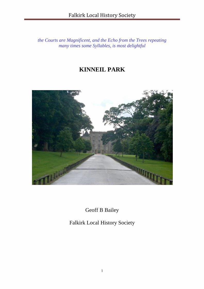
the Courts are Magnificent, and the Echo from the Trees repeating
many times some Syllables, is most delightful
KINNEIL PARK
Geoff B Bailey
Falkirk Local History Society
Falkirk Local History Society
2
KINNEIL PARK
Geoff B Bailey
CONTENTS: Page
No.
Introduction 3
Prehistoric 3
Roman 4
Dark Ages 5
Medieval 6
16th Century 7
17th Century 9
18th Century 20
19th Century 23
20th Century 26
Appendix 30
Kinneil Fortlet 30
Deer Park Dyke 31
Ice-House 32
Coachhouse 32
Dean Bridge 34
Kirk Bridge 35
Roman Bridge 35
The Piers 36
Bibliography 37

Falkirk Local History Society
3
Introduction
Kinneil lies on the southern shore of the Forth Estuary at the western edge of the sprawling town of Bo’ness (NS 983 806). The ground dips from 80m OD at the back of the wood to 35m at Kinneil House and the main parks where a steep escarpment rapidly takes it down to 5m. At the foot of the escarpment is the A904 road to Falkirk, which more or less defines the shoreline for much of the historical period. Three moderately sized streams run south to north from the high ground at the back of the wood to the shore, having carved out deep gullies on the way. These are, from west to east, the Deil’s Burn, the Gil Burn (also known as the Kirk Burn) and the Dean Burn. The area covered by the Park has changed over the centuries, but throughout most of its history has comprised of a large wood on the free draining land to the south and fields on the flatter plateau beside the House. At the west end of the Park the poor drainage at the foot of the wood created a bog. The present landscape owes much to the past and even the influence of the Roman Wall can still be seen. It is the designed landscape of 1680-1705 that rightly dominates. This was designed by Alexander Edward, perhaps the best known landscape architect of the time. He was also responsible for magnificent schemes at Hamilton, Kinross and Alloa, but it is here at Kinneil that his legacy remains most tangible. It is a Park of national importance. Throughout this report the term Park with a capital P is used for what might be termed the Policy, which consisted of the pleasure grounds of Kinneil House and Kinneil Wood. Unfortunately the term park is often also used of the enclosed fields within the Park, and these are only capitalised where referred to by name, such as Lady Well Park. The term House with a capital H is used for Kinneil House and not its outbuildings, offices or subsidiary houses.
Prehistoric
The earliest remains in the area are the shell middens of the Neolithic at the foot of the Gil Burn called, appropriately, the Deil’s Kitchen (SMR 219). The oyster beds would have occupied the gently shelving shallow waters of the Forth at this point (see Sloane 1997). Once harvested the oysters were brought to the shore for processing and the empty shells discarded in huge tips known as middens. Although the contemporary dwellings have not been found, they would, on analogy with Weedingshall, have occupied the plateau above and would have consisted of roundhouses. The oysters provided a reliable stable source of food and occupation would have continued at Kinneil throughout the centuries. Unfortunately there are only occasional glimpses of related activities, such as the Bronze Age burial cairn at Laughing Hill (SMR 114) to the south. This cairn, made of gravel, was constructed on the western shelf of the ridge known as the Flints, in a prominent position when viewed from either the west or the Forth. In the latter instance it would have been silhouetted against the skyline. Further west there was a standing stone on Kinneil Muir (SMR 840).
Falkirk Local History Society
4
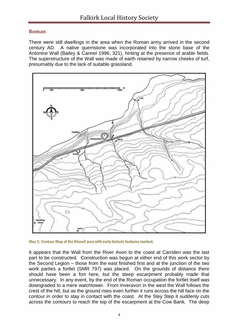
Roman
There were still dwellings in the area when the Roman army arrived in the second century AD. A native quernstone was incorporated into the stone base of the Antonine Wall (Bailey & Cannel 1996, 321), hinting at the presence of arable fields. The superstructure of the Wall was made of earth retained by narrow cheeks of turf, presumably due to the lack of suitable grassland.
Illus 1: Contour Map of the Kinneil area with early historic features marked.
It appears that the Wall from the River Avon to the coast at Carriden was the last part to be constructed. Construction was begun at either end of this work sector by the Second Legion – those from the east finished first and at the junction of the two work parties a fortlet (SMR 797) was placed. On the grounds of distance there should have been a fort here, but the steep escarpment probably made that unnecessary. In any event, by the end of the Roman occupation the fortlet itself was downgraded to a mere watchtower. From Inveravon in the west the Wall follows the crest of the hill, but as the ground rises even further it runs across the hill face on the contour in order to stay in contact with the coast. At the Stey Step it suddenly cuts across the contours to reach the top of the escarpment at the Cow Bank. The deep

Falkirk Local History Society
5
ravines of the three streams within Kinneil Park made it impossible to follow the edge of the escarpment, and in any case the Wall was heading for the next ridge to the east which took it along the line later used by Dean Road. The Roman road, known as the Military Way, ran close to the back of the Wall, thus avoiding the bog to the south of the fortlet. When the fortlet was demolished the road was realigned so that it crossed over the remains. The frontier was abandoned around 160AD, after less than twenty years.
Illus 2: The Fortlet as displayed
after the excavation in the1980s.
Dark Ages Illus 3: Aerial Photograph showing the circular ditch around
the churchyard (left), the Antonine Ditch (centre) and the
hollow way (right).
The line of the Wall provided the main route across the waist of Scotland and even today it is followed by Nether Kinneil Road, Grahamsdyke Road and Dean Road. The Rampart remained as a prominent feature for some time and to the south of Bo’ness became known as Waird Dyke (Waldie 1913, 22). Where the Dean Burn debouched into the Forth a sheltered bay provided a suitable landing place for the small vessels of the period, which were able to beach on the shelving coast. A cist burial at the Snab probably dates to the 8th-10th century. On the knoll once occupied by the fortlet a small stone trough was found in 1940 and identified as a coffin or cist. It was made of a single piece of stone and must have been for a child (Bo’ness Journal 1943).

Falkirk Local History Society
6
The Forth was a highway for ideas as well as goods and it appears that it was used by early Christian communities. Early churches occur all along the coast, such as at Cramond, Abercorn, Blackness, Carriden, Bothkennar and Airth. Kinneil was amongst the earliest of these and it is probably why it is mentioned by Bede in the early 8th century and why it is associated with St Serf in the 6th century (Bailey 2015). Aerial photographs show a wide circular ditch surrounding the later church, which indicates the presence of a Celtic monastery – the ditch and its upcast bank being the vallum monasterri defining its boundary. Its position, tucked into the corner formed by the coastal escarpment and the ravine of the Gil Burn is similar to that of several promontory forts further east. It is possible that a large ditch found in the later walled garden belongs to just such a site (Bailey 1996). These would have overlooked the creek or harbour.
The place name “Kinneil” is derived from this time and means “head of the Wall”, from the fact that it is here that the Wall comes into close contact with the coast at an escarpment. The Pictish and English forms are given by Bede as “Paenfahel” and “Penneltun” respectively, and mean the same thing.
Medieval Illus 4: Reconstruction of the Rood Stone in its setting.
A large rood stone (SMR 1583) was carved at Kinneil sometime in the 10th century or early 11th century. This standing stone must have stood inside the monastic enclosure and was a symbol of its flourishing condition and cultural importance. However, over the following two centuries the Celtic Church was largely replaced by that of the Catholic tradition and at Kinneil the church was rebuilt in stone by Herbert the Chamberlain in the 12th century. The new building was typical of the period with a small rectangular nave and a narrower chancel to its east. It now served as a parish church for an area stretching from the River Avon in the west and south to the aptly named Boundary Street on the east side of Bo’ness. The site was chosen not for a central position, but because of its earlier connection with the church. Usually such parish churches were close to the administrative centre of the area and presumably this is where Herbert had his residence. It would have been on the site of the later House. New centres of this date often take the form of motte and bailey castles, but here the old promontory fort was probably re-used. The buildings would have been of timber. The known ditch of this proposed fort lies to the south of the Antonine Wall and by this time the main trunk road had been re-aligned to cross the Gil Burn further south where the banks
are less deep. To help the descent into the valley the road was placed in a cutting to either side (and just as at Callendar Park the road cutting became mistaken by antiquarians for the Antonine Wall) creating what is often called a hollow way (Glendinning 2000). Casual finds of 12-14th century pottery in the field to the west and south-west of the church show that there was a settlement in that area (SMR 784). It would have been relatively small, not much bigger than a small village or large fermtoun.

Falkirk Local History Society
7
Illus 5: The Parishes of
Kinneil and Carriden
showing the line of the main
road following the Antonine
Wall, churches, and castles
or granges.
Tradition says that the Antonine Wall formed the base of the main road through the village. The site of the Roman fortlet was heavily cultivated using rig and furrow; the furrows cutting into the Roman remains (Bailey & Cannel 1996). Such furrows were also found on the south
side of the bog south of the fortlet (Bailey forthcoming), and can be seen on aerial photographs south-west of the church. These latter are clearly S-shaped; a shape created by the need to turn the teams of oxen at the end of each furrow. A deer park was formed around the laird’s residence and is shown on Pont’s 16th century map (reproduced by Bleau in 1640). The large earth dyke for its perimeter can still be seen along the southern edge of the wood and it may be a continuation of this feature east of the Hamilton Gate that is known as Wardly Bank on the estate map of 1748. It also appears at the top of the Cow Bank as an augmentation of the Antonine rampart, but due to later improvements and extensions to the Park its other boundaries are lost. It was a curving feature and on the west we can assume that it crossed the contours gradually to meet the Antonine Wall at the Stey Step. On the east it can be seen to begin to curve northwards at the edge of the wood and presumably headed towards the Dean Burn in the vicinity of the Dean.
16th Century
In the middle of the 16th century the castle at Kinneil was substantially rebuilt as a “palace” by the second Earl of Arran. From 1546 to 1554, when he was Regent of Scotland, money from the national exchequer was used to construct a large and unique dwelling. It consisted of two elements. Firstly there was a broad five-storey tower with horizontal gun embrasures pointing across the precipitous valley of the Gil Burn. The almost flat roof provided magnificent views of the coast and the estate. The tower thus had an imposing façade and its use as a viewing platform was significant. Secondly there was the main dwelling, known as the Palace Wing. In it there was a procession of state rooms, richly decorated with murals. These mimicked those of the sovereign herself. It must be presumed that there were elaborate defensive foreworks on the vulnerable east side, with an approach aligned

Falkirk Local History Society
8
with the main doorway of the tower. The court between the tower and foreworks would have contained an elaborate garden, which could be viewed from the palace windows or form the tower roof. The public road that followed the line of the Antonine Wall to the village and then bent to the south to cross the Gil Burn near the later “Roman Bridge” would have remained well to the south of these enclosures and presumably crossed the Dean Burn more or less where it is now crossed by Provost Road. Between the road and the new palace would have been the formal gardens.
Scotland was unstable for much of Mary’s reign and the Earl of Arran had to seek refuge in France from 1564 to 1569. On his return he found his residences burnt or otherwise destroyed. A contemporary letter states that “the Duke’s houses of Kinneil and Linlithgow are demolished by powder.” It is likely that this refers to the defensive
features of the forework, ensuring that the palace would not withstand an
attack. The palace and its murals survived. The Earl would have realised the impossibility and futility of rebuilding such features and probably now levelled the area and landscaped it in Continental style extending the formal gardens to the east. The walled garden, inner court and part of the east avenue may belong to this period. The innermost court lay between the tower, the palace and the walled garden. On the east it was screened by a tall colonnade. The Earl’s son, the first Marquis of Hamilton used Kinneil as his chief residence in the 1580s and hosted visits by James VI.
A report of 1540 noted that there was a landing place near Kinneil at Bo’ness with boats (Bain 1892, 714) and it is clear that commerce had started there by that date. Slowly the monetary economy developed and with it the port grew in importance overtaking trade at the old creek of Kinneil and part of the population moved to the new location. Malting, a traditional industry at Kinneil, remained there and the early feuars in Bo’ness were bound by their tithes to go to the Brewlands of Kinneil to have their barley made into malt (Salmon 1913, 47). The park where this occurred was still called Brewlands some 300 years later and was located to the south of the walled garden (Macdonald 1941, 31). Its presence within Kinneil Park, along with the village, demonstrates that this was still part of the community land. There was no overnight flit to the new town and the slow drift of people from the old village would not inevitably have led to the demise of that settlement – much time, effort and cultural baggage were invested in the houses there.
Illus 6: The Remaining attached Column at the south end of the
Colonnade for the Inner Court.

Falkirk Local History Society
9
17th Century
The use of “chariots” or carriages in Scotland was greatly retarded by the poor quality of the roads. The Duke of Hamilton was amongst the first to possess such a mode of transport and in 1611 a coachhouse was built at Kinneil (Marshall 2000, 108). The House was also kept up to date by the addition of a bowling alley in 1604 (ibid, 115). Coal was mined at Kinneil from an early date, but the main change from the use of peat and wood as fuel to the use of coal occurred around 1500. It was this change that encouraged the growth of the salt industry in the Bo’ness area. The earliest mines appear as a series of craters running north to south in Kinneil Wood, caused by collapsed bell pits. In her will of 1644 Anna Cunninghame, wife of the second Marquis of Hamilton, made mention of the money that she had invested in the family mines and saltworks at Kinneil and advised her son, the first Duke, to do the same. The 17th century estate papers contain many references to coal mining, for example from the 1673 rental “Payed Expensse for setting downe the coal sink in Kinneil Wode, the sink at Borrowstoun, timber for the trapping and cradling therof” (McGuire, nd, 13).
Illus 7: Map showing the Location of Craters marking collapsed Bell Pits.
The wood was tremendously important for any exploitation of the estate, as well as a valuable asset in its own right. As well as furnishing material to cradle the pit shafts, construct windlasses and weave baskets for the coal industry, it was used in agriculture for ploughs, tools and fences. At the beginning of the 18th century a Dutchman is said to have offered to reclaim some 2,000 acres of carse at Kinneil on condition that he would get a free lease of this land for forty years and the timber from Kinneil Wood necessary for erecting the dykes (Sibbald 1710, 18). Timber from the wood was also used in the construction and repair of buildings.

Falkirk Local History Society
10
In 1650 the Hamilton estates were confiscated for the family’s role in the opposition to the Commonwealth. General Monck was given possession of Kinneil and its income went to him. Needless to say little was spent on maintenance of the grounds during the years that it was under occupation and it was to be ten years before, on payment of a hefty fine, it was returned to the family. Its representative was then Duchess Anne and on 20th July 1660 one of her servants “passed through the whole rooms of the said castle and, finding no manner of plenishing therein, took real, virtual and peaceable possession of the foresaid castle and house of Kinneil by receiving the keys of the outer gate” (Marshall 2000, 58). The yards, courts and gardens surrounding the house were secure and the house suffered little damage. The coal pits, however, seem to have been flooded. The kitchen garden was flourishing and was kept well supplied with seeds for such plants as French leeks and onions, carrots, turnips, beetroot, radish and spinach. Artichokes were tried out and in the 1660s asparagus plants were brought over from Holland (Marshall 2000, 60). The best part of the garden was the orchard, noted for its Murray pears and Brethren pears. As well as cherry trees round the walls there were peaches and apricots. Some of the fruit was sent to Hamilton for the family, but the remainder was sold locally. A full time gardener was employed. In the 1680s his name was James Miller, who seems to have been a Quaker (ibid, 72).
Illus 8: Gravestone of a later gardener at Kinneil in Bo’ness Churchyard. The inscription reads: 1831/ This is
the Burying ground of THOMAS HANNAN Forrester and Gardener at Kinneil and JANET GRAY his Wife and
Children.
In 1667 work began on improving and enlarging Kinneil House as it was intended to be the residence of the Duke and Duchess’s eldest son, the Earl of Arran. An account was put forward by Patrick Callendar, chamberlain of Kinneil, in 1671 for “the Dealles and trees” used “for the Castell of Kinneil.” Work must have been done on the inner courts and yards at this time, building upon those already present,

Falkirk Local History Society
11
creating a series of compartments ruled by the straight line – man’s dominance over nature. Cells occurred within cells with discrete functional uses. A separate walled garden was built on the north side of the avenue just for fruit trees. The 1673 rental mentions the large amount of lime used for the “new orchard dyke”. It took a while for the orchard to get established. 1696 was a bad year for many crops, including the fruit. On 17 July that year it is recorded that Henry Anderson, gardener in Grange, and William Pinkerton, gardener in Linlithgow, “being convened at the desire of Daniel Hamilton, chamberlain of Kinneil, to comprise and value the whole pears, apples, plums, cherries, gooseberries and currantberries of the yards of Kinneil, do find the same, (excepting those in the north yard which are reserved for Her Grace the Duchess her use) to be worth only the sum of twenty pounds Scots money” (Marshall 2000, 60). New coping stones were placed on the walls of the orchard in 1698. It is called “Cherry Garden” on the plan of 1748. After the construction of this north orchard the old walled garden (SMR 1351) concentrated upon the production of vegetables. Two accounts for garden seed survive from 1703-5 with the main demand being for beans, carrots, parsnip, radish, “seallarie,” “Colayflowr,” and the like. On the east side of the ravine through which the Gil Burn passes the House are the remains of an ice-house of an early type (SMR 68). It consists of two elements, a cylindrical shaft with an opening on a level just below the House, and a long passage which sloped up to meet it. Both elements were buried in the hill-side. The date of construction is unknown, but the style and the use of stone throughout suggests that it would fit in well with the re-organisation of the Park by Duchess Anne. Scottish ice-houses of this date are known at Castle Huntly, Perthshire, and Glamis Castle, Angus (Urquhart 1960). The Hamilton family was particularly well connected with France, where such structures were well developed. They were favoured for the preservation of fruit, a product for which Kinneil was famous.
Illus 9: The Coachhouse (left) and Banqueting House (right), looking north-west.

Falkirk Local History Society
12
The coachhouse too was rebuilt in the 1680s (now the museum, SMR 344). Typical of the period it has steep crowstepped gables and a pantile roof. Two wide entrances allowed the coaches to be put under shelter. The upper floor was used as a hay loft and accommodation for the servants. The coachhouse formed the western side of a small court, whose northern side is formed by Duchess Anne Cottages. This long two storey building is now private housing, but the presence of rather large fireplaces at either end of the first floor suggests that it was used as a banqueting hall – a precursor of that built at Chatelherault on the Hamilton estate. Its scale is
similar to that at Airth Castle in 1722. Cottages were built to counterbalance this court just outside the north-east corner of the walled garden. Kinneil Cottages (SMR 344) were occupied by estate workers and were involved in the working side of the estate. In front of them was the calf yard and opposite that a deer park.
Illus 10: Kinneil Cottages looking north-west.
As part of the refurbishment of the House and the grounds the Duke and Duchess of Hamilton must have decided to speed up the movement of people from the old village of Kinneil to Bo’ness. This was not simply a matter of enabling the landscaping of the site close to the House in a more suitable manner, but also one of economic importance. The Duke and Duchess were in need of money to carry out their improvements at Kinneil, and subsequently on an even grander scale at Hamilton. The development of the town provided greater financial returns than had previously been available. In January 1668 they were granted a charter naming the town as the head burgh of a Regality. This was followed the year after by an Act of the Scots Parliament not only embodying the charter, but also giving the burgh the privilege of a free port and harbour. The very next year, as a result of a supplication from the Duke and Duchess, Parliament suppressed the Kirk and Parish of Kinneil and declared the Kirk of Bo’ness to be the kirk of a new united Parish of Bo’ness. The old manse and glebe at Kinneil were to be removed and new ones provided by the Hamiltons at Bo’ness. Clearance of the village was accelerated and the planting of trees greatly enhanced. One of the first acts to be passed by the new Regality Court was an “Act anent shooting of Wyld Foules” (Salmon 1913, 84), primarily designed to preserve game in the parks that were being created. It was to be 1691 before the village was formally ended (NSA, Salmon 1913, 48). That was probably the date that the public road through Kinneil Park was finally closed. Henceforth through traffic either took the low road to Falkirk along the edge of the carse or used the ascents and descents at the Stey Step and the Snab to either side of the Park. For a short time the site to the west of Kinneil House was known as “Old Kinneil” and the houses built at the Snab in the 1690s as “New Kinneil.”
Falkirk Local History Society
13
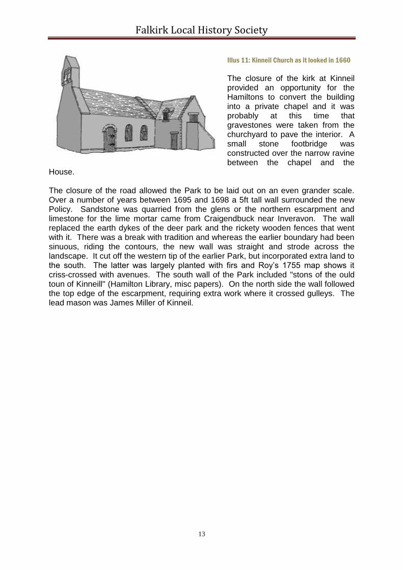
Illus 11: Kinneil Church as it looked in 1660
The closure of the kirk at Kinneil provided an opportunity for the Hamiltons to convert the building into a private chapel and it was probably at this time that gravestones were taken from the churchyard to pave the interior. A small stone footbridge was constructed over the narrow ravine between the chapel and the
House. The closure of the road allowed the Park to be laid out on an even grander scale. Over a number of years between 1695 and 1698 a 5ft tall wall surrounded the new Policy. Sandstone was quarried from the glens or the northern escarpment and limestone for the lime mortar came from Craigendbuck near Inveravon. The wall replaced the earth dykes of the deer park and the rickety wooden fences that went with it. There was a break with tradition and whereas the earlier boundary had been sinuous, riding the contours, the new wall was straight and strode across the landscape. It cut off the western tip of the earlier Park, but incorporated extra land to the south. The latter was largely planted with firs and Roy’s 1755 map shows it criss-crossed with avenues. The south wall of the Park included "stons of the ould toun of Kinneill" (Hamilton Library, misc papers). On the north side the wall followed the top edge of the escarpment, requiring extra work where it crossed gulleys. The lead mason was James Miller of Kinneil.

Falkirk Local History Society
14
Illus 12: Transcribed version of the 1748 plan of Kinneil Park.
Within this large enclosure the grass parks near the House had to be kept in trim by grazing animals. In May 1696 a long tradition was established of letting grass in the park to the coal lessee for his gin horses. At that time they numbered 16 to 20 (GD 406//1/4137). In 1760 the gin horses were put into the Easter Low Park and the Lady Well Park, which were held at a cheaper rate than normal (GD58). One unusual occupant of the yards was an antelope. It was being fed in 1697 and the 1700-2 lists of fodder for the animals include a small quantity of peas for the antelope (Hamilton Library 201169/10; Marshall 2000, 60).

Falkirk Local History Society
15
Illus 13: Dean Bridge looking north-east.
By 1697 the work had spread to the enclosure of the fields stretching as far west as Inveravon. In that year lime was bought for the wall extending from the River Avon to the Snab, and 1,700 thorns were required for the hedge from the Dean to the Snab. Large amounts of whin and broom were removed as the moorland was improved. It was now too that the main avenues were laid out. The principal avenue was the existing one running east from the central door in the tower. From the coachhouse to the Dean Burn this was known as the Wester Avenue. In October 1698 it was planted with trees, and dykes were built on either side. These were probably temporary drystone dykes “for preserving the hedg and trees” (Burrell’s Journal; today the dykes, with mortar matrices, remain, but there is no trace of the
hedges.). Stones were quarried at the “Castell burn” for a bridge over the Dean Burn (Hamilton Library, stable accounts). The Dean Bridge is a magnificent structure, constructed at a point where the stream valley is deep and narrow, with rock outcrops on either side. A waterfall splashed playfully immediately to the north of the bridge. Wood was provided "to John Pollock for the feet and tramms of the ston cairts and sleads of Kinneil" (Hamilton Library). Immediately south-east of the bridge a set of outer offices was built for the factor, including a thatched barn and stable (Burrell’s Journal). It was probably now too that the outer lodge and its adjacent gate piers were constructed. The lodge used the pantiles of this period on its piended roof and was inward looking, with a plain blank wall to

Falkirk Local History Society
16
the public. The tall stone piers had engaged columns on their outer sides and pyramid finials ending in small spheres. A rolling stone was acquired for smoothing the gravel paths.
Illus 14: The Outer Lodge and Gate Piers looking west towards Kinneil House (FoK).
At right angles to the Wester Avenue was the Hamilton Avenue. It ran from the Lady Well Cottages along the east side of the walled garden and the Wood to the Hamilton Gate in the south wall of the Park. It required a small bridge over the Gil Burn, which was also constructed by James Miller, in 1705. A large earth causeway rests on this bridge. Stone dykes were built on either side of the avenue from the bridge to the Hamilton Gate. At the same time work began on the most ambitious of all the avenues. Unlike the previous two it was not a case of improving an existing track and, as it was to be used to exercise horses, it was known as the “great Rydeing” or “Gallop”. It ran parallel to and 130m to the south of the main avenue from the Dean Burn to the Stey Step – a distance of just over 1.5km. It crossed the Gil Burn on the level by a substantial bridge known as the “Roman Bridge”, which at 15m was unusually wide as befitted its purpose. The Great Riding ran along the south side of the walled garden and the north side of the ha-ha that separated the wood from the Meadows and the Fir Pond Park. Hyde Park Gate was inserted into the west wall of the Park so that it could be extended along a tree lined path as far as the Stey Step, where it ended in a roundel. To help to pay for this work in 1707 the Duke of Hamilton returned property at Mumrills near Laurieston to the Livingston family represented by the Earl of Linlithgow. This incurred the wrath of his mother, Duchess Anne, who thought that the money could have been better spent than on the "unnecessary expences you are at wt engineers at Kinneill" (Hamilton Papers GD 406/1/8394). The drainage and cultivation of the parks were improved. The eastern tributary of the Deil’s Burn was diverted to the west so that it no longer flowed through the Meadows. The new course was lined with stone. To the west of the Meadows was a scrubby boggy area containing pools of water. In 1697 they were “Levelling the old earth Dyke of the wood on the north side of the ponds”. Here the deer park boundary had probably re-used the Antonine Wall. In 1704 they were “Digging up whins in the firrpool inclosure” (GD406/1/5104). The result was two rectangular ponds set within their own enclosures. Small ponds occurred elsewhere. There were two in the enclosure to the north of the orchard, and springs in the Lady Well and Laigh parks. At the top end of the East Field Park the bog contained numerous pools.
Despite these improvements the park was still only capable of sustaining a limited number of beasts, as Duchess Anne pointed out: “As for the improvement of the parks the upper one is not capable to feed above 50 (including the wood) and if it be stocked to the full for thy own use as the last year aney mor then 30 will be an overcharge against winter so that is to be considerd in the first place. The under park cannot subsist above 30 and thes must have liberty of the meadows after the hay is cutt for it being (much of it) dry and sandie ground there is very letell in it by the middle of Jilly. The prices of grasing is ten pound a horse two merk a cow or an ox and proportionally if the beasts are young. But if expectation hould as to the coall works I think it will be found adviesable to reserve grass to the tennants cairt

Falkirk Local History Society
17
horses for since ther is iccasion for a double number if ther be not food for them the work cannot be wrought at least if I be not provided that way I have not food for one and have keept three all winter as for my accounts” (Hamilton papers GD406/1/8394). One answer was to use Highland cattle: “Having considered the number of beasts in the park doe think there will not be subsistence for them in the winter tyme, therfor it were fitt to putt off the cuntrie beasts, befor they fall away wt cold and want for being used with houseing and night feeding will not endure the winter so well as the highland beasts who for their hardiness may be reserved unless it be thought fitt to salt som of them now while they are in their prime.” (GD406/1/10910). The hay from the Meadows was kept in the lofts of the stable and coachhouse (Hamilton papers GD406/10765). In April 1704 the Duke of Hamilton had the following horses as Kinneil: “Argill, Charters, Diamond, Gray pad, Bay mare, The Colt, Bouson, Bull dogg, Douglass, Brown workhorse.” Duchess Anne had two doocots erected at Hamilton in the 1680s and it may be assumed that one was also constructed during her improvements to Kinneil. This may be the unnamed circular feature marked at the centre of the Wood (SMR 32) on the first edition OS map (NS 9795 8006). This too provided a steady income and in 1697 money was “Received from Anthony Elye for Pidgeons sold be him out of the Doucat of Kinniell” (Hamilton Library 201169/10).

Falkirk Local History Society
18
Illus 15: Map of Kinneil Park in 1810 showing: 1 – Orchard; 2 – inner court; 3 middle court; 4 – walled
garden; 5 – West Avenue; 6 – Easter Avenue; 7-7 Hamilton Avenue; 8-8 Great Ride; 9 – doocot; 10 –
summerhouse.
Two pavilions or summerhouses were carefully placed within the Park to provide an appreciation of the landscape. The large one was at the north-west corner at the top of the escarpment (NS 9752 8032). It enjoyed the same extensive views across the Forth that the Antonine Wall had at this point, being on its line – only now the Abbey Craig at Stirling had a national significance. The field to the west became known as “Summerhouse Park.” On the 1810 map the pavilion is noted as “old summerhouse.” The location of the other, referred to as the south-east pavilion, is less certain. In 1697 Andrew Mitchel, quarrier for Kinneil, provided stones for the Easter Park wall, beginning at the Summerhouse, which suggests that it was a little to the north of the Hamilton Gate (around NS 9855 7999). It was evidently a new feature and that same year John Pollock, wright, made a door for the summerhouse, whilst William Shad, smith, forged “130 Great headed nails for the Door of the Southeist Summerhouss of the park” (Burrell’s Journal). Avenues were cut through the wood to provide vistas and one of these may have been aligned on the summerhouse. Writing on 24 July 1705 John Hamilton, the chamberlain, wrote "The Closet vistoe is inteerly cut except a little at the ends which consists of birtch." (Hamilton Papers GD406/1/5427)

Falkirk Local History Society
19
At the turn of the century the plans for Kinneil had not been completed. It is not clear whose master plan was being followed, but it would seem to have been the work of Alexander Edward who planned several gardens in Scotland in the grand French axial manner. Edward had assisted William Bruce with the layout for the gardens at Hopetoun House and at Kinross. On an even grander scale he prepared drawings for the "Great Design" of the landscape around Hamilton Palace in 1708 for Duchess Anne. The enormous scheme included plantations, forest rides, and mounds in the shape of the cinquefoils of the Hamilton arms. It was never fully realised, due to the deaths of Edward that year, and of Anne in 1716, and due to the expense of the proposals. Over a year after Edward’s death we find work progressing on extending the main avenue at Kinneil into fields to the east to create the Easter Avenue. On 14th January 1710 the factor, James Crauford, wrote to the Duke of Hamilton asking for directions about placing avenues and purchasing ground for that purpose. "George Miller and I measured and staiked all that avenue which is to goe down be the east end of the Edinb avenue to the church way wee find to make it stright and of a convenient breadth your Gra: will be foarced to purchas a peec ground from James Cassels". He noted that George Miller had "Mr Edwards draught y of" (Lennoxlove 2864). This plan was drawn up in 1708 (RHP 89889). The landscape at Kinneil is typical of Scottish design at this time. It started as a single axial layout. Often these were orientated upon an ancient monument in the distance – a church, castle of hill fort. At Kinneil the line was determined by its point of origin at the tower house with the unusually large frontage. Its other end would have vanished into infinity on the horizon near Douglas Park. Extending it to the east emphasised this vanishing point. The addition of a second parallel axis in the form of the Great Ride was an unusual and bold step. Utilising the northern edge of the wood gave it an abrupt and unique appearance which must have been impressive. It also saved space. The use of diagonal avenues was a late development and at Kinneil they are not as well considered as those of the Earl of Marr at Alloa. The two main diagonal lines through the wood were meant to be seen from the Great Ride -one from the Roman Bridge and one from Hyde Park Gate. One is, however, orientated on Kinneil House. It runs almost parallel to the Hamilton Avenue, but is turned slightly anticlockwise. The main feature missing from the plan of the Park at this time are the elaborate parterres that are a major feature of the work of Alexander Edward, and of William Bruce before him. Plans of such intricate planting survive for Kinross and elsewhere and provide a good indication of what might have existed. They would have been located between the colonnade of the inner court and the gate piers of the middle court, between the orchard and the walled garden. The latter contain topiary, seats, ornamental beds and presumably a sundial. Such was the state of the Park when Robert Sibbald wrote his account of the county: “The Wood and Avenues of Kineil, are all enclosed now with an high Stone Dyke well built, and in their circumference make up some Miles of Ground, where beside the Wood are fine Gardens and large Square-plots of fine Grass: the principal Avenue to the Palace is from the East. This from the Bridge over the Dean-bourn to the North-West Pavilion, at the end of the Visto to the West, will be a Mile long: it would require the Pen and Pencill of a skilfull Architect to describe justly the beauties and conveniences of this Princely Seat, which with regard to the Situation upon a
Falkirk Local History Society
20
hight hanging over the Firth below it, and the wholesome Air it enjoyes, may be placed amongst the finest Seats in Britain, and tho for vast and Magnificent Building, it cedes to the Palace of Hamilton, and for the fine and curious Contrivance of the Work, and the great extent of the Gardens, Inclosures and Park, and the neat Buildings of the Town of Hamilton joined to it; yet if you look to the Noble prospect of the Firth and Countrie adjacent here, and the many fertile Lands belonging to His Grace here, and the neat Houses of the Gentry in the Neighbourhood of it, it may be said in some particulars to surmount it. The Avenue from the East is long and broad, and well planted upon its sides, and has both outer and inner Office houses in convenient places, the Courts are Magnificent, and the Echo from the Trees in the Glen upon the North side of the outer Court, repeating many times some Syllables, is most delightfull; over against it is an Avenue from the South. The Garden to the south of the two Courts, for Gravel walks, and Shrubs cut into several figures, fine Wall fruits, and standers, and curious Flowers and Herbs, is most beautifull... The Wood is cut out in convenient Vistoes, the Pavilion in it affords the retirement of an Hermitage, and an excellent prospect far and near.” (Sibbald 1710, 18-19).
18th Century
Kinneil House became a juncture house where the mother of the then Duke lived out her retirement. This she held in life-rent, with the obligation to maintain the existing features, but not to add to them. This even extended to the cutting of the wood. The trees were cut every 40-50 years and still formed a valuable crop. In 1722 the Duke sold part of the standing crop to Alexander Gillies, but his mother, then in residence, claimed the wood as part of her life-rent. Evidently little love was lost between mother and son for a law suit ensued in which it was found that “the life rentrix, might use the woods of Kinneil for her proper uses, and for keeping in repair the houses on the lands of Kinneil, which she liefe-rents; but that she had no right to cut or dispose of the said woods by sale or otherwise” (House of Peers 1807). The delay caused by the law suit upset the usual rotation and in was 1789 before the following advertisement appeared in the pages of the Edinburgh Evening Courant: “Voluntary roup of 1,000 full grown trees at Kinneil. Oak, elm, ash, plane, beech & c, but principally plane and ash. Proprietor to cut. Sold by cubic foot. Twenty lots. John Burrel at Kinneil House” (26 November 1789). The other part of the wood had been harvested in 1712 and so by rotation came around again in 1763 when much of it was sold to Carron Company (Burrell’s Journal). It was also traditional to divide the wood into areas, which were then let for the exploitation of the living trees for their bark and branches. These divisions were known as hags and over the years 1744-51 were bought by Charles Addison of Woodhead. Fruit trees from Kinneil were still sought after. In 1719, for example, some were acquired for the new walled garden at Airth (NLS 10803/34). The enclosures within the park also provided some security for the over-wintering of cavalry horses. In 1709 dragoons stationed at Bo'ness and Linlithgow had been overwintered on hay at the Kinneil parks, but left in the summer as they considered the grazing too

Falkirk Local History Society
21
expensive (406/1/5531). Major Guest had his horses at Kinneil the following winter (406/1/5544). Far from being an intrusion, this was considered a useful source of income. However during the Jacobite rebellion in December 1745 when a large detachment of Hamilton’s Dragoons was stationed at Kinneil at least two of their horses were stolen by local dissidents and the dragoons accidentally set the church on fire (Bailey 1996, 36). According to tradition the house of Hamilton would only stand as long as the church did. It came as no surprise therefore that when the remains of the church were being demolished a wall fell on the man responsible and killed him. Consequently the west gable with its double belfry was allowed to remain. There were other reasons for keeping it. Fashions in landscaping had changed dramatically since the previous century and the ancient stonework provided a readymade romantic ruin or folly. It is also said to have acted as a sea mark for ships using this part of the Forth, which, if true, indicates that the tree cover then was a lot less than it is today. In May 1735 William Adam, the architect, was at Kinneil (Lennoxlove 2807). It is not known what his commission was, but as late as 1749 his son, John, was still trying to recover costs for the journeys that had been made to Bo’ness and Hamilton for the drawing of plans (ibid 2578). It is tempting to think that it was for the creation of a building like the one he designed at the end of the Great Avenue at Hamilton at Chatelherault. The coal on the estate was now being worked along the escarpment between Kinneil Park and the town of Bo’ness. From 1700 onwards the tack of the coal specifically excluded the “parks and yeards” of Kinneil from work associated with the operations (GD406/1/10910). Deeper seams were accessed and these required increasing volumes of water to be pumped out. One of the largest pits was just to the east of the Snab. A fire engine (now known as a steam engine) was erected there in 1735. In February 1740 Lord Elphinstone, the lessee of the coal, proposed alterations to more effectively remove the water: “It is proposed to bring up the coals from the bottom of the bearing sinks to the grass by a machine for that purpose, and for that end that it should be made to go by water if possible; the water to be got from a burn which runs cross Kinneil Avenue, and from all the land water to be gathered all into a dam in a proper place, where it can be got to be deep, above and south from the fire engine.” (Dundas papers GD75/530/2). The burn must have been the Dean Burn and it is just possible that this extract refers to the construction of the dam to the north of the Dean Bridge. This substantial curved stone dam is not shown on either the 1748 or 1810 plans, but appears on the first edition OS. Its omission may be due to its industrial use rather than its designed landscape value. Even the steam engines used timber from Kinneil Wood. “A note of timber cutt at Kinneil for the use of Duke of Hamilton's new engine at Cappies point & old engine at Corbyhall by Neill Small since Septr 1747” includes plain trees in the Lady Well Park as well as fir and ash – the latter for shovel handles (GD2177). In 1760 a lease of the estate and the coal and salt works was granted by the Tutors of the Duke of Hamilton to Dr John Roebuck and John Glasford. Roebuck became the sole lessee of Kinneil parks in 1769. This included Dean House, also known as the Factor’s House. As part of the agreement Roebuck was to drain the ponds in the Ladywell and Laigh Parks and all the parks but one were to be kept in grass (2177).
Falkirk Local History Society
22
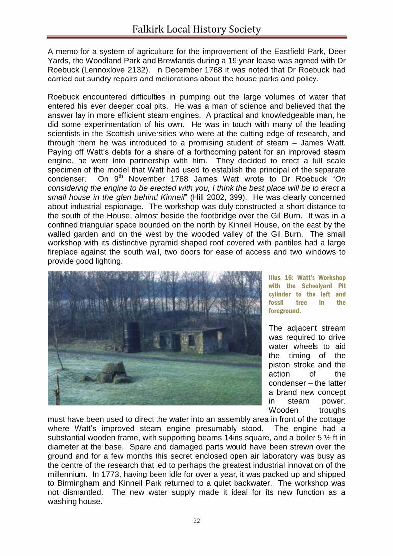
A memo for a system of agriculture for the improvement of the Eastfield Park, Deer Yards, the Woodland Park and Brewlands during a 19 year lease was agreed with Dr Roebuck (Lennoxlove 2132). In December 1768 it was noted that Dr Roebuck had carried out sundry repairs and meliorations about the house parks and policy. Roebuck encountered difficulties in pumping out the large volumes of water that entered his ever deeper coal pits. He was a man of science and believed that the answer lay in more efficient steam engines. A practical and knowledgeable man, he did some experimentation of his own. He was in touch with many of the leading scientists in the Scottish universities who were at the cutting edge of research, and through them he was introduced to a promising student of steam – James Watt. Paying off Watt’s debts for a share of a forthcoming patent for an improved steam engine, he went into partnership with him. They decided to erect a full scale specimen of the model that Watt had used to establish the principal of the separate condenser. On 9th November 1768 James Watt wrote to Dr Roebuck “On considering the engine to be erected with you, I think the best place will be to erect a small house in the glen behind Kinneil” (Hill 2002, 399). He was clearly concerned about industrial espionage. The workshop was duly constructed a short distance to the south of the House, almost beside the footbridge over the Gil Burn. It was in a confined triangular space bounded on the north by Kinneil House, on the east by the walled garden and on the west by the wooded valley of the Gil Burn. The small workshop with its distinctive pyramid shaped roof covered with pantiles had a large fireplace against the south wall, two doors for ease of access and two windows to provide good lighting.
Illus 16: Watt’s Workshop
with the Schoolyard Pit
cylinder to the left and
fossil tree in the
foreground.
The adjacent stream was required to drive water wheels to aid the timing of the piston stroke and the action of the condenser – the latter a brand new concept in steam power. Wooden troughs
must have been used to direct the water into an assembly area in front of the cottage where Watt’s improved steam engine presumably stood. The engine had a substantial wooden frame, with supporting beams 14ins square, and a boiler 5 ½ ft in diameter at the base. Spare and damaged parts would have been strewn over the ground and for a few months this secret enclosed open air laboratory was busy as the centre of the research that led to perhaps the greatest industrial innovation of the millennium. In 1773, having been idle for over a year, it was packed up and shipped to Birmingham and Kinneil Park returned to a quiet backwater. The workshop was not dismantled. The new water supply made it ideal for its new function as a washing house.

Falkirk Local History Society
23
In 1794 the Edinburgh Evening Courant advertised for let “The house, offices, and gardens of Kinneil, also as possessed by him [Roebuck], with adjoining inclosures, to the extent of 150 acres or thereby” (1 November 1794).
19th Century
Writing in 1799 Robert Rennie, the minister for Bo’ness, stated that “The house is surrounded by two gardens, by large inclosures, and by aged planting, which forms beautiful natural vistas; and though now uninhabited, in other times it was the residence of Nobility” (NSA, 699). The tone is one of past glories. The House itself was subsequently rented out to Dugald Stewart, the moral philosopher, who stayed from 1809 to 1828 and wrote some of his books here. The grounds, however, were not maintained to the same high standard. It was probably during Stewart’s occupancy that the inner gate piers became the boundary of the private space associated with the House.
Illus 17: Dean House
looking north-west.
Kinneil House and Dean House continued to be rented out for some time. In 1889 PB Mitchell gave permission for the Carriden and Kinneil
Instrumental Bands to hold a
promenade concert at Kinneil House. Perhaps
the best known tenants of the Dean were the Wilson family, who owned and managed the Kinneil Ironworks (SMR704) from 1843 to1870. In 1846 a specification was drawn up to convert the barn at Kinneil offices into a dwelling house (Lennoxlove 2578); this was the barn at the Dean. The Dean was often described as the outer offices and included a stable as well as the barn, suggesting that it was run as a home farm. Normally the factor stayed at the Dean, but during Dr Roebuck’s tenancy the factor lived at the Snab. Thereafter it was gradually improved and enlarged. Gardens were laid out to the south. By the mid 19th century it had become a large Victorian villa in the Scottish Baronial style. The old banqueting house had been converted into dwellings and the presence of sundial in the garden to the north shows that it was of good quality. The smaller abodes in Kinneil Cottages remained for the use of estate workers, such as the forester. They were all served by wells, with or without pumps, until long in the 20th century.

Falkirk Local History Society
24
Illus 18: Kinneil House looking west with the inner gate piers in the foreground, c1910. The dwarf walls to
either side of the piers carry a wooden frame covered with wire.
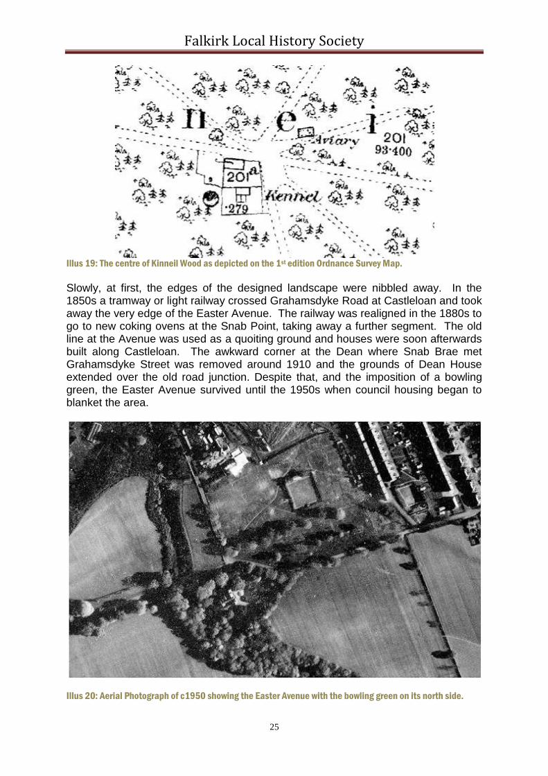
The wood remained a valuable asset and in 1814 William Whyte of Dunblane offered to buy the growing wood at Kinneil for £2,000 (Lennoxlove 5150). The orchard became a nursery. The hub of the many axial avenues in the wood was an obvious focal point and yet the early maps show it devoid of features. The first edition Ordnance Survey map shows a kennel and an aviary and an unnamed circular structure, which was probably the earlier doocot. The kennel, like that at Callendar Wood, was well away from the House because of the noise made by the dogs. It had large exercise yards and would have held hunting hounds. Immediately to its north was a small dwelling for the gamekeeper. By the second edition OS map the doocot had disappeared, as had the aviary, but a larger “keepers lodge” and a well had been added, remaining present on the third edition. There is no trace of any buildings now. The “target” in Brewlands Park must have been for the tenant of the House rather than the gamekeeper.
Falkirk Local History Society
25
Illus 19: The centre of Kinneil Wood as depicted on the 1st edition Ordnance Survey Map.
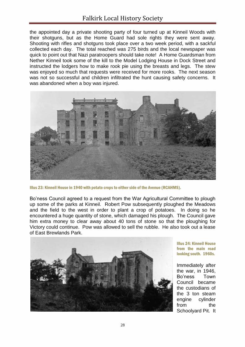
Slowly, at first, the edges of the designed landscape were nibbled away. In the 1850s a tramway or light railway crossed Grahamsdyke Road at Castleloan and took away the very edge of the Easter Avenue. The railway was realigned in the 1880s to go to new coking ovens at the Snab Point, taking away a further segment. The old line at the Avenue was used as a quoiting ground and houses were soon afterwards built along Castleloan. The awkward corner at the Dean where Snab Brae met Grahamsdyke Street was removed around 1910 and the grounds of Dean House extended over the old road junction. Despite that, and the imposition of a bowling green, the Easter Avenue survived until the 1950s when council housing began to blanket the area.
Illus 20: Aerial Photograph of c1950 showing the Easter Avenue with the bowling green on its north side.

Falkirk Local History Society
26
The pond of 0.56 acres created in the Dean Burn by the substantial stone weir to the north of the Dean Bridge complemented the design landscape of Edward. The water could be seen to excellent advantage by anyone crossing the bridge, particularly if they were in a carriage. Its calm clean waters, teaming with fish, must have contrasted beautifully with those of the Forth beyond. Further upstream a second dam of 0.30 acres was constructed with a brick weir around 1900. It too occupied the base of a steep-sided valley, but there were few vantage points from which to observe it. The pond seems to have been purely utilitarian, providing an additional reserve in dry summers for the first pond. Both weirs have been breached and there is little left of the later one; consequently neither dam holds water. The first edition OS map shows that the two ponds in the Fir Pond Park had by then been reduced to one (although the 1810 map fails to show any). It served as a curling pond. The East Pond at the Meadows first appears on the 1860 OS map. It was formed by erected an earth bank across the point where the valley of the Deil’s Burn widens out at the top of the escarpment, and lining the inner slope with clay and stone. It is quite large at 0.97 acres and appears to be linked with industry further east. The same is true of the even larger reservoir or West Pond, some 4.15 acres. It first appears on the second edition OS map and has been connected with the distillery at Capies Point. Rather surprisingly, Hamilton Lodge, close to Hamilton Gate, makes its first appearance on the third edition of the Ordnance survey maps.
20th Century
In 1909 the 13th Duke of Hamilton revised the family’s interest in Kinneil and had Sir Robert Lorimer
draw up a set of proposals for a doubling of the size of the House. This would have included
redesigning the gardens in close proximity to it, creating garden walks boxed in by yew hedges.
These plans were never executed, probably because of the First World War. The climate after the war
was completely different and the family had to relinquish one of its oldest possessions.
In 1923 Bo’ness Town Council bought Kinneil Park from the Hamilton family with the intention of building council houses. It was converted into a recreational park for the public, with park benches arranged along the main avenue and putting greens on either side between the coachhouse and the House.
Illus 21: The Wester Avenue looking east in 1925.

Falkirk Local History Society
27
The leisure activities were extended in a rather unusual direction in 1934 when the first of the Bo’ness Speed Hill Climbs took place. This became a major national event with famous drivers attended, watched by thousands of spectators (Baird 2007). Initially the cars started in the court in front of the coachhouse and sped up Hamilton Drive. From 1947 to 1966 the start line was at the Paddock. The cars the climbed the Crawyett to the courtyard, which formed an S-bend, and on passed the walled garden as before. The difficult Snake Bend was inserted at the end of the walled garden, where Provost Road now cuts Hamilton Avenue. The return road was through the wood, over the Roman Bridge, along the front of Watt’s workshop, behind Kinneil House, along the north side of the orchard and then down Crawyett on a specially constructed terrace above the road. At the bottom of the hill a bridge was also placed over the Gill Burn. A temporary scaffold bridge was annually placed over the access drive to the coachhouse, just north of the main avenue. Bales of hay, tyres, fences and the odd stone wall acted as crash barriers. Illus 22: The Hill Climb at the Snake Bend looking north towards Duchess Anne Cottages with the Scaffold
Bridge in place.
It was 1936 before the Council had mustered the further resources required to bring its plans to fruition and a contract was signed for the demolition of the House. Work began and was well advanced when the 16th century murals were discovered and just in the nick of time the then H.M. Office of Works secured guardianship of the part containing them. Work commenced immediately on conserving the murals, reinstating the ceilings that had been torn out and putting a new roof on. The remainder of the building was only put in the hands of the Secretary of State for Scotland in 1975. Amazingly work continued on the House during the early years of the Second World War when the roof was finished. It was essential during the war to exploit the resources of the Park. In 1940 trees were sold to Harrower, Welsh & Co and to Messrs Kennedy, both of Bo’ness, for use as pit props. English timber merchants had considered the wood too small for them to bid for. In 1944 woodmen from Bathgate paid Bo’ness Council £200 to cut down more trees, with the approval of the Timber Control. New trees were planted the following year. The wood harboured rooks, which were considered to be detrimental to the crops of the neighbouring farms. It was therefore agreed in 1941 that members of the Home Guard should be allowed to practice their shooting there in order to reduce the number of birds. On
Falkirk Local History Society
28
the appointed day a private shooting party of four turned up at Kinneil Woods with their shotguns, but as the Home Guard had sole rights they were sent away. Shooting with rifles and shotguns took place over a two week period, with a sackful collected each day. The total reached was 275 birds and the local newspaper was quick to point out that Nazi paratroopers should take note! A Home Guardsman from Nether Kinneil took some of the kill to the Model Lodging House in Dock Street and instructed the lodgers how to make rook pie using the breasts and legs. The stew was enjoyed so much that requests were received for more rooks. The next season was not so successful and children infiltrated the hunt causing safety concerns. It was abandoned when a boy was injured.
Illus 23: Kinneil House in 1940 with potato crops to either side of the Avenue (RCAHMS).
Bo’ness Council agreed to a request from the War Agricultural Committee to plough up some of the parks at Kinneil. Robert Pow subsequently ploughed the Meadows and the field to the west in order to plant a crop of potatoes. In doing so he encountered a huge quantity of stone, which damaged his plough. The Council gave him extra money to clear away about 40 tons of stone so that the ploughing for Victory could continue. Pow was allowed to sell the rubble. He also took out a lease of East Brewlands Park.
Illus 24: Kinneil House
from the main road
looking south. 1960s.
Immediately after the war, in 1946, Bo’ness Town Council became the custodians of the 3 ton steam engine cylinder from the Schoolyard Pit. It

Falkirk Local History Society
29
had been worked on by James Watt during his experiments at Bo’ness and was now erected beside his cottage in the Park. The fossilised remains of a tree, found in one of the pits, were also placed nearby.
The original tree planting emphasised the west/east orientation of the Park but maintained views out across the Forth as well as into the estate. Unfortunately since the war the trees have been allowed to provide a massive screen and it is possible in the summer months to walk for hours in the estate without even glimpsing the estuary. Conversely the House and the church are masked from the coast. The 1970s saw significant changes to the appearance of the Park. In the late 1960s it had been decided to sell the East Park for private housing and Provost Road was constructed. Applications for individual houses flooded in between 1971 and 1978. A new access road led into the Park over the former site of Dean House. In 1971 the restoration of Kinneil Cottages was proposed and the work was carried out in 1973. 1973 also saw the Park became part of the property portfolio of Falkirk District Council. It decided to house a new museum in the old coachhouse and this was undertaken between 1973 and 1975. Kinneil House was made more presentable in 1980/1 when new windows were put in. At the same time the fortlet on the Antonine Wall was excavated by Falkirk Museum and presented to the public. The children’s corner, featuring rabbits in hutches, was installed to the east of Duchess Anne Cottages, only to be removed in the early 1990s. In 2006 it was proposed to close Kinneil Museum, but active lobbying by local residents saw the decision reversed. The Friends of Kinneil was set up to help promote and develop Kinneil Estate and Foreshore. Liaising with Historic Scotland the group has arranged for greater access to the House. In the following year the “60th reunion” of veteran racing cars and owners occurred at Kinneil to commemorate the Bo’ness Hill Climb. Those attending decided to revive the event, which has been successfully accomplished. It is run each September and is accompanied by classic car shows and other attractions. The race has led to physical changes to the Park. A low but substantial fence has been erected along the north side of the Crawyett as a safety barrier; kerbing was placed on the inside of the Paddock Bend, bollards between the museum and the cottages were removed. The Park has shown itself capable of adapting to such minor changes – and will continue to do so into the future. The past has not been forgotten. In 2014 the vandalised remains of Kinneil Church were consolidated and plans are afoot to reinstate the orchard...

Falkirk Local History Society
30
APPENDIX
Kinneil Fortlet (SMR 797) The Roman fortlet at Kinneil is a long-axis fortlet measuring 18.5m west/east by 21.5m north/south internally and is attached to, and contemporary with, the Antonine Wall. The ramparts were similar in construction to the Wall, with clay cheeks retaining an earth core all placed on a 3m wide stone base. On the more vulnerable side to the west there were two small ditches, but only a single one to the east. A slightly offset causeway occurred opposite the south gate. A metalled road ran across the causeway, through the south gate and the interior and on through the north gate. The south gate had six large wooden posts, the northern gate eight, suggesting that the latter may have supported a tower. Inside the fortlet the road was flanked by rectangular wooden buildings approximately 17m long by 4.1m wide, with verandas. Lean-to shelters occurred against the back of the Antonine Wall and are associated with cooking. In the north-west corner was a well, 3.0m deep. Outside the fortlet, in the angle made by its east rampart and that of the Wall, a curving ditch enclosed a very small annexe, possibly for the latrine block.
Illus 25: Interpretative Plan of Kinneil Fortlet.
During the Roman occupation of Scotland the fortlet was demolished. The Military Way was diverted over the levelled ramparts and a flagged causeway placed across the eastern ditch. The north gate was blocked, but the tower seems to have been retained, perhaps as an observation post. The lean-to structures were also re-used.

Falkirk Local History Society
31
Deer Park Dyke
The earth dyke that surrounded the medieval deer park still survives for a distance of approximately 1.0km as a prominent mound along the sinuous southern boundary of the present wood. What is probably another length of it runs along the top of the Cow Bank for 60m. The western side of the deer park was removed when the Kinneil New Ground was enclosed in the early 18th century, but it presumably crossed the contours at a slight angle to reach the section just mentioned. That section also coincides with the rampart of the Antonine Wall and it is quite possible that the Roman earthwork formed the northern boundary of the deer park. The medieval road to Falkirk would, on analogy to the known situation at Dean Road, have occupied the upcast of the old frontier ditch on the north side of this boundary. The church and the House /castle are both north of the Roman line, as was presumably the early village. The east side of the deer park is likewise unknown. At the easternmost surviving part, near Hamilton Gate, the bank is curving to the north-east. This line would follow the contours back towards the Dean. It must have passed along the watershed between the Gil Burn and the Dean Burn before turning north. It is assumed that it then took the line of the east boundary of what became East Field Park, influencing the boundaries here at a later date. Northward from the Dean the deep valley provides a natural boundary and this appears to be the line shown on Pont’s and Bleau’s maps in the 16th and 17th centuries respectively. However, the deer park is unlikely to have crossed the main road. In the 1690s Duchess Anne had the stone dyke built in its place on a new line. The wall followed the same strict straight lines as the new designed landscape, of which it was the first step in laying out. To the south it added Wester and Easter Firs and Woodhead Park. On the north the new wall occupied the lip of the escarpment a little beyond the Antonine Wall. Twenty or so years later the main road was diverted along the coast and the lower parks were incorporated behind a newer wall. In 1705 New Park was added to the east and New Kinneil Ground to the west, requiring minor alterations to the public roads.
Illus 26: Map showing the line of the medieval deer park earth dyke, the straight
1690s stone walls surrounding the Park, and the later additions.

Falkirk Local History Society
32
Ice-House (SMR 68)
This is perhaps the oldest ice-house in the Falkirk District. It consists of two elements, a cylindrical well with an opening near the House (NS 9818 8057), and a low arched tunnel (1.2m wide and 1.2m high and longer than the 35m remaining), which led to the base of the well. All the work is of stone. The well has now been filled in and the point of junction is no longer accessible. The mouth of the tunnel lies besides the Gil Burn, some distance below that of the well. The tunnel is aligned almost N-S parallel with the Burn, with the entrance at the north. The whole of the east bank of the burn is evidently made ground at this point and building debris protrudes from it. The "tunnel" would seem to have been built in the open, having cut back the side of the valley, and then buried with soil derived from building operations elsewhere.
The obvious date for such an operation would have been the end of the seventeenth century when Duchess Anne was laying out the Estate. The Hamilton family had many influential and knowledgeable contacts, including with France, and the construction of an ice-house would have been in character. The Kinneil estate was renowned for its fruit orchard and an ice store would have been useful. The gorge is now wooded.
The Coachhouse (SMR 344)
The original coachhouse at Kinneil was built in 1611 and seems to have occupied the northern part of the present museum building. In the north it started on line with the orchard wall and must have ended close to the later large doorways. In the 1660s the orchard was constructed and the line of the coachhouse’s western side was continued southward by the orchard wall, which then turned west to form the south side of the orchard. This original building was single storey, as is shown by the disposition of quoins at the north end of the present structure. A blocked doorway with chamfered margins under the later hay loft loading bay belongs to this period. The walls incorporated reused masonry, two of which (A & B on the elevation drawing) have broad roll-moulded margins) in the same hard grey sandstone as the doorway. These probably derived from the defensive foreworks demolished in the 1580s. In the 1680s the coachhouse was rebuilt as part of the development of the wider park landscape. It was now two storeys to balance the adjacent banqueting house, and these in turn were counterbalanced by the construction of Kinneil Cottages on the opposite side of the avenue. It was typical of the late 17th century with steep crowstepped gables, dormer windows with triangular pediments, pantile roof and cavetto moulded eaves courses. The walls were of random rubble and traces of a
Illus 27: The Entrance to the Ice-House looking south.

Falkirk Local History Society
33
shell-rich harling remain. It extended further south than its predecessor using the orchard wall for the base of the west wall of the extension. The south gable now acted as a retaining wall and this continued eastward to form the south side of the stable court. The main façade faced east onto this court. The margins of the north door of this front are chamfered with a rebate, as are those of the doorway near the southern end, and the sides of the coach entrances. The tooling in each case consists of horizontal overlapping strokes. This is similar to the tooling on the Dean Bridge, which was constructed in the 1690s, except that the stone at the coachhouse was cleaned in the 1970s and therefore looks newer. This suggests that they are an original feature of the 1680s building and that the two coach entrances date to that period. There are indications that they had elliptical arches, presumably springing from a central pier. At a subsequent date, probably in the mid-19th century, the pier was replaced by a large upright stone slab and the arches by a thick iron plate. The north end of the earlier coachhouse was retained as a single storey adjunct. The upper floor of the coachhouse was used for the storage of hay and as accommodation. The latter is testified by the presence of a fireplace against the south gable, its chimney stack now sadly removed. The adjacent window is a later insertion, but the barred window on the ground floor of the gable is original. Being a minor structure it only has simple chamfered margins.
Illus 28: The East Elevation of the Coachhouse (Museum).
By the mid-18th century the retaining wall on the south side of the court was being used as part of a structure attached to the coachhouse, probably for storage. At a later date, probably in the late 19th century, a large window was inserted below the hay loft door on the ground floor. The single storey northern end of the building became dilapidated and was demolished at the beginning of the 20th century. In the 1950s the empty building was used by officials from the Bo’ness Hill Climb as an observation post. A viewing turret was added to the wallhead at the north-east corner by adding several courses of masonry to the wall and placing a timber shed-like structure on it. The storage building on the south side of the court had been demolished and provided a relatively safe platform for the spectators to witness the cars racing through the chicane formed by the court and its buildings. In 1973 Falkirk District Council commissioned William Cadell to renovate the building for use as a museum. As part of this refurbishment the late ground floor window was filled with stone, the observation tower was removed, the hay loft door became a window,

Falkirk Local History Society
34
the dormer pediments were replaced and the ground level was raised. The latter included laying whinstone sets inside the main room to reflect its former use as a stable. The entrance step would, of course, have been incompatible with its original use. The interior was gutted and new floors, stairs and internal partitions inserted. Outside the building cobbles were laid and the terrace on the south side of the court scarped. Much patching of the external stonework was required, including at the south-east corner where the storage wing had been removed. A re-used inscribed stone was removed and can still be seen in one of the nearby gardens. The north gable required considerable infill in the centre where the earlier coachhouse had been demolished.
Dean Bridge
Dean Bridge carried the main avenue across the valley of the Dean Burn on the perpendicular axis of the tower house. It separated the Wester Avenue from the Easter Avenue. The bridge has a single arch with a 6.0m span flanked by massive buttresses and long abutments. The voissoirs and 14 courses of masonry in the piers below the imposts are large rustic blocks. Behind the piers are buttresses 2.1m wide, which rise to the wall head where they are capped by single blocks of stone. Below the moulded stringcourse they have regular chamfered quoins. Shorter buttresses of the same dimensions occur at each end of the bridge, the distance between them being greater at the east side due to the gentler valley side there. The bridge is thus 47.2m long. The eastern buttresses are largely buried as a result of landscaping following the demolition of the Dean. Above the string course and an offset course the parapet is made of large upright slabs with V-shaped tops. These now carry short iron uprights for a wire fence. The abutments are plain with weeping holes in the lower levels.
Illus 29: South elevation of Dean Bridge.

Falkirk Local History Society
35
Kirk Bridge
Illus 30: South
Elevation of the Kirk
Bridge.
This is a small single arched rustic footbridge located immediately south-west of Kinneil House to cross the deep ravine of the Gil or Kirk Burn. On the church side the bedrock has been cut back and forms the west pier with the arch springing from it at a height of about 3.0m above the water level. The arch is 3.8m across and a rock cut ledge indicates the position of the forming frame. On the east the bedrock does not rise as rapidly and an offset foundation occurs. Although the soffit of the arch is made of neatly squared voussoirs, the majority of the stonework is coarse, almost vernacular. The parapet walls are low, only 0.7m high, and have ovoid copestones. On the west they extend beyond the lip of the valley, but on the east do not reach the lip. In the latter case they splay outwards to form wing walls. Around 2004 a galvanised metal rails was added to the parapet for safety. The valley here is spectacular with its vertical sedimentary rock faces on the west sculpted by the weather. This contrasts with the softer wild garlic strewn slopes on the east. These slopes too are artificial and north of the bridge conceal the ice-house. The bridge was probably constructed as a private access from the House to the Church and its design and scale contrast markedly with the Dean Bridge or the Roman Bridge.
Roman Bridge
Renewed local antiquarian interest in the Roman Empire in the early 19th century was often led by ministers, who had access to private grounds. Any ruinous structure of unknown date was attributed to this period and this seems to have been the case at Kinneil where stone walls were observed on the banks of the Gil Burn immediately to the north of the Great Ride. They are annotated as “ROMAN BRIDGE (REMAINS 0F)” on the first edition Ordnance Survey map, and the surveyors made the following note: “This is pointed out in the locality as the remains of the bridge built by the Romans to carry the Wall of Antoninus across the small burn that runs close to Kinneil House; the only portions at present visible are the two piers or abutments that supported the arch; from the appearance of the ground there can be no doubt but that this was the spot where a bridge once stood, and the Rev Mr McKenzie of Borrowstounness and other intelligent persons of the locality speak of having heard years ago very old people make mention of the spot being place where a Roman bridge stood.” (Ordnance Survey Name Book – Bo’ness Parish).

Falkirk Local History Society
36
The location suggests that it may in fact have been the remains of the medieval bridge that were seen. The existing bridge was constructed in around 1705 as part of the Great Ride of Gallop, and this accounts for its extraordinary breadth. It is in fact little more than a large culvert with tall abutments retaining the earth of the causeway over the valley. Its parapets are barely over 0.3m tall.
The Piers
One set of features often overlooked at Kinneil are the substantial stone piers that are typical of Edward’s designs. The outer court gate piers stood next to the lodge (NS 9865 8072) at the public road and were pretty massive. They separated the Easter Avenue from Dean Bridge and the Wester Avenue. Unfortunately they were demolished around 1960 by Bo’ness Town Council as part of its “improvements” and we have to rely on postcards and a painting by William Woolard for evidence. The postcards show the view from outside looking towards the House with the lodge to the right. The estate wall and the lodge provide the scale and this is confirmed by the painting that shows an adult standing next to that wall. They thus bear comparison with the surviving contemporary piers at Alloa. They too were set at a considerable distance from the House and gave the appearance of false distance. Like the other piers at Kinneil there are engaged columns on the outer side. The finial is in the form of a small obelisk capped by a sphere.
Illus 31: The Kinneil Piers drawn to
a common scale.
The middle court gate piers (NS 9832 8060) are better known because they survive, though the northern one recently lost its ball finial. Here again is the column, but the moulding is more intricate. The bottom 0.4m is now hidden in the ground due to recent landscaping which saw the removal of the dwarf wall that ran from each pier to the museum or
to Kinneil Cottages. These walls were originally part of a ha-ha and supported a trellis fence. The piers had been located about 20m to the west and the wall was set back from the buildings to either side. They were moved to their present position around 1750. The other remaining pier anchored the south end of the colonnade for the inner court to the tall screen wall linking it with the walled garden. Like the other piers it has rebated corners, except in this case for the north-east corner where it begins to form the colonnade. The ball finial is seen on an early photograph, but is now missing.

Falkirk Local History Society
37
BIBLIOGRAPHY
Bailey, G.B. 1996 1996 'Stream crossings on the Antonine Wall', Proc Soc Antiq Scot, 126 (1996), 347-369.
Bailey, G.B. 2015 Kinneil Kirk.
Bailey, G.B. & Cannel, J
1996 'Excavations at Kinneil fortlet on the Antonine Wall, 1980-1', Proc Soc Antiq Scot, 126 (1996), 303-346
Bain, J. 1892 The Hamilton Papers
Baird, K. 2007 Bo’ness Speed Hill Climb: Scotland’s First Motor Racing Venue.
Glendinning, B 2000 ‘Investigations of the Antonine Wall and medieval settlement at Kinneil House, Bo’ness, Falkirk’, Proc Soc Antiq Scot, 130 (2000), 509-524.
Hill, R.L. 2002 James Watt Volume 1: His time in Scotland, 1736-1774.
House of Peers 1807 Reports of Cases on Appeal from Scotland, decided in the House of Peers.
Lowrey, J. 2012 ‘A prospect on Antiquity and Britannia on edge’ in ‘Landscape and the work of Sir William Bruce and Alexander Edward’, Architectural Heritage XXIII, 57-74.
Macdonald, A . 1941 The Place-names of West Lothian.
McGuire, D. Medieval and Early Modern Life at Kinneil.
Marshall, R. K. 2000 The Days of Duchess Anne: Life in the household of the Duchess of Hamilton 1656-1716.
Sibbald, R. 1710 The History and Description of Linlithgowshire.
'History of the Sheriffdoms of Linlithgow and Stirling,'
Sloane, D. 1997 ‘Greed and stupidity: the end of the Forth oyster beds’, Calatria 11, 89-94.
Stewart, M 2012 ‘John Erskine, Earl of Mar: Architecture, landscape and industry’ in ‘Sir William Bruce and Architecture in Early Modern Scotland’, Architectural Heritage, XXIII, 97-116.
Urquhart, E. 1960 ‘Seventeenth century ice-houses at Castle Huntly near Longforgan, Perthshire, and Glamis Castle, Angus’, Proceedings of the Society of Antiquaries of Scotland, 43.
Waldie, G 1883 (reprinted 1913)
Walks Along the Northern Roman Wall.