Embed Size (px)
Citation preview
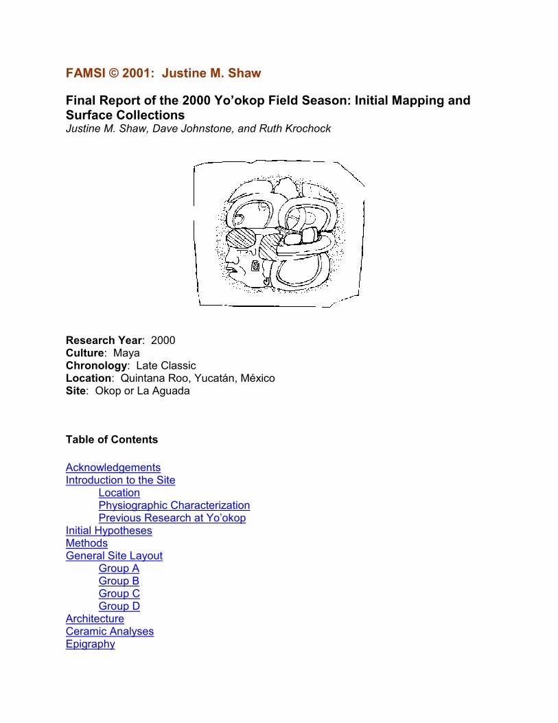
FAMSI © 2001: Justine M. Shaw
Final Report of the 2000 Yo’okop Field Season: Initial Mapping and Surface Collections Justine M. Shaw, Dave Johnstone, and Ruth Krochock
Research Year: 2000 Culture: Maya Chronology: Late Classic Location: Quintana Roo, Yucatán, México Site: Okop or La Aguada
Table of Contents
Acknowledgements Introduction to the Site
Location Physiographic Characterization Previous Research at Yo’okop
Initial Hypotheses Methods General Site Layout
Group A Group B Group C Group D
Architecture Ceramic Analyses Epigraphy
2
Preliminary Analysis of Epigraphic and Iconographic Data Plans for Future Documentation of Carved Stone Monuments
Discussion and Conclusions List of Figures Sources Cited
Acknowledgements
The 2000 Yo’okop field season was made possible by grants from the H. John Heinz III Fund of the Heinz Family Foundation (reference number H1305) and the Foundation for the Advancement of Mesoamerican Studies, Inc. (FAMSI project number 99016). Without these funds, our research would not have been possible.
Additionally, the members of Proyecto Arqueológico Yo’okop would like to thank Hugh and Dianne Johnstone and Tom and Mary Lou Shaw for years of unflagging support as we worked toward our goal of running our own research project. Our family and friends have been incredibly patient and supportive. We also would like to thank the following colleagues: David Freidel for giving us the opportunity to first work in the Northern Lowlands, Bill Rathje for his continued encouragement, Vernon Scarborough for reading through drafts of early proposals, Jennifer Mathews for providing us with excellent advice and connections to get started in Quintana Roo, Miguel Astor Aguilera for keeping us sane in the field, Nancy Forand for giving us in-depth information about local culture and politics, Adriana Velázquez Morlet (director of INAH-Quintana Roo) for enabling us in our initial reconnaissance and giving us helpful proposal recommendations, and INAH Nacional for giving us permission to carry out our research.
Finally, and most importantly, we would like to thank the people of Sabán and Huay Max who graciously allowed us to live and work in their ejido during the summer of 2000. In addition to the crew members we were able to hire, we received countless archaeological (and survival) tips and assistance from individuals throughout the ejido.
2000 Field Crew from the Sabán Ejido
Week One Week Two
Alfonso Moo Uc Quillermo Canche Sansores
Galdino Canche Chimal Gonzalo Poot Poot
Pablo Moo Uc Gerardo Canche Canche
Gregorio Moo Moo Susano Chan Poot
Diego Canche Canche Marcelino Diaz May
Julian Pat Mayay Pablo Poot Poot
Jose Narciso Poot Chan Eliodoro Perera Cab
Arsenio Moo Arnona Estanislao Chan Poot
Luis Chimal Chimal Miguel Canche Cupul
Sebastian Balam Kumul Bernardo Poot Poot
I Polito Dzul Moo Idelfonzo Uc Poot
3
Guillermo Poot Cohno Graciano Uc Batun
Week Three Week Four
Alfonso Tun Chan Zantiago Chimal May
Isidro Pool Chi Fidel Chan Chi
Miguel C Moo Kanil Evelio Canche Itza
Silverio Pat Tun Juan Noh Moo
Mauro Poot Poot Jose Dolores Diaz May
Nacinto Pool Canche Juan Moo Uc
Pedro Chan Pech Epifanio Cab Chuc
Macximiliano Moo Balam Jose Fuentes Cab
Marcelino Itza Mazun Pedro R Toz Arjona
Filiberto Moo Pat Zacarias Cano Cohuo
Florentino Moo Chan Alvario Moo y Chan
Vicente Poot Kanil Victoriano Dzul Ku
Week Five Week Six
Damiano Moo Arnona Gilberto Canche Zansores
Norberto Poot Cohuo Benjamin Moo Poot
Mariano Noh Moo Rufino Moo Balán
Leoneucario Moo Poot Ermilo Canche Chimal
Maria Lucila Ken Noh Anastacio Poot Poot
Anbrocio Itza Poot Domingo Moo Moo
Aurelio Canche Canche Luis Renan Estrada Blanco
Juan de Dios Moo Balam Benito Canul Chi
Alberto Kanil Poot Fausto Kanil Chan
Petronilo Moo Pat Manuel de Jesus Canche Chimal
Miguel Tun Perez Cristino Moo Moo
Miguel Moo Kanil Mario Kanil Moo
Alberto Kauil Poot
2000 Sabán Laboratory Crew
Carlos Rene Canche Tejero
Liberato Itza Poot
Elmi Narlene Moo Fuentes
Lincey Moo Kauil
Naybby Raquel Kauil Tun
For additional information on the Proyecto Arqueológico Yo’okop please visit: http://online.redwoods.cc.ca.us/yookop/. Submitted 11/01/2000 by: Justine M. Shaw [email protected]
4
Introduction to the Site
Location
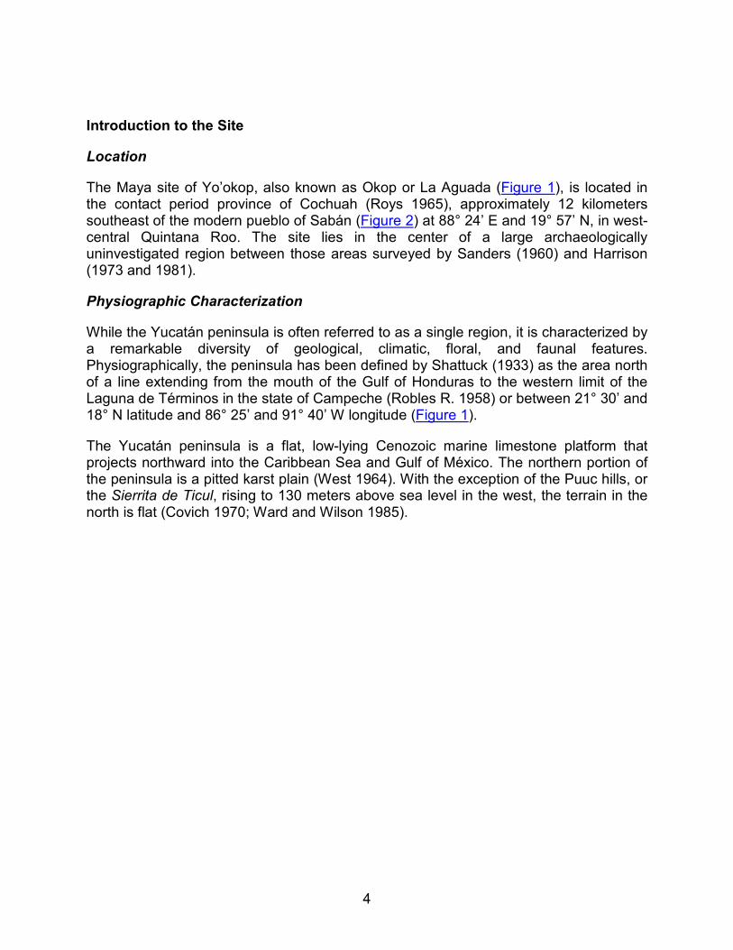
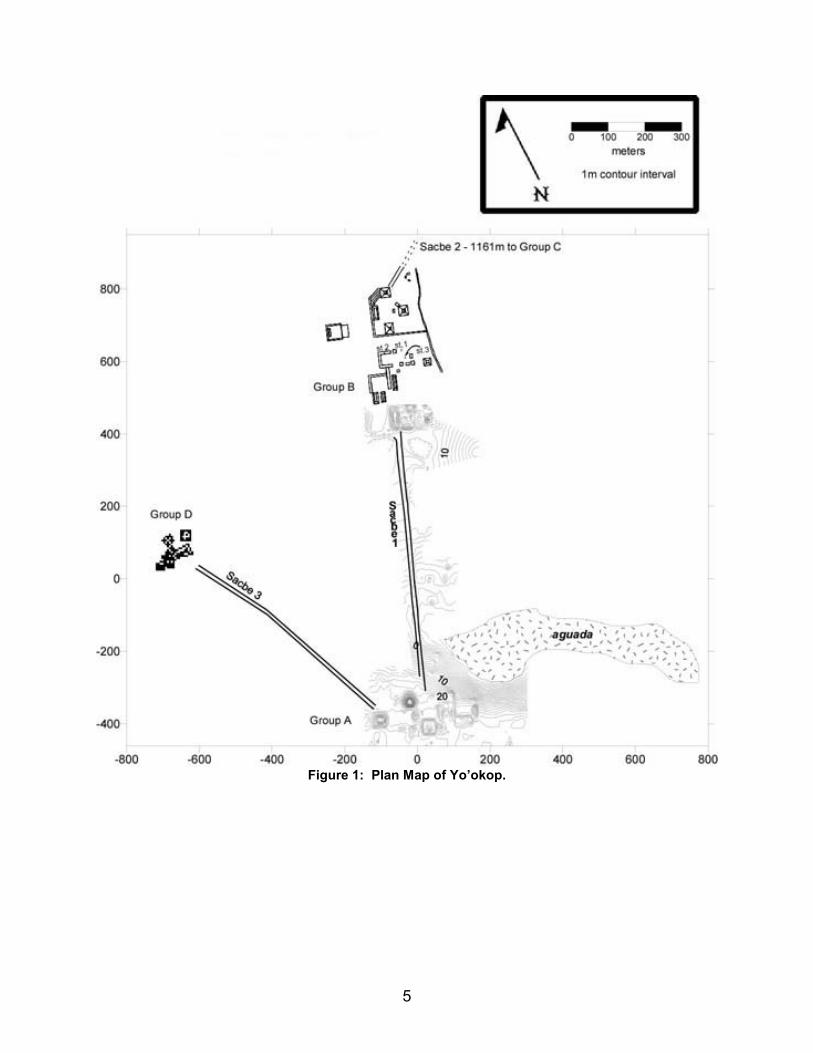
The Maya site of Yo’okop, also known as Okop or La Aguada (Figure 1), is located in the contact period province of Cochuah (Roys 1965), approximately 12 kilometers southeast of the modern pueblo of Sabán (Figure 2) at 88° 24’ E and 19° 57’ N, in west-central Quintana Roo. The site lies in the center of a large archaeologically uninvestigated region between those areas surveyed by Sanders (1960) and Harrison (1973 and 1981).
Physiographic Characterization
While the Yucatán peninsula is often referred to as a single region, it is characterized by a remarkable diversity of geological, climatic, floral, and faunal features. Physiographically, the peninsula has been defined by Shattuck (1933) as the area north of a line extending from the mouth of the Gulf of Honduras to the western limit of the Laguna de Términos in the state of Campeche (Robles R. 1958) or between 21° 30’ and 18° N latitude and 86° 25’ and 91° 40’ W longitude (Figure 1).
The Yucatán peninsula is a flat, low-lying Cenozoic marine limestone platform that projects northward into the Caribbean Sea and Gulf of México. The northern portion of the peninsula is a pitted karst plain (West 1964). With the exception of the Puuc hills, or the Sierrita de Ticul, rising to 130 meters above sea level in the west, the terrain in the north is flat (Covich 1970; Ward and Wilson 1985).
5
Figure 1: Plan Map of Yo’okop.
6
Figure 2: Location of Yo’okop.
7
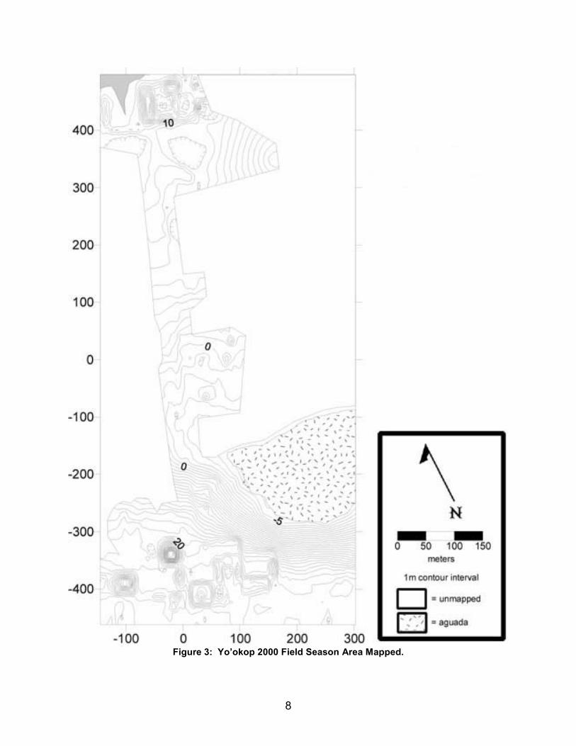
The North also has a number of unique geological features. Aguadas, intermittent or permanent ponds, are present throughout the northern plain (West 1964); one is located near Group A at Yo’okop (Figure 3). These features are both culturally and naturally created, and are frequently stone and clay lined when of human origin (Dahlin 1986; Shattuck 1933). Constructed aguadas were, and are, frequently placed in and around rejolladas (sinkholes without water) (Siemens 1979). Some aguadas are created naturally as cenotes (sinkholes with water) filled with sediment and organic debris (Tamayo and West 1964). No cenotes are present at Yo’okop; the closest cenote is approximately 15 kilometers from the site near the modern pueblo of X-Cabil. Additionally, underground cavities at Yo’okop and other sites have been excavated for centuries to obtain sascab, a nearly pure carbonate material for construction (E. Wilson 1980).
As might be expected, soils within the peninsula are highly variable according to the topography, rainfall, age of the soil, organisms within and on top of the soil, parent material, and organic materials (Dunning 1991). In the North, this soil cover is extremely thin with little to no transition zone; bedrock comprises up to 50% of the surface (Ringle 1985; E. Wilson 1980). Soils of the state of Yucatán, northern Campeche, and northern Quintana Roo are generally described as Laterization-process soils, while those to the south are Rendzina (southern Quintana Roo and southeastern Campeche) and Glei (southwest Campeche and Tabasco) soils (Stevens 1964). The laterization found in the north occurs as conditions of fluctuating groundwater levels result in reduction of iron and loss of silica (Limbrey 1975).
Modern climatic variations in the Yucatán are generally moderate, although the northeastern corner of the peninsula does lie on a hurricane track through which passes nearly every storm impacting the northern Caribbean coast (Contreras Arias 1958; Ward and Wilson 1976). This brings damaging storms to the Yo’okop area once or twice each decade. The northern part of the peninsula possesses a Tropical Monsoon (Am) climate, with very heavy rainfall only in the summer, while the southern portion is designated Tropical Rainy (Af) with at least 60 millimeters of rainfall in the driest month (E. Wilson 1980).
8
Figure 3: Yo’okop 2000 Field Season Area Mapped.
9
Previous Research at Yo’okop
While no concentrated program of research had taken place at the site of Yo’okop prior to the 2000 season, several archaeologists have made extended visits to the area. The first to report the site, as "Okop" or "La Aguada", were Mason and Spinden (Mason 1927). Then, in 1954, Stromsvik and Pollock (Stromsvik et al. 1955) visited the site. Concentrating on the northern group (Group B), they noted the existence of three good-sized pyramids ranging from 9-15 meters in height. Additionally, they extracted the remains of a stela from a ramon tree and noted the existence of a southern group (Group A) joined to the northern mounds by a sacbe. Although Stromsvik and Pollock noted that the largest structure in Group A had re-used Terminal Classic Puuc style elements, they estimated, based upon the style of various stelae, that the major period of construction at Yo’okop was the Late Classic. No ceramics were recovered at this time.
In 1966, Jack Walker and Reginald Wilson made a brief visit to the structures closest to the aguada, in Group A. Pilot Bill Clapp then located Groups A, B, and C, sacbeob 1 and 2, and three stelae (stelae 1, 2, and 3) in 1969. This spurred Walker and Wilson to return in 1972 to make basic renderings of the main groups and take measurements of important structures and features. Although they conducted no excavations, their work provides the most extensive description of the site yet published (R. Wilson 1974). A correlation between Wilson’s (1974) structure numbers and those assigned by the current project are presented in Table 1.
In 1998, INAH conducted basic reconnaissance and surface collections at Yo’okop. Shaw and Johnstone also visited the site this year, after preliminary meetings with INAH Quintana Roo and then the leaders of Sabán, in order to take photographs and assess the logistics of conducting research at the site. Additionally, Arq. Luis Alberto Martos López (1997) has worked at the historic Fortín de Yo’okop, a Caste War installation between the pueblo of Sabán and the Maya site of Yo’okop.
Table 1 Correlation Between Walker’s (1974) Structure Numbers
and Current Structure Numbers
Walker’s System Current System
Group A Structure 1 S4W1-1
Group A Structure 2 S4W2-1
Group A Structure 3 S4E2-9
Group A Structure 4 S4E2-1
Group A Structure 5 S4E1-5
Group A Structure 6 ?part of S4E2-1
Group A Structure 7 S5E1-1 and all structures around plaza to east
10
Group A Structure 8 S5W1-1
Group A Structure 9 S4W1-2
Group B Structure 1 N5W1-3
Group B Structure 2 N5W1-2
Group B Structure 3 N5W1-7
Group B Structure 4 N5W1-6
Group B Structure 5 N5E1-2
Group B Structure 6 N5W2-1
Group B Structure 7 not mapped in 2000
Group B Structure 8 not mapped in 2000
Group B Structure 9 not mapped in 2000
Group B Structure 10 not mapped in 2000
Group B Structure 11 not mapped in 2000
Group B Structure 12 not mapped in 2000
Group B Structure 13 not mapped in 2000
Group B Structure 14 not mapped in 2000
Group B Structure 15 not mapped in 2000
Group B Structure 16 not mapped in 2000
Group B Structure 17 not mapped in 2000
Group B Structure 18 not mapped in 2000
Group B Structure 19 not mapped in 2000
Group B Structure 20 not mapped in 2000
Group B Structure 21 not mapped in 2000
Group B Structure 22 not mapped in 2000
Group B Structure 23 not mapped in 2000
Group B Structure 24 not mapped in 2000
Group B Structure 25 not mapped in 2000
Initial Hypotheses
The initial archaeological research at Yo’okop revolves around two sets of related hypotheses. The first of these predicts that the relative size of Yo’okop’s occupation will vary with the climate changes documented in studies of nearby lakes and cenotes. The second deals with Yo’okop’s political fortunes as a frontier site. These hypotheses will
11
be discussed in depth here, but will be fully evaluated at the close of the report, after all data have been presented (see "Discussion and Conclusions").
It is believed that since Yo’okop has only one water source, an aguada not in direct contact with the water table, site occupation will be particularly sensitive to any abnormally dry episodes. Unlike many other northern sites, Yo’okop lacks cenotes, which provide access to the freshwater lens floating over a thicker layer of salt water (Dahlin 1983) and no ancient wells have been located at the site. Instead, its aguada functions more like chultunes, which capture and store potable water in the Puuc zone (Becquelin and Michelet 1994). Even if well maintained (Faust 1998), aguadas require regular local rainfall to refill. Cenotes, relying on the freshwater table within the limestone substrate, have a much larger water supply from which to draw. Therefore, any markedly dry periods would impact not just Yo’okop’s inhabitants’ ability to grow crops, but could go so far as to make potable water scarce or unavailable.
Evaluating the relative correlation between Yo’okop’s occupation and climate change involves the use of a local climatic sequence from Lake Chichancanab (Figure 2) (Hodell et al. 1995), located just 20 kilometers from Yo’okop. This sequence, using 18O/ 16O ratios, documents the region’s climate through most of the Holocene. These data, much more detailed than previous explorations of the lake’s record (Covich 1970; Covich and Stuiver 1974), demonstrate unambiguous evidence for climatic drying between A.D. 800 and 1000. This evidence is consistent with data from Punta Laguna, located approximately 20 kilometers north of Cobá (Curtis and Hodell 1996), Cenote San José Chulchacá, in northwestern Yucatán (Leyden et al. 1996; Whitmore et al. 1996), Lake Cobá and Lake Sayaucil (Leyden et al. 1998; Whitmore et al. 1996), and Lake Miragoane, Haiti (Hodell et al. 1991). If this episode, the driest of the past 8,000 years, is at least partially responsible for the decline of the Classic Maya in the central lowlands (Lowe 1985; Gill 1995 and 2000; Shaw 2000), then climatic downturns detected in the local Lake Chichancanab sediment cores should be accompanied by some changes at Yo’okop.
It was predicted that the impact of such water scarcity should appear at Yo’okop through investments in water capture and storage and/or as a decrease in occupation size. We could begin to evaluate the first expected signal of water scarcity at Yo’okop, increased investment in water capture and storage, during the first season. Mapping portions of the site core (Figure 3), including the area surrounding the aguada, demonstrated that monumental constructions may have served to re-direct and capture water for storage. Future seasons may explore the degree to which these efforts might have also included enlarging the aguada by quarrying it for the construction of the adjacent Group A, which contains the site’s tallest structure. Folan and others (1983:455) have proposed that the lakes at Cobá may have originated as quarries, becoming lakes after excavations struck the water table.
Scarborough’s (1993 and 1994) work at Kinal and La Milpa demonstrates the prevalence of such subtle features at other Maya sites. The careful management of water storage features permitted long-term occupations in areas that lacked permanent natural sources of water, such as at Tikal (Scarborough 1998). Although such features
12
may have been an integral part of site planning from early in Yo’okop’s occupational sequence, it was predicted that any marked changes in the evaporation/precipitation ratio, like that seen from about A.D. 800-1000, should be met with increased investment in these features. In the future, we would like to test-pit detected water management features in hopes of obtaining ceramics, or even C-14 samples, that might produce an estimated date for their construction. Future excavations will also be aimed at exploring if, and when, the aguada was modified by humans (e.g. Faust 1998; Shattuck 1933). Test pitting or trenching the aguada is clearly critical to the testing of this hypothesis, but the time investment needed for such a technically demanding excavation is beyond that available during the first few seasons of the project.
Another signal of water scarcity is anticipated to be a marked decrease in the site-wide relative population size. Although some population might concentrate at Yo’okop’s aguada for potable water during drought times, it would be impossible to grow enough food to sustain a sizeable population without a more extensive system of water provision with multiple water outlets. Therefore, the overall population of the site should drop during any extended dry period; even if the aguada was modified to the extent that it was able to store sufficient drinking water, prolonged crop failures would likely bring about a marked population decrease. Due to the limited nature of the 2000 project, and its focus on initially mapping major architectural groups, we can only begin to make very preliminary statements about the relative population of Yo’okop during any given time period.
Particularly dry conditions might also be reflected in a range of other social responses. One might expect the leaders of Yo’okop, as political and religious heads (Freidel et al. 1995), to have responded to drought with an increase in, or elaboration of, ritual activities and investments. Even if population decreased, more monumental constructions or modifications might have accompanied this prolonged threat. In the future, when excavations can be carried out to explore and date large architecture, this consequence may be evaluated. Additionally, or alternately, innovations in religious practice, such as the borrowing of deities or concepts, may have taken place as leaders feverishly attempted to appease the being(s) responsible for drought. It is hoped that Ruth Krochock’s studies of existing and future epigraphic materials can begin to explore this issue (see "Epigraphy").
We began to evaluate this first set of hypotheses during the first season of research through the comparison of relative ceramic frequencies from each time period. Analyzed according to the Type-Variety system, the total number of identified sherds from each time period can be compared. It is predicted that if the Terminal Classic (A.D. 750/800-1000) was so dry that water for agriculture, or even drinking, was scarce, sherd counts should decrease during this period. The very general trends detected in this initial test of the hypothesis (see "Ceramic Analyses") will be further explored in future seasons as more excavations provide a better picture of how settlement patterns change through time. After excavations are conducted, comparisons between time periods will be made on a site-wide basis in terms of the number of occupational loci per period.
13
A second set of hypotheses evaluated this first season concerns Yo’okop’s political affiliations. There is a lack of knowledge about the region for the Formative and Early Classic periods, often buried under layers of construction fill. Some sense of the political affiliations of Yo’okop (assuming the site was occupied during these times), as expressed through ceramic and architectural styles, could begin to be assessed during the first season. This was done by noting the appearance of diagnostic architectural elements (i.e. Early Classic Izamal-style blocks) and ceramics. As excavations are conducted in future seasons, it is hoped that the discovery of early in situ architecture and ceramics will enable researchers to determine the regions with which Yo’okop was affiliated during the first part of its occupation.
Currently, much more is understood about the Late to Terminal Classic at the site. Robles and Andrews (1986, Figure 3.4) place Yo’okop in an Eastern cultural sphere dominated by Cobá. If this was the case, then it is expected that the architecture, ceramics, and lithic sources of the site would closely resemble those of the dominant site in the cultural sphere, Cobá. An alternative hypothesis is that Yo’okop functioned as a frontier town between competing political and economic spheres. This might have resulted in a blending of traditions and styles. Although some initial assessments are possible after the first season (see "Architecture", "Ceramic Analyses", and "Epigraphy") it is premature to ascribe the site to any cultural sphere without further research.
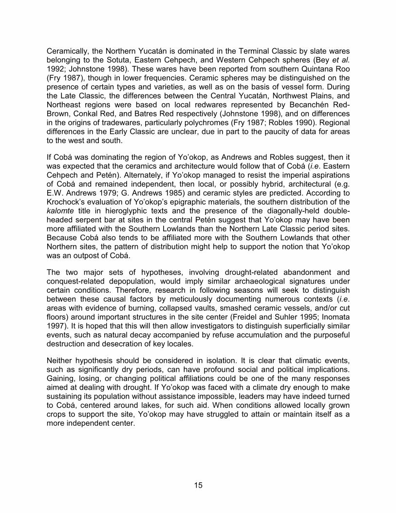
Yo’okop is located between the Puuc, Central Yucatán, and Petén architectural styles (Figure 4), each associated with different regional ceramic spheres (Fry 1987; Robles 1990). These architectural and ceramic distributions are believed to represent cultural or political units with possible affiliations to macrostates (e.g. Martin and Grube 1995). Each of these surrounding regions were powerful enough to exert significant influence over Yo’okop, including direct conquest. Recent research (e.g. Andrews and Robles 1985) has shown that Maya warfare and alliance systems extended over large distances. The question of political affiliation may be addressed directly through contemporary texts, as well as inferred from architectural and ceramic data.
The regional architectural styles are relatively easily distinguished, at least for the Terminal Classic and Postclassic periods. The Petén style consists in part of plain load-bearing walls of roughly quarried stone, slab corbelled vaults, and plain terraces with rounded corners. This style has been noted at Cobá (Thompson et al. 1932:108), and in the "Petén Corridor" of Eastern Quintana Roo (Harrison 1982:120-121). The Puuc style is composed of core-veneer masonry, including the vault stones, with plain substructures (Pollock 1980). The Central Yucatán style (Potter 1977) includes corbelled vaults whose stones have either rounded or beveled faces, walls composed of a combination of semi-load-bearing and cut veneer stone, and terraces with recessed panels. Veneer stones are present at Yo’okop, especially in Group B. No substantial intact Terminal Classic structures were noted however, making a stylistic determination of the architecture impossible at this time. This state of preservation may be the result of the systematic destruction and burial of these buildings and the subsequent reuse of their stones, as has been reported at Uomuul (Harrison 1979:200).
14
Figure 4: Northern Architectural Styles.
15
Ceramically, the Northern Yucatán is dominated in the Terminal Classic by slate wares belonging to the Sotuta, Eastern Cehpech, and Western Cehpech spheres (Bey et al. 1992; Johnstone 1998). These wares have been reported from southern Quintana Roo (Fry 1987), though in lower frequencies. Ceramic spheres may be distinguished on the presence of certain types and varieties, as well as on the basis of vessel form. During the Late Classic, the differences between the Central Yucatán, Northwest Plains, and Northeast regions were based on local redwares represented by Becanchén Red-Brown, Conkal Red, and Batres Red respectively (Johnstone 1998), and on differences in the origins of tradewares, particularly polychromes (Fry 1987; Robles 1990). Regional differences in the Early Classic are unclear, due in part to the paucity of data for areas to the west and south.
If Cobá was dominating the region of Yo’okop, as Andrews and Robles suggest, then it was expected that the ceramics and architecture would follow that of Cobá (i.e. Eastern Cehpech and Petén). Alternately, if Yo’okop managed to resist the imperial aspirations of Cobá and remained independent, then local, or possibly hybrid, architectural (e.g. E.W. Andrews 1979; G. Andrews 1985) and ceramic styles are predicted. According to Krochock’s evaluation of Yo’okop’s epigraphic materials, the southern distribution of the kalomte title in hieroglyphic texts and the presence of the diagonally-held double-headed serpent bar at sites in the central Petén suggest that Yo’okop may have been more affiliated with the Southern Lowlands than the Northern Late Classic period sites. Because Cobá also tends to be affiliated more with the Southern Lowlands that other Northern sites, the pattern of distribution might help to support the notion that Yo’okop was an outpost of Cobá.
The two major sets of hypotheses, involving drought-related abandonment and conquest-related depopulation, would imply similar archaeological signatures under certain conditions. Therefore, research in following seasons will seek to distinguish between these causal factors by meticulously documenting numerous contexts (i.e. areas with evidence of burning, collapsed vaults, smashed ceramic vessels, and/or cut floors) around important structures in the site center (Freidel and Suhler 1995; Inomata 1997). It is hoped that this will then allow investigators to distinguish superficially similar events, such as natural decay accompanied by refuse accumulation and the purposeful destruction and desecration of key locales.
Neither hypothesis should be considered in isolation. It is clear that climatic events, such as significantly dry periods, can have profound social and political implications. Gaining, losing, or changing political affiliations could be one of the many responses aimed at dealing with drought. If Yo’okop was faced with a climate dry enough to make sustaining its population without assistance impossible, leaders may have indeed turned to Cobá, centered around lakes, for such aid. When conditions allowed locally grown crops to support the site, Yo’okop may have struggled to attain or maintain itself as a more independent center.
16
Methods
Mapping and surface collections were the initial foci of the 2000 field season at Yo’okop. This work concentrated on the recording of Group A and Sacbe 1, and began the mapping of Group B (Figure 3). The map will be augmented in future seasons by the completion of Group B, and the addition of Groups C and D, as well as through the recording of adjacent residential zones. Whenever possible, transects and nearby milpas will also be used to enlarge the map.
A GPS (Global Positioning System - Garmin GPS 12CX) was used to more exactly locate the position of the site, and also to record the locations of the groups and features that could not be well mapped this season. A laser transit (Topcon GTS-213), operated by Shaw and Johnstone, recorded the finer details of the structures and natural terrain in the mapped zones. Shaw and Johnstone’s mapping was possible because of the assistance of a crew of 12 assistants from the ejido of Sabán (pueblos of Sabán and Huay Max). These assistants cleared all features to be mapped, cut intervening brechas to allow zones to be searched, helped look for features, and frequently served as "rodmen" when either Shaw or Johnstone were engaged in other tasks.
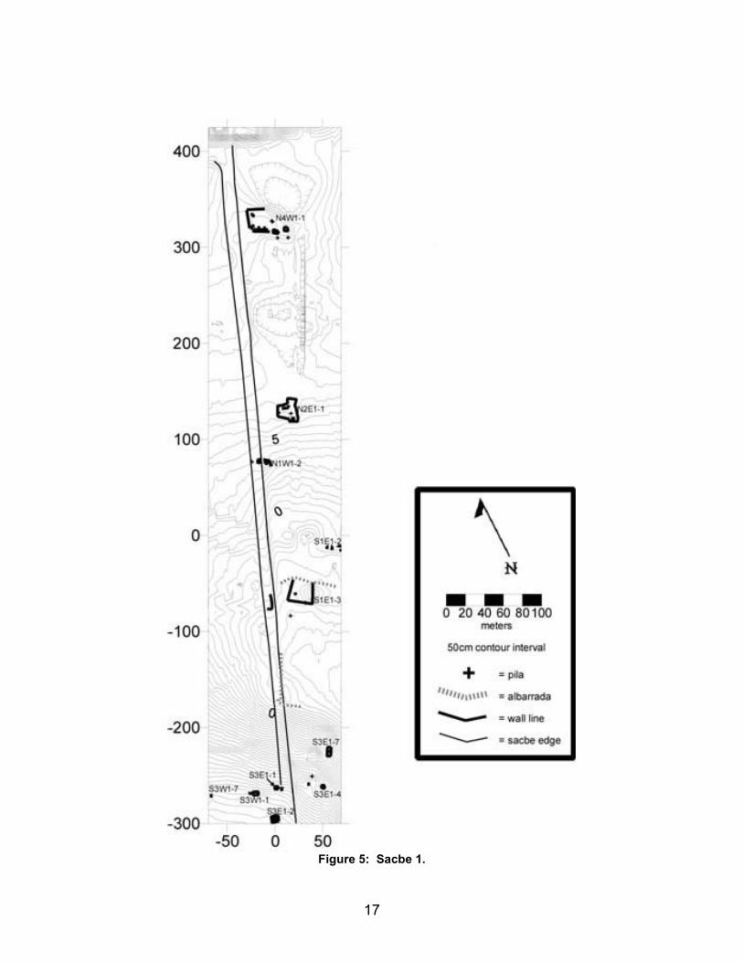
Mapping began by establishing a site datum, located on a bedrock outcrop 100 meters north of the point that modern road cuts sacbe 1, and five meters east of sacbe 1’s eastern edge (Figure 5). This site datum (and as many other data as possible) was established as an "X" carved into the bedrock to serve as a permanent point to be used in future seasons. From this first datum, recording proceeded south towards Group A. Sacbe 1 formed the western edge of the mapped zone, although an area immediately east of the roadway was also recorded. Once at Group A, an effort was made to record every structure within the dense group, regardless of size. Group A did have a well-defined northern edge, although the western and southern boundaries were less clear and density dropoff was used to define the end of the group. The aguada marked the eastern side of the group. Once Group A was completed, work returned to the site datum, proceeded along sacbe 1, and the area immediately east of the road, to Group B. Only the southern portion of Group B was recorded. The southeast corner of the acropolis was mapped, but time did not permit the southwestern edge, and the central and northern parts, to be recorded.
As a data collector initially rented did not function, data on each point (recorded as coordinates N, E, and Z relative to the site datum, as well as with a descriptive code and notes) were manually entered into a laptop computer each night and e-mailed home each weekend to ensure the safety of the data. Additionally, the bases of structures and features were hand-plotted in the field to allow ground-truthing and permit structure naming. This strategy permitted a formal map of the documented region to be prepared early in the fall of 2000. The maps are presented topographically, as well as with foundation braces and other walls, in order to most accurately represent the appearance of any features. A contour interval of 50 centimeters is used on most of the maps (see individual maps for scale) to clearly distinguish small mounds.
17
Figure 5: Sacbe 1.
18
Surface collections have been used on a number of projects (e.g. Killion et al. 1989; Kurjack 1974; A. Smith 1972; Thomas 1981; Willey, Bullard, Glass, and Gifford 1965) and were employed on a limited basis in 2000. Collections from small houses were obtained by removing all the ceramics (and other small artifacts) from the surface of the northern half of the structures, in order to leave the other half for future studies. Plazas were represented by collection from three square meter areas. Approximately 1/6 to 1/4 of the base of larger structures was collected (with a minimum of 5 × 8 meters being searched on each large structure). Johnstone supervised each of the collections. Local laborers performed most of the actual work of collection. Shaw and Johnstone also conducted some collections to verify that there was not a difference between what trained archaeologists would have collected and what crew members gathered.
Materials from the collections were then washed and marked with locations by a crew of five lab assistants (secundaría students from the Sabán ejido) supervised directly by Johnstone. Johnstone then analyzed ceramics using the type-variety system (Smith, Willey, and Gifford 1960) that has become the norm for most archaeological projects working in the Northern Lowlands. Many of the ceramics recovered during the first season will be used to establish a type collection to aid in future research.
The Project utilized color and black-and-white print photographs, color slides, and extensive note-taking, to record remains visible on the surface within the mapped region. Photographs were also taken of all glyph blocks and stelae at night in order to discern further details.
After the field season, Surfer (version 7.0) was used to convert X, Y, and Z information on each data point into the series of maps included in this report. Glyphic materials were hand-drawn by Johnstone from slides, supplemented by print photographs and sketches. His drawings were then scanned and manipulated using Adobe Illustrator (version 8.0).
General Site Layout
According to our present knowledge, the site of Yo’okop consists of four major architectural groups (Groups A, B, C, and D) linked by sacbeob (Figure 1). These four groups have significantly larger architecture (up to 28 meters in height) at substantially higher densities than the remainder of the site. Between the major groups, moderate-sized mounds (five to six meters in height), platforms, rejolladas, and small residential structures are scattered. These lower-density, inter-group zones are believed to be where the majority of Yo’okop’s population resided.
Group A is the southernmost monumental component of the site. It is linked by the 718-meter Sacbe 1, which runs from the north-central edge of Group A north to south-central Group B. Group B is further connected to Group C by Sacbe 2, which extends 1,161 meters to the northeast. This season an additional group and associated sacbe
19
were discovered: Group D and Sacbe 3. Group D is connected by Sacbe 3 to the northwestern part of Group A. Several informants reported a further connection between Groups D and B, although time did not permit a search for such a roadway. The monumental structures in Groups A and B, as well as some intervening constructions, share an alignment of 25 degrees east of magnetic north. Sacbe 1, however, aims 20 degrees east of magnetic north.
The majority of the site is situated on essentially flat terrain, although Group A sits atop a sharp natural rise. The only water source on or near the site known to archaeologists and local inhabitants is an aguada immediately to the east of Group A. A modern dirt road between Sabán and Dzoyola cuts through Sacbeob 1 and 3, running E-W, 100 meters north of Group A. Only footpaths connect the modern road to other portions of the site.
Other ruins are reported in the region, including one cluster of significant mounds near the modern pueblo of X-Cabil (which surround a cenote) and a second site a few kilometers southwest of Group A. The latter site was visited in 1998 by Shaw and Johnstone and was observed to have substantial quantities of Late Formative sherds present on the surface. No water source is reported for the site. An ejido resident making milpa at this (?)Formative site collected a bark-beater in excellent condition, which was photographed by Johnstone. While these loci are considered to be separate sites for reasons of distance alone, the relationship between these adjacent communities and Yo’okop is not known.
To the best of our knowledge, Yo’okop was by far the largest site in the region, perhaps second only to Cobá within the modern state of Quintana Roo. We plan to continue to document and explore both the major architectural groups and intervening settlement zones in future seasons. Additionally, a more systematic regional inventory is envisioned.
Group A
Accurately recording the surface remains of Group A constituted the bulk of the 2000 field season at Yo’okop. The northern edge of the group is approximately 100 meters south of the modern road between Sabán and Dzoyola. While this accessibility made it an attractive initial focus for our work, it also has exposed the group to more looting than is evident in other groups. Approximately eight huacero holes were present in the vicinity, although a focus on plazas has prevented architecture from being severely impacted by most of the pits.
Group A (Figure 6 and Figure 7) measures roughly 400 (E-W) by 200 (N-S) meters and rises to between 18 and 46 meters above the site datum. The majority of the structures in Group A are oriented 25 degrees east of north. Containing some of the larger monumental architecture at the site and located to the west-southwest of the aguada, Group A was apparently an important locus during most, if not all, of Yo’okop’s
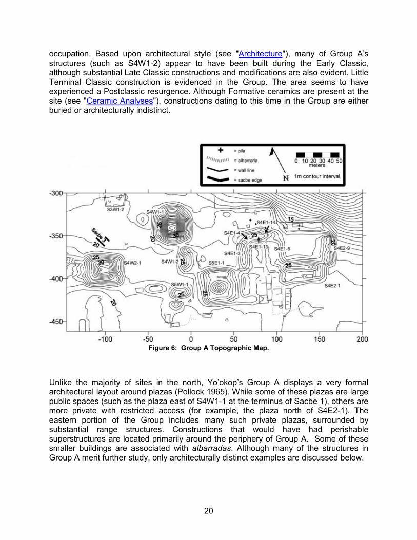
20
occupation. Based upon architectural style (see "Architecture"), many of Group A’s structures (such as S4W1-2) appear to have been built during the Early Classic, although substantial Late Classic constructions and modifications are also evident. Little Terminal Classic construction is evidenced in the Group. The area seems to have experienced a Postclassic resurgence. Although Formative ceramics are present at the site (see "Ceramic Analyses"), constructions dating to this time in the Group are either buried or architecturally indistinct.
Figure 6: Group A Topographic Map.
Unlike the majority of sites in the north, Yo’okop’s Group A displays a very formal architectural layout around plazas (Pollock 1965). While some of these plazas are large public spaces (such as the plaza east of S4W1-1 at the terminus of Sacbe 1), others are more private with restricted access (for example, the plaza north of S4E2-1). The eastern portion of the Group includes many such private plazas, surrounded by substantial range structures. Constructions that would have had perishable superstructures are located primarily around the periphery of Group A. Some of these smaller buildings are associated with albarradas. Although many of the structures in Group A merit further study, only architecturally distinct examples are discussed below.
21
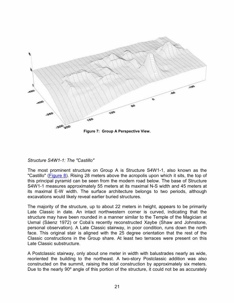
Figure 7: Group A Perspective View.
Structure S4W1-1: The "Castillo"
The most prominent structure on Group A is Structure S4W1-1, also known as the "Castillo" (Figure 8). Rising 28 meters above the acropolis upon which it sits, the top of this principal pyramid can be seen from the modern road below. The base of Structure S4W1-1 measures approximately 55 meters at its maximal N-S width and 45 meters at its maximal E-W width. The surface architecture belongs to two periods, although excavations would likely reveal earlier buried structures.
The majority of the structure, up to about 22 meters in height, appears to be primarily Late Classic in date. An intact northwestern corner is curved, indicating that the structure may have been rounded in a manner similar to the Temple of the Magician at Uxmal (Sáenz 1972) or Cobá’s recently reconstructed Xaybe (Shaw and Johnstone, personal observation). A Late Classic stairway, in poor condition, runs down the north face. This original stair is aligned with the 25 degree orientation that the rest of the Classic constructions in the Group share. At least two terraces were present on this Late Classic substructure.
A Postclassic stairway, only about one meter in width with balustrades nearly as wide, reoriented the building to the northeast. A two-story Postclassic addition was also constructed on the summit, raising the total construction by approximately six meters. Due to the nearly 90º angle of this portion of the structure, it could not be as accurately
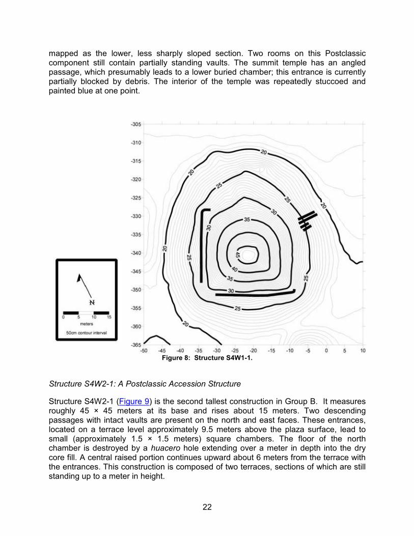
22
mapped as the lower, less sharply sloped section. Two rooms on this Postclassic component still contain partially standing vaults. The summit temple has an angled passage, which presumably leads to a lower buried chamber; this entrance is currently partially blocked by debris. The interior of the temple was repeatedly stuccoed and painted blue at one point.
Figure 8: Structure S4W1-1.
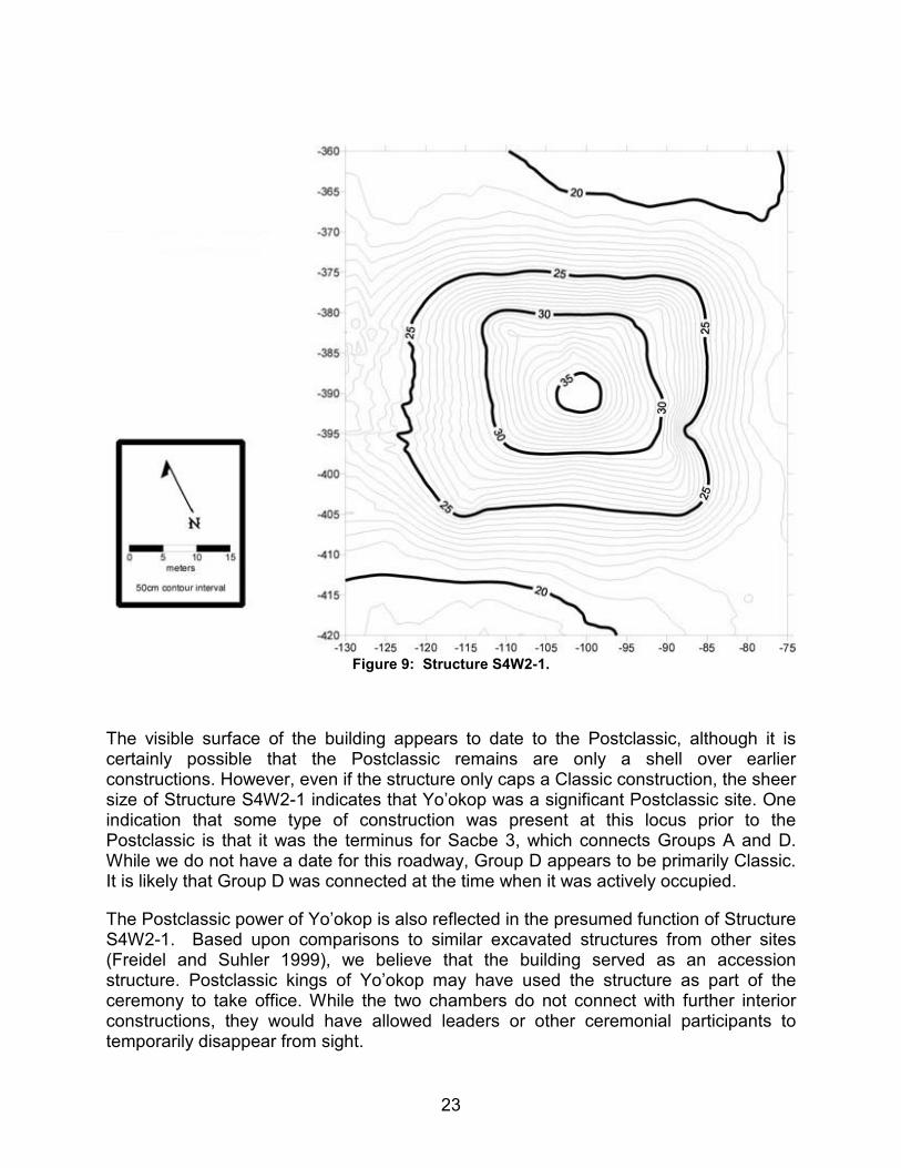
Structure S4W2-1: A Postclassic Accession Structure
Structure S4W2-1 (Figure 9) is the second tallest construction in Group B. It measures roughly 45 × 45 meters at its base and rises about 15 meters. Two descending passages with intact vaults are present on the north and east faces. These entrances, located on a terrace level approximately 9.5 meters above the plaza surface, lead to small (approximately 1.5 × 1.5 meters) square chambers. The floor of the north chamber is destroyed by a huacero hole extending over a meter in depth into the dry core fill. A central raised portion continues upward about 6 meters from the terrace with the entrances. This construction is composed of two terraces, sections of which are still standing up to a meter in height.
23
Figure 9: Structure S4W2-1.
The visible surface of the building appears to date to the Postclassic, although it is certainly possible that the Postclassic remains are only a shell over earlier constructions. However, even if the structure only caps a Classic construction, the sheer size of Structure S4W2-1 indicates that Yo’okop was a significant Postclassic site. One indication that some type of construction was present at this locus prior to the Postclassic is that it was the terminus for Sacbe 3, which connects Groups A and D. While we do not have a date for this roadway, Group D appears to be primarily Classic. It is likely that Group D was connected at the time when it was actively occupied.
The Postclassic power of Yo’okop is also reflected in the presumed function of Structure S4W2-1. Based upon comparisons to similar excavated structures from other sites (Freidel and Suhler 1999), we believe that the building served as an accession structure. Postclassic kings of Yo’okop may have used the structure as part of the ceremony to take office. While the two chambers do not connect with further interior constructions, they would have allowed leaders or other ceremonial participants to temporarily disappear from sight.
24
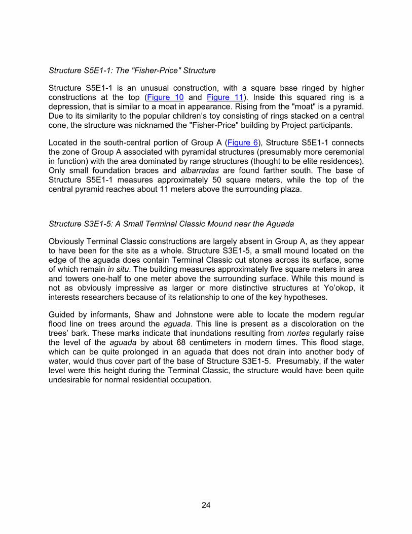
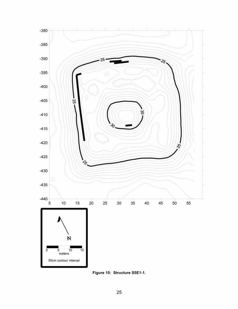
Structure S5E1-1: The "Fisher-Price" Structure
Structure S5E1-1 is an unusual construction, with a square base ringed by higher constructions at the top (Figure 10 and Figure 11). Inside this squared ring is a depression, that is similar to a moat in appearance. Rising from the "moat" is a pyramid. Due to its similarity to the popular children’s toy consisting of rings stacked on a central cone, the structure was nicknamed the "Fisher-Price" building by Project participants.
Located in the south-central portion of Group A (Figure 6), Structure S5E1-1 connects the zone of Group A associated with pyramidal structures (presumably more ceremonial in function) with the area dominated by range structures (thought to be elite residences). Only small foundation braces and albarradas are found farther south. The base of Structure S5E1-1 measures approximately 50 square meters, while the top of the central pyramid reaches about 11 meters above the surrounding plaza.
Structure S3E1-5: A Small Terminal Classic Mound near the Aguada
Obviously Terminal Classic constructions are largely absent in Group A, as they appear to have been for the site as a whole. Structure S3E1-5, a small mound located on the edge of the aguada does contain Terminal Classic cut stones across its surface, some of which remain in situ. The building measures approximately five square meters in area and towers one-half to one meter above the surrounding surface. While this mound is not as obviously impressive as larger or more distinctive structures at Yo’okop, it interests researchers because of its relationship to one of the key hypotheses.
Guided by informants, Shaw and Johnstone were able to locate the modern regular flood line on trees around the aguada. This line is present as a discoloration on the trees’ bark. These marks indicate that inundations resulting from nortes regularly raise the level of the aguada by about 68 centimeters in modern times. This flood stage, which can be quite prolonged in an aguada that does not drain into another body of water, would thus cover part of the base of Structure S3E1-5. Presumably, if the water level were this height during the Terminal Classic, the structure would have been quite undesirable for normal residential occupation.
25
Figure 10: Structure S5E1-1.
26
Figure 11: Structure S5E1-1 Perspective View.
Logically, it seems more likely that the small mound was built and occupied (as a residence or for another function) during a time when the water level of the aguada was lower than at present. Interestingly, data from nearby Lake Chichancanab (Hodell et al. 1995) do indicate that the Terminal Classic was a substantially drier time for the region. In fact, based upon our very preliminary architectural and ceramic observations, we would postulate that it was so dry that Yo’okop had very little occupation during the Terminal Classic. Structure S3E1-5 may be one of the few structures that the remaining Terminal Classic population did build. Such dry conditions made it possible, and perhaps more attractive, to build in a locus that would not be chosen today. If this small structure is a residence, location near the receding aguada might have been for practical reasons. Alternately, the heightened value that water attained at this time may mean that Structure S3E1-5 is a shrine devoted to a water-related aspect of religion or a government building associated with monitoring usage. Project members plan to propose the test-pitting of Structure S3E1-5 during the 2001 season to begin to explore these issues.
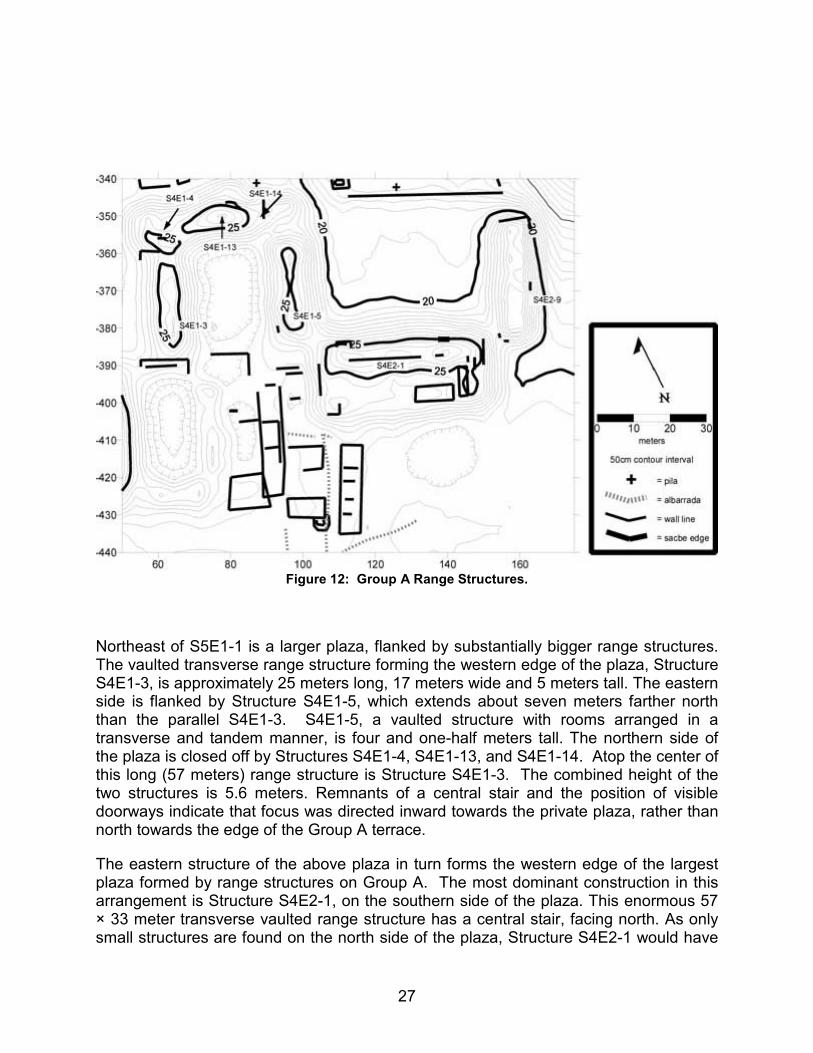
Range Structures in Group A
The eastern portion of Group A is dominated by a series of substantial range structures located around formal plazas (Figure 12). East of Structure S5E1-1 ("Fisher-Price") are a series of small plazas. The first two plazas, about 25 meters long (N-S) by 12-15 meters wide (E-W), are well defined by moderate sized range structures. Much smaller plazas are enclosed by platforms and foundation braces farther to the southeast.
27
Figure 12: Group A Range Structures.
Northeast of S5E1-1 is a larger plaza, flanked by substantially bigger range structures. The vaulted transverse range structure forming the western edge of the plaza, Structure S4E1-3, is approximately 25 meters long, 17 meters wide and 5 meters tall. The eastern side is flanked by Structure S4E1-5, which extends about seven meters farther north than the parallel S4E1-3. S4E1-5, a vaulted structure with rooms arranged in a transverse and tandem manner, is four and one-half meters tall. The northern side of the plaza is closed off by Structures S4E1-4, S4E1-13, and S4E1-14. Atop the center of this long (57 meters) range structure is Structure S4E1-3. The combined height of the two structures is 5.6 meters. Remnants of a central stair and the position of visible doorways indicate that focus was directed inward towards the private plaza, rather than north towards the edge of the Group A terrace.
The eastern structure of the above plaza in turn forms the western edge of the largest plaza formed by range structures on Group A. The most dominant construction in this arrangement is Structure S4E2-1, on the southern side of the plaza. This enormous 57 × 33 meter transverse vaulted range structure has a central stair, facing north. As only small structures are found on the north side of the plaza, Structure S4E2-1 would have
28
had an excellent view of the site’s aguada, which lies down a sharp natural slope to the north-northeast. The eastern edge is delineated by Structure S4E2-9, another transverse vaulted range structure. Although smaller than S4E2-1, the 20 × 38 × 4.5 meter construction would dominate most other settings. This substantial plaza group is perched on the limits of the natural rise above the aguada. Farther north, as the terrain drops by approximately 25 meters in the 70 meter span to the aguada, no structures were evidenced. Farther east along this edge only platforms and foundation braces are evidenced; this largest plaza group appears to mark the eastern end of Group A.
Based upon the size, formal nature, and location of these range structures, we believe them to be the residences of the most elite occupants of Yo’okop. The substantial horizontal and vertical dimensions of the structures composing these eastern plazas, as well as their location on prime land just above the aguada, attests to the power of the occupants. While the size of these range structures is impressive, the obviously planned nature of the plazas, with the consistent 25 degree alignment, perhaps deserves even more attention. Such sizeable, formally arranged plazas are absent at most Northern sites. Cobá (Folan 1983) is one of the few sites in the North to also exhibit such features; large numbers of planned plazas with substantial range structures are much more characteristic of Southern sites such as Tikal.
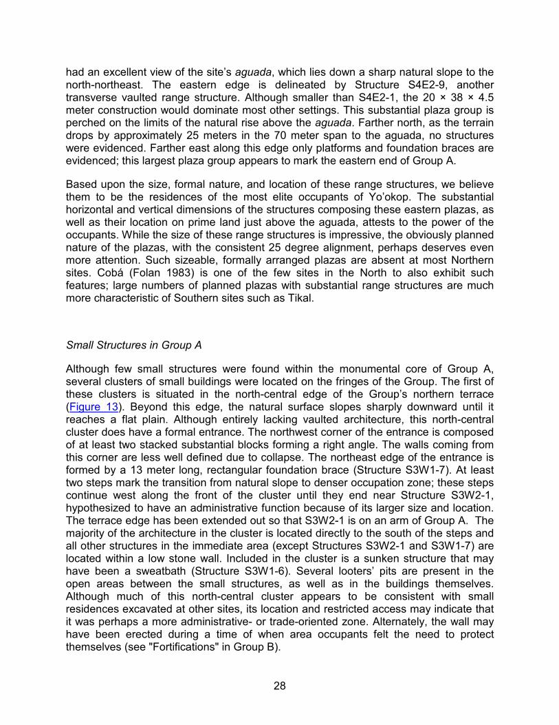
Small Structures in Group A
Although few small structures were found within the monumental core of Group A, several clusters of small buildings were located on the fringes of the Group. The first of these clusters is situated in the north-central edge of the Group’s northern terrace (Figure 13). Beyond this edge, the natural surface slopes sharply downward until it reaches a flat plain. Although entirely lacking vaulted architecture, this north-central cluster does have a formal entrance. The northwest corner of the entrance is composed of at least two stacked substantial blocks forming a right angle. The walls coming from this corner are less well defined due to collapse. The northeast edge of the entrance is formed by a 13 meter long, rectangular foundation brace (Structure S3W1-7). At least two steps mark the transition from natural slope to denser occupation zone; these steps continue west along the front of the cluster until they end near Structure S3W2-1, hypothesized to have an administrative function because of its larger size and location. The terrace edge has been extended out so that S3W2-1 is on an arm of Group A. The majority of the architecture in the cluster is located directly to the south of the steps and all other structures in the immediate area (except Structures S3W2-1 and S3W1-7) are located within a low stone wall. Included in the cluster is a sunken structure that may have been a sweatbath (Structure S3W1-6). Several looters’ pits are present in the open areas between the small structures, as well as in the buildings themselves. Although much of this north-central cluster appears to be consistent with small residences excavated at other sites, its location and restricted access may indicate that it was perhaps a more administrative- or trade-oriented zone. Alternately, the wall may have been erected during a time of when area occupants felt the need to protect themselves (see "Fortifications" in Group B).
29
Figure 13: Group A, North-Central Residential Area.
To the east of this north-central cluster, to the west of Sacbe 1, are scattered non-vaulted structures, including Structure S3E1-2. Although small in size, its strategic location close to S4W1-1 and the Sacbe 1 terminus mean that it may have been an important ceremonial and/or administrative building. Other foundation braces (Structures S3E1-1 and S3W1-1) rest directly atop the Group A terrace edge, also just west of the roadway.
The southern and southwestern edges of the Group, although lacking a definite, architectural edge, were defined as the point at which monumental architecture abruptly transitions to small platforms and foundation braces. One locus of small architecture was mapped at the southwest corner, while another concentration was found just south of Group A’s substantial range structures. This south-central concentration is distinguished by its use of apparently contemporaneous albarradas to divide portions of the cluster, as well as its continuation of the 25 degree site alignment. Other small architecture at the site tends to be less rigid in following this orientation.
30
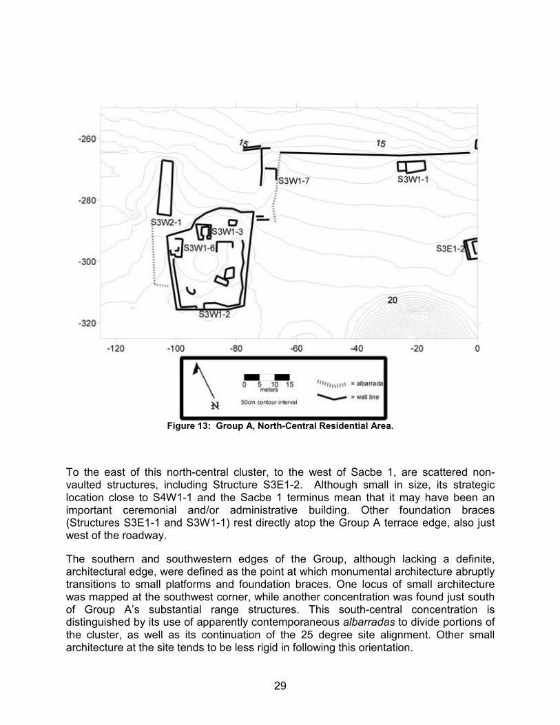
A final small cluster of note in the area was found after a nearly 100-meter gap to the east of Group A (Figure 14). Two brechas were cut to the east of the S4E2-1 plaza group after informants reported that substantial architecture continued in this direction. While no monumental architecture was located, several structures on a well-built platform were found. Based upon architectural styles, the platform and several structures upon it appear to have been built in the Early Classic, with less well-built buildings having been added in the Late Classic. The gap between this platform and Group A is most readily explained by the undulating terrain between the two loci. No architecture was found in the zone immediately north of the platform; here the sharp decline to the aguada likely made construction unattractive.
Figure 14: Eastern Residential Platform.
31
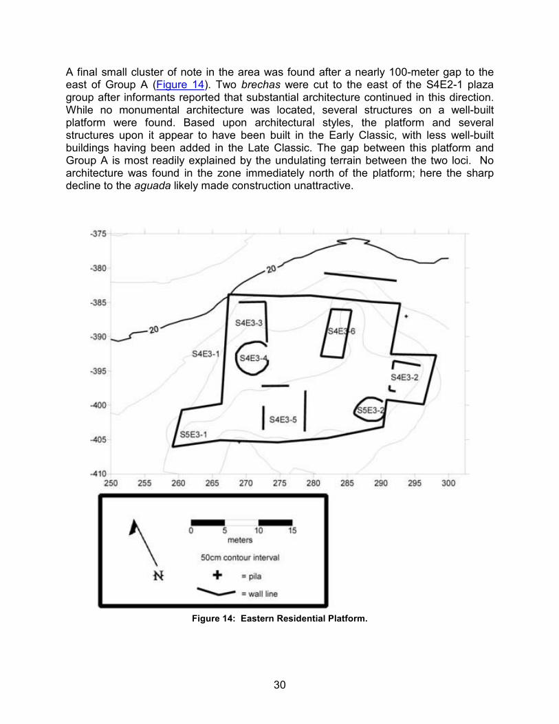
Group B
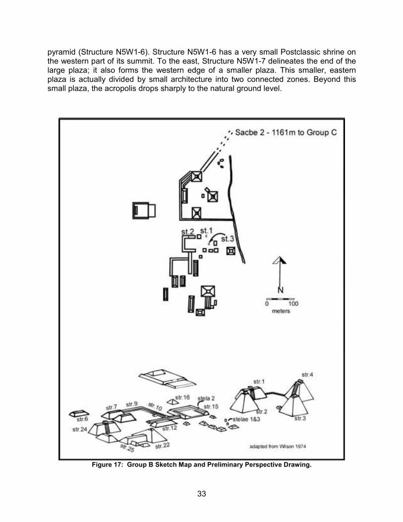
Due to the large size of Group A, and the distance covered by Sacbe 1, only a small portion of Group B could be recorded during the 2000 field season. Following the mapping of Sacbe 1, between Groups A and B, as well as an area immediately to the east of the roadway, researchers were able to map the south-central and southeastern portions of Group B (Figure 15 and Figure 16). The majority of the Group thus remains recorded only on a sketch map (Wilson 1974) (Figure 17). One of the first tasks of the proposed 2001 season will be the completion of this Group’s mapping. Significant monumental constructions continue to the west, north, and northeast of the recorded zone.
Figure 15: Group B Partial Map.
32
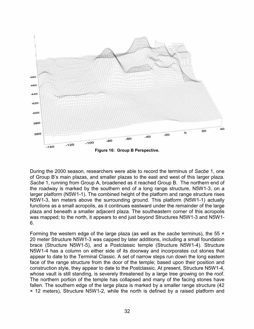
Figure 16: Group B Perspective.
During the 2000 season, researchers were able to record the terminus of Sacbe 1, one of Group B’s main plazas, and smaller plazas to the east and west of this larger plaza. Sacbe 1, running from Group A, broadened as it reached Group B. The northern end of the roadway is marked by the southern end of a long range structure, N5W1-3, on a larger platform (N5W1-1). The combined height of the platform and range structure rises N5W1-3, ten meters above the surrounding ground. This platform (N5W1-1) actually functions as a small acropolis, as it continues eastward under the remainder of the large plaza and beneath a smaller adjacent plaza. The southeastern corner of this acropolis was mapped; to the north, it appears to end just beyond Structures N5W1-3 and N5W1-6.
Forming the western edge of the large plaza (as well as the sacbe terminus), the 55 × 20 meter Structure N5W1-3 was capped by later additions, including a small foundation brace (Structure N5W1-5), and a Postclassic temple (Structure N5W1-4). Structure N5W1-4 has a column on either side of its doorway and incorporates cut stones that appear to date to the Terminal Classic. A set of narrow steps run down the long eastern face of the range structure from the door of the temple; based upon their position and construction style, they appear to date to the Postclassic. At present, Structure N5W1-4, whose vault is still standing, is severely threatened by a large tree growing on the roof. The northern portion of the temple has collapsed and many of the facing stones have fallen. The southern edge of the large plaza is marked by a smaller range structure (42 × 12 meters), Structure N5W1-2, while the north is defined by a raised platform and
33
pyramid (Structure N5W1-6). Structure N5W1-6 has a very small Postclassic shrine on the western part of its summit. To the east, Structure N5W1-7 delineates the end of the large plaza; it also forms the western edge of a smaller plaza. This smaller, eastern plaza is actually divided by small architecture into two connected zones. Beyond this small plaza, the acropolis drops sharply to the natural ground level.
Figure 17: Group B Sketch Map and Preliminary Perspective Drawing.
34
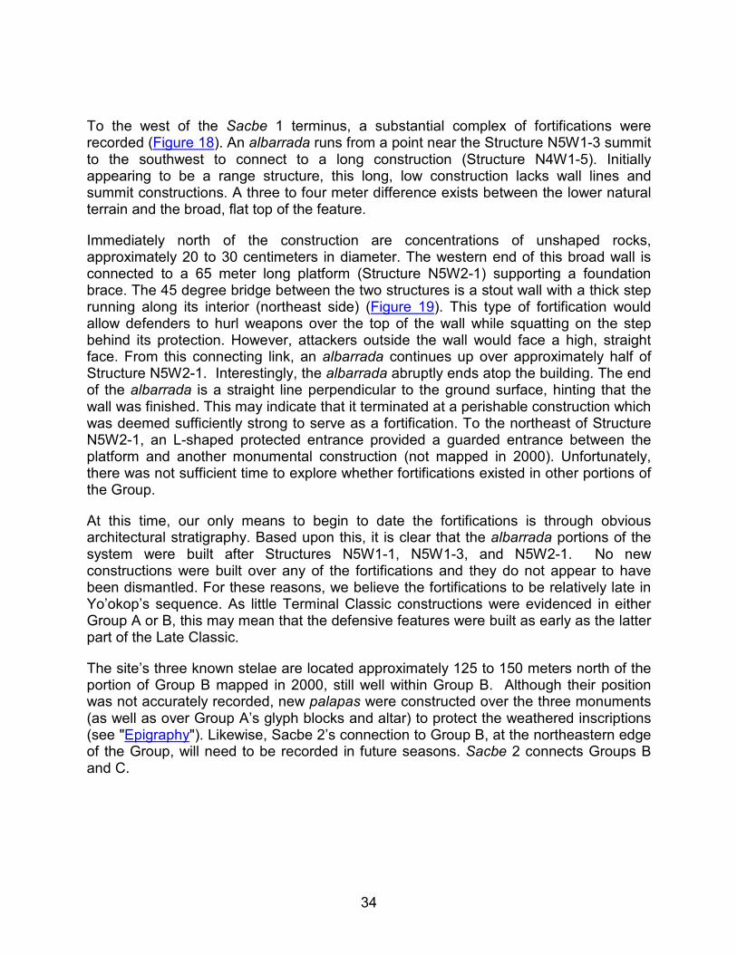
To the west of the Sacbe 1 terminus, a substantial complex of fortifications were recorded (Figure 18). An albarrada runs from a point near the Structure N5W1-3 summit to the southwest to connect to a long construction (Structure N4W1-5). Initially appearing to be a range structure, this long, low construction lacks wall lines and summit constructions. A three to four meter difference exists between the lower natural terrain and the broad, flat top of the feature.
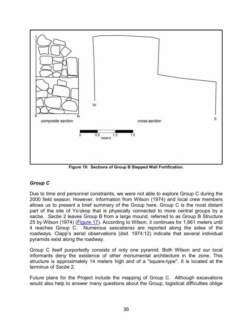
Immediately north of the construction are concentrations of unshaped rocks, approximately 20 to 30 centimeters in diameter. The western end of this broad wall is connected to a 65 meter long platform (Structure N5W2-1) supporting a foundation brace. The 45 degree bridge between the two structures is a stout wall with a thick step running along its interior (northeast side) (Figure 19). This type of fortification would allow defenders to hurl weapons over the top of the wall while squatting on the step behind its protection. However, attackers outside the wall would face a high, straight face. From this connecting link, an albarrada continues up over approximately half of Structure N5W2-1. Interestingly, the albarrada abruptly ends atop the building. The end of the albarrada is a straight line perpendicular to the ground surface, hinting that the wall was finished. This may indicate that it terminated at a perishable construction which was deemed sufficiently strong to serve as a fortification. To the northeast of Structure N5W2-1, an L-shaped protected entrance provided a guarded entrance between the platform and another monumental construction (not mapped in 2000). Unfortunately, there was not sufficient time to explore whether fortifications existed in other portions of the Group.
At this time, our only means to begin to date the fortifications is through obvious architectural stratigraphy. Based upon this, it is clear that the albarrada portions of the system were built after Structures N5W1-1, N5W1-3, and N5W2-1. No new constructions were built over any of the fortifications and they do not appear to have been dismantled. For these reasons, we believe the fortifications to be relatively late in Yo’okop’s sequence. As little Terminal Classic constructions were evidenced in either Group A or B, this may mean that the defensive features were built as early as the latter part of the Late Classic.
The site’s three known stelae are located approximately 125 to 150 meters north of the portion of Group B mapped in 2000, still well within Group B. Although their position was not accurately recorded, new palapas were constructed over the three monuments (as well as over Group A’s glyph blocks and altar) to protect the weathered inscriptions (see "Epigraphy"). Likewise, Sacbe 2’s connection to Group B, at the northeastern edge of the Group, will need to be recorded in future seasons. Sacbe 2 connects Groups B and C.
35
Figure 18: Group B Fortifications.
36
Figure 19: Sections of Group B Stepped Wall Fortification.
Group C
Due to time and personnel constraints, we were not able to explore Group C during the 2000 field season. However, information from Wilson (1974) and local crew members allows us to present a brief summary of the Group here. Group C is the most distant part of the site of Yo’okop that is physically connected to more central groups by a sacbe. Sacbe 2 leaves Group B from a large mound, referred to as Group B Structure 25 by Wilson (1974) (Figure 17). According to Wilson, it continues for 1,661 meters until it reaches Group C. Numerous sascaberas are reported along the sides of the roadways. Clapp’s aerial observations (ibid. 1974:12) indicate that several individual pyramids exist along the roadway.
Group C itself purportedly consists of only one pyramid. Both Wilson and our local informants deny the existence of other monumental architecture in the zone. This structure is approximately 14 meters high and of a "square-type". It is located at the terminus of Sacbe 2.
Future plans for the Project include the mapping of Group C. Although excavations would also help to answer many questions about the Group, logistical difficulties oblige
37
us to first concentrate such efforts on the more accessible portions of the site. No roads or footpaths currently extend to Group C.
Group D
Although long recognized by locals, Group D only became known to Project members during the 2000 field season. The Group, connected to Group A by the newly-documented Sacbe 3, lies to the northwest of Group A and the southwest of Group B. The modern road from Sabán slices through Sacbe 3, as it does the more eastern Sacbe 1. Informants report a roadway also linking Groups D and B, but we were not able to adequately search the intervening area to determine whether such a link exists.
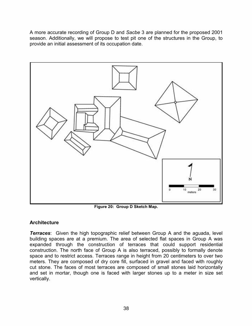
Shaw and two local assistants spent an afternoon recording the path of Sacbe 3 from Group A to Group D using a GPS and making a quick tape and compass map of the primary structures of Group D (Figure 20). One of these assistants had made milpa in the Group D area two years previously and was able to greatly assist in locating structures in the thick recent growth. While this map does not include all structures in the area, it does provide a general impression of the Group’s composition.
Group D differs from the nearby Groups A and B in terms of overall size, as well as in the scale of the structures themselves. Although it contains both range structures and pyramidal constructions, none of the observed structures attain a height of more than about five to six meters above the surrounding terrain. None of the range structures reach the enormous lengths of those found in the other groups.
Sacbe 2 opens into a broad raised plaza to the south of the structures mapped in 2000. Other than two recent looter’s pits, no other features appear in the terminus vicinity. The mapped area includes two larger range structures connected at an angle of approximately 70 degrees. The smaller of these structures forms the end of a small, deep plaza. To the west and southwest of this small plaza are a small pyramid and range structure. Other small pyramids are scattered to the north and east of the range structures, including the two noted on the sketch map. In order to avoid errors and future confusion, no structure numbers will be assigned in the Group until each structure’s exact grid square position may be determined.
Based on this first assessment, Group D consists of elite residences and minor ceremonial facilities. Its smaller scale would seem to reflect its lesser importance. However, the effort to construct a substantial sacbe to the group indicates that Group D was somehow a significant part of the site. Possible explanations include that the Group may have been important only briefly, at a particular point in Yo’okop’s history, or that, while primarily residential, it may have been the home of an important elite family. It is consistent with the idea that each ruler or dynasty may have built a new palace and established a new locus of power.
38
A more accurate recording of Group D and Sacbe 3 are planned for the proposed 2001 season. Additionally, we will propose to test pit one of the structures in the Group, to provide an initial assessment of its occupation date.
Figure 20: Group D Sketch Map.
Architecture
Terraces: Given the high topographic relief between Group A and the aguada, level building spaces are at a premium. The area of selected flat spaces in Group A was expanded through the construction of terraces that could support residential construction. The north face of Group A is also terraced, possibly to formally denote space and to restrict access. Terraces range in height from 20 centimeters to over two meters. They are composed of dry core fill, surfaced in gravel and faced with roughly cut stone. The faces of most terraces are composed of small stones laid horizontally and set in mortar, though one is faced with larger stones up to a meter in size set vertically.

39
Sacbeob: Sacbeob may be thought of as long two-sided terraces that connect architectural groups by artificially leveling the intervening topography with a regular grade. Of the three sacbeob currently known from Yo’okop, only Sacbe 1 and Sacbe 3 were examined this season. Both run relatively straight for 718 and 650 meters respectively, and terminate in major architectural groups. The height of sacbeob varies according to local terrain, from 10 to 170 cm. The modern road from Sabán to Dzoyola cuts through Sacbe 1 and Sacbe 3, exposing the road cores in profile. Both sacbeob are faced with cut stone laid horizontally and set in mortar. The core is composed of dry laid stone grading from boulder-sized, through cobble- to pebble-sized rough stone near the upper surface. The road is then surfaced with crushed and compacted sascab. To build and maintain Sacbe 1, a number of sascaberos are located adjacent to and under the sacbe.
Platforms: Platforms are freestanding terraces that provide level surfaces for public display and the construction of residential superstructures. Based on ceramic surface collections, the five platforms mapped in the 2000 season appear to date from the Late Formative through the Late Classic. The two tentative Late Formative platforms (Structures S1E1-3 & N2E1-1) are distinguished by facing stones composed of medium-to-large, roughly-shaped blocks set vertically. These stones act as a retaining wall for the platform fill that is capped by rough gravel. Two other platforms (Structures S3W1-2 & S4E3-1), apparently dating to the Early Classic, are faced with similarly-sized stones more carefully dressed and laid horizontally with the largest stones at the corners. The final platform (Structure N4E1-1) is faced with smaller stones laid horizontally. This construction style is also found on two additions to platform S4E3-1, confirming the relatively late date for this construction style.
Acropoli: A single acropolis located in Group B was mapped this season. Acropoli differ from platforms in terms of scale and function. In addition to supporting a pyramid, this acropolis supports a number of range structures. No formal stairways are apparent to give access to this acropolis. Structure N5W1-1 measures 98 m × 66 m in area and 2.5 m in height.
Pyramids: Pyramidal structures may be thought of as stacked platforms which support summit temples instead of residences. Four pyramids were mapped this season: three in Group A and one in Group B. Three (Structures S5E1-1, S4W1-1, and N5W1-6) exhibit relatively steep sides and rears, with less steep fronts. The best preserved, Structure S4W1-1, displays two construction phases, a lower Classic Period construction surmounted by later Postclassic construction. The Classic Period pyramid rises in three terraces faced with small, well-dressed stones at an 80 degree angle, and is largely free of chinking. An outset stairway without balustrades is situated on the north side of the pyramid and runs two thirds of the way up the structure. Where erosion has exposed the construction fill of the terrace, uncut stones in a silt matrix may be seen. The fourth pyramid, Structure S4W2-1, is a Postclassic structure that differs from the others in general form and in construction techniques. While pyramidal terraces are typically solid constructions, Structure S4W2-1 contains two vaulted, descending passages with stairs that terminate in small rooms. The masonry of these walls is composed of small, roughly-quarried stone with abundant chinking and a thick coat of
40
plaster. Apart from the passages, the three terraces of this structure are built of unshaped dry laid stone. No facing stones have been located in situ.
Summit temples: Summit temples are small, vaulted-masonry structures that crown pyramidal bases. At present, no Classic period summit temples are known, and it assumed that these were constructed of perishable materials. Two Postclassic summit temples were mapped this season, one in each group. In Group B, Structure N5W1-4 is a one-room building constructed in East Coast style. The walls are composed of reused block and veneer stones on a concrete core. The narrow doorway is flanked by reused Puuc-style spindles, and a recessed lintel spans the opening. The vault is supported by roughly-shaped, load-bearing corbels with heavy use of chinking stones. The summit temple in Group A (Structure S4W1-6), capping Structure S4W1-1 is more complex, having two stories linked by internal ramps or stairs. The front lower façade was similar to that of Structure N5W1-4 (Stromsvik et al. 1955: figure 2l), having reused Puuc spindles supporting a recessed lintel. This front wall has subsequently collapsed. The internal masonry is considerably coarser than that of the exterior, resembling the internal passages of Structure S4W2-1. These are covered with at least five coats of plaster, two of which were painted blue.
Range structures: Range structures are linear, multi-room masonry superstructures. At least thirteen such structures were mapped this season. Humus accumulation and collapse material may conceal many other range structures within the portion of the site that was mapped. All range structures noted at present seem to date to the Early or Late Classic Periods on the basis of construction style. Examples of both tandem and transverse room plans are apparent. Where masonry walls are visible, the stonework consists of small moderately well cut to finely cut load-bearing stone. A portion of a vault is visible in Structure S4E1-4, and consists of coarsely dressed and heavily-chinked, corbeled, load-bearing stones.
Foundation braces: Foundation braces are the stone foundations for perishable superstructures, usually residential in function. Both apsidal and rectangular examples are noted at Yo’okop, with some of the latter containing multiple rooms. A number of foundation braces also contain inner benches along rear walls. In some cases, new foundation braces are placed over existing ones, suggesting a long occupational history for several residential locales. While the majority of these are located around the perimeter of major architectural groups, the presence of some in the center of plazas may indicate late occupation or perhaps the remains of siege structures as have been reported at Dos Pilas (Demarest 1993:99) and Yaxuná (Shaw and Johnstone 1996:43).
Albarradas: Albarradas are low, free-standing walls that serve to divide or enclose space. They consist of stones of varying size stacked up to one meter in height without mortar. The basal course is usually composed of larger stones set upright. Some albarradas are associated with the foundation braces of Group A. Others, located northwest of the aguada, seem to be late constructions, as they pass over earlier constructions including Sacbe 1.

41
Fortifications: Fortification walls are different from albarradas in terms of scale and function. They are designed to restrict access to certain areas by wholly or partially enclosing them. The fortification walls of Group B (Structure N5W2-2, Figure 19) are steep and the Group’s stepped rampart walls are consistent with other Northern Lowland fortifications (Webster 1979). Well-preserved sections have a height of two meters and a width of three meters. Unlike those found at several other Northern Maya sites, including Chunchucmil and Yaxuná (Dahlin 2000; Manahan et al. 1997), the Group B fortifications do not appear to have been hastily constructed, "last-ditch" efforts. The fortifications are composed of a thick rubble core enclosed by dry-laid, roughly-quarried stone walls. The fortification walls are not continuous, but incorporate existing structures into the defensive system. A fortification wall runs up to and partially over Structure N5W2-1.
Ceramic Analyses
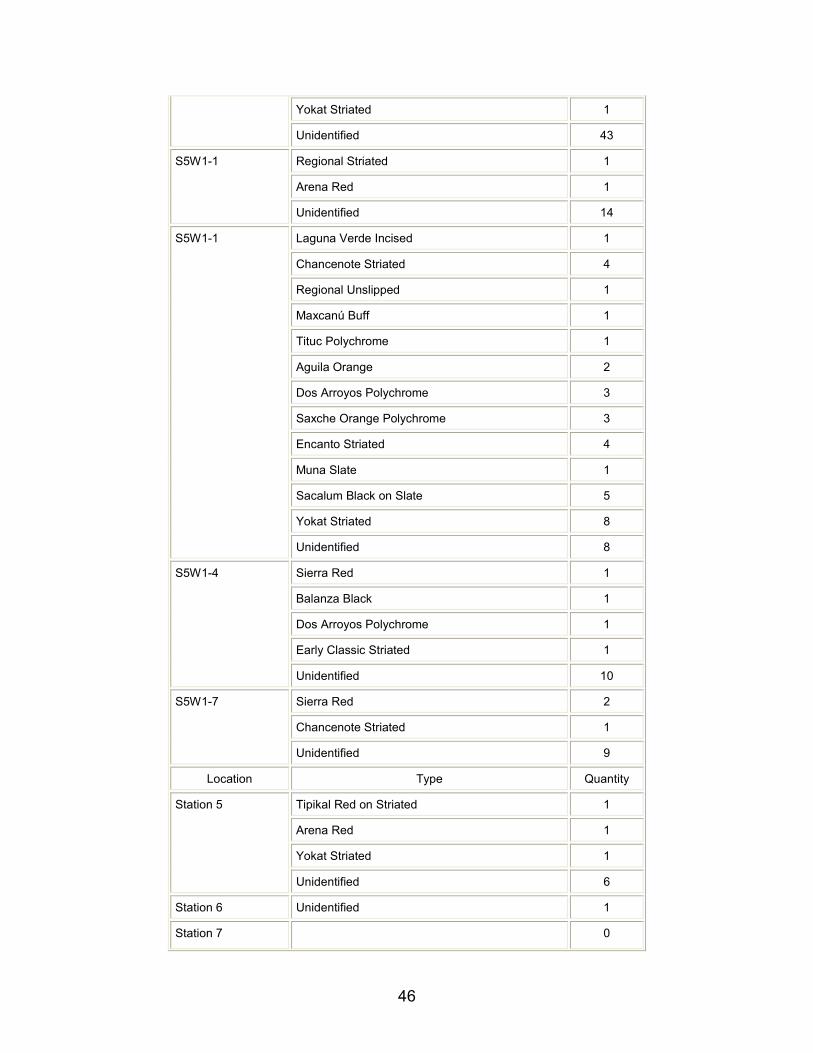
Surface collections were undertaken at Yo’okop in order to establish a preliminary site chronology and to enable content comparison to other sites in the region. These collections were undertaken primarily in Group A, but also from Group B and a few structures alongside Sacbe 1. A variety of features were sampled, including plazas, residential platforms, range structures, and pyramids. For structures less than six meters in length, the northern half of the building constituted the sample area. Larger structures had a 2x6 m area that was collected, also on the northern side. Plaza areas had standard 2x2 m collection areas. All sherds within the collection area that could be recognized as such were bagged, washed, and given a permanent label with their provenience noted by structure number or plaza number. Ceramic analysis was carried out using the Type-Variety system (Smith et al. 1960). Those sherds that could be identified were identified to at least the level of the ceramic type.
Thirty-eight localities were surface collected during the 2000 field season. Over a third (13) of these localities did not yield any ceramics. The remaining twenty-five localities produced a total of 622 sherds, of which more than half (54.02%) were unidentified. The number of unidentified sherds is more than twice the rate of unidentified sherds from excavated contexts at Yaxuná (Johnstone 1999). This large discrepancy is largely due to the nature of the sherds themselves. Surface ceramics are exposed to a wider range of mechanical, thermal and chemical agents that reduce the surface detail needed for accurate identification.
In spite of the poor quality of the ceramics themselves, 27 types were identified (Table 2), along with an unknown type containing shell temper. These types are fairly evenly distributed between 5 components spanning the Late Formative through the Postclassic. Though too early to say definitively, there does not seem to be any obvious gaps in the sequence, suggesting continuous occupation at Yo’okop for approximately 1000 years. Trade wares, in the form of polychrome vessels, are present during the Early and Late Classic Periods. These wares originate in the Southern Lowlands, and suggest a trade link between Yo’okop and the Petén for much of the Classic Period.
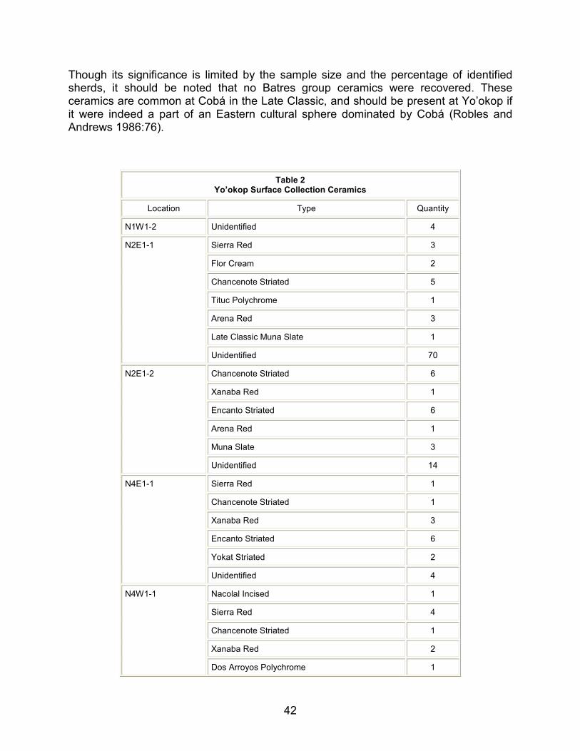
42
Though its significance is limited by the sample size and the percentage of identified sherds, it should be noted that no Batres group ceramics were recovered. These ceramics are common at Cobá in the Late Classic, and should be present at Yo’okop if it were indeed a part of an Eastern cultural sphere dominated by Cobá (Robles and Andrews 1986:76).
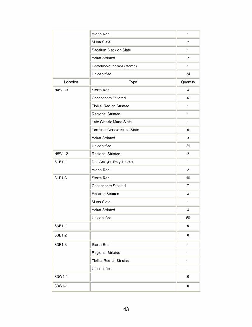
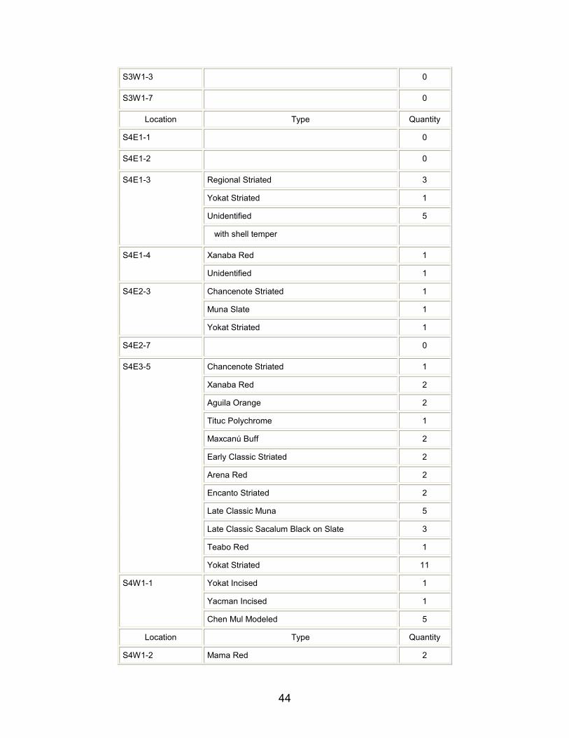
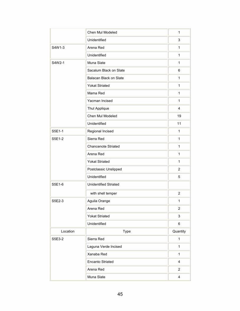
Table 2 Yo’okop Surface Collection Ceramics
Location Type Quantity
N1W1-2 Unidentified 4
Sierra Red 3
Flor Cream 2
Chancenote Striated 5
Tituc Polychrome 1
Arena Red 3
Late Classic Muna Slate 1
N2E1-1
Unidentified 70
Chancenote Striated 6
Xanaba Red 1
Encanto Striated 6
Arena Red 1
Muna Slate 3
N2E1-2
Unidentified 14
Sierra Red 1
Chancenote Striated 1
Xanaba Red 3
Encanto Striated 6
Yokat Striated 2
N4E1-1
Unidentified 4
Nacolal Incised 1
Sierra Red 4
Chancenote Striated 1
Xanaba Red 2
N4W1-1
Dos Arroyos Polychrome 1
43
Arena Red 1
Muna Slate 2
Sacalum Black on Slate 1
Yokat Striated 2
Postclassic Incised (stamp) 1
Unidentified 34
Location Type Quantity
Sierra Red 4
Chancenote Striated 6
Tipikal Red on Striated 1
Regional Striated 1
Late Classic Muna Slate 1
Terminal Classic Muna Slate 6
Yokat Striated 3
N4W1-3
Unidentified 21
N5W1-2 Regional Striated 2
Dos Arroyos Polychrome 1 S1E1-1
Arena Red 2
Sierra Red 10
Chancenote Striated 7
Encanto Striated 3
Muna Slate 1
Yokat Striated 4
S1E1-3
Unidentified 60
S3E1-1 0
S3E1-2 0
Sierra Red 1
Regional Striated 1
Tipikal Red on Striated 1
S3E1-3
Unidentified 1
S3W1-1 0
S3W1-1 0
44
S3W1-3 0
S3W1-7 0
Location Type Quantity
S4E1-1 0
S4E1-2 0
Regional Striated 3
Yokat Striated 1
Unidentified 5
S4E1-3
with shell temper
Xanaba Red 1 S4E1-4
Unidentified 1
Chancenote Striated 1
Muna Slate 1
S4E2-3
Yokat Striated 1
S4E2-7 0
Chancenote Striated 1
Xanaba Red 2
Aguila Orange 2
Tituc Polychrome 1
Maxcanú Buff 2
Early Classic Striated 2
Arena Red 2
Encanto Striated 2
Late Classic Muna 5
Late Classic Sacalum Black on Slate 3
Teabo Red 1
S4E3-5
Yokat Striated 11
Yokat Incised 1
Yacman Incised 1
S4W1-1
Chen Mul Modeled 5
Location Type Quantity
S4W1-2 Mama Red 2
45
Chen Mul Modeled 1
Unidentified 3
Arena Red 1 S4W1-3
Unidentified 1
Muna Slate 1
Sacalum Black on Slate 6
Balacan Black on Slate 1
Yokat Striated 1
Mama Red 1
Yacman Incised 1
Thul Applique 4
Chen Mul Modeled 19
S4W2-1
Unidentified 11
S5E1-1 Regional Incised 1
Sierra Red 1
Chancenote Striated 1
Arena Red 1
Yokat Striated 1
Postclassic Unslipped 2
S5E1-2
Unidentified 5
Unidentified Striated S5E1-6
with shell temper 2
Aguila Orange 1
Arena Red 2
Yokat Striated 3
S5E2-3
Unidentified 6
Location Type Quantity
Sierra Red 1
Laguna Verde Incised 1
Xanaba Red 1
Encanto Striated 4
Arena Red 2
S5E3-2
Muna Slate 4
46
Yokat Striated 1
Unidentified 43
Regional Striated 1
Arena Red 1
S5W1-1
Unidentified 14
Laguna Verde Incised 1
Chancenote Striated 4
Regional Unslipped 1
Maxcanú Buff 1
Tituc Polychrome 1
Aguila Orange 2
Dos Arroyos Polychrome 3
Saxche Orange Polychrome 3
Encanto Striated 4
Muna Slate 1
Sacalum Black on Slate 5
Yokat Striated 8
S5W1-1
Unidentified 8
Sierra Red 1
Balanza Black 1
Dos Arroyos Polychrome 1
Early Classic Striated 1
S5W1-4
Unidentified 10
Sierra Red 2
Chancenote Striated 1
S5W1-7
Unidentified 9
Location Type Quantity
Tipikal Red on Striated 1
Arena Red 1
Yokat Striated 1
Station 5
Unidentified 6
Station 6 Unidentified 1
Station 7 0
47
Encanto Striated 1
Yokat Striated 1
Station 11
Unidentified 3
Station 17 0
Chancenote Striated 1 Stela 1 Palapa
Tekit Incised 1
Stela 2 Palapa 0
Muna Slate 3
Tekit Incised 1
Stela 3 Palapa
Unidentified 2
TOTAL SHERDS FOUND 622
PERCENT UNIDENTIFIED 54.02%
Epigraphy
Numerous Maya sites in the northern Yucatán peninsula contain stone monuments decorated with hieroglyphic inscriptions and low-relief sculpture. In spite of these riches, archaeologists, art historians, and epigraphers are often disappointed by the poor preservation of these carved images. Much of the extant epigraphic and iconographic record in the Northern Lowlands has become inaccessible because the porous, local limestone on which it was carved has been eroded by the elements over time. For this reason, any readable hieroglyphic writing and iconography that we can recover at Yo’okop becomes vital to our understanding of the political history of this region. We are pleased to report the re-discovery of four carved stone monuments and the discovery of three previously unknown carved stone monuments at Yo’okop during the 2000 season. The four previously known monuments include Stelae 1, 2, 3, and one circular altar (Stromsvik et al. 1955; Wilson 1974); the three previously unknown monuments are carved stone blocks. Johnstone and Krochock have made preliminary field drawings of the monuments now located at Yo’okop. In addition to the monuments mentioned above, three stone blocks and three altars which have been previously reported by Wilson (1974) and Stromsvik, Pollock, and Berlin (1955) have either been removed from the site to another location or have not yet been rediscovered at the site. We intend to search for these and other "missing" monuments at the site and also in the neighboring communities such as Dzoyola next season.
Johnstone and Krochock have begun a preliminary analysis of the inscriptions and iconography, however, additional fieldwork is necessary before a full analysis can be offered. We anticipate that a more complete decipherment of the hieroglyphic
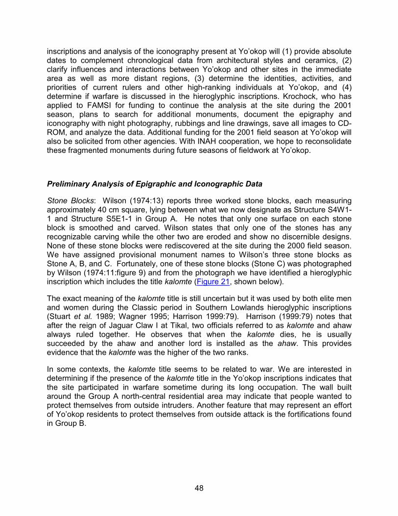
48
inscriptions and analysis of the iconography present at Yo’okop will (1) provide absolute dates to complement chronological data from architectural styles and ceramics, (2) clarify influences and interactions between Yo’okop and other sites in the immediate area as well as more distant regions, (3) determine the identities, activities, and priorities of current rulers and other high-ranking individuals at Yo’okop, and (4) determine if warfare is discussed in the hieroglyphic inscriptions. Krochock, who has applied to FAMSI for funding to continue the analysis at the site during the 2001 season, plans to search for additional monuments, document the epigraphy and iconography with night photography, rubbings and line drawings, save all images to CD-ROM, and analyze the data. Additional funding for the 2001 field season at Yo’okop will also be solicited from other agencies. With INAH cooperation, we hope to reconsolidate these fragmented monuments during future seasons of fieldwork at Yo’okop.
Preliminary Analysis of Epigraphic and Iconographic Data
Stone Blocks: Wilson (1974:13) reports three worked stone blocks, each measuring approximately 40 cm square, lying between what we now designate as Structure S4W1-1 and Structure S5E1-1 in Group A. He notes that only one surface on each stone block is smoothed and carved. Wilson states that only one of the stones has any recognizable carving while the other two are eroded and show no discernible designs. None of these stone blocks were rediscovered at the site during the 2000 field season. We have assigned provisional monument names to Wilson’s three stone blocks as Stone A, B, and C. Fortunately, one of these stone blocks (Stone C) was photographed by Wilson (1974:11:figure 9) and from the photograph we have identified a hieroglyphic inscription which includes the title kalomte (Figure 21, shown below).
The exact meaning of the kalomte title is still uncertain but it was used by both elite men and women during the Classic period in Southern Lowlands hieroglyphic inscriptions (Stuart et al. 1989; Wagner 1995; Harrison 1999:79). Harrison (1999:79) notes that after the reign of Jaguar Claw I at Tikal, two officials referred to as kalomte and ahaw always ruled together. He observes that when the kalomte dies, he is usually succeeded by the ahaw and another lord is installed as the ahaw. This provides evidence that the kalomte was the higher of the two ranks.
In some contexts, the kalomte title seems to be related to war. We are interested in determining if the presence of the kalomte title in the Yo’okop inscriptions indicates that the site participated in warfare sometime during its long occupation. The wall built around the Group A north-central residential area may indicate that people wanted to protect themselves from outside intruders. Another feature that may represent an effort of Yo’okop residents to protect themselves from outside attack is the fortifications found in Group B.
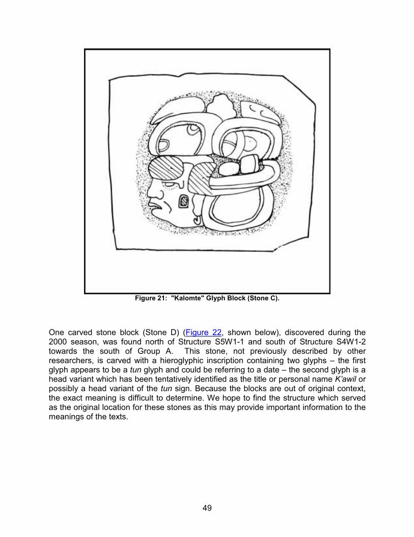
49
Figure 21: "Kalomte" Glyph Block (Stone C).
One carved stone block (Stone D) (Figure 22, shown below), discovered during the 2000 season, was found north of Structure S5W1-1 and south of Structure S4W1-2 towards the south of Group A. This stone, not previously described by other researchers, is carved with a hieroglyphic inscription containing two glyphs – the first glyph appears to be a tun glyph and could be referring to a date – the second glyph is a head variant which has been tentatively identified as the title or personal name K’awil or possibly a head variant of the tun sign. Because the blocks are out of original context, the exact meaning is difficult to determine. We hope to find the structure which served as the original location for these stones as this may provide important information to the meanings of the texts.
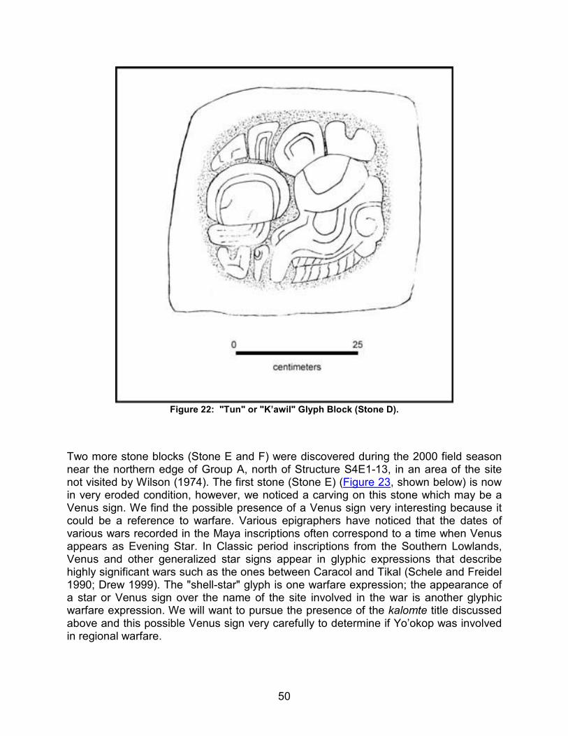
50
Figure 22: "Tun" or "K’awil" Glyph Block (Stone D).
Two more stone blocks (Stone E and F) were discovered during the 2000 field season near the northern edge of Group A, north of Structure S4E1-13, in an area of the site not visited by Wilson (1974). The first stone (Stone E) (Figure 23, shown below) is now in very eroded condition, however, we noticed a carving on this stone which may be a Venus sign. We find the possible presence of a Venus sign very interesting because it could be a reference to warfare. Various epigraphers have noticed that the dates of various wars recorded in the Maya inscriptions often correspond to a time when Venus appears as Evening Star. In Classic period inscriptions from the Southern Lowlands, Venus and other generalized star signs appear in glyphic expressions that describe highly significant wars such as the ones between Caracol and Tikal (Schele and Freidel 1990; Drew 1999). The "shell-star" glyph is one warfare expression; the appearance of a star or Venus sign over the name of the site involved in the war is another glyphic warfare expression. We will want to pursue the presence of the kalomte title discussed above and this possible Venus sign very carefully to determine if Yo’okop was involved in regional warfare.
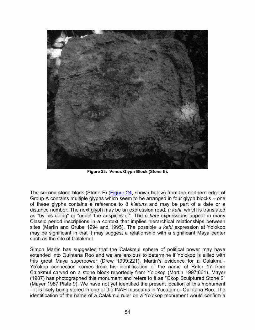
51
Figure 23: Venus Glyph Block (Stone E).
The second stone block (Stone F) (Figure 24, shown below) from the northern edge of Group A contains multiple glyphs which seem to be arranged in four glyph blocks – one of these glyphs contains a reference to 8 k’atuns and may be part of a date or a distance number. The next glyph may be an expression read, u kahi, which is translated as "by his doing" or "under the auspices of". The u kahi expressions appear in many Classic period inscriptions in a context that implies hierarchical relationships between sites (Martin and Grube 1994 and 1995). The possible u kahi expression at Yo’okop may be significant in that it may suggest a relationship with a significant Maya center such as the site of Calakmul.
Simon Martin has suggested that the Calakmul sphere of political power may have extended into Quintana Roo and we are anxious to determine if Yo’okop is allied with this great Maya superpower (Drew 1999:221). Martin’s evidence for a Calakmul-Yo’okop connection comes from his identification of the name of Ruler 17 from Calakmul carved on a stone block reportedly from Yo’okop (Martin 1997:861). Mayer (1987) has photographed this monument and refers to it as "Okop Sculptured Stone 2" (Mayer 1987:Plate 9). We have not yet identified the present location of this monument – it is likely being stored in one of the INAH museums in Yucatán or Quintana Roo. The identification of the name of a Calakmul ruler on a Yo’okop monument would confirm a
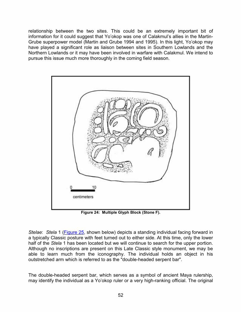
52
relationship between the two sites. This could be an extremely important bit of information for it could suggest that Yo’okop was one of Calakmul’s allies in the Martin-Grube superpower model (Martin and Grube 1994 and 1995). In this light, Yo’okop may have played a significant role as liaison between sites in Southern Lowlands and the Northern Lowlands or it may have been involved in warfare with Calakmul. We intend to pursue this issue much more thoroughly in the coming field season.
Figure 24: Multiple Glyph Block (Stone F).
Stelae: Stela 1 (Figure 25, shown below) depicts a standing individual facing forward in a typically Classic posture with feet turned out to either side. At this time, only the lower half of the Stela 1 has been located but we will continue to search for the upper portion. Although no inscriptions are present on this Late Classic style monument, we may be able to learn much from the iconography. The individual holds an object in his outstretched arm which is referred to as the "double-headed serpent bar".
The double-headed serpent bar, which serves as a symbol of ancient Maya rulership, may identify the individual as a Yo’okop ruler or a very high-ranking official. The original

53
function of the double-headed serpent bar in Formative iconography was to symbolize the sky. When carried in the arms of Classic Maya rulers on monuments, the double-headed serpent bar symbolizes the "sky umbilicus" or kuxan sum that connects the rulers "to their sources of supernatural power and the ecliptic path across the sky" (Schele and Mathews 1998:416). The ecliptic is the line of constellations in which the sun rises and sets throughout the year (Freidel et al. 1995:78). The ecliptic constellations create a snake-like path that tracks the movement of the sun, the moon, and the planets. In this way, powerful Maya leaders shown holding the double-headed serpent bar controlled not only the physical realm on earth but the cosmos as well. Similar double-headed serpent bars held by rulers appear on stelae throughout the Southern Lowlands. The serpent bar held diagonally, as is the one on Yo’okop Stela 1, can be found on Naranjo Stela 22 which dates to A.D. 702. The individual on Yo’okop Stela 1 also wears a belt which is adorned with carved stone (possibly jade) heads and celts. These ornaments can be seen carved on Maya monuments and portable objects from the Early Classic [example: The Leiden Plaque (dating to ca. A.D. 320) (Schele and Miller 1986:121)] to the Terminal Classic [examples: Xultún Stela 10 (A.D. 889) and Seibal Stela 10 (A.D. 849) (Sharer 1994:653, 353)].
Stela 2 (Figure 26, shown below) depicts a ballplayer actively playing the ballgame. He wears the ballplayer’s yoke around his waist. He also wears an elaborate headdress that may be a version of the Xiuhtototl browpiece commonly seen in the iconography of Terminal Classic Chichén Itzá (Taube 1994:243). Although the general appearance of the iconography is Late Classic in style, the presence of this headdress may date Stela 2 to the Terminal Classic period. Shaw and Johnstone have located, but not yet mapped, a possible ballcourt about 100 meters to the south of the current location of Stela 2, perhaps suggesting that the sculpture once decorated ballcourt benches. At this time, we are not sure if the monument was a panel or a free-standing stela. Hieroglyphic texts located on either side of the figure in Stela 2, although somewhat eroded, promise to reveal more details with further study.
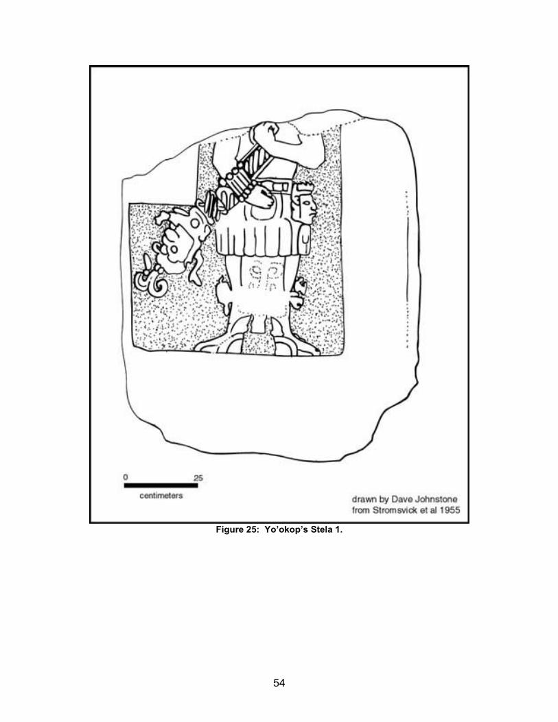
54
Figure 25: Yo’okop’s Stela 1.
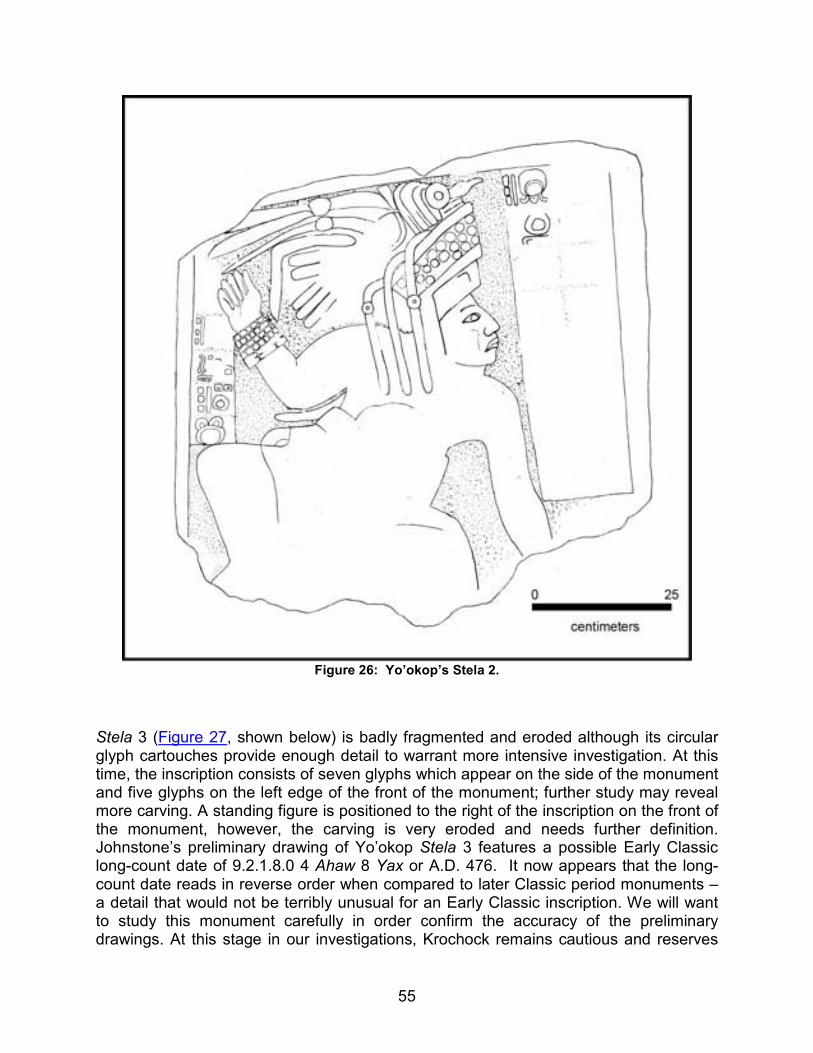
55
Figure 26: Yo’okop’s Stela 2.
Stela 3 (Figure 27, shown below) is badly fragmented and eroded although its circular glyph cartouches provide enough detail to warrant more intensive investigation. At this time, the inscription consists of seven glyphs which appear on the side of the monument and five glyphs on the left edge of the front of the monument; further study may reveal more carving. A standing figure is positioned to the right of the inscription on the front of the monument, however, the carving is very eroded and needs further definition. Johnstone’s preliminary drawing of Yo’okop Stela 3 features a possible Early Classic long-count date of 9.2.1.8.0 4 Ahaw 8 Yax or A.D. 476. It now appears that the long-count date reads in reverse order when compared to later Classic period monuments – a detail that would not be terribly unusual for an Early Classic inscription. We will want to study this monument carefully in order confirm the accuracy of the preliminary drawings. At this stage in our investigations, Krochock remains cautious and reserves
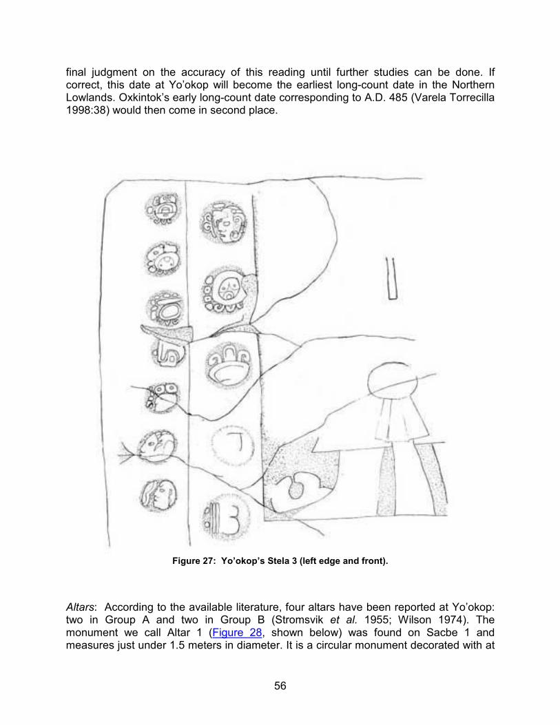
56
final judgment on the accuracy of this reading until further studies can be done. If correct, this date at Yo’okop will become the earliest long-count date in the Northern Lowlands. Oxkintok’s early long-count date corresponding to A.D. 485 (Varela Torrecilla 1998:38) would then come in second place.
Figure 27: Yo’okop’s Stela 3 (left edge and front).
Altars: According to the available literature, four altars have been reported at Yo’okop: two in Group A and two in Group B (Stromsvik et al. 1955; Wilson 1974). The monument we call Altar 1 (Figure 28, shown below) was found on Sacbe 1 and measures just under 1.5 meters in diameter. It is a circular monument decorated with at
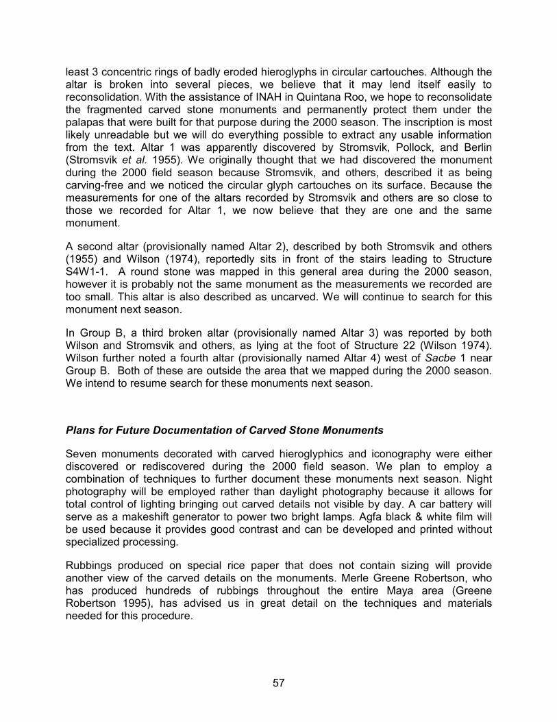
57
least 3 concentric rings of badly eroded hieroglyphs in circular cartouches. Although the altar is broken into several pieces, we believe that it may lend itself easily to reconsolidation. With the assistance of INAH in Quintana Roo, we hope to reconsolidate the fragmented carved stone monuments and permanently protect them under the palapas that were built for that purpose during the 2000 season. The inscription is most likely unreadable but we will do everything possible to extract any usable information from the text. Altar 1 was apparently discovered by Stromsvik, Pollock, and Berlin (Stromsvik et al. 1955). We originally thought that we had discovered the monument during the 2000 field season because Stromsvik, and others, described it as being carving-free and we noticed the circular glyph cartouches on its surface. Because the measurements for one of the altars recorded by Stromsvik and others are so close to those we recorded for Altar 1, we now believe that they are one and the same monument.
A second altar (provisionally named Altar 2), described by both Stromsvik and others (1955) and Wilson (1974), reportedly sits in front of the stairs leading to Structure S4W1-1. A round stone was mapped in this general area during the 2000 season, however it is probably not the same monument as the measurements we recorded are too small. This altar is also described as uncarved. We will continue to search for this monument next season.
In Group B, a third broken altar (provisionally named Altar 3) was reported by both Wilson and Stromsvik and others, as lying at the foot of Structure 22 (Wilson 1974). Wilson further noted a fourth altar (provisionally named Altar 4) west of Sacbe 1 near Group B. Both of these are outside the area that we mapped during the 2000 season. We intend to resume search for these monuments next season.
Plans for Future Documentation of Carved Stone Monuments
Seven monuments decorated with carved hieroglyphics and iconography were either discovered or rediscovered during the 2000 field season. We plan to employ a combination of techniques to further document these monuments next season. Night photography will be employed rather than daylight photography because it allows for total control of lighting bringing out carved details not visible by day. A car battery will serve as a makeshift generator to power two bright lamps. Agfa black & white film will be used because it provides good contrast and can be developed and printed without specialized processing.
Rubbings produced on special rice paper that does not contain sizing will provide another view of the carved details on the monuments. Merle Greene Robertson, who has produced hundreds of rubbings throughout the entire Maya area (Greene Robertson 1995), has advised us in great detail on the techniques and materials needed for this procedure.
58
Figure 28: Yo’okop’s Altar 1.
Preliminary pencil on paper field drawings will be produced of all the inscriptions and iconography. This step provides crucial first-hand viewing of all the visible details and will increase the accuracy of the finished ink drawings. The final drawings, done with permanent ink on Mylar, will facilitate analysis of the epigraphic and iconographic data.
The drawings, photographs, and rubbings will ultimately be saved to CD-ROMs to preserve the data and to make them available for other scholars. The drawings will also be posted on the internet. Krochock has produced similar CD-ROMs of rubbings from Chichén Itzá in a previous (1996) FAMSI project. The programs, Adobe Photoshop and Adobe Illustrator will be employed to aid in the production of quality drawings and to allow manipulation of the images for better viewing of details. Following the documentation of the monuments, Krochock will provide a final analysis of the hieroglyphic inscriptions and iconography.
Discussion and Conclusions
The first season of research at Yo’okop yielded results well beyond any prior expectations, in terms of the scale, quality, and quantity of remains. In addition to
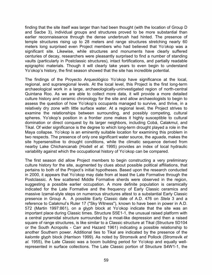
59
finding that the site itself was larger than had been thought (with the location of Group D and Sacbe 3), individual groups and structures proved to be more substantial than earlier reconnaissance through the dense underbrush had hinted. The presence of temple structures rising up to 28 meters and range structures stretching nearly 60 meters long surprised even Project members who had believed that Yo’okop was a significant site. Likewise, while structures and monuments have clearly suffered centuries of decay, researchers were pleasantly surprised to find a number of standing vaults (particularly in Postclassic structures), intact fortifications, and partially readable epigraphic materials. Though it will clearly take years to even begin to understand Yo’okop’s history, the first season showed that the site has incredible potential.
The findings of the Proyecto Arqueológico Yo’okop have significance at the local, regional, and supraregional levels. At the local level, this Project is the first long-term archaeological work in a large, archaeologically-uninvestigated region of north-central Quintana Roo. As we are able to collect more data, it will provide a more detailed culture history and ceramic chronology for the site and allow archaeologists to begin to assess the question of how Yo’okop’s occupants managed to survive, and thrive, in a relatively dry zone with little surface water. At a regional level, the Project strives to examine the relationships between surrounding, and possibly competing, cultural spheres. Yo’okop’s position in a frontier zone makes it highly susceptible to cultural domination or direct conquest by its larger neighbors, including Cobá, Calakmul, and Tikal. Of wider significance is the degree to which long-term drought played a role in the Maya collapse. Yo’okop is an eminently suitable location for examining this problem in two respects. The presence of only one significant water source, the aguada, makes the site hypersensitive to drought conditions, while the climatic sequence derived from nearby Lake Chichancanab (Hodell et al. 1995) provides an index of local hydraulic variability against which the occupational history of Yo’okop can be compared.
The first season did allow Project members to begin constructing a very preliminary culture history for the site, augmented by clues about possible political affiliations, that pertains to both of the Project’s initial hypotheses. Based upon the research conducted in 2000, it appears that Yo’okop may date from at least the Late Formative through the Postclassic. A few scattered Middle Formative sherds were observed in the region, suggesting a possible earlier occupation. A more definite population is ceramically indicated for the Late Formative and the frequency of Early Classic ceramics and massive Izamal-style steps on numerous structures attest to a substantial Early Classic presence in Group A. A possible Early Classic date of A.D. 476 on Stela 3 and a reference to Calakmul’s Ruler 17 ("Sky Witness"), known to have been in power in A.D. 572 (Martin 1997:861), on a glyph block at Yo’okop indicate that the site was an important place during Classic times. Structure S5E1-1, the unusual raised platform with a central pyramidal structure surrounded by a moat-like depression and then a raised square of range structures, is like similar to a Classic structure at Tikal (Structure 5D104 or the South Acropolis - Carr and Hazard 1961) indicating a possible relationship to another Southern power. Additional ties to Tikal are indicated by the presence of the kalomte glyph block (Harrison 1999). As noted by Stromsvik and Pollock (Stromsvik et al. 1955), the Late Classic was a boom building period for Yo’okop and equally well-represented in surface collections. The Late Classic portion of Structure S4W1-1, the
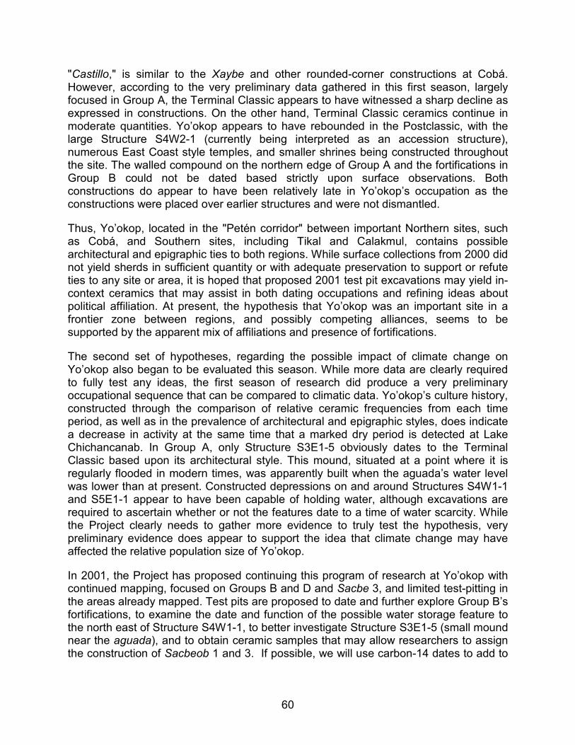
60
"Castillo," is similar to the Xaybe and other rounded-corner constructions at Cobá. However, according to the very preliminary data gathered in this first season, largely focused in Group A, the Terminal Classic appears to have witnessed a sharp decline as expressed in constructions. On the other hand, Terminal Classic ceramics continue in moderate quantities. Yo’okop appears to have rebounded in the Postclassic, with the large Structure S4W2-1 (currently being interpreted as an accession structure), numerous East Coast style temples, and smaller shrines being constructed throughout the site. The walled compound on the northern edge of Group A and the fortifications in Group B could not be dated based strictly upon surface observations. Both constructions do appear to have been relatively late in Yo’okop’s occupation as the constructions were placed over earlier structures and were not dismantled.
Thus, Yo’okop, located in the "Petén corridor" between important Northern sites, such as Cobá, and Southern sites, including Tikal and Calakmul, contains possible architectural and epigraphic ties to both regions. While surface collections from 2000 did not yield sherds in sufficient quantity or with adequate preservation to support or refute ties to any site or area, it is hoped that proposed 2001 test pit excavations may yield in-context ceramics that may assist in both dating occupations and refining ideas about political affiliation. At present, the hypothesis that Yo’okop was an important site in a frontier zone between regions, and possibly competing alliances, seems to be supported by the apparent mix of affiliations and presence of fortifications.
The second set of hypotheses, regarding the possible impact of climate change on Yo’okop also began to be evaluated this season. While more data are clearly required to fully test any ideas, the first season of research did produce a very preliminary occupational sequence that can be compared to climatic data. Yo’okop’s culture history, constructed through the comparison of relative ceramic frequencies from each time period, as well as in the prevalence of architectural and epigraphic styles, does indicate a decrease in activity at the same time that a marked dry period is detected at Lake Chichancanab. In Group A, only Structure S3E1-5 obviously dates to the Terminal Classic based upon its architectural style. This mound, situated at a point where it is regularly flooded in modern times, was apparently built when the aguada’s water level was lower than at present. Constructed depressions on and around Structures S4W1-1 and S5E1-1 appear to have been capable of holding water, although excavations are required to ascertain whether or not the features date to a time of water scarcity. While the Project clearly needs to gather more evidence to truly test the hypothesis, very preliminary evidence does appear to support the idea that climate change may have affected the relative population size of Yo’okop.
In 2001, the Project has proposed continuing this program of research at Yo’okop with continued mapping, focused on Groups B and D and Sacbe 3, and limited test-pitting in the areas already mapped. Test pits are proposed to date and further explore Group B’s fortifications, to examine the date and function of the possible water storage feature to the north east of Structure S4W1-1, to better investigate Structure S3E1-5 (small mound near the aguada), and to obtain ceramic samples that may allow researchers to assign the construction of Sacbeob 1 and 3. If possible, we will use carbon-14 dates to add to
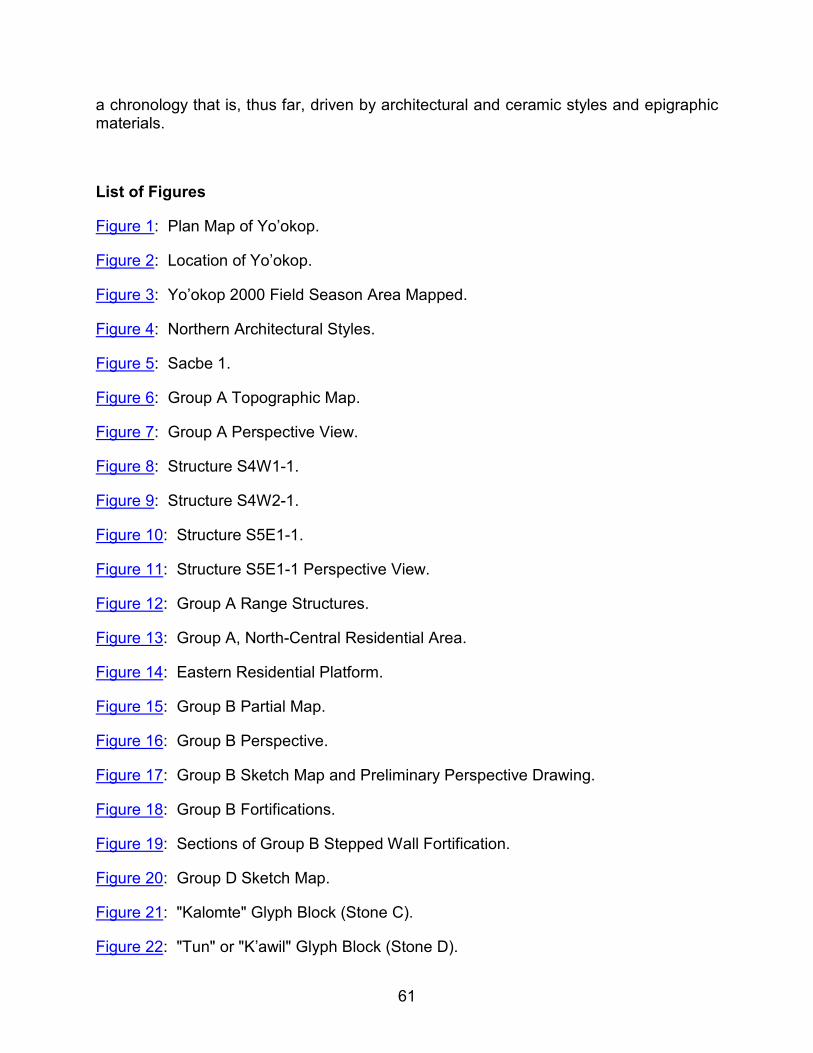
61
a chronology that is, thus far, driven by architectural and ceramic styles and epigraphic materials.
List of Figures
Figure 1: Plan Map of Yo’okop.
Figure 2: Location of Yo’okop.
Figure 3: Yo’okop 2000 Field Season Area Mapped.
Figure 4: Northern Architectural Styles.
Figure 5: Sacbe 1.
Figure 6: Group A Topographic Map.
Figure 7: Group A Perspective View.
Figure 8: Structure S4W1-1.
Figure 9: Structure S4W2-1.
Figure 10: Structure S5E1-1.
Figure 11: Structure S5E1-1 Perspective View.
Figure 12: Group A Range Structures.
Figure 13: Group A, North-Central Residential Area.
Figure 14: Eastern Residential Platform.
Figure 15: Group B Partial Map.
Figure 16: Group B Perspective.
Figure 17: Group B Sketch Map and Preliminary Perspective Drawing.
Figure 18: Group B Fortifications.
Figure 19: Sections of Group B Stepped Wall Fortification.
Figure 20: Group D Sketch Map.
Figure 21: "Kalomte" Glyph Block (Stone C).
Figure 22: "Tun" or "K’awil" Glyph Block (Stone D).
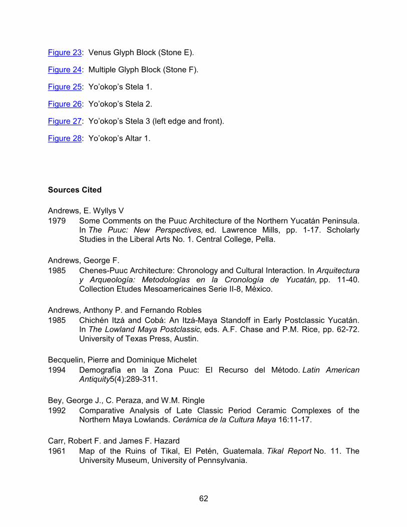
62
Figure 23: Venus Glyph Block (Stone E).
Figure 24: Multiple Glyph Block (Stone F).
Figure 25: Yo’okop’s Stela 1.
Figure 26: Yo’okop’s Stela 2.
Figure 27: Yo’okop’s Stela 3 (left edge and front).
Figure 28: Yo’okop’s Altar 1.
Sources Cited
Andrews, E. Wyllys V
1979 Some Comments on the Puuc Architecture of the Northern Yucatán Peninsula. In The Puuc: New Perspectives, ed. Lawrence Mills, pp. 1-17. Scholarly Studies in the Liberal Arts No. 1. Central College, Pella.
Andrews, George F.
1985 Chenes-Puuc Architecture: Chronology and Cultural Interaction. In Arquitectura y Arqueología: Metodologías en la Cronología de Yucatán, pp. 11-40. Collection Etudes Mesoamericaines Serie II-8, México.
Andrews, Anthony P. and Fernando Robles
1985 Chichén Itzá and Cobá: An Itzá-Maya Standoff in Early Postclassic Yucatán. In The Lowland Maya Postclassic, eds. A.F. Chase and P.M. Rice, pp. 62-72. University of Texas Press, Austin.
Becquelin, Pierre and Dominique Michelet
1994 Demografía en la Zona Puuc: El Recurso del Método. Latin American Antiquity5(4):289-311.
Bey, George J., C. Peraza, and W.M. Ringle
1992 Comparative Analysis of Late Classic Period Ceramic Complexes of the Northern Maya Lowlands. Cerámica de la Cultura Maya 16:11-17.
Carr, Robert F. and James F. Hazard
1961 Map of the Ruins of Tikal, El Petén, Guatemala. Tikal Report No. 11. The University Museum, University of Pennsylvania.
63
Contreras Arias, Alfonso
1958 Bosquejo Climatológico. In Los Recursos Naturales del Sureste y Su Aprovechamiento, volumen 2, ed. Enrique Beltran, pp. 93-158. Instituto Mexicano de Recursos Naturales Renovables, México.
Covich, Alan P.
1970 Stability of Molluscan Communities: A Paleolimnologic Study of Environmental Disturbance in the Yucatán Peninsula. Ph.D. Dissertation. Yale University. University Microfilms, Ann Arbor.
Covich, Alan and M. Stuiver
1974 Changes in Oxygen 18 as a Measure of Long-term Fluctuations in Tropical Lake Levels and Molluscan Populations. Limnology and Oceanography 19:682-691.
Curtis, Jason and David A. Hodell
1996 Climate Variability on the Yucatán Peninsula (México) During the Past 3500 Years, and Implications for Maya Cultural Evolution. Quaternary Research 46:37-47.
Dahlin, Bruce
1983 Climate and Prehistory on the Yucatán Peninsula. Climate Change 5:245-263.
1986 Reconstructing Ancient Maya Adaptive Patterns on the Northern Plains of Yucatán, México: 1986 Interim Report. Howard University, Washington.
2000 The Barricade and Abandonment of Chunchucmil: Implications for Northern Maya Warfare. Latin American Antiquity 11(3):283-298.
Demarest, Arthur A.
1993 The Violent Saga of a Maya Kingdom. National Geographic 18(2):94-111.
Drew, David
1999 The Lost Chronicles of the Maya Kings. University of California Press, Berkeley and Los Angeles.
Dunning, Nicholas
1991 Soils and Settlement in the Sayil Valley: A Preliminary Assessment. In The Ancient Maya City of Sayil: The Mapping of a Puuc Region Center, eds. J.A. Sabloff and G. Tourtellot, pp. 20-26. Middle American Research Institute Publication 60. Tulane University, New Orleans.
64
Faust, Betty Bernice
1998 Mexican Rural Development and the Plumed Serpent: Technology and Maya Cosmology in the Tropical Forest of Campeche, México. Bergin & Garvey, Westport.
Folan, William J.
1983a The Ruins of Cobá. In Cobá: A Classic Maya Metropolis. ed. William Folan, Ellen R. Kintz, and Laraine A. Fletcher, pp. 65-87. Academic Press, New York.
Folan, W.J, J. Gunn, J.D. Eaton and R.W. Patch
1983b Paleoclimatological Patterning in Southern Mesoamerica. Journal of Field Archaeology 10:453-467.
Freidel, David, Linda Schele, and Joy Parker
1995 Maya Cosmos: Three Thousand Years on the Shaman’s Path. William Morrow, New York.
Freidel, David and Charles Suhler
1999 The Path of Life. In Mesoamerican Architecture as a Cultural Symbol, ed. Jeff Karl Kawalski, pp. 250-273. Oxford University Press, Oxford.
1995 Termination Rituals: Implications for Maya War. Paper presented at the 1995 Palenque Mesa Redonda. Palenque, México.
Fry, Robert E.
1987 The Ceramic Sequence of South-Central Quintana Roo, México. In Maya Ceramics,eds. P.M. Rice and R.J. Sharer, pp. 111-122. BAR International Series 345, Oxford.
Gill, Richardson B.
1995 The Great Maya Droughts. Ph.D. Dissertation, University of Texas, Austin.
2000 The Great Maya Droughts. University of New Mexico Press, Albuquerque.
Greene Robertson, Merle
1998 Merle Greene Robertson’s Rubbings of Maya Sculpture. CD-ROM Volumes 1-11. Pre-Columbian Art Research Institute, San Francisco.
65
Grube, Nikolai
1994 Hieroglyphic Sources for the History of Northwest Yucatán. In Hidden among the Hills, Maya Archaeology of the Northwest Yucatán Peninsula, edited by Hanns J. Prem, pp. 316-358. First Maler Symposium, Bonn 1989, Acta Mesoamericana Volume 7, Verlag Von Flemming Möckmühl.
Harrison, Peter D.
1973 Precolumbian Settlement Distributions and External Relationships in Southern Quintana Roo, Part I: Architecture. In XL Congresso Internazionale Degli Americanisti.volume I, pp. 479-501. Casa Editrice Tilgher, Genova.
1979 The Lobil Postclassic Phase in the Southern Interior of the Yucatán Peninsula. InMaya Archaeology and Ethnohistory, eds. by N. Hammond and G.R. Willey, pp. 189-207. University of Texas Press, Austin.
1981 Some Aspects of Preconquest Settlement in Southern Quintana Roo, México. InLowland Maya Settlement Patterns, ed. by W. Ashmore, pp. 259-286. SAR, Albuquerque.
1982 Subsistence and Society in Eastern Yucatán. In Maya Subsistence: Studies in Memory of Dennis E. Puleston, ed. K. V. Flannery, pp. 119-130. Academic Press, New York.
1999 The Lords of Tikal: Rulers of an Ancient Maya City. Thames and Hudson, London.
Hodell, David, Jason H. Curtis, and Mark Brenner
1995 Possible Role of Climate in the Collapse of the Classic Maya Civilization. Nature375(1):391-394.
Inomata, Takeshi
1997 The Last Day of a Fortified Classic Maya Center. Ancient Mesoamerica 8(2):337-351.
Hodell, D.A., J.H. Curtis, G.A. Jones, A. Higuera-Gundy, M. Brenner, M.W. Binford, and K.T. Dorsey
1991 Reconstruction of Caribbean Climate Change Over the Past 10,500 Years. Nature352:790-793.
66
Johnstone, Dave
1998 Yaxuná Ceramics: Chronological and Spatial Relationships. Paper Presented at the 63rd SAA Meetings, Seattle.
1999 Ceramic Summary from 1997. In The Selz Foundation Yaxuná Project Final Report of the 1997 Season with Collected Papers. ed. J.M. Shaw and D.A. Freidel, pp.7. Department of Anthropology, Southern Methodist University, Dallas.
Killion, Thomas, Jeremy Sabloff, Gair Tourtellot, and Nicholas Dunning
1989 Intensive Surface Collection of Residential Clusters at Terminal Classic Sayil, Yucatán, México. Journal of Field Archaeology 16:273-294.
Kurjack, Edward B.
1974 Prehistoric Lowland Maya Community and Social Organization: A Case Study at Dzibilchaltún, Yucatán, México. Middle American Research Institute. Publication 38. Tulane University, New Orleans.
Leyden, Barbara W., Mark Brenner, and Bruce H. Dahlin
1996 A Record of Long- and Short-Term Climatic Variation from Northwest Yucatán: Cenote San José Chulchacá. In The Managed Mosaic: Ancient Maya Agriculture and Resource Use, ed. S.L. Fedick, pp. 30-49. Salt Lake City: University of Utah Press.
Leyden, B, M. Brenner, T. Whitmore, J.H. Curtis, D.R. Piperno, and B.H. Dahlin
1998 Cultural and Climatic History of Cobá, a Lowland Maya City in Quintana Roo, México.Quaternary Research 49:111-122.
Limbrey, Susan
1975 Soil Science and Archaeology. Academic Press, New York.
Lowe, John W.G.
1985 The Dynamics of Apocalypse: A Systems Simulation of the Classic Maya Collapse.University of New Mexico Press, Albuquerque.
Manahan, K., James Ambrosino, and Traci Ardren
1997 The Last Stand: Defensive Constructions at Yaxuná, Yucatán. Paper presented at the 62nd Annual Meetings of the Society for American Archaeology, Nashville, TN.
67
Martin, Simon
1997 The Painted King List: A Commentary on Codex-Style Dynastic Vases in The Maya Vase Book, a Corpus of Rollout Photographs of Maya Vases by Justin Kerr, Volume 5, pp. 846-867. Kerr Associates, New York.
Martin, Simon and Nikolai Grube
1994 Evidence for Macro-Political Organization Amongst Classic Maya Lowland States. Unpublished manuscript on file at Dumbarton Oaks Washington D.C., and University of Bonn.
1995 Maya Superstates. Archaeology 48(6)41-46.
Martos L., Luis Alberto
1997 Proyecto Arqueológico Fortín de Yokob. D.I.C.P.A. I.N.A.H.
Mason, G.
1927 Silver Cities of Yucatán. G.P. Putnam. New York.
Mayer, Karl Herbert
1987 Maya Monuments: Sculptures of Unknown Provenance, Supplement 1. Verlag von Flemming, Berlin.
Pollock, Harry E.D.
1965 Architecture of the Maya Lowlands. In Handbook of Middle American Indians: Volume 2, Archaeology of Southern Mesoamerica, ed. Gordon R. Willey, pp. 378-440. University of Texas Press, Austin, TX.
1980 The Puuc: An Architectural Survey of the Hill Country of Yucatán and Northern Campeche, México. Memoirs of the Peabody Museum of Archaeology and Ethnology Volume 19, Cambridge.
Potter, David F.
1977 Maya Architecture of the Central Yucatán Peninsula, México. M.A.R.I. Publication 44, Tulane University, New Orleans.
Ringle, William
1985 The Settlement Patterns of Komchen, Yucatán, México. UMI Dissertation Information Service, Ann Arbor.
68
Robles, J. Fernando
1990 La Sequencia Cerámica de la Región de Cobá, Quintana Roo. Serie Arqueología 184, INAH, México.
Robles, Fernando and Anthony P. Andrews
1986 A Review and Synthesis of Recent Postclassic Archaeology in Northern Yucatán, México. In Household and Community in the Mesoamerican Past, eds. R.R. Wilk and W. Ashmore, pp. 53-97. SAR, University of New Mexico Press, Albuquerque.
Robles Ramos, Ramiro
1958 Geologia y Geohidrologia. In Los Recursos Naturales del Sureste y Su Aprovechamiento, ed. Enrique Beltran, pp. 53-92. Instituto Mexicano de Recursos Naturales Renovables, México.
Roys, Ralph L.
1965 Lowland Maya Native Society at Spanish Contact. In Archaeology of Southern Mesoamerica, Part Two, ed. G.R. Willey, pp. 659-678. Handbook of Middle American Indians, Volume 3. University of Texas Press. Austin.
Sáenz, César A.
1972 Exploraciones y Restauraciones en Uxmal (1970-1971). INAH Boletin Epoca 2(2):31-40.
Sanders, William T.
1960 Prehistoric Ceramics and Settlement Patterns in Quintana Roo, México. Contributions to American Anthropology and History. no. 60. Washington.
Scarborough, Vernon
1993 Water Management in the Southern Maya Lowlands: An Accretive Model for the Engineered Landscape. In Economic Aspects of Water Management in the Prehispanic New World, eds. Vernon Scarborough and Barry L. Isaac, pp. 17-69. JAI Press, Greenwich.
1994 The Pre-Hispanic Maya Reservoir System at Kinal, Petén, Guatemala. Ancient Mesoamerica 5:97-106.
1998 Ecology and Ritual: Water Management and the Maya. Latin American Archaeology9(2):135-159.
69
Schele, Linda and David A. Freidel
1990 A Forest of Kings: The Untold Story of the Ancient Maya. William Morrow and Company, Inc., New York.
Schele, Linda and Peter Mathews
1998 The Code of Kings, The Language of Seven Sacred Maya Temples and Tombs.Scribner, New York.
Schele, Linda and Mary Miller
1986 The Blood of Kings, Dynasty and Ritual in Maya Art, Kimbell Art Museum, Fort Worth.
Sharer, Robert J.
1994 The Ancient Maya, Fifth Edition. Stanford University Press, Stanford, California.
Shattuck, George C.
1933 General and Miscellaneous Information About Yucatán. In The Peninsula of Yucatán,ed. G. Shattuck, pp. 5-27. Carnegie Institution of Washington, Washington.
Shaw, Justine M. and Dave Johnstone
1996 Core and Periphery Mapping during the 1995 Season. In The Selz Foundation Yaxuná Project Final Report of the 1995 Field Season. ed. D.A. Freidel, Department of Anthropology, Southern Methodist University, Dallas.
Siemens, Alfred
1979 Possible Karstic Constraints on Prehispanic Mayan Land Use and Transportation in the Southern Lowlands. In Actes du XLII Congrès International des Amèricanistes, Congrès du Centenaire, Volume VIII, pp. 373-388. Paris.
Smith, A. Ledyard
1972 Excavations at Altar de Sacrificios: Architecture, Settlement, Burials, and Caches.Papers of the Peabody Museum of Archaeology and Ethnology, Harvard University, volume 62, no. 2. Cambridge.
Smith, R.E., G.R. Willey, and J.C. Gifford
1960 The Type Variety Concept as a Basis for the Analysis of Maya Pottery. American Antiquity 25(3):330-340.
70
Stevens, Rayfred L.
1964 The Soils of Middle America and Their Relation to Indian Peoples and Cultures. InHandbook of Middle American Indians, volume 1: Natural Environment and Early Cultures, ed. R. C. West, pp. 265-315. University of Texas Press, Austin.
Stromsvik, Gustav, H.E.D. Pollock, and Heinrich Berlin
1955 Exploration in Quintana Roo. In Current Reports, Carnegie Institution of Washington, Department of Archaeology. no. 23. pp. 169-178.
Stuart, David, Nikolai Grube, and Linda Schele
1989 A Substitution Set for the "Ma Cuch/Batab" Title. Copán Note 58. Copán Acropolis Archaeological Project and Instituto Hondureño de Antropología e Historia, Copán.
Tamayo, Jorge and Robert C. West
1964 The Hydrography of Middle America. In Handbook of Middle American Indians, volume 1: Natural Environment and Early Cultures, ed. R.C. West, pp. 84-121. University of Texas Press, Austin.
Taube, Karl A.
1994 The Iconography of Toltec Period Chichén Itzá. In Hidden among the Hills: Maya Archaeology of the Northwest Yucatán Peninsula, edited by Hanns J. Prem, pp. 212-246. First Maler Symposium, Bonn 1989, Acta Mesoamericana Volume 7, Verlag Von Flemming Möckmühl.
Thomas, Prentice M., Jr.
1981 Prehistoric Maya Settlement Patterns at Becán, Campeche, México. Middle American Research Institute Publication 45. Tulane University, New Orleans.
Thompson, J. Eric S., H.E.D. Pollock, and J. Charlot
1932 A Preliminary Study of the Ruins of Cobá, Quintana Roo, México. Carnegie Institution of Washington, Publication 424. Washington D.C.
Varela Torrecilla, Carmen
2000 El Clásico Medio en el Noroccidente de Yucatán, BAR International series 739 Oxford.
Wagner, Elizabeth
1995 Thoughts on the chak-te- / kalom te- Title. Unpublished Manuscript circulated by the author, dated February 7, 1995.
71
Ward, William C. and James Lee Wilson
1976 General Aspects of the Northeastern Coast of the Yucatán Peninsula. In Carbonate Rocks and Hydrogeology of the Yucatán Peninsula, México, eds. A.E. Weidie and W.C. Ward, pp. 35-44. New Orleans Geological Society, New Orleans.
1985 Geology of Yucatán Platform. In Geology and Hydrogeology of the Yucatán and Quaternary Geology of the Northeastern Yucatán Peninsula, eds. W.C. Ward, A.E. Weidie, and W. Back, pp. 1-19. New Orleans Geological Society, New Orleans.
Webster, David
1979 Cuca, Chacchob, Dzonot Aké; Three Walled Northern Maya Centers. Occasional Papers in Anthropology No. 11. Department of Anthropology, Pennsylvania State University, University Park.
West, Robert C.
1964 Surface Configuration and Associated Geology of Middle America. In Handbook of Middle American Indians, volume 1: Natural Environment and Early Cultures, ed. R.C. West, pp. 33-83. University of Texas Press, Austin.
Whitmore, Thomas J., Mark Brenner, Jason Curtis, Bruce Dahlin, and Barbara Leyden
1996 Holocene Climatic and Human Influences on Lakes of the Yucatán Peninsula, México: An Interdisciplinary, Paleoclimnological Approach. The Holocene 6(3):273-287.
Willey, Gordon, William R. Bullard, Jr., John Glass, and James C. Gifford
1965 Prehistoric Maya Settlements in the Belize Valley. Papers of the Peabody Museum of Archaeology and Ethnology, Vol. 54. Harvard University, Cambridge.
Wilson, Eugene
1980 Physical Geography of the Yucatán Peninsula. In Yucatán: A World Apart. eds. E.H. Moseley and E.D. Terry, pp. 5-39. University of Alabama Press, Tuscaloosa.
Wilson, Reginald
1974 Okop: Antigua Ciudad Maya de Artesanos. INAH Boletín Epoca II:9:3-14.