Embed Size (px)
Citation preview

DEPARTMENT OF THE INTERIOR U.S. GEOLOGICAL SURVEY
Feasibility of a Nationwide Program for the Identification and Delineation of Hazards from Mud Flows and Other Landslides
Chapter A. Landslide Classification for Identification of Mud Flows and Other Landslides
Russell H. CampbelliMonty A. Hampton ,
by2 2 David J. Varnes , Robert W. Fleming
4 iDavid B. Prior , Dwight A. Sangrey , Donald R. Nichols , and Earl E. Brabb
Open-File Report 85-276A
Prepared in cooperation with the Federal Emergency Management Agency
This report is preliminary and has not been reviewed for conformity with U.S, Geological Survey editorial standards and stratigraphic nomenclature.
A U.S. Geological Survey, Reston, Virginia
3 U.S. Geological Survey, Menlo Park, California
U.S. Geological Survey, Denver, Colorado
Coastal Studies Institute, Louisiana State University, Baton Rouge, Louisiana
Department of Civil Engineering Carnegie-Mellon University Pittsburgh, Pennsylvania

Chapter A. Contents
Page
Introduction...........................................................A-l
Landslide Classification and Nomenclature..............................A-3
Transporting Mechanisms and Rates of Movement..........................A-4
Location and Geometry..................................................A-8
Materials..............................................................A-9
Moisture...............................................................A-10
Scar and Deposit Characteristics.......................................A-10
Damaging Forces and Effects in Floods, or in Mud Flows
and Other Landslides...............................................A-ll
Common Triggers........................................................A-12
Mud Flow, Mudflow, Mud Slide, and Mudslide.............................A-13
Landslide Disasters and "Noncatastrophic" Landslides...................A-17
Classification Factors and FEMA Programs...............................A-19
References.............................................................A-21
ILLUSTRATIONS
Figure A-l. Classification of slope movements.........................A-3a
Figure A-2. Relations of soil slips and debris flows to slope.........A-8a
Figure A-3. Relations of landslides in bedrock to slope..............,A-8b
Figure A-4. Relations of landslides in unconsolidated
materials to slope.................................................A-8c
Figure A-5. Flood and landslide phenomena: status under NFIP.........,A-15a
Figure A-6. Flood and landslide phenomena: mud flows
and other landslides...............................................A-16a
Plate A-l. Landslide classification, summary table............... In Pocket
Plate A-2. Landslide classes and recognition criteria............ In Pocket

Chapter A
LANDSLIDE CLASSIFICATION FOR IDENTIFICATION OF MUD FLOWS AND OTHER LANDSLIDES
by
R. H. Campbell, D. J. Varnes, R. W. Fleming, M. A. Hampton, D. B. Prior, D. A. Sangrey, D. R. Nichols, and E. E. Brabb
Introduction
The adoption and summary review of a widely accepted, systematic landslide classification is a necessary first step in the evaluation of the feasibility of a nationwide program to identify areas at risk from mud flows and other landslides. At the request of the Federal Emergency Management Agency (FEMA), a joint effort was undertaken by the U.S. Geological Survey (USGS) and the FEMA to address the needs of FEMA programs in flood insurance, disaster assistance and hazard mitigation. The report of the National Research Council (NRC) Committee on Methodologies for Predicting Mudflow Areas (1982) addressed FEMA concerns that floodplain maps do not identify areas of mud flow hazard for the purposes of the "mudslide" provisions of the National Flood Insurance Program (NFIP), and has indicated that "clear water floods, mud floods, mud flows, and other landslides" consitute a flood-landslide continuum. The NRC Committee addressed the distinction between floods and landslides, and identified mud floods as floods in contrast with mud flows as landslides, but did not address the distinctions between mud flows and other landslides. Discriminating between "mudslides (i.e., mudflows)" and other landslides remained a primary concern in the FEMA administration of the mudslide provisions of the NFIP. Mud flows and other landslides also pose a nationwide potential for disaster (causing major damage annually to 4/5 of the States of the U.S.) and are, therefore, also important to FEMA administration of programs in Disaster Assistance and Hazard Mitigation.
NFIP regulations treat floods and "mudslides (i.e., mudflows)" together, while addressing other landslides as different phenomena, even though many individual events display some properties common to all three. Consequently, evaluating the feasibility of nationwide identification of areas susceptible to "mudslides (i.e., mudflows)", and of areas susceptible to other landslides that might constitute a National disaster, requires addressing several questions:
o What hazardous conditions and natural processes are technicallyappropriate for inclusion under terras such as "floods", "mudslides", and "other landslides"?
o What levels of comprehensiveness and accuracy are required in delineating the potentially hazardous areas?
o What are the probable costs for different methods of identifying and delineating areas of potential hazards?
A - 1
o Can a methodology having a satisfactory level of comprehensiveness and accuracy be developed, that can be applied on a nationwide basis, for which the costs and schedules for completion are within reasonable bounds?
The actual selection of specific kinds of events to be included in a nationwide program of identifying mud-flow and other landslide hazards is a socio-political decision, as is the choice of standards for accuracy and comprehensiveness. On the other hand, technical expertise can provide a uniform descriptive terminology for adoption as an aid to consistency within and between technical and regulatory language regarding landslides. Technical analysis can also suggest options that permit the socio-political decisions to be made in a context that includes consideration of the "trade-offs" in accuracy, comprehensiveness, and costs of implementing hazard-identification programs.
Using an established classification system, the evaluation of the feasibility of a program to identify areas at risk from mud flows and other landslides can proceed to examine various methods that might be utilized in delineating landslide susceptibility, and to make some approximate estimates of their costs. In seeking that objective, technical aspects of the above questions have been addressed in a sequence of steps:
1. Adoption of a well-documented widely accepted classification system and systematic nomenclature specifically, that of Varnes (1978) as a basis for naming and describing various kinds of landslide processes (this chapter).
2. Selecting a number of landslide terms to represent the wide variety of kinds of landslides in the geologic-hydrologic continuum of slope and channel mass-transport events, and listing them in an array that reflects some consensus as to the relative proportion of wet flow among the mechanisms associated with each kind (this chapter).
3. Listing, with the above array, the general characteristics that might be used to recognize which class of landslide has occurred, the most common kinds of damage to be expected, and the most common triggering events. The array can then be considered as one of the means for correlating regulatory language regarding NFIP distinctions between mud flows and other landslides with technical aspects of recognition and classification. It can also be used to identify and describe the kinds of mud-flow and other landslide events that are most likely to result in disaster declarations, and those most likely to be associated with other disaster-causing events such as rainstorms, earthquakes, and volcanic eruptions. (Steps 1 through 3 are reported in this chapter, A.)
4. Summarize existing methods and capabilities for delineating areas of potential hazard from mud flows and other landslides, together with some preliminary estimates of the costs for their implementation (Chapter B.).
5. Identify obvious preliminary priority areas for landslide hazard identification and evaluation in the conterminous U.S., and discuss the methods by which priorities for the delineation of susceptibility to mud flows and other landslides can be addressed in more detail (Chapter C.).
A -2

6. Examine the economic value and the cost-effectiveness of utilizing regional topographic and geologic information as a basis for predicting where mitigation activities are most likely to be needed (Chapter D.).
To identify the hazardous conditions and events in a context that avoids inconsistencies between technical definitions and regulatory statements, requires agreement on terminology used in both administrative and technical definitions. For this report, the classification system of Varnes (1978) has been adopted because it is a widely accepted, well documented, systematic technical classification that is readily available as a published document. As such, it can be used in an interactive process of review and revision by both technical and administrative personnel, as well as a basis for further discussion of questions of comprehensiveness, accuracy, schedule, and cost.
Landslide Classification and Nomenclature
The evolution of landslide nomenclature (distinctive names for different kinds of events) has been largely unsystematic. The introduction of new terms has generally been a one-at-a-time reflection of new observations and physical measurements. Classification systems generally have been devised subsequent to the first uses of the names that appear in the classifications. Classification systems are generally erected with the purpose of examining the similarities and differences between events for systematic changes. Numerous landslide classifications have been devised by geologists and engineers. Several different systems have been widely used by different workers in different parts of the world, different parts of the U.S., and even by different workers in the same areas. Each system has been devised with a somewhat different perspective regarding the most important factors. One result has been that some similar events have been called by different names in different classification systems, and, conversely, different kinds of events have been called by similar names. Consequently, landslide class names and terms that are not referenced to some specific classification system can be uninformative and confusing. Popular media usage of terms such as "mudslide" also contributes to confusion in landslide nomenclature. The most comprehensive recent classification available, and one that also approaches nomenclature systematically, is that of D. J. Varnes (1978).
The technical terminology used in this report follows the classification described by Varnes 1 (1978) chapter on "Slope Movement Types and Processes" in Landslides - Analysis and Control, Transportation Research Board Special Report 176. Varnes 1 tabulation showing the general classes of slope movements is reproduced as Figure A-l. His classification and nomenclature give
Figure A-l. Near Here
primary consideration to the type of movement and secondary consideration to type of material. His systematic nomenclature utilizes names compounded of terms for mechanism of mass movement downslope and for the kind of material
A - 3

TYPE Of MOVEMENT
PALLS
TOPPLES
ROTATIONAL FEW
SLIDES WI<rS
TRANSLATIONAL ^CJ^ ~MANX
UNITS
LATERAL SPREADS
PLOWS
TYPE OP MATERIAL
BEDROCK
Rock fall
Rock topple
Rock slump
Rock block slide
Rock slide
Rock spread
Rock flow
(deep creep)
ENGINEERING SOILS
Predominantly coarse
Debris fall
Debris topple
Debris slump
Debris block slide
Debris slide
Debris spread
Predominantly fine
Earth fall
Earth topple
Earth slump
Earth block slide
Earth slide
Earth spread
Debris flow Earth flow
(soil creep)
COMPLEX Combination of two or more principal types of movement
Figure A-l. Classification of slope movements. (From Varnes, 1978)
A-3a

constituting the moving mass. The simple names in Figure A-l can be made progressively more detailed and informative by expansions using carefully- defined descriptor words. Where important components of complex landslides can be identified, names are compounded (e.g., slump-earth flow). Additional modifiers or special names can be used to describe rates of movement, wetness, and special triggering factors, if known. For a more comprehensive discussion and for references to original sources, the reader should consult Varnes 1 (1978) article and illustrated table, which is reproduced here as Plate A-l.
Plate A-l. Folded, In Pocket
For the purposes of this report, Varnes 1 orderly tabulation of types of movements and source materials has been revised to present an array that retains his broad grouping according to dominant type of movement, but separates wet flows and dry flows, and arranges landslide terms in order of decreasing general importance of wet flow as a component of the mechanism of movement (Plate A-2.). The array of Plate A-2 is intended to illustrate the
Plate A-2. Folded, In Pocket
similarities and differences that are of greatest concern to FEMA's National Flood Insurance Program (NFIP). The inclusion of common triggering events also assists in identifying the kinds of landslides most likely to involve the FEMA Disaster Assistance Programs. Most of the landslide classes listed in Plate A-2 are described and illustrated by Varnes (1978). Plate A-2 also includes field recognition criteria by which most of the factors critical to classification can be identified.
Transporting Mechanisms and Rates of Movement
Varnes (1978) describes landslide mechanisms using the terms "Falls, Topples, Rotational Slides, Translational Slides, Lateral Spreads, Flows, and Complex." The following summary descriptions have been excerpted or abstracted from Varnes, and the reader is referred to that paper for more detailed discussions together with references to usage of the terms by other workers:
Falls
Detached masses of any size move down steep slopes or cliffs with little or no shear displacement between the materials originally in contact, and descend mostly through the air by free fall, bouncing, or rolling.
A -4

Topples
The moving masses detach and pivot outward from the slopes about axes or points below the center of mass (commonly near their basal contacts with the stable parts of the slope), imparting overturning moments (out of the slope) to units of mass in motion, similar to earliest stages of rolling.
Slides
The detached masses remain in constant sliding contact with the underlying stable slope materials, with shearing movement taking place along the surface of contact. In many slides, chiefly those that move slowly over few irregularities in the basal slip surface, relative movement within the moving mass, if any, takes place on a relatively few internal shear surfaces that divide the mass into a relatively few discrete subunits. Many other slides, however, are greatly disrupted and consist of many individual units. The principal resistance to mass movement in slides results from frictional forces acting on the rupture surfaces.
Rotational Slides occur along surfaces of rupture that are curvedconcavely upward, imparting a backward (into the slope) tilt to the moving mass or its major subunits. Concave-upward rupture surfaces most commonly form within relatively homogeneous materials.
Translational Slides occur along rupture surfaces that are generally planar or gently undulatory. Planar rupture surfaces most commonly follow pre-existing discontinuities such as bedding planes, faults, joints, or the bedrock-regolith interface. The degree to which the moving mass is disrupted during displacement is commonly a function of the degree to which the rupture surface departs from the planar, and the distance the mass has moved.
Lateral Spreads
Flat to gently dipping translational displacement can result in overall extension (or "spreading") of detached, coherent masses, which move toward a free face on a basal shear surface or on subjacent material that has deformed by liquefaction or plastic flow. Spreading can also occur as a result of distributed shear in a mass of bedrock without evidence of a well-defined basal shear surface or zone of plastic flow.
Flows
Moving masses having internal differential movements that are distributed throughout the mass are termed "flows." In earth and debris masses the differential movements can be intergranular, and visible shear surfaces may not form; or differential movements can take place on closely spaced shear surfaces, some or all of which may be short-lived and heal without leaving clear evidence in the deposits. Movements in bedrock that may be described as a form of flow are extremely slow and distributed among many closely spaced fractures. Because wet flow and associations with flooding are important to FEMA's administration of the NFIP, flow mechanisms are
A - 5 .

here separated into "wet flow" or "dry flow." Wet flows are further subdivided depending on whether the moving masses consist of cohesive materials capable of retaining their water content during slow plastic deformation, or of non-cohesive materials from which water tends to drain relatively quickly, leaving a relatively stable deposit.
Flows (and flowlike movements) in Bedrock Flow movements in bedrock include deformations that are distributed among many large or small fractures, including microfractures, without the concentration of displacement along a through-going rupture surface. They may result in folding, bending, bulging, or other manifestations of plastic behavior, and the internal distribution of velocities may simulate that of viscous fluids.
Wet Flows (in earth and debris) In non-cohesive (relatively) flows,internal distribution of differential velocities varies systematically throughout the fluid mass. In cohesive (relatively) flows, the internal distribution of velocities resembles that of a plastic body in plug flow, and the moving masses are usually bounded by visible shear surfaces. Gradations between these cohesive and non-cohesive extremes include plug flows that are bounded by zones of distributed velocities rather than visible boundary shears, and that do not display internal slip surfaces.
In describing viscous fluids, the terms "Newtonian" and "non- Newtonian" are frequently used to describe differences in properties that affect flow rates.
Newtonian fluids are single-phase fluids having viscosities that are unique to a particular fluid composition at specified temperatures. Examples of Newtonian fluids are water, machine oil, honey, glycerine, and pitch. In Newtonian fluids, the flow rate varies inversely with viscosity and is a linear function of applied shear stress.
Non-Newtonian fluids include the polyphase fluids (such as mixtures of Newtonian fluids with solid particles or immiscible liquids) that behave as though their viscosities depend on the amount of admixed solid particles. Examples of non-Newtonian fluids are clay slurries, oil-well drilling muds, ketchup, paint, mustard, mayonnaise, wet concrete, natural mud flows and debris flows, and flowing lava. In non-Newtonian fluids, the flow rate of the material varies non-linearly with the shear stress, so that velocity and runout are difficult to predict.
Dry Flows Granular materials such as silt, sand, and fine gravel can flow downslope with internal distribution of velocities accommodated by grain-to-grain interaction, without the development of boundary or internal slip surfaces. Trapped or entrained air may provide an important fluidizing component, especially in the development of earthquake-triggered loess flows and in extremely rapid rock-fragment flows initiated as rock falls.
A -6

Complex
Slope movements that exhibit more than one of the major modes of movement are termed "complex." Nearly all landslides are complex to some degree, and "complex" is only rarely used in naming the landslide class. Different parts of a landslide mass can move by flowing and sliding simultaneously, or a single mass may move by toppling, falling, sliding, and flowing in sequence. Landslide class names generally serve to identify the dominant mechanism and material, with or without the addition of descriptor terms. In instances of major changes during the movement of a mass, where two or more kinds of movement can be clearly identified, terms are commonly hyphenated. For example, an extremely rapid rock- fragment (or debris) flow that begins as a rock fall from a high mountain cliff can be termed a "rock fall-debris flow" (or a "rock fall-debris avalanche"), or a rapid debris flow generated by a soil slip can be termed a "soil slip-debris flow."
Mechanisms and rates of movement are closely associated; however, most mechanisms operate over a range of rates that overlaps with the ranges of other mechanisms. Consequently, names that emphasize high or low rates of movement, such as "avalanche" or "creep," may not provide satisfactory information about the mechanism of movement. The rate scale used by Varnes (1978) includes:
Extremely Rapid..........10 ft/sec (3 m/sec) or greaterVery Rapid...............! ft/min (0.3 m/min) to 10 ft/secRapid....................5 ft/day (1.5 m/day) to 1 ft/minModerate.................5 ft/mo (1.5 m/mo) to 5 ft/daySlow.....................5 ft/yr (1.5 m/yr) to 5 ft/moVery Slow................1 ft/5yr (0.06 m/yr) to 5 ft/yrExtremely Slow...........less than 1 ft/5 yr
The rate of movement of any slide or flow can, of course, change quickly. Slides that move at rates described as moderate to slow are commonly at or near equilibrium between gravitational forces tending to drive the mass downslope and the frictional forces that resist sliding and/or internal deformation. Movement at rates described as moderate to very rapid commonly reflects sufficient disequilibrium so that rapid acceleration and deceleration can occur. An extreme example is provided by rapid debris flows that develop from soil slips in colluvial soils on steep hillsides. Creep in colluvial soils on hillsides is generally extremely slow and may be undetectable. When saturated as a result of heavy rainfall or rapid snowmelt, thin slabs of the material can fail as soil slips, with a relatively slow initial rate of movement. If the moisture content of the moving mass equals or exceeds the liquid limit of the saturated material, remolding caused by the slide movement can result in a change-of-state from a solid, sliding slab to a fluid slurry that moves by flow. The change-of-state to a fluid is accompanied by a sudden, drastic reduction in the frictional resistance to movement, so that even though the gravitational driving forces remain constant, the mass accelerates downslope and can reach very rapid speeds.
A - 7

Location and Geometry
The geometric forms of underlying slip surfaces and the steepness of the slopes where landslides originate and over which they move provide important limits on the kinds of transporting mechanisms, distance and rate of movement, and the degree of internal disruption of the materials in the moving masses. In addition, runout distances for debris flows and mud flows are greater for thicker (or deeper) flows, and depths can be maintained over relatively gentle gradients if the flows are confined within channels.
Slabs and blocks of bedrock or cohesive soil, for example, can move farther with less internal disruption over planar slip surfaces than over surfaces that are concave upward, such as are characteristic of rotational slides. In general, geologic discontinuities such as bedding planes, joints, and faults, that may serve as preexisting surfaces of weakness along which sliding can occur, tend to be planar in form. Consequently, landslides with slip surfaces along such discontinuities tend to be blocky or slabby in form, and may originate in areas having slopes that range from very steep to very gentle; the principal factor in determining the susceptibility to movement is the geometric relation between the orientation of the surfaces of weakness and that of the topographic slope.
For many kinds of landslides, hillslope steepness is a major factor in determining susceptibility to slope movement. Campbell (1980) presented generalized graphic representations of these relations, reproduced here as Figures A-2, A-3, and A-4. (Note that because the diagrams were developed for
Figure A-2. Near HereFigure A-3. Near HereFigure A-4. Near Here
an area where some kinds of landslides are not known to have occurred, the landslide classes represented are not comprehensive. Important landslide classes, such as quick clay flows, are missing because the diagrams apply only to a specific area that lacks quick clay flows.) Nearly all kinds of landslides are most common on slopes greater than 3:1 (18°); fewer, but still significant kinds of landslides originate on slopes greater than 5:1 (11°)and less than 3:1. Landslides that originate on slopes less than 5:1 generally require extremely weak materials or preexisting surfaces with low shear resistance; commonly, but not invariably, earthquake shaking or construction excavation serves to trigger their movement toward a free face.
Rainstorm-triggered soil slip-debris flow failures commonly originate on slopes steeper than 3:1, and deposition generally begins on slopes gentler than 5:1. Moreover, runout over slopes less than 5:1 of debris flows generated on steeper slopes above generally does not exceed a few hundred feet, except where flow is confined to a channel. (See fig. A-2 notes.)
A -8

&0
Ratio
Percent
Degrees
C
C
5
) -
)
Likelihood of
soil slips
Common effects
on flow velocity
from 45 to 55 . areas covered by coil mantle decrease in proportion to increasing areas of bare bedrock. Slopes steeper than about 55° are generally bare, and rockfalls (rather than soil slips) are the chief hazard.
Figure A-2. Relation of soil slips and debris flows to slope.(From Campbell, 1975)
Note: According to an inventory by D. M. Morton (written communication, 1975) of soil slips that occurred during the heavy rainstorms of the 1969 winter season in the area adjacent to the Santa Clara River Valley, Ventura County, California, there were a total of 32,730 individual scars counted in an area of about 550 mi (about 10.5 7-1/2 min quadrangles). The slope interval for each was identified from slope maps that had been prepared by photomechanical methods from the topographic quadrangles. The results are tabulated below:
Slope Interval (percent)
0-20% 20-33% 33-50% 50-67%67% +
No. of scars
126812
2,3904,978
24,424
Percentage of total scars
0.4%2.5%7.3%15.2%74.6%
The figures above have not been adjusted for local irregularities in the slope intervals. Examinations of selected scars in the low slope intervals (0-20%, 20-30%) show that many are headed on slopes that are locally steeper than the slope interval on the map.
A-8a

CL oV)
Ratio
Percent
Degrees
Sk>p« failures
»n bedrock.
Figure A-3. Relation of landslides in bedrock to slope. (From Campbell, 1980)
(Note that because this figure was developed for landslides in a small part of southern California, it is not comprehensive with respect to all landslide classes in the United States.)
A-8b

Ratio
Percent
Degrees
Slope failures
in unconsofid-
afed deposits.
Figure A-4. Relation of landslides in unconsolidated material to slope.(From Campbell, 1980)
(Note that because this figure was developed for landslides in a small part of southern California, it is not comprehensive with respect to all landslide classes in the United States.)
A-8c

Materials
Varnes (1978) adopted four terms to describe material involved in slope movements "bedrock" and "engineering soils r " with "debris" and "earth" as subsets of engineering soils:
1. Bedrock designates hard or firm rock that was intact and in its natural place before the initiation of movement.
2. Engineering soil includes any loose, unconsolidated or poorly cemented aggregate of solid particles, generally of natural mineral, rock, or inorganic composition and either transported or residual, together with any interstitial gas or liquid. Natural soils may contain variable amounts of organic material.
a. Debris refers to an engineering soil, generally surficial, that contains a significant proportion of coarse material. "Debris" may be used to specify material in which 20 to 80 percent of the fragments are greater than 2 mm (0.08 in) in size, and the remaining fragments less than 2 mm.
b. Earth connotes material in which about 80 percent or more of the fragments are smaller than 2 mm; it includes a range of rock and mineral fragments from nonplastic sand to highly plastic clay.
During landslide movement, slope materials are subjected to different degrees of internal disruption; therefore, those parts of landslide class names that describe materials can change as the mass moves downslope. Falling bedrock blocks can be broken by impact and bouncing into mixtures of rock fragments appropriately termed "debris." Engineering soils (including debris) can be disrupted by discrete slip surfaces into blocks, or they may become completely disaggregated into their constituent particles. Some special kinds of parent materials can be altered in place by dynamic shaking during an earthquake. For example, some layers of wet sand can undergo liquefaction and flow, causing "sand boils", and dry loess (wind-deposited silt and sand) with porous structure may collapse into dry flow.
1. In distinguishing debris flows from mud flows, Varnes (1978) restricts the term "mud flow" for rapidly moving, wet earth flow that contains at least 50 percent fragments smaller than 2 mm, whereas "debris flow" denotes a rapidly moving earth flow that contains more than 50 percent fragments coarser than 2 nun in size. It should be noted, however, that both "debris flow" and "mudflow" have been used in a broader sense (e.g., Sharp and Nobles, 1953, Middleton and Hampton, 1973, and Campbell, 1975) to refer to flowing slurries with more regard for their flow and depositional characteristics than to their proportional contents of rock fragments coarser than coarse sand size (2 nun).
A - 9
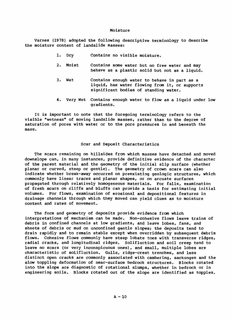
Moisture
Varnes (1978) adopted the following descriptive terminology to describe the moisture content of landslide masses:
1. Dry Contains no visible moisture.
2. Moist Contains some water but no free water and may behave as a plastic solid but not as a liquid.
3. Wet Contains enough water to behave in part as aliquid, has water flowing from it, or supports significant bodies of standing water.
4. Very Wet Contains enough water to flow as a liquid under low gradients.
It is important to note that the foregoing terminology refers to the visible "wetness" of moving landslide masses, rather than to the degree of saturation of pores with water or to the pore pressures in and beneath the mass.
Scar and Deposit Characteristics
The scars remaining on hillsides from which masses have detached and moved downslope can, in many instances, provide definitive evidence of the character of the parent material and the geometry of the initial slip surface (whether planar or curved, steep or gentle). The geometry of crown scars can also indicate whether break-away occurred on preexisting geologic structures, which commonly have linear traces and planar shapes, or on arcuate surfaces propagated through relatively homogeneous materials. For falls, examination of fresh scars on cliffs and bluffs can provide a basis for estimating initial volumes. For flows, examination of erosional and depositional features in drainage channels through which they moved can yield clues as to moisture content and rates of movement.
The form and geometry of deposits provide evidence from which interpretations of mechanism can be made. Non-cohesive flows leave trains of debris in confined channels at low gradients, and leave lobes, fans, and sheets of debris or mud on unconfined gentle slopes; the deposits tend to drain rapidly and to remain stable except when overridden by subsequent debris flows. Cohesive flows commonly have steep lobate toes with transverse ridges, radial cracks, and longitudinal ridges. Solifluction and soil creep tend to leave no scars (or very inconspicuous ones), and small, multiple lobes are characteristic of solifluction. Gulls, ridge-crest trenches, and less distinct open cracks are commonly associated with cambering, sackungen and the slow toppling deformation of near-surface bedrock structures. Blocks rotated into the slope are diagnostic of rotational slumps, whether in bedrock or in engineering soils. Blocks rotated out of the slope are identified as topples.
A -10

The internal fabric of the deposits generally provides diagnostic evidence by which mud-flood and mud-flow origins can be distinguished; however, the depositional landforms and the geologic settings of the deposits can also be of assistance in recognizing the mechanism of emplacement. Matrix-supported conglomerates in bodies with lobate fronts or as steep "alluvial" fans at the mouths of small, steep drainage basins indicate debris-flow origin; internal bedding lamination, graded bedding, and a relatively flat "floodplain" with an incised channel indicate that a flood or mud flood is the origin. Of course, mud flows and mud floods can both occur in mountain canyons and some "alluvial" fans include both mud-flow and mud-flood deposits; where this can occur, a careful field examination can generally yield diagnostic evidence. Where soil slip-debris flow events have occurred recently enough so that the scars remain visible, the likelihood that debris deposits downslope or downstream were emplaced by debris-flow mechanisms is high. However, the rapid obliteration of scars by new vegetation and the rapid regeneration of colluvial soils on slopes causes the absence of scars to be of virtually no value as evidence that debris-flow activity has not occurred. The principal evidence for past debris flows is provided by the debris-flow deposits, most of which remain recognizable for thousands of years, even if dissected and partly removed by major stream erosion or human construction activity.
The nomenclature of the principal features of landslide scars and deposits is illustrated for a slump-earth flow in Figure 2.It on Plate A-l. The names are adaptable to nearly all kinds of landslides, although terms like "main body", "head", and "toe" become much more obscure when applied to flows that have moved completely out of the vicinity of their crown areas. The distances between crown scars and displaced masses (from a few feet for small rotational slumps to a few miles for some large debris flows) provide indications of the rates of movement and the sizes of the areas having a potential for hazard from recurrences of the events.
Damaging Forces and Effects in Floods, Mud Flows, and other Landslides
A standard nomenclature needs to be developed and adopted to describe the effects of various events on structures. Several terms are suggested here, some of which apply to effects of both floods and landslides.
Inundation (that is, immersion of an object in a fluid) is a principal cause of damage from floods, and debris/mud flows. Damage is caused by physical and chemical changes in materials that are ordinarily dry protected from wetting by foundations below and by roof structures above.
Drag, the frictional and differential pressure forces acting on objects in moving streams of viscous fluids, can cause damage to structures surrounded by flowing water, mud, or debris by displacing them laterally from their foundations.
Buoyancy, the lifting force that tends to cause structures to float off their foundations, is another effect that is shared by floods and mud flows.
A - 11

Burial or partial burial by the deposition of sediment occurs from both floods and mud flows, but is also an effect of other landslides.
Lateral pressure is built up when mud or debris pushes against one side of a structure, whether from mud flows or debris flows, or at the toes of active slides. Rapidly flowing, turbulent floods can also develop lateral hydraulic forces.
Lateral impact by a fast-moving debris flow poses a destructive capability from the momentum of relatively small masses. Lateral impact from boulders, trees, and other objects carried by floods is accompanied by the hydraulic effects of deep, fast-flowing water. Lateral impact can also result from other fast-moving landslides such as debris slides and rock falls.
Impact from above requires steep slopes (or gradients). Rock and debris falls and topples are the most common sources of these impacts; however, debris flows in some mountain areas have become air-borne by flow over cliffs, and have impacted structures from above.
Foundation failure refers to the adverse effects on structures from tilting, shearing (both laterally and vertically), and pulling apart of the earth materials on which structures are founded, where a structure is founded astride the boundary of a landslide, or astride the boundaries of individual blocks that move differentially within a landslide.
Common Triggers
Landslides can be triggered during readily identified exogenous events such as earthquakes, heavy rainstorms or rapid snowmelt, volcanic eruptions, and other landslides. However, the details of the triggering mechanisms are sometimes not clearly defined by simple association with such events. Earthquake shaking imparts cyclical changes in loading on slope materials and can also cause liquefaction of susceptible materials. Heavy rainstorms and rapid snowmelt tend to raise pore fluid pressures at shallow depths, as does rapid melting of snow and ice during volcanic eruptions. These dramatic events may be associated with other adverse effects, both direct and indirect. Rainstorms may be associated with floods as well as landslides. Earthquake shaking can directly affect structures, cause liquefaction in low- lying areas, and trigger landslides on slopes; if the slope materials are saturated, some masses may move as flows. Landslides also result from the cumulative effects of less obvious e.vents such as wedging by freeze-thaw or shrink-swell cycles, root wedging, animal burrows, tectonic uplift, undercut/surcharge by natural erosion and deposition, undercut/surcharge from construction activity, and thaw of ice-bearing soils (permafrost). Rising ground water level is an important variable triggering factor that may be ephemeral over a short term during a single rainstorm, or moderate to long- termed, from the cumulative rainfall of several storms or a season. The toes of large, slow moving landslides may become oversteepened and fail as small slumps and slides which, if sufficiently wet, can change to flows.
A -12

Mud Flow, Mudflow, Mud Slide, and Mudslide
The definitions that presently guide administration of the National Flood Insurance Program, as published in Title 44, Code of Federal Regulations (1983, p. 167-173), include:
"Flood or Flooding means:
(a) A general and temporary condition of partial or complete inundation of normally dry land areas from:
(1) The overflow of inland or tidal waters.(2) The unusual and rapid accumulation or runoff of surface
waters from any source.(3) Mudslides (i.e., mudflows) which are proximately caused or
precipitated by accumulations of water on or under the ground.
(b) The collapse or subsidence of land along the shore of a lake or other body of water as a result of erosion or undermining caused by waves or currents... or by an unanticipated force of nature, such as a flash flood or an abnormal tidal surge, or by some similarly unusual and unforeseeable event which results in flooding..."
"Mudslide (i.e., mudflow) describes a condition where there is a river, flow or inundation of liquid mud down a hillside usually as a result of a dual condition of loss of brush cover, and the subsequent accumulation of water on or under the ground preceded by a period of unusually heavy or sustained rain. A mudslide (i.e., mudflow) may occur as a distinct phenomenon while a landslide is in progress, and will be recognized as such... only if the raudflow, and not the landslide, is the proximate cause of damage that occurs."
Ambiguities, inaccuracies, and inconsistencies attend attempts to reconcile the foregoing regulatory definitions with established technical classification systems and descriptive terminology. The historic technical usage of "mud slide" or "mudslide" refers to phenomena that are significantly different from those described above as "mudslide (i.e., mudflow)." The assertion in the regulatory definitions that heavy rainfall and absence of brush cover are usual conditions for the occurrence of "mudslides (i.e., mudflows)" is inaccurate. Neither rainfall nor absence of brush cover are requisite conditions for the formation of mud flows, which begin on well- vegetated slopes at least as commonly as on slopes that have lost brush cover, and mud flows occur in association with snowmelt as well as rainfall; nor is either of those conditions required for the initiation of a mud slide. The sense in which "inundation" is used seems to be as a synonym for "river or flow", rather than as a criterion for the kind of damage to be insured; but it is significant to note that inundation is only one of several common kinds of damaging effects that can be inflicted on a structure by a mud flow; and
A -13

inundation is not at all common as a direct result of a mud slide. (For a more complete discussion of the legislative and regulatory background regarding this problem, see p. 5-10 in National Research Council, 1982.)
To conform with the systematic nomenclature of Varnes 1 (1978) classification, both "mudslide" and "mudflow" should be written as two words, i.e., "mud slide" and "mud flow." Both one-word and two-word forms have been used, historically, without any intent or connotation of scientific distinction, and are virtually interchangeable with regard to technical usage. Although the rules of the GPO Style Manual (1967, p. 73-130) indicate a preference for the one-word compound form, the usage of this report follows the two-word nomenclature of the systematic classification, except where the accuracy of a quotation or direct reference requires otherwise.
Mud Flow (see Plate 1, drawings 2.1r2 and 2.1r3), in the strict sense ofVarnes (1978) classification, denotes a very slow to very rapid, wet flow of cohesive or noncohesive earth material composed of at least 50 percent grains smaller than 2 mm. In a broader sense, mud flow has been used to include phenomena ranging from slurry flows of noncohesive earth material having more than 50 percent grains larger than 2mm (e.g., Sharp and Nobles, 1953; Morton and Campbell, 1974) to very slow, plastic flows of cohesive earth material (e.g., Howe, 1909; Skempton and Hutchinson, 1969, p. 295). In Soviet literature, according to Varnes (1978, p. 19), mud flow is used to include heavily laden flows of water-transported sediment (mud floods), as well as (non-Newtonian) slurry flows of mud or debris.
The Committee on Methodologies for Predicting Mudflow Areas (National Research Council, 1982), adopted a sensu lato usage of "mud flow" that excluded mud floods, but included all flows having sufficient viscosity (by virtue of sufficient wet mud matrix) to support large boulders, regardless of the relative proportion of matrix mud to larger debris particles. The phenomena identified by this sensu lato usage of "mud flow" include those identified as mud flows, debris flows (including as used in the literature of sedimentology: e.g., Middleton and Hampton, 1973), slow earth flows (mud slides), quick clay flows, and other landslides for which wet flow is a significant component of the mechanism.
Virtually all slurry flows of noncohesive earth material that originate on hillslopes in association with heavy rainfall or flooding contain sufficient coarse earth material to fall within the scope of the sensu stricto use of "debris flow". Only rarely is coarse detritus absent to a degree that makes the sensu stricto use of "mud flow" appropriate for naturally occurring, subaerial slurry flows.
Varnes (1978) includes wet, rapidly moving earth flows in the sensu stricto class of mud flows, regardless of cohesiveness. However, slow plastic flows of cohesive earth material having 50 percent or less grains smaller than 2 mm, are more commonly termed "earth flows" (see Reefer and Johnson, 1983, p. 4), or "mud slides" (Hutchinson and Bhandari, 1971);
Mudflow has been used in technical literature to cover the same range ofphenomena as has the two-word term, mud flow, and the two forms should be
A - 14

considered interchangeable. The compound one-word form, raudflow, is preferred by the GPO Style Manual (1967), and is the form used in the regulations of the National Flood Insurance Program. For this report, however, in the interest of consistency with the systematic nomenclature of the Varnes (1978) classification, the preferred usage is the two-word term, mud flow.
Mud Slide denotes a generally slow-moving mass of softened clayey material which advances chiefly by sliding on discrete basal and lateral boundary shear surfaces (Hutchinson and Bhandari, 1971) . Moving mud-slide masses are internally deformed by plastic flow which may take place on internal shear surfaces. In U.S. technical literature, these features more commonly have been termed "earthflows" (Crandell and Varnes, 1961), or "earth flows" (Reefer and Johnson, 1983), as illustrated by diagrams 2.1r3, 2.1s5, and 2.It on Plate 1. The definitions seem to exclude noncohesive flows of debris and mud, except as such flows might develop from a mud slide. However, mud slides are included within the range of phenomena described by the sensu lato usage of the term mud flow, and are not excluded by the sensu stricto usage of the term.
The one-word compound, "mudslide, is the form used by Hutchinson and Bhandari (1971), who ascribe first usages to Fleming (1878) and Cailleux and Tricart (1950). (It should be noted that the abstract in English that accompanies the article by Cailleux and Tricart, 1950, uses the two-word form, mud slide.) Brunsden (1984) has recently summarized the history of the terminology (but not the compounding) and many technical aspects of mudslides; he consistently uses the one-word compound.
Mudslide is the specific compound word form used in the Housing and Urban Development Act of 1969, P.L. 91-152, Sec. 409 (a), which amended the National Flood Insurance Act of 1968 (42 U.S. Code, 1983, sec. 4001 (f)).
Until recently, in most of the United States, "mudslide" has been regarded as an imprecise popular (nontechnical) term, frequently used by the news media to refer to a wide scope of events, ranging from debris-laden floods to many kinds of wet rotational and translational slides, and even including some wet rock-fall events. Both the one-word and two-word compound forms have been used in the technical literature; however, to be consistent with the systematic nomenclature of Varnes (1978) classification system, the usage of this report gives preference to the two-word form, mud slide.
The report of the Committee on Methodologies for Predicting Mudflow Areas (National Research Council, 1982) identified the kinds of events that should be termed "mud flows" as transitional from "mud floods", at the wet-flow end of a gradational continuum, from "other landslides", at the drier end. Figure A-5, reproduced from that report, illustrates the distinctions. The Committee
Figure A-5., Near Here
A -15
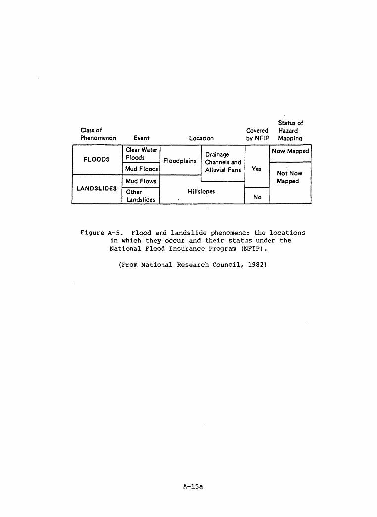
Class of Phenomenon Event Location
Status ofCovered Hazard byNFIP Mapping
FLOODS
LANDSLIDES
dear Water Floods
Mud Floods
Mud Flows
Other Landslides
FloodplainsDrainage Channels and Alluvial Fans
Hillslopes
Yes
No
Now Mapped
Not Now Mapped
Figure A-5. Flood and landslide phenomena: the locations in which they occur and their status under the National Flood Insurance Program (NFIP).
(From National Research Council, 1982)
A-15a

described those distinctions as follows:
"The key characteristic in differentiating between mud floods and mud flows is that a mud flow possesses a combination of density and strength that will support inclusions of higher density than water, such as boulders, both during transport and when the mass comes to rest. The ability to support an inclusion during transport stems from a velocity- dependent strength (the matrix viscosity) and a velocity-independent strength (the shearing resistance of the mass). When the flow comes to rest, the velocity-dependent strength goes to zero. However, ...(if a) high density inclusion does not sink in the mass (at rest,) ... it is supported by ... static shearing resistance. A mud flood ... does not have static shearing resistance. Transport of inclusions is possible only because of the strength provided by the motion of the fluid. When the fluid velocity goes to zero, the strength also goes to zero and the supporting capability of the mass is lost. All inclusions of higher density than the fluid (water, in roost cases) then sink at Stokes* Law rates that depend on the viscosity of the fluid."
The foregoing criteria serve to distinguish mud flows from mud floods within the continuum of natural processes represented by "clear water floods, mud floods, mud flows, and other landslides" on Figure A-5, and clearly uses "mud flow" in a sensu lato context. Using a standardized terminology, referenced to the systematic technical landslide classification of Varnes (1978), the "mud flows" and "other landslides" parts of that continuum can be further subdivided. Figure A-6 is an adaptation of the format of Figure A-5.
Figure A-6., Near Here
The right-hand column of Figure A-6, titled "NFIP Coverage", reflects our interpretation of how events described by technical terminology derived from the Varnes (1978) classification (as listed in the column headed "Usage, This Report") would correlate with the present language of NFIP regulations regarding coverage for "mudslides, i.e., mudflows". It does not represent a recommendation as to whether or not specific kinds of events should be insured.
The array shown in Figure A-6 illustrates that debris flows and noncohesive mud flows, in the technical terminology adopted for this report, clearly correlate with the mud flow part of "mud flows and other landslides" in the usage of the 1982 NRC report, indicating that these kinds of landslides would appear to be covered.
Wet cohesive flows such as earth flows and mud slides fall into an equivocal category. They are included as mud-flow phenomena because, although they commonly show evidence of movement by sliding, elements of internal wet flow are essential to their mechanism of movement. Most wet slides are also considered equivocal because, although wet flow is not an essential element of their mechanism of movement, wet flow can be a significant element in their mechanisms, depending on local, sometimes ephemeral factors; moreover, their
A - 16
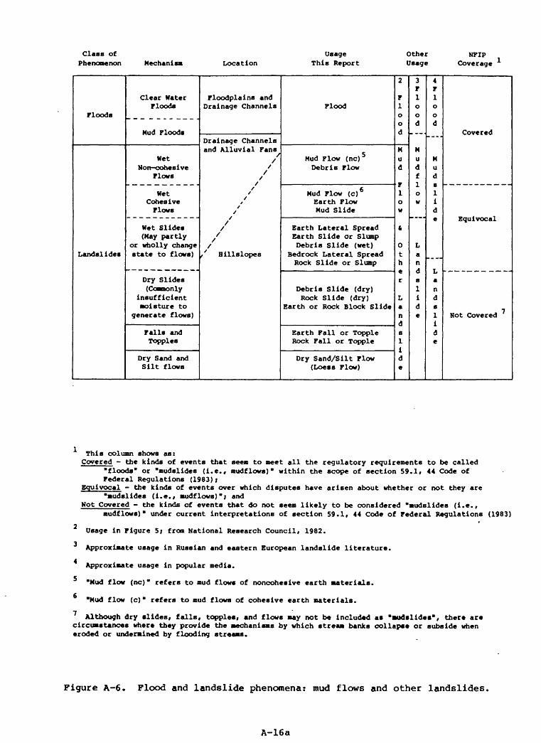
Class of Phenomenon Mechanii Location
Usage This Report
Other Usage
NFIP Coverage
Floods
Landslides
Clear Water Floods
Mud Floods
Wet Non-cohesive
Flows
Wet Cohesive Flows
Wet Slides (May partly
or wholly change state to flows)
Dry Slides (Coamonly
insufficient moisture to
generate flows)
Falls and Topples
Dry Sand and Silt flows
Floodplains and Drainage Channels
Drainage Channelsand Alluvial Fans
/ /
/ /
/ // /
/ t / /
/
//
// Hillslopes
Flood
Mud Flow (nc) 5 Debris Flow
Mud Flow (c) 6 Earth Flow Mud Slide
Earth Lateral Spread Earth Slide or Slump Debris Slide (wet)
Bedrock Lateral Spread Rock Slide or Slump
Debris Slide (dry) Rock Slide (dry)
Earth or Rock Block Slide
Earth Fall or Topple Rock Fall or Topple
Dry Sand/Silt Flow (Loess Flow)
2
F 1 oo d
Mu d
F 1 0w
fc
Ot h
r
La n rt8
1
i
de
3F 1 Ood
Mu d f1o w
La nd8
1
i
de
4F 1 o od
_ _- .
Mu d
1 i d
La n d8
1
I
d
e
Hot Covered
This column shows as: Covered - the kinds of events that seem to meet all the regulatory requirements to be called
floods" or "mudslides (i.e., mudflows)" within the scope of section 59.1, 44 Code of Federal Regulations (1983)*
Equivocal - the kinds of events over which disputes have arisen about whether or not they are mudslides (i.e., mudflows)*} and
Not Covered - the kinds of events that do not seem likely to be considered "mudslides (i.e.,mudflows)" under current interpretations of section 59.1, 44 Code of Federal Regulations (1983)
2 Usage in Figure 5; from National Research Council, 1982.
Approximate usage in Russian and eastern European landslide literature.
Approximate usage in popular media.
Mud flow (nc)" refers to mud flow* of noncohesive earth materials.
Mud flow (c)" refers to mud flows of cohesive earth materials.
7 Although dry slides, falls, topples, and flows may not be included as "Mudslides", there are circumstances where they provide the mechanisms by which stream banks collapse or subside when eroded or undermined by flooding streams.
Figure A-6. Flood and landslide phenomena: mud flows and other landslides,
A-16a

activity can give rise to wet flows. Indeed, although many of the "other landslides" generally lack sufficient moisture to initiate flows, they can contain sufficient moisture and contribute to the development of flows.
At the dry extreme of the landslide continuum, dry sand and silt flows, dry earth falls and topples, dry rock falls and topples, dry rock block slides, dry rock slides, and dry debris slides would seem to be excluded from NFIP coverage by a general absence of wet flow among the mechanisms involved with their movement. However, even though Figure A-6 shows dry slides, dry falls, dry topples, and dry flows to be excluded from coverage because they are not, themselves, "mudslides", it should be noted that many, relatively dry, kinds of landslides can be initiated in association with flooding. Landslides are common forms of erosion along the banks of streams, rivers, lakes, and reservoirs. Banks and shoreline materials can be undercut by flood currents and waves, leading to their collapse or subsidence by landslide processes. High water levels in flooding streams, lakes, and reservoirs cause ground-water levels to rise in adjacent earth materials, reducing their internal resistance to failure by landslide processes. Although many relatively dry landslides triggered in this way do not appear to meet the criteria of Figure A-6 for coverage as "mudslides", some could occur in circumstances where questions about NFIP coverage under other parts of the definition for "flood or flooding" (44 Code of Federal Regulations, sec. 59.1, p. 169) might be raised for further consideration.
Landslide Disasters and "Noncatastrophic" Landslides
Landslides are events that occur throughout the range between sudden and catastrophic at one extreme and slow and insidious at the other. Landslide disasters are commonly associated with exogenous triggering events such as major earthquakes, rainstorms, or rapid snowmelt. The triggering event may cause additional damage from earthquake shaking or flooding, and landslide effects may not be readily separable from such other effects without intensive study. The identification of areas in which there is some potential for landslide disaster can be achieved by delineating areas susceptible to landslide (including debris flow and mud flow) hazards during non-disaster conditions, and combining that evaluation with information on the relative potential for levels of seismic shaking or rainfall intensity and duration that are capable of triggering landslides.
The following list of some 20th century landslide disasters in the U.S. is not comprehensive, but can serve as a general representation:
o 1906 Numerous "flow-slides" and other landslides were triggered in the San Francisco Bay Region by the great earthquake, which also caused liquefaction in the wet lowlands of the area (Youd and Hoose, 1978).
o 1853(?), 1874, 1936, 1958 Giant waves, as much as 1,720 feet high in the 1958 event, generated in Lituya Bay, southeastern Alaska, by large landslides, probably triggered by earthquakes (Miller, 1960).
o 1964 The great earthquake in Alaska triggered major damaging landslides over a vast area of south-central Alaska. Submarine landslides at Seward,
A -17
Valdez, and Whittier generated large local waves that added to the destruction already caused by the shaking and landslides (Eckel, 1970).
1969 Most of the 150 people killed in central Virginia during the Hurricane Camille "flood" died from blunt-force injuries rather than by drowning. Debris supplied by the numerous debris flow avalanches caused by the heavy rain, is believed to have been the instrument of injury (Williams and Guy, 1973).
1969 "Mudslides" (in this instance determined to be soil slip-debris flows) in southern California killed 20 people in the course of two intense rainstorms. Campbell (1975) noted that all 20 fatalities were caused by a total of 10 soil slip-debris flow events that originated in chaparral-, sagebrush-, and grass-covered slopes. Even though mud floods and mud flows were also generated in recently burned parts of the San Gabriel Mountains, resulting in great damage on the alluvial fans along the south flank of the range, much damage and all of the fatalities resulted from flows that originated on unburned slopes having natural or landscaped vegetation cover.
1971 Damaging landslides triggered by the San Fernando earthquake, southern California, caused major losses at the San Fernando Reservoirs, Juvenile Hall, Olive View, and Camp Holton localities, as well as hundreds of debris slides on the slopes of the San Gabriel Mountains (Yerkes, 1973).
1972 Three coal-refuse impoundments at Buffalo Creek, West Virginia, failed during heavy rains, forming a debris flow or mud flood that traveled 24 km downstream, killing 125 people and leaving 4,000 homeless (Davies and others, 1973).
1978 Two major rainstorms triggered destructive debris flows and also caused extensive flooding in southern California. Storm-triggered landslide damage in the City of Los Angeles, alone, was estimated at $50 million (Slosson and Krohn, 1982, p. 291).
1980 A series of six major rainstorms hit southern California and Arizona in a period of 8 1/2 days, causing major flooding and landsliding. Landslide damage in the City of Los Angeles was estimated at $70 million (Slosson and Krohn, 1982, p. 291).
1980 A minor earthquake triggered a massive rock slide-debris avalanche on the north side of Mount St. Helens, Washington, uncorking the pressurized magma chamber which erupted explosively. In about 10 minutes, the debris avalanche traveled as much as 23 km, burying an area of about 60 km in the North Fork Toutle River valley to an average depth of 45 meters. Mud flows (debris flows) generated during the eruption extended down the Toutle and Cowlitz Rivers to and into the Columbia River. In addition to debris flow damage along its course, the channel-filling debris increases the danger of later flooding on the Cowlitz (Voight and others, 1983).
1982 Major damage (totals estimated at about $300 million) occurred, 19 deaths were confirmed, and five more people were missing and presumed dead
A - 18

in the San Francisco Bay area. The dead and missing were the result of 11 debris flows and one major rapid block slide (with associated peripheral debris flows). Small but damaging landslides occurred in large numbers scattered over a large area (see Brown, 1984, for summary).
o 1982-83 Major damage from landslides (estimates in the hundreds of millions of dollars) occurred in central and northern California from exceptional total rainfall of the winter rainy season, and in the Washoe Lake area, Nevada, along the Wasatch Front and in the Wasatch Range, Utah, from rainfall and rapid thaw of exceptional snowpack. A general rise in ground water levels in many landslide areas of the western States is associated with a major global weather perturbation (Utah Geological and Mineral Survey, 1983). One landslide at Thistle, Utah, caused direct losses in excess of $200 million (Kaliser, 1983, p. 4.), to become the most expensive single landslide in U.S. history.
Although landslide "disasters" are plentiful enough, the annual cumulative losses which are dominated by non-catastrophic landslide events are staggering. Schuster (1978), using data from various sources, concluded that direct and indirect losses to public and private property in the United States exceeded $1 billion per year. Fleming and Taylor (1980) acquired and compared damage figures for a number of U.S. communities and listed the following average annual losses for selected areas:
$5,900,000 San Francisco Bay region (nine counties)4,000,000 Allegheny County, Pennsylvania5,170,000 Hamilton County, Ohio
In southern California, notable landslide events occurred in several recent winter rainy seasons, for which estimated damages are reported by Slosson and Krohn (1982).
1951-52 $7,500,0001961-62 7,500,0001968-69 6,000,0001977-78 50,000,000
Classification Factors and FEMA Programs
The technical classification described in this report can be applied to evaluating methods for nationwide hazards identification for the purposes of the Disaster Assistance, Hazards Mitigation, and National Flood Insurance Programs, either alone or in combination.
The mudslide provisions of the NFIP seem concerned primarily with flow as a mechanism, with wet debris or mud as the materials, and with inundation, buoyancy, drag, lateral impact, lateral pressure, partial or complete burial, and (possibly) erosional undercutting as the kinds of damage-producing forces and effects. Association with times of flooding appears important where both floods and "mudslides" are caused by the same triggering events, such as heavy rainstorms. In addition to damage by "mudslide i.e., mudflow" events
A -19

themselves, some relatively dry landslides, including earth or rock falls, topples, and slides, that occur because of erosion or undermining of slopes by flooding streams might also be of concern to the NPIP within the context of the definitions of "flood" and "flooding" in 44 Code of Federal Regulations (1983).
Disaster Assistance requires damage of sufficient social and economic importance to be classified as disastrous, and that exceeds the capability of a State to deal with it. This tends to focus attention on large events that occur with such rapidity that people are killed or injured and much property damaged. Landslide events of this kind occur mostly in combination with triggering events such as severe rainstorms, earthquakes, and volcanic eruptions. Generally, steep slopes and mountainous terrain are required to provide the gravitational drive for acceleration of falls, slides and flows to high speeds. Debris-flow disasters, such as that of January 1982 in the San Francisco Bay region, consist of a large number of destructive but relatively small events in hilly and mountainous terrain. Earthquake-triggered lateral spreads and quick-clay flows, however, can move very rapidly on low slopes, as evidenced by the Turnagain Heights landslide in Anchorage, triggered by the 1964 Alaska earthquake.
Usually, disaster declarations have been made in circumstances where the landslide activity is associated with flooding, earthquake shaking, or volcanic eruption. Because landslides may continue to cause damage long after the triggering events have ceased to be active, it is difficult to specify the end of the "disaster" by direct reference to the landslide activity. However, if the landslides are triggered by other events, such as those listed above, temporal associations with the triggering events could be used for assigning times for termination of the disaster period.
Hazards mitigation planning and engineering design for landslide mitigation require knowledge of the dominant type of landslide in any given region, and of the kinds of events most likely to trigger movement. Although mitigation activities are generally specific for specific sites, land-use planning and preliminary engineering design are greatly aided by the identification and delineation of areas of potential hazard in terms of type and relative susceptibility.
The nationwide delineation of relative susceptibility to mud flows and other landslides would be of unquestioned usefulness in the implementation of the FEMA programs noted above. Clearly, there are many options for different levels of effort that might be appropriate to the information needs of such a program. Moreover, the costs and benefits of acquiring and applying different levels of information must be considered. The cost of the identification and delineation, nationwide, of the relative susceptibility of different areas to hazards from mud flows and other landslides is directly dependent on: a) the detail, comprehensiveness, and reliability with which the risks are identified, and b) the accuracy with which the distribution of risk is depicted.
A -20

References
Beck, A. C., 1967, Gravity faulting as a mechanism of topographic adjustment: New Zealand Journal of Geology and Geophysics, v. 11, no. 1, p. 191-199
Brown, William M., Ill, 1984, Debris Flows, Landslides, and Floods in the San Francisco Bay Region, January 1982; Overview and Summary of a Conference Held at Stanford University, August 23-26, 1982: National Academy Press, 83 p.
Brunsden, Denys, 1984, Mudslides, Jji Brunsden, D., and Prior, D. B., eds.; Slope Instability: John Wiley & Sons Ltd., p. 363-418.
Cailleux, A., and Tricart, J., 1950, Un type de solifluction: les coulees boueuses: Revue de Geomorphologie Dynamique, v. 1, p. 4-46
Campbell, R. H., 1975, Soil slips, debris flows, and rainstorms in the Santa Monica Mountains and vicinity, southern California: U.S.Geological Survey Prof. Paper 851, 51 p.
Campbell, R. H., 1980, Landslide maps showing field classification, Point Dume quadrangle, California: U. S. Geological Survey Miscellaneous Field Studies Map MF-1167, 1:24,000, 1:62,500
Crandell, D. R., and Varnes, D. J., 1961, Movement of the Slumgullion Earthflow near Lake City, Colorado, art. 57 in Short papers in the geologic and hydrologic sciences: U. S. Geological Survey Professional Paper 424-B, p. B136-B139.
44 Code of Federal Regulations, 1983, Emergency management and assistance, Title 44, revised as of October 1, 1983: Office of the Federal Register, General Services Administration, Part 59, p. 166-178
Davies, W. E., Bailey, J. F., and Kelley, D. B., 1973, West Virginia's Buffalo Creek flood; a study of the hydrology and engineering geology: U.S. Geological Survey Circular 667, 32p.
de Freitas, M. H., and Watters, R. J., 1973, Some field examples of toppling failure: Geotechnique, v. 23, mo. 4., p. 495-514
Eckel, E. B., 1970, The Alaska earthquake March 27, 1964; lessons and conclusions: U.S. Geological Survey Professional Paper 546, 57 p.
Fleming, R. W., and Taylor, F. A., 1980, Estimating the costs of landslide damage in the United States: U.S.Geological Survey Circular 832, 21 p.
Fleming, S., 1878, Reports and documents in reference to the location of the line and a western terminal harbour: McLean Roger & Co., Ottawa
Hansen, W. R., 1965, Effects of the earthquake of March 27, 1964, atAnchorage, Alaska: U. S. Geological Survey Professional Paper 542-A, 68 p.
A - 21

Helm, A., 1932 r Bergsturz und Menschenleben: Fretz and Wasmuth Verlag, Zurich, 218 p.
Howe, Ernest, 1909, Landslides in the San Juan Mountains, Colorado: U.S. Geological Survey Professional Paper 67, 58 p.
Hutchinson, J. N., 1970, A coastal mudflow on the London clay cliffs at Beltinge, north Kent: Geotechnique, v. 20, p. 412-438
Hutchinson, J. N., and Bhandari, R. K., 1971, Undrained loading, a fundamental mechanism of mudflows and other mass movements: Geotechnique, v. 21, p. 353-358
Jahn, A., 1964, Slope morphological features resulting from gravitation: Zeitschrift fur Geomorphologie, Supp. Band 5, p. 59-72
Johnson, A. M., and Rodine, J. R., 1984, Debris flow, in Brunsden, D., andPrior, D. B., eds., Slope instability: John Wiley & Sons Ltd., p. 257-361.
Kaliser, B. N., 1983, Geologic hazards of 1983: Utah Geological and Mineral Survey, Survey Notes, v. 17, no. 2, p. 3-8
Reefer, D. K., and Johnson, A. M., 1983, Earth flows: morphology,mobilization, and movement: U. S. Geological Survey Professional Paper 1264, 56 p.
Middleton, G. V., and Hampton, M. A., 1973, Sediment gravity flows: mechanics of flow and deposition, in. Middleton, G. V., and Bouma, A. H., co- chairmen, Turbidites and deep-water sedimentation; short course lecture notes: Pacific Section S.E.P.M. Los Angeles, p. 1-38
Miller, Don J., 1960, Giant waves in Lituya Bay, Alaska: U.S. Geological Survey Professional Paper 354-C, 86 p.
Morton, D. M., and Campbell, R. H., 1974, Spring mudflows at Wrightwood, southern California: Quarterly Journal of Engineering Geology, v. 7, p. 377-384.
National Research Council, Committee on Methodologies for Predicting Mudflow Areas, 1982, Selecting a methodology for delineating mudslide hazard areas for the National Flood Insurance Program: National Academy Press, Washington, D. C., 35 p.
Nemcok, A., 1972, Gravitational slope deformations in the high mountains ofthe Slovak Carpathians: Sbornik Geologickych ved, Rada HIG, no. 10, p. SI- 37
Nemcok, A., Pasek, J., and Rybar, J., 1972, Classification of landslides and other mass movements: Rock Mechanics, v. 4, no. 2, p. 71-78
Rybar, J., and Dobr, J. 1966, Fold deformations in the north-Bohemian coal basins: Sbornik geologickych ved, Rada HIG, no. 5, p. 133-140
A - 22
Schuster, R. L., and Fleming, R. W., in press, Economic losses and fatalities due to landslides: Bulletin of the Association of Engineering Geologists, 43 ms pages
Schuster, R. L., 1978, Introduction, in Schuster, R. L., and Krizek, R. J., eds., Landslides - Analysis and Control: Transportation Research Board Special Report 176, p. 1-10
Sharpe, C. F. S., 1938, Landslides and related phenomena, a study of mass movements of soil and rock: Columbia University Press, New York, 137 p.
Sharp, R. p., and Nobles, L. H., 1953, Mudflow of 1941 at Wrightwood, southern California: Geol. Soc. America Bull., v. 64, p. 547-560
Skempton, A. W., and Hutchinson, J. N., 1969, Stability of natural slopes and embankment foundations: Internat. Conf. on Soil Mechanics and Foundation Eng., 7th, Mexico City 1969, State of the Art Volume, p. 291-340
Slosson, J. E., and Krohn, J. P., 1982, Southern California landslides of 1978 and 1980, p. 291-319; in Committee on Natural Disasters, National Research Council and Environmental Quality Laboratory, California Institute of Technology, 1982, Storms, floods, and debris flows in southern California and Arizona, 1978 and 1980, Proceedings of a symposium, September 17-18, 1980: National Academy Press, 487 p.
42 U. S. Code, 1983, Title 42 The public health and welfare, 1982 edition: U. S. Government Prinitng Office, v. 16, p. 468-493
U. S. Geological Survey, 1982, Goals and tasks of the landslide part of aground-failure hazards reduction program: U. S. Geological Survey Circular 880, 49 p.
U.S. Government Printing Office Style Board, 1967, Style Manual, revised edition: U.S. Government Printing Office, Washington, D.C., 512 p.
Utah Geological and Mineral Survey, 1983, Governor's Conference on Geologic Hazards: Utah Geological and Mineral Survey Circular 74, 99 p.
Varnes, D. J., 1958, Landslide types and processes, _in Eckel, E. B., ed., Landslides and engineering practice: Highway Research Board Special Report 29, Washington, D. C. p. 20-47.
Varnes, D. J., 1978, Slope movement types and processes, in Schuster, R. L., and Krizek, R. J., eds., Landslides-Analysis and Control: Transportation Research Board Special Report 176, National Academy of Sciences, p. 11-33.
Voight, B., Janda, R. J., Glicken, H., and Douglass, p. M., 1983, Nature and mechanics of the Mount St. Helens rockslide-avalanche of 18 May, 1980: Geotechnique, v. 33, p.243-273.
A - 23
Williams, G. P., and Guy, Harold P., 1973, Erosional and depositional aspects of Hurricane Camille in Virginia, 1969: U.S. Geological Survey Professional Paper 804, 80 p.
Yerkes, R. F., 1973, Effects of San Fernando earthquake as related to geology; p. 137-154 _in, Murphy, L. M., Sci. ccord., San Fernando, California, earthquake of February 9, 1971, Volume III, Geological and geophysical studies: National Oceanic and Atmospheric Administration, 432 p.
Youd, T. L., and Hoose, S. N., 1978, Historic ground failures in northern California triggered by earthquakes: U.S. Geological Survey Professional Paper 993, 177 p.
Zaruba, Q., 1952, Periglacial phenomena in the Turnov region: Sbornik Ustredniho Ustavu Geologickeho, v. 19, p. 157-168
Zaruba, Q., and Mencl, V., 1969, Landslides and their control: Elsevier, New York, and Academia, Prague, 205 p.
Zischinsky, U., 1966, On the deformation of high slopes: Proc. 1st Congress, International Society of Rock Mechanics, Lisbon, v. 2, p. 179-185
A - 24