Embed Size (px)
Citation preview
November 7, 2007 The Landplan Collaborative Ltd.
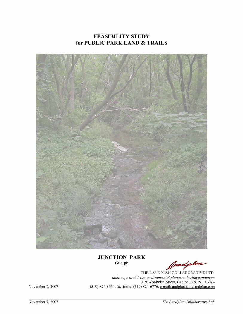
FEASIBILITY STUDYfor PUBLIC PARK LAND & TRAILS
JUNCTION PARKGuelph
THE LANDPLAN COLLABORATIVE LTD.landscape architects, environmental planners, heritage planners
319 Woolwich Street, Guelph, ON, N1H 3W4November 7, 2007 (519) 824-8664, facsimile: (519) 824-6776, e-mail:[email protected]

November 7, 2007 The Landplan Collaborative Ltd.
TABLE of CONTENTS
FEASIBILITY STUDY for PUBLIC PARK LAND & TRAILSJUNCTION PARK
SILVER CREEK JUNCTION
INTRODUCTION . . . . . . . . . . . . . . . . . . . . . . . . . . . . . . . . . . . . . . . . . . . . . . . . . . . . . . . . . . . . . . . . . . . 1
THIS STUDY . . . . . . . . . . . . . . . . . . . . . . . . . . . . . . . . . . . . . . . . . . . . . . . . . . . . . . . . . . . . . . . . . . . . . . 2
1.0 SITE CHARACTERISTICS . . . . . . . . . . . . . . . . . . . . . . . . . . . . . . . . . . . . . . . . . . . . . . . . . . . . . . . . 3
1.1 History . . . . . . . . . . . . . . . . . . . . . . . . . . . . . . . . . . . . . . . . . . . . . . . . . . . . . . . . . . . . . . . . . . . . . 4
1.2 Natural Environment . . . . . . . . . . . . . . . . . . . . . . . . . . . . . . . . . . . . . . . . . . . . . . . . . . . . . . . . . . . 7
2.0 THE MERITS OF DEVELOPING A PARK . . . . . . . . . . . . . . . . . . . . . . . . . . . . . . . . . . . . . . . . . . . 8
2.1 Land Use Planning Exercise . . . . . . . . . . . . . . . . . . . . . . . . . . . . . . . . . . . . . . . . . . . . . . . . . . . . . 8
2.2 The Concept . . . . . . . . . . . . . . . . . . . . . . . . . . . . . . . . . . . . . . . . . . . . . . . . . . . . . . . . . . . . . . . . . 9
3.0 THE CONCEPT PLAN . . . . . . . . . . . . . . . . . . . . . . . . . . . . . . . . . . . . . . . . . . . . . . . . . . . . . . . . . . 12
Appendix A - excerpt from City of Guelph Zoning By-law (1995) - 14864

FEASIBILITY STUDY for PUBLIC PARK LAND & TRAILS JUNCTION PARKSILVER CREEK JUNCTION 1
November 7, 2007 The Landplan Collaborative Ltd.
INTRODUCTION
In October 2005, an Official Plan Amendment and Zone Change application was filed with the City ofGuelph for the Lafarge property. One aspect of the redevelopment of this site includes the conveyance of thelands located east of Howitt Creek to the City of Guelph, for the purpose of open space and park use.
Since that time there have been a number of meetings with the community, City staff and the Grand RiverConservation Authority to address matters related to the redevelopment of the Lafarge property.
In March 2007, the applicants were provided with comments from the Park Planner for the City andadditional comments from the Park Planner were received in April 2007. In June 2007, the City providedthe applicant with a schedule of “Outstanding Information” that the City required before the application couldbe brought forward to Council for their review. One of the items identified in that schedule was a “feasibilitystudy for the park and trail routes”.
The purpose of this report is to address the matters set out in correspondence from the Park Planner (Marchand April 2007) as well as completing the “Feasibility Study” for the park development .... a feasibility studyof the site for public parkland and trail use should be provided. (memo from Helen White, Park Planner toMelissa Castellan, Planner, City of Guelph, March 15, 2007) Further elaboration on the “feasibility study”was provided by Ms White in her memo of April 2007 to Melissa Castellan where she stated: ... staff requirea short feasibility study of the site for P-3 zone use by a planning consultant or landscape architect todetermine the extent of the lands developable for parkland use, including:a) Feasibility plan, based on a topographic/legal survey of proposed dedication parcel (including
environmental lands), to include:• Existing main features, including structures, surface utilities, paving, rock outcrops, quarry items,
vegetation, etc.• Subsurface structures to extent known• Easements or other legal development constraints• Existing grading with contours at min. 1m contour interval• Required environmental buffers to park development including vegetation communities that are
recommended to remain• Approximate anticipated toe-of-slope line for berming to CN standards for all rail lines• Indicate options for providing public road frontage to the parcel which would provide good views
into the park from adjacent properties and meet requirements of emergency services access• Indicate where utilities could be provided to the parcel• Preliminary basic parkland grading
c) Site Concept Plan:• Indicate how the park parcel will fit within the overall site concept plan which meets the City’s
Urban Design Guidelines• Provide a trail concept plan for the entire application site, indicating how future City trail routes
could feasibly cross the entire site including the commercial area (north-south, east-west, andconnection from Howitt Park), meeting Guelph Trail Master Plan standards
b) Other information:• If it is proposed as a public road access point, an engineer’s statement on the structural capacity of
the existing bridge over the creek for potential park use vehicle loads, estimate of remaining bridgelifespan and estimated cost of repair/replacement to bring up to required standards
• Geotechnical information: soil profiles and descriptions for several places on the site and evaluationof potential drainage issues
• Evaluate feasibility and estimated cost of multiuse trail railway crossings at Howitt Park, InkermanSt. and Goldie Park that meet CN guidelines
• Any other constraints on park development

FEASIBILITY STUDY for PUBLIC PARK LAND & TRAILS JUNCTION PARKSILVER CREEK JUNCTION 2
November 7, 2007 The Landplan Collaborative Ltd.
• A conclusion on the suitability of the site for P-3 zoning, and if not a recommendation for alternateparkland and zoning
Ms White’s memos were in response to a proposal to provide a 4.39 ha park at the easterly end of theproperty. Her response to the proposal was based on the premise that the park would be a P.3 zonedCommunity Park and meet the requirements of that City designation. In summary, Ms White stated that ParkPlanning did not support the proposed Official Plan and Zoning By-law Amendment in its current form andrequired the applicant to address concerns regarding the park parcel and trail routes.
THIS STUDY
This feasibility study addresses the request outlined above, and includes:• a site review to determine the characteristics of the site and its opportunities and constraints for access,
trails, other uses, etc.;• a discussion on the merits of developing a park to take advantage of the site characteristics by
providing opportunities for interpretation of its history and its former extractive and industrial uses aswell as education with respect to its regeneration as a natural area;
• a concept plan that illustrates trails, access, linkages, interpretive, educational and recreationalopportunities, proposed plantings, stormwater management/flood control.
FEASIBILITY STUDY for PUBLIC PARK LAND & TRAILS JUNCTION PARKSILVER CREEK JUNCTION 3
1 Brook McIlroy Planning + Urban Design, City of Guelph - Lafarge Site Urban Design Guidelines & ConceptPlan for Future Commercial and Mixed-Use Brownfield Development. September 2005
November 7, 2007 The Landplan Collaborative Ltd.
1.0 SITE CHARACTERISTICS
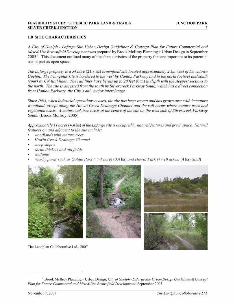
A City of Guelph - Lafarge Site Urban Design Guidelines & Concept Plan for Future Commercial andMixed-Use Brownfield Development was prepared by Brook McIlroy Planning + Urban Design in September2005 1. This document outlined many of the characteristics of the property that are important to its potentialuse in part as open space.
The Lafarge property is a 54 acre (21.8 ha) brownfield site located approximately 2 km west of DowntownGuelph. The triangular site is bordered to the west by Hanlon Parkway and to the north (active) and south(spur) by CN Rail lines. The rail lines have berms up to 20 feet (6 m) in depth with the steepest sections tothe north. The site is accessed from the south by Silvercreek Parkway South, which has a direct connectionfrom Hanlon Parkway, the City’s only major interchange.
Since 1994, when industrial operations ceased, the site has been vacant and has grown over with immaturewoodland, except along the Howitt Creek Drainage Channel and the rail berms where mature trees andvegetation exists. A mature oak tree exists at the centre of the site on the west side of Silvercreek ParkwaySouth. (Brook McIlroy, 2005)
Approximately 11 acres (4.4 ha) of the Lafarge site is occupied by natural features and green space. Naturalfeatures on and adjacent to the site include:• woodlands with mature trees• Howitt Creek Drainage Channel• steep slopes• shrub thickets and old fields• wetlands• nearby parks such as Goldie Park (+/-1 acre) (0.4 ha) and Howitt Park (+/-10 acres) (4 ha) (ibid)
The Landplan Collaborative Ltd., 2007
FEASIBILITY STUDY for PUBLIC PARK LAND & TRAILS JUNCTION PARKSILVER CREEK JUNCTION 4
2 Keleher John W., Building Guelph’s Railroads. Historic Guelph, The Royal City Volume XXXIV 1994-1995,The Guelph Historical Society, Guelph, ON 1995
3 ibid
4 http://encyclopedia.farlex.com/Canadian+National+Railway
November 7, 2007 The Landplan Collaborative Ltd.
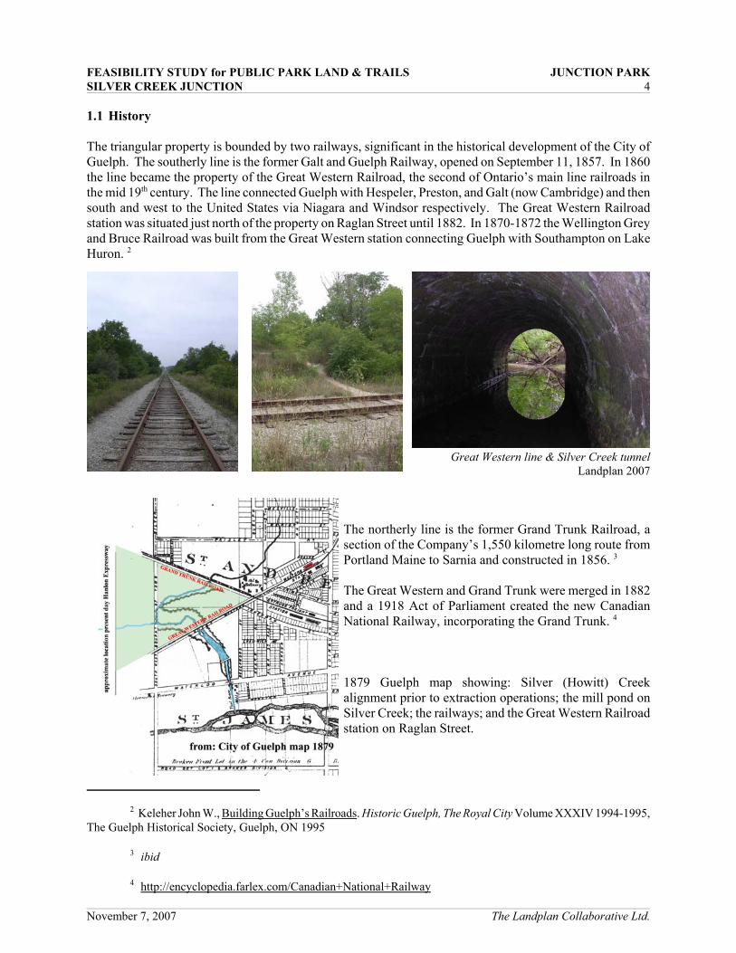
Great Western line & Silver Creek tunnelLandplan 2007
1.1 History
The triangular property is bounded by two railways, significant in the historical development of the City ofGuelph. The southerly line is the former Galt and Guelph Railway, opened on September 11, 1857. In 1860the line became the property of the Great Western Railroad, the second of Ontario’s main line railroads inthe mid 19th century. The line connected Guelph with Hespeler, Preston, and Galt (now Cambridge) and thensouth and west to the United States via Niagara and Windsor respectively. The Great Western Railroadstation was situated just north of the property on Raglan Street until 1882. In 1870-1872 the Wellington Greyand Bruce Railroad was built from the Great Western station connecting Guelph with Southampton on LakeHuron. 2
The northerly line is the former Grand Trunk Railroad, asection of the Company’s 1,550 kilometre long route fromPortland Maine to Sarnia and constructed in 1856. 3
The Great Western and Grand Trunk were merged in 1882and a 1918 Act of Parliament created the new CanadianNational Railway, incorporating the Grand Trunk. 4
1879 Guelph map showing: Silver (Howitt) Creekalignment prior to extraction operations; the mill pond onSilver Creek; the railways; and the Great Western Railroadstation on Raglan Street.
FEASIBILITY STUDY for PUBLIC PARK LAND & TRAILS JUNCTION PARKSILVER CREEK JUNCTION 5
5 Shamanl Tony, Guelph’s Master Brewers and Malsters. Historic Guelph: The Royal City Volume XXXVIII,The Guelph Historical Society, Guelph, ON 1999
6 Guelph Radial Railway, ‘Streetcars in the Royal City’. Guelph, Ontario, revised January 31, 2006http://www.trainweb.org/elso/guelph.htm
November 7, 2007 The Landplan Collaborative Ltd.
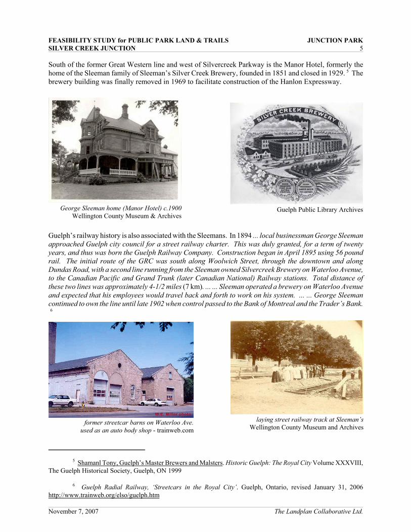
George Sleeman home (Manor Hotel) c.1900Wellington County Museum & Archives
former streetcar barns on Waterloo Ave.used as an auto body shop - trainweb.com
Guelph Public Library Archives
laying street railway track at Sleeman’sWellington County Museum and Archives
South of the former Great Western line and west of Silvercreek Parkway is the Manor Hotel, formerly thehome of the Sleeman family of Sleeman’s Silver Creek Brewery, founded in 1851 and closed in 1929. 5 Thebrewery building was finally removed in 1969 to facilitate construction of the Hanlon Expressway.
Guelph’s railway history is also associated with the Sleemans. In 1894 ... local businessman George Sleemanapproached Guelph city council for a street railway charter. This was duly granted, for a term of twentyyears, and thus was born the Guelph Railway Company. Construction began in April 1895 using 56 poundrail. The initial route of the GRC was south along Woolwich Street, through the downtown and alongDundas Road, with a second line running from the Sleeman owned Silvercreek Brewery on Waterloo Avenue,to the Canadian Pacific and Grand Trunk (later Canadian National) Railway stations. Total distance ofthese two lines was approximately 4-1/2 miles (7 km). ... ... Sleeman operated a brewery on Waterloo Avenueand expected that his employees would travel back and forth to work on his system. ... ... George Sleemancontinued to own the line until late 1902 when control passed to the Bank of Montreal and the Trader’s Bank. 6

FEASIBILITY STUDY for PUBLIC PARK LAND & TRAILS JUNCTION PARKSILVER CREEK JUNCTION 6
7 Pers. com. Peter Vanarnhem, P. Eng., September 2007
8 Shute Jeremy. Neighbourhood Creeks: The Opportunities for Fostering Stewardship by Rediscovering LocalUrban Buried Creeks. 4th Canadian River Heritage Conference Proceedings Guelph, ON June 6-9, 2004, and pers. comSeptember 2007
November 7, 2007 The Landplan Collaborative Ltd.
former car barnsLandplan, September 2007
headwaters of Silver Creek(Howitt Creek) Jeremy Shute, 2004
Landplan, September 2007
Sleeman built substantial stone streetcar barns on WaterlooAvenue at the foot of what is now Howitt Park. After thestreet railway was closed, the barns were used as anautomotive body shop for some time and are now quitehandsome dwellings.Silver (Howitt) Creek is piped and flows under the adjacentparking lot.
Eden Street, opposite the brewery is lined with workers’cottages from the Sleeman Brewery era. They form thenucleus, with the Manor Hotel, of a collection of heritagestructures associated with an important era and family inGuelph’s history.
Silver Creek Brewery was named for the adjacent creek that ran to the Speed River. The stream is now calledHowitt Creek and it traverses the subject property, although its alignment has been altered from pre-development times (see map page 4). 7
Almost all of Silver Creek north of the property is now buried. Itsheadwaters can be seen on Dawson Road in the north of the cityin the form of a roadside ditch. 8. A portion of the creek is alsoburied between Howitt Park and the Speed River.
Historically the land has been used for:• sand and gravel extraction (until 1974)• asphalt production• concrete and block fabrication (until 1994)• sedimentation ponds• heavy truck maintenance and repair (Brook McIlroy, 2005)

FEASIBILITY STUDY for PUBLIC PARK LAND & TRAILS JUNCTION PARKSILVER CREEK JUNCTION 7
9 Environmental Impact Study for the Lafarge Property North-South Environmental Inc., October 2005 andAddendum II, November 2007
November 7, 2007 The Landplan Collaborative Ltd.
1.2 Natural Environment
An Environmental Impact Study for the Lafarge Property was prepared in October 2005 with AddendumII of the report being penned in November 2007 by North-South Environmental Inc. 9. The original report,through consultation with other professionals and agencies has been supplemented with detailed tree surveys,riparian restoration plans to enhance biodiversity and improve linkages, and a plant species list recommendedfor re-vegetation of portions of the property. The vegetative, fish and faunal characteristics of the propertyare described in detail in the reports.
In summary, North-South Environmental conclude that there are no regionally or provincially significantvegetation communities on the site. There are no provincially significant plant or animal species on the site.(North-South, October 2005 and November 2007)

FEASIBILITY STUDY for PUBLIC PARK LAND & TRAILS JUNCTION PARKSILVER CREEK JUNCTION 8
November 7, 2007 The Landplan Collaborative Ltd.
2.0 THE MERITS OF DEVELOPING A PARK
2.1 Land Use Planning Exercise
Two land use planning exercise meetings with representatives of the neighbourhood were organized by theCity and held August 27th and September 6th, 2007. The landowner’s representative was an observer to thesemeetings.
Following is the August 27th LaFarge Land Use Planning Exercise record of the input participants providedin response to the following statements regarding the future development of the site.• Wouldn’t it be lovely if…?• If only…• I wish…Responses related to open space, park land, trails, and recreation were as follows.
Greenspace• Wouldn’t it be lovely if…greenspace was increased in our downtown area with a new park and
revitalized creek.• Environmental concerns i.e. green space, pollution, noise, traffic, were the priority in development
considerations.• If only… the natural features of the site could be preserved and accessed by the community.• Wouldn’t it be lovely if…greenspace, recreation and sense of community connectivity was enhanced.• Wouldn’t it be lovely if…there was lots of greenspace and parkland.• Wouldn’t it be lovely if…the site included a park that was larger than an offering.
Recreation• Wouldn’t it be lovely if…a new recreation area including skate board park, outdoor rink and soccer
fields with mixed commercial.• Wouldn’t it be lovely if…soccer fields were developed to let kids play near our homes.• Wouldn’t it be lovely if…bike trails connected from Paisley through property to Howitt to River.• Wouldn’t it be lovely if…they build a recreation area.• If the City would buy the property and turn it into park and soccer fields.• Wouldn’t it be nice if…partly devoted to recreational use.• A community centre was developed.• Go cross country skiing in the winter
Thoughts and comments on open space, park land, trails, and recreation in the September 6th LaFarge LandUse Planning Exercise were as follows.
FEASIBILITY STUDY for PUBLIC PARK LAND & TRAILS JUNCTION PARKSILVER CREEK JUNCTION 9
10 City of Guelph Zoning By-law (1995) - 14864 Section 9 – Park (P) Zones (see Appendix A)
11 For example, frontage on a public street (1 metre of frontage for every 100 m2 of park space) is not practicalgiven the location and configuration of the proposed park. Public access can be assured by a public easement acrossthe proposed east-west main street of the development to the existing creek crossing. Emergency access across therailway at Inkerman Street can also be provided. Off-street parking is not provided in the proposed park, but availablein the adjacent development, keeping the park site free of automobiles.
November 7, 2007 The Landplan Collaborative Ltd.
2.2 The Concept
The site’s characteristics, including its history, suggests that it would be appropriate that the lands east ofSilver (Howitt) Creek be dedicated to open space and recreational uses. Although separated from theneighbourhoods on either side by railway tracks, there are obvious visual and open space linkages that canbe made to provide a large complex of recreational and natural environment open space from Goldie Parkthrough Howitt Park to the Speed River valley.
The lands suggested as park land consist of about 5.71 ha (14.1 acres). Natural environment features are thecreek with its associated woodland, and successional woodlands, thickets and meadows. Culturally, the landsexhibit evidence of industrial activity of about 40 years (1950s through 1994) which included gravelextraction, an asphalt plant and a concrete plant. Historic associations from the mid-19th century withGuelph’s railways, mills, a brewery, and residential developments can still be found bordering the property.
The concept for Junction Park builds on its natural and cultural attributes, its historical associations, and someof its current ad hoc uses. The lands, although currently in private ownership, are being used for passiverecreational activities such as walking, dog walking, cross-country skiing, cycling, and nature appreciation,as well as some less desirable activities.
The City’s park zone categories 10 were developed with the purpose of securing required recreational openspace needs for neighbourhoods, communities, and the City as a whole. Junction Park would not meet thepark zoning criteria, and although it could be made to comply, this would be antithetical to the character ofthe site and its potential. Rather than attempt to make the site fit a particular definition, it is suggested thatthe park be developed in a manner that reflects and takes advantage of its natural and cultural characteristicsand suits the needs of its users.11
The August 27th LaFarge Land Use Planning Exercise held by the City concluded:Wouldn’t it be lovely if…
• greenspace was increased in our downtown area with a new park and revitalized creek;• greenspace, recreation and sense of community connectivity was enhanced;• there was lots of greenspace and parkland;• the site included a park that was larger than an offering;• a new recreation area including skate board park, outdoor rink and soccer fields with mixed
commercial;• soccer fields were developed to let kids play near our homes

FEASIBILITY STUDY for PUBLIC PARK LAND & TRAILS JUNCTION PARKSILVER CREEK JUNCTION 10
12 Park land dedication requirements for a commercial land use on the subject property would be 2% of the landarea or cash-in-lieu; for a residential land use, 5% or cash-in-lieu. The proposed park land is 26 % of the propertyand is 5.71 ha rather than the 4.39 ha noted as desired by the participants in the LaFarge Land Use Planning Exercise.
13 Environmental Impact Study for the Lafarge Property North-South Environmental Inc., October 2005 andAddendum II, November 2007
14 ibid
November 7, 2007 The Landplan Collaborative Ltd.
• bike trails connected from Paisley through property to Howitt to River;• they build a recreation area;• the City would buy the property and turn it into park and soccer fields;• partly devoted to recreational use;• a community centre was developed;• (one could) go cross country skiing in the winter; and
If only…the natural features of the site could be preserved and accessed by the community. (City of GuelphAugust 27, 2007)
The September 6th LaFarge Land Use Planning Exercise held by the City posed ideas for recreation and parkland suggesting that ... the desired park area would be the 4.39 ha triangle on the north-east side of the creekwith pedestrian access across the rail lines, from the adjacent parks, and across the creek at the current culvertlocation.
The park concept answers most of the questions in the affirmative and fulfills many of the ideas posed by:• substantially increasing green space in the neighbourhood/community; 12
• providing connectivity of green space and the community through an extensive pedestrian ,cyclist, andcross-country ski trail system;
• creating an opportunity for an outdoor ice rink larger than any in the City; and• preserving and enhancing the natural features of the site while offering recreational opportunities in
accord with the site’s natural and cultural features.
Because the proposed park is an abandoned extraction site and aggregate materials plant, it is nearly devoidof topsoil and growing conditions are not conducive to traditional park turf and manicured sports fields.Rather, the vegetation that has naturally established itself shows that the site will support trees, shrubs andherbaceous ground covers. Unfortunately, much of the vegetation that has established is exotic material withits source being the adjacent residential and industrial neighbourhoods. Sixty-three percent of the trees onthe property are non-natives 13. Siberian Elm and Manitoba Maple are the predominant non-natives.Trembling aspen, a short-lived successional species of disturbed habitats, is the predominant native species.
The natural environment can be significantly enhanced through plantings of native materials. Anenhancement program is provided in North-South’s report. 14 The concept is to improve the site’s biodiversityby eventually replacing the exotic and invasive tree species with native trees that will thrive here.
As well as satisfying most of the desires expressed in the City’s land use planning exercise, the conceptincludes a substantial program of interpretation and education. Park users would be provided with signageat appropriate intervals on the trail system that interprets the natural features of the site, the cultural artifacts,and the adjacent historical associations such as the railways. (see examples on page 13)
FEASIBILITY STUDY for PUBLIC PARK LAND & TRAILS JUNCTION PARKSILVER CREEK JUNCTION 11
15 Guelph Trail Master Plan, Final Report, City of Guelph, Fall 2005
November 7, 2007 The Landplan Collaborative Ltd.
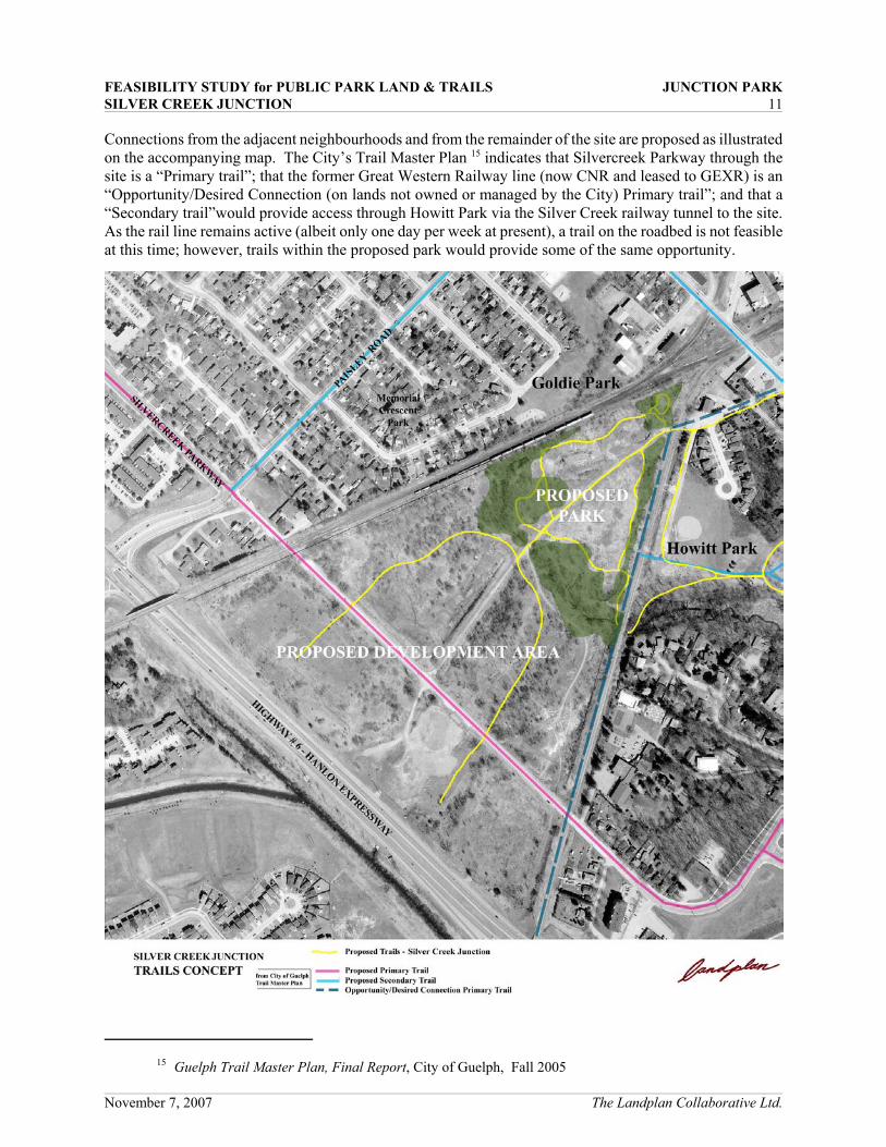
Connections from the adjacent neighbourhoods and from the remainder of the site are proposed as illustratedon the accompanying map. The City’s Trail Master Plan 15 indicates that Silvercreek Parkway through thesite is a “Primary trail”; that the former Great Western Railway line (now CNR and leased to GEXR) is an“Opportunity/Desired Connection (on lands not owned or managed by the City) Primary trail”; and that a“Secondary trail”would provide access through Howitt Park via the Silver Creek railway tunnel to the site.As the rail line remains active (albeit only one day per week at present), a trail on the roadbed is not feasibleat this time; however, trails within the proposed park would provide some of the same opportunity.
FEASIBILITY STUDY for PUBLIC PARK LAND & TRAILS JUNCTION PARKSILVER CREEK JUNCTION 12
November 7, 2007 The Landplan Collaborative Ltd.
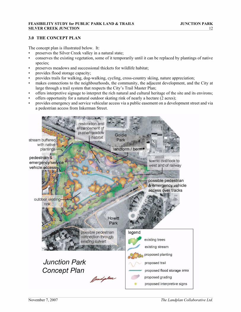
3.0 THE CONCEPT PLAN
The concept plan is illustrated below. It:• preserves the Silver Creek valley in a natural state;• conserves the existing vegetation, some of it temporarily until it can be replaced by plantings of native
species;• preserves meadows and successional thickets for wildlife habitat;• provides flood storage capacity;• provides trails for walking, dog-walking, cycling, cross-country skiing, nature appreciation;• makes connections to the neighbourhoods, the community, the adjacent development, and the City at
large through a trail system that respects the City’s Trail Master Plan;• offers interpretive signage to interpret the rich natural and cultural heritage of the site and its environs;• offers opportunity for a natural outdoor skating rink of nearly a hectare (2 acres);• provides emergency and service vehicular access via a public easement on a development street and via
a pedestrian access from Inkerman Street.

FEASIBILITY STUDY for PUBLIC PARK LAND & TRAILS JUNCTION PARKSILVER CREEK JUNCTION 13
November 7, 2007 The Landplan Collaborative Ltd.
examples of interpretive signage for Junction Park

FEASIBILITY STUDY for PUBLIC PARK LAND & TRAILS JUNCTION PARKSILVER CREEK JUNCTION 14
November 7, 2007 The Landplan Collaborative Ltd.
The proposed park has a strong relationship to the proposed development to the west. Access is maintainedvia the existing creek culvert crossing. Pedestrians and cyclists can move through either a naturalizedlandscape that also serves for stormwater drainage and ecological linkage, or on an urban walkway shadedby trees. The overall concept plan is illustrated below.

FEASIBILITY STUDY for PUBLIC PARK LAND & TRAILS JUNCTION PARKSILVER CREEK JUNCTION 15
November 7, 2007 The Landplan Collaborative Ltd.
As noted above, pedestrians and cyclists have the option of accessing the park via a naturalized linear openspace that serves for stormwater drainage and management and an ecological linkage, or on an shaded urbanwalkway on a public easement. The linear open space would be comprised of a naturalized drainage swalethat is “layered” with native plantings, with herbaceous cover on the ground plane, supported by shrubs, smallflowering trees, and large deciduous and coniferous trees. A typical section through this open space isillustrated below.

FEASIBILITY STUDY for PUBLIC PARK LAND & TRAILS JUNCTION PARKAppendix A excerpt from City of Guelph Zoning By-law (1995) - 14864
SECTION 9 – PARK (P) ZONES
9.1 PERMITTED USES
The following are permitted Uses within the Park – (P.1, P.2, P.3, P.4 and P.5) Zones:
9.1.1 Conservation Land (P.1) ZoneConservation AreaFlood Control FacilityRecreation TrailWildlife Management Area
9.1.2 Neighbourhood Park (P.2) ZoneConservation AreaInformal Play AreaMunicipal Parkland or recreation areaOutdoor skating rinkOutdoor Sportsfield FacilitiesPicnic areas (consisting of a maximum of 4 tables)Play EquipmentPublic washroomRecreation TrailWading pool and/or water spray area
9.1.3 Community Park (P.3) ZoneAny Use permitted in Section 9.1.2 and the following:Concession standsHistoric sitesOutdoor theatreParking AreasPicnic areas (no limit on number of tables)Public swimming poolWildlife Management AreaA Dwelling Unit or units for staff (subject to the approval of the Medical Officer of Health)
9.1.4 Regional Park (P.4) ZoneAny Use permitted in Section 9.1.3 and the following:Amusement RidesArenaBotanical GardensCampgroundsCemeteryMuseumRecreation Centre
9.1.5 Commercial Recreation Park (P.5) ZoneClubOutdoor Sportsfield FacilitiesRecreation Centre

FEASIBILITY STUDY for PUBLIC PARK LAND & TRAILS JUNCTION PARKAppendix A excerpt from City of Guelph Zoning By-law (1995) - 14864
9.2 REGULATIONS
Within the Park (P) Zones, no land shall be Used and no Building or Structure shall be erected orUsed except in conformity with the applicable regulations contained in Section 4 – GeneralProvisions, the regulations set out in Table 9.2, and the following.
9.2.1 Regulations for the Conservation Land (P.1) Zone
Within a Conservation Land (P.1) Zone, lands are to remain in their natural condition. Noconstruction of Buildings or Structures, removal or placement of fill, or any otherdevelopment shall be permitted which could disrupt the ecology or natural features of aWetland, and area of scientific and natural interest (ANSIs) or a significant woodlot andwildlife area.
Despite the above, Buildings or Structures existing at the time of the passing of this By-lawwithin the P.1 Zone shall be recognized. However, any expansion, reconstruction, orextension of any existing Use shall be subject to the Floodproofing requirements of theGrand River Conservation Authority and shall require consultation with the Ministry ofNatural Resources.
9.2.2 Lighting for Outdoor Skating Rinks – P.2, P.3 and P.4 Zones
Outdoor skating rinks within the P.2, P.3 and P.4 Zones shall be permitted to have lightingfacilities developed in accordance with Section 4.18.1.
9.2.3 Lighting for Outdoor Sportsfield Facilities – P.4 Zone
Outdoor Sportsfield Facilities shall be permitted to have lighting facilities developed inaccordance with Section 4.18.1.
TABLE 9.2 - REGULATIONS GOVERNING THE P.2, P.3, P.4 AND P.5 ZONES
Park Zones Neighbourhood(P.2) Park
Community(P.3) Park
Regional(P.4) Park
CommercialRecreation (P.5)
Park
Minimum LotArea ------------------------- 1,200 m2
Minimum LotFrontage
50 metres. Despite this minimum, a Lot Frontagecalculation formula of 1 metre of frontage for every 100
m2 of park space is required.30 metres
Minimum Sideand Rear Yard 7.5 metres
Minimum FrontYard 6 metres from the Street Line and as set out in Section 4.24
Off-StreetParking
In accordance with Section 4.13 and the following:Off-Street parking shall be a minimum of 7.5 metres
from the Street Line.
In accordancewith Section
4.13
FEASIBILITY STUDY for PUBLIC PARK LAND & TRAILS JUNCTION PARKAppendix A excerpt from City of Guelph Zoning By-law (1995) - 14864
Park Zones Neighbourhood(P.2) Park
Community(P.3) Park
Regional(P.4) Park
CommercialRecreation (P.5)
Park
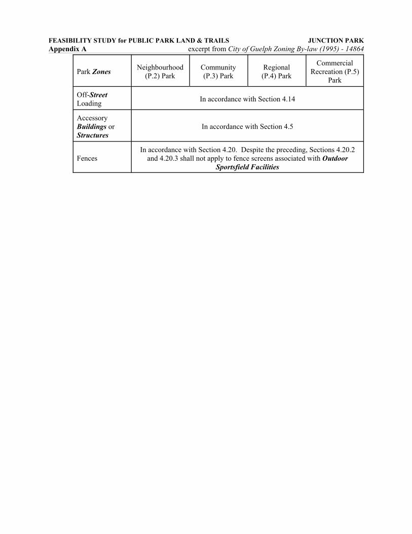
Off-StreetLoading In accordance with Section 4.14
AccessoryBuildings orStructures
In accordance with Section 4.5
FencesIn accordance with Section 4.20. Despite the preceding, Sections 4.20.2
and 4.20.3 shall not apply to fence screens associated with OutdoorSportsfield Facilities