Embed Size (px)
Citation preview
February 21, 2019
King County Flood Control District ATTN: Michelle Clark, SEPA Responsible Official 516 Third Avenue Room 1200 Seattle, WA 98104
RE: WRIA 9 WEF Comments on Scope of Lower Green River Corridor Flood Hazard Management Plan (Corridor Plan) and Programmatic Environmental Impact Statement (PEIS)
Dear Ms. Clark:
The Watershed Ecosystem Forum (WEF) for the Green-Duwamish and Central Puget Sound Watershed (WRIA 9) respectfully submits the attached comments on the King County Flood Control District (District) Corridor Plan and PEIS. WRIA 9 represents a coalition of 17 local governments and numerous local, state and federal partners committed to Chinook salmon recovery. The 2005 Salmon Habitat Plan is the watershed’s blueprint for salmon recovery and project implementation by partner organizations has collectively resulted in approximately $160 million of habitat-related investments to support “Making Our Watershed Fit for a King.”
The Corridor Plan is being developed as the watershed – and the larger Puget Sound region – continues to experience a long-term decline in wild Chinook salmon. Escapement in five out of the past ten years has not achieved the watershed’s short-term goal of 1,000-4,200 wild spawners. The 10-year average of 1,363 wild Chinook remains significantly below the long-term target of 27,000. Chinook productivity is currently limited by rearing habitat capacity in the Lower and Middle Green River. Restoring additional rearing habitat is critically needed to increase productivity and reverse the long-term decline in wild Chinook abundance. It will also address the parallel Puget Sound-wide prey availability crisis facing the Southern Resident Orca population.
Several long-term efforts are aligning to create a tremendous opportunity to reverse the long-term decline in wild Chinook salmon and unlock the potential of the watershed. Duwamish clean-up and restoration, fish passage at Howard Hanson Dam, and the Corridor Plan collectively represent over $1 billion in investments in our watershed over the next 50 years. The success of these efforts is inherently interconnected. Integration of salmon recovery and floodplain management in the Lower Green is critical to addressing the current bottleneck in salmon productivity and realizing the full potential of these investments.
As the Puget Sound region weighs the “bold actions” necessary to reverse salmon and Orca declines, it must capitalize on this once in a generation opportunity to think and act comprehensively about the Lower Green River landscape, solve multiple challenges and leverage hundreds of millions of dollars in investments. WRIA 9 recommends the Corridor Plan holistically approach flood management in a way that integrates Chinook salmon recovery, economic development, recreation, and environmental justice. As the state and federally-identified organization responsible for protecting and restoring salmon habitat in the watershed, WRIA 9 has analyzed the three alternatives identified in the November 26,
King County Flood Control District February 21, 2019 Page 2 of 2 2018 PEIS scoping notice. The alternatives do not advance the multi-objective salmon recovery strategies supported by the WRIA 9 Salmon Habitat Plan, or committed to in the 2013 King County Flood Hazard Management Plan and 2014 Lower Green System-Wide Improvement Framework (SWIF) process.
WRIA 9 embraces the importance of the Lower Green levee system and supports making significant regional investments in flood risk reduction. WRIA 9 recommends the District integrate flood control and salmon recovery by evaluating a fourth alternative that reflects the multi-objective vision adopted by the District Executive Committee during the original SWIF. When the District decided to submit the pared-down Interim SWIF to ensure it retained temporary eligibility for PL-84-99 assistance, it stressed that the “broader objectives” of the SWIF stakeholders would be better achieved through a corridor planning process (FCS2016-05.2). WRIA 9 continues to support the District’s commitment to a corridor planning process based on broader, multi-benefit objectives. The WRIA recommends the District-led PEIS review process consider a “fourth alternative” that embraces a multi-benefit framework. The attached draft Alternative 4 Map and Narrative, together with our written comments are intended to help inform development of an alternative that:
• Integrates flood risk reduction and salmon habitat restoration consistent with established goals and policies;
• Reflects salmon habitat restoration concepts for the Lower Green River that are supported by the cities and King County;
• Makes substantive contribution towards achieving the salmon habitat goals established for the Lower Green Subwatershed; and
• Ensures vegetation management and facility alignment support healthy riparian vegetation in high priority areas identified by the 2013 Muckleshoot Riparian Aspect Mapping.
WRIA 9 looks forward to working with the District to develop and implement a Corridor Plan alternative that enhances community and ecological resilience to flooding, while making substantive progress towards “Making Our Watershed Fit for King.” As you proceed with the environmental evaluation of alternatives, we strongly recommend an alternative that reflects the broader, multi-benefit needs of the watershed. If you have any questions, please contact Doug Osterman, WRIA 9 Salmon Recovery Manager, at 206-477-4793 or [email protected].
Sincerely,
Marlla Mhoon Bill Peloza Councilmember, City of Covington Deputy Mayor, City of Auburn WRIA 9 Watershed Ecosystem Forum Co-Chair WRIA 9 Watershed Ecosystem Forum Co-Chair Cc: WRIA 9 Watershed Ecosystem Forum
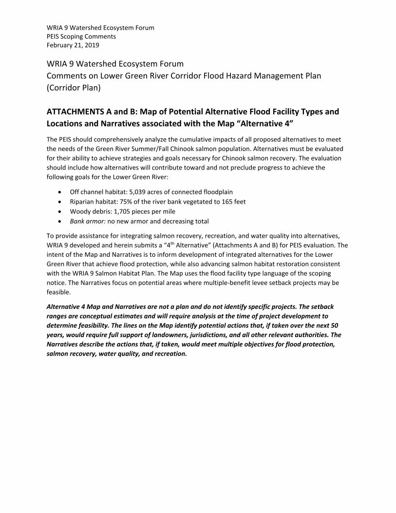
WRIA 9 Watershed Ecosystem Forum PEIS Scoping Comments February 21, 2019 WRIA 9 Watershed Ecosystem Forum Comments on Lower Green River Corridor Flood Hazard Management Plan (Corridor Plan) ATTACHMENTS A and B: Map of Potential Alternative Flood Facility Types and Locations and Narratives associated with the Map “Alternative 4”
The PEIS should comprehensively analyze the cumulative impacts of all proposed alternatives to meet the needs of the Green River Summer/Fall Chinook salmon population. Alternatives must be evaluated for their ability to achieve strategies and goals necessary for Chinook salmon recovery. The evaluation should include how alternatives will contribute toward and not preclude progress to achieve the following goals for the Lower Green River:
• Off channel habitat: 5,039 acres of connected floodplain • Riparian habitat: 75% of the river bank vegetated to 165 feet • Woody debris: 1,705 pieces per mile • Bank armor: no new armor and decreasing total
To provide assistance for integrating salmon recovery, recreation, and water quality into alternatives, WRIA 9 developed and herein submits a “4th Alternative” (Attachments A and B) for PEIS evaluation. The intent of the Map and Narratives is to inform development of integrated alternatives for the Lower Green River that achieve flood protection, while also advancing salmon habitat restoration consistent with the WRIA 9 Salmon Habitat Plan. The Map uses the flood facility type language of the scoping notice. The Narratives focus on potential areas where multiple-benefit levee setback projects may be feasible.
Alternative 4 Map and Narratives are not a plan and do not identify specific projects. The setback ranges are conceptual estimates and will require analysis at the time of project development to determine feasibility. The lines on the Map identify potential actions that, if taken over the next 50 years, would require full support of landowners, jurisdictions, and all other relevant authorities. The Narratives describe the actions that, if taken, would meet multiple objectives for flood protection, salmon recovery, water quality, and recreation.

IMAGE_Ortho2017KCNAT
Attachment AFacility Type and (Footprint)
FCD-A Wall (<100ft)FCD-B-Layback (100 to 150ft)FCD-C-Setback (>150ft)FCD-D-Flood proofNo Flood Action
Ü0 1 2 30.5
Miles
Reach 14
Reach 15
Reach 13
Reach 16Alternative 4 Map and narratives are not a plan and do not identifyspecific projects. The setback ranges are conceptual estimates andwill require analysis at the time of project development to determinefeasibility. The lines on the map identify potential actions that, if takenover the next 50 years, would require full support of landowners,jurisdictions, and all other relevant authorities. The narrativesdescribe the actions that, if taken, would meet multiple objectives forflood protection, salmon recovery, water quality, and recreation.
Reach 10
Reach 12
TextReach 11
Reach 9
Reach 5Reach 6
Reach 7
Reach 8
Reach 3
Reach 2
Reach 1
TextReach 4
WRIA 9 Watershed Ecosystem Forum PEIS Scoping – Attachment B (Alternative 4 Narratives) February 21, 2019 Page 1 of 11
ATTACHMENT B: Alternative 4 Narratives
WRIA 9 urges the Flood District to consider an integrated flood protection and salmon habitat vision. The attached map and associated reach based narratives should help inform the Flood District’s work to develop and analyze integrated alternatives that achieve flood protection, while also significantly advancing salmon habitat, recreation, and water quality. The map uses the flood facility type language (Type A facility, Type B facility, etc.) of the environmental review scoping notice, and the narrative focuses on potential areas where multiple-benefit levee setback projects may be feasible. We do not offer any recommendations related to level of flood protection, simply possibilities for optimizing habitat and other multi-benefit objectives waterward of potential flood facilities. The map and narrative are broken into reaches, with the narratives further broken out into right and left banks describing the potential multi-benefit project actions. Multi-benefit objectives include:
- Increased channel and flood capacity, and associated decrease in water surface elevations - Creation of off-channel juvenile salmon habitat - Enhanced riparian function and improved water temperature/quality - Trail and recreation improvements
Alternative 4 Map and Narratives are not a plan and do not identify specific projects. The setback ranges are conceptual estimates and will require analysis at the time of project development to determine feasibility. The lines on the map identify potential actions that, if taken over the next 50 years, would require full support of landowners, jurisdictions, and all other relevant authorities. The narratives describe the actions that, if taken, would meet multiple objectives for flood protection, salmon recovery, water quality, and recreation.
We recommend that at the time of any individual project’s development, the Flood District study the possibilities around optimizing a levee setback in terms of the objectives listed above and in conjunction with local shoreline master programs, irrespective of today’s land use and adjacent property ownership. Setbacks could necessitate changes to the existing trail corridor as well as create new recreational opportunities. In locations where levee alignment proposals would impact existing recreational trails, implementation would be contingent on addressing recreational needs during project planning.
Shade need areas described below are based on the methodology laid out in Fox 2014, also known as the Muckleshoot Sun maps. The Salmon Habitat Plan: Making our Watershed Fit for King from 2005 is referred to as ‘the Salmon Plan’ below.
Reach 1, RM 11.0 to RM 12.4 (Black River confluence to I-405 crossing)
Setbacks within this reach could provide a moderate increase in flood capacity, improve juvenile rearing habitat, and enhance riparian function.
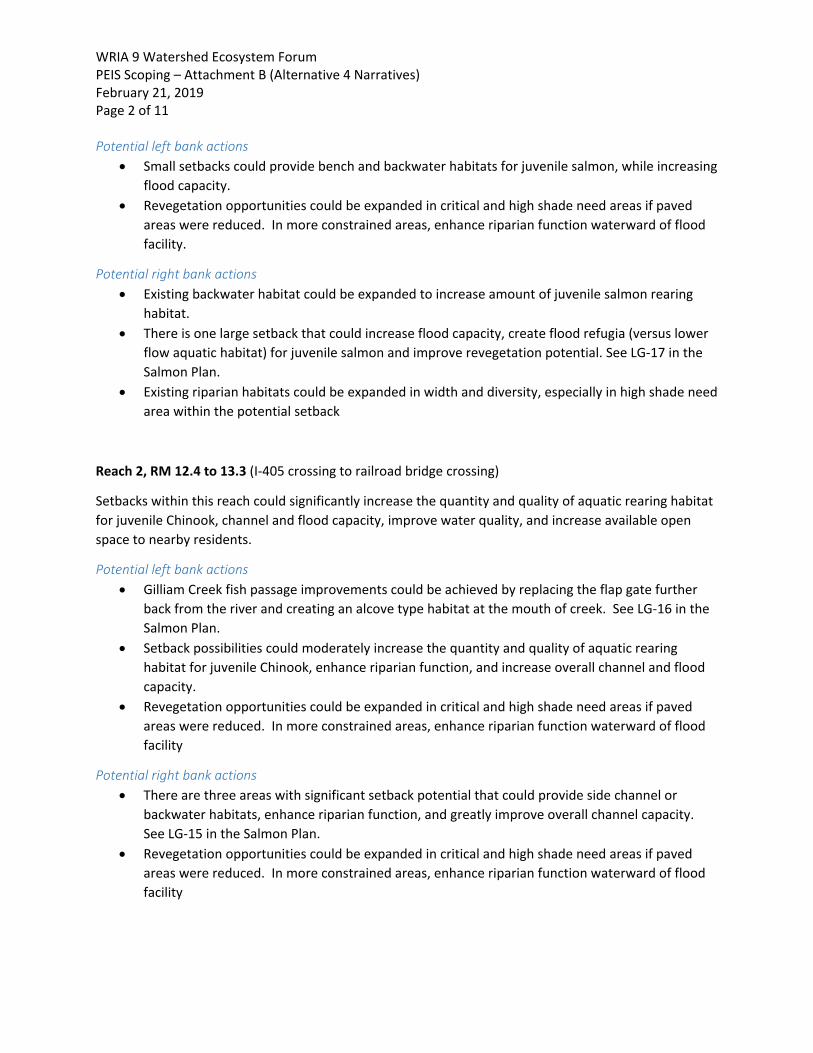
WRIA 9 Watershed Ecosystem Forum PEIS Scoping – Attachment B (Alternative 4 Narratives) February 21, 2019 Page 2 of 11 Potential left bank actions
• Small setbacks could provide bench and backwater habitats for juvenile salmon, while increasing flood capacity.
• Revegetation opportunities could be expanded in critical and high shade need areas if paved areas were reduced. In more constrained areas, enhance riparian function waterward of flood facility.
Potential right bank actions • Existing backwater habitat could be expanded to increase amount of juvenile salmon rearing
habitat. • There is one large setback that could increase flood capacity, create flood refugia (versus lower
flow aquatic habitat) for juvenile salmon and improve revegetation potential. See LG-17 in the Salmon Plan.
• Existing riparian habitats could be expanded in width and diversity, especially in high shade need area within the potential setback
Reach 2, RM 12.4 to 13.3 (I-405 crossing to railroad bridge crossing)
Setbacks within this reach could significantly increase the quantity and quality of aquatic rearing habitat for juvenile Chinook, channel and flood capacity, improve water quality, and increase available open space to nearby residents.
Potential left bank actions • Gilliam Creek fish passage improvements could be achieved by replacing the flap gate further
back from the river and creating an alcove type habitat at the mouth of creek. See LG-16 in the Salmon Plan.
• Setback possibilities could moderately increase the quantity and quality of aquatic rearing habitat for juvenile Chinook, enhance riparian function, and increase overall channel and flood capacity.
• Revegetation opportunities could be expanded in critical and high shade need areas if paved areas were reduced. In more constrained areas, enhance riparian function waterward of flood facility
Potential right bank actions • There are three areas with significant setback potential that could provide side channel or
backwater habitats, enhance riparian function, and greatly improve overall channel capacity. See LG-15 in the Salmon Plan.
• Revegetation opportunities could be expanded in critical and high shade need areas if paved areas were reduced. In more constrained areas, enhance riparian function waterward of flood facility
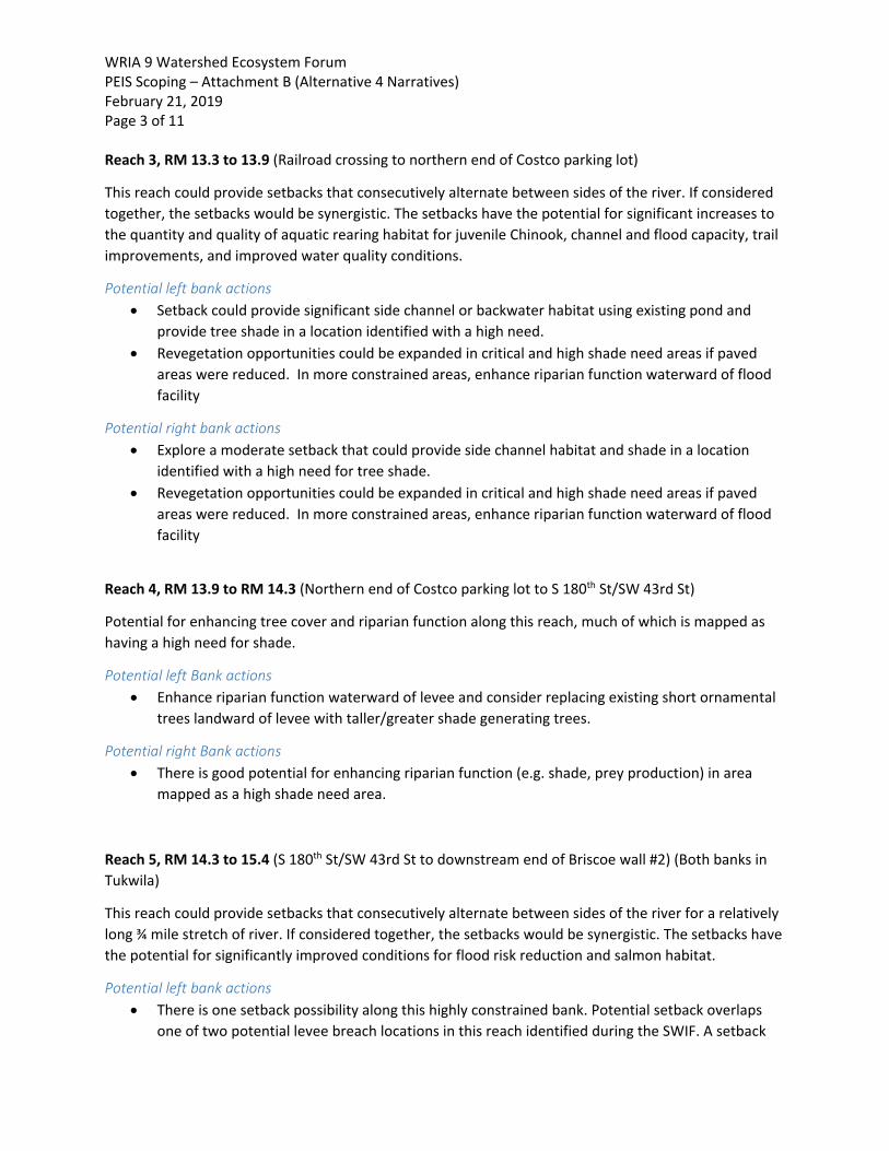
WRIA 9 Watershed Ecosystem Forum PEIS Scoping – Attachment B (Alternative 4 Narratives) February 21, 2019 Page 3 of 11 Reach 3, RM 13.3 to 13.9 (Railroad crossing to northern end of Costco parking lot)
This reach could provide setbacks that consecutively alternate between sides of the river. If considered together, the setbacks would be synergistic. The setbacks have the potential for significant increases to the quantity and quality of aquatic rearing habitat for juvenile Chinook, channel and flood capacity, trail improvements, and improved water quality conditions.
Potential left bank actions • Setback could provide significant side channel or backwater habitat using existing pond and
provide tree shade in a location identified with a high need. • Revegetation opportunities could be expanded in critical and high shade need areas if paved
areas were reduced. In more constrained areas, enhance riparian function waterward of flood facility
Potential right bank actions • Explore a moderate setback that could provide side channel habitat and shade in a location
identified with a high need for tree shade. • Revegetation opportunities could be expanded in critical and high shade need areas if paved
areas were reduced. In more constrained areas, enhance riparian function waterward of flood facility
Reach 4, RM 13.9 to RM 14.3 (Northern end of Costco parking lot to S 180th St/SW 43rd St)
Potential for enhancing tree cover and riparian function along this reach, much of which is mapped as having a high need for shade.
Potential left Bank actions • Enhance riparian function waterward of levee and consider replacing existing short ornamental
trees landward of levee with taller/greater shade generating trees.
Potential right Bank actions • There is good potential for enhancing riparian function (e.g. shade, prey production) in area
mapped as a high shade need area.
Reach 5, RM 14.3 to 15.4 (S 180th St/SW 43rd St to downstream end of Briscoe wall #2) (Both banks in Tukwila)
This reach could provide setbacks that consecutively alternate between sides of the river for a relatively long ¾ mile stretch of river. If considered together, the setbacks would be synergistic. The setbacks have the potential for significantly improved conditions for flood risk reduction and salmon habitat.
Potential left bank actions • There is one setback possibility along this highly constrained bank. Potential setback overlaps
one of two potential levee breach locations in this reach identified during the SWIF. A setback
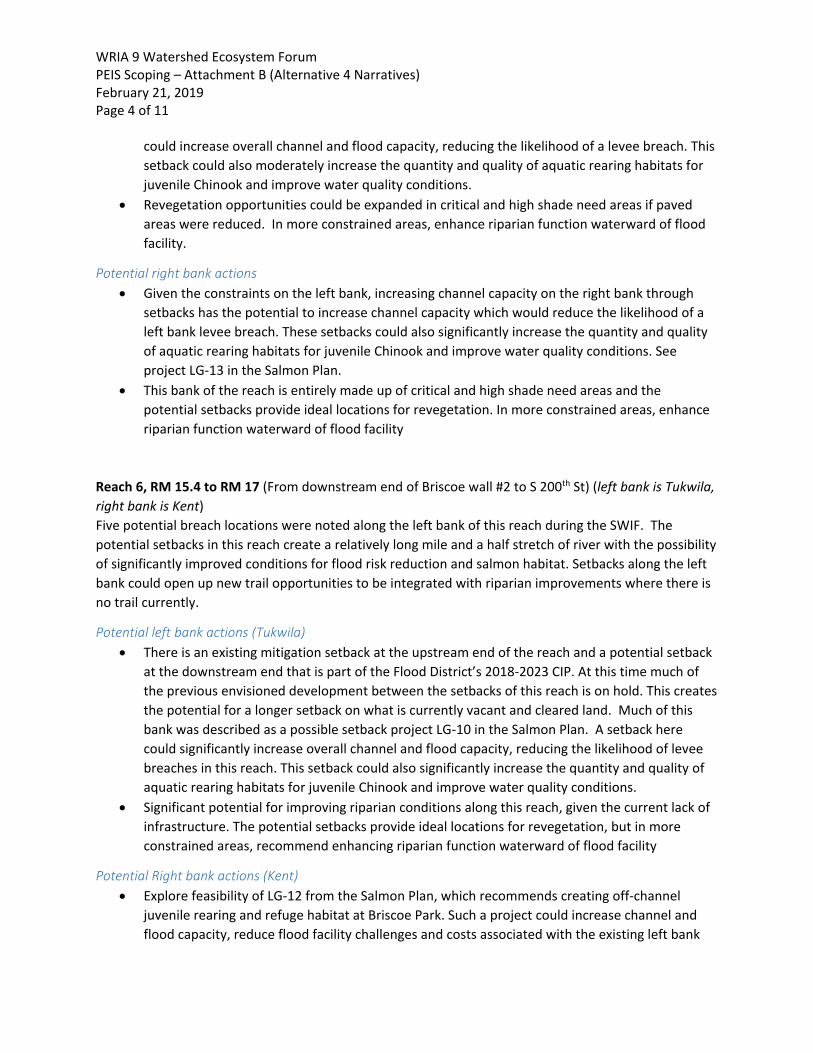
WRIA 9 Watershed Ecosystem Forum PEIS Scoping – Attachment B (Alternative 4 Narratives) February 21, 2019 Page 4 of 11
could increase overall channel and flood capacity, reducing the likelihood of a levee breach. This setback could also moderately increase the quantity and quality of aquatic rearing habitats for juvenile Chinook and improve water quality conditions.
• Revegetation opportunities could be expanded in critical and high shade need areas if paved areas were reduced. In more constrained areas, enhance riparian function waterward of flood facility.
Potential right bank actions • Given the constraints on the left bank, increasing channel capacity on the right bank through
setbacks has the potential to increase channel capacity which would reduce the likelihood of a left bank levee breach. These setbacks could also significantly increase the quantity and quality of aquatic rearing habitats for juvenile Chinook and improve water quality conditions. See project LG-13 in the Salmon Plan.
• This bank of the reach is entirely made up of critical and high shade need areas and the potential setbacks provide ideal locations for revegetation. In more constrained areas, enhance riparian function waterward of flood facility
Reach 6, RM 15.4 to RM 17 (From downstream end of Briscoe wall #2 to S 200th St) (left bank is Tukwila, right bank is Kent) Five potential breach locations were noted along the left bank of this reach during the SWIF. The potential setbacks in this reach create a relatively long mile and a half stretch of river with the possibility of significantly improved conditions for flood risk reduction and salmon habitat. Setbacks along the left bank could open up new trail opportunities to be integrated with riparian improvements where there is no trail currently.
Potential left bank actions (Tukwila) • There is an existing mitigation setback at the upstream end of the reach and a potential setback
at the downstream end that is part of the Flood District’s 2018-2023 CIP. At this time much of the previous envisioned development between the setbacks of this reach is on hold. This creates the potential for a longer setback on what is currently vacant and cleared land. Much of this bank was described as a possible setback project LG-10 in the Salmon Plan. A setback here could significantly increase overall channel and flood capacity, reducing the likelihood of levee breaches in this reach. This setback could also significantly increase the quantity and quality of aquatic rearing habitats for juvenile Chinook and improve water quality conditions.
• Significant potential for improving riparian conditions along this reach, given the current lack of infrastructure. The potential setbacks provide ideal locations for revegetation, but in more constrained areas, recommend enhancing riparian function waterward of flood facility
Potential Right bank actions (Kent) • Explore feasibility of LG-12 from the Salmon Plan, which recommends creating off-channel
juvenile rearing and refuge habitat at Briscoe Park. Such a project could increase channel and flood capacity, reduce flood facility challenges and costs associated with the existing left bank
WRIA 9 Watershed Ecosystem Forum PEIS Scoping – Attachment B (Alternative 4 Narratives) February 21, 2019 Page 5 of 11
CIP project by reducing water surface elevations locally. Implementation would be contingent on relocating the existing recreational elements/opportunities at Briscoe Park.
• Reach has a high percentage of critical and high shade need areas and the potential setback provides ideal locations for revegetation. In more constrained areas, recommend enhancing riparian function waterward of flood facility.
Reach 7, RM 17 to 17.8 (S 200th ST to S 212th ST) (left bank is partly in Tukwila and partly in Kent, right bank is Kent)
Potential setbacks in this reach could create almost a mile of river with significantly improved conditions for flood risk reduction and salmon. It provides one of the few areas where flood storage could be significantly increased.
Potential left bank actions (RM 17 to 17.3 in Tukwila; the rest is of the LB is in Kent) • The bank in this reach is a combination of private levee, County revetments and portions of
Frager Road that act like a levee. The flapgate at the mouth of Johnson Creek not only restricts salmon access, it disconnects a significant area of potential flood storage from most flows below 100 year events. The entire left bank in this reach is part of project LG-11 in the Salmon Plan. Aspects of LG-11 have already been implemented as a mitigation project, but due to the fish passage barrier those habitat improvements are inaccessible to juvenile and adult salmon. Separate from improving access to the floodplain habitats, there is potential to setback shoreline infrastructure to significantly increase the amount and quality of juvenile salmon rearing habitats along the river, increase flood and channel capacity, and incorporate improved trail opportunities and supporting amenities.
• There are critical and high shade need areas that could be integrated into trail, habitat, and flood actions to increase riparian widths.
Potential right bank actions • The right bank in this reach is described in the Salmon Plan as LG-10. The flood control levee
was previously setback for 100 year LOP and serves as the primary trail location, but portions of the original levee and revetment were left in place along the bank of the river. There is the potential to increase channel capacity and salmon habitat by creating bench and alcove type habitats in several locations along this reach. These potential actions should be integrated with the secondary trails, view corridors, other passive recreational opportunities and river access for the public.
• There is a high shade need area that could be integrated into trail, habitat, and flood actions to increase riparian widths in high shade need areas.
Reach 8, RM 17.8 to 19.3 (S 212th ST to Veterans Dr.)
The potential setbacks in this reach could create over a mile of river with significantly improved conditions for flood risk reduction and salmon. It provides one of the few areas where flood storage could be significantly increased by reconnecting a historic wetland complex.
WRIA 9 Watershed Ecosystem Forum PEIS Scoping – Attachment B (Alternative 4 Narratives) February 21, 2019 Page 6 of 11 Potential left bank actions
• Frager Road runs along the shoreline of this reach and acts like a levee, with Flood District maintained revetments along the toe of the bank in the river. Most of the road is closed and used as a trail. From river mile 17.8 to 18.8 there is an opportunity for a moderate setback that could provide bench and alcove type habitats, allowing for an integrated nature experience for users of the Green River trail system in this location.
• From RM 18.8 to 19.2 there is the potential for a setback that would allow for the reconnection of a large floodplain wetland complex to the river which could provide significant flood and channel capacity as well as significant rearing habitat improvements.
• The potential setbacks provide ideal locations for revegetation, especially in the high and critical shade need areas.
Potential right bank actions • Site of upcoming Lower Russell Road project, project LG-10 in the Salmon Plan. • This reach has a high percentage of critical and high shade need areas and the potential setback
provides ideal locations for revegetation. In more constrained areas, there may be opportunities to enhance riparian function waterward of flood facility.
Reach 9, RM 19.3 to 21.3 (Veterans Dr. to W. Meeker St.)
The SWIF noted three potential levee breach locations on the right bank in this reach. The potential to setback the left bank through much of this reach would provide significant flood risk reduction, especially when considering the heavily constrained right bank. The setbacks have the potential to create significant salmon benefits and the opportunity integrate improved trail and recreational opportunities.
Potential left bank actions • Potential to setback much of the left bank downstream of the golf course. The potential setback
would allow for the reconnection of a stream and wetland complex to the river creating significant juvenile salmon rearing habitat improvement. Setbacks could also provide significant increase to flood and channel capacity, reducing flood risks on the constrained right banks. Within this setback area is the Salmon Plan project LG 9, which has the potential to create significant amounts of juvenile salmon rearing habitat and flood and channel capacity. Trail improvements should be integrated with any setbacks to ensure a quality recreational experience.
• Reach has a high percentage of critical and high shade need areas and the potential setbacks provides ideal locations for revegetation. In more constrained areas, recommend enhancing riparian function waterward of flood facility.
Potential right bank actions • There is one moderate sized setback noted on the right bank that could increase channel and
flood capacity, improve juvenile rearing habitat quantity and quality, and improve water quality. Implementation would be contingent on preserving the current/potential recreational value as

WRIA 9 Watershed Ecosystem Forum PEIS Scoping – Attachment B (Alternative 4 Narratives) February 21, 2019 Page 7 of 11
part of the setback project or relocating the existing recreational elements/opportunities at Russell Woods Park
• There may be opportunities to enhance riparian function waterward of flood facility.
Reach 10, RM 21.3 to 23.2 (W. Meeker St to 88th Ave S. (Most of the left bank is in Unincorporated King County)
In this reach the right bank is highly constrained, whereas there is potential for setbacks on the left bank that could significantly increase salmon habitat and channel capacity.
Potential left bank actions • Salmon Plan project LG-7 calls out a variety of off channel habitat creation through bank
setbacks throughout this reach, including the Downey Farmstead project at river mile 21.7. • There is the potential to setback Frager Road where it would not impact existing farm
structures, but could provide opportunities to improve rearing habitats, enhance riparian conditions critical and high shade need areas, and integrate trail improvements.
• This bank of the reach has a high percentage of critical and high shade need areas and the potential setbacks provides ideal locations for revegetation. In more constrained areas, there are opportunities to enhance riparian function waterward of flood facility.
Potential right bank actions • Revegetation efforts should be undertaken in the medium and high shade needs area, focusing
on enhancing riparian function waterward of flood facility. Revegetation efforts should take into account significant views, public safety issues and the recreational experience of trail users.
Reach 11, RM 23.2 to 24 (88th Ave S. to Union Pacific Railroad crossing) (both banks are city of Kent)
The setbacks on the left bank can work synergistically with the existing Riverview Park side channel and Leber Homestead backwater project. Looking at both banks together there is the potential to create a long stretch of both greatly improved salmon habitat and channel capacity.
Potential left bank actions • Several opportunities to setback the banks and existing revetments to create off channel
juvenile salmon rearing habitat and increase flood and channel capacity that are part of project LG-7 in the Salmon Plan. A portion of the setback would be contingent on relocating existing stormwater infrastructure. There is also the potential to create new trails and increase the amount of natural space lands available to the public.
• The bank of the reach has a high percentage of critical and high shade need areas and the potential setbacks provides ideal locations for revegetation. In more constrained areas, recommend enhancing riparian function waterward of flood facility.

WRIA 9 Watershed Ecosystem Forum PEIS Scoping – Attachment B (Alternative 4 Narratives) February 21, 2019 Page 8 of 11 Potential right bank actions
• There is the potential to increase flood refuge habitat by reconnecting the floodplain in Foster Park during moderate to high flood flows while preserving the current/potential recreational value. Foster Park has high recreational value because it is located at the intersection of two regional trails (Green River Trail and the Interurban Trail). The bank of this reach has a high proportion of low shade need areas, though critical and high shade need areas are in areas that are less constrained. Revegetation efforts could be focused in the medium and high shade needs area.
Reach 12, RM 24 to 26.5 (Union Pacific Railroad crossing to intersection of Green River Road and 94th Place S.) (Left bank is Unincorporated King County, while the right bank is mostly in the city of Kent).
The SWIF noted two potential levee breach locations on the right bank in this reach. The Potential setbacks through much of this reach would provide significant flood risk reduction benefits, create significant increase in quantity and quality of salmon habitat benefits and create the opportunity to improve the trail corridor and increase access to open space.
Potential left bank actions • Salmon Plan projects LG-6, LG-5, LG-4, and LG-3 occur along this bank. These projects are
focused on creating off channel habitats and providing fish passage to NE Auburn Creek and its associated wetland habitat. The combination of these possible habitat projects would create significant habitat improvements in an area that currently has very limited habitat as well as reduce flood risks on the right bank by increasing flood and channel capacity throughout the reach. Two of the project concepts overlap with existing agricultural uses and agricultural interests would need to be integrated into those projects.
• This bank of the reach has a high percentage of critical and high shade need areas and the potential projects provides ideal locations for revegetating these areas. There are additional revegetation opportunities throughout the reach.
Potential right bank actions • The Milwaukee and Breda setbacks are currently in planning and design and it is expected that
these projects will provide synergistic flood and salmon benefits when combined with Salmon Plan project LG-6 on the left bank. These setback projects also provide the opportunity to complete a missing link of the Green River Trail, and improve the trail in other stretches.
• The bank of this reach has low shade need, however, innovative shading techniques could be used to provide shade in the areas of high shade need of this reach.
Reach 13, RM 26.5 to 27.6 (Intersection of Green River Road and 94th Place S. to the S 277th ST) (Both banks are Unincorporated King County)
The potential setbacks through much of this reach would provide significant flood risk reduction benefits, create significant increases in quantity and quality of juvenile salmon habitat rearing and
WRIA 9 Watershed Ecosystem Forum PEIS Scoping – Attachment B (Alternative 4 Narratives) February 21, 2019 Page 9 of 11 refuge habitats and the could fill in the missing link of the Green River Trail as well as provide more open space.
Potential left bank actions • The setback project in this reach spans a narrow portion of land where the river double backs on
itself and was described in Reach 12 as part of Salmon Plan project LG-4. • This reach has a high percentage of critical and high shade need areas which overlap the setback
area and an existing, but unused King County Parks trail easement. If the eventual connector of the Green River Trail is not located on the left bank, then the existing easement would provide an ideal location for riparian revegetation.
Potential right bank actions • There is a degraded floodplain wetland that is predominately in public ownership that could be
reconnected back to the river as part of a potential setback. There is an unnamed stream that connects to the wetland and enters the river through a flap gated culvert that is a fish passage barrier. If the flap gate could be removed as part of the setback, a large portion of floodplain storage would be reconnected at lower flood flows as well as provide fish access to flood refuge. If the wetland was also restored, the rearing habitat value to juvenile salmon would greatly increase as well as the value as an open space. This project is LG-1 in the Salmon Plan.
• This reach has a high proportion of medium shade need areas, but revegetation opportunities could be expanded if paved areas near the river were reduced as part of the setbacks.
• The Green River Trail connector appears likely to occur on this bank. Any trail creation or improvements should be integrated with potential setbacks.
Reach 14, RM 27.6 to 29.5 (S 277th St to Southern extent of Reddington Levee) Left bank is Auburn, Right bank is a mixture of Kent, Unincorporated King County and Auburn.
There are opportunities to provide fish passage to several small streams and create additional juvenile salmon off-channel rearing habitats, which would also provide increased channel and floodplain capacity.
Potential left bank actions • The recently constructed Reddington Levee extends for much of the left bank. While the
setback levee is in place, there are still potential areas to create off-channel rearing habitat and expand channel capacity in several locations where the setback is more than 300 feet from the river’s edge. Downstream of the Reddington levee there is the potential to create a setback that connects the large wetland mitigation project to the river which would provide juvenile salmon flood refuge and rearing habitats. Trail connections and improvements should be integrated with any setback.
• There are critical and high shade need areas that could be integrated into trail, habitat, and flood actions to maximize riparian widths.
WRIA 9 Watershed Ecosystem Forum PEIS Scoping – Attachment B (Alternative 4 Narratives) February 21, 2019 Page 10 of 11 Potential right bank actions
• Along the right bank there are three small streams that have limited fish access and degraded stream habitat near their stream mouths. There is the potential to provide fish passage and undertake stream habitat improvements. Improvements to Mary Olsen Creek is project LG-2 the Salmon Plan.
• There are critical and high shade need areas that could be integrated into trail, habitat, and flood actions to maximize riparian widths.
Reach 15, RM 29.5 to RM 31.1 (Southern extent of Reddington Levee to 8th ST NE bridge) Both banks are Auburn
In this reach, there was one breach location noted in the SWIF. This reach has potential setbacks that consecutively alternate between sides of the river. If considered together, the setbacks would increase channel capacity, synergistically reducing flood risks on the densely populated left bank. The setbacks have the potential for significant increases to the quantity and quality of aquatic rearing habitat for juvenile Chinook, improved water quality conditions, and could be integrated with park redevelopment.
Potential left bank actions • There is the potential to setback a portion of the Dykstra levee. This could greatly improve
channel capacity in a section of the river where it is restricted due to the Green River valley wall extending to the river’s right bank edge. Improved channel capacity here would be synergistic with potential setbacks on the right bank upstream and downstream of this location. This would reduce the risk of a left bank levee breach while improving instream conditions and access to habitats for juvenile salmon.
• There are critical and high shade need areas that could be integrated into trail, habitat, and flood actions to maximize riparian widths.
Potential right bank actions • At the upstream end of the reach there is the potential for setbacks to address moderate
channel migration zone hazards, to reconnect floodplain, and create new side channel and/or backwater rearing habitat. Increasing channel capacity here could reduce the risk of the left bank levee overtopping into dense housing. The setbacks would need to be integrated with the recreational improvements being undertaken at the 104 Ave Park.
• There is the potential to set back portions of 104 Ave SE and Green River Road SE which both act as levees. These segments cut off portions of the floodplain and each has a fish passage barrier associated with it. These setbacks could significantly increase channel capacity, reducing flood risks to the dense housing on the left bank and improve juvenile salmon flood refuge and rearing habitats and access to spawning habitat.
• There are critical and high shade need areas that could be integrated into trail, road, habitat, and flood actions to maximize riparian widths.
Reach 16. RM 31.1 to RM 31.9 (8th ST NE bridge to Fenster Park)

WRIA 9 Watershed Ecosystem Forum PEIS Scoping – Attachment B (Alternative 4 Narratives) February 21, 2019 Page 11 of 11
The Lower Green River begins at the upstream end of this reach. Most of the right bank is either unpopulated or abuts the Green River Valley wall. This reach has one potential setback noted which would reduce channel migration risks and improve floodplain connectivity and edge habitat for salmon.
Potential Left Bank actions • Expand recent levee setback to reconnect additional floodplain habitat and reduce risks
associated with a mapped severe channel migration area. • Existing riparian habitats could be expanded in width and diversity, especially in high shade need
areas.
Potential Right Bank actions • Existing riparian habitats could be expanded in width and diversity, especially in high shade need
areas.

WRIA 9 Watershed Ecosystem Forum PEIS Scoping Comments – Attachment C February 21, 2019 Page 1 of 4
ATTACHMENT C: Policy, Management, and Technical Comments and PEIS Scope
Analysis The November 28, 2018 scoping notice deemphasizes a multi-objective approach by stating the Corridor Plan should “balance” versus “achieve” multiple objectives. As a reach-wide flood hazard reduction planning effort, the Corridor Plan should apply a multi-benefit lens in evaluating alternatives for the Lower Green River. The April 20, 2018 Flood Control District (FCD) Motion 19-01.1 acknowledges that the Corridor Plan is a follow-up to the Interim System-Wide Improvement Framework (SWIF) and will apply a multiple objective framework to the planning process. In 2014, the FCD committed to advancing the following multi-benefit objectives in the Lower Green River: • Integrated river and floodplain management: Reach agreement on an integrated list of multi-
objective, prioritized projects and non-regulatory, programmatic actions that achieve the Green River SWIF’s agreed to goals for level of protection from flooding. This integrated set of flood protection strategies and actions shall: (a) improve water temperature; (b) advance progress towards meeting salmon protection and recovery goals; (c) enhance open space, recreation, treaty fishing, and public access; (d) support farmland protection, resiliency and productivity; and (e) reduce long-term facility maintenance costs.
• Vegetation management: Develop shoreline and levee vegetation management recommendations to further the goals of the ESA, CWA, and Corps PL84-99 standards.
• Ecological resiliency: Improve the ecological resiliency of the Lower Green River’s aquatic and terrestrial habitats through implementation of the Green River SWIF’s priority projects and non-regulatory, programmatic recommendations.
Moreover, the following multiple benefit objectives of the 2013 King County Flood Hazard Management Plan “…provide general guidance for all of its floodplain management activities” and “…define the standard that is binding on cities, towns and special districts in King County”: • Policy G-3 Comprehensive River & Flood Hazard Management: King County should provide
comprehensive river and flood hazard management through the implementation of projects and programs that result in multiple benefits, including those created by meeting any or all of the following non-prioritized objectives, including (e) protect and, where possible, enhance aquatic and riparian habitat in a manner consistent with adopted salmon habitat recovery plans.
• Policy G-4 – River and Flood Hazard Management Services: King County should provide river and flood hazard management services to reduce the risk of flood and channel migration hazards by preserving open space in flood hazard areas and channel migration zones.
• Policy G-6 – Inter-Government Coordination and Cooperation: King County flood hazard management activities should be planned and implemented in close cooperation with cities, counties, tribes, salmon habitat recovery planning partners and other agencies sharing jurisdiction in each basin.
WRIA 9 Watershed Ecosystem Forum PEIS Scoping Comments – Attachment C February 21, 2019 Page 2 of 4 • Policy G-10 Protecting Natural Functions & Values: King County shall protect flood storage,
conveyance, and ecological values of floodplains, wetlands, and riparian corridors and, when feasible, should enhance or restore these ecological functions and values. Flood risk reduction strategies and projects should be coordinated on a river-reach scale with the salmon habitat recovery plans
• Policy PROJ-6 Flood Protection Facility Design & Maintenance Objectives: King County should construct new flood protection facilities and maintain, repair or replace existing flood protection facilities in such a way as to: (a) require minimal maintenance over the long term; (b) ensure that flood or channel migration risks are not transferred to other sites; (c) protect or enhance aquatic, riparian and other critical habitats; and (d) protect or enhance multiple beneficial uses of flood hazard areas
• Policy PROJ-7: Flood Protection Facilities within Critical Areas Ordinance Aquatic Areas and Aquatic Area Buffers: Wherever possible, King County should relocate existing flood protection facilities farther from the river edge and associated buffers to increase flood conveyance and allow natural river processes to occur
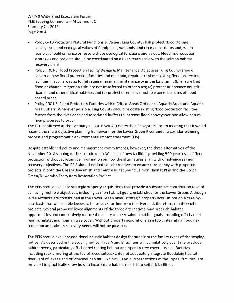
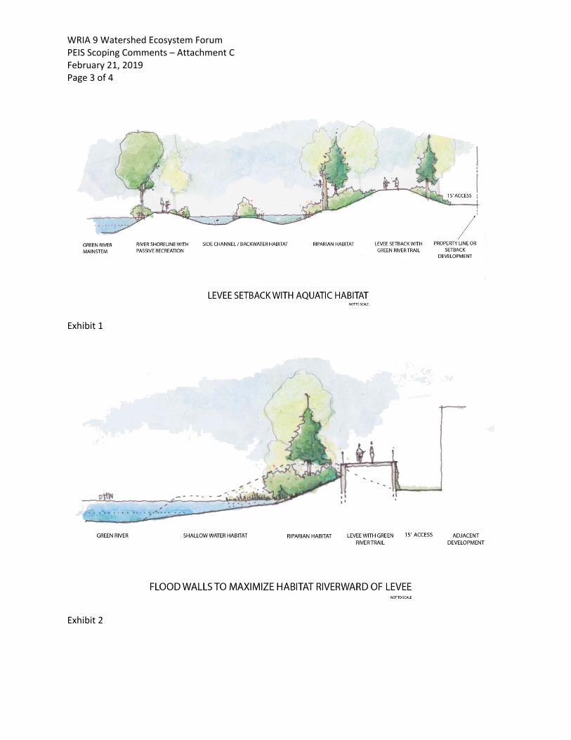
The FCD confirmed at the February 11, 2016 WRIA 9 Watershed Ecosystem Forum meeting that it would resume the multi-objective planning framework for the Lower Green River under a corridor planning process and programmatic environmental impact statement (EIS). Despite established policy and management commitments, however, the three alternatives of the November 2018 scoping notice include up to 30 miles of new facilities providing 500-year level of flood protection without substantive information on how the alternatives align with or advance salmon recovery objectives. The PEIS should evaluate all alternatives to ensure consistency with proposed projects in both the Green/Duwamish and Central Puget Sound Salmon Habitat Plan and the Corps Green/Duwamish Ecosystem Restoration Project. The PEIS should evaluate strategic property acquisitions that provide a substantive contribution toward achieving multiple objectives, including salmon habitat goals, established for the Lower Green. Although levee setbacks are constrained in the Lower Green River, strategic property acquisitions on a case-by-case basis that will enable levees to be setback further from the river and, therefore, multi-benefit projects. Several proposed levee alignments of the three alternatives may preclude habitat opportunities and cumulatively reduce the ability to meet salmon habitat goals, including off-channel rearing habitat and riparian tree cover. Without property acquisitions as a tool, integrating flood risk reduction and salmon recovery needs will not be possible. The PEIS should evaluate additional aquatic habitat design features into the facility types of the scoping notice. As described in the scoping notice, Type A and B facilities will cumulatively over time preclude habitat needs, particularly off-channel rearing habitat and riparian tree cover. Type C facilities, including rock armoring at the toe of levee setbacks, do not adequately integrate floodplain habitat riverward of levees and off-channel habitat. Exhibits 1 and 2, cross sections of the Type C facilities, are provided to graphically show how to incorporate habitat needs into setback facilities.
WRIA 9 Watershed Ecosystem Forum PEIS Scoping Comments – Attachment C February 21, 2019 Page 3 of 4
Exhibit 1
Exhibit 2
WRIA 9 Watershed Ecosystem Forum PEIS Scoping Comments – Attachment C February 21, 2019 Page 4 of 4 The PEIS should evaluate the impacts of proposed flood control facilities and interim vegetation management guidelines on in-stream water temperatures. The existing riparian corridor has limited canopy coverage. More than 50 percent of the river banks are devoid of trees within shading distance of the river. Current water temperatures in the Lower Green River regularly exceed water quality standards as described in the 2011 Green River Total Daily Maximum Load (TMDL) Water Quality Improvement Report.1 Water temperatures in excess of these standards have been shown to delay adult salmon migration, increase disease exposure, reduce juvenile growth and survival, and result in mortality. The TMDL states that the Lower Green River will not meet state standards and that Threatened species of salmon are likely to experience lethal temperatures if levees are required to be cleared of vegetation and, moreover, that until vegetation standards are changed the Green River will not meet water quality standards. The PEIS should evaluate the Interim SWIF Vegetation Management Plan ability to support a healthy riparian corridor that addresses elevated in-stream temperatures. Proposed levee alignments should be assessed with respect to the Riparian Aspect Mapping effort (Sun Map) completed by the Muckleshoot Indian Tribe in 2013. Will proposed levee alignments and implementation of vegetation maintenance requirements exacerbate in-stream temperatures and contribute to more frequent and severe water quality exceedances in the Lower Green? How will the proposed vegetation standards impact the watersheds ability to implement the TMDL in the future? No alternative of the PEIS should preclude reestablishment of functional riparian habitats where proposed levee alignments intersect with high potential shade areas. Existing development, including parking lots, agricultural areas, and roads, should not automatically preclude consideration of setting back levees where achieving shade has high potential.
1 The Green River Temperature TMDL uses the applicable temperature criteria for the designated aquatic life uses defined in WAC 173-201A-200(c) and 173-201A-602 which are:
• To protect the designated aquatic life uses of “Core Summer Salmonid Habitat,” the highest 7-DADMax temperature must not exceed 16°C (60.8°F) at a probability frequency of more than once every ten years on average between June 15 and September 15. The 16°C criterion applies to the Green River above approximately river mile 23.8, at the river’s confluence with Mill Creek. Downstream of that location the 17.5°C criterion applies.
• To protect the designated aquatic life uses of “Salmonid Spawning, Rearing, and Migration, and Salmonid Rearing and Migration Only,” the highest 7-DADMax temperature must not exceed 17.5°C (63.5°F) at a probability frequency of more than once every ten years on average between September 16 and June 14.
• To protect spawning and incubation of salmonid species the Green River from Black River (near Kent) to Howard Hanson Dam must not exceed 13°C between September 15 and July 1.