Embed Size (px)
Citation preview

Field Guide to Montana’s Wetland and Riparian Ecological Systems
November 2010

1
Field Key to Wetland and Riparian Ecological Systems of Montana
1a. Wetland defined by groundwater inflows and peat (organic soil) accumulation of at least 40 cm (unless underlain by bedrock). Vegetation can be woody or herbaceous. If the wetland occurs within a mosaic of non-peat forming wetland or riparian systems, then the patch must be at least 0.1 hectares (0.25 acres). If the wetland occurs as an isolated patch surrounded by upland, then there is no minimum size criteria. ................................................................................. Rocky Mountain Subalpine-Montane Fen
1b. Wetland does not have at least 40 cm of peat (organic soil) accumulation or occupies an area less than 0.1 hectares (0.25 acres) within a mosaic of other non-peat forming wetland or riparian systems ... 2 2a. Total woody canopy cover generally 25% or more within the overall wetland/riparian area. Any purely herbaceous patches are less than 0.5 hectares and occur within a mosaic of woody vegetation. Note: Relictual woody vegetation such as standing dead trees and shrubs are included here ................... .
...................................................................... GO TO KEY A: Woodland and Shrubland Ecological Systems
2b. Total woody canopy cover generally less than 25% within the overall wetland/riparian area. Any woody vegetation patches are less than 0.5 hectares and occur within a mosaic of herbaceous wetland vegetation ............................................................................ GO TO KEY B: Herbaceous Ecological Systems
KEY A: Woodland and Shrubland Ecological Systems 1a. Woody wetland associated with any stream channel, including ephemeral, intermittent, or perennial (Riverine HGM Class) .................................................................................................................... 2
1b. Woody wetland associated with the discharge of groundwater to the surface or fed by snowmelt or precipitation. This system often occurs on slopes, lakeshores, or around ponds. Sites may experience overland flow but no channel formation. (Slope, Flat, Lacustrine, or Depressional HGM Classes) ............. 8 2a. Riparian woodlands and shrublands of the montane or subalpine zone .............................................. 3
2b. Riparian woodlands and shrublands of the plains, foothills, or lower montane zone .......................... 4 3a. Montane or subalpine riparian woodlands (canopy dominated by trees), occurring as a narrow streamside forest lining small, confined low- to mid-order streams. Common tree species include Abies lasiocarpa, Picea engelmannii, Pseudotsuga menziesii, and Populus tremuloides ........................................
.......................................................................... Rocky Mountain Subalpine-Montane Riparian Woodland
3b. Montane or subalpine riparian shrublands (canopy dominated by shrubs with sparse tree cover), occurring as either a narrow band of shrubs lining the streambank of steep V-shaped canyons or as a wide, extensive shrub stand (sometimes referred to as a shrub carr) on alluvial terraces in low-gradient valley bottoms. Beaver activity is common within the wider occurrences. Species of Salix, Alnus, or Betula are typically dominant ............................ Rocky Mountain Subalpine-Montane Riparian Shrubland 4a. Riparian woodlands and shrublands of the foothills or lower montane zones of the Northern and Middle Rockies and the Wyoming Basin ....................................................................................................... 5

2
4b. Riparian woodlands and shrublands of the Northwestern or Western Great Plains of eastern Montana ........................................................................................................................................................ 6 5a. Foothill or lower montane riparian woodlands and shrublands associated with mountain ranges of the Northern Rockies in northwestern Montana. This type excludes island mountain ranges east of the Continental Divide in Montana. Populus balsamifera ssp. trichocarpa is typically the canopy dominant in woodlands. Other common tree species include Populus tremuloides, Betula papyifera, Betula occidentalis, and Picea glauca. Shrub understory species include Cornus sericea, Acer glabrum, Alnus incana, Oplopanax horridus, and Symphoricarpos albus. Areas of riparian shrubland and open wet meadow are common ..... Northern Rocky Mountain Lower Montane Riparian Woodland and Shrubland
5b. Foothill or lower montane riparian woodlands and shrublands associated with mountain ranges of the Middle Rockies and the Wyoming Basin. This type also includes island mountain ranges in central and eastern Montana. Woodlands are dominated by Populus spp. including Populus angustifolia, Populus balsamifera ssp. trichocarpa, Populus deltoides, and Populus fremontii. Common shrub species include Salix spp., Alnus incana, Crataegus spp., Cornus sericea, and Betula occidentalis. ...........................
.......................................... Rocky Mountain Lower Montane-Foothill Riparian Woodland and Shrubland
6a. Woodlands and shrublands of draws and ravines associated with permanent or ephemeral streams, steep north-facing slopes, or canyon bottoms that do not experience flooding. Common tree species include Fraxinus spp., Acer negundo, Populus tremuloides, and Ulmus spp. Important shrub species include Crataegus spp., Prunus virginiana, Rhus spp., Rosa woodsii, Symphoricarpos occidentalis, and Shepherdia argentea. ...................................................................... Great Plains Wooded Draw and Ravine
6b. Woodlands and shrublands of small to large streams and rivers of the Northwestern or Western Great Plains. Overall vegetation is lusher than above and includes more wetland indicator species. Dominant species include Populus balsamifera ssp. trichocarpa, Populus deltoides, and Salix spp. .......... 7 7a. Woodlands and shrublands of riparian areas of medium and small rivers and streams with little or no floodplain development and typically flashy hydrology ......................................... Great Plains Riparian
7b. Woodlands and shrublands of riparian areas along medium and large rivers with extensive floodplain development and periodic flooding ........................................................ Great Plains Floodplain 8a. Woody wetland associated with small, shallow ponds in northwestern Montana. Ponds are ringed by trees including Populus balsamifera ssp. trichocarpa, Populus tremuloides, Betula papyrifera, Abies grandis, Abies lasiocarpa, Picea engelmannii, Pinus contorta, and Pseudotsuga menziesii. Typical shrub species include Cornus sericea, Amelanchier alnifolia, and Salix spp. ............................................................
.......................................................................................................... Rocky Mountain Wooded Vernal Pool
8b. Woody wetland associated with the discharge of groundwater to the surface, or sites with overland flow but no channel formation. .................................................................................................................... 9 9a. Coniferous woodlands associated with poorly drained soils that are saturated year round or seasonally flooded. Soils can be woody peat but tend toward mineral. Common tree species include Thuja plicata, Tsuga heterophylla, and Picea engelmannii. Common species of the herbaceous understory include Mitella spp., Calamagrostis spp., and Equisetum arvense ..............................................
................................................................................................................... Rocky Mountain Conifer Swamp
9b. Woody wetlands dominated by shrubs ............................................................................................... 10

3
10a. Subalpine to montane shrubby wetlands that occur around seeps, fens, and isolated springs on slopes away from valley bottoms. This system can also occur within a mosaic of multiple shrub- and herb-dominated communities within snowmelt-fed basins. This example of the system has the same species composition as the riverine example of this system and is dominated by species of Salix, Alnus, or Betula. ............................................................ Rocky Mountain Subalpine-Montane Riparian Shrubland
10b. Lower foothills to valley bottom shrublands restricted to temporarily or intermittently flooded drainages or flats and dominated by Sarcobatus vermiculatus .......................................... Greasewood Flat
KEY B: Herbaceous Wetland Ecological Systems
1a. Herbaceous wetlands of the Northwestern Glaciated Plains, Northwestern Great Plains, or Western Great Plains regions of eastern Montana ..................................................................................................... 2
1b. Herbaceous wetlands of other regions .................................................................................................. 5 2a. Wetland occurs as a complex of depressional wetlands within the glaciated plains of northern Montana. Typical species include Schoenoplectus spp. and Typha latifolia on wetter, semi-permanently flooded sites, and Eleocharis spp., Pascopyrum smithii, and Hordeum jubatum on drier, temporarily flooded sites ....................................................................................................... Great Plains Prairie Pothole
2b. Wetland does not occur as a complex of depressional wetlands within the glaciated plains of Montana ........................................................................................................................................................ 3 3a. Depressional wetlands in the Western Great Plains with saline soils. Salt encrustations can occur on the surface. Species are typically salt-tolerant such as Distichlis spicata, Puccinellia spp., Salicornia spp., and Schoenoplectus maritimus ...................................................... Great Plains Saline Depression Wetland
3b. Depressional wetlands in the Western Great Plains with obvious vegetation zonation dominated by emergent herbaceous vegetation, including Eleocharis spp., Schoenoplectus spp., Phalaris arundinacea, Calamagrostis canadensis, Hordeum jubatum, and Pascopyrum smithii ..................................................... 4 4a. Depressional wetlands in the Western Great Plains associated with open basins that have an obvious connection to the groundwater table. This system can also occur along stream margins where it is linked to the basin via groundwater flow. Typical plant species include species of Typha, Carex, Schoenoplectus, Eleocharis, Juncus, and floating genera such as Potamogeton, Sagittaria, and Ceratophyllum.. ........................................................... Great Plains Open Freshwater Depression Wetland
4b. Depressional wetlands in the Western Great Plains primarily within upland basins having an impermeable layer such as dense clay. Recharge is typically via precipitation and runoff, so this system typically lacks a groundwater connection. Wetlands in this system tend to have standing water for a shorter duration than Western Great Plains Open Freshwater Depression Wetlands. Common species include Eleocharis spp., Hordeum jubatum, and Pascopyrum smithii ............................................................ ...................................................................................................... Great Plains Closed Depression Wetland 5a. Wetlands with a permanent water source throughout all or most of the year. Water is at or above the surface throughout the growing season, except in drought years. This system can occur around ponds, as fringes around lakes and along slow-moving streams and rivers. The vegetation is dominated

4
by common emergent and floating leaved species including species of Scirpus, Schoenoplectus, Typha, Juncus, Carex, Potamogeton, Polygonum, and Nuphar. ........... Western North American Emergent Marsh
5b. Herbaceous wetlands associated with a high water table or overland flow, but typically lacking standing water. Sites with no channel formation are typically associated with snowmelt and not subjected to high disturbance events such as flooding (Slope HGM Class). Sites associated with a stream channel are more tightly connected to overbank flooding from the stream channel than with snowmelt and groundwater discharge and may be subjected to high disturbance events such as flooding (Riverine HGM Class). Vegetation is dominated by herbaceous species; typically graminoids have the highest canopy cover including Carex spp., Calamagrostis spp., and Deschampsia cespitosa ................................... ......................................................................................................................Alpine-Montane Wet Meadow
5
Rocky Mountain Subalpine-Montane Fen
General Description Fens occur infrequently throughout the Rocky Mountains from Colorado north into Canada. They are confined to specific environments defined by groundwater discharge, soil chemistry, and peat accumulation. This system includes poor fens, rich fens and extremely rich fens. Fens form at low points in the landscape or near slopes where groundwater intercepts the soil surface. Groundwater inflows maintain a fairly constant water level year-round, with water at or near the surface most of the time. Constant high water levels lead to accumulation of organic material, usually greater than 40 centimeters (15 inches) except on sites underlain by limestone bedrock. In addition to peat accumulation and perennially saturated soils, extremely rich and iron fens have distinct soil and water chemistry, with high levels of one or more minerals such as calcium, magnesium, or iron. Fens maintain stream water quality through denitrification and phosphorus absorption. They are among the most floristically diverse of all wetland types, supporting a large number of rare and uncommon bryophytes and vascular plant species, as well as providing habitat for uncommon mammals, mollusks and insects. Fens usually occur as a mosaic of herbaceous and woody plant communities. In herbaceous communities, there are several plant associations dominated by sedges (Carex species), spikerushes (Eleocharis species), and rushes (Juncus species). Bryophyte diversity is generally high and includes sphagnum (Sphagnum species). Forb diversity is especially high in extremely rich and iron fens. The woody community is typically composed of willow (Salix species) and birch (Betula nana) carr shrubland. The surrounding landscape may be ringed with other wetland systems: fens often grade into marshes, wet meadows or riparian shrublands, and can
6
be surrounded by conifer swamps or wet to mesic coniferous forests. In very rare cases, fens can occur within prairie grasslands in the glaciated Great Plains. Fens are found in scattered locations along the Rocky Mountain Front, in the Rocky Mountains and and intermountain valleys, in the small isolated central mountain ranges, and at higher elevations on the Beartooth Plateau in the southern portion of the state.
Diagnostic Characteristics Seepage-fed slopes, montane to subalpine elevations, organic peat layer greater than 40 cm deep, extreme (mineral) rich and iron-rich, saturated soils, bryophytes, graminoids Similar Systems Alpine-Montane Wet Meadow Western North American Emergent Marsh
Range This system occurs infrequently throughout the Rocky Mountains from Colorado north into Canada. In Montana, small fens are found in scattered locations in the glaciated plains and in the small isolated mountain ranges of the central part of the state. The Swan, Stillwater and Flathead valleys have numerous rich and extremely rich fen systems due to the prevalence of limestone bedrock in the Whitefish, Mission, and Swan mountain ranges. Similarly, rich and extremely rich fens are found along the limestone-rich Front Range east of the Continental Divide. East of the Continental Divide, both small and large rich and extremely rich prairie fens occur on the extreme western Great Plains bordering the Rocky Mountain Front (Lesica, 1986) and rarely, within the northwestern mixed grass prairie (Heidel et al, 2000). Further south in western Montana, poor fen systems are more common in the Bitterroot, Lolo, and Beaverhead ranges, and are found in the granitic, isolated central Montana island ranges and the Beartooth Plateau in southwestern Montana. Environment The montane-subalpine fen ecological system is a small-patch system composed of mountain wetlands that support a unique community of plants not found in other types of wetlands. Fens are confined to specific environments defined by groundwater discharge, soil chemistry, and peat accumulation of at least 40 centimeters (15 inches), although peat accumulations in areas overlain by gravel, cobble or bedrock may be less. Soils are typically organic histosols with 40 centimeters or more of organic material if overlying a mineral soil, or less if overlying bedrock, cobbles or gravels. Histosols range in texture from clayey-skeletal to loamy-skeletal and fine-loams. Fens form at low points in the landscape or near slopes where groundwater intercepts the soil surface. Groundwater inflows maintain a fairly constant water level year-round, with water at or near the surface most of the time. Constant high water levels lead to accumulations of organic material. Rich and extremely rich fens are found in areas underlain by limestone. Water chemistry ranges from only slightly acidic to alkaline and is usually distinctly calcareous. Marl deposits (precipitated calcium carbonates) are common in these systems. Tufa deposits or terraces can be seen in some rich fens and are composed of virtually pure calcium carbonate at
7
the soil surface, formed by continuous discharge and evaporation of calcite saturated groundwater. In northwestern Montana, pH values usually range from 5.9 to 8.4 (Chadde et al., 1998). Poor fens are more common in the northern Rocky Mountains and occur in areas overlain by non-calcareous bedrock, e.g., argillites and granite. These are usually flat, acidic, and saturated to the surface, sometimes with standing water. Iron rich fens are more rare in occurrence, and can be strongly acidic (as low as pH 2.98) and associated with geothermal features and bedrock of weathering pyrite, as found in some occurrences in the Yellowstone Plateau (Lemly, 2007). Iron rich fens support a diverse bryophyte community, typically have less vascular plant diversity, and are composed of species dependant on more acidic conditions.
Fens develop successionally through lake-filling, flow-through successional processes or by paludification (Chadde et al., 1998). Lake filling occurs in depressions and is often characterized by the presence of floating mats and a ring of carr vegetation on the outer margin of the peatland. Flow-through fens are the most common in the northern Rocky Mountains. They occur along springs, streams, slopes and benches with a constant inflow and outflow of calcium-rich water. They are characterized by a series of linear hummocks oriented perpendicular to the slope. Carr shrubland is well developed in flow-through fens due to well-aerated, nutrient-rich water near the inflow and outflow zones. Usually there is an open, nutrient- poor community in the central portion of the fen. Paludification occurs when fens expand due to a rise in the water table caused by peat accumulation. This process is most often observed near seeps and springs or adjacent to closed basin peatlands where peat accumulation causes wetter conditions along the outer edges. Higher water tables kill existing trees. In the northern Rocky Mountains, this successional process is limited due to prolonged summer droughts; however it may be seen in some fen systems at higher elevations.
In northwestern Montana, fens occur at montane to subalpine elevations, generally ranging from 985-2,165 meters (2,500-5,500 feet). In southwestern Montana, subalpine and alpine fens occur at higher elevations (Heidel and Rodemaker, 2008). These communities typically occur in seeps and wet sub-irrigated meadows in narrow to broad valley bottoms. Surface topography is typically smooth to concave with lake-fill peatlands or with slopes ranging from 0 to 10 percent in flow-through fens.
Vegetation Floristically, rich and extremely rich fens support the greatest vascular plant species diversity of all peatland types in the Rocky Mountains. Extremely rich fens are characterized by high species diversity and a mosaic of herbaceous and woody plant communities. In contrast, poor fens have scattered vascular plant cover and lower species diversity but are characterized by a nearly continuous and diverse cover of mosses and other bryophytes.
Several vascular plants have been identified as extremely rich or rich fen indicators in Montana, and some of these species are uncommon or rare. Indicators include: sage-leaf willow (Salix candida), simple bog sedge (Kobresia simpliciuscula), Bellardii bog sedge (Kobresia myosuroides), Rolland’s small clubrush (Trichophorum pumilum), little green sedge (Carex viridula), northern single spike sedge (Carex scirpoidea), pale sedge (Carex livida), bulblet-

8
bearing water hemlock (Cicuta bulbifera), slender cottongrass (Eriophorum gracile), green keeled cottongrass (Eriophorum viridicarinatum), beaked spikerush (Eleocharis rostellata), northern bog violet (Viola nephrophylla), pale bog laurel (Kalmia polifolia), Kalm’s lobelia (Lobelia kalmii), and yellow widelip orchid (Liparis loeselii). Other orchids such as giant helleborine orchid (Epipactis gigantea) are found in open sedge-dominated portions of the fen system, while one-leaf orchid (Ameorchis rotundifolia), sparrow’s egg ladyslipper (Cypripedium passerinum) and small yellow ladyslipper (Cypripedium parviflorum) occur on raised sphagnum hummocks around trees and shrubs near the perimeter of the fen. These species are found almost exclusively in fens or wet forest habitats bordering fens. Poor fens often include species found in more acidic conditions such as pale bog laurel (Kalmia polifolia), rannoch rush (Scheuchzeria palustris) and sundews (Drosera species).
In extremely rich and rich fens, the herbaceous community is often dominated by beaked sedges (Carex utriculata or Carex rostrata), water sedge (Carex aquatilis), mud sedge (Carex limosa), woolyfruit sedge (Carex lasiocarpa), spikerush (Eleocharis species), cottongrass (Eriophorum species), rushes (Scirpus species and Trichophorum species) and bulrushes (Shoenoplectus species). Other frequent species include Buxbaum’s sedge (Carex buxbaumii), analogue sedge (Carex simulata), northern bog sedge (Carex gynocrates), bristly-stalked sedge (Carex leptalea), poor sedge (Carex paupercula), yellow sedge (Carex flava), hair sedge (Carex capillaris), silvery sedge (Carex canescens), lens sedge (Carex lenticularis), Baltic rush (Juncus balticus), northern rush (Juncus alpino-articulatus), dagger leaf rush (Juncus ensifolius), threadleaf rush (Juncus filiformis), common spike rush (Eleocharis palustris), and few-flowered spike rush (Eleocharis quinqueflora). Common grasses include bluejoint reedgrass (Calamagrostis canadensis), tufted hairgrass (Deschampsia cespitosa), and fringed brome (Bromus ciliatus).
Rich and extremely rich fens also support high forb diversity. Common species include showy pussytoes (Antenarria pulcherrima), bog orchid (Plantanthera species), buckbean (Menyanthes trifoliata), elegant death camas (Zigadenus elegans), grass-of-parnassus (Parnassia species), beautiful shooting-star (Dodecatheon pulcherrinum), pink elephant’s head (Pedicularis groenlandica), arrow-grass (Triglochin palustris), and Siberian chives (Allium schoenoprasum). At subalpine elevations, common butterwort (Pinguicula vulgaris) often occurs near seeps or springs, in areas where there is marl accumulation or on tufa deposits or terraces.
In Montana, wet, floating Sphagnum-dominated mats are associated with open water edges or depressional areas of fen systems. Bryophyte floating mats often consist of Meesia moss (Meesia triquetra), Scorpidium moss (Scorpidium species), Magellan’s peatmoss (Sphagnum magellanicum) and brown peatmoss (Sphagnum fuscum). The bryophyte floating mat supports a very minor component of sedges such as mud sedge (Carex limosa) and smaller sedges such as grape sedge (Carex aurea), softleaf sedge (Carex disperma) and inland sedge (Carex interior), as well as cottongrass species (Eriophorum species). Fen indicators such as pale laurel (Kalmia polifolia), rannoch rush (Scheuchzeria palustris) and sundews (Drosera species) occur on these floating mats. Buckbean (Menyanthes trifoliata) is a late seral species from the sedge mat phase and is often present on floating mats.
9
Fens are frequently bordered by willow-bog birch (Salix species-Betula nana glandulosa) dominated carrs. Carr shrubland is well developed in flow-through fens due to highly-aerated nutrient-rich water near the inflow and outflow zones or the perimeter of basin fens. Sageleaf willow (Salix candida) is an indicator species, and sometimes the dominant willow species. Other willow species include autumn willow (Salix serrissima), Bebb’s willow (Salix bebbiana), Drummond’s willow (Salix drummondiana), plane-leaf willow (Salix planifolia), wolf willow (Salix wolfii), and undergreen willow (Salix commutata). Other common carr shrubs include alder (Alnus species), bog birch (Betula nana), alder buckthorn (Rhamnus alnifolia), shrubby cinquefoil (Dasiphora fruticosa), and western Labrador tea (Ledum glandulosum). Engelmann spruce (Picea engelmannii) is the most frequent conifer species associated with fens and forested fen margins of these systems (Hansen and others, 1995).
Alliances (A.1403) (Beaked Sedge, Northwest Territory Sedge) Seasonally Flooded Herbaceous Alliance (A.1469) Analogue Sedge Saturated Herbaceous Alliance (A.1404) Aquatic Sedge Seasonally Flooded Herbaceous Alliance (A.1413) Brown Bog Sedge Seasonally Flooded Herbaceous Alliance (A.995) Dwarf Birch Seasonally Flooded Shrubland Alliance (A.1002) Hoary Willow Seasonally Flooded Shrubland Alliance (A.1416) Mud Sedge Seasonally Flooded Herbaceous Alliance (A.1398) Threeway Sedge Seasonally Flooded Herbaceous Alliance (A.1415) Wiregrass Sedge Seasonally Flooded Herbaceous Alliance
Dynamic Processes Mountain fens act as natural filters, cleaning ground and surface water. Fens also act as sponges by absorbing heavy precipitation, then slowly releasing it downstream, minimizing erosion and recharging groundwater systems. Persistent groundwater and cold temperatures allow organic matter to accumulate, forming peat, which allows classification of wetlands within this system as fens. Peat accumulates at the rate of 8 to 11 inches per 1000 years, making peatlands a repository of 10,000 years of post-glacial history. Management Land uses surrounding fens can potentially alter the hydrology and nutrient inputs of these systems, thus changing their underlying processes. Increased land use within 100 meters has been found to be correlated with increased nutrient levels in peatlands in Montana, suggesting that setbacks should be 100 meters or more for adequate protection (Jones 2003). Draining, heavy cattle use, and irrigation practices can also alter hydrology and result in the loss of species diversity. Localized peat mining may occur on private lands.
Restoration Considerations The degree of damage that has occurred in a fen has a significant impact on the prospects for restoration. Peat mining will cause irreversible damage to fen systems because Rocky Mountain fens build peat so slowly (8 to 11 inches per 1,000 years). In fen systems where water has been drained or altered, the original hydrology of the system must be restored before any vegetation

10
restoration can be considered. If water levels are restored, re-growth and re-colonization of peat mosses can occur, although this is a very slow process. In deeper waters, regeneration depends on whether residual peat layers will become buoyant. Regeneration largely depends on water chemistry and residual peat layer quality. When peat quality is inadequate, shallow inundation is recommended (Smolders et al., 2002).
Heavy cattle use in a fen system can alter the hydrology by damaging soils within the fen system. Soil compaction and pugging within the peat layer will change surface water flow. Heavy cattle use can also alter the successional processes within the sedge- dominated area of a fen. Cattle hoof action can lead to pugging and hummocking, creating microsites where shrubs can become established, changing the sedge-dominated meadow to carr shrubland.
Original Concept Authors Natureserve Western Ecology Group Montana Version Authors T. Luna, L.K. Vance, C. McIntyre Version Date 1/17/2010
Literature Cited Chadde SW, Shelly JS, Bursik RJ, Moseley RK, Evenden AG, Mantas M, Rabe F, Heidel B. 1998.
Peatlands on national forests of the northern Rocky Mountains: ecology and conservation. Ogden, UT: USDA Forest Service, Rocky Mountain Research Station; Report nr RMRS-GTR-11.
Hansen PL, Pfister RD, Boggs K, Cook BJ, Joy J, Hinckley DK. Classification and management of Montana's riparian and wetland sites. No. 54, 1-646. 1995. Montana Forest and Conservation Experiment Station, School of Forestry, University of Montana. Miscellaneous Publication.
Heidel B, Cooper SV, Jean C. 2000. Plant species of special concern and plant associations of Sheridan County, Montana. Report to the U.S. Fish and Wildlfie Service. Helena, Montana: Montana Natural Heritage Program; -22 pp. plus appendices.
Heidel B, Rodemaker E. 2008. Inventory of peatland systems in the Beartooth Mountains, Shoshone National Forest, Park County, Wyoming. Laramie, Wyoming: Wyoming Natural Diversity database; Report nr Prepared for: Environmental Protection Agency.
Jones WM. 2003. Kootenai National Forest peatlands: description and effects of forest management. Helena, MT: Montana Natural Heritage Program.

11
Lemly J. 2007. Fens of Yellowstone National Park, USA: Regional and local controls over plant species distribution [dissertation]. Colorado State University. 143 p.
Lesica P. 1986. Vegetation and flora of Pine Butte Fen, Teton County, Montana. Great Basin Nat 46(1):22-32.
Mitsch WJ, Gosselink JG. 2000. Peatlands in Wetlands (3rd Edition). New York: John Wiley & Sons.
Smolders AJP, Tomassen HBM, Lamers LPM, Lomans BP, Roelofs JGM. 2002. Peat bog restoration by floating raft formation: the effects of groundwater and peat quality. J Appl Ecol(39):391-401.
Ecological Systems Field Guide: http://FieldGuide.mt.gov/displayES_Detail.aspx?ES=9234
12
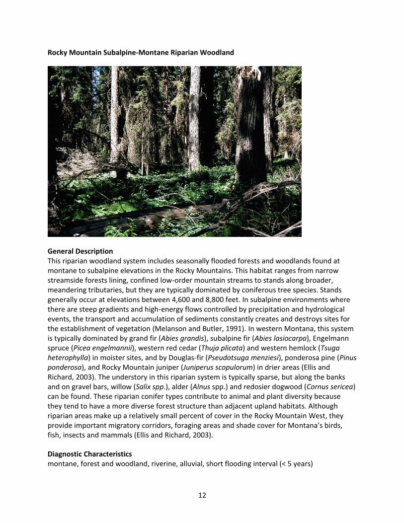
Rocky Mountain Subalpine-Montane Riparian Woodland
General Description This riparian woodland system includes seasonally flooded forests and woodlands found at montane to subalpine elevations in the Rocky Mountains. This habitat ranges from narrow streamside forests lining, confined low-order mountain streams to stands along broader, meandering tributaries, but they are typically dominated by coniferous tree species. Stands generally occur at elevations between 4,600 and 8,800 feet. In subalpine environments where there are steep gradients and high-energy flows controlled by precipitation and hydrological events, the transport and accumulation of sediments constantly creates and destroys sites for the establishment of vegetation (Melanson and Butler, 1991). In western Montana, this system is typically dominated by grand fir (Abies grandis), subalpine fir (Abies lasiocarpa), Engelmann spruce (Picea engelmannii), western red cedar (Thuja plicata) and western hemlock (Tsuga heterophylla) in moister sites, and by Douglas-fir (Pseudotsuga menziesi), ponderosa pine (Pinus ponderosa), and Rocky Mountain juniper (Juniperus scopulorum) in drier areas (Ellis and Richard, 2003). The understory in this riparian system is typically sparse, but along the banks and on gravel bars, willow (Salix spp.), alder (Alnus spp.) and redosier dogwood (Cornus sericea) can be found. These riparian conifer types contribute to animal and plant diversity because they tend to have a more diverse forest structure than adjacent upland habitats. Although riparian areas make up a relatively small percent of cover in the Rocky Mountain West, they provide important migratory corridors, foraging areas and shade cover for Montana’s birds, fish, insects and mammals (Ellis and Richard, 2003).
Diagnostic Characteristics montane, forest and woodland, riverine, alluvial, short flooding interval (< 5 years)

13
Similar Systems Northern Rocky Mountain Lower Montane Riparian Woodland and Shrubland Rocky Mountain Subalpine-Montane Riparian Shrubland Range This system is found at montane to subalpine elevations in the Rocky Mountains, from southern New Mexico north into Montana, Alberta and British Columbia, and west into the Intermountain region and the Colorado Plateau. In Montana, riparian conifer systems are found throughout the state, but are more common in the moister forested regions west of the Continental Divide. Environment This riparian woodland system includes seasonally flooded forests and woodlands found at montane to subalpine elevations of the Rocky Mountains. Stands typically occur at elevations between 4,600-8,800 feet. This system is common to the poorly-developed floodplains and terraces of V-shaped, narrow valleys and canyons, and less frequently, it occurs in moderate to wide valley bottoms on large floodplains along broad, meandering rivers such as the South Fork of the Flathead, and on pond or lake margins. In subalpine environments where there are steep gradients and high-energy flows controlled by precipitation and hydrological events, the transport and accumulation of sediments constantly creates and destroys sites for the establishment of vegetation (Melanson and Butler, 1991).
Vegetation Vegetation composition and structure can vary depending on latitude, elevation and climate. A woody riparian area in the subalpine zone of the Rocky Mountains in Montana is typically dominated by grand fir, subalpine fir and Engelmann spruce. Grand fir and Engelmann spruce are considered late seral species, while subalpine fir is predominantly found in climax communities at higher elevations or at lower elevations in frost pockets (Hansen et al., 1995). In the montane zone, dominant vegetation changes to a community dominated by ponderosa pine, western larch (Larix occidentalis) and Douglas fir (Pseudotsuga menziesii). Western red cedar (Thuja plicata) and western hemlock (Tsuga heterophylla) occur in moister sites west of the Continental Divide, and Some sites support Rocky Mountain juniper. The understory is typically sparse, but along the banks and on gravel bars, willow, alder and redosier dogwood can be present. Some sites support scattered black cottonwood (Populus balsamnifera) and/or small stands of quaking aspen (Populus tremuloides). The vegetation in these systems relies on a consistent shallow water table to meet individual plant requirements; however, periodic flooding is necessary for community maintenance. Flooding transports sediments and creates establishment sites for plant colonization. Many plants have acquired adaptive traits as a result of this disturbance regime. Mechanical adaptations such as stem flexibility and specialized oxygen-holding cells assist riparian plants to endure through the physical strains of flooding. Reproductive adaptations, including water-dispersible seeds, vegetative budding, and adventitious roots allow plants to colonize and regenerate by seed and asexual methods.
14
The understory shrub species often form in a narrow band in the gravel bars and embankments along the stream channel. In the montane zone, species such as thinleaf alder (Alnus incana), redoiser dogwood and willows such as Bebb’s willow (Salix bebbiana), Booth’s willow (Salix boothii), Drummond’s willow (Salix drummondiana), dusky willow (Salix melanopsis), and Geyer’s willow (Salix geyeriana) are common. In western Montana riparian forests dominated by spruce or subalpine fir, devil’s club (Oplopanax horridus) may be a codominate in the understory, but this is an infrequent plant association. Other minor shrubs include thimbleberry (Rubus parviflorus), elderberry (Sambucus species), Douglas hawthorn (Crataegus douglasii), black twinberry (Lonicera involucrata), alder buckthorn (Rhamnus alnifolia), serviceberry (Amelanchier alnifolia), common snowberry (Symphoricarpos albus) and Woods’ rose (Rosa woodsii).
In the subalpine elevations, sitka alder (Alnus viridis) and Drummond’s willow are frequently dominant. Water birch (Betula occidentalis) or resin birch (Betula glandulosa) may also be present. Planeleaf willow (Salix planifolia), undergreen willow (Salix commutata), Barclay’s willow (Salix barclayi), shortfruit willow (Salix brachycarpa) and grayleaf willow (Salix glauca) become common at higher elevations. Herbaceous vegetation forms a minor component of this system but may include small patches of bluejoint reedgrass (Calamagrostis canadensis), drooping woodreed (Cinna latifolia) and sedges such water sedge (Carex aquatilis). Common forbs include arrowleaf groundsel (Senecio triangularis), angelica (Angelica spp.) baneberry (Actaea rubra) western meadow rue (Thalictrum occidentale), starry solomon’s seal (Maianthemum stellatum), fragrant bedstraw (Galium triflorum), Virginia strawberry (Fragaria virginiana), sweet-cicely (Osmorhiza species), common cow parsnip (Heracleum maximum), clasp-leaf twistedstalk (Streptopus amplexifolius) and green false hellebore (Veratrum viride). Common ferns and fern allies are often present, such as horsetail (Equisetum species), American ladyfern (Athryium filix-femina), and oak fern (Gymnocarpium dryopteris).
Alliances (A.311) Black Cottonwood Temporarily Flooded Forest Alliance (A.191) Engelmann Spruce Seasonally Flooded Forest Alliance (A.572) Engelmann Spruce Seasonally Flooded Woodland Alliance (A.179) Engelmann Spruce Temporarily Flooded Forest Alliance (A.566) Engelmann Spruce Temporarily Flooded Woodland Alliance (A.188) Lodgepole Pine Seasonally Flooded Forest Alliance (A.175) Lodgepole Pine Temporarily Flooded Forest Alliance (A.562) Lodgepole Pine Temporarily Flooded Woodland Alliance (A.274) Quaking Aspen Forest Alliance (A.340) Quaking Aspen Seasonally Flooded Forest Alliance (A.300) Quaking Aspen Temporarily Flooded Forest Alliance (A.422) Subalpine Fir - Quaking Aspen Forest Alliance (A.190) Subalpine Fir Seasonally Flooded Forest Alliance (A.177) Subalpine Fir Temporarily Flooded Forest Alliance

15
Dynamic Processes Stochastic flood events and variable fluvial conditions are crucial to the development of establishment sites for riparian plants, and actl as a primary control on plant succession. Steep gradients and high-energy flows controlled by precipitation causes flooding events that transport sediments. The scouring out and accumulation of sediments creates and destroys sites for the establishment of vegetation (Melanson and Butler, 1991). Sediment accumulating in more meandering examples of these systems often creates gravel bars at or near the surface of the water where colonizing vegetation creates bands of mixed vegetation that occupies different stages of succession (Melanson and Butler, 1991). Ground water seepage from snowmelt may create shallow water tables or seeps that vegetation depends on for a portion of the growing season Management Grazing along narrow, low order streams can result in increased erosion and channel downcutting (Mitsch and Gosellink, 2000). Sites that are subjected to heavy grazing practices may transition to an herbaceous understory consisting of introduced grasses and forbs such as Kentucky bluegrass (Poa pratensis) and Canadian thistle (Cirsium arvense). In addition, fire suppression, timber harvest and reduced flood frequency can affect the succession of riparian communities.
Restoration Considerations Restoration strategies are dependent on the degree and type of disturbance event. Restoration efforts must first concentrate on restoring thestream's hydrology, so floods can re-occur. In-stream habitat enhancement (e.g., additions of logs or boulders) should be employed after restoring natural processes or where short-term improvements in habitat are needed (e.g., for species in recovery).
Removing or strictly limiting grazing by livestock and wildlife will allow the system to recover if hydric soils have not been lost due to extensive soil compaction, pugging, or down cutting of stream channels, and if there are existing populations of herbaceous native species (Carex, Juncus, and native grasses) that possess rhizomatous root systems capable of re-colonizing bare soils. Rhizomatous, highly adaptable exotic grasses such as Kentucky bluegrass, common timothy and smooth brome and pasture forbs such as clovers (Trifoliumspecies) and common dandelion (Taraxacum officinale) will persist on the site and may compete with existing populations of native graminiods and forbs. In these cases, land managers must determine whether the exotic density is small enough that an adequate stand of native graminoids and forbs can become established on the site if reseeding efforts are used. In all cases, grazing must be excluded for several years to allow adequate re-growth and recovery of existing shrubs and the herbaceous understory.
Because all major shrub species within this riparian system are capable of re-sprouting and typically possess extensive, spreading root systems, modified land management practices in areas of low to moderate impact can minimize additional restoration needs. Vigor, health and degree of vegetative regeneration of existing trees and shrubs must be evaluated to determine
16
if these components of the community are capable of recovery in an acceptable time frame. Intensive revegetation efforts should be limited to sites where a catastrophic wildfire or prolonged heavy grazing has destroyed existing trees, shrubs and the seed bank.
Original Concept Authors Natureserve Western Ecology Group Montana Version Authors L.K. Vance, C. McIntyre, T. Luna Version Date 2/15/2010
Literature Cited Cowardin LM, Carter V, Golet F, LaRoe ET. 1979 Dec. Classification of wetlands and deepwater
habitats of the United States. Washington, D.C.: U.S. Department of the Interior, Fish and Wildlife Service; Report nr FWS/OBS-79/31.
Ellis JH, Richard J. A planning guide for protecting Montana's wetlands and riparian areas.
www.mtwatercourse.org. 2003. Produced by Montana Watercourse. Hansen PL, Pfister RD, Boggs K, Cook BJ, Joy J, Hinckley DK. Classification and management of
Montana's riparian and wetland sites. No. 54, 1-646. 1995. Montana Forest and Conservation Experiment Station, School of Forestry, University of Montana. Miscellaneous Publication.
Melanson GP, Butler DR. 1991. Floristic variation among gravel bars in a subalpine river in
Montana, US. Arct Alp Res(23):273-8. Mitsch WJ, Gosselink JG. 2000. Riparian Ecosystems. Wetlands 3rd Edition. John Wiley and
Sons, Inc.; p 377-417.
Ecological Systems Field Guide: http://FieldGuide.mt.gov/displayES_Detail.aspx?ES=9171

17
Rocky Mountain Subalpine-Montane Riparian Shrubland
General Description This riparian system is a seasonally flooded shrubland found at montane to subalpine elevations of the Rocky Mountains. Shrubs dominate this system, with total shrub cover ranging from 20 to 100 percent. It occurs as linear bands of shrub vegetation lining streambanks and alluvial terraces in narrow to wide, low-gradient valley bottoms and floodplains with sinuous stream channels. Flooding creates and destroys sites for the establishment of vegetation through the transport and accumulation of coarse sediment (Melanson and Butler, 1991). Sediment accumlating in these systems can form gravel bars at or near the surface of the river, creating bands of mixed vegetation that occupy different stages of succession (Melanson and Butler, 1991). Ground water seepage from snowmelt may create shallow water tables or seeps that vegetation depends on for a portion of the growing season. This system often occurs as a mosaic of multiple communities that are shrub and herb dominated. The structure of vegetative communities in these systems can vary depending on latitude, elevation and climate. In Montana, these systems are dominated by willows, including Drummond’s willow (Salix drummondiana), Bebb’s willow (Salix bebbiana), planeleaf willow (Salix planifolia ssp. planifolia), undergreen willow (Salix commutata), Idaho willow (Salix wolfii), booth willow (Salix boothi) and Geyer’s willow (Salix geyeriana). Typical herbaceous vegetation found in the understory includes beaked sedge (Carex utriculata), bluejoint reedgrass (Calamagrostis canadensis), and northern reedgrass (Calamagrostis stricta). Generally, the upland vegetation surrounding these riparian systems are conifer dominated forests. Shrubland riparian systems

18
are important for bank stabilization, organic inputs to the adjacent stream, shade cover and wildlife habitat values.
Diagnostic Characteristics montane, shrubland, riverine, alluvial, broad leaf shrub, short flooding interval (< 5 years), short persistence
Similar Systems Northern Rocky Mountain Lower Montane Riparian Woodland and Shrubland Rocky Mountain Lower Montane-Foothill Riparian Woodland and Shrubland Rocky Mountain Subalpine-Montane Riparian Woodland Range This system is found throughout the Rocky Mountain cordillera from New Mexico north into Montana, and occurs in the isolated island mountain ranges of central and eastern Montana. It is found throughout the western states and provinces of North America; including the Intermountain Basin and Colorado Plateau states.
Environment This riparian system is a seasonally flooded shrubland found at montane to subalpine elevations of the Rocky Mountains. In Montana, this system typically occurs at elevations between 1,750 and 2,693 meters (5,740-8,830 feet). This system consists of narrow bands of shrub vegetation lining streambanks and alluvial terraces in narrow to wide, low-gradient valley bottoms and floodplains with sinuous stream channels. This system is also typical around seeps, fens, and isolated springs on hillslopes away from valley bottoms. Sediment that accumulates in these systems may create gravel bars at or near the surface of the river where colonizing vegetation creates bands of mixed vegetation that occupy different stages of succession (Melanson and Butler, 1991). Ground water seepage from snowmelt may create shallow water tables or seeps that vegetation depends on for a portion of the growing season. Vegetation Plant community composition and structure can vary depending on latitude, elevation and climate. For example, in southwest Montana Drummond’s willow occupies higher elevations while Geyer’s willow and booth willow are found at more intermediate elevations. In the northwest region of Montana, Geyer’s and booth willow are barely present and Drummond’s willow dominates most riparian areas (Hansen et al, 1995). Bebb’s willow, planeleaf willow, undergreen willow and Idaho willow are frequent associates. Barclay’s willow (Salix barclayi), shortfruit willow (Salix brachycarpa) and grayleaf willow (Salix glauca) become common at higher subalpine elevations. Sageleaf willow (Salix candida) is indicative of fens and occurs in association with other willow species to form the shrub-dominated carr layers within riparian areas feeding into or out of fens. Redoiser dogwood (Cornus sericea), shrubby cinquefoil (Dasiphora fruticosa), alder (Alnus spp.), currant (Ribes spp.) and Rocky Mountain maple (Acer glabrum) are common associates. Water birch (Betula occidentalis) or bog birch (Betula nana, glandulosa) may also be present.

19
Dominant graminoid vegetation in the herbaceous stratum of these shrubland riparian systems includes bluejoint reedgrass, northern reedgrass and Northwest Territory sedge. Common forbs include dwarf fireweed (Chamerion latifolium), field mint (Mentha arvensis), glaucous willowherb (Epilobium glaberrimum), western mountain aster (Symphyotrichum spathulatum), and tiny trumpets (Collomia linearis). Sharptooth angelica (Angelica arguta), starry solomon’s seal (Maianthemum stellatum), sweet-cicely (Osmorhiza species), common cow parsnip (Heracleum maximum), clasp-leaf twisted stalk (Streptopus amplexifolius) and green false hellebore (Veratrum viride) are frequent at higher elevations. Within rich fen-carr shrublands, graminoid and forb species diversity is typically higher than other sites supporting these riparian shrublands.
Flooding in these systems influences vegetative communities by transporting sediments and creating establishment sites for colonization. Many plants in these high-energy systems that experience large disturbances from floods have acquired adaptive traits. Some have flexible, resilient stems and specialized cells to hold oxygen so that they can survive large flood events. These species also have reproductive adaptations such as water-dispersed seeds and are able to sprout quickly from flood damaged stumps. Ground water seepage from snowmelt may create shallow water tables or seeps that vegetation depends on for a portion of the growing season. Sites that are over-browsed will become dominated by Bebb willow, a shrub that is more resilient to heavy grazing. In sites where there is prolonged disturbance, willow coverage will decrease, resulting in a more open canopy. Herbaceous vegetation will transition to a grass-dominated system including fowl bluegrass (Poa palustris), Kentucky bluegrass (Poa pratensis) and field horsetail (Equisetum arvense) (Hansen et al, 1995).
Alliances (A.1001) Booth's Willow Seasonally Flooded Shrubland Alliance (A.972) Booth's Willow Temporarily Flooded Shrubland Alliance (A.1004) Drummond's Willow Seasonally Flooded Shrubland Alliance (A.973) Drummond's Willow Temporarily Flooded Shrubland Alliance (A.995) Dwarf Birch Seasonally Flooded Shrubland Alliance (A.1006) Geyer's Willow Seasonally Flooded Shrubland Alliance (A.975) Geyer's Willow Temporarily Flooded Shrubland Alliance (A.986) Gray Alder Seasonally Flooded Shrubland Alliance (A.950) Gray Alder Temporarily Flooded Shrubland Alliance (A.963) Grayleaf Willow Temporarily Flooded Shrubland Alliance (A.1002) Hoary Willow Seasonally Flooded Shrubland Alliance (A.971) Long-beak Willow Temporarily Flooded Shrubland Alliance (A.1008) Planeleaf Willow Seasonally Flooded Shrubland Alliance (A.968) Red-osier Dogwood Temporarily Flooded Shrubland Alliance (A.952) Rocky Mountain Maple Temporarily Flooded Shrubland Alliance (A.958) Shrubby-cinquefoil Temporarily Flooded Shrubland Alliance (A.966) Sitka Alder Temporarily Flooded Shrubland Alliance (A.1003) Undergreen Willow Seasonally Flooded Shrubland Alliance (A.996) Water Birch Seasonally Flooded Shrubland Alliance

20
(A.967) Water Birch Temporarily Flooded Shrubland Alliance (A.979) Whiplash Willow Temporarily Flooded Shrubland Alliance (A.1009) Wolf's Willow Seasonally Flooded Shrubland Alliance (A.983) Wolf's Willow Temporarily Flooded Shrubland Alliance (A.1007) Yellow Willow Seasonally Flooded Shrubland Alliance (A.980) Yellow Willow Temporarily Flooded Shrubland Alliance Dynamic Processes Stochastic flood events and variable fluvial conditions are crucial to the development of establishment sites for riparian plants, and act as a primary control on plant succession. Steep gradients and high-energy flows controlled by precipitation cause flooding events that transport coarse sediments. Scouring out and accumulation of sediments constantly creates and destroys sites for the establishment of vegetation (Melanson and Butler, 1991). Accumulating sediments often create gravel bars at or near the surface of the water where colonizing vegetation creates bands of mixed vegetation occupying different stages of succession (Melanson and Butler, 1991). Ground water seepage from snowmelt may create shallow water tables or seeps that vegetation depends on for a portion of the growing season when stream flow is low. Management Grazing along narrow low order streams results in increased erosion and channel downcutting (Mitsch and Gosellink, 2000). Sites that are over-browsed will become dominated by Bebb’s willow, a shrub that is more resilient to heavy grazing. In sites where there is prolonged disturbance, willow coverage will decrease, and herbaceous vegetation will transition to a grass dominated system including fowl bluegrass, Kentucky bluegrass and field horsetail. In addition, fire suppression, timber harvest and reduced flood frequency can affect the succession of riparian communities. Restoration Considerations Restoration strategies will vary based on the degree and type of disturbance event. Restoration efforts must first concentrate on restoring the stream's hydrology, so the floods can re-occur. In-stream habitat enhancement (e.g., additions of logs or boulders) should be employed after restoring natural processes or where short-term improvements in habitat are needed (e.g, for species in recovery).
Removing grazing from this ecological system will allow the system to recover if hydric soils have not been lost due to extensive soil compaction, pugging, or down cutting of stream channels, and if there are existing populations of herbaceous native species (Carex, Juncus, and native grasses) that possess rhizomatous root systems capable of re-colonizing bare soils. However, rhizomatous, highly adaptable exotic grasses such as Kentucky bluegrass, common timothy and smooth brome, and pasture forbs such as clovers (Trifolium species) and common dandelion (Taraxacum officinale) will persist on the site and may compete with existing populations of native graminiods and forbs. In these cases, land managers must decide if the exotic density is sufficiently small that an adequate stand of native graminoids and forbs can

21
become established on the site if reseeding efforts are used. In all cases, grazing by cattle and wildlife should be excluded for several years to allow adequate re-growth and recovery of existing shrubs and the herbaceous understory.
Because all major shrub species within this riparian system are capable of re-sprouting and typically possess extensive, spreading root systems, modified land management practices in areas of low to moderate impact can minimize additional restoration needs. Vigor, health and degree of vegetative regeneration of existing shrubs must be evaluated to determine if these components of the community are capable of recovery in an acceptable time frame. Intensive revegetation efforts should be limited to sites where a catastrophic wildfire or prolonged heavy grazing has destroyed existing shrubs and the seed bank.
Original Concept Authors Natureserve Western Ecology Group Montana Version Authors C. McIntyre, L.K. Vance, T. Luna, Version Date 2/15/2010 Literature Cited Cowardin LM, Carter V, Golet F, LaRoe ET. 1979 Dec. Classification of wetlands and deepwater
habitats of the United States. Washington, D.C.: U.S. Department of the Interior, Fish and Wildlife Service; Report nr FWS/OBS-79/31.
Ellis JH, Richard J. A planning guide for protecting Montana's wetlands and riparian areas.
www.mtwatercourse.org. 2003. Produced by Montana Watercourse. Hansen PL, Pfister RD, Boggs K, Cook BJ, Joy J, Hinckley DK. Classification and management of
Montana's riparian and wetland sites. No. 54, 1-646. 1995. Montana Forest and Conservation Experiment Station, School of Forestry, University of Montana. Miscellaneous Publication.
Melanson GP, Butler DR. 1990. Woody debris, sediment, and riparian vegetation of a subalpine
river, Montana, USA. Arct Alp Res(22):183-94. Melanson GP, Butler DR. 1991. Floristic variation among gravel bars in a subalpine river in
Montana, US. Arct Alp Res(23):273-8. Mitsch WJ, Gosselink JG. 2000. Riparian Ecosystems. Wetlands 3rd Edition. John Wiley and
Sons, Inc.; p 377-417. Ecological Systems Field Guide: http://fieldguide.mt.gov:81/displayES_Detail.aspx?ES=9187

22
Northern Rocky Mountain Lower Montane Riparian Woodland and Shrubland
General Description This ecological system is found throughout the Rocky Mountain and Colorado Plateau regions. In Montana, sites occur at elevations of 609-1,219 meters (2,000-4,000 feet) west of the Continental Divide. East of the Continental Divide, this system ranges up to 1,676 meters (5,500 feet). It generally comprises a mosaic of multiple communities that are tree-dominated with a diverse shrub component. It is dependent on a natural hydrologic regime with annual to episodic flooding, so it is usually found within the flood zone of rivers, on islands, sand or cobble bars, and along streambanks. It can form large, wide occurrences on mid-channel islands in larger rivers, or narrow bands on small, rocky canyon tributaries and well-drained benches. It is also typically found in backwater channels and other perennially wet but less scoured sites, such as floodplains, swales and irrigation ditches. In some locations, occurrences extend into moderately high intermountain basins where the adjacent vegetation is sage steppe. Black cottonwood (Populus balsamifera ssp. trichocarpa) is the key indicator species. Other dominant trees may include boxelder maple (Acer negundo), narrowleaf cottonwood (Populus angustifolia), eastern cottonwood (Populus deltoides), Douglas-fir (Pseudotsuga menziesii), peachleaf willow (Salix amygdaloides), or Rocky Mountain juniper (Juniperus scopulorum). Dominant shrubs include Rocky Mountain maple (Acer glabrum), thinleaf alder (Alnus incana), river birch (Betula occidentalis), redoiser dogwood (Cornus sericea), hawthorne (Crataegus species), chokecherry (Prunus virginiana), skunkbush sumac (Rhus trilobata), willows (Salix species), rose (Rosa species), silver buffaloberry (Shepherdia argentea), or snowberry (Symphoricarpos species).

23
Diagnostic Characteristics Forest and Woodland, shrub dominated, lower montane to montane elevations, riverine-alluvial, short flooding interval (<5 yrs) Similar Systems Rocky Mountain Subalpine-Montane Riparian Woodland Rocky Mountain Lower Montane-Foothill Riparian Woodland and Shrubland Range This system is found at low to mid elevation throughout the mountains and foothills of northwestern Montana. Environment This riparian system is a seasonally flooded shrubland and woodland found throughout the northern Rocky Mountain region. It occurs at lower montane elevations in valleys and foothills on alluvial terraces, streambanks, and floodplains along moderate to high gradient streams and rivers. Soils are usually Entisols overlying river cobbles and gravel. Inceptisols and Mollisols can be found on older sites of relative stability that have had significant time for soil development. Soil texture varies from loam to coarse sand. Water tables may drop in late summer to 50 centimeters (20 inches) below the soil surface, but surface horizons remain moist due to capillary action. The coarse textured soils, stream gradients, and large amounts of coarse rock fragments create rapid movement of highly aerated water. Sites occur at elevations of 609-1,219 meters (2,000-4,000 feet) west of the Continental Divide. East of the Continental Divide, this system ranges up to 1,676 meters (5,500 feet) (Hansen et al., 1995).
Vegetation Black cottonwood (Populus balsamifera ssp. trichocarpa) is the key indicator species. Several other tree species can be mixed in the canopy, including boxelder maple (Acer negundo), narrowleaf cottonwood (Populus angustifolia), eastern cottonwood (Populus deltoides), Douglas-fir (Pseudotsuga menziesii), peachleaf willow (Salix amygdaloides), or Mountain juniper (Juniperus scopulorum). Quaking aspen (Populus tremuloides), paper birch (Betula papyrifera), water birch (Betula occidentalis) and white spruce (Picea glauca) also occur. Grand fir (Abies grandis), western red cedar (Thuja plicata), and western hemlock (Tsuga heterophylla) are commonly co-dominant canopy species in western Montana occurrences, particularly in lower montane riparian zones. Shrub understory components include red-oiser dogwood (Cornus sericea), Rocky Mountain maple (Acer glabrum), thinleaf alder (Alnus incana), devil’s club (Oplopanax horridus), and common snowberry (Symphoricarpos albus). Other shrubs may include currant (Ribes species), Douglas hawthorn (Crataegus douglasii), plane leaf willow (Salix planifolia) yellow willow (Salix lutea), Woods’ rose (Rosa woodsii), alder buckthorn (Rhamnus alnifolia), and common chokecherry (Prunus virginiana). Shrubby cinquefoil (Dasiphora fruticosa), Drummond’s willow (Salix drummondii), and sandbar willow (Salix exigua) are often present on recent alluvial bars.

24
Dominant graminoid vegetation in the herbaceous stratum includes bluejoint reedgrass (Calamagrostis canadensis), and to a much lesser extent, blue wildrye (Elymus glaucus) and Bebb’s sedge (Carex bebbii). Common forbs include yarrow (Achillea millefolium), fireweed (Chamerion angustifolium), swamp willow herb (Epilobium palustre), common cowparsnip (Heracleum maximum), aster (Symphyotrichum species), western meadow rue (Thalictrum occidentale), Canada goldenrod (Solidago canadensis), starry solomon’s seal (Maianthemum stellatum), clasping-leaf twisted stalk (Streptopus amplexicaulus) and western sagewort (Artemisia ludoviciana). Fern and fern ally cover is often high and includes species such as American ladyfern (Athyrium filix-femina), oak fern (Gymnocarpium dryopteris), and horsetails (Equisetum species).
Flooding in these systems influences community composition by transporting sediments and creating establishment sites for colonization. Plants have acquired adaptive traits to survive in these high-energy flood-disturbance settings. Many plants have flexible, resilient stems and specialized cells to hold oxygen so that they can survive large flood events; some have reproductive adaptations like water-dispersed seeds and are able to sprout quickly from damaged stumps.
Alliances (A.311) Black Cottonwood Temporarily Flooded Forest Alliance (A.176) Grand Fir Temporarily Flooded Forest Alliance (A.267) Paper Birch Forest Alliance (A.145) Western Hemlock Forest Alliance (A.174) Western Hemlock Temporarily Flooded Forest Alliance (A.166) Western Red-cedar Forest Alliance (A.193) Western Red-cedar Seasonally Flooded Forest Alliance Dynamic Processes Stochastic flood events and variable fluvial conditions are crucial to the development of establishment sites for riparian plants, and exert a primary control on plant succession. In areas with steep gradients, high-energy flows precipitated by snowmelt, rain-on-snow events or convective thunderstorms lead to floods, which in turn scour and transport coarse sediments. The scouring out and downstream accumulation constantly creates and destroys sites for the establishment of vegetation. Gravel bars are created at or near the surface of the river, where vegetation colonizes. As the gravel and point bars extend, mixed vegetation bands grow up, representing different stages of succession. The vegetation traps even more sediment, so that over time the size and height of the gravel bar increases. As gravel bar height increases, backwater channels can establish. These channels hold early runoff for an extended time, and are also fed by ground water seepage. Further from the channel, groundwater recharge from snowmelt may create shallow water tables or seeps that support vegetation when stream flow is low.

25
Management Grazing, timber harvest, recreation and residential development can all alter structure, composition, and function of this system. Poor grazing practices can result in increased erosion and channel downcutting, limiting the overbank flows that drive succession. Where grazing is excessive, shrub cover will decrease, resulting in a more open canopy. Continued heavy grazing can completely eliminate cottonwood regeneration, and herbaceous vegetation will eventually transition to a system dominated by grasses such as redtop (Agrostis stolonifera), fowl bluegrass (Poa palustris), Canada bluegrass (Poa compressa), Kentucky bluegrass (Poa pratensis) and other exotic perennial forbs. Any activity that alters the hydrology of these systems (e.g., improperly sized culverts, land clearing and compaction, water diversion and withdrawal, and rip-rap installation) can eventually lead to a loss of characteristic disturbance-prone vegetation communities. Restoration Considerations Restoration strategies are dependent on the level and type of disturbance event. Because all shrub species within this system are capable of resprouting, modified land management practices in areas of low to moderate impact can minimize additional restoration needs. Highly impacted sites and areas of potential soil erosion may require soil stabilization and, in some cases, reseeding or replanting. Original Concept Authors Natureserve Western Ecology Group Montana Version Authors L.K. Vance, C. McIntyre, T. Luna Version Date 1/22/2010 Literature Cited Hansen PL, Pfister RD, Boggs K, Cook BJ, Joy J, Hinckley DK. Classification and management of
Montana's riparian and wetland sites. No. 54, 1-646. 1995. Montana Forest and Conservation Experiment Station, School of Forestry, University of Montana. Miscellaneous Publication.
Ecological System Field Guide: http://fieldguide.mt.gov:81/displayES_Detail.aspx?ES=9155
26
Rocky Mountain Lower Montane-Foothill Riparian Woodland and Shrubland
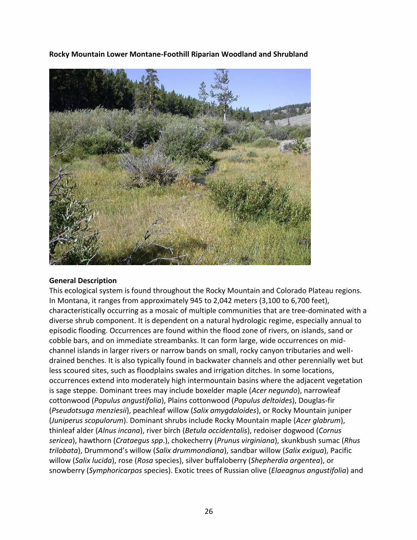
General Description This ecological system is found throughout the Rocky Mountain and Colorado Plateau regions. In Montana, it ranges from approximately 945 to 2,042 meters (3,100 to 6,700 feet), characteristically occurring as a mosaic of multiple communities that are tree-dominated with a diverse shrub component. It is dependent on a natural hydrologic regime, especially annual to episodic flooding. Occurrences are found within the flood zone of rivers, on islands, sand or cobble bars, and on immediate streambanks. It can form large, wide occurrences on mid-channel islands in larger rivers or narrow bands on small, rocky canyon tributaries and well-drained benches. It is also typically found in backwater channels and other perennially wet but less scoured sites, such as floodplains swales and irrigation ditches. In some locations, occurrences extend into moderately high intermountain basins where the adjacent vegetation is sage steppe. Dominant trees may include boxelder maple (Acer negundo), narrowleaf cottonwood (Populus angustifolia), Plains cottonwood (Populus deltoides), Douglas-fir (Pseudotsuga menziesii), peachleaf willow (Salix amygdaloides), or Rocky Mountain juniper (Juniperus scopulorum). Dominant shrubs include Rocky Mountain maple (Acer glabrum), thinleaf alder (Alnus incana), river birch (Betula occidentalis), redoiser dogwood (Cornus sericea), hawthorn (Crataegus spp.), chokecherry (Prunus virginiana), skunkbush sumac (Rhus trilobata), Drummond’s willow (Salix drummondiana), sandbar willow (Salix exigua), Pacific willow (Salix lucida), rose (Rosa species), silver buffaloberry (Shepherdia argentea), or snowberry (Symphoricarpos species). Exotic trees of Russian olive (Elaeagnus angustifolia) and

27
saltcedar (Tamarix species) may invade some stands in southeastern and south-central Montana. Diagnostic Characteristics montane, riverine/alluvial, mineral with A horizon less than 10 cm, unconsolidated, short flooding interval (less than 5 years), short persistence ( 50 to 100 years)
Similar Systems Northern Rocky Mountain Lower Montane Riparian Woodland and Shrubland Rocky Mountain Subalpine-Montane Riparian Woodland Range This system is found throughout the mid to low elevations of western and central Montana. Environment This system is dependent on a natural hydrologic regime, especially annual to episodic flooding. Occurrences are found within the flood zone of major rivers and the associated islands, sand or cobble bars, and along adjacent streambanks. It can occur as a large, wide patch on mid-channel islands in larger rivers or as narrow bands along small, rocky canyon tributaries and on well-drained benches. It is also typically found in backwater channels and other perennially wet but less scoured sites, such as floodplains swales and irrigation ditches. Elevations generally range from 945 to 2,042 meters (3,100 to 6,700 feet) (Hansen et al., 1995). Soils are usually Entisols or, less commonly, Inceptisols with an organic A horizon of less than ten centimeters. Coarse textured substrates allow for rapid movement of highly aerated water. The water table can drop during late summer, but soils remain moist due to capillary action. Vegetation Because of the frequent disturbance regime, this system usually occurs as a mosaic of shrub and tree dominant communities. Dominant trees may include boxelder maple, narrowleaf cottonwood, Plains cottonwood, Douglas-fir, peachleaf willow, or Rocky Mountain juniper. In central and eastern Montana, narrowleaf cottonwood frequently dominates the overstory. Dominant shrubs include Rocky Mountain maple, thinleaf alder, river birch, redoiser dogwood, hawthorn, chokecherry, skunkbush, Drummond’s willow, sandbar willow, Pacific willow, silver buffaloberry, rose or snowberry. Russian olive and saltcedar may invade some stands in southeastern and south-central Montana.
The herbaceous understory usually includes colonizing native forbs such as yarrow (Achillea millefolium), Canada goldenrod (Solidago canadensis), American licorice (Glycyrrhiza lepidota), Canada horseweed (Conyza canadensis) and exotics such as Canada thistle (Cirsium arvense) and common dandelion (Taraxacum officinale). Exotic grasses such as redtop (Agrostis stolonifera), Canada bluegrass (Poa compressa), Kentucky bluegrass (Poa pratensis), common timothy (Phleum pratense) and reed canarygrass (Phalaris arundinacea) can dominate the graminoid layer if this system adjoins cultivated areas or disturbed upland communities. Generally, some stands may have a small component of native graminoid species like slimstem

28
reedgrass (Calamagrostis stricta) or wheatgrasses (Elymus species) (Hansen et al., 1995). Wet meadow pataches adjoining or asscociated with this system often contain woolly sedge (Carex pellita), clustered field sedge (Carex praegracilis), Baltic rush (Juncus balticus), and bluejoint reedgrass (Calamagrostis canadensis).
Alliances (A.3564) (Canada Thistle, Leafy Spurge, Sweetclover species) - Mixed Forbs Herbaceous Alliance (A.1422) (Common Spikerush, Page Spikerush) Seasonally Flooded Herbaceous Alliance (A.947) (Coyote Willow, Sandbar Willow) Temporarily Flooded Shrubland Alliance (A.3539) (Field Horsetail, Variegated Scouring-rush, Common Scouring-rush) Semipermanently Flooded Herbaceous Alliance (A.1407) Alkali Cordgrass Seasonally Flooded Herbaceous Alliance (A.1374) Baltic Rush Seasonally Flooded Herbaceous Alliance (A.341) Box-elder Seasonally Flooded Forest Alliance (A.278) Box-elder Temporarily Flooded Forest Alliance (A.2657) Canadian Horseweed Seasonally Flooded Herbaceous Alliance (A.1419) Clustered Field Sedge Seasonally Flooded Herbaceous Alliance (A.1431) Common Reed Semipermanently Flooded Herbaceous Alliance (A.1405) Creeping Bentgrass Seasonally Flooded Herbaceous Alliance (A.568) Douglas-fir Temporarily Flooded Woodland Alliance (A.636) Eastern Cottonwood Temporarily Flooded Woodland Alliance (A.1329) Great Basin Wildrye Intermittently Flooded Herbaceous Alliance (A.1332) Inland Saltgrass Intermittently Flooded Herbaceous Alliance (A.1382) Kentucky Bluegrass Semi-natural Seasonally Flooded Herbaceous Alliance (A.310) Narrowleaf Cottonwood Temporarily Flooded Forest Alliance (A.641) Narrowleaf Cottonwood Temporarily Flooded Woodland Alliance (A.645) Peachleaf Willow Temporarily Flooded Woodland Alliance (A.565) Ponderosa Pine Temporarily Flooded Woodland Alliance (A.1347) Prairie Cordgrass Temporarily Flooded Herbaceous Alliance (A.2658) Quackgrass Herbaceous Alliance (A.1381) Reed Canarygrass Seasonally Flooded Herbaceous Alliance (A.563) Rocky Mountain Juniper Temporarily Flooded Woodland Alliance (A.506) Rocky Mountain Juniper Woodland Alliance (A.3566) Russian-olive Semi-natural Woodland Alliance (A.842) Salt-cedar species Semi-natural Temporarily Flooded Shrubland Alliance (A.960) Silver Buffaloberry Temporarily Flooded Shrubland Alliance (A.938) Skunkbush Sumac Intermittently Flooded Shrubland Alliance (A.2648) Smooth Horsetail Semipermanently Flooded Herbaceous Alliance (A.936) Water Birch Intermittently Flooded Shrubland Alliance (A.967) Water Birch Temporarily Flooded Shrubland Alliance (A.1414) Woolly Sedge Seasonally Flooded Herbaceous Alliance (A.980) Yellow Willow Temporarily Flooded Shrubland Alliance

29
Dynamic Processes Flooding is crucial to the development of establishment sites for cottonwood, and acts as primary control on plant succession. Steep gradients and high-energy flows driven by precipitation cause flooding events that transport coarse sediments. The scouring out and downstream accumulation of sediments constantly creates and destroys sites for the establishment of vegetation. Sediment accumulating in these systems often creates gravel bars at or near the surface of the river, creating bands of mixed vegetation occupying different stages of succession. Increasing vegetation traps even more sediment, so that over time the size and height of the gravel bar increases. Cottonwood and the associated shrub understory are adapted to these flooding events. Management Alteration of hydrology by dams and diversions are major influences on the structure, composition, and function of this community. In Montana, dams have eliminated the ability of cottonwood to regenerate by seeds in many places. As the cottonwood stand dies, successional processes will tend toward other communities unless flooding deposits new sediments that support seedling regeneration. Heavy grazing by cattle, or in some cases, elk and deer, along these streams and rivers can result in increased erosion and eliminate the vegetative regeneration of cottonwood sprouts. In sites where there is prolonged disturbance, shrub cover will decrease, resulting in a more open canopy. Restoration Considerations Maintaining an undisturbed buffer strip of cottonwood species adjacent to rivers and streams can stabilize riverbanks and will serve as a source for seedling and branch colonization if the hydrology of the river system is restored. Cottonwood requires full sunlight and a moist seed bed for colonization. If the site still has a fairly high water table and a remnant shrub population, the shrubs are capable of resprouting and will stabilize embankments and reduce sedimentation. If the site is highly impacted, seedlings or live cuttings can be used for more intensive restoration practices. Original Concept Authors Natureserve Western Ecology Group Montana Version Authors L.K. Vance, C. McIntyre, T. Luna Version Date 2/15/2010 Literature Cited Hansen PL, Pfister RD, Boggs K, Cook BJ, Joy J, Hinckley DK. Classification and management of
Montana's riparian and wetland sites. No. 54, 1-646. 1995. Montana Forest and Conservation Experiment Station, School of Forestry, University of Montana. Miscellaneous Publication.

30
Ecological Systems Field Guide: http://fieldguide.mt.gov:81/displayES_Detail.aspx?ES=9156
31
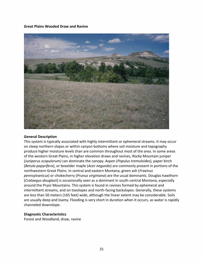
Great Plains Wooded Draw and Ravine
General Description This system is typically associated with highly intermittent or ephemeral streams. It may occur on steep northern slopes or within canyon bottoms where soil moisture and topography produce higher moisture levels than are common throughout most of the area. In some areas of the western Great Plains, in higher elevation draws and ravines, Rocky Mountain juniper (Juniperus scopulorum) can dominate the canopy. Aspen (Populus tremuloides), paper birch (Betula papyrifera), or boxelder maple (Acer negundo) are commonly present in portions of the northwestern Great Plains. In central and eastern Montana, green ash (Fraxinus pennsylvanicus) or chokecherry (Prunus virginiana) are the usual dominants. Douglas hawthorn (Crataegus douglasii) is occasionally seen as a dominant in south-central Montana, especially around the Pryor Mountains. This system is found in ravines formed by ephemeral and intermittent streams, and on toeslopes and north-facing backslopes. Generally, these systems are less than 50 meters (165 feet) wide, although the linear extent may be considerable. Soils are usually deep and loamy. Flooding is very short in duration when it occurs, as water is rapidly channeled downslope.
Diagnostic Characteristics Forest and Woodland, draw, ravine

32
Range This system is found throughout the Northwestern Glaciated Plains and the Northern Great Plains in Montana. Environment Wooded draws and ravines are best developed under conditions that favor snow entrapment, development of deeper soils, and concentration of moisture. These conditions are typical of ravines formed by ephemeral and intermittent streams and on toeslopes and north-facing backslopes. Uplands are generally mixed grass prairies and shrublands. Generally, these systems are less than 50 meters (165 feet) wide, although the linear extent may be considerable. Soils are usually deep loams. Flooding is very short in duration when it occurs, as water is rapidly channeled downslope.
Vegetation In Montana, this community is composed mostly of small trees, although larger diameter trees can occur at the foot of the ravine where there is greater available soil moisture. In some areas of the western Great Plains, in higher elevation draws and ravines, Rocky Mountain juniper can dominate the canopy. Aspen, paper birch or boxelder maple are commonly present in portions of the northwestern Great Plains. Throughout central and eastern Montana, green ash or chokecherry are the typical dominants, although Douglas hawthorn is occasionally seen as a dominant in south-central Montana, especially around the Pryor Mountains. Boxelder maple and American elm (Ulmus rubra or Ulmus americana) are often present. In many parts of Montana, particularly in disturbed occurrences, the understory is a dense shrub layer of western snowberry (Symphoricarpos occidentalis). In less disturbed sites, the understory is two-layered, with a shrub layer of chokecherry and other Prunus species, as well as hawthorne species, silverberry (Elaeagnus commutata), current (Ribes species), Woods' rose (Rosa woodsii), and silver buffaloberry (Shepherdia argentea). The lowest layer is dominated by sedges (Carex species) and grasses such as northern reedgrass (Calamagrostis stricta), western wheatgrass (Pascopyrum smithii), bluebunch wheatgrass (Pseudoroegneria spicata), and thickspike wheatgrass (Elymus lanceolatus). Common forbs include American licorice (Glycyrrhiza lepidota), yarrow (Achillea millefolium), meadow rue (Thalictrum dasycarpum), and bedstraw (Galium species). Exotics such as Russian olive (Elaeagnus angustifolia), yellow sweetclover (Meliotus officinalis) and Kentucky bluegrass (Poa pratensis) are often found throughout these systems, especially in agricultural areas.
Alliances (A.954) (Black Hawthorn, Fleshy Hawthorn) Temporarily Flooded Shrubland (A.954) (Black Hawthorn, Fleshy Hawthorn) Temporarily Flooded Shrubland (A.918) American Silverberry Shrubland Alliance (A.290) Eastern Cottonwood Temporarily Flooded Forest Alliance (A.308) Green Ash - (American Elm) Temporarily Flooded Forest Alliance (A.629) Green Ash - (American Elm) Woodland Alliance (A.563) Rocky Mountain Juniper Temporarily Flooded Woodland Alliance (A.961) Western Snowberry Temporarily Flooded Shrubland Alliance

33
Dynamic Processes Both domestic animals and wildlife use these systems readily, leading to trampling of vegetation and an increase in shrub domination. Fire is a secondary influence. Management Shade and moisture draw livestock into draws and ravines, concentrating use and creating the potential for degradation and the spread of exotic and invasive species. Alternate shade, water, and forage for livestock can reduce pressure on these systems, and maintain them as wildlife habitat. Restoration Considerations Restoration of this system may require alternate grazing practices to allow it to recover. Dominant species such as chokecherry, Douglas hawthorn, boxelder and elm have extensive root systems and will increase in cover after recovery or re-establishment. These species are rated as good to excellent for soil erosion control. In some cases, shrubs can be planted in clusters or bands in areas with high soil erosion potential. All other associated understory shrubs within this system - western snowberry, silverberry, gooseberry, Woods' rose, and silver buffaloberry - are rated as good to excellent restoration species, and possess strongly rhizomatous root systems that minimize soil erosion on steep slopes. Original Concept Authors S. Menard and K. Kindscher, mod. M.S. Reid Montana Version Authors L.K. Vance, T. Luna Version Date 2/19/2010

34
Great Plains Riparian
General Description This system is associated with perennial to intermittent or ephemeral streams throughout the northwestern Great Plains. In Montana, it occurs along smaller tributaries of the Yellowstone and Missouri rivers, as well as tributaries to the large floodplain rivers that feed them (e.g. the Milk, Marias, Musselshell, Powder, Clark’s Fork Yellowstone, Tongue, etc). In areas adjacent to the mountain ranges of central and southeastern Montana, and near the Rocky Mountain Front, it grades into Rocky Mountain Lower Montane-Foothill Riparian Woodland and Shrubland systems. This system is found on alluvial soils in highly variable landscape settings, from confined, deep cut ravines to wide, braided streambeds. Channel migration occurs in less-confined areas, but within a more narrow range than would occur in broad, alluvial floodplains. Typically, the rivers are wadeable by mid-summer. The primary inputs of water to these systems include groundwater discharge, overland flow, and subsurface interflow from the adjacent upland. Flooding is the key ecosystem process, creating suitable sites for seed dispersal and seedling establishment, and controlling vegetation succession. Communities within this system range from riparian forests and shrublands to tallgrass wet meadows and gravel/sand flats. Dominant species are similar to those found in the Great Plains Floodplain System. In the western part of the system’s range in Montana, the dominant overstory species is black cottonwood (Populus balsamifera ssp. trichocarpa) with narrowleaf cottonwood (Populus angustifolia) and Plains cottonwood (Populus deltoides) occurring as co-dominants in the riparian/floodplain interface near the mountains. Further east,

35
narrowleaf cottonwood and Plains cottonwood become dominant. In wetter systems, the understory is typically willow (Salix spp.) and redosier dogwood (Cornus stolonifera) with graminoids such as western wheatgrass (Pascopyrum smithii) and forbs like American licorice (Glycyrrhiza lepidota). In areas where the channel is incised, the understory may be dominated by big sagebrush (Artemisia tridentata) or silver sagebrush (Artemisia cana). Like floodplain systems, riparian systems are often subjected to overgrazing and/or agriculture and can be heavily degraded, with salt cedar (Tamarix ramosissima) and Russian olive (Eleagnus angustifolia) replacing native woody vegetation and regrowth. Groundwater depletion and lack of fire have resulted in additional species changes. Diagnostic Characteristics Forest and Woodland
Similar Systems Great Plains Floodplain Northern Rocky Mountain Lower Montane Riparian Woodland and Shrubland Rocky Mountain Lower Montane-Foothill Riparian Woodland and Shrubland
Range This system extends north into Alberta, Saskatchewan and Manitoba, east into the Dakotas and Nebraska, and south into Wyoming. In Montana, it occurs in the Yellowstone and Missouri River drainage basins along small rivers and perennial, intermittent and ephemeral streams. In areas adjacent to the mountain ranges of central and southeastern Montana, and near the Rocky Mountain Front, it grades into Rocky Mountain Lower Montane-Foothill Riparian Woodland and Shrubland systems. Environment The primary inputs of water to these systems include groundwater discharge, overland flow, and subsurface interflow from the adjacent upland. Flooding is the key ecosystem process. It creates suitable sites for seed dispersal and seedling establishment, and controls vegetation succession. This system is associated with small rivers and perennial to intermittent or ephemeral streams that flow only during part of the year. In the Great Plains, the water source is primarily local precipitation and groundwater inflow (Decker, 2007); in systems receiving flow from central and southeastern mountain ranges, snowmelt and summer thunderstorms provide a significant portion of flows. The boundaries of these riparian areas extend beyond the limits of flooding into streamside vegetation (Gregory, 1991). They are important links between terrestrial and aquatic ecosystems, acting as ecotones between upland and wetland, and connecting ecological processes and plant communities.
Vegetation Like the Western Great Plains Riparian system of Wyoming, Colorado and New Mexico, Montana’s Great Plains Riparian systems may include riparian forests or woodlands, as well as shrublands, tallgrass or mixedgrass wet meadows, herbaceous wetlands, and gravel/sand flats (Decker, 2007). Vegetation may be a mosaic of communities that are not always tree- or shrub-
36
dominated. At lower elevations (e.g. along the Little Powder River and Mizpah Creek in southeastern Montana), forested communities may form galleries dominated by Plains cottonwood. Narrowleaf cottonwood occurs at intermediate elevations and black cottonwood tends to be prevalent at higher elevations (Hansen et al., 1995). Willows commonly associated with this system include sandbar willow (Salix exigua), yellow willow (Salix lutea), peachleaf willow (Salix amygdaloides), and diamondleaf willow (Salix planifolia). Other shrubs include redosier dogwood, western snowberry (Symphoricarpos occidentalis), chokecherry (Prunus virginiana), and woods rose (Rosa woodsii). In areas where the channel is incised, the understory may be dominated by big sagebrush or silver sagebrush. The herbaceous stratum is variable. Subirrigated areas may support tallgrass meadows dominated by big bluestem (Andropogon gerardii) or fresh water cordgrass (Spartina pectinata). Other graminoids include wooly sedge (Carex pellita), little bluestem (Schizachyrium scoparium), western wheatgrass, porcupine needlegrass (Hesperostipa spartea), northern dropseed (Sporobolus heterolepis), and panic grass (Panicum virgatum). American licorice and Canada goldenrod (Solidago canadensis) are common understory forbs within all cottonwood riparian systems. These sites are prone to invasion by exotic grasses and forbs, the most widely established being creeping bentgrass (Agrostis stolonifera), cheatgrass (Bromus tectorum), quackgrass (Agropyron repens), Canada thistle (Cirsium arvense), clovers (Melilotus species), leafy spurge (Euphorbia esula) and common dandelion (Taraxacum officinale).
Alliances (A.636) Eastern Cottonwood Temporarily Flooded Woodland Alliance (A.843) Silver Sagebrush Temporarily Flooded Shrubland Alliance (A.961) Western Snowberry Temporarily Flooded Shrubland Alliance
Dynamic Processes Fluvial processes play a key role in the dynamics of Great Plains streams. The nature of these processes is often indicated by channel morphology. Meandering channels generally have a shallow gradient, low flow variability, and sediment loads dominated by silt and finer particles, while braided channels are characterized by a steep gradient, high flow variability, and a sediment load dominated by sand and coarser particles (Friedman, 2002). Flooding is the key ecosystem process whereby establishment sites for riparian vegetation are created, seeds are dispersed and vegetative succession is controlled. However, since Euro-American settlement, natural fluvial processes have been disrupted in many of these systems by dams and diversions. Fire has been suppressed, agricultural activities have increased siltation rates and introduced both non-native species and chemical changes, and native grazers have been largely replaced by domestic cattle. Consequently, there has been a direct loss of woody plant diversity. Furthermore, both channel incision and channel widening have altered flooding regimes, leading to establishment of flood-intolerant species in many areas. Management The quality and quantity of ground and surface water input into riparian areas is almost entirely determined by the condition of the surrounding landscape. Therefore, the integrity of riparian ecological systems is partly determined by processes operating in the surrounding landscape,

37
especially in the local watershed. Different types of land use can alter surface runoff and recharge of local aquifers, and introduce excess nutrients, pollutants, or sediments. Great Plains riparian systems have been substantially impacted by the development of both groundwater and surface water for irrigation. Alteration of natural hydrological processes by dams, diversions, ditches, roads, etc., and abiotic resource consumption through groundwater pumping have considerably altered the presettlement condition of the Great Plains. Vegetation responds to hydrologic changes by shifting from wetland- and riparian-dependent species to more mesic and xeric species typical of adjacent uplands and/or encroaching into the stream channel. When periodic flooding is eliminated by water management, riparian areas may become dominated by late-seral communities due to the inability of pioneer species (e.g., cottonwood and willow) to regenerate (Decker, 2007). Pollution from agricultural runoff can introduce excess nutrients into riparian areas. Increased nutrients can alter species composition by allowing aggressive, invasive species to displace native species. Nutrient cycles may also be disrupted by water management that eliminates normal flooding cycles and prevents deposition of organic material from floodwaters (Decker, 2007). Riparian vegetation is also affected by climatic drought that reduces soil moisture in the unsaturated zone and decreases streamflows, which reduces recharge and lowers the alluvial water table (Friedman et al. 1997). The elimination of beavers from most of the plains watersheds probably decreased water storage and increased variability in plains streams (Friedman et al. 1997). The replacement of native grazers, especially bison, with fenced cattle has changed the regeneration patterns of cottonwood. In addition, salt cedar and Russian olive can drastically alter ecological processes in these plains riparian areas. Tamarisk is an early successional species with dispersal strategies and habitat requirements similar to native cottonwood and willow (Lesica and Miles, 2004). It can replace the native cottonwood and willow where natural flow regimes have been altered.
Restoration Considerations Restoration strategies are dependent on the degree and type of disturbance event. Restoration efforts must first concentrate on restoring thestream's hydrology, so the floods can re-occur. In-stream habitat enhancement (e.g., additions of logs or boulders) should be employed after restoring natural processes or where short-term improvements in habitat are needed (e.g., for species in recovery).
Removingor eliminating grazing from this ecological system will allow the system to recover if hydric soils have not been lost due to extensive soil compaction, pugging, or down cutting of stream channels, and if there are existing populations of herbaceous native species (Carex, Juncus, and native grasses) that possess rhizomatous root systems capable of re-colonizing bare soils. The presence of rhizomatous, highly adaptable exotic grasses such as Kentucky bluegrass (Poa pratensis), common timothy (Phleum pratense) and smooth brome (Bromus inermis) and pasture forbs such as clovers (Trifolium species) and common dandelion (Taraxacum officinale) however, will persist on the site and may compete with existing populations of native graminiods and forbs. In these cases, land managers must decide if the exotic density is low enough that an adequate stand of native graminoids and forbs can become established on the site if reseeding efforts are used. In all cases, grazing should be excluded for several years to allow adequate re-growth and recovery of existing shrubs and the herbaceous understory.
38
Because all major shrub species within this riparian system are capable of re-sprouting and typically possess extensive, spreading root systems, modified land management practices in areas of low to moderate impact can minimize additional restoration needs. Vigor, health and degree of vegetative regeneration of existing trees and shrubs must be evaluated to determine if these components of the community are capable of recovery in an acceptable time frame. Intensive revegetation efforts should be limited to sites where a catastrophic wildfire or prolonged heavy grazing has destroyed existing trees, shrubs and the seedbank.
Original Concept Authors Natureserve Western Ecology Group Montana Version Authors L.K. Vance, C. McIntyre, T. Luna Version Date 2/14/2010 Literature Cited Covich AP, Fritz SC, Lamb PJ, Marzolf RD, Matthews WJ, Poiani KA, Prepas EE, Richmond MB,
Winter TC. 1997. Potential effects of climate change on aquatic ecosystems of the Great Plains of North America. Hydrological Processes(11):993-1021.
Decker K. 2007. Western Great Plains Riparian Woodland and Shrubland Ecological System:
Ecological Integrity Assessment. Colorado Natural Heritage Program; Available from. Dodds WK, Gido K, Whiles MR, Fritz KM, Matthews WJ. 2004. Life on the edge: the ecology of
Great Plains prairie streams. BioScience 54(3):205-16. Friedman JM, Lee VJ. 2002. Extreme floods, channel change, and riparian forests along
ephemeral streams. Ecological Monographs(72):409-25. Friedman JM, Osterkamp WR, Scott ML, Auble GT. 1998. Downstream effects of dams on
channel geometry and bottomland vegetation: regional patterns in the Great Plains. Wetlands 18(4):619-33.
Friedman JM, Scott ML, Auble GT. 1997. Water management and cottonwood forest dynamics
along prairie streams. In: Knopf FL, Samson FB, editors. Ecology and Conservation of Great Plains Vertibrates. New York: Springer-Verlag; p 49-71.
Gregory SV, Swanson FJ, McKee WA, Cummins KW. 1991. An ecosystem perspective of riparian
zones. BioScience 41(8):540-51. Hansen PL, Pfister RD, Boggs K, Cook BJ, Joy J, Hinckley DK. Classification and management of
Montana's riparian and wetland sites. No. 54, 1-646. 1995. Montana Forest and

39
Conservation Experiment Station, School of Forestry, University of Montana. Miscellaneous Publication.
Lesica P, Miles S. 2004. Ecological strategies for managing tamarisk on the C.M. Russell National
Wildlife Refuge, Montana, USA. Biol Conserv 119(4):535-43. Reed PB, Jr. 1988. National list of plant species that occur in wetlands: Northwest (region 9).
Washington D.C.: USDI Fish and Wildife Service, Research and Development; Report nr US Fish and Wildife Service Biological Report 88 (26.9). -89 p.
Woods AJ, Omernik JM, Nesser JA, Shelden J, Azevedo SH. 1999. Ecoregions of Montana.
Reston, Virginia: U.S. Geological Survey; Report nr (1:1,500,000 map). Ecological Systems Field Guide: http://fieldguide.mt.gov:81/displayES_Detail.aspx?ES=9326

40
Great Plains Floodplain
General Description This system occurs along the Missouri and Yellowstone Rivers and their larger tributaries, including parts of the Little Missouri, Clark’s Fork Yellowstone, Powder, Tongue, Bighorn, Milk, and Musselshell rivers. These are the big perennial rivers of the region, with hydrologic dynamics largely driven by snowmelt and rainfall originating in their headwater watersheds, rather than local precipitation events. In the absence of disturbance, periodic flooding of fluvial and alluvial soils and channel migration will create depressions and backwaters that support a mosaic of wetland and riparian vegetation, whose composition and structure is sustained, altered and redistributed by hydrology. Dominant communities within this system range from floodplain forests to wet meadows to gravel/sand flats, linked by underlying soils and flooding regimes. In the western part of the system’s range in Montana, the overstory dominant species is black cottonwood (Populus balsamifera ssp. trichocarpa) with narrowleaf cottonwood (Populus angustifolia) and eastern cottonwood (Populus deltoides) occurring as co-dominants in the riparian/floodplain interface near the mountains. Further east, narrowleaf cottonwood and Plains cottonwood become dominant. In relatively undisturbed stands, willow (Salix species), redosier dogwood (Cornus sericea) and common chokecherry (Prunus virginiana) form a thick, multi-layered shrub understory, with a mixture of cool and warm season graminoid species below. Box elder (Acer negundo) and green ash (Fraxinus pennsylvanica) form a tree understory in mid-seral and late-seral stands.

41
In Montana, many occurrences are now degraded to the point where the cottonwood overstory is the only remaining natural component. The hydrology of these floodplain systems has been affected by dams, highways, railroads and agricultural ditches, and as a result, they have lost their characteristic wetland /riparian mosaic structure. This has resulted in a highly altered community consisting of relict cottonwood stands with little regeneration. The understory vegetation is dominated by non-native pasture grasses, legumes and other introduced forbs, or by the disclimax western snowberry (Symphoricarpos occidentalis) and rose (Rosa species) shrub community.
Diagnostic Characteristics Floodplains; meandering channels with alluvial bar formation; vegetation occuring in bands or zones reflecting past deposition Similar Systems Great Plains Riparian Range This system is found in the northwestern Great Plains through southern Canada. In Montana, it is characteristic of the big river floodplains in the Missouri River Basin. It is found along the Missouri and Yellowstone Rivers and their larger tributaries, including parts of the Little Missouri, Clark’s Fork Yellowstone, Powder, Tongue, Bighorn, Milk, and Musselshell rivers. Elsewhere, this system is found in northern Nebraska and the Dakotas on the Niobrara, upper Missouri, White, Cheyenne, and Little Missouri rivers; and in the prairie provinces of Canada on the Saskatchewan River.
Environment This system may occur as relatively broad and extensive forests, as seen along the lower stretches of the Missouri and Yellowstone Rivers, or more narrow bands, as seen along the Milk, Little Missouri, Tongue and Powder Rivers. The elevational range of this system is from 579-1,310 meters (1,900-4,300 feet) (Hansen et al., 1995). These are the big perennial rivers of the region, with hydrologic dynamics largely driven by snowmelt and rainfall originating in their headwater watersheds, rather than by local precipitation events. In an undisturbed state, periodic flooding of the fluvial and alluvial soils and channel migration will create alluvial bars, depressions and backwaters supporting zones or mosaics of wetland and riparian vegetation, whose composition and structure is sustained, altered and redistributed by hydrology. Soils can be Entisols, Inceptisols and Mollisols on older stabilized sites. Often there is up to 1 meter of soil overlying river gravels and cobble. Water tables can drop to within 1 meter of the soil surface in summer months.
Vegetation In the western part of the system’s range in Montana, the overstory dominant species is black cottonwood, with narrowleaf cottonwood and Plains cottonwood occurring as co-dominants in the riparian/floodplain interface near the mountains. Further east, narrowleaf cottonwood and Plains cottonwood become dominant.
42
In less disturbed occurrences, willow species such as yellow willow (Salix lutea) planeleaf willow (Salix planifolia), and peachleaf willow (Salix amygdaloides) co-dominate the shrub layer with common chokecherry (Prunus virginiana), redosier dogwood (Cornus sericea), serviceberry (Amelanchier alnifolia) and currant (Ribes spps). Boxelder (Acer negundo), green ash (Fraxinus pennsylvanica), and American elm (Ulmus americana) are common in mid- to late-seral stands, and will generally succeed Plains cottonwood in the rivers of the Southeast. Sandbar willow (Salix exigua) and shrubby cinquefoil (Dasiphora fruticosa) frequently colonize recent alluvial bars in central and eastern Montana, while silverberry (Elaeagnus commutata), thinleaf alder (Alnus incana) and Drummond’s willow (Salix drummondiana) are colonizers in black cottonwood-dominated floodplains near the mountains and riparian/floodplain interface. Common graminoids associated with these floodplain systems include big bluestem (Andropogon gerardii), wooly sedge (Carex pellita), streamside wild rye (Elymus lanceolatus), old switch panicgrass (Panicum virgatum), western wheatgrass (Pascopyrum smithii), little bluestem (Schizachyrium scoparium), and sand dropseed (Sporobolus cryptandrus). Forbs include Drummond’s dryad (Dryas drummondii), yarrow (Achillea millefolium), starry solomon’s seal (Maianthemum stellatum) and aster (Symphyotrichum species). Because of the distrubance regimes typical in these systems, they are highly susceptible to invasion by exotic species. Russian olive (Elaeagnus angustifolia) and cheatgrass (Bromus tectorum) have become established in many stands, and leafy spurge (Euphorbia esula) is a common invasive.
Alliances (A.947) (Coyote Willow, Sandbar Willow) Temporarily Flooded Shrubland Alliance (A.1436) (Narrowleaf Cattail, Broadleaf Cattail) - (Clubrush species) Semipermanently Flooded Herbaceous Alliance (A.1394) Cattail species -(Clubrush species, Rush species) Seasonally Flooded Herbaceous Alliance (A.290) Eastern Cottonwood Temporarily Flooded Forest Alliance (A.636) Eastern Cottonwood Temporarily Flooded Woodland Alliance (A.1417) Nebraska Sedge Seasonally Flooded Herbaceous Alliance (A.1008) Planeleaf Willow Seasonally Flooded Shrubland Alliance (A.1347) Prairie Cordgrass Temporarily Flooded Herbaceous Alliance (A.968) Red-osier Dogwood Temporarily Flooded Shrubland Alliance (A.1864) Sand Flats Temporarily Flooded Sparsely Vegetated Alliance (A.843) Silver Sagebrush Temporarily Flooded Shrubland Alliance (A.961) Western Snowberry Temporarily Flooded Shrubland Alliance (A.1232) Western Wheatgrass Herbaceous Alliance Dynamic Processes In Montana, many occurrences are now degraded to the point where the cottonwood overstory is the only remaining natural component. The hydrology of these floodplain systems has been affected by dams, highways, railroads and agricultural ditches. As a result, they have lost their characteristic wetland /riparian mosaic structure. This has resulted in a highly altered community consisting of relict cottonwood stands with little regeneration. In the system’s disturbed/altered hydrological state and/or under heavy grazing pressure, there will be an

43
increase in shrub species such as western snowberry and rose and a corresponding decrease in willow species, redosier dogwood, currant, serviceberry and common chokecherry.
Successional processes create a community resembling adjacent upland communities; western snowberry and rose may persist, but will be joined by other native shrubs from adjacent upland communities, such as silver sagebrush (Artemisia cana)and big sagebrush (Artemisia tridentata). In addition, exotic shrub species such as salt cedar (Tamarix ramosissima) can invade disturbed floodplain systems. Russian olive has become a dominant overstory tree in many areas, shading out native species. In these disturbed floodplains, the understory vegetation is dominated by a mixture of pasture grasses such as smooth brome (Bromus inermis), common timothy (Phleum pratense), redtop (Agrostis stolonifera) and Kentucky bluegrass (Poa pratensis), as well as non-native forbs such as sweetclover (Melilotus species), clovers (Trifolium species), Canadian thistle (Cirsium canadensis) and common dandelion (Taraxacum officinale). Once exotic grasses become dominant, especially in the absence of episodic flooding, these systems cannot return to their original state without substantial management intervention.
Management Cottonwoods and willows are the dominant tree species in these Great Plains Floodplain Systems, creating a highly productive and important habitat type. Since they are specifically adapted to infrequent large flooding events that promote dispersion and colonization of newly formed alluvial bars, management efforts need to begin with identifying the frequency and duration of the flows necessary for colonization to succeed (Scott et al, 1994). Great Plains floodplain systems have been substantially impacted by the development of both groundwater and surface water for irrigation, isolating rivers from their adjacent floodplains. Unless water management can restore periodic flooding, floodplains and riparian areas may become dominated by late-seral communities, and nutrient cycles may be disrupted without floodwaters depositing organic material (Decker, 2007). In addition, management efforts need to target aggressive non-native shrubs like salt cedar and Russian olive that can drastically alter ecological processes. Tamarisk is an early successional species with dispersal strategies and habitat requirements similar to native cottonwood and willow (Lesica and Miles, 2004). It can replace the native cottonwood and willow where natural flow regimes have been altered. Early detection and rapid response are necessary to prevent its spread. Prescribed spring grazing by sheep has been effective in controlling leafy spurge along some rivers, particularly the upper Powder. Restoration Considerations Restoration strategies are dependent on the degree and type of disturbance event. Restoration efforts must first concentrate on restoring hydrologic processes or simulating large flood events. Instream habitat enhancement (e.g., additions of logs or boulders) can be employed after restoring natural processes or where short-term improvements in habitat are needed (e.g., for species in recovery).

44
Removing or limiting grazing will allow the system to recover if hydric soils have not been lost due to soil compaction, pugging, or downcutting of stream channels, and if there are existing populations of herbaceous native species (Carex, Juncus, and native grasses) with rhizomatous root systems capable of re-colonizing bare soils. Presence of rhizomatous, highly adaptable exotic grasses such as Kentucky bluegrass (Poa pratensis), common timothy (Phleum pratense) and smooth brome (Bromus inermis) and pasture forbs such as clovers (Trifoliumspecies) and common dandelion (Taraxacum officinale) however, will persist on the site and may compete with existing populations of native graminiods and forbs. In these cases, land managers must decide if the exotic density is small enough that an adequate stand of native graminoids and forbs can become established on the site if reseeding efforts are used. With reseeding, grazing must be excluded for several years to allow adequate re-growth and recovery of existing shrubs and the herbaceous understory.
Because all major shrub species within this floodplain system are capable of re-sprouting and typically possess extensive, spreading root systems, modified land management practices in areas of low to moderate impact can minimize additional restoration needs. Vigor, health and degree of vegetative regeneration of existing trees and shrubs must be evaluated to determine if these components of the community are capable of recovery in an acceptable time frame. Intensive revegetation efforts should be limited to sites where a catastrophic wildfire or prolonged heavy grazing has destroyed existing trees, shrubs and the seed bank.
Original Concept Authors Natureserve Western Ecology Group Montana Version Authors L.K. Vance, C. McIntyre, T. Luna, Version Date 6/10/2010
Literature Cited Decker K. 2007. Western Great Plains Riparian Woodland and Shrubland Ecological System:
Ecological Integrity Assessment. Colorado Natural Heritage Program. Friedman JM, Osterkamp WR, Scott ML, Auble GT. 1998. Downstream effects of dams on
channel geometry and bottomland vegetation: regional patterns in the Great Plains. Wetlands 18(4):619-33.
Friedman JM, Scott ML, Auble GT. 1997. Water management and cottonwood dynamics along
prairie streams. In: Knopf FL, Samson FB, editors. Ecology and Conservation of Great Plains Vertebrates. New York, NY: Springer-Verlag; p 49-71.
Hansen PL, Pfister RD, Boggs K, Cook BJ, Joy J, Hinckley DK. Classification and management of
Montana's riparian and wetland sites. No. 54, 1-646. 1995. Montana Forest and

45
Conservation Experiment Station, School of Forestry, University of Montana. Miscellaneous Publication.
Hauer RF, Lorang MS. 2004. River regulation, decline of ecological resources, and potential for
restoration in a semi-arid lands river in the western USA. Aquat Sci(66):388-401. Junk WJ, Welcomme RL. 1990. Floodplains. In: Patten BC, editor. Wetlands and Shallow
Continental Water Bodies. p 491-524. Lesica P, Miles S. 2004. Ecological strategies for managing tamarisk on the C.M. Russell National
Wildlife Refuge, Montana, USA. Biol Conserv 119(4):535-43. Scott ML, Auble GT, Friedman JM. 1997. Flood dependency of cottonwood establishment along
the Missouri River, Montana, USA. Ecological Applications 7(2):677-90. Ward WJ, Stanford JA. 2006. Ecological connectivity in alluvial river ecosystems and its
disruption by flow regime. Regulated Rivers: Research and Management(11):105-19.
Ecological Systems Field Guide: http://fieldguide.mt.gov:81/displayES_Detail.aspx?ES=9159
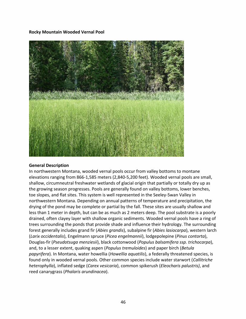
46
Rocky Mountain Wooded Vernal Pool
General Description In northwestern Montana, wooded vernal pools occur from valley bottoms to montane elevations ranging from 866-1,585 meters (2,840-5,200 feet). Wooded vernal pools are small, shallow, circumneutral freshwater wetlands of glacial origin that partially or totally dry up as the growing season progresses. Pools are generally found on valley bottoms, lower benches, toe slopes, and flat sites. This system is well represented in the Seeley-Swan Valley in northwestern Montana. Depending on annual patterns of temperature and precipitation, the drying of the pond may be complete or partial by the fall. These sites are usually shallow and less than 1 meter in depth, but can be as much as 2 meters deep. The pool substrate is a poorly drained, often clayey layer with shallow organic sediments. Wooded vernal pools have a ring of trees surrounding the ponds that provide shade and influence their hydrology. The surrounding forest generally includes grand fir (Abies grandis), subalpine fir (Abies lasiocarpa), western larch (Larix occidentalis), Engelmann spruce (Picea engelmannii), lodgepolepine (Pinus contorta), Douglas-fir (Pseudotsuga menziesii), black cottonwood (Populus balsamifera ssp. trichocarpa), and, to a lesser extent, quaking aspen (Populus tremuloides) and paper birch (Betula papyrifera). In Montana, water howellia (Howellia aquatilis), a federally threatened species, is found only in wooded vernal pools. Other common species include water starwort (Callitriche heterophylla), inflated sedge (Carex vesicaria), common spikerush (Eleocharis palustris), and reed canarygrass (Phalaris arundinacea).

47
Diagnostic Characteristics depressional isolated wetland Range This system occurs in northern Idaho and western Montana. West of the Continental Divide, in the Seeley-Swan Valley, there is a large concentration of pools and ponds occurring within forested environments. East of the Continental Divide, glaciated pools and ponds occur at elevations up to 1585 m (5,200 feet), particularly in the forested foothill and montane zones of the glaciated pothole region.
Environment In northwestern Montana, these ponds and pools occur in forested environments. Occurrences are found from valley bottoms to montane elevations ranging from 866 to 1,585 m (2,840-5,200 feet) (Mincemoyer, 2005). This system is well represented in the Seeley-Swan valley in northwestern Montana. Pools are generally found on valley bottoms, lower benches, toeslopes, and flat sites, often in glaciated kettleholes that vary in size and depth.
Depending on annual patterns of temperature and precipitation, the drying of the pond may be complete or partial by the fall or during drought years. However, many of these ponds remain at fairly constant water levels throughout the growing season. These sites can be shallow and less than 1 meter (3.3 feet) in depth, but can be as much as 2 meters (6 feet) deep. The pool substrate is a poorly drained, often clayey layer with shallow organic sediments. Parent materials are typically clay alluvium or clay colluvium (Mincemoyer, 2005). These freshwater ponds have pH ranges from 6.2 to 7.8 with most measurements between 6.5 and 7.5. The size of the pools/ponds can range from .4 to 4 hectares (1-10 acres) in size.
Vegetation The overstory surrounding vernal wooded pools is typically a mixed coniferous forest consisting of grand fir, subalpine fir, western larch, Engelmannspruce,lodgepolepine, Douglas-fir, and deciduous trees like black cottonwood and, to a lesser extent, quaking aspen and paper birch. Western red cedar (Thuja plicata) often borders the ponds, especially in the northern Swan Valley. Common shrubs occurring in the forest edges surrounding the pools include thinleaf alder (Alnus incana), redoiser dogwood (Cornus sericea), buckthorn alder (Rhamnus alnifolia), and willows (Salix spp.).
The herbaceous component is dominated by graminoids such as shortawn foxtail (Alopecurus aequalis), water sedge(Carex aquatilis), beaked sedge (Carex utriculata), inflated sedge, common spikerush, and rushes (Juncus spp.). Other characteristic species include woolyfruit sedge (Carex lasiocarpa), awned sedge (Carex atherodes), and wooly sedge (Carex pellita). Reed canarygrass is invasive in this system.
Water starwort (Callitriche species), pondweeds (Potamogeton spp.), burr reed (Sparganium spp.), white water crowfoot (Ranunculus aquatilis), common mare’s tail (Hippuris vulgaris), bladderworts (Utricularia spp.), field mint (Mentha arvensis), and yellowcress (Rorippa spp.) are

48
common herbaceous plant associates. Horsetails (Equisetum spp.) are often present. In Lake and Missoula counties, wooded vernal pools are habitat for water howellia, a federally threatened species. This annual aquatic may undergo dramatic yearly fluctuations in population size.
Alliances (A.1403) (Beaked Sedge, Northwest Territory Sedge) Seasonally Flooded Herbaceous Alliance (A.1436) (Narrowleaf Cattail, Broadleaf Cattail) - (Clubrush species) Semipermanently Flooded Herbaceous Alliance (A.1984) American White Water-lily - Yellow Pond-lily species Permanently Flooded Temperate Herbaceous Alliance (A.1404) Aquatic Sedge Seasonally Flooded Herbaceous Alliance (A.1374) Baltic Rush Seasonally Flooded Herbaceous Alliance (A.1400) Bluejoint Seasonally Flooded Herbaceous Alliance (A.1342) Common Spikerush Temporarily Flooded Herbaceous Alliance (A.1747) Duckweed species Permanently Flooded Herbaceous Alliance (A.2501) Inflated Sedge Seasonally Flooded Herbaceous Alliance (A.989) Red-osier Dogwood - Willow species Seasonally Flooded Shrubland Alliance (A.1381) Reed Canarygrass Seasonally Flooded Herbaceous Alliance (A.1455) Sedge species Saturated Herbaceous Alliance (A.1445) Small Floating Mannagrass Semipermanently Flooded Herbaceous Alliance (A.1881) Smartweed species Seasonally Flooded Herbaceous Alliance (A.1678) Water Horsetail Semipermanently Flooded Herbaceous Alliance (A.1679) Whitewater Crowfoot Semipermanently Flooded Herbaceous Alliance (A.1415) Wiregrass Sedge Seasonally Flooded Herbaceous Alliance (A.1414) Woolly Sedge Seasonally Flooded Herbaceous Alliance
Dynamic Processes Many of the pools in the Swan Valley remain at a fairly constant water level year round. In some cases, these pools can partially or completely dry down, depending on temperature, precipitation patterns and pool depth, by late fall. Prolonged drought caused by changing climatic patterns will impact the populations of species such as water howellia occurring within these pools. Management Adjacent land uses surrounding wooded vernal pool can potentially alter their hydrology, including grazing and timber harvest. Due to the lack of genetic variability in sampled water howellia populations, multiple pond clusters of inhabited and potential water howellia pools should be protected (Lesica et al., 1988.)
Original Concept Authors Natureserve Western Ecology Group

49
Montana Version Authors L.K. Vance, C. McIntyre, T. Luna Version Date 2/14/2010
Literature Cited Hansen PL, Pfister RD, Boggs K, Cook BJ, Joy J, Hinckley DK. Classification and management of
Montana's riparian and wetland sites. No. 54, 1-646. 1995. Montana Forest and Conservation Experiment Station, School of Forestry, University of Montana. Miscellaneous Publication.
Lesica P, Leary RF, Allendorf FW, Bilderback DE. 1988. Lack of genetic diversity within and
among populations of an endangered plant, Howellia aquatilis. Conservation Biology 2(3):275-82.
Mincemoyer S. 2005. Range-wide status assessment of Howellia aquatilis (water howellia).
Revised December 2005. Helena, MT: Montana Natural Heritage Program; Report nr Prepared for the U.S. Fish and Wildlife Service.
Pfister RD, Kovalchik BL, Arno SF, Presby RC. 1977. Forest habitat types of Montana. Ogden,
Utah: U.S. Department of Agriculture, Forest Service, Intermountain Forest and Range Experiment Station; Report nr General Technical Report INT-34.
Ecological System Field Guide: http://FieldGuide.mt.gov/displayES_Detail.aspx?ES=9162

50
Rocky Mountain Conifer Swamp
General Description In northwestern Montana, conifer swamps occur from 865 to 1485 meters (2,838-5,200 feet). This is a minor system with infrequent occurrences on valley bottoms, lower benches, toeslopes, stream terraces, and flat sites, often adjacent to lakes, fens or wet meadows with low gradient, meandering streams. Water tables are typically within 50 centimeters (20 inches) of the soil surface throughout the year, with standing water in surface depressions. These swamps are dominated by conifers growing on poorly drained soils that are saturated year-round or have seasonal flooding in the spring. This system is indicative of poorly drained, mucky areas, and areas are often a mosaic of moving water and stagnant water. Soils can be woody peat, muck or mineral but tend toward mineral. Vegetation includes wetland phases of western red cedar (Thuja plicata), western hemlock (Tsuga heterophylla), subalpine fir (Abies lasiocarpa) and Engelmann spruce (Picea engelmannii) forests. These wetland forests are generally distinguishable from other upland forests and woodlands by shallow water tables and mesic or hydric undergrowth vegetation. Some of the most typical understory species include American ladyfern (Athyrium filix-femina), woodfern (Dryopterisspecies), skunk cabbage (Lysichiton americanus), field horsetail (Equisetum arvense), arrowleaf groundsel (Senecio triangularis), and bluejoint reedgrass (Calamagrostis canadensis). This system frequently borders fens and wet to mesic coniferous forests.
51
Diagnostic Characteristics Woody wetland, Forest and Woodland, saturated soils, depressional, seepage fed slopes, mineral soil w/ A horizon <10 cm
Range This system occurs in the northern Rocky Mountains from northwestern Wyoming and central Montana, north into the Canadian Rockies and west into eastern Oregon and Washington. In northwestern Montana, this uncommon system is represented in the Flathead, Kootenai and Yaak river drainages. Montane spruce- and subalpine fir dominated swamps also occur east of the Continental Divide. Environment This system is dominated by coniferous trees on poorly drained soils that are saturated year-round or are subjected to seasonal flooding during spring months. These forests are found on flat to gently sloping lowlands, but also occur up to the lower limits of continuous forest. In northwestern Montana, these uncommon wetland forests occur most frequently in depressions on valley bottoms. However, they can occur on steeper slopes where soils are shallow over unfractured bedrock. Soils in these systems are poorly drained and can be organic peat or muck, but are more commonly mineral soils with an A horizon of 10 centimeters (4 inches) or less. Surface horizons usually have high organic matter, and redox depletions are found in moist subsoil. Water tables are typically within 50 centimeters (20 inches) of the soil surface throughout the year, with standing water in surface depressions. Generally, there is both moving and stagnant water within these forests. The system is often seen as an ecotone gradient between fens, wet meadows or marshes and mesic, upland coniferous forests. Some occurrences develop in spring-fed areas adjacent to lakes and ponds, but the system is most often found on benches, toeslopes or valley bottoms along mountain streams. At higher elevations, subalpine fir-bluejoint reedgrass (Abies lasiocarpa- Calamagrostis canadensis) forests are found along sub-irrigated stream terraces, pond margins and wet meadows (Pfister et al 1977).
Vegetation In conifer dominated swamps, the understory vegetation is characterized by high cover of ferns and fern allies such as American ladyfern (Athyrium filix-femina), woodfern (Dryopteris species), and horsetail (Equisetum species). Common graminoids include bluejoint reedgrass (Calamagrostis canadensis), beaked sedge (Carex utriculata) and softleaf sedge (Carex disperma).
In spruce- (Picea species) dominated swamps in the Flathead Valley, skunk cabbage (Lysichiton americanus) can form a nearly continuous cover in the understory. American ladyfern is often co-dominant on these sites. In other spruce-dominated occurrences, field horsetail (Equisetum arvense) or common horsetail (Equisetum hyemale) and American ladyfern are frequently the dominant species in the understory. Other forbs include arrowleaf groundsel (Senecio triangularis), Brewer’s miterwort (Mitella breweri), five stamen miterwort (Mitella pentandra), bunchberry dogwood (Cornus canadensis), dwarf red blackberry (Rubus pubescens), twisted

52
stalk (Streptopus amplexifolius), and Canada violet (Viola canadensis) (Hansen et al., 1995). Orchids such as one leaf orchid (Ameorchis rotundifolia), sparrow’s egg ladyslipper (Cypripedium passerinum) and small yellow ladyslipper (Cypripedium parviflorum) may occur on hummocks formed around base of trees and shrubs, especially in spruce swamps occurring adjacent to extremely rich fens. The shrub canopy may include thinleaf alder (Alnus incana), water birch (Betula occidentalis), dwarf birch (Betula nana) and redoiser dogwood (Cornus sericea).
In northwestern Montana, swamps of western redcedar (Thuja plicata) and western hemlock (Tsuga occidentalis) are largely confined to toeslopes and valley bottoms below 1,280 meters (4,200 feet). In these swamps, devil’s club (Oplopanax horridum) is the dominant shrub. Pacific yew (Taxus brevifolia) is often present. The herbaceous understory includes American skunk cabbage, American ladyfern, oak fern (Gymnocarpium dryopteris), wild ginger (Asarum caudatum), foam flower (Tiarella trifoliata), starry solomon’s seal (Maianthemum stellatum), and fragrant bedstraw (Galium triflorum).
Subalpine fir (Abies lasiocarpa) swamps are infrequently represented in Montana, but floristically, they are very similar to western red cedar swamps. This minor type occurs in colder areas between 1,188 to 1,324 meters (3,900 to 5,000 feet) in northwestern Montana (Pfister et al., 1977). However, subalpine fir-bluejoint reedgrass systems are common throughout Montana up to the subalpine elevations. Shrub cover is low and is usually represented by alder (Alnus species). Bluejoint reedgrass dominates the understory vegetation. Associated forbs include lanceleaf arnica (Arnica latifolia), Canadian horseweed (Conyza canadensis), Idaho licorice root (Ligusticum tenuifolium), and brook saxifrage (Saxifraga arguta).
Alliances (A.995) Dwarf Birch Seasonally Flooded Shrubland Alliance (A.204) Engelmann Spruce Saturated Forest Alliance (A.191) Engelmann Spruce Seasonally Flooded Forest Alliance (A.190) Subalpine Fir Seasonally Flooded Forest Alliance (A.177) Subalpine Fir Temporarily Flooded Forest Alliance (A.203) Western Hemlock Saturated Forest Alliance (A.166) Western Red-cedar Forest Alliance (A.193) Western Red-cedar Seasonally Flooded Forest Alliance Dynamic Processes Due to the high water tables, trees are very susceptible to windthrow. Fire is very infrequent. Mortality from spruce budworm outbreaks in adjacent upland forests may affect this system. Management Adjacent roads, trails, logging and other activities present problems due to poor drainage, organic soils, and high water tables. Wet and moist soils are very vulnerable to compaction, even during winter months. All development, travel and equipment use should be diverted away from these forested swamps to suitable, adjacent upland sites. Timber harvesting is very

53
problematic. Increased land use within 100 meters (328 feet) has been correlated with increased nutrient levels in peatlands in Montana, so setbacks should be 100 meters or greater to adequately protect these systems (Jones, 2003). Restoration Considerations The prerequisite for restoration of this system is to restore original hydrology on sites where water has been drained or altered. Remedial restoration work may be needed on sites where timber was harvested. Original Concept Authors Natureserve Western Ecology Group Montana Version Authors T. Luna, C. McIntyre, L.K. Vance, Version Date 1/21/2010 Literature Cited Hansen PL, Pfister RD, Boggs K, Cook BJ, Joy J, Hinckley DK. Classification and management of
Montana's riparian and wetland sites. No. 54, 1-646. 1995. Montana Forest and Conservation Experiment Station, School of Forestry, University of Montana. Miscellaneous Publication.
Jones WM. 2003. Kootenai National Forest peatlands: description and effects of forest
management. Helena, MT: Montana Natural Heritage Program. Pfister RD, Kovalchik BL, Arno SF, Presby RC. 1977. Forest habitat types of Montana. Ogden,
Utah: U.S. Department of Agriculture, Forest Service, Intermountain Forest and Range Experiment Station; Report nr General Technical Report INT-34.
Ecological Systems Field Guide: http://fieldguide.mt.gov:81/displayES_Detail.aspx?ES=9111
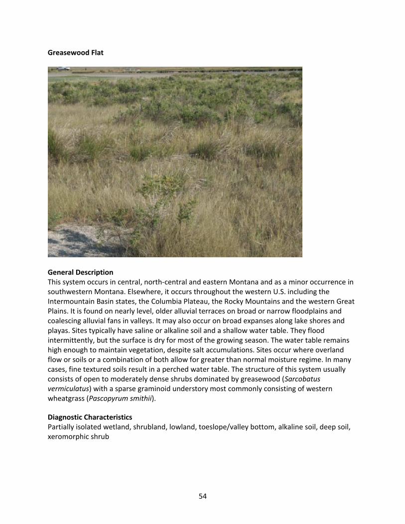
54
Greasewood Flat
General Description This system occurs in central, north-central and eastern Montana and as a minor occurrence in southwestern Montana. Elsewhere, it occurs throughout the western U.S. including the Intermountain Basin states, the Columbia Plateau, the Rocky Mountains and the western Great Plains. It is found on nearly level, older alluvial terraces on broad or narrow floodplains and coalescing alluvial fans in valleys. It may also occur on broad expanses along lake shores and playas. Sites typically have saline or alkaline soil and a shallow water table. They flood intermittently, but the surface is dry for most of the growing season. The water table remains high enough to maintain vegetation, despite salt accumulations. Sites occur where overland flow or soils or a combination of both allow for greater than normal moisture regime. In many cases, fine textured soils result in a perched water table. The structure of this system usually consists of open to moderately dense shrubs dominated by greasewood (Sarcobatus vermiculatus) with a sparse graminoid understory most commonly consisting of western wheatgrass (Pascopyrum smithii).
Diagnostic Characteristics Partially isolated wetland, shrubland, lowland, toeslope/valley bottom, alkaline soil, deep soil, xeromorphic shrub
55
Range This system occurs throughout the western U.S. including the Intermountain Basin states, the Columbia Plateau, the Rocky Mountains and the western Great Plains. It occurs in central, north-central and eastern Montana and as a minor occurrence in southwestern Montana. Environment In Montana, this ecological system represents one of the driest extremes of the riparian/wetland zone. It occurs on nearly level, older alluvial terraces on broad or narrow floodplains and coalescing alluvial fans in valleys. It may also occur on broad expanses along lake shores and playas. Sites typically have saline or alkaline soils and a shallow water table. They flood intermittently, but remain dry for most of the growing season. However, the underlying water table stays high enough to maintain vegetation, despite salt accumulations. The system occurs where overland flow or soils or a combination of both allow for a greater than normal moisture regime. High water tables are common, typically within 25 to 30 centimeters (10 to 12 inches) of the soil surface. Soils are fine textured, poorly drained and are alkaline or saline. Soil texture ranges from silt to clay. Sites range in elevation from 655 to 1,067 meters (2,150 to 3,500 feet) (Hansen et al., 1995).
Vegetation Greasewood (Sarcobatus vermiculatus) is the dominant shrub, although overall canopy cover may be low. Other shrubs present in some occurrences include four-wing saltbush (Atriplex canescens), shadscale saltbush (Atriplex confertifolia), Gardner’s saltbush (Atriplex gardneri), Wyoming big sagebrush (Artemisia tridentata ssp. wyomingensis), big sagebrush (Artemisia tridentata ssp. tridentata), silver sage (Artemisia cana ssp. cana), green rabbitbrush (Chrysothamnus viscidiflorus), rubber rabbitbrush (Ericameria nauseosa) or winterfat (Krascheninnikovia lanata).
Perennial grasses are the most common herbaceous cover, withwestern wheatgrass (Pascopyrum smithii) tending to dominate in undisturbed communities. Other graminoids commonly occurring in this system include slender wheatgrass (Elymus trachycaulus), prairie cordgrass (Spartina pectinata), Nutall’s alkaligrass (Puccinellia nuttalliana), Sandberg’s bluegrass (Poa secunda), inland saltgrass (Distichlis spicata), alkali sacaton (Sporobolus airoides), prairie sandgrass (Calamovilfa longifolia), basin wildrye (Leymus cinereus) and occasionally common spikerush (Eleocharis palustris). Common forb species include yarrow (Achillea millefolium), one-flowered groundsel (Pyrrocoma uniflora), boreal sagewort (Artemisia frigida), western sagewort (Artemisia ludoviciana), goosefoot (Chenopodium species), scarlet globe mallow (Sphaeralcea coccinea), western saltwort (Salicornia rubra) and curlycup gumweed (Grindelia squarrosa).
Adjacent drier communities are dominated by upland shrub or grassland communities such as mixed salt desert scrub, big sagebrush (Artemisia tridentata) shrublands, orthree tip sagebrush (Artemisia tripartita) shrublands. Wetter adjacent communities may be dominated by inland salt grass (Distichlis spicata) orwillow-cottonwood (Salix-Populus species) dominated communities. In Montana, this system can occur near alkaline lakes or in overflow washes.
56
Alliances (A.1422) (Common Spikerush, Page Spikerush) Seasonally Flooded Herbaceous Alliance (A.1267) Alkali Sacaton Herbaceous Alliance (A.1331) Alkali Sacaton Intermittently Flooded Herbaceous Alliance (A.1554) Greasewood Intermittently Flooded Shrub Herbaceous Alliance (A.1046) Greasewood Intermittently Flooded Shrubland Alliance (A.1877) Greasewood Intermittently Flooded Sparsely Vegetated Alliance (A.1204) Great Basin Wildrye Herbaceous Alliance (A.1329) Great Basin Wildrye Intermittently Flooded Herbaceous Alliance (A.1332) Inland Saltgrass Intermittently Flooded Herbaceous Alliance (A.1335) Nuttall's Alkali Grass Intermittently Flooded Herbaceous Alliance (A.835) Rubber Rabbitbrush Shrubland Alliance (A.870) Shadscale Shrubland Alliance
Dynamic Processes Soil-water dynamics within this system support a restricted range of species. Communities in good condition typically have 30 to 40 % shrub cover. Under continued disturbance, greasewood and western wheatgrass decrease in cover, while species such as foxtail barley (Hordeum jubatum) and yarrow (Achillea millefolium), and exotics like cheatgrass (Bromus tectorum), Japanese brome (Bromus japonicus) and Kentucky bluegrass (Poa pratensis), increase in cover. Management Overgrazing practices can significantly impact vigor and cover of principal shrub species, leading to an increase in cheatgrass and other exotics, although herbaceous cover in this system is often too low to attract cattle away from surrounding uplands. Off road travel can be a disturbance, especially in the early season, when clayey soils are still soft. In any season, heavy off road travel can be harmful to very slow growing dominant shrub species. Restoration Considerations In cases where the system has been impacted by heavy grazing, a rest-rotation regime with limited fall grazing may allow this system to recover by allowing regrowth of principal graminoid and shrub species. Severely impacted sites should be re-seeded to decrease soil erosion potential, to re-establish a native community, and to decrease weedy invasion by exotic species. Western wheatgrass can be used as the principal restoration species and can be seeded or transplanted as plugs. Once established this species spreads vigorously by rhizomes. Both greasewood and western wheatgrass exhibit excellent soil erosion control characteristics. Replanting with greasewood shrub seedlings may be necessary due to the slow recovery time within this system and low rates of natural seedling recruitment.
Original Concept Authors Natureserve Western Ecology Group

57
Montana Version Authors C. McIntyre, L.K. Vance, T. Luna Version Date 1/16/2010 Literature Cited
Hansen PL, Pfister RD, Boggs K, Cook BJ, Joy J, Hinckley DK. Classification and management of Montana's riparian and wetland sites. No. 54, 1-646. 1995. Montana Forest and Conservation Experiment Station, School of Forestry, University of Montana. Miscellaneous Publication.
Ecological Systems Field Guide: http://FieldGuide.mt.gov/displayES_Detail.aspx?ES=9103

58
Great Plains Closed Depressional Wetland
General Description This system includes a variety of depressional wetlands generally found in complexes in central and eastern Montana. This type of wetland differs from Great Plains Open Depressional Wetlands and Great Plains Prairie Potholes by being completely isolated from both the regional groundwater system and inter-wetland surface drainage systems. They occur in depressional basins found in flat, enclosed upland areas or on level shallow lake basins. The major sources of input water are precipitation and snow melt, and water loss occurs through evapotranspiration. The basins are typified by the presence of an impermeable layer, such as dense clay formed in alluvium that is poorly drained. Subsurface soil layers are restrictive to water movement and root penetration. Ponds and lakes associated with this system can experience periodic drawdowns during dry years, but are replenished by spring rains. Closed depressions experience irregular hydroperiods, most filling with water only occasionally and drying quickly, influencing the plant communities that are present. The drawdown zone is typically dominated by western wheatgrass (Pascopyrum smithii) and foxtail barley (Hordeum jubatum). Povertyweed (Iva axillaris) and willow dock (Rumex salicifolius) occupy the broad, low gradient basins which are shallowly inundated in the spring and draw down every year to reveal bottoms of gray bentonite. Common spikerush (Eleocharis palustris) occurs within the drawdown area where there is more organic matter in the substrate. Hardstem bulrush (Schoenoplectus acutus) typifies closed depressions sufficiently deep to remain permanently inundated during most years. Species richness can vary considerably among individual examples of this system and it is especially influenced by adjacent land use like agriculture and grazing.
59
Diagnostic Characteristics lowland, herbaceous, depression, depressional, playa, clay subsoil, impermeable layer, saturated, isolated wetland, strictly isolated wetland
Similar Systems Great Plains Prairie Pothole Great Plains Open Freshwater Depression Wetland Great Plains Saline Depression Wetland Range This system can be found throughout the eastern portion of the Western Great Plains; however, it is most prevalent in the central states of Nebraska, Kansas and Oklahoma. In Montana, closed depressions are most concentrated to the north of the HiLine and Route 2, from the Blackfeet Reservation to the North Dakota border. Individual depressions can also be found across the Northwestern Glaciated Plains north of the Missouri River. Environment This system is typified by depressional basins found in flat enclosed upland areas and level shallow lake basins, with an impermeable layer such as dense clay isolating the wetland from the regional groundwater system. It differs from Western Great Plains Open Depression Wetlands and Great Plains Prairie Potholes by being completely isolated from both the regional groundwater system and inter-wetland surface drainage systems. These wetlands occur in depressional basins found in flat enclosed upland areas or on level shallow lake basins. The major sources of input water are precipitation and snow melt; water loss occurs through evapotranspiration. The basins are typified by the presence of an impermeable layer, such as dense clay formed in alluvium that is poorly drained. Subsurface soil layers are restrictive to water movement and root penetration (Cook and Hauer, 2007). Ponds and lakes associated with this system can experience periodic drawdowns during dry years, but are replenished by spring rains. Closed depressions experience irregular hydroperiods, filling with water only occasionally and drying quickly, which influences the plant communities that are present. Vegetation Vegetation within this system is highly influenced by hydrology, salinity, fire and adjacent land uses. The drawdown zone is typically dominated by western wheatgrass (Pascopyrum smithii) and foxtail barley (Hordeum jubatum), the most common wet meadow component of this landscape. Needle spikerush (Eleocharis acicularis) and the small annual forbs slender plantain (Plantago elongata) and purslane speedwell (Veronica peregrina) are common in most stands. Povertyweed (Iva axillaris) and willow dock (Rumex salicifolius) occupy the broad, low gradient basins which are shallowly inundated in the spring and draw down every year to reveal bottoms of gray bentonite. The common spikerush (Eleocharis palustris) association is also within the drawdown zone but occurs at sites where there is more organic matter in the substrate. Foxtail barley (Hordeum jubatum) and needle spikerush (Eleocharis acicularis) are typically well represented in drier stands, while water knotweed (Polygonum amphibium) stands are found at

60
wetter sites. Marsh vegetation, dominated by hardstem bulrush (Schoenoplectus acutus), typifies depressions sufficiently deep to remain permanently inundated during most years. Forbs commonly associated with these marsh communities include water knotweed (Polygonum amphibium), common spikerush (Eleocharis palustris) and two headed water-starwort (Callitriche heterophylla). Alliances (A.1422) (Common Spikerush, Page Spikerush) Seasonally Flooded Herbaceous Alliance (A.1358) Foxtail Barley Temporarily Flooded Herbaceous Alliance (A.1046) Greasewood Intermittently Flooded Shrubland Alliance (A.1347) Prairie Cordgrass Temporarily Flooded Herbaceous Alliance (A.1232) Western Wheatgrass Herbaceous Alliance (A.1328 ) Western Wheatgrass Intermittently Flooded Herbaceous Alliance (A.1354) Western Wheatgrass Temporarily Flooded Herbaceous Alliance Dynamic Processes These systems developed under Northern Great Plains climatic conditions, which included natural disturbances by large herbivores, periodic flooding events and occasional fire. Wet-drought year climatic cycles in Montana, often in 10 to 20 year intervals, influence the ecological communities in these systems (Hansen et al., 1995). Each year seeds from annuals and perennials germinate and cover exposed mud flats, but when precipitation floods the depressions, the annuals drown and the perennials survive. Over a series of years the perennials dominate. The drawdown to mudflats is necessary so that emergent vegetation can become reestablished. This flooding, drawdown and the eventual exposure of mud flats drive the water-level vegetation cycle. Management Changes will occur in the plant communities due to climatic conditions and/or management actions. Due to the nature of the soils, these sites are considered moderately resilient. With continued adverse impacts, a moderate decline in vegetative vigor and composition will occur. Heavy continuous grazing and/or continuous seasonal (spring) grazing, without adequate recovery periods, will eventually lead to loss of the Western wheatgrass-foxtail barley wetland community, and inland saltgrass will begin to increase. Western wheatgrass will increase initially, but then will begin to decrease. In time, heavy continuous grazing will cause inland saltgrass, fowl bluegrass (Poa palustris), and other pioneer perennials and annuals to increase. This replacement plant community is resistant to change, due to the grazing tolerance of inland saltgrass and increased surface salts. However, a significant amount of production and diversity has been lost compared to the Western wheatgrass -foxtail barley community, and the loss of key cool season grasses and increased bare ground will affect energy flow and nutrient cycling. Water infiltration will be reduced significantly due to the massive shallow root system “root pan” characteristic of inland saltgrass, and the increased amount of bare ground. It will take a long time to bring this plant community back with management alone (USDA NRCS, 2003).

61
Restoration Considerations The major barriers to restoration are isolation, infrequent flooding, impermeable soils and invasive species. These factors must be addressed during the planning and long term management of restored wetlands. Original Concept Authors Natureserve Western Ecology Group Montana Version Authors C. McIntyre, L. Vance, T. Luna Version Date 2/9/2010 Literature Cited Cook BJ, Hauer FR. 2007. Effects of hydrological connectivity on water chemistry, soils, and
vegetation structure and function in intermontane depressional wetland landscape. Wetlands(27):719-38.
Hansen PL, Pfister RD, Boggs K, Cook BJ, Joy J, Hinckley DK. Classification and management of
Montana's riparian and wetland sites. No. 54, 1-646. 1995. Montana Forest and Conservation Experiment Station, School of Forestry, University of Montana. Miscellaneous Publication.
USDA NRCS - ND SM. 2003 R054XY022ND Section II - FOTG Closed Depression Ecological Site
Description. http://efotg.nrcs.usda.gov/references/public/ND/R054XY022ND_closed_depression.pdf
Ecological Systems Field Guide: http://FieldGuide.mt.gov/displayES_Detail.aspx?ES=9252
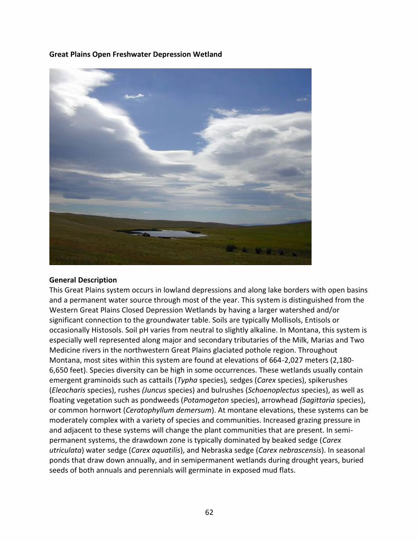
62
Great Plains Open Freshwater Depression Wetland
General Description This Great Plains system occurs in lowland depressions and along lake borders with open basins and a permanent water source through most of the year. This system is distinguished from the Western Great Plains Closed Depression Wetlands by having a larger watershed and/or significant connection to the groundwater table. Soils are typically Mollisols, Entisols or occasionally Histosols. Soil pH varies from neutral to slightly alkaline. In Montana, this system is especially well represented along major and secondary tributaries of the Milk, Marias and Two Medicine rivers in the northwestern Great Plains glaciated pothole region. Throughout Montana, most sites within this system are found at elevations of 664-2,027 meters (2,180-6,650 feet). Species diversity can be high in some occurrences. These wetlands usually contain emergent graminoids such as cattails (Typha species), sedges (Carex species), spikerushes (Eleocharis species), rushes (Juncus species) and bulrushes (Schoenoplectus species), as well as floating vegetation such as pondweeds (Potamogeton species), arrowhead (Sagittaria species), or common hornwort (Ceratophyllum demersum). At montane elevations, these systems can be moderately complex with a variety of species and communities. Increased grazing pressure in and adjacent to these systems will change the plant communities that are present. In semi-permanent systems, the drawdown zone is typically dominated by beaked sedge (Carex utriculata) water sedge (Carex aquatilis), and Nebraska sedge (Carex nebrascensis). In seasonal ponds that draw down annually, and in semipermanent wetlands during drought years, buried seeds of both annuals and perennials will germinate in exposed mud flats.
63
Diagnostic Characteristics Herbaceous, depression, depressional, saturated soils, partially isolated
Similar Systems Great Plains Prairie Pothole Great Plains Closed Depressional Wetland Great Plains Saline Depression Wetland
Range This system occurs across the western Great Plains from North Dakota and Kansas west to Montana and south to Texas. This system can occur throughout the western Great Plains but is likely more prevalent in the south-central portions of the division. Its distribution extends into central Montana, where it occurs in the matrix of the Northwestern Great Plains Mixed Grass Prairie. However, these depressions are most concentrated to the north of the Hi-Line and Route 2, from the Blackfeet Reservation to the North Dakota border. Individual depressions can also be found across the Northwest Glaciated Plains north of the Missouri River. Environment Open depression wetlands are found throughout the Northwestern Glaciated Great Plains region of Montana. They form in lowlands, and along lake borders and stream margins. They generally have more open basins, a large watershed, and a permanent water source throughout most of the year, except during exceptional drought years. This system differs from closed depressional wetlands by having a larger watershed and/or significant connection to the groundwater table (Cook and Hauer 2007). In Montana, most sites within this system are found at elevations of 664-2,027 meters (2,180-6,650 feet). Soils are typically Mollisols, Entisols or occasionally Histosols. Soil pH varies from neutral to slightly alkaline.
Vegetation Open depression wetlands often have submerged aquatic plants in the open water zone including common hornwort (Ceratophyllum demersum), short spikewater milfoil (Myriophyllum sibiricum), and horned pondweed (Zannichellia palustris) as well as floating-leaved plants including pondweeds (Stuckenia and Potamogeton species), white water crowfoot (Ranunculus aquatilis) and arrowheads (Sagittariaspecies). The central marsh zone is typically dominated by hardstem bulrush (Schoenoplectus acutus), but softstem bulrush (Schoenoplectus tabernaemontani), common threesquare (Schoenoplectus pungens) and alkali bulrush (Schoenoplectus maritimus), often co-dominate. Also found in the marsh zone are cattails (Typha species), water knotweed (Polygonum amphibium), and hemlock water parsnip (Sium suave). The seasonally flooded zones are typically dominated by graminoids including common spikerush (Eleocharis palustris), needle spikerush (Eleocharis acicularis), American sloughgrass (Beckmannia syzigachne), wheat sedge (Carex atherodes), foxtail barley (Hordeum jubatum), shortawn foxtail (Alopecurus aequalis), and water foxtail (Alopecurus geniculatus). Open depressional systems are often bordered by wet prairie zones characterized by species such as slimstem reedgrass (Calamagrostis stricta), clustered field sedge (Carex praegracilis), bluejoint (Calamagrostis canadensis) and fowl bluegrass (Poa palustris). Open depressions with
64
more alkaline or saline water and soil chemistry will typically be bordered by species such as saltgrass (Distichlis spicata), western wheatgrass (Pascopyrum smithii), and freshwater cordgrass (Spartina pectinata). Sites that have been moderately grazed often have an increase in Baltic rush (Juncus balticus), knotted rush (Juncus nodosus), foxtail barley (Hordeum jubatum), American sloughgrass (Beckmannia syzigachne), and western wheatgrass (Pascopyrum smithii). Alliances (A.1403) (Beaked Sedge, Northwest Territory Sedge) Seasonally Flooded Herbaceous Alliance (A.1422) (Common Spikerush, Page Spikerush) Seasonally Flooded Herbaceous Alliance (A.1436) (Narrowleaf Cattail, Broadleaf Cattail) - (Clubrush species) Semipermanently Flooded Herbaceous Alliance (A.1436) (Narrowleaf Cattail, Broadleaf Cattail) - (Clubrush species) Semipermanently Flooded Herbaceous Alliance (A.1404) Aquatic Sedge Seasonally Flooded Herbaceous Alliance (A.1396) Awned Sedge Seasonally Flooded Herbaceous Alliance (A.1374) Baltic Rush Seasonally Flooded Herbaceous Alliance (A.1675) Broadleaf Arrowhead Semipermanently Flooded Herbaceous Alliance (A.1394) Cattail species - (Clubrush species, Rush species) Seasonally Flooded Herbaceous Alliance (A.1342) Common Spikerush Temporarily Flooded Herbaceous Alliance (A.1443) Hardstem Bulrush - (Softstem Bulrush) Semipermanently Flooded Herbaceous Alliance (A.1417) Nebraska Sedge Seasonally Flooded Herbaceous Alliance (A.1754) Pondweed species - Coontail species - Waterweed species Permanently Flooded Herbaceous Alliance (A.1347) Prairie Cordgrass Temporarily Flooded Herbaceous Alliance (A.1765) Red-head Pondweed Permanently Flooded Herbaceous Alliance (A.1381) Reed Canarygrass Seasonally Flooded Herbaceous Alliance (A.1764) Sago Pondweed Permanently Flooded Herbaceous Alliance (A.1350) Sedge species - Alkali Plantain Temporarily Flooded Herbaceous Alliance (A.1465) Sedge species - Cattail species Saturated Herbaceous Alliance (A.1455) Sedge species Saturated Herbaceous Alliance (A.1445) Small Floating Mannagrass Semipermanently Flooded Herbaceous Alliance (A.1348) Smartweed species - Barnyard Grass species Temporarily Flooded Herbaceous Alliance (A.1881) Smartweed species Seasonally Flooded Herbaceous Alliance (A.1401) Sprangletop Seasonally Flooded Herbaceous Alliance (A.1354) Western Wheatgrass Temporarily Flooded Herbaceous Alliance Dynamic Processes These systems developed under Northern Great Plains climatic conditions, and experienced the natural influence of large herbivores, periodic flooding events and occasional fire. Wet-drought year climatic cycles in Montana, often in 10 to 20 year intervals, influence the ecological communities (Hansen et al., 1995). Seeds from annuals and perennials germinate and cover exposed mud flats, but when precipitation floods the depressions, the annuals drown and the

65
perennials survive. Over a series of years the perennials dominate. The drawdown to mudflats is necessary so that emergent vegetation can become reestablished. Flooding, drawdown and the eventual exposure of mud flats drive the water-level vegetation cycle. Species richness can vary considerably among individual examples and is especially influenced by adjacent land use. Agriculture may provide nutrient and herbicide runoff. In saline soil wetlands, the increase in precipitation during exceptionally wet years can dilute the salt concentration in the soils, which may allow for less salt-tolerant species to occur. Management Changes will occur in the plant communities due to climatic conditions and/or management activities. Conversion to agriculture and pastureland can impact this system when it alters the hydrology of the system. Restoration Considerations In open depression wetland systems where water has been drained or diverted, the original hydrology of the system must be restored. If water levels are restored, re-growth and re-colonization from dormant rhizomatous root systems of common emergent species can occur within a few years. Livestock grazing should be controlled to allow regrowth, recolonization and resprouting from existing root systems. Many of the characteristic species found in these systems are rhizomatous, and exhibit excellent erosion control properties. In some cases, if hydric soils are heavily altered due to pugging or compaction, addition of organic material may be needed to facilitate vegetation recolonization. Original Concept Authors Natureserve Western Ecology Group Montana Version Authors L. Vance, C. McIntyre, T. Luna Version Date 2/9/2010
Literature Cited Cook BJ, Hauer FR. 2007. Effects of hydrological connectivity on water chemistry, soils, and
vegetation structure and function in intermontane depressional wetland landscape. Wetlands(27):719-38.
Hansen PL, Pfister RD, Boggs K, Cook BJ, Joy J, Hinckley DK. Classification and management of
Montana's riparian and wetland sites. No. 54, 1-646. 1995. Montana Forest and Conservation Experiment Station, School of Forestry, University of Montana. Miscellaneous Publication.
Ecological System Field Guide: http://FieldGuide.mt.gov/displayES_Detail.aspx?ES=9218

66
Great Plains Prairie Pothole
General Description Prairie potholes occur in shallow depressions scraped out by glaciers in the northern Great Plains of Montana. The region is characterized by a glacial landscape of end moraines, stagnation moraines, outwash plains and lake plains. The glacial drift forms steep to slight local relief with fine-grained, silty to clayey soils. Limestone, sandstone, and shales are the predominant parent materials, and highly mineralized water can discharge from these rocks. The hydrology of this system is complex, and the concentration of dissolved solids results in water that ranges from fresh to extremely saline, with chemical characteristics varying seasonally and annually. Most prairie potholes and associated lakes contain alkaline water, which accumulates rapidly in during spring months, especially when soil frost is sufficiently deep to forestall all infiltration until after the ground thaws. Most water loss occurs through evapotranspiration, which exceeds precipitation during summer months. Vegetation within this system is highly influenced by hydrology, salinity and dynamics. Potholes can vary in depth and duration, which determines the local gradient of plant species. Similarly, species found within individual potholes will be strongly influenced by periodic drought and wet periods. The wettest sites, where water stands through summer, are characterized by hardstem bulrush (Schoenoplectus acutus), often occurring as a near monoculture, or with softstem bulrush (Schoenoplectus tabernaemontani) or common threesquare (Schoenoplectus pungens) along slightly drier margins. In permanently flooded sites, aquatic buttercups (Ranunculus species), aquatic smartweeds (Polygonum species), pondweeds (Potamogeton species) or duckweeds (Lemna species) are common. At the drier extremes, pothole vegetation generally occurs in a
67
concentric pattern from a wetter middle dominated by spikerush (Eleocharis species) through a drier ring of foxtail barley (Hordeum jubatum) and an outer margin of western wheatgrass (Pascopyrum smithii) or thickspike wheatgrass (Elymus lanceolatus). Prairie potholes are considered to be the most important breeding habitat for waterfowl in North America, with production estimates ranging from 50% to 80% of the continent’s main species. However, the extreme variability in climate and pothole water levels also results in extreme fluctuations in waterfowl populations from year to year. Prairie pothole wetlands also support a diverse assemblage of water-dependent birds. Diagnostic Characteristics lowland, herbaceous depressional, pothole, isolated wetland, temperate Similar Systems Great Plains Closed Depressional Wetland Great Plains Open Freshwater Depression Wetland Great Plains Saline Depression Wetland Range In Montana, most prairie potholes are concentrated north of the HiLine and Route 2, from the Blackfeet Reservation to the North Dakota border, although individual potholes occur across the Northwest Glaciated Plains north of the Missouri River. Elsewhere, this system occurs throughout the northern Great Plains from central Iowa northeast to southern Saskatchewan and Alberta. It encompasses approximately 870,000 square kilometers with approximately 80% of its range in southern Canada. It is also prevalent in North Dakota, South Dakota, and northern Minnesota.
Environment The prairie pothole ecological system is dominated by closed basins that receive irregular inputs of water from the surroundings and export water as groundwater. The climate is characterized by mid-continental temperature and precipitation extremes. The region is distinguished by a thin mantle of glacial drift with overlying stratified sedimentary rocks of the Mesozoic and Cenozoic ages; these form a glacial landscape of end moraines, stagnation moraines, outwash plains and lake plains. The glacial drift is from 30 meters to 120 meters thick and forms steep to slight local relief with fine-grained, silty to clayey soils. Limestone, sandstone, and shales are predominant, and highly mineralized water can discharge from these rocks. Precipitation and runoff from snowmelt are often the principal water sources, with groundwater inflow as a secondary source. Evapotranspiration is the primary source of water loss, with seepage loss secondary. The hydrology of this system is complex, and the concentration of dissolved solids results in water that ranges from fresh to extremely saline, with chemical characteristics varying seasonally and annually. Most prairie potholes and associated lakes contain water that is alkaline (pH >7.4). Surrounding uplands are generally in cropland (small grains), hay, or range.
Prairie potholes are considered to be the most important breeding habitat for waterfowl in North America, with production estimates ranging from 50% to 80% of the continent’s main

68
species. However, the extreme variability in climate and pothole water levels also results in extreme fluctuations in waterfowl populations from year to year. Prairie wetlands also support a diverse assemblage of water-dependent birds including Montana species of concern such as the black-crowned night heron (Nycticorax nycticorax), white-faced ibis (Plegadis chihi), Franklin’s gull (Larus pipixcan), common tern (Sterna hirundo), Forster’s tern (Sterna forsteri), and black tern (Chlidonias niger). American white pelicans (Pelecanus erythrorhynchos) feed extensively on tiger salamanders (Ambystoma tigrinum) found in prairie potholes. Sparsely-vegetated alkali potholes, especially in Sheridan County, are attractive to piping plovers (Charadrius melodus).
Vegetation Vegetation within this system is highly influenced by hydrology, salinity and dynamics. This system includes elements of emergent marshes and wet, sedge meadows that develop into a pattern of concentric rings. Potholes can vary in depth and duration, which determines the local gradient of species. Similarly, plant species found within individual potholes will be strongly influenced by periodic drought and wet periods. The wettest sites, where water stands into or through summer, are characterized by hardstem bulrush (Schoenoplectus acutus), often occurring as a near monoculture, or with a fringe of softstem bulrush (Schoenoplectus tabernaemontani) or common threesquare (Schoenoplectus pungens) along slightly drier margins. Cattails (Typha spp) are also seen in these wetter systems, although they are typically a minor component. During spring or in permanently flooded sites, aquatic buttercups (Ranunculus species), aquatic smartweeds (Polygonum species), pondweeds (Potamogeton species) or duckweeds (Lemna species) may be abundant. At the drier extremes, pothole vegetation generally occurs in a concentric pattern from a wetter middle dominated by spikerush (Eleocharisspecies) through a drier ring of foxtail barley (Hordeum jubatum) and an outer margin of western wheatgrass (Pascopyrum smithii) or thickspike wheatgrass (Elymus lanceolatus) (Hansen et al, 1995; Lesica 1989). Grazing, draining, and mowing of this system can influence vegetation distribution. Alliances (A.1467) Few-seed Sedge - Wiregrass Sedge Saturated Herbaceous Alliance (A.1443) Hardstem Bulrush - (Softstem Bulrush) Semipermanently Flooded Herbaceous Alliance (A.1444) Saltmarsh Clubrush Semipermanently Flooded Herbaceous Alliance Dynamic Processes Flooding is the primary natural dynamic influencing this system. Snowmelt in the spring often floods this system and can cause the prominent potholes within the system to overflow. Greater than normal precipitation can flood out emergent vegetation and/or increase herbivory by animal species such as muskrats. Periodic wet and droughty periods cause shifts in vegetation. Vegetation zones are evident, and each zone responds to changing environmental conditions. Draining and conversion to agriculture can also significantly impact this system. Much of the original extent of this system has been converted to cropland, and many remaining examples are under pressure to be drained.

69
Management Livestock use of potholes is limited by low palatability of characteristic species, although open water attracts livestock for both drinking and cooling. When upland vegetation becomes sparse, cattle will graze on spikerush and bulrush. Wet soils are easily trampled. Grazing, when properly planned and executed, can be a management tool, preventing cattail encroachment into open water, limiting the spread of exotics such as crested wheat (Agropyron cristatum) and smooth brome (Bromus inermis), and avoiding excessive litter buildup. Prescribed burning can be used to the same ends. Prairie potholes are primarily threatened by crop agriculture, by unrestricted grazing, and by oil and gas development. Region-wide, nearly half of this system has been lost. Restoration Considerations In Great Plains prairie pothole wetland systems where water has been drained or altered, the original hydrology of the system must be restored. If water levels are restored, re-growth and re-colonization from dormant rhizomatous root systems of common emergent species can occur within a few years. Many of the characteristic species found in marsh systems are rhizomatous, thus exhibit excellent erosion control properties. However, species that are infrequent in these wetland systems may not re-occur or re-establish in a given time frame. The major barriers to prairie pothole restoration are isolation, infrequent flooding and invasive species. These factors must be addressed during the planning and long term management of restored prairie pothole wetlands.
During restoration, cattle grazing needs to eliminated or controlled to allow regrowth, recolonization and resprouting from existing root systems. In some cases, if hydric soils are heavily altered due to pugging or compaction, addition of organic material may be needed to facilitate plant recolonization.
Original Concept Authors Natureserve Western Ecology Group Montana Version Authors L.K. Vance, C. McIntyre, T. Luna Version Date 2/9/2010
Literature Cited Hansen PL, Pfister RD, Boggs K, Cook BJ, Joy J, Hinckley DK. Classification and management of
Montana's riparian and wetland sites. No. 54, 1-646. 1995. Montana Forest and Conservation Experiment Station, School of Forestry, University of Montana. Miscellaneous Publication.

70
Lesica P. 1989. The vegetation and flora of glaciated prairie potholes of the Blackfeet Indian Reservation, Montana. Helena, MT: The Nature Conservancy, Montana Field Office; 26 p.
Ecological System Field Guide: http://FieldGuide.mt.gov/displayES_Detail.aspx?ES=9203

71
Great Plains Saline Depression Wetland
General Description This ecological system is very similar to both the Western Great Plains Open Freshwater Depression Wetland and the Western Great Plains Closed Depression Wetland found in wetland complexes in the central and northeastern portion of Montana. However, this system differs due to increased soil salinity, which causes these systems to become brackish. This high salinity is attributed to high evaporation and the accumulation of minerals dissolved in the water. Wetlands in this system are discharge wetlands, where water high in dissolved salts has moved from the regional groundwater system into the depression. Hydroperiods vary depending on precipitation and snowmelt, the primary source of water. Water is prevented from percolating out of the depression due to impermeable dense clay, and salt encrustations can occur on the surface with drying. Species that typify this system are salt-tolerant and halophytic graminoids such as alkali bulrush (Schoenoplectus maritimus), common three square (Schoenoplectus pungens), inland saltgrass (Distichlis spicata), Nuttall’s alkali grass (Puccinellia nuttalliana), foxtail barley (Hordeum jubatum), red swampfire (Salicornia rubra) and freshwater cordgrass (Spartina pectinata), and shrubs such as black greasewood (Sarcobatus vermiculatus). During exceptionally wet years, an increase in precipitation can dilute the salt concentration in the soils in some cases, allowing for less salt-tolerant species to occur. The distribution of this system extends into central Montana, where it occurs in the matrix of the Northwestern Great Plains Mixed Grass Prairie. However, these depressions are most concentrated to the north of the HiLine and Route 2, from the Blackfeet Reservation to the North Dakota Border. Individual

72
occurrences can also be found across the Northwest Glaciated Plains north of the Missouri River. Diagnostic Characteristics Isolated to partially isolated wetland, depression, saline conditions Similar Systems Great Plains Closed Depressional Wetland Great Plains Open Freshwater Depression Wetland Range This system can occur throughout the western Great Plains but is more prevalent in the south-central portions of the division. Its distribution extends into central Montana where it occurs in the matrix of the Northwestern Great Plains Mixed Grass Prairie. These saline depressions are most concentrated to the north of the HiLine and Route 2, from the Blackfeet Reservation to the North Dakota Border. Individual depressions can also be found across the Northwestern Glaciated Plains north of the Missouri River. Environment This system is distinguished from the freshwater depression systems by brackish water caused by strongly saline and alkaline soils. This high salinity is attributed to excessive evaporation and the accumulation of minerals dissolved in groundwater discharge. Water is prevented from percolating out of the depression due to an impermeable dense clay soil. Salt encrustations can occur on the surface due to slow water movement (Hansen et al, 1995). On the Blackfeet Indian reservation, water samples collected from saline depressions had conductivity values that ranged from 1,550-40,000 uhmos/cm (Lesica and Shelley, 1988). Vegetation Vegetation within this system is highly influenced by soil salinity and soil moisture. Salt-tolerant and halophytic species that typify this system include alkali bulrush (Schoenoplectus maritimus), common three square (Schoenoplectus pungens), inland saltgrass (Distichlis spicata), Nuttall’s alkali grass (Puccinellia nuttalliana), foxtail barley (Hordeum jubatum), red swampfire (Salicornia rubra) and freshwater cordgrass (Spartina pectinata), and shrubs such as black greasewood (Sarcobatus vermiculatus). Other species include western wheatgrass (Pascopyrum smithii) and foxtail barley (Hordeum jubatum). Plant zonation related to soil salinity is often apparent in these systems. with distinct rings occurring around the fringe of the depression. In deeper, more depressed halophytic habitats, red swampfire or prairie cordgrass will dominate with Nuttall’s alkali grass found directly upslope, followed by inland saltgrass. Shrubs such as greasewood and winterfat (Krascheninnikovia lanata) are common around the outer margins of this system. Pursh seepweed (Suaeda calceoliformis), annual goosefoot (Chenopodium species) and seaside arrowgrass (Triglochin maritima) are common forbs.
In northeastern Montana, the alkali bulrush association occurs as an emergent band around open water or as zonal vegetation around other plant associations. Water tables are often high,

73
often remaining above the soil surface at least through late summer. Soils are poorly drained, alkaline Entisols. Alkali bulrush forms dense, monotypic stands with up to 91% cover. In some areas along the wetland edge, very minor amounts of common spikerush (Eleocharis palustris) may be present. Alkali bulrush can survive periods of total inundation up to 1 meter (3.3 feet) deep, as well as drought periods where the water table remains less than 1 meter below the soil surface. It is a vigorously rhizomatous species that colonizes and spreads when the water table is within 10 centimeters (4 inches) of the surface. Cover of alkali bulrush may be replaced by red swampfire and other associated species during drought years.
Red swampfire occurs in the drawdown zone that is flooded during the early part of the growing season but where the water table drops below soil surface by late spring or early summer. Soils in this zone usually have silty-clay to clay texture, and the soil surface is covered with salt crusts. Principle salts are sulfates and chlorides of sodium and magnesium. It is one of a very few species that can persist in these hyper-saline conditions when the water table drops below the soil surface (Dodd and Coupland,1966).
Alliances (A.1436) (Narrowleaf Cattail, Broadleaf Cattail) - (Clubrush species) Semipermanently Flooded Herbaceous Alliance (A.1267) Alkali Sacaton Herbaceous Alliance (A.1433) Common Threesquare Semipermanently Flooded Herbaceous Alliance (A.1358) Foxtail Barley Temporarily Flooded Herbaceous Alliance (A.1554) Greasewood Intermittently Flooded Shrub Herbaceous Alliance (A.1341) Inland Saltgrass - (Foxtail Barley) Temporarily Flooded Herbaceous Alliance (A.1332) Inland Saltgrass Intermittently Flooded Herbaceous Alliance (A.1335) Nuttall's Alkali Grass Intermittently Flooded Herbaceous Alliance (A.1818) Red Saltwort Seasonally Flooded Herbaceous Alliance (A.1764) Sago Pondweed Permanently Flooded Herbaceous Alliance (A.1764) Sago Pondweed Permanently Flooded Herbaceous Alliance (A.1444) Saltmarsh Clubrush Semipermanently Flooded Herbaceous Alliance (A.1401) Sprangletop Seasonally Flooded Herbaceous Alliance (A.1354) Western Wheatgrass Temporarily Flooded Herbaceous Alliance Dynamic Processes These systems developed under Northern Great Plains climatic conditions that include natural influence of periodic flooding events and occasional fire. Climate has an important effect on saline areas because precipitation and snowmelt transport salts to the depressions and can dilute the soil solution while temperature and wind influence the rate of evapotranspiration. Increased precipitation and/or runoff can dilute the salt concentration and allow for less salt-tolerant species to occur while increased evapotranspiration increases soil salinity leading to a more brackish habitat type.
74
Management Changes will occur in the plant communities due to climatic conditions and/or management activities. Restoration Considerations In saline depression wetland systems where water has been drained or altered, the original hydrology of the system must be restored. If hydrology is restored, re-growth and re-colonization from dormant rhizomatous root systems of common emergent species can occur during periods of flooding. Cattle grazing should be deferred or controlled to allow regrowth, recolonization and resprouting from existing root systems. Annuals such as red swampfire and annual goosefoots require periods of inundation and drawdown to initiate germination and to complete their life cycles at the end of the growing season.
Original Concept Authors Natureserve Western Ecology Group Montana Version Authors T. Luna, C. McIntyre, L.K. Vance Version Date 2/9/2010
Literature Cited Dodd JD, Coupland RT. 1966. Vegetation of saline areas in Saskatchewan. Ecology 47(6):958-68. Hansen PL, Pfister RD, Boggs K, Cook BJ, Joy J, Hinckley DK. Classification and management of
Montana's riparian and wetland sites. No. 54, 1-646. 1995. Montana Forest and Conservation Experiment Station, School of Forestry, University of Montana. Miscellaneous Publication.
Lesica P. 1989. The vegetation and flora of glaciated prairie potholes of the Blackfeet Indian
Reservation, Montana. Helena, MT: The Nature Conservancy, Montana Field Office; 26 p.
Ecological System Field Guide: http://FieldGuide.mt.gov/displayES_Detail.aspx?ES=9256
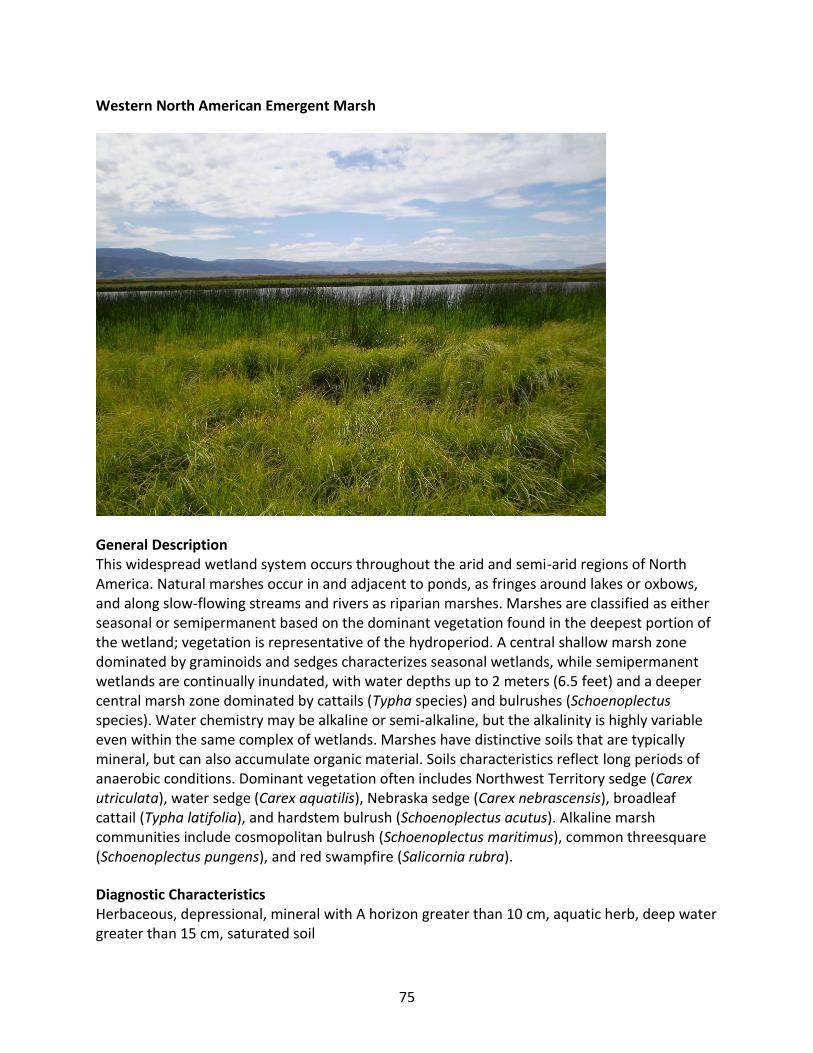
75
Western North American Emergent Marsh
General Description This widespread wetland system occurs throughout the arid and semi-arid regions of North America. Natural marshes occur in and adjacent to ponds, as fringes around lakes or oxbows, and along slow-flowing streams and rivers as riparian marshes. Marshes are classified as either seasonal or semipermanent based on the dominant vegetation found in the deepest portion of the wetland; vegetation is representative of the hydroperiod. A central shallow marsh zone dominated by graminoids and sedges characterizes seasonal wetlands, while semipermanent wetlands are continually inundated, with water depths up to 2 meters (6.5 feet) and a deeper central marsh zone dominated by cattails (Typha species) and bulrushes (Schoenoplectus species). Water chemistry may be alkaline or semi-alkaline, but the alkalinity is highly variable even within the same complex of wetlands. Marshes have distinctive soils that are typically mineral, but can also accumulate organic material. Soils characteristics reflect long periods of anaerobic conditions. Dominant vegetation often includes Northwest Territory sedge (Carex utriculata), water sedge (Carex aquatilis), Nebraska sedge (Carex nebrascensis), broadleaf cattail (Typha latifolia), and hardstem bulrush (Schoenoplectus acutus). Alkaline marsh communities include cosmopolitan bulrush (Schoenoplectus maritimus), common threesquare (Schoenoplectus pungens), and red swampfire (Salicornia rubra).
Diagnostic Characteristics Herbaceous, depressional, mineral with A horizon greater than 10 cm, aquatic herb, deep water greater than 15 cm, saturated soil

76
Similar Systems Alpine-Montane Wet Meadow Rocky Mountain Subalpine-Montane Fen
Range This wetland ecological system occurs throughout western North America. In Montana, it is system is found throughout the western and central portion of the state from foothill to upper montane elevations.
Environment This system is found in environments where precipitation is approximately 25 to 50 centimeters (10 to 20 inches) per year. In Montana, this system occurs in and adjacent to ponds, as fringes around lakes or oxbows, and along slow-flowing streams and rivers as riparian marshes. Water chemistry may be alkaline or semi-alkaline, but is highly variable even within the same complex of wetlands. Marshes have distinctive soils that are typically mineral, but can also accumulate organic material. Soils characteristics reflect long periods of anaerobic conditions, with gleying, high organic content, and redoximorphic features. Wetland marshes are classified as either seasonal or semi-permanent based on the dominant vegetation found in the deepest portion of the wetland (Stewart and Kantrud, 1971 and LaBaugh et al., 1996). Vegetation communities occurring in these marsh systems is representative of their hydroperiod; some basins dry to bare soil after seasonal flooding, while others will have a variety of wetland types in a zoned pattern dependent on seasonal water table depths and salt concentrations (Kudray and Cooper, 2006). Vegetation In semi-permanent marshes, sedges such as Northwest Territory sedge (Carex utriculata) and Nebraska sedge (Carex nebrascensis) are common with broadleaf cattail (Typha latifolia), softstem bulrush (Schoenoplectus tabernaemontani), and hardstem bulrush (Schoenoplectus acutus) located in the deeper portion of the marsh. Water sedge (Carex aquatilis) is frequently co-dominant with Northwest Territory sedge. Less commonly, blister sedge (Carex vesicaria) and awned sedge (Carex atherodes) are intermixed with Northwest Territory sedge or occur as co-dominants on similar sites. Beyond the emergent vegetation, floating-leaved hydrophytes may be present in wetter sites with longer inundation periods, including water lilies (Nymphaea species), yellow pondlily (Nuphar species), buttercup (Ranunculus species) and pondweed (Potamogeton species). Other floating species may be present in shallow water, such as duckweed, (Lemna species), and submergents such as common hornwort (Ceratophyllum demersum), horned pondweed (Zannichellia palustris), mare’s tail (Hippuris vulgaris) and water milfoil (Myriophyllum species). Common perennial forbs include common willow herb (Epilobium ciliatum), marsh cinquefoil (Potentilla palustris), Gmelin’s buttercup (Ranunculus gmelinii), greater creeping spearwort (Ranunculus flammula), hemlock water parsnip (Sium suave), willow dock (Rumex salicifolius), field mint (Mentha arvensis), leafy aster (Symphyotrichum foliaceum) and broadleaf arrowhead

77
(Sagittaria latifolia). Fern allies such as water horsetail (Equisetum fluviatile) and field horsetail (Equisetum arvense) often form significant cover. Grasses common to marshes include small floating mannagrass (Glyceria borealis), tufted hairgrass (Deschampsia cespitosa), and bluejoint reedgrass (Calamagrostis canadensis). Marshes with more alkaline water chemistry often have hardstem bulrush, cattail, common threesquare (Schoenoplectus pungens), alkali bulrush (Schoenoplectus maritimus), and red swampfire (Salicornia rubra). These marsh communities are brackish and support species adapted to saline and alkaline water and soil conditions, similar to Great Plains Saline Depression systems. Typically, riverine marshes subjected to unaltered, seasonal water flow and annual flooding are characterized by zonal vegetation determined by water depth with stands of bulrush (Schoenoplectus species) and cattail in deeper water, and manna grass (Glyceria species), water sedge, inflated sedge, water horsetail, and common spikerush in shallower water zones. Riverine marshes can be influenced by beaver activity and human caused influences that can change the structure and species richness of these plant communities. Beaver activity can increase species richness and diversify community structure by altering water flow, depth, and organic sediment accumulation. Alliances
A.1403 (Beaked Sedge, Northwest Territory Sedge) Seasonally Flooded Herbaceous Alliance A.1763 (Waterthread, Slender False Pondweed) Permanently Flooded Herbaceous Alliance A.1984 American White Water-lily - Yellow Pond-lily species Permanently Flooded Temperate Herbaceous Alliance A.1374 Baltic Rush Seasonally Flooded Herbaceous Alliance A.1400 Bluejoint Seasonally Flooded Herbaceous Alliance A.1419 Clustered Field Sedge Seasonally Flooded Herbaceous Alliance A.1431 Common Reed Semipermanently Flooded Herbaceous Alliance A.1433 Common Threesquare Semipermanently Flooded Herbaceous Alliance A.1747 Duckweed species Permanently Flooded Herbaceous Alliance A.1443 Hardstem Bulrush - (Softstem Bulrush) Semipermanently Flooded Herbaceous Alliance A.2501 Inflated Sedge Seasonally Flooded Herbaceous Alliance A.1332 Inland Saltgrass Intermittently Flooded Herbaceous Alliance A.1417 Nebraska Sedge Seasonally Flooded Herbaceous Alliance A.1347 Prairie Cordgrass Temporarily Flooded Herbaceous Alliance A.1818 Red Saltwort Seasonally Flooded Herbaceous Alliance A.1381 Reed Canarygrass Seasonally Flooded Herbaceous Alliance A.1444 Saltmarsh Clubrush Semipermanently Flooded Herbaceous Alliance A.1445 Small Floating Mannagrass Semipermanently Flooded Herbaceous Alliance

78
Dynamic Processes
Species richness can vary considerably among individual examples and is especially influenced by adjacent land use. Agriculture and forestry operations, when adjacent, may cause nutrient and herbicide runoff.
Management Changes will occur in the plant communities due to climatic conditions and/or management activities. Draining, ditching or conversion to agriculture and pastureland can alter the hydrology of the system. Moderate to heavy grazing practices can greatly decrease cover of beaked sedge and cause soil compaction. Invasive and exotic species such as reed canarygrass (Phalaris arundinacea), common reed (Phragmites australis), and Canadian thistle (Cirsium arvense) become established in areas of heavy grazing or other disturbances. Diversion or lateration of seasonal flooding in riverine systems can change the species composition and succesional direction of riverine marsh communities.
Restoration Considerations In marsh systems that have been drained or where the hydrology has been altered, the original hydrology of the system must be restored. If water levels are restored, re-growth and re-colonization from dormant rhizomatous root systems of common marsh species can occur within a few years. Cattle grazing must be eliminated or controlled to allow regrowth, recolonization, and resprouting from existing root systems. Many of the characteristic species found in marsh systems are rhizomatous, thus exhibiting excellent erosion control properties. In some cases, if hydric soils are heavily altered due to pugging or compaction, addition of organic material may be needed to facilitate vegetation recolonization.
Original Concept Authors Natureserve Western Ecology Group Montana Version Authors T. Luna., C. McIntyre, L. Vance Version Date 1/21/2010
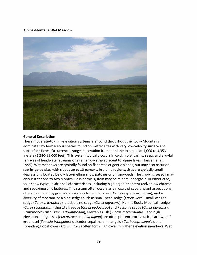
79
Alpine-Montane Wet Meadow
General Description These moderate-to-high-elevation systems are found throughout the Rocky Mountains, dominated by herbaceous species found on wetter sites with very low-velocity surface and subsurface flows. Occurrences range in elevation from montane to alpine at 1,000 to 3,353 meters (3,280-11,000 feet). This system typically occurs in cold, moist basins, seeps and alluvial terraces of headwater streams or as a narrow strip adjacent to alpine lakes (Hansen et al., 1995). Wet meadows are typically found on flat areas or gentle slopes, but may also occur on sub-irrigated sites with slopes up to 10 percent. In alpine regions, sites are typically small depressions located below late-melting snow patches or on snowbeds. The growing season may only last for one to two months. Soils of this system may be mineral or organic. In either case, soils show typical hydric soil characteristics, including high organic content and/or low chroma and redoximorphic features. This system often occurs as a mosaic of several plant associations, often dominated by graminoids such as tufted hairgrass (Deschampsia caespitosa), and a diversity of montane or alpine sedges such as small-head sedge (Carex illota), small-winged sedge (Carex microptera), black alpine sedge (Carex nigricans), Holm’s Rocky Mountain sedge (Carex scopulorum) shortstalk sedge (Carex podocarpa) and Payson’s sedge (Carex paysonis). Drummond’s rush (Juncus drummondii), Merten’s rush (Juncus mertensianus), and high elevation bluegrasses (Poa arctica and Poa alpina) are often present. Forbs such as arrow-leaf groundsel (Senecio triangularis), slender-sepal marsh marigold (Caltha leptosepala), and spreading globeflower (Trollius laxus) often form high cover in higher elevation meadows. Wet

80
meadows are associated with snowmelt and are usually not subjected to high disturbance events such as flooding. Diagnostic Characteristics Woody canopy generally less than 10%, total canopy cover more than 10%; subalpine to montane elevations; in snowmelt basins or adjacent to springs, seeps, streams, or lakes, or in areas with high water table; dominated by herbaceous emergent vegetation; organic layer less than 40 cm deep. Similar Systems Rocky Mountain Subalpine-Montane Mesic Meadow Rocky Mountain Subalpine-Montane Fen Western North American Emergent Marsh
Range This system is found throughout the Rocky Mountains and Intermountain West regions, ranging in elevation from montane to alpine (1000-3600 m). In Montana, they are most common as high-elevation wetlands in the colder and wetter mountains of the Beartooth-Absaroka range and in northwestern Montana. Environment Moisture for these wet meadow community types comes from groundwater, stream discharge, overland flow, overbank flow, and precipitation. Salinity and alkalinity are generally low due to the frequent flushing of moisture through the meadow. Depending on the slope, topography, hydrology, soils and substrate, intermittent, ephemeral, or permanent pools may be present. Standing water may be present during some or all of the growing season, with water tables typically remaining at or near the soil surface. Fluctuations of the water table throughout the growing season are not uncommon, however. On drier sites supporting the less mesic types, the late-season water table may be one meter or more below the surface. Soils typically possess a high proportion of organic matter, but this may vary considerably depending on the frequency and magnitude of alluvial deposition. Organic composition of the soil may include a thin layer near the soil surface. Soils may exhibit gleying and/or mottling throughout the profile. Vegetation A variety of plant communities are found within this system in Montana. Composition and zonation of wet meadow plant communities represent the competitive abilities, moisture and nutrient requirements, and stress tolerance of anoxic conditions of individual plant species. Variability of water-table depth and reduced soil conditions, soil pH, and saturation duration, strongly influences the distribution and assemblage of species within a wet meadow. Obligate wetland species occur within a fairly restricted range of water-table depth, whereas many common species such as tufted hairgrass, Baltic rush (Juncus balticus) and Kentucky bluegrass (Poa pratensis) occur over wide ranges. Overlap in ranges of water-table depth for individual

81
species suggests that small changes in hydrology could potentially result in shifts in dominance by different species, and ultimately replacement or loss of certain species.
Many alpine wet meadows throughout the state are dominated by tufted hairgrass, forming a dense stand of tussocks. The tufted hairgrass Temporarily Flooded Herbaceous Alliance has been found at elevations as high as 10,100 feet, but is much more common at lower elevations where it often occupies low gradient areas and slopes less than 15 percent, facing north to northeast (Cooper et al., 1997). This alliance is thought to be found in relatively undisturbed sites (Hansen et al., 1995), while more disturbed sites are dominated by Kentucky bluegrass (Poa pratensis), fowl bluegrass (Poa palustris), redtop (Agrostis stolonifera) and Baltic rush.
In southwestern Montana, wet meadow communities are dominated by species more characteristic of the Middle Rocky Mountains ecoregion, such as Holm’s Rocky Mountain sedge (Cooper et al, 1999). Drier sites, especially those where soils and/or hydrology have been disturbed, may be characterized by Baltic rush and clustered field sedge (Carex praegracilis) communities. In the Northern Rocky Mountains, shortstalk sedge or Payson’s sedge are dominant (Lesica, 2002), often found on slopes that range from zero to eight percent where the growing season lasts only for one to two months. In these northern occurrences, other common graminoids include small-head sedge, lens sedge (Carex lenticularis), smallwing sedge, black alpine sedge, beaked sedge (Carex utriculata), Drummond’s rush, Merten’s rush, arctic bluegrass, and alpine bluegrass. Common forbs include woolly pussytoes (Antennaria lanata), spreading globeflower, slender-sepal marsh marigold, arrow-leaf groundsel, elephant’s head (Pedicularis groenlandica), small flowered anemone (Anemone parviflora), alpine bistort (Polygonum viviparum), Buek’s groundsel (Packera subnuda), and Rocky Mountain goldenrod (Solidago multiradiata). Sibbaldia (Sibbaldia procumbens) often occurs in open areas within the turf or open peat. At more montane elevations, extensive shrubby cinquefoil (Dasiphora fruticosa) shrublands are frequently found adjacent to this system.
At montane elevations, zonation of wet meadow complexes is evident with sedges such as inflated sedges (Carex utriculata and C. vescicaria), wooly sedge (Carex pellita), Nebraska sedge (Carex nebrascensis) and water sedge (Carex aquatilis) occupying the wettest zone of the meadow complex. These sedge-dominated communities are typically surrounded by spikerushes (Eleocharis spp.), followed by a zone of grasses and forbs such as Baltic rush, bluejoint reedgrass (Calamagrostis canadensis), slimstem reedgrass (Calamagrostis stricta), pink elephant’s head and water ragwort (Senecio hydrophilus).
Alliances A.2578 (American Mannagrass, Fowl Mannagrass) Seasonally Flooded Herbaceous Alliance A.1424 (Arctic Hare's-foot Sedge, Hair Sedge, Small-head Sedge) Seasonally Flooded Herbaceous Alliance A.1403 (Beaked Sedge, Northwest Territory Sedge) Seasonally Flooded Herbaceous Alliance A.1422 (Common Spikerush, Page Spikerush) Seasonally Flooded Herbaceous Alliance A.2631 American Globeflower Saturated Herbaceous Alliance A.1469 Analogue Sedge Saturated Herbaceous Alliance

82
A.1404 Aquatic Sedge Seasonally Flooded Herbaceous Alliance A.1667 Arrowleaf Ragwort Temporarily Flooded Herbaceous Alliance A.1374 Baltic Rush Seasonally Flooded Herbaceous Alliance A.1418 Black Alpine Sedge Seasonally Flooded Herbaceous Alliance A.1400 Bluejoint Seasonally Flooded Herbaceous Alliance A.1419 Clustered Field Sedge Seasonally Flooded Herbaceous Alliance A.1468 Columbian Sedge Saturated Herbaceous Alliance A.1661 Cow-parsnip Temporarily Flooded Herbaceous Alliance A.1324 Drummond's Rush Herbaceous Alliance A.995 Dwarf Birch Seasonally Flooded Shrubland Alliance A.1409 Fowl Bluegrass Semi-natural Seasonally Flooded Herbaceous Alliance A.1420 Holm's Rocky Mountain Sedge Seasonally Flooded Herbaceous Alliance A.2501 Inflated Sedge Seasonally Flooded Herbaceous Alliance A.1325 Parry's Rush Herbaceous Alliance A.1645 Ross' Avens Herbaceous Alliance A.1357 Russet Sedge Temporarily Flooded Herbaceous Alliance A.1300 Showy Sedge Herbaceous Alliance A.958 Shrubby-cinquefoil Temporarily Flooded Shrubland Alliance A.1611 Sitka Valerian Herbaceous Alliance A.1445 Small Floating Mannagrass Semipermanently Flooded Herbaceous Alliance A.1456 Tufted Hairgrass Saturated Herbaceous Alliance A.1408 Tufted Hairgrass Seasonally Flooded Herbaceous Alliance A.1355 Tufted Hairgrass Temporarily Flooded Herbaceous Alliance A.1678 Water Horsetail Semipermanently Flooded Herbaceous Alliance A.2594 Western Bluejoint Temporarily Flooded Herbaceous Alliance A.1698 White Marsh-marigold Saturated Herbaceous Alliance A.1414 Woolly Sedge Seasonally Flooded Herbaceous Alliance Dynamic Processes Communities associated with this ecological system are adapted to soils that may be flooded or saturated throughout the growing season. They may also occur on areas with soils that are only saturated early in the growing season, or intermittently during heavy convective storms in summer. Most appear to be relatively stable types, although in some areas these may be impacted by intensive livestock grazing. Management Herbaceous wet meadows that have experienced disturbance like excessive grazing or heavy recreational pressure are often invaded by non-native vegetation and are difficult to restore. Typical successional plants to invade disturbed areas include Nebraska sedge (Carex nebrascensis), Baltic rush (Juncus balticus), and Kentucky bluegrass (Poa pratensis). To minimize disturbance, light to moderate grazing can be restricted to periods when the soil is completely dry and can be timed to occur after the maturation of native seedheads (Hansen et al., 1995). Recreational use should be diverted away from these meadows, and pack stock should be fed certified weed-free or pelletized feed.

83
Restoration Considerations Large scale restoration projects within this system are usually mine lands reclamation projects in non-protected areas. Small scale projects may occur in areas of heavy recreational use or areas of past intensive grazing. Original Concept Authors NatureServe Western Ecology Group Montana Version Authors L. Vance, C. McIntyre, T. Luna Version Date 4/17/2009
Literature Cited Brown RW, Chambers JC, Wheeler RM. 1988. Adaptations of Deschampsia cespitosa (tufted
hairgrass) for revegetation of high elevation disturbances: some selection criteria. High altitude revegetation workshop no. 8: Proceedings; 1988 March 3-4; Fort Collins, CO. Information Series No. 59. Fort Collins, CO: Colorado Water Resources Research Institute; p 147-72.
Brown RW, Chambers JC. 1990. Reclamation practices in high-mountain ecosystems. In:
Schmidt WC, McDonald KJ, editors. Proceedings--symposium on whitebark pine ecosystems: ecology and management of a high-mountain resource; 1989 March 29-31; Bozeman, MT. General Technical Report. INT-270. Ogden, UT: U.S. Department of Agriculture. Forest Service. Intermountain Research Station; p 329-34.
Brown RW, Johnston RS. 1978. Rehabilitation of a high elevation mine disturbance. In: Kenney
ST, editor. Proceedings: High altitude workshop no. 3. Environmental Res. Cent. Inf. Series No. 28. Fort Collins, CO: Colorado State University; p 116-30.
Buckner DL, Marr JW. 1990. Use of sodding in alpine vegetation. In: Hughes HG, Bonnicksen TM,
editors. Restoration `89: the new management challange: Proceedings, 1st annual meeting of the Society for Ecological Restoration; 1989 January 16-20; Oakland, CA. Madison, WI: The University of Wisconsin Arboretum, Society for Ecological Restoration; p 501-8.
Chambers JC, MacMahon JA, Brown RW. 1987. Germination characteristics of alpine grasses
and forbs: a comparison of early and late seral dominants with reclamation potential. Reclamation and Revegetation Research(6):235-49.
Chambers JC, MacMahon JA, Brown RW. 1990. Alpine seedling establishment: the influence of
disturbance type. Ecology 71(4):1323-41.

84
Cooper DJ. 1986. Community structure and classification of Rocky Mountain wetland ecosystems. In: Windell JT, Willard BE, Cooper DJ, Foster SQ, Knud-Hansen CF, Rink LP, Kiladis GN, editors. An ecological characterization of Rocky Mountain montane and subalpine wetlands. Biological Report 86 ed. U.S. Fish and Wildlife Service; p 66-147.
Cooper SV, Jean C, Heidel BL. 1999. Plant associations and related botanical inventory of the
Beaverhead Mountains Section, Montana. Helena: Montana Natural Heritage Program. Cooper SV, Lesica P, Page-Dumroese D. 1997. Plant community classification for alpine
vegetation on Beaverhead National Forest, Montana. Ogden, UT: USDA Forest Service, Intermountain Research Station; Report nr General Technical Report INT-GTR-362.
Cowardin LM, Carter V, Golet F, LaRoe ET. 1979 Dec. Classification of wetlands and deepwater
habitats of the United States. Washington, D.C.: U.S. Department of the Interior, Fish and Wildlife Service; Report nr FWS/OBS-79/31.
Jonas R. 1962. Population dynamics and ecology of Merriam's turkey. Montana Department of
Fish & Game; Report nr Final Rep. Proj. No. W-91-R-4 Job No. II-B. Kittel G, Wie EV, Damm M, Rondeau R, Kettler S, McMullen A, Sanderson J. 1999. A
classification of riparian and wetland plant associations of Colorado: A user's guide to the classification project. Fort Collins CO: Colorado Natural Heritage Program, Colorado State University; 70 p.
Lesica P. 2002. Flora of Glacier National Park. Corvallis: Oregon State University Press. 512 p.
Ecological System Field Guide: http://FieldGuide.mt.gov/displayES_Detail.aspx?ES=9217

85
Hydrogeomorphic (HGM) Classification of Wetlands in the Rocky Mountains
1a. Entire wetland unit is flat and precipitation is the primary source (>90%) of water. Groundwater and
surface water runoff are not significant sources of water to the unit ........................... Flats HGM Class
1b. Wetland does not meet the above criteria; primary water sources include groundwater and/or surface water .......................................................................................................................................... 2
2a. Entire wetland unit meets all of the following criteria: a) the vegetated portion of the wetland is on the shores of a permanent open water body at least 8 ha (20 acres) in size; b) at least 30% of the open water area is deeper than 2 m (6.6 ft); c) vegetation in the wetland experiences bidirectional flow as the result of vertical fluctuations of water levels due to rising and falling lake levels. ...............
................................................................................................................... Lacustrine Fringe HGM Class
2b. Wetland does not meet the above criteria; wetland is not found on the shore of a water body, water body is either smaller or shallower, OR vegetation is not effected by lake water levels ...................... 3
3a. Entire wetland unit meets all of the following criteria: a) wetland unit is in a valley, floodplain, or along a stream channel where it is inundated by overbank flooding from that stream or river; b) overbank flooding occurs at least once every two years; and c) wetland does not receive significant inputs from groundwater. NOTE: Riverine wetlands can contain depressions that are filled with water when the river is not flooding such as oxbows and beaver ponds. ................ Riverine HGM Class
3b. Wetland does not meet the above criteria; if the wetland is located within a valley, floodplain, or along a stream channel, it is outside of the influence of overbank flooding or receives significant hydrologic inputs from groundwater. .................................................................................................... 4
4a. Entire wetland unit meets all of the following criteria: a) wetland is on a slope (slope can be very gradual or nearly flat); b) groundwater is the primary hydrologic input; c) water, if present, flows through the wetland in one direction and usually comes from seeps or springs; and d) water leaves the wetland without being impounded. NOTE: Small channels can form within slope wetlands, but are not subject to overbank flooding. Surface water does not pond in these types of wetlands, except occasionally in very small and shallow depressions or behind hummocks (depressions are usually < 3ft diameter and less than 1 foot deep). ...................................................................... Slope HGM Class
4b. Wetland does not meet all of the above criteria. ................................................................................. 5
5a. Entire wetland unit is located in a topographic depression in which water ponds or is saturated to the surface at some time during the year. NOTE: Any outlet, if present, is higher than the interior of the wetland. ...................................................................................................... Depressional HGM Class
If the hydrologic criteria listed in each question do not apply to the entire wetland unit being rated, you probably have a wetland with multiple HGM classes. In this case, identify which hydrologic criteria in Questions 1-5 apply, and go to Question 6.

86
5b. Wetland does not meet the above criteria ............................................................................................ 6
6. If the wetland is difficult to classify, then it probably contains multiple HGM classes. For example, seeps at the base of a slope may grade into a riverine floodplain, or a small stream within a depressional wetland may have a zone of flooding along its sides. GO BACK AND IDENTIFY WHICH OF THE HYDROGEOMORPHIC CLASSES DESCRIBED IN QUESTIONS 1-5 APPLY TO DIFFERENT AREAS IN THE UNIT (make a rough sketch to help you decide).
If you have two HGM classes present within your wetland, then identify the HGM class that represents 10% or more of the assessment area using the following table.
HGM Classes observed within the wetland being assessed HGM Class to use in assessment (must represent 10% or more of the assessment area)
Slope + Riverine Riverine
Slope + Depressional Depressional
Slope + Lacustrine Fringe Lacustrine Fringe
Depressional + Riverine along stream within assessment area boundary
Depressional
Depressional + Lacustrine Fringe Depressional
NOTE: If the HGM class listed in column 2 represents less than 10% of the assessment area, then classify the wetland using the HGM class that represents more than 90% of the total assessment area. If you are still unable to determine which of the above criteria apply to your wetland, or if you have more than 2 HGM classes within an assessment area, classify the wetland as Depressional for the assessment and note reasoning.
Modified from: Hruby, Tom, (2004). Washington State Wetland Rating System for Eastern Washington - Revised. Publication #04-06-15. Washington State Department of Ecology, Olympia, Washington.

87
Key to the Cowardin Systems and Classes of the Rocky Mountains
Key to the Cowardin Systems
1a. Persistent emergent herbaceous vegetation, trees, shrubs, or emergent mosses cover 30% or more of the wetland. If the wetland occurs within a mosaic of systems, then the patch must be at least 0.1 hectares (0.25 acres). .................................................................................................................. PALUSTRINE
1b. Persistent emergents, trees, shrubs, or emergent mosses cover less than 30% of substrate, but nonpersistent emergents may be widespread during some portions of the year ....................................... 2 2a. Situated in a channel; water, when present, usually flowing .................................................... RIVERINE
2b. Situated in a basin, catchment, or on level or sloping ground; water usually not flowing .................... 3 3a. Area 8 ha (20 acres) or greater ............................................................................................. LACUSTRINE
3b. Area less than 8 ha ................................................................................................................................. 4 4a. Wave-formed or bedrock shoreline feature present or water depth 2 m (6.6 feet) or more. ................
.................................................................................................................................................... LACUSTRINE
4b. No wave-formed or bedrock shoreline feature present and water less than 2 m deep ...... PALUSTRINE
Key to the Cowardin Classes
1a. During the growing season of most years, areal cover by vegetation is less than 30%. ........................ 2
1b. During the growing season of most years, percentage of area covered by vegetation 30% or greater. . ...................................................................................................................................................................... 6 2a. Water regime permanently flooded, intermittently exposed, or semipermanently flooded. ............... 3
2b. Water regime irregularly exposed, regularly flooded, irregularly flooded, seasonally flooded, temporarily flooded, intermittently flooded, saturated, or artificially flooded. .......................................... 4 3a. Substrate of bedrock, boulders, or stones occurring singly or in combination covers 75% or more of the area .................................................................................................................................. ROCK BOTTOM
3b. Substrate of organic material, mud, sand, gravel, or cobbles with less than 75% areal cover of stones, boulders, or bedrock ........................................................................................ UNCONSOLIDATED BOTTOM 4a. Contained within a channel that does not have permanent flowing water (i.e., Intermittent Subsystem of Riverine System) ...................................................................................................STREAMBED
4b. Contained in a channel with perennial water or along the shore of a lake or pond .............................. 5 5a. Substrate of bedrock, boulders, or stones occurring singly or in combination covers 75% or more of the area (RIVERINE OR LACUSTRINE ONLY). ............................................................................ ROCKY SHORE
5b. Substrate of organic material, mud, sand, gravel, or cobbles; with less than 75% of the cover consisting of stones, boulders, or bedrock .......................................................... UNCONSOLIDATED SHORE

88
6a. Vegetation composed of pioneering annuals or seedling perennials, often not hydrophytes, occurring only at time of substrate exposure ............................................................................................................... 7
6b. Vegetation composed of algae, bryophytes, lichens, or vascular plants that are usually hydrophytic perennials ..................................................................................................................................................... 8 7a. Contained within a channel that does not have permanent flowing water. ............................................
............................................................................................................................. STREAMBED (VEGETATED)
7b. Contained within a channel with permanent water, or not contained in a channel ............................... ...................................................................................................... UNCONSOLIDATED SHORE (VEGETATED) 8a. Vegetation composed predominantly of nonvascular species ............................................................... 9
8b. Vegetation composed predominantly of vascular species ................................................................... 10 9a. Vegetation macrophytic algae, mosses, or lichens growing in water or the splash zone of shores. .......
................................................................................................................................................. AQUATIC BED
9b. Vegetation mosses or lichens usually growing on organic soils and always outside the splash zone of shores ..................................................................................................................... MOSS-LICHEN WETLAND 10a. Vegetation herbaceous ....................................................................................................................... 11
10b. Vegetation trees or shrubs ................................................................................................................. 12 11a. Vegetation emergents ........................................................................................ EMERGENT WETLAND
11b. Vegetation submergent, floating-leaved, or floating ...................................................... AQUATIC BED 12a. Dominants less than 6 m (20 feet) tall ........................................................... SCRUB-SHRUB WETLAND
12b. Dominants 6 m tall or taller ................................................................................. FORESTED WETLAND
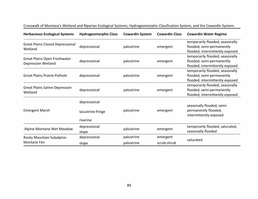
89
Crosswalk of Montana’s Wetland and Riparian Ecological Systems, Hydrogeomorphic Classfication System, and the Cowardin System.
Herbaceous Ecological Systems Hydrogeomorphic Class Cowardin System Cowardin Class Cowardin Water Regime
Great Plains Closed Depressional Wetland
depressional palustrine emergent temporarily flooded, seasonally flooded, semi-permanently flooded, intermittently exposed
Great Plains Open Freshwater Depression Wetland
depressional palustrine emergent temporarily flooded, seasonally flooded, semi-permanently flooded, intermittently exposed
Great Plains Prairie Pothole depressional palustrine emergent temporarily flooded, seasonally flooded, semi-permanently flooded, intermittently exposed
Great Plains Saline Depression Wetland
depressional palustrine emergent temporarily flooded, seasonally flooded, semi-permanently flooded, intermittently exposed
depressional
lacustrine fringe Emergent Marsh
riverine
palustrine emergent seasonally flooded, semi-permanently flooded, intermittently exposed
depressional Alpine-Montane Wet Meadow
slope palustrine emergent
temporarily flooded, saturated, seasonally flooded
depressional palustrine emergent Rocky Mountain Subalpine-Montane Fen slope palustrine scrub-shrub
saturated
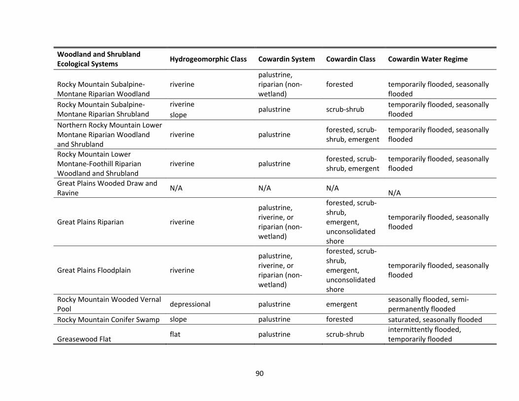
90
Woodland and Shrubland Ecological Systems
Hydrogeomorphic Class Cowardin System Cowardin Class Cowardin Water Regime
Rocky Mountain Subalpine-Montane Riparian Woodland
riverine palustrine, riparian (non-wetland)
forested temporarily flooded, seasonally flooded
riverine Rocky Mountain Subalpine-Montane Riparian Shrubland slope
palustrine scrub-shrub temporarily flooded, seasonally flooded
Northern Rocky Mountain Lower Montane Riparian Woodland and Shrubland
riverine palustrine forested, scrub-shrub, emergent
temporarily flooded, seasonally flooded
Rocky Mountain Lower Montane-Foothill Riparian Woodland and Shrubland
riverine palustrine forested, scrub-shrub, emergent
temporarily flooded, seasonally flooded
Great Plains Wooded Draw and Ravine
N/A N/A N/A N/A
Great Plains Riparian riverine
palustrine, riverine, or riparian (non-wetland)
forested, scrub-shrub, emergent, unconsolidated shore
temporarily flooded, seasonally flooded
Great Plains Floodplain riverine
palustrine, riverine, or riparian (non-wetland)
forested, scrub-shrub, emergent, unconsolidated shore
temporarily flooded, seasonally flooded
Rocky Mountain Wooded Vernal Pool
depressional palustrine emergent seasonally flooded, semi-permanently flooded
Rocky Mountain Conifer Swamp slope palustrine forested saturated, seasonally flooded
Greasewood Flat flat palustrine scrub-shrub
intermittently flooded, temporarily flooded