Embed Size (px)
Citation preview
Field Guide to Riparian Plant Communities in Northwestern Oregon United States Department of Agriculture Forest Service Pacific Northwest Region January 2005

Field Guide to Riparian Plant Communities in Northwestern Oregon
Condensed from
Riparian Plant Communities of Northwest Oregon: Streamside Plant Communities
By Cindy McCain
USFS Ecologist-Northwest Oregon Ecology Group
And
Native Freshwater Plant Associations of Northwestern Oregon
By John A. Christy Oregon Natural Heritage Information Center
Oregon State University
United States Department of Agriculture Forest Service
Pacific Northwest Region
Technical Paper R6-NR-ECOL-TP-01-05
January, 2005
Persons of any race, color, national origin, sex, age, religion, or with any handicapping condition are welcome to use and enjoy all facilities, programs and services of the USDA. Discrimination in any form is strictly against agency policy, and should be reported to the Secretary of Agriculture, Washington, DC 20250
Acknowledgements USDA Forest Service, the Oregon Watershed Enhancement Board, the Environmental Protection Agency, and USDI Bureau of Land Management supported production of the two parent volumes. This interagency project was the result of collaboration among members of the Northwest Oregon Ecology Group and cooperators from The Nature Conservancy/Oregon Natural Heritage Program (now Oregon Natural Heritage Information Center). Mt. Hood, Siuslaw, and Willamette National Forests and Eugene and Salem BLM Districts strongly supported the effort and encouraged synthesis of existing, independently collected data into a unified product for northwest Oregon. Cover art: Thuja plicata, from the United States Department of Agriculture Forest Service Collection, Hunt Institute for Botanical Documentation, Carnegie Mellon University, Pittsburgh, PA.
1
TABLE OF CONTENTS FOR THE FIELD GUIDE TO RIPARIAN PLANT COMMUNITIES IN NORTHWESTERN OREGON Introduction to the Field Guide to Riparian Plant Communities in Northwestern Oregon .............................................................................2 Purpose ..............................................................................................2 Study area ..........................................................................................4 Primary key to Field Guide to Riparian Plant Communities in Northwestern Oregon .........................................................................5 Table of Contents for Riparian Plant Communities in Northwest Oregon: Streamside Plant Communities of Northwest Oregon ...........7 Table of Contents for Native Freshwater Plant Associations of Northwestern Oregon .........................................................................186 APPENDICES Appendix I Species list.........................................................................332 Appendix II References .......................................................................356
2
INTRODUCTION TO THE FIELD GUIDE TO RIPARIAN PLANT COMMUNITIES IN NORTHWESTERN OREGON Purpose This field guide combines classifications of common streamside plant communities and native freshwater wetland communities in Northwest Oregon. It is a condensed version of two separate works which are both available on the CD that accompanies this book. The information is also available for reference or to download as a zipfile from the Interagency Clearinghouse of Ecological Information, Pacific NW Region website: http://www.reo.gov/ecoshare/Publications/Documents/FieldGuides/NWOriparian/ In both the CD and downloadable versions, the full guide is broken down into smaller file sizes for ease of downloading and printing. The files were created in Adobe Acrobat 5.0. Links within the document will lead you to appropriate sections. For example, opening the “Title Page, Acknowledgements, Table of Contents” file allows the reader to browse the contents of the entire guide. When the open-handed cursor turns into a pointing hand, there is a link available. Throughout the entire Table of Contents the pointing hand should be visible. Clicking on the link to which the hand is pointing will open the appropriate file and lead the reader to the selected section. The reader can return to files previously viewed by either clicking on the “Back” button in the browser or by finding green boxes within the document that direct the reader to other sections of the Guide. The purpose of the field guide is to allow an observer to identify communities in the field from key indicator species and environmental factors. A more complete discussion is available from the larger guides. This field guide is organized in two major sections: streamside communities and freshwater wetland communities. Each section has its own introduction, keys, and community descriptions. Many sites along streams or rivers include patches of wetlands where drainage is very poor. The most distinctively ‘wetland’ wetland-communities are identified and described only in the wetlands section. Wetland communities which commonly occur on floodplains are included in the streamside keys, with leads to the wetland association name and page number in the wetland section. The appendix provides a list of species occurring frequently in the riparian plant communities. The list is sorted first by scientific name, and then by common names. Wetland Indicator Status is included (US Army
3
Corps of Engineers 1987). Names of non-native species in Appendix I, Species List, are italicized. The full guides offer more information on the communities contained in the field guide. Please refer to these full guides which include: In Riparian Plant Communities of Northwest Oregon: Streamside Plant Communities:
• More detailed description of study methods, data sources, analyses.
• Ecosystem processes influencing streamside communities. • Comparison of Coast and Cascades: major patterns by
geomorphic group • Non-native plant species in riparian zones. • Plant community distribution shown in valley cross-sections • Community descriptions, including color photographs, soil profile
sketches, and wetland rating. • More inclusive cover/constancy tables for each community
(Appendix in an Excel table). In Native Freshwater Plant Associations of Northwestern Oregon:
• More detailed description of study methods, data sources, analyses
• National Vegetation Classification system units, Nature Serve ecological system name, and global and state rank.
• More detailed information on environment and ecology. • Global distribution of the plant association. • List of other studies related to the plant community. • More complete cover/constancy tables for each community.
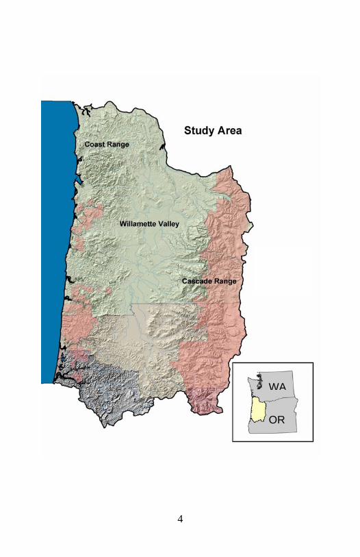
The two sections are organized differently. The streamside section is divided first into three geographic areas, then by geomorphic groups. The wetlands section divides communities into forest and woodland, shrubland, herbaceous, and nonvascular groupings, and includes information on geographic distribution in the descriptions of each type. The streamside study area includes only sites west of the Cascades Crest. Note that the wetlands section includes a small section of the east slope of the Cascades and along the lower Columbia River.
4
WA
OR
5
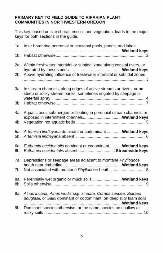
PRIMARY KEY TO FIELD GUIDE TO RIPARIAN PLANT COMMUNITIES IN NORTHWESTERN OREGON This key, based on site characteristics and vegetation, leads to the major keys for both sections in the guide. 1a. In or bordering perennial or seasonal pools, ponds, and lakes ......................................................................................Wetland keys 1b. Habitat otherwise...............................................................................2 2a. Within freshwater intertidal or subtidal zone along coastal rivers, or hydrated by these zones ..............................................Wetland keys 2b. Above hydrating influence of freshwater intertidal or subtidal zones ...........................................................................................................3 3a. In stream channels, along edges of active streams or rivers, or on steep or rocky stream banks, sometimes irrigated by seepage or waterfall spray ..................................................................................4 3b. Habitat otherwise ..............................................................................7 4a. Aquatic beds submerged or floating in perennial stream channels or exposed in intermittent channels..................................Wetland keys 4b. Vegetation not aquatic beds .............................................................5 5a. Artemisia lindleyana dominant or codominant .............Wetland keys 5b. Artemisia lindleyana absent .............................................................6 6a. Euthamia occidentalis dominant or codominant...........Wetland keys 6b. Euthamia occidentalis absent ................................ Streamside keys 7a. Depressions or seepage areas adjacent to montane Phyllodoce heath near timberline ...................................................Wetland keys 7b. Not associated with montane Phyllodoce heath ..............................8 8a. Perennially wet organic or muck soils .........................Wetland keys 8b. Soils otherwise .................................................................................9 9a. Alnus incana, Alnus viridis ssp. sinuata, Cornus sericea, Spiraea douglasii, or Salix dominant or codominant, on deep silty loam soils ......................................................................................Wetland keys 9b. Dominant species otherwise, or the same species on shallow or rocky soils .......................................................................................10
6
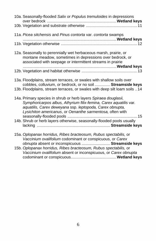
10a. Seasonally-flooded Salix or Populus tremuloides in depressions over bedrock ................................................................Wetland keys 10b. Vegetation and substrate otherwise ...............................................11 11a. Picea sitchensis and Pinus contorta var. contorta swamps ......................................................................................Wetland keys 11b. Vegetation otherwise ......................................................................12 12a. Seasonally to perennially wet herbaceous marsh, prairie, or montane meadow, sometimes in depressions over bedrock, or associated with seepage or intermittent streams in prairie ......................................................................................Wetland keys 12b. Vegetation and habitat otherwise ...................................................13 13a. Floodplains, stream terraces, or swales with shallow soils over cobbles, colluvium, or bedrock, or no soil .............. Streamside keys 13b. Floodplains, stream terraces, or swales with deep silt loam soils ..14 14a. Primary species in shrub or herb layers Spiraea douglasii, Symphoricarpos albus, Athyrium filix-femina, Carex aquatilis var. aquatilis, Carex deweyana ssp. leptopoda, Carex obnupta, Lysichiton americanus, or Oenanthe sarmentosa, often with seasonally-flooded pools ................................................................15 14b. Shrub or herb layers otherwise, seasonally-flooded pools usually lacking ................................................................... Streamside keys 15a. Oplopanax horridus, Ribes bracteosum, Rubus spectabilis, or Vaccinium ovalifolium codominant or conspicuous, or Carex obnupta absent or inconspicuous .......................... Streamside keys 15b. Oplopanax horridus, Ribes bracteosum, Rubus spectabilis, or Vaccinium ovalifolium absent or inconspicuous, or Carex obnupta codominant or conspicuous..........................................Wetland keys
7
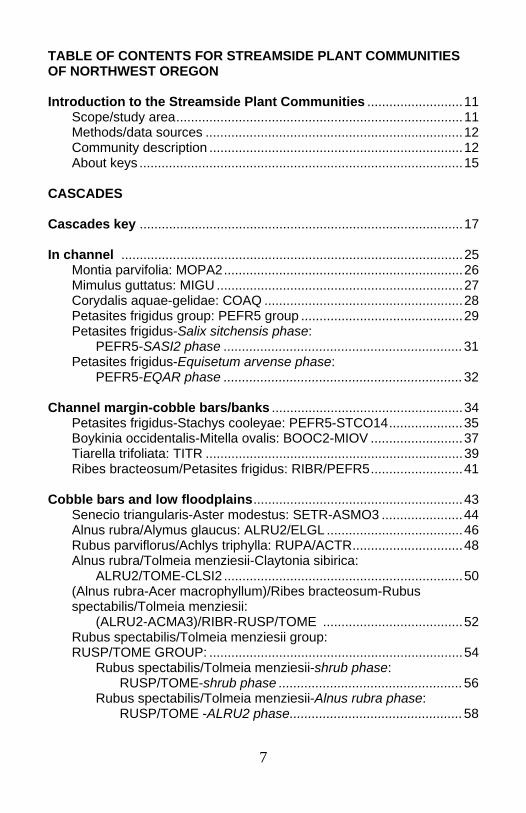
TABLE OF CONTENTS FOR STREAMSIDE PLANT COMMUNITIES OF NORTHWEST OREGON Introduction to the Streamside Plant Communities ..........................11 Scope/study area..............................................................................11 Methods/data sources ......................................................................12 Community description .....................................................................12 About keys ........................................................................................15
CASCADES Cascades key ........................................................................................17 In channel .............................................................................................25 Montia parvifolia: MOPA2.................................................................26 Mimulus guttatus: MIGU ...................................................................27 Corydalis aquae-gelidae: COAQ ......................................................28 Petasites frigidus group: PEFR5 group ............................................29 Petasites frigidus-Salix sitchensis phase: PEFR5-SASI2 phase .................................................................31 Petasites frigidus-Equisetum arvense phase:
PEFR5-EQAR phase .................................................................32 Channel margin-cobble bars/banks ....................................................34 Petasites frigidus-Stachys cooleyae: PEFR5-STCO14....................35 Boykinia occidentalis-Mitella ovalis: BOOC2-MIOV .........................37 Tiarella trifoliata: TITR ......................................................................39 Ribes bracteosum/Petasites frigidus: RIBR/PEFR5.........................41 Cobble bars and low floodplains.........................................................43 Senecio triangularis-Aster modestus: SETR-ASMO3 ......................44 Alnus rubra/Alymus glaucus: ALRU2/ELGL .....................................46 Rubus parviflorus/Achlys triphylla: RUPA/ACTR..............................48 Alnus rubra/Tolmeia menziesii-Claytonia sibirica: ALRU2/TOME-CLSI2 .................................................................50 (Alnus rubra-Acer macrophyllum)/Ribes bracteosum-Rubus spectabilis/Tolmeia menziesii: (ALRU2-ACMA3)/RIBR-RUSP/TOME ......................................52 Rubus spectabilis/Tolmeia menziesii group: RUSP/TOME GROUP: .....................................................................54 Rubus spectabilis/Tolmeia menziesii-shrub phase: RUSP/TOME-shrub phase ..................................................56 Rubus spectabilis/Tolmeia menziesii-Alnus rubra phase: RUSP/TOME -ALRU2 phase...............................................58
8
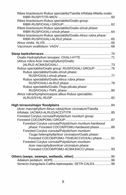
Ribes bracteosum-Rubus spectabilis/Tiarella trifoliata-Mitella ovalis: RIBR-RUSP/TITR-MIOV............................................................60 Ribes bracteosum-Rubus spectabilis/Oxalis group: RIBR-RUSP/OXALI GROUP:.....................................................62 Ribes bracteosum-Rubus spectabilis/Oxalis-shrub phase: RIBR-RUSP/OXALI-shrub phase:..............................................64 Ribes bracteosum-Rubus spectabilis/Oxalis-Alnus rubra phase: RIBR-RUSP/OXALI-ALRU2 phase ............................................65 Alnus viridis: ALVI5...........................................................................66 Vaccinium ovalifolium: VAOV ...........................................................68 Steep banks/terraces ............................................................................70 Oxalis-Hydrophyllum tenuipes: OXALI-HYTE ..................................71 (Alnus rubra-Acer macrophyllum)/Oxalis: (ALRU2-ACMA3)/OXALI ............................................................73 Rubus spectabilis/Oxalis group: RUSP/OXALI GROUP: ................75 Rubus spectabilis/Oxalis-shrub phase: RUSP/OXALI-shrub phase ..................................................77 Rubus spectabilis/Oxalis-Alnus rubra phase: RUSP/OXALI-ALRU2 phase ...............................................78 Rubus spectabilis/Oxalis-Thuja plicata phase: RUSP/OXALI-THPL phase..................................................80 Alnus rubra/Symphoricarpos albus-Rubus spectabilis: ALRU2/SYAL-RUSP ..................................................................82 High terraces/major floodplains ..........................................................84 (Acer macrophyllum-Alnus rubra)/Acer circinatum/Tiarella trifoliata: (ACMA3-ALRU2)/ACCI/TITR.............................................85 Forested Corylus cornuta/Polystichum munitum group: Forested COCO6/POMU GROUP:...................................................87 Forested Corylus cornuta/Polystichum munitum-hardwood phase: Forested COCO6/POMU-hardwood phase .............89 Forested Corylus cornuta/Polystichum munitum- Tsuga heterophylla/Acer circinatum/Oxalis phase: Forested COCO6/POMU-TSHE/ACCI/OXALI phase..........91 Forested Corylus cornuta/Polystichum munitum- Acer macrophyllum/Acer circinatum phase: Forested COCO6/POMU-ACMA3/ACCI phase...................93 Others (seeps, swamps, wetlands, other) ..........................................95 Adiatum pedatum: ADPE..................................................................96 Senecio triangularis-Caltha leptosepala: SETR-CALE4...................98
9
Oplopanax horridum-Rubus spectabilis group: OPHO-RUSP GROUP: ..............................................................99 Oplopanax horridum-Rubus spectabilis phase: OPHO-RUSP-shrub phase ......................................................101 Oplopanax horridum-Rubus spectabilis-Alnus rubra phase: OPHO-RUSP-ALRU2 phase....................................................102 Oplopanax horridum-Rubus spectabilis-Thuja plicata phase: OPHO-RUSP-THPL phase ......................................................104 Picea engelmannii/Vaccinium membranaceum: PIEN/VAME........106 Vaccinium ovalifolium-Rubus spectabilis/Lysichiton americanum: VAOV-RUSP/LYAM3 .........................................108 Thuja plicata/Rubus spectabilis/Lysichiton americanum- Oxalis: THPL/RUSP/LYAM3-OXALI ........................................110 Abies amabilis/Vaccinium ovalifolium: ABAM/VAOV .....................112 COAST RANGE Coast Range key .................................................................................114 In channel ...........................................................................................118 Equisetum: EQUIS..........................................................................119 Chrysosplenium glechomifolium: CHGL5 ......................................121 Oenanthe sarmentosa: OESA........................................................123 Mid-channel bars or channel margin ................................................125 Oxalis-Tolmeia menziesii: OXALI-TOME .......................................126 Rubus spectabilis-Ribes bracteosum/Chrysosplenium glechomifolium: RUSP-RIBR/CHGL5 ......................................128 Active channel shelf/active floodplain/first floodplains..................130 Rubus spectabilis-Ribes bracteosum group: RUSP-RIBR group...131
Rubus spectabilis-Ribes bracteosum-Stachys phase: RUSP-RIBR-STACH phase...............................................133 Rubus spectabilis-Ribes bracteosum-Tiarella trifoliata phase: RUSP-RIBR-TITR phase ...................................................135
Oplopanax horridum-Ribes bracteosum: OPHO-RIBR ..................137 Rubus spectabilis/Tolmeia menziesii-Oxalis group: RUSP/TOME-OXALI group ............................................................139 Rubus spectabilis/Tolmeia menziesii-Oxalis-Mitella ovalis phase: RUSP/TOME-OXALI-MIOV phase ....................................141 Rubus spectabilis/Tolmeia menziesii-Oxalis-Polystichum munitum phase: RUSP/TOME-OXALI-POMU phase...................................143

10
Terraces/steep toeslopes & Steep slide areas.................................145 Corylus cornuta-Acer circinatum/Oxalis: COCO6-ACCI/OXALI.....146 Rubus spectabilis/Polystichum munitum: RUSP/POMU ................148 Vaccinium alaskaense-Rubus spectabilis: VAAL-RUSP................150 Acer macrophyllum/Corylus cornuta-Rubus spectabilis: ACMA3/COCO6-RUSP............................................................151 Rubus spectabilis-Acer circinatum: RUSP-ACCI ...........................153 WILLAMETTE VALLEY Willamette Valley Key .........................................................................155 (Acer macrophyllum-Alnus)/Urtica dioica: (ACMA3-ALNUS)/URDI ...........................................................161 Populus trichocarpa/Equisetum hyemale: POBAT/EQHY..............162 (Fraxinus latifolia-Populus trichocarpa)Corylus cornuta/ Hydrophyllum tenuipes: (FRLA-POBAT)/COCO6/HYTE ...............163 Symphoricarpos albus/Urtica dioica group: SYAL/URDI GROUP .165
Symphoricarpos albus/Urtica dioica-Fraxinus latifolia/Sambucus racemosa-Corylus cornuta phase: SYAL/URDI-FRLA/SARA2-COCO6 phase .......................166 Symphoricarpos albus/Urtica dioica-(Acer macrophyllum-Populus trichocarpa)/Corylus cornuta phase: SYAL/URDI-(ACMA3-POBAT)/COCO6 phase .................168 Symphoricarpos albus/Urtica dioica-(Acer macrophyllum-Populus trichocarpa)/Oemleria cerasiformis phase: SYAL/URDI-(ACMA3-POBAT)/OECE phase ....................170
Fraxinus latifolia/Acer circinatum/Hydrophyllum tenuipes-Urtica dioica: FRLA/ACCI/HYTE-URDI ..............................................172 Hardwood/Rubus spectabilis/Hydrophyllum tenuipes: Hardwood/RUSP/HYTE ...........................................................174 (Populus trichocarpa-Fraxinus latifolia)/Rubus spectabilis-Symphoricarpos albus: (POBAT-FRLA)/RUSP-SYAL...................................................176 (Fraxinus latifolia-Quercus garryana)/Symphoricarpos albus: (FRLA-QUGA4)/SYAL..............................................................178 Acer macrophyllum/Symphoricarpos albus: ACMA3/SYAL ...........180 Forested Symphoricarpos albus/Maianthemum stellatum: Forested SYAL/MAST4............................................................181 Fraxinus latifolia/Symphoricarpos albus/Camassia quamash: FRLA/SYAL/CAQU2 ................................................................183 Thuja plicata/Maianthemum stellatum: THPL/MAST4....................184
11
Introduction to the Streamside Plant Communities Purpose The classification is mainly floristic, that is, it relies on plant species composition and abundance to sort samples into groups. The analysis then explores what conditions the samples have in common. The major descriptors for these conditions are broad bioregional area, elevation, geomorphic surface, soil texture, soil depth, and substrate type. Scope/study area The streamside section is divided into the three major regions in Northwest Oregon. For the Westside Cascades and Coast Range, the community descriptions are organized along a geomorphic gradient: stream level, floodplain, terrace, to valley wall. The Willamette Valley section is not divided by geomorphic surfaces. Sites were selected to represent relatively unmanaged reaches, though clearly overall watershed condition affected channel conditions and disturbance events. Sites with adjacent clearcuts or in stream buffers were not sampled. Plots were excluded where communities were dominated by non-native species. It is clear that the samples from the Valley represent the rare exceptional remnants, and that the majority of similar geomorphic settings there support more altered, invaded communities. Methods Data from several different though similar protocols have been integrated for this classification. Of the 680 plots assigned to streamside plant communities, 441 were in the Cascades, 146 in the Coast, and 93 in the Willamette Valley. Information on some variables is incomplete. This is particularly true for soil data. The sampling protocols consisted of locating a cluster of plots at a site or else along a transect across a creek. Each plot was chosen to represent a different community/geomorphic surface.
12
Plot methods Variable plot sizes were used to fit geomorphic and community boundaries. For USFS and BLM plots, data included location, environmental factors (elevation, aspect, slope, etc.), geomorphic surface, substrate, and vegetation composition and abundance. Tree sizes and ages were collected for a sub-sample of trees rooted in the plot in some data sets. Data analysis Two-way indicator-species analysis (TWINSPAN) (Hill 1979) was the primary method in classifying the communities. Because the environmental variables were so inconsistent among the datasets, environmental factors were evaluated qualitatively in refining communities and interpreting relationships between the plant communities and physical settings. Some species were excluded from the analysis: the epiphyte Polypodium glychirrizae (licorice fern), and plants identified in the field to group only (eg willow, grass, carex, composite, etc.). Also, a species was dropped from a plot if it was noted as occurring in that plot only on stumps or logs. Some datasets had limited information on whether tree cover was from trees rooted in the community or simply overhanging it. Where plot information showed that recorded tree cover for a plot was most likely coming from outside the community, the species was dropped from that plot. Some communities were fairly rare in the sample because they aren’t common under undisturbed canopies. Willow types are under represented in the streamside section for this reason, and also because they were sometimes identified only to genus when they were found on plots. However, several more willow types are described in the wetland section. Community descriptions Each community description contains:
• table of the most common and abundant species • plot elevation ranges • description of the geomorphic environment and soils • short narrative on plant community • description of similar types if applicable.
13
Each community description is titled with scientific name, common name, and PLANTS code from the USDA National Resource Conservation Service PLANTS database (USDA-NRCS 1999). Common names are from local references, especially from Pojar and MacKinnon (1994). Scientific names follow taxonomy consistent with the Oregon Flora Project unofficial 2003 working list, though taxonomy for that project will be finalized with publication of the Flora of Oregon (Dr. Scott Sundberg, personal communication, November 18, 2002). For forested communities where the overstory may be either or both of two species, the two species are listed in parentheses. For example (Alnus rubra-Acer macrophyllum) indicates that Alnus rubra and/or Acer macrophyllum are found in the community. Sample size and plot origin are noted. Note that the larger version of the streamside section uses common names in most descriptions. The condensed field guide relies on scientific names, in part to be consistent between the streamside and wetland sections, but also because the scientific names are less ambiguous. Each community description features a table summarizing the most common species present. The community tables are sorted by layer: overstory trees (>12’ tall), tree seedlings (<12 feet tall), shrubs, and herbs. Within each layer, species are sorted by constancy (% of plots within the community which had the species), and then by abundance (typical cover--average cover for the species on those plots where the species occurred). In the Willamette Valley section, trees of all sizes are treated as a single layer. Note that names of exotic species included in the community tables are italicized.
14
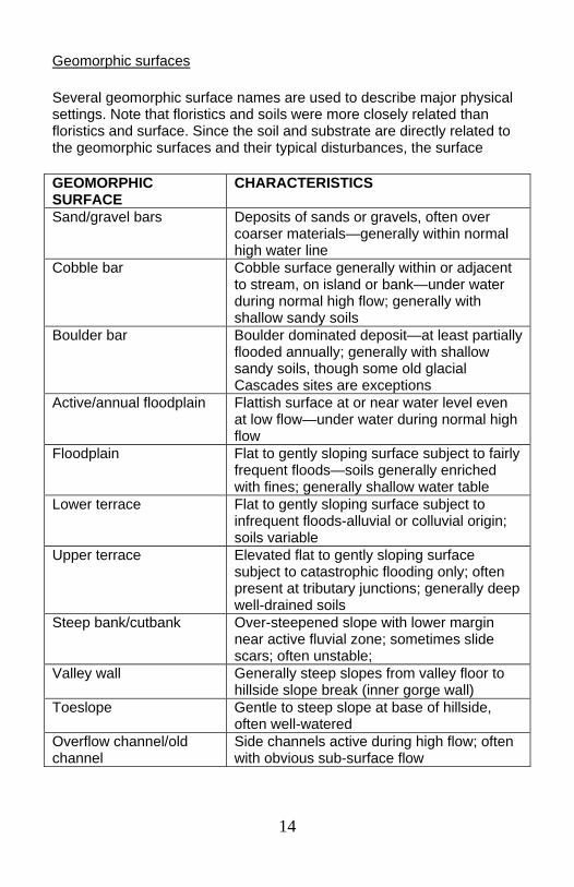
Geomorphic surfaces Several geomorphic surface names are used to describe major physical settings. Note that floristics and soils were more closely related than floristics and surface. Since the soil and substrate are directly related to the geomorphic surfaces and their typical disturbances, the surface
GEOMORPHIC SURFACE
CHARACTERISTICS
Sand/gravel bars Deposits of sands or gravels, often over coarser materials—generally within normal high water line
Cobble bar Cobble surface generally within or adjacent to stream, on island or bank—under water during normal high flow; generally with shallow sandy soils
Boulder bar Boulder dominated deposit—at least partially flooded annually; generally with shallow sandy soils, though some old glacial Cascades sites are exceptions
Active/annual floodplain Flattish surface at or near water level even at low flow—under water during normal high flow
Floodplain Flat to gently sloping surface subject to fairly frequent floods—soils generally enriched with fines; generally shallow water table
Lower terrace Flat to gently sloping surface subject to infrequent floods-alluvial or colluvial origin; soils variable
Upper terrace Elevated flat to gently sloping surface subject to catastrophic flooding only; often present at tributary junctions; generally deep well-drained soils
Steep bank/cutbank Over-steepened slope with lower margin near active fluvial zone; sometimes slide scars; often unstable;
Valley wall Generally steep slopes from valley floor to hillside slope break (inner gorge wall)
Toeslope Gentle to steep slope at base of hillside, often well-watered
Overflow channel/old channel
Side channels active during high flow; often with obvious sub-surface flow
15
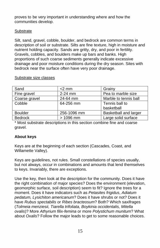
proves to be very important in understanding where and how the communities develop. Substrate Silt, sand, gravel, cobble, boulder, and bedrock are common terms in description of soil or substrate. Silts are fine texture, high in moisture and nutrient holding capacity. Sands are gritty, dry, and poor in fertility. Gravels, cobbles, and boulders make up bars and banks. High proportions of such coarse sediments generally indicate excessive drainage and poor moisture conditions during the dry season. Sites with bedrock near the surface often have very poor drainage. Substrate size classes
* Most substrate descriptions in this section combine fine and coarse gravel. About keys Keys are at the beginning of each section (Cascades, Coast, and Willamette Valley). Keys are guidelines, not rules. Small constellations of species usually, but not always, occur in combinations and amounts that lend themselves to keys. Invariably, there are exceptions. Use the key, then look at the description for the community. Does it have the right combination of major species? Does the environment (elevation, geomorphic surface, soil description) seem to fit? Ignore the trees for a moment. Does it have indicators such as Petasites frigidus, Adiatum pedatum, Lysichiton americanum? Does it have shrubs or not? Does it have Rubus spectabilis or Ribes bracteosum? Both? Which saxifrages (Tolmeia menziesii, Tiarella trifoliata, Boykinia occidentalis, Mitella ovalis)? More Athyrium filix-femina or more Polystichum munitum? What about Oxalis? Follow the major leads to get to some reasonable choices.
Sand <2 mm Grainy Fine gravel 2-24 mm Pea to marble size Coarse gravel 24-64 mm Marble to tennis ball Cobble 64-256 mm Tennis ball to
basketball Boulder 256-1096 mm Basketball and larger Bedrock > 1096 mm Large solid surface
16
If the plant-oriented key doesn’t seem to lead to the right place, use the geomorphic surface as a guide. Look through the community descriptions that fit the physical setting for the community. Is it within the normal high water line (within channel)? On cobble bars or channel margins? On terraces or steep banks? There can be groups of species which co-occur as indicators. The key may have a lead that says, “ if the sum of Species A, B, and C is greater than species X…”. In the field, you may have one or two of A, B, and C, and they may be about the same as species X. This sort of variability can be expected. If the rest of the community description fits your site, then this choice is reasonable. The tree component seems particularly variable. Where tree names are included in the community name, it shows that most plots had the tree species. However, they also may be absent. The community name should be interpreted as indicating that the community has the potential to include mature trees. Note that with rather small sample sizes, not all of the trees that might occur were recorded. For example, it is very likely that some communities labeled as Alnus rubra types or Acer macrophyllum types could easily support the other species. Where communities are named as hardwood types, conifers can occur, but are not consistent. If your site has conifers as well as hardwoods, it can still be included in the hardwood type.
17
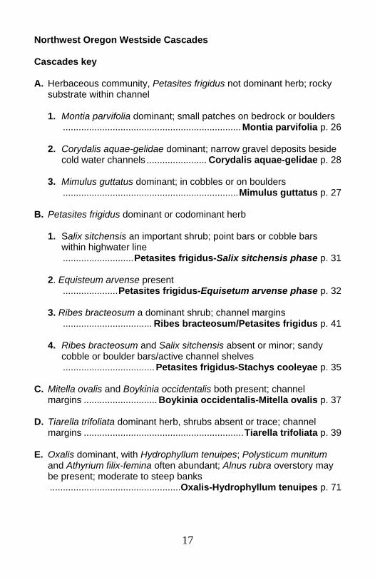
Northwest Oregon Westside Cascades Cascades key A. Herbaceous community, Petasites frigidus not dominant herb; rocky
substrate within channel 1. Montia parvifolia dominant; small patches on bedrock or boulders .................................................................... Montia parvifolia p. 26 2. Corydalis aquae-gelidae dominant; narrow gravel deposits beside
cold water channels ....................... Corydalis aquae-gelidae p. 28 3. Mimulus guttatus dominant; in cobbles or on boulders ...................................................................Mimulus guttatus p. 27 B. Petasites frigidus dominant or codominant herb 1. Salix sitchensis an important shrub; point bars or cobble bars
within highwater line ...........................Petasites frigidus-Salix sitchensis phase p. 31
2. Equisteum arvense present .....................Petasites frigidus-Equisetum arvense phase p. 32 3. Ribes bracteosum a dominant shrub; channel margins .................................. Ribes bracteosum/Petasites frigidus p. 41 4. Ribes bracteosum and Salix sitchensis absent or minor; sandy
cobble or boulder bars/active channel shelves ................................... Petasites frigidus-Stachys cooleyae p. 35 C. Mitella ovalis and Boykinia occidentalis both present; channel
margins ............................ Boykinia occidentalis-Mitella ovalis p. 37 D. Tiarella trifoliata dominant herb, shrubs absent or trace; channel
margins .............................................................Tiarella trifoliata p. 39 E. Oxalis dominant, with Hydrophyllum tenuipes; Polysticum munitum
and Athyrium filix-femina often abundant; Alnus rubra overstory may be present; moderate to steep banks
..................................................Oxalis-Hydrophyllum tenuipes p. 71
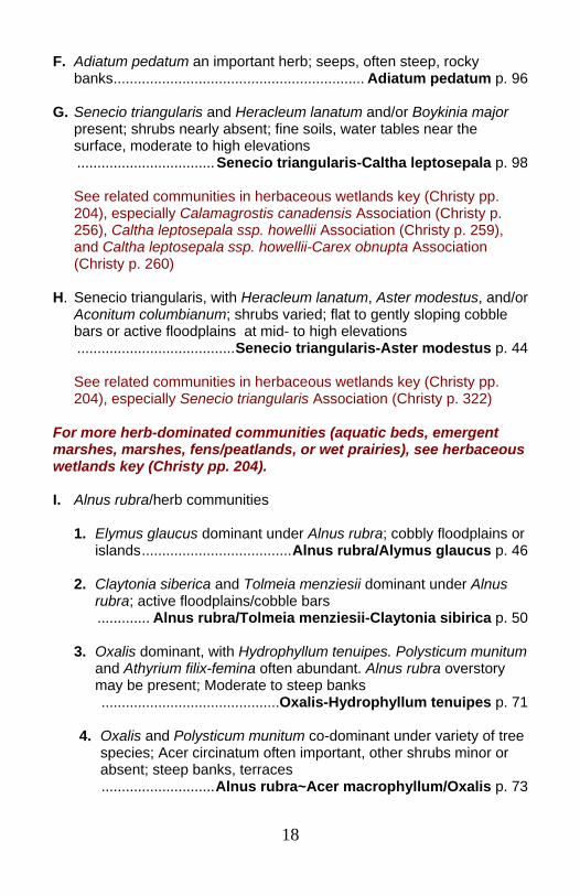
18
F. Adiatum pedatum an important herb; seeps, often steep, rocky banks.............................................................. Adiatum pedatum p. 96 G. Senecio triangularis and Heracleum lanatum and/or Boykinia major
present; shrubs nearly absent; fine soils, water tables near the surface, moderate to high elevations
..................................Senecio triangularis-Caltha leptosepala p. 98
See related communities in herbaceous wetlands key (Christy pp. 204), especially Calamagrostis canadensis Association (Christy p. 256), Caltha leptosepala ssp. howellii Association (Christy p. 259), and Caltha leptosepala ssp. howellii-Carex obnupta Association (Christy p. 260)
H. Senecio triangularis, with Heracleum lanatum, Aster modestus, and/or
Aconitum columbianum; shrubs varied; flat to gently sloping cobble bars or active floodplains at mid- to high elevations
.......................................Senecio triangularis-Aster modestus p. 44 See related communities in herbaceous wetlands key (Christy pp.
204), especially Senecio triangularis Association (Christy p. 322) For more herb-dominated communities (aquatic beds, emergent marshes, marshes, fens/peatlands, or wet prairies), see herbaceous wetlands key (Christy pp. 204). I. Alnus rubra/herb communities
1. Elymus glaucus dominant under Alnus rubra; cobbly floodplains or islands.....................................Alnus rubra/Alymus glaucus p. 46
2. Claytonia siberica and Tolmeia menziesii dominant under Alnus
rubra; active floodplains/cobble bars ............. Alnus rubra/Tolmeia menziesii-Claytonia sibirica p. 50
3. Oxalis dominant, with Hydrophyllum tenuipes. Polysticum munitum and Athyrium filix-femina often abundant. Alnus rubra overstory may be present; Moderate to steep banks
............................................Oxalis-Hydrophyllum tenuipes p. 71 4. Oxalis and Polysticum munitum co-dominant under variety of tree
species; Acer circinatum often important, other shrubs minor or absent; steep banks, terraces
............................Alnus rubra~Acer macrophyllum/Oxalis p. 73

19
5. Alnus rubra/Lysichiton americanus swamps
a. Carex obnupta >=5%, dominant or co-dominant with Lysichiton americanus ..............Alnus rubra/Carex obnupta-Lysichiton americanus
(Christy p. 209)
b. Carex obnupta <5%, Athyrium filix-femina may be co-dominant with Lysichiton americanus. ... Alnus rubra/Athyrium filix-femina-Lysichiton americanus
(Christy p. 208)
J. Shrub communities (may have tree overstories)—not dominated by Rubus spectabilis and/or Ribes bracteosum
1. Vaccinium ovalifolium-Vaccinium alaskaense dominant or co-
dominant
a. Two or more members of the moderate to high elevation suite of herbs (Achlys triphylla, Cornus canadensis, Linnea borealis, Tiarella trifoliata, Clintonia uniflora) represented; active floodplains,banks, cobble bars, moderate to higher elevations
......................................................Vaccinium ovalifolium p. 68
b. Rubus spectabilis an important shrub, mature conifer cover <20%, Lysichiton americanus present; poorly drained sites at moderate to higher elevations
........... Vaccinium ovalifolium-Rubus spectabilis/Lysichiton americanum p. 108
c. Mature conifer cover >20% and Abies amabilis present >5%;
wetland indicators (Caltha leptosepala, Lysichiton americanus, or Viola palustris) present; silver fir zone; alternating hummocks and swales
...........Abies amabilis/Vaccinium ovalifolium wetland p. 112
2. Vaccinium membranaceum dominant, under Picea engelmannii in mountain hemlock zone
............... Picea engelmannii/Vaccinium membranaceum p. 106
3. Alnus viridis dominant, often with Vaccinium ovalifolium and Ribes lacustre, with members of the moderate to high elevation suite of herbs (Achlys triphylla, Cornus canadensis, Linnea borealis, Tiarella trifoliata, Clintonia uniflora) represented; cobble bars and active floodplains in mid-to upper elevations..... Alnus viridis p. 66
20
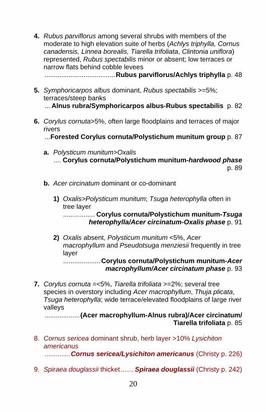
4. Rubus parviflorus among several shrubs with members of the
moderate to high elevation suite of herbs (Achlys triphylla, Cornus canadensis, Linnea borealis, Tiarella trifoliata, Clintonia uniflora) represented, Rubus spectabilis minor or absent; low terraces or narrow flats behind cobble levees
......................................Rubus parviflorus/Achlys triphylla p. 48
5. Symphoricarpos albus dominant, Rubus spectabilis >=5%; terraces/steep banks
... Alnus rubra/Symphoricarpos albus-Rubus spectabilis p. 82
6. Corylus cornuta>5%, often large floodplains and terraces of major rivers
...Forested Corylus cornuta/Polystichum munitum group p. 87
a. Polysticum munitum>Oxalis .... Corylus cornuta/Polystichum munitum-hardwood phase
p. 89
b. Acer circinatum dominant or co-dominant
1) Oxalis>Polysticum munitum; Tsuga heterophylla often in tree layer
................. Corylus cornuta/Polystichum munitum-Tsuga heterophylla/Acer circinatum-Oxalis phase p. 91
2) Oxalis absent, Polysticum munitum <5%, Acer
macrophyllum and Pseudotsuga menziesii frequently in tree layer
....................Corylus cornuta/Polystichum munitum-Acer macrophyllum/Acer circinatum phase p. 93
7. Corylus cornuta =<5%, Tiarella trifoliata >=2%; several tree
species in overstory including Acer macrophyllum, Thuja plicata, Tsuga heterophylla; wide terrace/elevated floodplains of large river valleys
...................(Acer macrophyllum-Alnus rubra)/Acer circinatum/ Tiarella trifoliata p. 85
8. Cornus sericea dominant shrub, herb layer >10% Lysichiton
americanus ..............Cornus sericea/Lysichiton americanus (Christy p. 226)
9. Spiraea douglassii thicket ....... Spiraea douglassii (Christy p. 242)
21
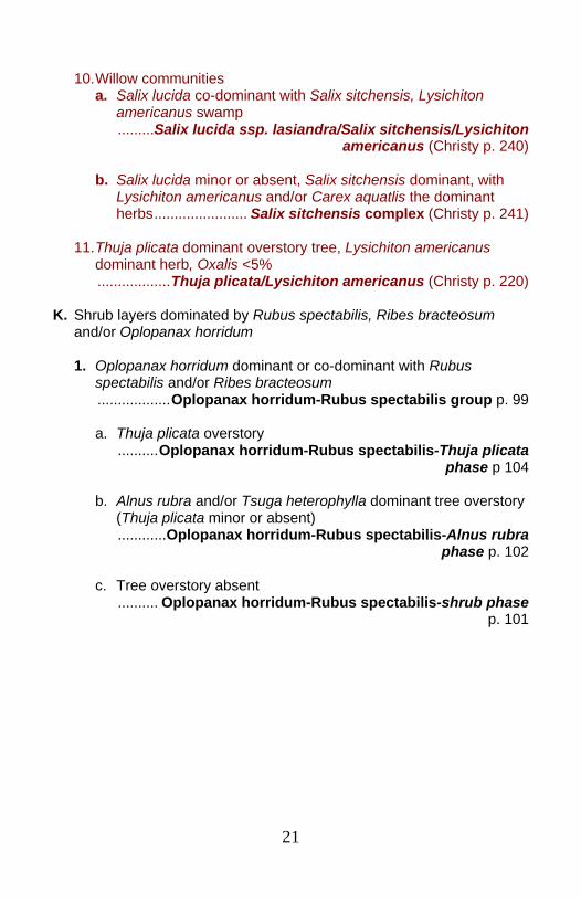
10. Willow communities
a. Salix lucida co-dominant with Salix sitchensis, Lysichiton americanus swamp
.........Salix lucida ssp. lasiandra/Salix sitchensis/Lysichiton americanus (Christy p. 240)
b. Salix lucida minor or absent, Salix sitchensis dominant, with
Lysichiton americanus and/or Carex aquatlis the dominant herbs....................... Salix sitchensis complex (Christy p. 241)
11. Thuja plicata dominant overstory tree, Lysichiton americanus
dominant herb, Oxalis <5% ..................Thuja plicata/Lysichiton americanus (Christy p. 220)
K. Shrub layers dominated by Rubus spectabilis, Ribes bracteosum
and/or Oplopanax horridum 1. Oplopanax horridum dominant or co-dominant with Rubus
spectabilis and/or Ribes bracteosum ..................Oplopanax horridum-Rubus spectabilis group p. 99 a. Thuja plicata overstory ..........Oplopanax horridum-Rubus spectabilis-Thuja plicata
phase p 104 b. Alnus rubra and/or Tsuga heterophylla dominant tree overstory
(Thuja plicata minor or absent) ............Oplopanax horridum-Rubus spectabilis-Alnus rubra
phase p. 102 c. Tree overstory absent .......... Oplopanax horridum-Rubus spectabilis-shrub phase
p. 101
22
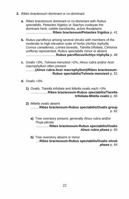
2. Ribes bracteosum dominant or co-dominant
a. Ribes bracteosum dominant or co-dominant with Rubus spectabilis, Petasites frigidus or Stachys cooleyae the dominant herb; cobble bars/banks, active floodplains
............................. Ribes bracteosum/Petasites frigidus p. 41
b. Rubus parviflorus among several shrubs with members of the moderate to high elevation suite of herbs (Achlys triphylla, Cornus canadensis, Linnea borealis, Tiarella trifoliata, Clintonia uniflora) represented, Rubus spectabilis minor or absent
.................................Rubus parviflorus/Achlys triphylla p. 48
c. Oxalis <3%, Tolmeia menziesii >2%; Alnus rubra and/or Acer macrophyllum often present
..........(Alnus rubra-Acer macrophyllum)/Ribes bracteosum- Rubus spectabilis/Tolmeia menziesii p. 52
d. Oxalis >3%
1) Oxalis, Tiarella trifoliata and Mitella ovalis each >3% ...................Ribes bracteosum-Rubus spectabilis/Tiarella
trifoliata-Mitella ovalis p. 60
2) Mitella ovalis absent ......... Ribes bracteosum-Rubus spectabilis/Oxalis group
p. 62 a) Tree overstory present, generally Alnus rubra and/or
Thuja plicata .............. Ribes bracteosum-Rubus spectabilis/Oxalis
Alnus rubra phase p. 65
b) Tree overstory absent or minor ... Ribes bracteosum-Rubus spectabilis/Oxalis shrub
phase p. 64
23
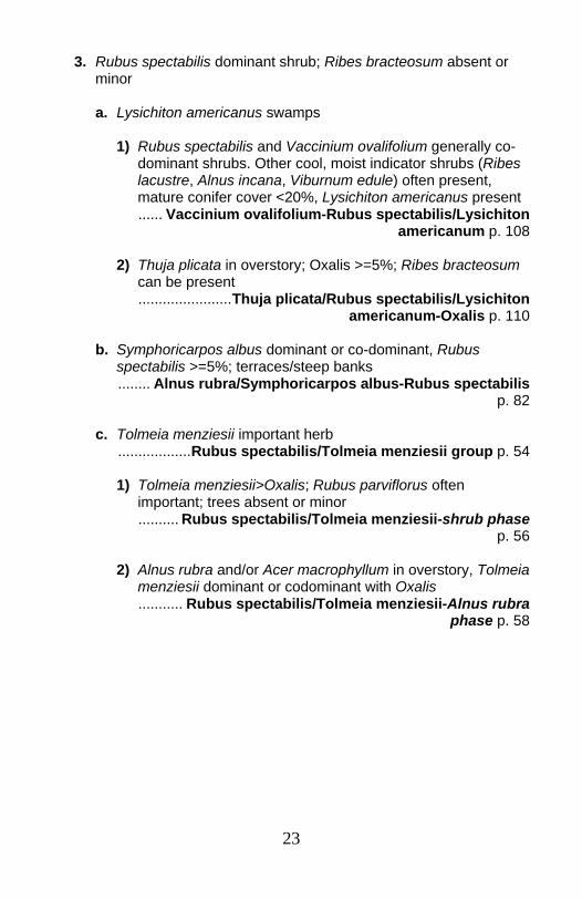
3. Rubus spectabilis dominant shrub; Ribes bracteosum absent or minor
a. Lysichiton americanus swamps
1) Rubus spectabilis and Vaccinium ovalifolium generally co-dominant shrubs. Other cool, moist indicator shrubs (Ribes lacustre, Alnus incana, Viburnum edule) often present, mature conifer cover <20%, Lysichiton americanus present
...... Vaccinium ovalifolium-Rubus spectabilis/Lysichiton americanum p. 108
2) Thuja plicata in overstory; Oxalis >=5%; Ribes bracteosum
can be present .......................Thuja plicata/Rubus spectabilis/Lysichiton
americanum-Oxalis p. 110
b. Symphoricarpos albus dominant or co-dominant, Rubus spectabilis >=5%; terraces/steep banks
........ Alnus rubra/Symphoricarpos albus-Rubus spectabilis p. 82
c. Tolmeia menziesii important herb ..................Rubus spectabilis/Tolmeia menziesii group p. 54
1) Tolmeia menziesii>Oxalis; Rubus parviflorus often
important; trees absent or minor .......... Rubus spectabilis/Tolmeia menziesii-shrub phase
p. 56
2) Alnus rubra and/or Acer macrophyllum in overstory, Tolmeia menziesii dominant or codominant with Oxalis
........... Rubus spectabilis/Tolmeia menziesii-Alnus rubra phase p. 58
24
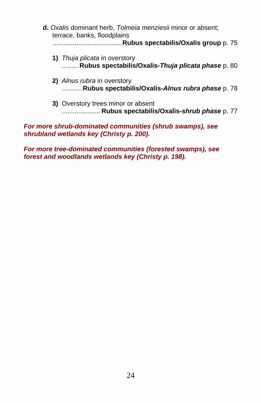
d. Oxalis dominant herb, Tolmeia menziesii minor or absent; terrace, banks, floodplains
......................................Rubus spectabilis/Oxalis group p. 75
1) Thuja plicata in overstory ......... Rubus spectabilis/Oxalis-Thuja plicata phase p. 80
2) Alnus rubra in overstory ...........Rubus spectabilis/Oxalis-Alnus rubra phase p. 78
3) Overstory trees minor or absent ..................... Rubus spectabilis/Oxalis-shrub phase p. 77
For more shrub-dominated communities (shrub swamps), see shrubland wetlands key (Christy p. 200). For more tree-dominated communities (forested swamps), see forest and woodlands wetlands key (Christy p. 198).
25
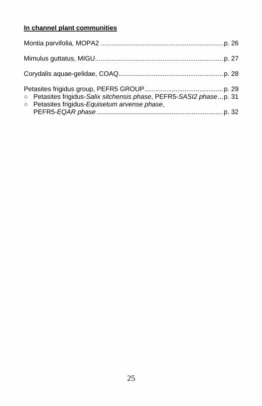
In channel plant communities Montia parvifolia, MOPA2 ...................................................................p. 26 Mimulus guttatus, MIGU......................................................................p. 27 Corydalis aquae-gelidae, COAQ.........................................................p. 28 Petasites frigidus group, PEFR5 GROUP...........................................p. 29 ○ Petasites frigidus-Salix sitchensis phase, PEFR5-SASI2 phase...p. 31 ○ Petasites frigidus-Equisetum arvense phase, PEFR5-EQAR phase .....................................................................p. 32

26
Montia parvifolia Streambank springbeauty MOPA2 N=4 (MHNF 4)
Elevations: 800 to 2500 feet (average 1550 feet). Geomorphic surfaces: Active channel area Substrate/soils: Occurs as small patches growing in pockets on bedrock or large boulders. Community: The Montia parvifolia community is herb dominated; Montia parvifolia with minor amounts of Mimulus guttatus and Oxalis are typical.
SPECIES CONSTANCY
% TYPICAL COVER %
Shrubs Rubus spectabilis 50 2 Herbs Montia parvifolia 100 14 Mimulus guttatus 75 3 Oxalis 75 1 Tolmiea menziesii 50 2 Claytonia sibirica 50 2 Galium triflorum 50 1 Polystichum munitum 50 1 Circaea alpina 50 1
27
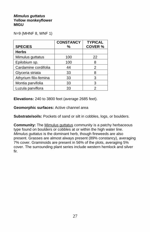
Mimulus guttatus Yellow monkeyflower MIGU N=9 (MHNF 8, WNF 1)
Elevations: 240 to 3800 feet (average 2685 feet). Geomorphic surfaces: Active channel area Substrate/soils: Pockets of sand or silt in cobbles, logs, or boulders. Community: The Mimulus guttatus community is a patchy herbaceous type found on boulders or cobbles at or within the high water line. Mimulus guttatus is the dominant herb, though fireweeds are also present. Grasses are almost always present (89% constancy), averaging 7% cover. Graminoids are present in 56% of the plots, averaging 5% cover. The surrounding plant series include western hemlock and silver fir.
SPECIES CONSTANCY
% TYPICAL COVER %
Herbs Mimulus guttatus 100 22 Epilobium sp. 100 8 Cardamine cordifolia 44 2 Glyceria striata 33 8 Athyrium filix-femina 33 3 Montia parvifolia 33 3 Luzula parviflora 33 2
28
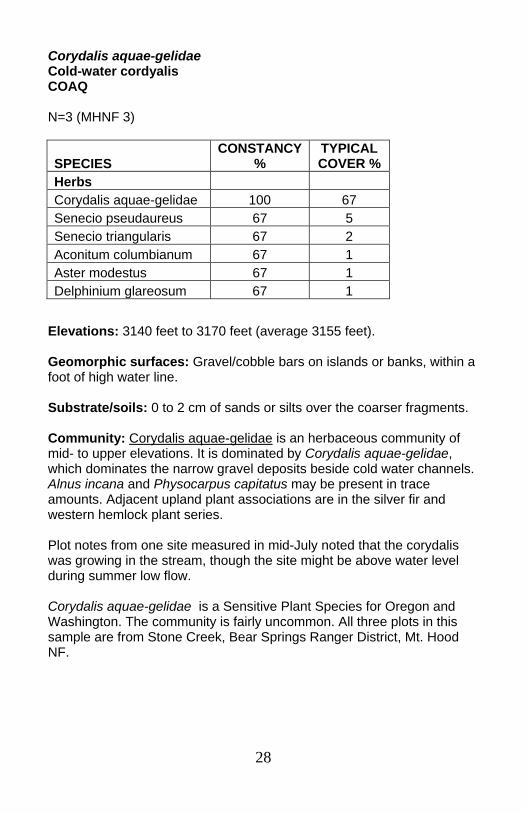
Corydalis aquae-gelidae Cold-water cordyalis COAQ N=3 (MHNF 3)
Elevations: 3140 feet to 3170 feet (average 3155 feet). Geomorphic surfaces: Gravel/cobble bars on islands or banks, within a foot of high water line. Substrate/soils: 0 to 2 cm of sands or silts over the coarser fragments. Community: Corydalis aquae-gelidae is an herbaceous community of mid- to upper elevations. It is dominated by Corydalis aquae-gelidae, which dominates the narrow gravel deposits beside cold water channels. Alnus incana and Physocarpus capitatus may be present in trace amounts. Adjacent upland plant associations are in the silver fir and western hemlock plant series. Plot notes from one site measured in mid-July noted that the corydalis was growing in the stream, though the site might be above water level during summer low flow. Corydalis aquae-gelidae is a Sensitive Plant Species for Oregon and Washington. The community is fairly uncommon. All three plots in this sample are from Stone Creek, Bear Springs Ranger District, Mt. Hood NF.
SPECIES CONSTANCY
% TYPICAL COVER %
Herbs Corydalis aquae-gelidae 100 67 Senecio pseudaureus 67 5 Senecio triangularis 67 2 Aconitum columbianum 67 1 Aster modestus 67 1 Delphinium glareosum 67 1
29
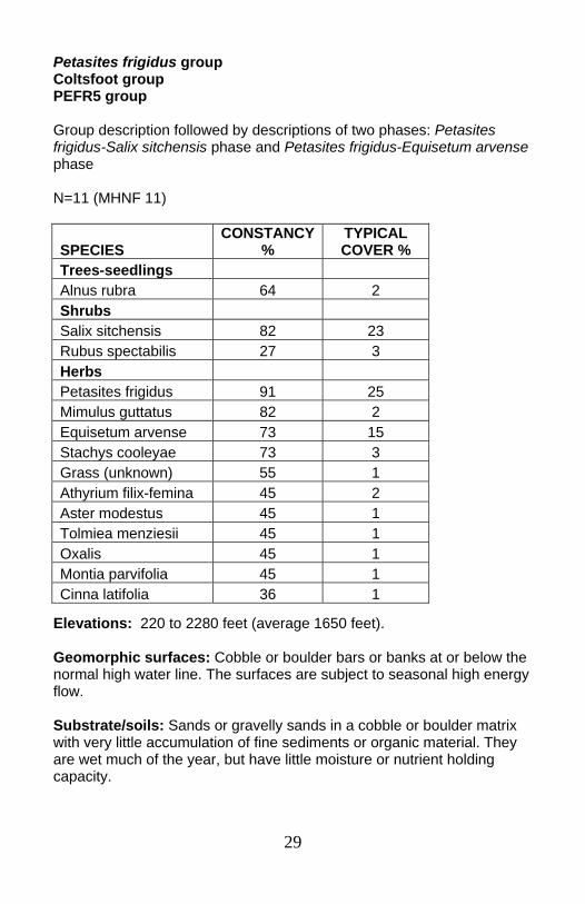
Petasites frigidus group Coltsfoot group PEFR5 group Group description followed by descriptions of two phases: Petasites frigidus-Salix sitchensis phase and Petasites frigidus-Equisetum arvense phase N=11 (MHNF 11)
Elevations: 220 to 2280 feet (average 1650 feet). Geomorphic surfaces: Cobble or boulder bars or banks at or below the normal high water line. The surfaces are subject to seasonal high energy flow. Substrate/soils: Sands or gravelly sands in a cobble or boulder matrix with very little accumulation of fine sediments or organic material. They are wet much of the year, but have little moisture or nutrient holding capacity.
SPECIES CONSTANCY
% TYPICAL COVER %
Trees-seedlings Alnus rubra 64 2 Shrubs Salix sitchensis 82 23 Rubus spectabilis 27 3 Herbs Petasites frigidus 91 25 Mimulus guttatus 82 2 Equisetum arvense 73 15 Stachys cooleyae 73 3 Grass (unknown) 55 1 Athyrium filix-femina 45 2 Aster modestus 45 1 Tolmiea menziesii 45 1 Oxalis 45 1 Montia parvifolia 45 1 Cinna latifolia 36 1
30
Community: The Petasites frigidus group is a lower elevation early seral community within the active channel. Salix, Petasites frigidus, Equisetum arvense, and Oxalis trilliifolia are common pioneer species on freshly scoured or deposited cobble bars. They are among the riparian species that can be delivered to a site by flood waters and root in an in- or near-channel surface. Similar types: The Petasites frigidus-Salix sitchensis phase and Petasites frigidus-Equisetum arvense phase are similar to the Petasites frigidus-Stachys cooleyae plant community. The Petasites frigidus-Stachys cooleyae type tends to have more active floodplain species (Ribes bracteosum, Stachys cooleyae, Athyrium filix-femina, Oxalis trilliifolia), and less Mimulus guttatus, a very wet indicator.

31
Petasites frigidus-Salix sitchensis phase Coltsfoot-Sitka willow phase PEFR5-SASI2 phase N=6 (MHNF 6)
Elevations: 220 to 2100 feet (average 1550 feet). Geomorphic surfaces: Cobble bars or lower banks, often point bars, within the normal high water line. Substrate/soils: Sands or gravelly sands in a cobble or boulder matrix. One plot was on bedrock “with some pockets of cobbles, sands, and gravels”. These sites are inundated annually, and have not accumulated fine sediments, organic matter, or litter. They are generally wet for much of the year, but have little moisture or nutrient holding capacity Community: Petasites frigidus-Salix sitchensis phase is an early seral community of the active channel area. Young Alnus rubra and minor amounts of Rubus spectabilis are sometimes found. Salix sitchensis dominates the community. Salix, Petasites frigidus, and Oxalis trillifolia are among the riparian species that can be delivered to a site by flood waters and root in an in- or near-channel surface.
SPECIES CONSTANCY
% TYPICAL COVER %
Trees-seedlings Alnus rubra 50 2 Shrubs Salix sitchensis 100 32 Rubus spectabilis 33 4 Herbs Petasites frigidus 83 10 Stachys cooleyae 67 5 Mimulus guttatus 67 3 Equisetum arvense 50 1 Oxalis 50 1 Montia parvifolia 50 1 Tolmiea menziesii 50 1
32
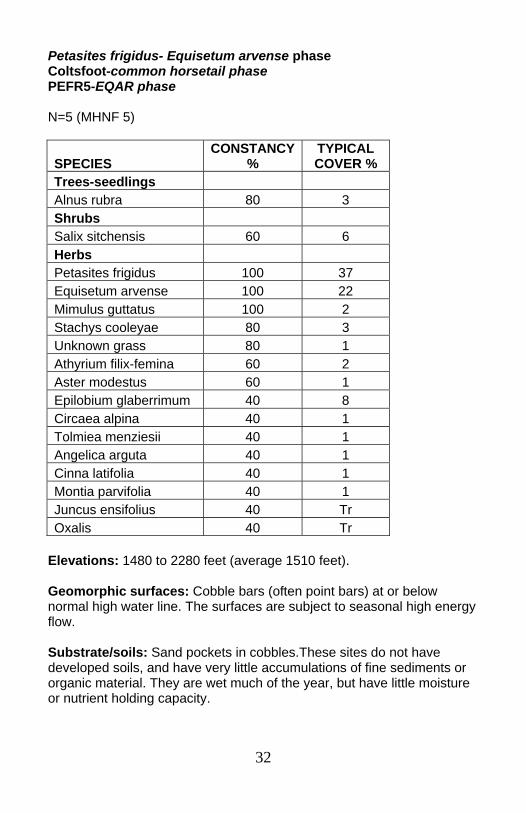
Petasites frigidus- Equisetum arvense phase Coltsfoot-common horsetail phase PEFR5-EQAR phase N=5 (MHNF 5)
Elevations: 1480 to 2280 feet (average 1510 feet). Geomorphic surfaces: Cobble bars (often point bars) at or below normal high water line. The surfaces are subject to seasonal high energy flow. Substrate/soils: Sand pockets in cobbles.These sites do not have developed soils, and have very little accumulations of fine sediments or organic material. They are wet much of the year, but have little moisture or nutrient holding capacity.
SPECIES CONSTANCY
% TYPICAL COVER %
Trees-seedlings Alnus rubra 80 3 Shrubs Salix sitchensis 60 6 Herbs Petasites frigidus 100 37 Equisetum arvense 100 22 Mimulus guttatus 100 2 Stachys cooleyae 80 3 Unknown grass 80 1 Athyrium filix-femina 60 2 Aster modestus 60 1 Epilobium glaberrimum 40 8 Circaea alpina 40 1 Tolmiea menziesii 40 1 Angelica arguta 40 1 Cinna latifolia 40 1 Montia parvifolia 40 1 Juncus ensifolius 40 Tr Oxalis 40 Tr
33
Community: The Petasites frigidus-Equisetum arvense phase is an herbaceous community within the active channel. Minor amounts of Alnus rubra seedlings and Salix sitchensis frequently occur. Sedges and rushes are generally present (80% constancy), summed cover averaging 4%. Mimulus guttatus, particularly, indicates that these sites are very wet much of the year. Petasites frigidus and Equisteum arvense are common pioneer species on freshly scoured or deposited cobble bars. Petasites frigidus and Oxalis often root from pieces deposited during the flood.
34
Channel margins-cobble bars/banks Petasites frigidus Boykinia occidentalis-Stachys cooleyae, PEFR5-STCO14 .................................................................................p. 35 Boykinia occidentalis-Mitella ovalis, BOOC2-MIOV............................p. 37 Tiarella trifoliata, TITR.........................................................................p. 39 Ribes bracteosum/Petasites frigidus, RIBR/PEFR5 ...........................p. 41
35
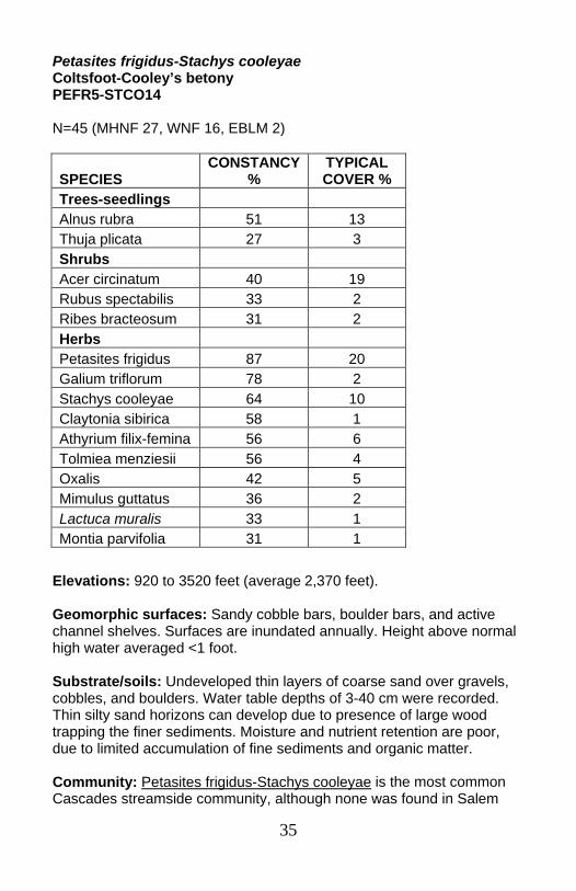
Petasites frigidus-Stachys cooleyae Coltsfoot-Cooley’s betony PEFR5-STCO14 N=45 (MHNF 27, WNF 16, EBLM 2)
Elevations: 920 to 3520 feet (average 2,370 feet). Geomorphic surfaces: Sandy cobble bars, boulder bars, and active channel shelves. Surfaces are inundated annually. Height above normal high water averaged <1 foot. Substrate/soils: Undeveloped thin layers of coarse sand over gravels, cobbles, and boulders. Water table depths of 3-40 cm were recorded. Thin silty sand horizons can develop due to presence of large wood trapping the finer sediments. Moisture and nutrient retention are poor, due to limited accumulation of fine sediments and organic matter. Community: Petasites frigidus-Stachys cooleyae is the most common Cascades streamside community, although none was found in Salem
SPECIES CONSTANCY
% TYPICAL COVER %
Trees-seedlings Alnus rubra 51 13 Thuja plicata 27 3 Shrubs Acer circinatum 40 19 Rubus spectabilis 33 2 Ribes bracteosum 31 2 Herbs Petasites frigidus 87 20 Galium triflorum 78 2 Stachys cooleyae 64 10 Claytonia sibirica 58 1 Athyrium filix-femina 56 6 Tolmiea menziesii 56 4 Oxalis 42 5 Mimulus guttatus 36 2 Lactuca muralis 33 1 Montia parvifolia 31 1
36
BLM plots. This is an herb dominated community which can support very young Alnus rubra or Thuja plicata, but seldom saplings. There is often an overhanging Acer circinatum canopy, but the shrub layer is generally sparse. Similar types: The Petasites frigidus-Stachys cooleyae community is similar to the Petasites frigidus group (Alnus viridis/Petasites frigidus and Petasites frigidus-Equisetum arvense), largely found within the high water line. The Petasites frigidus-Stachys cooleyae type has a wider range of species that can occur on floodplains. It appears to bridge the in-channel and channel margin/active floodplain transition.
37
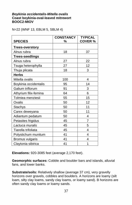
Boykinia occidentalis-Mitella ovalis Coast boykinia-oval-leaved mitrewort BOOC2-MIOV N=22 (WNF 13, EBLM 5, SBLM 4)
Elevations: 920-3085 feet (average 2,170 feet). Geomorphic surfaces: Cobble and boulder bars and islands, alluvial fans, and lower banks. Substrate/soils: Relatively shallow (average 37 cm), very gravelly horizons over gravels, cobbles and boulders. A horizons are loamy (silt loam, silty clay loams, sandy clay loams, or loamy sand). B horizons are often sandy clay loams or loamy sands.
SPECIES CONSTANCY
% TYPICAL COVER %
Trees-overstory Alnus rubra 18 37 Trees-seedlings Alnus rubra 27 22 Tsuga heterophylla 27 12 Thuja plicata 18 3 Herbs Mitella ovalis 100 4 Boykinia occidentalis 95 14 Galium triflorum 91 3 Athyrium filix-femina 64 6 Tolmiea menziesii 55 15 Oxalis 50 12 Stachys 50 11 Carex deweyana 50 11 Adiantum pedatum 50 4 Petasites frigidus 45 7 Lactuca muralis 45 5 Tiarella trifoliata 45 4 Polystichum munitum 41 4 Bromus vulgaris 41 4 Claytonia sibirica 41 1
38
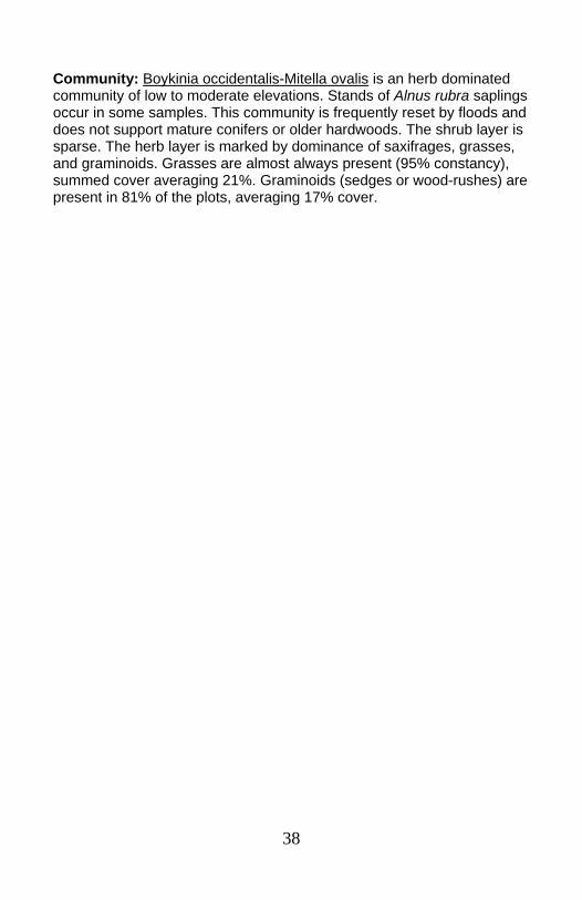
Community: Boykinia occidentalis-Mitella ovalis is an herb dominated community of low to moderate elevations. Stands of Alnus rubra saplings occur in some samples. This community is frequently reset by floods and does not support mature conifers or older hardwoods. The shrub layer is sparse. The herb layer is marked by dominance of saxifrages, grasses, and graminoids. Grasses are almost always present (95% constancy), summed cover averaging 21%. Graminoids (sedges or wood-rushes) are present in 81% of the plots, averaging 17% cover.
39
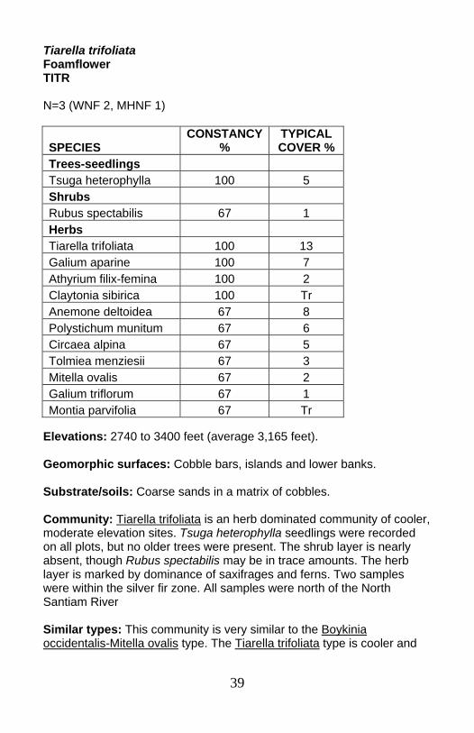
Tiarella trifoliata Foamflower TITR N=3 (WNF 2, MHNF 1)
Elevations: 2740 to 3400 feet (average 3,165 feet). Geomorphic surfaces: Cobble bars, islands and lower banks. Substrate/soils: Coarse sands in a matrix of cobbles. Community: Tiarella trifoliata is an herb dominated community of cooler, moderate elevation sites. Tsuga heterophylla seedlings were recorded on all plots, but no older trees were present. The shrub layer is nearly absent, though Rubus spectabilis may be in trace amounts. The herb layer is marked by dominance of saxifrages and ferns. Two samples were within the silver fir zone. All samples were north of the North Santiam River Similar types: This community is very similar to the Boykinia occidentalis-Mitella ovalis type. The Tiarella trifoliata type is cooler and
SPECIES CONSTANCY
% TYPICAL COVER %
Trees-seedlings Tsuga heterophylla 100 5 Shrubs Rubus spectabilis 67 1 Herbs Tiarella trifoliata 100 13 Galium aparine 100 7 Athyrium filix-femina 100 2 Claytonia sibirica 100 Tr Anemone deltoidea 67 8 Polystichum munitum 67 6 Circaea alpina 67 5 Tolmiea menziesii 67 3 Mitella ovalis 67 2 Galium triflorum 67 1 Montia parvifolia 67 Tr

40
more northerly than the lower, warmer Boykinia occidentalis-dominated community that was sampled only south of the North Santiam River.
41
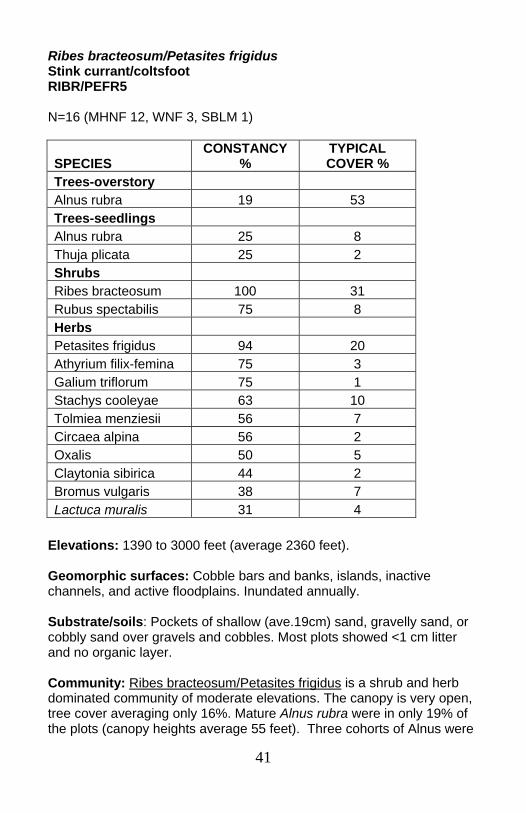
Ribes bracteosum/Petasites frigidus Stink currant/coltsfoot RIBR/PEFR5 N=16 (MHNF 12, WNF 3, SBLM 1)
Elevations: 1390 to 3000 feet (average 2360 feet). Geomorphic surfaces: Cobble bars and banks, islands, inactive channels, and active floodplains. Inundated annually. Substrate/soils: Pockets of shallow (ave.19cm) sand, gravelly sand, or cobbly sand over gravels and cobbles. Most plots showed <1 cm litter and no organic layer. Community: Ribes bracteosum/Petasites frigidus is a shrub and herb dominated community of moderate elevations. The canopy is very open, tree cover averaging only 16%. Mature Alnus rubra were in only 19% of the plots (canopy heights average 55 feet). Three cohorts of Alnus were
SPECIES CONSTANCY
% TYPICAL COVER %
Trees-overstory Alnus rubra 19 53 Trees-seedlings Alnus rubra 25 8 Thuja plicata 25 2 Shrubs Ribes bracteosum 100 31 Rubus spectabilis 75 8 Herbs Petasites frigidus 94 20 Athyrium filix-femina 75 3 Galium triflorum 75 1 Stachys cooleyae 63 10 Tolmiea menziesii 56 7 Circaea alpina 56 2 Oxalis 50 5 Claytonia sibirica 44 2 Bromus vulgaris 38 7 Lactuca muralis 31 4
42
aged on one plot (16 years, 20 years, 47 years), suggesting repeated floods. Grasses are present in 75% of the plots (ave. 4% cover). Graminoids occur on 56% of the plots (ave. 9% cover). The presence of shrubs and some Alnus indicate that the surfaces have some stability and are not reset annually. Note the low Rubus spectabilis and Oxalis cover compared to cobble substrates with more developed soils, and the dominance of the Petasites frigidus and Stachys cooleyae typical of herb dominated channel margin types.
43
Cobble bars and low floodplains Senecio triangularis-Aster modestus, SETR-ASMO3.........................p. 44 Alnus rubra/Alymus glaucus, ALRU2/ELGL........................................p. 46 Rubus parviflorus/Achlys triphylla, RUPA/ACTR ................................p. 48 Alnus rubra/Tolmeia menziesii-Claytonia sibirica, ALRU2/TOME-CLSI2 ..........................................................................p. 50 (Alnus rubra-Acer macrophyllum)/Ribes bracteosum-Rubus spectabilis/Tolmeia menziesii, (ALRU2-ACMA3)/ RIBR-RUSP/TOME .............................................................................p. 52 Rubus spectabilis/Tolmeia menziesii group-RUSP/TOME GROUP:..p. 54 ○ Rubus spectabilis/Tolmeia menziesii-shrub phase, RUSP/TOME-shrub phase.............................................................p. 56 ○ Rubus spectabilis/Tolmeia menziesii- Alnus rubra phase, RUSP/TOME-ALRU2 phase ..........................................................p. 58 Ribes bracteosum-Rubus spectabilis/Tiarella trifoliata-Mitella ovalis, RIBR-RUSP/TITR-MIOV.....................................................................p. 60 Ribes bracteosum-Rubus spectabilis/Oxalis group, RIBR-RUSP/OXALI GROUP...............................................................p. 62 ○ Ribes bracteosum-Rubus spectabilis/Oxalis-shrub phase, RIBR-RUSP/OXALI-shrub phase ..................................................p. 64 ○ Ribes bracteosum-Rubus spectabilis/Oxalis-Alnus rubra phase, RIBR-RUSP/OXALI-ALRU2 phase ................................................p. 65 Alnus viridis, ALVI5 .............................................................................p. 66 Oval leaved huckleberry, VAOV..........................................................p. 68
44
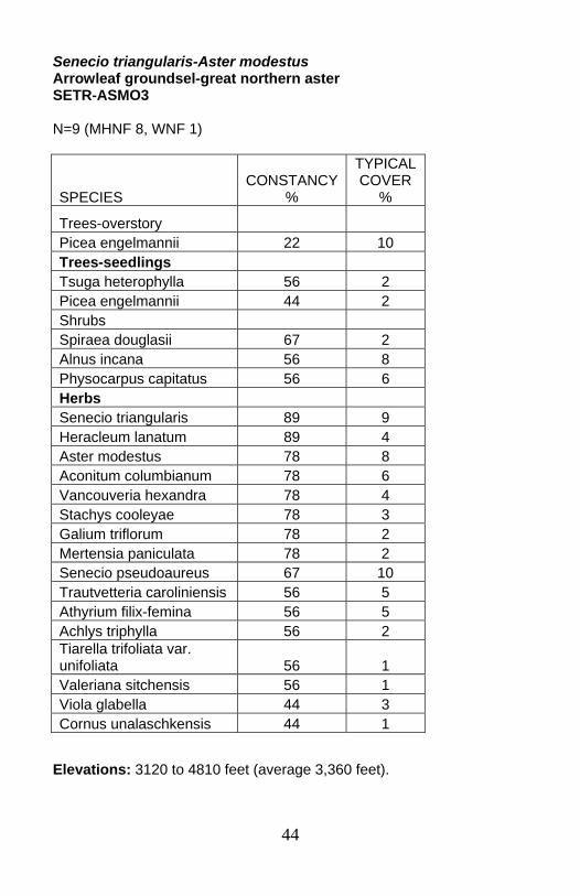
Senecio triangularis-Aster modestus Arrowleaf groundsel-great northern aster SETR-ASMO3 N=9 (MHNF 8, WNF 1)
Elevations: 3120 to 4810 feet (average 3,360 feet).
SPECIES CONSTANCY
%
TYPICAL COVER
%
Trees-overstory Picea engelmannii 22 10 Trees-seedlings Tsuga heterophylla 56 2 Picea engelmannii 44 2 Shrubs Spiraea douglasii 67 2 Alnus incana 56 8 Physocarpus capitatus 56 6 Herbs Senecio triangularis 89 9 Heracleum lanatum 89 4 Aster modestus 78 8 Aconitum columbianum 78 6 Vancouveria hexandra 78 4 Stachys cooleyae 78 3 Galium triflorum 78 2 Mertensia paniculata 78 2 Senecio pseudoaureus 67 10 Trautvetteria caroliniensis 56 5 Athyrium filix-femina 56 5 Achlys triphylla 56 2 Tiarella trifoliata var. unifoliata 56 1 Valeriana sitchensis 56 1 Viola glabella 44 3 Cornus unalaschkensis 44 1
45
Geomorphic surfaces: Active floodplains, cobble bars, and inactive channels. Slopes were extremely gentle, from 0 to 7%. The community is typically adjacent to the channel, 0 to 2 feet above the stream. Substrate/soils: Shallow silts, sandy silts or mucks over gravels and cobbles. Water tables were generally within 30cm of the surface. Community: Senecio triangularis-Aster modestus is an herb-rich community of flat cobbly surfaces in cool, higher elevations. Picea engelmannii can occasionally be found in the overstory. Shrubs are generally present. Most of the samples came from Stone Creek on the Mt. Hood NF, near Timothy Lake. The Willamette sample came from the Mink Lake Basin in Three Sisters Wilderness. Adjacent upland plant associations ranged from mountain hemlock types, through silver fir associations, to cool western hemlock associations in cold air drainage environments.
46
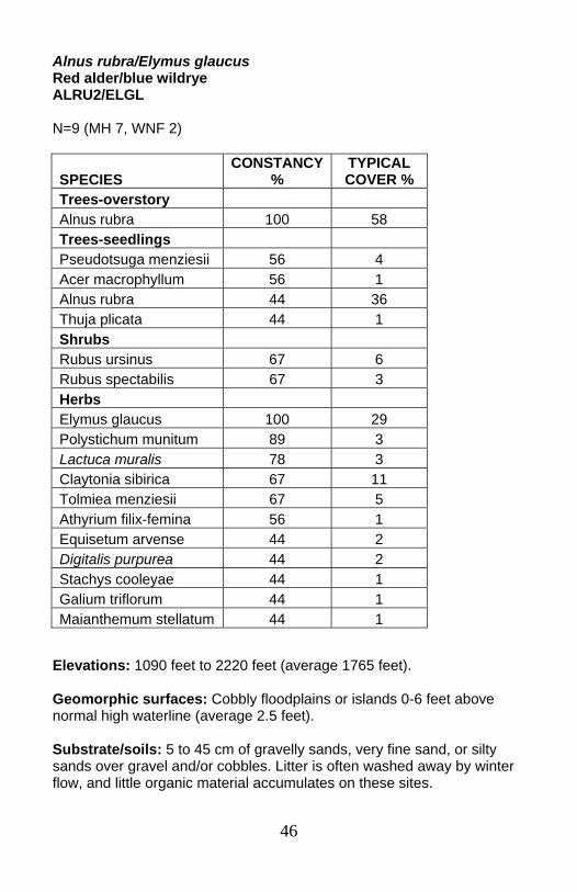
Alnus rubra/Elymus glaucus Red alder/blue wildrye ALRU2/ELGL N=9 (MH 7, WNF 2)
Elevations: 1090 feet to 2220 feet (average 1765 feet). Geomorphic surfaces: Cobbly floodplains or islands 0-6 feet above normal high waterline (average 2.5 feet). Substrate/soils: 5 to 45 cm of gravelly sands, very fine sand, or silty sands over gravel and/or cobbles. Litter is often washed away by winter flow, and little organic material accumulates on these sites.
SPECIES CONSTANCY
% TYPICAL COVER %
Trees-overstory Alnus rubra 100 58 Trees-seedlings Pseudotsuga menziesii 56 4 Acer macrophyllum 56 1 Alnus rubra 44 36 Thuja plicata 44 1 Shrubs Rubus ursinus 67 6 Rubus spectabilis 67 3 Herbs Elymus glaucus 100 29 Polystichum munitum 89 3 Lactuca muralis 78 3 Claytonia sibirica 67 11 Tolmiea menziesii 67 5 Athyrium filix-femina 56 1 Equisetum arvense 44 2 Digitalis purpurea 44 2 Stachys cooleyae 44 1 Galium triflorum 44 1 Maianthemum stellatum 44 1
47
Community: Alnus rubra/Alymus glaucus is a grassy mid-elevation forested floodplain community of the larger creeks and rivers. The overstory is dominantly Alnus rubra, less than 25 years old in the sample. Tree regeneration is often a dense stand of young Alnus rubra, but generally includes Pseudotsuga menziesii and Acer macrophyllum, or Thuja plicata. The shrub layer is sparse. Total grass cover in Alnus rubra/Alymus glaucus is the highest among all streamside communities in this section. Geomorphic surface, substrate, lack of soil development, and stand ages indicate that this community is frequently flooded, and is reset every few decades. Similar types: Alnus rubra/Alymus glaucus is similar to Alnus rubra/Rubus spectabilis, but has lower, less constant Rubus spectabilis and fewer ferns. It may occur on drier, coarser substrates, perhaps farther away from the water table during the summer.
48
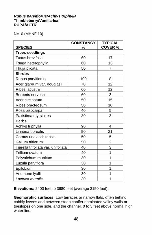
Rubus parviflorus/Achlys triphylla Thimbleberry/Vanilla-leaf RUPA/ACTR N=10 (MHNF 10)
Elevations: 2400 feet to 3680 feet (average 3150 feet). Geomorphic surfaces: Low terraces or narrow flats, often behind cobbly levees and between steep conifer dominated valley walls or toeslopes on one side, and the channel. 0 to 3 feet above normal high water line.
SPECIES CONSTANCY
% TYPICAL COVER %
Trees-seedlings Taxus brevifolia 60 17 Tsuga heterophylla 60 13 Thuja plicata 50 7 Shrubs Rubus parviflorus 100 8 Acer glabrum var. douglasii 70 12 Ribes lacustre 60 12 Berberis nervosa 60 3 Acer circinatum 50 15 Ribes bracteosum 50 10 Rosa pisocarpa 40 5 Paxistima myrsinites 30 3 Herbs Achlys triphylla 90 4 Linnaea borealis 50 21 Cornus unalaschkensis 50 5 Galium triflorum 50 2 Tiarella trifoliata var. unifoliata 40 3 Trillium ovatum 40 1 Polystichum munitum 30 1 Luzula parviflora 30 1 Epilobium 30 1 Anemone lyallii 30 1 Lactuca muralis 30 1
49
Substrate/soils: Shallow silts or sands in a matrix of cobbles. Community: Rubus parviflorus/vanilla-leaf is a shrub community of mid- to higher elevations. Conifer regeneration is plentiful (average 27% cover). Few seedlings appear to reach maturity. Mature trees occur on only 20% of plots. The important shrub species include a mix of upland and riparian species. Adjacent upland plant associations were in the western hemlock series; most often Western hemlock/rhododendron/Oregon grape. The most common herb species in the Rubus parviflorus/Achlys triphylla community occur in the Western hemlock/rhododendron/Oregon grape upland plant association.
50
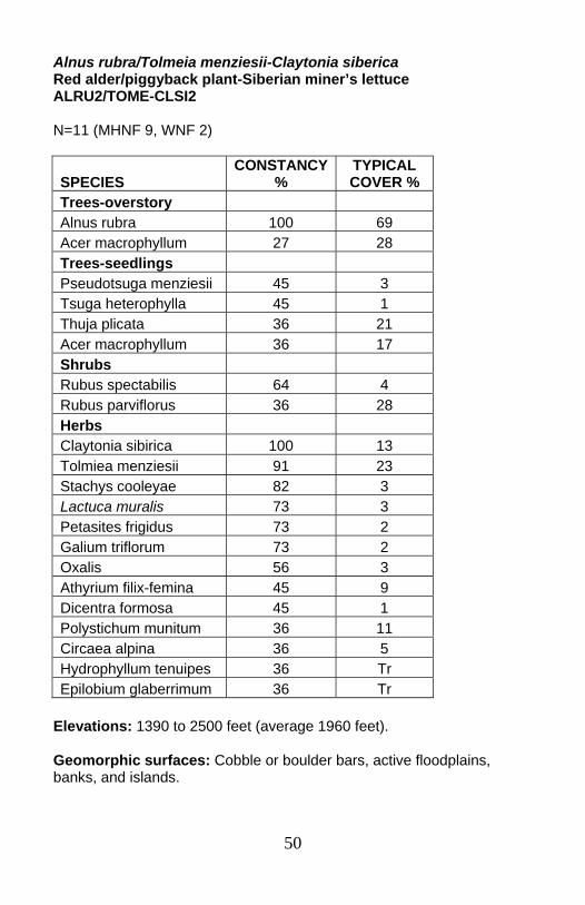
Alnus rubra/Tolmeia menziesii-Claytonia siberica Red alder/piggyback plant-Siberian miner’s lettuce ALRU2/TOME-CLSI2 N=11 (MHNF 9, WNF 2)
Elevations: 1390 to 2500 feet (average 1960 feet). Geomorphic surfaces: Cobble or boulder bars, active floodplains, banks, and islands.
SPECIES CONSTANCY
% TYPICAL COVER %
Trees-overstory Alnus rubra 100 69 Acer macrophyllum 27 28 Trees-seedlings Pseudotsuga menziesii 45 3 Tsuga heterophylla 45 1 Thuja plicata 36 21 Acer macrophyllum 36 17 Shrubs Rubus spectabilis 64 4 Rubus parviflorus 36 28 Herbs Claytonia sibirica 100 13 Tolmiea menziesii 91 23 Stachys cooleyae 82 3 Lactuca muralis 73 3 Petasites frigidus 73 2 Galium triflorum 73 2 Oxalis 56 3 Athyrium filix-femina 45 9 Dicentra formosa 45 1 Polystichum munitum 36 11 Circaea alpina 36 5 Hydrophyllum tenuipes 36 Tr Epilobium glaberrimum 36 Tr
51
Substrate/soils: Thin (2-35cm) layers of sands or gravelly sands over sandy cobbles, gravels, and boulders. Community: Alnus rubra/Tolmeia menziesii-Claytonia sibirica is an herb-dominated community which occurs under a dense young Alnus rubra canopy in moderately low elevations. Rubus spectabilis is frequent but not abundant. Stands are often sapling and pole sizeAlnus rubra (<9” dbh), less than 25 years old. Seedlings from several tree species are common, especially Thuja plicata, Pseudotsuga menziesii, Tsuga heterophylla, and Acer macrophyllum. The conifers are not found as overstory trees with this community. Shallow sands, high ground cover of exposed surface boulders, frequently flooded geomorphic surfaces, and very young Alnus rubra stands suggest that this community develops with frequent, fairly high energy flooding. Rubus spectabilis-Ribes bracteosum communities or similar Rubus spectabilis types might develop if these surfaces receive silt deposits and accumulate organic matter in the upper horizons.
52
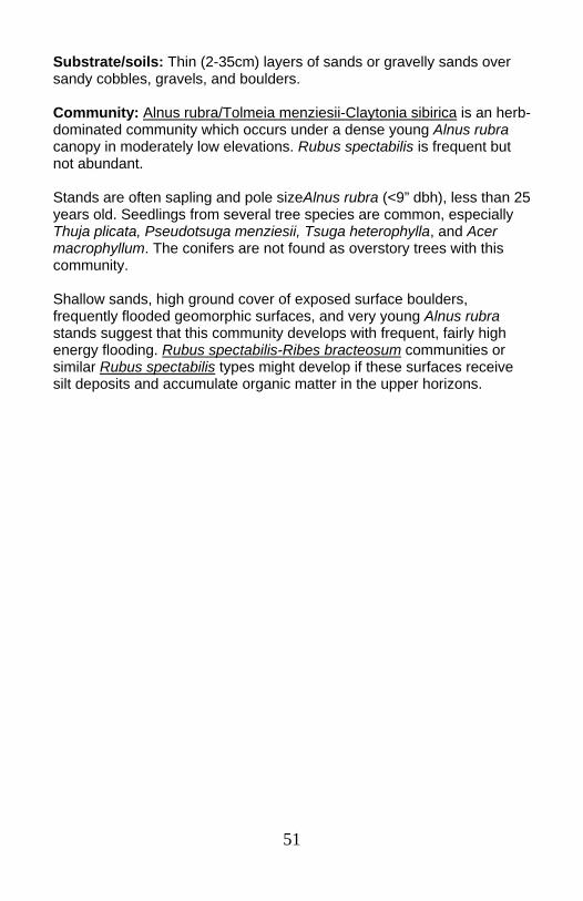
(Alnus rubra-Acer macrophyllum)/Ribes bracteosum-Rubus spectabilis/Tolmiea menziesii (Red alder-big leaf maple)/stink currant-salmonberry/piggyback plant (ALRU2-ACMA3)/RIBR-RUSP/TOME N=14 (MHNF 9, WNF 5)
Elevations: 800 to 3000 feet (average 2225 feet).
SPECIES CONSTANCY %
TYPICAL COVER %
Trees-overstory Alnus rubra 64 41 Thuja plicata 29 26 Acer macrophyllum 21 52 Trees-seedlings Tsuga heterophylla 43 2 Acer macrophyllum 36 4 Shrubs Ribes bracteosum 100 24 Rubus spectabilis 79 17 Acer circinatum 36 16 Herbs Tolmiea menziesii 100 11 Athyrium filix-femina 79 10 Galium triflorum 79 2 Stachys cooleyae 79 2 Claytonia sibirica 79 2 Oxalis 71 2 Polystichum munitum 57 2 Lactuca muralis 43 1 Hydrophyllum tenuipes 36 7 Circaea alpina 36 6 Montia parvifolia 36 4 Petasites frigidus 36 1

53
Geomorphic surfaces: Cobble bars, boulder bars, and active floodplains. Plots averaged 1.6 feet above average high water line and 15 feet away from the channel. Substrate/soils: Sands to gravelly sands (average 30 cm) over sand in a matrix of cobbles and/or boulders. Note that the similar Alnus rubra/Ribes bracteosum-Rubus spectabilis/Oxalis community generally has soils with more silt in the top horizons. Community: (Alnus rubra-Acer macrophyllum)/Ribes bracteosum-Rubus spectabilis/Tolmeia menziesii is a moderate elevation community. The canopy is most commonly found dominated by Alnus rubra, but the same understory occurs under Acer macrophyllum, especially on the Willamette NF. In the North Fork Clackamas drainage, Thuja plicata can be found in the overstory with the Alnus rubra. Overstory trees averaged 30% canopy cover. Canopy height averaged 62 feet. Near-channel geomorphic surfaces, coarse soil texture, and low cover of Polystichum munitum and Oxalis suggest that this community is reset more frequently than the Ribes bracteosum-Rubus spectabilis/Oxalis-Alnus rubra phase.
54
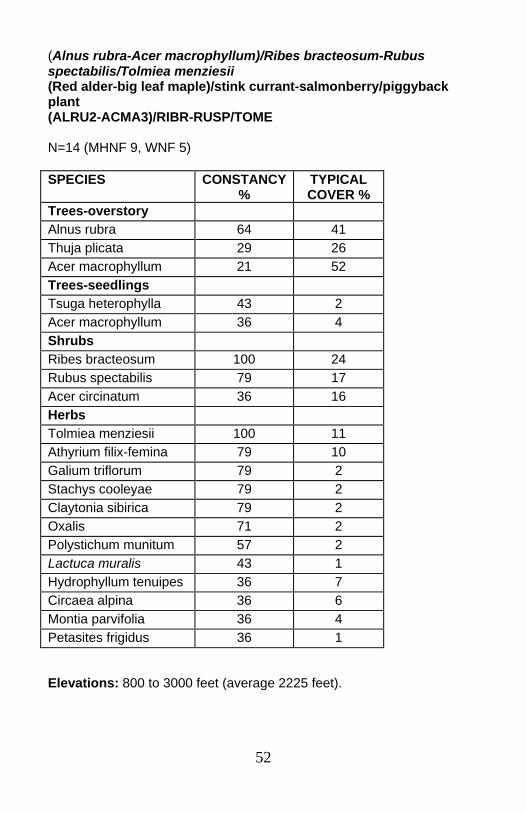
Rubus spectabilis/Tolmiea menziesii group Salmonberry/piggyback plant group RUSP/TOME group Group description followed by descriptions of two phases: Rubus spectabilis/Tolmiea menziesii –shrub phase, and Rubus spectabilis/Tolmiea menziesii-Alnus rubra phase N=25 (MHNF 16, EBLM 5, WNF 2, SBLM 2)
Elevations: 220 to 4120 feet (average 1875 feet). Geomorphic surfaces: Cobble bars, banks, islands, and annual floodplains. Plots averaged 4 feet above average high water line, and 21 feet from the average high water line.
SPECIES CONSTANCY
% TYPICAL COVER %
Trees-overstory Alnus rubra 76 47 Acer macrophyllum 28 29 Trees-seedlings Acer macrophyllum 40 5 Alnus rubra 36 12 Tsuga heterophylla 20 7 Thuja plicata 20 2 Shrubs Rubus spectabilis 100 24 Rubus parviflorus 44 12 Herbs Tolmiea menziesii 92 13 Galium triflorum 76 4 Claytonia sibirica 68 7 Athyrium filix-femina 64 17 Stachys cooleyae 64 7 Oxalis 60 8 Polystichum munitum 56 5 Lactuca muralis 56 3 Petasites frigidus 44 27 Circaea alpina 44 9
55
Substrate/soils: Loamy sands in the A horizon (ave. 8 cm) over B horizons (ave.18cm) of sands mixed with gravel or gravel/cobble. C horizons are also sands with gravels or gravels mixed with cobbles and boulders. Half the pits show buried soils which are exploited by roots. O horizons are 2 to 3 cm thick. Community: The Rubus spectabilis/Tolmeia menziesii group generally has young Alnus rubra and/or young Acer macrophyllum, but can occur without trees. Tolmeia menziesii, Stachys cooleyae and Petasites frigidus are common in active floodplain/stream bank communities. Polystichum munitum and Oxalis tend to have lower cover where Ribes bracteosum is dominant, as in the closely related Ribes bracteosum type: (Alnus rubra-Acer macrophyllum)/Ribes bracteosum-Rubus spectabilis/Tolmeia menziesii. Polystichum munitum and Oxalis cover are lower in this group overall than in the somewhat similar steep bank/terrace Rubus spectabilis/Oxalis group. Low Oxalis and Polystichum munitum covers generally are associated with slightly coarser soil textures or shallower soil depths. Dense stands of Alnus rubra can reestablish in the loamy sands on top of the gravel/cobble substrate. Often the trees can tap into buried O and A layers.

56
Rubus spectabilis/Tolmeia menziesii-shrub phase Salmonberry/piggyback plant–shrub phase RUSP/TOME-shrub phase N=5 (EBLM 2, SBLM 1, MHNF 1, WNF 1)
Elevations: 1050 to 4120 feet (average 2,250 feet). Geomorphic surfaces: Cobble/boulder bars, islands, and annual floodplains. Substrate/soils: Loam or loamy sands in the A horizon (ave. 5 cm) over B horizons (ave. 22 cm) of loamy sand or sand mixed with gravel or
SPECIES CONSTANCY
% TYPICAL COVER %
Shrubs Rubus spectabilis 100 27 Rubus parviflorus 60 12 Acer circinatum 40 8 Herbs Athyrium filix-femina 100 29 Galium triflorum 100 6 Tiarella trifoliata 80 9 Circaea alpina 60 19 Tolmiea menziesii 60 18 Boykinia occidentalis 60 16 Petasites frigidus 60 12 Bromus sitchensis 60 7 Lactuca muralis 60 6 Claytonia sibirica 60 5 Bromus vulgaris 40 9 Oxalis 40 8 Mitella ovalis 40 7 Adiantum pedatum 40 6 Carex deweyana 40 5 Stellaria crispa 40 3 Equisetum arvense 40 2 Montia parvifolia 40 2 Anaphalis margaritacea 40 1
57
gravel/cobble. C horizons are also sands with gravels or gravels mixed with cobbles and boulders. Some pits show buried soils which are exploited by roots. Development of O horizon 1 to 4 cm thick, as well as the A horizon suggest that although disturbance may be relatively frequent, there is enough time for some soil building processes. Community: Rubus spectabilis/piggybank plant-shrub phase is an herb-dominated community with a strong Rubus spectabilis and Rubus parviflorus component. Grasses are typically abundant (11% average summed cover and 80% constancy). Polystichum munitum and Oxalis, markers of deeper, finer substrates and less frequent disturbance, are minor or absent from most of this community.

58
Rubus spectabilis/Tolmeia menziesii-Alnus rubra phase Salmonberry/piggyback plant-red alder phase RUSP/TOME-ALRU2 phase N=20 (MHNF 15, EBLM 3, SBLM 1, WNF 1)
Elevations: 220 to 2780 feet (average 1,780 feet). Geomorphic surfaces: Cobble/boulder bars and islands, and active floodplains. Substrate/soils: Loamy sands in the A horizon (ave. 9 cm) over B horizons (ave. 17cm) of sands mixed with gravel or gravel/cobble. C horizons are also sands with gravels or gravels mixed with cobbles and boulders. Some profiles have buried soils which are exploited by roots. Development of O horizon 2 to 5 cm thick, as well as the A horizon suggest that although disturbance may be relatively frequent, there is
SPECIES CONSTANCY
% TYPICAL COVER %
Trees-overstory Alnus rubra 95 51 Acer macrophyllum 35 29 Trees-seedlings Acer macrophyllum 50 6 Alnus rubra 40 13 Shrubs Rubus spectabilis 100 25 Rubus parviflorus 40 11 Rubus ursinus 35 11 Herbs Tolmiea menziesii 100 13 Claytonia sibirica 70 8 Galium triflorum 70 3 Oxalis 65 8 Polystichum munitum 65 6 Athyrium filix-femina 55 15 Stachys cooleyae 55 4 Lactuca muralis 55 3 Petasites frigidus 40 24 Circaea alpina 40 7

59
enough time for some soil building processes. Deeper soils seem to be associated with tributary junctions and active alluvial fans. Community: The Rubus spectabilis/piggybank plant-Alnus rubra phase is a low to moderate elevation community dominated by Alnus rubra, sometimes with Acer macrophyllum. Polystichum munitum is more constant than Athyrium filix-femina. Athyrium filix-femina also occurs at lower cover in this phase than in the Rubus spectabilis/Tolmeia menziesii-shrub phase. Graminoids (sedges, rushes, woodrush) are common and abundant, occurring on 70% of the plots and averaging 14% summed cover. True grasses occur on on 60% of the plots, averaging 24% summed cover. This community often supports dense stands of Alnus rubra that can reestablish in the loamy sands on top of the gravel/cobble substrate. Often the trees can tap into buried O and A layers. Conifer saplings were not observed in the sample, probably due to substrate limitations and disturbance frequency.
60
Ribes bracteosum-Rubus spectabilis/Tiarella trifoliata-Mitella ovalis Stink currant-salmonberry/foamflower-oval-leaved mitrewort RIBR-RUSP/TITR-MIOV N=17 (EBLM 8, SBLM 8, WNF 1)
Elevations: 920 to 3400 feet (average 1600 feet). Geomorphic surfaces: Bars, banks, islands, and floodplains. Substrate/soils: Gravels or gravels with cobbles in the A horizon, gravels/cobbles in the B horizon, over cobbles, boulders, or bedrock. A
SPECIES CONSTANCY%
TYPICAL COVER %
Trees-overstory Acer macrophyllum 12 24 Trees-seedlings Tsuga heterophylla 18 5 Shrubs Ribes bracteosum 100 24 Rubus spectabilis 88 27 Vaccinium parvifolium 47 4 Herbs Athyrium filix-femina 100 16 Tiarella trifoliata 94 12 Polystichum munitum 88 19 Mitella ovalis 88 8 Oxalis 82 29 Tolmiea menziesii 76 13 Galium triflorum 76 4 Adiantum pedatum 71 7 Carex deweyana 71 2 Blechnum spicant 59 8 Boykinia occidentalis 53 6 Petasites frigidus 53 5 Circaea alpina 47 4 Bromus 41 4 Stellaria crispa 41 2
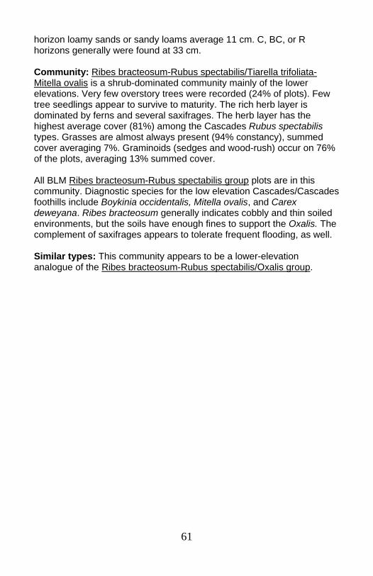
61
horizon loamy sands or sandy loams average 11 cm. C, BC, or R horizons generally were found at 33 cm. Community: Ribes bracteosum-Rubus spectabilis/Tiarella trifoliata-Mitella ovalis is a shrub-dominated community mainly of the lower elevations. Very few overstory trees were recorded (24% of plots). Few tree seedlings appear to survive to maturity. The rich herb layer is dominated by ferns and several saxifrages. The herb layer has the highest average cover (81%) among the Cascades Rubus spectabilis types. Grasses are almost always present (94% constancy), summed cover averaging 7%. Graminoids (sedges and wood-rush) occur on 76% of the plots, averaging 13% summed cover. All BLM Ribes bracteosum-Rubus spectabilis group plots are in this community. Diagnostic species for the low elevation Cascades/Cascades foothills include Boykinia occidentalis, Mitella ovalis, and Carex deweyana. Ribes bracteosum generally indicates cobbly and thin soiled environments, but the soils have enough fines to support the Oxalis. The complement of saxifrages appears to tolerate frequent flooding, as well. Similar types: This community appears to be a lower-elevation analogue of the Ribes bracteosum-Rubus spectabilis/Oxalis group.
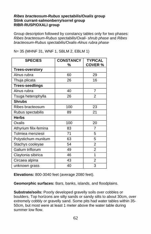
62
Ribes bracteosum-Rubus spectabilis/Oxalis group Stink currant-salmonberry/sorrel group RIBR-RUSP/OXALI group Group description followed by constancy tables only for two phases: Ribes bracteosum-Rubus spectabilis/Oxali- shrub phase and Ribes bracteosum-Rubus spectabilis/Oxalis-Alnus rubra phase N= 35 (MHNF 31, WNF 1, SBLM 2, EBLM 1)
Elevations: 800-3040 feet (average 2080 feet). Geomorphic surfaces: Bars, banks, islands, and floodplains. Substrate/soils: Poorly developed gravelly soils over cobbles or boulders. Top horizons are silty sands or sandy silts to about 30cm, over extremely cobbly or gravelly sand. Some pits had water tables within 35-50cm, but most were at least 1 meter above the water table during summer low flow.
SPECIES CONSTANCY %
TYPICAL COVER %
Trees-overstory Alnus rubra 60 29 Thuja plicata 26 16 Trees-seedlings Alnus rubra 40 7 Tsuga heterophylla 26 2 Shrubs Ribes bracteosum 100 23 Rubus spectabilis 89 21 Herbs Oxalis 100 20 Athyrium filix-femina 83 7 Tolmiea menziesii 71 5 Polystichum munitum 63 5 Stachys cooleyae 54 2 Galium triflorum 49 2 Claytonia sibirica 46 1 Circaea alpina 43 2 unknown grass 40 3
63
The plot with the highest Thuja plicata component was the only plot where a gley layer was found within a meter of bedrock. Community: The Ribes bracteosum-Rubus spectabilis/Oxalis group most often occurs as the Alnus rubra-dominated Ribes bracteosum-Rubus spectabilis/Oxalis-Alnus rubra phase. In the North Fork Clackamas drainage, Thuja plicata also is commonly found in the overstory. Where no mature trees are present (Ribes bracteosum-Rubus spectabilis/Oxalis-shrub phase), high shrub cover remained constant, but low shrub cover doubled, and herb cover increased 130%, though understory species composition is the same. Alnus canopy is moderate (average 33% cover; average plot canopy height 46’). Logs often act as substrate for upland species not typically rooted in the community. This community has much less Polystichum munitum and Athyrium filix-femina that the Rubus spectabilis/Oxalis group, which has more loams, deeper top horizons, and more organic matter and which often has older, larger trees.
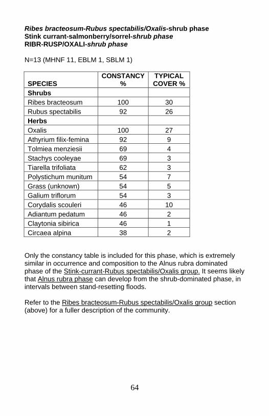
64
Ribes bracteosum-Rubus spectabilis/Oxalis-shrub phase Stink currant-salmonberry/sorrel-shrub phase RIBR-RUSP/OXALI-shrub phase N=13 (MHNF 11, EBLM 1, SBLM 1)
Only the constancy table is included for this phase, which is extremely similar in occurrence and composition to the Alnus rubra dominated phase of the Stink-currant-Rubus spectabilis/Oxalis group. It seems likely that Alnus rubra phase can develop from the shrub-dominated phase, in intervals between stand-resetting floods. Refer to the Ribes bracteosum-Rubus spectabilis/Oxalis group section (above) for a fuller description of the community.
SPECIES CONSTANCY
% TYPICAL COVER %
Shrubs Ribes bracteosum 100 30 Rubus spectabilis 92 26 Herbs Oxalis 100 27 Athyrium filix-femina 92 9 Tolmiea menziesii 69 4 Stachys cooleyae 69 3 Tiarella trifoliata 62 3 Polystichum munitum 54 7 Grass (unknown) 54 5 Galium triflorum 54 3 Corydalis scouleri 46 10 Adiantum pedatum 46 2 Claytonia sibirica 46 1 Circaea alpina 38 2
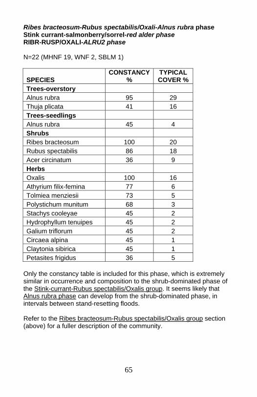
65
Ribes bracteosum-Rubus spectabilis/Oxali-Alnus rubra phase Stink currant-salmonberry/sorrel-red alder phase RIBR-RUSP/OXALI-ALRU2 phase N=22 (MHNF 19, WNF 2, SBLM 1)
Only the constancy table is included for this phase, which is extremely similar in occurrence and composition to the shrub-dominated phase of the Stink-currant-Rubus spectabilis/Oxalis group. It seems likely that Alnus rubra phase can develop from the shrub-dominated phase, in intervals between stand-resetting floods. Refer to the Ribes bracteosum-Rubus spectabilis/Oxalis group section (above) for a fuller description of the community.
SPECIES CONSTANCY
% TYPICAL COVER %
Trees-overstory Alnus rubra 95 29 Thuja plicata 41 16 Trees-seedlings Alnus rubra 45 4 Shrubs Ribes bracteosum 100 20 Rubus spectabilis 86 18 Acer circinatum 36 9 Herbs Oxalis 100 16 Athyrium filix-femina 77 6 Tolmiea menziesii 73 5 Polystichum munitum 68 3 Stachys cooleyae 45 2 Hydrophyllum tenuipes 45 2 Galium triflorum 45 2 Circaea alpina 45 1 Claytonia sibirica 45 1 Petasites frigidus 36 5

66
Alnus viridis Sitka alder ALVI5 N=14 (MHNF 13, WNF 1)
Elevations: 3270 to 4720 feet (average 3,784 feet). Geomorphic surfaces: Flat to very gently sloping cobble bars, cobbly islands, or active floodplains. Substrate/soils: Shallow layers (generally <20cm) of silt, sand, or silty sand over cobbles or within a cobble matrix. Two plots with deeper (36-52 cm) soils had rhododendron in the shrub layer.
SPECIES CONSTANCY
% TYPICAL COVER %
Trees-seedlings Tsuga heterophylla 43 12 Shrubs Alnus viridis 100 18 Vaccinium ovalifolium 79 14 Ribes lacustre 64 6 Viburnum edule 57 11 Rubus spectabilis 57 4 Ribes bracteosum 43 6 Rubus parviflorus 43 4 Menziesia ferruginea 36 6 Gaultheria ovatifolia 36 2 Herbs Achlys triphylla 79 6 Tiarella trifoliata var. unifoliata 71 2 Cornus unalaschkensis 64 7 Linnaea borealis 57 12 Athyrium filix-femina 57 7 Streptopus amplexifolius 43 1 Orthilia secunda 36 2 Clintonia uniflora 36 2 Mitella breweri 36 1 Senecio triangularis 36 Tr
67
Community: The Alnus viridis community is a shrubby mid- to upper-elevation community. It occurs in the upper range of the western hemlock zone, in the silver fir zone, and into the mountain hemlock zone. Cold air drainage effects can be seen in this community. For example, Tsuga mertensiana seedlings are found where silver fir associations form the adjacent upland associations. Mature conifers are seldom present. Mature hardwood trees were not recorded in the sample, though Alnus rubra seedlings occurred on 28% of the plots. Similar types: The Vaccinium ovalifolium community is very similar in composition and distribution to the Alnus viridis type and could be considered a phase of the same basic community. The Vaccinium ovalifolium community can occur on a wider range of geomorphic surfaces, and occasionally on deeper, poorly drained soils. The Alnus viridis community is more restricted to cobble bars and islands very close to or within the normal high water line.
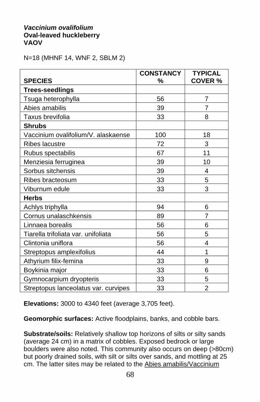
68
Vaccinium ovalifolium Oval-leaved huckleberry VAOV N=18 (MHNF 14, WNF 2, SBLM 2)
Elevations: 3000 to 4340 feet (average 3,705 feet). Geomorphic surfaces: Active floodplains, banks, and cobble bars. Substrate/soils: Relatively shallow top horizons of silts or silty sands (average 24 cm) in a matrix of cobbles. Exposed bedrock or large boulders were also noted. This community also occurs on deep (>80cm) but poorly drained soils, with silt or silts over sands, and mottling at 25 cm. The latter sites may be related to the Abies amabilis/Vaccinium
SPECIES CONSTANCY
% TYPICAL COVER %
Trees-seedlings Tsuga heterophylla 56 7 Abies amabilis 39 7 Taxus brevifolia 33 8 Shrubs Vaccinium ovalifolium/V. alaskaense 100 18 Ribes lacustre 72 3 Rubus spectabilis 67 11 Menziesia ferruginea 39 10 Sorbus sitchensis 39 4 Ribes bracteosum 33 5 Viburnum edule 33 3 Herbs Achlys triphylla 94 6 Cornus unalaschkensis 89 7 Linnaea borealis 56 6 Tiarella trifoliata var. unifoliata 56 5 Clintonia uniflora 56 4 Streptopus amplexifolius 44 1 Athyrium filix-femina 33 9 Boykinia major 33 6 Gymnocarpium dryopteris 33 5 Streptopus lanceolatus var. curvipes 33 2
69
ovalifolium community, where mature trees are found on well-drained microsites provided by hummocks. Community: The Vaccinium ovalifolium community occurs at higher elevations than similar Rubus spectabilis-dominated types. It is generally found in the silver fir zone, but is also found in the upper western hemlock zone. The distribution extends into the mountain hemlock zone. Cold air drainage effects are often evident in this community. Few tree seedlings reach maturity. This community seems to be the higher elevation analogue for the Rubus spectabilis/Oxalis types, considering soils, geomorphic surfaces, and stand structure. Similar types: The Alnus viridis community is very similar in composition and distribution to the Vaccinium ovalifolium type, and could be considered a phase of the same basic community. The Alnus viridis type occurs exclusively adjacent to the channel on shallow silty sands or sands on cobble bars, cobbly floodplains or islands. It does not occur with deeper poorly drained soils.
70
Steep banks/terraces Oxalis-Hydrophyllum tenuipes, OXALI-HYTE.....................................p. 71 (Alnus rubra-Acer macrophyllum)/Oxalis, (ALRU2-ACMA3)/OXALI .....................................................................p. 73 Rubus spectabilis/Oxalis group, RUSP/OXALI GROUP:....................p. 75 ○ Rubus spectabilis/Oxalis-shrub phase, RUSP/OXALI-shrub phase ............................................................p. 77 ○ Rubus spectabilis/Oxalis-Alnus rubra phase, RUSP/OXALI-ALRU2 phase..........................................................p. 78 ○ Rubus spectabilis/Oxalis-Thuja plicata phase, RUSP/OXALI-THPL phase ............................................................p. 80 Alnus rubra/Symphoricarpos albus-Rubus spectabilis, ALRU2/SYAL-RUSP ...........................................................................p. 82
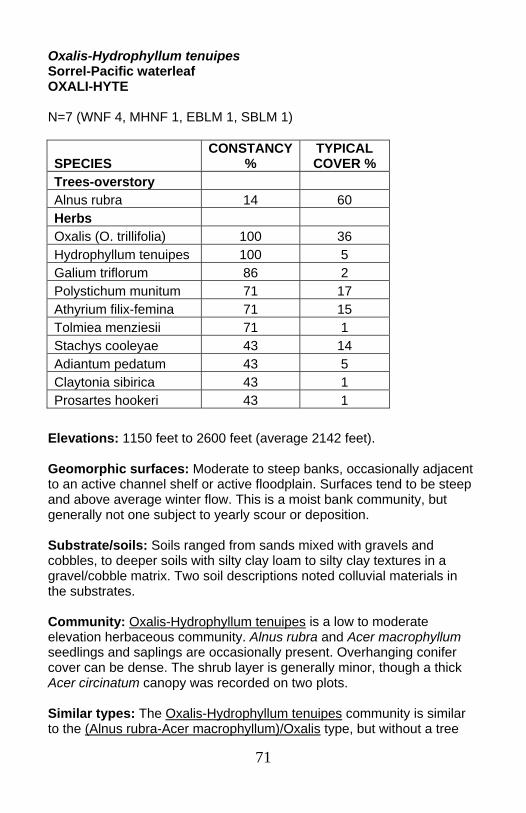
71
Oxalis-Hydrophyllum tenuipes Sorrel-Pacific waterleaf OXALI-HYTE N=7 (WNF 4, MHNF 1, EBLM 1, SBLM 1)
Elevations: 1150 feet to 2600 feet (average 2142 feet). Geomorphic surfaces: Moderate to steep banks, occasionally adjacent to an active channel shelf or active floodplain. Surfaces tend to be steep and above average winter flow. This is a moist bank community, but generally not one subject to yearly scour or deposition. Substrate/soils: Soils ranged from sands mixed with gravels and cobbles, to deeper soils with silty clay loam to silty clay textures in a gravel/cobble matrix. Two soil descriptions noted colluvial materials in the substrates. Community: Oxalis-Hydrophyllum tenuipes is a low to moderate elevation herbaceous community. Alnus rubra and Acer macrophyllum seedlings and saplings are occasionally present. Overhanging conifer cover can be dense. The shrub layer is generally minor, though a thick Acer circinatum canopy was recorded on two plots. Similar types: The Oxalis-Hydrophyllum tenuipes community is similar to the (Alnus rubra-Acer macrophyllum)/Oxalis type, but without a tree
SPECIES CONSTANCY
% TYPICAL COVER %
Trees-overstory Alnus rubra 14 60 Herbs Oxalis (O. trillifolia) 100 36 Hydrophyllum tenuipes 100 5 Galium triflorum 86 2 Polystichum munitum 71 17 Athyrium filix-femina 71 15 Tolmiea menziesii 71 1 Stachys cooleyae 43 14 Adiantum pedatum 43 5 Claytonia sibirica 43 1 Prosartes hookeri 43 1

72
component. Riparian indicators more common or abundant in the Oxalis-Hydrophyllum tenuipes community include Athyrium filix-femina and Stachys cooleyae. The herbaceous type may represent similar bank environments, but slightly wetter and/or younger than (Alnus rubra-Acer macrophyllum)/Oxalis.

73
(Alnus rubra-Acer macrophyllum)/Oxalis (Red alder-big leaf maple)/Sorrel (ALRU2-ACMA3)/OXALI N=16 (MHNF 8, WNF 5, EBLM 3)
Elevations: 920 to 2580 feet (average 1734 feet). Geomorphic surfaces: Steep cobbly or bouldery banks (12-45% slope), or on terraces. Substrate/soils: Soils on the steep banks are shallow loams or silty sands in a matrix of cobbles or boulders. Terrace plots had loamy clay,
SPECIES CONSTANCY
% TYPICAL COVER %
Trees-overstory Alnus rubra 56 50 Acer macrophyllum 38 47 Tsuga heterophylla 38 35 Thuja plicata 31 28 Trees-seedlings Tsuga heterophylla 38 3 Shrubs Acer circinatum 63 20 Rubus ursinus 50 2 Oemleria cerasiformis 38 2 Herbs Oxalis 100 27 Polystichum munitum 88 21 Galium triflorum 81 1 Athyrium filix-femina 63 5 Lactuca muralis 56 1 Adiantum pedatum 50 2 Tolmiea menziesii 44 3 Claytonia sibirica 44 1 Corydalis scouleri 38 31 Bromus vulgaris 38 6 Vancouveria hexandra 38 4 Petasites frigidus 38 1
74
silty clay or silts in the top horizons, above clays or sandy clays over cobbles. Deep organic layers were noted on some plots. Soil depths were 45 to 60 cm. Anaerobic conditions were noted for one plot where gleying occurred within the top 20 cm. Community: The (Alnus rubra-Acer macrophyllum)/Oxalis community can occur under a variety of tree species. Hardwood or mixed hardwood-conifer canopies are most common. Typical shrub cover is low, with Acer circinatum often the abundant species. Corydalis scourleri is an important associated species in this community in the Mt. Hood NF. Terrace plots had older trees (140-275 years old,). Tree ages and geomorphic surfaces suggest that this environment is not reset often by floods. Bank plots supported younger stands (9-70 years). Some stands had multiple ages which suggest successive non-stand replacement floods. Similar types: The Oxalis-Hydrophyllum tenuipes community is very similar to the (Alnus rubra-Acer macrophyllum)/Oxalis type, but without the tree component. The herbaceous type may represent similar bank environments, but slightly wetter and/or younger.

75
Rubus spectabilis/Oxalis group Salmonberry/Sorrel group RUSP/OXALI group Group description followed by descriptions of three phases: Rubus spectabilis/Oxalis–shrub phase, Rubus spectabilis/Oxalis-Alnus rubra phase, and Rubus spectabilis/Oxalis-Thuja plicata phase N=28 (MHNF 15, EBLM 7, SBLM 4, WNF 2)
Elevations: 800 to 2740 feet (average 1667feet). Geomorphic surfaces: Terraces, banks, and floodplains. Substrate/soils: Mt. Hood soil data show most plots had a top layer (average 11cm) of silty sand, sandy silt, sand or silty clay loam over sands in a cobble matrix. Soil data from BLM sites showed that loams (silt loam, loam, silty clay loam, sandy clay loam) formed the A and AB
SPECIES CONSTANCY %
TYPICAL COVER %
Trees-overstory Alnus rubra 50 43 Thuja plicata 21 48 Shrubs Rubus spectabilis 100 21 Vaccinium parvifolium 43 6 Ribes bracteosum 32 2 Herbs Oxalis 100 29 Polystichum munitum 89 25 Athyrium filix-femina 64 14 Galium triflorum 54 3 Claytonia sibirica 50 3 Adiantum pedatum 43 6 Tolmiea menziesii 43 4 Stachys cooleyae 43 3 Tiarella trifoliata 36 6 Circaea alpina 36 3 Bromus vulgaris 32 4

76
layer (ave 18cm.). The B layer (aver 41 cm) was most commonly loamy, but ranged from sand to sandy clay. Gravels made up more of the coarse fragments in the A and B horizons than cobbles. All soil pits had cobbles and/or boulders in the R layer. Community: Rubus spectabilis/Oxalis is a moderate elevation community that occurs with Alnus rubra (Rubus spectabilis/Oxalis-Alnus rubra phase) and/or Thuja plicata (Rubus spectabilis/Oxalis-Thuja plicata phase), but frequently occurs without trees in the overstory (Rubus spectabilis/Oxalis-shrub phase). Shrub and herb composition in all three groups is very similar. Among Rubus spectabilis communities, Rubus spectabilis/Oxalis occurs on soils with deeper organic layers and finer size fractions, smaller coarse fragments, and deeper soils. The sites are more fertile and with higher moisture availability. Older tree ages as well as smaller coarse fragment sizes and finer soil textures suggest that these sites have less frequent disturbance and slower water during floods. Multiple tree ages on some sites may indicate flooding which does not necessarily remove existing trees.
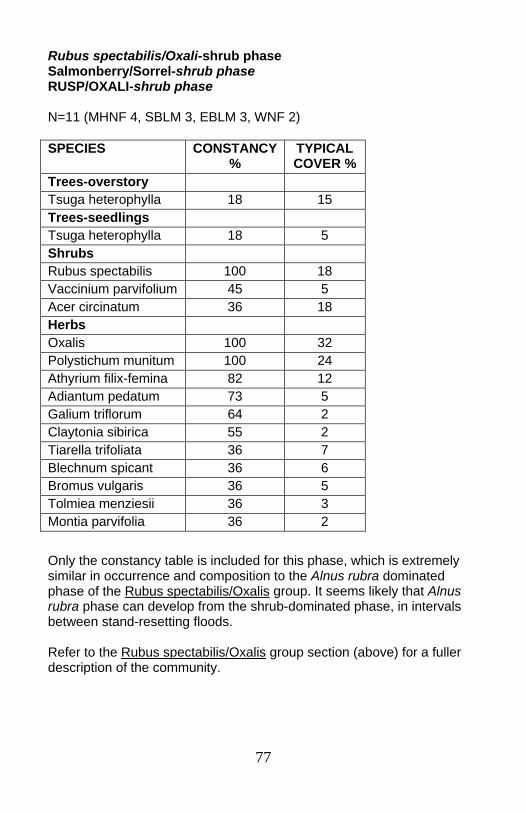
77
Rubus spectabilis/Oxali-shrub phase Salmonberry/Sorrel-shrub phase RUSP/OXALI-shrub phase N=11 (MHNF 4, SBLM 3, EBLM 3, WNF 2)
Only the constancy table is included for this phase, which is extremely similar in occurrence and composition to the Alnus rubra dominated phase of the Rubus spectabilis/Oxalis group. It seems likely that Alnus rubra phase can develop from the shrub-dominated phase, in intervals between stand-resetting floods. Refer to the Rubus spectabilis/Oxalis group section (above) for a fuller description of the community.
SPECIES CONSTANCY %
TYPICAL COVER %
Trees-overstory Tsuga heterophylla 18 15 Trees-seedlings Tsuga heterophylla 18 5 Shrubs Rubus spectabilis 100 18 Vaccinium parvifolium 45 5 Acer circinatum 36 18 Herbs Oxalis 100 32 Polystichum munitum 100 24 Athyrium filix-femina 82 12 Adiantum pedatum 73 5 Galium triflorum 64 2 Claytonia sibirica 55 2 Tiarella trifoliata 36 7 Blechnum spicant 36 6 Bromus vulgaris 36 5 Tolmiea menziesii 36 3 Montia parvifolia 36 2
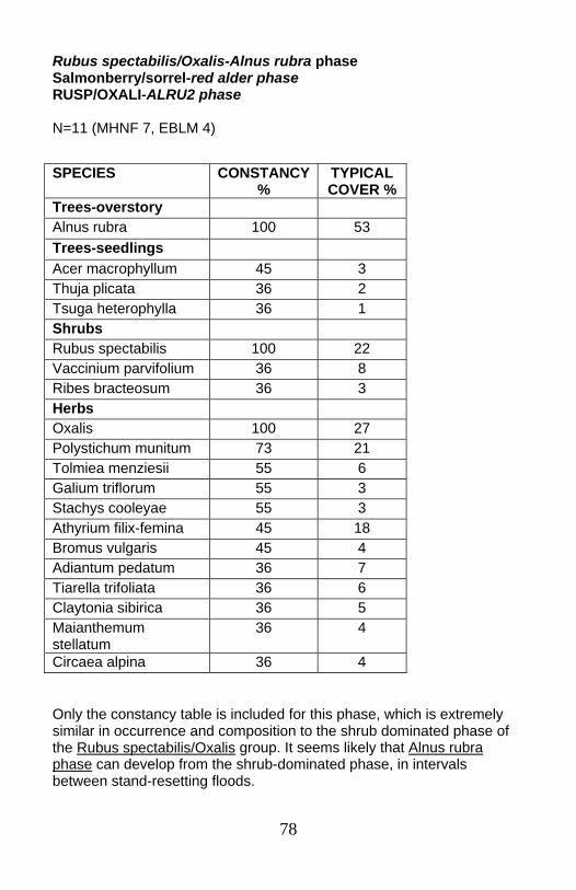
78
Rubus spectabilis/Oxalis-Alnus rubra phase Salmonberry/sorrel-red alder phase RUSP/OXALI-ALRU2 phase N=11 (MHNF 7, EBLM 4)
Only the constancy table is included for this phase, which is extremely similar in occurrence and composition to the shrub dominated phase of the Rubus spectabilis/Oxalis group. It seems likely that Alnus rubra phase can develop from the shrub-dominated phase, in intervals between stand-resetting floods.
SPECIES CONSTANCY %
TYPICAL COVER %
Trees-overstory Alnus rubra 100 53 Trees-seedlings Acer macrophyllum 45 3 Thuja plicata 36 2 Tsuga heterophylla 36 1 Shrubs Rubus spectabilis 100 22 Vaccinium parvifolium 36 8 Ribes bracteosum 36 3 Herbs Oxalis 100 27 Polystichum munitum 73 21 Tolmiea menziesii 55 6 Galium triflorum 55 3 Stachys cooleyae 55 3 Athyrium filix-femina 45 18 Bromus vulgaris 45 4 Adiantum pedatum 36 7 Tiarella trifoliata 36 6 Claytonia sibirica 36 5 Maianthemum stellatum
36 4
Circaea alpina 36 4

79
Grasses are generally present (73% constancy), averaging 5% cover. Graminoids occur on 55% of the plots, averaging 6% cover. Refer to the Rubus spectabilis/Oxalis group section (above) for a fuller description of the community.
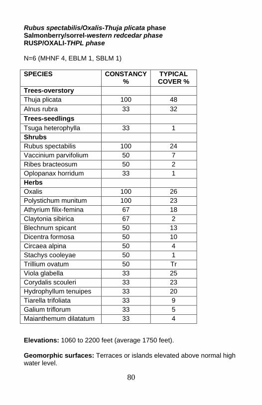
80
Rubus spectabilis/Oxalis-Thuja plicata phase Salmonberry/sorrel-western redcedar phase RUSP/OXALI-THPL phase N=6 (MHNF 4, EBLM 1, SBLM 1)
Elevations: 1060 to 2200 feet (average 1750 feet). Geomorphic surfaces: Terraces or islands elevated above normal high water level.
SPECIES CONSTANCY %
TYPICAL COVER %
Trees-overstory Thuja plicata 100 48 Alnus rubra 33 32 Trees-seedlings Tsuga heterophylla 33 1 Shrubs Rubus spectabilis 100 24 Vaccinium parvifolium 50 7 Ribes bracteosum 50 2 Oplopanax horridum 33 1 Herbs Oxalis 100 26 Polystichum munitum 100 23 Athyrium filix-femina 67 18 Claytonia sibirica 67 2 Blechnum spicant 50 13 Dicentra formosa 50 10 Circaea alpina 50 4 Stachys cooleyae 50 1 Trillium ovatum 50 Tr Viola glabella 33 25 Corydalis scouleri 33 23 Hydrophyllum tenuipes 33 20 Tiarella trifoliata 33 9 Galium triflorum 33 5 Maianthemum dilatatum 33 4
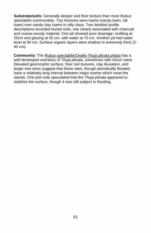
81
Substrate/soils: Generally deeper and finer texture than most Rubus spectabilis communities. Top horizons were loams (sandy loam, silt loam) over sandy clay loams to silty clays. Two detailed profile descriptions recorded buried soils, one clearly associated with charcoal and coarse woody material. One pit showed poor drainage: mottling at 25cm and gleying at 55 cm, with water at 70 cm. Another pit had water level at 90 cm. Surface organic layers were shallow to extremely thick (2-40 cm). Community: The Rubus spectabilis/Oxalis-Thuja plicata phase has a well developed overstory of Thuja plicata, sometimes with Alnus rubra. Elevated geomorphic surface, finer soil textures, clay illuviation, and larger tree sizes suggest that these sites, though periodically flooded, have a relatively long interval between major events which reset the stands. One plot note speculated that the Thuja plicata appeared to stabilize the surface, though it was still subject to flooding.
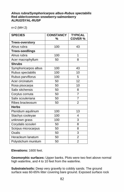
82
Alnus rubra/Symphoricarpos albus-Rubus spectabilis Red alder/common snowberry-salmonberry ALRU2/SYAL-RUSP n=2 (MH 2)
Elevations: 1600 feet. Geomorphic surfaces: Upper banks. Plots were two feet above normal high waterline, and 4 to 10 feet from the waterline. Substrate/soils: Deep very gravelly to cobbly sands. The ground surface was 60-65% litter covering bare ground. Exposed surface rock
SPECIES CONSTANCY %
TYPICAL COVER %
Trees-overstory Alnus rubra 100 43 Trees-seedlings Alnus rubra 100 1 Acer macrophyllum 50 8 Shrubs Symphoricarpos albus 100 43 Rubus spectabilis 100 10 Rubus parviflorus 100 5 Acer circinatum 50 12 Rosa pisocarpa 50 10 Salix sitchensis 50 8 Corylus cornuta 50 7 Salix scouleriana 50 7 Ribes bracteosum 50 2 Herbs Pteridium aquilinum 100 13 Stachys cooleyae 100 4 unknown grass 100 3 Corydalis scouleri 50 8 Scirpus microcarpus 50 8 Oxalis 50 3 Heracleum lanatum 50 2 Polystichum munitum 50 2
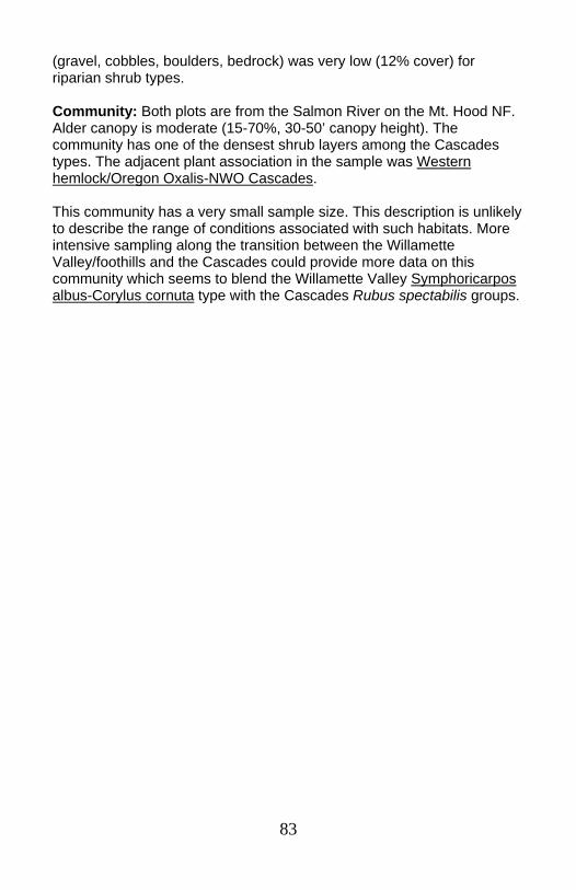
83
(gravel, cobbles, boulders, bedrock) was very low (12% cover) for riparian shrub types. Community: Both plots are from the Salmon River on the Mt. Hood NF. Alder canopy is moderate (15-70%, 30-50’ canopy height). The community has one of the densest shrub layers among the Cascades types. The adjacent plant association in the sample was Western hemlock/Oregon Oxalis-NWO Cascades. This community has a very small sample size. This description is unlikely to describe the range of conditions associated with such habitats. More intensive sampling along the transition between the Willamette Valley/foothills and the Cascades could provide more data on this community which seems to blend the Willamette Valley Symphoricarpos albus-Corylus cornuta type with the Cascades Rubus spectabilis groups.
84
High terraces/major floodplains (Acer macrophyllum-Alnus rubra)/Acer circinatum/Tiarella trifoliata, ACMA3-ALRU2)/ACCI/TITR ...............................................................p. 85 Forested Corylus cornuta/Polystichum munitum group, Forested COCO6/POMU GROUP: .....................................................p. 87 ○ Forested Corylus cornuta/Polystichum munitum-hardwood phase, Forested COCO6/POMU-hardwood phase ...................................p. 89 ○ Forested Corylus cornuta/Polystichum munitum—Tsuga heterophylla/Acer circinatum/Oxalis phase, Forested COCO6/POMU-TSHE/ACCI/OXALI phase ....................p. 91 ○ Forested Corylus cornuta/Polystichum munitum-Acer macrophyllum/Acer circinatum phase, Forested COCO6/POMU-ACMA3/ACCI phase .............................p. 93
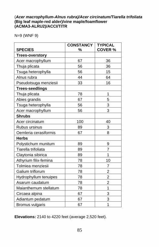
85
(Acer macrophyllum-Alnus rubra)/Acer circinatum/Tiarella trifoliata (Big leaf maple-red alder)/vine maple/foamflower (ACMA3-ALRU2)/ACCI/TITR N=9 (WNF 9)
Elevations: 2140 to 4220 feet (average 2,520 feet).
SPECIES CONSTANCY
% TYPICAL COVER %
Trees-overstory Acer macrophyllum 67 36 Thuja plicata 56 36 Tsuga heterophylla 56 15 Alnus rubra 44 64 Pseudotsuga menziesii 33 16 Trees-seedlings Thuja plicata 78 1 Abies grandis 67 5 Tsuga heterophylla 56 3 Acer macrophyllum 56 3 Shrubs Acer circinatum 100 40 Rubus ursinus 89 3 Oemleria cerasiformis 67 8 Herbs Polystichum munitum 89 9 Tiarella trifoliata 89 7 Claytonia sibirica 89 1 Athyrium filix-femina 78 10 Tolmiea menziesii 78 7 Galium triflorum 78 2 Hydrophyllum tenuipes 78 2 Asarum caudatum 78 2 Maianthemum stellatum 78 1 Circaea alpina 67 3 Adiantum pedatum 67 3 Bromus vulgaris 67 1
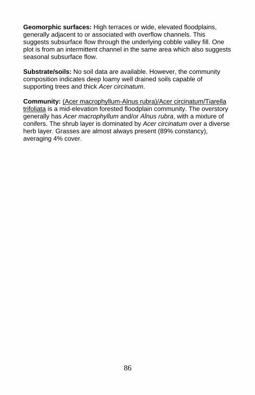
86
Geomorphic surfaces: High terraces or wide, elevated floodplains, generally adjacent to or associated with overflow channels. This suggests subsurface flow through the underlying cobble valley fill. One plot is from an intermittent channel in the same area which also suggests seasonal subsurface flow. Substrate/soils: No soil data are available. However, the community composition indicates deep loamy well drained soils capable of supporting trees and thick Acer circinatum. Community: (Acer macrophyllum-Alnus rubra)/Acer circinatum/Tiarella trifoliata is a mid-elevation forested floodplain community. The overstory generally has Acer macrophyllum and/or Alnus rubra, with a mixture of conifers. The shrub layer is dominated by Acer circinatum over a diverse herb layer. Grasses are almost always present (89% constancy), averaging 4% cover.

87
Forested Corylus cornuta/Polystichum munitum group Forested California hazel/sword fern group Forested COCO6/POMU group Group description followed by descriptions of three phases: Forested Corylus cornuta/Polystichum munitum-hardwood phase, Forested Corylus cornuta/Polystichum munitum-Tsuga heterophylla/Acer circinatum /Oxalis phase, and Forested Corylus cornuta/Polystichum munitum-Acer macrophyllum/Acer circinatum phase N=20 (WNF 18, EBLM 1, Willamette Valley 1) This constancy table is for the entire group combined. The individual phases are then presented separately.
* Herb species listed on next page. Elevations: 1050 to 2380 feet (average 1444 feet). Geomorphic surfaces: Two variants: one present on upper banks and toeslopes; the other in wide river valleys on old terraces of large rivers below dams.
SPECIES CONSTANCY
% TYPICAL COVER %
Trees-overstory Acer macrophyllum 42 31 Alnus rubra 33 42 Pseudotsuga menziesii 33 25 Calocedrus decurrens 33 12 Trees-seedlings Acer macrophyllum 50 3 Shrubs Corylus cornuta 100 25 Acer circinatum 92 24 Rubus ursinus 92 4 Vaccinium parvifolium 67 3 Oemleria cerasiformis 58 3 Symphoricarpos albus 42 5
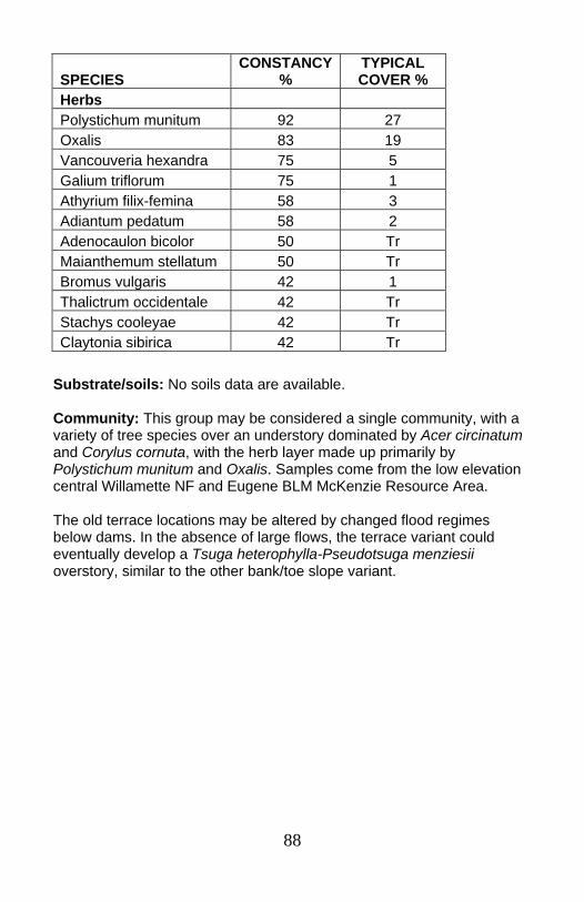
88
Substrate/soils: No soils data are available. Community: This group may be considered a single community, with a variety of tree species over an understory dominated by Acer circinatum and Corylus cornuta, with the herb layer made up primarily by Polystichum munitum and Oxalis. Samples come from the low elevation central Willamette NF and Eugene BLM McKenzie Resource Area. The old terrace locations may be altered by changed flood regimes below dams. In the absence of large flows, the terrace variant could eventually develop a Tsuga heterophylla-Pseudotsuga menziesii overstory, similar to the other bank/toe slope variant.
SPECIES CONSTANCY
% TYPICAL COVER %
Herbs Polystichum munitum 92 27 Oxalis 83 19 Vancouveria hexandra 75 5 Galium triflorum 75 1 Athyrium filix-femina 58 3 Adiantum pedatum 58 2 Adenocaulon bicolor 50 Tr Maianthemum stellatum 50 Tr Bromus vulgaris 42 1 Thalictrum occidentale 42 Tr Stachys cooleyae 42 Tr Claytonia sibirica 42 Tr
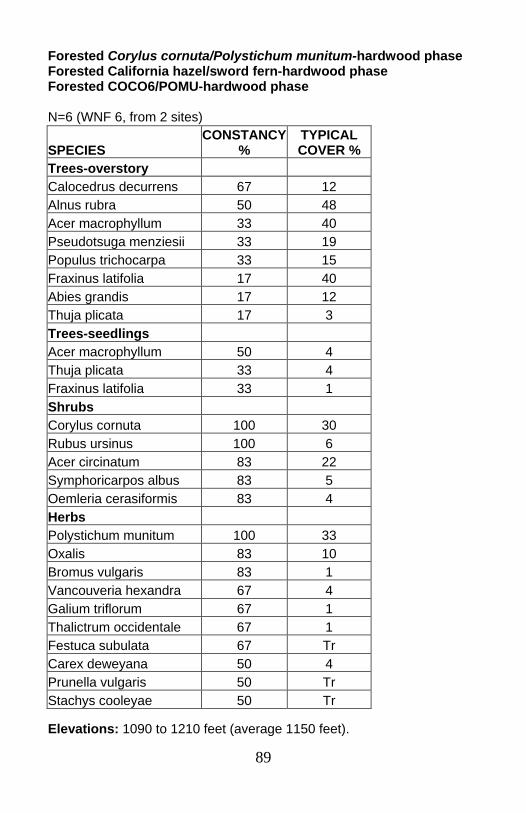
89
Forested Corylus cornuta/Polystichum munitum-hardwood phase Forested California hazel/sword fern-hardwood phase Forested COCO6/POMU-hardwood phase N=6 (WNF 6, from 2 sites)
Elevations: 1090 to 1210 feet (average 1150 feet).
SPECIES CONSTANCY
% TYPICAL COVER %
Trees-overstory Calocedrus decurrens 67 12 Alnus rubra 50 48 Acer macrophyllum 33 40 Pseudotsuga menziesii 33 19 Populus trichocarpa 33 15 Fraxinus latifolia 17 40 Abies grandis 17 12 Thuja plicata 17 3 Trees-seedlings Acer macrophyllum 50 4 Thuja plicata 33 4 Fraxinus latifolia 33 1 Shrubs Corylus cornuta 100 30 Rubus ursinus 100 6 Acer circinatum 83 22 Symphoricarpos albus 83 5 Oemleria cerasiformis 83 4 Herbs Polystichum munitum 100 33 Oxalis 83 10 Bromus vulgaris 83 1 Vancouveria hexandra 67 4 Galium triflorum 67 1 Thalictrum occidentale 67 1 Festuca subulata 67 Tr Carex deweyana 50 4 Prunella vulgaris 50 Tr Stachys cooleyae 50 Tr
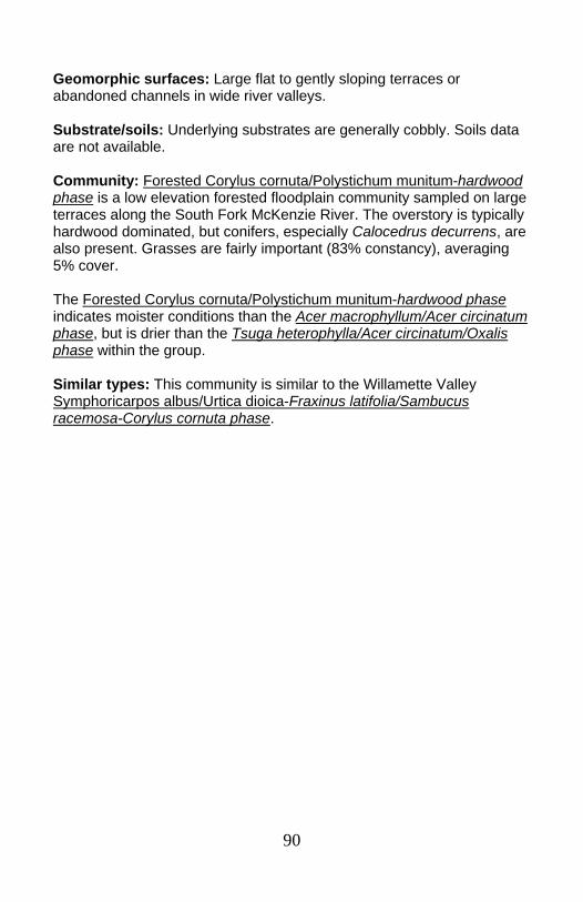
90
Geomorphic surfaces: Large flat to gently sloping terraces or abandoned channels in wide river valleys. Substrate/soils: Underlying substrates are generally cobbly. Soils data are not available. Community: Forested Corylus cornuta/Polystichum munitum-hardwood phase is a low elevation forested floodplain community sampled on large terraces along the South Fork McKenzie River. The overstory is typically hardwood dominated, but conifers, especially Calocedrus decurrens, are also present. Grasses are fairly important (83% constancy), averaging 5% cover. The Forested Corylus cornuta/Polystichum munitum-hardwood phase indicates moister conditions than the Acer macrophyllum/Acer circinatum phase, but is drier than the Tsuga heterophylla/Acer circinatum/Oxalis phase within the group. Similar types: This community is similar to the Willamette Valley Symphoricarpos albus/Urtica dioica-Fraxinus latifolia/Sambucus racemosa-Corylus cornuta phase.

91
Forested Corylus cornuta/Polystichum munitum-Tsuga heterophylla/Acer circinatum/Oxalis phase Forested California hazel/sword fern-western hemlock/vine maple/sorrel phase Forested COCO6/POMU-TSHE/ACCI/OXALI phase N=6 (WNF 5, EBLM 1)
* Herb species listed on next page. Elevations: 1050 feet to 2380 feet (average 1745 feet). Geomorphic surfaces: Toeslopes, upper banks, and terraces. Substrate/soils: One soil description from a steep valley wall showed a deep silty loam to silty clay soil.
SPECIES CONSTANCY
% TYPICAL COVER %
Trees-overstory Tsuga heterophylla 50 38 Acer macrophyllum 50 15 Pseudotsuga menziesii 33 35 Trees-seedlings Tsuga heterophylla 67 5 Alnus rubra 50 7 Acer macrophyllum 50 1 Shrubs Acer circinatum 100 27 Corylus cornuta 100 15 Vaccinium parvifolium 100 3 Rubus ursinus 83 1 Berberis nervosa 50 3 Rubus parviflorus 50 1
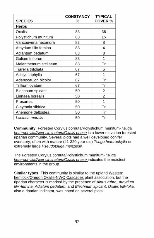
92
Community: Forested Corylus cornuta/Polystichum munitum-Tsuga heterophylla/Acer circinatum/Oxalis phase is a lower elevation forested riparian community. Several plots had a well developed conifer overstory, often with mature (41-320 year old) Tsuga heterophylla or extremely large Pseudotsuga menziesii. The Forested Corylus cornuta/Polystichum munitum-Tsuga heterophylla/Acer circinatum/Oxalis phase indicates the moistest environments in the group. Similar types: This community is similar to the upland Western hemlock/Oregon Oxalis-NWO Cascades plant association, but the riparian character is marked by the presence of Alnus rubra, Athyrium filix-femina, Adiatum pedatum, and Blechnum spicant. Oxalis trilliifolia, also a riparian indicator, was noted on several plots.
SPECIES CONSTANCY
% TYPICAL COVER %
Herbs Oxalis 83 36 Polystichum munitum 83 15 Vancouveria hexandra 83 8 Athyrium filix-femina 83 4 Adiantum pedatum 83 3 Galium triflorum 83 1 Maianthemum stellatum 83 Tr Tiarella trifoliata 67 5 Achlys triphylla 67 1 Adenocaulon bicolor 67 Tr Trillium ovatum 67 Tr Blechnum spicant 50 2 Linnaea borealis 50 2 Prosartes 50 1 Claytonia sibirica 50 Tr Anemone deltoidea 50 Tr Lactuca muralis 50 Tr
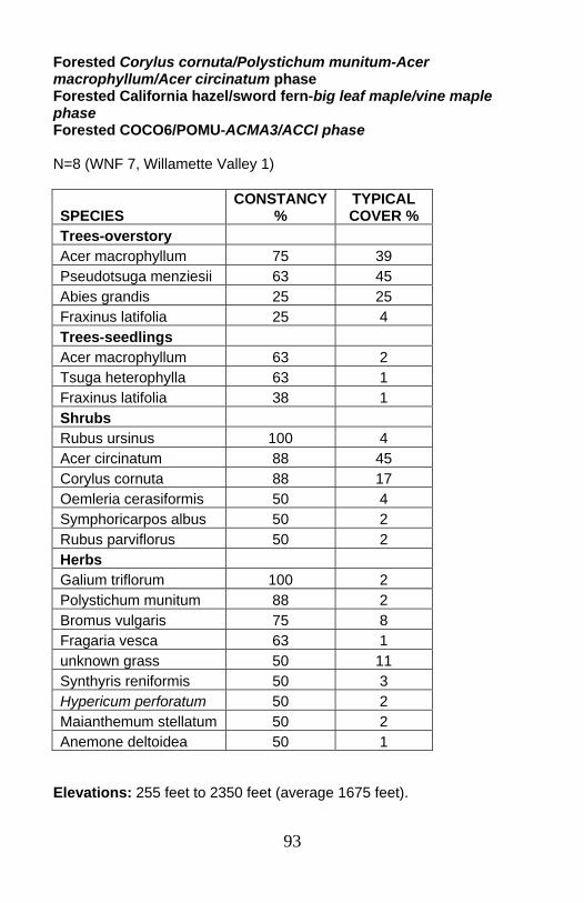
93
Forested Corylus cornuta/Polystichum munitum-Acer macrophyllum/Acer circinatum phase Forested California hazel/sword fern-big leaf maple/vine maple phase Forested COCO6/POMU-ACMA3/ACCI phase N=8 (WNF 7, Willamette Valley 1)
Elevations: 255 feet to 2350 feet (average 1675 feet).
SPECIES CONSTANCY
% TYPICAL COVER %
Trees-overstory Acer macrophyllum 75 39 Pseudotsuga menziesii 63 45 Abies grandis 25 25 Fraxinus latifolia 25 4 Trees-seedlings Acer macrophyllum 63 2 Tsuga heterophylla 63 1 Fraxinus latifolia 38 1 Shrubs Rubus ursinus 100 4 Acer circinatum 88 45 Corylus cornuta 88 17 Oemleria cerasiformis 50 4 Symphoricarpos albus 50 2 Rubus parviflorus 50 2 Herbs Galium triflorum 100 2 Polystichum munitum 88 2 Bromus vulgaris 75 8 Fragaria vesca 63 1 unknown grass 50 11 Synthyris reniformis 50 3 Hypericum perforatum 50 2 Maianthemum stellatum 50 2 Anemone deltoidea 50 1
94
Geomorphic surfaces: Old cobbly floodplains, often in wide river valleys with major side channels or overflow channels. Flooding would occur only during major flood events. Substrate/soils: Cobbly. No soils data are available for these samples. Cobbly sites are generally very well drained, with relatively poor water holding capacity. Community: Forested Corylus cornuta/Polystichum munitum-Acer macrophyllum/Acer circinatum phase is a dry shrubby forested community of large streams and rivers at low to moderate elevations. The herb layer is dominated by grasses; summed cover averaged 15% (constancy 88). Many of the species present indicate warm dry environments (Satureja douglasii, Synthyris renifromis, Fragaria vesca, Symphoricarpos albus). The adjacent upland plant associations often indicate more mesic conditions. Willamette NF plots are all from the South Fork McKenzie River drainage, within the western hemlock plant series. This is a reversal from the common pattern in forested riparian communities, where the streamside vegetation indicates moister conditions than on the adjacent hillsides. Forested Corylus cornuta/Polystichum munitum-Acer macrophyllum/Acer circinatum phase is the driest community in the Forested Corylus cornuta/Polystichum munitum group.
95
Others (seeps, swamps, wetlands, other) Adiatum pedatum, ADPE ....................................................................p. 96 Senecio triangularis-broad-leaved marsh-marigold, SETR-CALE4....p. 98 Oplopanax horridum-Rubus spectabilis group, OPHO-RUSP GROUP: .......................................................................p. 99 ○ Oplopanax horridum-Rubus spectabilis-shrub phase, OPHO-RUSP-shrub phase ..........................................................p. 101 ○ Oplopanax horridum-Rubus spectabilis-Alnus rubra phase, OPHO-RUSP-ALRU2 phase........................................................p. 102 ○ Oplopanax horridum-Rubus spectabilis-Thuja plicata phase, OPHO-RUSP-THPL phase ..........................................................p. 104 Picea engelmannii/Vaccinium membranaceum, PIEN/VAME ..........p. 106 Vaccinium ovalifolium-Rubus spectabilis/Lysichiton americanum, VAOV-RUSP/LYAM3 ........................................................................p. 108 Thuja plicata/Rubus spectabilis/Lysichiton americanum-Oxalis, THPL/RUSP/LYAM3-OXALI .............................................................p. 110 Abies amabilis/Vaccinium ovalifolium, ABAM/VAOV........................p. 112
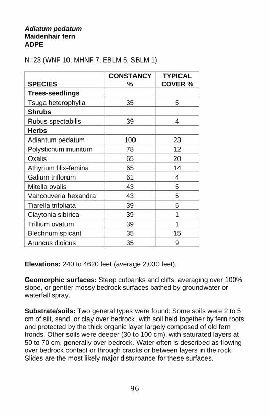
96
Adiatum pedatum Maidenhair fern ADPE N=23 (WNF 10, MHNF 7, EBLM 5, SBLM 1)
Elevations: 240 to 4620 feet (average 2,030 feet). Geomorphic surfaces: Steep cutbanks and cliffs, averaging over 100% slope, or gentler mossy bedrock surfaces bathed by groundwater or waterfall spray. Substrate/soils: Two general types were found: Some soils were 2 to 5 cm of silt, sand, or clay over bedrock, with soil held together by fern roots and protected by the thick organic layer largely composed of old fern fronds. Other soils were deeper (30 to 100 cm), with saturated layers at 50 to 70 cm, generally over bedrock. Water often is described as flowing over bedrock contact or through cracks or between layers in the rock. Slides are the most likely major disturbance for these surfaces.
SPECIES CONSTANCY
% TYPICAL COVER %
Trees-seedlings Tsuga heterophylla 35 5 Shrubs Rubus spectabilis 39 4 Herbs Adiantum pedatum 100 23 Polystichum munitum 78 12 Oxalis 65 20 Athyrium filix-femina 65 14 Galium triflorum 61 4 Mitella ovalis 43 5 Vancouveria hexandra 43 5 Tiarella trifoliata 39 5 Claytonia sibirica 39 1 Trillium ovatum 39 1 Blechnum spicant 35 15 Aruncus dioicus 35 9
97
Community: Adiatum pedatum is an herb-dominated community on steep cutbanks, cliffs, bedrock, and seeps. Shallow soils with saturated horizons and/or bedrock relatively near the surface on steep slopes limit development of the tree component.

98
Senecio triangularis-Caltha leptosepala Arrowleaf groundsel-broad-leaved marsh-marigold SETR-CALE4 N=7 (MHNF 4, WNF 2, SBLM 1)
Elevations: 3120 to 4420 feet (average 3,720 feet). Geomorphic surfaces: Variable. Substrate/soils: Always in fine textured soil with water very near the surface. Two plots were on steep muck covered bedrock or cobbles by waterfalls or cascades. Two others were in silts over rock by channel margins, while two were in wetlands. Community: Senecio triangularis-broad-leaved marsh-marigold is an herbaceous community of moderate to high elevations, mainly in the silver fir and mountain hemlock zones.
SPECIES CONSTANCY
% TYPICAL COVER %
Shrubs Vaccinium ovalifolium 29 5 Herbs Senecio triangularis 100 19 Caltha leptosepala 57 18 Mimulus guttatus 57 2 Boykinia major 43 7 Calamagrostis canadensis 43 7 Pleuropogon refractus 43 5 Veratrum viride 43 5 Epilobium anagallidifolium 43 5 Stachys cooleyae 43 2 Epilobium glaberrimum 43 1 Saxifraga odontoloma 29 37 Epilobium ciliatum ssp. watsonii 29 19 Trautvetteria caroliniensis 29 4 Carex luzulina 29 2 Castilleja 29 1 Platanthera stricta 29 1
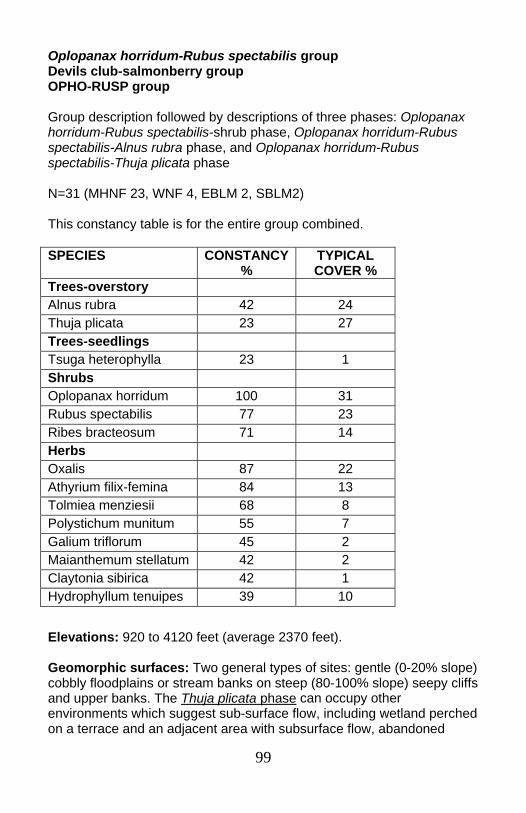
99
Oplopanax horridum-Rubus spectabilis group Devils club-salmonberry group OPHO-RUSP group Group description followed by descriptions of three phases: Oplopanax horridum-Rubus spectabilis-shrub phase, Oplopanax horridum-Rubus spectabilis-Alnus rubra phase, and Oplopanax horridum-Rubus spectabilis-Thuja plicata phase N=31 (MHNF 23, WNF 4, EBLM 2, SBLM2) This constancy table is for the entire group combined.
Elevations: 920 to 4120 feet (average 2370 feet). Geomorphic surfaces: Two general types of sites: gentle (0-20% slope) cobbly floodplains or stream banks on steep (80-100% slope) seepy cliffs and upper banks. The Thuja plicata phase can occupy other environments which suggest sub-surface flow, including wetland perched on a terrace and an adjacent area with subsurface flow, abandoned
SPECIES CONSTANCY %
TYPICAL COVER %
Trees-overstory Alnus rubra 42 24 Thuja plicata 23 27 Trees-seedlings Tsuga heterophylla 23 1 Shrubs Oplopanax horridum 100 31 Rubus spectabilis 77 23 Ribes bracteosum 71 14 Herbs Oxalis 87 22 Athyrium filix-femina 84 13 Tolmiea menziesii 68 8 Polystichum munitum 55 7 Galium triflorum 45 2 Maianthemum stellatum 42 2 Claytonia sibirica 42 1 Hydrophyllum tenuipes 39 10
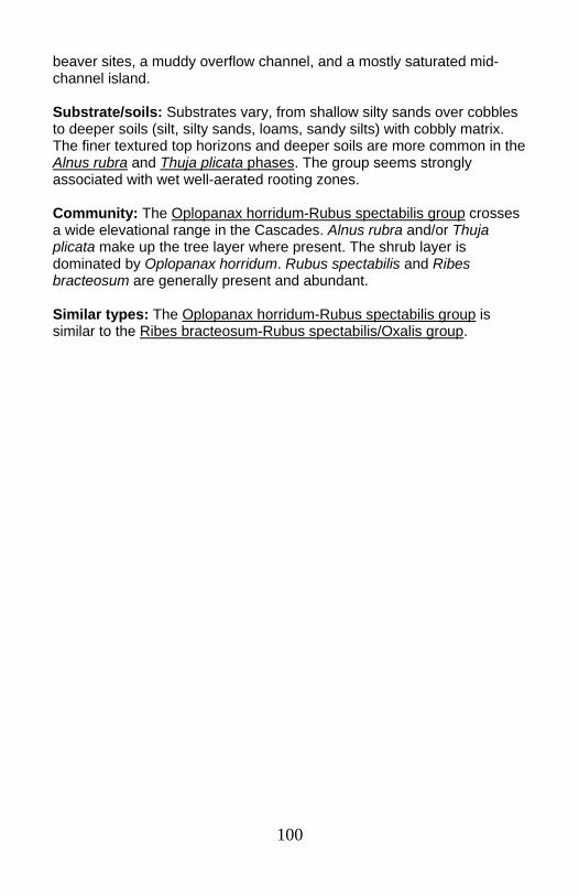
100
beaver sites, a muddy overflow channel, and a mostly saturated mid-channel island. Substrate/soils: Substrates vary, from shallow silty sands over cobbles to deeper soils (silt, silty sands, loams, sandy silts) with cobbly matrix. The finer textured top horizons and deeper soils are more common in the Alnus rubra and Thuja plicata phases. The group seems strongly associated with wet well-aerated rooting zones. Community: The Oplopanax horridum-Rubus spectabilis group crosses a wide elevational range in the Cascades. Alnus rubra and/or Thuja plicata make up the tree layer where present. The shrub layer is dominated by Oplopanax horridum. Rubus spectabilis and Ribes bracteosum are generally present and abundant. Similar types: The Oplopanax horridum-Rubus spectabilis group is similar to the Ribes bracteosum-Rubus spectabilis/Oxalis group.
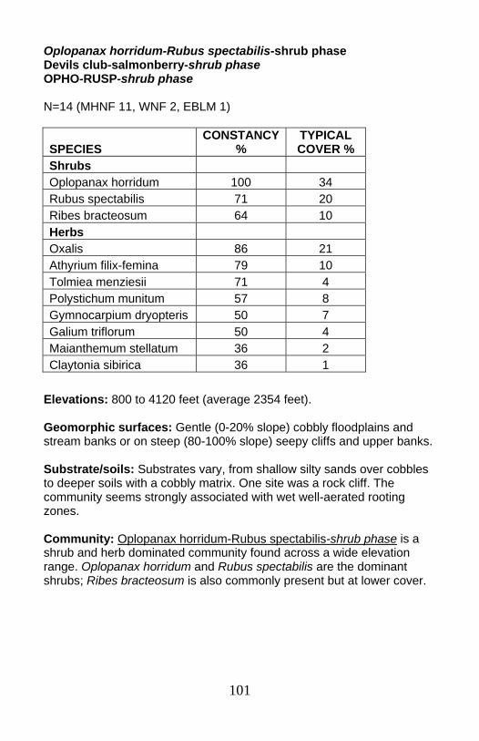
101
Oplopanax horridum-Rubus spectabilis-shrub phase Devils club-salmonberry-shrub phase OPHO-RUSP-shrub phase N=14 (MHNF 11, WNF 2, EBLM 1)
Elevations: 800 to 4120 feet (average 2354 feet). Geomorphic surfaces: Gentle (0-20% slope) cobbly floodplains and stream banks or on steep (80-100% slope) seepy cliffs and upper banks. Substrate/soils: Substrates vary, from shallow silty sands over cobbles to deeper soils with a cobbly matrix. One site was a rock cliff. The community seems strongly associated with wet well-aerated rooting zones. Community: Oplopanax horridum-Rubus spectabilis-shrub phase is a shrub and herb dominated community found across a wide elevation range. Oplopanax horridum and Rubus spectabilis are the dominant shrubs; Ribes bracteosum is also commonly present but at lower cover.
SPECIES CONSTANCY
% TYPICAL COVER %
Shrubs Oplopanax horridum 100 34 Rubus spectabilis 71 20 Ribes bracteosum 64 10 Herbs Oxalis 86 21 Athyrium filix-femina 79 10 Tolmiea menziesii 71 4 Polystichum munitum 57 8 Gymnocarpium dryopteris 50 7 Galium triflorum 50 4 Maianthemum stellatum 36 2 Claytonia sibirica 36 1
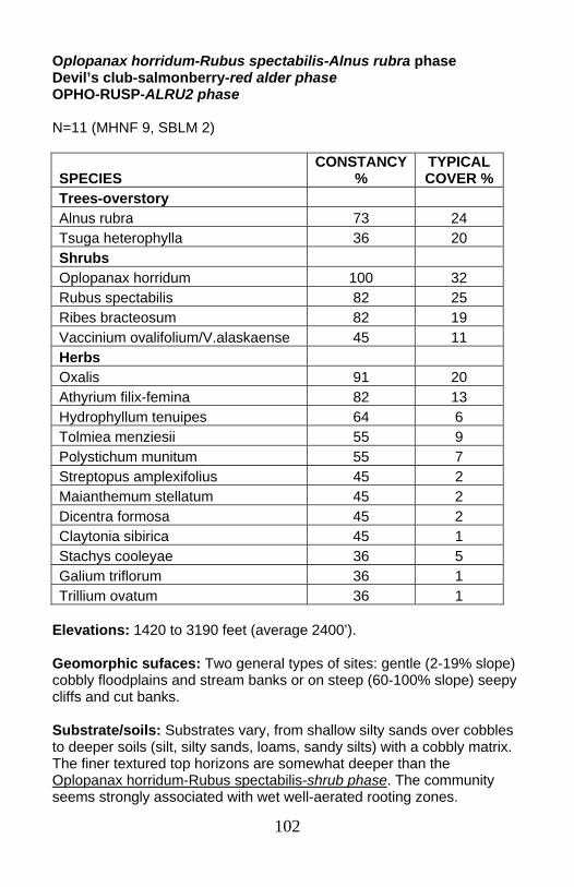
102
Oplopanax horridum-Rubus spectabilis-Alnus rubra phase Devil’s club-salmonberry-red alder phase OPHO-RUSP-ALRU2 phase N=11 (MHNF 9, SBLM 2)
Elevations: 1420 to 3190 feet (average 2400’). Geomorphic sufaces: Two general types of sites: gentle (2-19% slope) cobbly floodplains and stream banks or on steep (60-100% slope) seepy cliffs and cut banks. Substrate/soils: Substrates vary, from shallow silty sands over cobbles to deeper soils (silt, silty sands, loams, sandy silts) with a cobbly matrix. The finer textured top horizons are somewhat deeper than the Oplopanax horridum-Rubus spectabilis-shrub phase. The community seems strongly associated with wet well-aerated rooting zones.
SPECIES CONSTANCY
% TYPICAL COVER %
Trees-overstory Alnus rubra 73 24 Tsuga heterophylla 36 20 Shrubs Oplopanax horridum 100 32 Rubus spectabilis 82 25 Ribes bracteosum 82 19 Vaccinium ovalifolium/V.alaskaense 45 11 Herbs Oxalis 91 20 Athyrium filix-femina 82 13 Hydrophyllum tenuipes 64 6 Tolmiea menziesii 55 9 Polystichum munitum 55 7 Streptopus amplexifolius 45 2 Maianthemum stellatum 45 2 Dicentra formosa 45 2 Claytonia sibirica 45 1 Stachys cooleyae 36 5 Galium triflorum 36 1 Trillium ovatum 36 1
103
Community: Oplopanax horridum-Rubus spectabilis-Alnus rubra phase is a community with a fairly open overstory of Alnus rubra and/or Tsuga heterophylla over a thick shrub layer. The herb layer is somewhat sparser than similar Oplopanax horridum phases. Young Alnus rubra stands were most common, but Tsuga heterophylla up to 110 years were recorded. One low elevation site had a 153 year old Abies grandis present. This suggests that these communities are subject to periodic flooding that can be powerful enough to eliminate the overstory trees. However, for some sites, intervals between flooding may be long enough for conifer establishment and growth to sizes which may allow the trees to survive less severe flood events. Similar types: This community could be considered a phase of the Ribes bracteosum-Rubus spectabilis/Oxalis group, but it occurs with species combinations common in higher elevation communities, including Vaccinium ovalifolium, Maianthemum stellatum and Steptopus amplexifolius.
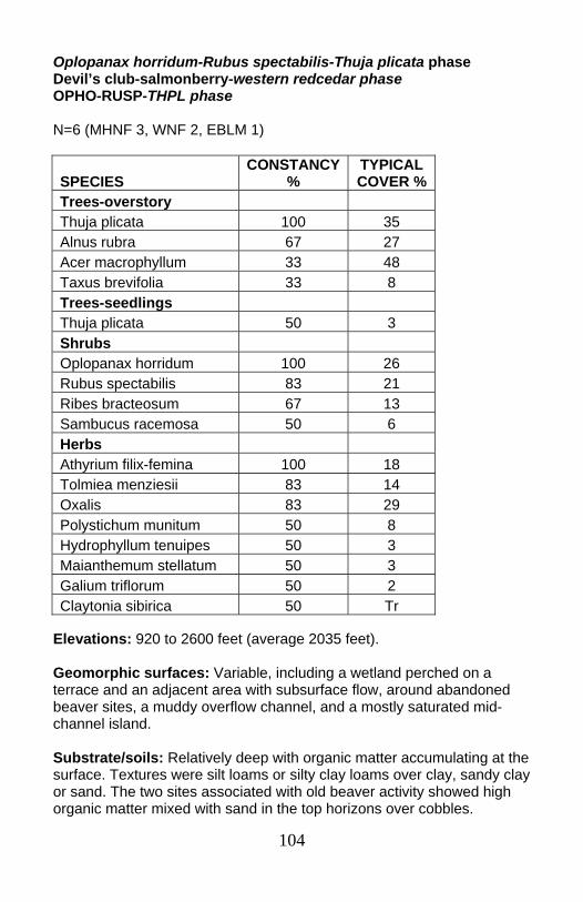
104
Oplopanax horridum-Rubus spectabilis-Thuja plicata phase Devil’s club-salmonberry-western redcedar phase OPHO-RUSP-THPL phase N=6 (MHNF 3, WNF 2, EBLM 1)
Elevations: 920 to 2600 feet (average 2035 feet). Geomorphic surfaces: Variable, including a wetland perched on a terrace and an adjacent area with subsurface flow, around abandoned beaver sites, a muddy overflow channel, and a mostly saturated mid-channel island. Substrate/soils: Relatively deep with organic matter accumulating at the surface. Textures were silt loams or silty clay loams over clay, sandy clay or sand. The two sites associated with old beaver activity showed high organic matter mixed with sand in the top horizons over cobbles.
SPECIES CONSTANCY
% TYPICAL COVER %
Trees-overstory Thuja plicata 100 35 Alnus rubra 67 27 Acer macrophyllum 33 48 Taxus brevifolia 33 8 Trees-seedlings Thuja plicata 50 3 Shrubs Oplopanax horridum 100 26 Rubus spectabilis 83 21 Ribes bracteosum 67 13 Sambucus racemosa 50 6 Herbs Athyrium filix-femina 100 18 Tolmiea menziesii 83 14 Oxalis 83 29 Polystichum munitum 50 8 Hydrophyllum tenuipes 50 3 Maianthemum stellatum 50 3 Galium triflorum 50 2 Claytonia sibirica 50 Tr
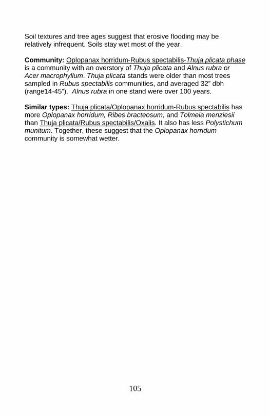
105
Soil textures and tree ages suggest that erosive flooding may be relatively infrequent. Soils stay wet most of the year. Community: Oplopanax horridum-Rubus spectabilis-Thuja plicata phase is a community with an overstory of Thuja plicata and Alnus rubra or Acer macrophyllum. Thuja plicata stands were older than most trees sampled in Rubus spectabilis communities, and averaged 32” dbh (range14-45”). Alnus rubra in one stand were over 100 years. Similar types: Thuja plicata/Oplopanax horridum-Rubus spectabilis has more Oplopanax horridum, Ribes bracteosum, and Tolmeia menziesii than Thuja plicata/Rubus spectabilis/Oxalis. It also has less Polystichum munitum. Together, these suggest that the Oplopanax horridum community is somewhat wetter.
106
Picea engelmannii/Vaccinium membranaceum Engelmann spruce/big huckleberry PIEN/VAME N=3 (WNF 3)
Elevations: 4720 to 4880 feet (average 4805 feet). Geomorphic surfaces: Banks, cobble/boulder bars, and overflow channels, often along intermittent channels
SPECIES CONSTANCY
% TYPICAL COVER %
Trees-overstory Picea engelmannii 100 20 Tsuga mertensiana 67 8 Abies lasiocarpa 67 4 Trees-seedlings Abies lasiocarpa 100 3 Tsuga mertensiana 67 1 Shrubs Vaccinium membranaceum 100 18 Ribes 100 9 Rubus pedatus 67 3 Herbs Achlys triphylla 100 5 Clintonia uniflora 100 4 Valeriana sitchensis 100 2 Orthilia secunda 100 1 Trillium ovatum 100 Tr Tiarella trifoliata 67 3 Mitella breweri 67 3 Athyrium filix-femina 67 3 Viola glabella 67 2 Viola 67 2 Senecio triangularis 67 1 Trisetum cernuum 67 1 Xerophyllum tenax 67 1 Anemone deltoidea 67 1
107
Substrate/soils: No soils data are available for these sites. Community: Picea engelmannii/Vaccinium membranaceum is a community sampled in the high elevation Mink Lake Basin in the Willamette NF’s Three Sisters Wilderness area. Adjacent stands for all three sites are in the Mountain hemlock/Vaccinium membranaceum/ beargrass plant association. Trees may be rooted in the plots or may overhang the banks and bars. The shrub layer is fairly sparse. The herb layer has species common to the mesic Mountain hemlock/big leaf huckleberry/queencup beadlily upland plant association, including Achlys triphylla, Clintonia uniflora, Valeriana sitchensis, and Orthilia secunda. However, it also includes low cover of more riparian species such as Mitella brewerii and Athyrium filix-femina, as well as Picea engelmannii. Trees noted on one plot were saplings and poles. These surfaces may be flooded during high winter flow.

108
Vaccinium ovalifolium-Rubus spectabilis/Lysichiton americanum Oval-leaved huckleberry-salmonberry/skunk cabbage VAOV-RUSP/LYAM3 N=9 (MHNF 9)
Elevations: 3000 to 4130 feet (average 3725 feet). Geomorphic surfaces: Inactive side channels or other sites where subsurface flow was noted. One site was in a wetland associated with a lake. Plots averaged less than 5% slope. Most samples are on Lowe Creek, Clackamas Ranger District, Mt. Hood NF.
Species Constancy
% TYPICAL COVER %
Trees-overstory Alnus rubra 33 48 Trees-seedlings Alnus rubra 33 9 Abies amabilis 33 2 Shrubs Rubus spectabilis 100 10 Vaccinium ovalifolium 89 20 Ribes bracteosum 56 12 Ribes lacustre 44 3 Alnus incana 33 27 Viburnum edule 33 7 Menziesia ferruginea 33 5 Lonicera involucrata 33 4 Herbs Lysichiton americanum 100 8 Tiarella trifoliata var. unifoliata 67 3 Gymnocarpium dryopteris 56 7 Achlys triphylla 56 4 Athyrium filix-femina 56 4 Streptopus lanceolatus var. curvipes 56 4 Streptopus amplexifolius 56 3 Boykinia major 44 12 Cornus unalaschkensis 44 4
109
Substrate/soils: Water tables were encountered in all soil pits at depths from 2-65 cm (average 36 cm). Mottles at 10-30 cm were found in a third of the pits. Several sites had muck layers over sandy horizons. Most were relatively deep soils (average 78 cm), with silty sands, sands, or silts over gravels or cobbles. Sandy horizons often overlay horizons of silt or sandy silt. Community: Vaccinium ovalifolium-Rubus spectabilis/Lysichiton americanum is a higher elevation forested swamp community generally found in the silver fir zone. It is a shrub dominated type that can occur under an Alnus rubra canopy (average 19 foot canopy height). Alnus rubra stands ranged from seedlings/sapling stages to older patches with ages up to115 years old. One site had Picea engelmannii in the overstory. These sites are too poorly drained for many conifer species. Many of the surfaces are clearly subject to frequent flooding as well.
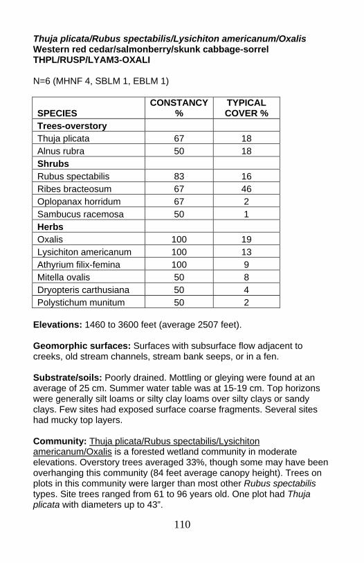
110
Thuja plicata/Rubus spectabilis/Lysichiton americanum/Oxalis Western red cedar/salmonberry/skunk cabbage-sorrel THPL/RUSP/LYAM3-OXALI N=6 (MHNF 4, SBLM 1, EBLM 1)
Elevations: 1460 to 3600 feet (average 2507 feet). Geomorphic surfaces: Surfaces with subsurface flow adjacent to creeks, old stream channels, stream bank seeps, or in a fen. Substrate/soils: Poorly drained. Mottling or gleying were found at an average of 25 cm. Summer water table was at 15-19 cm. Top horizons were generally silt loams or silty clay loams over silty clays or sandy clays. Few sites had exposed surface coarse fragments. Several sites had mucky top layers. Community: Thuja plicata/Rubus spectabilis/Lysichiton americanum/Oxalis is a forested wetland community in moderate elevations. Overstory trees averaged 33%, though some may have been overhanging this community (84 feet average canopy height). Trees on plots in this community were larger than most other Rubus spectabilis types. Site trees ranged from 61 to 96 years old. One plot had Thuja plicata with diameters up to 43”.
SPECIES CONSTANCY
% TYPICAL COVER %
Trees-overstory Thuja plicata 67 18 Alnus rubra 50 18 Shrubs Rubus spectabilis 83 16 Ribes bracteosum 67 46 Oplopanax horridum 67 2 Sambucus racemosa 50 1 Herbs Oxalis 100 19 Lysichiton americanum 100 13 Athyrium filix-femina 100 9 Mitella ovalis 50 8 Dryopteris carthusiana 50 4 Polystichum munitum 50 2

111
Poorly drained soils limit this community to species which can be successful with high water tables and occasional flooding, such as Thuja plicata and Lysichiton americanum.
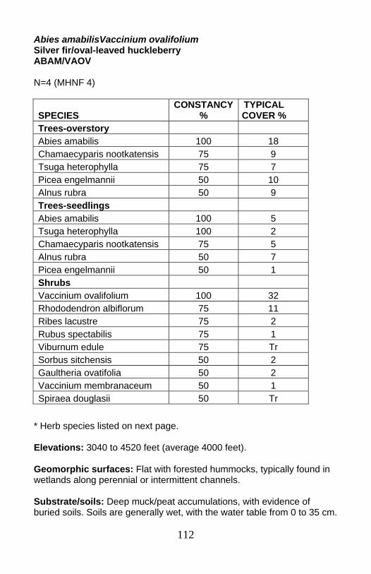
112
Abies amabilisVaccinium ovalifolium Silver fir/oval-leaved huckleberry ABAM/VAOV N=4 (MHNF 4)
* Herb species listed on next page. Elevations: 3040 to 4520 feet (average 4000 feet). Geomorphic surfaces: Flat with forested hummocks, typically found in wetlands along perennial or intermittent channels. Substrate/soils: Deep muck/peat accumulations, with evidence of buried soils. Soils are generally wet, with the water table from 0 to 35 cm.
SPECIES CONSTANCY
% TYPICAL COVER %
Trees-overstory Abies amabilis 100 18 Chamaecyparis nootkatensis 75 9 Tsuga heterophylla 75 7 Picea engelmannii 50 10 Alnus rubra 50 9 Trees-seedlings Abies amabilis 100 5 Tsuga heterophylla 100 2 Chamaecyparis nootkatensis 75 5 Alnus rubra 50 7 Picea engelmannii 50 1 Shrubs Vaccinium ovalifolium 100 32 Rhododendron albiflorum 75 11 Ribes lacustre 75 2 Rubus spectabilis 75 1 Viburnum edule 75 Tr Sorbus sitchensis 50 2 Gaultheria ovatifolia 50 2 Vaccinium membranaceum 50 1 Spiraea douglasii 50 Tr
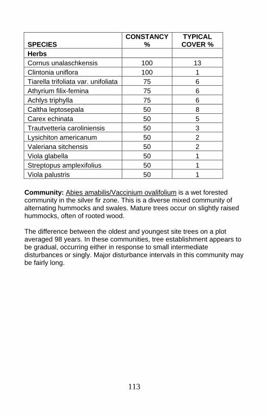
113
Community: Abies amabilis/Vaccinium ovalifolium is a wet forested community in the silver fir zone. This is a diverse mixed community of alternating hummocks and swales. Mature trees occur on slightly raised hummocks, often of rooted wood. The difference between the oldest and youngest site trees on a plot averaged 98 years. In these communities, tree establishment appears to be gradual, occurring either in response to small intermediate disturbances or singly. Major disturbance intervals in this community may be fairly long.
SPECIES CONSTANCY
% TYPICAL COVER %
Herbs Cornus unalaschkensis 100 13 Clintonia uniflora 100 1 Tiarella trifoliata var. unifoliata 75 6 Athyrium filix-femina 75 6 Achlys triphylla 75 6 Caltha leptosepala 50 8 Carex echinata 50 5 Trautvetteria caroliniensis 50 3 Lysichiton americanum 50 2 Valeriana sitchensis 50 2 Viola glabella 50 1 Streptopus amplexifolius 50 1 Viola palustris 50 1
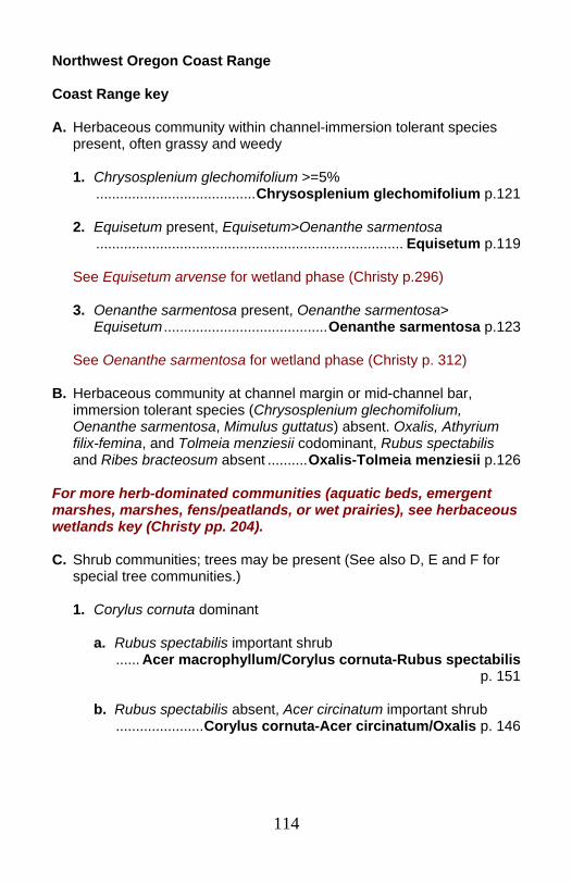
114
Northwest Oregon Coast Range Coast Range key A. Herbaceous community within channel-immersion tolerant species
present, often grassy and weedy 1. Chrysosplenium glechomifolium >=5% ........................................Chrysosplenium glechomifolium p.121
2. Equisetum present, Equisetum>Oenanthe sarmentosa ............................................................................. Equisetum p.119 See Equisetum arvense for wetland phase (Christy p.296) 3. Oenanthe sarmentosa present, Oenanthe sarmentosa> Equisetum .........................................Oenanthe sarmentosa p.123 See Oenanthe sarmentosa for wetland phase (Christy p. 312) B. Herbaceous community at channel margin or mid-channel bar, immersion tolerant species (Chrysosplenium glechomifolium,
Oenanthe sarmentosa, Mimulus guttatus) absent. Oxalis, Athyrium filix-femina, and Tolmeia menziesii codominant, Rubus spectabilis and Ribes bracteosum absent ..........Oxalis-Tolmeia menziesii p.126
For more herb-dominated communities (aquatic beds, emergent marshes, marshes, fens/peatlands, or wet prairies), see herbaceous wetlands key (Christy pp. 204). C. Shrub communities; trees may be present (See also D, E and F for
special tree communities.) 1. Corylus cornuta dominant
a. Rubus spectabilis important shrub ...... Acer macrophyllum/Corylus cornuta-Rubus spectabilis
p. 151
b. Rubus spectabilis absent, Acer circinatum important shrub ......................Corylus cornuta-Acer circinatum/Oxalis p. 146

115
2. Rubus spectabilis and/or Ribes bracteosum >5% or dominant shrubs
a. Ribes bracteosum an important shrub
1) Oplopanax horridum dominant or co-dominant, Rubus
spectabilis minor or absent .................Oplopanax horridum-Ribes bracteosum p. 137
2) Immersion tolerant species Chrysosplenium glechomifolium
and/or Oenanthe sarmentosa present, at channel margin ...Rubus spectabilis-Ribes bracteosum/Chrysosplenium
glechomifolium p. 128
3) Immersion tolerant species absent ..........Rubus spectabilis-Ribes bracteosum group p. 131
a) Tiarella trifoliata > sum of Stachys, Claytonia sibirica and
Mimulus dentatus, or sum of the 3 <5% ............ Rubus spectabilis-Ribes bracteosum-Tiarella
trifoliata phase p. 135
b) Sum of Stachys, Claytonia sibirica and Mimulus dentatus >5%
........... Rubus spectabilis-Ribes bracteosum-Stachys phase p. 133
b. Rubus spectabilis>5%, Ribes bracteosum minor or absent
1) Vaccinium alaskaense dominant .............. Vaccinium alaskaense-Rubus spectabilis p. 150
2) Corylus cornuta dominant or codominant with Rubus
spectabilis .....................Acer macrophyllum/Corylus cornuta-Rubus
spectabilis p. 151
3) Sum of Athyrium filix-femina and Tolmeia menziesii> Polystichum munitum
..........Rubus spectabilis/Tolmeia menziesii-Oxalis group p. 139
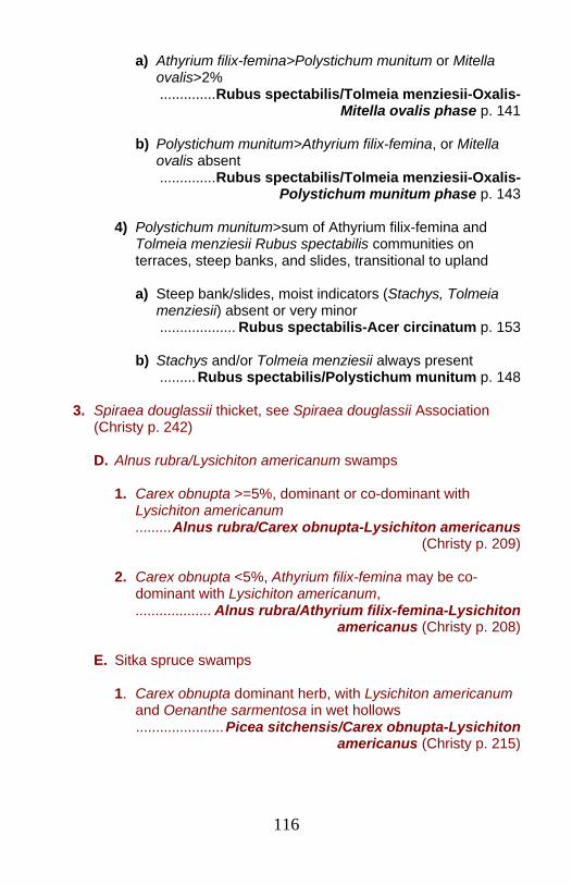
116
a) Athyrium filix-femina>Polystichum munitum or Mitella ovalis>2%
..............Rubus spectabilis/Tolmeia menziesii-Oxalis- Mitella ovalis phase p. 141
b) Polystichum munitum>Athyrium filix-femina, or Mitella
ovalis absent ..............Rubus spectabilis/Tolmeia menziesii-Oxalis-
Polystichum munitum phase p. 143
4) Polystichum munitum>sum of Athyrium filix-femina and Tolmeia menziesii Rubus spectabilis communities on terraces, steep banks, and slides, transitional to upland
a) Steep bank/slides, moist indicators (Stachys, Tolmeia
menziesii) absent or very minor ................... Rubus spectabilis-Acer circinatum p. 153
b) Stachys and/or Tolmeia menziesii always present .........Rubus spectabilis/Polystichum munitum p. 148
3. Spiraea douglassii thicket, see Spiraea douglassii Association
(Christy p. 242)
D. Alnus rubra/Lysichiton americanum swamps
1. Carex obnupta >=5%, dominant or co-dominant with Lysichiton americanum
.........Alnus rubra/Carex obnupta-Lysichiton americanus (Christy p. 209)
2. Carex obnupta <5%, Athyrium filix-femina may be co-
dominant with Lysichiton americanum, ................... Alnus rubra/Athyrium filix-femina-Lysichiton
americanus (Christy p. 208)
E. Sitka spruce swamps
1. Carex obnupta dominant herb, with Lysichiton americanum and Oenanthe sarmentosa in wet hollows
......................Picea sitchensis/Carex obnupta-Lysichiton americanus (Christy p. 215)

117
2. Lysichiton americanum swamp, Carex obnupta minor or absent, Cornus sericea dominant shrub
..................... Picea sitchensis/Cornus sericea/Lysichiton americanus (Christy p. 216)
F. Willow communities
1. Salix lucida co-dominant with Salix sitchensis, Lysichiton
americanum swamp .........Salix lucida ssp. lasiandra/Salix sitchensis/Lysichiton
americanus (Christy p. 240)
2. Salix lucida minor or absent, Salix sitchensis dominant, with Lysichiton americanum and/or Carex aquatalis var. dives the dominant herbs....... Salix sitchensis complex (Christy p. 241)
For more shrub-dominated communities (shrub swamps), see shrubland wetlands key (Christy p. 200). For more tree-dominated communities (forested swamps), see forest and woodlands wetlands key (Christy p. 198).
118
In channel: Equisetum: EQUIS ............................................................................p. 119 Chrysosplenium glechomifolium: CHGL5 .........................................p. 121 Oenanthe sarmentosa: OESA...........................................................p. 123
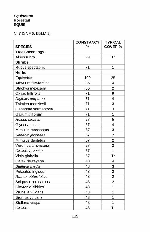
119
Equisetum Horsetail EQUIS N=7 (SNF 6, EBLM 1)
SPECIES CONSTANCY
% TYPICAL COVER %
Trees-seedlings Alnus rubra 29 Tr Shrubs Rubus spectabilis 71 1 Herbs Equisetum 100 28 Athyrium filix-femina 86 4 Stachys mexicana 86 2 Oxalis trilliifolia 71 9 Digitalis purpurea 71 4 Tolmiea menziesii 71 3 Oenanthe sarmentosa 71 3 Galium triflorum 71 1 Holcus lanatus 57 5 Glyceria striata 57 4 Mimulus moschatus 57 3 Senecio jacobaea 57 2 Mimulus dentatus 57 2 Veronica americana 57 2 Cirsium arvense 57 1 Viola glabella 57 Tr Carex deweyana 43 4 Stellaria media 43 3 Petasites frigidus 43 2 Rumex obtusifolius 43 2 Scirpus microcarpus 43 2 Claytonia sibirica 43 1 Prunella vulgaris 43 1 Bromus vulgaris 43 1 Stellaria crispa 43 1 Cirsium 43 Tr
120
Elevations: 30 to 600 feet (average 280 feet). Geomorphic surfaces: Gently sloping sandy gravel/cobble bars within annual flood zone in wide valleys (>100m). Summer low flow is generally within 20 cm. A second setting occurs with beaver dams. These sites are flooded much of the winter. Substrate/soils: Depositional bar sites have pockets or thin layers of sand overlaying coarser alluvium. Beaver dam sites can have fairly deep poorly drained soil. One pit had a water table within 10 cm of the surface and mottling at 36cm, soil textures silt over silt loam. Another site had coarse sand deposited over fine sand, overlying sandy clay, and clay. Community: The Equisetum community is a weedy, grassy community with almost no shrub layer and very low overhanging tree cover. Alnus rubra seedlings may be present, but no mature trees are found. Grasses average 27% summed cover; graminoids (sedges, bulrushes) 4% cover. Weeds such as Phalaris arundinacea can completely dominate this open, frequently disturbed community. Both settings provide good seedbeds for opportunistic weedy species and species tolerant of flooding.
Juncus 43 Tr Chrysosplenium glechomifolium 43 Tr Polystichum munitum 43 Tr Cardamine occidentalis 43 Tr

121
Chrysosplenium glechomaefolium Water-carpet CHGL5 N=7 (SNF 5, SBLM 2)
Elevations: 30 to 1440 feet (average 315 feet). Geomorphic surfaces: Often directly adjacent to the channel, in overflow channels, or in a swamp. Most sites are at or just above summer low flow.
SPECIES CONSTANCY
% TYPICAL COVER %
Shrubs Rubus spectabilis 86 16 Sambucus racemosa 57 16 Herbs Chrysosplenium glechomifolium 100 25 Athyrium filix-femina 100 7 Oxalis 86 18 Tolmiea menziesii 86 13 Oenanthe sarmentosa 71 9 Stachys mexicana 71 4 Mitella ovalis 57 11 Claytonia sibirica 57 10 Poa trivialis 43 54 Urtica dioica ssp. gracilis 43 9 Polystichum munitum 43 6 Mitella caulescens 43 3 Glyceria striata 43 3 Blechnum spicant 43 2 Equisetum 43 2 Bromus vulgaris 43 2 Stellaria crispa 43 2 Mimulus dentatus 43 1 Digitalis purpurea 43 Tr
122
Substrate/soils: Generally on gravel or cobble substrates. Sandy loams over sands, or sandy clay loams over sandy clays over coarse alluvium. Rooting depth is limited by water or anaerobic conditions near the surface. Community: Chrysosplenium glechomifolium is an herbaceous community occurring on surfaces that are inundated much of the year. Flood tolerant indicators include Chrysosplenium glechomifolium, Oenanthe sarmentosa, and Ranunculus repens var. repens. Rubus spectabilis and Sambucus racemosa can occur in this community, but often provide overhanging cover only. This open, frequently disturbed community has the highest typical cover in grasses of all streamside types in northwest Oregon. It can also be extremely weedy. Poa trivialis and Ranunculus repens var. repens can be dominants on some plots. Giant knotweeds (Polygonum cuspidatum , P. sachalinense, P. polystachyum) can also invade this community. These sites are too frequently disturbed and under water too long to develop a stable tree and shrub component.
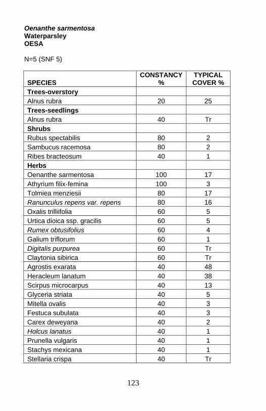
123
Oenanthe sarmentosa Waterparsley OESA N=5 (SNF 5)
SPECIES CONSTANCY
% TYPICAL COVER %
Trees-overstory Alnus rubra 20 25 Trees-seedlings Alnus rubra 40 Tr Shrubs Rubus spectabilis 80 2 Sambucus racemosa 80 2 Ribes bracteosum 40 1 Herbs Oenanthe sarmentosa 100 17 Athyrium filix-femina 100 3 Tolmiea menziesii 80 17 Ranunculus repens var. repens 80 16 Oxalis trilliifolia 60 5 Urtica dioica ssp. gracilis 60 5 Rumex obtusifolius 60 4 Galium triflorum 60 1 Digitalis purpurea 60 Tr Claytonia sibirica 60 Tr Agrostis exarata 40 48 Heracleum lanatum 40 38 Scirpus microcarpus 40 13 Glyceria striata 40 5 Mitella ovalis 40 3 Festuca subulata 40 3 Carex deweyana 40 2 Holcus lanatus 40 1 Prunella vulgaris 40 1 Stachys mexicana 40 1 Stellaria crispa 40 Tr
124
Elevations: 30 to 420 feet (average 225 feet). Geomorphic surfaces: Annually flooded sandy bars and islands, or bedrock channel margins. Substrate/soils: Sands to loamy sands or silt loams in cobbles and boulders, saturated, anaerobic conditions in the lower profile, with summer water tables within 45 to 60 cm of the surface. Community: Oenanthe sarmentosa is an herb dominated community, though Rubus spectabilis and Sambucus racemosa are frequently present at very low cover. Grasses, graminoids, and exotic species are prominent in this open, frequently disturbed type. Grasses average 38% summed cover. Graminoids (sedges, bulrushes) average 18% summed cover. Exotic species are present on every plot, averaging 38% cover. These surfaces are flooded much of the winter. Disturbance and rooting conditions prevent succession to stable conifer stands. Risk of invasion by aggressive exotic species is high. The Oenanthe sarmentosa community can be adjacent to the channel, or it can occur above the Equisetum or Chrysosplenium glechomifolium types.
125
Mid-channel bars or channel margin: Oxalis-Tolmeia menziesii, OXALI-TOME..........................................p. 126 Rubus spectabilis-Ribes bracteosum/Chrysosplenium glechomifolium, RUSP-RIBR/CHGL5 ...............................................p. 128

126
Oxalis-Tolmeia menziesii Sorrel-piggyback plant OXALI-TOME N=13 (EBLM 6, SBLM 4, SNF 3)
Elevations: 100 to 915 feet (average 650 feet). Geomorphic surfaces: Narrow active annual floodplains and steep stream banks. Substrate/soils: Generally fairly shallow, with mottling and/or gleying within 50 cm. Water tables are often within 50 cm. O layers are well developed. A horizons are silt loams or sandy loams. B horizons are sandy clay loams, silty clay loams, or silty sands. Gleyed horizons can be perched above bedrock or cobble/gravel creekbed material. Multiple B horizons in some soil pits are evidence of repeated floods resetting the surfaces. These active floodplains have well developed soils, but rooting conditions are affected by the shallow water table. The geomorphic surfaces are flooded annually.
SPECIES CONSTANCY
% TYPICAL COVER %
Shrubs Vaccinium parvifolium 46 9 Herbs Oxalis 100 32 Athyrium filix-femina 100 17 Tolmiea menziesii 100 16 Polystichum munitum 77 14 Stachys 62 14 Mitella ovalis 54 13 Adiantum pedatum 54 7 Galium triflorum 54 4 Stellaria crispa 54 2 Claytonia sibirica 46 4 Tiarella trifoliata 38 12 unknown grass 38 8 Circaea alpina 38 5
127
Community: Oxalis-Tolmeia menziesii is an herbaceous community of low to moderate elevations across the Coast Range. Overhanging deciduous tree canopy is common, although only one plot had an Alnus rubra seedling (15 years old). The shrub layer is generally minor. This community lacks the species such as Oenanthe sarmentosa or Chrysosplenium glechomifolium which are well adapted to depositional bars frequently under prolonged flooding. The community also had a much lower percentage of grasses and weeds than the in-channel herbaceous communities.
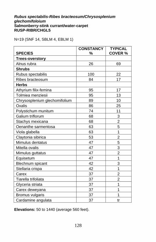
128
Rubus spectabilis-Ribes bracteosum/Chrysosplenium glechomifoloium Salmonberry-stink currant/water-carpet RUSP-RIBR/CHGL5 N=19 (SNF 14, SBLM 4, EBLM 1)
Elevations: 50 to 1440 (average 560 feet).
SPECIES CONSTANCY
% TYPICAL COVER %
Trees-overstory Alnus rubra 26 69 Shrubs Rubus spectabilis 100 22 Ribes bracteosum 84 17 Herbs Athyrium filix-femina 95 17 Tolmiea menziesii 95 13 Chrysosplenium glechomifolium 89 10 Oxalis 86 25 Polystichum munitum 74 11 Galium triflorum 68 3 Stachys mexicana 68 2 Oenanthe sarmentosa 63 5 Viola glabella 63 1 Claytonia sibirica 53 2 Mimulus dentatus 47 5 Mitella ovalis 47 3 Mimulus guttatus 47 2 Equisetum 47 1 Blechnum spicant 42 3 Stellaria crispa 42 1 Carex 37 2 Tiarella trifoliata 37 2 Glyceria striata 37 1 Carex deweyana 37 1 Bromus vulgaris 37 1 Cardamine angulata 37 tr
129
Geomorphic surfaces: Mid-channel bars, annual floodplains and stream banks. These sites are flooded much of the winter. Some surfaces were bisected by active or overflow channels. Substrate/soils: Seepy silt-covered bedrock floodplains or gravel-, cobble-, and boulder-bars. Soils varied. The community generally occurs where water is within 70 cm. Annual floodplain plots had sandy loams or loamy sands with mottles or gleying within 60 cm overlaying coarse alluvium or bedrock. Depositional bars had shallow sand layers over cobbles. Sites are most often directly adjacent to the channel. Occasionally, the Equisetum or Chrysosplenium glechomifolium communities can be found between the channel and the Rubus spectabilis-Ribes bracteosum/Chrysosplenium glechomifolium community. Community: The Rubus spectabilis-Ribes bracteosum/Chrysosplenium glechomifolium community is a mid-channel bar or channel-margin type. Overstory Alnus rubra, Acer macrophyllum, and Picea engelmannii 5 to 45 years old, are found on a few plots. Some members of a suite of flood-tolerant indicators are always present, including Chrysosplenium glechomifolium, Oenanthe sarmentosa, Mimulus guttatus, and Scirpus microcarpus. Where trees are present, shrub covers are higher and Polystichum munitum more common. Where trees are absent, Petasites frigidus tends to occur more often.
130
Active channel shelf/active floodplain/first floodplains Rubus spectabilis-Ribes bracteosum group: RUSP-RIBR GROUP .p. 131 ○ Rubus spectabilis-Ribes bracteosum-Stachys phase: RUSP-RIBR-STACH phase .........................................................p. 133 ○ Rubus spectabilis-Ribes bracteosum-Tiarella trifoliata phase: RUSP-RIBR-TITR phase .............................................................p. 135 Oplopanax horridum-Ribes bracteosum: OPHO-RIBR.....................p. 137 Rubus spectabilis/Tolmeia menziesii-Oxalis group: RUSP/TOME-OXALI GROUP...........................................................p. 139 ○ Rubus spectabilis/Tolmeia menziesii-Oxalis-Mitella ovalis phase: RUSP/TOME-OXALI-MIOV phase ..............................................p. 141 ○ Rubus spectabilis/Tolmeia menziesii-Oxalis-Polystichum munitum phase: RUSP/TOME-OXALI-POMU phase ..................p. 143
131
Rubus spectabilis-Ribes bracteosum group Salmonberry-stink currant group RUSP-RIBR group Group description followed by descriptions of two phases: Rubus spectabilis-Ribes bracteosum-Stachys phase and Rubus spectabilis-Ribes bracteosum-Tiarella trifoliata phase. N=28 (SBLM 14, EBLM 8, SNF 6) This constancy table is for the entire group combined. The individual phases are then presented separately.
Geomorphic surfaces: Active annual floodplains and cutbanks. Summer water tables are below 50 cm.
SPECIES CONSTANCY
% TYPICAL COVER %
Trees-overstory Alnus rubra 36 40 Shrubs Ribes bracteosum 100 23 Rubus spectabilis 96 48 Acer circinatum 39 15 Sambucus racemosa 36 15 Herbs Oxalis 89 22 Athyrium filix-femina 89 10 Tolmiea menziesii 86 18 Polystichum munitum 79 15 Galium triflorum 61 5 Stachys 57 17 Stellaria crispa 46 1 Mimulus dentatus 43 5 Adiantum pedatum 43 3 Claytonia sibirica 43 3 Tiarella trifoliata 36 12 Mitella caulescens 36 9 Circaea alpina 36 5
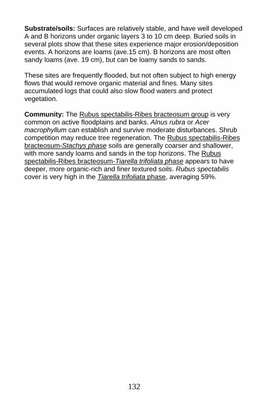
132
Substrate/soils: Surfaces are relatively stable, and have well developed A and B horizons under organic layers 3 to 10 cm deep. Buried soils in several plots show that these sites experience major erosion/deposition events. A horizons are loams (ave.15 cm). B horizons are most often sandy loams (ave. 19 cm), but can be loamy sands to sands. These sites are frequently flooded, but not often subject to high energy flows that would remove organic material and fines. Many sites accumulated logs that could also slow flood waters and protect vegetation. Community: The Rubus spectabilis-Ribes bracteosum group is very common on active floodplains and banks. Alnus rubra or Acer macrophyllum can establish and survive moderate disturbances. Shrub competition may reduce tree regeneration. The Rubus spectabilis-Ribes bracteosum-Stachys phase soils are generally coarser and shallower, with more sandy loams and sands in the top horizons. The Rubus spectabilis-Ribes bracteosum-Tiarella trifoliata phase appears to have deeper, more organic-rich and finer textured soils. Rubus spectabilis cover is very high in the Tiarella trifoliata phase, averaging 59%.
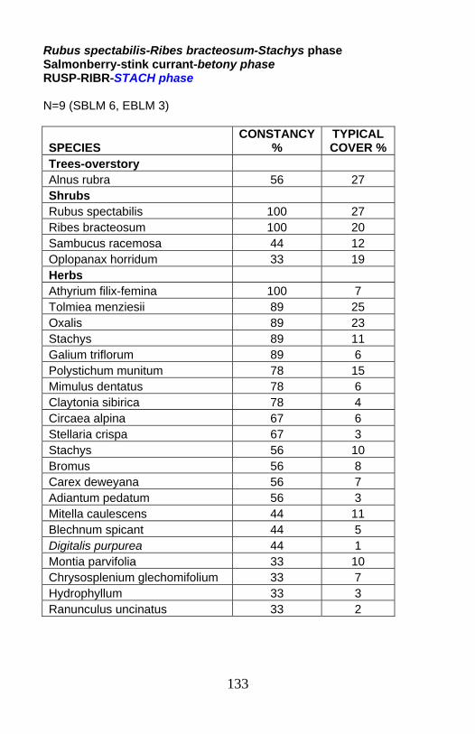
133
Rubus spectabilis-Ribes bracteosum-Stachys phase Salmonberry-stink currant-betony phase RUSP-RIBR-STACH phase N=9 (SBLM 6, EBLM 3)
SPECIES CONSTANCY
% TYPICAL COVER %
Trees-overstory Alnus rubra 56 27 Shrubs Rubus spectabilis 100 27 Ribes bracteosum 100 20 Sambucus racemosa 44 12 Oplopanax horridum 33 19 Herbs Athyrium filix-femina 100 7 Tolmiea menziesii 89 25 Oxalis 89 23 Stachys 89 11 Galium triflorum 89 6 Polystichum munitum 78 15 Mimulus dentatus 78 6 Claytonia sibirica 78 4 Circaea alpina 67 6 Stellaria crispa 67 3 Stachys 56 10 Bromus 56 8 Carex deweyana 56 7 Adiantum pedatum 56 3 Mitella caulescens 44 11 Blechnum spicant 44 5 Digitalis purpurea 44 1 Montia parvifolia 33 10 Chrysosplenium glechomifolium 33 7 Hydrophyllum 33 3 Ranunculus uncinatus 33 2
134
SPECIES CONSTANCY
% TYPICAL COVER %
unknown grass 33 2 Cardamine angulata 33 1 Dicentra formosa 33 1
Elevations: 320 to 1390feet (average 780 feet). Geomorphic surfaces: Bars, islands, or active floodplains within normal high water line. Some plots were on steep cutbanks with shallow soils. Substrate/soils: Soils tend to be somewhat coarser and shallower than the average for the group, with more sandy loams and sands in the top horizons. A horizons average 11 cm, and B horizons average 14 cm. Community: Rubus spectabilis-Ribes bracteosum-Stachys phase is shrub dominated, with a rich herb layer. Within the Rubus spectabilis-Ribes bracteosum group, the Rubus spectabilis-Ribes bracteosum-Stachys phase has more consistent Stachys, Claytonia sibirica, and Mimulus dentatus. Average Rubus spectabilis cover in the Stachys phase is less than half the average cover in the Tiarella trifoliata phase. Alnus rubra and Acer macrophyllum can establish and persist in this community. Deciduous tree ages ranged from 10 to 105 years. No overstory conifers were recorded.
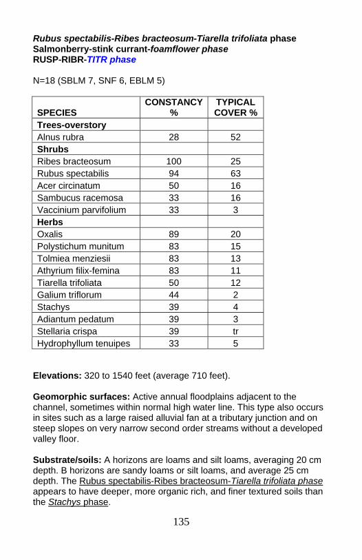
135
Rubus spectabilis-Ribes bracteosum-Tiarella trifoliata phase Salmonberry-stink currant-foamflower phase RUSP-RIBR-TITR phase N=18 (SBLM 7, SNF 6, EBLM 5)
Elevations: 320 to 1540 feet (average 710 feet). Geomorphic surfaces: Active annual floodplains adjacent to the channel, sometimes within normal high water line. This type also occurs in sites such as a large raised alluvial fan at a tributary junction and on steep slopes on very narrow second order streams without a developed valley floor. Substrate/soils: A horizons are loams and silt loams, averaging 20 cm depth. B horizons are sandy loams or silt loams, and average 25 cm depth. The Rubus spectabilis-Ribes bracteosum-Tiarella trifoliata phase appears to have deeper, more organic rich, and finer textured soils than the Stachys phase.
SPECIES CONSTANCY
% TYPICAL COVER %
Trees-overstory Alnus rubra 28 52 Shrubs Ribes bracteosum 100 25 Rubus spectabilis 94 63 Acer circinatum 50 16 Sambucus racemosa 33 16 Vaccinium parvifolium 33 3 Herbs Oxalis 89 20 Polystichum munitum 83 15 Tolmiea menziesii 83 13 Athyrium filix-femina 83 11 Tiarella trifoliata 50 12 Galium triflorum 44 2 Stachys 39 4 Adiantum pedatum 39 3 Stellaria crispa 39 tr Hydrophyllum tenuipes 33 5
136
Community: Rubus spectabilis-Ribes bracteosum-Tiarella trifoliata phase has extremely dense shrub cover. Rubus spectabilis cover is very high (average 59%) in the Tiarella trifoliata phase, approximately twice the average in the Stachys phase. Alnus rubra can establish and persist in this type. Competition from dense Rubus spectabilis may reduce tree survival.

137
Oplopanax horridum-Ribes bracteosum Devil’s club-stink currant OPHO-RIBR N=3 (SBLM 3)
Elevations: 1120 to 1540 feet (average 1300 feet). Geomorphic surfaces: Annual floodplains and a steep stream bank.
Species Constancy
% Typical cover %
Trees-seedlings Tsuga heterophylla 33 8 Abies grandis 33 Tr Shrubs Oplopanax horridum 100 57 Ribes bracteosum 100 42 Herbs Oxalis 100 50 Athyrium filix-femina 100 25 Adiantum pedatum 100 7 Tiarella trifoliata 100 7 Galium triflorum 67 3 Tolmiea menziesii 67 3 Maianthemum dilatatum 33 30 Bromus 33 20 Blechnum spicant 33 10 Carex deweyana 33 10 Stachys mexicana 33 7 Viola glabella 33 5 unknown grass 33 5 Chrysosplenium glechomifolium 33 3 Oenanthe sarmentosa 33 2 Streptopus amplexifolius 33 2 Thalictrum occidentale 33 2 Mimulus dentatus 33 Tr Mitella caulescens 33 Tr
138
Substrate/soils: Organic layers averaged 3 cm, much less than in the Rubus spectabilis-Ribes bracteosum group. A layers were silty clay loams or loamy sands (average 12 cm), over sandy clay loam or silty clay loam B horizons (average 18 cm). C horizons were sandy clays or sands in cobbles or gravels. Gley layers, indicating anaerobic conditions, were noted in two plots at an average depth of 28 cm. In those two soils, summer water table was found at an average depth of 60 cm. Community: Oplopanax horridum-Ribes bracteosum is a shrub dominated community. In this small sample, it occurred at moderate elevations on Salem BLM Coast Range lands. Small sample size limits confidence in the full description of this community. Rubus spectabilis did not occur in these plots. However, Rubus spectabilis was present on other plots on all three locations. Oplopanax horridum can indicate well aerated saturated conditions. Adiatum pedatum, always present in these plots, also frequently indicates water flowing through the soil profile for much of the year.

139
Rubus spectabilis/Tolmeia menziesii-Oxalis group Salmonberry/piggyback plant-sorrel group RUSP/TOME-OXALI group Group description followed by descriptions of two phases: Rubus spectabilis/Tolmeia menziesii-Oxalis-Polystichum munitum phase and Rubus spectabilis/Tolmeia menziesii-Oxalis-Mitella ovalis phase N=24 (SNF 15, SBLM 5, EBLM 4) This constancy table is for the entire group combined. The individual phases are then presented separately.
Elevations: 30 to 1390 feet (average 430 feet).
SPECIES CONSTANCY
% TYPICAL COVER %
Trees-overstory Alnus rubra 38 54 Shrubs Rubus spectabilis 100 32 Acer circinatum 42 31 Sambucus racemosa 42 26 Vaccinium parvifolium 42 1 Herbs Tolmiea menziesii 100 20 Athyrium filix-femina 100 14 Stachys 92 9 Oxalis 88 35 Polystichum munitum 83 15 Galium triflorum 63 3 Stellaria crispa 63 3 Claytonia sibirica 54 2 Tiarella trifoliata 46 8 Mitella ovalis 42 17 Carex deweyana 42 8 Blechnum spicant 38 6 Adiantum pedatum 38 3 Marah oreganus 38 2 Viola glabella 38 1
140
Geomorphic surfaces: Active floodplains, stream banks, and low terraces. Substrate/soils: Depth to water table was 40-94 cm. Gleying is noted in most soil descriptions (ave. 43 cm depth). Several sites had buried soils; one had 5 distinct A horizons. The organic layer averaged 4 cm. A horizons are silt loam, occasionally clay loam or sand. B horizons are loamy. Coarse fragments are low. Bedrock or cobble streambed is within 1m. Community: Rubus spectabilis/Tolmeia menziesii-Oxalis group is a widespread shrubby type. Alnus rubra forms an overstory in a third of the plots. Sitka spruce co-occurred with the Alnus on 3 plots; Acer macrophyllum was found on 3 plots. Wildlife use is heavy. Elk browse reduced Rubus spectabilis, Polystichum munitum, Athyrium filix-femina, and grasses significantly. Rubus spectabilis/Tolmeia menziesii-Oxalis-Mitella ovalis phase is generally on floodplains and lower banks. Rubus spectabilis/Tolmeia menziesii-Oxalis-Polystichum munitum phase is found on steep banks/valley walls and low terraces.
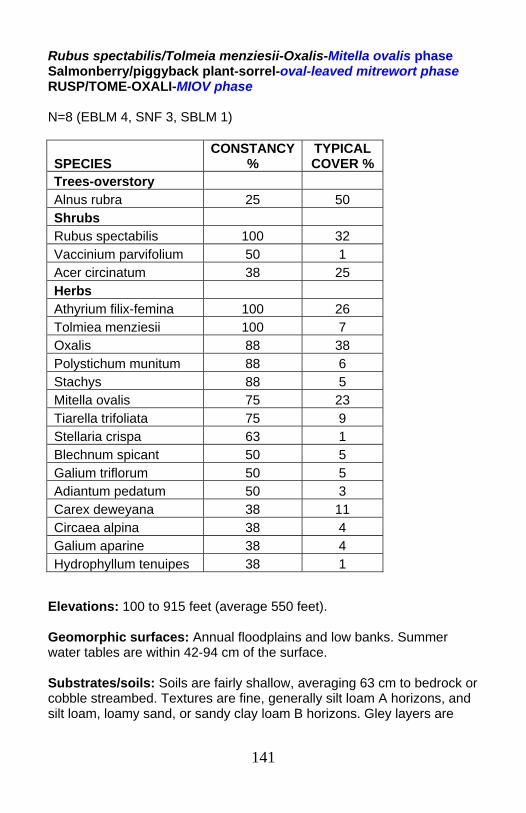
141
Rubus spectabilis/Tolmeia menziesii-Oxalis-Mitella ovalis phase Salmonberry/piggyback plant-sorrel-oval-leaved mitrewort phase RUSP/TOME-OXALI-MIOV phase N=8 (EBLM 4, SNF 3, SBLM 1)
Elevations: 100 to 915 feet (average 550 feet). Geomorphic surfaces: Annual floodplains and low banks. Summer water tables are within 42-94 cm of the surface. Substrates/soils: Soils are fairly shallow, averaging 63 cm to bedrock or cobble streambed. Textures are fine, generally silt loam A horizons, and silt loam, loamy sand, or sandy clay loam B horizons. Gley layers are
SPECIES CONSTANCY
% TYPICAL COVER %
Trees-overstory Alnus rubra 25 50 Shrubs Rubus spectabilis 100 32 Vaccinium parvifolium 50 1 Acer circinatum 38 25 Herbs Athyrium filix-femina 100 26 Tolmiea menziesii 100 7 Oxalis 88 38 Polystichum munitum 88 6 Stachys 88 5 Mitella ovalis 75 23 Tiarella trifoliata 75 9 Stellaria crispa 63 1 Blechnum spicant 50 5 Galium triflorum 50 5 Adiantum pedatum 50 3 Carex deweyana 38 11 Circaea alpina 38 4 Galium aparine 38 4 Hydrophyllum tenuipes 38 1

142
common in soil descriptions, at less than 50 cm depth. Several pits showed buried soils which are tapped by roots. Community: Rubus spectabilis/Tolmeia menziesii-Oxalis-Mitella ovalis phase is shrub dominated. No trees were found within this phase, though overhanging tree canopies can be dense. Athyrium filix-femina cover is almost always higher than Polystichum munitum cover, which marks this phase as slightly wetter than the Rubus spectabilis/Tolmeia menziesii-Oxalis-Polystichum munitum phase. The Rubus spectabilis/Tolmeia menziesii-Oxalis-Mitella ovalis phase appears to be too shallow, poorly drained, and too frequently disturbed to support a tree component. However, soil organic material and moisture holding capacity are high.
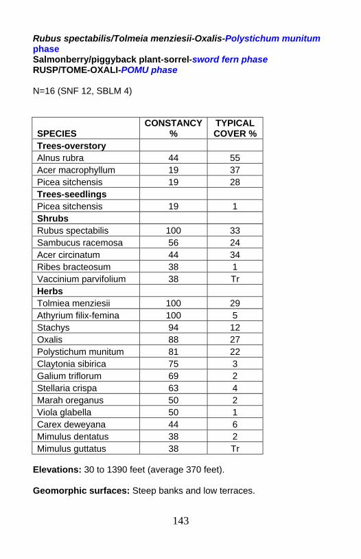
143
Rubus spectabilis/Tolmeia menziesii-Oxalis-Polystichum munitum phase Salmonberry/piggyback plant-sorrel-sword fern phase RUSP/TOME-OXALI-POMU phase N=16 (SNF 12, SBLM 4)
Elevations: 30 to 1390 feet (average 370 feet). Geomorphic surfaces: Steep banks and low terraces.
SPECIES CONSTANCY
% TYPICAL COVER %
Trees-overstory Alnus rubra 44 55 Acer macrophyllum 19 37 Picea sitchensis 19 28 Trees-seedlings Picea sitchensis 19 1 Shrubs Rubus spectabilis 100 33 Sambucus racemosa 56 24 Acer circinatum 44 34 Ribes bracteosum 38 1 Vaccinium parvifolium 38 Tr Herbs Tolmiea menziesii 100 29 Athyrium filix-femina 100 5 Stachys 94 12 Oxalis 88 27 Polystichum munitum 81 22 Claytonia sibirica 75 3 Galium triflorum 69 2 Stellaria crispa 63 4 Marah oreganus 50 2 Viola glabella 50 1 Carex deweyana 44 6 Mimulus dentatus 38 2 Mimulus guttatus 38 Tr
144
Substrate/soils: Moderately deep (60 to 90 cm). Most profiles are above summer water table level. A horizons are silt loams or clay loams 12-20 cm deep over silty clay loams, clay loams or loamy clay B horizons 48 to 55 cm deep. Some profiles showed buried soils. One profile had gleying at 75 cm. Note that the Mitella ovalis phase had shallower depths to anaerobic conditions and/or bedrock, and consistently higher water table. Community: Rubus spectabilis/Tolmeia menziesii-Oxalis-Polystichum munitum phase is shrub-dominated. Alnus rubra, Acer macrophyllum, and Sitka spruce can establish and survive on these sites. More trees are found in this phase of the Rubus spectabilis/Tolmeia menziesii-Oxalis group than in the Mitella ovalis phase. Athyrium filix-femina is always present but at lower cover than Polystichum munitum, which is not true for the Mitella ovalis phase of this group. Elk browse on some plots was noted to significantly affect cover of Rubus spectabilis, Polystichum munitum, Athyrium filix-femina, and grasses. Rubus spectabilis competition for tree regeneration can be severe.
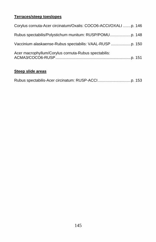
145
Terraces/steep toeslopes Corylus cornuta-Acer circinatum/Oxalis: COCO6-ACCI/OXALI .......p. 146 Rubus spectabilis/Polystichum munitum: RUSP/POMU...................p. 148 Vaccinium alaskaense-Rubus spectabilis: VAAL-RUSP ..................p. 150 Acer macrophyllum/Corylus cornuta-Rubus spectabilis: ACMA3/COCO6-RUSP.....................................................................p. 151 Steep slide areas Rubus spectabilis-Acer circinatum: RUSP-ACCI..............................p. 153
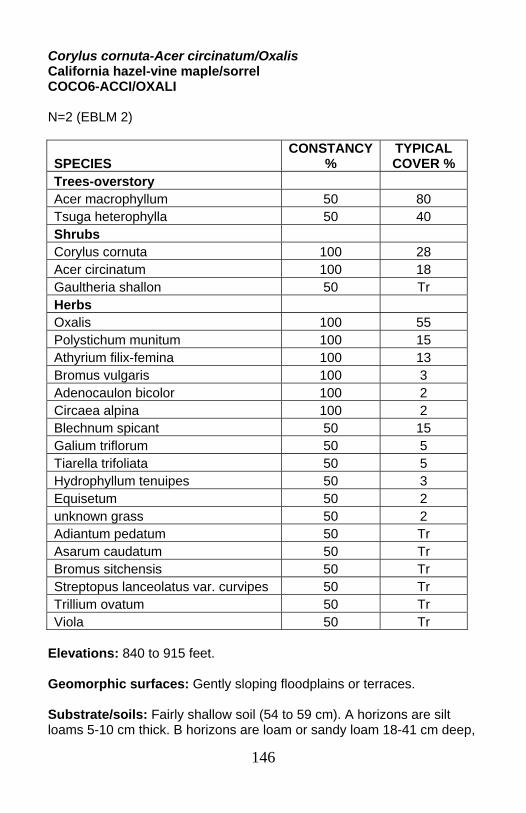
146
Corylus cornuta-Acer circinatum/Oxalis California hazel-vine maple/sorrel COCO6-ACCI/OXALI N=2 (EBLM 2)
Elevations: 840 to 915 feet. Geomorphic surfaces: Gently sloping floodplains or terraces. Substrate/soils: Fairly shallow soil (54 to 59 cm). A horizons are silt loams 5-10 cm thick. B horizons are loam or sandy loam 18-41 cm deep,
SPECIES CONSTANCY
% TYPICAL COVER %
Trees-overstory Acer macrophyllum 50 80 Tsuga heterophylla 50 40 Shrubs Corylus cornuta 100 28 Acer circinatum 100 18 Gaultheria shallon 50 Tr Herbs Oxalis 100 55 Polystichum munitum 100 15 Athyrium filix-femina 100 13 Bromus vulgaris 100 3 Adenocaulon bicolor 100 2 Circaea alpina 100 2 Blechnum spicant 50 15 Galium triflorum 50 5 Tiarella trifoliata 50 5 Hydrophyllum tenuipes 50 3 Equisetum 50 2 unknown grass 50 2 Adiantum pedatum 50 Tr Asarum caudatum 50 Tr Bromus sitchensis 50 Tr Streptopus lanceolatus var. curvipes 50 Tr Trillium ovatum 50 Tr Viola 50 Tr
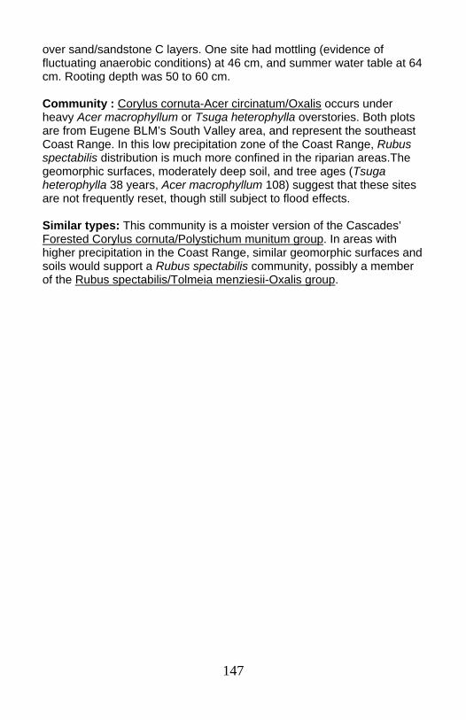
147
over sand/sandstone C layers. One site had mottling (evidence of fluctuating anaerobic conditions) at 46 cm, and summer water table at 64 cm. Rooting depth was 50 to 60 cm. Community : Corylus cornuta-Acer circinatum/Oxalis occurs under heavy Acer macrophyllum or Tsuga heterophylla overstories. Both plots are from Eugene BLM’s South Valley area, and represent the southeast Coast Range. In this low precipitation zone of the Coast Range, Rubus spectabilis distribution is much more confined in the riparian areas.The geomorphic surfaces, moderately deep soil, and tree ages (Tsuga heterophylla 38 years, Acer macrophyllum 108) suggest that these sites are not frequently reset, though still subject to flood effects. Similar types: This community is a moister version of the Cascades’ Forested Corylus cornuta/Polystichum munitum group. In areas with higher precipitation in the Coast Range, similar geomorphic surfaces and soils would support a Rubus spectabilis community, possibly a member of the Rubus spectabilis/Tolmeia menziesii-Oxalis group.
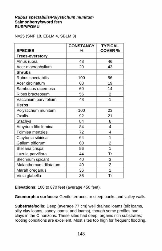
148
Rubus spectabilis/Polystichum munitum Salmonberry/sword fern RUSP/POMU N=25 (SNF 18, EBLM 4, SBLM 3)
Elevations: 100 to 870 feet (average 450 feet). Geomorphic surfaces: Gentle terraces or steep banks and valley walls. Substrate/soils: Deep (average 77 cm) well drained loams (silt loams, silty clay loams, sandy loams, and loams), though some profiles had clays in the C horizons. These sites had deep, organic rich substrates; rooting conditions are excellent. Most sites too high for frequent flooding.
SPECIES CONSTANCY
% TYPICAL COVER %
Trees-overstory Alnus rubra 48 46 Acer macrophyllum 20 43 Shrubs Rubus spectabilis 100 56 Acer circinatum 68 19 Sambucus racemosa 60 14 Ribes bracteosum 56 2 Vaccinium parvifolium 48 1 Herbs Polystichum munitum 100 23 Oxalis 92 21 Stachys 84 6 Athyrium filix-femina 84 4 Tolmiea menziesii 72 4 Claytonia sibirica 64 1 Galium triflorum 60 2 Stellaria crispa 56 1 Luzula parviflora 44 Tr Blechnum spicant 40 3 Maianthemum dilatatum 40 2 Marah oreganus 36 1 Viola glabella 36 Tr
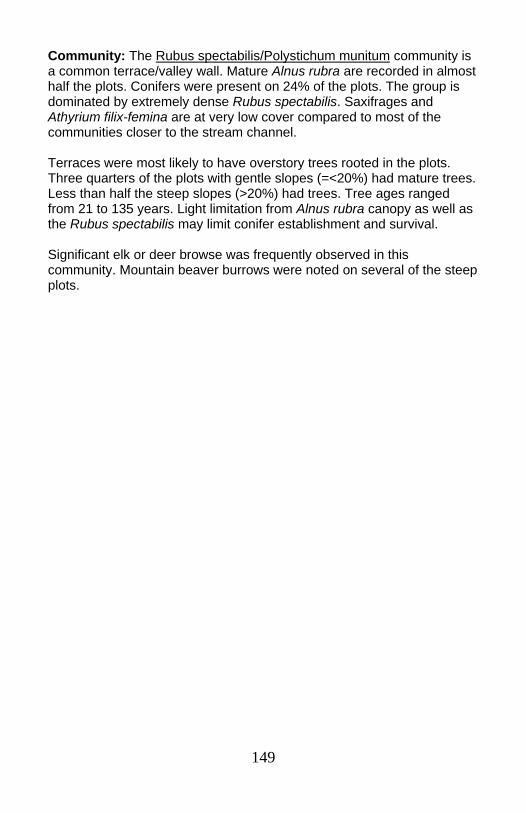
149
Community: The Rubus spectabilis/Polystichum munitum community is a common terrace/valley wall. Mature Alnus rubra are recorded in almost half the plots. Conifers were present on 24% of the plots. The group is dominated by extremely dense Rubus spectabilis. Saxifrages and Athyrium filix-femina are at very low cover compared to most of the communities closer to the stream channel. Terraces were most likely to have overstory trees rooted in the plots. Three quarters of the plots with gentle slopes (=<20%) had mature trees. Less than half the steep slopes (>20%) had trees. Tree ages ranged from 21 to 135 years. Light limitation from Alnus rubra canopy as well as the Rubus spectabilis may limit conifer establishment and survival. Significant elk or deer browse was frequently observed in this community. Mountain beaver burrows were noted on several of the steep plots.
150
Vaccinium alaskaense-Rubus spectabilis Alaska huckleberry-salmonberry VAAL-RUSP N=1 (SBLM 1)
Elevation: 1200 feet. Geomorphic surfaces: The plot is on a steep toeslope position. Substrate/soils: Fairly deep (100cm+) colluvial soil. There is a deep (20cm) O layer. The A layer is a clay loam, the BA layer is loamy clay, and the Bt horizon (at 70cm) is a clay. Gravels make up the minor coarse fragment component. Community: This is a single plot which represents a coastal variant of the Cascadian Vaccinium ovalifolium type. The plot is from Salem BLM’s Warnicke Creek in the Valley of the Giants area. This area has plant associations that indicate cool, moist environments more similar to some Cascadian conditions than most of the Coast Range (eg Western hemlock/Vaccinium alaskaense/oxalis-NWO Coast, and Western hemlock/oxalis-Achlys triphylla). One other plot from the Warnicke Creek cluster is incorporated in the Cascadian Boykinia occidentalis-Mitella ovalis description.
SPECIES TYPICAL COVER %
Shrubs Vaccinium alaskaense/Vaccinium ovalifolium 85 Rubus spectabilis 30 Vaccinium parvifolium 10 Menziesia ferruginea 8 Herbs Polystichum munitum 65 Blechnum spicant 10 Scoliopus hallii 9 Oxalis trilliifolia 8 Athyrium filix-femina 7 Boykinia occidentalis 3 Prosartes hookeri 2 Streptopus amplexifolius 2
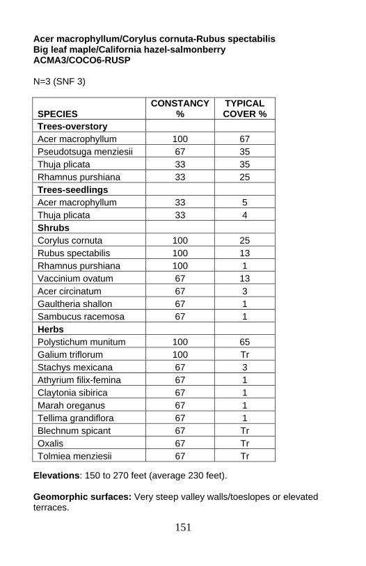
151
Acer macrophyllum/Corylus cornuta-Rubus spectabilis Big leaf maple/California hazel-salmonberry ACMA3/COCO6-RUSP N=3 (SNF 3)
Elevations: 150 to 270 feet (average 230 feet). Geomorphic surfaces: Very steep valley walls/toeslopes or elevated terraces.
SPECIES CONSTANCY
% TYPICAL COVER %
Trees-overstory Acer macrophyllum 100 67 Pseudotsuga menziesii 67 35 Thuja plicata 33 35 Rhamnus purshiana 33 25 Trees-seedlings Acer macrophyllum 33 5 Thuja plicata 33 4 Shrubs Corylus cornuta 100 25 Rubus spectabilis 100 13 Rhamnus purshiana 100 1 Vaccinium ovatum 67 13 Acer circinatum 67 3 Gaultheria shallon 67 1 Sambucus racemosa 67 1 Herbs Polystichum munitum 100 65 Galium triflorum 100 Tr Stachys mexicana 67 3 Athyrium filix-femina 67 1 Claytonia sibirica 67 1 Marah oreganus 67 1 Tellima grandiflora 67 1 Blechnum spicant 67 Tr Oxalis 67 Tr Tolmiea menziesii 67 Tr
152
Substrate/soils: Silt loams to loams. Community: Acer macrophyllum/Corylus cornuta-Rubus spectabilis is a warm, well drained forested community sampled in the southern Siuslaw NF. These sites are either on raised terraces immune to most floods or on steep colluvial valley walls. The main processes controlling vegetation in this community are not fluvial. Rubus spectabilis cover is relatively minor, and other riparian species such as Athyrium filix-femina, Tolmeia menziesii, or Stachys are present but in low abundance. This community is a transitional type, moister than the upslope plant associations but dominated by upland species. Succession to conifers occurs over time, though extremely steep slopes may limit stability.
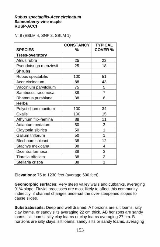
153
Rubus spectabilis-Acer circinatum Salmonberry-vine maple RUSP-ACCI N=8 (EBLM 4, SNF 3, SBLM 1)
Elevations: 75 to 1230 feet (average 600 feet). Geomorphic surfaces: Very steep valley walls and cutbanks, averaging 91% slope. Fluvial processes are most likely to affect this community indirectly, if channel changes undercut the over-steepened slopes to cause slides. Substrate/soils: Deep and well drained. A horizons are silt loams, silty clay loams, or sandy silts averaging 22 cm thick. AB horizons are sandy loams, silt loams, silty clay loams or clay loams averaging 27 cm. B horizons are silty clays, silt loams, sandy silts or sandy loams, averaging
SPECIES CONSTANCY
% TYPICAL COVER %
Trees-overstory Alnus rubra 25 23 Pseudotsuga menziesii 25 18 Shrubs Rubus spectabilis 100 51 Acer circinatum 88 43 Vaccinium parvifolium 75 5 Sambucus racemosa 38 7 Rhamnus purshiana 38 6 Herbs Polystichum munitum 100 34 Oxalis 100 15 Athyrium filix-femina 88 11 Adiantum pedatum 50 3 Claytonia sibirica 50 1 Galium triflorum 50 1 Blechnum spicant 38 12 Stachys mexicana 38 4 Dicentra formosa 38 3 Tiarella trifoliata 38 2 Stellaria crispa 38 1
154
35 cm. C horizons are found at an average depth of 104 cm. Only one profile showed anaerobic conditions, with mottling at a meter. Coarse fragments above the C horizon in the profile were generally colluvial, rather than alluvial, in origin. Community: Rubus spectabilis-Acer circinatum is a shrub dominated community found on steep valley walls and toeslopes. Riparian indicators such as Tolmeia menziesii are minor or absent in this community. Rubus spectabilis competition and slope instability may limit long-term conifer development in this community. On one plot, tree regeneration followed creation of an opening from a log falling onto the site. Such events may allow scattered conifers to establish. Some of the largest, oldest conifers in the sample occurred in this community.
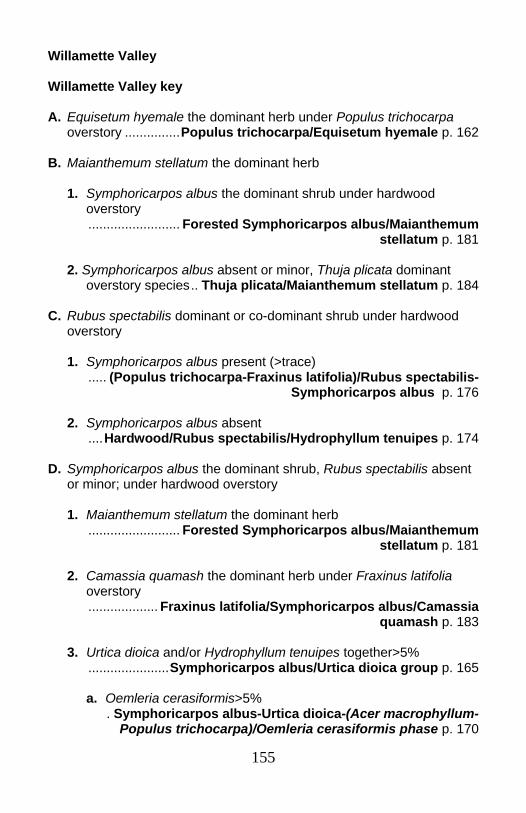
155
Willamette Valley Willamette Valley key A. Equisetum hyemale the dominant herb under Populus trichocarpa
overstory ...............Populus trichocarpa/Equisetum hyemale p. 162 B. Maianthemum stellatum the dominant herb
1. Symphoricarpos albus the dominant shrub under hardwood overstory
......................... Forested Symphoricarpos albus/Maianthemum stellatum p. 181
2. Symphoricarpos albus absent or minor, Thuja plicata dominant
overstory species.. Thuja plicata/Maianthemum stellatum p. 184 C. Rubus spectabilis dominant or co-dominant shrub under hardwood
overstory
1. Symphoricarpos albus present (>trace) ..... (Populus trichocarpa-Fraxinus latifolia)/Rubus spectabilis-
Symphoricarpos albus p. 176
2. Symphoricarpos albus absent ....Hardwood/Rubus spectabilis/Hydrophyllum tenuipes p. 174
D. Symphoricarpos albus the dominant shrub, Rubus spectabilis absent
or minor; under hardwood overstory
1. Maianthemum stellatum the dominant herb ......................... Forested Symphoricarpos albus/Maianthemum
stellatum p. 181
2. Camassia quamash the dominant herb under Fraxinus latifolia overstory
................... Fraxinus latifolia/Symphoricarpos albus/Camassia quamash p. 183
3. Urtica dioica and/or Hydrophyllum tenuipes together>5% ......................Symphoricarpos albus/Urtica dioica group p. 165
a. Oemleria cerasiformis>5% . Symphoricarpos albus-Urtica dioica-(Acer macrophyllum-
Populus trichocarpa)/Oemleria cerasiformis phase p. 170
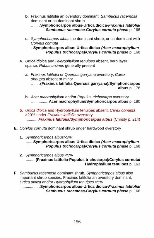
156
b. Fraxinus latifolia an overstory dominant, Sambucus racemosa dominant or co-dominant shrub
........Symphoricarpos albus-Urtica dioica-Fraxinus latifolia/ Sambucus racemosa-Corylus cornuta phase p. 166
c. Symphoricarpos albus the dominant shrub, or co-dominant with
Corylus cornuta . Symphoricarpos albus-Urtica dioica-(Acer macrophyllum-
Populus trichocarpa)/Corylus cornuta phase p. 168
4. Urtica dioica and Hydrophyllum tenuipes absent, herb layer sparse, Rubus ursinus generally present
a. Fraxinus latifolia or Quercus garryana overstory, Carex
obnupta absent or minor ........ (Fraxinus latifolia-Quercus garryana)/Symphoricarpos
albus p. 178
b. Acer macrophyllum and/or Populus trichocarpa overstory ................Acer macrophyllum/Symphoricarpos albus p. 180
5. Urtica dioica and Hydrophyllum tenuipes absent, Carex obnupta
>20% under Fraxinus latifolia overstory ........... Fraxinus latifolia/Symphoricarpus albus (Christy p. 214)
E. Corylus cornuta dominant shrub under hardwood overstory
1. Symphoricarpos albus>5% ...... Symphoricarpos albus-Urtica dioica-(Acer macrophyllum-
Populus trichocarpa)/Corylus cornuta phase p. 168
2. Symphoricarpos albus <5% .........(Fraxinus latifolia-Populus trichocarpa)/Corylus cornuta/
Hydrophyllum tenuipes p. 163
F. Sambucus racemosa dominant shrub, Symphoricarpos albus also important shrub species, Fraxinus latifolia an overstory dominant, Urtica dioica and/or Hydrophyllum tenuipes >5%
..................Symphoricarpos albus-Urtica dioica-Fraxinus latifolia/ Sambucus racemosa-Corylus cornuta phase p. 166
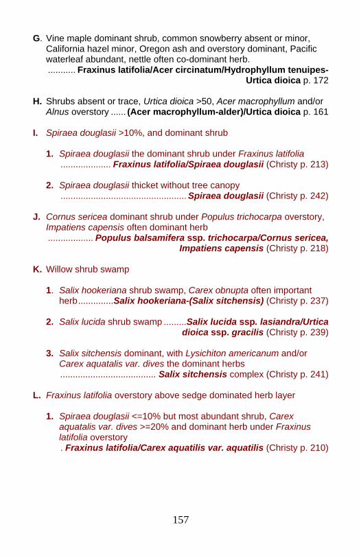
157
G. Vine maple dominant shrub, common snowberry absent or minor, California hazel minor, Oregon ash and overstory dominant, Pacific waterleaf abundant, nettle often co-dominant herb.
........... Fraxinus latifolia/Acer circinatum/Hydrophyllum tenuipes- Urtica dioica p. 172
H. Shrubs absent or trace, Urtica dioica >50, Acer macrophyllum and/or
Alnus overstory ...... (Acer macrophyllum-alder)/Urtica dioica p. 161 I. Spiraea douglasii >10%, and dominant shrub
1. Spiraea douglasii the dominant shrub under Fraxinus latifolia .................... Fraxinus latifolia/Spiraea douglasii (Christy p. 213)
2. Spiraea douglasii thicket without tree canopy .................................................. Spiraea douglasii (Christy p. 242)
J. Cornus sericea dominant shrub under Populus trichocarpa overstory,
Impatiens capensis often dominant herb .................. Populus balsamifera ssp. trichocarpa/Cornus sericea,
Impatiens capensis (Christy p. 218) K. Willow shrub swamp
1. Salix hookeriana shrub swamp, Carex obnupta often important herb..............Salix hookeriana-(Salix sitchensis) (Christy p. 237)
2. Salix lucida shrub swamp .........Salix lucida ssp. lasiandra/Urtica
dioica ssp. gracilis (Christy p. 239)
3. Salix sitchensis dominant, with Lysichiton americanum and/or Carex aquatalis var. dives the dominant herbs
...................................... Salix sitchensis complex (Christy p. 241) L. Fraxinus latifolia overstory above sedge dominated herb layer
1. Spiraea douglasii <=10% but most abundant shrub, Carex aquatalis var. dives >=20% and dominant herb under Fraxinus latifolia overstory
. Fraxinus latifolia/Carex aquatilis var. aquatilis (Christy p. 210)

158
2. Carex deweyana and/or Juncus patens dominant herbs under Fraxinus latifolia overstory, Rubus ursinus and Spiraea douglasii may be present
.........................Fraxinus latifolia/Carex deweyana-Urtica dioica ssp. Gracilis (Christy p. 211)
3. Carex obnupta >=20% and dominant herb under Fraxinus latifolia
overstory, Rubus ursinus, Spiraea douglasii, and Symphoricarpos albus may be present
.........................Fraxinus latifolia/Carex obnupta (Christy p. 212) For more herb-dominated communities (aquatic beds, emergent marshes, marshes, fens/peatlands, or wet prairies), see herbaceous wetlands key (Christy pp. 204). For more shrub-dominated communities (shrub swamps), see shrubland wetlands key (Christy p. 200). For more tree-dominated communities (forested swamps), see forest and woodlands wetlands key (Christy p. 198).
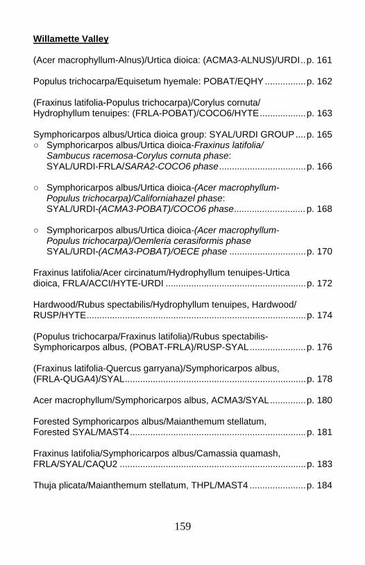
159
Willamette Valley (Acer macrophyllum-Alnus)/Urtica dioica: (ACMA3-ALNUS)/URDI..p. 161 Populus trichocarpa/Equisetum hyemale: POBAT/EQHY ................p. 162 (Fraxinus latifolia-Populus trichocarpa)/Corylus cornuta/ Hydrophyllum tenuipes: (FRLA-POBAT)/COCO6/HYTE..................p. 163 Symphoricarpos albus/Urtica dioica group: SYAL/URDI GROUP....p. 165 ○ Symphoricarpos albus/Urtica dioica-Fraxinus latifolia/ Sambucus racemosa-Corylus cornuta phase: SYAL/URDI-FRLA/SARA2-COCO6 phase..................................p. 166 ○ Symphoricarpos albus/Urtica dioica-(Acer macrophyllum- Populus trichocarpa)/Californiahazel phase: SYAL/URDI-(ACMA3-POBAT)/COCO6 phase............................p. 168 ○ Symphoricarpos albus/Urtica dioica-(Acer macrophyllum- Populus trichocarpa)/Oemleria cerasiformis phase SYAL/URDI-(ACMA3-POBAT)/OECE phase ..............................p. 170 Fraxinus latifolia/Acer circinatum/Hydrophyllum tenuipes-Urtica dioica, FRLA/ACCI/HYTE-URDI .......................................................p. 172 Hardwood/Rubus spectabilis/Hydrophyllum tenuipes, Hardwood/ RUSP/HYTE......................................................................................p. 174 (Populus trichocarpa/Fraxinus latifolia)/Rubus spectabilis-Symphoricarpos albus, (POBAT-FRLA)/RUSP-SYAL......................p. 176 (Fraxinus latifolia-Quercus garryana)/Symphoricarpos albus, (FRLA-QUGA4)/SYAL.......................................................................p. 178 Acer macrophyllum/Symphoricarpos albus, ACMA3/SYAL..............p. 180 Forested Symphoricarpos albus/Maianthemum stellatum, Forested SYAL/MAST4.....................................................................p. 181 Fraxinus latifolia/Symphoricarpos albus/Camassia quamash, FRLA/SYAL/CAQU2 .........................................................................p. 183 Thuja plicata/Maianthemum stellatum, THPL/MAST4 ......................p. 184
160
A note on alder: Both white alder (Alnus rhombifolia) and red alder (Alnus rubra) are present in riparian areas of low elevations of the central and southern Willamette Valley. The two species have similar appearance, and can grow next to each other. Alnus rubra is found at slightly higher elevations along the valley margin and in the NW Oregon Cascades and Coast Range. No Alnus rhombifolia was recorded in the Willamette Valley plots; only 6 of the sites had alder. Unfortunately, it is not possible to tell if the two species were distinguished in the field. Visits in 2004 to the three most northerly alder sites found only Alnus rubra t. Whether the same is true in the more southerly Willamette Valley riparian zones is uncertain. Therefore, most references in the Willamette Valley section have been generalized to Alnus/Alder.
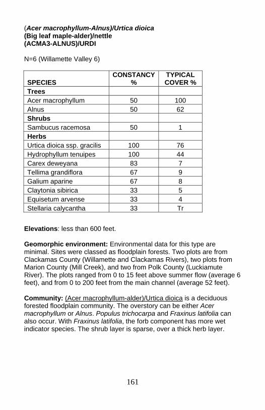
161
(Acer macrophyllum-Alnus)/Urtica dioica (Big leaf maple-alder)/nettle (ACMA3-ALNUS)/URDI N=6 (Willamette Valley 6)
Elevations: less than 600 feet. Geomorphic environment: Environmental data for this type are minimal. Sites were classed as floodplain forests. Two plots are from Clackamas County (Willamette and Clackamas Rivers), two plots from Marion County (Mill Creek), and two from Polk County (Luckiamute River). The plots ranged from 0 to 15 feet above summer flow (average 6 feet), and from 0 to 200 feet from the main channel (average 52 feet). Community: (Acer macrophyllum-alder)/Urtica dioica is a deciduous forested floodplain community. The overstory can be either Acer macrophyllum or Alnus. Populus trichocarpa and Fraxinus latifolia can also occur. With Fraxinus latifolia, the forb component has more wet indicator species. The shrub layer is sparse, over a thick herb layer.
SPECIES CONSTANCY
% TYPICAL COVER %
Trees Acer macrophyllum 50 100 Alnus 50 62 Shrubs Sambucus racemosa 50 1 Herbs Urtica dioica ssp. gracilis 100 76 Hydrophyllum tenuipes 100 44 Carex deweyana 83 7 Tellima grandiflora 67 9 Galium aparine 67 8 Claytonia sibirica 33 5 Equisetum arvense 33 4 Stellaria calycantha 33 Tr
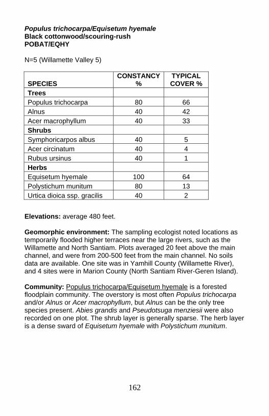
162
Populus trichocarpa/Equisetum hyemale Black cottonwood/scouring-rush POBAT/EQHY N=5 (Willamette Valley 5)
Elevations: average 480 feet. Geomorphic environment: The sampling ecologist noted locations as temporarily flooded higher terraces near the large rivers, such as the Willamette and North Santiam. Plots averaged 20 feet above the main channel, and were from 200-500 feet from the main channel. No soils data are available. One site was in Yamhill County (Willamette River), and 4 sites were in Marion County (North Santiam River-Geren Island). Community: Populus trichocarpa/Equisetum hyemale is a forested floodplain community. The overstory is most often Populus trichocarpa and/or Alnus or Acer macrophyllum, but Alnus can be the only tree species present. Abies grandis and Pseudotsuga menziesii were also recorded on one plot. The shrub layer is generally sparse. The herb layer is a dense sward of Equisetum hyemale with Polystichum munitum.
SPECIES CONSTANCY
% TYPICAL COVER %
Trees Populus trichocarpa 80 66 Alnus 40 42 Acer macrophyllum 40 33 Shrubs Symphoricarpos albus 40 5 Acer circinatum 40 4 Rubus ursinus 40 1 Herbs Equisetum hyemale 100 64 Polystichum munitum 80 13 Urtica dioica ssp. gracilis 40 2
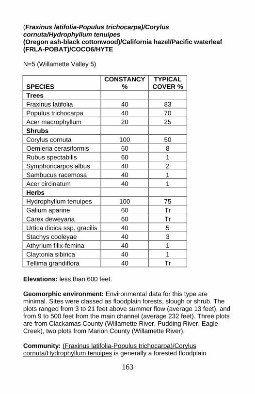
163
(Fraxinus latifolia-Populus trichocarpa)/Corylus cornuta/Hydrophyllum tenuipes (Oregon ash-black cottonwood)/California hazel/Pacific waterleaf (FRLA-POBAT)/COCO6/HYTE N=5 (Willamette Valley 5)
Elevations: less than 600 feet. Geomorphic environment: Environmental data for this type are minimal. Sites were classed as floodplain forests, slough or shrub. The plots ranged from 3 to 21 feet above summer flow (average 13 feet), and from 9 to 500 feet from the main channel (average 232 feet). Three plots are from Clackamas County (Willamette River, Pudding River, Eagle Creek), two plots from Marion County (Willamette River). Community: (Fraxinus latifolia-Populus trichocarpa)/Corylus cornuta/Hydrophyllum tenuipes is generally a forested floodplain
SPECIES CONSTANCY
% TYPICAL COVER %
Trees Fraxinus latifolia 40 83 Populus trichocarpa 40 70 Acer macrophyllum 20 25 Shrubs Corylus cornuta 100 50 Oemleria cerasiformis 60 8 Rubus spectabilis 60 1 Symphoricarpos albus 40 2 Sambucus racemosa 40 1 Acer circinatum 40 1 Herbs Hydrophyllum tenuipes 100 75 Galium aparine 60 Tr Carex deweyana 60 Tr Urtica dioica ssp. gracilis 40 5 Stachys cooleyae 40 3 Athyrium filix-femina 40 1 Claytonia sibirica 40 1 Tellima grandiflora 40 Tr
164
community. The overstory is dominated by Fraxinus latifolia, Populus trichocarpa, or sometimes Acer macrophyllum. Similar types: This type seems somewhat wetter than the strongly related Symphoricarpos albus/Urtica dioica group: (Fraxinus latifolia/Sambucus racemosa-Corylus cornuta phase and (Acer macrophyllum-Populus trichocarpa)/Corylus cornuta phase). (Fraxinus latifolia-Populus trichocarpa)/Corylus cornuta/Hydrophyllum tenuipes has less Rubus ursinus, Sambucus racemosa, Symphoricarpos albus and Urtica dioica, and more Corylus cornuta, Oemleria cerasiformis, and Hydrophyllum tenuipes.
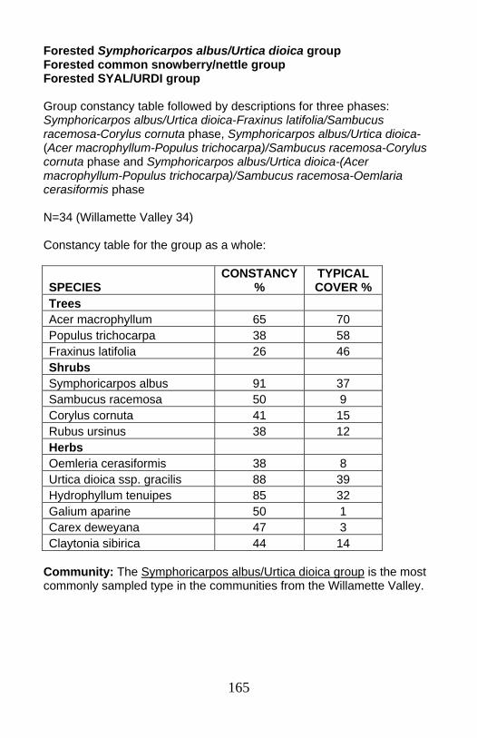
165
Forested Symphoricarpos albus/Urtica dioica group Forested common snowberry/nettle group Forested SYAL/URDI group Group constancy table followed by descriptions for three phases: Symphoricarpos albus/Urtica dioica-Fraxinus latifolia/Sambucus racemosa-Corylus cornuta phase, Symphoricarpos albus/Urtica dioica-(Acer macrophyllum-Populus trichocarpa)/Sambucus racemosa-Corylus cornuta phase and Symphoricarpos albus/Urtica dioica-(Acer macrophyllum-Populus trichocarpa)/Sambucus racemosa-Oemlaria cerasiformis phase N=34 (Willamette Valley 34) Constancy table for the group as a whole:
SPECIES CONSTANCY
% TYPICAL COVER %
Trees Acer macrophyllum 65 70 Populus trichocarpa 38 58 Fraxinus latifolia 26 46 Shrubs Symphoricarpos albus 91 37 Sambucus racemosa 50 9 Corylus cornuta 41 15 Rubus ursinus 38 12 Herbs Oemleria cerasiformis 38 8 Urtica dioica ssp. gracilis 88 39 Hydrophyllum tenuipes 85 32 Galium aparine 50 1 Carex deweyana 47 3 Claytonia sibirica 44 14
Community: The Symphoricarpos albus/Urtica dioica group is the most commonly sampled type in the communities from the Willamette Valley.

166
Symphoricarpos albus/Urtica dioica-Fraxinus latifolia/Sambucus racemosa-Corylus cornuta phase Common snowberry/nettle-Oregon ash/red elderberry-California hazel phase SYAL/URDI-FRLA/SARA2-COCO6 phase N=7 (Willamette Valley 7)
Elevations: less than 600 feet. Geomorphic environment: Environmental data for this type are minimal. Sites were classes as floodplain forests (79%) or sloughs (21%). Half the samples were from the mainstem Willamette River. Surface clay deposits were noted on 2 plots. The plots ranged from 1 to 21 feet above summer flow (average 12 feet), and from 0 to 500 feet
SPECIES CONSTANCY
% TYPICAL COVER %
Trees Fraxinus latifolia 100 44 Alnus 29 60 Shrubs Sambucus racemosa 100 15 Corylus cornuta 57 16 Symphoricarpos albus 57 13 Rubus ursinus 43 31 Acer circinatum 29 42 Crataegus douglasii 29 30 Rubus spectabilis 29 2 Herbs Urtica dioica ssp. gracilis 100 51 Hydrophyllum tenuipes 71 53 Tellima grandiflora 57 14 Carex deweyana 57 8 Athyrium filix-femina 29 2 Claytonia sibirica 29 1 Tolmiea menziesii 29 1 Marah oreganus 29 1 Cardamine oligosperma 29 Tr Polystichum munitum 29 Tr
167
from the channel (average 117 feet). Four plots are from Marion County, two plots each from Benton, Clackamas, Polk, and Yamhill Counties, and 1 plot from Linn County. Community: Symphoricarpos albus/Urtica dioica-Fraxinus latifolia/Sambucus racemosa-Corylus cornuta phase is a forested floodplain community . The overstory is Fraxinus latifolia, often with Alnus and occasionally Quercus garryana. Similar types: This phase of the Symphoricarpos albus/Urtica dioica group has lower and less constant Symphoricarpos albus cover than the Acer macrophyllum-Populus trichocarpa phase. With the overstory of Fraxinus latifolia and Alnus, it indicates a slightly wetter environment.

168
Symphoricarpos albus/Urtica dioica -(Acer macrophyllum-Populus trichocarpa)/Corylus cornuta phase Common snowberry/nettle-(Big leaf maple-black cottonwood)/California hazel phase SYAL/URDI-(ACMA3-POBAT)/COCO6 phase N=13 (Willamette Valley 13)
Elevations: less than 600 feet. Geomorphic environment: Environmental data for this type are minimal. Sites were classes as floodplain forests (79%) or sloughs (21%). Half the samples were from the mainstem Willamette River. Surface clay deposits were noted on 2 plots. The plots ranged from 1 to 21 feet above summer flow (average 12 feet), and from 0 to 500 feet from the channel (average 117 feet). Four plots are from Marion County, two plots each from Benton, Clackamas, Polk, and Yamhill Counties, and 1 plot from Linn County. Community: Symphoricarpos albus/Urtica dioica-(Acer macrophyllum-Populus trichocarpa) Corylus cornuta phase is a forested floodplain community. The overstory is Acer macrophyllum and/or Populus trichocarpa. The shrub layer is dominated by Symphoricarpos albus, with Corylus cornuta, Rubus ursinus, and Sambucus racemosa as the most
SPECIES CONSTANCY
% TYPICAL COVER %
Trees Acer macrophyllum 69 75 Populus trichocarpa 54 64 Shrubs Symphoricarpos albus 100 42 Corylus cornuta 62 16 Rubus ursinus 62 7 Sambucus racemosa 62 5 Rubus spectabilis 38 3 Herbs Urtica dioica ssp. gracilis 92 41 Hydrophyllum tenuipes 85 33 Carex deweyana 38 1 Galium triflorum 31 11 Claytonia sibirica 31 Tr
169
common associated species. Urtica dioica and Hydrophyllum tenuipes are both very abundant.
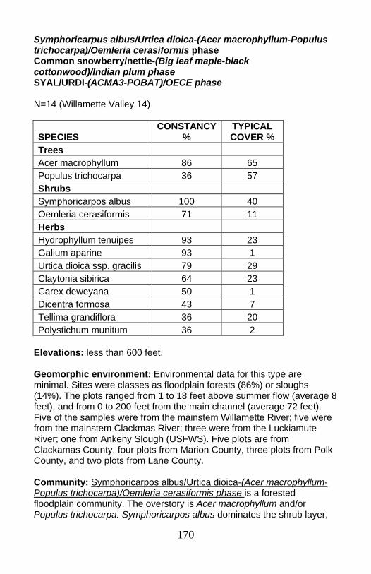
170
Symphoricarpus albus/Urtica dioica-(Acer macrophyllum-Populus trichocarpa)/Oemleria cerasiformis phase Common snowberry/nettle-(Big leaf maple-black cottonwood)/Indian plum phase SYAL/URDI-(ACMA3-POBAT)/OECE phase N=14 (Willamette Valley 14)
Elevations: less than 600 feet. Geomorphic environment: Environmental data for this type are minimal. Sites were classes as floodplain forests (86%) or sloughs (14%). The plots ranged from 1 to 18 feet above summer flow (average 8 feet), and from 0 to 200 feet from the main channel (average 72 feet). Five of the samples were from the mainstem Willamette River; five were from the mainstem Clackmas River; three were from the Luckiamute River; one from Ankeny Slough (USFWS). Five plots are from Clackamas County, four plots from Marion County, three plots from Polk County, and two plots from Lane County. Community: Symphoricarpos albus/Urtica dioica-(Acer macrophyllum-Populus trichocarpa)/Oemleria cerasiformis phase is a forested floodplain community. The overstory is Acer macrophyllum and/or Populus trichocarpa. Symphoricarpos albus dominates the shrub layer,
SPECIES CONSTANCY
% TYPICAL COVER %
Trees Acer macrophyllum 86 65 Populus trichocarpa 36 57 Shrubs Symphoricarpos albus 100 40 Oemleria cerasiformis 71 11 Herbs Hydrophyllum tenuipes 93 23 Galium aparine 93 1 Urtica dioica ssp. gracilis 79 29 Claytonia sibirica 64 23 Carex deweyana 50 1 Dicentra formosa 43 7 Tellima grandiflora 36 20 Polystichum munitum 36 2
171
with Oemleria cerasiformis as an important associated species. The lush understory is typically composed of Hydrophyllum tenuipes, Galium aparine, Urtica dioica, Claytonia sibirica, and Carex deweyana.
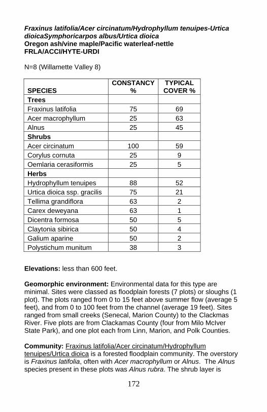
172
Fraxinus latifolia/Acer circinatum/Hydrophyllum tenuipes-Urtica dioicaSymphoricarpos albus/Urtica dioica Oregon ash/vine maple/Pacific waterleaf-nettle FRLA/ACCI/HYTE-URDI N=8 (Willamette Valley 8)
Elevations: less than 600 feet. Geomorphic environment: Environmental data for this type are minimal. Sites were classed as floodplain forests (7 plots) or sloughs (1 plot). The plots ranged from 0 to 15 feet above summer flow (average 5 feet), and from 0 to 100 feet from the channel (average 19 feet). Sites ranged from small creeks (Senecal, Marion County) to the Clackmas River. Five plots are from Clackamas County (four from Milo McIver State Park), and one plot each from Linn, Marion, and Polk Counties. Community: Fraxinus latifolia/Acer circinatum/Hydrophyllum tenuipes/Urtica dioica is a forested floodplain community. The overstory is Fraxinus latifolia, often with Acer macrophyllum or Alnus. The Alnus species present in these plots was Alnus rubra. The shrub layer is
SPECIES CONSTANCY
% TYPICAL COVER %
Trees Fraxinus latifolia 75 69 Acer macrophyllum 25 63 Alnus 25 45 Shrubs Acer circinatum 100 59 Corylus cornuta 25 9 Oemlaria cerasiformis 25 5 Herbs Hydrophyllum tenuipes 88 52 Urtica dioica ssp. gracilis 75 21 Tellima grandiflora 63 2 Carex deweyana 63 1 Dicentra formosa 50 5 Claytonia sibirica 50 4 Galium aparine 50 2 Polystichum munitum 38 3
173
dominated by Acer circinatum, with Corylus cornuta and Oemleria cerasiformis as the most common associated species. The herb layer generally has abundant Hydrophyllum tenuipes, with Urtica dioica a co-dominant. Tellima grandiflora and Carex deweyana also occur in over half the plots. Similar types: This community shares many species with the Symphoricarpos albus/Urtica dioica-Fraxinus latifolia/Sambucus racemosa-Corylus cornuta phase, but with Acer circinatum in the place of Symphoricarpos albus.

174
Hardwood/Salmonberry/Pacific waterleaf Hardwood/Rubus spectabilis/Hydrophyllum tenuipes Hardwood/RUSP/HYTE N=5 (Willamette Valley 5)
Geomorphic environment: Soil, substrate and geomorphic surface data are unavailable. Plots were 2 to 12 feet above river level (average 7 feet), and from 1 to 200 feet from the main creek channel. Plots were located in Benton (Camp Adair) and Clackamas (Milo McIver State Park, Molalla River State Park) counties. Community: Hardwood/Rubus spectabilis/Hydrophyllum tenuipes is a Willamette Valley forested floodplain community. It can occur under a range of overstory tree species, including Alnus, Populus trichocarpa, Fraxinus latifolia, and Acer macrophyllum. Rubus spectabilis is the dominant shrub, though Corylus cornuta and Sambucus racemosa commonly occur. The herb layer is dominated by Hydrophyllum tenuipes and Urtica dioica, almost always with Carex deweyana present. Galium
SPECIES CONSTANCY
% TYPICAL COVER %
Trees Alnus 40 80 Populus trichocarpa 40 55 Fraxinus latifolia 20 100 Acer macrophyllum 20 90 Shrubs Rubus spectabilis 100 50 Corylus cornuta 60 10 Sambucus racemosa 40 8 Herbs Hydrophyllum tenuipes 100 38 Carex deweyana 80 3 Urtica dioica ssp. gracilis 60 28 Galium aparine 60 25 Claytonia sibirica 60 11 Dicentra formosa 40 9 Athyrium filix-femina 40 2 Polystichum munitum 40 1 Stachys cooleyae 40 1
175
aparine and Claytonia sibirica are also common and abundant. Alnus rubra was confirmed at the Clackamas County sites.
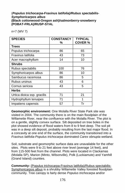
176
(Populus trichocarpa-Fraxinus latifolia)/Rubus spectabilis-Symphoricarpos albus (Black cottonwood-Oregon ash)/salmonberry-snowberry (POBAT-FRLA)/RUSP-SYAL n=7 (WV 7)
Geomorphic environment: One Molalla River State Park site was visited in 2004. The community there is on the main floodplain of the Willamette River, near the confluence with the Molalla River. The plot is on a gentle, slightly convex surface. Silt deposited on tree boles in the plot showed evidence of flood waters from 8 to 9 feet deep. The soil pit was in a deep silt deposit, probably resulting from the last major flood. In a concavity at one end of the surface, the community transitioned into a Fraxinus latifolia-Populus trichocarpa dominated Carex obnupta wetland. Soil, substrate and geomorphic surface data are unavailable for the other sites. Plots were 9 to 21 feet above river level (average 14 feet), and from 115-500 feet from the channel. Plots were located in Clackamas (Molalla SP), Marion (Minto, Wilsonville), Polk (Luckiamute) and Yamhill (Grand Island) counties. Community: (Populus trichocarpa-Fraxinus latifolia)/Rubus spectabilis-Symphoricarpos albus is a shrubby Willamette Valley forested floodplain community. Tree canopy is fairly dense Populus trichocarpa and/or
SPECIES CONSTANCY %
TYPICAL COVER %
Trees Populus trichocarpa 86 65 Fraxinus latifolia 43 73 Acer macrophyllum 14 10 Shrubs Rubus spectabilis 100 76 Symphoricarpos albus 86 10 Sambucus racemosa 86 5 Rubus ursinus 43 6 Cornus sericea 43 5 Herbs Urtica dioica ssp. gracilis 71 21 Hydrophyllum tenuipes 71 1 Impatiens capensis 57 Tr
177
Fraxinus latifolia. The thick shrub layer is dominated by Rubus spectabilis with Symphoricarpos albus and Sambucus racemosa. The herb layer is very sparse. The most common and abundant herb is Urtica dioica, though Hydrophyllum tenuipes and Impatiens capensis are usually present.
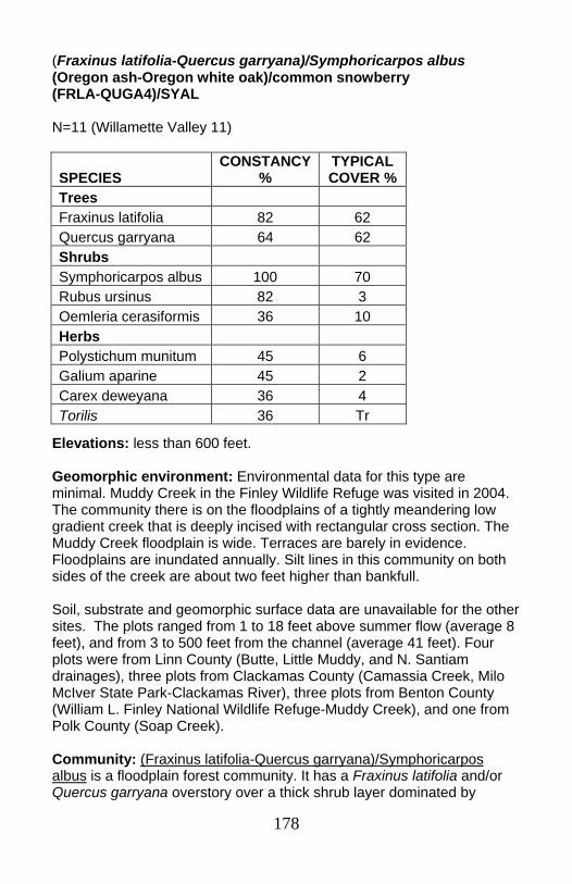
178
(Fraxinus latifolia-Quercus garryana)/Symphoricarpos albus (Oregon ash-Oregon white oak)/common snowberry (FRLA-QUGA4)/SYAL N=11 (Willamette Valley 11)
Elevations: less than 600 feet. Geomorphic environment: Environmental data for this type are minimal. Muddy Creek in the Finley Wildlife Refuge was visited in 2004. The community there is on the floodplains of a tightly meandering low gradient creek that is deeply incised with rectangular cross section. The Muddy Creek floodplain is wide. Terraces are barely in evidence. Floodplains are inundated annually. Silt lines in this community on both sides of the creek are about two feet higher than bankfull. Soil, substrate and geomorphic surface data are unavailable for the other sites. The plots ranged from 1 to 18 feet above summer flow (average 8 feet), and from 3 to 500 feet from the channel (average 41 feet). Four plots were from Linn County (Butte, Little Muddy, and N. Santiam drainages), three plots from Clackamas County (Camassia Creek, Milo McIver State Park-Clackamas River), three plots from Benton County (William L. Finley National Wildlife Refuge-Muddy Creek), and one from Polk County (Soap Creek). Community: (Fraxinus latifolia-Quercus garryana)/Symphoricarpos albus is a floodplain forest community. It has a Fraxinus latifolia and/or Quercus garryana overstory over a thick shrub layer dominated by
SPECIES CONSTANCY
% TYPICAL COVER %
Trees Fraxinus latifolia 82 62 Quercus garryana 64 62 Shrubs Symphoricarpos albus 100 70 Rubus ursinus 82 3 Oemleria cerasiformis 36 10 Herbs Polystichum munitum 45 6 Galium aparine 45 2 Carex deweyana 36 4 Torilis 36 Tr
179
Symphoricarpos albus. Rubus ursinus is the most common associated species. Oemleria cerasiformis is often present. The herb layer is relatively sparse. Polystichum munitum and Galium aparine are the most typical species.
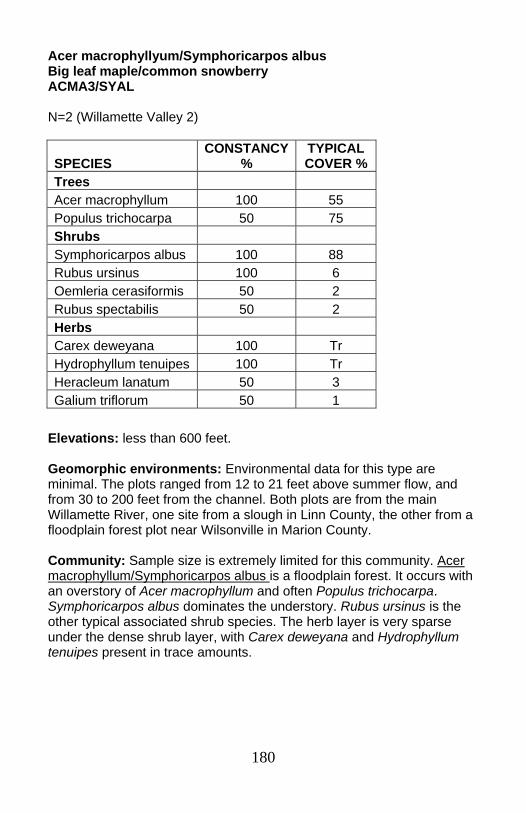
180
Acer macrophyllyum/Symphoricarpos albus Big leaf maple/common snowberry ACMA3/SYAL N=2 (Willamette Valley 2)
Elevations: less than 600 feet. Geomorphic environments: Environmental data for this type are minimal. The plots ranged from 12 to 21 feet above summer flow, and from 30 to 200 feet from the channel. Both plots are from the main Willamette River, one site from a slough in Linn County, the other from a floodplain forest plot near Wilsonville in Marion County. Community: Sample size is extremely limited for this community. Acer macrophyllum/Symphoricarpos albus is a floodplain forest. It occurs with an overstory of Acer macrophyllum and often Populus trichocarpa. Symphoricarpos albus dominates the understory. Rubus ursinus is the other typical associated shrub species. The herb layer is very sparse under the dense shrub layer, with Carex deweyana and Hydrophyllum tenuipes present in trace amounts.
SPECIES CONSTANCY
% TYPICAL COVER %
Trees Acer macrophyllum 100 55 Populus trichocarpa 50 75 Shrubs Symphoricarpos albus 100 88 Rubus ursinus 100 6 Oemleria cerasiformis 50 2 Rubus spectabilis 50 2 Herbs Carex deweyana 100 Tr Hydrophyllum tenuipes 100 Tr Heracleum lanatum 50 3 Galium triflorum 50 1
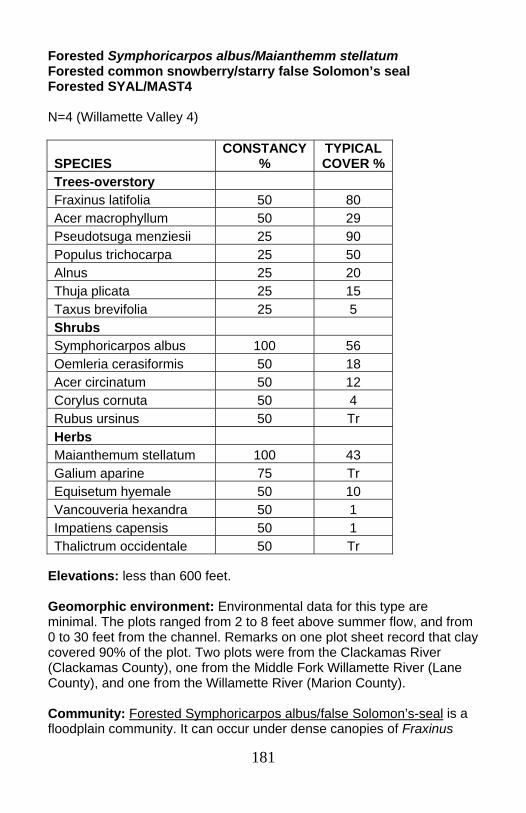
181
Forested Symphoricarpos albus/Maianthemm stellatum Forested common snowberry/starry false Solomon’s seal Forested SYAL/MAST4 N=4 (Willamette Valley 4)
Elevations: less than 600 feet. Geomorphic environment: Environmental data for this type are minimal. The plots ranged from 2 to 8 feet above summer flow, and from 0 to 30 feet from the channel. Remarks on one plot sheet record that clay covered 90% of the plot. Two plots were from the Clackamas River (Clackamas County), one from the Middle Fork Willamette River (Lane County), and one from the Willamette River (Marion County). Community: Forested Symphoricarpos albus/false Solomon’s-seal is a floodplain community. It can occur under dense canopies of Fraxinus
SPECIES CONSTANCY
% TYPICAL COVER %
Trees-overstory Fraxinus latifolia 50 80 Acer macrophyllum 50 29 Pseudotsuga menziesii 25 90 Populus trichocarpa 25 50 Alnus 25 20 Thuja plicata 25 15 Taxus brevifolia 25 5 Shrubs Symphoricarpos albus 100 56 Oemleria cerasiformis 50 18 Acer circinatum 50 12 Corylus cornuta 50 4 Rubus ursinus 50 Tr Herbs Maianthemum stellatum 100 43 Galium aparine 75 Tr Equisetum hyemale 50 10 Vancouveria hexandra 50 1 Impatiens capensis 50 1 Thalictrum occidentale 50 Tr

182
latifolia, Populus trichocarpa, Acer macrophyllum, or Pseudotsuga menziesii. A thick shrub layer is dominated by Symphoricarpos albus. Oemleria cerasiformis and Acer circinatum are often abundant, while Corylus cornuta and Rubus ursinus are also frequently present. Maianthemum stellatum is the dominant herb.
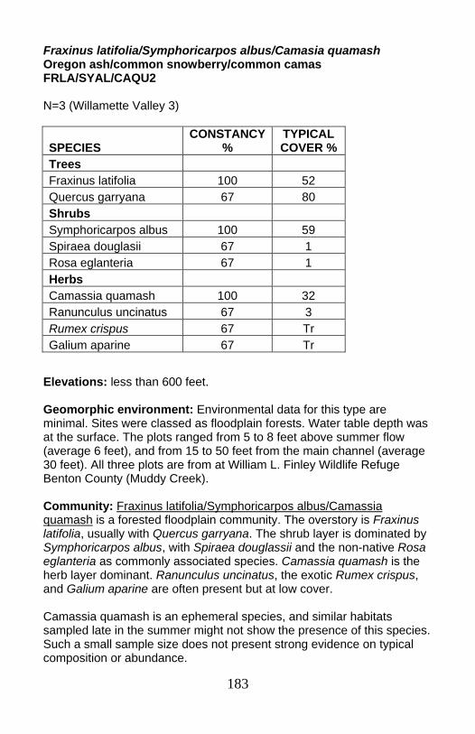
183
Fraxinus latifolia/Symphoricarpos albus/Camasia quamash Oregon ash/common snowberry/common camas FRLA/SYAL/CAQU2 N=3 (Willamette Valley 3)
Elevations: less than 600 feet. Geomorphic environment: Environmental data for this type are minimal. Sites were classed as floodplain forests. Water table depth was at the surface. The plots ranged from 5 to 8 feet above summer flow (average 6 feet), and from 15 to 50 feet from the main channel (average 30 feet). All three plots are from at William L. Finley Wildlife Refuge Benton County (Muddy Creek). Community: Fraxinus latifolia/Symphoricarpos albus/Camassia quamash is a forested floodplain community. The overstory is Fraxinus latifolia, usually with Quercus garryana. The shrub layer is dominated by Symphoricarpos albus, with Spiraea douglassii and the non-native Rosa eglanteria as commonly associated species. Camassia quamash is the herb layer dominant. Ranunculus uncinatus, the exotic Rumex crispus, and Galium aparine are often present but at low cover. Camassia quamash is an ephemeral species, and similar habitats sampled late in the summer might not show the presence of this species. Such a small sample size does not present strong evidence on typical composition or abundance.
SPECIES CONSTANCY
% TYPICAL COVER %
Trees Fraxinus latifolia 100 52 Quercus garryana 67 80 Shrubs Symphoricarpos albus 100 59 Spiraea douglasii 67 1 Rosa eglanteria 67 1 Herbs Camassia quamash 100 32 Ranunculus uncinatus 67 3 Rumex crispus 67 Tr Galium aparine 67 Tr
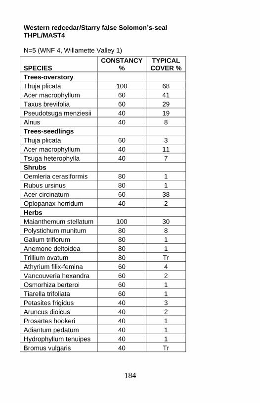
184
Western redcedar/Starry false Solomon’s-seal THPL/MAST4 N=5 (WNF 4, Willamette Valley 1)
SPECIES CONSTANCY
% TYPICAL COVER %
Trees-overstory Thuja plicata 100 68 Acer macrophyllum 60 41 Taxus brevifolia 60 29 Pseudotsuga menziesii 40 19 Alnus 40 8 Trees-seedlings Thuja plicata 60 3 Acer macrophyllum 40 11 Tsuga heterophylla 40 7 Shrubs Oemleria cerasiformis 80 1 Rubus ursinus 80 1 Acer circinatum 60 38 Oplopanax horridum 40 2 Herbs Maianthemum stellatum 100 30 Polystichum munitum 80 8 Galium triflorum 80 1 Anemone deltoidea 80 1 Trillium ovatum 80 Tr Athyrium filix-femina 60 4 Vancouveria hexandra 60 2 Osmorhiza berteroi 60 1 Tiarella trifoliata 60 1 Petasites frigidus 40 3 Aruncus dioicus 40 2 Prosartes hookeri 40 1 Adiantum pedatum 40 1 Hydrophyllum tenuipes 40 1 Bromus vulgaris 40 Tr
185
Elevations: less than 600 to 2390 feet. Geomorphic environment: Low terraces or elevated islands on unconstrained reaches of relatively large 4th to 6th order streams in the margins of the Willamette Valley. Soils data are from one plot. It had a loamy top horizon with increasing gravel content with depth. No surface coarse fragments were recorded from that site. The Willamette Valley site was on the lower Clackamas River. Willamette NF samples were from the South Fork McKenzie watershed. Community: The Thuja plicata/Maianthemum stellatum community occurs under dense Thuja plicata canopy, often with Acer macrophyllum and Taxus brevifolia. Pseudotsuga menziesii and Alnus may also be present. Acer circinatum is the most abundant shrub and is present in almost two-thirds of the plots. Oemleria cerasiformis and Rubus ursinus are typically present in trace amounts. The understory is dominated by Maianthemum stellatum, with Polystichum munitum the second important species. These sites are reset infrequently, though flooding may allow establishment of Alnus rubra without removing the existing overstory. Presence of wet-indicator species, such as Oplopanax horridum, Athyrium filix-femina and Petasites frigidus as well as the Thuja plicata overstory mark this community as riparian.
186
TABLE OF CONTENTS FOR NATIVE FRESHWATER PLANT ASSOCIATIONS OF NORTHWESTERN OREGON Introduction .........................................................................................190 Major Wetland Types ......................................................................190 Disturbance Processes...................................................................193 Exotic Plants ...................................................................................195 Methods ..........................................................................................196 Results ............................................................................................197 Key to Native Freshwater Wetland Plant Associations of Northwestern Oregon ...............................................................198 I. FOREST AND WOODLAND ASSOCIATIONS Forest and woodland associations key ......................................198 Alnus rubra/Athyrium filix-femina - Lysichiton americanus Association ...............................................................................208 Alnus rubra/Carex obnupta - Lysichiton americanus Association...209 Fraxinus latifolia/Carex aquatilis var. aquatilis Association ............210 Fraxinus latifolia/Carex deweyana - Urtica dioica ssp. Gracilis Association ..............................................................................211 Fraxinus latifolia/Carex obnupta Association..................................212 Fraxinus latifolia/Spiraea douglasii Association..............................213 Fraxinus latifolia/Symphoricarpos albus Association......................214 Picea sitchensis/Carex obnupta - Lysichiton americanus Association ...............................................................................215 Picea sitchensis/Cornus sericea/Lysichiton americanus Association ...............................................................................216 Pinus contorta var. contorta/Carex obnupta Association................217 Populus balsamifera ssp. trichocarpa /Cornus sericea/Carex deweyana ssp. leptopoda.........................................................218 Populus tremuloides/Carex obnupta Association ...........................219 Thuja plicata/Lysichiton americanus Association ...........................220 Tsuga heterophylla/Ledum glandulosum/Carex obnupta – Lysichiton americanus Association ..........................................221 II. SHRUBLAND ASSOCIATIONS Shrubland associations key ........................................................200 Alnus incana/Lysichiton americanus Association ...........................222 Alnus viridis ssp. sinuata/Lysichiton americanus Association ........223 Alnus viridis ssp. sinuata/Scirpus microcarpus Association ...........224 Betula nana/Carex aquatilis var. dives Association ........................225 Cornus sericea/Lysichiton americanus Association........................226 Kalmia microphylla/Carex aquatilis var. dives Association .............227
187
Ledum glandulosum - Gaultheria shallon/Carex obnupta Association ...............................................................................228 Ledum glandulosum/Carex obnupta/Sphagnum Association .........229 Ledum glandulosum/Darlingtonia californica/ Sphagnum Association ...............................................................................230 Ledum glandulosum - Myrica gale Association...............................231 Ledum glandulosum/Sanguisorba officinalis/Sphagnum Association ...............................................................................232 Malus fusca/Carex obnupta Association.........................................233 Myrica gale/Carex aquatilis var. dives Association.........................234 Salix commutata Association..........................................................235 Salix geyeriana complex.................................................................236 Salix hookeriana - (Salix sitchensis) Association............................237 Salix hookeriana - Malus fusca/Carex obnupta - Lysichiton americanus Association ...........................................................238 Salix lucida ssp. lasiandra/Urtica dioica ssp. gracilis Association ...............................................................................239 Salix lucida ssp. lasiandra/Salix sitchensis/Lysichiton americanus Association ...............................................................................240 Salix sitchensis complex.................................................................241 Spiraea douglasii Association.........................................................242 Spiraea douglasii - Vaccinium uliginosum/Carex obnupta – Deschampsia caespitosa Association ......................................243 Spiraea douglasii/Sphagnum Association ......................................244 Vaccinium caespitosum/Sanguisorba officinalis - Carex obnupta Association ...............................................................................245 Vaccinium caespitosum/Xerophyllum tenax - Sanguisorba officinalis Association ...............................................................246 Vaccinium uliginosum/Carex obnupta Association .........................247 Vaccinium uliginosum/Deschampsia caespitosa - Carex obnupta Association ...............................................................................248 Vaccinium uliginosum/Dodecatheon jeffreyi - Caltha leptosepala ssp. howellii Association...........................................................249 III. HERBACEOUS ASSOCIATIONS Key to herbaceous associations .................................................204 Athyrium filix-femina Association ....................................................250 Azolla (filiculoides, mexicana) Association .....................................251 Bidens cernua Association .............................................................252 Bidens frondosa Association ..........................................................253 Boykinia major Association.............................................................254 Brasenia schreberi Association ......................................................255 Calamagrostis canadensis Association ..........................................256 Calamagrostis nutkaensis Association ...........................................257 Callitriche heterophylla Association ................................................258

188
Caltha leptosepala ssp. howellii Association ..................................259 Caltha leptosepala ssp. howellii - Carex obnupta Association .......260 Camassia quamash Association.....................................................261 Carex amplifolia Association...........................................................261 Carex angustata Association ..........................................................263 Carex aperta Association................................................................264 Carex aquatilis var. aquatilis Association .......................................265 Carex aquatilis var. dives Association ............................................266 Carex aquatilis var. dives - Comarum palustre Association ...........267 Carex buxbaumii Association .........................................................268 Carex cusickii Association ..............................................................269 Carex deweyana ssp. leptopoda Association .................................270 Carex exsiccata Association...........................................................271 Carex feta Association....................................................................272 Carex lasiocarpa Association .........................................................273 Carex lenticularis Association.........................................................274 Carex limosa Association ...............................................................275 Carex luzulina Association..............................................................276 Carex nebrascensis Association.....................................................277 Carex nigricans Association ...........................................................278 Carex obnupta Association.............................................................279 Carex pachystachya Association....................................................280 Carex scopulorum Association .......................................................281 Carex simulata ................................................................................282 Carex utriculata Association ...........................................................283 Ceratophyllum demersum Association ...........................................284 Deschampsia caespitosa montane "wet meadow" complex...........285 Deschampsia caespitosa - Artemisia lindleyana Association .........287 Deschampsia caespitosa - Danthonia californica Association........288 Deschampsia caespitosa - Juncus balticus Association.................289 Dulichium arundinaceum Association.............................................290 Eleocharis acicularis Association....................................................291 Eleocharis ovata - Ludwigia palustris Association ..........................292 Eleocharis palustris Association .....................................................293 Eleocharis quinqueflora Association...............................................294 Elodea canadensis Association ......................................................295 Equisetum arvense Association......................................................296 Eragrostis hypnoides - Gnaphalium palustre Association ..............297 Euthamia occidentalis Association .................................................298 Glyceria striata Association.............................................................299 Hippuris vulgaris Association..........................................................300 Hydrocotyle ranunculoides Association ..........................................301 Isoetes nuttallii Association.............................................................302 Juncus balticus Association............................................................303 Juncus effusus Association ............................................................304
189
Juncus nevadensis Association......................................................305 Lemna minor Association................................................................306 Lilaeopsis occidentalis Association.................................................307 Ludwigia palustris - Polygonum hydropiperoides Association ........308 Menyanthes trifoliata Association ...................................................309 Nephrophyllidium crista-galli Association .......................................310 Nuphar lutea ssp. polysepala Association ......................................311 Oenanthe sarmentosa Association.................................................312 Paspalum distichum Association ....................................................313 Polygonum amphibium Association................................................314 Potamogeton natans Association ...................................................315 Ranunculus aquatilis Association ...................................................316 Ranunculus flammula Association..................................................317 Sagittaria latifolia Association .........................................................318 Sanguisorba officinalis - Carex aquatilis var. dives Association .....319 Schoenoplectus acutus Association ...............................................320 Scirpus microcarpus Association....................................................321 Senecio triangularis Association.....................................................322 Sparganium angustifolium Association...........................................323 Sparganium eurycarpum Association .............................................324 Torreyochloa pallida var. pauciflora Association.............................325 Trichophorum caespitosum Association .........................................326 Triteleia hyacinthina Association.....................................................327 Typha latifolia Association ..............................................................328 Utricularia macrorhiza Association .................................................329 NONVASCULAR ASSOCIATIONS Key to nonvascular associations ................................................207 Fontinalis antipyretica Association..................................................330 Polytrichum commune Association.................................................331
190
Introduction
This wetlands section provides keys, descriptions, and stand tables for 122 native freshwater plant associations (14 forest and woodland, 28 shrub, 78 herbaceous, 2 nonvascular) in northwestern Oregon, based on analysis of data from 1,992 plots distributed throughout the study area. Descriptions are provided for eight other plant associations for which there are no plot data. Northwestern Oregon as defined in this section includes the north half of both the Coast Range and Western Cascade ecoregions, and all of the Willamette Valley ecoregion. The Western Cascade ecoregion also includes a significant portion of the east slope of the Cascade Range, down to an elevation of about 3,000 feet in the north to 5,000 feet in the south.Note that the streamside section does not include the east slope of the Cascade Range. Data from some wetlands in coastal Douglas County and western Klamath County were also included where wetland associations from these adjoining areas are known or suspected to occur within the study area. This section describes only wetland associations with seasonal to perennial hydration, excluding irregularly flooded streamside vegetation (see streamside section of this field guide, or McCain 2004 for a more complete treatment). Salt marsh and brackish plant associations were also excluded, as were undersampled freshwater stands of Carex lyngbyei and Schoenoplectus americanus that occur up to 50 miles upstream from salt water in the Columbia River
Major Wetland Types Aquatic beds. Freshwater ponds, lakes, and sloughs are habitat for aquatic bed and emergent marsh associations and occur throughout northwestern Oregon. Along the coast, most large lakes formed when shifting sands blocked streams draining the Coast Range, creating deep lakes with steep slopes whose water levels may drop as much as 6-8 feet during the summer. Lakes and ponds also occur within the dune sheet in areas where the water table is at the surface. They are typically shallow and subject to seasonal changes in water levels, and some are unique because of their large size and extensive aquatic bed and emergent plant associations. Ponds, lakes, and sloughs are also associated with floodplains of major rivers throughout the study area, particularly on broad flats associated with the Willamette and Columbia Rivers. Water levels here typically recede in summer, so gravel banks and mud flats may appear, stranding some aquatic plants, but creating habitat for emergent species. Peatlands and headwater basins also contain pools, ponds, and tarns with aquatic bed associations. Ponds
191
and pools may also occur midslope, associated with benches and slump or sag ponds in landslide topography, often associated with marshes or peatlands that develop on these sites. Aquatic bed vegetation in ponds is usually entirely submerged or may have leaves floating at the surface. Most vegetation is rooted in sand, gravel, silt or mud, but some species are free-floating and drift about with wind and current. Extensive monotypic stands are typical of this kind of vegetation. If the water body is large enough, discrete clumping or zonation of single species can be seen, with mixtures occurring in the ecotones. Since 1850, much of this habitat has been lost to river channelization, has silted in naturally, or has been filled or recontoured for agriculture. Marshes. Marsh associations occur in depressions in various landforms, particularly headwall basins and floodplains. They may also occur midslope, associated with benches and slump or sag ponds in landslide topography. Water levels typically recede in summer, exposing gravel or mud flats and creating habitat for some seasonal species. Aquatic species may become stranded in these communities and persist with modified morphology, if the substrate is wet enough. If good zonation is present, it is possible to see weak-stemmed or decumbent species in the deeper water, or species specifically adapted to later exposure on mud flats, followed by taller herbs and shrubs on the landward side. Perennially wet marshes are usually too wet for the noxious grass Phalaris arundinacea to become established. Channelization, flood control and agriculture have caused extensive losses of these habitats. The Saggitaria latifolia association that was once common throughout the region in floodplain marshes inundated until midsummer largely has been displaced by Phalaris arundinacea except in the Columbia River bottoms. Mud flat associations along the lower Columbia River have suffered a similar fate. Peatlands. Most peatlands in Oregon are fens rather than bogs, being hydrated by mineral-rich surface or groundwater, lacking a domed peat profile, and having a pH generally higher than 5.5. Many fens, however, contain localized Sphagnum hummocks or lawns with a pH as low as 4, and may be classified as "poor fen." They occur in depressions in various landforms, particularly in interdunal depressions, headwall basins, and floodplains. Peatlands may also occur around midslope slump or sag ponds in landslide topography. They are usually perennially saturated but local areas of surface drying are not uncommon. These wetlands are widespread in northwestern Oregon but usually small in area, and occurrences in the Willamette Valley are now rare. Drainage, filling, peat mining, conversion to commercial cranberry production, and plant succession have destroyed many sites, and losses continue to occur despite wetland regulations that were designed to protect them.
192
The small area they occupy in the landscape is causing some conservation organizations to pass them over in the "bigger is better" philosophy that currently dominates the field. It is important to properly document the components of these ecosystems and to develop new conservation priorities to help protect representative examples in the state. Coastal fens in Oregon are floristically distinct from those north of the Columbia River (e.g., Golinski 1999; Vitt et al. 1999) and those at higher elevations in the Cascade and Coast Ranges (Seyer 1979, 1981, 1983; Wilson 1986; Frenkel et al. 1986), making them unique in North America and highly-ranked elements in state Heritage Program methodology. Wet prairies. The name prairie refers here to wet grasslands that developed on clay or silt loam soils in the Willamette Valley, on the Columbia River bottoms, and along the coast. Although best known for Deschampsia caespitosa, they contain many other species of grasses, sedges and herbs. Before flood control, wet prairies on the Columbia River bottoms were frequently flooded well into summer, and not much is known about their original composition because widespread invasion of Phalaris arundinacea has displaced many native species. Some stands were probably Deschampsia caespitosa prairie and others were Carex aperta prairie, and they intergraded with a complex of marshes and sloughs on the river bottoms. Willamette Valley prairie developed on heavy clay loam soils that created a seasonally perched water table that was often isolated hydrologically from streams and rivers. These sites are usually dry by late spring but depressions may retain water well into the summer. Few vernal pools are known to remain in the Willamette Valley and none are described in this guide. The Willamette Valley prairie is unique and one of the rarest ecosystems in the Pacific Northwest, containing a number of endemic plant species. It developed under a regime of frequent fire from both lightning and native Americans (Boyd 1999), but after settlement by Euroamericans it went into rapid decline. Considerable research is now being done on fire ecology and restoration in this habitat, but after twenty years of study most plant associations still remain unpublished. The few Willamette Valley prairie associations described in this guide are provided to help document the vegetation, but much work remains to be done. Shrub swamps. Shrub swamps are wetlands dominated by shrubs and they occur at all elevations throughout northwestern Oregon. They occur on floodplains and basins, and most tolerate a variable water regime. Community structure ranges from scattered shrubs with intervening herbaceous component, to dense and impenetrable stands of Salix, Cornus stolonifera, and Spiraea douglasii. Riparian shrub swamp associations are highly variable and difficult to classify. Many contain
193
various mixtures of the same species, with or without a partial tree canopy. Historically, willow swamps were the second most abundant wetland vegetation (after wet prairies) forming a wet landscape described by early explorers and land surveyors of the region. Many of these systems were maintained or enhanced by beavers and have since been lost to drainage and conversion to farming. Forested wetlands (swamps). This section includes only forested wetland associations occurring in seasonally to perennially flooded depressions, or with perennially wet soils throughout the stands. The major associations are dominated by Alnus rubra, Fraxinus latifolia, Picea sitchensis, or Thuja plicata. The extent of forested wetlands in northwestern Oregon is now much diminished from what it was in 1850. General Land Office survey notes from the 1850's show that riparian forest in the Willamette Valley was in some areas as much as five miles wide, but most stands are now reduced to narrow strips fringing streams and rivers (Benner and Sedell 1997). Probably at least 100,000 acres of this forest were cleared for agriculture and fuelwood. On the coast, old-growth Picea sitchensis swamp is very rare because most stands were readily accessible for logging and suitable sites may never have been numerous or extensive. Of an estimated 14,000 acres in Oregon in 1850, about 1,700 remain today, representing an 88 percent loss.
Disturbance Processes The major agents of wetland disturbance in northwestern Oregon have been beavers, floods, landslides, tsunamis, windthrow, fire, and people. These forces mediate the supply, movement, and chemistry of water and sediments and shape the development of different types of vegetation. Beavers. Beavers occur throughout the Pacific Northwest, their work most evident as beaver dams, beaver ponds, and plugged culverts. Less evident is the extensive cropping of wetland and streamside vegetation by beavers that den in streambanks without the familiar dams or lodges. Many wetlands developed on sediments trapped by long-vanished beaver dams, and in narrow drainages these wetlands persist as series of terraces extending upstream in stairstep fashion, the beaver dams no longer visible. Although beavers are seemingly ubiquitous today, some researches have estimated that historic populations in Oregon were ten times larger than what they are today. Their numbers were decimated first by commercial trapping prior to 1845, then by diminishing wetland acreage caused by their trapping, and finally by a rush of agricultural drainage projects.
194
Floods. Floods are the primary force influencing landforms and vegetation on river bottoms. They vary in magnitude and either destroy, create, or maintain wetlands. High-energy floods in constrained valleys may fill wetlands with sediment and create new wetlands by reworking sediments to create depressions. They frequently destroy beaver dams and expose accumulated sediments to erosion and rapid invasion by upland species. They also have less impact on some wetlands by simply rehydrating them after summer drying. Floods had their greatest effect on wetlands prior to construction of flood control dams in the Willamette River basin and on the Columbia River. Historically, two distinct seasonal flood regimes existed, one initiated by winter rain west of the Cascades, the other by spring snowmelt east of the Cascades. Winter floods ("rain floods") primarily affected the Willamette Valley and spring floods ("freshets") affected the Columbia River bottoms. Along the Columbia River, flood heights gradually diminished downstream, and below river mile 40 the broad estuary and strong tidal influence dissipated its effects. Floodwaters of 20 to 30 feet at Vancouver would rise to only 2 to 5 feet in the estuary (U.S. Army Corps of Engineers 1948, 1988). The spring floods on the Columbia River bottoms kept much of the floodplain under water until June or sometimes July, maintaining much wet prairie and seasonal willow and ash swamps that were later invaded by Phalaris arundinacea in the absence of prolonged flooding. Landslides. Like floods, landslides and debris torrents both create and destroy wetlands. Those occurring midslope may form isolated slump or sag ponds that are often associated with marshes and peatlands. Larger-scale landslide topography usually contains clusters of ponds over a large area. Debris torrents are concentrated in narrow stream valleys and scour riparian marshes and beaver impoundments associated with the streambed. Wetlands sometimes form in the jumbled deposits at the base of the flow. Tsunamis. Sediment cores indicate that tsunamis have repeatedly inundated salt marshes, swamps, and peatlands along the coast of the Pacific Northwest. Burial by marine sediments and associated tectonic uplift or subsidence destroys wetlands and creates new ones, but these processes are not well documented in Oregon. Windthrow. Windthrow is usually a minor agent of disturbance in our wetlands but locally could be catastrophic in a major storm. Picea sitchensis swamps on the coast are the most vulnerable wetlands. The roots of Picea cannot grow in perennially wet, anoxic soil and instead form wide-spreading but very shallow systems that, combined with buttresses at the base of the trunk, serve to keep the tree rocking back and forth on the spongy substrate. Windthrow is common in these
195
stands, creating canopy gaps for the dense shrub layer and reproducing trees. Windthrow of small trees is sometimes seen in peatlands where the weight of the tree becomes insupportable in the soft ground. Fire. Fire probably played a major role historically in most wetlands in northwestern Oregon except for the wettest of coastal swamps. Ignition sources were both aboriginal and by lightning, the former being most common in the Willamette Valley (Boyd 1999). Fire-scarred trees or stumps may often be found in the center of wetlands, and soil pits or sediment cores frequently contain charcoal, but these are the only evidence for fire in and around wetlands. While forest fires in upland settings have been well studied locally, no studies have focused on the role of fire in Oregon wetlands except for Willamette Valley prairie.
People. Although people have lived in northwestern Oregon for at least 10,000 years, large-scale human-caused changes to wetlands did not occur until after 1850. The greatest losses of wetland habitat in northwestern Oregon are directly attributable to settlement and land conversion. Agricultural drainage, livestock grazing, logging, groundwater pumping, urban and industrial development, and road construction have all taken their toll and made some wetland associations extremely rare. Recreational off-road vehicles, horseback riding, and hiking can damage wetlands if traffic is concentrated in fragile areas.
Exotic Plants Despite their location, certain wetland habitats appear to be especially vulnerable to invasion by exotic species. Recently drained sites with exposures of bare sediments, such as those occurring behind broken or abandoned beaver dams, are favored habitat for upland weeds as long as inundation does not recur in the second growing season. In contrast, seasonally-flooded mudflat associations on floodplains are rarely invaded by weeds as long as water persists into the growing season and suppresses weed development. Some aquatic bed associations are vulnerable to aggressive aquatic weeds and can be completely replaced by them. Well-known weedy species in our area include Myriophyllum aquaticum, Egeria densa, Ludwigia uruguayensis, Potamogeton crispus, and Myriophyllum spicatum. The most serious pests of lower-elevation emergent marsh and wet prairie are Phalaris arundinacea, Agrostis stolonifera, Poa pratensis, Iris pseudacorus, and Alopecurus pratensis. Phalaris arundinacea and Agrostis stolonifera are less common above 4,000 feet in the Cascade Range, but Poa pratensis extends well into subalpine meadows, where it may have been introduced as a forage species in range improvement programs, or brought in inadvertently by
196
sheep.
Methods Datasets. The datasets used in this analysis were collected by many individuals from 1966 to the present, and are listed in the full guide. Data were collected from a variety of plots sizes and transects scattered throughout the study area, and were usually placed subjectively in order to characterize perceived differences in vegetation. Plots of 10-500 m2 ("macroplots") were usually sampled to characterize homogeneous stands, while plots of 0.10-1 m2 ("microplots") were sampled to characterize either homogeneous stands remote from ecotones or changing zones of vegetation within ecotones. Microplots were either free-standing or sampled along transects. Whenever possible, plots were located in sites free of obvious human-caused disturbance. It is difficult to avoid disturbed sites at lower elevations, where pervasive ditching, drainage, and eutrophication have affected virtually all larger wetlands at one time or another. All plot data included percent cover of individual species and the vegetation layer to which the species belong. Environmental variables varied widely among datasets and were absent for some. Data analysis. This section attempts to describe only wetland associations with seasonal to perennial hydration. Plant associations were identified using cluster analysis, TWINSPAN, and Bray-Curtis ordination provided in PC-ORD (McCune and Mefford 1999), and manual analysis of association tables generated by ECOTOOLS (Smith 1997). In all cases, cover values were averaged for all plots within a plant association. Because of the differences in plot size and environmental data gathered in macroplots and microplots, data from these two plot types were analyzed separately. Although bryophytes are extremely good indicators of certain wetland plant associations, many datasets did not identify individual species. Where data are available, the species are enumerated in the descriptions of each association. Classification. The classification in this section conforms with the National Vegetation Classification System (NVCS): [http://biology.usgs.gov/npsveg/nvcs.html; http://www.natureserve.org/explorer/servlet/NatureServe?init=Ecol]. Each association is named after one or more diagnostic species in each vegetation layer. Following the NVCS, a 25% cover cutoff was used to segregate tree and shrub associations from herbaceous associations. Dominant species in the herb layer were defined as having at least 20%
197
cover, following the 1987 Wetland Delineation Manual (U.S. Army Corps of Engineers 1987), or having the highest cover available in depauperate stands. Many wetland species tend to form monotypic stands over relatively large areas but they also often form mixed stands with other types. When species are capable of forming monotypic stands of 100 m2 or more, they were recognized as distinct plant associations instead of patches. In the field, monotopic types are generally >25 m2 except for vernal pool associations that may occur in patches as small as 1-5 m2.
Results Keys and descriptions. Identification keys and descriptions are provided for 122 plant associations (14 forest and woodland, 28 shrub, 78 herbaceous, 2 nonvascular). Abbreviated stand tables are provided with the description for each association when plot data are available. Descriptions for several associations include phases that have been identified or are expected to occur in the region. Each phase is described briefly or is simply listed if detailed analysis has not been done. For convenience, Salix lucida ssp. lasiandra associations were placed together with other Salix associations in the shrub class, despite the fact that under favorable conditions Salix lucida ssp. lasiandra can reach tree height of 30 or 40 feet in western Oregon. In the stand tables for each association it is listed as a tree.
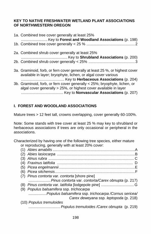
198
KEY TO NATIVE FRESHWATER WETLAND PLANT ASSOCIATIONS OF NORTHWESTERN OREGON 1a. Combined tree cover generally at least 25% ......................... Key to Forest and Woodland Associations (p. 198) 1b. Combined tree cover generally < 25 % ..............................................2 2a. Combined shrub cover generally at least 25% ............................................ Key to Shrubland Associations (p. 200) 2b. Combined shrub cover generally < 25% ............................................3 3a. Graminoid, forb, or fern cover generally at least 25 %, or highest cover available in layer; bryophyte, lichen, or algal cover various ......................................... Key to Herbaceous Associations (p. 204) 3b. Graminoid, forb, or fern cover generally < 25%; bryophyte, lichen, or algal cover generally > 25%, or highest cover available in layer ........................................ Key to Nonvascular Associations (p. 207) I. FOREST AND WOODLAND ASSOCIATIONS Mature trees > 12 feet tall, crowns overlapping, cover generally 60-100%. Note: Some stands with tree cover at least 25 % may key to shrubland or herbaceous associations if trees are only occasional or peripheral in the associations. Characterized by having one of the following tree species, either mature
or reproducing, generally with at least 20% cover: (1) Abies amabilis ..............................................................................A (2) Abies lasiocarpa ..........................................................................B (3) Alnus rubra ................................................................................. C (4) Fraxinus latifolia ........................................................................ D (5) Picea engelmannii ........................................................................E (6) Picea sitchensis............................................................................F (7) Pinus contorta var. contorta [shore pine] .....................Pinus contorta var. contorta/Carex obnupta (p. 217) (8) Pinus contorta var. latifolia [lodgepole pine] ............................... G (9) Populus balsamifera ssp. trichocarpa .................Populus balsamifera ssp. trichocarpa /Cornus sericea/
Carex deweyana ssp. leptopoda (p. 218) (10) Populus tremuloides .............................. Populus tremuloides /Carex obnupta (p. 219)
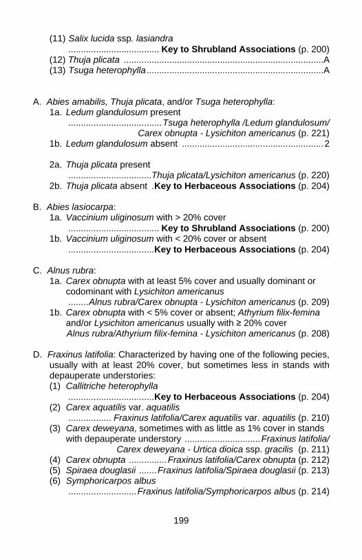
199
(11) Salix lucida ssp. lasiandra .................................... Key to Shrubland Associations (p. 200) (12) Thuja plicata ...............................................................................A (13) Tsuga heterophylla......................................................................A A. Abies amabilis, Thuja plicata, and/or Tsuga heterophylla: 1a. Ledum glandulosum present .....................................Tsuga heterophylla /Ledum glandulosum/
Carex obnupta - Lysichiton americanus (p. 221) 1b. Ledum glandulosum absent ........................................................2 2a. Thuja plicata present .................................Thuja plicata/Lysichiton americanus (p. 220) 2b. Thuja plicata absent .Key to Herbaceous Associations (p. 204) B. Abies lasiocarpa: 1a. Vaccinium uliginosum with > 20% cover .................................... Key to Shrubland Associations (p. 200) 1b. Vaccinium uliginosum with < 20% cover or absent ..................................Key to Herbaceous Associations (p. 204) C. Alnus rubra: 1a. Carex obnupta with at least 5% cover and usually dominant or
codominant with Lysichiton americanus ........Alnus rubra/Carex obnupta - Lysichiton americanus (p. 209) 1b. Carex obnupta with < 5% cover or absent; Athyrium filix-femina
and/or Lysichiton americanus usually with ≥ 20% cover Alnus rubra/Athyrium filix-femina - Lysichiton americanus (p. 208) D. Fraxinus latifolia: Characterized by having one of the following pecies,
usually with at least 20% cover, but sometimes less in stands with depauperate understories:
(1) Callitriche heterophylla ..................................Key to Herbaceous Associations (p. 204) (2) Carex aquatilis var. aquatilis ................. Fraxinus latifolia/Carex aquatilis var. aquatilis (p. 210) (3) Carex deweyana, sometimes with as little as 1% cover in stands with depauperate understory ..............................Fraxinus latifolia/
Carex deweyana - Urtica dioica ssp. gracilis (p. 211) (4) Carex obnupta ...............Fraxinus latifolia/Carex obnupta (p. 212) (5) Spiraea douglasii .......Fraxinus latifolia/Spiraea douglasii (p. 213) (6) Symphoricarpos albus ...........................Fraxinus latifolia/Symphoricarpos albus (p. 214)
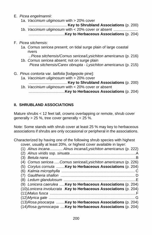
200
E. Picea engelmannii: 1a. Vaccinium uliginosum with > 20% cover .................................... Key to Shrubland Associations (p. 200) 1b. Vaccinium uliginosum with < 20% cover or absent ....................... ..................................Key to Herbaceous Associations (p. 204) F. Picea sitchensis: 1a. Cornus sericea present; on tidal surge plain of large coastal
rivers ..Picea sitchensis/Cornus sericea/Lysichiton americanus (p. 216) 1b. Cornus sericea absent; not on surge plain Picea sitchensis/Carex obnupta - Lysichiton americanus (p. 215)
G. Pinus contorta var. latifolia [lodgepole pine]: 1a. Vaccinium uliginosum with > 20% cover .................................... Key to Shrubland Associations (p. 200) 1b. Vaccinium uliginosum with < 20% cover or absent ..................................Key to Herbaceous Associations (p. 204) II. SHRUBLAND ASSOCIATIONS
Mature shrubs < 12 feet tall, crowns overlapping or remote, shrub cover generally > 25 %, tree cover generally < 25 %.
Note: Some stands with shrub cover at least 25 % may key to herbaceous associations if shrubs are only occasional or peripheral in the associations. Characterized by having one of the following shrub species with highest
cover, usually at least 20%, or highest cover available in layer: (1) Alnus incana............ Alnus incana/Lysichiton americanus (p. 222) (2) Alnus viridis ssp. sinuata ..............................................................A (3) Betula nana ..................................................................................B (4) Cornus sericea .....Cornus sericea/Lysichiton americanus (p. 226) (5) Corylus cornuta ........Key to Herbaceous Associations (p. 204) (6) Kalmia microphylla ..................................................................... C (7) Gaultheria shallon ...................................................................... D (8) Ledum glandulosum ....................................................................E (9) Lonicera caerulea .....Key to Herbaceous Associations (p. 204) (10) Lonicera involucrata .Key to Herbaceous Associations (p. 204) (11) Malus fusca .................................................................................F (12) Myrica gale ................................................................................. G (13) Rosa pisocarpa ........Key to Herbaceous Associations (p. 204) (14) Rosa gymnocarpa ....Key to Herbaceous Associations (p. 204)
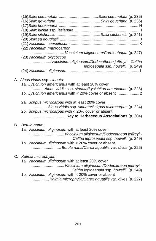
201
(15) Salix commutata ....................................Salix commutata (p. 235) (16) Salix geyeriana ........................................Salix geyeriana (p. 236) (17) Salix hookeriana ......................................................................... H (18) Salix lucida ssp. lasiandra ............................................................ I (19) Salix sitchensis ........................................Salix sitchensis (p. 241) (20) Spiraea douglasii ......................................................................... J (21) Vaccinium caespitosum ...............................................................K (22) Vaccinium macrocarpon ............................... Vaccinium uliginosum/Carex obnpta (p. 247) (23) Vaccinium oxycoccos ....................Vaccinium uliginosum/Dodecatheon jeffreyi – Caltha
leptosepala ssp. howellii (p. 249) (24) Vaccinium uliginosum ..................................................................L A. Alnus viridis ssp. sinuata: 1a. Lysichiton americanus with at least 20% cover ............. Alnus viridis ssp. sinuata/Lysichiton americanus (p. 223) 1b. Lysichiton americanus with < 20% cover or absent ....................2 2a. Scirpus microcarpus with at least 20% cover ............... Alnus viridis ssp. sinuata/Scirpus microcarpus (p. 224) 2b. Scirpus microcarpus with < 20% cover or absent ..................................Key to Herbaceous Associations (p. 204) B. Betula nana: 1a. Vaccinium uliginosum with at least 20% cover ................................Vaccinium uliginosum/Dodecatheon jeffreyi -
Caltha leptosepala ssp. howellii (p. 249) 1b. Vaccinium uliginosum with < 20% cover or absent ............................ Betula nana/Carex aquatilis var. dives (p. 225) C. Kalmia microphylla: 1a. Vaccinium uliginosum with at least 20% cover ................................Vaccinium uliginosum/Dodecatheon jeffreyi -
Caltha leptosepala ssp. howellii (p. 249) 1b. Vaccinium uliginosum with < 20% cover or absent .................. Kalmia microphylla/Carex aquatilis var. dives (p. 227)
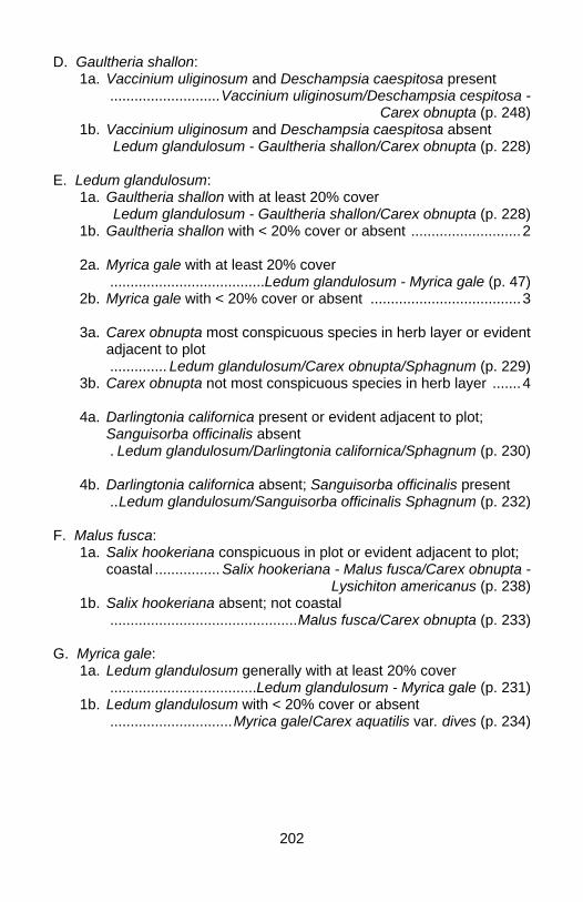
202
D. Gaultheria shallon: 1a. Vaccinium uliginosum and Deschampsia caespitosa present ...........................Vaccinium uliginosum/Deschampsia cespitosa -
Carex obnupta (p. 248) 1b. Vaccinium uliginosum and Deschampsia caespitosa absent Ledum glandulosum - Gaultheria shallon/Carex obnupta (p. 228) E. Ledum glandulosum: 1a. Gaultheria shallon with at least 20% cover Ledum glandulosum - Gaultheria shallon/Carex obnupta (p. 228) 1b. Gaultheria shallon with < 20% cover or absent ...........................2 2a. Myrica gale with at least 20% cover ......................................Ledum glandulosum - Myrica gale (p. 47) 2b. Myrica gale with < 20% cover or absent .....................................3 3a. Carex obnupta most conspicuous species in herb layer or evident adjacent to plot .............. Ledum glandulosum/Carex obnupta/Sphagnum (p. 229) 3b. Carex obnupta not most conspicuous species in herb layer .......4 4a. Darlingtonia californica present or evident adjacent to plot;
Sanguisorba officinalis absent . Ledum glandulosum/Darlingtonia californica/Sphagnum (p. 230) 4b. Darlingtonia californica absent; Sanguisorba officinalis present ..Ledum glandulosum/Sanguisorba officinalis Sphagnum (p. 232) F. Malus fusca: 1a. Salix hookeriana conspicuous in plot or evident adjacent to plot;
coastal ................ Salix hookeriana - Malus fusca/Carex obnupta - Lysichiton americanus (p. 238)
1b. Salix hookeriana absent; not coastal ..............................................Malus fusca/Carex obnupta (p. 233) G. Myrica gale: 1a. Ledum glandulosum generally with at least 20% cover ....................................Ledum glandulosum - Myrica gale (p. 231) 1b. Ledum glandulosum with < 20% cover or absent ..............................Myrica gale/Carex aquatilis var. dives (p. 234)
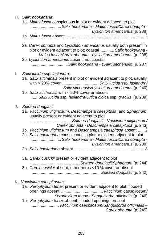
203
H. Salix hookeriana: 1a. Malus fusca conspicuous in plot or evident adjacent to plot ........................... Salix hookeriana - Malus fusca/Carex obnupta -
Lysichiton americanus (p. 238) 1b. Malus fusca absent .....................................................................2 2a. Carex obnupta and Lysichiton americanus usually both present in
plot or evident adjacent to plot; coastal ............ Salix hookeriana - Malus fusca/Carex obnupta - Lysichiton americanus (p. 238)
2b. Lysichiton americanus absent; not coastal .................................Salix hookeriana - (Salix sitchensis) (p. 237) I. Salix lucida ssp. lasiandra: 1a. Salix sitchensis present in plot or evident adjacent to plot, usually
with > 20% cover ................................ Salix lucida ssp. lasiandra/ Salix sitchensis/Lysichiton americanus (p. 240)
1b. Salix sitchensis with < 20% cover or absent ...... Salix lucida ssp. lasiandra/Urtica dioica ssp. gracilis (p. 239) J. Spiraea douglasii: 1a. Vaccinium uliginosum, Deschampsia caespitosa, and Sphagnum
usually present or evident adjacent to plot .................................... Spiraea douglasii - Vaccinium uliginosum/
Carex obnupta - Deschampsia caespitosa (p. 243) 1b. Vaccinium uliginosum and Deschampsia caespitosa absent ......2 2a. Salix hookeriana conspicuous in plot or evident adjacent to plot ........................... Salix hookeriana - Malus fusca/Carex obnupta -
Lysichiton americanus (p. 238) 2b. Salix hookeriana absent ..............................................................3 3a. Carex cusickii present or evident adjacent to plot ............................................Spiraea douglasii/Sphagnum (p. 244) 3b. Carex cusickii absent, other herbs <10 % cover or absent ............................................................ Spiraea douglasii (p. 242) K. Vaccinium caespitosum: 1a. Xerophyllum tenax present or evident adjacent to plot, flooded
openings absent ..................................... Vaccinium caespitosum/ Xerophyllum tenax - Sanguisorba officinalis (p. 246)
1b. Xerophyllum tenax absent, flooded openings present ......................... Vaccinium caespitosum/Sanguisorba officinalis –
Carex obnupta (p. 245)
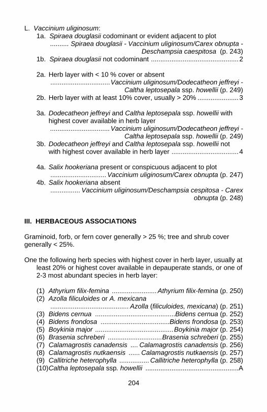
204
L. Vaccinium uliginosum: 1a. Spiraea douglasii codominant or evident adjacent to plot .......... Spiraea douglasii - Vaccinium uliginosum/Carex obnupta -
Deschampsia caespitosa (p. 243) 1b. Spiraea douglasii not codominant ...............................................2 2a. Herb layer with < 10 % cover or absent ................................Vaccinium uliginosum/Dodecatheon jeffreyi -
Caltha leptosepala ssp. howellii (p. 249) 2b. Herb layer with at least 10% cover, usually > 20% ......................3 3a. Dodecatheon jeffreyi and Caltha leptosepala ssp. howellii with
highest cover available in herb layer ................................Vaccinium uliginosum/Dodecatheon jeffreyi -
Caltha leptosepala ssp. howellii (p. 249) 3b. Dodecatheon jeffreyi and Caltha leptosepala ssp. howellii not
with highest cover available in herb layer ....................................4
4a. Salix hookeriana present or conspicuous adjacent to plot .............................. Vaccinium uliginosum/Carex obnupta (p. 247) 4b. Salix hookeriana absent ................ Vaccinium uliginosum/Deschampsia cespitosa - Carex
obnupta (p. 248)
III. HERBACEOUS ASSOCIATIONS Graminoid, forb, or fern cover generally > 25 %; tree and shrub cover generally < 25%.
One the following herb species with highest cover in herb layer, usually at
least 20% or highest cover available in depauperate stands, or one of 2-3 most abundant species in herb layer:
(1) Athyrium filix-femina ........................ Athyrium filix-femina (p. 250) (2) Azolla filiculoides or A. mexicana .......................................... Azolla (filiculoides, mexicana) (p. 251) (3) Bidens cernua ...........................................Bidens cernua (p. 252) (4) Bidens frondosa .....................................Bidens frondosa (p. 253) (5) Boykinia major ..........................................Boykinia major (p. 254) (6) Brasenia schreberi .............................Brasenia schreberi (p. 255) (7) Calamagrostis canadensis .... Calamagrostis canadensis (p. 256) (8) Calamagrostis nutkaensis ...... Calamagrostis nutkaensis (p. 257) (9) Callitriche heterophylla ................ Callitriche heterophylla (p. 258) (10) Caltha leptosepala ssp. howellii ..................................................A
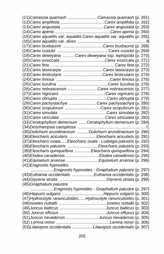
205
(11) Camassia quamash ..........................Camassia quamash (p. 261) (12) Carex amplifolia ......................................Carex amplifolia (p. 262) (13) Carex angustata .................................... Carex angustata (p. 263) (14) Carex aperta ................................................Carex aperta (p. 264) (15) Carex aquatilis var. aquatilis Carex aquatilis var. aquatilis (p. 265) (16) Carex aquatilis var. dives ............................................................B (17) Carex buxbaumii ...................................Carex buxbaumii (p. 268) (18) Carex cusickii ............................................ Carex cusickii (p. 269) (19) Carex deweyana .......... Carex deweyana ssp. leptopoda (p. 270) (20) Carex exsiccata ......................................Carex exsiccata (p. 271) (21) Carex feta.........................................................Carex feta (p. 272) (22) Carex lasiocarpa ...................................Carex lasiocarpa (p. 273) (23) Carex lenticularis ..................................Carex lenticularis (p. 274) (24) Carex limosa ...............................................Carex limosa (p. 275) (25) Carex luzulina ............................................Carex luzulina (p. 276) (26) Carex nebrascensis ..........................Carex nebrascensis (p. 277) (27) Carex nigricans .......................................Carex nigricans (p. 278) (28) Carex obnupta ..........................................Carex obnupta (p. 279) (29) Carex pachystachya ........................Carex pachystachya (p. 280) (30) Carex scopulorum .............................. Carex scopulorum (p. 281) (31) Carex simulata .........................................Carex simulata (p. 282) (32) Carex utriculata ...................................... Carex utriculata (p. 283) (33) Ceratophyllum demersum ...... Ceratophyllum demersum (p. 284) (34) Deschampsia caespitosa ........................................................... C (35) Dulichium arundinaceum ..........Dulichium arundinaceum (p. 290) (36) Eleocharis acicularis ........................Eleocharis acicularis (p. 291) (37) Eleocharis ovata..... Eleocharis ovata - Ludwigia palustris (p. 292) (38) Eleocharis palustris .......................... Eleocharis palustris (p. 293) (39) Eleocharis quinqueflora ..............Eleocharis quinqueflora (p. 294) (40) Elodea canadensis ............................ Elodea canadensis (p. 295) (41) Equisetum arvense ............................Equisetum arvense (p. 296) (42) Eragrostis hypnoides ....................Eragrostis hypnoides - Gnaphalium palustre (p. 297) (43) Euthamia occidentalis ...................Euthamia occidentalis (p. 298) (44) Glyceria striata .........................................Glyceria striata (p. 299) (45) Gnaphalium palustre ....................Eragrostis hypnoides - Gnaphalium palustre (p. 297) (46) Hippuris vulgaris ....................................Hippuris vulgaris (p. 300) (47) Hydrocotyle ranunculoides ..... Hydrocotyle ranunculoides (p. 301) (48) Isoetes nuttallii ..........................................Isoetes nuttallii (p. 302) (49) Juncus balticus ........................................Juncus balticus (p. 303) (50) Juncus effusus .........................................Juncus effusus (p. 304) (51) Juncus nevadensis ............................Juncus nevadensis (p. 305) (52) Lemna minor ...............................................Lemna minor (p. 306) (53) Lilaeopsis occidentalis ..................Lilaeopsis occidentalis (p. 307)
206
(54) Ludwigia palustris ............. Ludwigia palustris - Polygonum hydropiperoides (p. 308) (55) Menyanthes trifoliata ...................... Menyanthes trifoliata (p. 309) (56) Nephrophyllidium crista-galli .............................................Nephrophyllidium crista-galli (p. 310) (57) Nuphar lutea ssp. polysepala ........................................... Nuphar lutea ssp. polysepala (p. 311) (58) Oenanthe sarmentosa .................Oenanthe sarmentosa (p. 312) (59) Paspalum distichum ........................ Paspalum distichum (p. 313) (60) Polygonum amphibium ................Polygonum amphibium (p. 314) (61) Polygonum hydropiperoides ............. Ludwigia palustris - Polygonum hydropiperoides (p. 308) (62) Potamogeton natans ...................... Potamogeton natans (p. 315) (63) Ranunculus aquatilis ...................... Ranunculus aquatilis (p. 316) (64) Ranunculus flammula ....................Ranunculus flammula (p. 317) (65) Sagittaria latifolia .................................. Sagittaria latifolia (p. 318) (66) Sanguisorba officinalis ............................................................... D (67) Schoenoplectus acutus ............. Schoenoplectus acutus (p. 320) (68) Scirpus microcarpus ........................Scirpus microcarpus (p. 321) (69) Senecio triangularis ..........................Senecio triangularis (p. 322) (70) Sparganium angustifolium ......Sparganium angustifolium (p. 323) (71) Sparganium eurycarpum .......... Sparganium eurycarpum (p. 324) (72) Torreyochloa pallida var. pauciflora ..................................Torreyochloa pallida var. pauciflora (p. 325) (73) Trichophorum caespitosum .............................................. Trichophorum caespitosum (p. 326) (74) Triteleia hyacinthina .........................Triteleia hyacinthina (p. 327) (75) Typha latifolia ............................................ Typha latifolia (p. 328) (76) Utricularia macrorhiza ...................Utricularia macrorhiza (p. 329) A1. Sanguisorba officinalis usually codominant, Carex obnupta and/or Carex cusickii conspicuous in plot or evident adjacent to plot; Coast Range ........ Caltha leptosepala ssp. howellii - Carex obnupta (p. 260) A2. Sanguisorba officinalis, Carex obnupta, Carex cusickii absent or with < 5% cover; Cascade Range Caltha leptosepala ssp. howellii (p. 259) B1. Nuphar lutea ssp. polysepala present; coastal ........................Carex aquatilis var. dives - Comarum palustre (p. 267) B2. Nuphar lutea ssp. polysepala absent; montane ........................................................ Carex aquatilis var. dives (p. 266) C1. Carex unilateralis and Danthonia californica usually present ....................Deschampsia caespitosa - Danthonia californica (p. 288)
207
C2. Carex unilateralis and Danthonia californica absent ..........................2 2a. Artemisia lindleyana present, Juncus balticus absent; low
elevation .............. Deschampsia caespitosa - Artemisia lindleyana (p. 287) 2b. Artemisia lindleyana absent; Cascade Range ............................3 3a. Juncus balticus codominant ......................Deschampsia caespitosa - Juncus balticus (p. 289) 3b. Juncus balticus not codominant; any other combinations of
species ........................ Deschampsia caespitosa montane "wet meadow"
complex (p. 285) D1. Carex aquatilis var. dives conspicuous in plot or evident adjacent to plot; Carex obnupta and Carex cusickii absent; Cascade Range ................. Sanguisorba officinalis - Carex aquatilis var. dives (p. 319) D2. Carex aquatilis var. dives absent, Carex obnupta and/or Carex cusickii conspicuous in plot or evident adjacent to plot; Coast Range ................... Caltha leptosepala ssp. howellii - Carex obnupta (p. 259)
IV. NONVASCULAR ASSOCIATIONS Bryophyte, lichen, or algal cover generally > 25%; graminoid, forb, fern, tree, or shrub cover generally < 25%. Most abundant species in moss layer: 1a. Fontinalis antipyretica ..........................Fontinalis antipyretica (p. 330) 1b. Polytrichum commune ........................Polytrichum commune (p. 331)
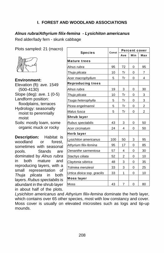
208
I. FOREST AND WOODLAND ASSOCIATIONS
Alnus rubra/Athyrium filix-femina - Lysichiton americanus Red alder/lady fern - skunk cabbage Plots sampled: 21 (macro)
Environment: Elevation (ft): ave. 1549
(500-4130) Slope (deg): ave. 1 (0-5) Landform position:
floodplains, terraces Hydrology: seasonally
moist to perennially moist
Soils: mostly loam, some organic muck or rocky
Description: Habitat is woodland or forest, sometimes with seasonal pools. Stands are dominated by Alnus rubra in both mature and reproducing layers, with a small representation of Thuja plicata in both layers. Rubus spectabilis is abundant in the shrub layer in about half of the plots. Lysichiton americanus and Athyrium filix-femina dominate the herb layer, which contains over 65 other species, most with low constancy and cover. Moss cover is usually on elevated microsites such as logs and tip-up mounds.
Percent cover Species Const Ave Min Max
Mature trees Alnus rubra 95 72 0 95 Thuja plicata 10 Tr 0 7 Acer macrophyllum 5 Tr 0 4 Reproducing trees Alnus rubra 19 3 0 30 Thuja plicata 10 Tr 0 3 Tsuga heterophylla 5 Tr 0 3 Picea engelmannii 5 Tr 0 2 Malus fusca 5 Tr 0 2 Shrub layer Rubus spectabilis 43 3 0 50 Acer circinatum 24 4 0 50 Herb layer Lysichiton americanus 100 50 3 95 Athyrium filix-femina 95 17 0 85 Oenanthe sarmentosa 57 4 0 30 Stachys ciliata 52 2 0 10 Claytonia sibirica 48 3 0 35 Tolmiea menziesii 33 3 0 25 Urtica dioica ssp. gracilis 33 1 0 10 Moss layer Moss 43 7 0 80
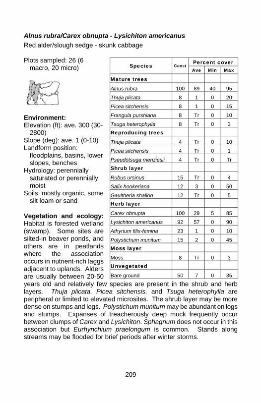
209
Alnus rubra/Carex obnupta - Lysichiton americanus Red alder/slough sedge - skunk cabbage Plots sampled: 26 (6
macro, 20 micro)
Environment: Elevation (ft): ave. 300 (30-
2800) Slope (deg): ave. 1 (0-10) Landform position:
floodplains, basins, lower slopes, benches
Hydrology: perennially saturated or perennially moist
Soils: mostly organic, some silt loam or sand
Vegetation and ecology: Habitat is forested wetland (swamp). Some sites are silted-in beaver ponds, and others are in peatlands where the association occurs in nutrient-rich laggs adjacent to uplands. Alders are usually between 20-50 years old and relatively few species are present in the shrub and herb layers. Thuja plicata, Picea sitchensis, and Tsuga heterophylla are peripheral or limited to elevated microsites. The shrub layer may be more dense on stumps and logs. Polystichum munitum may be abundant on logs and stumps. Expanses of treacherously deep muck frequently occur between clumps of Carex and Lysichiton. Sphagnum does not occur in this association but Eurhynchium praelongum is common. Stands along streams may be flooded for brief periods after winter storms.
Percent cover Species Const Ave Min Max
Mature trees Alnus rubra 100 89 40 95 Thuja plicata 8 1 0 20 Picea sitchensis 8 1 0 15 Frangula purshiana 8 Tr 0 10 Tsuga heterophylla 8 Tr 0 3 Reproducing trees Thuja plicata 4 Tr 0 10 Picea sitchensis 4 Tr 0 1 Pseudotsuga menziesii 4 Tr 0 Tr Shrub layer Rubus ursinus 15 Tr 0 4 Salix hookeriana 12 3 0 50 Gaultheria shallon 12 Tr 0 5 Herb layer Carex obnupta 100 29 5 85 Lysichiton americanus 92 57 0 90 Athyrium filix-femina 23 1 0 10 Polystichum munitum 15 2 0 45 Moss layer Moss 8 Tr 0 3 Unvegetated Bare ground 50 7 0 35
210
Fraxinus latifolia/Carex aquatilis var. aquatilis Oregon ash/aquatic sedge Plots sampled: 2 (macro)
Environment: Elevation (ft): 500 Slope (deg): 0 Landform position:
floodplains, basins Hydrology: seasonally wet
to flooded Soils: clay loam with
seasonal perched water table
Vegetation and ecology: Habitat is riparian forest. This association is known from only two plots and but is described here because it may be a relic of a more widespread historic vegetation type. It represents a mix of lowland and cold-soil vegetation of higher elevations. The shrub layer is diverse but cover is not particularly high. Proximity to settlement and agriculture is indicated by presence of exotic species such as Crataegus monogyna, Phalaris arundinacea, Poa trivialis, and Lolium arundinaceum.
Percent cover Species Const Ave Min Max
Mature trees Fraxinus latifolia 100 75 70 80 Shrub layer Spiraea douglasii 100 7 3 10 Rubus ursinus 100 4 2 5 Lonicera involucrata 100 3 3 3 Symphoricarpos albus 50 2 0 3 Amelanchier alnifolia 50 1 0 1 Rosa nutkana 50 Tr 0 1 Crataegus douglasii 50 Tr 0 Tr Crataegus monogyna 50 Tr 0 Tr Herb layer Carex aquatilis 100 50 20 80 Veratrum californicum 100 14 3 25 Carex deweyana ssp. leptopoda 100 4 2 5
Carex obnupta 100 3 2 3 Geum macrophyllum 100 2 2 2 Phalaris arundinacea 100 2 1 2 Epilobium ciliatum 100 2 1 2 Galium triflorum 100 Tr Tr Tr Mimulus guttatus 50 13 0 25 Oenanthe sarmentosa 50 4 0 8
211
Fraxinus latifolia/Carex deweyana - Urtica dioica ssp. gracilis Oregon ash/Dewey sedge - California nettle Plots sampled: 2 (macro)
Environment: Elevation (ft): ave. 255
(10- 500) Slope (deg): 0 Landform position: bottoms Hydrology: seasonally
flooded to moist Soils: silt loams Vegetation and ecology: Habitat is riparian forest. These stands occur in depressions on river and creek bottoms and were subject to sometimes prolonged seasonal inundation prior to flood control in western Oregon. Floodwaters may pool and persist into the growing season, suppressing herbaceous vegetation. Urtica dioica ssp. gracilis may be abundant in the herb layer although it is not represented in these plots. Depressions may contain no vegetation, only litterfall or recent deposits of silt, and these may become densely colonized by Fraxinus seedlings during the year following deposition. Tree trunks usually have thick sleeves of mosses that trap sediment and mark high water lines with silt stains. Many stands that now only flood occasionally probably contain more herbaceous vegetation than what existed before flood control. Invasion by Phalaris arundinacea and Solanum dulcamara can be particularly severe around openings in the canopy, displacing smaller native species.
Percent cover Species Const Ave Min Max
Mature trees Fraxinus latifolia 100 78 75 80 Shrub layer Rubus ursinus 50 9 0 18 Spiraea douglasii 50 5 0 10 Herb layer Carex deweyana ssp. leptopoda 100 31 1 60 Juncus patens 50 13 0 25 Phalaris arundinacea 50 3 0 5 Veronica scutellata 50 1 0 2 Geum macrophyllum 50 1 0 1 Juncus tenuis 50 1 0 1 Juncus effusus 50 Tr 0 Tr Agrostis exarata 50 Tr 0 Tr Perideridia gairdneri 50 Tr 0 Tr Stellaria calycantha 50 Tr 0 Tr Elymus glaucus 50 Tr 0 Tr Moss layer Moss 100 6 1 11
212
Fraxinus latifolia/Carex obnupta Oregon ash/slough sedge Plots sampled: 18 (macro)
Environment: Elevation (ft): ave. 669
(500-1700) Slope (deg): ave. 0 (0-2) Landform position:
floodplains and benches Hydrology: seasonally
flooded to saturated Soils: silt and clay loams,
some organic Vegetation and ecology: Habitat is riparian forest. The shrub layer is diverse but averages less than 10 percent cover, with occasionally high cover of Rubus ursinus, Symphoricarpos albus, Cornus sericea, or Acer circinatum. Carex obnupta dominates the herb layer. Forty other herbaceous species are reported from plots but most have less than 15 percent cover. The presence of Veratrum viride and Rudbeckia occidentalis in a stand of Fraxinus is unusual because these species are more typical of elevations above 2000-3000 feet.
Percent cover Species Cons
t Ave Min Max
Mature trees Fraxinus latifolia 100 64 25 90 Populus balsamifera ssp. trichocarpa 11 1 0 15
Frangula purshiana 11 Tr 0 5 Abies grandis 6 Tr 0 Tr Reproducing trees Fraxinus latifolia 11 Tr 0 1 Alnus rubra 6 Tr 0 Tr Shrub layer Rubus ursinus 67 6 0 36 Rosa nutkana 33 Tr 0 1 Symphoricarpos albus 28 3 0 20 Spiraea douglasii 22 1 0 8 Physocarpus capitatus 22 Tr 0 3 Corylus cornuta 22 Tr 0 2 Herb layer Carex obnupta 100 76 25 100 Polypodium glycyrrhiza 50 Tr 0 Tr Carex deweyana ssp. leptopoda 33 2 0 15
Polystichum munitum 33 1 0 10 Moss layer Moss 83 12 0 50

213
Fraxinus latifolia/Spiraea douglasii Oregon ash/Douglas spiraea Plots sampled: 3 (macro)
Environment: Elevation (ft): 500 Slope (deg): 0 Landform position:
floodplains Hydrology: seasonally
flooded to saturated Soils: silt and clay loams Vegetation and ecology: Habitat is riparian woodland or forest with open to closed canopy. Fraxinus latifolia is the only tree species present, and stands are characterized by a very dense shrub layer of Spiraea douglasii with little else present but Carex obnupta. Stands may be extensive along floodplains and some have no doubt developed on abandoned pasture land and old prairie.
Percent cover Species Const
Ave Min Max
Mature trees Fraxinus latifolia 100 74 50 90 Shrub layer Spiraea douglasii 100 85 60 100 Cornus sericea 25 Tr 0 1 Herb layer Carex obnupta 25 10 0 40 Ranunculus uncinatus 25 Tr 0 1 Apiaceae 25 Tr 0 Tr Rumex crispus 25 Tr 0 Tr Poa trivialis 25 Tr 0 Tr Epilobium ciliatum 25 Tr 0 Tr Moss layer Moss 50 1 0 4
214
Fraxinus latifolia/Symphoricarpos albus Oregon ash/snowberry Plots sampled: 2 (macro)
Environment: Elevation (ft): ave. 790
(500-1080) Slope (deg): ave. 1 (0-1) Landform position:
floodplain depressions Hydrology: seasonally
flooded Soils: silt and clay loams Vegetation and ecology: Habitat is riparian forest. Fraxinus latifolia is typically the only tree present in these stands. Symphoricarpos albus and Rubus ursinus may cover up to half the shrub layer, and Corylus cornuta may sometimes have cover up to 40 percent. The herb layer is dominated by monotypic stands of Carex obnupta with few other species present. Depressions with Carex obnupta may remain flooded into the growing season.
Percent cover Species Const Ave Min Max
Mature trees
Fraxinus latifolia 100 80 75 85
Shrub layer
Symphoricarpos albus 100 55 50 60
Rubus ursinus 100 33 Tr 65
Corylus cornuta 50 20 0 40
Cornus sericea 50 6 0 12
Amelanchier alnifolia 50 5 0 10
Acer circinatum 50 Tr 0 Tr
Herb layer
Carex obnupta 100 60 45 75
Carex deweyana ssp. leptopoda 100 1 Tr 2
Athyrium filix-femina 50 1 0 2
Galium triflorum 50 1 0 1
Botrychium virginianum 50 Tr 0 Tr
Galium aparine 50 Tr 0 Tr
Moss layer
Moss 100 3 1 5

215
Picea sitchensis/Carex obnupta - Lysichiton americanus Sitka spruce/slough sedge - skunk cabbage Plots sampled: 27 (7 macro, 20 micro)
Environment: Elevation (ft): ave. 24 (20-
40) Slope (deg): 0 Landform position:
floodplains, basins Hydrology: perennially
saturated Soils: organic or muck Vegetation and ecology: Habitat is forested wetland (swamp) in coastal fens. The association occurs peripheral to open mire or shrub-swamp and often develops in nutrient-rich laggs adjacent to uplands. Eurhynchium praelongum is the most common moss, but several species of Sphagnum become more frequent near the Columbia River and northward with increasing precipitation. Picea sitchensis grows slowly in perennially saturated soils and trees with diameters of 25-40 inches have been found to be 200-500 years old, generally much older than upland spruce with comparable diameters. These "swamp spruce" have a characteristic growth form with shallow and spreading root systems, buttressed trunks, and reduced crown spread. Large wads of Polypodium scouleri, and thick mats of epiphytic mosses, particularly Antitrichia curtipendula, are typical on upper trunks and limbs. Windthrow is frequent, creating gaps for regeneration of Picea, often as resprouts from fallen boles.
Percent cover Species Const
Ave Min Max
Mature trees Picea sitchensis 100 66 30 85 Alnus rubra 19 2 0 25 Thuja plicata 7 1 0 30 Tsuga heterophylla 4 1 0 20 Reproducing trees Tsuga heterophylla 4 Tr 0 1 Shrub layer Gaultheria shallon 37 4 0 30 Rubus spectabilis 30 3 0 20 Vaccinium parvifolium 30 3 0 20 Herb layer Carex obnupta 96 66 0 95 Lysichiton americanus 74 20 0 70 Oenanthe sarmentosa 22 1 0 20 Maianthemum dilatatum 22 1 0 8 Moss layer Moss 11 3 0 70
216
Picea sitchensis/Cornus sericea/Lysichiton americanus Sitka spruce/creek dogwood/skunk cabbage Plots sampled: 15 (macro)
Environment: Elevation (ft): ave. 5 (5-6) Slope (deg): 0 Landform position:
floodplains Hydrology: seasonally
flooded to perennially saturated
Soils: muck or organic Vegetation and ecology: Habitat is forested wetland (swamp) on floodplains of large coastal rivers, with daily freshwater tidal flooding. Stands occur on natural levees along river channels and larger tidal creeks, and form perimeters around typically lower and wetter interiors composed of either willow swamp or emergent marsh. Tsuga heterophylla is occasional on logs and stumps. A nearly impenetrable shrub layer is characteristic of these stands.
Percent cover Species Const
Ave Min Max
Mature trees Picea sitchensis 100 24 5 65 Alnus rubra 73 7 0 20 Thuja plicata 67 8 0 25 Frangula purshiana 67 4 0 20 Populus balsamifera ssp. trichocarpa 60 19 0 80
Reproducing trees Thuja plicata 13 Tr 0 2 Picea sitchensis 13 Tr 0 1 Shrub layer Cornus sericea 100 22 3 50 Rubus spectabilis 87 6 0 25 Rosa nutkana 80 3 0 10 Rubus ursinus 80 1 0 4 Rubus parviflorus 73 3 0 10 Vaccinium parvifolium 73 1 0 2 Gaultheria shallon 67 4 0 15 Oemleria cerasiformis 67 1 0 5 Symphoricarpos albus 67 1 0 5 Acer circinatum 60 5 0 20 Malus fusca 60 3 0 10 Salix sitchensis 40 5 0 40 Herb layer Lysichiton americanus 100 10 2 35 Athyrium filix-femina 93 2 0 10 Adiantum pedatum 93 1 0 2 Impatiens capensis 80 10 0 50 Carex obnupta 73 6 0 35 Oenanthe sarmentosa 60 2 0 5

217
Pinus contorta var. contorta/Carex obnupta Association Shore pine/slough sedge Plots sampled: 93 (11 macro, 82 micro)
Environment: Elevation (ft): ave. 76 (20-
100) Slope (deg): 0 Landform position: former
deflation plains, ancient marine terraces
Hydrology: seasonally flooded, dry in summer
Soils: sand, sometimes with duripan
Vegetation and ecology: Habitat is seasonally-flooded depressions in stabilized sand dunes along the coast. Most stands are 30-75 years old, with canopy cover between 0-85 percent. Pinus contorta is usually the only reproducing conifer present. The sparse shrub layer grows on mounds in and around the depressions. The density of the herb layer varies inversely with depth and duration of winter flooding. Drought-tolerant Warnstorfia exannulata, Sphagnum mendocinum, Polytrichum commune, and Fontinalis howellii are the most conspicuous mosses. Inclusions of the Salix hookeriana - Malus fusca/Carex obnupta - Lysichiton americanus association may occur in deeper depressions where water persists later in the season. Sand in dried-up depressions is often stained with iron. Peat does not develop at these sites because summer drying oxidizes any organic material.
Percent cover Species Const
Ave Min Max
Mature trees Pinus contorta var. contorta 99 30 0 85
Shrub layer Vaccinium ovatum 16 1 0 15 Vaccinium uliginosum 12 2 0 75 Gaultheria shallon 10 1 0 40 Herb layer Carex obnupta 100 27 1 75 Dichanthelium acuminatum var. fasciculare
9 1 0 15
Deschampsia caespitosa 6 1 0 50
Agrostis 5 Tr 0 10 Argentina egedii 3 Tr 0 20 Juncus lesueurii 3 Tr 0 10 Moss layer Moss 76 30 0 95 Unvegetated Bare ground 14 7 0 95 Litter 1 Tr 0 15
218
Populus balsamifera ssp. trichocarpa /Cornus sericea/Carex deweyana ssp. leptopoda Black cottonwood/creek dogwood/Dewey sedge Plots sampled: 3 (macro)
Environment: Elevation (ft): ave. 8 (5-
10) Slope (deg): 0 Landform position:
floodplains Hydrology: perennially
saturated Soils: silt loam or muck Vegetation and ecology: Habitat is forested wetland (swamp) in floodplains of large coastal rivers, with daily freshwater tidal flooding. Portions are flooded at high tide, but trees are restricted to areas elevated above the water. Fraxinus latifolia may be frequent. The shrub layer may include Salix sitchensis and very low cover of other species such as Rubus ursinus, Rubus spectabilis, Malus fusca, and Physocarpus capitatus. Because much of the understory is flooded at high tide, there are few herbaceous species present with any appreciable cover. Seeds of weedy Phalaris arundinacea, Iris pseudacorus, and Ranunculus repens are capable of rafting into the interior of stands at high tide and can occur almost anywhere. Despite the relative abundance of Impatiens capensis, which may not be native to the Pacific Northwest, Carex deweyana ssp. leptopoda is used here to distinguish these occurrences west of the Cascade Range from some Populus balsamifera ssp. trichocarpa/Cornus sericea stands reported from east of the Cascades.
Percent cover Species Const
Ave Min Max
Mature trees Populus balsamifera ssp. trichocarpa 100 48 30 75
Salix lucida ssp. lasiandra 67 8 0 15
Shrub layer Cornus sericea 100 47 20 60 Rubus ursinus 67 2 0 3 Rubus spectabilis 67 2 0 4 Herb layer Impatiens capensis 100 33 25 50 Carex deweyana ssp. leptopoda 100 1 1 2
Athyrium filix-femina 67 1 0 2 Lysichiton americanus 67 1 0 2 Scutellaria lateriflora 67 1 0 1 Solanum dulcamara 33 Tr 0 1 Callitriche 33 Tr 0 1 Prunella vulgaris 33 Tr 0 1

219
Populus tremuloides/Carex obnupta Quaking aspen/slough sedge Plots sampled: 1 (macro)
Environment: Elevation (ft): 500 Slope (deg): 0 Landform position:
floodplains, depressions Hydrology: seasonally
flooded to saturated Soils: silt loam or organic Vegetation and ecology: The single known occurrence of this association in Oregon is in a seasonally-flooded depression on shallow-soiled basalt scabland. It is described here because it may be a relic of type that was more widespread historically. Seasonal flooding is from precipitation but summer drying precludes formation of peat. The moss layer is covered up to 98 percent by Sphagnum mendocinum. Large expanses of swamp vegetation once occurred in the northern Willamette and Tualatin valleys and this association may have been part of it. Populus tremuloides still occurs in a number of low-elevation sites in Clackamas, Multnomah and Washington Counties, but most are on uplands that do not support wetland vegetation, and it becomes very rare at low elevations south of Clackamas County. These wetlands are thought to be more frequent in western Washington and perhaps extend to southwestern British Columbia but have not been sampled adequately. Spiraea douglasii and other species of Sphagnum have been observed in some stands in Washington. Despite the abundance of Spiraea douglasii in this association, Carex obnupta is used here to distinguish these low-elevation occurrences west of the Cascade Range from some Populus tremuloides/Spiraea douglasii stands reported from east of the Cascades.
Percent cover Species Const
Ave Min Max
Mature trees Populus tremuloides 100 50 50 50 Shrub layer Spiraea douglasii 100 80 80 80 Salix hookeriana 100 10 10 10 Herb layer Carex obnupta 100 Tr Tr Tr Moss layer Moss 100 98 98 98
220
Thuja plicata/Lysichiton americanus Western red cedar/skunk cabbage Plots sampled: 8 (macro)
Environment: Elevation (ft): ave. 2925
(1300-3800) Slope (deg): ave. 6 (0-14) Landform position:
floodplains, benches, and various slope positions with impeded drainage
Hydrology: perennially moist
Soils: loams Vegetation and ecology: Habitat is forested wetland (swamp) with shallow depressions among the trees. Stands are dominated by Pseudotsuga menziesii, when present, is usually peripheral in stands because of wet soils. Rubus spectabilis and Vaccinium ovalifolium occur in about half the plots, while the herb layer is dominated by Lysichiton americanus. Athyrium filix-femina has fairly high constancy but consistently low cover. Both shrub and herb layers are extremely diverse, with over 70 species present in the latter, sometimes making classification difficult. Trees and shrubs occupy elevated microsites, while Lysichiton americanus occupies wetter bottoms. Sphagnum occurs only at higher elevations.
Percent cover Species Const Ave Min Max
Mature trees
Thuja plicata 100 36 15 80
Abies amabilis 50 10 0 25
Tsuga heterophylla 50 8 0 30
Pseudotsuga menziesii 50 3 0 15 Reproducing trees
Thuja plicata 63 2 0 5
Tsuga heterophylla 50 1 0 3
Abies amabilis 38 1 0 2 Shrub layer
Rubus spectabilis 63 1 0 2
Vaccinium ovalifolium 50 3 0 8
Acer circinatum 38 Tr 0 2 Herb layer
Lysichiton americanus 100 28 8 60
Athyrium filix-femina 63 2 0 6
Galium triflorum 63 Tr 0 1
Blechnum spicant 50 6 0 30
Maianthemum dilatatum 38 1 0 7
Viola glabella 38 1 0 5
Listera 38 Tr 0 Tr
Asarum caudatum 38 Tr 0 Tr Moss layer
Moss 38 3 0 10
221
Tsuga heterophylla/Ledum glandulosum/Carex obnupta - Lysichiton americanus Western hemlock/Labrador tea/slough sedge - skunk cabbage Plots sampled: 8 (macro)
Environment: Elevation (ft): 25 Slope (deg): 0 Landform position:
floodplains, basins Hydrology: perennially
saturated to flooded Soils: organic muck and
peat Vegetation and ecology: Habitat is forested wetland (swamp) in coastal fens. Stands occur adjacent to open peatlands and shrub-swamps. Most trees and shrubs occur on elevated microsites such as decaying logs, stumps, and old root wads. Both Thuja plicata and Pinus contorta var. contorta may be suppressed or killed in waterlogged soils. The dense shrub layer may contain small amounts of Myrica californica. Sphagnum palustre or S. henryense are conspicuous in the moss layer. Stands are subject to windthrow in severe winter storms but appear to be self-perpetuating in the absence of major disturbance.
Percent cover Species Const Ave Min Max
Mature trees Tsuga heterophylla 100 19 4 60 Pinus contorta var. contorta 75 11 0 60 Thuja plicata 38 7 0 32 Picea sitchensis 25 2 0 8 Shrub layer Gaultheria shallon 100 21 12 40 Ledum glandulosum 100 14 4 32 Vaccinium ovatum 75 4 0 8 Vaccinium parvifolium 38 2 0 4 Herb layer Carex obnupta 100 42 16 60 Lysichiton americanus 100 4 4 4 Juncus 88 11 0 20 Oenanthe sarmentosa 50 2 0 4 Blechnum spicant 38 2 0 4 Moss layer Moss 100 20 4 36
222
II. SHRUBLAND ASSOCIATIONS
Alnus incana/Lysichiton americanus White alder/skunk cabbage Plots sampled: 7 (macro)
Environment: Elevation (ft): ave. 3789
(3120-4580) Slope (deg): ave. 5 (0-15) Landform position:
floodplains, basins, benches, slopes
Hydrology: seasonally moist to perennially saturated
Soils: mostly organic, some loam
Vegetation and ecology: Habitat is montane fens and shrub-swamp. Alnus incana may form dense stands with a variety of other shrubs. Over 60 species occur in the herb layer, making the understory extremely diverse and stands difficult to classify. This is why a number of publications have used "mesic forb" to characterize these stands.
Percent cover Species Const Ave Min Max
Mature trees Picea engelmannii 57 4 0 15 Tsuga heterophylla 29 1 0 7 Thuja plicata 14 2 0 15 Abies amabilis 14 1 0 5 Reproducing trees Tsuga heterophylla 57 1 0 3 Picea engelmannii 29 1 0 5 Abies amabilis 14 1 0 5 Thuja plicata 14 1 0 4 Abies grandis 14 Tr 0 Tr Shrub layer Alnus incana 100 50 20 81 Ribes bracteosum 43 2 0 10 Herb layer Lysichiton americanus 100 34 8 75 Athyrium filix-femina 86 14 0 55 Glyceria striata 86 5 0 15 Carex laeviculmis 71 6 0 20 Senecio triangularis 71 4 0 10 Stachys ciliata 71 1 0 4 Veronica americana 71 Tr 0 1 Maianthemum stellatum 57 2 0 6 Trautvetteria caroliniensis 57 1 0 7 Viola glabella 57 1 0 5 Moss layer Moss 14 6 0 40
223
Alnus viridis ssp. sinuata/Lysichiton americanus Sitka alder/skunk cabbage Plots sampled: 3 (macro)
Environment: Elevation (ft): ave. 3287
(2100-4400) Slope (deg): ave. 2 (0-4) Landform position:
depressions, seepage slopes
Hydrology: moist to perennially saturated
Soils: mostly organic, some silt loam
Vegetation and ecology: This association is a wetter variant of the Alnus viridis ssp. sinuata - Athyrium filix-femina association and contains considerably more Lysichiton americanus in the herb layer. Trees are scarce and are peripheral or limited to seedlings, and include Pinus monticola, Thuja plicata, Tsuga heterophylla, or Picea engelmannii. Alnus viridis ssp. sinuate is the primary shrub with lesser amounts of Ribes bracteosum, Ribes lacustre, and up to eight other species of shrubs that may form very dense thickets. The herb layer is diverse with over 30 species reported, but Lysichiton americanus, Athyrium filix-femina, Glyceria striata, Senecio triangularis, Stachys ciliata, Scirpus microcarpus, and Oenanthe sarmentosa are the most abundant. The diverse understory makes stands difficult to classify, and this is why a number of publications have used "mesic forb" to characterize these stands.
Percent cover Species Const
Ave Min Max
Mature trees
Pinus monticola 33 2 0 5
Reproducing trees
Thuja plicata 33 3 0 10
Tsuga heterophylla 33 Tr 0 Tr
Picea engelmannii 33 Tr 0 Tr
Shrub layer Alnus viridis ssp. sinuata 100 72 60 90
Ribes bracteosum 67 4 0 10
Herb layer
Lysichiton americanus 100 53 25 80
Athyrium filix-femina 67 9 0 20
Glyceria striata 67 8 0 20
Mimulus guttatus 67 Tr 0 1 Epilobium ciliatum ssp. watsonii 67 Tr 0 Tr
Moss layer
Moss 33 5 0 16

224
Alnus viridis ssp. sinuata/Scirpus microcarpus Sitka alder/small-fruited bulrush Plots sampled: 2 (macro)
Environment: Elevation (ft): ave. 3315
(3280-3350) Slope (deg): 2 Landform position:
depressions, seepage slopes
Hydrology: seasonally moist to moist
Soils: silt loam Vegetation and ecology: This association is a variant of the Alnus viridis ssp. sinuata/Athyrium filix-femina association that contains primarily Scirpus microcarpus in the herb layer. Trees are scarce and peripheral or limited to seedlings, and include Pinus contorta var. latifolia, Picea engelmannii, Abies amabilis, Thuja plicata, and Tsuga heterophylla. Alnus viridis ssp. sinuata is the primary shrub with a lesser amount of Amelanchier alnifolia recorded, and may form very dense thickets. The herb layer is diverse with 20 species recorded, but Scirpus microcarpus, Viola palustris and Cornus Canadensis are the most abundant. The diverse understory makes stands difficult to classify, and this is why a number of publications have used "mesic forb" to characterize these stands.
Percent cover Species Const
Ave Min Max
Mature trees Pinus contorta var. latifolia 50 30 0 60
Picea engelmannii 50 2 0 3 Reproducing trees
Picea engelmannii 50 1 0 2
Abies amabilis 50 1 0 1
Thuja plicata 50 Tr 0 Tr
Tsuga heterophylla 50 Tr 0 Tr
Shrub layer Alnus viridis ssp. sinuata 100 58 50 65
Amelanchier alnifolia 50 5 0 10
Herb layer
Scirpus microcarpus 100 65 60 70
Orthilia secunda 100 1 1 1
Viola palustris 50 10 0 20
Cornus canadensis 50 8 0 15
225
Betula nana/Carex aquatilis var. dives Bog birch/Sitka sedge Plots sampled: 2 (macro)
Environment: Elevation (ft): ave. 3959
(3300-4618) Slope (deg): 0 Landform position:
depressions Hydrology: perennially
saturated to flooded Soils: organic Vegetation and ecology: Habitat is montane fens. Although no trees were recorded from the plots, Pinus contorta var. latifolia and Picea engelmanii may be peripheral or occur on elevated microsites. Betula nana is the primary shrub, and with a variety of other shrubs such as Salix myrtillifolia, Salix geyeriana, Spiraea douglasii, or Alnus incana, it may form very dense thickets 8-10 feet tall. The herb layer is mostly a monotypic stand of Carex aquatilis var. dives with trace amounts of Lysichiton americanus, Eleocharis quinqueflora, Polygonum bistortoides, Equisetum arvense, and about 10 other species. Some stands may remain flooded with shallow water well into the growing season.
Percent cover Species Const
Ave Min Max
Shrub layer Betula nana 100 43 35 50 Salix myrtillifolia 50 28 0 55 Salix geyeriana 50 20 0 40 Spiraea douglasii 50 15 0 30 Alnus incana 50 5 0 10 Lonicera involucrata 50 5 0 10 Herb layer Carex aquatilis var. dives 100 65 60 70 Lysichiton americanus 100 2 Tr 3 Eleocharis quinqueflora 50 3 0 5 Polygonum bistortoides 50 2 0 3 Equisetum arvense 50 2 0 3 Hypericum anagalloides 50 1 0 2 Moss layer Moss 50 10 0 20

226
Cornus sericea/Lysichiton americanus Creek dogwood/skunk cabbage Plots sampled: 2 (macro)
Environment: Elevation (ft): ave. 2500,
(1640-3360) Slope (deg): 0 Landform position:
floodplains, basins Hydrology: perennially
saturated or seasonally flooded
Soils: organic or muck Vegetation and ecology: Habitat is montane shrub swamp. This association is typically a tall, dense stand of Cornus sericea with lesser amounts of Acer circinatum. and Rubus ursinus. The herb layer is primarily a stand of Lysichiton americanus with small amounts of Lemna minor and Carex obnupta, depending on elevation and amount of seasonal flooding. Very few other herbs are present and expanses of mud or muck are typical. Mosses are conspicuous and bare ground is an artifact of seasonal flooding.
Percent cover Species Const
Ave Min Max
Mature trees Frangula purshiana 50 2 0 3 Reproducing trees Fraxinus latifolia 50 3 0 6 Shrub layer Cornus sericea 100 80 65 95 Acer circinatum 100 4 1 6 Rubus ursinus 100 1 Tr 2 Herb layer Lysichiton americanus 100 20 15 25 Lemna minor 50 3 0 5 Carex obnupta 50 2 0 3 Moss layer Moss 50 30 0 60 Unvegetated Litter 50 10 0 20 Bare ground 50 3 0 5
227
Kalmia microphylla/Carex aquatilis var. dives Swamp laurel/Sitka sedge Plots sampled: 6 (3 macro, 3 micro)
Environment: Elevation (ft): ave. 4338,
(2300-5410) Slope (deg): ave. 1 (0-2) Landform position:
depressions, flats Hydrology: moist to
perennially saturated Soils: mostly organic,
some silt loam Vegetation and ecology: Habitat is montane fens. This type occurs at small scale on isolated hummocks within a wet lawn matrix, and at larger scale around hummocky edges of mires. Trees occur on elevated hummocks or "tree islands" . The herb layer has more than 20 species recorded, but has low cover and the moss layer is most conspicuous. Carex aquatilis var. dives is usually more abundant than indicated in these plots, these being more of a Sphagnum phase with fewer herbs present. The moss layer is composed almost entirely of tightly-packed mats of Sphagnum capillifolium and Aulacomniun palustre.
Percent cover Species Const
Ave Min Max
Mature trees
Pinus contorta var. latifolia
17 3 0 20
Reproducing trees Pinus contorta var. latifolia 17 Tr 0 1
Pinus monticola 17 Tr 0 1
Picea engelmannii 17 Tr 0 1
Tsuga mertensiana 17 Tr 0 Tr
Tsuga heterophylla 17 Tr 0 Tr
Shrub layer
Kalmia microphylla 100 24 15 35
Vaccinium uliginosum 33 2 0 10
Vaccinium 17 6 0 35
Gaultheria 17 Tr 0 2
Herb layer Carex echinata ssp. echinata 33 3 0 15
Drosera rotundifolia 33 3 0 10 Carex aquatilis var. dives 33 1 0 3
Lysichiton americanus 33 Tr 0 1
Moss layer
Moss 100 81 36 100
Unvegetated
Litter 50 5 0 10
228
Ledum glandulosum - Gaultheria shallon/Carex obnupta Labrador tea - salal/slough sedge Plots sampled: 33 (2
macro, 31 micro)
Environment: Elevation (ft): ave. 86, (20-
1030) Slope (deg): ave. 0 (0-4) Landform position:
floodplains, benches, and flats
Hydrology: seasonally moist to perennially saturated
Soils: organic Vegetation and ecology: Habitat is coastal fens. It occurs around the edges of open mires subject to successional infilling by trees and shrubs, and in regenerating swamp that has been logged, burned, or killed by prolonged flooding. The diverse shrub layer includes elements from open peatlands, shrub swamp, and swamp forest. The herb layer contains more than 20 species from both open mire and developing forest, but there are no obvious dominant species. Sphagnum palustre and Sphagnum henryense are conspicuous in the moss layer, with up to 80 percent cover, with trace amounts of Sphagnum mendocinum and Sphagnum capillifolium. This ecotonal association is valuable as edge habitat for a variety of animals and is always present in mires with a range of seral stages.
Percent cover Species Const
Ave Min Max
Mature trees Pinus contorta var. contorta 21 4 0 40
Reproducing trees
Tsuga heterophylla 15 Tr 0 5
Frangula purshiana 15 Tr 0 5
Picea sitchensis 12 Tr 0 3
Thuja plicata 12 Tr 0 2
Alnus rubra 3 Tr 0 1
Shrub layer
Ledum glandulosum 100 37 25 80
Gaultheria shallon 100 18 4 50
Spiraea douglasii 52 4 0 20
Herb layer Carex aquatilis var. dives 64 19 0 60
Carex obnupta 52 11 0 60
Agrostis exarata 45 3 0 15
Cornus canadensis 39 2 0 15
Blechnum spicant 30 1 0 10
Moss layer
Moss 48 10 0 80
Unvegetated
Litter 15 2 0 20
229
Ledum glandulosum/Carex obnupta/Sphagnum Labrador tea/slough sedge/sphagnum Plots sampled: 92 (micro)
Environment: Elevation (ft): ave. 57 (20-
2800) Slope (deg): 0 Landform position:
floodplains, basins Hydrology: perennially
saturated Soils: organic Vegetation and ecology: Habitat is coastal fens in poorly-drained basins, and on floating lake-fill mats. Well-developed Sphagnum hummocks 1-3 feet taller than surrounding wet hollows are typical. Vaccinium oxycoccos, Drosera rotundifolia, Lysichiton americanus, Eriophorum chamissonis, Trientalis europaea ssp. arctica, Carex echinata ssp. phyllomanica, and Carex leptalea are diagnostic species even though they may not always be abundant. The Sphagnum hummocks are sufficiently elevated above the influence of groundwater to be somewhat drier and they have lower pH and nutrient status than what is found in hollows. Hollows consist almost entirely of lawns of Sphagnum angustifolium, Sphagnum pacificum, or bare mud. Phases: (1) Sphagnum palustre and/or Sphagnum henryense, (2) Sphagnum fuscum.
Percent cover Species Const
Ave Min Max
Mature trees Pinus contorta var. contorta 23 2 0 30
Reproducing trees
Thuja plicata 27 3 0 40
Tsuga heterophylla 1 Tr 0 10
Frangula purshiana 1 Tr 0 1
Shrub layer
Ledum glandulosum 100 25 2 60
Vaccinium oxycoccos 48 4 0 35
Spiraea douglasii 33 4 0 35
Vaccinium uliginosum 21 2 0 30
Herb layer
Carex obnupta 74 12 0 60
Drosera rotundifolia 51 2 0 20 Carex echinata ssp. phyllomanica 41 4 0 35
Lysichiton americanus 28 4 0 40
Blechnum spicant 24 3 0 35 Eriophorum chamissonis 24 1 0 15
Moss layer
Moss 92 55 0 100
Unvegetated
Litter 3 Tr 0 30
230
Ledum glandulosum/Darlingtonia californica/Sphagnum Labrador tea/darlingtonia/sphagnum Plots sampled: 60 (1 macro, 59 micro)
Environment: Elevation (ft): ave. 40 (20-
40) Slope (deg): 0 Landform position:
floodplains, basins Hydrology: perennially
saturated Soils: organic Vegetation and ecology: Habitat is coastal fens in poorly-drained basins, on floating lake-fill mats, or on duripan soils with perched water tables. Woody vegetation is confined to Sphagnum hummocks. Darlingtonia californica, Drosera rotundifolia, Eriophorum chamissonis, Carex aquatilis var. dives, and Comarum palustre dominate the herb layer, and Empetrum nigrum is occasional. Phases: (1) Sphagnum palustre and/or Sphagnum henryense, (2) Sphagnum fuscum.
Percent cover Species Const
Ave Min Max
Mature trees Pinus contorta var. contorta 25 Tr 0 5
Reproducing trees
Tsuga heterophylla 17 Tr 0 2
Picea sitchensis 10 Tr 0 5
Frangula purshiana 2 Tr 0 1
Shrub layer
Ledum glandulosum 100 31 10 60
Vaccinium oxycoccos 67 9 0 40
Vaccinium uliginosum 63 18 0 70
Spiraea douglasii 25 2 0 25
Herb layer
Darlingtonia californica 100 18 1 50
Drosera rotundifolia 87 1 0 10 Eriophorum chamissonis 65 10 0 35
Carex aquatilis var. dives 53 2 0 15
Comarum palustre 37 5 0 35
Carex cusickii 30 3 0 30
Carex leptalea 28 2 0 25
Moss layer
Moss 100 59 1 99
231
Ledum glandulosum - Myrica gale Labrador tea - sweet gale Plots sampled: 0
Environment: Elevation (ft): ave. 40 (20-40) Slope (deg): 0 Landform position: depressions and flats Hydrology: perennially saturated Soils: organic or muck Vegetation and ecology: Habitat is coastal fens. The association has been observed in the field but not sampled, so a quantitative description of the vegetation is not available. It forms dense shrub stands 3-6 feet tall on perennially-saturated peat in minerotrophic peatlands, and occurs in low-gradient drainages where water is ponded. Standing water may occur in hollows. Trees are absent, and the shrub layer is composed exclusively of Ledum glandulosum and Myrica gale in approximately equal amounts with total shrub cover about 95 percent. The herb layer has not been documented, but is no doubt depauperate because of dense shading. The moss layer contains scattered mats of Sphagnum angustifolium with lesser amounts of Sphagnum palustre or Sphagnum henryense. Myrica gale fixes atmospheric nitrogen and is an important source of this element in mires. The tall growth of shrubs in this association may indicate past or ongoing disturbance to groundwater flows or water quality. This association is only known from the northern coast of Oregon, where it occurs in Gearhart Bog in Clatsop County. Early collections indicate that Myrica gale once extended as far south as Lincoln County, with a questionable record from Curry County, but Clatsop County is currently the southernmost known locality.
232
Ledum glandulosum/Sanguisorba officinalis/Sphagnum Labrador tea/burnet Plots sampled: 45 (micro)
Environment: Elevation (ft): ave. 283,
(100-2800) Slope (deg): 0 Landform position:
floodplains, depressions, ancient marine terraces
Hydrology: mostly perennially saturated, some seasonally flooded
Soils: mostly organic, some sandy
Vegetation and ecology: Habitat is coastal and Coast Range fens. The association typically forms well-developed hummocks 1-2 feet taller than surrounding mire vegetation. Mature trees are absent. Several unusual species occur in this association along the southern coast of Oregon but do not extend to the northernmost sites. Veratrum californicum and Carex buxbaumii are more typical of middle to upper elevations in the Cascade Range, while Sisyrinchium californicum, Helenium bolanderi, Rhynchospora capitellata, Senecio triangularis var. angustifolius, and Lilium occidentale are more typical of mires in northern California. Hummocks are dominated by Sphagnum palustre and Sphagnum henryense, and may include Cladina portentosa ssp. pacifica. Hollows consist almost entirely of lawns of Sphagnum angustifolium and Sphagnum pacificum, but bare mud bottoms or standing water are occasional. Many of the hollows are in elk and deer trails, and may serve to channel mineral-rich water through the mires.
Percent cover Species Const
Ave Min Max
Reproducing trees
Frangula purshiana 2 Tr 0 8
Shrub layer
Ledum glandulosum 100 27 3 80
Gaultheria shallon 27 1 0 10
Rubus ursinus 9 Tr 0 4
Vaccinium uliginosum 4 1 0 35
Herb layer
Sanguisorba officinalis 100 21 3 60 Carex echinata ssp. phyllomanica 67 3 0 15
Blechnum spicant 64 15 0 60
Agrostis exarata 53 2 0 12
Drosera rotundifolia 38 1 0 3 Sisyrinchium californicum 33 4 0 30
Moss layer
Moss 73 28 0 99
233
Malus fusca/Carex obnupta Crabapple/slough sedge Plots sampled: 1 (macro)
Environment: Elevation (ft): 200-2560 Slope (deg): 0 Landform position:
floodplains, depressions, benches
Hydrology: seasonally flooded to perennially moist Soils: muck or loam Vegetation and ecology: Habitat is depressions in both deciduous and coniferous forest. Several examples of this association have been observed in the field but only one plot has been sampled. All trees are peripheral to the wetlands. The most typical expression known to the author is a dense, monotypic stand of Malus fusca with a monotypic understory of Carex obnupta. Depending on hydroperiod, the understory ranges from nearly 100 percent cover of Carex obnupta to very low cover of any other vegetation because of prolonged seasonal ponding. The plot reported here also contains Salix geyeriana and Spiraea douglasii. The association may have been more widespread historically, as large expanses of swamp vegetation once occurred in the northern Willamette and Tualatin valleys. These wetlands have not been sampled adequately.
Percent cover Species Const
Ave Min Max
Shrub layer Malus fusca 100 60 60 60 Salix geyeriana 100 10 10 10 Spiraea douglasii 100 3 3 3 Herb layer Carex obnupta 100 97 97 97 Veronica scutellata 100 Tr Tr Tr
234
Myrica gale/Carex aquatilis var. dives Sweet gale/Sitka sedge Plots sampled: 1 (macro)
Environment: Elevation (ft): 3100 Slope (deg): 1 Landform position:
floodplains, montane basins
Hydrology: perennially saturated
Soils: organic Vegetation and ecology: Habitat is fens. This association has not been sampled extensively and more plots are needed. Trees are absent, and the shrub layer is composed primarily of Myrica gale from 2-4 feet tall with cover up to 95 percent. The single montane plot reported here also contains Spiraea douglasii and Betula nana, but coastal expressions would not contain Betula. The herb layer here contains Carex aquatilis var. dives in both coastal and montane sites, and the moss layer may contain Sphagnum. Myrica gale fixes atmospheric nitrogen and is an important source of this element in mires. It appears to favor edges of pools and former ditches that have infilled with poorly-consolidated peat, where water movement and nutrient status may be greater than in other peatland situations. In Oregon, it occurs at Gearhart Bog in Clatsop County, and may never have been very extensive. Early collections indicate that Myrica gale once extended as far south as Lincoln County, with a questionable record from Curry County, but Clatsop County is currently the southernmost known locality. Kunze (1994) noted that most occurrences of this association in the northern Puget Trough are in poor condition, presumably because of human disturbance, and that Myrica gale was once more widespread.
Percent cover Species
Const Av
e Min Max
Shrub layer Myrica gale 100 60 60 60 Spiraea douglasii 100 2 2 2 Betula nana 100 1 1 1 Herb layer Carex aquatilis var. dives 100 25 25 25
Sanguisorba officinalis 100 25 25 25
Agrostis thurberiana 100 Tr Tr Tr
235
Salix commutata Undergreen willow Plots sampled: 4 (1 macro, 3 micro)
Environment: Elevation (ft): 5250 Slope (deg): 6 Landform position: slope Hydrology: perennially
saturated Soils: organic Vegetation and ecology: Habitat is subalpine fens. The association occurs at the wet end of subalpine heath and intergrades with the Carex nigricans and Carex scopulorum associations. Woody plants are confined to hummocks and the remaining vegetation is wet lawn. The plots reported here do not record any trees but Tsuga mertensiana and Abies lasiocarpa may be present on hummocks. Salix commutata is the primary species in the shrub layer, with an average cover of 26 percent and ranging from 20-35 percent. The other four shrub species recorded occur at low constancy and very low cover. The primary species in the herb layer are Carex nigricans and Carex scopulorum, one or the other of which is usually present in the plot. Juncus balticus may form significant patches, but the other species recorded all occur with very low cover.
Percent cover Species Const
Ave Min Max
Shrub layer
Salix commutata 100 26 20 35
Spiraea densiflora 25 2 0 8
Cassiope mertensiana 25 2 0 7
Kalmia microphylla 25 2 0 7 Herb layer
Carex nigricans 75 31 0 75
Carex scopulorum 75 13 0 25
Pedicularis attollens 75 1 0 2
Aster alpigenus 50 1 0 5
Ligusticum grayi 50 1 0 4 Tofieldia glutinosa ssp. occidentalis 50 Tr 0 1
Juncus balticus 25 4 0 15
236
Salix geyeriana complex Geyer willow Plots sampled: 7 (macro)
Environment: Elevation (ft): ave. 4552
(2560-6575) Slope (deg): ave. 0 (0-1) Landform position:
floodplains, basins Hydrology: seasonally to
perennially flooded Soils: mostly organic,
some loam Vegetation and ecology: Habitat is montane fens. Plots are highly variable. Species with significant patch size suggest five phases that need more study: Phases: (1) Carex aquatilis var. aquatilis, (2) Carex aquatilis var. dives, (3) Carex nigricans - Carex scopulorum, (4) Carex obnupta, (5) Scirpus microcarpus.
Percent cover Species Const Ave Min Max
Shrub layer Salix geyeriana 100 56 20 98 Spiraea douglasii 43 8 0 40 Salix myrtillifolia 29 3 0 10 Salix commutata 29 1 0 10 Herb layer Veronica americana 57 Tr 0 1 Carex aquatilis var. dives 43 21 0 60 Dodecatheon jeffreyi 43 1 0 4 Carex aquatilis var. aquatilis 29 6 0 40 Carex utriculata 29 5 0 30 Hypericum anagalloides 29 3 0 15 Calamagrostis stricta ssp.inexpansa 29 1 0 7
Equisetum arvense 29 1 0 5 Muhlenbergia filiformis 29 1 0 5 Lysichiton americanus 29 1 0 2 Antennaria argentea 29 Tr 0 2 Epilobium ciliatum ssp. watsonii 29 Tr 0 1
Platanthera dilatata 29 Tr 0 1 Veronica serpyllifolia 29 Tr 0 1 Geum macrophyllum 29 Tr 0 1 Carex scopulorum 14 6 0 40 Carex nigricans 14 6 0 40 Scirpus microcarpus 14 3 0 20 Carex obnupta 14 1 0 10 Moss layer Moss 29 9 0 60
237
Salix hookeriana - (Salix sitchensis) Hooker willow - (Sitka willow) Plots sampled: 2 (macro)
Environment: Elevation (ft): ave. 1044
(500-1587) Slope (deg): ave. 1 (0-1) Landform position:
floodplains, basins Hydrology: seasonally flooded to perennially moist Soils: silt loam Vegetation and ecology: Habitat is depressions in floodplains and potholes in basalt scabland. The association is undersampled but reported here because it is common and widespread in the Willamette Valley, along the Columbia River, and at lower elevations in the Cascade Range. It represents clonal shrub swamps of the inland morphotype of Salix hookeriana that was previously called Salix piperi. Shrub swamps of this species occur in two phases determined by composition of the herb layer. Stands are typically dense thickets and are either monotypes of Salix hookeriana or have admixtures of Salix sitchensis and/or Spiraea douglasii. In the two plots reported here, Salix hookeriana has an average cover of 78 percent and ranging from 65-90 percent. Densely branched adventitious roots on the lower stems of Salix hookeriana and large whitish mats of dried algae may remain draped like tents over roots and trunks after water levels recede. Fontinalis antipyretica and Dichelyma uncinata are conspicuous in the moss layer. Phases: (1) Monotypic Salix hookeriana, (2) Carex obnupta.
Percent cover Species Const
Ave Min Max
Shrub layer
Salix hookeriana 100 78 65 90
Salix sitchensis 50 8 0 15
Spiraea douglasii 50 3 0 6 Herb layer
Carex obnupta 50 40 0 80 Moss layer
Moss 100 41 Tr 81

238
Salix hookeriana - (Malus fusca)/Carex obnupta - Lysichiton americanus Hooker willow - Oregon crabapple/slough sedge - skunk cabbage Plots sampled: 16 (macro)
Environment: Elevation (ft): ave. 34 (10-
100) Slope (deg): ave. 0 (0-1) Landform position:
floodplains, basins Hydrology: perennially
saturated Soils: organic Vegetation and ecology: Habitat is shrub swamp in peat-filled basins, adjacent to lakes and ponds, on old deflation plains, and interspersed with open mire in fens. Perennially wet soils usually preclude establishment of conifers, but occasional Alnus rubra, Pinus contorta var. contorta, or Picea sitchensis may occur on hummocks or peripheral to the wetland. The shrub layer is dense and tangled. The herb layer, usually dominated by Carex obnupta and Lysichiton americanus, may have expanses of deep muck soil exposed in the most shaded places. Epiphytic mosses and Polypodium glycyrrhiza are abundant in the canopy of tall shrubs. The moss layer contains mostly Eurhynchium praelongum, but one site is habitat for the rare Limbella fryei. Sphagnum palustre occurs in this association in Clatsop County, and occurs in similar sites farther north. Stands appear to be long-lived, maintained by wet soils and gap succession. The willows sustain frequent crown damage from winter storms and heavy browsing by beavers, followed by vigorous resprouting. The association is prime feeding and denning habitat for beaver.
Percent cover Species
Const Av
e Min Max
Mature trees Alnus rubra 31 2 0 15 Picea sitchensis 19 3 0 25 Shrub layer Salix hookeriana 88 30 0 95 Spiraea douglasii 88 13 0 50 Malus fusca 81 45 0 95 Lonicera involucrata 38 1 0 5 Ledum glandulosum 31 1 0 3 Herb layer Carex obnupta 100 40 2 75 Lysichiton americanus 63 18 0 50 Oenanthe sarmentosa 31 Tr 0 3 Athyrium filix-femina 31 Tr 0 2 Blechnum spicant 25 Tr 0 1 Moss layer Moss 25 2 0 14
239
Salix lucida ssp. lasiandra/Urtica dioica ssp. gracilis Pacific willow/California nettle Plots sampled: 6 (macro)
Environment: Elevation (ft): ave. 98 (10-
500) Slope (deg): 0 Landform position:
floodplains, basins Hydrology: seasonally
flooded to perennially saturated
Soils: mostly silt loam, some sandy loam
Vegetation and ecology: Habitat is shrub swamp around shallow lakes and ponds, and along low-gradient streams and river channels. In some stands Salix lucida ssp. lasiandra may not exceed shrub height. Because of a history of grazing and proximity to agricultural and urban areas, the herb layer is usually dominated by exotic cultivars of Phalaris arundinacea. Sites with seasonal inundation may have a higher component of native species in the herb layer such as Urtica dioica ssp. gracilis, Bidens frondosa, and Leersia oryzoides. Many sites are associated with shallow ponds and associated mudflat vegetation. Stands are used extensively by beaver and Salix lucida ssp. lasiandra resprouts vigorously following cropping. Trees appear to senesce after about 40 years and may not readily reproduce if stands are heavily infested with Phalaris arundinacea. Stands are often flooded in winter and historically were sometimes flooded into the growing season, but they need late-season draw-down to survive. Use of water control structures to keep shallow lakes flooded in summer have killed several large stands of Salix lucida ssp. lasiandra in the Portland area, destroying valuable shrub swamp but creatinig new mudflat habitat.
Percent cover Species Const Ave Min Max
Mature trees Salix lucida ssp. lasiandra 100 67 50 90 Fraxinus latifolia 17 1 0 3 Shrub layer Cornus sericea 33 1 0 5 Sambucus racemosa 17 7 0 40 Salix sitchensis 17 5 0 30 Salix fluviatilis 17 1 0 4 Herb layer Phalaris arundinacea 83 19 0 40 Impatiens capensis 50 12 0 35 Urtica dioica ssp. gracilis 33 13 0 40 Bidens frondosa 33 9 0 50 Leersia oryzoides 33 7 0 20 Moss layer Moss 17 Tr 0 1
240
Salix lucida ssp. lasiandra/Salix sitchensis/Lysichiton americanus Pacific willow/Sitka willow/skunk cabbage Plots sampled: 9 (macro)
Environment: Elevation (ft): ave. 239 (5-
2100) Slope (deg): ave. 0 (0-1) Landform position:
floodplains, basins Hydrology: perennially
saturated Soils: mostly loam, some
organic Vegetation and ecology: Habitat is floodplain depressions and sites with freshwater tidal irrigation. The association forms dense shrub swamps with considerable amounts of standing water. Salix lucida ssp. lasiandra is often only shrub or tall shrub height. Picea sitchensis, Alnus rubra, and Populus balsamifera ssp. trichocarpa are only occasional and confined to hummocks. The shrub layer contains almost 20 different species. More than 30 species are reported from the herb layer, but cover is usually low because of the dense shrub layer. Lysichiton americanus, Athyrium filix-femina, Impatiens capensis, Oenanthe sarmentosa, Carex obnupta and Carex aquatilis var. dives are hallmarks of freshwater tidal surge plain along the lower Columbia River.
Percent cover Species Const Ave Min Max
Mature trees Salix lucida ssp. lasiandra 89 20 0 60 Picea sitchensis 22 1 0 5 Reproducing trees Populus balsamifera ssp. trichocarpa 11 1 0 5
Shrub layer Salix sitchensis 89 28 0 75 Spiraea douglasii 78 11 0 30 Cornus sericea 67 13 0 70 Rubus ursinus 67 1 0 3 Lonicera involucrata 56 1 0 5 Rosa nutkana 44 2 0 10 Rubus spectabilis 44 2 0 5 Herb layer Lysichiton americanus 100 19 1 60 Athyrium filix-femina 78 10 0 60 Impatiens capensis 78 8 0 30 Oenanthe sarmentosa 67 4 0 20 Scirpus microcarpus 67 3 0 7 Vicia gigantea 44 Tr 0 1 Carex obnupta 33 7 0 55 Equisetum fluviatile 33 1 0 2 Veratrum californicum 33 Tr 0 2 Phragmites australis 33 Tr 0 2
241
Salix sitchensis complex Sitka willow Plots sampled: 7 (macro)
Environment: Elevation (ft): ave. 2789
(500-4474) Slope (deg): ave. 1 (0-3) Landform position:
floodplains, basins Hydrology: perennially
moist to saturated Soils: mostly organic, some
loam Vegetation and ecology: Habitat is depressions on floodplains and in fens. Plots are highly variable and probably composed of numerous phases that need further study. Alnus rubra, Picea engelmannii, and Abies amabilis are reported in small amounts but are probably peripheral to the wetlands. Phases: (1) Monotypic Salix sitchensis , (2) Lysichiton americanus, (3) Carex aquatilis var. dives, (4) Carex obnupta, (5) Scirpus microcarpus.
Percent cover Species Const Ave Min Max
Mature trees Alnus rubra 14 Tr 0 2 Reproducing trees Picea engelmannii 14 1 0 8 Abies amabilis 14 Tr 0 Tr Shrub layer Salix sitchensis 100 70 25 99 Spiraea douglasii 29 4 0 20 Alnus viridis ssp. sinuata 29 1 0 5 Salix geyeriana 14 4 0 30 Vaccinium uliginosum 14 4 0 25 Herb layer Lysichiton americanus 71 16 0 70 Carex aquatilis var. dives 43 18 0 90 Senecio triangularis 29 1 0 5 Carex echinata ssp. echinata 29 1 0 2
Viola palustris 29 Tr 0 2 Moss layer Moss 14 Tr 0 1
242
Spiraea douglasii Douglas spiraea Plots sampled: 4 (macro)
Environment: Elevation (ft): ave. 2235
(500-4100) Slope (deg): 1 (0-5) Landform position: toe
slopes, floodplains, basins
Hydrology: seasonally to perennially moist
Soils: mostly loam, some organic
Vegetation and ecology: Habitat is shrub swamp in riparian zones, prairies, and fens. Plots are highly variable and indicate that numerous phases are present that need further study. Twenty-seven other plots were left unclassified. The association described here is more or less monotypic and common at lower elevations. Trees are absent or peripheral. The shrub layer is dominated by Spiraea douglasii with an average cover of 95 percent, and is so dense that the herb layer is nearly nonexistent. Changes in hydrology may enhance dense stands. More northerly examples may contain Myrica gale and Ledum glandulosum. Stands may be extensive along floodplains and some have no doubt developed on abandoned pasture land and old prairie.
Percent cover Species
Const Ave Min Max
Shrub layer
Spiraea douglasii 100 95 90 100
Salix hookeriana 25 3 0 10
Crataegus douglasii 25 1 0 4 Herb layer
Polygonum punctatum 25 1 0 3
Myosotis laxa 25 Tr 0 Tr
Poa trivialis 25 Tr 0 Tr
Rumex crispus 25 Tr 0 Tr
Epilobium ciliatum 25 Tr 0 Tr
Stellaria media 25 Tr 0 Tr Moss layer
Moss 50 1 0 2
243
Spiraea douglasii - Vaccinium uliginosum/Carex obnupta - Deschampsia caespitosa Douglas spiraea - bog blueberry/slough sedge - tufted hairgrass Plots sampled: 57 (2 macro, 55 micro)
Environment: Elevation (ft): ave. 27 (20-
100) Slope (deg): 0 Landform position:
floodplains, basins Hydrology: seasonally to
perennially moist Soils: mostly organic, some sand Vegetation and ecology: Habitat is coastal marshes and fens. The association forms wet lawns, low hummocks, and lake-fill mats, and occurs as a primary vegetation type on denuded peat or in degraded sites once dominated by Ledum associations. Trees are absent, and no reproducing trees were observed. The herb layer is not particularly diverse, with only 9 species. Sphagnum angustifolium is the primary moss, occurring in 61 percent of the plots, with cover ranging from 0-95 percent. A network of elk trails in the peatland facilitate flows of mineral-rich water and may have long-term effect on vegetation by influencing the location and configuration of hummock-hollow topography. The abundance of Spiraea douglasii, the relatively poor development of hummocks, and a depauperate herb layer may indicate past or ongoing disturbance to groundwater flows or water quality. Spiraea douglasii tends to increase cover in disturbed peatlands, where the abundance, density, and size of the shrubs may indicate past or ongoing perturbation. This association is most frequent where human development, particularly roads, have impacted peatlands, and may be enhanced by eutrophic runoff from agricultural or urbanized areas.
Percent cover Species
Const Av
e Min Max
Shrub layer Spiraea douglasii 89 46 0 85 Vaccinium uliginosum 77 34 0 90
Salix hookeriana 18 2 0 25 Herb layer Carex obnupta 53 8 0 50 Deschampsia caespitosa 35 8 0 45
Moss layer Sphagnum 63 27 0 95 Moss 2 Tr 0 2
244
Spiraea douglasii/Sphagnum Douglas spiraea/sphagnum Plots sampled: 7 (macro)
Environment: Elevation (ft): 130 Slope (deg): 0 Landform position:
floodplains, basins Hydrology: perennially
saturated Soils: organic Vegetation and ecology: Habitat is edges of lakes and ponds, or on floating lake-fill mats in fens. The association is primarily shrub swamp and is known from only one site in Oregon, but is thought to be representative of similar stands in western Washington that have not been well studied. The moss layer is dominated by a saturated lawn of Sphagnum squarrosum with up to 90 percent cover beneath the shrubs. A small portion of the mat has well-developed hummocks of Sphagnum palustre 1-2 feet tall, and such hummocks are unknown elsewhere in Oregon except in coastal peatlands. The association may have been more widespread in Oregon historically, as large expanses of swamp vegetation once occurred on organic soils in the northern Willamette and Tualatin valleys. Similar sites on Sauvie Island (Multnomah County) and Lake Labish (Marion County) were destroyed by agricultural development as early as 1912. Spiraea douglasii is very common in western Oregon, but no examples are known to occur on floating mats of peat, and none with Sphagnum. The closest similar occurrences may be in the northern Puget Trough.
Percent cover Species
Const Av
e Min Max
Reproducing trees
Fraxinus latifolia 14 Tr 0 1
Shrub layer
Spiraea douglasii 100 51 10 75 Rubus ursinus 29 2 0 12 Herb layer Carex cusickii 86 45 0 85 Menyanthes trifoliata 86 1 0 1 Lycopus americanus 71 5 0 20 Agrostis capillaris 57 1 0 1 Lemna minor 29 Tr 0 1 Moss layer Sphagnum 100 57 20 90
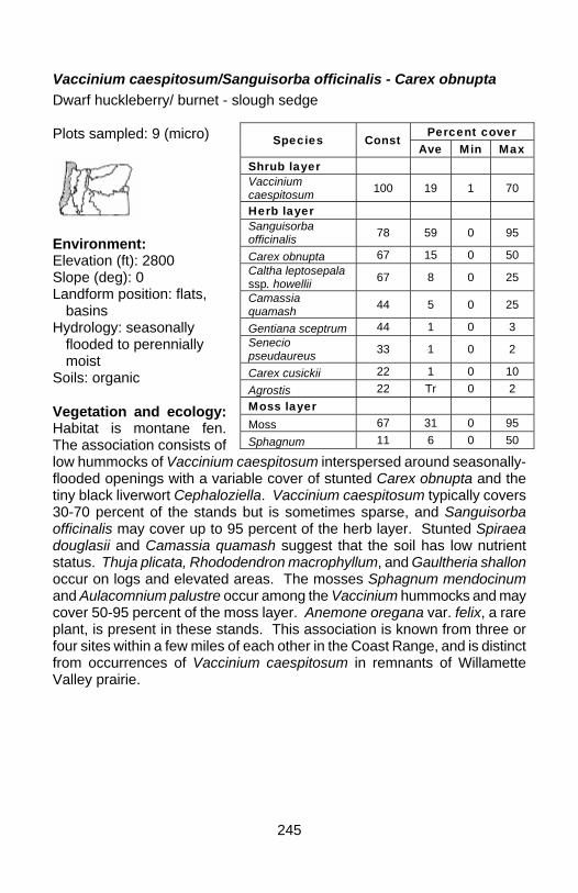
245
Vaccinium caespitosum/Sanguisorba officinalis - Carex obnupta Dwarf huckleberry/ burnet - slough sedge Plots sampled: 9 (micro)
Environment: Elevation (ft): 2800 Slope (deg): 0 Landform position: flats,
basins Hydrology: seasonally
flooded to perennially moist
Soils: organic Vegetation and ecology: Habitat is montane fen. The association consists of low hummocks of Vaccinium caespitosum interspersed around seasonally-flooded openings with a variable cover of stunted Carex obnupta and the tiny black liverwort Cephaloziella. Vaccinium caespitosum typically covers 30-70 percent of the stands but is sometimes sparse, and Sanguisorba officinalis may cover up to 95 percent of the herb layer. Stunted Spiraea douglasii and Camassia quamash suggest that the soil has low nutrient status. Thuja plicata, Rhododendron macrophyllum, and Gaultheria shallon occur on logs and elevated areas. The mosses Sphagnum mendocinum and Aulacomnium palustre occur among the Vaccinium hummocks and may cover 50-95 percent of the moss layer. Anemone oregana var. felix, a rare plant, is present in these stands. This association is known from three or four sites within a few miles of each other in the Coast Range, and is distinct from occurrences of Vaccinium caespitosum in remnants of Willamette Valley prairie.
Percent cover Species Const
Ave Min Max Shrub layer Vaccinium caespitosum 100 19 1 70
Herb layer Sanguisorba officinalis 78 59 0 95
Carex obnupta 67 15 0 50 Caltha leptosepala ssp. howellii 67 8 0 25
Camassia quamash 44 5 0 25
Gentiana sceptrum 44 1 0 3 Senecio pseudaureus 33 1 0 2
Carex cusickii 22 1 0 10 Agrostis 22 Tr 0 2 Moss layer Moss 67 31 0 95 Sphagnum 11 6 0 50
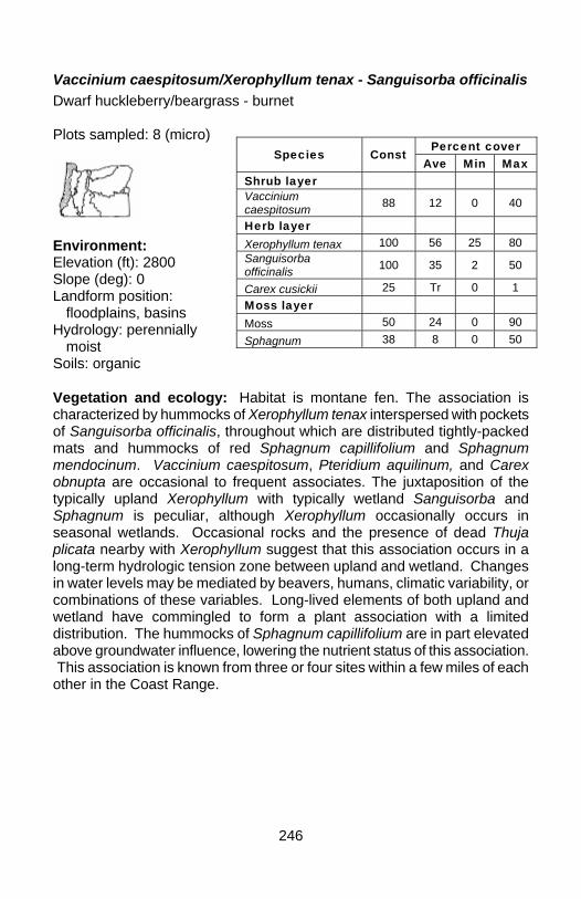
246
Vaccinium caespitosum/Xerophyllum tenax - Sanguisorba officinalis Dwarf huckleberry/beargrass - burnet Plots sampled: 8 (micro)
Environment: Elevation (ft): 2800 Slope (deg): 0 Landform position:
floodplains, basins Hydrology: perennially
moist Soils: organic Vegetation and ecology: Habitat is montane fen. The association is characterized by hummocks of Xerophyllum tenax interspersed with pockets of Sanguisorba officinalis, throughout which are distributed tightly-packed mats and hummocks of red Sphagnum capillifolium and Sphagnum mendocinum. Vaccinium caespitosum, Pteridium aquilinum, and Carex obnupta are occasional to frequent associates. The juxtaposition of the typically upland Xerophyllum with typically wetland Sanguisorba and Sphagnum is peculiar, although Xerophyllum occasionally occurs in seasonal wetlands. Occasional rocks and the presence of dead Thuja plicata nearby with Xerophyllum suggest that this association occurs in a long-term hydrologic tension zone between upland and wetland. Changes in water levels may be mediated by beavers, humans, climatic variability, or combinations of these variables. Long-lived elements of both upland and wetland have commingled to form a plant association with a limited distribution. The hummocks of Sphagnum capillifolium are in part elevated above groundwater influence, lowering the nutrient status of this association. This association is known from three or four sites within a few miles of each other in the Coast Range.
Percent cover Species Const
Ave Min Max Shrub layer Vaccinium caespitosum 88 12 0 40
Herb layer Xerophyllum tenax 100 56 25 80 Sanguisorba officinalis 100 35 2 50
Carex cusickii 25 Tr 0 1 Moss layer Moss 50 24 0 90 Sphagnum 38 8 0 50
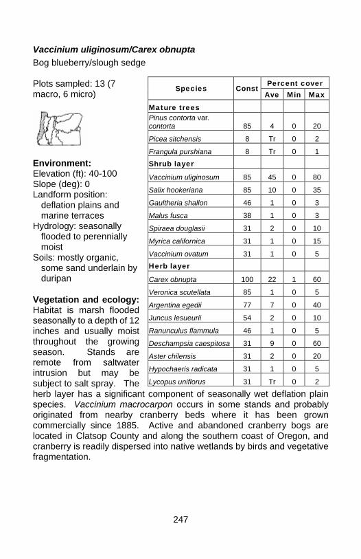
247
Vaccinium uliginosum/Carex obnupta Bog blueberry/slough sedge Plots sampled: 13 (7 macro, 6 micro)
Environment: Elevation (ft): 40-100 Slope (deg): 0 Landform position:
deflation plains and marine terraces
Hydrology: seasonally flooded to perennially moist
Soils: mostly organic, some sand underlain by duripan
Vegetation and ecology: Habitat is marsh flooded seasonally to a depth of 12 inches and usually moist throughout the growing season. Stands are remote from saltwater intrusion but may be subject to salt spray. The herb layer has a significant component of seasonally wet deflation plain species. Vaccinium macrocarpon occurs in some stands and probably originated from nearby cranberry beds where it has been grown commercially since 1885. Active and abandoned cranberry bogs are located in Clatsop County and along the southern coast of Oregon, and cranberry is readily dispersed into native wetlands by birds and vegetative fragmentation.
Percent cover Species Const
Ave Min Max
Mature trees Pinus contorta var. contorta 85 4 0 20
Picea sitchensis 8 Tr 0 2
Frangula purshiana 8 Tr 0 1 Shrub layer
Vaccinium uliginosum 85 45 0 80
Salix hookeriana 85 10 0 35
Gaultheria shallon 46 1 0 3
Malus fusca 38 1 0 3
Spiraea douglasii 31 2 0 10
Myrica californica 31 1 0 15
Vaccinium ovatum 31 1 0 5 Herb layer
Carex obnupta 100 22 1 60
Veronica scutellata 85 1 0 5
Argentina egedii 77 7 0 40
Juncus lesueurii 54 2 0 10
Ranunculus flammula 46 1 0 5
Deschampsia caespitosa 31 9 0 60
Aster chilensis 31 2 0 20
Hypochaeris radicata 31 1 0 5
Lycopus uniflorus 31 Tr 0 2

248
Vaccinium uliginosum/Deschampsia caespitosa - Carex obnupta Bog blueberry/tufted hairgrass - slough sedge Plots sampled: 73 (micro)
Environment: Elevation (ft): ave. 130
(50-160) Slope (deg): 0 Landscape position: old
deflation plains and marine terraces
Hydrology: seasonally flooded, moist to dry in summer
Soils: sand underlain by duripan Vegetation and ecology: Habitat is seasonally wet openings in coastal Pinus contorta var. contorta forest. Stands are flooded seasonally to a depth of 12 inches and are dry by midsummer. Substrate is sand or a thin organic layer over sand, often with iron-cemented hardpan. Pinus contorta var. contorta is sparse and mostly restricted to the periphery of stands. Sanguisorba officinalis, Gentiana sceptrum, and Pteridium aquilinum may be present in the herb layer in small amounts. Sphagnum mendocinum and the lichen Cladina portentosa ssp. pacifica are very conspicuous at some sites. The association appears to be declining because of successional changes caused by dune stabilization and possibly by cessation of stand-replacing fires. It is also vulnerable to recreational and residential development, and construction of commercial cranberry bogs. Threats from development are greatest between the Siuslaw River and Heceta Head. Some stands are adjacent to areas favored for mushroom picking and can be damaged by off-road vehicles used for mushroom harvest or general recreation.
Percent cover Species Const Ave Min Max
Mature trees Pinus contorta var. contorta 11 Tr 0 15 Shrub layer Vaccinium uliginosum 70 24 0 90 Herb layer Deschampsia caespitosa 85 32 0 80 Carex obnupta 71 10 0 50 Sanguisorba officinalis 49 2 0 15 Moss layer Sphagnum 81 29 0 95 Moss 73 11 0 50

249
Vaccinium uliginosum/Dodecatheon jeffreyi - Caltha leptosepala ssp. howellii Bog blueberry/Howell's marsh marigold Plots sampled: 42 (18 macro, 24 micro)
Environment: Elevation (ft): ave. 4363
(1900-5410) Slope (deg): ave. 0 (0-2) Landform position: toe
slopes, floodplains, basins
Hydrology: perennially moist to perennially saturated
Soils: mostly organic, some loam.
Vegetation and ecology: Habitat is montane fens. Vaccinium uliginosum plots are highly variable and indicate that numerous phases are present and need further study. Trees and shrubs are confined to hummocks or "tree islands" and the rest of the plot is a wet lawn with a large diversity of herbaceous species. Hummocks with very low shrub cover are composed mostly of the mosses Sphagnum capillifolium and Aulacomnium palustre.
Percent cover Species Const
Ave Min Max Mature trees Pinus contorta var. latifolia 17 2 0 35 Picea engelmannii 14 3 0 60 Reproducing trees Picea engelmannii 17 1 0 40 Pinus contorta var. latifolia 17 1 0 7 Abies amabilis 12 1 0 15 Abies lasiocarpa 10 1 0 50 Shrub layer Vaccinium uliginosum 100 41 5 85 Spiraea douglasii 33 3 0 55 Kalmia microphylla 26 1 0 25 Herb layer Dodecatheon jeffreyi 81 7 0 25 Caltha leptosepala ssp. howellii 64 11 0 55 Carex aquatilis var. dives 57 10 0 85 Ligusticum grayi 43 6 0 75 Deschampsia caespitosa 40 2 0 20 Platanthera dilatata 38 Tr 0 5 Senecio triangularis 31 1 0 11 Moss layer Moss 62 42 0 100 Unvegetated Litter 14 2 0 40
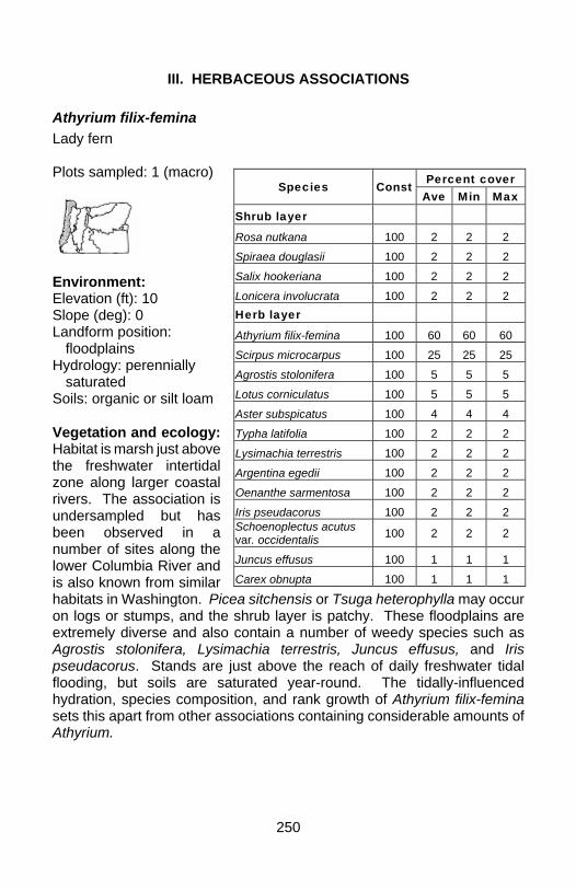
250
III. HERBACEOUS ASSOCIATIONS
Athyrium filix-femina Lady fern Plots sampled: 1 (macro)
Environment: Elevation (ft): 10 Slope (deg): 0 Landform position: floodplains Hydrology: perennially
saturated Soils: organic or silt loam Vegetation and ecology: Habitat is marsh just above the freshwater intertidal zone along larger coastal rivers. The association is undersampled but has been observed in a number of sites along the lower Columbia River and is also known from similar habitats in Washington. Picea sitchensis or Tsuga heterophylla may occur on logs or stumps, and the shrub layer is patchy. These floodplains are extremely diverse and also contain a number of weedy species such as Agrostis stolonifera, Lysimachia terrestris, Juncus effusus, and Iris pseudacorus. Stands are just above the reach of daily freshwater tidal flooding, but soils are saturated year-round. The tidally-influenced hydration, species composition, and rank growth of Athyrium filix-femina sets this apart from other associations containing considerable amounts of Athyrium.
Percent cover Species Const Ave Min Max
Shrub layer Rosa nutkana 100 2 2 2 Spiraea douglasii 100 2 2 2 Salix hookeriana 100 2 2 2 Lonicera involucrata 100 2 2 2 Herb layer Athyrium filix-femina 100 60 60 60 Scirpus microcarpus 100 25 25 25 Agrostis stolonifera 100 5 5 5 Lotus corniculatus 100 5 5 5 Aster subspicatus 100 4 4 4 Typha latifolia 100 2 2 2 Lysimachia terrestris 100 2 2 2 Argentina egedii 100 2 2 2 Oenanthe sarmentosa 100 2 2 2 Iris pseudacorus 100 2 2 2 Schoenoplectus acutus var. occidentalis 100 2 2 2
Juncus effusus 100 1 1 1 Carex obnupta 100 1 1 1
251
Azolla (filiculoides, mexicana) Mosquitofern Plots sampled: 1 (macro)
Environment: Elevation (ft): 500 Slope (deg): 0 Landform position: floodplains, flats Hydrology: seasonally to perennially flooded Soils: loam, silt loam Vegetation and ecology: Habitat is low-elevation eutrophic ponds, lakes, and sloughs with little water movement. Species of Azolla occur throughout northwestern Oregon, but stands extensive enough to be considered occurrences of this association are most common in low-elevation areas in the Coast Range and Willamette Valley. They typically form nearly monotypic green or reddish mats that float on the surface of lakes and ponds, often growing so dense that no open water is visible. Azolla needs open water to proliferate in winter and spring but it tolerates being stranded on mudflats when shallow pools dry out in summer. Mudflat sites are not uncommon, particularly on large floodplains, and in this habitat the Azolla mat develops a peculiar lumpy surface with varied microtopography. Elements of the Lemna minor association (Lemna, Spirodela, Ricciocarpos) may often be intermixed with Azolla but are always subordinate to Azolla. Eutrophic conditions favored by this association may be enhanced by enriched runoff in agricultural or urban landscapes.
Percent cover Species
Const Av
e Min Max
Herb layer
Azolla mexicana 100 99 99 99
252
Bidens cernua Nodding beggartick Plots sampled: 9 (macro)
Environment: Elevation (ft): ave. 282 (8-
500) Slope (deg): ave. 0 (0-1) Landform position:
floodplains, flats Hydrology: seasonally
flooded to perennially saturated
Soils: silt loam Vegetation and ecology: Habitat is low-elevation eutrophic marsh and mudflats along low-gradient streams and around shallow ponds. The association is strictly herbaceous and dominated by Bidens cernua and a variety of other marsh species that tolerate early-season flooding and summer drying that exposes mudflats with subirrigation. Other typical species present in lesser amounts include Polygonum hydropiperoides, Sagittaria latifolia, Eleocharis palustris, Ludwigia palustris, and Leersia oryzoides, but more than 15 other species are recorded. This association was probably fairly widespread in the Willamette Valley prior to flood control, but is now mostly restricted to the Columbia River floodplain in the Vancouver Basin. Prolonged pooling in depressions and freshwater tidal flooding along streams helps to keep invasive Phalaris arundinacea from invading stands.
Percent cover Species Const Ave Min Max
Herb layer
Bidens cernua 100 56 20 90 Polygonum hydropiperoides 56 14 0 80
Sagittaria latifolia 44 5 0 20
Eleocharis palustris 44 3 0 20
Ludwigia palustris 33 3 0 15
Leersia oryzoides 22 3 0 20
Alisma triviale 22 1 0 3
Callitriche 22 1 0 3 Sparganium angustifolium 22 Tr 0 2
Polygonum persicaria 22 Tr 0 3 Schoenoplectus americanus 11 4 0 40
Panicum capillare 11 1 0 10 Schoenoplectus tabernaemontani 11 1 0 5
253
Bidens frondosa Devil's beggartick Plots sampled: 2 (macro)
Environment: Elevation (ft): 500 Slope (deg): 0 Landform position:
floodplains, flats Hydrology: seasonally flooded to moist Soils: silt loam Vegetation and ecology: Habitat is low-elevation marsh and mudflats along low-gradient streams and around shallow ponds. The association typically forms nearly monotypic stands of Bidens frondosa that can have up to 100 percent cover. Nuphar lutea ssp. polysepala is the second most abundant species reported from plots, with traces of other aquatic or mudflat species. This association was probably fairly widespread in the Willamette Valley prior to flood control, but is now mostly restricted to the Columbia River floodplain in the Vancouver Basin. Prolonged pooling in depressions and freshwater tidal flooding along streams helps to keep invasive Phalaris arundinacea from invading stands.
Percent cover Species Const
Ave Min Max Herb layer Bidens frondosa 100 95 90 100 Nuphar lutea ssp. polysepala 50 5 0 10
Poaceae 50 2 0 4 Rorippa curvisiliqua 50 Tr 0 Tr Polygonum persicaria 50 Tr 0 Tr Lemna minor 50 Tr 0 Tr
254
Boykinia major Large boykinia Plots sampled: 2 (macro)
Environment: Elevation (ft): ave. 1663
(40-3285) Slope (deg): 0 Landform position:
depressions, flats Hydrology: perennially
saturated Soils: organic Vegetation and ecology: Habitat is coastal and montane fens, particularly sphagnum mires. The association needs more plot data, but a variety of occurrences have been observed in the field. It occurs in both open peatlands and under a partial canopy of Thuja plicata. Boykinia major is the primary species and forms a wet lawn with lesser amounts of Lysichiton americanus, Carex echinata ssp. echinata, Carex utriculata, Blechnum spicant, Juncus ensifolius, Cicuta douglasii, and Calamagrostis canadensis, depending on elevation. The moss layer is almost entirely Sphagnum.
Percent cover Species Const
Ave Min Max Shrub layer Spiraea douglasii 50 1 0 1 Herb layer Boykinia major 100 60 50 70 Lysichiton americanus 100 12 4 20
Carex echinata ssp. echinata 100 3 Tr 5
Hypericum anagalloides 100 1 Tr 1
Carex utriculata 50 15 0 30 Blechnum spicant 50 8 0 15 Juncus ensifolius 50 5 0 10 Cicuta douglasii 50 5 0 10 Calamagrostis canadensis 50 5 0 10
Viola 50 3 0 5 Carex obnupta 50 1 0 2 Juncus 50 1 0 1 Moss layer Moss 100 20 20 20
255
Brasenia schreberi Watershield Plots sampled: 0
Environment: Elevation (ft): 10-2000 Slope (deg): 0 Landform position: basins Hydrology: perennially flooded Soils: organic Vegetation and ecology: Habitat is low-elevation ponds, lakes, and sloughs. This is a rooted aquatic bed association that is widespread in western Oregon but has not been sampled and little information is available. Brasenia schreberi forms mats of floating leaves on the surface of the water and the network of submerged stems and undersides of leaves provide important habitat for aquatic invertebrates and fish. The association is not as common in northwestern Oregon as the Nuphar association. This association favors oligotrophic or mesotrophic waters and may be outcompeted by more aggressive species in eutrophic waters enhanced by enriched runoff in agricultural or urban landscapes.
256
Calamagrostis canadensis Bluejoint Plots sampled: 10 (4 macro, 6 micro)
Environment: Elevation (ft): ave. 4821
(3100-5410) Slope (deg): ave. 1 (0-5) Landform position:
floodplains, flats Hydrology: moist to
perennially saturated Soils: mostly organic,
some loam Vegetation and ecology: Habitat is edges of montane fens. The association is extremely diverse. The shrub layer contains 14 different species, and more than 60 species are present in the herb layer, indicating that the association occurs in a transition zone between montane fen and upland forest and contains components of both systems. The remaining mass of species occur only in small amounts.
Percent cover Species Const Ave Min Max
Mature trees Picea engelmannii 50 22 0 90 Abies lasiocarpa 20 1 0 8 Pinus contorta var. latifolia 20 1 0 10 Reproducing trees Abies lasiocarpa 30 5 0 45 Abies amabilis 30 Tr 0 3 Pinus contorta var. latifolia 20 Tr 0 3 Picea engelmannii 20 Tr 0 3 Shrub layer Vaccinium uliginosum 50 2 0 15 Spiraea densiflora 30 2 0 10 Herb layer Calamagrostis canadensis 100 46 12 95 Caltha leptosepala ssp. howellii 50 3 0 13 Senecio triangularis 50 1 0 5 Carex aquatilis var. dives 40 5 0 25 Dodecatheon jeffreyi 40 2 0 5 Ligusticum grayi 40 1 0 8 Platanthera dilatata 40 Tr 0 4 Moss layer Moss 40 18 0 100 Unvegetated Litter 30 11 0 70 Bare ground 10 1 0 10
257
Calamagrostis nutkaensis Pacific reedgrass Plots sampled: 0
Environment: Elevation (ft): 50-100 Slope (deg): 0 Landform position: floodplains, basins, flats Hydrology: perennially saturated Soils: organic Vegetation and ecology: Habitat is coastal fens. The association has not been sampled but is present in small amounts on the north coast and in larger amounts on the south coast. It forms nearly monotypic stands of Calamagrostis nutkaensis with a few other species with low constancy and cover but not documented here. The moss layer may contain high cover of Sphagnum or may largely be concealed by litter. Some stands have expanses of mud between hummocks of Calamagrostis and open water is lacking. Large tussocks of Calamagrostis nutkaensis are slightly elevated above the surface of the mire and are used extensively by elk for bedding. The association is uncommon and the best occurrences are located along the coast in southern Oregon and northern California.
258
Callitriche heterophylla Different-leaved water-starwort Plots sampled: 6 (macro)
Environment: Elevation (ft): ave. 733 (
500-1900) Slope (deg): 0 Landform position:
bottoms Hydrology: seasonally to
perennially flooded Soils: organic or silty loam Vegetation and ecology: Habitat is low-elevation shallow pools, ponds, slow-moving streams, and flooded shrub swamps. Fraxinus latifolia, Salix hookeriana, Salix lucida ssp. lasiandra, Salix sitchensis, and Spiraea douglasii are typical associates in this habitat, but woody vegetation may also be entirely absent. Callitriche heterophylla is the primary species and is usually immersed with the topmost leaves floating on the surface of the water. Emergent species present may include Oenanthe sarmentosa, Veronica scutellata, Cicuta douglasii, Torreyochloa pallida var. pauciflora, and Glyceria.
Percent cover Species Const
Ave Min Max
Mature trees Fraxinus latifolia 17 17 0 100 Herb layer Callitriche heterophylla 100 86 75 99 Oenanthe sarmentosa 67 10 0 40 Veronica scutellata 33 Tr 0 1 Lysichiton americanus 17 3 0 20 Torreyochloa pallida var. pauciflora 17 1 0 5 Moss layer Moss 17 Tr 0 1
259
Caltha leptosepala ssp. howellii Howell's marsh marigold Plots sampled: 7 (macro)
Environment: Elevation (ft): ave. 4319
(2800-5300) Slope (deg): ave. 4 (0-15) Landform position:
seepage slopes to floodplains and flats
Hydrology: moist to perennially saturated
Soils: mostly organic, some loam
Vegetation and ecology: Habitat is montane fens, forming lawns or flushes on gentle to moderate slopes below springs. Slopes are laced with rivulets or rills and irrigated by sheet flow. A number of phases are present that need further study. Woody plants have scanty cover and are primarily restricted to hummocks or "tree islands" within an herbaceous matrix, or they are peripheral to the wetland. The herb layer is extremely rich with almost 60 different species present from both wet flushes and drier hummocks or forest ecotones around the edges of these wetlands. Senecio triangularis, Trifolium longipes, Trautvetteria caroliniensis, and Veratrum californicum are conspicuous on hummocks. Rills are often filled with the aquatic moss Fontinalis neomexicana, and Polygonum bistortoides and the large leafy liverwort Scapania paludosa are also characteristic of these rills.
Caltha leptosepala ssp. howellii - Carex obnupta Howell's marsh marigold - slough sedge
Percent cover Species Const Ave Min Max
Mature trees Picea engelmannii 29 2 0 15 Abies amabilis 29 Tr 0 3 Tsuga mertensiana 29 Tr 0 1 Larix occidentalis 29 Tr 0 Tr Reproducing trees Picea engelmannii 43 1 0 5 Abies amabilis 29 Tr 0 1 Pinus contorta var. latifolia 29 Tr 0 1 Shrub layer Vaccinium caespitosum 14 1 0 10 Vaccinium uliginosum 14 1 0 8 Herb layer Caltha leptosepala ssp. howellii 100 50 15 80 Dodecatheon jeffreyi 86 8 0 20 Senecio triangularis 71 1 0 5 Hypericum anagalloides 57 5 0 30 Carex luzulina 57 1 0 2 Platanthera stricta 57 1 0 5 Tofieldia glutinosa 43 1 0 3 Equisetum arvense 43 Tr 0 1 Moss layer Moss 29 19 0 95
260
Plots sampled: 30 microplots
Environment: Elevation (ft): 2800 Slope (deg): ave. 5 (3-5) Landform position:
floodplains, flats, basins Hydrology: perennially
saturated Soils: organic Vegetation and ecology: Habitat is montane fens, forming lawns or flushes on gentle to moderate slopes below springs and seeps. Slopes are laced with rivulets or rills and irrigated by sheet flow. Stands lack hummocks or "tree islands." The primary herbs may not be present in all plots but are conspicuous adjacent to plots. Use of Carex obnupta in the name separates this association from Caltha vegetation of the Cascades and indicates an affinity to low-elevation coastal peatlands. Juncus balticus, Carex echinata ssp. phyllomanica, Scirpus microcarpus, Carex exsiccata, and Carex utriculata occur in patches with low constancy and average cover but sometimes with cover up to 70 percent. Rills are characteristically filled with the aquatic moss Fontinalis neomexicana that becomes hidden by sedge growth as the season progresses. Polygonum bistortoides and the large leafy liverwort Scapania paludosa are also characteristic of these rills. The moss layer may have up to 95 percent cover, mostly consisting of Sphagnum mendocinum and Aulacomnium palustre.
Percent cover Species Const Ave Min Max
Herb layer Caltha leptosepala ssp. howellii 87 35 0 90 Sanguisorba officinalis 60 41 0 95 Gentiana sceptrum 50 1 0 5 Carex obnupta 37 9 0 45 Carex cusickii 37 6 0 30 Equisetum arvense 30 1 0 10 Juncus ensifolius 27 1 0 8
Lysichiton americanus 23 1 0 18 Agrostis 23 Tr 0 2 Juncus balticus 20 3 0 40 Angelica genuflexa 20 1 0 6 Hypericum anagalloides 20 1 0 5 Moss layer Moss 80 53 0 95 Unvegetated Litter 3 1 0 15
261
Camassia quamash Small camas Plots sampled: 5 (1 macro, 4 micro)
Environment: Elevation (ft): ave. 220
(150-500) Slope (deg): ave. 2 (0-2) Landform position:
floodplains, flats, benches
Hydrology: seasonally flooded to seasonally moist
Soils: clay loam and shallow soil over bedrock
Vegetation and ecology: Habitat is clay prairie and basalt scabland with a seasonally perched water table. Camassia is conspicuous in spring and forms dense stands of gorgeous blue flowers, but it all but disappears with summer drought. Because of its seasonal presence, low elevation, and proximity to agriculture, many exotic species are present. Weeds such as Hypochaeris radicata, Stellaria, Aira caryophyllea, and Galium aparine may be inconspicuous when Camassia is at its peak but may dominate sites once it has disappeared. Both white and blue forms of Camassia quamash may be present, as well as Camassia leichtlinii. Camas was one of the most important staple foods for the original native peoples of the Willamette Valley and wet prairies were intensively managed for food production. Arable prairies were converted to agriculture and those on scabland sites were grazed by livestock, so that most surviving remnants are degraded with exotic species. This association may intergrade with the Triteleia hyacinthina association in areas of shallow soil over bedrock that have a perched water table or seasonal seepage.
Percent cover Species Const
Ave Min Max Herb layer Camassia quamash 100 25 20 40
Saxifraga oregana 40 8 0 30 Ranunculus occidentalis 20 6 0 30
Triteleia hyacinthina 20 2 0 10
Hypochaeris radicata 20 2 0 10
Stellaria 20 1 0 4 Mimulus guttatus 20 1 0 3 Juncus bufonius 20 Tr 0 1 Aira caryophyllea 20 Tr 0 1 Galium aparine 20 Tr 0 1 Moss layer Moss 80 76 0 100

262
Carex amplifolia Bigleaf sedge Plots sampled: 1 (macro)
Environment: Elevation (ft): 3450 Slope (deg): 7 Landform position: seepage
slopes, flats Hydrology: perennially
saturated Soils: organic Vegetation and ecology: Habitat is seepage slopes, rivulets, or sheet flow associated with springs. The association is represented by only one plot but it has been well documented by other researchers. Carex amplifolia is the primary species with an average cover of 40 percent, with lesser amounts of an unidentified Lotus, Lysichiton americanus, and Scirpus microcarpus. Twelve other species are present in the herb layer. Most occurrences are east of the Cascade Range, but these plots appear to be similar to others reported.
Percent cover Species Const Ave Min Max
Herb layer Carex amplifolia 100 40 40 40 Lotus 100 25 25 25 Lysichiton americanus 100 15 15 15 Scirpus microcarpus 100 10 10 10 Mimulus guttatus 100 5 5 5 Moss layer Moss 100 30 30 30
263
Carex angustata Widefruit sedge Plots sampled: 4 (2 macro, 2 micro)
Environment: Elevation (ft): 4400 Slope (deg): ave. 2 (1-2) Landform position:
floodplains, basins Hydrology: seasonally
flooded to moist Soils: loam or organic Vegetation and ecology: Habitat is seasonally moist montane meadows. Spiraea douglasii is present in half the plots but with very low cover. Carex angustata is the principal species in the herb layer, with an average cover of 43 percent and ranging up to 70 percent, with lesser amounts of Juncus balticus, Veratrum californicum, Deschampsia caespitosa, Dodecatheon jeffreyi, and Solidago canadensis. More than 30 other species present in trace amounts represent a mix of drier meadow and forest ecotone. Presence of Danthonia intermedia, Achillea millefolium, Potentilla gracilis, Stellaria crispa, and Poa pratensis strongly suggest that some sites were once grazed by livestock.
Percent cover Species Const Ave Min Max
Shrub layer Spiraea douglasii 50 2 0 5 Rosa pisocarpa 25 5 0 20 Vaccinium uliginosum 25 5 0 20 Lonicera 25 3 0 12 Herb layer Carex angustata 100 43 20 70 Juncus balticus 75 5 0 10 Veratrum californicum 50 11 0 35 Deschampsia caespitosa 50 10 0 30 Dodecatheon jeffreyi 50 9 0 20 Solidago canadensis 50 7 0 25 Polygonum bistortoides 50 1 0 1
264
Carex aperta Columbia sedge Plots sampled: 10 (macro)
Environment: Elevation (ft): ave. 510 (10-
3150) Slope (deg): ave. 0 (0-3) Landform position:
floodplains, toe slopes Hydrology: seasonally
flooded to seasonally moist
Soils: mostly silt loam, some organic Vegetation and ecology: Habitat is mostly low-elevation floodplains, but one site is known from a montane fen. Stands are seasonally flooded but dry by mid to late summer. The association was more widespread historically before diking and farming of the Columbia River lowlands, and the advent of exotic cultivars of Phalaris arundinacea. The few known stands that remain are either nearly monotypic Carex aperta in depressions too wet for Phalaris arundinacea, or in mixed stands dominated by Phalaris arundinacea. Elsewhere, it has been completely displaced by Phalaris arundinacea. The sedge itself is not rare but it is never plentiful. Most of the ten plots sampled here represent the monotypic expression, which may represent only the wettest end of the historic moisture gradient occupied by the association. Trees are absent or peripheral, but would include Salix lucida ssp. lasiandra and Fraxinus latifolia. Shrubs have low constancy and cover. Ten species are reported from the herb layer, including Polygonum amphibium, Bidens cernua, Bidens frondosa, and Ludwigia palustris that were not recorded in plots. Carex aperta once covered extensive areas of bottomland along the Columbia River and its tributaries between Longview and Skamania and into the Willamette Valley.
Percent cover Species Const
Ave Min Max Shrub layer Rubus armeniacus 30 2 0 8 Spiraea douglasii 10 1 0 5 Herb layer Carex aperta 100 88 62 98 Phalaris arundinacea 70 37 0 97 Epilobium ciliatum ssp. watsonii 40 4 0 13
Vicia 30 4 0 19 Cirsium arvense 30 3 0 13 Dipsacus fullonum 30 3 0 19
265
Carex aquatilis var. aquatilis Aquatic sedge Plots sampled: 10 (macro)
Environment: Elevation (ft): ave. 4385
(3320-5097) Slope (deg): ave. 1 (0-3) Landform position: slopes,
benches, basins Hydrology: perennially
saturated Soils: organic Vegetation and ecology: Habitat is usually montane fens. The association includes a heterogeneous mix of species that do not segregate in any meaningful way. Trees and shrubs are scarce. More than 50 species occur in the herb layer, but Carex aquatilis var. aquatilis is the most abundant and averages 61 percent cover and may have up to 99 percent cover. Many stands occur as monotypic reedswamp. Patches of other wetland species having low constancy but up to 50 percent cover include Eleocharis quinqueflora, Carex luzulina, Boykinia major, Parnassia fimbriata, Carex aquatilis var. dives, and Caltha leptosepala ssp. howellii. Senecio triangularis and Aconitum columbianum indicate some forest ecotone. Stands may occur on old beaver terraces on seepage slopes, and also in sag ponds on slopes prone to slumping. The Carex aquatilis var. aquatilis association is more common east of the Cascade Range and is mostly replaced by the Carex aquatilis var. dives association in and west of the Cascades.
Percent cover Species Const Ave Min Max
Reproducing trees Abies lasiocarpa 10 Tr 0 Tr Abies amabilis 10 Tr 0 Tr Shrub layer Salix hookeriana 10 1 0 10 Spiraea douglasii 10 1 0 8 Alnus incana 10 1 0 7 Herb layer Carex aquatilis var. aquatilis 100 61 30 99 Hypericum anagalloides 40 Tr 0 2 Platanthera stricta 30 Tr 0 Tr Moss layer Moss 40 17 0 70
266
Carex aquatilis var. dives Sitka sedge Plots sampled: 71 (46 macro, 25 micro)
Environment: Elevation (ft): ave. 4378
(2000-5428) Slope (deg): ave. 1 (0-17) Landform position: slopes,
benches, basins Hydrology: seasonally
flooded to perennially saturated
Soils: mostly organic, some loam
Vegetation and ecology: Habitat is usually montane fens. The association is widespread and important in the Cascade Range and includes a heterogeneous mix of species that do not segregate in any meaningful way. Trees and shrubs are scarce, although many different species are present. The herb layer is astonishingly diverse with more than 120 species recorded, but most of these have relatively low constancy and reflect the patchy distribution of many different taxa. Many stands occur as monotypic reedswamp with cover ranging from 5 to 99 percent, and some intergrade with the Carex utriculata association in seasonally flooded depressions. Stands may occur on old beaver terraces on seepage slopes, and also in sag ponds on slopes prone to slumping. Carex aquatilis var. dives can intermix with forest ecotone or meadow taxa as long as enough soil moisture is present. Plants become progressively dwarfed as conditions become drier.
Percent cover Species Const Ave Min Max
Mature trees Picea engelmannii 3 Tr 0 10 Pinus contorta var. latifolia 3 Tr 0 6 Reproducing trees Pinus contorta var. latifolia 4 Tr 0 2 Tsuga heterophylla 3 Tr 0 10 Picea engelmannii 3 Tr 0 3 Shrub layer Vaccinium uliginosum 14 1 0 20 Spiraea douglasii 14 1 0 15 Herb layer Carex aquatilis var. dives 100 54 5 99 Dodecatheon jeffreyi 37 3 0 20 Carex utriculata 24 4 0 40 Hypericum anagalloides 21 1 0 25 Moss layer Moss 23 4 0 95 Unvegetated Litter 31 4 0 40 Bare ground 23 11 0 95
267
Carex aquatilis var. dives - Comarum palustre Sitka sedge - marsh cinquefoil Plots sampled: 54 (micro)
Environment: Elevation (ft): ave. 35
(20-40) Slope (deg): 0 Landform position:
floodplains, flats Hydrology: perennially
saturated Soils: organic Vegetation and ecology: Habitat is coastal fens, floating lake-fill mats, and low-gradient drainages. The association is primarily minerotrophic reedswamp. The surface usually has several inches of standing water and the vegetation is typified by vegetation requiring very wet to flooded conditions. Trees are rarely present, and shrubs are present in about half the plots and may also include Spiraea douglasii, Lonicera involucrata, and Salix hookeriana. The herb layer is diverse and may also include Hypericum anagalloides, Oenanthe sarmentosa, and Lycopus uniflorus. Darlingtonia californica is present along the mid-coast. Carex obnupta occurred only in trace amounts in the plots sampled, but may be more abundant than indicated in the stand table. Sphagnum and other mosses are absent except in hummocks of Ledum and Spiraea. The association is a transitional vegetation type between aquatic bed and open fen or shrub swamp.
Percent cover Species Const
Ave Min Max Mature trees Pinus contorta var. contorta 2 Tr 0 2 Reproducing trees Picea sitchensis 2 Tr 0 1 Shrub layer Ledum glandulosum 37 6 0 35 Vaccinium uliginosum 33 6 0 40 Herb layer Carex aquatilis var. dives 100 47 5 90 Comarum palustre 83 17 0 55 Nuphar lutea ssp. polysepala 43 11 0 65 Athyrium filix-femina 31 3 0 30 Unvegetated Litter 24 5 0 40 Water 7 1 0 20

268
Carex buxbaumii Buxbaum's sedge Plots sampled: 5 (macro)
Environment: Elevation (ft): 4730 Slope (deg): 0 Landform position:
floodplains, flats, basins Hydrology: perennially
saturated Soils: organic Vegetation and ecology: Habitat is montane fens. The association occurs in open fens and around the edges of wet meadows, where it intergrades with slightly drier Deschampsia caespitosa associations. Trees are absent from these plots but may be present in some stands on elevated hummocks or "tree islands." Vaccinium uliginosum and Spiraea douglasii occur in trace amounts only, also on hummocks. Carex buxbaumii is the primary species, averaging 49 percent cover but ranging up to 70 percent cover in some stands. Lycopus uniflorus and Deschampsia caespitosa are present in lesser amounts, along with 17 other fen species in trace amounts.
Percent cover Species Const
Ave Min Max
Shrub layer
Vaccinium uliginosum 40 Tr 0 Tr
Spiraea douglasii 20 Tr 0 Tr Herb layer
Carex buxbaumii 100 49 35 70
Lycopus uniflorus 80 6 0 20
Deschampsia caespitosa 80 6 0 25 Moss layer
Moss 20 Tr 0 1
269
Carex cusickii Cusick's sedge Plots sampled: 3 (macro)
Environment: Elevation (ft): ave. 2057
(1970-2200) Slope (deg): 0 Landform position:
floodplains, basins Hydrology: perennially
saturated Soils: mostly organic, some
loam Vegetation and ecology: Habitat is low to mid-elevation fen and marsh. The association is composed of nearly monotypic stands of Carex cusickii, with an average cover of 80 percent and with cover up to 90 percent. Eleven other species are recorded from the herb layer, but all occur only in trace amounts. No trees are recorded and one plot records Mahonia aquifolium, probably from an elevated position as this is not a wetland species. The moss layer is conspicuous with an average cover of 40 percent but some plots have cover of up to 100 percent. One or two phases need more sampling. One is a sphagnum fen habitat with Comarum palustre, Lysichiton americanus, Menyanthes trifoliata, Drosera rotundifolia, and Eriophorum chamissonis. The other occurs in marsh around shallow lakes, ponds, and sloughs where Carex cusickii forms pedestals among expanses of water and deep muck, with Comarum palustre, Cicuta douglasii, and Oenanthe sarmentosa.
Percent cover Species Const Ave Min Max
Shrub layer Mahonia aquifolium 33 Tr 0 Tr Herb layer Carex cusickii 100 80 60 95 Potentilla 33 2 0 5 Carex aquatilis var. aquatilis 33 2 0 5
Hypericum anagalloides 33 1 0 3 Dulichium arundinaceum 33 1 0 2 Carex leptalea 33 Tr 0 1 Carex utriculata 33 Tr 0 1 Poaceae 33 Tr 0 1 Viola 33 Tr 0 Tr Lycopus uniflorus 33 Tr 0 Tr Drosera rotundifolia 33 Tr 0 Tr Carex echinata ssp. echinata 33 Tr 0 Tr
Moss layer Moss 67 40 0 100
270
Carex deweyana ssp. leptopoda Dewey sedge Plots sampled: 2 (macro)
Environment: Elevation (ft): 500 Slope (deg): 0 Landform position:
floodplains, flats Hydrology: seasonally
flooded to moist Soils: clay loam Vegetation and ecology: Habitat is clay prairie with perched water table. This association is presumably a relic component of native Willamette Valley wet prairie. Although it occurs at low elevation, has a history of grazing, and is surrounded by agriculture, relatively few exotic species are recorded in the plots. It is classified here as an association because of the significant cover of Carex deweyana ssp. leptopoda in prairie rather than its more common occurrence in Fraxinus latifolia woodland. A significant amount of Deschampsia caespitosa, Carex pellita, and Carex unilateralis are also present, which are indicators of prairie remnants in the Willamette Valley. The association may represent one of a number of poorly-described native prairie types now mostly decimated by settlement. Hopefully other stands can be found and documented.
Percent cover Species Const Ave Min Max
Herb layer Carex deweyana ssp. leptopoda 100 73 65 80
Myosotis laxa 100 23 15 30 Deschampsia caespitosa 100 11 2 20 Carex pellita 100 7 4 10 Carex unilateralis 100 7 4 10 Juncus tenuis 100 4 3 5 Eleocharis acicularis 100 1 Tr 1 Epilobium ciliatum 100 Tr Tr Tr Galium parisiense 100 Tr Tr Tr Veronica scutellata 50 10 0 20 Carex feta 50 8 0 15 Callitriche heterophylla 50 1 0 1 Beckmannia syzigachne 50 Tr 0 Tr Eleocharis palustris 50 Tr 0 Tr Rumex crispus 50 Tr 0 Tr Moss layer Moss 50 4 0 8
271
Carex exsiccata Western inflated sedge Plots sampled: 33 (31 macro, 2 micro)
Environment: Elevation (ft): ave. 2490
(100-5000) Slope (deg): ave. 0 (0-3) Landform position:
floodplains, flats, benches
Hydrology: seasonally flooded to perennially saturated
Soils: organic, silt loam, or sand Vegetation and ecology: Habitat is small to large shallow basins. Composition is diverse with no obvious segregate types. Stands are usually flooded seasonally to a depth of one to three feet and may dry out by midsummer with the water table just below the soil surface. Stands are usually nearly monotypic reedswamp in standing water or bare mud, but sometimes Carex exsiccata occurs in wet lawns with combinations of more than 90 other herbaceous species. The diversity is due mainly to the variety of elevations at which the association occurs, but most of these species occur only in trace amounts. The association is present but uncommon at lower elevations along the coast and in interior valleys of western Oregon, and becomes more common at higher elevations in the Coast and Cascade Range.
Percent cover Species Const
Ave Min Max
Mature trees
Thuja plicata 3 Tr 0 1 Pseudotsuga menziesii 3 Tr 0 1
Reproducing trees
Thuja plicata 3 Tr 0 1 Pseudotsuga menziesii 3 Tr 0 1
Shrub layer
Spiraea douglasii 18 Tr 0 5
Herb layer
Carex exsiccata 100 69 20 100
Veronica scutellata 21 2 0 35 Nuphar lutea ssp. polysepala 15 2 0 20
Carex obnupta 15 1 0 10
Moss layer
Moss 12 3 0 45
Unvegetated
Bare ground 9 3 0 60
Litter 9 1 0 25
272
Carex feta Greensheath sedge Plots sampled: 3 (macro)
Environment: Elevation (ft): 500 Slope (deg): 0 Landform position:
floodplains, flats Hydrology: seasonally
flooded to wet Soils: clay loam Vegetation and ecology: Habitat is clay prairie with perched water table. The association is presumably a relic component of native Willamette Valley wet prairie. Although it occurs at low elevation, has a history of grazing, and is surrounded by agriculture, there are relatively few exotic species recorded in the plots. It is documented here as an association because of the significant cover of Carex feta and Carex deweyana ssp. leptopoda in prairie with a significant amount of Deschampsia caespitosa. It may represent one of a number of poorly-described native prairie types now mostly decimated by settlement. Hopefully other stands can be found and documented.
Percent cover Species Const Ave Min Max
Herb layer
Carex feta 100 42 35 50 Carex deweyana ssp. leptopoda 100 24 20 27
Epilobium ciliatum 100 1 Tr 1
Galium parisiense 100 Tr Tr 1
Deschampsia caespitosa 67 15 0 30
Oenanthe sarmentosa 67 12 0 25
Myosotis laxa 67 11 0 25
Eleocharis palustris 67 7 0 20
Veronica scutellata 67 4 0 10
Carex unilateralis 33 2 0 6
Carex pellita 33 2 0 5
Holcus lanatus 33 1 0 4
Rumex crispus 33 1 0 3
Callitriche heterophylla 33 Tr 0 1
Mentha arvensis 33 Tr 0 1
Ranunculus alismifolius 33 Tr 0 Tr
Beckmannia syzigachne 33 Tr 0 Tr
Juncus tenuis 33 Tr 0 Tr
Danthonia californica 33 Tr 0 Tr Moss layer
Moss 33 3 0 10

273
Carex lasiocarpa Slender sedge Plots sampled: 25 (macro)
Environment: Elevation (ft): ave. 4680
(4100-4730) Slope (deg): 0 Landform position:
floodplains, flats Hydrology: perennially
flooded to perennially saturated
Soils: organic Vegetation and ecology: Habitat is montane marshes and fens. This association occurs at the eastern edge of the study area and is rare in Oregon. It occurs as nearly monotypic and sometimes extensive stands of Carex lasiocarpa with up to 90 percent cover, with lesser amounts of Deschampsia caespitosa, Aster occidentalis, Juncus balticus, Carex utriculata, Calamagrostis stricta ssp. inexpansa, and Carex aquatilis var. dives. Stands seen by the author are flooded 1-6 inches throughout the growing season.
Percent cover Species Const
Ave Min Max Shrub layer Vaccinium uliginosum 4 Tr 0 Tr Herb layer Carex lasiocarpa 100 49 15 90 Deschampsia caespitosa 48 1 0 10
Aster occidentalis 32 1 0 10 Juncus balticus 28 1 0 25 Carex utriculata 24 3 0 30 Galium trifidum 24 Tr 0 1 Potamogeton gramineus 16 Tr 0 6
Epilobium ciliatum 16 Tr 0 Tr
Calamagrostis stricta ssp. inexpansa
12 1 0 15
Carex aquatilis var. dives 12 1 0 20
Utricularia intermedia 12 Tr 0 12 Veronica scutellata 12 Tr 0 10 Moss layer Moss 8 1 0 15
274
Carex lenticularis Lakeshore sedge Plots sampled: 14 (13 macro, 1 micro)
Environment: Elevation (ft): ave. 4151 (3240-5146) Slope (deg): ave. 1 (0-2) Landform position:
floodplains, basins, benches
Hydrology: perennially saturated
Soils: mostly organic, some sandy
Vegetation and ecology: Habitat is montane wet meadows interspersed with forest edge. Trees and shrubs are mostly peripheral, occuring with low constancy and in trace amounts. The herb layer is astonishingly diverse, with over 100 species, all from a fairly narrow elevational zone. Carex lenticularis may occur as nearly monotypic stands or with other wet meadow species. Senecio triangularis and Polygonum bistortoides occur in about half the plots but at very low cover. Other species with significant intermixed patches include an unidentified Viola, Carex luzulina, Carex aquatilis var. dives, and Carex utriculata. About one-fourth of the rest of the species occur in peripheral forest ecotone, where the substrate is elevated somewhat above the water table.
Percent cover Species Const Ave Min Max
Mature trees Salix scouleriana 7 Tr 0 1 Picea engelmannii 7 Tr 0 Tr Reproducing trees Picea engelmannii 7 Tr 0 5 Abies amabilis 7 Tr 0 2 Shrub layer Salix 14 1 0 8 Cornus sericea 14 1 0 5 Spiraea douglasii 14 Tr 0 3 Herb layer Carex lenticularis 100 47 20 75 Senecio triangularis 50 1 0 10 Polygonum bistortoides 43 1 0 3 Viola 29 4 0 30 Carex luzulina 29 2 0 15 Carex exsiccata 29 1 0 7 Agrostis thurberiana 29 1 0 5 Veronica americana 29 1 0 7 Moss layer Moss 21 8 0 95

275
Carex limosa Mud sedge Plots sampled: 9 (micro)
Environment: Elevation (ft): 3360 Slope (deg): 0 Landform position:
floodplains, flats Hydrology: perennially
flooded to perennially saturated
Soils: organic Vegetation and ecology: Habitat is montane fens and poor fens. This association is typically species-poor, with low species cover and with considerable expanses of water 1-3 inches deep, mud, or Sphagnum between sparsely-distributed plants. Tsuga heterophylla is the only tree recorded but is restricted to low hummocks where it may be chlorotic and stunted. Carex limosa is the primary species in the herb layer with cover ranging from 5-75 percent but averaging only 25 percent. Menyanthes trifoliata is the second most abundant herb, with lesser amounts of Drosera rotundifolia, Dulichium arundinaceum, and Carex utriculata, the last two species indicative of conditions bordering on reedswamp. Although not reflected in these plots, Utricularia intermedia, Drosera anglica, and algae are frequent in the shallow pools. The moss mat is conspicuous, with an average cover of 75 percent and ranging to 100 percent, and is usually composed of Sphagnum. Stands may intergrade with the Eleocharis quinqueflora and Carex simulata associations that often have similar sparse vegetation and sloppy substrate.
Percent cover Species Const Ave Min Max
Reproducing trees Tsuga heterophylla 11 Tr 0 1 Herb layer Carex limosa 100 25 5 75 Menyanthes trifoliata 89 16 0 30 Drosera rotundifolia 44 2 0 10 Dulichium arundinaceum 33 1 0 4 Carex utriculata 22 1 0 5 Spiranthes romanzoffiana 11 Tr 0 1 Moss layer Moss 78 75 0 100 Unvegetated Bare ground 22 7 0 40
276
Carex luzulina Woodrush sedge Plots sampled: 8 (6 macro, 2 micro)
Environment: Elevation (ft): ave. 4378
(3460-4760) Slope (deg): ave. 1 (0-3) Landform position:
floodplains, flats, basins Hydrology: seasonally to
perennially moist Soils: mostly organic,
some loam Vegetation and ecology: Habitat is mostly montane fens. While not recorded in these plots, Pinus contorta var. latifolia, Picea engelmannii, or Abies lasiocarpa may be present with shrubs on hummocks or "tree islands." The herb layer is a wet lawn with some 65 species reported from a fairly narrow elevational zone. Carex luzulina does not form dense monotypic stands like so many other sedges. Its cover ranges from sparse stands to dense, but averages only 34 percent. Other abundant lawn-forming species present include Hypericum anagalloides, Deschampsia caespitosa, Dodecatheon jeffreyi, Caltha leptosepala ssp. howellii, and Carex aquatilis var. dives. Ranunculus gormanii, Microseris borealis, and Muhlenbergia filiformis form large patches but occur at much lower constancy. The moss mat is conspicuous with an average cover of 29 percent but may range up to 90 percent.
Percent cover Species Const Ave Min Max
Shrub layer
Vaccinium uliginosum 63 6 0 30
Spiraea douglasii 25 4 0 30
Herb layer
Carex luzulina 100 34 8 75
Hypericum anagalloides 75 8 0 30
Deschampsia caespitosa 75 7 0 35
Dodecatheon jeffreyi 63 8 0 40 Caltha leptosepala ssp. howellii 63 4 0 17
Carex aquatilis var. dives 63 3 0 10
Eleocharis quinqueflora 63 3 0 7
Pedicularis groenlandica 63 1 0 3
Ranunculus gormanii 38 4 0 25
Microseris borealis 38 4 0 25
Drosera anglica 38 2 0 10
Trifolium longipes 38 2 0 10
Moss layer
Moss 63 29 0 90
Unvegetated
Water 25 9 0 40
277
Carex nebrascensis Nebraska sedge Plots sampled: 3 (macro)
Environment: Elevation (ft): ave. 5415
(5200-5700) Slope (deg): 1 Landform position:
floodplains, flats Hydrology: perennially
saturated Soils: organic Vegetation and ecology: Habitat is montane fens and wet meadows. The association is very common in montane meadows of the intermountain west and is barely present along the eastern edge of the Cascade Range. Picea engelmannii and Pinus contorta var. latifolia are present in trace amounts and are probably peripheral, while Vaccinium uliginosum has a cover of 15 percent in one plot. Carex nebrascensis is the primary species in the herb layer, with very small amounts of Polygonum bistortoides, Dodecatheon alpinum, Eleocharis quinqueflora and 8 other species. The hydroperiod for the plots reported here is wetter than the norm for this association and the species composition suggests that conditions are at the wet end of the spectrum.
Percent cover Species Const
Ave Min Max Reproducing trees Picea engelmannii 33 Tr 0 1 Pinus contorta var. latifolia 33 Tr 0 1
Shrub layer Vaccinium uliginosum 33 5 0 15
Lonicera involucrata 33 1 0 2 Salix sitchensis 33 Tr 0 1 Herb layer Carex nebrascensis 100 29 26 34 Polygonum bistortoides 67 1 0 2
Dodecatheon alpinum 67 1 0 1
Eleocharis quinqueflora 33 3 0 8
Carex atrata var. atrosquama 33 1 0 3
Carex microptera 33 1 0 3 Equisetum arvense 33 1 0 2 Epilobium brachycarpum 33 Tr 0 1
Carex brunnescens 33 Tr 0 1 Deschampsia caespitosa 33 Tr 0 1
Ranunculus populago 33 Tr 0 1
Viola orbiculata 33 Tr 0 1
278
Carex nigricans Black alpine sedge Plots sampled: 14 (3 macro, 11 micro)
Environment: Elevation (ft): ave. 5747
(5175-6557) Slope (deg): ave. 9 (0-
25) Landform position:
various slope positions, floodplains, basins
Hydrology: seasonally moist to perennially saturated
Soils: organic or loam Vegetation and ecology: Habitat is depressions and seepy alluvial fans in subalpine heath. This association is somewhat drier than the Salix commutata association but intergrades with it. It also intergrades with the Carex scopulorum association and upland Phyllodoce empetriformis heath. Stands on alluvial fans occur below springs and seeps and may be laced with rivulets or irrigated by sheet flow. Trees are absent and shrubs are confined to hummocks. The herb layer has over 35 different species present, but most occur at low constancy and cover. About half of the remaining herbs are wet lawn species and half are drier meadow species. This is not a productive habitat and considerable bare ground may be present in plots. Phases: Eleocharis quinqueflora. It occurs at the wet end of the Carex nigricans association, containing more Eleocharis quinqueflora than Carex., and may intergrade with the Eleocharis quinqueflora association.
Percent cover Species Const Ave Min Max
Shrub layer Salix commutata 100 10 1 20 Kalmia microphylla 43 3 0 25 Phyllodoce empetriformis 36 1 0 5 Gaultheria humifusa 36 1 0 6 Vaccinium uliginosum 7 Tr 0 1 Spiraea densiflora 7 Tr 0 1 Salix 7 Tr 0 1 Salix planifolia 7 Tr 0 1 Herb layer Carex nigricans 100 33 5 95 Carex scopulorum 64 9 0 40 Pedicularis attollens 50 1 0 3 Eleocharis quinqueflora 36 4 0 20 Ligusticum grayi 29 2 0 26 Tofieldia glutinosa ssp. occidentalis 29 1 0 6
Packera cymbalarioides 29 1 0 5
279
Carex obnupta Slough sedge Plots sampled: 57 (15 macro, 42 micro)
Environment: Elevation (ft): ave. 394
(20-2800) Slope (deg): ave. 0 (0-4) Landform position:
floodplains, flats, benches
Hydrology: seasonally moist or flooded to perennially saturated
Soils: organic, muck, or loam
Vegetation and ecology: Habitats include isolated depressions with internal drainage, peatlands, shrub swamps, ancient marine terraces, and deflation plains. The Carex obnupta association is heterogeneous and difficult to segregate into meaningful types. Stands range from species-rich assemblages to monotypes, and dense to depauperate stands, the latter with only bare mud or sphagnum between the plants. Tussocks may be six inches in diameter, closely spaced and 1-3 feet tall, or 3 feet in diameter, 3-6 feet apart and growing up to 6 feet tall. Trees are mostly peripheral and 14 species of shrubs are reported, including Rosa pisocarpa, Rosa gymnocarpa, and Corylus cornuta. More than 80 species have been recorded from the herb layer, including Oenanthe sarmentosa, Lysichiton americanus, Veronica americana, Carex exsiccata, Myosotis laxa, and Carex cusickii. Common species in the moss layer include Eurhynchium praelongum and Sphagnum mendocinum. Some sites are old beaver swamps cleared for pasture and then abandoned because they were too wet for livestock. Beaver subsequently reclaimed most of these sites. Elk and beaver use may be heavy.
Percent cover Species Const
Ave Min Max Mature trees Alnus rubra 5 Tr 0 7 Fraxinus latifolia 4 Tr 0 12 Calocedrus decurrens 2 Tr 0 6 Reproducing trees Alnus rubra 5 Tr 0 7 Acer macrophyllum 2 Tr 0 Tr Shrub layer Rubus ursinus 11 1 0 20 Herb layer Carex obnupta 100 66 20 99 Athyrium filix-femina 28 4 0 95 Rorippa nasturtium-aquaticum 23 3 0 40
Moss layer Moss 42 34 0 95
280
Carex pachystachya Chamisso sedge Plots sampled: 3 (macro)
Environment: Elevation (ft): 500 Slope (deg): 0 Landform position:
floodplains, flats Hydrology: seasonally wet
to moist Soils: clay loam Vegetation and ecology: Habitat is clay prairie with perched water table. This association is presumably a relic component of native Willamette Valley wet prairie. Because of its low elevation, history of grazing, and proximity to agriculture, it is full of exotic species. It is documented here because of the significant cover of native Carex pachystachya and Hordeum brachyantherum, and it may represent one of a number of poorly-described native prairie types now mostly decimated by settlement. Hopefully stands in better condition can be found and documented.
Percent cover Species Const Ave Min Max
Herb layer Carex pachystachya 100 62 25 95 Agrostis stolonifera 100 38 10 75 Hordeum brachyantherum 100 6 5 8 Poa pratensis 100 3 1 5 Cirsium arvense 67 2 0 5 Vicia tetrasperma 67 1 0 1 Agrostis capillaris 33 1 0 4 Phalaris arundinacea 33 Tr 0 1 Rumex acetosella 33 Tr 0 1
281
Carex scopulorum Mountain sedge Plots sampled: 8 (macro)
Environment: Elevation (ft): ave. 5747
(5175-6557) Slope (deg): ave. 9 (0-25) Landform position: various
slope positions, floodplains, basins
Hydrology: seasonally moist to perennially saturated
Soils: organic or loam Vegetation and ecology: Habitat is depressions and seepy alluvial fans in subalpine heath. Stands of this association occur in transitional areas between the slightly wetter Carex nigricans association and slightly drier associations of Carex spectabilis and upland Phyllodoce heath, and intergrade with both. Stands on alluvial fans occur below springs and seeps and may be laced with rivulets and or irrigated by sheet flow. Trees are absent, and shrubs are sparse. Other herbaceous species with significant patches include Eleocharis quinqueflora, Eleocharis palustris, and Juncus balticus. Phases: Eleocharis quinqueflora. It occurs at the wet end of the Carex scopulorum association and intergrades with the Carex nigricans association. Stands contain more Eleocharis quinqueflora than Carex. Carex nigricans and Carex brunnescens may form significant patches.
Percent cover Species Const Ave Min Max
Shrub layer Salix commutata 25 1 0 4 Salix sitchensis 13 1 0 10 Salix myrtillifolia 13 Tr 0 1 Kalmia microphylla 13 Tr 0 1 Spiraea densiflora 13 Tr 0 1 Phyllodoce empetriformis 13 Tr 0 1 Herb layer Carex scopulorum 100 49 10 90 Deschampsia caespitosa 50 9 0 70 Ligusticum grayi 50 2 0 7 Dodecatheon jeffreyi 50 1 0 2 Packera cymbalarioides 50 1 0 2 Muhlenbergia filiformis 38 4 0 25 Tofieldia glutinosa 38 3 0 15 Aster alpigenus 38 2 0 10 Carex nigricans 38 2 0 5 Epilobium alpinum 38 Tr 0 1 Equisetum arvense 38 Tr 0 1 Moss layer Moss 25 6 0 30
282
Carex simulata Analogue sedge Plots sampled: 5 (4 macro, 1 micro)
Environment: Elevation (ft): ave. 4736
(4730-4760) Slope (deg): 0 Landform position:
floodplains, flats, basins Hydrology: perennially
saturated Soils: organic Vegetation and ecology: Habitat is montane fens. This association is better known from east of the Cascade Range, and is not common in the study area. The hydroperiod for the plots reported here is much wetter than the norm for this association and they must be considered at the wet end of the spectrum. No trees or shrubs are present, and only ten species are reported from the herb layer. Stands may have considerable expanses of water 1-3 inches deep, mud, or Sphagnum between sparsely-distributed plants. Carex simulata is the most abundant herb, ranging from 25-65 percent cover and averaging 47 percent. Juncus balticus and Deschampsia caespitosa occur in about half the plots but with very low cover. Carex utriculata may have patches with up to 30 percent cover, indicating some conditions similar to reedswamp. Other species occur mostly in trace amounts. Stands may intergrade with the Eleocharis quinqueflora and Carex limosa associations that often have similar sparse vegetation and sloppy substrate. Because it is so wet, this association probably should be separated from other concepts of the Carex simulata association, but more study is needed.
Percent cover Species Const Ave Min Max
Herb layer Carex simulata 100 47 25 65 Juncus balticus 60 3 0 10 Deschampsia caespitosa 60 Tr 0 Tr Carex utriculata 40 6 0 30 Ranunculus flammula 40 Tr 0 Tr Veronica scutellata 40 Tr 0 Tr Eleocharis quinqueflora 20 2 0 10 Utricularia intermedia 20 1 0 3 Aster occidentalis 20 Tr 0 1 Mimulus primuloides 20 Tr 0 Tr Moss layer Moss 60 1 0 1 Unvegetated Water 20 12 0 60
283
Carex utriculata Beaked sedge Plots sampled: 53 (30 macro, 23 micro)
Environment: Elevation (ft): ave. 4475
(1080-5428) Slope (deg): ave. 0 (0-2) Landform position:
floodplains, flats, basins, benches
Hydrology: seasonally flooded to moist
Soils: mostly organic, some loam
Vegetation and ecology: Habitat is montane fens. This is a common and important association in the Cascade Range. Stands are usually seasonally flooded to a depth of 1-2 feet, or may dry out by midsummer with the water table just below the soil surface. Trees are restricted to elevated hummocks or "tree islands." Alnus viridis ssp. sinuata occurs on peaty flats or in depressions, while other shrub species are restricted to hummocks. The herb layer occurs as either a nearly monotypic reedswamp of Carex utriculata in standing water or bare mud, or as a component of wet lawn with more than 80 other species. The association has not been reported from lower elevations. Some stands were no doubt grazed by livestock in the past, and use by elk and deer may be heavy.
Percent cover Species Const Ave Min Max
Mature trees Pinus contorta var. latifolia 2 1 0 38 Reproducing trees Thuja plicata 2 Tr 0 Tr Tsuga heterophylla 2 Tr 0 Tr Shrub layer Spiraea douglasii 6 Tr 0 2 Alnus viridis ssp. sinuata 4 1 0 60 Lonicera caerulea 4 1 0 50 Vaccinium uliginosum 4 Tr 0 1 Vaccinium oxycoccos 2 2 0 98 Spiraea densiflora 2 Tr 0 20 Kalmia microphylla 2 Tr 0 10 Herb layer Carex utriculata 100 52 5 100 Deschampsia caespitosa 21 3 0 50 Carex aquatilis var. dives 15 3 0 50 Hypericum anagalloides 13 3 0 60 Calamagrostis canadensis 11 2 0 45 Moss layer Moss 45 9 0 100 Unvegetated Litter 51 10 0 100 Bare ground 34 18 0 95 Water 4 1 0 50
284
Ceratophyllum demersum Coontail Plots sampled: 0
Environment: Elevation (ft): 10-1000 Slope (deg): 0 Landform position: floodplains, basins Hydrology: aquatic, perennially flooded Soils: organic Vegetation and ecology: Habitat is low-elevation, low-gradient, eutrophic streams and rivers, ponds, lakes, and sloughs. This is a non-rooted aquatic association that is widespread in western Oregon, but it has not been sampled and little information is available. Ceratophyllum demersum forms dense, monotypic submerged beds that do not emerge above the surface of the water. Eutrophic conditions favored by this association may be enhanced by enriched runoff in agricultural or urban landscapes. Though a native species, Ceratophyllum demersum is a well-known pest in many lakes where rank aquatic vegetation interferes with recreation.

285
Deschampsia caespitosa montane "wet meadow" complex Tufted hairgrass
Deschampsia caespitosa probably has the widest ecological amplitude of any native wetland species in Oregon and historically has been one of our most important grasses. It occurs from coastal salt marsh to subalpine wetlands on a variety of environmental gradients. It forms a myriad of intergrading vegetation types that are often difficult to separate into meaningful entities. Added to this mix is the central role that Deschampsia played in farming and livestock grazing between 1850 and 1960, and the effect that these uses had on condition and species composition. At low elevations, some stands of Deschampsia survive as degraded relics of coastal or Willamette Valley prairie, while others are known to have developed on land previously plowed by farmers. Most stands at middle and high elevations were grazed by sheep and cattle during this period and the relative intensity of historic grazing continues to be mirrored in a wide variety of intergrading combinations of species. There are also at least three subspecies of Deschampsia caespitosa in the study area but it is not clear that any correlation exists between the distribution of subspecies and the different Deschampsia associations. Many stands of Deschampsia caespitosa have been sampled by many workers over the last 40 years, resulting in a huge species matrix representing various disturbance histories. Because of the difficulty of separating the myriad Deschampsia vegetation types, many workers have chosen to refer to these simply as "wet meadow", "mountain meadow", "moist meadow", or "tufted hairgrass meadow." Phases of Deschampsia caespitosa Association. Most of the 13 phases listed below occur in montane fens or at the edges of wet meadows between 3300 and 6635 feet elevation. Unless noted otherwise, they form flushes on slopes below springs, or wet lawns on peaty flats, and are perennially saturated or flooded. Trees and shrubs are limited to hummocks, and the herb layer contains components from both wet lawn and hummocks. Many of these phases have very similar habitat conditions and probably simply represent different patch dynamics. (1) Monotypic Deschampsia caespitosa. This vegetation is not the same as the much more widespread occurrence in relatively drier meadows on mineral soils that has a different species composition.
286
(2) Caltha leptosepala ssp. howellii. (3) Carex aquatilis var. dives. (4) Carex buxbaumii phase: (5) Carex exsiccata. (6) Dodecatheon jeffreyi. (7) Eleocharis quinqueflora. Similar in habitat and elevational range as the Eleocharis quinqueflora association, but not as flooded and is more species-rich. (8) Hypericum anagalloides. (9) Microseris borealis. (10) Muhlenbergia filiformis. (11) Ranunculus gormanii. Restricted to the central Cascade Range in Lane, Deschutes, Douglas, and northwestern Klamath counties, coinciding with the primary range of Ranunculus gormanii. (12) Scirpus congdonii. (13) Trifolium logipes. Habitat is montane meadows and fringes of fens, transitional between wet Deschampsia fen on organic soils and the more widespread but drier Deschampsia "meadow" vegetation on seasonally moist loam or pumice. It contains elements of both habitats, but is closer to meadow than fen. Trees and shrubs are less likely to be confined to hummocks but still may be clumped.
287
Deschampsia caespitosa - Artemisia lindleyana Tufted hairgrass - Columbia River wormwood Plots sampled: 2 (macro)
Environment: Elevation (ft): 40 Slope (deg): 0 Landform position:
floodplains Hydrology: seasonally
flooded to moist Soils: river cobbles, silt Vegetation and ecology: Habitat is cobble beds and silt along the Columbia River at the western end of the Columbia River Gorge. The cobble beds are inundated when Bonneville Dam releases surplus water, usually in spring, and may be 1-2 feet above low summer flows. Deschampsia caespitosa was not recorded from one of the two plots sampled here but was present nearby and is also present in the Oregon site, and so is considered to be the principal species in the herb layer with at least 35 percent cover. The cobbles are coated with silt and covered with the lichen Dermatocarpon. More plots are needed to adequately describe this association, but it may be difficult to find remnants in good condition. Both Artemisia lindleyana and Coreopsis tinctoria var. atkinsoniana are more typical of riparian areas of eastern Oregon and Washington. It is probable that this association extended much further upriver, possibly throughout the Columbia River Gorge and into eastern Oregon and Washington, but all these areas are now drowned behind a series of dams.
Percent cover Species Const Ave Min Max
Mature trees Salix lucida ssp. lasiandra 50 1 0 1 Reproducing trees Fraxinus latifolia 50 1 0 2 Shrub layer Salix fluviatilis 100 4 2 5 Amorpha fruticosa 50 1 0 2 Herb layer Artemisia lindleyana 100 23 20 25 Coreopsis tinctoria var. atkinsoniana 100 3 1 5 Trifolium arvense 100 2 1 3 Aster 100 2 1 2 Medicago lupulina 100 2 1 2 Xanthium strumarium 100 1 1 1 Deschampsia caespitosa 50 18 0 35

288
Deschampsia caespitosa - Danthonia californica Tufted hairgrass - California oatgrass Plots sampled: 3 (macro)
Environment: Elevation (ft): 500 Slope (deg): 0 Landform position: floodplains, flats Hydrology: seasonally wet Soils: clay loam Vegetation and ecology: Habitat is clay prairie with perched water table. This association is one of the better-known components of relic native Willamette Valley wet prairie. Stands sampled or observed elsewhere often have a higher component of Danthonia californica, and this has traditionally been used to identify the association. Because it occurs at low elevation, has a history of grazing, and is surrounded by agriculture, there are a variety of few exotic species recorded in the plots. The only woody plant, Rosa eglanteria, is exotic. Deschampsia caespitosa is the primary species in the herb layer with an average cover of 47 percent and cover up to 60 percent. Other native species with significant cover are Carex unilateralis and Plagiobothrys figuratus, species typical of shallow depressions and suggesting that these stands are a little wetter or contain more depressions than sites with more Danthonia californica. Of the other 22 species, only six are exotic. This association may be one of a number of poorly-described native prairie types now mostly decimated by settlement. Hopefully other stands can be found and documented.
Percent cover Species Const Ave Min Max
Shrub layer Rosa eglanteria 33 Tr 0 Tr Herb layer Deschampsia caespitosa 100 47 30 60 Galium parisiense 100 Tr Tr Tr Leucanthemum vulgare 67 11 0 20 Carex unilateralis 67 5 0 15 Epilobium ciliatum 67 5 0 12 Plantago lanceolata 67 3 0 8 Holcus lanatus 67 Tr 0 1 Hypochaeris radicata 67 Tr 0 1 Plagiobothrys figuratus 33 7 0 20 Potentilla gracilis 33 5 0 16 Mentha arvensis 33 3 0 10 Camassia quamash 33 3 0 9 Alopecurus saccatus 33 1 0 3 Moss layer Moss 67 13 0 25
289
Deschampsia caespitosa - Juncus balticus Tufted hairgrass - Baltic rush Plots sampled: 7 (macro)
Environment: Elevation (ft): 5167 (4618-6317) Slope (deg): 0 Landform position:
floodplains, basins Hydrology: perennially
moist Soils: organic and loam Vegetation and ecology: Habitat is wet to moist montane meadows and fens, and the association is more typical of meadows than fens. Trees are not well represented but would include Picea engelmannii and Abies lasiocarpa. The shrub layer contains only Salix geyeriana at low constancy and low cover, which in many areas provides elevated substrate for seedlings of Picea engelmannii and Abies lasiocarpa. The herb layer contains about 40 species, Deschampsia caespitosa and Juncus balticus being the primary species, the former with average cover of 61 percent and ranging to 80 percent, and the latter about half that. Lesser species include Muhlenbergia filiformis and Trifolium longipes. The remaining species reflect a mix of wetland and drier meadow types. The rich mix of herbs, particularly Antennaria rosea, Potentilla drummondii, Ranunculus alismifolius, and Fragaria virginiana, suggest a history of grazing.
Percent cover Species Const
Ave Min Max Shrub layer Salix geyeriana 14 Tr 0 1 Herb layer Deschampsia caespitosa 100 61 40 80 Juncus balticus 100 26 10 50 Muhlenbergia filiformis 71 4 0 15 Trifolium longipes 57 2 0 15 Aster foliaceus 43 4 0 25 Antennaria rosea 43 3 0 10 Gentiana newberryi 29 8 0 30 Potentilla drummondii 29 2 0 10 Ranunculus alismifolius 29 1 0 7 Dodecatheon jeffreyi 29 1 0 6 Aster alpigenus 29 1 0 2 Carex pachystachya 29 Tr 0 2 Fragaria virginiana 29 Tr 0 1 Moss layer Moss 29 11 0 60
290
Dulichium arundinaceum Threeway sedge Plots sampled: 9 (2 macro, 7 micro)
Environment: Elevation (ft): ave. 2406
(80-4730) Slope (deg): 0 Landform position:
basins, benches Hydrology: perennially
flooded to saturated Soils: mostly organic,
some sand Vegetation and ecology: Habitat is fens and marshes. The association forms emergent stands around the edges of shallow lakes and in perennially or seasonally flooded shallow depressions. Most stands are monotypes of Dulichium arundinaceum with an average cover 56 percent and ranging from 10-90 percent. Menyanthes trifoliata is present in more than half the plots but with low average cover. The remaining seven species reported are very sparse, and much of the space between plants is open water or exposed mud in seasonally-flooded stands. The moss layer can be nonexistent or 100 percent cover of Sphagnum. At one time Dulichium arundinaceum was thought to be rare in Oregon but is more common than originally thought. There are a few limited occurrences of this association in the Willamette Valley and it may once have been more widespread before drainage and conversion to agriculture.
Percent cover Species Const
Ave Min Max Herb layer Dulichium arundinaceum 100 56 10 90
Menyanthes trifoliata 67 7 0 30 Drosera rotundifolia 11 1 0 10 Potamogeton gramineus 11 Tr 0 4
Lysichiton americanus 11 Tr 0 2 Carex aquatilis 11 Tr 0 1 Utricularia macrorhiza 11 Tr 0 1 Carex utriculata 11 Tr 0 Tr Carex lasiocarpa 11 Tr 0 Tr Moss layer Moss 11 11 0 100
291
Eleocharis acicularis Needle spikerush Plots sampled: 1 (macro)
Environment: Elevation (ft): 4730 Slope (deg): 0 Landform position:
floodplains, basins Hydrology: seasonally flooded to perennially saturated Soils: organic or loam Vegetation and ecology: Habitat is montane fens and seasonal pools in meadows. Plants may be relatively sparse with considerable open water or mud. This association is more common east of the Cascade Range. It is mostly a monotype of Eleocharis acicularis with lesser amounts of Elodea canadensis, Callitriche heterophylla, and Sparganium angustifolium recorded in this single plot. Pools may dry out in summer but the soil remains moist.
Percent cover Species Const
Ave Min Max Herb layer Eleocharis acicularis 100 60 60 60 Elodea canadensis 100 15 15 15 Callitriche heterophylla 100 10 10 10
Sparganium angustifolium 100 1 1 1
Moss layer Moss 100 10 10 10
292
Eleocharis ovata - Ludwigia palustris Ovate spikerush - water purslane Plots sampled: 5 (macro)
Environment: Elevation (ft): ave. 800
(500-2000) Slope (deg): 0 Landform position: floodplains, basins Hydrology: perennially moist to perennially saturated Soils: silt loam Vegetation and ecology: Habitat is edges and mudflats of shallow seasonal lakes, pools, and in freshwater tidal flats along larger coastal rivers. Stands are either monotypes of Eleocharis ovata or mixed in lawns with Ludwigia palustris, submerged early in the season but exposed on mudflats as water levels drop. Considerable amounts of open water or bare mud may be present. A few other emergent or mudflat species may be present but in low amounts. There may also be some admixture of the Lilaeopsis occidentalis association on mudflats.
Percent cover Species Const
Ave Min Max Herb layer Eleocharis ovata 100 54 35 98 Ludwigia palustris 80 34 0 50 Lamiaceae 40 4 0 10 Bidens cernua 20 6 0 30 Agrostis exarata 20 Tr 0 Tr
Epilobium ciliatum ssp. watsonii
20 Tr 0 Tr
293
Eleocharis palustris Creeping spikerush Plots sampled: 8 (7 macro, 1 micro)
Environment: Elevation (ft): ave. 1201
(8-4730) Slope (deg): ave. 0 (0-1) Landform position:
floodplains, basins Hydrology: seasonally
wet to perennially flooded
Soils: organic, sand, loam Vegetation and ecology: Habitat is shallow depressions in meadows, fens, and marshes. Stands are predominantly herbaceous. The shrub layer is sparse, dominated by Salix hookeriana or Spiraea douglasii with low constancy and very low percent cover. Eleocharis palustris is the primary species in the herb layer, with average cover of 59 percent and cover ranging from 30-100 percent. About 40 other species are present in fairly low constancy, but with some have significant patches of Juncus nevadensis, Polygonum hydropiperoides, or Juncus acuminatus, depending on elevation. The diversity of species is due largely to the wide range of elevation and location for this association, which could not be separated satisfactorily into more coherent units.
Percent cover Species Const
Ave Min Max Shrub layer Salix hookeriana 25 1 0 3 Spiraea douglasii 13 Tr 0 1 Herb layer Eleocharis palustris 100 59 30 100 Deschampsia caespitosa 38 3 0 10 Carex obnupta 38 1 0 5 Phalaris arundinacea 38 1 0 2 Juncus nevadensis 25 4 0 20 Schoenoplectus americanus 25 1 0 5
Myosotis laxa 25 Tr 0 2

294
Eleocharis quinqueflora Few-flowered spikerush Plots sampled: 34 (9 macro, 25 micro)
Environment: Elevation (ft): ave. 4190
(3120-5410) Slope (deg): ave. 0 (0-2) Landform position:
basins, benches Hydrology: perennially
moist to perennially saturated
Soils: mostly organic, some loam
Vegetation and ecology: Habitat is montane fens, wet edges of meadows, and sometimes on floating lake-fill mats. The association is primarily a wet lawn with woody vegetation confined to hummocks or "tree islands." Stands may be perennially flooded with 1-3 inches of water, and these have fewer species than saturated stands. The herb layer has over 80 different species, and may include Carex limosa, Utricularia intermedia, Eriophorum gracile, and Carex echinata ssp. echinata. These wetlands were assumed to be Sphagnum mires until the late 1970s, when it was discovered that they were dominated by "brown mosses" such as Hamatocaulis vernicosus, Tomentypnum nitens, and Meesia triquetra, all well-known indicators of medium to rich fens.
Percent cover Species Const
Ave Min Max Reproducing trees Picea engelmannii 3 Tr 0 1 Pinus contorta var. latifolia 3 Tr 0 Tr
Tsuga mertensiana 3 Tr 0 Tr Abies lasiocarpa 3 Tr 0 Tr Shrub layer Vaccinium uliginosum 18 1 0 35 Vaccinium oxycoccos 15 1 0 15 Herb layer Eleocharis quinqueflora 100 27 3 90 Drosera anglica 59 7 0 30 Carex simulata 44 5 0 30 Carex aquatilis var. dives 35 4 0 25 Mimulus primuloides 32 2 0 20 Dodecatheon jeffreyi 32 2 0 25 Hypericum anagalloides 32 1 0 15 Moss layer Moss 62 33 0 95 Unvegetated Water 32 11 0 90 Litter 6 2 0 60
295
Elodea canadensis Canadian waterweed Plots sampled: 0
Environment: Elevation (ft): 10-5000 Slope (deg): 0 Landform position: floodplains, basins Hydrology: aquatic, submerged Soils: organic Vegetation and ecology: Habitat is lakes, ponds, and low-gradient rivers. This is a rooted or free-floating aquatic bed association that is widespread in western Oregon. It has not been sampled and little information is available. Elodea canadensis forms dense mats beneath the surface of the water and may provide important habitat for aquatic invertebrates and fish. This association may favor eutrophic conditions and may be enhanced by enriched runoff in agricultural or urban landscapes.
296
Equisetum arvense Field horsetail Plots sampled: 2 (macro)
Environment: Elevation (ft): ave. 2115
(1900-2329) Slope (deg): ave. 7 (0-
13) Landform position:
various slope positions, basins
Hydrology: perennially moist to saturated
Soils: mostly loam, some organic
Vegetation and ecology: Habitat is seepy alluvial fans, slopes, wet meadows, and fens. This is mostly a low to mid-elevation association, often occurring in sites with some groundwater movement. It is often small-patch size in water tracks, and the plots suggest considerable inclusions of upland species that may be an artifact of plot size or configuration in a sinuous wetland configuration. Discounting the trees and shrubs that are mostly peripheral to the stand, the primary species in the herb layer is Equisetum arvense, with average cover of 88 percent and cover ranging from 80-95 percent. Other wetland associates with lesser cover include Hypericum anagalloides and Mimulus guttatus. Of the other 25 species, nearly half are upland taxa and should not be part of this association. This is a widespread and well-known association in other regions and obviously undersampled locally.
Percent cover Species Const
Ave Min Max Mature trees Pseudotsuga menziesii 50 6 0 12
Pinus ponderosa 50 5 0 10 Reproducing trees Quercus garryana 50 Tr 0 Tr Shrub layer Rosa nutkana 50 3 0 5 Alnus incana 50 1 0 1 Symphoricarpos albus 50 Tr 0 Tr Rubus ursinus 50 Tr 0 Tr Herb layer Equisetum arvense 100 88 80 95 Hypericum anagalloides 50 8 0 15
Mimulus guttatus 50 5 0 10
297
Eragrostis hypnoides - Gnaphalium palustre Teal lovegrass - western marsh cudweed Plots sampled: 4 (macro)
Environment: Elevation (ft): ave. 385
(40-500) Slope (deg): 0 Landform position:
floodplains Hydrology: seasonally
flooded to saturated Soils: silt loam Vegetation and ecology: Habitat is low-elevation beds of dried shallow seasonal pools and lakes. Trees are peripheral but may include Fraxinus latifolia, Populus balsamifera ssp. trichocarpa, and Salix fluviatilis. The herb layer contains species adapted to early-season inundation and subsequent exposure as lakes and ponds dry up. Most exotic species are excluded by inundation extending into the growing season. Eragrostis hypnoides forms a loose and patchy sod with Gnaphalium and considerable bare ground may be present. These sites appear to be drier than those occupied by the mudflat vegetation of the Lilaeopsis occidentalis or Azolla associations, the mud often cracking deeply and the top layer losing most of its moisture.
Euthamia occidentalis Western goldentop
Percent cover Species Const
Ave Min Max Mature trees Salix lucida ssp. lasiandra 50 Tr 0 Tr
Herb layer Eragrostis hypnoides 100 37 3 85 Gnaphalium palustre 75 27 0 90 Rorippa curvisiliqua 75 1 0 4 Bidens frondosa 50 2 0 6 Polygonum hydropiperoides 50 1 0 3 Bidens cernua 50 1 0 2 Solanum dulcamara 50 Tr 0 Tr Cirsium arvense 50 Tr 0 Tr Lindernia dubia 25 10 0 40 Eleocharis ovata 25 1 0 2 Ludwigia palustris 25 1 0 2 Echinochloa crusgalli 25 Tr 0 Tr Limosella aquatica 25 Tr 0 Tr Polygonum amphibium 25 Tr 0 Tr Panicum capillare 25 Tr 0 Tr Rumex crispus 25 Tr 0 Tr Scutellaria lateriflora 25 Tr 0 Tr Senecio vulgaris 25 Tr 0 Tr Epilobium ciliatum 25 Tr 0 Tr Moss layer Moss 25 3 0 10
298
Plots sampled: 2 (macro)
Environment: Elevation (ft): 20 Slope (deg): 2 Landform position: floodplains Hydrology: moist Soils: silt loam Vegetation and ecology: Habitat is gently sloping, silty river shores exposed at seasonal low flows, between the high water cutbank and the water line. No trees are present below the high water cutbank, but Salix fluviatilis and Salix lucida ssp. lasiandra are frequently present at the toe of the cutbank and sometimes form extensive stands along the flat shore adjacent to this association. The exotic Amorpha fruticosa is rapidly spreading along the riverbanks in this habitat. The herb layer contains over 20 different species, some exotics and some opportunists on seasonally scoured and inundated shorelines. Euthamia occidentalis is the principal species and forms tall stands with an average cover of 38 percent and ranging from 30-45 percent. Most of the other species are incidental and have low cover values, but are of interest because some are uncommon except in this habitat.
Percent cover Species Const
Ave Min Max Reproducing trees Salix fluviatilis 50 2 0 3 Herb layer Euthamia occidentalis 100 38 30 45 Artemisia vulgaris 100 1 1 1 Cyperus erythrorhizos 50 10 0 20
299
Glyceria striata Fowl mannagrass Plots sampled: 5 (3 macro, 2 micro)
Environment: Elevation (ft): ave. 3818
(2800-4720) Slope (deg): ave. 2 (0-3) Landform position:
floodplains, basins Hydrology: perennially
saturated Soils: organic, loam, or
sand Vegetation and ecology: Habitat is montane marshes, fens, and edges of wet meadows. Glyceria striata forms tall and often nearly monotypic stands, and some standing water may be present into the growing season. The plots reported here document occurrences of this association in fens. Most woody vegetation is peripheral to the wetland or confined to hummocks or "tree islands," and most herbaceous vegetation forms wet lawns. The herb layer contains almost 40 different species, including sometimes large patches of Polygonum bistortoides. Hummock or edge species such as Veratrum viride, Rudbeckia occidentalis, and Senecio triangularis may be conspicuous. This association is more common east of the Cascades. Glyceria elata is now considered a synonym of Glyceria striata.
Percent cover Species Const
Ave Min Max Mature trees Picea engelmannii 20 4 0 22 Tsuga mertensiana 20 Tr 0 1 Reproducing trees Tsuga mertensiana 20 1 0 4 Shrub layer Ribes 20 3 0 16 Alnus viridis ssp. sinuata 20 1 0 5 Spiraea douglasii 20 Tr 0 1 Vaccinium 20 Tr 0 Tr Herb layer Glyceria striata 100 48 13 80 Viola 60 10 0 35 Veratrum viride 40 15 0 40 Deschampsia caespitosa 40 5 0 15 Caltha leptosepala ssp. howellii 40 4 0 20 Veronica americana 40 4 0 12 Epilobium ciliatum ssp. watsonii 40 3 0 10
300
Hippuris vulgaris Common mare's-tail Plots sampled: 5 (micro)
Environment: Elevation (ft): 20 Slope (deg): 0 Landform position: floodplains, basins Hydrology: seasonally flooded to perennially saturated Soils: organic Vegetation and ecology: Habitat is shallow depressions and pools in marshes and fens. This association is widespread but uncommon locally. The plots reported here are from the coast and probably don't reflect the range of subordinate species that may be present elsewhere. Stands are often extensive monotypes of Hippuris vulgaris with an average cover of 37 percent and ranging from 25 to 50 percent. Most of the remaining cover is open water or mud if water levels drop. These plots report Cicuta douglasii as an associate, and other species such as Schoenoplectus acutus, Schoenoplectus tabernaemontani, or Potamogeton may be present. Where pools dry up, the substrate remains moist to saturated, and Hippuris cannot survive complete desiccation.
Percent cover Species Const
Ave Min Max Herb layer Hippuris vulgaris 100 37 25 50 Cicuta douglasii 20 1 0 5 Unvegetated Water 100 62 50 75

301
Hydrocotyle ranunculoides Floating marshpennywort Plots sampled: 0
Environment: Elevation (ft): 0-5000 Slope (deg): 0 Landform position: floodplains, flats, basins Hydrology: seasonally flooded to perennially saturated Soils: organic Vegetation and ecology: Habitat is shallow lakes, ponds, pools, or low-gradient streams, sometimes in fens. This is a rooted aquatic bed association that is widespread in western Oregon but uncommon locally. It has not been sampled and little information is available. It forms nearly monotypic emergent stands that may cover the entire surface of shallow lakes, ponds, and pools in peatlands. Cover ranges from 60-95 percent. It is not clear if this association favors eutrophic conditions or may be enhanced by enriched runoff in agricultural or urban landscapes.

302
Isoetes nuttallii Nuttall's quillwort Plots sampled: 5 (macro)
Environment: Elevation (ft): 500 Slope (deg): 0 Landform position:
floodplains, basins Hydrology: seasonally
flooded to perennially moist
Soils: silt loam Vegetation and ecology: Habitat is beds of intermittent streams and seasonally-flooded pools in clay prairie, riparian woodland, or on shallow-soiled basalt scabland. This association forms linear bands of vegetation in ephemeral streams and pools. Trees and shrubs were absent from the plots described here that were sampled in open prairie. Of the ten species in the herb layer, Isoetes nuttallii is the principal species with average cover of 57 percent and ranging from 40-85 percent. Lotus pinnatus and an unidentified grass had 60 percent constancy and cover of 50 and 25 percent, respectively. Most of the remaining herbs occur only in trace amounts. A number of these species, including Isoetes nuttallii, dry up and disappear by midsummer. Other stands have been observed in mixed Fraxinus latifolia - Quercus garryana riparian forest.
Percent cover Species Const
Ave Min Max Herb layer Isoetes nuttallii 100 57 40 85 Lotus pinnatus 60 12 0 50 Poaceae 60 7 0 25 Veronica scutellata 40 4 0 10 Mimulus guttatus 40 2 0 8 Triteleia hyacinthina 20 Tr 0 1 Camassia quamash 20 Tr 0 1 Gratiola 20 Tr 0 1 Epilobium ciliatum 20 Tr 0 1 Juncus tenuis 20 Tr 0 1
303
Juncus balticus Baltic rush Plots sampled: 6 (macro)
Environment: Elevation (ft): ave. 5070
(4400-6300) Slope (deg): ave. 2 (0-9) Landform position:
floodplains, basins, benches
Hydrology: seasonally moist to perennially flooded
Soils: mostly loam, some organic
Vegetation and ecology: Habitat is montane meadows and fens. This association occurs in both seasonally moist meadows as well as perennially wet fens. Species composition is diverset. Trees and shrubs are usually clumped in meadows and confined to hummocks in fens. The herb layer contains more than 60 different species, and Trifolium longipes, Carex lenticularis, and Aster occidentalis may form conspicuous patches. The species diversity in some stands no doubt reflects a history of grazing, and Juncus balticus itself is an increaser under moderate grazing. This association is widespread at higher elevations and is most common east of the Cascades Range.
Percent cover Species Const
Ave Min Max Mature trees Picea engelmannii 33 2 0 13 Abies lasiocarpa 33 1 0 2 Reproducing trees Abies lasiocarpa 17 1 0 3 Picea engelmannii 17 Tr 0 2 Shrub layer Rubus lasiococcus 33 Tr 0 Tr Vaccinium membranaceum 33 Tr 0 Tr
Vaccinium scoparium 33 Tr 0 Tr Herb layer Juncus balticus 100 48 25 80 Polygonum bistortoides 50 10 0 50 Carex scopulorum 50 4 0 12 Pedicularis groenlandica 50 1 0 6
Caltha leptosepala ssp. howellii 33 2 0 9
Deschampsia caespitosa 33 2 0 10 Senecio triangularis 33 2 0 10 Mimulus guttatus 33 2 0 10 Moss layer Moss 17 Tr 0 Tr
304
Juncus effusus Soft rush Plots sampled: 6 (macro)
Environment: Elevation (ft): ave. 1848
(0-3450) Slope (deg): ave. 2 (0-7) Landform position:
slopes, floodplains, basins
Hydrology: seaonally moist to perennially saturated
Soils: mostly loam, some organic
Vegetation and ecology: Habitat is meadows, fens, and old pastures. This association is generally thought of as a disturbance type resulting from grazing, but some occurrences suggest that it is native in some places because they are unlikely to have ever been heavily grazed. It is widespread at a variety of elevations but is especially abundant at low elevations in western Oregon. The plots here are from the Coast Range and Cascade Range. Trees are nearly absent but may include Alnus rubra, Fraxinus latifolia, Quercus garryana, or conifers peripheral to the wetland. The herb layer includes about 60 different species. Old pastures at low elevations may also have large amounts of Ranunculus repens but this species wasn't recorded in these plots.
Percent cover Species Const
Ave Min Max Mature trees Alnus rubra 17 Tr 0 Tr Reproducing trees Pseudotsuga menziesii 17 1 0 3 Shrub layer Salix sitchensis 33 Tr 0 1 Herb layer Juncus effusus 100 52 20 85 Juncus ensifolius 100 2 Tr 5 Hypericum anagalloides 83 43 0 75 Galium trifidum 67 Tr 0 1 Scirpus microcarpus 50 5 0 25 Equisetum arvense 50 3 0 20 Oenanthe sarmentosa 50 3 0 20 Carex obnupta 50 1 0 5 Mimulus moschatus 50 Tr 0 1 Lotus corniculatus 33 4 0 20 Athyrium filix-femina 33 4 0 20 Moss layer Moss 83 11 0 49
305
Juncus nevadensis Nevada rush Plots sampled: 2 (macro)
Environment: Elevation (ft): ave. 4560
(4389-4730) Slope (deg): 0 Landform position:
floodplains, basins Hydrology: perennially
saturated Soils: organic or loam Vegetation and ecology: Habitat is montane marshes and fens. Juncus nevadensis usually forms nearly monotypic stands in seasonally or perennially flooded shallow depressions and requires more water than Juncus balticus. It is widespread but most common east of the Cascade Range. The two plots reported here occur in fens, where trees and shrubs are mostly confined to hummocks or "tree islands" and the herb layer is mostly a wet lawn. This occurrence appears to be at the wet end of the spectrum for this association and needs more sampling. The moss layer in one plot is nearly 100 percent Sphagnum.
Percent cover Species Const
Ave Min Max Reproducing trees Picea engelmannii 50 Tr 0 Tr Pinus contorta var. latifolia 50 Tr 0 Tr
Shrub layer Vaccinium uliginosum 50 2 0 4 Salix geyeriana 50 Tr 0 Tr Alnus incana 50 Tr 0 Tr Herb layer Juncus nevadensis 100 38 35 40 Mimulus primuloides 50 10 0 20 Carex utriculata 50 5 0 10 Hypericum anagalloides 50 5 0 10
Triantha occidentalis 50 4 0 7 Carex simulata 50 3 0 5 Menyanthes trifoliata 50 3 0 5 Poa palustris 50 3 0 5 Carex aquatilis var. dives 50 2 0 3
Deschampsia caespitosa 50 2 0 3
Muhlenbergia filiformis 50 1 0 2
Lysichiton americanus 50 1 0 1 Sanguisorba occidentalis 50 1 0 1
Carex lasiocarpa 50 1 0 1 Moss layer Moss 50 50 0 99
306
Lemna minor Common duckweed Plots sampled: 2 (macro)
Environment: Elevation (ft): ave. 650
(sea level-800) Slope (deg): 0 Landform position:
floodplains, basins Hydrology: seasonally to perennially flooded Soils: silt loam Vegetation and ecology: Habitat is seasonal to perennial pools, ponds, lakes, and sloughs, usually at lower elevations. This association forms bright green floating mats on the surface of the water, usually growing so dense that no open water is visible. Lemna needs open water to proliferate in winter and spring but it tolerates being stranded on mudflats when ponds and pools dry out in summer. Although not included in these two plots, other small floating species are common components of this association, particularly Spirodela polyrrhiza, Azolla, Wolffia, and the aquatic liverworts Ricciocarpos natans and Riccia fluitans, but they are always subordinate to Lemna. All of these species can survive stranding on mud, but cannot survive complete desiccation. It is not clear if this association is enhanced by eutrophic conditions caused by enriched runoff in agricultural or urban landscapes.
Percent cover Species Const Av
e Min Max
Herb layer Lemna minor 100 90 80 100 Carex obnupta 50 35 0 70 Lysichiton americanus 50 5 0 10
Callitriche heterophylla 50 1 0 1

307
Lilaeopsis occidentalis Western grasswort Plots sampled: 3 (macro)
Environment: Elevation (ft): ave. 5 (1-10) Slope (deg): 0 Landform position:
floodplains Hydrology: perennially
moist Soils: silt loam Vegetation and ecology: Habitat is mudflats in seasonal ponds and within or just above freshwater tidal zone of larger coastal rivers. This peculiar association is made up primarily of small, annual species on mud with a scattering of perennial species near the upper edge of the mudflats. Lilaeopsis occidentalis, Crassula aquatica, and Limosella aquatica are always present but with diminishing percent cover. They form clumps or mats that may migrate with receding moisture on seasonal lakebeds, or stay in place in perennially-irrigated muds within the freshwater tidal zone. Eleocharis palustris, Eleocharis acicularis, and an unidentified Callitriche are present in about half the plots, sometimes with cover up to 40 percent. Lilaeopsis occidentalis is more commonly seen in brackish estuaries but is also not infrequent in freshwater systems.
Percent cover Species Const Ave Min Max
Herb layer
Lilaeopsis occidentalis 100 28 20 35
Crassula aquatica 100 13 1 35
Limosella aquatica 100 7 1 10
Eleocharis palustris 67 15 0 40
Eleocharis acicularis 67 7 0 10
Callitriche 67 2 0 5 Schoenoplectus americanus 33 3 0 10
Bidens cernua 33 1 0 3
Sium suave 33 1 0 3 Polygonum hydropiperoides 33 1 0 3
Juncus oxymeris 33 1 0 2
Elodea canadensis 33 Tr 0 1
Equisetum arvense 33 Tr 0 1
Myriophyllum spicatum 33 Tr 0 1
Alisma triviale 33 Tr 0 1
Gratiola neglecta 33 Tr 0 1
Sagittaria latifolia 33 Tr 0 1
Myriophyllum ussuriense 33 Tr 0 1
Ceratophyllum demersum 33 Tr 0 1
Juncus nevadensis 33 Tr 0 1

308
Ludwigia palustris - Polygonum hydropiperoides Water-purslane - swamp smartweed Plots sampled: 16 (12 macro, 4 micro)
Environment: Elevation (ft): ave. 288
(10-500) Slope (deg): 0 Landform position:
floodplains, basins Hydrology: seasonally flooded to moist Soils: mostly silt loam, some organic Vegetation and ecology: Habitat is shallow, seasonally flooded eutrophic lakes, ponds, and sloughs at low elevations, subject to drying in summer. It is more common in interior valleys on Fraxinus latifolia floodplains, but occurs sporadically along the coast. Salix lucida ssp. lasiandra is the only tree or shrub present but it has low constancy and cover because of extensive seasonal ponding. Polygonum hydropiperoides is the primary species with an average cover of 57 percent and ranges to 99 percent. It is not always present, and when absent the associated Ludwigia palustris is conspicuous. Ludwigia has a constancy of 63 percent, an average cover of 34 percent, and may range to 90 percent. Eighteen other species in the herb layer occur at low constancy and cover, except for significant patches of Bidens cernua, Sagittaria latifolia, or Leersia oryzoides. Phalaris arundinacea may also form patches but is inhibited by seasonal ponding. The association tolerates eutrophic conditions and flashy hydroperiods associated with urban and agricultural landscapes.
Percent cover Species Const Av
e Min
Max
Mature trees Salix lucida ssp. lasiandra 6 Tr 0 3
Herb layer Polygonum hydropiperoides 94 57 0 99
Ludwigia palustris 63 34 0 90 Bidens cernua 38 5 0 40 Eleocharis palustris 25 1 0 15
309
Menyanthes trifoliata Bogbean Plots sampled: 5 (macro)
Environment: Elevation (ft): ave. 3664
(sea level-4580) Slope (deg): 0 Landform position:
floodplains, benches, basins
Hydrology: perennially flooded or saturated
Soils: organic Vegetation and ecology: Habitat is in perennially flooded or saturated depressions, the edges of ponds, and in wet lawns in peatlands. This association is usually composed of nearly monotypic stands of Menyanthes trifoliata, with an average cover of 32 percent and ranging from 10-60 percent. Most of the remaining space between plants is open water, mud, or Sphagnum. About 10 other herbaceous species are recorded from these plots but all occur at low constancy and cover. Water levels may drop in summer but the substrate remains moist to saturated. The association is most common between 2,000 and 6,000 feet elevation throughout western Oregon. Several historic occurrences were known from the Willamette Valley but only two are currently known. Menyanthes is fairly common in coastal peatlands but its occurrence as a plant association is limited. Here it may occur in wet lawns with more typical coastal peatland species such as Carex cusickii, Comarum palustre, Carex obnupta, and Eriophorum chamissonis.
Percent cover Species
Const Av
e Min Max
Herb layer Menyanthes trifoliata 100 32 10 60 Cicuta douglasii 40 1 0 5 Carex limosa 40 1 0 5 Lysichiton americanus 40 1 0 5
Carex echinata ssp. echinata 40 Tr 0 Tr
Carex arcta 20 2 0 12 Carex utriculata 20 2 0 10 Carex aquatilis var. dives 20 1 0 5
Drosera rotundifolia 20 1 0 5 Carex aquatilis 20 1 0 5 Cinna latifolia 20 1 0 5 Poa palustris 20 1 0 4 Moss layer Moss 80 70 0 98
310
Nephrophyllidium crista-galli Deer cabbage Plots sampled: 2 (macro)
Environment: Elevation (ft): ave. 3585
(3550-3620) Slope (deg): ave. 4 (2-6) Landform position: slopes Hydrology: perennially
saturated Soils: organic Vegetation and ecology: Habitat is montane fens, forming extensive wet lawns or flushes on gentle to moderate slopes below springs and seeps. The slopes are laced with rivulets and are also irrigated by sheet flow. Nephrophyllidium crista-galli resembles Caltha leptosepala ssp. howellii and forms similar but denser stands in similar sloping, seepy habitats. Woody plants have scanty cover and are primarily restricted to hummocks or "tree islands" within a matrix of wet lawn, or they are peripheral to the wetland. Nephrophyllidium is the primary species in the herb layer, with average cover of 75 percent and ranging from 60-90 percent. Carex aquatilis var. aquatilis and Boykinia major may form significant patches. The twelve other species occur at very low cover values. Nephrophyllidium is rare in Oregon and was only recently discovered on the Salem BLM District. It has also been called Fauria crista-galli. These are probably the southernmost occurrences of this species in North America.
Nuphar lutea ssp. polysepala Pond lily
Percent cover Species Const Ave Min Max
Herb layer Nephrophyllidium crista-galli 100 75 60 90 Carex aquatilis var. aquatilis 100 12 3 20 Boykinia major 100 9 3 15 Tofieldia glutinosa 100 4 2 5 Polygonum bistortoides 100 3 1 5 Parnassia fimbriata 100 1 1 1 Agrostis thurberiana 100 Tr Tr Tr Senecio triangularis 100 Tr Tr Tr Carex laeviculmis 50 3 0 5 Poaceae 50 Tr 0 Tr Platanthera stricta 50 Tr 0 Tr Luzula campestris 50 Tr 0 Tr Platanthera dilatata 50 Tr 0 Tr Epilobium ciliatum ssp. watsonii 50 Tr 0 Tr Hypericum anagalloides 50 Tr 0 Tr Moss layer Moss 50 45 0 90
311
Plots sampled: 5 (macro)
Environment: Elevation (ft): ave. 2732, range 100-5010 Slope (deg): 0 Landform position: floodplains, basins Hydrology: seasonally to perennially flooded Soils: mostly loam, some organic Vegetation and ecology: Habitat is eutrophic ponds, lakes, and sloughs. Nuphar lutea ssp. polysepala forms rooted aquatic beds in ponds and lakes. It tolerates seasonal drying that may reveal its enormous, prehistoric-looking fleshy rhizomes at the bottom of mud cracks. Trees and shrubs are peripheral to the wetland. The herb layer in these plots contains 18 species, dominated by Nuphar with an average of 34 percent cover and ranging from 2-60 percent. Potamogeton natans, Sparganium angustifolium, and Myriophyllum sibiricum form significant patches in these plots, and other commonly associated species include species of Glyceria, Brasenia schreberi, Dulichium arundinaceum, Menyanthes trifoliata, Utricularia macrorhiza, and Carex exsiccata. The leaves of Nuphar float on the surface of the water or protrude 1-2 feet above it. Stands may cover extensive areas or be relatively sparse.
Percent cover Species
Const Av
e Min
Max
Shrub layer Spiraea douglasii 20 Tr 0 1 Herb layer Nuphar lutea ssp. polysepala 100 34 2 60
Potamogeton natans 60 4 0 20 Sparganium angustifolium 20 6 0 30
Myriophyllum sibiricum 20 4 0 20
Lemna minor 20 3 0 15
312
Oenanthe sarmentosa Water parsley Plots sampled: 7 (macro)
Environment: Elevation (ft): ave. 820
(500-2340) Slope (deg): ave. 0 (0-1) Landform position:
floodplains, basins Hydrology: seasonally
flooded to perennially saturated
Soils: loam Vegetation and ecology: Habitat is muddy openings in forested wetland (swamp), marsh, or shrub-swamp. Oenanthe sarmentosa typically forms stands in muddy openings in both deciduous and coniferous swamp and is most common at lower elevations. Alnus rubra and Fraxinus latifolia are the primary deciduous species, and Thuja plicata and Picea sitchensis are the primary conifers, but none of these occur with much constancy or cover and are mostly peripheral to the wetland. Shrubs are also scarce, with Salix sitchensis being the most common one in the plots. The herb layer may be diverse and over 40 species are recorded here, but most of them occur with low constancy and cover. Oenanthe sarmentosa is the primary species with average cover of 68 percent and a range of 40-99 percent. Other species with significant patches include Callitriche heterophylla, Typha latifolia, Eleocharis palustris, Ranunculus uncinatus, and Lysichiton americanus. Stands are usually flooded early in the season and dry down in summer, but the soil usually remains moist.
Percent cover Species Const
Ave Min Max
Mature trees
Alnus rubra 29 3 0 20
Fraxinus latifolia 14 11 0 80
Thuja plicata 14 Tr 0 Tr
Frangula purshiana 14 Tr 0 Tr Shrub layer
Salix sitchensis 29 1 0 5 Herb layer
Oenanthe sarmentosa 100 68 40 99 Carex deweyana ssp. leptopoda 43 Tr 0 1
Callitriche heterophylla 29 10 0 70
Typha latifolia 29 6 0 40
Eleocharis palustris 29 5 0 25
Poa trivialis 29 3 0 20 Moss layer
Moss 29 4 0 25
313
Paspalum distichum Knotgrass Plots sampled: 3 (macro)
Environment: Elevation (ft): ave. 33
(20-40) Slope (deg): ave. 2 (0-5) Landform position:
floodplains, basins Hydrology: seasonally
flooded to perennially moist
Soils: silt loam, sand Vegetation and ecology: Habitat is shallow depressions in floodplains and wet prairie. This association forms dense, nearly monotypic stands on mud or sand flats. Stands are flooded seasonally but dry out in summer, although the water table is never far below the soil surface. Most occurrences are in the Willamette Valley and on the Columbia River floodplain in the Vancouver Basin. Eighteen species are recorded from the herb layer. Paspalum distichum may not be native to the Pacific Northwest, but it is included here until some convincing evidence can be found. It provides good forage for waterfowl but some managers consider it a nuisance in irrigation projects because it obstructs ditches.
Percent cover Species Const
Ave Min Max Mature trees Salix lucida ssp. lasiandra 67 1 0 2
Reproducing trees
Salix lucida ssp. lasiandra 33 2 0 5
Shrub layer Salix fluviatilis 33 1 0 3 Salix sitchensis 33 Tr 0 1 Herb layer Paspalum distichum 100 57 40 70 Equisetum arvense 67 14 0 40 Eleocharis palustris 67 7 0 15 Phalaris arundinacea 67 6 0 15 Carex vulpinoidea 67 5 0 10 Helenium autumnale 67 4 0 8 Juncus effusus 67 3 0 8 Mentha pulegium 67 2 0 5 Polygonum hydropiperoides 67 2 0 4
Schoenoplectus tabernaemontani 67 1 0 2
Carex interrupta 33 3 0 10 Carex feta 33 3 0 10 Carex aperta 33 2 0 5 Lindernia dubia 33 2 0 5
314
Polygonum amphibium Water smartweed Plots sampled: 0
Environment: Elevation (ft): 10-1000 Slope (deg): 0 Landform position: floodplains, basins Hydrology: submerged aquatic Soils: organic Vegetation and ecology: Habitat is low-elevation eutrophic ponds, lakes, and sloughs. This is a rooted aquatic bed association that is widespread in western Oregon but has not been sampled and little information is available. Polygonum amphibium may form extensive floating mats on the surface of lakes and ponds but it also tolerates seasonal drying. Stands sampled elsewhere are usually monotypic, with 30-95 percent cover. This association provides important habitat for aquatic invertebrates and fish. It is likely that it is enhanced by enriched runoff in agricultural or urban landscapes.
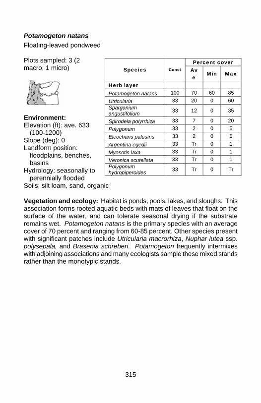
315
Potamogeton natans Floating-leaved pondweed Plots sampled: 3 (2 macro, 1 micro)
Environment: Elevation (ft): ave. 633
(100-1200) Slope (deg): 0 Landform position:
floodplains, benches, basins
Hydrology: seasonally to perennially flooded
Soils: silt loam, sand, organic Vegetation and ecology: Habitat is ponds, pools, lakes, and sloughs. This association forms rooted aquatic beds with mats of leaves that float on the surface of the water, and can tolerate seasonal drying if the substrate remains wet. Potamogeton natans is the primary species with an average cover of 70 percent and ranging from 60-85 percent. Other species present with significant patches include Utricularia macrorhiza, Nuphar lutea ssp. polysepala, and Brasenia schreberi. Potamogeton frequently intermixes with adjoining associations and many ecologists sample these mixed stands rather than the monotypic stands.
Percent cover Species Const Av
e Min Max
Herb layer Potamogeton natans 100 70 60 85 Utricularia 33 20 0 60 Sparganium angustifolium 33 12 0 35
Spirodela polyrrhiza 33 7 0 20 Polygonum 33 2 0 5 Eleocharis palustris 33 2 0 5 Argentina egedii 33 Tr 0 1 Myosotis laxa 33 Tr 0 1 Veronica scutellata 33 Tr 0 1 Polygonum hydropiperoides 33 Tr 0 Tr
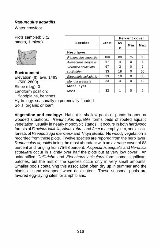
316
Ranunculus aquatilis Water crowfoot Plots sampled: 3 (2 macro, 1 micro)
Environment: Elevation (ft): ave. 1483
(500-2800) Slope (deg): 0 Landform position:
floodplains, benches Hydrology: seasonally to perennially flooded Soils: organic or loam Vegetation and ecology: Habitat is shallow pools or ponds in open or wooded situations. Ranunculus aquatilis forms beds of rooted aquatic vegetation, usually in nearly monotypic stands. It occurs in both hardwood forests of Fraxinus latifolia, Alnus rubra, and Acer macrophyllum, and also in forests of Pseudotsuga menziesii and Thuja plicata. No woody vegetation is recorded from these plots. Twelve species are repored from the herb layer, Ranunculus aquatilis being the most abundant with an average cover of 88 percent and ranging from 75-98 percent. Alopecurus aequalis and Veronica scutellata occur in slightly over half the plots but at very low cover. An unidentified Callitriche and Eleocharis acicularis form some significant patches, but the rest of the species occur only in very small amounts. Smaller pools containing this association often dry up in summer and the plants die and disappear when desiccated. These seasonal pools are favored egg-laying sites for amphibians.
Percent cover Species Const Av
e Min Max
Herb layer Ranunculus aquatilis 100 88 75 98 Alopecurus aequalis 67 4 0 6 Veronica scutellata 67 3 0 6 Callitriche 33 18 0 55 Eleocharis acicularis 33 10 0 30 Mentha arvensis 33 4 0 12 Moss layer Moss 33 1 0 2

317
Ranunculus flammula Creeping buttercup Plots sampled: 8 (1 macro, 7 micro)
Environment: Elevation (ft): ave. 3886
(2800-5410) Slope (deg): 0 Landform position:
floodplains, basins Hydrology: seasonally
flooded to perennially moist Soils: organic or loam Vegetation and ecology: Habitat is seasonally flooded depressions where peat or mud are exposed at low water. Ranunculus flammula forms sparse to dense aquatic mats in shallow depressions that dry out as summer progresses, when plants persist and flower in stoloniferous mats over the mud. Woody vegetation is peripheral to the wetland and may include various species of Salix, Vaccinium uliginosum, and Spiraea douglasii. Ranunculus flammula is the principal herbaceous species with an average cover of 51 percent and ranging from 15 to 90 percent. Five other species of herbs are recorded, all with low constancy and cover, except for patches of an unidentified Potamogeton and Carex utriculata. Occurrences can become quite dry late in the season and Ranunculus flammula disappears under heavy trampling by elk. These seasonal pools are favored egg-laying sites for amphibians.
Percent cover Species
Const Av
e Min Max
Herb layer Ranunculus flammula 100 51 15 70
Carex aquatilis var. dives 25 3 0 13
Potamogeton 13 6 0 45 Carex utriculata 13 3 0 20 Dodecatheon jeffreyi 13 Tr 0 1 Carex lenticularis 13 Tr 0 Tr Moss layer Moss 25 1 0 5
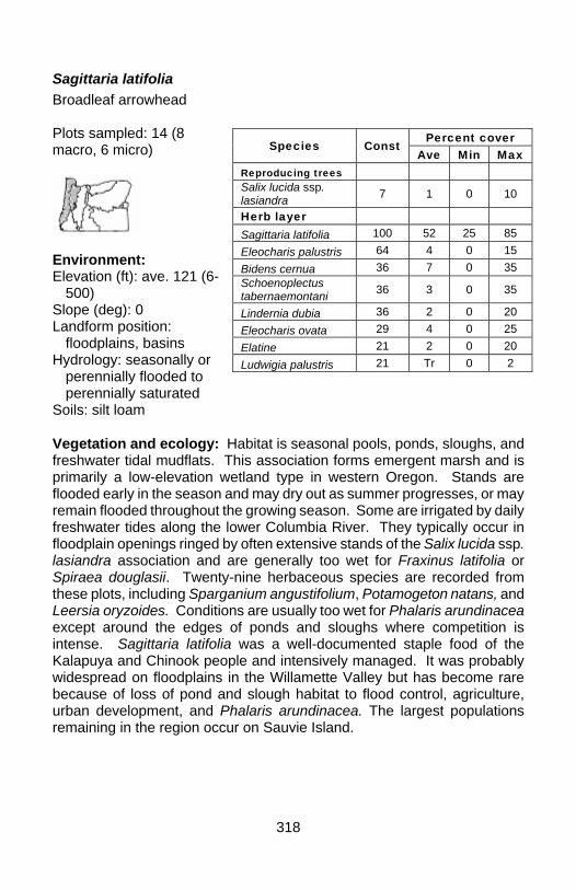
318
Sagittaria latifolia Broadleaf arrowhead Plots sampled: 14 (8 macro, 6 micro)
Environment: Elevation (ft): ave. 121 (6-
500) Slope (deg): 0 Landform position:
floodplains, basins Hydrology: seasonally or
perennially flooded to perennially saturated
Soils: silt loam Vegetation and ecology: Habitat is seasonal pools, ponds, sloughs, and freshwater tidal mudflats. This association forms emergent marsh and is primarily a low-elevation wetland type in western Oregon. Stands are flooded early in the season and may dry out as summer progresses, or may remain flooded throughout the growing season. Some are irrigated by daily freshwater tides along the lower Columbia River. They typically occur in floodplain openings ringed by often extensive stands of the Salix lucida ssp. lasiandra association and are generally too wet for Fraxinus latifolia or Spiraea douglasii. Twenty-nine herbaceous species are recorded from these plots, including Sparganium angustifolium, Potamogeton natans, and Leersia oryzoides. Conditions are usually too wet for Phalaris arundinacea except around the edges of ponds and sloughs where competition is intense. Sagittaria latifolia was a well-documented staple food of the Kalapuya and Chinook people and intensively managed. It was probably widespread on floodplains in the Willamette Valley but has become rare because of loss of pond and slough habitat to flood control, agriculture, urban development, and Phalaris arundinacea. The largest populations remaining in the region occur on Sauvie Island.
Percent cover Species Const
Ave Min Max Reproducing trees Salix lucida ssp. lasiandra 7 1 0 10
Herb layer Sagittaria latifolia 100 52 25 85 Eleocharis palustris 64 4 0 15 Bidens cernua 36 7 0 35 Schoenoplectus tabernaemontani 36 3 0 35
Lindernia dubia 36 2 0 20 Eleocharis ovata 29 4 0 25 Elatine 21 2 0 20 Ludwigia palustris 21 Tr 0 2
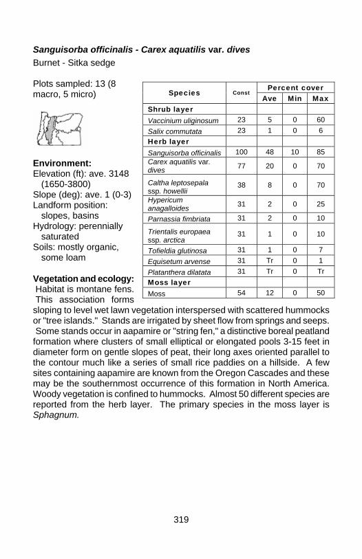
319
Sanguisorba officinalis - Carex aquatilis var. dives Burnet - Sitka sedge Plots sampled: 13 (8 macro, 5 micro)
Environment: Elevation (ft): ave. 3148
(1650-3800) Slope (deg): ave. 1 (0-3) Landform position:
slopes, basins Hydrology: perennially
saturated Soils: mostly organic,
some loam Vegetation and ecology: Habitat is montane fens. This association forms sloping to level wet lawn vegetation interspersed with scattered hummocks or "tree islands." Stands are irrigated by sheet flow from springs and seeps. Some stands occur in aapamire or "string fen," a distinctive boreal peatland formation where clusters of small elliptical or elongated pools 3-15 feet in diameter form on gentle slopes of peat, their long axes oriented parallel to the contour much like a series of small rice paddies on a hillside. A few sites containing aapamire are known from the Oregon Cascades and these may be the southernmost occurrence of this formation in North America. Woody vegetation is confined to hummocks. Almost 50 different species are reported from the herb layer. The primary species in the moss layer is Sphagnum.
Percent cover Species Const
Ave Min Max Shrub layer Vaccinium uliginosum 23 5 0 60 Salix commutata 23 1 0 6 Herb layer Sanguisorba officinalis 100 48 10 85 Carex aquatilis var. dives 77 20 0 70
Caltha leptosepala ssp. howellii
38 8 0 70
Hypericum anagalloides 31 2 0 25
Parnassia fimbriata 31 2 0 10
Trientalis europaea ssp. arctica
31 1 0 10
Tofieldia glutinosa 31 1 0 7 Equisetum arvense 31 Tr 0 1 Platanthera dilatata 31 Tr 0 Tr Moss layer Moss 54 12 0 50
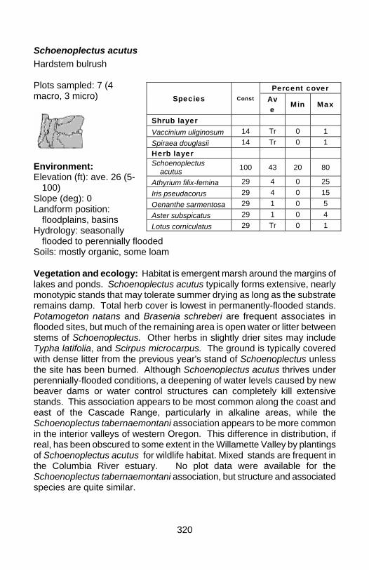
320
Schoenoplectus acutus Hardstem bulrush Plots sampled: 7 (4 macro, 3 micro)
Environment: Elevation (ft): ave. 26 (5-
100) Slope (deg): 0 Landform position:
floodplains, basins Hydrology: seasonally
flooded to perennially flooded Soils: mostly organic, some loam Vegetation and ecology: Habitat is emergent marsh around the margins of lakes and ponds. Schoenoplectus acutus typically forms extensive, nearly monotypic stands that may tolerate summer drying as long as the substrate remains damp. Total herb cover is lowest in permanently-flooded stands. Potamogeton natans and Brasenia schreberi are frequent associates in flooded sites, but much of the remaining area is open water or litter between stems of Schoenoplectus. Other herbs in slightly drier sites may include Typha latifolia, and Scirpus microcarpus. The ground is typically covered with dense litter from the previous year's stand of Schoenoplectus unless the site has been burned. Although Schoenoplectus acutus thrives under perennially-flooded conditions, a deepening of water levels caused by new beaver dams or water control structures can completely kill extensive stands. This association appears to be most common along the coast and east of the Cascade Range, particularly in alkaline areas, while the Schoenoplectus tabernaemontani association appears to be more common in the interior valleys of western Oregon. This difference in distribution, if real, has been obscured to some extent in the Willamette Valley by plantings of Schoenoplectus acutus for wildlife habitat. Mixed stands are frequent in the Columbia River estuary. No plot data were available for the Schoenoplectus tabernaemontani association, but structure and associated species are quite similar.
Percent cover Species Const Av
e Min Max
Shrub layer Vaccinium uliginosum 14 Tr 0 1 Spiraea douglasii 14 Tr 0 1 Herb layer Schoenoplectus
acutus 100 43 20 80
Athyrium filix-femina 29 4 0 25 Iris pseudacorus 29 4 0 15 Oenanthe sarmentosa 29 1 0 5 Aster subspicatus 29 1 0 4 Lotus corniculatus 29 Tr 0 1

321
Scirpus microcarpus Small-fruited bulrush Plots sampled: 20 (15 macro, 5 micro)
Environment: Elevation (ft): ave. 2732
(560-4100) Slope (deg): ave. 2 (0-25) Landform position:
slopes, basins Hydrology: seasonally
moist to perennially saturated
Soils: organic, loam, sand Vegetation and ecology: Habitat is marshes, fens, or springs. Stands are highly variable and a number of different phases could be segregated with further study. Stands are usually monotypic and may reach heights of 3 feet. Trees are peripheral to the wetlands and can be both deciduous or conifers. Eight shrubs are reported from these stands but all have negligible constancy and cover. Almost 80 species are reported from the herb layer, presumably because of the great variety of habitats and elevations in which the association occurs. Scirpus microcarpus is the primary species, with average cover of 75 percent and ranging from 15-98 percent. Most other species have much lower constancy and cover. Associated species with significant patches include Lysichiton americanus, Athyrium filix-femina, Oenanthe sarmentosa, Stachys ajugoides var. rigida, Carex aquatilis var. dives, and Senecio triangularis.
Percent cover Species Const Av
e Min Max
Shrub layer Alnus incana 4 Tr 0 5 Rosa pisocarpa 4 Tr 0 2 Salix 4 Tr 0 1 Salix commutata 4 Tr 0 Tr Rubus laciniatus 4 Tr 0 Tr Spiraea douglasii 4 Tr 0 Tr Rubus spectabilis 4 Tr 0 Tr Rubus ursinus 4 Tr 0 Tr Herb layer Scirpus microcarpus 100 75 15 98 Glyceria striata 39 2 0 15 Mimulus guttatus 35 1 0 10 Lysichiton americanus 30 4 0 35
Athyrium filix-femina 30 3 0 60 Oenanthe sarmentosa 26 6 0 80
Stachys ajugoides var. rigida
26 6 0 40
Moss layer Moss 30 4 0 49
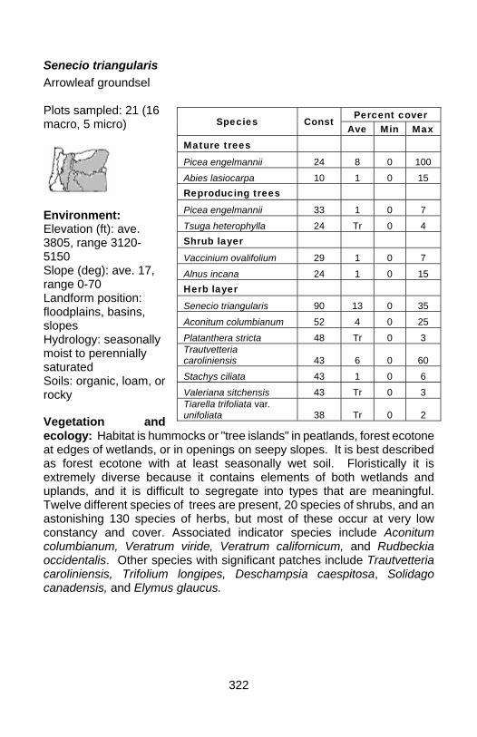
322
Senecio triangularis Arrowleaf groundsel Plots sampled: 21 (16 macro, 5 micro)
Environment: Elevation (ft): ave. 3805, range 3120-5150 Slope (deg): ave. 17, range 0-70 Landform position: floodplains, basins, slopes Hydrology: seasonally moist to perennially saturated Soils: organic, loam, or rocky Vegetation and ecology: Habitat is hummocks or "tree islands" in peatlands, forest ecotone at edges of wetlands, or in openings on seepy slopes. It is best described as forest ecotone with at least seasonally wet soil. Floristically it is extremely diverse because it contains elements of both wetlands and uplands, and it is difficult to segregate into types that are meaningful. Twelve different species of trees are present, 20 species of shrubs, and an astonishing 130 species of herbs, but most of these occur at very low constancy and cover. Associated indicator species include Aconitum columbianum, Veratrum viride, Veratrum californicum, and Rudbeckia occidentalis. Other species with significant patches include Trautvetteria caroliniensis, Trifolium longipes, Deschampsia caespitosa, Solidago canadensis, and Elymus glaucus.
Percent cover Species Const
Ave Min Max Mature trees Picea engelmannii 24 8 0 100 Abies lasiocarpa 10 1 0 15 Reproducing trees Picea engelmannii 33 1 0 7 Tsuga heterophylla 24 Tr 0 4 Shrub layer Vaccinium ovalifolium 29 1 0 7 Alnus incana 24 1 0 15 Herb layer Senecio triangularis 90 13 0 35 Aconitum columbianum 52 4 0 25 Platanthera stricta 48 Tr 0 3 Trautvetteria caroliniensis 43 6 0 60 Stachys ciliata 43 1 0 6 Valeriana sitchensis 43 Tr 0 3 Tiarella trifoliata var. unifoliata 38 Tr 0 2
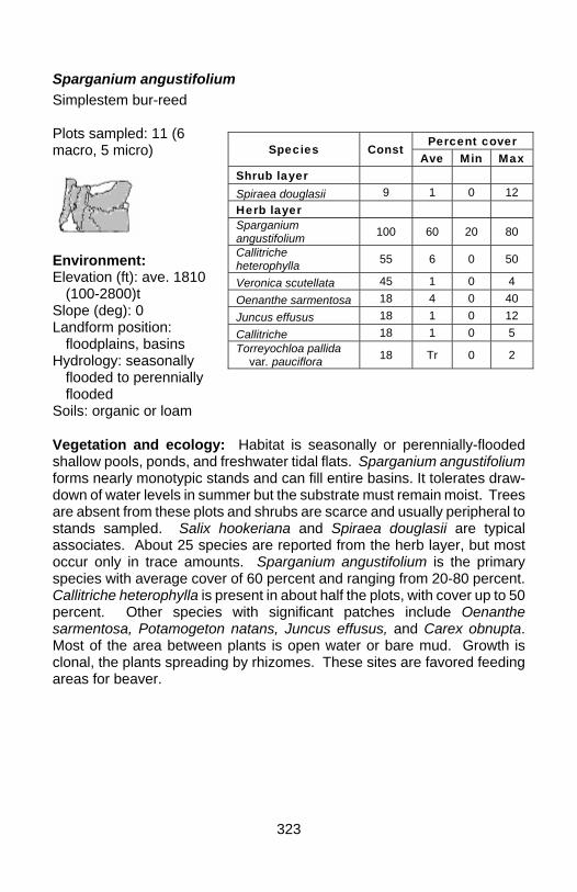
323
Sparganium angustifolium Simplestem bur-reed Plots sampled: 11 (6 macro, 5 micro)
Environment: Elevation (ft): ave. 1810
(100-2800)t Slope (deg): 0 Landform position:
floodplains, basins Hydrology: seasonally
flooded to perennially flooded
Soils: organic or loam Vegetation and ecology: Habitat is seasonally or perennially-flooded shallow pools, ponds, and freshwater tidal flats. Sparganium angustifolium forms nearly monotypic stands and can fill entire basins. It tolerates draw-down of water levels in summer but the substrate must remain moist. Trees are absent from these plots and shrubs are scarce and usually peripheral to stands sampled. Salix hookeriana and Spiraea douglasii are typical associates. About 25 species are reported from the herb layer, but most occur only in trace amounts. Sparganium angustifolium is the primary species with average cover of 60 percent and ranging from 20-80 percent. Callitriche heterophylla is present in about half the plots, with cover up to 50 percent. Other species with significant patches include Oenanthe sarmentosa, Potamogeton natans, Juncus effusus, and Carex obnupta. Most of the area between plants is open water or bare mud. Growth is clonal, the plants spreading by rhizomes. These sites are favored feeding areas for beaver.
Percent cover Species Const
Ave Min Max Shrub layer Spiraea douglasii 9 1 0 12 Herb layer Sparganium angustifolium 100 60 20 80
Callitriche heterophylla 55 6 0 50
Veronica scutellata 45 1 0 4 Oenanthe sarmentosa 18 4 0 40 Juncus effusus 18 1 0 12 Callitriche 18 1 0 5 Torreyochloa pallida
var. pauciflora 18 Tr 0 2
324
Sparganium eurycarpum Broadfruit bur-reed Plots sampled: 5 (micro)
Environment: Elevation (ft): 20-200 Slope (deg): 0 Landform position: floodplains, basins Hydrology: seasonally to perennially flooded Soils: organic, loam Vegetation and ecology: Habitat is shallow lakes, ponds, and sloughs. Sparganium eurycarpum forms nearly monotypic emergent stands with most of the space between plants occupied by litter or open water. Sparganium has an average cover of 34 percent and ranges from 20-45 percent cover. No other vegetation is reported here except for Cicuta douglasii, but almost any common emergent species could be present in small amounts. The association appears to be limited to low elevations.
Percent cover Species Const
Ave Min Max Herb layer Sparganium eurycarpum 100 34 20 45
Cicuta douglasii 20 2 0 10 Unvegetated Litter 100 45 15 70 Water 80 19 0 35
325
Torreyochloa pallida var. pauciflora Pale false mannagrass Plots sampled: 6 (macro)
Environment: Elevation (ft): ave. 1848
(880-3825) Slope (deg): ave. 0 (0-2) Landform position:
floodplains, basins, benches
Hydrology: perennially moist to flooded
Soils: mostly loam, some sand or organic
Vegetation and ecology: Habitat is sodden edges of fens, meadows, and marshes, including beaver marshes. Torreyochloa pallida var. pauciflora forms sparse to dense stands of low to moderate diversity. Most trees and shrubs are peripheral but Alnus rubra may be present in small amounts. More than 35 species are reported from the herb layer, but most occur at very low constancy and cover. Most of the surface between plants is mud or open water.
Percent cover Species Const
Ave Min Max Reproducing trees Alnus rubra 17 Tr 0 Tr Shrub layer Salix sitchensis 33 Tr 0 Tr Rubus ursinus 17 Tr 0 Tr Herb layer Torreyochloa pallida var. pauciflora 100 56 30 80
Veronica americana 67 1 0 3 Scirpus microcarpus 67 1 0 1 Juncus effusus 50 9 0 30 Typha latifolia 50 5 0 25 Oenanthe sarmentosa 50 1 0 5 Lysichiton americanus 33 9 0 50 Callitriche 33 2 0 6 Sparganium angustifolium 33 2 0 6 Carex obnupta 33 1 0 3 Myosotis laxa 33 Tr 0 2 Phalaris arundinacea 33 Tr 0 Tr Stellaria calycantha 33 Tr 0 Tr Moss layer Moss 17 Tr 0 Tr
326
Trichophorum caespitosum Tufted clubrush Plots sampled: 9 (macro)
Environment: Elevation (ft): ave. 3442
(2650-4240) Slope (deg): ave. 5 (0-
15) Landform position:
floodplains, basins Hydrology: perennially
moist to perennially saturated
Soils: mostly organic, some loam
Vegetation and ecology: Habitat is montane fens, forming wet lawns on flats or gentle to moderate slopes below springs and seeps. Trichophorum caespitosum forms conspicuous tussocks. Trees and shrubs have scanty cover and are primarily restricted to hummocks or "tree islands" within a matrix of wet lawn, or they are peripheral to the wetland. Over 40 species are reported from the herb layer, most of them typical of wet lawns in fens. Trichophorum caespitosum is uncommon in Oregon and occurrences of this association are limited to the northern part of the Cascade Range.
Percent cover Species Const
Ave Min Max Mature trees Pinus monticola 11 Tr 0 2 Reproducing trees Thuja plicata 33 3 0 22 Shrub layer Vaccinium uliginosum 67 3 0 7 Gaultheria ovatifolia 33 Tr 0 1 Herb layer Trichophorum caespitosum 100 44 20 75
Tofieldia glutinosa 100 5 Tr 15 Hypericum anagalloides 89 29 0 65 Caltha leptosepala ssp. howellii 89 9 0 20
Sanguisorba officinalis 67 11 0 25 Eriophorum gracile 67 4 0 30 Dodecatheon jeffreyi 56 3 0 15 Drosera rotundifolia 56 2 0 6 Agrostis thurberiana 56 1 0 7 Parnassia fimbriata 56 1 0 5 Gentiana sceptrum 56 Tr 0 Tr Carex aquatilis var. dives 44 7 0 30 Moss layer Moss 67 2 0 7
327
Triteleia hyacinthina White brodiaea Plots sampled: 12 (macro)
Environment: Elevation (ft): 500 Slope (deg): 0 Landform position:
floodplains Hydrology: seasonally
moist Soils: loam Vegetation and ecology: Habitat is seasonally wet prairie on shallow soil over basalt bedrock, with a perched water table. Woody species are absent from these plots but may include Quercus garryana, Symphoricarpos albus, or Spiraea douglasii. A shallow mantle of soil supports a mix of dry upland prairie species (e.g., Poa scabrella, Festuca roemeri, Danthonia californica, Lomatium utriculatum, Plectritis congesta) on convex surfaces and wet prairie species in concave surfaces. The concave surfaces pool water in winter and spring and support at least 25 herbaceous species recorded in these plots, about one-third of which are exotics. The moss layer may contain Polytrichum piliferum and Racomitrium ericoides that indicate severe drying later in the summer. Conspicuous sheets of algae turn white when they dry and delineate areas of seasonally pooled water, a good secondary indicator of hydric conditions in sites that don't otherwise meet wetland criteria because they lack hydric soils. A challenging aspect of this association is that most of the Triteleia is sterile, showing only short terete shoots, and because of this some researchers have called this the "unknown Brodiaea association." Stands intergrade with the Camassia quamash association where deeper pockets of soil occur.
Percent cover Species Const
Ave Min Max Herb layer Triteleia hyacinthina 100 62 35 95 Hypochaeris radicata 92 12 0 40
Camassia quamash 75 11 0 30 Danthonia californica 50 1 0 3 Prunella vulgaris 33 8 0 45 Lotus pinnatus 33 1 0 8 Centaurium erythraea 33 Tr 0 2
Hypericum anagalloides 25 Tr 0 1
Eleocharis acicularis 25 Tr 0 1 Moss layer Moss 58 15 0 60
328
Typha latifolia Broadleaf cattail Plots sampled: 4 (macro)
Environment: Elevation (ft): ave. 1299
(500-1950) Slope (deg): 0-1 Landform position:
floodplains, basins, flats
Hydrology: seasonally moist to perennially saturated
Soils: loam Vegetation and ecology: Habitat is shallow depressions, marshes, edges of lakes, and freshwater tidal flats. This is a common association but is overlooked and undersampled. The general aspect is usually a monotype of Typha latifolia, but closer inspection shows some differentiation based on patches of other vegetation. The only woody species recorded in these four plots are Frangula purshiana and Salix hookeriana with 25 percent constancy but with only trace cover. About twenty species are recorded from the herb layer. Some exotics are evident and indicate low elevation and proximity to settlement. Although this association is native, it appears to respond positively to eutrophic conditions caused by agricultural and urban runoff. Changes in surface and groundwater flows associated with road construction also appear to have a strong influence on this association.
Percent cover Species Const
Ave Min Max Reproducing trees Frangula purshiana 25 Tr 0 Tr Shrub layer Salix hookeriana 25 1 0 2 Herb layer Typha latifolia 100 54 40 65 Myosotis laxa 25 9 0 35 Mentha 25 8 0 30 Scirpus microcarpus 25 8 0 30 Equisetum arvense 25 3 0 13 Carex stipata 25 3 0 10 Cirsium arvense 25 2 0 9 Glyceria striata 25 2 0 7 Stachys ciliata 25 1 0 5 Veronica scutellata 25 1 0 5 Cicuta douglasii 25 1 0 3 Elymus glaucus 25 1 0 2 Moss layer Moss 25 24 0 95
329
Utricularia macrorhiza Common bladderwort Plots sampled: 0
Environment: Elevation (ft): 10-2000 Slope (deg): 0 Landform position: floodplains, basins Hydrology: submerged aquatic Soils: organic Vegetation and ecology: Habitat is lakes and ponds, usually with perennial water. This is an unrooted aquatic bed association that is widespread in western Oregon but it has not been sampled and little information is available. Utricularia macrorhiza is insectivorous and characterized by its large bladders blackened with the remains of aquatic invertebrates. It forms sparse to dense masses of nearly monotypic submerged vegetation with cover ranging from 40-95 percent. It provides important habitat for aquatic invertebrates and fish. It is the most common Utricularia at lower elevations and the only one to form extensive stands, but it is not as common as some other aquatic bed associations. It is not clear if this association favors eutrophic conditions or may be enhanced by enriched runoff in agricultural or urban landscapes.
330
IV. NONVASCULAR ASSOCIATIONS
Fontinalis antipyretica Fountain moss Plots sampled: 1 (macro)
Environment: Elevation (ft): 3800 Slope (deg): 0 Landform position: floodplains, basins, benches Hydrology: seasonally flooded to perennially flooded Soils: organic or loam Vegetation and ecology: Habitat is seasonally or perennially flooded pools, ponds, and sloughs. Fontinalis antipyretica usually forms extensive submerged beds that tolerate both perennial submergence or seasonal exposure. Beds may be 2-3 feet thick when submerged, and dry down to a 6-inch thick turf if the pool loses all its water in summer. Although this association is represented by only one plot and is obviously undersampled, it is widespread in the region. The plot data here represent a perennially flooded pool with a cover of only 10 percent, but covers of 80-100 are the norm. There is no evidence that this association increases under eutrophic conditions, and only a few stands have been observed that would approach these conditions. Most occur in clean, cold, slow or non-flowing water. Pearsons (1989) and Markle et al. (1991) found that this association provides important cover for the federally-listed Oregon chub. Fontinalis neomexicana is a related species that occurs in cold flowing water in both streams and fen or flush rivulets.
Percent cover Species Const
Ave Min Max Moss layer Moss 100 10 10 10
331
Polytrichum commune Haircap moss Plots sampled: 5 (micro)
Environment: Elevation (ft): 5410 Slope (deg): 0 Landform position: basins Hydrology: perennially to
seasonally moist Soils: organic Vegetation and ecology: This association is most common in seasonally-flooded depressions in the Tsuga mertensiana zone. Stands may occur in small depressions among trees, but most occur in larger seasonal ponds with no forest canopy. Heavy snow accumulations persist longer into the growing season and together with subsequent meltwater suppress most other vegetation. Stands are usually monotypic mats composed entirely of the moss Polytrichum commune up to 6 inches thick. Where slopes around depressions are steep enough, Polytrichum occupies a seasonally-flooded zone between upland and late-season ponded water often occupied by Carex utriculata, Nuphar lutea ssp. polysepala, or Glyceria. Deschampsia caespitosa is often present at the upper margin of this zone. In shallow depressions with less perceptible slopes, Polytrichum may completely carpet the bottom of the depression, forming extensive lawns. Thick mats act as insulating blankets and retain moisture throughout the growing season. The 1996 Torrey Lake fire in Lane County scorched or killed 60-99 percent of Polytrichum mats in some transects, but regeneration from uninjured tissue below the surface was evident within two years and is ongoing. Dead stands were replaced by Glyceria or Calamagrostis.
Percent cover Species Const Ave Min Max
Herb layer Carex utriculata 20 Tr 0 1 Moss layer Moss 100 64 5 100 Unvegetated Litter 100 21 1 95 Bare ground 20 17 0 85
332
Appendix I: Species list Alphabetized by scientific name
Scientific name Common name Wetland Origin PLANTS code
Abies amabilis Silver fir FACU native ABAM Abies grandis Grand fir FACU native ABGR Abies lasiocarpa Subalpine fir FACU native ABLA Abies procera Noble fir UPL native ABPR Acer circinatum Vine maple FAC- native ACCI
Acer glabrum var. douglasii Rocky Mountain maple FAC native ACGLD4
Acer macrophyllum Big leaf maple FACU native ACMA3 Achillea millefolium Yarrow FACU native ACMI2 Achlys triphylla Vanilla leaf UPL native ACTR
Aconitum columbianum Columbian monkshood FACW native ACCO4
Aconitum columbianum ssp. columbianum
Columbian monkshood FACW native ACCOC2
Aconitum columbianum ssp. viviparum
Columbian monkshood FACW native ACCOV2
Actaea rubra Red baneberry UPL native ACRU2 Adenocaulon bicolor Pathfinder UPL native ADBI Adiantum pedatum Maidenhair fern FAC native ADPE Ageratina occidentalis Western snakeroot UPL native AGOC2 Agoseris elata Tall agoseris FAC native AGEL Agrostis capillaris Colonial bentgrass FACU exotic AGCA5 Agrostis exarata Spike bentgrass FACW native AGEX Agrostis humilis Alpine bentgrass FACW native AGHU Agrostis oregonensis Oregon bentgrass FAC native AGOR Agrostis pallens Dune bentgrass FACU native AGPA8 Agrostis stolonifera Creeping bentgrass FAC+ exotic AGST2 Alnus incana Mountain alder FACW native ALIN2 Alnus rubra Red alder FAC native ALRU2 Alnus viridis Sitka alder FACW native ALVI5 Amaranthus Pigweed species UNK unknown AMARA
Amelanchier alnifolia Saskatoon serviceberry FACU native AMAL2
Anaphalis margaritacea Pearly everlasting UPL native ANMA
Anemone deltoidea Three-leaved anemone UPL native ANDE3
Anemone lyallii Lyall's anemone UPL native ANLY Anemone oregana Blue windflower FACU native ANOR Angelica arguta Sharptooth angelica FACW native ANAR3
333
Scientific name Common name Wetland Origin PLANTS code
Angelica genuflexa Kneeling angelica FACW native ANGE2 Antennaria argentea Silver pussytoes FACU native ANAR5 Anthoxanthum odoratum Sweet vernalgrass FACU exotic ANOD Aquilegia formosa Sitka columbine FAC native AQFO Aralia californica California spikenard FAC+ native ARCA2 Arenaria Sandwort species UNK unknown ARENA Arnica amplexicaulis Streambank arnica FACW native ARAM2 Arnica latifolia Broadleaf arnica FAC- native ARLA8 Artemisia douglasiana Douglas' sagewort FACW native ARDO3 Aruncus dioicus Nettle FACU native ARDI8 Asarum caudatum Wild ginger FACU native ASCA2 Aster alpigenus Alpine aster FAC native ASAL2 Aster modestus Great northern aster FACW native ASMO3 Athyrium filix-femina Lady fern FAC+ native ATFI Berberis aquifolium Tall Oregon grape UPL native BEAQ Berberis nervosa Dwarf Oregon grape UPL native BENE2 Blechnum spicant Deer fern FAC+ native BLSP Borago Borage species UNK unknown BORAG Botrychium multifidum Leathery grapefern FAC native BOMU Boykinia major Large boykinia FACW native BOMA3 Boykinia occidentalis Coastal boykinia FACW native BOOC2 Bromus inermis Smooth brome FAC exotic BRIN2 Bromus pacificus Pacific brome UPL native BRPA3 Bromus rigidus Ripgut brome UPL exotic BRDI3 Bromus sitchensis Alaska brome FACU native BRSI Bromus vulgaris Colombian brome UPL native BRVU Calamagrostis canadensis Bluejoint FACW native CACA4 Calocedrus decurrens Incense cedar UPL native CADE27
Caltha leptosepala Broad-leaved marsh-marigold OBL native CALE4
Camassia quamash Common camas FACW native CAQU2 Campanula scouleri Scouler's bluebell UPL native CASC7 Cardamine angulata Angled bittercress FACW native CAAN5 Cardamine breweri Brewer's bittercress FACW native CABR6 Cardamine cordifolia Heartleaf bittercress FACW native CACO6 Cardamine occidentalis Western bittercress FACW native CAOC Cardamine oligosperma Few-sided bittercress FAC native CAOL Carex aquatilis Water sedge OBL native CAAQ Carex aquatilis var. dives Sitka sedge OBL native CAAQD
334
Scientific name Common name Wetland Origin PLANTS code
Carex athrostachya Slenderbeak sedge FACW native CAAT3 Carex deweyana Dewey's sedge FACU native CADE9 Carex echinata Prickly sedge FACW native CAEC Carex hendersonii Henderson's sedge FAC native CAHE7 Carex integra Smoothbeak sedge FACU native CAIN10 Carex interrupta Greenfruit sedge OBL native CAIN17 Carex laeviculmis Smoothstem sedge FACW native CALA13 Carex lenticularis Tufted sedge FACW native CALE8 Carex luzulina Woodrush sedge OBL native CALU7 Carex mertensii Merten's sedge FAC native CAME6 Carex multicostata Manyrib sedge FACU native CAMU6 Carex obnupta Slough sedge OBL native CAOB3 Carex pachystachya Thick-headed sedge FAC native CAPA14 Carex saxatilis Russet sedge FACW native CASA10 Carex spectabilis Showy sedge FACW native CASP5
Castilleja miniata Common red paintbrush FAC native CAMI12
Ceanothus velutinus Snowbrush ceanothus UPL native CEVE
Cerastium fontanum ssp. vulgare Big chickweed FACU exotic CEFOV2 Cerastium glomeratum Sticky chickweed UPL exotic CEGL2 Chamaecyparis nootkatensis Alaska yellow-cedar FAC native CHNO Chamerion angustifolium var. canescens Fireweed FACU native EPAN2 Chimaphila umbellata Prince's pine UPL native CHUM Chrysolepis chrysophylla Chinquapin UPL native CHCH7 Chrysosplenium glechomifolium Water-carpet OBL native CHGL5
Cicuta douglasii Douglas' water-hemlock OBL native CIDO
Cimicifuga laciniata Mount Hood bugbane FACW native CILA Cinna latifolia Wood reedgrass FACW native CILA2
Circaea alpina Enchanter's-nightshade FAC native CIAL
Cirsium arvense Canada thistle FAC- exotic CIAR4 Cirsium vulgare Bull thistle FACU exotic CIVU
Claytonia cordifolia Heart-leaved springbeauty FACW native CLCO3
Claytonia perfoliata Miner's lettuce FAC native CLPE
Claytonia sibirica Siberian miner's lettuce FAC native CLSI2
Clintonia uniflora Queencup beadlily UPL native CLUN2
335
Scientific name Common name Wetland Origin PLANTS code
Collinsia parviflora Small-flowered blue-eyed Mary UPL native COPA3
Collomia heterophylla Varied leaf collomia FACU native COHE2 Coptis laciniata Gold thread FAC native COLA3 Corallorhiza maculata Western coral root UPL native COMA4 Cornus nuttallii Pacific dogwood UPL native CONU4 Cornus sericea Red osier dogwood FACW native COSE16 Cornus unalaschkensis Dogwood bunchberry FAC- native COUN Corydalis aquae-gelidae Cold-water corydalis OBL native COAQ Corydalis scouleri Scouler's corydalis FAC+ native COSC4 Corylus cornuta California hazel FACU native COCO6 Crataegus douglasii Black hawthorn FAC native CRDO2
Cynoglossum Hound's-tongue species UNK unknown CYNOG
Cytisus scoparius Scotch broom UPL exotic CYSC4 Dactylis glomerata Orchard grass FACU exotic DAGL Delphinium glareosum Olumpic larkspur UPL native DEGL Delphinium nuttallianum Two-lobe larkspur FAC native DENU2 Delphinium occidentale Western larkspur FACU exotic DEOC
Delphinium trolliifolium Trollius-leaved larkspur UPL native DETR2
Deschampsia cespitosa Tufted hairgrass FACW native DECE Deschampsia elongata Slender hairgrass FACW native DEEL Dicentra formosa Pacific bleedingheart UPL native DIFO Digitalis purpurea Common foxglove FACU exotic DIPU Distichlis spicata Seashore saltgrass FACW native DISP Dodecatheon dentatum Dentate shooting star FACW native DODE Dryopteris carthusiana Wood fern FAC+ native DRCA11 Eleocharis palustris Creeping spike-rush OBL native ELPA3 Elymus glaucus Blue wildrye FACU native ELGL
Enemion hallii Willamette false rue anemone UPL native ENHA
Epilobium anagallidifolium Alpine willowherb FACW native EPAN4 Epilobium ciliatum ssp. glandulosum
Purple-leaved willowherb FACW native EPCIG
Epilobium ciliatum ssp. watsonii
Purple-leaved willowherb FACW native EPCIW
Epilobium glaberrimum Smooth willowherb FACW native EPGL Epilobium luteum Yellow willowherb FACW native EPLU
Epilobium minutum Small-flowered willowherb UPL native EPMI
Equisetum arvense Common horsetail FAC native EQAR
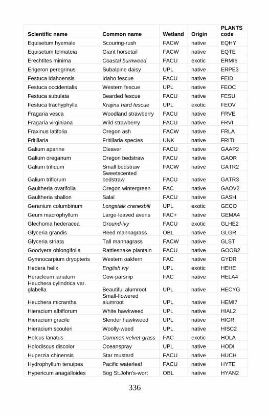
336
Scientific name Common name Wetland Origin PLANTS code
Equisetum hyemale Scouring-rush FACW native EQHY Equisetum telmateia Giant horsetail FACW native EQTE Erechtites minima Coastal burnweed FACU exotic ERMI6 Erigeron peregrinus Subalpine daisy UPL native ERPE3 Festuca idahoensis Idaho fescue FACU native FEID Festuca occidentalis Western fescue UPL native FEOC Festuca subulata Bearded fescue FACU native FESU Festuca trachyphylla Krajina hard fescue UPL exotic FEOV Fragaria vesca Woodland strawberry FACU native FRVE Fragaria virginiana Wild strawberry FACU native FRVI Fraxinus latifolia Oregon ash FACW native FRLA Fritillaria Fritillaria species UNK native FRITI Galium aparine Cleaver FACU native GAAP2 Galium oreganum Oregon bedstraw FACU native GAOR Galium trifidum Small bedstraw FACW native GATR2
Galium triflorum Sweetscented bedstraw FACU native GATR3
Gaultheria ovatifolia Oregon wintergreen FAC native GAOV2 Gaultheria shallon Salal FACU native GASH Geranium columbinum Longstalk cranesbill UPL exotic GECO Geum macrophyllum Large-leaved avens FAC+ native GEMA4 Glechoma hederacea Ground-ivy FACU exotic GLHE2 Glyceria grandis Reed mannagrass OBL native GLGR Glyceria striata Tall mannagrass FACW native GLST Goodyera oblongifolia Rattlesnake plantain FACU native GOOB2 Gymnocarpium dryopteris Western oakfern FAC native GYDR Hedera helix English ivy UPL exotic HEHE Heracleum lanatum Cow-parsnip FAC native HELA4 Heuchera cylindrica var. glabella Beautiful alumroot UPL native HECYG
Heuchera micrantha Small-flowered alumroot UPL native HEMI7
Hieracium albiflorum White hawkweed UPL native HIAL2 Hieracium gracile Slender hawkweed UPL native HIGR Hieracium scouleri Woolly-weed UPL native HISC2 Holcus lanatus Common velvet-grass FAC exotic HOLA Holodiscus discolor Oceanspray UPL native HODI Huperzia chinensis Star mustard FACU native HUCH Hydrophyllum tenuipes Pacific waterleaf FACU native HYTE Hypericum anagalloides Bog St.John's-wort OBL native HYAN2

337
Scientific name Common name Wetland Origin PLANTS code
Hypericum formosum Western St. John's-wort FAC native HYFO4
Hypericum perforatum Common St.John's-wort UPL exotic HYPE
Hypochaeris radicata Hairy cat's ear FACU exotic HYRA3 Impatiens capensis Jewelweed FACW native IMCA Juncus arcticus var. balticus Arctic rush FACW native JUBA Juncus bufonius Toad rush FACW native JUBU Juncus covillei Coville's rush FACW native JUCO5 Juncus effusus Common rush FACW native JUEF Juncus ensifolius Dagger-leaved rush FACW native JUEN Juncus parryi Parry's rush FAC+ native JUPA Juncus patens Spreading rush FACW native JUPA2 Juncus regelii Regel's rush FACW native JURE Lactuca biennis Tall blue lettuce FAC native LABI Lactuca muralis Wall-lettuce UPL exotic MYMU Lactuca serriola Prickly lettuce FACU exotic LASE Lapsana communis Common nipplewort UPL exotic LACO3 Lathyrus nevadensis Purple peavine UPL native LANEP Leucanthemum vulgare Oxeye daisy UPL exotic LEVU Ligusticum grayi Gray's lovage UPL native LIGR Lilium columbianum Columbian lily FAC native LICO Linnaea borealis Twinflower FACU native LIBO3 Listera borealis Northern twayblade FACW native LIBO4
Listera caurina Northwestern twayblade FACU native LICA10
Listera convallarioides Broad-leaved twayblade FAC native LICO5
Listera cordata Heartleaf twayblade FAC native LICO6 Lolium arundinaceum Tall fescue FAC- exotic LOAR10 Lonicera ciliosa Orange honeysuckle UPL native LOCI3 Lonicera involucrata Black twinberry FAC+ native LOIN5 Lotus corniculatus Bird's-foot trefoil FAC exotic LOCO6 Lotus crassifolius Big deervetch UPL native LOCR
Lotus denticulatus Meadow birds-foot trefoil UPL native LODE
Lupinus Lupine species UNK unknown LUPIN
Luzula multiflora Many-flowered wood-rush FACU exotic LUCA2
Luzula multiflora ssp. multiflora
Many-flowered wood-rush FACU exotic LUCAM3
Luzula parviflora Small-flowered wood-rush FAC- native LUPA4
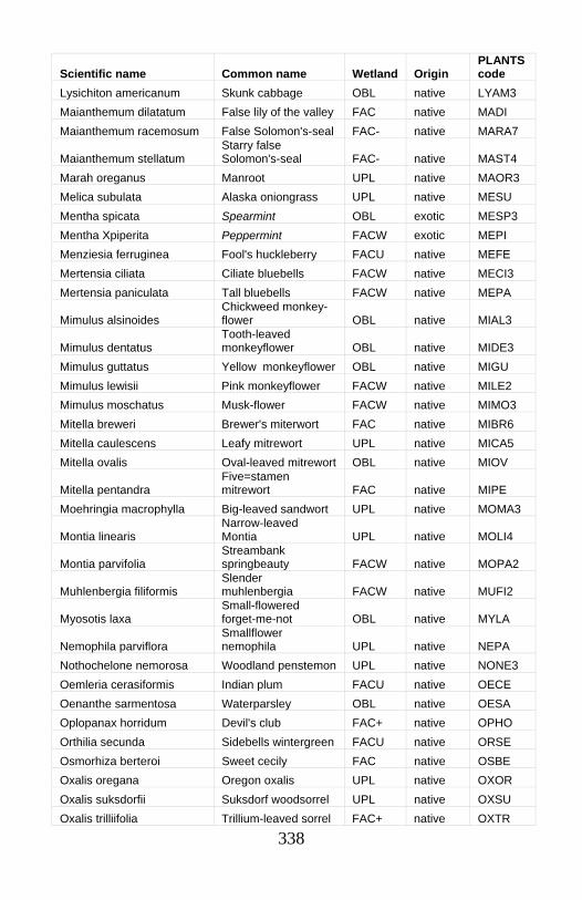
338
Scientific name Common name Wetland Origin PLANTS code
Lysichiton americanum Skunk cabbage OBL native LYAM3 Maianthemum dilatatum False lily of the valley FAC native MADI Maianthemum racemosum False Solomon's-seal FAC- native MARA7
Maianthemum stellatum Starry false Solomon's-seal FAC- native MAST4
Marah oreganus Manroot UPL native MAOR3 Melica subulata Alaska oniongrass UPL native MESU Mentha spicata Spearmint OBL exotic MESP3 Mentha Xpiperita Peppermint FACW exotic MEPI Menziesia ferruginea Fool's huckleberry FACU native MEFE Mertensia ciliata Ciliate bluebells FACW native MECI3 Mertensia paniculata Tall bluebells FACW native MEPA
Mimulus alsinoides Chickweed monkey-flower OBL native MIAL3
Mimulus dentatus Tooth-leaved monkeyflower OBL native MIDE3
Mimulus guttatus Yellow monkeyflower OBL native MIGU Mimulus lewisii Pink monkeyflower FACW native MILE2 Mimulus moschatus Musk-flower FACW native MIMO3 Mitella breweri Brewer's miterwort FAC native MIBR6 Mitella caulescens Leafy mitrewort UPL native MICA5 Mitella ovalis Oval-leaved mitrewort OBL native MIOV
Mitella pentandra Five=stamen mitrewort FAC native MIPE
Moehringia macrophylla Big-leaved sandwort UPL native MOMA3
Montia linearis Narrow-leaved Montia UPL native MOLI4
Montia parvifolia Streambank springbeauty FACW native MOPA2
Muhlenbergia filiformis Slender muhlenbergia FACW native MUFI2
Myosotis laxa Small-flowered forget-me-not OBL native MYLA
Nemophila parviflora Smallflower nemophila UPL native NEPA
Nothochelone nemorosa Woodland penstemon UPL native NONE3 Oemleria cerasiformis Indian plum FACU native OECE Oenanthe sarmentosa Waterparsley OBL native OESA Oplopanax horridum Devil's club FAC+ native OPHO Orthilia secunda Sidebells wintergreen FACU native ORSE Osmorhiza berteroi Sweet cecily FAC native OSBE Oxalis oregana Oregon oxalis UPL native OXOR Oxalis suksdorfii Suksdorf woodsorrel UPL native OXSU Oxalis trilliifolia Trillium-leaved sorrel FAC+ native OXTR
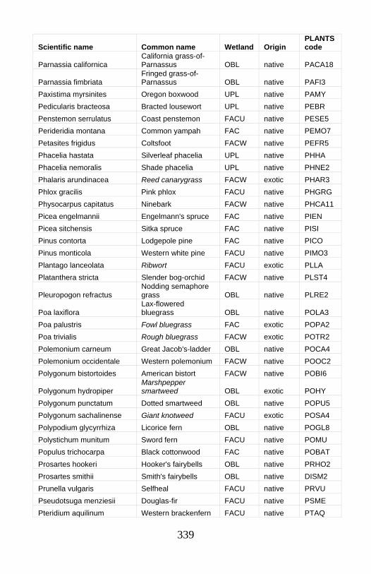
339
Scientific name Common name Wetland Origin PLANTS code
Parnassia californica California grass-of-Parnassus OBL native PACA18
Parnassia fimbriata Fringed grass-of-Parnassus OBL native PAFI3
Paxistima myrsinites Oregon boxwood UPL native PAMY Pedicularis bracteosa Bracted lousewort UPL native PEBR Penstemon serrulatus Coast penstemon FACU native PESE5 Perideridia montana Common yampah FAC native PEMO7 Petasites frigidus Coltsfoot FACW native PEFR5 Phacelia hastata Silverleaf phacelia UPL native PHHA Phacelia nemoralis Shade phacelia UPL native PHNE2 Phalaris arundinacea Reed canarygrass FACW exotic PHAR3 Phlox gracilis Pink phlox FACU native PHGRG Physocarpus capitatus Ninebark FACW native PHCA11 Picea engelmannii Engelmann's spruce FAC native PIEN Picea sitchensis Sitka spruce FAC native PISI Pinus contorta Lodgepole pine FAC native PICO Pinus monticola Western white pine FACU native PIMO3 Plantago lanceolata Ribwort FACU exotic PLLA Platanthera stricta Slender bog-orchid FACW native PLST4
Pleuropogon refractus Nodding semaphore grass OBL native PLRE2
Poa laxiflora Lax-flowered bluegrass OBL native POLA3
Poa palustris Fowl bluegrass FAC exotic POPA2 Poa trivialis Rough bluegrass FACW exotic POTR2 Polemonium carneum Great Jacob's-ladder OBL native POCA4 Polemonium occidentale Western polemonium FACW native POOC2 Polygonum bistortoides American bistort FACW native POBI6
Polygonum hydropiper Marshpepper smartweed OBL exotic POHY
Polygonum punctatum Dotted smartweed OBL native POPU5 Polygonum sachalinense Giant knotweed FACU exotic POSA4 Polypodium glycyrrhiza Licorice fern OBL native POGL8 Polystichum munitum Sword fern FACU native POMU Populus trichocarpa Black cottonwood FAC native POBAT Prosartes hookeri Hooker's fairybells OBL native PRHO2 Prosartes smithii Smith's fairybells OBL native DISM2 Prunella vulgaris Selfheal FACU native PRVU Pseudotsuga menziesii Douglas-fir FACU native PSME Pteridium aquilinum Western brackenfern FACU native PTAQ
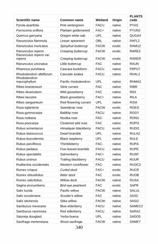
340
Scientific name Common name Wetland Origin PLANTS code
Pyrola asarifolia Pink wintergreen FACU native PYAS Pyrrocoma uniflora Plantain goldenweed FAC+ native PYUN2 Quercus garryana Oregon white oak UPL native QUGA4 Ranunculus flammula Lesser spearwort OBL native RAFL2 Ranunculus muricatus Spinyfruit buttercup FACW exotic RAMU2 Ranunculus repens Creeping buttercup FACW exotic RARE3 Ranunculus repens var. repens Creeping buttercup FACW exotic RARER Ranunculus uncinatus Little buttercup FAC native RAUN Rhamnus purshiana Cascara buckthorn FACU native FRPU7 Rhododendron albiflorum Cascade azalea FACU native RHAL2 Rhododendron macrophyllum Pacific rhododendron UPL native RHMA3 Ribes bracteosum Stink currant FAC native RIBR Ribes divaricatum Wild gooseberry FAC native RIDI Ribes lacustre Black gooseberry FAC+ native RILA Ribes sanguineum Red-flowering currant UPL native RISA Rosa eglanteria Sweetbriar rose FACW exotic ROEG Rosa gymnocarpa Baldhip rose FACU native ROGY Rosa nutkana Nootka rose FAC- native RONU Rosa pisocarpa Clustered wild rose FAC native ROPI2 Rubus armeniacus Himalayan blackberry FACU exotic RUDI2 Rubus lasiococcus Dwarf bramble UPL native RULA2 Rubus leucodermis Black raspberry UPL native RULE Rubus parviflorus Thimbleberry FAC- native RUPA Rubus pedatus Five-leaved bramble FACU native RUPE Rubus spectabilis Salmonberry FAC+ native RUSP Rubus ursinus Trailing blackberry FACU native RUUR Rudbeckia occidentalis Western coneflower FAC- native RUOC2 Rumex crispus Curled dock FAC+ exotic RUCR Rumex obtusifolius Bitter dock FAC exotic RUOB Rumex salicifolius Willow dock FACW native RUSA Sagina procumbens Bird-eye pearlwort FAC exotic SAPR Salix lucida Pacific willow FACW native SALUL Salix scouleriana Scouler's willow FAC native SASC Salix sitchensis Sitka willow FACW native SASI2 Sambucus mexicana Blue elderberry FACU native SAMEC2 Sambucus racemosa Red elderberry FACU native SARA2 Satureja douglasii Yerba buena UPL native SADO5 Saxifraga mertensiana Wood saxifrage FACW native SAME7
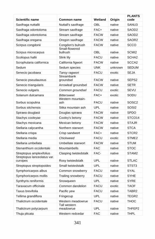
341
Scientific name Common name Wetland Origin PLANTS code
Saxifraga nuttallii Nuttall's saxifrage OBL native SANU3 Saxifraga odontoloma Stream saxifrage FAC+ native SAOD2 Saxifraga odontoloma Stream saxifrage FACW native SAOD2 Saxifraga oregana Oregon saxifrage FACW native SAOR2 Scirpus congdonii Congdon's bulrush FACW native SCCO
Scirpus microcarpus Small-flowered bullrush OBL native SCMI2
Scoliopus hallii Slink lily FACU native SCHA2 Scrophularia californica California figwort FACW native SCCA2 Sedum Sedum species UNK unknown SEDUM Senecio jacobaea Tansy ragwort FACU exotic SEJA
Senecio pseudaureus Streambank groundsel FACW native SEPS2
Senecio triangularis Arrowleaf groundsel FACW native SETR Senecio vulgaris Common groundsel FACU exotic SEVU Solanum dulcamara Bittersweet FAC+ exotic SODU
Sorbus scopulina Western mountain-ash FACU native SOSC2
Sorbus sitchensis Sitka mountain ash UPL native SOSI2 Spiraea douglasii Douglas spiraea FACW native SPDO Stachys cooleyae Cooley's betony FACW native STCO14 Stachys mexicana Mexican betony FACW native STAJR Stellaria calycantha Northern starwort FACW native STCA Stellaria crispa Crisp sandwort FAC+ native STCR2 Stellaria media Chickweed FACU exotic STME2 Stellaria umbellata Umbellate starwort FACW native STUM Stenanthium occidentale Mountainbells FAC native STOC Streptopus amplexifolius Clasping twistedstalk FAC- native STAM2 Streptopus lanceolatus var. curvipes Rosy twistedstalk UPL native STLAC Streptopus streptopoides Small twistedstalk UPL native STST3 Symphoricarpos albus Common snowberry FACU native SYAL Symphoricarpos mollis Trailing snowberry FACU native SYHE Synthyris reniformis Snowqueen UPL native SYRE Taraxacum officinale Common dandelion FACU exotic TAOF Taxus brevifolia Pacific yew FACU native TABR2 Tellima grandiflora Fringecup UPL native TEGR2 Thalictrum occidentale Western meadowrue FACU native THOC
Thalictrum polycarpum Tall western meadowrue UPL native THFEP2
Thuja plicata Western redcedar FAC native THPL

342
Scientific name Common name Wetland Origin PLANTS code
Tiarella trifoliata Coolwort foamflower FAC- native TITR Tiarella trifoliata var. trifoliata Coolwort foamflower FAC- native TITR Tiarella trifoliata var. unifoliata Coolwort foamflower UPL native TITRU Tolmiea menziesii Piggyback plant FAC native TOME Torilis Hedgeparsley UNK exotic TORIL Torreyochloa pallida var. pauciflora Weak alkali grass OBL native TOPAP3 Toxicodendron diversilobum Poison oak UPL native TODI Trautvetteria caroliniensis False bugbane FAC native TRCA Trientalis arctica Northern starflower OBL native TREUA2 Trientalis latifolia Western starflower FAC- native TRLA6 Trifolium howellii Howell's clover FACW native TRHO Trifolium longipes Long-stalked clover FAC- native TRLO Trillium ovatum Pacific trillium FACU native TROV2 Trisetum canescens Tall trisetum FACU native TRCEC Trisetum cernuum Nodding trisetum FACU native TRCE2 Tsuga heterophylla Western hemlock FACU native TSHE Tsuga mertensiana Mountain hemlock FACU native TSME Urtica dioica ssp. gracilis Nettle FAC+ native URDI Vaccinium alaskaense Oval-leaf huckleberry FACU native VAOV Vaccinium deliciosum Blueleaf huckleberry UPL native VADE Vaccinium membranaceum Big huckleberry FACU native VAME Vaccinium ovalifolium Oval-leaf huckleberry UPL native VAOV
Vaccinium ovatum Evergreen huckleberry UPL native VAOV2
Vaccinium parvifolium Red huckleberry FACU native VAPA Vaccinium scoparium Grouse whortleberry FACU native VASC Valeriana occidentalis Western valerian FAC native VAOC2 Valeriana scouleri Scouler's valerian FAC native VASC2 Valeriana sitchensis Sitka valerian FAC native VASI Vancouveria hexandra Insideout flower UPL native VAHE
Veratrum californicum California false hellebore FACW native VECA2
Veratrum viride False hellebore FACW native VEVI Veronica americana American brooklime OBL native VEAM2 Veronica officinalis Common gypsyweed UPL exotic VEOF2 Viburnum edule High-bush cranberry FACW native VIED Viburnum ellipticum Oval-leaved viburnum FACU native VIEL Vicia americana American vetch FAC native VIAM
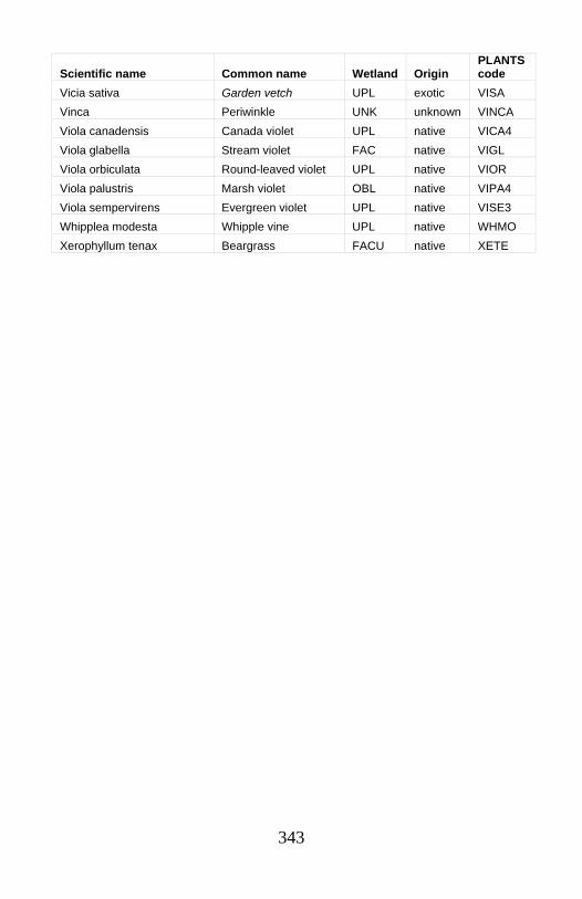
343
Scientific name Common name Wetland Origin PLANTS code
Vicia sativa Garden vetch UPL exotic VISA Vinca Periwinkle UNK unknown VINCA Viola canadensis Canada violet UPL native VICA4 Viola glabella Stream violet FAC native VIGL Viola orbiculata Round-leaved violet UPL native VIOR Viola palustris Marsh violet OBL native VIPA4 Viola sempervirens Evergreen violet UPL native VISE3 Whipplea modesta Whipple vine UPL native WHMO Xerophyllum tenax Beargrass FACU native XETE
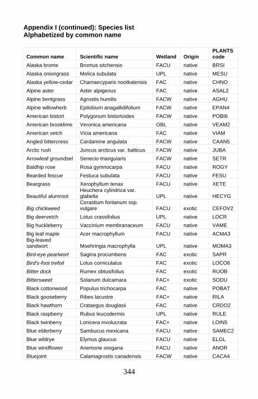
344
Appendix I (continued): Species list Alphabetized by common name
Common name Scientific name Wetland Origin PLANTS code
Alaska brome Bromus sitchensis FACU native BRSI Alaska oniongrass Melica subulata UPL native MESU Alaska yellow-cedar Chamaecyparis nootkatensis FAC native CHNO Alpine aster Aster alpigenus FAC native ASAL2 Alpine bentgrass Agrostis humilis FACW native AGHU Alpine willowherb Epilobium anagallidifolium FACW native EPAN4 American bistort Polygonum bistortoides FACW native POBI6 American brooklime Veronica americana OBL native VEAM2 American vetch Vicia americana FAC native VIAM Angled bittercress Cardamine angulata FACW native CAAN5 Arctic rush Juncus arcticus var. balticus FACW native JUBA Arrowleaf groundsel Senecio triangularis FACW native SETR Baldhip rose Rosa gymnocarpa FACU native ROGY Bearded fescue Festuca subulata FACU native FESU Beargrass Xerophyllum tenax FACU native XETE
Beautiful alumroot Heuchera cylindrica var. glabella UPL native HECYG
Big chickweed Cerastium fontanum ssp. vulgare FACU exotic CEFOV2
Big deervetch Lotus crassifolius UPL native LOCR Big huckleberry Vaccinium membranaceum FACU native VAME Big leaf maple Acer macrophyllum FACU native ACMA3 Big-leaved sandwort Moehringia macrophylla UPL native MOMA3 Bird-eye pearlwort Sagina procumbens FAC exotic SAPR Bird's-foot trefoil Lotus corniculatus FAC exotic LOCO6 Bitter dock Rumex obtusifolius FAC exotic RUOB Bittersweet Solanum dulcamara FAC+ exotic SODU Black cottonwood Populus trichocarpa FAC native POBAT Black gooseberry Ribes lacustre FAC+ native RILA Black hawthorn Crataegus douglasii FAC native CRDO2 Black raspberry Rubus leucodermis UPL native RULE Black twinberry Lonicera involucrata FAC+ native LOIN5 Blue elderberry Sambucus mexicana FACU native SAMEC2 Blue wildrye Elymus glaucus FACU native ELGL Blue windflower Anemone oregana FACU native ANOR Bluejoint Calamagrostis canadensis FACW native CACA4

345
Common name Scientific name Wetland Origin PLANTS code
Blueleaf huckleberry Vaccinium deliciosum UPL native VADE Bog St.John's-wort Hypericum anagalloides OBL native HYAN2 Borage species Borago UNK unknown BORAG Bracted lousewort Pedicularis bracteosa UPL native PEBR Brewer's bittercress Cardamine breweri FACW native CABR6 Brewer's miterwort Mitella breweri FAC native MIBR6 Broadleaf arnica Arnica latifolia FAC- native ARLA8 Broad-leaved marsh-marigold Caltha leptosepala OBL native CALE4 Broad-leaved twayblade Listera convallarioides FAC native LICO5 Bull thistle Cirsium vulgare FACU exotic CIVU California false hellebore Veratrum californicum FACW native VECA2 California figwort Scrophularia californica FACW native SCCA2 California grass-of-Parnassus Parnassia californica OBL native PACA18 California hazel Corylus cornuta FACU native COCO6 California spikenard Aralia californica FAC+ native ARCA2 Canada thistle Cirsium arvense FAC- exotic CIAR4 Canada violet Viola canadensis UPL native VICA4 Cascade azalea Rhododendron albiflorum FACU native RHAL2 Cascara buckthorn Rhamnus purshiana FACU native FRPU7 Chickweed Stellaria media FACU exotic STME2 Chickweed monkey-flower Mimulus alsinoides OBL native MIAL3 Chinquapin Chrysolepis chrysophylla UPL native CHCH7 Ciliate bluebells Mertensia ciliata FACW native MECI3 Clasping twistedstalk Streptopus amplexifolius FAC- native STAM2 Cleaver Galium aparine FACU native GAAP2 Clustered wild rose Rosa pisocarpa FAC native ROPI2 Coast penstemon Penstemon serrulatus FACU native PESE5 Coastal boykinia Boykinia occidentalis FACW native BOOC2 Coastal burnweed Erechtites minima FACU exotic ERMI6 Cold-water corydalis Corydalis aquae-gelidae OBL native COAQ Colombian brome Bromus vulgaris UPL native BRVU Colonial bentgrass Agrostis capillaris FACU exotic AGCA5 Coltsfoot Petasites frigidus FACW native PEFR5 Columbian lily Lilium columbianum FAC native LICO Columbian monkshood Aconitum columbianum FACW native ACCO4
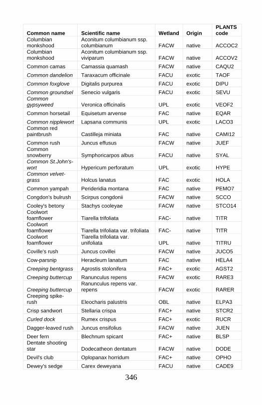
346
Common name Scientific name Wetland Origin PLANTS code
Columbian monkshood
Aconitum columbianum ssp. columbianum FACW native ACCOC2
Columbian monkshood
Aconitum columbianum ssp. viviparum FACW native ACCOV2
Common camas Camassia quamash FACW native CAQU2 Common dandelion Taraxacum officinale FACU exotic TAOF Common foxglove Digitalis purpurea FACU exotic DIPU Common groundsel Senecio vulgaris FACU exotic SEVU Common gypsyweed Veronica officinalis UPL exotic VEOF2 Common horsetail Equisetum arvense FAC native EQAR Common nipplewort Lapsana communis UPL exotic LACO3 Common red paintbrush Castilleja miniata FAC native CAMI12 Common rush Juncus effusus FACW native JUEF Common snowberry Symphoricarpos albus FACU native SYAL Common St.John's-wort Hypericum perforatum UPL exotic HYPE Common velvet-grass Holcus lanatus FAC exotic HOLA Common yampah Perideridia montana FAC native PEMO7 Congdon's bulrush Scirpus congdonii FACW native SCCO Cooley's betony Stachys cooleyae FACW native STCO14 Coolwort foamflower Tiarella trifoliata FAC- native TITR Coolwort foamflower Tiarella trifoliata var. trifoliata FAC- native TITR Coolwort foamflower
Tiarella trifoliata var. unifoliata UPL native TITRU
Coville's rush Juncus covillei FACW native JUCO5 Cow-parsnip Heracleum lanatum FAC native HELA4 Creeping bentgrass Agrostis stolonifera FAC+ exotic AGST2 Creeping buttercup Ranunculus repens FACW exotic RARE3
Creeping buttercup Ranunculus repens var. repens FACW exotic RARER
Creeping spike-rush Eleocharis palustris OBL native ELPA3 Crisp sandwort Stellaria crispa FAC+ native STCR2 Curled dock Rumex crispus FAC+ exotic RUCR Dagger-leaved rush Juncus ensifolius FACW native JUEN Deer fern Blechnum spicant FAC+ native BLSP Dentate shooting star Dodecatheon dentatum FACW native DODE Devil's club Oplopanax horridum FAC+ native OPHO Dewey's sedge Carex deweyana FACU native CADE9
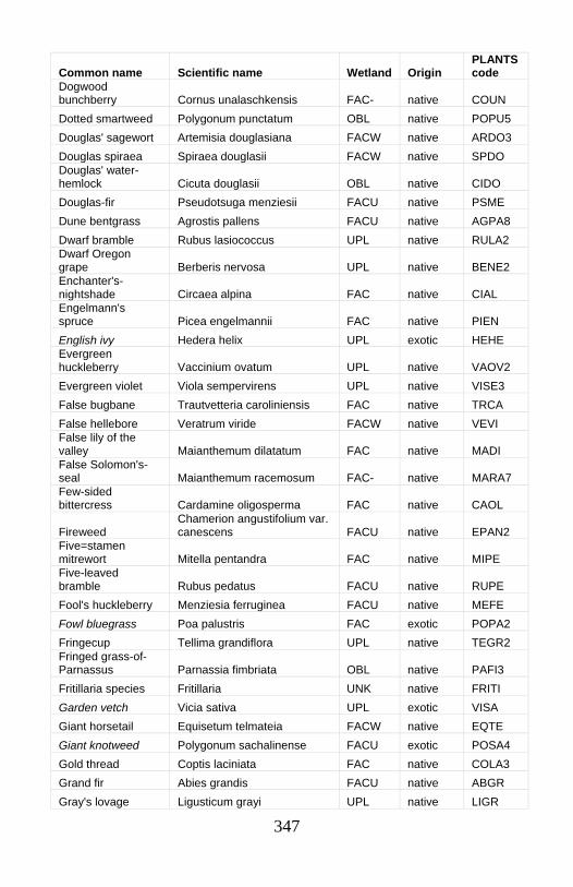
347
Common name Scientific name Wetland Origin PLANTS code
Dogwood bunchberry Cornus unalaschkensis FAC- native COUN Dotted smartweed Polygonum punctatum OBL native POPU5 Douglas' sagewort Artemisia douglasiana FACW native ARDO3 Douglas spiraea Spiraea douglasii FACW native SPDO Douglas' water-hemlock Cicuta douglasii OBL native CIDO Douglas-fir Pseudotsuga menziesii FACU native PSME Dune bentgrass Agrostis pallens FACU native AGPA8 Dwarf bramble Rubus lasiococcus UPL native RULA2 Dwarf Oregon grape Berberis nervosa UPL native BENE2 Enchanter's-nightshade Circaea alpina FAC native CIAL Engelmann's spruce Picea engelmannii FAC native PIEN English ivy Hedera helix UPL exotic HEHE Evergreen huckleberry Vaccinium ovatum UPL native VAOV2 Evergreen violet Viola sempervirens UPL native VISE3 False bugbane Trautvetteria caroliniensis FAC native TRCA False hellebore Veratrum viride FACW native VEVI False lily of the valley Maianthemum dilatatum FAC native MADI False Solomon's-seal Maianthemum racemosum FAC- native MARA7 Few-sided bittercress Cardamine oligosperma FAC native CAOL
Fireweed Chamerion angustifolium var. canescens FACU native EPAN2
Five=stamen mitrewort Mitella pentandra FAC native MIPE Five-leaved bramble Rubus pedatus FACU native RUPE Fool's huckleberry Menziesia ferruginea FACU native MEFE Fowl bluegrass Poa palustris FAC exotic POPA2 Fringecup Tellima grandiflora UPL native TEGR2 Fringed grass-of-Parnassus Parnassia fimbriata OBL native PAFI3 Fritillaria species Fritillaria UNK native FRITI Garden vetch Vicia sativa UPL exotic VISA Giant horsetail Equisetum telmateia FACW native EQTE Giant knotweed Polygonum sachalinense FACU exotic POSA4 Gold thread Coptis laciniata FAC native COLA3 Grand fir Abies grandis FACU native ABGR Gray's lovage Ligusticum grayi UPL native LIGR
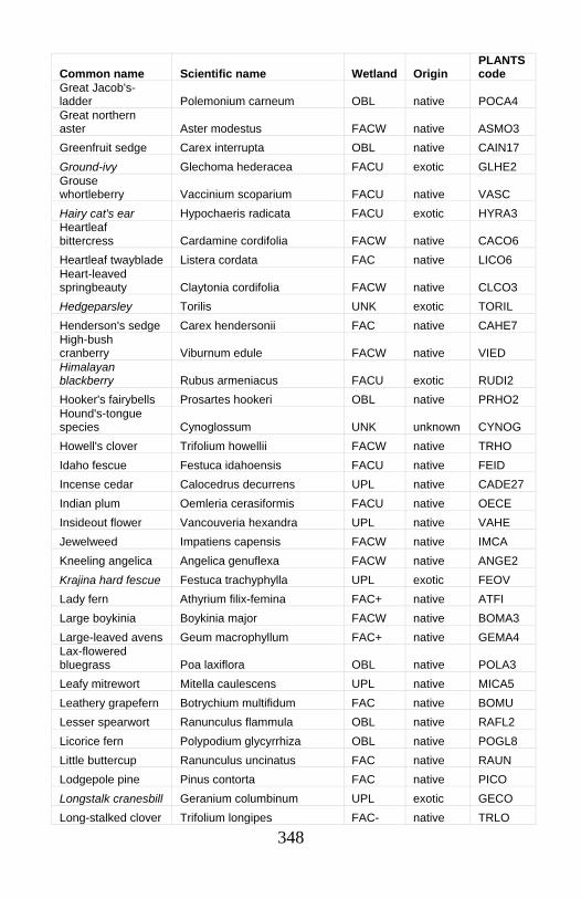
348
Common name Scientific name Wetland Origin PLANTS code
Great Jacob's-ladder Polemonium carneum OBL native POCA4 Great northern aster Aster modestus FACW native ASMO3 Greenfruit sedge Carex interrupta OBL native CAIN17 Ground-ivy Glechoma hederacea FACU exotic GLHE2 Grouse whortleberry Vaccinium scoparium FACU native VASC Hairy cat's ear Hypochaeris radicata FACU exotic HYRA3 Heartleaf bittercress Cardamine cordifolia FACW native CACO6 Heartleaf twayblade Listera cordata FAC native LICO6 Heart-leaved springbeauty Claytonia cordifolia FACW native CLCO3 Hedgeparsley Torilis UNK exotic TORIL Henderson's sedge Carex hendersonii FAC native CAHE7 High-bush cranberry Viburnum edule FACW native VIED Himalayan blackberry Rubus armeniacus FACU exotic RUDI2 Hooker's fairybells Prosartes hookeri OBL native PRHO2 Hound's-tongue species Cynoglossum UNK unknown CYNOG Howell's clover Trifolium howellii FACW native TRHO Idaho fescue Festuca idahoensis FACU native FEID Incense cedar Calocedrus decurrens UPL native CADE27 Indian plum Oemleria cerasiformis FACU native OECE Insideout flower Vancouveria hexandra UPL native VAHE Jewelweed Impatiens capensis FACW native IMCA Kneeling angelica Angelica genuflexa FACW native ANGE2 Krajina hard fescue Festuca trachyphylla UPL exotic FEOV Lady fern Athyrium filix-femina FAC+ native ATFI Large boykinia Boykinia major FACW native BOMA3 Large-leaved avens Geum macrophyllum FAC+ native GEMA4 Lax-flowered bluegrass Poa laxiflora OBL native POLA3 Leafy mitrewort Mitella caulescens UPL native MICA5 Leathery grapefern Botrychium multifidum FAC native BOMU Lesser spearwort Ranunculus flammula OBL native RAFL2 Licorice fern Polypodium glycyrrhiza OBL native POGL8 Little buttercup Ranunculus uncinatus FAC native RAUN Lodgepole pine Pinus contorta FAC native PICO Longstalk cranesbill Geranium columbinum UPL exotic GECO Long-stalked clover Trifolium longipes FAC- native TRLO
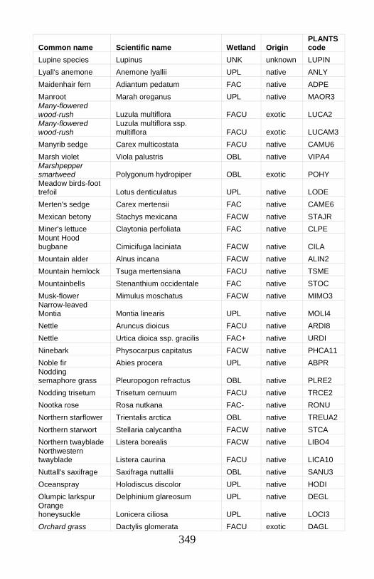
349
Common name Scientific name Wetland Origin PLANTS code
Lupine species Lupinus UNK unknown LUPIN Lyall's anemone Anemone lyallii UPL native ANLY Maidenhair fern Adiantum pedatum FAC native ADPE Manroot Marah oreganus UPL native MAOR3 Many-flowered wood-rush Luzula multiflora FACU exotic LUCA2 Many-flowered wood-rush
Luzula multiflora ssp. multiflora FACU exotic LUCAM3
Manyrib sedge Carex multicostata FACU native CAMU6 Marsh violet Viola palustris OBL native VIPA4 Marshpepper smartweed Polygonum hydropiper OBL exotic POHY Meadow birds-foot trefoil Lotus denticulatus UPL native LODE Merten's sedge Carex mertensii FAC native CAME6 Mexican betony Stachys mexicana FACW native STAJR Miner's lettuce Claytonia perfoliata FAC native CLPE Mount Hood bugbane Cimicifuga laciniata FACW native CILA Mountain alder Alnus incana FACW native ALIN2 Mountain hemlock Tsuga mertensiana FACU native TSME Mountainbells Stenanthium occidentale FAC native STOC Musk-flower Mimulus moschatus FACW native MIMO3 Narrow-leaved Montia Montia linearis UPL native MOLI4 Nettle Aruncus dioicus FACU native ARDI8 Nettle Urtica dioica ssp. gracilis FAC+ native URDI Ninebark Physocarpus capitatus FACW native PHCA11 Noble fir Abies procera UPL native ABPR Nodding semaphore grass Pleuropogon refractus OBL native PLRE2 Nodding trisetum Trisetum cernuum FACU native TRCE2 Nootka rose Rosa nutkana FAC- native RONU Northern starflower Trientalis arctica OBL native TREUA2 Northern starwort Stellaria calycantha FACW native STCA Northern twayblade Listera borealis FACW native LIBO4 Northwestern twayblade Listera caurina FACU native LICA10 Nuttall's saxifrage Saxifraga nuttallii OBL native SANU3 Oceanspray Holodiscus discolor UPL native HODI Olumpic larkspur Delphinium glareosum UPL native DEGL Orange honeysuckle Lonicera ciliosa UPL native LOCI3 Orchard grass Dactylis glomerata FACU exotic DAGL
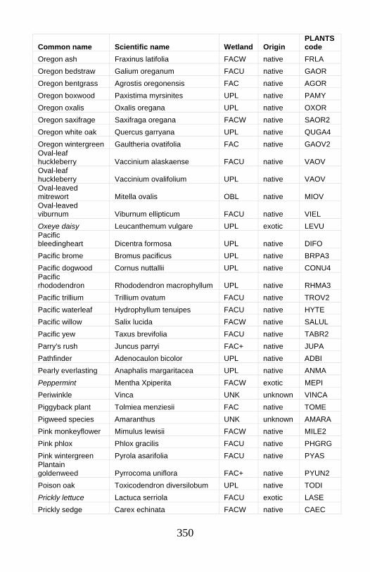
350
Common name Scientific name Wetland Origin PLANTS code
Oregon ash Fraxinus latifolia FACW native FRLA Oregon bedstraw Galium oreganum FACU native GAOR Oregon bentgrass Agrostis oregonensis FAC native AGOR Oregon boxwood Paxistima myrsinites UPL native PAMY Oregon oxalis Oxalis oregana UPL native OXOR Oregon saxifrage Saxifraga oregana FACW native SAOR2 Oregon white oak Quercus garryana UPL native QUGA4 Oregon wintergreen Gaultheria ovatifolia FAC native GAOV2 Oval-leaf huckleberry Vaccinium alaskaense FACU native VAOV Oval-leaf huckleberry Vaccinium ovalifolium UPL native VAOV Oval-leaved mitrewort Mitella ovalis OBL native MIOV Oval-leaved viburnum Viburnum ellipticum FACU native VIEL Oxeye daisy Leucanthemum vulgare UPL exotic LEVU Pacific bleedingheart Dicentra formosa UPL native DIFO Pacific brome Bromus pacificus UPL native BRPA3 Pacific dogwood Cornus nuttallii UPL native CONU4 Pacific rhododendron Rhododendron macrophyllum UPL native RHMA3 Pacific trillium Trillium ovatum FACU native TROV2 Pacific waterleaf Hydrophyllum tenuipes FACU native HYTE Pacific willow Salix lucida FACW native SALUL Pacific yew Taxus brevifolia FACU native TABR2 Parry's rush Juncus parryi FAC+ native JUPA Pathfinder Adenocaulon bicolor UPL native ADBI Pearly everlasting Anaphalis margaritacea UPL native ANMA Peppermint Mentha Xpiperita FACW exotic MEPI Periwinkle Vinca UNK unknown VINCA Piggyback plant Tolmiea menziesii FAC native TOME Pigweed species Amaranthus UNK unknown AMARA Pink monkeyflower Mimulus lewisii FACW native MILE2 Pink phlox Phlox gracilis FACU native PHGRG Pink wintergreen Pyrola asarifolia FACU native PYAS Plantain goldenweed Pyrrocoma uniflora FAC+ native PYUN2 Poison oak Toxicodendron diversilobum UPL native TODI Prickly lettuce Lactuca serriola FACU exotic LASE Prickly sedge Carex echinata FACW native CAEC
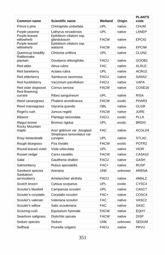
351
Common name Scientific name Wetland Origin PLANTS code
Prince's pine Chimaphila umbellata UPL native CHUM Purple peavine Lathyrus nevadensis UPL native LANEP Purple-leaved willowherb
Epilobium ciliatum ssp. glandulosum FACW native EPCIG
Purple-leaved willowherb
Epilobium ciliatum ssp. watsonii FACW native EPCIW
Queencup beadlily Clintonia uniflora UPL native CLUN2 Rattlesnake plantain Goodyera oblongifolia FACU native GOOB2 Red alder Alnus rubra FAC native ALRU2 Red baneberry Actaea rubra UPL native ACRU2 Red elderberry Sambucus racemosa FACU native SARA2 Red huckleberry Vaccinium parvifolium FACU native VAPA Red osier dogwood Cornus sericea FACW native COSE16 Red-flowering currant Ribes sanguineum UPL native RISA Reed canarygrass Phalaris arundinacea FACW exotic PHAR3 Reed mannagrass Glyceria grandis OBL native GLGR Regel's rush Juncus regelii FACW native JURE Ribwort Plantago lanceolata FACU exotic PLLA Ripgut brome Bromus rigidus UPL exotic BRDI3 Rocky Mountain maple Acer glabrum var. douglasii FAC native ACGLD4
Rosy twistedstalk Streptopus lanceolatus var. curvipes UPL native STLAC
Rough bluegrass Poa trivialis FACW exotic POTR2 Round-leaved violet Viola orbiculata UPL native VIOR Russet sedge Carex saxatilis FACW native CASA10 Salal Gaultheria shallon FACU native GASH Salmonberry Rubus spectabilis FAC+ native RUSP Sandwort species Arenaria UNK unknown ARENA Saskatoon serviceberry Amelanchier alnifolia FACU native AMAL2 Scotch broom Cytisus scoparius UPL exotic CYSC4 Scouler's bluebell Campanula scouleri UPL native CASC7 Scouler's corydalis Corydalis scouleri FAC+ native COSC4 Scouler's valerian Valeriana scouleri FAC native VASC2 Scouler's willow Salix scouleriana FAC native SASC Scouring-rush Equisetum hyemale FACW native EQHY Seashore saltgrass Distichlis spicata FACW native DISP Sedum species Sedum UNK unknown SEDUM Selfheal Prunella vulgaris FACU native PRVU
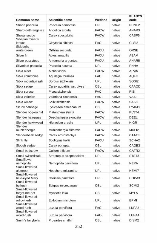
352
Common name Scientific name Wetland Origin PLANTS code
Shade phacelia Phacelia nemoralis UPL native PHNE2 Sharptooth angelica Angelica arguta FACW native ANAR3 Showy sedge Carex spectabilis FACW native CASP5 Siberian miner's lettuce Claytonia sibirica FAC native CLSI2 Sidebells wintergreen Orthilia secunda FACU native ORSE Silver fir Abies amabilis FACU native ABAM Silver pussytoes Antennaria argentea FACU native ANAR5 Silverleaf phacelia Phacelia hastata UPL native PHHA Sitka alder Alnus viridis FACW native ALVI5 Sitka columbine Aquilegia formosa FAC native AQFO Sitka mountain ash Sorbus sitchensis UPL native SOSI2 Sitka sedge Carex aquatilis var. dives OBL native CAAQD Sitka spruce Picea sitchensis FAC native PISI Sitka valerian Valeriana sitchensis FAC native VASI Sitka willow Salix sitchensis FACW native SASI2 Skunk cabbage Lysichiton americanum OBL native LYAM3 Slender bog-orchid Platanthera stricta FACW native PLST4 Slender hairgrass Deschampsia elongata FACW native DEEL Slender hawkweed Hieracium gracile UPL native HIGR Slender muhlenbergia Muhlenbergia filiformis FACW native MUFI2 Slenderbeak sedge Carex athrostachya FACW native CAAT3 Slink lily Scoliopus hallii FACU native SCHA2 Slough sedge Carex obnupta OBL native CAOB3 Small bedstraw Galium trifidum FACW native GATR2 Small twistedstalk Streptopus streptopoides UPL native STST3 Smallflower nemophila Nemophila parviflora UPL native NEPA Small-flowered alumroot Heuchera micrantha UPL native HEMI7 Small-flowered blue-eyed Mary Collinsia parviflora UPL native COPA3 Small-flowered bullrush Scirpus microcarpus OBL native SCMI2 Small-flowered forget-me-not Myosotis laxa OBL native MYLA Small-flowered willowherb Epilobium minutum UPL native EPMI Small-flowered wood-rush Luzula parviflora FAC- native LUPA4 Small-flowered wood-rush Luzula parviflora FAC- native LUPA4 Smith's fairybells Prosartes smithii OBL native DISM2
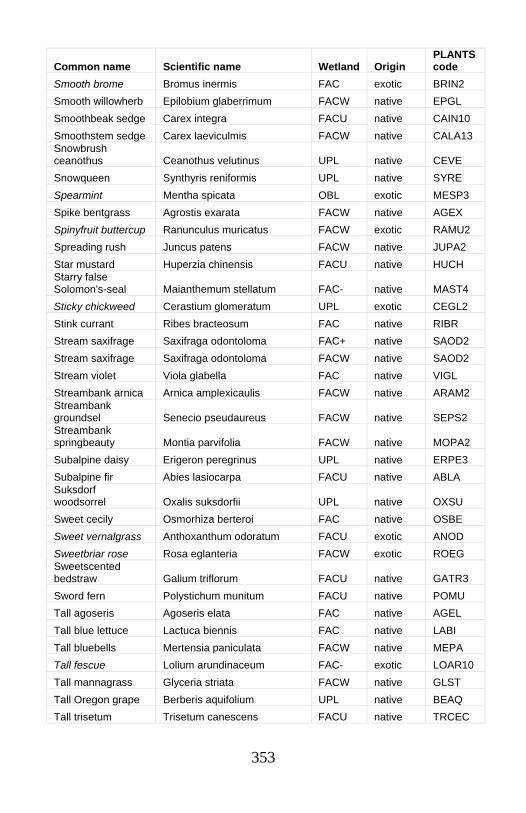
353
Common name Scientific name Wetland Origin PLANTS code
Smooth brome Bromus inermis FAC exotic BRIN2 Smooth willowherb Epilobium glaberrimum FACW native EPGL Smoothbeak sedge Carex integra FACU native CAIN10 Smoothstem sedge Carex laeviculmis FACW native CALA13 Snowbrush ceanothus Ceanothus velutinus UPL native CEVE Snowqueen Synthyris reniformis UPL native SYRE Spearmint Mentha spicata OBL exotic MESP3 Spike bentgrass Agrostis exarata FACW native AGEX Spinyfruit buttercup Ranunculus muricatus FACW exotic RAMU2 Spreading rush Juncus patens FACW native JUPA2 Star mustard Huperzia chinensis FACU native HUCH Starry false Solomon's-seal Maianthemum stellatum FAC- native MAST4 Sticky chickweed Cerastium glomeratum UPL exotic CEGL2 Stink currant Ribes bracteosum FAC native RIBR Stream saxifrage Saxifraga odontoloma FAC+ native SAOD2 Stream saxifrage Saxifraga odontoloma FACW native SAOD2 Stream violet Viola glabella FAC native VIGL Streambank arnica Arnica amplexicaulis FACW native ARAM2 Streambank groundsel Senecio pseudaureus FACW native SEPS2 Streambank springbeauty Montia parvifolia FACW native MOPA2 Subalpine daisy Erigeron peregrinus UPL native ERPE3 Subalpine fir Abies lasiocarpa FACU native ABLA Suksdorf woodsorrel Oxalis suksdorfii UPL native OXSU Sweet cecily Osmorhiza berteroi FAC native OSBE Sweet vernalgrass Anthoxanthum odoratum FACU exotic ANOD Sweetbriar rose Rosa eglanteria FACW exotic ROEG Sweetscented bedstraw Galium triflorum FACU native GATR3 Sword fern Polystichum munitum FACU native POMU Tall agoseris Agoseris elata FAC native AGEL Tall blue lettuce Lactuca biennis FAC native LABI Tall bluebells Mertensia paniculata FACW native MEPA Tall fescue Lolium arundinaceum FAC- exotic LOAR10 Tall mannagrass Glyceria striata FACW native GLST Tall Oregon grape Berberis aquifolium UPL native BEAQ Tall trisetum Trisetum canescens FACU native TRCEC
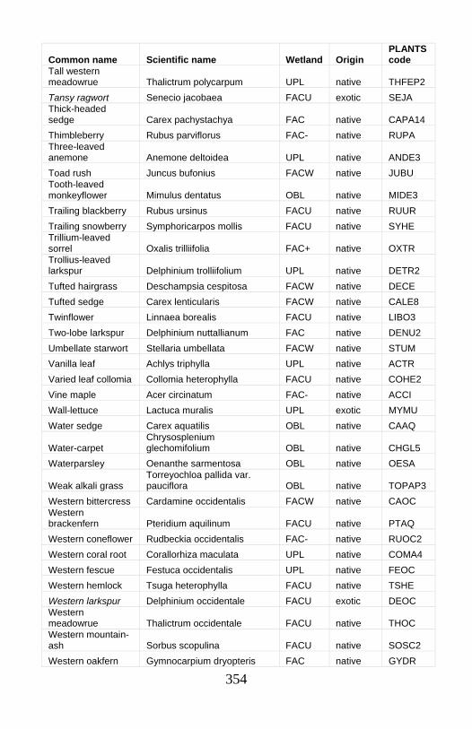
354
Common name Scientific name Wetland Origin PLANTS code
Tall western meadowrue Thalictrum polycarpum UPL native THFEP2 Tansy ragwort Senecio jacobaea FACU exotic SEJA Thick-headed sedge Carex pachystachya FAC native CAPA14 Thimbleberry Rubus parviflorus FAC- native RUPA Three-leaved anemone Anemone deltoidea UPL native ANDE3 Toad rush Juncus bufonius FACW native JUBU Tooth-leaved monkeyflower Mimulus dentatus OBL native MIDE3 Trailing blackberry Rubus ursinus FACU native RUUR Trailing snowberry Symphoricarpos mollis FACU native SYHE Trillium-leaved sorrel Oxalis trilliifolia FAC+ native OXTR Trollius-leaved larkspur Delphinium trolliifolium UPL native DETR2 Tufted hairgrass Deschampsia cespitosa FACW native DECE Tufted sedge Carex lenticularis FACW native CALE8 Twinflower Linnaea borealis FACU native LIBO3 Two-lobe larkspur Delphinium nuttallianum FAC native DENU2 Umbellate starwort Stellaria umbellata FACW native STUM Vanilla leaf Achlys triphylla UPL native ACTR Varied leaf collomia Collomia heterophylla FACU native COHE2 Vine maple Acer circinatum FAC- native ACCI Wall-lettuce Lactuca muralis UPL exotic MYMU Water sedge Carex aquatilis OBL native CAAQ
Water-carpet Chrysosplenium glechomifolium OBL native CHGL5
Waterparsley Oenanthe sarmentosa OBL native OESA
Weak alkali grass Torreyochloa pallida var. pauciflora OBL native TOPAP3
Western bittercress Cardamine occidentalis FACW native CAOC Western brackenfern Pteridium aquilinum FACU native PTAQ Western coneflower Rudbeckia occidentalis FAC- native RUOC2 Western coral root Corallorhiza maculata UPL native COMA4 Western fescue Festuca occidentalis UPL native FEOC Western hemlock Tsuga heterophylla FACU native TSHE Western larkspur Delphinium occidentale FACU exotic DEOC Western meadowrue Thalictrum occidentale FACU native THOC Western mountain-ash Sorbus scopulina FACU native SOSC2 Western oakfern Gymnocarpium dryopteris FAC native GYDR
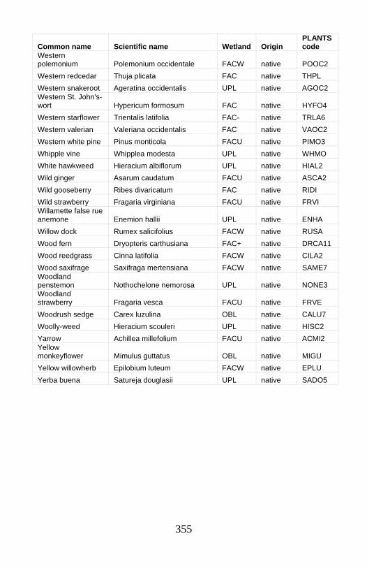
355
Common name Scientific name Wetland Origin PLANTS code
Western polemonium Polemonium occidentale FACW native POOC2 Western redcedar Thuja plicata FAC native THPL Western snakeroot Ageratina occidentalis UPL native AGOC2 Western St. John's-wort Hypericum formosum FAC native HYFO4 Western starflower Trientalis latifolia FAC- native TRLA6 Western valerian Valeriana occidentalis FAC native VAOC2 Western white pine Pinus monticola FACU native PIMO3 Whipple vine Whipplea modesta UPL native WHMO White hawkweed Hieracium albiflorum UPL native HIAL2 Wild ginger Asarum caudatum FACU native ASCA2 Wild gooseberry Ribes divaricatum FAC native RIDI Wild strawberry Fragaria virginiana FACU native FRVI Willamette false rue anemone Enemion hallii UPL native ENHA Willow dock Rumex salicifolius FACW native RUSA Wood fern Dryopteris carthusiana FAC+ native DRCA11 Wood reedgrass Cinna latifolia FACW native CILA2 Wood saxifrage Saxifraga mertensiana FACW native SAME7 Woodland penstemon Nothochelone nemorosa UPL native NONE3 Woodland strawberry Fragaria vesca FACU native FRVE Woodrush sedge Carex luzulina OBL native CALU7 Woolly-weed Hieracium scouleri UPL native HISC2 Yarrow Achillea millefolium FACU native ACMI2 Yellow monkeyflower Mimulus guttatus OBL native MIGU Yellow willowherb Epilobium luteum FACW native EPLU Yerba buena Satureja douglasii UPL native SADO5
356
Appendix II: References Benner, P.A. & J.R. Sedell. 1997. Upper Willamette River landscape: a historic perspective. Pp. 23-47 in: A. Laenen & D.A. Dunette (eds.). River quality: dynamics and restoration. CRC Press, Lewis Publishers, New York. 480 pp. Boyd, R. 1999. Strategies of Indian burning in the Willamette Valley. Pp. 94-138 in: R. Boyd (ed.). Indians, fire, and the land in the Pacific Northwest. Oregon State University Press, Corvallis. 313 pp. Frenkel, R.E., W.H. Moir & J.A. Christy. 1986. Vegetation of Torrey Lake Mire, central Cascade Range, Oregon. Madroño 33: 24-39. Golinski, K. 1999. Bogs of the lower Fraser Valley, an overview of regional significance. Report to British Columbia Environmental Assessment Office. University of Victoria. 12 pp. + tables. Hill, M. O. 1979. TWINSPAN: a FORTRAN program for arranging multivariate data in an ordered two-way table by classification of the individuals and attributes. Ecology and Systematics, Cornell University, Ithaca, N. Y. Kunze, L.M. 1994. Preliminary classification of native, low elevation, freshwater wetland vegetation in western Washington. Natural Heritage Program, Department of Natural Resources, Olympia. 120 pp. Markle, D.F., T.N. Pearsons & D.T. Bills. 1991. Natural history of Oregonichthys (Pisces: Cyprinidae), with a description of a new species from the Umpqua River of Oregon. Copeia 1991: 277-293. McCune, B. & M.J. Mefford. 1999. PC-ORD for Windows. Multivariate analysis of ecological data. Version 4.01. MjM Software, Glendeden Beach, Oregon. Pearsons, T.N. 1989. Ecology and decline of a rare western minnow: the Oregon chub (Oregonichthys crameri). M.S. thesis. Oregon State University, Corvallis. 89 pp. Pojar, J., and A. MacKinnon. 1994. Plants of the Pacific Northwest Coast. B.C. Ministry of Forests and Lone Pine Publishing. Vancouver, British Columbia.
357
Seyer, S. C. 1979. Vegetative ecology of a montane mire, Crater Lake National Park, Oregon. M.S. thesis. Oregon State University, Corvallis. 187 pp. Seyer, S. C. 1981. Survey of vegetation of 18 lakes in Wallowa-Whitman National Forest, Oregon. USDA Forest Service, Forest Sciences Laboratory, Corvallis, Oregon. 47 pp. Seyer, S. C. 1983. Ecological analysis, Multorpor Fen Preserve, Oregon. The Nature Conservancy, Oregon Field Office, Portland. 28 pp. Smith, B. 1997. ECOTOOLS. Version 2.3. USDA Forest Service, Okanogan National Forest, Washington. Sundberg, S. 2002. Personal communication. U.S. Army Corps of Engineers. 1948. Review report on Columbia River and tributaries. Appendix L. Main Columbia River below Yakima River. U.S. Army Corps of Engineers, North Pacific Division, Portland. U.S. Army Corps of Engineers. 1987. Corps of Engineers wetlands delineation manual. Technical Report Y-87-1. Department of the Army, Wetlands Research Program Environmental Laboratory. Vicksburg, Mississippi. 100 pp. + appendices. U.S. Army Corps of Engineers. 1988. Lower Columbia River flood control study. River mile 0 to 145. Summary Report. Columbia River and tributaries review study CRT 69. U.S. Army Corps of Engineers, Portland District. USDA-NRCS PLANTS database. 1999, USDA Natural Resources Conservation Service. National Plant Data Center. Baton Rouge, LA. 70974. (http://plants.usda.gov) Vitt, D.H., L.A. Halsey & J. Doubt. 1999. The distinctness of Burns Bog. Report to British Columbia Environmental Assessment Office. University of Alberta, Edmonton. 26 pp. Wilson, C.E. 1986. Floristic and edaphic aspects of vegetational patterns in subalpine mires of the Cascade Mountains of Oregon. M.S. thesis. University of Oregon, Eugene. 59 pp.