Embed Size (px)
Citation preview
Field Indicators for Field Indicators for Identifying Hydric Soils in Identifying Hydric Soils in
New England V3.0New England V3.0
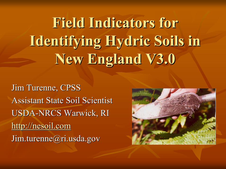
Jim Turenne, CPSSJim Turenne, CPSSAssistant State Soil Scientist Assistant State Soil Scientist USDAUSDA--NRCS Warwick, RINRCS Warwick, RIhttp://nesoil.comhttp://[email protected]@ri.usda.gov
Hydric Soils 101Hydric Soils 101
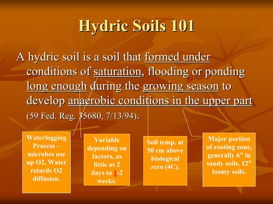
A hydric soil is a soil that A hydric soil is a soil that formed underformed underconditions of conditions of saturationsaturation, flooding or ponding , flooding or ponding long enoughlong enough during the during the growing seasongrowing season to to develop develop anaerobic conditions in the upper part anaerobic conditions in the upper part (59 Fed. Reg. 35680, 7/13/94)(59 Fed. Reg. 35680, 7/13/94). .
WaterloggingProcess –
microbes use up O2, Water
retards O2 diffusion.
Variable depending on
factors, as little as 2
days to 1-2 weeks.
Soil temp. at 50 cm above
biological zero (4C).
Major portion of rooting zone, generally 6” in sandy soils, 12”
loamy soils.
Hydric Soils 101Hydric Soils 101
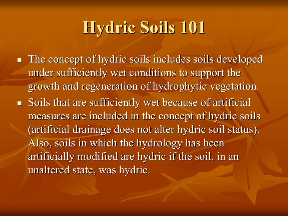
The concept of hydric soils includes soils developed The concept of hydric soils includes soils developed under sufficiently wet conditions to support the under sufficiently wet conditions to support the growth and regeneration of growth and regeneration of hydrophytichydrophytic vegetation. vegetation. Soils that are sufficiently wet because of artificial Soils that are sufficiently wet because of artificial measures are included in the concept of hydric soils measures are included in the concept of hydric soils (artificial drainage does not alter hydric soil status). (artificial drainage does not alter hydric soil status). Also, soils in which the hydrology has been Also, soils in which the hydrology has been artificially modified are hydric if the soil, in an artificially modified are hydric if the soil, in an unaltered state, was hydric. unaltered state, was hydric.
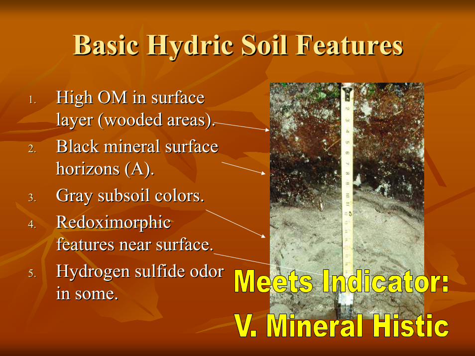
Basic Hydric Soil FeaturesBasic Hydric Soil Features
1.1. High OM in surface High OM in surface layer (wooded areas).layer (wooded areas).
2.2. Black mineral surface Black mineral surface horizons (A).horizons (A).
3.3. Gray subsoil colors.Gray subsoil colors.4.4. Redoximorphic Redoximorphic
features near surface.features near surface.5.5. Hydrogen sulfide odor Hydrogen sulfide odor
in some.in some.
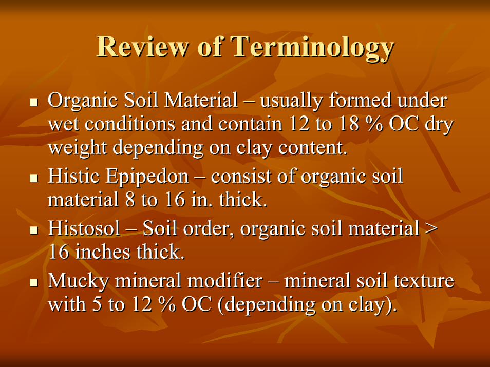
Review of TerminologyReview of Terminology
Organic Soil Material Organic Soil Material –– usually formed under usually formed under wet conditions and contain 12 to 18 % OC dry wet conditions and contain 12 to 18 % OC dry weight depending on clay content.weight depending on clay content.Histic Epipedon Histic Epipedon –– consist of organic soil consist of organic soil material 8 to 16 in. thick.material 8 to 16 in. thick.Histosol Histosol –– Soil order, organic soil material > Soil order, organic soil material > 16 inches thick.16 inches thick.Mucky mineral modifier Mucky mineral modifier –– mineral soil texture mineral soil texture with 5 to 12 % OC (depending on clay).with 5 to 12 % OC (depending on clay).
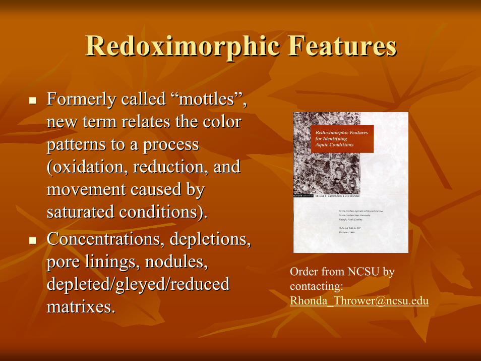
Redoximorphic FeaturesRedoximorphic Features
Formerly called “mottles”, Formerly called “mottles”, new term relates the color new term relates the color patterns to a process patterns to a process (oxidation, reduction, and (oxidation, reduction, and movement caused by movement caused by saturated conditions).saturated conditions).Concentrations, depletions, Concentrations, depletions, pore linings, nodules, pore linings, nodules, depleted/gleyed/reduced depleted/gleyed/reduced matrixes.
Order from NCSU by contacting: [email protected].
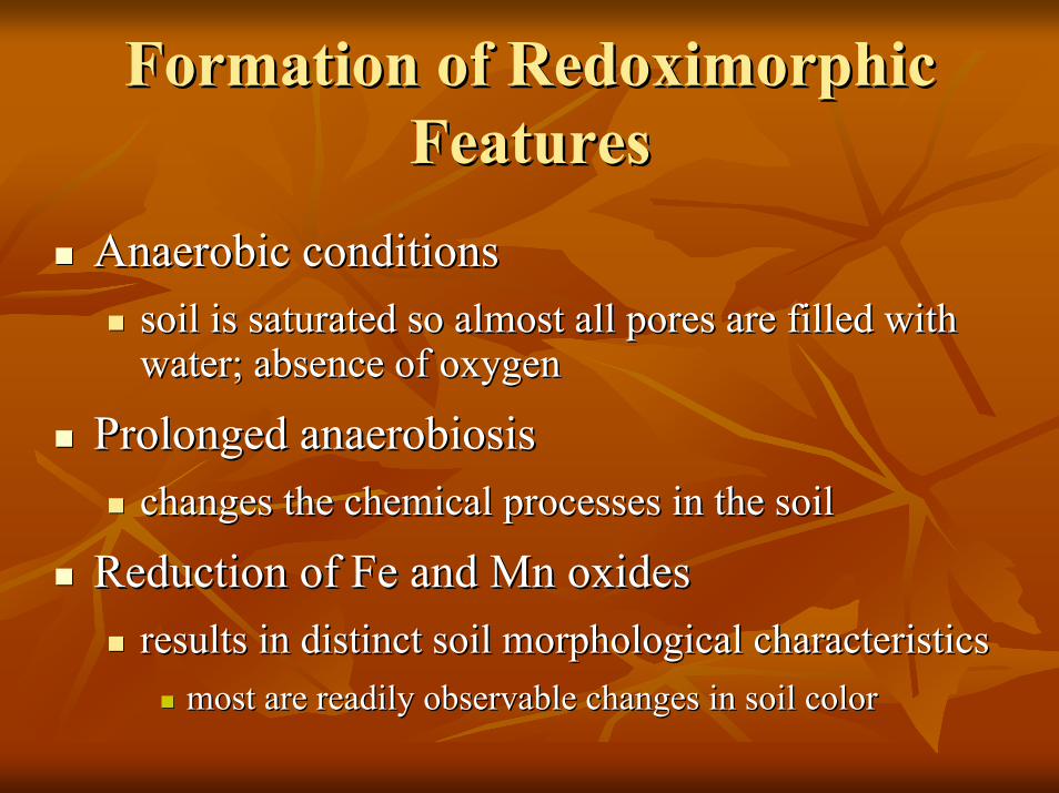
Formation of Redoximorphic Formation of Redoximorphic FeaturesFeatures
Anaerobic conditionsAnaerobic conditionssoil is saturated so almost all pores are filled with soil is saturated so almost all pores are filled with water; absence of oxygenwater; absence of oxygen
Prolonged anaerobiosisProlonged anaerobiosischanges the chemical processes in the soilchanges the chemical processes in the soil
Reduction of Fe and Reduction of Fe and MnMn oxidesoxidesresults in distinct soil morphological characteristicsresults in distinct soil morphological characteristics
most are readily observable changes in soil colormost are readily observable changes in soil color
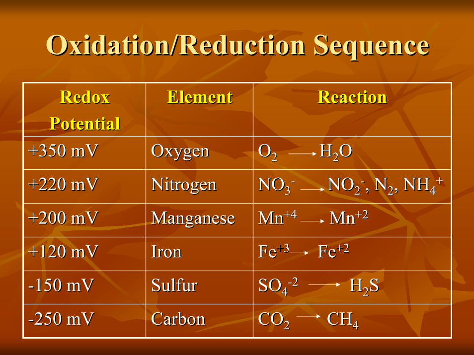
Oxidation/Reduction SequenceOxidation/Reduction Sequence
COCO22 CHCH44CarbonCarbon--250 mV250 mV
SOSO44--22 HH22SSSulfurSulfur--150 mV150 mV
FeFe+3+3 FeFe+2+2IronIron+120 mV+120 mV
MnMn+4+4 MnMn+2+2ManganeseManganese+200 mV+200 mV
NONO33-- NONO22
--, N, N22, NH, NH44++NitrogenNitrogen+220 mV+220 mV
OO22 HH22OOOxygenOxygen+350 mV+350 mV
ReactionReactionElementElementRedoxRedoxPotentialPotential
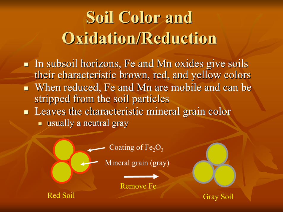
Soil Color and Soil Color and Oxidation/ReductionOxidation/Reduction
In subsoil horizons, Fe and In subsoil horizons, Fe and MnMn oxides give soils oxides give soils their characteristic brown, red, and yellow colorstheir characteristic brown, red, and yellow colorsWhen reduced, Fe and When reduced, Fe and MnMn are mobile and can be are mobile and can be stripped from the soil particlesstripped from the soil particlesLeaves the characteristic mineral grain colorLeaves the characteristic mineral grain color
usually a neutral grayusually a neutral gray
Coating of Fe2O3
Mineral grain (gray)
Remove FeRed Soil Gray Soil
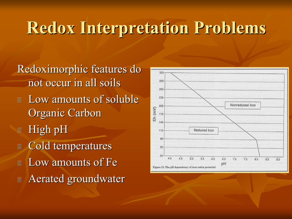
Redox Interpretation ProblemsRedox Interpretation Problems
Redoximorphic features do Redoximorphic features do not occur in all soilsnot occur in all soilsLow amounts of soluble Low amounts of soluble Organic CarbonOrganic CarbonHigh pHHigh pHCold temperaturesCold temperaturesLow amounts of FeLow amounts of FeAerated groundwaterAerated groundwater
Redox ExamplesRedox Examples
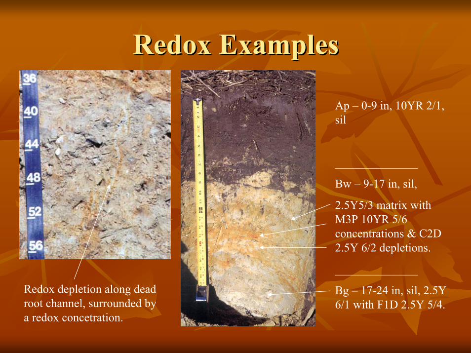
Ap – 0-9 in, 10YR 2/1, sil
______________
Bw – 9-17 in, sil,
2.5Y5/3 matrix with M3P 10YR 5/6 concentrations & C2D 2.5Y 6/2 depletions.
______________
Bg – 17-24 in, sil, 2.5Y 6/1 with F1D 2.5Y 5/4.
Redox depletion along dead root channel, surrounded by a redox concetration.
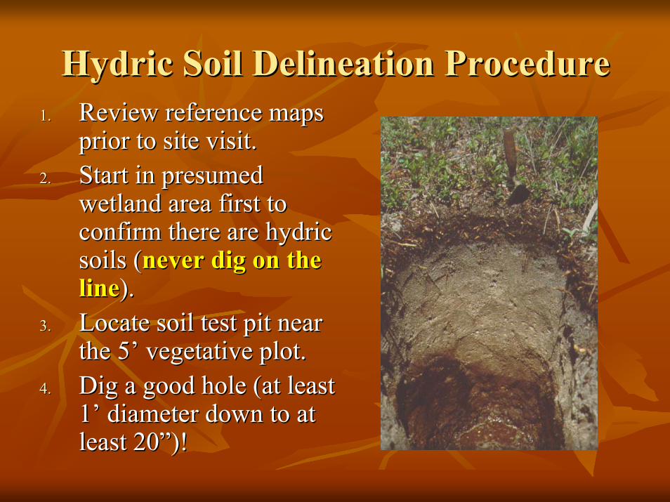
Hydric Soil Delineation ProcedureHydric Soil Delineation Procedure1.1. Review reference maps Review reference maps
prior to site visit.prior to site visit.2.2. Start in presumed Start in presumed
wetland area first to wetland area first to confirm there are hydric confirm there are hydric soils (soils (never dig on the never dig on the lineline).).
3.3. Locate soil test pit near Locate soil test pit near the 5’ vegetative plot.the 5’ vegetative plot.
4.4. Dig a good hole (at least Dig a good hole (at least 1’ diameter down to at 1’ diameter down to at least 20”)!least 20”)!
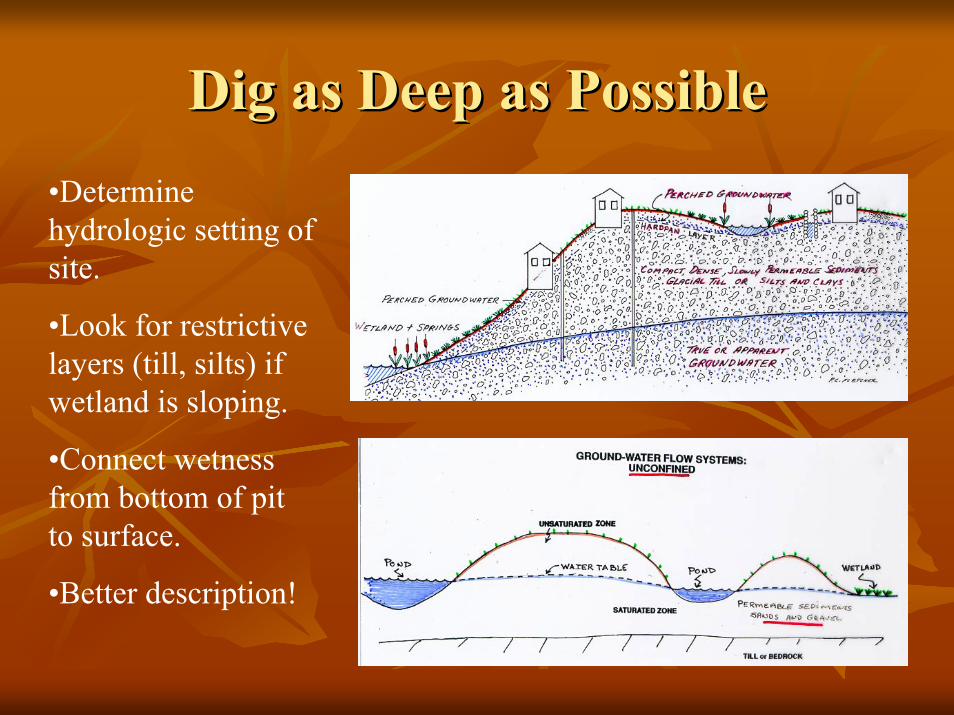
Dig as Deep as PossibleDig as Deep as Possible•Determine hydrologic setting of site.
•Look for restrictive layers (till, silts) if wetland is sloping.
•Connect wetness from bottom of pit to surface.
•Better description!
Hydric Soil Delineation ProcedureHydric Soil Delineation Procedure
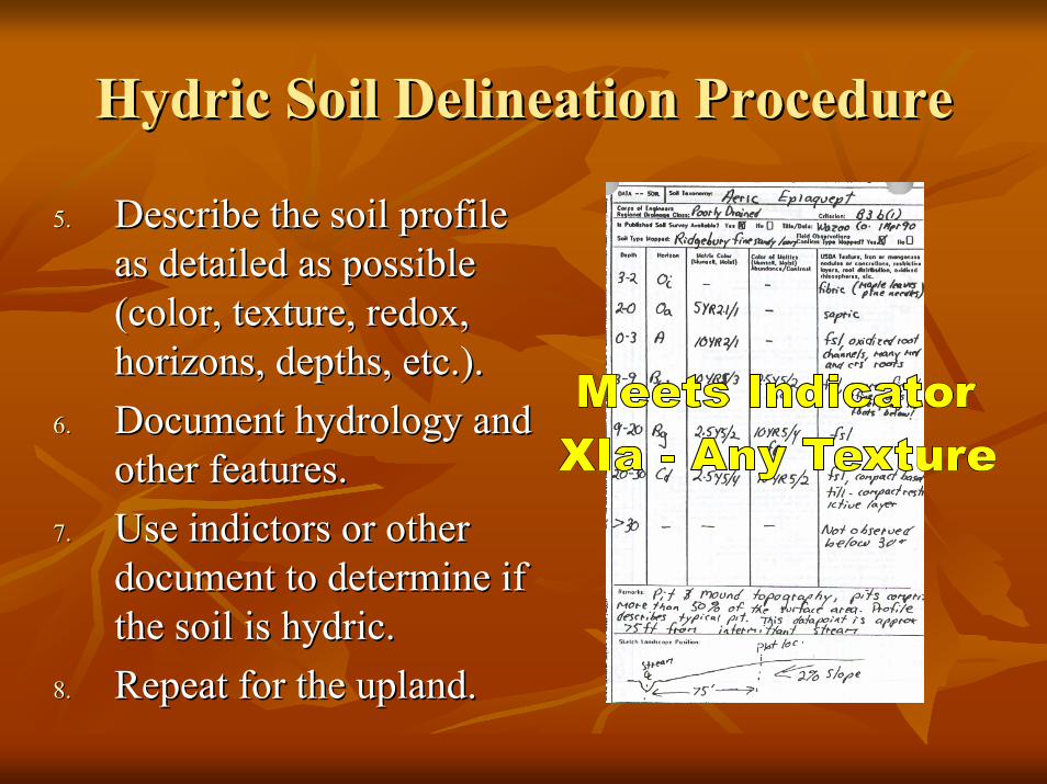
5.5. Describe the soil profile Describe the soil profile as detailed as possible as detailed as possible (color, texture, redox, (color, texture, redox, horizons, depths, etc.).horizons, depths, etc.).
6.6. Document hydrology and Document hydrology and other features.other features.
7.7. Use indictors or other Use indictors or other document to determine if document to determine if the soil is hydric.the soil is hydric.
8.8. Repeat for the upland.Repeat for the upland.
Hydric Soil Delineation ProcedureHydric Soil Delineation Procedure
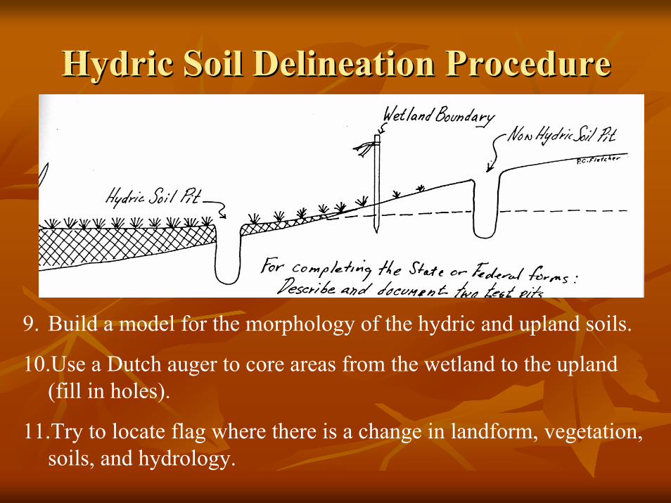
9. Build a model for the morphology of the hydric and upland soils.
10.Use a Dutch auger to core areas from the wetland to the upland (fill in holes).
11.Try to locate flag where there is a change in landform, vegetation, soils, and hydrology.
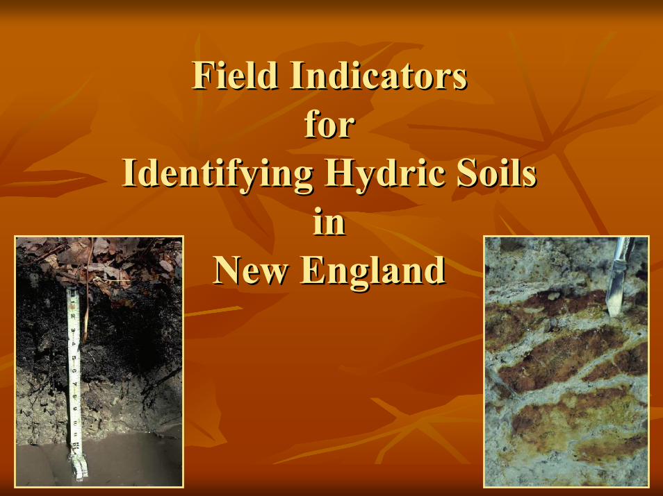
Field Indicators Field Indicators for for
Identifying Hydric Soils Identifying Hydric Soils in in
New EnglandNew England
NEW ENGLAND INDICATORS: NEW ENGLAND INDICATORS: A HISTORY LESSONA HISTORY LESSON
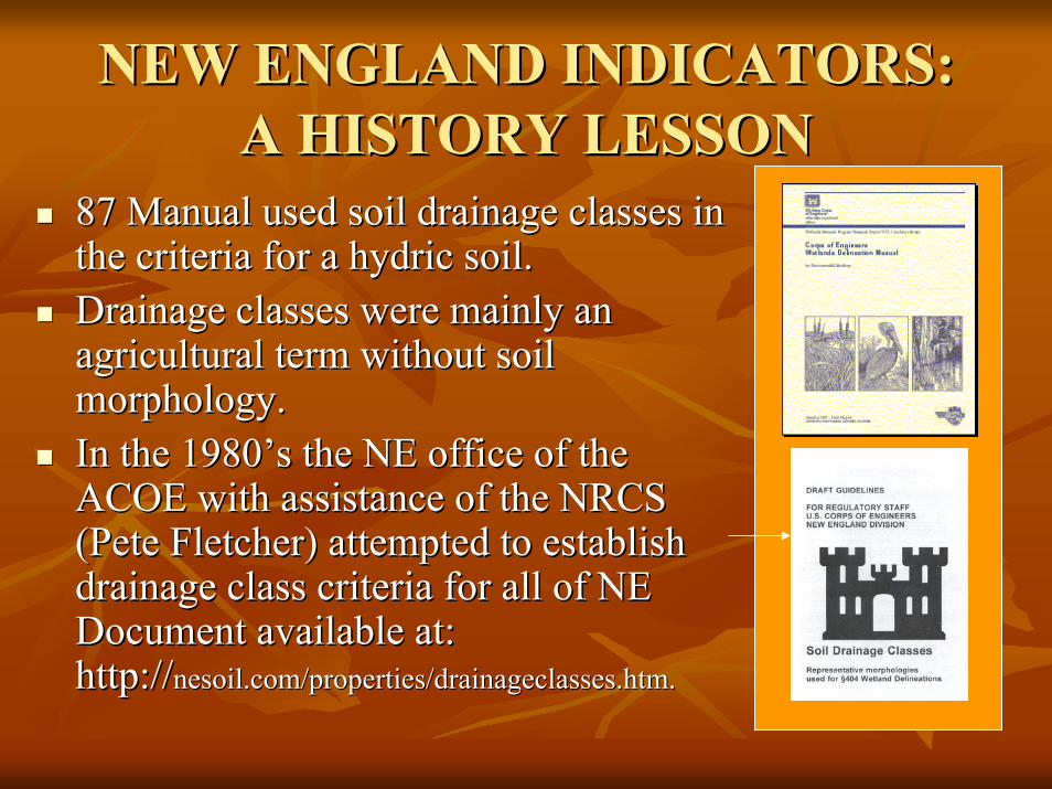
87 Manual used soil drainage classes in 87 Manual used soil drainage classes in the criteria for a hydric soil.the criteria for a hydric soil.Drainage classes were mainly an Drainage classes were mainly an agricultural term without soil agricultural term without soil morphology.morphology.In the 1980’s the NE office of the In the 1980’s the NE office of the ACOE with assistance of the NRCS ACOE with assistance of the NRCS (Pete Fletcher) attempted to establish (Pete Fletcher) attempted to establish drainage class criteria for all of NE drainage class criteria for all of NE Document available at: Document available at: http://http://nesoil.com/properties/drainageclasses.htmnesoil.com/properties/drainageclasses.htm..
NEW ENGLAND INDICATORS: NEW ENGLAND INDICATORS: A HISTORY LESSONA HISTORY LESSON
Team of COE, EPA, NRCS traveled Team of COE, EPA, NRCS traveled throughout NE to examine soils and data.throughout NE to examine soils and data.Although some success was reached, the final Although some success was reached, the final drainage class criteria were still confusing.drainage class criteria were still confusing.In 1992 the drainage class contingent merged In 1992 the drainage class contingent merged into the NETCHS with the goal of establishing into the NETCHS with the goal of establishing hydric soil indicators (like those being hydric soil indicators (like those being developed at the time at the federal level) to developed at the time at the federal level) to identify hydric soils in NE. identify hydric soils in NE.
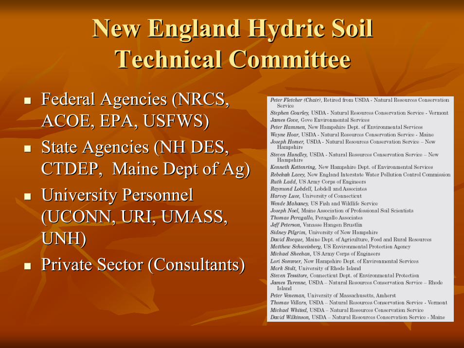
New England Hydric Soil New England Hydric Soil Technical Committee Technical Committee
Federal Agencies (NRCS, Federal Agencies (NRCS, ACOE, EPA, USFWS)ACOE, EPA, USFWS)State Agencies (NH DES, State Agencies (NH DES, CTDEP, Maine Dept of Ag)CTDEP, Maine Dept of Ag)University Personnel University Personnel (UCONN, URI, UMASS, (UCONN, URI, UMASS, UNH)UNH)Private Sector (Consultants)Private Sector (Consultants)
Field Indicators for Identifying Field Indicators for Identifying Hydric Soils in New EnglandHydric Soils in New England
Only regionOnly region--wide publication not based on wide publication not based on National indicatorsNational indicators..Recognized by the ACOE to conform to Recognized by the ACOE to conform to results obtained using the 1987 Manual (see results obtained using the 1987 Manual (see letter). letter). ACOE encourages its usage throughout NE.ACOE encourages its usage throughout NE.Published through the New England Interstate Published through the New England Interstate Water Pollution Control Commission.Water Pollution Control Commission.
Field Indicators FeaturesField Indicators Features
Dynamic document Dynamic document ––changes made as a result of new changes made as a result of new data, agreed to by the NETCHS.data, agreed to by the NETCHS.Hierarchal key Hierarchal key –– starts with wettest soils (few starts with wettest soils (few morphologies) to the drymorphologies) to the dry--end of hydric soils.end of hydric soils.Looks for a combination of soil morphologies at Looks for a combination of soil morphologies at certain depths to determine if the soil meets the certain depths to determine if the soil meets the definition of a hydric soil.definition of a hydric soil.If a soil meets an indicator it can be considered a If a soil meets an indicator it can be considered a hydric soil. If no indicators are met it does hydric soil. If no indicators are met it does NOTNOTmean the soil is nonmean the soil is non--hydric (professional judgment).hydric (professional judgment).
Field Indicators FeaturesField Indicators Features
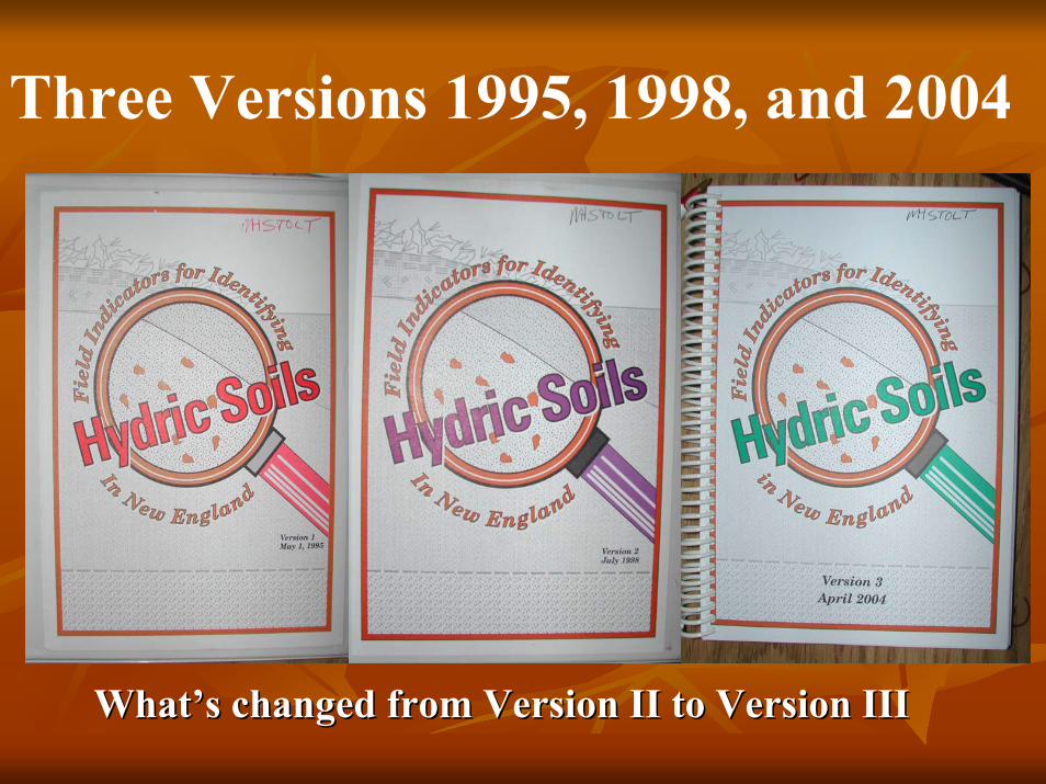
Three Versions 1995, 1998, and 2004
What’s changed from Version II to Version IIIWhat’s changed from Version II to Version III
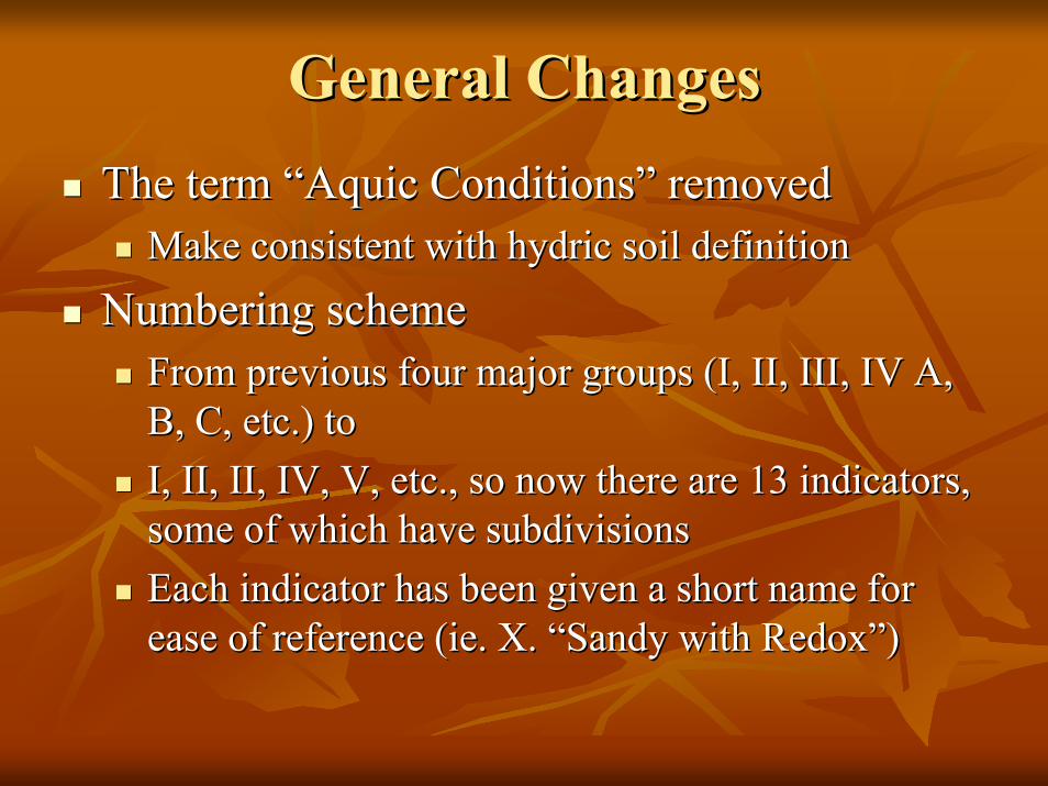
General ChangesGeneral ChangesThe term “Aquic Conditions” removedThe term “Aquic Conditions” removed
Make consistent with hydric soil definitionMake consistent with hydric soil definition
Numbering schemeNumbering schemeFrom previous four major groups (I, II, III, IV A, From previous four major groups (I, II, III, IV A, B, C, etc.) toB, C, etc.) toI, II, II, IV, V, etc., so now there are 13 indicators, I, II, II, IV, V, etc., so now there are 13 indicators, some of which have subdivisionssome of which have subdivisionsEach indicator has been given a short name for Each indicator has been given a short name for ease of reference (ease of reference (ieie. X. “Sandy with Redox”). X. “Sandy with Redox”)

General ChangesGeneral ChangesNo indicators in Version II were droppedNo indicators in Version II were dropped
Some remain unchangedSome remain unchangedOthers have minor modificationsOthers have minor modificationsThere is 1 new indicator for “dark” soilsThere is 1 new indicator for “dark” soils
New informationNew informationSupplement prepared by Dave Supplement prepared by Dave RocqueRocque that that discusses hydric soil identification in a less discusses hydric soil identification in a less technical mannertechnical mannerProblem soil information greatly expandedProblem soil information greatly expanded
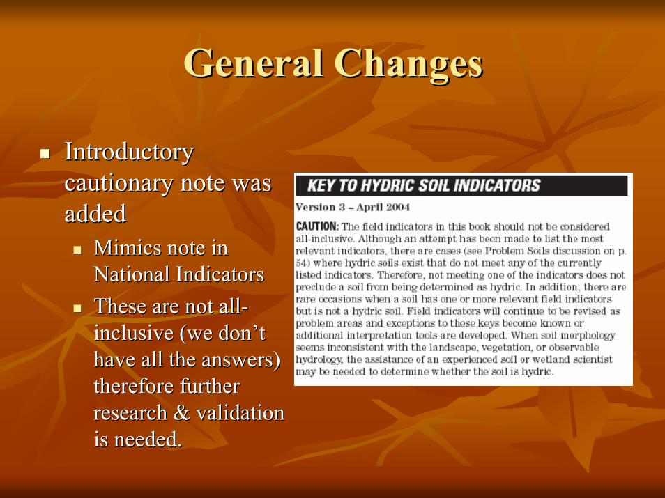
General ChangesGeneral Changes
Introductory Introductory cautionary note was cautionary note was addedadded
Mimics note in Mimics note in National IndicatorsNational IndicatorsThese are not allThese are not all--inclusive (we don’t inclusive (we don’t have all the answers) have all the answers) therefore further therefore further research & validation research & validation is needed.is needed.
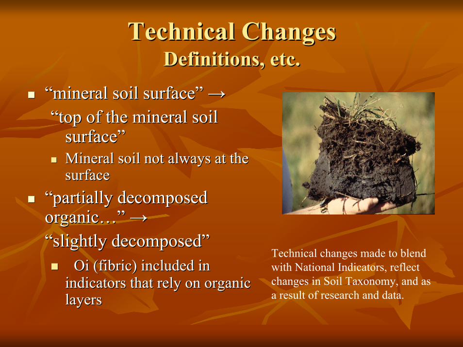
Technical ChangesTechnical ChangesDefinitions, etc.Definitions, etc.
““mineral soil surface” mineral soil surface” →→““top of the mineral soil top of the mineral soil
surface”surface”Mineral soil not always at the Mineral soil not always at the surfacesurface
“partially decomposed “partially decomposed organic…” organic…” →→““slightly decomposedslightly decomposed””
OiOi (fibric) included in (fibric) included in indicators that rely on organic indicators that rely on organic layers
Technical changes made to blend with National Indicators, reflect changes in Soil Taxonomy, and as a result of research and data.layers
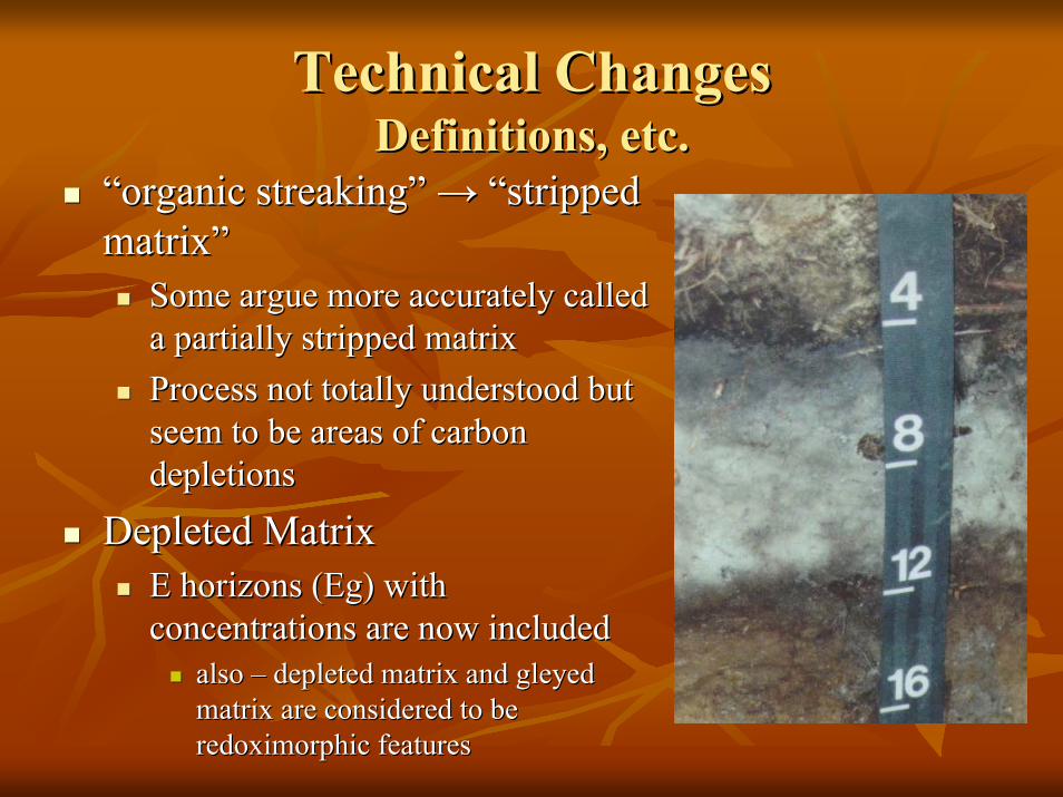
Technical ChangesTechnical ChangesDefinitions, etc.Definitions, etc.
““organic streakingorganic streaking”” →→ ““stripped stripped matrixmatrix””
Some argue more accurately called Some argue more accurately called a partially stripped matrixa partially stripped matrixProcess not totally understood but Process not totally understood but seem to be areas of carbon seem to be areas of carbon depletionsdepletions
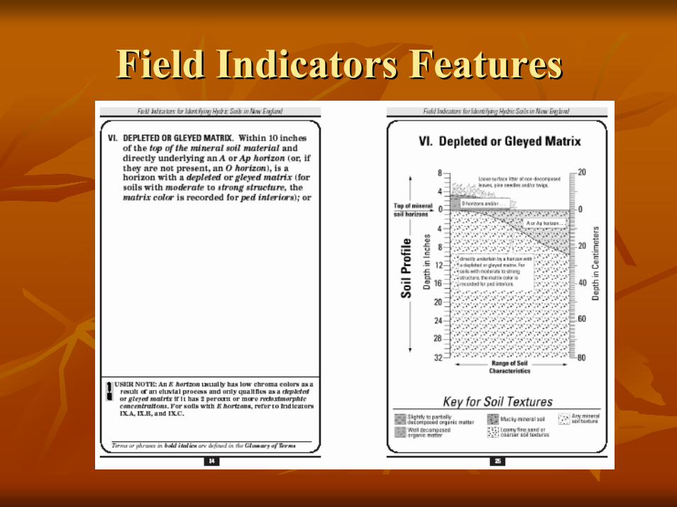
Depleted MatrixDepleted MatrixE horizons (E horizons (EgEg) with ) with concentrations are now includedconcentrations are now included
also also –– depleted matrix and gleyed depleted matrix and gleyed matrix are considered to be matrix are considered to be redoximorphic featuresredoximorphic features
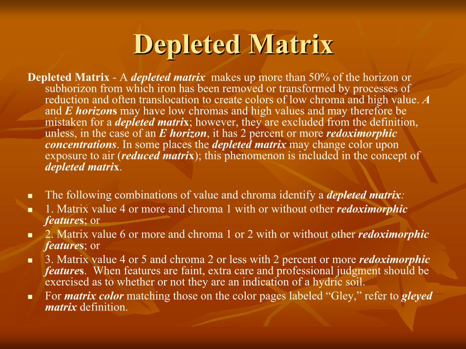
Depleted MatrixDepleted MatrixDepleted Matrix - A depleted matrix makes up more than 50% of the horizon or
subhorizon from which iron has been removed or transformed by processes ofreduction and often translocation to create colors of low chroma and high value. Aand E horizons may have low chromas and high values and may therefore be mistaken for a depleted matrix; however, they are excluded from the definition, unless, in the case of an E horizon, it has 2 percent or more redoximorphic concentrations. In some places the depleted matrix may change color upon exposure to air (reduced matrix); this phenomenon is included in the concept ofdepleted matrix.
The following combinations of value and chroma identify a depleted matrix:1. Matrix value 4 or more and chroma 1 with or without other redoximorphic features; or2. Matrix value 6 or more and chroma 1 or 2 with or without other redoximorphic features; or3. Matrix value 4 or 5 and chroma 2 or less with 2 percent or more redoximorphic features. When features are faint, extra care and professional judgment should be exercised as to whether or not they are an indication of a hydric soil.For matrix color matching those on the color pages labeled “Gley,” refer to gleyed matrix definition.

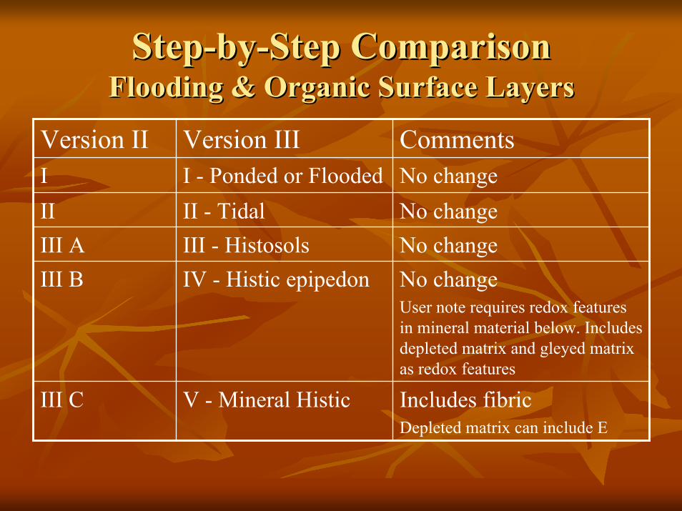
StepStep--byby--Step ComparisonStep ComparisonFlooding & Organic Surface LayersFlooding & Organic Surface Layers
Includes fibricDepleted matrix can include E
V - Mineral HisticIII C
No changeUser note requires redox features in mineral material below. Includes depleted matrix and gleyed matrix as redox features
IV - Histic epipedonIII BNo changeIII - HistosolsIII ANo changeII - TidalII No changeI - Ponded or FloodedI CommentsVersion IIIVersion II
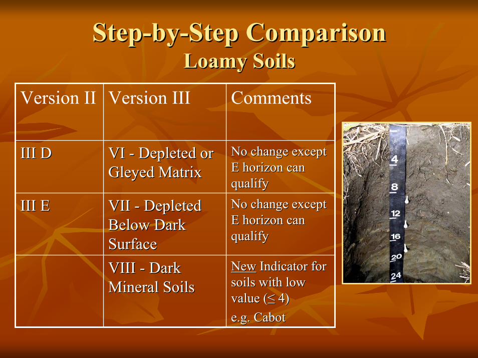
StepStep--byby--Step ComparisonStep ComparisonLoamy SoilsLoamy Soils
No change except No change except E horizon can E horizon can qualifyqualify
VI VI -- Depleted or Depleted or Gleyed MatrixGleyed Matrix
III DIII D
NewNew Indicator for Indicator for soils with low soils with low value (value (≤≤ 4)4)e.g. Cabote.g. Cabot
VIII VIII -- Dark Dark Mineral SoilsMineral Soils
No change except No change except E horizon can E horizon can qualifyqualify
VII VII -- Depleted Depleted Below Dark Below Dark SurfaceSurface
III EIII E
CommentsVersion IIIVersion II
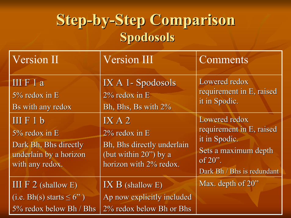
StepStep--byby--Step ComparisonStep ComparisonSpodosolsSpodosols
CommentsVersion IIIVersion II
Max. depth of 20”Max. depth of 20”IX B IX B (shallow E)(shallow E)ApAp now explicitly includednow explicitly included2% redox below 2% redox below BhBh or or BhsBhs
III F 2 III F 2 (shallow E) (shallow E) (i.e. (i.e. Bh(sBh(s) starts ) starts ≤≤ 66”” ))5% redox below 5% redox below BhBh / / BhsBhs
Lowered redox Lowered redox requirement in E, raised requirement in E, raised it in Spodic.it in Spodic.Sets a maximum depth Sets a maximum depth of 20”.of 20”.Dark Dark BhBh / / BhsBhs is redundantis redundant
IX A 2IX A 22% redox in E2% redox in EBhBh, , BhsBhs directly underlain directly underlain (but within 20”) by a (but within 20”) by a horizon with 2% redox.horizon with 2% redox.
III F 1 bIII F 1 b5% redox in E5% redox in EDark Dark BhBh, , BhsBhs directly directly underlain by a horizon underlain by a horizon with any redox.with any redox.
Lowered redox Lowered redox requirement in E, raised requirement in E, raised it in Spodic.it in Spodic.
IX A 1IX A 1-- SpodosolsSpodosols2% redox in E2% redox in EBhBh, , BhsBhs, Bs with 2%, Bs with 2%
III F 1 aIII F 1 a5% redox in E5% redox in EBs with any redoxBs with any redox
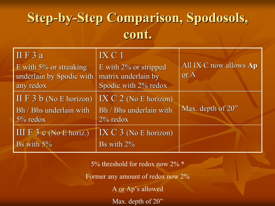
StepStep--byby--Step Comparison, Spodosols, Step Comparison, Spodosols, cont.cont.
IX C 3 IX C 3 (No E horizon)(No E horizon)Bs with 2%Bs with 2%
III F 3 c III F 3 c (No E (No E horizhoriz.).)Bs with 5%Bs with 5%
Max. depth of 20”Max. depth of 20”IX C 2 IX C 2 (No E horizon)(No E horizon)BhBh / / BhsBhs underlain with underlain with 2% redox2% redox
II F 3 b II F 3 b (No E horizon)(No E horizon)BhBh / / BhsBhs underlain with underlain with 5% redox5% redox
All IX C now allows All IX C now allows ApAporor AA
IX C 1IX C 1E with 2% or stripped E with 2% or stripped matrix underlain by matrix underlain by Spodic with 2% redoxSpodic with 2% redox
II F 3 aII F 3 aE with 5% or streaking E with 5% or streaking underlain by Spodic with underlain by Spodic with any redoxany redox
5% threshold for redox now 2% *
Former any amount of redox now 2%
A or Ap’s allowed
Max. depth of 20”
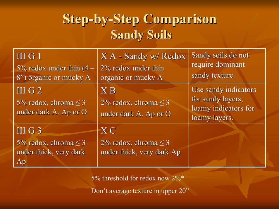
StepStep--byby--Step ComparisonStep ComparisonSandy SoilsSandy Soils
Sandy soils do not Sandy soils do not require dominant require dominant sandy texture.sandy texture.
X A X A -- Sandy w/ RedoxSandy w/ Redox2% redox under thin 2% redox under thin organic or mucky Aorganic or mucky A
III G 1III G 15% redox under thin (4 5% redox under thin (4 ––8”) organic or mucky A8”) organic or mucky A
X CX C2% redox, chroma 2% redox, chroma ≤≤ 3 3 under thick, very dark under thick, very dark ApAp
III G 3III G 35% redox, chroma 5% redox, chroma ≤≤ 3 3 under thick, very dark under thick, very dark ApAp
Use sandy indicators Use sandy indicators for sandy layers, for sandy layers, loamy indicators for loamy indicators for loamy layers.loamy layers.
X BX B2% redox, chroma 2% redox, chroma ≤≤ 33under dark A, under dark A, ApAp or Oor O
III G 2III G 25% redox, chroma 5% redox, chroma ≤≤ 3 3 under dark A, under dark A, ApAp or Oor O
5% threshold for redox now 2%*
Don’t average texture in upper 20”
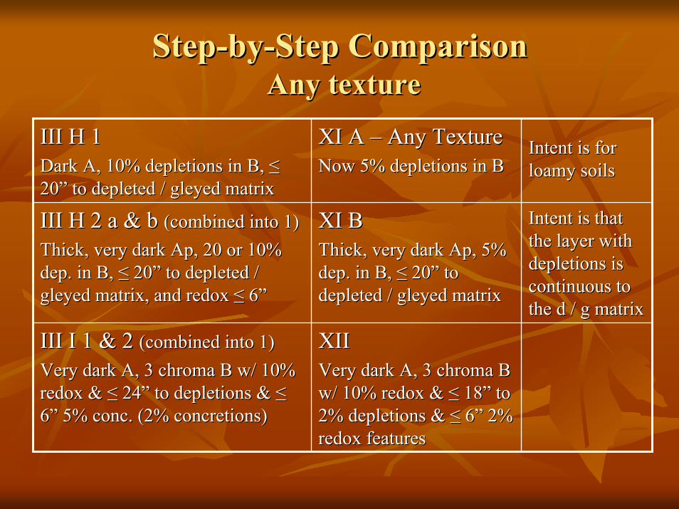
StepStep--byby--Step ComparisonStep ComparisonAny textureAny texture
XIIXIIVery dark A, 3 chroma B Very dark A, 3 chroma B w/ 10% redox & w/ 10% redox & ≤≤ 18” to 18” to 2% depletions & 2% depletions & ≤≤ 6” 2% 6” 2% redox featuresredox features
III I 1 & 2 III I 1 & 2 (combined into 1)(combined into 1)Very dark A, 3 chroma B w/ 10% Very dark A, 3 chroma B w/ 10% redox & redox & ≤≤ 24” to depletions & 24” to depletions & ≤≤6” 5% conc. (2% concretions)6” 5% conc. (2% concretions)
Intent is that Intent is that the layer with the layer with depletions is depletions is continuous to continuous to the d / g matrix the d / g matrix
XI BXI BThick, very dark Thick, very dark ApAp, 5% , 5% dep. in B, dep. in B, ≤≤ 2020”” to to depleted / gleyed matrixdepleted / gleyed matrix
III H 2 a & b III H 2 a & b (combined into 1)(combined into 1)Thick, very dark Thick, very dark ApAp, 20 or 10% , 20 or 10% dep. in B, dep. in B, ≤≤ 2020”” to depleted / to depleted / gleyed matrix, and redox gleyed matrix, and redox ≤≤ 66””
Intent is for Intent is for loamy soilsloamy soils
XI A XI A –– Any TextureAny TextureNow 5% depletions in BNow 5% depletions in B
III H 1III H 1Dark A, 10% depletions in B, Dark A, 10% depletions in B, ≤≤2020”” to depleted / gleyed matrixto depleted / gleyed matrix
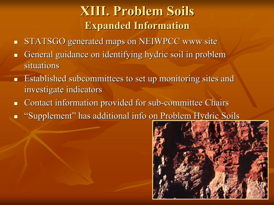
XIII. Problem SoilsXIII. Problem SoilsExpanded InformationExpanded Information
STATSGO generated maps on NEIWPCC www siteSTATSGO generated maps on NEIWPCC www siteGeneral guidance on identifying hydric soil in problem General guidance on identifying hydric soil in problem situationssituationsEstablished subcommittees to set up monitoring sites and Established subcommittees to set up monitoring sites and investigate indicatorsinvestigate indicatorsContact information provided for subContact information provided for sub--committee Chairscommittee Chairs“Supplement” has additional info on Problem Hydric Soils“Supplement” has additional info on Problem Hydric Soils
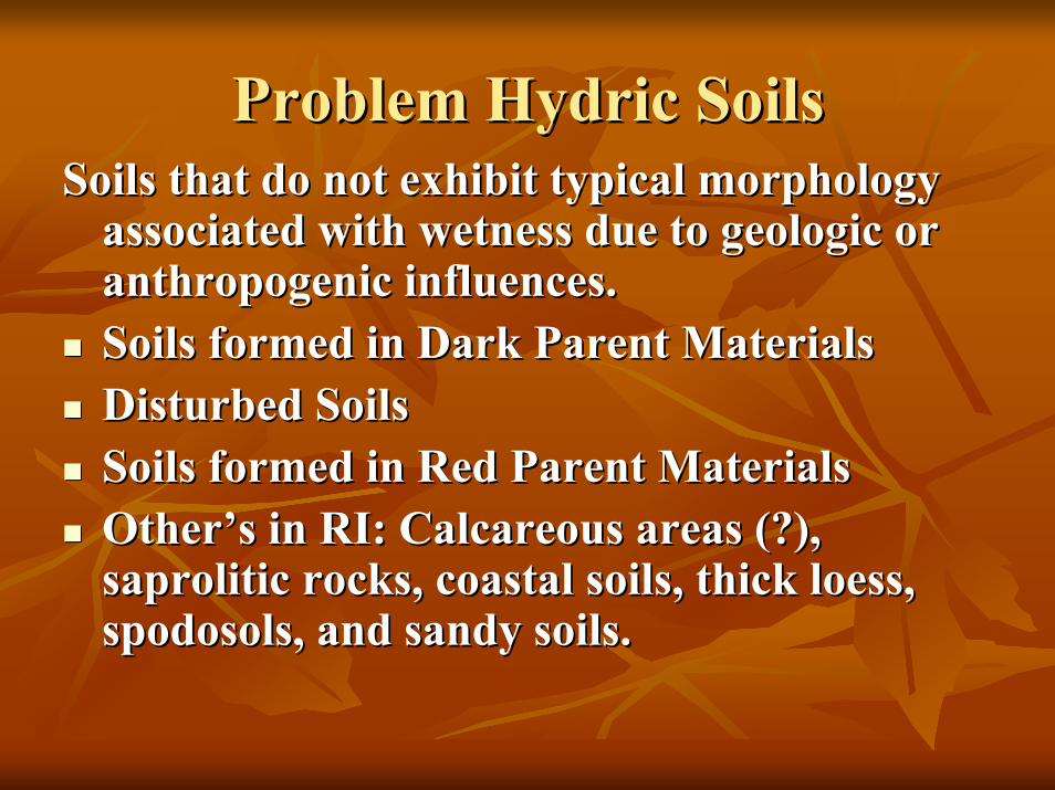
Problem Hydric SoilsProblem Hydric SoilsSoils that do not exhibit typical morphology Soils that do not exhibit typical morphology
associated with wetness due to geologic or associated with wetness due to geologic or anthropogenic influences.anthropogenic influences.Soils formed in Dark Parent MaterialsSoils formed in Dark Parent MaterialsDisturbed SoilsDisturbed SoilsSoils formed in Red Parent MaterialsSoils formed in Red Parent MaterialsOther’s in RI: Calcareous areas (?), Other’s in RI: Calcareous areas (?), saproliticsaprolitic rocks, coastal soils, thick loess, rocks, coastal soils, thick loess, spodosols, and sandy soils.spodosols, and sandy soils.
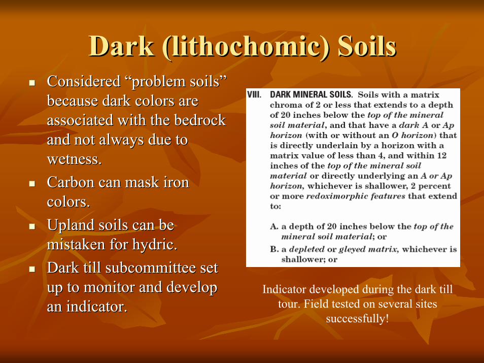
Dark (Dark (lithochomiclithochomic) Soils) SoilsConsidered “problem soils” Considered “problem soils” because dark colors are because dark colors are associated with the bedrock associated with the bedrock and not always due to and not always due to wetness.wetness.Carbon can mask iron Carbon can mask iron colors.colors.Upland soils can be Upland soils can be mistaken for hydric.mistaken for hydric.Dark till subcommittee set Dark till subcommittee set up to monitor and develop up to monitor and develop an indicator.
Indicator developed during the dark till tour. Field tested on several sites
successfully!an indicator.
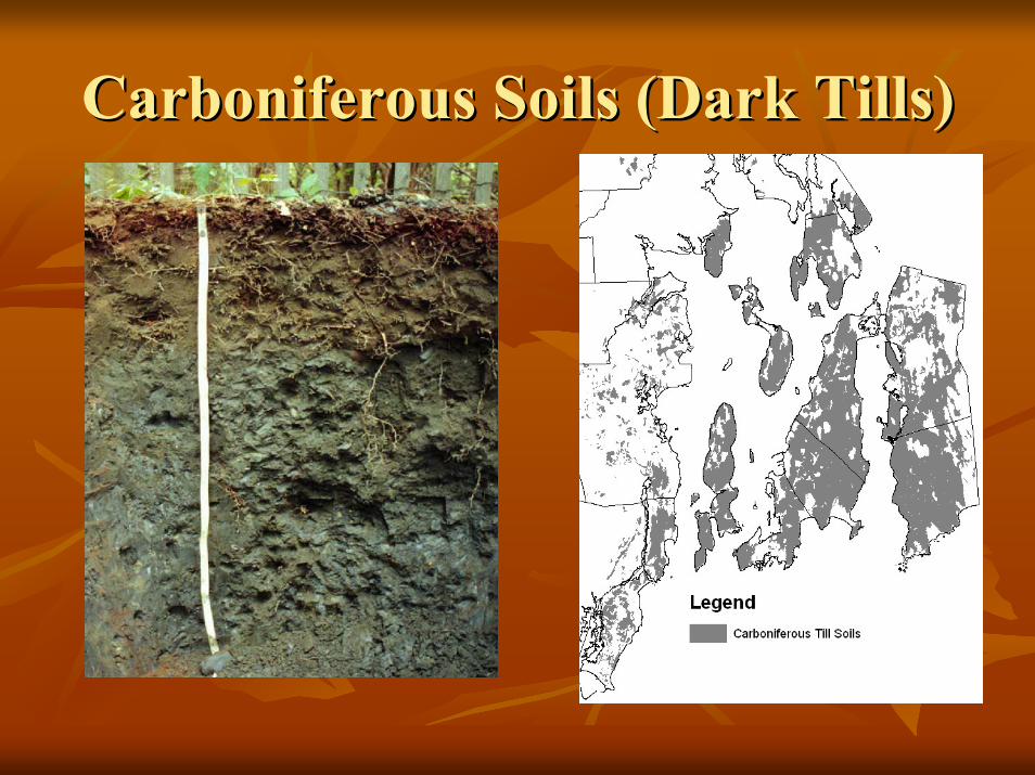
Carboniferous Soils (Dark Tills)Carboniferous Soils (Dark Tills)
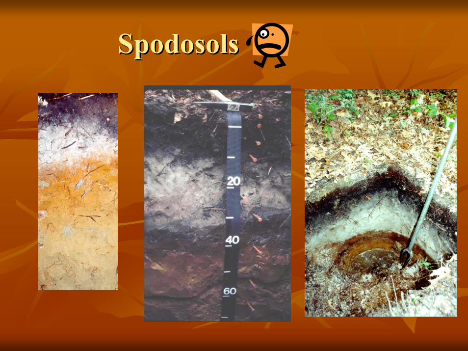
SpodosolsSpodosols
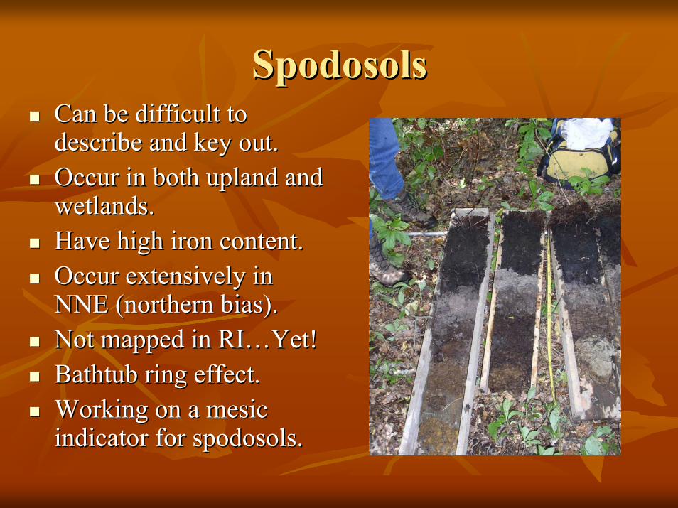
SpodosolsSpodosolsCan be difficult to Can be difficult to describe and key out.describe and key out.Occur in both upland and Occur in both upland and wetlands.wetlands.Have high iron content.Have high iron content.Occur extensively in Occur extensively in NNE (northern bias).NNE (northern bias).Not mapped in RI…Yet!Not mapped in RI…Yet!Bathtub ring effect.Bathtub ring effect.Working on a mesic Working on a mesic indicator for spodosols.indicator for spodosols.
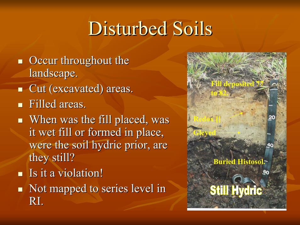
Disturbed SoilsDisturbed SoilsOccur throughout the Occur throughout the landscape.landscape.Cut (excavated) areas.Cut (excavated) areas.Filled areas.Filled areas.When was the fill placed, was When was the fill placed, was it wet fill or formed in place, it wet fill or formed in place, were the soil hydric prior, are were the soil hydric prior, are they still?they still?Is it a violation!Is it a violation!Not mapped to series level in Not mapped to series level in RI.
Fill deposited 77 to 82.
Buried Histosol.
Redox []
Gleyed
RI.

Anthropogenic SoilsAnthropogenic Soils
Excavated soil –old sand and gravel pit mined down to water table – now a hydric soil/wetland.
Soccer field with fill over buried hydric soils, tray left still hydric, tray right (higher elevation) non-hydric.
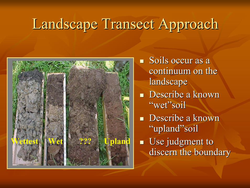
Landscape Transect ApproachLandscape Transect Approach
Soils occur as a Soils occur as a continuum on the continuum on the landscapelandscapeDescribe a known Describe a known “wet”soil“wet”soilDescribe a known Describe a known “upland”soil“upland”soilUse judgment to Use judgment to discern the boundarydiscern the boundary
Wettest UplandWet ???
What Next?What Next?Begin Work on Version 4.Begin Work on Version 4.Monitor problem soil areas 3 locations Monitor problem soil areas 3 locations along representative transects along representative transects ––develop guidelines and indicators if develop guidelines and indicators if possible.possible.
Validate indicatorsValidate indicatorsDevelop new indicatorsDevelop new indicators
Help WantedHelp Wanted
We need your help to identify representative locations and monitor the soils and hydrology:
1. Looking for sites that can be monitored for several years (wells, Eh meter, etc.).
2. Any sites where indicators don’t work.
3. Any accessible sites where you have data.
4. Any recommendations/changes/clarifications we can make with V 4.0.

QuestionsQuestions