Embed Size (px)
Citation preview
Field Managers’ Abbreviated Version: Interim Management Guidelines for the Nullarbor Caves and Selected Karst Features
Western Australia Department of Environment and Conservation and the Rangelands NRM Co-ordinating Group
Geoscene International
Division of Scenic Spectrums Pty Ltd WPDOCS: Nullarbor/FinRpt/FieldIMG_310109
i
Field Managers’ Abbreviated Version: Interim Management Guidelines for the Nullarbor Caves and Selected Karst Features
Western Australia Department of Environment and Conservation and the Rangelands NRM Co-ordinating Group
Geoscene International
Division of Scenic Spectrums Pty Ltd WPDOCS: Nullarbor/FinRpt/FieldIMG_310109
ii
Acknowledgements The Nullarbor Karst IMG Project was initiated during March, 2007. During that time, a wide range of persons have been involved in the project, volunteering contributions through the Steering Committee or through consultations and other assistance. The time and contributions of these people has been greatly appreciated and is acknowledged with thanks. Steering Committee Members have included: Department of Environment and Conservation, Western Australia:
• Alan Danks (South Coast Regional Nature Conservation Leader, Albany) • Julie Patten (Esperance District Nature Conservation Coordinator) • Klaus Tiedemann (Esperance District Manager)
Australian Government Natural Resource Management Team: • Neil Riches (NRM Facilitator – Biodiversity, Western Australian Team)
Rangelands NRM Team:
• Sylvia Clarke (Southern Rangelands Biodiversity Coordinator, Kalgoorlie) • Renee Berry ( Southern Rangelands Biodiversity Coordinator, Kalgoorlie)
Department of Indigenous Affairs, Western Australia:
• Kymberley Russell (Senior Projects Officer, Kalgoorlie)
Goldfields Land and Sea Council: • Dennis Forrest (Project Officer, Kalgoorlie) • Phil Drayson (Land Unit Coordinator, Perth)
Western Australia Museum: • Dr. Bill Humphreys (WA Museum)
Pastoralists: • Peter Brown AM and Barbara Brown (Pastoral Leaseholders – Arubiddy Station); • Colin and Bree Campbell (Pastoral Leaseholders – Mundrabilla Station)
Speleologists, Cave Divers and Cave Researchers: • Jay Anderson (Dry caver; Representing the ASF /former Australian Speleological Federation President); • Paul Hosie (Cave diver; Representing Cave Exploration Group of South Australia –CEGSA -, who are
the key custodians of Nullarbor Karst identification and location information); • Dr. Stefan Eberhard (Caver, researcher, co-author of the Subterranean Biodiversity of the Nullarbor
Karst Desktop Study, caving consultant - Subterranean Ecology) • Ann Marie Meredith (Dry caver; WA Speleological Group member); • Norman Poulter OAM (ASF member, caver; researcher) • Eve Taylor (Speleological Research Group WA / caver, researcher) • Paul Devine (Speleological Research Group WA / caver, researcher) • Rauleigh Webb (ASF member, caver; researcher).
Other individuals who have been consulted, assisted the preparation of the report or provided photography have included: Mirning and Ngadju Traditional Owners Consulted:
• Eddie McKenzie – Goldfields Land & Sea Council and Ngadju Aboriginal People • Clem Lawrie –Mirning Aboriginal People • Michael Laing –Mirning Aboriginal People • Johnny Graham – Ngadju Aboriginal People
Field Managers’ Abbreviated Version: Interim Management Guidelines for the Nullarbor Caves and Selected Karst Features
Western Australia Department of Environment and Conservation and the Rangelands NRM Co-ordinating Group
Geoscene International
Division of Scenic Spectrums Pty Ltd WPDOCS: Nullarbor/FinRpt/FieldIMG_310109
iii
• Rule Wicker– Ngadju Aboriginal People Australian Speleological Federation and Australian Cave and Karst Management Association members:
• Peter Ackroyd (ASF, caver, researcher) • Fr. Ken Boland (ASF, caver, researcher) • Peter Dykes (member of Australian Speleological Federation, Convenor of ASF Commission for
Aboriginal and Torres Strait Island Cultural Matters, botanist) • Professor Elery Hamilton-Smith AM (Chairman IUCN Cave and Karst Management Committee) • Professor Julia James (ASF, karst researcher, University of Sydney) • Graham Pilkington (CEGSA President, caver, researcher)
Government personnel:
• Vanessa Bray (Land Unit Management Assistant, Perth) • Sarah Comer (Regional Ecologist, South Coast Region, Albany) • Penny O’Conner, Manager Assessment & Registration, Heritage Council of Western Australia) • Kathryn Przywolnik (Archaeologist, Dept. of Indigenous Affairs, WA) • Dr. John Watson (South Coast Strategic Land Use Planner, previously the DEC South Coast Regional
Manager) Photographers:
• Chris Bradley (National University Caving Club) • Olaf Theden (National University Caving Club) • Norman Poulter OAM (ASF member, caver; researcher) • Klaus Tiedemann (District Manager, DEC Esperance)
Organisations consulted and surveyed during 2007 by DEC:
• Australian Speleological Federation (ASF) • Cave Divers Association of Australia (CDAA) • Department of Environment and Conservation (DEC) • Department of Indigenous Affairs (DIA) • Department of Planning and Infrastructure (DPI) • Fire & Emergency Services Authority (FESA) • Goldfields and Esperance Development Commission (GEDC) • Shaw Horizons (Tourism Operators) • Shire of Dundas • Speleological Research Group of Western Australia (SRGWA) • Tourism Western Australia
Field Managers’ Abbreviated Version: Interim Management Guidelines for the Nullarbor Caves and Selected Karst Features
Western Australia Department of Environment and Conservation and the Rangelands NRM Co-ordinating Group
Geoscene International
Division of Scenic Spectrums Pty Ltd WPDOCS: Nullarbor/FinRpt/FieldIMG_310109
iv
Acronyms ACKMA Australian Cave and Karst Management Association ARTC Australian Rail Track Corporation Ltd ASF Australian Speleological Federation CAC Caves Access Committee CALM former Dept. of Conservation and Land Management CDAA Cave Divers Association of Australia CEGSA Cave Exploration Group (South Australia) Inc. CLAP Cave Leader Assessment Panel CLMR Conservation and Land Management Regulations 2002 CMAC Caves Management Advisory Committee DEC Dept. of Environment and Conservation DEWHA Dept. of Environment, Water, Heritage and the Arts DIA Dept. of Indigenous Affairs DIR Dept of Industry and Resources DOLA former Dept. of Lands and Agriculture DMPR Dept. of Mineral and Petroleum Resources DPI Dept. of Planning and Infrastructure DWR Dept. of Water Resources EPA Environment Protection Authority EPBA Environment Protection and Biodiversity Conservation Act 1999 FESA Fire and Emergency Services Authority GEDC Goldfields & Esperance Development Commission GLSC Goldfields Land and Sea Council HREOC Human Rights and Equal Opportunities Commission IBRA Interim Biogeographical Regionalisation for Australia IMG Interim Management Guideline(s) IUCN International Union for Conservation of Nature KIDSA Karst Index Database – South Australia LAA Land Administration Act 1997 LAC Limits of Acceptable Change LCDC Land Conservation District Committees MATs Management Action Targets NCKMAC Nullarbor Caves and Karst Management Advisory Committee NHT Natural Heritage Trust NLP National Landcare Program NRM Natural Resource Management NRS National Reserve System NUCC National University Caving Club PGA Pastoralists and Graziers Association PLB Pastoral Lands Board SEIG Statutory Exploration Information Group SRGWA Speleological Research Group of Western Australia SLS State Land Services TOMM Tourism Optimisation Management Model RAOU Royal Australian Ornithologists Union UNESCO RAS Register of Aboriginal Sites RATIS Recreation and Tourism Information System RCTs Resource Condition Targets ROS Recreation Opportunity Spectrum VAMP Visitor Activity Management Process VERP Visitor Experience Resource Protection VIM Visitor Impact Management WAFF Western Australian Farmers Federation WAHC Western Australian Heritage Council WAM Western Australian Museum WARMS Western Australian Rangeland Monitoring System WASG Western Australian Speleological Group WCPA World Commission on Protected Areas ZCA Zone Control Authorities
Field Managers’ Abbreviated Version: Interim Management Guidelines for the Nullarbor Caves and Selected Karst Features
Western Australia Department of Environment and Conservation and the Rangelands NRM Co-ordinating Group
Geoscene International
Division of Scenic Spectrums Pty Ltd WPDOCS: Nullarbor/FinRpt/FieldIMG_310109
v
CONTENTS Acknowledgements i Acronyms iii 1. Executive Summary and Key Recommendations 1 2. Project Background 2 2.1 Project Aims and Objectives 2 2.2 Key Focus Attributes and Assets Addressed 3 2.3 Potential Uses Considered 3 2.4 Key Management Activities 3 2.5 Funding Agencies and Steering Committee 4
2.5.1 A Joint Initiative 4 2.5.2 Project Management and Consultations 4
2.6 Project Area and Overview Description 4 2.6.1 Geographic Area 4 2.6.2 Physiographic Units, Biogeographic Subregions and Vegetation 4 2.6.3 Climate 8 2.6.4 Caves and Karst Features of the Nullarbor 8 2.6.5 Coastal Features 8 2.6.6 Transportation Routes, Settlements and Facilities 8 2.6.7 Land Use and Economic Sectors 8
2.7 Overall Significance 8 2.7.1 Geologic and Geomorphic Values 9 2.7.2 Ecological, Flora and Fauna Values 9 2.7.3 Indigenous Heritage 17 2.7.4 Non-Indigenous Heritage 17 2.7.5 Tourism, Recreation and Wilderness Values, Facilities and Activities 18 2.7.6 Scientific Research and Education Values 18 2.7.7 Scenic Resources 19 2.7.8 Economic Values 20
3. Land Tenure, Legislative and Management Framework 20 3.1 Land Tenure 20 3.2 Conservation Estate 20 3.3 Legislative and Management Framework 22 4 Recommended Interim Management Guidelines 22 4.1 Introduction to the Guidelines and Management Context 22 4.2 Key Issue Areas 24
Field Managers’ Abbreviated Version: Interim Management Guidelines for the Nullarbor Caves and Selected Karst Features
Western Australia Department of Environment and Conservation and the Rangelands NRM Co-ordinating Group
Geoscene International
Division of Scenic Spectrums Pty Ltd WPDOCS: Nullarbor/FinRpt/FieldIMG_310109
vi
CONTENTS….continued 4.3 Interim Management Guidelines for the General Management and Use of Caves 25 4.3.1 IMG 1: Vesting of Cave Management 25 4.3.2 IMG 2: Management Advisory Committee 26 4.3.3 IMG 3: Cave Access Permit System 26 4.3.4 IMG 4: Cave Management Classification System 27 4.3.5 IMG 5: Assessment of Cave Risks to Visitors 27 4.3.6 IMG 6: Locked Access for Selected Caves 27 4.3.7 IMG 7: Fencing Cave Reserves within Pastoral Leaseholds 28 4.3.8 IMG 8: Visitor Impact Monitoring Methods 29 4.3.9 IMG 9: Field Management Staffing Alternatives 29 4.3.10 IMG 10: Cave-Related Capital Works 30 4.3.11 IMG 11: Visitor Interpretation Feasibility Study 30 4.3.12 IMG 12: Groundwater Protection 30
4.3.13 IMG 13: Ecosystem, Flora and Fauna Conservation 30 4.3.14 IMG 14: Threatening Pest Animal and Plant Control 31 4.3.15 IMG 15: Fire Control 32 4.3.16. IMG 16: Protection of Cultural Heritage Sites 32
4.3.17 IMG 17: Holistic and Best Management Practices 32 4.4 Interim Management Guidelines for Specific Pastoral Issues 32 4.4.1 IMG 18: Survey and Fencing of Areas above Cave Passages 32 4.4.2 IMG 19: Surface Drainage and Farm Dam Construction 33 4.5 Interim Management Guidelines for Mining, Transport and Communications
Infrastructure Uses 33 4.5.1 IMG 20: Excavations and Drilling Above Cave Passages 33 4.5.2 IMG 21: Surface Drainage Changes Related to Mining and Infrastructure 34 4.6 Interim Management Guidelines Related to Aboriginal Recognition and Co-operation 34 4.6.1 IMG 22: Aboriginal Rights, Knowledge and Co-operative Management 34 4.7 Interim Management Guidelines Regarding Safety and Liability Issues 35 4.7.1 IMG 23: Risk Assessments and Management 35 4.8 Enhanced Management Frameworks 35 4.8.1 IMG 24 Preliminary Review of Enhanced Management Frameworks 35 GLOSSARY 36 REFERENCES 40
Field Managers’ Abbreviated Version: Interim Management Guidelines for the Nullarbor Caves and Selected Karst Features
Western Australia Department of Environment and Conservation and the Rangelands NRM Co-ordinating Group
Geoscene International
Division of Scenic Spectrums Pty Ltd WPDOCS: Nullarbor/FinRpt/FieldIMG_310109
vii
CONTENTS….continued APPENDICES APPENDIX 1: Legislative and Management Framework 47 A1.1 Key Legislative Acts 51 A1.2 Key Government Departments 51 A1.3 Key Commonwealth Policies and Strategies 52 A1.4 Key State Government Policies and Strategies 52 A1.5 Commonwealth and Interstate Management Agreements 53 A1.6 International Treaties and Agreements 53 A1.7 Other Ex-Officio Policies and Guidelines 53 APPENDIX 2: Heritage Sites and Places on Various Government and Community Registers and Lists 53 APPENDIX 3: Frame of Reference Scenic Assessment Criteria 54 APPENDIX 4: Visitor Access, Infrastructure Needs, Interpretation, Management Presence and Control Issues 55 A4.1 Two Schools of Thought on Public Access to Caves and Karst Features of the Nullarbor 55 A4.2 Potential Infrastructure Needs at Caves Open to Access 55 A4.3 Interpretive Facilities and Programs 56 A4.4 Provision of Management and Interpretive Presence 57 APPENDIX 5: Groundwater Issues 57 A5.1 Groundwater Values and Threats 57 A5.2 DMPR Guidelines Regarding Exploratory Drilling 58 A5.3 EPA Guidance Statement No. 54 59 A5.4 Regional Water Resource Assessments 60 A5.5 Draft NRM Strategy 60 A5.6 Licensing and Monitoring Wells 61 APPENDIX 6: Potential Impacts of Pastoral Uses on Caves, Karst Features and Associated Ecosystems 61 A6.1 Potential Adverse Effects 61 A6.2 Monitoring Procedures 62 A6.3 Rangelands NRM Strategy and Best Practice Guidelines 62 A6.4 Field Actions on Pastoral Lands in Co-operation with Leaseholders 63
Field Managers’ Abbreviated Version: Interim Management Guidelines for the Nullarbor Caves and Selected Karst Features
Western Australia Department of Environment and Conservation and the Rangelands NRM Co-ordinating Group
Geoscene International
Division of Scenic Spectrums Pty Ltd WPDOCS: Nullarbor/FinRpt/FieldIMG_310109
viii
CONTENTS….continued APPENDIX 7: Potential Mining Uses and Infrastructure Impacts on Caves 63 A7.1 Potential Impacts of Mining 63 A7.2 Mining Guideline Documents 65 A7.3 GLSC Mining Policy 65 A7.4 Transport and Communications Infrastructure Impacts 65 APPENDIX 8: Aboriginal Cultural Heritage, Recognition and Co-operation 66 APPENDIX 9: Safety and Liability Issues 66 APPENDIX 10 Enhanced Management Frameworks 68 FIGURES Figure 1 The W. A. Nullarbor Cave and Associated Features Project Area within the
Broader Nullarbor Karst System 5 Figure 2 Beard’s (1975) Physiographic/Vegetation Units 6 Figure 3 Caves and Karst Features Known during 1992 10 Figure 4 Caves and Karst Features Known during 2007 11 Figure 5 Land Tenure of the Karst System with Caves 21 Figure 6 Overview of Management Issues Regarding the Nullarbor Caves, Dolines, Blowholes and Associated Karst Areas 23 Figure A5 Northwest-Southeast Geological Section of the Eucla Basin 59 TABLES Table 1 Rare and Priority 1 Flora Species in the Project Area 16 Table 2 Examples of Schedule 1 and Other Priority Fauna Species in the Project Area 16 Table 3 DEC Cave Management Classification System (2006) 28 Table A1 Government Departments, Legislation, Ministries and Responsibilities 47 Table A2 Heritage Sites and Places Listed on Government and Community Registers and Lists 53 Table A3 Scenic Resource Frame of Reference Assessment Criteria for Nullarbor Features of High or Moderate Scenic Quality 54
Field Managers’ Abbreviated Version: Interim Management Guidelines for the Nullarbor Caves and Selected Karst Features
Western Australia Department of Environment and Conservation and the Rangelands NRM Co-ordinating Group
Geoscene International
Division of Scenic Spectrums Pty Ltd WPDOCS: Nullarbor/FinRpt/FieldIMG_310109
1
FIELD MANAGER’S ABBREVIATED VERSION: INTERIM MANAGEMENT GUIDELINES FOR THE NULLARBOR CAVES AND SELECTED KARST FEATURES 1. Executive Summary and Key Recommendations This is the Field Managers’ Abbreviated Version of the Interim Management Guidelines (IMGs) for caves and selected karst features of the Nullarbor Karst System in Western Australia 1. The current focus area is primarily from the Trans Australian Railway south to the coastline and from the South Australian border west to Point Malcolm. A full, unabbreviated IMG report is also available from DEC and Rangelands NRM. The Nullarbor caves and associated features play a critical role in a much larger karst system that is without question of world and national significance for a range of natural and cultural resources (e.g. geologic, palaeontololgical, archeological, biological etc. and in terms of indigenous and non-indigenous cultural heritage).
Although the area receives relatively low visitor numbers due to remoteness, it is extremely fragile and vulnerable, even to the level of use currently received. Currently, the management co-ordination, presence, activity and control over the caves and karst features are inadequate given the high conservation values and vulnerability of the area. The current Cave Access Permit System is inconsistently applied and unenforceable, primarily due to a lack of public knowledge/co-operation and no field checks on usage. There are significant public safety and liability issues. There are also many untapped opportunities for presentation and interpretation of the outstanding features of the area to the public and for enhanced conservation measures and research. These issues are briefly presented in this report, but are fully explored and documented in the unabbreviated IMG report. Twenty-four IMGs are recommended for consideration (refer to Section 4). Priority guidelines include: 1. review and consideration of alternatives for field-based conservation officers; 2. apply the Cave Management Classification System and the Cave Access Permit System in a consistent and
rigorous manner; 3. conduct assessments of cave risks to visitors for selected caves on a priority basis; 4. vestment of overall management of all caves and associated karst features to a single State Government
department – DEC - with oversight from a new Nullarbor Cave and Karst Management Advisory Committee (NCKMAC);
5. fence, gate and lock critically significant and fragile caves, dolines and blowholes; 6. continue priority ecosystem, flora and fauna protection and recovery programs and weed and pest animal
controls on a targeted basis; 7. survey and fence ground-surface footprints of significant cave passages on pastoral leasehold properties and
Unallocated Crown Lands for safety and conservation purposes; 8. provide visitor information, safety and interpretive facilities and programs on a selected and priority basis as
indicated by feasibility assessments and specified works plans; 9. conduct preliminary reviews of potential enhanced management frameworks. Areas that may have the potential to receive funding under periodic Federal Government grant programs (e.g., Caring for Our Country) have been identified in the full IMG report, along with significant resource assessment, planning and research projects. Sharing the full IMG report with the community, key stakeholders and other government land managers, and partnering with them is strongly encouraged. NOTE 1: Selected sections of the text have been highlighted in bold lettering to facilitate quicker reading of key points by the reader.
Field Managers’ Abbreviated Version: Interim Management Guidelines for the Nullarbor Caves and Selected Karst Features
Western Australia Department of Environment and Conservation and the Rangelands NRM Co-ordinating Group
Geoscene International
Division of Scenic Spectrums Pty Ltd WPDOCS: Nullarbor/FinRpt/FieldIMG_310109
2
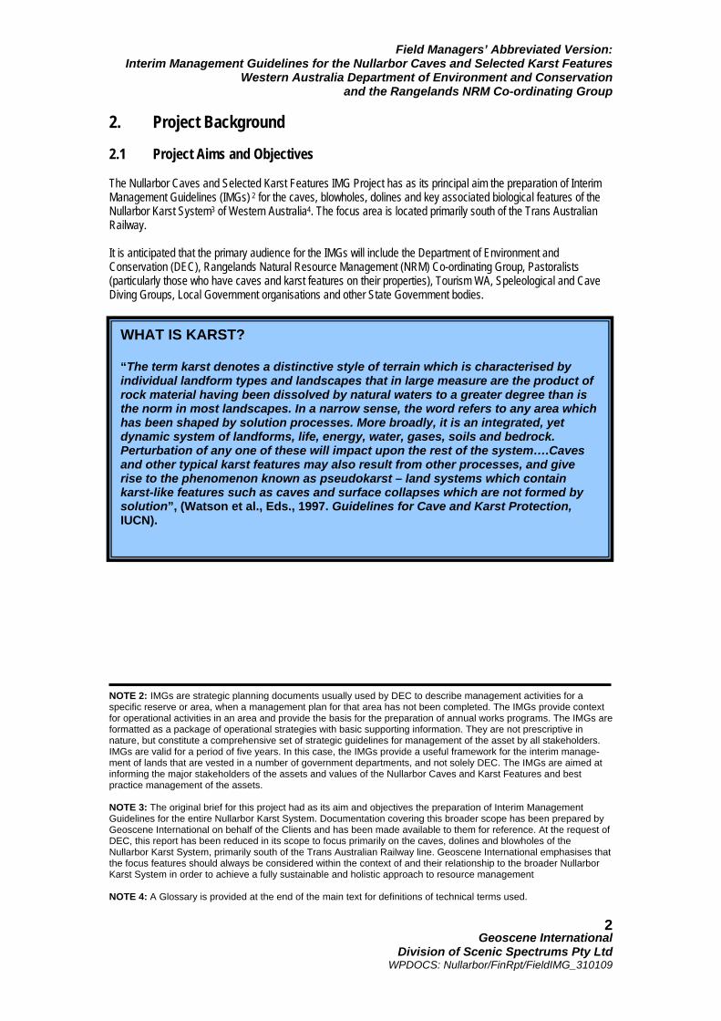
2. Project Background 2.1 Project Aims and Objectives The Nullarbor Caves and Selected Karst Features IMG Project has as its principal aim the preparation of Interim Management Guidelines (IMGs) 2 for the caves, blowholes, dolines and key associated biological features of the Nullarbor Karst System3 of Western Australia4. The focus area is located primarily south of the Trans Australian Railway.
It is anticipated that the primary audience for the IMGs will include the Department of Environment and Conservation (DEC), Rangelands Natural Resource Management (NRM) Co-ordinating Group, Pastoralists (particularly those who have caves and karst features on their properties), Tourism WA, Speleological and Cave Diving Groups, Local Government organisations and other State Government bodies.
NOTE 2: IMGs are strategic planning documents usually used by DEC to describe management activities for a specific reserve or area, when a management plan for that area has not been completed. The IMGs provide context for operational activities in an area and provide the basis for the preparation of annual works programs. The IMGs are formatted as a package of operational strategies with basic supporting information. They are not prescriptive in nature, but constitute a comprehensive set of strategic guidelines for management of the asset by all stakeholders. IMGs are valid for a period of five years. In this case, the IMGs provide a useful framework for the interim manage-ment of lands that are vested in a number of government departments, and not solely DEC. The IMGs are aimed at informing the major stakeholders of the assets and values of the Nullarbor Caves and Karst Features and best practice management of the assets. NOTE 3: The original brief for this project had as its aim and objectives the preparation of Interim Management Guidelines for the entire Nullarbor Karst System. Documentation covering this broader scope has been prepared by Geoscene International on behalf of the Clients and has been made available to them for reference. At the request of DEC, this report has been reduced in its scope to focus primarily on the caves, dolines and blowholes of the Nullarbor Karst System, primarily south of the Trans Australian Railway line. Geoscene International emphasises that the focus features should always be considered within the context of and their relationship to the broader Nullarbor Karst System in order to achieve a fully sustainable and holistic approach to resource management NOTE 4: A Glossary is provided at the end of the main text for definitions of technical terms used.
WHAT IS KARST? “The term karst denotes a distinctive style of terrain which is characterised by individual landform types and landscapes that in large measure are the product of rock material having been dissolved by natural waters to a greater degree than is the norm in most landscapes. In a narrow sense, the word refers to any area which has been shaped by solution processes. More broadly, it is an integrated, yet dynamic system of landforms, life, energy, water, gases, soils and bedrock. Perturbation of any one of these will impact upon the rest of the system….Caves and other typical karst features may also result from other processes, and give rise to the phenomenon known as pseudokarst – land systems which contain karst-like features such as caves and surface collapses which are not formed by solution”, (Watson et al., Eds., 1997. Guidelines for Cave and Karst Protection, IUCN).
Field Managers’ Abbreviated Version: Interim Management Guidelines for the Nullarbor Caves and Selected Karst Features
Western Australia Department of Environment and Conservation and the Rangelands NRM Co-ordinating Group
Geoscene International
Division of Scenic Spectrums Pty Ltd WPDOCS: Nullarbor/FinRpt/FieldIMG_310109
3
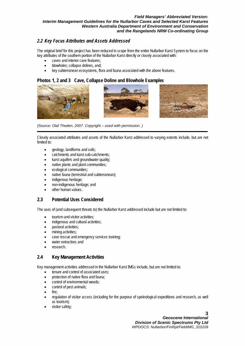
2.2 Key Focus Attributes and Assets Addressed The original brief for this project has been reduced in scope from the entire Nullarbor Karst System to focus on the key attributes of the southern portion of the Nullarbor Karst directly or closely associated with:
• caves and interior cave features; • blowholes; collapse dolines, and; • key subterranean ecosystems, flora and fauna associated with the above features.
Photos 1, 2 and 3 Cave, Collapse Doline and Blowhole Examples
(Source: Olaf Theden, 2007. Copyright – used with permission. )
Closely associated attributes and assets of the Nullarbor Karst addressed to varying extents include, but are not limited to:
• geology, landforms and soils; • catchments and karst sub-catchments; • karst aquifers and groundwater quality; • native plants and plant communities; • ecological communities; • native fauna (terrestrial and subterranean); • indigenous heritage; • non-indigenous heritage; and • other human values.
2.3 Potential Uses Considered The uses of (and subsequent threats to) the Nullarbor Karst addressed include but are not limited to:
• tourism and visitor activities; • indigenous and cultural activities; • pastoral activities; • mining activities; • cave rescue and emergency services training; • water extraction; and • research.
2.4 Key Management Activities Key management activities addressed in the Nullarbor Karst IMGs include, but are not limited to:
• tenure and control of associated uses; • protection of native flora and fauna; • control of environmental weeds; • control of pest animals; • fire; • regulation of visitor access (including for the purpose of speleological expeditions and research, as well
as tourism); • visitor safety;
Field Managers’ Abbreviated Version: Interim Management Guidelines for the Nullarbor Caves and Selected Karst Features
Western Australia Department of Environment and Conservation and the Rangelands NRM Co-ordinating Group
Geoscene International
Division of Scenic Spectrums Pty Ltd WPDOCS: Nullarbor/FinRpt/FieldIMG_310109
4
• public utilities and services; • liability; and • confidentiality.
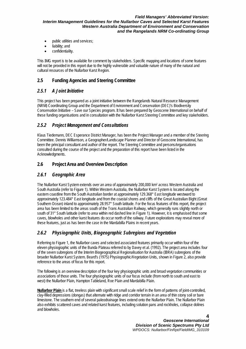
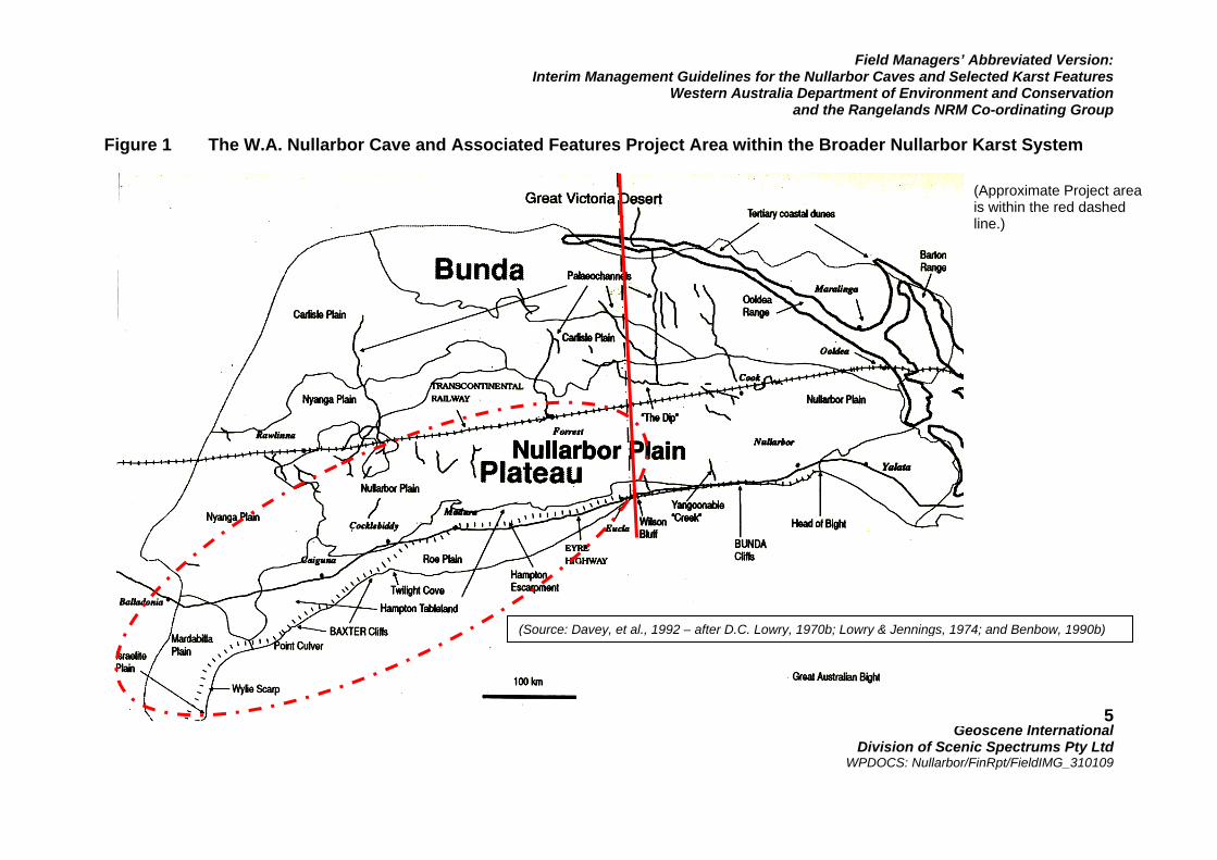
This IMG report is to be available for comment by stakeholders. Specific mapping and locations of some features will not be provided in this report due to the highly vulnerable and valuable nature of many of the natural and cultural resources of the Nullarbor Karst Region. 2.5 Funding Agencies and Steering Committee 2.5.1 A Joint Initiative This project has been prepared as a joint initiative between the Rangelands Natural Resource Management (NRM) Coordinating Group and the Department of Environment and Conservation (DEC)’s Biodiversity Conservation Initiative – Save our Species program. It has been prepared by Geoscene International on behalf of these funding organisations and in consultation with the Nullarbor Karst Steering Committee and key stakeholders. 2.5.2 Project Management and Consultations Klaus Tiedemann, DEC Esperance District Manager, has been the Project Manager and a member of the Steering Committee. Dennis Williamson, a Geographer/Landscape Planner and Director of Geoscene International, has been the principal consultant and author of the report. The Steering Committee and persons/organisations consulted during the course of the project and the preparation of this report have been listed in the Acknowledgments. 2.6 Project Area and Overview Description 2.6.1 Geographic Area The Nullarbor Karst System extends over an area of approximately 200,000 km2 across Western Australia and South Australia (refer to Figure 1). Within Western Australia, the Nullarbor Karst System is located along the eastern coastline from the South Australian border at approximately 129.368° East longitude westward to approximately 123.484° East longitude and from the coastal shores and cliffs of the Great Australian Bight (Great Southern Ocean) inland to approximately 28.957° South latitude. For the focus features of this report, the project area has been limited to the areas south of the Trans Australian Railway, which generally runs slightly north or south of 31° South latitude (refer to area within red dashed line in Figure 1). However, it is emphasised that some caves, blowholes and other karst features do occur north of the railway. Future explorations may reveal more of these features, just as has been the case in the Mardabilla Plains in recent years. 2.6.2 Physiographic Units, Biogeographic Subregions and Vegetation Referring to Figure 1, the Nullarbor caves and selected associated features primarily occur within four of the eleven physiographic units of the Bunda Plateau referred to by Davey et al. (1992). The project area includes four of the seven subregions of the Interim Biogeographical Regionalisation for Australia (IBRA) subregions of the broader Nullarbor Karst System. Beard’s (1975) Physiographic/Vegetation Units, shown in Figure 2, also provide reference to the areas of focus for this report. The following is an overview description of the four key physiographic units and broad vegetation communities or associations of those units. The four physiographic units of our focus include (from north to south and east to west) the Nullarbor Plain, Hampton Tableland, Roe Plain and Mardabilla Plain. Nullarbor Plain is a flat, treeless plain with significant small scale relief in the form of patterns of joint-controlled, clay-filled depressions (dongas) that alternate with ridge and corridor terrain in an area of thin stony soil or bare limestone. The southern end of several paleodrainage lines extend onto the Nullarbor Plain. The Nullarbor Plain also exhibits scattered caves and related karst features, including solution pans and rockholes, collapse dolines and blowholes.
Field Managers’ Abbreviated Version: Interim Management Guidelines for the Nullarbor Caves and Selected Karst Features
Western Australia Department of Environment and Conservation and the Rangelands NRM Co-ordinating Group
Geoscene International
Division of Scenic Spectrums Pty Ltd WPDOCS: Nullarbor/FinRpt/FieldIMG_310109
5
Figure 1 The W.A. Nullarbor Cave and Associated Features Project Area within the Broader Nullarbor Karst System
(Approximate Project area is within the red dashed line.)
(Source: Davey, et al., 1992 – after D.C. Lowry, 1970b; Lowry & Jennings, 1974; and Benbow, 1990b)
Field Managers’ Abbreviated Version: Interim Management Guidelines for the Nullarbor Caves and Selected Karst Features
Western Australia Department of Environment and Conservation and the Rangelands NRM Co-ordinating Group
Geoscene International
Division of Scenic Spectrums Pty Ltd WPDOCS: Nullarbor/FinRpt/FieldIMG_310109
6
Figure 2 Beard’s (1975) Physiographic/Vegetation Units
(Source: Tille, 2006. Soil-landscapes of Western Australia’s Rangelands and Arid Interior)
Field Managers’ Abbreviated Version: Interim Management Guidelines for the Nullarbor Caves and Selected Karst Features
Western Australia Department of Environment and Conservation and the Rangelands NRM Co-ordinating Group
Geoscene International
Division of Scenic Spectrums Pty Ltd WPDOCS: Nullarbor/FinRpt/FieldIMG_310109
7
The vegetation is Bluebush - Saltbush steppe in central areas; low woodlands of Acacia papyrocarpa (Western Myall) over Maireana sedifolia (Bluebush) are present in peripheral areas, including Myoporum platycarpum and E. oleosa in the east and west. Hampton Tableland lies south of the Nullarbor Plain where the Nullarbor Limestone formation has undergone significant denudation, completely removed in parts, revealing the underlying Abrakurrie Limestone. This area has most of the known caves and collapse dolines of the region. The tableland surface is dominated by ridge and corridor terrain with local relief up to 10 m. The ridges tend to be rockier than those of the Nullarbor Plain and carry scattered Acacia and/or mallee Eucalyptus in the chenopod shrubland. A feature known as “karren” is restricted to the coastal cliffs and former coastal escarpment, adjacent to the collapse dolines and other cave entrances. Rounded pocketing and perforation of the limestone, which occurs by solution beneath the soil, has been exposed in many places by subsequent deflation. The Hampton Tableland is considered to be the most important area of the region for the development of a range of surface and subsurface karst features. Various Mallee communities dominate the limestone scree slopes and pavements, as well as the sandy surfaces. Alluvial and calcareous plains below the scarp support Eucalypt woodlands and Myall open low woodlands. Roe Plain is a depositional surface formed on the Pliocene to Pleistocene Roe Calcarenite. This comprises an emerging sea floor with beach ridges and coastal dunes that are separated from the higher parts of the Bunda Plain by the Hampton Escarpment. The dunes occur in several ages, including some modern active ridges. Some caves occur on the plain, showing a different style to those of the main Bunda Plateau (Lowry & Jennings, 1974). The alluvial and calcareous plains below the scarp support Eucalypt woodlands and Myall open low woodlands. Mardabilla Plain is located in the south-western portion of the Bunda Plateau, south of the Nyanga Plain. This area is also flat and soil covered, with numerous inliers of basement rocks that distinguish this unit. The basement rocks are commonly ringed by shallow moats, 3-10 m deep and 50-150 m across, which probably formed from solution by aggressive runoff from the inliers. One of the largest basement rock inliers is Mount Ragged, which preserves a dramatic wave-cut bench of the Eocene age on the slopes of the mountain about 150 m above the plain (Lowry, 1970b). Mallees and shrublands on sandplains are associated with lateritised uplands, playas and granite outcrops. Diverse woodlands are rich in endemic eucalypts, on low greenstone hills, valley alluvials and broad plains of calcareous earths. Immediately adjacent to the four focus physiographic units are the Nyanga Plain, Israelite Plain and Sea Cliffs physiographic units. Nyanga Plain is a featureless plain located north and west of the Nullarbor Plain and flanks the northern edge of the western end of the Hampton Tableland. It is covered with a thick continuous layer of clay and calcrete with occasional closed depressions that may be the result of deflation, as well as solution of the substrate. Low erosion scarps mark the margins of the plain. South of the Mardabilla Plain and the Wylie Scarp, the Israelite Plain is located adjacent to the coast. It is part of the Esperance 2 - Recherche IBRA subregion and vegetation comprises heath, coastal dune scrub, Mallee, Mallee-heath and granite heath. Vegetation types are diverse. The Sea Cliffs physiographic unit (refer Photo 5) occurs in an unbroken line, with vertical sea cliffs 40 – 100 m above the ocean to the east and the west of Roe Plain. The eastern section in South Australia is called the Bunda Cliffs and is 200 km long. The western section is called the Baxter Cliffs, which extend for 160 km. These cliffs are unbroken due to the lack of streams in the region. The upper section commonly forms overhangs. The southern edge of the Hampton Escarpment constitutes a remnant sea cliff that was cut when the sea flooded the plain in the late Pliocene, tying in with the current Sea Cliffs at both ends. Mallee with Boree (Melaleuca pauperiflora) occurs on calcareous clay and loam.
Field Managers’ Abbreviated Version: Interim Management Guidelines for the Nullarbor Caves and Selected Karst Features
Western Australia Department of Environment and Conservation and the Rangelands NRM Co-ordinating Group
Geoscene International
Division of Scenic Spectrums Pty Ltd WPDOCS: Nullarbor/FinRpt/FieldIMG_310109
8
2.6.3 Climate Peter Tille’s (2006) Soil-landscapes of Western Australia’s Rangelands and Arid Interior follows Beard (1990) in describing the bioclimate of the Nullarbor soil-landscape province of the Central Southern soil-landscape region as “mainly Eremaean. This is a desert climate, commonly with 12 dry months a year. Mean Rainfall is mostly 150-250 mm (dropping to 100 mm in the north) with no seasonal tendency. The south of the province extends into the Sub-Eremaen bioclimate zone, a Mediterranean semi-desert with 9-11 dry months and rainfall rising to 300 mm on the Great Australian Bight. In the southwest (near Israelite Bay) the bioclimate tends toward Thermoxeric, extra dry to dry Mediterranean with 6-8 dry months and up to 400 mm of winter-dominant rainfall.” 2.6.4 Caves and Karst Features of the Nullarbor The project area exhibits a high diversity and number of karst features, including numerous caves, blowholes, dolines, rock holes and rock shelters and other features (arches, fissures, sea caves and other holes). Until recently, most of these features were thought to be concentrated on the Nullarbor Plain, the Hampton Tableland and Roe Plain. (Refer to Section for further information on the cave and karst features and their ecology. 2.6.5 Coastal Features Key coastal features from east to west include: Wilson Bluff (at Eucla), Low Point, Red Rocks Point (east end of Nuytsland Nature Reserve), Middini Beach, Widdingbillia Hill, Madura Beach, Scorpion Bight, Twilight Cove, Point Dover, Baxter Cliffs, Toolina Cove, Point Culver and Israelite Bay. These are relevant for features and reference points for coastal planning within the Nullarbor Karst System. 2.6.6 Transportation Routes, Settlements and Facilities The Trans Australian Railway runs east-west through the northern portion of the Nullarbor Karst System. A number of railway stations and sidings were constructed along the railway, most of which are now abandoned. The Eyre Highway (referred to by some the Nullarbor Highway) runs east-west through the southern part of the planning area. Key settlements or highway service centres located along the Eyre Highway from east to west include Border Village, Eucla, Mundrabilla Roadhouse, Madura Hotel, Cocklebiddy Motel, Caiguna, Old Telegraph Station (a ruin) and Balladonia Hotel. Many of these roadhouses and motel complexes obtain their water from underground sources via desalination processes. Electricity transmission lines were previously established to settlements along the Trans Australian Railway, but not along the Eyre Highway. Formerly used microwave transmission towers exist in various locations. A number of optic fibre telecommunication lines extend along the main road and railway corridors and the microwave transmission towers (their technology now outdated) A relatively sparse network of minor roads, 4WD tracks and rough tracks exist throughout the region. 2.6.7 Land Use and Economic Sectors The key land uses and economic sectors currently include pastoral grazing, mining, tourism, some commercial fishing and the conservation estate (Nature Reserves, National Parks, etc.). The land tenure, legislative and management framework for the land uses are discussed further in Section 3 and Appendix 1. 2.7 Overall Significance The overall significance of the entire Nullarbor Karst System is of national and world importance and is fully documented in the unabbreviated IMG report. The caves and selected associated karst features documented in this report play a critical role in that overall significance.
Field Managers’ Abbreviated Version: Interim Management Guidelines for the Nullarbor Caves and Selected Karst Features
Western Australia Department of Environment and Conservation and the Rangelands NRM Co-ordinating Group
Geoscene International
Division of Scenic Spectrums Pty Ltd WPDOCS: Nullarbor/FinRpt/FieldIMG_310109
9
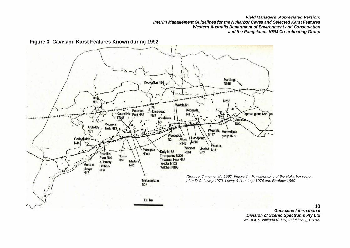
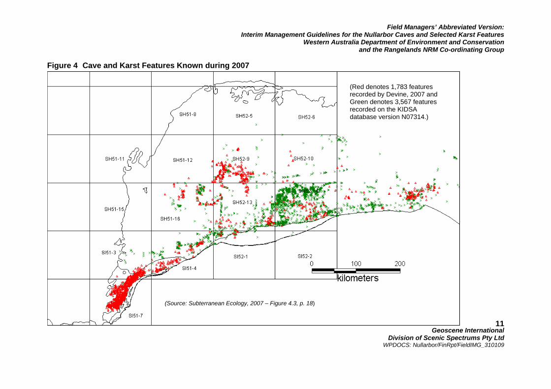
2.7.1 Geologic and Geomorphic Values The Nullarbor Karst is the largest karst area in Australia and the largest contiguous karst formation in the world. The arid nature of the Nullarbor Karst is highly significant in term of the type and variety of speleothems and other karst features within the caves. A high number of karst features, including dongas, blowholes, rockholes, dolines and caves of various types with dry and underwater sections exist (refer to Figures 3 and 4). Many rare and beautiful internal cave features known as speleothems also occur throughout the caves. Devine (2003, as quoted by Subterranean Ecology, 2007) indicates that there are potentially 50,000 karst features on the Nullarbor. KIDSA currently have just over 3500 karst features recorded, including 684 caves, 1,169 blowholes, 926 dolines, 533 rockholes and rock shelters, and 255 other karst features (Subterranean Ecology, 2007 – Table 4-1, p. 14). Recent discoveries on the Mardabilla Plain (Devine, 2007 and other unpublished data) have greatly increased the number of known karst features. Subterranean Ecology (2007, p. 19) estimate that only 7% of the total potential caves have been recorded to date. It is estimated that over 50,000 caves and karst features are likely to exist in the Nullarbor region. The plan length of caves and blowholes entails over 73 km of dry cave passages and over 11 km of wet passages in Western Australia. 2.7.2 Ecological, Flora and Fauna Values The area supports a wide range of “at risk” rare, endangered, vulnerable and/or endemic flora and fauna species on the ground surface areas. Within the soils, regolith and cave passages, a wide range fauna exist, including troglofauna, stygofauna, guanofauna, edaphobites, bat species and bird species. A high degree of endemism exists for many of these species. The caves and dolines play a refugia role for many of the species. Many of the species are distinctive and highly diverse and representative examples of relictual subterranean fauna are found in the caves of Roe Plain and the Hampton Tableland.
WHAT ARE SPELEOTHEMS? Speleothems are cave features formed through calcium, solution, gypsum or salt crystalisation processes. They include halite, calcite and gypsum speleothems (mainly calcite in the Nullarbor Karst Region). Halite speleothems are very delicate and beautiful in their form and may occur as fibres, crusts, stalactites, stalagmites, columns and calcite rafts. Halite speleothems have been identified in at least seven caves and are most abundant and diverse in Mullamullang Cave (N37). They can be very large or of micro proportions. Halite speleothems are considered to be very rare and fragile. Gypsum speleo-thems occur as needles, crusts and flowers on roofs and walls, as crusts near lakes and as coarse curving crystals in floor mud deposits, stalactites and as secondary deposits on calcite speleothems. Gypsum speleothems are relatively rare in Australia, but not on the Nullarbor, where significant deposits in caves are known. Refer to Davey, et al. (1992) and ASF (1978).
Field Managers’ Abbreviated Version: Interim Management Guidelines for the Nullarbor Caves and Selected Karst Features
Western Australia Department of Environment and Conservation and the Rangelands NRM Co-ordinating Group
Geoscene International
Division of Scenic Spectrums Pty Ltd WPDOCS: Nullarbor/FinRpt/FieldIMG_310109
10
Figure 3 Cave and Karst Features Known during 1992
(Source: Davey et al., 1992, Figure 2 – Physiography of the Nullarbor region: after D.C. Lowry 1970, Lowry & Jennings 1974 and Benbow 1990)
Field Managers’ Abbreviated Version: Interim Management Guidelines for the Nullarbor Caves and Selected Karst Features
Western Australia Department of Environment and Conservation and the Rangelands NRM Co-ordinating Group
Geoscene International
Division of Scenic Spectrums Pty Ltd WPDOCS: Nullarbor/FinRpt/FieldIMG_310109
11
Figure 4 Cave and Karst Features Known during 2007
(Red denotes 1,783 features recorded by Devine, 2007 and Green denotes 3,567 features recorded on the KIDSA database version N07314.)
(Source: Subterranean Ecology, 2007 – Figure 4.3, p. 18)
Field Managers’ Abbreviated Version: Interim Management Guidelines for the Nullarbor Caves and Selected Karst Features
Western Australia Department of Environment and Conservation and the Rangelands NRM Co-ordinating Group
Geoscene International
Division of Scenic Spectrums Pty Ltd WPDOCS: Nullarbor/FinRpt/FieldIMG_310109
12
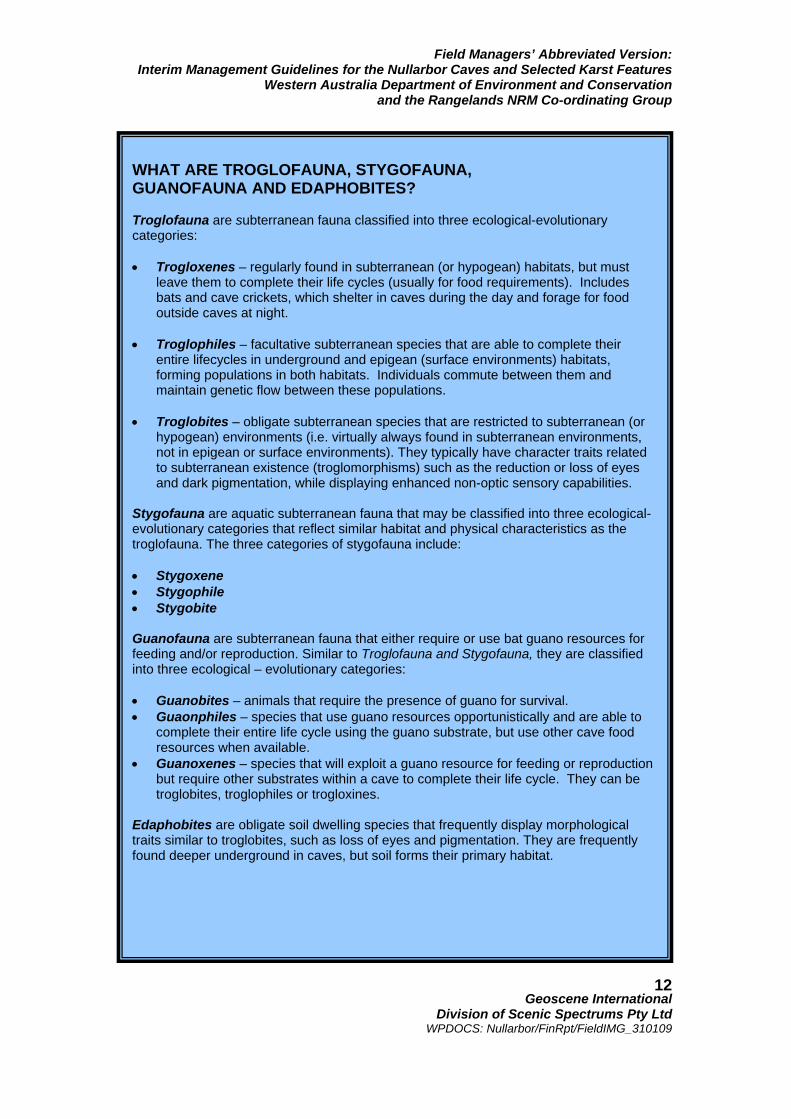
WHAT ARE TROGLOFAUNA, STYGOFAUNA, GUANOFAUNA AND EDAPHOBITES? Troglofauna are subterranean fauna classified into three ecological-evolutionary categories: • Trogloxenes – regularly found in subterranean (or hypogean) habitats, but must
leave them to complete their life cycles (usually for food requirements). Includes bats and cave crickets, which shelter in caves during the day and forage for food outside caves at night.
• Troglophiles – facultative subterranean species that are able to complete their
entire lifecycles in underground and epigean (surface environments) habitats, forming populations in both habitats. Individuals commute between them and maintain genetic flow between these populations.
• Troglobites – obligate subterranean species that are restricted to subterranean (or
hypogean) environments (i.e. virtually always found in subterranean environments, not in epigean or surface environments). They typically have character traits related to subterranean existence (troglomorphisms) such as the reduction or loss of eyes and dark pigmentation, while displaying enhanced non-optic sensory capabilities.
Stygofauna are aquatic subterranean fauna that may be classified into three ecological-evolutionary categories that reflect similar habitat and physical characteristics as the troglofauna. The three categories of stygofauna include: • Stygoxene • Stygophile • Stygobite Guanofauna are subterranean fauna that either require or use bat guano resources for feeding and/or reproduction. Similar to Troglofauna and Stygofauna, they are classified into three ecological – evolutionary categories: • Guanobites – animals that require the presence of guano for survival. • Guaonphiles – species that use guano resources opportunistically and are able to
complete their entire life cycle using the guano substrate, but use other cave food resources when available.
• Guanoxenes – species that will exploit a guano resource for feeding or reproduction but require other substrates within a cave to complete their life cycle. They can be troglobites, troglophiles or trogloxines.
Edaphobites are obligate soil dwelling species that frequently display morphological traits similar to troglobites, such as loss of eyes and pigmentation. They are frequently found deeper underground in caves, but soil forms their primary habitat.
Field Managers’ Abbreviated Version: Interim Management Guidelines for the Nullarbor Caves and Selected Karst Features
Western Australia Department of Environment and Conservation and the Rangelands NRM Co-ordinating Group
Geoscene International
Division of Scenic Spectrums Pty Ltd WPDOCS: Nullarbor/FinRpt/FieldIMG_310109
13
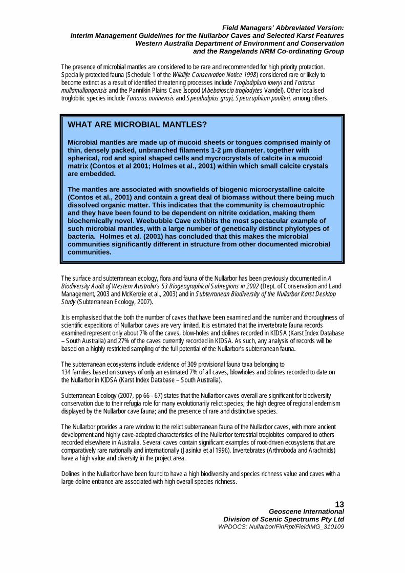
The presence of microbial mantles are considered to be rare and recommended for high priority protection. Specially protected fauna (Schedule 1 of the Wildlife Conservation Notice 1998) considered rare or likely to become extinct as a result of identified threatening processes include Troglodiplura lowryi and Tartarus mullamullangensis and the Pannikin Plains Cave Isopod (Abebaioscia troglodytes Vandel). Other localised troglobitic species include Tartarus nurinensis and Speothalpius grayi, Speozuphium poulteri, among others. The surface and subterranean ecology, flora and fauna of the Nullarbor has been previously documented in A Biodiversity Audit of Western Australia’s 53 Biogeographical Subregions in 2002 (Dept. of Conservation and Land Management, 2003 and McKenzie et al., 2003) and in Subterranean Biodiversity of the Nullarbor Karst Desktop Study (Subterranean Ecology, 2007). It is emphasised that the both the number of caves that have been examined and the number and thoroughness of scientific expeditions of Nullarbor caves are very limited. It is estimated that the invertebrate fauna records examined represent only about 7% of the caves, blow-holes and dolines recorded in KIDSA (Karst Index Database – South Australia) and 27% of the caves currently recorded in KIDSA. As such, any analysis of records will be based on a highly restricted sampling of the full potential of the Nullarbor’s subterranean fauna. The subterranean ecosystems include evidence of 309 provisional fauna taxa belonging to 134 families based on surveys of only an estimated 7% of all caves, blowholes and dolines recorded to date on the Nullarbor in KIDSA (Karst Index Database – South Australia). Subterranean Ecology (2007, pp 66 - 67) states that the Nullarbor caves overall are significant for biodiversity conservation due to their refugia role for many evolutionarily relict species; the high degree of regional endemism displayed by the Nullarbor cave fauna; and the presence of rare and distinctive species. The Nullarbor provides a rare window to the relict subterranean fauna of the Nullarbor caves, with more ancient development and highly cave-adapted characteristics of the Nullarbor terrestrial troglobites compared to others recorded elsewhere in Australia. Several caves contain significant examples of root-driven ecosystems that are comparatively rare nationally and internationally (Jasinka et al 1996). Invertebrates (Arthroboda and Arachnids) have a high value and diversity in the project area. Dolines in the Nullarbor have been found to have a high biodiversity and species richness value and caves with a large doline entrance are associated with high overall species richness.
WHAT ARE MICROBIAL MANTLES? Microbial mantles are made up of mucoid sheets or tongues comprised mainly of thin, densely packed, unbranched filaments 1-2 µm diameter, together with spherical, rod and spiral shaped cells and mycrocrystals of calcite in a mucoid matrix (Contos et al 2001; Holmes et al., 2001) within which small calcite crystals are embedded. The mantles are associated with snowfields of biogenic microcrystalline calcite (Contos et al., 2001) and contain a great deal of biomass without there being much dissolved organic matter. This indicates that the community is chemoautrophic and they have been found to be dependent on nitrite oxidation, making them biochemically novel. Weebubbie Cave exhibits the most spectacular example of such microbial mantles, with a large number of genetically distinct phylotypes of bacteria. Holmes et al. (2001) has concluded that this makes the microbial communities significantly different in structure from other documented microbial communities.
Field Managers’ Abbreviated Version: Interim Management Guidelines for the Nullarbor Caves and Selected Karst Features
Western Australia Department of Environment and Conservation and the Rangelands NRM Co-ordinating Group
Geoscene International
Division of Scenic Spectrums Pty Ltd WPDOCS: Nullarbor/FinRpt/FieldIMG_310109
14
Some of the key rare and/or vulnerable fauna examples include:
• biogeographic and ecological importance of the speleohriid copepod, a Tethyan anchialine faunal element, showing the extension of the Tethyan track to the southern continental margin of Australia and its penetration of the rift zone between Australia and Antarctica;
• the only known troglobitic species of mygalomorph spiders known in Australia;
• the only highly troglomorphic cave beetles outside Tasmania; and
• the only cave-adapted centipede and mygalomorph species in Australia that are and which are
also quite rare on a world-wide basis;
• Specially Protected Fauna (Schedule 1 of the Wildlife Conservation Notice 1998) considered to be rare or likely to become extinct as a result of identified threatening processes, including:
o Troglodiplura lowryi (a mygalomorph spider) o Tartarus mullamullangensis o Abebaioscia troglodytes Vandel (Pannikin Plains Cave Isopod) of Murra-El-Elevyn Cave.
• Likely qualification for listing on Schedule 1 by most other localised troglobitic species, such as:
o Tartarus nurinensis o Speothalpius grayi,
Speozuphium poulteri, among others; Microbial mantles are special features of the lakes and water-filled passages of Cocklebiddy, Murra-El-Elevyn, Warbla, Weebubbie, Winbirra, Pannikin Plains, Olwolgin and other cave lakes on the Nullarbor (refer to box and photo on following page). Other significant subterranean fauna and flora values of the Nullarbor include bird habitat (for the Australian Kestrel Falco cenchroides, Masked Owl Tyto novaehollandiae, Fairy Martin Hirundo ariel and Welcome Swallow Hirundo neoxena); bat habitat (for the Chocolate Wattled Bat Chalinolobus morio and the Lesser Long-eared Bat Nyctophilus geoffroii. High biological significance rankings by Subterranean Ecology (2007) are based on the Graening method. The top 20 caves in order of their biological ranking include:
1. Old Homestead Cave (N83) 2. Mullamullang Cave (N37) 3. Cocklebiddy Cave (N48) 4. Thampanna Cave (N206) 5. Nurina Cave (N46) 6. Unnamed Cave (N1327) 7. Pannikin Plain Cave (N49) 8. Weebubbie Cave (N2) 9. Burnabbie Cave (N305) 10. Encompassing Cave (N327) 11. Olwolgin Cave (N920) 12. Murra-El-Elevyn Cave (N47) 13. Abrakurrie Cave (N470) 14. Koonalda Cave (N4) 15. Warbla Cave (N1) 16. Prostrate Cave (N1369) 17. Madura Cave (N62) 18. Fern Cave (N747) 19. Windy Hollow Cave (N645) 20. Dingo Donga Cave (N160)
Field Managers’ Abbreviated Version: Interim Management Guidelines for the Nullarbor Caves and Selected Karst Features
Western Australia Department of Environment and Conservation and the Rangelands NRM Co-ordinating Group
Geoscene International
Division of Scenic Spectrums Pty Ltd WPDOCS: Nullarbor/FinRpt/FieldIMG_310109
15
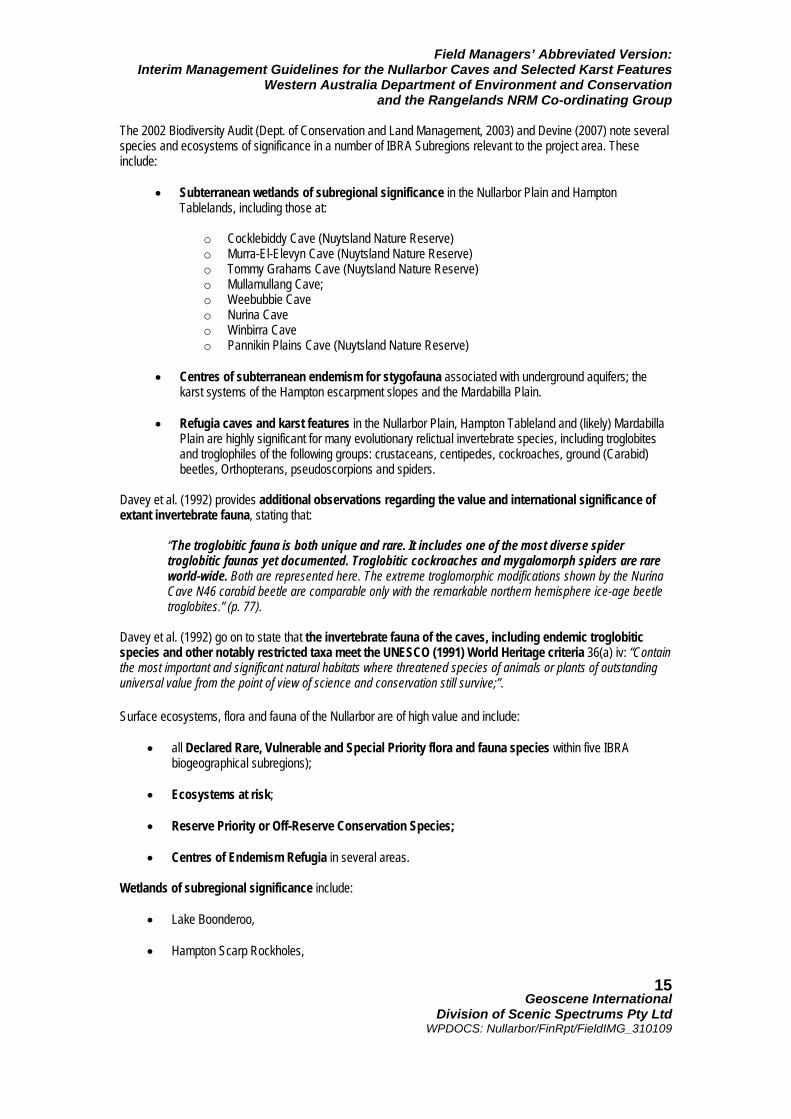
The 2002 Biodiversity Audit (Dept. of Conservation and Land Management, 2003) and Devine (2007) note several species and ecosystems of significance in a number of IBRA Subregions relevant to the project area. These include:
• Subterranean wetlands of subregional significance in the Nullarbor Plain and Hampton Tablelands, including those at:
o Cocklebiddy Cave (Nuytsland Nature Reserve) o Murra-El-Elevyn Cave (Nuytsland Nature Reserve) o Tommy Grahams Cave (Nuytsland Nature Reserve) o Mullamullang Cave; o Weebubbie Cave o Nurina Cave o Winbirra Cave o Pannikin Plains Cave (Nuytsland Nature Reserve)
• Centres of subterranean endemism for stygofauna associated with underground aquifers; the
karst systems of the Hampton escarpment slopes and the Mardabilla Plain.
• Refugia caves and karst features in the Nullarbor Plain, Hampton Tableland and (likely) Mardabilla Plain are highly significant for many evolutionary relictual invertebrate species, including troglobites and troglophiles of the following groups: crustaceans, centipedes, cockroaches, ground (Carabid) beetles, Orthopterans, pseudoscorpions and spiders.
Davey et al. (1992) provides additional observations regarding the value and international significance of extant invertebrate fauna, stating that:
“The troglobitic fauna is both unique and rare. It includes one of the most diverse spider troglobitic faunas yet documented. Troglobitic cockroaches and mygalomorph spiders are rare world-wide. Both are represented here. The extreme troglomorphic modifications shown by the Nurina Cave N46 carabid beetle are comparable only with the remarkable northern hemisphere ice-age beetle troglobites.” (p. 77).
Davey et al. (1992) go on to state that the invertebrate fauna of the caves, including endemic troglobitic species and other notably restricted taxa meet the UNESCO (1991) World Heritage criteria 36(a) iv: “Contain the most important and significant natural habitats where threatened species of animals or plants of outstanding universal value from the point of view of science and conservation still survive;”. Surface ecosystems, flora and fauna of the Nullarbor are of high value and include:
• all Declared Rare, Vulnerable and Special Priority flora and fauna species within five IBRA biogeographical subregions);
• Ecosystems at risk;
• Reserve Priority or Off-Reserve Conservation Species;
• Centres of Endemism Refugia in several areas.
Wetlands of subregional significance include:
• Lake Boonderoo, • Hampton Scarp Rockholes,
Field Managers’ Abbreviated Version: Interim Management Guidelines for the Nullarbor Caves and Selected Karst Features
Western Australia Department of Environment and Conservation and the Rangelands NRM Co-ordinating Group
Geoscene International
Division of Scenic Spectrums Pty Ltd WPDOCS: Nullarbor/FinRpt/FieldIMG_310109
16
• Duck Pond (Arubiddy Station);
• a Paleodrainage channel (on Gunnadorah Station); and
• Lake Daringdell.
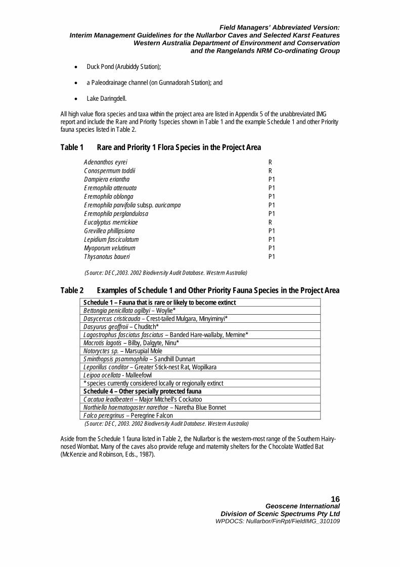
All high value flora species and taxa within the project area are listed in Appendix 5 of the unabbreviated IMG report and include the Rare and Priority 1species shown in Table 1 and the example Schedule 1 and other Priority fauna species listed in Table 2. Table 1 Rare and Priority 1 Flora Species in the Project Area (Source: DEC,2003. 2002 Biodiversity Audit Database. Western Australia) Table 2 Examples of Schedule 1 and Other Priority Fauna Species in the Project Area
(Source: DEC, 2003. 2002 Biodiversity Audit Database. Western Australia) Aside from the Schedule 1 fauna listed in Table 2, the Nullarbor is the western-most range of the Southern Hairy-nosed Wombat. Many of the caves also provide refuge and maternity shelters for the Chocolate Wattled Bat (McKenzie and Robinson, Eds., 1987).
Adenanthos eyrei R Conospermum toddii R Dampiera eriantha P1 Eremophila attenuata P1 Eremophila oblonga P1 Eremophila parvifolia subsp. auricampa P1 Eremophila perglandulosa P1 Eucalyptus merrickiae R Grevillea phillipsiana P1 Lepidium fasciculatum P1 Myoporum velutinum P1 Thysanotus baueri P1
Schedule 1 – Fauna that is rare or likely to become extinct Bettongia penicillata ogilbyi – Woylie* Dasycercus cristicauda – Crest-tailed Mulgara, Minyiminyi* Dasyurus geoffroii – Chuditch* Lagostrophus fasciatus fasciatus – Banded Hare-wallaby, Mernine* Macrotis lagotis – Bilby, Dalgyte, Ninu* Notoryctes sp. – Marsupial Mole Sminthopsis psammophila – Sandhill Dunnart Leporillus conditor – Greater Stick-nest Rat, Wopilkara Leipoa ocellata - Malleefowl * species currently considered locally or regionally extinct Schedule 4 – Other specially protected fauna Cacatua leadbeateri – Major Mitchell’s Cockatoo Northiella haematogaster narethae – Naretha Blue Bonnet Falco peregrinus – Peregrine Falcon
Field Managers’ Abbreviated Version: Interim Management Guidelines for the Nullarbor Caves and Selected Karst Features
Western Australia Department of Environment and Conservation and the Rangelands NRM Co-ordinating Group
Geoscene International
Division of Scenic Spectrums Pty Ltd WPDOCS: Nullarbor/FinRpt/FieldIMG_310109
17
2.7.3 Indigenous Heritage The Nullarbor Karst System has been home to Aboriginal people groups for tens of thousands of years. The area is significant for its anthropological values and for its archaeological values with some evidence of Aboriginal cave paintings and rockhole modifications. The project area has considerable significance to the Aboriginal commun-ities and the Traditional Owners of the region. The Aboriginal communities with potential interest include the Mirning People and the Ngadju People. Up to four or more Native Title claims are currently being considered for the project area, including the Esperance – Nyungar Claim, the Mirning Claim, the Ngadju Claim, the Ngadjunngarra Claim, and the Nullarbor Claim. The Goldfields Land & Sea Council (GLSC) is the Native Title Representative Body for the project area. Aboriginal heritage and heritage sites are recognised and protected through a number of legislative Acts, including the Australian Heritage Council Act 2003 (Cth), the Aboriginal Heritage Act 1972 (WA) and the Heritage Act of Western Australia 1990. Indigenous cultural heritage places, sites and features are protected under the Aboriginal Heritage Act 1972 (WA) and may potentially include: habitation sites, seed grinding sites, habitation structures, middens, stone artifact factory sites, marked trees, burial sites, stone structures, paintings, engravings, caches, ceremonial grounds, etc. All information received regarding potential Aboriginal sites is placed on the Register of Aboriginal Sites by the DIA, including supporting evidence. In relation to caves, some example Registered Aboriginal Sites are located at Dingo Cave on Moonera Station; Wapet, Joe’s, Mullamullang, Spider Sink and Kestrel No. 2 caves and Parritappa Doline on Madura Station; Madura Cave on Madura Station; Snake Pit and Webbs caves on Mundrabilla Station; Weebubbie Cave, Weebubbie Road Blowhole, Chowilla Landslip, Abrakurrie, Winbirra, and Kangaroo caves; and Cocklebiddy Cave in Nuytsland Nature Reserve. GLSC have prepared draft Traditional Usage Guidelines on behalf of the Traditional Owners of the Goldfields and Esperance regions intended for use by DEC and other government departments in relation to the recognition of Aboriginal Cultural Heritage, traditional indigenous activities and the Traditional Owners extensive knowledge of the country and its cultural and ecological relationships. 2.7.4 Non-Indigenous Heritage Non-Indigenous or European history in the project area dates back to the early explorations of Nuyts during 1627 and French and British explorers during the 1790s and early 1800s. Although European settlement of the Nullarbor has always involved relatively small populations, the Nullarbor has many important historic sites, places and structures as assessed in local and national terms. The Nullarbor karst supports some large pastoral leasehold properties that are iconic representations of life in the Australian Outback. Non-indigenous heritage sites are protected under the Heritage of Western Australia Act 1990, the Historic Shipwrecks Act 1976 (Cth) or the Aboriginal and Torres Strait Islander Heritage Protection Act 1984 (Cth). Non-Indigenous heritage sites and places may be listed under the former Commonwealth Register of National Estate, the National and Commonwealth Heritage Lists, the Western Australian Register of Heritage Places. Heritage Places may also be listed under Municipal Inventories or recorded/classified by the National Trust of Australia (WA Branch). Site registers and listings include the former Commonwealth Register of National Estate, the National and Commonwealth Heritage Lists, the Western Australian Register of Heritage Places or the Western Australian Geo-heritage Register. Natural heritage places may also be listed under Municipal Inventories or recorded/classified by the National Trust of Australia (WA Branch). Examples of non-indigenous cultural heritage places, sites and features these within the project area include: National Heritage Register sites (e.g., the Eucla Area, Nuytsland Nature Reserve, Old Telegraph Station
Field Managers’ Abbreviated Version: Interim Management Guidelines for the Nullarbor Caves and Selected Karst Features
Western Australia Department of Environment and Conservation and the Rangelands NRM Co-ordinating Group
Geoscene International
Division of Scenic Spectrums Pty Ltd WPDOCS: Nullarbor/FinRpt/FieldIMG_310109
18
at Balladonia) and State Heritage Register sites (e.g. Eucla Jetty, Old Eucla Telegraph Station, Eyre Telegraph Station, Mallee Tree, and Weebubbie Cave). Heritage sites on the Register of the National Estate, on the Western Australian Register of Heritage Places, the National Trust of Australia (WA Branch) or by the Shires of Dundas or Esperance are provided in Appendix 2. 2.7.5 Tourism, Recreation and Wilderness Values, Facilities
and Activities Recreation, tourism and wilderness values are clearly highly important values of the Nullarbor given its unique landscape features, its isolation and the popularity and notoriety of “crossing the Nullarbor” by travelers from throughout Australia and overseas. Tourism opportunities for the region noted by the (draft) Shire of Dundas Coastal Management Plan (South Coast Consulting, 2003) include:
o Landscape Features e.g. caves, cliffs, cave diving, underground lakes, fossils; o Flora and Fauna Experiences e.g. Eyre Bird Observatory, whale watching, fishing; o Nullarbor Experiences e.g. outback camping, star gazing, camel trekking; o Historical Adventures e.g. visiting ruins, travelling the Telegraph Line, where Eyre travelled, where
Baxter was buried; o Festival Experiences e.g. Eucla Gold Day, Eucla Shoot; o Nullarbor Products e.g. local seafood, artwork; o Research Expeditions e.g. marine, caving, flora, fauna, geology.
The Eyre Bird Observatory (housed within the former Eyre Telegraph Station) annually runs environmental and educational courses, including bat banding in Murra El Elevyn Cave, Malleefowl surveys on the Roe Plain and other activities. Annual visitor numbers to the Nullarbor’s Conservation Estate were quite low during 2006-2007, ranging from 5,500 visitor days at Nuytsland Nature Reserve, to 1000 visitor days each for Eucla National Park and for Dundas Nature Reserve. Queen Victoria Spring Nature Reserve had an estimated 100 visitor days, while the Great Victoria Desert Nature Reserve had only 20 estimated visitor days. This data has been provided by DECs Recreation and Tourism Information System (RATIS) database. Wilderness values of the Nullarbor are very high, as indicated by Davey et al. (1992, p. 79). 2.7.6 Scientific Research and Education Values Davey et al. (1992) state that scientific research and education values are high for the project area and for the Nullarbor Karst System in general. Scientific values of the planning area include (among many others):
o Geologic and geomorphic values o Speleological values o Hydrologic values o Botanical values (flora) o Zoological values (fauna) o Biodiversity values (flora and fauna) o Archaeological values o Anthropological values o Paleontological values;

Field Managers’ Abbreviated Version: Interim Management Guidelines for the Nullarbor Caves and Selected Karst Features
Western Australia Department of Environment and Conservation and the Rangelands NRM Co-ordinating Group
Geoscene International
Division of Scenic Spectrums Pty Ltd WPDOCS: Nullarbor/FinRpt/FieldIMG_310109
19
Davey et al. (1992) also state that “the Nullarbor is regarded internationally as the classical area for the study of arid land karst processes”; “The Nullarbor Plain is a vast educational resource at all levels in that it demonstrates all aspects of the formation of karst landforms in an arid climate”. The Nullarbor is also a highly valuable exploration destination, with explorations since the 1950s leading to a range of very important scientific discoveries and research opportunities. Most of these scientific and research values have been summarised above. Further brief summaries of the paleoenvironmental and archaeological values are provided here. Paleoenvironmental Values High paleoenvironmental values associated with fossils, subfossils, sediments, speleothems and other evidence of climate and forms of plants, animals and environmental conditions existing in prehistoric or geologic times are found on the Nullarbor. An unusually high number of paleological sites are distributed over a vast area (800 km x 400 km). Nullarbor paleoenvironmental data is prominent in continental interpretations of Australian environmental change and prehistory (e.g., Bowler 1982; Bowler, 1976; Galloway & Kemp 1981; Wasson 1982; Prideaux et al. 2007) and paleoclimatic evidence up to 350,000 years old (Davey et al. 1992). Well-preserved skeletons, tissue materials and mummified carcasses of Thylacine Thylacinus cynocephalus dated from 3300 – 4600 years BP have been found in Murra-El-Elevyn Cave N47 and Thylacine Hole N63 (Partrige 1967; Lowry & Lowry, 1967). Extinct megafauna has been found in the Thylacoleo Caves, including the prehistoric marsupial lion, Thylacoleo carnifex, displaying a mixed diversity compared to other Pleistocene fossils found elsewhere in Australia (Prideaux, 2006; Prideaux et al., 2007) The extinct Stick-nest Rat (Leporillus spp.) and associated pseudobitumen deposits have been found in many of the Nullarbor dolines and cave entrances. Archaeological Values High value archaeological materials and findings include:
• At least 60 archaeological sites have been identified on the Nullarbor Plains (unsure of how many
of these are within Western Australia).
• Koonalda Cave (South Australia) exhibits Aboriginal rock art and is thought to have been used as a flint mine and migratory watering point. These prehistoric uses are estimated to date back to 15,000 to 22,000 years BP (Gallus, 1968a; 1968b; and 1971; Hirst, 2008);
• Cave art has been confirmed in five sites on the Nullarbor and further discoveries of cave art are
thought to be likely;
• Allen’s Cave contained potential evidence of one of the earliest human occupations in an arid zone (yet to be corroborated) up to 40,000 years BP.
2.7.7 Scenic Resources Scenic resources include the visual landscape and the human appreciation of scenic beauty of the Nullarbor caves and associated karst features of focus. CALM’s (1994) assessed the Nullarbor Plain Landscape Character Subtype as having moderate to high scenic quality (CALM, 1994).
Field Managers’ Abbreviated Version: Interim Management Guidelines for the Nullarbor Caves and Selected Karst Features
Western Australia Department of Environment and Conservation and the Rangelands NRM Co-ordinating Group
Geoscene International
Division of Scenic Spectrums Pty Ltd WPDOCS: Nullarbor/FinRpt/FieldIMG_310109
20
Some of the notable features are the variety of landforms in the area including the steep cliffs (e.g. Baxter Cliffs), flat caves entrances (e.g. Cocklebiddy Cave), abrupt appearance of an escarpment (e.g. Hampton Scarp) and the formation and height of wind formed dunes (e.g., Delisser sand dunes and Eyre sand dunes). The vegetation also provides variety with pockets of taller vegetation in low lying areas that contrast with the surrounding adjacent low saltbush dominated plains.
Frame of reference assessment criteria for features of high or moderate scenic quality prepared by CALM (1994) are provided in Appendix 3. 2.7.8 Economic Values Economically, the Nullarbor region has a very low population and is generally undeveloped except for pastoral uses, a relatively low level of commercial fishing and some mining and petroleum exploration (with relatively little current mineral extraction). High value mineral sands and other mineral resources are thought to exist in the area and exploration continues with unknown, but potentially high economic value. Tourism is important to the area, but is based on relatively low visitor numbers and expenditures compared with other regions of Australia due to the remoteness of the area and the lack of infrastructure, accommodation and activities. Tourism may have greater future potential if developed and managed appropriately. 3. Land Tenure, Legislative and Management Framework 3.1 Land Tenure The major categories of tenure within the project area include:
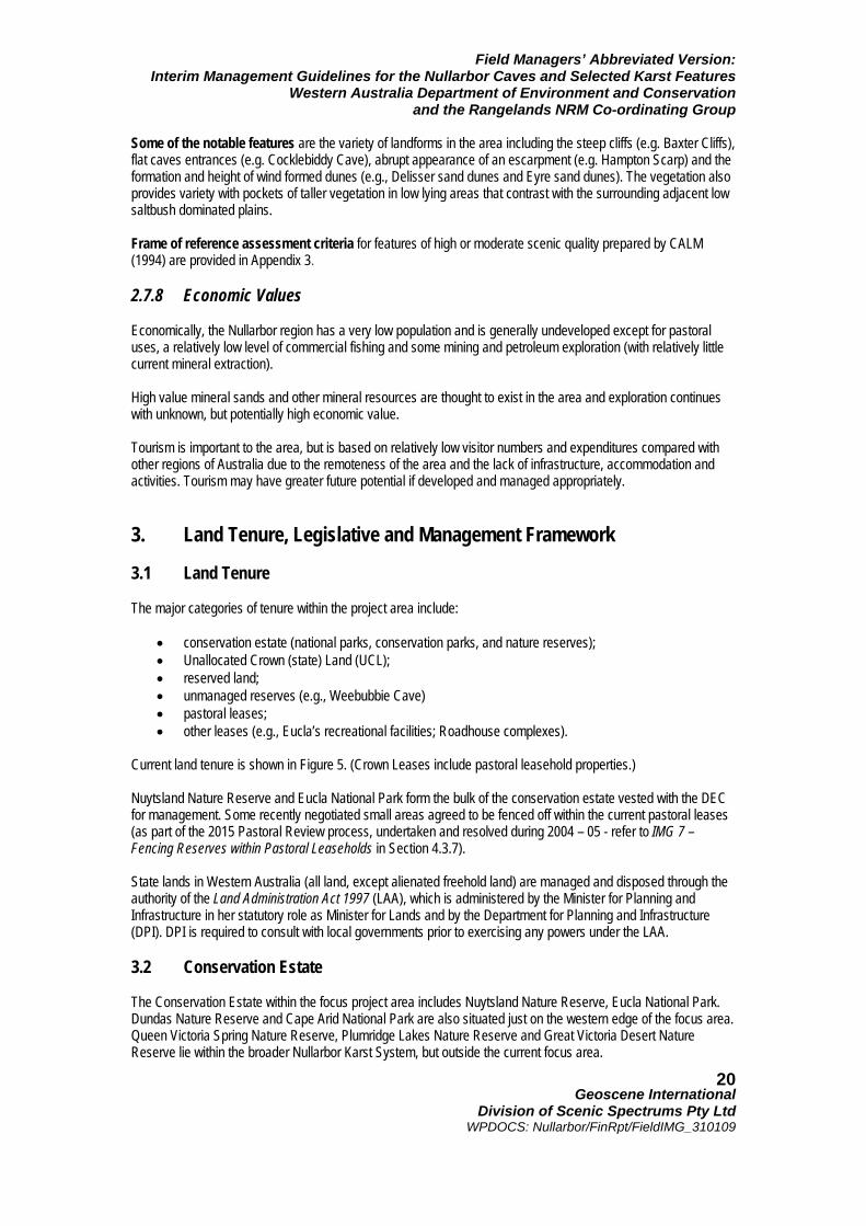
• conservation estate (national parks, conservation parks, and nature reserves); • Unallocated Crown (state) Land (UCL); • reserved land; • unmanaged reserves (e.g., Weebubbie Cave) • pastoral leases; • other leases (e.g., Eucla’s recreational facilities; Roadhouse complexes).
Current land tenure is shown in Figure 5. (Crown Leases include pastoral leasehold properties.) Nuytsland Nature Reserve and Eucla National Park form the bulk of the conservation estate vested with the DEC for management. Some recently negotiated small areas agreed to be fenced off within the current pastoral leases (as part of the 2015 Pastoral Review process, undertaken and resolved during 2004 – 05 - refer to IMG 7 – Fencing Reserves within Pastoral Leaseholds in Section 4.3.7). State lands in Western Australia (all land, except alienated freehold land) are managed and disposed through the authority of the Land Administration Act 1997 (LAA), which is administered by the Minister for Planning and Infrastructure in her statutory role as Minister for Lands and by the Department for Planning and Infrastructure (DPI). DPI is required to consult with local governments prior to exercising any powers under the LAA. 3.2 Conservation Estate The Conservation Estate within the focus project area includes Nuytsland Nature Reserve, Eucla National Park. Dundas Nature Reserve and Cape Arid National Park are also situated just on the western edge of the focus area. Queen Victoria Spring Nature Reserve, Plumridge Lakes Nature Reserve and Great Victoria Desert Nature Reserve lie within the broader Nullarbor Karst System, but outside the current focus area.
Field Managers’ Abbreviated Version: Interim Management Guidelines for the Nullarbor Caves and Selected Karst Features
Western Australia Department of Environment and Conservation and the Rangelands NRM Co-ordinating Group
Geoscene International
Division of Scenic Spectrums Pty Ltd WPDOCS: Nullarbor/FinRpt/FieldIMG_310109
21
Figure 5 Land Tenure of the Karst System with Caves
Dundas Nature Reserve
Cape Arid National Park
Queen Victoria Spring Nature Reserve
Eucla National Park
Cundeelee Aboriginal Reserve
Unallocated Crown Lands (Unshaded Areas)
Unallocated Crown Lands (Unshaded Areas)
(Source: Adapted from Subterranean Ecology, 2007 p. 20 – Figure 4 – 4)

Field Managers’ Abbreviated Version: Interim Management Guidelines for the Nullarbor Caves and Selected Karst Features
Western Australia Department of Environment and Conservation and the Rangelands NRM Co-ordinating Group
Geoscene International
Division of Scenic Spectrums Pty Ltd WPDOCS: Nullarbor/FinRpt/FieldIMG_310109
22
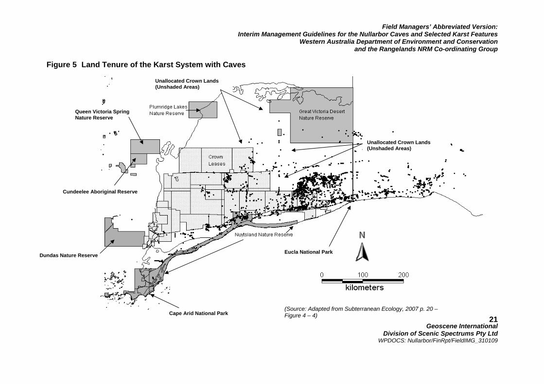
3.3 Legislative and Management Framework A large number of legislative Acts apply to the Nullarbor at the Commonwealth and Stage Government levels. The legislation and key management vestings, government agencies, policies and strategies that apply to the project area are detailed in Appendix 1. The most important aspect of this statutory framework is that DEC is responsible on behalf of the Conservation Commission of Western Australia (CCWA) for only those caves and associated karst features within the conservation estate. The Department of Planning and Infrastructure (DPI) is responsible for these features within Unallocated Crown Lands and within Pastoral Leasehold lands. This has some bearing on how caves, blowholes and dolines are managed and how cave access permits are administered. The Rangelands NRM Co-ordinating Council have their role in the region through the directives of the Commonwealth Department of Environment, Water, Heritage and the Arts (DEWHA). Many other State Government agencies have specific roles regarding the management or regulation of various other natural and cultural resources, as referred to further. The vestings, jurisdictions and policies of these various agencies tend to overlap with each other throughout the project area. These issues are raised through the full IMG report and outlined in Appendix 1. 4. Recommended Interim Management Guidelines 4.1 Introduction to the Guidelines and Management Context The following Interim Management Guidelines are recommended to address key issues that may need to be addressed within the next five years. The guidelines are not meant to replace existing legislation, regulations or policies relevant to the Nullarbor caves, blowholes and dolines within the project area, but should be complimentary. They guidelines are not meant to form a management plan at this time, but to provide guidance and direction for the management of key issues and the implementation of certain operational objectives and infrastructure that may arise in the interim. Given the combination of high environmental and cultural values and the mix of land tenure and management vestings there are a very wide range of management issues. Figure 6 provides an overview of this range of issues. In reviewing these issues, it is useful to recognise that the purpose of this report is to prepare Interim Management Guidelines for implementation over the next five years in order that essential field operations and management decisions can be carried out while a full management plan is in waiting. In addition, the focus is on the protection and management of the caves, dolines and blowholes and their immediate surrounds. What we are basically trying to do is take the first significant step towards some type of agreed, united on-ground management by a number of key stakeholders around the cave and karst areas that we believe are currently under potential existing threat. Maintenance and protection of the caves, dolines and blowholes (and where necessary recovery or rehabilitation), along with the associated surface ecosystems, flora and fauna are the central focus of the guidelines. Minimisation and protection of the resources from either direct or indirect damage by cave visitation and usage (for recreational or research purposes) or by land use activities and other environmental factors should be the primary objective. As Figure 6 indicates, all resource uses occurring within the broad legislative and management framework (as described in Section 3 and Appendix 1) may potentially result in various impacts to the caves and their associated karst features and ecosystems. The management framework should provide management and planning policies and programs designed to monitor and protect the resource condition and use.
Field Managers’ Abbreviated Version: Interim Management Guidelines for the Nullarbor Caves and Selected Karst Features
Western Australia Department of Environment and Conservation and the Rangelands NRM Co-ordinating Group
Geoscene International
Division of Scenic Spectrums Pty Ltd WPDOCS: Nullarbor/FinRpt/FieldIMG_310109
23
Figure 6 Overview of Impact Management Issues and Relationships Regarding the Nullarbor Caves, Dolines, and Blowholes and Associated Karst Areas
(Source: Geoscene International, 2008)
Field Managers’ Abbreviated Version: Interim Management Guidelines for the Nullarbor Caves and Selected Karst Features
Western Australia Department of Environment and Conservation and the Rangelands NRM Co-ordinating Group
Geoscene International
Division of Scenic Spectrums Pty Ltd WPDOCS: Nullarbor/FinRpt/FieldIMG_310109
24
The upper cells of Figure 6 show that the resources may potentially be damaged or degraded through:
• vegetation removal or damage; • groundwater diversions or depletion; • pollution or contamination; • erosion and sedimentation; • disease and infections, and • predators and competitors (plants or animals).
These forms of damage may arise through the various land uses of the area (e.g. tourism and recreation, pastoralism, mining, or Indigenous uses) or through environmental factors or events (e.g. pest plants and animals or wildfire). Aside from reliance on statutory laws and regulations, managers may also modify or control the potential land uses and impacts through a combination of:
• establishment of Conservation Reserves; • co-operative management and agreements (with freehold and leasehold landholders); • lease and licensing conditions (as applied to pastoral leases); • Native Title agreements, or • other management actions and operations.
The lower cells of Figure 6 show that the resources may potentially be damaged or degraded through:
• soil or surface cover compaction (or trampling); • breakage (primarily relating to speleothems or other internal cave features); • removal of speleothems, fossils, fauna, flora, etc.; or • contamination (e.g., chemical pollution, bacterial/fungal/virus invasions).
These impacts may potentially arise through recreational and tourism uses, cave rescue and safety training, research and exploration or various Indigenous uses. Such land uses and impacts may be modified or controlled through a combination of:
• controls/limitations on public knowledge of the location of the cave and karst features; • controls/limitations on physical access to the cave and karst sites (e.g. by not providing or restricting
vehicular and other forms of access); • user permit and licensing procedures; and • education and training (i.e., regarding cave and karst values, vulnerability and how to visit or use the
resources in an environmentally sensitive and sustainable manner). 4.2 Key Issue Areas Addressing all of the various issues raised by the flow chart in Figure 6 would certainly require a full management plan. For the purposes of the IMGs, it is suggested that the following are the key issue areas to be addressed for the interim period of management: (roughly in order of priority, but not absolutely so):
1. the use of caves and potential impacts on caves associated with:
• recreation & tourism uses; • research & exploration uses; and • rescue & safety training uses;
2. ecosystem, flora and fauna issues 3. pastoral uses and potential impacts on caves;
Field Managers’ Abbreviated Version: Interim Management Guidelines for the Nullarbor Caves and Selected Karst Features
Western Australia Department of Environment and Conservation and the Rangelands NRM Co-ordinating Group
Geoscene International
Division of Scenic Spectrums Pty Ltd WPDOCS: Nullarbor/FinRpt/FieldIMG_310109
25
4. mining uses and potential impacts on caves; 5. transport and communications infrastructure and associated impacts on caves; 6. issues related to indigenous cultural heritage and aboriginal recognition and co-operation; 7. safety and liability issues; and 8. consideration of enhanced management frameworks.
Each of these key issue areas involve a number of specific issues that may require IMGs, taking in several of the other considerations raised in Figure 6. These will be discussed further below. Several other uses with potential impacts are relatively well-addressed by existing regulations, guidelines and practices. Indigenous use of the area is relatively low-profile. Protocols are in place for co-operative Aboriginal access and management under current land tenure arrangements. Until current Native Title claims are resolved, it is difficult to add to the guidelines and agreed arrangements already in place. Wildfire or bushfire regulations and response guidelines are also in place. Apparently wildfires do not occur too often on the Nullarbor, but given the remoteness of the area and the low population, wildfires often go unchecked until they burn out naturally. In a similar fashion to wildfires, pest plant and animal controls are generally in place, along with protective measures for flora and fauna species declared under the EPBC Act, the Conservation and Land Management Act 1984 or the Wildlife Conservation Act 1950. New road and railway construction in the region is minimal, with most issues related to repairs and maintenance. Most of the issues are relatively site specific and would be handled through existing regulations and environmental management requirements of Main Roads, the railway authority and their contractors. Many existing management guidelines and regulations are in place regarding pastoral and mining uses. However, specific aspects of these should be reviewed in light of the focus issues of this report and recent adjustments to tenure and reserve allocations. The issues addressed will consider options regarding the range of land use and impact modifiers noted in Figure 6, including the application where appropriate of: Conservation Reserves; co-operative management and agreements; lease and licensing conditions, and management actions and operations. Each of these key issues and details regarding current management procedures and circumstances are fully reviewed in Section 5 of the unabbreviated IMG report, which should be read by all Nullarbor field managers. 4.3 Interim Management Guidelines for the General Management
and Use of Caves 4.3.1 IMG 1: Vesting of Cave Management A brief Discussion Paper should be prepared and considered regarding the vesting of primary responsibility for management of all caves, blowholes and dolines in the Nullarbor karst system with a single State Government authority for the purposes of rationalising and better managing g issues of visitor use, user permits, management classifications, facility provision, risk management, monitoring use and condition, safety and liability, and public relations and education regarding use. Although DEC would seem to be the logical authority to take on the central responsibility for cave and related karst resources, the appropriate agency should be given consideration and recommendation by a joint committee with appropriate representation. This may require some minor adjustments to existing regulations and management guidelines.
Field Managers’ Abbreviated Version: Interim Management Guidelines for the Nullarbor Caves and Selected Karst Features
Western Australia Department of Environment and Conservation and the Rangelands NRM Co-ordinating Group
Geoscene International
Division of Scenic Spectrums Pty Ltd WPDOCS: Nullarbor/FinRpt/FieldIMG_310109
26
Key Partnerships: DEC, DPI, PBL, SLS, DIA, GSLC and WAM. 4.3.2 IMG 2: Management Advisory Committee The Caves Management Advisory Committee (CMAC) has been established to assist with the management of the caves in the Leeuwin-Naturaliste National Park and other areas of southwest Western Australia. CMAC may provide a model that can be considered for the establishment of a similar advisory committee for the Nullarbor caves and karst area, perhaps to be referred to as the Nullarbor Caves and Karst Management Advisory Committee (NCKMAC) 5. Although there may be some cross-membership between CMAC and NCKMAC with one or two members initially, both areas require separate people with good knowledge of each region and the specific cave and karst resources of each. In addition, in consideration of time demands on committee members, it is best to have different people serving on the different committees. The committee should include representatives from the relevant Aboriginal communities, the local Nullarbor community, pastoralists, speleologists and other specialists. Key Partnerships: DEC, DPI, ASF, ACKMA, WASG, SRGWA, CDAA, WAM, GLSC, and local community and pastoralist representatives. 4.3.3 IMG 3: Cave Access Permit System Consideration should be given to standardising, rationalising, strengthening and promoting the Cave Access Permit System. Extend and improve the application of the current DEC Cave Access Permit System as a central procedure and regulation implemented by DEC and DPI. Consider how the same procedure can be applied by both government agencies or whether only one of them (likely DEC) should be vested with the responsibility as per IMG 1. Along with this, the regulations regarding the requirement for all cave visitors to have a permit prior to entering any cave in the Nullarbor region should be considered for any necessary improvement or strengthening. Some flexibility should be built into the permit process to consideration a higher level of security clearance for some cave explorers who have proven themselves to be more experienced, safe and trust-worthy. The permit requirements should be more widely advertised and promoted among all specialist dry caving groups, cave diving groups, outdoor education leaders, tour operators and the general community. Consideration should be given to standardising all Caving Leader/Cave Diving Leader training courses, required qualification certificates and licenses. In addition, streamlining and automating as much of the permit system and its record-keeping functions should be examined, including the use of specialised cave permit software and karst management database such as TRIPMan (Webb, 2006). Annual records of the number of visitors, length of stay, purpose and activities in each destination should be maintained in as detailed a manner as possible to assist with the longer term management planning needs of the area. Key Partnerships: DEC, DPI, ASF, ACKMA, WASG, SRGWA, CDAA, WAM, GLSC, and Tourism WA NOTE 5: NCKMAC could potentially substitute for the listing of key partnerships with ASF, ACKMA, WASG, SRGWA, CDAA, WAM, GLSC, Tourism WA and Pastoralists as indicated for most IMGs.
Field Managers’ Abbreviated Version: Interim Management Guidelines for the Nullarbor Caves and Selected Karst Features
Western Australia Department of Environment and Conservation and the Rangelands NRM Co-ordinating Group
Geoscene International
Division of Scenic Spectrums Pty Ltd WPDOCS: Nullarbor/FinRpt/FieldIMG_310109
27
4.3.4 IMG 4: Cave Management Classification System A preliminary application of the DEC Cave Management Classification System should be applied to the caves, blowholes and dolines currently listed on the CEGSA Cave Prioritisation or Risk Assessment list and to any other caves that receive notable use. (An example of the DEC Cave Management Classification System is shown in Table 3). This should incorporate and improve on the current Cave Risk Assessment, giving due consideration to classifying and prioritising caves, blowholes and dolines based on a full range of values as those can practically be assessed (including biodiversity ranking, speleological values and vulnerability, archaeological, palaeological, and Indigenous cultural values, etc.). Key Partnerships: DEC, DPI, ASF, ACKMA, WASG, SRGWA, CDAA, WAM, GLSC, Tourism WA and Pastoral Leaseholders with caves being classified. 4.3.5 IMG 5: Assessment of Cave Risks to Visitors What is currently referred to as the CEGSA Cave Prioritisation or Risk Assessment Table may be misconstrued by some as a comprehensive “risk assessment” rather than as a limited “cave vulnerability” table. It should be renamed and incorporated into the Cave Management Classification System (as per IMG 4). As resources permit and based on cave classifications and prioritisation resulting from IMG 4, assessments of cave risks to visitors who may enter caves should be assessed using appropriate geophysical and Australian Standard risk assessment procedures. Other factors should be considered when assessing risks to visitors, such as the type of visitor group, their experience and qualifications, the type of equipment used for different areas and purposes. The risk assessments should be maintained in a central database for referral and consideration in the application of the Cave Management Classification System and the Cave Access Permit System. The classification of caves as Tourist, Adventure or Restricted Access should be dependent on the assessment of cave risks to visitors. The priorities for determining which caves should be assessed for their risks to visitors should be influenced by a preliminary assessment of which caves should be categorised into which cave classification (i.e., it is likely that caves considered for the Tourist Cave classification should be assessed for their risks to visitors first to determine whether the level of risk may be too great or cost too much to mitigate for certain caves to be considered for the Tourist Cave category). To this extent, this guideline raises a potential “chicken-or-egg-first” dilemma. However, for interim purposes, it is probably more practical to complete preliminary cave classifications first, followed by risk assessments of specific caves as time and budget permit. Key Partnerships: DEC, DPI, PBL/SLS, ASF, ACKMA, WASG, SRGWA, CDAA, WAM, GLSC, Tourism WA and Pastoral Leaseholders. 4.3.6 IMG 6: Locked Access for Selected Caves Based on the outcomes of IMG 4 and IMG 5, selected caves should be considered by NCKMAC for fencing, gating and locking as time and budget permit. When locked gates or doors are involved, care should be taken that existing diurnal air flows into and out of caves is maintained unimpeded. The natural movement of fauna in and out of the caves should also not be impeded (i.e., for bats, owls and other fauna as appropriate.). All fencing and locking of access gates should preferably be implemented as part of a site development plan and landscape design concept plan. Key Partnerships: DEC, DPI, ASF, ACKMA, WASG, SRGWA, CDAA, WAM, GLSC, Tourism WA and Pastoral Leaseholders with caves being classified.
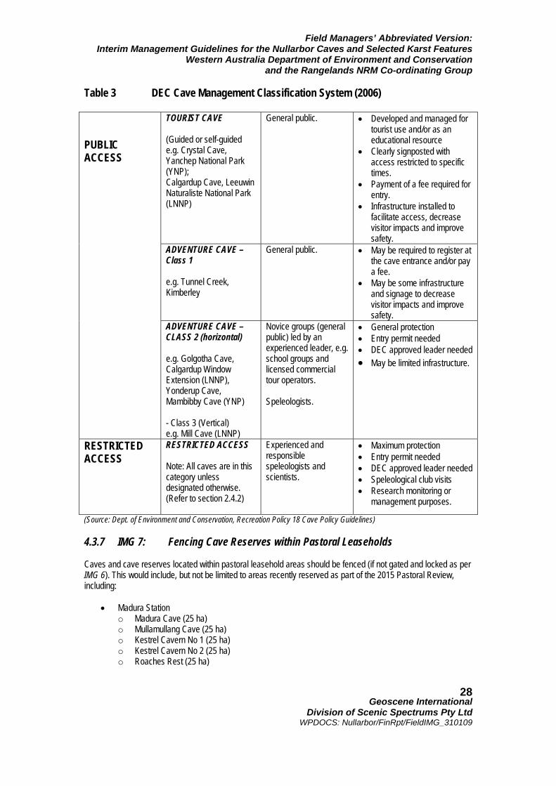
Field Managers’ Abbreviated Version: Interim Management Guidelines for the Nullarbor Caves and Selected Karst Features
Western Australia Department of Environment and Conservation and the Rangelands NRM Co-ordinating Group
Geoscene International
Division of Scenic Spectrums Pty Ltd WPDOCS: Nullarbor/FinRpt/FieldIMG_310109
28
Table 3 DEC Cave Management Classification System (2006)
TOURIST CAVE (Guided or self-guided e.g. Crystal Cave, Yanchep National Park (YNP); Calgardup Cave, Leeuwin Naturaliste National Park (LNNP)
General public. • Developed and managed for tourist use and/or as an educational resource
• Clearly signposted with access restricted to specific times.
• Payment of a fee required for entry.
• Infrastructure installed to facilitate access, decrease visitor impacts and improve safety.
ADVENTURE CAVE – Class 1 e.g. Tunnel Creek, Kimberley
General public. • May be required to register at the cave entrance and/or pay a fee.
• May be some infrastructure and signage to decrease visitor impacts and improve safety.
PUBLIC ACCESS
ADVENTURE CAVE – CLASS 2 (horizontal) e.g. Golgotha Cave, Calgardup Window Extension (LNNP), Yonderup Cave, Mambibby Cave (YNP) - Class 3 (Vertical) e.g. Mill Cave (LNNP)
Novice groups (general public) led by an experienced leader, e.g. school groups and licensed commercial tour operators. Speleologists.
• General protection • Entry permit needed • DEC approved leader needed • May be limited infrastructure.
RESTRICTED ACCESS
RESTRICTED ACCESS Note: All caves are in this category unless designated otherwise. (Refer to section 2.4.2)
Experienced and responsible speleologists and scientists.
• Maximum protection • Entry permit needed • DEC approved leader needed • Speleological club visits • Research monitoring or
management purposes.
(Source: Dept. of Environment and Conservation, Recreation Policy 18 Cave Policy Guidelines) 4.3.7 IMG 7: Fencing Cave Reserves within Pastoral Leaseholds Caves and cave reserves located within pastoral leasehold areas should be fenced (if not gated and locked as per IMG 6). This would include, but not be limited to areas recently reserved as part of the 2015 Pastoral Review, including:
• Madura Station
o Madura Cave (25 ha) o Mullamullang Cave (25 ha) o Kestrel Cavern No 1 (25 ha) o Kestrel Cavern No 2 (25 ha) o Roaches Rest (25 ha)
Field Managers’ Abbreviated Version: Interim Management Guidelines for the Nullarbor Caves and Selected Karst Features
Western Australia Department of Environment and Conservation and the Rangelands NRM Co-ordinating Group
Geoscene International
Division of Scenic Spectrums Pty Ltd WPDOCS: Nullarbor/FinRpt/FieldIMG_310109
29
• Moonera Station o Moonera Tank Cave (100 ha)
• Mundrabilla Station
o Webbs Cave / including the entrance to Snake Pit Cave (51 ha) o Thampanna Cave (37 ha) o Witches Cave (25 ha).
The objective of such fencing is to:
• keep sheep and other livestock well away from cave entrances, blowholes and dolines to prevent or minimise the potential effects of livestock manure and contaminants from being transferred into cave passages;
• keep domestic livestock from falling into caves, dolines and blowholes; • keep land managers and mining exploration teams and their equipment from falling into cave openings
or causing cave passages to collapse underneath them. Such fencing should be designed and installed in a manner that ensures native fauna can move freely to and from the cave/passage entrances without being impeded or placed under stress or danger, while ensuring that sheep and other livestock remain out of the excluded reserve. Key Partnerships: DEC, PBL, DPI, NRM Rangelands, ACKMA, ASF and Pastoral Leaseholders with caves being classified. 4.3.8 IMG 8: Visitor Impact Monitoring Methods Visitor Impact Monitoring methods should be considered (as discussed in Section 5.3.8) and the most suitable methods selected for future implementation. The TOMM and LAC methodologies are particularly suggested for evaluation. (This review could be done by an outside consultant.) Interim assessment of cave condition should take place for several caves as selected through the Cave Management Classification process (IMG 3), as time and budget permit. Key Partnerships: DEC, DPI, ACKMA, WAM, GLSC, ASF and any Pastoral Leaseholders with caves being assessed. 4.3.9 IMG 9: Field Management Staffing Alternatives Prepare a brief discussion paper regarding future field management staffing alternatives, including trained local volunteers, pastoral leaseholders and staff, Aboriginal people from the appropriate communities, DEC staff members or staff jointly funded by the Western Australian and South Australian Governments that can cover the whole of the Nullarbor karst system throughout both States. Depending on future cave classifications, interpretive programs and infrastructure, the staff may serve roles ranging from conservation management and monitoring to the provision of visitor information and interpretation to cave permit and land use regulation and enforcement. The number of staff and skill-set requirements should also be considered. The discussion paper should be discussed among appropriate State Government agencies and appropriate stakeholders. Key Partnerships: DEC, DPI, NRM Rangelands, ACKMA, ASF, GLSC and SA Dept. of Environment and other stakeholders as appropriate.
Field Managers’ Abbreviated Version: Interim Management Guidelines for the Nullarbor Caves and Selected Karst Features
Western Australia Department of Environment and Conservation and the Rangelands NRM Co-ordinating Group
Geoscene International
Division of Scenic Spectrums Pty Ltd WPDOCS: Nullarbor/FinRpt/FieldIMG_310109
30
4.3.10 IMG 10: Cave-Related Capital Works Cave-related capital works should be considered and prioritised for future implementation as funding becomes available. This would take into consideration a combination of factors as addressed in several of the IMGs above, including cave management classifications, cave risks to visitors, relative visitor demand, locked access and fencing needs, etc. Identified Tourist Caves and Adventure – Class 1 caves may be identified that require safety and interpretive signage, directional signage along access routes, carparking and walking track improvements, etc. Once priorities for works are established, work plans, site development plans and cost estimates should be progressively prepared and implemented as approvals are granted and funding becomes available. Key Partnerships: DEC, DPI, ACKMA/ASF, PBL/SLS and affected Pastoral Leaseholders. 4.3.11 IMG 11: Visitor Interpretation Feasibility Study DEC and the proposed NCKMAC may find that the interim management period provides a good opportunity to conduct a feasibility study into the potential provision of various interpretive facilities (e.g. interpretive and directional signage systems, boardwalks, parking and other visitor facilities, information brochures/booklets, CDs, DVD videos or TV programs) and possibly even a feasibility study into a future visitor centre for the area. Such a feasibility investigation goes hand-in-hand with IMG 4, IMG 5, IMG 8, IMG 9 and IMG 10. Conducting feasibility investigations of this nature during an interim management period without being rushed to respond to a political or economic directive is ideal and provides highly useful information for integration into a more permanent management plan for the area when that time comes. Key Partnerships: DEC, DPI, Tourism WA, ACKMA, ASF and Local Governments (Shire of Dundas, Shire of Esperance and City of Kalgoorlie-Boulder). 4.3.12 IMG 12: Groundwater Protection Extractions of and leakages or infusions into the Nullarbor groundwater system may occur through pastoral, mining exploration, road construction, and other land uses. These activities may have potential adverse effects on Nullarbor caves and karst features through the quantity and quality of groundwater recharge zones and confined or unconfined groundwater aquifers. Land use activities potentially affecting the groundwater should be considered through more integrated review and impact assessment procedures within the planning and land lease approval systems. Such uses might be considered to trigger a referral to the suggested single authority over Nullarbor caves and karst (IMG 1) and/or the suggested Nullarbor Caves and Karst Management Advisory Committee (IMG 2) before lease and planning approvals are granted. (This would be somewhat similar to the referral process used by Local Government Councils when referring planning applications to other relevant Authorities for comment prior to approval or similar to the Native Title trigger for Mining Leases.). Uses that would potentially cause unacceptable impacts on recharge zones, groundwater quantities (or levels); groundwater quality, groundwater flow rates or groundwater-based fauna (stygofauna) should not be approved. Key Partnerships: DEC, DPI, DWR, DIR, PBL, SLS, NRM Rangelands, ASF/ACKMA and Local Government within the region (Shire of Dundas, Shire of Esperance and City of Kalgoorlie-Boulder). 4.3.13 IMG 13: Ecosystems, Flora and Fauna Conservation The biodiversity of indigenous flora and fauna should continue to be identified and protect with an emphasis on ecosystems, species and communities at risk. Surface and subterranean flora and fauna species and taxa declared as protected under the Environment Protection and Biodiversity Conservation Act 1999 (Cth EPBC Act), the Conservation and Land Management Act 1984 (WA) or the Wildlife Conservation Act 1950 (WA) should be given management priority and conservation protection as required.
Field Managers’ Abbreviated Version: Interim Management Guidelines for the Nullarbor Caves and Selected Karst Features
Western Australia Department of Environment and Conservation and the Rangelands NRM Co-ordinating Group
Geoscene International
Division of Scenic Spectrums Pty Ltd WPDOCS: Nullarbor/FinRpt/FieldIMG_310109
31
Other recommendations regarding subterranean flora and fauna in terms of conservation, protection, action programs, recovery programs and research as recommended by Subterranean Ecology (2007), the 2002 Biodiversity Audit and subsequent flora and fauna investigations should be considered and prioritised according to their urgency and available staffing and budgets. In general, key actions should include:
1. Protect flora and fauna species listed under the EPBC Act 1999, the Wildlife Conservation Act 1950 and the CALM Act;
2. Apply recommendations of A Biodiversity Audit of Western Australia’s 53 Biogeographical Subregions in
2002 (Dept. of Conservation and Land Management, 2003); 3. Apply recommendations of NRM Strategy for the Rangelands Region of Western Australia (Rangelands
NRM, 2005); 4. Apply prescribed fire to conserve biodiversity according to DEC policy; 5. Prepare and implement approved recovery plans according to biodiversity priorities identified in the
Biodiversity Audit (2002) or in further investigations; 6. Implement measures to mitigate impacts various threatening processes as identified, including that of
visitor use to sensitive plant species or communities; 7. Prioritise and conduct specific research and monitoring activities; 8. Consider designation of new reserves in the Conservation Estate (as per Davey, et al. 1992 and
according to priority species and taxa as identified in the 2002 Biodiversity Audit; 9. Capacity building of community groups, land and lease holders through projects such as the Macro
Corridor project as referenced in A Biodiversity Audit of Western Australia’s 53 Biogeographical Subregions in 2002 (Dept. of Conservation and Land Management, 2003. Refer to the 2002 Biodiversity Audit (Dept. of Conservation and Land Management, 2003) and Subterranean Ecology (2007) for detailed recommendations.
Key Partnerships: DEC, NRM Rangelands, DPI, PBL, ASF, Pastoral Leaseholders and South Australia’s Dept. of Environment and Heritage. 4.3.14 IMG 14: Threatening Pest Animal and Plant Control Apply recommendations of A Biodiversity Audit of Western Australia’s 53 Biogeographical Subregions in 2002 (Dept. of Conservation and Land Management, 2003) and other more recent programs for the control of pest animals and plants that threaten indigenous flora and fauna species. Implement specific targeted projects within a 5 year timeframe where possible and achievable. Carry out localised mapping, control or eradication of targeted species. Continue monitoring programs and existing controls on feral animals (e.g. wild dogs, feral cats, fox, rabbits and starlings), adjusting and expanding eradication where necessary. Priorities should focus on endemic vegetation communities and indigenous plant species in some Nullarbor dolines that are under immediate threat of displacement/smothering by introduced weeds (e.g. at Webbs Cave, Chapel Rock doline, Madura Cave and some more recently discovered caves on the Roe Plain).
Field Managers’ Abbreviated Version: Interim Management Guidelines for the Nullarbor Caves and Selected Karst Features
Western Australia Department of Environment and Conservation and the Rangelands NRM Co-ordinating Group
Geoscene International
Division of Scenic Spectrums Pty Ltd WPDOCS: Nullarbor/FinRpt/FieldIMG_310109
32
Horehound, Deadly Nightshade, Wards Weed and Onion Grass are some of the pest weed species. Horehound seed, due to its sticking ability to clothes/ socks/ vehicles for instance can be easily, yet most of the time unknowingly, transported from one doline to another or to moisture-gaining areas. Key Partnerships: DEC, NRM Rangelands, DPI, PBL, Pastoral Leaseholders and South Australia’s Dept. of Environment and Heritage. 4.3.15 IMG 15: Fire Control The objectives and strategies recommended by the Draft South Coast Regional Fire Management Plan 2008-2013 should guide responses to fire in the Nullarbor region. The recommendations of the report Fire Management in the Rangelands (Tropical Savannas and Desert Knowledge Cooperative Research Centres, 2004) should also be considered. Key Partnerships: DEC, Shire of Dundas, the Fire and Emergency Service Authority (FESA), NRM Rangelands, and Pastoral Leaseholders. 4.3.16 IMG 16: Protection of Cultural Heritage Sites Indigenous and non-indigenous cultural heritage sites and places should be conserved and protected as required by the Aboriginal and Torres Strait Islander Heritage Protection Act 1984, Aboriginal Heritage Act 1972 (WA), Heritage of Western Australia Act 1990 and other relevant legislation and policies. Any planned development or excavations that may potentially affect archaeological or heritage features, fabric, sites or places should be referred to the appropriate government authorities, custodians and/or Traditional Owners for further assessment and approvals prior to any disturbance or alterations to the sites. With the agreement of DIA and GLSC, data on cultural heritage sites may be considered for inclusion or linking to the Karst Management database(s) such as mentioned in IMG 3, however, culturally sensitive sites may not always be made publicly known. Hence, this would not eliminate the requirement for due planning processes to take place. Key Partnerships: DEC, DPI, PBL, SLS, DIA, GLSC, HCWA, WAM (and DEHWA as appropriate). 4.3.17 IMG 17: Holistic and Best Management Practices It should be recognised that the Nullarbor caves and associated karst system is highly complex, interconnected and vulnerable. A “whole-of-system”, integrated and multi-disciplinary planning and management philosophy and approach should be encouraged. Best practice guidelines for caves and karst landscapes, such as those recommended in the box below, should be referred to and considered for all land use, conservation and visitor management decisions. Key Partnerships: DEC, NRM Rangelands, ASF and all other involved agencies and stakeholders. 4.4 Interim Management Guidelines for Specific Pastoral Issues 4.4.1 IMG 18: Surveys and Fencing of Areas above Cave Passages Existing surveys of the boundaries of areas directly above or close to known cave passages should be made available to pastoral leaseholders for conservation and safety purposes. Pastoralists should be encouraged to fence these areas off where practical from grazing sheep and livestock where such activity may adversely impact upon the indigenous vegetation important to meso-cavern and cave ecosystems and hydrology. These areas should also be clearly marked and/or fenced off where practical to prevent undesirable boring for water, excavations, leakage of human/animal wastes or chemical pollutants and to avoid the possible danger of heavy
Field Managers’ Abbreviated Version: Interim Management Guidelines for the Nullarbor Caves and Selected Karst Features
Western Australia Department of Environment and Conservation and the Rangelands NRM Co-ordinating Group
Geoscene International
Division of Scenic Spectrums Pty Ltd WPDOCS: Nullarbor/FinRpt/FieldIMG_310109
33
vehicular or farming equipment causing cave collapses. To a certain degree, these fenced off areas may potentially serve a similar purpose as riparian vegetation corridors or biolinks. Any such fencing should be implemented in an environmentally sensitive manner to avoid possible adverse impacts and to minimise drawing attention to the karst feature. Where existing surveys are not available from CEGSA, the ASF or other organisations, then priorities should be set for the surveying of known caves and the preparation of ground surface “footprint” maps for reference. [Note: to protect caves that are classified as Restricted Access or which have locations that are not to be available to the general public, the survey maps of cave passage locations should be kept in the strictest secrecy and confidentiality]. Key Partnerships: DEC, DPI, PBL, CEGSA/ASF, ACKMA and affected Pastoral Leaseholders. 4.4.2 IMG 19: Surface Drainage and Farm Dam Construction Changes to surface drainage, siting and construction of farm dams may have potential adverse effects on caves, blowholes, dolines or the karst hydrologic system. Pastoral leaseholders should consult with DEC regarding significant proposed changes to surface drainage or the proposed construction of farm dams or reservoirs that could potentially affect the surface footprint of known cave passages (IMG 18) or the meso-catchment surrounding the entrances to caves, blowholes or dolines. Key Partnerships: DEC, DPI, PBL, ACKMA, ASF and affected Pastoral Leaseholders 4.5 Interim Management Guidelines for Mining, Transport and Communications
Infrastructure Uses 4.5.1 IMG 20: Excavations and Drilling Above Cave Passages Excavations, exploratory or bore water drilling and other construction or extraction works directly above or close to known cave passages should be avoided where ever possible. Proposed works are subject to the normal planning approvals process and to planning, mining and environmental impact assessment regulations as required by the Land Administration Act 1997 (LAA, WA), Environmental Protection Act 1986, Conservation and Land
Cave and Karst Management Best Practice References
• Watson, John; Hamilton-Smith, Elery; Gillieson, David; Kiernan, Kevin, Eds., 1997. Guidelines for Cave and Karst Protection. Prepared for the World Commission on Protected Areas (WCPA) Working Group on Cave and Karst Protection, IUCN – The World Conservation Union.
• Elery Hamilton-Smith, 2006. Spatial Planning and Protective Measures for Karst
Areas 2006, in ACTA Carsologica 35/2, 5-11, Ljubljana.
• British Columbia Ministry of Forests, 2003. Karst Management Handbook for British Columbia.
• Karst Waters Institute, 2003. Recommendations and Guidelines for Managing
Caves on Protected Lands. Jones, et al. contributors.
Field Managers’ Abbreviated Version: Interim Management Guidelines for the Nullarbor Caves and Selected Karst Features
Western Australia Department of Environment and Conservation and the Rangelands NRM Co-ordinating Group
Geoscene International
Division of Scenic Spectrums Pty Ltd WPDOCS: Nullarbor/FinRpt/FieldIMG_310109
34
Management Act 1984 (WA), Mining Act 1978, Petroleum Act 1967, Industry and Technology Development Act 1998, and other relevant legislation and policies. The potential effects of exploratory drilling on groundwater resources should be minimised by applying the Guidelines for the Protection of Surface and Groundwater Resources during Exploration Drilling (WA Department of Mineral and Petroleum Resources, 2002). Existing surveys of ground surface “footprint” maps for areas above cave passages available from DEC, CEGSA, or the ASF should be referred to during the process of planning any mining, drilling, road works or other excavations within the Nullarbor karst region. Cave passage footprint areas already fenced off (IMG 18) on pastoral leasehold properties or elsewhere should not be selected for such operations. Where such ground surface “footprint” surveys have not been completed for known caves, such surveys should be prepared prior to planning development, exploration and construction sites. (In order: to protect caves that are classified as Restricted Access or which have locations that are not to be available to the general public, the survey maps of cave passage locations should be kept in the strictest secrecy and confidentiality.) Key Partnerships: DEC, DPI, DIR, PLB/SLS, Australian Rail Track Corporation Ltd (ARTC), EPA, ACKMA/ASF, Local Governments within the region (Shire of Dundas, Shire of Esperance and City of Kalgoorlie-Boulder), and all mining, telecommunications and railway companies operating in the area. 4.5.2 IMG 21: Surface Drainage Changes by Mining and Infrastructure Changes to surface drainage, siting and construction of works related to mining, roads, railways, telecommunications or other infrastructure may have potential adverse effects on caves, blowholes, dolines or the karst hydrologic system. Agents and representatives of such mining and infrastructure organisations or companies should consult with DEC regarding any proposed changes to surface drainage or the proposed construction of dams or reservoirs that could potentially affect the surface footprint of known cave passages (IMG 18) or the meso-catchment surrounding the entrances to caves, blowholes or dolines. Key Partnerships: DEC, DPI, DIR, PBL/SLS, EPA, ACKMA/ASF, Australian Rail Track Corporation Ltd (ARTC), Local Governments within the region (Shire of Dundas, Shire of Esperance and City of Kalgoorlie-Boulder), and all mining, telecommunications and railway companies operating in the area. 4.6 Interim Management Guidelines Related to Aboriginal Recognition and Co-operation 4.6.1 IMG 22: Aboriginal Rights, Knowledge and Co-operative Management In all management decisions and activities regarding Nullarbor caves and associated karst areas, Aboriginal rights as per the United Nations Declaration on Rights of Indigenous Peoples (United Nations General Assembly, 2007) should be acknowledged and upheld. Management and development activities should adhere to all requirements of the Aboriginal and Torres Strait Islander Heritage Protection Act 1984, the Native Title Act 1993 (Cth), the Aboriginal Heritage Act 1972 (WA) and any other relevant legislation and policies. The Goldfields Land and Sea Council should be contacted regarding the involvement and co-operation of Indigenous communities and Traditional Owners. The concept of “free, prior and informed consent” should be implemented as per the United Nations Declaration on Rights of Indigenous Peoples (United Nations General Assembly, 2007). In planning and managing any areas that may have Aboriginal connections, the Aboriginal knowledge of the country and culture be acknowledged and that Aboriginal management and ownership rights also be acknowledged and acted upon as appropriate.
Field Managers’ Abbreviated Version: Interim Management Guidelines for the Nullarbor Caves and Selected Karst Features
Western Australia Department of Environment and Conservation and the Rangelands NRM Co-ordinating Group
Geoscene International
Division of Scenic Spectrums Pty Ltd WPDOCS: Nullarbor/FinRpt/FieldIMG_310109
35
Indigenous people’s traditional use of the land for activities such as hunting, gathering native flowers, honey, etc. should be facilitated as appropriate. Key Partnerships: DEC, DPI, PBL, SLS, DIA, GLSC, local Indigenous Communities, Traditional Owners, Pastoral Leaseholders and development proponents as appropriate. 4.7 Interim Management Guidelines Regarding Safety and Liability Issues 4.7.1 IMG 23: Risk Assessments and Management Risk assessments for caves and associated karst features should be prepared as per IMG 5 in relation to use by tourists, recreationists, researchers, pastoralists, government staff members and other visitors. Specialist risk assessment and management expertise should be sought wherever necessary. Areas of potential liability should be reviewed in terms of the “duty of care” and responsibilities of DEC, DPI, PBL and SLS. Actions and safety measures to eliminate or minimise the risk should be taken on a priority basis. Any capital works required to implement such actions or safety measures should be carried out according to assessed priorities and available funding. In lieu of or in addition to such measures, hazard warnings, safety signage and notices or other information should be provided as appropriate to the general public, to leaseholders and to contractors who may be in the Nullarbor area. Any legal provisos declaring that vested management authorities are not liable for potential damages to property or injury/death to persons should be clearly included in any lease agreements, permits or contracts as advised by independent legal advisors. Consideration should be given to any accident liability and/or health/life insurance requirements for cave access permit-holders, pastoral leaseholders, researchers or other parties visiting or working in or near caves, blowholes or dolines Key Partnerships: DEC, DPI, PBL/SLS, ASF, ACKMA, WASG, SRGWA, CDAA, WAM, GLSC, Tourism WA and Pastoral Leaseholders. 4.8 Enhanced Management Frameworks 4.8.1 IMG 24: Preliminary Review of Enhanced Management Frameworks The highly dispersed and vulnerable nature of the caves and associated karst features of the project area, combined with the various land tenures and management vestings involved are an indication that at a preliminary level, it may be useful for the Nullarbor Cave and Karst Management Advisory Committee to investigate the appropriateness of forming some other regional management body that will provide for more of the key stakeholders and vested management authorities to be involved in joint decision-making and co-management regarding future land use and conservation management in the region, particularly regarding caves, blowholes and dolines. This guideline follows on from the 2002 Biodiversity Audit recommendations and those made by Subterranean Ecology (2007) and previously by Davey et al. (1992), continuing examination of how caves and karst features might best be protected and conserved should be carried out over the next five years. Further discussion of this issue and some of the alternative management frameworks that could be explored, each of which could allow continued use of Pastoral Leaseholds is provided in Appendix 10.
Field Managers’ Abbreviated Version: Interim Management Guidelines for the Nullarbor Caves and Selected Karst Features
Western Australia Department of Environment and Conservation and the Rangelands NRM Co-ordinating Group
Geoscene International
Division of Scenic Spectrums Pty Ltd WPDOCS: Nullarbor/FinRpt/FieldIMG_310109
36
GLOSSARY6 Accidental – in the context of the classification of cavernicolous organisms, refers to species which occasionally occur in caves (e.g. humans, snakes) but which cannot survive there for long; compare with troglobite, troglophile & accidental Aeolian – Windblown Anastamosing tubes – mesh or network of tubes; where these follow a bedding plane or joint in this becomes exposed in the cave roof or walls they form half-tubes Beachridge – a low linear ridge of beach and dune material formed at a coastline; generally found in groups of parallel ridges – compare with foredune Biogenic – derived from biological sources, typically from accumulation of dung and/or discarded food material Blind valley – a valley that is closed abruptly at its lower end by a cliff or slope facing up the valley; rare on the Nullarbor (e.g. Abrakurrie Cave N3) Blowhole – a round hole in the ground ranging in diameter from a few tens of centimetres to one or two metres, connecting with a generally smooth-walled vertical tube of similar diameter, which may or may not descend into an accessible cave chamber Cainozoic – the last of the geological eras, includes the Tertiary and Quaternary periods; extending from about 65 million years ago up to the present Calcarenite – an indurated sand composed mainly of detrital calcium carbonate fragments Calcite – the commonest calcium carbonate mineral and the main constituent of limestone Calcrete – a deposit, often nodular, of calcium carbonate formed in the soil; kankar Cave – a natural cavity in rock, large enough to be entered by a human Cave coral – very small speleothems consisting of short stalks with bulbous ends, usually occurring in patches Cavernicolous – found in caves; in relation to animals, the term cavernicole usually refers to a species which lives in caves for the whole or part of its life cycle Chenopod – a plant species in the family Chenopodiaceae, many of which are commonly known as saltbushes or bluebushes Chert – microcrystalline silica nodules; common in bands in the Wilson Bluff Limestone; exploited by Aboriginal people over many thousands of years (from caves, beach deposits and surface outcrops) for stone tools, with the material being very widely traded over a large part of Australia; also loosely called flint Clastic – composed of loose fragments (e.g. an unconsolidated sediment; a heap of bones beneath an owl-roost; mounds of sand-sized or platy fragments spalled from a passage roof or walls by crystal weathering) Coastal dunes – the combination of foredunes and backdunes over buried beachridges NOTE 6: This Glossary borrows primarily from that provided by Davey et al. (1992), with some minor adjustments and additions.
Field Managers’ Abbreviated Version: Interim Management Guidelines for the Nullarbor Caves and Selected Karst Features
Western Australia Department of Environment and Conservation and the Rangelands NRM Co-ordinating Group
Geoscene International
Division of Scenic Spectrums Pty Ltd WPDOCS: Nullarbor/FinRpt/FieldIMG_310109
37
“Coffee and cream” – a characteristic soft powdery cave floor deposit of very low bulk density derived from breakdown of the roof and walls of cave passages Cretaceous – the geological period that precedes the Tertiary; extending between about 135 and 65 million years ago Crystal weathering – detachment of particles of various sizes from a rock surface by the growth of crystals (mainly gypsum, to a lesser extent halite) from percolating salt solutions; an important process within Nullarbor caves in modifying cave form and producing various clastic floor deposits; also known as salt weathering or exsudation. Deflation – the removal of loose fine grained material from a surface by wind action Denudation – the general lowering of the land surface Detrital – material formed by mechanical breakage or abrasion Diagenetic – processes that modify the nature of a sediment or rock after it has been deposited – particularly in relation to increases or decreases in porosity and coherence Doline – crater – or well-like surface depressions or hollows (commonly but misleadingly known as sinkholes – especially on the Nullarbor where it is very rare for streams to sink into them), from a few to many hundreds of metres in dimensions Donga – in long-established local usage (Gibson 1909b), this is a shallow, generally circular, closed depression several metres deep and hundreds of metres across, with a flat clay-loam floor and very gentle slopes; this local use of the term donga is quite different from the established international meaning in geomorphology, where donga refers to a type of wadi or intermittent stream channel in arid or semi-arid country Duricrust – an indurated surface formed by weathering process involving cementation of the surficial soil and weathered rock by calcite (calcrete), iron oxides (ferricrete), silica (silcrete) or other cements Endemic – refers to a species which is only known from the region, area or site in question (i.e. both described from and confined to that place) Epeirogenic – pertaining to widespread, even (and usually gentle) uplift or subsidence of a land surface (with relatively little folding or faulting) Eustatic – pertaining to worldwide changes of sea levels Exsudation – see crystal weathering Facies – a lateral subdivision o f a stratigraphic unit, varying from the main unit and /or other subdivisions in fossils, texture and /or environment of deposition Ferricrete – a type of duricrust which is cemented by iron oxides Fluvial – produced by the action of a stream or river Foredune – a dune ridge build up behind a coastline; generally higher and more extensive than a beachridge Guano – accumulation of dung, often partly mineralised; in caves, most commonly derived from bats; see also pseudobitumen
Field Managers’ Abbreviated Version: Interim Management Guidelines for the Nullarbor Caves and Selected Karst Features
Western Australia Department of Environment and Conservation and the Rangelands NRM Co-ordinating Group
Geoscene International
Division of Scenic Spectrums Pty Ltd WPDOCS: Nullarbor/FinRpt/FieldIMG_310109
38
Gypsum – the most common mineral form of hydrated calcium sulphate Half-tube – a semi-cylindrical, elongate, recess exposed on a cave surface, often meandering and /or anastamosing Halite – the mineral form of sodium chloride Halocline – a discontinuity in dissolved solids concentration of groundwater (i.e. a boundary between zones of a different concentration) Hydrophilic – inhabiting moist places Indurated limestone – rock at or near the surface which has been case hardened and made relatively impervious to water by weathering and precipitation of calcite within it Kankar – calcrete Karren – the minor forms of karst, due to solution sculpture of rock on the surface or underground Karst – terrain with special landforms and drainage characteristics due to greater solubility of certain rocks (such as limestone) than is common on other lithologies; common examples include underground drainage differing markedly in configuration and connections from surface catchments, caves, rockholes, blowholes and various types of closed depression Mallee – a multi-stemmed form of tree growth arising from a common root stock; a common growth habit in a substantial number of species in the genus Eucalyptus in semi-arid and arid parts of Australia; mallee woodland occurs in a narrow southern (i.e. slightly wetter) band across the region, on the coastal side of the treeless plain; the term is sometimes also applied (erroneously) to the open myall and mulga (Acacia) woodlands in the Nullarbor region Megafauna – extinct marsupials of the Pleistocene which, although often closely related to modern species or genera, were relatively much larger and more heavily built Meteoric (water) – derived from the atmosphere, i.e., in the Nullarbor case, percolation water derived from rainfall rather than lateral movement of phreatic water; broadly equivalent to vadose Meteorite – stony or metallic extra-terrestrial objects which have fallen to earth; compare with tektite Palaeochannel – a definable corridor formerly occupied by a river or stream but, as a result of increased aridity, no longer carrying any effective streamflow Palaeodrainage – the network of palaeochannels and their watershed which, under less arid conditions, constituted the active surface catchment of the region; no longer active at present. Paralic – a transitional environment, mainly occurring by the sea but mainly non-marine in character: includes littoral, lagoonal and swampy environments. Phreatic – associated with that zone in the rock where voids are completely filled with water; compare with vadose. Pseudobitumen [dung bitumen] – tarry biogenic deposits common on ledges and in hollows around the walls of cave entrances, dolines and on the escarpments, derived from dung and other organic matter which, in the Nullarbor region is most commonly associated with old nests of the Stick Nest Rat Leporillus conditor [now extinct on the mainland].
Field Managers’ Abbreviated Version: Interim Management Guidelines for the Nullarbor Caves and Selected Karst Features
Western Australia Department of Environment and Conservation and the Rangelands NRM Co-ordinating Group
Geoscene International
Division of Scenic Spectrums Pty Ltd WPDOCS: Nullarbor/FinRpt/FieldIMG_310109
39
Regression – a withdrawal of the sea from the land, due to uplift or a eustatic drop in sea level; compare with transgression. Ridge and corridor terrain – repetitive terrain of low relief with generally stony ridges a few meters above flat silt-floored corridors. Rockhole (Gnamma) – a rounded basin which contains water after rain, ranging from 0.1m to several meters in diameter, up to a few meters deep. Salt weathering [exsudation] – see crystal weathering Silcrete – a type of duricrust cemented by amorphous or microcrystalline silica. Solution pan – an irregular shallow flat hollow in indurated surface limestone, usually only a few centimeters deep, which contains water after rain; often surrounded by an extensive flat rock pavement which contributes runoff; see also rockhole. Speleothem – a secondary mineral deposit formed in caves, most commonly of calcite; common forms include stalactites, stalagmites, helictites and cave coral. Stillsand – stationary with respect to sea level. Tektite – a usually glassy rounded object, derived from the earth by the impact of a large meteorite blasting rock up into the atmosphere at high velocity, which has fallen back to earth usually at a considerable distance from the impact; the impact site for Australian tektites is thought to have been in South-East Asia; all Australian examples date from a single event about 800,000 years ago; also know as Australites; in contrast with meteorites (which consist of extra-terrestrial material), tektites are made of terrestrial matter. Tertiary – the geologic time period lying between the Cretaceous and the Quaternary; extending from 65 to 1.8 million years ago, it occupies the bulk of the Cainozoic era. Tectonic – pertaining to large scale movements of the earth’s crust: i.e. folding, faulting etc. Terrigenous – shallow marine deposits consisting of sediments derived from the land surface. Transgression – an advance of the sea across the land, due to subsidence of the land, or a eutastic rise in sea level; compare with regression. Troglobite [& troglobitic] – an obligate cavernicole, unable to live outside the cave environment and exhibiting morphological adaptation to darkness and/or other characteristics of the cave environment; compare with troglophile, tragloxene and accidental. Trogloxene – a cavernicole which spends only part of its life cycle in caves and returns periodically to surface habitats; compare with troglophile, troglobite and accidental. Vadose – associated with that zone in the rock where voids are partly filled with air and through which water descends under gravity; compare with phreatic; see also meteoric
Field Managers’ Abbreviated Version: Interim Management Guidelines for the Nullarbor Caves and Selected Karst Features
Western Australia Department of Environment and Conservation and the Rangelands NRM Co-ordinating Group
Geoscene International
Division of Scenic Spectrums Pty Ltd WPDOCS: Nullarbor/FinRpt/FieldIMG_310109
40
REFERENCES
Australian Natural Resources Atlas, 2008. Water Resources - Overview - Western Australia. http://www.anra.gov.au/topics/water/overview/wa/index.html
Australian Natural Resources Atlas, 2008. Water resources - Allocation and Use - Western Australia. http://www.anra.gov.au/topics/water/allocation/wa/index.html
Association of Mining and Exploration Companies, Undated. Interim Code of Conduct for Mineral Exploration in Western Australia. Australian Speleological Federation, Western Australian Spelological Group, and Cave Explorers Group of South Australia, 2008. Preliminary Cave Risk Assessment Table. MS Excel Sheet. Prepared for the Department of Environment and Conservation. Australian Speleological Federation, 1995. Minimal Impact Caving Code. Australian Speleological Federation, 1992. ASF Code of Ethics. Australian Speleological Federation, date?. Cave Safety Guidelines. www.wasg.iinet.net.au/asf_safe.html Australian Speleological Federation, 1988.ASF Cave Diving – Code of Practice. Australian Speleological Federation, 1978. Resource Management of the Nullarbor Region, W.A. Davey, A., Editor. Contributing Authors: A.G. Davey (co-ordinator), J.G. Cundy, J.R. Dunkley, E. Hamilton-Smith, K.A. Lance, I.D. Lewis, K.R. Mott, R.W. Shoosmith, N.J. White and K.A. Williamson. Prepared for the Western Australian Environmental Protection Authority. Barr, T.C., Jr., and Holsinger, J.R., 1985. Specialisation in Cave Faunas. Annual Review of Ecology and Systematics. 16:331-37. Beard, J.S., 1975. The Vegetation of the Nullarbor Are: Vegetation Survey of Western Australia, 1: 1,000,000 Vegetation Series, Explanatory Notes to Sheet 4, Nullarbor. University of Western Australia Press, Perth. Beard, J.S., 1990. Plant Life of Western Australia. Kangaroo Press Pty Ltd., Kenthurst, NSW. Bednarik, R.G. 2001. Pilbara Petroglyphs Dated. Rock Art Research 18: 55-57 Bednarik, R.G. 1999. The Speleothem Medium of Finger Flutings and its Isotopic Geochemistry. The Artefact 22: 49-64. Bednarik, R.G. 1995. Untertag-Bergbau im Pleistozän. Quartär 45/46: 161-75. Bednarik,1991, On Natural Cave Markings. Helictite 29(2): 27-41. Bednarik, Robert G., Aslin, Geoffrey D., and Bednarik, Elfriede,1990. The Cave Petroglyphs of Australia. Australian Aboriginal Studies 1990, No. 2. Presented at the Hamilton AURA Inter-Congress Symposium in October 2003. Also available in Cave Art Research 2003 – Volume 3. http://mc2.vicnet.net.au/home/cara13/shared_files/Oz_cave_art.pdf Belnap, Jayne, Freimund, Wayne, Hammett, Jim, Harris, Jan, Hof, Marilyn, Johnson, Gary, Lime, David, Manning, Robert, McCool, Stephen, Rees, Michael, 1997. VERP: The Visitor Experience and Resource Protection (VERP) Framework. A Handbook for Planners and Managers. U.S. Department of the Interior – National Parks Service. http://planning.nps.gov/document/verphandbook.pdf Benbow, 1990. Tertiary coastal dunes of the Eucla Basin, Australia. Geomorphology 3: 9-29. Bowler, J.M., 1982. Aridity in the late Tertiary and Quaternary of Australia in: Evolution of the Flora and Fauna of Arid Australia. Barker W R & Greensdale, P J M (Eds).. Peacock Publications / Aust. Syst. Bot. Soc. / ANZAAS, S. Aust.; Adelaide. pp. 34-45 Bowler, J.M.,1976. Aridity in Australia: Age, Origins and Expression in Aeolian Landforms and Sediments. Earth Sci. Reviews 12: 279-310.
Field Managers’ Abbreviated Version: Interim Management Guidelines for the Nullarbor Caves and Selected Karst Features
Western Australia Department of Environment and Conservation and the Rangelands NRM Co-ordinating Group
Geoscene International
Division of Scenic Spectrums Pty Ltd WPDOCS: Nullarbor/FinRpt/FieldIMG_310109
41
Burke, David, 1991. Road through the Wilderness, the Story of the Transcontinental Railway, The First Great Work of Australia’s Federation. New South Wales University Press. Brodie, R., Sundaram, B., Tottenham, R., Hostetler, S., and Ransley, T. 2007. An Adaptive Management Framework for Connected Groundwater-Surface Water Resources in Australia. Bureau of Rural Sciences and National Landcare Programme:, Dept. of Agriculture, Fisheries and Forestry, Australian Government. Canberra. Brown, Peter AM, 2008. Pers. Com. with D. Williamson, Geoscene International, Scenic Spectrums Pty Ltd. June. Campbell, Bree, 2008. Pers. Com. with D. Williamson, Geoscene International, Scenic Spectrums Pty Ltd., June. Carden, Deborah, Undated. Cave Impact Monitoring – The Guidelines. Department of Conservation, West Coast, New Zealand. http://www.ackma.org/journal/69/Caves Impact Monitoring - Deborah Carden.pdf
Clark, Roger N. and Stankey, George H., 1979. The Recreation Opportunity Spectrum: A Framework for Planning, Management and Research. U.S. Department of Agriculture – Forest Service. Pacific Northwest Forest and Range Experiment Station. Gen. Tech. Report PNW-98. December, 1979. http://www.srnr.arizona.edu/~gimblett/Recreation_Opportunity_Spectrum.pdf Commonwealth of Australia and the State Government of Western Australia, 2002. Bilateral Agreement between The Commonwealth of Australia and The State of Western Australia. December. Contos, Annalisa, James, Julia, Rogers, Peter, and Prust, Phil, 2001. Challenges in Conservation of the Microbial Mantles in Nullarbor Caves. Publisher Not Stated. Davey, A.G.; Gray M.R.; Grimes, K.G.; Hamilton-Smith, E.; James, J.M.; and Spate, A.P, 1992. World Heritage Significance of Karst and Other Landforms in the Nullarbor Region. Applied Ecology Research Group, Faculty of Applied Science, University of Canberra. A report to the Commonwealth Department of The Arts, Sport, The Environment & Territories. Dept. of Conservation and Land Management, 1991. South Coast Region Regional Management Plan 1992 – 2002. Management Plan No. 24. Dept. of Conservation and Land Management for the National Parks and Nature Conservation Authority and the Lands and Forests Commission, Western Australia. Dept. of Conservation and Land Management, 2003. A Biodiversity Audit of Western Australia’s 53 Biogeographical Subregions in 2002. Western Australia Dept. of Conservation and Land Management (1994). Reading the Remote: Landscape Characters of Western Australia, ISBN 0 7309 5942 2. Government of Western Australia. Dept. of Environment and Conservation, 2002. Conservation and Land Management Regulations. Western Australia. Dept. of Environment and Conservation, 1998. Wildlife Conservation Notice. Schedule 1. Dept. of Fisheries, 2008. Aquaculture Groundwater Atlas – Nullarbor (Eucla Basin). Western Australia. http://www.fish.wa.gov.au/docs/pub/AquaGroundWater/nullarbor.php?00) Dept. of Environment and Conservation, Undated. Recreation Policy No. 18. Western Australia. Dept. of Environment and Conservation, 2008. Selected Caves in Retaliation to Pastoral Stations and the DEC Managed Estate. Western Australia. Dept. of Environment and Conservation, 2006. Guidelines for the Preparation of Management Plans for Terrestrial Conservation Reserves. DEC Management Planning Unit. Perth, 2006. Dept. of Indigenous Affairs, c. 2007. Guidelines for Preparing Reports for Applications to the Aboriginal Cultural Material Committee Under Section 18 of the Aboriginal Heritage Act 1972. Aboriginal Heritage Survey Reports. Government of Western Australia. Dept. of Indigenous Affairs, c. 2007. Notes and Guidelines for Applicants. Aboriginal Heritage Act 1972 Section 18 Notice of Application for the Minister’s Consent to Use Land. Government of Western Australia.
Field Managers’ Abbreviated Version: Interim Management Guidelines for the Nullarbor Caves and Selected Karst Features
Western Australia Department of Environment and Conservation and the Rangelands NRM Co-ordinating Group
Geoscene International
Division of Scenic Spectrums Pty Ltd WPDOCS: Nullarbor/FinRpt/FieldIMG_310109
42
Dept. of Industry and Resources, 2007. Guidelines for Mineral Exploration/Rehabilitation Activities. Western Australia, January.
Dept. of Industry and Resources, 2007. Guidelines for Mineral Exploration and Mining within Conservation Reserves and other Environmentally Sensitive Lands in WA. Western Australia, January. http://www.doir.wa.gov.au/documents/minealsandspetroleum/ED_Min_GL_ExpMininginConervReservesEnvSenstiveLandsWA_jan07.pdf Dept. of Industry and Resources, 2007. Guidelines for Management of Dieback Disease in Mineral Exploration http://www.doir.wa.gove.au/documents/mineralsandpetroleum/ED_Min_GL_MgmtDiebackDisease_Dec06.pdf Dept. of Mineral and Petroleum Resources, 2002. Guidelines for the Protection of Surface and Groundwater Resources During Exploration Drilling. Western Australia. Devine, Paul, 2003. Documentation and Ground Exploration of Nullarbor Karst. Proceedings of the 24th Biennial Conference of the Australian Speleological Federation, 2nd – 8th January 2003. Bunbury, Western Australia. Pp 57 – 61. Devine, Paul, 2007. The Karst Features of the SW Nullarbor – Mardabilla Plain & Adjacent Localities. Publisher Not Stated. de Vries, David, 2006. Groundwater Salinity, Desalination Equipment and Practices Applicable to the Rangelands Pastoral Industry. A Review for the Desert Knowledge Cooperative Research Centre. September. Diatreme Resources Limited, 2008. Heavy Mineral Sands – Eucla Basin. http://www.diatreme.com.au/default.asp?PageID=11 Economics Consulting Services, 2004. Water and the Western Australian Minerals and Energy Industry: Certainty of Supply for Future Growth. Prepared for The Chamber of Minerals and Energy of Western Australia. Environmental Protection Agency, 2003. Guidance for the Assessment of Environmental Factors (in accordance with the Environmental Protection Act 1986): Consideration of Subterranean Fauna in Groundwater and Caves during the Environmental Impact Assessment in Western Australia. EPA Rpt. No. 54. Environment Protection Authority, 2002. Environmental Protection and Sustainability of the Rangelands of Western Australia. Government of Western Australia. Farell, Tracy A. and Marion, Jeffery L., 2002. The Protected Area Visitor Impact Management (PAVIM) Framework: A Simplified Process for Making Management Decisions, in: Journal of Sustainable Tourism, Vol. 10, No. 1, 2002. Galloway, R. and Kemp, E., 1981.Late Cainozoic Environments in Australia. pp 53-80 in: Ecological Biogeography of Australia. Keast Allen (Ed.) 1981. Junk, The Hague. [Reprinted in: ARCHER Michael & CLAYTON Georgina (Eds), 1984. Vertebrate Zoogeography & Evolution in Australasia: Animals in Space and Time. Hesperian Press, Carlisle W. Aust. Pp. 61-67.] Gallus, A., 1968. Archaeological Excavations at Koonalda, Nullarbor Plain, 1957-1967. J. Antrhop. Soc. S. Aust. 6(7): 4-8. Gallus, A., 1968b. New Discoveries in Australian Prehistory, in: Liber Iosepho Kostrzewski Octogenario A Veneratoribus Dicatus. Jazdzewski, K. (Ed.). Wrocla: Zaktad Narodowy im. Ossolinskich. pp. 636 – 638. Gallus, A. 196c8. Parietal Art in Koonalda Cave, Nullarbor Plain. Helictite 6: 43-49. Gallus, A., 1971. Results of the Exploration of Koonalda Cave 1956-1968, in: Archaeology of the Gallus Site, Koonalda Cave, Wright, R.V.S. (Ed.). Aust. Ab. Stud. (26) Prehist. Serv., (5) Aust. Inst. Aboriginal Stud., Canberra, ASA 712.69 Geoscene International, 2008. Interim Management Guidelines for the Nullarbor Caves and Selected Karst Features, Division of Scenic Spectrums Pty Ltd. Prepared for the Western Australian Dept. of Environment and Conservation and Rangelands NRM Co-ordinating Committee. August. George, Richard, Clarke, Jonathan, and English, Pauline, 2005. Modern and Palaeogeogrpahic Trends in the Salinisation of the Western Australian Wheatbelt. AESC Conference, Melbourne, Australia. Goldfields Land & Sea Council, 2007. Free, Prior and Informed Consent. A Guide to the Negotiating Rights of Indigenous People of The Goldfields-Esperance Region. Information Brochure, November. Goldfields Land & Sea Council, 2008. Goldfields Lands & Sea Council Mining Policy. Our Land is Our Future. March. ..\..\..\Native Title Claims\Goldfields Land Council_files\GLCminingpolicy.htm
Field Managers’ Abbreviated Version: Interim Management Guidelines for the Nullarbor Caves and Selected Karst Features
Western Australia Department of Environment and Conservation and the Rangelands NRM Co-ordinating Group
Geoscene International
Division of Scenic Spectrums Pty Ltd WPDOCS: Nullarbor/FinRpt/FieldIMG_310109
43
Goldfields Land and Sea Council, 2008. Goldfields Land and Sea Council Mining Policy (2008) Draft Traditional Usage Guidelines. On behalf of the Traditional Owners of the Goldfields and Esperance Regions. Gray, M.R., 1973a.Cavernicolous Spiders from the Nullarbor Plain and South-West Australia. J. Aust. Ent. Soc. 12(3): 207-221.
Gray, M.R., 1973b. Survey of the Spider Fauna of Australian Caves. Helictite 11(3): 47-75. Haider, Wolfgang, 2004. Visitor Management Frameworks in North America. Forests for Recreation and Nature Tourism (FORREC). 2nd Management Committee Meeting + WGs Meeting + Workshop in Edinburgh, Scotland, 31 Oct. – 2 Nov., 2004. http://www.openspace.eca.ac.uk/costE33/ppt/WolfgangHaiderPresentation.ppt. Hamilton-Smith, 2008. May-July. Pers. Com. with D. Williamson, Geoscene International, Scenic Spectrums Pty Ltd. Hamilton-Smith, Elery, 2006 Spatial Planning for Protection Measures for Karst Areas, in: Acta Carsologica 35/2, pp. 5-11. Ljubljana. Hamilton-Smith, Elery, 1967a.The Arthropoda of Australian Caves. J. Aust, Ent. Soc.6(2): 103-228. Hamilton-Smith, Elery,1967b. Fauna of the Nullarbor Caves, in: Caves of the Nullarbor. Dunkerley J R & Wigley T M L (Eds.) 1967 Speleol. Research Council, Sydney. pp 35-42 Haynes, Roslyn, 2006. Seeking the Centre, in: Earthsong Journal, Winter 2006.
Hirst, K. Kris, 2008. Your Guide to Archaeology. http://archaeology.about.com/od/rockartsites/a/koonalda.htm
Holmes, A. J., Tujula, N. A. Holley, M., Contos, A. K., James, J. M. Rogers, P., and Gillings, M. R., (2001). Phylogenetic Structure of Unusual Aquatic Microbial Formations in Nullarbor Caves, Australia in Environ Microbiol.
Howarth Francis G., 1993. High-Stress Subterranean Habitats and Evolutionary Change in Cave-Inhabiting Arthropods. The American Naturalist, Vol. 142, Supplement: Evolutionary Responses to Environmental Stress (Jul., 1993), pp. S65-S77 Published by: The University of Chicago Press for The American Society of Naturalists. Howarth, F.G. & F.D. Stone, 1990. Elevated Carbon Dioxide Levels in Bayliss Cave, Australia: Implications for the Evolution Of Obligate Cave Species. Pacific Science 44: 207-18. Howarth, F.G., 1988. Environmental Ecology of North Queensland Caves: or Why Are There So Many Troglobites in Australia? Preprints of papers for the 17th Biennial Conference of the Austalian Speleological Federation, pp 76-84. Howarth, F.G., 1983. Ecology of Cave Anthorpods. Annual Review of Entomology 28:365-389. Ingram, 1969. Sporomorphs from the desiccated carcases of mammals from Thylacine Hole, Western Australia. Helictite 7(3): 62-66.
Jack, Elizabeth and Duka, Toni J., Undated. Kangaroo Island Tourism Optimization Management Model.
James, J.M., Pilkington, G., Rogers, P and Spate, A.P., 1991. The Nullarbor Carbanate Aquifer in Australia: the Impact of Man and Suggestions for Future Management. Proceedings of the International Conference on Environmental Changes in Karst Areas. I.G.U. – U.I.S. – Italy 15 – 27 Sept. 1991. Quarderni del Departmento di Georgrafia n. 13 1991 – Universita di Podova, pp. 205 – 214. Jasinkam, E.J., Knott, B., and McComb, A.J.,1996. Root Mats in Ground Water: a Fauna Rich Habitat. Journal of North American Benthological Society, 15: 508-519. Jennings, J.N., 1961. A Preliminary Report on the Karst Morphology of the Nullarbor Plains. Cave Ezpl. Gp (S. Aust.), Occ. Pap. 2. Kangaroo Island Tourism Optimisation Management Model Website: http://www.tomm.info/home.aspx Karst Waters Institute, 2003. Recommendations and Guidelines for Managing Caves on Protected Lands. Contributing authors: William K. Jones, Horton H. Hobbs III, Carol M. Wicks, Robert R. Currie, Louise D. Hose, Ronal C. Kerbo, James R. Goodbar, and Jerry Trout. Prepared for the National Cave and Karst Institute and the National Park Service, U.S. Dept. of Interior.
Field Managers’ Abbreviated Version: Interim Management Guidelines for the Nullarbor Caves and Selected Karst Features
Western Australia Department of Environment and Conservation and the Rangelands NRM Co-ordinating Group
Geoscene International
Division of Scenic Spectrums Pty Ltd WPDOCS: Nullarbor/FinRpt/FieldIMG_310109
44
Kranjc, A. and Poara, B., 2002. Temperature monitoring in Skocjanske Jame Caves: Acta Carsologica, v. 31, no. 1, pp. 85-96.
Landsberg, Jill, James, Craig D., Morton, Stephen R., Hobbs, Trevor J., Stol, Jacqui, Drew, Alex and Tongway, Helen, 1997. The Effects of Artificial Sources of Water on Rangeland Biodiversity. CSIRO Division of Wildlife and Ecology. Published by Environment Australia and CSIRO.
Leung, Yu-Fai and Monz, Christopher, 2006. Visitor Impact Monitoring: Old Issues, New Challenges – An Introduction to this Special Issue in: The George Wright Forum, Vol. 23, No. 2, 2006. Lowry, D.C., 1970. Geological Survey of Western Australia. Bulletin 122. Geology of the Western Australian Part of the Eucla Basin. Lowry, D.C.,1970b. Geology of the Western Australian Part of the Eucla Basin. W. Aust., Geol. Surv., Bull. 122 [201pp, map]. Lowry, D.C. and Jennings, J.N., 1974. The Nullarbor karst Australia. Zeist. Geomorph. NF 18(1): 36-81. Lowry, D.C., 1969.The Origin of Small Cavities in the Limestone of the Bunda Plateau, Eucla Basin. W. Aust., Geol. Surv., Ann. Rep. for 1968: 34-37 Lowry, D.C. and Lowry, J.W.J, 1967. Discovery of a Thylacine (Tasmanian Tiger) Carcass in a Cave near Eulca, Western Australia. Helictite 5(2): 25-29. Main, 1969. A Blind Mygalomorph Spider from a Nullarbor Plain Cave. J. Roy. Soc. W. Aust. 52(1): 9-11.
Manfredo, Michael J. (Ed.), 1992. Influencing Human Behaviour: Theory and Applications in Recreation, Tourism and Natural Resources Management. Sagamore Publishing Inc., Champaign, Illinois, USA.
Manidis Roberts Consultants (1997) Developing a Tourism Optimisation Management Model (TOMM), a model to monitor and manage tourism on Kangaroo Island, Final Report, South Australian Tourism Commission, Adelaide. http://tourism.sa.gov.au/tourism/publications.asp
McKenzie, N.L. and Robinson, A.C. (Eds.), 1987. A Biological Survey of the Nullarbor Region South and Western Australia in 1984. Prepared for the South Australian Department Environment and Planning, the Western Australian Department of Conservation and Land Management, and the Australian National Parks and Wildlife Service. Mejía, Francisco Galo, Carvajal, Alejando Martínez, and Patiño, Jorge Iván Ríos, 2001. Visitor Impact Management (VIM) for SCUBA Diving Areas in the San Andres Island Biosphere Reserve “Sea Flower”. Environmental Sciences school at the Universidad Tecnológica de Pereira (U.T.P-Colombia). http://www.utp.edu.co/areasmarinas.pdf Milham P. and Thompson, P., 1976. Relative Antiquity of Human Occupation and Extinct Fauna at Madura Cave, Southeastern Western Australia. Mankind 10(3): 175-180.
Miller G. and Twining-Ward L. (2005) Monitoring for a Sustainable Tourism Transition: the Challenge of Developing and Using Indicators. Oxon: CAB International. www.cabi-publishing.org/bookshop
Ministry of Forests, 2003. Karst Management Handbook for British Columbia. Government of the Province of British
Moon, Ron & Viv, 2007. Photos 11, 12 and 15. Moon Adventure Publications, http://www.guidebooks.com.au/latest.htm Mulvaney, John and Kamminga, John, 1999. Prehistory of Australia. Smithsonian Books and Allen and Unwin. National Water Commission, 2005. Regional Water Resource Assessment – Nullarbor State Water Management Area. Australian Water Resources 2005. http://www.water.gov.au/RegionalWaterResourcesAssessments/SpecificGeographicRegion/TabbedReports.aspx?PID=WA_SW_022WA
Parks Canada Agency, 2006. Parks Canada Guiding Principles and Operational Policies http://www.pc.gc.ca/docs/pc/poli/princip/sec1/index_e.asp.
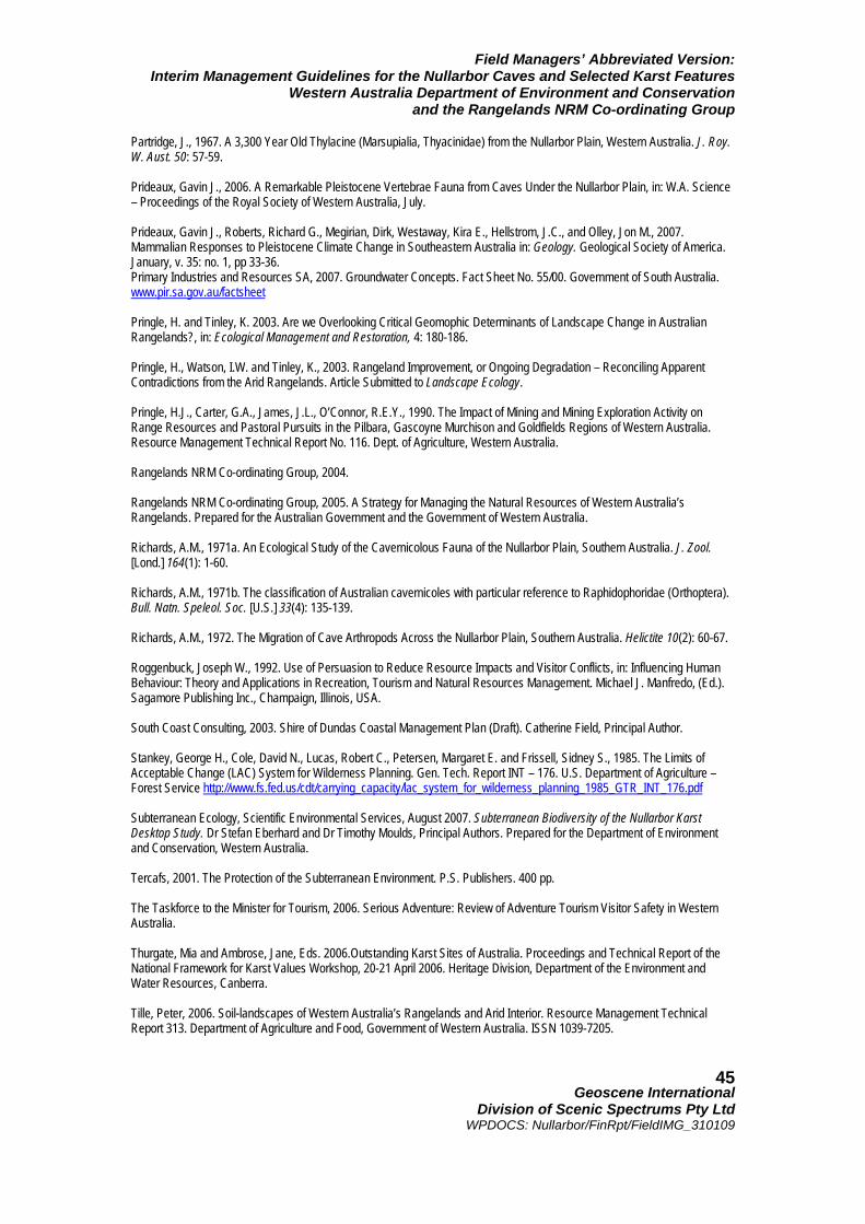
Field Managers’ Abbreviated Version: Interim Management Guidelines for the Nullarbor Caves and Selected Karst Features
Western Australia Department of Environment and Conservation and the Rangelands NRM Co-ordinating Group
Geoscene International
Division of Scenic Spectrums Pty Ltd WPDOCS: Nullarbor/FinRpt/FieldIMG_310109
45
Partridge, J., 1967. A 3,300 Year Old Thylacine (Marsupialia, Thyacinidae) from the Nullarbor Plain, Western Australia. J. Roy. W. Aust. 50: 57-59. Prideaux, Gavin J., 2006. A Remarkable Pleistocene Vertebrae Fauna from Caves Under the Nullarbor Plain, in: W.A. Science – Proceedings of the Royal Society of Western Australia, July. Prideaux, Gavin J., Roberts, Richard G., Megirian, Dirk, Westaway, Kira E., Hellstrom, J.C., and Olley, Jon M., 2007. Mammalian Responses to Pleistocene Climate Change in Southeastern Australia in: Geology. Geological Society of America. January, v. 35: no. 1, pp 33-36. Primary Industries and Resources SA, 2007. Groundwater Concepts. Fact Sheet No. 55/00. Government of South Australia. www.pir.sa.gov.au/factsheet Pringle, H. and Tinley, K. 2003. Are we Overlooking Critical Geomophic Determinants of Landscape Change in Australian Rangelands?, in: Ecological Management and Restoration, 4: 180-186. Pringle, H., Watson, I.W. and Tinley, K., 2003. Rangeland Improvement, or Ongoing Degradation – Reconciling Apparent Contradictions from the Arid Rangelands. Article Submitted to Landscape Ecology. Pringle, H.J., Carter, G.A., James, J.L., O’Connor, R.E.Y., 1990. The Impact of Mining and Mining Exploration Activity on Range Resources and Pastoral Pursuits in the Pilbara, Gascoyne Murchison and Goldfields Regions of Western Australia. Resource Management Technical Report No. 116. Dept. of Agriculture, Western Australia. Rangelands NRM Co-ordinating Group, 2004. Rangelands NRM Co-ordinating Group, 2005. A Strategy for Managing the Natural Resources of Western Australia’s Rangelands. Prepared for the Australian Government and the Government of Western Australia. Richards, A.M., 1971a. An Ecological Study of the Cavernicolous Fauna of the Nullarbor Plain, Southern Australia. J. Zool. [Lond.] 164(1): 1-60. Richards, A.M., 1971b. The classification of Australian cavernicoles with particular reference to Raphidophoridae (Orthoptera). Bull. Natn. Speleol. Soc. [U.S.] 33(4): 135-139. Richards, A.M., 1972. The Migration of Cave Arthropods Across the Nullarbor Plain, Southern Australia. Helictite 10(2): 60-67. Roggenbuck, Joseph W., 1992. Use of Persuasion to Reduce Resource Impacts and Visitor Conflicts, in: Influencing Human Behaviour: Theory and Applications in Recreation, Tourism and Natural Resources Management. Michael J. Manfredo, (Ed.). Sagamore Publishing Inc., Champaign, Illinois, USA. South Coast Consulting, 2003. Shire of Dundas Coastal Management Plan (Draft). Catherine Field, Principal Author. Stankey, George H., Cole, David N., Lucas, Robert C., Petersen, Margaret E. and Frissell, Sidney S., 1985. The Limits of Acceptable Change (LAC) System for Wilderness Planning. Gen. Tech. Report INT – 176. U.S. Department of Agriculture – Forest Service http://www.fs.fed.us/cdt/carrying_capacity/lac_system_for_wilderness_planning_1985_GTR_INT_176.pdf Subterranean Ecology, Scientific Environmental Services, August 2007. Subterranean Biodiversity of the Nullarbor Karst Desktop Study. Dr Stefan Eberhard and Dr Timothy Moulds, Principal Authors. Prepared for the Department of Environment and Conservation, Western Australia. Tercafs, 2001. The Protection of the Subterranean Environment. P.S. Publishers. 400 pp. The Taskforce to the Minister for Tourism, 2006. Serious Adventure: Review of Adventure Tourism Visitor Safety in Western Australia. Thurgate, Mia and Ambrose, Jane, Eds. 2006.Outstanding Karst Sites of Australia. Proceedings and Technical Report of the National Framework for Karst Values Workshop, 20-21 April 2006. Heritage Division, Department of the Environment and Water Resources, Canberra. Tille, Peter, 2006. Soil-landscapes of Western Australia’s Rangelands and Arid Interior. Resource Management Technical Report 313. Department of Agriculture and Food, Government of Western Australia. ISSN 1039-7205.
Field Managers’ Abbreviated Version: Interim Management Guidelines for the Nullarbor Caves and Selected Karst Features
Western Australia Department of Environment and Conservation and the Rangelands NRM Co-ordinating Group
Geoscene International
Division of Scenic Spectrums Pty Ltd WPDOCS: Nullarbor/FinRpt/FieldIMG_310109
46
Tourism Co-ordinates, 2007. Review of Nature Based Tourism. Prepared for the Minister for the Environment and the Minister for Tourism, W.A. Tourism Western Australia, 2008. Research and Analysis: Local Government Area Fact Sheet – Shire of Dundas 2007, May. Travelling Australia, 2008. Information Sheet. http://www.travelling-australia.info. UNESCO Intergovernmental Committee for the Protection of World Cultural and Natural Heritage, 1991. Operational Guidelines for the Implementation of the World Heritage Convention. World Heritage Committee, UNESCO Paris; WHC/2/revised B/September 1991. UNESCO Intergovernmental Committee for the Protection of World Cultural and Natural Heritage, 2007. A User’s Guide to World Heritage Criteria for Inscription. February. United Nations General Assembly, 2007. Declaration on Rights of Indigenous People. Wasson, R.J., 1982. Landform Development in Australia in: Evolution of the Flora and Fauna of Arid Australia. Barker, W. R. and Greenslade, P.J.M. (Eds). Peacock Publications/ Aust. Syst. Bot. Soc./ ANZAAS, S. Aust.; Adelaide. pp. 23-33. Watson, Alexander; Judd, Simon; Watson, James; Larn, Anya; and Mackenzie, David, 2008. The Extraordinary Nature of The Great Western Woodlands. The Wilderness Society. Watson, John; Hamilton-Smith, Elery; Gillieson, David; Kiernan, Kevin, Eds., 1997. Guidelines for Cave and Karst Protection. Prepared for the World Commission on Protected Areas (WCPA) Working Group on Cave and Karst Protection, IUCN – The World Conservation Union. Webb, John A. and James, Julia M., 2005. Karst Evolution of the Nullarbor Plain, Australia. Geological Society of America. Special Paper 404. Webb, Rauleigh, 2006. TRIPman Cave Permit Software. Webb, Rauleigh, 1999. Cave Management Prescriptions: An Alternative to Cave Classification Systems, in: Proceedings of the Thirteenth ACKMA Conference, Mount Gambier, South Australia, April 1999, Henderson, K., and Bell, P., (Eds.), Australasian Cave and Karst Management Association. http://www.ackma.org/papers/cmprescriptions.html White, Nicolas, 2001. Karst in Arid Australia, 2001 National Cave and Karst Management Symposium.
Williams, Paul, 2008. World Heritage Caves and Karst: A Thematic Study. IUCN Program on Protected Areas.
World Tourism Organisation, 2004. Indicators of Sustainable Development for Tourism Destinations: A Guidebook, World Tourism Organisation, Madrid, Spain. World Tourism Organisation
Yarra, Tania, 2007. Toad Hall: Cockelbiddy Cave, Australia in Quest: The Journal of Global Underwater Explorers. Vol. 8 No. 1 winter
Field Managers’ Abbreviated Version: Interim Management Guidelines for the Nullarbor Caves and Selected Karst Features
Western Australia Department of Environment and Conservation and the Rangelands NRM Co-ordinating Group
Geoscene International
Division of Scenic Spectrums Pty Ltd WPDOCS: Nullarbor/FinRpt/FieldIMG_310109
47
APPENDICES APPENDIX 1: Legislative and Management Framework Table A1 Government Departments, Legislation, Ministries and Responsibilities Government Departments/Branches
Enabling Legislation &/or Associated Ministry
Vested Management Responsibilities & Comments
Cth Dept. of Environment, Water, Heritage and the Arts (Natural Heritage Trust) Cth Dept. of Agriculture, Fisheries and Forestry CSIRO Sustainable Ecosystems
Environment Protection and Biodiversity Conservation Act 1999 (Cth EPBC Act) Commonwealth Ministers responsible for these Departments Partnership with WA Dept. of Conservation and Land Management (now DEC).
• Australian Terrestrial Biodiversity Assessment (2002) of biodiversity values, condition, management requirements and investment opportunities for integration with the Australian Natural Resources Information and Atlas
• Identify, protect manage and recover Australia’s biodiversity values, including endangered, rare, and threatened flora and fauna ecosystems, communities and species as per The National Strategy for the Conservation of Biological Diversity (ANZECC 1996)
Australian Heritage Council Australian Government Department of the Environment, Water, Heritage and the Arts in co-operation with associated WA Govt. Departments (Dept. of Indigenous Affairs, WA Heritage Council, etc.)
Environment Protection and Biodiversity Conservation Act 1999 (Cth EPBC Act)
Historic Shipwrecks Act 1976
Aboriginal and Torres Strait Islander Heritage Protection Act 1984
Cth Minister for the Environment, Heritage and the Arts
• Develop and implement national policy, programs and legislation to protect and conserve Australia's environment and heritage and to promote Australian arts and culture
• Maintain the National and Commonwealth Heritage Lists of places of outstanding heritage significance to Australia on and off Commonwealth controlled lands. It includes natural, historic and Indigenous places
• Protection of all shipwrecks more than 75 years (or less as declared by the relevant Cth Minister) together with their associated relics.
• Blanket protection to Indigenous archaeological sites
• Preservation and protection of areas and objects of particular significance to Aboriginals as per Aboriginal tradition.
Natural Resources Management (NRM) Co-ordinating Committees: • Rangelands Natural Resource
Management Co-ordinating Council • The Australian Government Natural
Resource Management Team (AGNRM Team)
Natural Heritage Trust Bilateral Agreement between the Commonwealth of Australia and the State of Western Australia (2002) AGNRM is a joint venture between the Australian Government Departments of the Environment, Water, Heritage and the Arts and Agriculture, Fisheries and Forestry and is composed of staff from both Departments.
• Integrated delivery of Natural Resource Management (NRM) priority issues
• Restoring degraded arid shrublands in the Goldfields-Nullarbor sub-region
• Biodiversity protection through the control of introduced weeds and feral animals and the re-establishment of appropriate fire regimes
• Water quality and management • Applies to the Southern Range-lands and
Arid Inland NRM Zones Originally developed from the National Action Plan for Salinity and Water Quality (NAP) and the Natural Heritage Trust (NHT) – now combined under the Caring for Our Country program.
Field Managers’ Abbreviated Version: Interim Management Guidelines for the Nullarbor Caves and Selected Karst Features
Western Australia Department of Environment and Conservation and the Rangelands NRM Co-ordinating Group
Geoscene International
Division of Scenic Spectrums Pty Ltd WPDOCS: Nullarbor/FinRpt/FieldIMG_310109
48
Table A1 Government Departments, Legislation, Ministries and Responsibilities …continued Government Departments/Branches
Enabling Legislation &/or Associated Ministry
Vested Management Responsibilities & Comments
Native Title Representative Bodies7 • Goldfields Land and Sea Council • Central Desert Native Title Services
Limited
Native Title Act 1993 (Cth) C’th Dept. of Families, Housing, Community Services and Indigenous Affairs Bilateral Agreement on Indigenous Affairs between the Commonwealth of Australia and the State of Western Australia 2006 – 2010.
• The GLSC and CDNTSL are the Federal Government-appointed Representative Bodies for Native Title in the Goldfields and Central Desert Regions of the Nullarbor
• The peak Aboriginal land and heritage bodies in their respective regions with jurisdiction over the lands and sea
• Consult with and represent Aboriginal people, particularly with regard to the achievement of meaningful native title outcomes as well as other land justice initiatives, while performing its functions under the Native Title Act 1993'
The Office of Native Title Native Title Act 1993 (C'tlh) Deputy Premier WA
• Implementation of the Common-wealth and State Government's native title policy
• Policy is based on the principles of negotiation, not litigation
• Where possible, to resolve all native title matters in Western Australia by agreement
• Represents the State's interests in every native title determination application over land and water, and takes the lead in the negotiation and implementation of major projects on land under native title claim.
WA Dept. of Planning and Infrastructure (DPI): • State Lands Services (SLS); • Pastoral Lands Board (PLB -
comprising DGs of DPI and Dept. of Agriculture & Food, 3 pastoral industry representatives, one conservation expert, and one Aboriginal member)
Land Administration Act 1997 (LAA, WA) Minister for Planning & Infrastructure
Management and administration of: • State Lands • Freehold Lands (planning strategies and
controls) • Pastoral Lands (Part 7 of the LAA) • PLB oversees administration of pastoral
leases; ensures that pastoral leases are managed on an ecologically sustainable basis, and; prepares periodic Range Condition Assessment (RCA) on all pastoral leasehold properties.
• The SLS administers the area on a risk management basis
• Aboriginal persons have right to enter any unenclosed or unimproved parts of a pastoral lease for customary hunting and gathering for sustenance.
NOTE 7: This table does not include the Aboriginal Lands Trust, which is not a government agency or department, but which was established through the Aboriginal Affairs Planning Authority Act 1972 (AAPA Act, WA) and is associated with the Commonwealth Minister for Indigenous Affairs. Key functions include, but not limited to: • promote the economic, social and cultural advancement of persons of Aboriginal descent in Western Australia; • apportion, apply or distribute the moneys available to it; • granting, selling, alienating, mortgaging, charging or demising personal property and, with the prior approval of the
Minister, of dealing in like manner with real property.
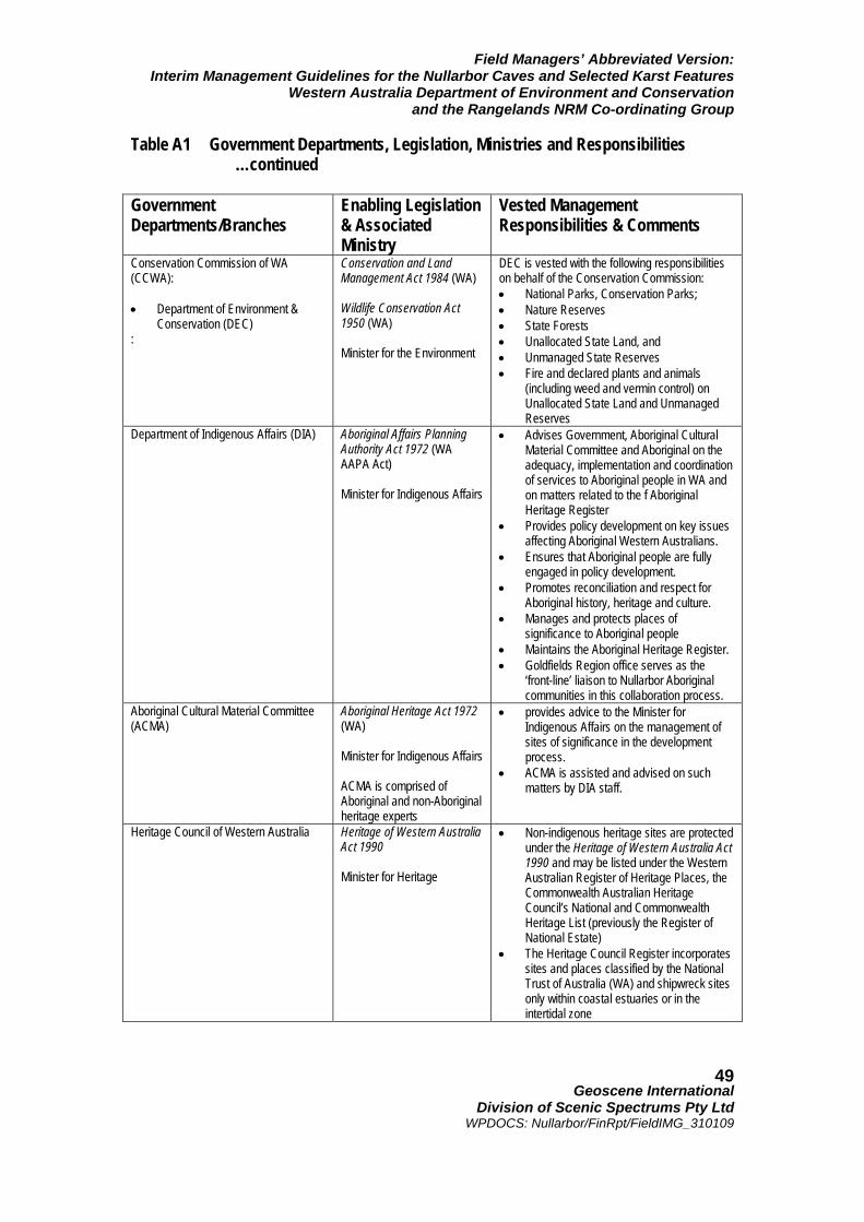
Field Managers’ Abbreviated Version: Interim Management Guidelines for the Nullarbor Caves and Selected Karst Features
Western Australia Department of Environment and Conservation and the Rangelands NRM Co-ordinating Group
Geoscene International
Division of Scenic Spectrums Pty Ltd WPDOCS: Nullarbor/FinRpt/FieldIMG_310109
49
Table A1 Government Departments, Legislation, Ministries and Responsibilities …continued Government Departments/Branches
Enabling Legislation & Associated Ministry
Vested Management Responsibilities & Comments
Conservation Commission of WA (CCWA): • Department of Environment &
Conservation (DEC) :
Conservation and Land Management Act 1984 (WA) Wildlife Conservation Act 1950 (WA) Minister for the Environment
DEC is vested with the following responsibilities on behalf of the Conservation Commission: • National Parks, Conservation Parks; • Nature Reserves • State Forests • Unallocated State Land, and • Unmanaged State Reserves • Fire and declared plants and animals
(including weed and vermin control) on Unallocated State Land and Unmanaged Reserves
Department of Indigenous Affairs (DIA) Aboriginal Affairs Planning Authority Act 1972 (WA AAPA Act) Minister for Indigenous Affairs
• Advises Government, Aboriginal Cultural Material Committee and Aboriginal on the adequacy, implementation and coordination of services to Aboriginal people in WA and on matters related to the f Aboriginal Heritage Register
• Provides policy development on key issues affecting Aboriginal Western Australians.
• Ensures that Aboriginal people are fully engaged in policy development.
• Promotes reconciliation and respect for Aboriginal history, heritage and culture.
• Manages and protects places of significance to Aboriginal people
• Maintains the Aboriginal Heritage Register. • Goldfields Region office serves as the
‘front-line’ liaison to Nullarbor Aboriginal communities in this collaboration process.
Aboriginal Cultural Material Committee (ACMA)
Aboriginal Heritage Act 1972 (WA) Minister for Indigenous Affairs ACMA is comprised of Aboriginal and non-Aboriginal heritage experts
• provides advice to the Minister for Indigenous Affairs on the management of sites of significance in the development process.
• ACMA is assisted and advised on such matters by DIA staff.
Heritage Council of Western Australia Heritage of Western Australia Act 1990 Minister for Heritage
• Non-indigenous heritage sites are protected under the Heritage of Western Australia Act 1990 and may be listed under the Western Australian Register of Heritage Places, the Commonwealth Australian Heritage Council’s National and Commonwealth Heritage List (previously the Register of National Estate)
• The Heritage Council Register incorporates sites and places classified by the National Trust of Australia (WA) and shipwreck sites only within coastal estuaries or in the intertidal zone
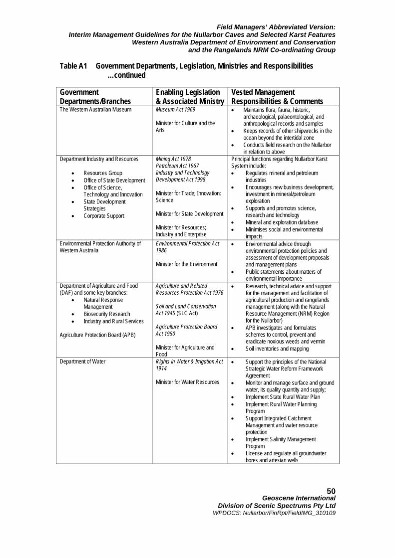
Field Managers’ Abbreviated Version: Interim Management Guidelines for the Nullarbor Caves and Selected Karst Features
Western Australia Department of Environment and Conservation and the Rangelands NRM Co-ordinating Group
Geoscene International
Division of Scenic Spectrums Pty Ltd WPDOCS: Nullarbor/FinRpt/FieldIMG_310109
50
Table A1 Government Departments, Legislation, Ministries and Responsibilities …continued Government Departments/Branches
Enabling Legislation & Associated Ministry
Vested Management Responsibilities & Comments
The Western Australian Museum Museum Act 1969 Minister for Culture and the Arts
• Maintains flora, fauna, historic, archaeological, palaeontological, and anthropological records and samples
• Keeps records of other shipwrecks in the ocean beyond the intertidal zone
• Conducts field research on the Nullarbor in relation to above
Department Industry and Resources
• Resources Group • Office of State Development • Office of Science,
Technology and Innovation • State Development
Strategies • Corporate Support
Mining Act 1978 Petroleum Act 1967 Industry and Technology Development Act 1998 Minister for Trade; Innovation; Science Minister for State Development Minister for Resources; Industry and Enterprise
Principal functions regarding Nullarbor Karst System include: • Regulates mineral and petroleum
industries • Encourages new business development,
investment in mineral/petroleum exploration
• Supports and promotes science, research and technology
• Mineral and exploration database • Minimises social and environmental
impacts Environmental Protection Authority of Western Australia
Environmental Protection Act 1986 Minister for the Environment
• Environmental advice through environmental protection policies and assessment of development proposals and management plans
• Public statements about matters of environmental importance
Department of Agriculture and Food (DAF) and some key branches:
• Natural Response Management
• Biosecurity Research • Industry and Rural Services
Agriculture Protection Board (APB)
Agriculture and Related Resources Protection Act 1976 Soil and Land Conservation Act 1945 (SLC Act) Agriculture Protection Board Act 1950 Minister for Agriculture and Food
• Research, technical advice and support for the management and facilitation of agricultural production and rangelands management (along with the Natural Resource Management (NRM) Region for the Nullarbor)
• APB investigates and formulates schemes to control, prevent and eradicate noxious weeds and vermin
• Soil inventories and mapping
Department of Water Rights in Water & Irrigation Act 1914 Minister for Water Resources
• Support the principles of the National Strategic Water Reform Framework Agreement
• Monitor and manage surface and ground water, its quality quantity and supply;
• Implement State Rural Water Plan • Implement Rural Water Planning
Program • Support Integrated Catchment
Management and water resource protection
• Implement Salinity Management Program
• License and regulate all groundwater bores and artesian wells
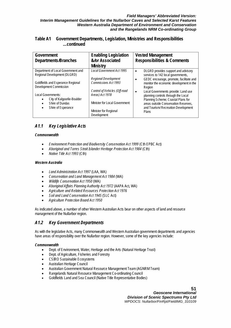
Field Managers’ Abbreviated Version: Interim Management Guidelines for the Nullarbor Caves and Selected Karst Features
Western Australia Department of Environment and Conservation and the Rangelands NRM Co-ordinating Group
Geoscene International
Division of Scenic Spectrums Pty Ltd WPDOCS: Nullarbor/FinRpt/FieldIMG_310109
51
Table A1 Government Departments, Legislation, Ministries and Responsibilities …continued Government Departments/Branches
Enabling Legislation &/or Associated Ministry
Vested Management Responsibilities & Comments
Department of Local Government and Regional Development (DLGRD) Goldfields and Esperance Regional Development Commission
Local Governments:
• City of Kalgoorlie-Boulder • Shire of Dundas • Shire of Esperance
Local Government Act 1995 Regional Development Commissions Act 1993 Control of Vehicles (Off-road Areas) Act 1978 Minister for Local Government Minister for Regional Development
• DLGRD provides support and advisory services to 142 local governments,
• GEDC encourage, promote, facilitate and monitor the economic development in the Region
• Local Governments provide: Land use planning controls through the Local Planning Scheme; Coastal Plans for areas outside Conservation Reserves, and Tourism/ Recreation Development Plans
A1.1 Key Legislative Acts Commonwealth
• Environment Protection and Biodiversity Conservation Act 1999 (Cth EPBC Act) • Aboriginal and Torres Strait Islander Heritage Protection Act 1984 (Cth) • Native Title Act 1993 (Cth)
Western Australia
• Land Administration Act 1997 (LAA, WA) • Conservation and Land Management Act 1984 (WA) • Wildlife Conservation Act 1950 (WA) • Aboriginal Affairs Planning Authority Act 1972 (AAPA Act, WA) • Agriculture and Related Resources Protection Act 1976 • Soil and Land Conservation Act 1945 (SLC Act) • Agriculture Protection Board Act 1950
As indicated above, a number of other Western Australian Acts bear on other aspects of land and resource management of the Nullarbor region. A1.2 Key Government Departments As with the legislative Acts, many Commonwealth and Western Australian government departments and agencies have areas of responsibility over the Nullarbor region. However, some of the key agencies include: Commonwealth
• Dept. of Environment, Water, Heritage and the Arts (Natural Heritage Trust) • Dept. of Agriculture, Fisheries and Forestry • CSIRO Sustainable Ecosystems • Australian Heritage Council • Australian Government Natural Resource Management Team (AGNRM Team) • Rangelands Natural Resource Management Co-ordinating Council • Goldfields Land and Sea Council (Native Title Representative Bodies)
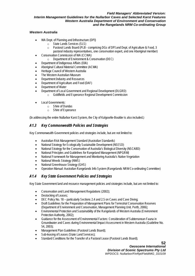
Field Managers’ Abbreviated Version: Interim Management Guidelines for the Nullarbor Caves and Selected Karst Features
Western Australia Department of Environment and Conservation and the Rangelands NRM Co-ordinating Group
Geoscene International
Division of Scenic Spectrums Pty Ltd WPDOCS: Nullarbor/FinRpt/FieldIMG_310109
52
Western Australia
• WA Dept. of Planning and Infrastructure (DPI) o State Lands Services (SLS) o Pastoral Lands Board (PLB - comprising DGs of DPI and Dept. of Agriculture & Food, 3
pastoral industry representatives, one conservation expert, and one Aboriginal member) • Conservation Commission of WA (CCWA)
o Department of Environment & Conservation (DEC) • Department of Indigenous Affairs (DIA) • Aboriginal Cultural Material Committee (ACMA) • Heritage Council of Western Australia • The Western Australian Museum • Department Industry and Resources • Department of Agriculture and Food (DAF) • Department of Water • Department of Local Government and Regional Development (DLGRD)
o Goldfields and Esperance Regional Development Commission
• Local Governments: o Shire of Dundas o Shire of Esperance
(In addressing the entire Nullarbor Karst System, the City of Kalgoorlie-Boulder is also included.) A1.3 Key Commonwealth Policies and Strategies Key Commonwealth Government policies and strategies include, but are not limited to:
• Australian Risk Management Standard (Australian Standards) • National Strategy for Ecologically Sustainable Development (NSESD) • National Strategy for the Conservation of Australia’s Biological Diversity (NSCABD) • National Principles and Guidelines for Rangeland Management (NPGRM) • National Framework for Management and Monitoring Australia’s Native Vegetation • National Weeds Strategy (NWS) • National Greenhouse Strategy (GHS) • Operation Manual: Australian Rangelands Info System (Rangelands NRM Co-ordinating Committee)
A1.4 Key State Government Policies and Strategies Key State Government land and resource management policies and strategies include, but are not limited to:
• Conservation and Land Management Regulations (2002); • Destocking of Leases; • DEC Policy No. 18 – particularly Sections 2.4 and 2.5 on Caves and Cave Diving; • Draft Guidelines for the Preparation of Management Plans for Terrestrial Conservation Reserves
(Department of Environment and Conservation, Management Planning Unit. Perth, 2006); • Environmental Protection and Sustainability of the Rangelands of Western Australia (Environment
Protection Authority, 2002); • Guidance for the Assessment of Environmental Factors: Consideration of Subterranean Fauna in
Groundwater and Caves during Environmental Impact Assessment in Western Australia (Guideline No. 54, 2003);
• Management Plan Guidelines (Pastoral Lands Board); • Sub-leasing of Leases (State Land Services); • Standard Conditions for the Transfer of a Pastoral Lease (Pastoral Lands Board);
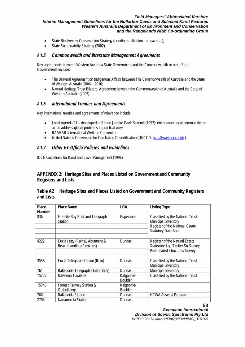
Field Managers’ Abbreviated Version: Interim Management Guidelines for the Nullarbor Caves and Selected Karst Features
Western Australia Department of Environment and Conservation and the Rangelands NRM Co-ordinating Group
Geoscene International
Division of Scenic Spectrums Pty Ltd WPDOCS: Nullarbor/FinRpt/FieldIMG_310109
53
• State Biodiversity Conservation Strategy (pending ratification and gazettal); • State Sustainability Strategy (2002).
A1.5 Commonwealth and Interstate Management Agreements Key agreements between Western Australia State Government and the Commonwealth or other State Governments include:
• The Bilateral Agreement on Indigenous Affairs between The Commonwealth of Australia and the State of Western Australia 2006 – 2010;
• Natural Heritage Trust Bilateral Agreement between the Commonwealth of Australia and the State of Western Australia (2002).
A1.6 International Treaties and Agreements Key international treaties and agreements of relevance include:
• Local Agenda 21 – developed at Rio de Janeiro Earth Summit (1992): encourages local communities to act to address global problems in practical ways
• RAMSAR International Wetland Convention • United Nations Convention for Combating Desertification (UNCCD: http://www.unccd.int/ ).
A1.7 Other Ex-Officio Policies and Guidelines IUCN Guidelines for Karst and Cave Management (1996) APPENDIX 2: Heritage Sites and Places Listed on Government and Community Registers and Lists Table A2 Heritage Sites and Places Listed on Government and Community Registers and Lists Place Number
Place Name LGA Listing Type
836 Israelite Bay Post and Telegraph Station
Esperance
Classified by the National Trust Municipal Inventory Register of the National Estate Statutory Data Base
4222 Eucla Jetty (Ruins), Abutment & Beach Landing (Remains)
Dundas
Register of the Natural Estate Statewide Lge Timber Str Survey Port-related Structures Survey
3558 Eucla Telegraph Station (Ruin) Dundas
Classified by the National Trust Municipal Inventory
761 Balladonia Telegraph Station (fmr) Dundas Municipal Inventory 15722 Rawlinna Townsite Kalgoorlie-
Boulder Classified by the National Trust
15746 Forrest Railway Station & Outbuildings
Kalgoorlie-Boulder
760 Balladonia Station Dundas HCWA Assesst Program 2705 Nanambinia Station Dundas
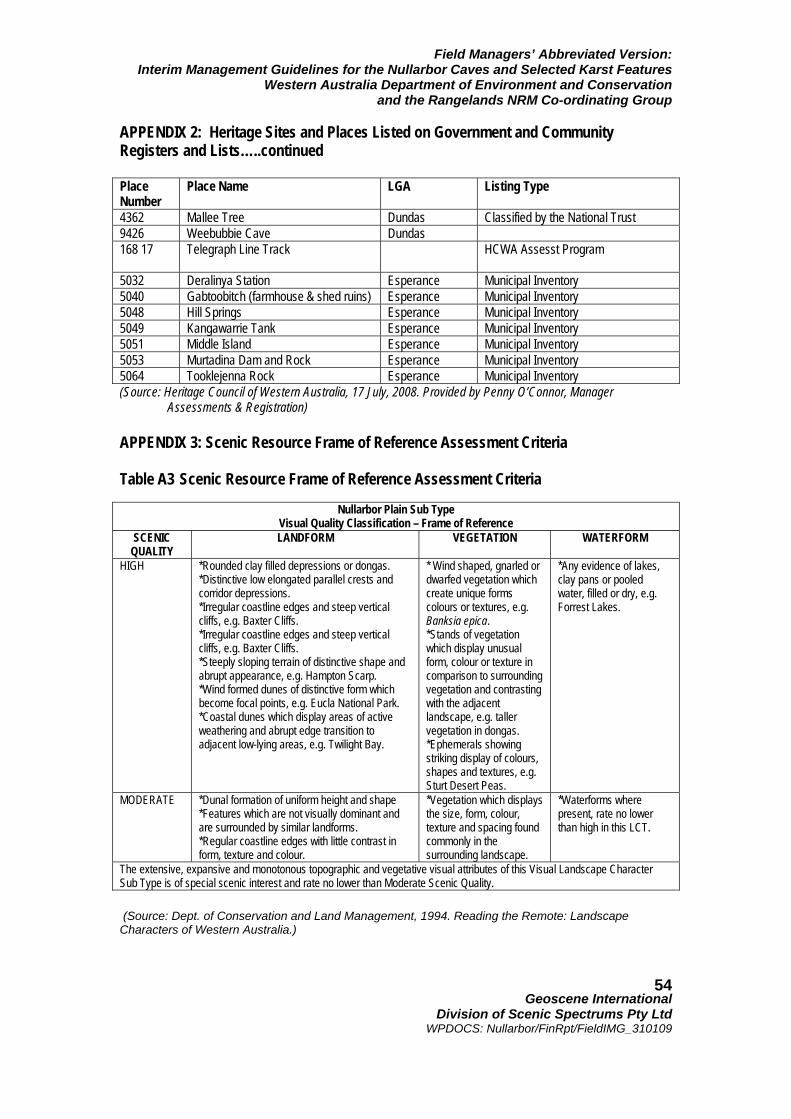
Field Managers’ Abbreviated Version: Interim Management Guidelines for the Nullarbor Caves and Selected Karst Features
Western Australia Department of Environment and Conservation and the Rangelands NRM Co-ordinating Group
Geoscene International
Division of Scenic Spectrums Pty Ltd WPDOCS: Nullarbor/FinRpt/FieldIMG_310109
54
APPENDIX 2: Heritage Sites and Places Listed on Government and Community Registers and Lists…..continued Place Number
Place Name LGA Listing Type
4362 Mallee Tree Dundas Classified by the National Trust 9426 Weebubbie Cave Dundas 168 17 Telegraph Line Track HCWA Assesst Program
5032 Deralinya Station Esperance Municipal Inventory 5040 Gabtoobitch (farmhouse & shed ruins) Esperance Municipal Inventory 5048 Hill Springs Esperance Municipal Inventory 5049 Kangawarrie Tank Esperance Municipal Inventory 5051 Middle Island Esperance Municipal Inventory 5053 Murtadina Dam and Rock Esperance Municipal Inventory 5064 Tooklejenna Rock Esperance Municipal Inventory (Source: Heritage Council of Western Australia, 17 July, 2008. Provided by Penny O’Connor, Manager
Assessments & Registration) APPENDIX 3: Scenic Resource Frame of Reference Assessment Criteria Table A3 Scenic Resource Frame of Reference Assessment Criteria
(Source: Dept. of Conservation and Land Management, 1994. Reading the Remote: Landscape Characters of Western Australia.)
Nullarbor Plain Sub Type Visual Quality Classification – Frame of Reference
SCENIC QUALITY
LANDFORM VEGETATION WATERFORM
HIGH *Rounded clay filled depressions or dongas. *Distinctive low elongated parallel crests and corridor depressions. *Irregular coastline edges and steep vertical cliffs, e.g. Baxter Cliffs. *Irregular coastline edges and steep vertical cliffs, e.g. Baxter Cliffs. *Steeply sloping terrain of distinctive shape and abrupt appearance, e.g. Hampton Scarp. *Wind formed dunes of distinctive form which become focal points, e.g. Eucla National Park. *Coastal dunes which display areas of active weathering and abrupt edge transition to adjacent low-lying areas, e.g. Twilight Bay.
* Wind shaped, gnarled or dwarfed vegetation which create unique forms colours or textures, e.g. Banksia epica. *Stands of vegetation which display unusual form, colour or texture in comparison to surrounding vegetation and contrasting with the adjacent landscape, e.g. taller vegetation in dongas. *Ephemerals showing striking display of colours, shapes and textures, e.g. Sturt Desert Peas.
*Any evidence of lakes, clay pans or pooled water, filled or dry, e.g. Forrest Lakes.
MODERATE *Dunal formation of uniform height and shape *Features which are not visually dominant and are surrounded by similar landforms. *Regular coastline edges with little contrast in form, texture and colour.
*Vegetation which displays the size, form, colour, texture and spacing found commonly in the surrounding landscape.
*Waterforms where present, rate no lower than high in this LCT.
The extensive, expansive and monotonous topographic and vegetative visual attributes of this Visual Landscape Character Sub Type is of special scenic interest and rate no lower than Moderate Scenic Quality.
Field Managers’ Abbreviated Version: Interim Management Guidelines for the Nullarbor Caves and Selected Karst Features
Western Australia Department of Environment and Conservation and the Rangelands NRM Co-ordinating Group
Geoscene International
Division of Scenic Spectrums Pty Ltd WPDOCS: Nullarbor/FinRpt/FieldIMG_310109
55
APPENDIX 4: Visitor Access, Infrastructure Needs, Interpretation, Management Presence and Control Issues A4.1 Two Schools of Thought on Public Access to Caves and Karst Features of the Nullarbor Regarding the issue of visitor access to caves and karst features, there appear to be two schools of thought as to whether land managers should restrict information about cave locations, physically restrict access or provide public information and education, as follows:
1. That even though the majority of visitors may respond in a responsible and sensitive manner when educated about the fragility of the caves, there will always be a certain percentage of people who will not respond to signage provided to prevent destructive behaviours regarding caves. Cave protection needs to respond to the worst-case situation and the lowest-common denominators regarding cave visitors;
2. That environmental interpretation and educational programs can increase the public’s knowledge of,
appreciation for, and care for caves and their fragile contacts – influencing visitor behaviours to reflect management objectives.
There is a great deal of truth in both of these schools of thought. The question is - which approach is the best one for the Nullarbor caves given the current circumstances? And, is one method or the other best for the Nullarbor as a whole, or should some caves be treated with the more regulatory approach and should other caves be treated with the more enlightened, educative approach? It is clear that the more restrictive secretive and regulatory approaches are simply un-enforceable and impractical for application to so many caves in such a remote area where there is no on-ground management presence. It is also clear that signage and self-administered educational tools (e.g., brochures, CDs, etc.) will also not be appropriate for all the caves in the region without providing some opportunities for people to visit and experience at least some of the caves. Caves that display more spectacular or curious internal features are also more likely to have a high Overall Risk rating, but are the more desirable caves for tourist and adventure use (from the tourists perspective). A small number of these types of caves should possibly be considered for tourism and adventure uses. This would be particularly so if they do not contain the rarest and most sacred features. Certainly the caves with the most rare and fragile features should be protected and most should not be opened to the public. Which of these caves should be available on a limited basis for research, exploration and survey by qualified professionals and certified organisa-tions is another point requiring further resolution. Whether certain caves should not ever be open to access or should be closed to access once their contents have been documented is another issue to be resolved, as even research activities can cause damage. A4.2 Potential Infrastructure Needs at Caves Open to Access For those caves that may be classified as Tourist Caves or Adventure Caves, additional infrastructure may be required or desirable to minimise visitor impacts. Currently, aside from the three caves that are gated and the few caves that may have small internal information and safety plaques, most caves have practically no infrastructure at all, other than a possible identification sign outside the cave entrance. The vehicular tracks and parking areas are generally informal and uncontrolled, with incremental damage being caused to the fringing vegetation areas (refer to Photos 47 and 48 as examples). Walking tracks to and from the cave are also usually informal and may often meander in multiple pathways, adding to the trampling of vegetation and the increase in erosion that may add to sedimentation within the caves. One of the relatively consistent findings in recreation research is that the provision of well-defined parking areas and walkways (through paving, boardwalks or other forms of hardening the pathway surface and confining visitors
Field Managers’ Abbreviated Version: Interim Management Guidelines for the Nullarbor Caves and Selected Karst Features
Western Australia Department of Environment and Conservation and the Rangelands NRM Co-ordinating Group
Geoscene International
Division of Scenic Spectrums Pty Ltd WPDOCS: Nullarbor/FinRpt/FieldIMG_310109
56
steps in the preferred direction) is very effective in preventing the random creation of adhoc pathways in various directions to and from recreational destinations. People will invariably choose the path of least resistance and the most obvious access way to reach the area of interest to them. This is also true within caves for the general public, even when the designated track may be relatively narrow. In this sense, those caves that are most visited and that may become classified as Tourist Caves or Adventure Caves may require the addition of infrastructure that minimises the likely impact of visitors’ vehicles and footsteps, as well as some aesthetic landscape design and interpretive signage. The relatively sparse road system in the Nullarbor is probably one of the most useful management tools (or non-tool) available to land managers – many people may give up on looking for places they have found on internet satellite imagery when they cannot find or gain access to the right road to the locations. But, 4WD vehicles and those with more adventurous spirits can get to many places that would have been left alone in the past. Decisions about the provision of roads in the first place or the upgrading existing vehicular tracks leading to caves need to be carefully considered in the context of the eventual cave classification and management purpose. Where roads already exist, similar decisions must be made regarding the provision or non-provision of directional signage to the caves. A4.3 Interpretive Facilities and Programs Although most of the caves are likely to remain unpromoted and inaccessible to the general public due to their high significance and fragility levels, this does not necessarily mean that the general public should completely miss out on the educational value and sense of awe and wonder that these caves may offer. As indicated above, some caves may be selected as Tourist Caves or Adventure Caves that are accessible to different segments of the public. Such caves may require better roads, improved directional, safety and interpretive signage, greater on-site infrastructure and possibly the implementation of guided tours with trained guides who can not only inform and interpret the caves for them, but also control and monitor visitors’ actions. Other alternatives include the provision of virtual cave tours (using sequential photography and videos), closed circuit television views into the caves (similar to the screening of bats in caves at Narracoorte World Heritage Area in South Australia), and educational DVDs and CDs that can be enjoyed in the car, at home or in schools. Lastly, the provision of a central museum on the Nullarbor Plain along the Eyre Highway or one or more visitor interpretation centres on the Nullarbor may be considered. Obviously, each of these alternatives would require further feasibility assessment. However, it has been shown in the research that visitors’ knowledge, appreciation and behaviours toward valuable and environmentally sensitive natural and cultural features make the greatest improvement when a combination of educational and interpretive techniques are utilised. These include personal contact and messages from rangers and tour guides, signage, brochures, videos, etc. Taken by themselves, especially in the case of signage and brochures, none of these methods is as effective by themselves as when combined with one or two of the other methods of educating visitors (refer to Roggenbuck, Chapter 7 in Manfredo, 1992). Usually, the more such public education and interpretive programs and facilities can be provided in locations away from the actual sites and prior to visitors going to the sites, the more effective the response. Importantly, the provision of interpretive facilities and programs off-site may well satisfy much of the public curiosity about the caves and give them understanding as to why many of the caves should not be accessed, while at the same time, gaining personal knowledge and value from the existence of the caves, the karst system and their role. This, combined with the possibility of visiting selected caves (as discussed above) may be an important step in providing much greater community appreciation and sensitivity toward the Nullarbor caves and karst features.
Field Managers’ Abbreviated Version: Interim Management Guidelines for the Nullarbor Caves and Selected Karst Features
Western Australia Department of Environment and Conservation and the Rangelands NRM Co-ordinating Group
Geoscene International
Division of Scenic Spectrums Pty Ltd WPDOCS: Nullarbor/FinRpt/FieldIMG_310109
57
A4.4 Provision of Management and Interpretive Presence Most of the above considerations would require some form of management and interpretive presence of staff or volunteers based within the Nullarbor on a full-time or at least seasonal basis. Such staff would probably need offices and other facilities located at Cocklebiddy, Madura or Eucla along the Eyre Highway. So far, DEC has not been able to justify paid full-time or part-time rangers located on the Nullarbor. Whether this may change in the future or not is unknown at this time. Other possibilities include the training and/or payment of selected volunteers who live on the Nullarbor (or who are willing to move there) to play interpretive, monitoring and regulatory roles. Currently, two volunteer resident wardens are located at Eyre. They are the eyes and ears for DEC in that part of the Nuytsland Nature Reserve. Such volunteers might be selected from among the existing local community, from among the Pastoralists who run leasehold grazing properties, from among appropriate Aboriginal communities, or from among qualified applicants to advertised positions. Another method of visitor control is to make selected caves accessible on a rotational basis during different years to allow rest periods without disruptions and impacts. APPENDIX 5: Groundwater Issues A5.1 Groundwater Values and Threats Environmental values of groundwater include:
• stygofauna assemblages (in aquifer ecosystems); • troglobitic faunal assemblages (in caves); • groundwater dependent vegetation; • maintaining baseflows or pools in waterways; • maintaining open water or waterlogged soils in wetlands (Rangelands NRM Co-ordinating Group, 2005); • bacterial colonies; • maintaining or protecting habitats, including those in the soil, water, root systems and caves.
Major threats to the groundwater system include:
• potential over-extraction of groundwater; • the uncontrolled flow of artesian bores; • changes to flow patterns; and • degradation of the water quality.
All of the above may pose a threat to the health and integrity of the groundwater ecosystems. (Threats also include human visitation and contamination within dolines, blowholes and caves through the spread of viruses and bacteria harmful to the indigenous flora and fauna.) Aquifers are considered to be vulnerable to degradation by exploratory drilling in the following ways:
• aquifers may be contaminated by entry through open boreholes by run-off water from the surface, such as in saline and industrial areas;
• aquifers containing useable-quality water being connected by drill holes to aquifers with inferior-quality
water or to leakage zones; cross flow may be induced by natural pressure differences or pressure differentials induced by pumping;
• uncontrolled flow of pressure aquifer water through drill holes between aquifers of different quality water
or through uncontrolled flow to wastage at the surface.
Field Managers’ Abbreviated Version: Interim Management Guidelines for the Nullarbor Caves and Selected Karst Features
Western Australia Department of Environment and Conservation and the Rangelands NRM Co-ordinating Group
Geoscene International
Division of Scenic Spectrums Pty Ltd WPDOCS: Nullarbor/FinRpt/FieldIMG_310109
58
The habitat and diversity of aquatic flora and fauna can be affected by contaminated groundwater aquifers. A5.2 DMPR Guidelines Regarding Exploratory Drilling Regarding the potential effects of exploratory drilling on groundwater resources, the WA Department of Mineral and Petroleum Resources have prepared Guidelines for the Protection of Surface and Groundwater Resources During Exploration Drilling (DMPR, 2002). These guidelines are in addition to regulations for exploration drilling and construction of water bores in designated groundwater areas. In Western Australia, the land occupier must have an appropriate groundwater license and the driller must hold an appropriate drillers’ license (Classes 1, 2 or 3) issued by the Australian Drilling Association and applicable for the particular intended type of groundwater drilling and bore construction. The Guidelines for the Protection of Surface and Groundwater Resources during Exploration Drilling (2002) identifies three types of aquifers:
• unconfined aquifers; • multi-layered aquifers; and • confined (artesian) aquifers.
The unconfined aquifers are also referred to as water table or phreatic aquifers, characterised by a groundwater body that has free exchange of pressure and moisture with the atmosphere. Rainfall on surface layers can percolate into the watertable and moisture from the watertable can also evaporate. Distinct layering of strata does not occur in these types of aquifers and little change in water level occurs when bore or exploration hills are drilled and completed. Little salinity mixing takes place naturally when the drilling penetrates these aquifers, although large increases in salinity may be found with increasing depth of bores. Figure A5 shows a section drawn from the northwest to the southeast across the Eucla Basin. This illustrates the geological structure. Cretaceous Loongana Sandstone is located at the base, which forms the artesian aquifer on Roe Plains. This is overlain by shales of the Toondi and Madura Formation. The unconfined aquifer consists mainly of the Wilson Bluff Limestone and the Abrakurrie Limestone, with greensands of the Cretaceous Nurina Formation, and the Eocene Hampton Sandstone at the base. Salinity levels and their geographic distribution vary considerably when comparing those of the upper level Wilson Bluff Limestone aquifer to those of the lower level Lagoona Sandstone aquifer. Unconfined aquifers are very susceptible to contamination from surface land uses, including the disposal of industrial waste, the use of agricultural fertilisers and sprays. Where the watertable is shallow, the salinity of these aquifers may increase. Unconfined aquifers are usually found in the following areas:
• upper layers of the coastal plains; • alluvial deposits of river valleys’; • in palaeoriver systems, such as those associated with the main salt lake chains; • in the regolith, the soil and weathered hardrock layer that covers most of the inland part of the State,
including the Goldfields, Ashburton, Pilbara and Kimberley regions. The regolith layer extends downward into the broken, fractured and jointed hardrock zone. Multi-layered aquifers are primarily associated with layered or stratified sediments in the large sedimentary basins of the State, including the Eucla basin. Drill holes that penetrate each layer of such aquifers usually result in a change in water level, indicating that water exchange between layers may be induced by a drill hole as a result of differential pressures.
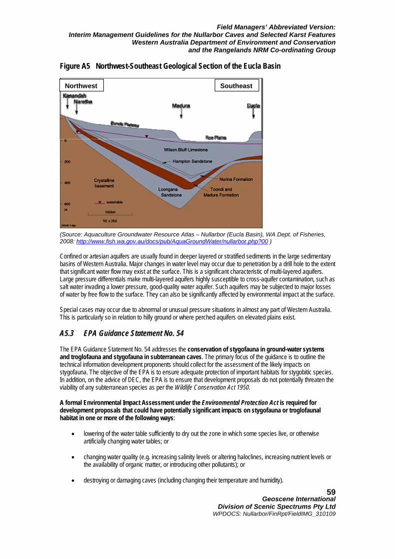
Field Managers’ Abbreviated Version: Interim Management Guidelines for the Nullarbor Caves and Selected Karst Features
Western Australia Department of Environment and Conservation and the Rangelands NRM Co-ordinating Group
Geoscene International
Division of Scenic Spectrums Pty Ltd WPDOCS: Nullarbor/FinRpt/FieldIMG_310109
59
Figure A5 Northwest-Southeast Geological Section of the Eucla Basin (Source: Aquaculture Groundwater Resource Atlas – Nullarbor (Eucla Basin), WA Dept. of Fisheries, 2008: http://www.fish.wa.gov.au/docs/pub/AquaGroundWater/nullarbor.php?00 ) Confined or artesian aquifers are usually found in deeper layered or stratified sediments in the large sedimentary basins of Western Australia. Major changes in water level may occur due to penetration by a drill hole to the extent that significant water flow may exist at the surface. This is a significant characteristic of multi-layered aquifers. Large pressure differentials make multi-layered aquifers highly susceptible to cross-aquifer contamination, such as salt water invading a lower pressure, good-quality water aquifer. Such aquifers may be subjected to major losses of water by free flow to the surface. They can also be significantly affected by environmental impact at the surface. Special cases may occur due to abnormal or unusual pressure situations in almost any part of Western Australia. This is particularly so in relation to hilly ground or where perched aquifers on elevated plains exist. A5.3 EPA Guidance Statement No. 54 The EPA Guidance Statement No. 54 addresses the conservation of stygofauna in ground-water systems and troglofauna and stygofauna in subterranean caves. The primary focus of the guidance is to outline the technical information development proponents should collect for the assessment of the likely impacts on stygofauna. The objective of the EPA is to ensure adequate protection of important habitats for stygobitic species. In addition, on the advice of DEC, the EPA is to ensure that development proposals do not potentially threaten the viability of any subterranean species as per the Wildlife Conservation Act 1950. A formal Environmental Impact Assessment under the Environmental Protection Act is required for development proposals that could have potentially significant impacts on stygofauna or troglofaunal habitat in one or more of the following ways:
• lowering of the water table sufficiently to dry out the zone in which some species live, or otherwise artificially changing water tables; or
• changing water quality (e.g. increasing salinity levels or altering haloclines, increasing nutrient levels or
the availability of organic matter, or introducing other pollutants); or
• destroying or damaging caves (including changing their temperature and humidity).
SoutheastNorthwest
Field Managers’ Abbreviated Version: Interim Management Guidelines for the Nullarbor Caves and Selected Karst Features
Western Australia Department of Environment and Conservation and the Rangelands NRM Co-ordinating Group
Geoscene International
Division of Scenic Spectrums Pty Ltd WPDOCS: Nullarbor/FinRpt/FieldIMG_310109
60
The guidance provides advice regarding the survey sampling design, demonstrating the lack of threat and the development of a management plan for the conservation of stygofauna within the impact area. A5.4 Regional Water Resource Assessments Regional Water Resource Assessments (National Water Commission, 2005 http://www.water.gov.au/RegionalWaterResourcesAssessments/SpecificGeographicRegion/tabbedreports.aspx?PID=WA_GW_233b ) suggest a number of high level performance indicators of water management for the Nullarbor groundwater management unit (GMU) based on information provided by the Western Australian Government. However, data and answers to a range of questions and key information of relevance to the National Water Initiative (NWI) do not appear to have been addressed to date, specifically in relation to:
• groundwater management framework; • water resource caps; • surface water / groundwater interaction; • sustainable groundwater yield; • environmental allowances / provisions; • groundwater diversions; and • groundwater entitlements.
Little monitoring of the above indicators appears to have taken place in the Nullarbor Karst region, nor is there strong evidence of a great deal of on-ground action in relation to management measures associated with these indicators. A5.5 Draft NRM Strategy The Draft NRM Strategy for the Rangelands Region (Rangelands NRM Co-ordinating Group, 2005) indicates that the implementation of groundwater monitoring and management actions in the Carnarvon Artesian Basin Rehabilitation Project has resulted in significant water savings due to the geophysical logging of bores, water management plans, decommissioning open flowing bores, and installation of reticulation to direct water to strategic locations. The economic and environmental benefits have included:
• improved management of total grazing pressure through better distribution of water to domestic animals and greater control of non-domestic species;
• more efficient and sustainable use of natural resources through better distribution of water; and
• increased access to water for other land uses such as tourism, aquaculture and horticulture.
In the Canning Basin, NLP funding has allowed the capping of artesian bores, resulting in the:
• removal of uncontrolled surface water to reduce the incidence of weed encroachment; • feral animals will be easier to monitor and control as watering points will be turned on only when
required;
• pumping water from re-drilled bores to areas deficient in water will increase pastoralists’ capacity to manage grazing and reduce the pressure on single water points, where erosion risks are high; and
• using artificial watering points rather than natural water points (i.e., permanent pools and rivers) to
lessen the impact of animals on fragile riparian areas. Whether or not such management actions have been considered and tried in the Nullarbor is not known, however, if not, they could possibly be considered.
Field Managers’ Abbreviated Version: Interim Management Guidelines for the Nullarbor Caves and Selected Karst Features
Western Australia Department of Environment and Conservation and the Rangelands NRM Co-ordinating Group
Geoscene International
Division of Scenic Spectrums Pty Ltd WPDOCS: Nullarbor/FinRpt/FieldIMG_310109
61
A5.6 Licensing and Monitoring Wells All confined wells within Western Australia require a license via the Crown for the use, flow and control of groundwater under the Rights in Water and Irrigation Act. Unconfined wells within specific ally proclaimed Groundwater Areas also require licensing. Groundwater licenses have been allocated in a manner to achieve sustainable use of groundwater resources throughout the Rangelands Region. The Department of Environment and Conservation (DEC) have also incorporated an allocation strategy and regular benchmark monitoring in sensitive and heavily utilised areas to ensure groundwater resources remain at sustainable levels for industrial, public water and environmental requirements. APPENDIX 6: Potential Impacts of Pastoral Uses on Caves, Karst Features and Associated Ecosystems A6.1 Potential Adverse Effects As caves, blowholes and dolines are linked to the surface; pastoral uses could potentially have adverse effects on the structure, physical and biological contents and hydrology of these karst features in the following ways:
• changes to the vegetative structure or removal of vegetation and the influence of tree/shrub root systems on the meso-cavernous system of the soils and regolith and on cave passages (which may also have adverse effects on surface ecosystems, flora and fauna);
• disruption) of surface water flows (diverting away from or into) in relation to the meso-cavernous system
or into dolines, blowholes and cave entrances, affecting the hydrologic flows;
• removal of groundwater volume and interruption of aquifer flows through the installation of water bores and wells, potentially resulting in declines in water quality and saltwater intrusion into the karst aquifer;
• effects on the quality of surface and groundwater through the introduction of pesticides, chemicals,
fertilizers, nutrients (e.g., nitrates, nitrites, phosphates, etc.), human sewage or animal wastes, or heavy metals (e.g. chromium, lead, mercury);
• development, construction, road building, and other infrastructure projects that may lead to drainage
basin alterations, decreased water quality and siltation;
• construction of surface reservoirs and subsequent flooding of caves (with excavations potentially breaking through passages that are close to the surface); and
• solid waste dumping into blowholes and dolines.
It is thought that caves under the main, higher level Nullarbor Plain are approximately 100 m below the surface. However, many of the caves on the lower Row Plain are so shallow in depth that the tree roots grow through the cave ceilings. Pannikin Plains Cave, for instance, extends under the Eyre Highway and vehicular traffic can be heard overhead by cavers inside the passage. Although the caves known to be located closer to the surface are more vulnerable than the deeper caves, this is not to say that the deeper caves are not at all vulnerable to surface activities or that shallower caves may not exist on the main Nullarbor Plain. The Western Australian Rangeland Monitoring System (WARMS) process indicates that improvements have been made in the Southern Rangelands since the 1990s and observations by Watson (unpublished) suggest there have been improvements in vegetation cover and erosion since the 1960s or 1970s. However, Pringle and Tinley (Pringle et al., submitted to Landscape Ecology, 2003) have identified insidious degradation in many areas of the Southern Rangelands that they predict will be felt gradually over very long timescales unless interventions are applied. In addition, Landsberg et al. (1997) of the CSIRO Division of Wildlife and Ecology identify the following

Field Managers’ Abbreviated Version: Interim Management Guidelines for the Nullarbor Caves and Selected Karst Features
Western Australia Department of Environment and Conservation and the Rangelands NRM Co-ordinating Group
Geoscene International
Division of Scenic Spectrums Pty Ltd WPDOCS: Nullarbor/FinRpt/FieldIMG_310109
62
potential changes to vegetation in response to grazing where artificial water points (from water bores) are provided for sheep or cattle:
1. development of a zone of extreme degradation around the water (up to 0.5 km) where soil crust is broken, erosion is high, and forbs dominate after rain;
2. increase in the number of unpalatable perennial shrubs beyond the sacrifice zone, particularly in
semi-arid woodland and arid shrubland habitats; and 3. decrease in abundance of palatable native perennial grasses due to selective grazing.
This is not to say that any of these problems actually exist within the project area, only that they may be potential problems to that require observation and monitoring. A6.2 Monitoring Procedures At present, there are two procedures in place for the assessment or monitoring of pastoral impacts:
• firstly, the Pastoral Lands Board inspects pastoral leases on a one to six year cycle. This approach varies the inspection frequency on the categorisation of each property from “Low Concern” (assessed every six years) to “High Concern” (assessed every year). It is assumed that such impacts are reasonably under control at present, however, it would be possible for management activities to occur on a property without being observed by the PLB for a number of years;
• secondly, the Western Australian Rangeland Monitoring System (WARMS) monitors approximately 1600
ground based sites selected to represent the pastoral Range-lands as a whole as well as areas where livestock grazing occurs. These include shrubland sites in the Southern Rangelands. The chenopod shrublands of the region receive proportionately more monitoring sites due to their relative productivity and fragility.
A6.3 Rangelands NRM Strategy and Best Practice Guidelines The entire Nullarbor Karst System is within the Southern Rangelands and Arid Interior NRM Sub-Regions, while the project area for this report is restricted to the Southern Rangelands Subregion. Pastoralism is the industry that affects the largest geographic areas of the Western Australian Rangelands. Pastoralists are key stakeholders and the Pastoralists and Graziers Association (PGA) and Western Australian Farmers Federation (WAFF) are peak industry bodies. Land Conservation District Committees (LCDCs), local zone meetings of the PGA and Zone Control Authorities (ZCAs), Landcare Groups and representatives to sub-regional NRM Groups are important participants in the NRM process. The Strategy for Managing the Natural Resources of Western Australia’s Rangelands (Rangelands NRM Co-ordinating Group, 2005) addresses rangelands management challenges through the identification and setting of performance standards and guidelines in relation to:
• priority natural resource assets; • resource condition targets (RCTs); and • management action targets (MATs).
Among the 14 key issues addressed by the RCTs and MATs are: declining soil condition, declining native vegetation integrity, declining inland aquatic water quality, altered water regimes, declining water quality/supply, declining terrestrial native species and community integrity, and decreasing primary productivity.
Field Managers’ Abbreviated Version: Interim Management Guidelines for the Nullarbor Caves and Selected Karst Features
Western Australia Department of Environment and Conservation and the Rangelands NRM Co-ordinating Group
Geoscene International
Division of Scenic Spectrums Pty Ltd WPDOCS: Nullarbor/FinRpt/FieldIMG_310109
63
Key RCTS include the improvement of soil surface condition (RCT3), the eradication or reduction of invasive and pest species (RCT4) and the maintenance or improvement in the density and cover of perennial vegetation (RCT5).
The MATs are grouped under five major categories:
• benchmarking and monitoring • on-ground actions • institutional frameworks, planning and policy; • education, awareness and further engagement (“capacity building”); and • cultural heritage.
An example “on-ground” MAT is for 70% of land managers to be implementing ecologically sustainable management practices by 2010. However, only 20% of properties are expected to implement best practice management soil conservation by 2010. A6.4 Field Actions on Pastoral Lands in Co-operation with Leaseholders The PBL and NRM processes are producing positive outcomes on pastoral lands of the project area. However, additional awareness-raising, training and assistance to pastoralists regarding the cave and karst values of the Nullarbor and best practice management techniques should be encouraged. More specifically, on-ground management actions, including potential fencing and revegetation may need to be considered for the recently negotiated exclusions around cave entries and dolines (refer to IMG 7). Another specific issue that may require further attention is that of fencing-off areas surrounding other dolines and cave entries in order to prevent excessive nutrients and weed seed from being transported into the dolines and cave entries via sheep manure in surface run-off. Any such fencing would need to be done in a way that it does not prohibit access to the dolines and caves by indigenous fauna. Lastly, it may be important for the pastoralists to understand which parts of their pastoral leases are located directly above/close to underground cave passages or where significant dolines and blowholes occur that may require care for either biodiversity or safety reasons. CEGSA and other speleological and cave diving groups hold survey information regarding the location of many caves, however, additional surveys and surface mapping may be required. By knowing where the surface boundaries of underground cave passages are located, Pastoralists could better ensure that the indigenous vegetation over these passages are protected from over grazing, fire or other activities that may harm or diminish the vegetation in those areas. In some ways, these areas located over cave passages may be treated in much the same way as riparian vegetation zones. In addition, such mapping would also assist the Pastoralists to avoid placing water bores, excavations, or heavy construction equipment within the boundaries of cave passages reflected on the ground surface. APPENDIX 7: Potential Mining Uses and Infrastructure Impacts on Caves A7.1 Potential Impacts of Mining A thorough search would be required to identify all the existing mining operations and exploration leases within the Nullarbor region. This would also require an on-going process to keep track of new leases and licenses. Mineral explorers are required by Western Australian legislation to report periodically on their programs. After a period of confidentiality, exploration reports and data are made publicly available, so that past exploration work is not unnecessarily repeated. These are referred to as open-file data.
Field Managers’ Abbreviated Version: Interim Management Guidelines for the Nullarbor Caves and Selected Karst Features
Western Australia Department of Environment and Conservation and the Rangelands NRM Co-ordinating Group
Geoscene International
Division of Scenic Spectrums Pty Ltd WPDOCS: Nullarbor/FinRpt/FieldIMG_310109
64
WAMEX is a searchable database of open-file reports on exploration for minerals (excluding oil and gas), and is managed by the Statutory Exploration Information Group (SEIG). Access to WAMEX is free of charge. Full digital copies of most reports are online (http://www.doir.wa.gov.au/5136.aspx ). Where a digital copy is not yet available, a microfiche copy of the report can be accessed at the Mineral House Library and at the Geological Survey's Kalgoorlie Regional Office. The total value of mining in the Nullarbor Karst region does not appear to be available. The economic value of mining is potentially significant, although not yet developed or fully verified. The Goldfields-Esperance Region produces gold, uranium and heavy mineral sands such as zircon. Mineral extraction predominantly occurs on the fringes of the Nullarbor (Kalgoorlie Terrane, Yilgarn Craton). In some other portions of the project area, potential diamond producing lands are under exploration and assessment. Paleo-channels within the Nullarbor Karst could be particularly attractive to mining explorations and future extractive activities. Other off-shore mineral exploration for petroleum and natural gas is underway and/or could potentially be expanded. The potential impacts of mining on caves, blowholes and dolines include many of the same impacts noted for pastoral land uses. Some of the key impacts of mining could include:
• oil and gas drilling on groundwater aquifers (in terms of interruption of flow, as well as potential pollution and contamination);
• removal of karst materials through quarrying activities;
• stockpile or landfill leachates contaminating surface and groundwater flows;
• physical impacts of heavy machinery or vehicles – potential collapse of cave passage rooftops, potential
damage to doline vegetation and surfaces, potential destruction of cave entry overhangs, etc. Pastoralists concerns noted by Pringle et al. (1990) regarding mining and mining exploration activities have included:
• excessive clearing of grid lines; • failure to cap drill holes or fill costeans;
• alluvial mining not followed by rehabilitation; use of hyper saline water in sluice mining operations;
• damage to fixed station infrastructure; use of station access roads during wet weather; • increased interference with normal station management;
• poorly sited and constructed access ways for pipelines and powerlines.
The IUCN Management Guidelines for Karst and Cave Management (1996) and members of the Steering Committee have noted the vulnerability of karst formation, ecology and ground-water quality to the percolation of contaminated water or to changes in surface water flows that percolate into the groundwater aquifers. Protection of groundwater is a particularly significant issue where mining (as well as pastoralism and other infrastructure construction) is concerned. As the Nullarbor groundwater system extends much further inland within the Eucla Basin than the Nullarbor Karst System itself, the dangers of groundwater contamination or pollution caused by mining in areas far removed from the project area are significant.
Field Managers’ Abbreviated Version: Interim Management Guidelines for the Nullarbor Caves and Selected Karst Features
Western Australia Department of Environment and Conservation and the Rangelands NRM Co-ordinating Group
Geoscene International
Division of Scenic Spectrums Pty Ltd WPDOCS: Nullarbor/FinRpt/FieldIMG_310109
65
A7.2 Mining Guideline Documents A number of guideline documents have been prepared in order to prevent or minimise adverse environmental effects of mining and mining exploration or to guide Environmental Impact Assessment, including:
• Guidelines for Mineral Exploration / Rehabilitation Activities http://www.doir.wa.gov.au/documents/environment/Exploration_Rehab_Activities.pdf
• Guidelines for the Protection of Surface and Groundwater Resources During Exploration Drilling (Dept.
of Mineral and Petroleum Resources, 2002);
• Guidance for the Assessment of Environmental Factors (in accordance with the Environmental Protection Act 1986): Consideration of Subterranean Fauna in Groundwater and Caves during the Environmental Impact Assessment in Western Australia. No. 54 (Environmental Protection Agency, 2003);
• Guidelines for Mineral Exploration and Mining within Conservation Reserves and other Environmentally
Sensitive Lands in WA http://www.doir.wa.gov.au/documents/minealsandspetroleum/ED_Min_GL_ExpMininginConervReservesEnvSenstiveLandsWA_jan07.pdf
• Interim Code of Conduct for Mineral Exploration in Western Australia (Association of Mining and
Exploration Companies, undated);
• Guidelines for Management of Dieback Disease in Mineral Exploration http://www.doir.wa.gove.au/documents/mineralsandpetroleum/ED_Min_GL_MgmtDiebackDisease_Dec06.pdf ;
• Goldfields Land and Sea Council Mining Policy (2008).
A7.3 GLSC Mining Policy The GLSC Mining Policy requires observance of several UN conventions by mining companies. The policy outlines a number of principles for mining-related decisions (primarily to do with the protection of Aboriginal rights), the cooperative decision-making involving GLSC with the Western Australian Government, the Federal Government and the proponent where possible. Operational principles are also suggested, including the making of any traditional knowledge available to the process. This policy is primarily focused on ensuring Aboriginal rights, and although mention is made of environmental issues, there is no direct reference to potential impacts on caves and associated karst features. A7.4 Transport and Communications Infrastructure Impacts The potential impacts generated by transport and communications infrastructure impacts are not much different than those noted for pastoral and mining activities. Protection of surface drainage, flora and fauna habitats, and groundwater resources are key concerns. In addition, the avoidance of placing heavy equipment or excavating over cave passages or too closely to dolines and blowholes is critical.
Field Managers’ Abbreviated Version: Interim Management Guidelines for the Nullarbor Caves and Selected Karst Features
Western Australia Department of Environment and Conservation and the Rangelands NRM Co-ordinating Group
Geoscene International
Division of Scenic Spectrums Pty Ltd WPDOCS: Nullarbor/FinRpt/FieldIMG_310109
66
APPENDIX 8: Aboriginal Cultural Heritage, Recognition and Co-operation All Indigenous cultural sites are protected by law, whether they are listed by the Department of Indigenous Affairs on the Aboriginal Heritage Register or not. In addition, it is important to acknowledge and uphold Aboriginal rights as per the United Nations Declaration on Rights of Indigenous Peoples (United Nations General Assembly, 2007). The Goldfields Land and Sea Council have adopted this standard for application when governments and others want to deal with indigenous peoples of the Goldfields-Esperance region or undertake development projects on their lands. The Declaration promotes the concept of “free, prior and informed consent”, which is also endorsed by the Australian Human Rights and Equal Opportunities Commission (HREOC). GLSC also request that in planning and managing any areas that may have Aboriginal connections, the Aboriginal knowledge of the country and culture be acknowledged and that Aboriginal management and ownership rights also be acknowledged and acted upon as appropriate. Indigenous people’s traditional use of the land for activities such as hunting, gathering native flowers, honey, etc. also needs to be facilitated as appropriate. Watson, et al. (2008), in their recent report on the Great Western Woodlands, provides a number of statements regarding Aboriginal Traditional Owners relationship and environmental knowledge of the landscape. These statements equally apply to Aboriginal relationships and knowledge of the Nullarbor landscape: “Traditional Aboriginal land use relies on intricate ecological and geographic knowledge. Over thousands of years, an intimate cultural understanding of the landscape and biota grew as successive generations watched seasons change and developed a ‘cultural map’ of their homelands. This knowledge is encoded in laws, stories, song, language, art and ritual, and has been passed through countless generations of custodians…..Historians and scientists have not yet paid enough attention to a range of customary Indigenous practices that are likely to be critical in successfully maintaining the full diversity of natural values found in the region. The long-accumulated ecological knowledge that underpins these practices is an important touchstone in understanding country…..Exercising and adapting these traditional practices to contemporary conservation and land management requires a direct management role for Traditional Owners. From the perspective of conservation science, traditional Indigenous management can be a vital part of responding to the environmental challenges. Moreover, the utilization of the latest conservation science, as well as contemporary techniques for recording and transmitting knowledge, can be a vital adaptive strategy for Indigenous custodians. Together, we can help respond to new and emerging threats” (Watson, et. al, 2008, p. 50.) APPENDIX 9: Safety and Liability Issues Potential liability issues directly related to the Nullarbor caves, blowholes and dolines could include the following items:
1. potential injuries or death to cave visitors under the following circumstances: a. while on a guided tour in a Conservation Reserve/Nat. Park; b. while on a guided tour off-reserve on Unallocated Crown Land or an Unmanaged Reserve; c. while on a guided tour off-reserve on a Pastoral Leasehold property; d. while visiting independently with a DEC or DPI permit (either on or off-reserve) e. while visiting independently without a DEC or DPI permit (either on or off-reserve;
2. potential injuries or death to DEC, WA Museum or other government staff or researchers while on official business (with or without permits);
3. potential injuries or death to university researchers:
a. with permits and not on pastoral leasehold or freehold lands b. with permits and on pastoral leasehold or freehold lands c. without permits and not on pastoral leasehold or freehold lands d. without permits and on pastoral leasehold or freehold lands.
Field Managers’ Abbreviated Version: Interim Management Guidelines for the Nullarbor Caves and Selected Karst Features
Western Australia Department of Environment and Conservation and the Rangelands NRM Co-ordinating Group
Geoscene International
Division of Scenic Spectrums Pty Ltd WPDOCS: Nullarbor/FinRpt/FieldIMG_310109
67
4. potential injuries or death to pastoral leaseholders, staff or guests as a result of cave passage collapse on the leasehold property:
a. with moderate to high risk areas identified and mapped for them prior to event; b. without moderate to high risk areas identified and mapped for them prior to event;
Obviously the degree of liability and the party who is liable would depend on each situation and the exact circumstances. These situations raise the question of what “Duty of Care” and safety requirements the managing government agency or a leaseholder or freehold landholder may have in relation to:
• preparation of adequate visitor and leaseholder risk management assessments; • adequate on-site posting and broader dissemination of appropriate safety, hazard and regulatory
information to the general public and to specific special interest groups who may potentially visit the caves or work in and around them;
• fencing-off or gating caves to prevent non-permitted access;
• requirements for visitor/researcher safety training certificates, licenses, and proper equipment for
circumstances; • provision of adequate hazard and safety information within lease and permit conditions;
• provision of adequate safety, search and rescue plans in the event of an accident;
• requirements for liability insurances by the appropriate government agency, the leaseholder or freehold
landowner, the tour operator, the research organisations or the clubs involved. DEC provides cave leadership training under its “Cave Leadership Course” for which potential caving leaders are assessed by the Cave Leader Assessment Panel (CLAP). This provides approved leaders with the capability of being issued permits with which they are allowed to take 10 to 15 caving participants into approved Tourist or Adventure Caves. The participants apparently are not required to have taken any cave leadership or safety courses. DEC also appears to require cave divers to hold certificates in relation to the Australian National Competencies for Caving and Diving before cave access permits are issued. The Australian Speleological Federation (via the Western Australian Speleological Group’s website – www.wasg.iinet.net.au/asf_safe.html) provides relatively extensive Cave Safety Guidelines on its website, however, does not offer any training courses. Reference is made to the need for cave divers to be certified by the Cave Divers Association of Australia (CDAA). CDAA provides the following training courses:
• Penetration Diver Course; • Cave Diver Course; and • Deep Cavern Diver Course.
CDAA also recognise other certification and experience programs for their members. They also provide safety guidelines via the ASF, including “ASF Cave Diving – Code of Practice” (1988) and “ASF Free Diving – Code of Practice”. These codes of practice, along with the ASFs Code of Ethics and Conservation 1992 and Minimal Impact Caving Code 1995 are referred to and form part of DECs own Caving Code of Practice (refer to box on page 46). An article in Quest (Vol. 8, 2007) by Tania Yarra outlines some of the practical consideration regarding dives at Cocklebiddy and other caves of the Nullarbor.
Field Managers’ Abbreviated Version: Interim Management Guidelines for the Nullarbor Caves and Selected Karst Features
Western Australia Department of Environment and Conservation and the Rangelands NRM Co-ordinating Group
Geoscene International
Division of Scenic Spectrums Pty Ltd WPDOCS: Nullarbor/FinRpt/FieldIMG_310109
68
APPENDIX 10 Enhanced Management Frameworks The highly dispersed nature of the caves and associated karst features of the project area, combined with the various land tenures and management vestings involved are an indication that at a preliminary level, it may be useful for the Nullarbor Cave and Karst Management Advisory Committee to be formed with broader representation or to investigate the appropriateness of forming some other regional management body that will provide for more of the key stakeholders and vested management authorities to be involved in joint decision-making and co-management regarding future land use and conservation management in the region, particularly regarding caves, blowholes and dolines. Following on from the 2002 Biodiversity Audit recommendations and those of Subterranean Ecology (2007) and previously by Davey et al. (1992), continuing examination of how caves and karst features might best be protected and conserved should be carried out over the next five years. Whether these resources are managed within a CAR Reserve System, the Conservation Estate or in other protective management agreements with Pastoral Leaseholders and Freehold land owners of the Nullarbor, it will be important to assess and prioritise the caves, blowholes and dolines for inclusion under various land tenure and management framework categories. Along with this, consideration may also be given to the various levels or forms of protected area management, given the high significance and vulnerability of the Nullarbor karst. While assuming the retention of the current land tenure arrangements, these framework categories could possibly include:
• a regional management authority; • a UNESCO Man and the Biosphere Programme “Biosphere Reserve”; • a World Conservation Union (IUCN) “Indigenous Protected Area”; • a UNESCO “Geopark” (Global Geoparks Network); or • a UNESCO (World Heritage Commission) World Heritage Site.
All of these categories for protected areas could be established while maintaining and including the existing Pastoral leaseholds on the Nullarbor. However, within the IUCN Protected Area Management Categories, only Category VI - Managed Resource Protected Area, would seem to allow for pastoral uses. This category is also used, but not generally funded, under Australia’s National Reserve System Program.
Further Websites and Links on Potential Protected Area Alternatives: • Australia’s National Reserve System (NRS) Program
http://www.unep-wcmc.org/protected_areas/index.html • UNESCO “Biosphere Reserves”
http://www.unesco.org/mab/BRs.shtml http://www.environment.gov.au/parks/biosphere/index.html Video on Biosphere Reserves
• IUCN “Indigenous Protected Area” or “Indigenous Conservation Territory” http://www.environment.gov.au/indigenous/ipa/index.html http://cms.iucn.org/what/issues/issues/index.cfm?uNewsID=11
• UNESCO “Geopark” http://www.unesco.org/science/earth/geoparks.shtml
• UNESCO (World Heritage Commission) World Heritage Sites Australian National Commission for UNESCO UNESCO World Heritage
• IUCN, WCPA and Australia’s NRS Protected Area Management Categories http://www.environment.gov.au/parks/iucn.html IUCN (World Conservation Union ) http://www.unep-wcmc.org/protected_areas/index.html http://cms.iucn.org/about/union/commissions/wcpa/wcpa_overview/index.cfm
End Appendices and Report