Embed Size (px)
Citation preview

tJllJm
'
, '
.~
'C'
FIELD TRIP REPORT
DATE: 6 September. 1979
PURPOSE: Inspect U.S. Forest Service
LOCATION: West Fk. Jarbidge River
. PERSONNEL: Patrick Coffin
DETAILS; . ' . Visited the West Fk •. Jarbidge River after report of channelization of the river in several locations by Crawforth, Regional Law Enforcement Assistant. He had also talked with George Urdhall in Jarbidge and George indicated the U.S. Forest Service was doing the work. Discussion with the Forest Service personnel in the Elko office indicated the ·work was 'being done to remove and clean river to prevent the' erosion of the .toad.anddestruction of the
The work started at the confluence 'of Pine Creek were several tree snags removed and work was accomplished all bridges down the Mahoney Ranger Station. The largest· the bridge above Pavlak Grade Gulch where about 500 feet channelized. in the middle of the channel with the gravel shoved upeach,bank for 10 15 on each bank.
Work accomplished near bridgeS and camping areas, down to Stationwithmos.t,work about 100 to 200 feet of channelization. One location had a short o.fabout 50 where snags were removed and some alteration of the stream was completed. About or more altered in miles of stream, mostly areas. .
Lee had requested Some of. the work to protect River. He indicated ,the flood 2 had moved the material in which were campgrounds. In a few locations they centered
built on each side. Shade, cover, low flow periods
of late "
This provided the !!oorest quality past the curretit'activity did not he fishery. " Pool creating should be
placed th"'str,,amby stratigicall.y Inaddition sensative be riprapped by large or gabion use to prevent the need working in periodically.
. ",'':
.
Patrick Region II Fisheries Asst. 6 September, 1979
".• , .
..
.
._ .• ,' .. .

d Ft'\-')
. .
t1
.,-
'---:V:-o-:l-u-m-e-:=-- -:-
ish Soeeies 1 ? 'Hetrie\ TOtAL I , /' \ -..0>1 , 1
•• .. r \ I ; . I I
-'OTALS 1+ 6 , I
Temperature __oc ---
Jrbidity: Runoff Stream Type: Shocking Effie: Stream Cover: by ; Flood _ Torr. __ Excellent _ --------- l"
High _ Good _ Heavy __loudy Rapidlrky r i Med. _ Fair
__ _ Slow _ Poor _ Light Inter. _ Slug. _ Open
I %, -
7;;: ___ Stream Depth Fish Collected __ _
& Species) t' . . r \
Total No.
1\1, 2
3\
,
Ave. (-6") Totsl Size
lOOn

._~. ~ .. ~_~_._. ---- .•.
.
71
• '
II _22.:
.. ', . . __ __ r ___ ..

'
--- ------
"
'
". " -'
'
-
-'
'
--="
" ~
-
_-,... _
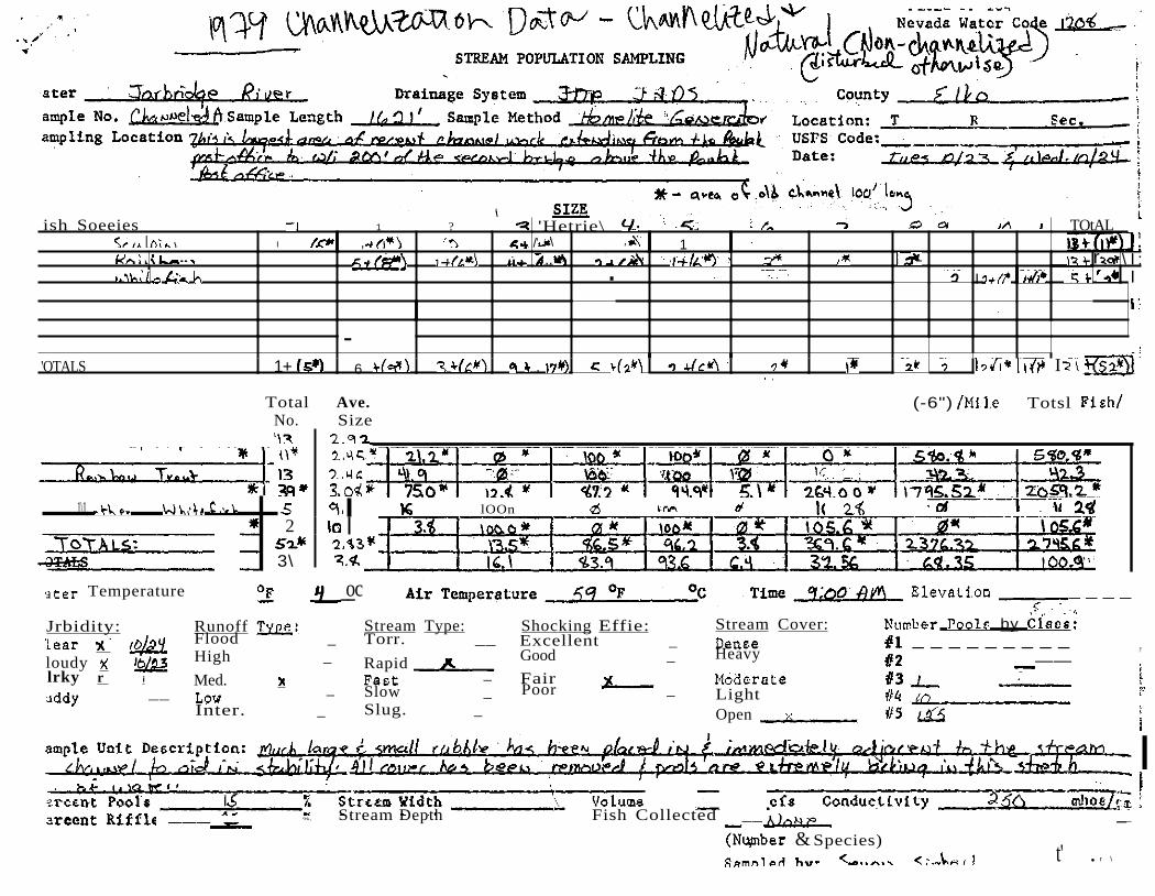
Nevada,Water Code
POPULATION SAMPLING
Water Drainage System County _ Sample Sample Length Sampling Location -- USFS Code:
- _
Fish Soecies /
5J J ,\ 'f • .i to
f
',TOTALS \ 7
Total Ave. % % (+(jll) %(_6") Fi es No • Size Catch 2 cm 15 2 cm - • Wild
i ( \ 1\. , l1;'t,,2 • 00 ' 7 0
I '
' . , v -.
TOTALS
Water Temperature o.C Air Temperature
"
I .
f
I
.
1 I
(+6") +15 2 cm
I
-(-(jll)/Mile
3\
, "
Elevation
Tolal
_
Turbidity: Runoff Type: Stream Type: Effic: Stream Cover: Number by Class: _
Clear Flood _ Torr. __ Excellent -- Dense _ Cloudy _ High Rapid __-- Good HeavyMurky _ Fair __ Modera-t-e---- IMed. FastMuddy _ Low _ Slow' Poor _ ..
Slug.----Inter. Open
, .

• .'_
. ~
1'/
.•
________ ....
__ . .., ,..y · ... . WL....
lIVe ' ~ _
Re . BottOlll
•
Roll. .
. •.
" Comments
o __.__ u~
__. I :,
..... . ..•
. .... .' . I .
_ °.
it ..S.r
._ ... • .r.
" ' ' '
725i.
,
"
.
_. _
,
Nevada Water Code
STREAM POPULATION SAMPLING
ater System D _ County _
ample No. Location: __ ampling Location of uSPS Code: _I
Date: .j
/ SIZE" SDedes
1/ TOTAL
I
- -- --
OTALS
Total Ave. Tol(+6") /M11e-'7.'7. (-6")% (+6") i No. Size Catch cm -1.5.2 cm +1.5 2 cm -J 2 ;
0
I100
Temperature OF °c Air Temperature °c Time 10:/5
rbidity: Runoff Type: Stream Type: Effic: Stream Cover: by Class:
JTALS
,ear Flood Torr. oudy High Rapid
: Med. Fast Low X Slow
,Excellent Good Heavy ,
Poor Light
Volume cfs Conductivity Collected"
Species)
Width _ Stream Depth _
Inter. Slug. Open'
I 1 ,

'
iexQ ,.' ,,.
, ."", ,~'__ .. \.
--'
.' ..- - ,
j
..,._..,. ~_...
='~=~/:;=<:m~t'
..'
".;.1·'r:-;n;.~·
..
Order and Re ti
'.' ". .. .. ..j.,",:_
- ,-
;:.!
--- .._....__ ...._---_. Ro 11 _ _ ..
fLstop Time " , ....
. /.,
__ 8 .
. .
. I .. eiJ;N1~tf¥J
' ={r
dl .
_
.." -'-'," - .; ______
. .. > "

.....
- -
'
'
--'-
_--,.-.,-
~
__
__..
-,-_-.,.,.-
_
.'
104 Nevada Water Code
STREAM POPULATION SAMPLING
Drainage System
Method
sh SDecies ,- 3 1O II TOTAL SIZE
(Metrie\ ., . ,
U •
W" 111 ••• D,'.
, ,',
'OTALS
I 1\ II
2- I, , ,
, I 17 \
, '
, Total Ave. (+6") , (-6") % (-6") I
No. Size Catch +15 2 em -15.2 em em -J ? ,., \ .1 D .
l._ "
,.\
OTALS \ 0 1/\ !
Temperature ... Air Temperature Time Elevation __ _
Jrbidity: Runoff Type: Stream Type: Shoekf.ng Effie: Stream Cover: by Class: , _Flood _ , 'Torr. _ Excellent _ Denee _lear
Rapid _ Heavy _ _loudy High _ Good _ 'Jrky _ Med. __ Fast Fair Moderate 113 3' ,uddy _ Low _ _ Light"
Inter. Slug. _ Opcu _
j•
ercent Pools Width _ Volume "',' efs,' ercent e-----::P---, Stream Depth Fish _' '
, (Number & Species) '
lver)
I

''''' e
o
.
-• ..• ,,,. .-
.
~ Hb.. . . .
., .. yt. .'..
g,,}.'7~
-
C
. Order and Relative jbundance
I/ •
eI
.
-_._-
.. \.we-..-. ... .
-
II __ . <
. ! ...
.,
t
"-eo' t•• , ,
b S
( .. Oh • , ,
-!c. r
...-.. '
.., . i .'
; "",'
.. '. '.~
. ' '
c,; .\ "'_ "I
, . '
, -
"' -
--
~
\2
Water R,'lJer County __
tion:Sample No. Sample MeUSPS Code:Sampl1ngLoeation :
Water Code
STREAM POPULATION SAMPLING
Fish SDeeiel! (Hetrie) TOTAl. .
.
-,
TOTALS I
,"--,
,
-
Total Ave. % (+6") (-6") % Total Fish/ e . h No. Catch +15. em -15.2 em +15 2 cm
•.• \ \ OC)
.. --- ...
TOTALS
Air Temperature ....7_·_oc Time II: 30 __ _Water
Turbidity: Clear . _ Cloudy __ Murky _ Muddy _
(Number Species)
~~:=~:~~~~~'_:'-:6~v~~~~:~~~~2+==~~~;~:;~~j=,. ~\' __ . .~JI1"!-- .rutfl
''Ie''5e;-('tl\O'\ ' ,,'otM
. .., .. " .' •..•
_ . ~."~~f
.,-,~':..,~',"'_, " . .' .., ...'"'
ua
lIottOlll Types
..•
.. .., Iq .
_ 1m
I.L__
1
c" ·--' -'--------.-,-'---------------
. .. ..
.. ", '
: ,... ,; . : ,:.;~::.·:=._n;~:.n~.j' I
.- ---","
.. .....
....
-__
~ -..
'-0-
__:"":""_
_
--,;;-
S~
Nevada Water
STREAM POPULATION SAMPLING .. .
Water r Drainage System County . _ No. Length samPI. Method _.__
Sampling Location ' usrs Code: _ Date: _ ..
Fish Soeeies TOTAl., ,.J 1
, I . I
' .. -
TOTALS I \ I I \
Total Ave. % (+6") (-6") % (+6") (-6") Tot al Fish/ Fi S"eci es No . Si ze Catch J5 em 2 em Wild , 2 em -'5 2 Mile- . .
\ J I
. .-
TOTALS
\ ()
0
«\.
0, b
2. $1, " _ .. ....
0IOD .
\
.. .
.s -. .. . . . .
Air Temperature Time Elevati.on __ _Water Temperature
Turbidity: Runeff Type: Stream Type: Shoeldng Erne: Stream Cover: Poole by Class: Clear Flood Torr. Excellent _ Cloudy __ _ Good Heavy __ Murky _ Med. Fast Fair Moderate Muddy _ Low Slow Poor _
Slug. Open 7 _
Pools W.idth Volume era Conducti.vity 30 Percent Riffle bO Stream Depth Fish.Collected'" ~
(Number Species) • J I

__
teO
-----------------------------------
J.ill.!::to!Ull Cotnr:',ents . AJ Lt ~, - .. f . ..tJ
oIV
....t.=2't7AN .. '.m '.
- . . .1 • . . .' ".€. JL·-:..£.iC's/& .. . 1m t~t(\tI-~-. ".! .
. ..' " ..
_ .. _
Roll
L __ , /I
. t ,. ) Q-. ': T
IS ' J
,/' , .••
tJfer u) . ..... . . . u ", '. "
. f IJ Is,' \'1 Q tl e. t .i..L· .'
\ 0 ()
'
n
,
. .
....
-
---
"
-......-
~
........
.,-___ _-.-
-
. _
-,-,
". -- . Water Code 12
STREAM POP\lLATION SAMPLING
Water . . . . Drainage . . County
. Sample No. Length Sample Method ~ T Sampling usrs
.. _
: . SIZE
Fish Soecies .. '. . . . TOTAl.(Metric) () Il .
.. .
.. ... i· -:,
-TOTALS
Total Ave. % (+6") % (-6") % (+6") Tolal -'5 2+J5 2 cmNo Size Catch em -J5 2 em WildFieh . . .
0 100 ) 07.,
1'1 \ I I 7, I ' ..-....
. ,
,, TOTALS 0 \ Ion let ')
Water Temperature __by Class:Shocking Effic:
Excellent _
Air Temperature o,C Time _
, I Stream Cover: Dense _
'Stream Type: Torr.
" Runoff Flood _
Turbidity: Clear Cloudy _ High _ Rapid _ Good _ Murky _ Fast _ Fair Moderate ..Muddy _
Med. Poor _ Light _Slow
Inter. _ Slug.··----- Open .3~
Unit Description: ··.,0·
--Gid . ·'·0 r'j(l t\ t\
w e Pools .... . cfs .. ·· Conductivity ..
Percent Riffle Fish _ . (Number' &'Species)
.
__ .
__ .. . ro.I/Jds
.
ze&
____ .. ll '"
.. ·
....J_I;l:j:··.··""'i=i~ . ...... ,., ,.....
Data __
Order and Bottom Types
.
:.+
..'.
._---------.
.
~
______ (
____

'
'
,
"
-
,,_.,..- _..,..-:-
__--:-~
~.."....
~
--Nevada Water Code
. ' STREAM POPULATION SAMPLING
ater Drainage System County,
ample No. Sample Length Sample Method ,Location: T ampling Location N USFS Code:
te:
SIZE ish Soeeies J
.,
I
-.., IU
7 I
'
Total Ave. % (+(i") % % (+6") (_(ill) Tot al F1 "hi 'i S No. Size Catch cm -15.2 cm Wild +15 2 cm - J e
• \. , . . e,$3.t .\ 7 \
--I I
Time'__ Elevllli,on _Temperature __ Air Temperature .
.'rbidity: Runoff Type: Stream Type: Shodd-DE Effie: Stream Number by Cless: _ _ Flood _ Torr. _ Excellent Denee _
Heavy _ _High _ Rapid __ Good _ lrky _ 'Med. _ Fast Fair __ __ _ __
_ Slow _ ... _Low Poor Light __ Inter. _ Slug. _ ) Open X
Unit Description:
Pools Width _ Volume cfs ConductivHy 7 Stream Depth _ Fish Collecte4 __ - _
(Number Species) II
1

----
.Q
. '
________-,..-- __
.
-
cJ-h
cooo;kJ . ~
. ~
_. .... -. ..
Bottom Types ' . . /0
\ • ) / '. ' fJ~ __ e ----- .... ,,'
----._-•.__ • I (UfO
Ro 11 - -Time
]
.'
--------_._-_._._._-._----_._--,
1 . i J .
.' .,
_
i "
b "
'. '
.,i.. !.
.
?
)<;'--
Description:
""
.
it
.
, FF 104
Nevada Water Code '.
STREAM POPULATION e I 0
1/ _ __ S8lllpleMethod (ole! Location: T R Sec.
USFS Date:
, It /I
SIZE II
Fish Snecies
Total Ave. 7. % (+6" ) % (-6" ) % % ( ) IMile ( -6" ) IMile Total Fish/
\Metric TOTAL III ( 5) I I I
N • -
I
.. ". : I •
1 1 1 \ I l
Fish Soecies No Size Catch -15.2 cm Wild HAtch +15 2 cm cm Mile 5 C. 2 .1"1 . 5
- 0 W 15 ' 10 1\ " /
.. I ••, 100·
' \"'-2.0./\ " \
I, S...I
A1
'\. , •
7 ..... ,If TOTALS C; • ., 10-.2 "
,
,
Cl
Water;Temperature' __ __oc Air Temperature Time //00 Elevation _' _ , Turbidity: Runoff Tvpe: Stream Tyoe: Shocking Effic: Number Pools by Class: Clear; Flood _ "Torr. Excellent \ .. __
_ High _ Rapid Good -_-Murky _ Med. _ Fast _ __ Fair Muddy :__ Low Poor
Inte-r-.---- Slug• ,"
Sample Unit
P,ercenl: P.ools Stream ,Width _,....;. _ Pereent Riffle Stream _

Order and Relative Abundance Bottom Types
\
Roll Type
Exposure f/stop Time COIIIlIlents
It ( t
)
'
'
--
n
__
..' .
__ ~
~
<-
~
__
Water Code
STREAM POPULATION SAMPLING
Water Drainage System County _ No. Sample I Location:
Sampling Location USPS Code: Date: ,
Fish Soeciell ? ' fl1etric' TOTAl. \ , .
! I
w
\ .. I
TOTALS 7
, I \ - ...... ,
\
Total Ave. % % (+6") % (-6") % (+6") 11·1i1e Tot a1 Hile15 2J 2t hJ 5 2 No Size Catch1'i es . . cm - cm , cm
I I .. . .. \ \On' I
• .. \
, TOTALS I .,
- .
Water Temperature __ __oC Air Temperature Time __ __ E _
Turbidity: Runoff Stream Type: Effie: Stream Cover: by _ _Clear _ Flood Torr. _ Excellent _
Cloudy _ High Rapid _ Good _ Heavy _ Murky _ Med. Fast __ __ Fair _ __ __ Muddy _ Low Slow _ Poor _ _ #4 )Q
Open _Inter. Slug. __
Unit •
'0,,1\ -0 Pools Str£alII Wid Volume efs Conductivity
Percent Riffle Depth Fish <
/ (Number & Species)

L
" ~
tk-erfC"/
-
. .i.... _ .,
s:'
f "'? ..•.•
- '
' '
.j
te
--nb-illt.s.,-!:!o. M < Q Q .• _I-=:'''''''-.l::l!:tl.Jt",~1.:s''''''-/I
)
Ro11 1m
B
J(",
..
..•..•...
• \' .. wi
I·The
II t
'I ~
5 ..
. ...,- .. ' ., -. " .' , . - . - -', - -
.. ,.. ...
';

.
_",....
-.
.
1
.a
-:--:::-----
---~.
~~- ~
Office 10SB Water Code __
OF FISH AND ofSURVEY
cream Drainage Syatem Sample Location County Survey Station Date of Survey T R Sec No .•
. Investigatorsand Status ILand Agency Uni.t Name
Fish Species INon Game Fish Species Endangered-Threatened Species
Water Surface Stream Bottom Stream Bank
.Pools Imbed. Left Bank Ri ht Bank • -I .. - .. - • .. ..- .. - .. ..
• -.... •.. • 11 12 15 18 20 21 27 28 10 12 15 17 38
a,·e .3 1.0 7.0 ( 10
3.8 .3 • 4 8 18.5 1.5 I 7 0 S
5D.8 .7 "0 35
iI ·n.1 . I
.
I S5 ,ccess Temperature; Water Air Time Weather :_-Elevation __
State Water Quality Discharge (cfs)' Water Chemistry Analysis Type _ Activity Status Geological Land Form Vegetative Type _ Bottom Width Geology Gradient Velocity Streamflow Type
Stream Shaded Ungulate Class Ungulate Use Fish Population Sampled Invertebrates Photo Points: Upstream Downstream Cross Channel General
,Tegetative Species __Quality
'ollution ,ongitude _ o o• . Latitude •
~=--
"
',
,
'
-... '"
-- ' , - -
- -- - -- -- - -- - - - - - -
-- - - -
-- .
- -- -
-
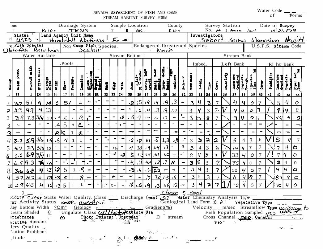
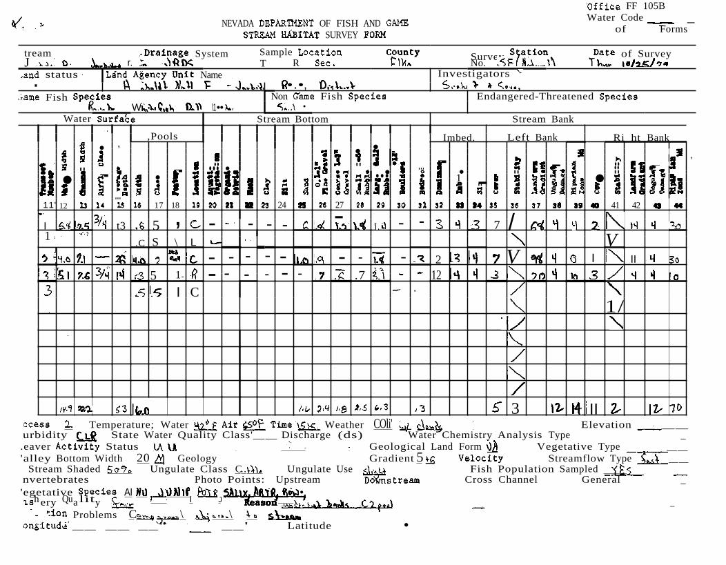
Water Code _NEVADA OF FISH AND GAME of FormsSTREAM HABITAT SURVEY FORM
Drainage System Sample Location County Survey Station Date of I '1' No. ( , I
d . I .. Non Species. lEndangered-lbreatened Species l U.S.F.S. Code
• \ . ' Water Surface Stream Bottom ' Stream Bank
.Pools Imbed. Left Bank Ri ht Bank • . . -:• •
. II .. • •• • • O' -. ..• .. . • D • -• •• • .. ..• •• • •0", •.. ... • .....
U 15 16 17 18 20
5./ 5/ , - - - ;5 ,3 7 7 5/
13 - - - . - - - .3 /. - 3 3 7· V / 0
·7 ' .. 3 7,3 13 / , - - 7 3 - - - .4 5 , - - - - , - - - - - - - - - - - - - -
- -1 - - - - - - - - - - -. -, - - 1,3 V 3 VIs 71 L - - . 3 4 . I:
5 7•. 13 - - - - 18 - 4 3 7 7 - - .. -' V 33 7 /! '7II - - -
7 '/ - -'. - - - .:i .7 3 7 4 0-' . - 0
8 5 1 - - - - 3 10 7 / q 4 • I - 3 7 7
1/10 5 I L - t .. 7 1
State Water Quality. Class Discharge Chemistry Analysis Type Activity Status Geological Land Form I
J.ey Bottom Width ?Om" Geology Gradient(%) Velocity__m/sec Streamflow cream Shaded 0 Ungulate Class e Fish Population Sampled
,D stream Cross Channel , Species '" ,',
lery Quality ,. ,'. '.ution Problems , .
;itude • ,' La • • -- -- - - ..- ---'
=-_
"
.
- -- - -
- - --
- - - - - -
- -- - - -
-'-_
,.
_-,- --;;;-- -,- -,- --,- -'- ..,--=-
~ _,_-------------
Water Code __NEVADA DEPARTMENT OF FISH AND GAME of
STREAM SURVEY
tream Drainage System Sample Location County Survey Station Date of Survey f T R Sec. No.
.and Status' I i \ame NO,n Game Species tened
Water Surface Stream Bottom Stream Bank
,Pools Imbed. Left Bank Ri ht Bank • •• • • ... •.. .. •.. • • .... -. ..• • •• .. • ... • ...
• •• • •• 0" .. .. 11 12 17 18 20 so 41
- - - 7 0I J - - - 4 I
15 J - - - - ·4 /. - 3 J V 5 .., - - - - - - - - , I I, 1 ·7 ,8 5 7
- - - , I .7 - /.- - - - - -- - - - - ',7 - 3 4 7 I 7 10
.4 - 1.0 ·3 7 V 10- - - - - 1.0
I 17./ /4 1/3 ccess Temperature; __ Time __ Weather __ Elevation __ urbidity State Water Quality Class' Discharge (cis) Water Chemistry Analysis Type eaver Activity Status -- Geological Land Form Vegetative Type _ 'alley Bottom Width Geology Gradient Velocity Streamflow Type _
Stream Shaded Ungulate Class Ungulate Use Fish Population Sampled nvertebrates Photo Points: Upstream Downs tream Cross Channel General egetative Species __ _ ishery Quality Reason
Proble-m-s------------------:>ngitude __ __ o oLatitude
" '
-
'
- -- - - -
- - - -
- - -.- - -
_' .'
_
:--
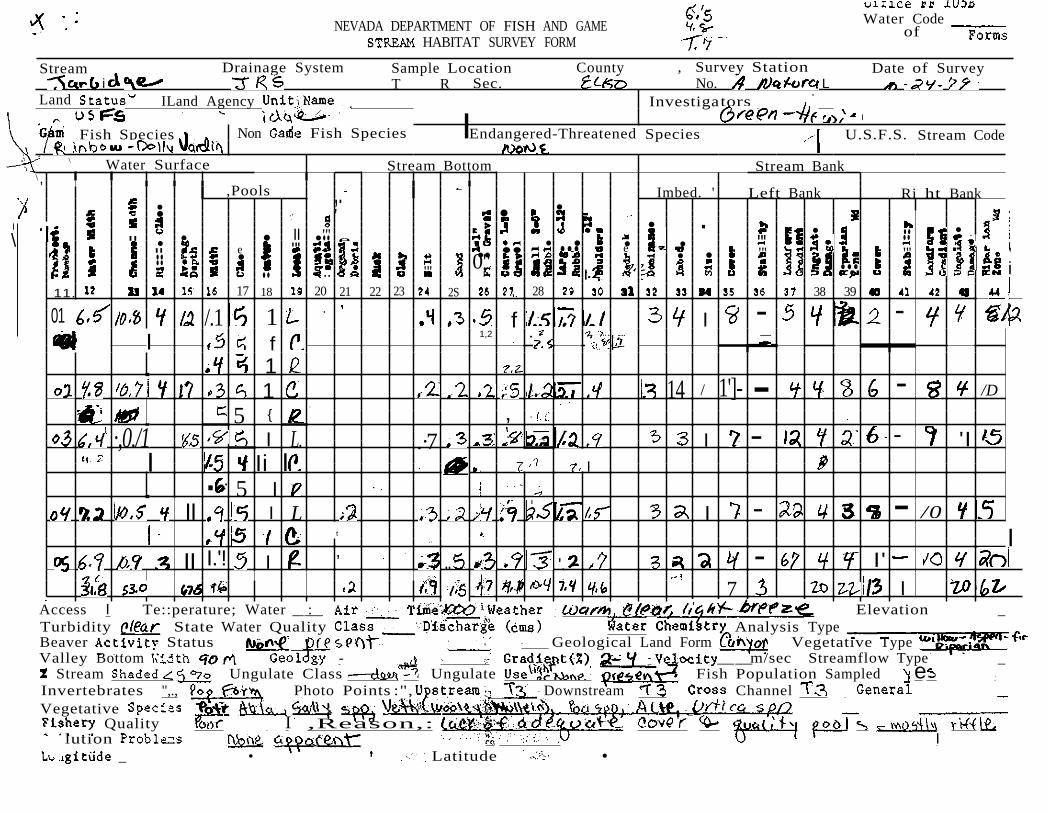
Office FF l05B
NEVADA DEPARTMENT OF FISH AND SURVEY FORM
Water Code of
System Sample Location Survey Station Date of Survey T R Sec. No. S 1•
InvestigatorsLand Agency Unit Name
Endangered-ThreatenedGame Fish Species ,I Non Game Fish Species' ,\ .
Water Surface I Stream Bottom Stream Bank
·Pools " Imbed. Left Bank Ri ht Bank • •
II " I •II .. • •• • .... .. ..• • •• •• '. ..• •• •0," ..... .... .. OCN
11 12 14 18 20 21 22 21 28 31 38 41 42
I L - - - \11 - 2 / 2. 7 ' \
, /.
5 1 C - - - 3 ,7 1
!5 I I 3 1 R - - ' - \ - 7 'I 7 6 I 3 .. 1/ I
5 - ,.3 5 \ L ./
13 \ .2 .3 3 3 7 L] /
5 I L
Is .7 3 13 7 VL - - - II. 2 - L\ 0: .3 3 7
, - -' - - - 3 3 0
Access Temperature; Water Air Weather .. •• Elevation _ Turbidity State Water Quality Class '__ Discharge (cfs) ..... Water Chemistrf Analysis Type Beaver Activity Status ' GeolClgical Land Form - Vegetative Type Valley Bottom Width '7q Geology , Gradient Velocity." % Stream Shaded Ungulate Class UngUlate, Use Fish Population Sampled Invertebrates •• Photo Points: Upstream Cross Channel General _ Vegetative Species J".; J I Fishery Quality Reason • _
Problems __
'
-=-
_
"- -----
-
Water Code . 'NEVADA DEPARTMENT OF FISH AND GAME of'. STREAM SURVEY , ',. ,
Countysys,tern Survey.. T 'R Sec No.
.
.
"
i
I State Water Quality Class __ (cms) . Chem1str . alysis
,
Status a Land Agency . . ' ...... ,() ,.' .
Species ! Game Fish Species Stream . I. . .
Water Surface ,. Stream Bottom Stream Bank
,Pools Imbed. Left Bank Ri ht Bank • •• .- .. ..
....• '. II • •.. " .. • ... • • • ..
" •• .... .. .... • •• .. .... 0".. n 17 19 20 21 22 23 25 26 27 28 31 38 39 41
.I - -._'.. . ..
/ 'I -. I ) C ..5
. I
J
! 111.7 /0 I I L - JIJ 4 -J I
, .
,
I I
.',
.'.
/,5 1,8 .
,,' Water Weather .1; Elevation
.•... Beaver,.Activity Status Geological Land Vegetative -/00 Geo[ogy Velocity__m/sec Streamflow
Shaded Ungulate Class Ungulate Use Fish Sampled - _
Vegetative Species Fishery Quality Pollution Problems Longitude, __ 0
Photo Cross Channeld\ op General _ '"
Reason r a __
\ \ . ..., . Latitude 0 __ '

_:-_
,..,
...ert
c'l.71
-
- -
' -
/o1713.,
,
CodeNEVADA OF FISH AND GAME of
STREAM SURVEY .FORM
tream System Sample Location County Survey Station Date of SurveyI •• .. T R Sec. No. _ c
.and Stal?us, Agency Unit Investigators . - Jj 1"ame Fish Species, Non Gime Fish Species Endangered-Threatened Species
I
I Stream Bottom Stream Bank
BankLeft Bank
•.. 136
Imbed.
• " II "
II .. . .... : • •. .... ...... .. "
21 22 25 27 SO17\18
.Pools
•
•
• II
11112
1 I. z..1 3 1\31.3 15
-.·'_1 _ I. I _ ,
-·1 _ - ).3 , -
1,
- - - ." I -' -
(,2. ,
·v v
7 I I
3 I I
7 VI \ 1010 10I
I I c.
1 I L \ I
1/ 1/
"cess Temperature; Elevation __ urbidity State Quality Class __ Discharge (ds)' Chemistry Analysis Type _ eaver Activity Status Geological Lanp Form Vegetative Type _
"alley Bott,om Gradient Velocity Streamflow Type Stream Shaded 0 Ungulate Ungulate Use Fish Population Sampled ---
nvertebrates 0 Photo Points: Upstream' Cross Channel General _ agetative Species __ishery Quality ,Reason
Problems i i
• • Latitude • .

' ",
" ' h "
' "'
__
'..
' e.;;;S'--
. ,. "
Water Surface Stream Bank
-1/5
'Ri ht BankLeft BankImbed.
3 3 4 - 5 30
3 I - 't
• • •.. .• ..
0 ..• • • •.. 37 38 39 41 42
I ,Pools •
• ... ._.,..
0
I ! 16 17 18 21 24 26 27 28
/ •
3 0 -I
6 10
\ I' 1-"-
/0 r Elevation _
Turbidity State Water Quality Class __ Discharge (cms) Analysis Type Activit, Geological Land Vegetative Type
Valley '" adi~~%);'- 'Velocity Streamflow Type Stream Ungulate dollD U,ngulate Fish Population Sampled _
Invertebrates ~ Photo Pointd: D stream Cross Channel General _ Vegetative Fishery Qua11 Rea on _ Pollution , Longitude , Latitude, •-- -- -- -- --

,
'
'
-
-
'
--'---"
' ~_
'
~ '
Office FF l05B Water CodeNEVADA OF FISH AND GAME of
STREAM SURVEY ,FORM
tream Drainage System Sample Location County Survey Station Date of SurveyF. • v ' ,) T R Sec. No • - , \0 I ..
Investigators
i,;ame Fish Spec es INon Game Fish Species, Endangered-Threatened Species R.
Water Surface • Stream Bottom Stream Bank
.Pools Imbed. Left Bank Ri ht Bank
I
•• ...
17 1815
I L - -
I
:5.1 3 2 '\ 1 L - -
- - - - 7 o 3 3 -.7 - 3
v 3
5 - - - _. - .5 - - 3 3 7 1/ 3 0
5
v
5 Temperature; Water
..
Air Time Weather' .. Elevation urbidity State Water Quality Class'__ Discharge Water/Chemistry Analysis Type
Activity Status IA -, Geological Land Form Vegetative Type _ alley Bottom Width Geology Gradient Velocity Streamflow Type __
Stream Shaded Ungulate Class ( .. Ungulate Use Fish Population Sampled nver'tebrates Photo Points: Upstream Cross Channel
:getativeSpecies],shery __ Reason ..
Jut,ion Problems ....... '
"JIigitude • 'Latitude •

y ,' -
--
~
l •••
112
1 --
._
__ -.,..__
mpledoo
----- ----
l05B WaterNEVADA DEPARTMENT OF FISH AND __ of -"'F-orm-s-
STREAM HABITAT SURVEY FORM
Drainage System Sample Location T R Sec. .
/ Land .. Game Fish Species Game .
Water Surface
\
I
... . • I .. •
,Pools
••• .. 17 18
I. '7 II I
)5
I i
..
L
..... a
20
.
•
• I
' I
Stream Bottom ..
.. u
23 24 25
. ,
I •.
. /.7
..
••0"
.
,, ,
••.... •...••
2827
. ,
/.2.I
.
. Survey Station Date of \0
tors.
.Imbed.
• •
•.. ..• u
I
.
I Stream Code
Stream Bank
Left Bank
•
37 38 39 41
- 5 -- 7 -'{
- 5 -
t I
I I I,, i ! i I
I I
I,
I
! !I
I . II
i
Turbidity State Water Chemistry Analysis Type Beaver .... Geological Land Form Vegetative Type
Ri ht Bank
•
42
. '
/0
Valley Bottom . Velocity mlsec Streamflow Type _ Stream Ungulate Ungulate Use Li Fish Population
Invertebrates • Photo . am Cross Channel _-_Vegetative Fishery 600 eason Pollution a
. Long:l,tude I Latitude
"
,~=--
'
-'
-- -
,
, ' _~.,.-
5'-- _
C.""'2'""1fp'.AJ.) ~
-
FF 105B Water Code _
NEVADA OF FISH AND of FormsSURVEY
tream System Sample Survey of SurveyJ r. T R No.
status InvestigatorsName . •.•, , Fish
W \1•• Non Fish Endangered-Threatened
•
Water Stream Bottom Stream Bank
,Pools Imbed. Left Bank Ri_ht Bank • , •• - ,.. .. - .. -.. - ... • ... ..- • • .. ..• • ... 1 - •• ..
...11' 12 17 18 24 27 41 42 - /I t3 5 , - - - - - - 7 1 \ V.C S L
- - - - - - - - 2 V I II 1
5 1 - - - - .7 12- -I C .
1/
3 II Temperature; Water Weather COli' Elevation __
urbidity State Water Quality Class'__ Discharge (ds) Water Chemistry Analysis Type _ .eaver Status Geological Land Form Vegetative Type __ 'alley Bottom Width 20 Geology Gradient 5 Streamflow Type __
Stream Shaded Ungulate Class C.. Ungulate Use Fish Population Sampled nvertebrates Photo Points: Upstream Cross Channel General _ 'egetative AI •. . h Qu lit I Jery a y ason r _
- Problems C \ \ __ __ __" __' Latitude •
y ",
p,' 'h
"
'
='
-'
-,
-"'
-" '
~ -=-----:=--_,,--_-;;-~:;-:
' .
,
Office FF l05B Water CodeNEVADA DEPARTMENT OFFISH AND GAME of -F=o-n-
STREAM
Date of SurveySystem Sample Location Survey Station T R Sec. No.
Status, J 11 r
. Land .
Game Non Game Fish Endangered-Threatened Species
Water Surface v \\ Stream Bottom Stream Bank
.Pools Imbed. Left Bank Ri ht Bank • •• • •I .. •• • ... • .• • •.. ••• •• i •0" ..
11 12 14 17 18 19 20 21 22 23 28 27 28 29 38 39 41
/'1.1 '7 / .5 I - -I I
I I L .•5 4 - I - /0 /
03 I .6 I.. 1/. . I - /1 I . 1,7 / - In 'I r. I I
- ( 2..I I .1 - -5 I
.---I
17 • I .5 {·5 .3 I.I ,
".' r I>.•
Access Time Turbidity State Water Quality Clas-s- Discharge (ds) Type Beaver Activity Status Geological:Land Type Valley Bottom Width Geoldgy • Velocity Streamflow Type % Stream Shaded Ungulate ) Ungulate Use Fish Population Sampled Ye S---Invertebrates PhotoPoinJs: OWtlls tream 0" Cross Channel Vegetative Species Fishery Quality Q\1 Pollution Problems 0
j
f I I) \ Longi tude • r , Latitude • • . ------ ---
0 (l
.-
. ...J.A~(
.
.. '
-.
.
'
'
-0
Water CodeNEVADA DEPARTMENT OF FISH AND GAME ' of
HABITAT SURVEY FORM
Stream Drainage System Sample Location County , Survey Station Date of Survey i T R Sec. No. L
Land ILand Agency Investigators I
\,
I
\
Fish Species Non Fish Species IEndangered-Threatened Species U.S.F.S. Stream Code
\ Water Surface Stream Bottom Stream Bank
,Pools Imbed. ' Left Bank Ri ht Bank,.• •• ' • • . .... ••.. II ..."' •.. • • e. "' "' • • • Ie ... •
•• •• •e "' "'.. • • ' .. 0" i.. "' ..... " 11. 17 18 20 21 22 23 2S 28 38 39
/.1 --01 1 f I I f
1,2
1 1 14 / 1']- - - /D
5 { ,
, .
·,0./1 -I L. .·7 I - 'I I Ii I I . 5 I
II I L I - - /0 t I
II I.'! I , .. '. - I'
7 iI Access I Te::perature; Water __: _ r Elevation _ Turbidity State Water Quality Analysis Type Beaver Status Geological Land Form Vegetative Type Valley Bottom - __m/sec Streamflow Type _
Stream Ungulate Class Ungulate · Fish Population Sampled eInvertebrates ",., Photo Points :", Downstream Channel Vegetative
Quality I ,Reason,: lution I
_ • Latitude •
..
=
-c- ___. ,. ___
FF 105B Water CodeNEVADA OF FISH AND GAME of
SURVEY
;tream Drainage System Sample Location County Survey Station Date of Survey T R Sec. No .-
InvestigatorsStatus ILand Agency Unit Name . Fish Species INon Game Fish Species Endangered-Threatened Species
Water Surface Stream Bottom Stream Bank
.Pools Imbed. Left Bank Ri ht Bank•
I •I .. • •• ... •• .. •• . • • ... ...• • •• •.... 11 12 U 15 17 18 20 21 24 27
/·5 1.7 1 7 I/O " I . ·1 7.7 7., 7.1
5'3 .3 1/
./ I (
,7 .'I - /I
,3'/• /.0 I /I Temperature; Water __ __ Time __ Weather Elevation
urbidity State Water Quality Class' Discharge (cfs)· Water Chemistry Analysis. Type __ Activity Statua -- Geological Land Form Vegetative Type
alley Bottom Width Geology Gradient Velocity Streamflow Type Stream Shaded Ungulate Class Ungulate Use Fish Population Sampled ------
"vertebrates Photo Points: Upstream Downstream Cross Channel General. .Species
Quality
)llution Problems ... _ • Latitude o
~=--
-.
.
g
1u
.".--=-_ -,-_::-. _
_-:- -= = __
-,...,._-,...,.--:" "- ....... ~------
--:" ~
FF l05B Water Code _
of
Drainage System Sample Location County Survey Station Date of Survey T RSec. No.
InvestigatorsStatus ILand Agency Unit Name . Fish Species INon Game Fish. Species Endangered-Threatened Species
Water Surface Stream Bottom Stream Bank
.Pools Imbed. Left Bank Ri ht Bank • .. . ••.. •.. •.. • -. • ..• .. ... • • .. ..... • •• ... 1• •• •0" ..
11 12 U 17 18 20 21 22 24 2S 27 28 10 38
1.7 I 7 110 I . ·1 7.7 7. 7.1
.3 JI
F 01 I 17 (
I.b /1
II Temperature; Water Air Time Weather Elevation __
urbidity State Water Quality Discharge (cfs) Water Chemistry Analysis, _ Activity Status -- Geological Land Form Vegetative Type
alley Bottom Width Geology Gradient Velocity Streamflow Stream Shaded Ungulate Class Ungulate Use
Downstream __ ----. Fish Population Sampled
Photo Points: Upstream Cross Channel .Species __ __
Quality Reason _ )llution Proble-m-s-----------
__ ___ o , oLatitude
-_-::-__
.
114<
l' ..
< "
"
cs I6.1149'13111
..
. 0 t'. - .
g ..
9 1,'i·'I-{i0ol-
Water CodeNEVADA DEPARTMENT OF FISH AND GAME of FormsSTREAM HABITAT SURVEY FORM
Stream Drainage System Sample Location County Survey Station Date of Survey T R Sec. No. A
Land ILand Agency UnitiName Investigators:. :- I '
,Pools..il
• • •• L •• ..
Ii : ..III ..
11 12 17 18
I (
L
I IlL I
Specie" Stream Code
Stream Bank
Imbed Left Bank 1 • ...... • ' .•. •• . l'. .., • 0 •••
.::I I20 21 22 123 124 28 I 31 I 41 42
I I, I• I'
?
I_ 13141/1'7.1-1 1 I/o . I.
..71. I. I
.. - 1-
, I
Bank
-53,01 I I I I
I Water _ r Elevation _ Turbidity State Water Quality Class Analysis Type Beaver Activity Status G'eological Land Form Valley Bottom : m/sec Streamflow Type
Stream Shaded Ungulate Class Ungulate f Fish Population Sampled eInvertebrates Photo, Points: . Upstream Downstream Cross Channel _ Vegetative Fishery Quality ... I t· . .
A 5 pO •
. i . .•gitude - - -- --_._ : Latitude' 0
'
p,.>.'". -h
"
' r
-
-'
1
--
-'
"
... ~--=~~~_~~
.
----
Office FF lOSB Water CodeDEPARTMENT OFFISH AND GAME of
STREAM FORM
System Sample Location Survey Station. Date of T R Sec. No. Tu
Status,) Land // (
•
Turbidity State Water Quality Class _ Discharge (cfs) Chemistrx Type Beaver Activity Status Se Geological·Land Form \ Type 5ub F Valley Bottom Width Geoldgy Velocity I Streamflow Type _
Game Species Game Fish Spec:i.es Endangered-Threatened Species
Water Surface v \\ Stream Bottom Stream Bank
.Pools Imbed. Left Bank Ri ht Bank • • • •
.. ... •..... • • e • .. . ..• ..... .... • •• • • . • ...
• •.. ••.. cOl
/ 11 17 18 20 21 22 23 27 10 15 18
1/ I - -I , I L 4 - / - /0 / I .6 /.. / - II
/. ( I -I r. I:,
I - (, • I -5 I : .,
I .5 /,5 . I
" I , , • .• I " ..
Access __ __ Time Elevation
% Stream Shaded Ungulate Class ) Ungulate Use ° Fish Population Sampled Invertebrates e Photo Poe Cross Channel General Vegetative Species Fishery Quality R Pollution Problems
..Longi tude • r , Latitude •--

~,
~
- - -
- - -' - - --
,
M"+--
'
-'''' ~.
Office FF 105B Water CodeOF FISH AND GAME
of FormsSURVEY
tream System Sample Location Date of SurveySurveyr, T R Sec. No. status' Name. \ \. '" .• 'D D ,1
ccess Temperature; Water Ait Time Weather' ... Elevation _ urbidity State Quality Class __ Discharge (cfs) Water Chemistry Analysis Type _ ,eaver Activity Geological Land Form Vegetative Type 'alley Bottom Width Geology Gradient 5 Velocity Streamflow
Stream Shaded Ungulate Class Ungulate Use Fish Population Sampled nvertebrates Photo Upstream Cross Channel General egetativeSpecies ALHU .
Quality ' , I .. ••L11 _ Problems ....\ ..,m
;ame Fish Species Non Fish Species Endangered-Threatened Species•. , \\
Water Surface Stream Stream Bank
.Pools Imbed. Left Bank Ri ht Bank • ,
• .. .. • •.. ..• •• • D•• • -• ••aD • • 11' 17 18 20 21 22 27 10 18
1/I 5 ' - - - 13 7 ,of. ,
\ '
3'
.c. 5 L
1.1 - - - - - - 2 I \I 15 \- .7 .7 i?- - - - 10
I -
. '/
1/
I. II
ongitude .., Latitude •
""
gen1J,uun1.!=-v- J"", J A
_-:---:: _
-,-"
o qC::5_
l05B Water
of
Drainage System Sample Location Survey Date of T R Sec. No. l \0
Land' /' Land A Name "
J ' ,"
J 1/' •
Game Fish Species Game '. U.S.F.S. Stream Code
Water Surface Stream Bottom Stream Bank
,Pools Imbed. Left Bank Ri ht Bank
- ..• - .. 0..- .. 8
22 23 24 27 28 30 31 33 36 37 38 39 41 42
• I I - 5 3 - 3C 01 /,'715 I ,L - 7 - /0. '
I i ,6 { i
1.7
I I I
,
I j I, I I ! I
Ii
S Time Elevation State Water Quality __ Discharge (ems) Water Chemistry Analysis Type
Beaver "" "" Geological Land Form Vegetative Type __ __ Valley Bottom , Velocity m/see Streamflow Type _
Stream Ungulate Ungulate Use Li Fish Population Invertebrates Photo :lfpstream , am Cross Channel ' Vegetative
eason ;::f:!f:m~-:if\i-:·1",-C.s.e:-¥,o~o::-\~7~~~Q"'S"-"-r,J;£!.il<eJ:..u;J,LJ_~!..!.l:=
"0 ----ic 600 '
Pollution 0 a Longitude • __ __' Latitude •

__=--_
'
'"
-- - -
- --
-'
,-
9 =..-- __
l
v
'Office FF lOSB Water CodeNEVADA DEPARTMENT OF FISH AND of
STREAM SURVEY FORM
tream Drainage System Sample Location County I - 1\ 1 .. •
.and ILand Agency Unit Name, • ••••
Survey Station Date of Survey .. - u ..
Investigators
;ame Fish Species, INon Game Species, Endangered-Threatened Species .. \. "
Water Surface Stream Bottom Stream Bank
.Pools . Imbed. Left Bank Ri ht Bank .. I , • •II .. .. •.. • - ... ... ... • .. ... • • 0 •II •• - .... 0 .- •.. 0" .. ".. .. ..
i 2011 12 17 18 24 25 25 27 28 SO 37
1 L - - /- - - - -
.5 5 1 - - - - 7 0 3 .7 I L - .7 - 3 3 7 0- - - 7 - -.-.
I 5 IR .5 3'
•. 5 1 3 7 3.3 - - - - -' • - - 0
5 I
.'
qo 5 ..
Temperature; Water Air Time Weather' •• Elevation _ urbidity State Water Quality Class .__ Discharge Water]Chem1stry Analysis Type eaver Activity Status h.o I.. Geological Land Form alley Bottom Width Geology Gradient Velocity Streamflow Type
Stream Shaded 50 Ungulate Class Ungulate Use Fish Population Sampled nveri:ebrates
Species Quality
.lu Problems
" Photo Points: "upstream" Cross Channel General
;", Reason .. .
Y."."
• • Latitude •
_
, .l. t"':
'7..<q .. ...._
--,--
..
!
- -
.. =-
*
ff+
0 (.,
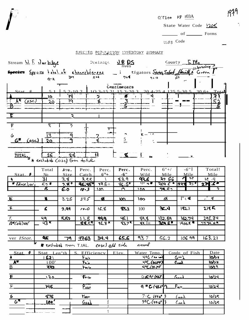
/:"'.. ;:' . r03A
State Water Code
of Forms
Code
Stream .. .. nves __
gators r,I'" -
Stat. # I i I I I I
5.1 I 5.2-10.2 I 1O.3-15.2! 15.3-20.3 20.4-25.4 125.5-30.5 30.6+ Tota' I I , -,-- I
I
T I a '-. t-
5 ' ,!
. .
' _, . 6
T.tAL. J e /,
Total Perc. Perc. Perc .. Perc. 6"+/ -6" I Total! Stat. No Size Catch -6" Wild Mile Mile Mile
It:, \ .q 01 Qr
':I . .'1::
I" I. ,."
100
r. :Vl P' I It
ver IStat. q • 7
Stat Stat Len"th S. Efficiencv E1ev. Water Temo. Condo of Fish Date I \ ••
00' i ,'B
.., Co
7· (
..
1/
F(:P",::~jS:
-
. 7~ __
- ---
~
C- U
-
.
01
.
, 6
__-'- .___ ..
.._
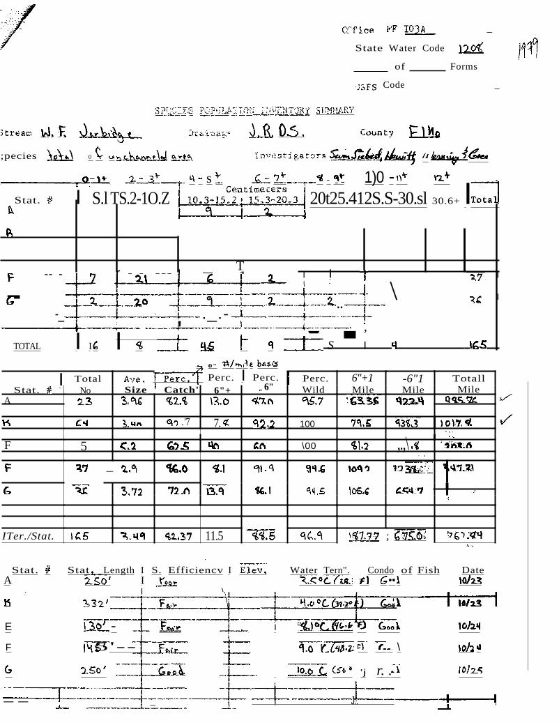
State Water
of
Code
Forms
Code _
;pecies 0
s - 1)0 Stat. I S.l TS.2-1O.Z 20t25.412S.S-30.sl 30.6+ I
r - - - --- I - --1-- I I I I \ I -
-- -T
..-_ ._.-
; I ' , ' 'I TOTAL I I I S I
0"
Perc. I Perc.I Total Perc. 6"+1 -6"1 Totall Stat. No Size Catch' 6"+ 6" Wild Mile Mile Mile
A
. '7 7. 100 .
F 5 \00 ,.,\ .<
__ "
ITer./Stat. 11.5 ; ".
Stat. A
E
F
Stat _Length I S. Efficiencv I Water Tern". Condo of Fish Date I ••I \
.•.
- I
I' 5'- \
'j r. .
-- _ I J.. ,
- -i
Stat. il 5.1 Channeled A 2 Natural A Channeled B Natural B 6 Channeled E Natural E Channeled F 3 Natural F 2 Channeled G 3
I Natural G '~--i
2 ; , -- j
TOTAL 18
f1+
.
e
0 F
250 ,._ :E.Od
_
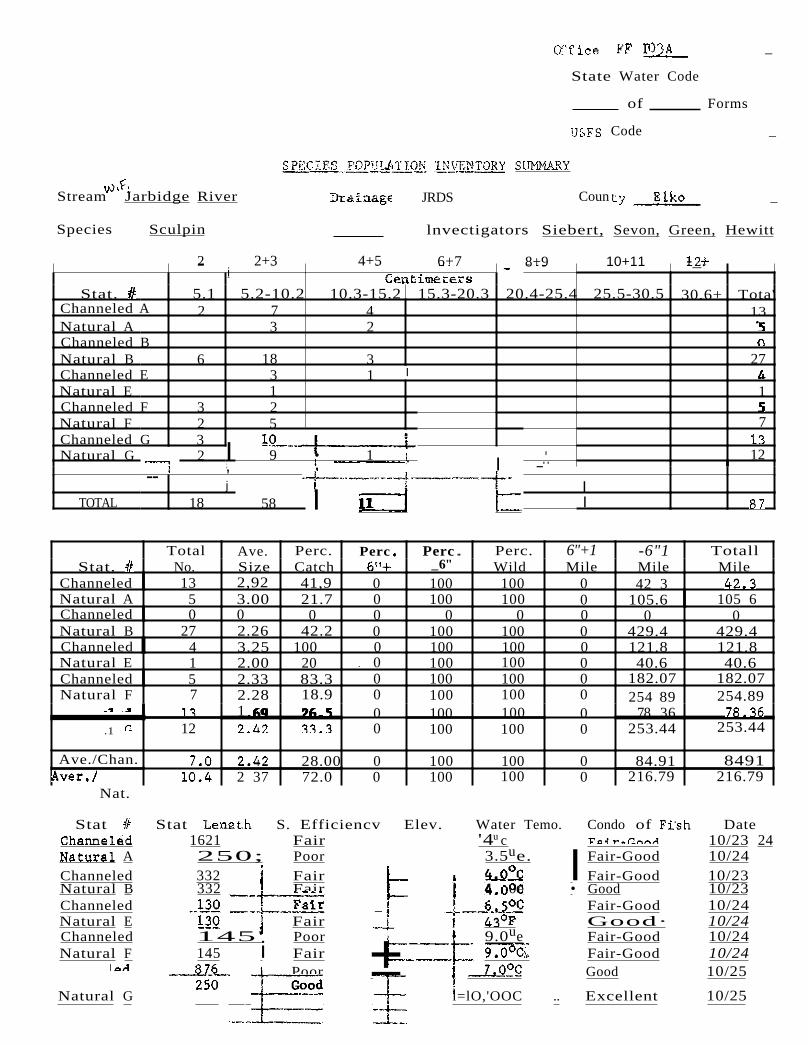
State Water Code
of Forms
Code _
Stream Jarbidge River JRDS Coun _
Species Sculpin lnvectigators Siebert, Sevon, Green, Hewitt
- 4+52 2+3
5.2-10.2 7 3
18 3 1 2 5
9
58
10+118+96+7- - -_.
10.3-15.2 15.3-20.3 20.4-25.4 25.5-30.5 30.6+ Tota' 4 13 2
3 27 1 I
1
7
• 1 I 12.•, _.'.
II I
Total Ave. Perc. Perc Perc .. Perc. 6"+1 -6"1 Totall Stat. No. Size Catch _6" Wild Mile Mile Mile
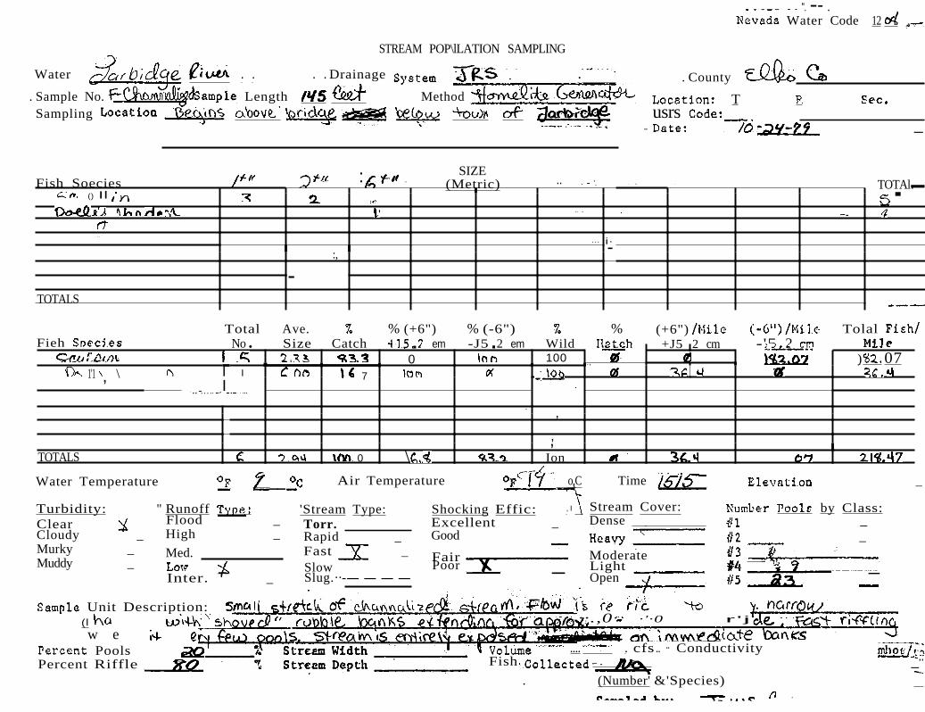
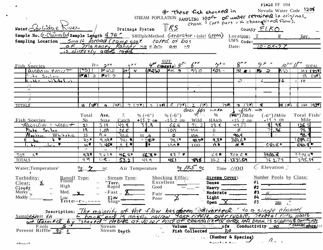
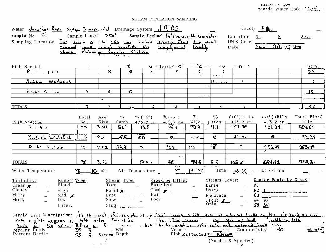
Channeled 13 2,92 41,9 0 100 100 0 42 3 Natural A 5 3.00 21.7 0 100 100 0 105.6 105 6 Channeled 0 0 0 0 0 0 0 0 0 Natural B 27 2.26 42.2 0 100 100 0 429.4 429.4 Channeled 4 3.25 100 0 100 100 0 121.8 121.8 Natural E 1 2.00 20 0 100 100 0 40.6 40.6 Channeled 5 2.33 83.3 0 100 100 0 182.07 182.07 Natural F 7 2.28 18.9 0 100 100 0 254 89 254.89
1 0 100 100 0 78 36 .1 12 0 100 100 0 253.44 253.44
Ave./Chan. 28.00 0 100 100 0 84.91 8491 2 37 72.0 0 100 100 0 216.79 216.79
Nat.
Stat Stat S. Efficiencv Elev. Water Temo. 1621 Fair '4u c
A 250; Poor 3.5ue. Channeled 332 Fair Natural B 332 Fair 4 0e Channeled _ Natural E Fair Channeled 145' Poor I 9.0ue Natural F 145 i Fair "
Poor ± L!J0e
Natural G l=lO,'OOC ..
Condo of Date 10/23 24
I Fair-Good 10/24 Fair-Good 10/23
• Good 10/23 Fair-Good 10/24 Good· 10/24 Fair-Good 10/24 Fair-Good 10/24 Good 10/25
Excellent 10/25
1
__
__
__r
I -__ __
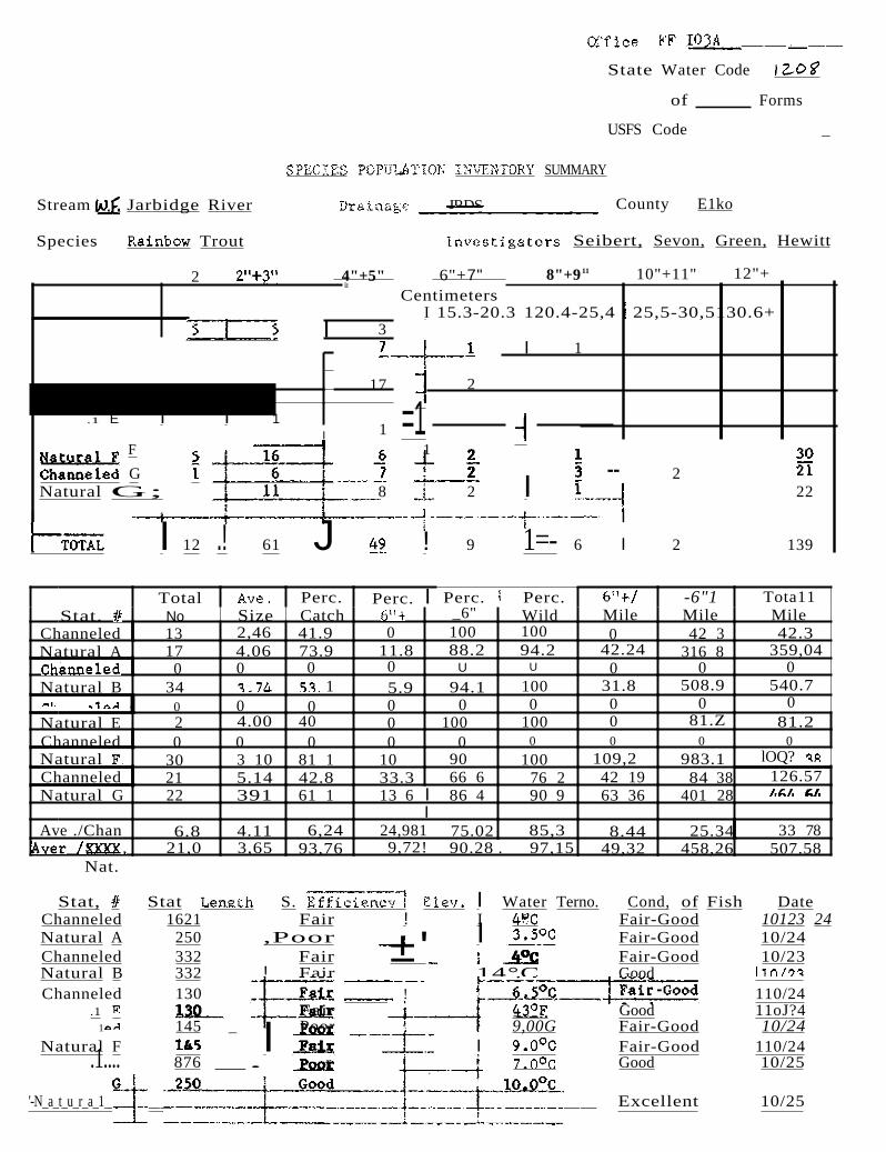
State Water Code
of Forms
USFS Code _
SUMMARY
Stream Jarbidge River JRDS County E1ko
Species Trout Seibert, Sevon, Green, Hewitt
2 4"+5" 6"+7" 8"+911 10"+11" 12"+ Ie
I 3
17
1I .1 E I I 1
F
G Natural G; 8
I
I 12 .! 61 J
Centimeters I 15.3-20.3 120.4-25,4 25,5-30,5130.6+
I 1
2
=1 1
-- 2 2 I 22
I
! 9 1=- 6 I 2 139
Total Perc. Perc. I Perc. Perc. -6"1 Tota11 Stat. No Size Catch _6" Wild Mile Mile Mile
Channeled 13 2,46 41.9 0 100 100 0 42 3 42.3 Natural A 17 4.06 73.9 11.8 88.2 94.2 42.24 316 8 359,04
0 0 0 0 U U 0 0 0 Natural B 34 1 5.9 94.1 100 31.8 508.9 540.7
1 0 0 0 0 0 0 0 0 0 Natural E 2 4.00 40 0 100 100 0 81.Z 81.2 Channeled 0 0 0 0 0 0 0 0 0
Natural 30 3 10 81 1 10 90 100 109,2 983.1 lOQ? Channeled 21 5.14 42.8 33.3 66 6 76 2 42 19 84 38 126.57 Natural G 22 391 61 1 13 6 I 86 4 90 9 63 36 401 28
I Ave ./Chan 6.8 4.11 6,24 24,981 75.02 85,3 8.44 25.34 33 78
21,0 3,65 93,76 9,72! 90.28 . 97,15 49,32 458,26 507.58 Nat.
Stat, Stat S. I Water Terno. Cond, of Fish Date Channeled 1621 Fair ! I Fair-Good 10123 24 Natural A 250 ,Poor I Fair-Good 10/24 Channeled 332 Fair ±' Fair-Good 10/23 Natural B 332 ! Fair 14°C Good Channeled 130 ! 110/24
.1 Fair Good 11oJ?4 1 145 _ Poor 9,00G Fair-Good 10/24
Natural F I Fair-Good 110/24I i: .1.... 876 _. r Good 10/25
'-N_a_t_u_r_a_1__ __ 10/25__ Excellent
-
- --- -
~
~
__ __
.
~
11+
::~~j==j~==1
_
State Water Code
of Forms
USFS Code _
SUMHARY
River JRDS Coun t y _
Species Whitefish Investigators Siebert, Sevon, Green, Hewitt
6" 7" 8" QI' 10" 11" 12"-- II II' Stat.__ 5.2-10.2 10.3-15.2 I 15.3-20.3 20.4-25.4 25.5-30.5 Tota30.6+
Channeled A I 0 I 0 I 0 I 2 2 1 Natural A 0 Channeled B
I -I I0 0 0: I v I 0 5 0 0 u - 0 0
Natural B 1 0 I 0 I 0 I 0 2 1 Channeled E I 0 I 0 I 0 I 0 0 0 Natural E I 0 I 0 I ,0 I 0 0 Channeled F 0 0 v I 0 0 Natural F .0 0 0 U I
0 0 1Channeled G .
n
Natural G . 0 I 1. 0 - 1
I
1I TOTAL /5 ( 3 8 10, 4
0 5 0 0
0 5 0 3 0 0 0 0 0 0 0 0 0 15 0 2
I 0 , 30
Perc .. _6"
0 0 0 0 0 0 0 0 0 0
0 0
Nat.
Wild 6"+/ Mile
-6"/ Mile
Total! Mile
100 16.28 0 16 28 0 0 0 0
100 79 52 0 79 52 100 47 7 0 47 7
0 0 0 0 0 0 0 0 0 0 0 0 0 0 0 0
100 90.4 0 90.40 100 42.24 0 42.24
100 37 24 0 37 24 100 17 99 0 17.99
Perc ..Ave. Perc .. Stat. No. Size Catch
5 16.1 1009.8 Natural A 0 0 0 0 Channeled 100 1005 6 Natural B 4.6 1003 10 33
led 0 0 0 0 Natural E 0 00 0 Channeled 0 0 00 Natural F 00 0 0 Channeled ( 15 10030.69.4
5.5 100Natural G 2 9.5
100Ave./ehan. 5 8.4 67 1 100
. Stat. 1Ll Stant, I S. Efficiency I Water Temp,J_ Condo of Fish 1 Date
Good 10 23 24 ,Poor I 3;·50 e 10 24+Fair I' 4.0oe Good 1023
I Good 10/23Fair I ! 6.50e 10/24 E J i Fair 10/24 I
145 Poor 10/24I 145 T- 10/24n -- n - ------- -
876 t- 7.0oe Good 0/25 I
INatural G 250 Good Good b.0/25;

--'-
- -
-
-
n
n n
- -
124
.__ .._ _
..
__
__ __
Sta te Wa ter Code I
of Forms
Code _
Stream . JRDS County Elko
Species _ Dolly' Varden Siebert, Sevon, Hewitt, Green
Stat. ! I S. Efficiency I I lolater Temp. I Condo of Fish I Date Channeled AI 1621 I Fair I -- . . I ..
PoorA 250 Poor I 3.50C I Channeled 332 Fair I ! 40C Natural Fair C -- I Channeled EI . Fair 10,24r 430FNatural E I 130 Fai... 10 24 ,Channeled F . Poor goC Poor 10/24
F 145 - Fai... gOC 10/24 'Channeled G Poor 10/25
ratural G I ,10/25 I
1" 2" ..I-II 6" ...-, I Stat. 5.1 . 5.2-10.2 I 10.3-15.2 I 15.3-20.3 20.4-25.4 25.5-30.5
Channeled A 0 0 Natural
0 0 0 0 vv0 0 0 I 0
Natural B O! 0 0 Channeled BOO 0 v V
v I v I Channeled E 0 0 0 0 U 0
n n 00 0 0 0 n n
00 0 I 0 I G .. .. 0 .o 0
v ' v I 0'.... O' I
l,I , l .
1
II I , ,
I I
I I I I
.
I 1
Perc. Total!Perc. Perc. 6"+/ -6"/Tot.al I Perc. 611+ _6" Mile MileNo Size Wild MileStat. Catch
0 0 0r.hanne1ed A 0 0 00 0 0 .1 A 124.3 21 12 01001 7" 100 0
0 0 0 00 0 0ed B 0 0 ..1 B 00 0 00 00 0 0
00 0 0 0ed E 0 0 0 0 ...- ..1 0 00 0 00 0 0 0
1 F 36 4 100 36.4 01 6" 16 7 100 0 , ....-,,1 0 00 0 00 0 0 0
G. 0 00 0 00 0 00 000 0 00 0.. ..... l G 0 0
7.28100 7.28 0100 02 6 0 50 4.22100 4.22 0Ave.... . 02 7 0 50 100
I v :i
Nat.
7"
30.6+ Tota 0 0
1 0 0 0 0 0 0 0 0 0 1 0 0 0 0 0 0

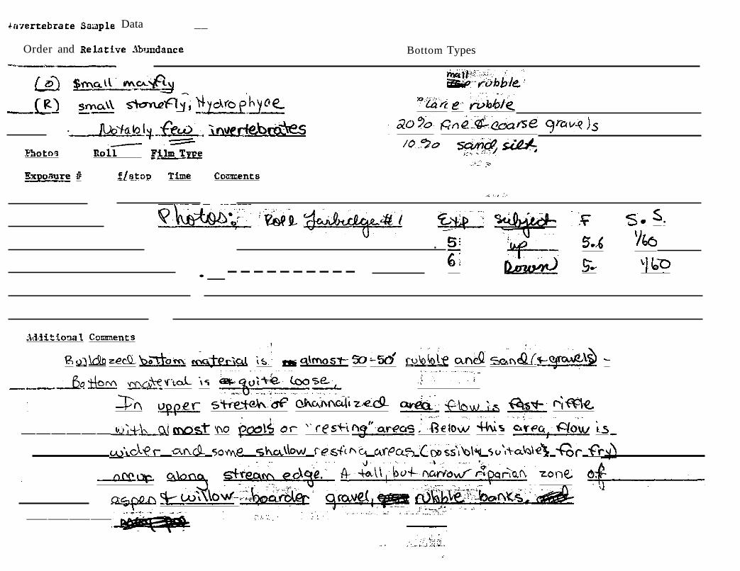
arPhotograph Code Key I
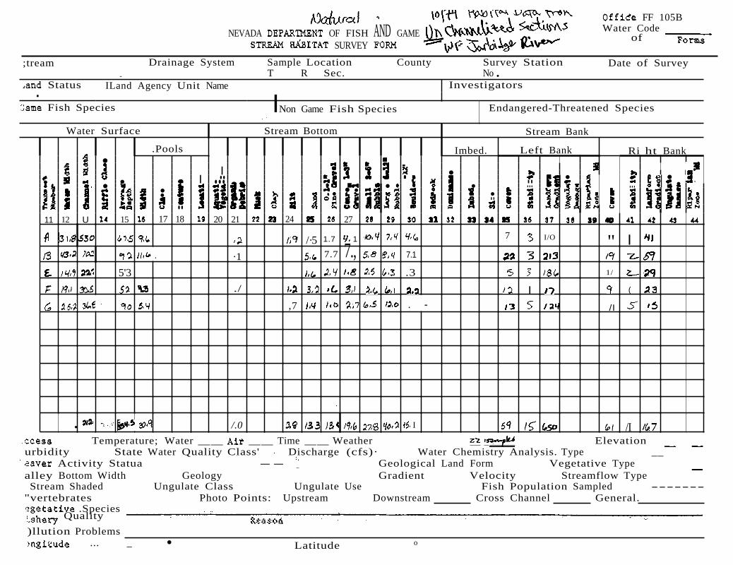
-!' ....I IV
A-I) 1975 photograph. Upstream from belQw bridge below Pine Creek Campground and above Bear Creek Summit road junction. Sept.24,75.(
A-2) 1975 photograph. Downstream from below bridge below Pine Creek Campground 'and above Bear Creek Summit road junction.
A-I) Upstream from below bridge below Pine Creek Campground and above Bear Creek Summit road junction. Sept.5,1979.
A-2) Downstream from below bridge below Pine Creek Campground and above Bear Creek Summit road junction. Sept.5,1979
A-3) Upstream towards A-2 from a point just above the junction of the Bear Creek Summit road.
A-4) Downstream from point A-3 towards bridge below the Bear Creek Summit road junction.
A-5) Upstream from point below Bear Creek Summit road junction.
B-1) Confluence of Pine Creek and Jarbidge River.
C-l) Downstream from A-5 towards bridge below Bear Creek Summit junction and above Bonanza Gulch.
C-2) Downstream from bridge below Bear Creek Summit road junction and above Bonanza Gulch.
C-3) Upstream from bridge below Bear Creek Summit road junction and above Nonanza Gulch.
C-4) Upstream from below Bonanza Gulch towards Pavlak Cabin·and bridge in C-l.
D-l) Upstream showing slightly altered area where trees and other debris' were removed from stream.
'D-2) Downstream from D-l showing unalte.red section 'of stream.
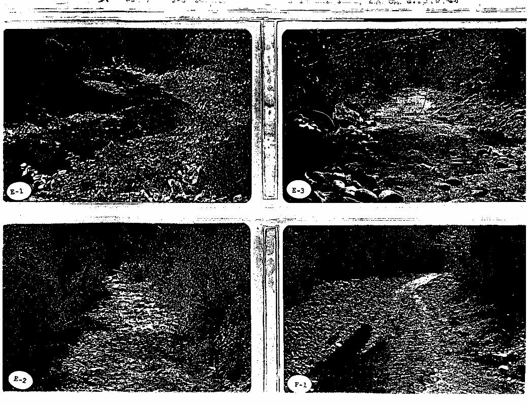
E-l) Downstream from bridge above Jarbidge Campground.
E-2) Upstream from bridge above Jarbidge Csmpground.
E-3) Upstream from below the Jarbidge Campground. Unaltered section of stream.
F-l) Upstream from bridge below town of Jarbidge.
F-2) Downstream from bridge below town of Jarbidge. Unaltered section of stream.
G-l) Upstresm from small campground sbove Mahoney Ranger Station.
G-2) Downstream from campground above Mahoney
-
- .
"
·, ..... .
I I
I, "

-.:..:.,;....------.----~. "-"-...
-= __--=---=--• ... ,
, """"
.. .'._. .. .. ,_" __

~
.... ........ .... . .. ".j
-'._-. .. .
n
I 1
II

__
Office FF I05A Table II State Water Code
USFS Code ---
r STREAM SURVEY SUMMARY AND ANALYSIS
District - Forest Resource Area - P.U.State -- County
Drainage Location T. R. Sect.
I
Hydrographic Region
Tota1 length of stream (mi.)
Total length of stream: Surveyed(mi.)
a. b. USFS c. Public, other d. Private
Total No. Sample Stations: a. b. Public c. Private
Total of all stream width measurements
Tota 1 channef width
Total width - all pools
Total width of all pools' classed I, 2, and 3
Total footage of desirable bottom me teria ls
Tota1 spawning grave Is
Sum of cover ratings
Sum of stability ratings
Elevation: (M.S.L.) a. Lowest b. Highest
Multiple use Number of camera points
Channel stability evaluation Number"of rating points Total of all ratings Average score Average score, value
.
Hydrographic Area
Percent Owner-Ship
Date
Factors Percent of total stream width in pools
Pool-riffle ratio, % optimum Pool quality, Percent of stream bottom with desirable materials
ee. er, % H ..
%Percent of habitat optimum
Average depth of stream m Average width of stream Percent stream shaded
Percent of bottom with clinging vegetation
Percent sedimentation
Percent of bottom with rooted vegetation
Average stream gradient (%) Percent landform gradient RB
LB Average stream velocity (f/s)
Stream discharge (c.f.s.)
Average water temperature: (OF or °C) Max.
Min. Turbidity description Access: (mi.) a. Remote b. Low standard trails c. Improved trails d. Low standard roads e. Improved roads
Water quality analysis: a. kit b. c. Coli
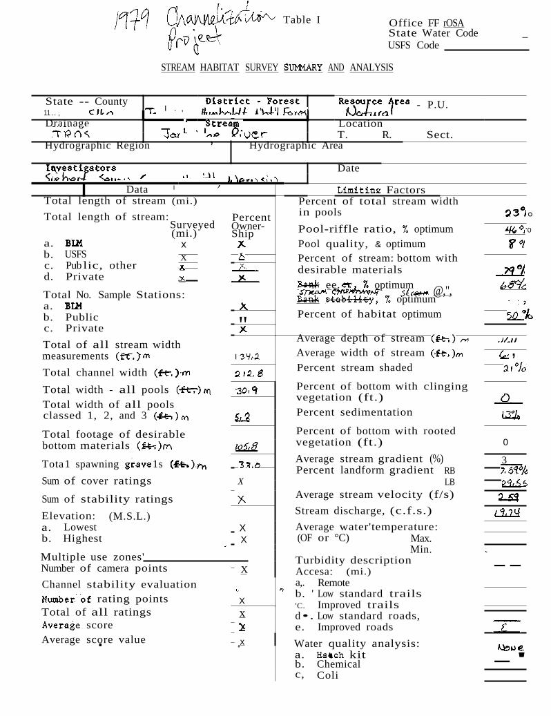
o;
-
--
, Table I Office FF rOSA
State Water Code _ USFS Code
STREAM HABITAT SURVEY AND ANALYSIS
State -- County 11 .. ,
Drainage
I . , - P.U.
Location T. R. Sect.,Hydrographic Region Hydrographic Area
Date ,
I';eneral Data I Factors Total length of stream (mi.)
Total length of stream: Surveyed(mi.)
a. x b. USFS X c. Pub lic, other d. Private
Total No. Sample Stations: a. b. Public c. Private
Total of all stream width measurements
Total channel width
Total width - all pools Total width of all pools classed 1, 2, and 3
Total footage of desirable bottom materials
Tota1 spawning 1s
Sum of cover ratings
Sum of stability ratings
Elevation: (M.S.L.) a. Lowest b. Highest
Multiple use zones'
Percent Owner-Ship
Number of camera points
Channel stability evaluation rating points
Total of all ratings score
Average score value ' .
" I
X
X X
X
X x
x,
Percent of total stream width in pools
Pool-riffle ratio, optimum Pool quality, & optimum Percent of stream: bottom with desirable materials
ee. optimum @,", optimum
Percent of habitat optimum
Average depth of stream Average width of stream Percent stream shaded
Percent of bottom with clinging vegetation (ft.) Percent sedimentation
Percent of bottom with rooted vegetation (ft.)
Average stream gradient (%) Percent landform gradient RB
LB Average stream velocity (f/s)
Stream discharge, (c.f.s.)
Average water'temperature: (OF or °C) Max.
Min. Turbidity description Accesa: (mi.) a,. Remote b. ' Low standard trails 'C. Improved trails d •. Low standard roads, e. Improved roads
Water quality analysis: a. kit b. Chemical c, Coli
° '0
,
3
-'
0

WEST FORK JARBIDGE RIVER 1979 Channelization Project
U.S. Forest Service 3,104 feet