Embed Size (px)
Citation preview
naly
sis
field ANALYSIS
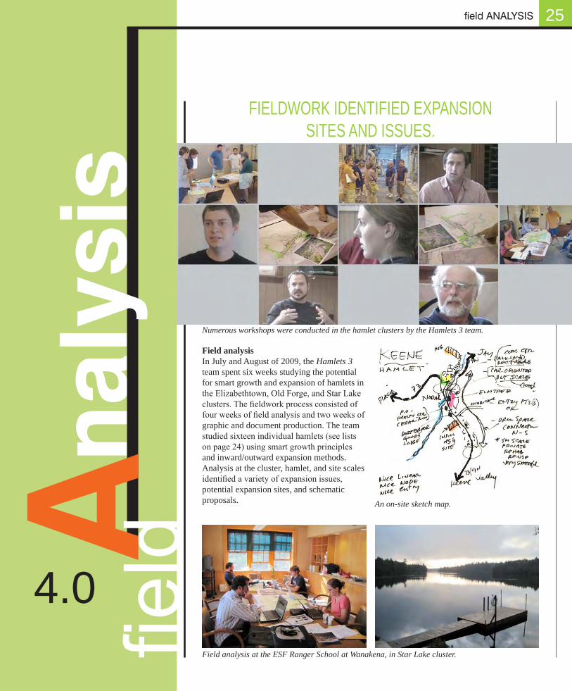
Field analysis In July and August of 2009, the Hamlets 3 team spent six weeks studying the potential for smart growth and expansion of hamlets in the Elizabethtown, Old Forge, and Star Lake clusters. The fieldwork process consisted of four weeks of field analysis and two weeks of graphic and document production. The team studied sixteen individual hamlets (see lists on page 24) using smart growth principles and inward/outward expansion methods. Analysis at the cluster, hamlet, and site scales identified a variety of expansion issues, potential expansion sites, and schematic proposals.
25
4.0
fieldA
FIELDWORK IDENTIFIED EXPANSION SITES AND ISSUES.
Field analysis at the ESF Ranger School at Wanakena, in Star Lake cluster.
Numerous workshops were conducted in the hamlet clusters by the Hamlets 3 team.
An on-site sketch map.
y
26
Route 28
Thendara Thendara
Old Forge
Big Moose
Eagle Bay
Inlet
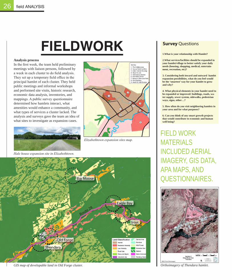
Orthoimagery of Thendara hamlet.
Hale house expansion site in Elizabethtown.
Elizabethtown expansion sites map.
FIELdWORK1.What is your relationship with Hamlet? 2.What services/facilities should be expanded in your hamlet/village to better satisfy your daily needs (housing, shopping, medical, entertain-ment, recreation, etc)? 3. Considering both inward and outward hamlet expansion possibilities, what do you feel would be the ‘smartest’ way for your hamlet to grow and why? 4. What physical elements in your hamlet need to be expanded or improved: buildings, roads, wa-ter supply, sewer system, sidewalks, pedestrian ways, signs, other…?
5. How often do you visit neighboring hamlets in your area and for what purposes?
6. Can you think of any smart growth projects that would contribute to economic and human well being?
Survey Questions
Analysis processIn the first week, the team held preliminary meetings with liaison persons, followed by a week in each cluster to do field analysis. They set up a temporary field office in the principal hamlet of each cluster. They held public meetings and informal workshops and performed site visits, historic research, economic data analysis, inventories, and mappings. A public survey questionnaire determined how hamlets interact, what amenities would enhance a community, and what types of services a cluster lacked. The analysis and surveys gave the team an idea of what sites to investigate as expansion cases.
field ANALYSIS
GIS map of developable land in Old Forge cluster.
FIELD WORK MATERIALS INCLUDED AERIAL IMAGERY, GIS DATA, APA MAPS, AND QUESTIONNAIRES.
A typical week in the field involved the following activities:
Day 1 – Reconnaissance of hamlets (including cognitive sketch maps) to assess landscape, environmental qualities, and physical hamlet conditions; APA Map and satellite imagery analysis; public midday kick-off meeting to discuss growth of the hamlets. Day 2 – Field visits to possible expansion sites; photography, GIS and other mapping procedures; one-on-one meetings with key stakeholders. Day 3 – Analysis of questionnaire responses, historical research, economic data analysis; mapping continues; public, informal, walk-in workshops in the evening. Day 4 – Finalize diagrams, maps, photo documentation; prepare Powerpoint presentation. Day 5 – Public exit presentation followed by question and answer; community social event.
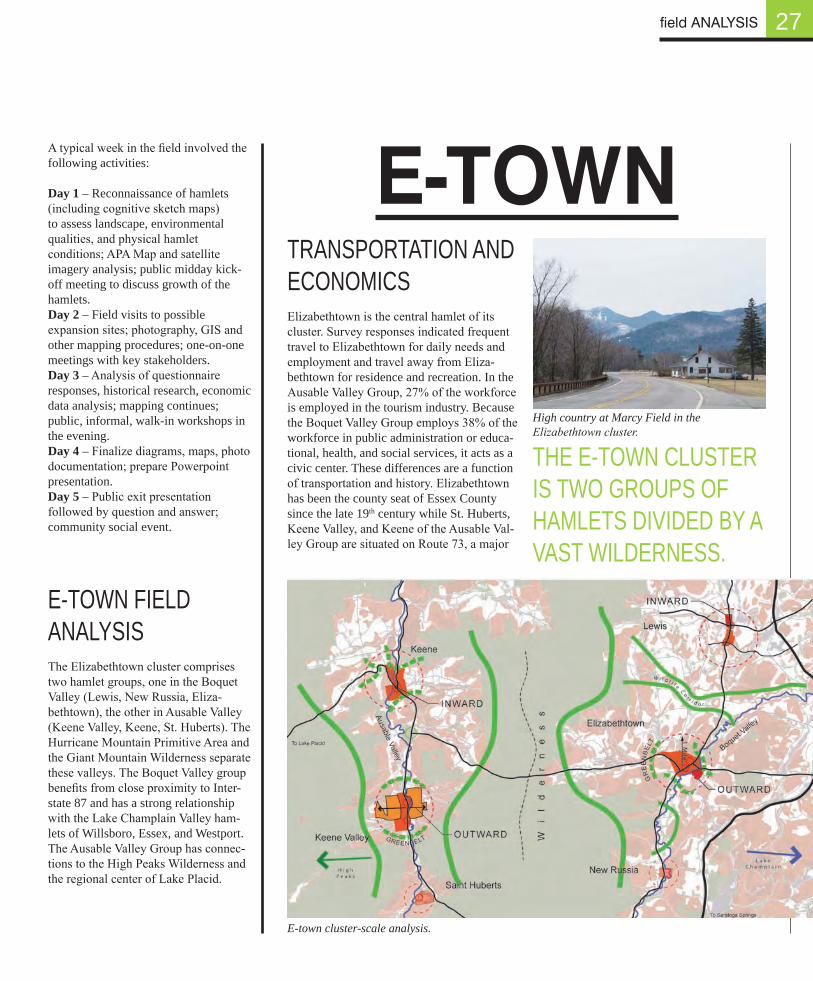
E-TOWN FIELD ANALYSIS The Elizabethtown cluster comprises two hamlet groups, one in the Boquet Valley (Lewis, New Russia, Eliza-bethtown), the other in Ausable Valley (Keene Valley, Keene, St. Huberts). The Hurricane Mountain Primitive Area and the Giant Mountain Wilderness separate these valleys. The Boquet Valley group benefits from close proximity to Inter-state 87 and has a strong relationship with the Lake Champlain Valley ham-lets of Willsboro, Essex, and Westport. The Ausable Valley Group has connec-tions to the High Peaks Wilderness and the regional center of Lake Placid.
TRANSPORTATION AND ECONOMICS Elizabethtown is the central hamlet of its cluster. Survey responses indicated frequent travel to Elizabethtown for daily needs and employment and travel away from Eliza-bethtown for residence and recreation. In the Ausable Valley Group, 27% of the workforce is employed in the tourism industry. Because the Boquet Valley Group employs 38% of the workforce in public administration or educa-tional, health, and social services, it acts as a civic center. These differences are a function of transportation and history. Elizabethtown has been the county seat of Essex County since the late 19th century while St. Huberts, Keene Valley, and Keene of the Ausable Val-ley Group are situated on Route 73, a major
27
E-town cluster-scale analysis.
High country at Marcy Field in the Elizabethtown cluster.
E-TOWn
field ANALYSIS
THE E-TOWN CLUSTER IS TWO GROUPS OF HAMLETS DIVIDED BY A VAST WILDERNESS.
2628
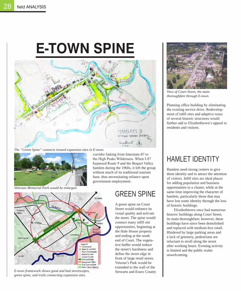
E-TOWn SPInE
The “Green Spine” connects inward expansion sites in E-town.
View of Court Street, the main thoroughfare through E-town.
Veterans Memorial Park would be enlarged.
field ANALYSIS
E-town framework shows good and bad streetscapes, green spine, and trails connecting expansion sites.
corridor linking from Interstate-87 to the High Peaks Wilderness. When I-87 bypassed Route 9 and the Boquet Valley hamlets during the 1960s, it left the group without much of its traditional tourism base, thus necessitating reliance upon government employment.
GREEN SPINEA green spine on Court Street would enhance its visual quality and activate the street. The spine would connect many infill site opportunities, beginning at the Hale House property and ending at the south end of Court. The vegeta-tive buffer would reduce the street’s harshness and define the street edge in front of large retail stores. Veteran’s Park would be extended to the wall of the Stewarts and Essex County
Planning office building by eliminating the existing service drive. Redevelop-ment of infill sites and adaptive reuse of several historic structures would further add to Elizabethtown’s appeal to residents and visitors.
HAMLET IDENTITYHamlets need strong centers to give them identity and to attract the attention of visitors. Infill sites are ideal places for adding population and business opportunities to a cluster, while at the same time improving the character of hamlets, particularly those that may have lost some identity through the loss of historic buildings.
Elizabethtown once had numerous historic buildings along Court Street, its main thoroughfare; however, these buildings have since been demolished and replaced with medium-box retail. Hindered by large parking areas and a lack of greenery, pedestrians are reluctant to stroll along the street after working hours. Evening activity is limited and the public realm unwelcoming.
29
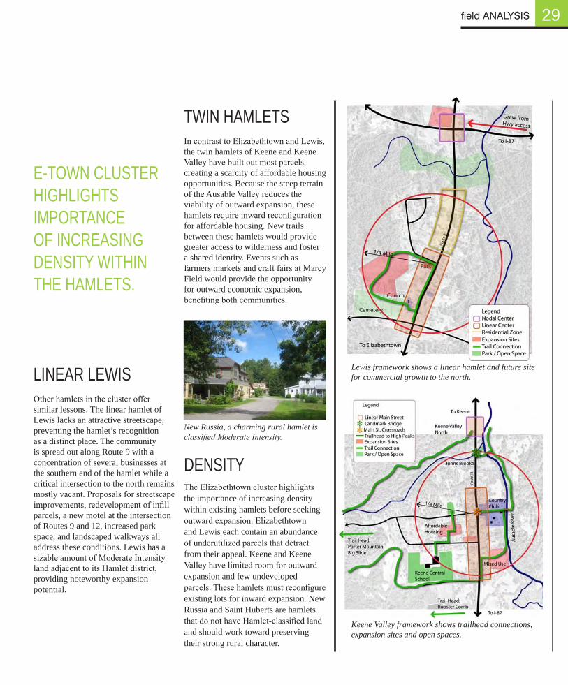
Keene Valley framework shows trailhead connections, expansion sites and open spaces.
TWIN HAMLETS
In contrast to Elizabethtown and Lewis, the twin hamlets of Keene and Keene Valley have built out most parcels, creating a scarcity of affordable housing opportunities. Because the steep terrain of the Ausable Valley reduces the viability of outward expansion, these hamlets require inward reconfiguration for affordable housing. New trails between these hamlets would provide greater access to wilderness and foster a shared identity. Events such as farmers markets and craft fairs at Marcy Field would provide the opportunity for outward economic expansion, benefiting both communities.
DENSITYThe Elizabethtown cluster highlights the importance of increasing density within existing hamlets before seeking outward expansion. Elizabethtown and Lewis each contain an abundance of underutilized parcels that detract from their appeal. Keene and Keene Valley have limited room for outward expansion and few undeveloped parcels. These hamlets must reconfigure existing lots for inward expansion. New Russia and Saint Huberts are hamlets that do not have Hamlet-classified land and should work toward preserving their strong rural character.
New Russia, a charming rural hamlet is classified Moderate Intensity.
Lewis framework shows a linear hamlet and future site for commercial growth to the north.
E-TOWN CLUSTER HIGHLIGHTS IMPORTANCE OF INCREASING DENSITY WITHIN THE HAMLETS.
field ANALYSIS
LINEAR LEWISOther hamlets in the cluster offer similar lessons. The linear hamlet of Lewis lacks an attractive streetscape, preventing the hamlet’s recognition as a distinct place. The community is spread out along Route 9 with a concentration of several businesses at the southern end of the hamlet while a critical intersection to the north remains mostly vacant. Proposals for streetscape improvements, redevelopment of infill parcels, a new motel at the intersection of Routes 9 and 12, increased park space, and landscaped walkways all address these conditions. Lewis has a sizable amount of Moderate Intensity land adjacent to its Hamlet district, providing noteworthy expansion potential.
Tobie
Trail
McCauley Mountain
Bubb & Sis Trail Head
Rocky Mt/ Black BearTrail Head
Public Boat Launch
Arrowhead Park
Fern Park
To RondaxeSnowmobiling &
Hiking Trails
Snow-mobileCenter
Old ForgePublic Beach &
WaterfrontCanoe Launch
Limekiln Campground
Snowmobile Center
Nick’s LakeCampground
Boat Rental
Moose River
Cascade Trail Head
Moss Lake Trail Head
Uncas Black Bear Mt. Trail
Head
Tobie Trail Conncection
Winter Recreation
Parks & Summer Recreation
Water Access & Recreation
Old Forge Cluster Trails
Moose RiverMoose River
Snowmobiling &
Moose RiverMoose RiverMoose RiverMoose RiverMoose RiverMoose River
12
3333333333 4
5
Trail HeadTrail HeadTrail HeadTrail HeadTrail Head
6 789
10
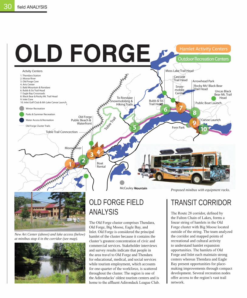
Hamlet Activity Centers
Outdoor Recreation Centers1. Thendara Station2. Moose River3. Old Forge Core4. Arts Center5. Bald Mountain & Rondaxe6. Bubb & Sis Trail Head7. Eagle Bay Crossroads8. Black Bear & Rocky Mt. Trail Head9. Inlet Core10. Inlet Golf Club & 6th Lake Canoe Launch
Actvity Centers
30
TRANSIT CORRIDORThe Route 28 corridor, defined by the Fulton Chain of Lakes, forms a linear string of hamlets in the Old Forge cluster with Big Moose located outside of the string. The team analyzed the corridor and mapped points of recreational and cultural activity to understand hamlet expansion opportunities. The hamlets of Old Forge and Inlet each maintain strong centers whereas Thendara and Eagle Bay present opportunities for place-making improvements through compact development. Several recreation nodes offer access to the region’s vast trail network.
OLD FORGE FIELD ANALYSIS The Old Forge cluster comprises Thendara, Old Forge, Big Moose, Eagle Bay, and Inlet. Old Forge is considered the principal hamlet of the cluster because it contains the cluster’s greatest concentration of civic and commercial services. Stakeholder interviews and survey results indicate that people in the area travel to Old Forge and Thendara for educational, medical, and social services while tourism employment, which accounts for one-quarter of the workforce, is scattered throughout the cluster. The region is one of the Adirondacks’ oldest tourism centers and is home to the affluent Adirondack League Club.
New Art Center (above) and lake access (below) at minibus stop 4 in the corridor (see map).
field ANALYSIS
Tobie
Trail
McCauley Mountain
Bubb & Sis Trail Head
Rocky Mt/ Black BearTrail Head
Public Boat Launch
Arrowhead Park
Fern Park
To RondaxeSnowmobiling &
Hiking Trails
Snow-mobileCenter
Old ForgePublic Beach &
WaterfrontCanoe Launch
Limekiln Campground
Snowmobile Center
Nick’s LakeCampground
Boat Rental
Moose River
Cascade Trail Head
Moss Lake Trail Head
Uncas Black Bear Mt. Trail
Head
Tobie Trail Conncection
Winter Recreation
Parks & Summer Recreation
Water Access & Recreation
Old Forge Cluster Trails
12
3 4
5
6 789
10
Hamlet Activity Centers
Outdoor Recreation Centers1. Thendara Station2. Moose River3. Old Forge Core4. Arts Center5. Bald Mountain & Rondaxe6. Bubb & Sis Trail Head7. Eagle Bay Crossroads8. Black Bear & Rocky Mt. Trail Head9. Inlet Core10. Inlet Golf Club & 6th Lake Canoe Launch
Actvity Centers
OLd FORgE
McCauley Mountain Proposed minibus with equipment racks.
31
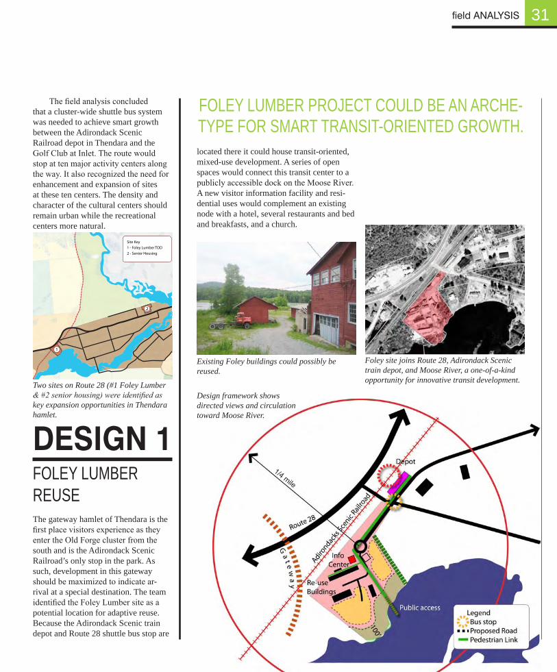
The field analysis concluded that a cluster-wide shuttle bus system was needed to achieve smart growth between the Adirondack Scenic Railroad depot in Thendara and the Golf Club at Inlet. The route would stop at ten major activity centers along the way. It also recognized the need for enhancement and expansion of sites at these ten centers. The density and character of the cultural centers should remain urban while the recreational centers more natural.
located there it could house transit-oriented, mixed-use development. A series of open spaces would connect this transit center to a publicly accessible dock on the Moose River. A new visitor information facility and resi-dential uses would complement an existing node with a hotel, several restaurants and bed and breakfasts, and a church.
dESIgn 1
FOLEY LUMBER PROJECT COULD BE AN ARCHE-TYPE FOR SMART TRANSIT-ORIENTED GROWTH.
0 0.1 0.2 0.3 0.4 0.50.05MilesHamlets 3
Case Study AreaLocator
This map should not be used forlegal jurisdictional determinations.
Provided ByThe Adirondack Park Agency
July 2009
Legend100 foot contour
500 foot contour
Wetland
Deep Water Marsh
Open Water
APLUDP/SLMPLand Classification
Hamlet
Moderate Intensity
Low Intensity
Rural Use
Resource Mgmt.
Industrial Use
Wilderness
Canoe Area
Primitive
Wild Forest
Intensive Use
Historic
State Administrative
Pending ClassificationThendara
Site Key1 - Foley Lumber TOD2 - Senior Housing
1
2
Existing Foley buildings could possibly be reused.
FOLEY LUMBER REUSE The gateway hamlet of Thendara is the first place visitors experience as they enter the Old Forge cluster from the south and is the Adirondack Scenic Railroad’s only stop in the park. As such, development in this gateway should be maximized to indicate ar-rival at a special destination. The team identified the Foley Lumber site as a potential location for adaptive reuse. Because the Adirondack Scenic train depot and Route 28 shuttle bus stop are
field ANALYSIS
Two sites on Route 28 (#1 Foley Lumber & #2 senior housing) were identified as key expansion opportunities in Thendara hamlet.
Foley site joins Route 28, Adirondack Scenic train depot, and Moose River, a one-of-a-kind opportunity for innovative transit development.
Design framework shows directed views and circulation toward Moose River.
1/4 mile
32
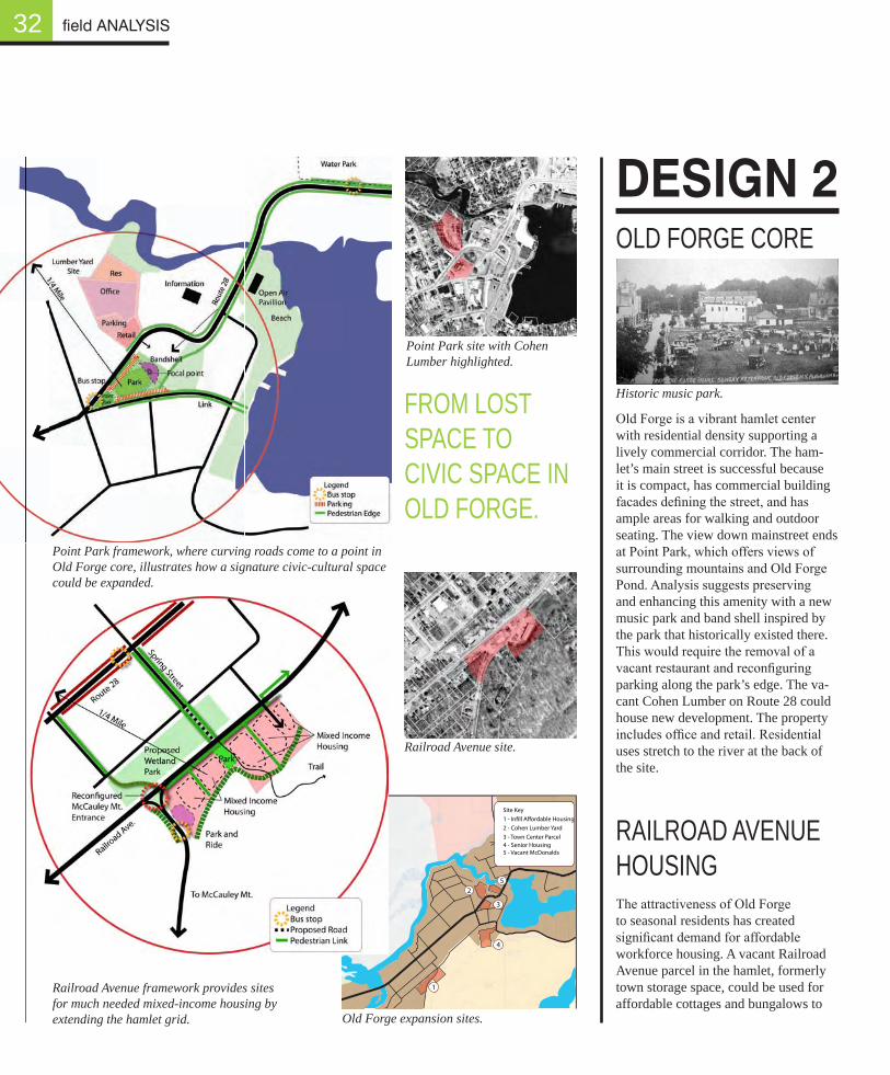
Old Forge is a vibrant hamlet center with residential density supporting a lively commercial corridor. The ham-let’s main street is successful because it is compact, has commercial building facades defining the street, and has ample areas for walking and outdoor seating. The view down mainstreet ends at Point Park, which offers views of surrounding mountains and Old Forge Pond. Analysis suggests preserving and enhancing this amenity with a new music park and band shell inspired by the park that historically existed there. This would require the removal of a vacant restaurant and reconfiguring parking along the park’s edge. The va-cant Cohen Lumber on Route 28 could house new development. The property includes office and retail. Residential uses stretch to the river at the back of the site.
RAILROAD AVENUE HOUSING The attractiveness of Old Forge to seasonal residents has created significant demand for affordable workforce housing. A vacant Railroad Avenue parcel in the hamlet, formerly town storage space, could be used for affordable cottages and bungalows to
dESIgn 2OLD FORGE CORE
0 0.1 0.2 0.3 0.4 0.50.05MilesHamlets 3
Case Study AreaLocator
This map should not be used forlegal jurisdictional determinations.
Provided ByThe Adirondack Park Agency
July 2009
Legend100 foot contour
500 foot contour
Forested Wetland
Shrub Wetland
Emergent Marsh
Open Water
APLUDP/SLMPLand Classification
Hamlet
Moderate Intensity
Low Intensity
Rural Use
Resource Mgmt.
Industrial Use
Wilderness
Canoe Area
Primitive
Wild Forest
Intensive Use
Historic
State Administrative
Pending Classification
Old Forge
5
Site Key1 - In�ll A�ordable Housing2 - Cohen Lumber Yard3 - Town Center Parcel4 - Senior Housing5 - Vacant McDonalds
1
2
3
4
Point Park site with Cohen Lumber highlighted.
Point Park framework, where curving roads come to a point in Old Forge core, illustrates how a signature civic-cultural space could be expanded.
Railroad Avenue framework provides sites for much needed mixed-income housing by extending the hamlet grid.
Railroad Avenue site.
Old Forge expansion sites.
Historic music park.
field ANALYSIS
FROM LOST SPACE TO CIVIC SPACE IN OLD FORGE.
33
MCCAULEY MT. EXPANSIONThe lack of remaining developable land within the hamlet of Old Forge illustrates the need for outward expansion in quickly growing hamlets. West-Central Adirondack Recreational Development Association’s (WARDA) McCauley Mountain expansion proposal is an example of smart outward expansion. The proposal builds upon an existing facility with new trails, a Nordic ski race center, and indoor recreational facilities. This expansion is located in close proximity to many existing residents of McCauley Mountain.
dESIgn 3
Expanding the McCauley Mountain recre-ation center could provide investments in the nearby hamlet of Old Forge.
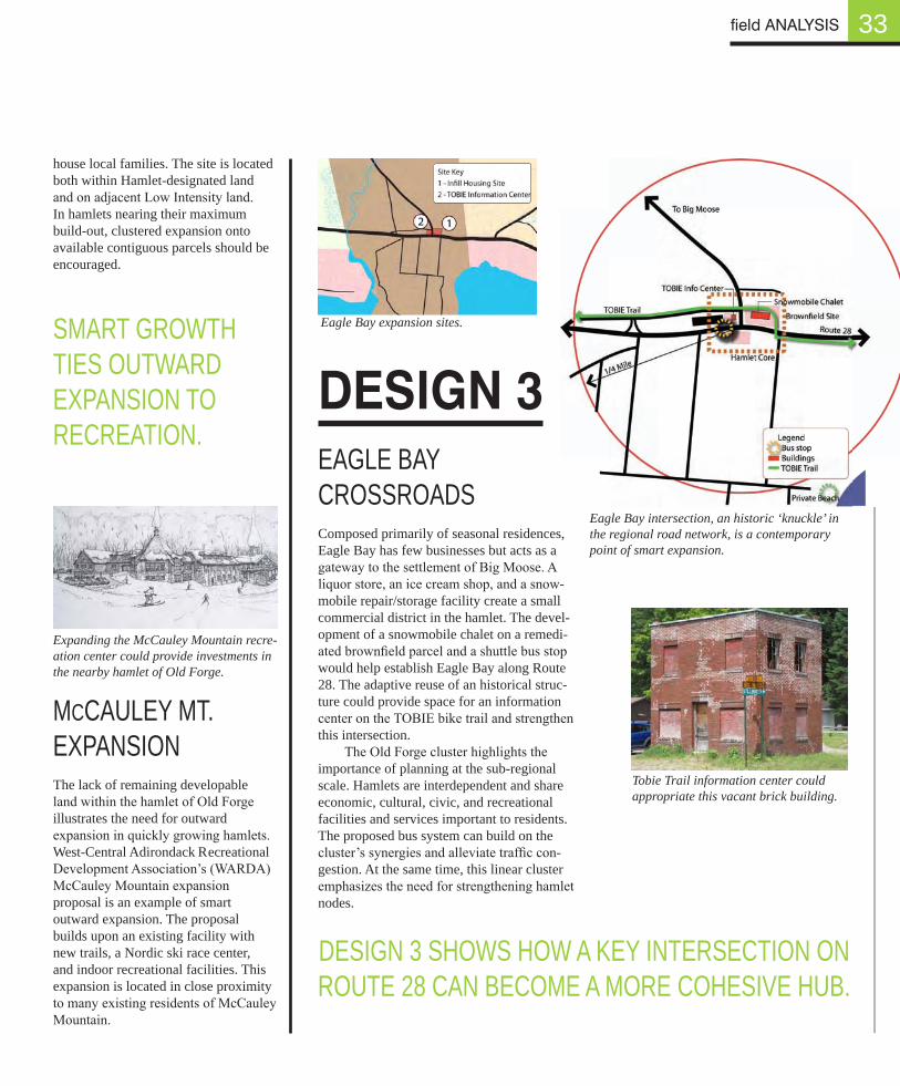
Eagle Bay intersection, an historic ‘knuckle’ in the regional road network, is a contemporary point of smart expansion.
Eagle Bay expansion sites.
EAGLE BAY CROSSROADS Composed primarily of seasonal residences, Eagle Bay has few businesses but acts as a gateway to the settlement of Big Moose. A liquor store, an ice cream shop, and a snow-mobile repair/storage facility create a small commercial district in the hamlet. The devel-opment of a snowmobile chalet on a remedi-ated brownfield parcel and a shuttle bus stop would help establish Eagle Bay along Route 28. The adaptive reuse of an historical struc-ture could provide space for an information center on the TOBIE bike trail and strengthen this intersection.
The Old Forge cluster highlights the importance of planning at the sub-regional scale. Hamlets are interdependent and share economic, cultural, civic, and recreational facilities and services important to residents. The proposed bus system can build on the cluster’s synergies and alleviate traffic con-gestion. At the same time, this linear cluster emphasizes the need for strengthening hamlet nodes.
SMART GROWTH TIES OUTWARD EXPANSION TO RECREATION.
DESIGN 3 SHOWS HOW A KEY INTERSECTION ON ROUTE 28 CAN BECOME A MORE COHESIVE HUB.
field ANALYSIS
Tobie Trail information center could appropriate this vacant brick building.
house local families. The site is located both within Hamlet-designated land and on adjacent Low Intensity land. In hamlets nearing their maximum build-out, clustered expansion onto available contiguous parcels should be encouraged.
34
SOCIO-ECONOMIC CONDITIONS The five hamlets, located within the towns of Clifton and Fine, are economi-cally and administratively interdepen-dent to the point that one interviewee said, “When Star Lake sneezes, Cranber-ry Lake holds the tissue.” The physical layout of the cluster’s two towns is also closely connected as a traveler crosses the towns’ border several times between Oswegatchie and Cranberry Lake (see map on page 63).
Star Lake is the cluster’s primary hamlet and residents from each of the satellite hamlets rely on services located there. Steel, mining, and mill opera-tions on the cluster’s abundant industrial land, historically provided jobs for the residents. However, most of these busi-nesses, aside from the Newton Falls Fine Paper mill, have since left. The hamlet of Wanakena provides employment opportunities through the Environmen-tal Science and Forestry (ESF) Ranger School while Cranberry Lake offers jobs in tourism. The interconnections of these hamlets provide an opportunity for cluster-scale economic renewal.
STAR LAKE FIELD ANALYSIS The Star Lake cluster, isolated by vast expanses of natural lands, has five hamlets: Star Lake, Oswegatchie, Newton Falls, Wanakena, and Cranberry Lake. With the exceptions of Wanakena and Cranberry Lake, the cluster’s U-shaped settlement pattern closely follows the former Carthage & Adirondack Railroad line and historic roads.
Star Lake regional analysis.
STAR LAKE
Star Lake cluster relationships.
field ANALYSIS
STAR LAKE CLUSTER FORMS A ‘U’ WITH TWO OUTPOST HAMLETS.
35
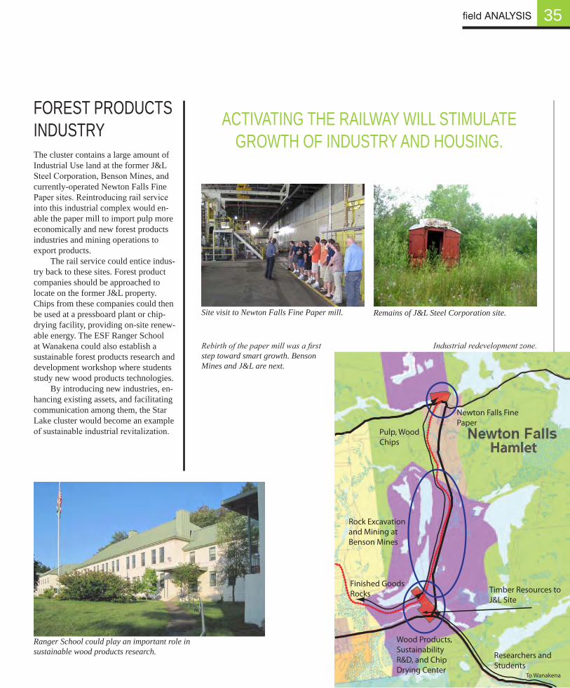
FOREST PRODUCTS INDUSTRYThe cluster contains a large amount of Industrial Use land at the former J&L Steel Corporation, Benson Mines, and currently-operated Newton Falls Fine Paper sites. Reintroducing rail service into this industrial complex would en-able the paper mill to import pulp more economically and new forest products industries and mining operations to export products.
The rail service could entice indus-try back to these sites. Forest product companies should be approached to locate on the former J&L property. Chips from these companies could then be used at a pressboard plant or chip-drying facility, providing on-site renew-able energy. The ESF Ranger School at Wanakena could also establish a sustainable forest products research and development workshop where students study new wood products technologies.
By introducing new industries, en-hancing existing assets, and facilitating communication among them, the Star Lake cluster would become an example of sustainable industrial revitalization.
Site visit to Newton Falls Fine Paper mill. Remains of J&L Steel Corporation site.
ACTIVATING THE RAILWAY WILL STIMULATE GROWTH OF INDUSTRY AND HOUSING.
Ranger School could play an important role in sustainable wood products research.
Timber Resources to J&L Site
Finished GoodsRocks
Rock Excavation and Mining at Benson Mines
Newton Falls Fine Paper
Pulp, Wood Chips
Researchers and Students
Wood Products, Sustainability R&D, and Chip Drying Center
Hamlet
To Wanakena
Industrial redevelopment zone.
field ANALYSIS
Rebirth of the paper mill was a first step toward smart growth. Benson Mines and J&L are next.
Glimpse of Star Lake behind Community Center.
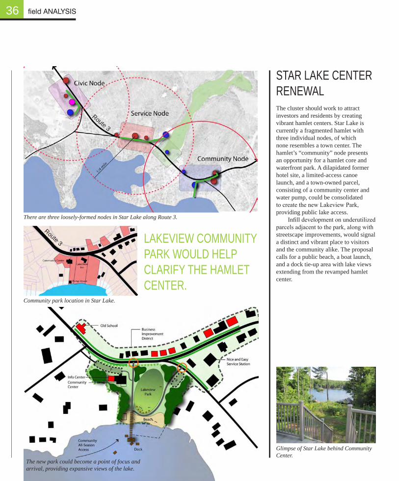
36
STAR LAKE CENTER RENEWALThe cluster should work to attract investors and residents by creating vibrant hamlet centers. Star Lake is currently a fragmented hamlet with three individual nodes, of which none resembles a town center. The hamlet’s “community” node presents an opportunity for a hamlet core and waterfront park. A dilapidated former hotel site, a limited-access canoe launch, and a town-owned parcel, consisting of a community center and water pump, could be consolidated to create the new Lakeview Park, providing public lake access.
Infill development on underutilized parcels adjacent to the park, along with streetscape improvements, would signal a distinct and vibrant place to visitors and the community alike. The proposal calls for a public beach, a boat launch, and a dock tie-up area with lake views extending from the revamped hamlet center.
Community park location in Star Lake.
There are three loosely-formed nodes in Star Lake along Route 3.
field ANALYSIS
The new park could become a point of focus and arrival, providing expansive views of the lake.
LAKEVIEW COMMUNITY PARK WOULD HELP CLARIFY THE HAMLET CENTER.
Route 3
Route 3
37
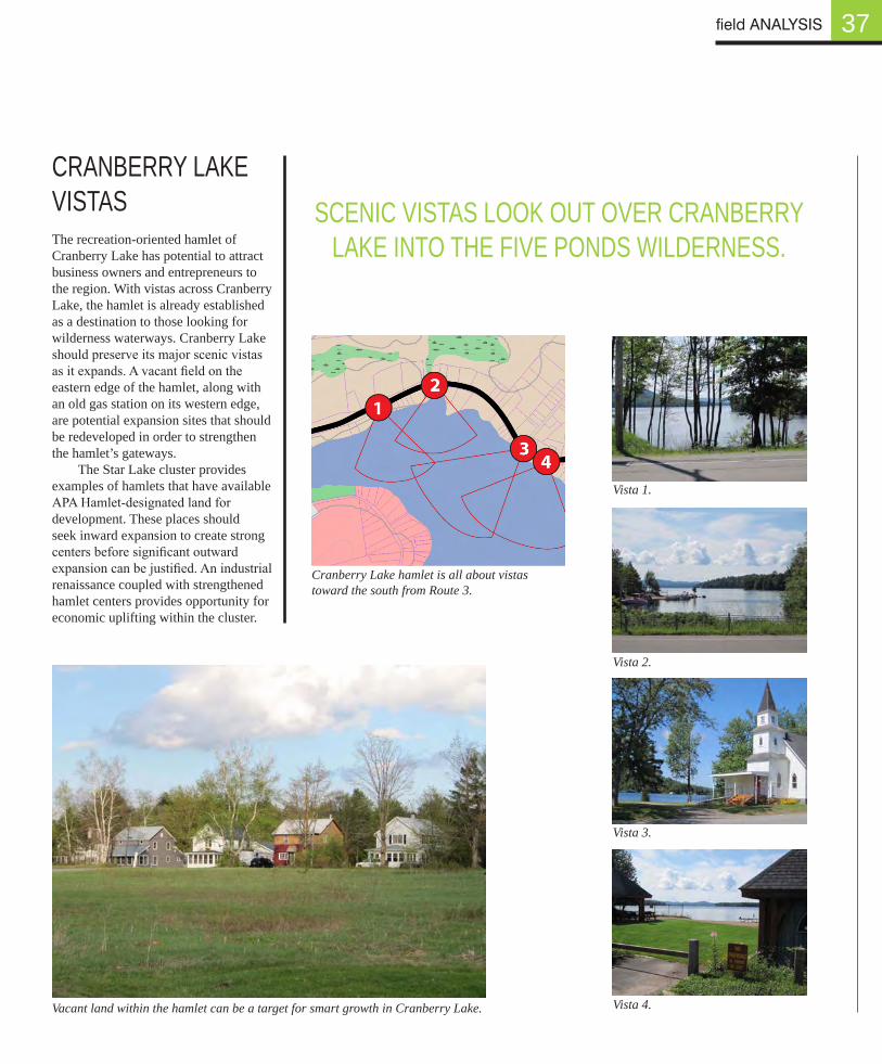
CRANBERRY LAKE VISTASThe recreation-oriented hamlet of Cranberry Lake has potential to attract business owners and entrepreneurs to the region. With vistas across Cranberry Lake, the hamlet is already established as a destination to those looking for wilderness waterways. Cranberry Lake should preserve its major scenic vistas as it expands. A vacant field on the eastern edge of the hamlet, along with an old gas station on its western edge, are potential expansion sites that should be redeveloped in order to strengthen the hamlet’s gateways.
The Star Lake cluster provides examples of hamlets that have available APA Hamlet-designated land for development. These places should seek inward expansion to create strong centers before significant outward expansion can be justified. An industrial renaissance coupled with strengthened hamlet centers provides opportunity for economic uplifting within the cluster.
Vista 1.
Vista 2.
Vista 3.
Vista 4.Vacant land within the hamlet can be a target for smart growth in Cranberry Lake.
SCENIC VISTAS LOOK OUT OVER CRANBERRY LAKE INTO THE FIVE PONDS WILDERNESS.
field ANALYSIS
Cranberry Lake hamlet is all about vistas toward the south from Route 3.
38
EXPAnSIOn SITES
field ANALYSIS
The Hamlets 3 field analysis of July and August 2009 led to an initial listing of expansion sites and helped citizens brainstorm growth opportunities in their hamlet. It provided insights into expansion problems in different areas of the park. This process clarified the need for an expansion planning model applicable to a variety of situations, a model that could advance the cause of smart growth in the Adirondacks. It would have to be a model that local planning board members could easily use. Section 5 introduces such a model.
Fieldwork Expansion Sites
31 inward, 19 outward. E-town: 13 inward, 4 outward = 17 total sites Old Forge: 10 inward, 11 outward = 21 total sites Star Lake: 8 inward, 4 outward = 12 total sites
50 total expansion sites | 31 inward | 19 outward
Elizabethtown Cluster Old Forge Cluster Star Lake Cluster
Inward
Reuse of Obsolete Buildings:Old Yellow Diner (E-town)
Vacant Pink Building (E-town)Elm Tree Inn (Keene)
Infill Vacant/Underutilized LandCobblestone Property (E-town)
Soccer/Ice Rink (E-town)River St. Lots (E-town)
Veteran’s Memorial Park (E-town)Town Park (Lewis)
Affordable Housing Site (Keene)Community Space (Keene)
Re-dividing/Reconfiguring lotsHale Senior Housing (E-town)
Mobile Home Site (Keene Valley)Assisted-Living Lot (Keene Valley)
Outward
Contiguous Sites at the EdgeNo. St. Subdivision (E-town)
Cemetery Land (Lewis)
Linear Hamlet ExtensionSite @ corner of Rt. 12 & Rt. 9
(Lewis)
Discrete Development AreasMarcy Field (Keene Valley)
Inward
Reuse of Obsolete Buildings:Vacant McDonalds (Old Forge)
Rt. 28 Senior Housing (Thendara)Moose River Outpost (Thendara)TOBIE Info Center (Eagle Bay)
Arrowhead Park Expansion (Inlet)
Infill Vacant/Underutilized LandHamlet Center Parcel (Old Forge)Foley Lumber Reuse (Thendara) “Snowmobile Chalet” (Eagle Bay)
Canal Bridge Remodel (Inlet)Inlet Golf Site (Inlet)
Re-dividing/Reconfiguring lotsCohen Lumber Lots (Old Forge)
Outward
Contiguous Sites at the EdgeRailroad Ave. Housing (Old Forge)
Senior Housing Expansion (Old Forge)
Fern Park Expansion (Inlet)6th Lake Canoe Launch (Inlet)
Linear Hamlet ExtensionArt Center Node (Old Forge)
Discrete Development AreasMcCauley Ski Mtn. (Old Forge)
Airport Development (Old Forge)Bald Mtn & Rondaxe trailhead (Old
Forge)Bubb & Sis Trailhead (Old Forge)Black Bear/ Rocky Mtn. Trailhead
(Inlet)Map Amendment Sites (Inlet)
Inward
Reuse of Obsolete Buildings:Core Infill Buildings (Star Lake)Vacant Gas Station (Cranberry
Lake)Church Reuse (Star Lake)
Infill Vacant/Underutilized LandWalkway Links - 3 Nodes (Star
Lake)Core Open Spaces (Newton Falls)Empty Field East End (Cranberry
Lake)
Re-dividing/Reconfiguring lotsCommunity Waterfront Park (Star
Lake)
Outward
Contiguous Sites at the EdgeBenson Mines (Newton Falls)
Linear Hamlet ExtensionResidential Building Lots
(Oswegatchie)No. Shore Housing (Wanakena)
Discrete Development AreasJ&L Site (Newton Falls)


![Digital Image Information Hiding Methods for Protecting ... · Expansion (PEE) [12], [13], and lossless compression [1], [14], [15] are also identified. Difference expansion and pixel](https://img.pdfslide.net/doc/110x75/5f38f71f63e470337e661bbc/digital-image-information-hiding-methods-for-protecting-expansion-pee-12.jpg)