Embed Size (px)
Citation preview

FIFTH FIVE-YEAR REVIEW REPORT FOR COMMENCEMENT BAY, SOUTH TACOMA CHANNEL SUPERFUND SITE
TACOMA, WASHINGTON
• • {; :5
Prepared by
U.S. Environmental Protection Agency Region 10
Seattle, Washington
~~ ---------------------------~✓ q}2-8 /zot_,_Y- _ Sheryl Bilbrey, Director Date Office of Environmental Cleanup


CB-STC 2018 FYR iii
Table of Contents
List of Abbreviations and Acronymns
Introduction
Site Background
Five-Year Review Summary Form
Sitewide Protectiveness Statement
Next Review
Well 12-A Project Area (OU 1)
South Tacoma Field Project Area (OU 4)
Tacoma Landfill Project Area (OU 5 & 6)
Well 12-A Appendicies
South Tacoma Field Appendicies
Tacoma Landfill Appendicies
CB-STC 2018 FYR iv
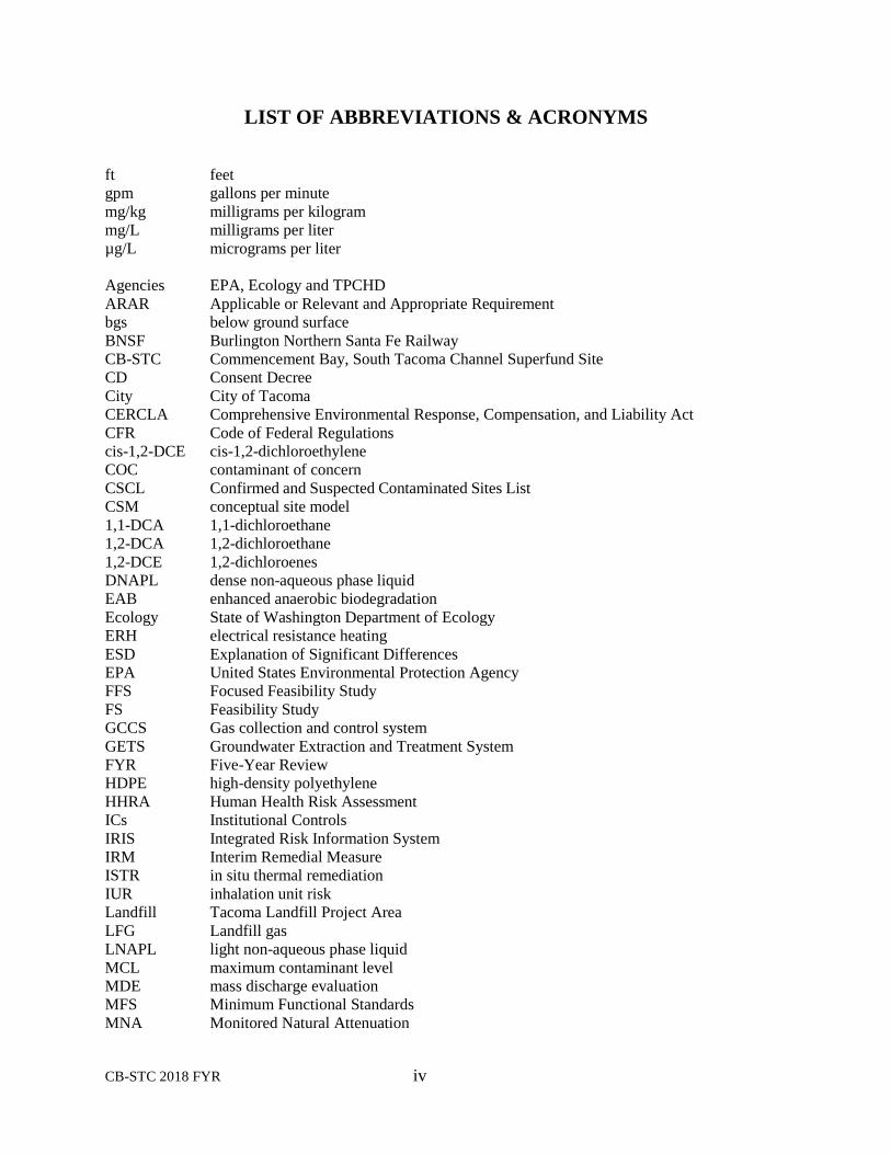
LIST OF ABBREVIATIONS & ACRONYMS
ft feet
gpm gallons per minute
mg/kg milligrams per kilogram
mg/L milligrams per liter
µg/L micrograms per liter
Agencies EPA, Ecology and TPCHD
ARAR Applicable or Relevant and Appropriate Requirement
bgs below ground surface
BNSF Burlington Northern Santa Fe Railway
CB-STC Commencement Bay, South Tacoma Channel Superfund Site
CD Consent Decree
City City of Tacoma
CERCLA Comprehensive Environmental Response, Compensation, and Liability Act
CFR Code of Federal Regulations
cis-1,2-DCE cis-1,2-dichloroethylene
COC contaminant of concern
CSCL Confirmed and Suspected Contaminated Sites List
CSM conceptual site model
1,1-DCA 1,1-dichloroethane
1,2-DCA 1,2-dichloroethane
1,2-DCE 1,2-dichloroenes
DNAPL dense non-aqueous phase liquid
EAB enhanced anaerobic biodegradation
Ecology State of Washington Department of Ecology
ERH electrical resistance heating
ESD Explanation of Significant Differences
EPA United States Environmental Protection Agency
FFS Focused Feasibility Study
FS Feasibility Study
GCCS Gas collection and control system
GETS Groundwater Extraction and Treatment System
FYR Five-Year Review
HDPE high-density polyethylene
HHRA Human Health Risk Assessment
ICs Institutional Controls
IRIS Integrated Risk Information System
IRM Interim Remedial Measure
ISTR in situ thermal remediation
IUR inhalation unit risk
Landfill Tacoma Landfill Project Area
LFG Landfill gas
LNAPL light non-aqueous phase liquid
MCL maximum contaminant level
MDE mass discharge evaluation
MFS Minimum Functional Standards
MNA Monitored Natural Attenuation

CB-STC 2018 FYR v
MTCA Washington State Model Toxics Control Act
NAPL non-aqueous phase liquid
NCP National Oil and Hazardous Substances Pollution Contingency Plan
NPL National Priorities List
O&M Operation and Maintenance
OU Operable Unit
PAH polyaromatic hydrocarbon
Pb lead
PCA 1,1,2,2-tetrachloroethane
PCB polychlorinated biphenyl
PCE tetrachloroethylene
POC Point of compliance
PRG Preliminary Remedial Goals
PRP Potentially Responsible Party
QAPP Quality Assurance Project Plan
RA Remedial Action
RAO Remedial Action Objectives
RCRA Resource Conservation and Recovery Act
RD Remedial Design
RfC reference concentration
RfD reference dose
RI Remedial Investigation
RSL regional screening level
ROD Record of Decision
RODA Amendment to the Record of Decision
RPM Remedial Project Manager
SDICP Site Development and Institutional Controls Plan
SF slope factor
STC South Tacoma Channel
STF South Tacoma Field
TBC To be considered
1,1,1-TCA 1,1,1-trichloroethane
TCE trichloroethylene
TLF Tacoma Landfill
TPCHD Tacoma-Pierce County Health Department
TPH total petroleum hydrocarbons
trans-1,2-DCE trans-1,2-dichloroethylene
TTZ thermal treatment zone
UAO Unilateral Administrative Order
UST underground storage tank
UU/UE unlimited use and unrestricted exposure
VC vinyl chloride
VES Vapor Extraction System
VOC volatile organic chemical

CB-STC 2018 FYR 1
2018 Five-Year Review
Commencement Bay – South Tacoma Channel
Superfund Site
I. INTRODUCTION
The purpose of a Five-Year Review (FYR) is to evaluate the implementation and performance of a
remedy to determine if the remedy is and will continue to be protective of human health and the
environment. The methods, findings, and conclusions of reviews are documented in five-year review
reports such as this one. In addition, FYR reports identify issues found during the review, if any, and
document recommendations to address them.
The U.S. Environmental Protection Agency (EPA) is preparing this five-year review pursuant to the
Comprehensive Environmental Response, Compensation, and Liability Act (CERCLA) Section 121,
consistent with the National Contingency Plan (NCP)(40 CFR Section 300.430(f)(4)(ii)), and considering
EPA policy.
This is the fifth FYR for the Commencement Bay, South Tacoma Channel Superfund Site (CB-STC Site).
The triggering action for this statutory review is the previous FYR completed on September 10, 2013.
The FYR has been prepared because hazardous substances, pollutants, or contaminants remain at the site
above levels that allow for unlimited use and unrestricted exposure (UU/UE).
The Site consists of three Project Areas – Well 12A, South Tacoma Field (STF) and Tacoma Landfill
(TLF) – and six Operable Units (OUs) as outlined in Table 1. The three Project Areas are all located in
south Tacoma but have distinctly different problems, remedies and approaches to protectiveness (Figure
1).
A separate review has been conducted for each Project Area and presented in this FYR as a separate
Section. Although Well 12A was historically divided into OUs 1, 2, and 3, currently, the Project Area is
considered one OU (OU1). OU2 and OU3 will not be mentioned further in this FYR. A Sitewide
Protectiveness Statement is presented in Section V of this report.
Table 1. Project Areas and Operable Units
FYR Section Project Area Operable Unit
II Well 12A
1 Well 12A - Groundwater
2 Well 12A Burlington Northern Soil Removal
3 Well 12A Soils (Vapor Extraction System)
III South Tacoma Field 4 South Tacoma Field
IV Tacoma Landfill 5 Tacoma Landfill - Cap
6 Tacoma Landfill - Groundwater
The Commencement Bay, South Tacoma Channel Superfund Site Five-Year Review was led by Jeremy
Jennings, EPA Region 10 and Chris Cora, EPA Region 10 (Well 12A Project Area). Participants will be
identified in each section of the FYR. The review began on February 26, 2018.
Site Background
The Site is in a light industrial area in the southern portion of Tacoma. In the late 1800’s, following the

CB-STC 2018 FYR 2
Well 12A
Tacoma
Landfill
South
Tacoma
Field
South Tacoma Channel Superfund Site Operable Units
0 200 400 800 Source:
Feet USGS Topographic Map, Tacoma South, WA, 1997
USGS Topographic Map, Steilacoom, WA, 1997
Figure 1. Location of Project Areas in the South Tacoma Channel Superfund Site

CB-STC 2018 FYR 3
expansion of the railroad, many of the properties near the tracks were utilized for light industry and
activities that supported the railroad. In 1960 the City of Tacoma opened a municipal landfill in the area.
Discharge of contaminants from these activities generated the source areas addressed at the Site.
As the population grew, the City of Tacoma added several drinking water supply wells in the area to
provide drinking water to residents. While the wells provided an alternative to drawing drinking water
from individual wells near Site contamination, groundwater extraction has influenced groundwater flows
across the Site. These impacts have been factored into the remedial actions at all three Project Areas.
The CB-STC Superfund Site was listed on the interim priority list by the U.S. Environmental Protection
Agency (EPA) in 1981 and formally listed on the National Priorities List (NPL) in 1983.
Well 12A (OU1)
The Well 12A Project Area encompasses the source of contamination from the former Time Oil Company
and Burlington Northern Railroad properties in south Tacoma. In 1981, chlorinated organic solvents were
detected in groundwater at the City of Tacoma’s Well 12A, a municipal water supply production well
owned and operated by the City of Tacoma, at concentrations above the drinking water criteria. The well
was shut-down until appropriate treatment was added. Investigations by EPA found the source of
contamination to likely be from a waste oil and solvent recycler that had operated on the above properties
from the 1920s through the 1960s.
The remedies for the Well 12A area were selected in the 1983 Record of Decision (ROD), 1985 first
ROD Amendment (RODA), and a 2009 RODA. Minor changed to the 1985 remedy were documented in
a 1987 remedial design change memorandum. A groundwater extraction and treatment system was
installed in 1988 and five additional systems were installed in August 1993. In 2012, actions were
undertaken to address VOC source areas through excavation, in-situ thermal treatment, soil vapor
extraction, and enhanced anaerobic bioremediation. The remedial actions are being implemented by EPA.
South Tacoma Field (OU4)
The South Tacoma Field Project Area addresses several sources of soil and groundwater contamination
on 260 acres of land adjacent to the railroad. Historical uses included railcar manufacturing, repair and
maintenance; iron and brass foundries; transformer maintenance and unpermitted dumping of foundry,
construction and domestic wastes. A 1994 ROD utilized a combination of treatment, containment and
institutional controls for the contaminated soil throughout the site and treatment of contaminated
groundwater at Pioneer Builders Supply. After contaminated soils at Pioneer Building Supply were
removed, a 1999 ESD changed the treatment of contaminated groundwater at Pioneer Builders Supply to
monitored natural attenuation (MNA).
In 1997, a dry well located on the Tacoma City Light property was remediated while most of the other
efforts were conducted in 1999. In 2005, following a request by the landowners, EPA partially deleted
the Soils portion of OU 4. Groundwater monitoring wells continue to be sampled annually. Work is being
performed by the Potentially Responsible Parties (PRPs).
Tacoma Landfill (OUs 5 and 6)
The Tacoma Landfill remedial actions address releases of hazardous substances from a municipal landfill
operated by the City of Tacoma. The 240-acre landfill operated from 1960 to 2013 and accepted
municipal, industrial, construction, demolition, and bulk wastes, some of which have since been
designated as hazardous substances. EPA’s 1988 ROD required capping of filled areas; leachate,
condensate and stormwater collection systems; collection of landfill gas; and groundwater extraction and
treatment. The landfill was closed in December 2015 and most of the groundwater outside the landfill
CB-STC 2018 FYR 4
footprint has attained cleanup levels. The remedial actions are being implemented by the PRP, the City of
Tacoma.
FIVE-YEAR REVIEW SUMMARY FORM
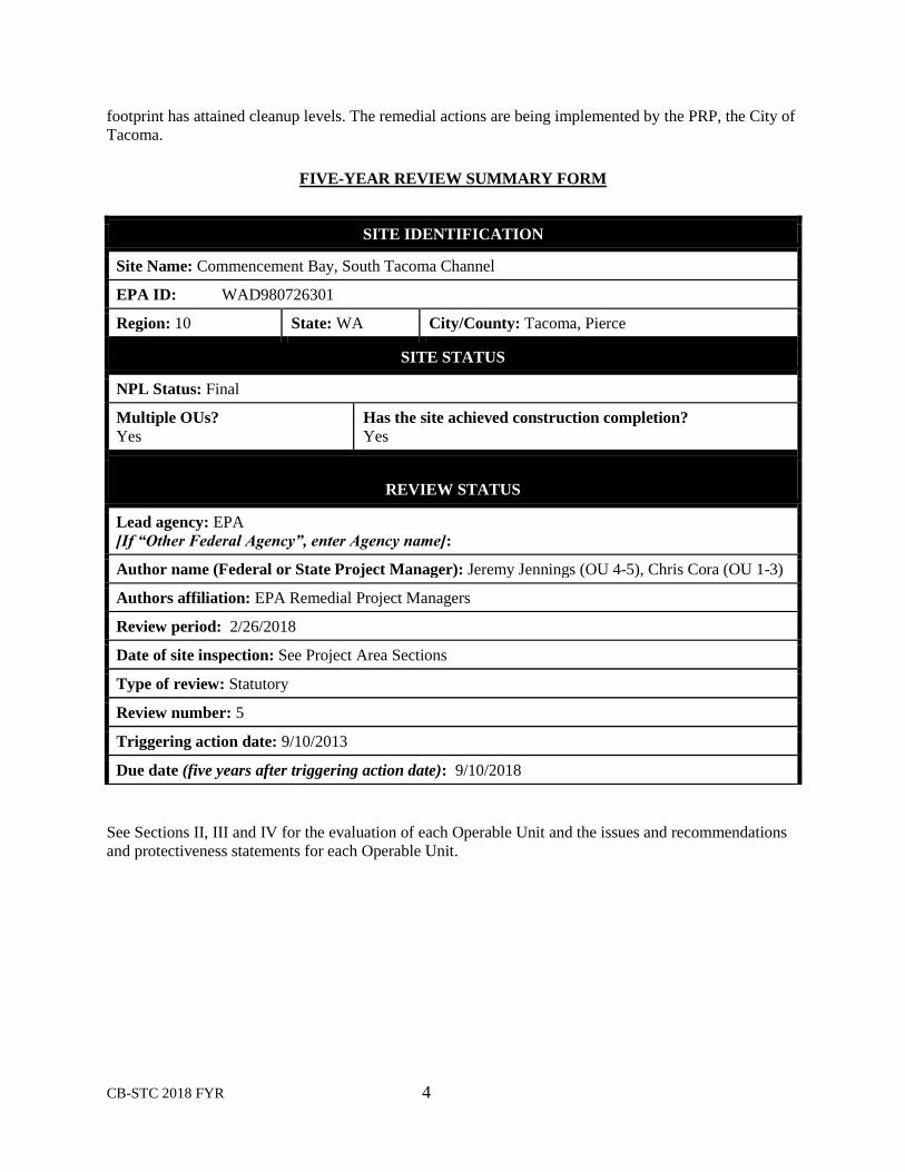
See Sections II, III and IV for the evaluation of each Operable Unit and the issues and recommendations
and protectiveness statements for each Operable Unit.
SITE IDENTIFICATION
Site Name: Commencement Bay, South Tacoma Channel
EPA ID: WAD980726301
Region: 10 State: WA City/County: Tacoma, Pierce
SITE STATUS
NPL Status: Final
Multiple OUs?
Yes
Has the site achieved construction completion?
Yes
REVIEW STATUS
Lead agency: EPA
[If “Other Federal Agency”, enter Agency name]:
Author name (Federal or State Project Manager): Jeremy Jennings (OU 4-5), Chris Cora (OU 1-3)
Authors affiliation: EPA Remedial Project Managers
Review period: 2/26/2018
Date of site inspection: See Project Area Sections
Type of review: Statutory
Review number: 5
Triggering action date: 9/10/2013
Due date (five years after triggering action date): 9/10/2018
CB-STC 2018 FYR 5
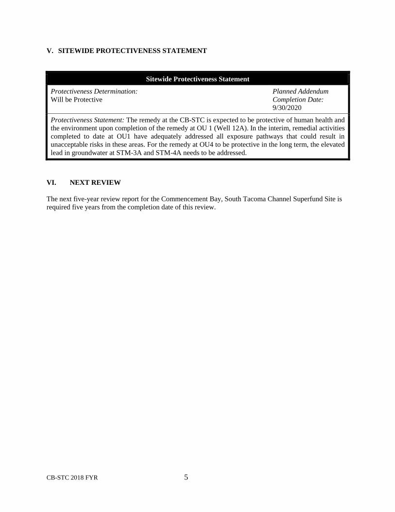
V. SITEWIDE PROTECTIVENESS STATEMENT
Sitewide Protectiveness Statement
Protectiveness Determination:
Will be Protective
Planned Addendum
Completion Date:
9/30/2020
Protectiveness Statement: The remedy at the CB-STC is expected to be protective of human health and
the environment upon completion of the remedy at OU 1 (Well 12A). In the interim, remedial activities
completed to date at OU1 have adequately addressed all exposure pathways that could result in
unacceptable risks in these areas. For the remedy at OU4 to be protective in the long term, the elevated
lead in groundwater at STM-3A and STM-4A needs to be addressed.
VI. NEXT REVIEW
The next five-year review report for the Commencement Bay, South Tacoma Channel Superfund Site is
required five years from the completion date of this review.
II.
Well 12A (OU1)
COMMENCEMENT BAY –
SOUTH TACOMA CHANNEL SUPERFUND SITE
PIERCE COUNTY, WASHINGTON
Prepared by
United States Army Corps of Engineers (USACE)
Seattle District
Seattle, Washington
Prepared for
U.S. Environmental Protection Agency
Region 10
Seattle, Washington

Well 12A i
[This page is intentionally left blank]

Well 12A ii
Well 12 A Table of Contents 1. INTRODUCTION .................................................................................................................. 1
1.1 Site Background ............................................................................................................... 1 2. RESPONSE ACTION SUMMARY ....................................................................................... 6
2.1 Basis for Taking Action ................................................................................................... 6 2.2 Response Actions ............................................................................................................. 7
2.3 Status of Implementation ............................................................................................... 10 2.4 IC Summary Table ......................................................................................................... 12 2.5 Systems Operations/Operation & Maintenance ............................................................. 14
3 PROGRESS SINCE THE LAST REVIEW ......................................................................... 15 4 FIVE-YEAR REVIEW PROCESS....................................................................................... 16
4.1 Community Notification & Site Interviews ................................................................... 16 4.2 Data Review ................................................................................................................... 16
4.2.1 Soil .......................................................................................................................... 17 4.2.2 Non-Aqueous Phase Liquid..................................................................................... 18 4.2.3 Groundwater ........................................................................................................... 18 4.2.4 Vapor Intrusion ....................................................................................................... 20
4.3 Site Inspection ................................................................................................................ 20 5 TECHNICAL ASSESSMENT ............................................................................................. 21
5.1 QUESTION A: Is the remedy functioning as intended by the decision documents? ... 21 5.1.1 Remedial Action Performance ................................................................................ 21 5.1.2 System Operations/O&M ........................................................................................ 22
5.1.3 Implementation of Institutional Controls and Other Measures .............................. 22 5.2 QUESTION B: Are the exposure assumptions, toxicity data, cleanup levels, and
remedial action objectives (RAOs) used at the time of the remedy selection still valid? ........ 22
5.2.1 Changes in Standards and TBCs ............................................................................ 23
5.2.2 Changes in Exposure Pathways .............................................................................. 23 5.2.3 Expected Progress Towards Meeting RAOs ........................................................... 23
5.3 QUESTION C: Has any other information come to light that could call into question
the protectiveness of the remedy? ............................................................................................. 23 6 ISSUES/RECOMMENDATIONS ....................................................................................... 24
6.1 OTHER FINDINGS ....................................................................................................... 24 7 PROTECTIVENESS STATEMENT.................................................................................... 24 8 NEXT REVIEW ................................................................................................................... 24
List of Appendicies (located following the Tacoma Landfill FYR Report)
A. Reference List
B. Detailed Geology, Response Actions, and Remedy Implementation
C. Data Review Figures
D. Site Inspection Trip Report, Photos, and Checklist
E. Public Notice
F. Interviews
Well 12A iii
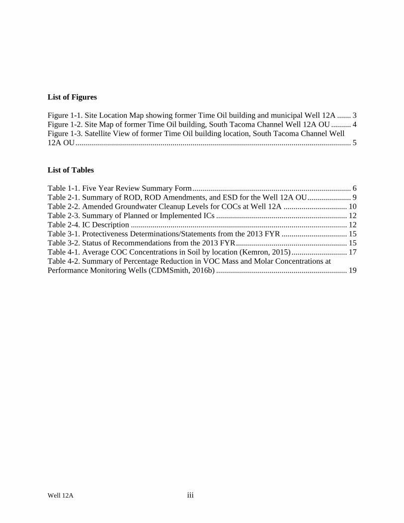
List of Figures
Figure 1-1. Site Location Map showing former Time Oil building and municipal Well 12A ....... 3 Figure 1-2. Site Map of former Time Oil building, South Tacoma Channel Well 12A OU .......... 4 Figure 1-3. Satellite View of former Time Oil building location, South Tacoma Channel Well
12A OU ........................................................................................................................................... 5
List of Tables
Table 1-1. Five Year Review Summary Form ................................................................................ 6
Table 2-1. Summary of ROD, ROD Amendments, and ESD for the Well 12A OU ...................... 9
Table 2-2. Amended Groundwater Cleanup Levels for COCs at Well 12A ................................ 10
Table 2-3. Summary of Planned or Implemented ICs .................................................................. 12
Table 2-4. IC Description ............................................................................................................. 12
Table 3-1. Protectiveness Determinations/Statements from the 2013 FYR ................................. 15
Table 3-2. Status of Recommendations from the 2013 FYR ........................................................ 15
Table 4-1. Average COC Concentrations in Soil by location (Kemron, 2015) ............................ 17
Table 4-2. Summary of Percentage Reduction in VOC Mass and Molar Concentrations at
Performance Monitoring Wells (CDMSmith, 2016b) .................................................................. 19

Well 12A 1
FIVE-YEAR REVIEW FOR WELL 12A PROJECT AREA,
COMMENCMENT BAY- SOUTH TACOMA CHANNEL SUPERFUND
1. INTRODUCTION
The purpose of a Five-Year Review (FYR) is to evaluate the implementation and performance of a
remedy in order to determine if the remedy is and will continue to be protective of human health and the
environment. The methods, findings, and conclusions of reviews are documented in five-year review
reports such as this one. In addition, FYR reports identify issues found during the review, if any, and
document recommendations to address them.
The U.S. Environmental Protection Agency (EPA) is preparing this five-year review pursuant to the
Comprehensive Environmental Response, Compensation, and Liability Act (CERCLA) Section 121,
consistent with the National Contingency Plan (NCP)(40 CFR Section 300.430(f)(4)(ii)), and considering
EPA policy.
This is the fifth FYR for the Well 12A project area (EPA ID No. WAD980726301), OU1,
Commencement Bay – South Tacoma Channel Superfund Site. The triggering action for this statutory
review is the completion date of the previous FYR in September 2013. The FYR has been prepared due to
the fact that hazardous substances, pollutants, or contaminants remain at the site above levels that allow
for unlimited use and unrestricted exposure (UU/UE).
The Well 12A project area consists of three Operable Units (OUs) collectively called the Well 12A OU,
and OU1 will be addressed in this FYR. OU1 addresses the overall remedy for the Well 12A OU. The
two OUs that are not addressed in this FYR are OU2 and OU3, as they were designated for administrative
purposes as components of the overall Well 12A OU remedy. Therefore, OU2 and OU3 are not
mentioned further in this review.
The OU1 component of the Commencement Bay – South Tacoma Channel Superfund Site Five-Year
Review was led by Christopher Cora, Remedial Project Manager from EPA. Participants included U.S.
Army Corps of Engineers staff Leanna Woods Pan (Environmental Engineer) and Alison M. Suess, Ph.D.
(Chemist). The review began on 4/2/2018.
1.1 Site Background
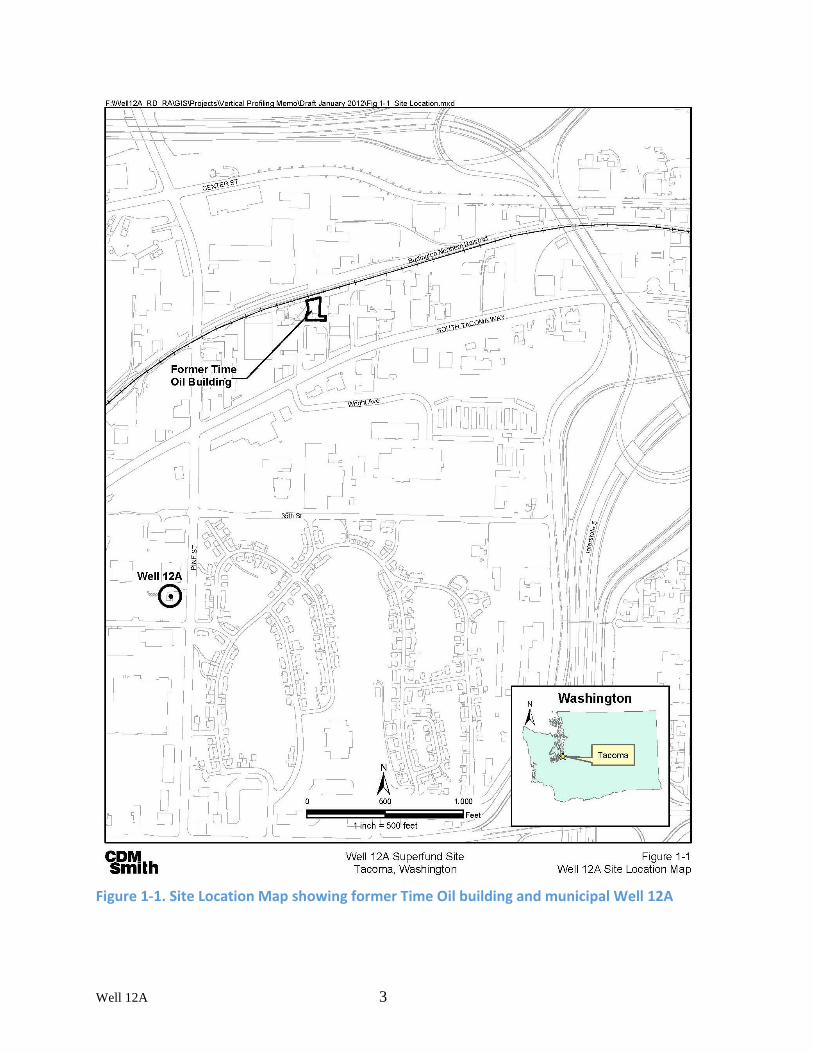
The Well 12A OU of the South Tacoma Channel (STC) Superfund site is located in Tacoma, Washington,
a populated area approximately 5 miles south of Commencement Bay. The source of contamination is
located at the property of the former Time Oil Company, near the junction of Interstate 5 and state
Highway 16 (Figure 1-1). The Well 12A OU encompasses the property of the former Time Oil Company,
and includes Well 12A, a municipal water supply production well owned and operated by the City of
Tacoma. Well 12A is now typically pumped during the peak water demand seasons (summer or early
fall), for testing, or to facilitate pumping capacity of nearby wells. The former Time Oil Company was
located at 3011 South Fife Street. Approximately 0.4 miles distant from the source of contamination,
Well 12A is located on Pine Street between 38th Avenue and South Tacoma Way. A Site Map is provided
in Figure 1-2.
The former Time Oil property was historically used for various industrial practices including oil recycling
and paint and lacquer manufacturing. Oil recycling and solvent processing began in the early 1920s and
continued until 1991 with occasional interruptions due to changes in ownership and a large fire in 1976.
Well 12A 2
The Time Oil Company vacated the property in 1991, and the space has since been used for storage and
small-scale manufacturing. In addition to a number of possible leaks and spills over the years, some of the
filter cake generated during oil recycling was land-disposed around the Time Oil Building and additional
filter cake was used as fill material in 1982 for constructing the Burlington Northern Railroad spur to the
north of the Time Oil Property. Subsequent investigations have identified this filter cake as a primary
source of 1,1,2,2-tetrachloroethane (PCA) 0F
1, tetrachloroethylene (PCE), trichloroethylene (TCE), and
other organic solvents discovered in the groundwater at Well 12A.
Current land use near the former Time Oil property and Well 12A is commercial and industrial. The
former Time Oil property is currently under private ownership and the tenants include the owners of a
storage facility and a metal recycler (Figure 1-3). Groundwater in the aquifer underlying the project area
is currently used as a drinking water source for the City of Tacoma. Thirteen production wells located
within the South Tacoma Channel are primarily used to augment inadequate supply from the Green River
during periods of high demand or high turbidity. Well 12A is operated infrequently due to the expense of
treatment. At a minimum, City of Tacoma wells are operated once every two years to check their
operation.
Additional details including Site geology, hydrogeology, response to contamination, and a chronology of
major activities for Well 12A are available in Appendix B.
1 The number of atoms represented by the prefix per- (i.e., totally substituted) is not correctly defined as tetra- in this
case, since ethane has six hydrogens. The use of the abbreviation “PCA” in this FYR is maintained for consistency
with Site documents. A more modern abbreviation for this chemical is “TeCA”.
Well 12A 3
Figure 1-1. Site Location Map showing former Time Oil building and municipal Well 12A
COM.th 5ml Well 12A Superfund Site
Tacoma, Washington
-,
Figure 1-1 Well 12A Site Location Map

Well 12A 4
Figure 1-2. Site Map of former Time Oil building, South Tacoma Channel Well 12A OU
VES Building
h-,-11-•-11-• Extraction Well
Pipeline
Former Time Oil Building
EW-5
□
Building Removed February 2004
-•-~-·-·-·-
- ·- •- •- ·- ·-' Performance
Radiator Warehouse System
Trailer
Warehouse/ Offices ' _)
(Fenced Enclosure)
Cala
Parking Area
i © ~ 02550 100 0 ...-L....I .._____J i Note: SP-1 , SP-2, and SP-3 are located in SCALE IN FEET
I the same general area. They are labeled source: ICF KAISER
LEGEND
@ Extraction Well
[@] Containment Vault and Extraction Well
GETS
VES
SP
EW
Former Time Oil Property Boundary
Groundwater Extract ion and Treatment System
Vapor Extraction System
Extraction Well Pipeline
Sampling Port
Extraction Well o5l individually for identification in the field. Modified by: URS f~ ========:::;:==========================:::::=========::::::: ~~ u~ ~~ -:~ &EPA
REGION 10
Figure 1-2 Site Map and GETS Sampling Locations
South Tacoma Channel/Well 12A Site
049-RA-RA-1014 S. Tacoma Channel/Well 12A
GETS O&M MANUAL

Well 12A 5
Figure 1-3. Satellite View of former Time Oil building location, South Tacoma Channel Well 12A OU
*Google satellite view obtained 5 April 2018, capture date July 2014
Well 12A 6
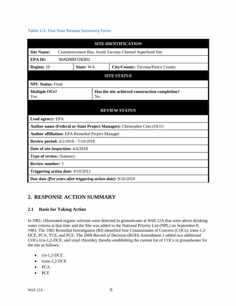
Table 1-1. Five Year Review Summary Form
2. RESPONSE ACTION SUMMARY
2.1 Basis for Taking Action
In 1981, chlorinated organic solvents were detected in groundwater at Well 12A that were above drinking
water criteria at that time and the Site was added to the National Priority List (NPL) on September 8,
1983. The 1983 Remedial Investigation (RI) identified four Contaminants of Concern (COCs): trans-1,2-
DCE, PCA, TCE, and PCE. The 2009 Record of Decision (ROD) Amendment 2 added two additional
COCs (cis-1,2-DCE, and vinyl chloride), thereby establishing the current list of COCs in groundwater for
the site as follows:
• cis-1,2-DCE
• trans-1,2-DCE
• PCA
• PCE
SITE IDENTIFICATION
Site Name: Commencement Bay, South Tacoma Channel Superfund Site
EPA ID: WAD980726301
Region: 10 State: WA City/County: Tacoma/Pierce County
SITE STATUS
NPL Status: Final
Multiple OUs?
Yes
Has the site achieved construction completion?
No
REVIEW STATUS
Lead agency: EPA
Author name (Federal or State Project Manager): Christopher Cora (OU1)
Author affiliation: EPA Remedial Project Manager
Review period: 4/2/2018 - 7/10/2018
Date of site inspection: 4/4/2018
Type of review: Statutory
Review number: 5
Triggering action date: 9/10/2013
Due date (five years after triggering action date): 9/10/2018

Well 12A 7
• TCE
• vinyl chloride
All COCs have been detected in groundwater at levels above either the Maximum Contaminant Levels
(MCLs) or Washington State Model Toxics Control Act (MTCA) cleanup levels (USEPA, 2009). The
Endangerment Assessment (associated with the Phase I FFS, discussed in Appendix B) determined that
public health may be threatened either by direct contact at the source area or by consumption of
contaminated drinking water if no additional remedial action was taken. On the basis of these findings,
remedial action was determined to be warranted to mitigate risks to human health and the environment.
2.2 Response Actions
The remedy for the site as set forth in the 1983 Record of Decision (ROD), 1985 first ROD Amendment,
and 1987 remedial design change memorandum included wellhead treatment at Well 12A using air
strippers, vadose zone soil treatment by a Vapor Extraction System (VES), limited soil excavation, and a
Groundwater Extraction and Treatment System (GETS) that uses carbon adsorption to treat extracted
groundwater. Table 2-1 provides a summary of decision documents.
In October 2009, EPA released ROD Amendment #2. In order to protect human health and the
environment, five Remedial Action Objectives (RAOs) were developed as part of ROD Amendment #2 to
reduce contaminant mass and decrease the size of the contaminated area. The Amendment #2 RAOs
replace the RAOs established in the ROD, ROD Amendment #1, and ESD, with the exception of the sixth
RAO listed below, which is retained from the earlier decisions. With respect to groundwater, if it is
potable (i.e., suitable for drinking in its natural state), MCLs are relevant and appropriate standards that
need to be met wherever practicable.
ROD Amendment #1 specified “[t]he objectives of the proposed remedial action are the mitigation and
control of contamination in the groundwater and in the soil at the source area.” Additional RAOs were
developed as part of this ROD Amendment #2 and include:
1. Eliminate the risk to human health posed by direct contact with filter cake and contaminated soil
at and near the surface still present on the east side of the Time Oil building;
2. Prevent or minimize the migration of contamination from the highly contaminated shallow soil
and filter cake area into the deeper soils to prevent further degradation of groundwater;
3. Remove sufficient contaminant mass within the source area to reduce the transport of
contaminants from this highly contaminated source material into downgradient groundwater;
4. Reduce contaminant mass discharge by 90% from the source area into the low concentration
groundwater treatment zone;
5. Reduce contaminant concentrations to meet cleanup levels selected in this amendment to be
protective of human health and the environment and to comply with all ARARs at specified
points of compliance.
6. Eliminate risk to human health from exposure to groundwater containing COCs in excess of
protective levels.
ROD Amendment #2 further subdivided compliance with the RAOs into three tiers to allow
implementation of a multi-component remedy and allow for decision-making such as when to transition
from one treatment technology to another and when to transfer O&M to the State of Washington
Department of Ecology (Ecology).

Well 12A 8
• 1st Tier - Address residual sources, minimize risk to receptors due to contaminated surface soils
and achieve a contaminant mass discharge reduction of at least 90% from the high-concentration
source area. Soil removal, ISTR, and EAB will be considered complete and the Remedy will be
considered operational and functional when Tier 1 criteria have been met. O&M will be turned
over to Ecology when Tier 1 criteria have been met.
• 2nd Tier – Achieve cleanup levels at interim performance monitoring points (within the current
groundwater plume) to ensure groundwater concentrations are below applicable or relevant and
appropriate requirements (ARAR)-specified levels at these locations.
• 3rd Tier – Determine if cleanup levels can be achieved in a reasonable timeframe throughout the
contaminant plume by discontinuing GETS operation and continuing to monitor natural
attenuation of any remaining contamination. If this demonstrates that cleanup levels could be
achieved in a reasonable timeframe with MNA only, the MNA contingency will be implemented
and GETS operation discontinued. If compliance with ARARs throughout the plume is deemed
not feasible, additional remedial alternatives or a Technical Impracticability waiver may be
sought for noncompliant portions of the aquifer.
Tier 2 and 3 are long term goals and EPA is currently assessing whether the source controls undertaken
by the ROD Amendment #2 are adequate to achieve Tier 2 and 3 in a reasonable period of time. An
evaluation is underway to determine whether or not adequate removal of source material will allow the
natural attenuation capacity of the aquifer to reduce COC concentrations to below cleanup levels. The
final report is anticipated to be submitted at approximately the same time this FYR is due for signature;
therefore, this FYR will not include the conclusions of the evaluation.
The major components of the amended remedy selected by EPA for OU1 in this Amendment #2 include:
• Excavation and off-site disposal of filter cake and contaminated soils in a Resource
Conservation and Recovery Act (RCRA) landfill
• In situ thermal remediation (ISTR) of soil and groundwater;
• In situ enhanced anaerobic bioremediation (EAB) of groundwater;
• Institutional controls (ICs) to avoid or limit exposure to site contamination and guide the use of
the aquifer;
• Continued Operation and Maintenance (O&M) of the groundwater extraction system (GETS)
selected in the ROD to prevent migration of contaminants while their mass is reduced (via
excavation, ISTR and EAB), with a contingency for discontinuation of the groundwater
extraction and treatment system and reliance on Monitored Natural Attenuation (MNA) for
further remediation once the active measures have achieved interim objectives;
• Monitoring of the plume; and
• Continued O&M of the air stripping units and monitoring groundwater for Volatile Organic
Compounds (VOCs) at Well 12A.
The remedy selected in ROD Amendment #2 is considered a final remedy for soils and an interim remedy
for groundwater that will be protective and assist in achieving the long-term objective of restoring the
aquifer to its beneficial use as a drinking water source for the City of Tacoma. During remedial design
investigations, more residual source material was discovered beneath the Time Oil Building than was
previously known. To address the additional source material, an Explanation of Significant Differences

Well 12A 9
(ESD) was completed in June 2012 that modifies the remedy to include removal of the Time Oil Building
to allow access to highly contaminated soils.
A summary of the interim and final remedial actions by decision document is presented in Table 2-1. For
further detail regarding remedial actions prior to this review period, see Appendix B. Cleanup levels
specified in the ROD Amendment #2 are available in Table 2-2.
Table 2-1. Summary of ROD, ROD Amendments, and ESD for the Well 12A OU
Date Decision
Document Remedial Action/Components
March 16,
1983 ROD Interim Measure:
• Installation of air stripping system at Well 12A
• Pumping Well 12A to provide a hydraulic barrier May 3,
1985 ROD
Amendment
#1
Address soil and groundwater contamination within source areas:
• Excavation and removal of filter cake and contaminated soils in and
around Time Oil Building and along the Burlington Northern Rail Road
(BNRR) rail spur
• Installation of GETS using air stripping for treatment
• Soil flushing using treated water in areas of higher soil contamination
• Capping in areas of lesser soil contamination April 28,
1987 Remedial Design
changes
documented in
Memorandum to
Regional
Administrator
Enhance soil and groundwater remedial action:
• Installation of Soil Vapor Extraction (SVE) system instead of soil
flushing
• Use of carbon adsorption for GETS treatment instead of air stripping
October
29, 2009 ROD
Amendment #2 Enhance soil and groundwater remedial action via:
• Shallow excavation, in-situ thermal remediation (ISTR), and enhanced
anaerobic bioremediation (EAB) of source material
• IC requirement to avoid/limit exposure to contamination
• Continued operation of air-stripping units at Well 12A with
contingency for MNA
• Continued plume monitoring
• Continued O&M of the air strippers and groundwater monitoring at
Well 12A June 14,
2012 Explanation of
Significant
Differences
(ESD)
Additional site characterization required modifications to the 2009 remedy:
• Remove the Time Oil Building to allow access to highly contaminated
soils

Well 12A 10
Table 2-2. Amended Groundwater Cleanup Levels for COCs at Well 12A
Contaminant
MTCA Method
B (ingestion &
inhalation)
MCL
Groundwater
Cleanup
Level
Basis for Cleanup Level
µg/L µg/L µg/L
1,2-cis-Dichloroethylene (cis-
DCE) 70 70 70 MCL
1,2-trans-Dichloroethylene
(trans-DCE) 100 100 100 MCL
1,1,2,2-Tetrachloroethane
(PCA) 0.2 NA 0.2 MTCA B 10-6 (no MCL)
Tetrachloroethylene (PCE) 0.8 5 0.8 MTCA B 10-5 < MCL
Trichloroethylene (TCE) 2.4 5 2.4
MTCA B non-
carcinogenic risk;
MTCA B 10-5 = 4.9
Vinyl chloride 0.3 2 0.3 MTCA B 10-5 < MCL
Notes:
MTCA - Washington State Model Toxics Control Act
MCL - Maximum contaminant level
µg/L - micrograms per liter
2.3 Status of Implementation
Collectively, the original ROD and ROD Amendments selected a multi-component remedy that was
adapted as more information became available. To achieve the RAOs, a combination of treatment
processes were utilized. The following residual source area interim RAs or activities were recently
implemented to address contaminated soil and groundwater:
• Wellhead treatment at Well 12A using three air strippers to treat pumped groundwater. These air
strippers were installed pursuant to the first ROD for the Site. The well is typically pumped
during seasonal periods of peak demand;
o Due to drought in 2015, Well 12A was pumped from May to October. There was
minimal use of Well12A during all other years of this review period. Further details are
provided in section B.5 of Appendix B.
• Excavation of highly contaminated soils, including filter cake. The excavation included a large
railroad tanker underground storage tank and a 55 gallon drum with debris;
o Between December 2011 and March 2012, excavation of shallow soils and filter cake in
the east area of the Time Oil building at the Site was completed. Approximately 2,130
tons of contaminated soil and filter cake were excavated and disposed at a permitted
offsite disposal facility. Also, a 14,280-gallon underground storage tank along with a 55
gallon drum, an empty cylinder, and other debris were removed and disposed.

Well 12A 11
• In Situ Thermal Remediation (ISTR) via high and low temperature electrical resistance heating
(ERH) of soils and groundwater. Soil vapor extraction was used to treat the volatile organic
vapors generated by the high temperature ERH;
o As part of the groundwater interim RA, ISTR was implemented to address the COC
source area present around and beneath the former Time Oil building at the Site in the
deep vadose and saturated zones of the aquifer. ISTR implementation required partial
demolition of the former Time Oil building to facilitate access for installation of the ISTR
system. ISTR was implemented in this area between November 2013 and November
2014. ISTR was successful in removing COCs and non-aqueous phase liquids (NAPLs)
from the vadose zone and saturated zone within the treatment footprint, with a target
treatment interval between 0 and 55 feet below ground surface. ISTR achieved a 78%
reduction in average soil COC concentrations and removed approximately 379 pounds of
Site COCs during operation. In addition, approximately 22,000 pounds of other non-
target compounds, predominantly petroleum hydrocarbons, were removed during ISTR
operation and a small UST was discovered and removed during installation of ISTR
subsurface components.
• Enhanced anaerobic biodegradation (EAB) of high-concentration groundwater plume through
injection of a carbon substrate (emulsified vegetable oil, either LactOil® or EOS 100®, was
selected based on well conditions) to enhance dechlorination under anaerobic conditions;
o As part of the groundwater interim RA, EAB was implemented to address residual COC
source areas located within the high-concentration groundwater plume at the Site.
Specifically, EAB targeted areas where elevated COC concentrations (approximately
greater than 300 micrograms per liter (μg/L) as TCE or cis-1,2-DCE) were present above
and within low-permeability silt units, which are serving as both a boundary for dense
non-aqueous phase liquid (DNAPL) vertical migration and as a continuing source of
contamination through back diffusion. EAB amendment injections, consisting of
emulsified oil and ethyl lactate, were completed between February 2014 and May 2014.
In addition, two localized areas within the EAB treatment zone where DNAPL was
encountered above the low-permeability silt units were targeted with low-temperature
ERH, which increased the subsurface temperatures to between 40 and 50 degrees Celsius
(°C) to accelerate DNAPL dissolution and biodegradation rates. The ERH system was
installed in July 2015 with startup in August 2015, and was operated until February 2017
to thermally enhance the EAB remedy.
• Post Remedial Action Mass Discharge was evaluated using methodology established in the 2013
Quality Assurance Project Plan (QAPP);
o The post-RA mass discharge evaluation results indicate a contaminant mass discharge
reduction of approximately 87.5% from baseline (pre-RA) conditions. While just short of
the 90% mass discharge reduction performance objective established for Tier 1
compliance in ROD Amendment #2, this represents a significant reduction in source
strength from the Time Oil source area.
These activities have been completed and biodegradation is ongoing. Currently, EPA is assessing the
success of the treatments and evaluating whether or not Tier 1 RAOs have been achieved. Groundwater
monitoring will be used to determine if the GETS operation can remain offline and MNA can be relied on
to achieve the long-term groundwater monitoring objectives of meeting cleanup levels in a reasonable

Well 12A 12
timeframe. Further detail regarding remedy implementation prior to this review period is available in the
Site file (see Section 4.1).
2.4 IC Summary Table
Table 2-3. Summary of Planned or Implemented ICs
Media,
engineered
controls, and
areas that do not
support UU/UE
based on current
conditions
ICs
Needed
ICs Called
for in the
Decision
Documents
Impacted
Parcel(s)
IC
Objective
Title of IC
Instrument
Implemented
and Date (or
planned)
Groundwater
and Soil Yes Yes
4860000130,
4860000140,
4860000170,
4860000100,
4860000110,
4860000120,
Avoid or limit
exposure to site
contamination and
guide the use of the
aquifer to protect
human health.
Environmental
Release and
Disclosure
Agreements are
currently in place for
these parcels, but ICs
have not been
implemented
Proprietary
Controls,
planned for
Spring 2019
Table 2-4. IC Description
Type of IC Description of IC Planned Date
Environmental
covenants for
use restrictions
Shallow soil contamination was identified at three parcels at
the time the draft IC plan was developed. This IC has not been
implemented and will be re-evaluated following the
achievement of Tier 1 objectives.
Spring 2019
Permits Construction permits are required to regulate excavation on
affected properties. Tacoma Municipal Code 13.09.080 requires
a permit before “constructing, installing, substantially
modifying, or changing the use of a facility or regulated
facility.” All properties affected by the soil contamination are
within the South Tacoma Groundwater Protection District.
Tacoma-Pierce County Health Department (TPCHD) is
responsible for regulating pollution prevention in this District
and utilizes institutional knowledge of the existing
contamination at the Well 12A OU to preclude construction
In Place

Well 12A 13
permitting. This IC is currently in place.
Zoning &
Covenants Land use zoning to prevent residential development and uses.
Properties where soil contamination has been identified are
currently located within the City of Tacoma zoning district M2
(heavy industrial). This IC is currently in place; the M2
boundary was verified as part of the previous FYR. However,
day care centers and schools are permitted within the M2
district per Tacoma Municipal Code Chapter 13.06.400.C.
Other institutional controls (e.g., environmental covenant) will
be needed to prevent use of these properties by these sensitive
populations.
Spring 2019
Covenant Environmental covenants for properties where wells are
located. Re-evaluation of this IC and the need for
environmental covenants will be completed following the
development of a long-term groundwater monitoring program.
According to April 2013 parcel access agreement information
available from CDMSmith, 25 parcels are currently located
above or adjacent to the 300-ppm COC groundwater plume.
Spring 2019
Permits Well permitting process. According to communications with
Sharon Bell of TPCHD as part of the previous FYR,
drinking water well installations are not allowed within the
City of Tacoma because it is a municipal service area.
TPCHD is very aware of the problems with the Time Oil
site and not likely to consider a well installation in that
vicinity for drinking water purposes. Washington State
regulations (WAC-1732-160-171) also prohibit installation
of any drinking water wells within or near known or
potential sources of contamination.
In Place
An IC plan was drafted in 2010 that recommended ICs for the protection of human health. EPA
completed a title search prior to the development of the draft IC plan in 2010. EPA has obtained access
agreements from property owners where investigation work and remedial activities were completed. In
addition, six parcels, including the Time Oil property and adjacent properties, have Environmental
Release and Disclosure Agreements in place to allow unencumbered access for purposes of remedial
action activities.
Upon completion of the source remedy and achievement of Tier 1 RAO, a long term monitoring plan will
be developed and the IC Plan will be finalized, thereby ensuring that the formal implementation of
proprietary ICs at select parcels are based on post remedial action conditions. Parcels with residual soil
contamination and those containing monitoring wells selected for long term monitoring will be
recommended for proprietary ICs.

Well 12A 14
2.5 Systems Operations/Operation & Maintenance
Remedial activities with ongoing O&M are described below.
Well Head Treatment and Well 12A
The City of Tacoma owns and operates Well 12A and the five air stripping towers adjacent to the well.
When in operation, treated water from Well 12A is added to the drinking water supply. Well 12A is
pumped during periods of peak demand (the summer or early fall), on an every-other-year frequency for
testing, or to facilitate pumping capacity of nearby wells. A mechanic from the City completes
maintenance of either the well or pump house based on either an identified need for corrective
maintenance or scheduled preventive maintenance. Further details are provided in section B.5 of
Appendix B. Operation of air stripping towers when Well 12A is in operation are used to reduce contaminant
concentrations to levels below water quality standards. This is an engineering control operated by
Tacoma Water and is currently in place. A pumping agreement has been made among EPA, Ecology,
and Tacoma Water to coordinate pumping and implementation of the remedy so that operation of Well
12A does not disrupt certain phases of the remedy. This IC is currently in place; the agreement was
signed in December 2010. Coordination meetings are conducted annually, as required by the agreement.
Groundwater Monitoring
Since the remedies selected in ROD Amendment #2 are implemented, the current groundwater
monitoring program is focused on performance monitoring and evaluation of monitored natural attenuation.
Groundwater monitoring objectives and wells to be sampled are determined for each sampling event
prior to that event. Twelve rounds of monitoring have been completed since ROD Amendment #2 was
signed. Further details are provided in section B.5 of Appendix B
The evaluation of the passive sampling devices during the December 2012 round of groundwater
monitoring concluded that the Hydrasleeve™ would provide adequate representation of subsurface
conditions during future performance monitoring events. Therefore, this sampling technology was utilized
in subsequent sampling events to decrease costs associated with performance monitoring. However, it was
also determined that HydraSleeve data should not be compared to historical groundwater sample results
collected with low-flow methods, should not be compared to regulatory targets, and should not be used
to measure mass discharge.
Summary of Costs of System Operations/O&M Effectiveness
Operating costs for Well 12A and the air stripping treatment system were provided by the City of Tacoma
for this FYR. Well 12A was briefly run in 2013 (primarily in October), 2014 (3 part days in February and
March), 2016 (1 part day in April), and 2018 (1 part day in February). Well 12A was not run at any time
during 2017, but was run extensively in 2015 from May to October due to drought. Briefly turning on
Well 12A restarts a 12-month series of demand charges from the power utility that are estimated to total
nearly $19,000; this assumes 3 of the 60 hp blowers are run along with the 200 hp submersible motor. To
avoid this, the City recently began utilizing a portable diesel generator to run the well (including the
blowers) for sampling. If the well is run continuously for an entire month from line power, the monthly
electric charge is over $9,000. If the well is then stopped and left off, the next 11 months is billed at
nearly $1,500 per month. Additional costs are incurred for mechanics (maintenance and site inspections),
engineers (technical questions and meetings), water rights reporting, electrical upgrades, treatment
(chemical addition and adjustments), and sampling.
Well 12A 15
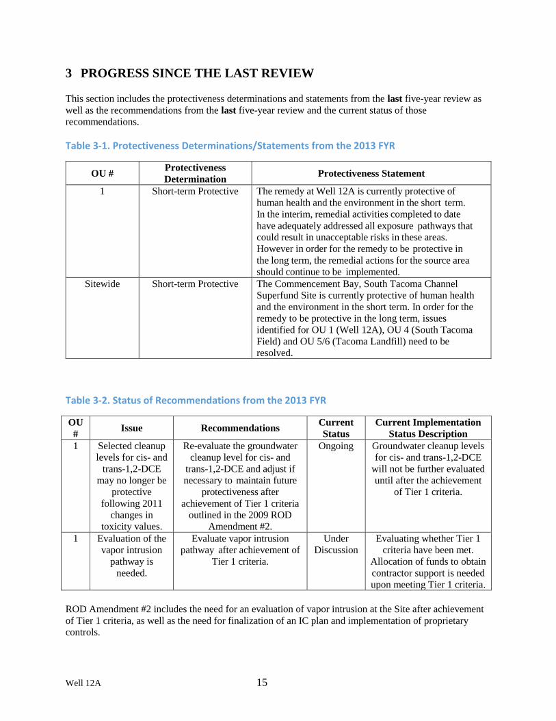
3 PROGRESS SINCE THE LAST REVIEW This section includes the protectiveness determinations and statements from the last five-year review as
well as the recommendations from the last five-year review and the current status of those
recommendations.
Table 3-1. Protectiveness Determinations/Statements from the 2013 FYR
OU # Protectiveness
Determination Protectiveness Statement
1 Short-term Protective The remedy at Well 12A is currently protective of
human health and the environment in the short term.
In the interim, remedial activities completed to date
have adequately addressed all exposure pathways that
could result in unacceptable risks in these areas.
However in order for the remedy to be protective in
the long term, the remedial actions for the source area
should continue to be implemented.
Sitewide Short-term Protective The Commencement Bay, South Tacoma Channel
Superfund Site is currently protective of human health
and the environment in the short term. In order for the
remedy to be protective in the long term, issues
identified for OU 1 (Well 12A), OU 4 (South Tacoma
Field) and OU 5/6 (Tacoma Landfill) need to be
resolved.
Table 3-2. Status of Recommendations from the 2013 FYR
OU
# Issue Recommendations
Current
Status
Current Implementation
Status Description
1 Selected cleanup
levels for cis- and
trans-1,2-DCE
may no longer be
protective
following 2011
changes in
toxicity values.
Re-evaluate the groundwater
cleanup level for cis- and
trans-1,2-DCE and adjust if
necessary to maintain future
protectiveness after
achievement of Tier 1 criteria
outlined in the 2009 ROD
Amendment #2.
Ongoing Groundwater cleanup levels
for cis- and trans-1,2-DCE
will not be further evaluated
until after the achievement
of Tier 1 criteria.
1 Evaluation of the
vapor intrusion
pathway is
needed.
Evaluate vapor intrusion
pathway after achievement of
Tier 1 criteria.
Under
Discussion
Evaluating whether Tier 1
criteria have been met.
Allocation of funds to obtain
contractor support is needed
upon meeting Tier 1 criteria.
ROD Amendment #2 includes the need for an evaluation of vapor intrusion at the Site after achievement
of Tier 1 criteria, as well as the need for finalization of an IC plan and implementation of proprietary
controls.

Well 12A 16
4 FIVE-YEAR REVIEW PROCESS
4.1 Community Notification & Site Interviews
A public notice was made available by publication in the Tacoma Weekly on 5/11/2018, stating that there
was a five-year review and inviting the public to submit any comments to the U.S. EPA. A copy of the
public notice is provided in Appendix E. The results of the review and the report will be made available at
the Site information repository located at the following addresses of online or physical locations.
Online: https://www.epa.gov/superfund/commencement-bay-stc
EPA Region 10 Superfund Records Center
1200 Sixth Avenue
Seattle, WA 98101
206-553-4494 (please call for an appointment)
Tacoma Public Library
Northwest Room
1102 Tacoma Avenue South
Tacoma, WA 98402
253-591-5666
During the FYR process, interviews were conducted via a mailed questionnaire to document any
perceived problems or successes with the remedy that has been implemented to date. Interview
questionnaires were completed by the City of Tacoma (Tacoma Water branch of Tacoma Public Utilities,
Project Manager Craig Downs), Washington State Department of Ecology (Project Manager, Chris
Maurer), and a local property owner. The results of these interviews are summarized below and
questionnaires are available in Appendix F.
The response by the Washington State Department of Ecology (Ecology) indicates that it is the
assessment of the agency that progress is being made toward successful remediation of the site.
Furthermore, cooperation between the State and EPA has facilitated remediation of the site. The Ecology
response notes that the Institutional Control Plan is outdated and needs revision.
The Local Property Owner, in their response, would like increased contact with EPA and a progress
update. They are in contact with the O&M contractor and are happy with their communication. They note
increased foot traffic for drop offs at the metal recycling facility since it has opened. EPA has followed up
with the Local Property Owner to answer questions.
4.2 Data Review
This FYR included a review of relevant, project-related documents including the ROD, ROD
amendments, one ESD, monitoring reports, investigation reports, and recent monitoring data. In addition,
the Post-Remedial Action Mass Discharge Evaluation Report, In Situ Thermal Remediation Completion
Report, and twelve groundwater monitoring reports including details regarding the EAB remedial action
were reviewed. A complete list of the documents reviewed and citations can be found in Appendix A.
The following is a review of the data collected in conjunction with the remedial actions during the last
five years. Data relevant to remedy performance and progress towards meeting RAOs will be discussed in

Well 12A 17
this section, including data trends to evaluate whether RAOs and associated cleanup levels established in
the ROD are likely to be achieved, data relevant to support engineering performance, and data related to
the site-specific groundwater remedy completion strategy.
4.2.1 Soil
Following the ROD Amendment #2, soil contamination at the Well 12A OU was addressed via
excavation of shallow soils, in situ thermal remediation of vadose and saturated zones underneath and
around the former Time Oil Building, as well as enhanced anaerobic bioremediation of saturated zones.
Information regarding these remedial actions is provided in Appendix B. Post-ERH confirmation
sampling was performed by CDM-Smith in July 2014. Average reduction in concentrations of the six
COCs by sample location is presented below in Table 4-1. Based on all data recorded during the baseline
and confirmatory sampling events, ERH achieved an overall contaminant reduction across the site of
77.7%. However, it should be noted that baseline levels were not obtained for some soil borings that later
were found to contain high concentrations of COCs. Soil borings SB03 and SB09 did not have a baseline
location and baseline sample B401 did not have a confirmatory location to derive a reduction percentage.
High concentrations of COCs at SB-09 corresponded to observations by CDM Smith of DNAPL in the
sample. Eliminating these data sets from the site-wide analysis indicates that the average reduction of
contaminant concentrations of the six target COCs was 94.5%. Furthermore, analytical results indicated
that the six COCs were not present in 58 of the 77 samples collected during confirmation sampling (i.e.
over 75% of the confirmation samples were non-detect) and VOC reductions continued to occur in the
TTZ until residual heat in the subsurface returned to natural conditions. Therefore, the percent reductions
presented in Table 4-1 are considered conservative.
Table 4-1. Average COC Concentrations in Soil by location (Kemron, 2015)
Following ISTR, the treatment goal for 90% reduction in average soil concentrations was met in the
saturated zone and significant reductions in mass concentrations were reached in the vadose zone.
Although the specific project goals were not met completely, significant and necessary progress toward
the mass discharge goals was made. ISTR achieved a 78% reduction in average soil COC concentrations
and removed approximately 379 pounds of Site COCs during operation. In addition, approximately
Average Pre- Average Post-
Soil Boring Location ERH ERH Percent Concentration Concentration Baseline/Confirmation for 6 COCs for 6 COCs Reduction
(µg/kg) (µg/kg)
B428 / SB01 72,785 397 99.5%
B411 / SB02 6,782 3,733 44.45%
No Baseline / SB03 403
B413 / SB04 27,299 395 98.6%
B402 / SB05 3,006 595 80.2%
B400 I SB06 61,837 346 99.4%
B432 / SB07 7,713 519 93.3%
B407 / SB08 465 769
No Baseline / SB09 27,670
B401 / No Confirmation 6,782 ~□--
Average All Data 17,100 3,800 77.8%
Values Baseline/Confirmation 20,600 1,100 94.7%

Well 12A 18
22,000 pounds of other non-target compounds, predominantly petroleum hydrocarbons, were removed
during ISTR operation.
4.2.2 Non-Aqueous Phase Liquid
Analytical data trends for the thermally-enhanced bioremediation wells EAB-1, EAB-2, EAB-5, and INJ-
30 are presented in Appendix C. Charts of the total COCs and chloride mass and molar flux at the
DNAPL wells (EAB-1 and INJ-30) throughout the period of EAB treatment indicate notable increases in
flux of COCs at both wells between June and September 2015, coinciding with the start of municipal
pumping and the start of heating (Figures C-1 and C-2 of Appendix C). The general trends indicated by
these calculated fluxes over time are described as follows:
• COC mass flux increased during implementation of EAB, due to enhanced dissolution resulting
in increasing dissolved-phase concentrations;
• Increased mass flux due to enhanced groundwater flux induced by municipal pumping in June
2015;
• Increased mass flux due to additional dissolution of DNAPL source, combined with enhanced
biological degradation, during heating as demonstrated at INJ-30 since September 2015;
• Decreased mass flux due to source depletion and enhanced biological degradation at EAB-1 since
September 2015; and
• Decreasing mass flux has been observed at INJ-30 since the peak flux in February 2016, though
flux remains elevated at INJ-30 when compared to EAB-1.
Thermally-enhanced bioremediation at EAB-1 has resulted in substantial reduction in COC
concentrations in this DNAPL hotspot, indicative of source depletion. At EAB-1, August 2016 data
shows that VOC concentrations have declined substantially since startup of low-temperature heating, and
total VOC mass and molar concentrations and fluxes have exhibited a continual decline throughout ERH
operation. Since EAB-1 is located in close proximity to a known high-conductivity preferential flow
pathway below the low-permeability silt unit that is significantly impacted by the Well 12A pumping, the
reduction in VOC mass at EAB-1 represents significant progress toward source mass reduction at a
location which contributes significantly to mass discharge from the site to the receptor.
4.2.3 Groundwater
EPA is in the process of preparing the Remedial Action Completion Report for the remedy implemented
per ROD Amendment #2; therefore, that data is not available for inclusion in this Five-Year Review.
Initial results indicate that RAOs have been met.
Table 4-2 presents a summary of the percentage reductions in COC mass and molar concentrations since
baseline sampling, completed prior to implementation of the EAB and ISTR remedies at the Well 12A
OU. Many wells within the EAB treatment area have exhibited significant reductions (greater than 90%)
in total COC mass during Groundwater Performance Monitoring Event #12. The median COC mass
concentration reduction in the wells sampled during Groundwater Performance Monitoring Event #12
was 87%, and the median molar concentration reduction was 82% compared to baseline levels. These
concentration reductions at the majority of the Well 12A OU monitoring wells indicate significant
progress of the EAB remedy. Several monitoring wells have exhibited concentration increases since
baseline sampling, primarily due to proximity to locations containing DNAPL or LNAPL (INJ-30, EAB-

Well 12A 19
5, MW-C, MW-314) or injection wells surrounding the INJ-30 thermally-enhanced bioremediation area
where dissolution of the DNAPL source is still being enhanced.
Evaluating the change in the molar concentrations and fractions (or ratios) of parent compounds to
dechlorination products is very useful in determining the efficacy of biodegradation brought about by
edible oil injection. During biodegradation, the molar ratios of the compounds involved in the reaction
chain will change. Looking at molar concentrations is more accurate and informative than evaluating
changes in concentration alone for the parent/dechlorination products because of the different molecular
weights of the compounds.
Table 4-2. Summary of Percentage Reduction in VOC Mass and Molar Concentrations at Performance Monitoring Wells (CDMSmith, 2016b)
Notes: • Negative values indicate the percentage reduction from baseline levels
• Wells without analytical data prior to remedy implementation (INJ‐19, INJ‐33, INJ‐37, INJ‐41, INJ‐43,
INJ‐44, INJ‐45) are excluded from the table.
• The median % reduction is not indicative of the percentage reduction in mass discharge which would be
measured through operation of the GETS.
Baseline Total M ass Current Total Mass Percent Baseline Total Molar Current Total Molar Percent
Well ID Concentration Concentration Reduction from Concentration Concentration Reduction from
(µg/ L) (µg/L) Baseline{%} (µmol/L) (µmol/ L) Baseline(%}
EAB-1 44,570.0 2,702.2 -94 292.84 20.40 -93
EAB-2 11,973.0 206.9 -98 82.25 2.92 -96
EAB-5 1,901.0 62,147.0 3169 13.62 758.77 5469
INJ-30 45,386.3 166,341.0 267 287.08 1140.43 297
CH2M-1 3,536.7 62.5 -98 29.05 0.81 -97
EAB-7 344.3 8.6 -98 3.59 0 .11 -97
EAB-8 107.1 4.5 -96 0.95 0 .05 -95
EAB-9 106.7 44 .1 -59 0.86 0 .49 -43
EAB-10 165.6 7.0 -96 1.35 0.08 -94
ICF-2 730.5 5.7 -99 6.69 0.06 -99
ICF-5D 2,196.3 282.1 -87 22.42 3.97 -82
MW-313 917.5 8.0 -99 7.14 0 .09 -99
MW-314 2,386.0 12,982.7 444 20.06 137.92 588
MW-C 87.9 1,625.7 1750 0.67 14.97 2143
WCC-18 2,499.9 11.4 -100 21.15 0.15 -99
INJ-3 1,758.2 614.1 -65 14.82 8 .04 -46
INJ-15 1,411.4 1,908.2 35 12.24 19 .97 63
INJ-16 1,511.6 28,200.0 1766 10.94 296.81 2613
INJ-17 101,330.0 49.7 -100 1029.30 0.62 -100
INJ-21 1,346.4 3, 248.0 141 11.68 3 1.34 168
INJ-27 10,762.0 102.9 -99 112.67 1 .30 -99
INJ-34 3,426.9 4.5 -100 30.14 0 .05 -100
INJ-39 1,093.5 1,692.4 55 9.20 18.02 96
INJ-46 1,378.0 1,488.5 8 10.50 16.00 52
INJ-47 2,337.8 2,538.7 9 19.58 38.07 94
Media n % Reduction -87 Media n % Reduction -82

Well 12A 20
• Wells within heated area for ERH include EAB-1, EAB-2, EAB-5, and INJ-30.
• DNAPL was present in wells EAB-1 and INJ-30.
• LNAPL was present in MW-314
• μg/L ‐ micrograms per liter
• μmol/L ‐ micromoles per liter
• DNAPL ‐ dense non‐aqueous phase liquid
• ERH ‐ electrical resistance heating
• GETS ‐ groundwater extraction and treatment system
• LNAPL ‐ light non‐aqueous phase liquid
While the remedy has made progress in reducing COC concentrations in most areas of the Well 12A OU,
evaluation of analytical data from monitoring wells alone was not sufficient to determine the percentage
reduction in mass discharge. Evaluation of concentration trends at GETS extraction wells over time
during the GETS extraction well pumping test in August 2016 provided the necessary information to
determine if the Tier 1 RAO (90% reduction in COC mass discharge from the source areas) is achievable
at this time.
Consistent with the baseline MDE (CDM 2013a), mass discharge for the full-scale GETS pumping test
and post-RA MDE sampling events was calculated as the product of flow rate and concentration. Using
this methodology, the post-RA MDE results indicate a contaminant mass discharge reduction of
approximately 87.5% from baseline (pre-RA) conditions. While just short of the 90% mass discharge
reduction performance objective established for the first tier of compliance in ROD Amendment #2, this
represents a significant reduction in source strength from the Time Oil source area. In addition, all COCs
except vinyl chloride, are below their respective MCLs at the GETS influent sampling port. Vinyl
chloride is quickly oxidized in the aerobic zone of the aquifer.
4.2.4 Vapor Intrusion
The health risk at the Well 12A OU due to vapor intrusion was considered by EPA, since VOCs may
migrate from contaminated soils and groundwater through the subsurface and a building overlying
elevated groundwater concentrations. Results of the Johnson and Ettinger computer modeling program
indicate that unacceptable risk to onsite workers within the building is possible and that further evaluation
is warranted. Furthermore, the vapor intrusion pathway was identified as a concern in the ROD
Amendment #2, which stipulated that vapor intrusion should be evaluated after targeted soil and
groundwater contamination is addressed. EPA plans to evaluate vapor intrusion in the near future, after
completing a performance assessment of the recent remedial actions.
4.3 Site Inspection
The inspection of the Site was conducted on 4/4/2018. In attendance were U.S. Army Corps of Engineers
staff Leanna Woods Pan, Alison Suess, and Karl Kunas. The purpose of the inspection was to assess the
protectiveness of the remedy. The participants observed the paved areas near the location of the former
Time Oil Building where the soil vapor extraction (SVE), bioremediation, excavation, and thermal
remediation actions took place. The property encompassing the recycling business and the former SVE
building is fenced, with gates open during the day for vehicle and pedestrian access. The participants also
observed the GETS area and the Well 12A area. Well 12A and GETS are fenced and locked. Some
signage at the area near the location of the former Time Oil Building and at the GETS area has peeling
labels with contact phone number information. The inspection checklist and photos taken during the April
4 site visit are presented in Appendix D.

Well 12A 21
5 TECHNICAL ASSESSMENT
5.1 QUESTION A: Is the remedy functioning as intended by the decision documents?
Question A Summary:
Yes. Interim remedial actions described in ROD Amendment #2 have been implemented and appear to be
functioning as intended based on data collected to date. Currently, EPA is assessing the success of the
treatments and evaluating whether or not Tier 1 RAOs have been achieved. Shallow soil contamination to
the east of the Time Oil building has been excavated and transported off-site for disposal. The
implementation of ISTR and EAB have decreased contaminant mass at the Site and improved
groundwater quality. Well 12A is operated during periods of high municipal water demand and water is
treated via air stripping prior to use. The GETS is currently on stand-by, awaiting further evaluation of
Tier 2 and Tier 3 RAO compliance. Engineering controls and governmental ICs are in place to prevent
exposure and protect human health.
5.1.1 Remedial Action Performance
Progress had been made toward achieving the Tier 1 objective of a 90% reduction in mass discharge.
Implementation of recent Remedial Actions (RA)s ISTR and EAB have substantially decreased
contaminant mass at the Site. The post-RA mass discharge evaluation (MDE) results indicate a
contaminant mass discharge reduction of approximately 87.5% from baseline (pre-RA) conditions. While
short of the 90% mass discharge reduction performance objective established for the first tier of
compliance in ROD Amendment #2, this represents a significant reduction in source strength from the
Time Oil source area.
Achievements of the recent RAs are summarized in the following bullets:
• 87.5% reduction in mass discharge of COCs.
• 99% reduction in mass discharge of parent compounds (PCA, PCE, and TCE).
• 67% reduction in mass discharge of degradation compounds (cis-1,2-DCE, trans-1,2-DCE, and
VC).
• Five of six COCs reduced to below MCLs in the GETS influent; only VC remains above the
MCL at approximately 20 μg/L.
• Excavation of 2,130 tons of contaminated shallow soil and filter cake.
• Removal of two underground storage tanks.
• In-situ thermal treatment of approximately 379 pounds of COCs and over 22,000 pounds of other
non-target petroleum hydrocarbons.
• EAB treatment of the high-concentration groundwater plume.
• Contingent shutdown of the GETS, which had been operational at the site for 29 years, pending
confirmation of Tier 2 and 3 RAO compliance evaluations.
• Decommissioning of the former SVE system.
The remedial actions (RAs) implemented at the Site since the 1980s have resulted in a substantial
improvement in groundwater quality in the region. In general, PCA and TCE concentrations have
declined between one and three orders of magnitude since the initial sampling events at these wells. The
recent reductions in source mass at the Site have continued to improve groundwater quality in the region.
Well 12A 22
5.1.2 System Operations/O&M
Current operation of Well 12A is limited to periods of high seasonal demand. When operational, the air-
stripper treatment system at Well 12A is working as designed. Electrical and communication systems
were upgraded in 2011/2012, but no other major repairs have occurred. Currently, only three of the five
air stripping towers are utilized to treat groundwater, resulting in significant cost savings. All treated
groundwater meets MCLs.
The GETS was utilized during implementation of the ISTR and EAB remedial activities. A baseline mass
discharge measurement was completed in 2013 using a pumping test method conducted with the GETS.
During remedial activities, the GETS remained offline. The GETS was restarted on November 14, 2016
for the post-RA pumping test to complete the Mass Discharge Evaluation. Currently, GETS O&M is on
standby while assessment of the potential for MNA to address source area contamination is being
completed. This assessment involves measuring mass flux reduction and modeling the attenuation
capacity of the aquifer. With the substantial reductions in source COC mass and reductions in mass
discharge, there is little substantive benefit in continued GETS operations for containment and mass
removal of the Time Oil source area. Therefore, the GETS operations remain offline while EPA assesses
whether or not Tier 2 and 3 RAO compliance may be attained in a reasonable amount of time (per ROD
Amendment#2). The GETS may be reactivated if RAOs have not been met by the remedial actions in the
future. Results of recent remedial actions are expected to be evaluated in a Remedial Action Completion
Report, which is scheduled to be finalized by the end of 2018. It is anticipated that this report will discuss
the potential achievement of Tier 1, 2, and 3 RAOs.
5.1.3 Implementation of Institutional Controls and Other Measures
Current ICs to prevent human exposure to shallow soil contamination include engineering controls and
governmental controls (e.g. construction permits, zoning restrictions, and listing of the site on the State of
Washington’s Confirmed and Suspected Contaminated Sites List [CSCL]). Additional proprietary ICs
(i.e. environmental covenants) were recommended to be placed on properties where soil contamination
remains. Current governmental ICs to prevent ingestion of contaminated groundwater include pumping
agreements with Tacoma Water and TPCHD’s well permitting process
5.2 QUESTION B: Are the exposure assumptions, toxicity data, cleanup levels, and remedial
action objectives (RAOs) used at the time of the remedy selection still valid?
Question B Summary:
Yes. There have been some changes to toxicity values for cis-1,2-DCE and trans-1,2-DCE that may
require future reevaluation of selected cleanup levels to ensure protectiveness is maintained. Those
changes are discussed further below. However, the changes do not currently affect protectiveness due to
governmental ICs in place to prevent exposure above the new standards. The RAOs are still valid, and
implementation of RAs at the Time Oil source area has made significant progress towards meeting the
RAOs.

Well 12A 23
5.2.1 Changes in Standards and TBCs
MCLs were selected as the cleanup levels for cis- and trans-1,2-DCE. Model Toxics Control Act (MTCA)
values were selected as the cleanup levels for other COCs. Since ROD Amendment #2, there have been
no revisions to the MCLs.
Vinyl chloride. The MTCA B cancer value for vinyl chloride has undergone two revisions since the ROD
Amendment #2, but the overall effect is that the value has not changed and the revisions therefore do not
affect protectiveness.
The ROD and subsequent amendments does not identify specific cleanup concentration standards for site
soil contamination. For groundwater, ROD Amendment #2 requires a contaminant discharge reduction of
at least 90% from the high-concentration source area near the Time Oil building to the dissolved-phase
contaminant plume (RAO #1). Soil removal, ISTR, and EAB will be considered complete and the remedy
will be considered operational and functional when this criteria has been met. This cleanup goal is
specific to the project area and is not affected by changes in published numerical cleanup standards.
There have been no revisions to laws and regulations since the last Five Year Review that affect the
protectiveness of the remedy.
5.2.2 Changes in Exposure Pathways
The exposure pathways for soil and groundwater presented in the RODs have not changed. Much of the
project area is paved or covered with concrete, thus limiting the occupants’ exposure to surface soil. No
new or changed human health or ecological routes or receptors have been identified at this time.
5.2.3 Expected Progress Towards Meeting RAOs
Implementation of RAs at the Time Oil source area since the 1980s has resulted in improvement in water
quality at the Well 12A OU, which has seen declines in concentration of TCE and PCA of more than an
order of magnitude since the mid-1980s. The recent reductions in source mass at the Site due to
implementation of the recent remedial actions (e.g. ISTR, EAB) are expected to continue this improving
trend in groundwater quality in the region. The post-RA mass discharge evaluation results indicate a
contaminant mass discharge reduction of approximately 87.5% from baseline (pre-RA) conditions. While
just short of the 90% mass discharge reduction performance objective established for Tier 1 compliance
in ROD Amendment #2, this represents a significant reduction in source strength from the Time Oil
source area and progress towards meeting RAOs.
5.3 QUESTION C: Has any other information come to light that could call into question the
protectiveness of the remedy?
No. Ecological risks have not been evaluated for the project area, because the area around the Site is
heavily developed as a commercial/industrial area and lacks suitable habitat. Therefore, no significant
ecological impacts are expected due to contamination. Furthermore, available data suggest that the
contaminant plume does not currently reach local streams or rivers. Also, there have been no impacts to
the project area due to natural disasters.

Well 12A 24
6 ISSUES/RECOMMENDATIONS
Issues/Recommendations
OU(s) without Issues/Recommendations Identified in the Five-Year Review:
OU1
6.1 OTHER FINDINGS
In addition, the following are recommendations that were identified during the FYR and may improve
performance of the remedy, but do not affect current and/or future protectiveness:
While exposure to groundwater is prevented due to permit and zoning restrictions, there are currently no
proprietary institutional controls in place for parcels impacted by contamination. Following achievement
of Tier 1 criteria, finalization of the IC Plan, and development of a long term monitoring plan,
environmental covenants are recommended to be placed on properties where soil contamination remains,
which will also ensure access to wells for long term monitoring.
7 PROTECTIVENESS STATEMENT
Protectiveness Statement(s)
Operable Unit:1
Protectiveness Determination:
Will be Protective
Protectiveness Statement: The remedy at OU1 is expected to be protective of human health and the
environment upon completion. Interim remedial actions described in ROD Amendment #2 have been
completed and appear to be functioning as intended based on data collected to date. Evaluation of Tier
1 RAOs are underway. Engineering controls and governmental ICs are in place to prevent exposure and
protect human health.
8 NEXT REVIEW
The next five-year review report for the Commencement Bay – South Tacoma Channel Well 12A
Superfund Site is required five years from the completion date of this review.

III.
SOUTH TACOMA FIELD (OU4)
COMMENCEMENT BAY –
SOUTH TACOMA CHANNEL SUPERFUND SITE
PIERCE COUNTY, WASHINGTON
Prepared by
U.S. Environmental Protection Agency
Region 10
Seattle, Washington

South Tacoma Field i
Table of Contents 1. INTRODUCTION .................................................................................................................... 1 2. RESPONSE ACTION SUMMARY ........................................................................................... 1
Basis for Taking Action .............................................................................................................. 1 Response Actions ........................................................................................................................ 2 Status of Implementation ............................................................................................................ 5
Institutional Controls .................................................................................................................. 7 Operation & Maintenance ........................................................................................................... 8
3. PROGRESS SINCE THE LAST REVIEW ............................................................................... 9
4. FIVE-YEAR REVIEW PROCESS........................................................................................... 10
Community Notification, Involvement & Site Interviews ........................................................ 10 Data Review .............................................................................................................................. 11
Site Inspection ........................................................................................................................... 12 5. TECHNICAL ASSESSMENT ................................................................................................. 13
QUESTION A: Is the remedy functioning as intended by the decision documents? .............. 13 QUESTION B: Are the exposure assumptions, toxicity data, cleanup levels, and remedial
action objectives (RAOs) used at the time of the remedy selection still valid? ....................... 14
QUESTION C: Has any other information come to light that could call into question the
protectiveness of the remedy? ................................................................................................... 15
6. ISSUES/RECOMMENDATIONS ........................................................................................... 15 OTHER FINDINGS.................................................................................................................. 16
7. PROTECTIVENESS STATEMENT........................................................................................ 16
FIGURES
APPENDICIES
A. List of Documents Reviewed, South Tacoma Field Operable Unit
B. Chronology
C. Interview Forms
D. Well Data from Wells STM-3A and STM-4A
E. Groundwater Analytical Results for Pioneer Builders Supply and Amsted
F. Risk Calculations
--

South Tacoma Field 1
FIVE-YEAR REVIEW for the SOUTH TACOMA FIELD OPERABLE UNIT,
COMMENCEMENT BAY – SOUTH TACOMA CHANNEL SUPERFUND SITE
1. INTRODUCTION – South Tacoma Field Operable Unit (OU 4)
This is the fourth FYR for the South Tacoma Field (STF) Operable Unit (OU), Commencement Bay-
South Tacoma Channel (CB-STC) Superfund Site. (This OU was not included in the first FYR for the
Site.) The FYR has been prepared since hazardous substances, pollutants, or contaminants remain above
levels that allow for unlimited use and unrestricted exposure (UU/UE).
This section of the FYR addresses one OU, OU 4. Remedies were selected to address three separate
source areas, two of which are reviewed in this FYR. The remedial action (RA) addressing sources on
Tacoma City Light is not addressed in this FYR because the RA was completed in 1997 and the area
remediated to levels that allow for UU/UE.
The FYR for the South Tacoma Field Operable Unit was led by Jeremy Jennings, EPA Region 10. An
EPA human health risk assessor assisted with portions of the data review. The Burlington Northern-Santa
Fe Railway Company (BNSF), the Potentially Responsible Party (PRP) was notified of the initiation of
the FYR. The PRP and their technical consultant provided input during the review process. The review
began on 4/1/2018.
Site Background
The South Tacoma Field (STF) Operable Unit 4 (OU4) consists of approximately 260 acres located along
8,000 feet of railroad tracks in the southwestern section of the City of Tacoma, Washington (Figure 1).
The Site is situated in a lowland area that includes a filled swamp and lake bed. The Site is mostly open
fields of grass with a few industrial and commercial facilities. Stormwater is conveyed across the western
side of the Site in an open channel that discharges into a small wetland. Municipal water supply wells for
the City of Tacoma are located east of the Site.
During the past 100 years, portions of the site have been used for a variety of industrial activities
including the manufacture and repair of railroad cars and equipment; the operation of a brass and iron
wheel foundry; a small airport runway, refueling depot, and repair facility; and Tacoma City Light’s
maintenance yard. Several parts of the Site were used as dump sites for industrial and construction
materials, including slag and sand from the foundry operations.
The OU is currently zoned as a heavy industrial district consisting of manufacturing and industrial uses.
However, an 18-acre strip along the western border is zoned for residential-commercial transitional use.
While most of the OU is fenced, there appears to be some use of the Site for casual recreation and by
homeless individuals.
See Section I for Five-Year Review Summary Form
2. RESPONSE ACTION SUMMARY
Basis for Taking Action
EPA began investigating the OU in 1981 as part of an investigation of potential sources influencing the
South Tacoma Channel. Site investigations were conducted throughout the 1980s with a Remedial
Investigation/ Feasibility Study (RI/FS) published in 1992. In 1990 and 1991, a non-CERCLA action had

South Tacoma Field 2
been taken at the Amstead Property to address soil contamination from leaking underground storage tanks
(see Figure 2 for locations of each area).
A 1993 Human Health Risk Assessment (HHRA) found that both cancer and non-cancer risks associated
with ingestion of surface soils under residential and industrial scenarios exceeded EPA’s risk thresholds.
Potential risks from soil ingestion under a recreational scenario, however, did not exceed thresholds and
thus, EPA determined that no action was needed. Groundwater at Pioneer Builders Supply also exceeded
EPA’s risk thresholds and was addressed in the ROD.
Both cancer and non-cancer risks from soil ingestion were primarily driven by arsenic. In some areas,
polychlorinated biphenyls (PCBs), polycyclic aromatic hydrocarbons (PAHs), copper and beryllium
account for some of the cancer risk. Lead was present at levels above EPA’s recommended thresholds in
numerous locations.
Pioneer Builders Supply was the only area where groundwater consistently exceeded MCLs and MTCA
Method B criteria. Ingestion of arsenic, and to a lesser extent, beryllium account for cancer risks
associated with drinking groundwater. Arsenic, manganese, naphthalene and nickel account for most of
the non-cancer risk.
A streamlined risk assessment was prepared for the petroleum contamination at the Amsted property.
Risks associated with drinking water were found to be below EPA risk thresholds. EPA determined that
the contamination in this area did not pose an unacceptable risk and thus, a CERCLA cleanup action was
not necessary.
The results of a 1993 Ecological Risk Assessment indicated that potential ecological impacts from on-site
contaminants were small and thus, did not require further action.
Response Actions
The September 29, 1994 ROD selected a combination of excavation, containment, treatment via air
sparging and soil vapor extraction and institutional controls (ICs) to address contaminated soils and
groundwater at the OU.
A September 29, 1999 Explanation of Significant Differences (ESD) changed the groundwater treatment
method at Pioneer Builders Supply from air sparging and soil vapor extraction to monitored natural
attenuation (MNA). The ESD only changed the treatment method to be used at Pioneer Builders Supply.
It did not change the Remedial Action Objectives (RAOs), cleanup levels, ICs or any other elements of
the remedy.
The overall cleanup goal for the OU was to protect human health and the environment by preventing
current and future exposure to contaminated soil and groundwater.
The remedy selected in the ROD was presented as three separate actions - STF Soils, Pioneer Builders
Supply and Tacoma City Light Dry Wells (Figure 2) - as described below. For a chronology of CERCLA
activities, see Appendix B.
STF Soils
The main purpose of the STF Soils remedy is to prevent exposure to surface and subsurface soils
contaminated by historical activities through a combination of excavation, treatment, containment and
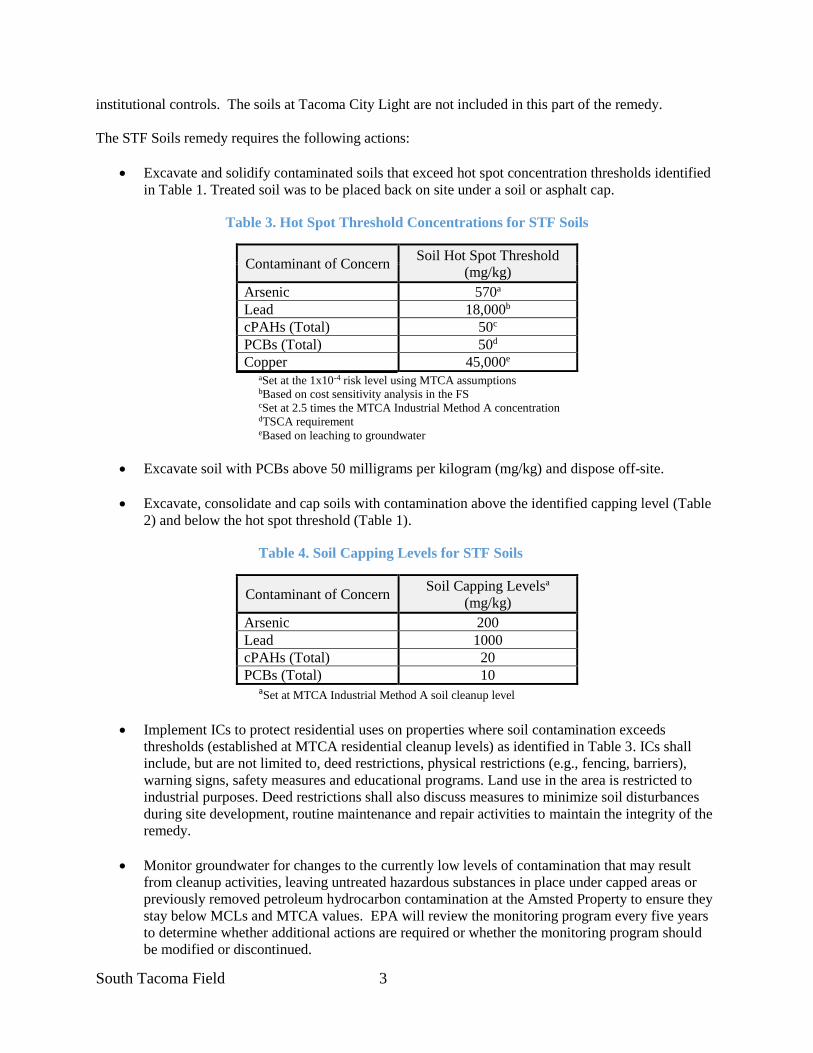
South Tacoma Field 3
institutional controls. The soils at Tacoma City Light are not included in this part of the remedy.
The STF Soils remedy requires the following actions:
• Excavate and solidify contaminated soils that exceed hot spot concentration thresholds identified
in Table 1. Treated soil was to be placed back on site under a soil or asphalt cap.
Table 3. Hot Spot Threshold Concentrations for STF Soils
Contaminant of Concern Soil Hot Spot Threshold
(mg/kg)
Arsenic 570a
Lead 18,000b
cPAHs (Total) 50c
PCBs (Total) 50d
Copper 45,000e
aSet at the 1x10⁻⁴ risk level using MTCA assumptions bBased on cost sensitivity analysis in the FS cSet at 2.5 times the MTCA Industrial Method A concentration dTSCA requirement eBased on leaching to groundwater
• Excavate soil with PCBs above 50 milligrams per kilogram (mg/kg) and dispose off-site.
• Excavate, consolidate and cap soils with contamination above the identified capping level (Table
2) and below the hot spot threshold (Table 1).
Table 4. Soil Capping Levels for STF Soils
Contaminant of Concern Soil Capping Levelsa
(mg/kg)
Arsenic 200
Lead 1000
cPAHs (Total) 20
PCBs (Total) 10 aSet at MTCA Industrial Method A soil cleanup level
• Implement ICs to protect residential uses on properties where soil contamination exceeds
thresholds (established at MTCA residential cleanup levels) as identified in Table 3. ICs shall
include, but are not limited to, deed restrictions, physical restrictions (e.g., fencing, barriers),
warning signs, safety measures and educational programs. Land use in the area is restricted to
industrial purposes. Deed restrictions shall also discuss measures to minimize soil disturbances
during site development, routine maintenance and repair activities to maintain the integrity of the
remedy.
• Monitor groundwater for changes to the currently low levels of contamination that may result
from cleanup activities, leaving untreated hazardous substances in place under capped areas or
previously removed petroleum hydrocarbon contamination at the Amsted Property to ensure they
stay below MCLs and MTCA values. EPA will review the monitoring program every five years
to determine whether additional actions are required or whether the monitoring program should
be modified or discontinued.
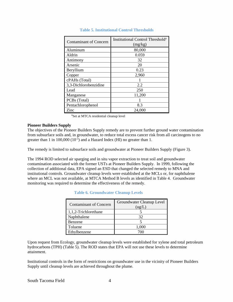
South Tacoma Field 4
Table 5. Institutional Control Thresholds
Contaminant of Concern Institutional Control Thresholda
(mg/kg)
Aluminum 80,000
Aldrin 0.059
Antimony 32
Arsenic 20
Beryllium 0.23
Copper 2,960
cPAHs (Total) 1
3,3-Dichlorobenzidine 2.2
Lead 250
Manganese 11,200
PCBs (Total) 1
Pentachlorophenol 8.3
Zinc 24,000 aSet at MTCA residential cleanup level
Pioneer Builders Supply
The objectives of the Pioneer Builders Supply remedy are to prevent further ground water contamination
from subsurface soils and, in groundwater, to reduce total excess cancer risk from all carcinogens to no
greater than 1 in 100,000 (10-5) and a Hazard Index (HI) no greater than 1.
The remedy is limited to subsurface soils and groundwater at Pioneer Builders Supply (Figure 3).
The 1994 ROD selected air sparging and in situ vapor extraction to treat soil and groundwater
contamination associated with the former USTs at Pioneer Builders Supply. In 1999, following the
collection of additional data, EPA signed an ESD that changed the selected remedy to MNA and
institutional controls. Groundwater cleanup levels were established at the MCLs or, for naphthalene
where an MCL was not available, at MTCA Method B levels as identified in Table 4. Groundwater
monitoring was required to determine the effectiveness of the remedy.
Table 6. Groundwater Cleanup Levels
Contaminant of Concern Groundwater Cleanup Level
(ug/L)
1,1,2-Trichlorethane 5
Naphthalene 32
Benzene 5
Toluene 1,000
Ethylbenzene 700
Upon request from Ecology, groundwater cleanup levels were established for xylene and total petroleum
hydrocarbons (TPH) (Table 5). The ROD states that EPA will not use these levels to determine
attainment.
Institutional controls in the form of restrictions on groundwater use in the vicinity of Pioneer Builders
Supply until cleanup levels are achieved throughout the plume.
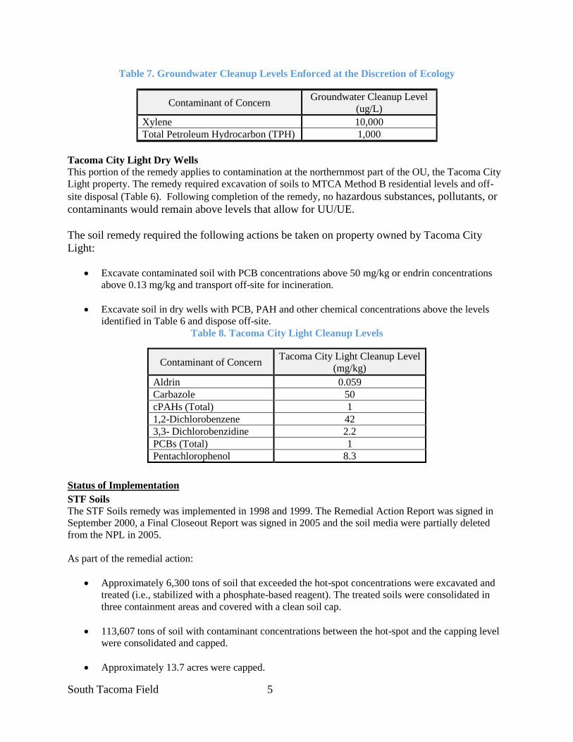
South Tacoma Field 5
Table 7. Groundwater Cleanup Levels Enforced at the Discretion of Ecology
Contaminant of Concern Groundwater Cleanup Level
(ug/L)
Xylene 10,000
Total Petroleum Hydrocarbon (TPH) 1,000
Tacoma City Light Dry Wells
This portion of the remedy applies to contamination at the northernmost part of the OU, the Tacoma City
Light property. The remedy required excavation of soils to MTCA Method B residential levels and off-
site disposal (Table 6). Following completion of the remedy, no hazardous substances, pollutants, or
contaminants would remain above levels that allow for UU/UE.
The soil remedy required the following actions be taken on property owned by Tacoma City
Light:
• Excavate contaminated soil with PCB concentrations above 50 mg/kg or endrin concentrations
above 0.13 mg/kg and transport off-site for incineration.
• Excavate soil in dry wells with PCB, PAH and other chemical concentrations above the levels
identified in Table 6 and dispose off-site.
Table 8. Tacoma City Light Cleanup Levels
Contaminant of Concern Tacoma City Light Cleanup Level
(mg/kg)
Aldrin 0.059
Carbazole 50
cPAHs (Total) 1
1,2-Dichlorobenzene 42
3,3- Dichlorobenzidine 2.2
PCBs (Total) 1
Pentachlorophenol 8.3
Status of Implementation
STF Soils
The STF Soils remedy was implemented in 1998 and 1999. The Remedial Action Report was signed in
September 2000, a Final Closeout Report was signed in 2005 and the soil media were partially deleted
from the NPL in 2005.
As part of the remedial action:
• Approximately 6,300 tons of soil that exceeded the hot-spot concentrations were excavated and
treated (i.e., stabilized with a phosphate-based reagent). The treated soils were consolidated in
three containment areas and covered with a clean soil cap.
• 113,607 tons of soil with contaminant concentrations between the hot-spot and the capping level
were consolidated and capped.
• Approximately 13.7 acres were capped.

South Tacoma Field 6
• A groundwater monitoring network was established to monitor potential impacts of the
containment areas on groundwater and the effectiveness of a previous non-CERCLA action at the
Amstead Property.
• ICs were established to limit access, prohibit residential development and prohibit activities that
would impair the integrity of the soil caps.
During remedial design, the PRP proposed to divide the OU into a series of grids, each measuring
between 50 and 250 feet in either direction. The level of cleanup performed in each grid was determined
by contaminate levels prior to the remediation. Grids where soils were above the hot spot thresholds
(Table 1) were excavated, treated and place into one of three containment areas. Grids with soil
concentrations above the capping levels (Table 2) were capped with at least 1 foot of soil or asphalt.
Remaining grids with soil concentrations greater than those identified in Table 3 were identified as
suitable for industrial uses. All other grids do not contain hazardous substances, pollutants, or
contaminants and are not subject to any use restrictions. ICs were required for all grids except those
in the last group above (below levels in Table 3).
A Post-Remedial Action Site Conditions Map identifies the grids that were remediated and/or capped, as
well as areas where maintenance is required. COC concentrations in the orange and white grids are at
levels protective of residential use while yellow, green and blue grids are protective of industrial uses
(Figure 4). For safety reasons, several small areas beneath active rail lines were not remediated and
identified in purple. The data for each area is presented in the Remedial Action Report while the map is
included in the Operations and Maintenance (O&M) Plan and Site Development and Institutional Control
Plan (SDICP).
Most of the Site was remediated to a level protective of industrial use but not residential use. Hazardous
waste remains in the three containment areas, under all capped areas and areas where soils were at levels
below capping levels and above the level protective of residential uses. The O&M Plan requires the
containment areas and the capped areas to be visually inspected once a year.
Eleven (11) shallow monitoring wells have been installed near the three containment areas to monitor for
changes that may result from the remedial actions (e.g. leaching of COCs into groundwater from the
containment areas). The wells are sampled once a year and analyzed for lead. Lead was chosen as the
indicator of leaching to the groundwater following a leaching study and review of historical data.
Three additional wells have been installed to monitor groundwater at the Amsted property (see Figure 2
for well locations). Samples are collected from the Amsted wells annually are analyzed for lead,
petroleum hydrocarbons and volatile organic compounds (VOCs). Results are provided to EPA in the
Annual Progress Report.
Partial NPL Deletion for Surface Soils: On February 24, 2005, EPA signed a Final Closeout Report for
Soils, documenting the completion of the soil remedy for the South Tacoma Field Operable Unit,
Commencement Bay- South Tacoma Channel Superfund Site. The soil cleanup levels had been attained,
institutional controls were in place, all remedial action reports relevant to soils had been completed and
the site was found to be protective of human health and the environment.
On June 14, 2005, the surface soils at the STF OU were deleted from the NPL. This partial deletion only
applied to the soils, not the groundwater. Soil cleanup levels were established to protect industrial uses,
and thus, residential uses are still restricted. In addition, restrictions continue to be in place to protect the
South Tacoma Field 7
capping placed over soils where concentrations of COCs are above industrial cleanup levels. O&M is
still required in these areas and protectiveness is required to be assessed by EPA at least once every five
years. Pioneer Builders Supply
In 1990 and 1991, during a non-CERCLA action, buried tanks and drums and visually contaminated soils
were excavated from Pioneer Builders Supply. In addition,15.4 tons of soil with PCBs exceeding 50
mg/kg were excavated and disposed off-site.
In 1998, additional groundwater characterization indicated that the level of COCs in the groundwater had
significantly decreased following source removal and were at a level that active groundwater treatment
was no longer needed. On September 29, 1999, EPA signed an ESD changing the groundwater treatment
method to MNA and institutional controls.
Five shallow monitoring wells have been installed to monitor the effectiveness of MNA. The wells are
sampled annually and analyzed for petroleum hydrocarbons and VOCs. Total petroleum hydrocarbons
and xylenes are monitored at the request of Ecology and are not used by EPA in evaluating performance
of the remedy.
Tacoma City Light Dry Wells
The remedy was implemented in 1997 as documented in a November 1997 Remedial Action Report. A
Final Closeout Report was signed by EPA on February 24, 2005. The soils were partially deleted from the
NPL on June 14, 2005.
No ICs are required. In addition, no further FYRs are required for this portion of the OU has no hazardous
substances, pollutants or contaminants remain above levels that allow for unlimited use and unrestricted
exposure (UU/UE).
Institutional Controls
The STF Soils RA requires ICs to protect residential uses on properties where soil contamination exceeds
the thresholds identified in Table 3. The Pioneer Builders Supply RA requires restrictions on
groundwater use at Pioneer Builders Supply until cleanup levels are achieved. Both area require controls
to protect the integrity of the remedy.
ICs required by the ROD are described in the Site Development and Institutional Control Plan (SDICP,
2000) and summarized in Table 6. Implementation, maintenance, and inspection of the ICs is performed
by the BNSF Railway Company.
In 1997, BNSF Railway Company filed an Environmental Restrictive Covenants and Access Easement
with the Pierce County Auditor covering 43 Property Tax Parcels owned by Burlington Northern. Thirty
of these parcels are identified on a map reproduced in Figure 5 of this FYR. A note on that figure states
that eight of the identified parcels are “no longer included” but the Site File does not contain any
explanations or supporting documentation. The geographic scope of the covenants relative to the site
should be reviewed to ensure ICs are in place where appropriate and to identify parcels where ICs are no
longer needed.
The Site File contains conflicting information regarding the ICs that are in place to prohibit residential use
and protect the containment area on the Amsted Property. Similarly, it is not clear whether a groundwater
use prohibition is in place at Pioneer Builders Supply and whether residential use prohibitions exist for
properties not owned by Burlington Northern.

South Tacoma Field 8
Table 9. IC Summary Table
Media, engineered
controls, and areas
that do not support
UU/UE based on
current conditions
ICs
Needed
ICs Called for
in the
Decision
Documents
Impacted Parcel(s) IC
Objective
Title of IC
Instrument
Implemented and
Date (or planned)
Soils Yes Yes
Areas where soil
concentrations
exceed IC
thresholds (Table 3)
Restrict residential
land use
BNSF 1997
Restrictive Covenant;
Status at Amsted is
not clear
Soils Yes Yes Capped Areas Prevent exposure from
contaminated soils
BNSF 1997
Restrictive Covenant;
Status at Amsted is
not clear
Soils Yes Yes Capped Areas Protect the integrity of
soil caps
BNSF 1997
Restrictive Covenant;
Status at Amsted is
not clear
Soils
Groundwater Wells Yes Yes
Perimeter of
remediated area
Protect the integrity of
the remedy
Fencing and signage
in place
Groundwater Yes Yes Pioneer Builders
Supply Property
Restrict use of
groundwater until
cleanup levels
achieved
BNSF 1997
Restrictive Covenant;
Status at Pioneer
Builders Supply is
not clear
The BNSF covenants address all the restrictions and conditions identified in the ROD. They restrict
residential use of the land, activities that disturb contaminated soil or the integrity of the capped areas and
the use of groundwater for drinking water in the vicinity of Pioneer Builders Supply. In addition, the
covenants require notification of EPA prior to any conveyance of the property. The access easement
allows for perpetual access to the property for implementation of the remedial actions. The restrictive
covenants, conditions and restrictions run with the land and are binding upon all successors, transferees
and assigns.
The SDICP identifies the physical restrictions, warning signs and safety measures. These features are in
place.
Operation & Maintenance
The Operation & Maintenance (O&M) Plan (Kennedy/Jenks, 2000) addresses ongoing monitoring and
maintenance requirements. Kennedy/Jenks, on behalf of BNSF, conducts annual inspections of the three
containment areas, the capped areas and security items such as fencing, gates, locks and signs. At each
containment area, the condition of vegetation and side slopes along are noted as are any signs of erosion,
settlement, ponding or seismic activity. All capped grids are inspected in a similar manner. All drainage
systems (swales etc.) are evaluated and any signs of failures, erosion or ponding noted. Grid and
settlement markers are located and any damage or settling reported. All groundwater monitoring wells
and associated locks or other infrastructure are inspected. Finally, the security features around the
perimeter of the area are evaluated. The contractor reported that these inspections typically span two days.
All findings are recorded on Operations and Maintenance Inspection Report Forms and submitted to EPA
in the Annual Report. Any deficiencies identified during the inspection or other activities are to be
South Tacoma Field 9
addressed as soon as possible after discovery.
No major problems were noted at the inspections conducted during this FYR period. However, several
locks were replaced and sections of fencing repaired.
During the site inspection, the PRP reported that several areas around the perimeter of the OU have been
used for dumping of household wastes and temporary “residences” of homeless individuals. When
discovered, items are removed by Burlington Northern staff.
Groundwater is monitored annually to track the progress of MNA (Pioneer Builders Supply) and ensure
that wastes in the consolidation areas is not impairing the groundwater (STF Soils).
In January 2016, a new well, NMW-8A1, was installed at Pioneer Builders Supply to replace a previously
damaged well. Two previously damaged and replaced Pioneer Builders Supply wells, NMW-8 and
NMW-1A, were decommissioned in November 2016.
3. PROGRESS SINCE THE LAST REVIEW
This section includes the protectiveness determinations and statements from the last five-year review as
well as the recommendations from the last five-year review and the status of those recommendations.
Table 8. Protectiveness Determinations & Statements from the 2013 FYR for
OU 4 - South Tacoma Field
Protectiveness
Determination Protectiveness Statement
Short-term Protective
The remedy at the South Tacoma Field OU is currently protective of human
health and the environment in the short term because ICs are in place to
prevent direct contact with soil and use of groundwater at Pioneer Builders
Supply as drinking water. However, for the remedy to be protective in the
long term, the groundwater monitoring program needs to be revised to
determine if there is an ongoing source to groundwater from the
contaminated soils and to ensure protectiveness.
Table 9. Status of Recommendations from the 2013 FYR
OU 4 - South Tacoma Field
# Issue Recommendation
Current
Status
Current
Implementation
Status Description
Completion
Date (if
applicable)
1 Lead concentrations
increased in two STF
wells
Modify the groundwater
monitoring program to
determine if there is an
ongoing source to
groundwater from the
contaminated soils.
Under
Discussion
Ongoing N/A
2 Wells STM-1A and
NMW-8A are
damaged and have not
been repaired.
Replace wells STM-1A
and NMW-8A to ensure
the groundwater
monitoring programs are
complete.
Completed Replaced by wells
STM-1A1 and
NMW-8A
1/29/2016

South Tacoma Field 10
# Issue Recommendation
Current
Status
Current
Implementation
Status Description
Completion
Date (if
applicable)
3 The effectiveness of
MNA at Pioneer
Building Supply has
not been evaluated as
recommended in the
previous FYR.
Continue groundwater
monitoring at Pioneer
Builders Supply and
complete an evaluation of
MNA. If future sampling
shows an increase in
concentrations, similar to
the historical fluctuations,
the impact of potential
residual soil contamination
on groundwater
concentrations should be
investigated. This could
include additional soil and
groundwater sampling and
an evaluation of
groundwater flow
variations on contaminant
concentrations.
Completed Monitoring data
was evaluated.
Samples indicate
likely attainment,
indicating MNA
was likely
successful.
4/26/2018
Notes:
Recommendation #1: The monitoring plan was not modified. However, a 2018 Optimization Review
was performed and recommendations for addressing data gaps presented. The recommendations were
provided to the PRP in May 2018. The PRP has reviewed the report and has redeveloped and resampled
the wells. Their report will include recommendations to address the source. Recommendation #3: All groundwater data was reviewed as part of the 2018 Optimization Report.
Additional detail is provided in the data review.
4. FIVE-YEAR REVIEW PROCESS
Community Notification, Involvement & Site Interviews
A public notice was posted on the Site web page and published in the May 11, 2018 Tacoma Weekly (see
Well 12A - Appendix E). Interested parties were invited to visit the site web page for more information
and to submit comments to EPA. No comments were received. The FYR Report will be made available
on the Site web page and at the Region 10 Records Center in Seattle.
EPA notified the State of Washington of the review. The State has not been actively involved at the OU
and, thus, declined the opportunity to participate. They will be provided a copy of the final FYR Report.
The PRP was notified of the FYR via a March 19, 2018 letter. The letter included a summary of the FYR
work to be completed and requested submission of the 2018 Annual Report, supplemental information on
ICs and a table presenting all the lead data collected from two wells. During follow-up discussions, the
PRP proposed that they redevelop and resample the two wells prior to completing the data analysis. Their
report is scheduled to be submitted this fall.

South Tacoma Field 11
A Site Inspection was conducted on May 22, 2018. During the inspection, EPA had discussions with the
PRP and their technical consultant regarding progress at the Site. No new issues or concerns were raised
during the inspection.
The PRP and consultant completed an interview form, providing their opinions on perceived problems
and successes with the remedy. The tone and content of their responses mirrored that heard at the site
inspection. Copies are provided in Appendix C.
Data Review
STF Soils
Soil Caps: Site inspection reports indicate that visual inspections of the capped areas were conducted
once a year. However, each report was submitted later than the previous year. In reviewing the
documentation, it does not appear a due date has been established for the submittal of the report. Such a
date should be established.
Several small areas of localized ponding were observed during each year’s inspection. The inspector
determined these were minor and did not require maintenance. EPA inspected several of these areas
during the Site Inspection and concurs that the extent of the ponding and any associated erosion is
minimal and corrective actions are not required. However, if, in the future, erosion occurs on sloped
surfaces, additional actions may be warranted.
During most inspections, there were areas of fencing, locks and/or signage identified as needing repair or
replacement. These deficiencies appear to have been addressed.
It was reported that several homeless encampments have been observed on the property and within the
fenced area. BNSF personnel facilitate the removal of these encampments and associated debris. It does
not appear that the trespass has led to any damage to capped areas.
Groundwater: Groundwater is encountered between the ground surface and 35 ft below ground surface
with seasonal fluctuations of up to 10 ft. Groundwater flow directions are highly variable due to seasonal
mounding and a very shallow gradient. However, flow tends to be towards the northwest along the western
part of the OU and north to east in the central part of the Site. In the southwestern corner, there is a relatively
steep gradient to the southwest.
Leaching from containment areas: Each year, samples were collected from 11 monitoring wells,
analyzed for lead and data submitted in the Annual Progress Report. During this FYR period, lead
concentrations above the 15 μg/L cleanup level were reported at two wells, STM-3A and STM-4A. Lead
concentrations at the other wells have been below the cleanup level since at least 2002. These results
suggest that the remedial actions for soils in most areas have been effective at preventing
leaching of contaminants. Given the length of time since cleanup levels have been exceeded at
most wells, it is recommended that the monitoring program be reviewed to determine if the
number of wells sampled and the frequency of sampling is still appropriate.
STM-3A and STM-4A are located along the western edge of the site, west and southwest of the
southernmost containment area. Lead levels at these two wells were first reported above the cleanup level
in 2010 (see Appendix D for data). During this FYR period, four of the five samples from each well
exceeded the cleanup level. Concentrations at STM-4A were slightly higher than at STM-3A, the highest
being a concentration of 230 μg/L (STM-4A, December 2014).
South Tacoma Field 12
The 2018 Optimization Review identified the source of the elevated lead levels as a data gap and
recommended that two new monitoring wells be installed downgradient of the wells to better delineate the
extent of the plume. Depending on the results, several additional actions were suggested.
The PRP reviewed a copy of the report and suggested that the elevated lead levels may be correlated with
elevated turbidity, suggesting the lead is not in the dissolved form and thus, not of concern to drinking
water. However, field measurements, including turbidity monitoring, have been inconsistently reported in
the annual report and may not have been collected during some sample events, despite it being required in
the monitoring plan. In July 2018, the PRP redeveloped and then sampled both wells for total and
dissolved lead. Turbidity was also to be reported. A report containing an analysis of the available lead and
turbidity data and recommended actions are scheduled to be submitted to EPA this fall. Appropriate steps
should be taken to address the source. There is no current or projected use of groundwater in this area and
no human health exposure routes are currently present.
Amsted Property: Groundwater samples collected from the three Amsted wells were analyzed for lead
and petroleum hydrocarbons. The only compounds detected this FYR period were diesel range
hydrocarbons in 2012. Based on the data, it can be concluded that the pre-ROD removal at the Amsted
Property has not led to the degradation of groundwater to levels below the MCLs. This finding should be
documented and consideration given to terminating monitoring at these three wells (see Appendix E for
data).
Pioneer Builders Supply
During this FYR period, annual samples are collected from five Pioneer Building Supply wells and
analyzed for petroleum hydrocarbons and volatile organic compounds (VOC) (EPA Method 8260) (see
Figure 3 for well locations). During this FYR period, there were no compounds found in the VOC scans
in three of the samples. In the other two wells, NMW-1A and NMW-10A, no COCs were detected
above the groundwater cleanup levels. However, on January 30, 2014 the concentration of 1,4-
Dichlorobenzene (not a COC) at NMW-1A (110 μg/L) exceeded the MCL (75 μg/L). All other 1,4-
Dichlorobenzene concentrations reported at this well were well below the MCL (37.5 to <1.0 μg/L).
Hydrocarbons were monitored at these wells at the request of Ecology for use outside of the CERCLA
process. Hydrocarbons were regularly reported above detection levels at NMW-1A and NMW-10A and
occasionally detected at NMW-9A. While no attempt was made to quantitatively evaluate the data, all
but two data points appear to be below MTCA cleanup levels.
Groundwater data indicate that COCs at all Pioneer Builders Supply wells have been below cleanup
levels since the 2012 sample event, suggesting that MNA has been successful. However, an attainment
analysis should be performed and the cumulative risk at current groundwater concentrations calculated to
ensure risks are no greater than 1 in 100,000 or a Hazard Index of 1. If additional data is required to
complete the analysis, changing the sampling frequency to quarterly may speed the demonstration of
attainment. If data indicate attainment, the continued need for groundwater monitoring and ICs should be
evaluated.
Site Inspection
A Site Inspection was conducted on 5/22/2018. In attendance were Jeremy Jennings, RPM, two
representatives of the BNSF Railroad and two technical consultants to the PRP. The purpose of the
inspection was to assess the protectiveness of the remedy. Inspection notes are is provided in Appendix F.
All photographs were taken as panoramic video and thus, are not included in this FYR but are available in
the Site file.
The inspection consisted of observing the capped areas, vegetation, land use, fencing and signage. During
South Tacoma Field 13
the site visit, several observations were noted:
• In general, the OU was heavily vegetated and in good condition. A strip in the SW corner is
unvegetated; however, this should not impact the integrity of any cap.
• The caps were in good condition and had experienced only minimal settling since construction.
The surface of most of the caps are in-grade with the surrounding area, thus limiting erosion
potential. Minor ponding noted in reports appeared to be formed where the cap surface had
settled a few inches, allowing water to puddle prior to seeping into the ground – no lateral erosion
was observed.
• Monitoring wells were accessible and locked.
• The fence was in good condition and trespassing appeared to be minimal. The PRP reported that
several chains and locks had been replaced during this FYR period.
• STM-3A and STM-4A were inspected. The wells are drilled in a depression along the western
site boundary and thus, is stratigraphically below the bottom of the adjacent containment cap. A
geological cross-section may be helpful in gaining a better understanding of the local
hydrogeology. Plans for redevelopment and additional sampling of the wells were discussed.
• The integrity of the capped areas and the condition of fencing, gates and signage were observed.
The controls appear to have limited trespassing. Consideration should be given to appropriate
treatment of Scotch Broom and Himalayan Blackberry.
• It appeared that homeless individuals had taken shelter at several locations around the Site but, at
the time of the inspection, none were on or near the capped areas. Miscellaneous trash was
scattered here and there. The PRP reported that BNSF regularly patrolled the perimeter of the site
and periodically removed trash and evicted homeless individuals residing on the property.
No significant concerns were identified by the PRP or its consultants. They indicated that the remedy had
been fully implemented and was performing as required. The PRP suggested that the sample network and
frequency of monitoring be reduced. Neither identified any community concerns.
5. TECHNICAL ASSESSMENT
QUESTION A: Is the remedy functioning as intended by the decision documents?
Question A Summary
Yes, the remedy is generally functioning as intended, except elevated lead levels in two shallow wells
near the south containment area indicate a potential problem with either the cap or sampling
methodology. Further investigation into the source is ongoing. All required soils have been capped and
there are no drinking water wells are present in this area so there is no current exposure pathway. The
STF Soils were partially deleted from the NPL in 2005.
STF Soils
The remedy has been implemented, and a Final Close-Out Report signed (EPA, 2005). The soil caps and
containment areas are inspected once a year. The cap locations are clearly identified in the O&M Plan
and SDICP. Groundwater monitoring is in place to facilitate assessment of cap performance.
South Tacoma Field 14
Soil Caps: Annual inspections have found only minor issues with the soil caps. They are well vegetated,
remain in good condition and appear to be functioning to isolate contaminated sediments from human
exposure. However, elevated lead levels in monitoring wells STM-3A and STM-4A may either indicate
migration of contaminants from the southern containment area or poor sampling practices.
Groundwater: A monitoring network has been established to monitor potential impacts to groundwater
from wastes in the containment areas. Lead is used as an indicator of COCs that could migrate to
groundwater. Data collected at the north containment area and the Amsted containment area do not show
signs of impairment, indicating the remedy is functioning to prevent leaching of COCs to groundwater.
Elevated lead levels continued to be reported at wells STM-3A and STM-4A, downgradient of the
southern containment area. This spring, the PRP redeveloped the wells and analyzed groundwater
samples for both total and dissolved lead. All data from the wells is currently being evaluated and will be
provided to EPA along with the PRP’s recommendations for addressing the source.
Access Controls: Fences, locking gates, ecology blocks and signs are in place and limit access and
potential disturbance of the capped areas as intended. ICs are in place to protect the integrity of the caps.
Pioneer Builders Supply
Groundwater data indicate that COCs at all Pioneer Builders Supply wells have been below cleanup
levels since the 2012 sample event. An attainment analysis, including a calculation of cumulative risks,
should be conducted to determine if remedial goals have been attained.
QUESTION B: Are the exposure assumptions, toxicity data, cleanup levels, and remedial action
objectives (RAOs) used at the time of the remedy selection still valid?
Question B Summary
Yes. The exposure assumptions, land uses and RAOs used at the time of the remedy selection are still
valid. While there have been some changes to toxicity data and ARARs, the remedy remains protective.
Exposure Assumptions
Current anticipated future land use at and near the OU and exposure pathways remain unchanged. Most of
the area is located within the South Tacoma Manufacturing/Industrial Center. Future residential use in
unlikely.
Toxicity Data and Cleanup Levels
Soils: Toxicity values for arsenic, PAH’s and lead have changed since cleanup levels were established in
the ROD.
The MTCA Method A value for arsenic under an industrial uses scenario is currently 20 mg/kg, as
opposed to 200 mg/kg in the ROD. To assess current protectiveness of the ROD cleanup level, potential
risks from industrial use exposures were quantified. The total cancer risk was quantified at 6.7x10⁻⁵ and
non-cancer risks at an HI of 0.42. Both risks are within EPA’s acceptable risk range and thus, the ROD
value for cleanup of arsenic in soils remains protective.
In 2017, EPA finalized a risk assessment for benzo(a)pyrene (BaP) and recommended that human health
risks for carcinogenic PAHs be expressed as BaP toxic equivalents. Using the updated information, the
cleanup goal for carcinogenic PAHs of 20 mg/kg equates to a 1x10⁻⁵ risk and thus remains protective.
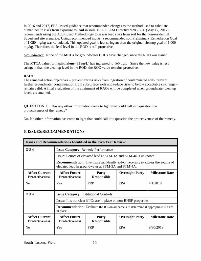
South Tacoma Field 15
In 2016 and 2017, EPA issued guidance that recommended changes to the method used to calculate
human health risks from exposure to lead in soils. EPA OLEM Directive 9285.6-56 (May 17, 2017)
recommends using the Adult Lead Methodology to assess lead risks from soil for the non-residential
Superfund site scenarios. Using recommended inputs, a recommended soil Preliminary Remediation Goal
of 1,050 mg/kg was calculated. This updated goal is less stringent than the original cleanup goal of 1,000
mg/kg. Therefore, the lead level in the ROD is still protective.
Groundwater: None of the MCLs for groundwater COCs have changed since the ROD was issued.
The MTCA value for naphthalene (32 μg/L) has increased to 160 μg/L. Since the new value is less
stringent than the cleanup level in the ROD, the ROD value remains protective.
RAOs
The remedial action objectives – prevent excess risks from ingestion of contaminated soils, prevent
further groundwater contamination from subsurface soils and reduce risks to below acceptable risk range -
remain valid. A final evaluation of the attainment of RAOs will be completed when groundwater cleanup
levels are attained.
QUESTION C: Has any other information come to light that could call into question the
protectiveness of the remedy?
No. No other information has come to light that could call into question the protectiveness of the remedy.
6. ISSUES/RECOMMENDATIONS
Issues and Recommendations Identified in the Five-Year Review:
OU 4 Issue Category: Remedy Performance
Issue: Source of elevated lead at STM-3A and STM-4a is unknown.
Recommendation: Investigate and identify actions necessary to address the source of
elevated lead in groundwater at STM-3A and STM-4A.
Affect Current
Protectiveness
Affect Future
Protectiveness
Party
Responsible
Oversight Party Milestone Date
No Yes PRP
EPA 4/1/2019
OU 4 Issue Category: Institutional Controls
Issue: It is not clear if ICs are in place on non-BNSF properties.
Recommendation: Evaluate the ICs on all parcels to determine if appropriate ICs are
in place.
Affect Current
Protectiveness
Affect Future
Protectiveness
Party
Responsible
Oversight Party Milestone Date
No Yes PRP
EPA 9/30/2019

South Tacoma Field 16
OTHER FINDINGS
In addition, the following are recommendations that were identified during the FYR and may improve
performance of the remedy, reduce costs, improve management of O&M or accelerate site close out, but
do not affect current and/or future protectiveness:
• Conduct an attainment analysis at all wells consistent with EPA guidance for evaluating the
completion of groundwater restoration remedial actions (OSWER 9355.0-129, OSWER 9283.1-
44). Where the minimum number of samples needed for an attainment analysis are not available,
consider increasing the sampling frequency to speed the demonstration of attainment. If
attainment of cleanup levels has been reached, calculate cumulative risks, evaluate the attainment
of RAOs and consider reduction of monitoring requirements.
• Review monitoring plan and consider determine if changes to the number of wells sampled or the
frequency of sampling are appropriate.
• Record and report field parameters, including turbidity, consistent with the monitoring plan.
• Evaluate whether there are ICs on parcels where capping has not occurred or residential and/or
groundwater cleanup levels have been attained. Consider revising covenants where appropriate.
• Establish a submission date for the Annual Reports.
7. PROTECTIVENESS STATEMENT
Protectiveness Statement(s)
Operable Unit: 4
South Tacoma Field
Protectiveness Determination:
Short-term Protective
Protectiveness Statement: The remedy at the South Tacoma Field OU is currently protective of human health and the environment in the
short term because ICs are in place to prevent direct contact with contaminated soil and use of contaminated
groundwater. However, for the remedy to be protective in the long term, the source of elevated lead in groundwater
at STM-3A and STM-4A needs to be investigated and addressed.
For Sitewide Protectiveness Statement, please see Section V.

IV.
TACOMA LANDFILL (OU5 & 6))
COMMENCEMENT BAY –
SOUTH TACOMA CHANNEL SUPERFUND SITE
PIERCE COUNTY, WASHINGTON
Prepared by
U.S. Environmental Protection Agency
Region 10
Seattle, Washington

1
[This page is intentionally left blank]
Tacoma Landfill Table of Contents
Table of Contents II. RESPONSE ACTION SUMMARY ...........................................................................................2
Basis for Taking Action ...............................................................................................................2 Response Actions .........................................................................................................................2
Status of Implementation .............................................................................................................3 Systems Operations/Operation & Maintenance ...........................................................................7
III. PROGRESS SINCE THE LAST REVIEW ..............................................................................8 IV. FIVE-YEAR REVIEW PROCESS .........................................................................................10
Community Notification, Involvement & Site Interviews .........................................................10 Data Review ...............................................................................................................................10
Site Inspection ............................................................................................................................13 V. TECHNICAL ASSESSMENT .................................................................................................13
QUESTION A: Is the remedy functioning as intended by the decision documents? ...............13 QUESTION B: Are the exposure assumptions, toxicity data, cleanup levels, and RAOs used
at the time of the remedy selection still valid? ..........................................................................14
QUESTION C: Has any other information come to light that could call into question the
protectiveness of the remedy? ....................................................................................................15
VI. ISSUES/RECOMMENDATIONS ..........................................................................................15 OTHER FINDINGS...................................................................................................................15
VII. PROTECTIVENESS STATEMENT .....................................................................................16
VIII. NEXT REVIEW ..............................................................................................................16
FIGURES
APPENDICIES
A. Documents Reviewed Data Review Figures
B. Supplemental Figures: Groundwater COC Concentration Maps
C. Institutional Controls
D. Interviews
E. Site Inspection Checklist
F. Site Photos
G. Risk Calculations

2 Tacoma Landfill OU
1 Tacoma Landfill OU
IV. FIVE-YEAR REVIEW for the TACOMA LANDFILL PROJECT AREA,
COMMENCEMENT BAY- SOUTH TACOMA CHANNEL SUPERFUND
SITE
I. INTRODUCTION - Tacoma Landfill Project Area (OU 5 and 6)
This is the fifth FYR for the Tacoma Landfill (TLF) Project Area (Landfill), Commencement Bay-South
Tacoma Channel (CB-STC) Superfund Site. The FYR has been prepared due to the fact that hazardous
substances, pollutants, or contaminants remain above levels that allow for unlimited use and unrestricted
exposure (UU/UE).
The TLF Project Area consists of two Operable Units (OUs), both of which are reviewed in this FYR.
The source areas are addressed in OU5 and the groundwater remedy in OU 6.
The FYR for the Tacoma Landfill Project Area was led by Jeremy Jennings, EPA Region 10. Participants
included an EPA human health risk assessor as well as representatives from Washington Department of
Ecology (Ecology) and the Tacoma-Pierce County Health District (TPCHD). The City of Tacoma (City),
the Potentially Responsible Party (PRP) was notified of the initiation of the FYR. The City and their
technical consultant provided input during the review process. The review began on 4/1/2018.
Site Background The Tacoma Landfill Project Area includes OU 5 and 6 of the Commencement Bay, South Tacoma
Channel Superfund Site (CB-STC) and is in Tacoma, Washington (Figure 1). The 240-acre landfill is
situated near the western border of Tacoma, surrounded by light industrial, commercial, and residential
properties. Leach Creek is located less than 0.5 miles west of the Site. In 1983, the Site was listed on the
National Priorities List (NPL) as part of the CB-STC Superfund Site.
The City of Tacoma (City) began operating the Tacoma Landfill as a municipal landfill in 1960. The
wastes disposed at the landfill include garbage, rubbish, industrial wastes, construction and demolition
wastes, street refuse, litter, and bulky waste. The landfill did not accept hazardous waste for disposal;
however, the landfill received wastes in the 1960s and 1970s that have since been designated as
hazardous wastes under state and federal law. Disposal of solid waste is no longer accepted. The landfill
achieved post-closure status under RCRA in December 2013.
The City of Tacoma has been identified as a PRP and is responsible for implementing the CERCLA
remedial actions under the oversight of both EPA and the Ecology. Current operations are regulated
under a Solid Waste Permit issued by the TPCHD. To facilitate consistency, the three agencies have
worked collaboratively on oversight activities and thus, are jointly referred to as “the Agencies”.
Land near the landfill continues to be used for residential and commercial purposes. A large commercial
warehouse has recently been developed adjacent to the southern portion of the western landfill boundary.
The City is currently using portions of the capped area for solid and hazardous waste collection and
recycling centers; a municipal waste transfer station; truck parking and dumpster storage; a CNG fueling
facility; Solid Waste Management offices; a golf driving range; the Tacoma Urban Forestry Landfill
Nursery and a model EnviroHouse and Rain Garden. The 2012 Institutional Controls (IC) Plan outlines
the process to be used by the City to evaluate future redevelopment opportunities.

2 Tacoma Landfill OU
All drinking water in the area is currently supplied by municipal water systems. There are no
downgradient residential or municipal wells that are used for drinking water within the area once
impacted by the contaminant plume.
II. RESPONSE ACTION SUMMARY
Basis for Taking Action
In 1983, hazardous compounds, primarily volatile organic compounds (VOCs), were detected in
groundwater and soil samples collected near the landfill. Further investigation indicated that elevated
VOC concentrations extended beyond the perimeter of the landfill in all directions. To the southwest, the
plume extended into a residential area that obtained drinking water from private wells. In addition,
landfill gases were found to be migrating from the landfill toward adjacent residences and businesses. To
address threats from these sources, in the mid-1980’s, residences were connected to the municipal water
supply system and, in 1986 the first stage of a landfill gas management system was constructed.
A human health risk assessment found that risks from consumption of groundwater impacted from Site
sources exceeded EPA’s acceptable risk levels for carcinogens. Vinyl chloride (VC) presented the
greatest risks, however, other VOCs were also found to be at levels of concern. Health risks associated
from inhalation of landfill gases (primarily methane) were found to be of secondary concern.
No ecological risks were identified at levels of concern. However, for protection of larval fishes and
benthos, all groundwater extraction water discharged to Leach Creek was required to meet the ambient
water quality criteria for protection of aquatic life as identified in the Washington State Water Quality
Standards.
Response Actions
Through a cooperative agreement with EPA, Ecology initiated site investigations in 1984. Responsibility
for the Remedial Investigation and Feasibility Study was transferred to the City under a 1986 Response
Order on Consent issued by Ecology. Early actions included connecting homes with potentially impacted
wells to municipal water (mid-1980’s) and constructing the first phase of a landfill gas management
system (1986).
On March 31, 1988, EPA issued the Record of Decision (ROD), that included source control using a
landfill cap, gas extraction system and landfill closure plan; management of contaminant migration using
a groundwater extraction and treatment system (GETS); monitoring and ICs to protect water supply wells.
Remedial Action Objectives (RAOs) are:
• Prevent further migration of the plume via the groundwater extraction-treatment system.
• Reduce the production of leachate by placing constraints on site operations and by properly
grading and capping the landfill.
• Eliminate off-site gas migration through the gas extraction system.
• Further protect public health and the environment via monitoring of groundwater, surface water,
gas probes, and air emissions and providing alternate water supplies where necessary.
The ROD required the following remedial actions:
• Source Control – Landfill Cap (OU 5)
3 Tacoma Landfill OU
o Cap unlined areas of the landfill to minimize infiltration and maximize run-off.
o Develop storm drainage plan to address increased run-off from caps.
o Identify and approve the number and location of leachate head wells in the Central Area.
o Develop a schedule for closure of the landfill. Include waste minimization measures.
o Collect and monitor gas generated from the landfill. Collected gas shall be burned by
combustors and condensate collected from the flare stations shall be treated or discharged to
the sanitary sewer.
• Management of Migration of Groundwater (OU 6)
o Control migration through use of a groundwater extraction and treatment system (GETS).
Minimum flows shall be maintained in Leach and Flett Creeks during extraction.
The treatment process shall be permanent; effectively reduce the toxicity, mobility and
volume of contaminants; and meet treatment performance goals.
Discharge of treated water may be to Leach Creek, Flett Creek or the sanitary sewer.
Air emissions from the treatment system shall be designed to meet appropriate ambient
air quality values.
o The treatment may be shut off when water quality within the plume and outside of the
compliance boundary (defined as the edge of the filled area) consistently meet or exceed
federal drinking water standards (MCLs) or other established health-based criteria.
• Monitoring (OU 6)
o Groundwater monitoring wells shall be installed in locations appropriate for obtaining
information on the spread of the plume, the extent of the plume migration, potential impacts
to Leach Creek and the Fircrest well system and the presence of a dense plume migrating
from the Site.
o Monitor both water quality and quantity in Leach Creek or other surface waters receiving
effluent or drainage from the landfill.
o Monitor effluent from the treatment system to assure that discharge limits are not exceeded.
o Monitor private wells in the path of the plume at least quarterly and the Fircrest wells
monthly. If any well becomes contaminated due to the landfill, replace the well and supply
water from the existing City of Tacoma water supply system.
• Institutional Controls (OU 6)
o Tacoma, in cooperation with the Town of Fircrest and Pierce County, shall pursue the
establishment of an ordinance, or other suitable methodology, to restrict drilling of water
supply wells in the area delineated in the ROD.
Status of Implementation
A Remedial Design – Remedial Action Consent Decree (CD) between EPA, Ecology, and the City to
implement the actions in the ROD was executed in federal court on November 13, 1989 and entered by
the Court on May 17, 1991. The CD was amended in 1996 to address flows in Leach Creek.
Source Control (OU 5)
There are six management areas at the landfill. Each area was filled, closed and capped at different times.
The areas are illustrated in Figure 2.
Landfill Closure Schedule: An initial schedule for closure of the landfill identified milestones for
construction of a bottom liner for the Central Area, capping of the unlined areas in the early 1990’s and a
4 Tacoma Landfill OU
December 31, 1999 final closure date. Three five-year extensions were granted to allow the Central Area
to receive of municipal wastes through 2012. The Central Area Cap was completed in November 2013.
This portion of the remedial action was completed in April 2015 when TPCHD determined the landfill to
be “closed” and transferred to “post-closure” status. EPA and Ecology reviewed the final construction
reports but, consistent with the ROD, deferred the compliance evaluation to TPCHD.
Capping Unlined Cells: Between 1990 and 1992 the north and south areas were leveled and covered with
two HDPE liners separated by a leak detection system. Drainage from the cap was managed with a system
of gravity drains as identified in a storm drainage plan. Leachate and condensate was collected and
drained into collection tanks, pumped through a pH dosing chamber and discharged to the sanitary sewer
system. In September 1999, EPA signed a Preliminary Close-Out Report documenting that construction
of a landfill cap for all unlined areas of the landfill was complete.
Capping the Central Area: In 1987, an additional waste cell was created on the vacant land in the middle
of the landfill (Central Area). A bottom liner and leachate collection system were constructed to
Minimum Functional Standards (MFS) and municipal wastes received through 2012. The remedial action
was completed when the Central Area cap was completed in November 2013.
The Environmental Operations and Maintenance Plan (O&M Plan) and the Leachate and Condensate
Management Plan outline current O&M and monitoring requirements for the landfill. Both reports were
updated on March 11, 2016. A summary of the data and activities are reported in the Annual Summary of
Inspections for the Tacoma Landfill Cap, Condensate Collection System and Central Area Leachate
System report.
Waste Reduction Measures: In 1990 the City developed the Prevention of Hazardous Substances and
Liquids Minimization Plan that included waste reduction measures as required by the ROD. The
hazardous waste collection area and recycling station were constructed pursuant to the City’s efforts to
minimize wastes. Additional waste reduction measures are required under the Solid Waste Permit issued
by the TPCHD. The minimization plan is currently housed in the Tacoma Landfill Operations Plan
Landfill Gas: Starting in July 1986, landfill gas (LFG) has been collected by a series of extraction wells
and conveyed to a Biogas Flare System. The gas collection and control system (GCCS) system is
monitored with a series of probes located throughout the landfill footprint, along the perimeter of the
landfill and outside the property boundary. Each probe station has up to five probes completed at different
depths. Data collected at the probe and flare stations is used to manage the flow of gas from individual
wells to optimize performance.
As of April 2017, the GCCS consisted of 196 operating extraction wells, 43 perimeter wells and 92 wells
scheduled for suspension (shut-off) (Figure 3). There were 119 probe stations, 84 of which were located
at or near the landfill boundary and were part of the compliance monitoring network. Thirty-five off-site
probe stations were used to monitor migration of gas beyond the footprint of the landfill. Monitoring,
management and maintenance plans were updated in 2018 (2018 Post-Closure Landfill Gas Management
Plan, August 10, 2018).
In response to the introduction of more efficient technology, in 2015 the City changed the type of meter
used to monitor gas concentrations and pressures at the probe stations. The sensor on the new meter
relays data to a handheld computer and is then downloaded to the City’s environmental database. To
digitally store and retrieve monitoring data, the City is currently developing a Landfill Gas Management
Database.

5 Tacoma Landfill OU
In 2014, the City requested Landau Associates (Landau) to review the LFG operational and monitoring
data for six gas monitoring wells and six extraction wells at the north end of the landfill and identify
potential system modifications that could optimize performance. The evaluation looked at one gas
monitoring well on the adjacent Home Depot property, five gas monitoring wells on the landfill and six
gas extraction wells located on the north end of the landfill. The evaluation found the north end gas
extraction system was operating effectively and preventing gas migration north of the landfill. In addition,
a secondary source was identified as the likely source of the elevated gas concentrations on the Home
Depot property, not the landfill.
A similar review for the entire landfill was documented in a March 10, 2016, Technical Memorandum.
Due to a decrease in the gas production, it was recommended that the GCCS be updated and sized
appropriately for existing and future conditions. Furthermore, it was recommended that, while the GCCS
prevents the lateral migration of LFG, decommissioning some extraction wells and probes would likely
lead to removing redundant collection devices and increase system efficiency. Finally, it was
recommended that inactive extraction wells be decommissioned and the continued need for the other
extraction wells and monitoring probes be evaluated.
On June 21, 2016, the City proposed a three-tiered approach to remove system redundancies and improve
system performance. Under Tier 1, monitoring was discontinued at 32 redundant offsite probes following
the August 2016 sampling event, 92 unused extraction wells were capped, the vacuum reduced
throughout the system and flows rebalanced. Under Tier 2, the City has evaluated discrete vertical zones
of extraction and used the results to simplify the system and maximize gas extraction. Finally, under Tier
3, the City plans to reevaluate if further actions would improve the efficiency of the system. The approach
is described in the 2018 Post Closure Landfill Gas Management Plan.
In July and August 2016, five probes on or near the former Hansen Pipe Property immediately west of the
landfill were permanently decommissioned to accommodate construction. Where appropriate,
replacement wells were added along the landfill boundary. At the same time, seven redundant perimeter
extraction wells were converted to monitoring probes.
Actions taken to manage the LFG are reported to EPA in the Tacoma Landfill Gas Evaluation Report.
Reports were submitted biannually through 2017. In November 2017, the Agencies approved the City’s
request to reduce the frequency of reporting to once a year.
Management of Migration of Groundwater (OU 6)
In 1992 and 1993, a network of 19 point-of-compliance (POC) extraction wells and nine edge-of-plume
(EOP) extraction wells were installed, a ground water treatment facility constructed and groundwater
extraction and treatment initiated. Seven additional extraction wells were installed between 1995 and
1997 (Figure 4).
Extraction water was initially collected in the holding area, treated and discharged either to the sanitary
sewer system or Leach Creek. In 2002, water quality improvements allowed for the water to be directly
discharged to the creek without treatment. Both the outfall and the creek have been monitored. The
treatment facility remains on-site but has not been used since 1998.
The ROD indicates that the extraction system may be shut off when water quality consistently meets or
exceeds MCLs or other risk/health-based criteria. The Consent Decree provides a process to develop a
list of indicator parameters to be used throughout the remainder of the RD and RA. The list of monitored
contaminants and the associated performance criteria (MCLs except 1,1-DCA and chloroethene) are
identified in Table 1.

6 Tacoma Landfill OU
TABLE 1. Groundwater Performance Criteria.
Contaminant Performance
Criteria (ug/L) Contaminant
Performance
Criteria (ug/L)
1,1,1-TCA 200 Benzene 5
1,1-DCA 20 Chloroethane 20
1,2-DCA 5 PCE 5
1,2-DCE (total) 70 TCE 5
cis-1,2-DCE 70 VC 2
trans-1,2-DCE 100
Following a review of the existing data, in 2009 and 2010, extraction was shutdown at the 14 off-site
extraction wells and 17 of the POC wells. Rebound monitoring was initiated. As of April 2018, four
extraction wells along the western landfill boundary were active.
An April 2018 Optimization Review Report prepared by EPA and evaluating the groundwater remedy
indicated the selected remedy had been effective at reducing contaminant concentrations consistent with
the RAOs at all but, potentially, two wells (TL-11A and TL-26A). To gain a better understanding of the
source in that area, additional landfill gas monitoring near TL-11A was recommended.
Under a 1996 amendment to the CD, the City was required to maintain 1.7 cubic feet per second flow in
Leach Creek to offset the effect of GETS pumping on groundwater recharge to the creek. A deep
augmentation well near the Leach Creek holding basin and, until 2003, was used to supplement flows.
The City decommissioned the well in 2018.
In February 2014, the City decommissioned three off-site wells that were shown to be in attainment of the
performance criteria and not likely to be needed in the future. All decommissioning was performed by a
licensed well driller and consistent with State requirements.
Groundwater Monitoring – OU 6
Groundwater monitoring was initiated in 1986. In 1996, all active monitoring plans were integrated into a
Sitewide groundwater monitoring plan.
In 2010, the monitoring plan was updated to monitor potential rebound as extraction wells were
shutdown. Four VOCs and four indicator parameters were removed from the analyte list at that time. In
2013, EPA reviewed the rebound data and recommended that the procedures be revised. The Rebound
Monitoring Plan Addendum, issued on July 28, 2014, addressed many of EPA’s concerns, removed wells
where performance criteria had been attained and added procedures to remove additional wells in the
future.
From 2014 through 2016, pursuant to a State requirement, total and dissolved metals were analyzed in a
subset of nine background wells (Background Groundwater Monitoring Plan, April 22, 2014). The data
was submitted to the Agencies quarterly and used to further the understanding of background metal
concentrations.
In 2014, a Post-Closure Groundwater and Surface Water Compliance Monitoring Plan was developed to
identify the post-closure monitoring required under the Solid Waste Permit for post-closure care. The 17
wells included in the plan were selected to meet long-term monitoring requirements of the Solid Waste
Permit and the CERCLA action. The plan included monitoring seven wells located along the western
landfill boundary to determine if groundwater performance standards are being met at the POC; eight off-
site, downgradient, post-closure monitoring wells used to evaluate migration of the contamination beyond
7 Tacoma Landfill OU
the POC; two background wells; the GETS outfall and Leach Creek. As part of the Optimization Review,
no data gaps were identified in the post-closure monitoring network.
The Post Closure Water Quality Monitoring, Sampling and Analysis Plan was prepared in February 2017
to present one groundwater monitoring program that addresses the long-term monitoring requirements
included in the federal, state and local regulations applicable to the landfill.
Data and analysis are reported quarterly in the Summary of Groundwater and Surface Water Data for
Tacoma Landfill. In addition, the Tacoma Landfill Consent Decree Annual Report provides an evaluation
of groundwater and surface water quality relative to groundwater performance criteria, including an
evaluation of the extent of plume migration.
Private and Municipal Wells: In the late 1980’s the City began routine sampling at private wells and
municipal wells operated by the town of Fircrest. Where chemical concentrations in a well were greater
than half the groundwater performance criteria, the City connected the property to the City of Tacoma’s
municipal water supply system. Furthermore, all new construction in the potentially affected area was
required to connect to the municipal system.
In 1995, the City reduced the volume of water extracted from two municipal wells near the landfill and
requested that Fircrest limit extraction from their municipal well closest to the landfill. In exchange for
temporarily closing the Fircrest well, the City agreed to drill a new municipal well further from the
landfill.
In 2008, the City reviewed all data collected from residential wells and completed a door-to-door survey
to verify if existing wells were being used as a drinking water supply. Based on the results, it was
determined that none of the remaining wells had been impacted by the landfill and that sampling was no
longer needed.
Institutional Controls
The remedy calls for the City to pursue establishing an ordinance that restricts drilling water supply wells
within the area of the plume, thus limiting potential exposure from drinking groundwater. The Tacoma
and University Place Municipal Codes have been revised to include a prohibition for construction of new
drinking water wells around the plume. In addition, the neighboring Town of Fircrest has prohibited the
drilling or installation of wells at any location within the town boundaries.
On November 16, 2001, the City filed a Restrictive Covenant with the Pierce County Auditor’s Office
restricting activity at the landfill that may impair the protectiveness of the remedy and restricted the
extraction and residential use of groundwater (see Appendix C). The Covenant has been attached to the
property deed.
Institutional Controls are described in the Tacoma Landfill Institutional Controls Plan (2012). There
were no changes to the ICs or IC Plan during this FYR period.
Systems Operations/Operation & Maintenance
The City originally had O&M plans for each element of the remedy. In 2016, the City made appropriate
updates to each plan and combined them in a site-wide Environmental Operations and Maintenance Plan.
Components of the site-wide O&M plan are included above for each OU.

8 Tacoma Landfill OU
Table 2: Summary of Planned and/or Implemented ICs Media, engineered
controls, and areas that do
not support UU/UE based
on current conditions
ICs
Needed
ICs Called
for in the
Decision
Documents
Impacted
Parcel(s)
IC
Objective
Title of IC
Instrument
Implemented and
Date (or planned)
Off-Site Groundwater Yes Yes
Parcels with
water supply
wells
downgradient
of the Site
Restrict installation
of ground water
wells and ground
water use in area of
the plume.
Drilling
prohibitions in
Pierce County,
Tacoma &
Fircrest Codes
Groundwater Yes
Identified
in Consent
Decree
Landfill
Restrict use of
groundwater to
prevent impacts to
human health
Restrictive
Covenant - Pierce
County No.
200111160567;
November 11,
2001
Integrity of Remedy -
Cap, gas and groundwater Yes
Identified
in Consent
Decree
Landfill Protect the integrity
of the remedy
Restrictive
Covenant - Pierce
County No.
200111160567;
November 11,
2001
During this FYR period, routine inspections, maintenance and sampling of groundwater extraction
system, groundwater monitoring well network, landfill cap, GCCS, and the leachate and condensate
collection systems were conducted. Preventative maintenance was conducted consistent with O&M plans
and minor repairs were made as needed. In January 2016, the City hired a contractor to remove the
accumulation of orange iron hydroxide on well screens, riser pipes and discharge lines.
In 2015 and 2016, the City regraded eight areas of the cap where ponding had been identified or the strain
exceeded 1%, as determined through a comparison of 2015 to August 1995 elevations.
III. PROGRESS SINCE THE LAST REVIEW
This section includes the protectiveness determinations and statements from the last five-year review as
well as the recommendations from the last five-year review and the current status of those
recommendations.
Table 3: Protectiveness Determinations/Statements from the 2013 FYR
OU # Protectiveness
Determination Protectiveness Statement
5/6 Short-term
Protective
The remedy at the Tacoma Landfill is currently protective of human health
and the environment in the short term because the groundwater and landfill
gas is being controlled through the GETS and landfill gas management
system, the Central Area final cover will be complete by December 31,
2013, and institutional controls are in place. However, in order for the
remedy to be protective in the long term, the following actions need to be
taken to ensure protectiveness: continue operation optimization of gas
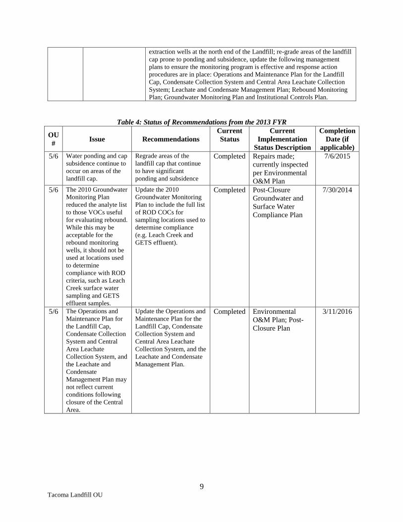
9 Tacoma Landfill OU
extraction wells at the north end of the Landfill; re-grade areas of the landfill
cap prone to ponding and subsidence, update the following management
plans to ensure the monitoring program is effective and response action
procedures are in place: Operations and Maintenance Plan for the Landfill
Cap, Condensate Collection System and Central Area Leachate Collection
System; Leachate and Condensate Management Plan; Rebound Monitoring
Plan; Groundwater Monitoring Plan and Institutional Controls Plan.
Table 4: Status of Recommendations from the 2013 FYR
OU
# Issue Recommendations
Current
Status
Current
Implementation
Status Description
Completion
Date (if
applicable)
5/6 Water ponding and cap
subsidence continue to
occur on areas of the
landfill cap.
Regrade areas of the
landfill cap that continue
to have significant
ponding and subsidence
Completed Repairs made;
currently inspected
per Environmental
O&M Plan
7/6/2015
5/6 The 2010 Groundwater
Monitoring Plan
reduced the analyte list
to those VOCs useful
for evaluating rebound.
While this may be
acceptable for the
rebound monitoring
wells, it should not be
used at locations used
to determine
compliance with ROD
criteria, such as Leach
Creek surface water
sampling and GETS
effluent samples.
Update the 2010
Groundwater Monitoring
Plan to include the full list
of ROD COCs for
sampling locations used to
determine compliance
(e.g. Leach Creek and
GETS effluent).
Completed Post-Closure
Groundwater and
Surface Water
Compliance Plan
7/30/2014
5/6 The Operations and
Maintenance Plan for
the Landfill Cap,
Condensate Collection
System and Central
Area Leachate
Collection System, and
the Leachate and
Condensate
Management Plan may
not reflect current
conditions following
closure of the Central
Area.
Update the Operations and
Maintenance Plan for the
Landfill Cap, Condensate
Collection System and
Central Area Leachate
Collection System, and the
Leachate and Condensate
Management Plan.
Completed Environmental
O&M Plan; Post-
Closure Plan
3/11/2016

10 Tacoma Landfill OU
5/6 Landfill gas continues
to be detected near the
Home Depot Property
at the north end of the
landfill.
Continue operation
optimization of gas
extraction in wells on the
northern edge of the
Landfill near the Home
Depot property.
Completed Data reviewed in
North End Landfill
Gas Control
Evaluation. Home
Depot gas likely
from a secondary
source.
Recommended
follow-up actions.
9/22/2014
5/6 The Rebound
Monitoring Plan
statistical methodology
is too restrictive,
leading to numerous
exceedances of the
contingent action
criteria, and the
response action
procedures described
in the plan have not
been followed.
Update the Rebound
Monitoring Plan. Completed Rebound
Monitoring Plan
Addendum; Post-
Closure Plan
7/28/2014
IV. FIVE-YEAR REVIEW PROCESS
Community Notification, Involvement & Site Interviews
A public notice was posted on the Site web page and published in the May 11, 2018 Tacoma Weekly (see
Well 12A, Appendix E). Interested parties were invited to visit the site web page for more information
and to submit comments to EPA. No comments were received. The FYR Report will be made available
on the Site web page and at the Region 10 Records Center in Seattle.
In addition, EPA notified Ecology, TPCHD and the PRP of the review. They will be provided a copy of
the final FYR Report. A FYR Meeting was held on May 1, 2018 and attended by Jeremy Jennings, EPA
RPM; a representative from Ecology and TPCHD; the PRP and their technical consultant and a second
EPA RPM. Major activities during this FYR period were summarized, upcoming work and optimization
opportunities were discussed at the meeting.
Following the meeting, an interview form and request to complete the form was emailed to each
participant (see Appx D for responses). All responses indicated that the remedy has been successful in
accomplishing the objectives and was close to being complete. No significant issues were raised.
Data Review
OU 5 – Landfill Cap – Source Control
Cap: Capping of the landfill was completed in November 2013 when the Central Area cap was completed.
The landfill was “Closed” and moved to RCRA “Post-Closure” status in April 2015.
The Environmental Operations and Maintenance Plan outlines the inspection program, maintenance
procedures and the sampling and documentation requirements for the landfill cap and the leachate and
condensate collection systems. A summary of the inspection findings is submitted to EPA in the Annual
Summary of Inspections Landfill Cap, Condensate Collection System and Central Area Leachate

11 Tacoma Landfill OU
Collection System. During this FYR period, the City completed O&M actions consistent with the plans.
The minor deficiencies identified were documented and actions were taken to address the issue.
The O&M Plan requires a demonstration of functional stability at least once every five years and
elevation surveys take place annually. When settlement exceeds thresholds, corrective actions are
initiated. The areas of ponding identified in the 2013 FYR were regraded and repaired during 2015 and
2016 while similar work on a few areas of the parking lot was scheduled for the summer of 2018. No
other significant settlement issues have been identified.
During the May 1, 2018 FYR Meeting, EPA was informed that the City desired to revise the O&M Plan
to reduce quantitative surveys to once every five years and change the allowable biaxial strain from 1% to
6% (regulatory limit is 10%). Visual surveys would continue to take place annually. The City was
encouraged to provide the Agencies with the recommended changes for review prior to implementation.
Gas: The GCCS is actively managed using data from the monitoring probes to is used to adjust the flow
of gas from individual wells and make decisions on system-wide improvements to optimize performance.
Perimeter gas probes are monitored weekly while extraction wells are monitored and adjusted quarterly.
Data and information are reported in the Gas System Evaluation Report (biannual prior to 2017, annual
thereafter). In addition, during this FYR period, several Technical Memoranda were produced to evaluate
optimization opportunities and systems operation.
As would be expected for a closed landfill, the rate of methane gas production is currently in decline
across the landfill and actively managed for optimal performance. Gas concentrations are generally
highest in the most-recent and the deepest fill areas (see Figure 5 for 2017 concentrations). In addition,
they found that the GCCS was preventing the lateral migration of LFG outside the property boundaries,
with concentrations above 5% (by volume) reported at only 8 of the 83 perimeter compliance monitoring
probes. Concentrations at 6 of the 8 wells were adjusted by increasing the flow rates at nearby extraction
wells. Additional study of gas concentrations at the other 2 wells, located just north of the landfill on
Home Depot property, is likely generated by a secondary source, not the landfill.
In a 2016 Technical Memorandum, Landau recommended a three-tier process to “right-size” the GCCS
by systematically testing to identify redundant collection devices and targeting extraction to the zones of
greatest gas production. Tier I, completed in early 2017, ceased extraction at all off-site wells and closed
probes found to be redundant and unnecessary. Tier II, completed between October and December 2017,
monitored changes when extraction from one or more extraction zone was suspended and evaluated the
data to determine if further extraction was necessary. Tier III will remove 10 to 15 poor-performing wells
from service and monitor the changes. Following completion of Tier, I and II, the extraction network was
reduced from 655 to 165 individual extraction wells. Most closed wells were left in place so that they
could be used for future monitoring or extraction. Continued efforts to optimize the GCCS should be
encouraged.
O&M reports indicate that inspections, preventative maintenance and other O&M activities have been
consistently implemented. No major issues with the LFG systems have been identified this FYR period.
OU 6 – Groundwater
GETS: During this FYR period, approximately 100 gallons per minute (gpm) of groundwater has been
extracted from five extraction wells, piped to the Leach Creek Holding Basin and discharged to Leach
Creek. Due to the quality at the point of discharge, no treatment has been required and no exceedences of
the discharge limits have been reported. The treatment system has not been used since 1998 and thus,
decommissioning of the system may be appropriate.
12 Tacoma Landfill OU
The five active extraction wells (W-01, W-02/W-03R, W-04, W-15 and W-16) are in the southern half of
the landfill, along the western boundary. From 2013 to 2015, well W-02 was off-line due to problems
with the well screen and, in 2015 was replaced by a new well labeled W-03R. Due to improved water
quality, terminating extraction at some of these wells may be appropriate.
Flow: Groundwater flow direction and gradients have not significantly changed during this FYR period
(Figure 6).
Groundwater Quality: Groundwater performance criteria for VC, 1,2-DCA and benzene are routinely met
at all monitoring wells. TCE and PCE criteria are regularly met at all but two wells, one of which the
most recent measurements were slightly below the performance criteria. The first well, TL-11A, is
located along the western boundary and is a POC well. The second, TL-26A, is located approximately
800 feet west of the western boundary and slightly north of TL-11A. During this FYR period, TL-11A
has shown consistently high concentrations of PCE (4.0 – 13 ug/L) and TCE (7.7 – 20 ug/L). (The MCL
for both contaminants is 5 ug/L.) The concentration trends for both COCs are relatively variable (Figure
7). There is no current route of exposure.
While currently just below the performance criteria, TCE and PCE at TL-26A increased to above the
performance criteria following the 2010 shutdown of extraction. Concentrations peaked just above the
performance criteria in the third quarter of 2015 and the second quarter of 2014 respectively. For the last
several years, concentrations of both the COCs have been in decline, suggesting the source is controlled
and the plume naturally attenuating (Figure 8). There is no current route of exposure (Figure 8).
To illustrate the reduction in plume size over time, two concentration contour maps have been generated
for PCE, TCE, 1,2-DCA, VC and benzene and provided in Appendix B. The first contour map for each
contaminant was generated using the maximum contaminant concentration recorded at each well,
illustrating the maximum plume size. The second contour map presents the most recent data collected
from each well (November 2017 or last sample last sample before well removed from sampling program),
thus illustrating the current plumes. he only current mappable plumes are in the southwest corner near
TL-11A and TL-26A. However, both the PCE and TCE plumes are significantly smaller than their
maximum size.
Quarterly rebound monitoring data has been conducted at the current network of wells since 2009 and
2010. After some early fluctuations, contaminant concentrations in all wells have either stabilized or are
decreasing. Given the time since shut-down, the continued value of rebound monitoring should be
evaluated.
Arsenic concentrations along the western edge of the landfill remain slightly elevated. However, a 2009
review this was due to redox conditions, not a release from the landfill.
A groundwater attainability analysis could be performed at most wells to determine where sufficient data
has been collected to demonstrate groundwater has met groundwater performance goals. Based on the
results, it may be appropriate to reduce monitoring at some wells. Prior to close-out, documentation of
attainment should be prepared for each well.
Surface Water Quality: Extracted groundwater is monitored just prior to being discharged to the Leach
Creek Holding Basin. Since the water quality at that point has consistently met performance criteria, the
current monitoring plan does not require instream monitoring. The frequency of monitoring transitioned
from semi-annual to quarterly during the second quarter of 2015.

13 Tacoma Landfill OU
O&M: O&M inspections and routine maintenance were performed as scheduled. In 2015, following
failure of the well screen, extraction well W-02 was replaced by W-03R. In 2016, wells with an
accumulation of iron hydroxide were rehabilitated.
Following the decommissioning of 11 extraction wells this FYR period, all off-site groundwater
extraction wells have been decommissioned. In addition, three monitoring wells and the Leach Creek
augmentation well were decommissioned in 2017 and other off-site wells are being considered for
decommissioning. The wells identified for post-closure monitoring or immediately downgradient of a
non-attainment well have not been considered candidates for decommissioning. Decommissioning was
performed by a licensed well driller and only permitted following Agency review. A similar evaluation
should be conducted prior to the decommissioning of additional wells. The locations of the
decommissioned wells are identified by a grey circle in Figure 4.
All O&M, sampling and management plans have been updated since the last FYR.
Site Inspection
The inspection of the Site was conducted on 5/1/2018. In attendance were Jeremy Jennings, EPA RPM; a
representative from Ecology; the PRP and their technical consultant and a second EPA RPM present to
learn from the process. The purpose of the inspection was to assess the protectiveness of the remedy.
The inspection included a driving tour around the top of the landfill with stops at locations where major
work had occurred during the FYR period. The landfill appeared to be well maintained. The City
appeared to be proactive in addressing potential concerns as they were identified. Throughout the tour,
EPA had discussions with the PRP, their technical consultant and the State regarding progress, problems
and successes at the Site. No issues or concerns were raised during the inspection that had not been
previously noted by the PRP.
V. TECHNICAL ASSESSMENT
QUESTION A: Is the remedy functioning as intended by the decision documents?
Question A Summary:
Yes, all elements of the remedy appear to be functioning as intended. All source controls have been
implemented and groundwater performance criteria are being met at most wells.
OU 5 – Landfill Cap – Source Control
Remedial Action Performance: All waste-collection areas have been capped and stormwater, condensate
and leachate collection systems are in place. All appear to be functioning as intended. Areas where
ponding was identified during the last FYR have been regraded and repaired.
A gas extraction system is preventing the lateral migration of gas and is functioning as intended. As gas
production has decreased, the City has taken steps to optimize operations through decommissioning of
redundant extraction wells and managing flows in the remaining wells.
The landfill was closed and moved into Post-Closure status in April 2015.
O&M: Routine inspections and maintenance are occurring, thus allowing for the continued functioning of
the remedial action. All O&M, sampling and management plans have recently updated.
14 Tacoma Landfill OU
OU 6 – Groundwater
Remedial Action Performance: Performance criteria have been met and extraction shut down at all but five
of the groundwater extraction wells. Rebound monitoring has not indicated a need to resume extraction at
any of the wells. Extracted groundwater consistently meets performance criteria at the discharge to the
Leach Creek Holding Basin and does not require treatment prior to discharge to Leach Creek.
Performance criteria are being met at all but two wells (TL-11A and TL-26A), thus indicating
contaminants have been contained except for a small area in the southwest corner of the landfill. TCE and
PCE concentrations in the two wells are relatively close to the MCLs. However, the concentration trend at
TL-11A is variable and may not lead to attainment in the next several years. Additional investigation of
the source is recommended to shorten the time to attainment. No exposure pathways are currently
present.
O&M: Routine inspections and maintenance are occurring, thus allowing for the continued functioning of
the remedial action. Following the malfunction of the well screen in W-02, a replacement well (W-03R)
was drilled. The O&M Plan was updated in 2016.
Institutional Controls
Required institutional controls are in place and functioning as intended. A 2001 Restrictive Covenant
restricts groundwater use and residential development on the Landfill property. In addition, three
communities downgradient of the landfill have revised their Municipal Codes to restrict or prohibit
installing new wells for domestic purposes.
QUESTION B: Are the exposure assumptions, toxicity data, cleanup levels, and RAOs used at the time
of the remedy selection still valid?
Question B Summary:
Yes, the exposure assumptions, toxicity data, performance criteria (cleanup levels) and RAOs used at the
time of remedy selection are still valid. There have been no changes that would call into question the
protectiveness of the remedy.
Groundwater - There are no changes to the health-based criteria that would call into question the
protectiveness of the remedy. The Safe Drinking Water Act and the Washington State Hazardous Waste
Cleanup Act were identified as ARARs. Groundwater performance criteria were established at the MCL
or, if no MCL was available, at risk/health-based criteria based on the residential use of drinking water.
No MCLs have become more stringent since the time the ROD was written. However, three MCLs (1,1-
DCA, ethyl benzene, toluene and xylenes) have become less stringent. These changes do not call into
question the protectiveness of the remedy.
Two health-based criteria were used in the ROD (chloroethene and 1,1-DCA). The current EPA Regional
Screening Level (RSL) for resident tap water for chloroethene is 21,000 ug/L, less stringent than the ROD
performance criterion of 20 ug/L. The current EPA RSL for 1,1-DCA is 2.8 ug/L, more stringent than the
ROD performance criterion of 20 ug/L. The risk associated with the ROD performance criterion for 1,1-
DCA is 7.3E-6, and thus, is within EPA’s acceptable risk range (see Appendix G for risk calculations).
Vapor Intrusion - The potential risk due to vapor intrusion was evaluated by the City in 2009. Use of the
J&E Model to screen for vinyl chloride and 1,2-DCA indicated residual concentrations in groundwater
15 Tacoma Landfill OU
off-site did not pose a risk to residents. VOC concentrations have decreased since this time due to
implementation of the remedy.
As part of this FYR, the Vapor Intrusion Screening Level (VISL) Calculator was used to assess the
exposure potential from TCE in the groundwater. In 2017, TCE was detected at six wells, all located near
the southwest corner of the landfill. The highest reported concentration at the boundary was 11 ug/L (TL-
11A) while the highest off-site contamination was 4.3 ug/L (TL-26A). The well screen at these two wells
are located at the top of the water table, 90 and 105 feet below the ground surface.
Using the VISL calculator and the default values for TCE, the groundwater screening value for short-term
noncancer endpoints was 22 ug/L, twice the highest concentration measured in 2017. This does not
consider any attenuation that may take place between the screen depth and the ground surface. Potential
exposure from intrusion of TCE vapors should not impact the protectiveness of the remedy.
Source Areas - Remedial actions selected for source control have been constructed, are currently
operating and appear to be in good condition. No quantitative performance criteria for gas were
established in the ROD. However, methane concentrations of 5% by volume remains a protective target.
Other - There have been no changes in contaminant characteristics, risk assessment methods, exposure
pathways or other changes that might impact RAOs or protectiveness of the remedy.
Progress Towards Meeting RAOs – The remedy has been effective. All source areas have been capped
and systems are in place to control gas, leachate, condensate and stormwater. Groundwater performance
criteria are met at all but one small area in the southwest corner.
QUESTION C: Has any other information come to light that could call into question the protectiveness
of the remedy?
No.
VI. ISSUES/RECOMMENDATIONS
Issues/Recommendations
OU(s) without Issues/Recommendations Identified in the Five-Year Review:
OU 5 & 6
OTHER FINDINGS
The following are recommendations that were identified during the FYR and may improve performance
of the remedy, reduce costs, accelerate site close out, etc., but do not affect current and/or future
protectiveness. Implementation of some of the recommendations may require Agency approval.
OU 5 – Source Control
• Review the methods and criteria used to evaluate functional stability of the landfill cap and
consider adjustments where appropriate.
16 Tacoma Landfill OU
• As the gas generation rate declines, continue to adjust flows for optimal performance.
OU 6 - Groundwater
• Consider further investigation of the source at TL-11A and, if appropriate, implement measures
to accelerate attainment of performance criteria.
• Consider conducting an attainability analysis at active extraction wells and evaluate the need for
continued extraction. • Prior to close-out, perform a groundwater attainability analysis at all wells. • Review current scope and need for the rebound monitoring program and modify as appropriate. • Eliminate quarterly groundwater reports and, instead, include all information in the annual report.
(Note: This change was request and approved by emails dated August 21 and 22, 2018.) • Consider decommissioning the GETS Treatment Plant.
VII. PROTECTIVENESS STATEMENT
Protectiveness Statement(s)
Operable Unit: 5
Protectiveness Determination:
Protective
Protectiveness Statement: The remedy at OU 5 is protective of human health and the environment. All
areas are capped, the landfill has closed and stormwater, condensate and leachate collection systems
are functioning. O&M activities are being implemented consistent with the O&M Plan. No current
exposure pathways are present.
Protectiveness Statement(s)
Operable Unit: 6
Protectiveness Determination:
Protective
Protectiveness Statement: The remedy at OU 6 is protective of human health and the environment.
Migration of the plume is under control and groundwater performance levels have been attained at all
but two wells. Groundwater continues to be extracted near the remaining PCE and TCE plumes. All
ICs are in place and no current exposure pathways are present.
VIII. NEXT REVIEW
The next five-year review report for the Commencement Bay, South Tacoma Channel Superfund Site is
required five years from the completion date of this review.
FIGURES
Extracted From:
2014 Post-Closure Monitoring Plan
2017 Annual Consent Decree Report
VOC Figures generated by City of Tacoma, 2018
Optimization Review Report, April 2018
2018 Post-Closure Landfill Gas Management Plan

2 Tacoma Landfill OU
[This page intentionally left blank]

ST163
ST16
S 47th St
S 56th St
S 38th St
35th St W S 35th St
27th St W
S 12th St
S Pi
ne St
N 9th St
S Ce
dar S
t
Emerson St
S 19th St
S Un
ion
Ave
S Mi
ldre
d St
40th St W
S Pe
arl S
t
S 48th St
S Or
char
d St
Alam
eda A
ve
51st
St W
S Tacoma Way
67th
Ave
W
Center St
Bridgeport Way W Cirque Dr W
S Ty
ler S
t
6th Ave
TacomaCemetery
FircrestGolf
Course
AllenmorePublic
Golf Course
Tacoma Mall
TacomaCommunity
College
HuntMiddleSchool
Leach
Cree
k
Leac
h CreekFircrestFircrest
OaklandOakland
Data Source: Esri 2012
City of Tacoma LandfillTacoma, Washington Vicinity Map
Figure1
0 0.5 1
Miles
G:\Pro
jects\
094\08
9\060\
064\Ti
er II M
onito
ring\2
018 U
pdate
\F01V
icinityM
ap.mx
d 5/17
/2018
!
!
!!
!
W a s h i ngtonW a s h i ngtonOlympia
ProjectLocation
TacomaSpokane
EverettSeattle
Project Location
t N
IA LANDAU ASSOCIATES,,_i._ ___ __J ______ ____._______.
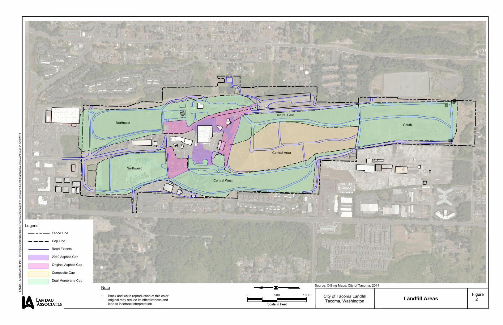
0 500 1000
Scale in Feet
Source: © Bing Maps; City of Tacoma, 2014Note
1. Black and white reproduction of this colororiginal may reduce its effectiveness andlead to incorrect interpretation.
City of Tacoma LandfillTacoma, Washington Landfill Areas
Figure2
LAN
DA
U A
SS
OC
IATE
S, I
NC
. | G
:\Pro
ject
s\09
4\08
9\06
0\06
4\Ti
er II
Mon
itorin
g\20
18 U
pdat
e\F0
3Lan
dfill
Cap
Sys
tem
.dw
g (A
) "Fi
gure
2" 8
/10/
2018
Legend
Fence Line
Cap Line
Road Extents
2010 Asphalt Cap
Original Asphalt Cap
Composite Cap
Dual Membrane Cap
-IA LANDAU M AsSOCIATES
.------- _____ ,........ ____ j _,,,_~ ~ ____;d~=3=:~
-- -~~~ "----~"----~
, ...... _,,..-_,.,.
Northeast
Central West
..
r
South
----------Central Area
D D 0
z

!E
&<
!E
!E
!E !E
!E
!E!E
!E
!E!E
!E
!E
!E
!E
!E
!E !E!E
!E
!E !E
!E
!E!E
!E
!E
!E
!E
!E
!E
!E!E
!E
!E
!E
!E
!E
!E
!E
!E
!E
!E
!E
!E
!E
!E !E
!E
!E
!E
!E
!E
!E
!E
!E
!E
!E !E !E
!E
!E
!E
!E
!E!E
!E
!E !E!E
!E
!E
!E
!E!E
!E
!E!E
!E
&<
!E
&<
!E
!E
!E
!E!E !E
!E
!E
!E
!E
!E
&<
!E
!E!E&<
!E
!E !E!E
!E
&<&<
&<
&<
&<
!E !E
!E
!E !E
!E
!E
!E!E
!E!E
!E!E
!E
!E !E
!E
!E!E!E !E !E
!E !E!E
!E!E!E
!E
!E
!E
!E
!E
!E!E
!E!E!E
!E
!E
!E!E
!E
!E
!E !E !E
!E
!E
!E
&<
&<
&<
&<
!A!A !A !A !A!A!A
!A!A
!A!A
!A!A
!A!A!A!A!A!A!A !H!H !H !H!H!H!H!H!H!H!H!H!H!H!H!H !H!H !H!H !H!H !H!H !H!H !H!H!H!H!H!H!H!H
!H!H!H!H!H!H!H!H!H!H!H
!H!H!H
!H!H!H!H!H!H!H!H!H!H!H!H!H!H!H!H!H!H!H!H!H!H!H!H!H!H!H!H!H!H!H!H!H!H!H!H!H!H!H!H!H!H!H
!H!H!H!H!H!H!H!H!H!H!H!H!H!H!H!H!H!H!H!H!H!H!H!H
!H!H!H!H!H!H!H!H!H!H!H!H!H!H!H!H
!H!H
!H!H
!H!H!H!H
!H!H!H!H!H!H!H!H!H!H!H!H
!H!H!H!H !H!H!H!H !H!H!H!H!H!H!H!H !H!H!H!H!H!H!H!H!H!H!H!H !H!H!H!H
!H!H!H!H !H!H!H!H !H!H!H!H !H!H!H!H !H!H!H!H !H!H!H!H !H!H!H!H
!H!H!H!H !H!H !H!H!H !H!H!H!H !H!H!H!H !H!H!H!H !H!H!H!H !H!H!H!H!H!H!H!H!H !H!H!H!H!H !H!H!H!H!H !H!H!H!H!H !H!H!H!H!H
!H!H!H!H
!H!H!H!H
!H!H!H!H!H
!H
!H
!H
!H!H
!H
!H
!H
"
Blower and Flare Station
Northeast AreaSouth AreaCentral East Area
Central West Area
Northwest Area
Central Area
0 500 1,000
Scale in Feet
City of Tacoma LandfillTacoma, Washington
Gas Collection and Control SystemOverview
Figure
3
Legend!E Interior Extraction Well - Operating!H Perimeter Monitoring Probe&< Perimeter Extraction Well - Operating!A Perimeter Extraction Well Converted to Monitoring Probe
Subject PropertyCap LineLandfill Gas Collection Header (Exposed)Landfill Gas Collection Header (Buried)Horizontal CollectorG
:\Pro
ject
s\09
4\08
9\06
0\06
4\Ti
er II
Mon
itorin
g\20
18 U
pdat
e\F0
4Gas
Col
lect
ionO
verv
iew
.mxd
8/1
0/20
18
Data Sources: Tacoma Landfill Stage 1-North Closure, Parametrix, May, 1990; Tacoma Landfill Stage 1-South Closure,Black & Veatch, June 1990; Tacoma Landfill Stage 2 Closure, Black & Veatch, June 1991; Esri World Imagery.
Note1. Black and white reproduction of this color
original may reduce its effectiveness and lead to incorrect interpretation.
IA LANDAU ASSOCIATES,
I l I I I I I l
. . . .. . . .. . . : ....... ~ .... : ; . . . .. • •♦ ♦ • .. , ...... ,... •. .. .......
·•······· .
. ..
. .
. . . -- --........ ♦ -- .,,,,,.
-- -- -- -- -- -- -- --
C]
- -.= ---

&<
&<
&<
&<
&<
&<
&<
&<
&<
&<
"ª"
"ª"
&<
&<&<
&<
&<
!H
&<
&<&<
&<
&<
&<
&<&<
&<&<
&<&< &<
&<
&<
&<
&<
&<
&<&<
&<&<&<
&<
&<
&<&<
&<&<&<&<&<&<
&<
&<
&<
&<
&<
&<
&<
&<
&<
&<
!H
"ª"&<
&<
&<
&<
&<
&<
&<
&<&<&<
&<
&<
&<
&<"ª"
&<
&<
&<
&<
&<&<
&<
&<
&<&<
&<
&<&<
&<
&<&<
&<&<
!H
&<
&<
&<
&<&<
&<
&<
&<
&<
&<
&<
&<
&<
&<
"ª"
&<
&<
&<
&<
&<
&<
&<
&<&<
&<
&<
&<
&<
"ª"
&<
&<
&<
GETSTreatment
Plant
GETSOutfall
S 48th St
S Ty
ler S
t
S Ty
ler S
t
Alam
eda
Ave
Ramsdell S t
TL-01C
Alam
eda
Ave
Emerson St
S 36th St
S Or
char
d St
S Or
char
d St
S Center St
Leac
h Cree
k
PW-10
W-31
TL-20A
TL-21A
LC-02
TL-24A
TL-27A
TL-27B
TL-22A
TL-28A
89.5 P1,P2
TL-23A
TL-11B,D
W-01
W-02
W-03
TL-26B
TL-09A,BW-32
TL-19C
TL-19AW-04
W-05
W-07
W-08
TL-12
TL-13C
W-09TL-08B,C
TL-08A
W-11
TL-25ATL-25B
W-12W-13W-14TL-10B
TL-10C,DW-36
W-33
EW-13
LC-04
W-37
W-43
W-38
W-15
MW-16-03
MW-16-02
W-17
W-18
W-19
W-20
TL-05A,C,D
W-21
TL-03A,C
LW-01
TL-01B
W-22
TL-02A,C
FL-01B
FL-01A
TL-16R
TL-18C
TL-14A
TL-15B,CTL-15A
TL-17AR
TL-17BR
TL-07C
TL-20C
PW-02
PW-01
PW-11
TL-11A
TL-26A
W-06
TL-13A
W-10
TL-10A
PW-07
PW-08
PW-06
PW-05
PW-3/4
TL-07A
PW-09 W-16
TL-04
TL-01A
TL-18A
LC-03
LC-01
W-30
W-41
W-40
W-42
W-35
W-34
0 700 1,400
Scale in Feet
Source: City of Tacoma 2004; ESRI World Imagery 2010
City of TacomaTacoma, Washington
Post-Closure GroundwaterMonitoring Locations
Figure
4
G:\Projects\094\089\010\015\VOC Contours\F02_PostClosureMonitoringLocations.mxd 7/22/2014 NAD 1983 StatePlane Washington South FIPS 4602 Feet
Legend
&<PW-25 Post-Closure Monitoring Well
"ª"LC-01 Compliance Monitoring Location
&<TL-10A,BTacoma Landfill Monitoring Well(Multiple Completion in One Borehole)
&<TL-12Tacoma Landfill Monitoring Well(Single Completion)
&<W-40 Decommissioned Monitoring Well
&<W-34 GETS Extraction Well
&<PW-3/4 GETS Performance Monitoring Well
"ª"LC-02 Leach Creek Sampling Location
!HEW-13 Other Monitoring Well
Landfill Boundary
Note1. Black and white reproduction of this color
original may reduce its effectiveness and lead to incorrect interpretation.
IA LANDAU AssocIATEs. ______________ L _________ _1,_ _______________ ...._ __ _

!!
!
!
!
!
!
!
!
!
!
!!!
!
!
!!
!
!!
!! !!!!!!!!!!!!!! !! !! !! !! !! !!!!!!!!
!!!!!!!!!!!
!!!
!!!!!!!!!!!!!!!!!!!!!!!!!!!!!!!!!!!!!!!!!!!!!!!!!!!!!!!!!!!!!!!!
!!!!!!!!!!!!!!!!!!!
!!
!!
!!!!
!!!! !!!!!!!! !!!! !!!! !!!!!!!! !!!!!!!! !!!! !!!!!!!! !!!! !!!! !!!! !!!! !!!! !!!!
!!!! !! !!! !!!! !!!!!!!! !!!! !!!!!!!!! !!!!! !!!!! !!!!! !!!!!
!!!!
!!!!
!!!!!
!
!
!
!
!!
!
!
!
!
!!
! ! !
!
!!
!
!
! !
!
!
!!!
!
!
!
!
!
!
!
!!!!
!!
!!
!
!
!!
!
!!
!!
!
!
!
!!
!
! !
! !!!
! ! !!!
!
!
!
!
!
!
!!
! ! !
! !
!
!!
!
!
!
!
!
!!
!
!
!
!
!
! ! !!
!
!!
!
!!
!
!
!
!!
!
!
!
! !
!
!
!!
!
!!! !
!
!
!!
!
!
!
!!!
!!
!!
!!
!!
!!!!
!
!
!E
&<!E
&<
!E
!E
!E !E
!E
&<
!E!E
!E
!E!E
!E
!E
!E
!E
!E
!E !E!E
!E
!E
!E !E
!E
!E!E
!E
!E
!E!E
!E
!E
!E
!E
!E!E
!E
!E
!E
!E
!E
!E
!E
!E
!E
!E!E!E
!E
!E
!E
!E
!E !E
!E
!E
!E
!E
!E
!E!E
!E
!E
!E
!E
!E
!E!E !E !E !E !E
&<
!E!E
!E!E!E!E
!E
!E
!E
!E
!E!E
!E
!E !E!E
!E
!E !E
&<
!E
!E
!E !E
!E!E !E!E
!E
&<
!E
!E
&<&<
!E
&<
!E!E
!E
!E!E
!E
!E!E!E
!E
!E!E
!E
!E
!E
!E
!E
!E!E
!E
!E
!E
!E
!E
!E
!E
!E
!E!E!E
!E &<
&<&<
!E
!E!E!E
&<&<&<
!E
!E !E!E
!E
!E!E
!E
!E
&<&< &<&< &<&< &< &<
&<&<&<
!E
!E
!E
!E
!E
!E
!E
!E
!E
!E
!E
!E
!E !E!E !E!E
!E
!E!E
!E!E
!E
!E!E
!E
!E!E!E
!E!E!E
!E !E
!E!E !E!E
!E!E!E!E
!E!E!E!E!E!E!E!E !E !E
!E
!E
!E!E
!E!E!E!E!E!E!E
!E!E!E!E!E
!E!E!E!E
&<
!E!E
!E!E
!E!E
!E
!E
!E !E!E
!E
!E!E!E
!E!E
!E
!E!E
!E
!E
!E
!E
&<&<
!E!E!E!E !E !E
!E
!E
&<
&<
&<
!E
&<&<&<
&<
&<
&<
&<
&<
&<
!H!H !H !H!H!H!H!H!H!H!H!H!H!H!H!H !H!H !H!H !H!H !H!H !H!H !H!H!H!H!H!H!H!H
!H!H!H!H!H!H!H!H!H!H!H
!H!H!H
!H!H!H!H!H!H!H!H!H!H!H!H!H!H!H!H!H!H!H!H!H!H!H!H!H!H!H!H!H!H!H!H!H!H!H!H!H!H!H!H!H!H!H
!H!H!H!H!H!H!H!H!H!H!H!H!H!H!H!H!H!H!H!H!H!H!H!H
!H!H!H!H!H!H!H!H!H!H!H!H!H!H!H!H
!H!H
!H!H
!H!H!H!H
!H!H!H!H!H!H!H!H!H!H!H!H
!H!H!H!H !H!H!H!H !H!H!H!H!H!H!H!H !H!H!H!H!H!H!H!H!H!H!H!H !H!H!H!H
!H!H!H!H !H!H!H!H !H!H!H!H !H!H!H!H !H!H!H!H !H!H!H!H !H!H!H!H
!H!H!H!H !H!H !H!H!H !H!H!H!H !H!H!H!H !H!H!H!H !H!H!H!H !H!H!H!H!H!H!H!H!H !H!H!H!H!H !H!H!H!H!H !H!H!H!H!H !H!H!H!H!H
!H!H!H!H
!H!H!H!H
!H!H!H!H!H
!H
!H
!H
!H!H
!H
!H
!H
0 500 1,000
Scale in Feet
City of Tacoma LandfillTacoma, Washington
Methane Concentrations:December 2017
Figure5
Legend!E Interior Extraction Well - Operating!H Perimiter Monitoring Probe&< Perimeter Extraction Well - Operating
Subject PropertyCap Line
Methane Concentrations (% by Vol)0 - 55 - 1515 - 3535 - 5555+
G:\P
roje
cts
\094
\08
9\0
60
\06
4\T
ier
II M
on
ito
rin
g\D
ec1
7\F
03
Me
tha
ne
Site
Wid
e.m
xd
1/2
9/2
01
8
Data Sources: Tacoma Landfill Stage 1-North Closure, Parametrix, May, 1990; Tacoma Landfill Stage 1-South Closure,Black & Veatch, June 1990; Tacoma Landfill Stage 2 Closure, Black & Veatch, June 1991; Esri World Imagery.
Notes1. Section boundaries are not included in
the interpolation.2. Black and white reproduction of this color
original may reduce its effectiveness and lead to incorrect interpretation.
LANDAU ASSOCIATES.
I l I I I I I l
-------------------,, -------- ' r:-:::-::-::-::-::"".~-=~~;~------ - - ' ·---------::-:::-=-----..:::;;..:=-::.1 _ _ _ _ _ _ _ _ _ _ _ _ _ _ _ _ -' --------------- ---------- ------ I ---- ------------------- ,---- I .......... ; ; ,,,,,,,,,, I
,,,,,,,,,, ,,,, ------- I ; I / ---; -- I I / - - - - - - - -, ; I
I / I I I ,,,... ; I I ............... ~ :,--.......... L-------------------- .....
------- \ I I ---~-- ' --------,,,,,,-- , ________ , ~ ,..,.--, I - - ,,,... I r--~--~---1 f l ,,,...-,,,...- f --: .... ,________ :
I _,,,...--~, I
--_ .......... ----------
I ,,,,,,,,,, ', I ; ....
--~~"~~---~,,,,,~,,,,,~---~~~~ ',..., I .... .... __
CJ D
D -

&<
&<
&<
&<
&<
&<
&<
&<
&<
&<
"ª"
"ª"
&<
&<&<
&<
&<
!H
&<
&<&<
&<
&<
&<
&<&<
&<&<
&<&< &<
&<
&<
&<
&<
&<
&<&<
&<&<&<
&<
&<
&<&<
&<&<&<&<&<&<
&<
&<
&<
&<
&<
&<
&<
&<
&<
&<
!H
"ª"&<
&<
&<
&<
&<
&<
&<
&<&<&<
&<
&<
&<
&<"ª"
&<
&<
&<
&<
&<&<
&<
&<
&<&<
&<
&<&<
&<
&<&<
&<&<
!H
&<
&<
&<
&<&<
&<
&<
&<
&<
&<
&<
&<
&<
&<
"ª"
&<
&<
&<
&<
&<
&<
&<
&<&<
&<
&<
&<
&<
"ª"
&<
&<
&<
GETSTreatment
Plant
GETSOutfall
S 48th St
S Ty
ler S
t
S Ty
ler S
t
Alam
eda
Ave
Ramsdell S t
TL-01B
Alam
eda
Ave
Emerson St
S 36th St
S Or
char
d St
S Or
char
d St
S Center St
Leac
h Cree
k
PW-10
W-31
TL-20A
TL-21A
LC-02
TL-24A
TL-27A
TL-27B
TL-22A
TL-28A
89.5 P1,P2
TL-23A
TL-11B,D
W-01
W-02
W-05
TL-26B
TL-09A,BW-32
TL-19C
TL-19A W-04
W-06
W-07
W-08
TL-12
TL-13C
W-09TL-08B,C
TL-08A
W-11
TL-25ATL-25B
W-12W-13W-14TL-10B
TL-10C,DW-36
W-33
EW-13
LC-04
W-37
W-43
W-38
W-15
MW-16-03
MW-16-02
W-17
W-18
W-19
W-20
TL-05A,C,D
W-21
TL-03A,C
LW-01
TL-01C
W-22
TL-02A,C
FL-01B
FL-01A
TL-16R
TL-18C
TL-14A
TL-15B,C
TL-15A
TL-17AR
TL-17BR
TL-07C
TL-20C
PW-02
PW-01
PW-11
TL-11A
TL-26AW-03
TL-13A
W-10
TL-10A
PW-07
PW-08
PW-06
PW-05
PW-3/4
TL-07A
PW-09W-16
TL-04
TL-01A
TL-18A
LC-03
LC-01
W-30
W-41
W-40
W-42
W-35
W-34
241
200
240
205210
215220
225230
235236
238
239
241240
200
240210 215
220225
235
236
237238
239
230205
Source: City of Tacoma 2004; ESRI World Imagery 2010
City of TacomaTacoma, Washington
Post-Closure GroundwaterMonitoring Locations and
Groundwater ContoursFigure
6
G:\Projects\094\089\010\015\VOC Contours\F03_GW_Contours.mxd 6/24/2014 NAD 1983 StatePlane Washington South FIPS 4602 Feet
Legend
&<PW-25 Post-Closure Monitoring Well
"ª"LC-01 Compliance Monitoring Location
&<TL-10A,BTacoma Landfill Monitoring Well(Multiple Completion in One Borehole)
&<TL-12Tacoma Landfill Monitoring Well(Single Completion)
&<W-40 Decommissioned Monitoring Well
&<W-34 GETS Extraction Well
&<PW-3/4 GETS Performance Monitoring Well
"ª"LC-02 Leach Creek Sampling Location
!HEW-13 Other Monitoring Well
Groundwater Elevation Contour1-Foot Interval Measured 4th Quarter 2012
Groundwater Elevation Contour5-Foot Interval Measured 4th Quarter 2012
Landfill Boundary
Note1. Black and white reproduction of this color
original may reduce its effectiveness and lead to incorrect interpretation.
jj
j
j Groundwater Flow Direction
0 700 1,400
Scale in Feet
\ \ \ \ \
\ \ \
' \ ' ' \ ~<' \ \ \
\ \
' ' ' I ' ' ' I I I I I I
I I I I I I
'
I I
I I I \ \
\
' ' '
/ /
/ /
/ /
\ \
' ' ' ' \
\ 'I. !
' i i ...... _ ..
/
\
/
\
' I
7 /
/
'i I , = \ I \
i \ I ' i / : I .. i f.i ,.,. : / !
L i ,
\ \
\ \
\ \
\ \
\
I
IA LANDAU ASSOCIATES. ____________ _j _________ .L_ _____________ ...&... __ __.
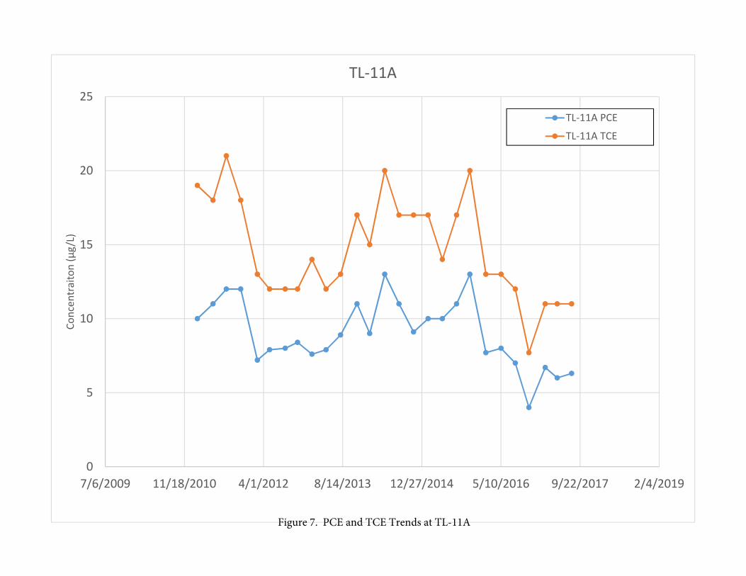
0
5
10
15
20
25
7/6/2009 11/18/2010 4/1/2012 8/14/2013 12/27/2014 5/10/2016 9/22/2017 2/4/2019
Concentraiton (µg/L)TL‐11A
TL‐11A PCE
TL‐11A TCE
Figure 7. PCE and TCE Trends at TL-11A
r

0
1
2
3
4
5
6
7/6/2009 11/18/2010 4/1/2012 8/14/2013 12/27/2014 5/10/2016 9/22/2017 2/4/2019
Concentraiton (µg/L)TL‐26A
TL‐26A PCE
TL‐26A TCE
Figure 8. TL-26A PCE and TCE Concentration Trends