Embed Size (px)
Citation preview

CREATED APPROVED REVISIONCHECKED
#*
#*11
10
±
LegendFauna Sites#* Habitat Assessment Number
Fauna HabitatSwales (29.08 ha)
Lake Margin (6.42 ha)
LOCALITY MAP
DATEPROJECT ID
LS RF
- NOTE THAT POSITION ERRORS CAN BE >5M IN SOME AREAS
- LOCALITY MAP SOURCED LANDGATE 2006
- TENEMENTS SOURCED FROM AGRIMIN 2017- RARE AND PRIORITY FLORA SOURCED DPAW 2017
- AERIAL PHOTOGRAPHY SOURCED LANDGATE 2007
AND ADDITIONAL LANGATE COMPOSITE AERIALS
(© Western Australian Land Information Authority 2015)
0
HORIZONTAL DATUM AND PROJECTION
AgriminSulphate of Potash ProjectLake Mackay, WAFauna Survey
COPYRIGHT: THIS DOCUMENT IS AND SHALL REMAIN THE PROPERTY OF 360 ENVIRONMENTAL. THIS DOCUMENT MAY ONLY BE USED FOR THE PURPOSE FOR WHICH IT WAS COMMISSIONED AND IN ACCORDANCE WITH THE T ERMS OF ENGAGEMENT FOR THE COMMISSION. 360 ENVIRONMENTAL DOES NOT HOLD ANY RESPONSIBILITY FOR THE MISUSE OF THIS DOC UMENT.
Figure 12Island 3
a 10 Bermondsey St, West Leederville, 6007 WA
t (08) 9388 8360
f (08) 9381 2360
w www.360environmental.com.au
EW
0 50 100 150 200
Meters
4/08/20172188
K:\Projects\1.0 EBS\2188 Eco Surveys Lake Mackay\Figures\Fauna Survey\2188 Fauna Habitat Figure 10 Island 3.mxd
GDA 1994 MGA Zone 52
@ A31:5,000

CREATED APPROVED REVISIONCHECKED
#*
#*
#*14
13
12
Island 5
Island 6
Island 4
447000
447000
448000
448000
449000
449000
450000
450000
451000
451000
7500
000
7500
000
7501
000
7501
000
7502
000
7502
000
7503
000
7503
000
7504
000
7504
000
±
LegendFauna Sites#* Habitat Assessment Number
Island 4Swale (16.42 ha)
Lake Margin (6.74 ha)
Island 5Swale (19.24 ha)
Lake Margin (5.01 ha)
Island 6Swale (14.91 ha)
Lake Margin (13.49 ha)
LOCALITY MAP
DATEPROJECT ID
LS RF
- NOTE THAT POSITION ERRORS CAN BE >5M IN SOME AREAS
- LOCALITY MAP SOURCED LANDGATE 2006
- TENEMENTS SOURCED FROM AGRIMIN 2017- RARE AND PRIORITY FLORA SOURCED DPAW 2017
- AERIAL PHOTOGRAPHY SOURCED LANDGATE 2007
AND ADDITIONAL LANGATE COMPOSITE AERIALS
(© Western Australian Land Information Authority 2015)
0
HORIZONTAL DATUM AND PROJECTION
AgriminSulphate of Potash ProjectLake Mackay, WAFauna Survey
COPYRIGHT: THIS DOCUMENT IS AND SHALL REMAIN THE PROPERTY OF 360 ENVIRONMENTAL. THIS DOCUMENT MAY ONLY BE USED FOR THE PURPOSE FOR WHICH IT WAS COMMISSIONED AND IN ACCORDANCE WITH THE T ERMS OF ENGAGEMENT FOR THE COMMISSION. 360 ENVIRONMENTAL DOES NOT HOLD ANY RESPONSIBILITY FOR THE MISUSE OF THIS DOC UMENT.
Figure 13Islands 4, 5 and 6
a 10 Bermondsey St, West Leederville, 6007 WA
t (08) 9388 8360
f (08) 9381 2360
w www.360environmental.com.au
EW
0 200 400 600 800 1,000
Meters
4/08/20172188
K:\Projects\1.0 EBS\2188 Eco Surveys Lake Mackay\Figures\Fauna Survey\2188 Fauna Habitat Figure 11 Islands 4 5 6.mxd
GDA 1994 MGA Zone 52
@ A31:25,000

CREATED APPROVED REVISIONCHECKED
#*15
±
LegendFauna Sites#* Habitat Assessment Number
Fauna HabitatSwale (0.09 ha)
Lake Margin (0.27 ha)
LOCALITY MAP
DATEPROJECT ID
LS RF
- NOTE THAT POSITION ERRORS CAN BE >5M IN SOME AREAS
- LOCALITY MAP SOURCED LANDGATE 2006
- CADASTRE SOURCED FROM LANDGATE 22 DEC 2015- AERIAL PHOTOGRAPHY SOURCED LANDGATE SEPT 2015
(© Western Australian Land Information Authority 2015)
0
HORIZONTAL DATUM AND PROJECTION
AgriminSulphate of Potash ProjectLake Mackay, WAFauna Survery
COPYRIGHT: THIS DOCUMENT IS AND SHALL REMAIN THE PROPERTY OF 360 ENVIRONMENTAL. THIS DOCUMENT MAY ONLY BE USED FOR THE PURPOSE FOR WHICH IT WAS COMMISSIONED AND IN ACCORDANCE WITH THE T ERMS OF ENGAGEMENT FOR THE COMMISSION. 360 ENVIRONMENTAL DOES NOT HOLD ANY RESPONSIBILITY FOR THE MISUSE OF THIS DOC UMENT.
Figure 14Island 7
a 10 Bermondsey St, West Leederville, 6007 WA
t (08) 9388 8360
f (08) 9381 2360
w www.360environmental.com.au
EW
4/08/20172188
K:\Projects\1.0 EBS\2188 Eco Surveys Lake Mackay\Figures\Fauna Survey\2188 Fauna Habitat Figure 12 Island 7.mxd
GDA 1994 MGA Zone 52
@ A31:1,250
0 10 20 30 40 50
Meters

CREATED APPROVED REVISIONCHECKED
[t
!(
!(
")
")
_̂
_̂
#*
#*
#*
#*
#*
#*
#*
5
3
20
19
18
17
16
452000
452000
454000
454000
456000
456000
458000
458000
460000
460000
462000
462000
464000
464000
7486
000
7486
000
7488
000
7488
000
7490
000
7490
000
7492
000
7492
000
7494
000
7494
000
±
LegendProposed Infrastructure Boundary
Existing Track
Fauna Sites[t Camp Site
!( Fauna Trap Site 3 & 5
") Camera Trap
#* Habitat Assessment Number
_̂ SM2
Fauna HabitatClaypan Swale
Dune
Lake Margin
LOCALITY MAP
DATEPROJECT ID
LS RF
- NOTE THAT POSITION ERRORS CAN BE >5M IN SOME AREAS
- LOCALITY MAP SOURCED LANDGATE 2006
- CADASTRE SOURCED FROM LANDGATE 22 DEC 2015- AERIAL PHOTOGRAPHY SOURCED LANDGATE SEPT 2015
(© Western Australian Land Information Authority 2015)
0
HORIZONTAL DATUM AND PROJECTION
AgriminSulphate of Potash ProjectLake Mackay, WAVertebrate Fauna Survey
COPYRIGHT: THIS DOCUMENT IS AND SHALL REMAIN THE PROPERTY OF 360 ENVIRONMENTAL. THIS DOCUMENT MAY ONLY BE USED FOR THE PURPOSE FOR WHICH IT WAS COMMISSIONED AND IN ACCORDANCE WITH THE T ERMS OF ENGAGEMENT FOR THE COMMISSION. 360 ENVIRONMENTAL DOES NOT HOLD ANY RESPONSIBILITY FOR THE MISUSE OF THIS DOC UMENT.
Figure 15Additional Habitat Assessments
a 10 Bermondsey St, West Leederville, 6007 WA
t (08) 9388 8360
f (08) 9381 2360
w www.360environmental.com.au
EW
0 500 1,000 1,500 2,000 2,500
Meters
4/08/20172188
K:\Projects\1.0 EBS\2188 Eco Surveys Lake Mackay\Figures\Fauna Survey\2188 Fauna Habitat Figure 13 Additional Habitat Assessments.mxd
GDA 1994 MGA Zone 52
@ A31:60,000
2188AE Fauna Survey Lake Mackay Sulphate of Potash Project
Agrimin
360 Environmental Pty Ltd 41
4 Results
4.1 Fauna Survey Limitations and Constraints
Survey constraints are often difficult to predict, as is the extent to which they influence
survey effort. The survey limitations and constraints of the fauna survey are outlined
below in Table 8.
Table 8: Limitations and constraints associated with the survey. VARIABLE IMPACT ON SURVEY OUTCOMES
Access The Survey Area is extremely remote. The nearest
township is the Kiwirrkurra Community which is
approximately 65 km to the south-west of the lake/ Survey
Area. It is virtually untouched, with very few existing access
tracks. Access was provided exclusively by helicopter to
each trap site and other assessment locations. This
remoteness limited the extent to which opportunistic
searches and more general fauna habitat assessments
could be undertaken. Nevertheless, searches were
undertaken as far as practicable in lieu of the access and
transportation constraints.
The focus of the survey effort was primarily on the
proposed infrastructure areas, two large islands on the lake
and other, smaller locations. The six trap sites were located
in habitats that are representative of those found in the
Survey Area. However, given the Survey Area’s size, there
were sections that were not accessed, although the
habitats that these areas supported were assessed in other
locations throughout the Survey Area, where possible.
Experience The personnel who undertook the survey were practitioners
suitably qualified in their respective fields:
Project Manager, Field Staff and Report Review: Dr
Ron Firth (Principal Zoologist); and
Field Staff, Data Interpretation and Reporting:
Laura Stevens (Zoologist).
Timing, weather, season The survey was undertaken from the 10 – 19 May 2017.
The most relevant and reliable Bureau of Meteorology
(BoM) weather station for the Survey Area is Walungurru
Airport (Site No. 15664), approximately 80 km south-east

2188AE Fauna Survey Lake Mackay Sulphate of Potash Project
Agrimin
360 Environmental Pty Ltd 42
VARIABLE IMPACT ON SURVEY OUTCOMES
of the southern boundary of the Survey Area. Walungurru
Airport weather station recorded 804.2 mm of rain in the
12 months prior to survey (May 2016 – April 2017) which
is 498.1 mm above the long-term average rainfall for the
same period (see Figure 2). In the three months prior to the
survey (February 2017 – April 2017), 119.4 mm of rainfall
was recorded which is just below the 130.8 mm average
rainfall for the same period (BoM 2017).
During the survey period, no rainfall was noted in the
Survey Area and none was recorded at the Walungurru
Airport weather station (see Table 1). On average, rainfall
in May is relatively low with the long-term average being
20.6 mm. Maximum temperatures during the survey were
close to the long-term average, though slightly higher on
five of the 10 survey days (Table 1). Minimum
temperatures during the survey were relatively close to the
long-term average on four of the 10 days, but below the
long-term average on six of the 10 days (noticeably lower
on five of the six days) (see Table 1).
It is worth noting that the Survey Area is a substantial
distance from the Walungurru Airport weather station. As a
result, there are likely to be differences in rainfall and
temperature records related to localised effects, though
these are unlikely to be significant.
Scope: Life forms sampled This was a Level 2 fauna survey, comprising a desktop
review of secondary data and a field survey that included
baseline trapping, habitat assessments, systematic and
opportunistic observations, acoustic micro bat call
recordings and camera traps. Vertebrate groups targeted
during the survey were reptiles, birds and mammals
(including micro bats).
Sources of information The desktop analysis used several sources to produce a list
of fauna species previously recorded in the vicinity of the
Survey Area. This includes records from the DPaW
Threatened Fauna Database Search, (DPaW 2017a), the
EPBC Protected Matters Search Tool (DEE 2017) and
NatureMap (DPaW 2017b) as well as past consultant
reports, field guides and other scientific literature (although

2188AE Fauna Survey Lake Mackay Sulphate of Potash Project
Agrimin
360 Environmental Pty Ltd 43
VARIABLE IMPACT ON SURVEY OUTCOMES
this was relatively limited for the general area).
Completeness A total of 94 fauna species were recovered from database
searches and a total of 94 species were also recorded
during the survey. A total of six trap sites were surveyed
over seven nights. Pitfall trap survey effort at trap sites
totalled 409 nights, funnel traps 672 nights, Elliott traps
420 nights, cage traps 168 nights and bird survey effort
was 480-person minutes. SM2 units and camera traps were
placed at each of the six trap sites and 24 hours of
opportunistic searches were undertaken. Spotlighting
(based near camp due to trap site access constraints)
totalled 120 minutes. Habitat assessments were
undertaken at 22 locations across the Survey Area,
including at trap sites.
Disturbances Likely due to its remote location, pre-existing disturbance
in the Survey Area is considered extremely low. Very minor
existing disturbances included animal tracks (camels) and
vehicle tracks.
4.2 Fauna Results
4.2.1 Database Results
Database searches returned 94 vertebrate species from 40 families. Of these, 37 were
reptile species from eight families, 36 were bird species from 21 families and 21 were
mammal species from 11 families.
A total of 21 conservation significant species (including Priority species) were identified
during the desktop review of database searches (Appendix B). These comprised one
reptile species, 16 bird species from 11 families and three mammal species from two
families. The likelihood of them occurring in the Survey Area is outlined in Table 8 and
reported in the results.
The DPaW threatened fauna database, NatureMap and the EPBC Protected Matters
Search Tool (PMST) returned a small number of species known to be historical records
of species now extinct in the local area e.g. Red-tailed Phascogale (Phascogale calura)
(locally called Kenngoor) and the Central Hare-wallaby (Marcopodidae lagorchestes
asomatus) (locally called Kuluwarri). Also, there were a number of database errors
including the Grey Wagtail (Motacilla cinerea) which is a rare visitor and has just two
confirmed records (Johnstone & Storr 1998). These species have been omitted from any
further discussion.

2188AE Fauna Survey Lake Mackay Sulphate of Potash Project
Agrimin
360 Environmental Pty Ltd 44
It is important to note that the EPBC PMST is not entirely based on point records but
also on broader information (e.g. bioclimatic distribution models), whereas the DPaW
threatened fauna database and NatureMap are solely based on point records.
Consequently, the results of the EPBC PMST are in some cases less accurate,
particularly at a local scale (e.g. the Yellow Wagtail (Motacilla flava)). As a result, the
EPBC PMST can include species that do not occur in the Survey Area because, for
example, there is no habitat available or they are now known to be locally extinct.
In addition, many fauna species are not distributed evenly across the landscape, being
more abundant in some places than others where they can be more readily detectable
(Currie 2007). Furthermore, some small, common, ground-dwelling reptile and mammal
species tend to be habitat specific, and many bird species can occur as regular migrants,
occasional visitors or vagrants. Therefore, all of these species have been omitted from
any further discussion regarding fauna results.
With the aforementioned species removed, a total of 21 conservation significant species
(including Priority species) were identified during the review of the database searches as
potentially occurring in the Survey Area. Of these, five species were recorded during the
survey (this includes during the recent waterbird survey), 10 species are considered
Likely to occur, one species is considered Possible to occur and five species are
considered Unlikely to occur in the Survey Area (Table 9). All 21 conservation significant
species are discussed in section 5.1. The Striated Grasswren (Amytornis striatus) was
not returned from database results, however, the species is also included for
consideration in this report since its distribution is considered Likely to include Lake
Mackay (section 5.1.1).
The Likelihood of each species occurring is based on the following criteria:
Recorded: Recorded during the field survey or site reconnaissance;
Likely: Suitable habitat is present in the Survey Area and the Survey Area is in
the species’ known distribution;
Possible: Limited or no suitable habitat is present in Survey Area, but is nearby.
The species has good dispersal abilities and is known from the general area; and
Unlikely: No suitable habitat is present in Survey Area but is nearby, the species
has poor dispersal abilities but is known from the general area or suitable habitat
is present, however, the Survey Area is outside of the species’ known
distribution.

2188AE Fauna Survey Lake Mackay Sulphate of Potash Project
Agrimin
360 Environmental Pty Ltd 45
Table 9: Conservation significant fauna recorded and potentially occurring in the Survey Area. IUCN listing – En = Endangered, Vu = Vulnerable and LC = Least Concern. En = Listed as Endangered
under the EBPC Act, Vu = Listed as Vulnerable under the EBPC Act, Mi = Listed as Migratory under the
EBPC Act, Ma = Listed as Marine under the EBPC Act, S = Scheduled (1 - 7) under the WC Act, P =
Listed as Priority (1 – 5) by DPaW.
SPECIES CONSERVATION
STATUS (EPBC ACT, WC ACT & PRIORITY)
LIKELIHOOD
Reptiles
Great Desert Skink (Liopholis kintorei) (locally called Tjakura) Vu, S3 Likely
Birds
Fork-tailed Swift (Apus pacificus) MiMa, S5 Recorded
Cattle Egret (Ardea ibis) MiMa, S5 Unlikely
Eastern Great Egret (Ardea modesta) MiMa, S5 Unlikely
Grey Falcon (Falco hypoleucos) Vu, S3 Unlikely
Oriental Plover (Charadrius veredus) MiMa, S5 Likely
Australian Painted Snipe (Rostratula australis) En, S2 Recorded
Common Sandpiper (Actitis hypoleucos) MiMa, S5 Likely
Sharp-tailed Sandpiper (Calidris acuminata) MiMa, S5 Recorded
Pectoral Sandpiper (Calidris melanotos) MiMa, S5 Likely
Common Greenshank (Tringa nebularia) MiMa, S5 Recorded
Red-necked Stint (Calidris ruficollis) MiMa, S5 Recorded
Oriental Pratincole (Glareola maldivarum) MiMa, S5 Likely
Night Parrot (Pezoporus occidentalis) En, S1 Possible
Princess Parrot (Polytelis alexandrae) Vu Likely
Rainbow Bee-eater (Merops ornatus) Ma, S5 Likely
Barn Swallow (Hirundo rustica) Ma, S5 Unlikely
Striated Grass-wren (Amytornis striatus striatus) P4 Likely
Mammals
Brush-tailed Mulgara (Dasycercus blythi) P4 Likely
Bilby (Macrotis lagotis) (locally called Ninu) Vu, S3 Likely
Northern Marsupial Mole (Notoryctes caurinus) (locally
called Kararratul) P4 Likely
4.2.2 Survey Results
During the field survey 94 species from 46 families were recorded. This consisted of two
amphibian species from one family, 24 species of reptile from seven families, 57 bird
2188AE Fauna Survey Lake Mackay Sulphate of Potash Project
Agrimin
360 Environmental Pty Ltd 46
species from 31 families and 11 mammal species from seven families. Three of the 11 mammal species were introduced - the Red Fox (Vulpes vulpes), the European Rabbit (Oryctolagus cininculus) and the Camel (Camelus dromedarius).
Figure 16 shows the frequency of all species captured at the trap sites during the field survey across all habitat types using pitfall and funnel trap captures. Reptiles were the most frequently recorded group, followed by mammals, with amphibians the least frequently recorded group.
Trap site data can be seen in Appendix D. This appendix is a record of all captures across the six trap sites. Data was recorded opportunistically throughout the survey and is presented in Appendix F. This appendix is a record of all species recorded in the overall Survey Area. It includes species that were recorded during spotlighting, when flying between trap sites and when walking in a more general nature in the Survey Area. Photographs of some species captured during the survey can be seen in Appendix G including the Short-tailed Pygmy Monitor (Varanus brevicaudus), Three-lined Knob-tail (Nephrurus levis) and Thorny Devil (Moloch horridus).
2188AB Pilgangoora Fauna Survey Lake Mackay Sulphate of Potash Project
Agrimin
360 Environmental Pty Ltd 47
Figure 16: Frequency of Species Captured at Trap Sites during the Survey.
0
20
40
60
80
100
120
140
Freq
uen
cy o
f C
aptu
re
Species
Species Captured at Trap Sites

2188 AE Fauna Survey Lake Mackay Sulphate of Potash Project
Agrimin
360 Environmental Pty Ltd 48
4.2.2.1 Amphibians
From the database searches, no amphibians have previously been recorded in the surrounding area (as per the database search parameters defined in section 3.2.1). During the survey, two amphibian species were recorded. The Desert Spade Frog (Notaden nichollsi) was recorded on 214 occasions and Sudell’s Frog (Neobatrachus sudelli) was recorded on 10 occasions. Both species were recorded at all trap sites with the exception of trap site 2.
4.2.2.2 Reptiles
From the database searches, a total of 37 species of reptile have been previously recorded in the surrounding area (as per the database search parameters defined in section 3.2.1). During the field survey, 24 species of reptile were recorded (Appendix C). The most frequently recorded species was the Leopard Ctenotus (Ctenotus pantherinus) with 96 captures in total and recorded at all trap sites. This was followed by the Fine Side-lined Ctenotus (Ctenotus dux) with 36 captures in total, recorded at all six trap sites and the Clay-soil Ctenotus (Ctenotus helenae) which was recorded on 30 occasions from trap sites 3-6.
4.2.2.3 Birds
From the database searches, a total of 36 bird species have been previously recorded in the surrounding area (as per the database search parameters defined in section 3.2.1). During the field survey, 57 species of bird were identified including those recorded during the waterbird survey (Appendix C). Bird species were recorded at all trap sites as well as opportunistically. The most frequently recorded (not necessarily the most abundant) bird species were the Singing Honeyeater (Lichenostomus virescens), Willie Wagtail (Rhipidura leucophrys) and Zebra Finch (Taeniopygia guttata), each of which was recorded at all six trap sites (with the exception of the Willie Wagtail at trap site 2) as well as opportunistically throughout the Survey Area.
The Singing Honeyeater was heard and seen in small groups at each trap site and heard in numerous locations throughout the Survey Area. The Willie Wagtail was observed singularly or in small groups and the Zebra Finch was mainly observed flying in flocks at each trap site and throughout the Survey Area.
4.2.2.4 Mammals
From the database searches, 21 species of mammal have previously been recorded in the surrounding area (as per the database search parameters defined in section 3.2.1). During the field survey, 11 species of mammal were recorded (Appendix C). Of these 11 species, five were recorded at the trap sites, two were Bat species recorded on the SM2 units and the remainder were recorded opportunistically. Three were introduced species.
During the field survey, the most frequently recorded mammal at the trap sites was the Desert Mouse (Pseudomys desertor) which was caught on 43 occasions at all trap sites,

2188 AE Fauna Survey Lake Mackay Sulphate of Potash Project
Agrimin
360 Environmental Pty Ltd 49
with the exception of trap site 2. This was followed by the Spinifex Hopping-mouse
(Notomys alexis) which was caught a total of 22 times from trap sites 3-6 and the Sandy
Inland Mouse (Pseudomys hermannsbergensis) which was caught 10 times from trap
sites 3, 4 and 6.
4.3 Fauna Habitat
Four broad fauna habitats types were identified in the Survey Area:
Dune;
Swale;
Claypan Swale; and
Lake Margin.
These habitats are widespread and common in areas adjacent to the Survey Area and
more broadly across the region.
The fauna habitats are mapped in Figures 7-15 and the habitat assessment undertaken in
each of the four habitats is detailed in Appendix E. The extent of each habitat in the
Survey Area is presented in Table 10.
Table 10: Habitat types and extent in the Survey Area.
HABITAT TYPE
EXTENT IN THE SURVEY AREA
(HA)
Dune 1078.21
Swale 3088.00
Claypan Swale 797.73
Lake Margin 573.91
Total Area 5547.29
Of the four habitats types described, Swale was by far the most extensive fauna habitat occurring in the Survey Area. Descriptions and photographs of fauna habitats are provided below.
4.3.1 Dune Fauna Habitat
The dune habitat is characterised by areas of dune crest that typically includes scattered
Eucalyptus sp. or Corymbia sp. trees over Acacia shrubland with a hummock grass layer
of spinifex (Triodia sp.) on deep sandy soils (refer Plates 3-8 for examples of Dune
habitat in the Survey Area).
A moderate diversity of microhabitats is present. While lacking tree hollows and logs,
leaf litter and debris were present. The soils present are suitable for digging and

2188 AE Fauna Survey Lake Mackay Sulphate of Potash Project
Agrimin
360 Environmental Pty Ltd 50
burrowing animals such as the Robust Duneslider (Lerista ips) and Narrow-banded Sand-
swimmer (Eremiascincus fasciolatus), both of which were recorded in this habitat.
The Dune habitat has the potential (in areas where the sand is less-soft) to support
several conservation significant vertebrate fauna species including the Great Desert
Skink (Liopholis kintorei) and Brush-tailed Mulgara (Dasycercus blythi). The Dune
habitat also provides shelter and foraging habitat for a number of bird species including
the Masked Woodswallow (Artamus personatus), Splendid Fairy-wren (Malurus
splendens), Horsfield's Bronze Cuckoo (Chrysococcyx basalis) and a number of
Honeyeater species, all of which were recorded in this habitat.
The Dune habitat also provides shelter and foraging habitat for a number of small
mammal species including the Desert Mouse, Sandy Inland Mouse, and Spinifex Hopping
Mouse, all of which were recorded in Dune habitat. Due to the structure of this habitat, it
is considered to be of moderate value to fauna in the Survey Area.
Plate 3: Dune Habitat.

2188 AE Fauna Survey Lake Mackay Sulphate of Potash Project
Agrimin
360 Environmental Pty Ltd 51
Plate 4: Dune Habitat showing Trap Site number 5.
Plate 5: Dune Habitat.

2188 AE Fauna Survey Lake Mackay Sulphate of Potash Project
Agrimin
360 Environmental Pty Ltd 52
Plate 6: Dune Habitat.
Plate 7: Dune Habitat.

2188 AE Fauna Survey Lake Mackay Sulphate of Potash Project
Agrimin
360 Environmental Pty Ltd 53
Plate 8: Dune Habitat.
4.3.2 Swale Fauna Habitat
The Swale habitat is characterised by the lower areas lying between the dune slopes and
crests in the Survey Area. Swale habitat is characterised by low, open shrubland of
Acacia sp. and Melaleuca sp. over hummock grassland of Triodia sp. on sandy soils.
Soils were more compact than in the Dune habitat and, in some areas, calcrete was
present (e.g. on Island 2 and Trap Site 4) which may limit habitat opportunities to some
extent for some burrowing species (see Plates 9-13 for examples of Swale habitat in the
Survey Area).
Allocasuarina decaisneana (Desert Oak) is scattered through this habitat, particularly on
Island 1, providing habitat for some bird and reptile species. A moderate diversity of
microhabitats is present, with some leaf litter and debris. The soils present in the Swale
habitat are typically suitable for digging and burrowing animals such as Delma butleri
(Unbanded Delma).
Swale habitat has the potential to support several conservation significant fauna species,
including M. lagotis (Bilby) in areas of more compact sand in which larger burrows can be
constructed. Swale habitat also has the potential to support L. kintorei (Great Desert
Skink), (D. blythi) Brush-tailed Mulgara and P. alexandrae (Princess Parrot). Due to the
structure of this habitat, it is considered to be of moderate value to fauna in the Survey
Area.

2188 AE Fauna Survey Lake Mackay Sulphate of Potash Project
Agrimin
360 Environmental Pty Ltd 54
Plate 9: Swale Habitat.
Plate 10: Swale Habitat.
2188 AE Fauna Survey Lake Mackay Sulphate of Potash Project
Agrimin
360 Environmental Pty Ltd 55
Plate 11: Swale Habitat showing Trap Site number 2.
Plate 12: Swale Habitat.

2188 AE Fauna Survey Lake Mackay Sulphate of Potash Project
Agrimin
360 Environmental Pty Ltd 56
Plate 13: Swale Habitat.
4.3.3 Claypan Swale Fauna Habitat
The Claypan Swale habitat is characterised by the lower areas between the dune slopes
and crests in the Survey Area where claypans are present. Claypan Swale habitat is
characterised by low open shrubland of Acacia sp. and Melaleuca sp. over hummock
grassland of Triodia sp., with some areas of compacted clay soils. Some areas still
contain sandy soils, however, they are typically more compact than in Swale habitat. The
Claypan Swale habitat contains areas where fresh water pools (probably mostly from
run-off) as was observed during the fauna survey (see Plates 14-19 for examples of
Claypan Swale habitat in the Survey Area).
Larger areas of Melaleuca are present in Claypan Swale habitat, providing important
habitat for many bird, mammal and reptile species. A moderate diversity of microhabitats
is present, with some leaf litter and debris. Although the soils are the most compact of
the Survey Area, they are still suitable for digging and burrowing species.
During the survey, some areas of this habitat had claypans that were dry which provides
little value to fauna. However, a number contained freshwater which provides important
habitat for reptile and mammal species (particularly in vegetation around the periphery of
the claypans, when present), including Sminthopsis macroura (Stripe-faced Dunnart)
and Pseudomys hermannsbergensis (Sandy Inland Mouse). Most significantly, however,
this wetland habitat provides habitat to waterbirds including Malacorhynchus
membranaceus (Pink-eared Duck), Ardea novaehollandie (White-faced Heron) and
Recurvirostra novaehollandiae (Red-necked Avocet), all of which were recorded at Trap
Site 4.

2188 AE Fauna Survey Lake Mackay Sulphate of Potash Project
Agrimin
360 Environmental Pty Ltd 57
Claypan Swale habitat has the potential to support several conservation significant
vertebrate fauna species including Rostratula australis (Australian Pained Snipe) and
migratory waders such as Tringa nebularia (Common Greenshank) and Calidris
acuminata (Sharp-tailed Sandpiper). Claypan Swale habitat is, therefore, considered to
be of high value to fauna in the Survey Area.
Plate 14: Claypan Swale Habitat.

2188 AE Fauna Survey Lake Mackay Sulphate of Potash Project
Agrimin
360 Environmental Pty Ltd 58
Plate 15: Claypan Swale Habitat.
Plate 16: Claypan Swale Habitat.
Plate 17: Claypan Swale Habitat.

2188 AE Fauna Survey Lake Mackay Sulphate of Potash Project
Agrimin
360 Environmental Pty Ltd 59
Plate 18: Claypan Swale Habitat.
Plate 19: Claypan Swale Habitat.

2188 AE Fauna Survey Lake Mackay Sulphate of Potash Project
Agrimin
360 Environmental Pty Ltd 60
4.3.4 Lake Margin Fauna Habitat
Lake Margin habitat is comprised of various Tecticornia species over scattered tussock
grassland on sandy soils and is found on island edges as well as the edge of the lake on
the mainland (see Plates 20-25 for examples of Lake Margin habitat in the Survey Area).
Lake Margin habitat has a limited diversity of microhabitats present, lacking the
structure of an over or midstorey and very limited leaf litter.
This habitat has a relatively low potential of supporting conservation significant fauna
species, although it may be utilised by migratory species including the Fork-tailed Swift
as well as wading birds such as Actitis hypoleucos (Common Sandpiper) and Calidris
ruficollis (Red-necked Stint) at certain times following large rainfall events. These birds,
however, are all more likely to use areas of freshwater during these times. Lake Margin
habitat is, therefore, considered to be of low value to fauna in the Survey Area.
Plate 20: Lake Margin Habitat.

2188 AE Fauna Survey Lake Mackay Sulphate of Potash Project
Agrimin
360 Environmental Pty Ltd 61
Plate 21: Lake Margin Habitat.
Plate 22: Lake Margin Habitat.

2188 AE Fauna Survey Lake Mackay Sulphate of Potash Project
Agrimin
360 Environmental Pty Ltd 62
Plate 23: Lake Margin Habitat.
Plate 24: Lake Margin Habitat.

2188 AE Fauna Survey Lake Mackay Sulphate of Potash Project
Agrimin
360 Environmental Pty Ltd 63
Plate 25: Lake Margin Habitat.
4.4 Camera Trap Results
The following species were recorded on the camera traps (Plates 26-28):
Canis lupus dingo (Dingo) – recorded at trap site 4;
Vulpes vulpes (Red Fox) – recorded at trap sites 2 and 6; and
Notomys alexis (Spinifex Hopping-mouse) recorded at trap site 6.
No species of conservation significance were recorded on motion cameras during the
survey.

2188 AE Fauna Survey Lake Mackay Sulphate of Potash Project
Agrimin
360 Environmental Pty Ltd 64
Plate 26: Canis lupus dingo (Dingo) recorded at Trap Site 4.
Plate 28: Vulpes vulpes (Fox) recorded at Trap Site 2.

2188 AE Fauna Survey Lake Mackay Sulphate of Potash Project
Agrimin
360 Environmental Pty Ltd 65
Plate 29: Notomys alexis (Spinifex Hopping Mouse) recorded at Trap Site 6.
4.5 SM2 Unit Results
The following two bat species were recorded on the SM2 unit during the survey:
Taphozous hilli (Hills Sheath-tailed Bat); and
Austronomus australis (White-striped Free-tailed Bat).
The Night Parrot was not recorded on the SM2 unit during the survey.

2188 AE Fauna Survey Lake Mackay Sulphate of Potash Project
Agrimin
360 Environmental Pty Ltd 66
5 Discussion
5.1 Conservation Significant Fauna
A total of 21 conservation significant fauna species (including Priority species) were
either recorded during the survey or identified during the desktop review of database
searches as potentially occurring in the Survey Area. These species are discussed below,
including some brief ecological information for each species and the reasons for their
likelihood of occurrence in the Survey Area. More information is presented for those
species recorded during the survey and / or where there is substantial information
(particularly ecological information) available in the literature.
5.1.1 Conservation Significant Species Recorded
Five conservation significant species in total were recorded during the 10-day field
survey and the recent waterbird survey, including the Fork-tailed Swift, Australian
Painted Snipe (recorded during the waterbird survey), Sharp-tailed Sandpiper, Common
Greenshank, and Red-necked Stint (these three species were also recorded during the
recent waterbird survey).
Fork-tailed Swift (Apus pacificus)
The Fork-tailed Swift is listed as Migratory under the EPBC Act and as S5 under the WC
Act. It is a non-breeding visitor to all states and territories of Australia (Higgins 1999).
The Fork-tailed Swift is a summer migrant to Australia usually during the months of
October-April. The Fork-tailed Swift is an aerial species which forages high above the
tree canopy and is independent of terrestrial habitats. It occurs in flocks of up to 2,000
birds and is often seen accompanying Tree Martins and Masked Wood swallows
(Johnstone & Storr 1998).
The DPaW threatened fauna database did not return any records of the Fork-tailed
Swift. The species was observed flying overhead on Island 3 and, while it will not be
reliant on the habitats of the Survey Area, it is likely to utilise the Survey Area as part of
its larger foraging home range.
Australian Painted Snipe (Rostratula australis)
The Australian Painted Snipe (Painted Snipe) is listed as Endangered under the EPBC
Act. It inhabits shallow, vegetated, temporary or infrequently filled inland wetlands of
Australia. Numbers of the Painted Snipe are thought to have declined substantially since
European settlement, particularly over the last 50 years, due to the loss and alteration of
wetlands (Garnett et al. 2011).
Migration patterns of the Painted Snipe are poorly known (Pringle 1987), although the
species is believed to disperse widely as evidenced by irregular and infrequent
occurrences and breeding throughout Australia (Marchant & Higgins 1993). Movements

2188 AE Fauna Survey Lake Mackay Sulphate of Potash Project
Agrimin
360 Environmental Pty Ltd 67
have been attributed to local conditions- birds move to flooded areas, from drying to
permanent wetlands and away from areas affected by drought.
There are no records of the Australian Painted Snipe in the DPaW threatened fauna
database for the Survey Area, however, one Australian Painted Snipe was recorded
during the recent Waterbird survey (April 2017). It is important to note that there was
only one record of the Australian Painted Snipe and it was observed approximately 25
km to the east of the nearest proposed infrastructure development area. It was recorded
at a claypan and aerial imagery, together with careful observations from scheduled
helicopter survey flights across the Survey Area over a 10 day period, show that
potentially 1,000s of similar claypans occur around Lake Mackay.
Recorded Waterbirds
The following three waterbirds were recorded at Lake Mackay and they are all listed as
Marine Migratory under the EPBC Act and as S5 under the WC Act:
Sharp-tailed Sandpiper (Calidris acuminata);
Common Greenshank (Tringa nebularia); and
Red-necked Stint (Calidris ruficollis).
The above species are birds that inhabit the shorelines of coasts and inland water bodies
during most of their life cycles. Most of these birds are from two taxonomic families, the
Sandpipers (Scolopacidae) and the Plovers (Charadriidae) (DoE 2015).
Australia is geographically and ecologically an important location for migratory
shorebirds within the East Asian–Australasian flyway. Thirty-six of the 37 Australian
migratory shorebird species breed in the northern hemisphere and migrate annually to
southern nonbreeding areas including Australia (DotE 2015).
Migratory shorebird species are mostly present in Australia during the non-breeding
period, from as early as August to as late as April/May each year (excluding the double-
banded plover, which is generally present from March to September). After arrival in
Australia at the end of long migrations, they disperse throughout the country to a wide
variety of habitats. These coastal and inland habitats include:
Coastal wetlands, estuaries, mudflats, rocky inlets, reefs and sandy beaches,
often supporting mangroves; and
Inland wetlands, floodplains and grassland areas, often with ephemeral water
sources.
These important habitats in Australia allow adult birds to build up the energy reserves
necessary to support northward migration and subsequent breeding. While they support
large numbers of adult shorebirds during the non-breeding period, many also support
smaller numbers of immature shorebirds of many species during the breeding season.

2188 AE Fauna Survey Lake Mackay Sulphate of Potash Project
Agrimin
360 Environmental Pty Ltd 68
Immature birds of some species remain in Australia for a number of years before
reaching maturity and migrating north to breed for the first time (DoE 2015).
The DPaW threatened fauna database did not return any records of these bird species,
however, the Survey Area appears to contain suitable habitat in terms of shallow
freshwater and salt water bodies where they might feed on insects and small molluscs.
These species were recorded as part of the Waterbird Survey undertaken by 360
Environmental in April 2017 (360 Environmental 2017) – see Table 11.
Table 11: Waterbirds recorded in the Survey Area
WATERBIRD LAKE (INDIVIDUALS) CLAYPAN (INDIVIDUALS) TOTAL (INDIVIDUALS)
Sharp-tailed Sandpiper 6 31 37
Common Greenshank 0 4 4
Red-necked Stint 252 250 502
5.1.1 Species Considered as Likely to Occur
A total of 10 species of conservation significance are considered as Likely to occur in the
Survey Area including the Great Desert Skink, the Oriental Plover, Pectoral Sandpiper,
Oriental Pratincole, Rainbow Bee-eater, Princess Parrot, Striated Grasswren, Brush-
tailed Mulgara, Bilby and Northern Marsupial Mole.
Great Desert Skink (Liopholis kintorei)
The Great Desert Skink is listed as Vulnerable under the EPBC Act and as Schedule 3
under the WC Act. It is a burrowing species in which large and complex burrow systems
may be occupied by family groups. Regular defecating spots are used (on the surface)
and generally indicate occupied burrow systems. The Great Desert Skink is found in a
variety of desert habitats on sandy, clay and loamy soils.
The DPaW threatened fauna database returned 33 records of the Great Desert Skink in
the search area (as per the database search parameters defined in section 3.2.1), all
from the vicinity of Kiwirrkurra. With the exception of three records, they are all from
2014 and 2016. A Bushblitz Survey undertaken in the vicinity of Kiwirrkurra and Lake
Mackay in 2015 also recorded the Great Desert Skink (Bushblitz 2015).
The Survey Area is within the known distribution of the species and suitable habitat is
present. The Great Desert Skink is, therefore, considered Likely to occur in the Survey
Area.
Waterbirds
The following four waterbirds are all listed as Marine Migratory under the EPBC Act and
as S5 under the WC Act:
Oriental Plover (Charadrius veredus);
Common Sandpiper (Actitis hypoleucos);

2188 AE Fauna Survey Lake Mackay Sulphate of Potash Project
Agrimin
360 Environmental Pty Ltd 69
Pectoral Sandpiper (Calidris melanotos); and
Oriental Pratincole (Glareola maldivarum).
As previously mentioned, Australia is geographically and ecologically an important
location for migratory shorebirds within East Asian–Australasian flyway. Migratory
shorebird species are mostly present during the non-breeding period, from as early as
August to as late as April/May each year.
The above mentioned waterbirds were not recorded during the waterbird survey or
during this current survey and records of them were not present in the DPaW threatened
fauna database. However, suitable habitat in terms of bare ground and samphire flats
next to fresh water and saltlakes was present in the Survey Area. As such, these
waterbirds are considered Likely to occur in the Survey Area when the lake has sufficient
and suitable resources.
Rainbow Bee-eater (Merops ornatus)
The Rainbow Bee-eater is listed as Marine under the EPBC Act and S5 under the WC
Act. This species is one of the most common and widespread birds in Australia with a
distribution that covers the majority of Australia (Barrett et al. 2003). The Rainbow Bee-
eater is a common and widespread species in WA, except the drier interior of the State
and the far south-west. It occurs in lightly wooded, often sandy country, preferring areas
near water. It feeds on airborne insects and nests throughout its range in WA in burrows
excavated in sandy ground or banks, often at the margins of roads and tracks (Johnstone
& Storr 1998). In WA, this bird can occur as a ‘resident, breeding visitor, postnuptial
nomad, passage migrant and winter visitor’ (Johnstone & Storr 1998).
There is a single record in the DPaW threatened fauna database, but it was not recorded
during the survey. It was, however, recorded throughout the Survey Area during the
Ecologia survey (Ecologia 2017). The Survey Area provides suitable foraging habitat and,
as such, it is considered Likely to occur in the Survey Area.
Princess Parrot (Polytelis alexandrae)
The Princess Parrot is listed as Vulnerable under the EPBC Act and P4 under the DPaW
Priority list. It is scattered and irregular across the arid regions from near Oodnadatta in
South Australia, west to near Coolgardie and the east Murchison River in WA and north
to near the Fitzroy River in WA and Howell Ponds in the Northern Territory. It may be
concentrated in the Great Sandy Desert, Gibson, Tanami and Great Victoria Deserts and
in the Central ranges (Higgins 1999).
The species inhabits shrublands and savanna woodlands in swales between sand dunes,
with occupied sites typically consisting of Triodia spp. and a variety of shrubs and
scattered emergent trees. The Princess Parrot feeds on the seeds of grasses, including
spinifex, and nests have been found in Desert Oak (Allocasuarina decaisneana) (Higgins
1999) which is a tree species recorded on Island 1 in Swale habitat.

2188 AE Fauna Survey Lake Mackay Sulphate of Potash Project
Agrimin
360 Environmental Pty Ltd 70
The DPaW threatened fauna database returned a single record of the Princess Parrot
from Kiwirrkurra in 2012. As a result of its known distribution and the presence of
suitable habitat in the Survey Area, the Princess Parrot is considered Likely to occur in
the Survey Area.
Striated Grasswren (Amytornis striatus striatus)
The Striated Grasswren (striatus) is listed as P4 under the DPaW Priority list. The
Striated Grasswren was not returned in any of the database searches, however, previous
experience indicates that the DPaW records have the subspecies listed incorrectly.
Amytornis striatus striatus (P4) is known from the Gibson Desert and Amytornis striatus
whitei is known from the Pilbara. DPaW records appear to have these two subspecies
confused. Amytornis striatus striatus has a known distribution in the Survey Area,
therefore, it has been considered in this report.
The Striated Grasswren (striatus) inhabits spinifex sand ridges and inter-dunes with
spinifex and acacia where it feeds on insects and seeds, including Triodia spp.
The Survey Area is within the known distribution of the species and suitable habitat is
present, therefore, it is considered Likely to occur.
Brush-tailed Mulgara (Dasycercus blythi)
DPaW lists the Brush-tailed Mulgara as Priority 4. It is distributed widely across inland
Australia with a population that fluctuates somewhat in response to seasonal conditions,
but is probably substantially >10,000 individuals even at its lowest point. The population
size has declined historically but may now be stable. If still declining, this is at a rate of
<10% over ten years (Woinarski et al. 2014).
Brush-tailed Mulgara habitat is bound broadly by the Tanami Desert in the north, the
Simpson Desert in the east, the Great Victoria Desert in the south and the Carnarvon,
Murchison and Pilbara IBRA regions in the west (Woinarski et al. 2014).
The Brush-tailed Mulgara is associated mostly with hummock (spinifex) grasslands but
also uses other vegetation types (often sandplains, grasslands and woodlands) when
mixed with or adjacent to hummock grasslands. It is mainly nocturnal and shelters during
the day in excavated burrow systems. Brush-tailed Mulgara burrows typically contain
between two and nine entrances with tunnels mostly found on a single level at a below
ground depth of about 300 mm. The lumen for a burrow entrance is typically an arch over
a flat bottom with a height of 70-80 mm and a width of 80-100 mm at the base
(Thompson & Thompson 2007). The diet of the Brush-tailed Mulgara comprises a broad
range of invertebrates and small vertebrates (Woinarski et al. 2014).
The DPaW threatened fauna database returned 13 records (seven records were labelled
as secondary signs in the database, i.e. most likely burrows) for the Brush-tailed Mulgara
from Kiwirrkurra and Lake Mackay from 2012 to 2016, six of which were from a survey
undertaken at Lake Mackay in 2012 (most likely Outback Ecology 2012).

2188 AE Fauna Survey Lake Mackay Sulphate of Potash Project
Agrimin
360 Environmental Pty Ltd 71
The Survey Area contains suitable habitat in terms of sandy areas in which Brush-tailed
Mulgara can construct burrows. This suitable habitat is most likely the Swale and
Claypan Swale habitat where the sand is sufficiently compact in which to construct
burrows. Although Dune habitat may be suitable in places, it is likely too soft in most
areas to allow Brush-tailed Mulgara to construct their burrows.
During the survey, no Brush-tailed Mulgara were captured in traps, none were recorded
on camera traps and no signs such as scats were observed. In addition, no Brush-tailed
Mulgara were recorded in the Level 1 survey undertaken by Ecologia (Ecologia 2017).
However, although no signs of the Brush-tailed Mulgara were recorded in the survey,
due to the number of records in vicinity, as well as suitable habitat being present in the
Survey Area, the Brush-tailed Mulgara is considered Likely to occur in the Survey Area.
Bilby (Macrotis lagotis)
The Bilby is listed as Vulnerable under the EPBC Act and as S3 under the WC Act.
Before European settlement, the Bilby was found in over 70% of the Australian mainland.
Contraction in its geographic range means it is now only found in a few locations in
Australian sandy deserts and the Pilbara (Thompson & Thompson 2008). The population
size is estimated to be fewer than 10,000 mature individuals and is undergoing
continuing decline estimated to exceed 10% over the last three generations (12 years)
and that is likely to continue (Woinarski et al. 2014).
Bilbies occupy a variety of habitats including Mitchell Grass and stony downs country of
cracking clays, desert sandplains and dune fields sometimes containing laterite,
hummock grasslands (Spinifex) and massive red earths with Acacia shrubland
(Southgate et al. 2007, Van Dyck 2008). Free surface water is not typically available in
the Bilby’s range. As a result, they derive most of their water from the food that they
consume. They are omnivorous and have a diet consisting of insects and their larvae,
seeds, fruit and fungi, the proportions of which can vary depending on location
(Southgate & Carthew 2006).
Bilbies are powerful diggers and can construct burrows systems that may be 3 m long
and up to 1.8 m deep (Van Dyck 2008). Bilbies typically use two to three burrows each
night and live in small groups of two to four individuals (Lavery & Kirkpatrick 1997).
Male Bilbies have been found to have a home range of 3.2 km (Moseby & O’Donnell
2003). They are mostly solitary and typically occur at low densities of < 1 km². They are
also relatively mobile, moving between a series of scattered burrows that can be more
than 1 km apart (Moseby & O’Donnell 2003; Southgate et al. 2005). Male Bilbies can
also move up to 5 km between burrows on consecutive nights (Southgate et al. 2007).
These factors make it difficult to detect their presence i.e. detectability is low for this
species.
The Survey Area contains suitable habitat in terms of sandy areas in which Bilbies can
construct burrows. This suitable habitat is most likely the Swale and Claypan Swale
habitat where the sand is sufficiently compact in which to construct burrows. Although

2188 AE Fauna Survey Lake Mackay Sulphate of Potash Project
Agrimin
360 Environmental Pty Ltd 72
Dune habitat may be suitable in places, it is likely too soft in most areas to allow Bilbies
to construct their burrows.
The DPaW threatened fauna database returned 70 records for the Bilby from Kiwirrkurra
from 2000 to 2016. With the exception of four camera trap records, all were secondary
signs. During the survey, no Bilbies were captured in traps, none were recorded on
camera traps and no signs, such as scats, were observed. In addition, no Bilbies were
recorded in the Level 1 survey undertaken by Ecologia (Ecologia 2017). A Bushblitz
Survey undertaken in the vicinity of Kiwirrkurra and Lake Mackay in 2015, however, did
return Bilby records. During this survey, Bilbies were recorded on camera traps and
through signs such as burrows (Bushblitz 2015).
Although no signs of the Bilby were recorded in this survey, recent local records,
together with the presence of suitable habitat in the Survey Area means that the Bilby is
considered Likely to occur in the Survey Area.
The Northern Marsupial Mole (Notoryctes caurinus)
DPaW list the Northern Marsupial Mole as Priority 4. The species occurs in the Great
Sandy, Little Sandy and the northern Gibson Deserts of WA. It is also likely to occur in
the western Tanami of WA and the western Northern Territory.
The distribution of the Northern Marsupial Mole follows that of the sand dune country
which they seem to prefer. The connectivity of dunes in determining distribution appears
important, i.e. mole signs are less common where there is low dune connectivity and
isolated areas of dunes may not be inhabited (Woinarski et al. 2014).
The Northern Marsupial Mole inhabits sand dunes and to a lesser extent adjacent swales
where there is suitable deep, loose sand. It spends almost its entire life underground,
only very occasionally coming to the surface and remaining on the surface for a very
short time (Woinarski et al. 2014).
DPaW’s threatened fauna database returned a single record of the Northern Marsupial
Mole from a survey undertaken in 2012. Ecologia (2017) recorded old signs (tunnel in a
dune) during their assessment. The Survey Area is within the known distribution of the
species and suitable habitat is present. The Northern Marsupial Mole is, therefore,
considered Likely to occur in the Survey Area.

2188 AE Fauna Survey Lake Mackay Sulphate of Potash Project
Agrimin
360 Environmental Pty Ltd 73
5.1.2 Species Considered as Possibly Occurring
One species of conservation significance considered as Possibly occurring in the Survey
Area is the Night Parrot.
Night Parrot (Pezoporus occidentalis)
The Night Parrot is listed as Endangered under the EPBC Act and Schedule 1 under the
WC Act. It is an enigmatic species thought possibly to be extinct until the recent
recoveries of two dead specimens from Queensland (and new locations more recently).
The type specimen and many early sightings, however, came from WA (Johnstone et al.
2013). A more recent sighting of the Night Parrot in the Pilbara comes from 12 April
2005 at a well near the Fortescue Marshes (Davis & Metcalf 2008), followed by breeding
observations at Pullen Pullen Reserve in Western Queensland (Murphy et al. 2017). This
was followed more recently by a sighting near Matuwa (Lorna Glen), north-east of
Wiluna, in 2009 (Hamilton et al. 2017).
DPaW’s threatened fauna database has no records of the Night Parrot in the search
area (as per the database search parameters defined in section 3.2.1) and there is very
limited ecological information available for this species such as its preferred habitat (only
very broad information). However, with increasing conservation focus being given to this
species, more information is likely to become available, e.g. the discovery of Night Parrot
nests in large Spinifex hummocks in Queensland (Murphy et al. 2017) which is a common
and widespread habitat type throughout much of south-east Queensland and WA,
including the Survey Area. In March 2017, a population was observed and photographed
at an interior salt lake in central Western Australia (at this stage no more details are
available). As such, although there is an absence of nearby records and a very limited
total number of records in WA, the Night Parrot is considered as Possibly occurring in
the Survey Area due to the presence of suitable habitat.
5.1.3 Species Considered as Unlikely to Occur
Three species of conservation significance are considered Unlikely to occur in the Survey
Area - the Cattle Egret, Grey Falcon and Barn Swallow.
Cattle Egret (Ardea ibis)
The Cattle Egret is listed as Migratory Marine under the EPBC Act and Schedule 5
under the WC Act. It is not listed by IUCN. It occurs in the wetter parts of WA, in
particular the Kimberley and the south-west. The species inhabits short grass, especially
damp pastures and wetlands, usually in the company of cattle and occasionally other
livestock. In WA, it is an irregular visitor, occurring mostly in autumn, and is not thought
to breed regularly (Johnstone & Storr 1998).
The DPaW threatened fauna database returned no records for the Cattle Egret. Records
were from the ERPBC PMST only. This search is based on broader information, for
example bioclimatic distribution models and the results are, in some cases, less accurate,

2188 AE Fauna Survey Lake Mackay Sulphate of Potash Project
Agrimin
360 Environmental Pty Ltd 74
particularly at a local scale (see section 4.2.1 above). As such, the Cattle Egret is
considered Unlikely to occur in the Survey Area.
Eastern Great Egret (Ardea modesta)
The Eastern Great Egret is listed as migratory under the EPBC Act and Schedule 5
under the WC Act. It is not listed by IUCN. It occurs in the Kimberley, Pilbara and on
the west coast from the Murchison River south, throughout the south-west, and east to
Cape Arid (Johnstone & Storr 1998). This species is an uncommon to very common
visitor, usually in ones, twos or small flocks and, occasionally, in very large aggregations
(up to 1,200), e.g. in Mandora Marsh in October 1999 and June 2000, and Fortescue
Marsh in June 2000 (Johnstone et al. 2013).
The DPaW threatened fauna database returned no records for the Eastern Great Egret.
Records were from the ERPBC PMST only. This search is based on broader information,
for example bioclimatic distribution models and the results are in some cases less
accurate, particularly at a local scale (see section 4.2.1 above). The Survey Area is
outside of the known distribution of the Eastern Great Egret and as such it is considered
Unlikely to occur in the Survey Area.
Grey Falcon (Falco hypoleucos)
The Grey Falcon is listed as Vulnerable under the EPBC Act and as S3 under the WC
Act. It is a poorly known endemic of inland Australia and is considered Australia’s rarest
Falcon and among the rarest Falco species in the world (Schoenjahn 2013).
The species is a resident or nomadic visitor to inland parts of all states (except
Tasmania) from a range of habitats, but is mainly found where annual rainfall is <500
mm, except when wet years are followed by drought and then they are more widespread
(Garnett et al. 2011). Nesting has been recorded from River Red Gum (E.
camaldulensis) and Coolibah (E. coolabah) trees up to 15 m above ground level
(Johnstone and Storr 1998; Garnett et al. 2011).
The DPaW threatened fauna database returned four records of the Grey Falcon, all from
1980. The Survey Area is within the species known distribution, however, it lacks the
lightly wooded coastal and riverine plains the species inhabits and lacks the large River
Red Gum trees required for nesting. The Grey Falcon is, therefore, considered Unlikey to
occur in the Survey Area.
Barn Swallow (Hirundo rustica)
The Barn Swallow is listed as Migratory under the EPBC Act and as S5 under the WC
Act. The Barn Swallow is a widespread house swallow of the northern hemisphere,
visiting coastal northern Australia south to Learmonth and appears as a vagrant further
south. It inhabits open country, agricultural land, especially near towns and wetlands
including sewage and saltwork ponds, river pools, swamps, tidal creeks and reservoirs
(Johnstone and Storr 1998).

2188 AE Fauna Survey Lake Mackay Sulphate of Potash Project
Agrimin
360 Environmental Pty Ltd 75
The DPaW threatened fauna database returned no records for the Barn Swallow.
Records were from the ERPBC PMST only. This search is based on broader information,
for example bioclimatic distribution models and the results are, in some cases, less
accurate, particularly at a local scale (see section 4.2.1 above). As such, the Barn
Swallow is considered Unlikely to occur in the Survey Area.

2188 AE Fauna Survey Lake Mackay Sulphate of Potash Project
Agrimin
360 Environmental Pty Ltd 76
6 Conclusion
Five species of conservation significance have been directly observed as part of the
recent waterbird survey and this current field survey, with four listed as Migratory
Marine species:
Fork-tailed Swift (Apus pacificus);
Sharp-tailed Sandpiper (Calidris acuminata);
Common Greenshank (Tringa nebularia); and
Red-necked Stint (Calidris ruficollis).
These migratory shorebirds (and other waterbirds) recorded during the fauna survey will
likely utilise the Survey Area sporadically and are unlikely to depend exclusively on the
foraging habitat present. This habitat is also widespread and common in the vicinity of
the Survey Area and, importantly, is also more broadly represented around the lake and
across the region. It should also be noted that these migratory bird species are likely to
only visit the lake and its claypans when episodically significant rainfall evets occur and
fill these waterbodies.
The Australian Painted Snipe (Rostratula australis) was recorded during the recent
waterbird survey and is listed as Endangered under the EPBC Act. It is important to note
that there was only one record of the Australian Painted Snipe and it was observed
approximately 25 km to the east of the nearest proposed infrastructure development
area. It was recorded at a claypan and aerial imagery, together with careful observations
from scheduled helicopter survey flights across the Survey Area over a 10 day period,
show that potentially 1,000s of similar claypans occur around Lake Mackay.
The following species are also listed as Migratory Marine and are considered Likely to
occur in the Survey Area:
Oriental Plover (Charadrius veredus);
Common Sandpiper (Actitis hypoleucos);
Pectoral Sandpiper (Calidris melanotos); and
Oriental Pratincole (Glareola maldivarum).
As mentioned above, these Migratory Marine bird species will only be present when local
waterbodies fill as a result of significant rainfall events.
The following species are considered to Likely occur or Possibly occur in the Survey
Area:
Great Desert Skink (Liopholis kintorei);
Night Parrot (Pezoporus occidentalis);

2188 AE Fauna Survey Lake Mackay Sulphate of Potash Project
Agrimin
360 Environmental Pty Ltd 77
Princess Parrot (Polytelis alexandrae);
Rainbow Bee-eater (Merops ornatus);
Striated Grasswren (Amytornis striatus striatus);
Brush-tailed Mulgara (Dasycercus blythi);
Bilby (Macrotis lagotis); and
Northern Marsupial Mole (Notoryctes caurinus).
In total, four natural, broad fauna habitats were identified in the Survey Area. These
include Dune, Swale, Claypan Swale and Lake Margin, the conditions of which were
classed as Pristine throughout the Survey Area. These habitats are widespread not only
within the Survey Area but also, more importantly, across the region.

2188 AE Fauna Survey Lake Mackay Sulphate of Potash Project
Agrimin
360 Environmental Pty Ltd 78
7 References
Barrett, G., Silcocks, A., Barry, S., Cunningham, R., & Poulter, R. (2003). The New Atlas
of Australian Birds. Hawthorn East, Victoria: Royal Australasian Ornithologists Union.
Beard, J. S. (1976) 1:1 000,000 vegetation series: explanatory notes to sheet 6 : the
vegetation of the Murchison region. Nedlands, W.A University of Western Australia.
Beard, J. S., Beeston, G. R., Harvey, J. M., Hopkins, A. J. M. & Shepherd, D. P. (2013).
The vegetation of Western Australia at the 1:3,000,000 scale. Explanatory memoir.
Second edition. Conservation Science Western Australia 9: 1-152.
Bureau of Meteorology [BOM]. (2017). Daily Weather Observations, Commonwealth of
Australia. Retrieved July 2017, from http://www.bom.gov.au/climate
Christidis, L., & Boles, W. E. (2008). Systematics and Taxonomy of Australian Birds.
Victoria: CSIRO Publishing.
Cogger, H. (2014). Reptiles and Amphibians of Australia. CSIRO Publishing
Currie, D. J. (2007). Disentangling the roles of environment and space in ecology.
Journal of Biogeography 34, 2009-2011.
Davis, R., & Metcalf, B. (2008). The night parrot (Pezoporus occidentalis) in northern
Western Australia: a recent sighting from the Pilbara region. Emu 108, 233-236.
Department of Parks and Wildlife [DPaW]. (2017a). Threatened and Priority Fauna
Information (custom search).
Department of Parks and Wildlife [DPaW]. (2017b). NatureMap: Mapping Western
Australia's Biodiversity. Department of Parks and Wildlife and Western Australian
Museum. Retrieved June 2017, from http://naturemap.dec.wa.gov.au/
Department of the Environment and Energy [DEE] (2016a). The Biogeographic
Regionalisation of Australia (IBRA). Commonwealth of Australia.
Department of the Environment and Energy [DEE] (2017). Protected Matters Search
Tool, Accessed from <http://www.environment.gov.au/epbc/pmst/index.html>
Commonwealth of Australia.
Department of the Environment [DotE] (2015). EPBC Act Policy Statement 3.21—
Industry guidelines for avoiding, assessing and mitigating impacts on EPBC Act listed
migratory shorebird species, Commonwealth of Australia 2015.
Department of Sustainability, Environment, Water, Population Communities
(DSEWPaC) (2010a). Survey Guidelines for Australia’s Threatened Birds. EPBC
Act survey guidelines 6.2
2188 AE Fauna Survey Lake Mackay Sulphate of Potash Project
Agrimin
360 Environmental Pty Ltd 79
Department of Sustainability, Environment, Water, Population Communities
(DSEWPaC) (2010b). Survey Guidelines for Australia’s Threatened Frogs. EPBC Act
survey guidelines 6.3.
Department of Sustainability, Environment, Water, Population Communities
(DSEWPaC) (2011a). Survey Guidelines for Australia’s Threatened Mammals. EPBC
Act survey guidelines 6.5.
Department of Sustainability, Environment, Water, Population Communities
(DSEWPaC) (2011b). Survey Guidelines for Australia’s Threatened Reptiles. EPBC Act
survey guidelines 6.6.
Department of the Environment, Water, Heritage and the Arts Survey Guidelines for
Australia’s Threatened Bats (DEWHA) (2010).
Environmental Protection Authority [EPA]. (2002). Terrestrial Biological Surveys as an
Element of Biodiversity Protection. Position Statement No. 3.
Environmental Protection Authority [EPA]. (2004). Terrestrial Fauna Surveys for
Environmental Impact Assessment in Western Australia (Guidance Statement No. 56).
Environmental Protection Authority [EPA-DEC]. (2010). Technical Guide – Terrestrial
Vertebrate Fauna Surveys for Environmental Impact Assessment.
Garnett, S. T., Szabo, J.K., & Dutson, G. (2011). The Action Plan for Australian Birds
2010. Collingwood, Victoria: CSIRO Publishing and Birds Australia.
Hamilton, N., A., Onus, M., Withnell, B. & Withnell K. (2017). Recent sightings of the
Night Parrot Pezoporus occidentalis from Matuwa (Lorna Glen) and Millrose Station in
Western Australia. Australian Field Ornithology 34, 71-75.
Higgins, P. J. (ed.) (1999). Handbook of Australian, New Zealand and Antarctic Birds.
Volume Four - Parrots to Dollarbird. Melbourne: Oxford University Press.
Johnstone, R. E., Burbidge, A. H., & Darnell, J. C. (2013). Birds of the Pilbara region,
including seas and offshore islands, Western Australia: distribution, status and historical
changes. Records of the Western Australian Museum Supplement 78, 343–441.
Johnstone, R. E. & Storr, G. M. (1998). Handbook of Western Australian Birds. Volume
1 - Non-Passerines (Emu to Dollarbird). Oxford University Press.
Keighery, B. J. (1994). Bushland Plant Survey. A Guide to Plant Community Survey for
the Community. Wildflower Society of WA (Inc.), Western Australia.
Kendrick, P. (2001). Department of Parks and Wildlife [DPaW]. Great Sandy Desert 2
9GSD2 – Mackay subregion).
https://www.dpaw.wa.gov.au/images/documents/about/science/projects/waaudit/gr
eat_sandy_desert02_p332-342.pdf
2188 AE Fauna Survey Lake Mackay Sulphate of Potash Project
Agrimin
360 Environmental Pty Ltd 80
Moseby, K. E., & O’Donnell, E. (2003). Reintroduction of the Greater Bilby, Macrotis
lagotis (Reid) (Marsupialia: Thylacomyidae), to Northern South Australia: Survival,
Ecology and Notes on Reintroduction Protocols. Wildlife Research 30:15-27.
Pringle, J.D. (1987). The shorebirds of Australia. Angus & Robertson, Sydney.
Schoenjahn, J. (2013). A hot environment and one type of prey: investigating why the
Grey Falcon (Falco hypoleucos) is Australia’s rarest falcon. Emu 113, 19-25.
Shepherd, D. P., Beeston, G. R., & Hopkins, A. J. M. (2001). Native Vegetation in
Western Australia (Technical Report 249). Perth: Department of Agriculture.
Southgate, R., Paltridge, R., Masters, P., & Nano, T. (2005). An evaluation of transect,
plot and aerial survey techniques to monitor the spatial pattern and status of the bilby
(Macrotis lagotis) in the Tanami Desert. Wildlife Research 32, 43–52.
Southgate, R. I., & Carthew, S. M. (2006). Diet of the bilby (Macrotis lagotis) in relation
to substrate, fire and rainfall characteristics in the Tanami Desert. Wildlife Research 33,
507-520.
Southgate, R., Paltridge, R., Masters, R., & Carthew, S. (2007). Bilby distribution and
fire: a test of alternative models of habitat suitability in the Tanami Desert, Australia’,
Ecography 30, 759-776.
Tille, P. (2006). Soil-Landscape Zones of the WA Rangelands and Interior (Technical
Report 313). Western Australia: Department of Agriculture and Food.
Van Dyck, S., & Strahan, R. (2008). The Mammals of Australia. New South Wales: New
Holland Publishers.
Woinarski, J. C .Z. Burbidge, A. A., & Harrison, P. L. (2014). The action plan for
Australian Mammals 2012. CSIRO Publishing.

2188 AE Fauna Survey Lake Mackay Sulphate of Potash Project
Agrimin
360 Environmental Pty Ltd 81
8 Limitations
This report is produced strictly in accordance with the scope of services set out in the
contract or otherwise agreed in accordance with the contract. 360 Environmental makes
no representations or warranties in relation to the nature and quality of soil and water
other than the visual observation and analytical data in this report.
In the preparation of this report, 360 Environmental has relied upon documents,
information, data and analyses (“client’s information”) provided by the client and other
individuals and entities. In most cases where client’s information has been relied upon,
such reliance has been indicated in this report. Unless expressly set out in this report,
360 Environmental has not verified that the client’s information is accurate, exhaustive or
current and the validity and accuracy of any aspect of the report including, or based
upon, any part of the client’s information is contingent upon the accuracy,
exhaustiveness and currency of the client’s information. 360 Environmental shall not be
liable to the client or any other person in connection with any invalid or inaccurate aspect
of this report where that invalidity or inaccuracy arose because the client’s information
was not accurate, exhaustive and current or arose because of any information or
condition that was concealed, withheld, misrepresented, or otherwise not fully disclosed
or available to 360 Environmental.
Aspects of this report, including the opinions, conclusions and recommendations it
contains, are based on the results of the investigation, sampling and testing set out in
the contract and otherwise in accordance with normal practices and standards. The
investigation, sampling and testing are designed to produce results that represent a
reasonable interpretation of the general conditions of the site that is the subject of this
report. However, due to the characteristics of the site, including natural variations in site
conditions, the results of the investigation, sampling and testing may not accurately
represent the actual state of the whole site at all points.
It is important to recognise that site conditions, including the extent and concentration of
contaminants, can change with time. This is particularly relevant if this report, including
the data, opinions, conclusions and recommendations it contains, are to be used a
considerable time after it was prepared. In these circumstances, further investigation of
the site may be necessary.
Subject to the terms of the contract between the Client and 360 Environmental Pty Ltd,
copying, reproducing, disclosing or disseminating parts of this report is prohibited
(except to the extent required by law) unless the report is produced in its entirety
including this page, without the prior written consent of 360 Environmental Pty Ltd.

2188 AE Fauna Survey Lake Mackay Sulphate of Potash Project
Agrimin
360 Environmental Pty Ltd
APPENDIX A
Definition of Threatened Fauna Species

2188 AE Fauna Survey Lake Mackay Sulphate of Potash Project
Agrimin
360 Environmental Pty Ltd
Western Australian Threatened Fauna Categories Wildlife Conservation Act 1950 (WA)
CATEGORY CODE DESCRIPTION
Schedule 1 S1 Rare or likely to become extinct as critically endangered
fauna.
Schedule 2 S2 Fauna that is rare or is likely to become extinct as
endangered fauna.
Schedule 3 S3 Fauna that is rare or is likely to become extinct as vulnerable
fauna.
Schedule 4 S4 Fauna presumed to be extinct.
Schedule 5 S5 Migratory birds protected under an international agreement.
Schedule 6 S6 Fauna that is of special conservation need as conservation
dependent fauna.
Schedule 7 S7 Other specially protected fauna
DPaW Fauna Priority Codes
CATEGORY CODE DESCRIPTION
Priority 1 P1 Taxa with few, poorly known populations on threatened lands.
Priority 2 P2 Taxa with few, poorly known populations on conservation
lands.
Priority 3 P3 Taxa with several, poorly known populations, some on
conservation lands.
Priority 4 P4
Taxa in need of monitoring: not currently threatened or in
need of special protection, but could become so.
Usually represented on conservation lands.
Priority 5 P5
Taxa in need of monitoring: not considered threatened, but
the subject of a specific conservation program, the cessation
of which would result in the species becoming threatened
within five years.
Categories of Threatened Fauna Species under the EPBC Act
CONSERVATION
CODE DESCRIPTION
Ex
Extinct
Taxa which at a particular time if, at the time, there is no reasonable doubt
that the last member of the species has died.
ExW Extinct in the Wild
Taxa which is known only to survive in cultivation, in captivity or as a
naturalised population well outside its past range; or it has not been
recorded in its known and/or expected habitat, at appropriate seasons,
anywhere in its past range, despite exhaustive surveys over a time frame
appropriate to its life cycle and form.

2188 AE Fauna Survey Lake Mackay Sulphate of Potash Project
Agrimin
360 Environmental Pty Ltd
CONSERVATION
CODE DESCRIPTION
CE Critically Endangered
Taxa which at a particular time, it is facing an extremely high risk of
extinction in the wild in the immediate future, as determined in accordance
with the prescribed criteria.
En Endangered
Taxa which is not critically endangered and it is facing a very high risk of
extinction in the wild in the medium-term future, as determined in
accordance with the prescribed criteria.
Vu Vulnerable
Taxa which is not critically endangered or endangered and is facing a high
risk of extinction in the wild in the medium-term future, as determined in
accordance with the prescribed criteria.
Source: Environment Protection and Biodiversity Conservation Act 1999
Conservation Categories of Threatened Species assessed by the IUCN
IUCN CONSERVATION CATEGORY CODE
The IUCN Red List ranks species at risk of extinction but also considers the status of all species from an increasing number of taxonomic groups based on a series of criteria.
IUCN Extinct
IUCN Extinct in the Wild
IUCN Critically Endangered
IUCN Endangered
IUCN Vulnerable
IUCN Near Threatened
IUCN Least Concern
IUCN Data Deficient
IUCN Not Evaluated
Ex
EW
CR
EN
VU
NT
LC
DD
NE

2188 AE Fauna Survey Lake Mackay Sulphate of Potash Project
Agrimin
360 Environmental Pty Ltd
APPENDIX B
Database Searches

Page 1
NatureMap Species Report
Created By Guest user on 19/06/2017
Kingdom Current Names Only Core Datasets Only
Method Centre Buffer
Group By
Animalia Yes Yes 'By Circle' 128° 38' 59'' E,22° 39' 38'' S 40km Family
Family Species Records Accipitridae 1 1 Agamidae 5 8 Araneidae 1 1 Camelidae 1 1 Canidae 2 2 Caprimulgidae 1 1 Columbidae 3 3 Corvidae 1 1 Cracticidae 1 1 Dasyuridae 1 6 Diplodactylidae 2 3 Estrilidae 1 1 Falconidae 2 2 Felidae 1 1 Gekkonidae 2 3 Lamponidae 1 1 Lycosidae 1 1 Meliphagidae 4 5 Motacillidae 2 2 Muridae 4 5 Nephilidae 1 1 Notoryctidae 1 1 Otididae 1 17 Pachycephalidae 1 1 Pardalotidae 1 1 Psittacidae 2 2 Pygopodidae 1 1 Scincidae 9 15 Scolopendridae 3 4 Varanidae 1 1 Zodariidae 1 2 TOTAL 59 95
Name ID Species Name Naturalised Conservation Code 1Endemic To QueryArea
Accipitridae1. 25540 Elanus caeruleus (Black-shouldered Kite)
Agamidae2. 30833 Amphibolurus longirostris (Long-nosed Dragon)
3. 25459 Ctenophorus isolepis (Crested Dragon, Military Dragon)
4. 24882 Ctenophorus nuchalis (Central Netted Dragon)
5. 24904 Moloch horridus (Thorny Devil)
6. 30955 Tympanocryptis centralis (Central Earless Dragon)
Araneidae7. Backobourkia collina
Camelidae8. 24254 Camelus dromedarius (Dromedary, Camel) Y
Canidae9. 24039 Canis lupus subsp. dingo (Dingo) Y
10. 24040 Vulpes vulpes (Red Fox) Y
Caprimulgidae11. 24368 Eurostopodus argus (Spotted Nightjar)
Columbidae12. 24401 Geopelia cuneata (Diamond Dove)
13. 25585 Geopelia striata (Zebra Dove)
14. 24407 Ocyphaps lophotes (Crested Pigeon)
NatureMap is a collaborative project of the Department of Parks and Wildlife and the Western Australian Museum.

Page 2
Name ID Species Name Naturalised Conservation Code 1Endemic To QueryArea
Corvidae15. 25593 Corvus orru (Torresian Crow)
Cracticidae16. 24420 Cracticus nigrogularis (Pied Butcherbird)
Dasyuridae17. 30903 Dasycercus blythi (Brush-tailed Mulgara, Ampurta) P4
Diplodactylidae18. 30933 Lucasium stenodactylum
19. 24927 Strophurus elderi
Estrilidae20. 30870 Taeniopygia guttata (Zebra Finch)
Falconidae21. 25621 Falco berigora (Brown Falcon)
22. 25622 Falco cenchroides (Australian Kestrel, Nankeen Kestrel)
Felidae23. 24041 Felis catus (Cat) Y
Gekkonidae24. 24959 Gehyra variegata
25. 24961 Heteronotia binoei (Bynoe's Gecko)
Lamponidae26. Asadipus auld
Lycosidae27. Hoggicosa alfi
Meliphagidae28. 24559 Acanthagenys rufogularis (Spiny-cheeked Honeyeater)
29. 24568 Epthianura aurifrons (Orange Chat)
30. 24570 Epthianura tricolor (Crimson Chat)
31. 25665 Melithreptus gularis (Black-chinned Honeyeater)
Motacillidae32. 25670 Anthus australis (Australian Pipit)
33. 24599 Anthus australis subsp. australis (Australian Pipit)
Muridae34. 24223 Mus musculus (House Mouse) Y
35. 24224 Notomys alexis (Spinifex Hopping-mouse)
36. 24235 Pseudomys desertor (Desert Mouse)
37. 24237 Pseudomys hermannsburgensis (Sandy Inland Mouse)
Nephilidae38. Nephila edulis
Notoryctidae39. 24147 Notoryctes caurinus (Northern Marsupial Mole, Kakarratul) P4
Otididae40. 24610 Ardeotis australis (Australian Bustard)
Pachycephalidae41. 24618 Oreoica gutturalis (Crested Bellbird)
Pardalotidae42. 25682 Pardalotus striatus (Striated Pardalote)
Psittacidae43. 25715 Cacatua roseicapilla (Galah)
44. 24736 Melopsittacus undulatus (Budgerigar)
Pygopodidae45. 25005 Lialis burtonis
Scincidae46. 25045 Ctenotus helenae
47. 25052 Ctenotus leonhardii
48. 25057 Ctenotus nasutus
49. 25066 Ctenotus quattuordecimlineatus
50. 25073 Ctenotus saxatilis (Rock Ctenotus)
51. 25125 Lerista bipes
52. 41412 Liopholis kintorei (Great Desert Skink, Tjakura) T
53. 25184 Menetia greyii
NatureMap is a collaborative project of the Department of Parks and Wildlife and the Western Australian Museum.

Page 3
Name ID Species Name Naturalised Conservation Code 1Endemic To QueryArea
54. 25202 Tiliqua multifasciata (Central Blue-tongue)
Scolopendridae55. Cormocephalus aurantiipes
56. Ethmostigmus rubripes
57. Scolopendra morsitans
Varanidae58. 25218 Varanus gouldii (Bungarra or Sand Monitor)
Zodariidae59. Minasteron perfoliatum
Conservation CodesT - Rare or likely to become extinctX - Presumed extinctIA - Protected under international agreementS - Other specially protected fauna1 - Priority 12 - Priority 23 - Priority 34 - Priority 45 - Priority 5
1 For NatureMap's purposes, species flagged as endemic are those whose records are wholely contained within the search area. Note that only those records complying with the search criterion are included in the
calculation. For example, if you limit records to those from a specific datasource, only records from that datasource are used to determine if a species is restricted to the query area.
NatureMap is a collaborative project of the Department of Parks and Wildlife and the Western Australian Museum.

Page 1
NatureMap Species Report
Created By Guest user on 19/06/2017
Kingdom Current Names Only Core Datasets Only
Method Centre Buffer
Group By
Animalia Yes Yes 'By Circle' 128° 27' 19'' E,22° 36' 21'' S 40km Family
Family Species Records Accipitridae 1 1 Agamidae 7 18 Araneidae 1 1 Camelidae 1 1 Canidae 2 2 Caprimulgidae 1 1 Carphodactylidae 1 4 Columbidae 3 3 Corvidae 1 1 Cracticidae 1 1 Dasyuridae 4 11 Diplodactylidae 4 11 Elapidae 1 2 Estrilidae 1 1 Falconidae 2 2 Felidae 1 1 Gekkonidae 4 12 Lamponidae 2 3 Lycosidae 1 1 Meliphagidae 4 5 Motacillidae 2 2 Muridae 4 11 Nephilidae 1 1 Notoryctidae 1 1 Otididae 1 17 Pachycephalidae 1 1 Pardalotidae 1 1 Psittacidae 2 2 Pygopodidae 3 3 Scincidae 17 51 Scolopendridae 4 8 Varanidae 3 3 Zodariidae 2 4 TOTAL 85 187
Name ID Species Name Naturalised Conservation Code 1Endemic To QueryArea
Accipitridae1. 25540 Elanus caeruleus (Black-shouldered Kite)
Agamidae2. 30833 Amphibolurus longirostris (Long-nosed Dragon)
3. 25459 Ctenophorus isolepis (Crested Dragon, Military Dragon)
4. 24876 Ctenophorus isolepis subsp. isolepis (Crested Dragon, Military Dragon)
5. 24882 Ctenophorus nuchalis (Central Netted Dragon)
6. 42401 Diporiphora paraconvergens (Grey-striped Western Desert Dragon)
7. 24904 Moloch horridus (Thorny Devil)
8. 30955 Tympanocryptis centralis (Central Earless Dragon)
Araneidae9. Backobourkia collina
Camelidae10. 24254 Camelus dromedarius (Dromedary, Camel) Y
Canidae11. 24039 Canis lupus subsp. dingo (Dingo) Y
12. 24040 Vulpes vulpes (Red Fox) Y
Caprimulgidae13. 24368 Eurostopodus argus (Spotted Nightjar)
NatureMap is a collaborative project of the Department of Parks and Wildlife and the Western Australian Museum.

Page 2
Name ID Species Name Naturalised Conservation Code 1Endemic To QueryArea
Carphodactylidae14. 24966 Nephrurus laevissimus
Columbidae15. 24401 Geopelia cuneata (Diamond Dove)
16. 25585 Geopelia striata (Zebra Dove)
17. 24407 Ocyphaps lophotes (Crested Pigeon)
Corvidae18. 25593 Corvus orru (Torresian Crow)
Cracticidae19. 24420 Cracticus nigrogularis (Pied Butcherbird)
Dasyuridae20. 30903 Dasycercus blythi (Brush-tailed Mulgara, Ampurta) P4
21. 24094 Ningaui ridei (Wongai Ningaui)
22. 24116 Sminthopsis macroura (Stripe-faced Dunnart)
23. 24120 Sminthopsis youngsoni (Lesser Hairy-footed Dunnart)
Diplodactylidae24. 30933 Lucasium stenodactylum
25. 24982 Rhynchoedura ornata (Western Beaked Gecko)
26. 24924 Strophurus ciliaris subsp. aberrans
27. 24927 Strophurus elderi
Elapidae28. 25305 Simoselaps anomalus (Desert Banded Snake)
Estrilidae29. 30870 Taeniopygia guttata (Zebra Finch)
Falconidae30. 25621 Falco berigora (Brown Falcon)
31. 25622 Falco cenchroides (Australian Kestrel, Nankeen Kestrel)
Felidae32. 24041 Felis catus (Cat) Y
Gekkonidae33. 24956 Gehyra pilbara
34. 24957 Gehyra purpurascens
35. 24959 Gehyra variegata
36. 24961 Heteronotia binoei (Bynoe's Gecko)
Lamponidae37. Asadipus auld
38. Lamponina scutata
Lycosidae39. Hoggicosa alfi
Meliphagidae40. 24559 Acanthagenys rufogularis (Spiny-cheeked Honeyeater)
41. 24568 Epthianura aurifrons (Orange Chat)
42. 24570 Epthianura tricolor (Crimson Chat)
43. 25665 Melithreptus gularis (Black-chinned Honeyeater)
Motacillidae44. 25670 Anthus australis (Australian Pipit)
45. 24599 Anthus australis subsp. australis (Australian Pipit)
Muridae46. 24223 Mus musculus (House Mouse) Y
47. 24224 Notomys alexis (Spinifex Hopping-mouse)
48. 24235 Pseudomys desertor (Desert Mouse)
49. 24237 Pseudomys hermannsburgensis (Sandy Inland Mouse)
Nephilidae50. Nephila edulis
Notoryctidae51. 24147 Notoryctes caurinus (Northern Marsupial Mole, Kakarratul) P4
Otididae52. 24610 Ardeotis australis (Australian Bustard)
Pachycephalidae53. 24618 Oreoica gutturalis (Crested Bellbird)
NatureMap is a collaborative project of the Department of Parks and Wildlife and the Western Australian Museum.

Page 3
Name ID Species Name Naturalised Conservation Code 1Endemic To QueryArea
Pardalotidae54. 25682 Pardalotus striatus (Striated Pardalote)
Psittacidae55. 25715 Cacatua roseicapilla (Galah)
56. 24736 Melopsittacus undulatus (Budgerigar)
Pygopodidae57. 30830 Delma desmosa
58. 25001 Delma nasuta
59. 25005 Lialis burtonis
Scincidae60. 30893 Cryptoblepharus buchananii
61. 25461 Ctenotus brooksi
62. 25045 Ctenotus helenae
63. 25050 Ctenotus leae
64. 25052 Ctenotus leonhardii
65. 25057 Ctenotus nasutus
66. 25064 Ctenotus pantherinus subsp. ocellifer (Leopard Ctenotus)
67. 25066 Ctenotus quattuordecimlineatus
68. 25073 Ctenotus saxatilis (Rock Ctenotus)
69. 43381 Eremiascincus pallidus (Western Narrow-banded Skink, Narrow-banded Sand
Swimmer)
70. 25125 Lerista bipes
71. 25142 Lerista ips
72. 25178 Lerista vermicularis
73. 41412 Liopholis kintorei (Great Desert Skink, Tjakura) T
74. 25184 Menetia greyii
75. 25194 Morethia ruficauda subsp. ruficauda
76. 25202 Tiliqua multifasciata (Central Blue-tongue)
Scolopendridae77. Cormocephalus aurantiipes
78. Ethmostigmus rubripes
79. Scolopendra laeta
80. Scolopendra morsitans
Varanidae81. 25210 Varanus brevicauda (Short-tailed Pygmy Monitor)
82. 25215 Varanus gilleni (Pygmy Mulga Monitor)
83. 25218 Varanus gouldii (Bungarra or Sand Monitor)
Zodariidae84. Cavasteron crassicalcar
85. Minasteron perfoliatum
Conservation CodesT - Rare or likely to become extinctX - Presumed extinctIA - Protected under international agreementS - Other specially protected fauna1 - Priority 12 - Priority 23 - Priority 34 - Priority 45 - Priority 5
1 For NatureMap's purposes, species flagged as endemic are those whose records are wholely contained within the search area. Note that only those records complying with the search criterion are included in the
calculation. For example, if you limit records to those from a specific datasource, only records from that datasource are used to determine if a species is restricted to the query area.
NatureMap is a collaborative project of the Department of Parks and Wildlife and the Western Australian Museum.
Page 1
NatureMap Species Report
Created By Guest user on 19/06/2017
Kingdom Current Names Only Core Datasets Only
Method Centre Buffer
Group By
Animalia Yes Yes 'By Circle' 128° 49' 31'' E,22° 22' 51'' S 40km Family
Family Species Records Accipitridae 1 1 Agamidae 4 4 Araneidae 1 1 Camelidae 1 1 Canidae 2 2 Caprimulgidae 1 1 Columbidae 3 3 Corvidae 1 1 Cracticidae 1 1 Diplodactylidae 1 1 Estrilidae 1 1 Falconidae 2 2 Felidae 1 1 Gekkonidae 2 2 Lamponidae 1 1 Lycosidae 1 1 Macropodidae 1 1 Meliphagidae 4 4 Motacillidae 1 1 Muridae 3 3 Nephilidae 1 1 Otididae 1 8 Pachycephalidae 1 1 Pardalotidae 1 1 Psittacidae 2 2 Pygopodidae 1 1 Scincidae 6 6 Scolopendridae 2 2 Varanidae 1 1 Zodariidae 1 1 TOTAL 50 57
Name ID Species Name Naturalised Conservation Code 1Endemic To QueryArea
Accipitridae1. 25540 Elanus caeruleus (Black-shouldered Kite)
Agamidae2. 30833 Amphibolurus longirostris (Long-nosed Dragon)
3. 25459 Ctenophorus isolepis (Crested Dragon, Military Dragon)
4. 24882 Ctenophorus nuchalis (Central Netted Dragon)
5. 24904 Moloch horridus (Thorny Devil)
Araneidae6. Backobourkia collina
Camelidae7. 24254 Camelus dromedarius (Dromedary, Camel) Y
Canidae8. 24039 Canis lupus subsp. dingo (Dingo) Y
9. 24040 Vulpes vulpes (Red Fox) Y
Caprimulgidae10. 24368 Eurostopodus argus (Spotted Nightjar)
Columbidae11. 24401 Geopelia cuneata (Diamond Dove)
12. 25585 Geopelia striata (Zebra Dove)
13. 24407 Ocyphaps lophotes (Crested Pigeon)
Corvidae
NatureMap is a collaborative project of the Department of Parks and Wildlife and the Western Australian Museum.

Page 2
Name ID Species Name Naturalised Conservation Code 1Endemic To QueryArea
14. 25593 Corvus orru (Torresian Crow)
Cracticidae15. 24420 Cracticus nigrogularis (Pied Butcherbird)
Diplodactylidae16. 30933 Lucasium stenodactylum
Estrilidae17. 30870 Taeniopygia guttata (Zebra Finch)
Falconidae18. 25621 Falco berigora (Brown Falcon)
19. 25622 Falco cenchroides (Australian Kestrel, Nankeen Kestrel)
Felidae20. 24041 Felis catus (Cat) Y
Gekkonidae21. 24959 Gehyra variegata
22. 24961 Heteronotia binoei (Bynoe's Gecko)
Lamponidae23. Asadipus auld
Lycosidae24. Hoggicosa alfi
Macropodidae25. 24121 Lagorchestes asomatus (Central Hare-wallaby) X Y
Meliphagidae26. 24559 Acanthagenys rufogularis (Spiny-cheeked Honeyeater)
27. 24568 Epthianura aurifrons (Orange Chat)
28. 24570 Epthianura tricolor (Crimson Chat)
29. 25665 Melithreptus gularis (Black-chinned Honeyeater)
Motacillidae30. 25670 Anthus australis (Australian Pipit)
Muridae31. 24223 Mus musculus (House Mouse) Y
32. 24224 Notomys alexis (Spinifex Hopping-mouse)
33. 24235 Pseudomys desertor (Desert Mouse)
Nephilidae34. Nephila edulis
Otididae35. 24610 Ardeotis australis (Australian Bustard)
Pachycephalidae36. 24618 Oreoica gutturalis (Crested Bellbird)
Pardalotidae37. 25682 Pardalotus striatus (Striated Pardalote)
Psittacidae38. 25715 Cacatua roseicapilla (Galah)
39. 24736 Melopsittacus undulatus (Budgerigar)
Pygopodidae40. 25005 Lialis burtonis
Scincidae41. 25045 Ctenotus helenae
42. 25052 Ctenotus leonhardii
43. 25057 Ctenotus nasutus
44. 25073 Ctenotus saxatilis (Rock Ctenotus)
45. 41412 Liopholis kintorei (Great Desert Skink, Tjakura) T
46. 25202 Tiliqua multifasciata (Central Blue-tongue)
Scolopendridae47. Cormocephalus aurantiipes
48. Scolopendra morsitans
Varanidae49. 25218 Varanus gouldii (Bungarra or Sand Monitor)
Zodariidae50. Minasteron perfoliatum
NatureMap is a collaborative project of the Department of Parks and Wildlife and the Western Australian Museum.

Page 3
Name ID Species Name Naturalised Conservation Code 1Endemic To QueryArea
Conservation CodesT - Rare or likely to become extinctX - Presumed extinctIA - Protected under international agreementS - Other specially protected fauna1 - Priority 12 - Priority 23 - Priority 34 - Priority 45 - Priority 5
1 For NatureMap's purposes, species flagged as endemic are those whose records are wholely contained within the search area. Note that only those records complying with the search criterion are included in the
calculation. For example, if you limit records to those from a specific datasource, only records from that datasource are used to determine if a species is restricted to the query area.
NatureMap is a collaborative project of the Department of Parks and Wildlife and the Western Australian Museum.

FAMILY GENUS SPECIES COMMON_NAM
CONS
CODE CLASS METHOD LOCALITY SITE_NAME GDA_LONG GDA_LAT YEAR
Charadriidae Charadrius veredus oriental plover IA BIRD Observational GIBSON DESERT NORTH Gary J Hway 45km E of Kiwirrku 128.22280000000 -22.94690000000 2010
Dasyuridae Dasycercus blythi Brush-tailed Mulgara P4 MAMMAL Secondary sign GIBSON DESERT NORTH Kiwirrkurra NT 128.03250000000 -22.43620000000 2012
Dasyuridae Dasycercus blythi Brush-tailed Mulgara P4 MAMMAL Secondary sign GIBSON DESERT NORTH Kiwirrkurra NT 128.42260000000 -22.69140000000 2012
Dasyuridae Dasycercus blythi Brush-tailed Mulgara P4 MAMMAL Secondary sign GIBSON DESERT NORTH Kiwirrkurra NT 128.01010000000 -22.92600000000 2012
Dasyuridae Dasycercus blythi Brush-tailed Mulgara P4 MAMMAL Secondary sign GIBSON DESERT NORTH Kiwirrkurra NT, Jalopa area 128.00000000000 -22.91740000000 2014
Dasyuridae Dasycercus blythi Brush-tailed Mulgara P4 MAMMAL Secondary sign GIBSON DESERT NORTH Kiwirrkurra NT, Kintore road, 15km E of Kiwirrkura 127.85070000000 -22.87780000000 2014
Dasyuridae Dasycercus blythi Brush-tailed Mulgara P4 MAMMAL Secondary sign GIBSON DESERT NORTH Kiwirrkurra NT, Kintore road, 20km E of Kiwirrkura 128.06910000000 -22.43680000000 2016
Dasyuridae Dasycercus blythi Brush-tailed Mulgara P4 MAMMAL Secondary sign GIBSON DESERT NORTH Kiwirrkurra NT, Near Marruwa 128.07140000000 -22.43680000000 2012
Dasyuridae Dasycercus blythi brush-tailed mulgara P4 MAMMAL survey GIBSON DESERT NORTH Western Desert, Lake Mackay 128.41450000000 -22.63410000000 2012
Dasyuridae Dasycercus blythi brush-tailed mulgara P4 MAMMAL survey GIBSON DESERT NORTH Western Desert, Lake Mackay 128.43050000000 -22.70620000000 2012
Dasyuridae Dasycercus blythi brush-tailed mulgara P4 MAMMAL survey GIBSON DESERT NORTH Western Desert, Lake Mackay 128.43040000000 -22.70670000000 2012
Dasyuridae Dasycercus blythi brush-tailed mulgara P4 MAMMAL survey GIBSON DESERT NORTH Western Desert, Lake Mackay 128.63360000000 -22.72500000000 2012
Dasyuridae Dasycercus blythi brush-tailed mulgara P4 MAMMAL survey GIBSON DESERT NORTH Western Desert, Lake Mackay 128.64210000000 -22.72500000000 2012
Dasyuridae Dasycercus blythi brush-tailed mulgara P4 MAMMAL survey GIBSON DESERT NORTH Western Desert, Lake Mackay 128.67360000000 -22.72680000000 2012
Dasyuridae Dasyurus geoffroii chuditch, western quoll VU MAMMAL Bones GIBSON DESERT NORTH near Kiwirrkurra 127.75000000000 -22.81670000000 0
Falconidae Falco hypoleucos grey falcon VU BIRD Observational GIBSON DESERT NORTH 128.50130000000 -21.49860000000 1980
Falconidae Falco hypoleucos grey falcon VU BIRD Observational GIBSON DESERT NORTH 128.50130000000 -21.49860000000 1980
Falconidae Falco hypoleucos grey falcon VU BIRD Observational GIBSON DESERT NORTH 127.50130000000 -22.49860000000 1980
Falconidae Falco hypoleucos grey falcon VU BIRD Observational NGAANYATJARRA-GILES 128.50130000000 -23.49860000000 1980
Macropodidae Lagorchestes asomatus central hare-wallaby EX MAMMAL Bones GIBSON DESERT NORTH Lake Mackay area on the WA/NT border 128.93400000000 -22.26260000000 1935
Scincidae Liopholis kintorei great desert skink VU REPTILE Unknown GIBSON DESERT NORTH
Kiwirrkura community and surrounds, vicinity of Lake
MacKay, Gisbson Desert (North) 128.61200000000 -22.60490000000 1999
Scincidae Liopholis kintorei great desert skink VU REPTILE Caught or trapped GIBSON DESERT NORTH Kiwirrkurra NT 128.00670000000 -22.42670000000 2000
Scincidae Liopholis kintorei great desert skink VU REPTILE Secondary sign GIBSON DESERT NORTH Kiwirrkurra NT 128.00530000000 -22.42640000000 2000
Scincidae Liopholis kintorei great desert skink VU REPTILE Secondary sign GIBSON DESERT NORTH Kiwirrkurra NT 127.91040000000 -22.88360000000 2014
Scincidae Liopholis kintorei great desert skink VU REPTILE Secondary sign GIBSON DESERT NORTH Kiwirrkurra NT 127.90710000000 -22.89020000000 2016
Scincidae Liopholis kintorei great desert skink VU REPTILE Secondary sign GIBSON DESERT NORTH Kiwirrkurra NT 127.90730000000 -22.89100000000 2016
Scincidae Liopholis kintorei great desert skink VU REPTILE Secondary sign GIBSON DESERT NORTH Kiwirrkurra NT 127.91380000000 -22.89890000000 2014
Scincidae Liopholis kintorei great desert skink VU REPTILE Secondary sign GIBSON DESERT NORTH Kiwirrkurra NT 127.92770000000 -22.90280000000 2014
Scincidae Liopholis kintorei great desert skink VU REPTILE Secondary sign GIBSON DESERT NORTH Kiwirrkurra NT 127.97510000000 -22.90970000000 2014
Scincidae Liopholis kintorei great desert skink VU REPTILE Secondary sign GIBSON DESERT NORTH Kiwirrkurra NT 127.97390000000 -22.91230000000 2016
Scincidae Liopholis kintorei great desert skink VU REPTILE Secondary sign GIBSON DESERT NORTH Kiwirrkurra NT 127.97270000000 -22.91260000000 2016
Scincidae Liopholis kintorei great desert skink VU REPTILE Secondary sign GIBSON DESERT NORTH Kiwirrkurra NT 127.97590000000 -22.91330000000 2016
Scincidae Liopholis kintorei great desert skink VU REPTILE Secondary sign GIBSON DESERT NORTH Kiwirrkurra NT 127.97590000000 -22.91330000000 2014
Scincidae Liopholis kintorei great desert skink VU REPTILE Secondary sign GIBSON DESERT NORTH Kiwirrkurra NT 127.97650000000 -22.91340000000 2016
Scincidae Liopholis kintorei great desert skink VU REPTILE Secondary sign GIBSON DESERT NORTH Kiwirrkurra NT 127.97660000000 -22.91360000000 2014
Scincidae Liopholis kintorei great desert skink VU REPTILE Secondary sign GIBSON DESERT NORTH Kiwirrkurra NT 128.00000000000 -22.91740000000 2014
Scincidae Liopholis kintorei great desert skink VU REPTILE Caught or trapped GIBSON DESERT NORTH Kiwirrkurra NT, 25 km E of Kiwirrkura 128.00690000000 -22.92500000000 2000
Scincidae Liopholis kintorei great desert skink VU REPTILE Secondary sign GIBSON DESERT NORTH Kiwirrkurra NT, Tjalapa area, north of road, KK-JAL-2 127.91020000000 -22.88230000000 2016
Scincidae Liopholis kintorei great desert skink VU REPTILE Secondary sign GIBSON DESERT NORTH Kiwirrkurra NT, Tjalapa area, north of road, KK-JAL-2 127.90940000000 -22.88400000000 2016
Scincidae Liopholis kintorei great desert skink VU REPTILE Secondary sign GIBSON DESERT NORTH Kiwirrkurra NT, Tjalapa area, north of road, KK-JAL-2 127.90890000000 -22.88770000000 2016
Scincidae Liopholis kintorei great desert skink VU REPTILE Secondary sign GIBSON DESERT NORTH Kiwirrkurra NT, Tjalapa area, north of road, KK-JAL-2 127.90710000000 -22.89020000000 2014
Scincidae Liopholis kintorei great desert skink VU REPTILE Secondary sign GIBSON DESERT NORTH Kiwirrkurra NT, Tjalapa area, north of road, KK-JAL-2 127.90730000000 -22.89100000000 2014
Scincidae Liopholis kintorei great desert skink VU REPTILE Secondary sign GIBSON DESERT NORTH Kiwirrkurra NT, Tjalapa area, north of road, KK-JAL-2 127.88900000000 -22.89620000000 2016
Scincidae Liopholis kintorei great desert skink VU REPTILE Secondary sign GIBSON DESERT NORTH Kiwirrkurra NT, Tjalapa area, north of road, KK-JAL-2 127.90410000000 -22.89980000000 2016
Scincidae Liopholis kintorei great desert skink VU REPTILE Secondary sign GIBSON DESERT NORTH Kiwirrkurra NT, Tjalapa area, north of road, KK-JAL-2 127.90450000000 -22.90050000000 2016
Scincidae Liopholis kintorei great desert skink VU REPTILE Secondary sign GIBSON DESERT NORTH Kiwirrkurra NT, Tjalapa area, north of road, KK-JAL-2 128.00180000000 -22.92280000000 2014
Scincidae Liopholis kintorei great desert skink VU REPTILE Secondary sign GIBSON DESERT NORTH Kiwirrkurra NT, Tjalapa area, north of road, KK-JAL-3 127.90910000000 -22.88340000000 2016
Scincidae Liopholis kintorei great desert skink VU REPTILE Secondary sign GIBSON DESERT NORTH Kiwirrkurra NT, Tjalapa area, north of road, KK-JAL-3 127.90880000000 -22.88340000000 2016
Scincidae Liopholis kintorei great desert skink VU REPTILE Secondary sign GIBSON DESERT NORTH Kiwirrkurra NT, Tjalapa area, north of road, KK-JAL-3 127.90770000000 -22.88370000000 2016
Scincidae Liopholis kintorei great desert skink VU REPTILE Secondary sign GIBSON DESERT NORTH Kiwirrkurra NT, Tjalapa area, north of road, KK-JAL-3 127.90760000000 -22.88410000000 2016

Scincidae Liopholis kintorei great desert skink VU REPTILE Secondary sign GIBSON DESERT NORTH Kiwirrkurra NT, Tjalapa area, south of road, KK-JAL-1 127.91160000000 -22.89690000000 2014
Scincidae Liopholis kintorei great desert skink VU REPTILE Secondary sign GIBSON DESERT NORTH Kiwirrkurra NT, Tjalapa area, south of road, KK-JAL-1 127.92750000000 -22.90310000000 2014
Scincidae Liopholis kintorei great desert skink VU REPTILE Secondary sign GIBSON DESERT NORTH Kiwirrkurra NT, Tjalapa area, south of road, KK-JAL-1 127.92940000000 -22.90440000000 2014
Peramelidae Macrotis lagotis bilby, dalgyte, ninu VU MAMMAL Remote camera GIBSON DESERT NORTH Kiwirrkurra NT 128.02760000000 -22.44120000000 2016
Peramelidae Macrotis lagotis bilby, dalgyte, ninu VU MAMMAL Secondary sign GIBSON DESERT NORTH Kiwirrkurra NT 127.98500000000 -22.35080000000 2000
Peramelidae Macrotis lagotis bilby, dalgyte, ninu VU MAMMAL Secondary sign GIBSON DESERT NORTH Kiwirrkurra NT 127.99720000000 -22.35080000000 2000
Peramelidae Macrotis lagotis bilby, dalgyte, ninu VU MAMMAL Secondary sign GIBSON DESERT NORTH Kiwirrkurra NT 127.98970000000 -22.37330000000 2012
Peramelidae Macrotis lagotis bilby, dalgyte, ninu VU MAMMAL Secondary sign GIBSON DESERT NORTH Kiwirrkurra NT 128.34140000000 -22.42060000000 2000
Peramelidae Macrotis lagotis bilby, dalgyte, ninu VU MAMMAL Secondary sign GIBSON DESERT NORTH Kiwirrkurra NT 128.31420000000 -22.43560000000 2000
Peramelidae Macrotis lagotis bilby, dalgyte, ninu VU MAMMAL Secondary sign GIBSON DESERT NORTH Kiwirrkurra NT 128.03250000000 -22.43620000000 2012
Peramelidae Macrotis lagotis bilby, dalgyte, ninu VU MAMMAL Secondary sign GIBSON DESERT NORTH Kiwirrkurra NT 127.58570000000 -22.79830000000 2014
Peramelidae Macrotis lagotis bilby, dalgyte, ninu VU MAMMAL Secondary sign GIBSON DESERT NORTH Kiwirrkurra NT 127.76110000000 -22.80530000000 2014
Peramelidae Macrotis lagotis bilby, dalgyte, ninu VU MAMMAL Secondary sign GIBSON DESERT NORTH Kiwirrkurra NT 127.74810000000 -22.80970000000 2000
Peramelidae Macrotis lagotis bilby, dalgyte, ninu VU MAMMAL Secondary sign GIBSON DESERT NORTH Kiwirrkurra NT 127.87360000000 -22.81000000000 2000
Peramelidae Macrotis lagotis bilby, dalgyte, ninu VU MAMMAL Secondary sign GIBSON DESERT NORTH Kiwirrkurra NT 127.59680000000 -22.83260000000 2012
Peramelidae Macrotis lagotis bilby, dalgyte, ninu VU MAMMAL Secondary sign GIBSON DESERT NORTH Kiwirrkurra NT 127.91720000000 -22.92470000000 2014
Peramelidae Macrotis lagotis bilby, dalgyte, ninu VU MAMMAL Secondary sign GIBSON DESERT NORTH Kiwirrkurra NT, 1km N Kiwirrkurra 127.76120000000 -22.80570000000 2014
Peramelidae Macrotis lagotis bilby, dalgyte, ninu VU MAMMAL Secondary sign GIBSON DESERT NORTH Kiwirrkurra NT, 1km N of Kiwirrkura 127.99740000000 -22.42950000000 2012
Peramelidae Macrotis lagotis bilby, dalgyte, ninu VU MAMMAL Secondary sign GIBSON DESERT NORTH Kiwirrkurra NT, 5km S of Murruwa 127.55000000000 -22.76460000000 2003
Peramelidae Macrotis lagotis bilby, dalgyte, ninu VU MAMMAL Secondary sign GIBSON DESERT NORTH Kiwirrkurra NT, Kintore road S of Jalopa area 127.99200000000 -22.41460000000 2012
Peramelidae Macrotis lagotis bilby, dalgyte, ninu VU MAMMAL Remote camera GIBSON DESERT NORTH Kiwirrkurra NT, Kiwirrkurra- 1 km E 128.00620000000 -22.43790000000 2014
Peramelidae Macrotis lagotis bilby, dalgyte, ninu VU MAMMAL Secondary sign GIBSON DESERT NORTH Kiwirrkurra NT, Kiwirrkurra area 128.00290000000 -22.43810000000 2015
Peramelidae Macrotis lagotis bilby, dalgyte, ninu VU MAMMAL Secondary sign GIBSON DESERT NORTH Kiwirrkurra NT, Kiwirrkurra area 127.68810000000 -22.83570000000 2016
Peramelidae Macrotis lagotis bilby, dalgyte, ninu VU MAMMAL Secondary sign GIBSON DESERT NORTH Kiwirrkurra NT, Kiwirrkurra area 127.69130000000 -22.83820000000 2016
Peramelidae Macrotis lagotis bilby, dalgyte, ninu VU MAMMAL Secondary sign GIBSON DESERT NORTH Kiwirrkurra NT, Marrapinti area 127.55650000000 -22.80950000000 2003
Peramelidae Macrotis lagotis bilby, dalgyte, ninu VU MAMMAL Secondary sign GIBSON DESERT NORTH Kiwirrkurra NT, Marruwa 127.76040000000 -22.80430000000 2015
Peramelidae Macrotis lagotis bilby, dalgyte, ninu VU MAMMAL Secondary sign GIBSON DESERT NORTH Kiwirrkurra NT, Murruwa 128.34420000000 -22.41190000000 2000
Peramelidae Macrotis lagotis bilby, dalgyte, ninu VU MAMMAL Secondary sign GIBSON DESERT NORTH Kiwirrkurra NT, Murruwa 127.78890000000 -22.82580000000 2000
Peramelidae Macrotis lagotis bilby, dalgyte, ninu VU MAMMAL Secondary sign GIBSON DESERT NORTH Kiwirrkurra NT, Murruwa 127.77470000000 -22.86060000000 2003
Peramelidae Macrotis lagotis bilby, dalgyte, ninu VU MAMMAL Secondary sign GIBSON DESERT NORTH Kiwirrkurra NT, N of Marapinti 127.99400000000 -22.42280000000 2012
Peramelidae Macrotis lagotis bilby, dalgyte, ninu VU MAMMAL Secondary sign GIBSON DESERT NORTH Kiwirrkurra NT, Near Marruwa 127.54030000000 -22.77670000000 2016
Peramelidae Macrotis lagotis bilby, dalgyte, ninu VU MAMMAL Secondary sign GIBSON DESERT NORTH Kiwirrkurra NT, Near Marruwa 127.95630000000 -22.81120000000 2016
Peramelidae Macrotis lagotis bilby, dalgyte, ninu VU MAMMAL Secondary sign GIBSON DESERT NORTH Kiwirrkurra NT, Near Marruwa 127.96150000000 -22.81280000000 2016
Peramelidae Macrotis lagotis bilby, dalgyte, ninu VU MAMMAL Secondary sign GIBSON DESERT NORTH Kiwirrkurra NT, Near Tjuntupul 127.53310000000 -22.77610000000 2016
Peramelidae Macrotis lagotis bilby, dalgyte, ninu VU MAMMAL Secondary sign GIBSON DESERT NORTH Kiwirrkurra NT, Near Tjuntupul 127.54050000000 -22.77710000000 2016
Peramelidae Macrotis lagotis bilby, dalgyte, ninu VU MAMMAL Secondary sign GIBSON DESERT NORTH Kiwirrkurra NT, Near Tjuntupul 127.53410000000 -22.77750000000 2016
Peramelidae Macrotis lagotis bilby, dalgyte, ninu VU MAMMAL Secondary sign GIBSON DESERT NORTH Kiwirrkurra NT, Near Tjutalpi 127.54290000000 -22.77650000000 2016
Peramelidae Macrotis lagotis bilby, dalgyte, ninu VU MAMMAL Secondary sign GIBSON DESERT NORTH Kiwirrkurra NT, Near Tjutalpi 127.54470000000 -22.77910000000 2016
Peramelidae Macrotis lagotis bilby, dalgyte, ninu VU MAMMAL Secondary sign GIBSON DESERT NORTH Kiwirrkurra NT, North of Karilwarra 127.99070000000 -22.37550000000 2014
Peramelidae Macrotis lagotis bilby, dalgyte, ninu VU MAMMAL Secondary sign GIBSON DESERT NORTH Kiwirrkurra NT, North of Karilwarra 127.98720000000 -22.37610000000 2014
Peramelidae Macrotis lagotis bilby, dalgyte, ninu VU MAMMAL Secondary sign GIBSON DESERT NORTH Kiwirrkurra NT, North of Karilwarra 128.00340000000 -22.43700000000 2014
Peramelidae Macrotis lagotis bilby, dalgyte, ninu VU MAMMAL Secondary sign GIBSON DESERT NORTH Kiwirrkurra NT, North of Karilwarra 127.54180000000 -22.77210000000 2016
Peramelidae Macrotis lagotis bilby, dalgyte, ninu VU MAMMAL Secondary sign GIBSON DESERT NORTH Kiwirrkurra NT, North of Karilwarra 127.54290000000 -22.77640000000 2016
Peramelidae Macrotis lagotis bilby, dalgyte, ninu VU MAMMAL Secondary sign GIBSON DESERT NORTH Kiwirrkurra NT, North of Karilwarra 127.54410000000 -22.77890000000 2016
Peramelidae Macrotis lagotis bilby, dalgyte, ninu VU MAMMAL Secondary sign GIBSON DESERT NORTH Kiwirrkurra NT, North of Karilwarra 127.54480000000 -22.77920000000 2016
Peramelidae Macrotis lagotis bilby, dalgyte, ninu VU MAMMAL Secondary sign GIBSON DESERT NORTH Kiwirrkurra NT, North of Karilwarra 127.54450000000 -22.77940000000 2016
Peramelidae Macrotis lagotis bilby, dalgyte, ninu VU MAMMAL Secondary sign GIBSON DESERT NORTH Kiwirrkurra NT, North of Karilwarra 127.54460000000 -22.78080000000 2016
Peramelidae Macrotis lagotis bilby, dalgyte, ninu VU MAMMAL Secondary sign GIBSON DESERT NORTH Kiwirrkurra NT, North of Karilwarra 127.54200000000 -22.78330000000 2016
Peramelidae Macrotis lagotis bilby, dalgyte, ninu VU MAMMAL Secondary sign GIBSON DESERT NORTH Kiwirrkurra NT, North of Karilwarra 127.54190000000 -22.78460000000 2016
Peramelidae Macrotis lagotis bilby, dalgyte, ninu VU MAMMAL Secondary sign GIBSON DESERT NORTH Kiwirrkurra NT, North of Karilwarra 127.54110000000 -22.78920000000 2016
Peramelidae Macrotis lagotis bilby, dalgyte, ninu VU MAMMAL Secondary sign GIBSON DESERT NORTH Kiwirrkurra NT, North of Karilwarra 127.78020000000 -22.80850000000 2016

Peramelidae Macrotis lagotis bilby, dalgyte, ninu VU MAMMAL Secondary sign GIBSON DESERT NORTH Kiwirrkurra NT, North of Karilwarra 127.78210000000 -22.81090000000 2016
Peramelidae Macrotis lagotis bilby, dalgyte, ninu VU MAMMAL Secondary sign GIBSON DESERT NORTH Kiwirrkurra NT, North of Karilwarra 127.77800000000 -22.81160000000 2016
Peramelidae Macrotis lagotis bilby, dalgyte, ninu VU MAMMAL Secondary sign GIBSON DESERT NORTH Kiwirrkurra NT, North of Karilwarra 127.77560000000 -22.81160000000 2015
Peramelidae Macrotis lagotis bilby, dalgyte, ninu VU MAMMAL Secondary sign GIBSON DESERT NORTH Kiwirrkurra NT, North of Karilwarra 127.68240000000 -22.83300000000 2016
Peramelidae Macrotis lagotis bilby, dalgyte, ninu VU MAMMAL Secondary sign GIBSON DESERT NORTH Kiwirrkurra NT, North of Karilwarra 127.68280000000 -22.83360000000 2016
Peramelidae Macrotis lagotis bilby, dalgyte, ninu VU MAMMAL Secondary sign GIBSON DESERT NORTH Kiwirrkurra NT, North of Karilwarra 127.68360000000 -22.83430000000 2016
Peramelidae Macrotis lagotis bilby, dalgyte, ninu VU MAMMAL Secondary sign GIBSON DESERT NORTH Kiwirrkurra NT, North of Karilwarra 127.68800000000 -22.83550000000 2016
Peramelidae Macrotis lagotis bilby, dalgyte, ninu VU MAMMAL Secondary sign GIBSON DESERT NORTH Kiwirrkurra NT, North of Karilwarra 127.68440000000 -22.83600000000 2016
Peramelidae Macrotis lagotis bilby, dalgyte, ninu VU MAMMAL Secondary sign GIBSON DESERT NORTH Kiwirrkurra NT, North of Karilwarra 127.69250000000 -22.83760000000 2016
Peramelidae Macrotis lagotis bilby, dalgyte, ninu VU MAMMAL Remote camera GIBSON DESERT NORTH Kiwirrkurra NT, Nyinmi area 127.57340000000 -22.79490000000 2014
Peramelidae Macrotis lagotis bilby, dalgyte, ninu VU MAMMAL Remote camera GIBSON DESERT NORTH
Kiwirrkurra NT, On road between Lake Mackay and
Marruwa 128.03990000000 -22.27040000000 2016
Peramelidae Macrotis lagotis bilby, dalgyte, ninu VU MAMMAL Secondary sign GIBSON DESERT NORTH Kiwirrkurra NT, Wala Wala road 127.54130000000 -22.77370000000 2016
Peramelidae Macrotis lagotis bilby, dalgyte, ninu VU MAMMAL Secondary sign GIBSON DESERT NORTH Kiwirrkurra NT, Wala Wala road 127.54110000000 -22.77430000000 2016
Peramelidae Macrotis lagotis bilby, dalgyte, ninu VU MAMMAL Secondary sign GIBSON DESERT NORTH Kiwirrkurra NT, Wala Wala road 127.54310000000 -22.77630000000 2016
Peramelidae Macrotis lagotis bilby, dalgyte, ninu VU MAMMAL Secondary sign GIBSON DESERT NORTH Kiwirrkurra NT, Wala Wala road 127.54230000000 -22.77640000000 2016
Peramelidae Macrotis lagotis bilby, dalgyte, ninu VU MAMMAL Secondary sign GIBSON DESERT NORTH Kiwirrkurra NT, Wala Wala road 127.54570000000 -22.78030000000 2015
Peramelidae Macrotis lagotis bilby, dalgyte, ninu VU MAMMAL Secondary sign GIBSON DESERT NORTH Kiwirrkurra NT, Wala Wala road 127.54370000000 -22.78090000000 2016
Peramelidae Macrotis lagotis bilby, dalgyte, ninu VU MAMMAL Secondary sign GIBSON DESERT NORTH Kiwirrkurra NT, Wala Wala road 127.54080000000 -22.78680000000 2015
Peramelidae Macrotis lagotis bilby, dalgyte, ninu VU MAMMAL Secondary sign GIBSON DESERT NORTH Kiwirrkurra NT, Wala Wala road 127.57350000000 -22.79500000000 2015
Peramelidae Macrotis lagotis bilby, dalgyte, ninu VU MAMMAL Secondary sign GIBSON DESERT NORTH Kiwirrkurra NT, Wala Wala road 127.68810000000 -22.83540000000 2016
Peramelidae Macrotis lagotis bilby, dalgyte, ninu VU MAMMAL Secondary sign GIBSON DESERT NORTH Kiwirrkurra NT, west of Nyinmi 127.99650000000 -22.42940000000 2016
Meropidae Merops ornatus rainbow bee-eater IA BIRD Observational GIBSON DESERT NORTH Gary Junction Rd 12 128.36530000000 -22.99310000000 2009
Notoryctidae Notoryctes caurinus northern marsupial mole P4 MAMMAL survey GIBSON DESERT NORTH Western Desert, Lake Mackay 128.64210000000 -22.71880000000 2012
Dasyuridae Phascogale calura red-tailed phascogale CD MAMMAL Subfossil material GIBSON DESERT NORTH 128.50000000000 -21.99990000000 1958
Dasyuridae Phascogale calura red-tailed phascogale CD MAMMAL Subfossil material GIBSON DESERT NORTH Gibson Desert 128.00000000000 -21.99990000000 1958
Dasyuridae Phascogale calura red-tailed phascogale CD MAMMAL Subfossil material GIBSON DESERT NORTH Gibson Desert 127.58330000000 -22.91660000000 1958
Dasyuridae Phascogale calura red-tailed phascogale CD MAMMAL Subfossil material GIBSON DESERT NORTH Gibson Desert 129.41660000000 -23.24990000000 1958
Psittacidae Polytelis alexandrae Princess Parrot P4 BIRD Sighting GIBSON DESERT NORTH Kiwirrkurra NT 128.29160000000 -22.44520000000 2012

EPBC Act Protected Matters Report
This report provides general guidance on matters of national environmental significance and other mattersprotected by the EPBC Act in the area you have selected.
Information on the coverage of this report and qualifications on data supporting this report are contained in thecaveat at the end of the report.
Information is available about Environment Assessments and the EPBC Act including significance guidelines,forms and application process details.
Other Matters Protected by the EPBC Act
Acknowledgements
Buffer: 60.0Km
Matters of NES
Report created: 27/03/17 18:21:34
Coordinates
This map may contain data which are©Commonwealth of Australia(Geoscience Australia), ©PSMA 2010
CaveatExtra Information
DetailsSummary

Summary
This part of the report summarises the matters of national environmental significance that may occur in, or mayrelate to, the area you nominated. Further information is available in the detail part of the report, which can beaccessed by scrolling or following the links below. If you are proposing to undertake an activity that may have asignificant impact on one or more matters of national environmental significance then you should consider theAdministrative Guidelines on Significance.
Matters of National Environmental Significance
Listed Threatened Ecological Communities:
Listed Migratory Species:
None
Great Barrier Reef Marine Park:
Wetlands of International Importance:
Listed Threatened Species:
None
4
None
None
National Heritage Places:
Commonwealth Marine Area:
World Heritage Properties:
None
None
6
The EPBC Act protects the environment on Commonwealth land, the environment from the actions taken onCommonwealth land, and the environment from actions taken by Commonwealth agencies. As heritage values of aplace are part of the 'environment', these aspects of the EPBC Act protect the Commonwealth Heritage values of aCommonwealth Heritage place. Information on the new heritage laws can be found athttp://www.environment.gov.au/heritage
This part of the report summarises other matters protected under the Act that may relate to the area you nominated.Approval may be required for a proposed activity that significantly affects the environment on Commonwealth land,when the action is outside the Commonwealth land, or the environment anywhere when the action is taken onCommonwealth land. Approval may also be required for the Commonwealth or Commonwealth agencies proposing totake an action that is likely to have a significant impact on the environment anywhere.
A permit may be required for activities in or on a Commonwealth area that may affect a member of a listed threatenedspecies or ecological community, a member of a listed migratory species, whales and other cetaceans, or a member ofa listed marine species.
Other Matters Protected by the EPBC Act
None
None
None
Listed Marine Species:
Whales and Other Cetaceans:
9
Commonwealth Heritage Places:
None
None
Critical Habitats:
Commonwealth Land:
Commonwealth Reserves Terrestrial:
NoneCommonwealth Reserves Marine:
Extra Information
This part of the report provides information that may also be relevant to the area you have nominated.
None
2State and Territory Reserves:
Nationally Important Wetlands:
NoneRegional Forest Agreements:
Invasive Species: 7
NoneKey Ecological Features (Marine)

Details
Listed Threatened Species [ Resource Information ]Name Status Type of PresenceBirds
Night Parrot [59350] Endangered Species or species habitatmay occur within area
Pezoporus occidentalis
Princess Parrot, Alexandra's Parrot [758] Vulnerable Species or species habitatmay occur within area
Polytelis alexandrae
Mammals
Greater Bilby [282] Vulnerable Species or species habitatknown to occur within area
Macrotis lagotis
Reptiles
Great Desert Skink, Tjakura, Warrarna, Mulyamiji[83160]
Vulnerable Species or species habitatknown to occur within area
Liopholis kintorei
Listed Migratory Species [ Resource Information ]* Species is listed under a different scientific name on the EPBC Act - Threatened Species list.Name Threatened Type of PresenceMigratory Marine Birds
Fork-tailed Swift [678] Species or species habitatlikely to occur within area
Apus pacificus
Migratory Terrestrial Species
Barn Swallow [662] Species or species habitatmay occur within area
Hirundo rustica
Grey Wagtail [642] Species or species habitatmay occur within area
Motacilla cinerea
Yellow Wagtail [644] Species or species habitatmay occur within area
Motacilla flava
Migratory Wetlands Species
Oriental Plover, Oriental Dotterel [882] Species or species habitatmay occur within area
Charadrius veredus
Oriental Pratincole [840] Species or species habitatmay occur within area
Glareola maldivarum
Matters of National Environmental Significance

Listed Marine Species [ Resource Information ]* Species is listed under a different scientific name on the EPBC Act - Threatened Species list.Name Threatened Type of PresenceBirds
Fork-tailed Swift [678] Species or species habitatlikely to occur within area
Apus pacificus
Great Egret, White Egret [59541] Species or species habitatlikely to occur within area
Ardea alba
Cattle Egret [59542] Species or species habitatmay occur within area
Ardea ibis
Oriental Plover, Oriental Dotterel [882] Species or species habitatmay occur within area
Charadrius veredus
Oriental Pratincole [840] Species or species habitatmay occur within area
Glareola maldivarum
Barn Swallow [662] Species or species habitatmay occur within area
Hirundo rustica
Rainbow Bee-eater [670] Species or species habitatmay occur within area
Merops ornatus
Grey Wagtail [642] Species or species habitatmay occur within area
Motacilla cinerea
Yellow Wagtail [644] Species or species habitatmay occur within area
Motacilla flava
Other Matters Protected by the EPBC Act
State and Territory Reserves [ Resource Information ]Name StateKiwirrkurra WASouthern Tanami NT
Extra Information
Invasive Species [ Resource Information ]Weeds reported here are the 20 species of national significance (WoNS), along with other introduced plantsthat are considered by the States and Territories to pose a particularly significant threat to biodiversity. Thefollowing feral animals are reported: Goat, Red Fox, Cat, Rabbit, Pig, Water Buffalo and Cane Toad. Maps fromLandscape Health Project, National Land and Water Resouces Audit, 2001.
Name Status Type of Presence

Name Status Type of PresenceMammals
Dromedary, Camel [7] Species or species habitatlikely to occur within area
Camelus dromedarius
Domestic Dog [82654] Species or species habitatlikely to occur within area
Canis lupus familiaris
Cat, House Cat, Domestic Cat [19] Species or species habitatlikely to occur within area
Felis catus
House Mouse [120] Species or species habitatlikely to occur within area
Mus musculus
Rabbit, European Rabbit [128] Species or species habitatlikely to occur within area
Oryctolagus cuniculus
Red Fox, Fox [18] Species or species habitatlikely to occur within area
Vulpes vulpes
Plants
Buffel-grass, Black Buffel-grass [20213] Species or species habitatmay occur within area
Cenchrus ciliaris

- non-threatened seabirds which have only been mapped for recorded breeding sites
- migratory species that are very widespread, vagrant, or only occur in small numbers
- some species and ecological communities that have only recently been listed
Not all species listed under the EPBC Act have been mapped (see below) and therefore a report is a general guide only. Where available datasupports mapping, the type of presence that can be determined from the data is indicated in general terms. People using this information in makinga referral may need to consider the qualifications below and may need to seek and consider other information sources.
For threatened ecological communities where the distribution is well known, maps are derived from recovery plans, State vegetation maps, remotesensing imagery and other sources. Where threatened ecological community distributions are less well known, existing vegetation maps and pointlocation data are used to produce indicative distribution maps.
- seals which have only been mapped for breeding sites near the Australian continent
Such breeding sites may be important for the protection of the Commonwealth Marine environment.
Threatened, migratory and marine species distributions have been derived through a variety of methods. Where distributions are well known and iftime permits, maps are derived using either thematic spatial data (i.e. vegetation, soils, geology, elevation, aspect, terrain, etc) together with pointlocations and described habitat; or environmental modelling (MAXENT or BIOCLIM habitat modelling) using point locations and environmental datalayers.
The information presented in this report has been provided by a range of data sources as acknowledged at the end of the report.Caveat
- migratory and
The following species and ecological communities have not been mapped and do not appear in reports produced from this database:
- marine
This report is designed to assist in identifying the locations of places which may be relevant in determining obligations under the EnvironmentProtection and Biodiversity Conservation Act 1999. It holds mapped locations of World and National Heritage properties, Wetlands of Internationaland National Importance, Commonwealth and State/Territory reserves, listed threatened, migratory and marine species and listed threatenedecological communities. Mapping of Commonwealth land is not complete at this stage. Maps have been collated from a range of sources at variousresolutions.
- threatened species listed as extinct or considered as vagrants
- some terrestrial species that overfly the Commonwealth marine area
The following groups have been mapped, but may not cover the complete distribution of the species:
Only selected species covered by the following provisions of the EPBC Act have been mapped:
Where very little information is available for species or large number of maps are required in a short time-frame, maps are derived either from 0.04or 0.02 decimal degree cells; by an automated process using polygon capture techniques (static two kilometre grid cells, alpha-hull and convex hull);or captured manually or by using topographic features (national park boundaries, islands, etc). In the early stages of the distribution mappingprocess (1999-early 2000s) distributions were defined by degree blocks, 100K or 250K map sheets to rapidly create distribution maps. More reliabledistribution mapping methods are used to update these distributions as time permits.
-22.43951 128.73826
Coordinates

-Environment and Planning Directorate, ACT-Birdlife Australia-Australian Bird and Bat Banding Scheme
-Department of Parks and Wildlife, Western Australia
Acknowledgements
-Office of Environment and Heritage, New South Wales
-Department of Primary Industries, Parks, Water and Environment, Tasmania
-Department of Land and Resource Management, Northern Territory-Department of Environmental and Heritage Protection, Queensland
-Department of Environment and Primary Industries, Victoria
-Australian National Wildlife Collection
-Department of Environment, Water and Natural Resources, South Australia
This database has been compiled from a range of data sources. The department acknowledges the followingcustodians who have contributed valuable data and advice:
-Australian Museum
-National Herbarium of NSW
Forestry Corporation, NSW-Australian Government, Department of Defence
-State Herbarium of South Australia
The Department is extremely grateful to the many organisations and individuals who provided expert adviceand information on numerous draft distributions.
-Natural history museums of Australia
-Queensland Museum
-Australian National Herbarium, Canberra
-Royal Botanic Gardens and National Herbarium of Victoria
-Geoscience Australia
-Ocean Biogeographic Information System
-Online Zoological Collections of Australian Museums-Queensland Herbarium
-Western Australian Herbarium
-Tasmanian Herbarium
-Northern Territory Herbarium
-South Australian Museum
-Museum Victoria
-University of New England
-CSIRO
-Other groups and individuals-Tasmanian Museum and Art Gallery, Hobart, Tasmania
-Museum and Art Gallery of the Northern Territory
-Reef Life Survey Australia-Australian Institute of Marine Science-Australian Government National Environmental Science Program
-Australian Tropical Herbarium, Cairns
-Australian Government – Australian Antarctic Data Centre
-Queen Victoria Museum and Art Gallery, Inveresk, Tasmania
-eBird Australia
-American Museum of Natural History
© Commonwealth of Australia
+61 2 6274 1111
Canberra ACT 2601 Australia
GPO Box 787
Department of the Environment
Please feel free to provide feedback via the Contact Us page.

2188 AE Fauna Survey Lake Mackay Sulphate of Potash Project
Agrimin
360 Environmental Pty Ltd
APPENDIX C
Fauna Species List
AMPHIBIANS
Scientific Name Common Name EPBC WC DPaW A B C D
Neobatrachus sudelli Sudells Frog X
Notaden nichollsi Desert Spade Frog X
Key: EPBC = Environmental Protection and Biodiversity Conservation Act 1999, WC = Wildlife Conservation Act 1950, DPaW = Department of Parks and
Wildlife Priority Code, A = Listed in Naturemap, B= DPaW Threatened and Priority fauna search, C = EPBC Protected Matters search, D= Fauna Survey
Note: For Definitions of Conservation Codes see Appendix A.
Conservation Codes
LIMNODYNASTIDAE

REPTILES
Scientific Name Common Name EPBC WC DPaW A B C D
Nephururs laevissimus Smooth Knob-tail X
Nephurus levis Three-lined Knob-tail X
Diplodactylus conspicillatus Fat-tailed Gecko X
Lucasium stenodactylum Pale-snouted Ground Gecko X X
Rhynchoedura ornata Western Beaked Gecko X
Strophurus ciliaris aberrans X
Strophurus elderi X X
Gehyra pilbara X
Gehyra purpurascens X
Gehyra variagata Tree Dtella X
Heteronotia binoei Bynoe's Gecko X X
Delma butleri X
Delma desmosa X
Delma nasuta X
Lialis burtonis X X
Cryptoblepharus buchananii X
Ctenotus brooksi X X
Ctenotus dux X
Ctenotus grandis X
Ctenotus helenae X X
Ctenotus leae X
Ctenotus leonhardii X
Ctenotus nasutus X X
Key: EPBC = Environmental Protection and Biodiversity Conservation Act 1999, WC = Wildlife Conservation Act 1950, DPaW = Department of Parks and Wildlife
Priority Code, A = Listed in Naturemap, B= DPaW Threatened and Priority fauna search, C = EPBC Protected Matters search, D= Fauna Survey
SCINCIDAE
PYGOPODIDAE
DIPLODACTYLIDAE
GEKKONIDAE
CARPHODACTYLIDAE
Conservation Codes
Note: For Definitions of Conservation Codes see Appendix A.

REPTILES
Scientific Name Common Name EPBC WC DPaW A B C D
Conservation Codes
Ctenotus pantherinus Leopard Ctenotus X X
Ctenotus quatturordecimilineatus X
Ctenotus saxatilis Stony-soil Ctenotus X
Eremiascincus fasciolatus X
Eremiascincus pallidus Western Narrow-banded Skink X
Lerista bipes X X
Lerista ips X X
Liopholis kintorei Great Desert Skink (Tjakura) Vu X X X
Menetia greyii Common Dwarf Skink X
Morethia ruficauda Fire-tailed Skink X
Tiliqua multifasciata Centralian Blue-tongued Lizard X X
Ctenophorus isolepis Military Sand Dragon X X
Ctenophorus nuchali Central Netted Dragon X
Diporiphora paraconvergens Grey-striped WesternDesert Dragon X
Diporiphora wonneckei X
Gowidon longirostris Long-nosed Dragon X X
Moloch horridus Thorny Devil X X
Tympanocryptis centralis Central Earless Dragon X
Varanus brevicauda Short-tailed Pygmy Monitor X X
Varanus eremius Pygmy Desert Monitor X
Veranus gilleni Pygmy Mulga Monitor X
Varanus gouldii Sand Monitor X
Simoselaps anormalus Desert Banded Snake X
ELAPIDAE
VARANIDAE
AGAMIDAE

BIRDSScientific Name Common Name EPBC WC DPaW A B C D E
Poliocephalus poliocephalus Hoary-headed Grebe X
Tachybaptus novaehollandiae Australasian Grebe X
Dendrocygna eytoni Plumed Whistling Duck X
Stictonetta naevosa Freckled Duck X
Cygnus atratus Black Swan X
Anas superciliosa Pacific Black Duck X X
Malacorhynchus membranaceus Pink-eared Duck X X
Anas gracilis Grey Teal X X
Aythya australis Hardhead X X
Geopelia cuneata Diamond Dove X X
Geopelia striata Peaceful Dove X
Ocyphaps lophotes Crested Pigeon X
Phaps chalcoptera Common Bronzewing X
Eurostopodus argus Spotted Nightjar X
Apus pacificus Fork-tailed Swift MiMa S5 X X
Ardea ibis Cattle Egret MiMa S5 X
Ardea modesta Eastern Great Egret MiMa S5 X
Ardeanovaehollandie White-faced Heron X X
Ardea pacifica White-necked Heron X
Elanus axillaris Black-shouldered Kite X
Hamirostra melanosternon Black-breasted Buzzard X
Haliastur sphenurus Whistling Kite X
Milvus migrans Black Kite X
Falco cenchroides Nankeen Kestrel X
Falco berigora Brown Falcon X X
Falco cenchroides Nankeen Kestrel X
Falco hypoleucos Grey Falcon S1 X
Fulica atra Eurasian Coot X X
Tribonyx ventralis Black-tailed Native-hen X
Key: EPBC = Environmental Protection and Biodiversity Conservation Act 1999, WC = Wildlife Conservation Act 1950, DPaW = Department of Parks and Wildlife
Priority Code, A = Listed in Naturemap, B= DPaW Threatened and Priority fauna search, C= EPBC Protected Matters search, D= Fauna Survey, E= Water Bird
Survey (360 Environmental 2017)
ANATIDAE
PODICIPEDIDAE
ACCIPITRIDAE
FALCONIDAE
ARDEIDAE
COLUMBIDAE
CAPRIMULGIDAE
APODIDAE
Conservation Codes
Note: For Definitions of Conservation Codes see Appendix A.
RALLIDAE

BIRDSScientific Name Common Name EPBC WC DPaW A B C D E
Conservation Codes
Ardeotis australis Australian Bustard X X
Himantopus himantopus Black-winged Stilt X
Recurvirostra novaehollandiae Red-necked Avocet X X
Cladorhynchus leucocephalus Banded Stilt X
Elseyornis melanops Black-fronted Dotterel X
Erythrogonys cinctus Red-kneed Dotterel X
Charadrius ruficapillus Red-capped Plover X
Charadrius veredus Oriental Plover MiMa S5 X XVanellus tricolor Banded Lapwing X
Rostratula australis Australian Painted Snipe En X
Actitis hypoleucos Common Sandpiper MiMa S5 XCalidris acuminata Sharp-tailed Sandpiper MiMa S5 X X
Calidris melanotos Pectoral Sandpiper MiMa S5 XTringa nebularia Common Greenshank MiMa S5 X
Calidris ruficollis Red-necked Stint MiMa S5 X
Turnix velox Little Button-quail X X
Glareola maldivarum Oriental Pratincole Mi X
Chroicocephalus novaehollandiae Silver Gull X
Gelochelidon macrotarsa Australian Gull-billed Tern X
Sterna hybrida Whiskered Tern X
Cacatua roseicapilla Galah X
Melopsittacus undulatus Budgerigar X X
Pezoporus occidentalis Night Parrot En X
Polytelis alexandrae Princess Parrot Vu P4 X X
Chrysococcyx basalis Horsfield's Bronze Cuckoo X
Todiramphus pyrrhopygius Red-backed Kingfisher X
Merops ornatus Rainbow Bee-eater Ma S5 X X
Acanthiza uropygialis Chestnut-rumped Thornbill X
Pardalotus striatus Striated Pardalote X
PARDALOTIDAE
MELIPHAGIDAE
RECURVIROSTRIDAE
CHARADRIIDAE
OTIDIDAE
ACANTHIZIDAE
ROSTRATULIDAE
SCOLOPACIDAE
GLAREOLIDAE
LARIDAE
CACATUIDAE
PSITTACIDAE
CUCULIDAE
MEROPIDAE
HALCYONIDAE
TURNICIDAE

BIRDSScientific Name Common Name EPBC WC DPaW A B C D E
Conservation Codes
Acanthagenys rufogularis Spiny-cheeked Honeyeater X
Certhionyx variegatus Pied Honeyeater X
Epthianura aurifrons Orange Chat X
Epthianura tricolor Crimson Chat X
Gavicalis virescens Singing Honeyeater X
Lacustrocia whitei Grey Honeyeater X
Lichenostomus penicillatus White-plumed Honeyeater X
Lichmera indistincta Brown Honeyeater X
Melithreptus gularis Black-chinned Honeyeater X
Psophodes occidentalis Chiming Wedgebill X
Coracina novaehollandiae Black-faced Cuckoo-shrike X
Oreoica gutturalis Crested Bellbird X
Artamus personatus Masked Woodswallow X
Cracticus nigrogularis Pied Butcherbird X
Cracticus torquatus Grey Butcherbird X
Rhipidura leucophrys Willie Wagtail X
Corvus bennetti Little Crow X
Corvus orru Torresian Crow X
Petroica goodenovii Red-capped Robin X
Malurus splendens Splendid Fairy-wren X
Hirundo neoxena Welcome Swallow X
Hirundo nigricans Tree Martin X
Hirundo rustica Barn Swallow Ma S3 X
Taeniopygia guttata Zebra Finch X X
Anthus australis Australian Pipit X X
Motacilla cinerea Grey Wagtail MiMa X
Motacilla flava Yellow Wagtail MiMa X
MALURIDAE
PACHYCEPHALIDAE
ARTAMIDAE
CRACTICIDAE
PSOPHODIDAE
CAMPEPHAGIDAE
PETROICIDAE
HIRUNDINIDAE
ESTRILDIDAE
MOTACILLIDAE
RHIPIDURIDAE
CORVIDAE

MAMMALSScientific Name Common Name EPBC WC DPaW A B C D
Dasycercus blythi Brush-tailed Mulgara P4 X XDasyurus hallucatus Northern Quoll En S1 XNingaui redei Wonngai Ningaui X XPhascogale calura Red-tailed Phascogale CD XSminthopsis macroura Stripe-faced Dunnart X XSminthopsis youngsoni Lesser Hairy-footed Dunnart X
Macrotis lagotis Bilby Vu S1 X X
Lagorchestes asomatus Central Hare-Wallaby X X
Notoryctes caurinus Northern Marsupial Mole P4 X X
Taphozous hilli Hills Sheath-tailed Bat X X
Austronomus australis White-striped Free-tailed Bat X X
Mus musculus House Mouse X XNotomys alexis Spinifex Hopping-mouse X XPseudomys desertor Desert Mouse X XPseudomys hermannsburgensis Sandy Inland Mouse X X
Canis lupus familiaris Domestic Dog XCanis lupus dingo Dingo X XVulpes vulpes Red Fox X X X
Felis catus Feral Cat X X
Oryctolagus ciniculus European Rabbit X X
Camelus dromedarius Dromedary X X X
Note: For Definitions of Conservation Codes see Appendix A.
MACROPODIDAE
Conservation Codes
Key: EPBC = Environmental Protection and Biodiversity Conservation Act 1999, WC = Wildlife Conservation Act 1950, DPaW = Department of Parks and Wildlife Priority Code, A = Listed in Naturemap, B= DPaW Threatened and Priority fauna search, C = EPBC Protected Matters search, D= Fauna Survey
DASYURIDAE
THYLACOMYIDAE
NOTORYCTIDAE
MOLOSSIDAE
LEPORIDAE
CAMELIDAE
CANIDAE
MURIDAE
FELIDAE
EMBALLONURIDAE

2188 AE Fauna Survey Lake Mackay Sulphate of Potash Project
Agrimin
360 Environmental Pty Ltd
APPENDIX D
Trap Site Data

Species
No.
recorded Site Trap Type Date Time
Pseudomys desetor 2 1 Elliott 11/05/2017 AM
Pseudomys desetor 1 1 Pitfall 11/05/2017 AM
Ctenotus dux 1 1 Funnel 11/05/2017 AM
Ctenotus dux 4 1 Pitfall 11/05/2017 AM
Ctenophorus isolepsis 1 2 Pitfall 11/05/2017 AM
Ctenotus pantherinus 2 2 Pitfall 11/05/2017 AM
Ctenotus dux 1 2 Pitfall 11/05/2017 AM
Ctenotus pantherinus 1 3 Pitfall 11/05/2017 AM
Ctenotus pantherinus 1 3 Hand 11/05/2017 AM
Notaden nichollsi 3 3 Pitfall 11/05/2017 AM
Ctenophorus isolepsis 1 3 Pitfall 11/05/2017 AM
Eremiascincus fasciolatus 1 3 Funnel 11/05/2017 AM
Ctenotus brooksi 1 3 Pitfall 11/05/2017 AM
Lucasium stenodactylum 1 3 Pitfall 11/05/2017 AM
Notaden nichollsi 3 3 Pitfall 11/05/2017 AM
Notaden nichollsi 1 1 Pitfall 11/05/2017 AM
Ctenotus dux 1 4 Pitfall 12/05/2017 AM
Ctenophorus isolepsis 1 4 Pitfall 12/05/2017 AM
Pseudomys hermannsburgensis 1 4 Pitfall 12/05/2017 AM
Pseudomys desetor 1 4 Pitfall 12/05/2017 AM
Pseudomys hermannsburgensis 1 4 Pitfall 12/05/2017 AM
Ctenotus pantherinus 2 2 Funnel 12/05/2017 AM
Ctenotus pantherinus 2 2 Pitfall 12/05/2017 AM
Ctenophorus isolepsis 1 2 Pitfall 12/05/2017 AM
Ctenophorus isolepsis 1 1 Pitfall 12/05/2017 AM
Ctenophorus isolepsis 1 1 Funnel 12/05/2017 AM
Ctenotus dux 1 1 Pitfall 12/05/2017 AM
Ctenotus dux 2 1 Funnel 12/05/2017 AM
Ctenotus pantherinus 1 1 Pitfall 12/05/2017 AM
Ctenotus pantherinus 1 1 Funnel 12/05/2017 AM
Notaden nichollsi 8 1 Pitfall 12/05/2017 AM
Ctenotus pantherinus 2 3 Pitfall 12/05/2017 AM
Ctenotus pantherinus 3 3 Funnel 12/05/2017 AM
Pseudomys hermannsburgensis 1 3 Pitfall 12/05/2017 AM
Ctenotus dux 2 3 Pitfall 12/05/2017 AM
Ctenotus dux 2 3 Funnel 12/05/2017 AM
Ctenotus brooksi 3 3 Pitfall 12/05/2017 AM
Eremiascincus fasciolatus 2 3 Pitfall 12/05/2017 AM
Eremiascincus fasciolatus 1 3 Funnel 12/05/2017 AM
Survey Trap Site Species Records

Notaden nichollsi 8 5 Pitfall 12/05/2017 AM
Notaden nichollsi 1 5 Pitfall 12/05/2017 PM
Ctenotus pantherinus 4 5 Funnel 12/05/2017 PM
Ctenotus pantherinus 1 5 Pitfall 12/05/2017 PM
Ctenotus helenae 1 5 Funnel 12/05/2017 PM
Ctenotus pantherinus 3 2 Funnel 12/05/2017 PM
Ctenotus pantherinus 1 2 Pitfall 12/05/2017 PM
Ctenotus dux 3 2 Funnel 12/05/2017 PM
Ctenotus dux 2 2 Pitfall 12/05/2017 PM
Ctenophorus isolepsis 3 2 Pitfall 12/05/2017 PM
Ctenotus pantherinus 2 1 Pitfall 12/05/2017 PM
Ctenotus dux 2 1 Pitfall 12/05/2017 PM
Ctenotus pantherinus 1 3 Funnel 12/05/2017 PM
Ctenotus pantherinus 1 3 Pitfall 12/05/2017 PM
Ctenotus dux 1 3 Pitfall 12/05/2017 PM
Diporiphora wonneckei 1 3 Funnel 12/05/2017 PM
Notaden nichollsi 8 6 Pitfall 13/05/2017 AM
Pseudomys sp. 1 6 Pitfall 13/05/2017 AM
Ctenotus dux 1 6 Pitfall 13/05/2017 AM
Notaden nichollsi 9 5 Pitfall 13/05/2017 AM
Eremiascincus fasciolatus 1 5 Funnel 13/05/2017 AM
Ctenophorus isolepsis 1 5 Pitfall 13/05/2017 AM
Ctenotus dux 1 5 Pitfall 13/05/2017 AM
Ctenotus dux 1 5 Pitfall 13/05/2017 AM
Notaden nichollsi 10 3 Pitfall 13/05/2017 AM
Eremiascincus fasciolatus 2 3 Funnel 13/05/2017 AM
Ctenotus pantherinus 3 3 Funnel 13/05/2017 AM
Ctenotus helenae 1 3 Funnel 13/05/2017 AM
Pseudomys desetor 1 3 Elliott 13/05/2017 AM
Ctenophorus isolepsis 1 3 Pitfall 13/05/2017 AM
Notomys alexis 1 3 Elliott 13/05/2017 AM
Ctenotus pantherinus 7 3 Pitfall 13/05/2017 AM
Ctenotus pantherinus 2 3 Funnel 13/05/2017 AM
Ctenotus dux 1 1 Pitfall 13/05/2017 AM
Ctenotus pantherinus 5 2 Pitfall 13/05/2017 AM
Ctenotus pantherinus 3 2 Funnel 13/05/2017 AM
Ctenotus dux 1 2 Pitfall 13/05/2017 AM
Pseudomys desetor 3 4 Elliott 13/05/2017 AM
Pseudomys desetor 1 4 Pitfall 13/05/2017 AM
Sminthopsis macroura 1 4 Pitfall 13/05/2017 AM
Ctenotus helenae 4 4 Funnel 13/05/2017 AM
Ctenotus dux 2 4 Pitfall 13/05/2017 AM
Ctenophorus isolepsis 2 4 Pitfall 13/05/2017 AM
Ctenotus pantherinus 1 4 Pitfall 13/05/2017 AM
Ctenotus grandis 1 4 Pitfall 13/05/2017 AM
Pseudomys hermensbergensis 1 6 Pitfall 13/05/2017 AM
Heteronotia binoei 1 4 Pitfall 13/05/2017 PM
Sminthopsis macroura 1 4 Pitfall 13/05/2017 PM

Moloch horridus 1 6 Hand 13/05/2017 PM
Notaden nichollsi 1 3 Pitfall 13/05/2017 PM
Ctenotus helenae 1 6 Pitfall 13/05/2017 PM
Ctenotus helenae 1 6 Funnel 13/05/2017 PM
Diporiphora wonneckei 1 6 Pitfall 13/05/2017 PM
Ctenotus pantherinus 1 6 Funnel 13/05/2017 PM
Ctenotus brooksi 2 3 Hand 13/05/2017 PM
Ctenotus dux 1 3 Pitfall 13/05/2017 PM
Ctenotus helenae 1 3 Pitfall 14/05/2017 AM
Notaden nichollsi 7 6 Pitfall 14/05/2017 AM
Neobatrachus sudelli 2 6 Pitfall 14/05/2017 AM
Pseudomys desetor 1 6 Pitfall 14/05/2017 AM
Notomys alexis 1 3 Pitfall 14/05/2017 AM
Notomys alexis 1 3 Funnel 14/05/2017 AM
Notaden nichollsi 1 3 Funnel 14/05/2017 AM
Notaden nichollsi 7 3 Pitfall 14/05/2017 AM
Ctenotus helenae 1 3 Pitfall 14/05/2017 AM
Ctenotus brooksi 1 3 Pitfall 14/05/2017 AM
Notaden nichollsi 5 5 Pitfall 14/05/2017 AM
Ctenotus helenae 1 5 Funnel 14/05/2017 AM
Ctenotus pantherinus 1 5 Funnel 14/05/2017 AM
Ctenophorus isolepsis 1 5 Funnel 14/05/2017 AM
Ctenotus brooksi 1 5 Funnel 14/05/2017 AM
Ctenotus brooksi 1 5 Pitfall 14/05/2017 AM
Pseudomys desetor 2 4 Pitfall 14/05/2017 AM
Pseudomys desetor 2 4 Funnel 14/05/2017 AM
Nephurus levis 1 4 Funnel 14/05/2017 AM
Sminthopsis macroura 1 4 Pitfall 14/05/2017 AM
Ctenotus helenae 2 4 Funnel 14/05/2017 AM
Ctenotus helenae 1 4 Pitfall 14/05/2017 AM
Ctenotus dux 1 4 Pitfall 14/05/2017 AM
Ctenotus dux 1 4 Pitfall 14/05/2017 PM
Ctenotus pantherinus 4 4 Funnel 14/05/2017 PM
Pseudomys desetor 1 4 Pitfall 14/05/2017 PM
Pseudomys desetor 1 4 Funnel 14/05/2017 PM
Ctenotus pantherinus 7 2 Funnel 14/05/2017 PM
Ctenotus pantherinus 1 2 Pitfall 14/05/2017 PM
Delma butleri 1 2 Pitfall 14/05/2017 PM
Ctenophorus isolepsis 1 2 Pitfall 14/05/2017 PM
Notaden nichollsi 1 4 Pitfall 15/05/2017 AM
Pseudomys desetor 1 4 Elliott 15/05/2017 AM
Notomys alexis 2 4 Elliott 15/05/2017 AM
Heteronotia binoei 1 4 Funnel 15/05/2017 AM
Lerista ips 1 4 Pitfall 15/05/2017 AM
Ctenotus pantherinus 6 3 Funnel 15/05/2017 AM
Ctenotus pantherinus 1 3 Pitfall 15/05/2017 AM
Ctenotus helenae 1 3 Funnel 15/05/2017 AM
Notaden nichollsi 5 3 Funnel 15/05/2017 AM

Ctenophorus isolepsis 1 3 Funnel 15/05/2017 AM
Pseudomys desetor 1 3 Elliott 15/05/2017 AM
Diporiphora wonneckei 1 5 Hand 15/05/2017 AM
Notaden nichollsi 6 5 Pitfall 15/05/2017 AM
Neobatrachus sudelli 1 5 Pitfall 15/05/2017 AM
Ctenophorus isolepsis 1 5 Pitfall 15/05/2017 AM
Varanus brevicauda 1 5 Pitfall 15/05/2017 AM
Ctenotus pantherinus 1 5 Pitfall 15/05/2017 AM
Ctenotus pantherinus 1 5 Pitfall 15/05/2017 AM
Ctenotus brooksi 1 5 Pitfall 15/05/2017 AM
Ctenotus nasutus 1 5 Pitfall 15/05/2017 AM
Ctenotus helenae 4 6 Pitfall 15/05/2017 AM
Notaden nichollsi 6 6 Pitfall 15/05/2017 AM
Ctenotus pantherinus 2 6 Pitfall 15/05/2017 AM
Notomys alexis 1 6 Elliott 15/05/2017 AM
Pseudomys desetor 1 6 Elliott 15/05/2017 AM
Ctenotus pantherinus 3 6 Funnel 15/05/2017 AM
Ctenotus pantherinus 1 1 Pitfall 15/05/2017 PM
Ctenotus dux 1 1 Pitfall 15/05/2017 PM
Ctenophorus isolepsis 1 1 Pitfall 15/05/2017 PM
Ctenotus pantherinus 1 2 Pitfall 15/05/2017 PM
Ctenophorus isolepsis 1 2 Hand 15/05/2017 PM
Nephurus levis 1 4 Funnel 16/05/2017 AM
Heteronotia binoei 1 4 Funnel 16/05/2017 AM
Notaden nichollsi 1 4 Pitfall 16/05/2017 AM
Varanus eremius 1 4 Pitfall 16/05/2017 AM
Notomys alexis 1 6 Elliott 16/05/2017 AM
Pseudomys desetor 3 6 Elliott 16/05/2017 AM
Notaden nichollsi 5 6 Pitfall 16/05/2017 AM
Ctenotus helenae 2 6 Pitfall 16/05/2017 AM
Pseudomys desetor 2 3 Elliott 16/05/2017 AM
Pseudomys desetor 1 3 Pitfall 16/05/2017 AM
Pseudomys hermensbergensis 1 3 Pitfall 16/05/2017 AM
Notomys alexis 1 3 Elliott 16/05/2017 AM
Ctenotus helenae 1 3 Elliott 16/05/2017 AM
Ctenotus helenae 1 3 Pitfall 16/05/2017 AM
Ctenotus pantherinus 2 3 Funnel 16/05/2017 AM
Notaden nichollsi 4 3 Pitfall 16/05/2017 AM
Diplodactylus conspicillatus 1 5 Funnel 16/05/2017 AM
Ctenotus helenae 1 5 Pitfall 16/05/2017 AM
Diporiphora wonneckei 1 5 Pitfall 16/05/2017 AM
Notaden nichollsi 2 5 Pitfall 16/05/2017 AM
Neobatrachus sudelli 1 5 Pitfall 16/05/2017 AM
Ctenophorus isolepsis 1 5 Pitfall 16/05/2017 AM
Pseudomys desetor 3 4 Elliott 16/05/2017 AM
Pseudomys desetor 1 4 Pitfall 16/05/2017 AM
Sminthopsis macroura 1 4 Pitfall 16/05/2017 AM
Ctenotus helenae 1 4 Funnel 16/05/2017 AM

Notaden nichollsi 2 4 Pitfall 16/05/2017 AM
Ctenotus pantherinus 3 1 Funnel 16/05/2017 AM
Ctenotus dux 1 1 Pitfall 16/05/2017 AM
Ctenotus dux 1 1 Funnel 16/05/2017 PM
Pseudomys desetor 2 1 Elliott 16/05/2017 PM
Ctenotus pantherinus 4 2 Pitfall 16/05/2017 PM
Delma butleri 1 2 Pitfall 16/05/2017 PM
Ctenotus dux 1 2 Pitfall 16/05/2017 PM
Morethia ruficauda 1 6 Pitfall 16/05/2017 PM
Notaden nichollsi 5 6 Pitfall 16/05/2017 PM
Ctenotus pantherinus 1 6 Funnel 16/05/2017 PM
Pseudomys desetor 2 6 Elliott 17/05/2017 AM
Pseudomys hermensbergensis 1 4 Pitfall 17/05/2017 AM
Ctenotus helenae 1 4 Pitfall 17/05/2017 AM
Lerista bipes 1 4 Pitfall 17/05/2017 AM
Notaden nichollsi 1 4 Pitfall 17/05/2017 AM
Notomys alexis 1 5 Hand 17/05/2017 AM
Ctenotus brooksi 1 5 Pitfall 17/05/2017 AM
Notaden nichollsi 4 5 Pitfall 17/05/2017 AM
Neobatrachus sudelli 1 5 Pitfall 17/05/2017 AM
Diporiphora wonneckei 1 5 Pitfall 17/05/2017 AM
Ctenophorus isolepsis 1 5 Pitfall 17/05/2017 AM
Notomys alexis 3 6 Elliott 17/05/2017 AM
Pseudomys desetor 2 6 Elliott 17/05/2017 AM
Pseudomys desetor 1 6 Pitfall 17/05/2017 AM
Pseudomys hermensbergensis 1 6 Elliott 17/05/2017 AM
Notaden nichollsi 2 6 Pitfall 17/05/2017 AM
Moloch horridus 1 3 Elliott 17/05/2017 AM
Ctenotus pantherinus 2 3 Funnel 17/05/2017 PM
Ctenotus helenae 1 3 Funnel 17/05/2017 PM
Notaden nichollsi 3 3 Pitfall 17/05/2017 PM
Neobatrachus sudelli 3 3 Pitfall 17/05/2017 PM
Pseudomys hermensbergensis 1 3 Pitfall 17/05/2017 PM
Notomys alexis 2 3 Elliott 17/05/2017 PM
Ctenophorus isolepsis 1 3 Pitfall 17/05/2017 PM
Pseudomys desetor 2 1 Elliott 17/05/2017 PM
Ctenotus pantherinus 1 1 Funnel 17/05/2017 PM
Ctenotus pantherinus 1 1 Pitfall 17/05/2017 PM
Notaden nichollsi 3 1 Pitfall 17/05/2017 PM
Neobatrachus sudelli 1 1 Pitfall 17/05/2017 PM
Tiliqua multifasciata 1 2 Funnel 17/05/2017 PM
Ctenophorus isolepsis 2 2 Pitfall 17/05/2017 PM
Ctenotus nasutus 1 2 Pitfall 17/05/2017 PM
Ctenotus pantherinus 1 2 Pitfall 17/05/2017 PM
Ctenotus helenae 1 4 Pitfall 17/05/2017 PM
Morethia ruficauda 1 4 Funnel 17/05/2017 PM
Notomys alexis 2 6 Elliott 18/05/2017 AM
Pseudomys desetor 1 6 Elliott 18/05/2017 AM
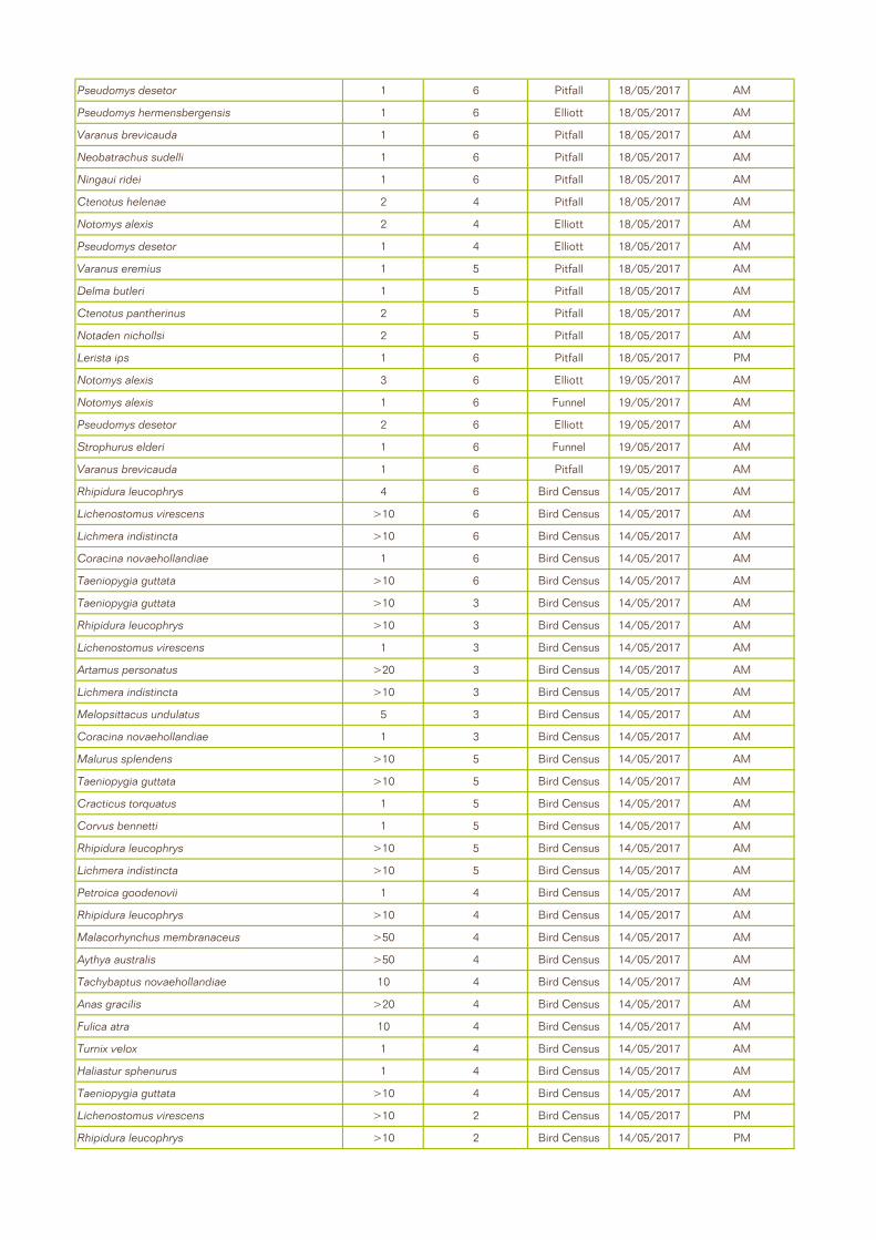
Pseudomys desetor 1 6 Pitfall 18/05/2017 AM
Pseudomys hermensbergensis 1 6 Elliott 18/05/2017 AM
Varanus brevicauda 1 6 Pitfall 18/05/2017 AM
Neobatrachus sudelli 1 6 Pitfall 18/05/2017 AM
Ningaui ridei 1 6 Pitfall 18/05/2017 AM
Ctenotus helenae 2 4 Pitfall 18/05/2017 AM
Notomys alexis 2 4 Elliott 18/05/2017 AM
Pseudomys desetor 1 4 Elliott 18/05/2017 AM
Varanus eremius 1 5 Pitfall 18/05/2017 AM
Delma butleri 1 5 Pitfall 18/05/2017 AM
Ctenotus pantherinus 2 5 Pitfall 18/05/2017 AM
Notaden nichollsi 2 5 Pitfall 18/05/2017 AM
Lerista ips 1 6 Pitfall 18/05/2017 PM
Notomys alexis 3 6 Elliott 19/05/2017 AM
Notomys alexis 1 6 Funnel 19/05/2017 AM
Pseudomys desetor 2 6 Elliott 19/05/2017 AM
Strophurus elderi 1 6 Funnel 19/05/2017 AM
Varanus brevicauda 1 6 Pitfall 19/05/2017 AM
Rhipidura leucophrys 4 6 Bird Census 14/05/2017 AM
Lichenostomus virescens >10 6 Bird Census 14/05/2017 AM
Lichmera indistincta >10 6 Bird Census 14/05/2017 AM
Coracina novaehollandiae 1 6 Bird Census 14/05/2017 AM
Taeniopygia guttata >10 6 Bird Census 14/05/2017 AM
Taeniopygia guttata >10 3 Bird Census 14/05/2017 AM
Rhipidura leucophrys >10 3 Bird Census 14/05/2017 AM
Lichenostomus virescens 1 3 Bird Census 14/05/2017 AM
Artamus personatus >20 3 Bird Census 14/05/2017 AM
Lichmera indistincta >10 3 Bird Census 14/05/2017 AM
Melopsittacus undulatus 5 3 Bird Census 14/05/2017 AM
Coracina novaehollandiae 1 3 Bird Census 14/05/2017 AM
Malurus splendens >10 5 Bird Census 14/05/2017 AM
Taeniopygia guttata >10 5 Bird Census 14/05/2017 AM
Cracticus torquatus 1 5 Bird Census 14/05/2017 AM
Corvus bennetti 1 5 Bird Census 14/05/2017 AM
Rhipidura leucophrys >10 5 Bird Census 14/05/2017 AM
Lichmera indistincta >10 5 Bird Census 14/05/2017 AM
Petroica goodenovii 1 4 Bird Census 14/05/2017 AM
Rhipidura leucophrys >10 4 Bird Census 14/05/2017 AM
Malacorhynchus membranaceus >50 4 Bird Census 14/05/2017 AM
Aythya australis >50 4 Bird Census 14/05/2017 AM
Tachybaptus novaehollandiae 10 4 Bird Census 14/05/2017 AM
Anas gracilis >20 4 Bird Census 14/05/2017 AM
Fulica atra 10 4 Bird Census 14/05/2017 AM
Turnix velox 1 4 Bird Census 14/05/2017 AM
Haliastur sphenurus 1 4 Bird Census 14/05/2017 AM
Taeniopygia guttata >10 4 Bird Census 14/05/2017 AM
Lichenostomus virescens >10 2 Bird Census 14/05/2017 PM
Rhipidura leucophrys >10 2 Bird Census 14/05/2017 PM

Petrochelidon nigricans 1 4 Bird Census 15/05/2017 PM
Phaps chalcoptera 1 4 Bird Census 15/05/2017 PM
Hirundo neoxena 2 4 Bird Census 15/05/2017 PM
Anthus novaeseelandiae 1 4 Bird Census 15/05/2017 PM
Conopophila whitei 1 3 Bird Census 15/05/2017 PM
Artamus personatus >50 1 Bird Census 15/05/2017 PM
Melopsittacus undulatus >30 1 Bird Census 15/05/2017 PM
Lichenostomus virescens >5 1 Bird Census 15/05/2017 PM
Artamus personatus >20 3 Bird Census 16/05/2017 AM
Taeniopygia guttata >10 3 Bird Census 16/05/2017 AM
Rhipidura leucophrys >5 3 Bird Census 16/05/2017 AM
Certhionyx variegatus 1 3 Bird Census 16/05/2017 AM
Lichenostomus virescens >10 5 Bird Census 16/05/2017 AM
Psophodes occidentalis 1 5 Bird Census 16/05/2017 AM
Artamus personatus >10 5 Bird Census 16/05/2017 AM
Rhipidura leucophrys >10 5 Bird Census 16/05/2017 AM
Malurus splendens 1 5 Bird Census 16/05/2017 AM
Geopelia cuneata 1 4 Bird Census 16/05/2017 AM
Ardea pacifca 1 4 Bird Census 16/05/2017 AM
Taeniopygia guttata >10 4 Bird Census 16/05/2017 AM
Lichenostomus virescens >10 4 Bird Census 16/05/2017 AM
Lichenostomus virescens >5 4 Bird Census 16/05/2017 AM
Rhipidura leucophrys 2 4 Bird Census 16/05/2017 AM
Lichenostomus virescens >10 6 Bird Census 16/05/2017 PM
Rhipidura leucophrys >10 4 Bird Census 17/05/2017 AM
Lichmera indistincta >5 4 Bird Census 17/05/2017 AM
Lichenostomus virescens >5 4 Bird Census 17/05/2017 AM
Corvus bennetti 1 5 Bird Census 17/05/2017 AM
Lichenostomus virescens 1 5 Bird Census 17/05/2017 AM
Rhipidura leucophrys 1 5 Bird Census 17/05/2017 AM
Chalcites basalis 1 5 Bird Census 17/05/2017 AM
Taeniopygia guttata >10 5 Bird Census 17/05/2017 AM
Lichenostomus virescens 1 5 Bird Census 17/05/2017 AM
Rhipidura leucophrys 1 5 Bird Census 17/05/2017 AM
Melopsittacus undulatus 3 5 Bird Census 17/05/2017 AM
Melopsittacus undulatus >25 3 Bird Census 17/05/2017 PM
Rhipidura leucophrys >5 3 Bird Census 17/05/2017 PM
Artamus personatus >50 3 Bird Census 17/05/2017 PM
Lichenostomus virescens >10 3 Bird Census 17/05/2017 PM
Lichenostomus virescens >10 1 Bird Census 17/05/2017 PM
Taeniopygia guttata >10 1 Bird Census 17/05/2017 PM
Taeniopygia guttata >10 2 Bird Census 17/05/2017 PM
Lichenostomus virescens >5 2 Bird Census 17/05/2017 PM
Chalcites basalis 1 2 Bird Census 17/05/2017 PM
Taeniopygia guttata >10 4 Bird Census 17/05/2017 PM
Rhipidura leucophrys 1 4 Bird Census 17/05/2017 PM
Lichenostomus virescens >5 4 Bird Census 17/05/2017 PM
Melopsittacus undulatus 15 4 Bird Census 18/05/2017 AM

Taeniopygia guttata 5 4 Bird Census 18/05/2017 AM
Rhipidura leucophrys 4 4 Bird Census 18/05/2017 AM
Artamus personatus 10 4 Bird Census 18/05/2017 AM
Petrochelidon nigricans 10 4 Bird Census 18/05/2017 AM
Melopsittacus undulatus >20 5 Bird Census 18/05/2017 AM
Artamus personatus >20 5 Bird Census 18/05/2017 AM
Malurus splendens 5 5 Bird Census 18/05/2017 AM
Lichenostomus virescens 2 5 Bird Census 18/05/2017 AM
Lichenostomus virescens 1 6 Bird Census 18/05/2017 PM
Taeniopygia guttata >10 6 Bird Census 18/05/2017 PM
2188 AE Fauna Survey Lake Mackay Sulphate of Potash Project
Agrimin
360 Environmental Pty Ltd
APPENDIX E
Habitat Assessments

N NE SW NW
E S W N/A
Soil Texture
Hummock Grassland
Acacia Shrubland
Scattered Plants
Sparse Moderate Thick
Riverine Woodland Overstorey
0 <5%
1 <20%
2 20-60%
3 60-100%
Other Grassland
Midstorey 3
0 <5%
1 <20%
2 20-60%
3 60-100%
Euc Woodland Ground Cover<0.5
0 <5%
1 <20%
2 20-60%
3 60-100%
Scale:
5 Pristine
4 Excellent
3 Very Good
2 Good
1 Degraded
0 Completely Degraded
0 <1 year
1 1 -3 Yr
2 4-5 Yr
3 >5 Yr
0 heavy
1 medium *
2 mild
3 none
0 heavy
1 medium
2 mild
3 none
Bare Ground
0<5%
1 <20%
2 20-60%
3 60-100%
Hummock Grass
0<5%
1<20%
2 20-60%
3 60-100%
Rock0
<5% 1
<20% 2
20-60%3
60-100%Other Grass
0 <5%
1<20%
2 20-60%
3 60-100%
Leaf Litter0
<5% 1
<20%2
20-60%3
60-100%Herbs
0 <5%
1 <20%
2 20-60%
3 60-100%
Logs >10cm
0 <5%
1<20%
2 20-60%
3 60-100%
Other: 0 <5%
1<20%
2 20-60%
3 60-100%
0 Rock
1 Stony2
Sandy Loam3 Sand Peeling Bark
0 none
1 rare
2 moderate
3 common
0 none
1 0-30%
2 30-70%
3 70-100%
Large Tree Hollows
0 none
1 rare
2 moderate
3 common
0 none
1 0-30%
2 30-70%
3 70-100%
Small Tree Hollows
0 none
1 rare
2 moderate
3 common
0 none
1 0-30%
2 30-70%
3 70-100%
Water Prescence
0 none
1 rare
2 moderate
3 common
0 none
1 0-30%
2 30-70%
3 70-100%
Distance to Water
0 >5km
1 2-5km
2 500m - 2km
3 <500m
Termite Mounds
0 none
1 rare
2 moderate
3 common
Absent Present Woody Debris0
none1
rare2
moderate3 common
YES NO
YES NO
YES NO
YES NO
Mammals ReptilesBirds
See Appendix D for species recorded at this site Dragon burrows
NO
Caves
SPECIES
Mulgara
DE
TAIL
S
Suitable habitat with sandy soil and within distribution but no signs
Bilby
Quoll
YES
Pebble Mouse
Suitable habitat with sandy soil and within distribution but no signs
Pebbles Stones
Exfoliating Slabs
Rock Crevices
Boulders
Suitability for Bats
Burrowing Suitability
VEGETATION
Veg
etat
ion
Des
crip
tion
Other:
Veg
etat
ion
Spe
cies
Ave
rage
H
eigh
t (m
)Cover
Stratum
Allocasuarina decaisneana
Acacia ligulata, Eremophila latrobei, Melaleuca glomerata
Triodia sp.
CONDITION LAST FIRE
General DISTURBANCE Cattle
GROUND COVER
MICROHABITATS
(Red) sand sandy-loam loam cracking clay clay
FAUNA HABITAT ASSESSMENT SHEET - 360 ENVIRONMENTAL
(North West)Location: Lake Mackay (Island 1) Habitat Assessment: 1 Trap Site 1
Project: 2188
Date: 14/05/2017 Easting: 04581698Aspect
Quadrat Size: 100 x 100 Northing: 7525386

N NE SW NW
E S W N/A
Soil Texture
Hummock Grassland
Acacia Shrubland
Scattered Plants
Sparse Moderate Thick
Riverine Woodland Overstorey
0 <5%
1 <20%
2 20-60%
3 60-100%
Other Grassland
Midstorey 2
0 <5%
1 <20%
2 20-60%
3 60-100%
Euc Woodland Ground Cover0.5
0 <5%
1 <20%
2 20-60%
3 60-100%
Scale:
5 Pristine
4 Excellent
3 Very Good
2 Good
1 Degraded
0 Completely Degraded
0 <1 year
1 1 -3 Yr
2 4-5 Yr
3 >5 Yr
0 heavy
1 medium *
2 mild
3 none
0 heavy
1 medium
2 mild
3 none
Bare Ground
0<5%
1 <20%
2 20-60%
3 60-100%
Hummock Grass
0<5%
1<20%
2 20-60%
3 60-100%
Rock0
<5% 1
<20% 2
20-60%3
60-100%Other Grass
0 <5%
1<20%
2 20-60%
3 60-100%
Leaf Litter0
<5% 1
<20%2
20-60%3
60-100%Herbs
0 <5%
1 <20%
2 20-60%
3 60-100%
Logs >10cm
0 <5%
1<20%
2 20-60%
3 60-100%
Other: 0 <5%
1<20%
2 20-60%
3 60-100%
0 Rock
1 Stony2
Sandy Loam3 Sand Peeling Bark
0 none
1 rare
2 moderate
3 common
0 none
1 0-30%
2 30-70%
3 70-100%
Large Tree Hollows
0 none
1 rare
2 moderate
3 common
0 none
1 0-30%
2 30-70%
3 70-100%
Small Tree Hollows
0 none
1 rare
2 moderate
3 common
0 none
1 0-30%
2 30-70%
3 70-100%
Water Prescence
0 none
1 rare
2 moderate
3 common
0 none
1 0-30%
2 30-70%
3 70-100%
Distance to Water
0 >5km
1 2-5km
2 500m - 2km
3 <500m
Termite Mounds
0 none
1 rare
2 moderate
3 common
Absent Present Woody Debris0
none1
rare2
moderate3 common
YES NO
YES NO
YES NO
YES NO
Mammals Reptiles
Date: 15/05/2017 Easting: 481698Aspect
Quadrat Size: 100 x 100 Northing: 7519278
FAUNA HABITAT ASSESSMENT SHEET - 360 ENVIRONMENTAL
(North West)Location: Lake Mackay (Island 2) Habitat Assessment: 2 Trap Site 2
Project: 2188
sand sandy-loam loam cracking clay clay
Burrowing Suitability
VEGETATION
Veg
etat
ion
Des
crip
tion
Other: Sand dune
Veg
etat
ion
Spe
cies
Ave
rage
H
eigh
t (m
) Cover
Stratum
Acacia ligulata, Eremophila latrobei, Melaleuca glomerata
Triodia sp.
CONDITION LAST FIRE
General DISTURBANCE Cattle
GROUND COVER
MICROHABITATS
Pebbles Stones
Exfoliating Slabs
Rock Crevices
Boulders
Suitability for Bats NO
Caves
SPECIES
Mulgara
DET
AIL
S
Suitable habitat with sandy soil and within distribution but no signs
Bilby Suitable habitat with sandy soil and within distribution but no signs
Quoll
YES
Pebble Mouse
Birds
See Appendix D for species recorded at this site

N NE SW NW
E S W N/A
Soil Texture
Hummock Grassland
Acacia Shrubland
Scattered Plants
Sparse Moderate Thick
Riverine Woodland Overstorey
0 <5%
1 <20%
2 20-60%
3 60-100%
Other Grassland Midstorey 2
0 <5%
1 <20%
2 20-60%
3 60-100%
Euc Woodland Ground Cover0.5
0 <5%
1 <20%
2 20-60%
3 60-100%
Scale:
5 Pristine
4 Excellent
3 Very Good
2 Good
1 Degraded
0 Completely Degraded
0 <1 year
1 1 -3 Yr
2 4-5 Yr
3 >5 Yr
0 heavy
1 medium *
2 mild
3 none
0 heavy
1 medium
2 mild
3 none
Bare Ground
0<5%
1 <20%
2 20-60%
3 60-100%
Hummock Grass
0<5%
1<20%
2 20-60%
3 60-100%
Rock0
<5% 1
<20% 2
20-60%3
60-100%Other Grass
0 <5%
1<20%
2 20-60%
3 60-100%
Leaf Litter0
<5% 1
<20%2
20-60%3
60-100%Herbs
0 <5%
1 <20%
2 20-60%
3 60-100%
Logs >10cm
0 <5%
1<20%
2 20-60%
3 60-100%
Other: 0 <5%
1<20%
2 20-60%
3 60-100%
0 Rock
1 Stony2
Sandy Loam3 Sand Peeling Bark
0 none
1 rare
2 moderate
3 common
0 none
1 0-30%
2 30-70%
3 70-100%
Large Tree Hollows
0 none
1 rare
2 moderate
3 common
0 none
1 0-30%
2 30-70%
3 70-100%
Small Tree Hollows
0 none
1 rare
2 moderate
3 common
0 none
1 0-30%
2 30-70%
3 70-100%
Water Prescence
0 none
1 rare
2 moderate
3 common
0 none
1 0-30%
2 30-70%
3 70-100%
Distance to Water
0 >5km
1 2-5km
2 500m - 2km
3 <500m
Termite Mounds
0 none
1 rare
2 moderate
3 common
Absent Present Woody Debris0
none1
rare2
moderate3 common
YES NO
YES NO
YES NO
YES NO
Mammals Reptiles
Date: 15/05/2017 Easting: 464156Aspect
Quadrat Size: 100 x 100 Northing: 7493512
FAUNA HABITAT ASSESSMENT SHEET - 360 ENVIRONMENTAL
(North West)Location: Lake Mackay (proposed eastern infrastructure area) Habitat Assessment: 3 Trap Site 3
Project: 2188
sand sandy-loam loam cracking clay clay
Burrowing Suitability
VEGETATION
Veg
etat
ion
Des
crip
tion
Other: Sand dune and adjacent to claypan
Veg
etat
ion
Spe
cies
Ave
rage
H
eigh
t (m
) Cover
Stratum
Acacia sp.
Triodia sp, Eragrostis sp., and Eriachne sp.
CONDITION LAST FIRE
General DISTURBANCE Cattle
GROUND COVER
MICROHABITATS
Pebbles Stones
Exfoliating Slabs
Rock Crevices
Boulders
Suitability for Bats NO
Caves
SPECIES
Mulgara
DE
TAIL
S
Suitable habitat with sandy soil and within distribution but no signs
Bilby Suitable habitat with sandy soil and within distribution but no signs
Quoll
YES
Pebble Mouse
Birds
See Appendix D for species recorded at this site

N NE SW NW
E S W N/A
Soil Texture
Hummock Grassland
Acacia Shrubland
Scattered Plants
Sparse Moderate Thick
Riverine Woodland Overstorey
0 <5%
1 <20%
2 20-60%
3 60-100%
Other Grassland Midstorey 2
0 <5%
1 <20%
2 20-60%
3 60-100%
Euc Woodland Ground Cover
<0.5
0 <5%
1 <20%
2 20-60%
3 60-100%
Scale:
5 Pristine
4 Excellent
3 Very Good
2 Good
1 Degraded
0 Completely Degraded
0 <1 year
1 1 -3 Yr
2 4-5 Yr
3 >5 Yr
0 heavy
1 medium *
2 mild
3 none
0 heavy
1 medium
2 mild
3 none
Bare Ground
0<5%
1 <20%
2 20-60%
3 60-100%
Hummock Grass
0<5%
1<20%
2 20-60%
3 60-100%
Rock0
<5% 1
<20% 2
20-60%3
60-100%Other Grass
0 <5%
1<20%
2 20-60%
3 60-100%
Leaf Litter0
<5% 1
<20%2
20-60%3
60-100%Herbs
0 <5%
1 <20%
2 20-60%
3 60-100%
Logs >10cm
0 <5%
1<20%
2 20-60%
3 60-100%
Other: (sedges)
0 <5%
1<20%
2 20-60%
3 60-100%
0 Rock
1 Stony2
Sandy Loam3 Sand Peeling Bark
0 none
1 rare
2 moderate
3 common
0 none
1 0-30%
2 30-70%
3 70-100%
Large Tree Hollows
0 none
1 rare
2 moderate
3 common
0 none
1 0-30%
2 30-70%
3 70-100%
Small Tree Hollows
0 none
1 rare
2 moderate
3 common
0 none
1 0-30%
2 30-70%
3 70-100%
Water Prescence
0 none
1 rare
2 moderate
3 common
0 none
1 0-30%
2 30-70%
3 70-100%
Distance to Water
0 >5km
1 2-5km
2 500m - 2km
3 <500m
Termite Mounds
0 none
1 rare
2 moderate
3 common
Absent Present Woody Debris0
none1
rare2
moderate3 common
YES NO
YES NO
YES NO
YES NO
Mammals Reptiles
Date: 15/05/2017 Easting: 477761Aspect
Quadrat Size: 100 x 100 Northing: 7487342
FAUNA HABITAT ASSESSMENT SHEET - 360 ENVIRONMENTAL
(North West)Location: Lake Mackay Habitat Assessment: 4 Trap Site 4
Project: 2188
sand sandy-loam loam cracking clay clay
Burrowing Suitability
VEGETATION
Veg
etat
ion
Des
crip
tion
Other: Claypan
Veg
etat
ion
Spe
cies
Ave
rage
H
eigh
t (m
) Cover
Stratum
Melaleuca glomerataMixed grasses including Triodia sp., herbs and sedges including Cyperus sp.
CONDITION LAST FIRE
General DISTURBANCE Cattle
GROUND COVER
MICROHABITATS
Pebbles Stones
Exfoliating Slabs
Rock Crevices
Boulders
Suitability for Bats NO
Caves
SPECIES
Mulgara
DE
TAIL
S
Suitable habitat with sandy soil and within distribution but no signs
Bilby Suitable habitat with sandy soil and within distribution but no signs
Quoll
YES
Pebble Mouse
Birds
See Appendix D for species recorded at this site

N NE SW NW
E S W N/A
Soil Texture
Hummock Grassland
Acacia Shrubland
Scattered Plants
Sparse Moderate Thick
Riverine Woodland Overstorey 4
0 <5%
1 <20%
2 20-60%
3 60-100%
Other Grassland Midstorey 1.5
0 <5%
1 <20%
2 20-60%
3 60-100%
Euc Woodland Ground Cover0.5
0 <5%
1 <20%
2 20-60%
3 60-100%
Scale:
5 Pristine
4 Excellent
3 Very Good
2 Good
1 Degraded
0 Completely Degraded
0 <1 year
1 1 -3 Yr
2 4-5 Yr
3 >5 Yr
0 heavy
1 medium *
2 mild
3 none
0 heavy
1 medium
2 mild
3 none
Bare Ground
0<5%
1 <20%
2 20-60%
3 60-100%
Hummock Grass
0<5%
1<20%
2 20-60%
3 60-100%
Rock0
<5% 1
<20% 2
20-60%3
60-100%Other Grass
0 <5%
1<20%
2 20-60%
3 60-100%
Leaf Litter0
<5% 1
<20%2
20-60%3
60-100%Herbs
0 <5%
1 <20%
2 20-60%
3 60-100%
Logs >10cm
0 <5%
1<20%
2 20-60%
3 60-100%
Other: 0 <5%
1<20%
2 20-60%
3 60-100%
0 Rock
1 Stony2
Sandy Loam3 Sand Peeling Bark
0 none
1 rare
2 moderate
3 common
0 none
1 0-30%
2 30-70%
3 70-100%
Large Tree Hollows
0 none
1 rare
2 moderate
3 common
0 none
1 0-30%
2 30-70%
3 70-100%
Small Tree Hollows
0 none
1 rare
2 moderate
3 common
0 none
1 0-30%
2 30-70%
3 70-100%
Water Prescence
0 none
1 rare
2 moderate
3 common
0 none
1 0-30%
2 30-70%
3 70-100%
Distance to Water
0 >5km
1 2-5km
2 500m - 2km
3 <500m
Termite Mounds
0 none
1 rare
2 moderate
3 common
Absent Present Woody Debris0
none1
rare2
moderate3 common
YES NO
YES NO
YES NO
YES NO
Mammals Reptiles
Date: 15/05/2017 Easting: 464656Aspect
Quadrat Size: 100 x 100 Northing: 7491479
sand sandy-loam loam cracking clay clay
Burrowing Suitability
VEGETATION
FAUNA HABITAT ASSESSMENT SHEET - 360 ENVIRONMENTAL
(North West)Location: Lake Mackay (proposed eastern infrastructure area) Habitat Assessment: 5 trap Site 5
Project: 2188
Veg
etat
ion
Des
crip
tion
Other: Sand dune and swale
Veg
etat
ion
Spe
cies
Ave
rage
H
eigh
t (m
) Cover
Stratum
Corymbia chippendaleia and Eucalyptus gammophylla
Acacia sp.
Triodia sp.Aristida sp. and mixed herbs
CONDITION LAST FIRE
General DISTURBANCE Cattle
GROUND COVER
MICROHABITATS
Pebbles Stones
Exfoliating Slabs
Rock Crevices
Boulders
Suitability for Bats NO
Caves
SPECIES
Mulgara
DE
TAIL
S
Suitable habitat with sandy soil and within distribution but no signs
Bilby Suitable habitat with sandy soil and within distribution but no signs
Quoll
YES
Pebble Mouse
Birds
See Appendix D for species recorded at this site

N NE SW NW
E S W N/A
Soil Texture
Hummock Grassland
Acacia Shrubland
Scattered Plants
Sparse Moderate Thick
Riverine Woodland Overstorey
0 <5%
1 <20%
2 20-60%
3 60-100%
Other Grassland
Midstorey 2
0 <5%
1 <20%
2 20-60%
3 60-100%
Euc Woodland Ground Cover0.5
0 <5%
1 <20%
2 20-60%
3 60-100%
Scale:
5 Pristine
4 Excellent
3 Very Good
2 Good
1 Degraded
0 Completely Degraded
0 <1 year
1 1 -3 Yr
2 4-5 Yr
3 >5 Yr
0 heavy
1 medium *
2 mild
3 none
0 heavy
1 medium
2 mild
3 none
Bare Ground
0<5%
1 <20%
2 20-60%
3 60-100%
Hummock Grass
0<5%
1<20%
2 20-60%
3 60-100%
Rock0
<5% 1
<20% 2
20-60%3
60-100%Other Grass
0 <5%
1<20%
2 20-60%
3 60-100%
Leaf Litter0
<5% 1
<20%2
20-60%3
60-100%Herbs
0 <5%
1 <20%
2 20-60%
3 60-100%
Logs >10cm
0 <5%
1<20%
2 20-60%
3 60-100%
Other: 0 <5%
1<20%
2 20-60%
3 60-100%
0 Rock
1 Stony2
Sandy Loam3 Sand Peeling Bark
0 none
1 rare
2 moderate
3 common
0 none
1 0-30%
2 30-70%
3 70-100%
Large Tree Hollows
0 none
1 rare
2 moderate
3 common
0 none
1 0-30%
2 30-70%
3 70-100%
Small Tree Hollows
0 none
1 rare
2 moderate
3 common
0 none
1 0-30%
2 30-70%
3 70-100%
Water Prescence
0 none
1 rare
2 moderate
3 common
0 none
1 0-30%
2 30-70%
3 70-100%
Distance to Water
0 >5km
1 2-5km
2 500m - 2km
3 <500m
Termite Mounds
0 none
1 rare
2 moderate
3 common
Absent Present Woody Debris0
none1
rare2
moderate3 common
YES NO
YES NO
YES NO
YES NO
Mammals Reptiles
Date: 15/05/2017 Easting: 442302Aspect
Quadrat Size: 100 x 100 Northing: 7499967
sand sandy-loam loam cracking clay clay
Burrowing Suitability
VEGETATION
FAUNA HABITAT ASSESSMENT SHEET - 360 ENVIRONMENTAL
(North West)Location: Lake Mackay (proposed western infrastructure area) Habitat Assessment: 6 Trap Site 6
Project: 2188V
eget
atio
n D
escr
ipti
on
Other: Sand dune and swale
Veg
etat
ion
Spe
cies
Ave
rage
H
eigh
t (m
) Cover
Stratum
Acacia sp., Eucalyptus gammophylla, Eremophila sp.
Triodia sp.
CONDITION LAST FIRE
General DISTURBANCE Cattle
GROUND COVER
MICROHABITATS
Pebbles Stones
Exfoliating Slabs
Rock Crevices
Boulders
Suitability for Bats NO
Caves
SPECIES
Mulgara
DE
TAIL
S
Suitable habitat with sandy soil and within distribution but no signs
Bilby Suitable habitat with sandy soil and within distribution but no signs
Quoll
YES
Pebble Mouse
Birds
See Appendix D for species recorded at this site

N NE SW NW
E S W N/A
Soil Texture
Hummock Grassland
Acacia Shrubland
Scattered Plants
Sparse Moderate Thick
Riverine Woodland Overstorey
0 <5%
1 <20%
2 20-60%
3 60-100%
Other Grassland Midstorey 2
0 <5%
1 <20%
2 20-60%
3 60-100%
Euc Woodland Ground Cover0.5
0 <5%
1 <20%
2 20-60%
3 60-100%
Scale:
5 Pristine
4 Excellent
3 Very Good
2 Good
1 Degraded
0 Completely Degraded
0 <1 year
1 1 -3 Yr
2 4-5 Yr
3 >5 Yr
0 heavy
1 medium *
2 mild
3 none
0 heavy
1 medium
2 mild
3 none
Bare Ground
0<5%
1 <20%
2 20-60%
3 60-100%
Hummock Grass
0<5%
1<20%
2 20-60%
3 60-100%
Rock0
<5% 1
<20% 2
20-60%3
60-100%Other Grass
0 <5%
1<20%
2 20-60%
3 60-100%
Leaf Litter0
<5% 1
<20%2
20-60%3
60-100%Herbs
0 <5%
1 <20%
2 20-60%
3 60-100%
Logs >10cm
0 <5%
1<20%
2 20-60%
3 60-100%
Other: 0 <5%
1<20%
2 20-60%
3 60-100%
0 Rock
1 Stony2
Sandy Loam3 Sand Peeling Bark
0 none
1 rare
2 moderate
3 common
0 none
1 0-30%
2 30-70%
3 70-100%
Large Tree Hollows
0 none
1 rare
2 moderate
3 common
0 none
1 0-30%
2 30-70%
3 70-100%
Small Tree Hollows
0 none
1 rare
2 moderate
3 common
0 none
1 0-30%
2 30-70%
3 70-100%
Water Prescence
0 none
1 rare
2 moderate
3 common
0 none
1 0-30%
2 30-70%
3 70-100%
Distance to Water
0 >5km
1 2-5km
2 500m - 2km
3 <500m
Termite Mounds
0 none
1 rare
2 moderate
3 common
Absent Present Woody Debris0
none1
rare2
moderate3 common
YES NO
YES NO
YES NO
YES NO
Mammals Reptiles
Date: 14/05/2017 Easting: 0481524Aspect
Quadrat Size: 100 x 100 Northing: 7525082
FAUNA HABITAT ASSESSMENT SHEET - 360 ENVIRONMENTAL
(North West)Location: Lake Mackay Habitat Assessment: 7 (Island 1)
Project: 2188
sand sandy-loam loam cracking clay clay
Burrowing Suitability
VEGETATION
Veg
etat
ion
Des
crip
tion
Other: Dune Crest
Veg
etat
ion
Spe
cies
Ave
rage
H
eigh
t (m
) Cover
Stratum
Acacia sp., Grevillea sp.
Triodia sp.
CONDITION LAST FIRE
General DISTURBANCE Cattle
GROUND COVER
MICROHABITATS
Pebbles Stones
Exfoliating Slabs
Rock Crevices
Boulders
Suitability for Bats NO
Caves
SPECIES
Mulgara
DE
TAIL
S
Suitable habitat with sandy soil and within distribution but no signs
Bilby Suitable habitat with sandy soil and within distribution but no signs
Quoll
YES
Singing Honeyeater
Pebble Mouse
Birds
White-plumed Honeyeater

N NE SW NW
E S W N/A
Soil Texture
Hummock Grassland
Acacia Shrubland
Scattered Plants
Sparse Moderate Thick
Riverine Woodland Overstorey 2
0 <5%
1 <20%
2 20-60%
3 60-100%
Other Grassland Midstorey
0 <5%
1 <20%
2 20-60%
3 60-100%
Euc Woodland Ground Cover0.5
0 <5%
1 <20%
2 20-60%
3 60-100%
Scale:
5 Pristine
4 Excellent
3 Very Good
2 Good
1 Degraded
0 Completely Degraded
0 <1 year
1 1 -3 Yr
2 4-5 Yr
3 >5 Yr
0 heavy
1 medium *
2 mild
3 none
0 heavy
1 medium
2 mild
3 none
Bare Ground
0<5%
1 <20%
2 20-60%
3 60-100%
Hummock Grass
0<5%
1<20%
2 20-60%
3 60-100%
Rock0
<5% 1
<20% 2
20-60%3
60-100%Other Grass
0 <5%
1<20%
2 20-60%
3 60-100%
Leaf Litter0
<5% 1
<20%2
20-60%3
60-100%Herbs
0 <5%
1 <20%
2 20-60%
3 60-100%
Logs >10cm
0 <5%
1<20%
2 20-60%
3 60-100%
Other: 0 <5%
1<20%
2 20-60%
3 60-100%
0 Rock
1 Stony2
Sandy Loam3 Sand Peeling Bark
0 none
1 rare
2 moderate
3 common
0 none
1 0-30%
2 30-70%
3 70-100%
Large Tree Hollows
0 none
1 rare
2 moderate
3 common
0 none
1 0-30%
2 30-70%
3 70-100%
Small Tree Hollows
0 none
1 rare
2 moderate
3 common
0 none
1 0-30%
2 30-70%
3 70-100%
Water Prescence
0 none
1 rare
2 moderate
3 common
0 none
1 0-30%
2 30-70%
3 70-100%
Distance to Water
0 >5km
1 2-5km
2 500m - 2km
3 <500m
Termite Mounds
0 none
1 rare
2 moderate
3 common
Absent Present Woody Debris0
none1
rare2
moderate3 common
YES NO
YES NO
YES NO
YES NO
Mammals Reptiles
Date: 14/05/2017 Easting: 442450Aspect
Quadrat Size: 100 x 100 Northing: 7500115
FAUNA HABITAT ASSESSMENT SHEET - 360 ENVIRONMENTAL
(North West)Location: Lake Mackay Habitat Assessment: 8 (site 6 to lake)
Project: 2188
sand sandy-loam loam cracking clay clay
Burrowing Suitability
VEGETATION
Veg
etat
ion
Des
crip
tion
Other: Dune Crest
Veg
etat
ion
Spe
cies
Ave
rage
H
eigh
t (m
) Cover
Stratum
Acacia sp.
Triodia sp.
CONDITION LAST FIRE
General DISTURBANCE Cattle
GROUND COVER
MICROHABITATS
Pebbles Stones
Exfoliating Slabs
Rock Crevices
Boulders
Suitability for Bats NO
Caves
SPECIES
Mulgara
DE
TAIL
S
Suitable habitat with sandy soil and within distribution but no signs
Bilby Suitable habitat with sandy soil and within distribution but no signs
Quoll
YES
Pebble Mouse
Birds

N NE SW NW
E S W N/A
Soil Texture
Hummock Grassland
Acacia Shrubland
Scattered Plants
Sparse Moderate Thick
Riverine Woodland Overstorey
0 <5%
1 <20%
2 20-60%
3 60-100%
Other Grassland Midstorey
0 <5%
1 <20%
2 20-60%
3 60-100%
Euc Woodland Ground Cover0.5
0 <5%
1 <20%
2 20-60%
3 60-100%
Scale:
5 Pristine
4 Excellent
3 Very Good
2 Good
1 Degraded
0 Completely Degraded
0 <1 year
1 1 -3 Yr
2 4-5 Yr
3 >5 Yr
0 heavy
1 medium *
2 mild
3 none
0 heavy
1 medium
2 mild
3 none
Bare Ground
0<5%
1 <20%
2 20-60%
3 60-100%
Hummock Grass
0<5%
1<20%
2 20-60%
3 60-100%
Rock0
<5% 1
<20% 2
20-60%3
60-100%Other Grass
0 <5%
1<20%
2 20-60%
3 60-100%
Leaf Litter0
<5% 1
<20%2
20-60%3
60-100%Herbs
0 <5%
1 <20%
2 20-60%
3 60-100%
Logs >10cm
0 <5%
1<20%
2 20-60%
3 60-100%
Other: 0 <5%
1<20%
2 20-60%
3 60-100%
0 Rock
1 Stony2
Sandy Loam3 Sand Peeling Bark
0 none
1 rare
2 moderate
3 common
0 none
1 0-30%
2 30-70%
3 70-100%
Large Tree Hollows
0 none
1 rare
2 moderate
3 common
0 none
1 0-30%
2 30-70%
3 70-100%
Small Tree Hollows
0 none
1 rare
2 moderate
3 common
0 none
1 0-30%
2 30-70%
3 70-100%
Water Prescence
0 none
1 rare
2 moderate
3 common
0 none
1 0-30%
2 30-70%
3 70-100%
Distance to Water
0 >5km
1 2-5km
2 500m - 2km
3 <500m
Termite Mounds
0 none
1 rare
2 moderate
3 common
Absent Present Woody Debris0
none1
rare2
moderate3 common
YES NO
YES NO
YES NO
YES NO
Mammals Reptiles
Date: 14/05/2017 Easting: 442364Aspect
Quadrat Size: 100 x 100 Northing: 7500332
FAUNA HABITAT ASSESSMENT SHEET - 360 ENVIRONMENTAL
(North West)Location: Lake Mackay Habitat Assessment: 9 (site 6 to lake)
Project: 2188
sand sandy-loam loam cracking clay clay
Burrowing Suitability
VEGETATION
Veg
etat
ion
Des
crip
tion
Other: Lake Margin
Veg
etat
ion
Spe
cies
Ave
rage
H
eigh
t (m
) Cover
Stratum
Triodia sp., Aristida sp., Eragrostis sp., Tecticornia sp.
CONDITION LAST FIRE
General DISTURBANCE Cattle
GROUND COVER
MICROHABITATS
Pebbles Stones
Exfoliating Slabs
Rock Crevices
Boulders
Suitability for Bats NO
Caves
SPECIES
Mulgara
DE
TAIL
S
Suitable habitat with sandy soil and within distribution but no signs
Bilby Suitable habitat with sandy soil and within distribution but no signs
Quoll
YES
Singing Honeyeater
Pebble Mouse
Birds
White Plumed Honeyeater

N NE SW NW
E S W N/A
Soil Texture
Hummock Grassland
Acacia Shrubland
Scattered Plants
Sparse Moderate Thick
Riverine Woodland Overstorey
0 <5%
1 <20%
2 20-60%
3 60-100%
Other Grassland Midstorey 1.5
0 <5%
1 <20%
2 20-60%
3 60-100%
Euc Woodland Ground Cover0.5
0 <5%
1 <20%
2 20-60%
3 60-100%
Scale:
5 Pristine
4 Excellent
3 Very Good
2 Good
1 Degraded
0 Completely Degraded
0 <1 year
1 1 -3 Yr
2 4-5 Yr
3 >5 Yr
0 heavy
1 medium *
2 mild
3 none
0 heavy
1 medium
2 mild
3 none
Bare Ground
0<5%
1 <20%
2 20-60%
3 60-100%
Hummock Grass
0<5%
1<20%
2 20-60%
3 60-100%
Rock0
<5% 1
<20% 2
20-60%3
60-100%Other Grass
0 <5%
1<20%
2 20-60%
3 60-100%
Leaf Litter0
<5% 1
<20%2
20-60%3
60-100%Herbs
0 <5%
1 <20%
2 20-60%
3 60-100%
Logs >10cm
0 <5%
1<20%
2 20-60%
3 60-100%
Other: 0 <5%
1<20%
2 20-60%
3 60-100%
0 Rock
1 Stony2
Sandy Loam3 Sand Peeling Bark
0 none
1 rare
2 moderate
3 common
0 none
1 0-30%
2 30-70%
3 70-100%
Large Tree Hollows
0 none
1 rare
2 moderate
3 common
0 none
1 0-30%
2 30-70%
3 70-100%
Small Tree Hollows
0 none
1 rare
2 moderate
3 common
0 none
1 0-30%
2 30-70%
3 70-100%
Water Prescence
0 none
1 rare
2 moderate
3 common
0 none
1 0-30%
2 30-70%
3 70-100%
Distance to Water
0 >5km
1 2-5km
2 500m - 2km
3 <500m
Termite Mounds
0 none
1 rare
2 moderate
3 common
Absent Present Woody Debris0
none1
rare2
moderate3 common
YES NO
YES NO
YES NO
YES NO
Mammals Reptiles
Date: 15/05/2017 Easting: 0484133Aspect
Quadrat Size: 100 x 100 Northing: 7506796
FAUNA HABITAT ASSESSMENT SHEET - 360 ENVIRONMENTAL
(North West)Location: Lake Mackay Habitat Assessment: 10 (Island 3)
Project: 2188
sand sandy-loam loam cracking clay clay
Burrowing Suitability
VEGETATION
Veg
etat
ion
Des
crip
tion
Other: Dune Swale
Veg
etat
ion
Spe
cies
Ave
rage
H
eigh
t (m
) Cover
Stratum
Acacia sp., Eremophila sp.
Aristida sp., Eragrostis sp.
CONDITION LAST FIRE
General DISTURBANCE Cattle
GROUND COVER
MICROHABITATS
Pebbles Stones
Exfoliating Slabs
Rock Crevices
Boulders
Suitability for Bats NO
Caves
SPECIES
Mulgara
DE
TAIL
S
Suitable habitat with sandy soil and within distribution but no signs
Bilby Suitable habitat with sandy soil and within distribution but no signs
Quoll
YES
Singing Honeyeater
Pebble Mouse
Birds
Willie Wagtail
Masked Wood Swallow

N NE SW NW
E S W N/A
Soil Texture
Hummock Grassland
Acacia Shrubland
Scattered Plants
Sparse Moderate Thick
Riverine Woodland Overstorey
0 <5%
1 <20%
2 20-60%
3 60-100%
Grassland Midstorey0
<5% 1
<20% 2
20-60%3
60-100%
Euc Woodland Ground Cover0.3
0 <5%
1 <20%
2 20-60%
3 60-100%
Scale:
5 Pristine
4 Excellent
3 Very Good
2 Good
1 Degraded
0 Completely Degraded
0 <1 year
1 1 -3 Yr
2 4-5 Yr
3 >5 Yr
0 heavy
1 medium *
2 mild
3 none
0 heavy
1 medium
2 mild
3 none
Bare Ground
0<5%
1 <20%
2 20-60%
3 60-100%
Hummock Grass
0<5%
1<20%
2 20-60%
3 60-100%
Rock0
<5% 1
<20% 2
20-60%3
60-100%Other Grass
0 <5%
1<20%
2 20-60%
3 60-100%
Leaf Litter0
<5% 1
<20%2
20-60%3
60-100%Herbs
0 <5%
1 <20%
2 20-60%
3 60-100%
Logs >10cm
0 <5%
1<20%
2 20-60%
3 60-100%
Other: 0 <5%
1<20%
2 20-60%
3 60-100%
0 Rock
1 Stony2
Sandy Loam3 Sand Peeling Bark
0 none
1 rare
2 moderate
3 common
0 none
1 0-30%
2 30-70%
3 70-100%
Large Tree Hollows
0 none
1 rare
2 moderate
3 common
0 none
1 0-30%
2 30-70%
3 70-100%
Small Tree Hollows
0 none
1 rare
2 moderate
3 common
0 none
1 0-30%
2 30-70%
3 70-100%
Water Prescence
0 none
1 rare
2 moderate
3 common
0 none
1 0-30%
2 30-70%
3 70-100%
Distance to Water
0 >5km
1 2-5km
2 500m - 2km
3 <500m
Termite Mounds
0 none
1 rare
2 moderate
3 common
Absent Present Woody Debris0
none1
rare2
moderate3 common
YES NO
YES NO
YES NO
YES NO
Mammals Reptiles
Date: 15/05/2017 Easting: 0484286Aspect
Quadrat Size: 100 x 100 Northing: 7506734
FAUNA HABITAT ASSESSMENT SHEET - 360 ENVIRONMENTAL
(North West)Location: Lake Mackay Habitat Assessment: 11 (Island 3)
Project: 2188
sand sandy-loam loam cracking clay clay
Burrowing Suitability
VEGETATION
Veg
etat
ion
Des
crip
tion
Other: Lake Margin
Veg
etat
ion
Spe
cies
Ave
rage
H
eigh
t (m
) Cover
Stratum
Aristida sp., Eragrostis sp., Swainsonasp.
CONDITION LAST FIRE
General DISTURBANCE Cattle
GROUND COVER
MICROHABITATS
Pebbles Stones
Exfoliating Slabs
Rock Crevices
Boulders
Suitability for Bats NO
Caves
SPECIES
Mulgara
DE
TAIL
S
Suitable habitat with sandy soil and within distribution but no signs
Bilby Suitable habitat with sandy soil and within distribution but no signs
Quoll
YES
Splendid Fairy Wren Lerista tracks?
Pebble Mouse
Birds
Willie Wagtail Rabbit Scats No reptile burrows

N NE SW NW
E S W N/A
Soil Texture
Hummock Grassland
Acacia Shrubland
Scattered Plants
Sparse Moderate Thick
Riverine Woodland Overstorey
0 <5%
1 <20%
2 20-60%
3 60-100%
Other Grassland Midstorey 2
0 <5%
1 <20%
2 20-60%
3 60-100%
Euc Woodland Ground Cover0.5
0 <5%
1 <20%
2 20-60%
3 60-100%
Scale:
5 Pristine
4 Excellent
3 Very Good
2 Good
1 Degraded
0 Completely Degraded
0 <1 year
1 1 -3 Yr
2 4-5 Yr
3 >5 Yr
0 heavy
1 medium *
2 mild
3 none
0 heavy
1 medium
2 mild
3 none
Bare Ground
0<5%
1 <20%
2 20-60%
3 60-100%
Hummock Grass
0<5%
1<20%
2 20-60%
3 60-100%
Rock0
<5% 1
<20% 2
20-60%3
60-100%Other Grass
0 <5%
1<20%
2 20-60%
3 60-100%
Leaf Litter0
<5% 1
<20%2
20-60%3
60-100%Herbs
0 <5%
1 <20%
2 20-60%
3 60-100%
Logs >10cm
0 <5%
1<20%
2 20-60%
3 60-100%
Other: 0 <5%
1<20%
2 20-60%
3 60-100%
0 Rock
1 Stony2
Sandy Loam3 Sand Peeling Bark
0 none
1 rare
2 moderate
3 common
0 none
1 0-30%
2 30-70%
3 70-100%
Large Tree Hollows
0 none
1 rare
2 moderate
3 common
0 none
1 0-30%
2 30-70%
3 70-100%
Small Tree Hollows
0 none
1 rare
2 moderate
3 common
0 none
1 0-30%
2 30-70%
3 70-100%
Water Prescence
0 none
1 rare
2 moderate
3 common
0 none
1 0-30%
2 30-70%
3 70-100%
Distance to Water
0 >5km
1 2-5km
2 500m - 2km
3 <500m
Termite Mounds
0 none
1 rare
2 moderate
3 common
Absent Present Woody Debris0
none1
rare2
moderate3 common
YES NO
YES NO
YES NO
YES NO
Mammals Reptiles
Date: 16/05/2017 Easting: 0451020Aspect
Quadrat Size: 100 x 100 Northing: 7502283
FAUNA HABITAT ASSESSMENT SHEET - 360 ENVIRONMENTAL
(North West)Location: Lake Mackay Habitat Assessment: 12 (Island 4)
Project: 2188
sand sandy-loam loam cracking clay clay
Burrowing Suitability
VEGETATION
Veg
etat
ion
Des
crip
tion
Other: Swale
Veg
etat
ion
Spe
cies
Ave
rage
H
eigh
t (m
) Cover
Stratum
Melaleuca sp.
Triodia sp., Aristida sp.
CONDITION LAST FIRE
General DISTURBANCE Cattle
GROUND COVER
MICROHABITATS
Pebbles Stones
Exfoliating Slabs
Rock Crevices
Boulders
Suitability for Bats NO
Caves
SPECIES
Mulgara
DE
TAIL
S
Suitable habitat with sandy soil and within distribution but no signs (island probabl
Bilby Suitable habitat with sandy soil and within distribution but no signs
Quoll
YES
Pebble Mouse
Birds
Zebra Finch Rabbit scats Agamid (dragon) burrows
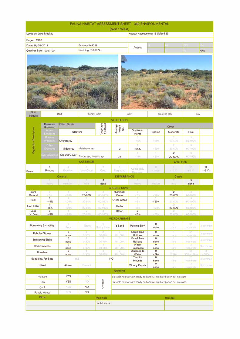
N NE SW NW
E S W N/A
Soil Texture
Hummock Grassland
Acacia Shrubland
Scattered Plants
Sparse Moderate Thick
Riverine Woodland Overstorey
0 <5%
1 <20%
2 20-60%
3 60-100%
Other Grassland Midstorey 2
0 <5%
1 <20%
2 20-60%
3 60-100%
Euc Woodland Ground Cover0.5
0 <5%
1 <20%
2 20-60%
3 60-100%
Scale:
5 Pristine
4 Excellent
3 Very Good
2 Good
1 Degraded
0 Completely Degraded
0 <1 year
1 1 -3 Yr
2 4-5 Yr
3 >5 Yr
0 heavy
1 medium *
2 mild
3 none
0 heavy
1 medium
2 mild
3 none
Bare Ground
0<5%
1 <20%
2 20-60%
3 60-100%
Hummock Grass
0<5%
1<20%
2 20-60%
3 60-100%
Rock0
<5% 1
<20% 2
20-60%3
60-100%Other Grass
0 <5%
1<20%
2 20-60%
3 60-100%
Leaf Litter0
<5% 1
<20%2
20-60%3
60-100%Herbs
0 <5%
1 <20%
2 20-60%
3 60-100%
Logs >10cm
0 <5%
1<20%
2 20-60%
3 60-100%
Other: 0 <5%
1<20%
2 20-60%
3 60-100%
0 Rock
1 Stony2
Sandy Loam3 Sand Peeling Bark
0 none
1 rare
2 moderate
3 common
0 none
1 0-30%
2 30-70%
3 70-100%
Large Tree Hollows
0 none
1 rare
2 moderate
3 common
0 none
1 0-30%
2 30-70%
3 70-100%
Small Tree Hollows
0 none
1 rare
2 moderate
3 common
0 none
1 0-30%
2 30-70%
3 70-100%
Water Prescence
0 none
1 rare
2 moderate
3 common
0 none
1 0-30%
2 30-70%
3 70-100%
Distance to Water
0 >5km
1 2-5km
2 500m - 2km
3 <500m
Termite Mounds
0 none
1 rare
2 moderate
3 common
Absent Present Woody Debris0
none1
rare2
moderate3 common
YES NO
YES NO
YES NO
YES NO
Mammals Reptiles
Date: 16/05/2017 Easting: 449328Aspect
Quadrat Size: 100 x 100 Northing: 7501974
FAUNA HABITAT ASSESSMENT SHEET - 360 ENVIRONMENTAL
(North West)Location: Lake Mackay Habitat Assessment: 13 (Island 5)
Project: 2188
sand sandy-loam loam cracking clay clay
Burrowing Suitability
VEGETATION
Veg
etat
ion
Des
crip
tion
Other: Swale
Veg
etat
ion
Spe
cies
Ave
rage
H
eigh
t (m
) Cover
Stratum
Melaleuca sp.
Triodia sp., Aristida sp.
CONDITION LAST FIRE
General DISTURBANCE Cattle
GROUND COVER
MICROHABITATS
Pebbles Stones
Exfoliating Slabs
Rock Crevices
Boulders
Suitability for Bats NO
Caves
SPECIES
Mulgara
DE
TAIL
S
Suitable habitat with sandy soil and within distribution but no signs
Bilby Suitable habitat with sandy soil and within distribution but no signs
Quoll
YES
Pebble Mouse
Birds
Rabbit scats

N NE SW NW
E S W N/A
Soil Texture
Hummock Grassland
Acacia Shrubland
Scattered Plants
Sparse Moderate Thick
Riverine Woodland Overstorey
0 <5%
1 <20%
2 20-60%
3 60-100%
Other Grassland Midstorey
0 <5%
1 <20%
2 20-60%
3 60-100%
Euc Woodland Ground Cover0.5
0 <5%
1 <20%
2 20-60%
3 60-100%
Scale:
5 Pristine
4 Excellent
3 Very Good
2 Good
1 Degraded
0 Completely Degraded
0 <1 year
1 1 -3 Yr
2 4-5 Yr
3 >5 Yr
0 heavy
1 medium *
2 mild
3 none
0 heavy
1 medium
2 mild
3 none
Bare Ground
0<5%
1 <20%
2 20-60%
3 60-100%
Hummock Grass
0<5%
1<20%
2 20-60%
3 60-100%
Rock0
<5% 1
<20% 2
20-60%3
60-100%Other Grass
0 <5%
1<20%
2 20-60%
3 60-100%
Leaf Litter0
<5% 1
<20%2
20-60%3
60-100%Herbs
0 <5%
1 <20%
2 20-60%
3 60-100%
Logs >10cm
0 <5%
1<20%
2 20-60%
3 60-100%
Other: 0 <5%
1<20%
2 20-60%
3 60-100%
0 Rock
1 Stony2
Sandy Loam3 Sand Peeling Bark
0 none
1 rare
2 moderate
3 common
0 none
1 0-30%
2 30-70%
3 70-100%
Large Tree Hollows
0 none
1 rare
2 moderate
3 common
0 none
1 0-30%
2 30-70%
3 70-100%
Small Tree Hollows
0 none
1 rare
2 moderate
3 common
0 none
1 0-30%
2 30-70%
3 70-100%
Water Prescence
0 none
1 rare
2 moderate
3 common
0 none
1 0-30%
2 30-70%
3 70-100%
Distance to Water
0 >5km
1 2-5km
2 500m - 2km
3 <500m
Termite Mounds
0 none
1 rare
2 moderate
3 common
Absent Present Woody Debris0
none1
rare2
moderate3 common
YES NO
YES NO
YES NO
YES NO
Mammals Reptiles
Date: 16/05/2017 Easting: 0447296Aspect
Quadrat Size: 100 x 100 Northing: 7501579
FAUNA HABITAT ASSESSMENT SHEET - 360 ENVIRONMENTAL
(North West)Location: Lake Mackay Habitat Assessment: 14 (Island 6)
Project: 2188
sand sandy-loam loam cracking clay clay
Burrowing Suitability
VEGETATION
Veg
etat
ion
Des
crip
tion
Other: Herbland/Grassland
Veg
etat
ion
Spe
cies
Ave
rage
H
eigh
t (m
)
Cover
Stratum
Triodia sp.and mixed shrubs
CONDITION LAST FIRE
General DISTURBANCE Cattle
GROUND COVER
MICROHABITATS
Pebbles Stones
Exfoliating Slabs
Rock Crevices
Boulders
Suitability for Bats NO
Caves
SPECIES
Mulgara
DE
TAIL
S
Suitable habitat with sandy soil and within distribution but no signs
Bilby Suitable habitat with sandy soil and within distribution but no signs
Quoll
YES
Pebble Mouse
Birds
Splendid Fairy Wren Rabbit scats

N NE SW NW
E S W N/A
Soil Texture
Hummock Grassland
Acacia Shrubland
Scattered Plants
Sparse Moderate Thick
Riverine Woodland Overstorey
0 <5%
1 <20%
2 20-60%
3 60-100%
Other Grassland Midstorey 1.5
0 <5%
1 <20%
2 20-60%
3 60-100%
Euc Woodland Ground Cover <0.50
<5% 1
<20% 2
20-60%3
60-100%
Scale:
5 Pristine
4 Excellent
3 Very Good
2 Good
1 Degraded
0 Completely Degraded
0 <1 year
1 1 -3 Yr
2 4-5 Yr
3 >5 Yr
0 heavy
1 medium *
2 mild
3 none
0 heavy
1 medium
2 mild
3 none
Bare Ground
0<5%
1 <20%
2 20-60%
3 60-100%
Hummock Grass
0<5%
1<20%
2 20-60%
3 60-100%
Rock0
<5% 1
<20% 2
20-60%3
60-100%Other Grass
0 <5%
1<20%
2 20-60%
3 60-100%
Leaf Litter0
<5% 1
<20%2
20-60%3
60-100%Herbs
0 <5%
1 <20%
2 20-60%
3 60-100%
Logs >10cm
0 <5%
1<20%
2 20-60%
3 60-100%
Other: 0 <5%
1<20%
2 20-60%
3 60-100%
0 Rock
1 Stony2
Sandy Loam3 Sand Peeling Bark
0 none
1 rare
2 moderate
3 common
0 none
1 0-30%
2 30-70%
3 70-100%
Large Tree Hollows
0 none
1 rare
2 moderate
3 common
0 none
1 0-30%
2 30-70%
3 70-100%
Small Tree Hollows
0 none
1 rare
2 moderate
3 common
0 none
1 0-30%
2 30-70%
3 70-100%
Water Prescence
0 none
1 rare
2 moderate
3 common
0 none
1 0-30%
2 30-70%
3 70-100%
Distance to Water
0 >5km
1 2-5km
2 500m - 2km
3 <500m
Termite Mounds
0 none
1 rare
2 moderate
3 common
Absent Present Woody Debris0
none1
rare2
moderate3 common
YES NO
YES NO
YES NO
YES NO
Mammals Reptiles
Date: 16/05/2017 Easting: 482625Aspect
Quadrat Size: 100 x 100 Northing: 7497221
FAUNA HABITAT ASSESSMENT SHEET - 360 ENVIRONMENTAL
(North West)Location: Lake Mackay Habitat Assessment: 15 (Island 7)
Project: 2188
sand sandy-loam loam cracking clay clay
Burrowing Suitability
VEGETATION
Veg
etat
ion
Des
crip
tion
Other: Lake margin
Veg
etat
ion
Spe
cies
Ave
rage
H
eigh
t (m
) Cover
Stratum
Melaleuca sp.
Eragrostis sp.
CONDITION LAST FIRE
General DISTURBANCE Cattle
GROUND COVER
MICROHABITATS
Pebbles Stones
Exfoliating Slabs
Rock Crevices
Boulders
Suitability for Bats NO
Caves
SPECIES
Mulgara
DE
TAIL
S
Suitable habitat with sandy soil and within distribution but no signs
Bilby Suitable habitat with sandy soil and within distribution but no signs
Quoll
YES
Pebble Mouse
Birds
Pelican eggs/nests (possibly)

N NE SW NW
E S W N/A
Soil Texture
Hummock Grassland
Acacia Shrubland
Scattered Plants
Sparse Moderate Thick
Riverine Woodland Overstorey 4
0 <5%
1 <20%
2 20-60%
3 60-100%
Other Grassland Midstorey 2
0 <5%
1 <20%
2 20-60%
3 60-100%
Euc Woodland Ground Cover0.5
0 <5%
1 <20%
2 20-60%
3 60-100%
Scale:
5 Pristine
4 Excellent
3 Very Good
2 Good
1 Degraded
0 Completely Degraded
0 <1 year
1 1 -3 Yr
2 4-5 Yr
3 >5 Yr
0 heavy
1 medium *
2 mild
3 none
0 heavy
1 medium
2 mild
3 none
Bare Ground
0<5%
1 <20%
2 20-60%
3 60-100%
Hummock Grass
0<5%
1<20%
2 20-60%
3 60-100%
Rock0
<5% 1
<20% 2
20-60%3
60-100%Other Grass
0 <5%
1<20%
2 20-60%
3 60-100%
Leaf Litter0
<5% 1
<20%2
20-60%3
60-100%Herbs
0 <5%
1 <20%
2 20-60%
3 60-100%
Logs >10cm
0 <5%
1<20%
2 20-60%
3 60-100%
Other: 0 <5%
1<20%
2 20-60%
3 60-100%
0 Rock
1 Stony2
Sandy Loam3 Sand Peeling Bark
0 none
1 rare
2 moderate
3 common
0 none
1 0-30%
2 30-70%
3 70-100%
Large Tree Hollows
0 none
1 rare
2 moderate
3 common
0 none
1 0-30%
2 30-70%
3 70-100%
Small Tree Hollows
0 none
1 rare
2 moderate
3 common
0 none
1 0-30%
2 30-70%
3 70-100%
Water Prescence
0 none
1 rare
2 moderate
3 common
0 none
1 0-30%
2 30-70%
3 70-100%
Distance to Water
0 >5km
1 2-5km
2 500m - 2km
3 <500m
Termite Mounds
0 none
1 rare
2 moderate
3 common
Absent Present Woody Debris0
none1
rare2
moderate3 common
YES NO
YES NO
YES NO
YES NO
Mammals Reptiles
Date: 18/05/2017 Easting: 0464557Aspect
Quadrat Size: 100 x 100 Northing: 7491208
FAUNA HABITAT ASSESSMENT SHEET - 360 ENVIRONMENTAL
(North West)Location: Lake Mackay Habitat Assessment: 16
Project: 2188
sand sandy-loam loam cracking clay clay
Burrowing Suitability
VEGETATION
Veg
etat
ion
Des
crip
tion
Other: Dune
Veg
etat
ion
Spe
cies
Ave
rage
H
eigh
t (m
) Cover
Stratum
Corymbia chippendaleia
Acacia sp.
Triodia sp.
CONDITION LAST FIRE
General DISTURBANCE Camel
GROUND COVER
MICROHABITATS
Pebbles Stones
Exfoliating Slabs
Rock Crevices
Boulders
Suitability for Bats NO
Caves
SPECIES
Mulgara
DET
AIL
S
Suitable habitat with sandy soil and within distribution but no signs
Bilby Suitable habitat with sandy soil and within distribution but no signs
Quoll
YES
Splendid Fair Wren
Pebble Mouse
Birds
Horsefields Bronze Cuckoo Camel tracks
Zebra Finch

N NE SW NW
E S W N/A
Soil Texture
Hummock Grassland
Acacia Shrubland
Scattered Plants
Sparse Moderate Thick
Riverine Woodland Overstorey 4
0 <5%
1 <20%
2 20-60%
3 60-100%
Other Grassland Midstorey 1.5
0 <5%
1 <20%
2 20-60%
3 60-100%
Euc Woodland Ground Cover 0.50
<5% 1
<20% 2
20-60%3
60-100%
Scale:
5 Pristine
4 Excellent
3 Very Good
2 Good
1 Degraded
0 Completely Degraded
0 <1 year
1 1 -3 Yr
2 4-5 Yr
3 >5 Yr
0 heavy
1 medium *
2 mild
3 none
0 heavy
1 medium
2 mild
3 none
Bare Ground
0<5%
1 <20%
2 20-60%
3 60-100%
Hummock Grass
0<5%
1<20%
2 20-60%
3 60-100%
Rock0
<5% 1
<20% 2
20-60%3
60-100%Other Grass
0 <5%
1<20%
2 20-60%
3 60-100%
Leaf Litter0
<5% 1
<20%2
20-60%3
60-100%Herbs
0 <5%
1 <20%
2 20-60%
3 60-100%
Logs >10cm
0 <5%
1<20%
2 20-60%
3 60-100%
Other: 0 <5%
1<20%
2 20-60%
3 60-100%
0 Rock
1 Stony2
Sandy Loam3 Sand Peeling Bark
0 none
1 rare
2 moderate
3 common
0 none
1 0-30%
2 30-70%
3 70-100%
Large Tree Hollows
0 none
1 rare
2 moderate
3 common
0 none
1 0-30%
2 30-70%
3 70-100%
Small Tree Hollows
0 none
1 rare
2 moderate
3 common
0 none
1 0-30%
2 30-70%
3 70-100%
Water Prescence
0 none
1 rare
2 moderate
3 common
0 none
1 0-30%
2 30-70%
3 70-100%
Distance to Water
0 >5km
1 2-5km
2 500m - 2km
3 <500m
NO Termite Mounds
0 none
1 rare
2 moderate
3 common
Absent Present Woody Debris0
none1
rare2
moderate3 common
YES NO
YES NO
YES NO
YES NO
Mammals Reptiles
Date: 18/05/2017 Easting: 0484220Aspect
Quadrat Size: Northing: 7490499
FAUNA HABITAT ASSESSMENT SHEET - 360 ENVIRONMENTAL
(North West)Location: Lake Mackay Habitat Assessment: 17
Project: 2188
sand sandy-loam loam cracking clay clay
Burrowing Suitability
VEGETATION
Veg
etat
ion
Des
crip
tion
Other: Dune
Veg
etat
ion
Spe
cies
Ave
rage
H
eigh
t (m
) Cover
Stratum
Corymbia chippendaleia
Acacia sp.
Triodia sp.
CONDITION LAST FIRE
General DISTURBANCE Cattle
GROUND COVER
MICROHABITATS
Suitable habitat with sandy soil and within distribution but no signs
Quoll
Pebbles Stones
Exfoliating Slabs
Rock Crevices
Boulders
Suitability for Bats YES
Willie Wagtail
Pebble Mouse
Birds
Singing Honeyeater
Caves
SPECIES
Mulgara
DE
TAIL
S
Suitable habitat with sandy soil and within distribution but no signs
Bilby
Brown Honeyeater

N NE SW NW
E S W N/A
Soil Texture
Hummock Grassland
Acacia Shrubland
Scattered Plants
Sparse Moderate Thick
Riverine Woodland Overstorey 4
0 <5%
1 <20%
2 20-60%
3 60-100%
Other Grassland Midstorey 1.5
0 <5%
1 <20%
2 20-60%
3 60-100%
Euc Woodland Ground Cover0.5
0 <5%
1 <20%
2 20-60%
3 60-100%
Scale:
5 Pristine
4 Excellent
3 Very Good
2 Good
1 Degraded
0 Completely Degraded
0 <1 year
1 1 -3 Yr
2 4-5 Yr
3 >5 Yr
0 heavy
1 medium *
2 mild
3 none
0 heavy
1 medium
2 mild
3 none
Bare Ground
0<5%
1 <20%
2 20-60%
3 60-100%
Hummock Grass
0<5%
1<20%
2 20-60%
3 60-100%
Rock0
<5% 1
<20% 2
20-60%3
60-100%Other Grass
0 <5%
1<20%
2 20-60%
3 60-100%
Leaf Litter0
<5% 1
<20%2
20-60%3
60-100%Herbs
0 <5%
1 <20%
2 20-60%
3 60-100%
Logs >10cm
0 <5%
1<20%
2 20-60%
3 60-100%
Other: 0 <5%
1<20%
2 20-60%
3 60-100%
0 Rock
1 Stony2
Sandy Loam3 Sand Peeling Bark
0 none
1 rare
2 moderate
3 common
0 none
1 0-30%
2 30-70%
3 70-100%
Large Tree Hollows
0 none
1 rare
2 moderate
3 common
0 none
1 0-30%
2 30-70%
3 70-100%
Small Tree Hollows
0 none
1 rare
2 moderate
3 common
0 none
1 0-30%
2 30-70%
3 70-100%
Water Prescence
0 none
1 rare
2 moderate
3 common
0 none
1 0-30%
2 30-70%
3 70-100%
Distance to Water
0 >5km
1 2-5km
2 500m - 2km
3 <500m
Termite Mounds
0 none
1 rare
2 moderate
3 common
Absent Present Woody Debris0
none1
rare2
moderate3 common
YES NO
YES NO
YES NO
YES NO
Mammals Reptiles
Date: 19/05/2017 Easting: 0463019Aspect
Quadrat Size: Northing: 7488129
FAUNA HABITAT ASSESSMENT SHEET - 360 ENVIRONMENTAL
(North West)Location: Lake Mackay Habitat Assessment: HA18
Project: 2188
sand sandy-loam loam cracking clay clay
Burrowing Suitability
VEGETATION
Veg
etat
ion
Des
crip
tion
Other: Dune
Veg
etat
ion
Spe
cies
Ave
rage
H
eigh
t (m
) Cover
Stratum
Corymbia chippendaleia
Acacia sp.
Triodia sp., Aristida sp., other grasses & herbs
CONDITION LAST FIRE
General DISTURBANCE Cattle
GROUND COVER
MICROHABITATS
Pebbles Stones
Exfoliating Slabs
Rock Crevices
Boulders
Suitability for Bats NO
Caves
SPECIES
Mulgara
DE
TAIL
S
Suitable habitat with sandy soil and within distribution but no signs
Bilby Suitable habitat with sandy soil and within distribution but no signs
Quoll
YES
Willie Wagtail Lerista tracks
Pebble Mouse
Birds
Budgies Hopping Mouse tracks Burrows of Agamids
Zebra Finch Other reptile sp tracks
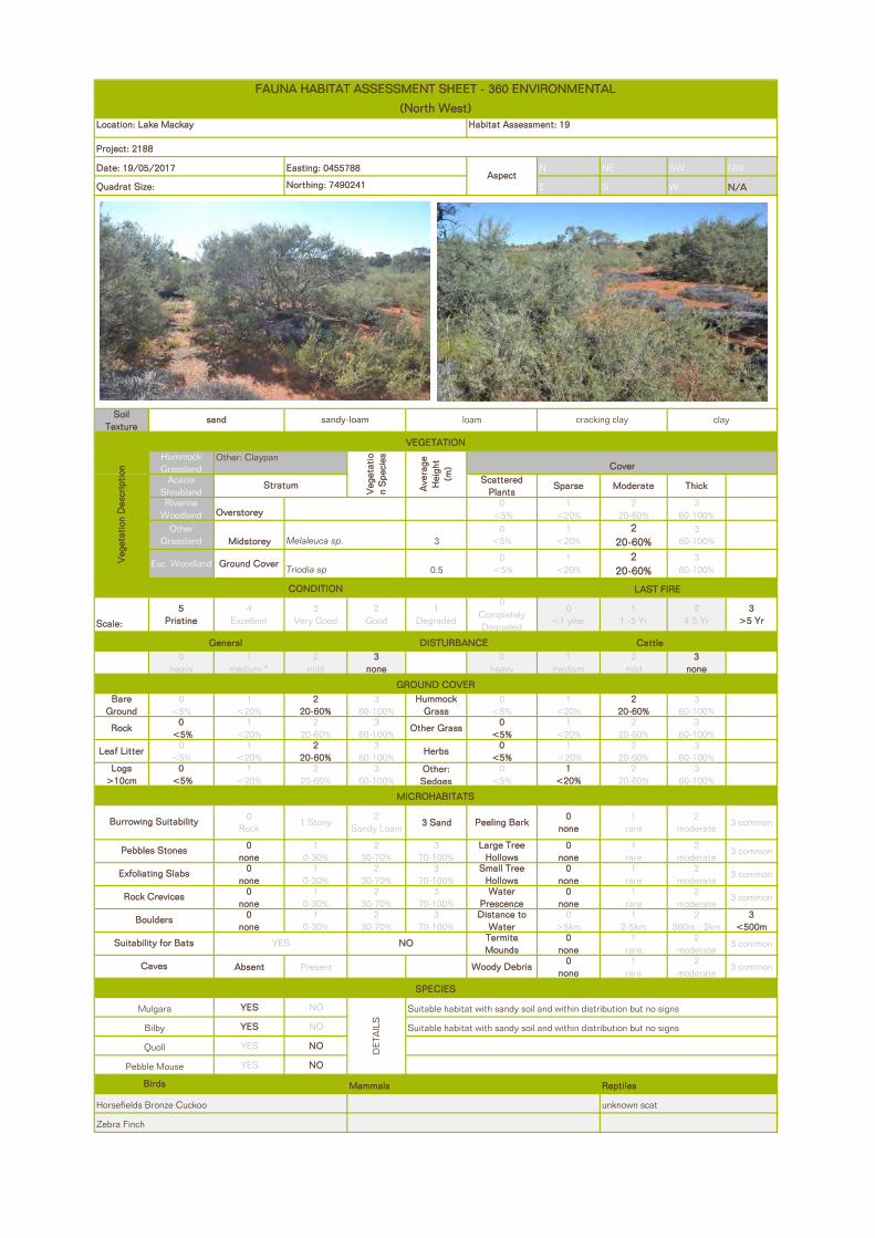
N NE SW NW
E S W N/A
Soil Texture
Hummock Grassland
Acacia Shrubland
Scattered Plants
Sparse Moderate Thick
Riverine Woodland Overstorey
0 <5%
1 <20%
2 20-60%
3 60-100%
Other Grassland Midstorey 3
0 <5%
1 <20%
2 20-60%
3 60-100%
Euc Woodland Ground Cover0.5
0 <5%
1 <20%
2 20-60%
3 60-100%
Scale:
5 Pristine
4 Excellent
3 Very Good
2 Good
1 Degraded
0 Completely Degraded
0 <1 year
1 1 -3 Yr
2 4-5 Yr
3 >5 Yr
0 heavy
1 medium *
2 mild
3 none
0 heavy
1 medium
2 mild
3 none
Bare Ground
0<5%
1 <20%
2 20-60%
3 60-100%
Hummock Grass
0<5%
1<20%
2 20-60%
3 60-100%
Rock0
<5% 1
<20% 2
20-60%3
60-100%Other Grass
0 <5%
1<20%
2 20-60%
3 60-100%
Leaf Litter0
<5% 1
<20%2
20-60%3
60-100%Herbs
0 <5%
1 <20%
2 20-60%
3 60-100%
Logs >10cm
0 <5%
1<20%
2 20-60%
3 60-100%
Other: Sedges
0 <5%
1<20%
2 20-60%
3 60-100%
0 Rock
1 Stony2
Sandy Loam3 Sand Peeling Bark
0 none
1 rare
2 moderate
3 common
0 none
1 0-30%
2 30-70%
3 70-100%
Large Tree Hollows
0 none
1 rare
2 moderate
3 common
0 none
1 0-30%
2 30-70%
3 70-100%
Small Tree Hollows
0 none
1 rare
2 moderate
3 common
0 none
1 0-30%
2 30-70%
3 70-100%
Water Prescence
0 none
1 rare
2 moderate
3 common
0 none
1 0-30%
2 30-70%
3 70-100%
Distance to Water
0 >5km
1 2-5km
2 500m - 2km
3 <500m
Termite Mounds
0 none
1 rare
2 moderate
3 common
Absent Present Woody Debris0
none1
rare2
moderate3 common
YES NO
YES NO
YES NO
YES NO
Mammals Reptiles
Date: 19/05/2017 Easting: 0455788Aspect
Quadrat Size: Northing: 7490241
FAUNA HABITAT ASSESSMENT SHEET - 360 ENVIRONMENTAL
(North West)Location: Lake Mackay Habitat Assessment: 19
Project: 2188
sand sandy-loam loam cracking clay clay
Burrowing Suitability
VEGETATION
Veg
etat
ion
Des
crip
tion
Other: Claypan
Veg
etat
ion
Spe
cies
Ave
rage
H
eigh
t (m
) Cover
Stratum
Melaleuca sp.
Triodia sp
CONDITION LAST FIRE
General DISTURBANCE Cattle
GROUND COVER
MICROHABITATS
Pebbles Stones
Exfoliating Slabs
Rock Crevices
Boulders
Suitability for Bats NO
Caves
SPECIES
Mulgara
DE
TAIL
S
Suitable habitat with sandy soil and within distribution but no signs
Bilby Suitable habitat with sandy soil and within distribution but no signs
Quoll
YES
Zebra Finch
Pebble Mouse
Birds
Horsefields Bronze Cuckoo unknown scat

N NE SW NW
E S W N/A
Soil Texture
Hummock Grassland
Acacia Shrubland
Scattered Plants
Sparse Moderate Thick
Riverine Woodland Overstorey 4m
0 <5%
1 <20%
2 20-60%
3 60-100%
Other Grassland Midstorey
0 <5%
1 <20%
2 20-60%
3 60-100%
Euc Woodland Ground Cover0.5
0 <5%
1 <20%
2 20-60%
3 60-100%
Scale:
5 Pristine
4 Excellent
3 Very Good
2 Good
1 Degraded
0 Completely Degraded
0 <1 year
1 1 -3 Yr
2 4-5 Yr
3 >5 Yr
0 heavy
1 medium *
2 mild
3 none
0 heavy
1 medium
2 mild
3 none
Bare Ground
0<5%
1 <20%
2 20-60%
3 60-100%
Hummock Grass
0<5%
1<20%
2 20-60%
3 60-100%
Rock0
<5% 1
<20% 2
20-60%3
60-100%Other Grass
0 <5%
1<20%
2 20-60%
3 60-100%
Leaf Litter0
<5% 1
<20%2
20-60%3
60-100%Herbs
0 <5%
1 <20%
2 20-60%
3 60-100%
Logs >10cm
0 <5%
1<20%
2 20-60%
3 60-100%
Other: 0 <5%
1<20%
2 20-60%
3 60-100%
0 Rock
1 Stony2
Sandy Loam3 Sand Peeling Bark
0 none
1 rare
2 moderate
3 common
0 none
1 0-30%
2 30-70%
3 70-100%
Large Tree Hollows
0 none
1 rare
2 moderate
3 common
0 none
1 0-30%
2 30-70%
3 70-100%
Small Tree Hollows
0 none
1 rare
2 moderate
3 common
0 none
1 0-30%
2 30-70%
3 70-100%
Water Prescence
0 none
1 rare
2 moderate
3 common
0 none
1 0-30%
2 30-70%
3 70-100%
Distance to Water
0 >5km
1 2-5km
2 500m - 2km
3 <500m
Termite Mounds
0 none
1 rare
2 moderate
3 common
Absent Present Woody Debris0
none1
rare2
moderate3 common
YES NO
YES NO
YES NO
YES NO
Mammals Reptiles
Date: 19/05/2017 Easting: 0451920Aspect
Quadrat Size: 100 x 100 Northing: 7490834
FAUNA HABITAT ASSESSMENT SHEET - 360 ENVIRONMENTAL
(North West)Location: Lake Mackay Habitat Assessment: 20
Project: 2188
sand sandy-loam loam cracking clay clay
Burrowing Suitability
VEGETATION
Veg
etat
ion
Des
crip
tion
Other: Sand Plain
Veg
etat
ion
Spe
cies
Ave
rage
H
eigh
t (m
) Cover
Stratum
Eucalyptus gammophylla
Triodia sp.
CONDITION LAST FIRE
General DISTURBANCE Cattle
GROUND COVER
MICROHABITATS
Pebbles Stones
Exfoliating Slabs
Rock Crevices
Boulders
Suitability for Bats NO
Caves
SPECIES
Mulgara
DET
AIL
S
Suitable habitat with sandy soil and within distribution but no signs
Bilby Suitable habitat with sandy soil and within distribution but no signs
Quoll
YES
Pebble Mouse
Birds
Zebra Finch Thorny Devil

N NE SW NW
E S W N/A
Soil Texture
Hummock Grassland
Acacia Shrubland
Scattered Plants
Sparse Moderate Thick
Riverine Woodland Overstorey
0 <5%
1 <20%
2 20-60%
3 60-100%
Other Grassland Midstorey 3
0 <5%
1 <20%
2 20-60%
3 60-100%
Euc Woodland Ground Cover<0.5
0 <5%
1 <20%
2 20-60%
3 60-100%
Scale:
5 Pristine
4 Excellent
3 Very Good
2 Good
1 Degraded
0 Completely Degraded
0 <1 year
1 1 -3 Yr
2 4-5 Yr
3 >5 Yr
0 heavy
1 medium *
2 mild
3 none
0 heavy
1 medium
2 mild
3 none
Bare Ground
0<5%
1 <20%
2 20-60%
3 60-100%
Hummock Grass
0<5%
1<20%
2 20-60%
3 60-100%
Rock0
<5% 1
<20% 2
20-60%3
60-100%Other Grass
0 <5%
1<20%
2 20-60%
3 60-100%
Leaf Litter0
<5% 1
<20%2
20-60%3
60-100%Herbs
0 <5%
1 <20%
2 20-60%
3 60-100%
Logs >10cm
0 <5%
1<20%
2 20-60%
3 60-100%
Other: 0 <5%
1<20%
2 20-60%
3 60-100%
0 Rock
1 Stony2
Sandy Loam3 Sand Peeling Bark
0 none
1 rare
2 moderate
3 common
0 none
1 0-30%
2 30-70%
3 70-100%
Large Tree Hollows
0 none
1 rare
2 moderate
3 common
0 none
1 0-30%
2 30-70%
3 70-100%
Small Tree Hollows
0 none
1 rare
2 moderate
3 common
0 none
1 0-30%
2 30-70%
3 70-100%
Water Prescence
0 none
1 rare
2 moderate
3 common
0 none
1 0-30%
2 30-70%
3 70-100%
Distance to Water
0 >5km
1 2-5km
2 500m - 2km
3 <500m
Termite Mounds
0 none
1 rare
2 moderate
3 common
Absent Present Woody Debris0
none1
rare2
moderate3 common
YES NO
YES NO
YES NO
YES NO
Mammals ReptilesBirds
Agamid (Dragon) burrows
NO
Caves
SPECIES
Mulgara
DE
TAIL
S
Suitable habitat with sandy soil and within distribution but no signs
Bilby Suitable habitat with sandy soil and within distribution but no signs
Quoll
YES
Pebble Mouse
Pebbles Stones
Exfoliating Slabs
Rock Crevices
Boulders
Suitability for Bats
Burrowing Suitability
VEGETATION
Veg
etat
ion
Des
crip
tion
Other:
Veg
etat
ion
Spe
cies
Ave
rage
H
eigh
t (m
)
Cover
Stratum
Acacia ligulata, Eremophila latrobei, Melaleuca glomerata
Triodia sp.
CONDITION LAST FIRE
General DISTURBANCE Cattle
GROUND COVER
MICROHABITATS
(Red) sand sandy-loam loam cracking clay clay
FAUNA HABITAT ASSESSMENT SHEET - 360 ENVIRONMENTAL
(North West)Location: Lake Mackay Habitat Assessment: 21 (Island 1)
Project: 2188
Date: 14/05/2017 Easting: 0481312Aspect
Quadrat Size: 100 x 100 Northing: 754729
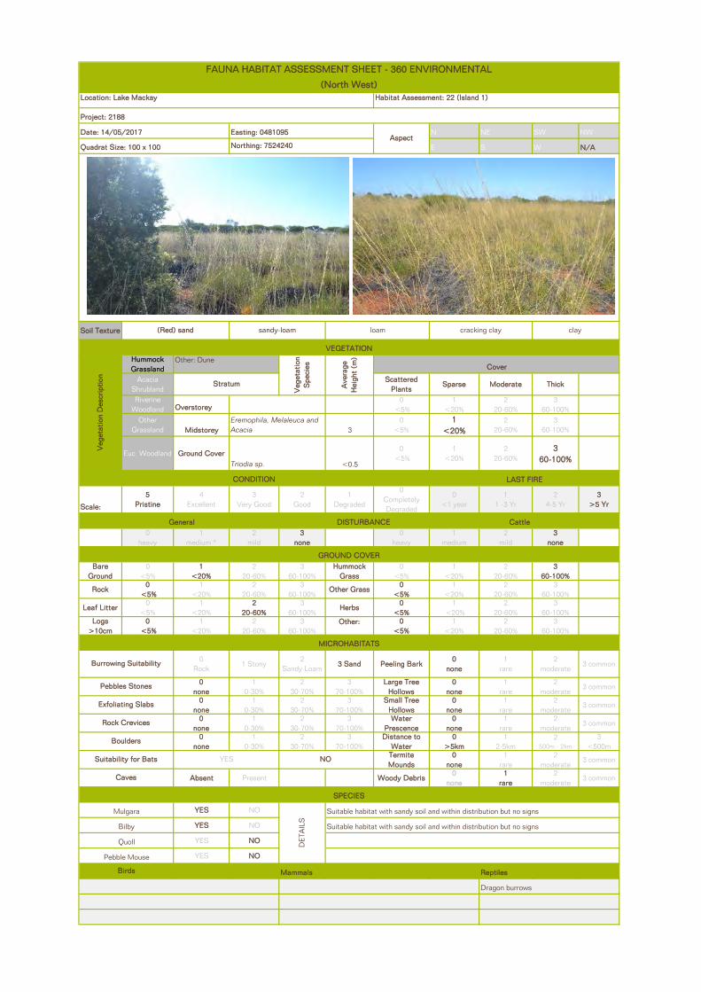
N NE SW NW
E S W N/A
Soil Texture
Hummock Grassland
Acacia Shrubland
Scattered Plants
Sparse Moderate Thick
Riverine Woodland Overstorey
0 <5%
1 <20%
2 20-60%
3 60-100%
Other Grassland Midstorey 3
0 <5%
1 <20%
2 20-60%
3 60-100%
Euc Woodland Ground Cover<0.5
0 <5%
1 <20%
2 20-60%
3 60-100%
Scale:
5 Pristine
4 Excellent
3 Very Good
2 Good
1 Degraded
0 Completely Degraded
0 <1 year
1 1 -3 Yr
2 4-5 Yr
3 >5 Yr
0 heavy
1 medium *
2 mild
3 none
0 heavy
1 medium
2 mild
3 none
Bare Ground
0<5%
1 <20%
2 20-60%
3 60-100%
Hummock Grass
0<5%
1<20%
2 20-60%
3 60-100%
Rock0
<5% 1
<20% 2
20-60%3
60-100%Other Grass
0 <5%
1<20%
2 20-60%
3 60-100%
Leaf Litter0
<5% 1
<20%2
20-60%3
60-100%Herbs
0 <5%
1 <20%
2 20-60%
3 60-100%
Logs >10cm
0 <5%
1<20%
2 20-60%
3 60-100%
Other: 0 <5%
1<20%
2 20-60%
3 60-100%
0 Rock
1 Stony2
Sandy Loam3 Sand Peeling Bark
0 none
1 rare
2 moderate
3 common
0 none
1 0-30%
2 30-70%
3 70-100%
Large Tree Hollows
0 none
1 rare
2 moderate
3 common
0 none
1 0-30%
2 30-70%
3 70-100%
Small Tree Hollows
0 none
1 rare
2 moderate
3 common
0 none
1 0-30%
2 30-70%
3 70-100%
Water Prescence
0 none
1 rare
2 moderate
3 common
0 none
1 0-30%
2 30-70%
3 70-100%
Distance to Water
0 >5km
1 2-5km
2 500m - 2km
3 <500m
Termite Mounds
0 none
1 rare
2 moderate
3 common
Absent Present Woody Debris0
none1
rare2
moderate3 common
YES NO
YES NO
YES NO
YES NO
Mammals ReptilesBirds
Dragon burrows
NO
Caves
SPECIES
Mulgara
DET
AIL
S
Suitable habitat with sandy soil and within distribution but no signs
Bilby Suitable habitat with sandy soil and within distribution but no signs
Quoll
YES
Pebble Mouse
Pebbles Stones
Exfoliating Slabs
Rock Crevices
Boulders
Suitability for Bats
Burrowing Suitability
VEGETATION
Veg
etat
ion
Des
crip
tion
Other: Dune
Veg
etat
ion
Spe
cies
Ave
rage
H
eigh
t (m
)
Cover
Stratum
Eremophila, Melaleuca and Acacia
Triodia sp.
CONDITION LAST FIRE
General DISTURBANCE Cattle
GROUND COVER
MICROHABITATS
(Red) sand sandy-loam loam cracking clay clay
FAUNA HABITAT ASSESSMENT SHEET - 360 ENVIRONMENTAL
(North West)Location: Lake Mackay Habitat Assessment: 22 (Island 1)
Project: 2188
Date: 14/05/2017 Easting: 0481095Aspect
Quadrat Size: 100 x 100 Northing: 7524240

2188 AE Fauna Survey Lake Mackay Sulphate of Potash Project
Agrimin
360 Environmental Pty Ltd
APPENDIX F
Opportunistic Data
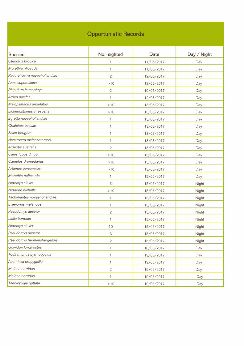
Species No. sighted Date Day / Night
Ctenotus brooksi 1 11/05/2017 Day
Morethia rificauda 1 11/05/2017 Day
Recurvirostra novaehollandiae 2 12/05/2017 Day
Anas superciliosa >10 12/05/2017 Day
Rhipidura leucophrys 2 10/05/2017 Day
Ardea pacifca 1 12/05/2017 Day
Melopsittacus undulatus >10 13/05/2017 Day
Lichenostomus virescens >10 13/05/2017 Day
Egretta novaehollandiae 1 13/05/2017 Day
Chalcites basalis 1 13/05/2017 Day
Falco berigora 1 13/05/2017 Day
Hamirostra melanosternon 1 13/05/2017 Day
Ardeotis australis 2 13/05/2017 Day
Canis lupus dingo >10 13/05/2017 Day
Camelus dromedarius >10 13/05/2017 Day
Artamus personatus >10 13/05/2017 Day
Morethia riuficauda 1 15/05/2017 Day
Notomys alexis 3 15/05/2017 Night
Notaden nichollsi >10 15/05/2017 Night
Tachybaptus novaehollandiae 1 15/05/2017 Night
Elseyornis melanops 1 15/05/2017 Night
Pseudomys desetor 2 15/05/2017 Night
Lialis burtonis 1 15/05/2017 Night
Notomys alexis 10 15/05/2017 Night
Pseudomys desetor 3 15/05/2017 Night
Pseudomys hermensbergensis 2 15/05/2017 Night
Gowidon longirostris 1 18/05/2017 Day
Todiramphus pyrrhopygius 1 19/05/2017 Day
Acanthiza uropygialis 1 19/05/2017 Day
Moloch horridus 2 19/05/2017 Day
Moloch horridus 1 19/05/2017 Day
Taeniopygia guttata >10 19/05/2017 Day
Opportunistic Records

2188 AE Fauna Survey Lake Mackay Sulphate of Potash Project
Agrimin
360 Environmental Pty Ltd
APPENDIX G
Photographs

2188AE Fauna Survey Lake Mackay Sulphate of Potash Project
Agrimin
Military Dragon (Ctenotus isolepis)
Wedge Snout Ctenotus (Ctenotus brooksi)

2188AE Fauna Survey Lake Mackay Sulphate of Potash Project
Agrimin
Fine Side-lined Ctenotus (Ctenotus dux)
Desert Mouse (Pseudomys desertor)

2188AE Fauna Survey Lake Mackay Sulphate of Potash Project
Agrimin
Short-tailed Pygmy Monitor (Varanus brevicaudus)
Grand Ctenotus (Ctenotus grandis)

2188AE Fauna Survey Lake Mackay Sulphate of Potash Project
Agrimin
Bynoe’s Prickly Gecko (Heteronotia binoei)
Three-lined Knob-tail (Nephrurus levis)

2188AE Fauna Survey Lake Mackay Sulphate of Potash Project
Agrimin
Wongai Ningaui (Ningaui ridei)
Thorny Devil (Moloch horridus)