Embed Size (px)
Citation preview

Copyright 2010, University Corporation for Atmospheric Research, all rights reserved
File Formats and Pre-Processing
File Formats
Pre-processing Tools
Useful Links
Presenter: Tara Jensen

Copyright 2010, University Corporation for Atmospheric Research, all rights reserved
Supported File Formats
Forecasts GRIB – GRIdded Binary file format (*version 1) NetCDF – MET specific network Common Data
Format Observations
PREPBUFR – binary dataset prepared by NCEP from varied data sources.
ASCII – MET specific format (10-cols x n-rows) GRIB – i.e. NEXRAD Level II or IV NetCDF – MET specific NetCDF format
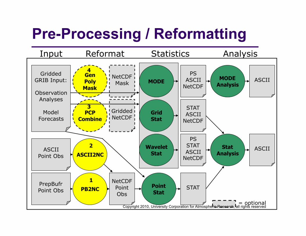
Point Stat
MODE
Grid Stat
Input Reformat Statistics
= optional
Stat Analysis
MODE Analysis
ASCII
ASCII
Gridded GRIB Input:
Observation Analyses
Model Forecasts
PrepBufr Point Obs
ASCII Point Obs
Wavelet Stat
STAT
PS ASCII
NetCDF
STAT ASCII
NetCDF
PS STAT ASCII
NetCDF
PB2NC
PCP Combine
ASCII2NC
Gen Poly Mask
Gridded NetCDF
NetCDF Point Obs
NetCDF Mask
Analysis
1
2
3
4
Pre-Processing / Reformatting
Copyright 2010, University Corporation for Atmospheric Research, all rights reserved

Copyright 2010, University Corporation for Atmospheric Research, all rights reserved
Data Reformating Tools
PB2NC and ASCII2NC Arrange observational data into the NetCDF point format
expected by Point-Stat.
PCP_Combine (optional) Sum precipitation values across two or more time periods. Subtract precipitation values to create values for finer
subperiods. Produces gridded NetCDF file that can be used as input
grid for any Statistics tool.
Gen_Poly_Mask (optional) Used when more complex masking is needed. Produces a NetCDF file of pre-defined mask. May be used for masking in any Statistics tools.

Copyright 2010, University Corporation for Atmospheric Research, all rights reserved
1. PB2NC Tool
Stands for “PREPBUFR to NetCDF”
Functionality: Filters and reformats PREPBUFR point observations into
intermediate NetCDF format. Configuration file specifies:
Observation types, locations, elevations, quality marks, times, and variables to retain or derive for use in Point-Stat.
Data formats: Reads PREPBUFR using NCEP’s BUFRLIB. Writes point NetCDF as input to Point-Stat. Note: v2.0 no longer requires CWORDSH to pre-process PREPBUFR files.

Copyright 2010, University Corporation for Atmospheric Research, all rights reserved
PREPBUFR BUFR is the World Meteorological Organization (WMO) standard
binary code for the representation and exchange of observational data.
http://www.nco.ncep.noaa.gov/sib/decoders/BUFRLIB/ http://www.ecmwf.int/products/data/software/
The PREPBUFR format is produced by NCEP for analyses and data assimilation. The system that produces this format: Assembles observations dumped from a number of sources Encodes
information about the observational error for each data type background (first guess) interpolated to each data location
Performs both rudimentary multi-platform quality control and more complex platform-specific quality control
MET currently only supports PREPBUFR. Let us know if you need to read in other BUFR format.

Copyright 2010, University Corporation for Atmospheric Research, all rights reserved
What is in PREPBUFR file? METv2.0/data/sample_obs/prepbufr/ndas.t00z.prepbufr.tm12.20070401.nr
==> append : to filename to view the data source BUFR 230ADPUPA UPPER-AIR (RAOB, PIBAL, RECCO, DROPS) REPORTS 231AIRCAR MDCRS ACARS AIRCRAFT REPORTS 232AIRCFT AIREP/PIREP, AMDAR(ASDAR/ACARS), E-ADAS(AMDAR BUFR) ACF233SATWND SATELLITE-DERIVED WIND REPORTS 234PROFLR WIND PROFILER REPORTS 235VADWND VAD (NEXRAD) WIND REPORTS 236SATEMP TOVS SATELLITE DATA (SOUNDINGS, RETRIEVALS, RADIANCES) 237ADPSFC SURFACE LAND (SYNOPTIC, METAR) REPORTS 238SFCSHP SURFACE MARINE (SHIP, BUOY, C-MAN PLATFORM) REPORTS 239SFCBOG MEAN SEA-LEVEL PRESSURE BOGUS REPORTS 240SPSSMI SSM/I RETRIEVAL PRODUCTS (REPROCESSED WIND SPEED, TPW) 241SYNDAT SYNTHETIC TROPICAL CYCLONE BOGUS REPORTS 242ERS1DA ERS SCATTEROMETER DATA (REPROCESSED WIND SPEED) 243GOESND GOES SATELLITE DATA (SOUNDINGS, RETRIEVALS, RADIANCES) 244QKSWND QUIKSCAT SCATTEROMETER DATA (REPROCESSED WIND SPEED) 245MSONET MESONET SURFACE REPORTS (COOPERATIVE NETWORKS) 246GPSIPW GLOBAL POSITIONING SATELLITE-INTEGRATED PRECIP. WATER 247RASSDA RADIO ACOUSTIC SOUNDING SYSTEM (RASS) TEMP PROFILE RPTSM063000BYTCNT…
Result of running unix “less” or “more” command:
>less \ ndas.t00z.prepbufr.tm12.20070401.nr

Copyright 2010, University Corporation for Atmospheric Research, all rights reserved
PREPBUFR - Known Issues
CWORDSH blocking In v1.0 and v1.1 it was needed to structure to data
properly for reading by the MET fortran code. v2.0 eliminates this need
Compilation of PREPBUFR on 64-bit OS If you will be using PREPBUFR files, you should
compile everything using 32-bit flags. Investigation of this problem in ongoing.

Copyright 2010, University Corporation for Atmospheric Research, all rights reserved
PB2NC: Usage
Usage: pb2nc prepbufr_file netcdf_file config_file [-pbfile prepbufr_file] [-valid_beg time] [-valid_end time] [-nmsg n] [-dump path] [-v level]
prepbufr_file Input obs file in PrepBufr format
netcdf_file Output name for NetCDF file
config_file PB2NC configuration file
-pbfile Additional input PrepBufr files
-valid_beg Beginning of valid time window [YYYYMMDD_[HH[MMSS]]
-valid_end End of valid time window [YYYYMMDD_[HH[MMSS]]
-nmsg Number of PrepBufr messages to process
-dump Dump entire contents of PrepBufr file to file in path
-v Level of logging

Copyright 2010, University Corporation for Atmospheric Research, all rights reserved
PB2NC: Run METv2.0/bin/pb2nc \
ndas.t00z.prepbufr.tm12.20070401.nr \ out/sample_pb.nc PB2NCConfig_tutorial -v 2
Reading Config File: PB2NCConfig_default Creating NetCDF File: out/sample_pb.nc Processing PrepBufr File: ndas.t00z.prepbufr.tm09.20070401.nr Blocking PrepBufr file to: /tmp/pb2nc_1705_0_blk.pb PrepBufr Time Center: 20070331_150000 Searching Time Window: 20070331_133000 to 20070331_163000 Processing 70884 PrepBufr messages... 5% 10% 15% 20% 25% 30% 35% 40% 45% 50% 55% 60% 65% 70% 75% 80% 85% 90% 95% 100% Total PrepBufr Messages processed = 70884 Rejected based on message type = 0 Rejected based on station id = 0 Rejected based on valid time = 0 Rejected based on masking grid = 0 Rejected based on masking polygon = 0 Rejected based on elevation = 0 Rejected based on pb report type = 0 Rejected based on input report type = 0 Rejected based on instrument type = 0 Rejected based on zero observations = 24153 Total PrepBufr Messages retained = 46731 Total observations retained or derived = 142709
This example takes a few minutes to run
Output NetCDF file is designated as out/sample_pb.nc
We will see the NetCDF format in a few slides

Copyright 2010, University Corporation for Atmospheric Research, all rights reserved
2. ASCII2NC Tool
Stands for “ASCII to NetCDF”
Functionality: Reformat ASCII point observations into intermediate
NetCDF format. One input ASCII format supported (10 columns). No configuration file.
Data formats: Reads MET specific ASCII format with point obs. Writes point NetCDF as input to Point-Stat. Future: support additional standard ASCII formats.

Copyright 2010, University Corporation for Atmospheric Research, all rights reserved
ASCII2NC: Usage
Usage: ascii2nc ascii_file netcdf_file [-format ascii_format] [-v level]
ascii_file Input obs file in ASCII format
netcdf_file Output name for NetCDF file
-format Override using MET specific point format (Future Option)
-v Level of logging

Copyright 2010, University Corporation for Atmospheric Research, all rights reserved
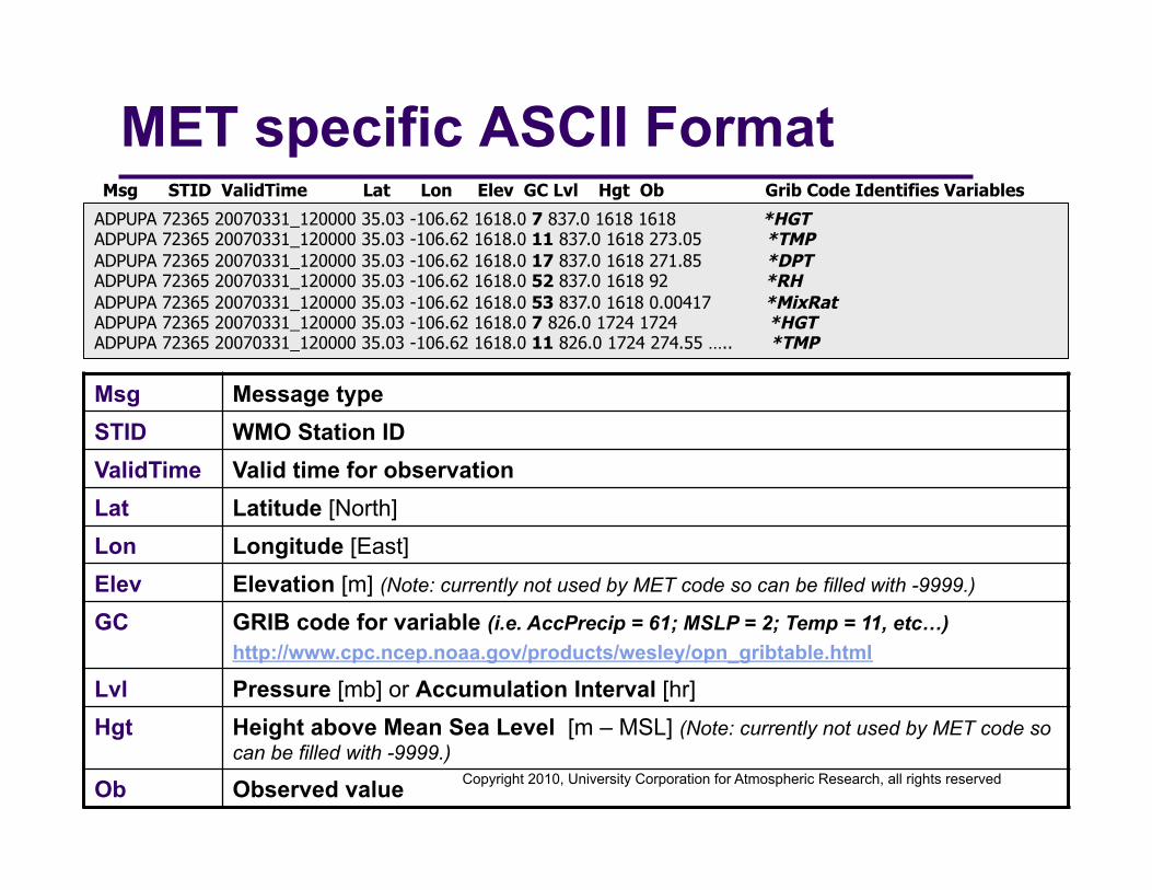
MET specific ASCII Format ADPUPA 72365 20070331_120000 35.03 -106.62 1618.0 7 837.0 1618 1618 ADPUPA 72365 20070331_120000 35.03 -106.62 1618.0 11 837.0 1618 273.05 ADPUPA 72365 20070331_120000 35.03 -106.62 1618.0 17 837.0 1618 271.85 ADPUPA 72365 20070331_120000 35.03 -106.62 1618.0 52 837.0 1618 92 ADPUPA 72365 20070331_120000 35.03 -106.62 1618.0 53 837.0 1618 0.00417 ADPUPA 72365 20070331_120000 35.03 -106.62 1618.0 7 826.0 1724 1724 ADPUPA 72365 20070331_120000 35.03 -106.62 1618.0 11 826.0 1724 274.55 …..
Msg STID ValidTime Lat Lon Elev GC Lvl Hgt Ob
Msg Message type STID WMO Station ID ValidTime Valid time for observation Lat Latitude [North] Lon Longitude [East] Elev Elevation [m] (Note: currently not used by MET code so can be filled with -9999.)
GC GRIB code for variable (i.e. AccPrecip = 61; MSLP = 2; Temp = 11, etc…) http://www.cpc.ncep.noaa.gov/products/wesley/opn_gribtable.html
Lvl Pressure [mb] or Accumulation Interval [hr] Hgt Height above Mean Sea Level [m – MSL] (Note: currently not used by MET code so
can be filled with -9999.) Ob Observed value
Copyright 2010, University Corporation for Atmospheric Research, all rights reserved
MET specific ASCII Format ADPUPA 72365 20070331_120000 35.03 -106.62 1618.0 7 837.0 1618 1618 *HGT ADPUPA 72365 20070331_120000 35.03 -106.62 1618.0 11 837.0 1618 273.05 *TMP ADPUPA 72365 20070331_120000 35.03 -106.62 1618.0 17 837.0 1618 271.85 *DPT ADPUPA 72365 20070331_120000 35.03 -106.62 1618.0 52 837.0 1618 92 *RH ADPUPA 72365 20070331_120000 35.03 -106.62 1618.0 53 837.0 1618 0.00417 *MixRat ADPUPA 72365 20070331_120000 35.03 -106.62 1618.0 7 826.0 1724 1724 *HGT ADPUPA 72365 20070331_120000 35.03 -106.62 1618.0 11 826.0 1724 274.55 ….. *TMP
Msg STID ValidTime Lat Lon Elev GC Lvl Hgt Ob Grib Code Identifies Variables
Msg Message type STID WMO Station ID ValidTime Valid time for observation Lat Latitude [North] Lon Longitude [East] Elev Elevation [m] (Note: currently not used by MET code so can be filled with -9999.)
GC GRIB code for variable (i.e. AccPrecip = 61; MSLP = 2; Temp = 11, etc…) http://www.cpc.ncep.noaa.gov/products/wesley/opn_gribtable.html
Lvl Pressure [mb] or Accumulation Interval [hr] Hgt Height above Mean Sea Level [m – MSL] (Note: currently not used by MET code so
can be filled with -9999.) Ob Observed value

Copyright 2010, University Corporation for Atmospheric Research, all rights reserved
MET specific ASCII Format ADPUPA 72365 20070331_120000 35.03 -106.62 1618.0 7 837.0 1618 1618 *HGT ADPUPA 72365 20070331_120000 35.03 -106.62 1618.0 11 837.0 1618 273.05 *TMP ADPUPA 72365 20070331_120000 35.03 -106.62 1618.0 17 837.0 1618 271.85 *DPT ADPUPA 72365 20070331_120000 35.03 -106.62 1618.0 52 837.0 1618 92 *RH ADPUPA 72365 20070331_120000 35.03 -106.62 1618.0 53 837.0 1618 0.00417 *MixRat ADPUPA 72365 20070331_120000 35.03 -106.62 1618.0 7 826.0 1724 1724 *HGT ADPUPA 72365 20070331_120000 35.03 -106.62 1618.0 11 826.0 1724 274.55 ….. *TMP
Msg STID ValidTime Lat Lon Elev GC Lvl Hgt Ob Ob assigns value to variable
Msg Message type STID WMO Station ID ValidTime Valid time for observation Lat Latitude [North] Lon Longitude [East] Elev Elevation [m] (Note: currently not used by MET code so can be filled with -9999.)
GC GRIB code for variable (i.e. AccPrecip = 61; MSLP = 2; Temp = 11, etc…) http://www.cpc.ncep.noaa.gov/products/wesley/opn_gribtable.html
Lvl Pressure [mb] or Accumulation Interval [hr] Hgt Height above Mean Sea Level [m – MSL] (Note: currently not used by MET code so
can be filled with -9999.) Ob Observed value
* Use a value of "-9999" to
indicate missing data

Copyright 2010, University Corporation for Atmospheric Research, all rights reserved
ASCII2NC: Run METv2.0/bin/ascii2nc sample_obs.txt \
sample_ascii.nc -v 2 netcdf sample_ascii { dimensions:
mxstr = 15 ; hdr_arr_len = 3 ; obs_arr_len = 5 ; nhdr = 5 ; nobs = UNLIMITED ; // (2140 currently)
variables: char hdr_typ(nhdr, mxstr) ; hdr_typ:long_name = "message type" ; char hdr_sid(nhdr, mxstr) ; hdr_sid:long_name = "station identification" ; char hdr_vld(nhdr, mxstr) ; hdr_vld:long_name = "valid time" ; hdr_vld:units = "YYYYMMDD_HHMMSS UTC" ; float hdr_arr(nhdr, hdr_arr_len) ; hdr_arr:long_name = "array of observation station header values" ; hdr_arr:_fill_value = -9999.f ; hdr_arr:columns = "lat lon elv" ; … ; float obs_arr(nobs, obs_arr_len) ; obs_arr:long_name = "array of observation values" ; obs_arr:_fill_value = -9999.f ; obs_arr:columns = "hdr_id gc lvl hgt ob" ; obs_arr:hdr_id_long_name = "index of matching header data" ; … ;
obs_arr = 0, 7, 837, 1618, 1618, 1, 11, 837, 1618, 273.05, 2, 17, 837, 1618, 271.85, 3, 52, 837, 1618, 92, 4, 53, 837, 1618, 0.00417, 5, 7, 826, 1724, 1724, 6, 11, 826, 1724, 274.55, 7, 17, 826, 1724, 272.15, 8, 52, 826, 1724, 84, 9, 53, 826, 1724, 0.00432, 10, 7, 815.3, 1829, 1829, 11, 11, 815.3, 1829, 276.45, 12, 17, 815.3, 1829, 265.75, 13, 52, 815.3, 1829, 45, 14, 53, 815.3, 1829, 0.0027, 15, 7, 815, 1832, 1832, 16, 11, 815, 1832, 276.55, 17, 17, 815, 1832, 265.55, 18, 52, 815, 1832, 44, 19, 53, 815, 1832, 0.00266, 20, 7, 784.7, 2134, 2134, 21, 11, 784.7, 2134, 274.05, 22, 17, 784.7, 2134, 264.15, 23, 52, 784.7, 2134, 47, …
Result of ncdump –h
Result of ncdump –v obs_arr
Output NetCDF file
This example has 2140 obs and takes seconds to run

Copyright 2010, University Corporation for Atmospheric Research, all rights reserved
3. PCP-Combine Tool Stands for “Precip-Combine” Functionality:
Mathematically combines precipitation fields across multiple files. Add precipitation over 2 files with or without different
accumulation intervals 2 NMM output files with 3-hr to get 6-hr accumulation.
Sum precipitation over 2 or more files when accumulation interval is the same 12 WSR-88D Level II data to go from 5 min accumulation to 1-hr
accumulation. Subtract precipitation in 2 files
2 ARW output files to go from 12 hr accumulations to 6 hour accumulation
Specify field name on the command line. No configuration file.
Data formats: Reads GRIB format. Writes gridded NetCDF as input to stats tools.

Copyright 2010, University Corporation for Atmospheric Research, all rights reserved
PCP-Combine: Usage
Usage: pcp_combine [-sum sum_args] or [-add add_args] or [-subtract sub_args] [-gc code] [-v level]
-sum Accumulates data over multiple files with same accum interval. Sum_args: (init_time, in_accum, valid_time, out_accum, out_file, -pcpdir path, -pcprx reg_exp)
-add Accumulates data over 2 files with or without different accum. intervals. Add_args: (in_file1, Accum1, in_file2, Accum2, out_file).
-subtract Subtracts data over two files. Sub_args: (in_file1, Accum1, in_file2, Accum2, out_file).
-gc GRIB code for variable (i.e. ACPC = 61; NCPCP =62; ACPCP =63, etc…).
-v Level of logging

Copyright 2010, University Corporation for Atmospheric Research, all rights reserved
PCP-Combine: Run Two example command lines
1) Adding 2 (6-hourly) accumulation forecast files into 1 (12-hourly) accumulation forecast.
METv2.0/bin/pcp_combine \ -add 20050807_060000.grb 6 \ 20050807_120000.grb 6 \ sample_fcst.nc
2) Summing 12 (1-hourly) accumulation observation files into 1 (12-hourly) accumulated observation file.
METv2.0/bin/pcp_combine \ -sum 00000000_000000 1 \
20050807_120000 12 \ sample_obs.nc -pcpdir data/ST2ml

Copyright 2010, University Corporation for Atmospheric Research, all rights reserved
PCP-Combine: Example #1
+
Graphics produced using ncview
20050807_060000 6hr acc
20050807_120000 6hr acc
20050807_120000 12 hr acc

Copyright 2010, University Corporation for Atmospheric Research, all rights reserved
4. Gen Poly Mask Tool Stands for “Generate Polyline
Mask”
Functionality: Uses a lat/lon polyline to
generate a 0/1 mask field to be applied to your data.
Applies this mask once – prior to running Point-Stat or Grid-Stat
No configuration file.
Data formats: Reads ASCII formatted polyline file. Reads GRIB file. Reads NetCDF files from
PCP-Combine. Writes gridded NetCDF file of
0/1 mask.
Accumulated Precip CONUS
31.1931 -120.4211
31.2291 -120.4976
31.2650 -120.5741
31.3009 -120.6123
31.3369 -120.6506
31.3728 -120.6888
31.4087 -120.6888
31.4447 -120.7270
992 more points…
Accumulated Precip

Copyright 2010, University Corporation for Atmospheric Research, all rights reserved
GRIB vs GRIB2 GRIB (or GRIB1): WRF postprocessor (WPP) produces GRIB1
format using copyGB tool Performs horizontal interpolation and destaggering (in the case of
WRF-NMM) onto a defined grid. Useful for both cores in creating an output grid not fixed by the
model integration domain. http://www.dtcenter.org/wrf-nmm/users/downloads/
GRIB2: NCEP and other WMO organizations have historical data in GRIB1 but now use GRIB 2 as the standard for gridded binary data.
At least two GRIB2toGRIB1 converters available NCEP cnvgrib
http://www.nco.ncep.noaa.gov/pmb/codes/GRIB2/ UCAR/CISL Grib Converter
http://dss.ucar.edu/libraries/grib/c.html

Copyright 2010, University Corporation for Atmospheric Research, all rights reserved
Data Inventory Tools wgrib – dumps GRIB1 headers and data.
http://www.cpc.ncep.noaa.gov/products/wesley/wgrib.html
wgrib2 – dumps GRIB2 headers and data. http://www.cpc.ncep.noaa.gov/products/wesley/wgrib2/
ncdump - dumps NetCDF headers and data. ncview – plots gridded NetCDF data.
http://www.unidata.ucar.edu/software/netcdf/
GrADS – command line interface to produce plots. http://www.iges.org/grads/downloads.html
NCL – command line interface to convert data formats, do data analysis and produce plots.
http://www.ncl.ucar.edu/ IDV – gui-driven visualization of many gridded and point datasets.
http://www.unidata.ucar.edu/software/idv/