Embed Size (px)
Citation preview
National Park ServiceU.S. Department of the InteriorNortheast Coastal and Barrier Network
Hurricane Sandy Science
Films to Promote Unity and HealingFilmmaker Sarah Gulick engages people in the science behind resilience
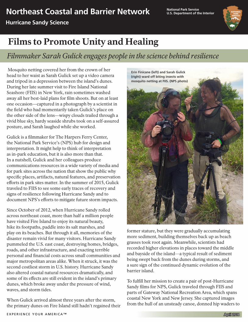
Mosquito netting covered her from the crown of her head to her waist as Sarah Gulick set up a video camera and tripod in a depression between the island’s dunes. During her late summer visit to Fire Island National Seashore (FIIS) in New York, rain sometimes washed away all her best-laid plans for film shoots. But on at least one occasion—captured in a photograph by a scientist in the field who had momentarily taken Gulick’s place on the other side of the lens—wispy clouds trailed through a vivid blue sky, hardy seaside shrubs took on a self-assured posture, and Sarah laughed while she worked.
Gulick is a filmmaker for The Harpers Ferry Center, the National Park Service’s (NPS) hub for design and interpretation. It might help to think of interpretation as in-park education, but it is also more than that. In a nutshell, Gulick and her colleagues produce communications resources in a wide variety of media and for park sites across the nation that show the public why specific places, artifacts, natural features, and preservation efforts in park sites matter. In the summer of 2015, Gulick traveled to FIIS to see some early traces of recovery and signs of resilience following Hurricane Sandy and to document NPS’s efforts to mitigate future storm impacts.
Since October of 2012, when Hurricane Sandy rolled across northeast coast, more than half a million people have visited Fire Island to enjoy its natural beauty, hike its footpaths, paddle into its salt marshes, and play on its beaches. But through it all, memories of the disaster remain vivid for many visitors. Hurricane Sandy pummeled the U.S. east coast, destroying homes, bridges, roads, and other infrastructure, and exacting terrible personal and financial costs across small communities and major metropolitan areas alike. When it struck, it was the second costliest storm in U.S. history. Hurricane Sandy also altered coastal natural resources dramatically, and some of its effects are still evident in the island’s primary dunes, which broke away under the pressure of wind, waves, and storm tides.
When Gulick arrived almost three years after the storm, the primary dunes on Fire Island still hadn’t regained their
former stature, but they were gradually accumulating more sediment, building themselves back up as beach grasses took root again. Meanwhile, scientists had recorded higher elevations in places toward the middle and bayside of the island—a typical result of sediment being swept back from the dunes during storms, and a sure sign of the continued dynamic evolution of the barrier island.
To fulfill her mission to create a pair of post-Hurricane Sandy films for NPS, Gulick traveled through FIIS and parts of Gateway National Recreation Area, which spans coastal New York and New Jersey. She captured images from the hull of an unsteady canoe, donned hip waders to
Erin Finicane (left) and Sarah Gulick (right) ward off biting insects with mosquito netting at FIIS. (NPS photo)
E X P E R I E N C E Y O U R A M E R I C A ™ April 2016
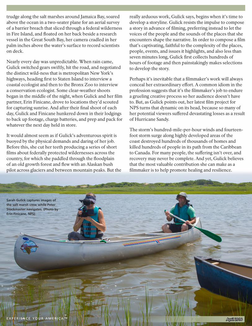
Sarah Gulick captures images of the salt marsh crew while Peter Stockmaster navigates. (Photo by Erin Finicane, NPS)
trudge along the salt marshes around Jamaica Bay, soared above the ocean in a two-seater plane for an aerial survey of a barrier breach that sliced through a federal wilderness in Fire Island, and floated on her back beside a research vessel in the Great South Bay, her camera cradled in her palm inches above the water’s surface to record scientists on deck.
Nearly every day was unpredictable. When rain came, Gulick switched gears swiftly, hit the road, and negotiated the distinct wild-ness that is metropolitan New York’s highways, heading first to Staten Island to interview a coastal ecologist and then to the Bronx Zoo to interview a conservation ecologist. Some clear-weather shoots began in the middle of the night, when Gulick and her film partner, Erin Finicane, drove to locations they’d scouted for capturing sunrise. And after their final shoot of each day, Gulick and Finicane hunkered down in their lodgings to back up footage, charge batteries, and prep and pack for whatever the next day held in store.
It would almost seem as if Gulick’s adventurous spirit is buoyed by the physical demands and daring of her job. Before this, she cut her teeth producing a series of short films about federally protected wildernesses across the country, for which she paddled through the floodplain of an old growth forest and flew with an Alaskan bush pilot across glaciers and between mountain peaks. But the
really arduous work, Gulick says, begins when it’s time to develop a storyline. Gulick resists the impulse to compose a story in advance of filming, preferring instead to let the voices of the people and the sounds of the places that she encounters shape the narrative. In order to compose a film that’s captivating, faithful to the complexity of the places, people, events, and issues it highlights, and also less than seven minutes long, Gulick first collects hundreds of hours of footage and then painstakingly makes selections to develop the story.
Perhaps it’s inevitable that a filmmaker’s work will always conceal her extraordinary effort. A common idiom in the profession suggests that it’s the filmmaker’s job to endure a grueling creative process so her audience doesn’t have to. But, as Gulick points out, her latest film project for NPS turns that dynamic on its head, because so many of her potential viewers suffered devastating losses as a result of Hurricane Sandy.
The storm’s hundred-mile-per-hour winds and fourteen-foot storm surge along highly developed areas of the coast destroyed hundreds of thousands of homes and killed hundreds of people in its path from the Caribbean to Canada. For many people, the suffering isn’t over, and recovery may never be complete. And yet, Gulick believes that the most valuable contribution she can make as a filmmaker is to help promote healing and resilience.
E X P E R I E N C E Y O U R A M E R I C A ™ April 2016
Gulick is creating a pair of short films that document the work of researchers who are contributing to federal projects launched in response to Hurricane Sandy. In May of 2013, the U.S. Department of the Interior (DOI) released $787 million for disaster relief and storm mitigation projects to be implemented by DOI agencies including the U.S. Fish and Wildlife Service, the U.S. Geological Survey, and NPS. NPS’s Northeast Coastal and Barrier Network (NCBN) used a portion of its mitigation funding to team up with scientists and researchers from universities and coastal research centers across the east coast and launch dozens of studies examining the resilience of coastal natural resources. Their research will enable park managers to make science-based decisions as they contend with the changes that Sandy caused and as they prepare for future storms, sea level rise, and other climate change impacts.
“This storm was terribly devastating for so many people,” Gulick says. “But ecologically, it created some really unique opportunities from a scientific standpoint. Through the research being done, we will be able to learn from Sandy and better understand the dynamic natural processes that are going on in these ecosystems. And this research—a sort of silver lining—will help us be more resilient in the future, make better management decisions, and do things that will benefit the parks and the communities locally.”
Gulick’s statement brings to light how learning about the resilience of natural resources is worthwhile for everybody, not just for park managers. No matter where people live, work, and play, they make use of natural resources to sustain economically productive communities. A natural resource can be a salt marsh, for instance, which contributes to improved water quality by filtering water that drains into an estuary. A bay, or even an entire island, can be considered a natural resource, too. For example, people who live on the south shore of Long Island depend upon their barrier island—Fire Island—to offer storm protection. For many decades, Long Island communities also depended on the health of the Great South Bay—which connects Fire Island with Long Island—for the region’s massive shellfishing industry.
Likewise, the actions of entire communities can have a huge impact on the stability of natural resources. Post-Hurricane Sandy resilience studies can help coastal communities and park managers alike understand how ecologically, recreationally, and commercially significant resources will fare in response to change so that people who depend upon park resources can work together to
make informed decisions about how to care for these shared resources.
To show the scope and value of many of the post-Hurricane Sandy resilience studies, Gulick’s two short films will engage people with the complex science behind ecosystem resilience. She hopes her work will inspire a diverse group of policymakers, park managers, park rangers, park visitors, local homeowners, and other stakeholders to reconsider, together, what resilience might mean for their coastal communities.
For the fiftieth anniversary of the Wilderness Act, Gulick and Finicane worked together to create a series of NPS videos called America’s Wilderness. In this series, Gulick established her voice as a filmmaker. But she did so, paradoxically, by giving way to the many different voices of the people and places she encountered along the way.
She resisted cloying music or didactic narration and seized instead on opportunities to deliver the sounds and silences emanating from snow-covered mountain ranges and flooded forests. She foregrounded the distinctive voices of people who had discovered a sense of belonging in
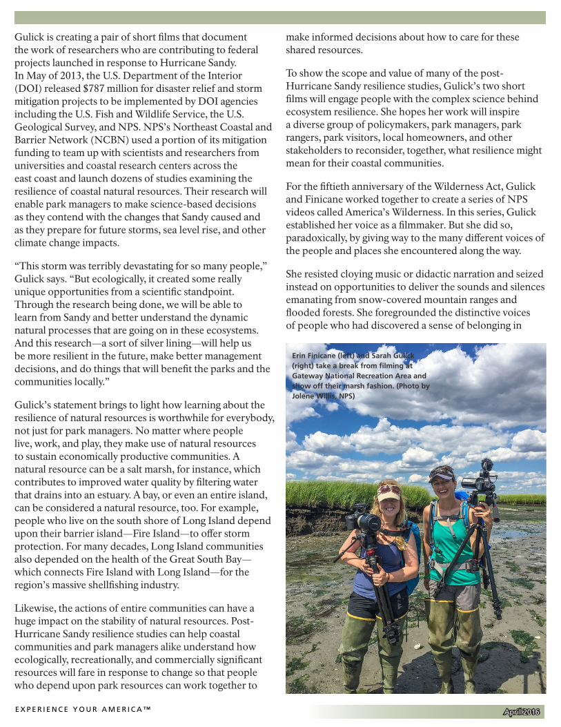
Erin Finicane (left) and Sarah Gulick (right) take a break from filming at Gateway National Recreation Area and show off their marsh fashion. (Photo by Jolene Willis, NPS)
E X P E R I E N C E Y O U R A M E R I C A ™ April 2016
the wilderness, and their very human stories about what experiences shaped their understandings of wilderness. A similar commitment to honoring diverse voices has guided Gulick’s approach to the post-Hurricane Sandy resilience films.
It would be easy, she says, to take control of the narrative, to mold a simple storyline. “But life is just so much messier than that,” she says. “I decided early on that it was really important that we let people tell their own stories.”
Even faced with the astounding complexity of dynamic natural resilience, our different human perspectives, and our evolving relationships with natural places, Gulick believes that communities that suffer disasters like Hurricane Sandy can work together to discover ways to bounce back. Moreover, she says, “When I got into film, I was really excited about how I could use film to unite people, to bring people together, to empower communities and to bring communities together around issues.” The stories that we tell one another, Gulick says, make all the difference in what we can accomplish.
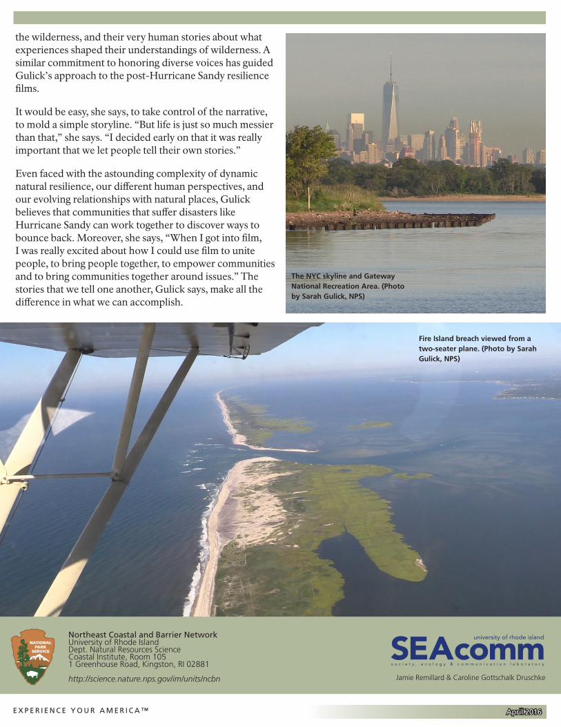
The NYC skyline and Gateway National Recreation Area. (Photo by Sarah Gulick, NPS)
Fire Island breach viewed from a two-seater plane. (Photo by Sarah Gulick, NPS)
Northeast Coastal and Barrier NetworkUniversity of Rhode IslandDept. Natural Resources ScienceCoastal Institute, Room 105 1 Greenhouse Road, Kingston, RI 02881
http://science.nature.nps.gov/im/units/ncbn
SEAcommuniversity of rhode island
s o c i e t y , e c o l o g y & c o m m u n i c a t i o n l a b o r a t o r y
Jamie Remillard & Caroline Gottschalk Druschke
E X P E R I E N C E Y O U R A M E R I C A ™ April 2016


![[Paris Unity meetup] - Unity 3D en entreprise](https://img.pdfslide.net/doc/110x75/55a64ec51a28ab123f8b45ab/paris-unity-meetup-unity-3d-en-entreprise.jpg)