Embed Size (px)
Citation preview
International Corporation Air Sciences
Final
CONCEPTUAL MODEL OF OZONE FORMATION IN THE TYLER/LONGVIEW/MARSHALL
NEAR NONATTAINMENT AREA
Prepared for
East Texas Council of Governments 3800 Stone Road
Kilgore, TX 75662
Prepared by Till Stoeckenius Greg Yarwood
ENVIRON International Corporation 101 Rowland Way, Suite 220
Novato, CA 94945
January 9, 2004
01 Rowland Way, Suite 220, Novato, CA 94945 415.899.0700
January 2004
i
TABLE OF CONTENTS
Page 1. INTRODUCTION ...................................................................................1-1 2. DATA COLLECTION..............................................................................2-1
Air Quality and Meteorological Data ..............................................................2-1 Emissions Data ........................................................................................2-2
3. RESULTS AND DISCUSSION ...................................................................3-1 Ozone Status and Trends.............................................................................3-1 Relationship of Ozone to Meteorological Conditions ...........................................3-5 Analysis of Hourly Ozone Data.....................................................................3-6 Windroses ............................................................................................ 3-14 Analysis of Aircraft Observations ................................................................ 3-17 Surface Nonmethane Hydrocarbon Measurements ............................................ 3-21 Conditions Associated with Recent High Ozone Events ...................................... 3-23
4. SUMMARY AND CONCLUSIONS .............................................................4-1
REFERENCES........................................................................................... R-1
APPENDICES Appendix A: Conceptual model for 8-hour ozone in East Texas and episode selection for new photochemical modeling Appendix B: Back Trajectory Plots
TABLES
Table 2-1. Summer average day emissions for point sources in the TLM NNA (tons/day). ..........................................................2-3 Table 2-2. Summer average day NOx emissions (tons/day) for additional major electric generating units in the vicinity of the TLM NNA ................2-3 Table 2-3. Summer average day emissions for on-road, off-road and area sources in the five county TLM NNA (tons/day). ...........................2-3
January 2004
ii
Table 3-1. Summary of 101 VOC samples collected at Longview (CAMS-19) on 16 days between 7/7/2002 and 9/29/2002 showing the number of samples (out of a total of 101) in which each compound appeared within the list of the five most abundant species along with the average concentrations within those samples and the average over all samples (from AQSI, 2002). ................................................................... 3-21 Table 3-2. Average concentrations of ethane, n-butane, and propane in 98 samples collected at Longview in July – September 2002 (AQSI, 2002) and 346 samples collected at individual rural locations in the eight southwestern states (TX, OK, LA, AR, MO, KS, CO, NM) by Katzenstein et al. (2003)........ 3-22 Table 3-3. Days in 2000 – 2003 on which 8-hour average ozone concentrations equaled or exceeded 85 ppb at both Longview and Tyler................................................................... 3-23 Table 3-4 Maximum 8-hour average ozone concentrations on days in 2002 – 2003 with concentrations greater than or equal to 85PPB at either Karnack or Waskon. .............................................. 3-24
FIGURES
Figure 2-1. Map of Northeast Texas showing locations of TNRCC air quality monitors (source: www.tnrcc.state.tx.us ). ............................2-1 Figure 2-2. Northeast Texas air quality monitoring sites (filled circles) and major point sources (open circles). Counties in the NNA are shaded.....................................................................2-2 Figure 2-3. Contributions of source categories to total 2002 summer average day VOC emissions in the TLM NNA.....................................2-4 Figure 2-4. Summary of 1999, 2002, and 2007 summer average day NOx and VOC emissions by major source categories in the Tyler-Marshall-Longview NNA. .................................................2-5 Figure 3-1. Long-term ozone trends at Longview (CAMS-19): annual second highest daily maximum 1-hour (top) and annual fourth highest daily maximum 8-hour (bottom)............................3-2 Figure 3-2. Annual fourth highest daily maximum 8-hour ozone at East Texas and northeastern Louisiana monitoring sites: 1995 – 2003. ......................................................................3-3 Figure 3-3. Annual fourth highest daily maximum 8-hour average ozone at locations in Northeast Texas, Dallas, and Shreveport, LA. ...........3-4 Figure 3-4. Annual 8-hour ozone design values and percent of days with daily maximum temperature greater than 100 F at Longview: 1987 – 2003 (Sather, 2003). .........................................3-5 Figure 3-5. Annual Ozone Action Day forecast results for 1994 – 2002 in East Texas. ............................................................3-6 Figure 3-6. Hourly average ozone and sulfur dioxide at Longview (C-19) on days exceeding 124 ppb ozone. ..........................................3-8
January 2004
iii
Figure 3-7. Hourly ozone, SO2, and NOx concentrations at Longview (CAMS-19) on 1 June 2003 (top) and 8 August 2002 (bottom)................ 3-12 Figure 3-8. Hourly ozone, SO2, and NOx concentrations at Longview (CAMS-19) on 27 September 2002. ................................................ 3-13 Figure 3-9 Mean diurnal profile of hourly average ozone at Longview (CAMS-19) for three different three year periods (error bars indicate 95% confidence intervals). ................................................ 3-14 Figure 3-10. Wind rose displays for morning (7:00 – 10:00 CST) and afternoon (13:00 – 16:00 CST) hours on high and low ozone days at Longview ....... 3-15 Figure 3-11. Wind rose displays for morning (6:00 – 11:00 CST) and afternoon (12:00 – 18:00 CST) hours on high and low ozone days at Karnack ......... 3-16 Figure 3-12 Baylor aircraft ozone measurements for early afternoon of 29 August 2002.3-15.................................................................. 3-17 Figure 3-13. Baylor aircraft measurements of ozone and olefins on afternoon of 30
September 2002 (light of symbol along flight path is proportional to olefin concentration; color indicates ozone concentrations ............................. 3-18
Figure 3-14. Baylor aircraft ozone measurements for mid-afternoon of 2 September 2002. ................................................................. 3-19 Figure 3-15. NOAA Electra aircraft flight path on 3 September 2000 showing ozone concentrations represented by the color scale. The thickness of the line indicates the magnitude of the SO2 concentration along the flight path. The circles locate NOx point sources whose magnitude is indicated by the diameter of the circle (from Vizuete, 2002). ............................. 3-20
January 2004
H:\etcog3\ConceptModUdate\Report\Final\Sec1(Intro).doc 1-1
1. INTRODUCTION This report presents a conceptual model of ozone formation in Northeast Texas using results of a review and analysis of air quality and meteorological conditions and trends and ozone precursor emission trends. The Texas Commission on Environmental Quality (TCEQ) operates three Continuous Air Monitoring Stations (CAMS) in the Tyler/Longview/Marshall (TLM) area of Northeast Texas. These stations monitor compliance with the National Ambient Air Quality Standard (NAAQS) for ozone. In recent years ozone levels measured at the Greg County Airport (Longview) have exceeded both the 1-hour and 8-hour National Ambient Air Quality Standards (NAAQS) for ozone. In 1996 the TLM area became a Flexible Attainment Region (FAR) and a mechanism for developing strategies to attain the 1-hour ozone standard was implemented under a Memorandum of Agreement (Flexible Attainment Region Memorandum of Agreement, September 16, 1996). The TLM area has received funding from the Texas legislature to address ozone air quality issues. These resources have funded studies through the East Texas Council of Governments (ETCOG) under the technical and policy direction of the North East Texas Air Care (NETAC) organization. In 1999, ENVIRON completed an ozone modeling study for two 1-hour ozone episodes that included future year modeling for 2007 and the evaluation of future year emission reduction strategies (Yarwood et al., 1999). In May 2002, the TNRCC submitted a State Implementation Plans (SIP) for Northeast Texas that demonstrated attainment of the 1-hour ozone standard by 2007 (TNRCC, 2002). In 1997 the U.S. Environmental Protection Agency (EPA) promulgated a new 8-hour NAAQS for ozone that is potentially much more stringent than the existing 1-hour standard. The 8-hour ozone NAAQS was challenged in court and was eventually upheld in 2002 by the U.S. Supreme Court. However, the Court required that the EPA revise its implementation policy. EPA issued a draft revised implementation policy on June 2, 2003. TLM is one of several near nonattainment areas (NNAs) in Texas that have been preparing technical studies to support eventual development of an 8-hour ozone SIP. In December 2002, the TLM NNA entered into an Early Action Compact EAC with EPA. One of the key activities to be completed for the EAC is development of a “conceptual model” that qualitatively describes ozone formation mechanisms and the rational for selection of episodes to be modeled. Previous modeling for Northeast Texas in FY 1998/99 developed ozone models for two episodes, June 20-23, 1995 and July 16-18, 1997. The June 1995 episode was used to develop a regional scale model whereas the July 1997 was used to develop an urban scale model (USM). These episodes were selected because they had very high 1-hour ozone levels, but they also have high 8-hour ozone levels. Conceptual model development work previously performed by ENVIRON (Yarwood et al., 2000; reproduced in Appendix A) identified a new third episode for modeling (15 – 22 August 1999) that was representative of conditions commonly associated with high 8-hour ozone levels. This document updates the previous conceptual model development and data analysis work of Yarwood et al. (2000) and Stoeckenius et al. (2002) with more recent data. Updated conclusions are developed regarding ozone formation in the TLM NNA and the need to identify any additional or alternate episodes for modeling.
January 2004
H:\etcog3\ConceptModUdate\Report\Final\Sec2(data).doc 2-1
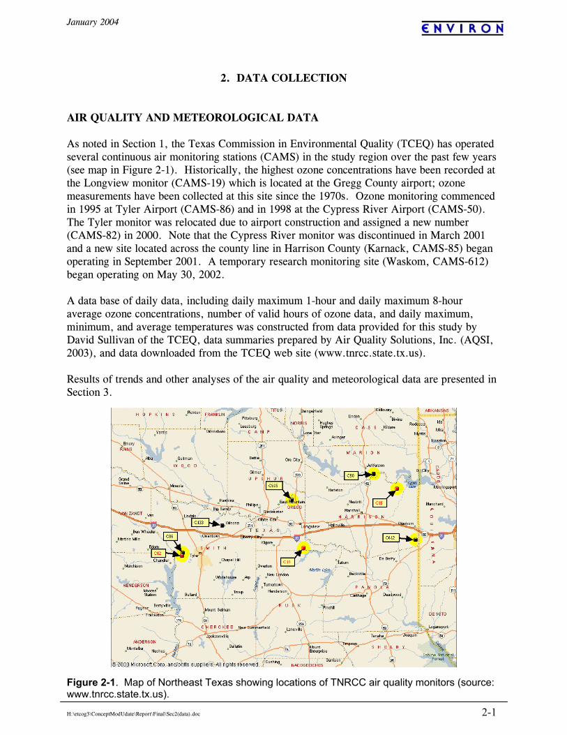
2. DATA COLLECTION AIR QUALITY AND METEOROLOGICAL DATA As noted in Section 1, the Texas Commission in Environmental Quality (TCEQ) has operated several continuous air monitoring stations (CAMS) in the study region over the past few years (see map in Figure 2-1). Historically, the highest ozone concentrations have been recorded at the Longview monitor (CAMS-19) which is located at the Gregg County airport; ozone measurements have been collected at this site since the 1970s. Ozone monitoring commenced in 1995 at Tyler Airport (CAMS-86) and in 1998 at the Cypress River Airport (CAMS-50). The Tyler monitor was relocated due to airport construction and assigned a new number (CAMS-82) in 2000. Note that the Cypress River monitor was discontinued in March 2001 and a new site located across the county line in Harrison County (Karnack, CAMS-85) began operating in September 2001. A temporary research monitoring site (Waskom, CAMS-612) began operating on May 30, 2002. A data base of daily data, including daily maximum 1-hour and daily maximum 8-hour average ozone concentrations, number of valid hours of ozone data, and daily maximum, minimum, and average temperatures was constructed from data provided for this study by David Sullivan of the TCEQ, data summaries prepared by Air Quality Solutions, Inc. (AQSI, 2003), and data downloaded from the TCEQ web site (www.tnrcc.state.tx.us). Results of trends and other analyses of the air quality and meteorological data are presented in Section 3.
Figure 2-1. Map of Northeast Texas showing locations of TNRCC air quality monitors (source: www.tnrcc.state.tx.us).
January 2004
H:\etcog3\ConceptModUdate\Report\Final\Sec2(data).doc 2-2
400 420 440 460 480 500 520 540 560 580 600
-900
-880
-860
-840
-820
-800
-780
-760
-740
-720
220150008CAMS_605
CAMS_50
CAMS_86
CAMS_82
220170001CAMS_85
CAMS_19
Eastman_Chemical_Co
Martin_Lake
Knox_Lee
Pirkey
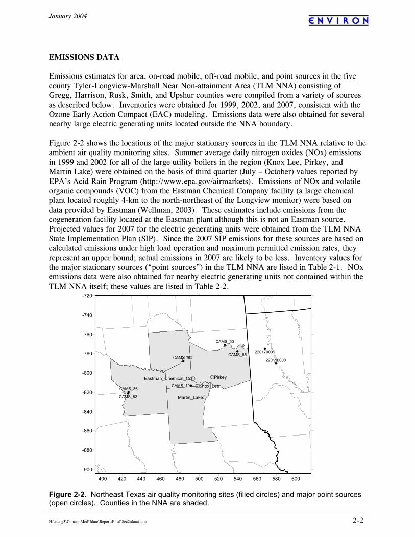
EMISSIONS DATA Emissions estimates for area, on-road mobile, off-road mobile, and point sources in the five county Tyler-Longview-Marshall Near Non-attainment Area (TLM NNA) consisting of Gregg, Harrison, Rusk, Smith, and Upshur counties were compiled from a variety of sources as described below. Inventories were obtained for 1999, 2002, and 2007, consistent with the Ozone Early Action Compact (EAC) modeling. Emissions data were also obtained for several nearby large electric generating units located outside the NNA boundary. Figure 2-2 shows the locations of the major stationary sources in the TLM NNA relative to the ambient air quality monitoring sites. Summer average daily nitrogen oxides (NOx) emissions in 1999 and 2002 for all of the large utility boilers in the region (Knox Lee, Pirkey, and Martin Lake) were obtained on the basis of third quarter (July – October) values reported by EPA’s Acid Rain Program (http://www.epa.gov/airmarkets). Emissions of NOx and volatile organic compounds (VOC) from the Eastman Chemical Company facility (a large chemical plant located roughly 4-km to the north-northeast of the Longview monitor) were based on data provided by Eastman (Wellman, 2003). These estimates include emissions from the cogeneration facility located at the Eastman plant although this is not an Eastman source. Projected values for 2007 for the electric generating units were obtained from the TLM NNA State Implementation Plan (SIP). Since the 2007 SIP emissions for these sources are based on calculated emissions under high load operation and maximum permitted emission rates, they represent an upper bound; actual emissions in 2007 are likely to be less. Inventory values for the major stationary sources (“point sources”) in the TLM NNA are listed in Table 2-1. NOx emissions data were also obtained for nearby electric generating units not contained within the TLM NNA itself; these values are listed in Table 2-2.
Figure 2-2. Northeast Texas air quality monitoring sites (filled circles) and major point sources (open circles). Counties in the NNA are shaded.
January 2004
H:\etcog3\ConceptModUdate\Report\Final\Sec2(data).doc 2-3
Table 2-1. Summer average day emissions for point sources in the TLM NNA (tons/day). 1999 2002 2007 Pirkey1 NOx 26 13 18 Knox Lee1 NOx 6.5 2.5 5.9 Martin Lake1 NOx 73 54 58 Eastman2 NOx 14 9.3 9.7 Eastman2 VOC 11 12 10 Other2 NOx 30 22 27 Other2 VOC 19 21 29
Table 2-2. Summer average day NOx emissions (tons/day) for additional major electric generating units in the vicinity of the TLM NNA.1 Facility 1999 2002 2007 Dolet Hills Power 35 34 32 Monticello 63 44 49 Stryker Creek 12 6.9 14 Welsh 72 43 29 Wilkes 11 5.7 7
Off-road mobile and area source emissions for the TLM NNA were obtained from an inventory development effort completed for the NETAC Early Action Compact ozone modeling (ENVIRON, 2004). Off-road mobile emissions for all equipment types except locomotive and aircraft are based on the latest version of EPA’s NONROAD emissions model. Locomotive and aircraft emissions were the values reported previously by ENVIRON (2001). On-road mobile source emissions for the TLM NNA were obtained from TCEQ. These results are based on application of EPA’s MOBILE6 emission factor model by the Texas Transportation Institute and reflect summer average day conditions. Emissions from these three source categories are summarized in Table 2-3. Table 2-3. Summer average day2 emissions for on-road, off-road and area sources in the five county TLM NNA (tons/day).
1999 2002 2007 On-Road NOx 73 62 40 VOC 28 23 21 Off-Road NOx 22 20 17 VOC 10 9.3 7.7 Area NOx 46 49 50 VOC 64 67 70
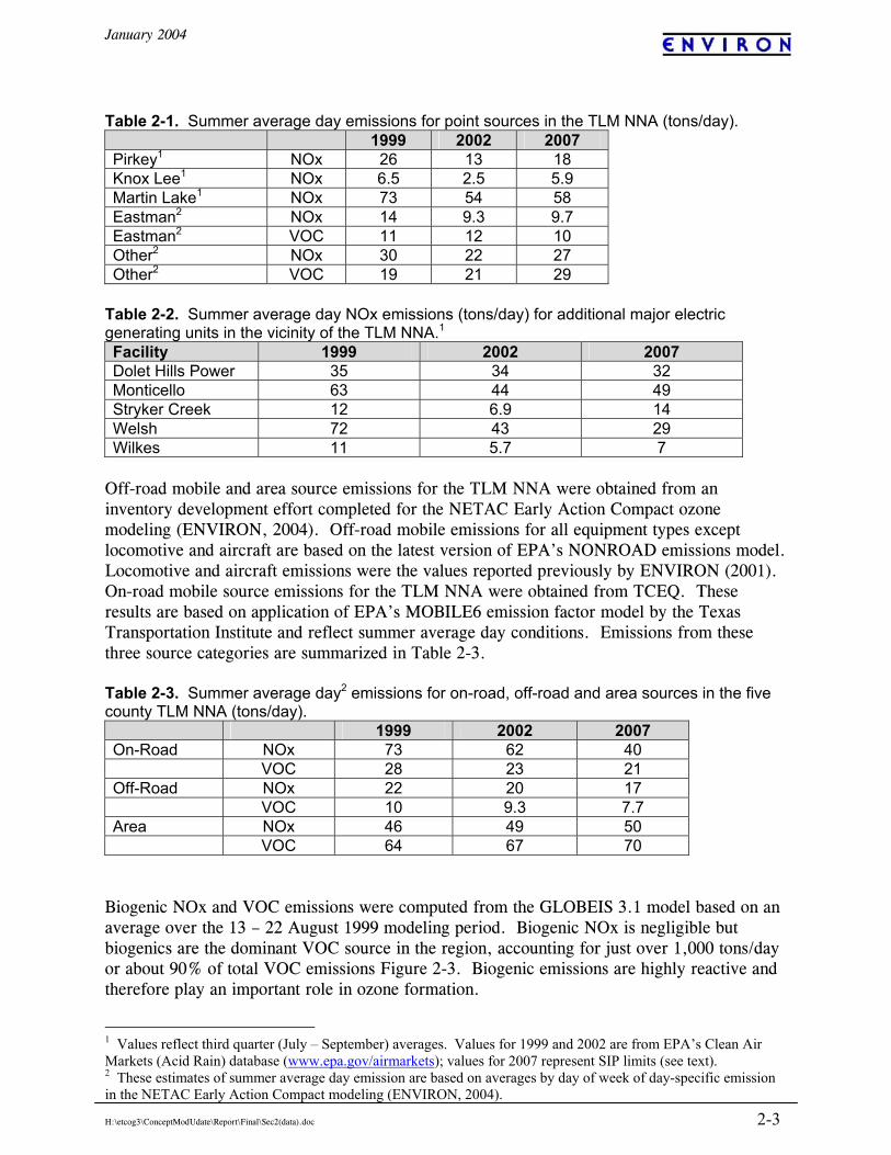
Biogenic NOx and VOC emissions were computed from the GLOBEIS 3.1 model based on an average over the 13 – 22 August 1999 modeling period. Biogenic NOx is negligible but biogenics are the dominant VOC source in the region, accounting for just over 1,000 tons/day or about 90% of total VOC emissions Figure 2-3. Biogenic emissions are highly reactive and therefore play an important role in ozone formation.
1 Values reflect third quarter (July – September) averages. Values for 1999 and 2002 are from EPA’s Clean Air Markets (Acid Rain) database (www.epa.gov/airmarkets); values for 2007 represent SIP limits (see text). 2 These estimates of summer average day emission are based on averages by day of week of day-specific emission in the NETAC Early Action Compact modeling (ENVIRON, 2004).
January 2004
H:\etcog3\ConceptModUdate\Report\Final\Sec2(data).doc 2-4
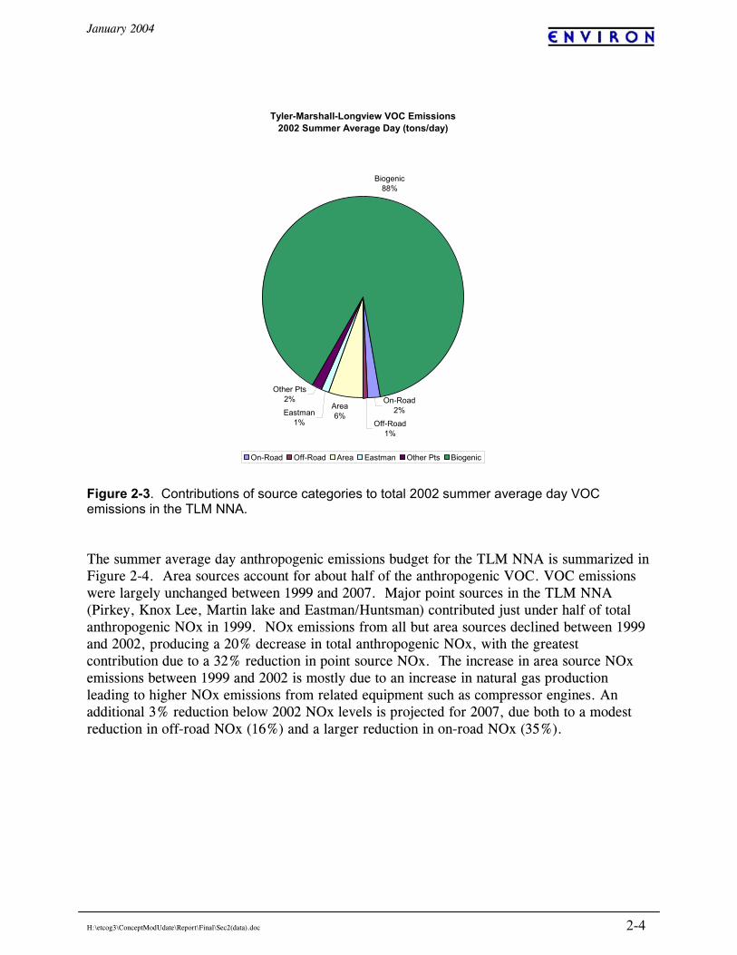
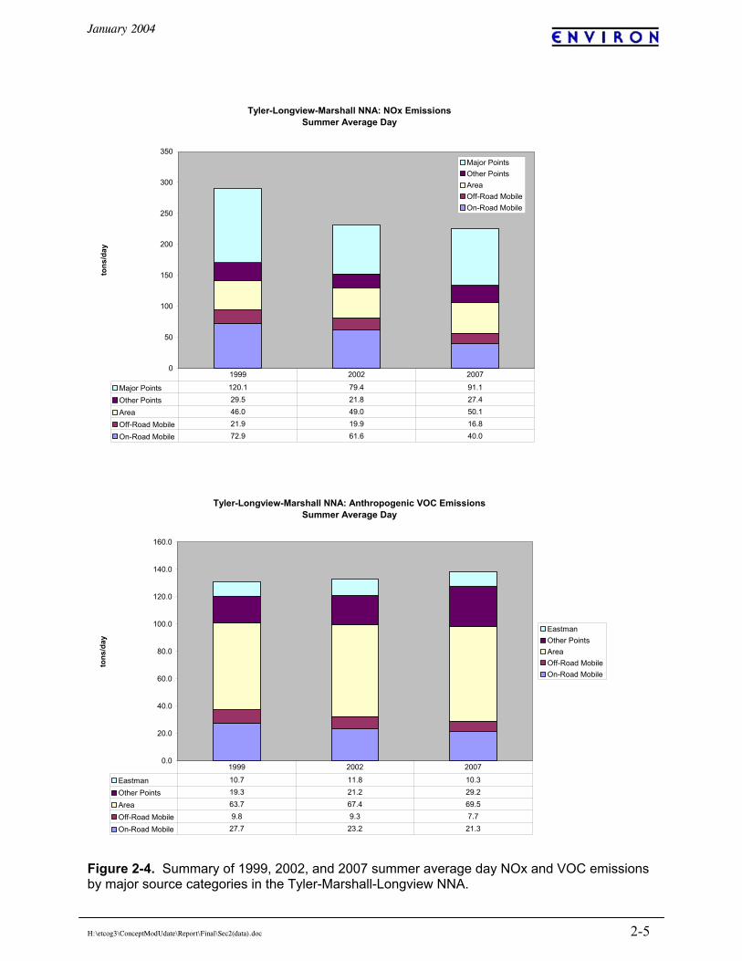
Figure 2-3. Contributions of source categories to total 2002 summer average day VOC emissions in the TLM NNA. The summer average day anthropogenic emissions budget for the TLM NNA is summarized in Figure 2-4. Area sources account for about half of the anthropogenic VOC. VOC emissions were largely unchanged between 1999 and 2007. Major point sources in the TLM NNA (Pirkey, Knox Lee, Martin lake and Eastman/Huntsman) contributed just under half of total anthropogenic NOx in 1999. NOx emissions from all but area sources declined between 1999 and 2002, producing a 20% decrease in total anthropogenic NOx, with the greatest contribution due to a 32% reduction in point source NOx. The increase in area source NOx emissions between 1999 and 2002 is mostly due to an increase in natural gas production leading to higher NOx emissions from related equipment such as compressor engines. An additional 3% reduction below 2002 NOx levels is projected for 2007, due both to a modest reduction in off-road NOx (16%) and a larger reduction in on-road NOx (35%).
Tyler-Marshall-Longview VOC Emissions 2002 Summer Average Day (tons/day)
On-Road2%
Off-Road1%
Area6%Eastman
1%
Other Pts2%
Biogenic88%
On-Road Off-Road Area Eastman Other Pts Biogenic
January 2004
H:\etcog3\ConceptModUdate\Report\Final\Sec2(data).doc 2-5
Figure 2-4. Summary of 1999, 2002, and 2007 summer average day NOx and VOC emissions by major source categories in the Tyler-Marshall-Longview NNA.
Tyler-Longview-Marshall NNA: NOx EmissionsSummer Average Day
0
50
100
150
200
250
300
350
tons
/day
Major PointsOther PointsAreaOff-Road MobileOn-Road Mobile
Major Points 120.1 79.4 91.1
Other Points 29.5 21.8 27.4
Area 46.0 49.0 50.1
Off-Road Mobile 21.9 19.9 16.8
On-Road Mobile 72.9 61.6 40.0
1999 2002 2007
Tyler-Longview-Marshall NNA: Anthropogenic VOC EmissionsSummer Average Day
0.0
20.0
40.0
60.0
80.0
100.0
120.0
140.0
160.0
tons
/day
EastmanOther PointsAreaOff-Road MobileOn-Road Mobile
Eastman 10.7 11.8 10.3
Other Points 19.3 21.2 29.2
Area 63.7 67.4 69.5
Off-Road Mobile 9.8 9.3 7.7
On-Road Mobile 27.7 23.2 21.3
1999 2002 2007
January 2004
H:\etcog3\ConceptModUdate\Report\Final\Sec2(data).doc 2-6
Given the dominant influence of biogenic VOCs, ozone formation in the TLM NNA is largely controlled by the availability of NO. Overall, the VOC/NOx emission ratio in the five county NNA in 2002 is estimated to be 5.2 tons VOC per ton of NOx. Assuming an average VOC molecular weight of 13.9 g/mole (Stoeckenius et al., 2003), this translates to a molar VOC/NOx ratio of 30:1, well within the NOx limited ozone formation regime. This implies that, broadly speaking, NOx reductions projected for future years will result in lower ozone levels. This does not, however, account for the influence of elevated background ozone which may be transported into the region or the local-scale impact of point source plumes. Aircraft sampling programs have identified ozone formation (and destruction of ozone via titration by NO) within NOx and combined NOx/VOC plumes from point sources in the TLM area. These observations are discussed in more detail in Section 3.
January 2004
H:\etcog3\ConceptModUdate\Report\Final\Sec3.doc 3-1
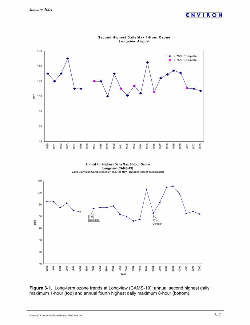
3. RESULTS AND DISCUSSION OZONE STATUS AND TRENDS EPA’s National Ambient Air Quality Standard for ozone includes both a 1-hour average standard and an 8-hour average standard. The 1-hour standard limits the frequency with which the daily maximum 1-hour average concentration can exceed 0.12 ppm to once per year (averaged over three years) while the 8-hour standard sets a maximum level (0.08 ppm) for the annual fourth highest daily maximum 8-hour average concentration.1 The 1-hour standard is violated if the fourth highest concentration in a period of three consecutive years exceeds 0.12 ppm.2 Although a single year of data is not considered sufficient to demonstrate attainment, the value of the second highest daily maximum 1-hour concentration in a year is frequently used as an informal indicator of attainment/nonattainment status. In the following discussion, we refer to this as the annual 1-hour design value. The 8-hour standard is violated if the annual fourth highest daily maximum 8-hour average concentration averaged over three consecutive years exceeds 0.08 ppm. Again, although a single year of data is not considered sufficient to demonstrate attainment, the fourth highest value in a given year is frequently used as an informal indicator of attainment/nonattainment status. Consequently, in the following discussion we refer to this statistic as the annual 8-hour design value. Long-Term Ozone Trend at Longview Ozone data have been collected at the Longview monitoring site (CAMS-19) located at the Gregg Co. airport since the 1970s. This was the only routine ozone monitoring site in the area prior to 1995. Figure 3-1 shows the trend in annual 1-hour and 8-hour ozone design values at Longview since 1980. As noted by Stoeckenius et al. (2002), this trend is quite remarkable in that the period 1980 – 1993 looks very different from the period 1993 – 2003. This difference is more readily apparent in the 8-hour design values as they exhibit less year-to-year variability than the 1-hour design values. Prior to 1993, design values were relatively consistent from one year to the next and exhibited fairly steady decreases between 1980 and 1985 and again between 1990 and 1993. After 1993, however, the interannual fluctuations were much greater and the overall trend is less clear. Stoeckenius et al. also note that the annual 8-hour design value is closely correlated with a broader measure of annual high ozone (the 95th percentile of the daily maximum 8-hour averages), indicating that the change in pattern before and after 1993 is not the result of just a handful of unusual values.
1 Under the rounding conventions specified in the standard, the 1-hour standard is exceeded by a concentration of 125 ppb or greater while the 8-hour standard is exceeded by a concentration of 85 ppb or greater. 2 Because the 1-hour standard is actually based on the expected value of the annual exceedance rate (which allows for adjustment of the exceedance count for missing data), it is possible under rare circumstances to record a violation of the standard even if the fourth highest daily 1-hour maximum in three years is less than 0.12 ppm.
January 2004
H:\etcog3\ConceptModUdate\Report\Final\Sec3.doc 3-2
Figure 3-1. Long-term ozone trends at Longview (CAMS-19): annual second highest daily maximum 1-hour (top) and annual fourth highest daily maximum 8-hour (bottom).
Annual 4th Highest Daily Max 8-Hour OzoneLongview (CAMS-19)
Valid Daily Max Completeness > 75% for May - October Except as Indicated
40
50
60
70
80
90
100
110
1980
1981
1982
1983
1984
1985
1986
1987
1988
1989
1990
1991
1992
1993
1994
1995
1996
1997
1998
1999
2000
2001
2002
2003
Year
ppb 72%
Complet
73% Complet
S econd H ighest D a ily M ax 1 -H our O zoneLongview Airport
40
60
80
100
120
140
16019
80
1981
1982
1983
1984
1985
1986
1987
1988
1989
1990
1991
1992
1993
1994
1995
1996
1997
1998
1999
2000
2001
2002
2003
ppb
> 75% C om plete< 75% C om plete
January 2004
H:\etcog3\ConceptModUdate\Report\Final\Sec3.doc 3-3
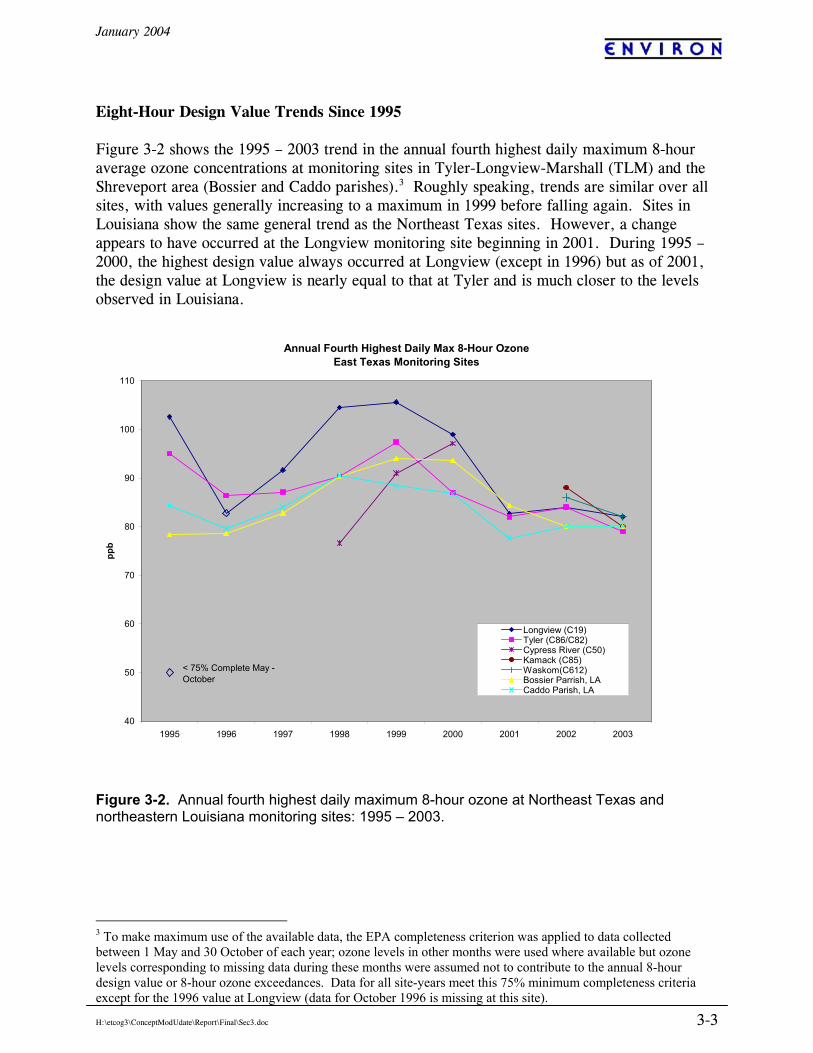
Eight-Hour Design Value Trends Since 1995 Figure 3-2 shows the 1995 – 2003 trend in the annual fourth highest daily maximum 8-hour average ozone concentrations at monitoring sites in Tyler-Longview-Marshall (TLM) and the Shreveport area (Bossier and Caddo parishes).3 Roughly speaking, trends are similar over all sites, with values generally increasing to a maximum in 1999 before falling again. Sites in Louisiana show the same general trend as the Northeast Texas sites. However, a change appears to have occurred at the Longview monitoring site beginning in 2001. During 1995 – 2000, the highest design value always occurred at Longview (except in 1996) but as of 2001, the design value at Longview is nearly equal to that at Tyler and is much closer to the levels observed in Louisiana.
Annual Fourth Highest Daily Max 8-Hour OzoneEast Texas Monitoring Sites
40
50
60
70
80
90
100
110
1995 1996 1997 1998 1999 2000 2001 2002 2003
ppb
Longview (C19)Tyler (C86/C82)Cypress River (C50)Kamack (C85)Waskom(C612)Bossier Parrish, LACaddo Parish, LA
< 75% Complete May - October
Figure 3-2. Annual fourth highest daily maximum 8-hour ozone at Northeast Texas and northeastern Louisiana monitoring sites: 1995 – 2003.
3 To make maximum use of the available data, the EPA completeness criterion was applied to data collected between 1 May and 30 October of each year; ozone levels in other months were used where available but ozone levels corresponding to missing data during these months were assumed not to contribute to the annual 8-hour design value or 8-hour ozone exceedances. Data for all site-years meet this 75% minimum completeness criteria except for the 1996 value at Longview (data for October 1996 is missing at this site).
January 2004
H:\etcog3\ConceptModUdate\Report\Final\Sec3.doc 3-4
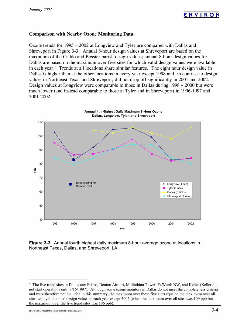
Comparison with Nearby Ozone Monitoring Data Ozone trends for 1995 – 2002 at Longview and Tyler are compared with Dallas and Shreveport in Figure 3-3. Annual 8-hour design values at Shreveport are based on the maximum of the Caddo and Bossier parish design values; annual 8-hour design values for Dallas are based on the maximum over five sites for which valid design values were available in each year.4 Trends at all locations share similar features. The eight hour design value in Dallas is higher than at the other locations in every year except 1998 and, in contrast to design values in Northeast Texas and Shreveport, did not drop off significantly in 2001 and 2002. Design values at Longview were comparable to those in Dallas during 1998 – 2000 but were much lower (and instead comparable to those at Tyler and in Shreveport) in 1996-1997 and 2001-2002.
Annual 4th Highest Daily Maximum 8-Hour OzoneDallas, Longview, Tyler, and Shreveport
40
50
60
70
80
90
100
110
1995 1996 1997 1998 1999 2000 2001 2002
Year
ppb
Longview (1 site)Tyler (1 site)Dallas (5 sites)Shreveport (2 sites)
Data missing for October, 1996
Figure 3-3. Annual fourth highest daily maximum 8-hour average ozone at locations in Northeast Texas, Dallas, and Shreveport, LA.
4 The five trend sites in Dallas are: Frisco, Denton Airport, Midlothian Tower, Ft.Worth NW, and Keller (Keller did not start operations until 7/16/1997). Although some ozone monitors in Dallas do not meet the completeness criteria and were therefore not included in this summary, the maximum over these five sites equaled the maximum over all sites with valid annual design values in each year except 2002 (when the maximum over all sites was 109 ppb but the maximum over the five trend sites was 106 ppb).
January 2004
H:\etcog3\ConceptModUdate\Report\Final\Sec3.doc 3-5
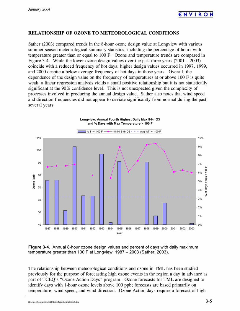
RELATIONSHIP OF OZONE TO METEOROLOGICAL CONDITIONS Sather (2003) compared trends in the 8-hour ozone design value at Longview with various summer season meteorological summary statistics, including the percentage of hours with temperature greater than or equal to 100 F. Ozone and temperature trends are compared in Figure 3-4. While the lower ozone design values over the past three years (2001 – 2003) coincide with a reduced frequency of hot days, higher design values occurred in 1997, 1999, and 2000 despite a below average frequency of hot days in those years. Overall, the dependence of the design value on the frequency of temperatures at or above 100 F is quite weak: a linear regression analysis yields a small positive relationship but it is not statistically significant at the 90% confidence level. This is not unexpected given the complexity of processes involved in producing the annual design value. Sather also notes that wind speed and direction frequencies did not appear to deviate significantly from normal during the past several years.
Longview: Annual Fourth Highest Daily Max 8-Hr O3 and % Days with Max Temperature > 100 F
40
50
60
70
80
90
100
110
1987 1988 1989 1990 1991 1992 1993 1994 1995 1996 1997 1998 1999 2000 2001 2002 2003
Year
Ozo
ne (p
pb)
0%
1%
2%
3%
4%
5%
6%
7%
8%
9%
10%
% o
f Day
s Tm
ax >
100
F
% T >= 100 F 4th Hi 8-Hr O3 Avg %T >= 100 F
Figure 3-4. Annual 8-hour ozone design values and percent of days with daily maximum temperature greater than 100 F at Longview: 1987 – 2003 (Sather, 2003). The relationship between meteorological conditions and ozone in TML has been studied previously for the purpose of forecasting high ozone events in the region a day in advance as part of TCEQ’s “Ozone Action Days” program. Ozone forecasts for TML are designed to identify days with 1-hour ozone levels above 100 ppb; forecasts are based primarily on temperature, wind speed, and wind direction. Ozone Action days require a forecast of high
January 2004
H:\etcog3\ConceptModUdate\Report\Final\Sec3.doc 3-6
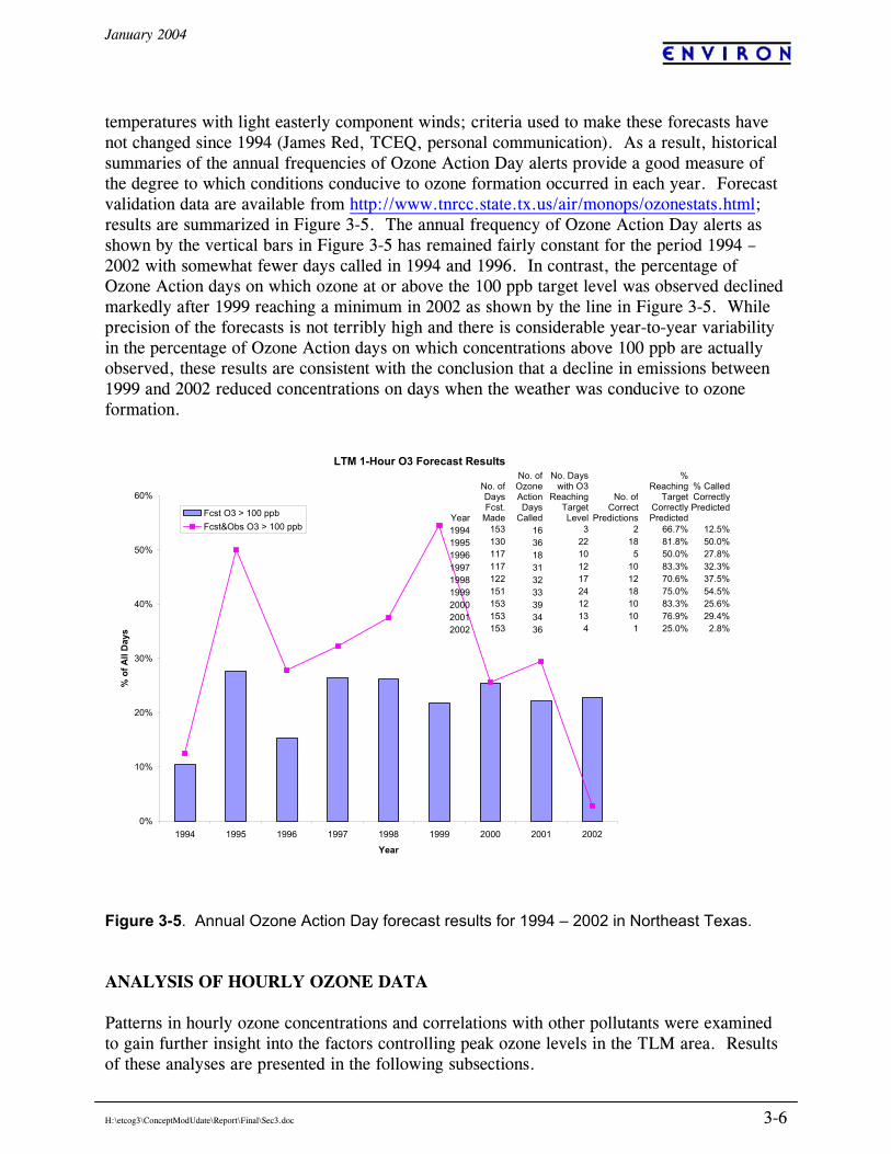
temperatures with light easterly component winds; criteria used to make these forecasts have not changed since 1994 (James Red, TCEQ, personal communication). As a result, historical summaries of the annual frequencies of Ozone Action Day alerts provide a good measure of the degree to which conditions conducive to ozone formation occurred in each year. Forecast validation data are available from http://www.tnrcc.state.tx.us/air/monops/ozonestats.html; results are summarized in Figure 3-5. The annual frequency of Ozone Action Day alerts as shown by the vertical bars in Figure 3-5 has remained fairly constant for the period 1994 – 2002 with somewhat fewer days called in 1994 and 1996. In contrast, the percentage of Ozone Action days on which ozone at or above the 100 ppb target level was observed declined markedly after 1999 reaching a minimum in 2002 as shown by the line in Figure 3-5. While precision of the forecasts is not terribly high and there is considerable year-to-year variability in the percentage of Ozone Action days on which concentrations above 100 ppb are actually observed, these results are consistent with the conclusion that a decline in emissions between 1999 and 2002 reduced concentrations on days when the weather was conducive to ozone formation.
Figure 3-5. Annual Ozone Action Day forecast results for 1994 – 2002 in Northeast Texas. ANALYSIS OF HOURLY OZONE DATA Patterns in hourly ozone concentrations and correlations with other pollutants were examined to gain further insight into the factors controlling peak ozone levels in the TLM area. Results of these analyses are presented in the following subsections.
LTM 1-Hour O3 Forecast Results
0%
10%
20%
30%
40%
50%
60%
1994 1995 1996 1997 1998 1999 2000 2001 2002
Year
% o
f All
Day
s
Fcst O3 > 100 ppbFcst&Obs O3 > 100 ppb
Year
No. of Days Fcst.
Made
No. of Ozone Action Days
Called
No. Days with O3
Reaching Target Level
No. of Correct
Predictions
% Reaching
Target Correctly Predicted
% Called Correctly Predicted
1994 153 16 3 2 66.7% 12.5%1995 130 36 22 18 81.8% 50.0%1996 117 18 10 5 50.0% 27.8%1997 117 31 12 10 83.3% 32.3%1998 122 32 17 12 70.6% 37.5%1999 151 33 24 18 75.0% 54.5%2000 153 39 12 10 83.3% 25.6%2001 153 34 13 10 76.9% 29.4%2002 153 36 4 1 25.0% 2.8%
January 2004
H:\etcog3\ConceptModUdate\Report\Final\Sec3.doc 3-7
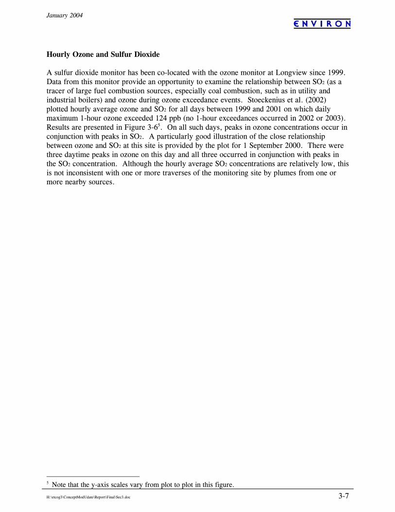
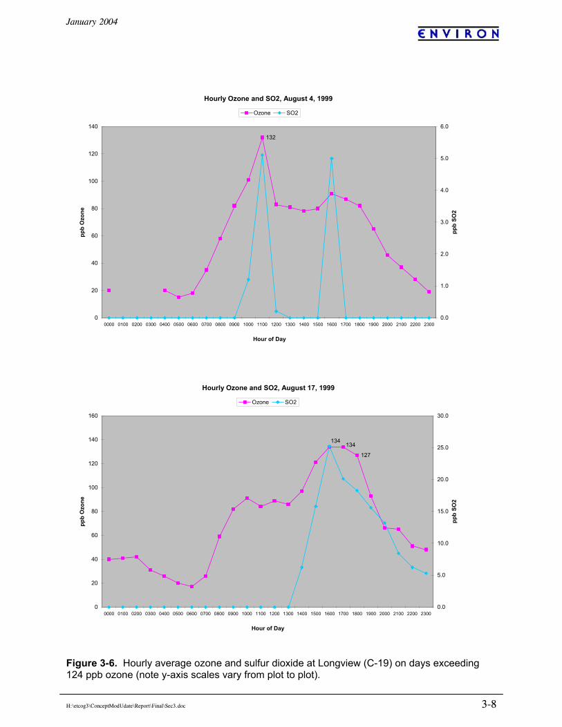
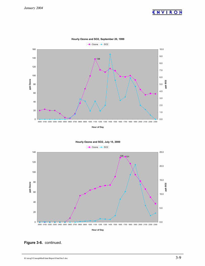
Hourly Ozone and Sulfur Dioxide A sulfur dioxide monitor has been co-located with the ozone monitor at Longview since 1999. Data from this monitor provide an opportunity to examine the relationship between SO2 (as a tracer of large fuel combustion sources, especially coal combustion, such as in utility and industrial boilers) and ozone during ozone exceedance events. Stoeckenius et al. (2002) plotted hourly average ozone and SO2 for all days between 1999 and 2001 on which daily maximum 1-hour ozone exceeded 124 ppb (no 1-hour exceedances occurred in 2002 or 2003). Results are presented in Figure 3-65. On all such days, peaks in ozone concentrations occur in conjunction with peaks in SO2. A particularly good illustration of the close relationship between ozone and SO2 at this site is provided by the plot for 1 September 2000. There were three daytime peaks in ozone on this day and all three occurred in conjunction with peaks in the SO2 concentration. Although the hourly average SO2 concentrations are relatively low, this is not inconsistent with one or more traverses of the monitoring site by plumes from one or more nearby sources.
5 Note that the y-axis scales vary from plot to plot in this figure.
January 2004
H:\etcog3\ConceptModUdate\Report\Final\Sec3.doc 3-8
Figure 3-6. Hourly average ozone and sulfur dioxide at Longview (C-19) on days exceeding 124 ppb ozone (note y-axis scales vary from plot to plot).
Hourly Ozone and SO2, August 4, 1999
132
0
20
40
60
80
100
120
140
0000 0100 0200 0300 0400 0500 0600 0700 0800 0900 1000 1100 1200 1300 1400 1500 1600 1700 1800 1900 2000 2100 2200 2300
Hour of Day
ppb
Ozo
ne
0.0
1.0
2.0
3.0
4.0
5.0
6.0
ppb
SO2
Ozone SO2
Hourly Ozone and SO2, August 17, 1999
134
127
134
0
20
40
60
80
100
120
140
160
0000 0100 0200 0300 0400 0500 0600 0700 0800 0900 1000 1100 1200 1300 1400 1500 1600 1700 1800 1900 2000 2100 2200 2300
Hour of Day
ppb
Ozo
ne
0.0
5.0
10.0
15.0
20.0
25.0
30.0
ppb
SO2
Ozone SO2
January 2004
H:\etcog3\ConceptModUdate\Report\Final\Sec3.doc 3-9
Figure 3-6. continued.
Hourly Ozone and SO2, September 20, 1999
138
0
20
40
60
80
100
120
140
160
0000 0100 0200 0300 0400 0500 0600 0700 0800 0900 1000 1100 1200 1300 1400 1500 1600 1700 1800 1900 2000 2100 2200 2300
Hour of Day
ppb
Ozo
ne
0.0
1.0
2.0
3.0
4.0
5.0
6.0
7.0
8.0
9.0
10.0
ppb
SO2
Ozone SO2
Hourly Ozone and SO2, July 15, 2000
129 131
0
20
40
60
80
100
120
140
0000 0100 0200 0300 0400 0500 0600 0700 0800 0900 1000 1100 1200 1300 1400 1500 1600 1700 1800 1900 2000 2100 2200 2300
Hour of Day
ppb
Ozo
ne
0.0
5.0
10.0
15.0
20.0
25.0
ppb
SO2
Ozone SO2
January 2004
H:\etcog3\ConceptModUdate\Report\Final\Sec3.doc 3-10
Figure 3-6. Concluded.
Hourly Ozone and SO2, August 11, 2000
130
0
20
40
60
80
100
120
140
0000 0100 0200 0300 0400 0500 0600 0700 0800 0900 1000 1100 1200 1300 1400 1500 1600 1700 1800 1900 2000 2100 2200 2300
Hour of Day
ppb
Ozo
ne
0.0
2.0
4.0
6.0
8.0
10.0
12.0
ppb
SO2
Ozone SO2
Hourly Ozone and SO2, September 1, 2000
138
0
20
40
60
80
100
120
140
160
0000 0100 0200 0300 0400 0500 0600 0700 0800 0900 1000 1100 1200 1300 1400 1500 1600 1700 1800 1900 2000 2100 2200 2300
Hour of Day
ppb
Ozo
ne
0.0
1.0
2.0
3.0
4.0
5.0
6.0
ppb
SO2
Ozone SO2
January 2004
H:\etcog3\ConceptModUdate\Report\Final\Sec3.doc 3-11
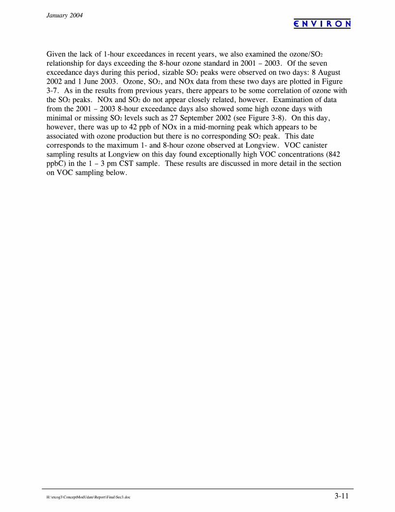
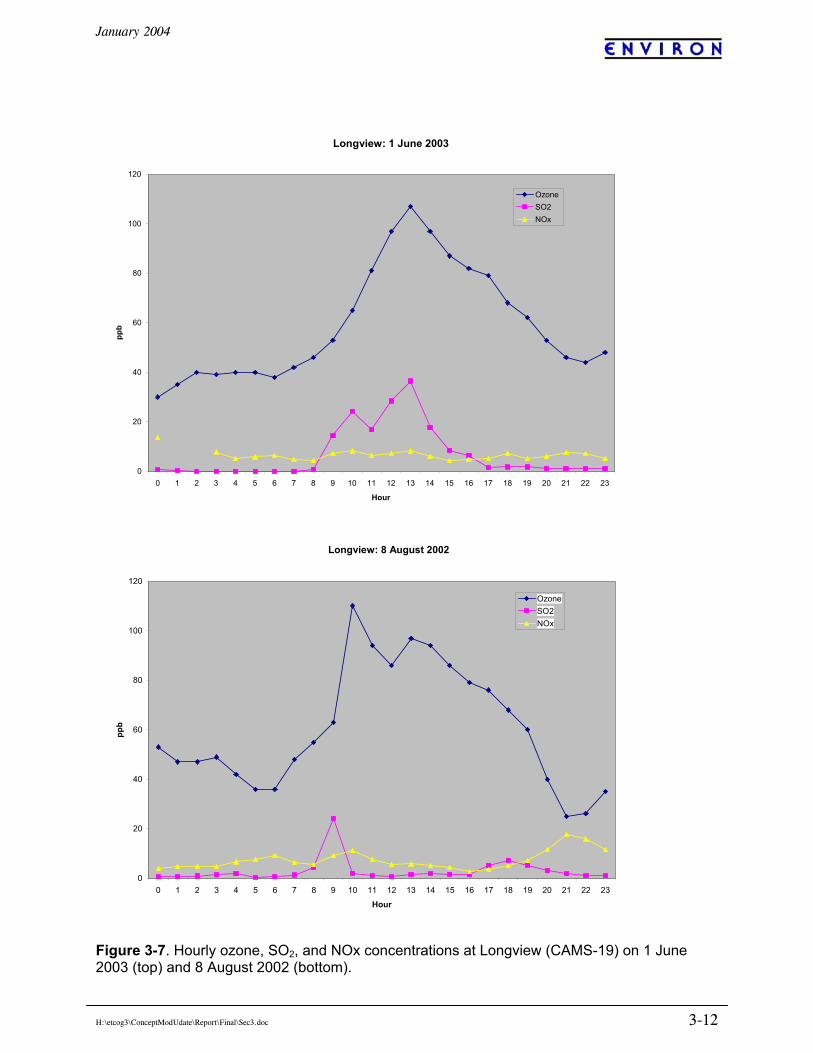
Given the lack of 1-hour exceedances in recent years, we also examined the ozone/SO2 relationship for days exceeding the 8-hour ozone standard in 2001 – 2003. Of the seven exceedance days during this period, sizable SO2 peaks were observed on two days: 8 August 2002 and 1 June 2003. Ozone, SO2, and NOx data from these two days are plotted in Figure 3-7. As in the results from previous years, there appears to be some correlation of ozone with the SO2 peaks. NOx and SO2 do not appear closely related, however. Examination of data from the 2001 – 2003 8-hour exceedance days also showed some high ozone days with minimal or missing SO2 levels such as 27 September 2002 (see Figure 3-8). On this day, however, there was up to 42 ppb of NOx in a mid-morning peak which appears to be associated with ozone production but there is no corresponding SO2 peak. This date corresponds to the maximum 1- and 8-hour ozone observed at Longview. VOC canister sampling results at Longview on this day found exceptionally high VOC concentrations (842 ppbC) in the 1 – 3 pm CST sample. These results are discussed in more detail in the section on VOC sampling below.
January 2004
H:\etcog3\ConceptModUdate\Report\Final\Sec3.doc 3-12
Figure 3-7. Hourly ozone, SO2, and NOx concentrations at Longview (CAMS-19) on 1 June 2003 (top) and 8 August 2002 (bottom).
Longview: 8 August 2002
0
20
40
60
80
100
120
0 1 2 3 4 5 6 7 8 9 10 11 12 13 14 15 16 17 18 19 20 21 22 23
Hour
ppb
OzoneSO2NOx
Longview: 1 June 2003
0
20
40
60
80
100
120
0 1 2 3 4 5 6 7 8 9 10 11 12 13 14 15 16 17 18 19 20 21 22 23 Hour
ppb
OzoneSO2NOx
January 2004
H:\etcog3\ConceptModUdate\Report\Final\Sec3.doc 3-13
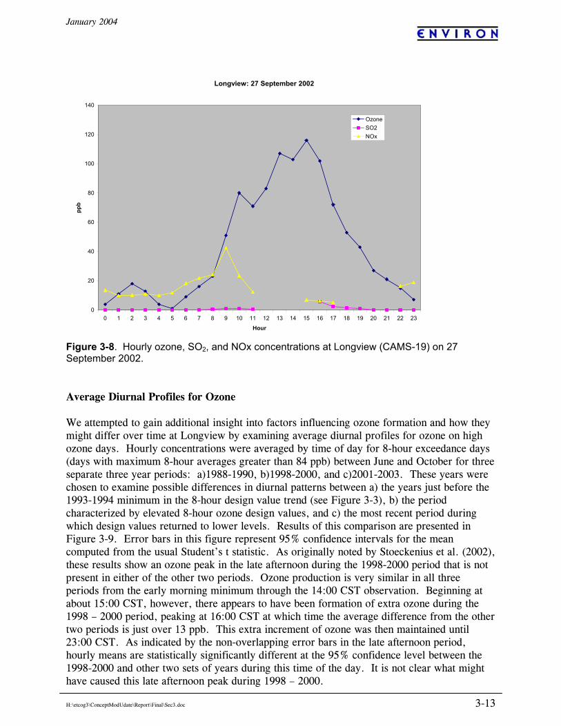
Figure 3-8. Hourly ozone, SO2, and NOx concentrations at Longview (CAMS-19) on 27 September 2002. Average Diurnal Profiles for Ozone We attempted to gain additional insight into factors influencing ozone formation and how they might differ over time at Longview by examining average diurnal profiles for ozone on high ozone days. Hourly concentrations were averaged by time of day for 8-hour exceedance days (days with maximum 8-hour averages greater than 84 ppb) between June and October for three separate three year periods: a)1988-1990, b)1998-2000, and c)2001-2003. These years were chosen to examine possible differences in diurnal patterns between a) the years just before the 1993-1994 minimum in the 8-hour design value trend (see Figure 3-3), b) the period characterized by elevated 8-hour ozone design values, and c) the most recent period during which design values returned to lower levels. Results of this comparison are presented in Figure 3-9. Error bars in this figure represent 95% confidence intervals for the mean computed from the usual Student’s t statistic. As originally noted by Stoeckenius et al. (2002), these results show an ozone peak in the late afternoon during the 1998-2000 period that is not present in either of the other two periods. Ozone production is very similar in all three periods from the early morning minimum through the 14:00 CST observation. Beginning at about 15:00 CST, however, there appears to have been formation of extra ozone during the 1998 – 2000 period, peaking at 16:00 CST at which time the average difference from the other two periods is just over 13 ppb. This extra increment of ozone was then maintained until 23:00 CST. As indicated by the non-overlapping error bars in the late afternoon period, hourly means are statistically significantly different at the 95% confidence level between the 1998-2000 and other two sets of years during this time of the day. It is not clear what might have caused this late afternoon peak during 1998 – 2000.
Longview: 27 September 2002
0
20
40
60
80
100
120
140
0 1 2 3 4 5 6 7 8 9 10 11 12 13 14 15 16 17 18 19 20 21 22 23
Hour
ppb
OzoneSO2NOx
January 2004
H:\etcog3\ConceptModUdate\Report\Final\Sec3.doc 3-14
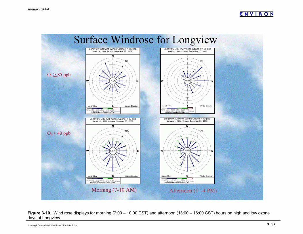
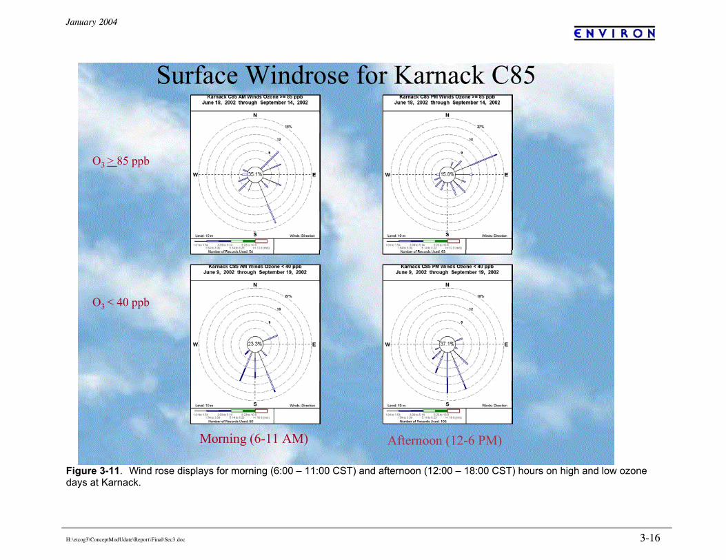
Figure 3-9. Mean diurnal profile of hourly average ozone at Longview (CAMS-19) for three different three year periods (error bars indicate 95% confidence intervals). WINDROSES Hourly surface wind direction and speed data on high and low ozone days at Longview (C19) are summarized in Figure 3-10. Morning winds on days with 8-hour ozone exceedances (O3 ≥ 85 ppb) are lighter with more frequent calm periods than morning winds on low ozone days (O3 ≤ 40 ppb). Afternoon winds are predominantly NE – E on high ozone days; winds out of the SW quadrant are almost non-existent. This is in contrast to low ozone days when afternoon winds are more common from directions other than the NE quadrant and calms are less frequent. Hourly surface wind direction and speed data on high and low ozone days at Karnack (C85) are summarized in Figure 3-11. As at Longview, morning winds on days with 8-hour ozone exceedances (O3 ≥ 85 ppb) are lighter with more frequent calm periods than on low ozone days and easterly component winds are more common on afternoons of high ozone days. Southerly component winds are more common on low ozone days at this site; this feature is also present at Longview but not as obvious. These data suggest low ozone events are often associated with the influence of Gulf air from the south traveling at moderate speeds and most likely associated with relatively deep vertical mixing. In contrast, high ozone days are typically associated with light, easterly component winds.
Average Ozone at LongviewDays with Max 8-Hour > 84 ppb
0
20
40
60
80
100
120
0:00
1:00
2:00
3:00
4:00
5:00
6:00
7:00
8:00
9:00
10:00
11:00
12:00
13:00
14:00
15:00
16:00
17:00
18:00
19:00
20:00
21:00
22:00
23:00
Observation Hour (CST)
ppb
1988-19901998-20002001-2003
January 2004
H:\etcog3\ConceptModUdate\Report\Final\Sec3.doc 3-15
Figure 3-10. Wind rose displays for morning (7:00 – 10:00 CST) and afternoon (13:00 – 16:00 CST) hours on high and low ozone days at Longview.
Surface Windrose for Longview
O3 > 85 ppb
O3 < 40 ppb
Morning (7-10 AM) Afternoon (1 -4 PM)
January 2004
H:\etcog3\ConceptModUdate\Report\Final\Sec3.doc 3-16
Figure 3-11. Wind rose displays for morning (6:00 – 11:00 CST) and afternoon (12:00 – 18:00 CST) hours on high and low ozone days at Karnack.
Surface Windrose for Karnack C85
O3 > 85 ppb
O3 < 40 ppb
Morning (6-11 AM) Afternoon (12-6 PM)
January 2004
H:\etcog3\ConceptModUdate\Report\Final\Sec3.doc 3-17
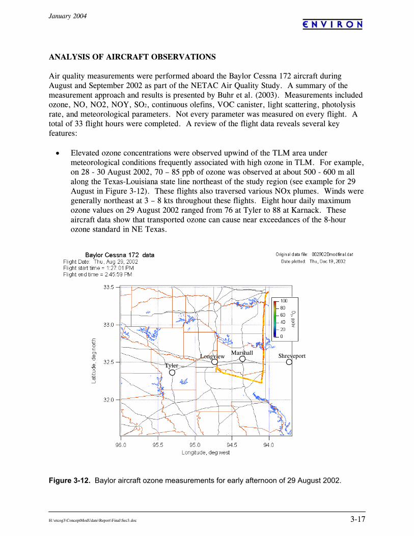
ANALYSIS OF AIRCRAFT OBSERVATIONS Air quality measurements were performed aboard the Baylor Cessna 172 aircraft during August and September 2002 as part of the NETAC Air Quality Study. A summary of the measurement approach and results is presented by Buhr et al. (2003). Measurements included ozone, NO, NO2, NOY, SO2, continuous olefins, VOC canister, light scattering, photolysis rate, and meteorological parameters. Not every parameter was measured on every flight. A total of 33 flight hours were completed. A review of the flight data reveals several key features:
• Elevated ozone concentrations were observed upwind of the TLM area under meteorological conditions frequently associated with high ozone in TLM. For example, on 28 - 30 August 2002, 70 – 85 ppb of ozone was observed at about 500 - 600 m all along the Texas-Louisiana state line northeast of the study region (see example for 29 August in Figure 3-12). These flights also traversed various NOx plumes. Winds were generally northeast at 3 – 8 kts throughout these flights. Eight hour daily maximum ozone values on 29 August 2002 ranged from 76 at Tyler to 88 at Karnack. These aircraft data show that transported ozone can cause near exceedances of the 8-hour ozone standard in NE Texas.
Figure 3-12. Baylor aircraft ozone measurements for early afternoon of 29 August 2002.
Tyler
Marshall Shreveport Longview
January 2004
H:\etcog3\ConceptModUdate\Report\Final\Sec3.doc 3-18
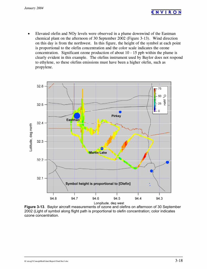
• Elevated olefin and NOy levels were observed in a plume downwind of the Eastman
chemical plant on the afternoon of 30 September 2002 (Figure 3-13). Wind direction on this day is from the northwest. In this figure, the height of the symbol at each point is proportional to the olefin concentration and the color scale indicates the ozone concentration. Significant ozone production of about 10 - 15 ppb within the plume is clearly evident in this example. The olefins instrument used by Baylor does not respond to ethylene, so these olefins emissions must have been a higher olefin, such as propylene.
Figure 3-13. Baylor aircraft measurements of ozone and olefins on afternoon of 30 September 2002 (Light of symbol along flight path is proportional to olefin concentration; color indicates ozone concentration.
January 2004
H:\etcog3\ConceptModUdate\Report\Final\Sec3.doc 3-19
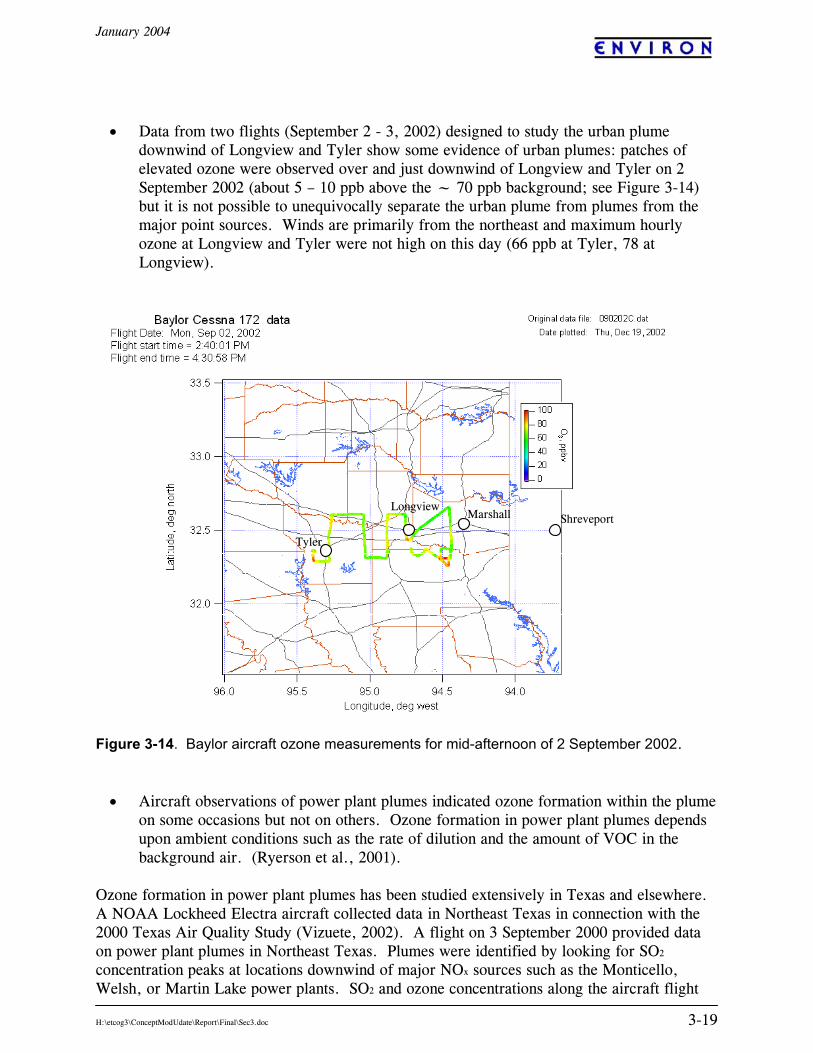
• Data from two flights (September 2 - 3, 2002) designed to study the urban plume
downwind of Longview and Tyler show some evidence of urban plumes: patches of elevated ozone were observed over and just downwind of Longview and Tyler on 2 September 2002 (about 5 – 10 ppb above the ~ 70 ppb background; see Figure 3-14) but it is not possible to unequivocally separate the urban plume from plumes from the major point sources. Winds are primarily from the northeast and maximum hourly ozone at Longview and Tyler were not high on this day (66 ppb at Tyler, 78 at Longview).
Figure 3-14. Baylor aircraft ozone measurements for mid-afternoon of 2 September 2002.
• Aircraft observations of power plant plumes indicated ozone formation within the plume on some occasions but not on others. Ozone formation in power plant plumes depends upon ambient conditions such as the rate of dilution and the amount of VOC in the background air. (Ryerson et al., 2001).
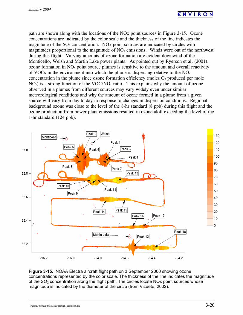
Ozone formation in power plant plumes has been studied extensively in Texas and elsewhere. A NOAA Lockheed Electra aircraft collected data in Northeast Texas in connection with the 2000 Texas Air Quality Study (Vizuete, 2002). A flight on 3 September 2000 provided data on power plant plumes in Northeast Texas. Plumes were identified by looking for SO2 concentration peaks at locations downwind of major NOx sources such as the Monticello, Welsh, or Martin Lake power plants. SO2 and ozone concentrations along the aircraft flight
Tyler
Marshall Shreveport Longview
January 2004
H:\etcog3\ConceptModUdate\Report\Final\Sec3.doc 3-20
path are shown along with the locations of the NOx point sources in Figure 3-15. Ozone concentrations are indicated by the color scale and the thickness of the line indicates the magnitude of the SO2 concentration. NOx point sources are indicated by circles with magnitudes proportional to the magnitude of NOx emissions. Winds were out of the northwest during this flight. Varying amounts of ozone formation are evident downwind of the Monticello, Welsh and Martin Lake power plants. As pointed out by Ryerson et al. (2001), ozone formation in NOx point source plumes is sensitive to the amount and overall reactivity of VOCs in the environment into which the plume is dispersing relative to the NOx concentration in the plume since ozone formation efficiency (moles O3 produced per mole NOx) is a strong function of the VOC/NOx ratio. This explains why the amount of ozone observed in a plumes from different sources may vary widely even under similar meteorological conditions and why the amount of ozone formed in a plume from a given source will vary from day to day in response to changes in dispersion conditions. Regional background ozone was close to the level of the 8-hr standard (8 ppb) during this flight and the ozone production from power plant emissions resulted in ozone aloft exceeding the level of the 1-hr standard (124 ppb). Figure 3-15. NOAA Electra aircraft flight path on 3 September 2000 showing ozone concentrations represented by the color scale. The thickness of the line indicates the magnitude of the SO2 concentration along the flight path. The circles locate NOx point sources whose magnitude is indicated by the diameter of the circle (from Vizuete, 2002).
0
10
20
30
40
50
60
70
80
90
100
110
120
130
January 2004
H:\etcog3\ConceptModUdate\Report\Final\Sec3.doc 3-21
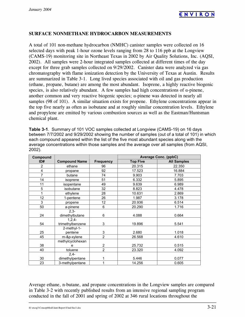
SURFACE NONMETHANE HYDROCARBON MEASUREMENTS A total of 101 non-methane hydrocarbon (NMHC) canister samples were collected on 16 selected days with peak 1-hour ozone levels ranging from 28 to 116 ppb at the Longview (CAMS-19) monitoring site in Northeast Texas in 2002 by Air Quality Solutions, Inc. (AQSI, 2002). All samples were 2-hour integrated samples collected at different times of the day except for three grab samples collected on 9/29/2002. Canister data were analyzed via gas chromatography with flame ionization detection by the University of Texas at Austin. Results are summarized in Table 3-1. Long lived species associated with oil and gas production (ethane, propane, butane) are among the most abundant. Isoprene, a highly reactive biogenic species, is also relatively abundant. A few samples had high concentrations of α-pinene, another common and very reactive biogenic species; α-pinene was detected in nearly all samples (98 of 101). A similar situation exists for propene. Ethylene concentrations appear in the top five nearly as often as isobutane and at roughly similar concentration levels. Ethylene and propylene are emitted by various combustion sources as well as the Eastman/Huntsman chemical plant. Table 3-1. Summary of 101 VOC samples collected at Longview (CAMS-19) on 16 days between 7/7/2002 and 9/29/2002 showing the number of samples (out of a total of 101) in which each compound appeared within the list of the five most abundant species along with the average concentrations within those samples and the average over all samples (from AQSI, 2002).
Average ethane, n-butane, and propane concentrations in the Longview samples are compared in Table 3-2 with recently published results from an intensive regional sampling program conducted in the fall of 2001 and spring of 2002 at 346 rural locations throughout the
Average Conc. (ppbC) Compound ID# Compound Name Frequency Top Five All Samples 2 ethane 96 20.315 22.350 4 propane 92 17.523 16.884 7 butane 74 9.903 7.703 14 isoprene 51 6.332 5.895 11 isopentane 49 9.639 6.989 5 isobutane 32 8.823 4.478 1 ethylene 28 10.631 2.869 12 1-pentene 26 1.987 3.178 3 propene 12 20.936 6.514 50 a-pinene 6 20.290 1.716
24 2,3-
dimethylbutane 6 4.088 0.664
54 1,2,4-
trimethylbenzene 3 19.896 5.541
25 2-methyl-1-
pentene 3 2.680 1.018 45 m-&p-xylene 2 26.568 4.610
38 methylcyclohexan
e 2 25.732 0.515 40 toluene 2 23.320 4.092
30 2,4-
dimethylpentane 1 5.446 0.077 23 3-methylpentane 1 14.256 0.605

January 2004
H:\etcog3\ConceptModUdate\Report\Final\Sec3.doc 3-22
southwestern U.S. (Katzenstein et al., 2003). Average concentrations of these natural gas related species at Longview are about three times higher than the regional averages, consistent with the spatial distribution of these species reported by Katzenstein et al. Ratios of average ethane/butane/propane at Longview are very similar to corresponding ratios in the regional averages, suggesting a common source for these species throughout the Southwest. Katzenstein et al., noting the spatial correlation of these species with oil and gas fields in the Southwest, concluded that oil and gas production is the dominant source of light alkanes in the Southwest. Results from the 2002 Longview samples are consistent with this finding. Table 3-2. Average concentrations of ethane, n-butane, and propane in 98 samples collected at Longview in July – September 2002 (AQSI, 2002) and 346 samples collected at individual rural locations in the eight southwestern states (TX, OK, LA, AR, MO, KS, CO, NM) by Katzenstein et al. (2003). Longview Avg.
(ppbC) Katzenstein et al.
(2003)6 Ethane 20.0 6.8 n-Butane 7.6 2.7
Sample Averages
Propane 16.7 5.1 Ethane/Propane 1.2 1.3 Ratio of
Averages n-Butane/Propane 0.46 0.53 The highest total NMHC concentration observed at Longview occurred in the 13:00 – 15:00 CST sample on 27 September 2002. This date corresponds to the 2002 annual peak 1-hour and 8-hour ozone averages at Longview. Total VOC in this sample was 842 ppbC but only 263 ppbC of this is accounted for by the 47 target species identified in the sample; the remaining 579 ppbC is associated with unidentified peaks in the chromatogram. No single identified species contributed more than 7% to the total carbon in this sample, whereas the top two unidentified peaks account for roughly 60% of the total so the primary sources of VOCs during the sampling period are not known. Looking at the identified species, however, we can see that there was relatively little contribution from natural gas sources (low butane, propane, isobutane, pentane concentrations) or from ethylene. There is also no detectable toluene or xylene in this sample, indicating a lack of contribution from gasoline vapors. Examination of the 11:00 – 13:00 CST sample collected on this day shows an NMHC total of 647 ppbC of which 392 ppbC (61%) is accounted for by identified species. Of the identified species in this earlier sample, 71% (on a ppbC basis) is accounted for by compounds typically associated with natural gas (ethane, propane, isobutane, butane, isopentane, pentane). No toluene, xylene or biogenic species (isoprene, α-pinene) were identified in this sample and the large unidentified peaks seen in the 13:00 – 15:00 CST sample are much smaller or absent. The source of the high VOC levels observed at Longview on the afternoon of 27 September 2002 is not clear from the VOC speciation data. The midday period sample is consistent with natural gas but the afternoon sample has little natural gas and is mostly unidentified.
6 Weighted average of September 2001 and April-May 2002 sample averages.
January 2004
H:\etcog3\ConceptModUdate\Report\Final\Sec3.doc 3-23
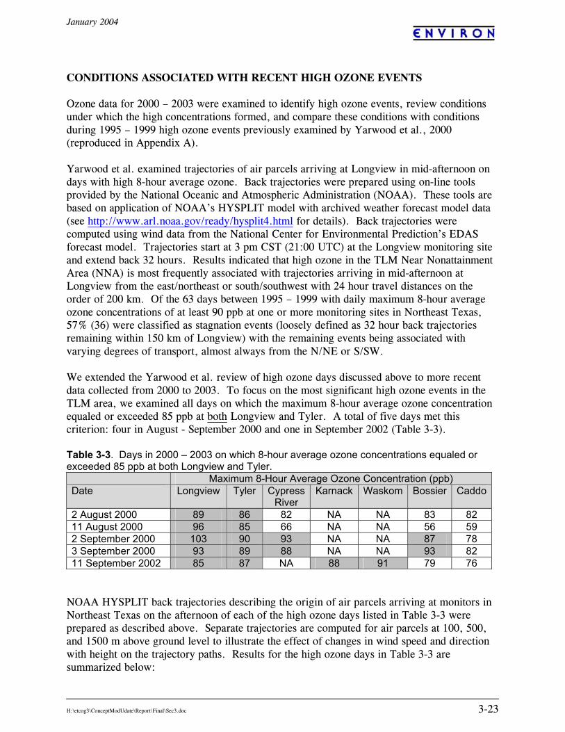
CONDITIONS ASSOCIATED WITH RECENT HIGH OZONE EVENTS Ozone data for 2000 – 2003 were examined to identify high ozone events, review conditions under which the high concentrations formed, and compare these conditions with conditions during 1995 – 1999 high ozone events previously examined by Yarwood et al., 2000 (reproduced in Appendix A). Yarwood et al. examined trajectories of air parcels arriving at Longview in mid-afternoon on days with high 8-hour average ozone. Back trajectories were prepared using on-line tools provided by the National Oceanic and Atmospheric Administration (NOAA). These tools are based on application of NOAA’s HYSPLIT model with archived weather forecast model data (see http://www.arl.noaa.gov/ready/hysplit4.html for details). Back trajectories were computed using wind data from the National Center for Environmental Prediction’s EDAS forecast model. Trajectories start at 3 pm CST (21:00 UTC) at the Longview monitoring site and extend back 32 hours. Results indicated that high ozone in the TLM Near Nonattainment Area (NNA) is most frequently associated with trajectories arriving in mid-afternoon at Longview from the east/northeast or south/southwest with 24 hour travel distances on the order of 200 km. Of the 63 days between 1995 – 1999 with daily maximum 8-hour average ozone concentrations of at least 90 ppb at one or more monitoring sites in Northeast Texas, 57% (36) were classified as stagnation events (loosely defined as 32 hour back trajectories remaining within 150 km of Longview) with the remaining events being associated with varying degrees of transport, almost always from the N/NE or S/SW. We extended the Yarwood et al. review of high ozone days discussed above to more recent data collected from 2000 to 2003. To focus on the most significant high ozone events in the TLM area, we examined all days on which the maximum 8-hour average ozone concentration equaled or exceeded 85 ppb at both Longview and Tyler. A total of five days met this criterion: four in August - September 2000 and one in September 2002 (Table 3-3). Table 3-3. Days in 2000 – 2003 on which 8-hour average ozone concentrations equaled or exceeded 85 ppb at both Longview and Tyler. Maximum 8-Hour Average Ozone Concentration (ppb) Date Longview Tyler Cypress
River Karnack Waskom Bossier Caddo
2 August 2000 89 86 82 NA NA 83 82 11 August 2000 96 85 66 NA NA 56 59 2 September 2000 103 90 93 NA NA 87 78 3 September 2000 93 89 88 NA NA 93 82 11 September 2002 85 87 NA 88 91 79 76
NOAA HYSPLIT back trajectories describing the origin of air parcels arriving at monitors in Northeast Texas on the afternoon of each of the high ozone days listed in Table 3-3 were prepared as described above. Separate trajectories are computed for air parcels at 100, 500, and 1500 m above ground level to illustrate the effect of changes in wind speed and direction with height on the trajectory paths. Results for the high ozone days in Table 3-3 are summarized below:
January 2004
H:\etcog3\ConceptModUdate\Report\Final\Sec3.doc 3-24
• 2 August 2000: trajectories are from the SW with slow transport in the morning and virtually no movement in the afternoon.
• 11 August 2000: trajectories are from the N to NE with relatively little movement
during the afternoon, similar to the results for 2 August.
• 2 September 2000: trajectories show a slow re-circulation pattern with subsidence indicative of a stagnation event.
• 3 September 2000: similar to 2 September but with the episode evolving to a slightly more steady flow from the NNE accompanied by an end to the strong subsidence.
• 11 September 2002: flow is light from the NE with parcels located over the TX-LA-AR
border area in the morning hours. All of the above episodes are associated with light winds and relatively short transport distances, consistent with the stagnation conditions found to dominate high ozone events during the previously analyzed 1995 – 1999 period. The predominant flow direction in the afternoons is from the NE except on 2 August 2000, also consistent with the 1995 – 1999 analysis. Note that 8-hour ozone exceedances also occurred at both Shreveport monitoring sites on 2 and 3 September 2000 but not during any of the other days listed in Table 3-3. Two new monitoring sites were established in northeastern Texas near the Louisiana border in 2002: Karnack (CAMS-85) and Waskom (CAMS-612). Eight-hour ozone design values at these new sites were as high or higher than the design values at Tyler and Longview in 2002 and 2003. Days on which 8-hour average ozone concentrations equaled or exceeded 85 ppb at one or the other of these two new sites are listed in Table 3-4. Note that no exceedances were observed at any site in Northeast Texas in 2003. Table 3-4. Maximum 8-hour average ozone concentrations on days in 2002 – 2003 with concentrations greater than or equal to 85 ppb at either Karnack or Waskom. Maximum 8-Hour Average Ozone Concentration (ppb) Date Tyler
(C82) Longview
(C19) Karnack
(C85) Waskom (C612)
Bossier Caddo
18 June 2002 66 73 86 70 68 72 22 June 2002 90 83 85 84 77 72 22 July 2002 41 40 85 62 63 55 9 August 2002 69 77 85 75 59 65 10 August 2002 69 77 88 82 70 77 11 August 2002 72 76 85 80 68 71 29 August 2002 76 77 88 86 72 73 11 September 2002 87 85 88 91 76 79 13 September 2002 73 80 82 90 74 71 14 September 2002 86 84 90 92 80 75
January 2004
H:\etcog3\ConceptModUdate\Report\Final\Sec3.doc 3-25
Back trajectories were computed by AQSI (2002) for air parcels arriving at selected monitors in Northeast Texas on the afternoon of each of the high ozone days listed in Table 3-4. These trajectories were computed using NOAA’s HYSPLIT model in the same manner as described above. Results are summarized below; trajectory plots are provided in Appendix B.
• 18 June 2002: Transport is from the east, the back trajectory from Karnack was located over the vicinity of Shreveport at noon.
• 22 June 2002: Back trajectories from Tyler show slow transport from the ENE with the trajectory just north of Shreveport at 6 am CST. The back trajectory from Waskom shows transport from the NE; the trajectory passed over Shreveport at about noon CST.
• 22 July 2002: Air parcels arriving at Karnack originated over Houston at about noon of the previous day.
• 9 August 2002: Trajectories show initial transport from the NE turning clockwise as the flow becomes southeasterly. Air parcels arriving at Karnack passed over the general vicinity of Shreveport at noon; parcels arriving at Longview were over the Texas-Louisiana border just south of Shreveport at 6 am CST.
• 10 August 2002: Transport is fairly rapid from the ESE; trajectories ending at Karnack and Waskom were just southeast of Shreveport at noon and over central northern Louisiana at 6 am CST.
• 11 August 2002: Transport between noon and 3 pm CST is from the east with trajectories ending at Waskom and Karnack having passed over the vicinity of Shreveport at noon CST. Transport earlier in the day was from the SE.
• 29 August 2002: Transport is fairly rapid from the NE; trajectories arriving at Waskom in the afternoon were located over southern Arkansas at 6 am CST.
• 11 September 2002: Back trajectories from Longview and Waskom indicate NE flow having passed over southernmost Arkansas during the morning hours. This pattern is very similar to 29 August 2002 but with somewhat slower transport speeds.
• 13 September 2002: Results are similar to 11 September with some vertical shear and generally slower speeds.
• 14 September 2002: The period between the 13th and 14th is characterized by a changing flow pattern as the northeasterly winds are replaced by southwesterlies. This results in a difference in trajectories for parcels arriving at Tyler and Longview as compared to Waskom and Karnack: the Tyler and Longview trajectories originate over Texas northeast of Houston while the Waskom and Karnack trajectories originate over southern Arkansas. Given the shift in winds, trajectories for this day are subject to greater uncertainty than on the other days which exhibited more persistent flow patterns.
The above trajectory results indicate high ozone at Karnack and Waskom (and occasionally at Longview and Tyler are) associated with transport from the east, with air parcels arriving at these sites at 3 pm typically located over the vicinity of Shreveport at about noon. Exceptions to this are 22 July 2002 (which only produced an 8-hour exceedance at Karnack) and 11 – 14 September 2002 (during which exceedances occurred on one or more days at all Northeast Texas sites). Thus, days with 8-hour exceedances at Karnack and Waskom (but not at Tyler or Longview) appear to be most frequently associated with transport from out of state in general and from Shreveport more specifically. This conclusion is not inconsistent with the lack of 8-hour exceedances at the Caddo and Bossier sites on these days. The Caddo and
January 2004
H:\etcog3\ConceptModUdate\Report\Final\Sec3.doc 3-26
Bossier parish monitoring sites are located, respectively, north of Shreveport and at the airport on the northern edge of the city. Since prevailing winds associated with ozone conducive conditions in this area are easterly to northeasterly, the peak ozone downwind of Shreveport will usually fall west of the city and not be detected at these two Louisiana sites. In summary, our analysis of high 8-hour ozone episodes in the 2000 – 2003 period indicate that meteorological conditions associated with these events are similar to those associated with earlier (1995 – 1999) high ozone events as described by Yarwood et al., 2000 (see Appendix A). The primary distinguishing feature of the 2000 – 2003 period is the general lack of high ozone events at Longview and Tyler in 2001 – 2003. While 8-hour exceedances were observed at either Karnack and Waskom on 10 days in 2002 (none in 2003), only one of these days had concurrent exceedances at both Tyler and Longview.
January 2004
H:\etcog3\ConceptModUdate\Report\Final\Sec4(conclusions).doc 4-1
4. SUMMARY AND CONCLUSIONS A key element in development of an effective ozone air quality management strategy for Northeast Texas is the development of a “conceptual model” that qualitatively describes ozone formation mechanisms in the area and provides a basis for selection of high ozone episodes for more detailed study and modeling. We have developed such a conceptual model for the Tyler-Longview-Marshall Near Nonattainment Area (TLM NNA) based on analyses of air quality, emissions and meteorological data collected over the past eight years. This work builds on earlier analyses of factors influencing ozone formation in Northeast Texas initiated by Yarwood et al. (2000) and Stoeckenius et al. (2002). Results of this study both support and enhance conclusions previously reached regarding the formation of elevated ozone levels in the TLM NNA. Ozone concentrations in East Texas have historically exceeded the maximum allowable level specified in EPA’s 8-hour National Ambient Air Quality Standard (NAAQS), the most recent violation occurred at Longview in the 2000 – 2002 attainment period. However, the annual 8-hour design value at Longview decreased markedly between 2000 and 2001 and this site (along with Tyler) is not in violation of the NAAQS for the 2001 – 2003 period. Other monitoring sites in the area (located at Karnack and Waskom in eastern Gregg county) did not have sufficient data to calculate 2001 – 2003 design values. Episodes of high ozone concentrations in the TLM NNA occur most often between June and September when the area is under the influence of a semi-permanent subtropical high pressure system, vertical mixing of pollutants in the atmosphere is restricted, skies are clear to partly cloudy, temperatures are high and winds are light. Most episodes are associated with near-surface winds from either the east/northeast or south/southwest with the latter direction appearing less consistently on the highest days and with greater variability in direction. Episodes can be classified as either “stagnant” with very little inflow of air from outside of Northeast Texas or “transport” with material usually arriving in the TLM area from northeastern Louisiana, southern Arkansas or southeastern Texas. On a regional scale, emissions of ozone precursors in Northeast Texas are dominated by highly reactive biogenic VOCs such as isoprene and pinenes; anthropogenic sources account for only 10% of total daily VOC emissions in the TLM NNA. The overall VOC/NOx emission ratios in the five county NNA in 2002 is estimated to be 33:1, well within the NOx limited ozone formation regime. As a result, reductions in NOx will be generally more effective in controlling ozone on a regional basis than reductions in anthropogenic VOC. Under the right conditions, NOx from various sources, which include several large electricity generating units located within and upwind of the TLM NNA in addition to on- and off-road mobile sources and other stationary sources, combine with the (mostly biogenic) VOC to make significant amounts of ozone. Correlations of hourly ozone and SO2 peaks at Longview are indicative of the influence of large fossil fuel combustion sources. Limited evidence from aircraft and surface data indicate that significant ozone formation may also be associated with plumes of NOx and highly reactive VOCs (HRVOCs) from point sources in the area. Sources of HRVOCs located near TLM include the Eastman/Huntsman complex and reductions in HRVOC emissions from this source can be expected to lower ozone levels nearby and at the
January 2004
H:\etcog3\ConceptModUdate\Report\Final\Sec4(conclusions).doc 4-2
Longview monitor. It was not possible to find a clearly identifiable Tyler/Longview urban plume in the aircraft data that was distinct from point source plumes. Ozone formed within and just upwind of the TLM NNA is often augmented by transport of elevated ozone concentrations from outside the area, almost always from the east/northeast or south/southwest. Aircraft observations have shown large areas with 70 – 85 ppb ozone upwind of TLM to the east/northeast. Only a small amount of additional local ozone production is needed under such conditions to produce exceedances of the 8-hour NAAQS. Prior to 2002, the maximum 8-hour design value typically occurred at the Longview monitor which is located at the Gregg County Airport. With reduction in ozone at Longview and the establishment of the Karnack and Waskom monitoring sites near the TX-LA border, the location of the maximum design value shifted to these new sites in eastern Harrison County. An analysis of back trajectories for the ten 8-hour exceedance days at these sites in 2002 – 2003 indicates that five of these exceedances appear to be associated with same-day transport from the Shreveport area. Exceedances did not occur at Tyler or Longview on four of these five days. Of the remaining five days, three were associated with transport from the NE; exceedances at Tyler and Longview occurred on one of these three days. These results suggest that the Karnack and Waskom 8-hour design values may be more responsive than the Tyler or Longview design values to future emission reductions in northeastern Louisiana. Ozone formation is known to be sensitive to meteorological conditions: high ozone is associated with warm, stable air masses and light winds from the east/northeast or south/southwest. EPA has noted that the decrease in ozone design values in the TLM NNA between 1998 – 2000 and 2001 – 2003 is coincident with a drop in the frequency of very hot days (temperatures greater than 100 F). However, other meteorological factors, as measured by the frequency with which forecasters predicted Ozone Action days for the area, did not indicate a reduced potential for high ozone in the latter period. The ozone reduction in 2001 – 2003 is also coincident with a sharp decrease in NOx emissions. This decrease is largely due to reductions in point source NOx implemented as part of the 1-hour State Implementation Plan revisions (total VOC emissions were largely unchanged). As noted above, one would expect a causal relationship between ozone and NOx reductions. However, a quantitative evaluation of the relative contributions of emission reductions vs. meteorological conditions to the recent decrease in the ozone design value may not be obtainable. NOx emission in the TLM NNA are projected to decline further by 2007 due to continued reductions in emissions from on-road mobile sources. These reductions should result in a further decline in local ozone levels. In addition, super-regional emission reductions required by the provisions of EPA’s NOx SIP call will continue to take effect in many southeastern states between 2003 and 2007. These regional NOx reductions should result in lower background ozone levels upwind of northeast Texas. Our review of high ozone episodes in 2000 – 2003 shows that meteorological conditions associated with these events are similar to those found in conjunction with 1995 – 1999 episodes, the reduced frequency of high ozone in the latter period not withstanding. This suggests that modeling analyses of previously selected episodes is still appropriate for purposes of fulfilling requirements of the ozone Early Action Compact. It is therefore not necessary to

January 2004
H:\etcog3\ConceptModUdate\Report\Final\Sec4(conclusions).doc 4-3
model new episodes beyond the August 13-22, 1999 episode that is the basis for the EAC modeling.
January 2004
H:\etcog3\ConceptModUdate\Report\Final\Sec5 References.doc R-1
REFERENCES AQSI, 2002. Air Quality in East Texas 2002. Final Report, Air Quality Solutions, Inc.,
Austin, TX. Buhr, M. S. Alvarez, J. Flynn III, S. Higgs, G. Zanin, and M. Shauck, 2003. Northeast
Texas Air Care (NETOAC) 2002 Air Quality Study: Baylor aircraft-based air quality measurement Data Atlas. DRAFT, September.
ENVIRON. 2004. “Ozone Modeling for the Northeast Texas Early Action Compact.”
Prepared by ENVIRON, Novato, CA. January. Katzenstein, A., L.A. Doezema, I.J. Simpson, D.R. Blake, F. Sherwood Rowland. 2003.
Extensive regional atmospheric hydrocarbon pollution in the southwestern United States. PNAS, Vol.100 No.21., October. Pp 11975-11979.
Ryerson, T.B., Trainer, M., Holloway, J.S., Parrish, D.D., Huey, L.G., Sueper, D.T.,
Frost, G.J., Donnelly, S.G., Schauffler, S., Atlas, E.L., Kuster, W.C., Goldan, P.D., Hubler, G., Meagher, J.F. and F.C. Fehsenfeld, 2001. Observations of ozone formation in power plant plumes and implications for ozone control strategies. Science V292 (719-723), 27 April
Sather, M., 2003. Personal communication, Mark Sather, U.S. Environmental Protection
Agency, Region VI, Dallas, TX. Stoeckenius, T., G Mansell, C. Tran, S.Coulter-Burke, M.Jimenez, G.Wilson. 2003.
Evaluation of the MOBILE Emission Factor Model. Task 2: Reconciliation of HC/NOx and CO/NOx Ratios in MOBILE6 Based Emission Inventories with Ambient Data. ENVIRON International Corp., Novato, CA. October.
Stoeckenius, T., G. Yarwood, S. Coulter-Burke, E. Agus. 2002. Analysis of Factors
Influencing Ozone Trends in the Tyler/Longview/Marshall Near Nonattainment Area. Prepared for East Texas Council of Governments. October.
Vizuete, W.G. 2002. Analysis of NOAA aircraft data for plume studies in Northeast Texas
during TexAQS 2000. University of Texas, Austin. October. Wellman, S., 2003. Personal communication, Sharon Wellman, Texas Eastman,
Environmental Affairs, Longview, TX. Yarwood, G., G. Mansell and C. Emery, 2000. Conceptual model for 8-hour ozone in East
Texas and episode selection for new photochemical modeling. Memorandum to NETAC Technical Committee, ENVIRON International Corp., 12 September.
Yarwood G., C. Emery, M. Jimenez, A. Shieh, T. Stoeckenius, C. Tran, G. Wilson. 1999.
Ozone Modelign for the Tyler-Longview-Marshall Area of East Texas. Report to the East Texas Council of Governments, Kilgore, TX.
January 2004
H:\etcog3\ConceptModUdate\Report\Final\Sec5 References.doc R-2
Yarwood, G., M. Jimenez, C.Emery, E.Tai, C.Tana and S.Lau, 2003. Modeling an August 1999 Ozone Episode in Northeast Texas. ENVIRON International Corp., Novato, CA, May 5.
January 2004
Appendix A
Conceptual model for 8-hour ozone in East Texas and episode selection for new photochemical modeling
MEMORANDUM To: NETAC Technical Committee
From: Greg Yarwood, Gerry Mansell, Chris Emery
Date: Revised, September 12, 2000
Subject: Conceptual model for 8-hour ozone in East Texas and episode selection for new photochemical modeling
INTRODUCTION The project plans for air quality activities in East Texas for FY 2000/2001 (Rider 13 activities) include the development of a new Regional Scale Model (RSM) for developing control strategies for 8-hour ozone. The first stage in developing the new RSM is to select which time period to model. The EPA has provided guidance on how to perform episode selection through the development of a “conceptual model” and the TNRCC has held several meetings to assist near-nonattainment areas, including East Texas, in developing conceptual models. This memo presents the conceptual model for high 8-hour ozone in East Texas and recommends an episode for the new RSM. Previous modeling for East Texas in FY 1998/99 developed ozone models for two episodes, June 20-23, 1995 and July 16-18, 1997. The June 1995 episode was used to develop a regional scale model whereas the July 1997 was used to develop an urban scale model (USM). These episodes were selected because they had very high 1-hour ozone levels, but they also have high 8-hour ozone levels. As discussed below, these existing episodes are appropriate for developing 8-hour ozone control strategies. The objectives in selecting a new third episode for modeling are to increase the number of days used for control strategy development and ensure that all the types of meteorological conditions commonly associated with high 8-hour ozone levels are adequately represented. EPA GUIDANCE ON CONCEPTUAL MODEL DEVELOPMENT EPA has issued guidance1 on how to select ozone episodes that are suitable for photochemical modeling to develop 8-hour ozone control strategies. The guidance calls for an analysis of air quality, meteorological and emissions data to determine the relationships between weather conditions and high ozone. This analysis is referred to as a “conceptual model.” The
1 Draft Guidance on the use of Models and Other Analyses in Attainment Demonstrations for the 8-Hour Ozone NAAQS. EPA-454/R-99-004. May, 1999.
Page 3
Golden Gate Plaza $ 101 Rowland Way $ Novato, California 94945-5010 USA
Tel: (415) 899-0700 $ Fax: (415) 899-0707 H:\etcog3\ConceptModUdate\Report\Final\AppendixA.doc
conceptual model is then used to guide the episode selection with the goal of choosing modeling days that represent all types of conditions that are commonly associated with high ozone. The EPA guidance also spells out other factors to be used in the episode selection along with the conceptual model. Primary considerations include the following: • Choose episodes of frequently occurring type with a variety of wind orientations when 8-hr
daily maximum ozone exceeds 84 ppb. • Choose episode days with observed 8-hr peaks within 10 ppb of the design values. • Choose days with useful supplementary data such as upper air wind measurements,
measurements for ozone precursors, etc. • Choose a sufficient number of days so that several high ozone days are available to
perform the attainment test at each monitor (e.g., don’t choose episodes that have high ozone days at Longview, but not Tyler).
Secondary considerations that may also influence the episode selection include: • Overlap with episodes that have been modeled previously or are being modeled by nearby
areas, since this can leverage resources. • A need to select weekdays and weekends, if there are important day of week differences. • Select episodes from years that coincide with the calculation of the current design value
(1997-1999). Secondary considerations may be included in the episode selection, but they should not take priority over primary considerations.
SOURCES OF DATA Air quality and meteorological data used in the conceptual model were from the sources described below. Air Quality Data The TNRCC currently operates three continuous air monitoring sites (CAMS) in East Texas: • Longview. CAMS 19 is located at the Gregg County Airport. Data from this site are for
ozone and meteorological parameters (wind speed and direction, temperature) and since 1999 nitrogen oxides (NOx, NO2 and NO) and sulfur dioxide (SO2).
• Tyler. The TNRCC has a CAMS at the Pounds Field Airport. From 1995 to 1999 this
Page 4
Golden Gate Plaza $ 101 Rowland Way $ Novato, California 94945-5010 USA
Tel: (415) 899-0700 $ Fax: (415) 899-0707 H:\etcog3\ConceptModUdate\Report\Final\AppendixA.doc
site was designated CAMS 85, but early in 2000 the monitor was within the airport to make way for a new terminal building. The distance the monitor was relocated was sufficiently large to require designation as a new site called CAMS 82. Data from this site are for ozone and meteorological parameters (wind speed and direction, temperature).
• Jefferson. CAMS 50 is located at the Cypress River Airport. Data from this site are
available from 1998 for ozone, nitrogen oxides (NOx, NO2 and NO) and meteorological parameters (wind speed and direction, temperature).
Since 1997, NETAC has sponsored the collection of supplemental air quality data are several locations in East Texas.
1997. VOC, NOx and hydrocarbon measurements at Palestine 1998. VOC and NOx measurements at Longview CAMS 19. 1999. Ozone, VOC, NOx and meteorological measurements at a new site to the north
of Longview called Big Woods. The locations of the TNRCC CAMS and the Big Woods site are shown in Figure 1. 8-Hour Design Values The TNRCC CAMS ozone measurements are used by EPA to compute 8-hour ozone design values. These design values will be used by EPA to designate whether areas attain an 8-hour ozone standard. The design value is the 4th highest daily peak 8-hr ozone value in each year averaged over most recent 3 complete years (1997-1999): • Longview (CAMS 19)– 100 ppb • Tyler (CAMS 82) -- 91 ppb • Jefferson (CAMS 50)-- not yet 3 complete years of data Under the proposed 8-hour ozone standard, the standard is violated in areas with a design value of 85 ppb or higher. Areas that violate the standard will use photochemical modeling to develop control strategies to reduce the estimated future year design value below 85 ppb. Previous modeling for East Texas has used a future year of 2007.
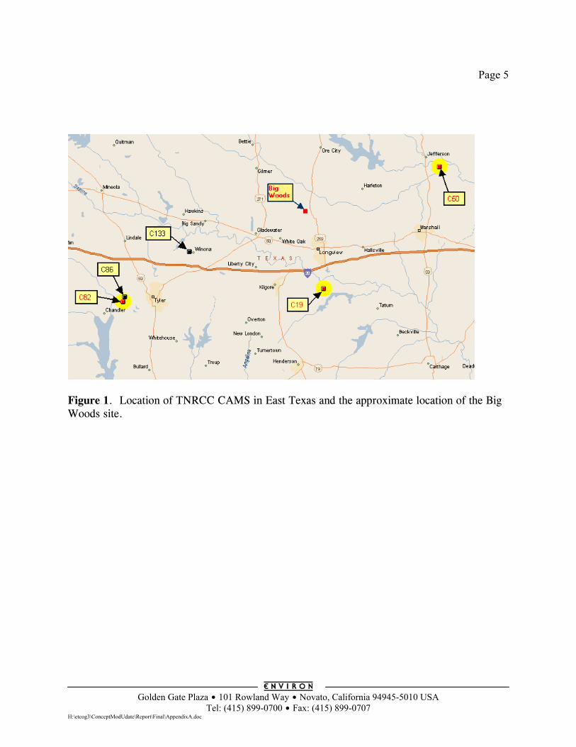
Page 5
Golden Gate Plaza $ 101 Rowland Way $ Novato, California 94945-5010 USA
Tel: (415) 899-0700 $ Fax: (415) 899-0707 H:\etcog3\ConceptModUdate\Report\Final\AppendixA.doc
Figure 1. Location of TNRCC CAMS in East Texas and the approximate location of the Big Woods site.
Page 6
Golden Gate Plaza $ 101 Rowland Way $ Novato, California 94945-5010 USA
Tel: (415) 899-0700 $ Fax: (415) 899-0707 H:\etcog3\ConceptModUdate\Report\Final\AppendixA.doc
Meteorological Data – Back Trajectories Local wind data for East Texas are available from the TNRCC CAMS, as described above. While these data are useful for determining the wind direction in the immediate vicinity of each monitor, they are less useful for developing the conceptual model for 8-hour ozone. Because 8-hour ozone is expected to be more regional in nature than 1-hour ozone, for the conceptual model it is useful to know what the regional wind patterns are like on high ozone days. Here, “regional” includes at least the Tyler/Longview/Marshall (TLM) area of East Texas, and may extend into surrounding areas and states. Considering these regional wind patterns provides a sense of where the air has come from during periods when monitors experience high 8-hour ozone. One way to evaluate the regional wind patterns is by preparing back trajectories. The National Oceanic & Atmospheric Administration (NOAA) provides tools to calculate back trajectories at http://www.arl.noaa.gov/ready/hysplit4.html. The NOAA back trajectories are based on archived data from weather forecasting models. A single back trajectory shows how the model predicts that air would move to arrive at a fixed end point in space and time. Back trajectories provide a simple picture of how air traveled to arrive at a given place and time. This picture should not be taken too literally since: • Back trajectories are based on computer models which have uncertainties. • The concept of a back trajectory over-simplifies the way air moves in the real atmosphere
because it neglects effects such as mixing and wind shear. For example, if a given back trajectory from Longview traces back to Houston over a 24 hour period, this should not be interpreted as saying that high ozone levels in East Texas must have resulted from transport of pollution from Houston because: (1) there are uncertainties in the direction of the back trajectory; (2) the back trajectory provides no information about whether Houston had high ozone levels at that time, and; (3) the trajectory model has no emissions or chemistry components. Back trajectories can be indicators of whether transport was a potential contributor to high ozone levels. Basing an analysis upon groups of back trajectories for multiple days may mitigate some of the uncertainties in back trajectory directions and distances. WHEN HAS HIGH OZONE OCCURED IN EAST TEXAS Ozone data for East Texas CAMS from all days in years 1995 to 1999 were analyzed to determine the year to year and month of year patterns in high 8-hour ozone (80 ppb or higher). The years 1995-99 were selected to include the existing RSM and USM episodes
Page 7
Golden Gate Plaza $ 101 Rowland Way $ Novato, California 94945-5010 USA
Tel: (415) 899-0700 $ Fax: (415) 899-0707 H:\etcog3\ConceptModUdate\Report\Final\AppendixA.doc
(1995 and 1997) up through the most recent complete year of data (1999). For 1995 and 1996, data were available only for the Tyler and Longview CAMS. Therefore, this analysis was restricted to exclude data from Jefferson. Figures 2A and 2B show the distribution of high ozone days by year and by month. For these recent years, 1995 had the most high ozone days, followed by 1999 whereas 1996 had the least high ozone days. The monthly distribution shows some high ozone days in 8 months of the year from March to October. The most high ozone days occur in the 4-month period, June through September, with the largest number of days in August. The existing USM and RSM models were developed for episodes in June 1995 and July 1997. Simplistically, this suggests choosing a new episode from later in the summer, either in August or September. However, the EPA guidance on episode selection stresses considering meteorological factors more than the time of year.
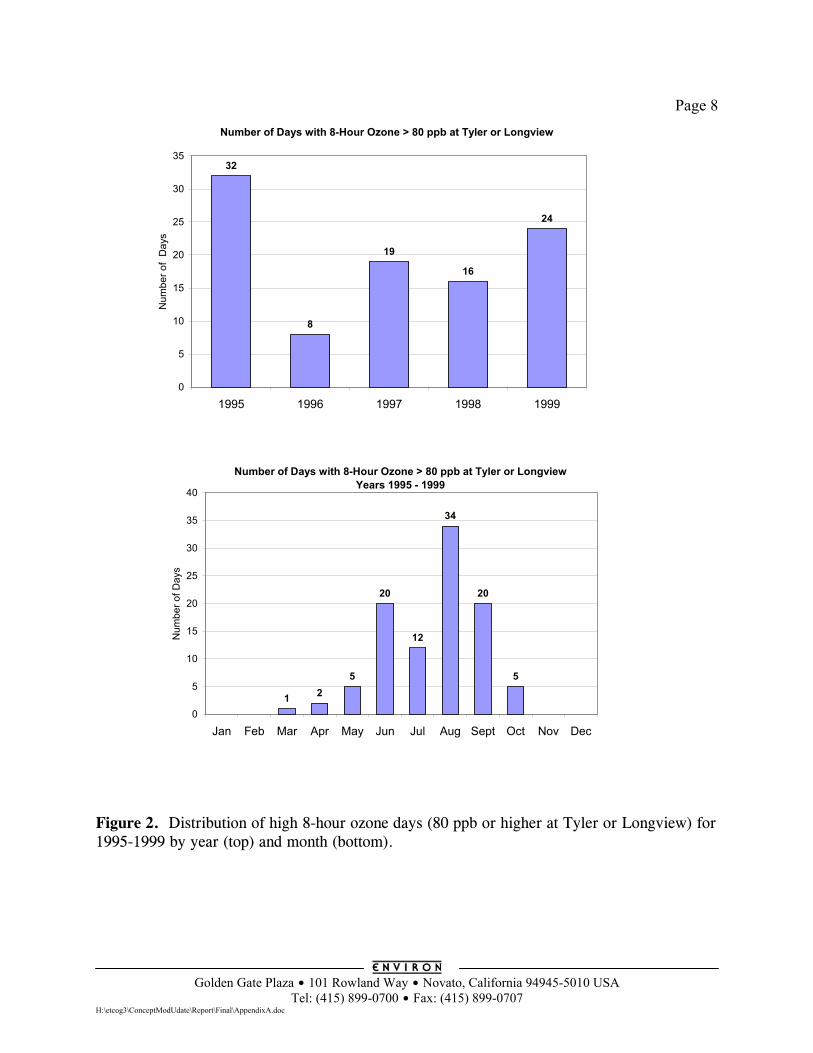
Page 8
Golden Gate Plaza $ 101 Rowland Way $ Novato, California 94945-5010 USA
Tel: (415) 899-0700 $ Fax: (415) 899-0707 H:\etcog3\ConceptModUdate\Report\Final\AppendixA.doc
Figure 2. Distribution of high 8-hour ozone days (80 ppb or higher at Tyler or Longview) for 1995-1999 by year (top) and month (bottom).
Number of Days with 8-Hour Ozone > 80 ppb at Tyler or Longview
32
8
19
16
24
0
5
10
15
20
25
30
35
1995 1996 1997 1998 1999
Num
ber o
f D
ays
Number of Days with 8-Hour Ozone > 80 ppb at Tyler or LongviewYears 1995 - 1999
1 25
20
12
34
20
5
0
5
10
15
20
25
30
35
40
Jan Feb Mar Apr May Jun Jul Aug Sept Oct Nov Dec
Num
ber o
f Day
s
Page 9
Golden Gate Plaza $ 101 Rowland Way $ Novato, California 94945-5010 USA
Tel: (415) 899-0700 $ Fax: (415) 899-0707 H:\etcog3\ConceptModUdate\Report\Final\AppendixA.doc
WIND PATTERNS ASSOCIATED WITH HIGH OZONE The objective of this analysis is to look at typical wind patterns on high ozone days by using back trajectories. The approach is to group together back trajectories for many days to mitigate some of the uncertainties associated with any single trajectory. We used only wind data from the most advanced meteorological model available at the NOAA web site (described above), which is the EDAS model from the National Center for Environmental Prediction (NCEP). Since EDAS is a relatively new model, we only calculated back trajectories for years 1997-1999. Back trajectories were calculated from Longview for all days in 1997-1999 with 8-hour ozone of 70 ppb or higher. The trajectories were run back for 32 hours from a starting time of 3 p.m. local time (21:00 UTC). The 32 hour trajectory length is also used by the TNRCC for similar analyses, and was selected because it is long enough to run back to the morning of the day before, but is not so long as to span several days which greatly increases uncertainties. Two trajectories were calculated for each day with starting altitudes of 500 and 1000 meters both of which are expected to be within the mixed layer. Running trajectories at different heights allows for the possibility that the wind speeds and directions vary with altitude (wind shear). In Figure 3 these back trajectories are segregated between days with moderate (70-85 ppb), high (85-100 ppb) and very high (> 100 ppb) 8-hour ozone in East Texas. As expected, there are many more days in the 70-85 ppb range than in the 85-100 ppb range and the >100 ppb range. The back trajectories come from a wide range of directions around East Texas, but some directions are more common and others less common. For days in the 70-85 ppb range, the most common directions are from the East/Northeast and the South/Southwest, whereas trajectories from the West/Northwest are rare. It also appears that airflow from the Southeast is less common than either the East or South on these moderately high ozone days. The pattern of wind directions on high ozone days (85-100 ppb) is similar. It appears that trajectories travel back shorter distances on the high days (85-100 ppb) than the moderate days (70-85 ppb), but this appearance may be deceptive because of the greater number of days in the moderate category. There are very few days in very high category (> 100 ppb) making it difficult to draw conclusions about trajectory directions and distances. The length of back trajectories on moderate/high/very high ozone days was investigated further by defining concentric rings around Longview at distances of 50, 100, 250, 500 and 1000 km. The number of points (number of hours) in each concentric ring was counted and graphed as a cumulative distribution as shown in Figure 4. This graph can be interpreted as the percent of time back trajectories spent within a certain distance of Longview on different types of days. Figure 4 confirms that there is a difference between moderate (70-85 ppb) and high (85-100 ppb) days, with air tending to travel from further away on moderate days than high days. Back trajectory distances for very high days are similar to the high days. The difference between the moderate and high/very high days is consistent with higher ozone
Page 10
Golden Gate Plaza $ 101 Rowland Way $ Novato, California 94945-5010 USA
Tel: (415) 899-0700 $ Fax: (415) 899-0707 H:\etcog3\ConceptModUdate\Report\Final\AppendixA.doc
occurring on days with lighter winds or stagnation. It also suggests a significant contribution from local emissions to ozone on high ozone days. However, this analysis can not be used to quantify the relative contributions of local ozone production versus regional transport of ozone, nor does it provide information on the range of influence of ozone through transport. These issues must be addressed by photochemical modeling. The conclusions from the back trajectory analysis are: • The predominant back trajectory directions on days with 8-hour ozone greater than 70 ppb
are from the East/Northeast and South/Southwest. • There are no clear difference in back trajectory directions between days with moderate
(70-85 ppb) or high (85-100 ppb) 8-hour ozone. • Back trajectories extend further away from East Texas on moderate (70-85 ppb) than
high/very high (>85 ppb) ozone days. This is consistent with higher ozone occurring on days with lighter winds or stagnation.
• On days with 8-hour ozone above 85 ppb, the back trajectories suggest that air traveled
usually from about 200 km away in last 24 hours. This distance is sufficient for pollution to travel between areas within East Texas or from Shreveport (100 km from Longview to the East), but makes it seem less likely that air could travel from the Gulf Coast (over 300 km away to the South).
• The back trajectory analysis can not be used to quantify the relative contributions of local
ozone production versus regional transport of ozone, nor does it provide information on the range of influence of ozone through transport. These issues must be addressed by photochemical modeling.
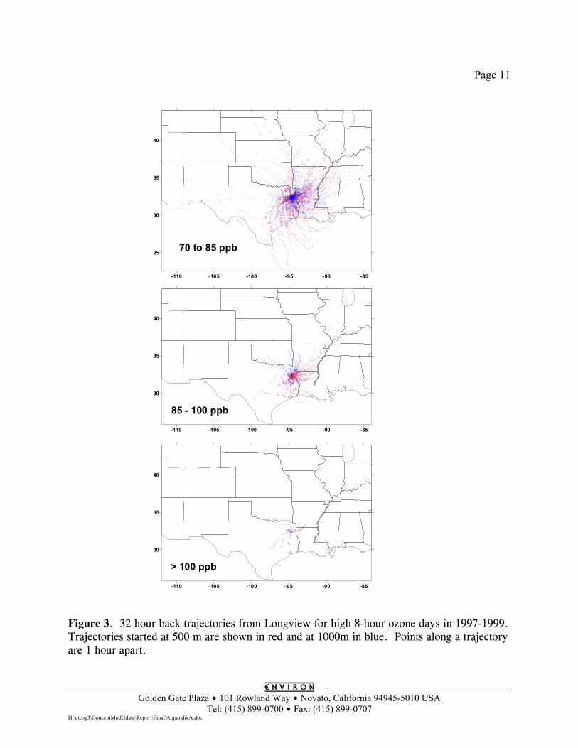
Page 11
Golden Gate Plaza $ 101 Rowland Way $ Novato, California 94945-5010 USA
Tel: (415) 899-0700 $ Fax: (415) 899-0707 H:\etcog3\ConceptModUdate\Report\Final\AppendixA.doc
Figure 3. 32 hour back trajectories from Longview for high 8-hour ozone days in 1997-1999. Trajectories started at 500 m are shown in red and at 1000m in blue. Points along a trajectory are 1 hour apart.
-110 -105 -100 -95 -90 -85
25
30
35
40
70 to 85 ppb
-110 -105 -100 -95 -90 -85
30
35
40
85 - 100 ppb
-110 -105 -100 -95 -90 -85
30
35
40
> 100 ppb
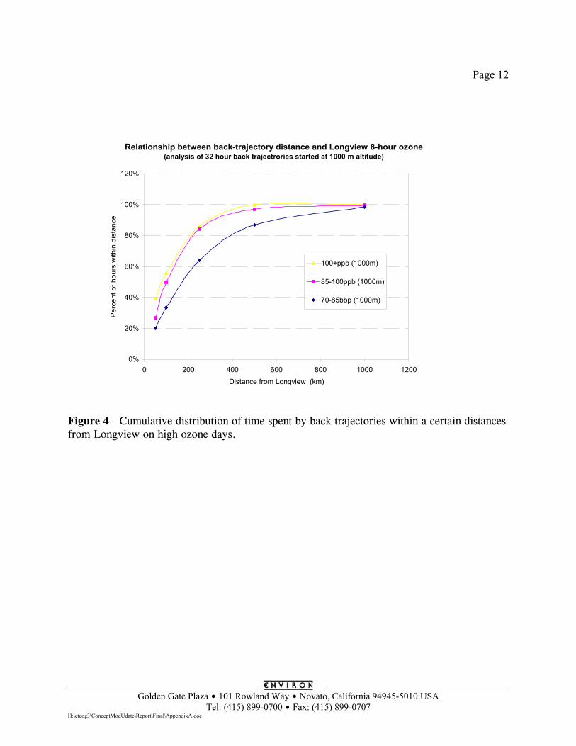
Page 12
Golden Gate Plaza $ 101 Rowland Way $ Novato, California 94945-5010 USA
Tel: (415) 899-0700 $ Fax: (415) 899-0707 H:\etcog3\ConceptModUdate\Report\Final\AppendixA.doc
Figure 4. Cumulative distribution of time spent by back trajectories within a certain distances from Longview on high ozone days.
Relationship between back-trajectory distance and Longview 8-hour ozone(analysis of 32 hour back trajectrories started at 1000 m altitude)
0%
20%
40%
60%
80%
100%
120%
0 200 400 600 800 1000 1200
Distance from Longview (km)
Per
cent
of h
ours
with
in d
ista
nce
100+ppb (1000m)
85-100ppb (1000m)
70-85bbp (1000m)
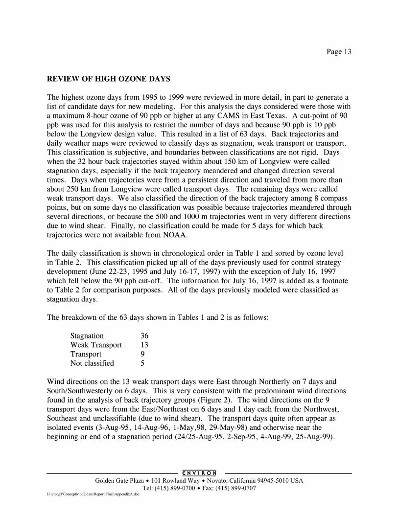
Page 13
Golden Gate Plaza $ 101 Rowland Way $ Novato, California 94945-5010 USA
Tel: (415) 899-0700 $ Fax: (415) 899-0707 H:\etcog3\ConceptModUdate\Report\Final\AppendixA.doc
REVIEW OF HIGH OZONE DAYS The highest ozone days from 1995 to 1999 were reviewed in more detail, in part to generate a list of candidate days for new modeling. For this analysis the days considered were those with a maximum 8-hour ozone of 90 ppb or higher at any CAMS in East Texas. A cut-point of 90 ppb was used for this analysis to restrict the number of days and because 90 ppb is 10 ppb below the Longview design value. This resulted in a list of 63 days. Back trajectories and daily weather maps were reviewed to classify days as stagnation, weak transport or transport. This classification is subjective, and boundaries between classifications are not rigid. Days when the 32 hour back trajectories stayed within about 150 km of Longview were called stagnation days, especially if the back trajectory meandered and changed direction several times. Days when trajectories were from a persistent direction and traveled from more than about 250 km from Longview were called transport days. The remaining days were called weak transport days. We also classified the direction of the back trajectory among 8 compass points, but on some days no classification was possible because trajectories meandered through several directions, or because the 500 and 1000 m trajectories went in very different directions due to wind shear. Finally, no classification could be made for 5 days for which back trajectories were not available from NOAA. The daily classification is shown in chronological order in Table 1 and sorted by ozone level in Table 2. This classification picked up all of the days previously used for control strategy development (June 22-23, 1995 and July 16-17, 1997) with the exception of July 16, 1997 which fell below the 90 ppb cut-off. The information for July 16, 1997 is added as a footnote to Table 2 for comparison purposes. All of the days previously modeled were classified as stagnation days. The breakdown of the 63 days shown in Tables 1 and 2 is as follows: Stagnation 36 Weak Transport 13 Transport 9 Not classified 5 Wind directions on the 13 weak transport days were East through Northerly on 7 days and South/Southwesterly on 6 days. This is very consistent with the predominant wind directions found in the analysis of back trajectory groups (Figure 2). The wind directions on the 9 transport days were from the East/Northeast on 6 days and 1 day each from the Northwest, Southeast and unclassifiable (due to wind shear). The transport days quite often appear as isolated events (3-Aug-95, 14-Aug-96, 1-May,98, 29-May-98) and otherwise near the beginning or end of a stagnation period (24/25-Aug-95, 2-Sep-95, 4-Aug-99, 25-Aug-99).
Page 14
Golden Gate Plaza $ 101 Rowland Way $ Novato, California 94945-5010 USA
Tel: (415) 899-0700 $ Fax: (415) 899-0707 H:\etcog3\ConceptModUdate\Report\Final\AppendixA.doc
Implications for Episode Selection This classification of days can be used to help decide what type of episode should be selected for new modeling to supplement the existing modeling. Tables 1 and 2 show that stagnation is the dominant classification (36 of 58 days classified). The days previously modeled for control strategy development (June 22-23, 1995 and July 16-17, 1997) are stagnation days and will be useful for developing 8-hour ozone control strategies because they are representative of the dominant type of high 8-hour ozone days. In selecting a new episode, we should recognize that stagnation is the dominant type. Therefore, we should not select a purely transport event, even if this were possible. In fact, there aren’t any multi-day transport events that would be suitable for a new modeling episode. Therefore, we should look for a multi-day event with a mixture of stagnation and transport or weak transport; perhaps with transport occurring at the set-up (beginning) or the clear-out (end) of a stagnation period.
Page 15
Golden Gate Plaza $ 101 Rowland Way $ Novato, California 94945-5010 USA
Tel: (415) 899-0700 $ Fax: (415) 899-0707 H:\etcog3\ConceptModUdate\Report\Final\AppendixA.doc
Table 1. Days in 1995-1999 with 8-hour ozone of 90 ppb or higher at any CAMS in East Texas ordered chronologically.
Date TLM 8hr Classification Wind direction 18-Mar-95 90 Weak Transport Northeasterly 13-Jun-95 96 Weak Transport Northerly 15-Jun-95 94 Weak Transport Southerly 16-Jun-95 93 Weak Transport Southeasterly 20-Jun-95 110 Stagnation Recirculation 21-Jun-95 101 Stagnation 22-Jun-95 102 Stagnation 23-Jun-95 103 Stagnation Southerly 27-Jun-95 90 Weak Transport Southerly 7-Jul-95 98 Stagnation Recirculation 11-Jul-95 99 Stagnation Northerly 3-Aug-95 92 Transport Easterly 10-Aug-95 90 Stagnation Easterly 20-Aug-95 96 Stagnation Northeasterly 24-Aug-95 97 Transport Easterly 25-Aug-95 103 Transport Easterly 27-Aug-95 110 Stagnation Northeasterly 28-Aug-95 97 Stagnation 29-Aug-95 99 Weak Transport Easterly 1-Sep-95 92 Stagnation 2-Sep-95 95 Transport Northeasterly 4-Sep-95 91 Stagnation Southerly 3-Jun-96 90 Stagnation 14-Aug-96 93 Transport Northeasterly 6-Sep-96* 97 29-Apr-97 92 Weak Transport Southerly 17-Jul-97 92 Stagnation Easterly 18-Jul-97 104 Weak Transport Southerly 28-Jul-97 91 Weak Transport Easterly 29-Jul-97 93 Stagnation 2-Sep-97 92 Stagnation 29-Sep-97 92 Stagnation 1-May-98 97 Transport Northwesterly 16-May-98 90 Stagnation Westerly 29-May-98 112 Transport Southerly 15-Jun-98 100 Stagnation Northwesterly 1-Aug-98 94 Stagnation Recirculation
Page 16
Golden Gate Plaza $ 101 Rowland Way $ Novato, California 94945-5010 USA
Tel: (415) 899-0700 $ Fax: (415) 899-0707 H:\etcog3\ConceptModUdate\Report\Final\AppendixA.doc
Date TLM 8hr Classification Wind Direction 2-Aug-98 90 Stagnation Recirculation 27-Aug-98* 104 28-Aug-98 114 Stagnation Recirculation 29-Aug-98 96 Weak Transport Northerly 2-Sep-98* 99 3-Sep-98 107 Weak Transport Northeasterly 4-Sep-98 96 Weak Transport Southwesterly 2-Aug-99 95 Stagnation 4-Aug-99 91 Transport Northeasterly 5-Aug-99 120 Stagnation Northeasterly 6-Aug-99 97 Stagnation 7-Aug-99 98 Stagnation 16-Aug-99 105 Weak Transport Northeasterly 17-Aug-99 110 Stagnation Southeasterly 18-Aug-99 91 Stagnation Recirculation 19-Aug-99 91 Stagnation Recirculation 21-Aug-99 92 Stagnation Northeasterly 22-Aug-99 91 Stagnation Southeasterly 25-Aug-99 93 Transport 28-Aug-99 94 Stagnation Easterly 18-Sep-99 91 Weak Transport Northeasterly 19-Sep-99 97 Stagnation Easterly 20-Sep-99 110 Stagnation 24-Sep-99 97 Stagnation Southerly 2-Oct-99* 91 13-Oct-99* 91 * These days were not classified because back trajectories were not available.
16-Jul-97 does not appear in the table because the 8-hour ozone of 88 ppb is below the 90 ppb cut-off. This day is of interest because it was modeled previously, and it was classified as stagnation, recirculation
Page 17
Golden Gate Plaza $ 101 Rowland Way $ Novato, California 94945-5010 USA
Tel: (415) 899-0700 $ Fax: (415) 899-0707 H:\etcog3\ConceptModUdate\Report\Final\AppendixA.doc
Table 2. Days in 1995-1999 with 8-hour ozone of 90 ppb or higher in East Texas ordered by ozone level.
Date
East Texas 8hr Ozone
Classification
Wind direction
5-Aug-99 120 Stagnation Northeasterly 28-Aug-98 114 Stagnation Recirculation 29-May-98 112 Transport Southerly 20-Jun-95 110 Stagnation Recirculation 17-Aug-99 110 Stagnation Southeasterly 20-Sep-99 110 Stagnation 27-Aug-95 110 Stagnation Northeasterly 3-Sep-98 107 Weak Transport Northeasterly 16-Aug-99 105 Weak Transport Northeasterly 27-Aug-98 104 18-Jul-97 104 Weak Transport Southerly 23-Jun-95 103 Stagnation Southerly 25-Aug-95 103 Transport Easterly 22-Jun-95 102 Stagnation 21-Jun-95 101 Stagnation 15-Jun-98 100 Stagnation Northwesterly 11-Jul-95 99 Stagnation Northerly 2-Sep-98 99 29-Aug-95 99 Weak Transport Easterly 7-Jul-95 98 Stagnation Recirculation 7-Aug-99 98 Stagnation 6-Sep-96 97 28-Aug-95 97 Stagnation 6-Aug-99 97 Stagnation 19-Sep-99 97 Stagnation Easterly 24-Sep-99 97 Stagnation Southerly 1-May-98 97 Transport Northwesterly 24-Aug-95 97 Transport Easterly 29-Aug-98 96 Weak Transport Northerly 4-Sep-98 96 Weak Transport Southwesterly 13-Jun-95 96 Weak Transport Northerly 20-Aug-95 96 Stagnation Northeasterly 2-Aug-99 95 Stagnation 2-Sep-95 95 Transport Northeasterly 1-Aug-98 94 Stagnation Recirculation 28-Aug-99 94 Stagnation Easterly
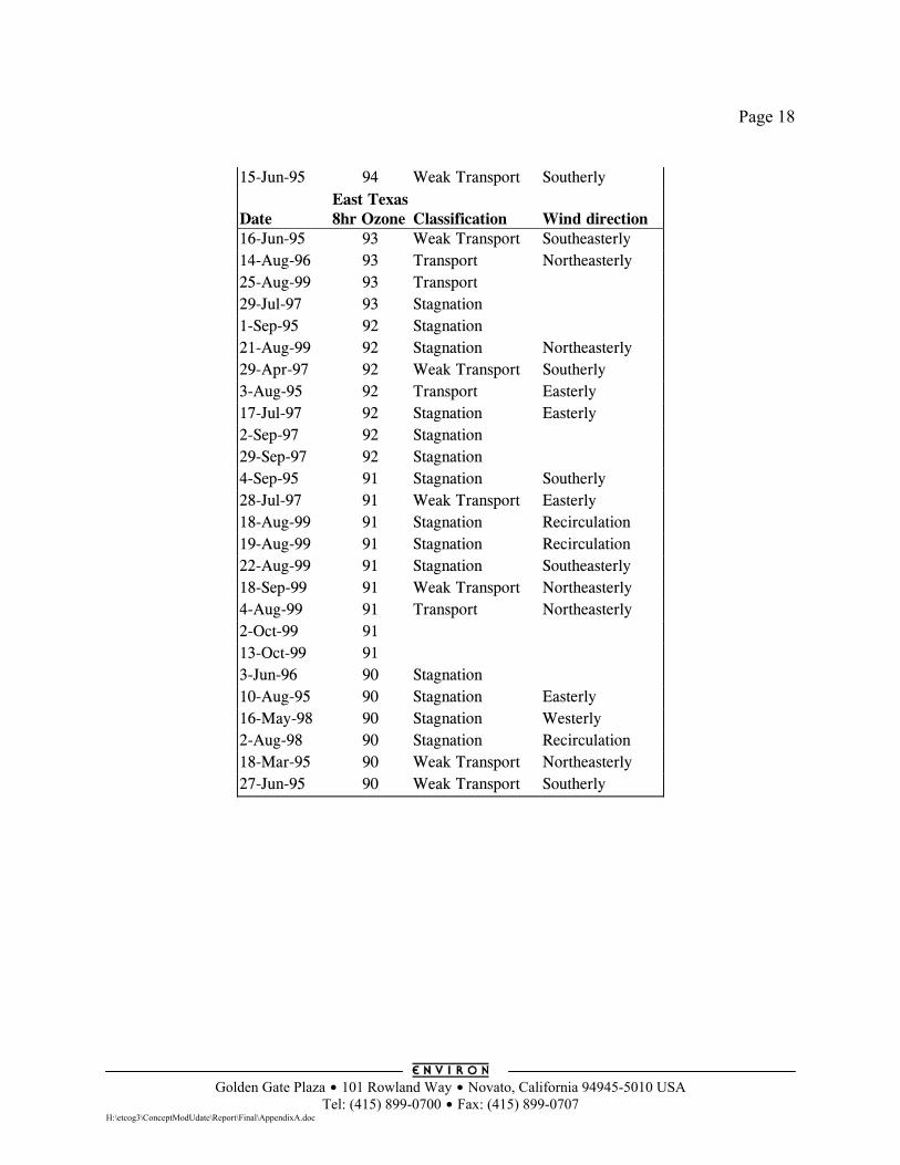
Page 18
Golden Gate Plaza $ 101 Rowland Way $ Novato, California 94945-5010 USA
Tel: (415) 899-0700 $ Fax: (415) 899-0707 H:\etcog3\ConceptModUdate\Report\Final\AppendixA.doc
15-Jun-95 94 Weak Transport Southerly Date
East Texas 8hr Ozone
Classification
Wind direction
16-Jun-95 93 Weak Transport Southeasterly 14-Aug-96 93 Transport Northeasterly 25-Aug-99 93 Transport 29-Jul-97 93 Stagnation 1-Sep-95 92 Stagnation 21-Aug-99 92 Stagnation Northeasterly 29-Apr-97 92 Weak Transport Southerly 3-Aug-95 92 Transport Easterly 17-Jul-97 92 Stagnation Easterly 2-Sep-97 92 Stagnation 29-Sep-97 92 Stagnation 4-Sep-95 91 Stagnation Southerly 28-Jul-97 91 Weak Transport Easterly 18-Aug-99 91 Stagnation Recirculation 19-Aug-99 91 Stagnation Recirculation 22-Aug-99 91 Stagnation Southeasterly 18-Sep-99 91 Weak Transport Northeasterly 4-Aug-99 91 Transport Northeasterly 2-Oct-99 91 13-Oct-99 91 3-Jun-96 90 Stagnation 10-Aug-95 90 Stagnation Easterly 16-May-98 90 Stagnation Westerly 2-Aug-98 90 Stagnation Recirculation 18-Mar-95 90 Weak Transport Northeasterly 27-Jun-95 90 Weak Transport Southerly
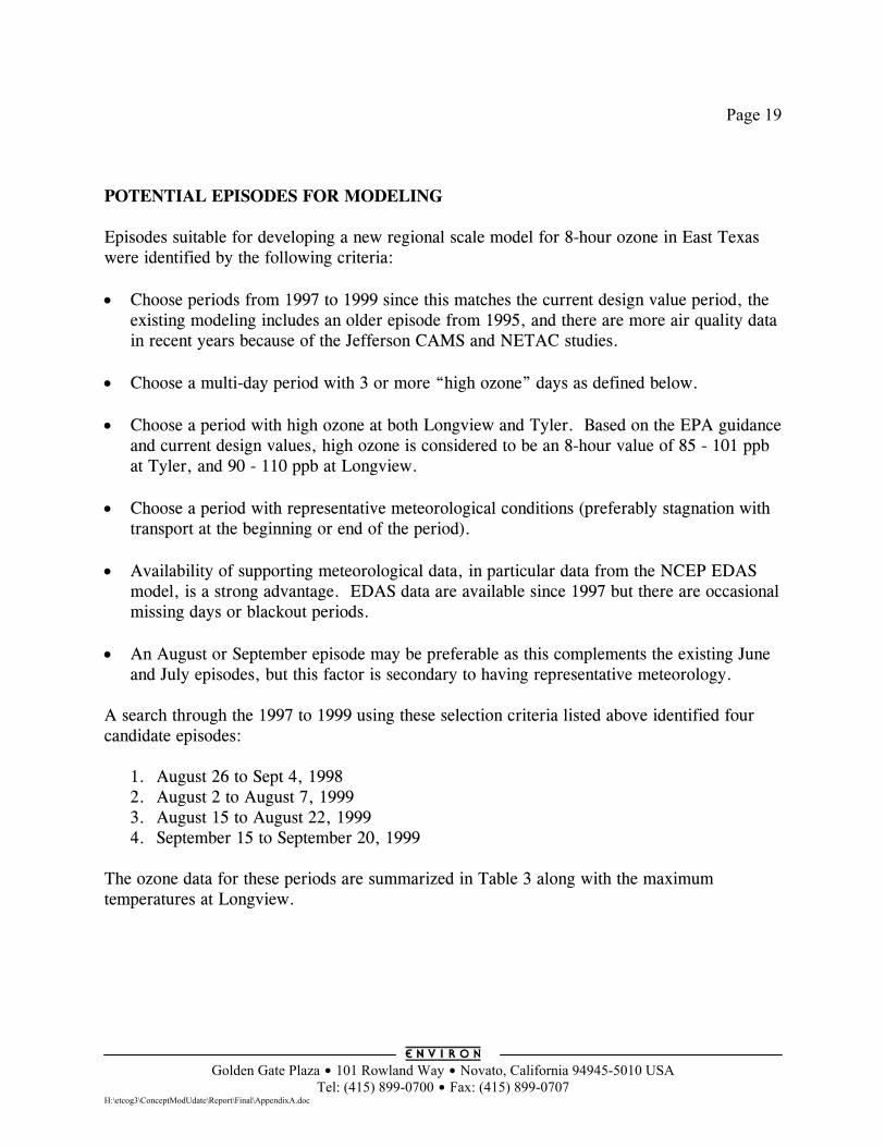
Page 19
Golden Gate Plaza $ 101 Rowland Way $ Novato, California 94945-5010 USA
Tel: (415) 899-0700 $ Fax: (415) 899-0707 H:\etcog3\ConceptModUdate\Report\Final\AppendixA.doc
POTENTIAL EPISODES FOR MODELING Episodes suitable for developing a new regional scale model for 8-hour ozone in East Texas were identified by the following criteria: • Choose periods from 1997 to 1999 since this matches the current design value period, the
existing modeling includes an older episode from 1995, and there are more air quality data in recent years because of the Jefferson CAMS and NETAC studies.
• Choose a multi-day period with 3 or more “high ozone” days as defined below. • Choose a period with high ozone at both Longview and Tyler. Based on the EPA guidance
and current design values, high ozone is considered to be an 8-hour value of 85 - 101 ppb at Tyler, and 90 - 110 ppb at Longview.
• Choose a period with representative meteorological conditions (preferably stagnation with
transport at the beginning or end of the period). • Availability of supporting meteorological data, in particular data from the NCEP EDAS
model, is a strong advantage. EDAS data are available since 1997 but there are occasional missing days or blackout periods.
• An August or September episode may be preferable as this complements the existing June
and July episodes, but this factor is secondary to having representative meteorology. A search through the 1997 to 1999 using these selection criteria listed above identified four candidate episodes:
1. August 26 to Sept 4, 1998 2. August 2 to August 7, 1999 3. August 15 to August 22, 1999 4. September 15 to September 20, 1999
The ozone data for these periods are summarized in Table 3 along with the maximum temperatures at Longview.
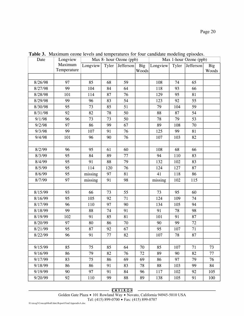
Page 20
Golden Gate Plaza $ 101 Rowland Way $ Novato, California 94945-5010 USA
Tel: (415) 899-0700 $ Fax: (415) 899-0707 H:\etcog3\ConceptModUdate\Report\Final\AppendixA.doc
Table 3. Maximum ozone levels and temperatures for four candidate modeling episodes.
Max 8- hour Ozone (ppb) Max 1-hour Ozone (ppb) Date Longview Maximum
Temperature Longview Tyler Jefferson Big
Woods Longview Tyler Jefferson Big
Woods
8/26/98 97 85 68 59 108 74 65 8/27/98 99 104 84 64 118 93 66 8/28/98 101 114 87 76 129 95 81 8/29/98 99 96 83 54 123 92 55 8/30/98 95 73 85 51 79 104 59 8/31/98 92 82 78 50 88 87 54 9/1/98 96 73 73 50 78 79 53 9/2/98 97 86 99 67 89 108 70 9/3/98 99 107 91 76 125 99 81 9/4/98 101 96 90 76 107 103 82
8/2/99 96 95 61 60 108 68 66 8/3/99 95 84 89 77 94 110 83 8/4/99 95 91 88 79 132 102 83 8/5/99 95 114 120 76 124 127 87 8/6/99 95 missing 97 81 41 118 86 8/7/99 97 missing 91 98 missing 102 115
8/15/99 93 66 73 55 73 95 60 8/16/99 95 105 92 71 124 109 74 8/17/99 96 110 97 90 134 105 94 8/18/99 99 88 74 91 91 78 98 8/19/99 102 91 85 81 101 91 87 8/20/99 97 80 86 70 90 99 72 8/21/99 95 87 92 67 95 107 71 8/22/99 96 91 77 82 107 78 87
9/15/99 85 75 85 64 70 85 107 71 73 9/16/99 86 79 82 76 72 89 90 82 77 9/17/99 83 75 86 69 69 86 97 79 76 9/18/99 86 86 91 83 78 88 103 99 84 9/19/99 90 97 91 84 96 117 102 92 105 9/20/99 92 110 99 88 89 138 105 91 100
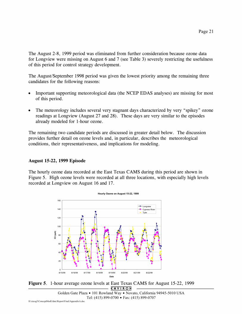
Page 21
Golden Gate Plaza $ 101 Rowland Way $ Novato, California 94945-5010 USA
Tel: (415) 899-0700 $ Fax: (415) 899-0707 H:\etcog3\ConceptModUdate\Report\Final\AppendixA.doc
The August 2-8, 1999 period was eliminated from further consideration because ozone data for Longview were missing on August 6 and 7 (see Table 3) severely restricting the usefulness of this period for control strategy development. The August/September 1998 period was given the lowest priority among the remaining three candidates for the following reasons: • Important supporting meteorological data (the NCEP EDAS analyses) are missing for most
of this period. • The meteorology includes several very stagnant days characterized by very “spikey” ozone
readings at Longview (August 27 and 28). These days are very similar to the episodes already modeled for 1-hour ozone.
The remaining two candidate periods are discussed in greater detail below. The discussion provides further detail on ozone levels and, in particular, describes the meteorological conditions, their representativeness, and implications for modeling. August 15-22, 1999 Episode The hourly ozone data recorded at the East Texas CAMS during this period are shown in Figure 5. High ozone levels were recorded at all three locations, with especially high levels recorded at Longview on August 16 and 17.
Figure 5. 1-hour average ozone levels at East Texas CAMS for August 15-22, 1999
Hourly Ozone on August 15-22, 1999
0
20
40
60
80
100
120
140
160
8/15/99 8/16/99 8/17/99 8/18/99 8/19/99 8/20/99 8/21/99 8/22/99
Date
O3
(ppb
)
LongviewCypress RiverTyler
Page 22
Golden Gate Plaza $ 101 Rowland Way $ Novato, California 94945-5010 USA
Tel: (415) 899-0700 $ Fax: (415) 899-0707 H:\etcog3\ConceptModUdate\Report\Final\AppendixA.doc
Meteorological Analysis for August 12-22, 1999 Weather conditions in eastern Texas during this period were characterized by high temperatures and moderate to high humidity, with occasional rain showers associated with weak frontal activity. Surface winds were typically weak from the south, with short-term variations to northerly directions after the fronts/troughs moved through the area toward the gulf coast. Surface meteorology was controlled by the influence of a wide stable ridge of high pressure aloft, which maintained the presence of a maritime tropical airmass over the south-central U.S for most of the period. This system was a dominant feature over the lower Mississippi Valley on August 12, but weakened on August 13 as a short-wave trough propagated through the central U.S. By August 14 the ridge had amplified and was centered over northern Texas, where it continued to strengthen and broaden for the next few days. By August 17, the ridge extended across the entire southern tier of the U.S. Ultimately, the ridge weakened and retrograded westward into New Mexico as a vigorous trough dug southward out of the northern plain states on August 19. This pattern continued to the end of the period. The first front to pass through Texas approached from the north on August 13. This east-west oriented front caused widespread light rain showers from Abilene through Dallas, to northeastern Texas. It progressed toward the gulf coast on August 14 causing light rain in Houston and back into central Texas. At that point the front weakened and became a stationary trough positioned along the gulf coast. This caused spotty afternoon convective activity and light rain showers in central Texas on August 15, and in southern Texas on August 16-18. Another east-west oriented front moved southward into Texas on August 19, causing light rain to fall from Dallas through east Texas. Again, this front propagated southward to the gulf coast and generated spotty convection and light rain in southern Texas through August 21. On August 22, hurricane “Brett” moved into the gulf coast between Brownsville and Corpus Christi, causing steady heavy precipitation throughout southern Texas. Daily maximum temperatures in eastern Texas varied between 94 and 105°F during the entire period, with 4 of the11 days above 100°F. Dewpoints reached the mid 70’s early in the period (a relative humidity of ~45-50% at 100°F) but dropped to the mid-50’s to mid-60’s for the remainder of the episode after the first frontal passage on August 14. Central Texas and Oklahoma remained much warmer during the period, where daily maximum temperatures were never less than the high 90’s and 9 of 11 days were at or above 100°F. Surface winds in eastern Texas generally possessed a southerly direction through most of the period, and were often calm or light (5-10 knots). Winds on August 12 and 13 were from the south-southwest, while more southeasterly directions continued for the remainder of the
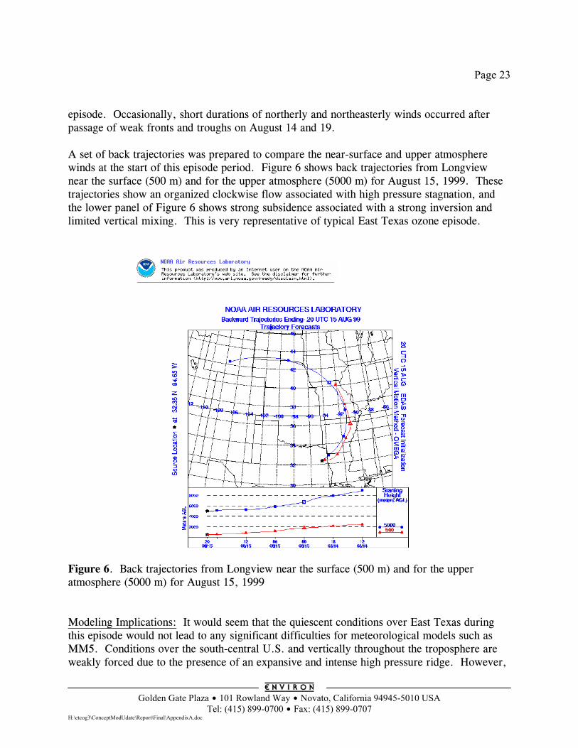
Page 23
Golden Gate Plaza $ 101 Rowland Way $ Novato, California 94945-5010 USA
Tel: (415) 899-0700 $ Fax: (415) 899-0707 H:\etcog3\ConceptModUdate\Report\Final\AppendixA.doc
episode. Occasionally, short durations of northerly and northeasterly winds occurred after passage of weak fronts and troughs on August 14 and 19. A set of back trajectories was prepared to compare the near-surface and upper atmosphere winds at the start of this episode period. Figure 6 shows back trajectories from Longview near the surface (500 m) and for the upper atmosphere (5000 m) for August 15, 1999. These trajectories show an organized clockwise flow associated with high pressure stagnation, and the lower panel of Figure 6 shows strong subsidence associated with a strong inversion and limited vertical mixing. This is very representative of typical East Texas ozone episode.
Figure 6. Back trajectories from Longview near the surface (500 m) and for the upper atmosphere (5000 m) for August 15, 1999 Modeling Implications: It would seem that the quiescent conditions over East Texas during this episode would not lead to any significant difficulties for meteorological models such as MM5. Conditions over the south-central U.S. and vertically throughout the troposphere are weakly forced due to the presence of an expansive and intense high pressure ridge. However,
Page 24
Golden Gate Plaza $ 101 Rowland Way $ Novato, California 94945-5010 USA
Tel: (415) 899-0700 $ Fax: (415) 899-0707 H:\etcog3\ConceptModUdate\Report\Final\AppendixA.doc
there are two features that could lead to some performance problems. The first is the persistence of weak surface fronts that propagate southward through Texas to the gulf coast, evolving into stationary troughs. Afternoon convection is associated with these features on some days of the episode and is mainly confined in the southern half of Texas. The interactions between this convection and the development of daily coastal sea breezes appear to be linked, and this dynamic is likely to be rather complex. The ability of MM5 to properly develop convection and sea-breeze features in space and time could be crucial in reproducing the wind and thermodynamic structures in the area. However, the gulf coast is well to the south of East Texas and so these phenomena should not cause problems for modeling in East Texas. The second issue is the hurricane entering southern Texas late in the period. This also has implications on regional dynamics, as well as where to place grid boundaries. September 15-20, 1999 Episode The hourly ozone data recorded at the East Texas CAMS during this period are shown in Figure 7. High ozone levels were recorded at all three locations, with especially high levels recorded at Longview on September 20. The TNRCC have noted that the start of this period coincided with back trajectories consistent with transport from the Northeast. Figure 8 shows an analysis performed to investigate whether this Northeasterly airflow could have transported high ozone into East Texas on September 16, 1999. This figure shows the 32-hour back trajectories at 500 m and 1000 m from Longview for September 16, 1999. Also shown are the 8-hour ozone maximums for sites in East Texas and Shreveport on September 16, 1999 and the 8-hour ozone maximums at four upwind sites on the previous day (September 15, 1999). These upwind sites were selected because they are classified as rural (by EPA) and should be representative of the background ozone levels transported into East Texas by the Northeasterly winds. This analysis suggests that the ozone levels associated with the Northeasterly winds were not very high, and that ozone transport was not very important in the set-up of the September 15-20 ozone episode.
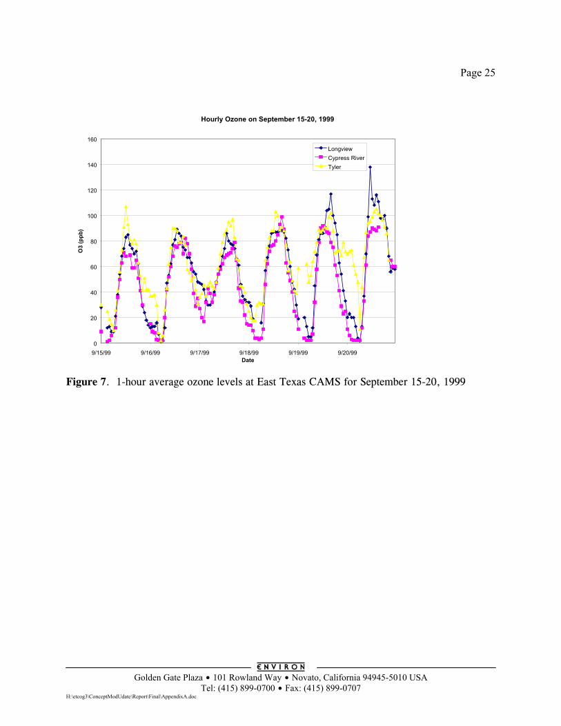
Page 25
Golden Gate Plaza $ 101 Rowland Way $ Novato, California 94945-5010 USA
Tel: (415) 899-0700 $ Fax: (415) 899-0707 H:\etcog3\ConceptModUdate\Report\Final\AppendixA.doc
Figure 7. 1-hour average ozone levels at East Texas CAMS for September 15-20, 1999
Hourly Ozone on September 15-20, 1999
0
20
40
60
80
100
120
140
160
9/15/99 9/16/99 9/17/99 9/18/99 9/19/99 9/20/99Date
O3
(ppb
)
LongviewCypress RiverTyler
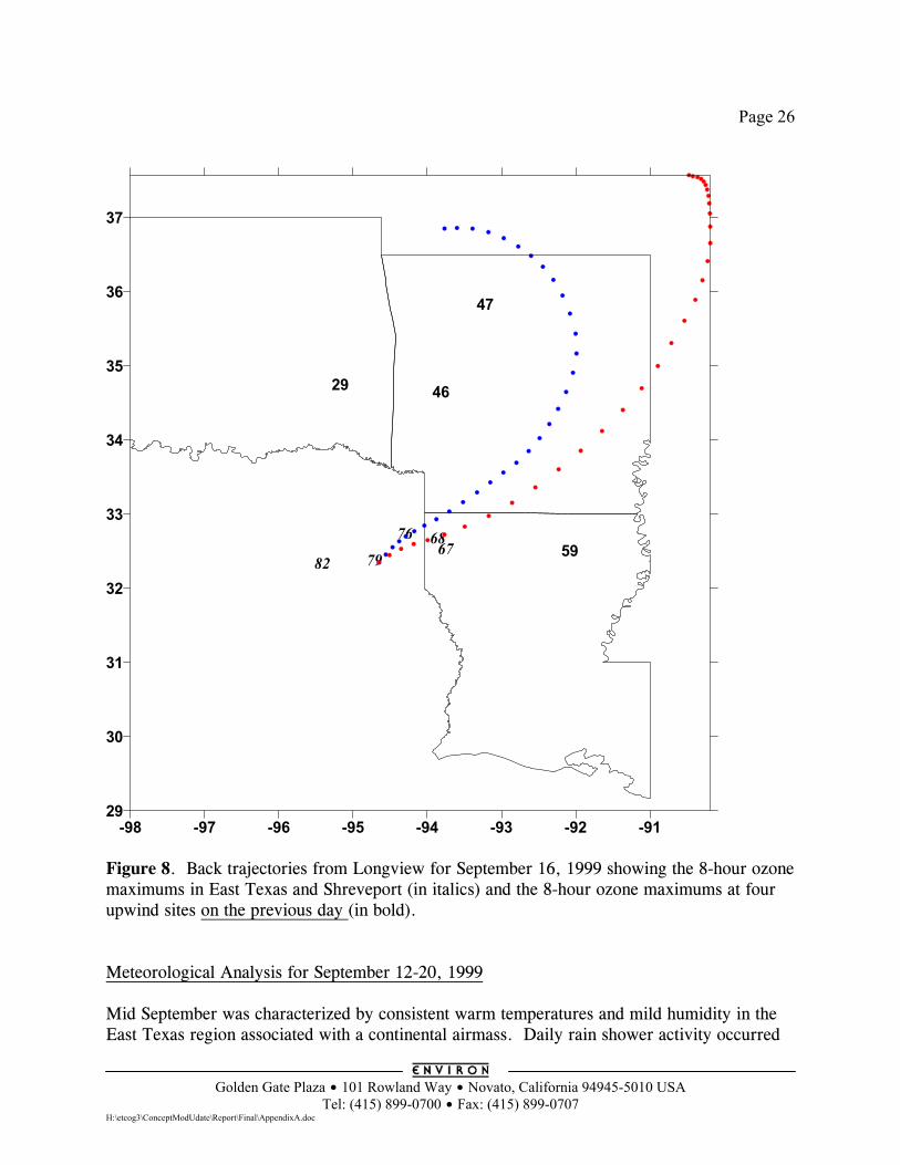
Page 26
Golden Gate Plaza $ 101 Rowland Way $ Novato, California 94945-5010 USA
Tel: (415) 899-0700 $ Fax: (415) 899-0707 H:\etcog3\ConceptModUdate\Report\Final\AppendixA.doc
79
76
826768
46
47
59
29
-98 -97 -96 -95 -94 -93 -92 -9129
30
31
32
33
34
35
36
37
Figure 8. Back trajectories from Longview for September 16, 1999 showing the 8-hour ozone maximums in East Texas and Shreveport (in italics) and the 8-hour ozone maximums at four upwind sites on the previous day (in bold). Meteorological Analysis for September 12-20, 1999 Mid September was characterized by consistent warm temperatures and mild humidity in the East Texas region associated with a continental airmass. Daily rain shower activity occurred
Page 27
Golden Gate Plaza $ 101 Rowland Way $ Novato, California 94945-5010 USA
Tel: (415) 899-0700 $ Fax: (415) 899-0707 H:\etcog3\ConceptModUdate\Report\Final\AppendixA.doc
throughout Texas and Oklahoma associated with weak upper-level short-waves. Calm to light winds were typically from the northeast and east through much of the period. Two tropical disturbances affected the southern U.S. during this episode: hurricane “Floyd” moved northward along the southeastern seaboard during September 14-16, and a tropical depression formed in the central Gulf of Mexico midway through the period and strengthened into tropical storm “Harvey” on September 20 just south of the Mississippi delta. The upper-level pressure and wind patterns were atypical of most episodes characterized by poor air quality in Texas. The usual pattern is for strong upper-air ridging and associated surface high pressure result in a subsiding air mass that leads to stagnation and suppression of vertical mixing. On September 12, however, a vigorous low-pressure system existed over the northern plains that induced troughing into the south-central U.S. The pattern slowly moved eastward over the next few days until the upper flow over the south-central U.S. became more zonal (west-to-east) on September 15. With winds aloft increasing to 15-30 knots, this pattern allowed several small waves to quickly propagate over Texas through September 19, which induced widespread light rain shower activity in Texas and Oklahoma each day during this period. On September 20, an approaching strong upper-level wave carried a cold front through Texas that caused some locally heavy thunderstorms in southeastern Oklahoma, and spotty convection along the front from San Antonio to East Texas. Daily maximum temperatures in East Texas during this period ranged from 84 to 87°F during the first 7 days, to the low 90’s by September 19 and 20. Regionally, maximum temperatures were slightly higher, typically reaching the low to mid 90’s on most days. Dewpoints were consistent across the south-central U.S. and remained in the mid-50’s (relative humidity of ~25-35%). After an initial frontal passage on September 12, winds in the region were light (calm to 5 knots) and generally from the northeast. Wind directions slowly veered toward easterly by September 17-18, and were mainly from the southeast on September 19 ahead of an approaching frontal system. After frontal passage late on September 20, winds were from the north and northeast at a relatively strong 10-15 knots. Once again, back trajectories were used to compare the near-surface and upper atmosphere winds at the start of the episode. Figure 9 shows back trajectories from Longview near the surface (500 m) and for the upper atmosphere (5000 m) for September 15, 1999. These trajectories show the high degree of shear between the Northeasterly surface winds and the strong Westerly zonal flow aloft. This pattern is unusual for high ozone episodes in East Texas.
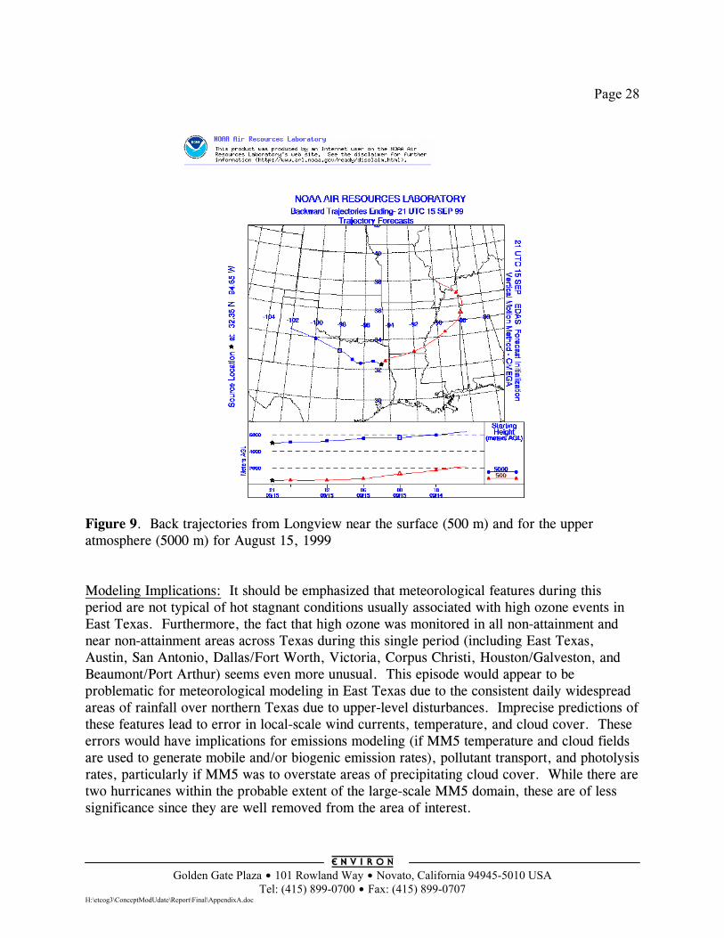
Page 28
Golden Gate Plaza $ 101 Rowland Way $ Novato, California 94945-5010 USA
Tel: (415) 899-0700 $ Fax: (415) 899-0707 H:\etcog3\ConceptModUdate\Report\Final\AppendixA.doc
Figure 9. Back trajectories from Longview near the surface (500 m) and for the upper atmosphere (5000 m) for August 15, 1999 Modeling Implications: It should be emphasized that meteorological features during this period are not typical of hot stagnant conditions usually associated with high ozone events in East Texas. Furthermore, the fact that high ozone was monitored in all non-attainment and near non-attainment areas across Texas during this single period (including East Texas, Austin, San Antonio, Dallas/Fort Worth, Victoria, Corpus Christi, Houston/Galveston, and Beaumont/Port Arthur) seems even more unusual. This episode would appear to be problematic for meteorological modeling in East Texas due to the consistent daily widespread areas of rainfall over northern Texas due to upper-level disturbances. Imprecise predictions of these features lead to error in local-scale wind currents, temperature, and cloud cover. These errors would have implications for emissions modeling (if MM5 temperature and cloud fields are used to generate mobile and/or biogenic emission rates), pollutant transport, and photolysis rates, particularly if MM5 was to overstate areas of precipitating cloud cover. While there are two hurricanes within the probable extent of the large-scale MM5 domain, these are of less significance since they are well removed from the area of interest.
Page 29
Golden Gate Plaza $ 101 Rowland Way $ Novato, California 94945-5010 USA
Tel: (415) 899-0700 $ Fax: (415) 899-0707 H:\etcog3\ConceptModUdate\Report\Final\AppendixA.doc
RECOMMENDED MODELING EPISODE For both the August and September 1999 episodes, the NCEP EDAS data are available for almost all days. During both periods, the highest ozone levels occur on days with stagnant meteorology, but these days do not appear to be as stagnant as the existing modeled episodes. The August 1999 episode is given the highest priority for modeling since the September 1999 episode appears atypical and may be difficult to model for East Texas to be specific: • The meteorology during the September 1999 episode appears to be unusual for high ozone
episodes in East Texas: - Temperatures were unusually cool for an ozone episode. Maximum temperatures at
Longview were mostly in the mid 80’s rather than the high 90’s (see Table 3). - Upper level winds were from the west and unusually strong at 5000 m. - Widespread daily rainfall occurred in North Texas and Oklahoma. Archived
NEXRAD data show rainfall in the area between Dallas to Shreveport on 4 of the 5 days.
We do not recommend choosing an atypical ozone episode as the cornerstone of 8-hour ozone control strategy development efforts.
• Some of the unusual meteorological factors mentioned above are also likely to make this a
difficult period to model successfully for East Texas. We judge that there is a greater risk of the September 1999 episode performing poorly in East Texas than the August 1999 episode.
• The August 1999 episode provides more high ozone days to use for control strategy
evaluation than the September 1999 episode (see Table 4). Table 4. Number of days with 8-hour ozone of 85 ppb or higher for candidate modeling episodes.
Number of days with 8-hour ozone of 85 ppb or higher Episode Period Longview Tyler Cypress River Aug 15 – Aug 22, 1999 6 4 2 Sept 15 – Sept 20, 1999 3 5 1
January 2004
Appendix B
Back Trajectory Plots
Selected Plots from:
AQSI, 2002. Air Quality in East Texas 2002. Final Report, Air Quality Solutions, Inc., Austin, TX.
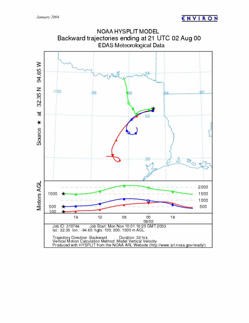
January 2004
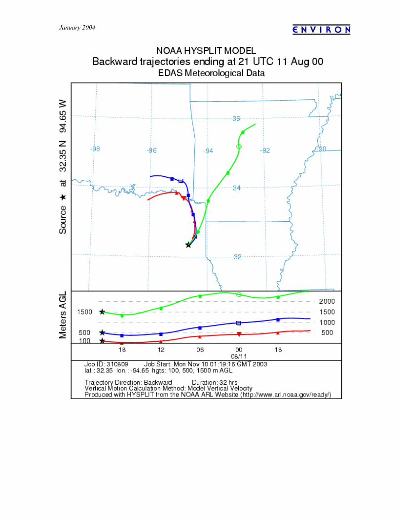
January 2004
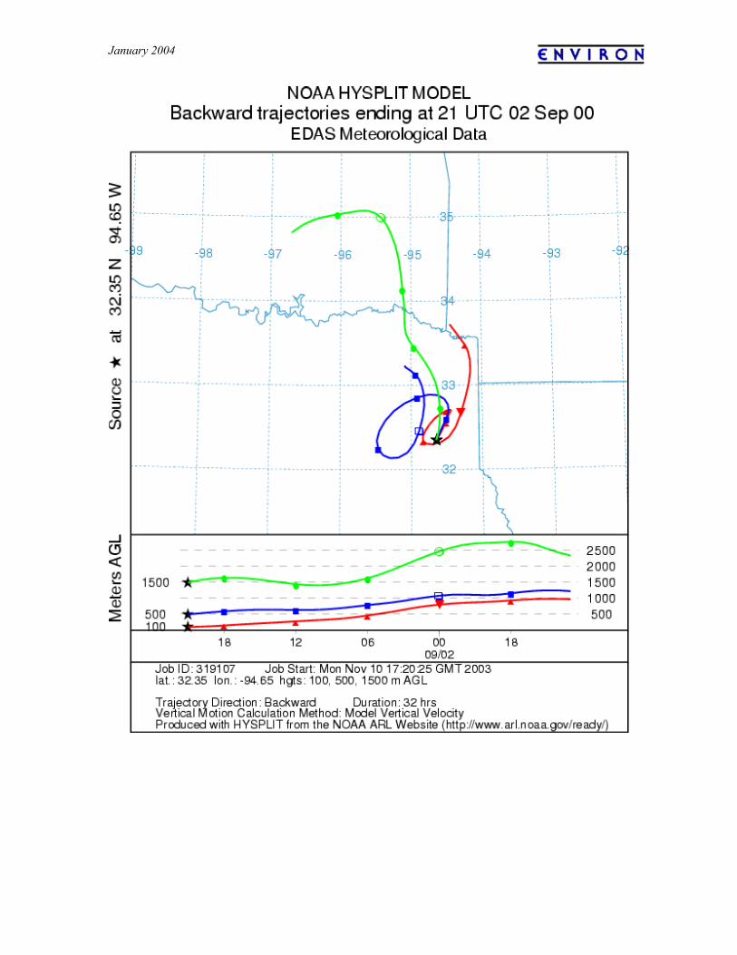
January 2004
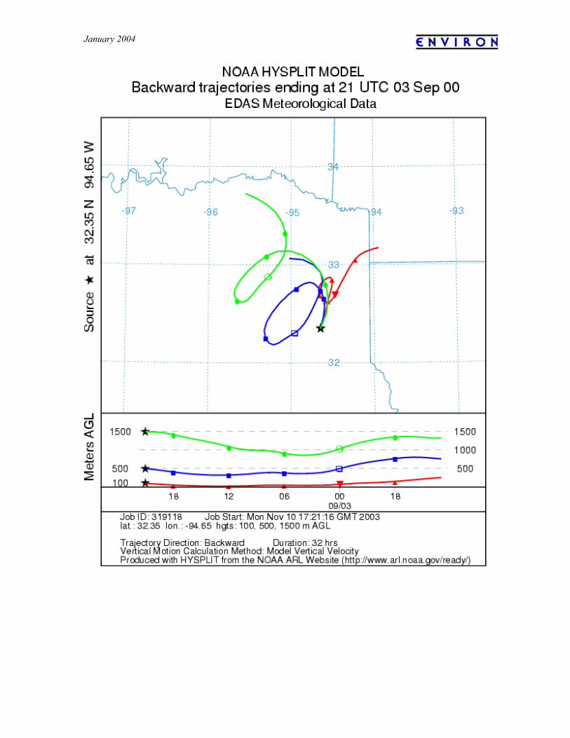
January 2004
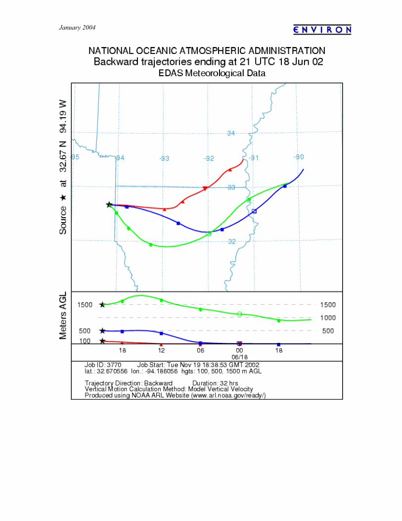
January 2004
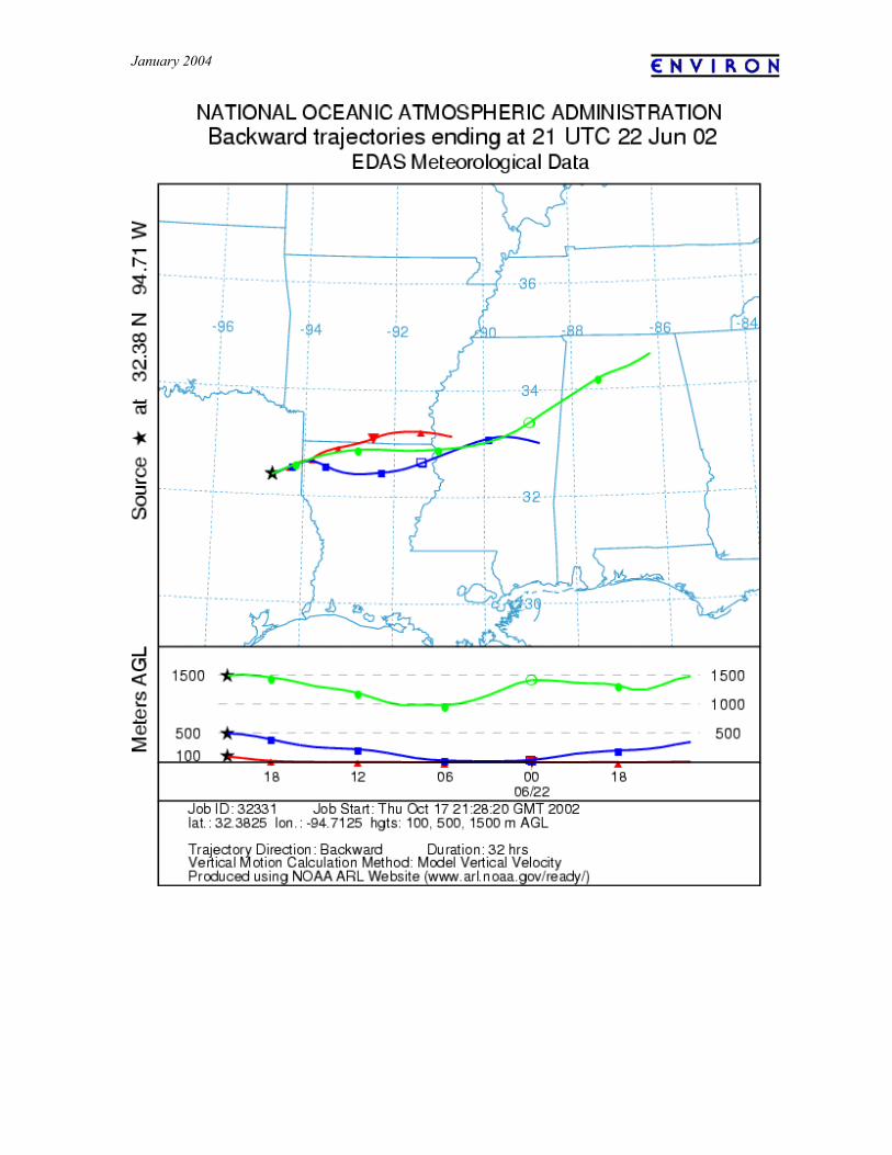
January 2004
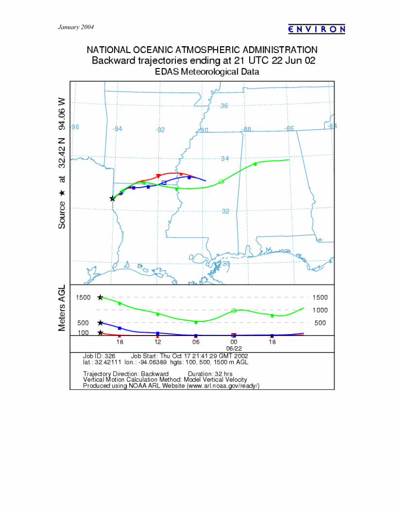
January 2004
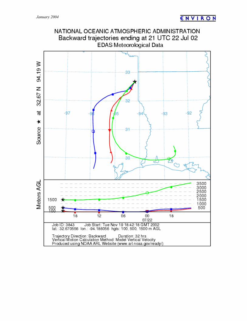
January 2004
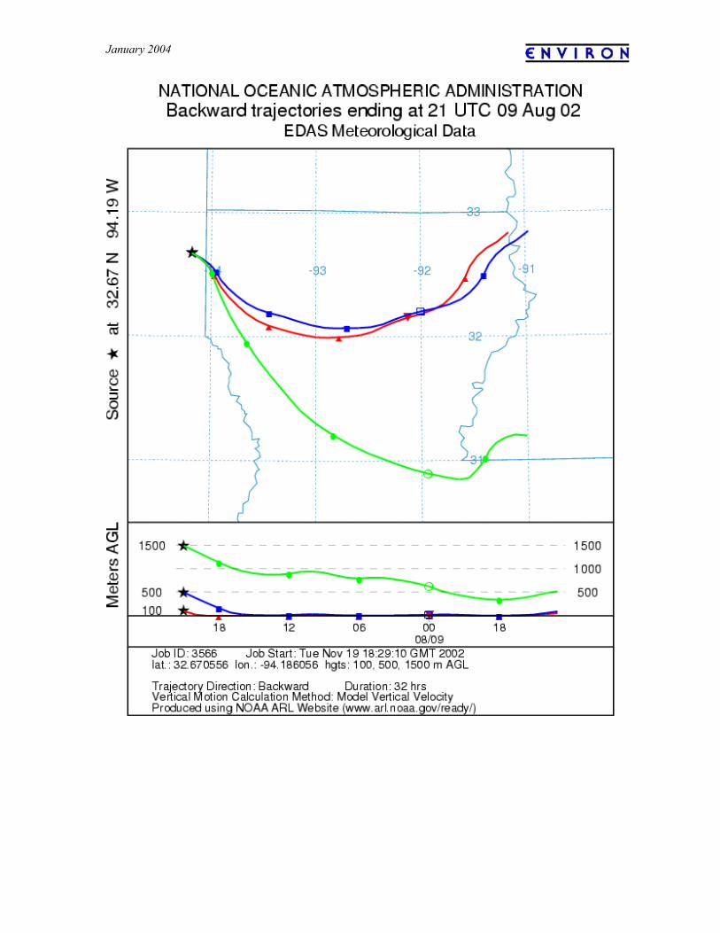
January 2004
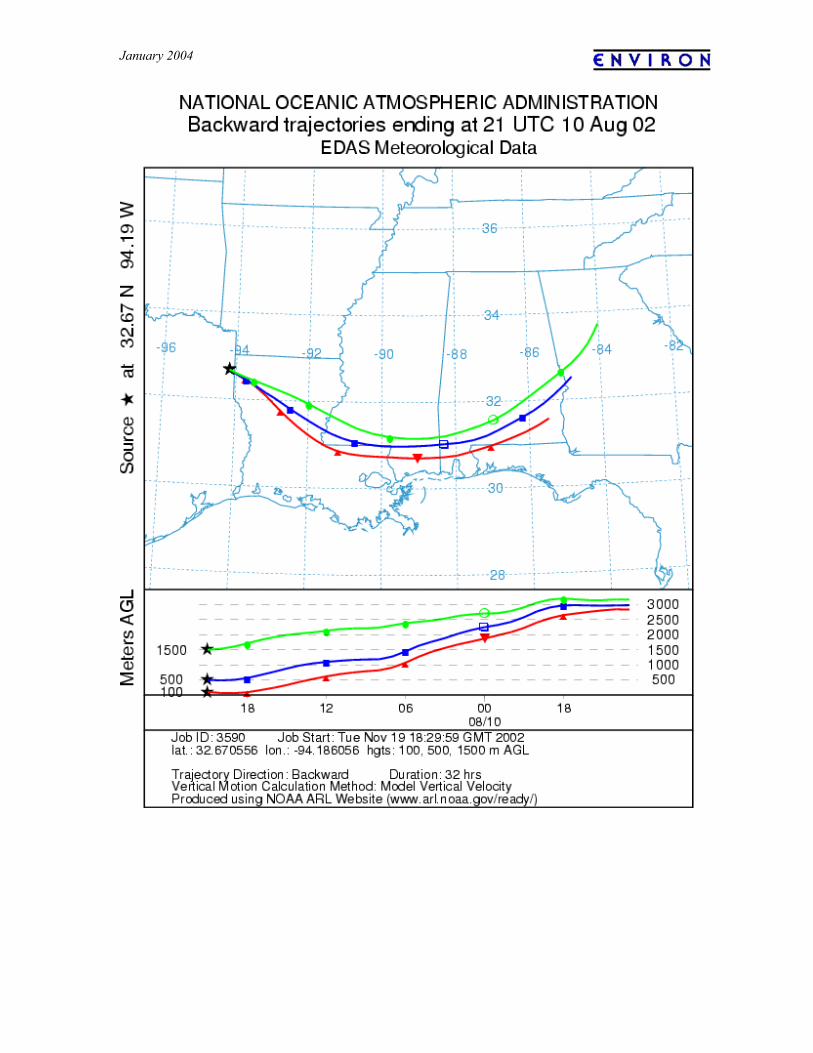
January 2004
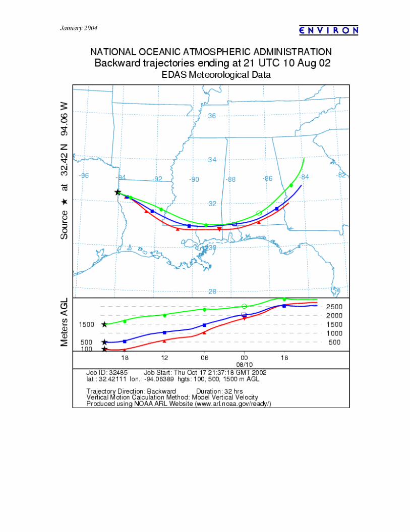
January 2004
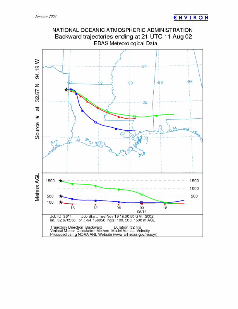
January 2004
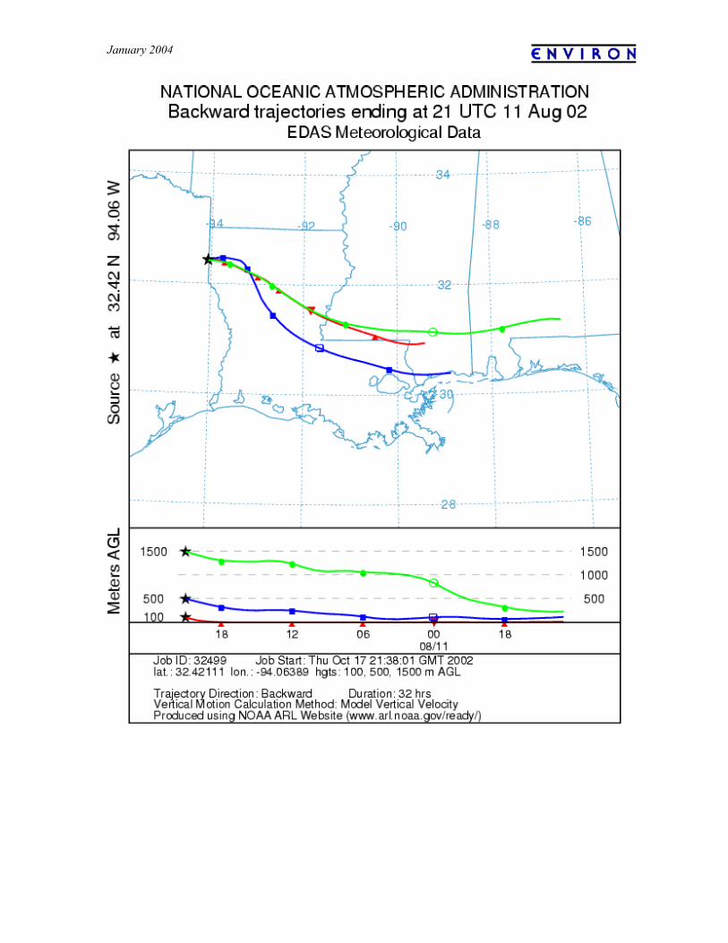
January 2004
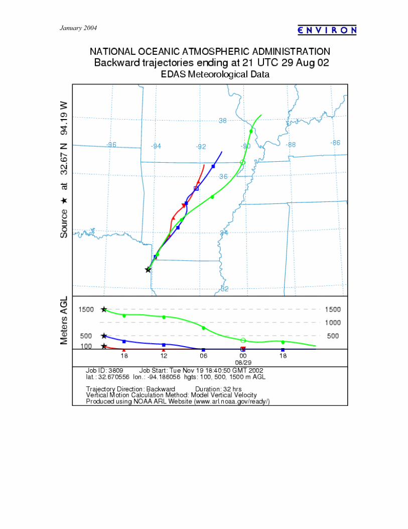
January 2004
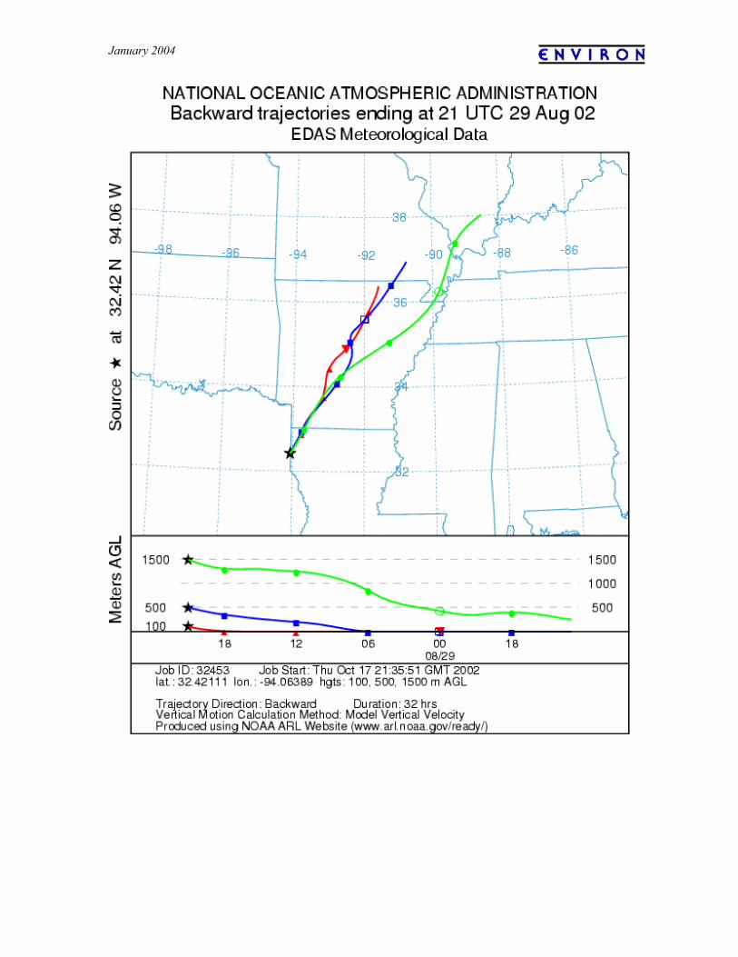
January 2004
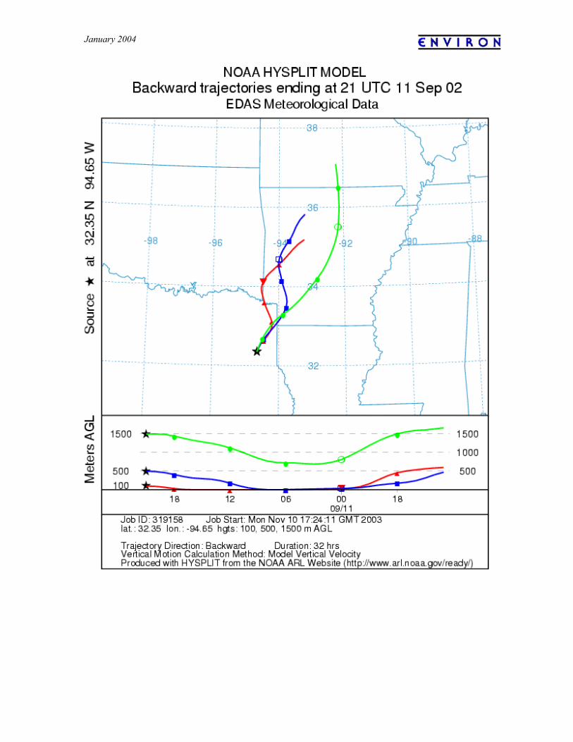
January 2004
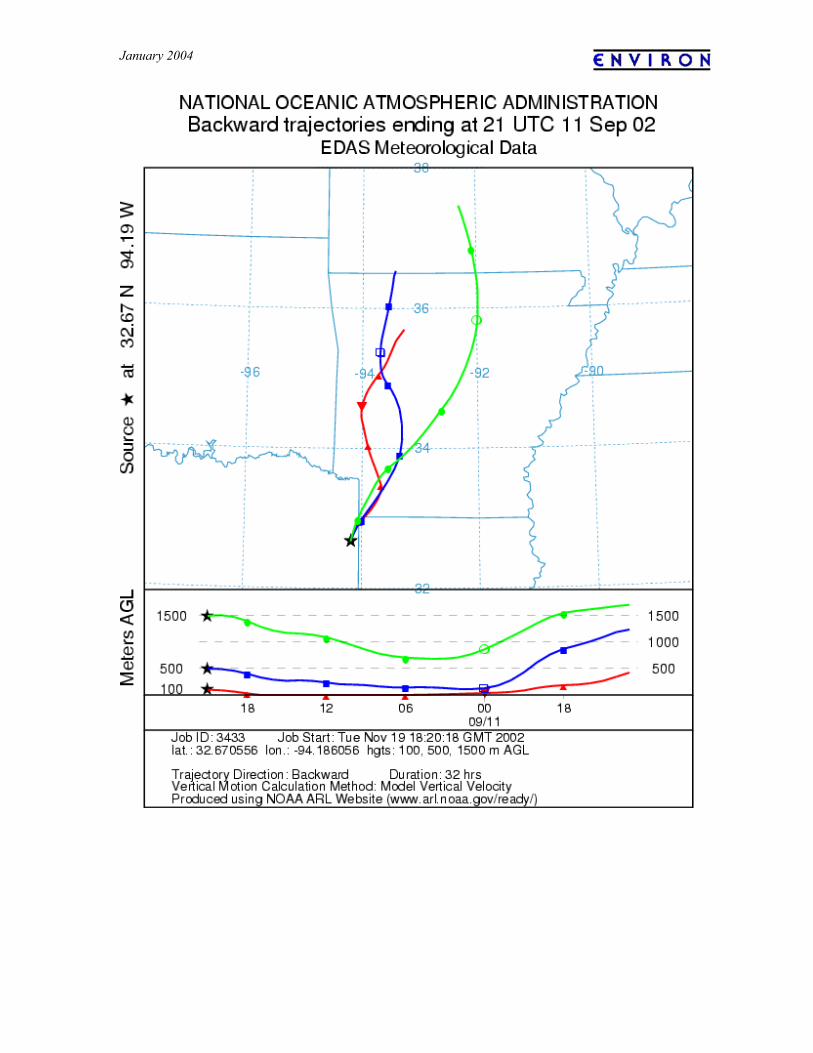
January 2004
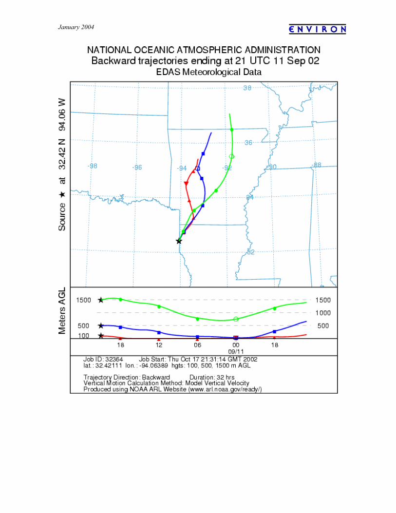
January 2004
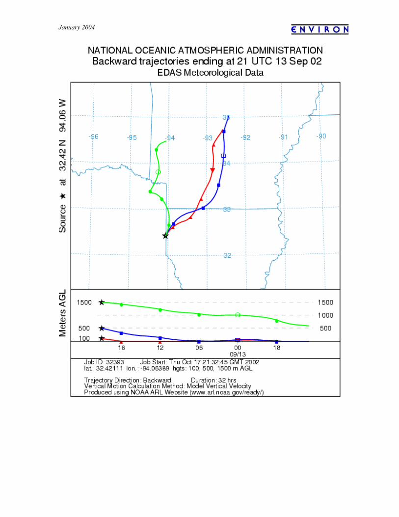
January 2004
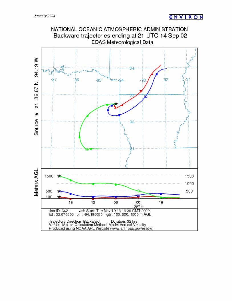
January 2004
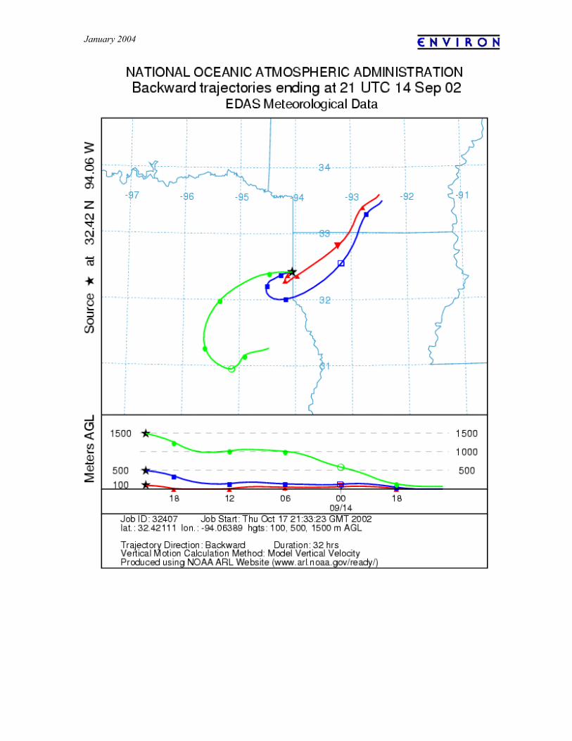
January 2004
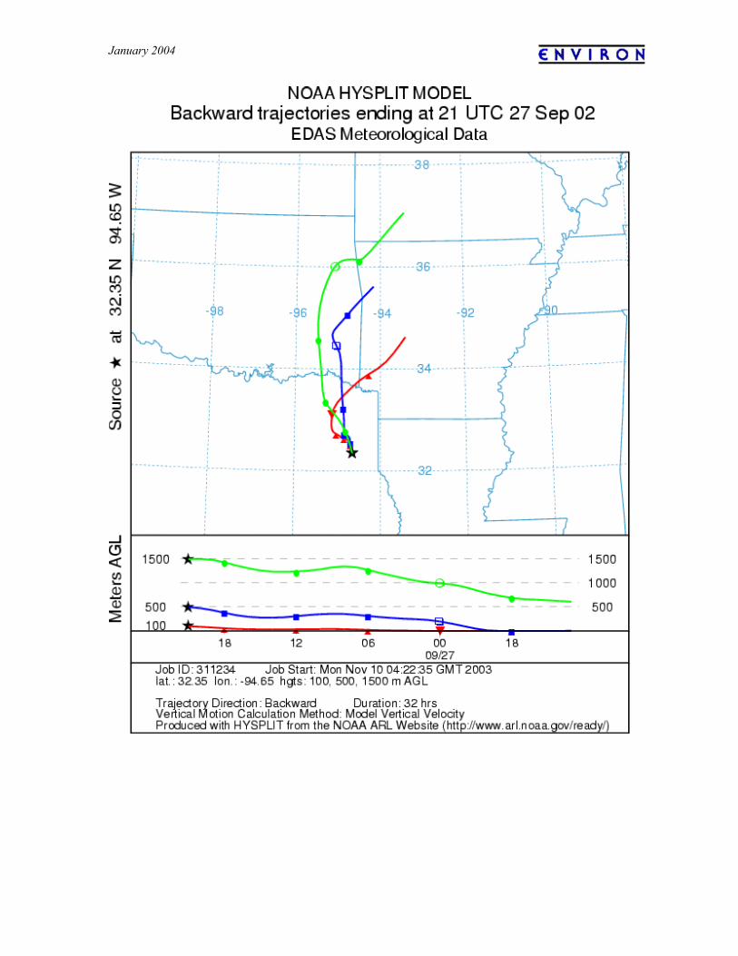
January 2004