Embed Size (px)
Citation preview
Final Environmental Assessment for the Outdoor Recreation Plan, Fort Benning, Georgia Environmental Management Division Fort Benning, Georgia
January 2009
ACRONYMS AND ABBREVIATIONS
AAFES Army & Air Force Exchange
Service AAP Army Alternative Procedures AL Alabama APE Area of Potential Effect ARPA Archaeological and Historic
Resources Preservation Act BMP Best Management Practice BRAC Base Realignment and Closure CEQ Council on Environmental Quality CFR Code of Federal Regulations CRM Cultural Resources Management CWA Clean Water Act CWW Columbus Water Works DoD Department of Defense DMPRC Digital Multi-Purpose Range
Complex EA Environmental Assessment EIS Environmental Impact Statement EMD Environmental Management
Division EO Executive Order EPA Environmental Protection Agency ESA Endangered Species Act ESMP Endangered Species Management
Plan ESPCP Erosion Sediment Pollution Control
Plan FEIS Final Environmental Impact
Statement FMWR Directorate of Family, Morale,
Welfare, and Recreation FNSI Finding of No Significant Impact FT Foot GA Georgia GAR Georgia Administrative Regulation GDNR Georgia Department of Natural
Resources gpd Gallons per day HPC Historic Properties Component HMMWV High Mobility Multi-purpose
Wheeled Vehicle ICRMP Integrated Cultural Resources
Management Plan INRMP Integrated Natural Resources
Management Plan IPBC Infantry Platoon Battle Course
ISBC Infantry Squad Battle Course ISR Installation Status Report LEED Leadership in Energy &
Environmental Design LF Linear Foot LNS Leisure Needs Assessment Survey mgd Million gallons per day MWR Morale, Welfare, and Recreation NAGPRA Native American Graves Protection
and Repatriation Act NEPA National Environmental Policy Act NHPA National Historic Preservation Act NRHP National Register of Historic Places NOI Notice of Intent NOR Notice of Registration NOV Notice of Violation NPDES National Pollutant Discharge
Elimination System NRHP National Register of Historic Places NRPA National Recreation & Parks
Association NWI National Wetlands Inventory ODRP Outdoor Recreation Plan OSJA Office of the Staff Judge Advocate PAO Public Affairs Officer PIP Public Involvement Plan PM Particulate Matter POL Petroleum, Oil, and Lubricants RCI Residential Communities Initiative RCW Red-cockaded Woodpecker ROI Region of Influence RPLANS Real Property Plans and Analysis
System RV Recreational Vehicle sf Square Foot SHPO State Historic Preservation Officer SOP Standard operating procedures SPCC Spill Prevention Control and
Countermeasure TMDL Total Maximum Daily Load USACE U.S. Army Corps of Engineers USAIC U.S. Army Infantry Center USFWS U.S. Fish and Wildlife Service WPCA Water Pollution Control Act WTC Warrior Training Center
1
FINDING OF NO SIGNIFICANT IMPACT (FNSI)
1.0 INTRODUCTION Fort Benning has prepared an Environmental Assessment (EA) to identify and evaluate potential environmental effects from construction/renovation and operation of additional outdoor sports, leisure, and recreational facilities as presented in the Outdoor Recreation Plan at Fort Benning, Georgia. This EA was prepared in accordance with the National Environmental Policy Act (NEPA), the Council on Environmental Quality Regulations at 40 Code of Federal Regulations (CFR) Parts 1500-1508, and the Army NEPA Regulation at 32 CFR Part 651 (Environmental Analysis of Army Actions). 2.0 DESCRIPTION OF THE PROPOSED ACTION Currently, there is a high demand for outdoor sports fields, leisure assets, and overnight accommodations at Fort Benning, including camping sites. This demand arises from the growing needs of the Installation, retired and visiting military, and their families. The main focus of the Outdoor Recreation Plan project is to develop more athletic facilities, trails, recreational vehicles (RV) sites, and camp sites for quality recreational opportunities to support the increased demand for such services at Fort Benning. The proposed action would provide the outdoor leisure facilities and campground areas needed to support recreational needs of Soldiers, civilians, and their Families at Fort Benning and complement existing outdoor options at the Installation. To ease the pressure for recreational facilities, the proposed action would construct and/or upgrade sports fields, RV sites, picnic pavilions and concessions, campgrounds, and playgrounds. 3.0 DESCRIPTION OF THE ALTERNATIVES Fort Benning developed two alternatives for the proposed action as part of the planning process: Alternative A (Proposed Action): Under Alternative A, Fort Benning would construct:
• Recreational vehicle sites; • Softball and soccer fields; • A waterplex and renovate an existing swimming pool; • Approximately 12 miles of new paved walking/biking trails and renovate others; • A permanent entertainment stage, with storage and production facilities (replacing the
existing facilities); and • Playgrounds, picnic pavilions, restrooms, concession areas, and dog parks.
2
Alternative B (No Action) In accordance with NEPA, the no-action alternative was also considered. Under this alternative, no new outdoor leisure and recreational assets would be constructed at Fort Benning. The existing, insufficient recreational facilities at the Post would continue to fail to meet the needs of Fort Benning personnel. 4.0 ANTICIPATED ENVIRONMENTAL EFFECTS In summary, the analysis contained in this EA indicates that for the most part, Alternative A would have only temporary, minor adverse effects to soils, water quality, and biological and cultural resources due to construction. No adverse significant impacts to any resources are anticipated either in a long- or short-term basis. The EA analyses demonstrated that with adherence to applicable federal and state environmental laws, regulations, and permitting processes no significant adverse environmental impacts would result from the proposed action as implemented by Alternative A. This determination is based on the following findings:
• Erosion control best management practices (e.g., silt fencing and soil covering) as prescribed under the National Pollutant Discharge Elimination System would minimize the potential adverse effects to soils and water quality that may result from construction.
• Soil erosion would be kept to a minimum, and potential contamination during construction would be minimized by following existing Fort Benning procedures required under construction contracts, and Federal and State regulations. Nearby Chattahoochee River (impaired) and Upatoi Creek would not be impacted due to small, portage only waterside sites, distance between proposed project sites, and soil erosion control measures.
• Alternative A would result in temporary, minor adverse impacts on federally- or state-listed species potentially occurring in the project areas.
• Recreation and visual resources would beneficially profit from implementation of the proposed action.
• Historical properties have a minor potential to be adversely impacted; however, avoidance, mitigation measures, and consultation will minimize or eliminate adverse effects.
• No cumulative impacts would result from implementing Alternative A. In accordance with Army NEPA Regulations, the Army must indicate if any mitigation measures would be needed to implement the proposed action. Under the proposed action, mitigation would be required for impacts to cultural and water resources; no other resource impacts would require mitigation. In summary, the required cultural resource mitigation measures would be:
• excavation/data recovery of historic properties in accordance with Fort Benning’s Historic Properties Component of the Integrated Cultural Resource Management Plan in the event that disturbance cannot be avoided, and

Final
Environmental Assessment Outdoor Recreation Plan
Fort Benning, Georgia
Prepared for the Environmental Division Fort Benning, Georgia
January 2009


EXECUTIVE SUMMARY

Environmental Assessment for the Outdoor Recreation Plan, Fort Benning, Georgia
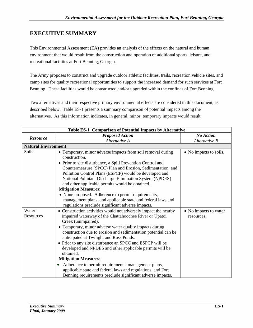
EXECUTIVE SUMMARY This Environmental Assessment (EA) provides an analysis of the effects on the natural and human environment that would result from the construction and operation of additional sports, leisure, and recreational facilities at Fort Benning, Georgia. The Army proposes to construct and upgrade outdoor athletic facilities, trails, recreation vehicle sites, and camp sites for quality recreational opportunities to support the increased demand for such services at Fort Benning. These facilities would be constructed and/or upgraded within the confines of Fort Benning. Two alternatives and their respective primary environmental effects are considered in this document, as described below. Table ES-1 presents a summary comparison of potential impacts among the alternatives. As this information indicates, in general, minor, temporary impacts would result.
Table ES-1 Comparison of Potential Impacts by Alternative
Resource Proposed Action No Action Alternative A Alternative B
Natural Environment Soils • Temporary, minor adverse impacts from soil removal during
construction. • Prior to site disturbance, a Spill Prevention Control and
Countermeasure (SPCC) Plan and Erosion, Sedimentation, and Pollution Control Plans (ESPCP) would be developed and National Pollutant Discharge Elimination System (NPDES) and other applicable permits would be obtained.
Mitigation Measures: • None proposed. Adherence to permit requirements,
management plans, and applicable state and federal laws and regulations preclude significant adverse impacts.
• No impacts to soils.
Water Resources
• Construction activities would not adversely impact the nearby impaired waterway of the Chattahoochee River or Upatoi Creek (unimpaired).
• Temporary, minor adverse water quality impacts during construction due to erosion and sedimentation potential can be anticipated at Twilight and Russ Ponds.
• Prior to any site disturbance an SPCC and ESPCP will be developed and NPDES and other applicable permits will be obtained.
Mitigation Measures: • Adherence to permit requirements, management plans,
applicable state and federal laws and regulations, and Fort Benning requirements preclude significant adverse impacts.
• No impacts to water resources.
Executive Summary ES-1 Final, January 2009
Environmental Assessment for the Outdoor Recreation Plan, Fort Benning, Georgia
ES-2 Executive Summary Final, January 2009
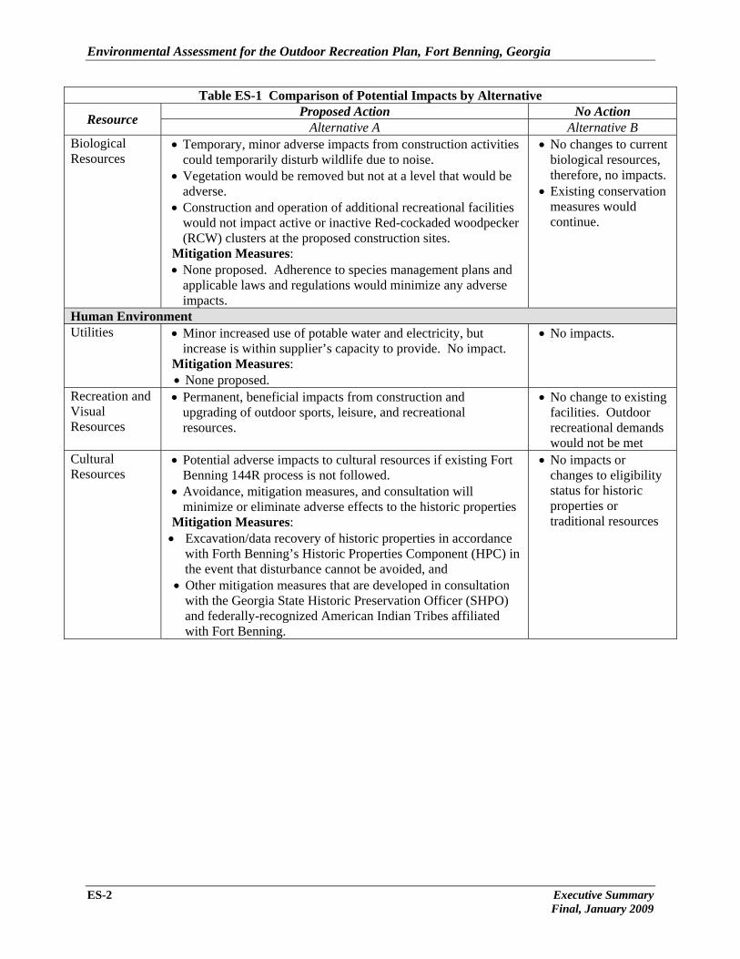
Table ES-1 Comparison of Potential Impacts by Alternative
Resource Proposed Action No Action Alternative A Alternative B
Biological Resources
• Temporary, minor adverse impacts from construction activities could temporarily disturb wildlife due to noise.
• Vegetation would be removed but not at a level that would be adverse.
• Construction and operation of additional recreational facilities would not impact active or inactive Red-cockaded woodpecker (RCW) clusters at the proposed construction sites.
Mitigation Measures: • None proposed. Adherence to species management plans and
applicable laws and regulations would minimize any adverse impacts.
• No changes to current biological resources, therefore, no impacts.
• Existing conservation measures would continue.
Human Environment Utilities • Minor increased use of potable water and electricity, but
increase is within supplier’s capacity to provide. No impact. Mitigation Measures: • None proposed.
• No impacts.
Recreation and Visual Resources
• Permanent, beneficial impacts from construction and upgrading of outdoor sports, leisure, and recreational resources.
• No change to existing facilities. Outdoor recreational demands would not be met
Cultural Resources
• Potential adverse impacts to cultural resources if existing Fort Benning 144R process is not followed.
• Avoidance, mitigation measures, and consultation will minimize or eliminate adverse effects to the historic properties
Mitigation Measures: • Excavation/data recovery of historic properties in accordance
with Forth Benning’s Historic Properties Component (HPC) in the event that disturbance cannot be avoided, and
• Other mitigation measures that are developed in consultation with the Georgia State Historic Preservation Officer (SHPO) and federally-recognized American Indian Tribes affiliated with Fort Benning.
• No impacts or changes to eligibility status for historic properties or traditional resources
Environmental Assessment for the Outdoor Recreation Plan, Fort Benning, Georgia
Alternative A (Proposed Action) Under the proposed action, the Army would construct:
• Recreational vehicle sites; • Softball and soccer fields; • A waterplex and renovate an existing swimming pool; • Approximately 12 miles of new paved walking/biking trails and renovate others; • A permanent entertainment stage, with storage and production facilities (replacing the
existing facilities); and • Playgrounds, picnic pavilions, restrooms, concession areas, and dog parks.
Alternative B (No Action) For the no-action alternative, no additional outdoor recreational facilities would be constructed at Fort Benning. The existing outdoor recreational facilities at Fort Benning would continue to fail to meet the needs of Installation personnel due to insufficient outdoor sports, leisure, and recreational facilities. This alternative has no potential impacts. ANTICIPATED ENVIRONMENTAL EFFECTS The EA analyses demonstrated that with adherence to applicable federal and state environmental laws, regulations, and permitting processes no significant adverse environmental impacts would result from the proposed action as implemented by Alternative A. This determination is based on the following findings:
• Erosion control best management practices (e.g., silt fencing and soil covering) as prescribed under the NPDES would minimize the potential adverse effects to soils and water quality that may result from construction.
• Soil erosion would be kept to a minimum, and potential contamination during construction would be minimized by following existing Fort Benning procedures required under construction contracts, and applicable Federal and state laws and regulations. Nearby Chattahoochee River (impaired) and Upatoi Creek (unimpaired) would not be impacted due to small proposed project sites, and soil erosion control measures.
• Alternative A should have only temporary, minor adverse impacts to RCWs and there are no other Federally or state listed species potentially occurring in the project areas.
• Recreation and visual resources would beneficially profit from implementation of the proposed action.
• Historical properties have the potential to be adversely impacted; however, avoidance, mitigation measures, and consultation in accordance with applicable cultural resource laws and regulations will minimize or eliminate adverse effects.
• No cumulative impacts would result from implementing Alternative A.
Executive Summary ES-3 Final, January 2009
Environmental Assessment for the Outdoor Recreation Plan, Fort Benning, Georgia
ES-4 Executive Summary Final, January 2009
In accordance with Army NEPA Regulations, the Army must indicate if any mitigation measures would be needed to implement the proposed action. It was determined that mitigation would be required for impacts to cultural and water resources; no other resource impacts would need mitigation. In summary, the required cultural resource mitigation measures would be:
• excavation/data recovery of historic properties in accordance with Fort Benning’s HPC in the event that disturbance cannot be avoided, and
• other mitigation measures that are developed in consultation with the Georgia SHPO and federally-recognized American Indian Tribes affiliated with the Fort Benning area.
Mitigation for water resources includes:
• Fort Benning requires the contractor to prepare a basic ESPCP designed similar to the one required under GAR 100001 Part IV for land disturbance less than 1 acre;
• preparation and implementation by the contractor of a plan to protect water resources from sediment and other pollution projects that are not subject to GDNR NPDES permit are not covered under a State permit; and
• best management practices are required to be implemented to control soil erosion, reduce the amount of runoff, and to prevent or minimize pollution of stormwater.
CONCLUSION Based on review of the information contained in this EA, it has been determined that implementation of Alternative A is the best course of action and that construction and renovation of Fort Benning’s outdoor sports and recreational facilities are not major federal actions within the meaning of Section 102(2) (c) of NEPA, and that the proposed outdoor recreation facility construction and upgrade actions would not result in significant potential environmental impacts. Therefore, preparation of an Environmental Impact Statement is not required.

TABLE OF CONTENTS

Environmental Assessment for the Outdoor Recreation Plan, Fort Benning, Georgia
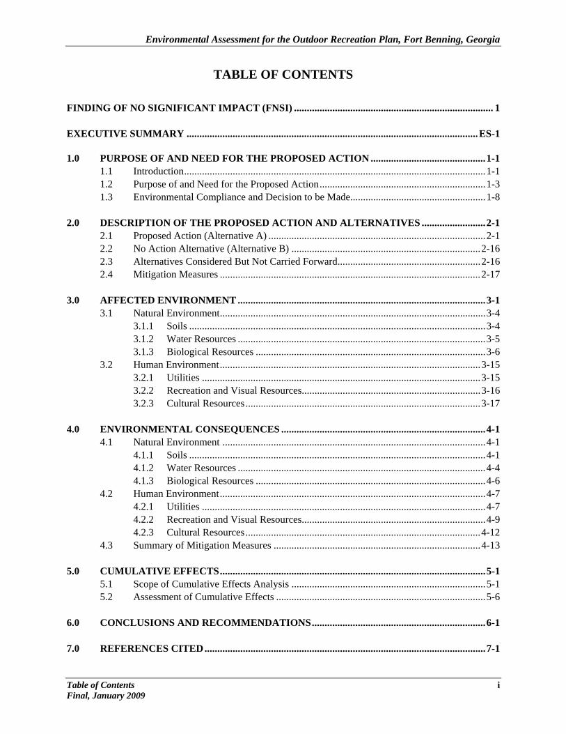
TABLE OF CONTENTS FINDING OF NO SIGNIFICANT IMPACT (FNSI) .............................................................................. 1 EXECUTIVE SUMMARY .................................................................................................................. ES-1 1.0 PURPOSE OF AND NEED FOR THE PROPOSED ACTION ............................................. 1-1 1.1 Introduction ...................................................................................................................... 1-1 1.2 Purpose of and Need for the Proposed Action ................................................................. 1-3 1.3 Environmental Compliance and Decision to be Made ..................................................... 1-8 2.0 DESCRIPTION OF THE PROPOSED ACTION AND ALTERNATIVES ......................... 2-1 2.1 Proposed Action (Alternative A) ..................................................................................... 2-1 2.2 No Action Alternative (Alternative B) .......................................................................... 2-16 2.3 Alternatives Considered But Not Carried Forward ........................................................ 2-16 2.4 Mitigation Measures ...................................................................................................... 2-17 3.0 AFFECTED ENVIRONMENT ................................................................................................. 3-1 3.1 Natural Environment ........................................................................................................ 3-4
3.1.1 Soils .................................................................................................................... 3-4 3.1.2 Water Resources ................................................................................................. 3-5 3.1.3 Biological Resources .......................................................................................... 3-6 3.2 Human Environment ...................................................................................................... 3-15 3.2.1 Utilities ............................................................................................................. 3-15 3.2.2 Recreation and Visual Resources...................................................................... 3-16 3.2.3 Cultural Resources ............................................................................................ 3-17 4.0 ENVIRONMENTAL CONSEQUENCES ................................................................................ 4-1 4.1 Natural Environment ....................................................................................................... 4-1 4.1.1 Soils .................................................................................................................... 4-1 4.1.2 Water Resources ................................................................................................. 4-4 4.1.3 Biological Resources .......................................................................................... 4-6 4.2 Human Environment ........................................................................................................ 4-7 4.2.1 Utilities ............................................................................................................... 4-7 4.2.2 Recreation and Visual Resources........................................................................ 4-9 4.2.3 Cultural Resources ............................................................................................ 4-12 4.3 Summary of Mitigation Measures ................................................................................. 4-13 5.0 CUMULATIVE EFFECTS ........................................................................................................ 5-1 5.1 Scope of Cumulative Effects Analysis ............................................................................ 5-1
5.2 Assessment of Cumulative Effects .................................................................................. 5-6 6.0 CONCLUSIONS AND RECOMMENDATIONS .................................................................... 6-1 7.0 REFERENCES CITED .............................................................................................................. 7-1
Table of Contents i Final, January 2009
Environmental Assessment for the Outdoor Recreation Plan, Fort Benning, Georgia
ii Table of Contents Final, January 2009
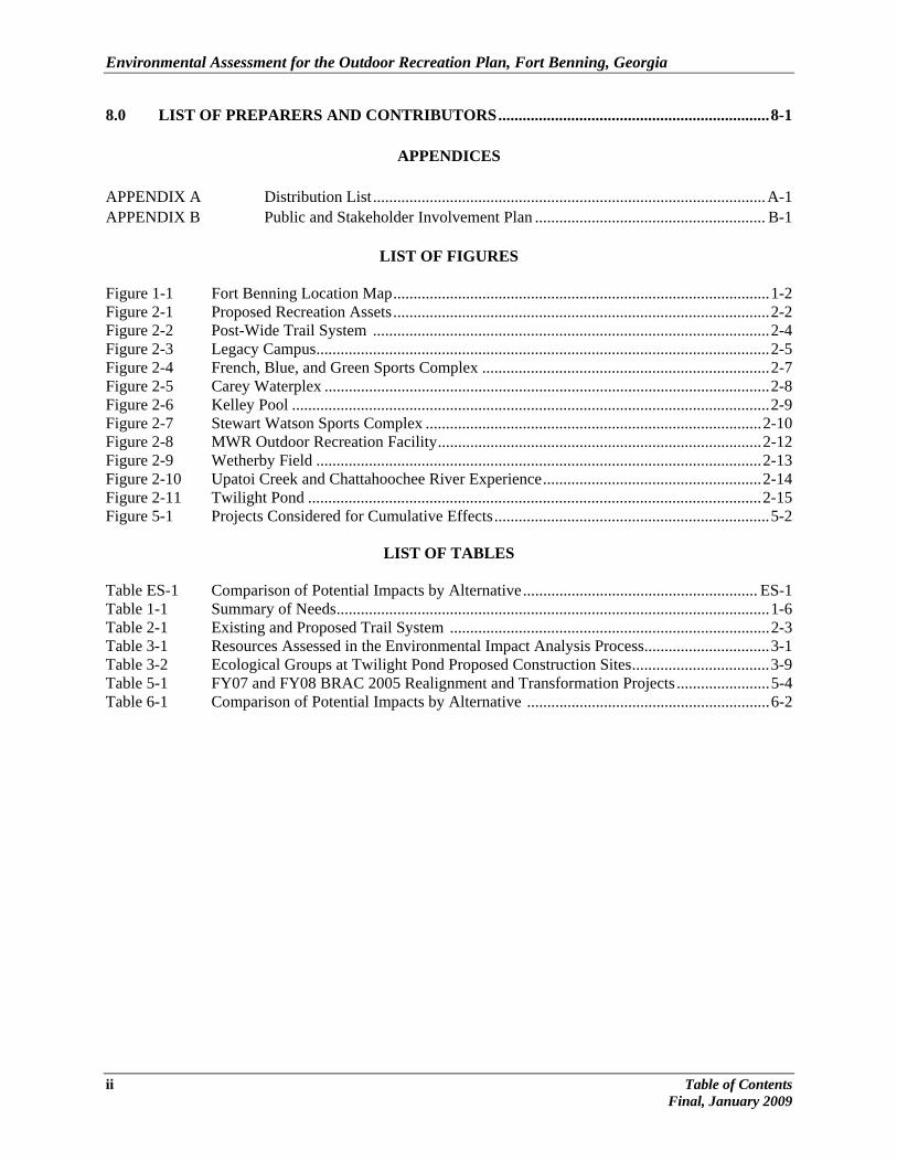
8.0 LIST OF PREPARERS AND CONTRIBUTORS ................................................................... 8-1
APPENDICES APPENDIX A Distribution List ................................................................................................. A-1 APPENDIX B Public and Stakeholder Involvement Plan ......................................................... B-1
LIST OF FIGURES
Figure 1-1 Fort Benning Location Map ............................................................................................. 1-2 Figure 2-1 Proposed Recreation Assets ............................................................................................. 2-2 Figure 2-2 Post-Wide Trail System .................................................................................................. 2-4 Figure 2-3 Legacy Campus ................................................................................................................ 2-5 Figure 2-4 French, Blue, and Green Sports Complex ....................................................................... 2-7 Figure 2-5 Carey Waterplex .............................................................................................................. 2-8 Figure 2-6 Kelley Pool ...................................................................................................................... 2-9 Figure 2-7 Stewart Watson Sports Complex ................................................................................... 2-10 Figure 2-8 MWR Outdoor Recreation Facility ................................................................................ 2-12 Figure 2-9 Wetherby Field .............................................................................................................. 2-13 Figure 2-10 Upatoi Creek and Chattahoochee River Experience ...................................................... 2-14 Figure 2-11 Twilight Pond ................................................................................................................ 2-15 Figure 5-1 Projects Considered for Cumulative Effects .................................................................... 5-2
LIST OF TABLES
Table ES-1 Comparison of Potential Impacts by Alternative .......................................................... ES-1 Table 1-1 Summary of Needs ........................................................................................................... 1-6 Table 2-1 Existing and Proposed Trail System ............................................................................... 2-3 Table 3-1 Resources Assessed in the Environmental Impact Analysis Process ............................... 3-1 Table 3-2 Ecological Groups at Twilight Pond Proposed Construction Sites .................................. 3-9 Table 5-1 FY07 and FY08 BRAC 2005 Realignment and Transformation Projects ....................... 5-4 Table 6-1 Comparison of Potential Impacts by Alternative ............................................................ 6-2

CHAPTER 1
PURPOSE OF AND NEED FOR THE PROPOSED ACTION

Environmental Assessment for the Outdoor Recreation Plan, Fort Benning, Georgia
1.0 PURPOSE AND NEED FOR THE PROPOSED ACTION 1.1 INTRODUCTION
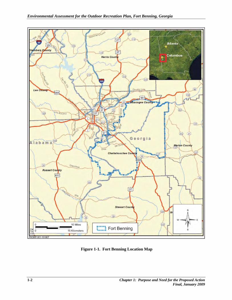
Fort Benning is preparing this Environmental Assessment (EA) to analyze environmental impacts from projects proposed in the Installation Outdoor Recreation Plan (Fort Benning 2006). In this EA, the analysis focuses on outdoor leisure areas and athletic facilities to support the recreational needs of personnel and families at Fort Benning. In accordance with National Environmental Policy Act (NEPA) and Council on Environmental Quality (CEQ) regulations implementing NEPA and Army NEPA Regulation (32 Code of Federal Regulations [CFR] Part 651), this Outdoor Recreation Plan EA also evaluates the no-action alternative. Fort Benning consists of 181,275 acres of federally-owned land south and east of Columbus, Georgia (GA), and south of Phenix City, Alabama (AL); the Chattahoochee River traverses the southwest portion of the Installation (Figure 1-1). There are four main cantonment areas on Fort Benning: Main Post, Kelley Hill, Sand Hill, and Harmony Church. Main Post houses various garrison and smaller U.S. Army Forces Command units such as 11th Engineer Battalion, 988th Military Policy Company, and a number of U.S. Army Training and Doctrine Command-related tenants. Kelley Hill houses the 3rd Brigade of the 3rd Infantry Division (Mechanized). Sand Hill is the primary location of the 192nd and 198nd Infantry Brigades, while Harmony Church primarily houses the Sniper and Ranger Schools. Within these cantonment areas, Fort Benning has its own schools, shopping malls, medical facilities, housing, and churches. While almost every type of recreation and athletics is available on Post, adequate facilities of every type are not. Army initiatives (e.g., Base Realignment and Closure [BRAC], Army Modular Force, and Grow the Force) will dramatically increase personnel and families at Fort Benning in the near future. The largest influx of personnel is led by the 2005 Department of Defense (DoD) BRAC Commission decisions to relocate the Armor Center and School from Fort Knox, Kentucky, to Fort Benning. This consolidates the Armor and Infantry Centers and Schools at Fort Benning and creates the Maneuver Center of Excellence for ground forces training and doctrine development. The BRAC realignments are expanding the Post population by an estimated 16,614 persons within the next few years. This brings the total population of Soldiers, students, trainees, family members, and civilian employees at Fort Benning to more than 50,000 with other initiatives likely to increase that number.
Chapter 1: Purpose and Need for the Proposed Action 1-1 Final, January 2009
Environmental Assessment for the Outdoor Recreation Plan, Fort Benning, Georgia
Figure 1-1. Fort Benning Location Map
1-2 Chapter 1: Purpose and Need for the Proposed Action Final, January 2009
Environmental Assessment for the Outdoor Recreation Plan, Fort Benning, Georgia
1.2 PURPOSE AND NEED FOR PROPOSED ACTION Military installations, including Fort Benning, have a continuous planning process to address mission changes, funding availability, and facility aging. The Outdoor Recreation Plan (ODRP) at Fort Benning is part of that planning process, providing near-, mid-, and long-term perspective of the overall Morale, Welfare, and Recreation (MWR) program. The recreational needs of the Active Duty, Reserve, and retired military and their families were examined using national, state, and Army approaches to determine priority projects and outline the funding timeline for them. The overall guiding principle for the ODRP is the Army Well-Being Initiative “…the personal- physical, material, mental, and spiritual – state of Soldiers, civilian retirees, and their families…” Army Well-Being provides the opportunities for Soldiers, civilians, and their Families to enhance their personal self-reliance and resilience as they pursue their individual aspirations. Key values of the ODRP include quality recreation programs that:
• Contribute to the quality-of-life, encourage positive individual values, and aid in recruitment and retention of personnel.
• Form an integral part of the non-pay compensation system. • Maintain a high esprit de corps, enhance job proficiency, and contribute to effectiveness. • Provide a sense of community among patrons and provide community support systems for a
mobile military population and their families. • Promote and maintain the physical, mental, and social well-being of military members, their
families, and other eligible members of the community. • Provide opportunities, recognition, and skill development for youth. • Provide sufficient funds to adequately meet the demand for quality recreational opportunities. • Form partnerships to develop a unified constituency that will improve outdoor recreational
resources.
These principles and values are the basis upon which the ODRP provides for facilities that offer appropriate recreational opportunities to all members of the supported population at Fort Benning. Comprehensive ODRPs are needed to guide Capital Improvements Programs for the annual programming and budgeting cycle, and are intended to provide for the long-term provisioning of outdoor recreation facilities and opportunities at or near U.S. Army installations. The ODRP at Fort Benning assesses the need for outdoor recreation areas and facilities through an on-Post inventory and analysis. It presents conceptual outdoor recreation area plans for the Installation, along with a phased Capital Improvements Program. The ODRP takes a long-range perspective by reflecting proposed developments in light of perceived unmet needs and observed trends in outdoor recreation activity, both on and off Post. It complements other planning documents that are part of the Installation’s master planning process. The
Chapter 1: Purpose and Need for the Proposed Action 1-3 Final, January 2009
Environmental Assessment for the Outdoor Recreation Plan, Fort Benning, Georgia
Fort Benning Outdoor Recreation Plan (ODRP), dated July 2006, guides the Post in the development of outdoor recreation assets for the next 5 to 10 years (Fort Benning 2006). This document, hereby incorporated by reference, is publicly available at the Sayers Library and accessible at: http://www.benningmwr.com/uchee31905.htm. The planning process used in the development of the ODRP comprised four stages:
• Investigation • Evaluation • Recommendation • Implementation
Investigation. This first stage gathered available information pertaining to outdoor opportunities on- and off-Post. This was followed by an on-Post workshop that featured consultations with the senior military and civilian leadership. The workshop included field investigation by a team of landscape architects, community and recreational planners, and geospatial analysts. In addition to documenting existing conditions through site visits, assessment forms, and photography, the workshop included interviews with stakeholders representing the recreational facility operators and various other functional interests, both garrison and tenant. Information gathered during the stakeholder interviews revealed there was no large shift in outdoor recreation needs by the military community in the last 10 years. Swimming, fishing, rental cabins and chalets, and intramural sports have remained popular activities. Interest and participation in soccer activities has increased slightly. Accordingly, outdoor recreational planning for Fort Benning has accounted for these local consistencies in providing the appropriate variety of opportunities in outdoor recreation facilities and programs. Evaluation. Using the information pertinent to outdoor recreation development, an evaluation was made of the potential effects of on- and off-Post conditions (natural and man-made) upon outdoor recreation. The principle opportunities and constraints were summarized. In addition, the needs and requirements of the Installation’s population, with regard to recreation, were determined. This effort included an evaluation of existing recreation activities and facilities (supply), an evaluation of the potential user population and a record of their use of recreation (demand), and integration of existing data regarding perceived needs. A comparison of the supply and demand quantified the recreation needs and requirements. In order to evaluate the current status of each recreational site, a rating system was developed to assess the condition of the amenities. The rating attributed to the amenity determined the action to be taken. If the facility or equipment was in excellent condition, no upgrade or improvement was necessary. If the facility or equipment was in good condition, only minor repair or improvement was needed. Facilities or equipment in fair condition would need repair. Facilities or equipment in poor condition would require substantial repair or possible replacement. Finally, facilities and equipment in deteriorated condition would need replacement or to be taken out of service.
1-4 Chapter 1: Purpose and Need for the Proposed Action Final, January 2009
Environmental Assessment for the Outdoor Recreation Plan, Fort Benning, Georgia
Recommendation. The third state in the planning process presented a framework and Site Development Plans for future development, together with order of magnitude cost estimates phased over a 10-year period. Information and trends gathered during investigation, together with needs and requirements identified during evaluation, served as the primary sources for all recommendations. This development scheme created the long-range plan to guide future development. Implementation. The final stage of the planning process, implementation, identified the necessary funding to execute the recommended phasing plan. Not all projects recommended in the ODRP were approved for funding; therefore, will not be implemented. Opportunities and Constraints to Recreational Development On-Post conditions (opportunities and constraints) could affect outdoor recreational opportunities and include elements of both the natural and man-made environment such as geology, soils, topography, hydrology, vegetation, fish and wildlife, aesthetic qualities, archeological and historic sites, traffic circulation, utilities, existing recreation facilities, and dangerous or hazardous areas. These opportunities include:
• A Post-wide desire and overall market to expand camping amenities and recreational activities provided by the Uchee Creek Army Campground and Marina.
• Expand recreation opportunities and recreational vehicle and large group camping at Twilight Pond.
• Maximize potential recreational development in on-Post wilderness areas. • Tap resources at Upatoi Creek for land and water recreational opportunities. • In concert with the Upatoi Creek, the Chattahoochee River could provide expanded opportunities
for fishing, canoeing/kayaking, hiking, night or daytime wildlife viewing, and programming for adventure activities.
• The abundance of historical and cultural resources would provide unique programming and destination assets.
• The on-Post Chattahoochee River Walk provides opportunities to expand the Post-wide Trail System and to link to off-Post destinations.
Several constraints to outdoor recreation were identified as well:
• The on-Post pools are old and in need of significant upgrades and repairs. • Development of forested areas around Twilight Pond may be constrained because of active Red
Cockaded Woodpecker (RCW) clusters or because of the presence of RCW forage habitat. • Solid waste management units may affect expansion at some sites.
Chapter 1: Purpose and Need for the Proposed Action 1-5 Final, January 2009
Environmental Assessment for the Outdoor Recreation Plan, Fort Benning, Georgia
• Training areas, ranges, and hunting areas limit accessibility and frequency of use to recreational assets.
• A competitive market exists off Post for youth sports programming and water parks, and may limit expansion of these types of recreational assets.
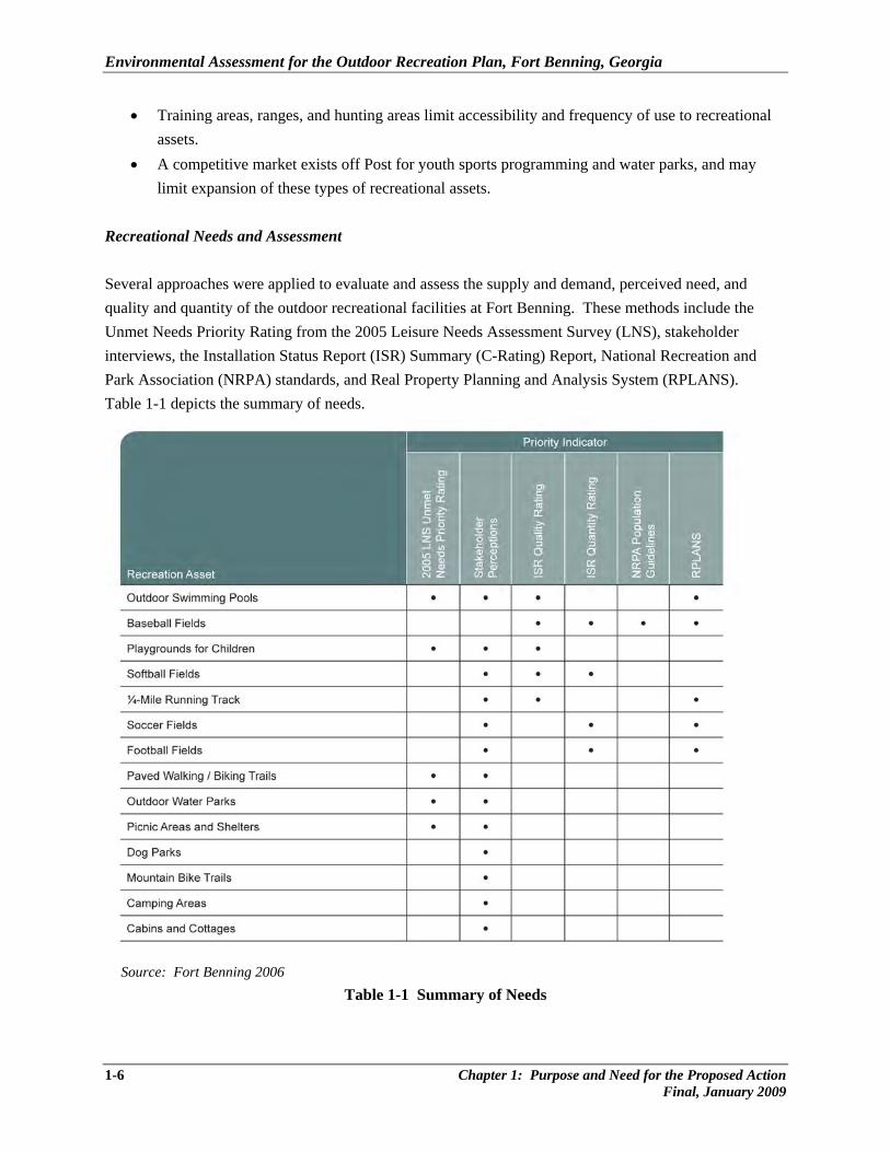
Recreational Needs and Assessment Several approaches were applied to evaluate and assess the supply and demand, perceived need, and quality and quantity of the outdoor recreational facilities at Fort Benning. These methods include the Unmet Needs Priority Rating from the 2005 Leisure Needs Assessment Survey (LNS), stakeholder interviews, the Installation Status Report (ISR) Summary (C-Rating) Report, National Recreation and Park Association (NRPA) standards, and Real Property Planning and Analysis System (RPLANS). Table 1-1 depicts the summary of needs.
Source: Fort Benning 2006
Table 1-1 Summary of Needs
1-6 Chapter 1: Purpose and Need for the Proposed Action Final, January 2009
Environmental Assessment for the Outdoor Recreation Plan, Fort Benning, Georgia
The LNS found that more than 60 percent of the respondents preferred to participate in activities on-Post, rather than off-Post. Moreover, a relatively high percentage of personnel living off-Post (often more than 50 percent) indicated they would prefer to participate in outdoor leisure activities on Post. These activities include outdoor swimming pools, picnic areas and shelters, soccer, mountain bike trails, tennis courts, playgrounds for children, in-line skating/skateboard areas, dog parks, and paved walking/biking trails. Stakeholder interviews identified the following on-Post recreational facilities and amenities needs:
• Increase the number of youth soccer fields to adequately accommodate the current number of teams.
• With expanding intramural sports programming on Post, the demand for more intramural ball fields was identified, especially within the Main Post and Sand Hill.
• On-Post swimming pools are highly used and greater interest in the facilities is likely if the quality of the facilities were increased.
• Fishing is a favorite pastime on Fort Benning. Several on-Post ponds are stocked, but lack improved roadways, boat ramps, fishing piers, and restrooms.
• There is a strong market for more recreational lodging at Uchee Creek Recreational Area chalets, cabins, and Recreational Vehicle (RV) and primitive area campsites.
• Outdoor concerts and special events held at Fort Benning are marketable and feasible. The current market could support more events and larger venues.
Each ODRP development proposal evaluated in this EA is expected to improve the opportunity for and quality of the outdoor recreation experience at the Installation toward one or more of the outcomes noted above. Further, it is expected that for each proposed improvement, there would be a measureable difference in the observable pattern of use of the facility or in the quality of the experience to the user. Summary Fort Benning population growth is expected to increase demand for outdoor recreational activities. Through various survey methods and interviews described above, the need to upgrade or improve existing facilities is necessary to address the on-Post unmet needs. The challenge is to accommodate all users who desire to partake of recreational facilities at Fort Benning. To achieve this requires construction of new outdoor athletic facilities, trails, RV and camp sites, and chalets for quality recreational opportunities. Through the ODRP process, 11 areas were identified for specific construction and improvement; ten of these areas form the proposed action in this EA; the eleventh was analyzed in the Environmental Assessment Uchee Creek Campground Expansion, Fort Benning, Russell County, Alabama. February 2007 (Fort Benning 2007a) with a Finding of No Significant Impact available for review at: http://www.benning.army.mil/EMD/_program_ mgt/legal/index.htm.
Chapter 1: Purpose and Need for the Proposed Action 1-7 Final, January 2009
Environmental Assessment for the Outdoor Recreation Plan, Fort Benning, Georgia
1-8 Chapter 1: Purpose and Need for the Proposed Action Final, January 2009
This EA will provide the environmental analysis for these ten ODRP projects, regardless of the project priority or timing. Funding delays could force a project analyzed in this EA beyond the normal NEPA time frame of 5 years. Each project design will be submitted to Environmental Management Division (EMD) for review when detailed plans and funds become available to ensure there are no changes or additional environmental requirements to be met. 1.3 ENVIRONMENTAL COMPLIANCE AND DECISION TO BE MADE Fort Benning is preparing this EA to identify, evaluate, and compare the potential environmental effects of implementing the projects identified within the ORDP, which include constructing new athletic fields, trails, and camping sites at Fort Benning. This EA is prepared in accordance with NEPA (40 CFR 1500-1508); the CEQ regulations that implement NEPA; and Army Regulation at 32 CFR Part 651 (Army Regulation 200-2, Environmental Effects of Army Actions). In general, the CEQ regulations require that prior to implementing any major action, the Federal agency must evaluate the proposal’s potential environmental effect as well as notify and involve the public in the agency’s decision-making process (Appendix A provides the EA distribution list, and Appendix B provides a copy of the public involvement plan associated with this proposal). This EA identifies the potential environmental effects of the proposed action, and contains discussions of any mitigation and permit requirements, findings, and conclusions in accordance with NEPA. Such information provides the basis for Fort Benning to determine which alternative to select and/or whether to prepare an Environmental Impact Statement (EIS) or a Finding of No Significant Impact (FNSI). The use of the term “significant” (and derivations thereof) in this EA is consistent with the definition and guidelines provided in the CEQ regulations (40 CFR 1508.27), which require consideration of both the context and intensity of impacts.

CHAPTER 2
DESCRIPTION OF THE PROPOSED ACTION AND ALTERNATIVES

Environmental Assessment for the Outdoor Recreation Plan, Fort Benning, Georgia
2.0 DESCRIPTION OF THE PROPOSED ACTION AND ALTERNATIVES
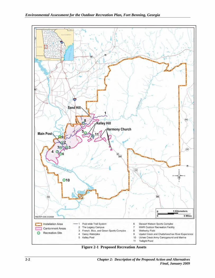
This chapter describes the Fort Benning projects proposed in the Installation Outdoor Recreation Plan (Fort Benning 2006a). The proposed action (Alternative A) involves improvements to outdoor leisure areas and athletic facilities in the southwest portion of the Installation (Figure 2-1). Alternative B is the no-action alternative, wherein the proposed outdoor recreational assets would not be constructed or improved at Fort Benning. 2.1 PROPOSED ACTION (ALTERNATIVE A) Under the proposed action (Alternative A) ten sites are proposed for recreation improvements, Figures 2-2 through 2-11 depict the proposed projects in detail and each legend lists existing assets in black, proposed new assets in green, and improved assets in blue. In an effort to address the outdoor recreation needs at Fort Benning, the following developments are proposed and are further described in this chapter:
• Create quality recreation settings by improving the layout and features of the French, Blue, and Green Sports Complex, the development of The Legacy Campus, and the development of a special event venue at Wetherby Field.
• Satisfy unmet needs by expanding the trails network and improving the facilities at each of the swimming pools.
• Relieve pressure on crowded activities by including features that allow for extended operating hours, more efficient use of facilities and staff, and provide more opportunities for self-guided recreational activities.
• Open new opportunities to enjoy the Chattahoochee River, Upatoi and Uchee Creeks, as well as King and Twilight ponds.
• Better align facility size and location to the population by building upon the existing assets of Legacy Park, and a physical fitness center and track at Stewart Watson Sports Complex.
Specifically, Fort Benning would develop, upgrade, and renovate ten areas of outdoor recreation assets; The Uchee Creek Army Campground and Marina expansion (number 11) added RV campsites and chalets to help alleviate the demand for overnight accommodations at Fort Benning, along with two new playgrounds. This expansion was evaluated for impacts in the Environmental Assessment Uchee Creek Campground Expansion, Fort Benning, Russell County, Alabama. February 2007 (Fort Benning 2007a) with a FNSI, and is hereby incorporated by reference.
Chapter 2: Description of the Proposed Action and Alternatives 2-1 Final, January 2009
Environmental Assessment for the Outdoor Recreation Plan, Fort Benning, Georgia
Figure 2-1 Proposed Recreation Assets
2-2 Chapter 2: Description of the Proposed Action and Alternatives Final, January 2009
Environmental Assessment for the Outdoor Recreation Plan, Fort Benning, Georgia
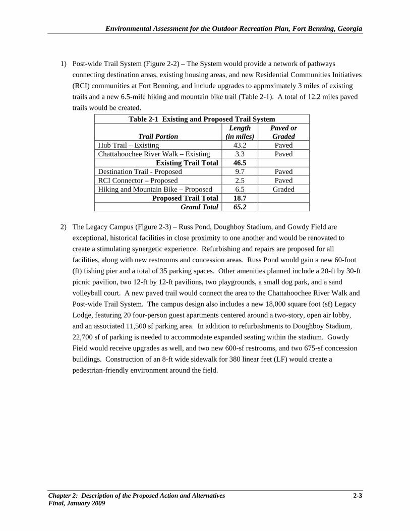
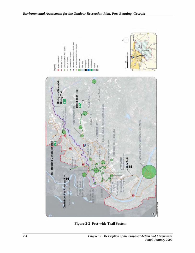
1) Post-wide Trail System (Figure 2-2) – The System would provide a network of pathways
connecting destination areas, existing housing areas, and new Residential Communities Initiatives (RCI) communities at Fort Benning, and include upgrades to approximately 3 miles of existing trails and a new 6.5-mile hiking and mountain bike trail (Table 2-1). A total of 12.2 miles paved trails would be created.
Table 2-1 Existing and Proposed Trail System
Trail Portion Length
(in miles)Paved or Graded
Hub Trail – Existing 43.2 Paved Chattahoochee River Walk – Existing 3.3 Paved
Existing Trail Total 46.5 Destination Trail - Proposed 9.7 Paved RCI Connector – Proposed 2.5 Paved Hiking and Mountain Bike – Proposed 6.5 Graded
Proposed Trail Total 18.7 Grand Total 65.2
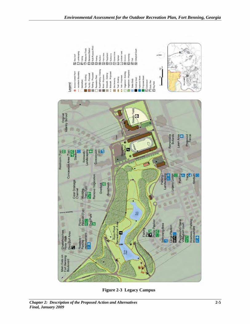
2) The Legacy Campus (Figure 2-3) – Russ Pond, Doughboy Stadium, and Gowdy Field are
exceptional, historical facilities in close proximity to one another and would be renovated to create a stimulating synergetic experience. Refurbishing and repairs are proposed for all facilities, along with new restrooms and concession areas. Russ Pond would gain a new 60-foot (ft) fishing pier and a total of 35 parking spaces. Other amenities planned include a 20-ft by 30-ft picnic pavilion, two 12-ft by 12-ft pavilions, two playgrounds, a small dog park, and a sand volleyball court. A new paved trail would connect the area to the Chattahoochee River Walk and Post-wide Trail System. The campus design also includes a new 18,000 square foot (sf) Legacy Lodge, featuring 20 four-person guest apartments centered around a two-story, open air lobby, and an associated 11,500 sf parking area. In addition to refurbishments to Doughboy Stadium, 22,700 sf of parking is needed to accommodate expanded seating within the stadium. Gowdy Field would receive upgrades as well, and two new 600-sf restrooms, and two 675-sf concession buildings. Construction of an 8-ft wide sidewalk for 380 linear feet (LF) would create a pedestrian-friendly environment around the field.
Chapter 2: Description of the Proposed Action and Alternatives 2-3 Final, January 2009
Environmental Assessment for the Outdoor Recreation Plan, Fort Benning, Georgia
Figure 2-2 Post-wide Trail System
2-4 Chapter 2: Description of the Proposed Action and Alternatives Final, January 2009
Environmental Assessment for the Outdoor Recreation Plan, Fort Benning, Georgia
Figure 2-3 Legacy Campus
Chapter 2: Description of the Proposed Action and Alternatives 2-5 Final, January 2009
Environmental Assessment for the Outdoor Recreation Plan, Fort Benning, Georgia
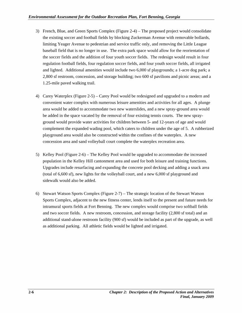
3) French, Blue, and Green Sports Complex (Figure 2-4) – The proposed project would consolidate the existing soccer and football fields by blocking Zuckerman Avenue with removable bollards, limiting Yeager Avenue to pedestrian and service traffic only, and removing the Little League baseball field that is no longer in use. The extra park space would allow for the reorientation of the soccer fields and the addition of four youth soccer fields. The redesign would result in four regulation football fields, four regulation soccer fields, and four youth soccer fields, all irrigated and lighted. Additional amenities would include two 6,000 sf playgrounds; a 1-acre dog park; a 2,800 sf restroom, concession, and storage building; two 600 sf pavilions and picnic areas; and a 1.25-mile paved walking trail.
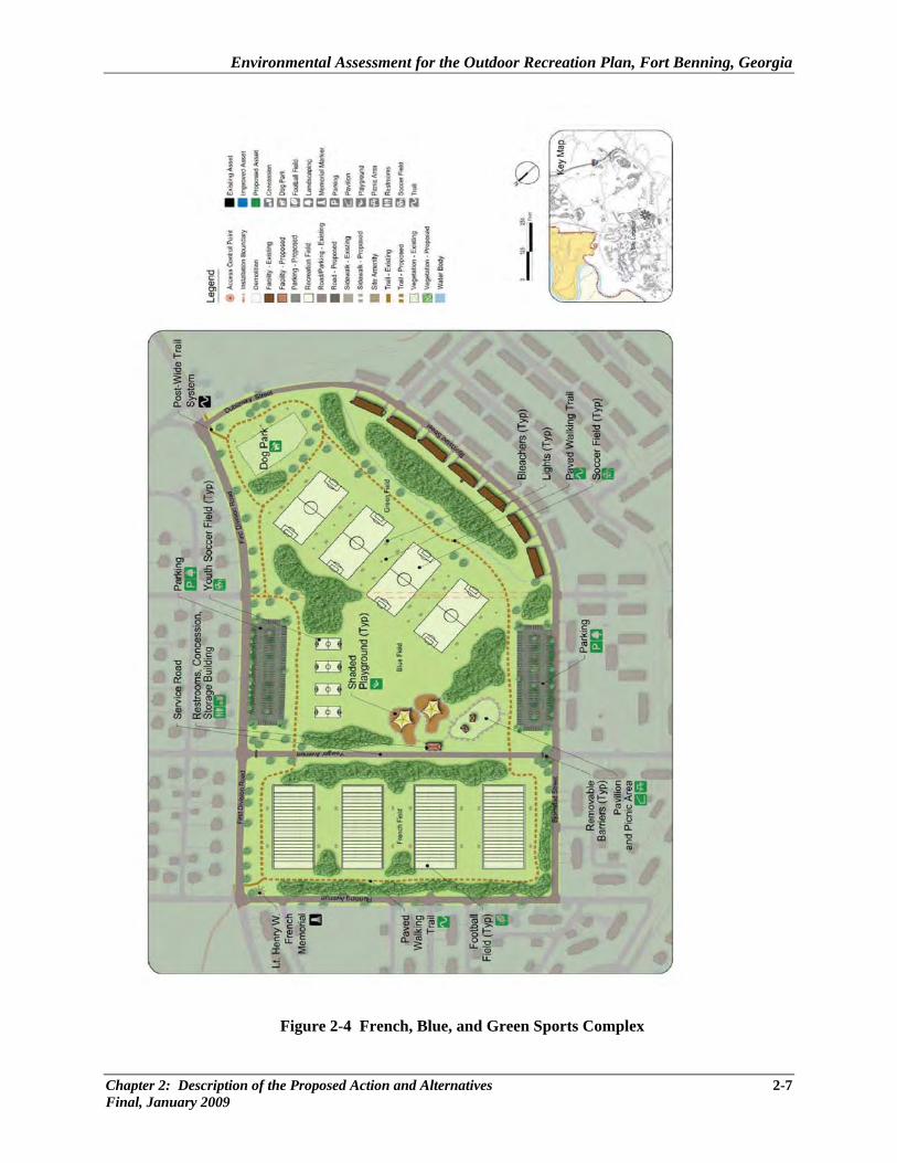
4) Carey Waterplex (Figure 2-5) – Carey Pool would be redesigned and upgraded to a modern and convenient water complex with numerous leisure amenities and activities for all ages. A plunge area would be added to accommodate two new waterslides, and a new spray-ground area would be added in the space vacated by the removal of four existing tennis courts. The new spray-ground would provide water activities for children between 5- and 12-years of age and would complement the expanded wading pool, which caters to children under the age of 5. A rubberized playground area would also be constructed within the confines of the waterplex. A new concession area and sand volleyball court complete the waterplex recreation area.
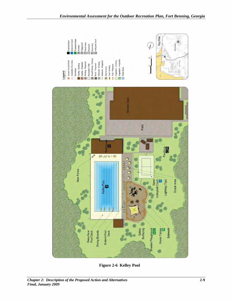
5) Kelley Pool (Figure 2-6) – The Kelley Pool would be upgraded to accommodate the increased population in the Kelley Hill cantonment area and used for both leisure and training functions. Upgrades include resurfacing and expanding the concrete pool decking and adding a snack area (total of 6,600 sf), new lights for the volleyball court, and a new 6,000 sf playground and sidewalk would also be added.
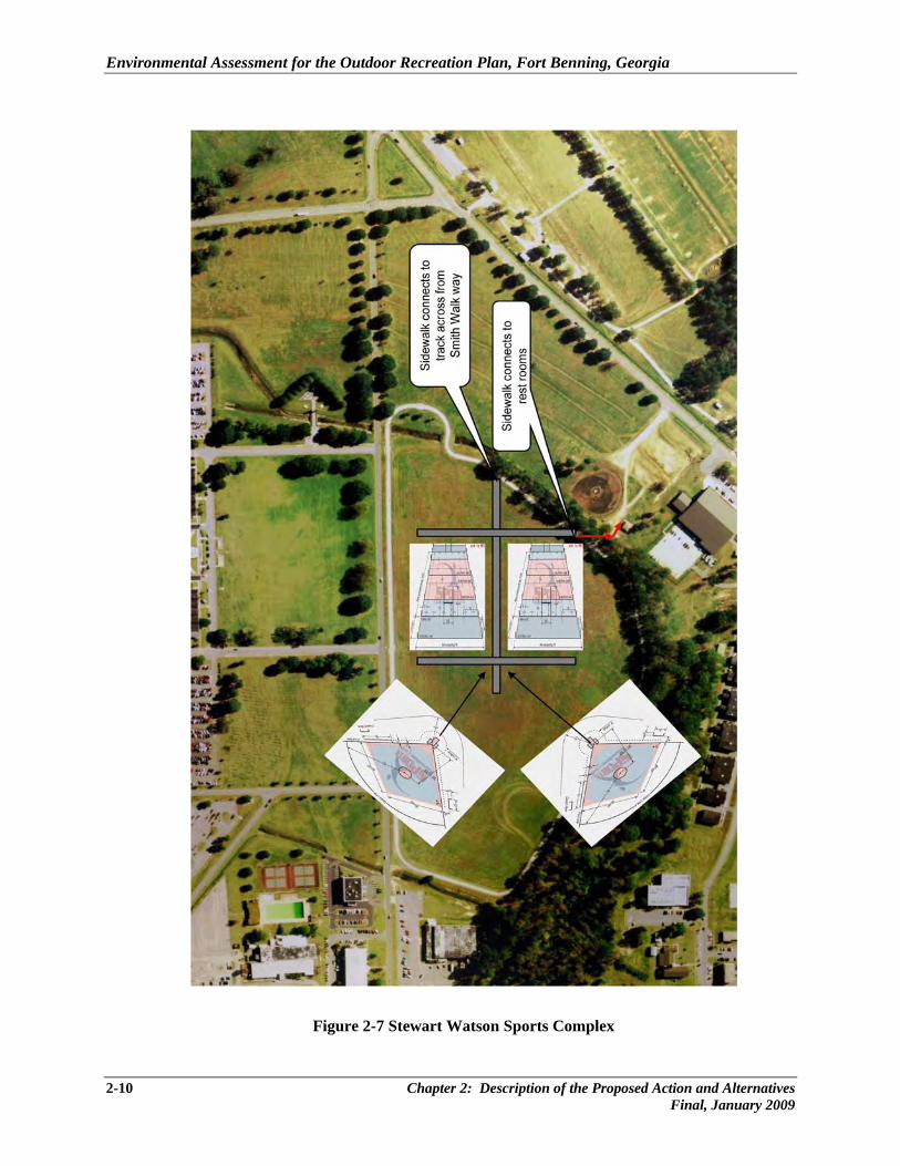
6) Stewart Watson Sports Complex (Figure 2-7) – The strategic location of the Stewart Watson
Sports Complex, adjacent to the new fitness center, lends itself to the present and future needs for intramural sports fields at Fort Benning. The new complex would comprise two softball fields and two soccer fields. A new restroom, concession, and storage facility (2,800 sf total) and an additional stand-alone restroom facility (900 sf) would be included as part of the upgrade, as well as additional parking. All athletic fields would be lighted and irrigated.
2-6 Chapter 2: Description of the Proposed Action and Alternatives Final, January 2009
Environmental Assessment for the Outdoor Recreation Plan, Fort Benning, Georgia
Figure 2-4 French, Blue, and Green Sports Complex
Chapter 2: Description of the Proposed Action and Alternatives 2-7 Final, January 2009
Environmental Assessment for the Outdoor Recreation Plan, Fort Benning, Georgia
Figure 2-5 Carey Waterplex
2-8 Chapter 2: Description of the Proposed Action and Alternatives Final, January 2009
Environmental Assessment for the Outdoor Recreation Plan, Fort Benning, Georgia
Figure 2-6 Kelley Pool
Chapter 2: Description of the Proposed Action and Alternatives 2-9 Final, January 2009
Environmental Assessment for the Outdoor Recreation Plan, Fort Benning, Georgia
Figure 2-7 Stewart Watson Sports Complex
2-10 Chapter 2: Description of the Proposed Action and Alternatives Final, January 2009

Environmental Assessment for the Outdoor Recreation Plan, Fort Benning, Georgia
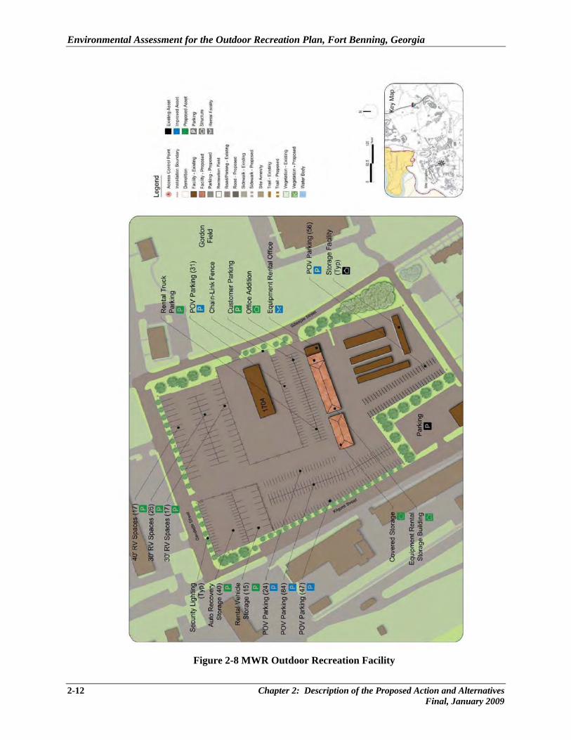
7) MWR Outdoor Recreation Facility (Figure 2-8) – The plan for this facility includes expansion of the existing office space by 1,400 sf to accommodate expanded services, an efficient organized layout for the various types of vehicle storage, and a new 8,200 sf storage building for large recreation equipment. The redesign of the vehicle storage areas would include new security lighting for the entire area and approximately 148,000 sf of new pavement.
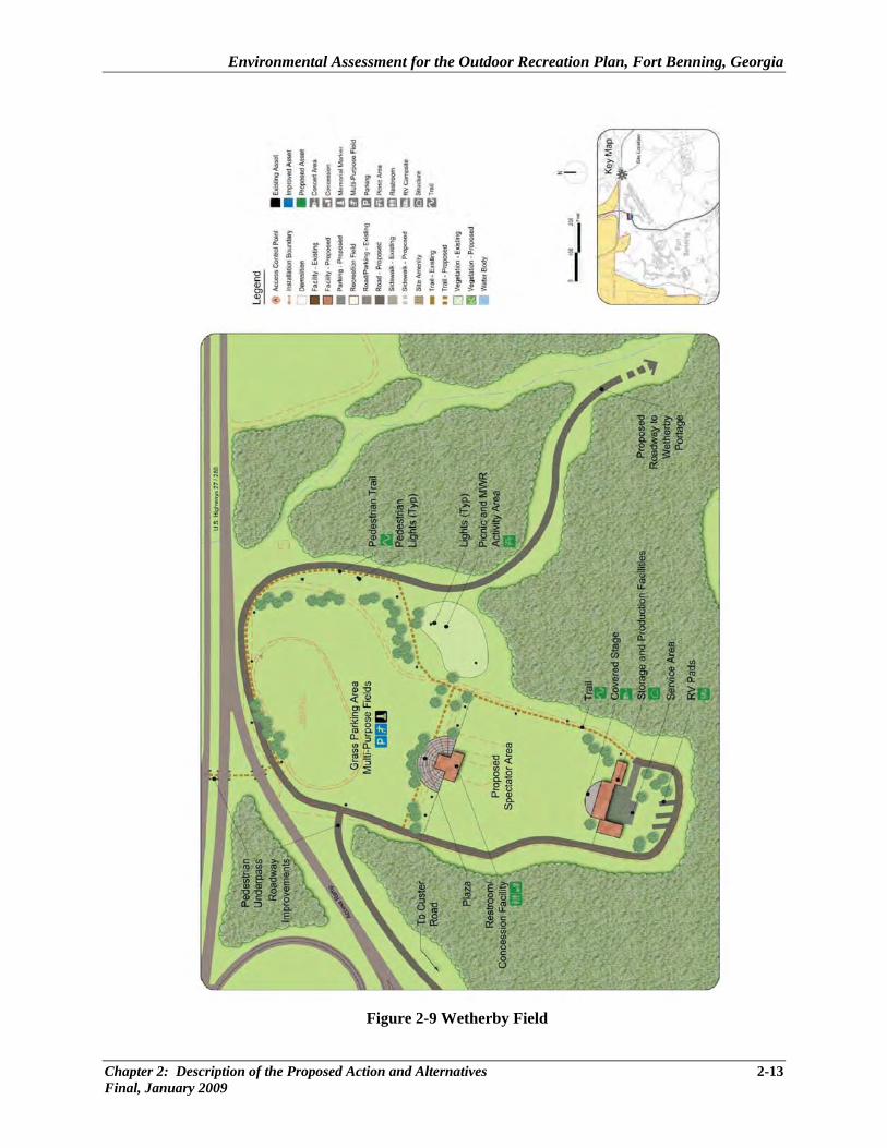
8) Wetherby Field (Figure 2-9) – The proposed plan for this site offers upgrades and permanent
solutions to the existing temporary facilities. The main objective of the project is to provide permanent facilities that would accommodate outdoor concerts and special events under a new 8,300 sf covered stage with an associated 3,950 sf storage facility. The stage would include a state-of-the-art sound system, and a 2,800 sf production facility attached to the eastern side. Three full hookup RV pads would be located behind the stage to accommodate performers and crew members. A new 6,000 sf restroom and concession facility, 13,700 sf paved entry plaza, lights, and roadway would also be part of this project. The area to the north of the entry plaza and picnic area would be upgraded for two new, lighted multi-purpose fields. The grass fields could be configured for youth and adult soccer, football, and intramural sports and would serve as parking areas during spectator events at the stage. Construction of a new 1/3 mile roadway (24 feet wide) would provide access to the highway for patrons entering and leaving events at the Field. Currently, there are about six small and two large concerts per year. All concerts begin at about 7:00 p.m., with the smaller concerts over by 9:00 p.m. and the larger concerts ending by 11:00 p.m. Once the Wetherby Field facilities are upgraded, it is not anticipated that the number of concerts would increase (personal communication, Shoemaker 2008). If there are any noise issues with these concerts, the existing noise complaint system would continue to be implemented to address individual concerns. Complaints are relayed to EMD, as well as to the parties who generated the noise and to the Installation Command. If needed, investigation and further action would follow (Fort Benning 2004).
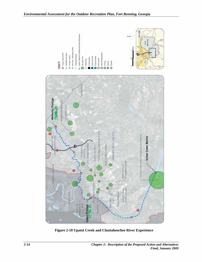
9) Upatoi Creek and Chattahoochee River Experience (Figure 2-10) – The Upatoi Creek flows
southwest from Sand Hill through Main Post where it converges with the Chattahoochee River. Upatoi Creek and the Chattahoochee River can provide unique adventure trails by water or land. The project includes a 13.5 mile kayak/canoe trail that begins at the Upatoi Creek proposed Wetherby Portage site, near Wetherby Field. The trail will merge with the Chattahoochee River and continue to the existing Uchee Creek Marina. This river trail will be seasonal due to the extreme seasonal variation of depths in the water ways. The Wetherby Portage site enhances a portion of river frontage that is already used for fishing and leisure activities. Proposed improvements include 2,887 LF of graded roadway, one 12-ft by 12-ft pavilion, and area lighting. The Upatoi Portage is a larger site with proposed improvements including a 1,700 LF of graded roadway off of 10th Mountain Division Road; shoulder parking for 20 vehicles; one 20-ft by 20-ft pavilion, area lighting; and a fish cleaning station. Between each portage site there are existing
Chapter 2: Description of the Proposed Action and Alternatives 2-11 Final, January 2009
Environmental Assessment for the Outdoor Recreation Plan, Fort Benning, Georgia
Figure 2-8 MWR Outdoor Recreation Facility
2-12 Chapter 2: Description of the Proposed Action and Alternatives Final, January 2009
Environmental Assessment for the Outdoor Recreation Plan, Fort Benning, Georgia
Figure 2-9 Wetherby Field
Chapter 2: Description of the Proposed Action and Alternatives 2-13 Final, January 2009
Environmental Assessment for the Outdoor Recreation Plan, Fort Benning, Georgia
Figure 2-10 Upatoi Creek and Chattahoochee River Experience
2-14 Chapter 2: Description of the Proposed Action and Alternatives Final, January 2009
Environmental Assessment for the Outdoor Recreation Plan, Fort Benning, Georgia
beaches that can be used as rest stops, fishing spots, or links to the Post-wide Trail System. Informational signage will highlight the importance of adhering to existing portage points and not disturbing additional ground or streambanks.
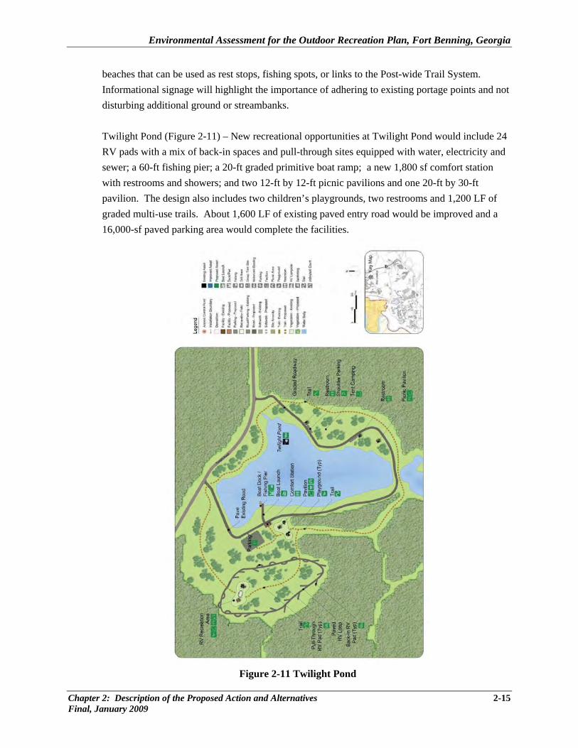
Twilight Pond (Figure 2-11) – New recreational opportunities at Twilight Pond would include 24 RV pads with a mix of back-in spaces and pull-through sites equipped with water, electricity and sewer; a 60-ft fishing pier; a 20-ft graded primitive boat ramp; a new 1,800 sf comfort station with restrooms and showers; and two 12-ft by 12-ft picnic pavilions and one 20-ft by 30-ft pavilion. The design also includes two children’s playgrounds, two restrooms and 1,200 LF of graded multi-use trails. About 1,600 LF of existing paved entry road would be improved and a 16,000-sf paved parking area would complete the facilities.
Figure 2-11 Twilight Pond
Chapter 2: Description of the Proposed Action and Alternatives 2-15 Final, January 2009
Environmental Assessment for the Outdoor Recreation Plan, Fort Benning, Georgia
2.2 NO-ACTION ALTERNATIVE (ALTERNATIVE B)
For the no-action alternative, Fort Benning would not construct new recreational facilities at the Installation. Existing facilities would continue to be inadequate to accommodate the recreational needs of Army personnel, and the gap would continue to widen as the Post adds new missions and Soldiers. This would cause Soldiers and families to seek recreational activities outside the Installation in order to satisfy their needs, which is inconvenient and more costly. Failure to increase capacity and upgrade current facilities would result in an adverse impact on quality of life for Soldiers and families at Fort Benning. 2.3 ALTERNATIVES CONSIDERED BUT NOT CARRIED FORWARD In determining the proposed action, the Army reviewed public and private sector recreation facilities and programs within a 40-mile radius of Fort Benning, including all local, Installation, regional, county, and state assets, and considered partnerships and agreements for leveraging community assets. This investigation concluded the unmet recreational needs of the Fort Benning population could be satisfied with the 11-site development areas proposed. Other alternatives were not viable as other assets would not meet the recreational requirements that are currently lacking at Fort Benning and in the surrounding area. An alternative considering other locations for recreational expansion was eliminated from detailed study in this analysis. New recreation areas could be constructed on lands now used for training. Conversely, one or more of the other existing recreational areas might be expanded to accommodate the increased visitor use. However, because of the extensive training mission, there is little room for recreation facility expansion without impacting either training areas or foraging/nesting habitat for the RCW, a federally listed endangered species found on Fort Benning. Construction of additional recreational areas or conversion of existing training land to recreational use probably would result in a conflict with either the Installation’s training missions or its recovery efforts for the RCW. Because of these conflicts, these alternatives were eliminated from detailed study. Recreational improvements were considered for the Kings Pond area of Post, but eliminated because of environmental impacts to the RCW and their foraging habitat. The Kings Pond improvements considered would have added 10 to 20 overnight chalets (similar to those provided at Uchee Creek), 20 to 30 RV pads, and a 1,500 sf country store, all utilizing a well and septic system. New electric lines would have had to be installed and linked to the nearby infrastructure. At approximately 1,400 to 1,600 sf, the chalets would each have accommodated 8 to 10 people and encompassed a total area of approximately 8 acres. The RV pads envisioned were a mix of pull-through and back-in sites and required a total of 7.25 acres. A 60-ft fishing pier and boat dock, a 20-ft by 30-ft picnic pavilion, two comfort stations, and a 3-mile bark covered walking/biking trail, along with 9,000 LF of paved roadway and a 15,000-sf paved parking area were also proposed.
2-16 Chapter 2: Description of the Proposed Action and Alternatives Final, January 2009
Environmental Assessment for the Outdoor Recreation Plan, Fort Benning, Georgia
Chapter 2: Description of the Proposed Action and Alternatives 2-17 Final, January 2009
2.4 MITIGATION MEASURES In accordance with Army NEPA Regulations, the Army must indicate if any mitigation measures would be needed to implement the proposed action. It was determined that mitigation would be required for impacts to cultural and water resources; no other resource impacts would require mitigation. In summary, the required cultural resource mitigation measures would be:
• excavation/data recovery of historic properties in accordance with Fort Benning’s HPC in the event that disturbance cannot be avoided, and
• other mitigation measures that are developed in consultation with the SHPO and Federally-recognized American Indian Tribes affiliated with Fort Benning.
Mitigation for water resources includes:
• Fort Benning requires the contractor to prepare a basic ESPCP designed similar to the one required under GAR 100001 Part IV for land disturbance less than 1 acre;
• preparation and implementation by the contractor of a plan to protect water resources from sediment and other pollution from projects that are not subject to GDNR NPDES permit and are not covered under a State permit; and
• best management practices are required to be implemented to control soil erosion, reduce the amount of runoff, and to prevent or minimize pollution of stormwater.


CHAPTER 3
AFFECTED ENVIRONMENT

Environmental Assessment for the Outdoor Recreation Plan, Fort Benning, Georgia
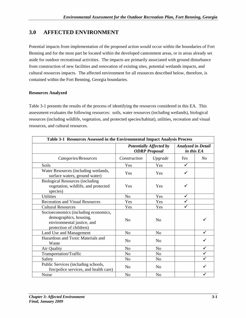
3.0 AFFECTED ENVIRONMENT Potential impacts from implementation of the proposed action would occur within the boundaries of Fort Benning and for the most part be located within the developed cantonment areas, or in areas already set aside for outdoor recreational activities. The impacts are primarily associated with ground disturbance from construction of new facilities and renovation of existing sites, potential wetlands impacts, and cultural resources impacts. The affected environment for all resources described below, therefore, is contained within the Fort Benning, Georgia boundaries. Resources Analyzed Table 3-1 presents the results of the process of identifying the resources considered in this EA. This assessment evaluates the following resources: soils, water resources (including wetlands), biological resources (including wildlife, vegetation, and protected species/habitat), utilities, recreation and visual resources, and cultural resources.
Table 3-1 Resources Assessed in the Environmental Impact Analysis Process
Potentially Affected by ODRP Proposal
Analyzed in Detail in this EA
Categories/Resources Construction Upgrade Yes No Soils Yes Yes Water Resources (including wetlands,
surface waters, ground water) Yes Yes
Biological Resources (including vegetation, wildlife, and protected species)
Yes Yes
Utilities No Yes Recreation and Visual Resources Yes Yes Cultural Resources Yes Yes Socioeconomics (including economics,
demographics, housing, environmental justice, and protection of children)
No No
Land Use and Management No No Hazardous and Toxic Materials and
Waste No No
Air Quality No No Transportation/Traffic No No Safety No No Public Services (including schools,
fire/police services, and health care) No No
Noise No No
Chapter 3: Affected Environment 3-1 Final, January 2009
Environmental Assessment for the Outdoor Recreation Plan, Fort Benning, Georgia
Resources Eliminated from Further Analysis
The Army evaluated 14 resources for their potential to be affected by the proposed action (Alternative A) and the no-action alternative (Alternative B). In accordance with CEQ regulations, this evaluation determined eight resources did not warrant further examination in the EA. The following provides the rationale for eliminating these resources from further analysis.
Socioeconomics/Environmental Justice. Socioeconomics focus on the general features of the local economy that could be affected by the proposed action or alternatives. Socioeconomics comprise the basic attributes of population and economic activity within Fort Benning and surrounding communities in Georgia and Alabama, and typically encompass population, employment, income, housing, and taxes. During construction of the proposed recreational facilities there may be a minor beneficial economic impact to local businesses from materials purchased or services rendered. Expanded campground operations and performances at the Wetherby Field Stage would also add a small financial benefit to concessionaires at the Post. Impacts, however, to socioeconomics are negligible and thus, were not analyzed further. The potential impacts associated with the proposed action and alternatives would not have a disproportional impact on low-income and minority populations. No low-income and/or minority populations are found in or near the proposed sites that could be impacted directly from construction activities and would be unlikely to be impacted indirectly by operations and maintenance functions because there is no real change to the existing operations; therefore, environmental justice is eliminated from further discussion. Protection of Children. Executive Order 13045, Protection of Children from Environmental Health Risks and Safety Risks requires each Federal agency to identify and assess environmental health and safety risks that may disproportionately affect children and pose a disproportionate environmental health or safety risk to children. The proposed action would not affect children because the construction areas would be cordoned off to limit access, no lead-based paint or other contaminants are found at the proposed expansion sites nor would be used, and the facilities that would be improved and/or built are found at existing cantonment facilities locations and would occur in an area of the Installation where no schools or residential homes are located. Therefore, protection of children is not further evaluated in this EA. Land Use and Management. Proposed renovation and upgrades to recreational facilities on Fort Benning are consistent with current land uses found within the cantonment and applicable campground areas. No change in land use or management from existing conditions would occur due to the proposed action, and further detailed analysis is not undertaken in this EA. Hazardous Materials and Waste. Handling, disposal, use, and storage of hazardous materials will be addressed in the Environmental Protection Plan that will be required of the construction contractor. In
3-2 Chapter 3: Affected Environment Final, January 2009
Environmental Assessment for the Outdoor Recreation Plan, Fort Benning, Georgia
addition, the Spill Prevention Control and Countermeasure Plan required under the National Pollutant Discharge Elimination System permit will also prescribe measures to address potential spills. Hazardous materials used or waste generated will not differ from existing conditions and will continue to comply with applicable federal, state, and local laws and regulations. Further evaluation of this resource is not warranted in this EA.
Air Quality. The three-county area around Fort Benning, Georgia (i.e., Chattahoochee and Muscogee Counties, Georgia [GA], and Russell County, Alabama [AL]) enjoys relatively good air quality, with levels of all criteria pollutant emissions currently in attainment. However, there is the possibility that within the next few years, the Environmental Protection Agency (EPA) may find a county in the region to be in non-attainment for one of the criteria pollutants (particulate matter 2.5 [PM2.5]) (personal communication, Gustafson 2006). These fine particulates are generally produced through fuel combustion from motor vehicles, power generation, industrial facilities, residential fire places, wood stoves, camp fires, and agricultural burning. If the region were found to be in non-attainment for PM2.5, the introduction of these particulates from the proposed action would not be regionally significant. This conclusion is justified because: 1) only about 10 acres of land would be disturbed for a few months over a 10-year period and this activity would temporarily produce large-particulate matter (PM10) in the form of dust; 2) the existing burn ban in the tri-county area would be followed and no open burning (such as camp fires) would be allowed; and 3) the RV and personal vehicles that would be associated with the increased visitors to the Post and campgrounds would most likely come from the area or would only be staying temporarily and not significantly contribute to the overall regional PM2.5 emissions. Therefore, impacts to air quality would be minimal. Most of the proposed construction sites are realigned or renovated current venues and would not create much disturbance. New construction in previously undisturbed areas includes 24 RV sites and 2 playgrounds and would not add measurably to the area pollutant levels. Leisure activities and campground operations would not impair the air quality found in the general Fort Benning area because no significant increases would be generated. Further evaluation of this resource, therefore, is not warranted in this EA.
Transportation. The total contribution of personally-owned and/or recreational vehicle traffic as a result of the proposed upgrade/expansions of recreational facilities would be minor, with the exception of the Wetherby Field and Special Events venue. The proposed plan for this site includes 1/3 mile of new roadway to connect to Custer Road, alleviating current and future congestion at periodic events. Removable bollards placed at the intersection of Ingersoll Street and Lauber Avenue would restrict through traffic in the area of the French, Blue, and Green Sports Complex, increasing safety in the area. An in-depth traffic study is not required as service vehicles would not be restricted and permanent traffic flow would not be impacted. Construction vehicle traffic would also be minimal, but could temporarily cause delays of traffic flow within the cantonment areas near the construction sites. However, the impacts would be negligible, short-term and limited to small areas of the Post. Vehicular transportation, therefore, requires no further analysis in this EA.
Chapter 3: Affected Environment 3-3 Final, January 2009
Environmental Assessment for the Outdoor Recreation Plan, Fort Benning, Georgia
Safety. Effects to human health and safety related to construction, as well as operation and maintenance of recreation assets, would be minimal and no different from standard, on-going activities occurring at Fort Benning. During construction, prescribed industrial safety standards would be followed. Operations and maintenance activities would be performed in accordance with all applicable safety directives. There are no other specific aspects of recreation operation and maintenance activities that would create any unique or extraordinary safety issues. Since no aspect of the proposal would alter the safety conditions for the Post, this resource is eliminated from further analysis.
Public Services. The proposed recreational projects would not affect services beyond the Post boundaries or capabilities regarding utilities, schools, fire and police protection, or health care services of the region; therefore, this resource is not evaluated further in this EA.
Noise. Noise from construction equipment would be buffered by vegetation, be localized, and occur on a short-term and temporary basis. Construction is projected to occur over a 10-year period, with much of it taking place in the winter when fewer visitors would be utilizing the outdoor and campground facilities, and occur during normal daylight hours. This would minimize annoyance due to construction noise. Once construction is complete, noise from the recreational facilities and campground operations would not be significantly different than that occurring presently. Thus, noise impacts are not analyzed further in this EA. 3.1 NATURAL ENVIRONMENT
3.1.1 Soils
The principal factor influencing stability of structures is soil properties. Soil, in general, refers to unconsolidated earthen materials overlying bedrock or other parent material. Soil structure, elasticity, strength, shrink-swell potential, and erodibility all determine the ability for the ground to support structures and facilities. Relative to development, soils typically are described in terms of their type, slope, physical characteristics, and relative compatibility or limitations with regard to particular construction activities and types of land use.
Most of the southwestern third of Fort Benning is covered by the Upper Loam Hills soil province which contains soils that are heavier textured and more mesic than the drier Sand Hills soils to the northeast (U.S. Army 2003). These soils also generally have higher organic matter content and higher water holding capacity. Soils along the Chattahoochee River are occasionally flooded sandy loams (USDA 1997), and the topography is generally smooth to gently rolling with low relief (USDA 1997). The southwestern portion of the Installation has the lowest terrain at about 190 feet above sea level, with low terraces parallel to the Chattahoochee.
3-4 Chapter 3: Affected Environment Final, January 2009
Environmental Assessment for the Outdoor Recreation Plan, Fort Benning, Georgia
To prevent erosion, damage to endangered species habitat, or sedimentation of streams and wetland areas, the Army employs Best Management Practices (BMPs) as defined by the Georgia Department Natural Resources (GDNR), and Georgia Soil and Water Conservation Commission. Georgia requires an approved Erosion Sedimentation Pollution Control Plan (ESPCP), fees, and Notice of Intent to meet the federal National Pollutant Discharge Elimination System (NPDES) and state water pollution control requirements. The Installation also considers and complies with soil conservation measures in their planning and execution for all construction, operation, and maintenance activities involving land disturbance. The ESPCP prescribes activities to limit erosion and sedimentation from the site and includes a site description, list of BMPs to be used, BMP inspection procedures to be performed by qualified personnel, procedures for timely BMP maintenance, requirements for sampling of discharges or receiving streams for turbidity, and reporting requirements to requisite state agencies.
Construction contractors must install erosion control measures and implement practices to prevent the occurrence of and to retain the sediment typically generated by the land-disturbing activities within the boundaries of the construction site. They must also plant or otherwise provide a permanent ground cover sufficient to restrain erosion after completion of construction. Contractors are also responsible for developing the ESPCP and obtaining approval, coordinating with Fort Benning Environmental Management Division for submittal of fees, and notice of intent to state agencies.
3.1.2 Water Resources
Water resources evaluation focuses on surface and ground water quality within the sites proposed for construction or upgrades. The Clean Water Act (CWA) of 1972 is the primary federal law that protects the nation’s waters, including lakes, rivers, aquifers, and coastal areas. The primary objective of the CWA is to restore and maintain the integrity of the nation’s waters. Jurisdictional wetlands and streambanks are also regulated resources and are subject to federal authority under Section 404 of the CWA. Jurisdictional waters are broadly defined and include navigable waters, as defined by the CWA, (including intermittent streams), impoundments, tributary streams, and wetlands.
Surface Water. The primary watercourse at Fort Benning, and boundary line between Georgia and Alabama, is the Chattahoochee River. The Chattahoochee River (a state-designated impaired waterway) flows in a southerly direction and contains numerous oxbows and wetland areas. On the Georgia side, most streams drain into the Chattahoochee River through the westward flowing Upatoi Creek, which enters north of the Main Post area and serves as the main drainage basin for other streams and tributaries at Fort Benning. On the Alabama side, the Uchee Creek flows east through the campground into the Chattahoochee River. Wetlands. The National Wetlands Inventory (NWI) conducted by the U.S. Fish and Wildlife Service (USFWS 1982) shows that Fort Benning contains about 16,926 acres of wetlands. The inventory
Chapter 3: Affected Environment 3-5 Final, January 2009
Environmental Assessment for the Outdoor Recreation Plan, Fort Benning, Georgia
described lacustrine, riverine, and palustrine systems. On Fort Benning, wetlands include impounded water, flowing water, river floodplains, stream floodplains, small stream swamps, wooded seepage bogs, herbaceous and shrub seepage bogs, and gum/oak ponds. While not specifically delineated, it is anticipated that there are jurisdictional wetlands present in at least three out of the ten proposed projects—hiking/biking trail upgrades, River Experience, and Twilight Pond. All wetlands will be delineated and permitting requirements met prior to any land disturbing activities.
Ground Water. Fort Benning is in the Coastal Plain hydrologic province of Georgia and Alabama, whose principal ground water source is the Cretaceous aquifer system. The aquifer systems are directly related to the various geologic formations. Seven drinking-water supply wells are found on Fort Benning (Fort Benning 2007b).
Storm Water. Management of storm water associated with construction activities including infrastructure/lineal projects is covered under GDNR NPDES Permit Georgia Administrative Regulation (GAR) 100002, Stand Alone Projects are regulated under GAR 100001, and Common Developments are regulated under 100003, and also requires the development and implementation of an ESPCP. A notice of intent (NOI) for construction-related storm water discharge must be submitted to the GDNR. It is required that the permittee develops and implements the ESPCP to reduce or minimize any impacts to water resources and to protect waterways from sedimentation due to eroding soil conditions. Storm water discharges within the Main Post drain directly into the Chattahoochee River through a storm drain system. Other storm water on the Installation drains via culverts, ditches, swales, and natural seepage and overland flow. Storm water from the other cantonment areas (Sand Hill, Kelley Hill, and Harmony Church as well as the training compartments) drains directly and indirectly into nearby surface water bodies (Fort Benning 2004). For projects that are not covered under the GDNR NPDES permits, typically for land disturbance less than 1 acre, Fort Benning uses a basic ESPCP designed similar to the one required under GAR 100001 Part IV. Projects that are not subject to GDNR NPDES permit are not covered under a State permit but preparation and implementation of such a plan is required by Fort Benning to protect water resources from sediment and other pollution. Best management practices are required to be implemented to control soil erosion, reduce the amount of runoff, and to prevent or minimize pollution of stormwater. Silt fencing must be installed prior to any land-disturbing activities. 3.1.3 Biological Resources
Biological resources include native or naturalized plants and animals and the habitats in which they occur. The Fort Benning Integrated Natural Resources Management Plan (INRMP) (U.S. Army 2003) provides a comprehensive overview of the status of biological resources throughout the Installation. For purposes of
3-6 Chapter 3: Affected Environment Final, January 2009
Environmental Assessment for the Outdoor Recreation Plan, Fort Benning, Georgia
this EA, discussions of resources present in areas that would be affected by implementation of the proposed actions at the construction sites are provided below for: 1) vegetation and wildlife, including migratory birds, and 2) special-status species, including threatened and endangered species.
Except for resident game birds, most of the birds on Fort Benning are protected under the Migratory Bird Treaty Act (MBTA). This Act implements various treaties and conventions between the US and Canada, Japan, Mexico, and the former Soviet Union for the protection of migratory birds. Conservation of migratory birds by federal agencies and their consideration in the NEPA process is also mandated by EO 13186. On July 31, 2006, a Memorandum of Understanding (MOU) was finalized between the Department of Defense and USFWS identifying measures to enhance migratory bird conservation on U.S. military installations. Consistent with this MOU, Fort Benning manages and conserves migratory bird species through its Integrated Natural Resources Management Plan (INRMP) and considers effects to migratory birds in any proposed action via the NEPA process. Fort Benning will continue to follow the applicable MOU provisions, which may involve permitting for some activities, and further consideration of migratory bird management in the INRMP. As of February 2007, the Migratory Bird Permit section of 50 CFR Part 21.15 allows for the incidental "take" of migratory birds during military readiness activities except for those ongoing or proposed activities that may result in a significant adverse effect on a population of a migratory bird species. Military readiness activity includes all training and operations of the Armed Forces that relate to combat, and the adequate and realistic testing of military equipment, vehicles, weapons, and sensors for proper operation and suitability for combat use. If a significant adverse effect on a population may result, then the Armed Forces must confer and cooperate with the USFWS to develop and implement appropriate conservation measures to minimize or mitigate such significant adverse activities.
Department of the Army interim guidance dated 28 July 2008 addresses unintentional take of migratory birds for actions other than military readiness activities. This memorandum states that non-military readiness activities resulting in unintentional “take” should be addressed in appropriate NEPA analysis and management practices should be developed to minimize adverse impacts on migratory birds to the greatest extent possible. The construction and other activities related to the ODRP proposed action are considered non-military readiness activities.
There are approximately 150 species of birds protected under the MBTA present on the Installation either seasonally or year round. Most of these species are breeding residents or neo-tropical migrants for which the typical breeding season is spring through summer. There are potentially 16 species occurring on Fort Benning considered Species of Concern (SOC) based on Partners in Flight (PIF) and Landbird Population Estimates (LPE). Each of these species has been assigned a PIF score. Under the PIF Assessment Process, scores are assigned to each species based on vulnerability factors. These include: Relative Abundance, Breeding Distribution, Non-breeding Distribution, Threats to Breeding, Threats to Non-breeding Distribution, and Population Trend. A higher PIF score indicates greater need for conservation attention directed towards the SOC within the region. Similarly, SOC with higher PIF priorities receive precedence in guiding conservation efforts. Fort Benning is currently cooperating with federal, state, and
Chapter 3: Affected Environment 3-7 Final, January 2009
Environmental Assessment for the Outdoor Recreation Plan, Fort Benning, Georgia
private organizations in gathering information on many migratory bird species in this region. Fort Benning personnel are dedicated to making sound ecological management decisions while at the same time providing for the needs of the military to accomplish its mission.
According to the PIF LPE database, populations of the migratory bird Species of Concern (SOC) with the exception of the RCW, are plentiful within the Bird Conservation Region (BCR) where Fort Benning occurs. Additionally, other breeding habitat exists on and off the Installation that can be used by the species. Fort Benning is situated primarily in the East Gulf Coastal Plain (EGCP) BCR. The EGCP BCR consists of uplands dominated by pine, originally longleaf and slash in the south and shortleaf mixed with hardwoods in the north. These are fire-maintained systems that give way to loblolly pine and hardwoods in damper areas and bottomland hardwood forest in extensive lowland drainages.
In accordance with DOD Instruction 4715.3, Fort Benning and several conservation partners identified Unique Ecological Areas (UEAs) that represent the best examples on Fort Benning of a particular habitat or plant community type. UEAs were chosen based on characteristics of their biotic and abiotic features and in many cases contain remnant native plant communities that have experienced minimal disturbance relative to other similar communities. As a result, such areas can serve as reference sites for the biodiversity and ecological processes associated with natural communities. Designation of UEAs is designed to ensure proactive management and long-term land-use planning and training activities that account for their presence and their preservation requirements (Pentecost 1999, Fort Benning 2001, 2003a). The management emphasis for UEAs is on communities and ecosystems, rather than individual species. For the proposed Fort Benning ODRP, no unique ecological areas would be impacted by the proposed recreational facilities.
Vegetation and Wildlife
Vegetation. On Fort Benning, plant and animal communities in both terrestrial and aquatic habitats have been classified into 13 ecological groups (U.S. Army 2003). Ecological groups provide a framework for managing species and habitats of concern on the Installation. Ecological groups are the top level of a hierarchy that includes a finer scale of differentiation, vegetation alliances, and associations that are structurally and functionally similar.
Only three of the ten recreational facilities upgrade sites, Twilight Pond, the River Experience, and the hiking/biking trail, would potentially impact any ecological group. The remaining seven sites are within the developed cantonment on areas of lawn, open field grass, or concrete and minimal vegetation will be removed. The Upatoi Creek and Chattahoochee River Experience is mainly a water route, creating small, new portages and riverside signage and platforms, and would not significantly impact any ecological group.
3-8 Chapter 3: Affected Environment Final, January 2009
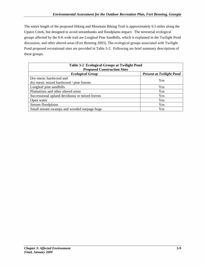
Environmental Assessment for the Outdoor Recreation Plan, Fort Benning, Georgia
The entire length of the proposed Hiking and Mountain Biking Trail is approximately 6.5 miles along the Upatoi Creek, but designed to avoid streambanks and floodplains impact. The terrestrial ecological groups affected by the 8-ft wide trail are Longleaf Pine Sandhills, which is explained in the Twilight Pond discussion, and other altered areas (Fort Benning 2003). The ecological groups associated with Twilight Pond proposed recreational sites are provided in Table 3-2. Following are brief summary descriptions of these groups.
Table 3-2 Ecological Groups at Twilight Pond Proposed Construction Sites
Ecological Group Present at Twilight Pond Dry-mesic hardwood and dry-mesic mixed hardwood / pine forests Yes
Longleaf pine sandhills Yes Plantations and other altered areas Yes Successional upland deciduous or mixed forests Yes Open water Yes Stream floodplains Yes Small stream swamps and wooded seepage bogs Yes
Chapter 3: Affected Environment 3-9 Final, January 2009

Environmental Assessment for the Outdoor Recreation Plan, Fort Benning, Georgia
Dry-mesic Hardwood and Dry-mesic Mixed Hardwood / Pine Forest These forests are quite variable on the Installation and occur in the ecotone between the dry ridge tops and the mesic bottoms. Common species found in these areas include white oak, red oak, water oak, sweetgum, loblolly pine, shortleaf pine, tuliptree, American holly, pignut hickory, southern red oak, and post oak. Sourwood, farkleberry/tree sparkleberry, red maple, flowering dogwood, chalk maple, redbud, and American hornbeam are common mid-canopy species. Common shrubs include sassafras, deer berry, and littlehip-haw. Woody vines include greenbrier, rattan vine, cross vine, and yellow jessamine. Herbaceous species include arrowleaf (ginger), partridge berry, and several grasses. Longleaf Pine Sandhills The Longleaf Pine Sandhills are characterized by relatively open stands of longleaf pine, frequently with an understory of scrub oak, on sandy soils. Longleaf pine maintains stronger dominance here than in the loamhills; loblolly and shortleaf pine are less able to compete successfully in the deep sandy and dry soils. Scrub oaks that are a common component of these stands include bluejack , sand post oak, and turkey oak. Sassafras, farkleberry, and hawthorn are common shrub species. Grasses and legumes are diverse and common in the ground layer. Despite stronger longleaf pine dominance, the Sandhills stands are generally less dense overall than the Loamhills stands. Because of lower fuel conditions on average as compared with the loamhills, the natural fire return interval is longer in the sandhill. The Longleaf Pine Sandhills ecological group is the dominant plant community on the Installation. Longleaf Pine Loamhills The stands are often a mix of loblolly, shortleaf, and longleaf pine over loamy soils. Common understory species include post oak, blackjack oak, flowering dogwood, and juvenile pines. Shrubs include deer berry, inkberry/gallberry, farkleberry, wax myrtle, and sassafras. Common herbaceous species typically include a variety of native legumes, native grasses, including little bluestem, and bracken fern. More disturbed areas may contain broomsedge and Japanese honeysuckle (U.S. Army 2003). Depending on the mix of pine species in the stand, slope position, and size of the natural fire compartment, natural fire-return interval areas are variable. Fire-return intervals for some stands occur frequently, in part because of the many ordnance-induced wildfires that occur within or adjacent to these stands.
3-10 Chapter 3: Affected Environment Final, January 2009
Environmental Assessment for the Outdoor Recreation Plan, Fort Benning, Georgia
The Longleaf Pine Loamhills community occurs throughout the Installation, but is more prevalent in the southern portion than in the northern portion. The Longleaf Pine Woodland, a subtype of the Longleaf Pine Loamhills ecological group, is a major target for restoration by Conservation and Land Management staff. Fort Benning’s goal is the restoration and maintenance of 90,000 acres of this plant community across the Installation (U.S. Army 2003). Plantations and Other Altered Areas Plantations and other altered areas represent habitat that has been substantially modified by silviculture, urban development, training exercises, or other human activity. Plantations are present on Fort Benning in stands of various age classes. About 16,000 acres of loblolly and slash pine were planted on Fort Benning from 1962 to 1994. In 1976 and 1977, 60 acres of longleaf pine were planted each year and from 1988 to 1999 a total of about 7,000 acres was planted with longleaf pine. Some of the acreage planted in longleaf in recent years has replaced some earlier loblolly and slash plantations that were damaged by southern pine beetles. In recent years, forest management goals have shifted from wood production to ecosystem restoration. Loblolly and slash pine plantations that are damaged by southern pine beetles and littleleaf disease are being replaced with longleaf pine in sites where historically longleaf would have been the dominant species. Abandoned wildlife openings also are being converted to longleaf pine where appropriate (U.S. Army 2003). Other altered areas include shrub and grassy areas that are a result of range construction and maintenance activities. The current shrub alliances are defined poorly and require further study and classification to determine which communities are present. Some unused grassy areas are currently scheduled for longleaf pine reforestation where appropriate (U.S. Army 2003). Plantations and other altered areas are distributed throughout the other ecological groups at the Installation, with particular concentration near rivers and waterways. Successional Upland Deciduous or Mixed Forests This ecological group was not included in the 2001 INRMP, but was addressed in 2002 and 2003 revisions, based on Pyne (2001). The community supports previously disturbed or open areas that have been recolonized by woody vegetation. Characteristic species includes broad-leaved deciduous and both broad- and needle-leaved deciduous trees. Examples of these communities include early successional deciduous or mixed vegetation dominated by “opportunistic” hardwoods and loblolly pine. Loblolly pine was extensively planted on the Installation and has proliferated into upland areas during a period of extended fire return times and general fire suppression on parts of the Installation. Other “opportunistic” hardwoods such as sweetgum, tuliptree, and water oak have increased in abundance and distribution across the lands of Fort Benning.
Chapter 3: Affected Environment 3-11 Final, January 2009
Environmental Assessment for the Outdoor Recreation Plan, Fort Benning, Georgia
These “semi-natural” or early successional communities likely occupy sites that would not have been dominated by these fire-intolerant hardwood species under a regime of frequent fire (U.S. Army 2003). Such sites are dispersed throughout the Installation, particularly near water bodies and along the borders of former plantations. Trees and other plants are important for many reasons, including shade, erosion control, wildlife habitat, timber products, medicinal products, and realistic training scenarios. The current management of the Installation is focused on restoration. Management practices and recommendations are in place to reestablish fire-climax forests and fire-maintained lowlands. Areas are managed to encourage recovery from previous disturbance due to agriculture and timber harvest. Management plans for federally-listed species, such as the RCW, also guide vegetation management policies. Various controls are in place to protect plant life, but some consumptive use is authorized. For example, hardwoods, underbrush, and grass may be cut and used for camouflage inside RCW clusters, consistent with the RCW Endangered Species Management Plan (ESMP). Thinning of the understory is conducted in some stands. Cutting of trees and live limbs in training areas cannot occur without prior approval of Directorate of Public Work (Conservation Branch) through the NEPA process. Harvest of firewood is allowed by permit from the U.S. Army Corps of Engineers (USACE). U.S. Army Infantry Center (USAIC) Regulation 210-4 (Range and Terrain Regulation) and USAIC Regulation 210-5 (Garrison Regulation) address these issues in more detail. Open Water Water impoundments at Fort Benning are the result of human activity and beaver dams. Flowing water habitats include rivers, creeks, and intermittent streams. These areas are mostly unvegetated or exhibit only submerged vegetation or plant life along the shoreline. At Fort Benning, flowing water includes streams of either Piedmont or Coastal Plain origin. Piedmont streams flow into the Installation from the north and flow generally in a southerly direction. Large rocks, pebbles, and sand are characteristic of the substrate of these streams. Piedmont streams are higher in fish and mussel diversity than Coastal Plain streams. Piedmont streams include Dozier, Cox, Randall, Kendall, Upatoi, Uchee, and Baker Creeks, as well as the Chattahoochee and Tar rivers (the Tar is a tributary of Upatoi Creek). The Upatoi Creek watershed is the main drainage area of Fort Benning. Its headwaters are in Chattahoochee, Talbot, and Marion Counties. Common plants found in open water habitats include white water lily, watershield, pondlily, buttonbush, smooth alder, and wax myrtle. Special status species that use impounded water sites include lax water-milfoil. Common inhabitants of impounded water communities include American alligators, beavers, waterfowl, game and nongame fish, and wading birds. Many other game and nongame species use these ponds for drinking water. The larger managed ponds (like Twilight Pond) provide recreational fishing opportunities to Installation personnel.
3-12 Chapter 3: Affected Environment Final, January 2009
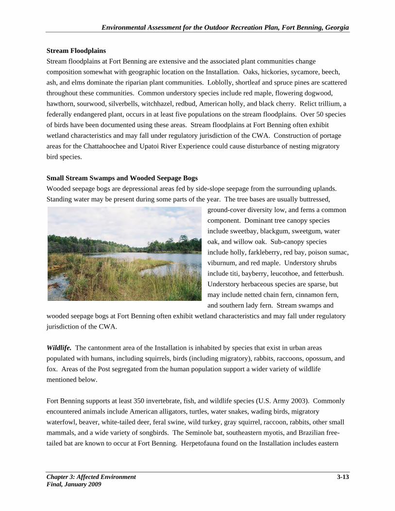
Environmental Assessment for the Outdoor Recreation Plan, Fort Benning, Georgia
Chapter 3: Affected Environment 3-13 Final, January 2009
Stream Floodplains Stream floodplains at Fort Benning are extensive and the associated plant communities change composition somewhat with geographic location on the Installation. Oaks, hickories, sycamore, beech, ash, and elms dominate the riparian plant communities. Loblolly, shortleaf and spruce pines are scattered throughout these communities. Common understory species include red maple, flowering dogwood, hawthorn, sourwood, silverbells, witchhazel, redbud, American holly, and black cherry. Relict trillium, a federally endangered plant, occurs in at least five populations on the stream floodplains. Over 50 species of birds have been documented using these areas. Stream floodplains at Fort Benning often exhibit wetland characteristics and may fall under regulatory jurisdiction of the CWA. Construction of portage areas for the Chattahoochee and Upatoi River Experience could cause disturbance of nesting migratory bird species. Small Stream Swamps and Wooded Seepage Bogs Wooded seepage bogs are depressional areas fed by side-slope seepage from the surrounding uplands. Standing water may be present during some parts of the year. The tree bases are usually buttressed,
ground-cover diversity low, and ferns a common component. Dominant tree canopy species include sweetbay, blackgum, sweetgum, water oak, and willow oak. Sub-canopy species include holly, farkleberry, red bay, poison sumviburnum, and red maple. Understory shrubs include titi, bayberry, leucothoe, and fetterbush. Understory herbaceous species are sparse, but may include netted chain fern, cinnamon fern, and southern lady fern. Stream swamps and
wooded seepage bogs at Fort Benning often exhibit wetland characteris
ac,
tics and may fall under regulatory jurisdiction of the CWA.
m, and ost segregated from the human population support a wider variety of wildlife
entioned below.
only
l
Wildlife. The cantonment area of the Installation is inhabited by species that exist in urban areas populated with humans, including squirrels, birds (including migratory), rabbits, raccoons, opossufox. Areas of the Pm Fort Benning supports at least 350 invertebrate, fish, and wildlife species (U.S. Army 2003). Commencountered animals include American alligators, turtles, water snakes, wading birds, migratory waterfowl, beaver, white-tailed deer, feral swine, wild turkey, gray squirrel, raccoon, rabbits, other smalmammals, and a wide variety of songbirds. The Seminole bat, southeastern myotis, and Brazilian free-tailed bat are known to occur at Fort Benning. Herpetofauna found on the Installation includes eastern
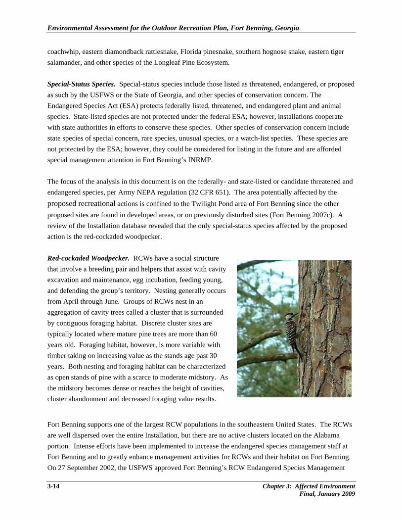
Environmental Assessment for the Outdoor Recreation Plan, Fort Benning, Georgia
3-14 Chapter 3: Affected Environment Final, January 2009
coachwhip, eastern diamondback rattlesnake, Florida pinesnake, southern hognose snake, eastern tiger
sed
e ies, or a watch-list species. These species are
ot protected by the ESA; however, they could be considered for listing in the future and are afforded
and
eviously disturbed sites (Fort Benning 2007c). A review of the Installation database revealed that the only special-status species affected by the proposed
oung,
As e midstory becomes dense or reaches the height of cavities,
g.
salamander, and other species of the Longleaf Pine Ecosystem. Special-Status Species. Special-status species include those listed as threatened, endangered, or propoas such by the USFWS or the State of Georgia, and other species of conservation concern. The Endangered Species Act (ESA) protects federally listed, threatened, and endangered plant and animal species. State-listed species are not protected under the federal ESA; however, installations cooperate with state authorities in efforts to conserve these species. Other species of conservation concern includstate species of special concern, rare species, unusual specnspecial management attention in Fort Benning’s INRMP. The focus of the analysis in this document is on the federally- and state-listed or candidate threatened endangered species, per Army NEPA regulation (32 CFR 651). The area potentially affected by the proposed recreational actions is confined to the Twilight Pond area of Fort Benning since the other proposed sites are found in developed areas, or on pr
action is the red-cockaded woodpecker.
Red-cockaded Woodpecker. RCWs have a social structure that involve a breeding pair and helpers that assist with cavity excavation and maintenance, egg incubation, feeding yand defending the group’s territory. Nesting generally occurs from April through June. Groups of RCWs nest in an aggregation of cavity trees called a cluster that is surroundedby contiguous foraging habitat. Discrete cluster sites are typically located where mature pine trees are more than 60 years old. Foraging habitat, however, is more variable with timber taking on increasing value as the stands age past 30 years. Both nesting and foraging habitat can be characterized as open stands of pine with a scarce to moderate midstory. thcluster abandonment and decreased foraging value results.
Fort Benning supports one of the largest RCW populations in the southeastern United States. The RCWsare well dispersed over the entire Installation, but there are no active clusters located on the Alabama portion. Intense efforts have been implemented to increase the endangered species management staff at Fort Benning and to greatly enhance management activities for RCWs and their habitat on Fort BenninOn 27 September 2002, the USFWS approved Fort Benning’s RCW Endangered Species Management
Environmental Assessment for the Outdoor Recreation Plan, Fort Benning, Georgia
Chapter 3: Affected Environment 3-15 Final, January 2009
Plan and issued a Biological Opinion that included specific management activities. This allowedimplementation of the “1996 Management Guidelines for the RCW on Army Installations.” Fort Bis also one of 13 primary core locations selected by the USFWS to manage for a RCW recovery population (451 clusters at Fort Benning). In July 2008, the number of managed clusters was 307, consisting of 271 Potential Breeding Groups (PBGs), 1 solitary RCW, 5 captured clusters and 23 inactive clusters (Fort Benning Conservation Branch unpub. data). A PBG is an adult male and adult female that occupy the same cluster whether or not they attempt to nest or successfully fledge young. Since 2003Fort Benning population has shown a steady increase and averages 2.7 percent increase in active clusteand 4.2 percent incrd
the enning
, the rs
ease in the number of PBGs per year (Fort Benning Conservation Branch unpub. ata). Fort Benning personnel will continue to coordinate any activities with the USFWS to minimize
3.2 HUMAN ENVIRONMENT
, utilities are the basic services required by the proposed recreational facilities upgrade/expansion projects include the following: potable water supply, wastewater, and energy/power
s
tallation (including several ranges) is drawn from seven on-Post, non-essential wells with
xisting withdrawal permits. Currently, there are no on-Post water supply systems found at Twilight
tized and managed by CWW. here are two sanitary wastewater treatment plants that serve the entire Installation with a combined
d
drain line pipe). A typical trench is 18 to 30 inches in depth, and 8 to 12 inches wide. The trenches are
impacts on RCWs.
3.2.1 Utilities
For this EA
sources.
Potable Water. Fort Benning’s water system is privatized and managed by the City of ColumbuWater Works (CWW) to provide potable water to the cantonment areas. Fort Benning retains ownership of the underlying lands; however, the ownership, operation, and maintenance of the buildings, systems, and associated water facilities are the responsibility of CWW. Currently, the CWW has a permitted withdrawal level of 90 million gallons per day (mgd) with current use at 54 mgd (personal communication, Fincher 2007). Potable water supply to more remote areas ofthe InsePond. Wastewater and Septic Systems. On-Post wastewater systems are privaTcapacity of 8.4 mgd with current use at 3 mgd (Fort Benning 2007b). Remote sites on the Installation are supported by septic systems that are composed of a holding tank and adrainfield, or leach field, for effluent absorption. In the most common design of a drainfield, perforatepipes are buried in gravel-filled trenches to form the drainfield. Pipes are placed across the slope line of sloped property (so that all of the effluent does not simply rush down to and leak out at the end of the
Environmental Assessment for the Outdoor Recreation Plan, Fort Benning, Georgia
3-16 Chapter 3: Affected Environment Final, January 2009
dug about 6 feet apart to allow space for a set of replacement trenches to be placed between the origones if the first set fails. The maximum leng
inal th of a trench is typically about 150 feet, but local soil
onditions would determine actual length.
all EPA, state, and Army requirements. Twilight Pond is not connected to the Post sewer system.
. y power to the cantonment areas, family housing, and
other developed areas of the Installation.
.2.2 Recreation and Visual Resources
ould occur within n Georgia; existing outdoor recreational assets include:
ounds;
grounds;
ng areas;
a, and 1 skate park, 2 hunting areas, 2 equestrian facilities, and 2 rental facilities.
pecific outdoor recreational and leisure assets currently at the ten proposed sites include:
are 3.3 miles of paved Chattahoochee River Walk trails and 43.2 miles f paved Hub Trail on Post.
g lodging and
aterside venues and paths, into an attractive center for outdoor enjoyments.
c Common clearances between septic components (tank and leach field) and wells, lakes, or structures are required, and include at least 50 feet between a well and a septic system tank or 150 feet between a well and a septic drainfield (InspectAPedia.com). Different authorities may recommend different distances, and Fort Benning would construct the septic systems according to
Electricity. Georgia Power supplies electrical power via two, 115-kilovolt feeders into its substation on Marne Road. Voltage is transformed, metered, and fed to the adjacent Flint Energies-owned substationTransmission lines leave this substation to suppl
3 The proposed locations for the recreational assets construction and upgrade projects wareas of Fort Benning found i
• 46.5 miles of trails; • 3 tent camping areas and 2 RV campgr• 2 baseball fields and 4 softball fields; • 5 swimming areas, 1 spray ground, and 4 play• 6 pavilions, 6 picnic areas; and 2 grill areas; • 7 fishing areas, 1 dock/pier, 1 boat launch, and 3 boati• 2 concert areas, 2 concession areas, and 9 restrooms; • 2 football fields, 2 soccer fields, and 2 multi-purpose fields; • 2 volleyball courts, 2 basketball courts, 1 tennis court, and 1 measured track; • 1 archery range, 1 firing range, 1 paintball area, 1 disc golf are•
S
Post-wide Trail System. Thereo The Legacy Campus. Fort Benning’s historical core in the vicinity of Russ Pond, Doughboy Stadium,and Gowdy Field offer the opportunity to blend a number of related functions, includinw
Environmental Assessment for the Outdoor Recreation Plan, Fort Benning, Georgia
Chapter 3: Affected Environment 3-17 Final, January 2009
French, Blue, and Green Sports Complex. Sports fields on-Post are heavily used. These fields lack
strooms, concession stands, and lights. An area of the fields is pictured below.
erplex. Current facilities are a swimming pool, tennis courts (unlighted), pavilion, and stroom.
n to the pool, facilities include restrooms, playground, pavilion, picnic area, nd volleyball court.
tewart Watson Sports Complex. Assets at the complex are a multi-purpose field and trail.
reation management facilities at Fort Benning are urrently a rental facility and storage area.
nal facilities at these locations include ails, boating, fishing, tent camping, swimming, and hunting.
nlighted), RV camping, concert venue with a temporary platform stage, pavilion, and restrooms.
Twilight Pond. Twilight Pond facilities include picnic areas and fishing.
.2.3 Cultural Resources
r
t effects to historic structures, historic districts, or archaeological ites from changes in visual setting.
portant to a culture, subculture, or ommunity for scientific, traditional, religious, or other reasons.
vior and
re Carey Watre Kelley Pool. In additioa S MWR Outdoor Recreation Facility. The recc Upatoi Creek and Chattahoochee River Experience. Recreatiotr Wetherby Field. Outdoor assets at the location include a multi-purpose field, softball field (u
3 The area of potential effect (APE), or affected environment, for cultural resources includes areas throughout the Installation where the proposed projects would occur to support outdoor recreational assetupgrades and/or renovations. It would include areas subject to direct effects from ground disturbance obuilding renovation as well as indirecs Cultural resources consist of historic districts, archaeological sites, buildings and structures, artifacts, objects, or any other physical evidence of human activity considered imc Archaeological resources include any material remains of past human life or activities that are 100 years old or more and capable of providing scientific or humanistic understandings of past human behacultural adaptation through the application of scientific or scholarly techniques (Archaeological Resources Protection Act of 1979, Section 3(I) 16 U.S.C. 470bb). For example, archaeological resources
Environmental Assessment for the Outdoor Recreation Plan, Fort Benning, Georgia
3-18 Chapter 3: Affected Environment Final, January 2009
consist of sites, arrowheads, stone flakes, or bottles. Architectural resources include standing buildings, dams, canals, bridges, and other structures of historic or aesthetic significance (NPS 2002). Traditional cultural resources can include archaeological resources, buildings, neighborhoods, prominent topograpfeatures, habitats, plants, animals, or traditional hunting and gathering areas that American Indians or others consider essential for the continuance of traditional cultures (NPS 1998). No traditional cultural properties
hic
have been identified on Fort Benning; therefore, this category will not be discussed further in is EA.
present and recognizable). Historic properties may be buildings, structures, historic districts, or
bjects
l
7,
t Tribal resources, Tribal
ghts, and Indian lands before decisions are made by the respective services.
a
for ready
Installation should be doing to ensure compliance with historic preservation laws and regulations and
th Under the NHPA as amended, only cultural resources included in or eligible for inclusion on the National Register of Historic Places (NRHP), defined as ‘historic properties’, warrant consideration with regard to adverse impacts from a proposed action. Historic properties generally must be more than 50 years old tobe considered for protection under the NHPA. However, under the NHPA, more recent structures, such as Cold War era military buildings, may warrant protection if they are “exceptionally significant.” To be considered eligible for the NRHP, cultural resources must meet one or more criteria as defined in 36 CFR60.4 for inclusion on the NRHP. These criteria include association with an important event, association with a famous person, embodiment of the characteristics of an important period in history, or the ability to contribute to scientific research. Resources must also possess integrity (i.e., its important historic featuresmust be o Several other federal laws, regulations, and Executive Orders have been established to manage culturaresources, including the Archaeological and Historic Resources Preservation Act (ARPA) the Native American Graves Protection and Repatriation Act (NAGPRA) of 1990 Executive Order (EO) 1300Sacred Sites; EO 13175, Consultation and Coordination with Indian Tribal Governments; and the Annotated American Indian and Alaska Native Policy (1999). This policy requires an assessment throughconsultation of the effect of proposed DoD actions that could significantly affecri Management of cultural resources on Fort Benning is an ongoing effort and will be accomplished vicompliance with applicable cultural resource laws and regulations, and the Installation’s Integrated Cultural Resources Management Plan (ICRMP), per Army Regulation 200-4 and DoD Instruction 4715.3.The ICRMP provides guidance for implementation of the Army’s cultural resources management policy, as prescribed in Army Regulation 200-4, Cultural Resources Management, and includes both an internal Army management plan (integrating the entirety of the cultural resources program with ongoing mission activities over a 5-year planning period) and a Historic Property Component (an extractable portion of the plan that provides for the management and treatment of historic properties). The ICRMP allows identification of potential conflicts between the Installation’s mission and the cultural resources management (CRM) program. The ICRMP provides Fort Benning with a guide to assess what the
Environmental Assessment for the Outdoor Recreation Plan, Fort Benning, Georgia
with the tools to measure progress towards achieving the objectives outlined in the management section of the ICRMP. To further improve efficiency in the Installation’s CRM program, Fort Benning has adopted the Army Alternative Procedures (AAP) for implementing the NHPA. Replacing NHPA Section 106 procedures (36 CFR 800), the Historic Properties Component (HPC) of the ICRMP provides the Standard Operating Procedures (SOPs) followed by Fort Benning when assessing proposed actions and their potential effects on Fort Benning’s historic properties. Certification of Fort Benning’s HPC by the ACHP was received in April 2006 (personal communication, Hamilton 2006). The purpose of the AAP is to expedite the review of actions that might affect historic properties and leverage the NEPA process for coordination and consultation. At Fort Benning, the NEPA process of project review begins with the proponent submitting a Fort Benning Form 144R (a record of environmental consideration). All projects are reviewed by the various Program Managers, including the Cultural Resources Manager. For those projects finding no effect to historic properties, a simple “concur” is noted, and the CRM review ends. Using Section 106 procedures, a finding of no adverse effect would still require review by the SHPOs and Tribes, as necessary. Under the HPC, however, a finding of no adverse effect will require no further review prior to the project notice to proceed, although record of the project is kept for a yearly review by the relevant state SHPO and Tribes in consultation with Fort Benning. An initial finding of an adverse effect for a project can be changed to no effect or no adverse effect if redesign or other avoidance measures are taken. Should mitigation be required, consultation with the appropriate SHPO and Tribes, as needed, will be conducted through the process required by NEPA. At this stage, comment may be made formally by all stakeholders, and Fort Benning must take into account such comments prior to deciding how to proceed. It should be noted that Memoranda of Agreement between Fort Benning and other stakeholders is no longer used to document consultation and mitigation; instead the NEPA documents and the HPC steps are used. Thus, a time-consuming effort normally found under 36 CFR 800 has been streamlined, while appropriate coordination with stakeholders occurs. Only NHPA Section 106 is covered by the AAP. Other legal requirements such as the NAGPRA, ARPA, NHPA Section 110, and other mandates are unaffected by the AAP and Fort Benning’s ICRMP addresses compliance with these requirements. Informal contacts between Installation Cultural Resource Managers, SHPO staff, and Tribal Representatives are maintained to assure appropriate alternatives are explored and considered early to achieve the highest level of historic preservation commensurate with mission requirements. Archaeological Resources. Since 1987, over 120 archaeological surveys encompassing over 170,000 acres have been completed at Fort Benning, effectively completing the Installation’s NHPA Section 110 requirements. As of 2003, all of the areas of Fort Benning, except those that pose threats to human health
Chapter 3: Affected Environment 3-19 Final, January 2009
Environmental Assessment for the Outdoor Recreation Plan, Fort Benning, Georgia
and safety (e.g. impact/dud areas), have been inventoried for archaeological resources. These surveys have ranged in size and scope from small-scale linear surveys to large-scale, multi-year inventories. As a result of these surveys, 3,982 archaeological sites have been recorded. A majority of those sites (n=2,831) have been determined ineligible for inclusion in the NRHP and the Georgia and Alabama SHPOs have concurred and these determinations have been included in consultation with federally recognized Tribes. Additionally, 1,151 cultural and/or archaeological sites consist of 79 sites determined eligible for the NRHP, including Yuchi Town (1RU63) which is listed on the NRHP and is also designated as a National Historic Landmark. The remaining 1,072 sites (of the 3,982) are in the process of being evaluated for NRHP eligibility; preliminary results of these evaluations determined that 27 of the 179 sites are considered eligible to the NRHP and 152 were ineligible to the NRHP. Unevaluated sites require the same protection as eligible sites until their eligibility can be formally determined (personal communication, Hamilton 2006). Architectural Resources/Historic Districts. Fort Benning is rich in buildings, structures, and objects, and has dedicated considerable effort toward the identification, preservation, and management of these historic properties. Since 1987, four architectural surveys have been conducted of Fort Benning’s cantonment and other developed areas (Main Post, Lawson Army Airfield, Custer Road, Sand Hill, Kelley Hill, Harmony Church, and the Ammunition Storage Point). The surveys identified and evaluated four distinctive districts, combining several hundred buildings. These historic districts are as follows: 1) the Main Post Historic District, 2) the Lawson Army Airfield Historic District, 3) the Parachute Jump Tower Historic District, and 4) the Ammunition Storage Area Historic District. Three of the districts are considered to be eligible to the NRHP, and are treated as though they are listed. Therefore, no changes would occur to management of these resources if they were formally nominated or listed. The fourth, the Ammunition Storage Area, is the exception because this resource falls under a program comment and requires no further compliance under NHPA. Fort Benning has also completed a Historic District Tree Management Plan in 1995 (updated in 2003) to aid management of the landscape associated with the numerous historic structures within historic districts on the Installation. Without a carefully managed landscaping plan, the various historic districts located within the Installation would lose a major part of their defining characteristics - the landscape. In addition to identifying and documenting historic districts, the cantonment/developed area surveys resulted in the identification of 1,782 buildings, structures, and objects. Many of the buildings, structures, and objects (n=638) are contributing resources to the three NRHP-eligible Historic Districts. An additional 21 buildings, structures, and objects are individually eligible to the NRHP, and one of those 21 buildings (Riverside or Quarters 1) is individually listed on the NRHP. A total of 28 of the 1,782 buildings, structures, and objects surveyed have been demolished in accordance with either a nationwide Programmatic Agreement or in consultation with the Georgia SHPO. The remaining 1,095 buildings,
3-20 Chapter 3: Affected Environment Final, January 2009
Environmental Assessment for the Outdoor Recreation Plan, Fort Benning, Georgia
Chapter 3: Affected Environment 3-21 Final, January 2009
structures, and objects are ineligible to the NRHP; the Georgia SHPO concurred with these recommendations (Fort Benning 2005). American Indian Resources. An ethnographic overview study identified federally-recognized Tribes that are potentially associated with Fort Benning lands (Deaver 2000). These American Indian Tribes include the: Alabama-Coushatta Tribe of Texas, Alabama-Quassarte Tribal Town of the Creek Nation of Oklahoma, Chickasaw Nation of Oklahoma, Coushatta Tribe of Louisiana, Kialegee Tribal Town of the Creek Nation of Oklahoma, Muscogee (Creek) Nation of Oklahoma, Poarch Band of Creek Indians, Seminole Tribe of Florida, Seminole Nation of Oklahoma, Thlopthlocco Tribal Town, and Keetoowah Band of Cherokee Indians of Oklahoma (Fort Benning 2006b). In addition to identifying the Tribes, the report described efforts to assess the interest of these Tribes in consulting with Fort Benning on the identification of properties of traditional religious and cultural importance; suggested types and resources sensitive to the Tribes; recommended procedures for site and resource protection; and strategies for handling inadvertent or unavoidable damage to sensitive resources. Currently, no Tribe has identified a property of traditional religious or cultural importance on Fort Benning managed lands (Fort Benning 2005). Fort Benning also has a Reinterment Comprehensive Agreement with several American Indian Tribes so that reinterment elsewhere on Post is an option for any displaced American Indian burials or related cultural items located on Fort Benning as part of the NAGPRA process (Fort Benning 2006b).


CHAPTER 4
ENVIRONMENTAL CONSEQUENCES

Environmental Assessment for the Outdoor Recreation Plan, Fort Benning, Georgia
Chapter 4: Environmental Consequences 4-1 Final, January 2009
4.0 ENVIRONMENTAL CONSEQUENCES The approach used for this impact analysis is to compare what would occur if the proposed action alternative (Alternative A) or the no-action alternative (Alternative B) were implemented at Fort Benning. The environmental impact analysis is designed to focus on those environmental resources potentially affected by implementation of construction and renovation projects proposed in the ODRP; thresholds of significance used throughout the EA have been developed through progressive environmental analyses conducted by Fort Benning such as the Digital Multipurpose Range Complex Final Environmental Impact Statement (FEIS) (Fort Benning 2004) and BRAC 2005 and Transformation Actions FEIS (Fort Benning 2007b). Potential effects may result under Alternative A due to the construction of several outdoor recreational facilities, with project descriptions presented in Chapter 2, and the affected environment and baseline conditions of the projects presented in Chapter 3. This chapter presents the potential environmental consequences of the proposed outdoor recreation facilities upgrades, construction, and operation (i.e., use of these facilities once they are operational) for each resource discussed in Chapter 3. Cumulative effects of the proposed ODRP projects, when considering past, present, and foreseeable future actions are presented in Chapter 5. In Chapter 6, impacts are compared for both alternatives and conclusions and recommendations are presented. 4.1 NATURAL ENVIRONMENT 4.1.1 Soils Impacts to soils are considered significant if ground disturbance or other activities violate applicable federal or state laws and regulations, and the potential for Notices of Violation (NOV) being issued for the failure to receive applicable state permits (e.g., NPDES construction permit) prior to initiating the proposed action. Potential adverse effects to soils could result from ground disturbance leading to soil erosion, fugitive dust propagation, sedimentation, and pollutants such as hazardous materials and/or waste. Adverse effects to soils are most likely to occur from construction activities; whereas recreational activities such as baseball, soccer, swimming, fishing, and camping are unlikely to significantly disturb soils after facility construction. Under the proposed action, tributary stream areas and wetlands will be avoided during any land-disturbing activities; however, if disturbance to these areas is deemed unavoidable the appropriate consultation and permits (e.g., stream buffer variance) will be obtained. Soil erosion and sedimentation controls will be put in place, per Water Pollution Control Act (WPCA) requirements, and NPDES permits will be obtained in advance.
Environmental Assessment for the Outdoor Recreation Plan, Fort Benning, Georgia
4-2 Chapter 4: Environmental Consequences Final, January 2009
Alternative A (Proposed Action)
Under this alternative, proposed construction would result in a total of approximately 29 acres of soil disturbance (this acreage includes the anticipated construction footprint as well as areas for equipment put down and landscaping). Ten of these acres at Twilight Pond are undisturbed, and would be cleared as a part of the construction of recreational facilities, access roads, parking areas, and septic systems. Soil impacts to the other 19 acres would occur in areas currently or previously developed and would be minimal, since these soils have been previously modified and in some areas are already covered with structures, concrete, or other appropriate surfaces; construction best management practices (as described in section 3.1.1) will also be applied to further minimize erosion and sedimentation potential.
Approximately a third of an acre for each back-in or pull-through RV site would be cleared of vegetation, and stump and root matter grubbed out. Any merchantable timber removed within these areas will be sold via a timber sale contract through Fort Benning’s Land Management Branch. All timber removal contracts will be conducted in accordance with Georgia forestry management practices for timber harvests. Any remaining non-commercial vegetative debris removal will be managed by the Installation under separate Fort Benning contracts. All slash removal contracts will be conducted to minimize the potential for erosion and sedimentation. Soil excavation will be compacted in a trench, or spoiled on or adjacent to the site and re-vegetated to prevent erosion. Construction equipment may result in the potential for petroleum, oils, and lubricants (POL) to migrate to the soil and be carried off site, thus leading to sedimentation and pollution of adjacent areas. For POLs, Fort Benning requires contractors to use fueling and maintenance practices as well as spill counter measures to prevent soil contamination. During the construction process vehicles will also use existing access roadways, which will result in less earth moving and vegetative removal.
Adherence to the ESPCP under the construction NPDES permit is required and includes measures to minimize soil impacts; during construction, the NPDES permit also requires daily, weekly, and monthly inspections and reports. The construction contractors are required to prepare, certify, and submit an ESPCP to the GDNR as part of the NPDES construction permit process. All erosion and sedimentation control measures and plans must be developed and designed by Georgia state-certified designers in accordance with the state’s sediment and stormwater management regulations. Components of the ESPCP include a project description, soil information, changes to existing contours, existing drainage patterns, BMP locations, detailed drawings, and a timeline or construction schedule. As part of the ESPCP, a SPCC Plan and measures are required to prevent and/or minimize spill/release from hazardous materials into ground surfaces. Practices specified in the ESPCP include erosion control matting, silt fencing, brush barriers, storm drain outlet protection, rock filter dams, berm construction, temporary and permanent seeding, and the application of mulch. The application of any or all of these measures depends upon precise, specific ground conditions in the areas disturbed by construction. Erosion control matting, if needed, will be used on slopes greater than 2.5:1. Sites are required to use sediment basins or
Environmental Assessment for the Outdoor Recreation Plan, Fort Benning, Georgia
Chapter 4: Environmental Consequences 4-3 Final, January 2009
retention/detention ponds sufficient to meet the requirement for 67 cubic yards of sediment storage per disturbed acre or are required to provide a statement justifying in the ESPCP why the sediment basins are not warranted for any given site. Gravel entrances/exits are a requirement for projects covered under an NPDES permit and will be used at construction exits to reduce transport––or drag-out––of mud from vehicles traveling from the site to existing paved roads. Roadways are required to be inspected daily for signs of tracking and are required to be cleaned daily. Additionally, road watering is required on all haul routes to minimize the amount of fugitive dust created during construction. The disturbed areas may also be seeded with temporary and permanent grasses to stabilize soils. Other management practices potentially applicable during the construction phase to address soil and sedimentation effects include: buffer zones, dust control on disturbed areas, construction road stabilization, and storm drain outlet protection. The selected construction contractor(s) will be responsible for continuously maintaining all erosion and sediment control measures during site construction. Facilities involving the use and storage of hazardous materials (such as those used for pool cleaning and maintenance) will be designed to meet SPCC requirements under Army Regulation 200-1, as well as state and federal requirements as applicable. These facilities include, but are not limited to, loading/unloading operations areas, hazardous material and POL storage areas (above/underground facilities), and generators. Design requirements of these facilities include: secondary containment and/or diversion structures, and spill supplies and equipment to mitigate spills and/or releases. These measures help prevent and/or minimize soil contamination from possible discharge of pollutants into the environment. Post-construction recreational activities and maintenance operations soil disturbances are expected to be minor, and would be managed as part of the Installation’s on-going environmental management program. Overall, this alternative would result in a potential for temporary, minor adverse effects to soils. Adherence to requirements of applicable Federal and state laws, regulations, and permits including erosion and sedimentation controls and measures would reduce any adverse, potentially significant effects due to construction or operations. Alternative B (No Action) Under the no-action alternative, no new construction or renovation would occur. As a result, no impacts to soils resulting from these activities would occur. Operations and maintenance activities within existing recreational areas and sports fields would continue, resulting in the same level of ground disturbance as currently occurring.
Environmental Assessment for the Outdoor Recreation Plan, Fort Benning, Georgia
4-4 Chapter 4: Environmental Consequences Final, January 2009
4.1.2 Water Resources The threshold level of significance for water quality is the violation of applicable federal or state laws and regulations, such as the CWA, Georgia WPCA requirements, and the GDNR and the potential for an NOV for the failure to receive applicable federal and state permits, such as a NPDES permit, prior to initiating site development activities. This also includes not following management practices for “impaired streams,” as defined under the Georgia statute for Total Maximum Daily Loads (TMDL). The threshold for streambanks and wetlands is failure to obtain the necessary permits or the violation of applicable Federal and state laws and regulations. Adverse effects to water resources (including water quality) could result from erosion, runoff, and surface contamination from pollutants such as hazardous materials and/or waste. Effects to water are most likely to occur during rain events on construction activities. Construction and alterations would occur for the most part in areas that have already been disturbed and used for similar recreational pursuits. Minimization of adverse impacts would be assured by following the practices outlined in section 3.1.2; however, the following additional management actions, already required by state or federal permits and regulations, would further reduce the potential for adverse impacts to water quality:
• No disturbance or construction-related activities will occur within a minimum of 25-foot vegetative buffer from state waters (Chattahoochee River has a 100-foot buffer), and buffer zones will be marked. Logging decks and defined skid trails for tree removal will be located outside the buffer zones.
• In areas adjacent to waterways, tree clearing will be accomplished using low-impact methods in accordance with the Georgia Forestry BMPs for Water Quality and Timber Harvesting.
• Pollution of nearby storm drainages and waterways will be minimized by SPCC Plan such as secondary containment and minimum material exposure.
Alternative A (Proposed Action) Waterways that could be affected by this proposal include the Chattahoochee River, Upatoi Creek, Russ Pond, and Twilight Pond, as well as streams, creeks, or rivers adjacent to the proposed projects. The Chattahoochee River is a state-designated impaired waterway. Under the proposed action Alternative A, the Post-wide trail, including those portions along waterways, would be improved and expanded; however, adherence to all permit and regulations applicable to sedimentation and erosion control will be required of the construction contractor(s) and thus minimize any adverse impacts to water quality to these waterways. Surface water resources such as wetlands and ponds are found within Alternative A. No facilities would be constructed until the jurisdictional wetlands are delineated and the appropriate Section 404 permitting requirements undertaken with the U.S. Army Corps of Engineers. Minor water quality impacts to

Environmental Assessment for the Outdoor Recreation Plan, Fort Benning, Georgia
Chapter 4: Environmental Consequences 4-5 Final, January 2009
adjacent streams and creeks will be assured by adhering to all state and federal construction permit and regulatory requirements. Under this alternative, therefore, adherence to applicable federal and state laws and regulations as well as Installation policies and guidelines is required and would minimize impacts to surface and ground water quality. As was mentioned above and in sections 3.1.1 and 3.1.2, all tree clearing and construction activities greater than 1 acre in size and/or as part of a common development area, such as Alternative A, require an NPDES General Permit for Storm Water Discharges. An ESPCP and Notice of Intent for construction-related storm water discharge will be submitted by the construction contractor(s) to the GDNR to meet these requirements. As a standard practice, Fort Benning will ensure the construction contractor(s) prepare and implement an SPCC Plan and its requirements during construction activities to prevent and/or minimize spills/releases of hazardous materials into waterways. Erosion control, as discussed previously, will be applied as necessary and practicable to minimize the deposition of sediments into adjacent surface waters at the disturbance site. As part of the NPDES permit, water samples will be collected during construction and changes in turbidity documented. If turbidity increases, additional erosion controls may be required. While streambanks are adjacent to some of the proposed projects, it is not anticipated that these resources would be adversely impacted either in the short-term under construction, or long-term for operation and maintenance activities. New water supply lines required in the cantonment area would have a backflow preventer and water meter installed, and will be disinfected following American Water Works Association methods as required. During construction and subsequent facility use, all wastewater discharges will either be connected to the cantonment sanitary sewer system or a separate septic system installed. Post-construction recreational and maintenance activities would not result in significant adverse effects to water quality as both are routine actions, already undertaken at recreational sites, and are covered by Installation environmental management plans and practices. Overall, potential short-term, minor adverse effects to water quality may result from this alternative. Use of silt fencing, soil covering, and mulching during construction will minimize effects to water quality. Alternative B (No Action)
Under the no-action alternative, the ten outdoor recreational upgrade/construction projects would not occur, and therefore, no site construction would be required. No changes to water resources would result from this alternative.
Environmental Assessment for the Outdoor Recreation Plan, Fort Benning, Georgia
4-6 Chapter 4: Environmental Consequences Final, January 2009
4.1.3 Biological Resources Impacts on biological resources would be considered significant if one of more of the following conditions would result:
• Substantial loss or degradation of habitat or ecosystem functions (natural features and processes) essential to the persistence of native plant and animal populations
• Substantial loss or degradation of a sensitive habitat, including wetlands that support high concentrations of special status species or migratory birds;
• Disruption of a federally listed species, its normal behavior patterns or its habitat that substantially impedes the Installation’s ability to either avoid jeopardy or conserve and recover the species; or
• Substantial loss of population or habitat for a state-protected or non-listed but special status species, increasing the likelihood of federal listing action to protect the species in the future.
Alternative A At the ten outdoor recreation sites, construction activities would entail ground disturbance and some vegetation removal. Noise and activity during construction would result in temporary disturbance to wildlife primarily within and immediately adjacent to these construction areas. The footprint of previously undisturbed ground under Alternative A would be approximately 10 acres, of which nearly all is Longleaf pine sandhills. The loss of vegetation and wildlife habitat within the nearly 10 acres would be minor and temporary adverse impacts. Impacts to wildlife would emanate from construction noise and would be minor and temporary in nature; therefore, there are no significant or adverse impacts. Migratory routes and/or habitats would be similarly disturbed through temporary construction activities. Fort Benning is currently cooperating with federal, state, and private organizations in gathering information on many migratory bird species in the area and Post personnel are dedicated to making sound ecological management decisions regarding migratory birds. The proposed action would not result in significant adverse effects to the migratory bird population. Additionally no state-listed species are found in the sites identified for construction and/or improvement (Fort Benning 2007a). Federally-listed birds such as the wood stork, and other protected species, would be negligibly impacted on a temporary basis during the construction period. Surveys and monitoring of migratory birds and waterfowl reveal little foraging activity throughout the project areas (Fort Benning 2003). The Outdoor Recreation Plan EA project will impact 26.3 acres of RCW habitat, 14.6 of which is associated with cluster BB04-01. Upon project completion, this cluster will have 81.6 acres of suitable and 9.0 acres of potentially suitable habitat; there will be 3,014 basal area of suitable acres and 526.3
Environmental Assessment for the Outdoor Recreation Plan, Fort Benning, Georgia
Chapter 4: Environmental Consequences 4-7 Final, January 2009
basal area of potentially suitable habitat. Potentially suitable habitat means that with minimal management, the stand will be suitable. Therefore, this cluster has the potential to have 90.6 acres with 3,540.2 basal area so it does not breach the take standard of 75 acres/3,000 basal area (personal communication, Barron, 2008). Overall, implementation of Alternative A would result in temporary, minor adverse impacts to biological resources. Use of BMPs for timber removal and soil erosion prevention to protect vegetation, water quality, and habitat, together with ongoing implementation of the policies, and management plans will help reduce adverse impacts. Alternative B (No Action) If no action were taken, there would be no change to biological resources from current conditions and, therefore, no impacts to biological resources. Existing land uses as well as existing conservation measures to sustain biological resources would continue. 4.2 HUMAN ENVIRONMENT 4.2.1 Utilities The assessment of impacts to utilities is based on comparing existing use and condition to proposed changes on these resources. The analysis compares current utility usage for applicable functions with anticipated future demands to determine potential impacts. Irrigation estimates were based on annual Georgia averages using acre-feet per acre of land to be watered. The threshold level of significance for utilities is the potential for change in demand that would adversely affect the ability of a utility provider to service existing customers; in addition, significance is determined by the ability of facilities to effectively accommodate additional demands. The primary direct utility impacts of the action alternative at Fort Benning are concentrated in the cantonment areas and mostly affect the nearby water supply capabilities. Impacts from the action alternative would also affect the wastewater systems and energy sources; however, they would have a lesser degree of impact than water supply requirements. Prior to construction, the contractor(s) will identify the existing and planned utility line layout, provide for a design of the appropriate upgrades in the construction plans, and describe how the utilities would be installed in the contractor’s ESPCP. Construction activities for all utilities and infrastructure to support utilities identified in this section are subject to all applicable laws, regulations, and permits required for construction.
Environmental Assessment for the Outdoor Recreation Plan, Fort Benning, Georgia
4-8 Chapter 4: Environmental Consequences Final, January 2009
Alternative A (Proposed Action) Potable Water Potable water use would not increase significantly at the refurbished or new concession stands. Water use for the concession stands and restrooms has been taken into account by the individual 150 gallons per day water use for all Post personnel. Irrigation of the athletic fields would be the largest user of water under the ODRP; however, this usage is not directly measured by the Post. To determine this rate, both the U.S. and state of Georgia averages per acre were evaluated and irrigation application rates calculated by dividing the total water withdrawals by the number of irrigated acres. The average annual application rate was 2.48 acre-feet per acre for the U.S. and 0.83 for Georgia (USGS 2000). The projected athletic fields to be irrigated (i.e., Stewart Watson, French, Blue, and Green, and Doughboy stadium) are approximately 25 acres and would increase water use by 18,000 gallons per day (0.018 mgd) for the proposed Fort Benning ODRP projects. This additional use would not create any capacity/availability issues within Fort Benning since there are 36 mgd available (90 mgd permitted and only 54 mgd currently used) to accommodate any increased needs. Redesign of the Carey Waterplex includes raising the floor of the 50-meter pool to a depth of 3 to 4 ft, while a plunge area is added at the south end for the waterslides. Other improvements include expansion of the wading pool, while new water assets include a diving pool and a spray ground. With the lower requirement of the 50-meter pool depth, the new and improved assets combine to increase the water requirement at the Waterplex from 550,000 to 575,000 gallons (personal communication, Shoemaker 2008). As was presented above, there is capacity to support this 25,000-gallon increase. A potable water well would be sunk at Twilight Pond for drinking water. Total daily water flow rates required were estimated at 500 gallons per day (gpd) based on an average of 20 RV sites being occupied every day, using 20 gpd for a total of 400 gpd, as well as an additional 100 gpd for restroom and other water use applications at the pond (Joint Committee on Administrative Rules 2007). Waste Water and Septic Systems Similar to the calculations for potable water, the sanitary wastewater requirements for new concessions and restrooms at recreation sites have been accounted for in the BRAC and Transformation EIS (Fort Benning 2007b) as part of the on-Post usage by permanent Installation personnel. In established areas, proposed sites will connect to existing systems. Septic system requirements for recreational sites at Twilight Pond, however, have not been previously analyzed. Twilight Pond would require a septic system for onsite wastewater disposal, including a drainfield. Prior to exact placement of the septic tank and drainfield, soil percolation tests will be conducted to determine the most appropriate location. The size of the absorption field needed could range considerably depending on the soil percolation rate, but this EA analyzed two systems at the pond, encompassing 2
Environmental Assessment for the Outdoor Recreation Plan, Fort Benning, Georgia
Chapter 4: Environmental Consequences 4-9 Final, January 2009
acres each. The design flow specifications require approximately 9,600 gpd (total for two systems), based on a maximum design capacity of 50 to 60 gpd, per person (NCC 2007) and an average occupancy of the RV sites and miscellaneous picnickers of 100 persons. Linkage to the Fort Benning water and sanitary sewer systems from Twilight Pond would occur as funds and proximity of lines permit. Electricity Electric use would not considerably change from existing conditions. Increased demand for energy sources from implementation of Alternative A would be within the capability of providers and impacts are not considered significant. The new facilities to be constructed would require additional electricity and services would be established through digging trenches from existing lines along the nearest road or other primary utilities location and placing of new service lines in these trenches, which would then be covered with soil and become buried lines. Some portions of the utility lines may be above ground due to limitations on trenching from existing geologic features. Trenching and other utility line construction would occur in previously-disturbed ground to the maximum extent possible. Installing energy-efficient lighting, appliances, and insulation (per Leadership in Energy & Environmental Design [LEED] recommendations) could reduce the demand for electricity. Increased electrical demand is not expected to overload the current power generation supplied to the Installation. Utilities Summary Upgrades to current buildings and construction of new facilities and RV sites would place minimal additional demands on utilities: potable water capacity exists to supply the new irrigation and facility demands, existing wastewater systems can be used where upgrades and new facilities can be linked to adjacent lines and new septic systems installed where this cannot be accomplished, and the minimal increase in electricity can be accommodated through linking with existing lines. Alternative B (No Action) Under this alternative, Fort Benning would continue to use and generate the same types of demand for utilities as are described under the affected environment. Maintenance of existing utility systems would be ongoing and there would be no changes from existing conditions. 4.2.2 Recreation and Visual Resources This section addresses potential effects of the proposed action and no-action alternative on the use and characteristics of recreational areas. Potential for changes in recreation use and access due to increased sports and leisure facilities in specific areas will be analyzed, as well as the potential loss of primitive recreational land, wilderness characteristics, and the solitude and serenity preferred in such settings. This section also addresses potential effects of the proposed action and no-action alternative on the visual qualities of the landscape and surrounding environment. The analysis concentrates on the potential for
Environmental Assessment for the Outdoor Recreation Plan, Fort Benning, Georgia
4-10 Chapter 4: Environmental Consequences Final, January 2009
changes to the visual qualities of the landscape as a result of increased recreation activities in specific areas. The assessment of impacts to recreational resources is based on comparing existing use and conditions to proposed changes on these resources. The analysis compares current outdoor recreation assets with anticipated future demands to determine potential impacts. The threshold level of significance for recreation is the potential for change in demand that would adversely affect the ability of Fort Benning to provide sports and leisure facilities for existing users; in addition, significance is determined by the ability of facilities to effectively accommodate additional demands. The level of significance of modification to a viewshed is determined by the degree to which the introduction of an anomalous structure or element into the visual landscape blends in or is compatible with the existing landscape. Proximity and relative scale are factors used in defining compatibility. Alternative A (Proposed Action) Post-wide Trail System. The system would allow Installation personnel to enjoy walking and biking activities on a total of over 65 miles of trails that include scenic waterside and wilderness sections, and also provide connection to off-Post areas of interest. Visual impacts from trail components would be beneficial, allowing viewers to experience the solitude and beauty of many unique areas of the Post previously unavailable. The Legacy Campus. The entire vision of the Campus would allow Installation inhabitants and visitors to experience the cultural and historical atmosphere of Gowdy Field and Doughboy Stadium while also enjoying the updated recreational amenities. The construction of a new lodging facility would benefit those who seek to experience the charm of bygone Fort Benning history within the Campus confines, complete with modern services. The renovation of nearby Russ Pond would enhance visual aspects of the Campus and allow water views from the lodge and Campus area. Plans for alteration of any portion of the Main Post Historic District, or within its view shed, will be reviewed by CRM through the FB144R process. Should project effects be determined adverse, alternatives and possible mitigation of adverse effects will be considered and adopted as needed. French, Blue, and Green Sports Complex. Additional sports fields would greatly expand recreational opportunities for a large Installation population desiring such facilities. Additional fields would satisfy the need that the growth of intramurals and youth sports programs has generated. Visual impacts would not be adverse as the area is located on the Main Post in existing sports fields.
Environmental Assessment for the Outdoor Recreation Plan, Fort Benning, Georgia
Chapter 4: Environmental Consequences 4-11 Final, January 2009
Carey Waterplex. Water activities are highly popular on Post and expansion of pools and construction of a waterplex would ease crowding at current facilities. Visual impacts would be beneficial as the removal of four tennis courts will be replaced with the waterplex spray-ground. Kelley Pool. Similar to impacts at the Carey Waterplex, the addition of more swimming pools is beneficial to Post residents who currently face a shortage of such facilities. Visual impacts from the proposed action at Kelley pool would be beneficial since the facilities would be upgraded and expanded and designed to complement nearby existing facilities. Stewart Watson Sports Complex. The addition of two softball fields and two soccer fields would enhance the ability of the Post to satisfy organized intramural and youth sports demands. Visual impacts would not be adverse as the proposed assets are at ground-level and would continue to be grass-covered. Further, the addition of irrigation to the area would be a beneficial visual impact by preventing the grass from becoming dry and dying. MWR Outdoor Recreation Facility. Expansion of office and storage space at the MWR facility would not change visual aspects of the area, which are currently semi-industrial in nature, and would alleviate crowded administrative and storage facilities which are not adequate for Installation demands. Wetherby Field. Proposed enhancements for Wetherby Field would greatly benefit special events at that venue. The Post would be able to host quality performers and ensure leisure activities meet the safety, recreation, and amenity requirements of attendees. Visual impacts would be greatly enhanced as well, by removing chain-link fencing and outmoded temporary facilities and replacing them with a modern entertainment stage and attractive concession areas. Upatoi Creek and Chattahoochee River Experience. Improvements and access for waterside recreation would be highly utilized by Installation residents and visitors. Proposed impacts from enhancement to the Upatoi and Chattahoochee River venues would increase leisure activities at both locations and serve to alleviate overcrowding at the few current access points. Visual impacts would be beneficial, allowing natural viewsheds within the Main Post cantonment area. Twilight Pond. The proposed facilities at Twilight Pond are expected to help relieve overcrowding and reduce wait-listing for camping opportunities at the current facilities. Construction of picnic pavilions and comfort stations would allow expanded recreation activities for day visitors and fishing enthusiasts. Visual impacts would be minor and limited to a few pavilions and small buildings scattered around the pond. In summary, recreation resources would be enhanced by all outdoor recreational facilities and upgrades found under Alternative A. Installation personnel would have expanded opportunities for sporting games,
Environmental Assessment for the Outdoor Recreation Plan, Fort Benning, Georgia
4-12 Chapter 4: Environmental Consequences Final, January 2009
special events, camping, picnicking, and walking and biking within the confines of the Post boundary. Visual impacts from the outdoor recreational enhancements would not be significant and for the most part create beneficial effects to the view sheds found at and adjacent to these proposed projects. Some areas would lose primitive recreation land with wilderness characteristics; however, the loss is negligible compared to the amount of that type of recreation land available on Post. Alternative B (No Action) Under the no-action alternative, Fort Benning would continue the same types of recreational and leisure activities as are described under the affected environment. Facilities would continue to be inadequate, overcrowded, and out-dated. 4.2.3 Cultural Resources For cultural resources, the threshold for significant impacts includes any disturbance that cannot be mitigated and affects the integrity of an historic property (an eligible cultural resource). The threshold also applies to any cultural resources that have not yet been evaluated for their eligibility to the NRHP or disturbs a resource in violation of ARPA, NAGPRA, and EO 13007. Analysis of potential impacts to cultural resources considers both direct and indirect impacts. Direct impacts may be the result of physically altering, damaging, or destroying all or part of a resource, altering characteristics of the surrounding environment by introducing visual or audible elements that are out of character for the period the resource represents, or neglecting the resource to the extent that is deteriorates or is destroyed. Indirect impacts are those that may occur as a result of the completed project, such as increased pedestrian traffic in the vicinity of the resource. Alternative A (Proposed Action) The area of potential impact is defined as the footprint as presented in Figures 2-2 through 2-11. Projects include new construction of new recreational structures across the Installation and interior/exterior renovation of existing facilities. Under the proposed action Alternative A, cultural resources may be affected. The Doughboy Stadium, Russ Pond, and Gowdy Field are historic properties found within the Main Post Historic District and therefore these must be evaluated by CRM through the Fort Benning 144R process. Should effects be determined adverse, alternatives and possible mitigation of adverse effects will be considered and adopted as needed. The MWR Outdoor Recreation Facility and associated upgrades/improvements, while not designated historic, are located within the viewshed of the Main Post Historic District; again the design plans must take into account impacts to the District’s viewshed and must be reviewed by CRM via the Fort Benning 144R process. The Upatoi Creek and Chattahoochee River Experience could also impact cultural resources along the river and creek banks and, as with the
Environmental Assessment for the Outdoor Recreation Plan, Fort Benning, Georgia
Chapter 4: Environmental Consequences 4-13 Final, January 2009
above-mentioned projects, the plans must be reviewed by CRM and go through the Fort Benning 144R process before construction can take place.
If previously unidentified cultural resources sites are discovered during construction or during the course of operations the Fort Benning CRM will be notified per ICRMP and HPC. Fort Benning will make an eligibility determination using HPC procedures. Eligible sites will require either (1) avoidance of impacts to the site’s integrity through the use of additional protective measures (i.e., berms, redirecting routes); (2) excavation to acquire the scientific and historic information inherent within its archeological and historical context; or (3) other mitigation as determined through consultation. Fort Benning will comply with other applicable cultural resource laws and regulations as outlined in the ICRMP. Alternative B (No Action) Under the no-action alternative, no changes to NRHP-listed or eligible cultural resources or unevaluated properties would occur. 4.3 SUMMARY OF MITIGATION MEASURES Mitigation would be required for impacts to cultural and water resources; no other resource impacts would require mitigation. The mitigation measures for architectural sites and historic districts eligible or potentially eligible for inclusion on the NRHP consist of:
• Minimizing adverse effects to the structures through the design process; • Conducting Historic American Building Survey/Historic American Engineering Record
documentation prior to renovation or demolition; and • Using compatible styles and maintaining appropriate landscaping in accordance with Fort
Benning’s Historic District Tree Management Plan.
Mitigation measures for archaeological resources that are eligible or potentially eligible for inclusion on the NRHP consist of:
• Avoiding direct effects through design; • Protecting cultural resources from potential contamination during construction and operations
through the SPCC and NPDES requirements; • Protecting resources through the use of signs and education of Soldiers; • Excavation/data recovery of historic properties in accordance with Forth Benning’s HPC in the
event that disturbance cannot be avoided, and; • Other mitigation measures developed in consultation with the SHPO and federally-recognized
American Indian Tribes.
Environmental Assessment for the Outdoor Recreation Plan, Fort Benning, Georgia
4-14 Chapter 4: Environmental Consequences Final, January 2009
Mitigation measures for water resources include: • Fort Benning requires the contractor to prepare a basic ESPCP designed similar to the one
required under GAR 100001 Part IV for land disturbance less than 1 acre; • preparation and implementation by the contractor of a plan to protect water resources from
sediment and other pollution from projects that are not subject to GDNR NPDES permit and are not covered under a State permit; and
• best management practices are required to be implemented to control soil erosion, reduce the amount of runoff, and to prevent or minimize pollution of stormwater.

CHAPTER 5
CUMULATIVE EFFECTS

Environmental Assessment for the Outdoor Recreation Plan, Fort Benning, Georgia
Chapter 5: Cumulative Effects 5-1 Final, January 2009
5.0 CUMULATIVE EFFECTS A cumulative effects analysis within an EA should consider the potential environmental consequences resulting from “the incremental impacts of the action when added to other past, present, and reasonably foreseeable future actions regardless of what agency or person undertakes such other actions” (40 CFR 1508.7). Assessing cumulative effects involves defining the scope of the other actions and their interrelationship with the proposed action if they overlap in space and time. Cumulative effects can result from individually minor, but collectively significant actions taking place over a period of time. Cumulative effects are most likely to arise when a proposed action is related to other actions that could occur in the same location or at a similar time. Actions geographically overlapping or close to the proposed action would likely have more potential for a relationship than those farther away. 5.1 Scope of Cumulative Effects Analysis Cumulative analysis must determine if the actions proposed in this EA have the possibility to result in either adverse or positive incremental impacts when considering other past, present, and future projects in a defined area near the proposed action location. For this EA, the defined area or region of influence (ROI) evaluated includes the cantonment and training areas as well as the ranges where ODRP projects are proposed (Figure 5-1). The timeframe applied for this analysis covers the next 5 years, the most reasonably foreseeable planning horizon for ODRP projects. The scope of the cumulative, incremental impacts analysis, therefore, is those activities associated with the ODRP and those identified in the Maneuver Center of Excellence Draft Environmental Impact Statement, No Action Alternative (available for viewing at https://www.benning.army.mil/EMD or http://www.hqda.army.mil/acsim/brac/eis docs/BenningDEIS.pdf) (Fort Benning 2008). These No Action Alternative projects constitute the 2005 Base Realignment and Closure and Transformation Activities Record of Decision announced in December 2007 (Fort Benning 2007b). Figure 5-1 identifies the ODRP project sites as well as the areas disturbed for projects under the Maneuver Center of Excellence No Action Alternative.
Actions Completed in the Last Five Years at Fort Benning
Privatization of the Water and Wastewater Treatment System (FY04) – The wastewater treatment system at Fort Benning, which consists of three facilities and a network of underground piping, has been privatized. The contract for the system included the day-to-day upkeep of the system and requires the contractor to abide by applicable federal, state, and Installation policies and guidelines. The process includes either the “mothballing” or demolition (to the concrete slab) of the existing water and wastewater treatment facilities and the construction of a series of new underground utility transport lines, for the purpose of connecting the existing on-Post facilities to the new owner’s off-Post facilities. Approximate size of the overall project area is 50 to 60 acres. An EA, FNSI, and Supplemental EA were prepared for this. action.
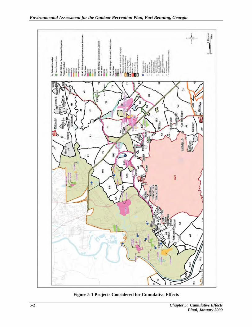
Environmental Assessment for the Outdoor Recreation Plan, Fort Benning, Georgia
5-2 Chapter 5: Cumulative Effects Final, January 2009
Figure 5-1 Projects Considered for Cumulative Effects
Environmental Assessment for the Outdoor Recreation Plan, Fort Benning, Georgia
Chapter 5: Cumulative Effects 5-3 Final, January 2009
• Communications Tower (FY04) – A communication tower was constructed in the South Harmony Church area, west of Cusseta Road and south of El Caney Road.
• New Army and Air Force Exchange Service (AAFES) Post Exchange (FY06) – Work consisted of constructing a new AAFES Exchange on the land across the street from the existing Exchange on Custer Road, Main Post, Fort Benning. The old AAFES Exchange will be reutilized in another format; it is not scheduled for demolition at this time. Work included landscaping and parking lot construction. Approximate size of the overall project area is 10 to 15 acres. An EA and FNSI were prepared for this action.
• Infantry Platoon Battle Course (IPBC) (FY06) – Work consisted of the construction of a new IPBC in the A12 portion of Fort Benning and would include tree clearing, grading, cut-and-fill, construction of the range and target firing area, and placement of targetry, in addition to the construction/emplacement of support facilities, access roads and trails, and associated utilities. Approximate size of the overall project area is 1,000 acres. An EA was prepared for this action (Fort Benning 2005c).
• The Digital Multi-Purpose Range Complex (DMPRC) (FY05) was constructed near the D13 area on Fort Benning. The DMPRC provides a state-of-the-art range facility for conducting advanced gunnery exercises in a realistic training environment. Support facilities associated with the DMPRC will be located adjacent to the range. The DMPRC design includes as many as 22 water crossings (average dimensions: 350 ft long by 29 ft wide each), and up to 1,500 acres of vegetation removal on the construction site is required. The DMPRC was constructed on approximately 1,800 acres and an EIS was prepared (Fort Benning 2004).
• Infantry Squad Battle Course (ISBC) (FY04) – Work consisted of the conversion of an existing Fort Benning range, Galloway Range, into an Infantry Squad Battle Course and includes the removal/replacement and upgrading of existing targetry, the construction of associated support facilities, the demolition of currently existing temporary buildings on site, and associated utility placement. Approximate size of the overall project area is 180 to 190 acres.
• National Infantry Museum (FY04) – A new infantry museum was constructed on the land between South Lumpkin and Fort Benning Roads on the Installation’s border with the City of Columbus. Work will also consist of establishing a World War II Company Street. The existing museum building, located on Baltzell Avenue, Main Post, Fort Benning, would be reutilized in another manner, but would not be demolished. Approximate size of the overall project area is 20 to 30 acres. An EA, FNSI, and errata sheet were prepared for this action by the Army (Fort Benning 2005a).
• Uchee Creek Campground Expansion (FY07) – Approximately 19 acres of improvements at the existing Fort Benning Uchee Creek Campground are included in this project. The campground is found in Russell County, AL, adjacent to the Chattahoochee River. Improvements include construction of up to 29 additional pull-through recreational vehicle sites, ten chalets, a new
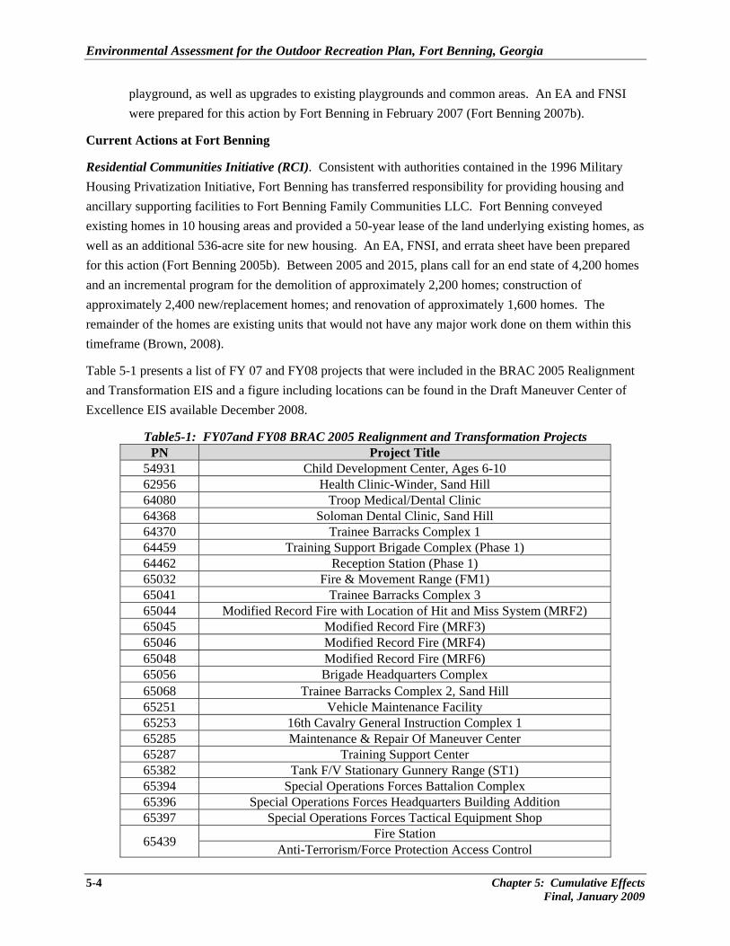
Environmental Assessment for the Outdoor Recreation Plan, Fort Benning, Georgia
5-4 Chapter 5: Cumulative Effects Final, January 2009
playground, as well as upgrades to existing playgrounds and common areas. An EA and FNSI were prepared for this action by Fort Benning in February 2007 (Fort Benning 2007b).
Current Actions at Fort Benning
Residential Communities Initiative (RCI). Consistent with authorities contained in the 1996 Military Housing Privatization Initiative, Fort Benning has transferred responsibility for providing housing and ancillary supporting facilities to Fort Benning Family Communities LLC. Fort Benning conveyed existing homes in 10 housing areas and provided a 50-year lease of the land underlying existing homes, as well as an additional 536-acre site for new housing. An EA, FNSI, and errata sheet have been prepared for this action (Fort Benning 2005b). Between 2005 and 2015, plans call for an end state of 4,200 homes and an incremental program for the demolition of approximately 2,200 homes; construction of approximately 2,400 new/replacement homes; and renovation of approximately 1,600 homes. The remainder of the homes are existing units that would not have any major work done on them within this timeframe (Brown, 2008).
Table 5-1 presents a list of FY 07 and FY08 projects that were included in the BRAC 2005 Realignment and Transformation EIS and a figure including locations can be found in the Draft Maneuver Center of Excellence EIS available December 2008.
Table5-1: FY07and FY08 BRAC 2005 Realignment and Transformation Projects PN Project Title
54931 Child Development Center, Ages 6-10 62956 Health Clinic-Winder, Sand Hill 64080 Troop Medical/Dental Clinic 64368 Soloman Dental Clinic, Sand Hill 64370 Trainee Barracks Complex 1 64459 Training Support Brigade Complex (Phase 1) 64462 Reception Station (Phase 1) 65032 Fire & Movement Range (FM1) 65041 Trainee Barracks Complex 3 65044 Modified Record Fire with Location of Hit and Miss System (MRF2) 65045 Modified Record Fire (MRF3) 65046 Modified Record Fire (MRF4) 65048 Modified Record Fire (MRF6) 65056 Brigade Headquarters Complex 65068 Trainee Barracks Complex 2, Sand Hill 65251 Vehicle Maintenance Facility 65253 16th Cavalry General Instruction Complex 1 65285 Maintenance & Repair Of Maneuver Center 65287 Training Support Center 65382 Tank F/V Stationary Gunnery Range (ST1) 65394 Special Operations Forces Battalion Complex 65396 Special Operations Forces Headquarters Building Addition 65397 Special Operations Forces Tactical Equipment Shop
65439 Fire Station Anti-Terrorism/Force Protection Access Control
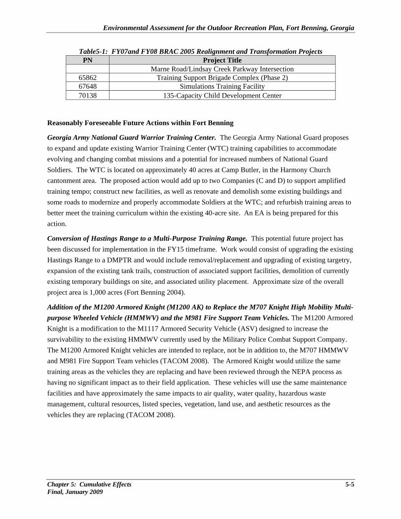
Environmental Assessment for the Outdoor Recreation Plan, Fort Benning, Georgia
Chapter 5: Cumulative Effects 5-5 Final, January 2009
Table5-1: FY07and FY08 BRAC 2005 Realignment and Transformation Projects PN Project Title
Marne Road/Lindsay Creek Parkway Intersection 65862 Training Support Brigade Complex (Phase 2) 67648 Simulations Training Facility 70138 135-Capacity Child Development Center
Reasonably Foreseeable Future Actions within Fort Benning
Georgia Army National Guard Warrior Training Center. The Georgia Army National Guard proposes to expand and update existing Warrior Training Center (WTC) training capabilities to accommodate evolving and changing combat missions and a potential for increased numbers of National Guard Soldiers. The WTC is located on approximately 40 acres at Camp Butler, in the Harmony Church cantonment area. The proposed action would add up to two Companies (C and D) to support amplified training tempo; construct new facilities, as well as renovate and demolish some existing buildings and some roads to modernize and properly accommodate Soldiers at the WTC; and refurbish training areas to better meet the training curriculum within the existing 40-acre site. An EA is being prepared for this action.
Conversion of Hastings Range to a Multi-Purpose Training Range. This potential future project has been discussed for implementation in the FY15 timeframe. Work would consist of upgrading the existing Hastings Range to a DMPTR and would include removal/replacement and upgrading of existing targetry, expansion of the existing tank trails, construction of associated support facilities, demolition of currently existing temporary buildings on site, and associated utility placement. Approximate size of the overall project area is 1,000 acres (Fort Benning 2004).
Addition of the M1200 Armored Knight (M1200 AK) to Replace the M707 Knight High Mobility Multi-purpose Wheeled Vehicle (HMMWV) and the M981 Fire Support Team Vehicles. The M1200 Armored Knight is a modification to the M1117 Armored Security Vehicle (ASV) designed to increase the survivability to the existing HMMWV currently used by the Military Police Combat Support Company. The M1200 Armored Knight vehicles are intended to replace, not be in addition to, the M707 HMMWV and M981 Fire Support Team vehicles (TACOM 2008). The Armored Knight would utilize the same training areas as the vehicles they are replacing and have been reviewed through the NEPA process as having no significant impact as to their field application. These vehicles will use the same maintenance facilities and have approximately the same impacts to air quality, water quality, hazardous waste management, cultural resources, listed species, vegetation, land use, and aesthetic resources as the vehicles they are replacing (TACOM 2008).
Environmental Assessment for the Outdoor Recreation Plan, Fort Benning, Georgia
5-6 Chapter 5: Cumulative Effects Final, January 2009
5.2 Assessment of Cumulative Effects Analysis of the ODRP action alternative resulted in a finding of minor, temporary, potential direct or indirect effects on soils, water resources, and biological resources that will be further analyzed in this section of the EA. These minor adverse impacts do not cause cumulative impacts when considering all other construction and training increases at Fort Benning. Thresholds for cumulative impacts are the same as for direct/indirect analysis. Soils. Cumulative impacts would be considered significant if ground disturbance or other activities would violate applicable federal or state laws and regulations, such as the Georgia Erosion and Sedimentation Act, and the potential for NOVs for the failure to receive applicable state permits, such as a NPDES construction/operation permit under the Erosion and Sedimentation Act. The ODRP projects are relatively small in size and no impacts to soils are expected because erosion control measures as required by applicable Federal, state, and local permits will be utilized. Other projects at Fort Benning to support BRAC and Transformation will occur during this same timeframe, and they are also required to minimize erosion and sedimentation. Based on the limited areas of disturbance involved in the ODRP projects and requirements to minimize soil erosion, Alternative A would have no cumulative impacts when considering the past, present, and future projects in the ROI. Water Resources. The threshold level of significance for water resources is defined as any long-term impacts (chemical, physical, or biological effects) that would alter the historical baseline or standard water quality conditions. Additionally, actions that adversely impact water bodies currently considered impaired under CWA would be considered significant. It is anticipated that jurisdictional wetlands could be affected by one or more of the ten proposed recreational facilities upgrade projects; however, these would all be delineated and the proper permitting processes undertaken to preclude any adverse impacts; therefore, it is anticipated that there would be no adverse effects to wetlands when considered together with other present or reasonably foreseeable actions. Biological Resources. Impacts on biological resources would be considered significant if one or more of the following conditions would result:
• substantial loss or degradation of habitat or ecosystem functions (natural features and processes) essential to the persistence of native plant and animal population numbers;
• substantial loss or degradation of a sensitive habitat, including wetlands and unique ecological areas that support high concentrations of special status species or migratory birds;
Environmental Assessment for the Outdoor Recreation Plan, Fort Benning, Georgia
Chapter 5: Cumulative Effects 5-7 Final, January 2009
• disruption of a federally listed species, its normal behavior patterns, or its habitat that substantially impedes the Installation’s ability to either avoid jeopardy or conserve and recover the species (including violating Section 9 of the ESA); or
• substantial loss of population or habitat for a state-protected or non-listed but special status species, increasing the likelihood of Federal listing action to protect the species in the future.
The definition of “substantial” is dependent on the species and habitats in question and the regional context in which the impact would occur. Impacts may be considered more adverse if the action affects previously undisturbed habitat or if the impact would occur over a large portion of available habitat in the region. Cumulative impacts to vegetation, wetlands, wildlife, and protected species are not likely to occur due to the additional habitat disturbance resulting from the removal associated with this proposal. The largest single ODRP project, the Twilight Pond area construction, would remove/disturb approximately 10 acres of vegetation, but would not present a Post-wide influence on overall vegetation availability for wildlife. Other proposed disturbances of vegetation are found in the cantonment areas on grass or concrete sites that are being renovated on previously disturbed ground. In addition, wildlife would only be temporarily disturbed from noise during construction, and migratory habitats and routes should not be adversely impacted. Cultural Resources. The threshold for significant impacts to cultural resources includes any adverse disturbance that cannot be mitigated and affects the integrity of an historic property (an eligible cultural resource) or that may affect a cultural resource that has not yet been evaluated to determine its eligibility to the NRHP or one that has importance to a traditional group under American Indian Religious Freedom Act, EO 13007, and NAGPRA. Cumulative effects of cultural resources would be contained within the Installation and would be similar to the environmental consequences provided in Section 4.2.3, in that cultural resources could potentially be affected where ground disturbance would occur to expose unknown cultural resources, where structures are renovated or demolished, or where visual elements may be introduced that are out of character with an historic property within the view shed. On Post, these impacts can be avoided, minimized, or mitigated, but would have a collective effect in reducing the overall number of historic properties on Fort Benning and in the surrounding region. This collective effect would be a minor adverse impact for cultural resources because all future construction projects would be under the same regulatory requirements for mitigation and these impacts would not be considered significant.


CHAPTER 6
CONCLUSIONS AND RECOMMENDATIONS

Environmental Assessment for the Outdoor Recreation Plan, Fort Benning, Georgia
6.0 CONCLUSIONS AND RECOMMENDATIONS After evaluation of impacts it is concluded that Alternative A, with its associated facility upgrades and renovations, as well as construction of sports fields, RV/camp sites, swimming pools, picnic pavilions, concessions, and playgrounds would meet the purpose and need of meeting the on-Post outdoor recreational needs and demands of Fort Benning Soldiers, retirees, and their families. The no-action alternative (Alternative B), would not meet the purpose and need for providing adequate recreational facilities and opportunities for Fort Benning and other Army personnel. The potential environmental consequences of Alternatives A and B on the relevant environmental resource categories are summarized in Table 6-1. The analysis contained in this EA indicates that for the most part, Alternative A would have only temporary, minor adverse effects to soils, water quality, and biological and cultural resources due to construction. No significant adverse impacts to any resources are anticipated either in a long- or short-term basis. The EA analyses demonstrated that with adherence to applicable federal and state environmental laws, regulations, and permitting processes no significant adverse environmental impacts would result from the proposed action as implemented by Alternative A. This determination is based on the following findings:
• Erosion control best management practices (e.g., silt fencing and soil covering) as prescribed under the NPDES would minimize the potential adverse effects to soils and water quality that may result from construction.
• Soil erosion would be kept to a minimum, and potential contamination during construction would be minimized by following existing Fort Benning procedures required under construction contracts, and applicable Federal and state laws and regulations. Nearby impaired Chattahoochee River and unimpaired Upatoi Creek would not be impacted due to small proposed project sites and soil erosion control measures.
• Alternative A should have only temporary, minor adverse impacts to RCWs and there are no other Federally or state listed species potentially occurring in the project areas.
• Recreation and visual resources would beneficially profit from implementation of the proposed action.
• Historical properties have the potential to be adversely impacted; however, avoidance, mitigation measures, and consultation in accordance with applicable cultural resource laws and regulations will minimize or eliminate adverse effects.
• No cumulative impacts would result from implementing Alternative A.
Chapter 6: Conclusions and Recommendations 6-1 Final, January 2009
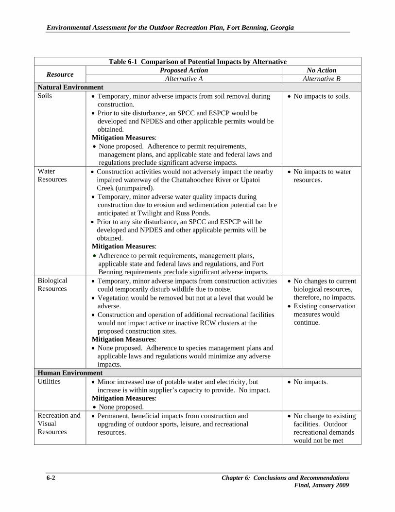
Environmental Assessment for the Outdoor Recreation Plan, Fort Benning, Georgia
Table 6-1 Comparison of Potential Impacts by Alternative
Resource Proposed Action No Action Alternative A Alternative B
Natural Environment Soils • Temporary, minor adverse impacts from soil removal during
construction. • Prior to site disturbance, an SPCC and ESPCP would be
developed and NPDES and other applicable permits would be obtained.
Mitigation Measures: • None proposed. Adherence to permit requirements,
management plans, and applicable state and federal laws and regulations preclude significant adverse impacts.
• No impacts to soils.
Water Resources
• Construction activities would not adversely impact the nearby impaired waterway of the Chattahoochee River or Upatoi Creek (unimpaired).
• Temporary, minor adverse water quality impacts during construction due to erosion and sedimentation potential can b e anticipated at Twilight and Russ Ponds.
• Prior to any site disturbance, an SPCC and ESPCP will be developed and NPDES and other applicable permits will be obtained.
Mitigation Measures: • Adherence to permit requirements, management plans,
applicable state and federal laws and regulations, and Fort Benning requirements preclude significant adverse impacts.
• No impacts to water resources.
Biological Resources
• Temporary, minor adverse impacts from construction activities could temporarily disturb wildlife due to noise.
• Vegetation would be removed but not at a level that would be adverse.
• Construction and operation of additional recreational facilities would not impact active or inactive RCW clusters at the proposed construction sites.
Mitigation Measures: • None proposed. Adherence to species management plans and
applicable laws and regulations would minimize any adverse impacts.
• No changes to current biological resources, therefore, no impacts.
• Existing conservation measures would continue.
Human Environment Utilities • Minor increased use of potable water and electricity, but
increase is within supplier’s capacity to provide. No impact. Mitigation Measures: • None proposed.
• No impacts.
Recreation and Visual Resources
• Permanent, beneficial impacts from construction and upgrading of outdoor sports, leisure, and recreational resources.
• No change to existing facilities. Outdoor recreational demands would not be met
6-2 Chapter 6: Conclusions and Recommendations Final, January 2009
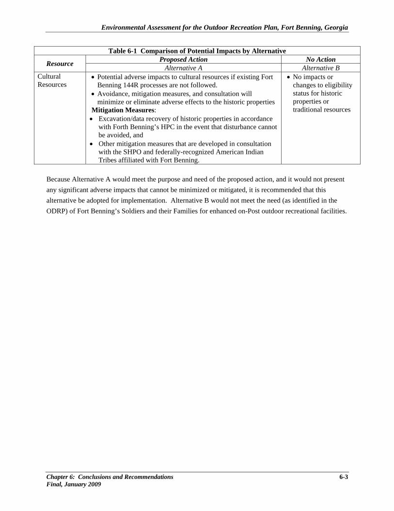
Environmental Assessment for the Outdoor Recreation Plan, Fort Benning, Georgia
Chapter 6: Conclusions and Recommendations 6-3 Final, January 2009
Table 6-1 Comparison of Potential Impacts by Alternative
Resource Proposed Action No Action Alternative A Alternative B
Cultural Resources
• Potential adverse impacts to cultural resources if existing Fort Benning 144R processes are not followed.
• Avoidance, mitigation measures, and consultation will minimize or eliminate adverse effects to the historic properties
Mitigation Measures: • Excavation/data recovery of historic properties in accordance
with Forth Benning’s HPC in the event that disturbance cannot be avoided, and
• Other mitigation measures that are developed in consultation with the SHPO and federally-recognized American Indian Tribes affiliated with Fort Benning.
• No impacts or changes to eligibility status for historic properties or traditional resources
Because Alternative A would meet the purpose and need of the proposed action, and it would not present any significant adverse impacts that cannot be minimized or mitigated, it is recommended that this alternative be adopted for implementation. Alternative B would not meet the need (as identified in the ODRP) of Fort Benning’s Soldiers and their Families for enhanced on-Post outdoor recreational facilities.


CHAPTER 7
REFERENCES CITED

Environmental Assessment for the Outdoor Recreation Plan, Fort Benning, Georgia
Chapter 7: References Cited 7-1 Final, January 2009
7.0 REFERENCES CITED Brown, John W. 2008. BRAC (SAIC Program Manager), Fort Benning. Email communication with
Kathy Rose, TEC Inc. 28 April. Deaver, S. 2000. An Ethnographic Overview of the Fort Benning Military Reservation. GA and AL.
November. Fincher, M. 2007. Utilities Manager, Directorate of Public Works. Fort Benning, Georgia. Personal
Communication.
Fort Benning. 2008. Draft Environmental Impact Statement for the Maneuver Center of Excellence. Fort Benning, GA. December.
_____. 2007a. Environmental Assessment for Uchee Creek Campground Expansion, Fort Benning,
Russell County, Alabama. February. _____. 2007b. Final Environmental Impact Statement, BRAC 2005 and Transformation Actions at Fort
Benning, GA. October. _____. 2007c. Biological Assessment for BRAC 2005 and Transformation Actions at Fort Benning, GA.
April. _____. 2006a. Outdoor Recreation Plan. Army Installation Management Agency, Southeast
Region Office. Fort Benning. July.
_____. 2006b. U.S. Army Infantry Center. Fort Benning, GA & AL. Historic Properties Component of the Integrated Cultural Resources Management Plan (ICRMP). For Certification under the Army Alternative Procedures for Historic Properties. February.
_____. 2005a. Environmental Assessment for Development and Implementation of a Historic Properties Component (HPC) Plan for Fort Benning in Accordance with Army Alternative Procedures. Prepared for Fort Benning, GA. October.
_____. 2005b. Residential Communities Initiative. Final Environmental Assessment. Fort Benning, GA. June.
Environmental Assessment for the Outdoor Recreation Plan, Fort Benning, Georgia
7-2 Chapter 7: References Cited Final, January 2009
_____. 2005c. Final Environmental Assessment for the Construction of the Infantry Platoon Battle Course. Fort Benning, GA and AL. August.
_____. 2004. Final Environmental Impact Statement Digital Multi-Purpose Range Complex. April. _____. 2003. Integrated Natural Resources Management Plan. Fort Benning Army Installation. 2001-
2005. Updated September. Gustafson, P. 2006 and 2007. CAA/Noise Programs Manager. Fort Benning, GA. Personal
communication. Hamilton, C.E. 2006. Cultural Resources Manager. Fort Benning, GA. Personal communication. InspectAPedia. 2007. Website address at www.InspectAPedia.com. Accessed on November 16. Joint Committee on Administrative Rules. 2007. Title 77: Public Health Chapter I: Department of
Public Health Subchapter r: Water and Sewage Part 930 Surface Source Water Treatment Code Section 930 Table B Daily Water Requirements. Illinois General Assembly. Accessed Website November 2007: http://www.ilga.gov/commission/jcar/admincode/077/07700930ZZ9998BR.html.
National Park Service (NPS). 2002. How to Apply the National Register Criteria for Evaluation.
National Register Publications Bulletin 15. U.S. Department of the Interior. _____. 1998. Guidelines for Evaluating and Documentation Traditional Cultural Properties. National
Register Publications Bulletin 38. U.S. Department of the Interior. North Carolina Cooperative (NCC). 2007. http://www.soil.ncsu.edu/publications/Soilfacts/AG-439-22/. Accessed November 15, 2007. Pyne, M. 2001. Ecological groups. Fort Benning, GA--a re-analysis. Report submitted to Fort Benning
under DAMD17-00-2-0017 05 17. October, 17 pp. United States Army (U.S. Army). 2008. Tank-automotive and Armament Command (TACOM). M1200
Armored Knight Draft Supplemental Environmental Assessment. October. _____. 2003. Integrated Natural Resources Management Plan. Fort Benning Army Installation. 2001-
2005. Updated September.
Environmental Assessment for the Outdoor Recreation Plan, Fort Benning, Georgia
Chapter 7: References Cited 7-3 Final, January 2009
United States Department of Agriculture (USDA). 1997. Natural Resources Conservation Service, Soil Survey of Chattahoochee and Marion Counties, Georgia.
United States Fish and Wildlife Service (USFWS). 1982. National Wetlands Inventory. U.S.
Department of the Interior. Washington, DC. United States Geological Survey (USGS). 2000. Estimated Use of Water in the United States in 2000.
http://ga.water.usgs.gov/edu/wuir.html. Accessed November 13, 2007.


CHAPTER 8
LIST OF PREPARERS AND CONTRIBUTORS

Environmental Assessment for the Outdoor Recreation Plan, Fort Benning, Georgia
8.0 LIST OF PREPARERS AND CONTRIBUTORS Stephen A. Berry, Senior Environmental Analyst B.S., Ecology/Chemistry, Birmingham-Southern College, 1977 B.S., Environmental Engineering, University of Florida, 1983 Years of Experience: 29 Christina Cummings, Production A.A.S., Administrative Office Technology, Boise State University, 1999 Years of Experience: 8 Cathy Doan, Environmental Analyst B.S., English, Central Michigan University, 1980 M.A., Human Resources Development, Webster University, 1985 Years of Experience: 13 Edie Mertz, Graphics A.A. General Education, Cerro Coso College, CA, 1994 Years of Experience: 14 Kathy L. Rose, Project Manager/Environmental Analyst B.A., Political Science/German, University of Massachusetts/Amherst, 1980 M.A., International Relations, George Washington University, 1983 M.S., Forest Resource Management, University of Idaho, 1996 Years of Experience: 22
Chapter 8: List of Preparers and Contributors 8-1 Final, January 2009


APPENDIX A
DISTRIBUTION LIST

Environmental Assessment for the Outdoor Recreation Plan, Fort Benning, Georgia
APPENDIX A DISTRIBUTION LIST
FOR PUBLIC NOTICE AND ENVIRONMENTAL ASSESSMENT
All individuals on this list were mailed a copy of the Notice of Availability for the EA. Persons who received both the Notice of Availability and the EA are annoted with a double asterisk.
I. MUNICIPAL AND COUNTY ELECTED AND APPOINTED OFFICIALS
Honorable Jim Wetherington Mrs. Evelyn Turner-Pugh City of Columbus, Mayor District 4 100 10th St. 6th Floor 325 Jefferson Drive Government Center Tower Columbus, GA 31907 Columbus, GA 31901 Mr. Myron Wells, Chairman, Marion County Mr. Julius Hunter , Jr. Board of Commissioners District 3 240 Cool Springs Road 139 Whippoorwill Lane Buena Vista, GA 31803 Columbus, GA 31906
II. STATE, COUNTY, AND LOCAL GOVERNMENT OFFICIALS Sen. George Hooks Sen. Ed Harbison Senate District 14 Senate District 15 P.O. Box 928 P.O. Box 1292 Americus, GA 31709 Columbus, GA 31902 Sen. Seth Harp Rep. Debbie Buckner Senate District 29 House District 130 P.O. Box 363 780 Fielder’s Mill Road Midland, GA 31820 Junction City, GA 31812 Rep. Vance Smith Jr, Rep. Calvin Smyre House District 129 House District 132 P.O. Box 171 P.O. Box 181 Pine Mountain, GA 31822 Columbus, GA 31902 Rep. Richard Smith Rep. Carolyn Hugley House District 131 House District 133 P.O. Box 2122 P.O. Box 6342 Columbus, GA 31902 Columbus, GA 31917 Senator Saxby Chambliss Senator Johnny Isakson 416 Russell Senate Office Bldg. 120 Russell Senate Office Building Washington, DC 20510 Washington, DC 20510
Appendix A: Distribution List A-1 Final, January 2009
Environmental Assessment for the Outdoor Recreation Plan, Fort Benning, Georgia
Jack Kingston Sanford Bishop, Jr. Georgia-1st District Georgia-2nd District 2368 Rayburn HOB 2429 Rayburn HOB Washington, DC 20515-1001 Washington, DC 20515-1002 Jim Marshall Hank Johnson Georgia-3rd District Georgia-4th District 515 Cannon, HOB 1133 Longworth HOB Washington, DC 20515-1003 Washington, DC 20515 John Lewis Tom Price Georgia-5th District Georgia-6th District 343 Cannon HOB 424 Cannon HOB Washington, DC 20515-1005 Washington, DC 20515 John Linder Mr. Lynn Westmorland Georgia-7th District Georgia-8th District 1026 Longworth HOB 1213 Longworth HOB Washington, DC 20515 Washington, DC 20515 Nathan Deal Georgia-9th District 2133 Rayburn HOB Washington, DC 20515 III. LOCAL AND REGIONAL ADMINISTRATORS, FEDERAL AGENCIES, OR COMMISSIONS WITH
REGULATORY INTEREST ** U.S. Fish & Wildlife Service ** Mr. J.I. Palmer Jr. Attn: John Doresky Administrator, Region IV P.O. Box 52560 U.S. EPA Fort Benning, GA 31995 61 Forsyth Street Atlanta, GA 30303 U.S. Fish & Wildlife Service USACE, Albany Field District RCW Recovery Coordinator Attn: Tom Fisher 261 Lehotsky Hall 1104 N. Westover Rd. Clemson, SC 29634 Albany, GA 31707 Mr. Bob Lord ** Mr. Gerald Miller Region IV, Wetland Section Commander, Savannah District USACE U. S. EPA Post Office Box 889 61 Forsyth Street Savannah, GA 31402-0889 Atlanta, GA 30303 U.S. Department of Agriculture ** Georgia State Clearinghouse Soil Conservation Service Ms. Barbara Jackson, Administrator Post Office Box 18 270 Washington Street, SW., 8th Floor Buena Vista, GA 31803 Atlanta, GA 30334 Mr. Noel Holcom , Commissioner Dr. Carol Couch Georgia Department of Natural Resources Georgia DNR, Environmental Policy Division 2 Martin Luther King Jr. Dr., SE, Suite 1252 East 2 Martin Luther King Jr. Dr., SE, Suite 1152 East Atlanta, GA 30334 Atlanta, GA 30334
A-2 Appendix A: Distribution List Final, January 2009
Environmental Assessment for the Outdoor Recreation Plan, Fort Benning, Georgia
** Mr. James R. Crozier, Region 5 Representative Mr. Willie R. Taylor, Director Georgia Soil & Water Conservation Commission USDI, Office of Env. Policy & Compliance 4344 Albany Highway 1849 C Street, N.W. Dawson, GA 39842 Washington, DC 20240 Columbus/Muscogee County Soil Conservation Service Columbus Consolidated Government Planning Div. 100 10th St. , 6th Floor 100 10th St., Sixth Floor Government Center Tower Government Center Tower Columbus, GA 31993 Columbus, GA 31902 Dr. Ray Luce, Director Mr. James D. Giattina Historic Preservation Division Director, Water Management Division Georgia Department of Natural Resources U.S. EPA 34 Peachtree Street, NW, Suite 1600 61 Forsyth Street S.W. Atlanta, GA 30303 Atlanta, GA 30303 Ms. Linda MacGregor Ms. Becky Kelley, Director Branch Chief Parks, Recreation and Historic Sites Division GA EPD, Watershed Protection Branch GA DNR 4220 International Pkwy, Suite 101 2 Martin Luther King Jr. Dr., SE, Suite 1352 Atlanta, GA 30354 Atlanta, GA 30334 Mr. Gregory Hogue USDI, Office of Environmental Policy & Compliance Russell Federal Bldg., Suite 114 75 Spring Street, S.W. Atlanta, GA 30303
IV. CITIZEN ADVISORY GROUPS AND LOCAL INTEREST GROUPS OR PERSONS
Chattahoochee Nature Center Wade Harrison 9135 Willeo Road The Nature Conservancy Roswell, GA 30075 Chattahoochee Fall Line Project Director
Post Office Box 52452 Sierra Club, Georgia Chapter Columbus, GA 31905 1447 Peachtree Street N.E. Suite 305 Audubon Society of Columbus Atlanta, GA 30309 P.O. Box 442
Hamilton, GA 31811 National Wildlife Society 1401 Peachtree Street N.E. Georgia Wildlife Federation Suite 240 11600 Hazelbrand Road Atlanta, GA 30309 Covington, GA 30014 Georgia Forestry Association, Inc. Chattahoochee RiverWatch 505 Pinnacle Court 30 W. 10th Street Norcross, GA 30071 P.O. Box 1492
Columbus, GA 31909 Georgia Woman Flyfishers 116 Kenninghall Ct. Smyrna, GA 30082
Appendix A: Distribution List A-3 Final, January 2009
Environmental Assessment for the Outdoor Recreation Plan, Fort Benning, Georgia
V. LOCAL NEWS AND MEDIA
WRBL TV 3 (CBS) WKCN (99.3 FM) Attn: Legals Attn: Legals 1350 13th Avenue 1353 13th Avenue Columbus, GA 31901 Columbus, GA 31901 WTVM TV 9 (ABC) WGSY (100 FM) Attn: Legals Attn: Legals 1909 Wynnton Road 1501 13th Avenue Columbus, GA 31994 Columbus, GA 31901 WXTX TV 54 (FOX) WOKS (1340 AM) and WXFE (105 FM) Attn: Legals Attn: Legals 6524 Buena Vista Road P.O. Box 1998 Columbus, GA 31994 Columbus, GA 31902 Columbus Ledger-Enquirer Mellow Times News P.O. Box 830 2904 Macon Road Columbus, GA 31902 Columbus, GA 31907
VI. LIBRARIES
Chattahoochee Valley Regional Library Columbus Public Library 1120 Bradley Dr. 3000 Macon Road Columbus, GA 31906 Columbus, GA 31906 Fort Benning Main Post Library South Columbus Branch Library Building 93 2034 South Lumpkin Road Fort Benning, GA 31905 Columbus, GA 31903
VII. FORT BENNING OFFICIALS Maj. Gen. Walter Wojdakowski Commander, U.S. Army Infantry Center Commanding General Infantry Hall (Bldg 4) Infantry Hall (Bldg 4) Fort Benning, GA 31905 Fort Benning, GA 31905 Deputy CG/Assistant Commandant PWD, Southeast Region, IMA Infantry Hall (Bldg 4) Attn: SFIM-SE-PW-E Fort Benning, GA 31905 1593 Hardee Avenue SW Fort McPherson, GA 30330 Commander, 75th Ranger Regiment Commander, US Army TRADOC HQ Building 2834 Attn ATBO-GE Fort Benning, GA 31905 5A North Gate Road Fort Monroe, VA 23651 Commander, 3rd Brigade, 3rd Infantry Division US Army, Northeast Region Office Building 9050 (Kelley Hill) Attn: SFIM-NE-ER Fort Benning, GA 31905 5A North Gate Road Fort Monroe, VA 23651
A-4 Appendix A: Distribution List Final, January 2009
Environmental Assessment for the Outdoor Recreation Plan, Fort Benning, Georgia
Appendix A: Distribution List A-5 Final, January 2009
Commander, 29th Infantry Regiment US Army, Northeast Region Office Building 5500 (Harmony Church) Attn: ATJA Fort Benning, GA 31905 11 Bernard Road Fort Monroe, VA 23651 Commander, 11th Infantry Regiment Building 2749 Paul A. Hird, PAHM Fort Benning, GA 31905 BRAC Project Manager, SAIC Contractor USAMEDDAC Commander, 36th Engineer Group Fort Benning, GA 31905 Building 2827 Fort Benning, GA 31905 Commander, Ranger Training Brigade Commander, Infantry Training Brigade Building 5024 (Harmony Church) Building 3410 (Sand Hill) Fort Benning, GA 31905 Fort Benning, GA 31905


APPENDIX B
PUBLIC AND STAKEHOLDER INVOLVEMENT PLAN

Environmental Assessment for the Outdoor Recreation Plan, Fort Benning, Georgia
Environmental Assessment for the Outdoor Recreation Plan Fort Benning, Georgia
Public and Stakeholder Involvement Plan (PIP) October 2008
1.0 PURPOSE 1.1 Need for Project. Fort Benning population growth is expected to increase the demand for outdoor recreational activities. Through various survey methods and interviews, the need to upgrade or improve existing facilities was deemed necessary to address the unmet needs of the on-Post community. The challenge is to accommodate all users who desire to partake of recreational facilities at Fort Benning. To achieve this goal requires construction of new outdoor athletic facilities, trails, RV and camp sites, and chalets for quality recreational opportunities. Through the Outdoor Recreation Plan (ODRP) process, 10 areas were identified for specific construction and improvement, and those areas form the proposed action in this EA. 1.2 Need for Public and Stakeholder Involvement Plan. This Public Involvement Plan (PIP) presents a comprehensive means of satisfying legal requirements while enhancing community knowledge and participation in the planning for the proposed outdoor recreation facilities improvements and expansion at Fort Benning. Throughout this PIP, “public” is used to broadly describe individuals who are in communities near the proposed project site or that may be interested or affected by the proposed action or alternatives. “Stakeholder” is used to identify those entities that have an additional relationship to Fort Benning environmental resources or regulatory or governmental duties. Stakeholders include the federal, state and local governmental agencies with regulatory authority over Fort Benning (e.g., United States Fish and Wildlife Service [USFWS] and Georgia State Historic Preservation Office); and interested public agencies. 1.2.1 Public involvement required by National Environmental Policy Act (NEPA). The primary law that drives public involvement is the National Environmental Policy Act (NEPA). NEPA requires federal agencies, such as the Army at Fort Benning, to prepare an environmental analysis of the proposed action and alternatives. Potential environmental impacts, both direct and indirect, are identified for the proposal and each alternative, and possible mitigation for any negative impacts is presented. Also, cumulative impacts (i.e., incremental impacts when considering other projects or actions in a region of affect) are identified as well as any resultant mitigation. An EA is the appropriate level of NEPA documentation for the implementation of projects of the Outdoor Recreation Plan at Fort Benning. The Council on Environmental Quality (CEQ) has NEPA oversight for the federal government and has published regulations and guidance for preparation of an EA. The Army supplements NEPA and the CEQ directions with Army NEPA Regulation 32 Code of Federal
Appendix B: Public and Stakeholder Involvement Plan B-1 Final, January 2009
Environmental Assessment for the Outdoor Recreation Plan, Fort Benning, Georgia
Regulations (CFR) Part 651, current version effective 29 March 2002. Army NEPA regulation provides guidelines for the contents of an EA and the processes required for full environmental analysis with participation by public, stakeholders, and regulators. This PIP will not restate the provisions of Army NEPA Regulation, so attention to the specific requirements provided therein is required to fully comply with Army NEPA Regulation and the Army’s requirement for public and stakeholder participation and scoping. NEPA requires opportunities for public review and comment of an EA. Public interaction is based on two-way communication that reflects the needs of the community, and may utilize such methods as notices, brochures, news releases, web page information, summaries, draft documents, public meetings, comments, and/or other methods. This PIP will address the means of meeting the NEPA and Army NEPA Regulation public involvement requirements. 1.2.2 Other Laws and Regulations. There are several other laws and regulations that require public notices and participation during the planning phases of a federal project and some may be relevant to the implementation of the proposed recreational facilities improvements. Although NEPA may address some of the topics and issues in the EA, Fort Benning needs to satisfy the requirements of these other laws and regulations. To further improve efficiency in the Installation’s Cultural Resource Management program, Fort Benning has adopted the Army Alternative Procedures (AAP) for implementing the National Historic Preservation Act (NHPA). Replacing NHPA Section 106 procedures (36 CFR Part 800), the Historic Properties Component (HPC) of the ICRMP provides the Standard Operating Procedures followed by Fort Benning when assessing proposed actions and their potential effects on Fort Benning’s historic properties. The purpose of the AAP is to expedite the review of actions that might affect historic properties and leverage the NEPA process for coordination and consultation. At Fort Benning, the NEPA process of project review begins with the proponent submitting a Fort Benning Form 144R. All projects are reviewed by the various Program managers, including the Cultural Resources Manager. For those projects finding no effect to historic properties, a simple “concur” is noted, and the CRM review ends. Using Section 106 procedures, a finding of no adverse effect would still require review by the State Historic Preservation Officer (SHPO) and Tribes, as necessary. Under the HPC, however, a finding of no adverse effect will require no further review prior to the project notice to proceed, although record of the project is kept for a yearly review by the relevant state SHPO and Tribes in consultation with Fort Benning. An initial finding of an adverse effect for a project can be changed to no effect or no adverse effect if redesign or other avoidance measures are taken. Should mitigation be required, consultation with the appropriate SHPO and Tribes, as needed, will be conducted through the process required by NEPA. At this stage, comment may be made formally by all stakeholders, and Fort Benning must take into account such comments prior to deciding how to proceed.
B-2 Appendix B: Public and Stakeholder Involvement Plan Final, January 2009
Environmental Assessment for the Outdoor Recreation Plan, Fort Benning, Georgia
1.2.3 Goals of Plan. Fort Benning is committed to meeting the legal requirements and also takes measures for communication and involvement of the public and stakeholders in the planning of the ODRP projects at Fort Benning. Limitations in resources, personnel, and time impose constraints that necessitate an efficient and realistic plan. This PIP must assist the Army planners and be realistic for implementation. Goals for this PIP include:
• Promote an understanding of public and stakeholder involvement requirements and opportunities for better resourcing and scheduling;
• Specify steps needed to meet legal responsibilities for comment opportunities of public members and stakeholders;
• List realistic time frames and responsible persons or offices for each step; • Coordinate activities to maximize the quality of the information, ensure the information relates to
planning actions in process, and incorporate any resultant feedback into future participation or planning processes;
• Incorporate opportunities to present information to better partner with the community; and • Keep the Fort Benning Public Affairs Officer (PAO) informed.
2.0 PUBLIC INVOLVMENT PLAN STRUCTURE Items in this PIP should be evaluated for suitability before engaging in the recommended actions. Army NEPA Regulation divides the scoping process into three phases for simplification: the Preliminary Phase, the Public Interaction Phase, and the Final Phase. Although the majority of public and stakeholder involvement is conducted in the Public Interaction Phase, the other two stages encompass important steps to prepare for and respond to public and stakeholder involvement. This PIP will use the three phases to organize this Plan, although the phases often overlap. 3.0 PRELIMINARY PHASE 3.1 Initial Internal Scoping. This is an internal Fort Benning action that is normally very informal and may result in limited amounts of documentation. Often proponents of the action start this internal scoping as a part of management planning for the proposal, rather than as a conscious effort to conduct internal scoping. Internal scoping is a process of identifying project requirements, initial environmental concerns, and possibly explore options to address those concerns. In this case, much of the internal scoping occurred throughout the ODRP development by the Division of Morale, Welfare and Recreation (MWR) and Directorate of Family, Morale, Welfare, and Recreation (FMWR). Internal scoping is important because it commences the environmental analysis; however, internal scoping is only a precursor to public and stakeholder involvement. It is important for the proponent (i.e., the Army at Fort Benning) and all those working with the proponent to keep in mind that the decisions regarding the project are not final and are just proposals. Until the process of environmental analysis and documenting
Appendix B: Public and Stakeholder Involvement Plan B-3 Final, January 2009
Environmental Assessment for the Outdoor Recreation Plan, Fort Benning, Georgia
a decision is complete, the proponent may modify the project, especially to reduce potential environmental impacts, incorporate internal concerns, or address potential mitigation measures. 3.1.1 Identify Proponent. Initially, the proponent(s) of the proposal is identified. Usually, the proponent is the person or activity that has initiated the action, has initiated a funding request, and makes the important decisions or recommendations regarding the project. For the implementation of the projects within the ODRP, the proponent has been identified as MWR and FMWR for this action. 3.1.2 Coordinate with Environmental Planners. For actions that could have, and/or the potential to have, a negative affect or a substantial positive affect on the environment, the proponent is required to coordinate with Environmental Management Division (EMD). Early coordination is required for large or complex projects. Failure to coordinate early can lead to several problems, including failure to maintain a proper NEPA record, delay in project execution, extra expense from redesigns and incorporation of mitigation, plus other problems. Normally the proponent initiates coordination by submitting a completed Fort Benning Form 144-R to EMD to determine what level of NEPA analysis is required; however the NEPA documentation for some proposals obviously requires more complex NEPA analysis and the internal scoping can begin with a kick-off meeting or other ways. For purposes of this NEPA process, MWR and MWR personnel coordinated NEPA compliance with EMD to initiate this EA. For the ODRP projects evaluated in this EA, MWR will submit the Fort Benning Form 144R to EMD as each project design becomes further refined.
3.1.3 Document internal scoping efforts. NEPA compliance involves maintaining records of alternatives explored, issues identified, personnel involved, and other aspects necessary for internal scoping. Preparing meeting minutes or notes or other evidence of internal scoping is helpful not only for maintaining a project file, but also to later recall information for environmental document preparation. Alternatives or options that may have been considered informally in the internal scoping process may be a basis for alternatives evaluated formally in the EA. This internal scoping does not substitute for public scoping, but it is a necessary precursor. The NEPA Administrative File for this action is kept at EMD.
3.1.4 Coordinate with Public Affairs Officers. The EMD NEPA Program Manager and Directorate of Public Works (DPW) will keep the Fort Benning PAO informed regarding environmental planning and scoping for the ODRP proposal. 3.1.5 Tentative List of Affected and Interested Parties (Mailing List). EMD maintains a NEPA mailing list consisting of individuals or entities that have shown interest in Fort Benning’s environmental studies or past projects. The mailing list also includes federal, state, and local government offices, Tribes, and other interested citizens and organizations requesting to be on the mailing list. This list will be reviewed and adjusted for each NEPA action. For the ODRP proposal, Fort Benning has taken the basic Mailing List and adjusted it according to the potential of those individuals to be affected by the proposed
B-4 Appendix B: Public and Stakeholder Involvement Plan Final, January 2009
Environmental Assessment for the Outdoor Recreation Plan, Fort Benning, Georgia
action and alternatives and to update addresses. Part of the scoping process includes continued maintenance of the Mailing List—it will be updated routinely to correct, add, and/or remove individuals, organizations, entities, and government agencies. 4.0 PREPARATION OF THE EA AND FINDING OF NO SIGNIFICANT IMPACT (FNSI) 4.1 Involvement in the EA Development. The EA is the environmental analysis document that is available for public review and comment in the NEPA process for this proposed action. While several partial drafts of the NEPA document may be routed for review at the Installation (internal) level, the first NEPA document to leave the Installation for public review is the EA and draft FNSI. The Installation will make every attempt to inform the public of the proposal and address any relevant comments during the Public Interaction Phase into the EA analysis. 4.2 EA Preparation 4.2.1 Drafting the NEPA Document. The EA will follow the general format in 32 CFR Part 651 although variations can be made as long as all required information and analysis are included. Reliable data and information are used in the development of the draft ODRP EA. It is suggested that the EA be simultaneously developed with other environmental planning requirements to be efficient and credible. 4.2.2 Gathering Information. Much information and data were obtained from existing sources. Coordination with the proponent, Fort Benning stakeholders, and external participants was conducted early to ensure the information and data are correctly presented in the EA. 4.2.3 Coordinating with Other Environmental Requirements. Several other environmental requirements involve data collection, potential project impact analysis, and consideration of mitigation measures (if needed). Information obtained to satisfy other requirements will be incorporated into the EA, when available. Often only a summary of the related information is presented, with either a reference to the full document, placing the full document in an appendix, or incorporating by reference. If either referencing or incorporating another document, the full text of the document will be available for public review when the EA is made publicly available. If possible, the public involvement activities will be integrated to meet the requirements of NEPA and other requirements to present a complete picture to the public of the proposal and potential environmental impacts.
4.2.4 Coordinating with Others: The EA internal Army review includes MWR, FMWR, DPW (Master Planning, EMD Program Managers), and the Office of the Staff Judge Advocate (OSJA Environmental Attorney) personnel. See 32 CFR 651 for more information.
Appendix B: Public and Stakeholder Involvement Plan B-5 Final, January 2009
Environmental Assessment for the Outdoor Recreation Plan, Fort Benning, Georgia
4.2.5 Cooperating Agencies. At this time, there are no cooperating agencies involved in the NEPA for the proposed projects of the ODRP proposal at Fort Benning. 5.0 PUBLIC INTERACTION PHASE Publishing the EA for Public and Stakeholder Review and Comment: The Notice of Availability (NOA) of the EA and draft FNSI will be published in the Columbus Ledger-Enquirer, and any other suitable media identified by the Installation. The Fort Benning website will also include the NOA, as well as the full text of the EA, draft FNSI, and, when possible, the appendices to the EA.
In addition to the announcement of the NOA in the newspaper and website, the NOA will also be mailed to all persons/agencies on the project Mailing List. Fort Benning is required to make hard copies of the EA and draft FNSI available for review to anyone on this list (or in the general public) upon request. At a minimum, hard copies of the EA and draft FNSI will be provided to key Installation personnel, regulatory agencies, and local libraries (both on and off Post). The review and comment period for the EA and FNSI is 30 days after the first publication of the NOA in the local media. 6.0 THE FINAL PHASE After the close of the time frame for public comment on the EA and draft FNSI, the Final Phase for public involvement begins. Comments are considered and any revisions must be incorporated, either by errata sheets for minor revisions or complete revision and production of a revised EA for more comprehensive changes. 6.1 Draft Finding of No Significant Impact (FNSI). No decision will be made until 30 days after the EA and draft FNSI have been made available for public review and comment. The draft FNSI includes the decision (which alternative is selected), a description of alternatives considered, explanation of all factors used in making the decision, and an account of avoidance and mitigation requirements (if applicable).
6.2 Mitigation and Monitoring. If mitigation measures are identified, then monitoring requirements will be identified in the EA and FNSI. A monitoring plan and enforcement programs for any required mitigation will be included in the EA and FNSI and carried out by the proponent. Fort Benning will provide the status of the mitigation and monitoring results upon request. Point of contact for requesting this information is the Fort Benning Public Affairs Office.
B-6 Appendix B: Public and Stakeholder Involvement Plan Final, January 2009

Environmental Assessment for the Outdoor Recreation Plan, Fort Benning, Georgia
Appendix B: Public and Stakeholder Involvement Plan B-7 Final, January 2009
References: Army NEPA Regulation at 32 CFR Part 651, 29 March 2002. Fort Benning. 2007. Environmental Assessment for the Uchee Creek Campground Expansion, Fort Benning, Russell County, Alabama; Appendix B, Public and Stakeholder Involvement Plan. February.