Embed Size (px)
Citation preview

Prepared by:
Centre for Geosciences Research cc
128 A Bach street Windhoek
Windhoek
Cell: 0856419511
Proponent:
Fanuel Kharuxab
P.O.Box 174 Karibib, NAMIBIA
ENVIRONMENTAL IMPACT ASSESMENT (EIA)
Fanuel Kharuxab ( Mining Claims: 68366,68367,68368,68369,68370,68371)
1
PROJECT DETAILS
TITLE:
Environmental Impact Assessment and Environmental Management Plan for the proposed small scale surface mining for marble in Fanuel Kharuxab Mining Claims 68366,68367,68368,68369,68370,68371 Karibib District, Erongo Region, Namibia.
AUTHORS:
o Mr Siyambango Mulife (Centre for Geosciences Research cc)
PROPONENT:
Fanuel Kharuxab P.O.Box 174 Karibib, NAMIBIA
CONSULTANCY:
Centre for Geosciences Research Cc PO Box 31423 Pioneerspark Windhoek, Namibia
Contact: Cell:0856419511
NAME
RESPONSIBILITY
QUALIFICATIONS
Mulife Siyambango
Director of Centre for Geosciences Research cc:
Project Director
B. Sc. in analytical, inorganic and physical chemistry,
M. Sc. in Industrial Rocks and Minerals, MBA in
Banking, Accounting and Strategic Management.

2
PROFESSIONAL
REGISTRATION
EXPERIENCE
Pr.Sci.Nat
Mr Siyambango is the director and founder of Centre
for Geosciences Research cc Mr Siyambango is a
qualified geologist, and specialist in industrial minerals
and rocks. Obtained an MSc in Industrial Rocks and
Minerals with majors in Mineral Resource Assessment
& Estimation; Mineral Extraction & Management
Marketing of Industrial Rocks and Minerals, Geology
and Technology of Industrial Rocks and Minerals. Mr
Siyambango is a fully trained and qualified Chemist
with a BSc in analytical, inorganic and physical
chemistry and Geography (Environmental
Studies). Extensively trained and experienced in
analytical instruments that are essential for mineral
exploration and mineral processing. Academically and
experienced trained Manager, with an MBA in
Banking, Accounting and Strategic Management.
The qualification supplements the economic
assessment of commerciality of mineral resources for
assessment of the bankability.

3
Table of Contents LIST OF FIGURES...................................................................................................................... 6
LIST OF TABLES ........................................................................................................................ 7
ABBREVIATIONS AND ACRONYMS ......................................................................................... 8
PART I: ENVIRONMENTAL IMPACT ASSESSMENT (EIA) REPORT ........................................ 9
1. Introduction ........................................................................................................................ 10
1.1. Project Background ..................................................................................................... 10
1.2. The objectives of the Environmental Assessment Process.......................................... 11
1.3. Terms of Reference .................................................................................................... 11
1.4. Scope of the Environmental Impact Assessment (EIA) ............................................... 12
2. Background to small scale surface mining for dimension stone (i.e. Marble) ...................... 13
2.1. What are dimension stones? ....................................................................................... 13
2.3. What is Marble dimension stone ................................................................................. 16
2.4. Concluding remark on this section .............................................................................. 16
3. Project description ............................................................................................................. 17
3.1. Rationale for the proposed project .............................................................................. 17
3.2. Proposed locality ........................................................................................................ 17
3.3. Geology of the area ..................................................................................................... 18
3.4. Climate ....................................................................................................................... 21
3.5. Infrastructure and exploration equipment’s requirement for the project ...................... 22
3.5.1. Mining equipment’s .............................................................................................................. 22
3.5.2. On site Infrastructure requirements ......................................................................... 23
3.6. Concluding remark on this section .............................................................................. 23
4. Legal and regulatory framework review .............................................................................. 24

4
4.1. Mineral Act of 1992 and the types of license it regulates ............................................. 24
4.2. Legal instrument relevant to this project ...................................................................... 26
4.3. Regulatory authorities and permitting .......................................................................... 29
4.4. Concluding remark on this section .............................................................................. 30
5. Affected environment ......................................................................................................... 31
5.1. General description of the project ............................................................................... 31
5.2. Social environment and archaeology .......................................................................... 31
5.2.1. Social environment .................................................................................................. 31
5.2.2. Archaeology ............................................................................................................ 33
5.3. Biophysical Environment ............................................................................................. 33
5.3.1. Geology ................................................................................................................... 33
5.3.2. Biodiversity (fauna and flora) ................................................................................... 35
5.3.3. Groundwater and surface water hydrogeology ........................................................ 35
5.4. Potential impact identified ........................................................................................... 40
5.5. Concluding remark on this section .............................................................................. 40
6. Public consultation process ................................................................................................ 41
6.1. Legal and policy requirement ...................................................................................... 41
6.2. Consultation process followed during the EIA process ................................................ 43
6.3. Limitation of the public consultation process ............................................................... 44
6.4. The interested and affected parties (I & AP’s) ..................................................................... 45
6.5. Outcome of the public engagement............................................................................. 45
6.6. Key issues identified during the public engagement process....................................... 45
6.7. Concluding remark on this section .............................................................................. 46
7. Impact assessment ............................................................................................................ 47
7.1. Identification of key issues .......................................................................................... 47

5
7.2. Methodology used or adopted for the impact assessment ........................................... 51
7.3. Biophysical Environment ............................................................................................. 55
7.3.1. Impact of oil spills on groundwater aquifer and surface water streams ................. 55
7.3.2. Loss of Fauna and Flora diversity ........................................................................ 57
7.3.3. Dust generation on site ........................................................................................ 58
7.4. Social Economic Environment ..................................................................................... 63
7.4.1. Job creation ......................................................................................................... 63
7.4.2. Potential spread of HIV/AIDS ............................................................................... 65
7.4.3. Disturbance or destruction of archaeological sites................................................ 66
7.5. Solid waste: wires, drill bits, and human waste ........................................................... 67
7.5.1. Descriptions ......................................................................................................... 67
7.5.2. Sensitivity of the affected environment ................................................................. 68
7.5.3. Mitigation and enhancement measures ................................................................ 68
7.5.4. Monitoring ............................................................................................................ 69
7.6. Land or soil disturbance: on site and the proposed 23km stretch road ........................ 69
7.6.1. Descriptions ......................................................................................................... 69
7.6.2. Sensitivity of the affected environment ................................................................. 69
7.6.3. Mitigation and enhancement measures ................................................................ 69
7.6.4. Monitoring ............................................................................................................ 70
7.7. Concluding remark on this section .............................................................................. 70
8. Conclusion and recommendations ..................................................................................... 71
8.1. Conclusion .................................................................................................................. 71
8.2. Recommendations ...................................................................................................... 71
9. References ........................................................................................................................ 72

6
LIST OF FIGURES
Figure 1: site location of Fanuel Kharuxab Mining Claims:
68366,68367,68368,68369,68370,68371in Karibib District, Erongo Region .............................. 10
Figure 2: Site location in relation to nearby towns, road and parks Fanuel .Kharuxab Mining
Claim ........................................................................................................................................ 18
Figure 3: Geology of the proposed in Fanuel Kharuxab Mining Claims: 68366,68367,68368,68369,68370,68371site ............................................................................ 21
Figure 4: Homogeneous marble within the Fanuel Kharuxab Mining Claims:
68366,68367,68368,68369,68370,68371as seen in a hand specimen ...................................... 34
Figure 5: The Karibib Formation (Tordiffe, 2013) ....................................................................... 37

7
LIST OF TABLES
Table 1: Dimension stone extraction methods and technologies................................................ 15
Table 2: The stratigraphy of the Swakop Group (Damara Sequence) based on Miller 2008 ...... 19
Table 3: Idealized Geology ........................................................................................................ 20
Table 4: List of machines/equipment and quantity to be used during the mining process .......... 22
Table 5: Types of license regulated by the Mineral Act of 1992, activities and environmental
requirements ............................................................................................................................. 25
Table 6: Legal instruments relevant to this project ..................................................................... 26
Table 7: The regulatory authority and permitting........................................................................ 29
Table 8: The APV for the Karibib Marble Aquifer in Mining claim ............................................... 38
Table 9: Public consultation process ......................................................................................... 44
Table 10: Process of determining the key impacts resulting from certain aspects of the proposed
small scale surface mining for marble ....................................................................................... 48
Table 11: Definition of criteria for assessing significant impact .................................................. 52
Table 12: Definitions of various significant rating or sensitivity ................................................... 54
Table 13: Expected significance of the project on liquid waste ................................................. 56
Table 14: Expected significance of the project on Biodiversity: fauna and flora.......................... 58
Table 15: Expected significance of the project on dust generated on site .................................. 60
Table 16: Expected significance of the project on social economic implications......................... 64
Table 17: Expected significance of the project on the spread of HIV/AIDS ................................ 66
Table 18: Expected significance of the project on archaeological sites ...................................... 67
Table 19: Expected significance of the project on solid waste ................................................... 68
Table 20: Expected significance of the project on soil or land disturbance ................................. 69

8
ABBREVIATIONS AND ACRONYMS
EMP Environmental Management Plan
EIA Environmental Impact Assessment
EC Environmental Commissioner
SADC Southern African Democratic Country
RSA Republic of South Africa
MME Ministry of Mines and Energy
MET Ministry of Environment and Tourism
MAWF Ministry of Agriculture Water and Forestry
DWA Department of Water Affairs
OMDEL Omaruru Delta
MC Mining Claim
DEA Department of Environmental Affairs
SM Site Manager
ENC Environmental Coordinator
SF Site Foreman
PS Project Staff
PP Project Proponent
EIA-C Environmental Impact Assessment Consultant
I&Aps Interested and Affected Parties
EAs Environmental Assessments

9
PART I: ENVIRONMENTAL IMPACT
ASSESSMENT (EIA) REPORT

10
1. Introduction
1.1. Project Background
Fanuel Kharuxab is proposing to carry out a quarry or a small scale surface mining
for marble near the town of Karibib in the Erongo Region (Figure 1).The associated
Fanuel Kharuxab Mining Claims: 68366,68367,68368,68369,68370,68371
relating to this undertaking are registered under his name. The Mining Claims
68366,68367,68368,68369,68370 and 68371 is as follows below:
(a) FANUEL KHARUXAB MINING CLAIMS
In line with the provisions of the Environmental Management Act (2007) and EIA
Regulations (2012) an Environmental Impact Assessment (EIA) is required for “
Mining Claims: 68366,68367,68368,68369,68370 and 68371 activities”.
Figure 1: site location of Fanuel Kharuxab Mining Claims:
68366,68367,68368,68369,68370,68371 in Karibib District, Erongo Region

11
In that regard CENTRE FOR GEOSCIENCES RESEARCH has been appointed to
conduct an Environmental Impact Assessment (EIA) and develop an
Environmental Management Plan (EMP) for the proposed small scale surface
mining project. Mulife Siyambango is an Environmental Assessment Practitioners
that conducted the EIA, and the CV is ( Appendix A).
1.2. The objectives of the Environmental Assessment Process
The study will involve the investigation and assessment of likely short and long-
term positive and negative environmental impacts of the activities related to the
proposed possible project with the following objectives:
• To prepare an Environmental Impact Assessment (EIA) report including
details of the proposed small scale surface mining or a quarrying;
• Develop an Environmental Management Plan (EMP) based on the
outcomes of this study in support of the environmental management of the
proposed small scale mining or a quarrying.
1.3. Terms of Reference
Terms of reference” means a document which forms part of an EIA report and sets
out how an assessment must be carried out. The term of reference for the
proposed project was set out based on the requirement by the Environmental
Management Act (2007) and its Regulation (2012). The steps which were followed
are described as follows:
a) a description of all tasks to be undertaken as part of the assessment
process, including any specialist to be included if needed;
b) an indication of the stages at which the Environmental Commissioner is to
be consulted;
c) a description of the proposed method of assessing the environmental
issues and alternatives; and

12
d) The nature and extent of the public consultation processes to be conducted
during the assessment process.
1.4. Scope of the Environmental Impact Assessment (EIA)
The particular objectives of the EIA in line with the Terms of Reference are to:
• Comply with Namibia’s Environmental Assessment Policy, Environmental
Management Act (2007) and its Regulations (2012).
• Confirm the justification of the project and to consider all alternatives that
would meet the need;
• Consult all Interested and Affected Parties (I&APs) to ensure that their
inputs are taken into account;
• Review the legal and policy framework and their relevant requirements for
this project;
• Describe the biophysical and socio-economic environment of the project
and determine the associated sensitivities to and suitability of the
prospecting, mining, and transportation activities.
• Identify and assess impacts related to the construction, operation and
decommissioning of the small scale surface mining and to propose suitable
mitigation strategies;
• Compile an Environmental Management Plan for the construction;
operation and decommissioning of the proposed small scale surface mining
for marble.

13
2. Background to small scale surface mining for dimension stone (i.e.
Marble)
2.1. What are dimension stones?
According to the provisions of Schedule 1, dimension stones are groups of
Minerals, elements and rock (Section 1), Part 2 of the Minerals (Prospecting and
Mining) Act, 1992, (Act No. 33, 1992), the dimension Stone Group includes all rock
material occurring naturally in, on or under the earth. They are capable of being
cut, shaped or used in blocks, slabs, sheets and tiles for the construction or
cladding of buildings, paving, monuments and memorials. Exploration or
prospecting means any operations carried on in connection with investigations,
including any accessing, extraction or incidental winning of any mineral or group
of minerals for the purposes of mineralogical examination, assaying, test work or
marketability surveys. While exploration area or prospecting area means the land
to which an exclusive prospecting license relates.
Dimension stone is one of the oldest and most durable building materials. The
Egyptian pyramids were built from quarried stone in about 2800 B.C., and the
Babylonians used cut stone in 600 B.C. to build the renowned Hanging Gardens,
one of the Seven Wonders of the World. The Greeks and Romans also used cut
and finished stone widely as construction, decorative, and statuary material.
The principal rock types used for dimension stone are marble, limestone, granite,
sandstone, and slate. Of these, granite, limestone, and marble are the three main
materials for construction, decorative and statuary. Physical properties, such as
durability, strength, and the ability of the stone to hold a surface finish, are
important in the industry. To the customer the esthetic properties such as color,
texture and pattern, and surface finish are very important.
Besides meeting the desired physical and esthetic properties, the rock must be
relatively free of fractures so that it can be split or cut from a quarry face in large

14
multi-tonne blocks and transported to the processing plant. Prospecting for, and
mining and production of dimension stone are more sophisticated and require
more care than the same processes or the methods used for natural stone
aggregate or sand and gravel.
2.2. Dimension stone mining
In mining dimension stone it is necessary to split or cut the stone into successively
smaller pieces until the final desired block size is achieved, and saleable blocks
are produced. The mining methods utilized in the extraction of dimension stone
range from relatively simple and low technology methods to some quite
technologically advanced methods. In general, marble is extracted using relatively
advanced non-explosive cutting technologies, and is even quarried in underground
situations, while granite tends to utilize more low-tech drilling and splitting
technologies, although this is changing. For this project marble will be extracted
using non-explosive cutting technologies.
For most rocks, the mining stage of dimension stone extraction conforms to one of
two general strategies. In the first of these, large volumes of rocks (usually in the
1000s of m 3range) are loosened by means of primary cuts, and then divided
stepwise into smaller pieces until commercial blocks are obtained, discarding
waste material as the process is performed. The cutting technology is the main
method employed in most granite and marble quarries.
There are three methods used in the extraction of dimension stone, such as
cutting, splitting and cautious blasting. For this project a cutting method will be
used as shown in the table 1 below. A summary of the different extraction
methods for dimension stone and the technologies involved are given in table 1
below.

15
Table 1: Dimension stone extraction methods and technologies
(Ashmole and Motloung, 2008)
Extraction
methods
Methods of
separating
blocks/slabs
Technology
Products
Cutting
Blocks separated
by means of kerfs
• Sand wire
(helicoidal
wire) ;
• Diamond
wire
• Chain saw
• Disc cutter
• Diamond
belt cutter
• Flame jet
• Water jet
Commercial blocks
Splitting
Blocks separated by
fractures induced in
pre-determined
planes
Explosives:
Detonating cord
• NG based
explosives
• Blasting
gunpowder
• Plug and
feather
• Expansive
mortar
• Hydraulic
wedges
Commercial blocks
Cautious
Blasting
Blasting with
minimal breakage
Explosives
• Natural
slabs
• Kerbs
• Paving
stones
• Cobbles
• Building
blocks
• Tiles
16
2.3. What is Marble dimension stone
Marble is defined commercially as any crystalline rock composed predominantly of
calcite, dolomite, or serpentine that is capable of taking a polish. Calcareous
materials account for approximately 57%, siliceous materials for around 38% (of
which granites account for probably over 95%), and slates for around 5% of total
world production of around 93 million tons in 2007 (Ashmole and Motloung, 2008).
2.4. Concluding remark on this section
In this section information was provided to explain different steps or phases that
are involved in mining demission stone, as well as explanation of what marble is
pertaining to the dimension stone industry. The following section provides
information of what Fanuel Kharuxab proposes for this project.

17
3. Project description
3.1. Rationale for the proposed project
The dimension stone industry in Namibia has been in existence for many years; however
its potential has not yet been fully developed. Prospecting company should utilize this
opportunity to take advantage of this development. The demand for demission stone is
increasing in Namibia, SADC and the rest of the world.
Namibia’s internal market for dimension stone is small, and is limited mainly to tomb stone
manufacturing with occasional building cladding/flooring application. Regionally, Namibia
exported 10,830 t and 41,456 t of its 2004 marble and granite production respectively to
SADC countries, mainly South Africa. Annual production of marble and granite has shown
a rapid increase in tonnage since 2003. There has been an increase in the variety of
dimension stone now available, which is mainly due to the upswing in dimension stone
exploration, and mining in Namibia, with more Mining Claims been applied for dimension
stone granted and several applications pending.
Against this background, Fanuel Kharuxab is proposing to carry out a quarry for Marble.
If the quarry test will be successfully, employment will be created to people within the
vicinity of the project area such as those residing near Karibib and Usakos.
3.2. Proposed locality
The Fanuel Kharuxab Mining Claims: 68366,68367,68368,68369,68370,68371is located
near Karibib Town. The distance to Fanuel Kharuxab Mining Claims:
68366,68367,68368,68369,68370,68371 from Karibib is about 8km in the southwestern
direction. From the B2 road, distance to Fanuel Kharuxab Mining Claims:
68366,68367,68368,68369,68370,68371 is 6km southward. Both B2 road and the Rail
link are on the west side of the Mining Claims(Figure 2). Karibib is the major settlement
found nearby Mining

18
Claims; furthermore, the Fanuel Kharuxab Mining Claims:
68366,68367,68368,68369,68370,68371 are outside the National Park (Figure 2).
Figure 2: Site location in relation to nearby towns, road and parks Fanuel Kharuxab
Mining Claims: 68366,68367,68368,68369,68370 and 68371
The general geology of the study area consists of crystalline marble, schist, amphibolite
and quartzitic rocks of the Karibib Formation in the Swakop Group of the Damara
Sequence. In some places, these lithologies are intruded by granite of the Salem Suite,
consequently introducing secondary discontinuities and compartmentalizing lithological
continuity.
Since the Swakop Group is the main prevalent part of the Damara Supergroup in the

19
study area, its complete stratigraphic column the Damara Supergroup is presented in
Table 2 and Figure 3, whereas Table 3.presents the idealized geology of the sites.

20
Table 2: The stratigraphy of the Swakop Group (Damara Sequence) based on
Miller 2008
(Source: Muller, 2008)
GROUP FORMATION
Damint Suite
Kuiseb
MEMBER
Karibibi
Otjongeama
Obserwasser
Arandis Okawayo
Spes Bona
LITHOLOGY
Granite
Schist & minor amphibilite
Calc-silicate rock, calc marble
Main marble
member
Schist & phyllitic schist,
metagreywacke Discontinous marble, biotite
schist, calc-silicate rocks
Calc-silicate rock, metagreywacke, schist, quartzite
COMMENT
Target Resource
Wide spread
Arises River
SW
AK
OP
GR
OU
P

21
Table 3: Idealized Geology
Figure 3: Geology of the proposed in Fanuel Kharuxab Mining Claims:
68366,68367,68368,68369,68370 and 68371site
LEGE
ND

22
3.3. Climate
Annual precipitation in the project area ranges from 150mm to 300mm. The average
temperature for Fanuel Kharuxab Mining Claims: 68366,68367,68368,68369,68370 and
68371 sites is between 21°C to 22°C. The area receives very little rainfall during wet
season, and thus the possession of Marble potential. The relative humidity of the area
range from 16% to 39% and the wind direction is predominantly dominated by southwest
wind.
23
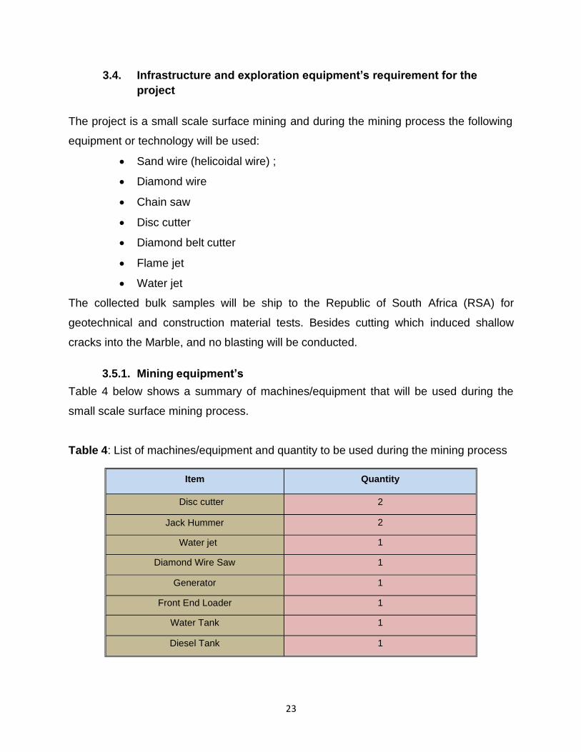
3.4. Infrastructure and exploration equipment’s requirement for the
project
The project is a small scale surface mining and during the mining process the following
equipment or technology will be used:
• Sand wire (helicoidal wire) ;
• Diamond wire
• Chain saw
• Disc cutter
• Diamond belt cutter
• Flame jet
• Water jet
The collected bulk samples will be ship to the Republic of South Africa (RSA) for
geotechnical and construction material tests. Besides cutting which induced shallow
cracks into the Marble, and no blasting will be conducted.
3.5.1. Mining equipment’s
Table 4 below shows a summary of machines/equipment that will be used during the
small scale surface mining process.
Table 4: List of machines/equipment and quantity to be used during the mining process
Item Quantity
Disc cutter 2
Jack Hummer
Water jet
Diamond Wire Saw
2
1
1
Generator 1
Front End Loader 1
Water Tank 1
Diesel Tank 1

24
3.5.2. On site Infrastructure requirements
a. Waste disposal infrastructure
Bins will be provided, and all litter will be disposed of at the nearest municipal dumping
site (i.e. Karibib Town Council Dumping site). Industrial waste will be mainly wire, cable,
drill bits, these items will be collected and removed from the sites. No unused machines,
part will remain on site. Chemical Toilets (Mobi Loo) will be erected on sites for the use
of the workers.
b. Electrical requirements
The area or sites have no access to the main electrical grid. Therefore during the mining
process, diesel generator will be used as a source of power. The diesel to be used on site
will be purchased from the nearby towns such as Karibib.
c. Road proposed
The B2 will be used for transportation of equipments to and from the site and also the
bulk samples collected for testing. To get to the site small stretches of roads will have to
be made from the main road to the mining claims site. The road length will be about +-
7km long to Fanuel Kharuxab Mining Claims.
3.5. Concluding remark on this section
In this section information on the rationale for the project, project location, geology of
the project location, and climate of the area were provided. Moreover, infrastructure that
will be needed for the project, and types and quantity of small scale mining equipments
were also described in this section. Human waste from the chemical toilets (Mobi loo) will
be dumped at Karibib Town Council Dumping site.

25
4. Legal and regulatory framework review
The national regulations governing prospecting and mining for dimension stone activities
in Namibia fall within the jurisdiction of the Ministry of Mines and Energy (MME). The
Minerals (Prospecting and Mining) Act (No 33 of 1992) is the most important legal
instrument governing the mining and prospecting industry in Namibia.
The Minerals (Prospecting and Mining) Act (No 33 of 1992) regulates reconnaissance
license, prospecting license and mining of minerals and dimension stone or rocks. The
Act details reporting requirements for monitoring of activities and compliance to
environmental performance, such as disposal methods and rehabilitation. The Mining
Commissioner, appointed by the Minister, is responsible for implementing the provisions
of this Act as well as the associated regulations such as the Health and Safety
Regulations. Several explicit references to the environment and its protection are
contained in the Minerals Act, which provides for environmental impact assessments,
rehabilitation of prospecting and mining areas and minimizing or preventing pollution.
4.1. Mineral Act of 1992 and the types of license it regulates
Below is an outline of the Mineral Act, linking the type of license it regulates, project
activities at every license stage and the environmental requirements are (Table 5).

26
Table 5: Types of license regulated by the Mineral Act of 1992, activities
and environmental requirements
Types of license
Exclusive Reconnaissance License
(ERL)
Activities
1. Project Identification,
2. Reconnaissance
Environmental Requirements
None Complete Environmental Questionnaire
Exclusive Prospecting
License
Exploration based on the following steps: Desktop study, Detailed Mapping,
Geophysical Methods, Drilling and Bulk
Sampling, Test a quarrying
Scoping Report, Environmental Impact
Assessment (EIA)
Mining License
Mining claims
Preconstruction and
Construction, Operation and, Ongoing Monitoring,
Decommissioning, Closure, Restoration and
Aftercare
Preconstruction and
Construction, Operation and, Ongoing Monitoring,
Decommissioning, Closure, Restoration and
Aftercare
Full Environmental Assessment ,covering, Scoping, Environmental Impact
Assessment(EIA) and the development of and Environmental Management Plan
(EMP)covering the complete project lifecycle including preconstruction, construction
operation and ongoing, decommissioning and aftercare. Aspects of the Environmental
Management Plan are usually incorporated into an Environmental Management Systems

27
4.2. Legal instrument relevant to this project
There are various legal instruments that advocates for the effects of small scale mining
on the environment. Table 6 below shows the summaries of the legislation that are
relevant to this project:
Table 6: Legal instruments relevant to this project
Topic Legislation Provisions Regulatory Authority
Small scale Marble Mining
Mineral (Prospecting and Mining) Act of 1992
The Minerals Act of 1990 governs minerals prospecting and mining. The Act provides for the reconnaissance license, prospecting license and mining for, and disposal of, and the exercise of control over minerals in Namibia.
Ministry of Mines and Energy
Environmental Impact Assessment
Water Supply and Effluent Discharge
Environmental Management Act of 2007 and EIA regulation of 2012
Water Resources
Management Act 2004
Provides list of activities that require an environmental assessment, including: Mining and Quarrying. Activities such as exploration or prospecting for minerals or dimension stone, mining for minerals or dimension stone. The Act also provides procedures for adequate public participation during the environmental assessment process for the interested and affected parties to voice and register their opinions and concern about a project.
This Act provides provisions for the control, conservation and use of water for domestic, agricultural, urban and industrial purposes.
The Act states that a license or permit is required to abstract and use water, and also discharge effluent.
In accordance with the Act, and due to the nature of the project, abstraction and use permits won’t be required for this project as on site water tank (500L) will be used. The capacity of the onsite tank is less than 20000m3 bench mark for water work permit.
Effluent (i.e. Human Waste) from the mobile toilet will be discharge at the karibib Municipality sewerage system. No effluent will be discharge in an water course. Waste water from dust suppression will be minimal and the water is expected to evaporate faster than it infiltrate. Therefore, no effluent discharge permits will be required for this project
Ministry of Environment and Tourism
Ministry of Agriculture Water and Forestry

28
Topic Legislation Provisions Regulatory Authority
Hazardous Substance such as used oil which (e.g. diesel)
Hazardous Substance Ordinance 14 of 1974
The Act provides for the control of substances which may cause injury or ill- health to or death of human beings by reason of their toxic, corrosive, irritant, strongly sensitizing or flammable nature or the generation of pressure thereby in certain circumstances; to provide for the prohibition and control of the importation, sale, use, operation, application, modification, disposal or dumping of such substance; and to provide for matters connected therewith”
Ministry of Health and Social Services
Fauna flora
and
The Nature
Conservation
Ordinance, Ordinance of 1975,
In the course of the Mine‘s activities, care must be taken to ensure that protected plant species and the eggs of protected and game bird species are not disturbed or destroyed. If such destruction or disturbance is inevitable, a permit must be obtained in this regard from the Minister of Environment and Tourism. For this project, due to it areal extend and location outside a protected area a permit will not be required.
Ministry of Environment and Tourism (MET)

29
Topic Legislation Provisions Regulatory Authority
Used oil
Petroleum Products and Energy Act 13 of 1990
The Act provides provisions for the any certificate holder or other person in control of activities related to any petroleum product is obliged to report any major petroleum product spill (defined as a spill of more than 200ℓ per spill) to the Minister. Such person is also obliged to take all steps as may be necessary in accordance with good petroleum industry practices to clean up the spill. Should this obligation not be met, the Minister is empowered to take steps to clean up the spill and to recover the costs thereof from the person. Used oil from this project will disposed at the Walvis Bay Municipality Hazardous Waste Site. Permission will be required from the facility owner prior to the dumping of the used oil.
Ministry of Mines and Energy
Employees
The Labour Act, 2007 (Act No. 11 of 2007)
The Labour Act gives effect to the constitutional commitment of Article 95 (11), to promote and maintain the welfare of the people. This Act is aimed at establishing a comprehensive labour law for all employees; to entrench fundamental labour rights and protections; to regulate basic terms and conditions of employment; to ensure the health, safety and welfare of employees
Ministry of Labour and social welfare
Archaeological
sites
National Heritage Act 27 of 2004 Ministry of Youth
This Act provides provisions for the protection and conservation of places and objects of heritage significance and the registration of such places and objects. The proposed exploration project will ensure that if any archaeological or paleontological objects, as described in the Act, are found in the course of its construction, mining operations or closure that such find be reported to the Ministry immediately. If necessary, the relevant permits must be obtained before disturbing or destroying any heritage.
National Service, Sport and
Culture
Desertification
United Nation Convention to Combat Desertification 1992
The convention objective is to forge a global partnership to reverse and prevent desertification/land degradation and to mitigate the effects of drought in affected areas in order to support poverty reduction and environmental sustainability
United Nation Convention

30
4.3. Regulatory authorities and permitting
The environmental regulatory authorities responsible for environmental protection and
management in relation to the proposed small scale mining project including their role in
regulating environmental protection are listed in Table 7. Table 7 below shows an extract
from the legal instruments of the regulating authorities with respect to the relevant permits/
licenses required for the proposed small scale surface mining project.
Table 7: The regulatory authority and permitting
Activities list
Small Scale Mining Programme
Applicable Legislation
Minerals (Prospecting and Mining) Act, 1992
Permitting Authority
Ministry of Mines and Energy
Current Status
Field Work to follow on issue of Environmental Clearance
EIA Clearance for Exploration
Environmental Policy and Environmental Management Act, (Act No. 7 of 2007)
Ministry of Environment and Tourism (MET)
To be applied on completion of this EIA and EMP Report for Exploration
EIA Clearance for Mining &
Mining Claims
Environmental Policy and Environmental Management Act, (Act No. 7 of 2007)
Ministry of Mines and
Energy
To apply if Economic Resources are Discovered and Project Advances to Feasibility and if the Feasibility Proves Positive
Topic Legislation Provisions Regulatory Authority
Convention on Biodiversity Biological Diversity
(CBD) 1992
This convention advocates for the conservation of biological diversity, the sustainable use of its components and the fair and equitable sharing of the
United Nation Convention
benefits arising out of the utilization of genetic resources.

31
Activities list Applicable Legislation
Permitting Authority
Current Status
Construction, alteration of waterworks with capacity to hold in excess of 20,000L. Abstraction of water other than that provided by Nam Water. Discharge of effluents or construction of effluent facility or disposal site
Water Resources Management Act, 2004 (No. 284 of 2004).
Ministry of Agriculture, Water and Forestry
To Apply when Required
Removal, disturbances or destruction of bird eggs
Nature Conservation Ordinance 4, 1975.
Nature Conservation Ordinance 4, 1975.
Removal, destruction of indigenous trees, bushes or plants within 100 yards of stream or watercourse
Forestry Act, 12 of 2001
Ministry of Water Affairs and Forestry (MWAF)
Discarding or disposing of used oil
Petroleum Products and Energy Act 13 of 1990
Ministry of Mines and Energy (MME).
To Apply when Required
Construction of waste Disposal sites.
License to Purchase, store
and use of Explosive
Magazines for Blasting
Environmental Policy and Environmental Management Act, (Act No. 7 of 2007)
Explosives Act 26 of 1956 (as amended in SA to
April 1978),
Ministry of Environment and Tourism (MET)
Ministry of Safety and
Security in
consultation with Ministry of Mines and Energy (MME).
4.4. Concluding remark on this section
In this section information on the relevant legislation to the project, the type of licenses
required and the permits were presented. The regulatory authorities relevant to the project
were also mentioned in this section.

32
5. Affected environment
5.1. General description of the project
The proposed project under Fanuel Kharuxab Mining Claims:
68366,68367,68368,68369,68370 and 68371 involves undertaking a small scale surface
mining for dimension stone in particular Marble. The overall aim of the project is to
evaluate for possible development of a viable quarry for Marble that may affect the
environment. The mineral groups that are targeted in this Mining Claims are dimension
stones in particular Marble.
Dimension Stone: In accordance with the provisions of Schedule 1, Groups of Minerals,
Elements and Rock (Section 1), Part 2 of the Minerals (Prospecting and Mining) Act,
1992, (Act No. 33, 1992), Dimension Stone Group include all rock material occurring
naturally in, on or under the earth which is capable of being cut, shaped or used in blocks,
slabs, sheets and tiles for the construction or cladding of buildings, paving, monuments
and memorials.
5.2. Social environment and archaeology
5.2.1. Social environment
According to Namibia Statistic agency, (2011), majority of the people in the area of Karibib
are heavily depended on dimension stone (i.e. Marble) industry for their livelihood. The
area (Karibib Town) has many small scale miners that operate mining for dimension stone
at small scale. Most of the small scale miners are previous disadvantage people.
Residents of Karibib Town are concerned about small miners selling their
exploration/mining license to foreigner investor due to lack of startup capital for potential
mining expansion. This could be seen as a threat and at the same time as an opportunity
in the sense that local miners could negotiated for shareholding agreement instead of
selling their licenses.

33
The report by Namibia Statistic agency, (2011) also revealed that the Karibib households
depend mainly on wages and salaries, farming, business or non-farming activities,
pension and cash remittance as their main income. About 58 % of the population depends
on wages and salaries. Only a small percentage depends on farming, which is the lowest
dependency in the area adding up to 6 % in the year 2011. About 9% of the population is
depended on business or non-farming activities (Namibia Statistic agency, 2011). The
dependency of the residents on pension only adds up 13% of the total population. The
other 7% depends on the cash remittance (Namibia Statistic agency, 2011). Comparing
to the Erongo region at large, the Karibib residence has the second highest
unemployment rate in the region after the Daures constituency with an unemployment
rate of 44% (Namibia Statistic agency, 2011). Karibib district is also one the constituency
with a high rate of no proper sanitation, ranking in second after the Daures constituency.
Therefore Karibib Town is in a crisis as far as employment, and thus development of the
town is concern. However, any developmental activity that is needed should not take
advantage of the unemployment situation in the Town at an expense of the environment
and thus sustainable developmental project are needed for this town.
It should also be noted that, the population of the Karibib Town is about 13 320, and the
town consist of only 9% of the Erongo Region population which is at 150 809 (Namibia
Statistics Agency, 2011). The population growth rate is only 1%, depicting a slow growth
rate which could be due to the little economic activities in the area to attract more
inhabitants. According to the statistics the labor force participation rate is at 76.3% in
Karibib, (Namibia Statistics Agency, 2011), were more men are economically active than
women.
It anticipated that this project will have little adversely negative impacts on the
communities living in Karibib and Usakos Towns, and nearby farms. Instead, the project
poses a significantly positive impact to the people living in the area such Karibib and
Usakos. The positive impacts are mainly, job creation, support to local retailers and
payment of export tax and VAT to the government of Namibia. The little negative

34
impacts identified are on the issues of health and safety of the employees, and the
potential spread of HIV/AIDS by the employees. Mitigation measures for the negatives
impacts and enhancement measures for positive impacts are all addressed in Section
7.4 of this document and in the EMP.
5.2.2. Archaeology
There are no archaeological sites within and outside the boundary of the mining claims.
The available archaeological sites are mainly rock arts. Rock arts are of historical
importance to the people it belongs to and the nation at large. These arts are protected
by laws in Namibia such as the National Heritage Act of 27 of 2004, hosted under the
Ministry of Youth. It’s widely spread that every project operating within an area where
there are lots of archeological sites is obliged not to destroy or temper with the sites.
Therefore, should their be existing rock arts located in the boundary where this project
will be operating should not be destroyed or tempered with during the duration of the
project. The mitigations measures for the protection of archeological sites are addressed
in Sub-section 7.4.3 of this document and the EMP.
5.3. Biophysical Environment
5.3.1. Geology
The geological set up within the two in Fanuel Kharuxab Mining Claims:
68366,68367,68368,68369,68370,68371is comprised of rock units from the Swakop
Group of the Damara Supergroup that was formed during the Damara Orogen. According
to Porada and Hill, (1974) majority of the marble occurrences within the Karibib District
are in favour of the white marble (Refer to figure 4) but there is also however the presence
of “fancy” marble (i.e. the red white- veined, yellowish-pink, grey, grey-banded marble) in
some parts of the area. Thus it can be said that the rocks are uncolored or banded, folded,
flamed or brecciated. Within the Fanuel Kharuxab Mining Claims:
68366,68367,68368,68369,68370 and 68371 there is the presence of white
homogeneous marble especially within the location of the target marble quarry and this
is an indication that the rock consists of pure calcite and/or dolomite.

35
Figure 4: Homogeneous marble within the Fanuel Kharuxab Mining Claims:
68366,68367,68368,68369,68370 and 68371as seen in a hand specimen
The marbles within the in Fanuel Kharuxab Mining Claims:
68366,68367,68368,68369,68370 and 68371 belong to the Karibib Formation which is
found within the Khomas Subgroup of the Swakop Group. The formation extends from
the Northern Zone (NZ) to the southern Central Zone (sCZ) of Namibia and despite a
broad similarity across this region it does however show considerable facies changes
between each of the NZ, nCZ and sCZ (Miller, 2008).
In terms of its composition, the Karibib formation consists chiefly of a thick succession
of dolomite marble with very subordinate intercalations of biotite-quartz schist. The
development of this formation varies considerably from place to place (Porada & Hill,
1974).

36
5.3.2. Biodiversity (fauna and flora)
The Fanuel Kharuxab Mining Claims: 68366,68367,68368,68369,68370 and 68371is
situated in the Namib Karoo and Western Highlands Savannah Biomes. In the Namib
Karoo Biome, tree cover is 2 to 10%, tree height is 2 to 5m, shrub height is 0.5 to 1m,
grass cover is 0.1 to 1% and grass height is >1.5m. The dominant vegetation in this
biome according to the ranking is acacia montis-ustii, acacia robynasiana, cyohostemma
currorii, africana, and calicorema capitiatia and orthanthyera albiadia (Mendelson, 2002).
The above mentioned vegetation hosted in the Namib Karoo Biomes are of medium
values.
In the Western Highlands Savannah Biomes, tree cover is 2 to 10%, tree height is 2 to
5m, shrub cover is 2 to 10%, and grass height is >0.1m. The dominant vegetation type
in this biome according to the ranking is acacia reficiens, euphorbia geuerichiana,
colophospermum mopane, maerua schinzii, and ademolobius garipensis (Mendelson,
2002).
Species number for mammals in the project area is about 61 to 71 species and the area
is ranked number 5 in terms of species sensitivity. The area has 75 species of biodiversity
compare to Zambezi Region at 120 and the Namib Desert at 9 species. Bird’s endemism
is ranked number 5 with 8 to 10 endemic species. The species of mammals are medium
sensitive in the project areas, therefore mitigation strategies are needed to protect these
species during the whole project phases.
5.3.3. Groundwater and surface water hydrogeology
The geologically situated on rocks of the Swakop Group in the Damara Supergroup.
The metamorphic rocks of the Swakop Group largely consist of less porous crystalline
schist and marble rock types. For that reason, the groundwater potential of the above
referenced mining claims site is closely associated with availability, nature, magnitude
and on the persistence of secondary geological structures like joints and fractures.

37
Supplementary to secondary geological structures, ephemeral stream channels with
alluvial deposits thicker than 15 m are important aquifers, particularly where the streams
are in cross cutting geometrical relationships with facture zones.
Therefore, it can be said that outside the major fracture zones, the Swakop Group is an
aquitard – referring to a geological formation that does not store or/and transport
groundwater. To illustrate this statement, Mukendwa (2013) rightfully concludes that the
Karibib Formation is not worth considering as an aquifer in the absence of fracture, this
is besides it being the most productive layer of the Swakop Group.
Locally, Karibib Formation (Figure 6) which consists of the Arises River Member (coarse
grained white calcitic marble beds), the Otjongema Member (Calc-silicate dolomitic
marble beds) and the Harmonie Member (Calc-silicate minor marble beds) is a source of
water supply to local settlements and towns. However, the hydraulic yield of the aquifer
is closely related to fracture storage, and is therefore highly variable and dependent on
annual recharge.

38
Figure 5: The Karibib Formation (Tordiffe, 2013)
Due to its carbonate nature, the Karibib Formation maintains good quality water with a
dominant calcium magnesium bicarbonate hydrochemical facie (Ca-Mg-HCO3).
Aquifer pollution vulnerability (APV)
The Namibian legal framework advocates and places stewardship responsibility on all
parties involved in activities which may have negative affect the environment, in this
regard particular reference is made to both the Water Act, Act No. 12 of 1956 and the
Environmental Act, Act No.7 of 2007 with respect to the cardinal responsibility of
protecting, preserving and sustainable use of water resources.

39
In recognition of these legal frameworks, the consultant has adopted the Aquifer
confinement Overburden and Depth to water table (AOD) index scheme to evaluate the
pollution vulnerability of the Karibib Formation Marble Aquifer.
Developed by Forster (1987), the AOD index scheme attempts to find the likelihood that
a contaminant loaded at the ground surface will reach the water table of an aquifer given
the nature of the aquifer, the nature and thickness of the aquifer’s overburden.
The AOD index presented in Table 4 is based on scales 1 to 10 of the Aquifer
confinement, the Overburden strata in the unsaturated zone of above the groundwater
strikes, and Depth to the water table in unconfined aquifers.
Table 8: The APV for the Karibib Marble Aquifer in Mining claim
Allocation ratings as inferred from borehole logs are multiplied with each other to
come up with AOD index. The indices reflect the following conditions:
• 0 – 150 Low APV
• 151 – 300 Moderate APV (Mod)
• 301 – 500 High APV
• >500 Extreme APV (Ext)
Borehole
Aquifer
Confinement
Overlaying
Strata Depth AOD APV
Place Coordinates
WWW (m)
Rating
(m)
Rating
(m)
Rating
IN
FANUEL
KHARUX
AB
MINING
CLAIMS
8960 3 9 4 8 14 8 441 HIGH

40
A primary appraisal of the Karibib Marble Aquifer for Aquifer Pollution Vulnerability (APV)
using the AOD index framework indicates that the aquifer is highly vulnerable to pollution,
therefore extra care, stewardship and site specific studies should be considered during
the Environmental Impact Assessment (EIA).

41
5.4. Potential impact identified
5.4.1. Positive impacts
• Employment creation
• Support to local retailers shops
• Export taxes and VAT payment
5.4.2. Negatives impacts
• Effect of oil spillage on groundwater and surface water
• Solid waste: wires, drill bites, and human waste
• Land and soil disturbance: on site and the proposed road
• Loss of biodiversity: fauna and flora
• Effect of dust that will be generated on-site
• Effect of the spread of HIV/AIDS & COVID -19
5.5. Concluding remark on this section
In this section the affected environment was described. The social and the
biophysical environmental information were provided and also the potential
positive and negative impacts of the project were identified.

42
6. Public consultation process
6.1. Legal and policy requirement
6.1.1. Environmental management act (2007) and it EIA regulations (2012)
Public consultation is a crucial part of the EIA process. This provides an opportunity to
stakeholders or interested member of the public to find out more about what is being
proposed, and to raise any issues or concerns. The Environmental Management Act
2007 and its EIA regulations of 2012 are the key documents governing environmental
impact assessment in Namibia.
One of the key objectives of the Act is to prevent and mitigate the significant effects of
activities on the environment by:
Ensuring that there are opportunities for timeous participation of interested and affected
parties throughout the assessment process; and ensuring that the findings of an
assessment are taken into account before any decision is made in respect of activities.”
The key principle of the Environmental Management Act 2007 advocates for public
participation. The principles states that “the participation of all interested and affected
parties must be promoted and decisions must take into account, the interest, needs and
values of interested and affected parties”.
Section 21 of the EIA Regulations outlines procedure on public participation process as
follows:
“(2).The person conducting a public consultation process must give notice to all potential
interested and affected parties of the application which is subjected to public consultation
by:
a) Fixing a notice board at a place conspicuous to the public at the boundary or on
the fence of the site where the activity to which the application relates is or is to be
undertaken;
b) Giving written notice to:

43
i. The owners and occupiers of land adjacent to the site where the activity is
or is to be undertaken or to any alternative site;
ii. The local authority council, regional council and traditional authority, as the
case may be, in which the site or alternative site is situated;
iii. Any other organ of state having jurisdiction in respect of any aspect of the
activity; and
c) Advertising the application once a week for two consecutive weeks in at least
two newspapers circulated widely in Namibia.
(3) A notice, notice board or advertisement referred to in sub regulation (2) must -
a) Give details of the application which is subjected to public consultation; and
b) State:
i. That the application is to be submitted to the Environmental Commissioner
in terms of these regulations;
ii. The nature and location of the activity to which the application relates;
iii. Where further information on the application or activity can he obtained:
and
c) The manner in which and the person to whom representations in respect of the
application may be made.
(6) When complying with this regulation, the person conducting the public
consultation process must ensure that a) information containing all relevant facts
in respect of the application is made available to potential interested and affected
parties; and b) consultation by potential interested and affected parties is facilitated
in such a manner that all potential interested and affected parties are provided with
a reasonable opportunity to comment on the application.
For the purpose of the Act and these regulations a notice is given to a person or
a person is informed of a decision, if a document to that effect is:
(a) Delivered personally to that person;
(b) Sent by registered post to the persons last known address;
44
(c) Left with an adult individual apparently residing at or occupying or employed
at the person’s last known address; or
(d) In the case of a business-
(i) Delivered to the public officer of the business;
(ii) Left with an adult individual apparently residing at or occupying or
employed at its registered address;
(iii) Sent by registered post addressed to the business or its public officer at
their last known addresses; or
(iv) Transmitted by means of a facsimile transmission to the person
concerned at the registered office of the business.”
6.2. Consultation process followed during the EIA process
Communication with stakeholders about the proposed small scale surface mining
project was facilitated through the following ways
• Identification of stakeholders
• Newspaper adverts
• Written notices
• Notice boards
• Information documents
• Stakeholder meetings via electronic remote were invited during the COVID
19 lockdown restriction
• Reasonable opportunity for the public to register and comment on the
project
45
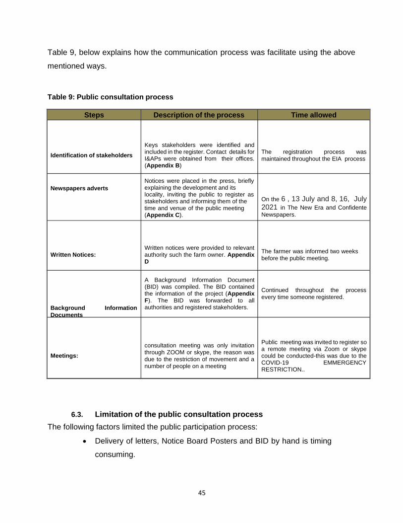
Table 9, below explains how the communication process was facilitate using the above
mentioned ways.
Table 9: Public consultation process
Steps Description of the process Time allowed
Identification of stakeholders
Keys stakeholders were identified and included in the register. Contact details for I&APs were obtained from their offices. (Appendix B)
The registration process was
maintained throughout the EIA process
Newspapers adverts
Notices were placed in the press, briefly explaining the development and its locality, inviting the public to register as stakeholders and informing them of the time and venue of the public meeting (Appendix C).
On the 6 , 13 July and 8, 16, July 2021 in The New Era and Confidente
Newspapers.
Written Notices:
Written notices were provided to relevant authority such the farm owner. Appendix D
The farmer was informed two weeks before the public meeting.
Background Information
Documents
A Background Information Document (BID) was compiled. The BID contained the information of the project (Appendix F). The BID was forwarded to all authorities and registered stakeholders.
Continued throughout the process
every time someone registered.
Meetings:
consultation meeting was only invitation through ZOOM or skype, the reason was due to the restriction of movement and a number of people on a meeting
Public meeting was invited to register so a remote meeting via Zoom or skype could be conducted-this was due to the COVID-19 EMMERGENCY RESTRICTION..
6.3. Limitation of the public consultation process
The following factors limited the public participation process:
• Delivery of letters, Notice Board Posters and BID by hand is timing
consuming.

46
• A physical meeting was not possible due to COVID -19 emergency law
restriction hence CENTRE FOR GEOSCIENCES RESEARCH encouraged
the use of electronic meeting once requested.
• Some stakeholders don’t have access to email or internet .
6.4. The interested and affected parties (I & AP’s)
There I&APs for this project were identified using information from the existing CENTRE
FOR GEOSCIENCES RESEARCH stakeholder database. Notices were placed in various
newspapers inviting the public to register as interested and affected parties.
Organizations were also selected whom the consultant considered to be interested in or
affected by this particular project. An I&APS can be defined as ‘(a) any person, group of
persons or organization interested in or affected by an activity; and (b) any organ of
state that may have jurisdiction over any aspect of the activity.
6.5. Outcome of the public engagement
The main issue that is drawn from the public participation is that the public were interested
in the project regardless of its magnitude, duration and the number of people to be
employed.
6.6. Key issues identified during the public engagement process
During the public participation process the following keys issues were identified:
• Rehabilitation of the site after mining
• Number of people to be employed in the project
• The duration of the EIA process
• The start of the mining or quarrying stage
• Management of waste both solid and liquid waste
• Safety measures in place for employees
The identified keys issues during the public participation process together with the issues
identified in section 5.5 above were assess for potential impacts in section 7 below.

47
6.7. Concluding remark on this section
In this section, issues on public participation process such as steps or methods that were
followed, process, the outcome of the public participation process, and key issues
identified were presented. Moreover the legality patterning to public participation was also
presented.

48
7. Impact assessment
7.1. Identification of key issues
Potentially significant impact identified from the baseline conditions, legal requirement,
and public participation process were screened to obtain issues that require further
investigation or assessment and those that doesn’t required further investigation. The
process shown in the flow chart below was used for the screening of potential issues.
Table 12 below, shows the screening of the identified impact using the flow chart.
No further
investigatio
n required
EIA and EMP
Further
investigation
required and
carried over
to full
assessment
(EIA)
Issues
within the
scope of
the project
and
proponent
responsibili
ty
Sufficient
information to
assess the
impact
Yes
Insufficient
information
to assess
the impact
Key issue
identified
No
Issues discussed
with the relevant
authority The end of
discussion or
closure
49
Table 10: Process of determining the key impacts resulting from certain aspects of the
proposed small scale surface mining for marble.
Environmental
feature
Surface water
and ground
water
Potential
impacts of
project feature
Contaminants of
construction
process (e.g. oil
spills etc)
Effluent
discharge from
mobile toilet
Contaminants
resulting from
the presence of
construction
workers
Key impact
Deterioration of
groundwater
quality
Degree of
sensitivity
Medium
sensitivity
Low sensitivity
Low sensitivity
Issue addressed in
Addressed in sub-
section:7.3.1. and
EMP
Addressed in EMP
Addressed in EMP
Fauna
Destruction of
flora
(vegetation)
could result in
the loss of
faunal
biodiversity
Loss of faunal
biodiversity
Medium to Low
sensitivity
Addressed in sub-
section:7.3.2. and
EMP
Flora
Removal or
damage to
vegetation could
result in loss of
biodiversity and
habitat destruction
Damage or
destruction of
protected or
high use value
trees, shrubs or
Loss of
biodiversity
Habitat
destruction
Loss of
protected or
high use value
flora
Medium to Low
sensitivity
Medium to Low
sensitivity
Addressed in sub-
section:7.3.2. and
EMP
Addressed in sub-
section:7.3.2. and
EMP

50
Environmental
feature
Potential
impacts of
project feature
Key impact
Degree of
sensitivity
Issue addressed in
Employment or
job creation
Permanent job
creation for local
people
Medium
sensitivity
Addressed in sub-
section:7.4.1. and
EMP
Social Economic
Environment
Support to local
retailers shops
and Export
taxes and VAT
payment
Potential spread
of HIV/AIDS &
COVID-19
Contribute to the
Karibib Town
economic
growth and the
nation at large
Spread
Low sensitivity
High sensitivity
Addressed in sub-
section:7.4.1. and
EMP
Addressed in sub-
section:7.4.2. and
EMP
Archaeology
Disturbance or destruction of archaeological
sites as a result of earthmoving operations
(construction) and accelerated soil
erosion (operation).
Damage to
existing or
undiscovered
archaeological
sites in the area
High sensitivity
Addressed in sub-
section:7.4.3. and
EMP
Solid waste
Dust on site and
gravel road
During mining
solid waste such
as drill bites,
plastic, and wire
will be
generated on
site
During mining or
removal of
marble block
dust will be
Damage to the
surrounding
environment
Effect the
employees and
wellbeing
Medium
sensitivity
Medium
sensitivity
Addressed in sub-
section:7.5 and
EMP
Addressed in sub-
section:7.3.3 and
EMP

51
Environmental
feature
Potential
impacts of
project feature
Key impact Degree of
sensitivity Issue addressed in
generated
Disturbance on
soil or land
During mining
top soil will be
removed to
access the
marble
Losses of top
soil that support
vegetation
growth
Addressed in sub-
High sensitivity section:7.6. and
EMP

52
7.2. Methodology used or adopted for the impact assessment
The assessment process that was developed by CENTRE FOR GEOSCIENCES
RESEARCH was formulated based on the collection and interpretation of the available
literature pertaining to the dimension stone field in particular marble. The process
included the review of previous EIA’s and EMP’s done in the surrounding areas and those
about dimension stone in Namibia. Other relevant documents were identified and
collected including:
• Environmental regulations covering environment, water, energy, health and
safety as well as all the related policies and guidelines;
• Mining regulations and all the related introductory information obtained from
the Office of the Mining Commissioner in the Ministry of Mines and Energy;
• Topographic maps, information and data sets about the location and
characteristics of claim.
• Information and data sets about the environmental regulation, biodiversity,
social economic and natural environment around the in Fanuel Kharuxab
Mining Claims: 68366,68367,68368,68369,68370,68371 obtained from the
Directorate of Environmental Affairs in the Ministry of Environment and
Tourism; Namibia Statistic agency.
• Information and data sets about the regional and local geology, geological
maps and all the related data sets, published materials and open file
documents have all been located in the Directorate of the Geological Survey
in the Ministry of Mines and Energy;
53
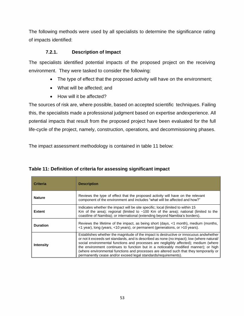
The following methods were used by all specialists to determine the significance rating
of impacts identified:
7.2.1. Description of Impact
The specialists identified potential impacts of the proposed project on the receiving
environment. They were tasked to consider the following:
• The type of effect that the proposed activity will have on the environment;
• What will be affected; and
• How will it be affected?
The sources of risk are, where possible, based on accepted scientific techniques. Failing
this, the specialists made a professional judgment based on expertise and experience. All
potential impacts that result from the proposed project have been evaluated for the full
life-cycle of the project, namely, construction, operations, and decommissioning phases.
The impact assessment methodology is contained in table 11 below:
Table 11: Definition of criteria for assessing significant impact
Criteria Description
Nature Reviews the type of effect that the proposed activity will have on the relevant component of the environment and includes “what will be affected and how?”
Extent Indicates whether the impact will be site specific; local (limited to within 15 Km of the area); regional (limited to ~100 Km of the area); national (limited to the coastline of Namibia); or international (extending beyond Namibia’s borders).
Duration
Intensity
Reviews the lifetime of the impact, as being short (days, <1 month), medium (months, <1 year), long (years, <10 years), or permanent (generations, or >10 years).
Establishes whether the magnitude of the impact is destructive or innocuous and whether or not it exceeds set standards, and is described as none (no impact); low (where natural/ social environmental functions and processes are negligibly affected); medium (where the environment continues to function but in a noticeably modified manner); or high (where environmental functions and processes are altered such that they temporarily or permanently cease and/or exceed legal standards/requirements).
54
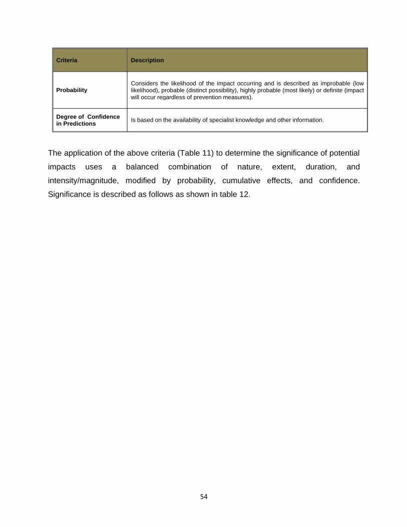
The application of the above criteria (Table 11) to determine the significance of potential
impacts uses a balanced combination of nature, extent, duration, and
intensity/magnitude, modified by probability, cumulative effects, and confidence.
Significance is described as follows as shown in table 12.
Criteria Description
Probability Considers the likelihood of the impact occurring and is described as improbable (low likelihood), probable (distinct possibility), highly probable (most likely) or definite (impact will occur regardless of prevention measures).
Degree of Confidence in Predictions
Is based on the availability of specialist knowledge and other information.
55
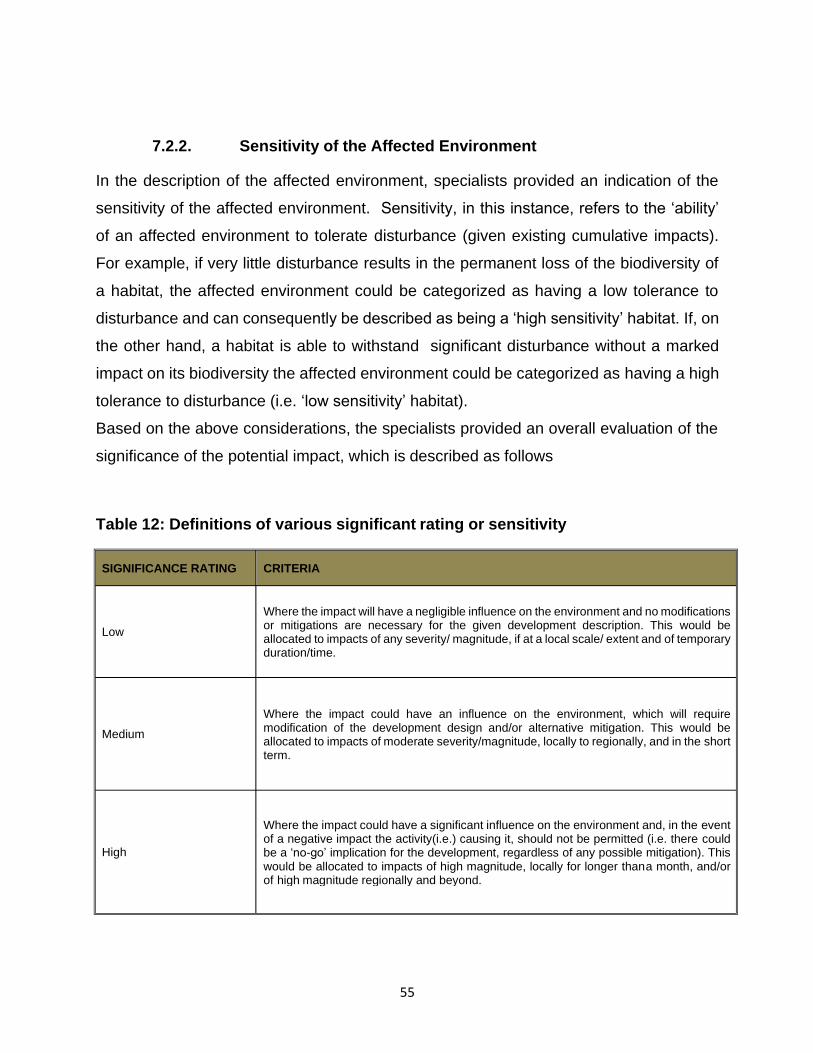
7.2.2. Sensitivity of the Affected Environment
In the description of the affected environment, specialists provided an indication of the
sensitivity of the affected environment. Sensitivity, in this instance, refers to the ‘ability’
of an affected environment to tolerate disturbance (given existing cumulative impacts).
For example, if very little disturbance results in the permanent loss of the biodiversity of
a habitat, the affected environment could be categorized as having a low tolerance to
disturbance and can consequently be described as being a ‘high sensitivity’ habitat. If, on
the other hand, a habitat is able to withstand significant disturbance without a marked
impact on its biodiversity the affected environment could be categorized as having a high
tolerance to disturbance (i.e. ‘low sensitivity’ habitat).
Based on the above considerations, the specialists provided an overall evaluation of the
significance of the potential impact, which is described as follows
Table 12: Definitions of various significant rating or sensitivity
SIGNIFICANCE RATING CRITERIA
Low
Where the impact will have a negligible influence on the environment and no modifications or mitigations are necessary for the given development description. This would be allocated to impacts of any severity/ magnitude, if at a local scale/ extent and of temporary duration/time.
Medium
Where the impact could have an influence on the environment, which will require modification of the development design and/or alternative mitigation. This would be allocated to impacts of moderate severity/magnitude, locally to regionally, and in the short term.
High
Where the impact could have a significant influence on the environment and, in the event of a negative impact the activity(i.e.) causing it, should not be permitted (i.e. there could be a ‘no-go’ implication for the development, regardless of any possible mitigation). This would be allocated to impacts of high magnitude, locally for longer than a month, and/or of high magnitude regionally and beyond.

56
7.2.3. Mitigation and Enhancement Measures
Where negative impacts are identified, mitigation objectives have been set, and practical,
attainable mitigation measures must be recommended that will minimise or eliminate the
impacts. Where mitigation is not feasible, this has been stated and reasons given. In the
case of positive impacts, enhancement measures are recommended for optimizing the
benefit to be derived.
7.2.4. Monitoring
Monitoring requirements with quantifiable standards to assess the effectiveness of
mitigation actions have been recommended where appropriate. These must indicate what
actions are required, by whom, and the timing and frequency thereof. If further
investigations must be undertaken and monitoring programmes implemented before,
during and after operations, these have been recommended.
7.3. Biophysical Environment
7.3.1. Impact of oil spills on groundwater aquifer and surface water
streams
7.3.1.1. Description
The dimension stone mining industry or quarrying is a clean industry from a pollution point
of view. Various environmental impact assessments conducted identified petrochemical
pollution emanating from this industry as the most serious threat in this regard, and in
order to maintain the record as a clean industry, this threat is taken very seriously.
There are various waste disposal methods used worldwide in mining industry or
dimension stone in particular marble. Management of used oil at a large scale is reported
to be a challenge as more significant maintenance is required to minimise the losses of
the oil into the environment (Richards, 2009). Used oil once it spill, it causes

57
detrimental effect to both living and none living things and more especially to groundwater
because it’s chemical constituents are poisonous. The oil coats and clings to every rock
and grain of sand. Sometimes if the oil washes into coastal marshes, mangrove forests
or other wetlands, fibrous plants and grasses absorb the oil, which can damage the
plants and make the whole area unsuitable as wildlife habitat.
7.3.1.2. Sensitivity of the affected environment
Table 13: Expected significance of the project on liquid waste
7.3.1.3. Mitigation and enhancement measures
• Train and supervise staff to ensure minimal spillage of oil.
• Routine inspections before the start of every work schedule involving
potential spillage.
• Old oil is collected and stored, and is sold to recycling companies.
• Equip the quarry site with emergency petrochemical spillage kits which
are used such events as hydraulic pipes bursting in service and spilling oil.
• Bio-remediate contaminated soil using proprietary products kept on sites
for the purpose. The process of bio-remediation involves loosening the
Criteria
Extent
Impact of oil spills on groundwater aquifer and surface water streams
local
Duration permanent
Intensity high
Probability definite
Significance before mitigation High
Significance after mitigation Medium
Degree of confidence in predictions high

58
contaminated soil to allow for oxygen penetration. Transported
contaminated soil to a specific impervious site for treatment to avoid
compaction during the process, and adding agricultural fertilizer and the
proprietary products containing appropriate microbes to break down the
hydrocarbons.
7.3.1.4. Monitoring
• Daily visual monitoring by site manager.
• Weekly spot checks by environmental manager
7.3.2. Loss of Fauna and Flora diversity
7.3.2.1. Description
Biodiversity (i.e. fauna and flora) is likely to be affected by the project during the mining
or quarrying process. But due to the size and duration of the project, the impact is
manageable.
The types of vegetation found in this area are classified in medium value category. In
addition to vegetation various invertebrates also host the area. Regardless of the low
value of the existing vegetation on site and along the road, activities that will be
undertaken during the mining process is likely to have an effect on the vegetation and the
invertebrates thereof. Therefore management measures will be considered to minimize
the above impacts.

59
7.3.2.2. Sensitivity of the affected environment
Table 14: Expected significance of the project on Biodiversity: fauna and flora
7.3.2.3. Mitigation and enhancement measures
• Avoid damage to protected or high use value trees during mining and usage of
heavy machines.
• Disturbance of marginal vegetation at the mountains should be limited.
• Avoid disturbance on invertebrate on site and along the gravel road stretch.
• During operation avoid the creation of multiples roads strips, which could result in
the disturbance of breading sites for various mammals.
7.3.2.4. Monitoring
An ENC for Fanuel Kharuxab should accompany drivers or heavy machine operator so
that the avoidance of trees and vegetation can be optimized. Other rules in the EMP to
avoid vegetation destruction should be monitored monthly.
7.3.3. Dust generation on site
7.3.3.1. Description
During the quarrying process dust will be generated onsite by earth moving equipment
and also on the gravel road by trucks and vehicles. On site, marble blocks will be cut into
smaller blocks in order to give them the desired smooth shape. During the cutting
Criteria Biodiversity: fauna and flora
Extent local
Duration long
Intensity medium
Probability definite
Significance before mitigation high
Significance after mitigation medium
Degree of confidence in predictions high

60
process about 25% the original marble mass is lost in the form of dust. In addition,
processing of marble results in the formation of marble dust, which is suspended in the air
and which could be inhaled by the workers. Epidemiological studies indicates that workers
exposed to marble dust stand an increased risk of suffering from asthma symptoms,
chronic bronchitis, nasal inflammation and impairment of lung function (Camici et al.,
1978; Angotzi et al., 2005; Leikin et al., 2009). In their study they found out that, the
affected workers were having body problems like headache, backache and stressed due
tounder- payment (Dagli et al., 2008). Individuals who were having papilloma have faced
problem at work like noise, dust or fumes and poor maintenance of equipment (Dagli et al.,
2008). Moreover, their data also demonstrated that long period of chronic exposure to
dust induced progressive atrophic changes in the alveoli (Gammal et al, 2011). Therefore,
there are some potential risk of dimension stone industry on the environmental, which
requires attention, mitigations, and management to protect the existing human and animal
health.
It is globally known that the generated dust during mining operations of marble may affect
human, plant and animal growth at the surrounding environment (Kirjoitettu, 2014).
Exposure between 10 and 15 years is associated with the long term complication, while
the short term complication can cause difficulty in breathing” (Kirjoitettu, 2014). The
reaction depends on the particle inhaled, as the lung is too exposed to expel particles
beyond 10 micro meters (Haruna, 2014). With the inherent natural mechanism of its
defence, the lung is supposed to be able to expel such amount of particles but sizes below
one to 10 millimeter (mm) can go down to the terminal end of the lung and the
macrophages may not be able to expel that (Haruna, 2014). To avoid respiratory or other
problems caused by exposure to dust, engineering control methods such as those
highlighted in the mitigation measures below and the use of tools that minimized the
generation of dust should be introduced.

61
7.3.3.2. Sensitivity of the affected environment
Table 15: Expected significance of the project on dust generated on site
Criteria Soil or land disturbance:
Extent local
Duration long to permanent
Intensity medium
Probability definite
Significance before mitigation high
Significance after mitigation medium
Degree of confidence in predictions high

62
7.3.3.3. Mitigations and enhancement measures
• Measures such as the use of wet processes enclosure of dust-producing
processes under negative air pressure (slight vacuum compared to the air
pressure outside the enclosure),
• Exhausting air containing dust through a collection system before emission
to the atmosphere, and exhaust ventilation should be used in the workplace.
• Use of personal protective equipment for proper dust control for respiratory
protection and should be used only where dust control methods are not yet
effective or are inadequate.
• Direct skin contact should be prevented by gloves, wearing respiratory
protection during cleanup,
• Educational awareness programs for workers should be instituted about
hazard of exposure to marble dust and on the use and maintenance of
exhaust ventilation systems, and the use and maintenance of personal
protective equipment to avoid risk of dust and noise.
• All gravel roads in quarry areas should have a speed limit of 60km/h for light
vehicles and 30km/h for heavy vehicles in order to minimise the amount of
dust generated by vehicles.
• In addition, where available water allows, roads should be sprayed with
water on a regular basis in order to prevent dust creation.
7.3.3.4. Monitoring
• Daily inspection by the ENC of the gravel roads and quarry site on possible
dust creation that requires attention.

63
• Daily inspection on site by the ENC to ensure that all workers are wearing
their protective clothes at all time during the mining process and the dry skin
contact with gloves is prevented.

64
7.4. Social Economic Environment
7.4.1. Job creation
7.4.1.1. Description
According to the Social Impact Assessment study by Anna, (2014), the employment rate
in Karibib has reduced from 71% in 2001 to 59% in 2011 while the unemployment
increased from 29% in 2001 to 41% in 2011. Comparing to the Erongo region at large,
the Karibib residence has the second highest unemployment rate in the region after the
Daures constituency with an unemployment rate of 44%. Karibib district is also one of the
constituencies with a high rate of no proper sanitation, ranking in second after the Daures
constituency.
It is clear that unemployment is big challenge in the Town of Karibib; hence the necessity
of this project which will employ about 12 to 15 people during the mining phase. The
employment will be conducted in the company’s offices which will be opened in the Town
of Karibib once mining has begun, the local authority will be contacted if assistance is
needed during the employment process in order to ensure that the local inhabitants can
get the full benefit.
It should be noted that the use of manual labour instead of mechanized
construction methods, does pose some advantages and disadvantages:
Advantages:
• If locals are used, housing will be available nearby,
• Contribution to local economy – reducing unemployment,
• Development of local skills,
• Smaller ecological footprint.

65
Disadvantages:
• It might increase the costs of the project impacting on the affordability of
water;
• It will take longer to complete than if the processed in mechanized;
• The safety risk resulting from open trenches will become bigger;
• It will require a greater management of workforce, quality of work.
7.4.1.2. Sensitivity of the affected Environment
By implementing the mining or quarry project the socioeconomic significance of
Fanuel Kharuxab can be summarized as follows:
Table 16: Expected significance of the project on social economic
implications
Criteria Social economics implications
Extent local
Duration long to permanent
Intensity medium
Probability definite
Significance before mitigation high
Significance after mitigation low
Degree of confidence in predictions high

66
7.4.1.3. Mitigation and enhancement measures
• Where unskilled labour can be used, a ‘locals first’ policy should be
considered.
• It is proposed that local people, meaning the community members from
Karibib Town, should be employed as far as possible, especially where no
specific skills are required.
• The Karibib Town Councilor could be requested to assist with the
recruitment of construction workers.
• Both men and women should be granted the opportunity to be employed by
this project.
7.4.1.4. Monitoring
It is recommended that Fanuel Kharuxab Mining Manager should employee
workers to be obtained from the potentially affected communities in particular
Karibib Town. Fanuel Kharuxab in consultation with the Karibib Town Councilor
will then be responsible to supervise the employment process when implementing
this ‘local’s first’ recommendation.
7.4.2. Potential spread of HIV/AIDS
7.4.2.1. Description
In the proposed project area, it is estimated that one out of every four people are
HIV positive. (Anna, 2014) Previous experience has shown that construction
workers or mining workers residing in a construction camp may engage in risky
sexual behaviour with members of the community. This can contribute to the
spread of HIV both in the project area and beyond to other region.

67
7.4.2.2. Sensitivity of the affected environment
Table 17: Expected significance of the project on the spread of HIV/AIDS
7.4.2.3. Mitigation and enhancement measures
Fanuel Kharuxab , ENC should sensitize the risks of sexual behaviour, and also
the effects of HIV/AIDS to its employees. Workers should be prohibited to engage
in such activities with especially minors. Mitigation measures as outlined in the
EMP should be adhered to.
7.4.2.4. Monitoring
The ENC should report back to Fanuel Kharuxab as to when and how the workers
received HIV training. Also, how workers were informed about the mitigation
measures of the EMP.
7.4.3. Disturbance or destruction of archaeological sites
7.4.3.1. Descriptions
The mining activities may partially or completely destroy some small
archaeological sites found within and outside the boundary of the mining are.
Criteria Contribution to the spread of HIV/AIDS
Extent national
Duration permanent
Intensity serious effect
Probability definite
Significance before mitigation high
Significance after mitigation medium
Degree of confidence in predictions high

68
These archaeological sites are rock arts and are associated with the sun people
tribe. Their archaeological significance is low to medium. It is also likely that some
damage will occur outside the immediate project area through the establishment
of access roads and contractor’s lay-down areas. Some cumulative impacts can
be expected during operation and decommissioning.
7.4.3.2. Sensitivity of the affected environment
Table 18: Expected significance of the project on archaeological sites
7.4.3.3. Mitigation and enhancement measures
• The records obtained during this fieldwork are considered adequate and
no further work is needed.
7.5. Solid waste: wires, drill bits, and human waste
7.5.1. Descriptions
Solid waste management is a problem in the mining industry or quarrying industry,
and sometimes this problems extent beyond the mining industry. In the mining
industry or exploration industry, different types of solid waste are generated and
some of these wastes contain toxic substance that can affect
Criteria
Extent
Contribution to the spread of HIV/AIDS
local
Duration permanent
Intensity serious effect
Probability definite
Significance before mitigation medium
Significance after mitigation Low
Degree of confidence in predictions high

69
living and non-living things. Therefore proper handling and management of these
wastes is critical for the protection of the environment.
Solid waste that will be generated from this project if not managed will have an
effect on the environment. The effect will mainly be at the project site. Human
waste that will be generated during the exploration process, if not managed will
have an effect on the environment although at a small scale.
7.5.2. Sensitivity of the affected environment
The significance of the identified problem to the study can summarise as follows:
Table 19: Expected significance of the project on solid waste
7.5.3. Mitigation and enhancement measures
Waste disposal sites should established on site were paper, plastic and wire should
be kept. The collected solid waste should be dispose at the Town of Karibib soil
waste disposal site. For human waste, mobile toilet should be made available on
site for workers and once these facilities are full, the collected human waste should
be disposed at the Karibib Town human waste disposal site. Prior to the disposal
of the above mentioned wastes Fanuel Kharuxab must entered into agreement
with the Karibib Town for permission to use their facility.
Criteria Solid waste :
Extent local
Duration short
Intensity low
Probability definite
Significance before mitigation medium
Significance after mitigation low
Degree of confidence in predictions high

70
7.5.4. Monitoring
• Weekly inspection by the ENC, to collect and empty the plastic bag that
are full and also the mobile toilet.
7.6. Land or soil disturbance: on site and the proposed 23km stretch
road
7.6.1. Descriptions
During the exploration process, land or soil will be disturb both on site and along
the proposed stretch road of about 23km linking the project site to the D1918 road.
Top soil will be removed on the surface rocks during the drilling to recover the slabs
needed for testing. The removed top soil during drilling if not properly management
will affect the growth of vegetation and the development biodiversity hiding or
resting spots.
7.6.2. Sensitivity of the affected environment
The significance of the identified problem to the study can summarize as follows:
Table 20: Expected significance of the project on soil or land disturbance
7.6.3. Mitigation and enhancement measures
The top soil from 0 to 30cm to removed and stockpile and to be used during the
rehabilitation process. The stockpile will seeded with seeds of grasses and shrubs
to keep organic activity alive, as well as ensure a fertile seed bank in the topsoil
when it is finally used. It is recommended that top soil to be removed
Criteria Soil or land disturbance:
Extent local
Duration permanent
Intensity serious affected
Probability definite
Significance before mitigation high
Significance after mitigation medium
Degree of confidence in predictions high

71
down to the subsoil, where it is significantly thicker than 0.5m, as topsoil is always
a scarce resource, and even if this lower material does not contain seed and is
poorer in soil organisms, it has been found to be useful in reclamation. Where top
soil is less than 150mm thick the unconsolidated material beneath should also be
removed and treated as topsoil.
7.6.4. Monitoring
• Daily inspection by ENC to ensure that top soil is removed and stock pile
on site.
7.7. Concluding remark on this section
In this section the identified impact were screened and assessed. The mitigation
measures of the identified impact will be addressed in the Environmental
Management Plan (EMP) report.

72
8. Conclusion and recommendations
8.1. Conclusion
The FANUEL KHARUXAB is in the Karibib District in Erongo Region. The mining
claims lies outside the National Park. The implementation of the proposed small
scale surface mining project by Fanuel Kharuxab will be undertaken with provisions
of the EIA regulation of 2012. Based on the assessment of both negative and
positive impacts undertaken for the proposed small scale surface mining project,
a number of high positive and negative impacts have been identified. Overall,
positive impacts of the proposed small scale surface mining project activities
outweigh the negative ones at local, regional, nation and global levels.
It is therefore concluded that all significant impacts identified during this
Environmental Impact Assessment can be mitigated through management actions
implemented during construction and operation. It is important that the
Environmental Management Plan developed for the project be implemented during
construction and operation otherwise the impacts identified will remain
unacceptable.
8.2. Recommendations
Based on the findings of this Environmental Assessment Study, it is recommended
that the proposed small scale surface mining project receive an Environmental
Clearance provided that an Environmental Plan be implemented.

73
9. References
o Ashmole, I,. (2004). “Dimension Stone: The Small Scale Mining Potential in South Africa”, Paper presented at Small Scale Mining, Johannesburg.
o Barnard, P. (1998). Under protected habitats. In: Barnard, P. (ed.). Biological diversity in Namibia: a country study. Windhoek: Namibian National Biodiversity Task Force.
o Bester, B. (1996). Bush encroachment – A thorny problem. Namibia Environment 1: 175-177.
o Bethune, S., Shaw, D. & Roberts, K.S. (2007). Wetlands of Namibia. John Meinert Printing,Windhoek.
o Biological diversity in Namibia: a country study. Windhoek: Namibian National Biodiversity Task Force.
o Boycott, R.C. & Bourquin, O.(2000). The Southern African Tortoise Book. O Bourquin, Hilton, RSA..
o Branch, B. (1998). Field guide to snakes and other reptiles of southern Africa. Struik Publishers, Cape Town, RSA.
o Branch, B. (2008). Tortoises, terrapins & turtles of Africa. Struik Publishers, Cape Town RSA.
o Broadley, D.G. (1983). Fitzsimons‘ Snakes of southern Africa. Jonathan Ball & AD. Donker Publishers, Parklands, RSA.
o Brown, C.J., Jarvis, A., Robertson, T. & Simmons, R.(1998). Bird diversity. In: Barnard, P.(ed.). Biological diversity in Namibia: a country study. Windhoek: Namibian National Biodiversity Task Force.
o Burke, A. (1998). Vegetation zones. In: Barnard, P. (ed.). Biological diversity in Namibia: a country study. Windhoek: Namibian National Biodiversity Task Force.
o Burke, A. (2003). Wild flowers of the Central Namib. Namibia Scientific Society, Windhoek.
o Buys, P.J. & Buys, P.J.C. (1983). Snakes of Namibia. Gamsberg Macmillan Publishers, Windhoek, Namibia.
o Carruthers, V.C. (2001). Frogs and frogging in southern Africa. Struik Publishers, Cape Town, RSA.
o Carvalho, J.F., Henriques, P., Fale, P., Luis, G.,. (2008). “Decision criteria for the exploration of ornamental-stone deposits: Application to the marbles of the Portuguese Estremoz Anticline”, International Journal of Rock Mechanics and Mining Sciences.
o Channing, A. & Griffin, M. (1993). An annotated checklist of the frogs of Namibia. Madoqua 18(2): 101-116.
o Channing, A. (2001). Amphibians of Central and Southern Africa. Protea Bookhouse, Pretoria, RSA.
o Coats Palgrave, K. (1983). Trees of Southern Africa. Struik Publishers, Cape Town, RSA.

74
o Curtis, B. & Barnard, P. (1998). Sites and species of biological, economic or archaeological importance. In: Barnard, P. (ed.). Biological diversity in Namibia: a country study. Windhoek: Namibian National Biodiversity Task Force.
o Curtis, B. & Mannheimer, C. (2005). Tree Atlas of Namibia. National Botanical Research Institute, Windhoek, Namibia.
o De Graaff, G. (1981). The rodents of southern Africa. Buterworths, RSA. o De Lukas, M, Janss, G.F.E., Whitfield, D.P. & Ferrer, M. (2008). Collision
fatality of raptors in wind farms does not depend on raptor abundance. Journal of Applied Ecology 45(6): 1695-1703.
o Department of Water Affairs (DWA). (2002). The hydrogeological map of Namibia
o Du Preez, L. & Carruthers, V. (2009). A complete guide to the frogs of southern Africa. Struik Publishers, Cape Town, RSA.
o Electricity Control Board (ECB).(2009), Annual Report, Windhoek, Namibia. o IUCN,.(1996). IUCN red list of threatened animals, IUCN, Gland,
Switserland. o IUCN. (2004). IUCN, Gland, Switserland. In: Griffin, M. 2005. Annotated
checklist and provisional national conservation status of Namibian mammals. Ministry of Environment and Tourism, Windhoek.
o Joubert, E. & Mostert, P.M.K. 1975. Distribution patterns and status of some mammals in South West Africa. Madoqua 9(1): 5-44.
o Kisting, J., 2008. Opportunities in the renewable energy sector in Namibia, Baobab Equity Management (Pty) Ltd, Windhoek, Namibia
o Mendelson, J., Jarvis, A., Roberts, C., and Robertson, T. (2002). Atlas of Namibia: A portrait of the land and its people. Windhoek, Namibia: Ministry of Environment and Tourism.
o Miller ,R. (2008).The geology of Namibia, neoproterozoic to lower palaeozoic
o Miller, R. McG., (1983a). The Pan – African Damara Orogen od S.W.A. / Namibia, Special Publication of the Geological Society of South Africa, 11, 431 - 515.
o Miller, R. McG., (1983b). Economic implications of plate tectonic models of the Damara Orogen, Special Publication of the Geological Society of South Africa, 11, 115 -138.
o Miller, R. McG., (1992). Stratigraphy. The mineral resource of Namibia, Geological Survey of Namibia, Ministry of Mines and Energy, Windhoek, 1.2 .1 -1.2.13.
o Ministry of Environment and Tourism. Republic of Namibia. (2008). Guide to the Environmental Management Act No. 7 of 2007. 56 pp
o Ministry of Environment and Tourism. Republic of Namibia. (2012). Environmental Impact Assessment Regulation: Enviromnental Management Act, 2007. Government Gazette No.4878.
o NamPower, 2010. Network Map (www. nampower.com.na) – Retrieved on 06th February 2014.

75
o NamWater.(1998).The hydrogeological conceptual model of the Omaruru Delta (OMDEL).
o Ransom, A. H., (1981). Interim Report on Prospecting Grant No. M46/3/758 – Tumas Project No. 53 - Namib Desert Park – Namibia, Period April 1978 - April 1981, Falconbridge of S.W.A. (PTY) LTD, Bulletin No. 2267 (Annex 4).
o Republic of Namibia. (2005). Namibia‘s Environmental Assessment Policy for Sustainable Development and Environmental Conservation.
o Republic of Namibia. (2007). Environmental Management Act No. 7 of 2007. Government Gazette No. 3966.
o Richards, J.P. (2009).Mining society and a sustainable world. Springer, New York.
o Risk Based Solution. (2011). Final EIA and EMP for the proposed exploration and possible testing a mine for the MINING CLAIMSno-4458, Karas Region. Swedish Exploration.
o SARDB, 2004. CBSG Southern Africa. In: Griffin, M.( 2005). Annotated checklist and provisional national conservation status of Namibian mammals. Ministry of Environment and Tourism, Windhoek.
o Shadmon, A,. (1993). “Dimension Stone - its Impact on environment and constructional applications the role of engineering geology”, Bulletin of the International Association of Engineering Geology, No 48, pp 119-122.
o Simmons R.E. & Brown C.J. (2009). Birds to watch in Namibia: red, rare and endemic species. National Biodiversity Programme, Windhoek.
o Simmons, R.E. (1998a). Important Bird Areas (IBA‘s) in Namibia. In: Barnard, P. (ed.).
o Simmons, R.E. (1998b). Areas of high species endemism. In: Barnard, P. (ed.). Biological diversity in Namibia: a country study. Windhoek: Namibian National Biodiversity Task Force.
o Simmons, R.E. (1998c). Flamingos: declining in southern Africa. In: Barnard, P. (ed.). Biological diversity in Namibia: a country study. Windhoek: Namibian National Biodiversity Task Force.
o Skinner, J.D. & Smithers, R.H.N. (1990). The mammals of the southern African subregion. University of Pretoria, RSA.
o Steven, N. M., (1993). A study of epigenetic mineralization in the Central Zone of the Damara Orogen, Namibia, with special reference to gold, tungsten, tin, and rare earth element. Geological Survey of Namibia, Memoir 16,166 pp.
o Tapscott, C., (1999). An overview of the socio-economics of some key maritime
industries in the Benguela Current region. A Report Prepared on Behalf of the Benguela Current Large Marine Ecosystem Project, Windhoek, October 1999