Embed Size (px)
Citation preview
Final Environmental Impact Statement
For Hydropower License
Office of Energy
Projects
December 2013
FERC/EIS-F-0245
Fede
ral E
nerg
y
Reg
ulator
y
Commiss
ion
Toledo Bend Hydroelectric Project
Project No. 2305-036 – Texas and Louisiana
Federal Energy Regulatory Commission
Office of Energy Projects Division of Hydropower Licensing
888 First Street, NE Washington, DC 20426

FERC/EIS-F-0245
ENVIRONMENTAL IMPACT STATEMENT
FOR HYDROPOWER LICENSE
Toledo Bend Hydroelectric Project—FERC Project No. 2305-036
Texas and Louisiana
Federal Energy Regulatory Commission Office of Energy Projects
Division of Hydropower Licensing 888 First Street, NE
Washington, D.C. 20426
December 2013

This page intentionally left blank.
FEDERAL ENERGY REGULATORY COMMISSION WASHINGTON, D.C. 20426
OFFICE OF ENERGY PROJECTS
To the Agency or Individual Addressed:
Reference: Final Environmental Impact Statement
Attached is the final environmental impact statement (EIS) for the Toledo Bend Hydroelectric Project (No. 2305-036), located on the Sabine River in Panola, Shelby, Sabine, and Newton counties, Texas; and De Soto, Sabine, and Vernon Parishes, Louisiana.
This final EIS documents the view of governmental agencies, non-governmental organizations, affected Indian tribes, the public, the license applicant, and Federal Energy Regulatory Commission (Commission) staff. It contains staff evaluations of the applicants’ proposal and the alternatives for relicensing the Toledo Bend Hydroelectric Project.
Before the Commission makes a licensing decision, it will take into account all concerns relevant to the public interest. The final EIS will be part of the record from which the Commission will make its decision. The final EIS was sent to the U.S. Environmental Protection Agency and made available to the public on or about December 20, 2013.
Copies of the final EIS are available for review in the Commission’s Public Reference Branch, Room 2A, located at 888 First Street, N.E., Washington, D.C. 20426. The final EIS also may be viewed on the Internet at www.ferc.gov/docs-filing/elibrary.asp. Please call (202) 502-8222 for assistance. Attachment: Final Environmental Impact Statement

This page intentionally left blank.
iii
COVER SHEET
a. Title: Relicensing the Toledo Bend Hydroelectric Project, FERC Project No. 2305-036.
b. Subject: Final Environmental Impact Statement c. Lead Agency: Federal Energy Regulatory Commission (Commission) d. Abstract: The existing project is located on the Sabine River in Panola,
Shelby, Sabine, and Newton counties, Texas; and De Soto, Sabine, and Vernon Parishes, Louisiana; approximately 156.5 miles upstream from the Gulf of Mexico. The project extends upstream to Bayou Murvaul, at river mile 279, above Logansport, Louisiana. Some of the project is located on the Sabine National Forest in Texas and the Indian Mounds Wilderness Area, administered by the U.S. Department of Agriculture, Forest Service (Forest Service). The Sabine River Authority of Texas and Sabine River Authority, State of Louisiana (Authorities) executed two Settlement Agreements pertaining to the relicensing of the project: (1) the Relicensing Settlement Agreement for Sabine National Forest (SNF Relicensing Agreement) between the Authorities and the Forest Service; and (2) the Relicensing Settlement Agreement for Lower Sabine River Water Quality and Aquatic Resources (ARA) between the Authorities, U.S. Fish and Wildlife Service, National Marine Fisheries Service, Texas Commission on Environmental Quality, Texas Parks and Wildlife Department, Texas Water Development Board, and Louisiana Department of Wildlife and Fisheries. The SNF Relicensing Agreement addresses uses of federal lands within the project boundary. The ARA includes proposed license articles addressing aquatic resources, water quality, water quantity, and other natural resources issues, including the American eel. The staff’s recommendation is to relicense the project as proposed, with certain modifications and additional measures recommended by staff.
e. Contact: Alan Mitchnick Federal Energy Regulatory Commission Office of Energy Projects 888 First Street, N.E. Washington, D.C. 20426 (202) 502-6074
iv
f. Transmittal: This final environmental impact statement to relicense the Toledo Bend Hydroelectric Project is being made available for public comment on or about December 20, 2013, as required by the National Environmental Policy Act of 19691 and the Commission’s Regulations Implementing the National Environmental Policy Act (18 CFR, Part 380).
1 National Environmental Policy Act of 1969, amended (Pub. L. 91-190. 42 U.S.C.
4321-4347, January 1, 1970, as amended by Pub. L. 94-52, July 3, 1975, Pub. L. 94-83, August 9, 1975, and Pub. L. 97-258, §4(b), September 13, 1982).
v
FOREWORD
The Federal Energy Regulatory Commission (Commission), pursuant to the Federal Power Act (FPA)2 and the U.S. Department of Energy Organization Act3 is authorized to issue licenses for up to 50 years for the construction and operation of non-federal hydroelectric development subject to its jurisdiction, on the necessary conditions:
That the project…shall be such as in the judgment of the Commission will be best adapted to a comprehensive plan for improving or developing a waterway or waterways for the use or benefit of interstate or foreign commerce, for the improvement and utilization of water-power development, for the adequate protection, mitigation, and enhancement of fish and wildlife (including related spawning grounds and habitat), and for other beneficial public uses, including irrigation, flood control, water supply, and recreational and other purposes referred to in section 4(e)…4
The Commission may require such other conditions not inconsistent with the FPA as may be found necessary to provide for the various public interests to be served by the project.5 Compliance with such conditions during the licensing period is required. The Commission’s Rules of Practice and Procedure allow any person objecting to a licensee’s compliance or noncompliance with such conditions to file a complaint noting the basis for such objection for the Commission’s consideration.6
2 16 U.S.C. §791(a)-825r, as amended by the Electric Consumers Protection Act of
1986, Public Law 99-495 (1986), the Energy Policy Act of 1992, Public Law 102-486 (1992), and the Energy Policy Act of 2005, Pub. L. 109-58 (2005).
3 Public Law 95-91, 91 Stat. 556 (1977). 4 16 U.S.C. § 803(a). 5 16 U.S.C. § 803(g). 6 18 C.F.R. § 385.206 (2013).

vi
This page intentionally left blank.
vii
TABLE OF CONTENTS
COVER SHEET ................................................................................................................. iii
FOREWORD ....................................................................................................................... v
LIST OF FIGURES ............................................................................................................ xi
LIST OF TABLES............................................................................................................ xiii
ACRONYMS AND ABBREVIATIONS.......................................................................... xv
EXECUTIVE SUMMARY ............................................................................................. xvii
1.0 INTRODUCTION .................................................................................................... 1 1.1 APPLICATION ............................................................................................. 1 1.2 PURPOSE OF ACTION AND NEED FOR POWER .................................. 1
1.2.1 Purpose of Action ............................................................................ 1 1.2.2 Need for Power ................................................................................ 3
1.3 STATUTORY AND REGULATORY REQUIREMENTS ......................... 3 1.3.1 Federal Power Act ........................................................................... 5
1.3.1.1 Section 18 Fishway Prescriptions ................................... 5 1.3.1.2 Section 4(e) Conditions .................................................. 5 1.3.1.3 Section 10(j) Recommendations ..................................... 6
1.3.2 Clean Water Act .............................................................................. 6 1.3.3 Endangered Species Act .................................................................. 6 1.3.4 Coastal Zone Management Act ....................................................... 7 1.3.5 National Historic Preservation Act .................................................. 7 1.3.6 Magnuson-Stevens Fishery Conservation and Management Act ... 8 1.3.7 Wilderness Act ................................................................................ 8
1.4 PUBLIC REVIEW AND COMMENT ......................................................... 9 1.4.1 Scoping ............................................................................................ 9 1.4.2 Interventions and Comments on the Application and Offer of
Settlement ...................................................................................... 10
2.0 PROPOSED ACTION AND ALTERNATIVES ................................................... 13 2.1 NO-ACTION ALTERNATIVE .................................................................. 13
2.1.1 Existing Project Facilities .............................................................. 13 2.1.2 Project Safety ................................................................................. 14 2.1.3 Existing Project Operation ............................................................ 14 2.1.4 Existing Environmental Measures ................................................. 17
2.2 APPLICANTS’ PROPOSAL ...................................................................... 18 2.2.1 Proposed Project Facilities ............................................................ 18 2.2.2 Proposed Project Operation ........................................................... 20
viii
2.2.3 Proposed Environmental Measures ............................................... 21 2.2.4 Modifications to Applicants’ Proposal—Mandatory Conditions .. 25
2.3 STAFF ALTERNATIVE ............................................................................ 28 2.4 ALTERNATIVES CONSIDERED BUT ELIMINATED FROM
DETAILED ANALYSIS ............................................................................ 28 2.4.1 Issuing a Non-Power License ........................................................ 30 2.4.2 Retiring the Project ........................................................................ 31
3.0 ENVIRONMENTAL ANALYSIS ......................................................................... 33 3.1 GENERAL DESCRIPTION OF THE RIVER BASIN .............................. 33 3.2 SCOPE OF CUMULATIVE EFFECTS ANALYSIS ................................ 34 3.3 PROPOSED ACTION AND ACTION ALTERNATIVES ....................... 34
3.3.1 Geology and Soil Resources .......................................................... 35 3.3.1.1 Affected Environment................................................... 35 3.3.1.2 Environmental Effects .................................................. 37
3.3.2 Aquatic Resources ......................................................................... 39 3.3.2.1 Affected Environment................................................... 39 3.3.2.2 Environmental Effects .................................................. 73
3.3.3 Terrestrial Resources ................................................................... 107 3.3.3.1 Affected Environment................................................. 107 3.3.3.2 Environmental Effects ................................................ 118
3.3.4 Threatened and Endangered Species ........................................... 126 3.3.4.1 Affected Environment................................................. 126 3.3.4.2 Environment Effects ................................................... 130
3.3.5 Recreation and Land Use Resources ........................................... 132 3.3.5.1 Affected Environment................................................. 132 3.3.5.2 Environmental Effects ................................................ 140
3.3.6 Cultural Resources ....................................................................... 152 3.3.6.1 Affected Environment................................................. 152 3.3.6.2 Environmental Effects ................................................ 158
3.3.7 Aesthetics .................................................................................... 162 3.3.7.1 Affected Environment................................................. 162 3.3.7.2 Environmental Effects ................................................ 163
3.4 NO-ACTION ALTERNATIVE ................................................................ 165
4.0 DEVELOPMENTAL ANALYSIS ...................................................................... 167 4.1 POWER AND ECONOMIC BENEFITS OF THE PROJECT ................ 167 4.2 COMPARISON OF ALTERNATIVES .................................................... 168
4.2.1 No-action Alternative .................................................................. 169 4.2.2 Authorities’ Proposal ................................................................... 170 4.2.3 Staff Alternative .......................................................................... 170
4.3 COST OF ENVIRONMENTAL MEASURES......................................... 170
ix
5.0 CONCLUSIONS AND RECOMMENDATIONS ............................................... 179 5.1 COMPARISON OF ALTERNATIVES .................................................... 179
6.0 LITERATURE CITED ......................................................................................... 205
7.0 LIST OF PREPARERS ........................................................................................ 209
8.0 LIST OF RECIPIENTS ........................................................................................ 211
APPENDIX A— Staff Responses to Comments on the Draft Environmental Impact Statement
APPENDIX B—Draft License Articles
APPENDIX C—Section 18 Prescription for Fishways
APPENDIX D—Forest Service Section 4(e) Conditions

x
This page intentionally left blank.
xi
LIST OF FIGURES
Figure 1-1. Toledo Hydroelectric Project ........................................................................ 2
Figure 2-1. Proposed layout of the new minimum flow generating unit ....................... 19
Figure 3-1. Toledo Bend reservoir levels for October 1, 1986, until August 22, 2012 . 41
Figure 3-2. Location of USGS gages downstream of Toledo Bend dam ...................... 46
Figure 3-3. Peak annual flow at the four USGS gages located downstream of the Toledo Bend Project .................................................................................... 47
Figure 3-4. Water quality monitoring sites in Toledo Bend reservoir ........................... 59
Figure 3-5. Profiles of DO concentrations in the lower reservoir in 2009 at station 10404, located upstream of the powerhouse ............................................... 60
Figure 3-6. Profiles of DO concentrations in the lower reservoir in 2010 at station 10404, located upstream of the powerhouse ............................................... 60
Figure 3-7. Water temperatures measured at 15-minute intervals in the lower Sabine River in November 2010 ............................................................................. 61
Figure 3-8. Water temperatures measured at 15-minute intervals in the lower Sabine River in September 2010 ............................................................................. 62
Figure 3-9. DO concentrations in the lower Sabine River at station RM141, just below the spillway and tailrace confluence ................................................. 63
Figure 3-10. DO concentrations in the lower Sabine River at station RM132 at Burr Ferry ............................................................................................................ 64
Figure 3-11. DO concentrations at 15-minute intervals in the lower Sabine River in June 2010 during hydropower releases ....................................................... 65
Figure 3-12. DO concentrations at 15-minute intervals in the lower Sabine River in July 2010 during hydropower releases ........................................................ 66
Figure 3-13. Backwater characteristics from two-unit operation as measured by USGS gage no. 08025360 and temporarily placed water level loggers ...... 78
Figure 3-14. Downstream attenuation of flow from two-unit operation for 6 hours ....... 79
Figure 3-15. Downstream attenuation of stage change from two-unit operation for 6 hours ............................................................................................................ 80
xii
Figure 3-16. Downstream attenuation of maximum change in stage in the lower Sabine River ................................................................................................ 81
Figure 3-17. Comparisons of downstream wetted perimeters with and without the proposed weekend flow releases ................................................................. 85
Figure 3-18. Reservoir levels and flows at the Toledo Bend and Burkeville USGS gage sites, January 1 to April 1, 2001 ......................................................... 92
Figure 3-19. Cofferdam during construction in 1967 ...................................................... 95
Figure 3-20. Bathymetry of cofferdam under present condition ..................................... 96
Figure 3-21. Cofferdam crest elevation profile surveyed on July 26 and August 1, 2011 ............................................................................................................. 97
Figure 3-22. Public recreation sites around the Toledo Bend reservoir ........................ 136
xiii
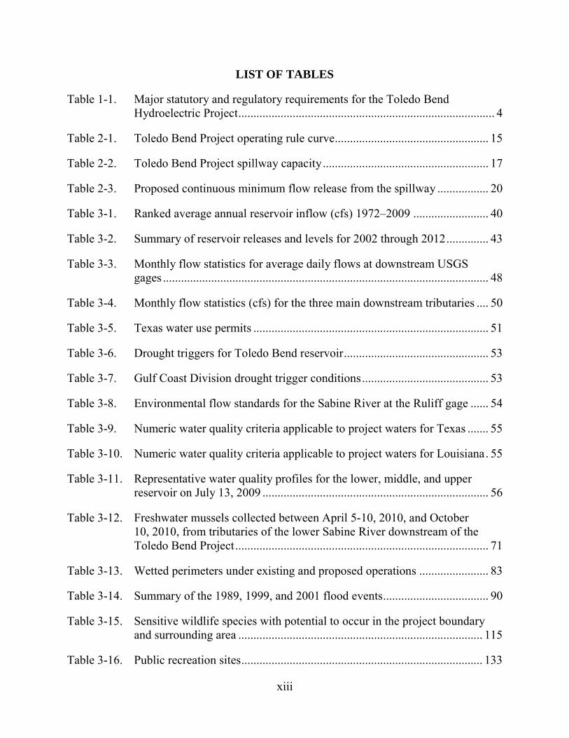
LIST OF TABLES
Table 1-1. Major statutory and regulatory requirements for the Toledo Bend Hydroelectric Project ..................................................................................... 4
Table 2-1. Toledo Bend Project operating rule curve ................................................... 15
Table 2-2. Toledo Bend Project spillway capacity ....................................................... 17
Table 2-3. Proposed continuous minimum flow release from the spillway ................. 20
Table 3-1. Ranked average annual reservoir inflow (cfs) 1972–2009 ......................... 40
Table 3-2. Summary of reservoir releases and levels for 2002 through 2012 .............. 43
Table 3-3. Monthly flow statistics for average daily flows at downstream USGS gages ............................................................................................................ 48
Table 3-4. Monthly flow statistics (cfs) for the three main downstream tributaries .... 50
Table 3-5. Texas water use permits .............................................................................. 51
Table 3-6. Drought triggers for Toledo Bend reservoir ................................................ 53
Table 3-7. Gulf Coast Division drought trigger conditions .......................................... 53
Table 3-8. Environmental flow standards for the Sabine River at the Ruliff gage ...... 54
Table 3-9. Numeric water quality criteria applicable to project waters for Texas ....... 55
Table 3-10. Numeric water quality criteria applicable to project waters for Louisiana . 55
Table 3-11. Representative water quality profiles for the lower, middle, and upper reservoir on July 13, 2009 ........................................................................... 56
Table 3-12. Freshwater mussels collected between April 5-10, 2010, and October 10, 2010, from tributaries of the lower Sabine River downstream of the Toledo Bend Project .................................................................................... 71
Table 3-13. Wetted perimeters under existing and proposed operations ....................... 83
Table 3-14. Summary of the 1989, 1999, and 2001 flood events ................................... 90
Table 3-15. Sensitive wildlife species with potential to occur in the project boundary and surrounding area ................................................................................. 115
Table 3-16. Public recreation sites ................................................................................ 133
xiv
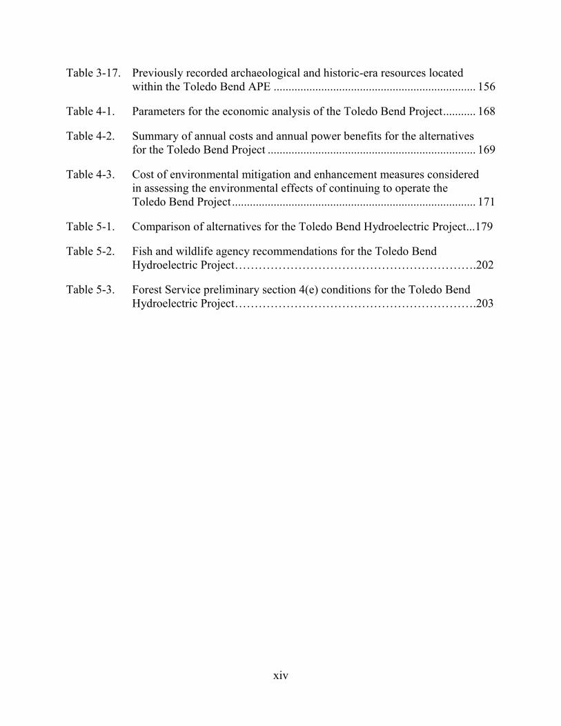
Table 3-17. Previously recorded archaeological and historic-era resources located within the Toledo Bend APE .................................................................... 156
Table 4-1. Parameters for the economic analysis of the Toledo Bend Project ........... 168
Table 4-2. Summary of annual costs and annual power benefits for the alternatives for the Toledo Bend Project ...................................................................... 169
Table 4-3. Cost of environmental mitigation and enhancement measures considered in assessing the environmental effects of continuing to operate the Toledo Bend Project .................................................................................. 171
Table 5-1. Comparison of alternatives for the Toledo Bend Hydroelectric Project...179
Table 5-2. Fish and wildlife agency recommendations for the Toledo Bend Hydroelectric Project…………………………………………………….202
Table 5-3. Forest Service preliminary section 4(e) conditions for the Toledo Bend Hydroelectric Project…………………………………………………….203

xv
ACRONYMS AND ABBREVIATIONS
Advisory Council Advisory Council on Historic Preservation AIR additional information request APE area of potential effects APLIC Avian Power Line Interaction Committee ARA Relicensing Settlement Agreement for Lower Sabine
River Water Quality and Aquatic Resources Authorities Sabine River Authority of Texas and Sabine River
Authority, State of Louisiana BP Before Present ºC degrees Celsius CFR Code of Federal Regulations cfs cubic feet per second Commission Federal Energy Regulatory Commission Corps U.S. Army Corps of Engineers CRWG Cultural Resources Working Group CZMA Coastal Zone Management Act DO dissolved oxygen EAP Emergency Action Plan EIS environmental impact statement ESA Endangered Species Act ºF degrees Fahrenheit FERC Federal Energy Regulatory Commission Forest Service U.S. Department of Agriculture, Forest Service FPA Federal Power Act FR Federal Register FWS U.S. Fish and Wildlife Service HPMP Historic Properties Management Plan Interior U.S. Department of the Interior kV kilovolt Louisiana DEQ Louisiana Department of Environmental Quality Louisiana DWF Louisiana Department of Wildlife and Fisheries LRMP Land and Resource Management Plan MA Management Area mg/L milligrams per liter msl mean sea level µg/L micrograms per liter MW megawatt MWh megawatt-hour National Register National Register of Historic Places NERC North American Electric Reliability Corporation NMFS National Marine Fisheries Service
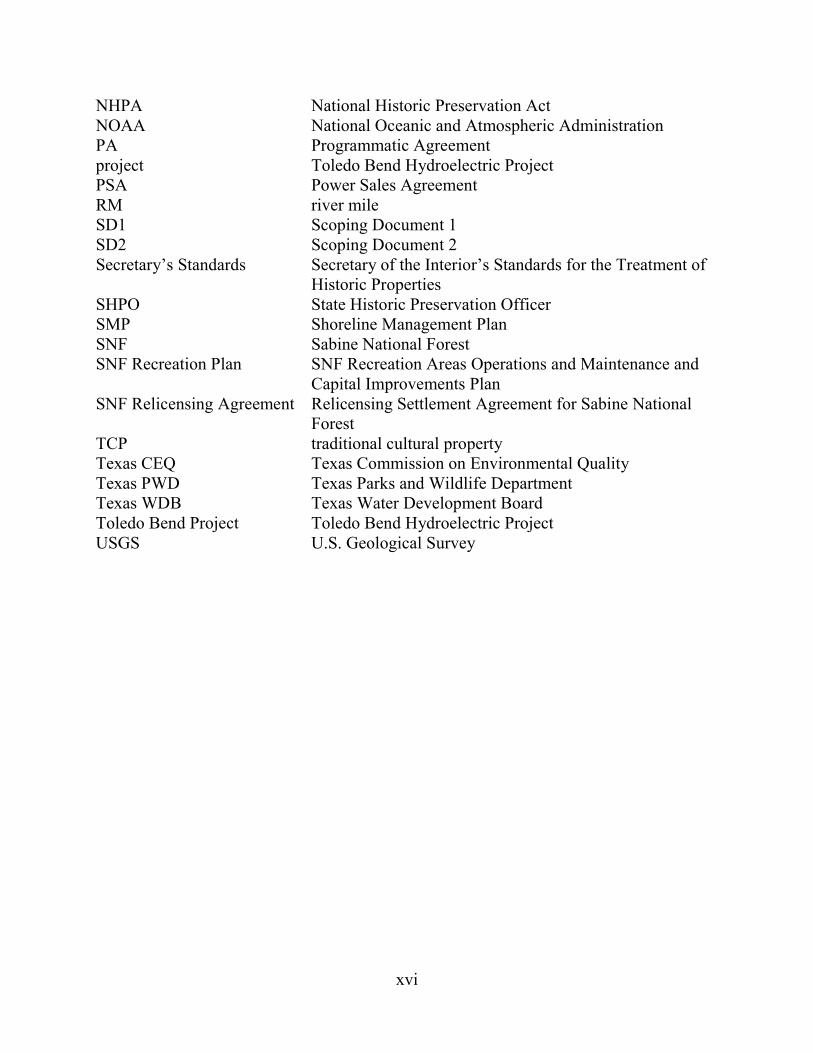
xvi
NHPA National Historic Preservation Act NOAA National Oceanic and Atmospheric Administration PA Programmatic Agreement project Toledo Bend Hydroelectric Project PSA Power Sales Agreement RM river mile SD1 Scoping Document 1 SD2 Scoping Document 2 Secretary’s Standards Secretary of the Interior’s Standards for the Treatment of
Historic Properties SHPO State Historic Preservation Officer SMP Shoreline Management Plan SNF Sabine National Forest SNF Recreation Plan SNF Recreation Areas Operations and Maintenance and
Capital Improvements Plan SNF Relicensing Agreement Relicensing Settlement Agreement for Sabine National
Forest TCP traditional cultural property Texas CEQ Texas Commission on Environmental Quality Texas PWD Texas Parks and Wildlife Department Texas WDB Texas Water Development Board Toledo Bend Project Toledo Bend Hydroelectric Project USGS U.S. Geological Survey
xvii
EXECUTIVE SUMMARY
On September 30, 2011, the Sabine River Authority of Texas and Sabine River Authority, State of Louisiana (the Authorities) filed an application for a new license with the Federal Energy Regulatory Commission (Commission or FERC) for the existing Toledo Bend Hydroelectric Project (Toledo Bend Project or project). On August 1, 2012, the Authorities filed an Offer of Settlement. In the accompanying Explanatory Statement, the Authorities stated that the proposed license articles, the section 18 fishway prescription, and section 4(e) land management conditions, if included in the project’s new license without modification, would resolve, among the parties to each of individual the settlement agreements,7 all issues associated with the Authorities’ pending final license application for continued operation of the project. The current license expired on September 30, 2013, and the project is currently operating under an annual license.
The 81-megawatt (MW) project is located on the Sabine River on the Texas-Louisiana border in Panola, Shelby, Sabine, and Newton counties in Texas and De Soto, Sabine, and Vernon parishes in Louisiana. The project is located at about river mile 147. The project occupies about 3,797 acres of federal lands located in the Sabine National Forest (SNF) and the Indian Mounds Wilderness Area administered by the U.S. Department of Agriculture, Forest Service (Forest Service).8 The remainder of the land within the project boundary (200,300 acres) is owned in fee by the Authorities.
Project Description The project includes a dam, reservoir, spillway, powerhouse, tailrace channel,
station transformer, and a transmission line (see figure 1-1). The dam consists of a rolled earth-fill embankment, about 11,250 feet long with a maximum height of about 112 feet and a crest elevation of 185 feet above mean sea level (msl). Three earthen saddle dikes (Dike No. 1 – about 800 feet long; Dike No. 2 – about 1,100 feet long; and Dike No. 3 – about 400 feet long) are located to the southwest of the existing powerhouse and each one has a crest elevation of 185 feet msl (see figure 1-1). At elevation 172 feet msl, the reservoir has a surface area of 185,000 acres, a gross storage capacity of about 4,477,000 acre-feet, and a useable storage capacity of about 1,554,000 acre-feet. The powerhouse intake channel is integral with the dam adjacent to the south abutment, and leads directly
7 The Offer of Settlement included two settlement agreements: (1) a Relicensing Settlement Agreement for Sabine National Forest between the Authorities and U.S. Department of Agriculture, Forest Service; and (2) a Relicensing Settlement Agreement for Lower Sabine River Water Quality and Aquatic Resources between the Authorities, U.S. Fish and Wildlife Service, National Marine Fisheries Service, Texas Commission on Environmental Quality, Texas Parks and Wildlife Department, Texas Water Development Board, and Louisiana Department of Wildlife and Fisheries.
8 The project was constructed prior to the designation of the Wilderness Area.

xviii
to the powerhouse intakes. Inflows to the powerhouse pass through the intake structure and two short penstocks to the powerhouse. The powerhouse is 180 feet wide, 80 feet long, and 55 feet high, and it contains two identical vertical Kaplan turbines with a combined authorized capacity of 81 MW. A 220-foot-long concrete tailrace extends downstream from the powerhouse to a 2-mile-long, excavated tailrace channel. An 838-foot-long spillway is located at the north dam abutment, and consists of a concrete, gravity-type, gated weir with eleven 40-foot-wide by 28-foot-high tainter gates, an 8.33-foot-wide by 12-foot-high low-flow sluiceway, two 20-inch-diameter flow bypass conduits, a concrete spillway chute, and a stilling basin. The spillway discharges to a 2.1-mile-long excavated spillway channel that joins and is contiguous with the Sabine River channel, which meanders downstream for about 4 miles to the confluence with the excavated tailrace channel. A station step-up transformer (13 kilovolt [kV]/138 kV) is located immediately south of and adjacent to the powerhouse. A 138-kV primary transmission line extends 394 feet from the transformer to a switchyard, interconnecting with the transmission grid via Entergy-TX transmission lines.
The project also includes 13 recreation facilities that the Authorities own and operate, including the Swede Johnson Recreation Area, Oak Ridge Park, Bubba Cowser Recreation Area, Converse Bay Recreation Area, Hot Wells Recreation Area, Blue Lake Landing Recreation Area, Clyde’s Crossing Recreation Area, San Miguel Park, Pendleton Park, Cypress Bend Park, Pleasure Point Park, Toledo Bend Observation Towers, and Sam Forse Collins Recreation Area.
The project was built for the primary purposes of water supply and secondary purposes of hydroelectric power generation and recreation. The project is operated in accordance with a rule curve that provides for the production of both peaking and non-peaking power. Peaking power (referred to as prime or primary power in the final license application) is produced from May through September (during the warm summer months) at any time the water surface elevation is above 168 feet msl but less than elevation 172 feet msl. Non-peaking power (referred to as secondary power in the final license application) is produced when the reservoir is above the seasonal elevations indicated in the rule curve, outside of the May through September period, and above elevation 172 feet msl during the May through September period. The project reservoir has historically operated with a normal maximum reservoir elevation of 172 feet msl, and power is typically only generated when the reservoir elevation is above elevation 168 feet msl. Typical daily operation consists of releasing either 7,000 or 14,000 cubic feet per second (cfs) to the lower Sabine River (i.e., one- or two-unit operation, respectively) for 6 to 8 hours to meet the afternoon and evening peak electrical demand. To meet the minimum flow requirements under the current license, a continuous minimum flow of 144 cfs is released to the spillway channel from the spillway low-flow sluiceway.
Proposed Facilities The Authorities propose to install a 1.3-MW horizontal Francis minimum flow
turbine-generator downstream of the spillway that would increase the project’s total
xix
generating capacity to 82.3 MW. Installing the new turbine would involve replacing one spillway tainter gate with a new conventional intake and a steel penstock measuring about 460-feet-long connected to a new powerhouse. The new powerhouse would be located at the end of the training wall and discharge directly to the existing spillway channel. A new transmission line would extend approximately 10,400 feet from the switchyard to the existing main powerhouse substation via a pole-mounted, 15-kV, medium-voltage cable. The proposed new project facilities are within the current project boundary.
Proposed Environmental Measures The Authorities propose to implement the Relicensing Settlement Agreement for
Sabine National Forest (SNF Relicensing Agreement) and the Relicensing Settlement Agreement for Lower Sabine River Water Quality and Aquatic Resources (ARA), which include the following measures:
• SNF Recreation Areas Operations and Maintenance and Capital Improvements Plan (SNF Recreation Plan)—Under the plan, the Sabine River Authority of Texas would operate, maintain, and improve the six SNF recreation areas (Indian Mounds Recreation Area,9 Willow Oak Recreation Area, Lakeview Recreation Area, East Hamilton boat launch, Ragtown Recreation Area, and Haley’s Ferry Boat Launch).
• Erosion Monitoring and Management Plan that would include 10 years of erosion monitoring to determine erosion rates at six representative sites along the project shoreline within the SNF and to mitigate effects of erosion on shoreline resources.
• Contribute $20,000 (2013 dollars) annually to the Forest Service for the ongoing treatment of Chinese tallow along the shoreline within the SNF. The Authorities would also require lessees and permittees on non-federal project lands to control and remove Chinese tallow on the leased and permitted lands.
• Continuous Releases at Spillway—new continuous minimum flow releases at the spillway, ranging from 150 to 300 cfs, following the monthly schedule described in table 2-3, to protect and enhance aquatic resources within the spillway channel and the lower Sabine River.
• A plan for the measurement and management of continuous releases from the spillway to ensure that flow releases are being maintained as required by any new license.
9 Indian Mounds Recreation Area is a lake-side recreation area with developed
facilities. It is outside (and not part) of the Indian Mounds Wilderness Area.
xx
• Forebay Cofferdam Monitoring Program—temperature monitoring in the project’s tailrace channel in July, August, and September to assist in monitoring the physical stability of the remnant forebay cofferdam to ensure that the submerged cofferdam continues to act as a water control structure forcing warmer and better-oxygenated water from the upper reservoir strata to flow to the powerhouse intakes. If monitoring demonstrates that the mean daily temperature of at least 10 percent of the monitored days in July, August, and September is below 20°C, then the powerhouse intakes are likely receiving cooler water from the lower reservoir strata, and the physical integrity of the remnant forebay cofferdam would be subject to further investigation. The Authorities would then collect in situ dissolved oxygen (DO) measurements at the same location to determine if low dissolved oxygen water from the lower reservoir strata is being discharged, survey the cofferdam crest elevations and compare them to 2011 baseline conditions to see if, and by how much the cofferdam has eroded, and, if necessary, develop a cofferdam restoration plan.
• Seasonal Powerhouse Operations—Upon the April 30, 2018 expiration of the current power sales agreement (or an earlier date if a new power sales agreement is reached prior to 2018), the Authorities would: reduce normal maximum powerhouse peaking flows to 12,000 cfs during
March through June; upon completion of the testing program to determine optimum weekend
releases (1,450 acre-feet per weekend day), file with the Commission for approval a weekend operations plan. The weekend operations plan would be based on flow testing conducted by the agencies to determine the flow rate and duration of weekend releases to enhance aquatic resources by reducing the extreme drops in flow and aquatic habitat that occur over the weekend due to the lack of normal hydropower discharges on those days; and
upon Commission approval, implement the weekend operations plan-- release 1,450 acre-feet of water from the powerhouse every weekend day in March and April, and depending on water year type, every weekend day in May and June.
• Provide for the upstream and downstream passage of American eel at the dam by preparing upstream and downstream passage plans that would be filed for Commission approval.
In addition to the measures proposed as part of the SNF Relicensing Agreement and the ARA, the Authorities also propose the following:
• A Recreation Management Plan for lands outside the SNF that identifies management and maintenance responsibilities for 13 project recreation sites operated by the Authorities on lands owned in fee.
xxi
• A Shoreline Management Plan (SMP) that consolidates the existing shoreline permitting program with: a new shoreline classification system; monitoring and enforcement measures; and plan review and updates.
• An Historic Properties Management Plan (HPMP) that includes measures to identify historic properties within the area of potential effects (APE); and avoid, reduce, or mitigate any effects on historic properties that are determined to be adverse.
Alternatives Considered This final environmental impact statement (EIS) considers the following
alternatives: (1) the Authorities’ proposal, as outlined above; (2) the Authorities’ proposal with staff modifications (staff alternative); and (3) no action, meaning that the Authorities’ would continue to operate the project with no changes.
Under the staff alternative, the project would include the following environmental measures proposed by the Authorities:
• The SNF Recreation Plan.
• The SNF Erosion Monitoring and Management Plan.
• Increased minimum flows at the project spillway ranging from 150 to 300 cfs, depending on the month and reservoir levels.
• A flow release plan for measurement and management of continuous releases at the spillway.
• A forebay cofferdam monitoring program to ensure physical stability of the cofferdam.
• Seasonal powerhouse operations, including reducing normal maximum powerhouse peaking flow to 12,000 cfs during March through June, and releasing 1,450 acre-feet of water every weekend day in March and April and, depending on water year type, every weekend day in May and June.
• Upstream and downstream passage for American eel.
• The proposed Recreation Management Plan.
• The proposed SMP.
• The proposed HPMP. In addition to the Authorities’ proposed measures, we recommend the following
modifications and additions:
• Prepare and file for Commission approval an erosion and sediment control plan with proposed best management practices and erosion control measures to
xxii
protect aquatic resources during the installation of the proposed minimum flow generating unit.
• An erosion monitoring plan for shoreline areas classified as Public Access and Conservation outside National Forest System lands to mitigate any effects of erosion on important shoreline resources.
• Continue to maintain reservoir levels between elevations 168 and 172 feet msl during normal hydropower production to provide public recreation and shoreline protection for the term of the license.
• Monitor the elevation of the forebay cofferdam by bathymetric survey at 15-year intervals (i.e., two to three surveys over the license period depending on the license term), in addition to the Authorities’ proposed use of water temperature monitoring, to ensure the physical stability of the cofferdam to help maintain higher downstream DO levels.
• Be responsible for treatment program for Chinese tallow along the shoreline within the SNF to help prevent the further spread of this species within the SNF; prepare an annual report outlining the amount and general location of Chinese tallow control on SNF lands to ensure implementation of proposed treatment measures.
• Prior to initiating construction of the proposed minimum flow generating unit, conduct surveys to confirm that no bald eagle nests occur within the recommended protection buffers. If a nest is identified, implement appropriate buffer distance and/or restrict construction activities to periods outside the nesting season, to prevent any effects of construction on any bald eagle nests.
• Design and construct the proposed transmission line associated with the proposed minimum flow generating unit in accordance with the Avian Power Line Interaction Committee (APLIC) guidelines to reduce potential effects of the proposed transmission line on birds in the project area.
• Prepare and file for Commission approval a spillway channel recreation access plan, after consultation with American Whitewater and the Sabine Whitewater Club that would enhance safety and access by providing public, car-top boating access to the spillway channel during normal flow releases. The plan should provide a methodology for evaluating access at flow levels between 300 and 3,000 cfs and establish specific criteria (either flow releases or associated reservoir levels) that would trigger closure of the site.
• Include in the SMP measures for controlling Chinese tallow outside SNF lands at project recreation areas maintained by the Authorities and at Conservation and Public Access classification areas where future ground-disturbing activities may occur, to assist in the control of this invasive species in the project area.
xxiii
Also incorporate guidelines for bald eagle protection measures into the SMP to address future nesting in the project area.
• Include in the proposed Recreation Management Plan a brief description and location information for the 12 non-project recreation sites that currently provide access to the project.
• Include in the proposed Recreation Management Plan a comprehensive inventory and description of each site, a discussion of planned improvements for each site, and a schedule for improvements at each site for the 17 project recreation sites, including access to the tailrace and spillway channels downstream of the dam. This would ensure that all publicly available recreation resources are adequate to meet demand and that the Authorities’ sites are maintained during any new license term.
• Include consultation with American Whitewater and Sabine Whitewater Club prior to filing the weekend operations plan with the Commission regarding release scheduling and timing of the weekend releases to ensure that weekend releases consider the secondary benefits for recreation.
• Provide spillway flow release and reservoir level information on a public website to provide boaters and other recreational users information for planning future recreational visits to the project.
• Design the proposed minimum flow generating unit to match the setting in the vicinity of the spillway to protect the aesthetics of the area.
Public Involvement and Areas of Concern Before filing its license application, the Authorities conducted pre-filing
consultation under the Commission’s Integrated Licensing Process. The intent of the pre-filing process is to initiate public involvement early in the project planning process and to encourage citizens, governmental entities, tribes, and other interested parties to identify and resolve issues prior to formally filing an application with the Commission.
The Authorities filed its Notice of Intent and Pre-Application Document on September 22, 2008. Scoping meetings were held in December 2008. A revised scoping document addressing these comments was issued on March 9, 2009. Based on issues identified during scoping and consultation with stakeholders, the applicant designed and conducted a number of studies in 2010, continuing into 2011.
Following the August 1, 2012, filing of the Offer of Settlement by the Authorities, the Commission issued Notice of Application Accepted for Filing, Soliciting Motions to Intervene and Protests, Ready for Environmental Analysis, Soliciting Comments, Recommendations, Preliminary Terms and Conditions, and Preliminary Fishway Prescriptions and Notice of Offer of Settlement on August 23, 2012. An erratum to the notice was issued on August 31, 2012. The notice set a comment deadline of October 22, 2012. The following entities filed comments on the application and the Offer of
xxiv
Settlement: Louisiana Department of Wildlife and Fisheries, Texas Parks and Wildlife Department (Texas PWD), Texas Water Development Board, the Authorities, American Whitewater and Sabine Whitewater Club, U.S. Department of the Interior, National Marine Fisheries Service, Louisiana Department of Environmental Quality, Texas PWD, the Forest Service, Robert R. Stump, and Harold Temple.
On June 14, 2013, we issued a draft EIS for relicensing the project. We conducted a public meeting in Orange, Texas on July 30, 2013 and in Many, Louisiana on July 31, 2013. Comments on the draft EIS were due by August 5, 2013. Comments were received from: the Authorities; Texas Commission on Environmental Quality; Katie Daffin; Mike and Shannon Cates; Alan Simmons; Texas Parks and Wildlife Department; U.S. Environmental Protection Agency, Region 6; U.S. Department of Agriculture, Forest Service, Southern Region and National Forests and Grasslands of Texas; American Whitewater and Sabine Whitewater Club; National Marine Fisheries Service; U.S. Department of the Interior; Alice Simmons; and Natural Resources Conservation Service.
The primary issues associated with relicensing the project are shoreline erosion, minimum flows, water temperatures, construction of a proposed minimum flow turbine at the spillway, upstream and downstream passage of the American eel, downstream flooding, invasive species management, shoreline management, recreational facilities, and cultural resources.
Staff Alternative
Geology and Soils Construction of the proposed minimum flow turbine could result in erosion and
sedimentation in the spillway channel immediately downstream of the construction site. Implementing best management practices and erosion control measures would minimize any erosion and sedimentation associated with ground-disturbing activities during the construction period.
Reservoir fluctuations, long wind fetch reaches, wave action, and erodible banks combine to cause erosion in some shoreline locations around the project reservoir. Developing and implementing an erosion monitoring and management plan on SNF lands, as recommended by the Authorities, and on lands classified as Conservation and Public Access outside of the SNF, as recommended by staff, would protect cultural resources, terrestrial resources, and recreational sites.
Aquatic Resources Implementing the proposed seasonal powerhouse operations (limiting maximum
powerhouse discharges and providing additional releases during the spring months) and increasing minimum flows in the spillway channel would benefit aquatic species in the
xxv
lower Sabine River by reducing downstream fluctuations associated with peaking operations and enhancing aquatic habitat.
The presence of the submerged cofferdam upstream of the powerhouse intakes prevents the discharge of lower oxygenated water from the reservoir depths and, as a result, flow releases from the powerhouse meet state water quality standards for DO. However, future erosion of this cofferdam may result in the release of colder low-oxygenated water. Monitoring the cofferdam structure with the Authorities’ proposed temperature monitoring, in conjunction with the staff-recommended periodic bathymetric survey of the cofferdam elevation, would help ensure that the continued releases from the powerhouse meet state standards for DO.
The project dam currently blocks the upstream and downstream movement of American eel, preventing it from using upstream freshwater habitat. Providing the proposed upstream and downstream passage for the American eel would mitigate the project effect of obstructing migration and provide access to upstream habitat.
Flood Control Flooding has occurred downstream of the Toledo Bend Project along the Sabine
River, and several downstream residents recommend changes to current reservoir operations such as pre-releasing flows prior to storm events or drawing down the project reservoir.
The size of the reservoir and current project operations provide some incidental flood control, but substantially lower reservoir levels associated with dedicated flood control operations, as recommended by downstream residents, would have adverse effects on water supply, power production, and recreational use and could conceivably exacerbate downstream flooding if rainfall from a predicted storm falls predominantly downstream of the dam.
Terrestrial Resources Bald eagles currently nest downstream of the project dam, and construction of the
proposed minimum flow turbine could disturb eagles nesting in proximity to the construction site. Conducting pre-construction surveys for bald eagles and implementing protective measures if bald eagle nests are found within potential disturbance buffers as recommended by staff would protect nesting bald eagles from construction noise and human-related activities.
Chinese tallow is an invasive tree species found in the project area that can adversely affect native botanical species and wildlife habitat. Controlling Chinese tallow on project lands classified as Public Access and Conservation in the proposed SMP where ground-disturbing activities would occur, as recommended by staff, as well as on National Forest System lands within the project boundary, as proposed by the Authorities, would help protect wildlife habitat.
xxvi
The proposed minimum flow turbine installation would include a new transmission line that could affect birds by collision or electrocution. Designing and constructing the transmission line associated with the proposed minimum flow generating unit in accordance with APLIC guidelines, as recommended by staff, would reduce these potential hazards to birds.
Recreation, Land Use, and Aesthetics The Authorities’ proposed Recreation Management Plan would provide and
maintain public access to project lands and waters for recreational purposes at 13 sites. However, there are an additional 16 recreation sites that provide access to the project. Of these 16 sites, four are owned and operated by the Authorities and are within the project boundary, including Cow Bayou Wilderness Area, the Tourist Information Center, the tailrace, and the spillway. The other 12 sites are owned in part and operated by federal, state, and local agencies, with one site, Frontier Park, managed by a private entity. The staff alternative would require all 29 sites to be included in the Recreation Management Plan to provide a single source of information for all recreation facilities at the project. For the 17 project sites, the Recreation Management Plan should include: (1) a comprehensive inventory and description of each site; (2) a discussion of planned improvements for each site; and (3) a schedule for improvements at each site. This would ensure that recreation supply and uses are accurately described and managed for each project recreation site through the term of a license. For the 12 non-project sites, the plan would include a brief description and location information for each site.
The Authorities operate the project in accordance with a rule curve (see table 2-1) included in the current power sales agreement that provides for the production of peak power. Under the agreement, which expires in 2018, reservoir levels are maintained between elevations 168 and 172 feet msl during normal project operations. A requirement to continue maintaining reservoir levels between elevations 168 and 172 feet msl beyond the expiration of the current power sales agreement during normal hydropower operations, as recommended by staff, would maintain existing recreational use of the reservoir and protect shoreline areas.
Currently, there is informal use of the spillway channel for whitewater boating with limited parameters set for balancing access and public. Developing and implementing a spillway channel recreation access plan, as recommended by staff, would provide public, car-top boating access to the spillway channel during times of boatable flows, but would also set parameters to protect public safety. Establishing specific criteria (either flow releases or associated reservoir levels) that would trigger closure of the spillway site during periods of non-boatable flows would make it clear as to when the area would be closed to visitors to enhance public safety.
Including American Whitewater and the Sabine Whitewater Club during plan development for the timing of releasing the 1,450 acre-feet of water associated with the seasonal powerhouse operations for aquatic habitat improvements would ensure that
xxvii
boater interests are considered. Providing flow release information required as part of proposed measurement of continuous spillway releases and reservoir level data in real time (measurements every 15 minutes and uploaded every hour) on a public website would allow recreational users to efficiently plan trips to the site.
Designing the proposed minimum flow generating unit with consideration for area aesthetics, as recommended by staff, would minimize effects on aesthetics in the vicinity of the spillway structure.
Cultural Resources Project-related reservoir level fluctuations, use and maintenance of project roads,
recreation, vandalism, and modifications or repairs to project facilities have the potential to adversely affect cultural resources at the project. The Authorities identified 355 previously recorded cultural resources within the project APE. Only 40 of these sites were visited during field efforts. Field efforts also resulted in the documentation of 49 new resources. However, less than 10 percent of the APE has been formally surveyed and many sites have not yet been investigated. The proposed HPMP provides a program to complete the formal survey of the APE within 15 years, and to assess and resolve project-related adverse effects to historic properties identified within the APE. Implementing the HPMP would insure protection or mitigation for historic properties (or other significant cultural resources) affected.
No-Action Alternative Under the no-action alternative, the project would continue to operate under the
terms and conditions of the existing license, and no new environmental protection, mitigation, or enhancement measures would be implemented.
Conclusions Based on our analysis, we recommend licensing the project as proposed by the
Authorities with some staff modifications and additional measures. In section 4.2 of the EIS, we estimate the likely cost of alternative power for each
of the three alternatives identified above. Our analysis shows that, during the first year of operation under the no-action alternative, project power would cost $5,057,750, or $21.11 per megawatt-hour (MWh) less than the likely alternative cost of power. Under the proposed action alternative, project power would cost $863,340, or $3.50/MWh less than the likely alternative cost of power. Under the staff alternative, project power would cost $791,030, or $3.21/MWh less than the likely alternative cost of power.
We chose the staff alternative as the preferred alternative because: (1) the project would provide a dependable source of electrical energy for the region (246,595 MWh annually); (2) the 82.3 MW of electric capacity (with the addition of a proposed minimum flow generating unit) comes from a renewable resource that does not contribute to atmospheric pollution, including greenhouse gases; and (3) the recommended

xxviii
environmental measures proposed by the Authorities, as modified by staff, would adequately protect and enhance environmental resources affected by the project. The overall benefits of the staff alternative would be worth the cost of the proposed and recommended environmental measures.
1
FINAL ENVIRONMENTAL IMPACT STATEMENT
Federal Energy Regulatory Commission Office of Energy Projects
Division of Hydropower Licensing Washington, D.C.
Toledo Bend Hydroelectric Project
FERC Project No. 2305-036—Texas and Louisiana
1.0 INTRODUCTION
1.1 APPLICATION On September 30, 2011, the Sabine River Authority of Texas and Sabine River
Authority, State of Louisiana (Authorities) filed an application for new license with the Federal Energy Regulatory Commission (Commission or FERC). The current license expired on September 30, 2013, and the project is currently operating under an annual license. The 81-megawatt (MW) Toledo Bend Hydroelectric Project (Toledo Bend Project or project) is located on the Sabine River on the Texas-Louisiana border and occupies land and waters in Panola, Shelby, Sabine, and Newton counties in Texas and DeSoto, Sabine, and Vernon parishes in Louisiana (figure 1-1). The project occupies 3,797 acres of federal lands located in the Sabine National Forest (SNF) and the Indian Mounds Wilderness Area, administered by U.S. Department of Agriculture, Forest Service (Forest Service). The Authorities propose to construct a new minimum flow generating unit with a capacity of 1.3 MW.
1.2 PURPOSE OF ACTION AND NEED FOR POWER
1.2.1 Purpose of Action The purpose of the Toledo Bend Project is to continue to provide a source of
hydroelectric power. Therefore, under the provisions of the Federal Power Act (FPA), the Commission must decide whether to issue a license to the Authorities for the Toledo Bend Project and what conditions should be placed on any license issued. In deciding whether to issue a license for a hydroelectric project, the Commission must determine that the project will be best adapted to a comprehensive plan for improving or developing a waterway. In addition to the power and developmental purposes for which licenses are issued (such as flood control, irrigation, or water supply), the Commission must give equal consideration to the purposes of: (1) energy conservation; (2) the protection of, mitigation of damage to, and enhancement of fish and wildlife resources; (3) the protection of recreational opportunities; and (4) the preservation of other aspects of environmental quality.
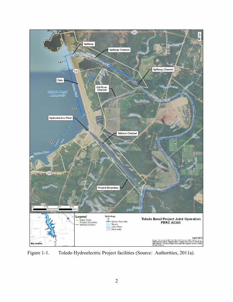
2
Figure 1-1. Toledo Hydroelectric Project facilities (Source: Authorities, 2011a).

3
Issuing a new license for the Toledo Bend Project would allow the Authorities to generate electricity for the term of a new license, making electrical power from a renewable resource available to its customers.
This final environmental impact statement (EIS) assesses the effects associated with operation of the project and alternatives to the proposed project. It also includes recommendations to the Commission on whether to issue a new license, and if so, includes the recommended terms and conditions to become a part of any license issued.
In this final EIS, we assess the environmental and economic effects of continuing to operate the project: (1) as proposed by the applicant, and (2) with our recommended measures. We also consider the effects of the no-action alternative. Important issues that are addressed include effects of continued project operations on shoreline erosion, water quality, downstream flooding, fishery resources, terrestrial resources, recreation and land use, shoreline management, and cultural resources.
1.2.2 Need for Power The Toledo Bend Project provides hydroelectric generation to meet part of
Texas’s and Louisiana’s power requirements, resource diversity, and capacity needs. The existing project has an installed capacity of 81.0 MW and generates approximately 239,635 megawatt-hours (MWh) per year. The project as proposed would have an installed capacity of 82.3 MW and would generate approximately 251,235 MWh per year.
The North American Electric Reliability Corporation (NERC) annually forecasts electrical supply and demand nationally and regionally for a 10-year period. The project is located in the Southwest Power Pool Regional Entity/Regional Transmission Organization region of the NERC. According to NERC’s 2012 forecast, the planning reserve margins for summer are expected to range from 30.01 percent to 23.73 percent and for winter are expected to range from 63.65 percent to 57.23 percent from 2013 to 2022 compared to the planning goal of 13.60 percent (NERC, 2012). The compound annual rate of growth for peak total internal demand is projected to grow at a rate of 0.95 percent for summer and 1.03 percent for winter from 2013 through 2022.
We conclude that power from the project would help meet a need for power in the Southwest Power Pool region in both the short- and long-term. The project would provide low-cost power that displaces generation from non-renewable sources. Displacing the operation of non-renewable facilities may avoid some power plant emissions, thus creating environmental benefits.
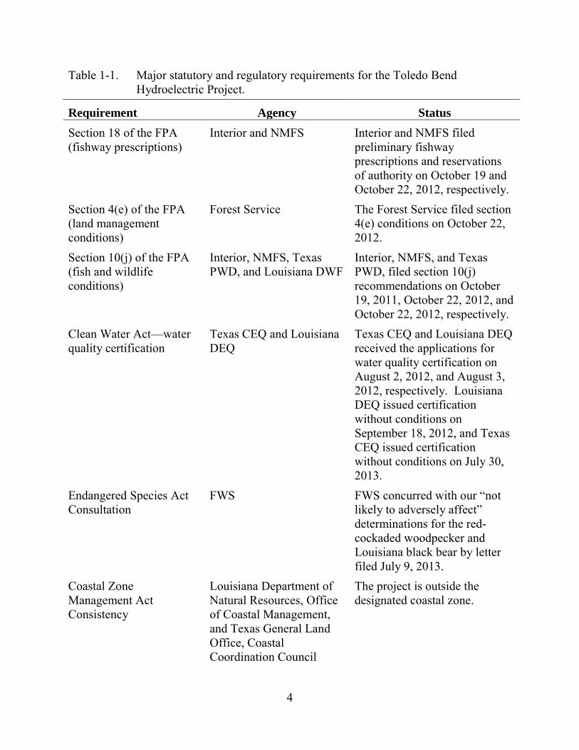
1.3 STATUTORY AND REGULATORY REQUIREMENTS A license for the Toledo Bend Project is subject to numerous requirements under
the FPA and other applicable statutes. We summarize the major regulatory requirements in table 1-1 and describe them below.
4
Table 1-1. Major statutory and regulatory requirements for the Toledo Bend Hydroelectric Project.
Requirement Agency Status Section 18 of the FPA (fishway prescriptions)
Interior and NMFS Interior and NMFS filed preliminary fishway prescriptions and reservations of authority on October 19 and October 22, 2012, respectively.
Section 4(e) of the FPA (land management conditions)
Forest Service The Forest Service filed section 4(e) conditions on October 22, 2012.
Section 10(j) of the FPA (fish and wildlife conditions)
Interior, NMFS, Texas PWD, and Louisiana DWF
Interior, NMFS, and Texas PWD, filed section 10(j) recommendations on October 19, 2011, October 22, 2012, and October 22, 2012, respectively.
Clean Water Act—water quality certification
Texas CEQ and Louisiana DEQ
Texas CEQ and Louisiana DEQ received the applications for water quality certification on August 2, 2012, and August 3, 2012, respectively. Louisiana DEQ issued certification without conditions on September 18, 2012, and Texas CEQ issued certification without conditions on July 30, 2013.
Endangered Species Act Consultation
FWS FWS concurred with our “not likely to adversely affect” determinations for the red-cockaded woodpecker and Louisiana black bear by letter filed July 9, 2013.
Coastal Zone Management Act Consistency
Louisiana Department of Natural Resources, Office of Coastal Management, and Texas General Land Office, Coastal Coordination Council
The project is outside the designated coastal zone.
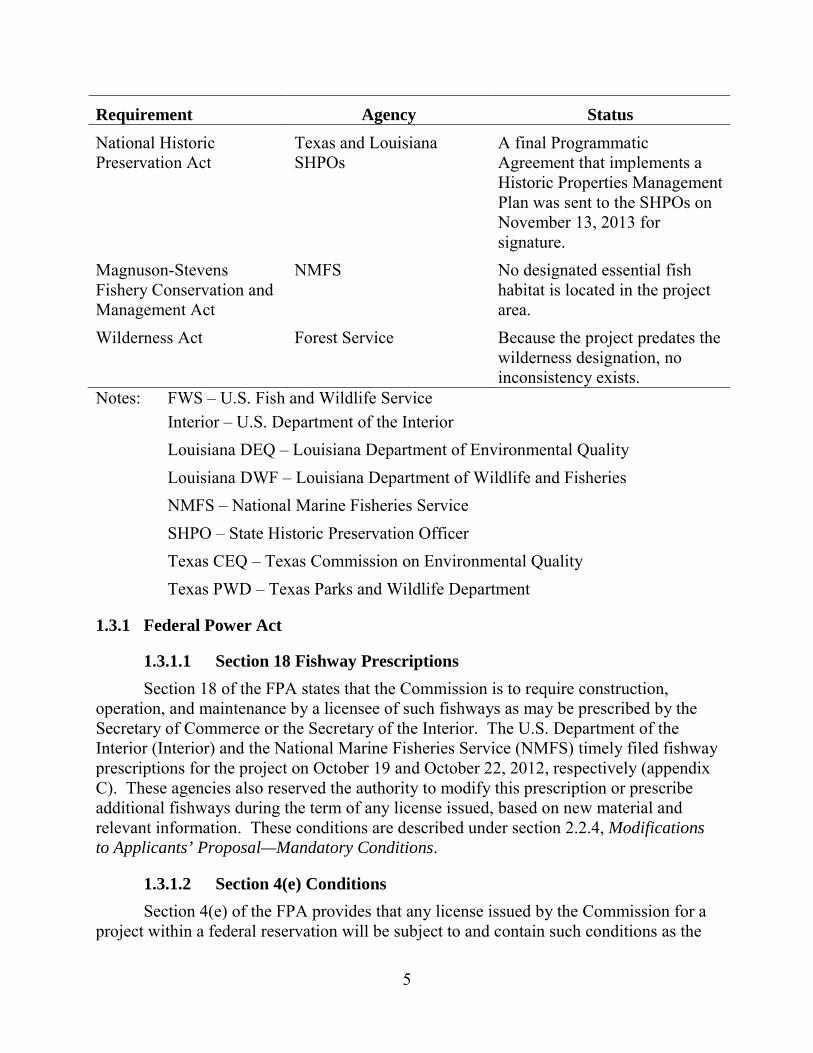
5
Requirement Agency Status National Historic Preservation Act
Texas and Louisiana SHPOs
A final Programmatic Agreement that implements a Historic Properties Management Plan was sent to the SHPOs on November 13, 2013 for signature.
Magnuson-Stevens Fishery Conservation and Management Act
NMFS No designated essential fish habitat is located in the project area.
Wilderness Act Forest Service Because the project predates the wilderness designation, no inconsistency exists.
Notes: FWS – U.S. Fish and Wildlife Service Interior – U.S. Department of the Interior Louisiana DEQ – Louisiana Department of Environmental Quality Louisiana DWF – Louisiana Department of Wildlife and Fisheries NMFS – National Marine Fisheries Service SHPO – State Historic Preservation Officer Texas CEQ – Texas Commission on Environmental Quality Texas PWD – Texas Parks and Wildlife Department
1.3.1 Federal Power Act
1.3.1.1 Section 18 Fishway Prescriptions Section 18 of the FPA states that the Commission is to require construction,
operation, and maintenance by a licensee of such fishways as may be prescribed by the Secretary of Commerce or the Secretary of the Interior. The U.S. Department of the Interior (Interior) and the National Marine Fisheries Service (NMFS) timely filed fishway prescriptions for the project on October 19 and October 22, 2012, respectively (appendix C). These agencies also reserved the authority to modify this prescription or prescribe additional fishways during the term of any license issued, based on new material and relevant information. These conditions are described under section 2.2.4, Modifications to Applicants’ Proposal—Mandatory Conditions.
1.3.1.2 Section 4(e) Conditions Section 4(e) of the FPA provides that any license issued by the Commission for a
project within a federal reservation will be subject to and contain such conditions as the
6
Secretary of the responsible federal land management agency deems necessary for the adequate protection and use of the reservation. The Forest Service filed final conditions by letter filed October 22, 2012 (appendix D), pursuant to section 4(e) of the FPA. These conditions are described under section 2.2.4, Modifications to Applicants’ Proposal—Mandatory Conditions.
1.3.1.3 Section 10(j) Recommendations Under section 10(j) of the FPA, each hydroelectric license issued by the
Commission must include conditions based on recommendations provided by federal and state fish and wildlife agencies for the protection, mitigation, or enhancement of fish and wildlife resources affected by the project. The Commission is required to include these conditions unless it determines that they are inconsistent with the purposes and requirements of the FPA or other applicable law. Before rejecting or modifying an agency recommendation, the Commission is required to attempt to resolve any such inconsistency with the agency, giving due weight to the recommendations, expertise, and statutory responsibilities of such agency.
Interior, NMFS, and the Texas Parks and Wildlife Department (Texas PWD), timely filed, on October 19, 2011, October 22, 2012, and October 22, 2012, respectively, recommendations under section 10(j), as summarized in table 5-2, in section 5.4.1, Recommendations of Fish and Wildlife Agencies. In section 5.4, we also discuss how we address the agency recommendations and comply with section 10(j).
1.3.2 Clean Water Act Under section 401 of the Clean Water Act, a license applicant must obtain
certification from the appropriate state pollution control agency verifying compliance with the Clean Water Act. On August 1, 2012, the Authorities applied to the Texas Commission on Environmental Quality (Texas CEQ) and Louisiana Department of Environmental Quality (Louisiana DEQ) for 401 water quality certification for the Toledo Bend Project. Texas CEQ and Louisiana DEQ received this request on August 2, 2012, and August 3, 2012. Texas CEQ timely issued the section 401 water quality certification without conditions on July 30, 2013 (letter from D. Galindo, Water Quality Division Director, Texas CEQ, filed on July 30, 2013). Louisiana DEQ also timely issued the section 401 water quality certification without conditions on September 18, 2012 (letter from M.C. Mitchell, Sr., Administrator, Water Permits, Division, Louisiana DEQ, Baton Rouge, LA, to J. Pratt, Sabine River Authority, Many, LA, September 18, 2012 filed on October 1, 2012).
1.3.3 Endangered Species Act Section 7 of the Endangered Species Act (ESA) requires federal agencies to ensure
that their actions are not likely to jeopardize the continued existence of endangered or threatened species or result in the destruction or adverse modification of the critical habitat of such species. Two plant and two wildlife species listed as threatened or
7
endangered under the ESA may occur in the project vicinity: earth fruit, Texas golden gladecress, red-cockaded woodpecker, and Louisiana black bear. Critical habitat has been designated for the gladecress in the project vicinity. Our analyses of project impacts on threatened and endangered species are presented in section 3.3.4, Threatened and Endangered Species, and our recommendations in section 5.2, Comprehensive Development and Recommended Alternative.
We conclude that relicensing of the Toledo Bend Project, as proposed with staff-recommended measures, is not likely to adversely affect the red-cockaded woodpecker and Louisiana black bear because proposed construction activities would occur outside of preferred habitat for these species. We sought concurrence from the U.S. Fish and Wildlife Service (FWS) concurrently with issuance of the draft EIS. On July 9, 2013, FWS filed a letter with the Commission concurring with our determination of effect for the red-cockaded woodpecker and Louisiana black bear (letter from E. Erfling, Field Supervisor, FWS, Houston, Texas, filed on July 9, 2013). Finally, we conclude that the project would have no effect on the earth fruit and Texas golden gladecress or designated critical habitat for the gladecress.
1.3.4 Coastal Zone Management Act Under section 307(c)(3)(A) of the Coastal Zone Management Act (CZMA), 16
U.S.C. §1456(3)(A), the Commission cannot issue a license for a project within or affecting a state’s coastal zone unless the state CZMA agency concurs with the license applicants’ certification of consistency with the state’s CZMA program, or the agency’s concurrence is conclusively presumed by its failure to act within 180 days of its receipt of the applicants’ certification.
The project is not located within the state-designated Coastal Management Zone, which, on the Sabine River, extends inland to the northern line of the Intercoastal Canal in Calcasieu Parish, Louisiana. The project is located about 139 miles upstream of this location, and the project would not affect Texas or Louisiana coastal resources. Therefore, the project is not subject to Texas or Louisiana coastal zone program review, and no consistency certification is needed for the action. By letters dated August 29, 2011, and September 16, 2011 (included in the license application filed on September 30, 2011), the Louisiana Department of Natural Resources, Office of Coastal Management, and the Texas General Land Office, Coastal Coordination Council, concurred.
1.3.5 National Historic Preservation Act Section 106 of the National Historic Preservation Act (NHPA) requires that every
federal agency “take into account” how each of its undertakings could affect historic properties. Historic properties are districts, sites, buildings, structures, traditional cultural properties (TCPs), and objects significant in American history, architecture, engineering, and culture that are eligible for inclusion in the National Register of Historic Places (National Register).
8
To meet the requirements of section 106, the Commission intends to execute a Programmatic Agreement (PA) with the Texas and Louisiana State Historic Preservation Officers (SHPOs) for the protection of historic properties from the effects of the operation of the Toledo Bend Project. The terms of the PA would ensure that the Authorities address and treat all historic properties identified within the project’s area of potential effects (APE) through implementation of the final Historic Properties Management Plan (HPMP) filed in June 2012. A final PA that implements a Historic Properties Management Plan was sent to the SHPOs on November 13, 2013 for signature and execution. The Authorities, Caddo Nation, the Alabama Coushatta Tribe of Texas, and the Choctaw Nation were invited to sign the PA as concurring parties.
1.3.6 Magnuson-Stevens Fishery Conservation and Management Act The Magnuson-Stevens Fishery Conservation and Management Act requires
federal agencies to consult with National Oceanic and Atmospheric Administration (NOAA) Fisheries on all actions that may adversely affect essential fish habitat. No essential fish habitat has been designated within the project boundary. By letter filed on January 20, 2009, NMFS stated that the Pre-Application Document and the relicensing studies proposed by the Authorities were adequate to satisfy information requirements of the Magnuson-Stevens Fishery Conservation Management Act.
1.3.7 Wilderness Act Section 4(c) of the Wilderness Act prohibits any commercial enterprise, structure,
or installation within designated wilderness areas, unless authorized by the President.10 The Commission has interpreted the Wilderness Act as prohibiting the licensing of projects with project works located within designated wilderness areas.11
The 12,369-acre Indian Mounds Wilderness Area, established in 1984,12 is located along the western shoreline of Toledo Bend reservoir, adjacent to the Indian Mounds Recreation Area. Approximately 147 acres of the Wilderness Area, between elevations 172 and 175 feet above mean sea level (msl), are located within the project boundary. However, no project recreation or other project facilities are located within the Wilderness Area.
Because those lands were included in the project boundary prior to designation of the Wilderness Area and no construction is proposed within the Indian Mounds
10 16 U.S.C. § 1133 (2012). 11 Thornton Lake Resource Co., 50 FERC ¶ 61,086 (1990). 12 Texas Wilderness Act of 1984, Pub. L. No. 98-574, 98 Stat. 3051 (1984).
9
Wilderness Area or additional lands would be inundated, there is no inconsistency with the Wilderness Act.13
1.4 PUBLIC REVIEW AND COMMENT The Commission’s regulations (18 Code of Federal Regulations [CFR], sections
5.1–5.16) require that applicants consult with appropriate resource agencies, tribes, and other entities before filing an application for a license. This consultation is the first step in complying with the Fish and Wildlife Coordination Act, the ESA, the NHPA, and other federal statutes. Pre-filing consultation must be complete and documented according to the Commission’s regulations.
1.4.1 Scoping Before preparing this EIS, we conducted scoping to determine what issues and
alternatives should be addressed. A scoping document (SD1) was distributed to interested agencies and others on November 13, 2008. It was noticed in the Federal Register on November 28, 2008. Two scoping meetings, both advertised in local newspapers, were held on December 16, 2008, in Many, Louisiana, to request oral comments on the project. A court reporter recorded all comments and statements made at the scoping meetings, and these are part of the Commission’s public record for the project. Environmental site reviews were held at the project on December 17, 2008, and October 19, 2011. In addition to comments provided at the scoping meetings, the following entities provided written comments:
Commenting Entity Comment Filing Date James L. Dodson December 15, 2008 John Mark Walters December 16, 2008 Louisiana Department of Wildlife and Fisheries
January 16, 2009
NMFS January 20, 2009 Forest Service January 21, 2009 National Wildlife Federation January 21, 2009 Texas PWD January 21, 2009 National Park Service January 21, 2009 Texas CEQ January 22, 2009; corrected January
29, 2009
13 PPL Montana, 121 FERC ¶ 62,198 (2007).
10
Commenting Entity Comment Filing Date Texas Historical Commission February 20, 2009 FWS March 2, 2009
A revised scoping document (SD2), addressing these comments, was issued on
March 9, 2009.
1.4.2 Interventions and Comments on the Application and Offer of Settlement On August 1, 2012, the Authorities and the parties to the agreement filed an Offer
of Settlement that was executed by a majority of participants in the licensing process. The Offer of Settlement included two Settlement Agreements pertaining to the relicensing of the project: (1) the Relicensing Settlement Agreement for Sabine National Forest (SNF Relicensing Agreement) between the Authorities and the Forest Service; and (2) the Relicensing Settlement Agreement for Lower Sabine River Water Quality and Aquatic Resources (ARA) between the Authorities, FWS, NMFS, Texas CEQ, Texas PWD, Texas Water Development Board (Texas WDB), and Louisiana Department of Wildlife and Fisheries (Louisiana DWF).14 The SNF Relicensing Agreement pertained to uses of federal lands within the project boundary. The ARA includes proposed license articles addressing aquatic resources, water quality, water quantity, and other natural resources issues, including the American eel.
The Commission issued Notice of Application Accepted for Filing, Soliciting Motions to Intervene and Protests, Ready for Environmental Analysis, Soliciting Comments, Recommendations, Preliminary Terms and Conditions, and Preliminary Fishway Prescriptions and Notice of Offer of Settlement, on August 23, 2012, and an erratum to the notice was issued on August 31, 2012. The notice set a comment deadline of October 22, 2012.
In response to the notice, the following entities filed motions to intervene:
Intervenor Date of Filing Interior October 4, 2012 American Whitewater and Sabine Whitewater Club October 18, 2012 Texas PWD October 22, 2012 NMFS October 22, 2012 Forest Service October 22, 2012
14 The Offer of Settlement can be found at:
http://elibrary.ferc.gov/idmws/common/opennat.asp?fileID=13038599.
11
Intervenor Date of Filing Robert R. Stump October 22, 2012
In response to the filing of the Offer of Settlement and the notice, the following entities filed comments on the application and Offer of Settlement:
Commenting Entities on Application and Offer of Settlement
Date of Filing
Louisiana DWF August 17, 2012 Texas PWD August 20, 2012 Texas WDB August 21, 2012 Authorities August 21, 2012 Harold Temple October 10, 201215 American Whitewater and Sabine Whitewater Club
October 18, 2012
Interior October 19, 2012 Forest Service October 21, 2012 NMFS October 22, 2012; amended
December 4, 2012 Texas PWD October 22, 2012 Robert R. Stump October 22, 2012 Louisiana DEQ October 31, 2012
The applicant filed reply comments on December 6, 2012.
1.4.3 Comments on the Draft EIS On June 14, 2013, the Commission staff issued the draft EIS for the relicensing of
the project. Comments on the draft EIS were due by August 5, 2013.16 In addition, the Commission accepted oral testimony on the draft EIS at two public meetings: one held on July 30, 2013, in Orange, Texas, and one held on July 31, 2013, in Many, Louisiana. The meetings were transcribed and are part of the public record. We modified the text of this final EIS in response to oral and written comments received, as appropriate.
15 Legal issues noted by Mr. Temple will be addressed in any license order. 16 The U.S. Environmental Protection Agency (EPA) issued notice of availability
for the draft EIS in the Federal Register on June 21, 2013, Vol. 78, no. 120, p. 37539.

12
Appendix A lists the commenters, summarizes the comments that were filed, and includes our responses to those comments, and indicates where we made modifications to the draft EIS.
13
2.0 PROPOSED ACTION AND ALTERNATIVES
2.1 NO-ACTION ALTERNATIVE The no-action alternative is the baseline from which to compare the proposed
action and all action alternatives that are assessed in the environmental document. Under the no-action alternative, for relicenses, the project would continue to operate under the terms and conditions of the current license.
2.1.1 Existing Project Facilities The Toledo Bend Project includes a dam, reservoir, spillway, powerhouse, tailrace
channel, station transformer, and a transmission line (see figure 1-1). The dam consists of a rolled earth-fill embankment, about 11,250 feet long with a maximum height of about 112 feet and a crest elevation of 185 feet msl. Three earthen saddle dikes (Dike No. 1 – about 800 feet long; Dike No. 2 – about 1,100 feet long; and Dike No. 3 – about 400 feet) are located to the southwest of the existing powerhouse and each one has a crest elevation of 185 feet msl (see figure 1-1). At elevation 172 feet msl, the reservoir has a surface area of 185,000 acres, a gross storage capacity of about 4,477,000 acre-feet, and a useable storage capacity of about 1,554,000 acre-feet. The powerhouse intake channel is integral with the dam adjacent to the south abutment and leads directly to the powerhouse intakes. Inflows to the powerhouse pass through the intake structure and two short penstocks to the powerhouse. The powerhouse is 180 feet wide, 80 feet long, and 55 feet high and contains two identical vertical Kaplan turbines with a combined authorized capacity of 81 MW. A 220-foot-long concrete tailrace extends downstream from the powerhouse to a 2-mile-long, excavated tailrace channel. An 838-foot-long spillway is located at the north dam abutment and consists of a concrete, gravity-type, gated weir with eleven 40-foot-wide by 28-foot-high tainter gates, an 8.33-foot-wide by 12-foot-high low-flow sluiceway, two 20-inch-diameter flow bypass conduits, a concrete spillway chute, and a stilling basin. The spillway discharges to a 2.1-mile-long excavated spillway channel that joins and is contiguous with the Sabine River channel, which meanders downstream for about 4 miles to the confluence with the excavated tailrace channel. A station step-up transformer (13 kilovolt [kV]/138 kV) is located immediately south of and adjacent to the powerhouse. A 138-kV primary transmission line extends 394 feet from the transformer to a switchyard, interconnecting with the transmission grid via Entergy-TX transmission lines.
The project also includes several recreation facilities that the Authorities own and operate, including Swede Johnson Recreation Area, Oak Ridge Park, Bubba Cowser Recreation Area, Converse Bay Recreation Area, Hot Wells Recreation Area, Blue Lake Landing Recreation Area, Clyde’s Crossing Recreation Area, San Miguel Park, Pendleton Park, Cypress Bend Park, Pleasure Point Park, Toledo Bend Observation Towers, and Sam Forse Collins Recreation Area.
The project boundary encompasses 204,097 acres of land (including inundated lands). Of this amount, about 3,797 acres of federal land is located in Texas and
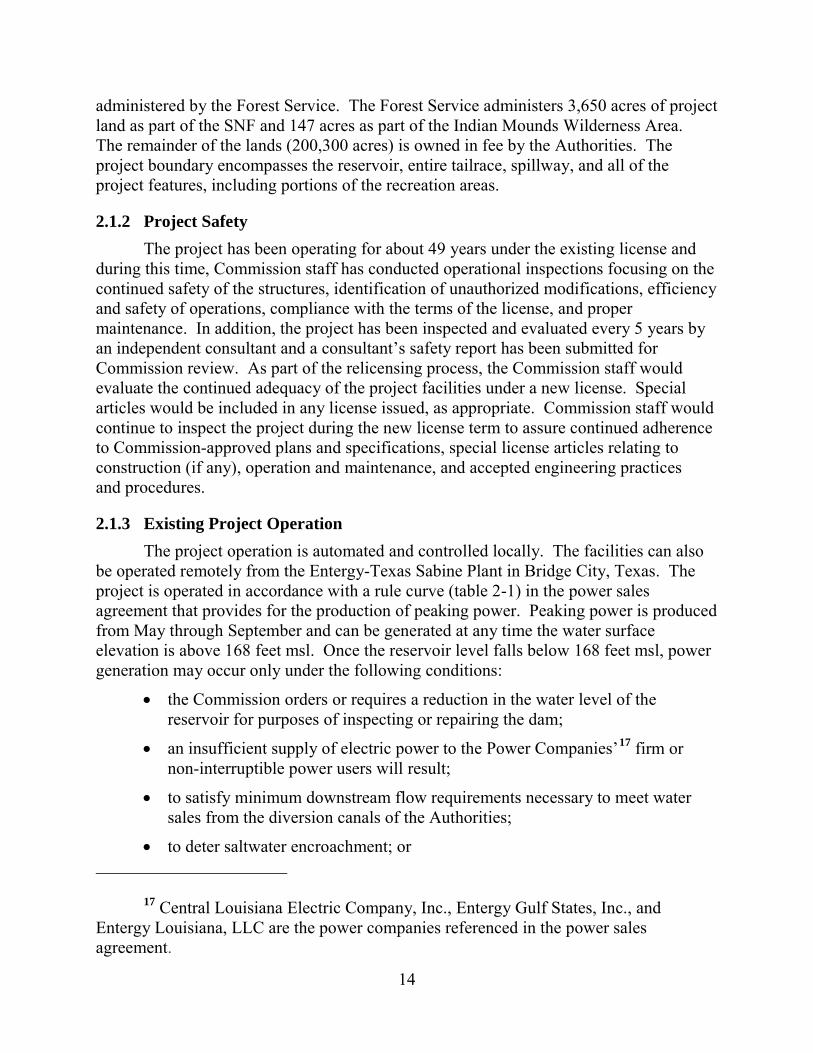
14
administered by the Forest Service. The Forest Service administers 3,650 acres of project land as part of the SNF and 147 acres as part of the Indian Mounds Wilderness Area. The remainder of the lands (200,300 acres) is owned in fee by the Authorities. The project boundary encompasses the reservoir, entire tailrace, spillway, and all of the project features, including portions of the recreation areas.
2.1.2 Project Safety The project has been operating for about 49 years under the existing license and
during this time, Commission staff has conducted operational inspections focusing on the continued safety of the structures, identification of unauthorized modifications, efficiency and safety of operations, compliance with the terms of the license, and proper maintenance. In addition, the project has been inspected and evaluated every 5 years by an independent consultant and a consultant’s safety report has been submitted for Commission review. As part of the relicensing process, the Commission staff would evaluate the continued adequacy of the project facilities under a new license. Special articles would be included in any license issued, as appropriate. Commission staff would continue to inspect the project during the new license term to assure continued adherence to Commission-approved plans and specifications, special license articles relating to construction (if any), operation and maintenance, and accepted engineering practices and procedures.
2.1.3 Existing Project Operation The project operation is automated and controlled locally. The facilities can also
be operated remotely from the Entergy-Texas Sabine Plant in Bridge City, Texas. The project is operated in accordance with a rule curve (table 2-1) in the power sales agreement that provides for the production of peaking power. Peaking power is produced from May through September and can be generated at any time the water surface elevation is above 168 feet msl. Once the reservoir level falls below 168 feet msl, power generation may occur only under the following conditions:
• the Commission orders or requires a reduction in the water level of the reservoir for purposes of inspecting or repairing the dam;
• an insufficient supply of electric power to the Power Companies’17 firm or non-interruptible power users will result;
• to satisfy minimum downstream flow requirements necessary to meet water sales from the diversion canals of the Authorities;
• to deter saltwater encroachment; or
17 Central Louisiana Electric Company, Inc., Entergy Gulf States, Inc., and Entergy Louisiana, LLC are the power companies referenced in the power sales agreement.
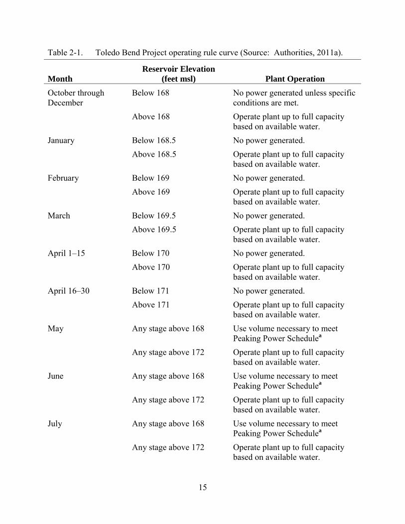
15
Table 2-1. Toledo Bend Project operating rule curve (Source: Authorities, 2011a).
Month Reservoir Elevation
(feet msl) Plant Operation October through December
Below 168 No power generated unless specific conditions are met.
Above 168 Operate plant up to full capacity based on available water.
January Below 168.5 No power generated. Above 168.5 Operate plant up to full capacity
based on available water. February Below 169 No power generated. Above 169 Operate plant up to full capacity
based on available water. March Below 169.5 No power generated. Above 169.5 Operate plant up to full capacity
based on available water. April 1–15 Below 170 No power generated. Above 170 Operate plant up to full capacity
based on available water. April 16–30 Below 171 No power generated. Above 171 Operate plant up to full capacity
based on available water. May Any stage above 168 Use volume necessary to meet
Peaking Power Schedulea Any stage above 172 Operate plant up to full capacity
based on available water. June Any stage above 168 Use volume necessary to meet
Peaking Power Schedulea Any stage above 172 Operate plant up to full capacity
based on available water. July Any stage above 168 Use volume necessary to meet
Peaking Power Schedulea Any stage above 172 Operate plant up to full capacity
based on available water.

16
Month Reservoir Elevation
(feet msl) Plant Operation August Any stage above 168 Use volume necessary to meet
Peaking Power Schedulea Any stage above 172 Operate plant up to full capacity
based on available water. September Any stage above 168 Use volume necessary to meet
Peaking Power Schedulea a In accordance with its power sales agreement, no more than 30,000,000 kilowatt-
hours of peaking power shall be scheduled during any one month of the peaking power period May through September, except with prior written consent of the Authorities.
• to make credits owed to the Power Companies or to make full reimbursements as required in its power sales agreement.
The project reservoir has historically operated with a normal maximum reservoir elevation of 172 feet msl and until 2007, a normal minimum reservoir elevation of 162.2 feet msl. Since the 2007 amendment to the power sales agreement, power is typically only generated when the reservoir elevation is above 168 feet msl.
During the May through September period when water is available for peaking power production between reservoir elevations 168 and 172 feet msl, the typical daily operation consists of releasing either 7,000 or 14,000 cubic feet per second (cfs) to the lower Sabine River (i.e., one- or two-unit operation, respectively) for 6 to 8 hours to meet the afternoon and evening peak electrical demand. A primary advantage of hydroelectric generation is the ability for the units to move from off-line to full-load in less than 10 minutes per unit. In addition to the releases for generation, there is also a minimum continuous release of 144 cfs from the spillway to the spillway channel. Powerhouse leakage that occurs when the units are offline has been estimated to range from 0 to 30 cfs per unit.
To meet the flow requirements under the current license, the continuous release of 144 cfs (i.e., 286 acre-feet per day) is maintained in the spillway channel by releases through two 20-inch-diameter conduits located in the spillway.
Flood control is not a project purpose, and the reservoir does not have a flood management pool. The spillway is located along the north dam abutment in Louisiana, and the spill gates are normally only operated when the reservoir level exceeds 172.5 feet msl. Discharge is controlled by eleven 40-foot-wide by 28-foot-high Tainter gates. Toledo Bend dam is designed to withstand a probable maximum flood event that would
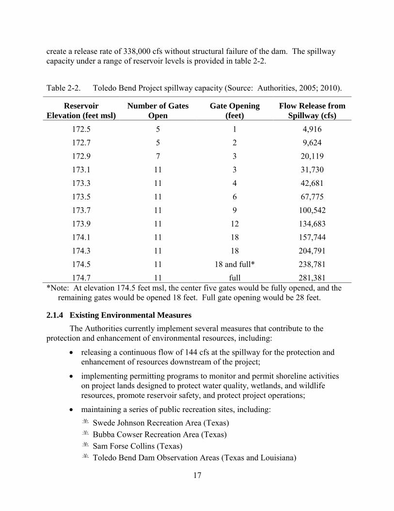
17
create a release rate of 338,000 cfs without structural failure of the dam. The spillway capacity under a range of reservoir levels is provided in table 2-2. Table 2-2. Toledo Bend Project spillway capacity (Source: Authorities, 2005; 2010).
Reservoir Elevation (feet msl)
Number of Gates Open
Gate Opening (feet)
Flow Release from Spillway (cfs)
172.5 5 1 4,916 172.7 5 2 9,624 172.9 7 3 20,119 173.1 11 3 31,730 173.3 11 4 42,681 173.5 11 6 67,775 173.7 11 9 100,542 173.9 11 12 134,683 174.1 11 18 157,744 174.3 11 18 204,791 174.5 11 18 and full* 238,781 174.7 11 full 281,381
*Note: At elevation 174.5 feet msl, the center five gates would be fully opened, and the remaining gates would be opened 18 feet. Full gate opening would be 28 feet.
2.1.4 Existing Environmental Measures The Authorities currently implement several measures that contribute to the
protection and enhancement of environmental resources, including:
• releasing a continuous flow of 144 cfs at the spillway for the protection and enhancement of resources downstream of the project;
• implementing permitting programs to monitor and permit shoreline activities on project lands designed to protect water quality, wetlands, and wildlife resources, promote reservoir safety, and protect project operations;
• maintaining a series of public recreation sites, including: Swede Johnson Recreation Area (Texas) Bubba Cowser Recreation Area (Texas) Sam Forse Collins (Texas) Toledo Bend Dam Observation Areas (Texas and Louisiana)
18
Oak Ridge (Louisiana) Cow Bayou Wilderness Area (Louisiana) Converse Bay (Louisiana) Hot Wells/San Patrico Overlook (Louisiana) Clyde’s Crossing Park (Louisiana) San Miguel (Louisiana) Tourist Information Center (Louisiana) Cypress Bend Golf Resort and Convention Center (Louisiana) Cypress Bend Park (Louisiana) Pleasure Point Campground (Louisiana) Pendleton Park (Louisiana) Blue Lake Landing Recreation Area (Louisiana);
• participating in cooperative efforts with Texas PWD and Louisiana DWF on the management of invasive aquatic plants and providing educational materials on the prevention of the spread of giant salvinia and water hyacinth.
2.2 APPLICANTS’ PROPOSAL
2.2.1 Proposed Project Facilities The Authorities propose to construct a 1.3-MW minimum flow turbine-generator
located immediately below the spillway (figure 2-1). The proposed installation would replace one spillway tainter gate with a new conventional intake. The spillway bay would be divided into two parts. A prefabricated steel intake structure would occupy 11 horizontal feet of the bay, and the remaining space would be used to build a stoplog gate, which would be used as the last of the spillway gates to be opened in the event of high inflows.
Just downstream of the intake, a steel penstock pipe approximately 460 feet in length would be installed to pass over the top of the existing reinforced-concrete training wall and would follow the land-side of the existing spillway chute training wall to the proposed powerhouse. The proposed 23-foot-wide by 70-foot-long minimum flow powerhouse would discharge directly to a 14-foot-wide, 500-foot-long minimum flow tailrace channel leading to the existing spillway channel (figure 2-1). The powerhouse would contain a single 1.3-MW horizontal Francis-type turbine-generator unit, switchgear, unit controls, and electrical protection equipment.
The generator would be connected to a 1,500-kV-ampere, 4.16-kV/13.8-kV, three-phase transformer located adjacent to the powerhouse access road in a new switchyard. A transmission line would extend approximately 10,400 feet from the switchyard to the existing main powerhouse substation via a pole-mounted, 15-kV, medium-voltage cable. The transmission line would be routed over the spillway and along the main dam on the
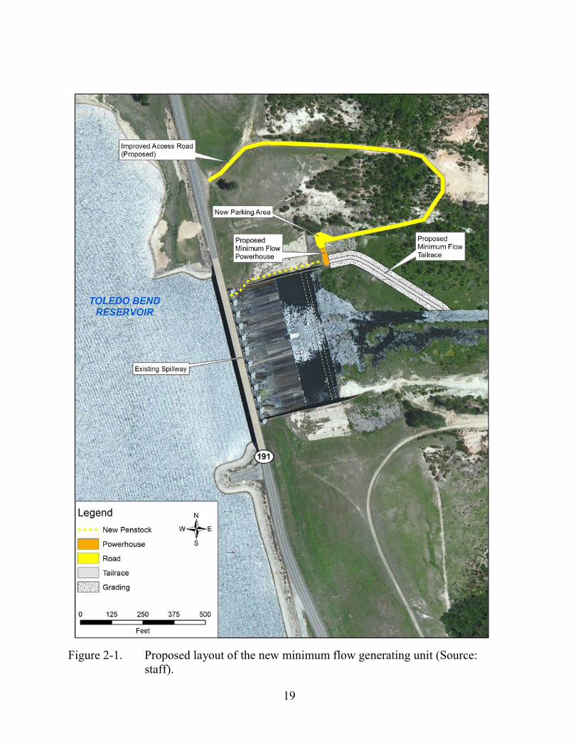
19
Figure 2-1. Proposed layout of the new minimum flow generating unit (Source:
staff).
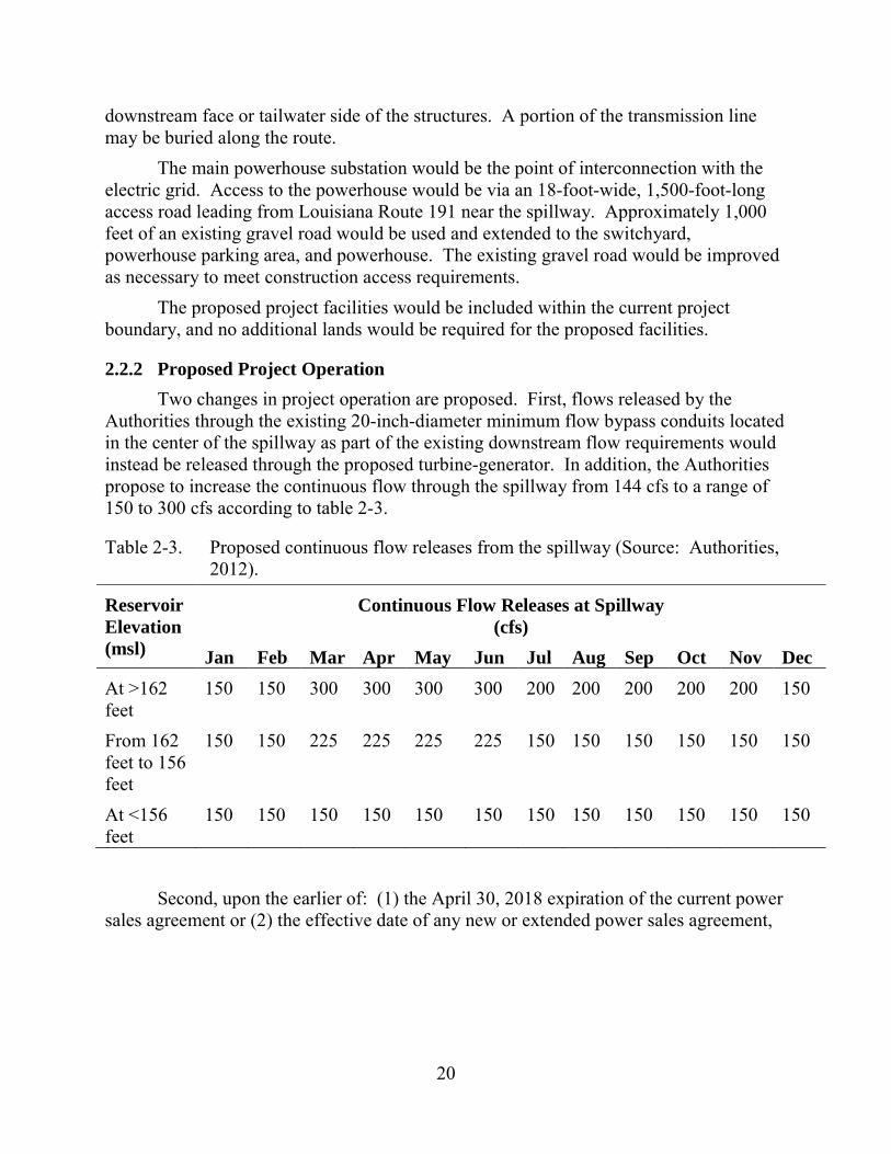
20
downstream face or tailwater side of the structures. A portion of the transmission line may be buried along the route.
The main powerhouse substation would be the point of interconnection with the electric grid. Access to the powerhouse would be via an 18-foot-wide, 1,500-foot-long access road leading from Louisiana Route 191 near the spillway. Approximately 1,000 feet of an existing gravel road would be used and extended to the switchyard, powerhouse parking area, and powerhouse. The existing gravel road would be improved as necessary to meet construction access requirements.
The proposed project facilities would be included within the current project boundary, and no additional lands would be required for the proposed facilities.
2.2.2 Proposed Project Operation Two changes in project operation are proposed. First, flows released by the
Authorities through the existing 20-inch-diameter minimum flow bypass conduits located in the center of the spillway as part of the existing downstream flow requirements would instead be released through the proposed turbine-generator. In addition, the Authorities propose to increase the continuous flow through the spillway from 144 cfs to a range of 150 to 300 cfs according to table 2-3.
Table 2-3. Proposed continuous flow releases from the spillway (Source: Authorities, 2012).
Reservoir Elevation (msl)
Continuous Flow Releases at Spillway (cfs)
Jan Feb Mar Apr May Jun Jul Aug Sep Oct Nov Dec At >162 feet
150 150 300 300 300 300 200 200 200 200 200 150
From 162 feet to 156 feet
150 150 225 225 225 225 150 150 150 150 150 150
At <156 feet
150 150 150 150 150 150 150 150 150 150 150 150
Second, upon the earlier of: (1) the April 30, 2018 expiration of the current power sales agreement or (2) the effective date of any new or extended power sales agreement,
21
the Authorities would implement seasonal powerhouse operations with the following components.18
During March, April, May, and June, the Authorities would limit the maximum powerhouse flow during peaking operations at the project to 12,000 cfs. On each weekend day in March and April, the Authorities would provide a volume of 1,450 acre-feet (or more at the Authorities’ discretion) of flow releases from the powerhouse.19 On each weekend in May and June, the Authorities would release the requirement for March and April, if both of the following conditions are met: (1) the mean calculated inflow to the reservoir for the first 6 months of the current water year (October 1 to March 31) is greater than 80 percent of the mean calculated inflow of the water year for the same 6-month period for the most recent 38-year period of record (not including the current water year); and (2) the Authorities are able to safely operate at least one turbine-generator unit within its normal operating range.
2.2.3 Proposed Environmental Measures The Authorities propose to implement the SNF Relicensing Agreement and the
ARA, which collectively include implementing the following conditions and measures:
• SNF Recreation Areas Operations and Maintenance and Capital Improvements Plan (SNF Recreation Plan) (4(e) Condition 13)—This plan (filed August 1, 2012) identifies responsibilities by the Sabine River Authority of Texas for operation, maintenance and improving the six SNF recreation areas (Indian Mounds Recreation Area,20 Willow Oak Recreation Area, Lakeview Recreation Area, East Hamilton boat launch, Ragtown Recreation Area, and Haley’s Ferry boat launch); details operation and maintenance activities for each of the recreation areas, including schedules; presents a capital funding plan to address the needs of the recreation areas; calls for annual review meetings with the Forest Service to determine if adjustments are necessary; and states that agreed-upon changes to the SNF Recreation Plan would be filed with the Commission.
• Erosion Monitoring and Management Plan (4(e) Condition 14) (filed August 1, 2012)—The Sabine River Authority of Texas would implement a 10-year monitoring program to determine erosion rates at six representative sites along
18 According to the Authorities, the proposed delay in implementation would allow
them to fully meet their obligations under the power sales agreement. 19 A volume of 1,450 acre-feet would produce a flow of 4,000 cfs for a duration of
about 4.4 hours, or a flow of 7,000 cfs for about 2.5 hours. 20 Indian Mounds Recreation Area is a lake-side recreation area with developed
facilities. It is outside (and not part) of the Indian Mounds Wilderness Area.
22
the project shoreline within the SNF; apply estimated rates to other similar project shoreline locations within the SNF; establish monitoring protocols designed to assist in determining whether erosion may impact environmental resources (e.g., cultural, terrestrial, and recreation sites) over the short or long term; classify the approximately 32-mile-long portion of the SNF shoreline that has experienced some degree of erosion and matching these portions of the SNF shoreline to one of the six selected monitoring sites based on similar physical characteristics; develop site-specific plans to address resource effects; and submit site-specific measures to the Forest Service for review and approval.
• Chinese Tallow Control (4(e) Condition 15)—The Sabine River Authority of Texas would contribute $20,000 (2013 dollars) annually to the Forest Service for the ongoing treatment of Chinese tallow along the shoreline within the SNF; also, as part of the Shoreline Management Plan (SMP), the Sabine River Authority of Texas would require lessees and permittees on non-federal project lands to control and remove Chinese tallow on the leased and permitted lands.
• Continuous Releases at Spillway (proposed Article A-1)—The Authorities would implement new continuous minimum flow releases at the spillway, ranging from 150 to 300 cfs, following the monthly schedule described in table 2-3, to protect and enhance aquatic resources within the spillway channel and the lower Sabine River.
• A plan for the measurement and management of continuous releases from the spillway (proposed Article A-2)—The Authorities would develop a flow release plan to ensure that flow releases are being maintained as required by any new license; identify location and means of delivery of the flow releases; describe the means for measuring the continuous flow releases (including specifications and drawings of any device, structure, or method that meets or exceeds U.S. Geological Survey [USGS] standards) and means of making such release information available to the Commission and resource agencies; provide a schedule for construction and operation of the flow release and measurement structure; and establish a process for amending the plan to accommodate the development schedule for the minimum flow unit at the spillway and any measures for downstream passage of American eel.
• Forebay Cofferdam Monitoring Program (proposed Article A-3)—The Authorities would conduct temperature monitoring in the project’s tailrace channel in July, August, and September to assist in monitoring the physical stability of the remnant forebay cofferdam to ensure that the submerged cofferdam continues to act as a water control structure forcing warmer and better-oxygenated water from the upper reservoir strata to flow to the powerhouse intakes. If monitoring demonstrates that the mean daily temperature of at least 10 percent of the monitored days in July, August, and
23
September is below 20°C, then the powerhouse intakes are likely receiving cooler water from the lower reservoir strata, and the physical integrity of the remnant forebay cofferdam would be subject to further investigation. The Authorities would then collect in situ dissolved oxygen (DO) measurements at the same location to determine if low dissolved oxygen water from the lower reservoir strata is being discharged, survey the cofferdam crest elevations and compare them to 2011 baseline conditions to see if, and by how much the cofferdam has eroded, and, if necessary, develop a cofferdam restoration plan.
• Seasonal Powerhouse Operations (proposed Article A-4)—Upon the April 30, 2018 expiration of the current power sales agreement (or an earlier date if a new power sales agreement is reached prior to 2018), the Authorities would: reduce normal maximum powerhouse peaking flows to 12,000 cfs during
March through June; upon completion of the testing program to determine optimum weekend
releases (1,450 acre-feet per weekend day), file with the Commission for approval a weekend operation plan. The weekend operations plan would be based on flow testing conducted by the agencies to determine the flow rate and duration of weekend releases to enhance aquatic resources by reducing the extreme drops in flow and aquatic habitat that occur over the weekend due to the lack of normal hydropower discharges on those days; and
upon Commission approval, implement the weekend operations plan-- release 1,450 acre-feet of water from the powerhouse every weekend day in March and April, and depending on water year type, every weekend day in May and June.
• Upstream and Downstream Passage of American Eel—The Authorities would provide for the upstream and downstream passage of American eel at the dam by preparing upstream and downstream passage plans. The upstream passage plan would include: plans for deployment of two portable ramp traps in the project tailrace and four portable ramp traps in the project spillway; a protocol for safely transporting juvenile eels captured in the ramp traps for release from the shoreline upstream of the dam at two locations; additional sampling for American eel with other gear types, such as electrofishing, in the vicinity of the ramp trap locations at least once per month when water temperatures are in the range of 16 to 21°Celsius (°C); continued consultations with the resource agencies throughout the ramp trap operations regarding adjustments to the location, design, and/or operation of the ramp traps necessary to maintain or enhance their performance; annual reports on the ramp trap operations, including the results of the upstream passage program, to be provided to the resource agencies and filed with the Commission; and a provision to cease fish passage operations if monitoring results indicate that an average of less than 150 eels per year are passed in years 3 through 5 of the program. The
24
downstream passage plan would include: a plan to safely pass adult American eels from the project reservoir to the Sabine River downstream of the project via the continuous flow releases or by other means at the project spillway, with the plan to be filed for Commission approval within 6 years of the Commission’s approval of the upstream passage plan; detailed design drawings and a construction schedule for any modifications necessary for continuous releases from the spillway to provide safe, timely, and effective downstream passage via a screening and diversion system to safely divert and transport eels away from the proposed minimum flow generating unit at the spillway, or design of a near-surface (upper 12 feet) continuous flow weir/intake facility at or near the spillway structure; a proposed schedule for initiating downstream passage operations following Commission approval of the plan; an annual report on downstream passage operations, including all measures implemented to promote safe and timely downstream passage; and provisions for an annual site visit and review of downstream passage operations by the resource agencies.
In addition to the measures proposed as part of the SNF Relicensing Agreement and the ARA, the Authorities also propose to implement their:
• Recreation Management Plan (filed March 6, 2012) for lands outside the SNF that identifies management and maintenance responsibilities for 13 project recreation sites operated by the Authorities on lands owned in fee. The plan describes the sites covered by the plan, including the condition, landownership, and 2010 use levels; describes the maintenance measures that would be implemented over the term of any license as well as a capital improvement program; describes the recreation monitoring program, including the program components, monitoring schedule, and relationship to the periodic updates of the plan and FERC reporting requirements (i.e., Form 80); and includes the consultation, reporting, and recreation management plan review to be implemented of the term of any license.
• SMP (filed February 3, 2012) that consolidates the existing shoreline permitting program with a new shoreline classification system, monitoring and enforcement measures and plan review and updates. Shorelines would be classified into one of four categories: Forest Service, Public Access, Conservation, and General. The permitting program section of the plan describes the permitting process, resource agency consultation requirements, application requirements, review and approval by the Authorities, Commission review and/or approval, and permitting requirements for existing facilities.
• HPMP (filed June 12, 2012) that includes measures to identify historic properties within the project APE; identify project-related effects; and avoid, reduce, or mitigate any effects on historic properties that are determined to be adverse. The HPMP includes, but is not limited to requirements for additional
25
archaeological survey and monitoring, public and employee education, a plan for inadvertent discoveries, procedures for the unanticipated discovery of human remains, procedures for emergency situations, consultation with appropriate agencies and tribes, including consultation regarding TCPs that may be present within the project APE, and a requirement to comply with the Secretary of the Interior’s Standards for the Treatment of Historic Properties (Secretary’s Standards) where feasible if modifications to the character-defining features of the Toledo Bend Project facilities become necessary.
2.2.4 Modifications to Applicants’ Proposal—Mandatory Conditions The following mandatory conditions would be made part of any issued license
unless modified by the conditioning agency and are evaluated as part of the Authorities’ proposal. These conditions are identical to appendix B of the ARA and thus are part of the Authorities’ proposal.
Section 18 Prescriptions Interior and NMFS filed identical section 18 fishway prescriptions that include
measures for upstream and downstream passage of American eel. The general terms and conditions specify that the Authorities:
• construct, operate, and maintain fishways to provide safe, timely, and effective passage through the project for American eels;
• provide representatives of FWS, NMFS, Louisiana DWF, and Texas PWD access to the project and pertinent records for the purpose of inspecting and determining compliance with the fishways prescription;
• monitor the migration of American eel at the project and operate upstream passage fishways throughout the upstream migration period and operate the downstream passage fishways throughout the downstream migration period;
• maintain the fishways in proper working order and clear fishways of trash, logs, and other material that would hinder safe, timely, and effective passage; and
• if ramp trap operations in years 3 through 5 of the upstream passage plan result in the passage of fewer than an average of 150 eels per year, the Authorities may propose to FWS/NMFS to discontinue all requirements of this fish passage prescription and to revert to a reservation of authority to prescribe fishways.
Upstream prescriptions specify that the Sabine Rivers Authorities prepare and file for Commission approval, within 18 months of issuance of a new license, an upstream passage plan to deploy and operate portable ramp traps and to safely pass juvenile American eels upstream of the project within 18 months after the effective date of the new license. The plan would consist of:
26
• detailed drawings with explanatory text for portable ramp traps, with two portable ramp traps at the downstream end or within the powerhouse tailrace, and four portable ramp traps within the spillway structure;
• a schedule for installation and testing the ramp traps;
• protocols for safe transportation of juveniles;
• procedures for data collection (e.g., size and number of eels captured and timing and location of captures and releases, and water temperatures);
• a phased schedule for operating, inspecting, and possibly relocating ramp traps and/or modifying the attraction flows as required;
• annual reports of upstream and downstream passage operations, prepared in consultation with the resource agencies, including information on the timing, locations, numbers, and sizes of eels captured and released; trap mortality; results of any eel sampling; water temperature data and any proposed revisions to the plan to improve its effectiveness at passing juvenile eels upstream of the dam; and
• provisions for an annual site visit and review of ramp trap operations with the resource agencies.
The prescription also allows for potential termination or adjustments to the program after 5 years of ramp trap operations, with the 5th annual report to address whether to continue such operations based on the number of eels passed upstream to date, giving due consideration to hydrologic/meteorological conditions and other relevant factors (such as actual operational time for the various ramps). If ramp trap operations in years 3 through 5 result in the passage of fewer than an average of 150 eels per year, the Authorities may propose to discontinue all requirements of the fish passage prescription, in accordance with the general terms and conditions for the fishway prescriptions.
Downstream prescriptions specify that, within 6 years after the Commission’s approval of the upstream passage plan, the Sabine Rivers Authorities must prepare and file for Commission approval a downstream passage plan to safely pass adult American eels via the continuous flow releases or by other means at the project spillway. The plan would include:
• detailed design drawings, with explanatory text and a construction schedule for any modifications necessary for the continuous releases from the spillway to provide safe, timely, and effective downstream passage via the continuous releases or other means consisting of a design of either a: screening and diversion system to safely divert and transport eels away
from the proposed minimum flow generating unit, or

27
near-surface (upper 12 feet) continuous flow weir/intake facility at or near the spillway structure to safely transport eels to the lower Sabine River if the continuous flow hydro turbine is not constructed;
• a proposed schedule for initiating downstream passage operations following Commission approval of the plan;
• an annual report, prepared in consultation with resource agencies, consisting of downstream passage operations, including documentation that the facilities were available throughout the year and any other measures implemented to promote safe and timely downstream passage; and
• provisions for an annual site visit and review of downstream passage operations by agencies.
Both Interior and NMFS also requested reservations of authority to modify their section 18 fishway prescriptions included in any license issued for the project.
Section 4(e) Land Management Conditions The Forest Service filed the following mandatory conditions (appendix D), which
are evaluated in this final EIS. We consider conditions 1 through 12 to be administrative and therefore not analyzed in our final EIS. The following section 4(e) conditions are resource-specific:
• Condition 13, SNF Recreation Plan—The Sabine River Authority of Texas would completely and fully comply with all provisions of the SNF Recreation Plan [described above in section 2.2.3, Proposed Environmental Measures, and attached as appendix C to the SNF Relicensing Agreement].
• Condition 14, Erosion Monitoring and Management Plan—The Sabine River Authority of Texas would completely and fully comply with all provisions of the SNF Erosion Monitoring and Management Plan [described above in section 2.2.3, Proposed Environmental Measures, and attached as appendix B to the SNF Relicensing Agreement].
• Condition 15, Chinese Tallow Control—The Sabine River Authority of Texas would provide monetary contributions to the Forest Service during the term of the license in the amount of twenty thousand dollars ($20,000 in 2013 dollars) per year to be used by the Forest Service for its ongoing treatment program for Chinese tallow along the shoreline within the SNF.
28
2.3 STAFF ALTERNATIVE21 The staff alternative includes the following environmental measures proposed by
the Authorities:
• the SNF Recreation Plan;
• the SNF Erosion Monitoring and Management Plan;
• increased minimum flows at the project spillway ranging from 150 to 300 cfs, depending on the month and reservoir levels;
• a flow release plan for measurement and management of continuous releases at the spillway;
• a forebay cofferdam monitoring program to ensure physical stability of the cofferdam;
• seasonal powerhouse operations, including reducing normal maximum powerhouse peaking flow to 12,000 cfs during March through June, and releasing 1,450 acre-feet of water every weekend day in March and April and depending on water year type, every weekend day in May and June;
• upstream and downstream passage for American eel, consistent with the fishway prescriptions filed by Interior and NMFS;
• the proposed Recreation Management Plan;
• the proposed SMP; and
• the proposed HPMP. In addition to the Authorities’ proposed measures, the staff alternative also
includes the following modifications and additions:
• Prepare and file for Commission approval an erosion and sediment control plan with proposed best management practices and erosion control measures to protect aquatic resources during the installation of the proposed minimum flow generating unit.
21 In some cases, we include a “Staff Alternative with Mandatory Conditions” that
includes the mandatory conditions that are excluded from the Staff Alternative. Because there is little difference between the Staff Alternative and Staff Alternative with Mandatory Conditions, we do not evaluate it as a separate alternative in this final EIS.
29
• Prepare and file for Commission approval an erosion monitoring plan for shoreline areas classified as Public Access and Conservation classification shorelines outside National Forest System lands to mitigate any effects of erosion on important shoreline resources.
• Continue to maintain reservoir levels between elevations 168 and 172 feet msl during normal hydropower production to provide public recreation and shoreline protection for the term of the license.
• Monitor the elevation of the forebay cofferdam by bathymetric survey at 15-year intervals (i.e., two to three surveys over the license period), in addition to the Authorities’ proposed use of water temperature monitoring, to ensure the physical stability of the cofferdam to help maintain higher downstream DO levels.
• Be responsible for treatment program for Chinese tallow along the shoreline within the SNF to help prevent the further spread of this species within the SNF; prepare an annual report outlining the amount and general location of Chinese tallow control on SNF lands to ensure implementation of proposed treatment measures.
• Prior to initiating construction of the proposed minimum flow generating unit, conduct surveys to confirm that no bald eagle nests occur within the recommended protection buffers. If a nest is identified, implement appropriate buffer distance and/or restrict construction activities to periods outside the nesting season, to prevent any effects of construction on any bald eagle nests.
• Design and construct the proposed transmission line associated with the proposed minimum flow generating unit in accordance with the Avian Power Line Interaction Committee (APLIC) guidelines to reduce potential effects of the proposed transmission line on birds in the project area.
• Prepare and file for Commission approval a spillway channel recreation access plan, after consultation with American Whitewater and the Sabine Whitewater Club that would enhance safety and access by providing public, car-top boating access to the spillway channel during normal flow releases. The plan should address access at flow levels between 300 and 3,000 cfs and establish specific criteria (either flow releases or associated reservoir levels) that would trigger closure of the site.
30
• Include in the SMP measures for controlling Chinese tallow outside SNF lands at project recreation areas maintained by the Authorities and at Conservation and Public Access classification areas where ground-disturbing activities would occur, to assist in the control of this invasive species in the project area. Also incorporate guidelines for bald eagle protection measures into the SMP to address future nesting and other bird activities in the project area.
• Include in the proposed Recreation Management Plan a brief description and location information for the 12 non-project recreation sites that currently provide access to the project.
• Include in the proposed Recreation Management Plan a comprehensive inventory and description of each site, a discussion of planned improvements for each site, and a schedule for improvements at each site for the 17 project recreation sites, including access to the tailrace and spillway channels downstream of the dam. This would ensure that all publicly available recreation resources are adequate to meet demand and that the Authorities’ sites are maintained during any new license term.
• Include consultation with American Whitewater and Sabine Whitewater Club prior to filing the weekend operations plan with the Commission regarding release scheduling and timing of the weekend releases to ensure that weekend releases consider the secondary benefits for recreation.
• Provide spillway flow release and reservoir level information on a public website to provide boaters and other recreational users information for planning future recreational visits to the project.
• Design the proposed minimum flow generating unit to match the setting in the vicinity of the spillway to protect the aesthetics of the area.
2.4 ALTERNATIVES CONSIDERED BUT ELIMINATED FROM DETAILED ANALYSIS We considered several alternatives to the applicants’ proposal, but eliminated
them from further analysis because they are not reasonable in the circumstances of this case. They are: (1) issuing a non-power license; and (2) retiring the project.
2.4.1 Issuing a Non-Power License A non-power license is a temporary license that the Commission will terminate
when it determines that another governmental agency will assume regulatory authority and supervision over the lands and facilities covered by the non-power license. At this point, no agency has suggested a willingness or ability to do so. No party has sought a non-power license and we have no basis for concluding that the project should no longer be used to produce power. Thus, we do not consider issuing a non-power license a realistic alternative to relicensing in this circumstance.

31
2.4.2 Retiring the Project Project retirement could be accomplished with or without dam removal. Either
alterative would involve denial of the relicense application and surrender or termination of the existing license with appropriate conditions. No participant has suggested that dam removal would be appropriate in this case, and we have no basis for recommending it. The project reservoir is a major source of water supply for the region and supports significant recreational activities, regardless of whether power is produced. Thus, dam removal is not a reasonable alternative to relicensing the project with appropriate protection, mitigation, and enhancement measures.
The second project retirement alternative would involve retaining the dam and disabling or removing equipment used to generate power. Project works would remain in place and could be used for historic or other purposes. This would require us to identify another government agency with authority to assume regulatory control and supervision of the remaining facilities. No agency has stepped forward, and no participant has advocated this alternative. Nor have we any basis for recommending it. Because the power supplied by the project is needed, a source of replacement power would have to be identified. In these circumstances, we do not consider removal of the electric generating equipment to be a reasonable alternative.

32
This page intentionally left blank.
33
3.0 ENVIRONMENTAL ANALYSIS
In this section, we present: (1) a general description of the project vicinity; (2) an explanation of the scope of our cumulative effects analysis; and (3) our analysis of the proposed action and other recommended environmental measures. Sections are organized by resource area. Under each resource area, historic and current conditions are first described. The existing condition is the baseline against which the environmental effects of the proposed action and alternatives are compared, including an assessment of the effects of proposed mitigation, protection, and enhancement measures, and any potential cumulative effects of the proposed action and alternatives. Staff conclusions and recommended measures are discussed in section 5.2, Comprehensive Development and Recommended Alternative. 22
3.1 GENERAL DESCRIPTION OF THE RIVER BASIN The Toledo Bend Project is located on the border of southeastern Texas and
western Louisiana. The dam, sited on the Sabine River at river mile (RM) 147 in Newton County, Texas, and Sabine Parish, Louisiana, is the only hydroelectric project on the Sabine River. At the full pool water surface elevation of 172 feet above msl, the Toledo Bend reservoir is about 70 miles long, but due to the meandering route of the channel of the Sabine River, the reservoir extends up to just above Logansport, Louisiana, at RM279. The Toledo Bend reservoir extends into Panola, Sabine, Shelby, and Newton counties in Texas, and Sabine, Vernon, and DeSoto parishes, in Louisiana. The Sabine River flows into the Gulf of Mexico near Port Arthur, Texas, and has a total drainage area of about 9,952 square miles. About 75 percent of the basin lies within Texas and the remaining 25 percent within Louisiana. The Sabine River Basin is bordered by the Cypress and Sulphur River basins on the north and northeast, the Calcasieu River Basin on the east, the Neches River Basin on the west, and Trinity River Basin on the northwest.
The Sabine River at Toledo Bend dam has a watershed area of 7,178 square miles. The headwaters of the Sabine River originate in northwest Hunt County near the city of Greenville, Texas, in the low, rolling hills of the Blackland Prairies. The Cowleech Fork Sabine River flows east/southeast before joining the South Fork of the Sabine River and Caddo Creek in Lake Tawakoni. The main stem of the Sabine River then continues southeast to the headwaters of Toledo Bend reservoir near Logansport, Louisiana, where the center channel becomes the state line for Louisiana and Texas. The river continues south to its mouth at Sabine Lake near the Gulf Coast, 560 river miles from its origin. Elevations in the basin range from near 700 feet in its headwaters areas to about 85 feet in the tailwater area downstream of Toledo Bend dam and sea level at the Gulf Coast. The
22 Unless otherwise indicated, our information is taken from the application for license for this project (Authorities, 2011a), the SNF Relicensing Agreement and ARA (Authorities, 2012a), and the response to the additional information request (AIR) (Authorities, 2012b).
34
majority of the Sabine River Basin is located within the Interior Coastal Plains, known locally as the Piney Woods that extends to about 20 miles north of Sabine Lake. The nearly flat Coastal Prairie begins north of Orange, Texas, and extends south to the Gulf of Mexico.
Downstream of Toledo Bend dam, the Sabine River is largely an alluvial river that flows through bottom land forests. Major tributaries that join the Sabine River downstream of the Toledo Bend dam include: Bayou Toro, Bayou Anacoco, and Big Cow Creek.
The climate in eastern Texas and western Louisiana is typically humid with warm summers and mild winters due to the subtropical climate. In the Toledo Bend dam area, the average low and high temperatures are about 35 and 57 degrees Fahrenheit (°F) in January and about 70 and 94°F in July. The Sabine River Basin’s annual precipitation averages about 35 inches in the upper Sabine River Basin and increases to about 55 inches at the Toledo Bend dam and to 60 inches in the lower Sabine River Basin near the Gulf Coast. In the Sabine River Basin, a majority of the yearly precipitation occurs during the winter and spring; consequently, streamflows typically increase during the winter and peak in the spring. The driest months are normally in late summer and early fall, but tropical storms with heavy rainfall sometimes affect the region and cause relatively high streamflows in the summer and fall.
3.2 SCOPE OF CUMULATIVE EFFECTS ANALYSIS According to the Council on Environmental Quality’s regulations for implementing
National Environmental Policy Act (40 CFR §1508.7), cumulative effect is the impact on the environment which results from the incremental impact of the action when added to other past, present, and reasonably foreseeable future actions regardless of what agency (federal or non-federal) or person undertakes such other actions. Cumulative impacts can result from individually minor but collectively significant actions taking place over a period of time, including hydropower and other land and water development activities. Through scoping, agency consultation, and our independent analysis, we have identified no resources that would be cumulatively affected by continuing to operate the Toledo Bend Project.
3.3 PROPOSED ACTION AND ACTION ALTERNATIVES In this section, we discuss the effect of the project alternatives on environmental
resources. For each resource, we first describe the affected environment, which is the existing condition and baseline against which we measure effects. We then discuss and analyze the specific site-specific and cumulative environmental issues.
Only the resources that would be affected, or about which comments have been received, are addressed in detail in this EIS. We have not identified any substantive issues related to socioeconomics or environmental justice associated with the proposed action, and, therefore, neither socioeconomics nor environmental justice is assessed in this EIS.
35
We present our recommendations in section 5.2, Comprehensive Development and Recommended Alternative.
3.3.1 Geology and Soil Resources
3.3.1.1 Affected Environment
Geology The project is located within the West Gulf Coastal Plain physiographic province,
which borders the Gulf of Mexico and includes parts of Louisiana, Texas, Arkansas, and Oklahoma. The region is dominated by shallow marine, deltaic, and alluvial sediments that were deposited during various periods of fluctuating sea levels and coastal subsidence during the Cenozoic Era. The modern topography of the region was shaped primarily at the end of the Pleistocene Epoch when retreating glaciers fed rivers that carried outwash sediments to the Gulf of Mexico; the large volumes of sediments deposited along the river valleys were later incised by Holocene streams. The generally gentle topography is characterized by parallel escarpment (cuestas) and accompanying valleys.
Within the state of Texas, the province is divided further into three physiographic subprovinces. The Blackland Prairies, consisting of low rolling hills, are located at the northern end of the Sabine River Watershed. The project dam, reservoir, and approximately 125 river miles of the Sabine River below the dam are located in the Interior Coastal Plains physiographic subprovince, which is characterized by parallel escarpments and covers 88 percent of the river’s watershed. The lower 20 river miles of the Sabine River between the city of Orange and Sabine Lake are located in the Coastal Prairies physiographic subprovince, characterized by flat grasslands and marshes.
Uplands in the vicinity of the reservoir comprise predominantly Tertiary sediments, while the river and tributary valleys are filled with Quaternary alluvial deposits. Sediments consist of various mixtures of sand, silt, and clay.
Downstream of Toledo Bend dam, the surficial geology consists primarily of Quaternary deposits in the form of terraces and alluvial deposits. Sediment types consist primarily of silt and clay with sand and some gravel. Between the dam and Burr Ferry (15 river miles downstream of the dam), the river is constricted and has a comparatively steep gradient, controlled by bedrock. The sediment load is generally low.
The floodplain of the river includes paleomeanders, which typically are swampy depressions or meander scrolls.23 Downstream of Burr Ferry, the Sabine River widens, its gradient decreases, the sediment load increases, and channel migration is a more dominant process. The head of the delta is located near Cutoff Bayou, south of Deweyville. Along
23 Rivers erode along the outside of turns in their channel, depositing sediment on the inside (point bars). Over time, the river shifts, leaving behind meander scrolls.
36
with the increasing tidal flows, coastal landforms increase south of this point, and the stream has an increasingly distributary flow24 network.
There is no evidence of active faults in the vicinity of the reservoir, and seismicity in the area is comparatively low. Weak to moderate earthquakes with magnitudes of 2.6 to 4.4 on the Richter scale were reported in 1964 along the Texas-Louisiana border; these earthquakes occurred concurrently with the construction of Toledo Bend dam and the filling of the Sam Rayburn reservoir, approximately 35 miles to the west of the project.
Mineral resources in the project area consist of construction materials (sand, gravel, crushed stone), lime, clay, lignite, and gypsum. In addition, oil and natural gas are extracted from the Mesozoic Era deposits subsurface. Prior to construction of the project, the Authorities acquired oil and gas wells beneath the area of the existing reservoir. Each well was plugged, closed, and abandoned according to regulations. Since 2007, oil and gas have been produced in the area from the Haynesville Shale using fracking technology.
Soils Soils in the vicinity of the project can be categorized into three broad physiographic
settings: Tertiary upland, Pleistocene fluvial terraces, and Holocene alluvium. Tertiary uplands surround and intrude on the reservoir forming its banks. Associated soils (Sacul, Ruston, Keithville, and Bowie series) consist of sandy loam to clayey loam, which generally formed on old coastal plain and marine deposits. Pleistocene fluvial terraces are located at the northern end of the reservoir and along the banks of mouths of tributaries at elevations higher than the water surface. Associated soils (Bienville, Hainesville, and Cahaba series) are sandy and generally formed on old alluvial or coastal sediment deposits. Holocene alluvium deposits occupy the lowest position in the landscape. They are present as point bars, natural levees, stream channels, backswamps, and terraces, and are typically found on floodplains. These soils (Guyton, Sawtown, Metcalf, Urbo, and Menatchie series) are generally sandy and loamy, and poorly to somewhat poorly drained.
In addition to these soils, deltaic/coastal deposits become more common as the Sabine River approaches Sabine Lake. Associated soils consist of loamy and clayey or mucky and clayey fluid materials.
The reservoir shoreline is susceptible to erosion because of the unconsolidated nature of the soil and sediments. The Authorities determined that 10 percent of the 1,130-mile-long shoreline had displayed varying levels of erosion. About 13 percent of the 228-mile-long portion of the shoreline occupied by the SNF displayed some erosion. Erosion is primarily caused by wave action and to a lesser extent by power boat wakes. The Authorities installed shoreline protection, such as riprap, in some locations to control erosion.
24 Distributary flow occurs in a stream that branches away from the main channel.

37
3.3.1.2 Environmental Effects
Construction of Minimum Flow Generating Unit Construction of the minimum flow generating unit would include disturbance of an
estimated 1.2 acres of ground (about 0.7 acre of temporary disturbance and 0.5 acre of permanent disturbance) to the north of the existing spillway for the construction of the penstock, powerhouse, tailrace, and access road, as described above in section 2.2.1. The proposed tailrace, although not fully described in the final license application, would have an estimated length of about 450 feet and depth of 14 feet. The proposed access road would be 1,500-feet-long and 18-feet-wide. The Authorities did not specify erosion control measures that would be implemented during construction.
Our Analysis During construction of the proposed generating unit, disturbed areas could erode
and transport sediment into the spillway channel. The final license application does not include design details for the proposed tailrace channel confluence with the spillway channel; however, depending on the residual flow velocity of the tailrace flows at the confluence during operation, localized erosion could occur in the spillway channel.
Implementation of appropriate best management practices and erosion control measures, including bank stabilization measures within the spillway channel, would minimize adverse effects from construction and operation.
Erosion
Reservoir Shoreline Operation of the reservoir under the proposed action combined with comparatively
unconsolidated sediments in the area would continue to result in some shoreline erosion. In the final license application, the Authorities propose to implement their SMP that would include an Erosion Monitoring Program, which would be developed in consultation with interested agencies and stakeholders. The proposed SMP filed on February 3, 2012, abandoned the erosion monitoring measures initially presented in the final license application.
As a provision of the SNF Relicensing Agreement filed with the Commission on August 1, 2012, the Authorities would implement the SNF Erosion Monitoring and Management Plan. The plan is also specified in Forest Service condition 14. This plan includes a 10-year monitoring program to determine erosion rates at six representative sites along the SNF shoreline. Subsequent to this analysis, the identified erosion rates would be extrapolated to predict erosion along the entire SNF shoreline. The Authorities, in consultation with the Forest Service, would identify areas where erosion poses a risk to sensitive biological or cultural resources and would implement site-specific mitigation plans in those areas. No other entity recommended remedial measures related to reservoir shoreline erosion in addition to those provided for in the SNF Relicensing Agreement.
38
Lower Sabine River Shoreline erosion has been observed in the lower Sabine River downstream of the
project. This erosion, which is the result of natural flow variations in the river, could be affected by the wide range of flows discharged from the project (from zero discharge to full powerhouse peaking operations). Scour of sediment occurs in the 15-mile reach between the project and Burr Ferry because sediment from upstream sources is being trapped in the project reservoir and thus is not available to renourish the river bed downstream of the dam. However, erosion rates are highest when the river is at flood stage. Downstream from Burr Ferry, sediment is supplied to the Sabine River channel after being scoured farther upstream and by sediment supplied by tributaries.
The Authorities propose to continue current peaking operations during the term of the license and increase the minimum continuous release at the spillway from 144 cfs to a range of flows from 150 to 300 cfs. The Authorities have not proposed any environmental protection, mitigation, or enhancement measures related to downstream erosion. The Authorities expect that project effects on geomorphological characteristics of the lower Sabine River downstream of the dam would be negligible.
Our Analysis Erosion along the reservoir shoreline, subjected to inundation, would continue to
occur. The SNF Shoreline Erosion Monitoring and Management Plan would be adequate to address erosion issues along the reservoir shoreline in the SNF. SNF lands occupy approximately 20 percent of the reservoir’s shoreline. However, as shown in the Updated Study Report (Authorities, 2011b), shoreline erosion is occurring in other parts of the reservoir, including in shoreline lands classified as Conservation and Public Access. Development and implementation of an erosion monitoring plan for these areas outside the SNF (i.e., non-Forest Service shoreline classified as Public Access or Conservation in the final SMP) would provide a mechanism for avoiding or minimizing effects on sensitive natural or human resources around the remainder of the reservoir shoreline.25 Conservation areas include shoreline lands containing cultural resources, nesting trees for bald eagles, rare plant species, and wetlands. Public Access areas include parks and boat ramps. Additional details regarding erosion of sensitive resources outside the SNF are discussed in section 3.3.3, Terrestrial Resources, and section 3.3.5, Recreation and Land Use. An erosion monitoring plan could be limited to the more sensitive shoreline classifications of Conservation and Public Access, within those areas where erosion has been observed.
25 In the final license application, the Authorities proposed to monitor shoreline erosion adjacent to sensitive resources pursuant to a proposed erosion monitoring program and stated that the erosion monitoring program would be filed with the final SMP. However, an erosion monitoring program was not included in the final SMP.

39
Sediments would continue to be scoured downstream of the dam as a result of natural flow variations and flow releases from the project. However, erosion control measures downstream of the dam are not warranted; daily flows during natural flood events, which can be more than five times greater than the peak flows during power generation (see section 3.3.2, Aquatic Resources), would have a greater effect on any shoreline erosion. The effect of the increase in minimum flow from 144 cfs to up to 300 cfs on downstream resources would be negligible because the dominant forces affecting the geomorphology of the river are flood events, not minimum flows. In addition, the higher minimum flow would affect primarily the excavated spillway channel and not the mainstem Sabine River downstream of the project.
3.3.2 Aquatic Resources
3.3.2.1 Affected Environment
Water Quantity Toledo Bend Reservoir The two largest tributaries of the Sabine River upstream of Toledo Bend dam are
Lake Fork Creek near RM433 and Big Sandy Creek near RM402. The farthest upstream dam on the main stem of the Sabine River system is Iron Bridge dam located near RM501 that forms Lake Tawakoni. The Sabine River Authority of Texas owns and operates Iron Bridge dam for water conservation and municipal water supply, with no design capacity for flood control. The storage capacity of Lake Tawakoni is 927,440 acre-feet, and the reservoir yields about 238,100 acre-feet/year. The Sabine River Authority of Texas also owns and operates Lake Fork dam, located on Lake Fork Creek, and it is used for municipal and industrial water supply, with no design capacity for flood control. Lake Fork reservoir covers about 27,690 acres and has a storage capacity of 675,819 acre-feet, with a minimum firm yield of 188,660 acre-feet per year.
Toledo Bend reservoir has a drainage area of 7,178 square miles. The nearest upstream gage is USGS gage no. 08022500 Sabine River at Logansport, Louisiana, with a drainage area of 4,842 square miles that measures gage height only. The nearest upstream gage that records flow is USGS gage no. 08022040 Sabine River near Beckville, Texas, with a drainage area of 3,589 square miles. The Authorities calculated average annual inflow to Toledo Bend reservoir as 4,195,177 acre-feet for the 1972 to 2009 period. In this period, the minimum annual inflow was 355,416 acre-feet in 1996 and the maximum was 7,926,256 acre-feet in 1991; table 3-1 provides a summary of the yearly inflows in cfs. The two highest calculated instantaneous inflows to the reservoir occurred in January 1999 (172,783 cfs) and in May 1989 (235,000 cfs) (Authorities, 2005).
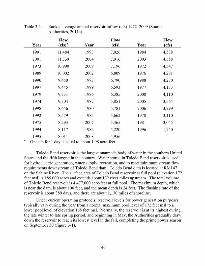
40
Table 3-1. Ranked average annual reservoir inflow (cfs) 1972–2009 (Source: Authorities, 2011a).
Year Flow (cfs)a Year
Flow (cfs) Year
Flow (cfs)
1991 11,484 1993 7,926 1984 4,578 2001 11,339 2004 7,916 2003 4,558 1973 10,990 2009 7,196 1972 4,347 1989 10,002 2002 6,809 1976 4,281 1990 9,450 1983 6,790 1988 4,270 1997 9,445 1999 6,593 1977 4,133 1979 9,331 1986 6,385 2000 4,110 1974 9,304 1987 5,851 2005 3,564 1998 8,656 1980 5,781 2006 3,299 1992 8,579 1985 5,662 1978 3,110 1975 8,293 2007 5,365 1981 3,045 1994 8,117 1982 5,220 1996 1,750 1995 8,011 2008 4,956
a One cfs for 1 day is equal to about 1.98 acre-feet.
Toledo Bend reservoir is the largest manmade body of water in the southern United States and the fifth largest in the country. Water stored in Toledo Bend reservoir is used for hydroelectric generation, water supply, recreation, and to meet minimum stream flow requirements downstream of Toledo Bend dam. Toledo Bend dam is located at RM147 on the Sabine River. The surface area of Toledo Bend reservoir at full pool (elevation 172 feet msl) is 185,000 acres and extends about 132 river miles upstream. The total volume of Toledo Bend reservoir is 4,477,000 acre-feet at full pool. The maximum depth, which is near the dam, is about 100 feet, and the mean depth is 24 feet. The flushing rate of the reservoir is about 389 days, and there are about 1,130 miles of shoreline.
Under current operating protocols, reservoir levels for power generation purposes typically vary during the year from a normal maximum pool level of 172 feet msl to a lower pool level of elevation 168 feet msl. Normally, the reservoir is at its highest during the late winter to late spring period, and beginning in May, the Authorities gradually draw down the reservoir to reach its lowest level in the fall, completing the prime power season on September 30 (figure 3-1).
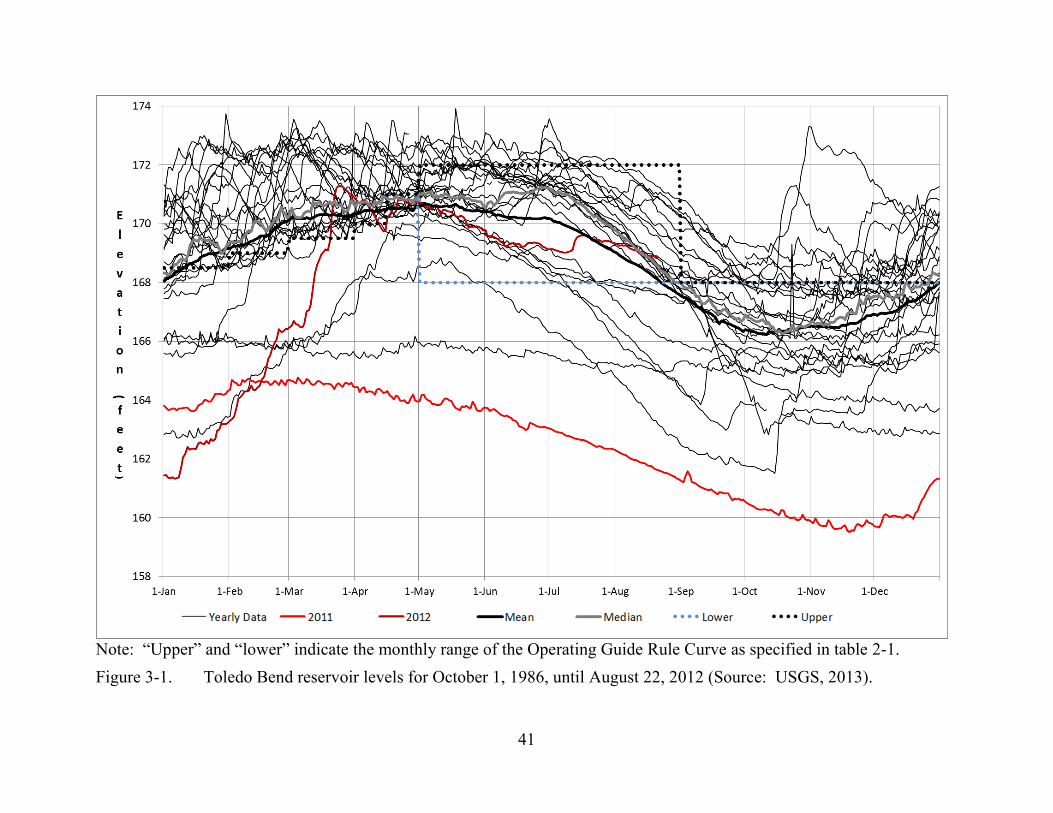
41
Note: “Upper” and “lower” indicate the monthly range of the Operating Guide Rule Curve as specified in table 2-1. Figure 3-1. Toledo Bend reservoir levels for October 1, 1986, until August 22, 2012 (Source: USGS, 2013).

42
Under the Authorities’ historical operating practices, the reservoir level rarely dropped below elevation 165 feet msl, although the current license allows the lowering of the reservoir level as low as elevation 162.2 feet msl for power production purposes under the five conditions outlined below. Once the reservoir level falls below elevation 168 feet msl, power generation may only occur under the following conditions:
• The Commission orders or requires a reduction in the water level of the reservoir for purposes of inspecting or repairing the dam;
• An insufficient supply of electric power to the Power Companies’ firm or non-interruptible power users will result;
• Non-use of the waters of the reservoir for the generation of hydroelectric power will result in the failure to satisfy minimum downstream flow requirements necessary to meet water sales from the diversion canals of the Authorities;
• Non-use of the waters of the reservoir for the generation of hydroelectric power will result in the failure to deter saltwater encroachment; or
• The Authorities fail to make all credits owed to the Power Companies or fail to make full reimbursements as required in sections 3.02A and 3.07 of the Consolidated Power Sales Agreement within the time identified in the current agreement.
Currently, the reservoir continues to be operated such that reservoir elevations are typically rising from January through April. A winter drawdown to elevation 168 feet msl allows filling by spring rains. Water levels increase from January through April to full pool level of 172 feet msl on or around May 1 (figure 3-1). Daily on-peak power generation typically occurs 5 to 6 days per week during the May through September season depending on water supply and electrical demand. For the remainder of the year, generation flows are driven by reservoir levels to meet the rule curve, and can occur on a constant or pulsed basis depending on inflows and reservoir elevation.
The project is operated in accordance with the Operating Guide Rule Curve (see table 2-1) with both primary (peaking) and secondary power production as defined by the Power Sales Agreement. Primary power is produced from May through September and can be generated at any time the water surface elevation is above 168 feet msl. Secondary power is produced when the reservoir is above the seasonal elevations shown in table 2-1. Historically, the Authorities have operated the reservoir with a normal maximum reservoir elevation of 172 feet msl, and until 2007, a normal minimum reservoir elevation of 162.2 feet msl. Since the 2007 amendment to the Power Sales Agreement, power is typically only generated when the reservoir elevation is above elevation 168 feet msl. Table 3-2 summarizes Toledo Bend reservoir releases for 2002 through 2012 and minimum and maximum reservoir levels. This period includes the lowest level that the reservoir has reached since initial filling: elevation of 159.51 feet

43
Table 3-2. Summary of reservoir releases and levels for 2002 through 2012 (Source: Authorities, 2011; USGS, 2013)
Year
Power Release (thousand acre-feet)
Spillway Release
(thousand acre-feet)
Maximum Reservoir Elevation
(feet) Date of
Maximum
Minimum Reservoir Elevation
(feet) Date of
Minimum 2002a 3,018.89 1,321.21 172.76 April 13 165.90 October 19 2003a 2,269.02 969.17 172.75 March 2 and 3 165.60 November 15 2004a 3,878.34 1,013.50 172.65 February 26 167.28 January 4 2005a 2,760.14 135.21 171.07 April 16 162.55 December 14 2006a 910.28 130.07 168.75 May 11 161.25 October 16 2007a 3,043.99 312.58 172.51 July 18 167.49 November 17 2008a 2,676.86 581.32 173.00 April 1 and 2 167.32 November 11 2009a 3,455.81 998.51 173.42 November 1 168.03 September 10
and 11 2010b NA NA 172.43 March 6 163.59 December 29 2011b NA NA 164.76 March 5 159.51 November 19 2012b NA NA 171.28 March 25 161.33 January 6
a Data for 2002 to 2009 are from Authorities (2011a). b Data for 2010 through 2012 are from USGS (2013). Notes: Data for 2012 include data until August 22. NA = Data for releases for 2010, 2011, and 2012 were not supplied by
the Authorities.
44
msl in 2011 during the recent exceptional drought. According to the U.S. Drought Monitor (U.S. Drought Monitor, 2013) most of the Sabine River Basin was classified as being in an exceptional drought, the worse classification, during most of 2011.
Generally, during May through September when water is available for primary power production and when the reservoir elevation is between 168 and 172 feet msl, the typical daily operation consists of operating one or two units that result in the release of either 7,000 or 14,000 cfs to the lower Sabine River for 6 to 8 hours to meet the afternoon and evening peak electrical demand. In addition to the releases for generation, there is also a minimum continuous release of 144 cfs from the spillway to the spillway channel that joins with flow from Bayou Toro. Powerhouse leakage occurs when the units are offline and supplies about 0 to 30 cfs per unit to the tailrace channel. During the recent drought in 2011 and 2012, very limited power generation occurred, and up to about 700 cfs was released from the dam to meet downstream water quality and water delivery requirements.
Flood control is not a project purpose and the ability for the project to affect flood flows depends on the water level of the reservoir and the associated storage capacity when high flows occur. The project was not designed as a flood control facility and does not have a flood management pool.
Spillway Operations and Downstream Flows The spillway is located along the north dam abutment in Louisiana. Also
contained in the spillway structure is a low-flow sluiceway with an invert elevation of 100 feet. The spillway gates are normally only operated when reservoir elevations exceed 172.5 feet msl. Operation of the spillway gates is described in table 2-2. Peak spillway and powerhouse releases (total discharge from the dam) as measured at USGS gage 08025360, Sabine River at Toledo Bend reservoir near Burkeville, Texas, include 114,000 cfs on May 19, 1989; 117,000 cfs on January 31, 1999; 85,600 cfs on March 3, 2011; and 75,300 cfs on November 2, 2009. To meet flow requirements under the current license, a continuous release of 144 cfs (i.e., 286 acre-feet per day) is maintained in the spillway channel by releases through two 20-inch-diameter conduits located in the low-flow sluiceway. An excavated spillway channel extends about 1.7 miles downstream to where it intersects Bayou Toro (drainage area 221 square miles) at RM145.5, and then continues 0.4 mile to the confluence of the Sabine River (RM145). The Sabine River then flows about 4 miles before being joined by the excavated tailrace channel, which conveys flows from the powerhouse to the Sabine River (see figure 1-1). The spillway channel and the Sabine River that convey the project’s current continuous flow requirement of 144 cfs to the Sabine River is sometimes referred to as “the 6-mile loop.”
When generating power, the powerhouse typically releases either 7,000 or 14,000 cfs (i.e., one- or two-unit operation) to the tailrace channel. The flows released from the powerhouse and spillway attenuate as they move downstream, resulting in a decrease in velocity, flow rate, and change in stage with distance from the dam. The attenuation
45
along the downstream river reaches is a function of channel storage, geometry (i.e., width, depth, shape, and slope), vegetation, roughness, and sinuosity. Flow attenuation also depends on contributions from tributaries and other accretion flow characteristics downstream of the Toledo Bend dam. There are three other USGS gages downstream of the dam (figure 3-2):
• Gage no. 08026000 Sabine River near Burkeville, Texas, at RM132;
• Gage no. 08025000 Sabine River near Bon Wier, Texas, at RM91; and
• Gage no. 08030500 Sabine River near Ruliff, Texas, at RM35. Table 3-3 provides monthly flow data from the four downstream gages. Major tributaries downstream of Bayou Toro include Bayou Anacoco and Big Cow Creek, which enter the Sabine River at RM104 and RM70, respectively. Table 3-4 provides monthly mean and median flows for these two tributaries as well as for Toro Bayou. Figure 3-3 illustrates the peak annual flow at the four downstream gages along the Sabine River for their respective periods of record.
Water Use In keeping with the project’s primary purpose as a water supply facility, a
provision of the Power Sales Agreement recognizes that water will be used for power generation unless it is needed for the purposes of municipal, domestic, and industrial water supply. The operation of the project provides a minimum firm yield of 2,086,600 acre-feet per year, equally shared by the Authorities. Most of this water is currently discharged through the powerhouse and is available downstream of the project for municipal, industrial, and agricultural purposes.
State Water Rights (Texas)—In most instances, Texas State law requires a water right for the use of surface water. Water rights documents include certificates of adjudication and permits issued and administered on behalf of the state by Texas CEQ. Table 3-5 lists Texas water rights within the reservoir and downstream of Toledo Bend reservoir.
On December 16, 1986, Certificate of Adjudication No. 05-4658 was issued to the Sabine River Authority of Texas, which consolidated the previously issued water rights permits that were authorized in 1961 and 1974 and set forth the following conditions:
• The Sabine River Authority of Texas can impound 4,477,000 acre-feet of water;
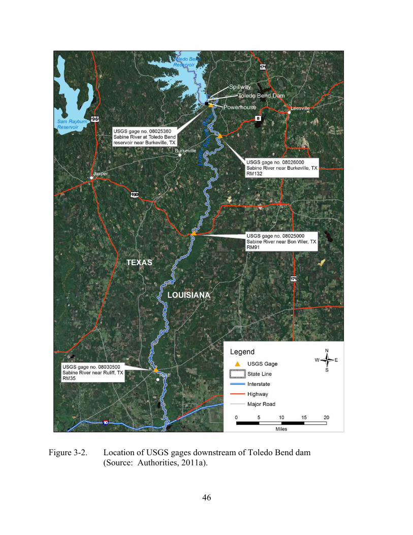
46
Figure 3-2. Location of USGS gages downstream of Toledo Bend dam (Source: Authorities, 2011a).
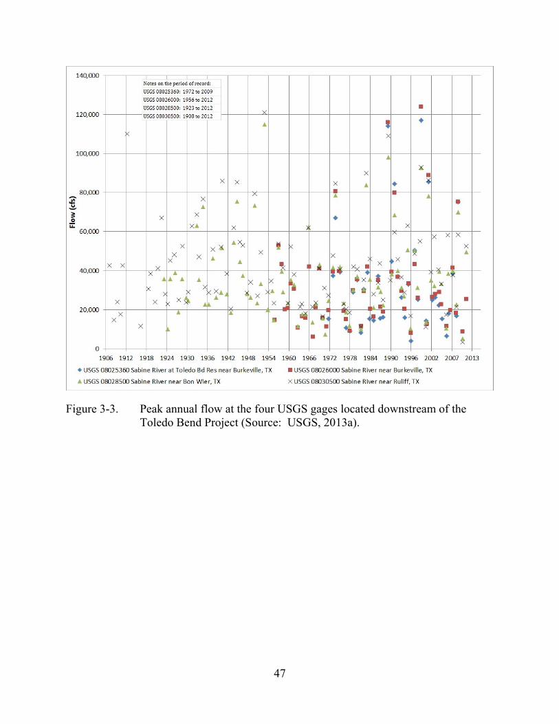
47
Figure 3-3. Peak annual flow at the four USGS gages located downstream of the Toledo Bend Project (Source: USGS, 2013a).
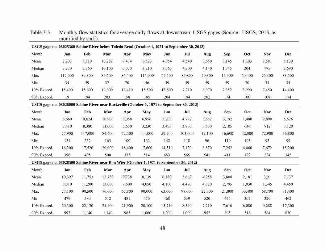
48
Table 3-3. Monthly flow statistics for average daily flows at downstream USGS gages (Source: USGS, 2013, as modified by staff).
USGS gage no. 08025360 Sabine River below Toledo Bend (October 1, 1971 to September 30, 2012)
Month Jan Feb Mar Apr May Jun Jul Aug Sep Oct Nov Dec
Mean 8,203 8,910 10,282 7,474 6,523 4,954 4,540 3,650 3,145 1,303 2,581 5,139
Median 7,270 7,360 10,100 5,070 3,210 3,565 4,200 4,140 1,745 204 775 2,690
Max 117,000 89,300 85,600 84,400 114,000 67,500 85,800 20,300 15,900 60,400 75,300 33,500
Min 34 59 37 70 56 59 59 59 59 30 34 34
10% Exceed. 15,400 15,600 19,600 16,410 15,500 13,800 7,210 6,970 7,352 3,990 7,450 14,400
90% Exceed. 19 194 203 158 185 204 194 202 174 100 108 174
USGS gage no. 08026000 Sabine River near Burkeville (October 1, 1971 to September 30, 2012)
Month Jan Feb Mar Apr May Jun Jul Aug Sep Oct Nov Dec
Mean 8,660 9,624 10,903 8,058 6,956 5,203 4,772 3,682 3,192 1,480 2,890 5,526
Median 7,410 8,380 11,000 5,650 3,230 3,450 3,850 3,650 2,105 644 812 3,120
Max 77,900 117,000 84,400 72,500 111,000 59,700 103,000 19,100 16,600 42,000 72,900 36,800
Min 131 252 163 100 162 142 118 96 110 103 93 99
10% Exceed. 16,200 17,520 20,000 18,400 17,600 14,510 7,120 6,870 7,252 4,060 7,672 15,200
90% Exceed. 396 495 500 373 514 663 565 541 411 192 234 345
USGS gage no. 08028500 Sabine River near Bon Wier (October 1, 1971 to September 30, 2012)
Month Jan Feb Mar Apr May Jun Jul Aug Sep Oct Nov Dec
Mean 10,397 11,753 12,739 9,738 8,139 6,180 5,662 4,258 3,808 2,181 3,91 7,137
Median 8,810 11,200 13,000 7,600 4,050 4,100 4,470 4,320 2,795 1,030 1,345 4,450
Max 77,100 90,500 76,000 67,800 90,000 63,000 98,000 22,300 21,800 33,400 68,700 81,400
Min 479 580 512 481 470 468 539 520 474 307 320 462
10% Exceed. 20,300 22,120 24,400 21,900 20,100 15,710 8,540 7,210 7,610 6,080 9,288 17,300
90% Exceed. 993 1,140 1,140 963 1,060 1,209 1,000 952 805 516 584 830
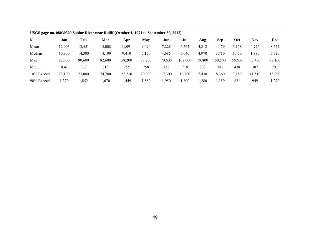
49
USGS gage no. 08030500 Sabine River near Ruliff (October 1, 1971 to September 30, 2012)
Month Jan Feb Mar Apr May Jun Jul Aug Sep Oct Nov Dec
Mean 12,003 13,451 14,008 11,091 9,090 7,228 6,562 4,812 4,479 3,158 4,726 8,577
Median 10,900 14,300 14,100 9,410 5,150 4,685 5,040 4,970 3,710 1,450 1,880 5,920
Max 82,000 90,600 82,600 58,200 87,200 70,600 108,000 19,800 50,500 56,600 57,400 88,100
Min 836 968 813 755 758 731 718 808 781 438 387 791
10% Exceed. 23,100 23,000 24,700 22,210 20,000 17,300 10,700 7,430 8,360 7,180 11,510 18,900
90% Exceed. 1,370 1,852 1,670 1,449 1,580 1,950 1,800 1,280 1,159 831 949 1,290
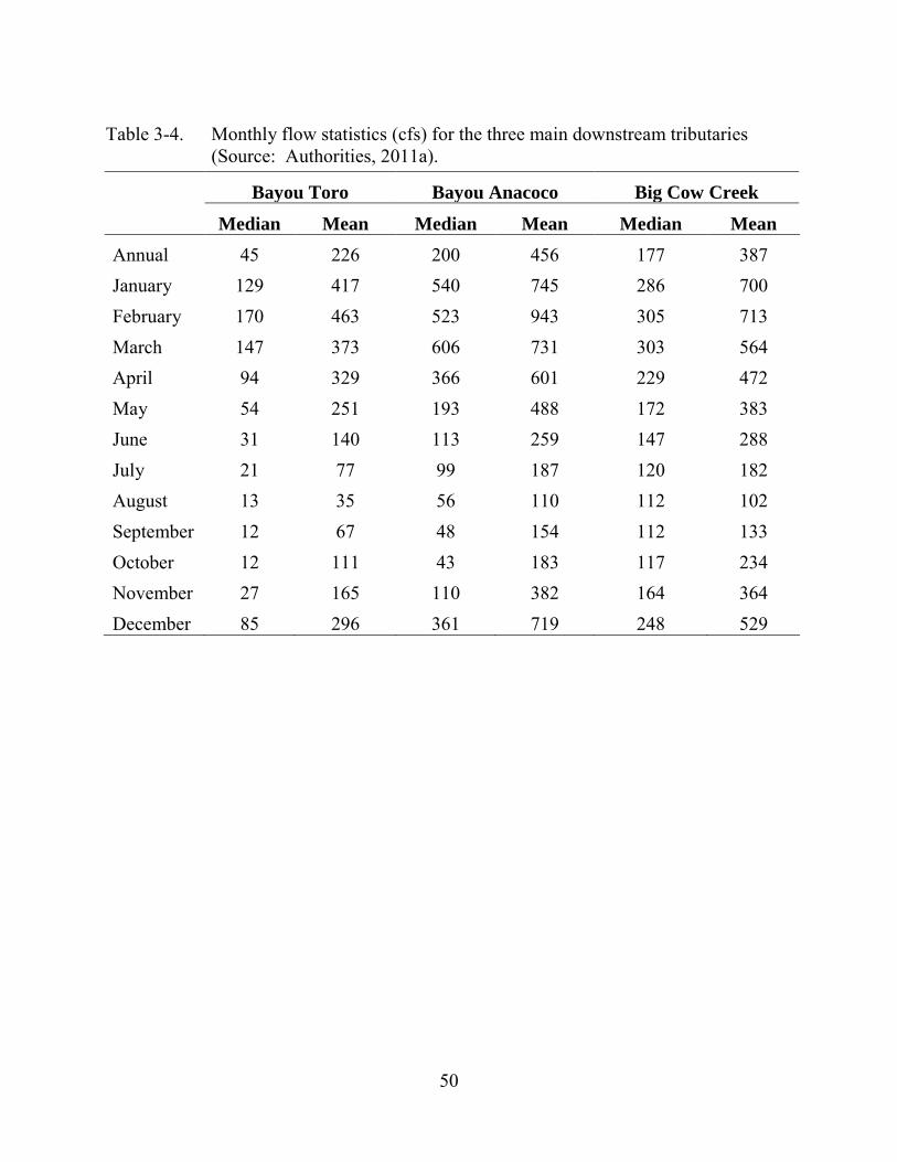
50
Table 3-4. Monthly flow statistics (cfs) for the three main downstream tributaries (Source: Authorities, 2011a).
Bayou Toro Bayou Anacoco Big Cow Creek
Median Mean Median Mean Median Mean Annual 45 226 200 456 177 387 January 129 417 540 745 286 700 February 170 463 523 943 305 713 March 147 373 606 731 303 564 April 94 329 366 601 229 472 May 54 251 193 488 172 383 June 31 140 113 259 147 288 July 21 77 99 187 120 182 August 13 35 56 110 112 102 September 12 67 48 154 112 133 October 12 111 43 183 117 234 November 27 165 110 382 164 364 December 85 296 361 719 248 529
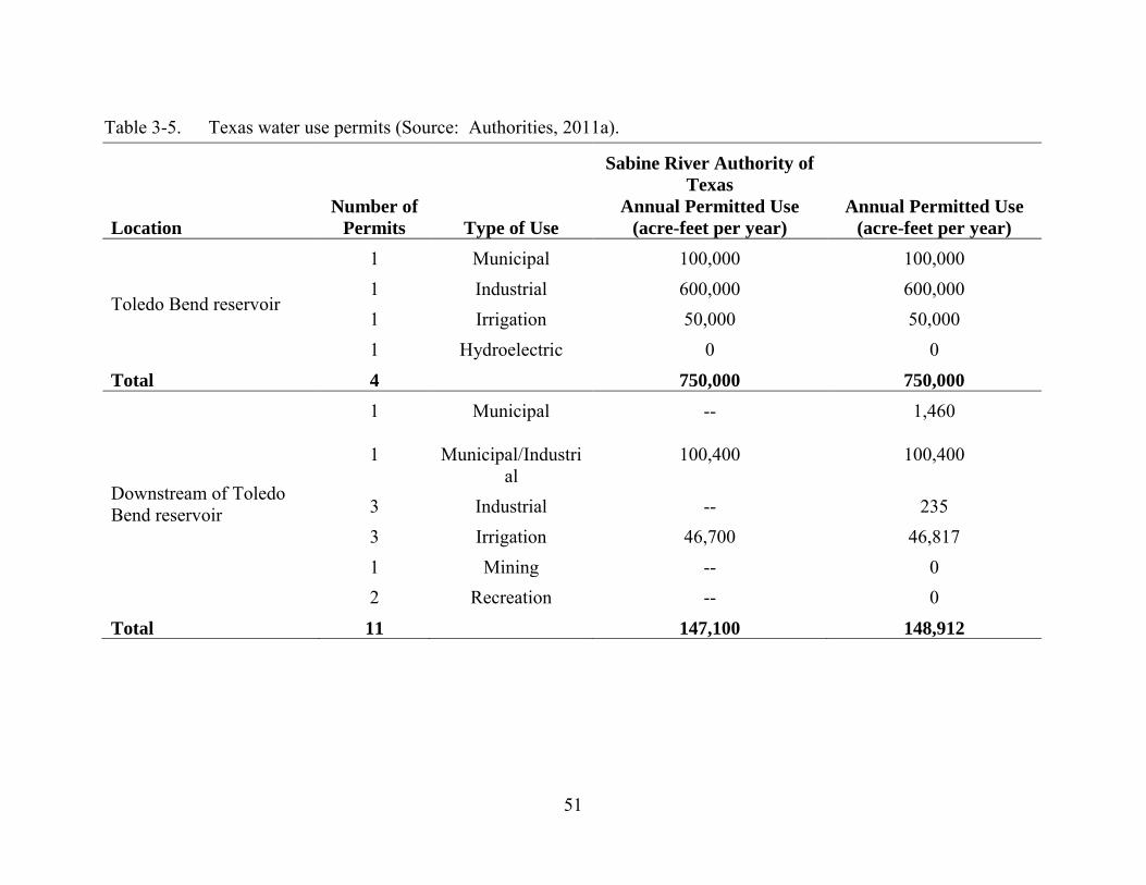
51
Table 3-5. Texas water use permits (Source: Authorities, 2011a).
Location Number of
Permits Type of Use
Sabine River Authority of Texas
Annual Permitted Use (acre-feet per year)
Annual Permitted Use (acre-feet per year)
Toledo Bend reservoir
1 Municipal 100,000 100,000 1 Industrial 600,000 600,000 1 Irrigation 50,000 50,000 1 Hydroelectric 0 0
Total 4 750,000 750,000
Downstream of Toledo Bend reservoir
1 Municipal -- 1,460
1 Municipal/Industrial
100,400 100,400
3 Industrial -- 235 3 Irrigation 46,700 46,817 1 Mining -- 0 2 Recreation -- 0
Total 11 147,100 148,912
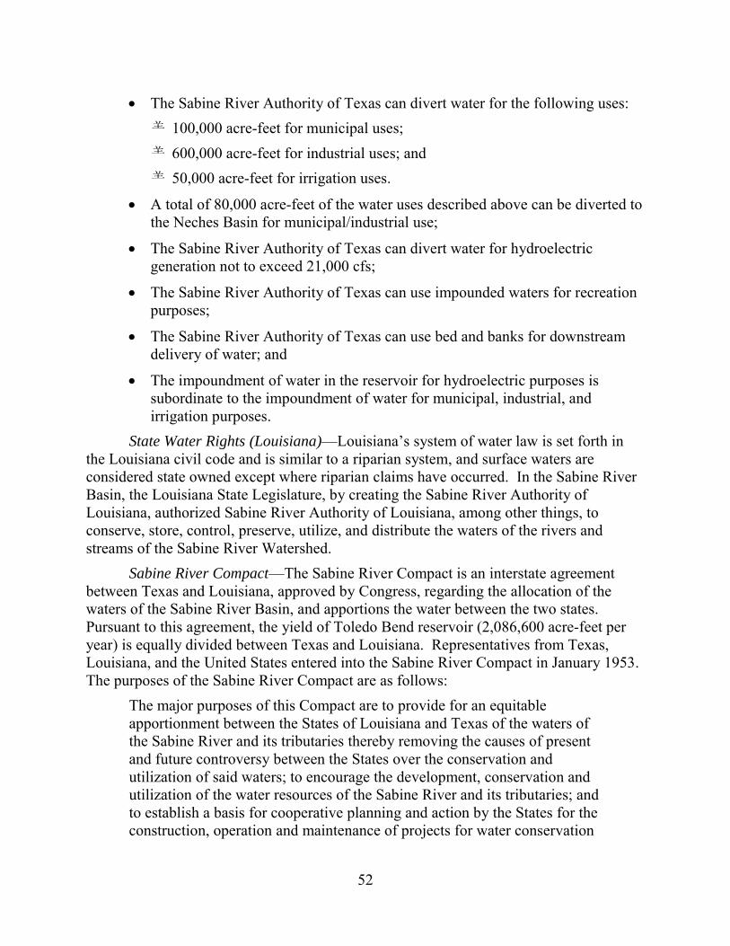
52
• The Sabine River Authority of Texas can divert water for the following uses: 100,000 acre-feet for municipal uses; 600,000 acre-feet for industrial uses; and 50,000 acre-feet for irrigation uses.
• A total of 80,000 acre-feet of the water uses described above can be diverted to the Neches Basin for municipal/industrial use;
• The Sabine River Authority of Texas can divert water for hydroelectric generation not to exceed 21,000 cfs;
• The Sabine River Authority of Texas can use impounded waters for recreation purposes;
• The Sabine River Authority of Texas can use bed and banks for downstream delivery of water; and
• The impoundment of water in the reservoir for hydroelectric purposes is subordinate to the impoundment of water for municipal, industrial, and irrigation purposes.
State Water Rights (Louisiana)—Louisiana’s system of water law is set forth in the Louisiana civil code and is similar to a riparian system, and surface waters are considered state owned except where riparian claims have occurred. In the Sabine River Basin, the Louisiana State Legislature, by creating the Sabine River Authority of Louisiana, authorized Sabine River Authority of Louisiana, among other things, to conserve, store, control, preserve, utilize, and distribute the waters of the rivers and streams of the Sabine River Watershed.
Sabine River Compact—The Sabine River Compact is an interstate agreement between Texas and Louisiana, approved by Congress, regarding the allocation of the waters of the Sabine River Basin, and apportions the water between the two states. Pursuant to this agreement, the yield of Toledo Bend reservoir (2,086,600 acre-feet per year) is equally divided between Texas and Louisiana. Representatives from Texas, Louisiana, and the United States entered into the Sabine River Compact in January 1953. The purposes of the Sabine River Compact are as follows:
The major purposes of this Compact are to provide for an equitable apportionment between the States of Louisiana and Texas of the waters of the Sabine River and its tributaries thereby removing the causes of present and future controversy between the States over the conservation and utilization of said waters; to encourage the development, conservation and utilization of the water resources of the Sabine River and its tributaries; and to establish a basis for cooperative planning and action by the States for the construction, operation and maintenance of projects for water conservation
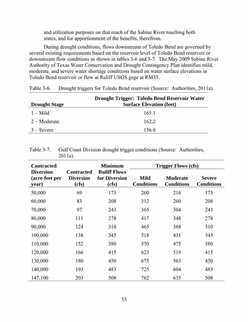
53
and utilization purposes on that reach of the Sabine River touching both states, and for apportionment of the benefits, therefrom. During drought conditions, flows downstream of Toledo Bend are governed by
several existing requirements based on the reservoir level of Toledo Bend reservoir or downstream flow conditions as shown in tables 3-6 and 3-7. The May 2009 Sabine River Authority of Texas Water Conservation and Drought Contingency Plan identifies mild, moderate, and severe water shortage conditions based on water surface elevations in Toledo Bend reservoir or flow at Ruliff USGS gage at RM35.
Table 3-6. Drought triggers for Toledo Bend reservoir (Source: Authorities, 2011a).
Drought Stage Drought Trigger: Toledo Bend Reservoir Water
Surface Elevation (feet) 1 – Mild 165.1 2 – Moderate 162.2 3 – Severe 156.0
Table 3-7. Gulf Coast Division drought trigger conditions (Source: Authorities, 2011a).
Contracted Diversion (acre-feet per year)
Contracted Diversion
(cfs)
Minimum Ruliff Flows for Diversion
(cfs)
Trigger Flows (cfs)
Mild Conditions
Moderate Conditions
Severe Conditions
50,000 69 173 260 216 173 60,000 83 208 312 260 208 70,000 97 243 365 304 243 80,000 111 278 417 348 278 90,000 124 310 465 388 310 100,000 138 345 518 431 345 110,000 152 380 570 475 380 120,000 166 415 623 519 415 130,000 180 450 675 563 450 140,000 193 483 725 604 483 147,100 203 508 762 635 508
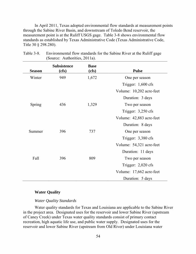
54
In April 2011, Texas adopted environmental flow standards at measurement points through the Sabine River Basin, and downstream of Toledo Bend reservoir, the measurement point is at the Ruliff USGS gage. Table 3-8 shows environmental flow standards as established by Texas Administrative Code (Texas Administrative Code, Title 30 § 298.280).
Table 3-8. Environmental flow standards for the Sabine River at the Ruliff gage (Source: Authorities, 2011a).
Season Subsistence
(cfs) Base (cfs) Pulse
Winter 949 1,672 One per season Trigger: 1,600 cfs Volume: 10,202 acre-feet Duration: 3 days
Spring 436 1,329 Two per season Trigger: 3,250 cfs Volume: 42,883 acre-feet Duration: 8 days
Summer 396 737 One per season Trigger: 3,380 cfs Volume: 54,321 acre-feet Duration: 11 days
Fall 396 809 Two per season Trigger: 2,020 cfs Volume: 17,662 acre-feet Duration: 5 days
Water Quality
Water Quality Standards Water quality standards for Texas and Louisiana are applicable to the Sabine River
in the project area. Designated uses for the reservoir and lower Sabine River (upstream of Caney Creek) under Texas water quality standards consist of primary contact recreation, high aquatic life use, and public water supply. Designated uses for the reservoir and lower Sabine River (upstream from Old River) under Louisiana water
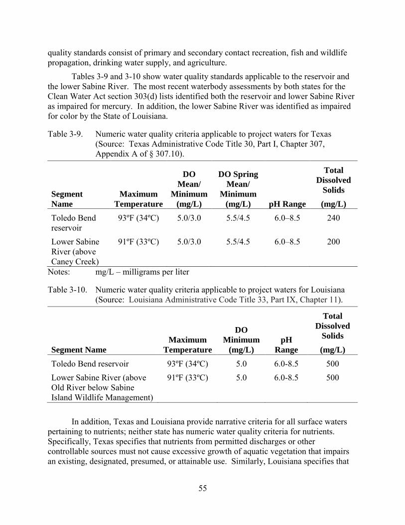
55
quality standards consist of primary and secondary contact recreation, fish and wildlife propagation, drinking water supply, and agriculture.
Tables 3-9 and 3-10 show water quality standards applicable to the reservoir and the lower Sabine River. The most recent waterbody assessments by both states for the Clean Water Act section 303(d) lists identified both the reservoir and lower Sabine River as impaired for mercury. In addition, the lower Sabine River was identified as impaired for color by the State of Louisiana.
Table 3-9. Numeric water quality criteria applicable to project waters for Texas (Source: Texas Administrative Code Title 30, Part I, Chapter 307, Appendix A of § 307.10).
Segment Name
Maximum Temperature
DO Mean/
Minimum (mg/L)
DO Spring Mean/
Minimum (mg/L) pH Range
Total Dissolved
Solids (mg/L)
Toledo Bend reservoir
93ºF (34ºC) 5.0/3.0 5.5/4.5 6.0–8.5 240
Lower Sabine River (above Caney Creek)
91ºF (33ºC) 5.0/3.0 5.5/4.5 6.0–8.5 200
Notes: mg/L – milligrams per liter
Table 3-10. Numeric water quality criteria applicable to project waters for Louisiana (Source: Louisiana Administrative Code Title 33, Part IX, Chapter 11).
Segment Name Maximum
Temperature
DO Minimum
(mg/L) pH
Range
Total Dissolved
Solids (mg/L)
Toledo Bend reservoir 93ºF (34ºC) 5.0 6.0-8.5 500 Lower Sabine River (above Old River below Sabine Island Wildlife Management)
91ºF (33ºC) 5.0 6.0-8.5 500
In addition, Texas and Louisiana provide narrative criteria for all surface waters
pertaining to nutrients; neither state has numeric water quality criteria for nutrients. Specifically, Texas specifies that nutrients from permitted discharges or other controllable sources must not cause excessive growth of aquatic vegetation that impairs an existing, designated, presumed, or attainable use. Similarly, Louisiana specifies that
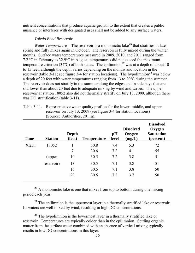
56
nutrient concentrations that produce aquatic growth to the extent that creates a public nuisance or interferes with designated uses shall not be added to any surface waters.
Toledo Bend Reservoir Water Temperature—The reservoir is a monomictic lake26 that stratifies in late
spring and fully mixes again in October. The reservoir is fully mixed during the winter months. Surface water temperatures measured in 2009, 2010, and 2011 ranged from 7.2 ºC in February to 32.9ºC in August; temperatures did not exceed the maximum temperature criterion (34ºC) of both states. The epilimnion27 was at a depth of about 10 to 15 feet, although the depth varies depending on the months and location in the reservoir (table 3-11; see figure 3-4 for station locations). The hypolimnion28 was below a depth of 20 feet with water temperatures ranging from 13 to 20ºC during the summer. The reservoir does not stratify in the summer along the edges and in side bays that are shallower than about 20 feet due to adequate mixing by wind and waves. The upper reservoir at station 18052 also did not thermally stratify on July 13, 2009, although there was DO stratification (table 3-11).
Table 3-11. Representative water quality profiles for the lower, middle, and upper reservoir on July 13, 2009 (see figure 3-4 for station locations) (Source: Authorities, 2011a).
Time Station Depth (feet) Temperature
pH level
Dissolved Oxygen (mg/L)
Dissolved Oxygen
Saturation (percent)
9:25h 18052 1 30.8 7.4 5.3 72 7 30.6 7.2 4.1 55 (upper 10 30.5 7.2 3.8 51
reservoir) 13 30.5 7.1 3.8 51 16 30.5 7.1 3.8 50 20 30.5 7.2 3.7 50
26 A monomictic lake is one that mixes from top to bottom during one mixing
period each year. 27 The epilimnion is the uppermost layer in a thermally stratified lake or reservoir.
Its waters are well mixed by wind, resulting in high DO concentrations. 28 The hypolimnion is the lowermost layer in a thermally stratified lake or
reservoir. Temperatures are typically colder than in the epilimnion. Settling organic matter from the surface water combined with an absence of vertical mixing typically results in low DO concentrations in this layer.

57
Time Station Depth (feet) Temperature
pH level
Dissolved Oxygen (mg/L)
Dissolved Oxygen
Saturation (percent)
23 30.5 7.1 3.5 47 26 30.4 7.0 2.0 27 33 29.3 7.1 0.1 1 43 25.0 7.1 0.1 1
10:47h 10402 1 31.5 7.8 6.9 93 7 30.4 7.4 5.4 72 (middle 10 30.2 7.3 5.1 68 reservoir) 13 30.1 7.2 4.6 60 16 30.0 7.1 3.9 52 20 29.9 7.0 3.1 41 33 26.1 6.9 0.1 1 46 21.1 7.0 0.1 1 61 18.6 7.0 0.1 1
14:52h 10404
1 32.4 8.3 7.6 105 7 31.7 8.3 7.7 105 (lower 10 30.8 8.1 7.5 100 reservoir) 13 30.5 8.1 7.4 99 16 30.0 7.4 5.9 78 20 27.4 6.8 0.8 10 33 22.6 6.8 0.1 1 66 17.5 6.9 0.1 1 82 16.7 7.0 0.1 1
58
Dissolved Oxygen—DO profile measurements from 2009, 2010, and 2011 reflect the stratified conditions in the summer (figures 3-4 to 3-6). DO concentrations in the well-mixed epilimnion ranged between 3.5 and 13.6 milligrams per liter (mg/L) throughout the year; the mean DO concentrations were generally well above 5 mg/L. From May to October, DO concentrations were observed to decrease to less than 4 or 5 mg/L below a water depth of 15 feet, and to less than 1 mg/L below a water depth of about 30 feet in the hypolimnion. The DO concentrations in the deep parts of the reservoir increased again to over 5 mg/L in late fall (November or December) due to mixing of the water column.
During monitoring in 2009, 2010, and 2011, the mixed surface water layer met the DO minimum concentration standard of 3 mg/L for Texas at all times, although monitoring for the 24-hour daily average criterion of 5.0 mg/L was not performed. Instantaneous monitoring performed in the spring at nine stations resulted in concentrations ranging between 6.0 and 12.5 mg/L; these concentrations met state standards. Louisiana’s DO minimum criterion of 5 mg/L for surface waters were also mostly met with the exception of 11 measurements at four stations (stations 10407, 15655, 15659, and 18052; figure 3-4) during the summer months. The lowest DO concentration was 3.5 mg/L measured at station 18052 in August 2010. Three of the four monitoring stations with low DO were located in reservoir side bays that may not be deep enough to stratify.
pH—During the 2009 to 2011 monthly monitoring, pH levels ranged from less than 6.7 to 9.2. The upper state standard for pH of 8.5 was exceeded a few times at five stations, typically in the mid-section of the reservoir during the summer months.
Turbidity and Total Dissolved Solids—During the 2009 to 2011 monitoring, turbidity ranged from 1 to 43 nephelometric turbidity units. Calculated total dissolved solids ranged from 75 to 187 mg/L, meeting both the water quality criteria for Texas and 500 mg/L for Louisiana.
Secchi Depth, Nutrients, and Chlorophyll—Secchi disk depths at the nine monitoring stations between January 2009 and December 2010 were 1 to 10 feet. These depths are characteristic of mesotrophic to eutrophic conditions (Carlson and Simpson, 1996). The Sabine River Authority of Texas monitors for nutrients in the reservoir. Orthophosphate concentrations of the reservoir surface waters since 2005 ranged from the method detection limit of 40 micrograms per liter (µg/L) up to 100 µg/L. Total phosphorus concentrations since 2000 reached up to 400 µg/L. Total phosphorus concentrations of 24 to 96 µg/L suggest eutrophic conditions; concentrations of 12 to 24 µg/L suggest mesotrophic conditions (Carlson and Simpson, 1996). Chlorophyll concentrations were measured at three stations with concentrations ranging from near zero during the winter to 33 µg/l during the more productive months of the year. The highest measured concentration was within the range typical for eutrophic conditions (i.e., 20 to56 µg/L; Carlson and Simpson, 1996). The main sources of nutrients are point and non-point sources in the watershed of the upper Sabine River.
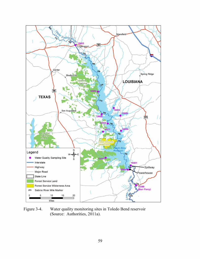
59
Figure 3-4. Water quality monitoring sites in Toledo Bend reservoir
(Source: Authorities, 2011a).

60
Figure 3-5. Profiles of DO concentrations in the lower reservoir in 2009 at station 10404, located upstream of the powerhouse (Source: Authorities, 2011a).
Figure 3-6. Profiles of DO concentrations in the lower reservoir in 2010 at station 10404, located upstream of the powerhouse (Source: Authorities, 2011a).
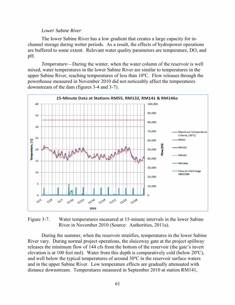
61
Lower Sabine River The lower Sabine River has a low gradient that creates a large capacity for in-
channel storage during wetter periods. As a result, the effects of hydropower operations are buffered to some extent. Relevant water quality parameters are temperature, DO, and pH.
Temperature—During the winter, when the water column of the reservoir is well mixed, water temperatures in the lower Sabine River are similar to temperatures in the upper Sabine River, reaching temperatures of less than 10ºC. Flow releases through the powerhouse measured in November 2010 did not noticeably affect the temperatures downstream of the dam (figures 3-4 and 3-7).
Figure 3-7. Water temperatures measured at 15-minute intervals in the lower Sabine River in November 2010 (Source: Authorities, 2011a).
During the summer, when the reservoir stratifies, temperatures in the lower Sabine River vary. During normal project operations, the sluiceway gate at the project spillway releases the minimum flow of 144 cfs from the bottom of the reservoir (the gate’s invert elevation is at 100 feet msl). Water from this depth is comparatively cold (below 20ºC), and well below the typical temperatures of around 30ºC in the reservoir surface waters and in the upper Sabine River. Low temperature effects are gradually attenuated with distance downstream. Temperatures measured in September 2010 at station RM141,
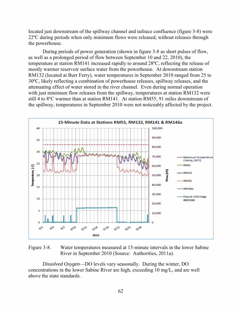
62
located just downstream of the spillway channel and tailrace confluence (figure 3-8) were 22ºC during periods when only minimum flows were released, without releases through the powerhouse.
During periods of power generation (shown in figure 3-8 as short pulses of flow, as well as a prolonged period of flow between September 10 and 22, 2010), the temperature at station RM141 increased rapidly to around 28ºC, reflecting the release of mostly warmer reservoir surface water from the powerhouse. At downstream station RM132 (located at Burr Ferry), water temperatures in September 2010 ranged from 25 to 30ºC, likely reflecting a combination of powerhouse releases, spillway releases, and the attenuating effect of water stored in the river channel. Even during normal operation with just minimum flow releases from the spillway, temperatures at station RM132 were still 4 to 8ºC warmer than at station RM141. At station RM55, 91 miles downstream of the spillway, temperatures in September 2010 were not noticeably affected by the project.
Figure 3-8. Water temperatures measured at 15-minute intervals in the lower Sabine River in September 2010 (Source: Authorities, 2011a).
Dissolved Oxygen—DO levels vary seasonally. During the winter, DO concentrations in the lower Sabine River are high, exceeding 10 mg/L, and are well above the state standards.
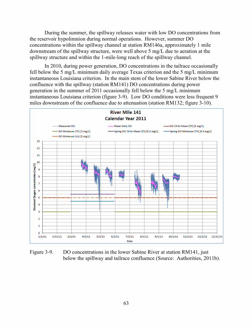
63
During the summer, the spillway releases water with low DO concentrations from the reservoir hypolimnion during normal operations. However, summer DO concentrations within the spillway channel at station RM146a, approximately 1 mile downstream of the spillway structure, were well above 5 mg/L due to aeration at the spillway structure and within the 1-mile-long reach of the spillway channel.
In 2010, during power generation, DO concentrations in the tailrace occasionally fell below the 5 mg/L minimum daily average Texas criterion and the 5 mg/L minimum instantaneous Louisiana criterion. In the main stem of the lower Sabine River below the confluence with the spillway (station RM141) DO concentrations during power generation in the summer of 2011 occasionally fell below the 5 mg/L minimum instantaneous Louisiana criterion (figure 3-9). Low DO conditions were less frequent 9 miles downstream of the confluence due to attenuation (station RM132; figure 3-10).
Figure 3-9. DO concentrations in the lower Sabine River at station RM141, just below the spillway and tailrace confluence (Source: Authorities, 2011b).
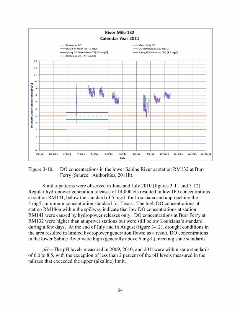
64
Figure 3-10. DO concentrations in the lower Sabine River at station RM132 at Burr Ferry (Source: Authorities, 2011b).
Similar patterns were observed in June and July 2010 (figures 3-11 and 3-12). Regular hydropower generation releases of 14,000 cfs resulted in low DO concentrations at station RM141, below the standard of 5 mg/L for Louisiana and approaching the 3 mg/L minimum concentration standard for Texas. The high DO concentrations at station RM146a within the spillway indicate that low DO concentrations at station RM141 were caused by hydropower releases only. DO concentrations at Burr Ferry at RM132 were higher than at upriver stations but were still below Louisiana’s standard during a few days. At the end of July and in August (figure 3-12), drought conditions in the area resulted in limited hydropower generation flows; as a result, DO concentrations in the lower Sabine River were high (generally above 6 mg/L), meeting state standards.
pH—The pH levels measured in 2009, 2010, and 2011were within state standards of 6.0 to 8.5, with the exception of less than 2 percent of the pH levels measured in the tailrace that exceeded the upper (alkaline) limit.
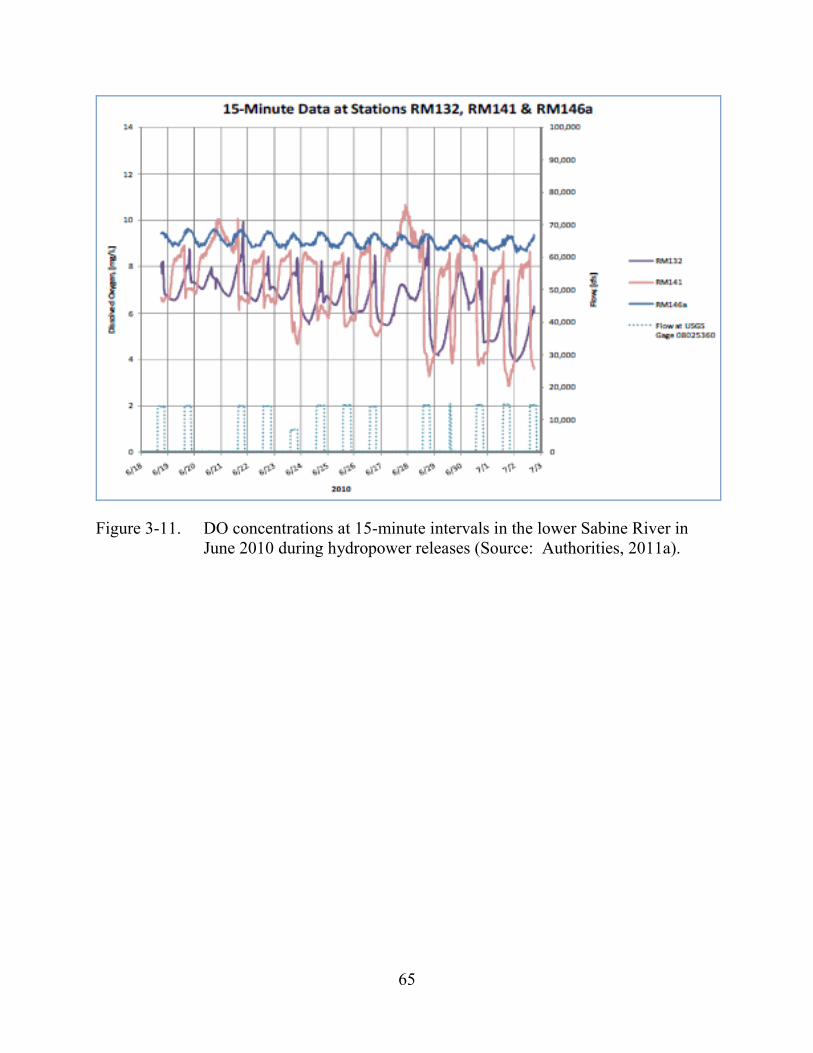
65
Figure 3-11. DO concentrations at 15-minute intervals in the lower Sabine River in June 2010 during hydropower releases (Source: Authorities, 2011a).
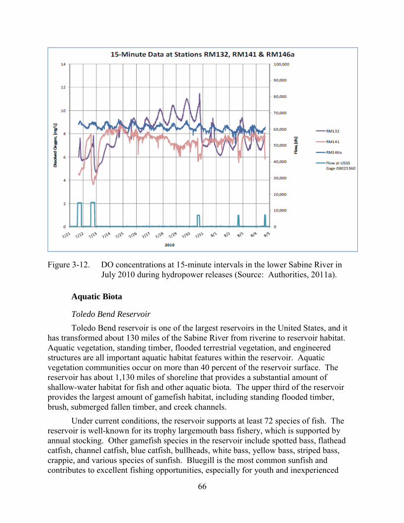
66
Figure 3-12. DO concentrations at 15-minute intervals in the lower Sabine River in July 2010 during hydropower releases (Source: Authorities, 2011a).
Aquatic Biota
Toledo Bend Reservoir Toledo Bend reservoir is one of the largest reservoirs in the United States, and it
has transformed about 130 miles of the Sabine River from riverine to reservoir habitat. Aquatic vegetation, standing timber, flooded terrestrial vegetation, and engineered structures are all important aquatic habitat features within the reservoir. Aquatic vegetation communities occur on more than 40 percent of the reservoir surface. The reservoir has about 1,130 miles of shoreline that provides a substantial amount of shallow-water habitat for fish and other aquatic biota. The upper third of the reservoir provides the largest amount of gamefish habitat, including standing flooded timber, brush, submerged fallen timber, and creek channels.
Under current conditions, the reservoir supports at least 72 species of fish. The reservoir is well-known for its trophy largemouth bass fishery, which is supported by annual stocking. Other gamefish species in the reservoir include spotted bass, flathead catfish, channel catfish, blue catfish, bullheads, white bass, yellow bass, striped bass, crappie, and various species of sunfish. Bluegill is the most common sunfish and contributes to excellent fishing opportunities, especially for youth and inexperienced
67
anglers. Striped bass are also stocked annually, but fishery surveys in the reservoir indicate they occur in low densities, and this species is targeted by few anglers. Non-game fish that occur in the reservoir include various sunfish, sucker, minnow, and darter species. Gizzard and threadfin shad are the primary forage fish.
Texas PWD currently lists the paddlefish as threatened. It was stocked in Toledo Bend reservoir with the goal of expanding its range and establishing a self-supporting population. Thirty-five miles of viable paddlefish spawning habitat occurs in the Sabine River immediately upstream of the reservoir, and there is evidence of some natural reproduction in this reach. Recent sampling suggests that paddlefish abundance is increasing in the reservoir.
Louisiana DWF lists Sabine shiner and suckermouth minnow as species of interest. Sabine shiner is found throughout Toledo Bend reservoir and is relatively common in the lower Sabine River. The suckermouth minnow is present in the reservoir based on historic collections but is scarce.
Lower Sabine River In general, the lower Sabine River downstream from the project is a low gradient
meandering waterway traversing sandy or alluvial soils allowing both active and continual channel movement. The lower Sabine River generally disperses water outward into large complex bottomland forested wetlands with alluvial substrate. Point bars, backwaters, pools, runs and tributaries with large/small woody debris, occasional fringe vegetation, and bank riparian cover upstream, oxbows and flooded bottomlands downstream, are the dominant aquatic habitat features.
Under current project operations, a continuous flow of 144 cfs is released at the spillway (RM147) to an excavated channel that joins Bayou Toro, and then the original Sabine River channel, finally joining the excavated tailrace channel about 6 miles below the spillway. From an aquatic habitat perspective, this first 6 miles of the Sabine River below the spillway functions as a large, semi-regulated tributary, with Bayou Toro providing some natural flow variability. The upper 2 miles are largely engineered excavated channel, relatively straight and scoured from flood flows, with pool, run, and some riffle habitat. The lower 4 miles follow the meandering path of the original Sabine River channel, and there is sufficient sediment to maintain small point bars at each bend. Pool and run habitat predominates in this reach. During periods of power generation, backwater from the tailrace channel can extend up to the spillway.
From May to September, daily peaking occurs five to six times per week for 4 to 8 hours during the afternoon and evening, depending on reservoir stage and electrical demand. This results in the release of 7,000 cfs (one-unit operation) or 14,000 cfs (two-unit operation) to the 2.1-mile-long excavated tailrace channel. The units typically go from off-line to full load in less than 10 minutes, which causes the water level to rapidly increase by up to 9 feet in the tailrace channel, with downstream attenuation that increases with the distance downstream. At the end of the generation cycle, the water
68
level in the tailrace channel rapidly decreases. The excavated channel is steep-sided and, during non-generation periods, remains wetted because of backwater from the Sabine River, seepage from the turbines, and groundwater inflow. The aquatic habitat is primarily bedrock/boulder substrate with riffles, slow-runs, and pools under non-generating conditions and exclusively deep, swift, run habitat under generating conditions.
Downstream of the confluence of the tailrace and spillway channels, is a 4-mile reach that is relatively straight with an incising channel (RM141 to RM137). Aquatic habitat in this reach has shallow to deep runs or pools, depending on discharge, and little to no cover other than woody debris or bank cover of relatively low value. One notable exception to this is the large bedrock outcrop creating a rocky shoal and riffle area at RM139, with a cluster of large woody debris along one bank. From RM137 to RM132, there is a transitional zone, with pool and run point bar habitat becoming the dominant feature with increasing amounts of cover. The hydraulic influence of daily peaking flows is diminished substantially in this reach. In the reach from RM132 to RM91, active lateral channel movement and point bar formation at all river bends is evident, indicating that sediment and woody debris recruitment and bank overhead cover all have normalized. At RM91, the hydraulic influence of daily peaking is substantially reduced. Downstream of RM91, habitat complexity increases with the appearance of secondary channels, sloughs, and oxbows and substrates becoming finer with increased distance downstream. Gravel is not present in the reach from RM71 to RM54.
The lower Sabine River supports a diverse warmwater fish assemblage and, with unhindered access from the Gulf of Mexico to Toledo Bend dam, fish include marine, estuarine, and freshwater species. Historical studies show that the overall fish community of the lower Sabine River is dominated (in numbers of fish) by minnow, at about 80 to 95 percent of the total catch in historical surveys. The remaining species consist of centrarchids (members of the sunfish and black bass family), suckers, darters, catfishes, and herrings. One notable change in species composition over time is the near-extirpation of the red shiner downstream of the project and its replacement with blacktail shiner following construction of the project dam.
The Authorities conducted general large river fish community surveys and surveys targeting American eel and blue sucker, both species of concern according to pre-filing consultations with stakeholders. The American eel is not federally listed and has no designated critical habitat or a recovery plan, but this species is currently under a status review for potential listing, following a 90-day finding issued September 29, 2011 (76 Federal Register [FR] 60431–60444).29 The American eel is widely distributed in the
29 Available at:
http://ecos.fws.gov/speciesProfile/profile/speciesProfile.action?spcode=E0AG, accessed February 27, 2013.
69
Atlantic Ocean and in estuaries and rivers of the Atlantic and Gulf coasts of the United States and southeastern Canada, as well as in much of the Mississippi River Basin and the West Indies and Caribbean regions. Total adult population size may exceed 1 million, but the species appears to be decreasing. Possible contributing factors to the decline include barriers to migration, habitat loss and alteration, in-river mortality, oceanic conditions, overfishing, predation, parasitism, and pollution (NatureServe, 2013a). In April 2000, the Atlantic States Marine Fisheries Commission (2000) issued an Interstate Fishery Management Plan for American Eel with the goal “to conserve and protect the American eel resource to ensure its continued role in the ecosystems while providing the opportunity for its commercial, recreational, scientific, and educational use.”
The blue sucker is also not federally listed and has no designated critical habitat or conservation/recovery plans (FWS, 2013). The blue sucker is a widely distributed species in large rivers of the central United States, but it is a species of concern because of greatly reduced abundance in parts of its range because of dam construction and reductions in water quality. The species is considered “vulnerable” in Texas and “imperiled” in Louisiana (Nature Serve, 2013b).
The goal of the American eel surveys was to determine if concentrations of eels occur below Toledo Bend dam and identify any seasonal migration patterns. The goal of the blue sucker surveys was to identify the location and timing of spawning and assess habitat use by juveniles. The vast majority of fish collected during the three types of surveys (37,478 individual fish of 74 species) were captured during the four intensive fish community sampling events over an 11-month period (September 2009, December 2009, April 2010, and July 2010). The apparent disappearance of red shiner below Toledo Bend dam and replacement with blacktail shiner was confirmed by studies. Concurrently, the red shiner continues to dominate the fish community in the Sabine River upstream of Toledo Bend reservoir where red shiner comprised more than 60 percent of all species, and blacktail shiner were exceptionally rare (0.23 percent) based on recent study results. The Authorities’ surveys document longitudinal trends of fish community composition in the lower Sabine River that reflect the expected biological, chemical, and physical transitional effects of a large reservoir returning back to a river system, and the natural changes in habitat from a well-defined river channel with rocky to sandy substrates, through a meandering sandy coastal plain, to a complex multichannel bottomland, and eventually, an estuary.
With the consistent minimum flow provided to the spillway channel and significant but variable tributary inflow from Bayou Toro, the spillway channel essentially acts as a large tributary to the main river, and therefore, maintains a rather distinct fish assemblage. Three species captured here were not captured elsewhere in the river: dollar sunfish, yellow bullhead, and golden shiner. Five bigscale logperch, a Louisiana special status species of interest, were only captured in the excavated spillway channel and the excavated tailrace channel. An area of steep bedrock riffles occurs in this reach, and offers quality habitat for American eel and blue sucker.
70
The continuously wetted channel of the excavated tailrace supports a substantial number of fish, including suckers and predator species. The fish community in the tailrace channel includes common reservoir inhabitants such as inland silverside, threadfin shad, bluegill, spotted bass, largemouth bass, and spotted gar. A single paddlefish was also collected in this channel. Most of these fish likely move downstream from the reservoir during periods of generation. This channel produced the lowest number of native minnow species, and the fish community is more similar to the Toledo Bend reservoir than the Sabine River.
Downstream of the confluence of the tailrace and spillway channels, from RM141 to 132, inland silversides become less abundant, threadfin shad become scarce, and minnows increase in abundance. Also, species that prefer riffle habitat or swift water, habitat that is rare farther downstream, were common in this reach. Relative abundance of blue sucker is highest in this reach due to the abundance of shallow swift-water habitat and large woody debris within this reach, preferred habitat for this species. From RM132 to RM71, minnows become the dominant species, with relative abundance at sampling sites from RM132 to RM120 ranging from 51 to 84 percent. Farther downstream, minnows continue to dominate the catch. Of a total of 154 Sabine shiners, a Louisiana species of interest, 97 percent were collected downstream of RM132. One suckermouth minnow, also a Louisiana species of interest, was collected at RM100.
The general and targeted American eel sampling resulted in the collection of 53 American eels. Of those, 44 were captured by electrofishing at six different sites, all but one upstream of RM132. Eels were collected during the general sampling electrofishing surveys during April, July, September, and December. American eel abundance was greatest in the spillway channel, which provides daytime cover that this species actively seeks. After 16 months of ramp trap sampling, designed to capture eels at the base of the dam, only 17 eels were collected. No temporal trends were evident from the collection results.
The general and targeted blue sucker sampling resulted in the collection of 84 individuals. Half of this total was collected at RM139 and RM132, where their preferred habitat (swift water over hard substrate such as bedrock or large woody debris) is most common. Blue sucker spawning is suspected to occur within this river reach. Blue sucker were also relatively common in other swiftwater habitat, such as the excavated tailrace channel and, to a lesser extent, the spillway channel. Although actual spawning was not documented by the surveys, based on the collection of likely spawning aggregations and the literature, it is believed to have occurred from late March through early April in 2010, when water temperatures reached 12oC to 18oC.
Freshwater Mussels Based on a review of historical data that the Authorities collected, it was apparent
that information on mussel resources downstream of the project in the upper reaches of the lower Sabine River was limited. Therefore, four study reaches were established for
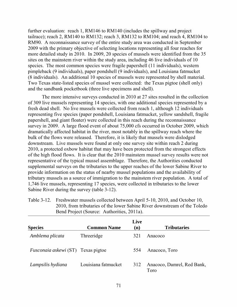
71
further evaluation: reach 1, RM146 to RM140 (includes the spillway and project tailrace); reach 2, RM140 to RM132; reach 3, RM132 to RM104; and reach 4, RM104 to RM90. A reconnaissance survey of the entire study area was conducted in September 2009 with the primary objective of selecting locations representing all four reaches for more detailed study in 2010. In 2009, 20 species of mussels were identified from the 35 sites on the mainstem river within the study area, including 46 live individuals of 10 species. The most common species were fragile papershell (11 individuals), western pimpleback (9 individuals), paper pondshell (9 individuals), and Louisiana fatmucket (8 individuals). An additional 10 species of mussels were represented by shell material. Two Texas state-listed species of mussel were collected: the Texas pigtoe (shell only) and the sandbank pocketbook (three live specimens and shell).
The more intensive surveys conducted in 2010 at 27 sites resulted in the collection of 309 live mussels representing 14 species, with one additional species represented by a fresh dead shell. No live mussels were collected from reach 1, although 12 individuals representing five species (paper pondshell, Louisiana fatmucket, yellow sandshell, fragile papershell, and giant floater) were collected in this reach during the reconnaissance survey in 2009. A large flood event of about 75,000 cfs occurred in October 2009, which dramatically affected habitat in the river, most notably in the spillway reach where the bulk of the flows were released. Therefore, it is likely that mussels were dislodged downstream. Live mussels were found at only one survey site within reach 2 during 2010, a protected oxbow habitat that may have been protected from the strongest effects of the high flood flows. It is clear that the 2010 mainstem mussel survey results were not representative of the typical mussel assemblage. Therefore, the Authorities conducted supplemental surveys on the tributaries to the upper reaches of the lower Sabine River to provide information on the status of nearby mussel populations and the availability of tributary mussels as a source of immigration to the mainstem river population. A total of 1,746 live mussels, representing 17 species, were collected in tributaries to the lower Sabine River during the survey (table 3-12).
Table 3-12. Freshwater mussels collected between April 5-10, 2010, and October 10, 2010, from tributaries of the lower Sabine River downstream of the Toledo Bend Project (Source: Authorities, 2011a).
Species Common Name Live (n) Tributaries
Amblema plicata Threeridge 321 Anacoco
Fusconaia askewi (ST) Texas pigtoe 554 Anacoco, Toro
Lampsilis hydiana Louisiana fatmucket 312 Anacoco, Damrel, Red Bank, Toro
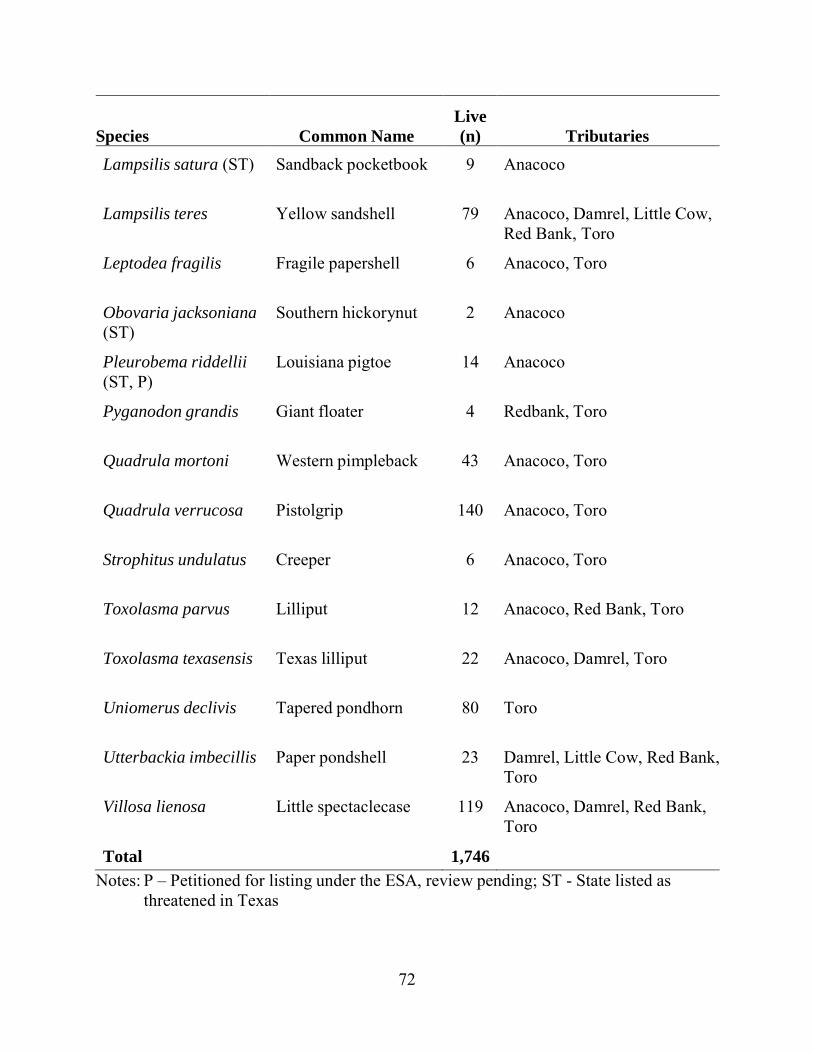
72
Species Common Name Live (n) Tributaries
Lampsilis satura (ST) Sandback pocketbook 9 Anacoco
Lampsilis teres Yellow sandshell 79 Anacoco, Damrel, Little Cow, Red Bank, Toro
Leptodea fragilis Fragile papershell 6 Anacoco, Toro
Obovaria jacksoniana (ST)
Southern hickorynut 2 Anacoco
Pleurobema riddellii (ST, P)
Louisiana pigtoe 14 Anacoco
Pyganodon grandis Giant floater 4 Redbank, Toro
Quadrula mortoni Western pimpleback 43 Anacoco, Toro
Quadrula verrucosa Pistolgrip 140 Anacoco, Toro
Strophitus undulatus Creeper 6 Anacoco, Toro
Toxolasma parvus Lilliput 12 Anacoco, Red Bank, Toro
Toxolasma texasensis Texas lilliput 22 Anacoco, Damrel, Toro
Uniomerus declivis Tapered pondhorn 80 Toro
Utterbackia imbecillis Paper pondshell 23 Damrel, Little Cow, Red Bank, Toro
Villosa lienosa Little spectaclecase 119 Anacoco, Damrel, Red Bank, Toro
Total 1,746 Notes: P – Petitioned for listing under the ESA, review pending; ST - State listed as
threatened in Texas
73
A key element of mussel life history pertains to the dependence of larval mussels (glochidia) on suitable host fish, where they become encysted, grow, and develop into juvenile mussels after which they drop from the host, settle to the bottom, and bury themselves in the substrate to continue their life cycle. Some species of mussel depend on certain species while other species do not appear to be selective. The host species for many species of mussels is still unknown or based on limited laboratory data. Based on known fish hosts of mussel species that occur in the lower Sabine River, suitable fish hosts were collected during Authorities’ 2009 and 2010 fish surveys.
3.3.2.2 Environmental Effects
Water Quantity
Measurement and Management of Flow Releases from the Spillway As a provision of the ARA (proposed Article A-1), the Authorities would
implement a new monthly continuous minimum flow release from the spillway based on the reservoir level as described in table 2-3. These seasonally adjusted flows are proposed to protect and enhance aquatic habitat and provide a reduction in the ratio between the base flow releases to the spillway channel and the peaking flows that are released from the powerhouse.
In ARA proposed Article A-2, the Authorities propose to file with the Commission within 18 months after the effective date of the license, a flow release plan for providing and measuring the continuous flow releases at the project spillway. The flow release plan would contain:
• identification of the location and means of delivery of the continuous flow releases, including the specifications and drawings, as appropriate, of all structures necessary to deliver continuous flows at the spillway;
• description of the means for measuring the continuous flow releases at the project spillway structure as provided in table 2-3, including: (a) the specifications and drawings, as appropriate, of any device, structure, or method to measure releases at the spillway structure that would meet or exceed USGS standards; and (b) the means for making such flow release data available electronically to the Commission and resource agencies;
• a schedule for the construction and commencement of operation of the flow release and flow measurement structures and devices, as well as interim measures for releasing flows described in table 2-3, beginning the later of (a) the end of the second year of any new license term, or (b) 10 days following the Commission’s approval of the plan; and
• a process for amending the plan to accommodate the development schedule for the proposed minimum flow generating unit at the spillway and to implement any measures for downstream passage of American eel.
74
The resource agencies are signatories to the ARA and therefore also support proposed Article A-2 and would be given at least 90 days to file comments and make recommendations on the Authorities’ proposed flow release plan. The plan would be approved by the Commission, who may also make any additional amendments or changes to the plan after the plan is filed.
Our Analysis Sabine River flows are recorded at USGS gage no. 08025360 Sabine River at
Toledo Bend, and are a combination of flows released from the powerhouse and the spillway. The Authorities also compute the flow through the turbine generators, and measure discharges from bypass gates and turbine generator leakage. Flows at the spillway are determined by measurement of the releases from the Tainter gates and the low-flow sluiceway.
Monitoring streamflow downstream of the spillway and from the proposed minimum flow generating unit would provide a means for stakeholders and the Commission to ensure compliance with flows released to the spillway channel. The Authorities propose to ensure compliance monitoring at this location by constructing a gage during the new license term. The Authorities’ proposal should be sufficient for ensuring compliance with applicable flow-related provisions for the spillway channel. While the Authorities plan to consult with the USGS on the proposed construction and monitoring of the proposed gage, the Authorities would ultimately be responsible for ensuring that the gage is adequately operated and maintained to serve the intended project purpose. The separation of flow reporting from the spillway and the powerhouse, compared to existing conditions, would allow for the easier tracking of proposed modified seasonal flow releases from the powerhouse as part of proposed Article A-4 (see below).
In the final license application, the Authorities did not indicate whether they would continue funding of USGS gages no. 08025360 Toledo Bend, 08026000 Burkeville (RM132), and 08028500 Bon Wier (RM91) that are located downstream of Toledo Bend dam on the lower Sabine River. These USGS gages are currently partly funded by the Sabine River Compact Commission, a related but different organization, than the Authorities. The continued operation of these gages would provide information needed to continue adherence to non-license related measures such as the environmental flow standards for the Sabine River adopted by Texas in April 2011.
Seasonal Powerhouse Operations As a provision of the ARA (proposed Article A-4), the Authorities would limit
maximum powerhouse discharges during peaking operations during the months of March through June. These lower peaking flows are proposed to limit the effects on downstream aquatic habitat and provide a reduction in the ratio between the base flow releases to the spillway channel and the peaking flows that are released from the powerhouse.
75
According to proposed Article A-4, the Authorities would implement seasonal powerhouse operations at the earliest of either: the April 30, 2018 expiration of the Authorities’ current power sales agreement, or the effective date of any new or extended power sales agreement. The seasonal powerhouse operations would include the following:
• During normal operations during the months of March, April, May, and June, the Authorities would limit the maximum powerhouse flow during peaking operations at the project to 12,000 cfs.
• March and April: On each weekend day in March and April, the Authorities would provide a volume of 1,450 acre-feet of flow releases from the powerhouse. Flows would be in the range of 4,000 to 7,000 cfs30 but may provide greater weekend powerhouse flows at their discretion.
• May and June: On each weekend day in May and June, the weekend operations described above for March and April would apply if both of the following conditions are met: The mean calculated inflow to the reservoir for the first six months of the
current water year (October 1 to March 31) is greater than 80 percent of the mean calculated inflow of the water year for the same 6-month period for the most recent 38-year period of record. The current water year would not be included in the most recent 38-year period of record.
The Authorities are able to safely operate at least one turbine-generator unit within its normal operating range.
Every tenth year the Authorities would evaluate, in consultation with the resource agencies, the frequency of May and June weekend powerhouse operations. If this evaluation demonstrates that weekend powerhouse operations in May and June occurred in fewer than 7 years of the prior 10-year period, the Authorities would adjust the 80 percent criterion in consultation with the resource agencies, such that weekend powerhouse operations in May and June are expected to occur in approximately two-thirds of the years over the next 10-year period.
The Authorities also propose to conduct flow tests to establish weekend releases prior to implementing the releases. These tests are proposed to occur prior to implementing the seasonal weekend operations, to determine the optimum timing of the 1,450 acre-feet of water to be released, based on further physical measurements within the downstream reach and limitations and efficiency of the powerhouse turbines. Plans for these flow tests are described in detail in Flow Testing to Optimize Weekend
30 A volume of 1,450 acre-feet would produce a flow of 4,000 cfs for a duration of
about 4.4 hours, or a flow of 7,000 cfs for about 2.5 hours.
76
Operations Benefits contained in appendix D to the ARA. The Authorities plan to release a series of powerhouse flows for the nine weekends during May and June:
• Weekend one: release a flow ranging from approximately 6,000–7,000 cfs for 2 hours and 45 minutes on each Saturday and Sunday;
• Weekend two: release a flow ranging from approximately 5,000–6,000 cfs for 3hours and 15 minutes on each Saturday and Sunday;
• Weekend three: release a flow ranging from approximately 4,000–5,000 cfs for4 hours on each Saturday and Sunday; and
• Weekends 4/5/6 and 7/8/9 would repeat the 1/2/3 sequence, above. As part of the flow testing, the resource agencies would select and establish up to
10 downstream river transects for monitoring river stage, wetted perimeter, wetted area and top width during the weekend test flows defined above. The resource agencies would also prepare a matrix of accretion flows that represent a reasonable range of historical accretion flows downstream of the project in the reaches where the test is being conducted, with the objective to identify flow conditions in dry, moderate, and wet water years. Using data collected during the flow testing, and no later than 4 months prior to initiating weekend operations under proposed Article A-4, the Authorities would file with the Commission for approval a weekend operations plan for implementing weekend operations as provided under proposed Articles A-4(2.1) and A-4(2.2), described above.
The resource agencies are signatories to the ARA and therefore also support proposed Article A-4 and would be given at least 90 days to file comments and make recommendations on the Authorities’ proposed weekend operations plan.
American Whitewater and the Sabine Whitewater Club requested two weekends each year of recreational spillway releases, beginning in the first year of the license, of 1,000 cfs for 8 hours on both Saturday and Sunday of each weekend. The timing of these releases was recommended to be during the months of March through June during the period of proposed higher base flows for releases from the spillway. American Whitewater and the Sabine Whitewater Club recommended that the timing and flow volumes of these releases should be subject to change to optimize recreational values.
Our Analysis The proposed seasonal powerhouse operations are intended to balance the needs of
hydropower generation, aquatic resources, terrestrial resources, recreational use and water supply, both within the project area and downstream on the Sabine River. The key objective is reducing the amount of variation in the flows released to the tailrace channel that results in water level fluctuations in both the spillway channel and downstream on the Sabine River. The Toledo Bend powerhouse has two turbine generators, both of which are designed to maximize efficiencies near the higher end of their hydraulic capacity of 7,500 cfs each. Because of this design, the amount of available water, and the varying electricity market needs and prices, the turbine generators have normally been
77
operated at peak capacity for 6 to 8 hours each day, and then shut down the rest of the day.
The confluence of the tailrace channel and the spillway channel is about 2 miles downstream of the powerhouse. During powerhouse operations, generation releases to the tailrace channel can also create backwater areas in large portions of the relatively flat low-gradient 6.1-mile-long the spillway channel. As part of the relicensing process, the Authorities conducted studies to determine the amount of backwater in the spillway channel by scheduling different amounts and lengths of generation at the powerhouse. These studies determined that the backwater characteristics from two-unit operation for 6 hours flow release of 14,675 cfs on September 9, 2009; range from a change in stage of 9 feet in the tailrace at USGS no. gage 08025360, to a change in stage of about 4 feet upstream in the spillway channel at the confluence with Bayou Toro. The change in stage was recorded at three different locations in the spillway channel and one in the Bayou Toro, about 0.2 river mile upstream of the confluence with the spillway channel. The rise of 4 feet at the data logger in Bayou Toro (145-BT1) was similar to the rise of 4 feet measured at data logger 146a located at RM146, about 1 mile downstream of the spillway structure. During the period shown in figure 3-13, the peak powerhouse discharge was 14,675 cfs for 6 hours and about 144 cfs was being released from the spillway. Based on the data from the USGS gage no. 0802550 Bayou Toro near Toro, LA, the average daily discharge from Bayou Toro was very low (less than 10 cfs) and stable.
Powerhouse operations also influence flow and stage height on the lower Sabine River for more than 100 miles downstream as shown in figure 3-14. During this period, inflows from tributaries were very low and did not substantially affect flow in the Sabine River. Figure 3-15 provides graphical representation of the stage height in the same time period, but gage height for USGS gage no. 08025360 was not available for this time period. These figures show that under existing conditions, flows and gage heights in the Sabine River are affected by maximum powerhouse releases by between 9 to almost 4 feet at the USGS gage locations. The USGS gage locations, however, are at relatively constricted sections of the river at bridge locations where the change in stage might be higher than other areas.
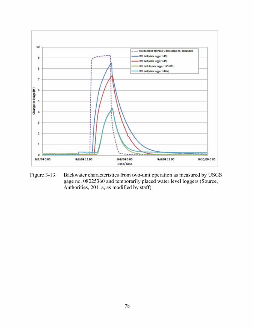
78
Figure 3-13. Backwater characteristics from two-unit operation as measured by USGS
gage no. 08025360 and temporarily placed water level loggers (Source, Authorities, 2011a, as modified by staff).

79
Figure 3-14. Downstream attenuation of flow from two-unit operation for 6 hours (USGS, 2013, as modified by staff).
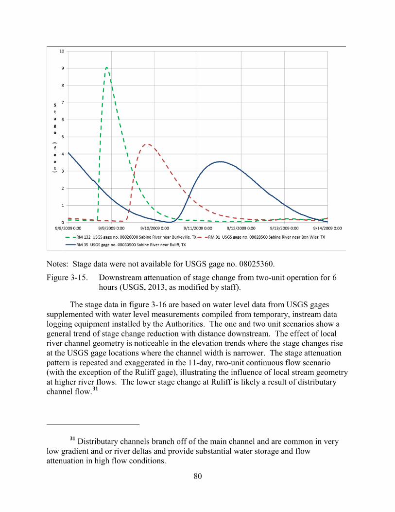
80
Notes: Stage data were not available for USGS gage no. 08025360. Figure 3-15. Downstream attenuation of stage change from two-unit operation for 6
hours (USGS, 2013, as modified by staff).
The stage data in figure 3-16 are based on water level data from USGS gages supplemented with water level measurements compiled from temporary, instream data logging equipment installed by the Authorities. The one and two unit scenarios show a general trend of stage change reduction with distance downstream. The effect of local river channel geometry is noticeable in the elevation trends where the stage changes rise at the USGS gage locations where the channel width is narrower. The stage attenuation pattern is repeated and exaggerated in the 11-day, two-unit continuous flow scenario (with the exception of the Ruliff gage), illustrating the influence of local stream geometry at higher river flows. The lower stage change at Ruliff is likely a result of distributary channel flow.31
31 Distributary channels branch off of the main channel and are common in very
low gradient and or river deltas and provide substantial water storage and flow attenuation in high flow conditions.
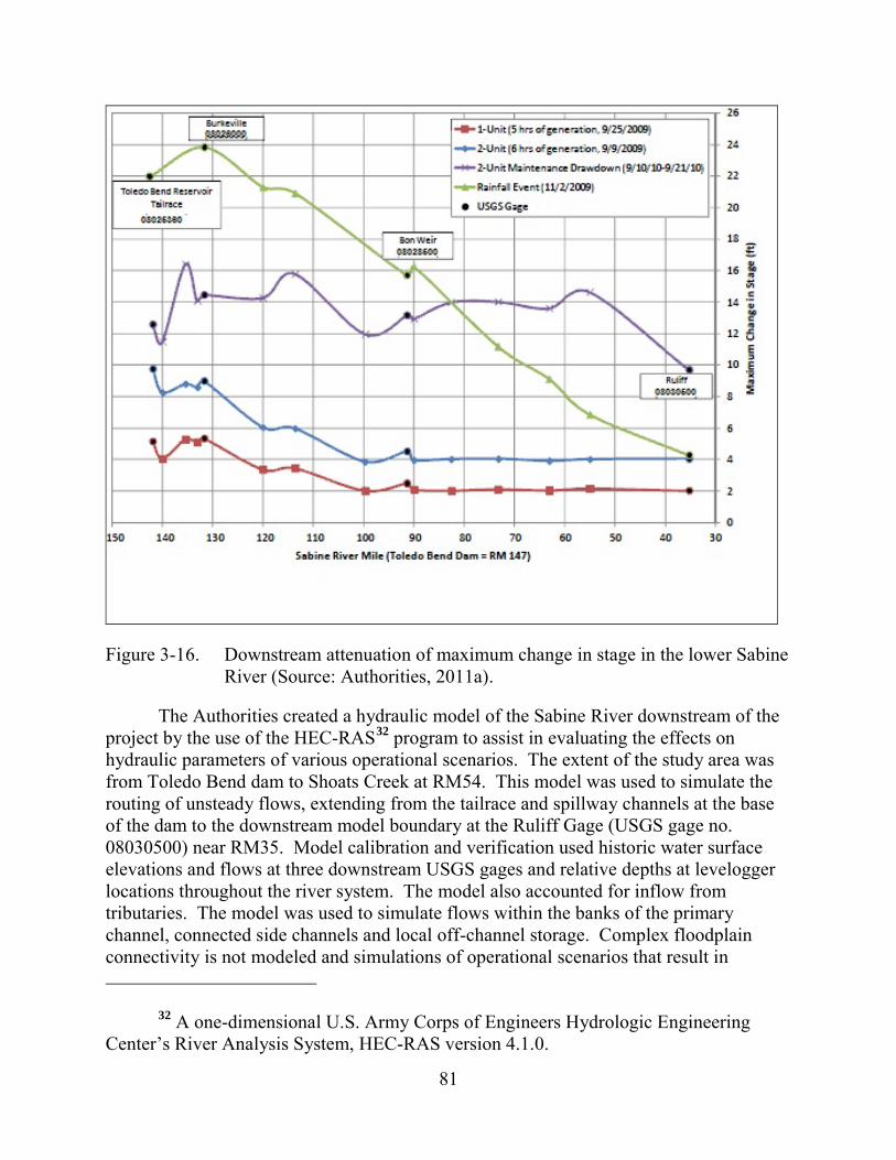
81
Figure 3-16. Downstream attenuation of maximum change in stage in the lower Sabine River (Source: Authorities, 2011a).
The Authorities created a hydraulic model of the Sabine River downstream of the project by the use of the HEC-RAS32 program to assist in evaluating the effects on hydraulic parameters of various operational scenarios. The extent of the study area was from Toledo Bend dam to Shoats Creek at RM54. This model was used to simulate the routing of unsteady flows, extending from the tailrace and spillway channels at the base of the dam to the downstream model boundary at the Ruliff Gage (USGS gage no. 08030500) near RM35. Model calibration and verification used historic water surface elevations and flows at three downstream USGS gages and relative depths at levelogger locations throughout the river system. The model also accounted for inflow from tributaries. The model was used to simulate flows within the banks of the primary channel, connected side channels and local off-channel storage. Complex floodplain connectivity is not modeled and simulations of operational scenarios that result in
32 A one-dimensional U.S. Army Corps of Engineers Hydrologic Engineering Center’s River Analysis System, HEC-RAS version 4.1.0.
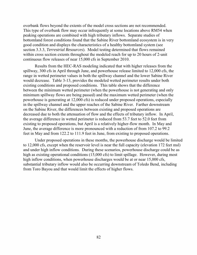
82
overbank flows beyond the extents of the model cross sections are not recommended. This type of overbank flow may occur infrequently at some locations above RM54 when peaking operations are combined with high tributary inflows. Separate studies of bottomland forest conditions found that the Sabine River bottomland ecosystem is in very good condition and displays the characteristics of a healthy bottomland system (see section 3.3.3, Terrestrial Resources). Model testing determined that flows remained within cross section extents throughout the modeled reach for up to 20 hours of 2-unit continuous flow releases of near 15,000 cfs in September 2010.
Results from the HEC-RAS modeling indicated that with higher releases from the spillway, 300 cfs in April through June, and powerhouse release limited to 12,000 cfs, the range in wetted perimeter values in both the spillway channel and the lower Sabine River would decrease. Table 3-13, provides the modeled wetted perimeter results under both existing conditions and proposed conditions. This table shows that the difference between the minimum wetted perimeter (when the powerhouse is not generating and only minimum spillway flows are being passed) and the maximum wetted perimeter (when the powerhouse is generating at 12,000 cfs) is reduced under proposed operations, especially in the spillway channel and the upper reaches of the Sabine River. Farther downstream on the Sabine River, the differences between existing and proposed operations are decreased due to both the attenuation of flow and the effects of tributary inflow. In April, the average difference in wetted perimeter is reduced from 53.7 feet to 52.0 feet from existing to proposed operations, but April is a relatively higher-flow month. In May and June, the average difference is more pronounced with a reduction of from 107.2 to 99.2 feet in May and from 122.2 to 111.9 feet in June, from existing to proposed operations.
Under proposed operations in these months, the powerhouse discharge would be limited to 12,000 cfs, except when the reservoir level is near the full capacity (elevation 172 feet msl) and under high inflow conditions. During these scenarios, powerhouse discharge could be as high as existing operational conditions (15,000 cfs) to limit spillage. However, during most high inflow conditions, when powerhouse discharges would be at or near 15,000 cfs, substantial tributary inflow would also be occurring downstream of Toledo Bend, including from Toro Bayou and that would limit the effects of higher flows.
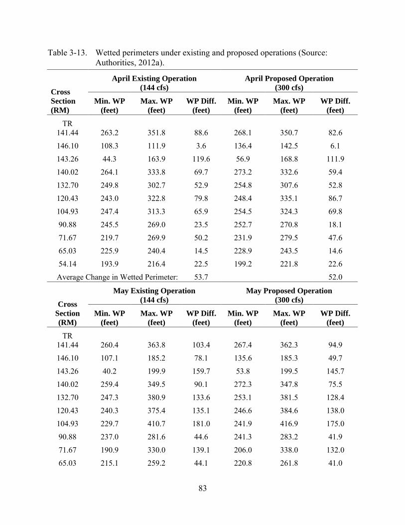
83
Table 3-13. Wetted perimeters under existing and proposed operations (Source: Authorities, 2012a).
Cross Section (RM)
April Existing Operation (144 cfs)
April Proposed Operation (300 cfs)
Min. WP (feet)
Max. WP (feet)
WP Diff. (feet)
Min. WP (feet)
Max. WP (feet)
WP Diff. (feet)
TR 141.44 263.2 351.8 88.6 268.1 350.7 82.6
146.10 108.3 111.9 3.6 136.4 142.5 6.1
143.26 44.3 163.9 119.6 56.9 168.8 111.9
140.02 264.1 333.8 69.7 273.2 332.6 59.4
132.70 249.8 302.7 52.9 254.8 307.6 52.8
120.43 243.0 322.8 79.8 248.4 335.1 86.7
104.93 247.4 313.3 65.9 254.5 324.3 69.8
90.88 245.5 269.0 23.5 252.7 270.8 18.1
71.67 219.7 269.9 50.2 231.9 279.5 47.6
65.03 225.9 240.4 14.5 228.9 243.5 14.6 54.14 193.9 216.4 22.5 199.2 221.8 22.6
Average Change in Wetted Perimeter: 53.7 52.0
Cross Section (RM)
May Existing Operation (144 cfs)
May Proposed Operation (300 cfs)
Min. WP (feet)
Max. WP (feet)
WP Diff. (feet)
Min. WP (feet)
Max. WP (feet)
WP Diff. (feet)
TR 141.44 260.4 363.8 103.4 267.4 362.3 94.9
146.10 107.1 185.2 78.1 135.6 185.3 49.7
143.26 40.2 199.9 159.7 53.8 199.5 145.7
140.02 259.4 349.5 90.1 272.3 347.8 75.5
132.70 247.3 380.9 133.6 253.1 381.5 128.4
120.43 240.3 375.4 135.1 246.6 384.6 138.0
104.93 229.7 410.7 181.0 241.9 416.9 175.0
90.88 237.0 281.6 44.6 241.3 283.2 41.9
71.67 190.9 330.0 139.1 206.0 338.0 132.0
65.03 215.1 259.2 44.1 220.8 261.8 41.0

84
54.14 181.4 251.8 70.4 187.6 257.0 69.4
Average Change in Wetted Perimeter: 107.2 99.2
Cross Section (RM)
June Existing Operation (144 cfs)
June Proposed Operation (300 cfs)
Min. WP (feet)
Max. WP (feet)
WP Diff. (feet)
Min. WP (feet)
Max. WP (feet)
WP Diff. (feet)
TR 141.44 258.3 365.0 106.7 266.8 363.9 97.1
146.10 107.2 190.0 82.8 135.6 187.5 51.9
143.26 38.9 205.5 166.6 52.0 202.7 150.7
140.02 256.9 351.3 94.4 271.1 349.8 78.7
132.70 245.9 389.5 143.6 252.1 389.6 137.5
120.43 238.7 395.6 156.9 245.4 397.2 151.8
104.93 206.3 429.1 222.8 231.1 431.2 200.1
90.88 232.9 286.1 53.2 236.1 287.5 51.4
71.67 180.9 350.5 169.6 188.8 358.3 169.5
65.03 208.8 265.6 56.8 214.0 268.0 54.0
54.14 173.6 264.6 91.0 180.2 268.6 88.4
Average Change in Wetted Perimeter: 122.2 111.9 Note: WP – wetter perimeter
Proposed Article A-4 also proposes powerhouse releases on weekend days in March and April and, depending on the water year, on weekend days in May and June. Currently during these months, powerhouse operations normally do not occur on the weekends due to the lower demand for power, unless the inflow is high and the reservoir is at or near full pool. The proposed weekend release of 1,450 acre-feet of water during every weekend day in March and April, and, depending on the type of water year, every weekend day in May and June, are proposed to limit the effects of intermittent powerhouse operations during the biologically important spring spawning and rearing period. The weekend powerhouse flow releases would not occur during May and June when runoff for the preceding October through March period was less than 80 percent of the mean inflow. Based on historical inflow calculations supplied by the Authorities for the 38-year period between 1972 and 2009, weekend powerhouse flows during May and June would not occur about 30 to 40 percent of the time. Results from the HEC-RAS modeling indicated that these flows would affect the lower Sabine River by limiting the variation in the wetted perimeter as shown in figure 3-17. These benefits would not occur during dry years when weekend flows would not be released.
85
Figure 3-17. Comparisons of downstream wetted perimeters with and without the
proposed weekend flow releases (Source: Authorities, 2012a).
The American Whitewater and the Sabine Whitewater Club requested recreational spillway releases of 1,000 cfs for 8 hours on both Saturday and Sunday of each weekend, for two weekends each year. American Whitewater and the Sabine Whitewater Club
86
recommended that the timing and flow volumes of these releases should be subject to change to optimize recreational values. The benefits of these releases to recreational opportunities in the spillway channel are discussed in detail in section 3.3.5, Recreational Resources.
Proposed Article A-4 also provides for flow testing to optimize the benefits of weekend operations at the project by maximizing the downstream benefits of weekend operations while still allowing for the generation of power during higher-value periods. The proposed flow testing would evaluate and quantify physical responses to alternative magnitudes and timing of pulsed releases under three different hydrologic conditions including dry, moderate, and wet and under a range of downstream accretion flows. The resource agencies would use the data collected during the tests to develop, in consultation with the Authorities, a set of nomographs or tables depicting the change in stage and downstream transect hydraulic parameters under each combination of conditions. This information would be used in the development of the weekend operations plan. Once the weekend flow rate is established, this flow rate would remain in place for 10 years, at which time the resource agencies could elect to repeat the flow test and/or request a revision to the flow rate for the weekend release. The downstream benefits of the weekend flow releases would be to minimize the weekend reductions in river stage that now occur, with associated effects on other hydraulic parameters (e.g., wetted perimeter, top width, and cross-sectional area) similar to HEC-RAS modeling results shown in figure 3-17. This in turn would have a beneficial effect on habitat for aquatic biota.
Proposed Article A-4 would provide benefits to the lower Sabine River by reducing the range of fluctuations in flow releases, water levels, and wetted perimeter as a result of the proposed higher spillway minimum flow releases, lower maximum powerhouse releases, and weekend powerhouse generation. These benefits would benefit the aquatic resources during the prime spawning and rearing time period of March through June. During dry years, with low inflows, weekend powerhouse generation would not occur, but the higher spillway releases and limitations on the peak powerhouse discharges would still occur and provide the above noted benefits, compared to current conditions.
Reservoir Levels As described in section 2.1.3, Existing Project Operation, the Toledo Bend
reservoir is typically operated in a normal elevation range of 168 to 172 feet msl for power generation, in accordance with its operating rule curve and power sales agreement. The project reservoir has historically operated with a normal maximum reservoir elevation of 172 feet msl and until 2007, a normal minimum reservoir elevation of 162.2 feet msl. Since the 2007 amendment to the power sales agreement, power is typically only generated when the reservoir elevation is above 168 feet msl. The Authorities are proposing to continue to operate the reservoir in the same manner as currently operated. Certain commenters on the draft EIS recommended lower reservoir levels to capture
87
high-flow events and limit downstream flooding. Those comments are discussed below under Operations during Flood Conditions.
Our Analysis Current reservoir operations have successfully balanced power generation and
environmental protection, including recreational use. Continuation of these operations, with a normal operating range of 168 to 172 feet msl, would in turn continue a balanced approach to reservoir operations that would benefit all project resources. In comments on the draft EIS, however, the Authorities objected to a license requirement that would mandate an operating range of elevation 168 to 172 feet msl, stating that would constrain their ability to operate the project for its primary purpose, water supply. The Authorities stated that they could agree to a license article that establishes a normal reservoir level range for hydroelectric power production purposes, but would need the ability to lower the reservoir below elevation 168 feet msl to meet downstream water releases for water supply purposes in fulfillment of the Sabine River Compact, the power sales agreement, and state water rights Our intent for recommending a specific range of reservoir operating levels was primarily related to normal hydropower operations. The Authorities currently release water from the reservoir to provide water supply to two canals owned by the Authorities that divert water from the Sabine River downstream of the dam. The Authorities’ recommendation for some flexibility outside of this range would maintain the project’s primary purpose for water supply while allowing for the generation of some limited hydropower at the same time.
Operations during Flood Conditions As described in section 2.1.3, Existing Project Operation, flood control is not a
project purpose, and the Toledo Bend reservoir does not have a flood management pool. The project was conceived, licensed, developed, and primarily functions as a water supply facility, with secondary uses of hydroelectric power generation and recreation. The Authorities are proposing to continue to operate the project during flood conditions in the same manner as currently operated. The Commission staff conducted an evaluation of the Authorities’ operation of the Toledo Bend Project during high-flow events (FERC, 2002). This evaluation involved a series of public meetings, a 2-year collaborative process, and a functional exercise of the Emergency Action Plan (EAP) in which many local residents participated. At that time, Commission staff did not order any changes to project operations as a result of its evaluation. The Authorities also indicate that they constantly monitor inflow and outflow relationships for the reservoir using real-time information, and also use forecasting tools such as the West Gulf River Forecast Center of the Advanced Hydrologic Prediction Center, and the National Weather Service.
In comments on the draft EIS, Katie Daffin, Mike and Shannan Cates, Alan Simmons, and Alice Simmons state that the draft EIS does not include detailed analysis of the operation of Toledo Bend Project during flood events. They state that operations of
88
the dam during flooding events have been poorly managed and have resulted in increased flooding levels downstream along the lower Sabine River. Mrs. Simmons requests that the Authorities adopt a policy of pre-releases from the reservoir when high rainfall events occur above the dam, and states that negligent project operations by the Authorities have resulted in the loss of life, including her son and grandson. Alan Simmons comments that the Authorities have operated the project to hold back flood inflows to the reservoir, and then have released water from the reservoir in astronomical amounts to save the dam from structural failure, without worrying about downstream private property damage or fatalities. Mike and Shannan Cates recommend that the Authorities should not hold enormous amounts of water “anticipating” the generation for profit when weather patterns look ominous. In addition, Mike and Shannan Cates recommend that the Authorities maintain a steady lake level of 165 to 167 feet msl during the “rainy” season by releasing only small amounts of water instead of holding and releasing large amounts at once.
Our Analysis Current reservoir operations, with a normal operating range generally between
elevation 168 and 172 feet msl, are balanced between water supply, power generation, and environmental protection, including recreational use. Toledo Bend reservoir, while not a flood control reservoir, may affect flood flows due to its large size, a surface area of 170,000 acres (266 square miles) at elevation 168 feet msl. With a maximum powerhouse release of 16,000 cfs, the reservoir can be lowered by only about 1 foot in 6 days if there is no inflow to the reservoir.
Downstream flood levels and releases from the reservoir are also affected by travel time, floodplain storage, tributary inflow, and varying channel and floodplain topography. For example, the lag time for high-flow releases from the Toledo Bend reservoir to Deweyville, located about 110 river miles downstream, is about 5 days. Below are the flows associated with flood levels at key downstream locations:
• Burkeville USGS gage (Highway 63 and River Road): 35,000 cfs (RM 132);
• Bon Weir USGS gage: 26,000 cfs (RM 91); and
• Ruliff USGS gage (Deweyville): 18,000 cfs (RM 35). The downstream residents affected by flood flows, in general, are located at the following locations:
• "River Road" residents live essentially immediately downstream of the dam;
• "Burkeville" residents live near the Highway 63 bridge crossing of the Sabine River;
• "Bon Wier" residents live near the Highway 190 bridge crossing of the Sabine River; and
89
• "Deweyville" residents live near the Highway 12 bridge crossing of the Sabine River.
Multiple studies have investigated changing operation of the Toledo Bend Project to increase the flood control capability. A study by the Corps in 1979 (cited in FERC, 2002) investigated project operational changes as well as the addition of flood control capability within the Sabine River basin. This analysis determined that it was not cost effective to improve the channel downstream of Toledo Bend dam, construct levee systems at Deweyville, or construct dams along the mainstem of the Sabine River or its tributaries to control flooding in the lower Sabine River. For changes to the Toledo Bend reservoir operation, this study determined that:
• Raising the dam and spillway to add flood control space for the 50- and 100-year floods showed that the additional flood control storage would reduce and smooth out the overall flood flows, but the peak flows would remain almost unchanged. Near Deweyville, this would result in only a 0.3-foot reduction in the flood levels for the 50- and 100-year flood events.
• A change in the operational rules for the reservoir would not make a substantial difference because of the narrow band of flood control storage available, and the relatively flat topography of the majority of the land flooded by the reservoir. Lower reservoir levels would also adversely affect boat docks and recreational opportunities.
Three major flood events have occurred downstream of Toledo Bend dam in the past 30 years:33 May 1989, January/February 1999, and March 2001. The May 1989 event was caused by heavy rainfall on May 17, 18, and 19, 1989, with a total rainfall of 5.05 inches at the dam and 8 to 14 inches at various locations on and around the reservoir. Limited rainfall occurred downstream of the dam. The January/February 1999 event was caused by a rainfall of 12.01 inches at the dam site and 3 to 11 inches across north Texas and northwest Louisiana. The March 2001 flood was caused by substantial rainfall in the basin following a very wet January and February. Table 3-14 provides a summary of the 1989, 1999, and 2001 flood events. The key points of table 3-14 are the calculated inflow rate, which would be the flow rate that would occur immediately downstream of the dam without the project in place, the general decrease in peak flow rates at the downstream gages, and the lag time for the peak flow at the downstream gages.
33 Other floods have occurred in this time period including July 1989 and
November 2009, but in general these floods were smaller than the three floods that are discussed.
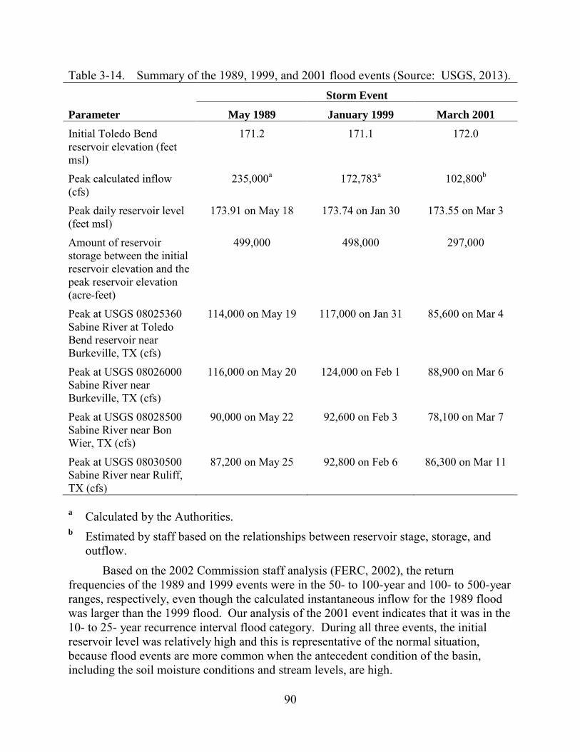
90
Table 3-14. Summary of the 1989, 1999, and 2001 flood events (Source: USGS, 2013).
Parameter
Storm Event
May 1989 January 1999 March 2001
Initial Toledo Bend reservoir elevation (feet msl)
171.2 171.1 172.0
Peak calculated inflow (cfs)
235,000a 172,783a 102,800b
Peak daily reservoir level (feet msl)
173.91 on May 18 173.74 on Jan 30 173.55 on Mar 3
Amount of reservoir storage between the initial reservoir elevation and the peak reservoir elevation (acre-feet)
499,000 498,000 297,000
Peak at USGS 08025360 Sabine River at Toledo Bend reservoir near Burkeville, TX (cfs)
114,000 on May 19 117,000 on Jan 31 85,600 on Mar 4
Peak at USGS 08026000 Sabine River near Burkeville, TX (cfs)
116,000 on May 20 124,000 on Feb 1 88,900 on Mar 6
Peak at USGS 08028500 Sabine River near Bon Wier, TX (cfs)
90,000 on May 22 92,600 on Feb 3 78,100 on Mar 7
Peak at USGS 08030500 Sabine River near Ruliff, TX (cfs)
87,200 on May 25 92,800 on Feb 6 86,300 on Mar 11
a Calculated by the Authorities. b Estimated by staff based on the relationships between reservoir stage, storage, and
outflow. Based on the 2002 Commission staff analysis (FERC, 2002), the return
frequencies of the 1989 and 1999 events were in the 50- to 100-year and 100- to 500-year ranges, respectively, even though the calculated instantaneous inflow for the 1989 flood was larger than the 1999 flood. Our analysis of the 2001 event indicates that it was in the 10- to 25- year recurrence interval flood category. During all three events, the initial reservoir level was relatively high and this is representative of the normal situation, because flood events are more common when the antecedent condition of the basin, including the soil moisture conditions and stream levels, are high.
91
A key part of the Commission staff 2002 analysis was an assessment of how the initial reservoir elevation could have affected the outflow and is summarized below.
For the 1989 Flood:
• If the reservoir started at elevation 162 feet msl and with an onset release of 5,500 cfs at the beginning of the storm, the reservoir would not rise to elevation 168 feet msl throughout the event;
• If the reservoir started at elevation 168 feet msl, the analysis indicated that the storm could be contained without flooding downstream. Releases through the powerhouse above elevation 168 feet msl were assumed to be 16,000 cfs; and
• If the reservoir started at elevation 172.5 feet msl, the analysis indicated that the storm would not be contained and there would be major flooding downstream with a maximum discharge higher than historic conditions.
For the 1999 Flood:
• If the reservoir started at elevation 162 feet msl and with an onset release of 5,500 cfs at the beginning of the storm, a total maximum discharge of 21,500 cfs would have occurred without major downstream flooding;
• If the reservoir started at elevation 168 feet msl with an onset release of 16,000 cfs, the analysis indicated that the storm could not be totally contained and would result in a maximum discharge of 36,100 cfs, but this would not result in major downstream flooding; and
• If the reservoir started at elevation 172.5 feet msl, the analysis indicated that the storm would not be contained and there would be major flooding downstream with a maximum discharge higher than historic conditions.
These analyses showed that there would be a flood control benefit if the reservoir level had been at lower elevations prior to the flood inflow. However, the assumption that the reservoir could be at a low elevation with very low or no inflow prior to a major flood event is highly unlikely. For example, the 1989 and 1999 events were preceded by a substantial amount of inflow from sustained rainfall over the weeks prior to the main flood event.
The 2001 flood event was smaller than the 1989 or 1999 events. Similar to what occurred in 1989 and 1999, the March 2001 event was preceded by a wet period in January and February that raised the reservoir level even under full generation from the powerhouse. As shown in figure 3-18, the reservoir level generally rose during January, and then remained relatively stable in February (+/- 1 foot in elevation). In response to the main inflow event, the reservoir level quickly rose in early March and the daily maximum outflow was reached on March 4 at the dam and March 6 downstream at Burkeville. During a secondary high inflow event in mid-March as indicated by the
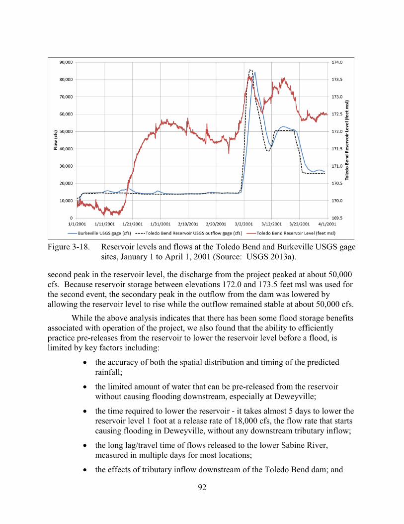
92
Figure 3-18. Reservoir levels and flows at the Toledo Bend and Burkeville USGS gage
sites, January 1 to April 1, 2001 (Source: USGS 2013a).
second peak in the reservoir level, the discharge from the project peaked at about 50,000 cfs. Because reservoir storage between elevations 172.0 and 173.5 feet msl was used for the second event, the secondary peak in the outflow from the dam was lowered by allowing the reservoir level to rise while the outflow remained stable at about 50,000 cfs.
While the above analysis indicates that there has been some flood storage benefits associated with operation of the project, we also found that the ability to efficiently practice pre-releases from the reservoir to lower the reservoir level before a flood, is limited by key factors including:
• the accuracy of both the spatial distribution and timing of the predicted rainfall;
• the limited amount of water that can be pre-released from the reservoir without causing flooding downstream, especially at Deweyville;
• the time required to lower the reservoir - it takes almost 5 days to lower the reservoir level 1 foot at a release rate of 18,000 cfs, the flow rate that starts causing flooding in Deweyville, without any downstream tributary inflow;
• the long lag/travel time of flows released to the lower Sabine River, measured in multiple days for most locations;
• the effects of tributary inflow downstream of the Toledo Bend dam; and
93
• the common occurrence of high inflows and high reservoir levels prior to most flood events.
As a result of the 2-year collaborative FERC process that occurred over 10 years ago, the Authorities noted in their comments on the draft EIS that they have implemented a number of improvements to the public notification procedures during high-flow events including:
• the installation of a NOAA radio transmitter that provides reservoir levels and releases;
• public notice of anticipated spillway operations and real-time reservoir levels via website and phone recordings;
• a flood warning and educational guide distributed to downstream residents;
• a spillway siren that sounds when the spillway gates are opened; and
• improved coordination and cooperation with state and local emergency management agencies.
When high discharges are anticipated, the Authorities notify local emergency management agencies and they personally notify residents that live in the floodplain downstream from the project. All of these improvements and procedures have been incorporated into the Authorities EAP that was most recently updated in 2010, and are in compliance with Commission requirements of 18 C.F.R. § 12.25 (2013).
Water Quality Water quality conditions in the surface waters generally met water quality criteria
with the exception of a few DO and pH measurements. The reservoir stratifies in the summer as is common for large reservoirs in the Southeast, and DO concentrations in the hypolimnion decrease to less than 1 mg/L as a result. Given the size of the reservoir, the proposed changes in project operation associated with the increased continuous minimum flow at the spillway, from the current 144 to 300 cfs, would minimally affect reservoir storage and not affect water quality in the reservoir. The Authorities are not proposing any environmental measures to protect or enhance reservoir water quality, and no entity has recommended such measures. Our discussion focuses on the effects of proposed changes in project operations on downstream water quality.
Spillway Flow Releases As agreed to in the ARA, the minimum flow release at the spillway would be
discharged through a proposed minimum flow generating unit and would increase from 144 cfs to a range of flows from 150 to 300 cfs. In addition, water would be withdrawn from a higher elevation in the water column than at present. The invert of the currently used sluiceway gate is at an elevation of 100 feet msl, and the invert of the proposed intake would be at an elevation of 145 feet msl. The higher invert would result in the
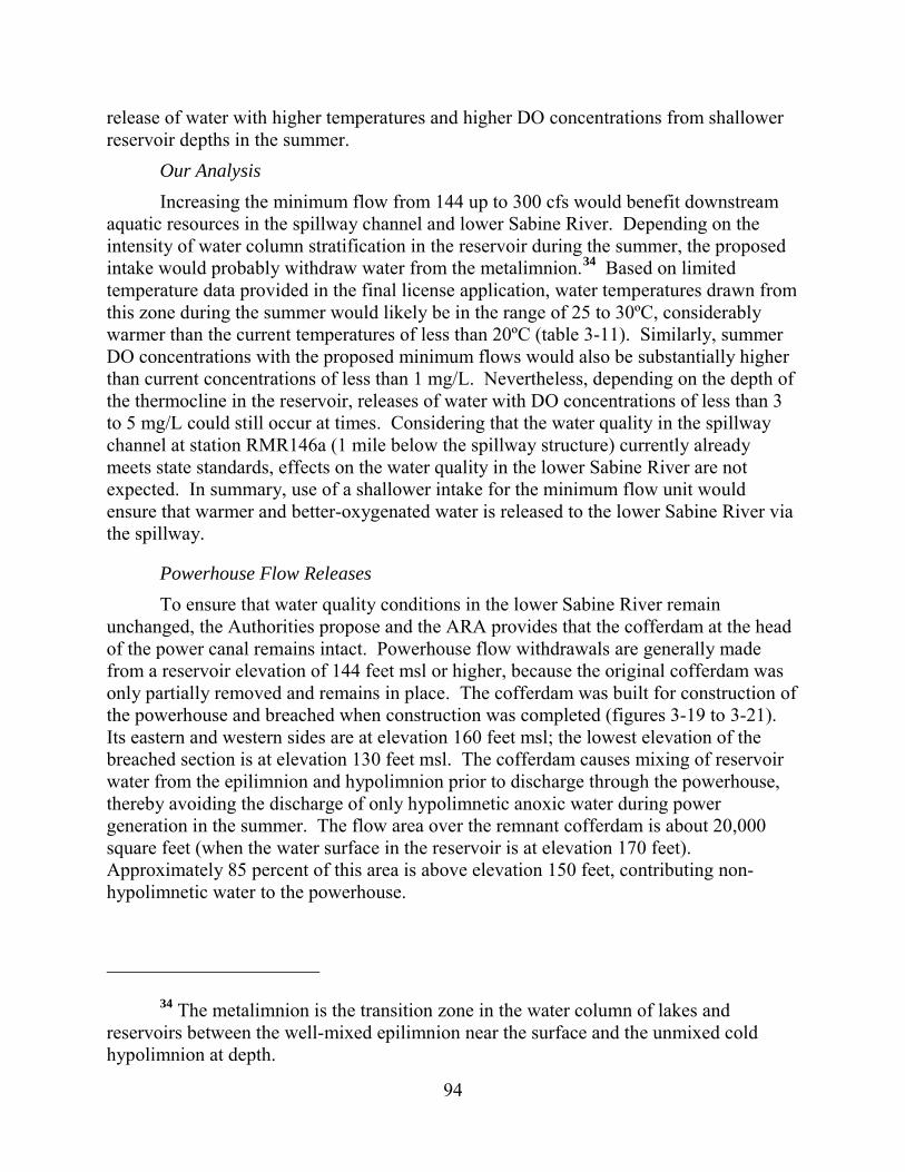
94
release of water with higher temperatures and higher DO concentrations from shallower reservoir depths in the summer.
Our Analysis Increasing the minimum flow from 144 up to 300 cfs would benefit downstream
aquatic resources in the spillway channel and lower Sabine River. Depending on the intensity of water column stratification in the reservoir during the summer, the proposed intake would probably withdraw water from the metalimnion.34 Based on limited temperature data provided in the final license application, water temperatures drawn from this zone during the summer would likely be in the range of 25 to 30ºC, considerably warmer than the current temperatures of less than 20ºC (table 3-11). Similarly, summer DO concentrations with the proposed minimum flows would also be substantially higher than current concentrations of less than 1 mg/L. Nevertheless, depending on the depth of the thermocline in the reservoir, releases of water with DO concentrations of less than 3 to 5 mg/L could still occur at times. Considering that the water quality in the spillway channel at station RMR146a (1 mile below the spillway structure) currently already meets state standards, effects on the water quality in the lower Sabine River are not expected. In summary, use of a shallower intake for the minimum flow unit would ensure that warmer and better-oxygenated water is released to the lower Sabine River via the spillway.
Powerhouse Flow Releases To ensure that water quality conditions in the lower Sabine River remain
unchanged, the Authorities propose and the ARA provides that the cofferdam at the head of the power canal remains intact. Powerhouse flow withdrawals are generally made from a reservoir elevation of 144 feet msl or higher, because the original cofferdam was only partially removed and remains in place. The cofferdam was built for construction of the powerhouse and breached when construction was completed (figures 3-19 to 3-21). Its eastern and western sides are at elevation 160 feet msl; the lowest elevation of the breached section is at elevation 130 feet msl. The cofferdam causes mixing of reservoir water from the epilimnion and hypolimnion prior to discharge through the powerhouse, thereby avoiding the discharge of only hypolimnetic anoxic water during power generation in the summer. The flow area over the remnant cofferdam is about 20,000 square feet (when the water surface in the reservoir is at elevation 170 feet). Approximately 85 percent of this area is above elevation 150 feet, contributing non-hypolimnetic water to the powerhouse.
34 The metalimnion is the transition zone in the water column of lakes and
reservoirs between the well-mixed epilimnion near the surface and the unmixed cold hypolimnion at depth.
95
Figure 3-19. Cofferdam during construction in 1967 (Source: Authorities, 2011b).

96
Figure 3-20. Bathymetry of cofferdam under present condition (Source: Authorities, 2011b).
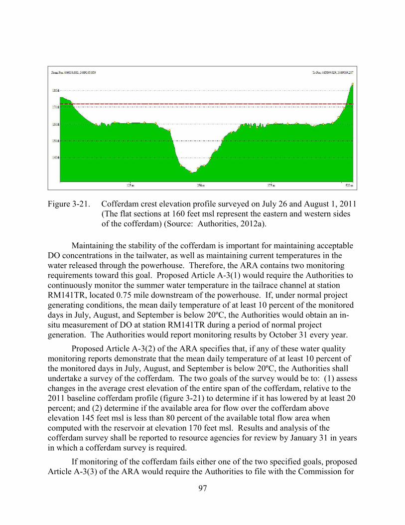
97
Figure 3-21. Cofferdam crest elevation profile surveyed on July 26 and August 1, 2011 (The flat sections at 160 feet msl represent the eastern and western sides of the cofferdam) (Source: Authorities, 2012a).
Maintaining the stability of the cofferdam is important for maintaining acceptable DO concentrations in the tailwater, as well as maintaining current temperatures in the water released through the powerhouse. Therefore, the ARA contains two monitoring requirements toward this goal. Proposed Article A-3(1) would require the Authorities to continuously monitor the summer water temperature in the tailrace channel at station RM141TR, located 0.75 mile downstream of the powerhouse. If, under normal project generating conditions, the mean daily temperature of at least 10 percent of the monitored days in July, August, and September is below 20ºC, the Authorities would obtain an in-situ measurement of DO at station RM141TR during a period of normal project generation. The Authorities would report monitoring results by October 31 every year.
Proposed Article A-3(2) of the ARA specifies that, if any of these water quality monitoring reports demonstrate that the mean daily temperature of at least 10 percent of the monitored days in July, August, and September is below 20ºC, the Authorities shall undertake a survey of the cofferdam. The two goals of the survey would be to: (1) assess changes in the average crest elevation of the entire span of the cofferdam, relative to the 2011 baseline cofferdam profile (figure 3-21) to determine if it has lowered by at least 20 percent; and (2) determine if the available area for flow over the cofferdam above elevation 145 feet msl is less than 80 percent of the available total flow area when computed with the reservoir at elevation 170 feet msl. Results and analysis of the cofferdam survey shall be reported to resource agencies for review by January 31 in years in which a cofferdam survey is required.
If monitoring of the cofferdam fails either one of the two specified goals, proposed Article A-3(3) of the ARA would require the Authorities to file with the Commission for
98
approval a Cofferdam Restoration Plan by the following July 1. This plan would include specifications, methods, and a schedule for restoring the cofferdam to elevations consistent with elevations of the cofferdam during the 2011 baseline survey (figure 3-21). Resource agencies would be allowed to comment and offer recommendations prior to filing the plan with the Commission.
Our Analysis The cofferdam has a pivotal role in maintaining acceptable water quality
conditions in the lower Sabine River during power generation. Monitoring and maintaining the elevation of the cofferdam, as required in the ARA, would help protect water quality. However, some of the provisions of proposed Article A-3 would require further consideration.
The tailrace temperature threshold of 20ºC in proposed Article A-3(1) may be too low for initiating monitoring of the cofferdam elevation, as required in proposed Article A-3(2). For example, the reservoir hypolimnion in July 2009 extended from a depth of about 20 feet (with a temperature of 27.4ºC) to the bottom at about 82 feet (with a temperature of 16.7ºC), resulting in a mean hypolimnetic water temperature of approximately 20ºC (table 3-11). The mean DO concentration within this zone was 0.2 mg/L. Therefore, the threshold of less than 20ºC as specified in proposed Article A-3(1) would only be reached, for the conditions occurring in July 2009, if water drawn into the powerhouse were to originate exclusively from the hypolimnion without contributions from the warm (>30ºC) epilimnetic surface water. However, it is likely that at least some epilimnetic water would also be drawn into the intake, acting to warm the powerhouse releases and making it unlikely that the 20ºC threshold would be met. A large influx of hypolimnetic waters to reach the 20ºC threshold would require substantial erosion of the cofferdam, approaching total loss of the cofferdam, which would be unlikely.
In addition, available data do not support the use of a temperature threshold of 20ºC as a surrogate for DO concentrations. Water temperatures and DO were monitored by the Authorities at tailrace station RM 141TM1 (proposed to be used as the station for continuous temperature monitoring, relabeled as RM 141 TM) during the summers of 2009, 2010, and 2011. In 2009 (July through September), temperature was monitored for approximately 4 weeks and DO for only 1 week. In 2010, temperature was monitored for 3 weeks and DO throughout the summer. In 2011, both parameters were monitored over the entire summer. Overall, all available temperatures during the summer months were in the upper twenties on average (ranging from approximately 24 to 32ºC), well above the 20ºC threshold. During the same time period, there were several occurrences when DO concentrations were less than 5 mg/l at station RM 141 TR1. In 2011, temperature and DO measurements were actually inversely related on a monthly basis. Specifically, temperatures in August 2011 (ranging from 30 to 32ºC) were at their peak for the summer, while DO concentrations were at their lowest, with concentrations of less than 5 mg/L at times. Therefore, a different temperature threshold may be appropriate (after
99
some further study), or alternatively, regular inspections could be made of the cofferdam to ensure its stability.
Proposed Article A-3(1) specifies the collection of a DO sample at station RM141TR if at least 10 percent of the temperature measurements on monitored days in July, August, and September during which the project is generating under normal conditions are below 20ºC. Even if the temperature was to decrease to below 20ºC under these conditions (which we consider unlikely as discussed above), a single DO measurement collected toward the end of the summer would not be very informative; more informative would be a DO measurement collected each time the temperature threshold was reached during a powerhouse release cycle, or alternatively continuous DO monitoring over the summer. However, we understand that the primary criterion for triggering a cofferdam survey would be water temperature, and because state DO standards are typically met downstream of the powerhouse, there may be little justification for additional DO monitoring.
Proposed Article A-3(2) specifies, among other provisions, to determine if the average crest elevation of the entire span of the cofferdam has lowered by at least 20 percent, as compared to the 2011 baseline cofferdam survey. The reference elevation is not specifically identified, but we assume it to be the 170-foot reservoir elevation that was also used for the second monitoring goal within this article. Using the 170-foot reference elevation, a lowering of 20 percent would result in an average cofferdam erosion rate of about 3 feet. Such an erosion rate should be suitable for triggering proposed Article A-3(3), the Cofferdam Restoration Plan.
In summary, while we consider provisions of proposed Article A-3(2) (with the assumption of the reference elevation specified above) and proposed Article A-3(3) adequate to address erosion of the cofferdam, the temperature threshold of 20ºC specified in proposed Article A-3(1) may be too low. Therefore, substantial erosion of the cofferdam could occur before provisions of proposed Articles A-3(2) and A-3(3) are triggered. Given the importance of the cofferdam for maintaining DO levels in the lower Sabine River, direct monitoring of the average crest elevation of the cofferdam at regular intervals (such as every 15 years) would be a more reliable approach to ascertain its stability and would eliminate the need for temperature monitoring downstream of the powerhouse. Temperature monitoring, however, would be useful for monitoring the variability of water quality conditions in project releases, which in concert with the bathymetric surveys would result in a better understanding of the relationship of water quality and the condition of the cofferdam.
Aquatic Biota The Authorities are not proposing major changes in project operations related to
reservoir level regulation and overall powerhouse operations, but are proposing to increase the minimum flow releases into the spillway channel. Under proposed operations, the reservoir levels would remain the same as under current operations, and

100
no major changes in project flow withdrawals from the reservoir would occur, resulting in no effects on reservoir fish populations. Therefore, we focus our discussion on downstream effects related to the implementation of the proposed increased minimum flow from the spillway, and the change in powerhouse operations to seasonally limit the maximum flow from the powerhouse. We also discuss the proposal for provision of American eel passage at the project.
Increased Spillway Minimum Flows and Modified Powerhouse Flows The Authorities are proposing to construct a minimum flow generating unit to
release a minimum flow into the spillway channel that would range from 150 to 300 cfs, depending on month and reservoir level, as described in table 2-3. The current minimum flow from the spillway is 144 cfs year-round, and the proposed higher minimum flows would benefit aquatic resources and limit flow variability downstream of the project. No additional minimum flow recommendations were made by any entities, as this proposed minimum flow is a provision of the ARA as spelled out in proposed Article A-1. The Authorities also propose to limit the peak discharge from the powerhouse to 12,000 cfs under normal operations during the months of March through June,35 and to provide periodic weekend releases of 4,000 to 7,000 cfs during this same period (proposed Article A-4).
Our Analysis Increasing the minimum flow in the spillway channel would increase the wetted
perimeter and aquatic habitat in the 1.7-mile-long excavated spillway channel and in the remainder of the “6-mile loop,” which also receives natural inflow from Bayou Toro. The increased minimum flow would also increase the wetted perimeter and aquatic habitat in the lower Sabine River, downstream of the confluence with the tailrace, although those effects would be quickly attenuated in a downstream direction. Capping the maximum powerhouse discharges to 12,000 cfs and the higher minimum flows from the spillway would act to reduce the variability in aquatic habitat in the lower Sabine River during the spawning and egg incubation period for most of the fisheries species in the river. Our discussion above under Water Quantity includes an analysis of the effects of these proposed operational changes on wetted perimeter from the spillway channel downstream to RM54 on the lower Sabine River in April, May, and June (table 3-13). That analysis indicated that because of the increased minimum flows from the spillway, the wetted perimeter, which can serve as a surrogate for estimating overall aquatic
35 Under the Authorities proposal, powerhouse releases would be allowed to
exceed 12,000 cfs if electrical system conditions called for higher flows or the use of reserve capacity. However, historically these conditions have occurred about two or three times per year.

101
habitat,36 would increase at all river stations modeled. The maximum wetted perimeter remained somewhat similar between the existing and proposed operations, but with an increase in wetted perimeter at the proposed minimum flow levels, the difference between the minimum and maximum wetted perimeter would decrease. This decreased difference indicates that under proposed operations, aquatic habitat would be more stable because the minimum amount of wetted area would be greater, and the difference between the minimum and maximum wetted area would be less. This would result in less variable aquatic habitat, which would benefit all aquatic resources in the river. This effect would be more evident in May and June and less so in April (table 3-13), when overall flows are higher in the river, resulting in less difference between minimum and maximum wetted perimeter.
The periodic weekend flow releases from the powerhouse would provide additional flows to the lower Sabine River during March and April, and depending on the water year, also in May and June. During the key spring spawning period on weekends, the Sabine River immediately downstream from the project would typically only receive minimum project releases from the spillway minimum flow, because the existing powerhouse is normally not operated on the weekends due to the lower power demands. These releases would enhance aquatic habitat in the lower river, and although not continuous releases, would act to diminish the fluctuations in habitat associated with project peaking operations. These periodic releases were described in greater detail under Water Quantity.
The seasonal powerhouse operations would not be implemented under the Authorities’ proposal until 2018 or possibly earlier if a new power sales agreement is signed. This would delay the enhancements noted above by up to 4 years, depending on the timing of any new license issuance and the status of any new power sales agreement. As a result, effects of powerhouse operations on downstream resources would continue as they have since the project first became operational in 1969. While that may not have a major adverse effect on downstream resources, the benefits of proposed modified powerhouse operations would nonetheless be delayed.
American Eel Passage The project dam, at RM146, is the first dam on the Sabine River upstream from
the Gulf of Mexico and, as such, blocks the upstream migration of the American eel from the Gulf. Substantial accessible habitat for American eel still occurs in the Sabine River Basin downstream of the project dam. However, most eel collections during the
36 Wetted perimeter is a direct measurement of the amount of wetted habitat in a
stream. It does not provide estimates of depths or velocities or the type of habitat available (such as riffle, run, or pool), but in the absence of that information, it can serve as an overall estimate of aquatic habitat.
102
Authorities eel surveys37 were made in the most upstream accessible reaches of the river closer to the dam, and particularly in the spillway channel. This indicates that the project dam is acting as an obstruction to upstream migration of the eel.
As part of the ARA, the Authorities are proposing to provide for safe and effective upstream and downstream passage of American eel at the project, as prescribed by NMFS and Interior. This proposal would include both an upstream passage plan and a downstream passage plan. The upstream passage plan would entail:
• A plan, for Commission approval, for deploying two portable ramp traps in the project tailrace and four portable ramp traps in the project spillway, including detailed design drawings and a schedule for deployment;
• A protocol for safely transporting juvenile eels captured in the ramp traps for release from the shoreline upstream of the dam at two locations (one for tailrace captures and one for spillway captures);
• Procedures for data collection, including the number and size of eels captured and released, and water temperatures at the time of collection;
• A phased schedule for operating, inspecting, and possibly relocating ramp traps and/or modifying the attraction flow provided to the ramps based on their performance, for a 5-year period, with year 1 for selection of the ramp locations and initial operations, and years 2 through 5 for continued operations, checking the eel ramps at least once per week year-round;
• Additional sampling for American eel with other gear types, such as electrofishing, in the vicinity of the ramp trap locations at least once per month when water temperatures are in the range of 16 to 21°C, but sampling would not be required at either the tailrace or spillway locations if the ramp traps in those locations collected at least 50 eels in the previous month; this sampling is to occur in the first 5 years of ramp trap operation and every fifth year thereafter;
• Continued consultations with the resource agencies throughout the ramp trap operations regarding adjustments to the location, design, and/or operation of the ramp traps necessary to maintain or enhance their performance, with any changes to be approved by the Commission;
• Annual reports on the ramp trap operations to be provided to the resource agencies and filed with the Commission, that would include information on the timing, locations, numbers, and sizes of eels captured and released, trap mortality, results of any eel sampling conducted in the vicinity of the ramp
37 American eel surveys were conducted by the Authorities from the base of the
dam downstream to RM141.
103
traps, water temperature data, any proposed revisions to the plan to improve its effectiveness at passing juvenile eels upstream of the dam, including whether to reduce or increase the number of ramp traps deployed, based on eel capture rates, and a schedule for an annual site visit and review of ramp trap operations with the agencies; draft annual reports would be provided to the resource agencies by August 1, and after a 45-day comment period would be filed with the Commission within 45 days of the close of the comment period, or on an alternative schedule as mutually agreed to by the Authorities, FWS, and NMFS; and
• Potential termination or adjustments to the program after 5 years of ramp trap operations, with the 5th annual report to address whether to continue such operations based on the number of eels passed upstream to date, giving due consideration to hydrologic/meteorological conditions and other relevant factors (such as actual operational time for the various ramps); if ramp trap operations in years 3 through 5 result in the passage of fewer than an average of 150 eels per year, the Authorities may propose to discontinue all requirements of the fish passage prescription, in accordance with the general terms and conditions for the fishway prescriptions.
The downstream passage plan would include:
• A plan to safely pass adult American eels from the project reservoir to the Sabine River downstream of the project via the continuous flow releases or by other means at the project spillway; the plan would be filed for Commission approval within 6 years of the Commission’s approval of the upstream passage plan;
• Detailed design drawings, with explanatory text, and a construction schedule for any modifications necessary for the continuous releases from the spillway to provide safe, timely, and effective downstream passage via the continuous releases or other means that may include: a screening and diversion system to safely divert and transport eels away from the proposed minimum flow generating unit at the spillway, if constructed; or design of a near-surface (upper 12 feet) continuous flow weir/intake facility at or near the spillway structure to safely transport eels to the lower Sabine River, if the minimum flow generating unit is not constructed;
• A proposed schedule for initiating downstream passage operations following Commission approval of the plan;
• An annual report on downstream passage operations, including documentation that the downstream passage facilities were available throughout the year, and any other measures implemented to promote safe and timely downstream passage; and
104
• Provisions for an annual site visit and review of downstream passage operations by the resource agencies.
The Section 18 fishway prescriptions filed by Interior on October 18, 2012, and by NMFS on December 4, 2012, are identical to the provisions of the ARA described above.
Our Analysis Fifty three American eel were collected by the Authorities downstream of both the
powerhouse and spillway, with the numbers highest in the spillway channel. Most were collected by electrofishing, but a small number (17) were collected by ramp trap sampling at the base of the dam. The electrofishing catch rates at Toledo Bend were comparable to some dams along the South Atlantic coast. These collections indicate that the lower Sabine River habitat is used by American eel and that the presence of Toledo Bend dam is a blockage to further upstream migration of the eel. Both Interior and NMFS have prescribed measures for upstream and downstream eel passage at the Toledo Bend Project, and the Authorities have agreed to provide eel passage as part of the ARA.
Our review of the proposed upstream and downstream passage plans indicates that these plans are essentially an adaptive management program designed to determine whether or not permanent eel passage at the project would be feasible and whether sufficient numbers of eels are available for passage at the project to justify permanent passage facilities. As indicated in the Interior comments and fishway prescription filed October 18, 2012, information on the distribution of American eel along the Gulf of Mexico coast and within Texas/Louisiana rivers is limited, although there is some information to indicate the eel is relatively common in some drainages. A phased program as outlined by the ARA and the fishway prescriptions is an appropriate approach for the Sabine River, where information collected to date by the applicant does not indicate a large population of American eel in the river. The setting of ramp traps and transportation of eels upstream of the dam is a common methodology for investigating potential eel abundance and the best locations for upstream eel passage facilities at dams. Any eels collected would be transported upstream.38 The upstream passage plan would include an initial 5-year period of operation, with the option to terminate the upstream passage program if only small numbers of eels are collected in the ramp traps (fewer than an average of 150 eels per year in years 3 through 5). This would be an appropriate and important part of the program, if results indicate that only small numbers of eels approach the dam and are available for upstream passage. The Interior fishway prescription estimates that 6,024 miles of stream habitat are available to eels downstream of Toledo Bend dam, which would be a substantial area of freshwater habitat for eels ascending the river from the Gulf of Mexico. Interior also states that 18,887 miles of stream habitat and
38 The ARA states that eels would be released upstream at shoreline locations, but
does not specify those locations. A consideration for any release locations would be that they not be placed in areas where predation by other species would be a potential issue.

105
the 185,000 acres of Toledo Bend reservoir habitat would become available for eels passed upstream of the dam. However, unless very large numbers of eels are available for passage upstream, the large area of upstream habitat would never be fully utilized.
The downstream passage plan is similarly a phased approach, which would not begin until 6 years after the Commission’s approval of the upstream passage plan. By then, the results of the 5-year upstream passage program would be known, including whether the program has collected sufficient upstream migrants to continue. The final decision on the minimum flow generating unit should also be known and would govern the design of the downstream passage facilities, whether they would be: (1) a screening and diversion system for the proposed minimum flow generating unit, (2) or a near-surface (upper 12 feet) continuous flow weir/intake facility at or near the spillway structure, in the event the minimum flow generating unit is not constructed.
The downstream passage plan states that no downstream passage facilities would be provided at the existing powerhouse. We understand that placing downstream passage facilities at the powerhouse would be technically challenging because of the large size of the structure and its intakes (there are six intakes, each 16.75-feet-wide by-29-feet high). However, when the powerhouse is operating at full capacity (12,000 to 15,000 cfs), it is likely that any downstream-migrating eels would more likely be attracted to the existing powerhouse than the relatively small flow to be passed through the spillway (150 to 300 cfs), when not in spill conditions.
During full powerhouse generation, the remaining cofferdam in front of the powerhouse intake increases the velocity leading to the intakes due to the shallower water column over the top of the cofferdam, which may act to attract eels to the powerhouse. If American eel are passed upstream at Toledo Bend dam, it is likely that at least some downstream-migrating adult eels would out-migrate through the existing powerhouse, while some eels could also out-migrate through the spillway structure.
If downstream passage facilities are constructed only at the spillway, any eels out-migrating through the existing powerhouse would need to pass through the turbine generators and may experience some level of mortality. However, the two units are large Kaplan units, which typically have large clearances between blades, a slow rotation speed, and relatively high survival for fish passage. Data from the EPRI fish survival database shows turbine passage survival of adult American eel ranging from about 70 to near 100 percent, for projects where eel survival was tested (EPRI, 1997). We note, however, the Toledo Bend project’s turbine operations occurs primarily during the day and eels migrate downstream primarily at night. This would likely influence the number of eels selecting a passage route through the Toledo Bend powerhouse. As such, if additional downstream passage facilities would not likely be necessary at the powerhouse.
Eels that may pass downstream through the proposed minimum flow generating unit would more likely require protection because the proposed unit would be smaller than the existing powerhouse units (although design details for the proposed unit are not
106
yet known). Smaller clearances between turbine blades would increase the chances of turbine strike and mortality of adult eels. The proposed downstream passage plan, however, would provide the mechanism for ensuring adequate protection for downstream-migrating eels at the proposed minimum flow generating unit, or at the spillway structure itself if the unit is not constructed.
Providing upstream and downstream passage of American eel at the project may contribute to the conservation of the species by mitigating the effects of the project in blocking upstream and downstream passage of the eel and by making more freshwater habitat available to the eel within the Sabine River Basin. Although the potential for this fish passage program to result in measurable improvements in the population of American eel within the basin and elsewhere is limited, this adaptive management approach would allow the determination of the feasibility and likelihood of success of eel passage at the project.
Effects on Species of Concern In addition to American eel, other species of concern that were targeted and were
collected by the pre-application studies included: paddlefish (state-listed as threatened by Texas PWD), Sabine shiner (listed as species of interest by Louisiana DWF), suckermouth minnow (also a species of interest by Louisiana DWF), and blue sucker (listed as threatened by Texas PWD). Paddlefish occur in the project reservoir with evidence that it is increasing in number, as does the Sabine shiner and suckermouth minnow, but the suckermouth minnow is rare (one was also collected in the lower Sabine River). The Sabine shiner is also common in the lower Sabine River, and the blue sucker was only collected in the lower river. Other than the proposals and prescriptions previously discussed for the American eel, no specific recommendations were made regarding protection of the species of concern.
Our Analysis As we discussed above, because no major changes in reservoir operations are
proposed, reservoir fish populations, including the species of concern, would not be affected by continued project operations. The observed improvement in the paddlefish population in the reservoir should also continue. Riverine species occurring in the lower Sabine River, such as the blue sucker, should benefit by the increases in aquatic habitat likely to occur because of the increased minimum flow releases from the spillway, and by the reduction in the fluctuations in aquatic habitat associated with peaking operations.
Effects on Freshwater Mussels The Authorities conducted mussel surveys in the lower Sabine River and its
tributaries in 2009 and 2010. The surveys found relatively good diversity, with a total of 20 species identified in 2009 and 14 identified in 2010 in the Sabine River, and 17 species identified in the tributaries in 2010. An additional 10 species of mussels were represented by shell material in the lower Sabine River.
107
Two Texas state-listed species of mussel were collected in the Sabine River: the Texas pigtoe (shell only), and the sandbank pocketbook (3 live specimens and shell). These two species were also collected in the tributary sampling, and two additional state-listed species, the southern hickorynut and Louisiana pigtoe, were also collected in the tributaries. The Louisiana pigtoe is petitioned for listing under the federal ESA, and that review is pending. Mussels residing in the lower Sabine River are subjected to fluctuating flow releases from the project.
Mussels located in tributary streams are less affected, and only in those reaches that are backwatered as a result of flow fluctuations in the Sabine River. No provisions were included in the ARA specifically targeting mussels, nor were any recommendations made by other entities regarding protection of mussel species.
Our Analysis Although no specific measures targeting mussels were proposed or recommended,
the proposals to increase minimum flows in the spillway channel, reduce the maximum flow releases from the powerhouse during the March through June period, and provide additional weekend flow releases from the powerhouse during the March through June period would improve aquatic habitat in the lower Sabine River and in the tributary reaches that are subject to water level fluctuations from the project. This would benefit mussels, because of their limited mobility in adjusting to rapid changes in water level or wetted area. Mussels can be stranded in areas subjected to rapid dewatering, and could experience desiccation and mortality if water levels remain low. Reducing the amount of higher-elevation habitat more likely to be dewatered, and increasing the frequency that habitat is re-watered would improve the survival of mussels occurring in such areas. Additionally and as previously discussed, the proposed project operations would also improve habitat for fish species that serve as hosts for the mussel species observed; therefore, mussel populations occurring in the lower Sabine River also would benefit.
3.3.3 Terrestrial Resources
3.3.3.1 Affected Environment
Vegetation Lands surrounding the project area occupy the U.S. Environmental Protection
Agency’s South Central Plains Ecoregion. The South Central Plains Ecoregion, known locally as the Piney Woods, is a region of mostly irregular plains that was once blanketed by upland oak-hickory-pine forests, but it now predominately consists of a loblolly pine and shortleaf pine forest. The Piney Woods vegetation zone covers many millions of acres, which are considered gently rolling to hilly-forested lands. Prior to European settlement, this area supported longleaf pine, shortleaf pine, loblolly pine, and oak-hickory forests and was typically maintained through fire. Today, the region is composed of fragmented pine and pine-hardwood forests with some cropland and pastureland. Bottomland hardwood forests of oak-hickory, elm, sweetgum, sugarberry, and ash are
108
located in the Piney Woods region. Swamps, bogs, and human-made lakes extend throughout the region. Vegetation communities within the project boundary include bottomland hardwood forests, mixed pine-hardwood forest, pine plantations, and grasslands or crops.
Bottomland Hardwood Forests Bottomland hardwood forest habitats in the project vicinity generally consist of a
well-developed canopy of mature oaks, ashes, birch, and other species. The subcanopy layer contains several young canopy species mixed with many tall shrubs, including sweetbay, hollies, wax-myrtles, and yaupon. Common herbs typically found in this community include cardinal flower, spotted jewelweed, smartweeds, and sedges. Large stands of giant cane are found in this community, especially along the natural levee banks and terraces. Depending on the microtopography, bottomland hardwood communities typically include many scrub\shrub and emergent wetland areas. Bottomland hardwood forest habitats commonly occur in the project boundary and are the dominant vegetation type along the lower Sabine River downstream of the project.
Bottomland forest habitats are dependent on fluctuating water levels and a natural hydrologic regime of alternating wet and dry periods. The Authorities conducted a bottomland connectivity study to assess the degree to which project operations cause overbank flooding of a frequency or duration sufficient to detrimentally affect bottomland habitats downstream of the project. In addition, the study examined the potential for groundwater connection between the mainstem Sabine River and interior bottomland oxbow lakes. The study addressed the lower Sabine River and adjacent bottomland habitats from Toledo Bend dam (RM147) downstream to Shoats Creek (RM54). Shoats Creek, which marks the ecological transition point from a fluvial system to a tidally influenced system, is considered the downstream extent of potential project influence.
The results of the study indicate bottomland floodplain inundation in lower Sabine River reaches is independent of project operations, except under conditions of high inflows from intervening tributaries. In general, upstream of RM80.52, peaking flow releases are held within the banks of the main channel and overbank flooding does not occur in the absence of large runoff events. Between RM80.52 and RM54, some overbank flooding occurs during the weekly generation cycle, resulting from project releases. Downstream of RM54, tidal influences begin to have greater influence on river stage and project influence is minor or non-existent. Field observations found that the bottomland floodplain community on the lower Sabine River is characterized by representative, intact botanical communities and typical hydrologic conditions. The vegetation gradient, soil conditions, and hydrology in these habitats were associated with the geomorphologic floodplain features and the local topography, including natural levees, depressions, terraces and oxbows. Mature overstory tree species and recruitment of these species were observed in most areas.

109
Groundwater data indicate no substantive groundwater connection between the mainstem Sabine River and interior bottomland oxbow lakes. The source of hydrology for these seasonally closed systems likely includes precipitation and direct connectivity with the Sabine River through tributary channels and infrequent overbank flooding.
Mixed Pine-Hardwood Forest Species composition within mixed pine-hardwood forest communities is variable,
depending on elevation and consequent moisture regime. Loblolly pine generally comprises 20 percent or more of the overstory in these communities. On moist sites, deciduous hardwoods, such as sweetgum, American beech, oak species, various maple species, and pignut hickory, are important components. On dryer upland sites protected from fire, overstory dominants include loblolly pine, southern red oak, post oak, water oak, blackgum, red maple, and mockernut hickory. Shrubs and understory species may include, depending on moisture regime, gallberry, American beautyberry, flowering dogwood, hawthorn species, sourwood, winged sumac, poison ivy, wax myrtle, yaupon, blackberries, deciduous holly, evening trumpetflower, partridge-berry, and violets.
Pine Plantations Pine plantation communities in the project vicinity are highly managed through
plantings and other silvicultural practices. These communities are typically planted as monotypic stands of loblolly pine or slash pine in open lands. Very little or no understory species are typical within pine plantation communities. Where fire has been used, sassafras, yaupon, dwarf pawpaw, American beautyberry, wax myrtle and winged sumac are the predominant shrubs regenerating in the sub-canopy.
Grasslands and Crops Grasslands and crops are areas that are dominated by pasture grasses (e.g., fescues,
panic grasses, and bluestems) and areas planted as row crops. Lawns or grassed areas associated with human development also fall into this category. Some natural areas including remnants of prairie systems still persist in the project area. Vegetation typically found in natural grassland systems include little bluestem, dropseeds, bushy broomsedge, big bluestem, Indian grasses, three-awn grasses, crowngrasses, panic grasses, lovegrasses, and bristle grasses. Common composites in this community include asters, blazing-stars, tick-seeds, goldenrods, western ragweed, ironweeds, brown-eyed susans, thorough-worts, pale purple coneflower, rosinweeds, Indian plantain, and sneezeweeds. Woody species that are often present include hawthorns, gum bully, Alabama supplejack, persimmon, rough-leaf dogwood, eastern red cedar, deciduous holly, and various greenbriars. These woody species may come to dominate unburned prairies.
Wetlands National Wetland Inventory digital mapping describes five general wetland types
within the project boundary. The most common wetland type represents the open-water

110
habitats of Toledo Bend reservoir. Wetlands, as defined by Cowardin et al., 1979, within the project area include:
• lacustrine aquatic bed – 51,075 acres;
• palustrine forested – 9,557 acres;
• palustrine aquatic bed – 4,462 acres;
• palustrine emergent – 2,284 acres; and
• palustrine scrub-shrub – 2,469 acres.
Riparian Areas Lands surrounding the lower Sabine River downstream of the project consist of a
matrix of wetland and upland areas, broken up by microtopography, including relic oxbows, back-water swamps, old river channels, and upland levees. Fluctuating water levels and a natural hydrologic regime of alternating wet and dry periods maintain these bottomland forest habitats.
The Authorities conducted a bottomland connectivity study to assess the degree to which project operations cause overbank flooding of a frequency or duration sufficient to detrimentally affect bottomland habitats downstream of the project. The study included topographical survey of river cross sections and use of hydrology leveloggers to measure the potential for groundwater connection between the mainstem Sabine River and interior bottomland oxbow lakes. The results of this study indicate that bottomland forests downstream from the project are in healthy, functioning condition. Vegetation characteristics were consistent with regional floodplain forests and regeneration of canopy species was evident in many locations.
Invasive Species
Chinese Tallow The Authorities conducted a study of Chinese tallow, an invasive tree, in
accordance with the Chinese Tallow Survey Study Plan, dated November 2009. Chinese tallow is an invasive tree species that was first introduced to the United States in 1772. Since that time, it has spread throughout the southeast from North Carolina to Texas, affecting approximately 100 million acres. Chinese tallow is an aggressive invader of riparian and bottomland habitats, and it thrives in open, disturbed areas, as well as mature forests with a developed canopy. Common methods of seed dispersal for Chinese tallow include birds and waterways (NRCS, 2013).
Chinese tallow commonly occurs within the project boundary and vicinity. It occurs throughout the Texas counties of Panola, Shelby, Sabine, and Newton, including many areas within the project boundary and on National Forest System lands. The species also occurs in Orange County downstream of the project, and adjacent east Texas counties. In Louisiana, Chinese tallow occurs throughout Vernon, Sabine, and De Soto
111
parishes, as well as Beauregard, Calcasieu, Cameron, and other parishes. The Forest Service has noted infestations of Chinese tallow in and around the North Toledo Bend Wildlife Management Area near the northern portion of the reservoir. Similarly, floodplain surveys conducted by the Authorities documented Chinese tallow as a common component of bottomland forests along two of the three floodplain transects sampled. Specimens in the downstream location appeared to be a relatively recent infestation, with only smaller individuals observed.
As part of development of the license application, the Authorities conducted a study to assess the presence of Chinese tallow in the vicinity of the Toledo Bend reservoir. The study area included all lands within the Toledo Bend project boundary and those lands affected by project operations and maintenance. The study area also included all the lands within the Forest Service’s SNF and adjacent regional lands to the east and west of the project. The study included use of both aerial photography and field surveys. The Authorities reviewed aerial photos taken in the fall and used spectral discrimination analysis to attempt to identify Chinese tallow based on the specific color of is leaves. The Authorities also conducted field reconnaissance surveys at 233 sites to collect leaves used to calibrate the spectral discrimination analysis. However, this method failed to identify a spectral band that isolated Chinese tallow from other red-leaved species, such as red maple and sweetgum. Reconnaissance surveys focused on public lands with easy access, with specific attention to forest edges, recreation areas, and low density development. These surveys identified 91 Chinese tallow sites in the project vicinity.
Aquatic Vegetation Invasive aquatic vegetation including giant salvinia, water hyacinth, and hydrilla
occur in Toledo Bend reservoir. These species are well established in reservoirs throughout the region, and both Texas PWD and Louisiana DWF are actively managing these species to limit effects on reservoir ecosystems and recreation in the region.
The two primary invasive aquatic plant species of concern at the Toledo Bend Project are giant salvinia and water hyacinth. Although both species are distributed reservoir wide, a majority of plant biomass is located in shallow, backwater areas (headwaters of both the reservoir and major embayments). The most recent estimates for reservoir-wide (Texas and Louisiana combined) coverage of prevalent aquatic vegetation were conducted between 2006 through 2009. Giant salvinia covered 2,002 acres in 2006, 2,555 acres in 2007, 4,091 acres in 2008, and 2,555 acres in 2009. In 2008, giant salvinia coverage reached a historical high (4,091 acres) and impeded angler access to portions of the reservoir. Cold winter water temperatures in early 2010 reduced overall coverage to only trace amounts, but plants were scattered throughout the entire reservoir.
Water hyacinth covered 1,525 acres in 2007, 2,822 acres in 2008, and 78 acres in 2009. Historically, hydrilla coverage at Toledo Bend reservoir has been in excess of 20,000 acres. Since 2006, hydrilla coverage ranged from 4,373 acres (2008) to 8,544 acres (2009). Though hydrilla is listed on the Texas PWD list of prohibitive plants, it is
112
considered beneficial for aquatic habitat at Toledo Bend reservoir because coverage has not been problematic or caused access problems in recent years.
Sensitive Plants and Botanical Communities The Authorities studied the potential for sensitive plants to occur within the
project boundary. The study identified 39 plants and 16 botanical communities with potential to occur within 0.5 mile of the project. The study included meandering pedestrian surveys within five botanical communities in the project boundary to identify sensitive species: evergreen forest/drainage group A;39 American beech/southern magnolia series; American beech/white oak series; loblolly pine/white oak-southern red oak series; and upland longleaf pine. No sensitive plants protected by Texas or Louisiana or the Forest Service were identified in the study area.
Wildlife The white-tailed deer, the most common big game species in the project vicinity,
occurs in a wide variety of habitats ranging from dense forests to agricultural land. This species is most prevalent along forest edges characterized by brushy and woody vegetation, which is essential for concealment and food. Wild feral hogs also are common, especially in the bottomland communities found along the lower Sabine River downstream of the project. Other mammals present in the project vicinity include furbearers, small game species, rodents, and bats. These wildlife species reside in many different habitat types, such as woodland, scrub-shrub or early successional woodland areas, and grassland areas; use of these areas may shift during different life stages and/or times or year.
Mammals typically found in woodland and riparian areas include northern raccoon, long-tailed weasel, eastern gray squirrel, striped skunk, and white-footed mouse. Bat species include the southeastern myotis, big brown bat, red bat, Rafinesque’s big-eared bat, and tri-colored bat. These mammals are normally found in woodland/riparian areas because of their food requirements, predator/prey relationships, and a preference (by several species) to use trees for den or nest sites.
Mammals typically found in scrub-shrub or early successional areas include coyote, red fox, nine-banded armadillo, and eastern cottontail. These mammals are normally found in scrub-shrub areas due to food requirements, predator/prey relationships and, in the case of the eastern cottontail and armadillo, escape cover.
Mammals typically found in grassland areas include the eastern, hispid cotton rat, and deer mouse. Several species of bats also use these areas in human-made structures in these areas of the project vicinity. Additionally, several species typical of grassland
39 Drainage group A is a sub-classification of evergreen forest, based on moisture
content.
113
habitats can be found in multiple habitat types due to their generalized requirements. Coyotes, for example, use woodlands, wetlands, and grasslands in addition to scrub-shrub areas for foraging, dens, and travel corridors.
Birds Avian species reside in many different habitat types in the project vicinity
including woodland, scrub-shrub or early successional areas, and grassland. Species typically found in woodland areas include barred owl, red-eyed vireo, American redstart, blue jay, and Carolina chickadee. These avian species utilize woodland areas due to feeding and nesting requirements.
Avian species typically found in scrub-shrub or early successional areas include indigo bunting, yellow-breasted chat, northern cardinal, and field sparrow. Often these scrub-shrub areas border grasslands and/or woodlands and also include transmission line rights-of-way. These avian species are routinely found in scrub-shrub or early successional areas due to habitat requirements for activities such as feeding and nesting.
Avian species typically found in grassland areas include red-tailed hawk and American goldfinch. Additionally, several of these species can be found in multiple habitat types due to their generalized requirements. Red-tailed hawks use woodlands and scrub-shrub areas for nesting and grasslands for foraging.
Avian species typically found in aquatic habitats and along shorelines include the spotted sandpiper, hooded merganser, blue-winged teal, green-winged teal, mallard, wood duck, belted kingfisher, great blue heron, snowy egret, and green heron. Species such as the herons use open water, point bars, and littoral habitats primarily for foraging preferring riparian arboreal nesting, while others such as the ducks may nest within vegetated shallows and bottomlands and forage in open water.
During the migratory periods and over the winter, relatively large concentrations of waterfowl species, including the mallard, blue-winged teal, and wood duck, use the reservoir, lower Sabine River, and adjacent sloughs and oxbows for stopover, loafing and foraging habitat. Shorebirds, such as the spotted sandpiper, solitary sandpiper, greater yellowlegs, semipalmated sandpiper, least sandpiper, and killdeer, also use the project area shorelines and flats during migratory periods.
Several waterbird or colonial bird rookeries also are found within the Toledo Bend reservoir. These rookeries can include interspecies associations including the great blue heron, great egret, snowy egret, green heron, cattle egret, and double-crested cormorant or monotypic groups of cormorants. Most of these rookeries are associated with islands of standing timber.
Avian species commonly found in emergent and scrub-shrub wetlands include king rail, Virginia rail, sora, northern rough-winged swallow, red-winged blackbird, green heron, and least bittern. These species use wetlands for foraging, shelter, and reproduction.
114
Avian species commonly found in riparian habitats include the American woodcock, purple martin, northern rough-winged swallow, northern mockingbird, barred owl, pileated woodpecker, summer tanager, northern parula, prothonotary warbler, and Louisiana waterthrush. These species use riparian areas for foraging, shelter, and reproduction.
Reptiles and Amphibians Reptiles and amphibians are common and well represented in the project vicinity.
These reptile and amphibian species inhabit many different habitat types, such as woodland, scrub-shrub or early successional areas, and grassland; use of these areas may shift during different life stages and times of year.
Species typically found in woodland areas because of their food and reproductive requirements include the three-toed box turtle, five-lined skink, southern copperhead, spotted salamander, southern toad, Gulf Coast toad, gray treefrog, and northern spring peeper. Species typically found in scrub/shrub or early successional areas because of their food and reproductive requirements include eastern hognose snake and Texas rat snake. Species typically found in grassland areas include the eastern garter snake. Additionally, several of these species can be found in multiple habitat types due to their generalized requirements. For example, southern toads and Texas rat snakes use most of the habitat types present in the project vicinity during the course of a year or during different life stages. Species typically found in riparian habitats include common five-lined skink, green anole, eastern gartersnake, southern copperhead, three-toed box turtle, marbled salamander, Cope’s gray treefrog, and bronze frog. Many species use riparian zones for shelter, venturing into more aquatic habitats to forage and reproduce.
Sensitive Wildlife Species The Authorities consulted with FWS, the Forest Service, Louisiana DWF,
Louisiana Natural Heritage, Texas PWD, and the Texas Natural Diversity Database to identify sensitive species with potential to occur in the project study area. Table 3-15 presents sensitive species with potential habitat likely to occur in the project boundary. The Authorities then conducted pedestrian meandering surveys in the project boundary to find occurrences of sensitive species. These surveys identified 8 colonial bird rookeries, 19 bald eagle nests (including 330-foot buffer areas), and 1 Southeastern myotis bat roost. These resources are described below. Federally listed, proposed, or candidate species are discussed in section 3.3.4, Threatened and Endangered Species.
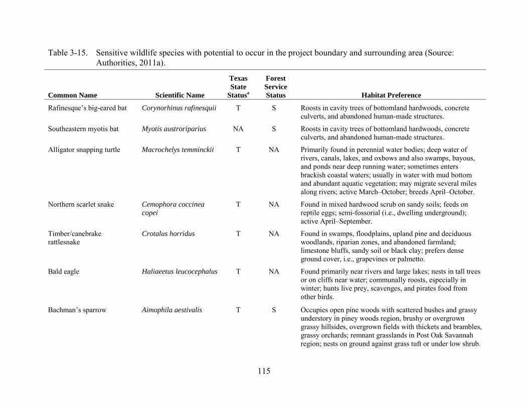
115
Table 3-15. Sensitive wildlife species with potential to occur in the project boundary and surrounding area (Source: Authorities, 2011a).
Common Name Scientific Name
Texas State
Statusa
Forest Service Status Habitat Preference
Rafinesque’s big-eared bat Corynorhinus rafinesquii T S Roosts in cavity trees of bottomland hardwoods, concrete culverts, and abandoned human-made structures.
Southeastern myotis bat Myotis austroriparius NA S Roosts in cavity trees of bottomland hardwoods, concrete culverts, and abandoned human-made structures.
Alligator snapping turtle Macrochelys temminckii T NA Primarily found in perennial water bodies; deep water of rivers, canals, lakes, and oxbows and also swamps, bayous, and ponds near deep running water; sometimes enters brackish coastal waters; usually in water with mud bottom and abundant aquatic vegetation; may migrate several miles along rivers; active March–October; breeds April–October.
Northern scarlet snake Cemophora coccinea copei
T NA Found in mixed hardwood scrub on sandy soils; feeds on reptile eggs; semi-fossorial (i.e., dwelling underground); active April–September.
Timber/canebrake rattlesnake
Crotalus horridus T NA Found in swamps, floodplains, upland pine and deciduous woodlands, riparian zones, and abandoned farmland; limestone bluffs, sandy soil or black clay; prefers dense ground cover, i.e., grapevines or palmetto.
Bald eagle Haliaeetus leucocephalus T NA Found primarily near rivers and large lakes; nests in tall trees or on cliffs near water; communally roosts, especially in winter; hunts live prey, scavenges, and pirates food from other birds.
Bachman’s sparrow Aimophila aestivalis T S Occupies open pine woods with scattered bushes and grassy understory in piney woods region, brushy or overgrown grassy hillsides, overgrown fields with thickets and brambles, grassy orchards; remnant grasslands in Post Oak Savannah region; nests on ground against grass tuft or under low shrub.
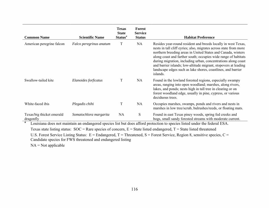
116
Common Name Scientific Name
Texas State
Statusa
Forest Service Status Habitat Preference
American peregrine falcon Falco peregrinus anatum T NA Resides year-round resident and breeds locally in west Texas, nests in tall cliff eyries; also, migrates across state from more northern breeding areas in United States and Canada, winters along coast and farther south; occupies wide range of habitats during migration, including urban, concentrations along coast and barrier islands; low-altitude migrant, stopovers at leading landscape edges such as lake shores, coastlines, and barrier islands.
Swallow-tailed kite Elanoides forficatus T NA Found in the lowland forested regions, especially swampy areas, ranging into open woodland; marshes, along rivers, lakes, and ponds; nests high in tall tree in clearing or on forest woodland edge, usually in pine, cypress, or various deciduous trees.
White-faced ibis Plegadis chihi T NA Occupies marshes, swamps, ponds and rivers and nests in marshes in low tree/scrub, bulrushes/reeds, or floating mats.
Texas/big thicket emerald dragonfly
Somatochlora margarita NA S Found in east Texas piney woods, spring fed creeks and bogs, small sandy forested streams with moderate current.
a Louisiana does not maintain an endangered species list but does afford protection to species listed under the federal ESA. Texas state listing status: SOC = Rare species of concern, E = State listed endangered, T = State listed threatened U.S. Forest Service Listing Status: E = Endangered, T = Threatened, S = Forest Service, Region 8, sensitive species, C = Candidate species for FWS threatened and endangered listing NA = Not applicable
117
Southeastern Myotis Bat The southeastern myotis is a bat species that primarily roosts in caves, but it will
often use anthropogenic structures and tree hollows, generally in mature trees near water. Males and females congregate in March and April to bear young with births occurring in late April to late May. The southeastern myotis is listed as a Forest Service sensitive species but is not listed under Louisiana or Texas statues that protect special-status species. The Authorities’ Terrestrial Special-Status Species Assessment documented one southeastern myotis roost within a study area that consisted of a 0.5-mile buffer adjacent to the project boundary. This occurrence of southeastern myotis is within the project boundary but is not in an area subject to project operations or maintenance.
Bald Eagle Bald eagles are present year-round throughout Texas and Louisiana as spring and fall migrants, breeders, or winter residents. The bald eagle population in Texas is divided into two populations: breeding birds and wintering birds. Breeding populations occur primarily in the eastern half of the state and along coastal counties from Rockport to Houston. Wintering populations are located primarily in the panhandle, central, and east Texas, and in other areas of suitable habitat throughout the state. The bald eagle is no longer listed under the ESA as of August 8, 2007, but the species remains protected under the Bald and Golden Eagle Protection Act of 1940, as amended. In Texas, the bald eagle is listed as a threatened species. In Louisiana, the bald eagle is not listed under the state-level endangered species statute.
The Authorities’ terrestrial special-status species Phase 1 study documented 11 active bald eagle nests within 0.5 mile of the project boundary in Louisiana, and 20 (13 active) in Texas. During the Phase 2 study, a total of 19 eagle nest buffers overlapped the project boundary that includes six bald eagle nests within the project boundary. Of those 19 eagle nest buffers, only 8 nest buffers were found to overlap eroding shorelines. In June 2011, the Authorities surveyed those eight nests (five in Texas and three in Louisiana) for updated location and usage and found that four of the five nests in Texas either have the nest or their buffer within the project boundary and that the remaining nest was not relocated at its previous location. Of the three nests in Louisiana, two could not be found at their previous observed location, and the remaining nest was found to be relocated outside the project boundary. Three active nests are located within 0.5 mile of project features, including one nest within 0.25 mile of the spillway.
Colonial Waterbird Rookeries Colonial waterbird rookeries are found in shoreline tree, shrub, and herbaceous
plant communities throughout Texas and Louisiana. Rookeries are not listed under Louisiana or Texas statutes protecting special-status species, although FWS recommends a 300-meter (984 feet) buffer during nesting season, from February 16 to August 31.

118
The Authorities’ studies documented eight colonial waterbird rookeries within a 300-meter (984-foot) buffer of the project boundary. Subsequent analysis of shoreline imagery found that reservoir shorelines adjacent to the rookeries show no evidence of erosion. These rookeries are not in areas subject to the effects of project operations or maintenance.
3.3.3.2 Environmental Effects
Effects on Wetlands and Bottomland Hardwood Communities Wetland and bottomland hardwood forests downstream of the reservoir consist of
a fluctuating water level ecosystem characterized and maintained by a natural hydrologic regime of alternating wet and dry periods. These forests support a distinct assemblage of plants and animals associated with landforms, soils, and hydrologic regimes. They are important communities for functions such as water quality, habitat for fish and wildlife, regulating flooding, and stream recharge. These communities are adapted to hydric soils and depend on overbank flooding for seed dispersal and seed germination. Overbank flooding also transports nutrients and organic matter to these forests. These forests are adapted to summer and fall dry periods when waters recede. Project operations that alter overbank flooding frequency, duration, or intensity could result in changes in floodplain soil chemistry, or reductions in tree reproduction. Conversely, project operations that increase flooding frequency or duration could reduce survivorship for species adapted to drier soils. These effects could result in changes in vegetation community structure and associated wildlife habitat. Reductions in bottomland hardwood forest could also affect downstream water quality and flood patterns.
The Authorities propose to construct a new powerhouse at the head of the spillway channel and release minimum flows ranging from 150 cfs to 300 cfs through the new powerhouse. The Authorities also propose to cap the maximum releases from the powerhouse at 12,000 cfs in the spring. No other changes in existing operations would occur.
Our Analysis The Authorities’ bottomland connectivity study indicates overbank flooding
frequency along the lower Sabine River varies by stream reach. Closer to the project (RM147–RM80.5) peaking operations do not result in overbank flooding. However, flooding in this reach occurs during high flow events. Downstream of RM 80.5, weekly operations create overbank flooding in some locations. Increasing minimum flows in the spillway channel would have a minimal effect on overbank flooding because these flows are small component of the total discharge from the project. Vegetation sampling occurred between RM99.7–RM73.3. Study results indicate: (1) the vegetation community composition is consistent with other bottomland hardwood forests in the region; (2) recruitment of dominant canopy species occurs in most study locations; and (3) project operations are not dramatically altering the function or composition of vegetation in these areas as compared to similar habitats in the region.

119
Effects of Invasive Species
Chinese Tallow The growing population of Chinese tallow in the project vicinity is likely to lead to
high population densities within the project boundary over the term of a new license. Increases in Chinese tallow density has potential to outcompete native species, primarily within wetlands and shrub lands. Such changes in vegetation structure have potential to affect sensitive plant and animal habitat.
To reduce potential effects of Chinese tallow on resources in the project boundary, the Authorities propose to work with the Forest Service to control this species on National Forest System lands. A provision of the SNF Relicensing Agreement would require the Authorities to contribute $20,000 annually to support the Forest Service’s Chinese tallow management activities on the 3,797 acres of project lands within the SNF. Additionally, the Authorities’ SMP, filed February 3, 2012, would require lease or permit holders for project lands to remove Chinese tallow from leased lands. These measures are also specified in Forest Service 4(e) condition 15. The SMP includes a 5-year review cycle to update the plan and its requirements, as needed over the term of the license.
Our Analysis Based on the Authorities’ Chinese tallow survey results, filed on October 31,
2011, occurrence of Chinese tallow on project lands is uncommon. While this species is present on lands surrounding the project, it was typically found in upland areas along roads, fence lines, hedge rows, and forest edges. Only one occurrence was recorded along the immediate perimeter of the reservoir shoreline. However, given this species’ propensity for open, disturbed, riparian habitats, it is reasonable to assume that over the term of a new license, further establishment on project lands would occur, especially as a result of ground-disturbing activities within the project boundary.
Chinese tallow located along roadways and other areas may be dispersed into new areas by project and non-project-related vehicular traffic, vegetation management, and maintenance activities. However, non-project land uses (e.g., recreational and commercial uses, timber harvesting, and residential development) within and adjacent to the project boundary likely have greater influence on weed ecology at these sites because these uses are substantially greater in scope, frequency, and duration than project-related activities.
Implementing the SNF Relicensing Agreement would ensure that Chinese tallow would be managed in portions of the project boundary on forest lands. Such management is likely to prevent Chinese tallow from affecting sensitive resources, such as wetlands or habitat for sensitive species. Similarly, enforcing provisions of the proposed SMP that would require all permit holders (shoreline property owners and public recreation providers) to control Chinese tallow on leased lands also would likely prevent high-density populations from establishing.
120
Management responsibility for Chinese tallow within Public Access and Conservation classification shorelines is not clear. The management of Chinese tallow on recreation areas maintained by the Authorities would result in a negligible increase in site management for any landscape contractor already maintaining the sites. Many of the shoreline areas classified as Conservation, however, can be remote and difficult to reach, the occurrence of Chinese tallow in these locations is unknown, and no potential conflicts with important species or habitats have been identified. Implementing control measures that limit the spread of this species in Conservation and Public Access classification shorelines where ground-disturbing activities would occur would act to protect these important resources. If these measures prove to be insufficient to protect reservoir resources from Chinese tallow or if a future conflict with sensitive species or habitats are identified, the Authorities’ and the Commission’s review of the SMP every 5 years could identify these shortcomings, and additional measures to control Chinese tallow could be implemented in the future as part of the SMP.
Invasive Aquatic Species The presence of invasive aquatic plants can affect other aquatic resources through
displacement of native species (e.g., pondweeds), affect ecosystem processes (e.g., lower DO levels), affect aesthetic values, and affect recreational use and access. Control methods employed through the Texas PWD and Louisiana DWF management programs have included annual herbicide treatments at access points, releases of salvinia weevils, and a water level drawdown. Both Texas PWD and Louisiana DWF have future management plans that include continual monitoring of giant salvinia coverage annually to document plant distribution and the effectiveness of the control measures.
At Toledo Bend reservoir, Texas PWD and Louisiana DWF direct the monitoring and management of the invasive aquatic plant community within the reservoir. The Sabine River Authority of Texas cooperates with Texas PWD and Louisiana DWF in the states’ management programs for invasive aquatic vegetation, which primarily focuses on water hyacinth and giant salvinia. The states’ cooperative program directs surveys and monitors invasive aquatic plans on an annual basis, actively manages invasive plant areas (i.e., using biological and chemical control measures), and promotes public education regarding control of aquatic invasive species populations. The Authorities propose to continue these management practices for the duration of any new license.
Our Analysis Left untreated, existing populations of hydrilla, water hyacinth, and giant salvinia
in Toledo Bend reservoir would likely expand and adversely affect aquatic ecosystem processes, aquatic fauna community structure, recreation potential, and aesthetic values in the project boundary. Currently, control measures including treatment, annual monitoring, and evaluation of treatment efficacy have sufficiently prevented these invasive species from detrimentally affecting biologic and recreational resources.
121
Continued implementation of the existing programs for the term of a new license, as the Authorities propose, would mitigate for effects of invasive aquatic plants.
Effects on State Listed and Forest Service Sensitive Species
Powerhouse and Transmission Line Construction Construction of the proposed minimum flow generating unit at the spillway would
require the use of heavy machinery to clear existing vegetation, excavate the powerhouse site, and transport workers and materials to the powerhouse site. Construction and operation also would create increased human presence within the project boundary. These activities could disturb local wildlife, resulting in an increased risk of nest or young abandonment for birds and small mammals, or interference with foraging behavior for birds, mammals, and reptiles. Direct mortality associated with vehicle collisions or grading and fill also is possible. Of particular interest are potential effects on bald eagle nests in the vicinity of the construction activities. The Authorities propose to construct a 15-kV transmission line about 1.8 miles from the proposed powerhouse site south along the dam to the existing substation. This line could potentially pose a risk of electrocution or collision for large birds, including bald eagles.
In the final license application, the Authorities note that National Bald Eagle Management Guidelines (FWS, 2007) recommend 330-foot to 1-mile protection buffers around bald eagle nests during the nesting season to protect nesting pairs from human-related noise disturbance. The Authorities state that there are no project operations or maintenance activities, including construction of the new powerhouse, proposed within 660 feet of known eagle nests; therefore, they propose no specific mitigation measures to protect bald eagles. In their additional information request (AIR) response letter, the Authorities (2012b) note that there had been a bald eagle nest located about 1,300 feet west-northwest of the spillway. Further consultation indicated that nest was destroyed during Hurricane Rita in 2005. Therefore, the Authorities do not expect construction noise to affect nesting bald eagles, and they do not propose any timing restrictions on construction activities. The Authorities propose to design and construct the new transmission line adhering to best management practices to avoid potential for bird electrocution and collision hazards associated with the line.
Our Analysis Construction of the proposed minimum flow generating unit would occur along
the northern spillway abutment. We estimate construction activities would permanently remove about 0.5 acre of vegetated habitat (associated with the new access road, powerhouse, and tailrace). Grading areas around these features would temporarily disturb an additional 0.7 acre of vegetation. Vegetation in areas of proposed disturbance consists of maintained grassland, and the Authorities do not propose tree removal during construction. Construction would not occur within wetlands. Therefore, most potential for direct effects on sensitive species would be avoided. Noise associated with construction activities could disturb animals occupying or nesting in adjacent habitats.
122
Sensitive species most likely to experience these effects include bald eagles and white-faced ibis. Bald eagles are known to nest to the north and west of the construction site, and wetland/marsh habitat in the spillway could provide limited nesting habitat for white-faced ibis, although no nesting activities have been reported in the area. Implementation of an erosion control plan specific to this area that includes revegetating temporarily disturbed areas with grass would restore existing vegetation.
FWS’ National Bald Eagle Management Guidelines include active nest protection buffers ranging from 330 feet to 1 mile, depending on the nature of disturbance under consideration. A 330-foot buffer is recommended for human foot traffic and motorized water vehicles. For activities that require blasting, or other loud, staccato noise (such as fireworks), the guidelines recommend a 0.5-mile buffer from active nests and communal roosting or foraging areas. This recommendation is extended to 1 mile from communal areas in open habitat. The guidelines recommend a 330-foot to 660-foot buffer for general construction activities, depending on the extent of similar activities in the surrounding area. Because no blasting is proposed for construction of the proposed minimum flow generating unit, a 330-foot to 660-foot buffer should be sufficient to protect nesting eagles from proposed activities. The closest known bald eagle nest is more than 0.25 mile from the project spillway. Therefore, construction activities are likely to comply with the FWS’ National Bald Eagle Management Guidelines. However, it is not uncommon for eagles to construct new nests, and although unlikely, there is limited potential nesting habitat present within 660 feet of the proposed construction site in trees to the northwest of the spillway. Confirming the presence of nests within the recommended protection buffers prior to initiating construction would provide the opportunity to implement protection measures. If a nest were identified, implementation of appropriate buffer distance or restriction of construction activities to periods outside the nesting season would ensure that construction does not affect nesting bald eagles.
Construction of the new powerhouse would also include construction of a 1.8-mile-long, 15-kV transmission line. Because of the small conductor separation required for these lines, potential exists for the electrocution of larger birds, including bald eagles, whose wing spans are capable of bridging the conductor separation. Transmission lines also pose a collision risk to flying birds. These collisions can result is serious injury or mortality. Constructing the new transmission line along Highway 191 at the base of the dam, as proposed, would likely limit potential for collisions because the dam would serve as a backdrop and flying birds would likely fly at elevations above the transmission line to clear the dam. The Authorities propose to adhere to best management practices for line design and construction, but they are not explicit as to what those practices are.
Recognizing potential hazards transmission lines create for birds, the APLIC, a consortium of utilities and FWS, developed guidelines for the design of electrical lines to minimize potential for electrocutions (APLIC, 2006) and collisions (APLIC, 2012). If the Authorities design and construct the proposed transmission line associated with the
123
new minimum flow generating unit in accordance with the APLIC guidelines, potential effects of project operation on birds would be reduced.
Erosion During preparation of the license application, the Authorities identified shoreline
erosion occurring in several sensitive natural communities: evergreen forest/drainage group A (in Louisiana); and longleaf pine, American beech/Southern magnolia, American beech/white oak, and loblolly pine/white oak/Southern red oak (in Texas). Effects of continued project operation, fluctuations in reservoir levels, and wave action are likely to cause continued shoreline erosion. Continued erosion would reduce terrestrial habitat, which could include disturbance to sensitive plant populations, and removal of bald eagle nest trees. Choices for erosion management, such as riprap, restoring riparian vegetation, or constructing walls and bulkheads could also affect habitat for terrestrial plants and wildlife. Additional effects of erosion are discussed in section 3.3.1, Geology and Soils.
The SNF Relicensing Agreement includes implementation of an Erosion Monitoring and Management Plan to reduce potential effects of erosion. The plan includes designation of six monitoring sites selected to be representative of project shorelines in the SNF. The Authorities would monitor these six sites for 10 years to determine erosion rates, and these rates would then be applied to estimate erosion rates at other sites. The results would enable the Authorities and the Forest Service to identify areas where erosion could affect sensitive areas over the term of the license. The Authorities and the Forest Service would then develop site-specific management plans for these areas.
Recognizing that monitoring of erosion rates would require frequent use of survey instruments and increased human presence, the Erosion Monitoring and Management Plan includes the following components aimed at limiting disturbance to sensitive plants and wildlife: (1) avoid locating monitoring sites in areas with habitat for federally listed threatened and endangered species or Forest Service sensitive species, and (2) avoid locating monitoring sites in areas within 330 feet of bald eagle nests. Following the 10-year monitoring period, the Authorities and the Forest Service would identify and develop site-specific management plans for any areas where estimated erosion rates would either: (1) cause adverse effects on federally listed threatened or endangered species; (2) result in the take of an eagle or eagle nest; (3) compromise the botanical character of the Beech Ravines Scenic Area; or (4) compromise the botanical character of Beech-Magnolia or Loblolly-Oak communities in the Mill Creek Cove Research Natural Area. The site-specific management plans would include measures to avoid adverse effects on habitat for federally listed threatened and endangered species, avoid loss of communities or populations of Forest Service sensitive species, or implement measures to mitigate for such losses.
124
Our Analysis Over the term of the existing license, erosion has occurred along the project
shorelines. The Authorities do not propose any changes to project operations that would affect existing erosion rates. However, continued erosion has potential to affect terrestrial resources, including sensitive vegetation communities, sensitive plant species, or habitat for sensitive wildlife.
Erosion monitoring activities would require human activity associated with land surveying. Monitoring sites would likely be accessed using motorized boats or other motorized vehicles. If these activities occur in proximity to nesting bald eagles, such disturbance could result in nest abandonment or reduce nesting success. The National Bald Eagle Management Guidelines (FWS, 2007) recommend 330-foot buffer distances from active bald eagle nests for motorized watercraft and non-motorized human entry.
Implementing the Erosion Monitoring and Management Plan included in the SNF Relicensing Agreement would provide estimates for erosion rates on National Forest System land and identify areas where erosion could occur in sensitive habitats over the term of the new license. Creating site-specific management plans for these areas would likely reduce erosion rates and prevent loss to sensitive plant populations, nesting trees for bald eagle, or other sensitive resources identified during the erosion study. Selecting monitoring sites removed from sensitive areas, as described in the plan, would reduce potential for disturbances to these resources and ensure the monitoring activities are consistent with the National Bald Eagle Management Guidelines.
The Erosion Monitoring and Management Plan only applies to areas within the SNF. Other sensitive areas exist around the reservoir, as indicated on the maps in the SMP and the shoreline erosion overlay on sensitive species maps included in the Updated Study Report (Authorities, 2011b). For example, these maps show obvious erosion near bald eagle sites BE-10, BE-11, BE-12, and sensitive evergreen forest vegetation. Erosion also is noted in additional areas designated as Conservation in the SMP. Limiting erosion monitoring and management activities to shoreline within the SNF, as included in the SNF Relicensing Agreement, would not provide protection for any of these other sensitive resources. Rather, implementing erosion monitoring activities at regular intervals (such as every 5 years) in SMP-designated Conservation or Public Access classification areas where shoreline erosion was previously documented, would allow the Authorities to determine whether erosion in these areas has potential to adversely affect sensitive resources. This additional erosion monitoring could use the same criteria as currently included in the Erosion Monitoring and Management Plan, including, may: (1) cause adverse effects on federally listed threatened or endangered species; (2) cause the loss of communities of Forest Service sensitive flora or populations of Forest Service sensitive fauna; (3) result in the take of an eagle or eagle nest; or (4) compromise the botanical character of the Evergreen Forest/drainage group A. Using these criteria would allow the Authorities to identify sensitive areas in which site-specific erosion management plans would be warranted. Site-specific management plans in these areas
125
and following protocols described in the Erosion Monitoring and Management Plan would increase protection to sensitive plant communities and habitat for sensitive wildlife species around the entire reservoir.
Shoreline Development Under the current license, the Authorities have issued a total of 7,169 permits for
non-project use of project lands over 950 miles of the project’s 1,130 miles of shoreline. Permitted non-project uses include boat docks, piers, and shoreline stabilization structures. These land uses are discussed further in Section 3.3.5, Recreation, Land Use and Aesthetics. If similar land use is permitted near sensitive habitat, including wetlands; bald eagle nests; colonial bird rookeries; or sensitive botanical communities, there is potential for adverse effects to these resources.
To guide management of non-project use of project shorelines under a new license, the Authorities propose to implement the SMP filed on February 3, 2012. The proposed plan classifies some areas of shoreline as Conservation, which includes lands where wetlands, historic properties, and special habitats are present. Prior to issuing any permits in these areas, the Authorities would require the permit applicant to consult with all affected state and federal resource agencies.
By letter to the Authorities, dated January 6, 2012, and included as appendix E of the proposed SMP, FWS recommends that the Authorities provide information on FWS’ trust resources, which include, but are not limited to, federally listed species, bald eagles, and migratory birds, directly to shoreline permit applicants in lieu of mandatory coordination with FWS. Except where prior Commission review and approval is required, the Authorities would require shoreline permit applicants to adhere to the FWS recommendations and instructions related to these resources. Where a proposed activity requires prior Commission review and approval, the Authorities would require applicants to consult with FWS prior to submitting their shoreline permit applications with the Authorities. In implementing the SMP, the Authorities would periodically update the information to be provided to applicants, as requested by FWS.
Our Analysis Implementing the proposed SMP would increase protection for sensitive resources
by requiring additional review of permit applications for non-project uses in Conservation areas. Through such review, the Authorities would identify and deny permits proposing unmitigated fill or dredging in wetlands, permits for docks and piers in proximity to eagle nests and colonial bird rookeries where motor noise could disturb these resources or permits proposing unmitigated removal of sensitive vegetation. While the SMP includes provisions to provide permit applicants with information related to FWS-managed resources, there is some ambiguity as to what specific information would be provided. While we expect these materials would include the National Bald Eagle Management Guidelines, this is not explicitly stated in the SMP. Additionally, because FWS does not have specific guidelines for protection of migratory birds, it is not clear
126
what measures the Authorities would recommend to protect these resources. If guidelines for protection of bald eagle were incorporated directly into the SMP, expectations regarding the protection of these resources would be clearer and potential for inadvertent activities reduced.
Recreation As discussed in Section 3.3.5, Recreation, Land Use, and Aesthetics, recreational
opportunities at Toledo Bend are frequently used and popular with local residents. The majority of public use includes use of motorized watercraft to access fishing opportunities. Other recreational use includes use of lands surrounding the project for bank fishing, hiking, camping, and hunting. These activities have potential to disturb sensitive bird species nesting in proximity to the project shoreline.
In their AIR response, the Authorities (2012b) evaluated potential for dispersed recreation to affect bald eagles and communal rookeries. The Authorities note that there were no signs of dispersed recreation within 600 feet of bald eagle nests in the project area. Of the 7 communal bird rookeries, 1 is located in areas with residential or commercial development and 1 is located in the North Toledo Bend Wildlife Management Area. The others are located in areas removed from boat access points, campsites, foot trails, or other informal public use areas.
Our Analysis The Authorities do not propose any measures that are expected to increase
recreation use at the project. Existing bald eagle nests and colonial bird rookeries have persisted under existing recreation pressure and there is no evidence that dispersed recreation is affecting these resources.
3.3.4 Threatened and Endangered Species
3.3.4.1 Affected Environment
Earth Fruit Earth fruit (Geocarpon minimum) was federally listed as a threatened species in
July 1987. Earth fruit is also state listed as threatened in Texas. In 1993, FWS published a recovery plan for this species, which lists several recovery tasks including protection of known populations, additional population searches, studying the ecology and biology of the species, monitoring populations, preserving genetic stock, and the establishment of additional populations (FWS, 1993). FWS published a 5-year review of the earth fruit in 2009 recommending no change in status. No critical habitat has been designated for the species.
Earth fruit is a small, inconspicuous annual plant that occurs in saline soil prairies. This species is most often seen during the 3- to 6-week spring flowering and fruiting period from late February to early June.

127
FWS recognizes six earth fruit populations in Louisiana, all of which are on private property. Three populations are located in Desoto Parish; however, none are near Toledo Bend reservoir. In addition, although three known populations are located in Texas and one of those is located in Panola County, it is not located within the project boundary. Therefore, no project-related effects on this species would occur, and no further discussion is needed.
Texas Golden Gladecress The Texas golden gladecress (Leavenworthia texana) is listed as endangered
(September 11, 2013). Critical habitat has been designated.in San Augustine and Sabine counties, Texas (September 11, 2013). The primary constituent elements include: (1) exposed outcrops of the Weches Formation within Weches prairies; (2) thin layers of rocky, alkaline soils, underlain by glauconite clay (greenstone, ironstone, bluestone), which are found only on the Weches Formation; and (3) outcrop ledges occurring within the glade such that Texas golden gladecress plants remain unshaded for a significant portion of the day, and trees should be far enough away from the outcrop(s) that leaves do not accumulate within the gladecress habitat.
The Texas golden gladecress is a winter annual found in the oak-hickory-pine forests on rocky outcrops of the Weches formation in the coastal plain of eastern Texas. The Weches formation is a band of ancient marine alkaline sediments that lies parallel to the Gulf Coast in east Texas. The Texas golden gladecress is well adapted to the habitat created by the Weches formation. This gladecress thrives in deep, bare soils with a sparse herbaceous ground layer. However, it does not tolerate a closed forest canopy or areas with a deep litter layer. It appears to be pollinated by a variety of small insects from the orders Diptera and Hymenoptera.
Historically, the gladecress was found in eight separate locations in San Augustine and Sabine counties, following the Weches formation. Two of those locations have been destroyed because of impacts from glauconite mining. The population in Sabine County, which is the closest known population to Toledo Bend reservoir, as well as the designated critical habitat, is located to the west of the reservoir, outside the project boundary. Therefore, no project-related effects on this species or designated critical habitat would occur, and no further discussion is needed.
Sprague’s Pipit The Sprague’s pipit (Anthus spragueii) was classified as a candidate species in
2010. As a candidate species, the Sprague pipit receives no formal protection under the ESA. This small bird species is found in interior grasslands of North America where it appears to be one of the few species that are prevalent in the prairie habitats of North America. Sprague’s pipit’s lifecycle is connected to undisturbed native prairie habits throughout its range. However, there are some reports that the pipits have been observed in cropland, prairie restoration areas, and nonnative planted grasslands. The Sprague’s pipit consumes a variety of insects (i.e., grasshoppers, beetles, and crickets) during the
128
summer breeding season and appears to forage on seeds during migration and the winter season. The breeding range for the Sprague’s pipit is throughout a majority of North Dakota, Montana (east of the Rocky Mountains); northern South Dakota; northwestern Minnesota in the United States and in southeastern Alberta, and the southern portions of Saskatchewan and Manitoba in Canada where the species can be found in well-drained, open grasslands. The wintering grounds include Arizona, Texas, Oklahoma, Arkansas, Mississippi, Louisiana, and portions of northern Mexico. During migration and wintering, Sprague’s pipits are found in both densely and sparsely vegetated grassland, and pastures, but avoid areas with significant shrub encroachment. Limited grassland habitat of low or marginal quality is present at the project spillway.
Louisiana Pine Snake Currently, Louisiana pine snake (Pituophis ruthveni) is a candidate for federal
listing; therefore, the Louisiana pine snake receives no formal federal protection under the ESA. This species is state listed as threatened in Texas. The Louisiana pine snake is a large, non-venomous constrictor (about 4 to 5 feet long). This snake is most commonly found in sandy, well-drained soils associated with open pine forests, especially longleaf-pine savannahs. The midstory is usually moderate to sparse with a well-developed herbaceous understory dominated by grasses. Its activity appears to be heavily concentrated on low, broad ridges overlain with sandy soils.
Studies have shown that in eastern Texas and western Louisiana pine snakes will spend a majority of their time below the surface. While underground, the snakes are possibly foraging, using the cooler temperatures to cool their body temperatures or avoid predators. While below ground, the snakes often use pocket gopher burrow systems. In addition, the Louisiana pocket gopher (Geomys breviceps) appears to be their primary food source, but pine snakes have been reported to also feed on other rodents, rabbits, amphibians, and ground-nesting birds and their eggs.
The Authorities’ Terrestrial Special Status Assessment Study estimated there are about 3,827 acres of suitable habitat for this species on the Texas side of the project within 0.5 mile of the project boundary. The study identified nine potential Louisiana pine snake habitat areas, six of which appear to overlap potentially eroding shorelines. Surveys of these areas did not detect any pocket gopher burrows or Louisiana pine snakes.
Red Cockaded Woodpecker Currently, the red-cockaded woodpecker (Picoides borealis) is federally listed as
endangered, and it was given federal protection with the passage of the ESA in 1973. In 1979, FWS approved the original recovery plan and, since that time, has approved two revisions in 1985 and 2003 (FWS, 2003). FWS published a 5-year review of the red-cockaded woodpecker’s status in 2006 (70 FR 53,807). The review indicated that no change was needed and the red-cockaded woodpecker should remain classified as endangered because the degree of threat remains moderate, and recovery potential for this
129
species remains high. FWS has not designated critical habitat for the species. Red-cockaded woodpecker is also state listed as endangered in Texas.
The red-cockaded woodpecker is a small, black and white woodpecker that nests in living pine trees. The male has a small, red spot on each side of its black cap. Like other woodpeckers, the red-cockaded woodpecker is an insectivore and requires large stands of mature pines for foraging and nesting. Their preferred nest clusters are relatively open pine stands that are maintained by a natural or prescribed burning regime with few to no hardwood trees higher than 15 feet. Older pine trees (70 years or more) are used most frequently. Suitable pine species include longleaf, slash, shortleaf, pond, and pitch pines. The red-cockaded woodpecker excavates a cavity into the bole of the living tree with red heartwood disease and then maintains sap wells that seep out around the cavity opening. This behavior is thought to protect against rat snakes and other predators.
Consultation with FWS and the Forest Service during preparation of the final license application and subsequent on-site investigations initially identified three red-cockaded woodpecker breeding colonies (RCW-5, RCW-6, and RCW-7) and associated 0.5-mile foraging buffers that overlap the project boundary. Field surveys later determined that RCW-5 and RCW-6 were actually the same colony and that while the 0.5-mile foraging habitat buffer at this colony overlapped the project shoreline, there was no evidence of erosion in the area. The foraging buffer at RCW-7 does overlap with eroding shoreline; however, field review with Forest Service personnel determined that foraging habitat in the area of the erosion was limited.
Louisiana Black Bear The Louisiana black bear (Ursus americanus luteolus) was federally listed as a
threatened species in 1992. FWS approved the recovery plan for the Louisiana black bear in 1995 (FWS, 1995). FWS initiated a 5-year review in August 2007 (72 FR 42,425–42,426). Critical habitat for the Louisiana black bear was designated on March 10, 2009 (74 FR 10,350–10,409). The critical habitat includes 1,195,821 acres of land in Avoyelles, East Carroll, Catahoula, Concordia, Franklin, Iberia, Iberville, Madison, Pointe Coupee, Richland, St. Martin, St. Mary, Tensas, West Carroll, and West Feliciana parishes, Louisiana. There is no critical habitat designated within the project boundary. Louisiana black bear is also state listed as threatened in Texas.
The Louisiana black bear (one of 16 subspecies of black bear) is a large, bulky bear with long black hair; a short, well-haired tail; and a facial profile that is blunt with small eyes. The Louisiana black bear skulls, when contrasted with other black bear skulls, are relatively long, narrow, and flat, and have proportionately large molar teeth. The Louisiana black bear typically inhabits bottomland hardwood forests, but also utilizes other types of forested habitats as well as brackish and freshwater marshes, salt domes, along bayous, and agricultural fields. Key habitat requirements include forage, water, cover, and sites for denning arranged across large, remote blocks of land. The
130
Louisiana black bear numbers are higher within bottomland and other forested habitats where acorns, nuts, and natural fruit production is high, and lower in fire-maintained, pine communities.
The biggest threats facing this black bear subspecies are habitat reduction and fragmentation and human interaction. The habitat loss and fragmentation threat is primarily due to clearing land for agriculture and other human activities. This threat can impede the movements of the bears both within and between populations and can also result in increased mortality, because bears are forced to forage on less protected sites, travel farther to forage, or cross barriers such as roads and highways. The threat from human interaction comes in the form of accidents (e.g., vehicular collisions), poaching, and nuisance abatement activities that may result in the death of the bear. Observations made during the Terrestrial Special Status Assessment Study included three black bears within 0.5 mile of the project boundary.
3.3.4.2 Environment Effects
Sprague’s Pipit There is limited potential for Sprague’s pipit to occupy habitats near Toledo Bend
reservoir in winter or during migration to breeding grounds elsewhere. Grassland habitats with potential to attract Sprague’s pipit are rare and of small extent in the project boundary. The Authorities’ studies indicate these areas are not located near areas of eroding reservoir banks. Construction of the new powerhouse would occur in grassland.
Our Analysis Although unlikely, there is limited potential for Sprague’s pipit to occur in
grasslands near the proposed powerhouse construction site. Habitat in this area consists of grasses planted along the spillway. If this species is present, potential effects of construction include noise disturbance and vehicular traffic. Vehicle traffic specific to powerhouse construction is expected to travel at relatively slow speed in the immediate vicinity of this habitat. If noise disturbance is too great, birds would likely relocate to grasslands further removed from the disturbance. There is no potential for nest disturbance. Similarly, recreation activities occurring in grasslands, like hiking or picnicking, could increase disturbance for Sprague’s pipit, were they to occur in the area. Such disturbance would be minor, and birds would likely relocate to other areas. These effects would be limited in duration and of minor intensity. Issuing a new license for the Toledo Bend Project would negligibly affect the Sprague’s pipit.
Louisiana Pine Snake Potential project effects on Louisiana pine snake habitat include habitat loss or
disturbance associated with erosion and recreation activities. These effects could result in collapsed burrows or disturbance, prompting snakes to leave shelter to flee to other areas. The Authorities’ proposed SMP would classify any habitat for sensitive species as
131
Conservation, and require agency consultation for any proposed non-project activities in these areas.
Our Analysis There is no evidence that areas identified as potential habitat for Louisiana pine
snake are currently occupied. Shoreline erosion in these areas is expected to be minor in relation to the acreage of habitat present in the project vicinity. No areas of concentrated recreational activity are known to occur in potential pine snake habitat areas. The proposed SMP would help minimize potential effects on habitat for Louisiana pine snake. Issuing a new license for the Toledo Bend Project would have negligible effects on the Louisiana pine snake.
Red Cockaded Woodpecker Potential project effects on red-cockaded woodpecker habitat include erosion and
recreation-related disturbance. No forest management or other activities that could influence forest structure are proposed. These activities, if implemented, would have the potential to reduce habitat quality and quantity and could reduce red-cockaded woodpecker foraging and nesting success. The Authorities identified three red-cockaded woodpecker colonies within 0.5 mile of the project boundary. However, field studies concluded the quality of foraging habitat in these areas was low.
The SNF Relicensing Agreement includes implementation of the Erosion Monitoring and Management Plan, which would identify erosion rates in areas with red-cockaded woodpecker habitat. If the erosion study indicates there is potential for erosion to adversely affect the red-cockaded woodpecker, the Authorities, in consultation with the Forest Service, would develop and implement a site-specific erosion management plan. Additionally, the Authorities’ proposed SMP would classify any habitat for sensitive species as Conservation and require agency consultation for any proposed non-project activities in these areas.
Our Analysis Red-cockaded woodpecker habitat in the project boundary is limited to low quality
foraging habitat. There is no evidence of erosion in the 0.5-mile buffer of the identified colonies. Implementing the Erosion Monitoring and Management Plan and the SMP, as proposed, would reduce the potential for erosion or non-project use of project lands from affecting red-cockaded woodpecker habitat. Because habitat quality is low and the Authorities’ proposed plans would protect these areas, issuing a new license for the Toledo Bend Project may affect, but is not likely to adversely affect, the red-cockaded woodpecker.
Louisiana Black Bear The project creates a large impoundment on the Sabine River with more than
1,000 miles of shoreline and extending more than 70 miles north to south. As such,
132
Toledo Bend reservoir creates a large barrier to black bears moving between habitat in Louisiana and Texas. No management or operational measures are proposed that are expected to affect bear habitat.
Our Analysis Issuing a new license for the Toledo Bend Project would maintain current habitat
conditions for Louisiana black bear. No project effects are expected in upland areas removed from the project shoreline. It is unlikely that bears use areas within the project boundary. While the project does create a migration barrier between Louisiana and Texas, the reservoir has been part of the landscape for more than 40 years. Therefore, extant bear populations are accustomed to its presence. Large tracts of undeveloped land, including the SNF, occur in the project vicinity and provide movement corridors for bears. The proposed project would not affect habitat in these corridors. Therefore, issuing a new license for the Toledo Bend Project may affect, but is not likely to adversely affect, Louisiana black bear.
3.3.5 Recreation and Land Use Resources
3.3.5.1 Affected Environment
Regional Recreation Resources The Sabine River, including Toledo Bend reservoir, is the primary source for
recreation opportunities in the region. Toledo Bend reservoir is the fifth largest human-made body of water, as measured by surface area, in the United States. It has an area of about 185,000 acres, is about 70 miles long, and has more than 1,100 miles of shoreline. Recreation opportunities exist on both the Texas and Louisiana sides of the reservoir, including fishing, hunting, boating, swimming, camping, canoeing, and picnicking to highly developed marinas, lodges, and motels. The SNF occupies land on the Texas shoreline and provides a range of recreation facilities and opportunities including campgrounds, boat ramps, fish camps and primitive (dispersed) camping. Within the SNF jurisdictional boundary lies the Indian Mounds Wilderness Area (which includes 12,369 acres designated by Congress in 1984). The surrounding parishes of DeSoto, Sabine, and Vernon in Louisiana and the counties of Panola, Shelby, Sabine, and Newton in Texas also offer many additional recreation opportunities.
Public Recreation Sites around the Project The Authorities’ Recreation Use and Needs Assessment Report characterized
recreation resources related to public access and use of Toledo Bend reservoir (Authorities, 2011c). In the 2011 recreation report, the Authorities (2011c) identify the study area as the Toledo Bend reservoir, excavated tailrace channel, excavated spillway
133
channel,40 existing developed recreation facilities at the project that the Authorities own and operate, and other governmental and commercial facilities that provide water-based recreation opportunities to the general public within the project boundary.
As noted above, the Authorities own and operate public recreation sites in Texas and Louisiana on Toledo Bend reservoir. The Toledo Bend Project also encompasses approximately 3,797 acres of federal lands administered by SNF, as well as 147 acres of the Indian Mounds Wilderness Area. Table 3-16 lists the public recreation sites that provide access to the lands and waters of the project along with some of the amenities at each site. Figure 3-22 shows the locations of these recreation facilities. Access sites available to the public provided by the adjacent towns are not listed in the table or the figure.
Table 3-16. Public recreation sites (Source: Authorities, 2011a, as modified by staff).
Recreation Site Name Owner
Res
troo
ms
Show
ers
Mot
el/C
abin
s
Ove
rnig
ht
Cam
ping
R
V S
ites
Dum
p St
atio
n G
roup
Fac
ility
T
rails
Picn
icki
ng
Boa
t Ram
p
Fish
ing
Pier
Sw
imm
ing
Oth
er
Am
eniti
es
Joaquin Public Ramp SRA-TX ●
Swede Johnson Recreation Area
SRA-TX ● ● ● Playground
Bubba Cowser Recreation Area
SRA-TX ● ● ●
Sam Forse Collins SRA-TX ● ● ● ● ● ● Playground
Frontier Park
SRA-TX/ private owner
● ● ● ● ● ● ● Boat storage
Yellow Dog Park Panola County
● ●
Tailrace Access Area SRA-TX Hand launch
Garrett Park and boat ramp
Desoto Parish
● ●
40 The spillway channel area was inadvertently omitted from the 2010 study effort
and is reported in the Updated Study Report (Authorities, 2011b).
134
Recreation Site Name Owner
Res
troo
ms
Show
ers
Mot
el/C
abin
s
Ove
rnig
ht
Cam
ping
R
V S
ites
Dum
p St
atio
n G
roup
Fac
ility
T
rails
Picn
icki
ng
Boa
t Ram
p
Fish
ing
Pier
Sw
imm
ing
Oth
er
Am
eniti
es
North Toledo Bend State Park
LDCRT ● ● ● ● ● ● ● ● ● ● ● Swimming pool and
playground
South Toledo Bend State Park
LDCRT ● ● ● ● ● ● ● ● ● ● ● ● Playground
Oak Ridge SRA-LA ● ● ● ● ● ● ● Playground
Cow Bayou Wilderness Area
SRA-LA ●
Converse Bay SRA-LA ● ● ● ● ●
Hot Wells/San Patrico Overlook
SRA-LA ● Bike rack
Clyde’s Crossing Park SRA-LA ● ●
San Miguel SRA-LA ● ● ● ●
Tourist Information Center
SRA-LA ● ● ● Playground, bike rack
Cypress Bend Park SRA-LA ● ● ● ● ● ● ● ●
Pleasure Point Campground
SRA-LA ● ● ● ● ● ● ● ●
Blue Lake Recreation Area
SRA-LA ●
Pendleton Park SRA-LA ● ● ●
Spillway Access Area SRA-LA ● Hand launch
Toledo Bend Observation Towers
SRA-TX and SRA-LA
● ● Viewing platforms
Haley’s Ferry boat SNF ● ● ●
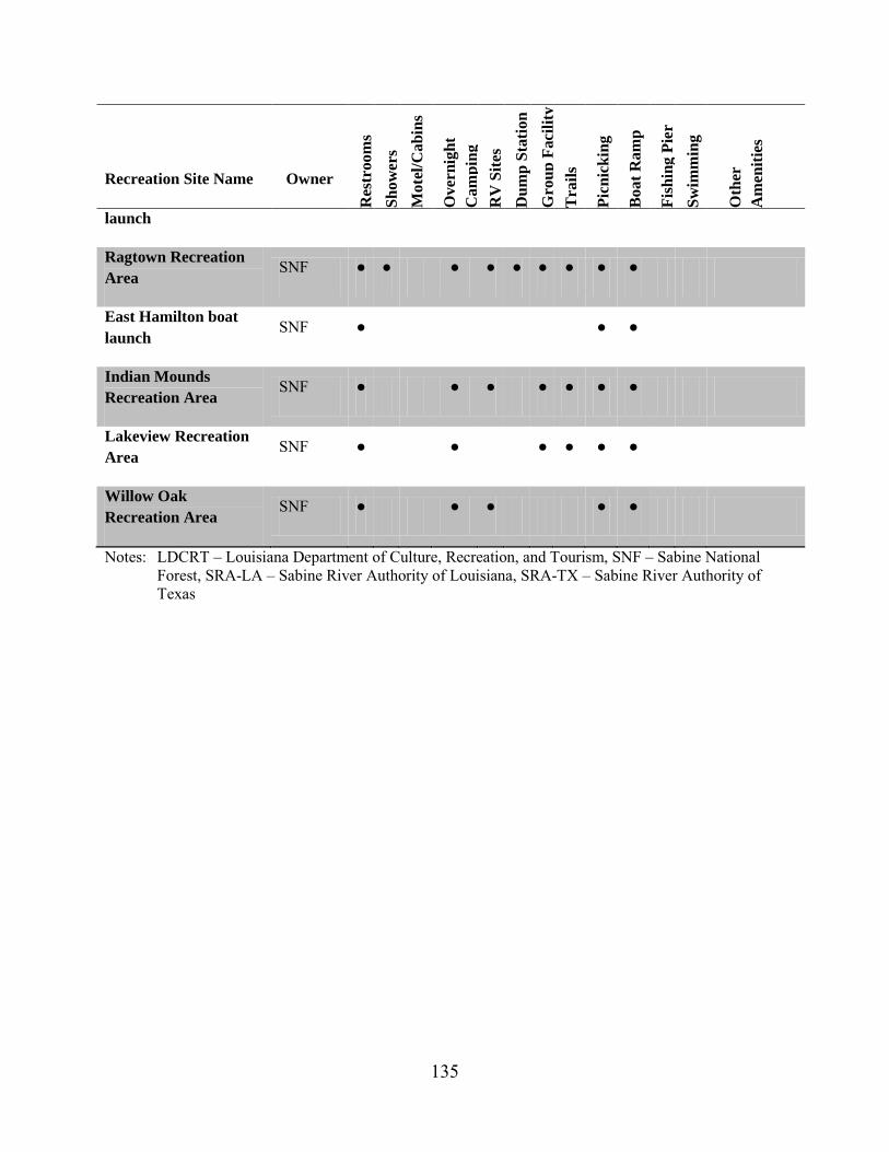
135
Recreation Site Name Owner
Res
troo
ms
Show
ers
Mot
el/C
abin
s
Ove
rnig
ht
Cam
ping
R
V S
ites
Dum
p St
atio
n G
roup
Fac
ility
T
rails
Picn
icki
ng
Boa
t Ram
p
Fish
ing
Pier
Sw
imm
ing
Oth
er
Am
eniti
es
launch
Ragtown Recreation Area
SNF ● ● ● ● ● ● ● ● ●
East Hamilton boat launch
SNF ● ● ●
Indian Mounds Recreation Area
SNF ● ● ● ● ● ● ●
Lakeview Recreation Area
SNF ● ● ● ● ● ●
Willow Oak Recreation Area
SNF ● ● ● ● ●
Notes: LDCRT – Louisiana Department of Culture, Recreation, and Tourism, SNF – Sabine National Forest, SRA-LA – Sabine River Authority of Louisiana, SRA-TX – Sabine River Authority of Texas
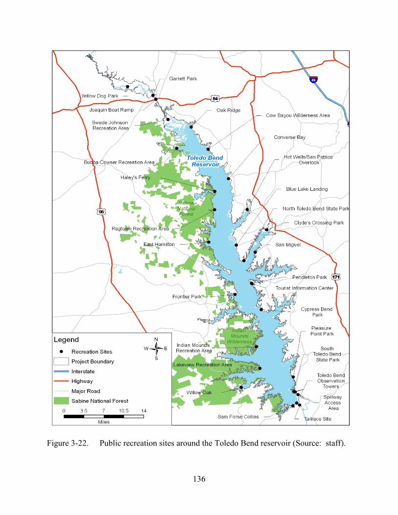
136
Figure 3-22. Public recreation sites around the Toledo Bend reservoir (Source: staff).
137
In addition to public recreation facilities, numerous commercial marinas and other private access locations in the vicinity include 28 private boat launches on the Louisiana shore and more than 30 on the Texas shore. Typically, these facilities are associated with hotels, restaurants, campgrounds, or other recreation/tourism businesses adjacent to the reservoir. Fees are charged at most, but not all, of these private facilities.
Public access sites on the Texas side include 15 ramps that are usable at elevations as low as 160.5 to 165.1 feet msl, and 24 of 29 commercial ramps are useable at elevations as low as 162.87 to 166.05 feet msl. The six boat launching facilities at the Authorities public recreation sites in Louisiana are fully usable at elevations as low as 160 to 164 feet msl, depending on each specific ramp and site. Fifteen of the 38 commercial boating facilities on the Louisiana side of the reservoir have boat launching ramps that are usable below elevation 165 feet msl.
Recreation Use According to the most recent FERC Form 80 Recreation Use at Hydropower
Developments (2008), the Toledo Bend Project receives an estimated 200,000 recreation days41 of daytime use and 60,000 recreation days nighttime use annually. The peak weekend average is approximately 10,000 recreation days. In the 2011 recreation report, the Authorities (2011c) estimate use levels for 13 of their recreation sites. Cypress Bend Park received the most use with 35,560 recreation days, followed by Pleasure Point Park with more than 29,000 recreation days, and Sam Forse Collins with more than 14,000 recreation days.
Recreation visitor surveys were administered at recreation access sites to collected data for the recreation report. Authorities (2011c) indicate that most survey respondents (42 percent) identified fishing from a boat as the primary activity pursued during their visit, followed closely by swimming/visiting the beach (39 percent) and fishing from shore (27 percent). Other popular activities included: camping (25 percent), resting/relaxing (24 percent), picnicking (14 percent), sightseeing (13 percent), and hiking/walking (10 percent). Less popular, the activities of sailing, water skiing, and scuba diving also occur. In the spillway channel, the most popular activity reported was swimming with non-motorized boating the second-most popular activity.
In addition to private outings, organizations sponsor annual fishing tournaments on the reservoir. Further, numerous opportunities are available to hunters in designated areas surrounding the project in the Upper Toledo Bend, North Toledo Bend, and Sabine Wildlife Management Areas.
Data from the onsite visitor surveys and visitor use counts indicate that current use levels of the sites around the reservoir is below the social carrying capacity, including
41 A recreation day is defined as each visit by a person for recreational purposes
during any portion of a 24-hour period.
138
during the peak use period of March through August. In the recreation report, the Authorities (2011c) conclude that the existing facilities are sufficient to meet estimated demand without the need for major expansions or land acquisition; however, they identified the need for increased frequency in site updates, relevant improvements, and maintenance tasks at each of the facilities. One of the most frequently observed and reported issues affecting visitors’ enjoyment of the recreation sites included in the recreation report was site maintenance and upkeep. Deteriorating facilities in need of repair included restrooms, picnic tables and playground equipment, as well as a need for modification of facilities to better accommodate users with disabilities. Demographic changes, as reported in the Sabine Authorities’ 2011 recreation report, are expected to increase the need for facilities that can accommodate large groups and families.
Recreation in the River Downstream Downstream of the Toledo Bend dam, the Sabine River meanders 147 miles to
Sabine Lake and, eventually, to the Gulf of Mexico. Canoe guide books characterize this section as a wide, slow moving, and a scenic, undeveloped canoe waterway in Texas and Louisiana. Put-in access is available in both the spillway and tailrace channels, as well as other locations farther downstream outside the project boundary. The spillway channel access site (Site 84 in the 2011 Recreation Use and Needs Study Addendum [Authorities, 2011d]) provides parking for visitors who are interested in swimming and fishing, a graded hand-launching area for small boats, and an open space for campers and picnickers. The Authorities maintain gates at the entrance to this site off of Highway 191, and they close the site when high flows are forecast. The Authorities also posts signs explaining the need for the closure during high flow events. When high flows are not predicted, this site is primarily used to access the spillway channel for fishing, boating, and swimming.
According to the 2011 recreation report, the section of the spillway channel from the confluence of Bayou Toro and the old river channel to the confluence with the tailrace channel has a gradient of approximately 2 to 3 feet per mile, indicating a negligible change in gradient (Authorities, 2011c). Use of the recreation site in the spillway channel varies by season with swimming and recreational boating popular in the summer and bank fishing and small boat use during other times of the year.
Within the spillway channel, two rocky outcroppings provide play spots for boaters, tubers, and swimmers. American Whitewater’s (2013) river information website
139
names these rocky outcroppings and rates them as Class I and II42 rapids that can be run nearly year-round. At flows above 1,000 cfs, there is another rapid farther downstream at the confluence with Toro Bayou; however, this rapid is typically run as a separate trip with different put-in and take-out locations than the upper spillway play spots.
Access roads on both sides of tailrace channel provide dispersed recreation access to the tailrace. Informal parking is provided at various sections of the tailrace providing visitors access to a graded hand boat launch and bank fishing opportunities with no developed facilities. Primitive camping also occurs in the area. According to American Whitewater’s website, there are two boating play spots in the tailrace channel below the project powerhouse. These spots are rated as Class III rapids at flows between 6,000 and 9,000 cfs.
Land Use The Toledo Bend Project is located in the sparsely populated areas of western
Louisiana and eastern Texas. Lands surrounding the reservoir include private, federal, state, and local government owned lands. Most land surrounding the project is undeveloped with adjoining private lands managed for timber or other private uses. The majority of public lands within the project boundary are managed for recreation use and administered by SNF, state, county, and local authorities. Private residential development is interspersed throughout the area and concentrated along select sections of the project shoreline. Non-project use of project lands by adjacent land owners includes private and commercial docks, piers, erosion control, landscaping and other shoreline development, as well as industrial uses, such as oil and gas exploration, pipelines, and water withdrawals.
Lands within the project boundary total approximately 204,090 acres (including inundated lands). At reservoir elevation 172 feet msl, approximately 185,000 acres (91 percent) are open waters. The Authorities are the predominant shoreline landowners. The federal government owns and the SNF administers the remaining project lands (3,797 acres along 250 miles of shoreline in Texas). Timber companies and the Forest Service are the largest land managers surrounding the project.
42 The level of difficulty of boating rapids generally classified into six difficulty
classes as maintained by the International Scale of River Difficulty – Standard Rated Rapids. Definitions for rapids on the Sabine River below the dam range from: Class I—fast moving water with riffles and small waves; Class II (novice)—straight-forward rapids with wide, clear channels that are evident without scouting, but occasional maneuvering may be required; Class III (Intermediate)—rapids with moderate, irregular waves that may be difficult to avoid and can swamp an open canoe; complex maneuvers in fast currents and good boat control in tight passages or around ledges are often required.
140
SNF lands are managed for multiple uses including timber production, wildlife habitat and recreation under a revised Land and Resource Management Plan (LRMP) for National Forests and Grasslands in Texas (1996). Management Areas (MA) identified in the LRMP within or adjacent to the project boundary include:
• MA2—Red Cockaded Woodpecker Management (managed for the protection of red cockaded woodpecker habitat and populations),
• MA4—Streamside Management (managed for the maintenance of water quality and protection of aquatic habitat and resources),
• MA7—Wilderness Management (managed to maintain or achieve a natural state as defined by the wilderness designation), and
• MA8—Special Area Management, which appears close to the project boundary; however, it is unclear from the LRMP whether this area is within the FERC project boundary.
Shoreline Permitting Program The Authorities manage the project shoreline through a shoreline permitting
program. The permitting program is used to facilitate approval and management of non-project activities, including the construction and placement of any structures within the project boundary, such as boat docks, piers, shoreline erosion measures, water withdrawals and industrial uses (e.g., gas pipelines). The Authorities currently manages 3,369 permits in Louisiana, and 3,800 permits in Texas.
3.3.5.2 Environmental Effects
Recreation Management Plans
Authorities’ Recreation Management Plan In their final license application, the Authorities propose to implement their
Recreation Management Plan. The plan addresses recreation resources including recreation facilities that are located within the FERC project boundary, are owned and managed by the Authorities, and are on lands owned in fee title by the Authorities. The 13 recreation sites addressed by the proposed recreation management plan include: Swede Johnson Recreation Area, Oak Ridge Park, Bubba Cowser Recreation Area, Converse Bay Recreation Area, Hot Wells Recreation Area, Blue Lake Landing Recreation Area, Clyde’s Crossing Recreation Area, San Miguel Park, Pendleton Park, Cypress Bend Park, Pleasure Point Park, Toledo Bend Observation Towers, and Sam Forse Collins Recreation Area. Three of these sites, Blue Lake, Pendleton, and the Toledo Bend Observation Towers were not included in the 2011 recreation report (Authorities, 2011c). Specific elements of the plan such as facility improvements, operation and maintenance, monitoring, and plan updates are addressed below.
141
American Whitewater and Sabine Whitewater Club recommend that the Commission require the Authorities to allow free, public, car-top boating access to the project spillway at all times for the duration of the license. In addition, these entities requested to be listed as a consulting party for the implementation of the proposed Recreation Management Plan. We address American Whitewater’s and Sabine Whitewater Club’s recommendation for unrestricted access to the spillway channel below under Proposed Operations and Downstream Flows.
Recreation Facility Operation and Maintenance The Authorities propose to continue to provide operation and maintenance of the
recreation facilities specifically included in as part of the Recreation Management Plan. Operation and maintenance activities would include completing minor repairs, painting, and replacing parts and minor structural components to keep the recreation facility or site in operating condition. These activities would not include expanding the capacity of a recreation area. The Authorities propose to maintain roads, pavement, boat ramps, boat docks, picnic and camp sites, restrooms, signs and kiosks, trash collection, utilities, and buildings or other structures at each recreation site.
The Authorities also propose to continue project operations with respect to maintaining reservoir levels. Current operations maintain reservoir levels between an elevation of 168 and 172 feet msl. Prior studies and determinations (FERC, 2003) suggest this operation range provides the maximum benefit to project recreation--particularly facilities associated with hotels, restaurants, campgrounds, or other recreation/tourism businesses adjacent to the reservoir.
Recreational Facility Improvements and Rehabilitation As part of the proposed Recreation Management Plan, the Authorities would
rehabilitate roads, boat access sites, and other amenities, as required. Possible improvements to roads and parking areas include resurfacing, restriping, paving, installing vehicle barriers, and completing other similar roadway improvements. Rehabilitation and improvement activities to boat ramps, docks, signs, fire rings, grills, and picnic tables, and replacement or upgrades to restroom facilities would be scheduled as required. The Authorities propose to conduct an annual facility inspection and to compile a list of facilities in need of rehabilitation.
Recreation Monitoring Program As part of the proposed Recreation Management Plan, the Authorities would
implement a recreation monitoring program to measure recreation use levels, recreation use impacts, visitor tolerances for impacts (crowding, conflict, use impacts, and facility conditions) and management actions that may be used to address identified impact problems. The monitoring program would include annual use estimates and completion of the FERC Form 80 Licensed Hydropower Development Recreation Use Report every
142
6 years. The Authorities would develop annual use estimates by collecting fee information and taking instantaneous counts during routine maintenance and electronic vehicle counts. Every 6 years consistent with the Form 80, the Authorities would file a report to summarize the annual data collected over the previous 6-year period, and beginning in 2020, their reports would include a discussion of any notable trends in the data.
The Authorities also propose to develop and file a visitor survey report every 12 years beginning in 2026. The report would be based on a recreation questionnaire aimed at determining if existing recreation facilities and opportunities are adequate to meet user preferences. The report would include objectives, methods, results, recommended reasonable resource management measures, and a schedule of implementation for recommended resource management measures. The Authorities would prepare the final report after consultation with the Louisiana Department of Culture, Recreation, and Tourism, Louisiana DWF, Texas PWD, National Park Service, and FWS.
Recreation Sites Not Addressed in the Recreation Management Plan As proposed, the Authorities’ Recreation Management Plan would address 13
developed recreation sites. Not included in the Recreation Management Plan are several recreation sites around the reservoir that provide shore-based recreation or access to project lands and waters. These sites include: Yellow Dog Park, Garrett Park and boat ramp, and Joaquin public boat ramp on the river above the reservoir; Frontier Park, Cow Bayou Wilderness, North Toledo Bend State Park, the Tourist Information Center, and South Toledo Bend State Park on the reservoir; and access areas at the spillway and the tailrace channel. The Authorities own (or partially own) six of these sites. Examination of recreation figures prepared by the Authorities indicates all of these sites are located within or partially within the FERC project boundary and provide access to lands and waters of the project. The three sites on the river above the reservoir and the five on the reservoir are also classified as Public Access in the proposed SMP (which we discuss in more detail later in this section).
Our Analysis The Authorities (2011c) conclude that although visitors indicated high satisfaction
with the facilities, many of the recreation sites managed by the Authorities exhibited visibly deferred maintenance or a complete lack of highly desired amenities, such as restrooms (or functioning restrooms), picnic tables, and other recreation-related amenities. The lack of restrooms or restrooms in disrepair could pose potential health risks if visitors are forced elsewhere. The presence of broken amenities, amenities in a state of disrepair, or amenities in need of routine maintenance also provide unsafe and uninviting conditions that diminish the quality of the recreation experience and resources. Implementation of the proposed Recreation Management Plan would provide a framework to guide the management of recreational resources to ensure that these sites receive regular maintenance and rehabilitation.
143
As currently proposed, the plan puts an increased emphasis on maintenance, especially restrooms, and modifications to the Authorities managed facilities to better accommodate visitors with disabilities. However, review of the site plans indicate restrooms are not identified or do not exist at the majority of the sites. Additionally, operation and maintenance measures would be required to ensure those sites are open and functional for their intended purposes in acceptable condition through the term of a new license. Such a maintenance program would provide specific information about the maintenance needs, activities, and responsibilities, thereby maintaining the quality of recreation resources and ensuring continued public access to each recreation site and the project into the future. Well-maintained facilities enhance the aesthetic quality and the physical condition of project-related recreational facilities.
Under the proposed recreation monitoring program, the Authorities would collect use information that would form the basis of use estimates. These estimates allow for tracking trends over time and support the examination of correlations among those trends. Filing a monitoring report along with the Form 80, as proposed, would be beneficial in tracking changes through time by providing context beyond the form’s basic facility categories.
Filing a visitor survey report every 12 years as proposed by the Authorities would provide additional and valuable data beyond use estimates alone. Visitors’ perceptions of the resource conditions and needs would assist the Authorities in providing high-quality recreation amenities and resources. Use monitoring would provide a process for continual evaluation and validation that the objectives of the Recreation Management Plan are being met. This type of adaptive management program would benefit recreational users by ensuring regular maintenance activities are consistent with the level of use and needs of visitors and that sites have sufficient capacity to meet those needs. Consultation with resource agencies as proposed would help ensure the appropriate survey tools and methods would be implemented to capture information of interest. Including American Whitewater and Sabine Whitewater Group to the list of parties to be consulted in the implementation of a final Recreation Management Plan would expand the diversity of recreation resources and expertise to be considered since this user group is currently unaccounted for. Given the existence of the whitewater play spots in the spillway and tailrace and the availability of boatable flows potentially year-round, inclusion of these entities is appropriate.
As licensees, the Authorities are responsible for providing reasonable public access to project lands and waters. Through their proposed Recreation Management Plan, the Authorities recognize the importance that the reservoir plays in providing recreation in the region and acknowledge that a variety of entities provide these opportunities. However, the plan is limited in scope by only identifying 13 sites owned and operated by the Authorities without providing any context of these sites within the larger view of recreation resources at the reservoir, or their consistency with the proposed SMP. Yellow Dog Park, Garrett Park and boat ramp, Joaquin public boat ramp, and North Toledo Bend and South Toledo Bend state parks are examples of sites not
144
identified in the proposed plan; but they are classified as public access areas in the proposed SMP. Similarly, the Authorities own and operate Cow Bayou Wilderness Area and the Tourist Information Center, but they are not included in either the SMP or the Recreation Management Plan. Cow Bayou Wilderness Area provides an undeveloped system of dirt roads and trails primarily for the use by off-road vehicles, and although there is no boat ramp for water access, the site provides shore-based activities. The Tourist Information Center is co-located within the Authorities administrative offices adjacent to Pendleton Park, which offers day use access, including covered picnic sites, play equipment, an informational map mural, and a small pier.
As documented in the 2011 recreation report, recreation is also popular in the spillway and tailrace channels immediately downstream of the dam, as described above (Authorities, 2011c). In addition to reservoir-based recreation, the spillway and tailrace channel sites support swimming, angling, and boating within the project boundary. These two sites appear to receive reasonable amounts of use and provide whitewater boating opportunities to a region with limited opportunities.
Identifying all public recreation sites that provide access to the lands and waters of the project, including those sites on Forest Service lands, in a revised comprehensive Recreation Management Plan would be consistent with recreation planning guidance as described in Recreation Development at Licensed Hydropower Projects (FERC, 1996) in which a good recreation plan specifically considers the total supply and quality of present recreation resources at a project, including sites not operated by the licensees. Such a revised plan would more accurately convey the full suite of available recreation opportunities at Toledo Bend reservoir, provide a single source of information for all recreation facilities at the Toledo Bend Project, and provide managers with a fuller picture of recreation at the project.
Although the Authorities do not provide operations and maintenance support to state, county, or private recreation facilities, the Authorities own the shorelines within the project boundary that is accessed from these public recreation sites. Identifying all public recreation areas that provide access to project lands and waters in a comprehensive Recreation Management Plan would not require the Authorities take on operation and management responsibilities for those sites not owned and operated by the Authorities. Rather, identifying oversight and management responsibilities for each recreation site would provide clarity to stakeholders and the general public interested in recreation and recreation management at the project, as well as be more consistent with the proposed SMP. Furthermore, it would also be appropriate for the Recreation Management Plan to provide more comprehensive and detailed information on recreation sites for which the Authorities have active management responsibilities, while the recreation sites which the Authorities do not provide operations and maintenance support would only be identified, located, and described. This would ensure that if there were a change in the supply of recreation resources, those changes and the potential to accommodate any resulting change in use patterns or demand would be understood in the context of overall recreation supply.
145
A revised Recreation Management Plan developed in consultation with a diverse stakeholder group that accounts for a wide range of recreation opportunities would help ensure public recreation facilities and access is provided that is consistent with demand.
Although the Authorities recognize the potential need to update the Recreation Management Plan and propose to update the plan in consultation with stakeholders, the Authorities do not suggest a time period to revisit or update the plan. Since the project was first constructed in the 1960s, recreation demand for water-based recreation at the reservoir has steadily grown. Over time, the facilities have aged, and as documented in the recreation report (Authorities, 2011c), they exhibit wear associated with regular use. Addressing maintenance of the recreation facilities is an important component of the Recreation Management Plan. However, recreation is not static and ensuring that facilities are the right type for the demands over the term of a typical license requires monitoring to ensure the Recreation Management Plan is revised to prevent any drop off in the quality of the resource. A Final Recreation Plan with scheduled updates coordinated around the proposed visitor survey reports could capitalize on the timing and information to address any changes in recreation resources that may be necessary in the middle of any license term. Having a scheduled update ensures the plan is kept current regardless of the extent of changes between plans.
SNF Relicensing Agreement Recreation Plan and SNF 4(e) Condition 13, Recreation Plan As part of the SNF Relicensing Agreement and Forest Service 4(e) condition, the
Authorities would implement the SNF Recreation Plan, which would address facility improvements, maintenance and operation for the six SNF recreation sites: Haley’s Ferry boat launch, Ragtown Recreation Area, East Hamilton boat launch, Indian Mounds Recreation Area, Lakeview Recreation Area, and Willow Oak Recreation Area. The proposed SNF Recreation Plan identifies responsibilities to be borne by Sabine River Authority of Texas in operating, maintaining, and improving the six SNF recreation areas. The details in the SNF Recreation Plan include: specific operation and maintenance activities for each site (including schedules for the completion of each task); a capital funding plan specifically addressing identified needs at each site; and annual review of the plan by Sabine River Authority of Texas and the Forest Service to identify recreation needs at the six sites and determine whether adjustments to the plan are necessary. The SNF Relicensing Agreement also addresses the potential for the Forest Service to exchange lands that are either embraced within the project boundary or within a Forest Service recreation area.
Our Analysis The SNF Recreation Plan would guide the Sabine River Authority of Texas in its
operation and management of the six recreation sites located within the SNF. As currently written, the SNF Recreation Plan establishes a framework for implementing improvements and management measures for each site. Site-specific operation and

146
maintenance measures identify the responsible party to ensure that each site is actively maintained for the term of a new license. Collectively, these operation and maintenance measures would ensure that the popular SNF recreation sites are in good working order and that visitors are provided high-quality recreation facilities while recreating at Toledo Bend reservoir throughout the length of the license term,
Proposed Operations and Downstream Flows As part of the ARA and preliminary 10j conditions from Interior and NMFS, the
Authorities make a number of proposals to project operations that could affect recreation resources, including: (1) reducing the maximum powerhouse flows during peaking operations from 14,000 cfs to 12,000 cfs during March through June; (2) providing 1,450 acre-feet of water to the tailrace channel each weekend day in March and April with potential to continue into May and June, depending on inflow conditions for the first 6 months of the current water year; and (3) providing a continuous minimum flow according to the release schedule that would ensure a minimum of 150 cfs is maintained in the spillway channel year-round with higher seasonal minimum flows (up to 300 cfs) as summarized previously in table 2-3. The Authorities also propose to install a low-flow generating unit at the spillway to generate electricity from the releases that would include a monitoring system to ensure the targets were achieved.
American Whitewater and the Sabine Whitewater Club recommend: (1) they be included in consultation for the proposed Continuous Flow Release schedule; (2) flow information be made publicly available (e.g., on Authorities’ webpage); (3) releases be made to the spillway of 1,000 cfs for 8 hours on both Saturday and Sunday for two weekends each year in consultation with American Whitewater and the Sabine Whitewater Club; and (4) access to the spillway channel be guaranteed at all times.
Our Analysis The proposed changes in operations would not affect land use surrounding the
project. Construction of the new powerhouse and a new minimum flow generating unit and associated facilities would occur within the footprint of the existing dam. Similarly, the proposed transmission line from the powerhouse to the existing substation would be constructed within the road right-of-way on top of the dam. These areas are currently developed and in use for hydropower generation associated with the existing dam. As such, construction activities would not result in any negative impacts to land uses.
Operation of the project and, specifically, increased flows to the tailrace and spillway, would have the potential to affect recreation resources and opportunities. The Authorities’ proposal to reduce the maximum flows during peaking by 2,000 cfs would have little to no noticeable effect on recreation in the tailrace. Whitewater boating is the only documented recreation activity that occurs in the tailrace channel that is dependent on the magnitude of flows; however, even with the reduction, peaking flows would be too high for the two documented boater play spots, which are described as boatable between 6,000 and 9,000 cfs. These two spots would continue to be available during startup and

147
ending of generation when flows increase from zero to the peak and back, or when a unit is operating at around 7,000 cfs. Down-river canoe and kayak trips putting in along the tailrace channel would experience slightly less “push”; however, at these flows, the overall effect would be modest.
Providing 1,450 acre-feet of water to the tailrace channel each weekend day in March and April, and potentially in May and June would provide water into the tailrace during periods when it was not provided in the past. This new flow release would be provided on weekends when generally more visitors would be able to take advantage of the flows. In the ARA (appendix D), the Authorities propose that the signatories would perform and analyze a series of powerhouse flow tests to occur on nine weekends in May and June in 2014 and, if needed, in 2015 and/or 2016. The objective of these flow tests would be to maximize the downstream benefits of weekend operations consistent with generation needs. Hydraulic parameters are the only downstream benefit listed. Proposed test flows in the ARA range from 4,000 cfs to 7,000 cfs; although the duration of the release is a function of the flow, it would range between 2 hours, 45 minutes at 7,000 cfs to 4 hours at 4,000 cfs. Using this general range as a surrogate for what a final weekend release program could look like, there is potential for whitewater boaters to utilize the flows. American Whitewater’s river webpage cites the preferred flows in the tailrace for boaters between 6,000 to 9,000 cfs, which results in large standing wave play spots in the tailrace channel. As such, there is an opportunity to make use of these weekend releases to provide recreation benefits in addition to the aquatic resource benefits for which they were developed. Including American Whitewater and the Sabine Whitewater Club in the consultation and study process for determining the magnitude, timing, and duration of flows for these weekend releases would include a currently unaccounted for user group that could provide input on the human and recreational dimensions of the releases, thereby increasing the overall benefit. Expanding the study group would ensure recreation resources are accounted for without compromising the intent of providing water for aquatic resource needs.
Under the current license, a continuous release of 144 cfs (i.e., 286 acre-feet per day) is maintained in the spillway channel. As proposed, continuous flows would be between 6 cfs (4 percent) and 156 cfs (108 percent) higher. While it has been noted that the spillway channel is boatable year-round, an increase from 146 cfs to150 cfs is a marginal rise in flow that would not likely provide a noticeable increase in the number of boater days. Continuous flow releases of 300 cfs would more than double the amount of water in the spillway, potentially providing a dramatic improvement over the current conditions. Because of the lack of existing data on boating days and preferred flow ranges for the spillway, the number of additional boatable days that the various proposed flows could generate is unknown. However, the information on American Whitewater’s webpage suggests that increased flows would likely improve the boater resources. This improvement is likely to be more dramatic for higher releases with the greatest benefits occurring when the reservoir elevation is higher than 162 feet msl, allowing the release of the highest continuous flows (table 2-3).
148
In addition to continuous releases, whitewater boaters may take advantage of any moderate spill events when the Authorities do not restrict access to the spillway. As described above, whitewater resources in the spillway channel are suspected to improve with increasing flows. Given the descriptions of the play spots, whitewater recreation would not likely be optimized with the proposed continuous flow releases. Therefore, spill events could have important recreational value to whitewater boaters making access an important issue during times of small and moderate spills. Based on a number of factors (including hydrology, boating reports, photos of the spillway, and professional experience with other hydroelectric projects throughout the country), staff estimate that whitewater boaters would prefer a range of flows between 500 and 3,000 cfs in the spillway channel.
In the draft EIS we estimated the number of days between 1971to 2010 when flows in the spillway were within the range of the staff-estimated, whitewater boater-preferred flows. At flows greater than 3,000 cfs, boating could be possible; however, it is likely that at these flows boating would be less desirable because the play spots wash out and access is restricted. In addition to the play spots in the spillway channel, American Whitewater describes a play spot just below the confluence with the old river channel that becomes boatable at flows of 1,000 cfs; however, this play spot is typically a separate trip associated with boating down Bayou Toro.
The ability to boat any moderate spill events in the staff-estimated, whitewater boater-preferred range is dependent on access to the spillway channel. As described in section 3.3.2, Aquatic Resources, flood events can result in flows greater than 100,000 cfs, and these events can pose risk and damage to life and property. The Authorities’ policy to restrict access during spill events protects public safety. Comments on the draft EIS highlighted the fact that the number of boatable days in the staff-estimated preferred range derived from daily USGS data was too coarse an analysis to accurately summarize flow conditions in the spillway channel. Under current operations, the Authorities restrict access to the channel before opening any gates under operating guide Step 1: which is the opening of five gates to a setting of 1 foot, which equates to about 5,000 cfs – higher than the staff estimated upper limit for preferred boating flows. As the lake level rises during a high-flow event, additional gates are opened. For example, Step 2 is the opening of all 11 gates to one foot, which results in about an 11,000-cfs discharge. Additional steps dictate the opening of additional gates up to their maximum opening (see table 2-2). Under these protocols even the lowest step results in flows higher than the staff estimated preferred boating range.
Unrestricted car-top access as requested by American Whitewater and the Sabine Whitewater Club would guarantee access for all users, but would increase the risk for those with less experience with high flows in the spillway channel. Given the potential for extremely high flows in the spillway channel, the Authorities’ policy to restrict access is sensible. Assuming that the Authorities spillway operation protocols remain the same, even step one in spillway gate operations results in flows greater than the staff estimated preferred boating range. Thus, there is not a clear opportunity for boaters to recreate in
149
the spillway channel within the staff estimated boater preferred range during any spill event. Additionally, the time period between steps during emergency spill operations may also be limited. Therefore, allowing access to the spillway channel during non-spill events and restricting access during spill periods is a reasonable balance of site access and protection of life and property.
Development of a spillway channel recreation access plan that characterizes the spillway access site and uses, and directly addresses procedures for closing the site during spill events (including establishing the reservoir levels or flow levels that would trigger spill events and close the site) would allow reasonable recreational access to the spillway channel while protecting public safety. Additionally, we recognize the unlikelihood of flows in the spillway channel between 300 and 5,000 cfs due to current and proposed operations. However, it would be necessary for the plan to also address access to the spillway for flows in non-emergency release situations (e.g., project shutdowns for maintenance or construction, or low river flow events [droughts] when the powerhouse may be shut down for extended periods). Consultation with American Whitewater and the Sabine Whitewater Club during the development of the final spillway channel recreation access plan would ensure that boaters have access to whitewater resources in the spillway channel during non-emergency spill periods and help define and provide boaters a better understanding of the spill procedures as they relate to recreation interests in the spillway channel. Development of this plan with these parameters would not meet American Whitewater’s request for unrestricted access to the spillway; however, the plan would address attempts to balance boater opportunities and spillway operations during high flow events. Including protocols in the spillway channel recreation access plan for notifying recreationists who are present in the spillway channel prior to releases (e.g., sounding a siren) would enhance the public’s understanding of safety measures at the site.
Publishing electronic flow release data from the proposed gage in near real time on a public website as requested by American Whitewater and the Sabine Whitewater Club would facilitate access to this information. This information is of interest for whitewater boaters (and likely of interest to swimmers and anglers) when making their decision whether to visit. Providing this information to only the Commission or resource agencies as proposed is of limited value to the boaters, swimmers, and anglers likely to benefit from these flows or recreate at the site. Additionally, providing reservoir elevation data in near real time on a public website would help inform boaters, anglers and swimmers about reservoir conditions, which would indicate how close the project is to spill conditions. Weather forecasts taken in combination with these two sources of gage data would provide the information necessary to predict spill events. Near real-time streamflow and reservoir elevation gage data would be of interest to boaters and other users, providing an improvement over existing conditions.
Including the spillway and tailrace channel access sites as well as the number of visitors to these sites in the proposed recreation monitoring program would provide valuable information on the use at these sites by a user group that is currently under-

150
represented. Over time, the demand for additional whitewater boating measures could be considered.
Shoreline Management The Authorities propose to implement the SMP for the Toledo Bend Project, filed
February 3, 2012. The SMP includes: shoreline management policies, shoreline classifications, a permitting program, monitoring and enforcement, and a process for review and updates. The general policies provide for maintaining reasonable public access, protecting fish and wildlife habitat, protecting cultural resources, protecting operational needs, facilitating compliance with license articles, minimizing adverse impacts on water quality, minimizing erosion, minimizing adverse scenic impacts, and guiding shoreline development.
The shoreline classifications used to define allowable uses of the shoreline include: (1) Forest Service, which identifies project lands that are federally owned and administered by the Forest Service and are excluded from the permitting provisions of the plan; (2) Public Access, which identifies project lands where publicly owned recreation facilities and access areas currently exist or are proposed for the term of the new license; (3) Conservation, which identifies project lands where sensitive resources (such as wetlands, historic properties, and special habitats) are present; and (4) General, which identifies project lands that do not fall into the aforementioned shoreline classifications, and encompasses the majority of all non-federal shoreline areas within the project boundary.
The proposed permitting process depends on: (1) the land use classification in which the proposed development or use is located; (2) the scope and type of the proposed development or use; and (3) whether the proposed development or use is within the scope the programmatic general permit from the U.S. Army Corps of Engineers.43
All permit applications must be reviewed and approved by the Authorities and potentially other agencies and/or the Commission before the permit applicant can begin any development or other ground-breaking activities at the proposed site. Approval can occur when the Authorities determine that the proposed activity is consistent with: (1) the primary project purpose of water supply and secondary purposes of hydroelectric generation and recreation; (2) the obligations of the license; (3) the Authorities’ policies and guidelines; and (4) the HPMP and Recreation Management Plan for the project. The Authorities also propose to monitor shoreline development and enforce permit violations,
43 The Authorities are in the process of obtaining this programmatic general permit
from the U.S. Army Corps of Engineers. This permit is a general permit typically issued for 5 years and allows for certain dredging and filling activities on the reservoir. The programmatic general permit expedites the overall permitting review process for those activities that fall within the approved scope.
151
unauthorized activities, and encroachment. The Authorities propose to review and update the SMP every 5 years in consultation with agencies and other interested parties.
As part of the SNF Relicensing Agreement and 4(e) conditions, the Authorities would implement the proposed Erosion Monitoring and Management Plan to reduce potential effects of erosion on sensitive shoreline resources. The Erosion Monitoring and Management Plan identifies six monitoring sites selected to be representative of project shorelines in the SNF that show evidence of erosion. The Authorities would monitor these six sites for 10 years to accurately determine erosion rates, which would then be applied to estimate erosion rates at other sites throughout the SNF. If the results lead to the determination that erosion would adversely affects sensitive resources, site-specific plans to address the issue would be developed.
Our Analysis Implementation of the Authorities’ proposed SMP would provide a single source
for shoreline management guidelines, policies, and an overall framework for managing the Toledo Bend shoreline over the term of any new license. The plan would bring all existing shoreline management programs and activities, such as the current permitting program, and any other guidelines into a single document.
Continued implementation of the shoreline permitting program would provide for the management of land uses within the project boundary. Project lands would remain available for public recreational uses, and private and commercial uses would continue to be permitted on project lands pending proper reviews. The Authorities would review permit applications for activities, such as construction of boat docks, piers, and landscaping, after an applicant has acquired all required regulatory permits.
Erosion has occurred along various segments of the Toledo Bend reservoir shoreline, including shorelines within the SNF, as discussed in section 3.3.1, Geology and Soils. The Authorities do not propose any changes to project operations that would affect existing erosion rates. However, because wind and wave action are likely to continue, erosion issues are likely to persist.
Implementing the proposed Erosion Monitoring and Management Plan (included in the SNF Relicensing Agreement) would provide a framework to monitor select sites to calculate erosion rates on National Forest System land. Additionally, this monitoring would identify areas where erosion could negatively influence access to or use of recreation facilities and other sensitive shorelines over the term of a new license. However, the proposed Erosion Monitoring and Management Plan would only apply to areas within the SNF leaving 80 percent of the shoreline without measures to protect against erosion. In the final license application, the Authorities proposed to implement an SMP that would include an erosion monitoring program; however, the final SMP filed with the Commission on February 3, 2012, abandoned this idea. Implementation of an erosion monitoring plan would provide a mechanism to avoid or minimize effects on sensitive natural or human resources around the remainder of the reservoir shoreline and

152
prevent erosion from negatively affecting recreation or other sensitive areas on land outside the SNF.
The proposed SMP requires all permit holders (including both shoreline residents and recreation providers) to eradicate Chinese tallow from their shoreline. A final SMP that commits to the proactive management of Chinese tallow at project recreation areas maintained by the Authorities and in areas classified as Public Access and Conservation where future ground-disturbing activities may occur would ensure those resources would receive additional protection. A SMP that prevents the spread of Chinese tallow in areas subjected to ground-disturbing activities would benefit existing wildlife habitat (see section 3.3.3, Terrestrial Resources).
3.3.6 Cultural Resources
3.3.6.1 Affected Environment Section 106 of the NHPA, as amended, requires the Commission to take into
account the effects of licensing a hydropower project on properties listed or eligible for listing in the National Register and allow the Advisory Council on Historic Preservation (Advisory Council) a reasonable opportunity to comment if any adverse effects on historic properties are identified within the project’s APE.
Historic properties are defined as any district, site, building, structure, or object that is included in or eligible for inclusion in the National Register. In this document, we also use the term “cultural resources” to include properties that have not been evaluated for eligibility for listing in the National Register. In most cases, cultural resources less than 50 years old are not considered eligible for the National Register. Cultural resources need enough internal contextual integrity to be considered historic properties. For example, dilapidated structures or heavily disturbed archaeological sites may not have enough contextual integrity to be considered eligible. TCPs are a type of historic property eligible for the National Register because of their association with cultural practices or beliefs of a living community that: (1) are rooted in that community’s history or (2) are important in maintaining the continuing cultural identity of the community (Parker and King, 1998).
Section 106 also requires that the Commission seek concurrence with the Texas and Louisiana SHPOs as appropriate on any finding involving effects or no effects on historic properties. If TCPs have been identified, section 106 also requires that the Commission consult with interested Native American tribes that might attach religious or cultural significance to such properties.
If existing or potential adverse effects have been identified on historic properties, the applicant needs to develop an HPMP to seek to avoid, reduce, or mitigate the effects. Potential effects that may be associated with a hydroelectric project include any project-related effects associated with the day-to-day operations and maintenance of the project after issuance of a new license. During development of the HPMP, the applicant should
153
consult with the Commission, Advisory Council, Texas SHPO, Louisiana SHPO, Native American tribes, and the Forest Service. In most cases, the HPMP would be implemented by execution of a PA that would be signed by the Commission, Advisory Council (if it chooses to participate), Texas SHPO, Louisiana SHPO, and other consulting parties.
On May 29, 2008, the Commission sent letters to three federally recognized Tribes, the Caddo Nation of Oklahoma (Caddo Nation), Alabama-Coushatta Tribe of Texas (Alabama-Coushatta Tribe), and the Coushatta Tribe of Louisiana, initiating government-to-government consultation regarding the project. In the letters, the Commission asked if the tribes were interested in participating in the licensing process and if they desired to meet with Commission staff to discuss the project. None of the three tribes responded directly to the Commission, but the Authorities subsequently identified the Alabama-Coushatta Tribe and the Caddo Nation as interested tribal organizations. The Commission included these two tribes on the project mailing list. On April 29, 2009, and on November 17, 2011, Commission staff participated in cultural resources consultation meetings that included the Caddo Nation, Alabama-Coushatta Tribe, Authorities, Forest Service, Texas SHPO, and Louisiana SHPO. These tribes have been consulted regarding study plans, fieldwork, and during development of the HPMP.
On June 27, 2013, the Choctaw Nation requested consultation with the Commission regarding the project. A telephone conversation between Commission staff and the Choctaw Nation was held on July 5, 2013, and a subsequent letter involving this telephone conversation was filed with the Commission by the Choctaw Nation on the same day. In their letter, the Choctaw Nation requested further consultation with the Commission regarding the project PA and requested a copy of the associated HPMP with the PA. On July 17, 2013, the Commission issued a letter to the Choctaw Nation, providing them with a copy of the draft PA and HPMP, and noted that, upon request, we would add the Choctaw Nation to the final PA as a concurring party. On July 25, 2013, the Choctaw Nation requested to be included as a concurring party to the PA.
Area of Potential Effects Pursuant to section 106, the Commission must take into account whether any
historic property could be affected by issuance of a new license within a project’s APE. The APE is defined as the geographic area or areas which an undertaking may directly or indirectly cause alterations in the character or use of historic properties, if any such properties exist. By letter dated January 11, 2011, the Texas SHPO stated that the APE must also include all areas that would be adversely affected regardless of landform or property ownership. In this case, the APE has been defined as all lands within the project boundary as shown in Exhibit G of the license application. This boundary follows an general 175-foot contour along the shoreline of Toledo Bend reservoir. It includes approximately 3,797 acres of Nation Forest System lands and 147 acres that are part of the Indian Mounds Wilderness Area. The APE also includes any lands outside of the project boundary where cultural resources may be affected by project-related activities
154
that are conducted in compliance with the FERC license (Authorities, 2012a). By approving the cultural resources study plan, the Commission also approved the APE.
Cultural History Overview The following text is adapted from the cultural overview provided in the final
HPMP (Authorities, 2012c). The Paleoindian period (ca 12,000–8,000 Before Present [BP]) is the earliest
generally accepted cultural period in North America. Paleoindian occupation of northeastern Texas and northwestern Louisiana is mainly represented by isolated artifacts, including fluted projectile points, bifacially worked scrapers and burins, and utilized flakes.
With the close of the Pleistocene came a period of climatic warming and a subsequent rise in sea level as surface water was released from glaciers and polar ice. The subsequent Archaic period (ca 8,400–4,000 BP) saw a gradual increase in population and changing lithic technologies. While they continued to follow a generalized hunter-gatherer subsistence strategy, there was in increased emphasis on processing and cooking foods as evidenced by the presence of groundstone implements, hearths, burned rock features, and pits. Midden sites found along major drainages suggest greater sedentism and repeated exploitation of particular areas.
The Woodland Period (ca 2,200–1,200 BP) is marked by greater sedentism, the appearance of ceramics, and a dependence on domesticated plants. The presence of middens, structural remains, and burials suggest a need to remain in particular locations for a length of time to tend to plant resources and participate in horticultural practices. Stone axes and hoe-shaped tools found in Woodland period sites further support these practices. During the Late Woodland, the primary cultural tradition is known as the Caddo Culture (Caddoans). Sites dating to this period are the most commonly found along the Sabine River in the project vicinity.
The first Europeans to enter the lower Sabine River Valley were the survivors of a shipwrecked vessel led by Álvar Núnez Cabeza de Vaca in 1530. Shortly thereafter, members of Hernando de Soto’s expedition, led by Luis de Moscoso, crossed the Sabine River and documented large Caddoan settlements in the river valley.
Spain and France both established missions and settlements in Louisiana and Texas. Natchitoches was the first permanent settlement in Louisiana and was founded by the French in 1714. At the same time, Spain established Catholic missions in Texas. The El Camino Real de los Tejas (Kings Road or Old San Antonio Road) was a network of roads that extended from Natchitoches, Louisiana, west and across the Sabine River, through Nacogdoches, Texas, and eventually to the Rio Grande. The El Camino Real de lose Tejas was recognized as a National Historic Trail in 2004.
Through the Louisiana Purchase in 1803, the Sabine River became a border between French and Spanish lands. However, the Sabine River was an agreed-upon

155
neutral ground known as the Sabine Free State. This area became a refuge for those escaping the law and was notorious for illicit activity. To control the area, both the Spanish and American governments worked jointly to rid the area of outlaws, and in 1821, the American government took over the region. This led to homesteading, and following Texas’ 1845 annexation to the United States, the establishment of cotton, sugarcane, and tobacco plantations. Large towns were established in the southern part of the Sabine River Valley which the upper end of the valley remained rural.
During the Civil War, the Sabine River Valley was a staging area with supplies and goods transported on the river. The beginning of the 20th century saw the establishment of oil wells and refineries, which became the most important economic venture for the region. Logging was also important, but declined in the 1930s with the Great Depression. The government purchased many of the clear-cut forest lands and employed workers through the Civilian Conservation Corps.
Following World War II, farming decreased with an increase in industrialization. The Toledo Bend Project was first conceived as a water supply facility. Construction of the project began in 1960 and ended in 1969. It is still primarily operated as a water supply project, with power generation and recreation as a secondary operation.
As mentioned above, the Authorities identified two federally recognized tribes as having ancestral ties to the area of the proposed project: the Alabama-Coushatta Tribe of Texas (Alabama-Coushatta Tribe), and the Caddo Nation of Oklahoma (Caddo Nation). Additionally, the Choctaw Nation has also stated that it has historical ties to the area.
Archaeological and Historic-Era Sites The Authorities conducted a review of records and files housed at the USGS,
General Land Office, University of Texas at Austin, Texas National Resources Information Systems to determine the location of previously identified archaeological sites, landmarks, historic structures, cemeteries and other resources within the proposed project boundary. Information from local informants was also sought. Following compilation of all known and pertinent data, a cultural resources base map was developed. This map identified the locations of a total of 355 known and reported archaeological sites within the APE and areas where existing conditions could affect historic properties sites (recreation, erosion, looting, and other ground-disturbing activities). These data were used to develop a probability model to identify areas for future field investigation. The results of this research were summarized in Pre-Fieldwork Report: Cultural Resources Desktop Analyses and GIS Modeling for the Toledo Bend Relicensing Project in Texas and Louisiana (HRA Gray and Pape, 2010a, as cited by Authorities, 2012c).
Of the total 355 previously recorded resources documented or reported within the APE, 6 are unmarked cemeteries, 283 are strictly prehistoric in nature, 22 contain only historic-era materials (including two marked cemeteries), and 44 contain both prehistoric and historic components (table 3-17). Two of the prehistoric sites were formally
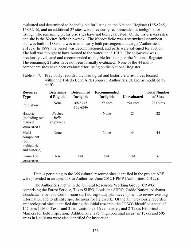
156
evaluated and determined to be ineligible for listing on the National Register (16SA245, 16SA246), and an additional 27 sites were previously recommended as ineligible for listing. The remaining prehistoric sites have not been evaluated. Of the historic-era sites, one site is the Neches Belle shipwreck. The Neches Belle was a sternwheel steamboat that was built in 1889 and was used to carry both passengers and cargo (Authorities, 2012c). In 1898, the vessel was decommissioned, and parts were salvaged for auction. The hull was thought to have burned to the waterline in 1910. The shipwreck was previously evaluated and recommended as eligible for listing on the National Register. The remaining 21 sites have not been formally evaluated. None of the 44 multi-component sites have been evaluated for listing on the National Register.
Table 3-17. Previously recorded archaeological and historic-era resources located within the Toledo Bend APE (Source: Authorities, 2012c, as modified by staff).
Resource Type
Determined Eligible
Determined Ineligible
Recommended Ineligible Unevaluated
Total Number of Sites
Prehistoric None 16SA245, 16SA246
27 sites 254 sites 283 sites
Historic (including two marked cemeteries)
Neches Belle
shipwreck
None 21 22
Multi-component (both prehistoric and historic)
None None 44 44
Unmarked cemeteries
NA NA NA NA 6
Details pertaining to the 355 cultural resource sites identified in the project APE were provided in an appendix to Authorities June 2012 HPMP (Authorities, 2012c).
The Authorities met with the Cultural Resources Working Group (CRWG) comprising the Forest Service, Texas SHPO, Louisiana SHPO, Caddo Nation, Alabama-Coushatta Tribe, and Commission staff during study plan development to review existing information and to identify specific areas for fieldwork. Of the 355 previously recorded archaeological sites identified during the initial research, the CRWG identified a total of 147 sites (116 in Texas and 31 in Louisiana), 16 cemeteries, and 2 Texas Historical Markers for field inspection. Additionally, 295 “high potential areas” in Texas and 505 areas in Louisiana were also identified for inspection.
157
A field reconnaissance of the locations selected by the CRWG for survey was conducted in 2010. Additional reconnaissance of 11 other areas was also conducted during a maintenance drawdown of the reservoir. Of the 147 previously recorded sites identified for investigation, only 31 sites in Texas and 9 in Louisiana were relocated. Visits to an additional 15 sites indicated significant prior ground disturbance and no evidence of cultural materials. The remaining 92 sites could not be located; these sites were recorded prior to reservoir construction and may have been inundated, destroyed by erosion or other factors following construction, or were otherwise not identified during the field reconnaissance. The Authorities state that intact portions of these sites may remain within or below the reservoir’s normal operating zone (Authorities, 2012c). A total of 49 new archaeological sites were also identified during the survey.
Two reports summarizing study findings of the reconnaissance were filed with the Commission: Management Summary: Cultural Resources Surveys for the Toledo Bend Relicensing Project in Texas (HRA Gray and Pape, 2012a) and Management Summary: Cultural Resources Surveys for the Toledo Bend Relicensing Project in Louisiana (HRA Gray and Pape, 2012b). In a letter dated December 21, 2011, the Texas Historical Commission concurred with the results and the recommendations provided in the final Texas Management Summary (letter from M. Wolfe, SHPO, Texas Historical Commission, Austin, TX, to R. Quiggle, Senior Regulatory Specialist, HDR, Syracuse, NY, filed June 12, 2012). On December 28, 2010, the Louisiana SHPO concurred with the recommendations provided in Louisiana Management Summary (letter from P. Boggan, Deputy SHPO, State of Louisiana Department of Culture, Recreation, and Tourism, Office of Cultural Development, Baton Rouge, LA, filed April 9, 2012).
While a total of 89 sites were documented during the 2010 field efforts (40 previously recorded sites and 49 new sites), less than 10 percent of the project APE has been surveyed, and an additional 208 archaeological sites that have not been investigated have been reported within the entire project APE.
The initial background review completed in 2010 identified 22 previously recorded and marked historic-period cemeteries in the vicinity of the project. Analysis of GIS data and existing information found that 17 of these cemeteries are located outside of the project APE, and three were relocated outside of the APE prior to project construction (Authorities, 2012c). A fourth marked cemetery, known as the “Round Lakes Cemetery” is currently inundated by the project reservoir. There is no further information about the cemetery, and its condition is unknown. The remaining marked cemetery, the McCord-Low Cemetery, is partially located within the APE.
A total of six unmarked cemeteries are also located within the project APE. One of these cemeteries was partially exposed during low-pool levels in July 2011, and local informants reported up to five additional cemeteries in the APE. One of these, the William Watson McDaniel, Sr. family cemetery was relocated during additional field investigations undertaken by the Authorities in February 2012. The remaining four
158
unmarked cemeteries are suspected to be inundated, and no information about their precise location in available.
Historic Buildings, Structures, and Districts Authorities conducted a National Register evaluation of the Toledo Bend Project
facilities. The results are presented in Architectural History Survey for the Toledo Bend Relicensing Project in Texas and Louisiana (HRA Gray and Pape, 2010c). The report evaluated the significance of the facilities within the framework of Municipal Engineering and Water Resources Development in the Sabine River Basin (1960–1969). While the project was completed in 1969 making the system less than 50 years old (the typical threshold for historic significance), construction on the project began in 1960. The Authorities concluded that the project facilities represent a unified district that is eligible for listing on the National Register at the national, state, and local levels. Contributing elements of the Toledo Bend Historic District include Toledo Bend dam, spillway, powerhouse, Sabine River Authority of Louisiana observation platform, and the Sabine River Authority of Texas observation platform. Other buildings and structures may also contribute to the district’s eligibility, and the Authorities proposes to evaluate these structures in the future on an as-needed basis.
The Toledo Bend Historic District was recommended as eligible under Criterion A as one of the largest municipal water and power supply projects in the United States that did not utilize federal funds for construction or operation and also for its contribution to the economic development of the area. The district was also recommended as eligible for the National Register under Criterion C as the largest human-made reservoir in the south and the fifth largest human-made reservoir in the United States. Synopses of these evaluations were provided in the two management summaries (HRA Gray and Pape, 2012a,b).
Traditional Cultural Properties To date, no potential TCPs of importance to the Caddo Nation or the Alabama-
Coushatta Tribe have been identified within the project APE. However, the Authorities are continuing consultation with these tribes to identify and document National Register-eligible TCPs within the APE and assess the project’s effects (if any) on these resources.
3.3.6.2 Environmental Effects
Project-Related Effects on Cultural Resources Project-related effects on cultural resources within the APE are likely to occur
from project operations and maintenance, use and maintenance of project roads, recreation, vandalism, and modifications or repairs to project facilities. Project effects are considered to be adverse when an activity may alter, directly or indirectly, the characteristics of a historic property that qualify the property for inclusion in the National Register. If adverse effects are found, such effects would need to be resolved in
159
consultation with the Texas SHPO or Louisiana SHPO, and with other parties. The Authorities (2012c) and the CRWG have identified several different types of project effects related to project operations, recreation and public use, and shoreline development.
Project operations can result in changes to reservoir levels. Archaeological sites and cemeteries located within or adjacent to the zone of normal reservoir fluctuation can be affected by shoreline erosion, including undercutting, sediment and artifact movement, and burial of archaeological deposits under transported sediment. Further, exposure of archaeological sites during low reservoir levels can result in vandalism and looting of cultural materials.
The project vicinity is popular for recreational activities, and inadvertent damage to cultural resources can also result from foot traffic that may strip vegetation thereby exposing archeological sediments. Not only could this result in erosion, but it may expose cultural materials and increase vandalism and looting. There are numerous public and private recreation facilities within the APE including parks, day-use areas, marinas, boat launches, campgrounds and other developments. Archaeological sites in the vicinity of these areas are particularly susceptible to impacts. Additionally, the use of power boats on the reservoir may result in wake erosion to shoreline sites. Shoreline development, including dredging and construction of new recreation facilities, landscaping, and other features on the shoreline may result in impacts on cultural resources.
Maintenance of the Toledo Bend Project facilities could adversely affect the character-defining features of the system that make it eligible for listing on the National Register.
Historic Properties Management Plan The Authorities filed a draft HPMP to address project effects on historic properties
with its license application in September 2011. In its February 7, 2012, AIR, the Commission requested that the draft HPMP be revised to include: (1) a revised table that describes the identified resources in greater detail; (2) a description of the specific project effects identified at individual sites identified during archaeological fieldwork; (3) a more detailed description of the specific measures proposed at individual sites; (4) further information regarding marked and unmarked historic cemeteries within the APE; and (5) copies of all consultation regarding the HPMP including but not limited to concurrence letters received from the Louisiana SHPO and Texas SHPO on National Register-eligibility recommendations. On June 12, 2012, the Authorities filed a final HPMP revised to address these requests. The final HPMP was prepared in consultation with the Texas SHPO, Louisiana SHPO, and CRWG, and in consideration of Guidelines for the Development of Historic Properties Management Plans for FERC Hydroelectric Projects (FERC and Advisory Council, 2002). It its final HPMP, the Authorities proposes to
160
undertake a variety of general measures for implementing the HPMP and managing cultural resources. The final HPMP includes:
• the appointment of an HPMP coordinator who would be responsible for overseeing implementation of the HPMP and coordinating consultation activities;
• a routine monitoring plan to assess project effects on cultural resources during ground-disturbing activities;
• a plan for review of future project activities on lands administered by the Forest Service;
• a plan for review of ground-disturbing project activities on non-federal lands;
• a public education and information program;
• a plan for inadvertent discoveries, including procedures for the discovery of any debris associated with the Space Shuttle Columbia;
• procedures for the unanticipated discovery of human remains;
• procedures for emergency situations;
• coordination with the SMP;
• procedures for the removal of lands from the project boundary and federal oversight;
• a plan for the curation of any recovered archaeological materials;
• preparation of an annual progress report documenting HPMP implementation provided to CRWG and the Commission;
• HPMP review and revision every 5 years in consultation with the Commission;
• a list of project activities that are exempt from further section 106 review;
• a process for dispute resolution;
• a requirement for future consultation with CRWG, including the Texas SHPO, Louisiana SHPO, Forest Service, Caddo Nation, and the Alabama-Coushatta Tribe; and
• a schedule for HPMP implementation. The Authorities did not complete cultural resources surveys of the project APE
during relicensing; therefore, project-related effects on specific cultural properties within the APE are unknown. However, the final HPMP provides a protocol to be followed to assess the potential effects of project activities on known cultural resources in the interim. Additionally, the final HPMP calls for completion of archaeological survey of National Forest System lands within the APE within 4 years of license issuance and acceptance; survey of other lands within the APE would be completed within 15 years of license
161
issuance. The final HPMP also includes a plan to evaluate all identified properties for listing on the National Register, and develop any necessary mitigation measures to resolve any project-related adverse effects on eligible properties. Mitigation measures for affected resources may include stabilization of erosion, installation of restrictive/protective signs, installation of restrictive barriers, and site burial. Site burial would follow the Texas SHPO’s Intentional Site Burial Policy and would be implemented only when it would not result in physical, chemical, or biological changes to the site. Data recovery excavations would be conducted at specific sites only when avoidance, protection, or stabilization measures are not feasible.
A portion of the McCord-Low Cemetery is located within the APE. Additionally, the William Watson McDaniel, Sr. family cemetery is also located in the APE. Although no project-related effects on these cemeteries were identified, and no specific treatment is prescribed in the final HPMP, the Authorities propose to monitor these locations and implement treatment measures if project effects are identified in the future. Inundation is affecting the newly discovered cemetery exposed during the 2011 reservoir drawdown. The Authorities proposed to install a protective cap at this location that would ensure that the graves that are present are protected during any future drawdowns. As specified in the final HPMP, this cap would be installed when reservoir conditions once again permitted access to the location. On November 21, 2011, the Texas SHPO concurred that the proposed design for the cap was sufficient (email from B. Martin, Texas Historical Commission, Austin, TX, to M. Swoboda, Licensing Manager, Authorities, Orange, TX, filed June 12, 2012).
The Authorities’ final HPMP states that consultation with the Caddo Nation and the Alabama-Coushatta to implement a formal TCP study is continuing and that an inventory, National Register evaluation, and assessment of project effects would be completed within 2 years of license issuance.
The final HPMP also contains a requirement to comply with the Secretary’s Standards where feasible should modifications to the character-defining features of the Toledo Bend Project facilities be necessary. Where modifications cannot be accomplished according to the Secretary’s Standards, data recovery for historic structures would entail Historic American Building Survey or Historic American Engineering Record documentation.
In its comments on the August 2012 Offer of Settlement, the Forest Service commented that, while there was considerable discussion of cultural resources management during HPMP development, negotiation is reflected in the final HPMP. On May 11, 2012, the Texas SHPO concurred with the final HPMP (letter from M. Wolfe, SHPO, Texas Historical Commission, Austin, TX, to R. Quiggle, Senior Regulatory Specialist, HDR, Syracuse, NY, filed June 12, 2012). According to the Authorities (2012c), the Louisiana SHPO also concurred with the final HPMP via correspondence dated May 14, 2012. The Authorities requested comments on the final HPMP from the Caddo Nation and from the Alabama-Coushatta Tribe, but no responses were received.
162
Our Analysis Implementation of the measures provided in Authorities’ final HPMP would
ensure that cultural resources within the project APE are appropriately managed and protected throughout the term of any license issued for the project. Additionally, the Authorities’ proposed plan to further identify cultural resources within the project APE, including TCPs; evaluate them for listing on the National Register; and develop any necessary mitigation measures to resolve any project-related adverse effects on eligible properties would resolve any project-related potential effects to historic properties. Completion of these pending studies according to the proposed schedule would allow for the HPMP review and amendment every 5 years including updated and/or new cultural resources data.
To meet the requirements of section 106, the Commission intends to execute a PA with the Texas SHPO and Louisiana SHPO (given that upon notification, the Advisory Council would choose not to participate). A final Programmatic Agreement that implements a Historic Properties Management Plan was sent to the SHPOs on November 13, 2013 for signature and execution. The Authorities, Caddo Nation, the Alabama Coushatta Tribe of Texas, and the Choctaw Nation were invited to sign the PA as concurring parties. Execution of the PA would ensure that the Authorities address all historic properties identified within the project’s APE through the implementation of the final HPMP.
3.3.7 Aesthetics
3.3.7.1 Affected Environment Toledo Bend reservoir is located within the relatively rural region of eastern Texas
western Louisiana. Most of the shoreline is heavily wooded over rolling hills. The forested areas surrounding the project consist of pine plantations, mixed pine-hardwood forests, and some bottomland hardwoods. The non-forested areas are dominated by pastures, grasses, and occasional row crops. Residential development is interspersed throughout the area and adjacent to the project shoreline. The reservoir is so wide in areas that, at times, the other shoreline is not visible.
Non-project uses and recreation development are evident in the project. There are 26 public recreation facilities, dozens of commercial recreation facilities, and more than 7,000 shoreline permits for non-project use of project lands.
Open areas at recreation sites and other project facilities are maintained by mowing. Industrial features include the Toledo Bend dam, spillway gates, powerhouse, substation, warehouses, office buildings, and pole-mounted electric distribution and communication lines. Major transportation features in the project vicinity include Louisiana Highway 191 and Texas Highway 692.
163
3.3.7.2 Environmental Effects The Authorities propose to construct an intake replacing one tainter gate, leading
to a new minimum flow generating unit to be installed in a new powerhouse, and discharging flows into spillway channel. The proposed minimum flow unit and supporting infrastructure would include one prefabricated metal building to house the turbine, generator, and ancillary equipment; transformer and substation; concrete and metal conduits and other structures affixed to the existing dam, spillway gates, concrete training wall, and spillway apron; improved gravel or paved roads; and pole-mounted transmission lines. To minimize effects of the construction on aesthetic resources in the project area, the Authorities propose to limit the footprint of construction to the smallest area possible and implement construction best management practices throughout the construction period. Air emissions associated with construction activities would be temporary and variable, depending on project location, duration, and level of activity. These emissions would be predominantly associated with the exhaust generated by operating construction equipment, but could also be attributed to fugitive dust (particulate matter) produced by materials staging, demolition, and earthworks activities, as well as concrete processing operations.
The ARA and agency preliminary 10(j) conditions in addition to the SNF Relicensing Agreement and Forest Service 4(e) conditions provide for changes in operations and land management that could affect aesthetic resources. Proposed operational changes include a new continuous flow release schedule at the project spillway, reduction in seasonal powerhouse peaking operations, and weekend releases of 1,450 acre-feet on each weekend day and in March and April and possibly in May and June depending on water availability. Proposed land management measures would include the SNF Recreation Plan, SNF Erosion Monitoring and Management Plan, and the Authorities’ Recreation Management Plan and SMP.
In its comments on the draft EIS, EPA recommends that, to reduce potential short-term air quality effects associated with construction activities, the Authorities should include a construction emissions mitigation plan. EPA states that, in addition to meeting all applicable local, state, or federal requirements, including EPA-recommended mitigation measures in the construction emissions mitigation plan, to reduce emissions of nitrogen oxides, carbon monoxide, particulate matter, sulfur dioxide, and other pollutants, EPA also recommends fugitive dust source controls, mobile and stationary source controls, and inventory controls to reduce short-term air quality effects.
Our Analysis Effects on aesthetics associated with the proposed construction of the minimum
flow generating unit would be limited to the active construction period of less than 2 years associated with the installation and would occur on lands previously developed for project purposes. Construction activities would result in increased noise and dust in the area and would be most noticeable to visitors in the spillway or vehicles traveling across the dam. The Authorities’ proposal to limit the footprint of construction and use best

164
management practices would minimize effects on aesthetic resources. Use of colors, forms, and textures in the design process that closely matches the existing structures would further minimize the visual impact of the new facilities.
The minimum flow generating unit would be constructed in Louisiana and, according to current Louisiana DEQ standards (Louisiana DEQ, 2013), an air permit is not required if the sources are from mobile sources such as trucks, or non-road engines such as construction vehicles. In addition, Louisiana DEQ does not require a permit if the potential emissions are less than 5 tons per year of any regulated air pollutant as defined by the federal Clean Air Act and less than 15 tons per year of all defined pollutants.
The proposed seasonal operation limiting peaking flows would lessen the variability of flows in the tailrace; however, given the generation schedule and peaking operation regime the magnitude of these effects on the aesthetics is likely to be modest. Proposed weekend releases in March and April would provide additional water into the tailrace for aquatic resources with secondary benefits to recreation. Providing these flows would result in periods within the weekends where water would be present providing a different viewing environment for the duration of the releases. Given the releases would be for a short duration (between 3 to 5 hours), the larger visual impact would likely be the ramping up and down of flows associated with the releases.
The addition of the minimum flow generating unit would increase flows to the spillway channel. A continuous flow of 150 cfs would increase the amount of water marginally (from the existing flow of 144 cfs) and would likely be unnoticeable from viewpoints; however, a 300-cfs flow would double the amount of water currently released to the spillway, which would likely result in a noticeable change in visual appearance. The spillway is popular with swimmers, and during years when the reservoir is above elevation 162 feet msl, these higher continuous releases would provide more water to the reach, but it is not clear if this would have any substantial bearing on the quality of the aesthetics in the area other than higher water levels.
The Authorities’ proposed Recreation Management Plan and the SNF Recreation Plan include operation and management responsibilities, which would contribute to improved conditions at the recreation sites, preserving the aesthetic quality by ensuring that facilities do not fall into disrepair and/or become outdated.
Implementing the SNF Erosion Monitoring and Management Plan, as well as an erosion monitoring program for sites outside the SNF would establish measures to mitigate for any erosion that would threaten sensitive or recreational resources. Addressing active erosion sites would maintain or improve the visual quality of those areas as well as reduce the turbidity in the water near them for the term of any new license.
Air emissions and dust production associated with the proposed construction activities are expected to be small and could be less than the levels that would require

165
local, state, or federal permits. However, final design plans for the minimum flow generating unit and improvements to the recreation facilities have not been finalized or filed.
3.4 NO-ACTION ALTERNATIVE Under the no-action alternative the project would continue to operate as it has in
the past. None of the Authorities’ proposed measures or the resource agencies’ recommendations and mandatory conditions would be required.

166
This page intentionally left blank.

167
4.0 DEVELOPMENTAL ANALYSIS
In this section, we look at the Toledo Bend Project’s use of the Sabine River for hydropower purposes to see what effect various environmental measures would have on the project’s costs and power benefits. Consistent with the Commission’s approach to economic analysis, the power benefit of the project is determined by estimating the cost of obtaining the same amount of energy and capacity using the likely alternative generating resources available in the region. In keeping with Commission policy as described in Mead, our economic analysis is based on current electric power cost conditions and does not consider future escalation of fuel prices in valuing the hydropower project’s power benefits.44
Our analysis includes: (1) an estimate of the cost of individual measures considered for the protection, mitigation and enhancement of environmental resources affected by the project, and (2) an estimate of the project power benefits for each of the licensing alternatives. To determine the net annual power benefit for each of the licensing alternatives, we compare project costs to the value of the power output as represented by the cost of a likely alternative source of power in the region. For any alternative, a positive net annual power benefit indicates that the project power costs less than the current cost of alternative generation resources and a negative net annual power benefit indicates that project power costs more than the current cost of alternative generation resources. This estimate helps to support an informed decision concerning what is in the public interest with respect to a proposed license. However, project economics is only one of many public interest factors the Commission considers in determining whether, and under what conditions, to issue a license.
4.1 POWER AND ECONOMIC BENEFITS OF THE PROJECT Table 4-1 summarizes the economic assumptions and economic information we
use in our analysis. Most of the information was provided by the Authorities in its license application. We find that the values provided by the Authorities are reasonable for the purposes of our analysis. Cost items common to all alternatives include taxes and insurance costs; net investment (the total investment in power plant facilities remaining to be depreciated); estimated future capital investment required to maintain and extend the life of plant equipment and facilities; relicensing costs; normal operation and maintenance cost; and Commission fees.
44 See Mead Corporation, Publishing Paper Division, 72 FERC ¶ 61,027 (July
13, 1995). In most cases, electricity from hydropower would displace some form of fossil-fueled generation, in which fuel cost is the largest component of the cost of electricity production.
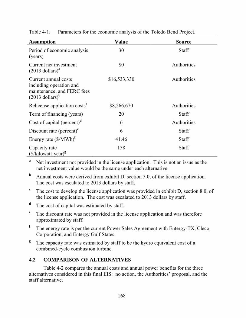
168
Table 4-1. Parameters for the economic analysis of the Toledo Bend Project.
Assumption Value Source Period of economic analysis (years)
30 Staff
Current net investment (2013 dollars)a
$0 Authorities
Current annual costs including operation and maintenance, and FERC fees (2013 dollars)b
$16,533,330 Authorities
Relicense application costsc $8,266,670 Authorities Term of financing (years) 20 Staff Cost of capital (percent)d 6 Authorities Discount rate (percent)e 6 Staff Energy rate ($/MWh)f 41.46 Staff Capacity rate ($/kilowatt-year)g
158 Staff
a Net investment not provided in the license application. This is not an issue as the net investment value would be the same under each alternative.
b Annual costs were derived from exhibit D, section 5.0, of the license application. The cost was escalated to 2013 dollars by staff.
c The cost to develop the license application was provided in exhibit D, section 8.0, of the license application. The cost was escalated to 2013 dollars by staff.
d The cost of capital was estimated by staff. e The discount rate was not provided in the license application and was therefore
approximated by staff. f The energy rate is per the current Power Sales Agreement with Entergy-TX, Cleco
Corporation, and Entergy Gulf States. g The capacity rate was estimated by staff to be the hydro equivalent cost of a
combined-cycle combustion turbine.
4.2 COMPARISON OF ALTERNATIVES Table 4-2 compares the annual costs and annual power benefits for the three
alternatives considered in this final EIS: no action, the Authorities’ proposal, and the staff alternative.
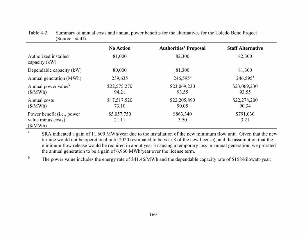
169
Table 4-2. Summary of annual costs and annual power benefits for the alternatives for the Toledo Bend Project (Source: staff).
No Action Authorities’ Proposal Staff Alternative Authorized installed capacity (kW)
81,000 82,300 82,300
Dependable capacity (kW) 80,000 81,300 81,300 Annual generation (MWh) 239,635 246,595a 246,595a Annual power valueb ($/MWh)
$22,575,270 94.21
$23,069,230 93.55
$23,069,230 93.55
Annual costs ($/MWh)
$17,517,520 73.10
$22,205,890 90.05
$22,278,200 90.34
Power benefit (i.e., power value minus costs) ($/MWh)
$5,057,750 21.11
$863,340 3.50
$791,030 3.21
a SRA indicated a gain of 11,600 MWh/year due to the installation of the new minimum flow unit. Given that the new turbine would not be operational until 2020 (estimated to be year 8 of the new license), and the assumption that the minimum flow release would be required in about year 3 causing a temporary loss in annual generation, we prorated the annual generation to be a gain of 6,960 MWh/year over the license term.
b The power value includes the energy rate of $41.46/MWh and the dependable capacity rate of $158/kilowatt-year.

170
4.2.1 No-action Alternative Under the no-action alternative, the project would continue to operate as it does
now. The project generates an average of 239,635 MWh of electricity annually. The annual power value of the project under the no-action alternative would be $22,575,270 (about $94.21/MWh). The average annual cost of producing this power would be about $17,517,520 (about $73.10/MWh), resulting in an average annual power benefit of $5,057,750 (about $21.11/MWh). In other words, the project produces energy at a cost that is less expensive than that of currently available alternative generation by $21.11/MWh.
4.2.2 Authorities’ Proposal Under the Authorities’ proposal, the project would generate an average of
246,595 MWh of electricity annually. The annual power value of the project under the Authorities’ proposal would be $23,069,230 (about $93.55/MWh). The average annual cost of producing this power would be about $22,205,890 (about $90.05/MWh), resulting in an average annual cost that is $863,340 (about $3.50/MWh) less than the likely alternative cost of power.
4.2.3 Staff Alternative The staff alternative includes the Authorities’ proposal and has the same capacity
and energy attributes. Table 4-3 shows the staff-recommended additions, deletions, and modifications to the Authorities’ proposed environmental protection and enhancement measures and the estimated cost of each. The project would continue to generate an average of 246,595 MWh of electricity annually. The annual power value of the project under the staff alternative would be $23,069,230 (about $93.55/MWh). The average annual cost of producing this power would be about $22,278,200 (about $90.34/MWh), resulting in an average annual cost that is $791.030 (about $3.21/MWh) less than the likely alternative cost of power.
4.3 COST OF ENVIRONMENTAL MEASURES Table 4-3 shows the costs for each of the environmental mitigation and
enhancement measures considered in the analysis. We convert all costs to equal annual (levelized) values over a 30-year period of analysis to give a uniform basis for comparing the benefits of a measure to its cost.
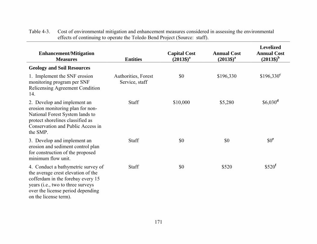
171
Table 4-3. Cost of environmental mitigation and enhancement measures considered in assessing the environmental effects of continuing to operate the Toledo Bend Project (Source: staff).
Enhancement/Mitigation Measures Entities
Capital Cost (2013$)a
Annual Cost (2013$)a
Levelized Annual Cost
(2013$)b
Geology and Soil Resources 1. Implement the SNF erosion monitoring program per SNF Relicensing Agreement Condition 14.
Authorities, Forest Service, staff
$0 $196,330 $196,330c
2. Develop and implement an erosion monitoring plan for non-National Forest System lands to protect shorelines classified as Conservation and Public Access in the SMP.
Staff $10,000 $5,280 $6,030d
3. Develop and implement an erosion and sediment control plan for construction of the proposed minimum flow unit.
Staff $0 $0 $0e
4. Conduct a bathymetric survey of the average crest elevation of the cofferdam in the forebay every 15 years (i.e., two to three surveys over the license period depending on the license term).
Staff $0 $520 $520f
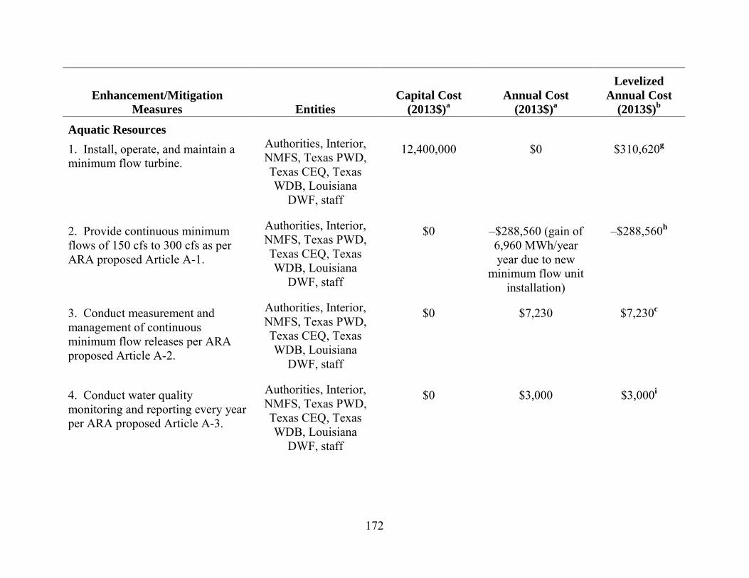
172
Enhancement/Mitigation Measures Entities
Capital Cost (2013$)a
Annual Cost (2013$)a
Levelized Annual Cost
(2013$)b
Aquatic Resources 1. Install, operate, and maintain a minimum flow turbine.
Authorities, Interior, NMFS, Texas PWD, Texas CEQ, Texas WDB, Louisiana
DWF, staff
12,400,000 $0 $310,620g
2. Provide continuous minimum flows of 150 cfs to 300 cfs as per ARA proposed Article A-1.
Authorities, Interior, NMFS, Texas PWD, Texas CEQ, Texas WDB, Louisiana
DWF, staff
$0 –$288,560 (gain of 6,960 MWh/year year due to new
minimum flow unit installation)
–$288,560h
3. Conduct measurement and management of continuous minimum flow releases per ARA proposed Article A-2.
Authorities, Interior, NMFS, Texas PWD, Texas CEQ, Texas WDB, Louisiana
DWF, staff
$0 $7,230 $7,230c
4. Conduct water quality monitoring and reporting every year per ARA proposed Article A-3.
Authorities, Interior, NMFS, Texas PWD, Texas CEQ, Texas WDB, Louisiana
DWF, staff
$0 $3,000 $3,000i
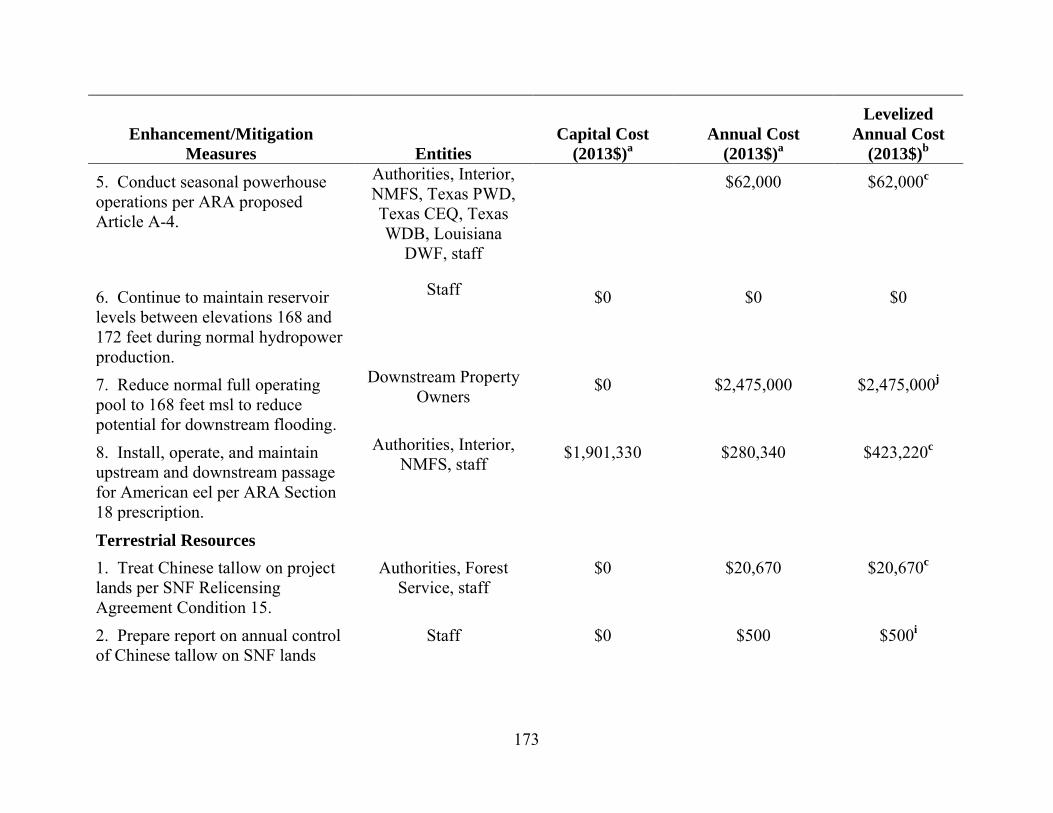
173
Enhancement/Mitigation Measures Entities
Capital Cost (2013$)a
Annual Cost (2013$)a
Levelized Annual Cost
(2013$)b 5. Conduct seasonal powerhouse operations per ARA proposed Article A-4.
Authorities, Interior, NMFS, Texas PWD, Texas CEQ, Texas WDB, Louisiana
DWF, staff
$62,000 $62,000c
6. Continue to maintain reservoir levels between elevations 168 and 172 feet during normal hydropower production.
Staff $0 $0 $0
7. Reduce normal full operating pool to 168 feet msl to reduce potential for downstream flooding.
Downstream Property Owners
$0 $2,475,000 $2,475,000j
8. Install, operate, and maintain upstream and downstream passage for American eel per ARA Section 18 prescription.
Authorities, Interior, NMFS, staff
$1,901,330 $280,340 $423,220c
Terrestrial Resources 1. Treat Chinese tallow on project lands per SNF Relicensing Agreement Condition 15.
Authorities, Forest Service, staff
$0 $20,670 $20,670c
2. Prepare report on annual control of Chinese tallow on SNF lands
Staff $0 $500 $500i
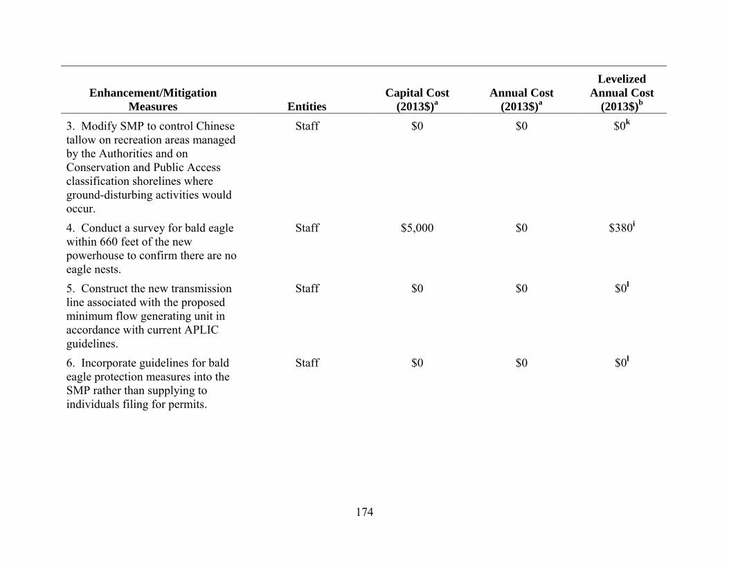
174
Enhancement/Mitigation Measures Entities
Capital Cost (2013$)a
Annual Cost (2013$)a
Levelized Annual Cost
(2013$)b 3. Modify SMP to control Chinese tallow on recreation areas managed by the Authorities and on Conservation and Public Access classification shorelines where ground-disturbing activities would occur.
Staff $0 $0 $0k
4. Conduct a survey for bald eagle within 660 feet of the new powerhouse to confirm there are no eagle nests.
Staff $5,000 $0 $380i
5. Construct the new transmission line associated with the proposed minimum flow generating unit in accordance with current APLIC guidelines.
Staff $0 $0 $0l
6. Incorporate guidelines for bald eagle protection measures into the SMP rather than supplying to individuals filing for permits.
Staff $0 $0 $0l
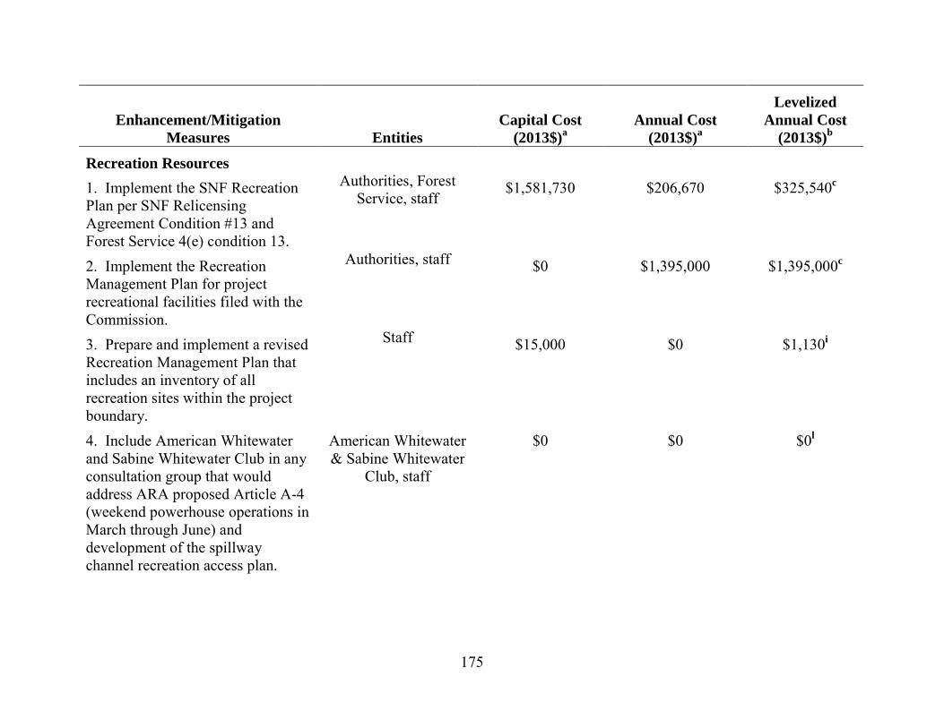
175
Enhancement/Mitigation Measures Entities
Capital Cost (2013$)a
Annual Cost (2013$)a
Levelized Annual Cost
(2013$)b
Recreation Resources 1. Implement the SNF Recreation Plan per SNF Relicensing Agreement Condition #13 and Forest Service 4(e) condition 13.
Authorities, Forest Service, staff
$1,581,730 $206,670 $325,540c
2. Implement the Recreation Management Plan for project recreational facilities filed with the Commission.
Authorities, staff $0 $1,395,000 $1,395,000c
3. Prepare and implement a revised Recreation Management Plan that includes an inventory of all recreation sites within the project boundary.
Staff $15,000 $0 $1,130i
4. Include American Whitewater and Sabine Whitewater Club in any consultation group that would address ARA proposed Article A-4 (weekend powerhouse operations in March through June) and development of the spillway channel recreation access plan.
American Whitewater & Sabine Whitewater
Club, staff
$0 $0 $0l

176
Enhancement/Mitigation Measures Entities
Capital Cost (2013$)a
Annual Cost (2013$)a
Levelized Annual Cost
(2013$)b 5. Allow public, car-top boating access to the project spillway during non-spill events.
American Whitewater & Sabine Whitewater
Club, staff
$20,000 $0 $1,500i
6. Provide flow schedules (24 hours in advance) as well as information collected as part of ARA proposed Article A-2 (measurement of continuous spillway releases) in near real time on a public web site.
American Whitewater & Sabine Whitewater
Club, staff
$10,000 $0 $750i
7. Release 1,000 cfs for 8 hours to the spillway, on both Saturday and Sunday on two weekends per year between March–June in consultation with American Whitewater and Sabine Whitewater Club.
American Whitewater & Sabine Whitewater
Club
$0 $7,550 $7,550l
Land Use 1. Implement the SMP. Authorities $0 $1,343,330 $1,343,330c
Cultural Resources 1. Implement the final HPMP filed with the Commission on June 12, 2012.
Authorities, Staff $0 $206,670 $206,670c
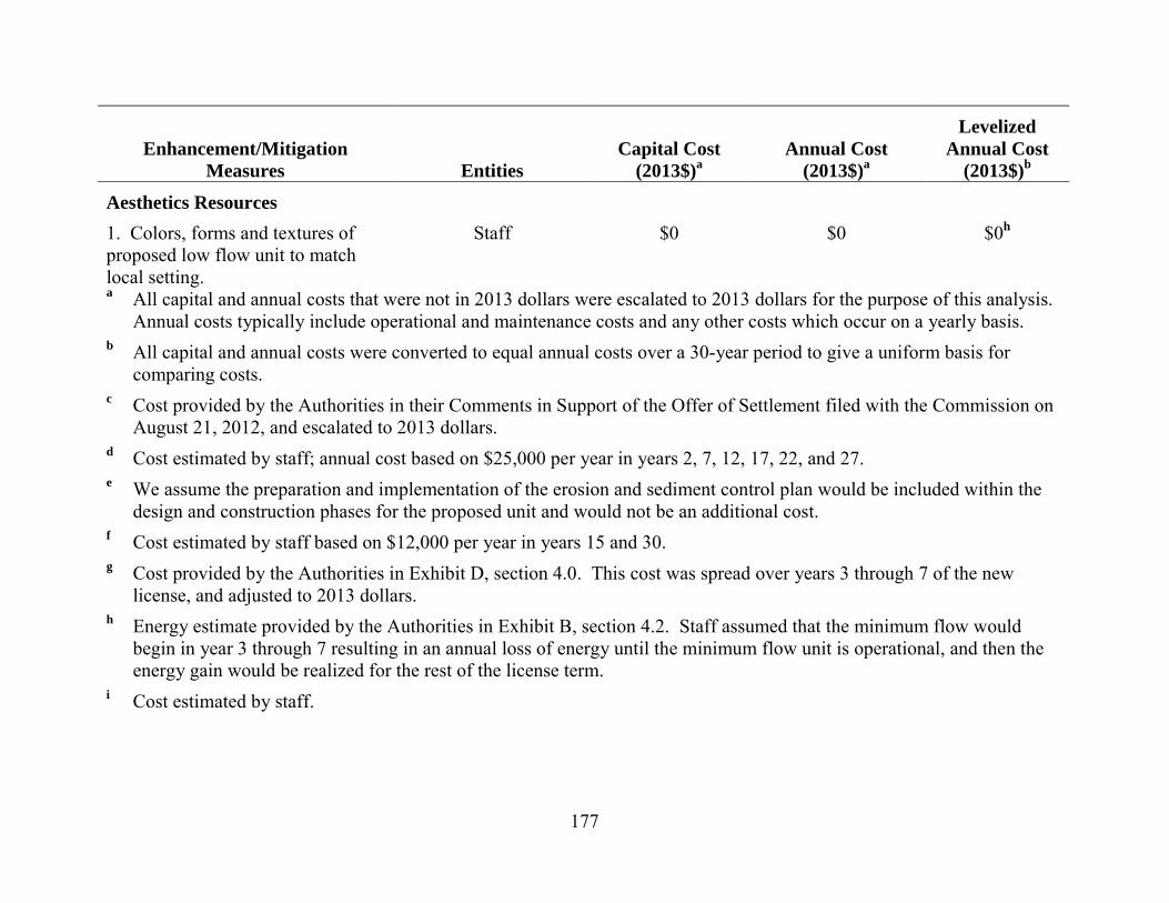
177
Enhancement/Mitigation Measures Entities
Capital Cost (2013$)a
Annual Cost (2013$)a
Levelized Annual Cost
(2013$)b
Aesthetics Resources 1. Colors, forms and textures of proposed low flow unit to match local setting.
Staff $0 $0 $0h
a All capital and annual costs that were not in 2013 dollars were escalated to 2013 dollars for the purpose of this analysis. Annual costs typically include operational and maintenance costs and any other costs which occur on a yearly basis.
b All capital and annual costs were converted to equal annual costs over a 30-year period to give a uniform basis for comparing costs.
c Cost provided by the Authorities in their Comments in Support of the Offer of Settlement filed with the Commission on August 21, 2012, and escalated to 2013 dollars.
d Cost estimated by staff; annual cost based on $25,000 per year in years 2, 7, 12, 17, 22, and 27. e We assume the preparation and implementation of the erosion and sediment control plan would be included within the
design and construction phases for the proposed unit and would not be an additional cost. f Cost estimated by staff based on $12,000 per year in years 15 and 30. g Cost provided by the Authorities in Exhibit D, section 4.0. This cost was spread over years 3 through 7 of the new
license, and adjusted to 2013 dollars. h Energy estimate provided by the Authorities in Exhibit B, section 4.2. Staff assumed that the minimum flow would
begin in year 3 through 7 resulting in an annual loss of energy until the minimum flow unit is operational, and then the energy gain would be realized for the rest of the license term.
i Cost estimated by staff.

178
j Cost estimated by staff based on a 25 percent estimated loss in hydroelectric generation caused by loss of head and storage associated with reducing the normal full pool to 168 feet msl. Minimum pool levels less than 168 feet msl would result in greater losses in generation and increased costs.
k Staff estimates that there would be no additional cost to implement the measure. l Cost estimated by staff based on an estimated loss of about 182 MWh/year.
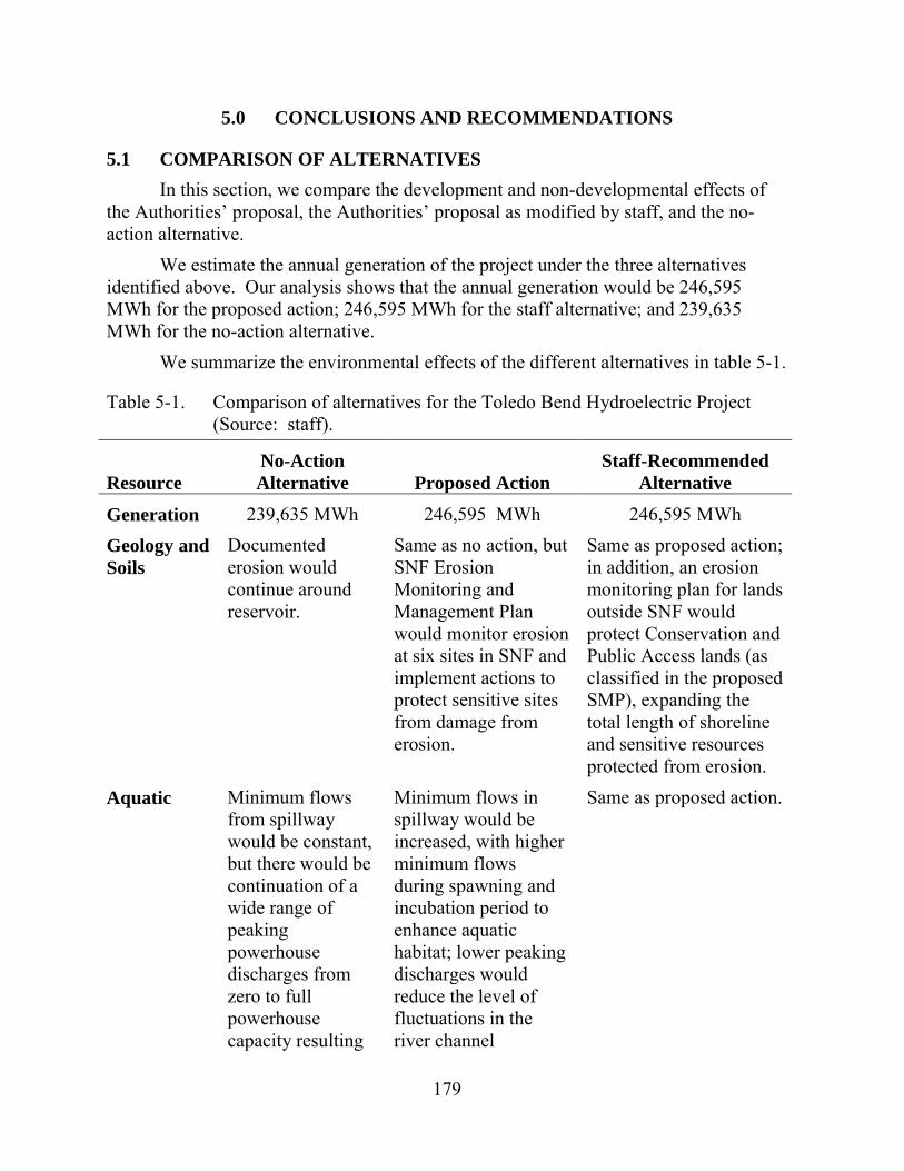
179
5.0 CONCLUSIONS AND RECOMMENDATIONS
5.1 COMPARISON OF ALTERNATIVES In this section, we compare the development and non-developmental effects of
the Authorities’ proposal, the Authorities’ proposal as modified by staff, and the no-action alternative.
We estimate the annual generation of the project under the three alternatives identified above. Our analysis shows that the annual generation would be 246,595 MWh for the proposed action; 246,595 MWh for the staff alternative; and 239,635 MWh for the no-action alternative.
We summarize the environmental effects of the different alternatives in table 5-1.
Table 5-1. Comparison of alternatives for the Toledo Bend Hydroelectric Project (Source: staff).
Resource No-Action Alternative Proposed Action
Staff-Recommended Alternative
Generation 239,635 MWh 246,595 MWh 246,595 MWh Geology and Soils
Documented erosion would continue around reservoir.
Same as no action, but SNF Erosion Monitoring and Management Plan would monitor erosion at six sites in SNF and implement actions to protect sensitive sites from damage from erosion.
Same as proposed action; in addition, an erosion monitoring plan for lands outside SNF would protect Conservation and Public Access lands (as classified in the proposed SMP), expanding the total length of shoreline and sensitive resources protected from erosion.
Aquatic Minimum flows from spillway would be constant, but there would be continuation of a wide range of peaking powerhouse discharges from zero to full powerhouse capacity resulting
Minimum flows in spillway would be increased, with higher minimum flows during spawning and incubation period to enhance aquatic habitat; lower peaking discharges would reduce the level of fluctuations in the river channel
Same as proposed action.
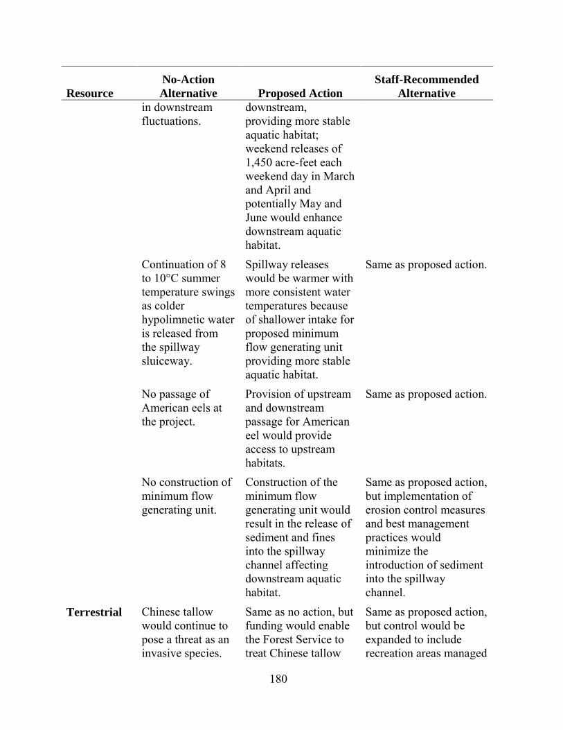
180
Resource No-Action Alternative Proposed Action
Staff-Recommended Alternative
in downstream fluctuations.
downstream, providing more stable aquatic habitat; weekend releases of 1,450 acre-feet each weekend day in March and April and potentially May and June would enhance downstream aquatic habitat.
Continuation of 8 to 10°C summer temperature swings as colder hypolimnetic water is released from the spillway sluiceway.
Spillway releases would be warmer with more consistent water temperatures because of shallower intake for proposed minimum flow generating unit providing more stable aquatic habitat.
Same as proposed action.
No passage of American eels at the project.
Provision of upstream and downstream passage for American eel would provide access to upstream habitats.
Same as proposed action.
No construction of minimum flow generating unit.
Construction of the minimum flow generating unit would result in the release of sediment and fines into the spillway channel affecting downstream aquatic habitat.
Same as proposed action, but implementation of erosion control measures and best management practices would minimize the introduction of sediment into the spillway channel.
Terrestrial Chinese tallow would continue to pose a threat as an invasive species.
Same as no action, but funding would enable the Forest Service to treat Chinese tallow
Same as proposed action, but control would be expanded to include recreation areas managed
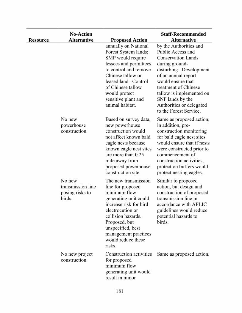
181
Resource No-Action Alternative Proposed Action
Staff-Recommended Alternative
annually on National Forest System lands; SMP would require lessees and permittees to control and remove Chinese tallow on leased land. Control of Chinese tallow would protect sensitive plant and animal habitat.
by the Authorities and Public Access and Conservation Lands during ground-disturbing. Development of an annual report would ensure that treatment of Chinese tallow is implemented on SNF lands by the Authorities or delegated to the Forest Service.
No new powerhouse construction.
Based on survey data, new powerhouse construction would not affect known bald eagle nests because known eagle nest sites are more than 0.25 mile away from proposed powerhouse construction site.
Same as proposed action; in addition, pre-construction monitoring for bald eagle nest sites would ensure that if nests were constructed prior to commencement of construction activities, protection buffers would protect nesting eagles.
No new transmission line posing risks to birds.
The new transmission line for proposed minimum flow generating unit could increase risk for bird electrocution or collision hazards. Proposed, but unspecified, best management practices would reduce these risks.
Similar to proposed action, but design and construction of proposed transmission line in accordance with APLIC guidelines would reduce potential hazards to birds.
No new project construction.
Construction activities for proposed minimum flow generating unit would result in minor
Same as proposed action.
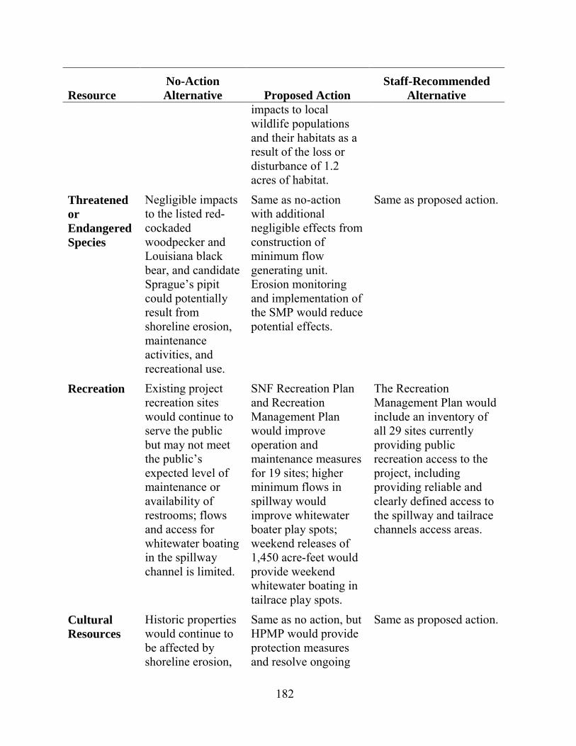
182
Resource No-Action Alternative Proposed Action
Staff-Recommended Alternative
impacts to local wildlife populations and their habitats as a result of the loss or disturbance of 1.2 acres of habitat.
Threatened or Endangered Species
Negligible impacts to the listed red-cockaded woodpecker and Louisiana black bear, and candidate Sprague’s pipit could potentially result from shoreline erosion, maintenance activities, and recreational use.
Same as no-action with additional negligible effects from construction of minimum flow generating unit. Erosion monitoring and implementation of the SMP would reduce potential effects.
Same as proposed action.
Recreation Existing project recreation sites would continue to serve the public but may not meet the public’s expected level of maintenance or availability of restrooms; flows and access for whitewater boating in the spillway channel is limited.
SNF Recreation Plan and Recreation Management Plan would improve operation and maintenance measures for 19 sites; higher minimum flows in spillway would improve whitewater boater play spots; weekend releases of 1,450 acre-feet would provide weekend whitewater boating in tailrace play spots.
The Recreation Management Plan would include an inventory of all 29 sites currently providing public recreation access to the project, including providing reliable and clearly defined access to the spillway and tailrace channels access areas.
Cultural Resources
Historic properties would continue to be affected by shoreline erosion,
Same as no action, but HPMP would provide protection measures and resolve ongoing
Same as proposed action.
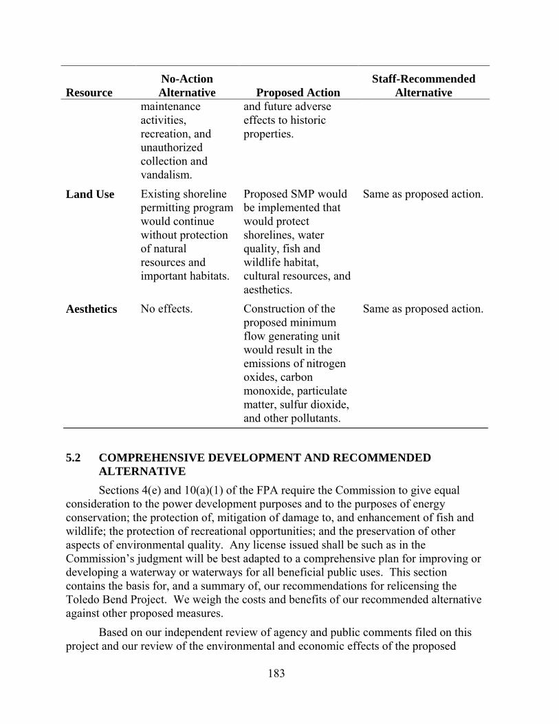
183
Resource No-Action Alternative Proposed Action
Staff-Recommended Alternative
maintenance activities, recreation, and unauthorized collection and vandalism.
and future adverse effects to historic properties.
Land Use Existing shoreline permitting program would continue without protection of natural resources and important habitats.
Proposed SMP would be implemented that would protect shorelines, water quality, fish and wildlife habitat, cultural resources, and aesthetics.
Same as proposed action.
Aesthetics No effects. Construction of the proposed minimum flow generating unit would result in the emissions of nitrogen oxides, carbon monoxide, particulate matter, sulfur dioxide, and other pollutants.
Same as proposed action.
5.2 COMPREHENSIVE DEVELOPMENT AND RECOMMENDED ALTERNATIVE Sections 4(e) and 10(a)(1) of the FPA require the Commission to give equal
consideration to the power development purposes and to the purposes of energy conservation; the protection of, mitigation of damage to, and enhancement of fish and wildlife; the protection of recreational opportunities; and the preservation of other aspects of environmental quality. Any license issued shall be such as in the Commission’s judgment will be best adapted to a comprehensive plan for improving or developing a waterway or waterways for all beneficial public uses. This section contains the basis for, and a summary of, our recommendations for relicensing the Toledo Bend Project. We weigh the costs and benefits of our recommended alternative against other proposed measures.
Based on our independent review of agency and public comments filed on this project and our review of the environmental and economic effects of the proposed
184
project and its alternatives, we selected the staff alternative, as the preferred option. We recommend this option because: (1) issuance of a new hydropower license by the Commission would allow the Authorities to operate the project as an economically beneficial and dependable source of electrical energy for their customers; (2) the 82.3 MW of electric capacity comes from a renewable resource that does not contribute to atmospheric pollution; (3) the public benefits of this alternative would exceed those of the no-action alternative; and (4) the recommended measures would protect and enhance fish and wildlife resources and provide improved recreation opportunities at the project.
In the following section, we make recommendations as to which environmental measures proposed by the Authorities or recommended by agencies and other entities should be included in any license issued for the project. In addition to the Authorities’ proposed environmental measures, we recommend additional staff-recommended environmental measures to be included in any license issued for the project. We also discuss which measures we do not recommend including in a license.
Measures Proposed by the Authorities Based on our environmental analysis of the Authorities’ proposal discussed in
section 3 and the costs discussed in section 4, we recommend including the following environmental measures proposed by the Authorities in any license issued for the project. Our recommended modifications to the Authorities’ proposed measures are shown in italic.
• SNF Recreation Areas Operations and Maintenance and Capital Improvements Plan (SNF Recreation Plan)—This plan identifies responsibilities of the Sabine River Authority of Texas for operating, maintaining, and improving the six SNF recreation areas (Indian Mounds Recreation Area, Willow Oak Recreation Area, Lakeview Recreation Area, East Hamilton Boat Launch, Ragtown Recreation Area, and Haley’s Ferry Boat Launch). The Authorities believe that implementation of this plan would ensure that project-related recreation areas within the SNF are maintained and operated during any new license term.
• Erosion Monitoring and Management Plan—The Sabine River Authority of Texas should implement a 10-year monitoring program to determine erosion rates at six representative sites along the project shoreline within the SNF and to develop measures to mitigate any effects of erosion on shoreline resources.
• Chinese Tallow Treatment—The Sabine River Authority of Texas should be responsible for ongoing treatment program for Chinese tallow along the shoreline within the SNF to help prevent the further spread of this species within the SNF, and prepare an annual report outlining the amount and general location of Chinese tallow control on SNF lands to ensure implementation of proposed treatment measures.
185
• Continuous Releases at Spillway—The Authorities would implement new continuous minimum flow releases at the spillway, ranging from 150 to 300 cfs, following the monthly schedule described in table 2-3, to protect and enhance aquatic resources within the spillway channel and the lower Sabine River.
• A plan for the measurement and management of continuous releases from the spillway—The Authorities should develop a flow release plan for providing and measuring flow releases in the project spillway channel to ensure that flow releases are being maintained as required by any new license. The Authorities should also provide flow information of continuous spillway releases and reservoir level data in near real time on a public website to provide boaters and other recreational users information that may allow planning of future recreational visits to the project.
• Forebay Cofferdam Monitoring—The Authorities should conduct temperature monitoring in the project’s tailrace channel in July, August, and September to assist in monitoring the physical stability of the remnant forebay cofferdam to ensure that the submerged cofferdam continues to act as a water control structure forcing warmer and better-oxygenated water from the upper reservoir strata to flow to the powerhouse intakes. If monitoring demonstrates that the mean daily temperature of at least 10 percent of the monitored days in July, August, and September is below 20°C, then the powerhouse intakes are likely receiving cooler water from the lower reservoir strata, and the physical integrity of the remnant forebay cofferdam would be subject to further investigation. The Authorities would then collect in situ dissolved oxygen (DO) measurements at the same location to determine if low dissolved oxygen water from the lower reservoir strata is being discharged, survey the cofferdam crest elevations and compare them to 2011 baseline conditions to see if, and by how much the cofferdam has eroded, and, if necessary, develop a cofferdam restoration plan. In addition, the Authorities should conduct direct monitoring of the elevation of the forebay cofferdam by bathymetric survey at 15-year intervals (i.e., two to three surveys over the license period depending on the license term) to ensure the physical stability of the cofferdam.
• Seasonal Powerhouse Operations—The Authorities should, upon the April 30, 2018 expiration of the current power sales agreement (or an earlier date if a new power sales agreement is reached prior to the 2018 expiration of the agreement):
� reduce normal maximum powerhouse peaking flows to 12,000 cfs during March through June;

186
� upon completion of the testing program to determine optimum weekend releases, file with the Commission for approval a weekend operations plan. The weekend operations plan would be based on flow testing conducted by the agencies to determine the flow rate and duration of weekend releases. Prior to filing the weekend operations plan with the Commission, also consult with American Whitewater and Sabine Whitewater Club regarding release scheduling and timing of the weekend releases; and
� upon Commission approval, implement the weekend operations plan--release 1,450 acre-feet of water every weekend day in March and April, and depending on water year type, every weekend day in May and June.
• Upstream and Downstream Passage of American Eel—The Authorities should provide for the upstream and downstream passage of American eel at the dam by implementation of upstream and downstream fish passage plans that would be filed for Commission approval.
In addition to the measures proposed as part of the SNF Relicensing Agreement and the ARA, the Authorities should implement their:
• Recreation Management Plan for lands outside the SNF that identifies management and maintenance responsibilities for 13 project recreation sites operated by the Authorities on lands owned in fee. The Authorities believe that implementation of this plan would ensure that recreation sites within the project area are maintained and operated during any new license term. The plan should include all recreation sites that are within the project boundary and are owned and operated by the Authorities, including the 13 sites already identified in the recreation management plan, Cow Bayou Wilderness Area, Tourist Information Center, the tailrace, and spillway area. The recreation management plan should also include brief descriptions and locations of the six recreation sites within the Sabine National Forest, two state parks, and all other public recreation facilities that provide access to the project. Including all public access points to the project lands and waters in a revised Recreation Management Plan would provide a single source of information for all recreation facilities at the Toledo Bend Project and provide managers and interested stakeholders with a fuller picture of recreation at the project.
• SMP, which consolidates the existing shoreline permitting program with a new shoreline classification system, monitoring and enforcement measures, and plan review and updates. Implementation of this plan would ensure that reservoir shoreline resources are protected during any new license term. The SMP also requires lessees and permittees to control and remove Chinese tallow. The plan should also include measures to control Chinese tallow on project recreation areas managed by the Authorities and on Conservation

187
and Public Access classification shorelines where ground-disturbing activities would occur. Also, the Authorities should incorporate guidelines for bald eagle protection measures into the SMP to address future nesting in the project area.
• HPMP, which includes measures to identify historic properties within the project’s APE, identify project-related effects, and avoid, reduce, or mitigate any effects on historic properties that are determined to be adverse.
Additional Measures Recommended by Staff In addition to the Authorities’ proposed measures listed above, we recommend
including the following staff-recommended measures in any license issued for the Toledo Bend Project:
• Prepare and file for Commission approval an erosion and sediment control plan with proposed best management practices and erosion control measures to protect aquatic resources during the construction of the proposed minimum flow generating unit.
• Prepare and file for Commission approval an erosion monitoring plan for shoreline areas classified as Public Access and Conservation shorelines outside National Forest System lands to mitigate any effects of erosion on important shoreline resources.
• Continue to maintain reservoir levels between elevations 168 and 172 feet msl during normal hydropower production to provide public recreation and shoreline protection for the term of the license.
• Prior to initiating construction of the proposed minimum flow generating unit, conduct surveys to confirm no bald eagle nests occur within the recommended protection buffers. If a nest is identified, implement appropriate buffer distance and/or restrict construction activities to periods outside the nesting season, to prevent any effects of construction on any bald eagle nests.
• Design and construct the proposed transmission line associated with the proposed minimum flow generating unit in accordance with the APLIC guidelines, to reduce potential effects of project operation on birds in the project area.
• Prepare and file for Commission approval a spillway channel recreation access plan, after consultation with American Whitewater and the Sabine Whitewater Club that would enhance safety and access by providing public, car-top boating access to the spillway channel during normal flow releases. The plan should address access at flow levels between 300 and 3,000 cfs and
188
establish specific criteria (either flow releases or associated reservoir levels) that would trigger closure of the site.
• Design the proposed minimum flow generating unit to match the setting in the vicinity of the spillway to protect the aesthetics of the area.
Below, we discuss key issues and our rationale for our additional staff-recommended measures.
Erosion and Emissions Control for Proposed Minimum Flow Unit Construction Construction of the minimum flow generating unit would include disturbance of
an estimated 1.2 acres of ground (about 0.7 acre of temporary disturbance and 0.5 acre of permanent disturbance) to the north of the existing spillway. The Authorities did not specify erosion control measures that would be implemented during construction. Although the total area of construction would not be large, erosion control measures should be in place for this construction to protect water quality in the spillway channel. Therefore, we recommend that the Authorities prepare an erosion and sediment control plan with best management practices and erosion control measures for construction of the proposed minimum flow generating unit. We estimate that the development and implementation of this erosion and sediment control plan would be included within the design and construction phases for the proposed unit and would not result in an additional cost.
We do not recommend a construction emission mitigation plan to protect air quality during construction given the limited amount of construction activities associated with construction of the minimum flow turbine. Further, we would expect the development of best management practices be included within the design and construction phases for the proposed unit or included in state air quality permits, if such permits are required.
SNF Shoreline Erosion Monitoring and Management Plan As part of the SNF Relicensing Agreement, the Sabine River Authority of Texas
would implement the SNF Shoreline Erosion Monitoring and Management Plan, which addresses erosion issues along the reservoir shoreline in the SNF, which occupies approximately 20 percent of the reservoir’s shoreline. Under this plan, the Sabine River Authority of Texas would: (1) implement a 10-year monitoring program to determine erosion rates at six representative sites along the project shoreline within the SNF; (2) apply estimated rates to other similar project shoreline locations within the SNF; (3) establish monitoring protocols designed to assist in determining whether erosion may impact environmental resources (e.g., cultural, terrestrial, and recreation sites) over the short or long term; (4) classify the approximately 32-mile-long portion of the SNF shoreline that has experienced some degree of erosion, and matching these portions of the SNF shoreline to one of the six selected monitoring sites based on similar physical
189
characteristics; (5) develop site-specific plans to address any resource effects; and (6) submit site-specific measures to the Forest Service and the Commission for review and approval. This would have an estimated annualized cost of $196,330, but given the benefits of reduced erosion on cultural, recreation, and wildlife resources that would result from the plan’s implementation, this is a reasonable cost to protect the important shoreline resources within the SNF.
Erosion Monitoring Plan for Lands outside the Sabine National Forest As shown in the Updated Study Report (Authorities, 2011b), shoreline erosion is
occurring along parts of the reservoir shoreline other than the shoreline of the SNF, including in areas designated as Conservation and Public Access lands in the SMP. These Conservation areas include historic properties, nesting trees for bald eagles, rare plant species, and wetlands. Public Access areas include parks and boat ramps. Although the Authorities have selected shoreline erosion monitoring sites on SNF lands, no shoreline erosion monitoring has been proposed for non-SNF lands. We recommend that the Authorities develop and implement an erosion monitoring plan for these areas outside the SNF (i.e., for non-Forest Service shoreline classified as Public Access or Conservation in the final SMP) because of their importance in protecting cultural, recreation, and wildlife resources. Monitoring should focus on those locations within the Conservation and Public Access lands where erosion was observed during relicensing studies.
The erosion monitoring plan should include protocols, methods, and schedules for monitoring reservoir shoreline erosion in the areas described above. The recommended key components of the erosion monitoring plan would be as follows: (1) identifying representative sites for erosion monitoring from available records and through selected site visits; (2) establishing baseline conditions at these locations during a field survey using appropriate photo-documentation and descriptions; (3) revisiting these areas in the field every 5 years using the same approach; and (4) preparing and implementing a site-specific management plan for Commission approval if erosion shows potential for adversely affecting sensitive resources or Authorities owned and managed recreation features included in the Recreation Management Plan. Criteria for determining the need for site-specific management plans should include: (1) adverse effects on federally listed threatened or endangered species; (2) the take of an eagle or eagle nest; (3) effects to the botanical character of the Evergreen Forest/drainage group A; or (4) effects to Authorities owned and operated recreation facilities identified in the Recreation Management Plan or cultural resources.
The erosion monitoring plan should provide for consultations with appropriate stakeholders and agencies, if erosion appears to be threatening sensitive natural resources or human uses within the Conservation and Public Access lands. We estimate that an erosion monitoring plan would have an annualized cost of $6,030 and would be worth the cost for protection of sensitive shoreline resources from erosion.
190
Original Cofferdam Monitoring Powerhouse flow withdrawals are generally made from a reservoir elevation of
144 feet msl or higher, because the original cofferdam was only partially removed and remains in place. The submerged cofferdam causes mixing of reservoir water from both the epilimnion and hypolimnion prior to discharge through the powerhouse, thereby avoiding the discharge of only hypolimnetic anoxic cool water during power generation in the summer. Maintaining the stability of the cofferdam is important for maintaining acceptable DO concentrations in the tailwater and current temperatures in the water released through the powerhouse.
Therefore, to ensure that water quality conditions in the lower Sabine River remain unchanged, the Authorities propose that the submerged cofferdam at the head of the power canal remains intact. To ensure this, the Authorities propose to continuously monitor the summer water temperature in the 1.5-mile-long tailrace channel at station RM141TR, located 0.75 mile downstream of the powerhouse. If, under normal project generating conditions, the mean daily temperature of at least 10 percent of the monitored days in July, August, and September is below 20ºC, the Authorities would obtain an in-situ measurement of DO at station RM141TR during a period of normal project generation to determine if DO standards are met. Under these conditions, the Authorities would also conduct a survey of the cofferdam. If this survey finds that the cofferdam has eroded by at least 20 percent, or that the available area for flow over the cofferdam above elevation 145 feet msl is less than 80 percent of the available total flow area when computed with the reservoir at elevation 170 feet msl, the Authorities would prepare and file with the Commission for approval a Cofferdam Restoration Plan.
Our analysis of available water temperature data from the reservoir, however, indicates that the tailrace temperature threshold of 20ºC in proposed Article A-3(1) may be too low to trigger monitoring of the cofferdam elevation. Based on the temperature profile of the reservoir and the current elevation of the submerged cofferdam, it is unlikely that a temperature of 20ºC would be met, unless the entire cofferdam eroded and only hypolimnetic water was withdrawn from the reservoir, an unlikely scenario. In addition, the available data do not establish a temperature of 20ºC as the appropriate threshold for indicating adequate DO concentrations at the proposed monitoring station. Thus, we recommend that the Authorities, as a complement to their proposed water temperature monitoring program, directly monitor the elevation of the cofferdam by bathymetric survey at 10- to 15-year intervals (i.e., two to three surveys over the license period depending on the license term). This would ensure that the cofferdam stability and elevation is maintained, in the event the temperature monitoring program fails to detect a substantial erosion of the cofferdam. We also recommend the Authorities’ implement their proposed water temperature monitoring program as a cost-effective, first-order approach for monitoring the variability of water quality conditions in project releases, which in concert with the bathymetric surveys, would allow better understanding of the relationship of water quality and the condition of the cofferdam. We estimate that these bathymetric surveys would have an annualized cost of $520,
191
which is a reasonable cost for ensuring the continued stability of the cofferdam and thus maintenance of downstream water quality standards.
Continuous Spillway Releases The Authorities propose to provide new continuous flow releases at the spillway,
ranging from 150 to 300 cfs, following a monthly schedule (see table 2-3), to protect and enhance aquatic resources within the spillway channel and the Sabine River. We recommend these proposed continuous flow releases. These releases would be passed through the proposed minimum flow generating unit, once that unit is constructed adjacent to the existing spillway structure. This would result in an increase in continuous flows in the spillway channel from the current license requirement of 144 cfs, which would result in an enhancement of aquatic habitat and recreational opportunities in the spillway channel and in the Sabine River downstream of the project. The higher continuous flows would increase the baseline wetted perimeter and in turn aquatic habitat in the spillway channel and in the Sabine River, which would benefit aquatic biota. Higher continuous flows in the bypassed reach would also enhance boating and tubing conditions in the spillway channel. Because these flows would be passed through the proposed minimum flow generating unit, there would be a net gain in generation of 6,960 MWh/year, worth $288,560 annually.
Seasonal Powerhouse Operations Upon the April 30, 2018 expiration of the current power sales agreement (or an
earlier date if a new power sales agreement is reached prior to 2018), the Authorities propose to protect and enhance downstream aquatic resources in the lower Sabine River by: (1) reducing normal maximum powerhouse peaking flows to 12,000 cfs during operations in March through June; (2) releasing 1,450 acre-feet of water every weekend day in March and April and depending on water year type, every weekend day in May and June; and (3) after flow testing conducted by the agencies to determine appropriate flow rate and duration of weekend releases, determining the optimum timing for releasing the 1,450 acre-feet of water. Once the Authorities make that determination, they would file with the Commission for approval a weekend operations plan, 4 months prior to initiating weekend operations.
As we previously discussed in section 3.3.2, Aquatic Resources, the Authorities’ proposed operations would have a beneficial effect on downstream aquatic habitat by reducing the range of peaking operations thus reducing the variability in aquatic habitat. Further, the additional flow releases on weekend days in March through June would also enhance recreational boating opportunities. Although implementation of these measures and associated benefits would be delayed as late as 2018, the delay would avoid potential conflicts and additional costs associated with the current power sales agreement. Given that downstream fish populations are healthy, delaying these modest habitat enhancement measures for as long as 4 years would have limited effects to downstream fish populations. The delay is supported by the resource agencies. We
192
estimate that the annualized cost for implementing these modified powerhouse operations would be $62,000, but the benefits of these operational changes to downstream aquatic habitat would be worth the cost. Therefore, we are recommending these seasonal powerhouse operations and recommend these modified operations begin in 2018 as proposed by the Authorities.
Reservoir Levels While not a requirement of the current license, the Toledo Bend reservoir is
operated in a normal elevation range of 168 to 172 feet msl, in accordance with its operating rule curve and power sales agreement, which will expire in 2018. The project reservoir has historically operated with a normal maximum reservoir elevation of 172 feet msl and until 2007, a normal minimum reservoir elevation of 162.2 feet msl. Since the 2007 amendment to the power sales agreement, power is typically only generated when the reservoir elevation is above 168 feet msl.
Several downstream residents recommended changes to the current reservoir operations to decrease flood levels downstream along the Sabine River. The Authorities and agencies did not recommend any changes because they have stated that the current reservoir operations have successfully balanced power generation and environmental protection, including recreational use (FERC, 2003). Our analysis of the effects of project operations during historic floods indicated that, while flood control is not part of normal project operations, substantial reductions in the outflow as compared to inflow normally occur. In addition, our analysis showed that additional flood control could be provided if reservoir levels are kept substantially below 168 feet during the majority of the year. However, these low water levels would substantially reduce the Authorities’ ability to provide water supply to meet downstream water supply obligations to municipal, industrial, and agricultural users, especially during drought periods such as those experienced in 2011. For water supply purposes, Toledo Bend reservoir has an estimated firm yield of 2,086,000 acre-feet/year. Restricting the reservoir elevation to 168 feet msl would reduce useable water supply storage by 688,050 acre-feet and reduce firm yield of the reservoir by at least 33 percent. Lower reservoir levels would also reduce power production. For example, resetting the normal pool to reduce flooding to 168 feet from the current 172 feet msl would result in a 5 percent loss in head at the turbines and a loss of 44 percent of the useable storage for hydropower purposes. The combined loss of head and useable storage could reduce annual hydropower generation by as much as 48 percent or 115,000 MWh. Lower water levels could also adversely affect the utilization of boat docks and other recreational facilities. Lowering the reservoir even more for flood control purposes would result in greater effects to power generation, water supply, and recreation. Pre-releasing water in anticipation of heavy rainfall could also exacerbate downstream flooding if the rainfall strikes predominantly downstream.

193
Continuation of the current hydropower operations, with a normal operating range of elevation 168 to 172 feet msl, would continue to provide a balanced approach to reservoir operation that would benefit all project resources. In their comments on the draft EIS, the Authorities stated their opposition to the staff’s recommendation for this normal operating range, stating that such a requirement could impose significant and far-reaching operational changes at the project well beyond the scope of what any party has advocated or recommended during the relicensing process. However, the Authorities state that they could agree to a license requirement that establishes a normal reservoir level range for hydroelectric power production purposes, protects non-hydropower purposes, and provides the ability to lower the reservoir below elevation 168 feet msl to meet downstream water releases for water supply purposes, and to operate for hydroelectric power production outside the established power pool in specific authorized instances. We agree with the Authorities that the normal reservoir level range should be specified only for hydropower operations, and that hydropower production outside the normal operating range of elevation 168 to 172 feet msl should be authorized due to storm or high water events, as a result of reservoir drawdowns for inspection of public works or maintenance, to meet continuous flow release requirements at the spillway, and to satisfy downstream water supply and other obligations. These exclusions would allow the project to generate power during reservoir releases for authorized purposes. Therefore, we recommend these reservoir operational parameters be made a requirement of any license issued. There would be no additional cost to continuing this mode of operation. Although future releases for water supply could potentially draw down the reservoir to lower levels, these releases would be addressed through future Commission actions.
The Authorities also recommend that they be able to generate outside the normal operating range when hydroelectric power production below 168 feet msl is necessary to avoid an insufficient supply of firm or non-interruptible power to the licensees’ wholesale customers; and until termination of the existing power sales agreement, in the event the licensees fail to make all credits or reimbursements owed to Cleco Power LLC, Entergy Gulf States, Inc., and Entergy Louisiana, LLC, as required by sections 3.02A and 3.07 of the power sales agreement. It is unclear, however, how often these provisions would be implemented, the effects on lake levels, or the cost to the Authorities of not implementing these provisions. Without additional information, we are unable to recommend inclusion of these provisions as long-term license conditions.
American Eel Passage The Authorities propose to provide upstream and downstream passage of
American eel at the project. This measure is consistent with the section 18 fishway prescriptions filed by Interior and NMFS. Based on collections of eels downstream of the project, with the highest numbers captured in reaches closest to the dam, we conclude that the dam is potentially blocking upstream migration of the eel. Upon Commission approval, the Authorities would implement an upstream passage plan,
194
using an adaptive management approach. This approach would include trapping (and upstream transport by truck) of eels in both the project tailrace and spillway channel and additional sampling by alternative methods (such as electrofishing) in the vicinity of these trapping locations. This upstream passage plan would be terminated if less than an average of 150 eels per year is passed in years 3 through 5 of the program. If, however, this threshold is met, the Authorities would implement a downstream passage plan, within 6 years of the Commission’s approval of the upstream passage plan, which would include measures to safely pass eels downstream at the project spillway structure, either by continuous flow releases or other structural measures.
Based on the low numbers of American eel collected by the Authorities’ downstream of the project (total of 53), it appears that the project’s effect on upstream migration of eels is limited at this time. However, the Authorities’ adaptive management approach to eel passage would determine if a permanent passage program is needed to mitigate for the effects of the project in blocking significant numbers of migrating eels and preventing access to new upstream freshwater eel habitat within the Sabine River Basin. FWS estimates that as much as 14,887 miles of main stem and tributary habitat, 1,130 miles of reservoir shoreline habitat, and 185,000 acres of lacustrine habitat may be available upstream of the project dam. Therefore, we recommend implementation of the Authorities’ eel passage program. We estimate that the annualized cost for this program would be $423,220, but the environmental benefits noted above would be worth the cost.
Treatment of Chinese Tallow on SNF Lands Chinese tallow is an invasive tree species that can outcompete native vegetation.
The Forest Service is required by Executive Order 13112, Invasive Species (1999) and agency direction to prevent the introduction and spread of invasive species. The Authorities propose and Forest Service condition 15 specifies that the Authorities provide $20,000 annually to the Forest Service for treatment of Chinese tallow on project lands within the SNF. While we conclude that the funding specified in the Agreement would be sufficient to adequately treat Chinese tallow on SNF lands on an annual basis, we note that the Authorities are ultimately responsible for the management of the project reservoir shoreline and project lands. Therefore, instead of recommending funding for the Forest Service, we recommend the Authorities be responsible for implementing Chinese tallow treatment measures on SNF lands. We note, however, that this measure could be accomplished through the proposed funding of the Forest Service consistent with Forest Service condition 15. In order to ensure that this measure is implemented or that the measure relates to project impacts or project purposes, we recommend that the Authorities prepare an annual report that outlines the amount and general location of the treatment efforts conducted either by the Authorities or delegated to the Forest Service on SNF lands. Any treatment of Chinese tallow on SNF lands by the Authorities would require Forest Service authorization.
195
The proposed treatment would help prevent Chinese tallow from affecting sensitive resources, such as wetlands, shoreline habitat, or habitat for sensitive species. We believe that the annual cost of $20,670 for treatment and $500 for annual reports would be worth the benefits to sensitive species and habitats.
Bald Eagle Nest Surveys The Authorities propose to construct a new minimum flow generating unit
adjacent to the project spillway. The closest known bald eagle nest is more than 0.25 mile from the project spillway; therefore, construction activities would comply with the FWS’ National Bald Eagle Management Guidelines, which call for a 330-foot to 660-foot buffer zone to protect nesting eagles from construction activities. However, prior to commencement of construction, eagles might construct new nests, and although this is unlikely, we note there is some potential nesting habitat present within 660 feet of the proposed construction site in trees to the northwest of the spillway. Therefore, we recommend that, prior to initiating construction, the Authorities survey the area in the vicinity of the proposed powerhouse location to confirm that no eagles have constructed new nests within the recommended protection buffers. If a nest is identified, the Authorities should implement an appropriate buffer distance or restrict construction activities to periods outside the nesting season to ensure construction does not adversely affect bald eagles. We estimate that the annualized cost for this survey would be $380, a reasonable cost for ensuring the protection of any bald eagle nesting that may occur near the construction site.
Proposed Transmission Line Design Construction of the Authorities’ proposed new minimum flow powerhouse
would also include construction of a 1.8-mile-long, 15-kV transmission line. Because of the small conductor separation required for these lines, potential exists for the electrocution of larger birds, including bald eagles, whose wing spans are capable of bridging the conductor separation. In addition to electrocution hazards, transmission lines also pose a collision risk to flying birds. The Authorities propose to adhere to best management practices for line design and construction, but they are not explicit as to what those practices would be. Recognizing the potential hazards that transmission lines may create for birds, APLIC, a consortium of utilities and FWS, developed guidelines for the design of electrical lines to minimize potential for electrocutions and collisions. We recommend that the Authorities design and construct the proposed primary transmission line at the project associated with the proposed minimum flow generating unit in accordance with the APLIC guidelines, which would reduce the potential effects of the proposed transmission lines on birds. There would be no additional costs for this measure because the APLIC guidelines could simply be incorporated into the transmission line design.
196
Consultation with American Whitewater and Sabine Whitewater Club The Authorities propose changes in powerhouse operation that could affect
recreational usage of the tailrace channel and the lower Sabine River, in particular recreational boating. As part of the proposed weekend powerhouse releases, the Authorities would conduct flow testing to determine the optimum flow levels and timing of the releases, prior to preparing a weekend operations plan for Commission approval. Proposed Article A-4 states that “resource agencies” would be consulted during the testing and plan preparation, but does not specify which agencies or whether any other organizations would be consulted. Including American Whitewater and Sabine Whitewater Club in the consultation and study process for determining the magnitude, timing, and duration of flows for proposed weekend releases would help the Authorities determine if recreation needs are accounted for without compromising the primary purpose of providing water for aquatic resource protection. There would be no additional cost to the Authorities for including these groups in this consultation.
Recreational Access to the Project Spillway Channel Boating, fishing and swimming are popular recreation activities that occur in the
spillway channel. Under current and proposed project operations, recreationists have access to the spillway channel at all times, except when anticipated high-flow events necessitate closure for public safety reasons. American Whitewater and the Sabine River Club requested free, unlimited access to the spillway channel at all times to ensure access to spill events that improve boating conditions over the minimum flow releases. The Authorities expressed concern for unlimited access to the spillway for public safety reasons, because flows in the spillway channel can exceed 100,000 cfs.
Our analysis found that normal operation of the project spillway provides some opportunities for whitewater boating in the spillway channel. Given the relatively low flows provided by the continuous minimum flow releases, boating opportunities are limited in the spillway channel, but other uses such as swimming, tubing, and fishing may still occur. In the draft EIS, we had recommended that boating access be provided to the spillway channel for moderate spill events in the assumed preferred boatable flow range of 500 to 3,000 cfs. However, the Authorities commented that their current policy is to restrict access to the channel during any emergency spill event to protect public safety, because even the first step of spill gate operations results in a flow of about 5,000 cfs, which is higher than the staff-estimated maximum boatable flow of 3,000 cfs. We understand the Authorities’ need to restrict public access during dangerous river levels in the spillway channel. Therefore, we recommend that the Authorities’ threshold for closing the site be spelled out as part of the development of a spillway channel recreation access plan. This plan should: (1) identify the conditions of the spillway channel access site and appropriate uses; (2) establish specific criteria (either flow releases or associated reservoir levels) that would trigger closure of the site; and (3) provide a protocol for notifying recreationists who are present in the spillway channel before releases occur (e.g., sounding a siren) for public safety.
197
Development of this plan after consultation with American Whitewater and Sabine Whitewater Club would provide boater input to the plan and ensure that whitewater boaters are informed about boating opportunities in the spillway channel during normal operations while maintaining public safety.
We estimate that a spillway channel recreation access plan would have an annualized cost of $1,500, which is a reasonable cost for providing boaters (and other interested recreation users) guaranteed access to a regionally limited recreation opportunity.
American Whitewater and the Sabine Whitewater Club also recommended that the Authorities release flows to the spillway channel of 1,000 cfs for 8 hours on both Saturday and Sunday for two weekends each year (total of 4 days) to provide additional whitewater boating opportunities. Our analysis found that the recommended additional releases would have an annualized cost of $7,550. Taking into consideration the limited amount of whitewater boating opportunities in the region, demand for this activity is lower than other types of recreational activities, such as flatwater boating/fishing. Given the proposed spring weekend powerhouse operations and resulting releases to the tailrace, higher minimum flows in the spillway channel, the relatively limited demand, and the estimated annual cost of $7,550 to provide additional releases, we do not recommend the 4 days of scheduled releases for whitewater boating in the spillway channel.
Publicly Available Flow Information Water level information related to the project, including lake level and spillway
flows, is needed by recreationists for planning and decision making on where and when to recreate. Posting electronic near real-time lake level and flow data for the spillway channel on a public website would facilitate access to this information. Providing this information only to the Commission or resource agencies, as proposed by the Authorities, is of limited value to the boaters, swimmers, and anglers likely to use the flows or recreate in the spillway channel. Therefore, we recommend that lake level and spillway flow data be made available on a public website, which would have a reasonable annualized cost of only $750.
Sabine National Forest Recreation Management Plan This proposed plan identifies responsibilities of the Sabine River Authority of
Texas for operation, maintenance, and improving the six SNF recreation areas (Indian Mounds Recreation Area, Willow Oak Recreation Area, Lakeview Recreation Area, East Hamilton Boat Launch, Ragtown Recreation Area, and Haley’s Ferry Boat Launch); details operation and maintenance activities for each of the recreation areas, including schedules; presents a capital funding plan to address the needs of the recreation areas; calls for annual review meetings with the Forest Service to determine if adjustments are necessary; and states that agreed-upon changes to the SNF Recreation Plan would be filed with the Commission for approval. This plan would implement
198
management and operations measures that would maintain and/or improve recreation facilities within the SNF. These sites constitute the majority of access on the west side of the reservoir. We conclude this plan would be worth the annualized cost of $325,540 to continue to provide recreation opportunities and resources within the SNF and access along the west side of the reservoir.
Recreation Management Plan for Lands outside the Sabine National Forest The Authorities proposed Recreation Management Plan for project lands outside
the SNF describes 13 public recreation sites, including the condition, land ownership and 2010 use levels; describes the maintenance measures that would be implemented over the term of any license, as well as a capital improvement program; describes the recreation monitoring program, including the program components, monitoring schedule, and relationship to the periodic updates of the plan and FERC reporting requirements (i.e., Form 80); and includes the consultation, reporting, and recreation management plan review to be implemented over the term of any license. Implementation of the plan would ensure those 13 recreation sites are upgraded, monitored and maintained throughout the term of any license.
The Authorities’ proposed plan, however, fails to include all the public recreation sites that provide access to the project. In the Authorities’ response to the draft EIS, they explain why eight of these 10 sites, those not included in the recreation management plan or the Sabine National Forest recreation management plan, were excluded from the recreation management plan. Five of these sites, Yellow Dog Park, Garrett Park and boat ramp, Joaquin public boat ramp, North Toledo Bend State Park, and South Toledo Bend State Park, are managed by state or county agencies. Frontier Park has mixed ownership (i.e., Authorities’ and private lands), but it is privately operated. Two of these sites, however, are owned and operated by the Authorities, Cow Bayou Wilderness Area, and the Tourist Information Center. These two sites are within the project boundary and provide shore-based recreational activities.
In addition to the above sites, the tailrace and spillway access sites were also not included in the Recreation Management Plan. These sites provide access to swimming, fishing, and boating opportunities that are unique to the project area.
Therefore, the Authorities should revise the Recreation Management Plan to include all identified public recreation sites that provide access to the project. These sites can be organized into two categories: (1) recreation sites that are within the project boundary and are owned and operated by the Authorities; and (2) recreation sites that are owned and operated by federal, state, or private entities. The recreation management plan for the former category should include a comprehensive inventory and description of each site, a discussion of planned improvements at each site, and a schedule for when those improvements would be completed. These sites include the 13 sites already identified in the recreation management plan, Cow Bayou Wilderness Area, Tourist Information Center, the tailrace, and spillway area. The recreation

199
management plan for the latter category should include brief descriptions and locations of the six recreation sites within the Sabine National Forest, two state parks, and all other public recreation facilities that provide access to the project.
The Commission, the Authorities, and other recreation providers would then have a complete picture of the supply and management responsibilities of public recreation resources at the project. Similarly, monitoring efforts designed to identify use of these sites would capture a more accurate count of potential recreation activity occurring at the entire project rather than at a partial listing of sites. Providing this information in a comprehensive Recreation Management Plan would ensure the resources are fully documented, monitored, and maintained throughout the term of any license. Addressing management responsibilities and the proposed enhancements of each site, as appropriate, in the final plan would clarify oversight of each site in the plan’s inventory. We are not, however, recommending that the Authorities take on operation and management responsibilities for those sites not owned and operated by the Authorities. Overall, the Recreation Management Plan should be a comprehensive document that addresses all sites for which the Authorities have active management responsibilities, as well as identifying sites that provide public access to project waters, although they are currently absent from the plan. We estimate that revisions to the Recreation Management Plan would add an additional $1,130 to the annualized cost for the plan and would be worth the cost to ensure that all recreation sites in the project area are recognized.
We conclude that the Recreation Management Plan, including our recommended additions, would be worth the $1,395,000 total annual cost, to ensure that these recreation sites continue to meet public demand for recreation at the project.
Shoreline Management Plan The Authorities propose to implement the SMP filed on February 3, 2012. This
plan includes: shoreline management policies, shoreline classifications, a permitting program, monitoring and enforcement, and a process for review and updates to the plan. The general policies provide for maintaining reasonable public access, protection of fish and wildlife habitat, protection of cultural resources, protection of operational needs, facilitating compliance with pertinent license articles, minimizing adverse impacts on water quality, minimizing erosion, minimizing adverse scenic impacts, and guiding shoreline development.
However, the proposed plan did not adequately address proactive management of Chinese tallow. Chinese tallow is an invasive species that thrives along the shoreline areas, resulting in dense, obstructive growth and can be spread by the project reservoir or land-disturbing activities. The proposed SMP includes language requiring shoreline permit holders to control Chinese tallow along their properties within the general shoreline classification; however, management responsibility of Chinese tallow within the other shoreline classifications is not as clear. Therefore, we recommend the
200
Authorities include provisions in the SMP to control Chinese tallow on recreation areas managed by the Authorities as part of routine vegetation management to ensure those areas receive protection. Because of the far-reaching extent of lands classified as Conservation and the lack of identified conflicts between invasive species and important resources, it is reasonable to limit Chinese tallow control measures to Conservation and Public Access classification lands where project-related ground-disturbing activities--a major contributor to the spread of invasive species--would occur either by the Authorities or by their permittees.
Development and implementation of the Authorities’ proposed SMP would provide a single source for shoreline management guidelines, policies, and an overall framework for managing the Toledo Bend shoreline over the term of any new license, consistent with the operation and maintenance of lands according to the project’s purpose. The plan would bring all existing shoreline management programs and activities, such as the current permitting program, and any other guidelines into a single document. The Authorities would require formal approval of all land use activities that take place within the project boundary, except those that occur within the Forest Service classification.
We recommend implementation of this plan with our recommended measures and conclude that it would be worth the estimated $1,343,330 annual cost to ensure the shoreline is actively managed to minimize negative impacts to the water and near shore environments. Staff recommended additions to the plan related to Chinese tallow control and bald eagle protection would have negligible additional costs.
Aesthetics Associated with the Proposed Minimum Flow Generating Unit The Authorities’ proposal to construct a minimum flow generating unit and
supporting infrastructure would include construction of a prefabricated metal building to house the turbine, generator, and ancillary equipment. To minimize effects of the construction on aesthetic resources, the Authorities propose to limit the footprint of construction to the smallest amount possible and implement construction best management practices throughout the construction period. The proposed building would introduce new facilities into the project that may not match the existing appearance of the surrounding structures. Once the new unit is constructed and is operational, the effects of the new building and associated structures on aesthetics could be minimized by use of colors, forms, and textures that closely match the existing structures at the spillway. Therefore, we recommend that appropriate colors, forms, and textures for the new facilities be considered and adopted during the design and construction of these facilities. This would not add any additional costs to the design and construction of the proposed unit.
201
5.3 UNAVOIDABLE ADVERSE EFFECTS
Construction of the proposed minimum flow generating unit would result in disturbance of about 1.2 acres (0.7 acre temporary and 0.5 acre permanent) of mowed grass and scrub on the downstream side of the project spillway, and increased temporary disturbance to wildlife associated with constructing the new powerhouse and transmission line. Project construction would also involve excavation of earthen material near the spillway, which would likely result in the release of small amounts of sediment and fines to the spillway channel, even with implementation of an erosion and sediment control plan and best management practices. Continued operation of the project powerhouse would continue to release waters that may occasionally not meet state water quality standards for DO, although these state water quality standards would continue to be met most of the time. Project operation would release variable flows related to peaking, resulting in fluctuations in aquatic habitat suitability downstream, but proposed higher spillway minimum flows and changes in powerhouse operations would act to reduce the extent of fluctuations. There is the potential for continued bank erosion associated with reservoir operations, but erosion monitoring is proposed to allow the Authorities to identify areas subjected to erosion and potential corrective actions.
5.4 SUMMARY OF SECTION 10(j) RECOMMENDATIONS AND 4(e) CONDITIONS
5.4.1 Fish and Wildlife Agency Recommendations Under the provisions of section 10(j) of the FPA, each hydroelectric license
issued by the Commission shall include conditions based on recommendations provided by federal and state fish and wildlife agencies for the protection, mitigation, and enhancement of fish and wildlife resources affected by the project. In response to our ready for environmental analysis notice, the following fish and wildlife agencies submitted recommendations for the project: Interior (October 19, 2012), Texas PWD (October 22, 2012), and NMFS (October 22, 2012).
Section 10(j) of the FPA states that whenever the Commission believes that any fish and wildlife agency recommendation is inconsistent with the purposes and the requirements of the FPA or other applicable law, the Commission and the agency will attempt to resolve any such inconsistency, giving due weight to the recommendations, expertise, and statutory responsibilities of such agency. Table 5-2 lists the recommendations filed subject to section 10(j), and whether the recommendations are adopted under the staff alternative. Environmental recommendations that we consider outside the scope of section 10(j) have been considered under section 10(a) of the FPA and are addressed in the specific resource sections of this document and the previous section. Of the four recommendations that we consider to be within the scope of section 10(j), we include them all.
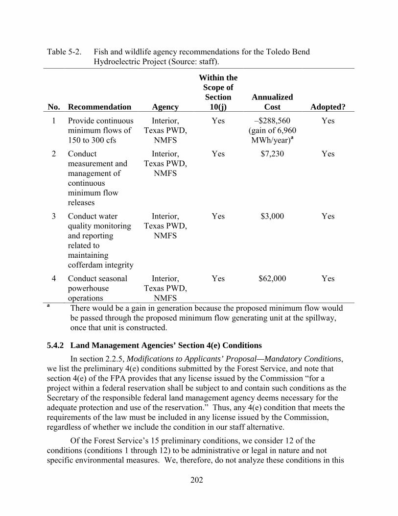
202
Table 5-2. Fish and wildlife agency recommendations for the Toledo Bend Hydroelectric Project (Source: staff).
No. Recommendation Agency
Within the Scope of Section
10(j) Annualized
Cost Adopted? 1 Provide continuous
minimum flows of 150 to 300 cfs
Interior, Texas PWD,
NMFS
Yes –$288,560 (gain of 6,960 MWh/year)a
Yes
2 Conduct measurement and management of continuous minimum flow releases
Interior, Texas PWD,
NMFS
Yes $7,230 Yes
3 Conduct water quality monitoring and reporting related to maintaining cofferdam integrity
Interior, Texas PWD,
NMFS
Yes $3,000 Yes
4 Conduct seasonal powerhouse operations
Interior, Texas PWD,
NMFS
Yes $62,000 Yes
a There would be a gain in generation because the proposed minimum flow would be passed through the proposed minimum flow generating unit at the spillway, once that unit is constructed.
5.4.2 Land Management Agencies’ Section 4(e) Conditions In section 2.2.5, Modifications to Applicants’ Proposal—Mandatory Conditions,
we list the preliminary 4(e) conditions submitted by the Forest Service, and note that section 4(e) of the FPA provides that any license issued by the Commission “for a project within a federal reservation shall be subject to and contain such conditions as the Secretary of the responsible federal land management agency deems necessary for the adequate protection and use of the reservation.” Thus, any 4(e) condition that meets the requirements of the law must be included in any license issued by the Commission, regardless of whether we include the condition in our staff alternative.
Of the Forest Service’s 15 preliminary conditions, we consider 12 of the conditions (conditions 1 through 12) to be administrative or legal in nature and not specific environmental measures. We, therefore, do not analyze these conditions in this
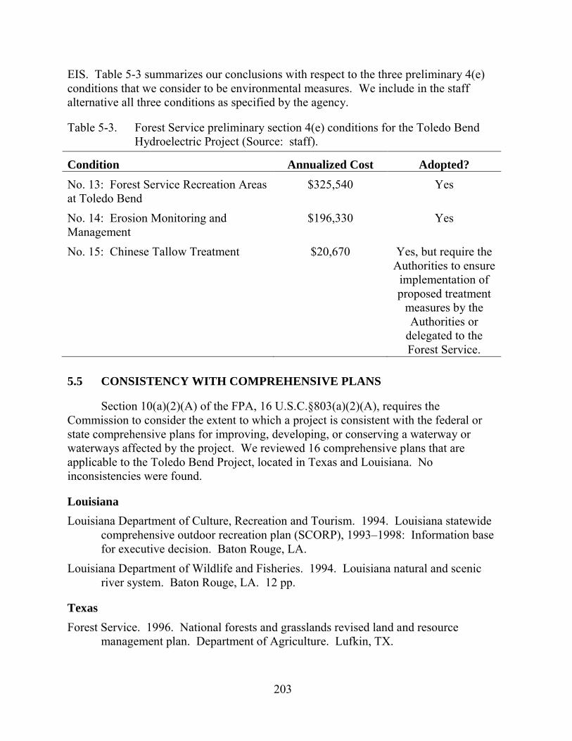
203
EIS. Table 5-3 summarizes our conclusions with respect to the three preliminary 4(e) conditions that we consider to be environmental measures. We include in the staff alternative all three conditions as specified by the agency.
Table 5-3. Forest Service preliminary section 4(e) conditions for the Toledo Bend Hydroelectric Project (Source: staff).
Condition Annualized Cost Adopted? No. 13: Forest Service Recreation Areas at Toledo Bend
$325,540 Yes
No. 14: Erosion Monitoring and Management
$196,330 Yes
No. 15: Chinese Tallow Treatment $20,670 Yes, but require the Authorities to ensure
implementation of proposed treatment
measures by the Authorities or
delegated to the Forest Service.
5.5 CONSISTENCY WITH COMPREHENSIVE PLANS
Section 10(a)(2)(A) of the FPA, 16 U.S.C.§803(a)(2)(A), requires the Commission to consider the extent to which a project is consistent with the federal or state comprehensive plans for improving, developing, or conserving a waterway or waterways affected by the project. We reviewed 16 comprehensive plans that are applicable to the Toledo Bend Project, located in Texas and Louisiana. No inconsistencies were found.
Louisiana Louisiana Department of Culture, Recreation and Tourism. 1994. Louisiana statewide
comprehensive outdoor recreation plan (SCORP), 1993–1998: Information base for executive decision. Baton Rouge, LA.
Louisiana Department of Wildlife and Fisheries. 1994. Louisiana natural and scenic river system. Baton Rouge, LA. 12 pp.
Texas Forest Service. 1996. National forests and grasslands revised land and resource
management plan. Department of Agriculture. Lufkin, TX.
204
Texas Parks and Wildlife Department. 1988. The Texas wetlands plan: Addendum to the 1985 Texas outdoor recreation plan. Austin, TX. May 1988.
Texas Parks and Wildlife Department. 1997. Texas wetlands conservation plan. Texas Wetlands Conservation Program. Austin, TX.
Texas Parks and Wildlife Department. 2010. Texas Outdoor Recreation Plan (SCORP): Assessment and Policy Plan. Austin, TX.
Texas State Soil and Water Conservation Board. 1981. Soil and water conservation: The Texas approach. Temple, TX. August 1981. 288 pp.
Texas Water Development Board. 2007. Water for Texas: Texas state water plan. GP-8-1. November 2007. Three volumes.
U.S. Fish and Wildlife Service. 1985. Land protection plan for Texas/Oklahoma bottomland hardwoods and migratory waterfowl. Department of the Interior, Albuquerque, NM. January 15, 1985.
U.S. Fish and Wildlife Service. 1989. Texas bottomland hardwood initiative: A component of the Lower Mississippi Valley joint venture—North American waterfowl management plan. Department of the Interior, Nacogdoches, TX. October 1989.
Louisiana/Texas Gulf States Marine Fisheries Commission. 2006. The striped bass fishery of the Gulf
of Mexico, United States: A regional management plan. Ocean Springs, MS. March 2006.
National Marine Fisheries Service. 2000. Fishery Management Report No. 36 of the Atlantic States Marine Fisheries Commission: Interstate fishery management plan for American eel (Anguilla rostrata). Prepared by the American eel plan development team. April 2000.
National Park Service. 1993. The nationwide rivers inventory. Department of the Interior. Washington, D.C. January 1982.
U.S. Fish and Wildlife Service. Canadian Wildlife Service. 1986. North American waterfowl management plan. Department of the Interior. Environment Canada. May 1986.
U.S. Fish and Wildlife Service. 1990. Gulf Coast joint venture plan: A component of the North American waterfowl management plan. June 1990.
U.S. Fish and Wildlife Service. Undated. Fisheries USA: The recreational fisheries policy of the U.S. Fish and Wildlife Service. Washington, D.C.
205
6.0 LITERATURE CITED
American Whitewater 2013. Sabine River, Louisiana/Texas webpage. Available at: http://www.americanwhitewater.org/content/River/detail/id/10178/. Accessed January 23, 2013.
APLIC (Avian Power Line Interaction Committee). 2012. Reducing avian collisions with power lines: The state of the art in 2012. Edison Electric Institute and APLIC. Washington, D.C.
APLIC, Edison Electric Institute, and Raptor Research Foundation. 2006. Suggested practices for raptor protection on power lines: The state of the art in 2006. Avian Power Line Interaction Committee, Edison Electric Institute, and the Raptor Research Foundation, Washington, D.C.
Atlantic States Marine Fisheries Commission. 2000. Interstate fishery management plan for American eel. Fishery Management Report No. 36 of the Atlantic States Marine Fisheries Commission.
Authorities (Sabine River Authority of Texas and Sabine River Authority, State of Louisiana). 2012a. Offer of settlement and explanatory statement for relicensing the Toledo Bend Project, FERC No. 2305. Sabine River Authority of Texas and Sabine River Authority, State of Louisiana, Orange, TX. Filed August 1, 2012.
Authorities. 2012b. Toledo Bend Project, Project No. 2305-036, response to request for additional information. Sabine River Authority of Texas and Sabine River Authority, State of Louisiana, Orange, TX. Filed April 9, 2012.
Authorities. 2012c. Toledo Bend Project (FERC No. 2305), historic properties management plan. Sabine River Authority of Texas and Sabine River Authority, State of Louisiana, Orange, TX.
Authorities. 2011a. Toledo Bend Project, FERC No. 2305, final license application. Sabine River Authority of Texas and Sabine River Authority, State of Louisiana, Orange, TX. Filed September 20, 2011.
Authorities. 2011b. Updated study report. Sabine River Authority of Texas and Sabine River Authority, State of Louisiana, Orange, TX. Filed October 31, 2011b.
Authorities. 2011c. Recreation use and needs assessment report. Sabine River Authority of Texas and Sabine River Authority, State of Louisiana, Orange, TX. October 2011.
Authorities. 2011d. Addendum to recreation use and needs assessment report. Sabine River Authority of Texas and Sabine River Authority, State of Louisiana, Orange, TX. October 2011.
206
Authorities. 2010. Operations Model Operations/Verification Report. Sabine River Authority of Texas and Sabine River Authority, State of Louisiana, Orange, TX. October 2010.
Authorities. 2005. Section 4 Standard Operations Procedures. Available at: ftp://ftp.sratx.org/pub/Engineering/Supporting%20Tech%20Info/STI_Section4.pdf. February 28, 2005. Accessed on August 29, 2013.
Carlson R.E. and J. Simpson. 1996. A coordinator’s guide to volunteer lake monitoring methods. North American Lake Management Society. 96 pp.
Cowardin, L.M., V. Carter, F.C. Golet, and E.T. LaRoe. 1979. Classification of wetlands and deepwater habitats of the United States. FWS/OBS-79/31. U.S. Department of the Interior, Fish and Wildlife Service. 131 pp.
EPRI (Electric Power Research Institute). 1997. Turbine entrainment and survival database - field tests. EPRI TR-108630. Prepared by Alden Research Laboratory, Inc., Holden, MA.
FERC (Federal Energy Regulatory Commission). 2003. Final analysis--request to raise the project’s minimum reservoir elevation, Toledo Bend Project, FERC No. 2305-016. Office of Energy Projects. November 2003. 28 pp.
FERC. 2002. Toledo Bend Project, Project No. 2305-016, request for changes to reservoir operations. Federal Energy Regulatory Commission, Washington, DC. December, 2002.
FERC. 1996. Recreation development at licensed hydropower projects. Federal Energy Regulatory Commission, Washington, DC. March 1996.
FERC and Advisory Council on Historic Preservation. 2002. Guidelines for the development of historic properties management plans for FERC hydroelectric projects. Federal Energy Regulatory Commission and Advisory Council on Historic Preservation, Washington, DC. May 20, 2002.
FWS (U.S. Fish and Wildlife Service). Blue sucker (Cycleputs elongatus) web page. Available at: http://ecos.fws.gov/speciesProfile/profile/speciesProfile.action?spcode=E060. Accessed February 27, 2013.
FWS. 2007. National bald eagle management guidelines. May 2007. Available at: http://www.fws.gov/southdakotafieldoffice/NationalBaldEagleManagementGuidelines.pdf. Accessed January 24, 2013.
FWS. 2003. Red-cockaded woodpecker recovery plan. Second revision. U.S. Fish and Wildlife Service, Southeast Region, Atlanta GA. Available: http://ecos.fws.gov/docs/recovery_plan/030320_2.pdf. Accessed February 1, 2013.
207
FWS. 1995. Recovery plan for Louisiana black bear. U.S. Fish and Wildlife Service, Southeast Region, Southeast Region, Atlanta, GA. Available at: http://ecos.fws.gov/docs/recovery_plan/950927.pdf. Accessed February 1, 2013.
FWS. 1993. Recovery plan for Geocarpon minimum. U.S. Fish and Wildlife Service, Southeast Region, Jackson Mississippi. Available: http://ecos.fws.gov/docs/recovery_plan/930726.pdf. Accessed February 1, 2013.
HRA Gray and Pape. 2012a. Management summary: Cultural resources surveys for the Toledo Bend Relicensing Project in Texas.
HRA Gray and Pape. 2012b. Management summary: Cultural resources surveys for the Toledo Bend Relicensing Project in Louisiana.
HRA Gray and Pape. 2012c. Architectural history survey for the Toledo Bend Relicensing Project in Texas and Louisiana.
HRA Gray and Pape. 2010a. Pre-fieldwork report: Cultural resources desktop analyses and GIS modeling for the Toledo Bend Relicensing Project in Texas and Louisiana (as cited by Authorities, 2012)
Louisiana DEQ. 2013, Air Permits, Engineering and Planning web page. Available at: http://www.deq.louisiana.gov/portal/tabid/2619/Default.aspx. Accessed September 16, 2013.
Meyer, R. 2011. Triadica sebifera. In: Fire Effects Information System. Available at: http://www.fs.fed.us/database/feis/. Accessed January 16, 2013. U.S. Department of Agriculture, Forest Service, Rocky Mountain Research Station, Fire Sciences Laboratory (Producer).
NatureService. 2013a. American eel web page. Available at: Available at: http://www.natureserve.org/explorer/servlet/NatureServe?searchName=Anguilla+rostrata. Accessed February 27, 2013.
NatureServe. 2013b. Blue sucker web page. Available at: http://www.natureserve.org/explorer/servlet/NatureServe?searchName=Cycleptus+elongatus. Accessed February 27, 2013.
NERC (North American Electricity Reliability Corporation). 2012. 2012 long-term reliability assessment. North American Electricity Reliability Corporation. Atlanta, GA. November 2012.
NRCS (Natural Resources Conservation Service). 2013. Plant guide: Chinese tallow tree web page. Available at: http://plants.usda.gov/plantguide/pdf/pg_trse6.pdf. Accessed February 20, 2013.
Parker, P.L., and T.K. King. 1998. National Register bulletin 38: Guidelines for documenting and evaluating traditional cultural properties. U.S. Department of the Interior, National Park Service, National Register, History and Education, National Register of Historic Places, Washington, DC.
208
U.S. Drought Monitor. 2013. Drought monitor archives. Available at: http://droughtmonitor.unl.edu/archive.html. Accessed on February 20, 2013. National Drought Mitigation Center, Lincoln, NE.
U.S. Energy Administration. 2012. Annual energy outlook. Release date December 5, 2012. Available at: http://www.eia.gov/forecasts/aeo/index.cfm. Accessed January 29, 2013.
USGS (U.S. Geological Survey). 2013. USGS surface-water for Texas webpage. Available at: http://waterdata.usgs.gov/tx/nwis/rt. Accessed January 23, 2013. U.S. Geological Survey, Reston, VA.
USGS. 2013a. USGS surface-water for Texas webpage. Available at: http://waterdata.usgs.gov/tx/nwis/rt. Accessed August 22, 2013. U.S. Geological Survey, Reston, VA.
209
7.0 LIST OF PREPARERS
Federal Energy Regulatory Commission Alan Mitchnick—Project Coordination, Terrestrial Resources, Threatened and
Endangered Species (Senior Technical Expert; M.S., Wildlife and Fisheries Sciences; B.S., Biological Sciences and Environmental Studies)
Adam Beeco—Recreation and Land Use Resources, Aesthetics (Outdoor Recreation Planner; Ph.D, M.S., Parks, Recreation, and Tourism Management; B.A., Psychology)
Joseph Hassell—Need for Power and Developmental Analysis, Geology and Soils, Water Resources, Water Quality (Environmental Engineer; M.S., B.S. Agricultural Engineering)
Kenneth Hogan—Aquatic Resources (Fishery Biologist; B.S., Fisheries Management and Aquaculture)
Carolyn Templeton—Geology and Soil Resources, Recreation and Land Use/Aesthetics, Cultural Resources (Environmental Biologist; M.S., GeoEnvironmental Science; B.S., Biology)
Frank Winchell—Cultural Resources (Archeologist; Ph.D, M.A., B.A., Anthropology)
Louis Berger Group Peter Foote—Task Management, Aquatic Resources (Senior Fisheries Biologist; M.S.,
Fisheries Biology; B.S., Wildlife Biology) John Hart—Water Resources (Hydrologist; B.A., Physics) Bernward Hay—Geology and Soil Resources (Principal Environmental Scientist; Ph.D.,
Oceanography (Marine Geology); M.S., Geological Sciences and Remote Sensing)
Douglas Hjorth—Aquatic Resources (Senior Aquatic Ecologist; M.A., Biology; B.S., Fisheries Biology)
Kenneth Hodge—Need for Power and Developmental Analysis (Senior Engineer; B.S., Civil Engineering)
Coreen Johnson—Editorial Review (Technical Editor; B.A., English/Education) Alison Macdougall—Cultural Resources (Senior Environmental Manager; B.A.,
Anthropology) Leslie Pomaville—Recreation and Land Use Resources, Aesthetics (Scientist; B.S.,
Environmental and Natural Resources) Tyler Rychener—Terrestrial Resources, Threatened and Endangered Species
(Environmental Scientist/GIS; M.S., Plant Biology; B.S., Biology)

210
Jot Splenda— Recreation and Land Use Resources (Environmental Planner; M.E.S.M, Water Resource Management; B.S., Ecology and Evolution)
211
8.0 LIST OF RECIPIENTS
American Whitewater
Kevin Colburn National Stewardship Director American Whitewater 2725 Highland Drive Missoula, Montana 59802
American Whitewater Roman Ryder 1601 S. Whispering Woods Dr. Lake Charles, Louisiana 70605
Belles, Mark Mark Belles 9318 Willard St Rowlett, Texas 75088
Cook Inlet Region, Inc.
Dara Glass, Land Manager Cook Inlet Region, Inc. 2525 C Street Suite 500 Anchorage, Alaska 99503
Environmental Protection Agency Compliance and Enforcement Division 1445 Ross Ave Suite 1200 Dallas, Texas 75202-2750
Federal Energy Regulatory Comm., ARO Regional Engineer 3700 Crestwood Pkwy NW, Suite 950 Duluth, Georgia 30096-7155
Forest Service Director 2405 S. Texas Avenue College Station, Texas 77843-0001
Forest Service
Eng. Staff Southern Region Regional Forester Southern Region 3100 Hascall Rd NW Atlanta, Georgia 30309
General Land Office Director Stephen F. Austin State Office Building Austin, Texas 78701
Geological Survey Director 3079 Energy Coast Environment, Bldg. G Baton Rouge, Louisiana 70803-0001
Hemphill, City of PO Box 788 Hemphill, Texas 75948-0788
Louisiana Dept. of Agriculture & Forest.
Director PO Box 3554 Baton Rouge, Louisiana 70821-3554 East Baton Rouge
Louisiana Dept. of Environmental Quality
Max Forbes Jr. Louisiana Dept. of Environmental Quality 1064 Highland Park Drive Baton Rouge, LA 70808
212
Louisiana Dept. of Environmental Quality
Thomas Griggs Louisiana Dept. of Environmental Quality P. O. Box 4313 Baton Rouge, LA 70821-4313
Louisiana Dept. of Natural Resources
Director PO Box 1628 Baton Rouge, Louisiana 70821-1628 East Baton Rouge
Louisiana Dept. of Transportation & Dev. PO Box 94245 Baton Rouge, Louisiana 70804-9245
Louisiana Dept. of Transportation & Dev.
Mike Aghayan, Chief Louisiana Dept. of Transportation & Dev. PO Box 94245 Baton Rouge, Louisiana 70804-9245
Louisiana. Department of Wildlife and Fisheries
PO Box 98000 Baton Rouge, Louisiana 70898-9000
Louisiana Office of Conservation Director PO Box 94275 Baton Rouge, Louisiana 70804-9275
Louisiana Office of Program Development Director PO Box 44247 Baton Rouge, Louisiana 70804-4247
Louisiana Office of The Attorney Gen. Atty. General PO Box 94095 Baton Rouge, Louisiana 70804-9095
Louisiana Parks & Recreation Commission Director PO Box 44426 Baton Rouge, Louisiana 70804-4426
Louisiana Public Service Commission Suite 1630 PO Box 91154 Baton Rouge, Louisiana 70821-9154
National Marine Fisheries Service
Prescott H Brownell Regional FERC Coordinator National Marine Fisheries Service 219 Fort Johnson Road Charleston, South Carolina 29412
National Marine Fisheries Service
Director Southeast Regional Office 263 13th Ave S Saint Petersburg, Florida 33701-5511
Newton, City of City Hall Newton, Texas 75951
Sabine River Action Coalition
Michelle McFaddin Sabine River Action Coalition PO Box 80721 Austin, Texas 78708-0721

213
Sabine River Authority of Texas
Donnie Henson Ops Manager Sabine River Authority of Texas PO Box 579 Orange, Texas 77631-0579
Sabine River Authority of Texas
Jerry Clark Executive V.P. & General Man. Sabine River Authority of Texas PO Box 579 Orange, Texas 77631-0579
Sabine River Authority, State of Louisiana
James W. Pratt Executive Director Sabine River Authority, State of Louisiana 15091 Texas Hwy Many, Louisiana 71449
Sabine River Authority, State of Louisiana
Mike Rankin, Engineer Sabine River Authority, State of Louisiana 15091 Texas Hwy Many, Louisiana 71449
Sabine River Authority
Melvin T Swoboda Toledo Bend Licensing Manager Sabine River Authority PO Box 579 Orange, Texas 77631-0579
Sabine River Authority
Charles Sensiba, Member Van Ness Feldman, LLP 1050 Thomas Jefferson Street, NW Seventh Floor Washington, DC 20007-3877
Sabine River Authority
Jim D. Washburn Project Administrator Toledo Bend Project RR 1 Box 270 Burkeville, Texas 75932
Sabine River Authority
Gary Bachman Van Ness Feldman, LLP 1050 Thomas Jefferson St. NW Washington, DC 20007-3877
Sabine River Authority of Texas
Butch Choate Operations Manager Sabine River Authority of Texas P. O. Box 579 Orange, Texas 77631
Sabine River Authority of Texas
Ann Galassi ED Manager Sabine River Authority of Texas P. O. Box 579 Orange, Texas 77631

214
Sabine River Authority of Texas
William R. Hughes, Jr. Director of Engineering Services Sabine River Authority of Texas P.O. Box 579 Orange, Texas 77631
Sabine River Authority, State of Louisiana
Carl L. Chance IT Management Consultant Sabine River Authority, State of Louisiana 15091 Texas Hwy Many, Louisiana 71449
Sabine River Authority, State of Louisiana
Kellie Ferguson Sabine River Authority, State of Louisiana 15091 Texas Highway Many, Louisiana 71449
Simmons, Alice Alice Simmons 2892 Trails End Road Evans, Louisiana 70639
Stump, Robert Robert Stump 2315 Dogwood Trail DeRidder, Louisiana 70634-6909
Texas Bureau of Economic Geology Director PO Box X Austin, Texas 78713-8924
Texas Commission on Environmental Quality
Robert Hansen MC150 PO Box 13087 Austin, Texas 78711-3087
Texas Commission on Environmental Quality
Mark Fisher MC150 PO Box 13087 Austin, Texas 78711-3087
Texas Department of Health Director 1100 W 49th St Austin, Texas 78756-3101
Texas Department of Parks & Wildlife PO Box 1685 San Marcos, Texas 78667-1685
Texas Office of the Attorney General Atty. General PO Box 12548 Austin, Texas 78711-2548
Texas Railroad Commission (NGPA) Director PO Box 12967 Austin, Texas 78711-2967
Texas Soil & Water Conservation Board Director PO Box 658 Temple, Texas 76503-0658
Texas Soil Conservation Service 101 S Main St Temple, Texas 76501-7602
215
Texas State Historical Commission PO Box 12276 Austin, Texas 78711-2276
Texas Department of State Health Services Director PO Box 149347 Austin, Texas 78714-9347
Texas Office of the Governor
Governor of Texas Texas Office of the Governor PO Box 12428 Austin, Texas 78711-2428
US Bureau of Indian Affairs PO Box 26567 Albuquerque, New Mexico 87125-6567
US Bureau of Indian Affairs PO Box 368 Anadarko, Texas 73005-0368
US Bureau of Indian Affairs
James T. Kardatzke US Bureau of Indian Affairs 545 Marriott Drive Suite 700 Nashville, Tennessee 37214
US Bureau of Indian Affairs
Bob Dach Hydropower Program Manager US Bureau of Indian Affairs Natural Resources 911 NE 11th Avenue Portland, Oregon 97232
US Bureau of Indian Affairs Solicitor's Office 1849 C Street, NW Washington, DC 20420
U.S. Bureau of Indian Affairs
Director Office of Environmental Policy and Compliance 1001 Indian School Rd NW Albuquerque, New Mexico 87104-2303
US Bureau of Land Management Jackson District Office 411 Briarwood Dr., Suite 404 Jackson, Mississippi 39206-3058
US Bureau of Land Management PO Box 27115 Santa Fe, New Mexico 87502-0115
U.S. Bureau of Land Management
John M Sullivan, RPA U.S. Bureau of Land Management 411 Briarwood Dr. Suite 404 Eastern States Office Jackson, Mississippi 39206-3058
U.S. Bureau of Reclamation PO Box 36900 Billings, Montana 59107-6900
U.S. Bureau of Reclamation
Regional Director U.S. Bureau of Reclamation 125 S State St., Room 6107 Salt Lake City, Utah 84138-1102
216
U.S Coast Guard MSO Morgan City 800 David Dr., Suite 232 Morgan City, LOUISIANA 70380-1351
U.S Coast Guard MSO Port Arthur 2901 Turtle Creek Dr. Port Arthur, Texas 77642
U.S Coast Guard MSO New Orleans 1615 Poydras St. # 77 New Orleans, Louisiana 70112-1254
U.S Coast Guard US Coast Guard 3111 Woodridge Dr. Houston, Texas 77087
U.S. Coast Guard
Commandant MSO New Orleans 200 Hendee St. New Orleans, Louisiana 70114-1402
US Department of the Interior
Regional Environmental Officer US Department of the Interior PO Box 26567 Albuquerque, New Mexico 87125-6567
US Department of the Interior
Gerald Thornton Attorney, Office of the Field U.S. Department of the Interior 530 South Gay Street, Room 308 Knoxville, Tennessee 37902
US Department of the Interior Arturo J. Vale, III 17629 El Camino Real Houston, Texas 77058
US Department of the Interior Seth Bordelon 646 Cajundome Blvd., Suite 400 Lafayette, Louisiana 70506
US Department of the Interior
Jerry W Ziewitz SE Region Conservation Planning 1601 Balboa Avenue Panama City, Florida 32405
U.S. Department of the Interior
Regional Envir. Office U.S. Department of the Interior 1001 Indian School Rd NW, Suite 348 Albuquerque, New Mexico 87104
U.S. Fish and Wildlife Service 17629 El Camino Real, Suite 211 Houston, TX 77058
U.S. Fish and Wildlife Service Division of Ecological Services 2524 S Frontage Rd Vicksburg, Mississippi 39180-5269
U.S. Fish and Wildlife Service Suite 400 646 Cajundome Blvd Lafayette, Louisiana 70506-4290
217
U.S. Fish and Wildlife Service PO Box 1600 Rio Grande, Texas 00745-1600
U.S. Fish and Wildlife Service
Office Director U.S. Fish and Wildlife Service Southwest Regional Office 500 Gold Ave SW, Room 4012 Albuquerque, New Mexico 87102-3118
U.S. Fish and Wildlife Service
Cynthia Bohn U.S. Fish and Wildlife Service Ecological Services 1875 Century Blvd NE, Suite 200 Atlanta, Georgia 30345-3319
U.S. Fish & Wildlife Service Regional Director PO Box 1306 Albuquerque, New Mexico 87102-1306
United States House of Representatives
Honorable Ted Poe US House of Representatives 1605 Longworth House Office Building Washington, DC 20515
United States Senate Honorable John Cornyn United States Senate Washington, DC 20510
United States Senate
Honorable David Vitter United States Senate 516 Hart Senate Office Bldg. Washington, DC 20510
United States Senate Honorable Kay B Hutchison United States Senate Washington, DC 20510
United States Senate Honorable Mary Landrieu United States Senate Washington, DC 20510

218
This page intentionally left blank.
.
APPENDIX A
STAFF RESPONSES TO COMMENTS ON THE DRAFT
ENVIRONMENTAL IMPACT STATEMENT

This page intentionally left blank.
A-1
APPENDIX A
STAFF RESPONSES TO COMMENTS ON THE DRAFT
ENVIRONMENTAL IMPACT STATEMENT
The Commission staff issued its draft environmental impact statement (draft EIS)
for the proposed relicensing of the Toledo Bend Project on June 14, 2013. Staff requested comments on the draft EIS be filed by August 5, 2013. The following entities and individuals filed comments on the draft EIS.
Commenting Entity Date Filed Sabine River Authority, Texas and Sabine River Authority,
Louisiana (Authorities) August 30, 2013 Texas Commission on Environmental Quality (Texas CEQ) August 6, 2013 Katie Daffin August 5, 2013 Mike and Shannon Cates August 5, 2013 Alan Simmons August 5, 2013 Texas Parks and Wildlife Department (Texas PWD) August 5, 2013 U.S. Environmental Protection Agency, Region 6 (EPA) August 5, 2013 U.S. Department of Agriculture, Forest Service, Southern Region and National Forests and Grasslands of Texas (Forest Service) August 5, 2013 Sabine River Authority, Texas and Sabine River Authority, Louisiana August 5, 2013 American Whitewater and Sabine Whitewater Club August 2, 2013 Louisiana Office of State Parks July 31, 201345 National Marine Fisheries Service (NMFS) July 29, 2013 U.S. Department of the Interior (Interior) July 24, 2013 Alice Simmons July 18, 2013 Natural Resources Conservation Service July 3, 2013
45 Comments were made at the public meeting held in Many, Louisiana, on
July 31, 2013.
A-2
Below, we summarize the substance of the comments received, provide responses to those comments, and explain how the text of the draft EIS was modified, as appropriate, to address the comments. Unless otherwise noted, changes addressing editorial comments were made to the final EIS, but are not described below. Comments are divided by resource areas.
GENERAL Comment: The Authorities point out that several of our recommendations are in conflict with critical provisions of the ARA and SNF Relicensing Agreement. They are concerned that these conflicts could upset the ARA and SNF Relicensing Agreement because the parties to the ARA and SNF Relicensing Agreement can terminate their agreements if the new license contains a material modification to any of the settlement measures. In addition, they state that the differences between the recommendations in the draft EIS and the ARA and SNF Relicensing Agreement are generally unnecessary to meet FPA and National Environmental Policy Act requirements and are duplicative or are without support in the record. NMFS and Interior state that, while they do not object to the draft license articles recommended by the Commission in the draft EIS, they do not advocate the additional obligations of the recommended articles. They state that the negotiated terms and conditions as included in the ARA would adequately protect, mitigate any adverse effects to, and enhance fish and wildlife resources. Texas CEQ suggests that, based on the significant amount of effort and resources invested in the ARA, the license for the Toledo Bend Project should include the unmodified terms of the ARA. Texas PWD is concerned that our additional measures might disrupt the ARA and recommends that the new license should be consistent with the ARA.
Response: The final EIS contains our independent analysis of the issues associated with relicensing the Toledo Bend Project. Most of our recommendations are consistent with the relicensing agreements. However, in some cases, we recommend adjustments to the measures proposed by the relicensing agreements for reasons outlined in the EIS to ensure protection of the environmental resources associated with the Sabine River or consistency with Commission’s policies and practices. As discussed below, in many cases we have modified our recommendations in the draft EIS to be more consistent with the ARA and SNF Relicensing Agreements. Comment: EPA recommends that the Authorities prepare a Construction Emissions Mitigation Plan to reduce potential short-term air quality impacts associated with the construction of the proposed low flow powerhouse. EPA’s recommendation includes specific measures to reduce impacts associated with emissions of nitrogen oxides, carbon monoxide, particulate matter, sulfur dioxide, and other pollutants from construction-related activities, such as: fugitive dust controls, mobile and stationary source controls, and administrative controls. Response: We do not believe that a construction Emissions Mitigation Plan is needed given the minimal effects to air quality from the limited construction activities associated
A-3
with the minimum flow turbine. Best management practices would likely be part of the construction plan for the project or required by state permits. We revised section 3.3.7.2, Aesthetics, to address this issue. Comment: EPA notes that the draft EIS neither assesses the socioeconomics and environmental justice aspects of the proposed project, nor its potential impacts. Response: Environmental justice as defined by Executive Order 12898, Environmental Justice for Low Income and Minority Populations (1994) applies to the agencies specified in section 1-102 of that Order, and the Commission is not one of the specified agencies. Consequently, the provisions of Executive Order 12898 are not binding on the Commission. However, it is current Commission practice to address environmental justice in its NEPA document when there is sufficient information in the record indicating that it is necessary to do so. There is no information in the record and EPA failed to introduce any new information to support the premise that an environmental justice or socioeconomics analysis is relevant in the relicensing of this project. Further, environmental justice and socioeconomic issues were not identified during the scoping process or comment period. To highlight this, we have revised section 3.3 to include environmental justice to the list of topics lacking substantive issues and therefore not assessed in this final EIS. Comment: Texas CEQ and Texas PWD state that the renewed license should be issued for a 50-year term. Response: The appropriate term of a new license would be evaluated and finalized in any license order issued for the project.
GEOLOGY AND SOIL RESOURCES Comment: The Authorities comment that, because construction of the proposed minimum flow generating unit would occur completely within the state of Louisiana, it is neither necessary nor appropriate for draft article 402, Erosion and Sediment Control Plan for Project Construction, to include a consultation requirement with Texas state resource agencies. Response: Draft license article 402 of the final EIS has been revised to make this correction. Comment: The Authorities comment that our recommendation to develop an erosion monitoring plan for Conservation and Public Access lands outside the SNF is based on the unfounded premise that there are areas of “active erosion” at the project. The Authorities state there is no evidence in the record that there is active erosion at the project. Nevertheless, the Authorities have a number of recommendations to correct inaccuracies and make the monitoring protocol consistent with its proposed SNF Erosion Monitoring Plan. The Authorities recommend the following revisions: (1) consistently refer to the plan as “erosion monitoring plan,” not “program”; (2) delete “actively eroding locations”; (3) eliminate as a criterion for determining the need for site-specific
A-4
management plans “the potential loss of communities of Forest Service sensitive flora or populations of Forest Service sensitive fauna”; (4) clarify that effects to project-sponsored public recreation facilities and not private facilities is a proper criteria for determining the need for site-specific management plans; and (5) include a regulatory deadline for preparing and filing the plan for Commission approval. Response: We have modified the title of the erosion monitoring plan to be consistent with the Authorities’ recommendation. We have removed the reference to actively eroding locations because we agree with the Authorities that the primary goal of the plan is to identify if shorelines are actively eroding. We have eliminated the reference to the potential criteria for determining the need for the development of site-specific management plans to those areas with the potential loss of Forest Service Sensitive flora or fauna as such a designation is not applicable to the lands outside of the SNF. We clarify that the proper criteria for the development of site-specific management plans are threats by erosion to project-sponsored public recreation facilities. Finally, we propose a deadline of 1 year from the effective date of the license for the filing of a plan for Commission approval. These changes and modifications have been made in section 3.3.1.2 of the final EIS and in draft license article 403.
AQUATIC RESOURCES Comment: Katie Daffin, Mike and Shannon Cates, Alan Simmons, and Alice Simmons state that the draft EIS does not include detailed analysis of the operation of Toledo Bend Project during flood events. They state that operations of the dam during flooding events have been poorly managed and have resulted in increased flooding levels downstream along the lower Sabine River. Response: We have added additional information and analysis to the final EIS in section 3.3.2.2, Aquatic Resources, Environmental Effects, Water Quantity, on the historical effects of the Toledo Bend Project during recent flooding events. Our analyses show that, while the project is not operated as a flood control project, available reservoir storage and flow regulation have reduced the peak flow rate from the dam and in turn downstream flood levels during some flood events, as compared to what would have occurred without the presence of the project. Comment: Mrs. Simmons states that she has lived downstream of the project along the Sabine River for many years. She requests that the Authorities adopt a policy of pre-release from the reservoir when high rainfall events occur above the dam, but states that the Authorities have indicated that they do not operate the dam as a flood control dam. She also believes that negligent project operations by the Authorities have resulted in the loss of life, including her son and grandson. Response: We have included additional information and analyses in the final EIS in section 3.3.2.2, Aquatic Resources, Environmental Effects, Water Quantity, on the historical effects of the Toledo Bend Project during flooding events, and the potential effects of pre-release operations when a flood event is predicted or when high rainfall
A-5
occurs in the upper part of the watershed. These analyses show that, while pre-release can be beneficial in some situations, there are also problems with pre-releases depending on the track and timing of the rainfall and if the forecasted rainfall actually occurs. If the reservoir is lowered and the predicted rainfall does not occur, water supply operations (the primary purpose of the project) could be adversely affected. In addition, in some circumstances, pre-release operations could add to the flood levels in the lower Sabine River, because of the slow travel times for flood waters (several days), particularly if large amounts of rainfall occurs downstream of the dam. Comment: Alan Simmons commented that, although the Authorities have stated that the Toledo Bend Project is not a flood control reservoir, they have operated the project to hold back the flood inflow in the reservoir. He further commented that when the Authorities then release water from the reservoir, it is done in astronomical amounts to save the dam from structural failure, without worrying about downstream private property damage or fatalities. Response: Toledo Bend dam is designed to withstand a probable maximum flood event that would create a release rate of 338,000 cfs without structural failure of the dam. This release rate is almost three times larger than the maximum flood event that has occurred since the construction of the dam (117,000 cfs in January 1999, as reported at USGS gage no 08025360 Sabine River at Toledo Bend). As described in the final EIS in section 3.3.2.2, Aquatic Resources, Environmental Effects, Water Quantity, the Authorities have implemented a range of notifications and other measures for downstream property owners and residents to alert them when releases from the dam are likely to approach or exceed flood levels. Comment: Mike and Shannon Cates, who live near the river below the dam in Evans, Louisiana, state that the Authorities have done a poor job in managing the Toledo Bend Project’s water levels and flow releases. They state that the license should not be renewed and instead the governing board should consist of 60 percent local residents that live on the lake and the river, and 40 percent the hydroelectric business owner. In addition, they state that yearly renewals of the license should be made and be based on the reviews submitted by persons affected by the generation or lack thereof, businesses counting on revenue generated by the lake level, and the amount of revenue provided by generation, compared to how much water was lost when large amounts of water has to be released. In general they recommend the following:
• Do not hold an enormous amount of water “anticipating” the generation for profit when you see weather patterns that look ominous (slow reactions by the governing body decision makers keep our community “held hostage” waiting for the worst);
• Maintain a steady lake level of 165-167 feet above mean sea level (msl) during the “rainy” season by releasing small amounts of water instead of holding and releasing large amounts at once; and
• Minimize generation (just enough to keep a positive flow) in times of drought so not to dry dock all lake inhabitants.
A-6
Response: In regard to reservoir operations, in particular pre-releases, as discussed in the final EIS in section 3.3.2.2 Aquatic Resources, Environmental Effects, Water Quantity, it would take about 6 days to lower the reservoir by 1 foot when the dam is releasing 16,000 cfs (the maximum powerhouse discharge rate) without any inflow to the reservoir. This is the key factor in limiting the viability of pre-release procedures, especially when combined with the difficulties in accurately predicting rainfall amounts days in advance over the Sabine River Basin. Maintaining a lake level in the 165- to 167-foot msl range would affect the primary purpose of the project, which is water supply, and limit recreational opportunities; it may also conflict with existing water level management agreements. As described in the draft and final EIS and as occurred during the recent drought, the Authorities substantially decrease or stop generation during droughts to ensure that the reservoir level is maintained and water is available for water supply purposes. Comment: Texas PWD, NMFS, and Interior state that they disagree with the modification of the agency comment timelines outlined in the draft EIS, which are different from the ARA, including the following:
• Article 405, Flow Release Plan, reduces the time to comment on the plan from 90 to 30 days;
• Article 406, Cofferdam Restoration Plan, reduces the time to comment from 45 to 30 days; and
• Article 407, Weekend Operations Plan, reduces the time to comment from 45 to 30 days.
Texas PWD, NMFS, and Interior state that the review timelines in the ARA were developed after carefully considering the technical evaluation necessary for meaningful comments on the proposed plans. Interior adds that the longer comment periods are necessary to accommodate the coordination of comments and recommendations among the six federal and state resource agency parties to the ARA, and the inclusion of American Whitewater and Sabine Whitewater Club as commenting entities. Response: We are in agreement with the comment review timelines in the ARA and have revised the timelines in the draft license articles in the final EIS accordingly. Comment: NMFS and Interior made general comments that the appendix A, Draft License Articles, should include the cofferdam profile figure referenced in the text on page 88 of the draft EIS (figure 3-19) and the study plan, Flow Testing to Optimize Weekend Operations Benefits, as appendices to the license articles as a convenience to readers. Response: Figures and appendices are not typically included in the list of license conditions, but license orders will contain figures and appendices, as appropriate. Comment: NMFS and Interior stated that our separation of the first bulleted paragraph under the All Years section of the fishway prescription in Appendix B of the draft EIS, into two bulleted sections appears to be in error, and the paragraph should be contiguous.
A-7
Response: We have made this correction in the final EIS. Comment: NMFS and Interior both commented on section 3.3.2, Aquatic Resources, on page 94 concerning American eel passage. They agree that the dam is a blockage to upstream migration of eel. However, they contend the electrofishing catch per unit effort of American eel downstream from the project does not support the Commission’s characterization that the applicant collected “small numbers of American eel” because the electrofishing catch rates at Toledo Bend were comparable to some dams along the South Atlantic coast. Response: The final EIS, section 3.3.2 Aquatic Resources, has been revised to reflect this comment. Comment: NMFS and Interior both commented on section 3.3.2, Aquatic Resources, on page 96 concerning American eel downstream passage. They note that survival rate of adult eels migrating downstream from the reservoir to the lower Sabine River would likely exceed the Commission’s predictions because turbine operation occurs primarily during the day and eels migrate downstream primarily at night. Response: The final EIS, section 3.3.2 Aquatic Resources, has been revised to reflect this comment. Comment: The Authorities state that the wording of draft license article 404, based on the ARA proposed license article A-1, to implement new continuous flow releases at the spillway has been modified. The Authorities state that the proposed license article was modified by deleting a critical sentence that would remove the Authorities’ discretion to provide releases at the spillway at rates greater than the rates specified in the Article 404 schedule, resulting in a material modification of the ARA. The Authorities state that the continuous flow releases are not minimum flow releases as described in the draft EIS. Instead the Authorities state that the ARA allows for minor fluctuations in downstream flow releases from the targeted continuous release flows. The Authorities explain that because the settling parties agreed to these acceptable tolerances, the parties felt it necessary to expressly provide that higher flows attributable to storm events that passed through the spillway would not constitute a violation of the continuous flow release requirement and recommend adding the following two sentences to Article 404:
• “The Licensees are not required to provide releases at the spillway greater than 144 cfs, but may do so at their discretion.”
• “The Licensees are not required to provide releases at the spillway greater than the applicable continuous flow release value in the table above, but may provide greater releases at the spillway at their discretion.”
Response: We agree that the targeted releases from the spillway should have allowable tolerances and find that the tolerances defined by the settlement agreement reasonable. We have changed the wording of the draft license article in the final EIS as suggested by the Authorities. This ensures that the tolerances inadvertently exceeded by storm events or for other reasons do not constitute a violation of the license. We have also changed the
A-8
name of the releases in article 404 to “Continuous Flow Releases from the Spillway” to be consistent with the Settlement Agreement. Comment: The Authorities note that they have no objection to providing the continuous flow release and lake elevation data to the public as described in the draft EIS license article 405, Measurement and Management of Continuous Releases from Spillway. They state that providing this information instantaneously as recommended is not realistic and suggest changing to “near real time” that would be consistent with USGS standards. Response: The final EIS and draft license article 405 have been revised to replace “instantaneous” with “near real time.” Comment: The Authorities object to our recommendation to conduct direct monitoring of the elevation of the forebay cofferdam by bathymetric survey at 10-year intervals. The Authorities argue that this addition would increase new license implementation costs and obligations without any corresponding protection of water quality downstream of the project. The Authorities argue that temperature monitoring is an appropriate surrogate for dissolved oxygen (DO) concentrations because the remnants of the earthen cofferdam ensure that water entering the powerhouse intake is dominated by warmer, well-oxygenated surface waters, and monitoring the actual submerged earthen structure is unnecessary. The Authorities recognize that we may find sufficient evidence to require periodic cofferdam survey as recommended in the draft EIS; however, the Authorities recommend any such monitoring should be infrequent such as every 15 to 20 years during the license term. Response: The Offer of Settlement states on page A-3 that a DO measurement is to be taken “if the mean daily temperature of at least 10 percent of the monitored days in July, August, and September, during which the Project is generating under normal conditions, is below 20 degrees Celsius.” Aside from the justification presented in the draft EIS (page 89), available data do not support the use of a temperature threshold of 20 degrees C (ºC) as a surrogate for DO concentrations as the relationship between these two parameters is dubious, at best. Water temperatures and DO were monitored by the Authorities at tailrace station RM 141 TM1 (proposed to be used as the station for continuous temperature monitoring, relabeled as RM 141 TM) during the summers of 2009, 2010, and 2011. In 2009, temperature was monitored for 4 weeks and DO for 1 week. In 2010, temperature was monitored for 3 weeks and DO throughout the summer. In 2011, both parameters were monitored over the entire summer. Overall, measured temperatures during the summer months were relatively warm, ranging from approximately 24 to 32ºC, well above the 20ºC threshold. However, during the same time period, there were several occurrences when DO concentrations were less than 5 mg/l at station RM 141 TR1. In 2011, temperature and DO measurements were actually inversely related on a monthly basis. Specifically, temperatures in August 2011 (ranging from 30 to 32ºC) were at their peak for the summer, while DO concentrations were at their lowest, with concentrations of less than 5 mg/L recorded on several occasions.
A-9
In addition, adequate information to evaluate the potential for erosion of the cofferdam is not available. Erosion rates are a function of grain size and flow velocity; rates are highest at peak flow velocities. Erosion, if it were to occur, might be higher in the deep opening of the cofferdam where the core material of the cofferdam is exposed. The opening is of greater significance; if it deepens or widens, more oxygen-poor hypolimnetic water would be drawn into the turbines during the summer. Therefore, we continue to recommend regular monitoring of the elevation of the cofferdam the appropriate approach. However, a change in monitoring frequency from 10 years to 15 years (i.e., two to three surveys over the license period depending on the license term) would be adequate to determine if the cofferdam is eroding. We revised section 3.3.2 in the final EIS accordingly. Comment: The Authorities disagree with the draft license article 407, Seasonal Powerhouse Operations, which includes changes to the ARA proposed license article A-4. These additions would change the timing of the obligation to reduce normal maximum powerhouse peaking flows to 12,000 cfs to commence upon license issuance, and change the timing of implementation of the weekend operations plan, to within 18 months of license issuance. The Authorities state that they strongly oppose this change because the proposed ARA license article was drafted to ensure that the Authorities can comply with their current obligations under the existing and valid contract governing power production that expires in 2018. Response: We recognize the Authorities’ concerns regarding its obligations under its existing power sales contract. Given that downstream fish populations are healthy, delaying these modest habitat enhancement measures for as long as 4 years would have limited long-term effects on downstream fish populations. We also recognize that the delay is supported by the resource agencies. Therefore, we now recommend that the Authorities implement their proposed seasonal powerhouse operations no later than the scheduled power sales agreement (PSA) expiration date of April 30, 2018. We have revised the text of the final EIS and draft license article 407 to require the maximum 12,000 cfs spring peaking flows to commence upon the earlier of the scheduled April, 30, 2018 expiration of the PSA or of the effective date of any new PSA. Comment: The Authorities state that there are many areas in the draft EIS that should be changed to clearly state that the project’s primary purpose is water supply, and hydropower operations and recreation are secondary purposes. Response: While the designation of water supply as the primary purpose of the project was stated in many areas in the draft EIS, we have added additional clarification to the final EIS. Comment: The Authorities disagree with draft license article 408, Reservoir Levels, that would require the Authorities to operate the project reservoir within a normal operating range of elevation 168 to 172 feet msl. The Authorities state that they are very concerned that Article 408 could impose significant and far-reaching operational changes at the
A-10
project well beyond the scope of what any party has advocated or recommended during the relicensing process. They are also very concerned that a broad interpretation of the language “operate the project” could undermine the primary purpose of the project (water supply), and inadvertently and inappropriately elevate recreational and aesthetic values above the primary purpose of water supply, for which the States of Louisiana and Texas jointly funded and built the project. The Authorities state that they could agree to a license article that establishes a normal reservoir level range for hydroelectric power production purposes, but would need the ability to lower the reservoir below elevation 168 feet msl to meet downstream water releases for water supply purposes. However, the Authorities state that, if the Commission decides to include a license requirement addressing reservoir operations, the article should be revised to:
• preserve the primary project purpose of water supply; • establish a power pool that applies only to hydroelectric power production; and • recognize the specific instances in which the Authorities are authorized to operate
for hydroelectric power production outside the established power pool (some of which are contractual under the current PSA).
The Authorities provide suggested detailed wording revisions to the draft license article. Response: We agree that the Authorities should be allowed the flexibility to make hydropower when the reservoir water surface is below 168 feet msl under certain circumstances. We recommend these exceptions because these conditions generally allow the production of hydropower as an ancillary benefit from necessary releases thereby enhancing the overall benefits of the project. We have modified draft article 408 to allow the authorities to produce hydropower outside the normal operating range;
• due to storm or high water events;
• due to reservoir drawdown necessary for inspection of public works or maintenance;
• to allow the production of hydropower from the minimum flow releases, which is the intended release method after the construction of the minimum flow unit; and
• when necessary to meet water supply obligations to customers located downstream of the project that obtain water via releases from the project to the Sabine River.
Without additional information on potential effects to reservoir levels, however, we have not included in draft article 408 authorization to generate outside the normal operating range when hydroelectric power production is below 168 feet msl to avoid an insufficient supply of firm or non-interruptible power to the licensees’ wholesale customers or in the event the licensees fail to make all credits or reimbursements owed under the power sales agreement.
A-11
TERRESTRIAL RESOURCES Comment: EPA suggests the final EIS should include additional discussion of the impacts of the proposed 1.8-mile-long transmission line and should include a description and map of the line’s location and potential impacts to vegetation; waters of the United States, including wetlands; and any other resource category that may be affected. Response: The map in Figure 2-1 of the final EIS has been revised to include the proposed transmission line. Potential resource impacts of the proposed transmission line are discussed in the EIS (sections 3.3.3.2 and 3.3.7.2) and include our recommended mitigation measures. Comment: The Authorities object to the our recommendation of adding new Chinese tallow measures to the Shoreline Management Plan (SMP) outside of the parameters of the SNF Agreement and draft article 409. The Authorities refute text in the draft EIS that controlling Chinese tallow on project lands “would help protect wildlife habitat” claiming there is no record evidence to suggest that Chinese tallow within the project boundary is adversely affecting wildlife habitat; therefore, our recommendation bears no nexus to the project. Response: We continue to find that our recommendation to control Chinese tallow outside the SNF has a nexus to the project as a result of the reservoir’s contribution to the spread of tallow seeds and the potential spread of Chinese tallow as a result of ground-disturbing activities. However, we recognize that many of the shoreline areas classified as Conservation can be remote and difficult to reach, the occurrence of Chinese tallow in these locations may be unknown, and no potential conflicts with rare species or important habitats have been identified. Then again, the future expansion of this rapidly spreading invasive species during the next 30- to 50-year license term could compete with native species. After consideration of the Authorities’ recommendation, we revised the EIS to recommend measures limiting the spread of this species in the event that the Authorities engage in ground-disturbing activities on Conservation and Public Access classification areas or as part of routine maintenance of project recreation areas. Comment: The Authorities object to our conclusion that the Authorities should be responsible for implementing the Chinese tallow treatment measures on the SNF lands as described in the draft EIS in license article 409, Chinese Tallow. The Authorities believe the addition of this article is unnecessary and a material modification of the SNF Relicensing Agreement. The Authorities indicate that the actual treatments on lands administered by the Forest Service should be a Forest Service responsibility and by Forest Service personnel, and that a funding obligation by the Authorities was the most appropriate way to implement this proposal. The Forest Service believes that Forest Service 4(e) condition 15, Treatment of Chinese Tallow, would be sufficient to protect Forest Service lands. Response: The Commission can only regulate entities within its jurisdiction (such as licensees) and has no jurisdiction over the Forest Service, which is the agency that would
A-12
ultimately decide where and how the funds are implemented. In addition, the Commission cannot delegate its regulatory authority over licensees to another agency. It is between the Authorities and Forest Service how to implement the measure, which can include funding as provided in Forest Service 4(e) condition 15; however, the ultimate responsibility for implementing the measure rests with the Authorities. Providing funding without any assurance that a measure would be implemented or that the measure relates to project impacts or project purposes, along with specifying cost caps, is inconsistent with the Commission’s settlement policy (Policy Statement on Hydropower Licensing Settlement, September 21, 2006, Docket No. PL06-5-000). Staff does not believe that it is unreasonable to require the Authorities to ensure that the intent of the condition is met. We expect the $20,000 allocated would provide sufficient treatment of Chinese tallow. Therefore, we continue to recommend that the Authorities file an annual summary report outlining the amount and general location of treatments performed by the Authorities or delegated to the Forest Service to ensure the funding addresses Chinese tallow as proposed. We recognize that the Authorities would have to acquire authorization from the Forest Service prior to implementing treatment measures on Forest Service lands. Comment: The Authorities note that draft article 410, Bird Friendly Transmission Lines Plan, should clarify the measure only applies to the primary transmission line at the project associated with the construction of the proposed minimum flow generating unit. The Authorities also note that, because it is not yet certain whether the primary transmission line would be located solely within Louisiana or cross into Texas, the article should not include an absolute requirement to consult with Texas PWD. Response: We revised section 3.3.3.2, section 5.2, and draft license article 410 to clarify that raptor protection measures would only be required for any new primary (jurisdictional) transmission lines associated with construction of the proposed minimum flow generating unit and that consultation would only be required with the state fish and wildlife agency for the state the line may cross.
RECREATION AND LAND USE RESOURCES Comment: The Authorities object to the recommendation to consult with American Whitewater and the Sabine Whitewater Club regarding the timing of the proposed weekend powerhouse releases included as draft EIS license Article 407, Seasonal Powerhouse Operations. The Authorities state the purpose of the weekend releases is not to promote whitewater recreation at the project or project-sponsored recreation in the tailrace. Response: Proposed weekend operations in March through June were developed to enhance the downstream fishery; however, the timing (on weekends) and the proposed operation ranges (4,000 to 7,000 cfs) would provide secondary benefits to the whitewater boaters who use the tailrace. Whitewater boating within the region is limited We concluded that the operation range would be within the preferred boating range for the
A-13
tailrace and during a period (i.e., weekends) when more boaters would likely be available would be a direct benefit to this resource. Although this was not the intention of the measure, there is an opportunity to ensure the timing of the releases is consistent with boater preferences and still be consistent with the intent of the measure. As such, we recommend consulting both American Whitewater and the Sabine Whitewater Club and affording them an opportunity to maximize any secondary benefits (i.e., recreation) of this measure. Comment: The Authorities note that our recommended license article 412, Revised Recreation Management Plan, would significantly revise and expand the Recreation Management Plan filed by the Authorities on March 6, 2012. Specifically, the Authorities object to the recommendation that all 29 identified recreation facilities, including the SNF recreation facilities, become project-sponsored recreation facilities for which the Authorities must schedule and undertake improvements, and for which the Authorities would become ultimately responsible under the new license for all construction, management, and maintenance. Response: We did not intend for the Authorities to include all 29 identified recreation facilities within the project boundary as project-sponsored recreation sites, nor make the Authorities responsible for all improvements, construction, management, and maintenance for those sites. Sections 2.1.4, 3.3.5, 5.2 and draft license article 412 have been revised in the final EIS to clarify that all 29 identified sites should be described and included as an inventory of available public recreation access and opportunities at the project in the final Recreation Management Plan to provide context for the sites that are operated and maintained by the Authorities. The management and any improvements or construction at non-Authority owned and operated sites would remain the responsibilities of the entities that own and operate those sites. Including all the sites in the Recreation Management Plan would provide a comprehensive report of recreation facilities available to the public at Toledo Bend reservoir. Comment: The Louisiana Office of State Parks recommends that Toledo Bend State Park and South Toledo Bend State Park, which sit on the reservoir, not be included within the project boundary because they were not previously included within the boundary and already are regulated by both state and federal agencies. It believes that another layer of regulation is unnecessary. Response: We did not intend for the Authorities to place the two state parks within the project boundary. We have revised the text in section 3.3.5.2 and draft license article 412 to clarify that these sites should be included in the Recreation Management Plan as an inventory of available public recreation access and opportunities. Comment: The Authorities note that the tailrace should be excluded from the Recreation Management Plan and object to it as a project-sponsored recreation site, citing safety concerns associated with promoting whitewater boating during the peaking operations of the powerhouse.
A-14
Response: Pursuant to the Commission’s regulations, licensees must develop suitable public recreational facilities upon project lands and waters and make provisions for adequate public access to such project facilities and waters (18 C.F.R. §2.7(b), 2013). The Commission has recognized that “[a]ll whitewater boating poses some risk, including the risk that rescue may be required. The fact that there may be risk involved with whitewater boating or other recreational activities does not obviate a licensee’s responsibility to provide recreational opportunities in accordance with area needs.”46 Our analysis of recreation at the project found the tailrace to be a valuable and viable whitewater recreation opportunity in an area with limited whitewater recreation opportunities. Failure to include the tailrace in the Recreation Management Plan could lead to long-term neglect of this area over the course of a future license. Including the tailrace in the final Recreation Management Plan would also be consistent with the uses anticipated from the proposed seasonal, weekend operations and formally recognize it as an area used for recreation purposes, developed or not, with a direct nexus to the project. Inclusion in the plan would ensure the site receives routine monitoring and maintenance. With regard to whitewater boating, the Commission has held that “[w]hen there are safety and liability concerns, it is appropriate to move with caution in order to determine whether whitewater boating releases should be included as part of the license.”47 The primary access point and primary whitewater play spot within the tailrace is approximately 900 feet downstream from the powerhouse and downstream of a danger warning sign that stretches across the river. Our analysis suggests that the class II-III rapids within the tailrace do not promote an inordinately dangerous whitewater boating opportunity. Extensive use of the tailrace area for whitewater boating and downriver recreation already occurs, and no releases are required beyond the current operation and proposed ARA; therefore, excluding the tailrace access area from the recreation plan would not fulfill the Authorities’ responsibility to provide reasonable recreational access at the project. Comment: Similar to public access in the tailrace, the Authorities object to including the spillway channel dispersed recreation site in the Recreation Management Plan; however, they do agree with the recommendation to develop an access plan that identifies the condition of the spillway channel access site, clarify the threshold at which the site must be closed, and provide a protocol for notifying anyone present in the spillway channel before releases occur, to ensure public safety. To highlight their concerns, the Authorities provide details on the spill procedures and triggers for opening gates. The Authorities note that they restrict access to the channel before opening the gates under operating guide Step 1: which includes opening five gates to a setting of 1 foot (about
46 Public Utility District No. 1 of Chelan County, Washington, 119 FERC ¶ 61,055, at P 10 (2007).
47 Public Utility District No. 1 of Chelan County, Washington, 119 FERC ¶ 61,055, at P 9 (2007).
A-15
5,000 cfs) – higher than the our estimated upper limit for preferred boating flows. As the lake level rises, additional measures are taken. For example, Step 2 includes opening all 11 gates to one foot which results in about an 11,000-cfs discharge. Additional steps dictate the number of feet all of the gates are opened. Response: Our existing discussion, with some corrections and updates, adequately describes the recreation resources available and used within the spillway channel. Similar to the tailrace, recreation is occurring at this location and it should be monitored and managed. Development of an access plan as part of the revised Recreation Management Plan is the appropriate process to address the availability of the site for public enjoyment. The draft EIS incorrectly assumed that there was broader discretion within the protocols of opening the gates to pass spill during floods. Because the existing protocols dictate that spills start at 5,000 cfs, section 3.5.2 and draft license article 412 in the final EIS have been revised to require the Authorities to clarify the conditions under which access is permitted and at what levels it would be appropriate to close the site to recreational uses. Comment: The Authorities object to our recommendation in draft license article 412 to provide a schedule for updating the Recreation Management Plan every 12 years, stating that a new Recreation Management Plan should only be submitted if updates are warranted. Response: As proposed in the Recreation Management Plan, the Authorities would collect and compile annual use estimates; submit data, trends, and proposed recreation changes in a report to be filed in conjunction with the Commission’s Form 80 filings every 6 years. The Authorities would also develop and file a Recreation and Monitoring Report after consultation the Louisiana Department of Culture, Recreation and Tourism, Louisiana Department of Wildlife and Fish, Texas PWD, National Park Service, and FWS every 12 years to determine if existing recreation facilities and opportunities are adequate to meet user preferences and demand. However, the proposed Recreation Management Plan did not have a timetable to file updates. We concluded that updating the recreation management plan during this 12-year review cycle would be appropriate because having a current up-to-date plan on file is important to ensure the recreation resources are adequate to meet the public need. Updates to the plan, if necessary, would be based on the findings from the data and monitoring. Section 3.5.2 in the final EIS has been revised to clarify the combination of surveys and use data that would be used in updating the plan.
CULTURAL RESOURCES Comment: EPA notes that the draft EIS does not indicate that FERC engaged in government-to-government consultation with Tribes (EO 13175) nor does the draft EIS refer to any agency consultation policy or guidance that would guide the consultation process with Tribes. EPA recommends consultation with Tribes concerning the potential effects of the project; include the correspondence to demonstrate fulfillment of Tribal

A-16
consultation duties; and reference consultation policies and guidance used by FERC in the final EIS. Response: We modified Section 3.3.6.1 of the draft EIS to outline our efforts to consult with the Caddo Nation of Oklahoma, Alabama-Coushatta Tribe of Texas, the Coushatta Tribe of Louisiana, and the Choctaw Nation. Further, as described in section 1.3.5, National Historic Preservation Act, these tribes were invited to sign the PA as concurring parties.

APPENDIX B
DRAFT LICENSE ARTICLES

This page intentionally left blank.

B-1
APPENDIX B
DRAFT LICENSE ARTICLES
Article 401. Commission Approval, Notification, and Consultation Requirements.
(a) Requirement to File Plans for Commission Approval
One of the Forest Service 4(e) conditions requires the licensees to prepare plans for approval by the Forest Service for implementation of specific measures, in the event that shoreline erosion within the Sabine National Forest (SNF) attributable to project operations is causing, or, during the new license term, will cause any adverse resource effects, but does not require prior Commission approval. Each such plan, if required under the Forest Service condition, shall also be filed with the Commission for approval. These plans are listed below.
Forest Service condition no.
Plan name Due date
14 Site specific erosion management and mitigation plans
10 years after license issuance, if the licensees, in consultation with the
Forest Service, determine that shoreline erosion within the SNF
attributable to project operations is causing, or, during the new license
term, will cause any adverse resource effects
(b) Requirement to Consult with Forest Service
One of the Forest Service 4(e) conditions requires the licensees to consult with the Forest Service for several programs. These consultation meetings document compliance with requirements of this license and may have a bearing on future actions. Each meeting shall be memorialized in a summary report and be filed with the Commission. These consultation meetings are listed in the following table.
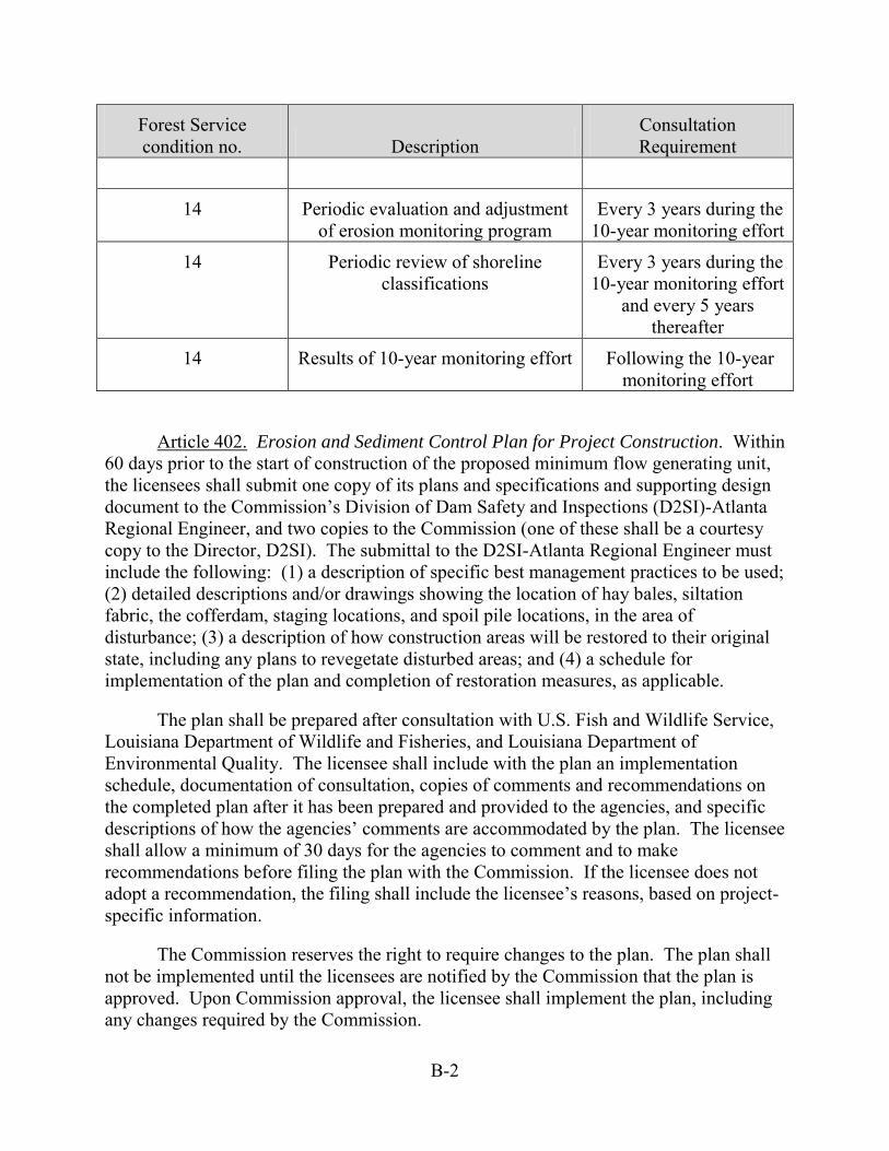
B-2
Forest Service condition no. Description
Consultation Requirement
14 Periodic evaluation and adjustment of erosion monitoring program
Every 3 years during the 10-year monitoring effort
14 Periodic review of shoreline classifications
Every 3 years during the 10-year monitoring effort
and every 5 years thereafter
14 Results of 10-year monitoring effort Following the 10-year monitoring effort
Article 402. Erosion and Sediment Control Plan for Project Construction. Within 60 days prior to the start of construction of the proposed minimum flow generating unit, the licensees shall submit one copy of its plans and specifications and supporting design document to the Commission’s Division of Dam Safety and Inspections (D2SI)-Atlanta Regional Engineer, and two copies to the Commission (one of these shall be a courtesy copy to the Director, D2SI). The submittal to the D2SI-Atlanta Regional Engineer must include the following: (1) a description of specific best management practices to be used; (2) detailed descriptions and/or drawings showing the location of hay bales, siltation fabric, the cofferdam, staging locations, and spoil pile locations, in the area of disturbance; (3) a description of how construction areas will be restored to their original state, including any plans to revegetate disturbed areas; and (4) a schedule for implementation of the plan and completion of restoration measures, as applicable.
The plan shall be prepared after consultation with U.S. Fish and Wildlife Service, Louisiana Department of Wildlife and Fisheries, and Louisiana Department of Environmental Quality. The licensee shall include with the plan an implementation schedule, documentation of consultation, copies of comments and recommendations on the completed plan after it has been prepared and provided to the agencies, and specific descriptions of how the agencies’ comments are accommodated by the plan. The licensee shall allow a minimum of 30 days for the agencies to comment and to make recommendations before filing the plan with the Commission. If the licensee does not adopt a recommendation, the filing shall include the licensee’s reasons, based on project-specific information.
The Commission reserves the right to require changes to the plan. The plan shall not be implemented until the licensees are notified by the Commission that the plan is approved. Upon Commission approval, the licensee shall implement the plan, including any changes required by the Commission.

B-3
Article 403. Erosion Monitoring and Management. The licensees shall, within 1 year of license issuance of the license, file for Commission approval an erosion monitoring plan for non-Forest Service project lands classified as Conservation and Public Access in the licensees’ Shoreline Management Plan. The plan, which shall be consistent with the Sabine National Forest Erosion Monitoring and Management Plan required under FPA Section 4(e) Condition 14, shall include provisions for: (1) identifying representative sites for erosion monitoring from available records and through selected site visits; (2) establishing baseline conditions at these locations during a field survey using appropriate photo-documentation and descriptions; (3) revisiting these areas in the field every 5 years using the same approach; and (4) preparing and implementing a site-specific management plan for Commission approval if erosion shows potential for adversely affecting sensitive resources or the licensees owned and managed recreation features included in the Recreation Management Plan required under Article 412. Criteria for determining the need for site-specific management plans should include: (1) adverse effects on federally listed threatened or endangered species; (2) the take of an eagle or eagle nest; (3) effects to the botanical character of the Evergreen Forest/drainage group A; or (4) effects to the licensees owned and operated recreation facilities identified in the Recreation Management Plan or cultural resources.
The erosion monitoring plan shall be developed after consultation with the U.S. Fish and Wildlife Service, Texas Parks and Wildlife Department, Louisiana Department of Wildlife and Fisheries, and Louisiana Department of Culture, Recreation and Tourism. The plan filed with the Commission shall include documentation of consultation, copies of comments and recommendations on the completed plan after it has been prepared and provided to the above entities, and a specific description of how comments are accommodated by the plan. The licensees shall allow a minimum of 30 days to comment before filing the plan with the Commission. If the licensees do not adopt a recommendation, the filing shall include the licensees’ reasons, based on site-specific information.
The Commission reserves the right to require changes to the plan. Upon Commission approval, the licensees shall implement the plan, including any changes required by the Commission.
Article 404. Continuous Releases from the Spillway. From the effective date of the license through the later of (1) the end of the second year of the license term, or (2) 10 days following the Commission’s approval of the flow release plan filed under Article 405, the licensees shall release continuous flows at the project spillway of 144 cubic feet per second (cfs). Such releases shall be measured and reported in accordance with U.S. Geological Survey (USGS) standards applicable to USGS Gage 08025360, Sabine River at Toledo Bend Reservoir. The licensees are not required to provide releases at the spillway greater than 144 cfs, but may do so at their discretion.
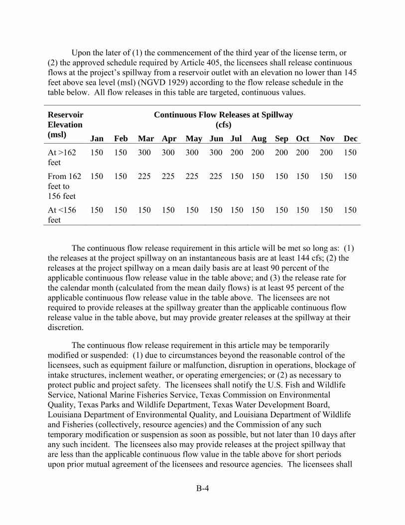
B-4
Upon the later of (1) the commencement of the third year of the license term, or (2) the approved schedule required by Article 405, the licensees shall release continuous flows at the project’s spillway from a reservoir outlet with an elevation no lower than 145 feet above sea level (msl) (NGVD 1929) according to the flow release schedule in the table below. All flow releases in this table are targeted, continuous values.
Reservoir Elevation (msl)
Continuous Flow Releases at Spillway (cfs)
Jan Feb Mar Apr May Jun Jul Aug Sep Oct Nov Dec At >162 feet
150 150 300 300 300 300 200 200 200 200 200 150
From 162 feet to 156 feet
150 150 225 225 225 225 150 150 150 150 150 150
At <156 feet
150 150 150 150 150 150 150 150 150 150 150 150
The continuous flow release requirement in this article will be met so long as: (1) the releases at the project spillway on an instantaneous basis are at least 144 cfs; (2) the releases at the project spillway on a mean daily basis are at least 90 percent of the applicable continuous flow release value in the table above; and (3) the release rate for the calendar month (calculated from the mean daily flows) is at least 95 percent of the applicable continuous flow release value in the table above. The licensees are not required to provide releases at the spillway greater than the applicable continuous flow release value in the table above, but may provide greater releases at the spillway at their discretion.
The continuous flow release requirement in this article may be temporarily modified or suspended: (1) due to circumstances beyond the reasonable control of the licensees, such as equipment failure or malfunction, disruption in operations, blockage of intake structures, inclement weather, or operating emergencies; or (2) as necessary to protect public and project safety. The licensees shall notify the U.S. Fish and Wildlife Service, National Marine Fisheries Service, Texas Commission on Environmental Quality, Texas Parks and Wildlife Department, Texas Water Development Board, Louisiana Department of Environmental Quality, and Louisiana Department of Wildlife and Fisheries (collectively, resource agencies) and the Commission of any such temporary modification or suspension as soon as possible, but not later than 10 days after any such incident. The licensees also may provide releases at the project spillway that are less than the applicable continuous flow value in the table above for short periods upon prior mutual agreement of the licensees and resource agencies. The licensees shall
B-5
notify the Commission of any such mutually agreed upon flow modification as soon as possible, but not later than 10 days after any such incident.
Article 405. Measurement and Management of Continuous Flow Releases from the Spillway. Within 18 months after the effective date of the license, the licensees shall file with the Commission for approval a flow release plan for providing and measuring the continuous flow releases at the project spillway pursuant to Article 404. The plan shall:
(1) Identify the location and means of delivery of the continuous flow releases, including the specifications and drawings, as appropriate, of all structures necessary to deliver continuous flows at the spillway;
(2) Describe the means for measuring the continuous flow releases at the project spillway structure as provided in the Article 404 table, including: (a) the specifications and drawings, as appropriate, of any device, structure, or method to measure flow releases at the spillway, which must meet or exceed USGS standards; and (b) the means for making such flow release data (measurement of continuous spillway releases and lake elevation levels) available electronically to the Commission, resource agencies, and the public in near real time on a public website;
(3) Include a schedule for the construction and commencement of operation of the facilities described under elements (1) and (2) above, as well as interim measures for releasing flows under the Article 404 table, beginning the later of (a) the end of the second year of the new license term, or (b) 10 days following the Commission’s approval of the plan; and
(4) Include a process for amending the plan to accommodate the development schedule for the mini-hydro powerhouse at the spillway and to implement any measures for downstream passage of American eel (Anguilla rostrata), as provided in the fishway prescriptions for the American eel set forth in Appendix _ of the license.
Prior to filing the plan, for Commission approval, the licensees shall develop the flow release plan after consultation with the U.S. Fish and Wildlife Service, National Marine Fisheries Service, Texas Commission on Environmental Quality, Texas Parks and Wildlife Department, Texas Water Development Board, Louisiana Department of Environmental Quality, and Louisiana Department of Wildlife and Fisheries (collectively, resource agencies). The licensees shall allow a minimum of 90 days for the resource agencies to comment and to make recommendations before filing the plan with the Commission. The licensees shall include with the plan documentation of consultation with the resources agencies, including copies of any comments received, and specific descriptions of how the resource agencies’ comments are accommodated by the plan. If the licensees do not adopt a recommendation, the filing shall include the licensees’ reasons, based on project specific reasons.
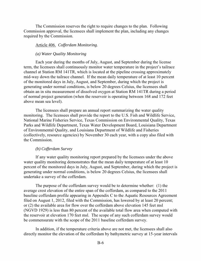
B-6
The Commission reserves the right to require changes to the plan. Following Commission approval, the licensees shall implement the plan, including any changes required by the Commission.
Article 406. Cofferdam Monitoring.
(a) Water Quality Monitoring
Each year during the months of July, August, and September during the license term, the licensees shall continuously monitor water temperature in the project’s tailrace channel at Station RM 141TR, which is located at the pipeline crossing approximately mid-way down the tailrace channel. If the mean daily temperature of at least 10 percent of the monitored days in July, August, and September, during which the project is generating under normal conditions, is below 20 degrees Celsius, the licensees shall obtain an in situ measurement of dissolved oxygen at Station RM 141TR during a period of normal project generation (when the reservoir is operating between 168 and 172 feet above mean sea level).
The licensees shall prepare an annual report summarizing the water quality monitoring. The licensees shall provide the report to the U.S. Fish and Wildlife Service, National Marine Fisheries Service, Texas Commission on Environmental Quality, Texas Parks and Wildlife Department, Texas Water Development Board, Louisiana Department of Environmental Quality, and Louisiana Department of Wildlife and Fisheries (collectively, resource agencies) by November 30 each year, with a copy also filed with the Commission.
(b) Cofferdam Survey
If any water quality monitoring report prepared by the licensees under the above water quality monitoring demonstrates that the mean daily temperature of at least 10 percent of the monitored days in July, August, and September, during which the project is generating under normal conditions, is below 20 degrees Celsius, the licensees shall undertake a survey of the cofferdam.
The purpose of the cofferdam survey would be to determine whether: (1) the average crest elevation of the entire span of the cofferdam, as compared to the 2011 baseline cofferdam profile appearing in Appendix C to the Aquatic Resources Agreement filed on August 1, 2012, filed with the Commission, has lowered by at least 20 percent; or (2) the available area for flow over the cofferdam above elevation 145 feet msl (NGVD 1929) is less than 80 percent of the available total flow area when computed with the reservoir at elevation 170 feet msl. The scope of any such cofferdam survey would be commensurate with the scope of the 2011 baseline cofferdam survey.
In addition, if the temperature criteria above are not met, the licensees shall also directly monitor the elevation of the cofferdam by bathymetric survey at 15-year intervals
B-7
(i.e., two to three surveys over the license period depending on the license term) such that no 15-year period passes without a survey being completed. This would ensure that the cofferdam stability and elevation is maintained, in the event the temperature monitoring program fails to detect a substantial erosion of the cofferdam.
By January 31 in years in which the cofferdam survey is conducted, the licensees shall complete the cofferdam survey, together with an analysis of the survey results, and file it with the Commission, with copies to the resource agencies for their review.
(c) Cofferdam Restoration Plan
If the licensees’ cofferdam survey demonstrates that either: (1) the average crest elevation of the entire span of the cofferdam, as compared to the 2011 baseline cofferdam profile has lowered by at least 20 percent; or (2) the available area for flow over the cofferdam above elevation 145 feet msl is less than 80 percent of the available total flow area when computed with the reservoir at elevation 170 feet msl, the licensees shall file, for Commission approval, a Cofferdam Restoration Plan.
The licensees shall file any required cofferdam restoration plan by July 1 following the January 31 distribution of the cofferdam survey. The plan shall propose detailed specifications, methods, and a schedule for restoring the cofferdam to elevations consistent with the 2011 baseline cofferdam survey. Prior to filing the plan for Commission approval, the licensees shall develop the plan in consultation with the resource agencies. The licensees shall allow a minimum of 45 days for the resource agencies to comment and make recommendations before filing the plan with the Commission. The licensees shall include with the plan filed with the Commission documentation of consultation, copies of comments and recommendations from the resource agencies, and specific descriptions of how the resource agencies’ recommendations are accommodated by the plan. If the licensees do not adopt a recommendation, the filing shall include the licensees’ reasons, based on project-specific information.
The Commission reserves the right to require changes to the proposed plan. Upon Commission approval, the licensees shall implement the plan, including any changes required by the Commission.
Article 407. Seasonal Powerhouse Operations. Upon the earlier of: (1) the scheduled April 30, 2018 expiration of the current sales agreement; or (2) the effective date of any new or extended power sales agreement, the licensees shall implement seasonal powerhouse operations with the following components.
(a) Powerhouse Releases during Seasonal Peaking Operations
During the months of March, April, May, and June, the licensees shall limit the maximum powerhouse flow during peaking operations at the project to 12,000 cubic feet

B-8
per second (cfs). This limitation on peaking operations shall not apply to: (1) any call on the portion of the project’s generation capacity which is held in reserve, as spinning or non-spinning reserve, or is needed to respond to unanticipated changes in scheduled system generation; and/or (2) any emergency call on power that requires the licensees to respond to an unexpected transmission system upset or anomaly, including such issues as congestion, frequency or voltage anomalies, or grid disturbances, including brown-outs or black-outs.
(b) Weekend Operations in March through June
March and April: On each weekend day in March and April, the licensees shall provide a volume of 1,450 acre-feet of flow releases from the powerhouse. Such flows will be released in the range of 4,000 to 7,000 cfs, after approval of the weekend operations plan by the Commission under this article. The licensees shall not be required to provide powerhouse flow releases greater than 1,450 acre-feet each weekend day, but may provide greater weekend powerhouse flows at their discretion.
May and June: On each weekend day in May and June, the weekend operations provided in March and April will apply if both of the following conditions are met:
(1) The mean calculated inflow to the reservoir for the first 6 months of the current water year (October 1 to March 31) is greater than 80 percent of the mean calculated inflow of the water year for the same six-month period for the most recent 38-year period of record. The current water year shall not be included in the most recent 38-year period of record.
(2) The licensees are able to safely operate at least one turbine-generator unit within its normal operating range.
For purposes of the annual calculation of the inflow to the reservoir, the licensees shall perform such calculation in substantial conformance with the methods employed during relicensing as provided in section 3 of the final report entitled Toledo Bend Project, Operations Model, Operations/Verification Report dated October 2010. The licensees shall compute the reservoir inflow for the first six months of each water year to determine if that year’s inflow is greater than 80 percent of the long-term mean for that period as provided in paragraph (1) above. The licensees shall submit that calculation and supporting documentation to the U.S. Geological Survey, U.S. Fish and Wildlife Service, National Marine Fisheries Service, Texas Commission on Environmental Quality, Texas Parks and Wildlife Department, Texas Water Development Board, Louisiana Department of Environmental Quality, and Louisiana Department of Wildlife and Fisheries (collectively, resource agencies) for review and comment by April 10 of each year. The licensees shall allow 10 days for the resource agencies to comment on the calculation and supporting documentation. No later than April 25, the licensees shall file with the Commission their May/June weekend flow schedule.

B-9
Each tenth year during the license term, the licensees shall evaluate, in consultation with the resource agencies, the frequency of May and June weekend powerhouse operations. If this evaluation demonstrates that weekend powerhouse operations in May and June occurred in fewer than 7 years of the prior 10-year period, the licensees shall adjust the 80 percent criterion in consultation with the resource agencies, such that weekend powerhouse operations in May and June are expected to occur in approximately two-thirds of the years over the next 10-year period. Any proposed adjustment to the criterion triggering weekend powerhouse operations must be approved by the Commission.
Flow Testing to Establish Weekend Operations: Prior to implementing weekend operations under this article, the licensees shall cooperate with the resource agencies’ monitoring of the lower Sabine River downstream of Toledo Bend dam. The licensees’ obligations related to assisting resource agencies’ monitoring and evaluation program shall be consistent with the Flow Testing to Optimize Weekend Operations Benefits contained in Appendix D to the Aquatic Resources Agreement (ARA) filed on August 1, 2012.
Not later than 4 months prior to initiating weekend operations under this article, the licensees shall file with the Commission for approval a weekend operations plan for implementing weekend operations as provided under this article. In any case, the project’s powerhouse operations under the plan shall not require the licensees to operate either turbine-generator unit at flows considered by the licensees to be unsafe, potentially damaging to the unit, or at very low efficiency. The licensees must support any such determination with appropriate documentation of the unfavorable conditions.
The licensees shall develop the weekend operations plan after consultation with the resource agencies, American Whitewater, and Sabine Whitewater Club. The licensees shall allow a minimum of 45 days for the resource agencies and other entities to comment and make recommendations before filing the plan with the Commission. The licensees shall include with the plan documentation of consultation with the resource agencies and other entities, copies of comments and recommendations from the resource agencies and other entities, and specific descriptions of how the resource agencies’ and other entities’ recommendations are accommodated by the plan. If the licensees do not adopt a recommendation, the filing shall include the licensees’ reasons based on project-specific information.
The Commission reserves the right to require changes to the proposed plan. Upon Commission approval, the licensees shall implement the plan, including any changes required by the Commission.
Subject to the total 1,450 acre-feet daily volume under this article, the flow rate and duration of weekend releases in the Commission-approved plan are subject to change, but no more frequently than once every 10 years, unless otherwise authorized by
B-10
the Commission. If, after 10 years of implementation, the resource agencies elect to re-conduct flow testing and, based on such flow testing, seek to adjust the Commission-approved plan, the licensees shall consult with the resource agencies, American Whitewater, and Sabine Whitewater Club as provided in the Flow Testing to Optimize Weekend Operations Benefits (Appendix D to the ARA). Any proposed changes to the weekend operations plan must be filed with the Commission for approval.
Article 408. Reservoir Operations for Hydroelectric Power Production. The licensees shall operate the project reservoir for hydroelectric power production within a normal operating range of elevation 168 to 172 feet above mean sea level (msl). The licensees are authorized to operate the project reservoir for hydroelectric power production outside this normal operating range:
(1) due to storm or high water events;
(2) due to reservoir drawdown necessary for inspection of public works or maintenance as required by the Commission;
(3) for releases to meet continuous release requirements under Article 404; or
(4) for releases to satisfy the licensees’ water supply or other downstream obligations.
Nothing in this article restricts or otherwise affects the licensees’ authority to operate project reservoir levels for purposes other than hydroelectric power production.
Article 409. Chinese Tallow Treatment. The licensees shall file with the Commission annually a report outlining the amount and general location of Chinese tallow treatment on Sabine National Forest lands funded by the licensees under Forest Service 4(e) condition 15, Treatment of Chinese Tallow. The Commission reserves the right to require any additional measures necessary to treat Chinese tallow consistent with the intent of Forest Service 4(e) condition 15.
Further, the Shoreline Management Plan filed on February 3, 2012 is modified to require the licensees to implement measures to control the spread of Chinese tallow at project recreation areas maintained by the Authorities as part of routine vegetation management and on Conservation and Public Access classification lands where ground-disturbing activities would occur.
Article 410. Bird-Friendly Transmission Lines Plan. At least 90 days before the start of any land-disturbing or land-clearing activities associated with construction of any primary transmission line associated with the minimum flow generating unit, the licensees shall file with the Commission for approval, a transmission line design plan to protect birds from electrocution and collision hazards.

B-11
The plan shall include provisions for adequate separation of energized conductors, groundwires, and other metal hardware, adequate insulation, and any other measures necessary to limit potential for collisions or electrocutions. The licensees shall design and construct the primary transmission lines associated the proposed minimum flow generating unit in strict accordance with the industry standard guidelines set forth in the current versions of the following protection guidelines: (1) Avian Power Line Interaction Committee (APLIC) Suggested Practices for Raptor Protection on Power Lines: The State of the Art in 2006; and (2) APLIC’s Reducing Avian Collisions with Power Line: The State of the Art in 2012.
The plan shall be prepared after consultation with the U.S. Fish and Wildlife Service and the state wildlife department for any state the line may cross (Texas Parks and Wildlife Department and/or Louisiana Department of Wildlife and Fisheries). The licensees shall include with the plan documentation of consultation, copies of comments and recommendations on the completed plan after it has been prepared and provided to the agencies, and specific descriptions of how the agencies’ comments are accommodated by the plan. The licensees shall allow a minimum of 30 days for the agencies to comment and to make recommendations before filing the plan with the Commission. If the licensees do not adopt a recommendation, the filing shall include the licensees’ reasons, based on project-specific information.
The Commission reserves the right to require changes to the plan. The plan shall not be implemented until the licensees are notified by the Commission that the plan is approved. Upon Commission approval, the licensees shall implement the plan, including any changes required by the Commission.
Article 411. Bald Eagle Protection Measures. At least 90 days before the start of any land-disturbing or land-clearing activities associated with construction of the minimum flow turbine, the licensees shall conduct surveys for bald eagle nests within 660 feet of the construction site. If any eagle nests are identified in the survey area, the licensees shall implement measures consistent with the current U.S. Fish and Wildlife Service’s National Bald Eagle Management Guidelines.
Further, the Shoreline Management Plan filed on February 3, 2012 is modified to require that permitted activities conducted within 660 feet of a bald eagle nest are consistent with the current U.S. Fish and Wildlife Service’s National Bald Eagle Management Guidelines.
Article 412. Revised Recreation Management Plan. The licensees shall, within 1 year of license issuance, revise the Recreation Management Plan filed with the Commission on March 6, 2012, and file a revised plan for Commission approval, to include the following: (1) comprehensive inventory and descriptions of the 17 identified public recreation facilities that the licensees are responsible for within the project boundary, including the 13 sites already identified in the Recreation Management Plan,
B-12
Cow Bayou Wilderness Area, Tourist Information Center, and tailrace and spillway areas; (2) brief descriptions and locations of the other recreation sites that are the responsibility of other federal, state, and local agencies including: six recreation sites within the Sabine National Forest, two state parks, and other public recreation facilities that provide access to the project; (3) a discussion of planned improvements at each licensees-managed site; (4) a schedule for when those improvements would be completed; (5) a spillway channel recreation access plan that: (a) identifies the conditions of the spillway channel access site and associated uses; (b) establishes specific criteria (either flow releases or associated reservoir levels) that would trigger closure of the site; and (c) provides a protocol for notifying recreationists who are present in the spillway channel before releases occur (e.g., sounding a siren) for public safety; and (6) a schedule for proposed recreation and visitor survey monitoring reports that would include provisions to file Recreation Management Plan updates every 12 years.
The revised plan shall be developed in consultation with the U.S. Forest Service, U.S. Fish and Wildlife Service, Texas Parks and Wildlife Department, Louisiana Department of Wildlife and Fisheries, Louisiana Department of Culture, Recreation and Tourism, American Whitewater, and the Sabine Whitewater Club. The plan filed with the Commission shall include documentation of consultation, copies of comments and recommendations on the completed plan after it has been prepared and provided to the consultation list, and a specific description of how comments are accommodated by the plan. The licensees shall allow a minimum of 30 days for agencies and other entities to comment before filing the plan with the Commission. If the licensees do not adopt a recommendation, the filing shall include the licensees’ reasons, based on site-specific information.
The Commission reserves the right to require changes to the plan. Upon Commission approval, the licensees shall implement the plan, including any changes required by the Commission.
Article 413. Programmatic Agreement and Historic Properties Management Plan. The licensees shall implement the “Programmatic Agreement Among the Federal Energy Regulatory Commission, the State of Texas State Historic Preservation Officer, and the State of Louisiana State Historic Preservation Officer for Managing Historic Properties that may be Affected by a New License Issued for the Continued Operation of the Toledo Bend Hydroelectric Project in Panola, Shelby, Sabine, and Newton Counties, Texas; and De Soto, Sabine, and Vernon Parishes, Louisiana (FERC No. 2305-036),” executed on _________, and including but not limited to the Historic Properties Management Plan (HPMP) for the project. In the event that the Programmatic Agreement is terminated, the licensees shall continue to implement the provisions of its approved HPMP. The Commission reserves the authority to require changes to the HPMP at any time during the term of the license.

B-13
Article 414. Design of Minimum Flow Unit Powerhouse. The licensees shall design the colors, forms, and textures of the minimum flow generating unit and appurtenant facilities to match the setting in the vicinity of the project spillway. The licensees shall file photographic documentation with the Commission within 30 days of completion of the powerhouse and appurtenant facilities to ensure all new facilities comply with this article.
Article 415. Use and Occupancy. (a) In accordance with the provisions of this article, the licensees shall have the authority to grant permission for certain types of use and occupancy of project lands and waters and to convey certain interests in project lands and waters for certain types of use and occupancy, without prior Commission approval. The licensees may exercise the authority only if the proposed use and occupancy is consistent with the purposes of protecting and enhancing the scenic, recreational, and other environmental values of the project. For those purposes, the licensees shall also have continuing responsibility to supervise and control the use and occupancies for which it grants permission, and to monitor the use of, and ensure compliance with the covenants of the instrument of conveyance for, any interests that it has conveyed, under this article. If a permitted use and occupancy violates any condition of this article or any other condition imposed by the licensees for protection and enhancement of the project’s scenic, recreational, or other environmental values, or if a covenant of a conveyance made under the authority of this article is violated, the licensees shall take any lawful action necessary to correct the violation. For a permitted use or occupancy, that action includes, if necessary, canceling the permission to use and occupy the project lands and waters and requiring the removal of any non-complying structures and facilities.
(b) The type of use and occupancy of project lands and waters for which the licensees may grant permission without prior Commission approval are: (1) landscape plantings; (2) non-commercial piers, landings, boat docks, or similar structures and facilities that can accommodate no more than 10 water craft at a time and where said facility is intended to serve single-family type dwellings; (3) embankments, bulkheads, retaining walls, or similar structures for erosion control to protect the existing shoreline; and (4) food plots and other wildlife enhancement. To the extent feasible and desirable to protect and enhance the project's scenic, recreational, and other environmental values, the licensees shall require multiple use and occupancy of facilities for access to project lands or waters. The licensees shall also ensure that, to the satisfaction of the Commission’s authorized representative, the use and occupancies for which it grants permission are maintained in good repair and comply with applicable state and local health and safety requirements. Before granting permission for construction of bulkheads or retaining walls, the licensees shall: (1) inspect the site of the proposed construction, (2) consider whether the planting of vegetation or the use of riprap would be adequate to control erosion at the site, and (3) determine that the proposed construction is needed and would not change the basic contour of the impoundment shoreline. To implement this paragraph (b), the licensees may, among other things, establish a program for issuing

B-14
permits for the specified types of use and occupancy of project lands and waters, which may be subject to the payment of a reasonable fee to cover the licensees’ costs of administering the permit program. The Commission reserves the right to require the licensees to file a description of its standards, guidelines, and procedures for implementing this paragraph (b) and to require modification of those standards, guidelines, or procedures.
(c) The licensees may convey easements or rights-of-way across, or leases of project lands for: (1) replacement, expansion, realignment, or maintenance of bridges or roads where all necessary state and federal approvals have been obtained; (2) storm drains and water mains; (3) sewers that do not discharge into project waters; (4) minor access roads; (5) telephone, gas, and electric utility distribution lines; (6) non-project overhead electric transmission lines that do not require erection of support structures within the project boundary; (7) submarine, overhead, or underground major telephone distribution cables or major electric distribution lines (69-kilovolts or less); and (8) water intake or pumping facilities that do not extract more than one million gallons per day from a project impoundment. No later than January 31 of each year, the licensees shall file three copies of a report briefly describing for each conveyance made under this paragraph (c) during the prior calendar year, the type of interest conveyed, the location of the lands subject to the conveyance, and the nature of the use for which the interest was conveyed.
(d) The licensees may convey fee title to, easements or rights-of-way across, or leases of project lands for: (1) construction of new bridges or roads for which all necessary state and federal approvals have been obtained; (2) sewer or effluent lines that discharge into project waters, for which all necessary federal and state water quality certification or permits have been obtained; (3) other pipelines that cross project lands or waters but do not discharge into project waters; (4) non-project overhead electric transmission lines that require erection of support structures within the project boundary, for which all necessary federal and state approvals have been obtained; (5) private or public marinas that can accommodate no more than 10 water craft at a time and are located at least one-half mile (measured over project waters) from any other private or public marina; (6) recreational development consistent with an approved report on recreational resources of an Exhibit E; and (7) other uses, if: (i) the amount of land conveyed for a particular use is five acres or less; (ii) all of the land conveyed is located at least 75 feet, measured horizontally, from project waters at normal surface elevation; and (iii) no more than 50 total acres of project lands for each project development are conveyed under this clause (d)(7) in any calendar year. At least 60 days before conveying any interest in project lands under this paragraph (d), the licensees must submit a letter to the Director, Office of Energy Projects, stating its intent to convey the interest and briefly describing the type of interest and location of the lands to be conveyed (a marked Exhibit G map may be used), the nature of the proposed use, the identity of any federal or state agency official consulted, and any federal or state

B-15
approvals required for the proposed use. Unless the Director, within 45 days from the filing date, requires the licensees to file an application for prior approval, the licensees may convey the intended interest at the end of that period.
(e) The following additional conditions apply to any intended conveyance under paragraph (c) or (d) of this article:
(1) Before conveying the interest, the licensees shall consult with federal and state fish and wildlife or recreation agencies, as appropriate, and the State Historic Preservation Officer.
(2) Before conveying the interest, the licensees shall determine that the proposed use of the lands to be conveyed is not inconsistent with any approved report on recreational resources of an Exhibit E; or, if the project does not have an approved report on recreational resources, that the lands to be conveyed do not have recreational value.
(3) The instrument of conveyance must include the following covenants running with the land: (i) the use of the lands conveyed shall not endanger health, create a nuisance, or otherwise be incompatible with overall project recreational use; (ii) the grantee shall take all reasonable precautions to ensure that the construction, operation, and maintenance of structures or facilities on the conveyed lands will occur in a manner that will protect the scenic, recreational, and environmental values of the project; and (iii) the grantee shall not unduly restrict public access to project waters.
(4) The Commission reserves the right to require the licensees to take reasonable remedial action to correct any violation of the terms and conditions of this article, for the protection and enhancement of the project's scenic, recreational, and other environmental values.
(f) The conveyance of an interest in project lands under this article does not in itself change the project boundaries. The project boundaries may be changed to exclude land conveyed under this article only upon approval of revised Exhibit G drawings (project boundary maps) reflecting exclusion of that land. Lands conveyed under this article will be excluded from the project only upon a determination that the lands are not necessary for project purposes, such as operation and maintenance, flowage, recreation, public access, protection of environmental resources, and shoreline control, including shoreline aesthetic values. Absent extraordinary circumstances, proposals to exclude lands conveyed under this article from the project shall be consolidated for consideration when revised Exhibit G drawings would be filed for approval for other purposes.
(g) The authority granted to the licensees under this article shall not apply to any part of the public lands and reservations of the United States included within the project boundary.

B-16
This page intentionally left blank.

APPENDIX C SECTION 18 PRESCRIPTION FOR FISHWAYS

This page intentionally left blank.

C-1
APPENDIX C SECTION 18 PRESCRIPTION FOR FISHWAYS
Both the Department of the Interior and the National Marine Fisheries Service (NMFS) filed preliminary section 18 fishway prescriptions that were identical. Therefore, we list only a single fishway prescription common to both agencies.
To facilitate the migration of American eels in the Sabine River Basin past the Toledo Bend Hydroelectric Project (Project), the U.S. Fish and Wildlife Service (FWS)/NMFS requests the Commission include the following conditions as part of any license it may issue for the Project. At this time, the prescription is limited to structures and measures necessary to facilitate passage of American eels. The Secretary reserves the authority, after notice and opportunity for hearing, to modify this prescription and/or to prescribe additional fishways during the term of any license issued, based on new material and relevant information. General Terms and Conditions for Fishways
1. The Sabine River Authority, State of Louisiana, and the Sabine River Authority of Texas (Licensees) shall construct, operate, and maintain at their own expense the fishways prescribed herein in order to provide safe, timely and effective passage through the Project for American eels.
2. The Licensees shall provide designated representatives of the U.S. Fish and Wildlife Service, National Marine Fisheries Service, Louisiana Department of Wildlife and Fisheries, and Texas Parks and Wildlife Department (Agencies) access to the Project and to pertinent records for the purpose of inspecting the fishways and determining compliance with the fishways prescription.
3. The Licensees shall monitor the migration of the American eel at the Toledo Bend Project and shall operate upstream passage fishways throughout the upstream migration period and operate downstream passage fishways throughout the downstream migration period, in accordance with the terms of this prescription.
4. The Licensees shall maintain fishways in proper working order and shall clear fishways and adjacent areas, upstream and downstream, of trash, logs, and other material that would hinder safe, timely and effective passage. The Licensees shall perform necessary maintenance sufficiently in advance of migratory periods to ensure that fishways are ready for testing and inspection, and will operate effectively, during the migratory periods.
5. If ramp trap operations in Years 3 through 5 of the Upstream Passage Plan result in the passage of fewer than an average of 150 eels per year, the Licensees may propose to FWS/NMFS to discontinue all requirements of this fish passage prescription, and to revert to a reservation of authority to prescribe fishways. FWS/NMFS will grant this request if the Licensees demonstrate that they have made a good-faith effort to operate the ramp traps properly through Year 5,
C-2
without any extended equipment failures, and Project-specific information demonstrates that the ramp traps in Years 3 through 5 effectively capture eels in the immediate vicinity of the spillway or tailrace structure.
Upstream Passage Plan Within 18 months after the effective date of the new license, the Licensees shall file, for Commission approval, a plan to deploy and operate portable ramp traps and to safely pass juvenile American eels from the Sabine River to suitable locations upstream of the Project works. The plan shall consist of the following:
1. Detailed design drawings, with explanatory text, for portable ramp traps, specifying dimensions, slopes, materials, substrate, methods and facilities for providing sufficient attraction flow to the ramp traps, including:
• Two (2) portable ramp traps at the downstream end of, or within, the concrete tailrace structure of the Project powerhouse, with due consideration of the full range of tailwater elevation changes.
• Four (4) portable ramp traps within the spillway structure, at or upstream of the lower end of the concrete wing walls along each bank, with due consideration of the location of continuous flow releases and the full range of tailwater elevation changes.
2. A schedule for installing and testing the ramp traps so that they are operational within six months of the Commission’s approval of the Plan.
3. A protocol for safely transporting juvenile eels captured in the ramp traps for release from the shoreline upstream of the dam at two locations (one for tailrace captures and one for spillway captures) a safe distance away from the spillway gates and the powerhouse intake.
4. Procedures for collecting data, which shall include, but not be limited to, the size and number of eels captured, the timing and location of eel captures and releases, and water temperature at the ramp trap entrance during trap inspections.
5. A phased schedule for operating, inspecting, and possibly relocating ramp traps and/or modifying the attraction flow provided to the ramps based on their performance, as follows:
Year – 1
• Select initial ramp trap locations in consultation with the Agencies.
• Operate year-round, checking for eels at least once per week.
• Prepare an annual report (see item 6, below), including any recommended changes to the plan to improve effectiveness.
C-3
Year – 2
• Implement any ramp trap location, ramp trap design, or operational changes recommended in the Year 1 annual report and finalized in consultation with the Agencies.
• Operate year-round, checking for eels at least once each week and more frequently during periods of higher abundance or trap mortality, as indicated by Year 1 experience.
• Prepare an annual report (see item 6, below), including any recommended changes to the plan to improve effectiveness and to define the seasonal period(s) for operations during Year 3, based on capture results during the first two years of year-round operation.
Year – 3 and Beyond
• Implement any ramp trap location, ramp trap design, or operational changes recommended in the prior year’s annual report and finalized in consultation with the Agencies.
• Operate during the season(s) recommended in the prior year’s annual report and finalized in consultation with the Agencies, checking for eels at least once each week and more frequently during periods of higher abundance or trap mortality, as indicated by experience in prior years.
• Prepare an annual report (see item 6, below), including any recommended changes to the plan to improve effectiveness and, if necessary, to further adjust the seasonal period(s) for operation of the ramp traps.
All Years
• During ramp trap operations, the Licensees shall sample for eels (e.g., by electro-fishing and/or other appropriate methods at the Licensees’ discretion) in the vicinity of the ramp traps within the spillway or tailrace structures to determine whether low catch rates at one or more traps are due to ineffective trap design, location, or attraction flow. Sampling may occur at any time during ramp trap operations as deemed necessary, but shall occur at least once per calendar month when water temperature as measured at the ramp traps is in the range of 16-21 degrees C. However, sampling will not be required at the spillway structure if the traps located at that structure captured more than 50 eels in the previous calendar month. Likewise, sampling will not be required at the tailrace structure if the traps located at that structure captured more than 50 eels in the previous calendar month. Unless otherwise agreed to by the Agencies, this sampling will occur each of the first five years of ramp trap operations and every fifth year thereafter.
C-4
• The Licensees may remove ramp traps as necessary to prevent loss or damage during flood events, promptly returning them to operation when the flood has passed.
• The Licensees will increase the frequency of trap inspections as necessary to avoid eel mortality or to accommodate high eel capture rates.
• Before implementing any change in Project operations that could substantially affect performance of the ramp traps (e.g., a relocation of the continuous flow release point), the Licensees shall consult with and propose to the Agencies adjustments to the location, design, and/or operation of the ramp traps necessary to maintain or enhance their performance, allowing 90 days for the Agencies to comment. The Licensees shall file the proposal with the Commission for approval, including documentation of Agency consultation. If the Licensees do not adopt an Agency recommendation, the filing shall include the Licensees’ reasons, based on project-specific information.
6. An annual report of ramp trap operations, to be filed with the Commission and the Agencies. The report shall include timing, locations, numbers, and sizes of eels captured and released, trap mortality, results of any eel sampling conducted in the vicinity of the ramp traps, water temperature data, and any proposed revisions to the plan to improve its effectiveness at passing juvenile eels upstream of the dam. After five years of ramp trap operations, the 5th annual report will address whether to continue such operations based on the number of eels passed upstream to date, giving due consideration to hydrologic/meterologic conditions and other relevant factors (e.g., down time for the various ramps). If ramp trap operations in Years 3 through 5 result in the passage of fewer than an average of 150 eels per year, the Licensees may propose to discontinue all requirements of this fish passage prescription, as provided in the General Terms and Conditions for Fishways, above. Beginning with the 5th annual report, and every fifth year thereafter, the annual report will address whether to reduce or increase the number of ramp traps The Licensees will submit the annual report to the Agencies for review no later than August 1 each year. The Agencies shall provide comments and recommendations within 45 days. The Licensee shall file the annual report, including documentation of Agency consultation, with the Commission within 45 days after the close of the comment period. The filing date for this report may be adjusted by mutual agreement between the Licensees, USFWS and NMFS, after filing notice of any such agreement with the Commission.
7. A schedule for an annual site visit and review of ramp trap operations with the Agencies during the 45-day annual report Agency review period.

C-5
The Licensees shall prepare the plan after consulting with the Agencies. The Licensees shall include with the plan documentation of consultation, copies of comments and recommendations received, and specific descriptions of how the Agencies’ comments are accommodated in the Licensees’ plan. The Licensees shall allow a minimum of 90 days for the Agencies to comment on the plan before filing it with the Commission. If the Licensees do not adopt an Agency recommendation, the filing shall include the Licensees’ reasons, based on project-specific information. The Commission reserves the right to require changes to the proposed plan. Upon Commission approval, the Licensees shall implement the plan, including any changes required by the Commission. Downstream Passage Plan Within 6 years after the Commission’s approval of the Upstream Passage Plan, the Licensees shall file, for Commission approval, a plan to safely pass adult American eels from the Project reservoir to the Sabine River downstream of the Project via the continuous flow releases or by other means at the Project spillway. Eel passage and/or protection measures are not required at the Project’s existing powerhouse. The Licensees’ plan shall consist of the following:
1. Detailed design drawings, with explanatory text, and a construction schedule for any modifications necessary for the continuous releases from the spillway to provide safe, timely, and effective downstream passage via the continuous releases or other means, consisting of either: a. design of a screening and diversion system to safely divert and transport eels
away from the new continuous flow hydro turbine at the spillway, if constructed, and to the lower Sabine River; or
b. design of a near-surface (upper 12 feet) continuous flow weir/intake facility at or near the spillway structure to safely transport eels to the lower Sabine River, if the continuous flow hydro turbine is not constructed.
2. Proposed schedule for initiating downstream passage operations following Commission approval of the plan.
3. Annual reporting of downstream passage operations, including documentation that the downstream passage facilities were available throughout the year, and any other measures implemented to promote safe and timely downstream passage.
4. Provisions for an annual site visit and review of downstream passage operations by the Agencies.
The Licensees shall prepare the plan after consulting with the Agencies. The Licensees shall include with the plan documentation of consultation, copies of comments and recommendations received, and specific descriptions of how the Agencies’ comments are

C-6
accommodated in the Licensees’ plan. The Licensees shall allow a minimum of 90 days for the Agencies to comment on the plan before filing it with the Commission. If the Licensees do not adopt an Agency recommendation, the filing shall include the Licensees’ reasons, based on project-specific information. The Commission reserves the right to require changes to the proposed plan. Upon Commission approval, the Licensees shall implement the plan, including any changes required by the Commission.
APPENDIX D
FOREST SERVICE SECTION 4(e) CONDITIONS

This page intentionally left blank.
D-1
APPENDIX D
FOREST SERVICE SECTION 4(e) CONDITIONS
The Forest Service (USFS)48 provides the following final 4(e) conditions for the Toledo Bend Hydropower Project, FERC No. P-2305, in accordance with 18 CFR 4.34(b)(l)(i). License articles contained in the Federal Energy Regulatory Commission’s (FERC’s) Standard Form L-1 (revised October 1975) issued by Order No. 540, dated October 31, 1975, cover general requirements that the Secretary of Agriculture, acting by and through the Forest Service (USFS), considers necessary for the adequate protection and utilization of the land and resources of the National Forests and Grasslands in Texas. For the USFS’s determination under Section 4(e) of the Federal Power Act (16 U.S.C. 797(e)), the purposes for which National Forest System lands were created or acquired shall be the protection and utilization of those resources enumerated in the Organic Administration Act of 1897 (30 Stat. 11), the Multiple-Use Sustained Yield Act of 1960 (74 Stat. 215), the National Forest Management Act of 1976 (90 Stat. 2949), and any other law specifically establishing a unit of the National Forest System or prescribing the management thereof (such as the Wilderness Act or the Wild and Scenic Rivers Act), as such laws may be amended from time to time, and as implemented by regulations and approved Forest Plans prepared in accordance with the National Forest Management Act. Specifically, these conditions are based on the Revised Land and Resource Management Plan for the National Forests and Grasslands in Texas, as approved by the Regional Forester of the Southern Region. Therefore, pursuant to Section 4(e) of the Federal Power Act, the following conditions covering specific requirements for protection and utilization of National Forest System lands shall also be included in any license amendment issued.
Condition 1 – Reservation of Authority in the Event the Settlement Agreement is Materially Modified or Not Accepted by the Commission The U.S. Department of Agriculture Forest Service (USFS) 4(e) conditions are premised on two considerations: 1. The Commission's acceptance and incorporation of these USFS Section 4(e) conditions, which are included as Appendix A to the Settlement Agreement, without material modification into the license.
48 Throughout this final EIS we use “Forest Service,” but in the section 4(e)
conditions the acronym “USFS” is used to maintain consistency with the section 4(e) conditions as written by the Forest Service. This also applies for other conventions used by Forest Service and not typically used in FERC documents.
D-2
2. The Licensees’ immediate and complete implementation of their obligations in accordance with the Settlement Agreement as it may be modified or conformed by the Parties following issuance of the license by the Commission. In the event that either of these considerations is not met, the USFS reserves its authority to amend, supplement or modify its terms and conditions at a later time.
Condition 2 – Reservation of Authority The Licensees shall implement, upon order of the Commission, such additional conditions as may be identified by the Secretary of Agriculture, pursuant to the authority provided in Section 4(e) of the Federal Power Act, as necessary for the adequate protection and utilization of reservations of the United States occupied by the Project and under the authority of the USFS, provided that such additional conditions are necessary, based on compelling new evidence that is not in the record of the FERC proceeding or otherwise available at the time the Commission issues the license, to address changed circumstances.
Condition 3 – Surrender of License or Transfer of Ownership Prior to any surrender of this license, the Licensees shall provide assurance acceptable to USFS that the Licensees shall restore any Project area directly affecting National Forest System (NFS) lands to a condition satisfactory to the USFS upon or after surrender of the license, as appropriate. To the extent restoration is required, the Licensees shall prepare a restoration plan, which shall identity the measures to be taken to restore such NFS lands and shall include or identity adequate financial mechanisms to ensure performance of the restoration measures. In the event of any transfer of the license or sale of the Project, the Licensees shall assure that, in a manner satisfactory to the USFS, the Licensees or transferee will provide for the costs of surrender and restoration. If deemed necessary by the USFS to assist it in evaluating the Licensees’ proposal, the Licensees shall conduct an analysis, using experts approved by the USFS, to estimate the potential costs associated with surrender and restoration of any Project area directly affecting NFS lands to USFS specifications. In addition, the USFS may require the Licensees to pay for an independent audit of the transferee to assist the USFS in determining whether the transferee has the financial ability to fund the surrender and restoration work specified in the analysis. Condition 4 – Indemnification The Licensees shall indemnify, defend, and hold the United States harmless for any costs, damages, claims, liabilities, and judgments arising from past, present, and future acts or omissions of the Licensees in connection with the Licensees’ use and/or occupancy of NFS lands authorized by this license. This indemnification and hold harmless provision applies to any negligent acts and omissions of the Licensees or the Licensees’ assigns, agents, employees, affiliates, subsidiaries, fiduciaries, contractors, or lessees in connection with the Licensees’ use and/or occupancy of NFS lands
D-3
authorized by this license which result in: (1) violations of any laws and regulations which are now or which may in the future become applicable, and including but not limited to environmental laws such as the Comprehensive Environmental Response Compensation and Liability Act, Resource Conservation and Recovery Act, Oil Pollution Act, Clean Water Act, and the Clean Air Act; (2) judgments, claims, demands, penalties, or fees assessed against the United States; (3) costs, expenses, and damages incurred by the United States (other than as contemplated by the license); or (4) the release or imminent release of any solid waste, hazardous substances, pollutant, contaminant, or oil in any form in the environment. The provisions of this condition do not apply to any damages, judgments, claims, or demands arising out of the negligence, recklessness, or willful misconduct of the United States or other third parties or to damages, judgments, claims, or demands arising out of any activity initially occurring outside the Project boundary or outside NFS lands. Condition 5 – Compliance with Regulations on National Forest System Lands The Licensees shall comply with the regulations of the U.S. Department of Agriculture for activities on NFS lands. The Licensees also shall comply with any and all applicable Federal, State, county, and municipal laws, ordinances, or regulations in connection with the Licensees’ use and/or occupancy of NFS lands authorized by the license, to the extent those laws, ordinances or regulations are not preempted by Federal law. Condition 6 – Pesticide Use Restrictions Pesticides may not be used to control undesirable woody and herbaceous vegetation, aquatic plants, fish, insects, and rodents on NFS lands without the prior written approval of the USFS. The Licensees shall submit a request for approval of planned uses of pesticides on NFS lands. The request must cover annual planned use and be updated as required by the USFS. The Licensees shall provide information essential for review, including a forest-specific pesticide risk assessment, in the form specified. Exceptions to this condition may be allowed only when unexpected outbreaks of pests require control measures that were not anticipated at the time the request was submitted. In such an instance, an emergency request and approval may be made. The Licensees shall use on NFS lands only those materials registered by the U.S. Environmental Protection Agency for the specific purpose planned. The Licensees must strictly follow label instructions in the preparation and application of pesticides and disposal of excess materials and containers. Condition 7 – Hazards on National Forest System Lands The Licensees have a continuing responsibility to report to the USFS all hazardous conditions on or directly affecting NFS lands observed by or reported to the Licensees in connection with the Licensees’ use and/or occupancy of NFS lands authorized by the license, and to take any reasonable and appropriate action for the abatement of such conditions. For areas covered by the SNF Recreation Plan, that plan establishes the

D-4
Licensees’ responsibility for maintaining public safety. For those areas not covered by the SNF Recreation Plan, the Licensees will report to the USFS all hazardous conditions on NFS lands observed by or reported to the Licensees in connection with the Licensees’ use and/or occupancy of NFS lands as soon as practicable following the observation or report. If the hazard presents an immediate threat to public safety or NFS lands or facilities, the Licensees shall take reasonable and appropriate action for the abatement of the hazardous condition. The Licensees shall notify the USFS of its emergency abatement actions as soon as practicable after such actions have been taken. If the hazard does not present an immediate threat to public safety or NFS lands or facilities, the Licensees shall consult with the USFS to determine the need for and timing of abatement of the hazardous condition, and shall undertake any abatement activities as mutually agreed upon by the USFS and the Licensees.
Condition 8 – Hazardous Substances Plan Prior to any activities on NFS lands involving the use or storage of any hazardous substances, the Licensees shall file with the Commission a plan approved by the USFS for hazardous substances storage, spill prevention, and spill cleanup for Project facilities on or directly affecting NFS lands. In addition, during planning and prior to any new construction or maintenance not addressed in an existing plan, the Licensees shall notify the USFS, and the USPF shall make a determination whether a plan approved by the USFS for oil and hazardous substances storage and spill prevention and cleanup is needed. At a minimum, the plan must require the Licensees to: (1) maintain in the Project area, or, at an alternative location approved by the USFS, a cache of spill cleanup equipment suitable to contain any spill from the Project; (2) periodically inform the USFS of the location of the spill cleanup equipment on NFS lands and of the location, type, and quantity of oil and hazardous substances stored in the Project area; (3) inform the USFS immediately of the nature, time, date, location, and action taken for any spill affecting NFS lands, and Licensees’ adjoining property when such spill could reasonably be expected to affect NFS lands; and (4) provide annually to the USFS a list of Licensees’ project contacts. Condition 9 – Valid Claims and Existing Rights This license is subject to all valid rights and claims of third parties. The United States is not liable to the Licensees for the exercise of any such right or claim.
Condition 10 – Surveys, Land Corners The Licensees shall avoid disturbance to all public land survey monuments, private property comers, and forest boundary markers. In the event that any such land markers or monuments on NFS lands are destroyed by an act or omission of the Licensees, in connection with the use and/or occupancy authorized by this license, depending on the type of monument destroyed, the Licensees shall reestablish or reference same in accordance with (1) the procedures outlined in the “Manual of Instructions for the

D-5
Survey of the Public Land of the United States,” (2) the specifications of the County Surveyor, or (3) the specifications of the USFS. Further, the Licensees shall ensure that any such official survey records affected are amended as provided by law. Condition No. 11 – Damage to Land, Property, and Interests of the United States The Licensees have an affirmative duty to protect the land, property, and interests of the United States from damage arising from the Licensees’ construction, maintenance, or operation of the Project works or the works appurtenant or accessory thereto under the license. The Licensees’ liability for fire and other damages to NFS lands shall be determined in accordance with the Federal Power Act and FERC Standard Form L-5 Articles 27 and 29. Condition No. 12 – Sunset Provision Conditions 1 through 12 will automatically expire as to and upon the deed or transfer of title to one or both Licensees or any other non-federal entity of all lands of the United States administered by the USFS that are either: (1) embraced within the Commission-approved Project boundary; or (2) within a USFS recreation area or boat launch adjacent to Toledo Bend Reservoir. In the event these conditions expire as a result of the deed or transfer of all the United States lands described above, Conditions 1 through 12 will be deemed removed from the license, and the Licensees shall have no further compliance obligations under these Conditions. Condition 13 – USFS Recreation Areas at Toledo Bend The Licensee Sabine River Authority of Texas (SRA-TX) shall completely and fully comply with all provisions of the SNF Recreation Plan, attached as Appendix C to the Relicensing Settlement Agreement for Sabine National Forest and filed with the Commission. The SNF Recreation Plan may be amended only upon mutual agreement of the USFS and Licensee SRA-TX. As provided in the SNF Recreation Plan, Licensee SRA-TX shall convene an annual meeting with the USFS by March 31 of each year to review current recreation needs and determine whether adjustments to the SNF Recreation Plan are warranted. If Licensee SRA-TX and the USFS mutually agree to any changes to the SNF Recreation Plan, Licensee SRA-TX shall prepare an amended SNF Recreation Plan, which incorporates the mutually agreed-upon changes. Licensee SRA-TX shall submit any such amended SNF Recreation Plan to the Commission for approval by September 30. Upon Commission approval, Licensee SRA-TX shall comply with the amended SNF Recreation Plan. Concurrent with the Commission’s relicensing of the Project, the Licensees and USFS are endeavoring to reach a land exchange agreement that would transfer title to one or both Licensees or any other non-federal entity of all lands of the United States administered by the USFS that are either: (1) embraced within the Commission-
D-6
approved Project boundary; or (2) within a USFS recreation area or boat launch adjacent to Toledo Bend Reservoir. Accordingly, this Condition 13 will automatically expire: (1) as to and upon the deed or transfer of title to one or both Licensees or any other non-federal entity of those United States lands associated with one or more of the “USFS Recreation Areas,” as that term is defined in the SNF Recreation Plan; and (2) the Commission’s approval of the Licensees’ plan for the orderly disposition of the USFS Recreation Areas, as described below. Upon reaching an agreement for a land exchange involving the United States lands associated with the USFS Recreation Areas, the Licensees shall prepare a plan, in consultation with the USFS, for the orderly continuation or retirement of the USFS Recreation Areas deeded or transferred to one or both Licensees or any other non-federal entity. Such plan may include, but is not limited to, an amendment of the Commission-approved Recreation Management Plan for the Project. Following the transfer, the Licensees shall file the plan for the Commission's approval. The Licensees shall implement the plan as approved by the Commission. In the event this Condition 13 fully expires as a result of the deed or transfer of the United States lands associated with all the USFS Recreation Areas, this Condition 13 will be deemed removed from the license, and the Licensees shall have no further compliance obligations under this Condition 13.
Condition 14 – Erosion Monitoring and Management The Licensees shall completely and fully comply with all provisions of the Sabine National Forest Erosion Monitoring and Management Plan (SNF Erosion Plan), attached as Appendix B to the Relicensing Settlement Agreement for Sabine National Forest and filed with the Commission. This Condition 14 will automatically expire as to and upon the deed or transfer of title to one or both Licensees or any other non-federal entity of those lands of the United States administered by the USFS that are either: (1) embraced within the Commission-approved Project boundary; or (2) within a USFS recreation area or boat launch adjacent to Toledo Bend Reservoir. In the event this Condition 14 fully expires as a result of the deed or transfer of all the United States lands described above, this Condition 14 will be deemed removed from the license, and the Licensees shall have no further compliance obligations under this Condition 14. Condition 15 – Treatment of Chinese Tallow The Licensees shall provide monetary contributions to the USFS during the term of the license in the amount of twenty thousand dollars ($20,000) per year to be used by the USFS for its ongoing treatment program for Chinese tallow. These funds are based on 2013 dollars and shall be adjusted annually according to the U.S. Department of Labor, Bureau of Labor Statistics Consumer Price Index for All Urban Consumers (CPI-U). If in any year the USFS does not expend all funds contributed by the Licensees for that

D-7
year, the remaining unexpended amount may be used by the USFS in subsequent years for the purposes for which the contributions have been made. In each calendar year during the term of the license, the Licensees shall submit to the USFS one (1) payment representing the total cash contribution to be paid for that particular year. The payment will be in the form of a single check made payable to “National Forests and Grasslands in Texas,” and shall be transmitted to the USFS no later than November 1 of each year. In addition, the Licensees shall require, as a provision in the Commission-approved Shoreline Management Plan for the Project, that lessees and permittees on Project lands take measures to control and remove Chinese tallow on the leased and permitted premises. The annual monetary contribution requirement of this Condition 15 will automatically expire as to and upon the deed or transfer of title to one or both Licensees or any other non-federal entity of all lands of the United States administered by the USFS that are either: (1) embraced within the Commission-approved Project boundary; or (2) within a USFS recreation area or boat launch adjacent to Toledo Bend Reservoir. In the event the annual monetary contribution requirement of this Condition 15 fully expires as a result of the deed or transfer of all the United States lands described above, the requirement will be deemed removed from the license, and the Licensees shall have no further compliance obligations for providing monetary contributions under this Condition 15.

D-8
This page intentionally left blank.